| NWS forecast for any "City, St" or Zipcode | |
Current Conditions
Forecasts
Satellite Imagery
Radar Imagery
Winter Wx
Fire Weather
Long Range Outlooks
Other
Kentucky Climate
Climatology
Pests/Disease
Ag/Wx Calculators
Hydrology Info.
Other UKAWC Sites
Severe Wx
Tropical Wx
Kentucky Ag Wx
Drought
National Wx
International Wx
Learning About Wx
About UKAWC
Sun, Moon & Planets UKAWC Home
 |
Weather & Climatological Data |
Home| Current Conditions| Forecasts| Satellite| Radar| Media| Outlooks| Drought| Severe| Tropical Wx| Winter Wx| Climatology| Calc| Fire| NWS| Historical| About Us| Spring Ag-Update| Glance| GlanceClim
 NWS JetStream - Online School for Weather :
Study Guide: Climate (Excellent...for everyone)
NWS JetStream - Online School for Weather :
Study Guide: Climate (Excellent...for everyone)
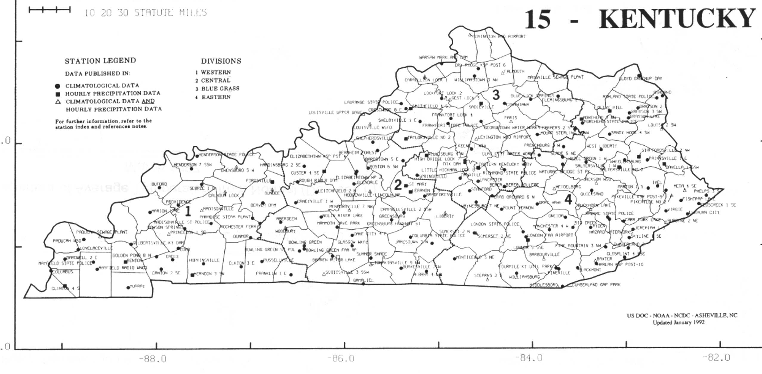
| Hourly, 2rd, West,Cent, East,NE, N, | Daily, PAD, LMK, JKL | Monthly | Threshold Search | Variable-length summaries | Graphics | Rainfall Normals | Ky Mesonet |
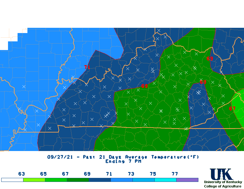
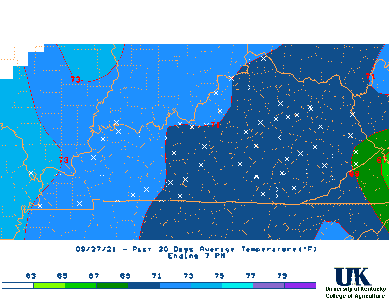
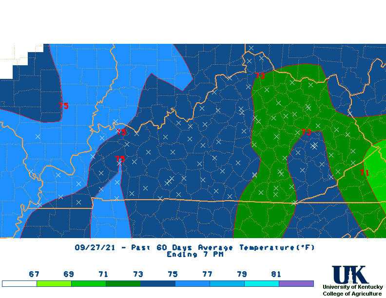
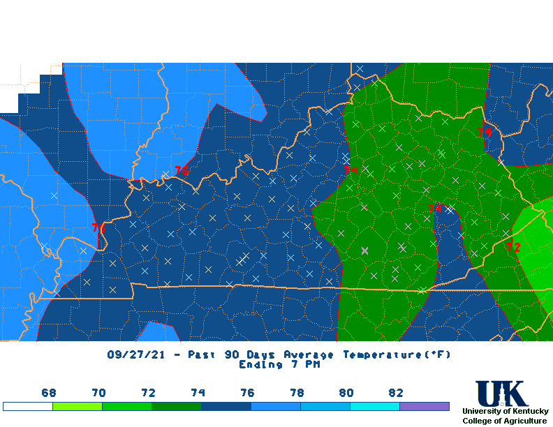
![]() Summary of Kentucky Mesonet & NWS Weather Stations for various time periods for entire state:(Updated daily - Based on PM Obs.)
Summary of Kentucky Mesonet & NWS Weather Stations for various time periods for entire state:(Updated daily - Based on PM Obs.)
Month-to-date Daily Weather Information (Dailies):
CLI (Dailies):
Monthly NWS Climate Summaries (CLM):
![]() Climate Summaries By Climate Disision:
West,
central,
Bluegrass,
East,
All
Climate Summaries By Climate Disision:
West,
central,
Bluegrass,
East,
All
![]() Midwest Climate Center:
Climate Calendar generator
Midwest Climate Center:
Climate Calendar generator
![]() UK Ag.:
Kentucky Crop Calendar
UK Ag.:
Kentucky Crop Calendar
![]() Univ of Wash.:
1981-2010 Normals by state ,
Kentucky
Univ of Wash.:
1981-2010 Normals by state ,
Kentucky
![]() NASA:
Climatology Resource for Agroclimatology
NASA:
Climatology Resource for Agroclimatology
![]() NWS:
Climate Data (New)
NWS:
Climate Data (New)
![]() UKAWC:
New Kentucky Temperature and Rainfall Maps (NWS+Coop+Mesonet weather Stations)
UKAWC:
New Kentucky Temperature and Rainfall Maps (NWS+Coop+Mesonet weather Stations)
![]() NCDC:
World Data Center,
Daily data
NCDC:
World Data Center,
Daily data
![]() UCAR:
USGS WaterAlert (NEW)
UCAR:
USGS WaterAlert (NEW)
![]() Heating & Cooling Degree Day Comparisons
Heating & Cooling Degree Day Comparisons
![]() UCAR:
Teleconnections (Excellent)
UCAR:
Teleconnections (Excellent)
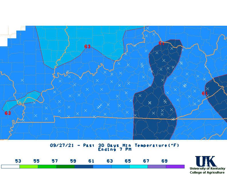
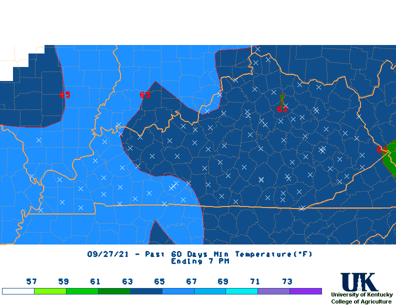
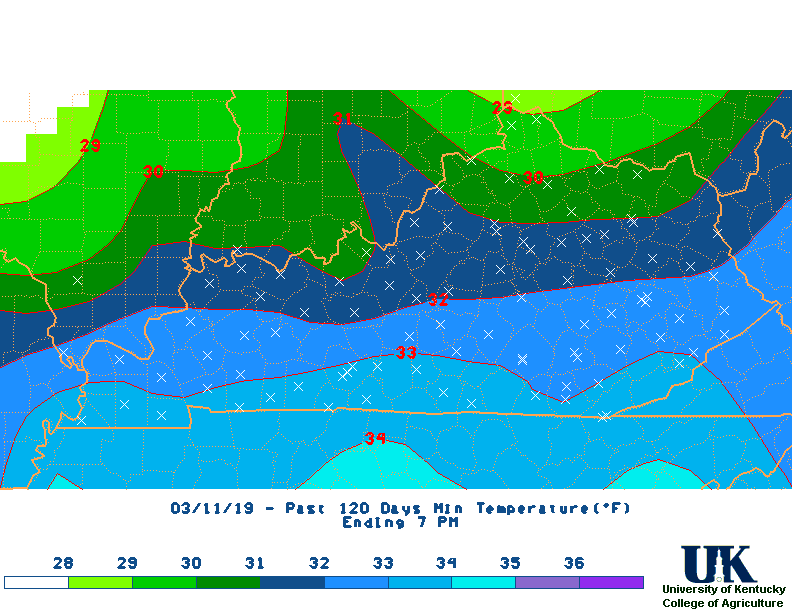
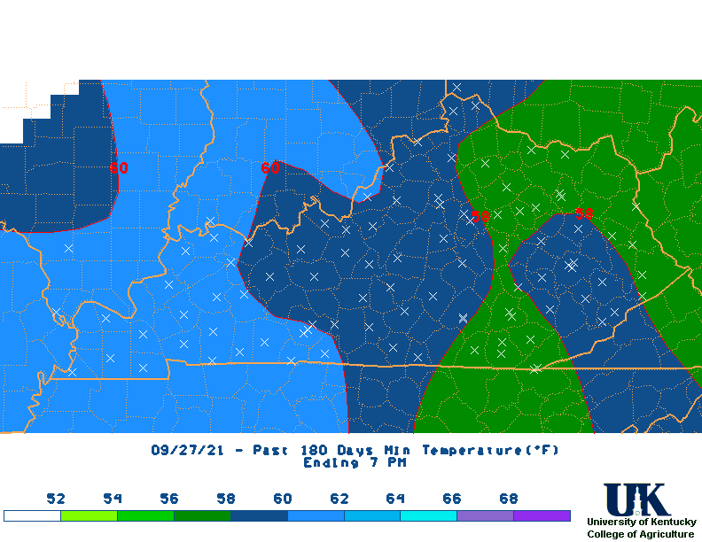
![]() UKAWC: NEW Climate MEGA MAPS
UKAWC: NEW Climate MEGA MAPS
![]() CPC: NEW Climate Long-Lead Briefing
CPC: NEW Climate Long-Lead Briefing
![]() Kentucky Mesonet (Over 50 Sites):
Current Weather Data,
Daily Max/Mins for Yesterday (& past days),
Historical
Kentucky Mesonet (Over 50 Sites):
Current Weather Data,
Daily Max/Mins for Yesterday (& past days),
Historical
![]() NWS U.S. Mesonet (New):
Current U.S. Weather Data
NWS U.S. Mesonet (New):
Current U.S. Weather Data
![]() METAR/SPECIAL OBS (NWS):
Paducah,
Louisville,
Jackson,
Wilmington, OH,
UKAWC Raw reports,
FAA
METAR/SPECIAL OBS (NWS):
Paducah,
Louisville,
Jackson,
Wilmington, OH,
UKAWC Raw reports,
FAA
![]() NWS:
New Kentucky Daily Rainfall Maps (Inclds 1st Order weather stations, KyMesonet and CoCoRaHs stations)
NWS:
New Kentucky Daily Rainfall Maps (Inclds 1st Order weather stations, KyMesonet and CoCoRaHs stations)
![]() NWS:
New NOAA/NWS Climate Web
NWS:
New NOAA/NWS Climate Web
![]() WRCC:
COMPARATIVE Climate Data,
A-L States,
M-N States,
O-Z States,
WRCC:
COMPARATIVE Climate Data,
A-L States,
M-N States,
O-Z States,
![]() US Weather Database For 162 Cities:
AM Data,
PM Data
US Weather Database For 162 Cities:
AM Data,
PM Data
![]() NCDC:
Radar Archive (For past radar views!)
NCDC:
Radar Archive (For past radar views!)
![]() NCDC-Frost/Freeze Dates (1971-2000):
Kentucky ,
IL ,
IN,
OH,
PA,
WV,
VA,
NC,
SC,
FL,
TN,
GA,
AL,
MS,
LA,
AR,
MO,
IA
NCDC-Frost/Freeze Dates (1971-2000):
Kentucky ,
IL ,
IN,
OH,
PA,
WV,
VA,
NC,
SC,
FL,
TN,
GA,
AL,
MS,
LA,
AR,
MO,
IA
![]() NCAR:
Kentucky Hydrological Networks
NCAR:
Kentucky Hydrological Networks
![]() Noaa: National Operational Hydrologic Remote Sensing Center
Interactive Snow Information ,
Snow Anaylsis
Noaa: National Operational Hydrologic Remote Sensing Center
Interactive Snow Information ,
Snow Anaylsis
![]() WeatherARC:
Daily Snow Totals
WeatherARC:
Daily Snow Totals
![]() NWS:
Precip Analysis
NWS:
Precip Analysis
![]() NWS Southern Regional Office:
U.S. Hourly Precip Analysis (new!)
NWS Southern Regional Office:
U.S. Hourly Precip Analysis (new!)
![]() CPC:
All CPC Products (new!)
CPC:
All CPC Products (new!)
![]() USGS:
Kentucky Raingauge sites
USGS:
Kentucky Raingauge sites
![]() NWS:
Southern Region Hourly Precip Analysis (Experimental)
NWS:
Southern Region Hourly Precip Analysis (Experimental)
![]() NCDC :
State/Regional/National Moisture Status
,
Kentucky
NCDC :
State/Regional/National Moisture Status
,
Kentucky
![]() Midwest Regional Climate Center ,
Midwest Climate Watch (MCC)
Midwest Regional Climate Center ,
Midwest Climate Watch (MCC)
USGS:
Natural Hazards Support System
![]() Kentucky Climate Center ,
Drought Trend
Kentucky Climate Center ,
Drought Trend
![]() Kentucky Climate Watch (Multiple sources)
Kentucky Climate Watch (Multiple sources)
![]() Prism Climate Data (Oregon State Univ.),
U.S.
Prism Climate Data (Oregon State Univ.),
U.S.
![]() NCDC State-wide Climate Analysis (NEW!):
Kentucky,
Other NCDC Climate Maps,
Archives
NCDC State-wide Climate Analysis (NEW!):
Kentucky,
Other NCDC Climate Maps,
Archives
![]() NCDC:
State of the Climate Drought
NCDC:
State of the Climate Drought
![]() NWS Rainfall Frequency Atlas (NEW!):
Kentucky
| All States
NWS Rainfall Frequency Atlas (NEW!):
Kentucky
| All States
![]() CPC:
Kentucky & US Heating Degree Totals ,
Season-to-date totals
CPC:
Kentucky & US Heating Degree Totals ,
Season-to-date totals
![]() EPA (NEW!):
Kentucky Air Quality: Current Conditions, Forecast & Archives
EPA (NEW!):
Kentucky Air Quality: Current Conditions, Forecast & Archives
![]() Kentucky CoCoRaHS Daily Precip Observations (NEW!):
Central
Kentucky CoCoRaHS Daily Precip Observations (NEW!):
Central
![]() Space Weather Data and Products (NEW!):
Alerts, Forecasts & Models
Space Weather Data and Products (NEW!):
Alerts, Forecasts & Models
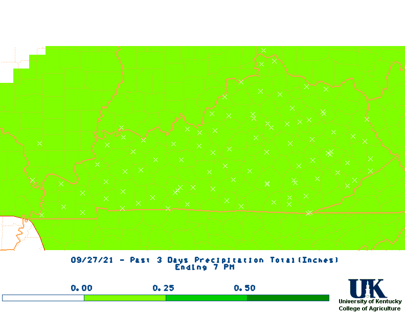
![]() The Past 72-Hour Weather Observations for:
The Past 72-Hour Weather Observations for:
CGI
PAH
EVV
EHR
OWB
HOP
BWG
LOU
Alt
SDF
FFT
FTK
LEX
Alt
CVG
SME
LOZ
JKL
MID
HTS
TRI
![]() The Past Weather Observations Graghics (MesoWest/NWS):
The Past Weather Observations Graghics (MesoWest/NWS):
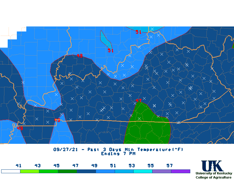
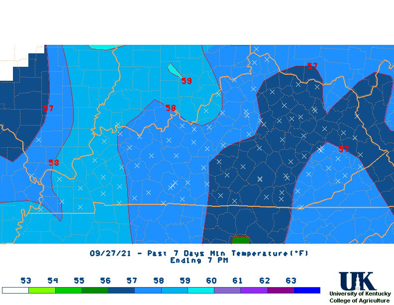
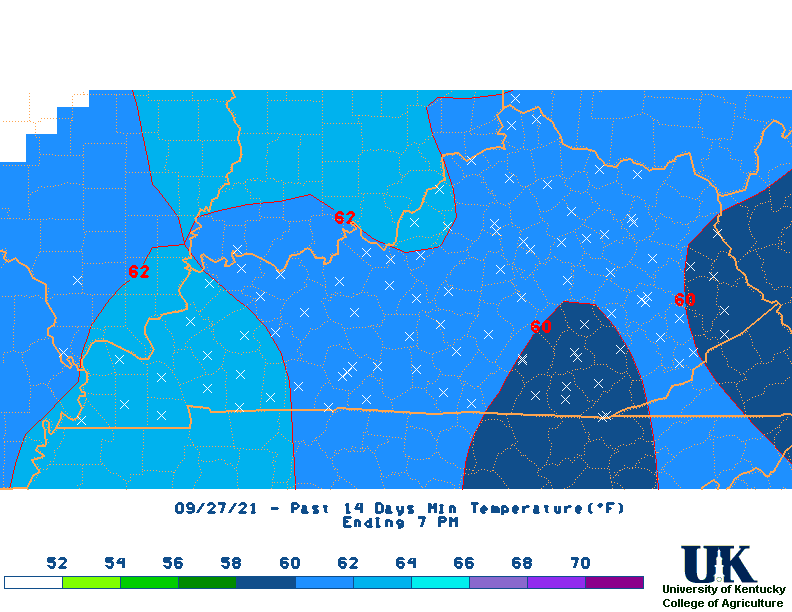
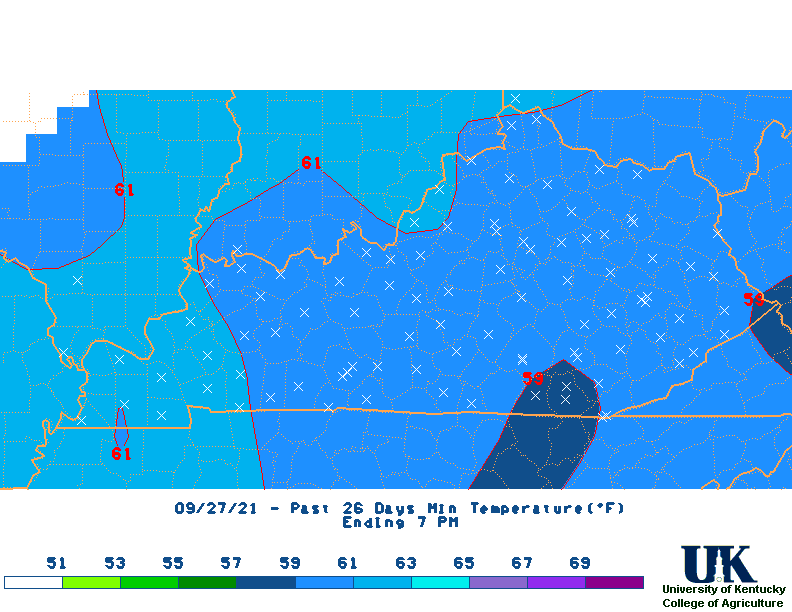
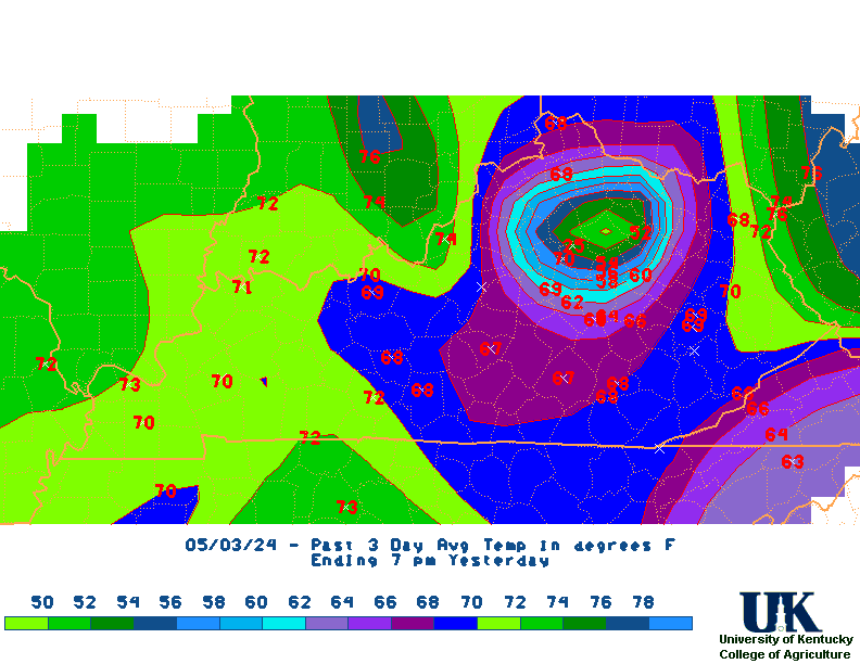
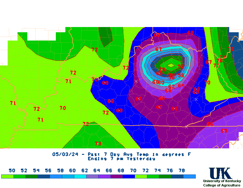
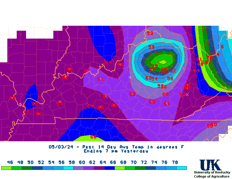
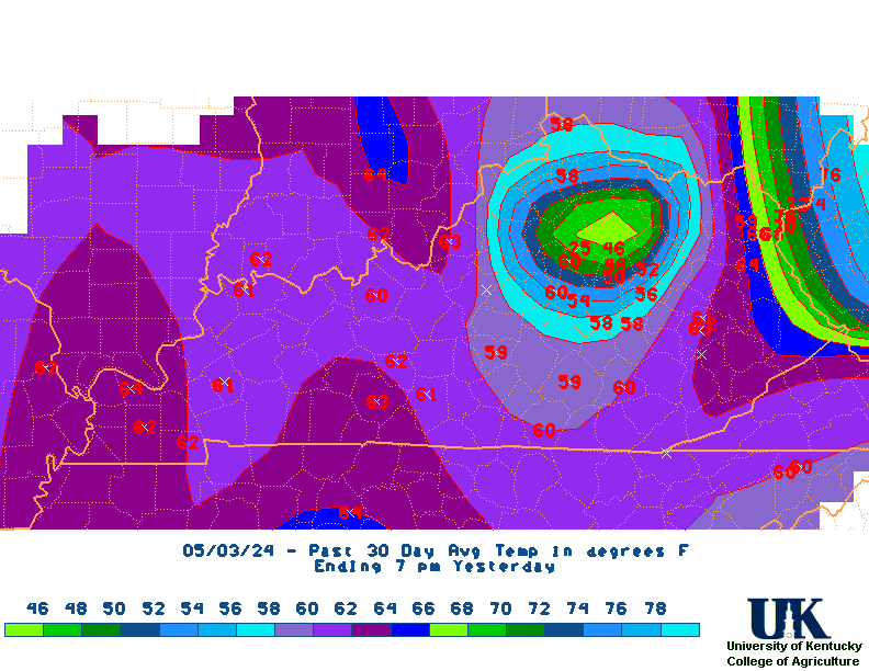
12 hr
24 hr
36 hr
2 day
3 day
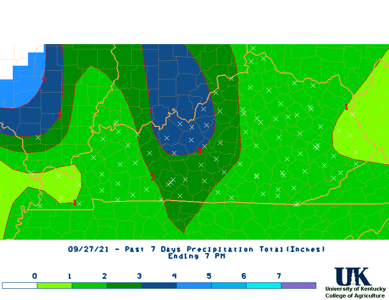
7 Day
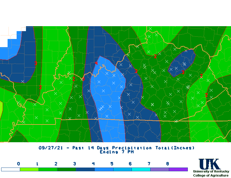
14 day
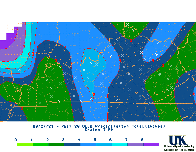
28 day
![]() Current NWS State Observations/Climate All
Data:
Current NWS State Observations/Climate All
Data:
Hourly Obs.
[KY],
[MAP],
[ALL],
[KY]
[IN]
[WV]
[OH]
[TN]
[IL]
[MO]
[AR]
Ag. Obs.
[KY],
[KY],
[Archive of Evening Obs]
[IN]
[WV]
[OH]
[TN]
[IL]
[MO]
[AR]
Daily Climate Data
[PAH],
[SDF],
[LEX],
[BWG],
[JKL],
[CVG],
1st,
[ALL],
Daily,
PAD,
LMK,
JKL,
[Previous obs KY],
[ALL]
[IN]
[WV]
[OH]
[TN], 2nd
[IL]
[MO]
[AR]
Monthly Climate Data
[PAH],
[BWG],
[SDF],
[LEX],
[CVG],
[JKL],
[alt PAH],
[alt SDF],
[alt JKL],
[ALL]
[IN]
[WV]
[OH]
[TN]
[IL]
[MO]
[AR]

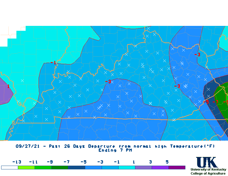
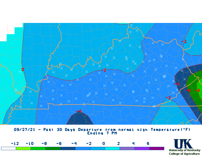
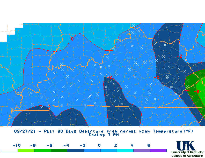
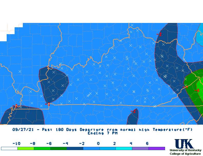
KY Monthly Rainfall Departures
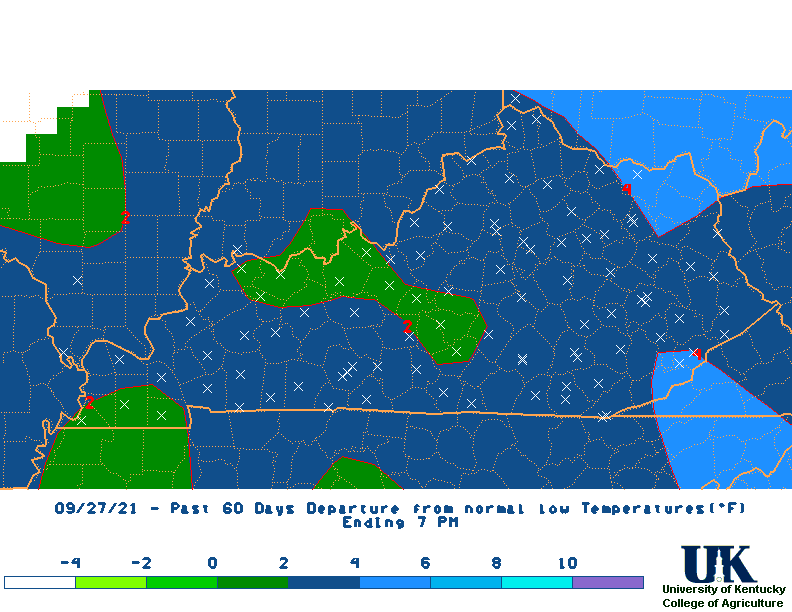
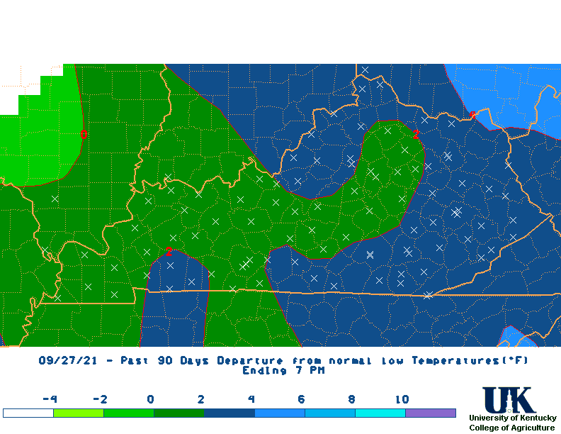
KY Monthly Temperature Departures
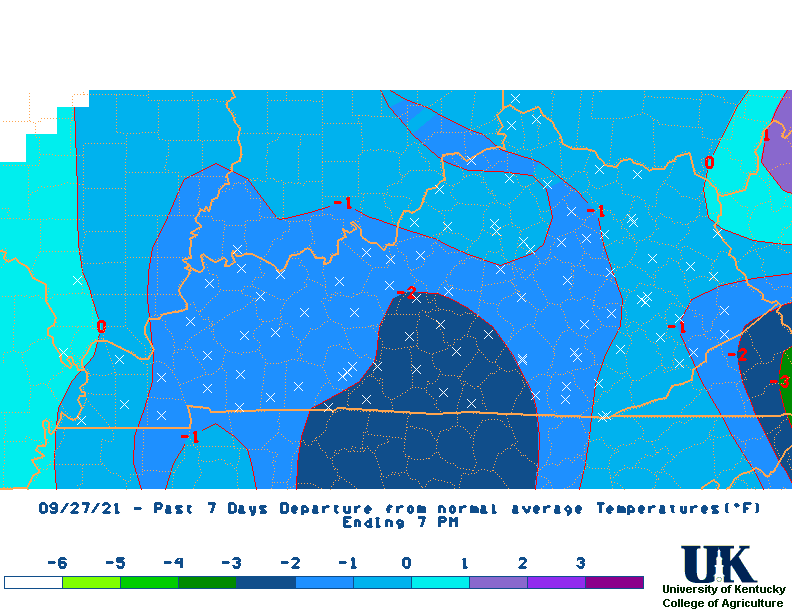
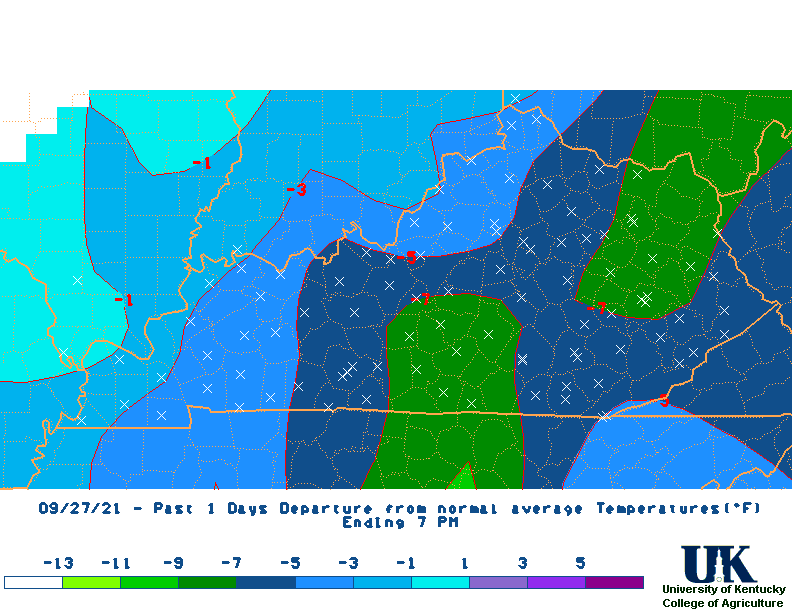
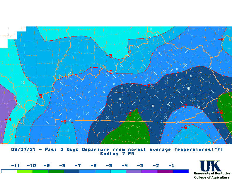
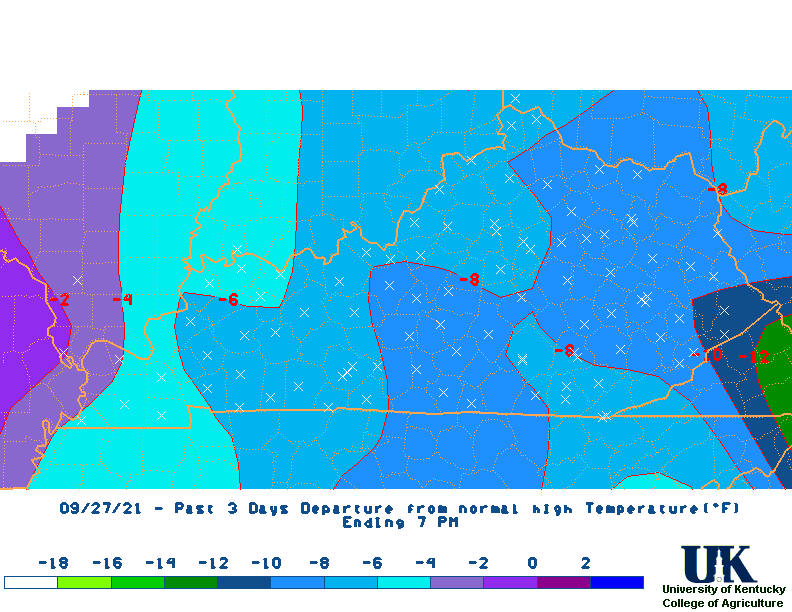
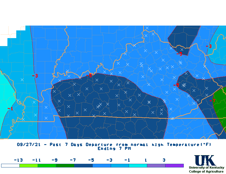
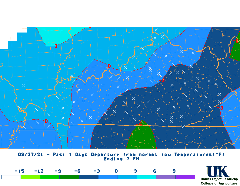
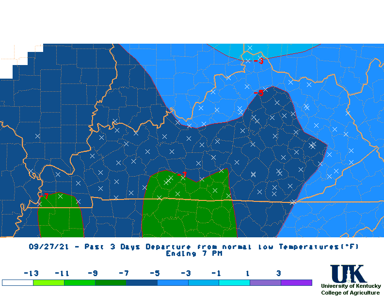
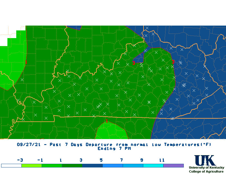
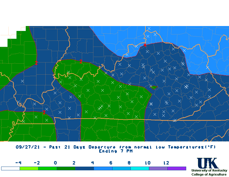
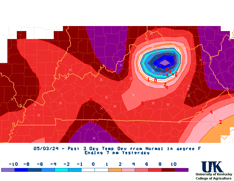
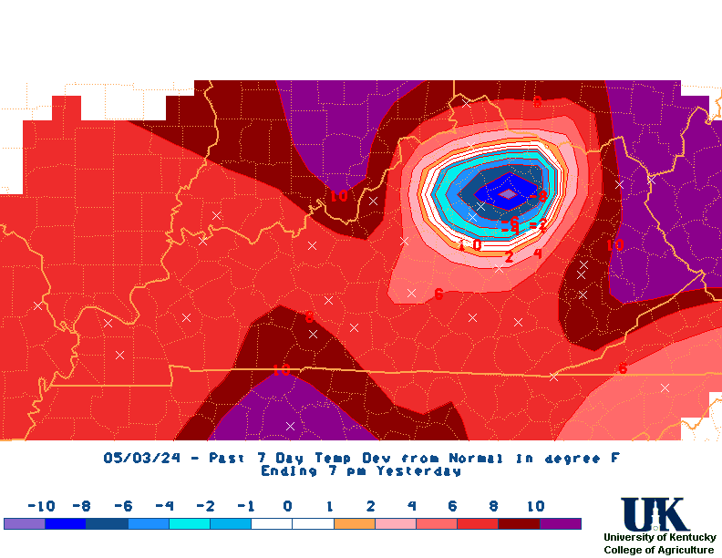
Ky 7-Day Temperature Dep.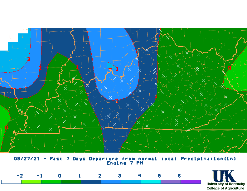
Ky 7-Day Rainfall Dep.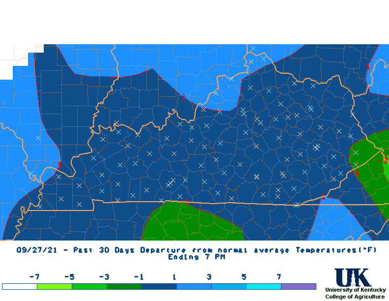
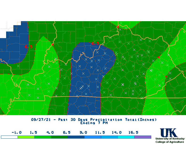
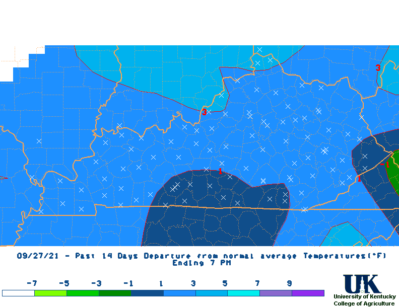
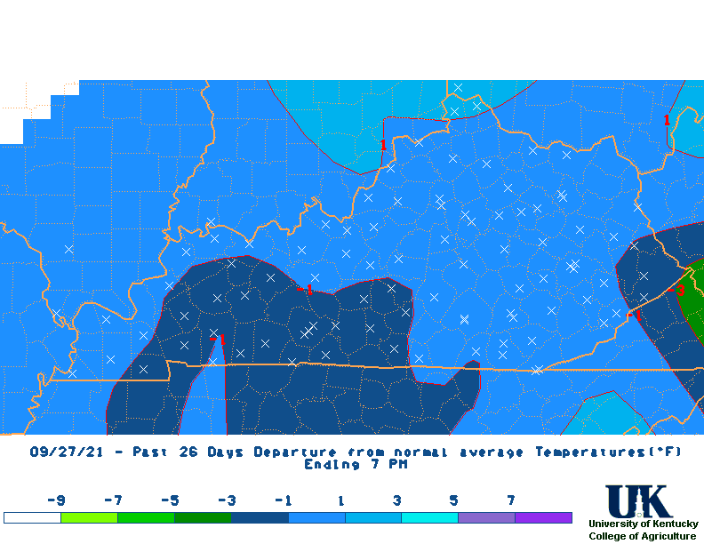
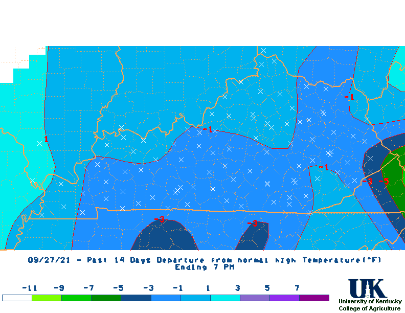
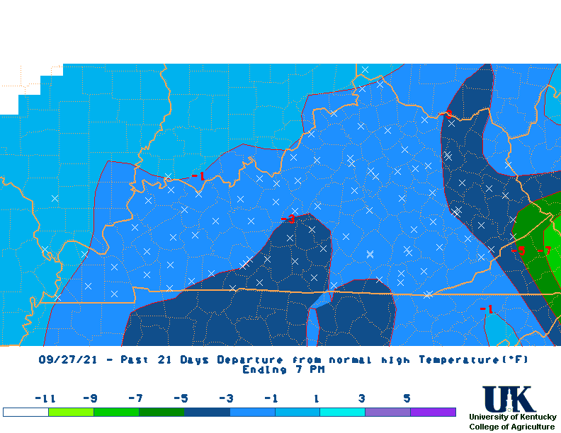
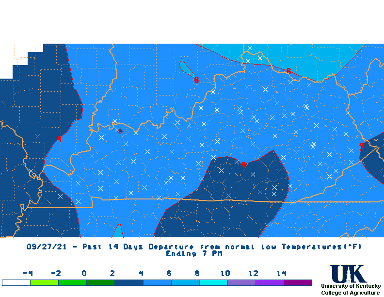
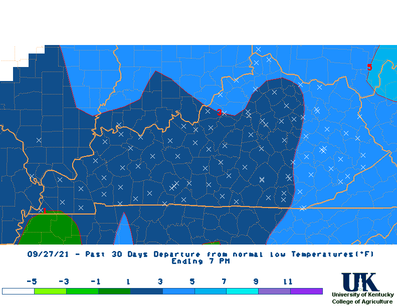
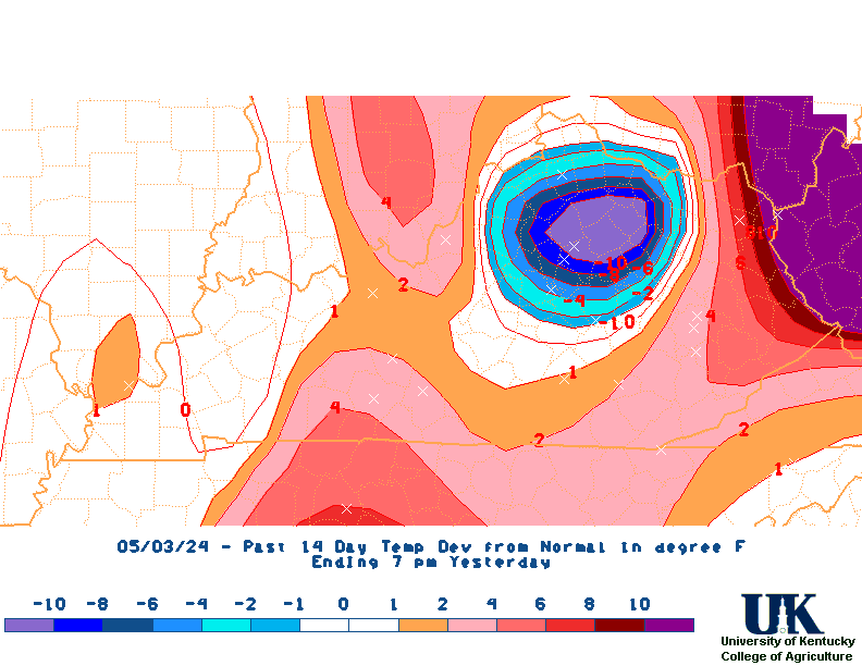
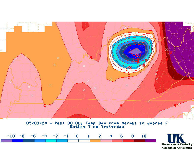
Ky 30-Day Temperature Dep.
Ky 30-Day Rainfall Dep.
![]() UKAWC:
All States Fall Colors (USFS)
UKAWC:
All States Fall Colors (USFS)
![]() UKAWC:
Yesterdays Agricultural/State Weather Observations, [7 PM Ag. Observations]
1st-Order KY Weather Obs (NoaaPort),
1st-Order KY Weather Obs (LDM)
.
UKAWC:
Yesterdays Agricultural/State Weather Observations, [7 PM Ag. Observations]
1st-Order KY Weather Obs (NoaaPort),
1st-Order KY Weather Obs (LDM)
.
![]() NWS Regional Weather Observations:
Paducah,
2nd,
3rd,
Louisville,
2nd,
Jackson,
2nd,
All
NWS Regional Weather Observations:
Paducah,
2nd,
3rd,
Louisville,
2nd,
Jackson,
2nd,
All
![]() UKAWC:
Last 7 Days Regional Weather Observations
UKAWC:
Last 7 Days Regional Weather Observations
![]() U.S. National Arboretum:
Plant Hardiness Zones for Kentucky and U.S.
U.S. National Arboretum:
Plant Hardiness Zones for Kentucky and U.S.
Cape Girardeau,
PAH ,
EVV,
LMK,
LEX,
JKL,
Cincinnati,
RLX,
ILN,
Frankfort,
Bowling Green,
London,
OHX,
Nashville,
Bristol (Tri-Cities,
MRX,
IND,
All CF6's
PAH ,
LMK,
JKL,
RLX,
ILN,
OHX,
MRX,
IND,
All CLI's
TN:
MEM,
Nash,
Knox,
CHA,
TRI-city,
KY:
PAH ,
EVV ,
LMK,
CVG,
LEX,
BWG,
JKL,
LOZ,
RLX,
ILN,
Huntington,
IND,
All CLm's
![]() Kentucky Climate Maps & Narratives (NWS 1st Order + Coop + Kentucky Mesonet Stations, 24 Hour Period, 7 PM to 7 PM):
Kentucky Climate Maps & Narratives (NWS 1st Order + Coop + Kentucky Mesonet Stations, 24 Hour Period, 7 PM to 7 PM):
Climate Tables
Climate Narratives
Rainfall Total Maps
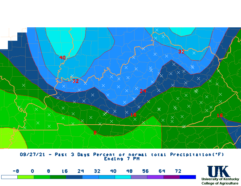
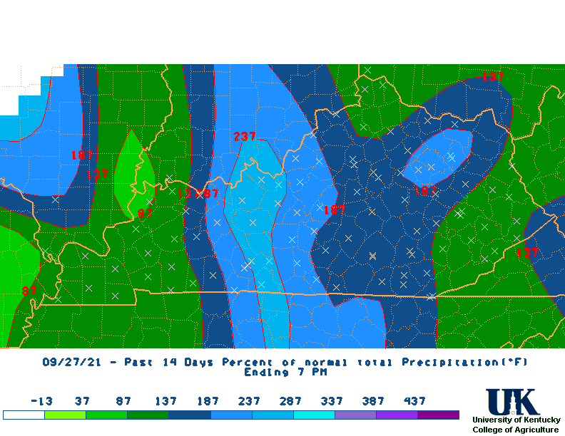
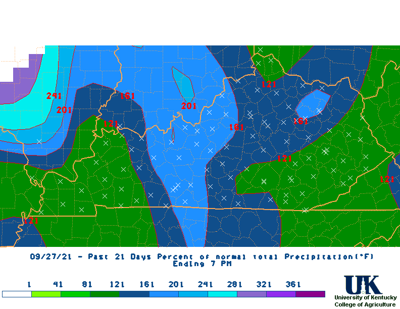
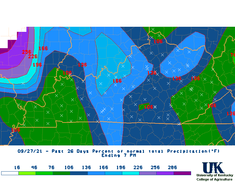
Percent of Normal Rainfall Maps
Rainfall Departure Maps
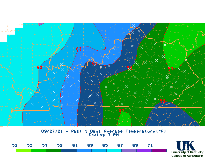
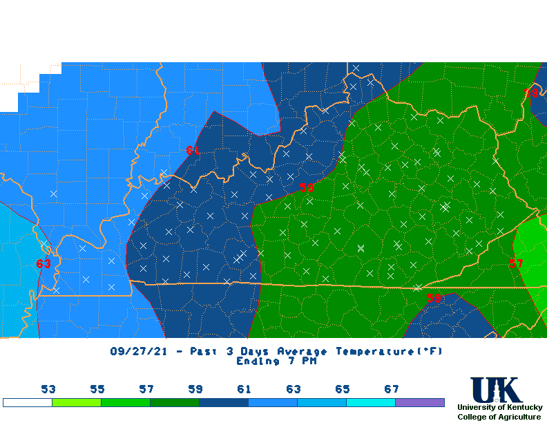
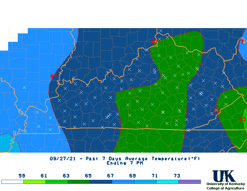
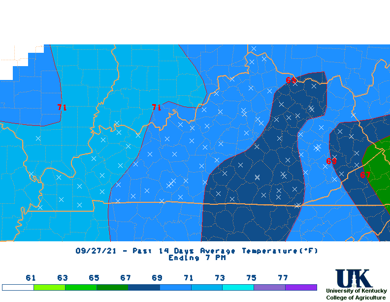
Average Temperature Maps
Average Temperature Departure Maps
Max Temperature Maps
Max Temperature Departure Maps
Min Temperature Maps
Min Temperature Departure Maps
High Max Temperature Maps
Low Min Temperature Maps
All Maps
* M2D = Month-to-Date
![]() Kentucky Climate Maps & Narratives (NWS stations only):
Kentucky Climate Maps & Narratives (NWS stations only):
Climate Narratives
Rainfall Total Maps
Rainfall Departure Maps
Temperature Maps
Temperature Departure Maps
![]() Kentucky Mesonet
Kentucky Mesonet
![]() UKAWC Regional Ag Weather Summary (Select Format):
Spring , Summer ,
Fall
UKAWC Regional Ag Weather Summary (Select Format):
Spring , Summer ,
Fall
![]() Kentucky Weather & Crop Report (Current & previous issues),
PDF version
Kentucky Weather & Crop Report (Current & previous issues),
PDF version
![]() UKAWC Kentucky Current Growing Season Summary:
[Weekly | Monthly ], Past Years,
Past Forecast Maps
UKAWC Kentucky Current Growing Season Summary:
[Weekly | Monthly ], Past Years,
Past Forecast Maps
![]() CPC:
US & Global Temperature and Rainfall Maps (By world continents)
CPC:
US & Global Temperature and Rainfall Maps (By world continents)
 US Weekly Rainfall Departures |
 US Weekly Temperature Departures |
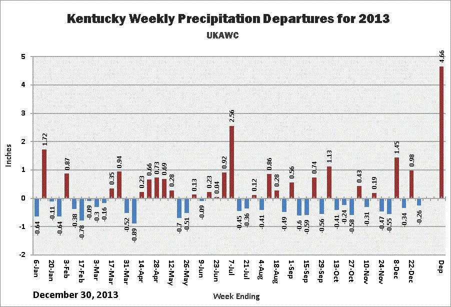 KY Weekly Rainfall Departures |
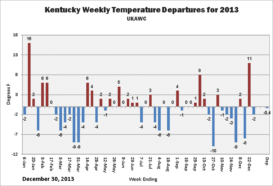 KY Weekly Temperature Departures |
 MRCC:
Monthly Temperature, Precipitation, Snow and GDD Normals for Kentucky (1971-2000)
MRCC:
Monthly Temperature, Precipitation, Snow and GDD Normals for Kentucky (1971-2000)
 NCDC:
Monthly Heating Degree Day Normals (all states)NCDC:
Cooling Degree Day Normals (all states)NCDC:
Monthly Station Normals of Temperature, Precipitation, and Heating and Cooling Degree Days
1971 - 2000NCDC:
Divsional/Regional Monthly Station Normals of Temperature, Precipitation, and Heating and Cooling Degree Days
1971 - 2000NCDC:
Dynamic Normals ProductsNCDC:
All Land-based ProductsNCDC:
State Climate Descriptions (all states)
T-Storm/Tornado Climatology (NOAA)
NCDC:
Monthly Heating Degree Day Normals (all states)NCDC:
Cooling Degree Day Normals (all states)NCDC:
Monthly Station Normals of Temperature, Precipitation, and Heating and Cooling Degree Days
1971 - 2000NCDC:
Divsional/Regional Monthly Station Normals of Temperature, Precipitation, and Heating and Cooling Degree Days
1971 - 2000NCDC:
Dynamic Normals ProductsNCDC:
All Land-based ProductsNCDC:
State Climate Descriptions (all states)
T-Storm/Tornado Climatology (NOAA)Evaporation and Soil Moisture
NOAA:
Soil Moisture & Evap Data and Normals,
Monthly Evaporation Archive (NEW!)
![]() UKAWC:
Historical Daily Data for 1st-Order Stations in and around Kentucky (1949 thru 1999).
UKAWC:
Historical Daily Data for 1st-Order Stations in and around Kentucky (1949 thru 1999).
![]() UKAWC GIS Estimates of Monthly Normals by County for:
[Evaporation | Rainfall]
UKAWC GIS Estimates of Monthly Normals by County for:
[Evaporation | Rainfall]
NCDC:
GIS Portal
![]() UKAWC:
Historical Daily Data for 1st-Order Stations in and around Kentucky (1949 thru 1999).
UKAWC:
Historical Daily Data for 1st-Order Stations in and around Kentucky (1949 thru 1999).
NOAA:
Soil Moisture & Evap Data and Normals,
Monthly Evaporation Archive (NEW!)
![]() UKAWC GIS Estimates of Monthly Normals by County for:
[Evaporation | Rainfall]
UKAWC GIS Estimates of Monthly Normals by County for:
[Evaporation | Rainfall]
| Hourly,2nd, 3rd | Daily | Monthly | Threshold Search | Variable-length summaries |
| Kentucky Monthly Statewide Data (1895 to Present) |
||
|---|---|---|
| Rainfall Totals | Temperature | Ranking |
| Kentucky Monthly Climate Division Data (1895 to Present) |
||||
|---|---|---|---|---|
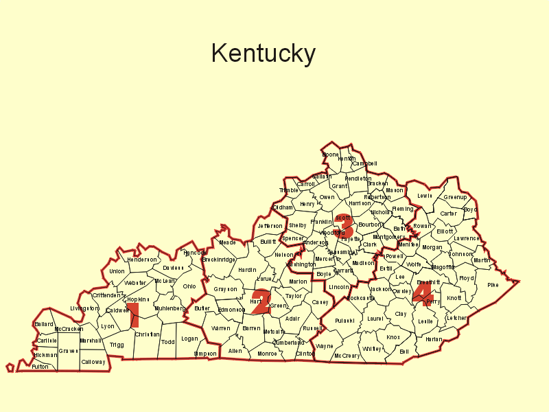
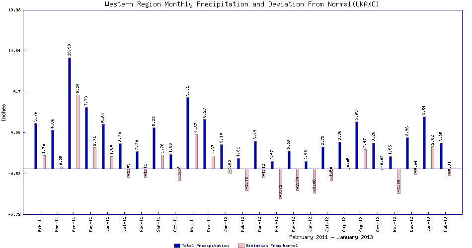
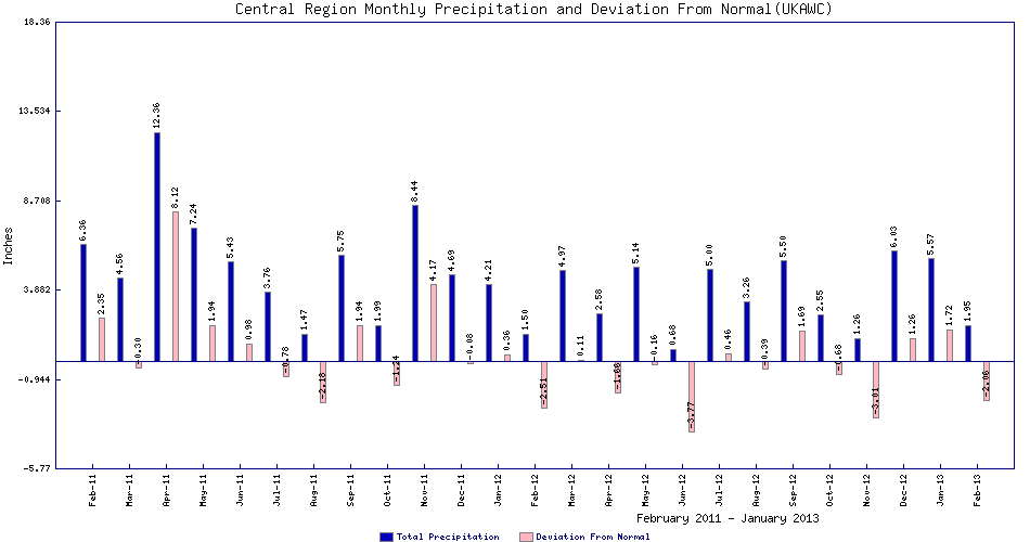
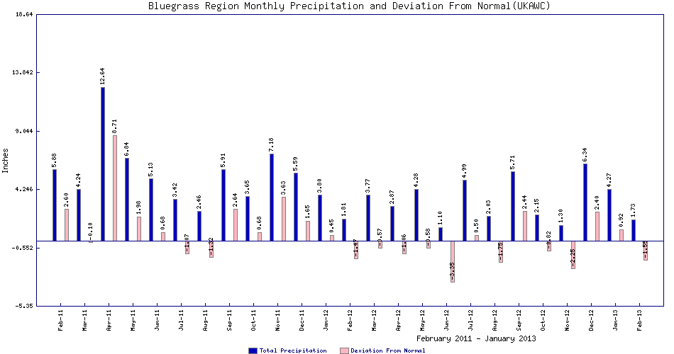
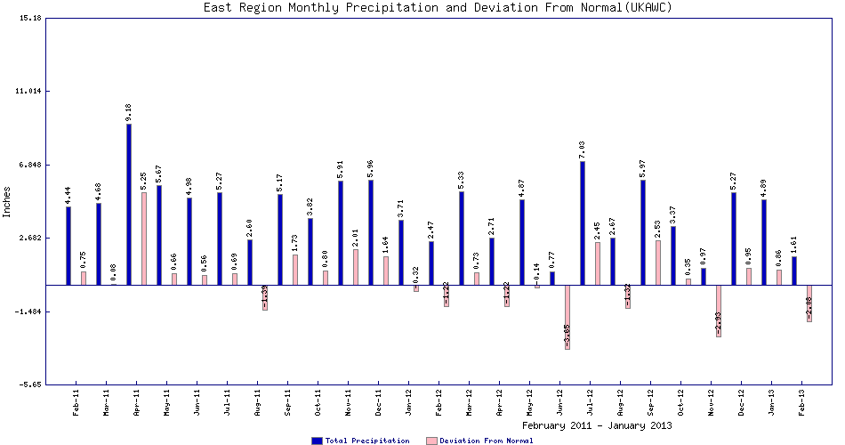
| 1895-Present Monthly Rainfall | West (CD-1), Graph | Central (CD-2),Graph | Bluegrass (CD-3),Graph | East (CD-4),Graph |
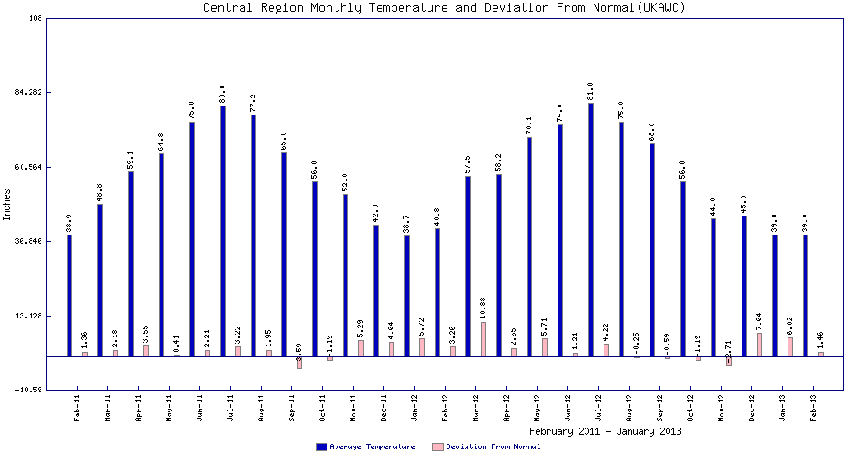
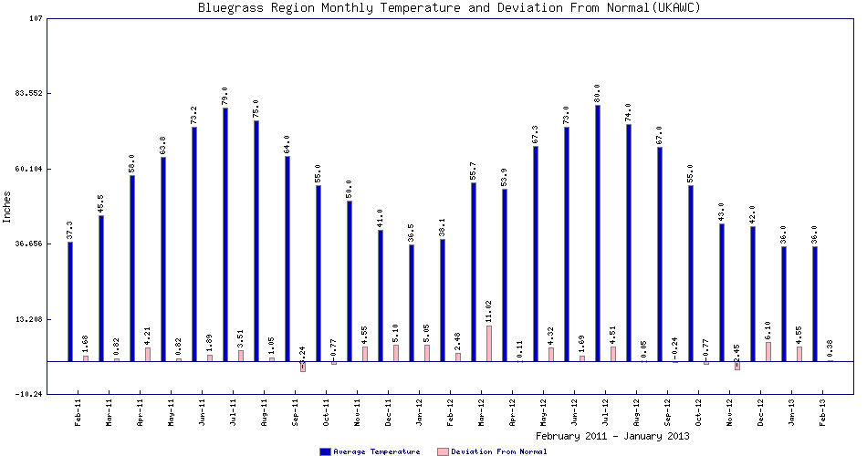
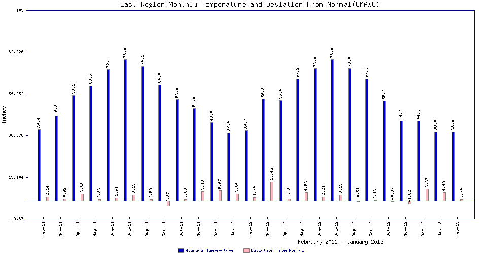
| 1895-Present Monthly Temperature | West (CD-1),Graph | Central (CD-2),Graph | Bluegrass (CD-3),Graph | East (CD-4),Graph |
![]() UK Research Farm Weather Data:
UK Research Farm Weather Data:
NCDC:
State Climate Descriptions (all states)
State Climate Narratives (VisitUSA.com)
![]() WRCC:
COMPARATIVE Climate Data,
A-L States,
M-N States,
O-Z States,
WRCC:
COMPARATIVE Climate Data,
A-L States,
M-N States,
O-Z States,
Additional Climate Narratives by State (Western Regional Climate Center:
Climate Narrratives of all US States & Cities
Geography and Climate of all US States,
More States
Prizm (Oregon Climate Service):
Rainfall Normals by States (1971-2000)
US Rainfall Normals by Month( 1971-2000)
![]() USGS:
State-by-state Info
USGS:
State-by-state Info
![]() USGS:
WaterWatch -- Current water resources conditions ,
Current Kentucky Streamflows
USGS:
WaterWatch -- Current water resources conditions ,
Current Kentucky Streamflows
Download the guide: Climate Literacy: The Essential Principles of Climate Science — reflects a broad and current effort to define climate literacy.
High (14.67MB) Resolution pdf | Low (2.92MB) Resolution pdf | Word (780kb).
![]()