|
![[Header Map]](/images/header.gif)
University of Kentucky
Agricultural Weather Center
Serving Kentucky residents |
On
the World Wide Web at:
http://weather.uky.edu/ |
Current Conditions|
Forecasts|
Satellite|
Radar|
Media|
Outlooks|
Drought|
Severe|
Tropical Wx|
Winter Wx|
Climatology|
Fire|
NWS|
Historical|
About Us|
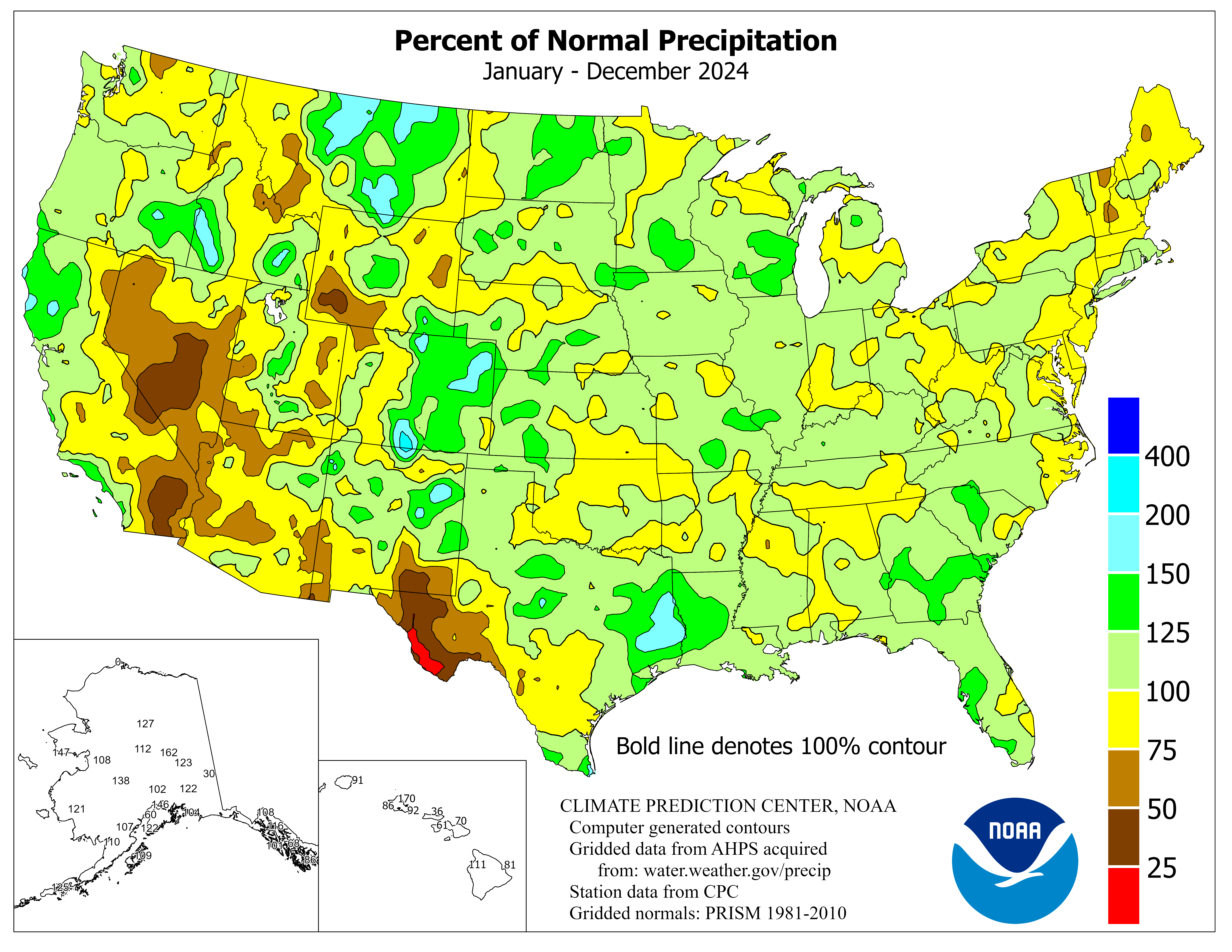
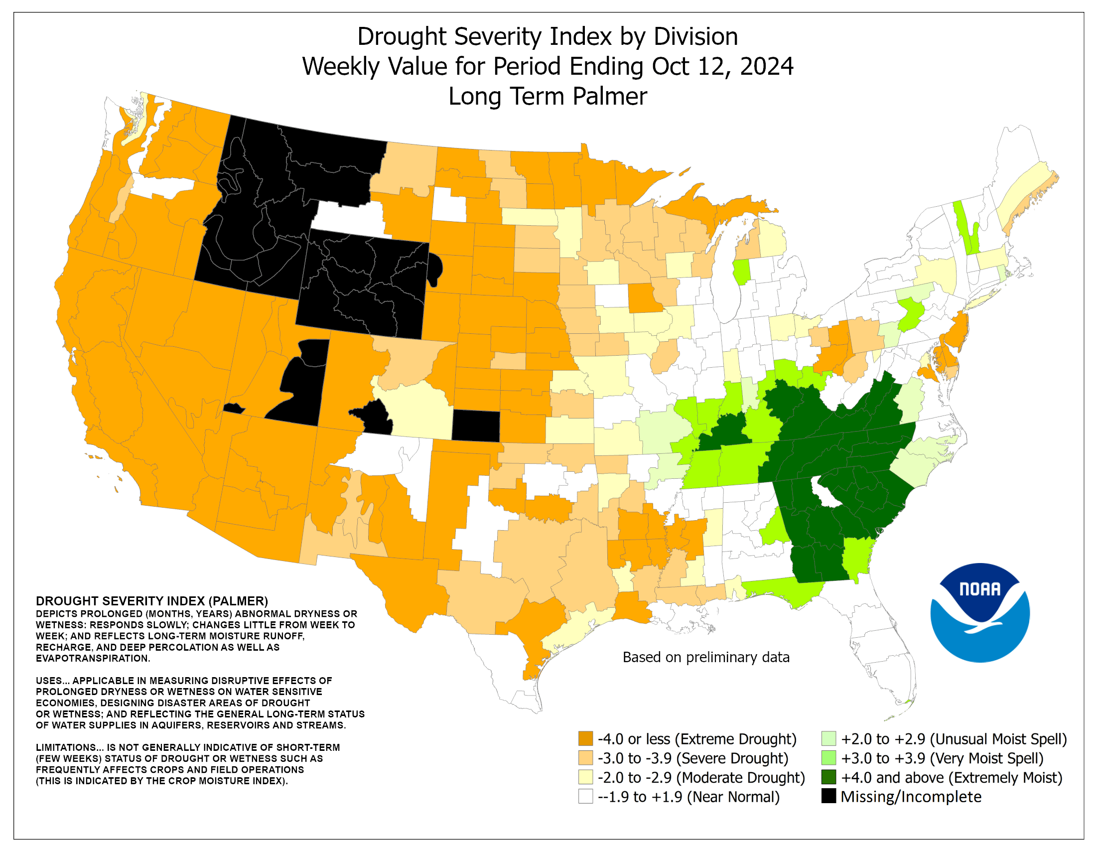
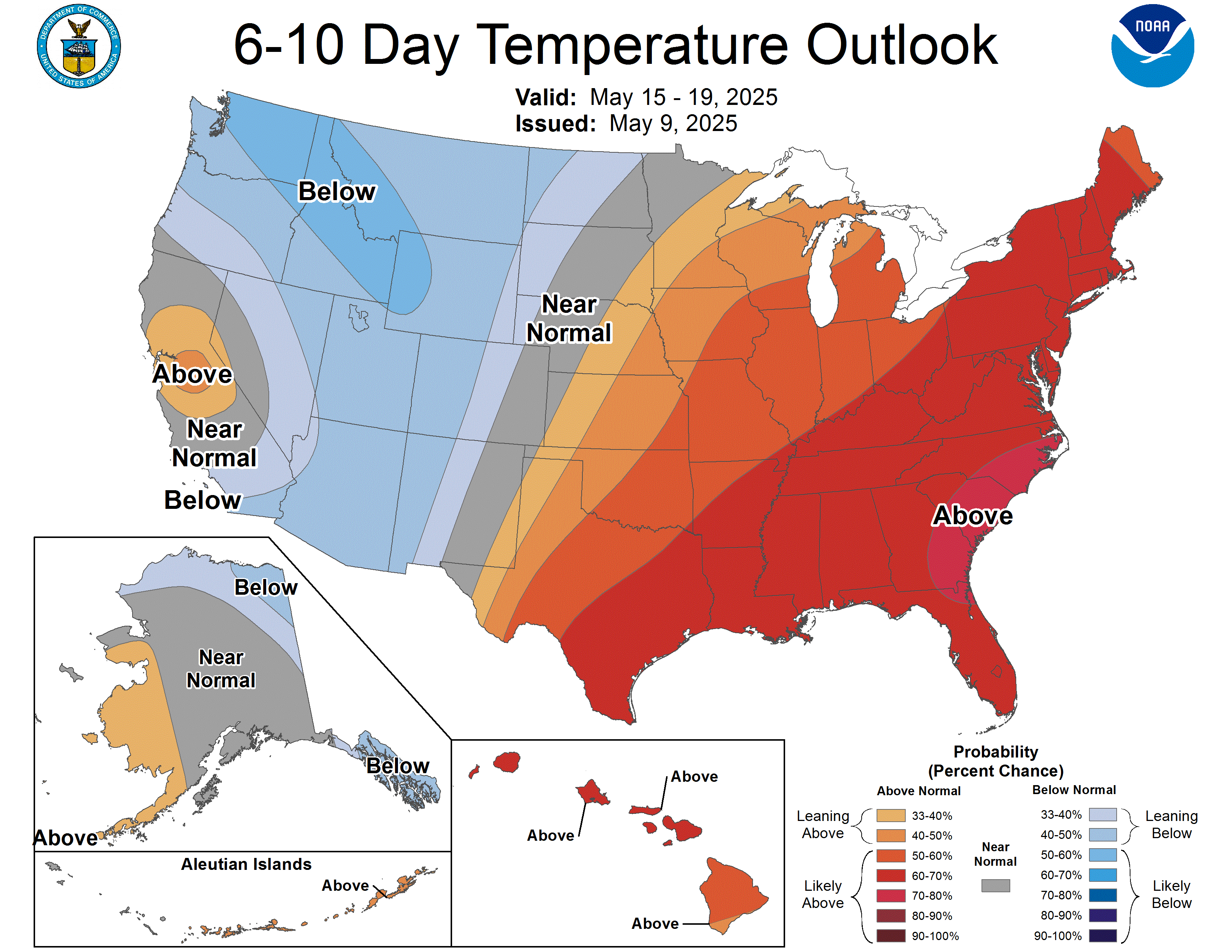
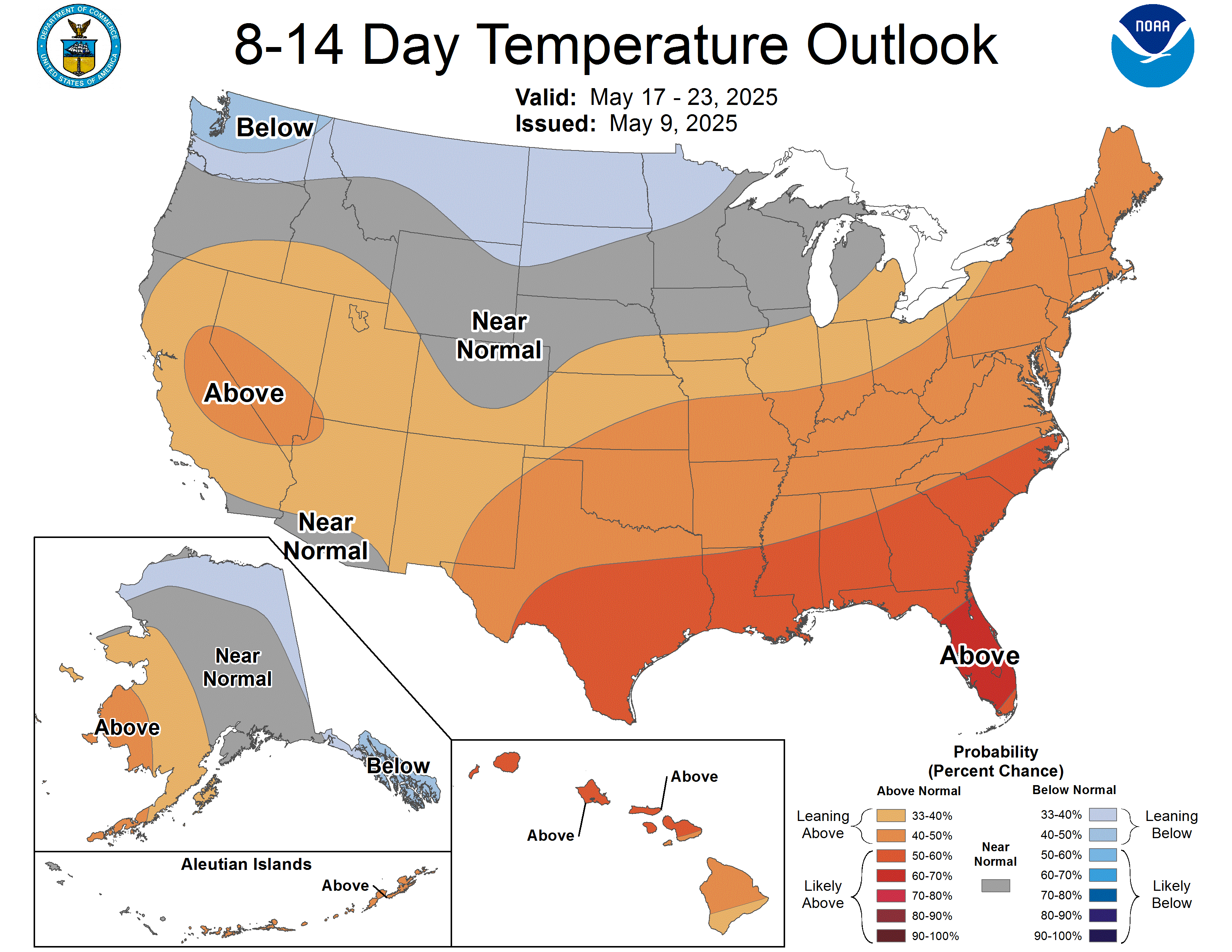
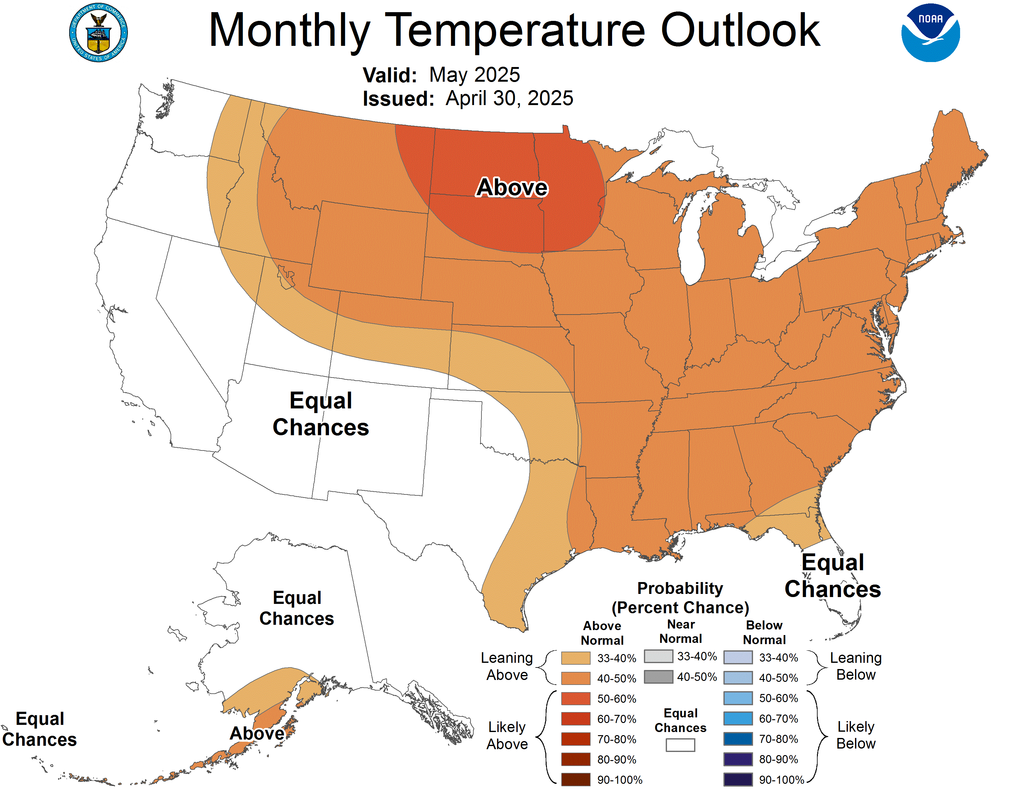
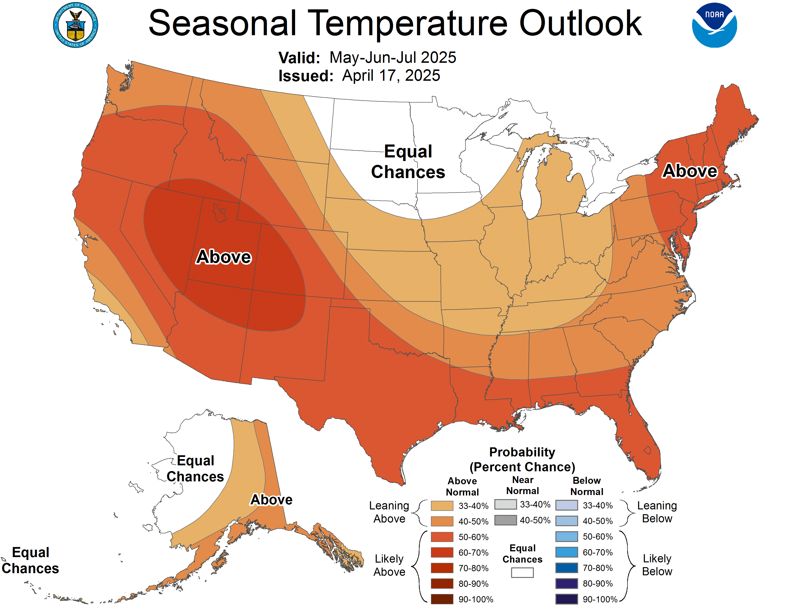
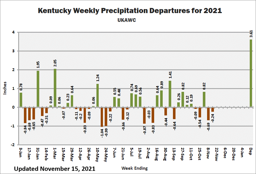
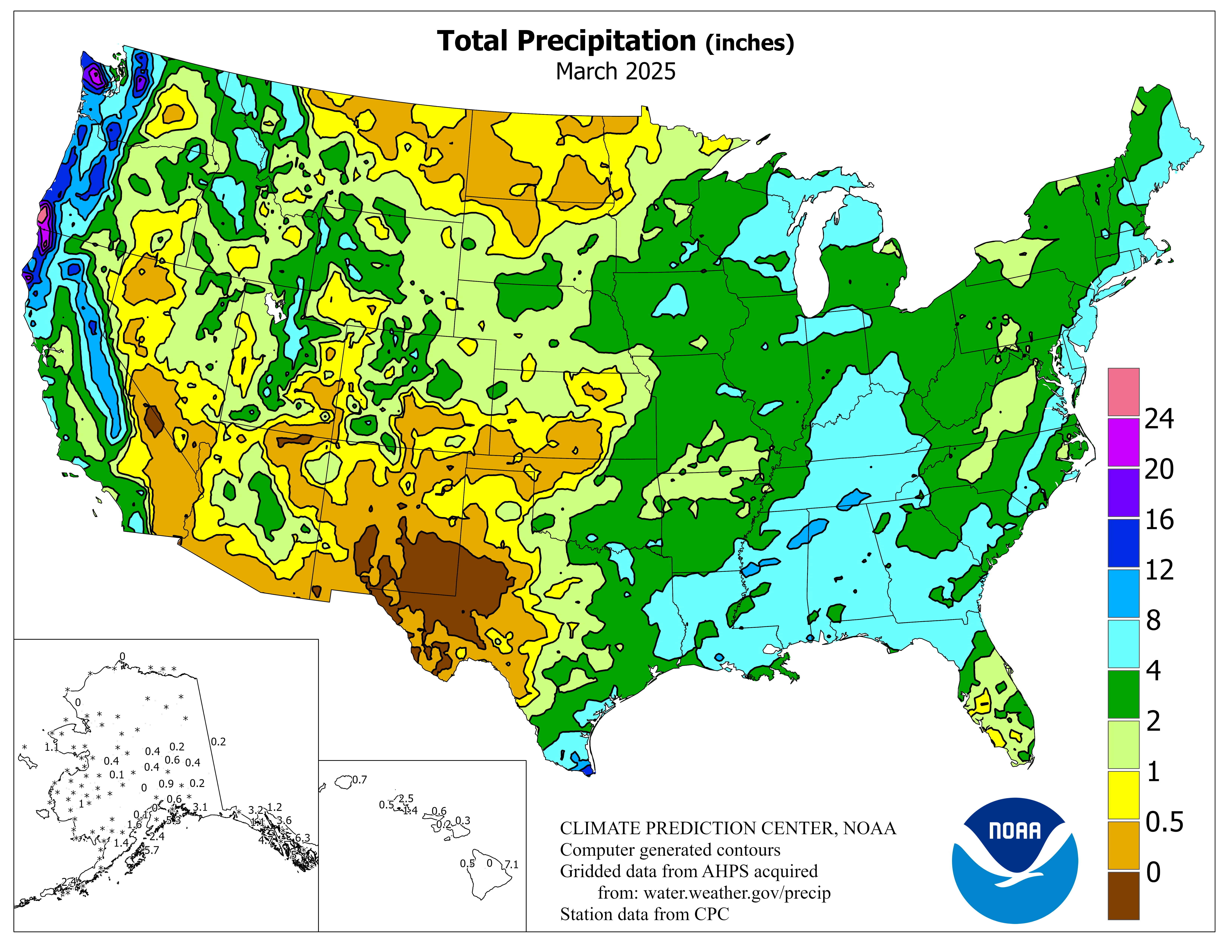
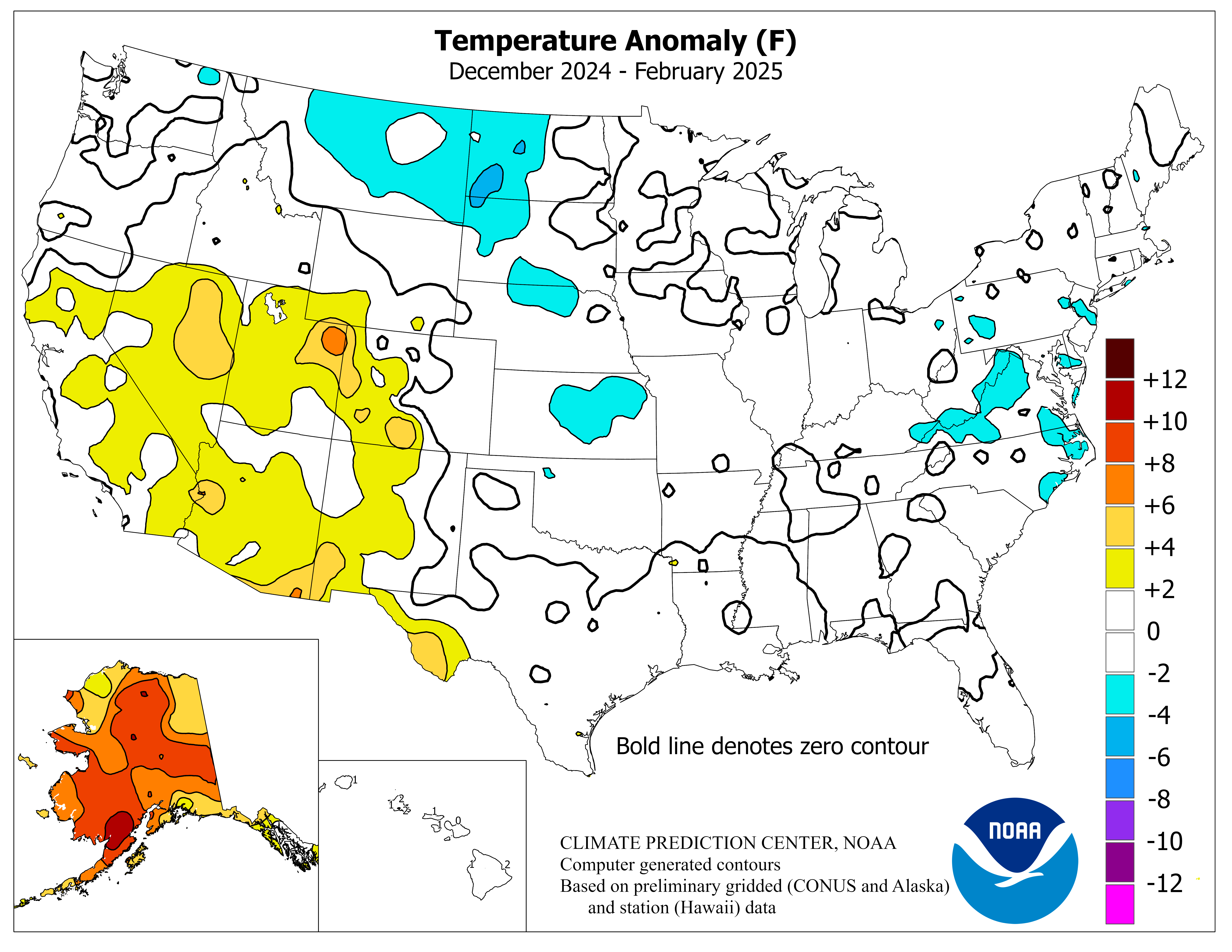
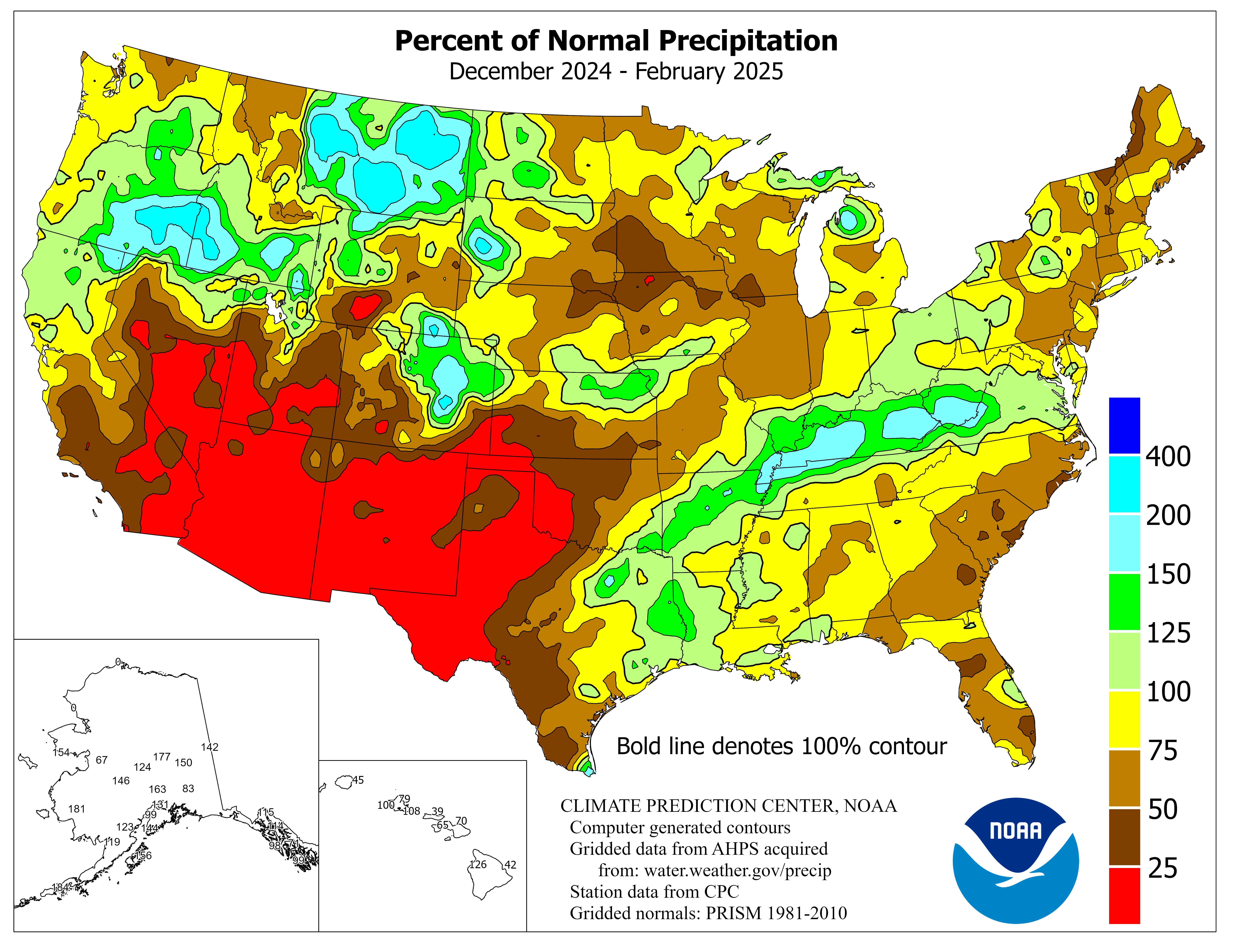
Kentucky Climate Update
This web page will provide users with an indepth view of the current
climatological situation in Kentucky. Climate related graphs and maps will be
update daily, weekly and monthly to provide Kentucky residents the latest
information for Kentucky's past, present and future climate status. Sources are
from UKAWC, NWS, NCEP, CPC, NCDC, USGS and the Kentucky Climate Center.
Let us know if there are addition items you would like to see on this page.
Tom Priddy, Director UK Ag. Weather Center.
Click any image to enlarge. Additional drought information is available here.
Click here for the latest Weekly Kentucky Weather Summary, and click
here for the latest Monthly Kentucky Climate Report.
For Past Years Click here.
Climate Summaries By Climate Disision:
West,
Central,
Bluegrass,
East,
All
|
|
Click here for the SOI trend graph
Click here for the Weekly Palmer Drought and Crop Moisture data for Kentucky
Kentucky Hydrologic and Agricultural Drought Status:
Date: Monday Oct 18 2021
Re: Palmer Drought (PDSI)/Crop Moisture (CMI) Indices
Well Above Normal Temperatures and Below Normal Rainfall:
Much like the first half of October, well above normal temperatures remained in place
for the workweek. Highs peaked on Thursday with temperatures in the low to middle
80s across much of the state, which would be about 10 to 15 degrees above normal for
this time of year. Showers and storms crossed the western half of Kentucky on
Monday night, before dissipating to the east. Following another light round of
showers Wednesday, more significant activity arrived on Friday with the passage of a
strong cold front. Some storms across Western Kentucky did show capable of
producing damaging winds. Overall, outside of some spotty locations, most of the
state ended under an inch for the week. Behind the front, much cooler air filtered
into the state from the northwest. Highs on Saturday and Sunday were limited to the
60s. Lows on Sunday morning even dipped into the middle 30s to low 40s, prompting the
possibility of patchy frost in low lying and sheltered locations.
WEST KY Long-term Hydrological Moisture status is: NEAR NORMAL
CENTRAL KY Long-term Hydrological Moisture status is: NEAR NORMAL
BLUEGRASS KY Long-term Hydrological Moisture status is: NEAR NORMAL
EAST KY Long-term Hydrological Moisture status is: NEAR NORMAL
WEST KY Crop Moisture status is: Favorable For Normal Growth And Fieldwork
CENTRAL KY Crop Moisture status is: Favorable For Normal Growth And Fieldwork
BLUEGRASS KY Crop Moisture status is: Favorable, Except Still Too Wet In Spots
EAST KY Crop Moisture status is: Favorable For Normal Growth And Fieldwork
Rainfall needed above normal to end the hydrological drought: West 0.00 inches,
Central 0.00 inches, Bluegrass 0.00 inches and East 0.00 inches.
WEEKLY PALMER DROUGHT AND CROP MOISTURE DATA FOR THE CLIMATE DIVISIONS IN THE CENTRAL REGION
CLIMATE PREDICTION CENTER, NCEP, NWS, NOAA
WEEK 33 OF THE 2021 GROWING SEASON IS THE WEEK ENDING 16 OCT 2021
SOIL PCT MONTH PRELIM-P PRECIP
MOISTURE FIELD CHANGE MOIST FINAL -F NEEDED
UPPER LOWER CAP. POT RUN CROP FROM ANOM PALMER TO END
TEMP PCPN LAYER LAYER END EVAP OFF MOIST PREV (Z) DROUGHT DROUGHT
ST CD CLIMATE DIVISION (F) (IN) (IN) (IN) WEEK (IN) (IN) INDEX WEEK INDEX INDEX (IN)
KY 1 WESTERN 70.2 0.68 0.00 4.50 50.0 0.82 0.00 0.16 -0.06 0.24 0.35 P
KY 2 CENTRAL 69.1 0.61 0.81 5.89 74.5 0.80 0.00 0.56 -0.49 2.24 1.08 P
KY 3 BLUEGRASS 68.2 0.66 0.88 7.53 93.5 0.78 0.00 1.03 -0.59 3.08 1.68 F
KY 4 EASTERN 68.5 0.52 0.30 4.19 74.8 0.78 0.00 0.37 -0.41 1.34 1.08 P
Note: In the "Precip Needed to End Drought" column...that rainfall is needed ABOVE NORMAL./K. Thomas Priddy, UKAWC
Daily Streamflow Conditions/
Map of below normal 7-day average streamflow compared to historical streamflow for the day of the year (Kentucky)
|
|
|
|
|
|
|
|
30 Day Outlook Discussion Here
90 Day Outlook Discussion Here
Current Agricultural Weather Conditions in Kentucky
Based on observations at 500pm EDT, Monday June 05, 2023
Across Kentucky...temperatures are near 87 degrees west, near 84 degrees central, and near 78 degrees east. Current sky conditions are sunny west, partly sunny central, and partly sunny east. In the west, relative humidity is near 35%, and the dew point is near 57 degrees. In the central part of the state, relative humidity is near 34%, and the dew point is near 53 degrees. In the east, relative humidity is near 43%, and the dew point is near 54 degrees. Current drying conditions are good west, good central, and good east. The livestock heat stress category is no stress west, no stress central, and no stress east. Winds are from the north at 6 mph west, where conditions are favorable for spraying. Winds are from the north at 14 mph with gusts at 22 mph central, where conditions are not favorable for spraying due to strong winds. Winds are calm east, where conditions are favorable for spraying. Based on current available observations, the highest temperature is 87 degrees at Paducah, Owensboro, and Bowling Green. The lowest temperature is 78 degrees at Jackson.
Click here
for the entire list of ag. weather observations across Kentucky.
Updated Thursday Evening, December 9, 2021
Severe weather on the table
It has been a rather active weather pattern to start December. Through the 8th, the
state has averaged 1.39 inches. Attention now turns to another round of showers and
storms tomorrow and Saturday. Altogether, another half to 1.5 inches will be on the
table. Coverage will start tomorrow scattered in nature. Highs will jump into the 60s
across much of the area behind breezy southerly winds. Shower/storm coverage and
intensity then increases tomorrow night and into Saturday morning. A line of storms is expected with damaging
winds as the main threat, but tornadoes also very much possible. Heavy rain also presents
a flooding threat, especially for low lying areas. Now is the time to get animals out
of those spots. Bottom line, this will present an overnight threat, so please have
a way to get warning (highly suggest a NOAA Weather Radio).
After a brief cool down for the latter half of the weekend, temperatures go on the uphill
climb next week. Outlooks hint the warm air will hang around the area through the third
full week of December. Any additional rain chances look to hold off until late workweek.
Fayette County Precision Ag. Weather Forecast
Ag Weather Center, Department of Biosystems & Agricultural Engineering, University of Kentucky