NWS forecast for any "City, St" or Zipcode


Weather & Forecasts
Current Conditions
Forecasts
Satellite Imagery
Radar Imagery
Winter Wx
Fire Weather
Long Range Outlooks
Other


Kentucky Climate
Climatology
Pests/Disease
Ag/Wx Calculators
Hydrology Info.


Other UKAWC Sites
Severe Wx
Tropical Wx
Kentucky Ag Wx
Drought
National Wx
International Wx
Learning About Wx
About UKAWC


UKAWC Home


[Header Map]


Drought Status For Kentucky

Latest Palmer Drought Severity Index


Latest Crop Moisture Index


Latest Drought Monitor

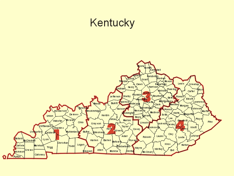
Click Here for a map of Kentucky's climate zones. Click Here for past weekly drought updates.


 From The UK Ag. Weather Center: Here's Kentucky drought status by
climate division. See drought definitions below.

 
See drought definitions below.

Date: Monday Oct 18 2021 Re: Palmer Drought (PDSI)/Crop Moisture (CMI) Indices Well Above Normal Temperatures and Below Normal Rainfall: Much like the first half of October, well above normal temperatures remained in place for the workweek. Highs peaked on Thursday with temperatures in the low to middle 80s across much of the state, which would be about 10 to 15 degrees above normal for this time of year. Showers and storms crossed the western half of Kentucky on Monday night, before dissipating to the east. Following another light round of showers Wednesday, more significant activity arrived on Friday with the passage of a strong cold front. Some storms across Western Kentucky did show capable of producing damaging winds. Overall, outside of some spotty locations, most of the state ended under an inch for the week. Behind the front, much cooler air filtered into the state from the northwest. Highs on Saturday and Sunday were limited to the 60s. Lows on Sunday morning even dipped into the middle 30s to low 40s, prompting the possibility of patchy frost in low lying and sheltered locations. WEST KY Long-term Hydrological Moisture status is: NEAR NORMAL CENTRAL KY Long-term Hydrological Moisture status is: NEAR NORMAL BLUEGRASS KY Long-term Hydrological Moisture status is: NEAR NORMAL EAST KY Long-term Hydrological Moisture status is: NEAR NORMAL WEST KY Crop Moisture status is: Favorable For Normal Growth And Fieldwork CENTRAL KY Crop Moisture status is: Favorable For Normal Growth And Fieldwork BLUEGRASS KY Crop Moisture status is: Favorable, Except Still Too Wet In Spots EAST KY Crop Moisture status is: Favorable For Normal Growth And Fieldwork Rainfall needed above normal to end the hydrological drought: West 0.00 inches, Central 0.00 inches, Bluegrass 0.00 inches and East 0.00 inches. WEEKLY PALMER DROUGHT AND CROP MOISTURE DATA FOR THE CLIMATE DIVISIONS IN THE CENTRAL REGION CLIMATE PREDICTION CENTER, NCEP, NWS, NOAA WEEK 33 OF THE 2021 GROWING SEASON IS THE WEEK ENDING 16 OCT 2021 SOIL PCT MONTH PRELIM-P PRECIP MOISTURE FIELD CHANGE MOIST FINAL -F NEEDED UPPER LOWER CAP. POT RUN CROP FROM ANOM PALMER TO END TEMP PCPN LAYER LAYER END EVAP OFF MOIST PREV (Z) DROUGHT DROUGHT ST CD CLIMATE DIVISION (F) (IN) (IN) (IN) WEEK (IN) (IN) INDEX WEEK INDEX INDEX (IN) KY 1 WESTERN 70.2 0.68 0.00 4.50 50.0 0.82 0.00 0.16 -0.06 0.24 0.35 P KY 2 CENTRAL 69.1 0.61 0.81 5.89 74.5 0.80 0.00 0.56 -0.49 2.24 1.08 P KY 3 BLUEGRASS 68.2 0.66 0.88 7.53 93.5 0.78 0.00 1.03 -0.59 3.08 1.68 F KY 4 EASTERN 68.5 0.52 0.30 4.19 74.8 0.78 0.00 0.37 -0.41 1.34 1.08 P ::::::::::::::::: Date: Monday Oct 11 2021 Re: Palmer Drought (PDSI)/Crop Moisture (CMI) Indices Well Above Normal Temperatures and Above Normal Rainfall: A slow-moving disturbance aloft produced rounds of showers and storms across the area over the course of the workweek. The most significant activity occurred on Wednesday and Thursday. The highest accumulations were focused across Lake Cumberland Region and north into the Bluegrass region where persistent showers and storms produced 1-3+ inches. Elsewhere though, most saw accumulations under an inch. Precipitation tapered off to end the workweek and opened to a dry, but warm weekend. In fact, highs were in the 80s across Kentucky on Sunday. Even had a handful of locations across Western KY touch the upper 80s. Normal highs for this time of year range from the upper 60s to middle 70s across the state. WEST KY Long-term Hydrological Moisture status is: NEAR NORMAL CENTRAL KY Long-term Hydrological Moisture status is: NEAR NORMAL BLUEGRASS KY Long-term Hydrological Moisture status is: NEAR NORMAL EAST KY Long-term Hydrological Moisture status is: NEAR NORMAL WEST KY Crop Moisture status is: Favorable For Normal Growth And Fieldwork CENTRAL KY Crop Moisture status is: Prospects Above Normal, Some Fields Too Wet BLUEGRASS KY Crop Moisture status is: Prospects Above Normal, Some Fields Too Wet EAST KY Crop Moisture status is: Moisture Adequate For Present Needs Rainfall needed above normal to end the hydrological drought: West 0.00 inches, Central 0.00 inches, Bluegrass 0.00 inches and East 0.00 inches. WEEKLY PALMER DROUGHT AND CROP MOISTURE DATA FOR THE CLIMATE DIVISIONS IN THE CENTRAL REGION CLIMATE PREDICTION CENTER, NCEP, NWS, NOAA WEEK 32 OF THE 2021 GROWING SEASON IS THE WEEK ENDING 9 OCT 2021 SOIL PCT MONTH PRELIM-P PRECIP MOISTURE FIELD CHANGE MOIST FINAL -F NEEDED UPPER LOWER CAP. POT RUN CROP FROM ANOM PALMER TO END TEMP PCPN LAYER LAYER END EVAP OFF MOIST PREV (Z) DROUGHT DROUGHT ST CD CLIMATE DIVISION (F) (IN) (IN) (IN) WEEK (IN) (IN) INDEX WEEK INDEX INDEX (IN) KY 1 WESTERN 71.4 0.66 0.00 4.57 50.7 0.88 0.00 0.22 -0.03 0.17 0.44 P KY 2 CENTRAL 69.5 1.86 1.00 5.89 76.6 0.83 0.00 1.05 0.42 2.63 1.19 F KY 3 BLUEGRASS 69.2 2.23 1.00 7.53 94.8 0.83 0.00 1.62 0.92 3.00 1.69 F KY 4 EASTERN 68.7 1.37 0.56 4.19 79.2 0.81 0.00 0.78 0.44 1.53 1.22 F :::::::::::::::::: Date: Monday Oct 4 2021 Re: Palmer Drought (PDSI)/Crop Moisture (CMI) Indices Above Normal Temperatures and Rainfall: Harvest benefited from some dry and mild weather throughout much of the workweek. Skies ran mostly sunny across the Bluegrass State and along with southerly flow in place, highs jumped into the upper 70s to middle 80s each day. Rain held off until the weekend for most of the state (some light showers across far W-KY on Friday). Coverage turned widespread at times, most notably on Sunday with some pockets of moderate to heavy rainfall. Overall, the state averaged 0.93 inches for the week, most of which fell on Sunday. This number marked a third straight week that the state average has ran above normal. WEST KY Long-term Hydrological Moisture status is: NEAR NORMAL CENTRAL KY Long-term Hydrological Moisture status is: NEAR NORMAL BLUEGRASS KY Long-term Hydrological Moisture status is: NEAR NORMAL EAST KY Long-term Hydrological Moisture status is: NEAR NORMAL WEST KY Crop Moisture status is: Favorable For Normal Growth And Fieldwork CENTRAL KY Crop Moisture status is: Favorable For Normal Growth And Fieldwork BLUEGRASS KY Crop Moisture status is: Favorable For Normal Growth And Fieldwork EAST KY Crop Moisture status is: Favorable For Normal Growth And Fieldwork Rainfall needed above normal to end the hydrological drought: West 0.00 inches, Central 0.00 inches, Bluegrass 0.00 inches and East 0.00 inches. WEEKLY PALMER DROUGHT AND CROP MOISTURE DATA FOR THE CLIMATE DIVISIONS IN THE CENTRAL REGION CLIMATE PREDICTION CENTER, NCEP, NWS, NOAA WEEK 31 OF THE 2021 GROWING SEASON IS THE WEEK ENDING 2 OCT 2021 SOIL PCT MONTH PRELIM-P PRECIP MOISTURE FIELD CHANGE MOIST FINAL -F NEEDED UPPER LOWER CAP. POT RUN CROP FROM ANOM PALMER TO END TEMP PCPN LAYER LAYER END EVAP OFF MOIST PREV (Z) DROUGHT DROUGHT ST CD CLIMATE DIVISION (F) (IN) (IN) (IN) WEEK (IN) (IN) INDEX WEEK INDEX INDEX (IN) KY 1 WESTERN 70.9 0.58 0.12 4.62 52.7 0.89 0.00 0.25 -0.16 0.00 0.56 P KY 2 CENTRAL 68.9 0.34 0.51 5.35 65.1 0.83 0.00 0.63 -0.44 1.30 0.84 P KY 3 BLUEGRASS 67.1 0.40 0.62 6.51 79.2 0.78 0.00 0.70 -0.48 1.19 1.01 P KY 4 EASTERN 65.8 0.13 0.00 4.19 69.8 0.73 0.00 0.34 -0.41 0.33 0.63 P :::::::::::::::::: Date: Monday Sep 27 2021 Re: Palmer Drought (PDSI)/Crop Moisture (CMI) Indices Below Normal Temperatures and Above Normal Rainfall: Fall is normally our driest time of the year, but that hasn’t been the case as of late. The state averaged 1.67 inches this period, marking a second straight of above normal rainfall. All of the rain fell between Monday and Wednesday. Outside of some portions of Western and far Eastern Kentucky, this was a statewide event with most seeing over an inch. Much of North Central Kentucky even topped 2 inches. Other than a narrow band of light rain on Saturday, the rest of the week was predominantly dry. Temperatures ran much cooler over the second half of the week behind a strong cold front. The fall season opened with highs on Wednesday and Thursday staying in the middle 60s to low 70s. Low temperatures were coolest on Friday morning with much of Kentucky in the low to middle 40s. Paintsville even dipped into the upper 30s, marking the first time anyone across the state has been in the 30s since late May. WEST KY Long-term Hydrological Moisture status is: NEAR NORMAL CENTRAL KY Long-term Hydrological Moisture status is: NEAR NORMAL BLUEGRASS KY Long-term Hydrological Moisture status is: NEAR NORMAL EAST KY Long-term Hydrological Moisture status is: NEAR NORMAL WEST KY Crop Moisture status is: Moisture Adequate For Present Needs CENTRAL KY Crop Moisture status is: Prospects Above Normal, Some Fields Too Wet BLUEGRASS KY Crop Moisture status is: Prospects Above Normal, Some Fields Too Wet EAST KY Crop Moisture status is: Moisture Adequate For Present Needs Rainfall needed above normal to end the hydrological drought: West 0.00 inches, Central 0.00 inches, Bluegrass 0.00 inches and East 0.00 inches. WEEKLY PALMER DROUGHT AND CROP MOISTURE DATA FOR THE CLIMATE DIVISIONS IN THE CENTRAL REGION CLIMATE PREDICTION CENTER, NCEP, NWS, NOAA WEEK 30 OF THE 2021 GROWING SEASON IS THE WEEK ENDING 25 SEP 2021 SOIL PCT MONTH PRELIM-P PRECIP MOISTURE FIELD CHANGE MOIST FINAL -F NEEDED UPPER LOWER CAP. POT RUN CROP FROM ANOM PALMER TO END TEMP PCPN LAYER LAYER END EVAP OFF MOIST PREV (Z) DROUGHT DROUGHT ST CD CLIMATE DIVISION (F) (IN) (IN) (IN) WEEK (IN) (IN) INDEX WEEK INDEX INDEX (IN) KY 1 WESTERN 67.1 1.20 0.43 4.62 56.1 0.77 0.00 0.41 0.31 1.08 0.67 P KY 2 CENTRAL 65.5 2.08 1.00 5.35 70.5 0.73 0.00 1.07 0.88 3.03 0.96 F KY 3 BLUEGRASS 65.5 1.82 1.00 6.51 83.4 0.74 0.00 1.18 0.87 3.13 1.22 F KY 4 EASTERN 65.7 1.32 0.57 4.21 79.7 0.75 0.00 0.75 0.48 1.96 1.12 F :::::::::::::::::: Date: Monday Sep 20 2021 Re: Palmer Drought (PDSI)/Crop Moisture (CMI) Indices Above Normal Temperatures and Rainfall: Following two straight weeks of cooler than normal temperatures, summer warmth and humidity returned to the Bluegrass State. Highs rose well into the 80s on a near daily basis, while dewpoints in the upper 60s to low 70s gave a humid feel to the air. The bulk of the rain for the week fell in a couple rounds, one midweek and the other over the weekend. The state averaged just under three quarters of an inch with the first round, but slow storm movements and torrential rainfall did lead to some isolated instances of excessive rainfall and bouts of flash flooding. The focus for heavier rainfall was across South Central Kentucky over the weekend. While the state averaged 1.10 inches for the week, many across this area saw accumulations of 2+ inches. WEST KY Long-term Hydrological Moisture status is: NEAR NORMAL CENTRAL KY Long-term Hydrological Moisture status is: NEAR NORMAL BLUEGRASS KY Long-term Hydrological Moisture status is: NEAR NORMAL EAST KY Long-term Hydrological Moisture status is: NEAR NORMAL WEST KY Crop Moisture status is: Favorable For Normal Growth And Fieldwork CENTRAL KY Crop Moisture status is: Moisture Adequate For Present Needs BLUEGRASS KY Crop Moisture status is: Favorable For Normal Growth And Fieldwork EAST KY Crop Moisture status is: Favorable For Normal Growth And Fieldwork Rainfall needed above normal to end the hydrological drought: West 0.00 inches, Central 0.00 inches, Bluegrass 0.00 inches and East 0.00 inches. WEEKLY PALMER DROUGHT AND CROP MOISTURE DATA FOR THE CLIMATE DIVISIONS IN THE CENTRAL REGION CLIMATE PREDICTION CENTER, NCEP, NWS, NOAA WEEK 29 OF THE 2021 GROWING SEASON IS THE WEEK ENDING 18 SEP 2021 SOIL PCT MONTH PRELIM-P PRECIP MOISTURE FIELD CHANGE MOIST FINAL -F NEEDED UPPER LOWER CAP. POT RUN CROP FROM ANOM PALMER TO END TEMP PCPN LAYER LAYER END EVAP OFF MOIST PREV (Z) DROUGHT DROUGHT ST CD CLIMATE DIVISION (F) (IN) (IN) (IN) WEEK (IN) (IN) INDEX WEEK INDEX INDEX (IN) KY 1 WESTERN 75.3 0.61 0.00 4.62 51.4 1.10 0.00 0.10 -0.14 -0.11 0.34 P KY 2 CENTRAL 74.0 1.13 0.44 4.56 55.5 1.05 0.00 0.19 0.05 0.78 0.11 P KY 3 BLUEGRASS 73.6 0.69 0.20 6.23 71.5 1.05 0.00 0.31 -0.31 1.08 0.77 P KY 4 EASTERN 72.3 0.74 0.00 4.21 70.1 1.00 0.00 0.27 -0.19 0.03 0.81 P :::::::::::::::::: Date: Monday Sep 13 2021 Re: Palmer Drought (PDSI)/Crop Moisture (CMI) Indices Below Normal Temperatures and Rainfall: Weather-wise, it was a rather quiet week for the Commonwealth. Outside of some spotty, light activity across North Central Kentucky on Saturday, the only rainfall event was on Wednesday with the passage of a cold front. This boundary forced a narrow band of showers and embedded thunderstorms through the region, mainly Central Kentucky and points to the east. Most remained under a quarter inch, but heavy rain did produce some totals up to around a half inch or more. Temperatures ran below seasonable norms behind the cold front, before rising over the weekend. Highs were back in the low to middle 80s statewide on Sunday, but humidity levels remained low. WEST KY Long-term Hydrological Moisture status is: NEAR NORMAL CENTRAL KY Long-term Hydrological Moisture status is: NEAR NORMAL BLUEGRASS KY Long-term Hydrological Moisture status is: NEAR NORMAL EAST KY Long-term Hydrological Moisture status is: NEAR NORMAL WEST KY Crop Moisture status is: Favorable For Normal Growth And Fieldwork CENTRAL KY Crop Moisture status is: Favorable For Normal Growth And Fieldwork BLUEGRASS KY Crop Moisture status is: Favorable For Normal Growth And Fieldwork EAST KY Crop Moisture status is: Favorable For Normal Growth And Fieldwork Rainfall needed above normal to end the hydrological drought: West 0.00 inches, Central 0.00 inches, Bluegrass 0.00 inches and East 0.00 inches. WEEKLY PALMER DROUGHT AND CROP MOISTURE DATA FOR THE CLIMATE DIVISIONS IN THE CENTRAL REGION CLIMATE PREDICTION CENTER, NCEP, NWS, NOAA WEEK 28 OF THE 2021 GROWING SEASON IS THE WEEK ENDING 11 SEP 2021 SOIL PCT MONTH PRELIM-P PRECIP MOISTURE FIELD CHANGE MOIST FINAL -F NEEDED UPPER LOWER CAP. POT RUN CROP FROM ANOM PALMER TO END TEMP PCPN LAYER LAYER END EVAP OFF MOIST PREV (Z) DROUGHT DROUGHT ST CD CLIMATE DIVISION (F) (IN) (IN) (IN) WEEK (IN) (IN) INDEX WEEK INDEX INDEX (IN) KY 1 WESTERN 70.4 0.23 0.00 4.89 54.4 0.93 0.00 0.24 -0.30 1.03 0.48 P KY 2 CENTRAL 68.9 0.25 0.36 4.56 54.7 0.89 0.00 0.14 -0.19 0.51 -0.23 P KY 3 BLUEGRASS 68.3 0.44 0.56 6.23 75.5 0.88 0.00 0.62 -0.40 1.87 0.78 P KY 4 EASTERN 68.4 0.30 0.00 4.40 73.3 0.88 0.00 0.46 -0.44 2.51 0.80 P ::::::::::::::::::: Date: Monday Sep 6 2021 Re: Palmer Drought (PDSI)/Crop Moisture (CMI) Indices Below Normal Temperatures and Much Above Normal Rainfall: The month of August closed on a wet note with several rounds of showers and storms pushing through Kentucky on Monday and Tuesday. A combination of a cold front and the remnants of Hurricane Ida led to totals of 1-3+ inches across much of the area. The only exception was the Purchase area of Western Kentucky, which missed about everything. Following some lingering light activity on Wednesday across Eastern Kentucky, cooler and less humid air filtered into the area for the second half of the workweek. In fact, highs only rose into the middle 70s to low 80s on Thursday and Friday. The week then closed with another round of showers, mainly Saturday night and Sunday, with the passage of a cold front. The highest totals were across Western Kentucky and up into the Bluegrass with many seeing totals of a half to 1 inch+. Overall, the state averaged 2.16 inches for the week, which was almost 1.5 inches above normal. WEST KY Long-term Hydrological Moisture status is: NEAR NORMAL CENTRAL KY Long-term Hydrological Moisture status is: NEAR NORMAL BLUEGRASS KY Long-term Hydrological Moisture status is: NEAR NORMAL EAST KY Long-term Hydrological Moisture status is: NEAR NORMAL WEST KY Crop Moisture status is: Moisture Adequate For Present Needs CENTRAL KY Crop Moisture status is: Moisture Adequate For Present Needs BLUEGRASS KY Crop Moisture status is: Prospects Above Normal, Some Fields Too Wet EAST KY Crop Moisture status is: Moisture Adequate For Present Needs Rainfall needed above normal to end the hydrological drought: West 0.00 inches, Central 0.00 inches, Bluegrass 0.00 inches and East 0.00 inches. WEEKLY PALMER DROUGHT AND CROP MOISTURE DATA FOR THE CLIMATE DIVISIONS IN THE CENTRAL REGION CLIMATE PREDICTION CENTER, NCEP, NWS, NOAA WEEK 27 OF THE 2021 GROWING SEASON IS THE WEEK ENDING 4 SEP 2021 SOIL PCT MONTH PRELIM-P PRECIP MOISTURE FIELD CHANGE MOIST FINAL -F NEEDED UPPER LOWER CAP. POT RUN CROP FROM ANOM PALMER TO END TEMP PCPN LAYER LAYER END EVAP OFF MOIST PREV (Z) DROUGHT DROUGHT ST CD CLIMATE DIVISION (F) (IN) (IN) (IN) WEEK (IN) (IN) INDEX WEEK INDEX INDEX (IN) KY 1 WESTERN 74.3 1.66 0.56 4.97 61.4 1.10 0.00 0.54 0.51 1.71 0.71 P KY 2 CENTRAL 73.3 2.20 1.00 4.56 61.8 1.07 0.00 0.33 1.14 0.90 -0.05 P KY 3 BLUEGRASS 72.1 2.23 1.00 6.23 80.3 1.03 0.00 1.02 1.02 2.08 0.82 P KY 4 EASTERN 71.8 1.61 0.58 4.40 83.0 1.03 0.00 0.90 0.06 2.56 0.92 F ::::::::::::::::::: Date: Monday Aug 30 2021 Re: Palmer Drought (PDSI)/Crop Moisture (CMI) Indices Above Normal Temperatures and Below Normal Rainfall: Heat remained with the area throughout the week with highs consistently peaking in the upper 80s to middle 90s. Combined with dewpoints in the 70s, heat indices once again rose over the century mark for many across the Commonwealth. This has been a trend throughout the month and data at the Ag Weather Center suggests this will be one of the warmest Augusts on record. Preliminary data places August 2021 in the top 20 (data going back to 1895). Rainfall was hit and miss for much of the state. After starting the week mostly dry, the rest of the week featured daily rounds of isolated to scattered activity. Once again, any storm was capable of producing very heavy rainfall and combined with limited coverage, led to quite the range in totals over a short distance. While some locations recorded over an inch, others ran dry. WEST KY Long-term Hydrological Moisture status is: NEAR NORMAL CENTRAL KY Long-term Hydrological Moisture status is: NEAR NORMAL BLUEGRASS KY Long-term Hydrological Moisture status is: NEAR NORMAL EAST KY Long-term Hydrological Moisture status is: NEAR NORMAL WEST KY Crop Moisture status is: Favorable For Normal Growth And Fieldwork CENTRAL KY Crop Moisture status is: Topsoil Moisture Short, Germination Slow BLUEGRASS KY Crop Moisture status is: Favorable For Normal Growth And Fieldwork EAST KY Crop Moisture status is: Favorable For Normal Growth And Fieldwork Rainfall needed above normal to end the hydrological drought: West 0.00 inches, Central 3.45 inches, Bluegrass 1.15 inches and East 0.00 inches. WEEKLY PALMER DROUGHT AND CROP MOISTURE DATA FOR THE CLIMATE DIVISIONS IN THE CENTRAL REGION CLIMATE PREDICTION CENTER, NCEP, NWS, NOAA WEEK 26 OF THE 2021 GROWING SEASON IS THE WEEK ENDING 28 AUG 2021 SOIL PCT MONTH PRELIM-P PRECIP MOISTURE FIELD CHANGE MOIST FINAL -F NEEDED UPPER LOWER CAP. POT RUN CROP FROM ANOM PALMER TO END TEMP PCPN LAYER LAYER END EVAP OFF MOIST PREV (Z) DROUGHT DROUGHT ST CD CLIMATE DIVISION (F) (IN) (IN) (IN) WEEK (IN) (IN) INDEX WEEK INDEX INDEX (IN) KY 1 WESTERN 81.6 0.21 0.00 4.97 55.2 1.48 0.00 0.03 -0.48 -0.08 0.09 P KY 2 CENTRAL 80.5 0.25 0.00 4.43 49.2 1.44 0.00 -0.81 -0.61 -1.27 -1.36 F 3.45 KY 3 BLUEGRASS 79.3 0.34 0.00 6.03 66.9 1.34 0.00 -0.00 -0.39 -0.53 -0.62 P 1.15 KY 4 EASTERN 78.7 0.12 0.00 4.40 73.3 1.34 0.00 0.84 -0.63 0.53 0.55 P ::::::::::::::::: Date: Monday Aug 23 2021 Re: Palmer Drought (PDSI)/Crop Moisture (CMI) Indices Near Normal Temperatures and Much Above Normal Rainfall: The Commonwealth received a healthy dose of rainfall last week with the state averaging 1.75 inches. That number increased to 2.67 inches for Eastern Kentucky, alone. Outside of a dry Sunday, each day featured some level of rainfall coverage across the state. A combination of heavy rainfall and slow storm movement led to many bouts of localized flooding. Several stations across the Southern Bluegrass and Eastern Kentucky saw in excess of 5 inches, some of which can be attributed to Tropical Depression Fred moving through the latter on Tuesday. Overall, this marks a second straight week that the Commonwealth has averaged over 1.5 inches of rainfall. Outside of rainfall, high humidity remained across the area with temperatures generally running below normal by day and above normal at night. WEST KY Long-term Hydrological Moisture status is: NEAR NORMAL CENTRAL KY Long-term Hydrological Moisture status is: NEAR NORMAL BLUEGRASS KY Long-term Hydrological Moisture status is: NEAR NORMAL EAST KY Long-term Hydrological Moisture status is: NEAR NORMAL WEST KY Crop Moisture status is: Moisture Adequate For Present Needs CENTRAL KY Crop Moisture status is: Prospects Improved But Rain Still Needed BLUEGRASS KY Crop Moisture status is: Moisture Adequate For Present Needs EAST KY Crop Moisture status is: Prospects Above Normal, Some Fields Too Wet Rainfall needed above normal to end the hydrological drought: West 0.00 inches, Central 2.49 inches, Bluegrass 0.00 inches and East 0.00 inches. WEEKLY PALMER DROUGHT AND CROP MOISTURE DATA FOR THE CLIMATE DIVISIONS IN THE CENTRAL REGION CLIMATE PREDICTION CENTER, NCEP, NWS, NOAA WEEK 25 OF THE 2021 GROWING SEASON IS THE WEEK ENDING 21 AUG 2021 SOIL PCT MONTH PRELIM-P PRECIP MOISTURE FIELD CHANGE MOIST FINAL -F NEEDED UPPER LOWER CAP. POT RUN CROP FROM ANOM PALMER TO END TEMP PCPN LAYER LAYER END EVAP OFF MOIST PREV (Z) DROUGHT DROUGHT ST CD CLIMATE DIVISION (F) (IN) (IN) (IN) WEEK (IN) (IN) INDEX WEEK INDEX INDEX (IN) KY 1 WESTERN 77.2 1.75 0.48 5.45 65.9 1.27 0.00 0.51 0.52 0.07 0.55 P KY 2 CENTRAL 76.4 1.01 0.00 5.10 56.7 1.24 0.00 -0.20 0.17 -0.97 -1.04 P 2.49 KY 3 BLUEGRASS 75.4 1.57 0.36 6.49 76.1 1.21 0.00 0.39 0.41 -0.19 0.46 P KY 4 EASTERN 74.9 3.01 1.00 4.56 92.7 1.20 0.00 1.47 1.59 2.05 0.87 F :::::::::::::::::::: Date: Monday Aug 9 2021 Re: Palmer Drought (PDSI)/Crop Moisture (CMI) Indices Below Normal Temperatures and Much Below Normal Rainfall: Outside of some scattered showers and storms across primarily the eastern half of Kentucky, it was another mostly dry week for the area. The western half of Kentucky and into the Bluegrass Region missed out on most of the rainfall and ahead of any showers late Sunday evening, this area was running about 1 to 2 inches below normal over the past two weeks. Those numbers extend to over two inches over the past three weeks. Most of the rain that was seen Sunday evening fell after the data cutoff and will be reflected on next week’s report. Outside of rainfall, temperatures ran on the cool and less humid side for much of the workweek, before returning to seasonable norms over the weekend. WEST KY Long-term Hydrological Moisture status is: NEAR NORMAL CENTRAL KY Long-term Hydrological Moisture status is: NEAR NORMAL BLUEGRASS KY Long-term Hydrological Moisture status is: NEAR NORMAL EAST KY Long-term Hydrological Moisture status is: NEAR NORMAL WEST KY Crop Moisture status is: Topsoil Moisture Short, Germination Slow CENTRAL KY Crop Moisture status is: Topsoil Moisture Short, Germination Slow BLUEGRASS KY Crop Moisture status is: Topsoil Moisture Short, Germination Slow EAST KY Crop Moisture status is: Topsoil Moisture Short, Germination Slow Rainfall needed above normal to end the hydrological drought: West 0.00 inches, Central 3.18 inches, Bluegrass 1.53 inches and East 1.88 inches. WEEKLY PALMER DROUGHT AND CROP MOISTURE DATA FOR THE CLIMATE DIVISIONS IN THE CENTRAL REGION CLIMATE PREDICTION CENTER, NCEP, NWS, NOAA WEEK 23 OF THE 2021 GROWING SEASON IS THE WEEK ENDING 7 AUG 2021 SOIL PCT MONTH PRELIM-P PRECIP MOISTURE FIELD CHANGE MOIST FINAL -F NEEDED UPPER LOWER CAP. POT RUN CROP FROM ANOM PALMER TO END TEMP PCPN LAYER LAYER END EVAP OFF MOIST PREV (Z) DROUGHT DROUGHT ST CD CLIMATE DIVISION (F) (IN) (IN) (IN) WEEK (IN) (IN) INDEX WEEK INDEX INDEX (IN) KY 1 WESTERN 73.0 0.01 0.00 5.53 61.4 1.13 0.00 -0.39 -0.42 -0.97 -0.31 P KY 2 CENTRAL 72.8 0.11 0.00 5.37 59.7 1.13 0.00 -0.67 -0.37 -1.63 -1.24 P 3.18 KY 3 BLUEGRASS 71.8 0.16 0.00 6.61 73.4 1.10 0.00 -0.16 -0.22 -1.35 -0.76 P 1.53 KY 4 EASTERN 71.9 0.19 0.00 3.99 66.6 1.12 0.00 -0.08 -0.46 -1.11 -0.89 P 1.88 :::::::::::::::::::: Date: Monday Aug 2 2021 Re: Palmer Drought (PDSI)/Crop Moisture (CMI) Indices Near Normal Temperatures and Slightly Below Normal Rainfall: Kentucky saw some of the warmest temperatures of the summer season this past week, specifically between Tuesday and Thursday. Highs each day peaked in the upper 80s to middle 90s. Oppressive humidity pushed peak heat indices into the 100 to 110 range on Thursday, taking the livestock heat stress index into the danger and emergency categories. Rain returned to the area for the second half of the week, but not for all. Significant rain fell Thursday night and into Friday across Eastern Kentucky. In fact, a large area saw more than two inches, resulting in some bouts of flooding. The rest of Kentucky, for the most part, missed out on anything significant for the week. A number of stations totaled less than a tenth of an inch, especially across Central KY. WEST KY Long-term Hydrological Moisture status is: NEAR NORMAL CENTRAL KY Long-term Hydrological Moisture status is: NEAR NORMAL BLUEGRASS KY Long-term Hydrological Moisture status is: NEAR NORMAL EAST KY Long-term Hydrological Moisture status is: NEAR NORMAL WEST KY Crop Moisture status is: Favorable For Normal Growth And Fieldwork CENTRAL KY Crop Moisture status is: Topsoil Moisture Short, Germination Slow BLUEGRASS KY Crop Moisture status is: Favorable For Normal Growth And Fieldwork EAST KY Crop Moisture status is: Moisture Adequate For Present Needs Rainfall needed above normal to end the hydrological drought: West 0.00 inches, Central 1.86 inches, Bluegrass 0.00 inches and East 0.00 inches. WEEKLY PALMER DROUGHT AND CROP MOISTURE DATA FOR THE CLIMATE DIVISIONS IN THE CENTRAL REGION CLIMATE PREDICTION CENTER, NCEP, NWS, NOAA WEEK 22 OF THE 2021 GROWING SEASON IS THE WEEK ENDING 31 JUL 2021 SOIL PCT MONTH PRELIM-P PRECIP MOISTURE FIELD CHANGE MOIST FINAL -F NEEDED UPPER LOWER CAP. POT RUN CROP FROM ANOM PALMER TO END TEMP PCPN LAYER LAYER END EVAP OFF MOIST PREV (Z) DROUGHT DROUGHT ST CD CLIMATE DIVISION (F) (IN) (IN) (IN) WEEK (IN) (IN) INDEX WEEK INDEX INDEX (IN) KY 1 WESTERN 80.2 0.52 0.00 6.31 70.1 1.52 0.00 0.03 -0.19 0.70 0.22 P KY 2 CENTRAL 78.9 0.62 0.00 6.06 67.4 1.41 0.00 -0.30 -0.20 -0.45 -0.75 P 1.86 KY 3 BLUEGRASS 77.0 0.81 0.00 7.38 82.0 1.34 0.00 0.06 -0.06 -0.22 -0.50 P KY 4 EASTERN 76.5 1.74 0.41 4.37 79.6 1.33 0.00 0.38 0.40 0.21 -0.23 P :::::::::::::::::: Date: Monday Aug 26 2021 Re: Palmer Drought (PDSI)/Crop Moisture (CMI) Indices Below Normal Temperatures and Much Below Normal Rainfall: Following a very wet first half of July, the weather turned quiet this period leading to mostly dry conditions across the state. The one exception came on Sunday as scattered showers and storms formed across the area. Ultimately though, the state averaged just 0.08 inches for the week. A number of locations missed the rain on Sunday and did not record any rainfall for the week. Looking back, this was the driest week for the Commonwealth since the second week of May. Temperatures ran slightly below seasonable norms through most the workweek, brought down a bit by a smokey haze originating from wildfires across the Western United States. Temperatures and especially humidity increased over the weekend with some seeing the heat index top the century mark. WEST KY Long-term Hydrological Moisture status is: NEAR NORMAL CENTRAL KY Long-term Hydrological Moisture status is: NEAR NORMAL BLUEGRASS KY Long-term Hydrological Moisture status is: NEAR NORMAL EAST KY Long-term Hydrological Moisture status is: NEAR NORMAL WEST KY Crop Moisture status is: Moisture Adequate For Present Needs CENTRAL KY Crop Moisture status is: Topsoil Moisture Short, Germination Slow BLUEGRASS KY Crop Moisture status is: Moisture Adequate For Present Needs EAST KY Crop Moisture status is: Topsoil Moisture Short, Germination Slow Rainfall needed above normal to end the hydrological drought: West 0.00 inches, Central 0.00 inches, Bluegrass 0.00 inches and East 1.78 inches. WEEKLY PALMER DROUGHT AND CROP MOISTURE DATA FOR THE CLIMATE DIVISIONS IN THE CENTRAL REGION CLIMATE PREDICTION CENTER, NCEP, NWS, NOAA WEEK 21 OF THE 2021 GROWING SEASON IS THE WEEK ENDING 24 JUL 2021 SOIL PCT MONTH PRELIM-P PRECIP MOISTURE FIELD CHANGE MOIST FINAL -F NEEDED UPPER LOWER CAP. POT RUN CROP FROM ANOM PALMER TO END TEMP PCPN LAYER LAYER END EVAP OFF MOIST PREV (Z) DROUGHT DROUGHT ST CD CLIMATE DIVISION (F) (IN) (IN) (IN) WEEK (IN) (IN) INDEX WEEK INDEX INDEX (IN) KY 1 WESTERN 76.6 0.76 0.10 7.01 79.0 1.32 0.00 0.22 0.07 1.67 0.58 P KY 2 CENTRAL 75.5 0.08 0.00 6.65 73.9 1.28 0.00 -0.10 -0.27 -0.02 -0.43 P KY 3 BLUE GRASS 73.2 0.01 0.00 7.84 87.1 1.19 0.00 0.12 -0.40 1.20 0.55 P KY 4 EASTERN 73.4 0.12 0.00 4.37 72.8 1.21 0.00 -0.02 -0.15 0.51 -0.84 P 1.78 :::::::::::::::::::::: Date: Monday Jul 19 2021 Re: Palmer Drought (PDSI)/Crop Moisture (CMI) Indices Near Normal Temperatures and Above Normal Rainfall: Kentucky saw another active week with multiple rounds of showers and storms. Just like the previous period, each day featured some amount of rainfall coverage. The highest coverage occurred early in the week and again on Friday/over the weekend with a cold front slowly progressing across the area. Storms were again capable of producing frequent lightning, gusty winds, and torrential rainfall, which in some cases led to localized flooding. The state rainfall average has now run above normal for three straight weeks, which is the first time that has happened in 2021. Over that three-week period, the state has averaged 4.96 inches, which is about 2 inches above normal over that time span. Just to put into perspective, normal rainfall for July in Kentucky is 4.86 inches. WEST KY Long-term Hydrological Moisture status is: NEAR NORMAL CENTRAL KY Long-term Hydrological Moisture status is: NEAR NORMAL BLUEGRASS KY Long-term Hydrological Moisture status is: NEAR NORMAL EAST KY Long-term Hydrological Moisture status is: NEAR NORMAL WEST KY Crop Moisture status is: Favorable For Normal Growth And Fieldwork CENTRAL KY Crop Moisture status is: Favorable For Normal Growth And Fieldwork BLUEGRASS KY Crop Moisture status is: Moisture Adequate For Present Needs EAST KY Crop Moisture status is: Favorable For Normal Growth And Fieldwork Rainfall needed above normal to end the hydrological drought: West 0.00 inches, Central 0.00 inches, Bluegrass 0.00 inches and East 0.00 inches. WEEKLY PALMER DROUGHT AND CROP MOISTURE DATA FOR THE CLIMATE DIVISIONS IN THE CENTRAL REGION CLIMATE PREDICTION CENTER, NCEP, NWS, NOAA WEEK 20 OF THE 2021 GROWING SEASON IS THE WEEK ENDING 17 JUL 2021 SOIL PCT MONTH PRELIM-P PRECIP MOISTURE FIELD CHANGE MOIST FINAL -F NEEDED UPPER LOWER CAP. POT RUN CROP FROM ANOM PALMER TO END TEMP PCPN LAYER LAYER END EVAP OFF MOIST PREV (Z) DROUGHT DROUGHT ST CD CLIMATE DIVISION (F) (IN) (IN) (IN) WEEK (IN) (IN) INDEX WEEK INDEX INDEX (IN) KY 1 WESTERN 77.8 1.21 0.66 7.01 85.2 1.39 0.00 0.15 -0.40 1.31 0.68 P KY 2 CENTRAL 77.4 1.46 0.34 7.35 85.5 1.38 0.00 0.17 -0.08 0.68 0.18 P KY 3 BLUEGRASS 76.5 1.72 1.00 8.00 100.0 1.35 0.34 0.52 0.24 2.17 0.92 P KY 4 EASTERN 75.9 1.17 0.55 4.80 89.2 1.34 0.00 0.13 -0.07 1.41 0.02 P :::::::::::::::::::::: Date: Monday Jul 12 2021 Re: Palmer Drought (PDSI)/Crop Moisture (CMI) Indices Above Normal Temperatures and Rainfall: The Commonwealth has seen a very active pattern as of late with two straight weeks where the state rainfall average has run well above normal. In fact, the state has averaged 3.39 inches over that two week span, which is nearly 1.5 inches above normal. Outside of a mostly dry Friday this past week, the Commonwealth saw at least isolated to scattered coverage on a daily basis. Activity really picked up on Thursday with an advancing cold front and then again over the weekend with multiple rounds of storms. Heavy rain continued to be the predominant threat, which led to some bouts of localized flooding. While the state averaged 1.67 inches for the week, a large number of locations saw more than two. Outside of storms, heat and humidity remained with the Commonwealth throughout the period, but close to what we would normally see at this time of year. WEST KY Long-term Hydrological Moisture status is: NEAR NORMAL CENTRAL KY Long-term Hydrological Moisture status is: NEAR NORMAL BLUEGRASS KY Long-term Hydrological Moisture status is: NEAR NORMAL EAST KY Long-term Hydrological Moisture status is: NEAR NORMAL WEST KY Crop Moisture status is: Moisture Adequate For Present Needs CENTRAL KY Crop Moisture status is: Moisture Adequate For Present Needs BLUEGRASS KY Crop Moisture status is: Favorable For Normal Growth And Fieldwork EAST KY Crop Moisture status is: Favorable For Normal Growth And Fieldwork Rainfall needed above normal to end the hydrological drought: West 0.00 inches, Central 0.00 inches, Bluegrass 0.00 inches and East 0.00 inches. WEEKLY PALMER DROUGHT AND CROP MOISTURE DATA FOR THE CLIMATE DIVISIONS IN THE CENTRAL REGION CLIMATE PREDICTION CENTER, NCEP, NWS, NOAA WEEK 19 OF THE 2021 GROWING SEASON IS THE WEEK ENDING 10 JUL 2021 SOIL PCT MONTH PRELIM-P PRECIP MOISTURE FIELD CHANGE MOIST FINAL -F NEEDED UPPER LOWER CAP. POT RUN CROP FROM ANOM PALMER TO END TEMP PCPN LAYER LAYER END EVAP OFF MOIST PREV (Z) DROUGHT DROUGHT ST CD CLIMATE DIVISION (F) (IN) (IN) (IN) WEEK (IN) (IN) INDEX WEEK INDEX INDEX (IN) KY 1 WESTERN 77.5 1.98 0.84 7.01 87.2 1.39 0.00 0.55 0.41 -0.15 0.52 P KY 2 CENTRAL 77.0 1.63 0.26 7.35 84.6 1.37 0.00 0.25 0.30 -0.83 -0.05 P KY 3 BLUEGRASS 76.0 1.30 0.97 8.00 99.6 1.33 0.00 0.28 -0.46 1.23 0.67 P KY 4 EASTERN 75.2 1.42 0.72 4.80 92.1 1.32 0.00 0.20 -0.36 0.22 -0.12 P :::::::::::::::::::::: Date: Monday Jul 5 2021 Re: Palmer Drought (PDSI)/Crop Moisture (CMI) Indices Near Normal Temperatures and Above Normal Rainfall: Summer heat and humidity was in place to start the period with highs jumping into the upper 80s to middle 90s on Monday and Tuesday. Isolated to scattered showers and storms accompanied the heat, before increasing in coverage on Wednesday and especially Thursday with the passage of a cold front. In fact, coverage turned widespread on Thursday and with a very moist and unstable airmass in place, torrential rainfall was once again on the table. This led to some bouts of flash flooding across the state. Some of the more intense activity fell across Southern Fayette and Clark Counties, which saw 4-6 inches. Otherwise, the state as a whole averaged 1.73 inches for the week, the highest weekly average since early May. Behind the cold front, conditions turned dry, cooler, and less humid for the end of the work week and holiday weekend. WEST KY Long-term Hydrological Moisture status is: NEAR NORMAL CENTRAL KY Long-term Hydrological Moisture status is: NEAR NORMAL BLUEGRASS KY Long-term Hydrological Moisture status is: NEAR NORMAL EAST KY Long-term Hydrological Moisture status is: NEAR NORMAL WEST KY Crop Moisture status is: Moisture Adequate For Present Needs CENTRAL KY Crop Moisture status is: Prospects Improved But Rain Still Needed BLUEGRASS KY Crop Moisture status is: Moisture Adequate For Present Needs EAST KY Crop Moisture status is: Moisture Adequate For Present Needs Rainfall needed above normal to end the hydrological drought: West 0.00 inches, Central 0.00 inches, Bluegrass 0.00 inches and East 2.46 inches. WEEKLY PALMER DROUGHT AND CROP MOISTURE DATA FOR THE CLIMATE DIVISIONS IN THE CENTRAL REGION CLIMATE PREDICTION CENTER, NCEP, NWS, NOAA WEEK 18 OF THE 2021 GROWING SEASON IS THE WEEK ENDING 3 JUL 2021 SOIL PCT MONTH PRELIM-P PRECIP MOISTURE FIELD CHANGE MOIST FINAL -F NEEDED UPPER LOWER CAP. POT RUN CROP FROM ANOM PALMER TO END TEMP PCPN LAYER LAYER END EVAP OFF MOIST PREV (Z) DROUGHT DROUGHT ST CD CLIMATE DIVISION (F) (IN) (IN) (IN) WEEK (IN) (IN) INDEX WEEK INDEX INDEX (IN) KY 1 WESTERN 77.5 1.64 0.25 7.01 80.6 1.39 0.00 0.14 0.33 -1.81 -0.11 P KY 2 CENTRAL 76.9 1.15 0.00 7.35 81.6 1.37 0.00 -0.05 0.01 -1.50 -0.39 P KY 3 BLUEGRASS 75.7 2.01 1.00 8.00 100.0 1.33 0.13 0.74 0.70 1.12 0.57 P KY 4 EASTERN 74.8 1.92 0.62 4.80 90.3 1.30 0.00 0.56 0.47 0.44 -1.11 F 2.46 :::::::::::::::::::: Date: Monday Jun 28 2021 Re: Palmer Drought (PDSI)/Crop Moisture (CMI) Indices Below Normal Temperatures and Rainfall: The majority of the rainfall for the week fell on Monday as a cold front crossed the area. A very moist airmass led to torrential rainfall rates at times with accumulations of 1 to 1.5 inches for much of Kentucky. The exception was across South Central Kentucky and along the Ohio River between Ballard County in Western Kentucky to Campbell County in the Northern Bluegrass. These areas generally stayed under a half inch. Outside of some spotty activity over the weekend, the rest of the period followed a mostly dry pattern. Looking at temperatures, dehind the cold front early in the week, highs fell below normal for a couple days. In fact,temperatures were limited to the low to middle 70s on Tuesday. Saying that, it did not last long as highs were back in the middle 80s to low 90s for the weekend, along with increased humidity. WEST KY Long-term Hydrological Moisture status is: NEAR NORMAL CENTRAL KY Long-term Hydrological Moisture status is: NEAR NORMAL BLUEGRASS KY Long-term Hydrological Moisture status is: NEAR NORMAL EAST KY Long-term Hydrological Moisture status is: NEAR NORMAL WEST KY Crop Moisture status is: Topsoil Moisture Short, Germination Slow CENTRAL KY Crop Moisture status is: Topsoil Moisture Short, Germination Slow BLUEGRASS KY Crop Moisture status is: Favorable For Normal Growth And Fieldwork EAST KY Crop Moisture status is: Favorable For Normal Growth And Fieldwork Rainfall needed above normal to end the hydrological drought: West 0.00 inches, Central 0.00 inches, Bluegrass 1.88 inches and East 3.33 inches. WEEKLY PALMER DROUGHT AND CROP MOISTURE DATA FOR THE CLIMATE DIVISIONS IN THE CENTRAL REGION CLIMATE PREDICTION CENTER, NCEP, NWS, NOAA WEEK 17 OF THE 2021 GROWING SEASON IS THE WEEK ENDING 26 JUN 2021 SOIL PCT MONTH PRELIM-P PRECIP MOISTURE FIELD CHANGE MOIST FINAL -F NEEDED UPPER LOWER CAP. POT RUN CROP FROM ANOM PALMER TO END TEMP PCPN LAYER LAYER END EVAP OFF MOIST PREV (Z) DROUGHT DROUGHT ST CD CLIMATE DIVISION (F) (IN) (IN) (IN) WEEK (IN) (IN) INDEX WEEK INDEX INDEX (IN) KY 1 WESTERN 74.5 0.64 0.00 7.01 77.9 1.26 0.00 -0.19 -0.21 -1.84 -0.45 P KY 2 CENTRAL 73.7 0.96 0.00 7.53 83.7 1.23 0.00 -0.06 -0.48 -1.33 -0.36 P KY 3 BLUEGRASS 72.2 0.90 0.53 7.92 93.9 1.18 0.00 0.04 -0.35 -0.53 -0.86 P 1.88 KY 4 EASTERN 71.5 0.84 0.00 4.80 80.0 1.16 0.00 0.09 -0.54 -1.26 -1.50 P 3.33 :::::::::::::::::::: Date: Monday Jun 7 2021 Re: Palmer Drought (PDSI)/Crop Moisture (CMI) Indices Below Normal Temperatures and Above Normal Rainfall: Following a drier month of May, the Bluegrass State saw quite the active pattern for the start of June. The brunt of the activity fell between Tuesday night and Thursday. Just about everyone across the state saw significant widespread rainfall. A large portion of Western Kentucky saw 2+ inches. Totals decreased to the east with most in the 0.5 to 1.5 inch range. Some strong to severe storms accompanied the activity on Thursday, producing gusty winds and moderate to heavy rainfall. During this time frame, temperatures ran below normal, not seeing an increase until Friday and Saturday. Highs on Saturday reached into the middle to upper 80s under partly to mostly sunny skies. The week then closed with scattered precipitation in place on Sunday. Overall, Western Kentucky averaged 2.46 inches for the week. Those numbers decreased quite drastically to the east with Eastern Kentucky only averaging 1 inch. WEST KY Long-term Hydrological Moisture status is: NEAR NORMAL CENTRAL KY Long-term Hydrological Moisture status is: NEAR NORMAL BLUEGRASS KY Long-term Hydrological Moisture status is: NEAR NORMAL EAST KY Long-term Hydrological Moisture status is: NEAR NORMAL WEST KY Crop Moisture status is: Prospects Above Normal, Some Fields Too Wet CENTRAL KY Crop Moisture status is: Moisture Adequate For Present Needs BLUEGRASS KY Crop Moisture status is: Moisture Adequate For Present Needs EAST KY Crop Moisture status is: Moisture Adequate For Present Needs Rainfall needed above normal to end the hydrological drought: West 0.00 inches, Central 0.00 inches, Bluegrass 2.57 inches and East 3.10 inches. WEEKLY PALMER DROUGHT AND CROP MOISTURE DATA FOR THE CLIMATE DIVISIONS IN THE CENTRAL REGION CLIMATE PREDICTION CENTER, NCEP, NWS, NOAA WEEK 66 OF THE 2020 GROWING SEASON IS THE WEEK ENDING 5 JUN 2021 SOIL PCT MONTH PRELIM-P PRECIP MOISTURE FIELD CHANGE MOIST FINAL -F NEEDED UPPER LOWER CAP. POT RUN CROP FROM ANOM PALMER TO END TEMP PCPN LAYER LAYER END EVAP OFF MOIST PREV (Z) DROUGHT DROUGHT ST CD CLIMATE DIVISION (F) (IN) (IN) (IN) WEEK (IN) (IN) INDEX WEEK INDEX INDEX (IN) KY 1 WESTERN 66.5 2.02 1.00 8.00 100.0 0.75 0.13 1.19 1.16 -1.35 1.26 P KY 2 CENTRAL 65.9 1.73 0.99 7.80 97.7 0.74 0.00 0.89 0.86 -1.74 0.80 P KY 3 BLUEGRASS 64.7 0.88 0.17 7.83 88.8 0.71 0.00 0.13 0.15 -2.56 -0.91 P 2.57 KY 4 EASTERN 64.5 0.84 0.14 4.96 84.9 0.70 0.00 0.11 0.11 -2.64 -1.14 P 3.10 :::::::::::::::::::::: Date: Monday May 31 2021 Re: Palmer Drought (PDSI)/Crop Moisture (CMI) Indices Below Normal Temperatures and Rainfall: Kentucky saw an extension to the dry and warm pattern to start the workweek. Highs on Monday and Tuesday jumped into the middle 80s to around 90, well above normal for this time of year. The dry pattern finally broke over the second half of the workweek with a couple rounds of showers and storms, one coming on Wednesday and the other on Friday. In addition to some light activity on Saturday, the state averaged 0.89 inches for the week, which is still slightly below normal for this time of year. Saying that, the rain was still a welcome sight after two straight weeks of well below normal rainfall. Through May 30th, the state is running about 1.25 inches below normal for the month of May. Behind the passage of a cold front on Friday, very chilly air for May standards filtered into the region. In fact, highs on Saturday struggled in the 50s with many locations setting all time record cool high temperatures for the day. WEST KY Long-term Hydrological Moisture status is: NEAR NORMAL CENTRAL KY Long-term Hydrological Moisture status is: NEAR NORMAL BLUEGRASS KY Long-term Hydrological Moisture status is: NEAR NORMAL EAST KY Long-term Hydrological Moisture status is: NEAR NORMAL WEST KY Crop Moisture status is: Favorable For Normal Growth And Fieldwork CENTRAL KY Crop Moisture status is: Favorable For Normal Growth And Fieldwork BLUEGRASS KY Crop Moisture status is: Topsoil Moisture Short, Germination Slow EAST KY Crop Moisture status is: Favorable For Normal Growth And Fieldwork Rainfall needed above normal to end the hydrological drought: West 0.00 inches, Central 0.00 inches, Bluegrass 1.33 inches and East 1.69 inches. WEEKLY PALMER DROUGHT AND CROP MOISTURE DATA FOR THE CLIMATE DIVISIONS IN THE CENTRAL REGION CLIMATE PREDICTION CENTER, NCEP, NWS, NOAA WEEK 65 OF THE 2020 GROWING SEASON IS THE WEEK ENDING 29 MAY 2021 SOIL PCT MONTH PRELIM-P PRECIP MOISTURE FIELD CHANGE MOIST FINAL -F NEEDED UPPER LOWER CAP. POT RUN CROP FROM ANOM PALMER TO END TEMP PCPN LAYER LAYER END EVAP OFF MOIST PREV (Z) DROUGHT DROUGHT ST CD CLIMATE DIVISION (F) (IN) (IN) (IN) WEEK (IN) (IN) INDEX WEEK INDEX INDEX (IN) KY 1 WESTERN 71.1 0.79 0.00 7.86 87.3 1.08 0.00 0.03 -0.53 -0.78 1.04 P KY 2 CENTRAL 70.1 0.90 0.00 7.80 86.7 1.05 0.00 0.03 -0.52 -0.31 0.76 P KY 3 BLUEGRASS 69.8 0.91 0.00 7.83 87.0 1.05 0.00 -0.02 -0.17 -1.10 -0.51 P 1.33 KY 4 EASTERN 69.5 0.95 0.00 4.96 82.7 1.05 0.00 -0.00 -0.01 -1.80 -0.66 P 1.69 :::::::::::::::::::::: Date: Monday May 24 2021 Re: Palmer Drought (PDSI)/Crop Moisture (CMI) Indices Above Normal Temperatures and Much Below Normal Rainfall: Kentucky saw a second straight week of below normal rainfall in what is typically the wettest month of the year for the Bluegrass State. In fact, a number of locations across Kentucky did not see any rainfall throughout the period. If accumulations were seen, they were generally light in nature and confined to the first couple days of the week. Over the past 14 days, the state has only averaged 0.23 inches, which is just over two inches below normal. Summer-like temperatures accompanied the dry conditions. Highs slowly inched upward throughout the period, peaking in the mid to upper 80s for most everyone. Louisville even hit 90 for the first time this year. WEST KY Long-term Hydrological Moisture status is: NEAR NORMAL CENTRAL KY Long-term Hydrological Moisture status is: NEAR NORMAL BLUEGRASS KY Long-term Hydrological Moisture status is: NEAR NORMAL EAST KY Long-term Hydrological Moisture status is: NEAR NORMAL WEST KY Crop Moisture status is: Favorable For Normal Growth And Fieldwork CENTRAL KY Crop Moisture status is: Favorable For Normal Growth And Fieldwork BLUEGRASS KY Crop Moisture status is: Favorable For Normal Growth And Fieldwork EAST KY Crop Moisture status is: Favorable For Normal Growth And Fieldwork Rainfall needed above normal to end the hydrological drought: West 0.00 inches, Central 0.00 inches, Bluegrass 0.00 inches and East 0.00 inches. WEEKLY PALMER DROUGHT AND CROP MOISTURE DATA FOR THE CLIMATE DIVISIONS IN THE CENTRAL REGION CLIMATE PREDICTION CENTER, NCEP, NWS, NOAA WEEK 64 OF THE 2020 GROWING SEASON IS THE WEEK ENDING 22 MAY 2021 SOIL PCT MONTH PRELIM-P PRECIP MOISTURE FIELD CHANGE MOIST FINAL -F NEEDED UPPER LOWER CAP. POT RUN CROP FROM ANOM PALMER TO END TEMP PCPN LAYER LAYER END EVAP OFF MOIST PREV (Z) DROUGHT DROUGHT ST CD CLIMATE DIVISION (F) (IN) (IN) (IN) WEEK (IN) (IN) INDEX WEEK INDEX INDEX (IN) KY 1 WESTERN 70.3 0.21 0.13 8.00 90.3 1.03 0.00 0.56 -0.54 -0.01 1.50 P KY 2 CENTRAL 68.9 0.03 0.00 7.93 88.1 0.99 0.00 0.55 -0.56 -0.10 1.14 P KY 3 BLUEGRASS 68.0 0.14 0.00 7.96 88.4 0.97 0.00 0.15 -0.51 -0.64 -0.20 P KY 4 EASTERN 66.9 0.08 0.05 5.00 84.2 0.93 0.00 0.01 -0.04 -1.94 -0.38 P ::::::::::::::::::::::: Date: Monday May 17 2021 Re: Palmer Drought (PDSI)/Crop Moisture (CMI) Indices Well Below Normal Temperatures and Much Below Normal Rainfall: Judging by May standards, Kentucky saw another dry and cool period. Temperatures ran below normal the entirety of the week. Highs struggled in the 60s through Thursday, before slowly inching higher over the weekend. Some patchy frost was even in the picture late in the workweek for mainly the Bluegrass and Eastern Kentucky. Below normal temperatures have been no stranger to Kentucky as of late. In fact, the state average temperature has ran below normal four of the past five weeks. Through May 16th, high temperatures for the month have averaged about 6 degrees below normal. Low temperatures have ran roughly 4 degrees below normal. Mostly dry conditions accompanied the cooler temperatures. The state only averaged 0.08 inches for the week, most of which fell over the latter half of the weekend. WEST KY Long-term Hydrological Moisture status is: UNUSUAL MOIST SPELL CENTRAL KY Long-term Hydrological Moisture status is: UNUSUAL MOIST SPELL BLUEGRASS KY Long-term Hydrological Moisture status is: NEAR NORMAL EAST KY Long-term Hydrological Moisture status is: NEAR NORMAL WEST KY Crop Moisture status is: Favorable, Except Still Too Wet In Spots CENTRAL KY Crop Moisture status is: Favorable, Except Still Too Wet In Spots BLUEGRASS KY Crop Moisture status is: Favorable For Normal Growth And Fieldwork EAST KY Crop Moisture status is: Favorable For Normal Growth And Fieldwork Rainfall needed above normal to end the hydrological drought: West 0.00 inches, Central 0.00 inches, Bluegrass 0.00 inches and East 0.00 inches. WEEKLY PALMER DROUGHT AND CROP MOISTURE DATA FOR THE CLIMATE DIVISIONS IN THE CENTRAL REGION CLIMATE PREDICTION CENTER, NCEP, NWS, NOAA WEEK 63 OF THE 2020 GROWING SEASON IS THE WEEK ENDING 15 MAY 2021 SOIL PCT MONTH PRELIM-P PRECIP MOISTURE FIELD CHANGE MOIST FINAL -F NEEDED UPPER LOWER CAP. POT RUN CROP FROM ANOM PALMER TO END TEMP PCPN LAYER LAYER END EVAP OFF MOIST PREV (Z) DROUGHT DROUGHT ST CD CLIMATE DIVISION (F) (IN) (IN) (IN) WEEK (IN) (IN) INDEX WEEK INDEX INDEX (IN) KY 1 WESTERN 56.5 0.46 0.95 8.00 99.5 0.51 0.00 1.10 -1.09 1.20 2.31 P KY 2 CENTRAL 55.5 0.37 0.88 8.00 98.6 0.49 0.00 1.11 -1.11 1.12 2.04 P KY 3 BLUEGRASS 53.9 0.24 0.78 8.00 97.5 0.46 0.00 0.66 -0.66 0.42 0.61 P KY 4 EASTERN 54.9 0.39 0.90 5.00 98.4 0.49 0.00 0.05 -0.50 -0.88 0.49 P ::::::::::::::::::::::: Date: Monday May 3 2021 Re: Palmer Drought (PDSI)/Crop Moisture (CMI) Indices Above Normal Temperatures and Rainfall: Unlike the previous couple weeks, temperatures ran near to above normal for much of the period with highs peaking in the 70s about every day. Even reaching the low to middle 80s statewide on Tuesday. The one exception came Friday night when the eastern third of the state saw lows dip well into the 30s, opening the possibility of some patchy frost in valley and sheltered locations. Looking at precipitation, an active pattern setup across Kentucky on Wednesday and Thursday with multiple bouts of moderate to heavy rainfall. The highest totals were seen across Western Kentucky and locations to the northeast along the Ohio River. Following a couple near perfect days for the running of the Oaks and Derby, light rain started to return to the area on Sunday. Overall, total accumulations decreased from west to east for the week. While Western Kentucky averaged 1.60 inches, Eastern Kentucky ran below normal at 0.65 inches. WEST KY Long-term Hydrological Moisture status is: NEAR NORMAL CENTRAL KY Long-term Hydrological Moisture status is: NEAR NORMAL BLUEGRASS KY Long-term Hydrological Moisture status is: NEAR NORMAL EAST KY Long-term Hydrological Moisture status is: NEAR NORMAL WEST KY Crop Moisture status is: Prospects Above Normal, Some Fields Too Wet CENTRAL KY Crop Moisture status is: Favorable For Normal Growth And Fieldwork BLUEGRASS KY Crop Moisture status is: Favorable For Normal Growth And Fieldwork EAST KY Crop Moisture status is: Favorable For Normal Growth And Fieldwork Rainfall needed above normal to end the hydrological drought: West 0.00 inches, Central 0.00 inches, Bluegrass 0.00 inches and East 0.00 inches. WEEKLY PALMER DROUGHT AND CROP MOISTURE DATA FOR THE CLIMATE DIVISIONS IN THE CENTRAL REGION CLIMATE PREDICTION CENTER, NCEP, NWS, NOAA WEEK 61 OF THE 2020 GROWING SEASON IS THE WEEK ENDING 1 MAY 2021 SOIL PCT MONTH PRELIM-P PRECIP MOISTURE FIELD CHANGE MOIST FINAL -F NEEDED UPPER LOWER CAP. POT RUN CROP FROM ANOM PALMER TO END TEMP PCPN LAYER LAYER END EVAP OFF MOIST PREV (Z) DROUGHT DROUGHT ST CD CLIMATE DIVISION (F) (IN) (IN) (IN) WEEK (IN) (IN) INDEX WEEK INDEX INDEX (IN) KY 1 WESTERN 64.4 1.46 1.00 8.00 100.0 0.76 0.70 1.09 0.20 -1.13 1.89 P KY 2 CENTRAL 62.8 0.93 1.00 8.00 100.0 0.72 0.21 0.48 -0.29 -1.74 1.22 P KY 3 BLUEGRASS 61.1 1.15 1.00 8.00 100.0 0.68 0.47 0.57 -0.02 -1.02 0.37 P KY 4 EASTERN 61.0 0.65 0.98 5.00 99.7 0.67 0.00 0.02 -0.49 -2.22 0.71 P :::::::::::::::::::: Date: Monday April 26 2021 Re: Palmer Drought (PDSI)/Crop Moisture (CMI) Indices Well Below Normal Temperatures and Slightly Below Normal Precipitation: Despite being in the third week of April, Kentucky received another taste of winter this past week. Following a mild and dry start to the workweek, a strong cold front worked through the region on Tuesday night. Widespread showers accompanied the boundary, but as temperatures plummeted, precipitation type turned to snow. Much of the state saw some minor accumulations on grassy and elevated surfaces, peaking across North Central Kentucky and the Bluegrass Region in the 1 to 2 inch range. Snow melted pretty quickly, but chilly temperatures stuck around the next several days with well below normal temperatures in place. Extreme minimum temperatures for the week were down in the upper 20s to middle 30s for most of Kentucky. While temperatures warmed up over the weekend, the state saw a round of widespread rainfall on Saturday. Much of the state saw between a half and one inch of precipitation. Southwestern Kentucky, including most of the Purchase and Pennyrile regions, were between 1 and 1.5 inches. WEST KY Long-term Hydrological Moisture status is: NEAR NORMAL CENTRAL KY Long-term Hydrological Moisture status is: NEAR NORMAL BLUEGRASS KY Long-term Hydrological Moisture status is: NEAR NORMAL EAST KY Long-term Hydrological Moisture status is: NEAR NORMAL WEST KY Crop Moisture status is: Moisture Adequate For Present Needs CENTRAL KY Crop Moisture status is: Moisture Adequate For Present Needs BLUEGRASS KY Crop Moisture status is: Moisture Adequate For Present Needs EAST KY Crop Moisture status is: Favorable For Normal Growth And Fieldwork Rainfall needed above normal to end the hydrological drought: West 0.00 inches, Central 0.00 inches, Bluegrass 0.00 inches and East 0.00 inches. WEEKLY PALMER DROUGHT AND CROP MOISTURE DATA FOR THE CLIMATE DIVISIONS IN THE CENTRAL REGION CLIMATE PREDICTION CENTER, NCEP, NWS, NOAA WEEK 60 OF THE 2020 GROWING SEASON IS THE WEEK ENDING 24 APR 2021 SOIL PCT MONTH PRELIM-P PRECIP MOISTURE FIELD CHANGE MOIST FINAL -F NEEDED UPPER LOWER CAP. POT RUN CROP FROM ANOM PALMER TO END TEMP PCPN LAYER LAYER END EVAP OFF MOIST PREV (Z) DROUGHT DROUGHT ST CD CLIMATE DIVISION (F) (IN) (IN) (IN) WEEK (IN) (IN) INDEX WEEK INDEX INDEX (IN) KY 1 WESTERN 50.6 1.20 1.00 8.00 100.0 0.31 0.59 0.89 0.48 -1.30 1.83 P KY 2 CENTRAL 49.2 1.01 1.00 8.00 100.0 0.29 0.42 0.77 0.21 -1.45 1.46 P KY 3 BLUEGRASS 47.0 0.77 1.00 8.00 100.0 0.25 0.48 0.59 0.01 -1.12 0.38 P KY 4 EASTERN 47.1 0.62 1.00 5.00 100.0 0.25 0.11 0.51 -0.14 -1.69 1.12 P ::::::::::::::::::: Date: Monday April 19 2021 Re: Palmer Drought (PDSI)/Crop Moisture (CMI) Indices Below Normal Temperatures and Rainfall: The state saw multiple rounds of light rainfall pass through the region over the course of the week, but in the end, didn't amount to much in the way of accumulations. Overall, the state average ran below normal for a third straight week, totaling 0.17 inches. Through April 18th, data at the Ag Weather Center shows the state has only averaged 0.96 inches, which is over 1.5 inches below normal. Following a mild start to the week, temperatures took a step back for the second half with below normal temperatures in place. The coolest temperatures were seen on Friday morning with most of Kentucky dropping into the low to middle 30s, opening up the possibility of frost. WEST KY Long-term Hydrological Moisture status is: NEAR NORMAL CENTRAL KY Long-term Hydrological Moisture status is: NEAR NORMAL BLUEGRASS KY Long-term Hydrological Moisture status is: NEAR NORMAL EAST KY Long-term Hydrological Moisture status is: NEAR NORMAL WEST KY Crop Moisture status is: Favorable For Normal Growth And Fieldwork CENTRAL KY Crop Moisture status is: Favorable For Normal Growth And Fieldwork BLUEGRASS KY Crop Moisture status is: Favorable For Normal Growth And Fieldwork EAST KY Crop Moisture status is: Favorable For Normal Growth And Fieldwork Rainfall needed above normal to end the hydrological drought: West 0.00 inches, Central 0.00 inches, Bluegrass 0.00 inches and East 0.00 inches. WEEKLY PALMER DROUGHT AND CROP MOISTURE DATA FOR THE CLIMATE DIVISIONS IN THE CENTRAL REGION CLIMATE PREDICTION CENTER, NCEP, NWS, NOAA WEEK 59 OF THE 2020 GROWING SEASON IS THE WEEK ENDING 17 APR 2021 SOIL PCT MONTH PRELIM-P PRECIP MOISTURE FIELD CHANGE MOIST FINAL -F NEEDED UPPER LOWER CAP. POT RUN CROP FROM ANOM PALMER TO END TEMP PCPN LAYER LAYER END EVAP OFF MOIST PREV (Z) DROUGHT DROUGHT ST CD CLIMATE DIVISION (F) (IN) (IN) (IN) WEEK (IN) (IN) INDEX WEEK INDEX INDEX (IN) KY 1 WESTERN 55.6 0.15 0.70 8.00 96.7 0.45 0.00 0.41 -0.50 -1.56 1.76 P KY 2 CENTRAL 54.1 0.12 0.70 8.00 96.7 0.42 0.00 0.56 -0.55 -0.77 1.48 P KY 3 BLUEGRASS 51.8 0.33 0.96 8.00 99.5 0.37 0.00 0.58 -0.57 -1.30 0.46 P KY 4 EASTERN 53.3 0.14 0.74 5.00 95.6 0.40 0.00 0.65 -0.64 -0.19 1.32 P ::::::::::::::::::::: Date: Monday Apr 5 2021 Re: Palmer Drought (PDSI)/Crop Moisture (CMI) Indices Below Normal Temperatures and Rainfall: Well below normal temperatures were the big story for the week with multiple nights below the freezing mark. The week opened with frosty conditions in place on Monday morning as lows dipped into the upper 20s to low 30s. Following a brief warmup on Tuesday, a cold front pushed through the area on Tuesday night, accompanied by a round of widespread rain showers. Overall, this was the only significant rainfall event for the week with the state average at 0.90 inches. Much cooler air filtered into the area behind the boundary with three straight nights of subfreezing temperatures for much of the area. The most significant cold air arrived Thursday night/Friday morning when lows dropped into the low to middle 20s for much of KY. This is about 15 to 20 degrees below normal for this time of year. Luckily, the Commonwealth saw a warming trend over the weekend, eventually back in the upper 60s to middle 70s on Sunday with plenty of sunshine. WEST KY Long-term Hydrological Moisture status is: VERY MOIST SPELL CENTRAL KY Long-term Hydrological Moisture status is: UNUSUAL MOIST SPELL BLUEGRASS KY Long-term Hydrological Moisture status is: NEAR NORMAL EAST KY Long-term Hydrological Moisture status is: UNUSUAL MOIST SPELL WEST KY Crop Moisture status is: Favorable, Except Still Too Wet In Spots CENTRAL KY Crop Moisture status is: More Dry Weather Needed, Work Delayed BLUEGRASS KY Crop Moisture status is: Prospects Above Normal, Some Fields Too Wet EAST KY Crop Moisture status is: More Dry Weather Needed, Work Delayed Rainfall needed above normal to end the hydrological drought: West 0.00 inches, Central 0.00 inches, Bluegrass 0.00 inches and East 0.00 inches. WEEKLY PALMER DROUGHT AND CROP MOISTURE DATA FOR THE CLIMATE DIVISIONS IN THE CENTRAL REGION CLIMATE PREDICTION CENTER, NCEP, NWS, NOAA WEEK 57 OF THE 2020 GROWING SEASON IS THE WEEK ENDING 3 APR 2021 SOIL PCT MONTH PRELIM-P PRECIP MOISTURE FIELD CHANGE MOIST FINAL -F NEEDED UPPER LOWER CAP. POT RUN CROP FROM ANOM PALMER TO END TEMP PCPN LAYER LAYER END EVAP OFF MOIST PREV (Z) DROUGHT DROUGHT ST CD CLIMATE DIVISION (F) (IN) (IN) (IN) WEEK (IN) (IN) INDEX WEEK INDEX INDEX (IN) KY 1 WESTERN 48.3 1.01 1.00 8.00 100.0 0.24 0.77 1.75 -0.20 0.50 2.99 P KY 2 CENTRAL 47.1 1.09 1.00 8.00 100.0 0.23 0.86 2.18 -0.44 0.54 2.79 P KY 3 BLUEGRASS 45.6 0.91 1.00 8.00 100.0 0.21 0.70 1.40 0.01 -0.47 1.31 P KY 4 EASTERN 45.8 0.91 1.00 5.00 100.0 0.20 0.71 2.14 -0.71 0.73 2.55 P ::::::::::::::::::: Date: Monday Mar 29 2021 Re: Palmer Drought (PDSI)/Crop Moisture (CMI) Indices Well Above Normal Temperatures and Above Normal Rainfall: Kentucky saw a third straight week of above normal temperatures. Highs generally rose into the 60s and 70s about every day. Some even hit the low 80s on the 24th. While the week started out on a quiet and dry note, Kentucky saw a strong storm system pass through the region on Thursday. This event came in a couple rounds, one early in the morning and the other that afternoon and into the overnight hours. The first round produced widespread soaking showers, while the second brought some severe weather to the region. Even some weak tornadoes. Another round of rain followed over the weekend with high accumulations across South Central and Southeastern Kentucky. Two inches+ was common for this area and led to some significant flooding for the region. Overall, the state averaged over 1.5 inches for the week, but Eastern Kentucky in itself, was at 2.73 inches. WEST KY Long-term Hydrological Moisture status is: VERY MOIST SPELL CENTRAL KY Long-term Hydrological Moisture status is: UNUSUAL MOIST SPELL BLUEGRASS KY Long-term Hydrological Moisture status is: NEAR NORMAL EAST KY Long-term Hydrological Moisture status is: UNUSUAL MOIST SPELL WEST KY Crop Moisture status is: More Dry Weather Needed, Work Delayed CENTRAL KY Crop Moisture status is: Too Wet, Some Standing Water BLUEGRASS KY Crop Moisture status is: Favorable, Except Still Too Wet In Spots EAST KY Crop Moisture status is: Too Wet, Some Standing Water Rainfall needed above normal to end the hydrological drought: West 0.00 inches, Central 0.00 inches, Bluegrass 0.00 inches and East 0.00 inches. WEEKLY PALMER DROUGHT AND CROP MOISTURE DATA FOR THE CLIMATE DIVISIONS IN THE CENTRAL REGION CLIMATE PREDICTION CENTER, NCEP, NWS, NOAA WEEK 56 OF THE 2020 GROWING SEASON IS THE WEEK ENDING 27 MAR 2021 SOIL PCT MONTH PRELIM-P PRECIP MOISTURE FIELD CHANGE MOIST FINAL -F NEEDED UPPER LOWER CAP. POT RUN CROP FROM ANOM PALMER TO END TEMP PCPN LAYER LAYER END EVAP OFF MOIST PREV (Z) DROUGHT DROUGHT ST CD CLIMATE DIVISION (F) (IN) (IN) (IN) WEEK (IN) (IN) INDEX WEEK INDEX INDEX (IN) KY 1 WESTERN 57.7 1.17 1.00 8.00 100.0 0.48 0.69 1.95 -0.57 1.75 3.12 P KY 2 CENTRAL 56.9 2.14 1.00 8.00 100.0 0.47 1.67 2.62 0.73 1.79 2.85 F KY 3 BLUEGRASS 56.1 1.00 1.00 8.00 100.0 0.46 0.54 1.39 -0.29 0.74 1.43 P KY 4 EASTERN 56.2 2.33 1.00 5.00 100.0 0.46 1.87 2.85 0.89 2.61 2.84 P ::::::::::::::::::::: Date: Monday Mar 22 2021 Re: Palmer Drought (PDSI)/Crop Moisture (CMI) Indices Above Normal Temperatures and Rainfall: The state averaged 1.26 inches for the period behind multiple bouts of widespread rainfall through the workweek. The first round arrived on Monday as a band of showers with embedded thunderstorms produced a tenth to half inch of rain across the region. More activity then arrived on Wednesday and Thursday with a range of accumulations between 0.5 and 1.5 inches. Some severe storms even pushed through portions of far Eastern Kentucky on Thursday with the passage of cold front. Dry conditions then followed on Friday and over the weekend with plenty of sunshine in place. Highs on Saturday and Sunday each topped out in the 60s across the area. Normal highs temperatures for this time of year range in the middle 50s to low 60s. WEST KY Long-term Hydrological Moisture status is: VERY MOIST SPELL CENTRAL KY Long-term Hydrological Moisture status is: UNUSUAL MOIST SPELL BLUEGRASS KY Long-term Hydrological Moisture status is: NEAR NORMAL EAST KY Long-term Hydrological Moisture status is: NEAR NORMAL WEST KY Crop Moisture status is: More Dry Weather Needed, Work Delayed CENTRAL KY Crop Moisture status is: Favorable, Except Still Too Wet In Spots BLUEGRASS KY Crop Moisture status is: Favorable, Except Still Too Wet In Spots EAST KY Crop Moisture status is: Too Wet, Some Standing Water Rainfall needed above normal to end the hydrological drought: West 0.00 inches, Central 0.00 inches, Bluegrass 0.00 inches and East 0.00 inches. WEEKLY PALMER DROUGHT AND CROP MOISTURE DATA FOR THE CLIMATE DIVISIONS IN THE CENTRAL REGION CLIMATE PREDICTION CENTER, NCEP, NWS, NOAA WEEK 55 OF THE 2020 GROWING SEASON IS THE WEEK ENDING 20 MAR 2021 SOIL PCT MONTH PRELIM-P PRECIP MOISTURE FIELD CHANGE MOIST FINAL -F NEEDED UPPER LOWER CAP. POT RUN CROP FROM ANOM PALMER TO END TEMP PCPN LAYER LAYER END EVAP OFF MOIST PREV (Z) DROUGHT DROUGHT ST CD CLIMATE DIVISION (F) (IN) (IN) (IN) WEEK (IN) (IN) INDEX WEEK INDEX INDEX (IN) KY 1 WESTERN 52.6 1.53 1.00 8.00 100.0 0.33 1.20 2.52 -0.10 2.12 3.30 F KY 2 CENTRAL 51.7 1.09 1.00 8.00 100.0 0.32 0.77 1.89 -0.35 1.80 2.54 P KY 3 BLUEGRASS 47.8 0.94 1.00 8.00 100.0 0.24 0.70 1.68 -0.29 1.60 1.67 P KY 4 EASTERN 50.2 1.28 1.00 5.00 100.0 0.29 0.99 1.96 0.03 2.94 1.88 P ::::::::::::::::::: Date: Monday Mar 15 2021 Re: Palmer Drought (PDSI)/Crop Moisture (CMI) Indices Above Normal Temperatures and Below Normal Rainfall: The Commonwealth ran dry for the first few days of the workweek, which ultimately led to a 10-day stretch of dry conditions since the exceptional rainfall seen over the last couple days of February. Well above normal temperatures accompanied the dry conditions, peaking Tuesday through Thursday in the upper 60s to low 70s. Rain returned to the area on Thursday and Thursday night with the passage of a cold front. The highest accumulations were seen across counties bordering Southwestern Indiana with values of 2+ inches. After another rainfall event Friday night/Saturday morning for the Purchase and Pennyrile Regions, dry conditions and seasonable temperatures returned for the weekend. Overall, Western Kentucky averaged 1.62 inches for the week, while the rest of the climate divisions across Kentucky saw below normal rainfall. WEST KY Long-term Hydrological Moisture status is: VERY MOIST SPELL CENTRAL KY Long-term Hydrological Moisture status is: UNUSUAL MOIST SPELL BLUEGRASS KY Long-term Hydrological Moisture status is: NEAR NORMAL EAST KY Long-term Hydrological Moisture status is: NEAR NORMAL WEST KY Crop Moisture status is: More Dry Weather Needed, Work Delayed CENTRAL KY Crop Moisture status is: More Dry Weather Needed, Work Delayed BLUEGRASS KY Crop Moisture status is: More Dry Weather Needed, Work Delayed EAST KY Crop Moisture status is: Favorable, Except Still Too Wet In Spots Rainfall needed above normal to end the hydrological drought: West 0.00 inches, Central 0.00 inches, Bluegrass 0.00 inches and East 0.00 inches. WEEKLY PALMER DROUGHT AND CROP MOISTURE DATA FOR THE CLIMATE DIVISIONS IN THE CENTRAL REGION CLIMATE PREDICTION CENTER, NCEP, NWS, NOAA WEEK 54 OF THE 2020 GROWING SEASON IS THE WEEK ENDING 13 MAR 2021 SOIL PCT MONTH PRELIM-P PRECIP MOISTURE FIELD CHANGE MOIST FINAL -F NEEDED UPPER LOWER CAP. POT RUN CROP FROM ANOM PALMER TO END TEMP PCPN LAYER LAYER END EVAP OFF MOIST PREV (Z) DROUGHT DROUGHT ST CD CLIMATE DIVISION (F) (IN) (IN) (IN) WEEK (IN) (IN) INDEX WEEK INDEX INDEX (IN) KY 1 WESTERN 53.8 1.51 1.00 8.00 100.0 0.35 1.16 2.62 -0.31 1.97 3.26 F KY 2 CENTRAL 52.4 0.89 1.00 8.00 100.0 0.33 0.56 2.24 -1.11 1.84 2.65 P KY 3 BLUEGRASS 49.9 0.88 1.00 8.00 100.0 0.28 0.60 1.97 -0.77 1.67 1.77 P KY 4 EASTERN 49.1 0.28 1.00 5.00 100.0 0.26 0.02 1.93 -1.89 2.92 1.76 P ::::::::::::::::: Date: Monday Mar 8 2021 Re: Palmer Drought (PDSI)/Crop Moisture (CMI) Indices Below Normal Temperatures and Above Normal Precipitation: While dry conditions were in place for most of the week, state data shows Kentucky averaged over an inch for the week. This is due to the fact that data for the new period starts at 7PM on Sunday. Thus, this period takes into account a significant portion of rainfall on the evening and overnight of the 28th. Dry conditions then filtered into the area on Monday and stuck around the rest of the period, giving the Commonwealth a much needed break from extreme rainfall. Otherwise, temperatures fluctuated throughout the week with Kentucky ultimately a couple degrees below normal for the period, but with plenty in the way sunshine. WEST KY Long-term Hydrological Moisture status is: VERY MOIST SPELL CENTRAL KY Long-term Hydrological Moisture status is: UNUSUAL MOIST SPELL BLUEGRASS KY Long-term Hydrological Moisture status is: UNUSUAL MOIST SPELL EAST KY Long-term Hydrological Moisture status is: UNUSUAL MOIST SPELL WEST KY Crop Moisture status is: Too Wet, Some Standing Water CENTRAL KY Crop Moisture status is: Excessively Wet, Some Fields Flooded BLUEGRASS KY Crop Moisture status is: Too Wet, Some Standing Water EAST KY Crop Moisture status is: Excessively Wet, Some Fields Flooded Rainfall needed above normal to end the hydrological drought: West 0.00 inches, Central 0.00 inches, Bluegrass 0.00 inches and East 0.00 inches. WEEKLY PALMER DROUGHT AND CROP MOISTURE DATA FOR THE CLIMATE DIVISIONS IN THE CENTRAL REGION CLIMATE PREDICTION CENTER, NCEP, NWS, NOAA WEEK 53 OF THE 2020 GROWING SEASON IS THE WEEK ENDING 6 MAR 2021 SOIL PCT MONTH PRELIM-P PRECIP MOISTURE FIELD CHANGE MOIST FINAL -F NEEDED UPPER LOWER CAP. POT RUN CROP FROM ANOM PALMER TO END TEMP PCPN LAYER LAYER END EVAP OFF MOIST PREV (Z) DROUGHT DROUGHT ST CD CLIMATE DIVISION (F) (IN) (IN) (IN) WEEK (IN) (IN) INDEX WEEK INDEX INDEX (IN) KY 1 WESTERN 45.5 2.18 1.00 8.00 100.0 0.16 2.02 2.93 1.12 1.20 3.22 F KY 2 CENTRAL 44.5 2.29 1.00 8.00 100.0 0.15 2.14 3.35 0.94 1.74 2.89 F KY 3 BLUEGRASS 42.1 1.87 1.00 8.00 100.0 0.12 1.75 2.74 0.77 1.51 2.04 P KY 4 EASTERN 43.1 2.47 1.00 5.00 100.0 0.13 2.34 3.82 0.87 3.58 2.79 P ::::::::::::::::::::::: Date: Monday Mar 1 2021 Re: Palmer Drought (PDSI)/Crop Moisture (CMI) Indices Above Normal Temperatures and Much Above Normal Precipitation: Exceptional rainfall fell across the Bluegrass State to end February, marking a third straight week of very impactful weather conditions across the area. Overall, the state averaged 2.81 inches over the last few days of the month behind multiple waves of rainfall. The most impactful period of rainfall occurred Saturday night and Sunday as widespread coverage combined with moderate to heavy intensity and led to numerous bouts of flash flooding and river flooding. Some of the rain fell after the data cutoff for the report this week, but overall, most of Kentucky saw 2 to 6+ inches through Sunday night. Putting this into perspective, the state averages 3.67 inches for the month of February as a whole. Looking at temperatures, the state finally saw a break from the cold of previous weeks. In fact, the state saw multiple days with highs in the 60s and some even hitting the 70s. WEST KY Long-term Hydrological Moisture status is: UNUSUAL MOIST SPELL CENTRAL KY Long-term Hydrological Moisture status is: UNUSUAL MOIST SPELL BLUEGRASS KY Long-term Hydrological Moisture status is: NEAR NORMAL EAST KY Long-term Hydrological Moisture status is: UNUSUAL MOIST SPELL WEST KY Crop Moisture status is: Prospects Above Normal, Some Fields Too Wet CENTRAL KY Crop Moisture status is: Too Wet, Some Standing Water BLUEGRASS KY Crop Moisture status is: Too Wet, Some Standing Water EAST KY Crop Moisture status is: Excessively Wet, Some Fields Flooded Rainfall needed above normal to end the hydrological drought: West 0.00 inches, Central 0.00 inches, Bluegrass 0.00 inches and East 0.00 inches. WEEKLY PALMER DROUGHT AND CROP MOISTURE DATA FOR THE CLIMATE DIVISIONS IN THE CENTRAL REGION CLIMATE PREDICTION CENTER, NCEP, NWS, NOAA WEEK 52 OF THE 2020 GROWING SEASON IS THE WEEK ENDING 27 FEB 2021 SOIL PCT MONTH PRELIM-P PRECIP MOISTURE FIELD CHANGE MOIST FINAL -F NEEDED UPPER LOWER CAP. POT RUN CROP FROM ANOM PALMER TO END TEMP PCPN LAYER LAYER END EVAP OFF MOIST PREV (Z) DROUGHT DROUGHT ST CD CLIMATE DIVISION (F) (IN) (IN) (IN) WEEK (IN) (IN) INDEX WEEK INDEX INDEX (IN) KY 1 WESTERN 44.9 1.08 1.00 8.00 100.0 0.15 0.93 1.81 0.05 -0.28 2.69 P KY 2 CENTRAL 44.6 1.74 1.00 8.00 100.0 0.15 1.59 2.41 0.76 0.16 2.53 P KY 3 BLUEGRASS 41.4 1.34 1.00 8.00 100.0 0.11 1.23 1.97 0.50 0.11 1.70 P KY 4 EASTERN 41.8 2.21 1.00 5.00 100.0 0.11 2.10 2.95 1.27 1.21 2.22 P ::::::::::::::::::: Date: Monday Feb 22 2021 Re: Palmer Drought (PDSI)/Crop Moisture (CMI) Indices Well Below Normal Temperatures and Above Normal Precipitation: It was a week to remember for the Bluegrass State with two major winter storms pushing through the area. The first wave moved through the region on Monday and Monday night, resulting in a mix of wintry precipitation across the state. In the end, Eastern Kentucky was hit with another major ice storm for the second time in less than a week. Many saw accumulations of a quarter to half inch+ in this region. Once again, travel became treacherous and power outages increased with an estimated peak of 150,000 customers without power. Heavy sleet and snow mixed in with the ice farther to the north and west into Central KY (2-5+ inches), eventually transitioning to mostly snow (5-9 inches) across Western Kentucky. Very chilly air followed on Tuesday with highs struggling in the upper teens to middle 20s. Round two then swung through the area on Wednesday and Thursday. Luckily, this storm brought more in the way of snow showers, but was still impactful, leaving 3 to 5 inches across much of the southern half of Kentucky, tapering to the north. Very chilly air followed the next couple days with morning temperatures dipping into the single digits and even below zero at times (first time since 2015). WEST KY Long-term Hydrological Moisture status is: UNUSUAL MOIST SPELL CENTRAL KY Long-term Hydrological Moisture status is: UNUSUAL MOIST SPELL BLUEGRASS KY Long-term Hydrological Moisture status is: NEAR NORMAL EAST KY Long-term Hydrological Moisture status is: NEAR NORMAL WEST KY Crop Moisture status is: Prospects Above Normal, Some Fields Too Wet CENTRAL KY Crop Moisture status is: Prospects Above Normal, Some Fields Too Wet BLUEGRASS KY Crop Moisture status is: Prospects Above Normal, Some Fields Too Wet EAST KY Crop Moisture status is: Prospects Above Normal, Some Fields Too Wet Rainfall needed above normal to end the hydrological drought: West 0.00 inches, Central 0.00 inches, Bluegrass 0.00 inches and East 0.00 inches. WEEKLY PALMER DROUGHT AND CROP MOISTURE DATA FOR THE CLIMATE DIVISIONS IN THE CENTRAL REGION CLIMATE PREDICTION CENTER, NCEP, NWS, NOAA WEEK 51 OF THE 2020 GROWING SEASON IS THE WEEK ENDING 20 FEB 2021 SOIL PCT MONTH PRELIM-P PRECIP MOISTURE FIELD CHANGE MOIST FINAL -F NEEDED UPPER LOWER CAP. POT RUN CROP FROM ANOM PALMER TO END TEMP PCPN LAYER LAYER END EVAP OFF MOIST PREV (Z) DROUGHT DROUGHT ST CD CLIMATE DIVISION (F) (IN) (IN) (IN) WEEK (IN) (IN) INDEX WEEK INDEX INDEX (IN) KY 1 WESTERN 16.1 1.01 1.00 8.00 100.0 0.00 1.01 1.76 0.27 1.45 2.65 P KY 2 CENTRAL 21.3 0.84 1.00 8.00 100.0 0.00 0.84 1.65 0.03 1.17 1.97 P KY 3 BLUEGRASS 21.1 0.76 1.00 8.00 100.0 0.00 0.76 1.47 0.05 1.10 0.88 P KY 4 EASTERN 25.7 0.95 1.00 5.00 100.0 0.00 0.95 1.68 0.23 1.39 0.68 P ::::::::::::::::::: Date: Monday Feb 15 2021 Re: Palmer Drought (PDSI)/Crop Moisture (CMI) Indices Well Below Normal Temperatures and Below Normal Precipitation: The first significant and impactful winter storm of 2021 pushed through the state on Wednesday and Thursday. Ice was the primary threat for most of the state with accumulations ranging from a tenth to half inch+ for much of the area. The ice resulted in hazardous driving conditions, tree damage and power outages, especially across Eastern Kentucky. Additional rounds of light precipitation followed through the rest of the period, along with some very cold air sliding into the area. Highs struggled in the 20s and 30s through the weekend. Even teens across Western KY on Sunday. Lows on Sunday morning ranged from the single digits across Western Kentucky to middle 20s for Eastern Kentucky. Winds chills in the single digits and even below zero, prompted the livestock cold stress index to dip into the Emergency Category. WEST KY Long-term Hydrological Moisture status is: UNUSUAL MOIST SPELL CENTRAL KY Long-term Hydrological Moisture status is: UNUSUAL MOIST SPELL BLUEGRASS KY Long-term Hydrological Moisture status is: NEAR NORMAL EAST KY Long-term Hydrological Moisture status is: NEAR NORMAL WEST KY Crop Moisture status is: Favorable, Except Still Too Wet In Spots CENTRAL KY Crop Moisture status is: Favorable, Except Still Too Wet In Spots BLUEGRASS KY Crop Moisture status is: Favorable, Except Still Too Wet In Spots EAST KY Crop Moisture status is: Favorable, Except Still Too Wet In Spots Rainfall needed above normal to end the hydrological drought: West 0.00 inches, Central 0.00 inches, Bluegrass 0.00 inches and East 0.00 inches. WEEKLY PALMER DROUGHT AND CROP MOISTURE DATA FOR THE CLIMATE DIVISIONS IN THE CENTRAL REGION CLIMATE PREDICTION CENTER, NCEP, NWS, NOAA WEEK 50 OF THE 2020 GROWING SEASON IS THE WEEK ENDING 13 FEB 2021 SOIL PCT MONTH PRELIM-P PRECIP MOISTURE FIELD CHANGE MOIST FINAL -F NEEDED UPPER LOWER CAP. POT RUN CROP FROM ANOM PALMER TO END TEMP PCPN LAYER LAYER END EVAP OFF MOIST PREV (Z) DROUGHT DROUGHT ST CD CLIMATE DIVISION (F) (IN) (IN) (IN) WEEK (IN) (IN) INDEX WEEK INDEX INDEX (IN) KY 1 WESTERN 25.8 0.44 1.00 8.00 100.0 0.00 0.44 1.49 -0.61 0.69 2.58 P KY 2 CENTRAL 30.3 0.62 1.00 8.00 100.0 0.00 0.62 1.62 -0.37 0.56 2.01 P KY 3 BLUEGRASS 27.2 0.55 1.00 8.00 100.0 0.00 0.55 1.42 -0.31 0.42 0.89 P KY 4 EASTERN 31.5 0.67 1.00 5.00 100.0 0.00 0.67 1.45 -0.09 0.42 0.57 P ::::::::::::::::::: Date: Monday Feb 8 2021 Re: Palmer Drought (PDSI)/Crop Moisture (CMI) Indices Below Normal Temperatures and Precipitation: Feburary opened with widespread snow showers on Monday and Monday night, resulting in light accumulations under 2 inches for most everyone. Dry conditions then took over Tuesday and Wednesday with NW winds keeping temperatures near to below normal. Southerly flow increased on Thursday ahead of a cold front. Gusty winds, sometimes topping 30 mph, pushed highs into the middle 40s to low 50s across the state. Widespread rainfall accompanied the boundary with most accumulations between a tenth and half inch, highest across Western Kentucky and tapering to the east. Outside of some minor disturbances bringing some light snow/rain showers over the weekend, temperatures went on the downhill slide with highs on Sunday limited to the upper 20s to middle 30s. Overall, the state averaged 0.40 inches for the week, which is about a half inch below normal. WEST KY Long-term Hydrological Moisture status is: UNUSUAL MOIST SPELL CENTRAL KY Long-term Hydrological Moisture status is: UNUSUAL MOIST SPELL BLUEGRASS KY Long-term Hydrological Moisture status is: NEAR NORMAL EAST KY Long-term Hydrological Moisture status is: NEAR NORMAL WEST KY Crop Moisture status is: More Dry Weather Needed, Work Delayed CENTRAL KY Crop Moisture status is: More Dry Weather Needed, Work Delayed BLUEGRASS KY Crop Moisture status is: Favorable, Except Still Too Wet In Spots EAST KY Crop Moisture status is: Favorable, Except Still Too Wet In Spots Rainfall needed above normal to end the hydrological drought: West 0.00 inches, Central 0.00 inches, Bluegrass 0.00 inches and East 0.00 inches. WEEKLY PALMER DROUGHT AND CROP MOISTURE DATA FOR THE CLIMATE DIVISIONS IN THE CENTRAL REGION CLIMATE PREDICTION CENTER, NCEP, NWS, NOAA WEEK 49 OF THE 2020 GROWING SEASON IS THE WEEK ENDING 6 FEB 2021 SOIL PCT MONTH PRELIM-P PRECIP MOISTURE FIELD CHANGE MOIST FINAL -F NEEDED UPPER LOWER CAP. POT RUN CROP FROM ANOM PALMER TO END TEMP PCPN LAYER LAYER END EVAP OFF MOIST PREV (Z) DROUGHT DROUGHT ST CD CLIMATE DIVISION (F) (IN) (IN) (IN) WEEK (IN) (IN) INDEX WEEK INDEX INDEX (IN) KY 1 WESTERN 35.9 0.44 1.00 8.00 100.0 0.02 0.42 2.10 -1.26 0.41 2.88 P KY 2 CENTRAL 35.0 0.45 1.00 8.00 100.0 0.02 0.43 1.99 -1.12 0.18 2.22 P KY 3 BLUEGRASS 32.2 0.47 1.00 8.00 100.0 0.00 0.47 1.73 -0.78 0.10 1.06 P KY 4 EASTERN 33.2 0.35 1.00 5.00 100.0 0.00 0.35 1.54 -0.84 -0.10 0.66 P ::::::::::::::::::: Date: Monday Feb 1 2021 Re: Palmer Drought (PDSI)/Crop Moisture (CMI) Indices Above Normal Temperatures and Much Above Normal Precipitation: An exceptional amount of rain fell across the state to start out the week as an area of low pressure worked through the area. Widespread light to moderate showers led to a soaking rainfall event, even accompanied by some storms. Overall, most of the state saw 1 to 3+ inches. The highest totals were seen across Western and West- Central Kentucky, which led to some flooding. This ended up breaking a three week streak of the state precipitation average running below normal and wiped out any mention of ‘abnormally dry conditions’ on the US Drought Monitor across South-Central Kentucky. This event was followed by a couple more rounds, one on Wednesday/Wednesday night and the other over the weekend. The midweek system brought the area a round of snow with 1 to 3 inches common across the eastern half of the state. Adding another half inch+ of rain over the weekend, the state averaged 2.74 inches for the week. WEST KY Long-term Hydrological Moisture status is: VERY MOIST SPELL CENTRAL KY Long-term Hydrological Moisture status is: UNUSUAL MOIST SPELL BLUEGRASS KY Long-term Hydrological Moisture status is: NEAR NORMAL EAST KY Long-term Hydrological Moisture status is: NEAR NORMAL WEST KY Crop Moisture status is: Excessively Wet, Some Fields Flooded CENTRAL KY Crop Moisture status is: Excessively Wet, Some Fields Flooded BLUEGRASS KY Crop Moisture status is: Too Wet, Some Standing Water EAST KY Crop Moisture status is: Too Wet, Some Standing Water Rainfall needed above normal to end the hydrological drought: West 0.00 inches, Central 0.00 inches, Bluegrass 0.00 inches and East 0.00 inches. WEEKLY PALMER DROUGHT AND CROP MOISTURE DATA FOR THE CLIMATE DIVISIONS IN THE CENTRAL REGION CLIMATE PREDICTION CENTER, NCEP, NWS, NOAA WEEK 48 OF THE 2020 GROWING SEASON IS THE WEEK ENDING 30 JAN 2021 SOIL PCT MONTH PRELIM-P PRECIP MOISTURE FIELD CHANGE MOIST FINAL -F NEEDED UPPER LOWER CAP. POT RUN CROP FROM ANOM PALMER TO END TEMP PCPN LAYER LAYER END EVAP OFF MOIST PREV (Z) DROUGHT DROUGHT ST CD CLIMATE DIVISION (F) (IN) (IN) (IN) WEEK (IN) (IN) INDEX WEEK INDEX INDEX (IN) KY 1 WESTERN 36.5 3.38 1.00 8.00 100.0 0.03 3.35 3.36 3.04 0.16 3.27 P KY 2 CENTRAL 36.1 3.13 1.00 8.00 100.0 0.03 3.10 3.11 2.76 -0.08 2.54 P KY 3 BLUEGRASS 31.6 2.50 1.00 8.00 100.0 0.00 2.50 2.51 2.16 -0.18 1.30 P KY 4 EASTERN 34.7 2.39 1.00 5.00 100.0 0.01 2.38 2.38 2.18 -0.29 0.96 P ::::::::::::::::::: Date: Monday Feb 25 2021 Re: Palmer Drought (PDSI)/Crop Moisture (CMI) Indices Above Normal Temperatures and Below Normal Precipitation: Dry conditions have been the norm for much of January. That trend did not change this period as Kentucky saw a third straight week of below normal precipitation. While the state did see a few rounds of precipitation throughout the week (Monday, Wednesday night, and Sunday), each one featured only light accumulations. The highest totals with each round were mainly between a tenth and two tenths of an inch. The trend in dry weather has led the US Drought Monitor to reintroduce 'abnormally dry' conditions across much of South Central Kentucky. While precipitation ran below normal once again, temperatures followed an up and down pattern, ultimately ending the week above normal. This marks a fifth straight week of near to above normal temperatures for the Bluegrass State, dating back into late December. WEST KY Long-term Hydrological Moisture status is: UNUSUAL MOIST SPELL CENTRAL KY Long-term Hydrological Moisture status is: NEAR NORMAL BLUEGRASS KY Long-term Hydrological Moisture status is: NEAR NORMAL EAST KY Long-term Hydrological Moisture status is: NEAR NORMAL WEST KY Crop Moisture status is: Favorable For Normal Growth And Fieldwork CENTRAL KY Crop Moisture status is: Favorable For Normal Growth And Fieldwork BLUEGRASS KY Crop Moisture status is: Favorable For Normal Growth And Fieldwork EAST KY Crop Moisture status is: Favorable For Normal Growth And Fieldwork Rainfall needed above normal to end the hydrological drought: West 0.00 inches, Central 0.00 inches, Bluegrass 0.00 inches and East 0.00 inches. WEEKLY PALMER DROUGHT AND CROP MOISTURE DATA FOR THE CLIMATE DIVISIONS IN THE CENTRAL REGION CLIMATE PREDICTION CENTER, NCEP, NWS, NOAA WEEK 47 OF THE 2020 GROWING SEASON IS THE WEEK ENDING 23 JAN 2021 SOIL PCT MONTH PRELIM-P PRECIP MOISTURE FIELD CHANGE MOIST FINAL -F NEEDED UPPER LOWER CAP. POT RUN CROP FROM ANOM PALMER TO END TEMP PCPN LAYER LAYER END EVAP OFF MOIST PREV (Z) DROUGHT DROUGHT ST CD CLIMATE DIVISION (F) (IN) (IN) (IN) WEEK (IN) (IN) INDEX WEEK INDEX INDEX (IN) KY 1 WESTERN 38.0 0.20 1.00 8.00 100.0 0.04 0.16 0.32 -0.33 -0.73 2.02 P KY 2 CENTRAL 37.5 0.19 1.00 8.00 100.0 0.04 0.15 0.35 -0.35 -1.06 1.46 P KY 3 BLUEGRASS 34.7 0.11 1.00 8.00 100.0 0.02 0.09 0.35 -0.40 -0.56 0.32 P KY 4 EASTERN 36.0 0.12 1.00 5.00 100.0 0.02 0.10 0.20 -0.41 -1.88 0.03 P :::::::::::::::::::: Date: Monday Jan 18 2021 Re: Palmer Drought (PDSI)/Crop Moisture (CMI) Indices Slightly Above Normal Temperatures and Below Normal Precipitation: The Bluegrass State saw precipitation run below normal for a second straight week. Just like precipitation events last week, any accumulations were very light in nature. Despite seeing precipitation on a daily basis between Thursday night and Sunday, the state average was 0.18 inches for the week. Much of that total came in the form of snow over the weekend with periodic rounds of light accumulations. The highest totals came Friday night and Saturday morning when several locations saw 1 to 2 inches. Warm ground temperatures tended to limit any impacts with accumulations mainly on grassy and elevated surfaces. Over the past 14 days, the state has averaged 0.22 inches, which is about 1.5 inches below normal. WEST KY Long-term Hydrological Moisture status is: UNUSUAL MOIST SPELL CENTRAL KY Long-term Hydrological Moisture status is: NEAR NORMAL BLUEGRASS KY Long-term Hydrological Moisture status is: NEAR NORMAL EAST KY Long-term Hydrological Moisture status is: NEAR NORMAL WEST KY Crop Moisture status is: Favorable For Normal Growth And Fieldwork CENTRAL KY Crop Moisture status is: Favorable For Normal Growth And Fieldwork BLUEGRASS KY Crop Moisture status is: Favorable For Normal Growth And Fieldwork EAST KY Crop Moisture status is: Favorable For Normal Growth And Fieldwork Rainfall needed above normal to end the hydrological drought: West 0.00 inches, Central 0.00 inches, Bluegrass 0.00 inches and East 0.00 inches. WEEKLY PALMER DROUGHT AND CROP MOISTURE DATA FOR THE CLIMATE DIVISIONS IN THE CENTRAL REGION CLIMATE PREDICTION CENTER, NCEP, NWS, NOAA WEEK 46 OF THE 2020 GROWING SEASON IS THE WEEK ENDING 16 JAN 2021 SOIL PCT MONTH PRELIM-P PRECIP MOISTURE FIELD CHANGE MOIST FINAL -F NEEDED UPPER LOWER CAP. POT RUN CROP FROM ANOM PALMER TO END TEMP PCPN LAYER LAYER END EVAP OFF MOIST PREV (Z) DROUGHT DROUGHT ST CD CLIMATE DIVISION (F) (IN) (IN) (IN) WEEK (IN) (IN) INDEX WEEK INDEX INDEX (IN) KY 1 WESTERN 34.9 0.09 1.00 8.00 100.0 0.01 0.06 0.65 -0.50 -0.29 2.49 P KY 2 CENTRAL 34.4 0.12 1.00 8.00 100.0 0.01 0.11 0.70 -0.47 -0.58 1.94 P KY 3 BLUEGRASS 33.1 0.17 1.00 8.00 100.0 0.00 0.17 0.75 -0.41 0.03 0.80 P KY 4 EASTERN 33.8 0.18 1.00 5.00 100.0 0.01 0.17 0.61 -0.32 -0.89 0.49 P :::::::::::::::::::::::: Date: Monday Jan 11 2021 Re: Palmer Drought (PDSI)/Crop Moisture (CMI) Indices Near Normal Temperatures and Much Below Normal Precipitation: Cloud cover held steady throughout much the week, leading to chilly conditions. Following a cold front on Monday night, highs struggled in the 30s to low 40s on a daily basis, slightly below normal for this time of year. Very light rain/snow showers accompanied the front. This was followed a disturbance passing to our south on Thursday and Thursday night. Ultimately, this was another light snow event with the highest accumulations across North Central Kentucky in the 0.5 to 2 inch range. Still though, these accumulations were limited to grassy and elevated surfaces. Dry conditions then followed through the weekend. Altogether, the state averaged 0.04 inches for the week. Saying that, the Thursday update of the US Drought Monitor did remove any mention of abnormally dry conditions from the state with higher accumulations around the start of 2021. WEST KY Long-term Hydrological Moisture status is: VERY MOIST SPELL CENTRAL KY Long-term Hydrological Moisture status is: UNUSUAL MOIST SPELL BLUEGRASS KY Long-term Hydrological Moisture status is: NEAR NORMAL EAST KY Long-term Hydrological Moisture status is: NEAR NORMAL WEST KY Crop Moisture status is: Favorable, Except Still Too Wet In Spots CENTRAL KY Crop Moisture status is: Favorable, Except Still Too Wet In Spots BLUEGRASS KY Crop Moisture status is: Favorable, Except Still Too Wet In Spots EAST KY Crop Moisture status is: Favorable For Normal Growth And Fieldwork Rainfall needed above normal to end the hydrological drought: West 0.00 inches, Central 0.00 inches, Bluegrass 0.00 inches and East 0.00 inches. WEEKLY PALMER DROUGHT AND CROP MOISTURE DATA FOR THE CLIMATE DIVISIONS IN THE CENTRAL REGION CLIMATE PREDICTION CENTER, NCEP, NWS, NOAA WEEK 45 OF THE 2020 GROWING SEASON IS THE WEEK ENDING 9 JAN 2021 SOIL PCT MONTH PRELIM-P PRECIP MOISTURE FIELD CHANGE MOIST FINAL -F NEEDED UPPER LOWER CAP. POT RUN CROP FROM ANOM PALMER TO END TEMP PCPN LAYER LAYER END EVAP OFF MOIST PREV (Z) DROUGHT DROUGHT ST CD CLIMATE DIVISION (F) (IN) (IN) (IN) WEEK (IN) (IN) INDEX WEEK INDEX INDEX (IN) KY 1 WESTERN 36.7 0.01 0.98 8.00 99.8 0.03 0.00 1.15 -1.14 0.53 3.01 P KY 2 CENTRAL 35.7 0.02 1.00 8.00 100.0 0.02 0.00 1.17 -1.16 0.63 2.47 P KY 3 BLUEGRASS 35.2 0.05 1.00 8.00 100.0 0.02 0.03 1.16 -1.09 1.13 1.24 P KY 4 EASTERN 35.5 0.13 1.00 5.00 100.0 0.02 0.11 0.93 -0.71 0.63 0.90 P ::::::::::::::::::::::: Date: Monday Jan 4 2021 Re: Palmer Drought (PDSI)/Crop Moisture (CMI) Indices Well Above Normal Temperatures and Above Normal Precipitation: Rain was abundant as Kentucky closed 2020 and opened the new year. Following a quiet and chilly start to the period, widespread rain showers accompanied a cold front passing through the area Wednesday and lasting into Thursday morning. After a brief break, widespread rain returned late Thursday night and continued into New Year’s Day as an upper-level disturbance worked across the area. While the state did see some light accumulations over the weekend, the brunt of the weekly state average fell on either side of the holiday. Overall, the state averaged 1.69 inches for the period, which is over three quarters of an inch above normal. Ahead of a cold front on Friday, well above normal temperatures were seen across the state with highs jumping into the 60s and even low 70s for much of South-Central Kentucky. Behind the boundary, temperatures went on the downhill slide, only topping out in the upper 30s to middle 40s on Sunday. WEST KY Long-term Hydrological Moisture status is: VERY MOIST SPELL CENTRAL KY Long-term Hydrological Moisture status is: VERY MOIST SPELL BLUEGRASS KY Long-term Hydrological Moisture status is: UNUSUAL MOIST SPELL EAST KY Long-term Hydrological Moisture status is: UNUSUAL MOIST SPELL WEST KY Crop Moisture status is: Too Wet, Some Standing Water CENTRAL KY Crop Moisture status is: Too Wet, Some Standing Water BLUEGRASS KY Crop Moisture status is: Too Wet, Some Standing Water EAST KY Crop Moisture status is: Prospects Above Normal, Some Fields Too Wet Rainfall needed above normal to end the hydrological drought: West 0.00 inches, Central 0.00 inches, Bluegrass 0.00 inches and East 0.00 inches. WEEKLY PALMER DROUGHT AND CROP MOISTURE DATA FOR THE CLIMATE DIVISIONS IN THE CENTRAL REGION CLIMATE PREDICTION CENTER, NCEP, NWS, NOAA WEEK 44 OF THE 2020 GROWING SEASON IS THE WEEK ENDING 2 JAN 2021 SOIL PCT MONTH PRELIM-P PRECIP MOISTURE FIELD CHANGE MOIST FINAL -F NEEDED UPPER LOWER CAP. POT RUN CROP FROM ANOM PALMER TO END TEMP PCPN LAYER LAYER END EVAP OFF MOIST PREV (Z) DROUGHT DROUGHT ST CD CLIMATE DIVISION (F) (IN) (IN) (IN) WEEK (IN) (IN) INDEX WEEK INDEX INDEX (IN) KY 1 WESTERN 41.0 2.13 1.00 8.00 100.0 0.07 2.06 2.29 1.54 0.88 3.58 F KY 2 CENTRAL 42.7 1.84 1.00 8.00 100.0 0.10 1.74 2.33 1.14 0.88 3.05 F KY 3 BLUEGRASS 40.2 1.98 1.00 8.00 100.0 0.07 1.91 2.25 1.40 1.36 2.09 P KY 4 EASTERN 40.6 0.91 1.00 5.00 100.0 0.07 0.84 1.64 0.03 0.83 2.27 P :::::::::::::::::::::::: Date: Monday Dec 28 2020 Re: Palmer Drought (PDSI)/Crop Moisture (CMI) Indices Near Normal Temperatures and Below Normal Precipitation: The first half of the week ran unseasonably mild, peaking on Wednesday with highs around 60 across the state. Big changes then arrived on Christmas Eve as a strong cold front pushed through Kentucky. Rain transitioned to a wintry mix and eventually snow after temperatures crashed quickly behind the front with strong northwest flow in place. Snow continued into Thursday night and lingered into Christmas Day with the most significant activity across Eastern Kentucky. Accumulations were generally between 4 to 6 inches for this area. Some locations topped 8 inches. Low temperatures dropped into the teens for Christmas morning and only warmed into the upper teens to mid-20s during the day. Much of the eastern half of the state even dropped into the single digits on Saturday morning. During this 48-hour timespan, wind chills dropped into the single digits and even below zero at times, pushing the livestock cold stress index into the Emergency category. Good news arrived over the weekend as winds transitioned to the southwest and highs were back in the 50s by Sunday. WEST KY Long-term Hydrological Moisture status is: VERY MOIST SPELL CENTRAL KY Long-term Hydrological Moisture status is: UNUSUAL MOIST SPELL BLUEGRASS KY Long-term Hydrological Moisture status is: NEAR NORMAL EAST KY Long-term Hydrological Moisture status is: NEAR NORMAL WEST KY Crop Moisture status is: Favorable For Normal Growth And Fieldwork CENTRAL KY Crop Moisture status is: Favorable, Except Still Too Wet In Spots BLUEGRASS KY Crop Moisture status is: Favorable For Normal Growth And Fieldwork EAST KY Crop Moisture status is: Prospects Above Normal, Some Fields Too Wet Rainfall needed above normal to end the hydrological drought: West 0.00 inches, Central 0.00 inches, Bluegrass 0.00 inches and East 0.00 inches. WEEKLY PALMER DROUGHT AND CROP MOISTURE DATA FOR THE CLIMATE DIVISIONS IN THE CENTRAL REGION CLIMATE PREDICTION CENTER, NCEP, NWS, NOAA WEEK 43 OF THE 2020 GROWING SEASON IS THE WEEK ENDING 26 DEC 2020 SOIL PCT MONTH PRELIM-P PRECIP MOISTURE FIELD CHANGE MOIST FINAL -F NEEDED UPPER LOWER CAP. POT RUN CROP FROM ANOM PALMER TO END TEMP PCPN LAYER LAYER END EVAP OFF MOIST PREV (Z) DROUGHT DROUGHT ST CD CLIMATE DIVISION (F) (IN) (IN) (IN) WEEK (IN) (IN) INDEX WEEK INDEX INDEX (IN) KY 1 WESTERN 37.9 0.51 1.00 8.00 100.0 0.04 0.47 0.75 -0.03 -0.23 3.08 P KY 2 CENTRAL 36.9 0.57 1.00 8.00 100.0 0.03 0.54 1.19 -0.11 0.58 2.67 P KY 3 BLUEGRASS 35.2 0.43 1.00 8.00 100.0 0.02 0.41 0.85 -0.08 0.63 1.01 P KY 4 EASTERN 35.1 0.86 1.00 5.00 100.0 0.02 0.84 1.61 0.09 1.49 1.31 P :::::::::::::::::::::::::::: Date: Monday Dec 21 2020 Re: Palmer Drought (PDSI)/Crop Moisture (CMI) Indices Below Normal Temperatures and Above Normal Precipitation: An active pattern led to multiple rounds of precipitation throughout the week. Many of the rounds featured widespread coverage. Temperatures hovering around freezing produced a wintry mix of precipitation from time to time. Overall, the state averaged 1.12 inches, which was slightly above normal for the period. This ended a stretch of four straight weeks where the state average ran below normal. The active pattern resulted in limited sunshine throughout the week. High temperatures struggled in the middle 30s to low 30s through Thursday, before rising into the middle to upper 40s over the weekend. WEST KY Long-term Hydrological Moisture status is: VERY MOIST SPELL CENTRAL KY Long-term Hydrological Moisture status is: VERY MOIST SPELL BLUEGRASS KY Long-term Hydrological Moisture status is: NEAR NORMAL EAST KY Long-term Hydrological Moisture status is: NEAR NORMAL WEST KY Crop Moisture status is: Moisture Adequate For Present Needs CENTRAL KY Crop Moisture status is: Prospects Above Normal, Some Fields Too Wet BLUEGRASS KY Crop Moisture status is: Moisture Adequate For Present Needs EAST KY Crop Moisture status is: Prospects Above Normal, Some Fields Too Wet Rainfall needed above normal to end the hydrological drought: West 0.00 inches, Central 0.00 inches, Bluegrass 0.00 inches and East 0.00 inches. WEEKLY PALMER DROUGHT AND CROP MOISTURE DATA FOR THE CLIMATE DIVISIONS IN THE CENTRAL REGION CLIMATE PREDICTION CENTER, NCEP, NWS, NOAA WEEK 42 OF THE 2020 GROWING SEASON IS THE WEEK ENDING 19 DEC 2020 SOIL PCT MONTH PRELIM-P PRECIP MOISTURE FIELD CHANGE MOIST FINAL -F NEEDED UPPER LOWER CAP. POT RUN CROP FROM ANOM PALMER TO END TEMP PCPN LAYER LAYER END EVAP OFF MOIST PREV (Z) DROUGHT DROUGHT ST CD CLIMATE DIVISION (F) (IN) (IN) (IN) WEEK (IN) (IN) INDEX WEEK INDEX INDEX (IN) KY 1 WESTERN 34.8 0.77 1.00 8.00 100.0 0.01 0.76 0.78 0.37 0.25 3.27 P KY 2 CENTRAL 35.5 1.27 1.00 8.00 100.0 0.02 1.25 1.30 0.74 0.56 2.95 P KY 3 BLUEGRASS 34.5 0.94 1.00 8.00 100.0 0.01 0.91 0.93 0.46 0.78 1.75 P KY 4 EASTERN 36.0 1.37 1.00 5.00 100.0 0.02 1.17 1.52 0.83 0.92 1.22 P :::::::::::::::::::: Date: Monday Dec 14 2020 Re: Palmer Drought (PDSI)/Crop Moisture (CMI) Indices Above Normal Temperatures and Below Normal Precipitation: The period started with chilly temperatures in place. Highs on Monday and Tuesday struggled in the 30s and 40s across the state.Those temperatures did go on the increase through the end of the work week, eventually topping out in the 60s on Thursday and Friday, well above normal for this time of year. A cold front then pushed through the region over the first half of the weekend, sparking a round of rain showers. An addional round followed late on Sunday with some of these accumulations reflected on the next week’s report. Overall, the state averaged under a quarter inch, marking a fourth straight week of below normal precipitation. The latest update of the US Drought Monitor introduced an area of abnormally dry conditions to South Central Kentucky. Over the past 30 days, data at the UK Ag Weather Center shows the state has only averaged 2.10 inches, which is 2.35 inches below normal. WEST KY Long-term Hydrological Moisture status is: VERY MOIST SPELL CENTRAL KY Long-term Hydrological Moisture status is: UNUSUAL MOIST SPELL BLUEGRASS KY Long-term Hydrological Moisture status is: NEAR NORMAL EAST KY Long-term Hydrological Moisture status is: NEAR NORMAL WEST KY Crop Moisture status is: Favorable For Normal Growth And Fieldwork CENTRAL KY Crop Moisture status is: Favorable For Normal Growth And Fieldwork BLUEGRASS KY Crop Moisture status is: Favorable For Normal Growth And Fieldwork EAST KY Crop Moisture status is: Favorable For Normal Growth And Fieldwork Rainfall needed above normal to end the hydrological drought: West 0.00 inches, Central 0.00 inches, Bluegrass 0.00 inches and East 0.00 inches. WEEKLY PALMER DROUGHT AND CROP MOISTURE DATA FOR THE CLIMATE DIVISIONS IN THE CENTRAL REGION CLIMATE PREDICTION CENTER, NCEP, NWS, NOAA WEEK 41 OF THE 2020 GROWING SEASON IS THE WEEK ENDING 12 DEC 2020 SOIL PCT MONTH PRELIM-P PRECIP MOISTURE FIELD CHANGE MOIST FINAL -F NEEDED UPPER LOWER CAP. POT RUN CROP FROM ANOM PALMER TO END TEMP PCPN LAYER LAYER END EVAP OFF MOIST PREV (Z) DROUGHT DROUGHT ST CD CLIMATE DIVISION (F) (IN) (IN) (IN) WEEK (IN) (IN) INDEX WEEK INDEX INDEX (IN) KY 1 WESTERN 45.2 0.24 1.00 8.00 100.0 0.13 0.11 0.41 -0.41 -0.19 3.24 P KY 2 CENTRAL 43.6 0.12 1.00 8.00 100.0 0.12 0.00 0.56 -0.56 -0.24 2.51 P KY 3 BLUEGRASS 41.3 0.07 0.98 8.00 99.8 0.09 0.00 0.47 -0.50 0.02 0.87 P KY 4 EASTERN 41.0 0.17 1.00 4.82 97.0 0.08 0.00 0.69 -0.50 -0.30 0.77 P ::::::::::::::::::: Date: Monday Dec 7 2020 Re: Palmer Drought (PDSI)/Crop Moisture (CMI) Indices Below Normal Temperatures and Precipitation: Kentucky saw the first accumulating snow of the season to start out the work week. Most accumulations were limited to the eastern half state and grassy/elevated surfaces. Activity started early Monday morning with some slushy accumulations. Most of this snow melted during the day as temperatures rose above freezing, but another round followed that evening/overnight. This led to accumulations of 1 to 2 inches across the eastern half of the state. Temperatures really struggled behind the snow with highs on Tuesday limited to the 30s. Later that night, Kentucky saw the coldest temperatures of the week as lows dipped into the middle teens to low 20s, which pushed the livestock cold stress index into the danger category. Temperatures did rise over the second half of the week, but not enough to end the trend of below normal temperatures. Kentucky saw another round of precipitation on Thursday night and Friday, but this time fell as all rain. Accumulations were highest across SE Kentucky and lowest farther west. Overall, while Eastern Kentucky averaged 1.18 inches for the week, that number dropped to 0.28 for Western Kentucky. WEST KY Long-term Hydrological Moisture status is: VERY MOIST SPELL CENTRAL KY Long-term Hydrological Moisture status is: UNUSUAL MOIST SPELL BLUEGRASS KY Long-term Hydrological Moisture status is: NEAR NORMAL EAST KY Long-term Hydrological Moisture status is: NEAR NORMAL WEST KY Crop Moisture status is: Favorable For Normal Growth And Fieldwork CENTRAL KY Crop Moisture status is: Prospects Above Normal, Some Fields Too Wet BLUEGRASS KY Crop Moisture status is: Moisture Adequate For Present Needs EAST KY Crop Moisture status is: Prospects Above Normal, Some Fields Too Wet Rainfall needed above normal to end the hydrological drought: West 0.00 inches, Central 0.00 inches, Bluegrass 0.00 inches and East 0.00 inches. WEEKLY PALMER DROUGHT AND CROP MOISTURE DATA FOR THE CLIMATE DIVISIONS IN THE CENTRAL REGION CLIMATE PREDICTION CENTER, NCEP, NWS, NOAA WEEK 40 OF THE 2020 GROWING SEASON IS THE WEEK ENDING 5 DEC 2020 SOIL PCT MONTH PRELIM-P PRECIP MOISTURE FIELD CHANGE MOIST FINAL -F NEEDED UPPER LOWER CAP. POT RUN CROP FROM ANOM PALMER TO END TEMP PCPN LAYER LAYER END EVAP OFF MOIST PREV (Z) DROUGHT DROUGHT ST CD CLIMATE DIVISION (F) (IN) (IN) (IN) WEEK (IN) (IN) INDEX WEEK INDEX INDEX (IN) KY 1 WESTERN 37.4 0.41 1.00 8.00 100.0 0.03 0.38 0.82 -0.14 0.33 3.54 P KY 2 CENTRAL 36.2 1.11 1.00 8.00 100.0 0.03 1.06 1.12 0.87 0.20 2.90 P KY 3 BLUE GRASS 35.4 1.04 1.00 8.00 100.0 0.02 0.02 0.97 0.58 0.57 1.79 P KY 4 EASTERN 36.4 1.39 1.00 4.73 95.5 0.03 0.00 1.19 1.02 0.81 1.08 P ::::::::::::::::::::: Date: Monday Nov 30 2020 Re: Palmer Drought (PDSI)/Crop Moisture (CMI) Indices Above Normal Temperatures and Below Normal Rainfall: The Commonwealth saw a few rounds of showers through the period, a couple coming midweek and the other on Sunday. Coverage turned widespread with the earlier rounds on Tuesday night and Wednesday. Accumulations were highest along the Ohio River (~ 1 inch) and decreased to the southeast (< 0.10 inches). Breezy conditions accompanied the rain with many seeing peak gusts between 25 and 40 mph. A few dry days followed before the week closed with some light rain showers pushing back into the area on Sunday. Some of the rain fell after the data cutoff and will not be reflected in this report. Overall though, the state averaged a half inch for the week, marking a second straight week of below normal rainfall. Conditions also ran mild for much of the period, which led to a fourth straight week of above normal temperatures. WEST KY Long-term Hydrological Moisture status is: VERY MOIST SPELL CENTRAL KY Long-term Hydrological Moisture status is: UNUSUAL MOIST SPELL BLUEGRASS KY Long-term Hydrological Moisture status is: NEAR NORMAL EAST KY Long-term Hydrological Moisture status is: NEAR NORMAL WEST KY Crop Moisture status is: Prospects Above Normal, Some Fields Too Wet CENTRAL KY Crop Moisture status is: Moisture Adequate For Present Needs BLUEGRASS KY Crop Moisture status is: Moisture Adequate For Present Needs EAST KY Crop Moisture status is: Moisture Adequate For Present Needs Rainfall needed above normal to end the hydrological drought: West 0.00 inches, Central 0.00 inches, Bluegrass 0.00 inches and East 0.00 inches. WEEKLY PALMER DROUGHT AND CROP MOISTURE DATA FOR THE CLIMATE DIVISIONS IN THE CENTRAL REGION CLIMATE PREDICTION CENTER, NCEP, NWS, NOAA WEEK 39 OF THE 2020 GROWING SEASON IS THE WEEK ENDING 28 NOV 2020 SOIL PCT MONTH PRELIM-P PRECIP MOISTURE FIELD CHANGE MOIST FINAL -F NEEDED UPPER LOWER CAP. POT RUN CROP FROM ANOM PALMER TO END TEMP PCPN LAYER LAYER END EVAP OFF MOIST PREV (Z) DROUGHT DROUGHT ST CD CLIMATE DIVISION (F) (IN) (IN) (IN) WEEK (IN) (IN) INDEX WEEK INDEX INDEX (IN) KY 1 WESTERN 48.4 0.95 1.00 8.00 100.0 0.19 0.61 0.96 0.23 0.08 3.71 P KY 2 CENTRAL 48.6 0.41 0.98 8.00 99.8 0.21 0.00 0.25 0.06 -0.68 2.60 P KY 3 BLUEGRASS 47.4 0.64 1.00 7.00 88.9 0.19 0.00 0.39 0.24 -0.40 0.85 P KY 4 EASTERN 47.8 0.36 1.00 3.37 72.8 0.19 0.00 0.17 0.03 -0.50 0.61 P :::::::::::::::::::::: Date: Monday Nov 23 2020 Re: Palmer Drought (PDSI)/Crop Moisture (CMI) Indices Above Normal Temperatures and Below Normal Rainfall: The week opened with dry and chilly conditions in place. The coldest temperatures were seen Tuesday night as lows dropped into the 20s with clear skies in place. Even had some stations drop into the low 20s. The second half of the workweek featured a warming trend as winds transitioned to the south. Highs on Thursday and Friday rose into the 60s. While it was mild, breezy conditions and low relativity humidity led to an increased fire danger on Thursday. Rain returned over the weekend with the passage of a cold front, but accumulations were very minimal. Despite some widespread coverage, the state only averaged 0.15 inches. Some of the rain across Eastern Kentucky fell after the data cutoff and will be reflected on the report next week. WEST KY Long-term Hydrological Moisture status is: VERY MOIST SPELL CENTRAL KY Long-term Hydrological Moisture status is: UNUSUAL MOIST SPELL BLUEGRASS KY Long-term Hydrological Moisture status is: NEAR NORMAL EAST KY Long-term Hydrological Moisture status is: NEAR NORMAL WEST KY Crop Moisture status is: Favorable For Normal Growth And Fieldwork CENTRAL KY Crop Moisture status is: Favorable For Normal Growth And Fieldwork BLUEGRASS KY Crop Moisture status is: Favorable For Normal Growth And Fieldwork EAST KY Crop Moisture status is: Favorable For Normal Growth And Fieldwork Rainfall needed above normal to end the hydrological drought: West 0.00 inches, Central 0.00 inches, Bluegrass 0.00 inches and East 0.00 inches. WEEKLY PALMER DROUGHT AND CROP MOISTURE DATA FOR THE CLIMATE DIVISIONS IN THE CENTRAL REGION CLIMATE PREDICTION CENTER, NCEP, NWS, NOAA WEEK 38 OF THE 2020 GROWING SEASON IS THE WEEK ENDING 21 NOV 2020 SOIL PCT MONTH PRELIM-P PRECIP MOISTURE FIELD CHANGE MOIST FINAL -F NEEDED UPPER LOWER CAP. POT RUN CROP FROM ANOM PALMER TO END TEMP PCPN LAYER LAYER END EVAP OFF MOIST PREV (Z) DROUGHT DROUGHT ST CD CLIMATE DIVISION (F) (IN) (IN) (IN) WEEK (IN) (IN) INDEX WEEK INDEX INDEX (IN) KY 1 WESTERN 50.9 0.09 0.85 8.00 98.3 0.24 0.00 0.73 -0.68 2.49 3.50 P KY 2 CENTRAL 49.3 0.14 0.78 8.00 97.5 0.22 0.00 0.19 -0.53 0.82 2.77 P KY 3 BLUEGRASS 47.9 0.16 0.95 6.60 83.9 0.21 0.00 0.15 -0.49 1.42 0.85 P KY 4 EASTERN 46.8 0.10 0.92 3.28 70.0 0.18 0.00 0.14 -0.52 0.98 0.83 P ::::::::::::::::::::::::::: Date: Monday Nov 16 2020 Re: Palmer Drought (PDSI)/Crop Moisture (CMI) Indices Well Above Normal Temperatures and Above Normal Rainfall: The week opened with an extension of dry conditions from the previous period. The dry weather was accompanied by well above normal temperatures, record breaking in some cases. Highs on Monday and Tuesday rose into the middle 70s to low 80s. The exceptional warmth then ended on Tuesday night and Wednesday with the passage of a cold front, which dropped temperatures back closer to seasonable norms for the second half of the week. The boundary also brought a round of rainfall with totals much more significant across the eastern half of Kentucky compared to the western half. Another front then pushed through the area over the weekend. Combined with the first boundary earlier in the period, the state averaged about an inch for the week. The bigger story with the cold front over the weekend was the very breezy conditions in place. As the boundary pushed through the region, most across Kentucky saw peak gusts between 40 and 50 mph. WEST KY Long-term Hydrological Moisture status is: VERY MOIST SPELL CENTRAL KY Long-term Hydrological Moisture status is: VERY MOIST SPELL BLUEGRASS KY Long-term Hydrological Moisture status is: NEAR NORMAL EAST KY Long-term Hydrological Moisture status is: NEAR NORMAL WEST KY Crop Moisture status is: Favorable, Except Still Too Wet In Spots CENTRAL KY Crop Moisture status is: Favorable For Normal Growth And Fieldwork BLUEGRASS KY Crop Moisture status is: Favorable For Normal Growth And Fieldwork EAST KY Crop Moisture status is: Moisture Adequate For Present Needs Rainfall needed above normal to end the hydrological drought: West 0.00 inches, Central 0.00 inches, Bluegrass 0.00 inches and East 0.00 inches. WEEKLY PALMER DROUGHT AND CROP MOISTURE DATA FOR THE CLIMATE DIVISIONS IN THE CENTRAL REGION CLIMATE PREDICTION CENTER, NCEP, NWS, NOAA WEEK 37 OF THE 2020 GROWING SEASON IS THE WEEK ENDING 14 NOV 2020 SOIL PCT MONTH PRELIM-P PRECIP MOISTURE FIELD CHANGE MOIST FINAL -F NEEDED UPPER LOWER CAP. POT RUN CROP FROM ANOM PALMER TO END TEMP PCPN LAYER LAYER END EVAP OFF MOIST PREV (Z) DROUGHT DROUGHT ST CD CLIMATE DIVISION (F) (IN) (IN) (IN) WEEK (IN) (IN) INDEX WEEK INDEX INDEX (IN) KY 1 WESTERN 58.2 0.78 1.00 8.00 100.0 0.41 0.06 1.41 -0.58 5.13 3.83 P KY 2 CENTRAL 57.7 0.55 0.86 8.00 98.4 0.41 0.00 0.72 -0.39 2.76 3.06 P KY 3 BLUEGRASS 55.8 0.74 1.00 6.60 84.5 0.38 0.00 0.64 -0.17 3.48 1.09 P KY 4 EASTERN 57.0 1.29 1.00 3.28 71.4 0.40 0.00 0.66 0.47 1.40 1.15 P ::::::::::::::::::: Date: Monday Nov 9 2020 Re: Palmer Drought (PDSI)/Crop Moisture (CMI) Indices Above Normal Temperatures and Much Below Normal Rainfall: A hard freeze brought an end to the 2020 growing season on Monday morning as lows dipped well into the 20s across the state. Many in the low to middle 20s. Otherwise, the first full week of November featured perfect harvest weather with dry conditions, sunny skies, and increasing temperatures in place. After the chilly start to the period, high temperatures were back to around 70 for the second half of the work week. The warming trend continued into the weekend with some record-breaking temperatures on Sunday with highs in the upper 70s to low 80s. Just to put into perspective, these temperatures were about 20 degrees above normal highs, which average in the upper 50s to low 60s for this time of year. WEST KY Long-term Hydrological Moisture status is: NEAR NORMAL CENTRAL KY Long-term Hydrological Moisture status is: NEAR NORMAL BLUEGRASS KY Long-term Hydrological Moisture status is: NEAR NORMAL EAST KY Long-term Hydrological Moisture status is: NEAR NORMAL WEST KY Crop Moisture status is: Moisture Adequate For Present Needs CENTRAL KY Crop Moisture status is: Moisture Adequate For Present Needs BLUEGRASS KY Crop Moisture status is: Moisture Adequate For Present Needs EAST KY Crop Moisture status is: Moisture Adequate For Present Needs Rainfall needed above normal to end the hydrological drought: West 0.00 inches, Central 0.00 inches, Bluegrass 0.00 inches and East 0.00 inches. WEEKLY PALMER DROUGHT AND CROP MOISTURE DATA FOR THE CLIMATE DIVISIONS IN THE CENTRAL REGION CLIMATE PREDICTION CENTER, NCEP, NWS, NOAA WEEK 36 OF THE 2020 GROWING SEASON IS THE WEEK ENDING 7 NOV 2020 KY 1 WESTERN 53.3 0.00 0.69 8.00 96.6 0.31 0.00 1.99 -1.89 4.65 3.75 P KY 2 CENTRAL 51.6 0.00 0.72 8.00 96.9 0.28 0.00 1.11 -1.02 2.42 3.14 P KY 3 BLUEGRASS 50.6 0.00 0.73 6.51 80.4 0.27 0.00 0.81 -0.79 2.99 1.01 P KY 4 EASTERN 50.1 0.00 0.75 2.64 56.5 0.25 0.00 0.19 -0.51 0.76 0.75 P ::::::::::::::::::::: Date: Monday Nov 2 2020 Re: Palmer Drought (PDSI)/Crop Moisture (CMI) Indices Below Normal Temperatures and Much Above Normal Rainfall: October closed with an active weather pattern in place. The most significant accumulations were seen on Wednesday and Thursday as a combination of a strong disturbance aloft and the remnants of Hurricane Zeta produced widespread rainfall across the state. Over these 2 days, most of Kentucky saw 1 to 3+ inches. The higher end of these totals were primarily across Western Kentucky and extending northeast for a tier of two counties close to the Ohio River. Combined with lighter accumulations earlier in the period, the state averaged 2.16 inches, marking a second straight week of above normal rainfall. Behind the system on Thursday, much cooler air filtered into the area on Friday and the weekend. Frost was prevalent on Saturday morning as lows dipped into the low to middle 30s. A stronger cold front then swept through the area on Sunday. While the frontal passage was dry, strong winds accompanied the boundary, gusting between 30 and 40 mph from time to time. The cold temperatures behind this front will be reflected on next week’s report. WEST KY Long-term Hydrological Moisture status is: EXTREME MOIST SPELL CENTRAL KY Long-term Hydrological Moisture status is: VERY MOIST SPELL BLUEGRASS KY Long-term Hydrological Moisture status is: UNUSUAL MOIST SPELL EAST KY Long-term Hydrological Moisture status is: NEAR NORMAL WEST KY Crop Moisture status is: Excessively Wet, Some Fields Flooded CENTRAL KY Crop Moisture status is: Too Wet, Some Standing Water BLUEGRASS KY Crop Moisture status is: Prospects Above Normal, Some Fields Too Wet EAST KY Crop Moisture status is: Moisture Adequate For Present Needs Rainfall needed above normal to end the hydrological drought: West 0.00 inches, Central 0.00 inches, Bluegrass 0.00 inches and East 0.00 inches. WEEKLY PALMER DROUGHT AND CROP MOISTURE DATA FOR THE CLIMATE DIVISIONS IN THE CENTRAL REGION CLIMATE PREDICTION CENTER, NCEP, NWS, NOAA WEEK 35 OF THE 2020 GROWING SEASON IS THE WEEK ENDING 31 OCT 2020 SOIL PCT MONTH PRELIM-P PRECIP MOISTURE FIELD CHANGE MOIST FINAL -F NEEDED UPPER LOWER CAP. POT RUN CROP FROM ANOM PALMER TO END TEMP PCPN LAYER LAYER END EVAP OFF MOIST PREV (Z) DROUGHT DROUGHT ST CD CLIMATE DIVISION (F) (IN) (IN) (IN) WEEK (IN) (IN) INDEX WEEK INDEX INDEX (IN) KY 1 WESTERN 50.9 3.14 1.00 8.00 100.0 0.26 2.50 3.88 2.02 4.70 4.10 F KY 2 CENTRAL 53.8 1.78 1.00 8.00 100.0 0.34 0.43 2.13 0.77 2.57 3.47 F KY 3 BLUEGRASS 51.3 2.16 1.00 6.51 83.4 0.29 0.00 1.60 0.95 2.88 1.96 P KY 4 EASTERN 55.4 1.51 1.00 2.64 60.7 0.38 0.00 0.70 0.57 1.55 1.11 P ::::::::::::::::::::::: Date: Monday Oct 26 2020 Re: Palmer Drought (PDSI)/Crop Moisture (CMI) Indices Above Normal Temperatures and Rainfall: Leading into this period, Kentucky had been running on the dry side with five straight weeks of below normal rainfall. The dry pattern came to an abrupt halt this week as Kentucky averaged 1.68 inches behind multiple rounds of soaking rainfall. The first event came on Monday as multiple disturbances passed over a stalled frontal boundary. Warm and mild conditions followed for a few days, before a second round on Friday as a strong cold front sparked scattered to numerous showers and storms across the region. A cool weekend followed with occasional periods of light showers/drizzle. Overall, the highest accumulations for the week were seen across Western/Central Kentucky and up into the Bluegrass region. In fact, a large section of this area saw 2+ inches. Totals diminished farther east as Eastern Kentucky averaged a little under a half inch for the week. After a dry first half of the month, this week of wet weather has taken the state average closer to normal for the month of October. WEST KY Long-term Hydrological Moisture status is: NEAR NORMAL CENTRAL KY Long-term Hydrological Moisture status is: NEAR NORMAL BLUEGRASS KY Long-term Hydrological Moisture status is: NEAR NORMAL EAST KY Long-term Hydrological Moisture status is: NEAR NORMAL WEST KY Crop Moisture status is: Favorable For Normal Growth And Fieldwork CENTRAL KY Crop Moisture status is: Topsoil Moisture Short, Germination Slow BLUEGRASS KY Crop Moisture status is: Topsoil Moisture Short, Germination Slow EAST KY Crop Moisture status is: Favorable For Normal Growth And Fieldwork Rainfall needed above normal to end the hydrological drought: West 0.00 inches, Central 0.00 inches, Bluegrass 2.12 inches and East 0.00 inches. WEEKLY PALMER DROUGHT AND CROP MOISTURE DATA FOR THE CLIMATE DIVISIONS IN THE CENTRAL REGION CLIMATE PREDICTION CENTER, NCEP, NWS, NOAA WEEK 34 OF THE 2020 GROWING SEASON IS THE WEEK ENDING 24 OCT 2020 SOIL PCT MONTH PRELIM-P PRECIP MOISTURE FIELD CHANGE MOIST FINAL -F NEEDED UPPER LOWER CAP. POT RUN CROP FROM ANOM PALMER TO END TEMP PCPN LAYER LAYER END EVAP OFF MOIST PREV (Z) DROUGHT DROUGHT ST CD CLIMATE DIVISION (F) (IN) (IN) (IN) WEEK (IN) (IN) INDEX WEEK INDEX INDEX (IN) KY 1 WESTERN 59.7 0.12 0.00 6.37 70.8 0.48 0.00 0.02 -0.12 -0.70 1.57 P KY 2 CENTRAL 60.0 0.15 0.00 6.18 68.6 0.50 0.00 -0.06 -0.13 -0.88 1.69 P KY 3 BLUEGRASS 58.7 0.25 0.00 4.02 44.7 0.48 0.00 -0.41 -0.05 -1.21 -1.13 P 2.12 KY 4 EASTERN 59.1 0.56 0.64 2.03 44.4 0.48 0.00 0.16 -0.01 0.91 0.48 P :::::::::::::::::::::: Date: Monday Oct 19 2020 Re: Palmer Drought (PDSI)/Crop Moisture (CMI) Indices Near Normal Temperatures and Below Normal Rainfall: Focus for the week revolved around a couple cold fronts. The first pushed through the area on Monday and Monday night, accompanied by a quick-hitting broken line of showers. Most saw a quarter inch or less. The boundary was followed by a stronger cold front on Thursday. This front was also accompanied by some light showers with most under a tenth of an inch. The bigger change came in the way of temperatures. Highs struggled in the 50s on Friday and was followed by a very cool night areawide. The majority of Kentucky saw temperatures dip into the low to middle 30s. Several even fell into the upper 20s. Looking at average freeze dates, most locations in Kentucky see the first 32-degree temperature of the fall season over the second half of October. Temperatures did trend a bit warmer over the weekend, and once again, the state saw a light round of scattered showers on Sunday. Overall though, Kentucky averaged about a quarter inch for the week, marking a fifth straight week that the state average has ran below normal. WEST KY Long-term Hydrological Moisture status is: NEAR NORMAL CENTRAL KY Long-term Hydrological Moisture status is: UNUSUAL MOIST SPELL BLUEGRASS KY Long-term Hydrological Moisture status is: NEAR NORMAL EAST KY Long-term Hydrological Moisture status is: NEAR NORMAL WEST KY Crop Moisture status is: Favorable For Normal Growth And Fieldwork CENTRAL KY Crop Moisture status is: Favorable For Normal Growth And Fieldwork BLUEGRASS KY Crop Moisture status is: Topsoil Moisture Short, Germination Slow EAST KY Crop Moisture status is: Favorable For Normal Growth And Fieldwork Rainfall needed above normal to end the hydrological drought: West 0.00 inches, Central 0.00 inches, Bluegrass 1.55 inches and East 0.00 inches. WEEKLY PALMER DROUGHT AND CROP MOISTURE DATA FOR THE CLIMATE DIVISIONS IN THE CENTRAL REGION CLIMATE PREDICTION CENTER, NCEP, NWS, NOAA WEEK 33 OF THE 2020 GROWING SEASON IS THE WEEK ENDING 17 OCT 2020 SOIL PCT MONTH PRELIM-P PRECIP MOISTURE FIELD CHANGE MOIST FINAL -F NEEDED UPPER LOWER CAP. POT RUN CROP FROM ANOM PALMER TO END TEMP PCPN LAYER LAYER END EVAP OFF MOIST PREV (Z) DROUGHT DROUGHT ST CD CLIMATE DIVISION (F) (IN) (IN) (IN) WEEK (IN) (IN) INDEX WEEK INDEX INDEX (IN) KY 1 WESTERN 59.7 0.12 0.00 6.64 73.8 0.50 0.00 0.14 -0.16 -0.65 1.90 P KY 2 CENTRAL 60.0 0.15 0.00 6.43 71.4 0.52 0.00 0.07 -0.14 -0.90 2.04 P KY 3 BLUEGRASS 58.7 0.25 0.00 4.13 45.8 0.49 0.00 -0.36 -0.07 -1.40 -0.91 P 1.55 KY 4 EASTERN 59.1 0.56 0.56 2.03 43.2 0.50 0.00 0.17 -0.04 0.48 0.48 P :::::::::::::::::::::: Date: Monday Oct 12 2020 Re: Palmer Drought (PDSI)/Crop Moisture (CMI) Indices Above Normal Temperatures and Below Normal Rainfall: The Commonwealth saw the remnants of Hurricane Delta pass through the region this period, bringing widespread rainfall to predominantly Eastern Kentucky on Saturday and Sunday. Much of Southeastern Kentucky saw between 0.75 and 1.5 inches. Totals diminished greatly father west and north across the rest of Kentucky. In fact, while Eastern Kentucky averaged over an inch for the week, Western Kentucky and the Bluegrass region both averaged less than a quarter inch. This event accounted for nearly all of the rainfall for the period as the state remained mostly dry throughout the work week. Temperatures also remained mild for much of the period. The one exception came on Monday with well below normal temperatures in place. Many woke up on Monday morning to temperatures in the 30s. Much of Western and West-Central Kentucky dipped into the low to middle 30s, resulting in some light patchy frost. WEST KY Long-term Hydrological Moisture status is: UNUSUAL MOIST SPELL CENTRAL KY Long-term Hydrological Moisture status is: UNUSUAL MOIST SPELL BLUEGRASS KY Long-term Hydrological Moisture status is: NEAR NORMAL EAST KY Long-term Hydrological Moisture status is: NEAR NORMAL WEST KY Crop Moisture status is: Favorable For Normal Growth And Fieldwork CENTRAL KY Crop Moisture status is: Favorable For Normal Growth And Fieldwork BLUEGRASS KY Crop Moisture status is: Topsoil Moisture Short, Germination Slow EAST KY Crop Moisture status is: Favorable For Normal Growth And Fieldwork Rainfall needed above normal to end the hydrological drought: West 0.00 inches, Central 0.00 inches, Bluegrass 1.04 inches and East 0.00 inches. WEEKLY PALMER DROUGHT AND CROP MOISTURE DATA FOR THE CLIMATE DIVISIONS IN THE CENTRAL REGION CLIMATE PREDICTION CENTER, NCEP, NWS, NOAA WEEK 32 OF THE 2020 GROWING SEASON IS THE WEEK ENDING 10 OCT 2020 SOIL PCT MONTH PRELIM-P PRECIP MOISTURE FIELD CHANGE MOIST FINAL -F NEEDED UPPER LOWER CAP. POT RUN CROP FROM ANOM PALMER TO END TEMP PCPN LAYER LAYER END EVAP OFF MOIST PREV (Z) DROUGHT DROUGHT ST CD CLIMATE DIVISION (F) (IN) (IN) (IN) WEEK (IN) (IN) INDEX WEEK INDEX INDEX (IN) KY 1 WESTERN 61.0 0.19 0.00 6.93 77.0 0.54 0.00 0.30 -0.21 -0.82 2.23 P KY 2 CENTRAL 61.1 0.38 0.00 6.70 74.5 0.56 0.00 0.21 -0.07 -0.82 2.38 P KY 3 BLUEGRASS 59.7 0.10 0.00 4.24 47.1 0.53 0.00 -0.29 -0.31 -1.29 -0.70 P 1.04 KY 4 EASTERN 59.2 0.68 0.50 2.03 42.1 0.51 0.00 0.21 -0.03 0.91 0.44 P ::::::::::::::::::::::: Date: Monday Oct 5 2020 Re: Palmer Drought (PDSI)/Crop Moisture (CMI) Indices Below Normal Temperatures and Rainfall: Below normal rainfall continued for a third straight week, but unlike the previous two, Kentucky did see some significant rainfall on Monday with the passage of a cold front. Overall, the state averaged 0.62 inches for the week, most of which falling with this boundary. Outside of some spotty light showers on Tuesday, Thursday, and Sunday; the rest of the week followed a mostly dry and cool pattern. The coolest temperatures were seen on Friday and over the weekend as highs struggled in the 60s. Low temperatures both Friday and Saturday mornings dipped into the middle 30s to low 40s, opening the opportunity for some patchy frost in sheltered and low lying locations. As a side note, the state has averaged 1.78 inches over the past 30 days, which is about 1.75 inches below normal. WEST KY Long-term Hydrological Moisture status is: UNUSUAL MOIST SPELL CENTRAL KY Long-term Hydrological Moisture status is: UNUSUAL MOIST SPELL BLUEGRASS KY Long-term Hydrological Moisture status is: NEAR NORMAL EAST KY Long-term Hydrological Moisture status is: NEAR NORMAL WEST KY Crop Moisture status is: Moisture Adequate For Present Needs CENTRAL KY Crop Moisture status is: Favorable For Normal Growth And Fieldwork BLUEGRASS KY Crop Moisture status is: Moisture Adequate For Present Needs EAST KY Crop Moisture status is: Moisture Adequate For Present Needs Rainfall needed above normal to end the hydrological drought: West 0.00 inches, Central 0.00 inches, Bluegrass 0.00 inches and East 0.00 inches. WEEKLY PALMER DROUGHT AND CROP MOISTURE DATA FOR THE CLIMATE DIVISIONS IN THE CENTRAL REGION CLIMATE PREDICTION CENTER, NCEP, NWS, NOAA WEEK 31 OF THE 2020 GROWING SEASON IS THE WEEK ENDING 3 OCT 2020 SOIL PCT MONTH PRELIM-P PRECIP MOISTURE FIELD CHANGE MOIST FINAL -F NEEDED UPPER LOWER CAP. POT RUN CROP FROM ANOM PALMER TO END TEMP PCPN LAYER LAYER END EVAP OFF MOIST PREV (Z) DROUGHT DROUGHT ST CD CLIMATE DIVISION (F) (IN) (IN) (IN) WEEK (IN) (IN) INDEX WEEK INDEX INDEX (IN) KY 1 WESTERN 60.0 0.65 0.12 7.12 80.5 0.53 0.00 0.51 0.05 -0.63 2.50 P KY 2 CENTRAL 59.5 0.45 0.00 6.84 76.0 0.53 0.00 0.28 -0.06 -0.53 2.56 P KY 3 BLUE GRASS 58.8 0.50 0.00 4.45 49.4 0.52 0.00 0.02 0.09 -0.50 -0.38 P KY 4 EASTERN 59.3 0.86 0.33 2.03 39.4 0.53 0.00 0.24 0.12 0.40 0.31 P ::::::::::::::::::::::::: Date: Monday Sep 28 2020 Re: Palmer Drought (PDSI)/Crop Moisture (CMI) Indices Below Normal Temperatures and Much Below Normal Rainfall: Weather conditions have trended dry recently. The state only averaged about a tenth of an inch this period, marking a second straight week with most of the area seeing very little to no rainfall. The rainfall that was seen occurred over the second half of the workweek as the remnants of another tropical system, Beta, progressed across the southern half of Kentucky. The highest accumulations were primarily across extreme Southeastern Kentucky. Over the past 14 days, data at the Ag Weather Center shows the state has averaged 0.12 inches, which is about 1.5 inches below normal for this time of year. Despite the dry conditions, the Commonwealth did see pleasant fall weather with below normal high temperatures in place for much of the workweek and only warming slightly to seasonable norms over the weekend. WEST KY Long-term Hydrological Moisture status is: UNUSUAL MOIST SPELL CENTRAL KY Long-term Hydrological Moisture status is: UNUSUAL MOIST SPELL BLUEGRASS KY Long-term Hydrological Moisture status is: NEAR NORMAL EAST KY Long-term Hydrological Moisture status is: NEAR NORMAL WEST KY Crop Moisture status is: Favorable For Normal Growth And Fieldwork CENTRAL KY Crop Moisture status is: Favorable For Normal Growth And Fieldwork BLUEGRASS KY Crop Moisture status is: Topsoil Moisture Short, Germination Slow EAST KY Crop Moisture status is: Favorable For Normal Growth And Fieldwork Rainfall needed above normal to end the hydrological drought: West 0.00 inches, Central 0.00 inches, Bluegrass 0.00 inches and East 0.00 inches. WEEKLY PALMER DROUGHT AND CROP MOISTURE DATA FOR THE CLIMATE DIVISIONS IN THE CENTRAL REGION CLIMATE PREDICTION CENTER, NCEP, NWS, NOAA WEEK 30 OF THE 2020 GROWING SEASON IS THE WEEK ENDING 26 SEP 2020 SOIL PCT MONTH PRELIM-P PRECIP MOISTURE FIELD CHANGE MOIST FINAL -F NEEDED UPPER LOWER CAP. POT RUN CROP FROM ANOM PALMER TO END TEMP PCPN LAYER LAYER END EVAP OFF MOIST PREV (Z) DROUGHT DROUGHT ST CD CLIMATE DIVISION (F) (IN) (IN) (IN) WEEK (IN) (IN) INDEX WEEK INDEX INDEX (IN) KY 1 WESTERN 63.2 0.14 0.00 7.12 79.1 0.64 0.00 0.46 -0.37 1.01 2.41 P KY 2 CENTRAL 62.9 0.08 0.00 6.90 76.7 0.64 0.00 0.34 -0.25 0.89 2.66 P KY 3 BLUEGRASS 61.7 0.00 0.00 4.46 49.6 0.62 0.00 -0.07 -0.26 0.62 -0.37 P KY 4 EASTERN 60.9 0.15 0.00 2.03 33.9 0.59 0.00 0.12 -0.09 1.10 0.06 P :::::::::::::::::::::: Date: Monday Sep 21 2020 Re: Palmer Drought (PDSI)/Crop Moisture (CMI) Indices Below Normal Temperatures and Much Below Normal Rainfall: Dry conditions were the common theme throughout the week. In fact, other than portions of Southeastern Kentucky that saw a brush of light rainfall from the remnants of Hurricane Sally, most did not record anything for the period. The dry conditions ended up breaking a stretch of five straight weeks that the state rainfall average has ran above normal. Skies ran clear for most of the week, despite some smoky haze filtering throughout the area from fires across the Western US. Cool conditions accompanied the dry pattern, giving the Commonwealth its first taste of fall weather. Following the passage of a dry cold front on Thursday, highs struggled in the 60s and 70s over the weekend behind northeast flow. Lows each night fell into the 40s. A handful of locations even dropped into the upper 30s. Normal lows for the middle of September run in the middle to upper 50s. WEST KY Long-term Hydrological Moisture status is: UNUSUAL MOIST SPELL CENTRAL KY Long-term Hydrological Moisture status is: VERY MOIST SPELL BLUEGRASS KY Long-term Hydrological Moisture status is: NEAR NORMAL EAST KY Long-term Hydrological Moisture status is: NEAR NORMAL WEST KY Crop Moisture status is: Favorable For Normal Growth And Fieldwork CENTRAL KY Crop Moisture status is: Favorable For Normal Growth And Fieldwork BLUEGRASS KY Crop Moisture status is: Moisture Adequate For Present Needs EAST KY Crop Moisture status is: Moisture Adequate For Present Needs Rainfall needed above normal to end the hydrological drought: West 0.00 inches, Central 0.00 inches, Bluegrass 0.00 inches and East 0.00 inches. WEEKLY PALMER DROUGHT AND CROP MOISTURE DATA FOR THE CLIMATE DIVISIONS IN THE CENTRAL REGION CLIMATE PREDICTION CENTER, NCEP, NWS, NOAA WEEK 29 OF THE 2020 GROWING SEASON IS THE WEEK ENDING 19 SEP 2020 SOIL PCT MONTH PRELIM-P PRECIP MOISTURE FIELD CHANGE MOIST FINAL -F NEEDED UPPER LOWER CAP. POT RUN CROP FROM ANOM PALMER TO END TEMP PCPN LAYER LAYER END EVAP OFF MOIST PREV (Z) DROUGHT DROUGHT ST CD CLIMATE DIVISION (F) (IN) (IN) (IN) WEEK (IN) (IN) INDEX WEEK INDEX INDEX (IN) KY 1 WESTERN 70.0 0.01 0.00 7.54 83.8 0.89 0.00 0.83 -0.72 1.75 2.72 P KY 2 CENTRAL 69.1 0.27 0.05 7.32 81.9 0.87 0.00 0.59 -0.40 1.71 3.06 P KY 3 BLUEGRASS 65.9 0.32 0.16 4.70 54.0 0.77 0.00 0.19 0.04 1.15 0.03 P KY 4 EASTERN 66.9 1.07 0.42 2.04 41.0 0.80 0.00 0.21 0.16 1.26 0.32 P ::::::::::::::::::::: Date: Monday Sep 14 2020 Re: Palmer Drought (PDSI)/Crop Moisture (CMI) Indices Above Normal Temperatures and Rainfall: The work week followed a rather stagnant pattern with dry and mild conditions in place. Each day featured temperatures jumping into the mid to upper 80s, some hitting the low 90s. This pattern changed drastically over the weekend for many across Kentucky with multiple rounds of showers and storms. The most excessive accumulations were seen across South Central Kentucky and extending into Northeastern Kentucky where many received two or more inches. Some areas saw much more rain than others, which was the case for Jackson, Morgan, Lincoln, and Casey Counties. Portions of these counties saw 4 to 5+ inches, which did lead to significant flash flooding. Total accumulations west of the line mentioned above were much less with many under a half inch. In fact, Western Kentucky only averaged a third of an inch for the week. WEST KY Long-term Hydrological Moisture status is: VERY MOIST SPELL CENTRAL KY Long-term Hydrological Moisture status is: VERY MOIST SPELL BLUEGRASS KY Long-term Hydrological Moisture status is: NEAR NORMAL EAST KY Long-term Hydrological Moisture status is: NEAR NORMAL WEST KY Crop Moisture status is: Favorable, Except Still Too Wet In Spots CENTRAL KY Crop Moisture status is: Favorable, Except Still Too Wet In Spots BLUEGRASS KY Crop Moisture status is: Moisture Adequate For Present Needs EAST KY Crop Moisture status is: Favorable For Normal Growth And Fieldwork Rainfall needed above normal to end the hydrological drought: West 0.00 inches, Central 0.00 inches, Bluegrass 0.00 inches and East 0.00 inches. WEEKLY PALMER DROUGHT AND CROP MOISTURE DATA FOR THE CLIMATE DIVISIONS IN THE CENTRAL REGION CLIMATE PREDICTION CENTER, NCEP, NWS, NOAA WEEK 28 OF THE 2020 GROWING SEASON IS THE WEEK ENDING 12 SEP 2020 SOIL PCT MONTH PRELIM-P PRECIP MOISTURE FIELD CHANGE MOIST FINAL -F NEEDED UPPER LOWER CAP. POT RUN CROP FROM ANOM PALMER TO END TEMP PCPN LAYER LAYER END EVAP OFF MOIST PREV (Z) DROUGHT DROUGHT ST CD CLIMATE DIVISION (F) (IN) (IN) (IN) WEEK (IN) (IN) INDEX WEEK INDEX INDEX (IN) KY 1 WESTERN 75.6 0.49 0.36 8.00 92.9 1.13 0.00 1.55 -0.54 2.55 3.18 P KY 2 CENTRAL 74.3 0.77 0.65 7.32 88.5 1.08 0.00 0.99 -0.44 2.45 3.36 F KY 3 BLUE GRASS 73.1 0.94 0.61 4.70 59.0 1.04 0.00 0.15 -0.28 1.53 0.20 P KY 4 EASTERN 72.7 0.49 0.15 2.04 36.4 1.03 0.00 0.05 -0.07 0.68 0.00 P :::::::::::::::::::: Date: Monday Sep 7 2020 Re: Palmer Drought (PDSI)/Crop Moisture (CMI) Indices Above Normal Temperatures and Well Above Normal Rainfall: An active pattern led to excessive rainfall for much of the state this period. Most of the rain fell between Monday through Thursday as the Kentucky saw daily rounds of showers and storms. Coverage turned widespread at times and with a moist air mass in place, storms were capable of producing very heavy rainfall and led to some localized flooding. Overall, the state averaged 2.11 inches, which is well over an inch above normal for this time of year. 1 to 2+ inch total accumulations were widespread across Kentucky with very few stations below an inch. As a side-note, preliminary data from August shows the state averaged 5.02 inches for the month, which would be good for an 11th straight month of above normal precipitation. All eyes then turned to Thursday night and Friday as a cold front pushed through the Ohio Valley. This boundary opened the door to a dry Labor Day weekend with cooler temperatures and lower humidity. High temperatures for Derby Day were only in the upper 70s to middle 80s, before taking a bit of a jump on Sunday. Lows each night dipped into the 50s. WEST KY Long-term Hydrological Moisture status is: VERY MOIST SPELL CENTRAL KY Long-term Hydrological Moisture status is: VERY MOIST SPELL BLUEGRASS KY Long-term Hydrological Moisture status is: NEAR NORMAL EAST KY Long-term Hydrological Moisture status is: NEAR NORMAL WEST KY Crop Moisture status is: Too Wet, Some Standing Water CENTRAL KY Crop Moisture status is: Prospects Above Normal, Some Fields Too Wet BLUEGRASS KY Crop Moisture status is: Moisture Adequate For Present Needs EAST KY Crop Moisture status is: Moisture Adequate For Present Needs Rainfall needed above normal to end the hydrological drought: West 0.00 inches, Central 0.00 inches, Bluegrass 0.00 inches and East 0.00 inches. WEEKLY PALMER DROUGHT AND CROP MOISTURE DATA FOR THE CLIMATE DIVISIONS IN THE CENTRAL REGION CLIMATE PREDICTION CENTER, NCEP, NWS, NOAA WEEK 27 OF THE 2020 GROWING SEASON IS THE WEEK ENDING 5 SEP 2020 SOIL PCT MONTH PRELIM-P PRECIP MOISTURE FIELD CHANGE MOIST FINAL -F NEEDED UPPER LOWER CAP. POT RUN CROP FROM ANOM PALMER TO END TEMP PCPN LAYER LAYER END EVAP OFF MOIST PREV (Z) DROUGHT DROUGHT ST CD CLIMATE DIVISION (F) (IN) (IN) (IN) WEEK (IN) (IN) INDEX WEEK INDEX INDEX (IN) KY 1 WESTERN 74.9 2.45 1.00 8.00 100.0 1.12 0.05 2.09 1.35 3.69 3.32 F KY 2 CENTRAL 75.6 2.12 0.96 7.32 92.0 1.16 0.00 1.43 0.92 2.77 3.39 F KY 3 BLUEGRASS 73.8 1.80 0.71 4.70 60.1 1.09 0.00 0.43 0.65 0.90 0.02 P KY 4 EASTERN 74.5 1.82 0.69 2.04 45.5 1.13 0.00 0.12 0.68 0.49 0.20 P :::::::::::::::::::::: Date: Monday Aug 31 2020 Re: Palmer Drought (PDSI)/Crop Moisture (CMI) Indices Above Normal Temperatures and Rainfall: Led by the remnants of Hurricane Laura tracking through Kentucky, rainfall ran above normal for a third straight week. Overall, the state averaged 1.14 inches. Ahead of the system, the Bluegrass State was situated within a typical summer-time air mass with tropical heat and humidity in place between Monday and Thursday. Highs consistently jumped into the middle 80s to low 90s, accompanied by isolated to scattered rain coverage on a daily basis. The remnants of Laura quickly pushed through the region over the course of Friday and early Saturday, bringing widespread rainfall to the area. A cold front then followed on Saturday, leading to a break in heat on Sunday. Looking back at the past three weeks, Kentucky has averaged 3.43 inches, which is about an inch above normal. WEST KY Long-term Hydrological Moisture status is: UNUSUAL MOIST SPELL CENTRAL KY Long-term Hydrological Moisture status is: VERY MOIST SPELL BLUEGRASS KY Long-term Hydrological Moisture status is: NEAR NORMAL EAST KY Long-term Hydrological Moisture status is: NEAR NORMAL WEST KY Crop Moisture status is: Moisture Adequate For Present Needs CENTRAL KY Crop Moisture status is: Moisture Adequate For Present Needs BLUEGRASS KY Crop Moisture status is: Topsoil Moisture Short, Germination Slow EAST KY Crop Moisture status is: Topsoil Moisture Short, Germination Slow Rainfall needed above normal to end the hydrological drought: West 0.00 inches, Central 0.00 inches, Bluegrass 1.51 inches and East 1.08 inches. WEEKLY PALMER DROUGHT AND CROP MOISTURE DATA FOR THE CLIMATE DIVISIONS IN THE CENTRAL REGION CLIMATE PREDICTION CENTER, NCEP, NWS, NOAA WEEK 26 OF THE 2020 GROWING SEASON IS THE WEEK ENDING 29 AUG 2020 SOIL PCT MONTH PRELIM-P PRECIP MOISTURE FIELD CHANGE MOIST FINAL -F NEEDED UPPER LOWER CAP. POT RUN CROP FROM ANOM PALMER TO END TEMP PCPN LAYER LAYER END EVAP OFF MOIST PREV (Z) DROUGHT DROUGHT ST CD CLIMATE DIVISION (F) (IN) (IN) (IN) WEEK (IN) (IN) INDEX WEEK INDEX INDEX (IN) KY 1 WESTERN 78.4 1.01 0.00 7.72 85.7 1.29 0.00 0.74 0.05 1.58 2.74 F KY 2 CENTRAL 77.8 1.11 0.00 7.32 81.3 1.27 0.00 0.51 0.08 0.76 2.98 P KY 3 BLUEGRASS 77.5 0.86 0.00 4.70 52.2 1.26 0.00 -0.22 -0.08 -1.07 -0.74 P 1.51 KY 4 EASTERN 76.4 0.87 0.00 2.04 34.0 1.23 0.00 -0.56 -0.06 -1.55 -0.53 P 1.08 ::::::::::::::::::::: Date: Monday Aug 24 2020 Re: Palmer Drought (PDSI)/Crop Moisture (CMI) Indices Below Normal Temperatures and Above Normal Rainfall: Focus early in the week was a cold front sinking into the region on Tuesday. Scattered to numerous showers and storms accompanied the boundary during the afternoon and evening hours. Some scattered activity was left across Southeastern Kentucky on Wednesday, but otherwise, cooler and less humid air was ushered into the area behind the front. Highs were only around 80 on Wednesday, before falling into the mid 50s to low 60s that night. The rest of the period followed a similar pattern with daily rounds of scattered showers/storms and cooler than normal temperatures. Going with the common theme in recent weeks, storms were capable of producing very heavy rainfall and with slow storm movements, opened the door to some flooding. Overall, the state average was above normal, but totals were quite different from one side of the state to the other. While Eastern Kentucky averaged 1.33 inches for the week, that number dropped to 0.46 inches for Western Kentucky. WEST KY Long-term Hydrological Moisture status is: UNUSUAL MOIST SPELL CENTRAL KY Long-term Hydrological Moisture status is: UNUSUAL MOIST SPELL BLUEGRASS KY Long-term Hydrological Moisture status is: NEAR NORMAL EAST KY Long-term Hydrological Moisture status is: NEAR NORMAL WEST KY Crop Moisture status is: Favorable For Normal Growth And Fieldwork CENTRAL KY Crop Moisture status is: Moisture Adequate For Present Needs BLUEGRASS KY Crop Moisture status is: Prospects Improved But Rain Still Needed EAST KY Crop Moisture status is: Prospects Improved But Rain Still Needed Rainfall needed above normal to end the hydrological drought: West 0.00 inches, Central 0.00 inches, Bluegrass 1.22 inches and East 0.00 inches. WEEKLY PALMER DROUGHT AND CROP MOISTURE DATA FOR THE CLIMATE DIVISIONS IN THE CENTRAL REGION CLIMATE PREDICTION CENTER, NCEP, NWS, NOAA WEEK 25 OF THE 2020 GROWING SEASON IS THE WEEK ENDING 22 AUG 2020 SOIL PCT MONTH PRELIM-P PRECIP MOISTURE FIELD CHANGE MOIST FINAL -F NEEDED UPPER LOWER CAP. POT RUN CROP FROM ANOM PALMER TO END TEMP PCPN LAYER LAYER END EVAP OFF MOIST PREV (Z) DROUGHT DROUGHT ST CD CLIMATE DIVISION (F) (IN) (IN) (IN) WEEK (IN) (IN) INDEX WEEK INDEX INDEX (IN) KY 1 WESTERN 74.0 0.79 0.12 7.86 88.7 1.13 0.00 0.69 -0.29 2.38 2.67 F KY 2 CENTRAL 73.9 1.12 0.15 7.33 83.1 1.13 0.00 0.43 0.01 1.70 2.93 P KY 3 BLUEGRASS 72.1 0.95 0.00 4.92 54.7 1.07 0.00 -0.14 0.17 0.64 -0.66 P 1.22 KY 4 EASTERN 72.6 0.96 0.00 2.17 36.1 1.10 0.00 -0.50 0.23 -0.27 -0.37 P :::::::::::::::::::: Date: Monday Aug 17 2020 Re: Palmer Drought (PDSI)/Crop Moisture (CMI) Indices Above Normal Temperatures and Rainfall: Kentucky averaged 1.30 inches for the period, marking the third time in the past four weeks that the state average has been above normal. The wet pattern persisted for much of the week, starting with an area of light to moderate showers passing southeast through the Bluegrass and Eastern Kentucky on Monday. Some of the most significant activity occurred on Wednesday through Friday with scattered to numerous showers and storms in place. The slow-moving nature of these storms, combined with torrential rainfall, led to numerous bouts of flash flooding. 1 to 2+ inches was common with the strongest storms. The week closed with the passage of a cold front on Sunday, which pushed a broken line of showers and storms through mainly the eastern half of the state. Looking back at the past 30 days, the state has averaged 5.30 inches, which is 1.31 inches above normal. WEST KY Long-term Hydrological Moisture status is: UNUSUAL MOIST SPELL CENTRAL KY Long-term Hydrological Moisture status is: UNUSUAL MOIST SPELL BLUEGRASS KY Long-term Hydrological Moisture status is: NEAR NORMAL EAST KY Long-term Hydrological Moisture status is: NEAR NORMAL WEST KY Crop Moisture status is: Prospects Above Normal, Some Fields Too Wet CENTRAL KY Crop Moisture status is: Favorable For Normal Growth And Fieldwork BLUEGRASS KY Crop Moisture status is: Topsoil Moisture Short, Germination Slow EAST KY Crop Moisture status is: Topsoil Moisture Short, Germination Slow Rainfall needed above normal to end the hydrological drought: West 0.00 inches, Central 0.00 inches, Bluegrass 1.63 inches and East 0.00 inches. WEEKLY PALMER DROUGHT AND CROP MOISTURE DATA FOR THE CLIMATE DIVISIONS IN THE CENTRAL REGION CLIMATE PREDICTION CENTER, NCEP, NWS, NOAA WEEK 24 OF THE 2020 GROWING SEASON IS THE WEEK ENDING 15 AUG 2020 SOIL PCT MONTH PRELIM-P PRECIP MOISTURE FIELD CHANGE MOIST FINAL -F NEEDED UPPER LOWER CAP. POT RUN CROP FROM ANOM PALMER TO END TEMP PCPN LAYER LAYER END EVAP OFF MOIST PREV (Z) DROUGHT DROUGHT ST CD CLIMATE DIVISION (F) (IN) (IN) (IN) WEEK (IN) (IN) INDEX WEEK INDEX INDEX (IN) KY 1 WESTERN 78.7 1.76 0.46 7.86 92.5 1.36 0.00 0.98 0.39 2.54 2.65 F KY 2 CENTRAL 77.5 1.38 0.16 7.33 83.3 1.31 0.00 0.42 -0.25 1.17 2.55 P KY 3 BLUEGRASS 76.3 0.78 0.00 4.99 55.5 1.26 0.00 -0.31 -0.40 -0.01 -0.74 P 1.63 KY 4 EASTERN 76.0 0.81 0.00 2.22 37.0 1.26 0.00 -0.73 -0.17 -0.80 -0.34 P ::::::::::::::::::: Date: Monday Aug 10 2020 Re: Palmer Drought (PDSI)/Crop Moisture (CMI) Indices Below Normal Temperatures and Rainfall: Above normal rainfall has been the trend the past couple weeks, but that came to a halt over the first full week of August. Other than portions of Central Kentucky, rainfall was lacking for most of the state. Kentucky averaged about a quarter inch for the period, most of which coming over the first half of the week with the passage of a weak cold front. Coverage was lacking, staying isolated to scattered in nature. Behind the frontal passage, Kentucky saw a break in the heat and humidity with fall- like conditions in place. High temperatures only rose into the middle 70s to around 80 on Tuesday and Wednesday. This was accompanied by some unseasonably cool nights with some seeing lows in the mid to upper 50s. These temperatures are more typical of mid to late September in Kentucky. Saying that, the break did not last long as heat returned for the weekend, along with isolated to scattered storms across the western half of the state on Sunday. WEST KY Long-term Hydrological Moisture status is: UNUSUAL MOIST SPELL CENTRAL KY Long-term Hydrological Moisture status is: UNUSUAL MOIST SPELL BLUEGRASS KY Long-term Hydrological Moisture status is: NEAR NORMAL EAST KY Long-term Hydrological Moisture status is: NEAR NORMAL WEST KY Crop Moisture status is: Favorable For Normal Growth And Fieldwork CENTRAL KY Crop Moisture status is: Favorable For Normal Growth And Fieldwork BLUEGRASS KY Crop Moisture status is: Favorable For Normal Growth And Fieldwork EAST KY Crop Moisture status is: Topsoil Moisture Short, Germination Slow Rainfall needed above normal to end the hydrological drought: West 0.00 inches, Central 0.00 inches, Bluegrass 0.91 inches and East 0.00 inches. WEEKLY PALMER DROUGHT AND CROP MOISTURE DATA FOR THE CLIMATE DIVISIONS IN THE CENTRAL REGION CLIMATE PREDICTION CENTER, NCEP, NWS, NOAA WEEK 23 OF THE 2020 GROWING SEASON IS THE WEEK ENDING 8 AUG 2020 SOIL PCT MONTH PRELIM-P PRECIP MOISTURE FIELD CHANGE MOIST FINAL -F NEEDED UPPER LOWER CAP. POT RUN CROP FROM ANOM PALMER TO END TEMP PCPN LAYER LAYER END EVAP OFF MOIST PREV (Z) DROUGHT DROUGHT ST CD CLIMATE DIVISION (F) (IN) (IN) (IN) WEEK (IN) (IN) INDEX WEEK INDEX INDEX (IN) KY 1 WESTERN 72.7 0.50 0.06 7.86 88.0 1.11 0.00 0.59 -0.43 1.29 2.15 P KY 2 CENTRAL 72.9 0.22 0.09 7.33 82.5 1.13 0.00 0.67 -0.42 0.33 2.29 P KY 3 BLUEGRASS 71.6 0.13 0.04 5.25 58.8 1.09 0.00 0.09 -0.23 -0.73 -0.54 P 0.91 KY 4 EASTERN 73.1 0.18 0.00 2.40 40.1 1.16 0.00 -0.56 -0.21 -1.52 -0.05 P ::::::::::::::::::::::: Date: Monday Jul 27 2020 Re: Palmer Drought (PDSI)/Crop Moisture (CMI) Indices Above Normal Temperatures and Rainfall: Kentucky saw a typical summer-time weather pattern throughout the week with a warm, moist, and unstable air mass in place. Heat was accompanied by daily rounds of storms during the heat of the afternoon. Rain coverage was a bit more pronounced this period. In doing so, other some isolated spots, most of Kentucky saw at least a half inch. The state average 1.25 inches for the week, slightly above normal for this time of year. Just like recent weeks, if caught under a storm, 1 to 2+ inches was common. Looking at data from the Ag Weather Center over the past 30 days, rainfall has been plentiful for most of Kentucky over that period. The state has averaged 5.46 inches, higher accumulations across Western and Central Kentucky (averages of 7.11 and 6.61, respectively) and lower across Eastern Kentucky (4.01 inches). Some localized areas have been much drier compared to the surrounding area. This includes portions of SE/NE Kentucky and the southern Bluegrass, which are roughly 1 to 2 inches below normal over the past 30 days. WEST KY Long-term Hydrological Moisture status is: NEAR NORMAL CENTRAL KY Long-term Hydrological Moisture status is: NEAR NORMAL BLUEGRASS KY Long-term Hydrological Moisture status is: NEAR NORMAL EAST KY Long-term Hydrological Moisture status is: NEAR NORMAL WEST KY Crop Moisture status is: Favorable For Normal Growth And Fieldwork CENTRAL KY Crop Moisture status is: Favorable For Normal Growth And Fieldwork BLUEGRASS KY Crop Moisture status is: Topsoil Moisture Short, Germination Slow EAST KY Crop Moisture status is: Abnormally Dry, Prospects Deteriorating Rainfall needed above normal to end the hydrological drought: West 0.00 inches, Central 0.00 inches, Bluegrass 2.71 inches and East 0.00 inches. WEEKLY PALMER DROUGHT AND CROP MOISTURE DATA FOR THE CLIMATE DIVISIONS IN THE CENTRAL REGION CLIMATE PREDICTION CENTER, NCEP, NWS, NOAA WEEK 21 OF THE 2020 GROWING SEASON IS THE WEEK ENDING 25 JUL 2020 SOIL PCT MONTH PRELIM-P PRECIP MOISTURE FIELD CHANGE MOIST FINAL -F NEEDED UPPER LOWER CAP. POT RUN CROP FROM ANOM PALMER TO END TEMP PCPN LAYER LAYER END EVAP OFF MOIST PREV (Z) DROUGHT DROUGHT ST CD CLIMATE DIVISION (F) (IN) (IN) (IN) WEEK (IN) (IN) INDEX WEEK INDEX INDEX (IN) KY 1 WESTERN 81.4 1.46 0.00 7.86 87.3 1.59 0.00 0.28 -0.28 2.51 1.60 P KY 2 CENTRAL 80.6 1.06 0.00 7.30 81.1 1.55 0.00 0.07 -0.10 0.51 1.92 P KY 3 BLUEGRASS 79.8 0.82 0.00 4.99 55.4 1.47 0.00 -0.87 -0.14 -2.12 -1.06 P 2.71 KY 4 EASTERN 79.3 0.92 0.00 2.47 41.1 1.48 0.00 -1.29 -0.04 -2.93 -0.06 P :::::::::::::::::::::::: Date: Monday Jun 29 2020 Re: Palmer Drought (PDSI)/Crop Moisture (CMI) Indices Below Normal Temperatures and Much Above Normal Rainfall: Exceptional rainfall fell across the Bluegrass State over this past week as the state averaged 2.25 inches. This broke a four week stretch of below normal rainfall. While the state saw numerous rounds of showers and storms through the period, the most intense activity occurred over the weekend. Several waves of storms pushed through Kentucky and as the state sat within a very moist air mass, torrential rainfall was common. One of these waves led to substantial flooding across portions of West Central Kentucky on Sunday. The three highest accumulations according to the Kentucky Mesonet on Sunday came from Ohio, Muhlenberg, and McLean Counties with totals of 4 to 6+ inches. This wave carried southeast into South Central Kentucky with numerous stations over two inches for the day. WEST KY Long-term Hydrological Moisture status is: NEAR NORMAL CENTRAL KY Long-term Hydrological Moisture status is: NEAR NORMAL BLUEGRASS KY Long-term Hydrological Moisture status is: NEAR NORMAL EAST KY Long-term Hydrological Moisture status is: UNUSUAL MOIST SPELL WEST KY Crop Moisture status is: Moisture Adequate For Present Needs CENTRAL KY Crop Moisture status is: Moisture Adequate For Present Needs BLUEGRASS KY Crop Moisture status is: Moisture Adequate For Present Needs EAST KY Crop Moisture status is: Prospects Improved But Rain Still Needed Rainfall needed above normal to end the hydrological drought: West 0.00 inches, Central 0.00 inches, Bluegrass 0.00 inches and East 0.00 inches. WEEKLY PALMER DROUGHT AND CROP MOISTURE DATA FOR THE CLIMATE DIVISIONS IN THE CENTRAL REGION CLIMATE PREDICTION CENTER, NCEP, NWS, NOAA WEEK 17 OF THE 2020 GROWING SEASON IS THE WEEK ENDING 27 JUN 2020 SOIL PCT MONTH PRELIM-P PRECIP MOISTURE FIELD CHANGE MOIST FINAL -F NEEDED UPPER LOWER CAP. POT RUN CROP FROM ANOM PALMER TO END TEMP PCPN LAYER LAYER END EVAP OFF MOIST PREV (Z) DROUGHT DROUGHT ST CD CLIMATE DIVISION (F) (IN) (IN) (IN) WEEK (IN) (IN) INDEX WEEK INDEX INDEX (IN) KY 1 WESTERN 74.7 2.07 0.81 6.77 84.2 1.26 0.00 0.50 0.79 -1.67 0.11 P KY 2 CENTRAL 74.2 2.20 0.95 7.09 89.3 1.25 0.00 0.71 0.90 -1.47 1.88 P KY 3 BLUEGRASS 73.7 1.74 0.50 6.45 77.2 1.24 0.00 0.13 0.54 -2.39 0.55 P KY 4 EASTERN 73.1 1.13 0.00 4.16 69.3 1.23 0.00 -0.17 0.07 -2.35 2.23 P :::::::::::::::::::: Date: Monday Jun 22 2020 Re: Palmer Drought (PDSI)/Crop Moisture (CMI) Indices Below Normal Temperatures and Rainfall: Kentucky saw a fourth straight week of below normal rainfall. Focus for much of the period was on a slow-moving area of low pressure aloft that hovered to the east of the Bluegrass State. Conditions were mostly dry through Wednesday, but as the area of low pressure slowly moved closer, scattered showers and storms returned to the eastern half of Kentucky on Thursday. Coverage then turned more of the hit or miss variety on Friday and Saturday, still mainly across the eastern half of the state. The pattern changed by Sunday as the upper level low moved to the northeast and another disturbance pushed into the area, producing much-needed widespread rain coverage for the first time in quite a while. Saying that, accumulations were still quite variable across Kentucky. Overall, the state averaged 0.65 inches for the week, which is about a third of an inch below normal. Over the past 30 days, rainfall deficits are over 1.5 inches below normal across the state. The extended period of dry weather has led the US Drought Monitor to introduce an area of ‘Abnormally Dry’ conditions across mainly Western/West Central Kentucky. WEST KY Long-term Hydrological Moisture status is: NEAR NORMAL CENTRAL KY Long-term Hydrological Moisture status is: NEAR NORMAL BLUEGRASS KY Long-term Hydrological Moisture status is: NEAR NORMAL EAST KY Long-term Hydrological Moisture status is: UNUSUAL MOIST SPELL WEST KY Crop Moisture status is: Topsoil Moisture Short, Germination Slow CENTRAL KY Crop Moisture status is: Topsoil Moisture Short, Germination Slow BLUEGRASS KY Crop Moisture status is: Topsoil Moisture Short, Germination Slow EAST KY Crop Moisture status is: Topsoil Moisture Short, Germination Slow Rainfall needed above normal to end the hydrological drought: West 0.00 inches, Central 0.00 inches, Bluegrass 0.00 inches and East 0.00 inches. WEEKLY PALMER DROUGHT AND CROP MOISTURE DATA FOR THE CLIMATE DIVISIONS IN THE CENTRAL REGION CLIMATE PREDICTION CENTER, NCEP, NWS, NOAA WEEK 16 OF THE 2020 GROWING SEASON IS THE WEEK ENDING 20 JUN 2020 SOIL PCT MONTH PRELIM-P PRECIP MOISTURE FIELD CHANGE MOIST FINAL -F NEEDED UPPER LOWER CAP. POT RUN CROP FROM ANOM PALMER TO END TEMP PCPN LAYER LAYER END EVAP OFF MOIST PREV (Z) DROUGHT DROUGHT ST CD CLIMATE DIVISION (F) (IN) (IN) (IN) WEEK (IN) (IN) INDEX WEEK INDEX INDEX (IN) KY 1 WESTERN 72.5 0.36 0.00 6.77 75.2 1.16 0.00 -0.29 -0.19 -2.84 -0.49 P KY 2 CENTRAL 70.4 0.26 0.00 7.09 78.7 1.08 0.00 -0.19 -0.17 -2.70 1.25 P KY 3 BLUEGRASS 69.0 0.36 0.00 6.45 71.7 1.04 0.00 -0.41 -0.36 -3.81 0.10 P KY 4 EASTERN 66.7 0.56 0.00 4.23 70.5 0.95 0.00 -0.24 -0.41 -3.14 2.31 P :::::::::::::::::: Date: Monday Jun 15 2020 Re: Palmer Drought (PDSI)/Crop Moisture (CMI) Indices Above Normal Temperatures and Below Normal Rainfall: Conditions have trended dry recently across Kentucky with three straight weeks of below normal rainfall. Over this 21-day period, the state has only averaged two inches of rainfall, which is over an inch below normal. Saying that, some locations have received under an inch over that time period and over two inches below normal. Looking at this past week, focus was on the remnants of Tropical Storm Cristobal early in the period. This system ended up taking a track just west of Kentucky and unfortunately, took the higher accumulations with it. Showers and storms were scattered to numerous in nature across the western half of Kentucky and limited father east. This was flipped on Wednesday as a strong cold front pushed through the state. While the eastern half of Kentucky benefited from some rainfall, the western half was left mostly dry. After a dry second half of the work week, light showers again fell over the weekend, but nothing too significant. Overall, the state averaged less than a half inch for the week. WEST KY Long-term Hydrological Moisture status is: NEAR NORMAL CENTRAL KY Long-term Hydrological Moisture status is: NEAR NORMAL BLUEGRASS KY Long-term Hydrological Moisture status is: NEAR NORMAL EAST KY Long-term Hydrological Moisture status is: UNUSUAL MOIST SPELL WEST KY Crop Moisture status is: Topsoil Moisture Short, Germination Slow CENTRAL KY Crop Moisture status is: Favorable For Normal Growth And Fieldwork BLUEGRASS KY Crop Moisture status is: Topsoil Moisture Short, Germination Slow EAST KY Crop Moisture status is: Favorable For Normal Growth And Fieldwork Rainfall needed above normal to end the hydrological drought: West 0.00 inches, Central 0.00 inches, Bluegrass 0.00 inches and East 0.00 inches. WEEKLY PALMER DROUGHT AND CROP MOISTURE DATA FOR THE CLIMATE DIVISIONS IN THE CENTRAL REGION CLIMATE PREDICTION CENTER, NCEP, NWS, NOAA WEEK 67 OF THE 2019 GROWING SEASON IS THE WEEK ENDING 13 JUN 2020 SOIL PCT MONTH PRELIM-P PRECIP MOISTURE FIELD CHANGE MOIST FINAL -F NEEDED UPPER LOWER CAP. POT RUN CROP FROM ANOM PALMER TO END TEMP PCPN LAYER LAYER END EVAP OFF MOIST PREV (Z) DROUGHT DROUGHT ST CD CLIMATE DIVISION (F) (IN) (IN) (IN) WEEK (IN) (IN) INDEX WEEK INDEX INDEX (IN) KY 1 WESTERN 76.2 0.47 0.00 7.63 84.8 1.10 0.00 -0.08 -0.09 -2.78 -0.26 P KY 2 CENTRAL 75.0 0.18 0.00 8.00 88.9 1.06 0.00 0.01 -0.07 -2.30 1.60 P KY 3 BLUEGRASS 73.0 0.20 0.00 7.17 79.6 0.99 0.00 -0.02 -0.67 -1.25 0.39 P KY 4 EASTERN 72.6 0.20 0.00 4.71 78.6 0.98 0.00 0.21 -0.61 -0.95 2.37 P ::::::::::::::::: Date: Monday Jun 8 2020 Re: Palmer Drought (PDSI)/Crop Moisture (CMI) Indices Above Normal Temperatures and Below Normal Rainfall: Kentucky saw a second straight week of below normal rainfall. According to data at the Ag Weather Center, the state has averaged 1.62 inches over the past two weeks, which is just over a half inch below normal. Carrying over from the previous weekend, dry weather held for most of the state through Wednesday, giving the Commonwealth a 5 day stretch of dry conditions. Increasing temperatures and humidity accompanied this dry weather with highs back in the mid 80s to low 90s for Tuesday and Wednesday. Rainfall returned to the area on Thursday afternoon/evening with scattered to numerous showers and storms in place. Any storms that formed were capable of producing torrential rainfall. Totals varied tremendously based on the location of those storms, with totals ranging from under a quarter inch to over 2 inches. This was the only rainfall event across the week for most of Kentucky. Above normal temperatures continued on Saturday, ahead of a weak frontal boundary moving through the state. This boundary had little moisture to work with and for the most part, just resulted in a temporary break from the humidity on Sunday. WEST KY Long-term Hydrological Moisture status is: NEAR NORMAL CENTRAL KY Long-term Hydrological Moisture status is: UNUSUAL MOIST SPELL BLUEGRASS KY Long-term Hydrological Moisture status is: NEAR NORMAL EAST KY Long-term Hydrological Moisture status is: VERY MOIST SPELL WEST KY Crop Moisture status is: Favorable For Normal Growth And Fieldwork CENTRAL KY Crop Moisture status is: Favorable For Normal Growth And Fieldwork BLUEGRASS KY Crop Moisture status is: Favorable For Normal Growth And Fieldwork EAST KY Crop Moisture status is: Favorable For Normal Growth And Fieldwork Rainfall needed above normal to end the hydrological drought: West 0.00 inches, Central 0.00 inches, Bluegrass 0.00 inches and East 0.00 inches. WEEKLY PALMER DROUGHT AND CROP MOISTURE DATA FOR THE CLIMATE DIVISIONS IN THE CENTRAL REGION CLIMATE PREDICTION CENTER, NCEP, NWS, NOAA WEEK 66 OF THE 2019 GROWING SEASON IS THE WEEK ENDING 6 JUN 2020 SOIL PCT MONTH PRELIM-P PRECIP MOISTURE FIELD CHANGE MOIST FINAL -F NEEDED UPPER LOWER CAP. POT RUN CROP FROM ANOM PALMER TO END TEMP PCPN LAYER LAYER END EVAP OFF MOIST PREV (Z) DROUGHT DROUGHT ST CD CLIMATE DIVISION (F) (IN) (IN) (IN) WEEK (IN) (IN) INDEX WEEK INDEX INDEX (IN) KY 1 WESTERN 73.8 0.56 0.22 8.00 91.3 1.01 0.00 0.01 -0.06 -1.33 0.62 P KY 2 CENTRAL 72.2 1.03 0.88 8.00 98.7 0.96 0.00 0.08 -0.05 -1.16 2.68 P KY 3 BLUEGRASS 71.2 0.54 0.00 7.86 87.3 0.93 0.00 0.65 -0.71 0.01 1.58 P KY 4 EASTERN 70.1 1.01 0.44 5.00 90.6 0.89 0.00 0.82 -0.61 0.03 3.67 P :::::::::::::::::: Date: Monday Jun 1 2020 Re: Palmer Drought (PDSI)/Crop Moisture (CMI) Indices Above Normal Temperatures and Below Normal Rainfall: The closing week of May consisted of a summer-like pattern for Kentucky. The work week saw daily rounds of showers and storms, most of which isolated to scattered in nature. The one exception came Wednesday when much of West Central and Central Kentucky saw a round of widespread showers. Overall for the week, the state averaged 0.66 inches. Averages were higher for the western half of the state with help from the Wednesday event, closer to an inch. Those numbers dipped to well under a half inch for the eastern half. Warm temperatures accompanied the active pattern, peaking earlier in the week on Memorial Day when highs jumped into the middle 80s to low 90s. A big change then occurred late in the week following the passage of a cold front on Friday. Much cooler and dry conditions arrived for the weekend. Saturday and Sunday both featured sunny skies, lower humidity, and high temperatures in the 70s/low 80s. WEST KY Long-term Hydrological Moisture status is: NEAR NORMAL CENTRAL KY Long-term Hydrological Moisture status is: VERY MOIST SPELL BLUEGRASS KY Long-term Hydrological Moisture status is: UNUSUAL MOIST SPELL EAST KY Long-term Hydrological Moisture status is: EXTREME MOIST SPELL WEST KY Crop Moisture status is: Favorable For Normal Growth And Fieldwork CENTRAL KY Crop Moisture status is: Favorable For Normal Growth And Fieldwork BLUEGRASS KY Crop Moisture status is: Favorable, Except Still Too Wet In Spots EAST KY Crop Moisture status is: Favorable, Except Still Too Wet In Spots Rainfall needed above normal to end the hydrological drought: West 0.00 inches, Central 0.00 inches, Bluegrass 0.00 inches and East 0.00 inches. WEEKLY PALMER DROUGHT AND CROP MOISTURE DATA FOR THE CLIMATE DIVISIONS IN THE CENTRAL REGION CLIMATE PREDICTION CENTER, NCEP, NWS, NOAA WEEK 65 OF THE 2019 GROWING SEASON IS THE WEEK ENDING 30 MAY 2020 SOIL PCT MONTH PRELIM-P PRECIP MOISTURE FIELD CHANGE MOIST FINAL -F NEEDED UPPER LOWER CAP. POT RUN CROP FROM ANOM PALMER TO END TEMP PCPN LAYER LAYER END EVAP OFF MOIST PREV (Z) DROUGHT DROUGHT ST CD CLIMATE DIVISION (F) (IN) (IN) (IN) WEEK (IN) (IN) INDEX WEEK INDEX INDEX (IN) KY 1 WESTERN 72.7 0.93 0.67 8.00 96.3 1.15 0.00 0.07 -0.49 -0.05 1.39 P KY 2 CENTRAL 72.4 0.96 0.81 8.00 97.9 1.15 0.00 0.13 -0.50 0.11 3.20 P KY 3 BLUEGRASS 72.6 0.40 0.23 8.00 91.4 1.17 0.00 1.36 -1.35 1.74 2.47 P KY 4 EASTERN 72.2 0.49 0.32 5.00 88.7 1.17 0.00 1.43 -1.42 1.97 4.28 P ::::::::::::::::::::: Date: Monday May 25 2020 Re: Palmer Drought (PDSI)/Crop Moisture (CMI) Indices Near Normal Temperatures and Above Normal Rainfall: Depending on the exact location across Kentucky, this period was either exceptionally wet or relatively dry. The focus over the first half of the week was a disturbance aloft that didn’t move much, keeping cloudy and wet weather entrenched over the state between Monday and Thursday. Rainfall was most extreme across the eastern half of the state on Monday and Tuesday, especially-so just east of a line from Pulaski, Fayette, and Boone Counties. When it was all said and done, this region saw 2 to 5+ inches of rainfall with a sharp cutoff to the west. The extreme rainfall within a very short period of time led to saturated soils and in turn, moderate/major flooding for a large portion of the Bluegrass Region and Eastern Kentucky. The rest of the week featured daily bouts of rainfall, but only isolated to scattered in coverage. Overall, the state averaged 2.16 inches for the week, but there was quite the range across the state. While the Bluegrass Region and Eastern Kentucky averaged 3.90 and 3.16 inches respectively, Western Kentucky only averaged 0.69 inches. Looking at temperatures, the period started with cooler weather in place, but summer heat returned over the weekend. Highs jumped into the mid to upper 80s, some touching 90. Dewpoints in the middle 60s to low 70s gave a much muggier feel to the air. WEST KY Long-term Hydrological Moisture status is: NEAR NORMAL CENTRAL KY Long-term Hydrological Moisture status is: VERY MOIST SPELL BLUEGRASS KY Long-term Hydrological Moisture status is: VERY MOIST SPELL EAST KY Long-term Hydrological Moisture status is: EXTREME MOIST SPELL WEST KY Crop Moisture status is: Favorable For Normal Growth And Fieldwork CENTRAL KY Crop Moisture status is: Favorable For Normal Growth And Fieldwork BLUEGRASS KY Crop Moisture status is: Too Wet, Some Standing Water EAST KY Crop Moisture status is: Too Wet, Some Standing Water Rainfall needed above normal to end the hydrological drought: West 0.00 inches, Central 0.00 inches, Bluegrass 0.00 inches and East 0.00 inches. WEEKLY PALMER DROUGHT AND CROP MOISTURE DATA FOR THE CLIMATE DIVISIONS IN THE CENTRAL REGION CLIMATE PREDICTION CENTER, NCEP, NWS, NOAA WEEK 64 OF THE 2019 GROWING SEASON IS THE WEEK ENDING 23 MAY 2020 SOIL PCT MONTH PRELIM-P PRECIP MOISTURE FIELD CHANGE MOIST FINAL -F NEEDED UPPER LOWER CAP. POT RUN CROP FROM ANOM PALMER TO END TEMP PCPN LAYER LAYER END EVAP OFF MOIST PREV (Z) DROUGHT DROUGHT ST CD CLIMATE DIVISION (F) (IN) (IN) (IN) WEEK (IN) (IN) INDEX WEEK INDEX INDEX (IN) KY 1 WESTERN 66.9 0.79 0.89 8.00 98.8 0.90 0.00 0.56 -0.56 -0.07 1.71 P KY 2 CENTRAL 66.3 1.12 1.00 8.00 100.0 0.89 0.23 0.63 -0.25 0.19 3.54 P KY 3 BLUEGRASS 65.3 3.27 1.00 8.00 100.0 0.87 2.40 2.71 1.90 2.69 3.21 F KY 4 EASTERN 64.9 3.12 1.00 5.00 100.0 0.85 1.93 2.85 1.67 3.53 5.04 F :::::::::::::::::::::::: Date: Monday May 18 2020 Re: Palmer Drought (PDSI)/Crop Moisture (CMI) Indices Below Normal Temperatures and Rainfall: The weather pattern flipped this week, starting the period with below normal temperatures in place and ending more like summer. The period opened with northwest flow limiting highs to the upper 40s to middle 50s for portions of the state. Frost was again an issue Monday night across Eastern Kentucky as lows dropped into the middle 30s. Cooler weather stuck around midweek along with a return of widespread light showers across the region. Total accumulations were higher across Western Kentucky with some exceeding an inch, but decreased significantly farther east. After the rain moved out, southerly flow ushered much warmer air into the Ohio Valley for the second half of the week. Highs consistently rose into the upper 70s to middle 80s from Thursday onward, even turning a bit muggy over the weekend. A more active pattern accompanied the warmer temperatures on Friday and stuck around through the end of the period. Multiple rounds of showers and storms traversed the state, mostly across the northern half with a front stalled across the region. While the state averaged 0.73 inches fort the week, accumulations were much higher across Western Kentucky and North Central Kentucky where many saw 1 to 2+ inches. Those totals dropped dramatically to the east as Eastern Kentucky only averaged 0.26 inches for the week. WEST KY Long-term Hydrological Moisture status is: UNUSUAL MOIST SPELL CENTRAL KY Long-term Hydrological Moisture status is: VERY MOIST SPELL BLUEGRASS KY Long-term Hydrological Moisture status is: UNUSUAL MOIST SPELL EAST KY Long-term Hydrological Moisture status is: EXTREME MOIST SPELL WEST KY Crop Moisture status is: Prospects Above Normal, Some Fields Too Wet CENTRAL KY Crop Moisture status is: Favorable For Normal Growth And Fieldwork BLUEGRASS KY Crop Moisture status is: Favorable For Normal Growth And Fieldwork EAST KY Crop Moisture status is: Favorable, Except Still Too Wet In Spots Rainfall needed above normal to end the hydrological drought: West 0.00 inches, Central 0.00 inches, Bluegrass 0.00 inches and East 0.00 inches. WEEKLY PALMER DROUGHT AND CROP MOISTURE DATA FOR THE CLIMATE DIVISIONS IN THE CENTRAL REGION CLIMATE PREDICTION CENTER, NCEP, NWS, NOAA WEEK 63 OF THE 2019 GROWING SEASON IS THE WEEK ENDING 16 MAY 2020 SOIL PCT MONTH PRELIM-P PRECIP MOISTURE FIELD CHANGE MOIST FINAL -F NEEDED UPPER LOWER CAP. POT RUN CROP FROM ANOM PALMER TO END TEMP PCPN LAYER LAYER END EVAP OFF MOIST PREV (Z) DROUGHT DROUGHT ST CD CLIMATE DIVISION (F) (IN) (IN) (IN) WEEK (IN) (IN) INDEX WEEK INDEX INDEX (IN) KY 1 WESTERN 60.1 1.27 1.00 8.00 100.0 0.63 0.64 1.12 0.13 0.61 2.01 P KY 2 CENTRAL 58.9 0.61 1.00 8.00 100.0 0.61 0.00 0.88 -0.89 0.74 3.65 P KY 3 BLUEGRASS 56.9 0.56 1.00 8.00 100.0 0.56 0.00 0.81 -0.81 1.00 2.27 P KY 4 EASTERN 56.3 0.19 0.66 5.00 94.3 0.53 0.00 1.18 -1.20 2.06 4.11 P ::::::::::::::::::::::: Date: Monday May 11 2020 Re: Palmer Drought (PDSI)/Crop Moisture (CMI) Indices Well Below Normal Temperatures and Above Normal Rainfall: The big story for the week was a cold air outbreak late in the period that brought record breaking temperatures to much of the Bluegrass State. The coldest temperatures were seen early Saturday morning as many across the Commonwealth saw temperatures plummet into the upper 20s to middle 30s. Coldest across the eastern half of the state and increasing farther west. Putting these temperatures into perspective, normal lows for this time of year are in the low to middle 50s. While Saturday morning was the coldest, the state did see a few more rounds of frosty temperatures throughout the week, most notable on Sunday morning across Eastern Kentucky, when temperatures yet again dropped into the low to mid 30s for many locations. Cold air of this extreme and this late in the spring season is quite rare across Kentucky. Looking at frost occurrence data, having temperatures of 32 degrees or lower at this time of the year is less than a 10% probability for many across the state. While temperatures were well below normal for the week, the Commonwealth also saw multiple rounds of widespread showers, one coming Monday night/Tuesday, another on Friday, and ended with a closing round on Sunday. Altogether, the state averaged 1.37 inches for the week. WEST KY Long-term Hydrological Moisture status is: NEAR NORMAL CENTRAL KY Long-term Hydrological Moisture status is: EXTREME MOIST SPELL BLUEGRASS KY Long-term Hydrological Moisture status is: UNUSUAL MOIST SPELL EAST KY Long-term Hydrological Moisture status is: EXTREME MOIST SPELL WEST KY Crop Moisture status is: Prospects Above Normal, Some Fields Too Wet CENTRAL KY Crop Moisture status is: Prospects Above Normal, Some Fields Too Wet BLUEGRASS KY Crop Moisture status is: Prospects Above Normal, Some Fields Too Wet EAST KY Crop Moisture status is: Too Wet, Some Standing Water Rainfall needed above normal to end the hydrological drought: West 0.00 inches, Central 0.00 inches, Bluegrass 0.00 inches and East 0.00 inches. WEEKLY PALMER DROUGHT AND CROP MOISTURE DATA FOR THE CLIMATE DIVISIONS IN THE CENTRAL REGION CLIMATE PREDICTION CENTER, NCEP, NWS, NOAA WEEK 62 OF THE 2019 GROWING SEASON IS THE WEEK ENDING 9 MAY 2020 SOIL PCT MONTH PRELIM-P PRECIP MOISTURE FIELD CHANGE MOIST FINAL -F NEEDED UPPER LOWER CAP. POT RUN CROP FROM ANOM PALMER TO END TEMP PCPN LAYER LAYER END EVAP OFF MOIST PREV (Z) DROUGHT DROUGHT ST CD CLIMATE DIVISION (F) (IN) (IN) (IN) WEEK (IN) (IN) INDEX WEEK INDEX INDEX (IN) KY 1 WESTERN 58.2 1.30 1.00 8.00 100.0 0.56 0.74 0.99 0.25 0.43 1.87 P KY 2 CENTRAL 55.9 1.66 1.00 8.00 100.0 0.50 1.16 1.77 0.54 2.02 4.00 P KY 3 BLUEGRASS 53.0 1.39 1.00 8.00 100.0 0.43 0.96 1.62 0.30 2.16 2.69 P KY 4 EASTERN 53.8 1.85 1.00 5.00 100.0 0.45 1.40 2.38 0.43 4.34 4.74 F ::::::::::::::::::::: Date: Monday May 4 2020 Re: Palmer Drought (PDSI)/Crop Moisture (CMI) Indices Near Normal Temperatures and Below Normal Rainfall: The work week started out on a dry and mild note with highs in the 60s and 70s. Along and ahead of a cold front, widespread showers returned to the area Tuesday night and into Wednesday. Lighter activity then continued into Thursday. The rain and heavy cloud cover did lead to temperatures that were well below normal for the last day of April as highs struggled in the upper 40s to middle 50s on Thursday. This followed a cooler trend that has stuck around for much of the second half of April. Looking back at the past month and while preliminary, data from the Ag Weather Center shows the state saw its first month of below normal temperatures since November. Luckily, the cool weather didn’t last long as highs rose into the 80s for many by Saturday. A strong to at times, severe line of showers and storms then closed out the week on Sunday. Totals did vary quite a bit across the state for the week. Combined with the Wednesday/Thursday event, the western half of the state was about a half inch below normal for the week, while the eastern half was actually above normal. WEST KY Long-term Hydrological Moisture status is: NEAR NORMAL CENTRAL KY Long-term Hydrological Moisture status is: VERY MOIST SPELL BLUEGRASS KY Long-term Hydrological Moisture status is: UNUSUAL MOIST SPELL EAST KY Long-term Hydrological Moisture status is: EXTREME MOIST SPELL WEST KY Crop Moisture status is: Favorable For Normal Growth And Fieldwork CENTRAL KY Crop Moisture status is: Favorable, Except Still Too Wet In Spots BLUEGRASS KY Crop Moisture status is: Favorable, Except Still Too Wet In Spots EAST KY Crop Moisture status is: More Dry Weather Needed, Work Delayed Rainfall needed above normal to end the hydrological drought: West 0.00 inches, Central 0.00 inches, Bluegrass 0.00 inches and East 0.00 inches. WEEKLY PALMER DROUGHT AND CROP MOISTURE DATA FOR THE CLIMATE DIVISIONS IN THE CENTRAL REGION CLIMATE PREDICTION CENTER, NCEP, NWS, NOAA WEEK 61 OF THE 2019 GROWING SEASON IS THE WEEK ENDING 2 MAY 2020 SOIL PCT MONTH PRELIM-P PRECIP MOISTURE FIELD CHANGE MOIST FINAL -F NEEDED UPPER LOWER CAP. POT RUN CROP FROM ANOM PALMER TO END TEMP PCPN LAYER LAYER END EVAP OFF MOIST PREV (Z) DROUGHT DROUGHT ST CD CLIMATE DIVISION (F) (IN) (IN) (IN) WEEK (IN) (IN) INDEX WEEK INDEX INDEX (IN) KY 1 WESTERN 59.4 0.64 1.00 8.00 100.0 0.59 0.05 0.74 -0.64 -0.82 1.69 P KY 2 CENTRAL 57.1 0.70 1.00 8.00 100.0 0.53 0.17 1.23 -0.88 0.19 3.55 P KY 3 BLUEGRASS 55.8 0.90 1.00 8.00 100.0 0.51 0.39 1.32 -0.54 0.75 2.15 P KY 4 EASTERN 55.6 1.33 1.00 5.00 100.0 0.49 0.84 1.95 -0.28 2.06 4.41 F ::::::::::::::::::: Date: Monday Apr 27 2020 Re: Palmer Drought (PDSI)/Crop Moisture (CMI) Indices Below Normal Temperatures and Above Normal Rainfall: April rainfall has been below normal for much of the month, but that changed this week as Kentucky saw multiple waves of widespread showers. Overall, the state averaged 1.74 inches for the week, most of which fell Thursday and over the weekend. Other than some portions of Western Kentucky that saw under an inch, 1 to 2+ inches was common across the rest of the state. Temperatures continued to run cooler than normal, but not as significant as the previous period. The coldest temperatures were seen Tuesday night following the passage of a weak cold front through the area. Lows fell into the 30s, prompting another threat of frost, especially so across the eastern half of the state. A handful of counties once again fell into the upper 20s. This led the way to a second straight week of below normal temperatures for the Bluegrass State. WEST KY Long-term Hydrological Moisture status is: UNUSUAL MOIST SPELL CENTRAL KY Long-term Hydrological Moisture status is: VERY MOIST SPELL BLUEGRASS KY Long-term Hydrological Moisture status is: UNUSUAL MOIST SPELL EAST KY Long-term Hydrological Moisture status is: EXTREME MOIST SPELL WEST KY Crop Moisture status is: Prospects Above Normal, Some Fields Too Wet CENTRAL KY Crop Moisture status is: Too Wet, Some Standing Water BLUEGRASS KY Crop Moisture status is: Prospects Above Normal, Some Fields Too Wet EAST KY Crop Moisture status is: Too Wet, Some Standing Water Rainfall needed above normal to end the hydrological drought: West 0.00 inches, Central 0.00 inches, Bluegrass 0.00 inches and East 0.00 inches. WEEKLY PALMER DROUGHT AND CROP MOISTURE DATA FOR THE CLIMATE DIVISIONS IN THE CENTRAL REGION CLIMATE PREDICTION CENTER, NCEP, NWS, NOAA WEEK 60 OF THE 2019 GROWING SEASON IS THE WEEK ENDING 25 APR 2020 SOIL PCT MONTH PRELIM-P PRECIP MOISTURE FIELD CHANGE MOIST FINAL -F NEEDED UPPER LOWER CAP. POT RUN CROP FROM ANOM PALMER TO END TEMP PCPN LAYER LAYER END EVAP OFF MOIST PREV (Z) DROUGHT DROUGHT ST CD CLIMATE DIVISION (F) (IN) (IN) (IN) WEEK (IN) (IN) INDEX WEEK INDEX INDEX (IN) KY 1 WESTERN 56.1 1.43 1.00 8.00 100.0 0.47 0.96 1.38 0.46 -1.13 2.05 P KY 2 CENTRAL 54.7 1.59 1.00 8.00 100.0 0.45 1.14 2.11 0.17 -0.30 3.86 P KY 3 BLUEGRASS 52.7 1.52 1.00 8.00 100.0 0.41 1.11 1.86 0.36 -0.28 2.24 P KY 4 EASTERN 53.1 1.61 1.00 5.00 100.0 0.41 1.20 2.23 0.16 1.03 4.33 F ::::::::::::::::::::::::: Date: Monday Apr 20 2020 Re: Palmer Drought (PDSI)/Crop Moisture (CMI) Indices Well Below Normal Temperatures and Near Normal Rainfall: The week started with a line of showers and storms continuing to progress across the state ahead of a cold front. Based on the data cutoff, some of this rainfall was on last week’s report. While the state average was near normal this period, much of this average came from this event. The rest of the week followed a much drier pattern with only light accumulations throughout. In fact, most of the state saw less than half inch of additional rainfall, most coming on Friday. Overall, through the 19th, the state has averaged 2.14 inches for the month of April, which is roughly a half inch below normal. Well below normal temperatures accompanied the dry conditions. Normal high temperatures run in the middle 60s to around 70 for the middle of April, while lows average in the middle to upper 40s. Over much of the period, high struggled in the 50s, while also seeing multiple bouts of subfreezing temperatures. This was especially the case Tuesday night as much of the state dropped below freezing and some even experienced a hard freeze with lows dipping into the middle 20s to low 30s. This was followed by another round on Wednesday night, but subfreezing temperatures were primarily limited to the northern half of Kentucky. Altogether, the cold temperatures throughout the period broke a six week streak of the state average temperature running above normal. WEST KY Long-term Hydrological Moisture status is: NEAR NORMAL CENTRAL KY Long-term Hydrological Moisture status is: VERY MOIST SPELL BLUEGRASS KY Long-term Hydrological Moisture status is: NEAR NORMAL EAST KY Long-term Hydrological Moisture status is: EXTREME MOIST SPELL WEST KY Crop Moisture status is: Moisture Adequate For Present Needs CENTRAL KY Crop Moisture status is: Prospects Above Normal, Some Fields Too Wet BLUEGRASS KY Crop Moisture status is: Prospects Above Normal, Some Fields Too Wet EAST KY Crop Moisture status is: Too Wet, Some Standing Water Rainfall needed above normal to end the hydrological drought: West 0.00 inches, Central 0.00 inches, Bluegrass 0.00 inches and East 0.00 inches. WEEKLY PALMER DROUGHT AND CROP MOISTURE DATA FOR THE CLIMATE DIVISIONS IN THE CENTRAL REGION CLIMATE PREDICTION CENTER, NCEP, NWS, NOAA WEEK 59 OF THE 2019 GROWING SEASON IS THE WEEK ENDING 18 APR 2020 SOIL PCT MONTH PRELIM-P PRECIP MOISTURE FIELD CHANGE MOIST FINAL -F NEEDED UPPER LOWER CAP. POT RUN CROP FROM ANOM PALMER TO END TEMP PCPN LAYER LAYER END EVAP OFF MOIST PREV (Z) DROUGHT DROUGHT ST CD CLIMATE DIVISION (F) (IN) (IN) (IN) WEEK (IN) (IN) INDEX WEEK INDEX INDEX (IN) KY 1 WESTERN 48.1 1.14 1.00 8.00 100.0 0.25 0.58 0.92 0.39 -1.60 1.88 P KY 2 CENTRAL 47.8 2.08 1.00 8.00 100.0 0.25 1.40 1.94 1.32 -0.85 3.59 P KY 3 BLUEGRASS 46.3 1.74 1.00 8.00 100.0 0.23 1.34 1.50 1.23 -1.36 1.87 P KY 4 EASTERN 47.1 2.07 1.00 5.00 100.0 0.24 1.73 2.07 1.33 0.31 4.14 F ::::::::::::::::::::::::: Date: Monday Apr 13 2020 Re: Palmer Drought (PDSI)/Crop Moisture (CMI) Indices Above Normal Temperatures and Near Normal Rainfall: The period started with above normal temperatures and mostly dry conditions in place. Highs consistently rose into the mid-70s to mid-80s with sunny skies. The tide turned on Wednesday evening and Wednesday night as a strong cold front pushed through the state. The highlight of the event was a strong to severe line of storms that formed ahead of the frontal boundary. This line, in addition to some storms earlier in the day, led to numerous reports of large hail and damaging winds. Behind the boundary, breezy northwest winds ushered much cooler air into the area for the end of the work week. Low temperatures dipped into the upper 20s to middle 30s Friday night, prompting the first Freeze Warnings and Frost Advisories of the spring season. Southerly flow brought temperatures back into the 60s over the weekend, but light to moderate rain showers returned to the area Sunday afternoon. Some of this rain fell after the data cutoff and will be reflected in next week’s report. Combined with the Wednesday event, the state averaged just over an inch for the week, which is near normal for this time of year. WEST KY Long-term Hydrological Moisture status is: NEAR NORMAL CENTRAL KY Long-term Hydrological Moisture status is: VERY MOIST SPELL BLUEGRASS KY Long-term Hydrological Moisture status is: NEAR NORMAL EAST KY Long-term Hydrological Moisture status is: VERY MOIST SPELL WEST KY Crop Moisture status is: Favorable For Normal Growth And Fieldwork CENTRAL KY Crop Moisture status is: Favorable For Normal Growth And Fieldwork BLUEGRASS KY Crop Moisture status is: Favorable For Normal Growth And Fieldwork EAST KY Crop Moisture status is: Favorable For Normal Growth And Fieldwork Rainfall needed above normal to end the hydrological drought: West 0.00 inches, Central 0.00 inches, Bluegrass 0.00 inches and East 0.00 inches. WEEKLY PALMER DROUGHT AND CROP MOISTURE DATA FOR THE CLIMATE DIVISIONS IN THE CENTRAL REGION CLIMATE PREDICTION CENTER, NCEP, NWS, NOAA WEEK 58 OF THE 2019 GROWING SEASON IS THE WEEK ENDING 11 APR 2020 SOIL PCT MONTH PRELIM-P PRECIP MOISTURE FIELD CHANGE MOIST FINAL -F NEEDED UPPER LOWER CAP. POT RUN CROP FROM ANOM PALMER TO END TEMP PCPN LAYER LAYER END EVAP OFF MOIST PREV (Z) DROUGHT DROUGHT ST CD CLIMATE DIVISION (F) (IN) (IN) (IN) WEEK (IN) (IN) INDEX WEEK INDEX INDEX (IN) KY 1 WESTERN 58.9 0.25 0.69 8.00 96.6 0.54 0.00 0.53 -0.53 -1.03 1.87 P KY 2 CENTRAL 58.3 0.13 0.57 8.00 95.3 0.54 0.00 0.62 -0.62 -1.02 3.01 P KY 3 BLUEGRASS 56.3 0.56 0.83 8.00 98.1 0.49 0.00 0.27 -0.44 -1.82 1.31 P KY 4 EASTERN 57.1 0.41 0.90 5.00 98.3 0.51 0.00 0.74 -0.75 -0.26 3.24 P :::::::::::::::::::::: Date: Monday Apr 6 2020 Re: Palmer Drought (PDSI)/Crop Moisture (CMI) Indices Above Normal Temperatures and Below Normal Rainfall: Following an exceptionally wet March, the first week of April opened with some much- welcomed dry conditions. The only significant rainfall event passed through the Bluegrass State on Tuesday. Total accumulations varied significantly, between a half and one inch across the southern half of the state and less than a tenth of an inch towards the northern fringes. Otherwise, the rest of the period was mostly dry. Overall, the state averaged 0.41 inches, which marks the first week of below average precipitation since the last week of February. The drier pattern was accompanied by fluctuating temperatures for much of the week and partly to mostly sunny skies. High temperatures ran below normal on Tuesday and Wednesday. Much of the state dipped into the middle 30s to low 40s on Thursday morning. Some even hitting the lower 30s. The cool conditions did not last long as the state was seeing highs back in the 60s and 70s for the end of the work week and into the weekend. WEST KY Long-term Hydrological Moisture status is: UNUSUAL MOIST SPELL CENTRAL KY Long-term Hydrological Moisture status is: VERY MOIST SPELL BLUEGRASS KY Long-term Hydrological Moisture status is: NEAR NORMAL EAST KY Long-term Hydrological Moisture status is: EXTREME MOIST SPELL WEST KY Crop Moisture status is: Favorable, Except Still Too Wet In Spots CENTRAL KY Crop Moisture status is: Favorable, Except Still Too Wet In Spots BLUEGRASS KY Crop Moisture status is: Favorable For Normal Growth And Fieldwork EAST KY Crop Moisture status is: Favorable, Except Still Too Wet In Spots Rainfall needed above normal to end the hydrological drought: West 0.00 inches, Central 0.00 inches, Bluegrass 0.00 inches and East 0.00 inches. WEEKLY PALMER DROUGHT AND CROP MOISTURE DATA FOR THE CLIMATE DIVISIONS IN THE CENTRAL REGION CLIMATE PREDICTION CENTER, NCEP, NWS, NOAA WEEK 57 OF THE 2019 GROWING SEASON IS THE WEEK ENDING 4 APR 2020 SOIL PCT MONTH PRELIM-P PRECIP MOISTURE FIELD CHANGE MOIST FINAL -F NEEDED UPPER LOWER CAP. POT RUN CROP FROM ANOM PALMER TO END TEMP PCPN LAYER LAYER END EVAP OFF MOIST PREV (Z) DROUGHT DROUGHT ST CD CLIMATE DIVISION (F) (IN) (IN) (IN) WEEK (IN) (IN) INDEX WEEK INDEX INDEX (IN) KY 1 WESTERN 54.9 0.39 0.98 8.00 99.8 0.41 0.00 1.06 -1.08 0.64 2.57 P KY 2 CENTRAL 54.2 0.39 0.98 8.00 99.8 0.41 0.00 1.24 -1.24 1.11 3.84 P KY 3 BLUEGRASS 52.7 0.14 0.76 8.00 97.3 0.38 0.00 0.71 -0.72 -0.17 1.89 P KY 4 EASTERN 53.3 0.74 1.00 5.00 100.0 0.39 0.35 1.49 -0.79 1.82 3.96 P ::::::::::::::::::::: Date: Monday Mar 30 2020 Re: Palmer Drought (PDSI)/Crop Moisture (CMI) Indices Well Above Normal Temperatures and Slightly Above Normal Rainfall: Farmers welcomed some drier conditions this past week. While the state averaged 1.06 inches for the period, which is slightly above normal, this number was bumped higher by higher accumulations across Southeastern Kentucky. Eastern Kentucky averaged 1.48 inches for the week, but the rest of the state was actually slightly below normal. Light to moderate showers passed through the area on Tuesday as low pressure pushed just south of the area. Other than some portions of the Northern Bluegrass that saw scattered activity, this was followed by a few days of mostly dry and warm weather. In fact, highs Thursday through Saturday were in the middle 70s to middle 80s behind breezy southerly flow. A strong storm system then pushed through the state Saturday evening and overnight. Some storms became strong to severe with damaging winds as the main hazard. A strong EF2 tornado even touched down in Henderson County with estimated peak winds of 115 mph. Temperatures took a step back on Sunday with highs in the 60s and very breezy conditions in place. Peak wind gusts between 35 and 45 mph were common across Kentucky, highest across the Bluegrass region. WEST KY Long-term Hydrological Moisture status is: VERY MOIST SPELL CENTRAL KY Long-term Hydrological Moisture status is: EXTREME MOIST SPELL BLUEGRASS KY Long-term Hydrological Moisture status is: UNUSUAL MOIST SPELL EAST KY Long-term Hydrological Moisture status is: EXTREME MOIST SPELL WEST KY Crop Moisture status is: More Dry Weather Needed, Work Delayed CENTRAL KY Crop Moisture status is: More Dry Weather Needed, Work Delayed BLUEGRASS KY Crop Moisture status is: Favorable, Except Still Too Wet In Spots EAST KY Crop Moisture status is: More Dry Weather Needed, Work Delayed Rainfall needed above normal to end the hydrological drought: West 0.00 inches, Central 0.00 inches, Bluegrass 0.00 inches and East 0.00 inches. WEEKLY PALMER DROUGHT AND CROP MOISTURE DATA FOR THE CLIMATE DIVISIONS IN THE CENTRAL REGION CLIMATE PREDICTION CENTER, NCEP, NWS, NOAA WEEK 56 OF THE 2019 GROWING SEASON IS THE WEEK ENDING 28 MAR 2020 SOIL PCT MONTH PRELIM-P PRECIP MOISTURE FIELD CHANGE MOIST FINAL -F NEEDED UPPER LOWER CAP. POT RUN CROP FROM ANOM PALMER TO END TEMP PCPN LAYER LAYER END EVAP OFF MOIST PREV (Z) DROUGHT DROUGHT ST CD CLIMATE DIVISION (F) (IN) (IN) (IN) WEEK (IN) (IN) INDEX WEEK INDEX INDEX (IN) KY 1 WESTERN 56.0 1.01 1.00 8.00 100.0 0.43 0.58 2.14 -0.98 1.89 3.16 P KY 2 CENTRAL 55.9 1.22 1.00 8.00 100.0 0.44 0.78 2.48 -0.93 2.75 4.49 P KY 3 BLUEGRASS 53.4 0.67 1.00 8.00 100.0 0.39 0.28 1.43 -0.88 0.69 2.72 P KY 4 EASTERN 54.9 1.28 1.00 5.00 100.0 0.42 0.86 2.28 -0.59 2.44 4.37 F :::::::::::::::::::::: Date: Monday Mar 23 2020 Re: Palmer Drought (PDSI)/Crop Moisture (CMI) Indices Above Normal Temperatures and Precipitation: Mild and wet conditions have been the norm for much of March 2020 and that did not change this period. After a light rainfall event on Monday/Monday night, more significant activity arrived Wednesday and Thursday. Widespread rainfall fell on both days. The latter produced scattered storms, which led to some bouts of heavy rain. More showers accompanied the passage of a cold front on Friday and another disturbance on Sunday. All together, the state averaged 1.84 inches, which is good for a third straight week of above normal rainfall. Through the 22nd, the state has now averaged over 5 inches since the start of March. Looking at temperatures, highs jumped into the 60s and 70s Wednesday through Friday. Saying that, behind the cold front on Friday, temperatures took an abrupt turn. Between Friday and Saturday, there was a ~25 - 30 degree swing in high temperatures. Lows that night dropped into the upper 20s to middle 30s. WEST KY Long-term Hydrological Moisture status is: VERY MOIST SPELL CENTRAL KY Long-term Hydrological Moisture status is: EXTREME MOIST SPELL BLUEGRASS KY Long-term Hydrological Moisture status is: VERY MOIST SPELL EAST KY Long-term Hydrological Moisture status is: EXTREME MOIST SPELL WEST KY Crop Moisture status is: Excessively Wet, Some Fields Flooded CENTRAL KY Crop Moisture status is: Excessively Wet, Some Fields Flooded BLUEGRASS KY Crop Moisture status is: More Dry Weather Needed, Work Delayed EAST KY Crop Moisture status is: Too Wet, Some Standing Water Rainfall needed above normal to end the hydrological drought: West 0.00 inches, Central 0.00 inches, Bluegrass 0.00 inches and East 0.00 inches. WEEKLY PALMER DROUGHT AND CROP MOISTURE DATA FOR THE CLIMATE DIVISIONS IN THE CENTRAL REGION CLIMATE PREDICTION CENTER, NCEP, NWS, NOAA WEEK 55 OF THE 2019 GROWING SEASON IS THE WEEK ENDING 21 MAR 2020 SOIL PCT MONTH PRELIM-P PRECIP MOISTURE FIELD CHANGE MOIST FINAL -F NEEDED UPPER LOWER CAP. POT RUN CROP FROM ANOM PALMER TO END TEMP PCPN LAYER LAYER END EVAP OFF MOIST PREV (Z) DROUGHT DROUGHT ST CD CLIMATE DIVISION (F) (IN) (IN) (IN) WEEK (IN) (IN) INDEX WEEK INDEX INDEX (IN) KY 1 WESTERN 50.5 1.97 1.00 8.00 100.0 0.28 1.69 3.12 0.25 2.31 3.41 F KY 2 CENTRAL 51.1 2.02 1.00 8.00 100.0 0.31 1.71 3.41 -0.00 2.92 4.66 F KY 3 BLUEGRASS 48.7 1.40 1.00 8.00 100.0 0.27 1.13 2.31 -0.04 1.47 3.18 F KY 4 EASTERN 50.7 1.80 1.00 5.00 100.0 0.31 1.49 2.87 0.12 2.13 4.44 F :::::::::::::::::::::: Date: Monday Mar 16 2020 Re: Palmer Drought (PDSI)/Crop Moisture (CMI) Indices Above Normal Temperatures and Precipitation: Mild and wet conditions continued for a second straight week. All together, the state averaged 2.29 inches for the period as multiple rounds of showers and some storms pushed through Kentucky. Activity was most significant on Thursday as some storms became strong to severe. Severe weather involving damaging winds and large hail was most common across primarily western Kentucky, while heavy rainfall was more widespread across the state. Ahead of these storms, temperatures rose into the 60s and 70s. Following the event, a cold front worked through Kentucky on Friday. Temperatures only rose into the 40s over the weekend and was accompanied by another couple rounds of widespread showers on Saturday. Through March 15th, data at the Ag Weather Center shows the state has averaged 3.57 inches for the month, which is about 1.5 inches above normal. WEST KY Long-term Hydrological Moisture status is: VERY MOIST SPELL CENTRAL KY Long-term Hydrological Moisture status is: EXTREME MOIST SPELL BLUEGRASS KY Long-term Hydrological Moisture status is: VERY MOIST SPELL EAST KY Long-term Hydrological Moisture status is: EXTREME MOIST SPELL WEST KY Crop Moisture status is: Too Wet, Some Standing Water CENTRAL KY Crop Moisture status is: Excessively Wet, Some Fields Flooded BLUEGRASS KY Crop Moisture status is: Too Wet, Some Standing Water EAST KY Crop Moisture status is: Too Wet, Some Standing Water Rainfall needed above normal to end the hydrological drought: West 0.00 inches, Central 0.00 inches, Bluegrass 0.00 inches and East 0.00 inches. WEEKLY PALMER DROUGHT AND CROP MOISTURE DATA FOR THE CLIMATE DIVISIONS IN THE CENTRAL REGION CLIMATE PREDICTION CENTER, NCEP, NWS, NOAA WEEK 54 OF THE 2019 GROWING SEASON IS THE WEEK ENDING 14 MAR 2020 SOIL PCT MONTH PRELIM-P PRECIP MOISTURE FIELD CHANGE MOIST FINAL -F NEEDED UPPER LOWER CAP. POT RUN CROP FROM ANOM PALMER TO END TEMP PCPN LAYER LAYER END EVAP OFF MOIST PREV (Z) DROUGHT DROUGHT ST CD CLIMATE DIVISION (F) (IN) (IN) (IN) WEEK (IN) (IN) INDEX WEEK INDEX INDEX (IN) KY 1 WESTERN 51.6 2.07 1.00 8.00 100.0 0.30 1.77 2.87 0.66 1.10 3.24 F KY 2 CENTRAL 51.5 2.36 1.00 8.00 100.0 0.31 2.05 3.41 0.68 1.65 4.51 F KY 3 BLUEGRASS 50.4 1.98 1.00 8.00 100.0 0.30 1.68 2.35 1.01 0.59 3.13 F KY 4 EASTERN 51.2 2.16 1.00 5.00 100.0 0.31 1.85 2.75 0.94 0.89 4.27 F ::::::::::::::::::::::::: Date: Monday Mar 9 2020 Re: Palmer Drought (PDSI)/Crop Moisture (CMI) Indices Above Normal Temperatures and Precipitation: The work week started with mild and wet conditions in place. Widespread showers worked across the area Monday morning ahead of an upper level disturbance. After a short break that afternoon, another round moved through Kentucky that evening and overnight. This time though, numerous showers was accompanied by scattered storms. Some storms became strong to severe across Western and South-Central Kentucky, producing large hail and even a couple tornadoes. Overall, this accounted for the brunt of the rainfall for the week with the state averaging 1.28 inches. Saying that, portions of Western and South Central Kentucky saw more than two. The rest of the week stayed quiet with fluctuating temperatures, cooling off toward the end of the work week and warming up again over the weekend. WEST KY Long-term Hydrological Moisture status is: VERY MOIST SPELL CENTRAL KY Long-term Hydrological Moisture status is: EXTREME MOIST SPELL BLUEGRASS KY Long-term Hydrological Moisture status is: UNUSUAL MOIST SPELL EAST KY Long-term Hydrological Moisture status is: VERY MOIST SPELL WEST KY Crop Moisture status is: Too Wet, Some Standing Water CENTRAL KY Crop Moisture status is: Too Wet, Some Standing Water BLUEGRASS KY Crop Moisture status is: Favorable, Except Still Too Wet In Spots EAST KY Crop Moisture status is: Favorable, Except Still Too Wet In Spots Rainfall needed above normal to end the hydrological drought: West 0.00 inches, Central 0.00 inches, Bluegrass 0.00 inches and East 0.00 inches. WEEKLY PALMER DROUGHT AND CROP MOISTURE DATA FOR THE CLIMATE DIVISIONS IN THE CENTRAL REGION CLIMATE PREDICTION CENTER, NCEP, NWS, NOAA WEEK 53 OF THE 2019 GROWING SEASON IS THE WEEK ENDING 7 MAR 2020 SOIL PCT MONTH PRELIM-P PRECIP MOISTURE FIELD CHANGE MOIST FINAL -F NEEDED UPPER LOWER CAP. POT RUN CROP FROM ANOM PALMER TO END TEMP PCPN LAYER LAYER END EVAP OFF MOIST PREV (Z) DROUGHT DROUGHT ST CD CLIMATE DIVISION (F) (IN) (IN) (IN) WEEK (IN) (IN) INDEX WEEK INDEX INDEX (IN) KY 1 WESTERN 49.4 1.50 1.00 8.00 100.0 0.24 1.26 2.21 0.29 1.69 3.01 F KY 2 CENTRAL 47.1 1.90 1.00 8.00 100.0 0.21 1.69 2.73 0.66 2.29 4.23 F KY 3 BLUEGRASS 45.3 0.66 1.00 8.00 100.0 0.18 0.48 1.34 -0.40 1.00 2.65 P KY 4 EASTERN 44.8 1.05 1.00 5.00 100.0 0.16 0.89 1.81 -0.05 1.97 3.74 P ::::::::::::::::::::: Date: Monday Mar 2 2020 Re: Palmer Drought (PDSI)/Crop Moisture (CMI) Indices Below Normal Temperatures and Precipitation: Wet conditions stuck around for most of the work week. Precipitation started out as rain on Monday and Tuesday, but colder air filtering into the area on Wednesday led to a couple light rounds of snow to end the work week. Dry conditions returned over the weekend. Overall, the state averaged 0.86 inches for the week. Since February 1st, Kentucky has averaged 5.89 inches, almost two inches above normal over that time span. Looking at temperatures, highs struggled in the 30s and 40s and lows dipped into the 20s from Wednesday to Saturday. Despite temperatures back in the 60s on Sunday, temperatures averaged a couple degrees below normal for the week. This broke a streak of 8 straight weeks of near to above normal temperatures to start the year. WEST KY Long-term Hydrological Moisture status is: UNUSUAL MOIST SPELL CENTRAL KY Long-term Hydrological Moisture status is: VERY MOIST SPELL BLUEGRASS KY Long-term Hydrological Moisture status is: UNUSUAL MOIST SPELL EAST KY Long-term Hydrological Moisture status is: VERY MOIST SPELL WEST KY Crop Moisture status is: Favorable, Except Still Too Wet In Spots CENTRAL KY Crop Moisture status is: More Dry Weather Needed, Work Delayed BLUEGRASS KY Crop Moisture status is: Prospects Above Normal, Some Fields Too Wet EAST KY Crop Moisture status is: Favorable, Except Still Too Wet In Spots Rainfall needed above normal to end the hydrological drought: West 0.00 inches, Central 0.00 inches, Bluegrass 0.00 inches and East 0.00 inches. WEEKLY PALMER DROUGHT AND CROP MOISTURE DATA FOR THE CLIMATE DIVISIONS IN THE CENTRAL REGION CLIMATE PREDICTION CENTER, NCEP, NWS, NOAA WEEK 52 OF THE 2019 GROWING SEASON IS THE WEEK ENDING 29 FEB 2020 SOIL PCT MONTH PRELIM-P PRECIP MOISTURE FIELD CHANGE MOIST FINAL -F NEEDED UPPER LOWER CAP. POT RUN CROP FROM ANOM PALMER TO END TEMP PCPN LAYER LAYER END EVAP OFF MOIST PREV (Z) DROUGHT DROUGHT ST CD CLIMATE DIVISION (F) (IN) (IN) (IN) WEEK (IN) (IN) INDEX WEEK INDEX INDEX (IN) KY 1 WESTERN 40.4 0.91 1.00 8.00 100.0 0.08 0.83 1.92 -0.27 2.09 2.78 P KY 2 CENTRAL 40.0 0.91 1.00 8.00 100.0 0.08 0.83 2.07 -0.42 2.43 3.90 P KY 3 BLUEGRASS 37.7 0.94 1.00 8.00 100.0 0.05 0.89 1.74 0.03 1.42 2.89 P KY 4 EASTERN 38.8 0.59 1.00 5.00 100.0 0.06 0.53 1.86 -0.80 4.12 3.72 P ::::::::::::::::::::: Date: Monday Feb 24 2020 Re: Palmer Drought (PDSI)/Crop Moisture (CMI) Indices Near Normal Temperatures and Below Normal Precipitation: After two straight weeks of exceptional rainfall to start the month of February, a much welcomed drier pattern returned to the area this period. After a very mild Monday, widespread light showers returned to the area Monday night and Tuesday, but accumulations were under a half inch for most of the state. For much of Kentucky, this ended up being the only precipitation event for the week as high pressure then took control. Behind a cold front on Tuesday, temperatures went on the downhill slide over the rest of the work week. Low temperatures dropped into the middle teens to low 20s both Friday and Saturday mornings. As high pressure moved east over the weekend, winds transitioned to the south/southwest and pushed high temperatures back into the 50s. WEST KY Long-term Hydrological Moisture status is: UNUSUAL MOIST SPELL CENTRAL KY Long-term Hydrological Moisture status is: EXTREME MOIST SPELL BLUEGRASS KY Long-term Hydrological Moisture status is: UNUSUAL MOIST SPELL EAST KY Long-term Hydrological Moisture status is: EXTREME MOIST SPELL WEST KY Crop Moisture status is: More Dry Weather Needed, Work Delayed CENTRAL KY Crop Moisture status is: More Dry Weather Needed, Work Delayed BLUEGRASS KY Crop Moisture status is: Favorable, Except Still Too Wet In Spots EAST KY Crop Moisture status is: More Dry Weather Needed, Work Delayed Rainfall needed above normal to end the hydrological drought: West 0.00 inches, Central 0.00 inches, Bluegrass 0.00 inches and East 0.00 inches. WEEKLY PALMER DROUGHT AND CROP MOISTURE DATA FOR THE CLIMATE DIVISIONS IN THE CENTRAL REGION CLIMATE PREDICTION CENTER, NCEP, NWS, NOAA WEEK 51 OF THE 2019 GROWING SEASON IS THE WEEK ENDING 22 FEB 2020 SOIL PCT MONTH PRELIM-P PRECIP MOISTURE FIELD CHANGE MOIST FINAL -F NEEDED UPPER LOWER CAP. POT RUN CROP FROM ANOM PALMER TO END TEMP PCPN LAYER LAYER END EVAP OFF MOIST PREV (Z) DROUGHT DROUGHT ST CD CLIMATE DIVISION (F) (IN) (IN) (IN) WEEK (IN) (IN) INDEX WEEK INDEX INDEX (IN) KY 1 WESTERN 39.9 0.38 1.00 8.00 100.0 0.07 0.31 2.19 -1.56 1.42 2.79 P KY 2 CENTRAL 39.3 0.39 1.00 8.00 100.0 0.07 0.32 2.49 -1.84 1.75 3.97 P KY 3 BLUEGRASS 37.1 0.28 1.00 8.00 100.0 0.04 0.24 1.71 -1.23 0.58 2.82 P KY 4 EASTERN 38.0 0.44 1.00 5.00 100.0 0.05 0.39 2.66 -1.89 3.55 3.99 P ::::::::::::::::::::: Date: Monday Feb 17 2020 Re: Palmer Drought (PDSI)/Crop Moisture (CMI) Indices Above Normal Temperatures and Much Above Normal Precipitation: Kentucky has not been able to catch a break from excessive rainfall over the first half of the February. Through February 16th, data at the Ag Weather Center shows the state has averaged 4.66 inches, which is 2.64 inches above normal. About 2.5 inches of that 4.66 total came over the past week. Rain came in two rounds, one on Monday and the other on Wednesday/Wednesday night. While both rounds brought widespread rainfall, the latter was more significant with 1 to 2+ inches falling across the state ahead of a cold front. Saturated soils led to flash flooding in some areas. Behind the cold front, temperatures took quite the dip. After starting the week in the 50s, highs struggled in the 20s and 30s on Thursday and Friday. Lows dipped into the teens both nights. Some sites even hit the single digits. WEST KY Long-term Hydrological Moisture status is: VERY MOIST SPELL CENTRAL KY Long-term Hydrological Moisture status is: EXTREME MOIST SPELL BLUEGRASS KY Long-term Hydrological Moisture status is: VERY MOIST SPELL EAST KY Long-term Hydrological Moisture status is: EXTREME MOIST SPELL WEST KY Crop Moisture status is: Excessively Wet, Some Fields Flooded CENTRAL KY Crop Moisture status is: Excessively Wet, Some Fields Flooded BLUEGRASS KY Crop Moisture status is: Too Wet, Some Standing Water EAST KY Crop Moisture status is: Excessively Wet, Some Fields Flooded Rainfall needed above normal to end the hydrological drought: West 0.00 inches, Central 0.00 inches, Bluegrass 0.00 inches and East 0.00 inches. WEEKLY PALMER DROUGHT AND CROP MOISTURE DATA FOR THE CLIMATE DIVISIONS IN THE CENTRAL REGION CLIMATE PREDICTION CENTER, NCEP, NWS, NOAA WEEK 50 OF THE 2019 GROWING SEASON IS THE WEEK ENDING 15 FEB 2020 SOIL PCT MONTH PRELIM-P PRECIP MOISTURE FIELD CHANGE MOIST FINAL -F NEEDED UPPER LOWER CAP. POT RUN CROP FROM ANOM PALMER TO END TEMP PCPN LAYER LAYER END EVAP OFF MOIST PREV (Z) DROUGHT DROUGHT ST CD CLIMATE DIVISION (F) (IN) (IN) (IN) WEEK (IN) (IN) INDEX WEEK INDEX INDEX (IN) KY 1 WESTERN 36.9 2.53 1.00 8.00 100.0 0.03 2.50 3.75 1.24 1.36 3.16 F KY 2 CENTRAL 37.5 2.96 1.00 8.00 100.0 0.04 2.92 4.33 1.50 2.04 4.37 F KY 3 BLUEGRASS 35.0 2.16 1.00 8.00 100.0 0.02 2.14 2.94 1.34 1.03 3.23 F KY 4 EASTERN 39.0 2.89 1.00 5.00 100.0 0.06 2.83 4.55 1.10 3.77 4.38 F ::::::::::::::::::::: Date: Monday Feb 10 2020 Re: Palmer Drought (PDSI)/Crop Moisture (CMI) Indices Above Normal Temperatures and Much Above Normal Precipitation: After three straight weeks of near to below normal precipitation, Kentucky averaged more than two inches this period. Precipitation was seen on a near daily basis. The most significant rounds fell Monday night/Tuesday and Wednesday night. Grounds became saturated and while the state averaged 2 inches, many locations across Southeastern Kentucky saw 3 to 5+ inches, which led to significant flooding in this area. Temperatures then took a downhill turn and transitioned precipitation to snow for Thursday night and Friday morning. Much of the state saw 1 to 2 inches, even higher in parts of the Bluegrass and Eastern Kentucky. While mostly cloudy skies remained into the weekend, temperatures did moderate to slightly above normal by Sunday. WEST KY Long-term Hydrological Moisture status is: UNUSUAL MOIST SPELL CENTRAL KY Long-term Hydrological Moisture status is: VERY MOIST SPELL BLUEGRASS KY Long-term Hydrological Moisture status is: UNUSUAL MOIST SPELL EAST KY Long-term Hydrological Moisture status is: VERY MOIST SPELL WEST KY Crop Moisture status is: Too Wet, Some Standing Water CENTRAL KY Crop Moisture status is: Too Wet, Some Standing Water BLUEGRASS KY Crop Moisture status is: Prospects Above Normal, Some Fields Too Wet EAST KY Crop Moisture status is: Excessively Wet, Some Fields Flooded Rainfall needed above normal to end the hydrological drought: West 0.00 inches, Central 0.00 inches, Bluegrass 0.00 inches and East 0.00 inches. WEEKLY PALMER DROUGHT AND CROP MOISTURE DATA FOR THE CLIMATE DIVISIONS IN THE CENTRAL REGION CLIMATE PREDICTION CENTER, NCEP, NWS, NOAA WEEK 49 OF THE 2019 GROWING SEASON IS THE WEEK ENDING 8 FEB 2020 SOIL PCT MONTH PRELIM-P PRECIP MOISTURE FIELD CHANGE MOIST FINAL -F NEEDED UPPER LOWER CAP. POT RUN CROP FROM ANOM PALMER TO END TEMP PCPN LAYER LAYER END EVAP OFF MOIST PREV (Z) DROUGHT DROUGHT ST CD CLIMATE DIVISION (F) (IN) (IN) (IN) WEEK (IN) (IN) INDEX WEEK INDEX INDEX (IN) KY 1 WESTERN 43.7 2.09 1.00 8.00 100.0 0.12 1.97 2.51 1.43 -0.29 2.60 P KY 2 CENTRAL 43.8 2.29 1.00 8.00 100.0 0.13 2.16 2.83 1.48 0.28 3.93 F KY 3 BLUEGRASS 41.7 1.19 1.00 8.00 100.0 0.10 1.09 1.60 0.57 -0.49 2.61 P KY 4 EASTERN 43.7 3.05 1.00 5.00 100.0 0.13 2.92 3.45 2.39 1.42 3.72 F :::::::::::::::::: Date: Monday Jan 27 2020 Re: Palmer Drought (PDSI)/Crop Moisture (CMI) Indices Near Normal Temperatures and Precipitation: Carrying over from the previous period, chilly conditions continued early in the week. Low temperatures through Wednesday morning were generally in the teens for much of Kentucky and highs struggled in the 20s and 30s. Wind chills even dipped into the single digits again on Monday morning causing the livestock cold stress index to once again dip into the danger to emergency categories. Dry conditions prevailed until late Thursday and into Friday as a disturbance aloft worked through the region. This system brought widespread rain back to the region and accounted for most of the rainfall over the period. Most saw between a half to 1 inch. The state average for the week was 0.78. Cloudy skies and patchy drizzle/light showers remained over the weekend, but temperatures did go on the increase with highs back in the 40s. WEST KY Long-term Hydrological Moisture status is: UNUSUAL MOIST SPELL CENTRAL KY Long-term Hydrological Moisture status is: VERY MOIST SPELL BLUEGRASS KY Long-term Hydrological Moisture status is: UNUSUAL MOIST SPELL EAST KY Long-term Hydrological Moisture status is: VERY MOIST SPELL WEST KY Crop Moisture status is: Favorable, Except Still Too Wet In Spots CENTRAL KY Crop Moisture status is: Favorable, Except Still Too Wet In Spots BLUEGRASS KY Crop Moisture status is: Favorable, Except Still Too Wet In Spots EAST KY Crop Moisture status is: Favorable, Except Still Too Wet In Spots Rainfall needed above normal to end the hydrological drought: West 0.00 inches, Central 0.00 inches, Bluegrass 0.00 inches and East 0.00 inches. WEEKLY PALMER DROUGHT AND CROP MOISTURE DATA FOR THE CLIMATE DIVISIONS IN THE CENTRAL REGION CLIMATE PREDICTION CENTER, NCEP, NWS, NOAA WEEK 47 OF THE 2019 GROWING SEASON IS THE WEEK ENDING 25 JAN 2020 SOIL PCT MONTH PRELIM-P PRECIP MOISTURE FIELD CHANGE MOIST FINAL -F NEEDED UPPER LOWER CAP. POT RUN CROP FROM ANOM PALMER TO END TEMP PCPN LAYER LAYER END EVAP OFF MOIST PREV (Z) DROUGHT DROUGHT ST CD CLIMATE DIVISION (F) (IN) (IN) (IN) WEEK (IN) (IN) INDEX WEEK INDEX INDEX (IN) KY 1 WESTERN 44.2 0.41 1.00 8.00 100.0 0.12 0.29 1.35 -0.78 1.43 2.34 P KY 2 CENTRAL 45.1 0.68 1.00 8.00 100.0 0.15 0.53 1.69 -0.64 2.01 3.62 P KY 3 BLUEGRASS 43.2 0.53 1.00 8.00 100.0 0.12 0.41 1.22 -0.41 1.21 2.67 P KY 4 EASTERN 45.7 0.75 1.00 5.00 100.0 0.16 0.59 1.60 -0.42 2.27 3.10 P ::::::::::::::::: Date: Monday Jan 20 2020 Re: Palmer Drought (PDSI)/Crop Moisture (CMI) Indices Above Normal Temperatures and Below Normal Precipitation: The week started out with unseasonably mild conditions in place with highs topping out in the middle 50s to low 60s by Tuesday. This was the case despite mostly cloudy skies and some showers on Tuesday. Rain was mostly confined to the southeastern side of the state. This was followed by another round on Wednesday as a cold front passed through the region. Ahead of the boundary, highs jumped into the 60s, but behind the front, a northwest wind kept highs in the 30s and 40s for Thursday and Friday. The active week continued into the weekend with light to moderate showers expanding across the area Friday night and into Saturday. While rainfall was widespread, this round followed the trend of the previous events this week and total accumulations were not overly significant. Despite the active pattern, the state averaged 0.65 inches for the week, which is slightly below normal for this time of year. This broke a four week streak of above normal precipitation. Behind a secondary cold front on Saturday, Kentucky saw highs in the 20s on Sunday. Wind chills were even in the single digits on Sunday morning with the livestock cold stress index hovering in the danger to emergency categories. WEST KY Long-term Hydrological Moisture status is: UNUSUAL MOIST SPELL CENTRAL KY Long-term Hydrological Moisture status is: VERY MOIST SPELL BLUEGRASS KY Long-term Hydrological Moisture status is: VERY MOIST SPELL EAST KY Long-term Hydrological Moisture status is: VERY MOIST SPELL WEST KY Crop Moisture status is: More Dry Weather Needed, Work Delayed CENTRAL KY Crop Moisture status is: More Dry Weather Needed, Work Delayed BLUEGRASS KY Crop Moisture status is: Favorable, Except Still Too Wet In Spots EAST KY Crop Moisture status is: More Dry Weather Needed, Work Delayed Rainfall needed above normal to end the hydrological drought: West 0.00 inches, Central 0.00 inches, Bluegrass 0.00 inches and East 0.00 inches. WEEKLY PALMER DROUGHT AND CROP MOISTURE DATA FOR THE CLIMATE DIVISIONS IN THE CENTRAL REGION CLIMATE PREDICTION CENTER, NCEP, NWS, NOAA WEEK 46 OF THE 2019 GROWING SEASON IS THE WEEK ENDING 18 JAN 2020 SOIL PCT MONTH PRELIM-P PRECIP MOISTURE FIELD CHANGE MOIST FINAL -F NEEDED UPPER LOWER CAP. POT RUN CROP FROM ANOM PALMER TO END TEMP PCPN LAYER LAYER END EVAP OFF MOIST PREV (Z) DROUGHT DROUGHT ST CD CLIMATE DIVISION (F) (IN) (IN) (IN) WEEK (IN) (IN) INDEX WEEK INDEX INDEX (IN) KY 1 WESTERN 44.2 0.41 1.00 8.00 100.0 0.12 0.29 2.13 -1.56 1.71 2.74 P KY 2 CENTRAL 45.1 0.68 1.00 8.00 100.0 0.14 0.54 2.33 -1.25 1.93 3.92 P KY 3 BLUEGRASS 43.2 0.53 1.00 8.00 100.0 0.12 0.41 1.63 -0.82 1.08 3.02 P KY 4 EASTERN 45.7 0.75 1.00 5.00 100.0 0.15 0.60 2.02 -0.83 1.66 3.35 P ::::::::::::::::::::::: Date: Monday Jan 13 2020 Re: Palmer Drought (PDSI)/Crop Moisture (CMI) Indices Well Above Normal Temperatures and Precipitation: It may be the middle of winter, but it sure doesn’t feel like it in Kentucky. Temperatures ran above normal the entire week, peaking in the 60s and 70s on Friday and Saturday. Putting this into perspective, normal high temperatures for this time of year are in the low to middle 40s across the state. Other than a light rainfall event across the southern half of the state on Tuesday morning, the primary focus for the week was a strong system working through Kentucky on Friday and Saturday. Winds were very gusty throughout the event, but most notable on Saturday when gusts between 40 and 60 mph were common. This was especially the case as a couple lines of showers worked through Kentucky, causing some bouts of damaging winds and power outages. Otherwise, rainfall accumulations were highest across Western Kentucky (>2 inches) and tapered farther east. Overall, the state averaged 1.66 inches for the period. WEST KY Long-term Hydrological Moisture status is: VERY MOIST SPELL CENTRAL KY Long-term Hydrological Moisture status is: EXTREME MOIST SPELL BLUEGRASS KY Long-term Hydrological Moisture status is: VERY MOIST SPELL EAST KY Long-term Hydrological Moisture status is: VERY MOIST SPELL WEST KY Crop Moisture status is: Excessively Wet, Some Fields Flooded CENTRAL KY Crop Moisture status is: Some Drying But Still Excessively Wet BLUEGRASS KY Crop Moisture status is: More Dry Weather Needed, Work Delayed EAST KY Crop Moisture status is: More Dry Weather Needed, Work Delayed Rainfall needed above normal to end the hydrological drought: West 0.00 inches, Central 0.00 inches, Bluegrass 0.00 inches and East 0.00 inches. WEEKLY PALMER DROUGHT AND CROP MOISTURE DATA FOR THE CLIMATE DIVISIONS IN THE CENTRAL REGION CLIMATE PREDICTION CENTER, NCEP, NWS, NOAA WEEK 45 OF THE 2019 GROWING SEASON IS THE WEEK ENDING 11 JAN 2020 SOIL PCT MONTH PRELIM-P PRECIP MOISTURE FIELD CHANGE MOIST FINAL -F NEEDED UPPER LOWER CAP. POT RUN CROP FROM ANOM PALMER TO END TEMP PCPN LAYER LAYER END EVAP OFF MOIST PREV (Z) DROUGHT DROUGHT ST CD CLIMATE DIVISION (F) (IN) (IN) (IN) WEEK (IN) (IN) INDEX WEEK INDEX INDEX (IN) KY 1 WESTERN 46.8 2.42 1.00 8.00 100.0 0.16 2.26 3.69 0.82 2.99 3.15 F KY 2 CENTRAL 46.5 1.71 1.00 8.00 100.0 0.16 1.55 3.58 -0.50 3.70 4.23 F KY 3 BLUEGRASS 45.7 1.09 1.00 8.00 100.0 0.16 0.93 2.45 -0.61 3.10 3.35 F KY 4 EASTERN 44.4 1.22 1.00 5.00 100.0 0.13 1.09 2.85 -0.68 3.56 3.58 F :::::::::::::::::::::: Date: Monday Jan 6 2020 Re: Palmer Drought (PDSI)/Crop Moisture (CMI) Indices Well Above Normal Temperatures and Precipitation: The calendar turned the page to 2020 with warm and wet conditions continuing from the end of 2019. Highs on New Year’s Day rose into the middle 40s to around 50 and then remained in the 50s through Friday. While it was warm, the Bluegrass State saw another round of exceptional rainfall between Thursday and Saturday. Periods of light to moderate rain led to total accumulations of 1 to 2+ inches. Dating back into late December, average rainfall across the state has been above normal for three straight weeks. Over that time span, Kentucky has averaged nearly 5 inches of rainfall, which is over 2 inches above normal. WEST KY Long-term Hydrological Moisture status is: UNUSUAL MOIST SPELL CENTRAL KY Long-term Hydrological Moisture status is: EXTREME MOIST SPELL BLUEGRASS KY Long-term Hydrological Moisture status is: VERY MOIST SPELL EAST KY Long-term Hydrological Moisture status is: VERY MOIST SPELL WEST KY Crop Moisture status is: Too Wet, Some Standing Water CENTRAL KY Crop Moisture status is: Excessively Wet, Some Fields Flooded BLUEGRASS KY Crop Moisture status is: Excessively Wet, Some Fields Flooded EAST KY Crop Moisture status is: Excessively Wet, Some Fields Flooded Rainfall needed above normal to end the hydrological drought: West 0.00 inches, Central 0.00 inches, Bluegrass 0.00 inches and East 0.00 inches. WEEKLY PALMER DROUGHT AND CROP MOISTURE DATA FOR THE CLIMATE DIVISIONS IN THE CENTRAL REGION CLIMATE PREDICTION CENTER, NCEP, NWS, NOAA WEEK 44 OF THE 2019 GROWING SEASON IS THE WEEK ENDING 4 JAN 2020 SOIL PCT MONTH PRELIM-P PRECIP MOISTURE FIELD CHANGE MOIST FINAL -F NEEDED UPPER LOWER CAP. POT RUN CROP FROM ANOM PALMER TO END TEMP PCPN LAYER LAYER END EVAP OFF MOIST PREV (Z) DROUGHT DROUGHT ST CD CLIMATE DIVISION (F) (IN) (IN) (IN) WEEK (IN) (IN) INDEX WEEK INDEX INDEX (IN) KY 1 WESTERN 46.1 2.36 1.00 8.00 100.0 0.15 2.21 2.87 1.54 1.50 2.82 F KY 2 CENTRAL 46.4 3.41 1.00 8.00 100.0 0.16 3.25 4.08 2.41 3.15 4.13 F KY 3 BLUEGRASS 46.9 2.51 1.00 8.00 100.0 0.18 2.28 3.06 1.62 3.27 3.35 F KY 4 EASTERN 46.7 2.92 1.00 5.00 100.0 0.17 2.60 3.53 1.97 3.93 3.53 F ::::::::::::::::::::::::: Date: Monday Dec 30 2019 Re: Palmer Drought (PDSI)/Crop Moisture (CMI) Indices Below Normal Temperatures and Much Above Normal Precipitation: An exceptional amount of rain fell across the area to start the period. Rainfall intensity was moderate to heavy at times and led to an average of nearly two inches falling across the Commonwealth. The excessive rainfall led to areal flood warnings issued across the area. Behind the rain, much cooler air filtered into Kentucky. Lingering cloud cover kept highs in the 30s on Tuesday and Wednesday. Skies then cleared Wednesday night with lows dipping into the upper teens to low 20s. This was followed by an abrupt warming trend the rest of the week, along with continued dry conditions. By Sunday, high temperatures were several degrees above normal in the 50s. WEST KY Long-term Hydrological Moisture status is: UNUSUAL MOIST SPELL CENTRAL KY Long-term Hydrological Moisture status is: VERY MOIST SPELL BLUEGRASS KY Long-term Hydrological Moisture status is: UNUSUAL MOIST SPELL EAST KY Long-term Hydrological Moisture status is: UNUSUAL MOIST SPELL WEST KY Crop Moisture status is: Favorable, Except Still Too Wet In Spots CENTRAL KY Crop Moisture status is: Favorable, Except Still Too Wet In Spots BLUEGRASS KY Crop Moisture status is: Favorable, Except Still Too Wet In Spots EAST KY Crop Moisture status is: Favorable, Except Still Too Wet In Spots Rainfall needed above normal to end the hydrological drought: West 0.00 inches, Central 0.00 inches, Bluegrass 0.00 inches and East 0.00 inches. WEEKLY PALMER DROUGHT AND CROP MOISTURE DATA FOR THE CLIMATE DIVISIONS IN THE CENTRAL REGION CLIMATE PREDICTION CENTER, NCEP, NWS, NOAA WEEK 43 OF THE 2019 GROWING SEASON IS THE WEEK ENDING 28 DEC 2019 SOIL PCT MONTH PRELIM-P PRECIP MOISTURE FIELD CHANGE MOIST FINAL -F NEEDED UPPER LOWER CAP. POT RUN CROP FROM ANOM PALMER TO END TEMP PCPN LAYER LAYER END EVAP OFF MOIST PREV (Z) DROUGHT DROUGHT ST CD CLIMATE DIVISION (F) (IN) (IN) (IN) WEEK (IN) (IN) INDEX WEEK INDEX INDEX (IN) KY 1 WESTERN 51.5 0.55 1.00 8.00 100.0 0.24 0.31 1.33 -0.70 -0.10 2.33 P KY 2 CENTRAL 50.2 0.31 1.00 8.00 100.0 0.23 0.08 1.67 -1.51 0.62 3.29 P KY 3 BLUEGRASS 48.7 0.16 0.95 8.00 99.5 0.21 0.00 1.44 -1.45 1.27 2.59 P KY 4 EASTERN 48.5 0.05 0.85 5.00 97.5 0.20 0.00 1.56 -1.57 1.27 2.48 P ::::::::::::::::::::: Date: Monday Dec 23 2019 Re: Palmer Drought (PDSI)/Crop Moisture (CMI) Indices Below Normal Temperatures and Much Above Normal Precipitation: An exceptional amount of rain fell across the area to start the period. Rainfall intensity was moderate to heavy at times and led to an average of nearly two inches falling across the Commonwealth. The excessive rainfall led to areal flood warnings issued across the area. Behind the rain, much cooler air filtered into Kentucky. Lingering cloud cover kept highs in the 30s on Tuesday and Wednesday. Skies then cleared Wednesday night with lows dipping into the upper teens to low 20s. This was followed by an abrupt warming trend the rest of the week, along with continued dry conditions. By Sunday, high temperatures were several degrees above normal in the 50s. WEST KY Long-term Hydrological Moisture status is: UNUSUAL MOIST SPELL CENTRAL KY Long-term Hydrological Moisture status is: VERY MOIST SPELL BLUEGRASS KY Long-term Hydrological Moisture status is: VERY MOIST SPELL EAST KY Long-term Hydrological Moisture status is: VERY MOIST SPELL WEST KY Crop Moisture status is: Too Wet, Some Standing Water CENTRAL KY Crop Moisture status is: Excessively Wet, Some Fields Flooded BLUEGRASS KY Crop Moisture status is: Too Wet, Some Standing Water EAST KY Crop Moisture status is: Excessively Wet, Some Fields Flooded Rainfall needed above normal to end the hydrological drought: West 0.00 inches, Central 0.00 inches, Bluegrass 0.00 inches and East 0.00 inches. WEEKLY PALMER DROUGHT AND CROP MOISTURE DATA FOR THE CLIMATE DIVISIONS IN THE CENTRAL REGION CLIMATE PREDICTION CENTER, NCEP, NWS, NOAA WEEK 42 OF THE 2019 GROWING SEASON IS THE WEEK ENDING 21 DEC 2019 SOIL PCT MONTH PRELIM-P PRECIP MOISTURE FIELD CHANGE MOIST FINAL -F NEEDED UPPER LOWER CAP. POT RUN CROP FROM ANOM PALMER TO END TEMP PCPN LAYER LAYER END EVAP OFF MOIST PREV (Z) DROUGHT DROUGHT ST CD CLIMATE DIVISION (F) (IN) (IN) (IN) WEEK (IN) (IN) INDEX WEEK INDEX INDEX (IN) KY 1 WESTERN 34.5 1.48 1.00 8.00 100.0 0.01 1.47 2.03 0.90 2.11 2.62 F KY 2 CENTRAL 35.2 2.29 1.00 8.00 100.0 0.02 2.27 3.18 1.36 4.09 3.77 F KY 3 BLUEGRASS 34.0 2.06 1.00 8.00 100.0 0.01 2.05 2.89 1.20 4.35 3.10 F KY 4 EASTERN 36.9 2.11 1.00 5.00 100.0 0.03 2.08 3.13 1.01 4.65 3.20 F :::::::::::::::::::: Date: Monday Dec 16 2019 Re: Palmer Drought (PDSI)/Crop Moisture (CMI) Indices Above Normal Temperatures and Below Normal Precipitation: The period started off very mild with highs jumping into the upper 50s to middle 60s on Monday. Saying that, the warm weather was accompanied by periods of light to moderate rain showers through the day and overnight with occasional gusty winds. A strong cold front then swept through the Ohio Valley on Tuesday. Temperatures went abruptly on the decrease and transitioned some rain to snow in southeastern counties, but accumulations were limited. Lows that night dipped into the middle teens to low 20s across the state. Those temperatures went quickly on the rebound, back in the 40s on Wednesday. Cloudy and wet weather then arrived for the weekend with daily rounds of light showers on Friday, Saturday, and Sunday. Even saw a wintry mix for portions of Northern Kentucky on Sunday evening. Overall, the state averaged 0.76 inches, which is good for a second straight week of below normal precipitation. WEST KY Long-term Hydrological Moisture status is: UNUSUAL MOIST SPELL CENTRAL KY Long-term Hydrological Moisture status is: VERY MOIST SPELL BLUEGRASS KY Long-term Hydrological Moisture status is: UNUSUAL MOIST SPELL EAST KY Long-term Hydrological Moisture status is: UNUSUAL MOIST SPELL WEST KY Crop Moisture status is: Favorable, Except Still Too Wet In Spots CENTRAL KY Crop Moisture status is: Favorable, Except Still Too Wet In Spots BLUEGRASS KY Crop Moisture status is: Favorable, Except Still Too Wet In Spots EAST KY Crop Moisture status is: Too Wet, Some Standing Water Rainfall needed above normal to end the hydrological drought: West 0.00 inches, Central 0.00 inches, Bluegrass 0.00 inches and East 0.00 inches. WEEKLY PALMER DROUGHT AND CROP MOISTURE DATA FOR THE CLIMATE DIVISIONS IN THE CENTRAL REGION CLIMATE PREDICTION CENTER, NCEP, NWS, NOAA WEEK 41 OF THE 2019 GROWING SEASON IS THE WEEK ENDING 14 DEC 2019 SOIL PCT MONTH PRELIM-P PRECIP MOISTURE FIELD CHANGE MOIST FINAL -F NEEDED UPPER LOWER CAP. POT RUN CROP FROM ANOM PALMER TO END TEMP PCPN LAYER LAYER END EVAP OFF MOIST PREV (Z) DROUGHT DROUGHT ST CD CLIMATE DIVISION (F) (IN) (IN) (IN) WEEK (IN) (IN) INDEX WEEK INDEX INDEX (IN) KY 1 WESTERN 40.6 0.25 1.00 8.00 100.0 0.07 0.15 1.13 -0.77 2.51 2.16 P KY 2 CENTRAL 40.9 0.70 1.00 8.00 100.0 0.08 0.62 1.82 -0.61 3.74 3.24 P KY 3 BLUEGRASS 40.2 0.90 1.00 8.00 100.0 0.07 0.83 1.69 -0.05 3.33 2.63 F KY 4 EASTERN 40.5 1.33 1.00 5.00 100.0 0.07 1.26 2.12 0.37 3.86 2.72 F :::::::::::::::::::: Date: Monday Dec 9 2019 Re: Palmer Drought (PDSI)/Crop Moisture (CMI) Indices Near Normal Temperatures and Below Normal Precipitation: After two straight weeks of above normal rainfall, Kentucky welcomed some drier conditions this past week. The state only averaged 0.11 inches, which is almost an inch below normal. The rainfall came in a couple different rounds, one on Monday and the other on Friday. While coverage turned widespread for both, intensity was lacking. A break was need as looking back over the past 30 days, data at the Ag Weather Center shows the state has averaged 5.15 inches of precipitation. WEST KY Long-term Hydrological Moisture status is: UNUSUAL MOIST SPELL CENTRAL KY Long-term Hydrological Moisture status is: VERY MOIST SPELL BLUEGRASS KY Long-term Hydrological Moisture status is: UNUSUAL MOIST SPELL EAST KY Long-term Hydrological Moisture status is: UNUSUAL MOIST SPELL WEST KY Crop Moisture status is: Favorable, Except Still Too Wet In Spots CENTRAL KY Crop Moisture status is: More Dry Weather Needed, Work Delayed BLUEGRASS KY Crop Moisture status is: Favorable, Except Still Too Wet In Spots EAST KY Crop Moisture status is: Favorable, Except Still Too Wet In Spots Rainfall needed above normal to end the hydrological drought: West 0.00 inches, Central 0.00 inches, Bluegrass 0.00 inches and East 0.00 inches. WEEKLY PALMER DROUGHT AND CROP MOISTURE DATA FOR THE CLIMATE DIVISIONS IN THE CENTRAL REGION CLIMATE PREDICTION CENTER, NCEP, NWS, NOAA WEEK 40 OF THE 2019 GROWING SEASON IS THE WEEK ENDING 7 DEC 2019 SOIL PCT MONTH PRELIM-P PRECIP MOISTURE FIELD CHANGE MOIST FINAL -F NEEDED UPPER LOWER CAP. POT RUN CROP FROM ANOM PALMER TO END TEMP PCPN LAYER LAYER END EVAP OFF MOIST PREV (Z) DROUGHT DROUGHT ST CD CLIMATE DIVISION (F) (IN) (IN) (IN) WEEK (IN) (IN) INDEX WEEK INDEX INDEX (IN) KY 1 WESTERN 43.2 0.07 0.97 8.00 99.6 0.10 0.00 1.90 -1.91 2.89 2.42 P KY 2 CENTRAL 42.5 0.10 1.00 8.00 100.0 0.10 0.00 2.43 -2.45 3.86 3.28 P KY 3 BLUEGRASS 40.9 0.18 1.00 8.00 100.0 0.08 0.10 1.74 -1.57 2.90 2.45 P KY 4 EASTERN 40.2 0.17 1.00 5.00 100.0 0.07 0.10 1.75 -1.59 3.19 2.37 P :::::::::::::::::: Date: Monday Dec 2 2019 Re: Palmer Drought (PDSI)/Crop Moisture (CMI) Indices Above Normal Temperatures and Well Above Normal Precipitation: Kentucky saw an exceptionally high amount of rainfall over the course of the week as the state averaged 3.43 inches. Based on data at the UK Ag Weather Center, this would be good for the third wettest week of the year. The rainfall was split between two rounds, one coming Tuesday/Wednesday and the other on Friday/Saturday. Widespread light to moderate rainfall accompanied each round, but the early weekend system was much more prolonged and accounted for the brunt of the weekly accumulations. The longevity of the event led to saturated soils and some minor flooding issues with multiple area flood warnings put into effect. In addition to the rainfall, Kentucky experienced very breezy conditions following the first round on Wednesday. Maximum wind gusts of 40 to 50+ mph were common across Kentucky. WEST KY Long-term Hydrological Moisture status is: UNUSUAL MOIST SPELL CENTRAL KY Long-term Hydrological Moisture status is: VERY MOIST SPELL BLUEGRASS KY Long-term Hydrological Moisture status is: UNUSUAL MOIST SPELL EAST KY Long-term Hydrological Moisture status is: UNUSUAL MOIST SPELL WEST KY Crop Moisture status is: Excessively Wet, Some Fields Flooded CENTRAL KY Crop Moisture status is: Excessively Wet, Some Fields Flooded BLUEGRASS KY Crop Moisture status is: Excessively Wet, Some Fields Flooded EAST KY Crop Moisture status is: Excessively Wet, Some Fields Flooded Rainfall needed above normal to end the hydrological drought: West 0.00 inches, Central 0.00 inches, Bluegrass 0.00 inches and East 0.00 inches. WEEKLY PALMER DROUGHT AND CROP MOISTURE DATA FOR THE CLIMATE DIVISIONS IN THE CENTRAL REGION CLIMATE PREDICTION CENTER, NCEP, NWS, NOAA WEEK 39 OF THE 2019 GROWING SEASON IS THE WEEK ENDING 30 NOV 2019 SOIL PCT MONTH PRELIM-P PRECIP MOISTURE FIELD CHANGE MOIST FINAL -F NEEDED UPPER LOWER CAP. POT RUN CROP FROM ANOM PALMER TO END TEMP PCPN LAYER LAYER END EVAP OFF MOIST PREV (Z) DROUGHT DROUGHT ST CD CLIMATE DIVISION (F) (IN) (IN) (IN) WEEK (IN) (IN) INDEX WEEK INDEX INDEX (IN) KY 1 WESTERN 46.8 2.95 1.00 8.00 100.0 0.16 2.79 3.81 1.74 4.34 2.75 F KY 2 CENTRAL 46.2 4.14 1.00 8.00 100.0 0.16 3.98 4.88 3.05 4.92 3.65 F KY 3 BLUEGRASS 44.7 3.14 1.00 8.00 100.0 0.14 2.79 3.31 2.53 3.72 2.68 F KY 4 EASTERN 43.6 2.99 1.00 5.00 100.0 0.12 2.87 3.34 2.34 3.94 2.70 F :::::::::::::::::: Date: Monday Nov 25 2019 Re: Palmer Drought (PDSI)/Crop Moisture (CMI) Indices Below Normal Temperatures and Above Normal Precipitation: Overall, the period was quite active with multiple rounds of rainfall passing through the region. The state averaged over an inch with the most significant activity having occurred Thursday through Saturday. Even saw some thunderstorms across Southeastern Kentucky on Saturday. While the state averaged an inch, accumulations were higher across South Central and Western Kentucky with many receiving 1.5 to 2+ inches. Those totals diminished to under an inch across the Northern Bluegrass. Looking at temperatures, after a cool start to the week, temperatures did rise into the 50s by Wednesday and Thursday, some hitting the 60s. The active pattern then brought temperatures back to below seasonable norms for the weekend. WEST KY Long-term Hydrological Moisture status is: UNUSUAL MOIST SPELL CENTRAL KY Long-term Hydrological Moisture status is: UNUSUAL MOIST SPELL BLUEGRASS KY Long-term Hydrological Moisture status is: NEAR NORMAL EAST KY Long-term Hydrological Moisture status is: NEAR NORMAL WEST KY Crop Moisture status is: Too Wet, Some Standing Water CENTRAL KY Crop Moisture status is: Prospects Above Normal, Some Fields Too Wet BLUEGRASS KY Crop Moisture status is: Moisture Adequate For Present Needs EAST KY Crop Moisture status is: Prospects Above Normal, Some Fields Too Wet Rainfall needed above normal to end the hydrological drought: West 0.00 inches, Central 0.00 inches, Bluegrass 0.00 inches and East 0.00 inches. WEEKLY PALMER DROUGHT AND CROP MOISTURE DATA FOR THE CLIMATE DIVISIONS IN THE CENTRAL REGION CLIMATE PREDICTION CENTER, NCEP, NWS, NOAA WEEK 38 OF THE 2019 GROWING SEASON IS THE WEEK ENDING 23 NOV 2019 SOIL PCT MONTH PRELIM-P PRECIP MOISTURE FIELD CHANGE MOIST FINAL -F NEEDED UPPER LOWER CAP. POT RUN CROP FROM ANOM PALMER TO END TEMP PCPN LAYER LAYER END EVAP OFF MOIST PREV (Z) DROUGHT DROUGHT ST CD CLIMATE DIVISION (F) (IN) (IN) (IN) WEEK (IN) (IN) INDEX WEEK INDEX INDEX (IN) KY 1 WESTERN 43.9 1.77 1.00 8.00 100.0 0.12 1.37 2.07 1.19 3.37 2.14 F KY 2 CENTRAL 43.9 1.58 1.00 8.00 100.0 0.13 1.45 1.83 1.00 3.27 2.70 P KY 3 BLUEGRASS 43.2 0.94 1.00 7.79 97.6 0.12 0.00 0.78 0.32 2.63 1.86 F KY 4 EASTERN 43.8 1.17 1.00 5.00 100.0 0.13 0.87 1.00 0.62 2.21 1.87 F ::::::::::::::::::::: Date: Monday Nov 18 2019 Re: Palmer Drought (PDSI)/Crop Moisture (CMI) Indices Well Below Normal Temperatures and Below Normal Precipitation: A slow moving cold front worked through the region on Monday. Precipitation started out as rain, but eventually transitioned to snow that evening and overnight as arctic air pushed into the area. One to two inches of snow was common across much of the state. Otherwise, the most notable highlight was the extreme drop in temperatures. Highs stayed in the 20s for much of Kentucky on Tuesday and then dropped into the teens and single digits that night. The Kentucky Mesonet station in Henderson recorded the lowest temperature of 2 degrees. Following Tuesday, temperatures went on the uphill climb, eventually ending up in the upper 40s to middle 50s on Sunday. Dry conditions prevailed with the rain/snow on Monday being the only precipitation event for the week. WEST KY Long-term Hydrological Moisture status is: NEAR NORMAL CENTRAL KY Long-term Hydrological Moisture status is: UNUSUAL MOIST SPELL BLUEGRASS KY Long-term Hydrological Moisture status is: NEAR NORMAL EAST KY Long-term Hydrological Moisture status is: NEAR NORMAL WEST KY Crop Moisture status is: Favorable For Normal Growth And Fieldwork CENTRAL KY Crop Moisture status is: Favorable For Normal Growth And Fieldwork BLUEGRASS KY Crop Moisture status is: Favorable For Normal Growth And Fieldwork EAST KY Crop Moisture status is: Favorable For Normal Growth And Fieldwork Rainfall needed above normal to end the hydrological drought: West 0.00 inches, Central 0.00 inches, Bluegrass 0.00 inches and East 0.00 inches. WEEKLY PALMER DROUGHT AND CROP MOISTURE DATA FOR THE CLIMATE DIVISIONS IN THE CENTRAL REGION CLIMATE PREDICTION CENTER, NCEP, NWS, NOAA WEEK 37 OF THE 2019 GROWING SEASON IS THE WEEK ENDING 16 NOV 2019 SOIL PCT MONTH PRELIM-P PRECIP MOISTURE FIELD CHANGE MOIST FINAL -F NEEDED UPPER LOWER CAP. POT RUN CROP FROM ANOM PALMER TO END TEMP PCPN LAYER LAYER END EVAP OFF MOIST PREV (Z) DROUGHT DROUGHT ST CD CLIMATE DIVISION (F) (IN) (IN) (IN) WEEK (IN) (IN) INDEX WEEK INDEX INDEX (IN) KY 1 WESTERN 34.8 0.19 1.00 7.72 96.9 0.01 0.00 0.88 -0.62 4.16 1.78 P KY 2 CENTRAL 36.4 0.25 1.00 8.00 100.0 0.03 0.22 0.83 -0.46 3.43 2.40 P KY 3 BLUEGRASS 36.5 0.13 1.00 6.97 88.5 0.03 0.00 0.46 -0.37 3.18 1.66 P KY 4 EASTERN 36.7 0.25 1.00 4.83 97.1 0.03 0.00 0.38 -0.20 3.06 1.53 P ::::::::::::::::::::::: Date: Monday Nov 11 2019 Re: Palmer Drought (PDSI)/Crop Moisture (CMI) Indices Below Normal Temperatures and Rainfall: Following a dry and fairly warm start to the period, a cold front moved through the area on Thursday. This boundary brought a round of widespread showers to the region with accumulations between 0.5 to 1.25 inches for much of the state, highest totals across Western Kentucky. Much cooler air of Canadian origin then filtered into Kentucky that night and into Friday. In fact, temperatures both Friday and Saturday mornings dropped into the low to middle 20s. A handful of locations even dropped into the upper teens. Conditions remained dry for the weekend with temperatures going on the increase, back to seasonable norms. WEST KY Long-term Hydrological Moisture status is: NEAR NORMAL CENTRAL KY Long-term Hydrological Moisture status is: UNUSUAL MOIST SPELL BLUEGRASS KY Long-term Hydrological Moisture status is: NEAR NORMAL EAST KY Long-term Hydrological Moisture status is: NEAR NORMAL WEST KY Crop Moisture status is: Prospects Above Normal, Some Fields Too Wet CENTRAL KY Crop Moisture status is: Favorable, Except Still Too Wet In Spots BLUEGRASS KY Crop Moisture status is: Moisture Adequate For Present Needs EAST KY Crop Moisture status is: Favorable For Normal Growth And Fieldwork Rainfall needed above normal to end the hydrological drought: West 0.00 inches, Central 0.00 inches, Bluegrass 0.00 inches and East 0.00 inches. WEEKLY PALMER DROUGHT AND CROP MOISTURE DATA FOR THE CLIMATE DIVISIONS IN THE CENTRAL REGION CLIMATE PREDICTION CENTER, NCEP, NWS, NOAA WEEK 36 OF THE 2019 GROWING SEASON IS THE WEEK ENDING 9 NOV 2019 SOIL PCT MONTH PRELIM-P PRECIP MOISTURE FIELD CHANGE MOIST FINAL -F NEEDED UPPER LOWER CAP. POT RUN CROP FROM ANOM PALMER TO END TEMP PCPN LAYER LAYER END EVAP OFF MOIST PREV (Z) DROUGHT DROUGHT ST CD CLIMATE DIVISION (F) (IN) (IN) (IN) WEEK (IN) (IN) INDEX WEEK INDEX INDEX (IN) KY 1 WESTERN 42.8 1.16 1.00 7.54 94.9 0.11 0.00 1.50 0.30 4.68 1.82 F KY 2 CENTRAL 42.5 0.66 1.00 8.00 100.0 0.11 0.00 1.29 -0.33 3.87 2.44 P KY 3 BLUEGRASS 41.5 0.67 1.00 6.87 87.4 0.10 0.00 0.83 0.01 3.76 1.80 F KY 4 EASTERN 42.1 0.46 1.00 4.61 93.4 0.10 0.00 0.58 -0.08 3.93 1.52 P :::::::::::::::::: Date: Monday Nov 4 2019 Re: Palmer Drought (PDSI)/Crop Moisture (CMI) Indices Below Normal Temperatures and Above Normal Rainfall: After a record breaking dry September, the Bluegrass State has seen exceptionally wet conditions throughout October. That was no different for end of the month as a frontal boundary interacted with multiple disturbances to spark a couple rounds of widespread showers this past Wednesday and Thursday. Overall, the state averaged 1.73 inches, marking the third week out of the past four that the state has averaged over an inch. A large swath of area running from South Central Kentucky to the Northern Bluegrass received between 2 and 3 inches. Preliminary data suggests this month will place in the top 5 wettest October’s on record. Following the passage of the cold front on Thursday, an unseasonably cold air mass settled into the area. The growing season essentially ended this past weekend with three straight days of below freezing temperatures. Most saw lows drop into the middle 20s to around 30. WEST KY Long-term Hydrological Moisture status is: NEAR NORMAL CENTRAL KY Long-term Hydrological Moisture status is: UNUSUAL MOIST SPELL BLUEGRASS KY Long-term Hydrological Moisture status is: NEAR NORMAL EAST KY Long-term Hydrological Moisture status is: NEAR NORMAL WEST KY Crop Moisture status is: Prospects Above Normal, Some Fields Too Wet CENTRAL KY Crop Moisture status is: Prospects Above Normal, Some Fields Too Wet BLUEGRASS KY Crop Moisture status is: Moisture Adequate For Present Needs EAST KY Crop Moisture status is: Moisture Adequate For Present Needs Rainfall needed above normal to end the hydrological drought: West 0.00 inches, Central 0.00 inches, Bluegrass 0.00 inches and East 0.00 inches. WEEKLY PALMER DROUGHT AND CROP MOISTURE DATA FOR THE CLIMATE DIVISIONS IN THE CENTRAL REGION CLIMATE PREDICTION CENTER, NCEP, NWS, NOAA WEEK 35 OF THE 2019 GROWING SEASON IS THE WEEK ENDING 2 NOV 2019 SOIL PCT MONTH PRELIM-P PRECIP MOISTURE FIELD CHANGE MOIST FINAL -F NEEDED UPPER LOWER CAP. POT RUN CROP FROM ANOM PALMER TO END TEMP PCPN LAYER LAYER END EVAP OFF MOIST PREV (Z) DROUGHT DROUGHT ST CD CLIMATE DIVISION (F) (IN) (IN) (IN) WEEK (IN) (IN) INDEX WEEK INDEX INDEX (IN) KY 1 WESTERN 48.9 1.38 1.00 6.49 83.2 0.22 0.00 1.20 0.49 4.79 1.54 F KY 2 CENTRAL 51.7 1.98 1.00 7.45 93.9 0.29 0.00 1.62 1.10 5.80 2.35 P KY 3 BLUEGRASS 52.4 1.92 1.00 6.30 81.2 0.32 0.00 0.82 0.91 5.34 1.61 P KY 4 EASTERN 54.2 1.24 1.00 4.25 87.5 0.35 0.00 0.66 0.50 5.03 1.34 P :::::::::::::::::: Date: Monday 28 2019 Re: Palmer Drought (PDSI)/Crop Moisture (CMI) Indices Above Normal Temperatures and Rainfall: Significant rainfall fell across the state for a third straight week. The highest accumulations were seen over the course of Friday night through Saturday night as the remnants of Tropical Storm Olga pushed northeast through the area. This system sent a high amount of moisture into the region, leading to moderate to heavy rainfall from time to time. High winds accompanied some of the showers across Western Kentucky and led to some severe warnings with gusts over 60 mph. Overall, in addition to rain from another frontal passage earlier in the week, the state averaged 1.89 inches. Saying that, totals were a bit higher across Western Kentucky, which came in at an average of 2.62 inches. Through the 27th, the state has now averaged 4.85 inches for the month, well above average for what is normally the driest month of the year. The US Drought Monitor continues to make improvements across the state with severe drought only covering 7% of Kentucky and moderate drought down to 26%. WEST KY Long-term Hydrological Moisture status is: NEAR NORMAL CENTRAL KY Long-term Hydrological Moisture status is: NEAR NORMAL BLUEGRASS KY Long-term Hydrological Moisture status is: NEAR NORMAL EAST KY Long-term Hydrological Moisture status is: NEAR NORMAL WEST KY Crop Moisture status is: Moisture Adequate For Present Needs CENTRAL KY Crop Moisture status is: Moisture Adequate For Present Needs BLUEGRASS KY Crop Moisture status is: Prospects Improved But Rain Still Needed EAST KY Crop Moisture status is: Moisture Adequate For Present Needs Rainfall needed above normal to end the hydrological drought: West 0.00 inches, Central 0.00 inches, Bluegrass 0.00 inches and East 0.00 inches. WEEKLY PALMER DROUGHT AND CROP MOISTURE DATA FOR THE CLIMATE DIVISIONS IN THE CENTRAL REGION CLIMATE PREDICTION CENTER, NCEP, NWS, NOAA WEEK 34 OF THE 2019 GROWING SEASON IS THE WEEK ENDING 26 OCT 2019 SOIL PCT MONTH PRELIM-P PRECIP MOISTURE FIELD CHANGE MOIST FINAL -F NEEDED UPPER LOWER CAP. POT RUN CROP FROM ANOM PALMER TO END TEMP PCPN LAYER LAYER END EVAP OFF MOIST PREV (Z) DROUGHT DROUGHT ST CD CLIMATE DIVISION (F) (IN) (IN) (IN) WEEK (IN) (IN) INDEX WEEK INDEX INDEX (IN) KY 1 WESTERN 57.0 2.42 1.00 5.33 70.3 0.41 0.00 0.71 1.33 2.52 1.18 F KY 2 CENTRAL 56.8 1.69 1.00 5.76 75.1 0.42 0.00 0.52 0.76 2.96 0.67 P KY 3 BLUEGRASS 57.2 1.41 1.00 4.70 63.3 0.44 0.00 -0.09 0.57 2.39 0.30 P KY 4 EASTERN 55.7 1.84 1.00 3.36 72.6 0.39 0.00 0.16 1.01 2.83 0.55 P :::::::::::::::::::::: Date: Monday Oct 21 2019 Re: Palmer Drought (PDSI)/Crop Moisture (CMI) Indices Below Normal Temperatures and Above Normal Rainfall: The state averaged 0.81 inches for the period, marking a second straight week of above normal rainfall. The higher totals was a result of two events. The first event came Tuesday night as a cold front moved through the area. This boundary sparked a quick hitting round of widespread showers with embedded storms. Accumulations were generally between a half and one inch for most of the state. This was followed by the second event on Saturday as moisture streaming into the state around Tropical Storm Nestor sparked showers across primarily Southeastern Kentucky. For the week, this area saw 1 to 2 inches of rainfall, which was especially beneficial with recent dry conditions. While most of the state had seen major improvements in recent weeks, Southeastern Kentucky actually saw drought worsen with ‘Extreme’ drought expanding across this area. Bottom line, after a record breaking dry September, October is going in the opposite direction. WEST KY Long-term Hydrological Moisture status is: NEAR NORMAL CENTRAL KY Long-term Hydrological Moisture status is: NEAR NORMAL BLUEGRASS KY Long-term Hydrological Moisture status is: NEAR NORMAL EAST KY Long-term Hydrological Moisture status is: NEAR NORMAL WEST KY Crop Moisture status is: Prospects Improved But Rain Still Needed CENTRAL KY Crop Moisture status is: Prospects Improved But Rain Still Needed BLUEGRASS KY Crop Moisture status is: Prospects Improved But Rain Still Needed EAST KY Crop Moisture status is: Prospects Improved But Rain Still Needed Rainfall needed above normal to end the hydrological drought: West 0.00 inches, Central 0.00 inches, Bluegrass 0.47 inches and East 1.04 inches. WEEKLY PALMER DROUGHT AND CROP MOISTURE DATA FOR THE CLIMATE DIVISIONS IN THE CENTRAL REGION CLIMATE PREDICTION CENTER, NCEP, NWS, NOAA WEEK 33 OF THE 2019 GROWING SEASON IS THE WEEK ENDING 19 OCT 2019 SOIL PCT MONTH PRELIM-P PRECIP MOISTURE FIELD CHANGE MOIST FINAL -F NEEDED UPPER LOWER CAP. POT RUN CROP FROM ANOM PALMER TO END TEMP PCPN LAYER LAYER END EVAP OFF MOIST PREV (Z) DROUGHT DROUGHT ST CD CLIMATE DIVISION (F) (IN) (IN) (IN) WEEK (IN) (IN) INDEX WEEK INDEX INDEX (IN) KY 1 WESTERN 53.7 0.74 1.00 3.32 48.0 0.34 0.00 -0.62 0.27 -0.10 -0.21 P KY 2 CENTRAL 53.3 0.82 1.00 4.49 61.0 0.34 0.00 -0.24 0.36 0.87 -0.10 P KY 3 BLUEGRASS 52.8 0.72 1.00 3.73 52.5 0.34 0.00 -0.66 0.30 0.44 -0.54 P 0.47 KY 4 EASTERN 52.2 1.02 1.00 1.91 48.5 0.32 0.00 -0.85 0.65 0.22 -0.80 P 1.04 :::::::::::::::: Date: Monday Oct 14 2019 Re: Palmer Drought (PDSI)/Crop Moisture (CMI) Indices Near Normal Temperatures and Above Normal Rainfall: Carrying over from the previous period, a cold front continued to work through the area on Monday morning. This boundary sparked numerous to widespread light to moderate showers, leading to significant accumulations across the area. This was followed by secondary cold front progressing through the area on Friday. Overall, the state has averaged over two inches since the start of the month. This period broke a five week streak of below normal rainfall. The significant rainfall led the US Drought Monitor to make some improvements with roughly 17% of the state now under a ‘severe’ drought, down from 58% last week. The bigger highlight with the frontal passage on Friday was the significant drop in temperatures, which led to frost advisories issued across the area and state’s first real taste of fall. Temperatures dropped well into the 30s over the weekend, Western Kentucky on Friday night and more statewide on Saturday night. Henderson and Mayfield were the coolest spots, each dropping down to 29. WEST KY Long-term Hydrological Moisture status is: NEAR NORMAL CENTRAL KY Long-term Hydrological Moisture status is: NEAR NORMAL BLUEGRASS KY Long-term Hydrological Moisture status is: NEAR NORMAL EAST KY Long-term Hydrological Moisture status is: NEAR NORMAL WEST KY Crop Moisture status is: Prospects Improved But Rain Still Needed CENTRAL KY Crop Moisture status is: Prospects Improved But Rain Still Needed BLUEGRASS KY Crop Moisture status is: Some Improvement But Still Too Dry EAST KY Crop Moisture status is: Some Improvement But Still Too Dry Rainfall needed above normal to end the hydrological drought: West 0.80 inches, Central 0.00 inches, Bluegrass 1.64 inches and East 2.95 inches. WEEKLY PALMER DROUGHT AND CROP MOISTURE DATA FOR THE CLIMATE DIVISIONS IN THE CENTRAL REGION CLIMATE PREDICTION CENTER, NCEP, NWS, NOAA WEEK 32 OF THE 2019 GROWING SEASON IS THE WEEK ENDING 12 OCT 2019 SOIL PCT MONTH PRELIM-P PRECIP MOISTURE FIELD CHANGE MOIST FINAL -F NEEDED UPPER LOWER CAP. POT RUN CROP FROM ANOM PALMER TO END TEMP PCPN LAYER LAYER END EVAP OFF MOIST PREV (Z) DROUGHT DROUGHT ST CD CLIMATE DIVISION (F) (IN) (IN) (IN) WEEK (IN) (IN) INDEX WEEK INDEX INDEX (IN) KY 1 WESTERN 62.0 1.66 1.00 2.92 43.5 0.57 0.00 -0.89 1.23 -1.35 -0.57 P 0.80 KY 2 CENTRAL 62.3 3.04 1.00 4.01 55.6 0.59 0.00 -0.60 1.99 -0.45 -0.35 P KY 3 BLUEGRASS 61.5 2.45 1.00 3.35 48.3 0.58 0.00 -0.96 1.69 -0.91 -0.89 P 1.64 KY 4 EASTERN 62.4 1.73 1.00 1.21 36.8 0.60 0.00 -1.50 1.40 -1.70 -1.49 P 2.95 :::::::::::::::::: Date: Monday Oct 7 2019 Re: Palmer Drought (PDSI)/Crop Moisture (CMI) Indices Well Above Normal Temperatures and Below Normal Rainfall: Kentucky finally saw some significant rainfall on Sunday as a cold front moved through the area. Scattered to numerous showers and some storms led to accumulations of well over an inch for portions of North Central Kentucky. Rainfall did turn more widespread that evening and carried over into the overnight. Much of these accumulations fell after the data cutoff for this period and will be seen in the crop report next week. This rainfall followed a very dry September. Data at the Ag Weather Center shows the state only averaged 0.28 inches for the month, which would likely be good for the driest September on record. For many, the rainfall on Sunday was the first significant activity since the last week of August. The latest update to the US Drought Monitor on Thursday upgraded a small portion of Southeastern Kentucky into an ‘Extreme’ drought, while also expanding ‘Severe’ drought to cover 58% of the state. Much of the focus this week was on rainfall, but Kentucky also saw record breaking warmth over the first half of the period with highs consistently jumping well into the 90s. While daily records were broken, all-time highs for October were also surpassed. WEST KY Long-term Hydrological Moisture status is: NEAR NORMAL CENTRAL KY Long-term Hydrological Moisture status is: NEAR NORMAL BLUEGRASS KY Long-term Hydrological Moisture status is: MODERATE DROUGHT EAST KY Long-term Hydrological Moisture status is: MODERATE DROUGHT WEST KY Crop Moisture status is: Excessively Dry, Yield Prospects Reduced CENTRAL KY Crop Moisture status is: Excessively Dry, Yield Prospects Reduced BLUEGRASS KY Crop Moisture status is: Excessively Dry, Yield Prospects Reduced EAST KY Crop Moisture status is: Excessively Dry, Yield Prospects Reduced Rainfall needed above normal to end the hydrological drought: West 3.95 inches, Central 5.17 inches, Bluegrass 6.28 inches and East 5.86 inches. WEEKLY PALMER DROUGHT AND CROP MOISTURE DATA FOR THE CLIMATE DIVISIONS IN THE CENTRAL REGION CLIMATE PREDICTION CENTER, NCEP, NWS, NOAA WEEK 31 OF THE 2019 GROWING SEASON IS THE WEEK ENDING 5 OCT 2019 SOIL PCT MONTH PRELIM-P PRECIP MOISTURE FIELD CHANGE MOIST FINAL -F NEEDED UPPER LOWER CAP. POT RUN CROP FROM ANOM PALMER TO END TEMP PCPN LAYER LAYER END EVAP OFF MOIST PREV (Z) DROUGHT DROUGHT ST CD CLIMATE DIVISION (F) (IN) (IN) (IN) WEEK (IN) (IN) INDEX WEEK INDEX INDEX (IN) KY 1 WESTERN 76.8 0.04 0.00 2.83 31.5 1.10 0.00 -2.12 -0.50 -3.19 -1.52 F 3.95 KY 2 CENTRAL 77.4 0.01 0.00 2.56 28.4 1.12 0.00 -2.59 -0.51 -3.56 -1.86 P 5.17 KY 3 BLUEGRASS 76.3 0.05 0.00 2.48 27.5 1.08 0.00 -2.65 -0.40 -3.89 -2.49 F 6.28 KY 4 EASTERN 75.9 0.08 0.00 1.08 17.9 1.07 0.00 -2.90 -0.43 -4.21 -2.59 F 5.86 ::::::::::::::::::::: Date: Monday Sep 30 2019 Re: Palmer Drought (PDSI)/Crop Moisture (CMI) Indices Well Above Normal Temperatures and Much Below Normal Rainfall: The state of Kentucky has now went four straight weeks with much below normal rainfall. Month-to-date rainfall through the 29th shows the Bluegrass State has only averaged 0.27 inches for the month, which is over three inches below normal. The state only averaged 0.16 inches for this period. Portions of Western Kentucky saw better coverage on Thursday and came in at 0.31. Still though, Kentucky did not see any drought busters. The US Drought Monitor upgraded portions of North Central and Southeastern Kentucky into a ‘Severe’ drought, while also expanding ‘Moderate’ drought to cover over half of the state. Looking at temperatures, even though the fall season arrived this past week, heat stuck around. Highs were back in the low to middle 90s over the weekend. A combination of dry conditions, low humidity, and breezy winds at times has led to an enhanced fire danger, prompting many counties to issue burn bans. WEST KY Long-term Hydrological Moisture status is: NEAR NORMAL CENTRAL KY Long-term Hydrological Moisture status is: NEAR NORMAL BLUEGRASS KY Long-term Hydrological Moisture status is: MODERATE DROUGHT EAST KY Long-term Hydrological Moisture status is: MODERATE DROUGHT WEST KY Crop Moisture status is: Some Improvement But Still Too Dry CENTRAL KY Crop Moisture status is: Excessively Dry, Yield Prospects Reduced BLUEGRASS KY Crop Moisture status is: Excessively Dry, Yield Prospects Reduced EAST KY Crop Moisture status is: Excessively Dry, Yield Prospects Reduced Rainfall needed above normal to end the hydrological drought: West 2.99 inches, Central 3.04 inches, Bluegrass 5.36 inches and East 4.71 inches. WEEKLY PALMER DROUGHT AND CROP MOISTURE DATA FOR THE CLIMATE DIVISIONS IN THE CENTRAL REGION CLIMATE PREDICTION CENTER, NCEP, NWS, NOAA WEEK 30 OF THE 2019 GROWING SEASON IS THE WEEK ENDING 28 SEP 2019 SOIL PCT MONTH PRELIM-P PRECIP MOISTURE FIELD CHANGE MOIST FINAL -F NEEDED UPPER LOWER CAP. POT RUN CROP FROM ANOM PALMER TO END TEMP PCPN LAYER LAYER END EVAP OFF MOIST PREV (Z) DROUGHT DROUGHT ST CD CLIMATE DIVISION (F) (IN) (IN) (IN) WEEK (IN) (IN) INDEX WEEK INDEX INDEX (IN) KY 1 WESTERN 73.2 0.33 0.00 3.21 35.7 0.98 0.00 -1.62 0.04 -3.00 -1.23 P 2.99 KY 2 CENTRAL 72.9 0.08 0.00 2.92 32.4 0.98 0.00 -2.08 -0.29 -3.28 -1.22 P 3.04 KY 3 BLUEGRASS 72.6 0.11 0.00 2.80 31.1 0.98 0.00 -2.25 -0.21 -3.72 -2.19 F 5.36 KY 4 EASTERN 70.7 0.12 0.00 1.29 21.6 0.91 0.00 -2.47 -0.16 -4.09 -2.18 P 4.71 ::::::::::::::::::: Date: Monday Sep 23 2019 Re: Palmer Drought (PDSI)/Crop Moisture (CMI) Indices Well Above Normal Temperatures and Much Below Normal Rainfall: Rainfall ran scarce for a third straight week with many once again not recording any accumulations. Looking at the table of weather data below, most stations have recorded between 1 to 2 inches over the past four weeks. Saying that, the brunt of these accumulations fell over the last week of August. Looking at some stations across the state; Louisville, Bowling Green, Paducah, Lexington, and Jackson have all not recorded any rainfall for at least 25 days. Some are at 27 days now. Going at least 25 days without rainfall simply does not happen very often. The most recent time this was matched of the five cities listed above was Paducah in 2010. The US Drought Monitor expanded ‘Moderate Drought’ to include over a quarter of the state with the latest update this past Thursday. This is the largest percentage of the state in drought since December of 2016. Dry conditions have also helped push temperatures higher. Highs continued to rise around 90 on daily basis with many even jumping into the mid to upper 90s on Monday. Normal highs for this time of year are in the middle 70s to low 80s. WEST KY Long-term Hydrological Moisture status is: NEAR NORMAL CENTRAL KY Long-term Hydrological Moisture status is: NEAR NORMAL BLUEGRASS KY Long-term Hydrological Moisture status is: NEAR NORMAL EAST KY Long-term Hydrological Moisture status is: NEAR NORMAL WEST KY Crop Moisture status is: Abnormally Dry, Prospects Deteriorating CENTRAL KY Crop Moisture status is: Abnormally Dry, Prospects Deteriorating BLUEGRASS KY Crop Moisture status is: Excessively Dry, Yield Prospects Reduced EAST KY Crop Moisture status is: Excessively Dry, Yield Prospects Reduced Rainfall needed above normal to end the hydrological drought: West 2.06 inches, Central 1.51 inches, Bluegrass 4.24 inches and East 3.58 inches. WEEKLY PALMER DROUGHT AND CROP MOISTURE DATA FOR THE CLIMATE DIVISIONS IN THE CENTRAL REGION CLIMATE PREDICTION CENTER, NCEP, NWS, NOAA WEEK 29 OF THE 2019 GROWING SEASON IS THE WEEK ENDING 21 SEP 2019 SOIL PCT MONTH PRELIM-P PRECIP MOISTURE FIELD CHANGE MOIST FINAL -F NEEDED UPPER LOWER CAP. POT RUN CROP FROM ANOM PALMER TO END TEMP PCPN LAYER LAYER END EVAP OFF MOIST PREV (Z) DROUGHT DROUGHT ST CD CLIMATE DIVISION (F) (IN) (IN) (IN) WEEK (IN) (IN) INDEX WEEK INDEX INDEX (IN) KY 1 WESTERN 78.0 0.00 0.00 3.46 38.4 1.20 0.00 -1.66 -0.59 -2.42 -0.90 P 2.06 KY 2 CENTRAL 76.9 0.02 0.00 3.24 36.0 1.15 0.00 -1.79 -0.62 -1.65 -0.70 P 1.51 KY 3 BLUEGRASS 75.6 0.05 0.00 3.10 34.4 1.11 0.00 -2.04 -0.49 -2.35 -1.78 P 4.24 KY 4 EASTERN 73.8 0.00 0.00 1.49 24.9 1.05 0.00 -2.31 -0.58 -2.60 -1.69 P 3.58 ::::::::::::::::::::: Date: Monday Sep 16 2019 Re: Palmer Drought (PDSI)/Crop Moisture (CMI) Indices Well Above Normal Temperatures and Much Below Normal Rainfall: Dry weather and unrelenting heat has engulfed the Bluegrass State. According to data at the Ag Weather Center, through the first 15 days of the month, the state has only averaged 0.06 inches. The US Drought Monitor has reintroduced ‘Moderate Drought’ to portions of North Central Kentucky and established a new area across Southeastern Kentucky. This period was no different with the trend of mostly dry conditions remaining in place. Other than some spotty showers and storms, this was a second straight week where many locations saw no rainfall. In addition to the dry weather, summer heat has remained entrenched across the area. Highs in the low to middle 90s were common this past week, including many jumping into the upper 90s on Tuesday. Lexington airport hit 100 degrees for the first time since 2012. WEST KY Long-term Hydrological Moisture status is: NEAR NORMAL CENTRAL KY Long-term Hydrological Moisture status is: NEAR NORMAL BLUEGRASS KY Long-term Hydrological Moisture status is: NEAR NORMAL EAST KY Long-term Hydrological Moisture status is: NEAR NORMAL WEST KY Crop Moisture status is: Abnormally Dry, Prospects Deteriorating CENTRAL KY Crop Moisture status is: Abnormally Dry, Prospects Deteriorating BLUEGRASS KY Crop Moisture status is: Favorable For Normal Growth And Fieldwork EAST KY Crop Moisture status is: Abnormally Dry, Prospects Deteriorating Rainfall needed above normal to end the hydrological drought: West 0.00 inches, Central 0.00 inches, Bluegrass 0.00 inches and East 2.07 inches. WEEKLY PALMER DROUGHT AND CROP MOISTURE DATA FOR THE CLIMATE DIVISIONS IN THE CENTRAL REGION CLIMATE PREDICTION CENTER, NCEP, NWS, NOAA WEEK 28 OF THE 2019 GROWING SEASON IS THE WEEK ENDING 14 SEP 2019 SOIL PCT MONTH PRELIM-P PRECIP MOISTURE FIELD CHANGE MOIST FINAL -F NEEDED UPPER LOWER CAP. POT RUN CROP FROM ANOM PALMER TO END TEMP PCPN LAYER LAYER END EVAP OFF MOIST PREV (Z) DROUGHT DROUGHT ST CD CLIMATE DIVISION (F) (IN) (IN) (IN) WEEK (IN) (IN) INDEX WEEK INDEX INDEX (IN) KY 1 WESTERN 78.2 0.00 0.00 3.99 44.3 1.23 0.00 -1.07 -0.66 -0.95 -0.29 P KY 2 CENTRAL 77.7 0.06 0.00 3.71 41.2 1.21 0.00 -1.17 -0.73 -0.95 -0.07 P KY 3 BLUE GRASS 77.0 0.03 0.00 3.51 39.0 1.19 0.00 -1.55 -0.69 -1.60 -1.16 P 2.57 KY 4 EASTERN 76.8 0.05 0.00 1.81 30.2 1.19 0.00 -1.73 -0.79 -1.98 -1.00 P 2.07 :::::::::::::::::::: Date: Monday Sep 9 2019 Re: Palmer Drought (PDSI)/Crop Moisture (CMI) Indices Near Normal Temperatures and Much Below Normal Rainfall: Looking at total accumulations, this is one of the driest weeks the state has seen in quite some time. The state only averaged one hundreth of an inch with most not seeing anything for the week. The last time Kentucky averaged under a tenth of an inch was back in early February. The dry conditions broke a two week stretch of above normal rainfall. Saying all this, September and October are climatologically, our two driest months of the year. Two cold fronts did move through the area on Wednesday and Friday but were starved of moisture. Noticeably cooler and less humid air moved into the area behind the departing boundaries, especially the latter. Highs over the weekend were below normal for this time of year with temperatures in the upper 70s to middle 80s and much more comfortable humidity. WEST KY Long-term Hydrological Moisture status is: NEAR NORMAL CENTRAL KY Long-term Hydrological Moisture status is: NEAR NORMAL BLUEGRASS KY Long-term Hydrological Moisture status is: NEAR NORMAL EAST KY Long-term Hydrological Moisture status is: NEAR NORMAL WEST KY Crop Moisture status is: Topsoil Moisture Short, Germination Slow CENTRAL KY Crop Moisture status is: Topsoil Moisture Short, Germination Slow BLUEGRASS KY Crop Moisture status is: Topsoil Moisture Short, Germination Slow EAST KY Crop Moisture status is: Topsoil Moisture Short, Germination Slow Rainfall needed above normal to end the hydrological drought: West 0.00 inches, Central 0.00 inches, Bluegrass 0.00 inches and East 0.00 inches. WEEKLY PALMER DROUGHT AND CROP MOISTURE DATA FOR THE CLIMATE DIVISIONS IN THE CENTRAL REGION CLIMATE PREDICTION CENTER, NCEP, NWS, NOAA WEEK 27 OF THE 2019 GROWING SEASON IS THE WEEK ENDING 7 SEP 2019 SOIL PCT MONTH PRELIM-P PRECIP MOISTURE FIELD CHANGE MOIST FINAL -F NEEDED UPPER LOWER CAP. POT RUN CROP FROM ANOM PALMER TO END TEMP PCPN LAYER LAYER END EVAP OFF MOIST PREV (Z) DROUGHT DROUGHT ST CD CLIMATE DIVISION (F) (IN) (IN) (IN) WEEK (IN) (IN) INDEX WEEK INDEX INDEX (IN) KY 1 WESTERN 75.6 0.00 0.00 4.62 51.3 1.15 0.00 -0.41 -0.55 -0.64 0.32 P KY 2 CENTRAL 74.5 0.00 0.00 4.25 47.3 1.11 0.00 -0.44 -0.44 -0.61 0.55 P KY 3 BLUEGRASS 73.4 0.03 0.00 4.03 44.8 1.07 0.00 -0.86 -0.55 -1.39 -0.49 P KY 4 EASTERN 73.1 0.01 0.00 2.24 37.3 1.07 0.00 -0.94 -0.57 -1.65 -0.26 P ::::::::::::::::::::: Date: Monday Sep 2 2019 Re: Palmer Drought (PDSI)/Crop Moisture (CMI) Indices Below Normal Temperatures and Above Normal Rainfall: August came to a close with a second straight week of above normal rainfall. Overall, the state averaged 1.26 inches behind multiple rounds of rainfall over the first half of the period. Later in the week, a front stalled over the area and coverage became isolated to widely scattered on a daily basis. Storms were slow movers and produced a tremendous amount of rainfall, leading to some bouts of flooding and even some large hail. The rainfall has improved conditions across the state and led the US Drought Monitor to remove moderate drought from portions of North Central Kentucky. Looking at temperatures, behind the passage of a cold front on Tuesday, Kentucky received a dose of fall weather for a couple days. Highs were only in the upper 70s to middles 80s both Wednesday and Thursday with low humidity. Those temperatures then went on the increase through the weekend, back to around 90. WEST KY Long-term Hydrological Moisture status is: NEAR NORMAL CENTRAL KY Long-term Hydrological Moisture status is: NEAR NORMAL BLUEGRASS KY Long-term Hydrological Moisture status is: NEAR NORMAL EAST KY Long-term Hydrological Moisture status is: NEAR NORMAL WEST KY Crop Moisture status is: Moisture Adequate For Present Needs CENTRAL KY Crop Moisture status is: Moisture Adequate For Present Needs BLUEGRASS KY Crop Moisture status is: Prospects Improved But Rain Still Needed EAST KY Crop Moisture status is: Prospects Improved But Rain Still Needed Rainfall needed above normal to end the hydrological drought: West 0.00 inches, Central 0.00 inches, Bluegrass 0.00 inches and East 0.00 inches. WEEKLY PALMER DROUGHT AND CROP MOISTURE DATA FOR THE CLIMATE DIVISIONS IN THE CENTRAL REGION CLIMATE PREDICTION CENTER, NCEP, NWS, NOAA WEEK 26 OF THE 2019 GROWING SEASON IS THE WEEK ENDING 31 AUG 2019 SOIL PCT MONTH PRELIM-P PRECIP MOISTURE FIELD CHANGE MOIST FINAL -F NEEDED UPPER LOWER CAP. POT RUN CROP FROM ANOM PALMER TO END TEMP PCPN LAYER LAYER END EVAP OFF MOIST PREV (Z) DROUGHT DROUGHT ST CD CLIMATE DIVISION (F) (IN) (IN) (IN) WEEK (IN) (IN) INDEX WEEK INDEX INDEX (IN) KY 1 WESTERN 74.2 0.78 0.00 5.29 58.8 1.11 0.00 0.14 0.00 -0.13 0.85 P KY 2 CENTRAL 72.7 1.66 0.60 4.51 56.8 1.06 0.00 -0.00 0.83 -0.60 1.08 P KY 3 BLUEGRASS 71.8 1.27 0.23 4.43 51.8 1.04 0.00 -0.31 0.60 -1.16 0.10 P KY 4 EASTERN 70.7 1.32 0.32 2.55 47.8 1.00 0.00 -0.37 0.66 -1.60 0.40 P :::::::::::::::::: Date: Monday Aug 26 2019 Re: Palmer Drought (PDSI)/Crop Moisture (CMI) Indices Above Normal Temperatures and Rainfall: After three straight weeks of below normal precipitation, the US Drought Monitor introduced an area of ‘Moderate Drought’ to portions of North Central Kentucky with the latest update. In addition, the area of ‘Abnormally Dry Conditions’ also expanded to include nearly half of the state. Luckily, the state did finally see some beneficial rainfall this past week as multiple rounds pushed through the area. The unsettled pattern started on Tuesday evening as a line of storms pushed south into the Bluegrass State. This was followed by an active pattern over the next few days as a cold front was slow to pass through the region, each day featuring scattered coverage of showers and storms. Overall, the state averaged an inch for the week, but that number jumped to 1.66 for Western Kentucky. Some portions of this area, including Paducah, saw more than three inches. WEST KY Long-term Hydrological Moisture status is: NEAR NORMAL CENTRAL KY Long-term Hydrological Moisture status is: NEAR NORMAL BLUEGRASS KY Long-term Hydrological Moisture status is: NEAR NORMAL EAST KY Long-term Hydrological Moisture status is: NEAR NORMAL WEST KY Crop Moisture status is: Moisture Adequate For Present Needs CENTRAL KY Crop Moisture status is: Prospects Improved But Rain Still Needed BLUEGRASS KY Crop Moisture status is: Prospects Improved But Rain Still Needed EAST KY Crop Moisture status is: Abnormally Dry, Prospects Deteriorating Rainfall needed above normal to end the hydrological drought: West 0.00 inches, Central 0.00 inches, Bluegrass 0.00 inches and East 0.00 inches. WEEKLY PALMER DROUGHT AND CROP MOISTURE DATA FOR THE CLIMATE DIVISIONS IN THE CENTRAL REGION CLIMATE PREDICTION CENTER, NCEP, NWS, NOAA WEEK 25 OF THE 2019 GROWING SEASON IS THE WEEK ENDING 24 AUG 2019 SOIL PCT MONTH PRELIM-P PRECIP MOISTURE FIELD CHANGE MOIST FINAL -F NEEDED UPPER LOWER CAP. POT RUN CROP FROM ANOM PALMER TO END TEMP PCPN LAYER LAYER END EVAP OFF MOIST PREV (Z) DROUGHT DROUGHT ST CD CLIMATE DIVISION (F) (IN) (IN) (IN) WEEK (IN) (IN) INDEX WEEK INDEX INDEX (IN) KY 1 WESTERN 78.5 1.37 0.05 5.46 61.2 1.32 0.00 0.14 0.42 -0.80 0.82 P KY 2 CENTRAL 78.4 0.73 0.00 4.51 50.1 1.32 0.00 -0.83 0.03 -2.11 0.52 P KY 3 BLUEGRASS 77.7 0.81 0.00 4.43 49.2 1.29 0.00 -0.91 0.10 -2.26 -0.24 P KY 4 EASTERN 77.1 0.66 0.00 2.55 42.6 1.28 0.00 -1.03 -0.12 -2.75 0.03 P :::::::::::::::::::: Date: Monday Aug 19 2019 Re: Palmer Drought (PDSI)/Crop Moisture (CMI) Indices Above Normal Temperatures and Below Normal Rainfall: Kentucky has experienced a dry August thus far with three straight weeks of below normal rainfall. Data at the UK Ag Weather Center shows the state has only averaged 0.92 inches through August 18th, which is almost 1.5 inches below normal. The northern half of the state did see some widespread rainfall on Tuesday morning, but not nearly enough. The rest of the week featured spotty rainfall with little, if any falling across the southern half of the state. ‘Abnormally Dry Conditions’ were expanded across North Central Kentucky with the Thursday update of the US Drought Monitor, in addition to a small area introduced across Southeastern Kentucky. Bottom line, it has been a dry August for the Bluegrass State. The heat has not helped matters with highs in the middle 80s to low 90s common over the period. A handful of stations even rose into the upper 90s on Sunday. WEST KY Long-term Hydrological Moisture status is: NEAR NORMAL CENTRAL KY Long-term Hydrological Moisture status is: NEAR NORMAL BLUEGRASS KY Long-term Hydrological Moisture status is: NEAR NORMAL EAST KY Long-term Hydrological Moisture status is: NEAR NORMAL WEST KY Crop Moisture status is: Topsoil Moisture Short, Germination Slow CENTRAL KY Crop Moisture status is: Topsoil Moisture Short, Germination Slow BLUEGRASS KY Crop Moisture status is: Abnormally Dry, Prospects Deteriorating EAST KY Crop Moisture status is: Topsoil Moisture Short, Germination Slow Rainfall needed above normal to end the hydrological drought: West 0.00 inches, Central 0.00 inches, Bluegrass 0.00 inches and East 0.00 inches. WEEKLY PALMER DROUGHT AND CROP MOISTURE DATA FOR THE CLIMATE DIVISIONS IN THE CENTRAL REGION CLIMATE PREDICTION CENTER, NCEP, NWS, NOAA WEEK 24 OF THE 2019 GROWING SEASON IS THE WEEK ENDING 17 AUG 2019 SOIL PCT MONTH PRELIM-P PRECIP MOISTURE FIELD CHANGE MOIST FINAL -F NEEDED UPPER LOWER CAP. POT RUN CROP FROM ANOM PALMER TO END TEMP PCPN LAYER LAYER END EVAP OFF MOIST PREV (Z) DROUGHT DROUGHT ST CD CLIMATE DIVISION (F) (IN) (IN) (IN) WEEK (IN) (IN) INDEX WEEK INDEX INDEX (IN) KY 1 WESTERN 78.7 0.30 0.00 5.46 60.6 1.35 0.00 -0.28 -0.30 -0.72 0.49 P KY 2 CENTRAL 77.2 0.43 0.00 4.82 53.6 1.29 0.00 -0.86 -0.23 -1.54 0.73 P KY 3 BLUEGRASS 76.5 0.31 0.00 4.68 52.0 1.27 0.00 -1.01 -0.36 -1.94 -0.06 P KY 4 EASTERN 75.4 0.38 0.00 2.85 47.5 1.23 0.00 -0.91 -0.38 -1.69 0.38 P :::::::::::::::::::: Date: Monday Aug 12 2019 Re: Palmer Drought (PDSI)/Crop Moisture (CMI) Indices Near Normal Temperatures and Below Normal Rainfall: As summer heat continues, attention over recent weeks has turned toward increasingly dry conditions for some areas of the state. A couple frontal boundaries moved through the Lower Ohio Valley this past week, sparking isolated to scattered storms. Rainfall accumulations were limited to mainly two areas of the state: Western/West Central Kentucky and the Northern Bluegrass/Northeastern Kentucky. Between the two (North Central Kentucky extending into Southeastern Kentucky), very little, if any rainfall was seen. Overall, this pushed the state to a second straight week of below normal rainfall. In addition, the US Drought Monitor introduced a large area of ‘Abnormally Dry Conditions’ for North Central Kentucky, which has missed most of the rainfall over the past couple weeks. WEST KY Long-term Hydrological Moisture status is: NEAR NORMAL CENTRAL KY Long-term Hydrological Moisture status is: NEAR NORMAL BLUEGRASS KY Long-term Hydrological Moisture status is: NEAR NORMAL EAST KY Long-term Hydrological Moisture status is: NEAR NORMAL WEST KY Crop Moisture status is: Favorable For Normal Growth And Fieldwork CENTRAL KY Crop Moisture status is: Topsoil Moisture Short, Germination Slow BLUEGRASS KY Crop Moisture status is: Topsoil Moisture Short, Germination Slow EAST KY Crop Moisture status is: Topsoil Moisture Short, Germination Slow Rainfall needed above normal to end the hydrological drought: West 0.00 inches, Central 0.00 inches, Bluegrass 0.00 inches and East 0.00 inches. WEEKLY PALMER DROUGHT AND CROP MOISTURE DATA FOR THE CLIMATE DIVISIONS IN THE CENTRAL REGION CLIMATE PREDICTION CENTER, NCEP, NWS, NOAA WEEK 23 OF THE 2019 GROWING SEASON IS THE WEEK ENDING 10 AUG 2019 SOIL PCT MONTH PRELIM-P PRECIP MOISTURE FIELD CHANGE MOIST FINAL -F NEEDED UPPER LOWER CAP. POT RUN CROP FROM ANOM PALMER TO END TEMP PCPN LAYER LAYER END EVAP OFF MOIST PREV (Z) DROUGHT DROUGHT ST CD CLIMATE DIVISION (F) (IN) (IN) (IN) WEEK (IN) (IN) INDEX WEEK INDEX INDEX (IN) KY 1 WESTERN 78.1 0.63 0.00 6.18 68.7 1.35 0.00 0.02 -0.10 0.24 0.91 P KY 2 CENTRAL 77.2 0.30 0.00 5.33 59.2 1.31 0.00 -0.63 -0.35 -1.75 1.14 P KY 3 BLUEGRASS 76.0 0.51 0.00 5.24 58.2 1.27 0.00 -0.65 -0.24 -1.24 0.53 P KY 4 EASTERN 74.9 0.29 0.00 3.32 55.3 1.23 0.00 -0.53 -0.44 -1.35 0.94 P ::::::::::::::::: Date: Monday Aug 5 2019 Re: Palmer Drought (PDSI)/Crop Moisture (CMI) Indices Near Normal Temperatures and Below Normal Rainfall: Overall, the state averaged 0.67 inches for the week, which is about a third of an inch below normal. Coverage was more of the hit or miss variety, with isolated to scattered showers and storms in place most of the week. While some areas saw very little, others that got caught underneath slow-moving cells saw more than 1.5 inches. Portions of North-Central Kentucky have trended to the drier side over the past two weeks with rainfall departure of 1 to 2 inches below normal. Temperatures ran around normal for the period with highs consistently getting into the middle 80s to low 90s. WEST KY Long-term Hydrological Moisture status is: NEAR NORMAL CENTRAL KY Long-term Hydrological Moisture status is: NEAR NORMAL BLUEGRASS KY Long-term Hydrological Moisture status is: NEAR NORMAL EAST KY Long-term Hydrological Moisture status is: NEAR NORMAL WEST KY Crop Moisture status is: Favorable For Normal Growth And Fieldwork CENTRAL KY Crop Moisture status is: Topsoil Moisture Short, Germination Slow BLUEGRASS KY Crop Moisture status is: Topsoil Moisture Short, Germination Slow EAST KY Crop Moisture status is: Topsoil Moisture Short, Germination Slow Rainfall needed above normal to end the hydrological drought: West 0.00 inches, Central 0.00 inches, Bluegrass 0.00 inches and East 0.00 inches. WEEKLY PALMER DROUGHT AND CROP MOISTURE DATA FOR THE CLIMATE DIVISIONS IN THE CENTRAL REGION CLIMATE PREDICTION CENTER, NCEP, NWS, NOAA WEEK 22 OF THE 2019 GROWING SEASON IS THE WEEK ENDING 3 AUG 2019 SOIL PCT MONTH PRELIM-P PRECIP MOISTURE FIELD CHANGE MOIST FINAL -F NEEDED UPPER LOWER CAP. POT RUN CROP FROM ANOM PALMER TO END TEMP PCPN LAYER LAYER END EVAP OFF MOIST PREV (Z) DROUGHT DROUGHT ST CD CLIMATE DIVISION (F) (IN) (IN) (IN) WEEK (IN) (IN) INDEX WEEK INDEX INDEX (IN) KY 1 WESTERN 77.3 0.26 0.00 6.72 74.7 1.33 0.00 0.12 -0.30 -0.18 1.12 P KY 2 CENTRAL 77.4 0.30 0.00 6.00 66.6 1.34 0.00 -0.28 -0.35 -1.53 1.65 P KY 3 BLUEGRASS 76.5 0.58 0.00 5.72 63.5 1.31 0.00 -0.41 -0.24 -1.62 0.99 P KY 4 EASTERN 75.4 0.56 0.00 3.94 65.6 1.28 0.00 -0.09 -0.34 -0.65 1.59 P :::::::::::::::::::: Date: Monday Jul 29 2019 Re: Palmer Drought (PDSI)/Crop Moisture (CMI) Indices Below Normal Temperatures and Above Normal Rainfall: A cold front early in the week sparked multiple rounds of showers and storms across the area. Once again, storms were capable of producing very heavy rainfall and led to some flash flooding across the region. For most, this was the only rainfall for the week as high pressure kept the area dry for the rest of the period. Saying that, the state still averaged 1.07 inches, but accumulations varied greatly with the scattered nature of the storms. Following the passage of the front, much cooler and noticeably less humid air filtered into the Bluegrass State as winds transitioned to the north. Dewpoints dropped into the 50s after being in the 70s most of last week. Afternoon highs ranged in the upper 70s to middle 80s through Thursday, before going back on the increase for the weekend. Still though, the cooler temperatures broke a four week stretch of above normal temperatures. WEST KY Long-term Hydrological Moisture status is: NEAR NORMAL CENTRAL KY Long-term Hydrological Moisture status is: UNUSUAL MOIST SPELL BLUEGRASS KY Long-term Hydrological Moisture status is: NEAR NORMAL EAST KY Long-term Hydrological Moisture status is: UNUSUAL MOIST SPELL WEST KY Crop Moisture status is: Moisture Adequate For Present Needs CENTRAL KY Crop Moisture status is: Moisture Adequate For Present Needs BLUEGRASS KY Crop Moisture status is: Prospects Improved But Rain Still Needed EAST KY Crop Moisture status is: Moisture Adequate For Present Needs Rainfall needed above normal to end the hydrological drought: West 0.00 inches, Central 0.00 inches, Bluegrass 0.00 inches and East 0.00 inches. WEEKLY PALMER DROUGHT AND CROP MOISTURE DATA FOR THE CLIMATE DIVISIONS IN THE CENTRAL REGION CLIMATE PREDICTION CENTER, NCEP, NWS, NOAA WEEK 21 OF THE 2019 GROWING SEASON IS THE WEEK ENDING 27 JUL 2019 SOIL PCT MONTH PRELIM-P PRECIP MOISTURE FIELD CHANGE MOIST FINAL -F NEEDED UPPER LOWER CAP. POT RUN CROP FROM ANOM PALMER TO END TEMP PCPN LAYER LAYER END EVAP OFF MOIST PREV (Z) DROUGHT DROUGHT ST CD CLIMATE DIVISION (F) (IN) (IN) (IN) WEEK (IN) (IN) INDEX WEEK INDEX INDEX (IN) KY 1 WESTERN 74.6 1.42 0.20 7.44 84.8 1.22 0.00 0.42 0.25 0.64 1.57 P KY 2 CENTRAL 74.1 1.27 0.06 6.73 75.4 1.21 0.00 0.07 0.20 -0.94 2.19 P KY 3 BLUEGRASS 73.5 1.07 0.00 6.22 69.1 1.20 0.00 -0.17 0.10 -1.60 1.46 P KY 4 EASTERN 72.1 1.52 0.37 4.18 75.8 1.15 0.00 0.25 0.40 -0.01 2.07 P ::::::::::::::::: Date: Monday Jul 22 2019 Re: Palmer Drought (PDSI)/Crop Moisture (CMI) Indices Above Normal Temperatures and Rainfall: The remnants of Tropical Storm Barry worked through the region over the first half of the work week, resulting in multiple rounds of storms. Once again, a very moist air mass led to torrential rainfall from time to time. The state averaged 1.40 inches for the week, but several locations recorded 2 to 3+ inches. As the remnants of Barry moved away from the region midweek, focus then turned to oppressive heat moving into the area through the weekend. An ‘Excessive Heat Warning’ was issued for much of the state as temperatures rose into the upper 80s to middle 90s for highs. A very sticky air mass with dewpoints in the middle to upper 70s led to heat indices between 100 and 110 degrees during the day. This was ultimately the warmest period of the year thus far and pushed livestock heat stress into the danger to emergency category each day. Looking back, the state has now gone four straight weeks of above normal temperatures. WEST KY Long-term Hydrological Moisture status is: NEAR NORMAL CENTRAL KY Long-term Hydrological Moisture status is: UNUSUAL MOIST SPELL BLUEGRASS KY Long-term Hydrological Moisture status is: NEAR NORMAL EAST KY Long-term Hydrological Moisture status is: NEAR NORMAL WEST KY Crop Moisture status is: Moisture Adequate For Present Needs CENTRAL KY Crop Moisture status is: Topsoil Moisture Short, Germination Slow BLUEGRASS KY Crop Moisture status is: Topsoil Moisture Short, Germination Slow EAST KY Crop Moisture status is: Topsoil Moisture Short, Germination Slow Rainfall needed above normal to end the hydrological drought: West 0.00 inches, Central 0.00 inches, Bluegrass 0.00 inches and East 0.00 inches. WEEKLY PALMER DROUGHT AND CROP MOISTURE DATA FOR THE CLIMATE DIVISIONS IN THE CENTRAL REGION CLIMATE PREDICTION CENTER, NCEP, NWS, NOAA WEEK 20 OF THE 2019 GROWING SEASON IS THE WEEK ENDING 20 JUL 2019 SOIL PCT MONTH PRELIM-P PRECIP MOISTURE FIELD CHANGE MOIST FINAL -F NEEDED UPPER LOWER CAP. POT RUN CROP FROM ANOM PALMER TO END TEMP PCPN LAYER LAYER END EVAP OFF MOIST PREV (Z) DROUGHT DROUGHT ST CD CLIMATE DIVISION (F) (IN) (IN) (IN) WEEK (IN) (IN) INDEX WEEK INDEX INDEX (IN) KY 1 WESTERN 80.2 1.46 0.00 7.44 82.6 1.55 0.00 0.17 0.07 0.26 1.21 P KY 2 CENTRAL 80.7 0.42 0.00 6.73 74.8 1.57 0.00 -0.13 -0.49 -1.12 2.08 P KY 3 BLUEGRASS 80.8 1.24 0.00 6.31 70.1 1.58 0.00 -0.27 -0.03 -2.23 1.49 P KY 4 EASTERN 78.8 0.89 0.00 4.18 69.6 1.47 0.00 -0.15 -0.21 -1.37 1.75 P ::::::::::::::::::: Date: Monday Jul 15 2019 Re: Palmer Drought (PDSI)/Crop Moisture (CMI) Indices Above Normal Temperatures and Below Normal Rainfall: Conditions were drier across the area this period, while summer heat remained entrenched across the area. High temperatures consistently reached into the upper 80s to lower 90s. Some even reaching the middle 90s across Western Kentucky. Combined with dewpoints in the 70s, the livestock heat stress index remained elevated in the danger to emergency categories. Most of the rainfall for the period fell midweek with summer-time afternoon thunderstorms on Wednesday and followed by a cold front pushing through the area on Thursday. Coverage remained isolated to scattered with the state average for the week only coming in at 0.59 inches. Most of the activity fell across Southwestern, South-Central, and Eastern Kentucky. North- Central Kentucky and the Northern Bluegrass missed on most of the rain. WEST KY Long-term Hydrological Moisture status is: NEAR NORMAL CENTRAL KY Long-term Hydrological Moisture status is: UNUSUAL MOIST SPELL BLUEGRASS KY Long-term Hydrological Moisture status is: NEAR NORMAL EAST KY Long-term Hydrological Moisture status is: UNUSUAL MOIST SPELL WEST KY Crop Moisture status is: Favorable For Normal Growth And Fieldwork CENTRAL KY Crop Moisture status is: Favorable For Normal Growth And Fieldwork BLUEGRASS KY Crop Moisture status is: Topsoil Moisture Short, Germination Slow EAST KY Crop Moisture status is: Favorable For Normal Growth And Fieldwork Rainfall needed above normal to end the hydrological drought: West 0.00 inches, Central 0.00 inches, Bluegrass 0.00 inches and East 0.00 inches. WEEKLY PALMER DROUGHT AND CROP MOISTURE DATA FOR THE CLIMATE DIVISIONS IN THE CENTRAL REGION CLIMATE PREDICTION CENTER, NCEP, NWS, NOAA WEEK 19 OF THE 2019 GROWING SEASON IS THE WEEK ENDING 13 JUL 2019 SOIL PCT MONTH PRELIM-P PRECIP MOISTURE FIELD CHANGE MOIST FINAL -F NEEDED UPPER LOWER CAP. POT RUN CROP FROM ANOM PALMER TO END TEMP PCPN LAYER LAYER END EVAP OFF MOIST PREV (Z) DROUGHT DROUGHT ST CD CLIMATE DIVISION (F) (IN) (IN) (IN) WEEK (IN) (IN) INDEX WEEK INDEX INDEX (IN) KY 1 WESTERN 80.6 0.37 0.00 7.51 83.5 1.58 0.00 0.10 -0.47 1.78 0.97 P KY 2 CENTRAL 79.9 0.69 0.00 7.72 85.7 1.50 0.00 0.36 -0.51 2.18 2.67 P KY 3 BLUEGRASS 79.0 0.30 0.00 6.56 72.8 1.47 0.00 -0.24 -0.78 0.57 1.62 P KY 4 EASTERN 77.7 1.01 0.00 4.62 77.1 1.43 0.00 0.06 -0.57 1.95 2.13 P ::::::::::::::::::: Date: Monday Jul 8 2019 Re: Palmer Drought (PDSI)/Crop Moisture (CMI) Indices Above Normal Temperatures and Rainfall: The weather this past week followed a repetitive pattern. Each day started with mostly to partly sunny skies, but by late morning to early afternoon, clouds were on the increase. Peak heating brought diurnal rounds of scattered to numerous showers and storms, mainly of the pulse variety and dissipating shortly after sunset. While severe weather was minimal, a moist and very unstable air mass led to torrential downpours, frequent lightning, and occasional gusty winds. Overall, the repetitive pattern led to a state rainfall average of 1.35 inches for the week, over a third of an inch above normal. As an extension to the last week of June, highs remained in the middle 80s to low 90s throughout the week. High dew points pushed peak heat indices into the middle 90s to around 100 at times and kept the livestock heat stress index elevated in the danger category. WEST KY Long-term Hydrological Moisture status is: NEAR NORMAL CENTRAL KY Long-term Hydrological Moisture status is: VERY MOIST SPELL BLUEGRASS KY Long-term Hydrological Moisture status is: UNUSUAL MOIST SPELL EAST KY Long-term Hydrological Moisture status is: UNUSUAL MOIST SPELL WEST KY Crop Moisture status is: Favorable For Normal Growth And Fieldwork CENTRAL KY Crop Moisture status is: Favorable For Normal Growth And Fieldwork BLUEGRASS KY Crop Moisture status is: Favorable For Normal Growth And Fieldwork EAST KY Crop Moisture status is: Favorable For Normal Growth And Fieldwork Rainfall needed above normal to end the hydrological drought: West 0.00 inches, Central 0.00 inches, Bluegrass 0.00 inches and East 0.00 inches. WEEKLY PALMER DROUGHT AND CROP MOISTURE DATA FOR THE CLIMATE DIVISIONS IN THE CENTRAL REGION CLIMATE PREDICTION CENTER, NCEP, NWS, NOAA WEEK 18 OF THE 2019 GROWING SEASON IS THE WEEK ENDING 6 JUL 2019 SOIL PCT MONTH PRELIM-P PRECIP MOISTURE FIELD CHANGE MOIST FINAL -F NEEDED UPPER LOWER CAP. POT RUN CROP FROM ANOM PALMER TO END TEMP PCPN LAYER LAYER END EVAP OFF MOIST PREV (Z) DROUGHT DROUGHT ST CD CLIMATE DIVISION (F) (IN) (IN) (IN) WEEK (IN) (IN) INDEX WEEK INDEX INDEX (IN) KY 1 WESTERN 80.0 1.35 0.66 8.00 96.2 1.56 0.00 0.57 -0.43 1.62 1.48 P KY 2 CENTRAL 79.2 1.08 0.49 8.00 94.4 1.48 0.00 0.87 -0.74 2.29 3.06 P KY 3 BLUEGRASS 79.3 0.70 0.00 7.53 83.7 1.49 0.00 0.54 -0.60 1.58 2.41 P KY 4 EASTERN 77.0 1.15 0.00 4.97 82.9 1.40 0.00 0.63 -0.54 1.96 2.36 P ::::::::::::::::: Date: Monday Jul 1 2019 Re: Palmer Drought (PDSI)/Crop Moisture (CMI) Indices Above Normal Temperatures and Below Normal Rainfall: More summer-like conditions moved back into the area for the last week of June. Heat really built into the state over the second half of the period with highs consistently getting into the upper 80s to low 90s. Combined with higher humidity, the livestock heat stress index jumped into the danger category each afternoon and evening. Showers and storms were hit and miss for much of the week with only a few solid chances of rainfall. The first came on Monday as a weak cold front produced widespread showers and embedded storms. A second disturbance sparked scattered to numerous activity across Western/Central Kentucky on Wednesday evening and then Sunday, another round pushed south across the state. Overall, average total accumulations were higher across Western Kentucky at 1.12 inches and lowest in the Bluegrass Region with an average of 0.48. Data at the Ag Weather Center shows the state averaged 7.70 inches for the month of June, which is over 3 inches above normal. WEST KY Long-term Hydrological Moisture status is: NEAR NORMAL CENTRAL KY Long-term Hydrological Moisture status is: VERY MOIST SPELL BLUEGRASS KY Long-term Hydrological Moisture status is: UNUSUAL MOIST SPELL EAST KY Long-term Hydrological Moisture status is: UNUSUAL MOIST SPELL WEST KY Crop Moisture status is: Favorable, Except Still Too Wet In Spots CENTRAL KY Crop Moisture status is: Favorable, Except Still Too Wet In Spots BLUEGRASS KY Crop Moisture status is: Favorable, Except Still Too Wet In Spots EAST KY Crop Moisture status is: Favorable, Except Still Too Wet In Spots Rainfall needed above normal to end the hydrological drought: West 0.00 inches, Central 0.00 inches, Bluegrass 0.00 inches and East 0.00 inches. WEEKLY PALMER DROUGHT AND CROP MOISTURE DATA FOR THE CLIMATE DIVISIONS IN THE CENTRAL REGION CLIMATE PREDICTION CENTER, NCEP, NWS, NOAA WEEK 17 OF THE 2019 GROWING SEASON IS THE WEEK ENDING 29 JUN 2019 SOIL PCT MONTH PRELIM-P PRECIP MOISTURE FIELD CHANGE MOIST FINAL -F NEEDED UPPER LOWER CAP. POT RUN CROP FROM ANOM PALMER TO END TEMP PCPN LAYER LAYER END EVAP OFF MOIST PREV (Z) DROUGHT DROUGHT ST CD CLIMATE DIVISION (F) (IN) (IN) (IN) WEEK (IN) (IN) INDEX WEEK INDEX INDEX (IN) KY 1 WESTERN 77.1 1.25 0.87 8.00 98.6 1.38 0.00 1.00 -0.87 0.96 1.35 P KY 2 CENTRAL 76.8 1.26 0.89 8.00 98.8 1.37 0.00 1.61 -1.54 3.83 3.53 P KY 3 BLUEGRASS 76.1 0.61 0.26 8.00 91.8 1.35 0.00 1.14 -1.04 2.22 2.89 P KY 4 EASTERN 75.2 0.54 0.22 5.00 86.9 1.32 0.00 1.17 -1.10 2.84 2.45 P :::::::::::::::::: Date: Monday Jun 24 2019 Re: Palmer Drought (PDSI)/Crop Moisture (CMI) Indices Near Normal Temperatures and Much Above Normal Rainfall: Exceptionally wet conditions continue to plague the area. Dry weather has been hard to find with daily rounds of showers and storms this past week. Overall, the state averaged 3.63 inches for the period. Central Kentucky, in itself, even averaged 4.15, marking the second time this month that this area has went over 4 inches. Kentucky remained situated into a moist atmosphere for most of the week, which led to torrential rainfall and localized flooding from time to time. Several lines of storms pushed through the area, especially Friday and over the weekend. These lines produced frequent lightning, damaging winds and even some tornadoes. Looking more at the abundant rainfall, Kentucky typically averages 4.25 inches for the month of June. Thus far, data at the Ag Weather Center shows the state has averaged 6.88 inches for the month. This would place Kentucky in the top 10 wettest June’s of all time, but still not close to the all-time record of 11.67 inches set in 1928. WEST KY Long-term Hydrological Moisture status is: NEAR NORMAL CENTRAL KY Long-term Hydrological Moisture status is: VERY MOIST SPELL BLUEGRASS KY Long-term Hydrological Moisture status is: VERY MOIST SPELL EAST KY Long-term Hydrological Moisture status is: VERY MOIST SPELL WEST KY Crop Moisture status is: Prospects Above Normal, Some Fields Too Wet CENTRAL KY Crop Moisture status is: Excessively Wet, Some Fields Flooded BLUEGRASS KY Crop Moisture status is: Too Wet, Some Standing Water EAST KY Crop Moisture status is: Too Wet, Some Standing Water Rainfall needed above normal to end the hydrological drought: West 0.00 inches, Central 0.00 inches, Bluegrass 0.00 inches and East 0.00 inches. WEEKLY PALMER DROUGHT AND CROP MOISTURE DATA FOR THE CLIMATE DIVISIONS IN THE CENTRAL REGION CLIMATE PREDICTION CENTER, NCEP, NWS, NOAA WEEK 16 OF THE 2019 GROWING SEASON IS THE WEEK ENDING 22 JUN 2019 SOIL PCT MONTH PRELIM-P PRECIP MOISTURE FIELD CHANGE MOIST FINAL -F NEEDED UPPER LOWER CAP. POT RUN CROP FROM ANOM PALMER TO END TEMP PCPN LAYER LAYER END EVAP OFF MOIST PREV (Z) DROUGHT DROUGHT ST CD CLIMATE DIVISION (F) (IN) (IN) (IN) WEEK (IN) (IN) INDEX WEEK INDEX INDEX (IN) KY 1 WESTERN 75.8 3.25 1.00 8.00 100.0 1.32 0.58 1.87 1.87 0.83 1.26 P KY 2 CENTRAL 74.6 3.82 1.00 8.00 100.0 1.27 2.27 3.15 2.00 3.31 3.58 P KY 3 BLUEGRASS 73.2 3.37 1.00 8.00 100.0 1.22 2.01 2.18 1.81 2.57 3.70 P KY 4 EASTERN 72.1 3.25 1.00 5.00 100.0 1.18 1.95 2.27 1.62 2.85 3.03 P :::::::::::::::::::: Date: Monday Jun 17 2019 Re: Palmer Drought (PDSI)/Crop Moisture (CMI) Indices Below Normal Temperatures and Rainfall: Kentucky average rainfall was below normal for the week, but that does not tell the whole story. Western and Central Kentucky each averaged under a quarter inch for the week, well below normal. Accumulations increased farther east and especially north. The Bluegrass area averaged 1.53 inches behind multiple rounds of rainfall, mainly Wednesday and Sunday afternoons/evenings. Temperature-wise, it was a cooler week overall for the Bluegrass State with the weekly state average coming in below normal for this first time since March. The coolest period came Friday morning as clear skies and calm winds sent lows into the middle to upper 40s! WEST KY Long-term Hydrological Moisture status is: NEAR NORMAL CENTRAL KY Long-term Hydrological Moisture status is: UNUSUAL MOIST SPELL BLUEGRASS KY Long-term Hydrological Moisture status is: NEAR NORMAL EAST KY Long-term Hydrological Moisture status is: UNUSUAL MOIST SPELL WEST KY Crop Moisture status is: Moisture Adequate For Present Needs CENTRAL KY Crop Moisture status is: Excessively Wet, Some Fields Flooded BLUEGRASS KY Crop Moisture status is: Prospects Above Normal, Some Fields Too Wet EAST KY Crop Moisture status is: Too Wet, Some Standing Water Rainfall needed above normal to end the hydrological drought: West 0.00 inches, Central 0.00 inches, Bluegrass 0.00 inches and East 0.00 inches. WEEKLY PALMER DROUGHT AND CROP MOISTURE DATA FOR THE CLIMATE DIVISIONS IN THE CENTRAL REGION CLIMATE PREDICTION CENTER, NCEP, NWS, NOAA WEEK 67 OF THE 2018 GROWING SEASON IS THE WEEK ENDING 15 JUN 2019 SOIL PCT MONTH PRELIM-P PRECIP MOISTURE FIELD CHANGE MOIST FINAL -F NEEDED UPPER LOWER CAP. POT RUN CROP FROM ANOM PALMER TO END TEMP PCPN LAYER LAYER END EVAP OFF MOIST PREV (Z) DROUGHT DROUGHT ST CD CLIMATE DIVISION (F) (IN) (IN) (IN) WEEK (IN) (IN) INDEX WEEK INDEX INDEX (IN) KY 1 WESTERN 73.5 1.39 1.00 7.81 97.9 1.00 0.00 0.35 0.02 -1.47 0.26 P KY 2 CENTRAL 72.1 3.53 1.00 8.00 100.0 0.96 2.57 3.70 1.41 1.47 2.88 P KY 3 BLUEGRASS 70.2 1.79 1.00 8.00 100.0 0.90 0.72 1.22 0.40 -0.52 1.90 P KY 4 EASTERN 69.2 2.49 1.00 5.00 100.0 0.86 1.63 2.26 0.95 0.04 2.10 P :::::::::::::::::::: Date: Monday Jun 10 2019 Re: Palmer Drought (PDSI)/Crop Moisture (CMI) Indices Above Normal Temperatures and Much Above Normal Rainfall: A very active pattern with daily bouts of rainfall between Wednesday and Sunday led to an exceptionally wet week for the Commonwealth. Much of the activity fell across Central Kentucky and areas to the east, scattered to numerous in coverage most of the time. Thunderstorms tended to be slow-movers during the period and with a combination of torrential rainfall and saturated ground, localized flooding was a possibility. Central Kentucky, in itself, averaged 4.14 inches for the week. A handful of locations were more than five inches. Putting this into perspective, Kentucky averages 4.25 inches for the entire month of June. Western Kentucky saw the least, but still came in at 1.55 inches. After portions of the state were starting to get dry in May, the state has now went two straight weeks with above normal rainfall. WEST KY Long-term Hydrological Moisture status is: NEAR NORMAL CENTRAL KY Long-term Hydrological Moisture status is: NEAR NORMAL BLUEGRASS KY Long-term Hydrological Moisture status is: NEAR NORMAL EAST KY Long-term Hydrological Moisture status is: NEAR NORMAL WEST KY Crop Moisture status is: Moisture Adequate For Present Needs CENTRAL KY Crop Moisture status is: Too Wet, Some Standing Water BLUEGRASS KY Crop Moisture status is: Moisture Adequate For Present Needs EAST KY Crop Moisture status is: Prospects Above Normal, Some Fields Too Wet Rainfall needed above normal to end the hydrological drought: West 0.00 inches, Central 0.00 inches, Bluegrass 0.00 inches and East 0.00 inches. WEEKLY PALMER DROUGHT AND CROP MOISTURE DATA FOR THE CLIMATE DIVISIONS IN THE CENTRAL REGION CLIMATE PREDICTION CENTER, NCEP, NWS, NOAA WEEK 66 OF THE 2018 GROWING SEASON IS THE WEEK ENDING 8 JUN 2019 SOIL PCT MONTH PRELIM-P PRECIP MOISTURE FIELD CHANGE MOIST FINAL -F NEEDED UPPER LOWER CAP. POT RUN CROP FROM ANOM PALMER TO END TEMP PCPN LAYER LAYER END EVAP OFF MOIST PREV (Z) DROUGHT DROUGHT ST CD CLIMATE DIVISION (F) (IN) (IN) (IN) WEEK (IN) (IN) INDEX WEEK INDEX INDEX (IN) KY 1 WESTERN 73.5 1.39 0.82 7.60 93.6 1.00 0.00 0.33 0.00 -1.64 0.52 P KY 2 CENTRAL 72.1 3.53 1.00 8.00 100.0 0.96 0.69 2.29 2.37 -0.91 1.89 P KY 3 BLUEGRASS 70.2 1.79 1.00 7.83 98.1 0.90 0.00 0.82 0.66 -1.52 1.78 P KY 4 EASTERN 69.2 2.49 1.00 5.00 100.0 0.86 0.06 1.31 1.47 -1.75 1.45 P ::::::::::::::::: Date: Monday Jun 3 2019 Re: Palmer Drought (PDSI)/Crop Moisture (CMI) Indices Above Normal Temperatures and Rainfall: Kentucky broke a three-week streak of below normal rainfall as the state averaged 1.18 inches for the period. While conditions were mostly dry on Memorial Day and Tuesday, rain coverage increased over the second half of the workweek. A combination of surface boundaries and unstable atmosphere sparked showers and storms on a daily basis with some storms becoming strong to severe at times. While the state averaged 1.18 inches, that number increased to 1.76 across Western Kentucky. Some saw 3+ inches. The rain came as some areas of the state were starting to get fairly dry. The US Drought Monitor even introduced ‘Abnormally Dry’ conditions to portions of Central and Eastern Kentucky with the latest update on May 30th. WEST KY Long-term Hydrological Moisture status is: NEAR NORMAL CENTRAL KY Long-term Hydrological Moisture status is: NEAR NORMAL BLUEGRASS KY Long-term Hydrological Moisture status is: NEAR NORMAL EAST KY Long-term Hydrological Moisture status is: NEAR NORMAL WEST KY Crop Moisture status is: Moisture Adequate For Present Needs CENTRAL KY Crop Moisture status is: Prospects Improved But Rain Still Needed BLUEGRASS KY Crop Moisture status is: Moisture Adequate For Present Needs EAST KY Crop Moisture status is: Topsoil Moisture Short, Germination Slow Rainfall needed above normal to end the hydrological drought: West 0.00 inches, Central 0.00 inches, Bluegrass 0.00 inches and East 0.00 inches. WEEKLY PALMER DROUGHT AND CROP MOISTURE DATA FOR THE CLIMATE DIVISIONS IN THE CENTRAL REGION CLIMATE PREDICTION CENTER, NCEP, NWS, NOAA WEEK 65 OF THE 2018 GROWING SEASON IS THE WEEK ENDING 1 JUN 2019 SOIL PCT MONTH PRELIM-P PRECIP MOISTURE FIELD CHANGE MOIST FINAL -F NEEDED UPPER LOWER CAP. POT RUN CROP FROM ANOM PALMER TO END TEMP PCPN LAYER LAYER END EVAP OFF MOIST PREV (Z) DROUGHT DROUGHT ST CD CLIMATE DIVISION (F) (IN) (IN) (IN) WEEK (IN) (IN) INDEX WEEK INDEX INDEX (IN) KY 1 WESTERN 75.9 1.73 0.43 7.60 89.2 1.30 0.00 0.33 0.41 -2.27 0.82 P KY 2 CENTRAL 75.1 1.33 0.06 7.06 79.1 1.27 0.00 -0.08 0.12 -3.19 0.99 P KY 3 BLUEGRASS 73.6 1.43 0.21 7.73 88.3 1.22 0.00 0.16 0.21 -2.18 1.73 P KY 4 EASTERN 72.9 1.05 0.00 4.43 73.8 1.20 0.00 -0.16 -0.01 -2.48 0.89 P ::::::::::::::::: Date: Monday May 27 2019 Re: Palmer Drought (PDSI)/Crop Moisture (CMI) Indices Well Above Normal Temperatures and Below Normal Rainfall: Kentucky has now went three straight weeks with below normal rainfall. The state only averaged 0.61 inches for the week with higher totals across the Purchase area, North Central Kentucky, and the Bluegrass. Totals diminished across Southern and Southeastern Kentucky. The brunt of the activity came on Sunday as a disturbance sparked scattered to numerous storms across primarily the northern half of Kentucky. Storms were capable of heavy rain, frequent lightning, and some gusty winds. Otherwise, the rest of the week featured hit-or-miss activity with most of the state staying dry. Looking at temperatures, summer-like heat returned over the second half of the week with highs jumping into the upper 80s to low 90s. This marked the ninth straight week of near to above normal temperatures for the Bluegrass State. WEST KY Long-term Hydrological Moisture status is: NEAR NORMAL CENTRAL KY Long-term Hydrological Moisture status is: NEAR NORMAL BLUEGRASS KY Long-term Hydrological Moisture status is: NEAR NORMAL EAST KY Long-term Hydrological Moisture status is: NEAR NORMAL WEST KY Crop Moisture status is: Topsoil Moisture Short, Germination Slow CENTRAL KY Crop Moisture status is: Topsoil Moisture Short, Germination Slow BLUEGRASS KY Crop Moisture status is: Topsoil Moisture Short, Germination Slow EAST KY Crop Moisture status is: Topsoil Moisture Short, Germination Slow Rainfall needed above normal to end the hydrological drought: West 0.00 inches, Central 0.00 inches, Bluegrass 0.00 inches and East 0.00 inches. WEEKLY PALMER DROUGHT AND CROP MOISTURE DATA FOR THE CLIMATE DIVISIONS IN THE CENTRAL REGION CLIMATE PREDICTION CENTER, NCEP, NWS, NOAA WEEK 64 OF THE 2018 GROWING SEASON IS THE WEEK ENDING 25 MAY 2019 SOIL PCT MONTH PRELIM-P PRECIP MOISTURE FIELD CHANGE MOIST FINAL -F NEEDED UPPER LOWER CAP. POT RUN CROP FROM ANOM PALMER TO END TEMP PCPN LAYER LAYER END EVAP OFF MOIST PREV (Z) DROUGHT DROUGHT ST CD CLIMATE DIVISION (F) (IN) (IN) (IN) WEEK (IN) (IN) INDEX WEEK INDEX INDEX (IN) KY 1 WESTERN 74.5 0.47 0.00 7.60 84.4 1.22 0.00 -0.08 -0.43 -1.98 0.81 P KY 2 CENTRAL 74.3 0.17 0.00 7.06 78.4 1.22 0.00 -0.20 -0.39 -2.74 1.27 P KY 3 BLUEGRASS 72.6 0.46 0.00 7.73 85.9 1.16 0.00 -0.05 -0.14 -2.16 1.84 P KY 4 EASTERN 72.3 0.05 0.00 4.54 75.7 1.16 0.00 -0.15 -0.36 -1.71 1.27 P :::::::::::::::::::: Date: Monday May 20 2019 Re: Palmer Drought (PDSI)/Crop Moisture (CMI) Indices Near Normal Temperatures and Below Normal Rainfall: Kentucky rainfall has now been below normal for two straight weeks. Monday and Tuesday started the period cool and dry, before a disturbance passed through Western Kentucky on Wednesday. Many across this area saw anywhere from a quarter to an inch+, while the rest of the state remained dry. This was followed by another disturbance on Thursday evening and overnight, dropping through portions of Central and Eastern Kentucky. Storms were capable of producing heavy rain and dangerous lightning. Mostly dry conditions then returned for Friday and Saturday, accompanied by a return to summer heat and humidity. Highs rose into the middle to upper 80s for most with some even touching 90 degrees. Scattered activity returned on Sunday, but once again, most stayed dry. Over the past two weeks, a large section of Central and Eastern Kentucky are showing rainfall departures of 1 to 2 inches below normal. Some locations around Bowling Green are more than 2 inches below. WEST KY Long-term Hydrological Moisture status is: NEAR NORMAL CENTRAL KY Long-term Hydrological Moisture status is: UNUSUAL MOIST SPELL BLUEGRASS KY Long-term Hydrological Moisture status is: UNUSUAL MOIST SPELL EAST KY Long-term Hydrological Moisture status is: UNUSUAL MOIST SPELL WEST KY Crop Moisture status is: Favorable For Normal Growth And Fieldwork CENTRAL KY Crop Moisture status is: Favorable For Normal Growth And Fieldwork BLUEGRASS KY Crop Moisture status is: Favorable For Normal Growth And Fieldwork EAST KY Crop Moisture status is: Favorable For Normal Growth And Fieldwork Rainfall needed above normal to end the hydrological drought: West 0.00 inches, Central 0.00 inches, Bluegrass 0.00 inches and East 0.00 inches. WEEKLY PALMER DROUGHT AND CROP MOISTURE DATA FOR THE CLIMATE DIVISIONS IN THE CENTRAL REGION CLIMATE PREDICTION CENTER, NCEP, NWS, NOAA WEEK 63 OF THE 2018 GROWING SEASON IS THE WEEK ENDING 18 MAY 2019 SOIL PCT MONTH PRELIM-P PRECIP MOISTURE FIELD CHANGE MOIST FINAL -F NEEDED UPPER LOWER CAP. POT RUN CROP FROM ANOM PALMER TO END TEMP PCPN LAYER LAYER END EVAP OFF MOIST PREV (Z) DROUGHT DROUGHT ST CD CLIMATE DIVISION (F) (IN) (IN) (IN) WEEK (IN) (IN) INDEX WEEK INDEX INDEX (IN) KY 1 WESTERN 63.8 0.57 0.30 8.00 92.3 0.77 0.00 0.35 -0.50 -1.68 1.61 P KY 2 CENTRAL 62.8 0.15 0.00 7.99 88.7 0.75 0.00 0.19 -0.50 -2.03 2.25 P KY 3 BLUEGRASS 61.4 0.27 0.40 8.00 93.4 0.72 0.00 0.09 -0.50 -1.06 2.60 P KY 4 EASTERN 61.5 0.28 0.56 5.00 92.7 0.72 0.00 0.21 -0.50 -0.80 2.37 P :::::::::::::::::::: Date: Monday May 13 2019 Re: Palmer Drought (PDSI)/Crop Moisture (CMI) Indices Above Normal Temperatures and Below Normal Rainfall: Weather-wise, the first and second halves of the period were nearly opposite to each other. Dry and very warm conditions were in place for Monday through Wednesday. In fact, highs rose solidly into the low to middle 80s across the state by Wednesday. Combined with some elevated humidity, Kentucky got an early taste of summer. Conditions then took a 180-degree turn for the second half of the week as wet and cooler weather returned. The state saw several rounds of scattered to numerous showers pass through the region, but total accumulations were fairly light for most of the state. While portions of Southeastern Kentucky and the Northern Bluegrass saw rainfall well in upwards of an inch, Western and Central Kentucky averaged less than a half inch. WEST KY Long-term Hydrological Moisture status is: UNUSUAL MOIST SPELL CENTRAL KY Long-term Hydrological Moisture status is: VERY MOIST SPELL BLUEGRASS KY Long-term Hydrological Moisture status is: VERY MOIST SPELL EAST KY Long-term Hydrological Moisture status is: VERY MOIST SPELL WEST KY Crop Moisture status is: Favorable For Normal Growth And Fieldwork CENTRAL KY Crop Moisture status is: Favorable For Normal Growth And Fieldwork BLUEGRASS KY Crop Moisture status is: Favorable For Normal Growth And Fieldwork EAST KY Crop Moisture status is: Moisture Adequate For Present Needs Rainfall needed above normal to end the hydrological drought: West 0.00 inches, Central 0.00 inches, Bluegrass 0.00 inches and East 0.00 inches. WEEKLY PALMER DROUGHT AND CROP MOISTURE DATA FOR THE CLIMATE DIVISIONS IN THE CENTRAL REGION CLIMATE PREDICTION CENTER, NCEP, NWS, NOAA WEEK 62 OF THE 2018 GROWING SEASON IS THE WEEK ENDING 11 MAY 2019 SOIL PCT MONTH PRELIM-P PRECIP MOISTURE FIELD CHANGE MOIST FINAL -F NEEDED UPPER LOWER CAP. POT RUN CROP FROM ANOM PALMER TO END TEMP PCPN LAYER LAYER END EVAP OFF MOIST PREV (Z) DROUGHT DROUGHT ST CD CLIMATE DIVISION (F) (IN) (IN) (IN) WEEK (IN) (IN) INDEX WEEK INDEX INDEX (IN) KY 1 WESTERN 64.9 0.30 0.50 8.00 94.5 0.80 0.00 0.85 -0.84 0.28 2.09 P KY 2 CENTRAL 65.2 0.40 0.58 8.00 95.3 0.82 0.00 0.69 -0.68 0.19 2.97 P KY 3 BLUEGRASS 64.0 0.65 0.85 8.00 98.4 0.80 0.00 0.59 -0.58 0.44 3.21 P KY 4 EASTERN 64.6 1.33 1.00 5.00 100.0 0.82 0.51 0.71 0.01 0.33 3.02 P :::::::::::::::::::::: Date: Monday May 6 2019 Re: Palmer Drought (PDSI)/Crop Moisture (CMI) Indices Well Above Normal Temperatures and Above Normal Rainfall: Extended periods of dry weather have been few over the past month. Data from the Ag Weather Center shows that the state has averaged 6.05 inches over the past thirty days. The wet trend continued this past week with several rounds of showers and storms passing through the area from Wednesday and lasting through Derby Day. An unstable and moist air mass in place led to moderate/heavy rainfall at times and even the potential for flooding by later in the week. Rainfall coverage turned widespread Thursday night/Friday morning and again on Saturday. Overall, the state averaged 1.62 inches for the week, which marks the third week out of the past four with above normal rainfall. While it has been wet, temperatures have been running warm for this time of year. Highs jumped into the 80s numerous times this past week. WEST KY Long-term Hydrological Moisture status is: UNUSUAL MOIST SPELL CENTRAL KY Long-term Hydrological Moisture status is: VERY MOIST SPELL BLUEGRASS KY Long-term Hydrological Moisture status is: VERY MOIST SPELL EAST KY Long-term Hydrological Moisture status is: VERY MOIST SPELL WEST KY Crop Moisture status is: Prospects Above Normal, Some Fields Too Wet CENTRAL KY Crop Moisture status is: Favorable, Except Still Too Wet In Spots BLUEGRASS KY Crop Moisture status is: Favorable, Except Still Too Wet In Spots EAST KY Crop Moisture status is: Moisture Adequate For Present Needs Rainfall needed above normal to end the hydrological drought: West 0.00 inches, Central 0.00 inches, Bluegrass 0.00 inches and East 0.00 inches. WEEKLY PALMER DROUGHT AND CROP MOISTURE DATA FOR THE CLIMATE DIVISIONS IN THE CENTRAL REGION CLIMATE PREDICTION CENTER, NCEP, NWS, NOAA WEEK 61 OF THE 2018 GROWING SEASON IS THE WEEK ENDING 4 MAY 2019 SOIL PCT MONTH PRELIM-P PRECIP MOISTURE FIELD CHANGE MOIST FINAL -F NEEDED UPPER LOWER CAP. POT RUN CROP FROM ANOM PALMER TO END TEMP PCPN LAYER LAYER END EVAP OFF MOIST PREV (Z) DROUGHT DROUGHT ST CD CLIMATE DIVISION (F) (IN) (IN) (IN) WEEK (IN) (IN) INDEX WEEK INDEX INDEX (IN) KY 1 WESTERN 65.7 1.74 1.00 8.00 100.0 0.81 0.71 1.69 0.16 1.59 2.77 P KY 2 CENTRAL 66.5 1.51 1.00 8.00 100.0 0.86 0.54 1.37 -0.06 1.41 3.58 P KY 3 BLUEGRASS 64.9 1.22 1.00 8.00 100.0 0.82 0.40 1.17 -0.36 1.01 3.66 P KY 4 EASTERN 65.7 1.54 1.00 5.00 100.0 0.85 0.60 0.70 0.32 -0.00 2.95 P :::::::::::::::::::::::::: Date: Monday April 29 2019 Re: Palmer Drought (PDSI)/Crop Moisture (CMI) Indices Above Normal Temperatures and Below Normal Rainfall: The first half of the work week started on the warm side with high temperatures topping out in the middle 70s to low 80s for highs. After a dry Monday, a frontal boundary sank into the area and with disturbances passing overhead, sparked several rounds of showers and storms through Friday. The most widespread activity occurred Thursday and Thursday night. Overall, the highest accumulations for the week were confined to areas along the Ohio River and the Northern Bluegrass with around 1 to 2+ inches. Those numbers declined to the southern half of the state as most were under a half inch for the week. WEST KY Long-term Hydrological Moisture status is: UNUSUAL MOIST SPELL CENTRAL KY Long-term Hydrological Moisture status is: VERY MOIST SPELL BLUEGRASS KY Long-term Hydrological Moisture status is: VERY MOIST SPELL EAST KY Long-term Hydrological Moisture status is: UNUSUAL MOIST SPELL WEST KY Crop Moisture status is: Favorable, Except Still Too Wet In Spots CENTRAL KY Crop Moisture status is: Favorable, Except Still Too Wet In Spots BLUEGRASS KY Crop Moisture status is: Favorable, Except Still Too Wet In Spots EAST KY Crop Moisture status is: Favorable For Normal Growth And Fieldwork Rainfall needed above normal to end the hydrological drought: West 0.00 inches, Central 0.00 inches, Bluegrass 0.00 inches and East 0.00 inches. WEEKLY PALMER DROUGHT AND CROP MOISTURE DATA FOR THE CLIMATE DIVISIONS IN THE CENTRAL REGION CLIMATE PREDICTION CENTER, NCEP, NWS, NOAA WEEK 60 OF THE 2018 GROWING SEASON IS THE WEEK ENDING 27 APR 2019 SOIL PCT MONTH PRELIM-P PRECIP MOISTURE FIELD CHANGE MOIST FINAL -F NEEDED UPPER LOWER CAP. POT RUN CROP FROM ANOM PALMER TO END TEMP PCPN LAYER LAYER END EVAP OFF MOIST PREV (Z) DROUGHT DROUGHT ST CD CLIMATE DIVISION (F) (IN) (IN) (IN) WEEK (IN) (IN) INDEX WEEK INDEX INDEX (IN) KY 1 WESTERN 62.6 0.47 0.78 8.00 97.6 0.69 0.00 1.53 -1.53 0.45 2.56 P KY 2 CENTRAL 61.0 0.54 0.89 8.00 98.8 0.65 0.00 1.43 -1.42 0.68 3.56 P KY 3 BLUEGRASS 60.1 1.25 1.00 8.00 100.0 0.64 0.61 1.53 -0.30 0.21 3.75 P KY 4 EASTERN 59.9 0.53 0.91 5.00 98.4 0.62 0.00 0.38 -0.50 -1.18 2.78 P :::::::::::::::::: Date: Monday Apr 22 2019 Re: Palmer Drought (PDSI)/Crop Moisture (CMI) Indices Near Normal Temperatures and Above Normal Rainfall: According to data with the UK Ag Weather Center, April has been a fairly wet month thus far for the Bluegrass State with the state averaging 3.94 inches through the 21st. This is about an inch above normal over that time span. A good portion of that total fell this past week as the state averaged 1.78 inches. Most of this activity fell over a three day period, lasting from Thursday into Saturday as a cold front and associated area of low pressure worked through the state. This marked the second straight week of above normal rainfall. A substantial area of Western/Central Kentucky and up into the Northern Bluegrass even received in excess of two inches with this round. WEST KY Long-term Hydrological Moisture status is: VERY MOIST SPELL CENTRAL KY Long-term Hydrological Moisture status is: EXTREME MOIST SPELL BLUEGRASS KY Long-term Hydrological Moisture status is: VERY MOIST SPELL EAST KY Long-term Hydrological Moisture status is: VERY MOIST SPELL WEST KY Crop Moisture status is: Excessively Wet, Some Fields Flooded CENTRAL KY Crop Moisture status is: Too Wet, Some Standing Water BLUEGRASS KY Crop Moisture status is: Prospects Above Normal, Some Fields Too Wet EAST KY Crop Moisture status is: Moisture Adequate For Present Needs Rainfall needed above normal to end the hydrological drought: West 0.00 inches, Central 0.00 inches, Bluegrass 0.00 inches and East 0.00 inches. WEEKLY PALMER DROUGHT AND CROP MOISTURE DATA FOR THE CLIMATE DIVISIONS IN THE CENTRAL REGION CLIMATE PREDICTION CENTER, NCEP, NWS, NOAA WEEK 59 OF THE 2018 GROWING SEASON IS THE WEEK ENDING 20 APR 2019 SOIL PCT MONTH PRELIM-P PRECIP MOISTURE FIELD CHANGE MOIST FINAL -F NEEDED UPPER LOWER CAP. POT RUN CROP FROM ANOM PALMER TO END TEMP PCPN LAYER LAYER END EVAP OFF MOIST PREV (Z) DROUGHT DROUGHT ST CD CLIMATE DIVISION (F) (IN) (IN) (IN) WEEK (IN) (IN) INDEX WEEK INDEX INDEX (IN) KY 1 WESTERN 56.1 2.63 1.00 8.00 100.0 0.46 2.17 3.06 1.28 1.15 3.16 F KY 2 CENTRAL 57.2 2.57 1.00 8.00 100.0 0.51 2.06 2.85 1.27 1.02 4.09 P KY 3 BLUEGRASS 57.0 1.85 1.00 8.00 100.0 0.53 1.32 1.83 0.83 0.34 3.78 P KY 4 EASTERN 57.6 1.33 1.00 5.00 100.0 0.54 0.79 0.88 0.29 -0.84 3.35 P :::::::::::::::: Date: Monday Apr 15 2019 Re: Palmer Drought (PDSI)/Crop Moisture (CMI) Indices Well Above Normal Temperatures and Above Normal Rainfall: Kentucky saw above normal rainfall over the past week behind multiple rounds of precipitation. Activity started on Monday as an upper level disturbance worked across the area. Widespread coverage was focused more across the southern half of the state. This was followed by a few mild and dry days. By Thursday, breezy southerly flow ahead of an approaching area of low pressure pushed highs into the low to middle 80s for much of the state. A cold front then swept through on Thursday night and into Friday, bringing a quick-hitting round of showers and storms. Accumulations were fairly light with this round, but was followed by another area of low pressure working through the area on Saturday night and into Sunday. Overall, this system accounted for the brunt of the 1.59 state average for the week. Accompanying the weekend system was high winds with numerous gusts over 40 mph and some exceeding 50. WEST KY Long-term Hydrological Moisture status is: UNUSUAL MOIST SPELL CENTRAL KY Long-term Hydrological Moisture status is: VERY MOIST SPELL BLUEGRASS KY Long-term Hydrological Moisture status is: VERY MOIST SPELL EAST KY Long-term Hydrological Moisture status is: VERY MOIST SPELL WEST KY Crop Moisture status is: Prospects Above Normal, Some Fields Too Wet CENTRAL KY Crop Moisture status is: Prospects Above Normal, Some Fields Too Wet BLUEGRASS KY Crop Moisture status is: Prospects Above Normal, Some Fields Too Wet EAST KY Crop Moisture status is: Moisture Adequate For Present Needs Rainfall needed above normal to end the hydrological drought: West 0.00 inches, Central 0.00 inches, Bluegrass 0.00 inches and East 0.00 inches. WEEKLY PALMER DROUGHT AND CROP MOISTURE DATA FOR THE CLIMATE DIVISIONS IN THE CENTRAL REGION CLIMATE PREDICTION CENTER, NCEP, NWS, NOAA WEEK 58 OF THE 2018 GROWING SEASON IS THE WEEK ENDING 13 APR 2019 SOIL PCT MONTH PRELIM-P PRECIP MOISTURE FIELD CHANGE MOIST FINAL -F NEEDED UPPER LOWER CAP. POT RUN CROP FROM ANOM PALMER TO END TEMP PCPN LAYER LAYER END EVAP OFF MOIST PREV (Z) DROUGHT DROUGHT ST CD CLIMATE DIVISION (F) (IN) (IN) (IN) WEEK (IN) (IN) INDEX WEEK INDEX INDEX (IN) KY 1 WESTERN 62.9 2.11 1.00 8.00 100.0 0.67 1.43 1.78 0.94 -0.73 2.45 P KY 2 CENTRAL 62.5 2.00 1.00 8.00 100.0 0.67 1.33 1.58 0.82 -0.99 3.33 P KY 3 BLUEGRASS 62.0 1.49 1.00 8.00 100.0 0.67 0.82 1.00 0.31 -1.15 3.39 P KY 4 EASTERN 62.0 1.25 1.00 5.00 100.0 0.67 0.58 0.59 0.19 -1.94 3.26 P ::::::::::::::::::::: Date: Monday Apr 8 2019 Re: Palmer Drought (PDSI)/Crop Moisture (CMI) Indices Slightly Above Normal Temperatures and Below Normal Rainfall: The month of April started on a cold note with low temperatures dipping well into the 20s on Monday morning. This prompted the first freeze warnings of the spring season to be issued across the southern half of Kentucky. Dry conditions and warmer temperatures then prevailed through midweek, eventually rising into the middle 60s to around 70 on Wednesday. An upper level disturbance then brought light rain showers to the region on Thursday night and into Friday. This was followed by a more intense round on Sunday as showers and scattered storms pushed through the Bluegrass State. Overall though, the state only averaged just over a half inch for the week. WEST KY Long-term Hydrological Moisture status is: UNUSUAL MOIST SPELL CENTRAL KY Long-term Hydrological Moisture status is: VERY MOIST SPELL BLUEGRASS KY Long-term Hydrological Moisture status is: VERY MOIST SPELL EAST KY Long-term Hydrological Moisture status is: VERY MOIST SPELL WEST KY Crop Moisture status is: Favorable For Normal Growth And Fieldwork CENTRAL KY Crop Moisture status is: Favorable For Normal Growth And Fieldwork BLUEGRASS KY Crop Moisture status is: Favorable For Normal Growth And Fieldwork EAST KY Crop Moisture status is: Favorable For Normal Growth And Fieldwork Rainfall needed above normal to end the hydrological drought: West 0.00 inches, Central 0.00 inches, Bluegrass 0.00 inches and East 0.00 inches. WEEKLY PALMER DROUGHT AND CROP MOISTURE DATA FOR THE CLIMATE DIVISIONS IN THE CENTRAL REGION CLIMATE PREDICTION CENTER, NCEP, NWS, NOAA WEEK 57 OF THE 2018 GROWING SEASON IS THE WEEK ENDING 6 APR 2019 SOIL PCT MONTH PRELIM-P PRECIP MOISTURE FIELD CHANGE MOIST FINAL -F NEEDED UPPER LOWER CAP. POT RUN CROP FROM ANOM PALMER TO END TEMP PCPN LAYER LAYER END EVAP OFF MOIST PREV (Z) DROUGHT DROUGHT ST CD CLIMATE DIVISION (F) (IN) (IN) (IN) WEEK (IN) (IN) INDEX WEEK INDEX INDEX (IN) KY 1 WESTERN 49.9 0.27 0.99 8.00 99.9 0.28 0.00 0.84 -0.83 -0.79 2.14 P KY 2 CENTRAL 49.3 0.54 1.00 8.00 100.0 0.28 0.26 0.76 -0.24 -2.16 3.09 P KY 3 BLUEGRASS 48.6 0.32 1.00 8.00 100.0 0.28 0.04 0.69 -0.60 -1.87 3.42 P KY 4 EASTERN 48.7 0.29 1.00 5.00 100.0 0.27 0.02 0.40 -0.47 -2.90 3.42 P ::::::::::::::::: Date: Monday Apr 1 2019 Re: Palmer Drought (PDSI)/Crop Moisture (CMI) Indices Near Normal Temperatures and Above Normal Precipitation: The month of March came to a close with a week of slightly above normal rainfall and near normal temperatures. The period started with low pressure sliding southeast across the area, sparking showers and isolated storms. A few dry days followed with mostly sunny skies taking temperatures on the uphill climb. Highs were sitting in the 70s by Thursday for much of Kentucky. Rain chances then went on the increase again starting Thursday night and lasting through Saturday. Rainfall totals were on the light side early-on, but a strong cold front passed through the state on Saturday, sparking a line of showers and storms. This line accounted for the brunt of the rainfall for the week, a little over an inch on average. This broke a two week stretch of below normal rainfall through the mid- section of March. Overall, data at the Ag Weather Center shows Kentucky averaged 3.46 inches for month, which was the first month of below normal precipitation since October of last year. WEST KY Long-term Hydrological Moisture status is: UNUSUAL MOIST SPELL CENTRAL KY Long-term Hydrological Moisture status is: VERY MOIST SPELL BLUEGRASS KY Long-term Hydrological Moisture status is: EXTREME MOIST SPELL EAST KY Long-term Hydrological Moisture status is: EXTREME MOIST SPELL WEST KY Crop Moisture status is: Prospects Above Normal, Some Fields Too Wet CENTRAL KY Crop Moisture status is: Prospects Above Normal, Some Fields Too Wet BLUEGRASS KY Crop Moisture status is: Prospects Above Normal, Some Fields Too Wet EAST KY Crop Moisture status is: Favorable For Normal Growth And Fieldwork Rainfall needed above normal to end the hydrological drought: West 0.00 inches, Central 0.00 inches, Bluegrass 0.00 inches and East 0.00 inches. WEEKLY PALMER DROUGHT AND CROP MOISTURE DATA FOR THE CLIMATE DIVISIONS IN THE CENTRAL REGION CLIMATE PREDICTION CENTER, NCEP, NWS, NOAA WEEK 56 OF THE 2018 GROWING SEASON IS THE WEEK ENDING 30 MAR 2019 SOIL PCT MONTH PRELIM-P PRECIP MOISTURE FIELD CHANGE MOIST FINAL -F NEEDED UPPER LOWER CAP. POT RUN CROP FROM ANOM PALMER TO END TEMP PCPN LAYER LAYER END EVAP OFF MOIST PREV (Z) DROUGHT DROUGHT ST CD CLIMATE DIVISION (F) (IN) (IN) (IN) WEEK (IN) (IN) INDEX WEEK INDEX INDEX (IN) KY 1 WESTERN 52.6 1.32 1.00 8.00 100.0 0.34 0.91 1.67 0.29 0.20 2.70 P KY 2 CENTRAL 51.2 0.94 1.00 8.00 100.0 0.32 0.51 1.00 0.12 -0.88 3.55 P KY 3 BLUEGRASS 50.2 1.35 1.00 8.00 100.0 0.31 1.01 1.29 0.54 -0.27 4.06 P KY 4 EASTERN 50.2 0.79 1.00 5.00 100.0 0.30 0.34 0.87 -0.02 -1.06 4.08 P ::::::::::::::::::::: Date: Monday Apr 25 2019 Re: Palmer Drought (PDSI)/Crop Moisture (CMI) Indices Below Normal Temperatures and Much Below Normal Precipitation: As opposed to February, the weather pattern has turned to dry one in March. Through the 24th of the month, data at the Ag Weather Center shows the state has only averaged 2.38 inches, which is over an inch below normal. This past week was the driest of the month with Kentucky only averaging a little over a tenth of an inch and marked the second straight week of below normal precipitation. High pressure kept the area dry for most of the week. A couple systems did move through the area on Wednesday night/Thursday and Sunday, but in the case of both, only amounted to light accumulations. WEST KY Long-term Hydrological Moisture status is: UNUSUAL MOIST SPELL CENTRAL KY Long-term Hydrological Moisture status is: VERY MOIST SPELL BLUEGRASS KY Long-term Hydrological Moisture status is: EXTREME MOIST SPELL EAST KY Long-term Hydrological Moisture status is: EXTREME MOIST SPELL WEST KY Crop Moisture status is: Favorable, Except Still Too Wet In Spots CENTRAL KY Crop Moisture status is: Favorable For Normal Growth And Fieldwork BLUEGRASS KY Crop Moisture status is: Favorable For Normal Growth And Fieldwork EAST KY Crop Moisture status is: Favorable For Normal Growth And Fieldwork Rainfall needed above normal to end the hydrological drought: West 0.00 inches, Central 0.00 inches, Bluegrass 0.00 inches and East 0.00 inches. WEEKLY PALMER DROUGHT AND CROP MOISTURE DATA FOR THE CLIMATE DIVISIONS IN THE CENTRAL REGION CLIMATE PREDICTION CENTER, NCEP, NWS, NOAA WEEK 55 OF THE 2018 GROWING SEASON IS THE WEEK ENDING 23 MAR 2019 SOIL PCT MONTH PRELIM-P PRECIP MOISTURE FIELD CHANGE MOIST FINAL -F NEEDED UPPER LOWER CAP. POT RUN CROP FROM ANOM PALMER TO END TEMP PCPN LAYER LAYER END EVAP OFF MOIST PREV (Z) DROUGHT DROUGHT ST CD CLIMATE DIVISION (F) (IN) (IN) (IN) WEEK (IN) (IN) INDEX WEEK INDEX INDEX (IN) KY 1 WESTERN 45.1 0.09 0.93 8.00 99.2 0.16 0.00 1.38 -1.36 -0.55 2.71 P KY 2 CENTRAL 43.1 0.03 0.89 8.00 98.8 0.14 0.00 0.88 -0.87 -1.32 3.82 P KY 3 BLUEGRASS 41.8 0.09 0.97 8.00 99.6 0.12 0.00 0.75 -0.74 -1.18 4.00 P KY 4 EASTERN 42.0 0.14 0.85 5.00 97.5 0.12 0.00 0.89 -0.83 -1.37 4.43 P :::::::::::::::: Date: Monday Mar 18 2019 Re: Palmer Drought (PDSI)/Crop Moisture (CMI) Indices Above Normal Temperatures and Below Normal Precipitation: Dry conditions ruled to start the week, but that quickly changed by Thursday as a strong low-pressure system worked through the area. Ahead of the low, temperatures warmed into the upper 60s to middle 70s both Wednesday and Thursday. Showers and storms arrived starting Wednesday night and intensified Thursday morning across Western Kentucky. This area saw strong to severe storms with some producing tornadoes, four in all, including an EF2 near Paducah. In addition to the storms, very breezy winds were present all day on Thursday. A High Wind Warning was even issued for portions of the state. Winds gusting between 40 and 50 mph was common outside of thunderstorms, but there were also several reports over 50, including 69 mph in Fayette County! Precipitation was very slow to move east from Western Kentucky and slowly diminished in strength and intensity. In doing so, while Western Kentucky averaged 1.73 inches for the week and caused some flooding, Eastern Kentucky came in at only 0.14 inches. WEST KY Long-term Hydrological Moisture status is: VERY MOIST SPELL CENTRAL KY Long-term Hydrological Moisture status is: EXTREME MOIST SPELL BLUEGRASS KY Long-term Hydrological Moisture status is: EXTREME MOIST SPELL EAST KY Long-term Hydrological Moisture status is: EXTREME MOIST SPELL WEST KY Crop Moisture status is: Too Wet, Some Standing Water CENTRAL KY Crop Moisture status is: Favorable, Except Still Too Wet In Spots BLUEGRASS KY Crop Moisture status is: Favorable, Except Still Too Wet In Spots EAST KY Crop Moisture status is: Favorable, Except Still Too Wet In Spots Rainfall needed above normal to end the hydrological drought: West 0.00 inches, Central 0.00 inches, Bluegrass 0.00 inches and East 0.00 inches. WEEKLY PALMER DROUGHT AND CROP MOISTURE DATA FOR THE CLIMATE DIVISIONS IN THE CENTRAL REGION CLIMATE PREDICTION CENTER, NCEP, NWS, NOAA WEEK 54 OF THE 2018 GROWING SEASON IS THE WEEK ENDING 16 MAR 2019 SOIL PCT MONTH PRELIM-P PRECIP MOISTURE FIELD CHANGE MOIST FINAL -F NEEDED UPPER LOWER CAP. POT RUN CROP FROM ANOM PALMER TO END TEMP PCPN LAYER LAYER END EVAP OFF MOIST PREV (Z) DROUGHT DROUGHT ST CD CLIMATE DIVISION (F) (IN) (IN) (IN) WEEK (IN) (IN) INDEX WEEK INDEX INDEX (IN) KY 1 WESTERN 50.2 1.69 1.00 8.00 100.0 0.27 1.42 2.74 0.10 2.91 3.37 F KY 2 CENTRAL 50.0 0.35 1.00 8.00 100.0 0.28 0.07 1.75 -1.60 2.82 4.54 P KY 3 BLUEGRASS 49.0 0.40 1.00 8.00 100.0 0.27 0.13 1.49 -1.22 2.06 4.71 P KY 4 EASTERN 50.0 0.11 0.83 5.00 97.1 0.28 0.00 1.72 -1.72 4.42 5.17 P :::::::::::::::::: Date: Monday Mar 11 2019 Re: Palmer Drought (PDSI)/Crop Moisture (CMI) Indices Well Below Normal Temperatures and Above Normal Precipitation: The period started off with very cold temperatures and dry conditions in place. North/northwest flow brought some Arctic air into the region on Monday and Tuesday. Kentuckians woke up to wind chills in the single digits each morning and highs only reaching into the 20s and 30s, well below seasonable norms. Temperatures slightly increased to end the work week, but not quite enough to prevent any wintry weather. Winter Weather Advisories were issued for Thursday night and into Friday morning. Many across the northern half of the state saw 1 to 2 inches of slushy snow. In typical Ohio Valley fashion, the weather took a 180 degree turn for the weekend. High temperatures jumped into the 50s and 60s ahead of a strong area of low pressure. Several rounds of showers and storms progressed through the area during the day with heavy rain as the primary threat. This accounted for the brunt of the precipitations for the week as the state averaged 1.33 inches. WEST KY Long-term Hydrological Moisture status is: VERY MOIST SPELL CENTRAL KY Long-term Hydrological Moisture status is: EXTREME MOIST SPELL BLUEGRASS KY Long-term Hydrological Moisture status is: EXTREME MOIST SPELL EAST KY Long-term Hydrological Moisture status is: EXTREME MOIST SPELL WEST KY Crop Moisture status is: More Dry Weather Needed, Work Delayed CENTRAL KY Crop Moisture status is: Excessively Wet, Some Fields Flooded BLUEGRASS KY Crop Moisture status is: Too Wet, Some Standing Water EAST KY Crop Moisture status is: Some Drying But Still Excessively Wet Rainfall needed above normal to end the hydrological drought: West 0.00 inches, Central 0.00 inches, Bluegrass 0.00 inches and East 0.00 inches. WEEKLY PALMER DROUGHT AND CROP MOISTURE DATA FOR THE CLIMATE DIVISIONS IN THE CENTRAL REGION CLIMATE PREDICTION CENTER, NCEP, NWS, NOAA WEEK 53 OF THE 2018 GROWING SEASON IS THE WEEK ENDING 9 MAR 2019 SOIL PCT MONTH PRELIM-P PRECIP MOISTURE FIELD CHANGE MOIST FINAL -F NEEDED UPPER LOWER CAP. POT RUN CROP FROM ANOM PALMER TO END TEMP PCPN LAYER LAYER END EVAP OFF MOIST PREV (Z) DROUGHT DROUGHT ST CD CLIMATE DIVISION (F) (IN) (IN) (IN) WEEK (IN) (IN) INDEX WEEK INDEX INDEX (IN) KY 1 WESTERN 31.7 1.08 1.00 8.00 100.0 0.00 1.08 2.64 -0.48 4.80 3.11 P KY 2 CENTRAL 32.0 1.68 1.00 8.00 100.0 0.00 1.68 3.35 0.02 5.17 5.15 F KY 3 BLUEGRASS 30.0 1.54 1.00 8.00 100.0 0.00 1.54 2.71 0.37 3.93 5.29 F KY 4 EASTERN 31.4 1.71 1.00 5.00 100.0 0.00 1.71 3.44 -0.01 6.81 6.06 F :::::::::::::::::::: Date: Monday Mar 4 2019 Re: Palmer Drought (PDSI)/Crop Moisture (CMI) Indices Below Normal Temperatures and Precipitation: Three straight weeks of well above normal precipitation has finally came in an end. Kentucky experienced some drier conditions this week, only averaging about a quarter inch. This followed what will go down as the second wettest February on record for the Bluegrass State with data going back to 1895. Conditions were dry through Wednesday with temperatures following a warming trend. Highs by Wednesday were in the 60s. A cold front then moved through the area late in the day, bringing cooler temperatures back to the area for the rest of the week. This frontal passage was a mostly dry one, but was followed by southern stream disturbance later on Thursday, bringing some light rain to the region. Attention then turned to Sunday where a couple waves aloft sparked a wintry mix across the region. Cold rain across much of the region and some snow farther north. WEST KY Long-term Hydrological Moisture status is: VERY MOIST SPELL CENTRAL KY Long-term Hydrological Moisture status is: EXTREME MOIST SPELL BLUEGRASS KY Long-term Hydrological Moisture status is: EXTREME MOIST SPELL EAST KY Long-term Hydrological Moisture status is: EXTREME MOIST SPELL WEST KY Crop Moisture status is: Some Drying But Still Excessively Wet CENTRAL KY Crop Moisture status is: Some Drying But Still Excessively Wet BLUEGRASS KY Crop Moisture status is: More Dry Weather Needed, Work Delayed EAST KY Crop Moisture status is: Some Drying But Still Excessively Wet Rainfall needed above normal to end the hydrological drought: West 0.00 inches, Central 0.00 inches, Bluegrass 0.00 inches and East 0.00 inches. WEEKLY PALMER DROUGHT AND CROP MOISTURE DATA FOR THE CLIMATE DIVISIONS IN THE CENTRAL REGION CLIMATE PREDICTION CENTER, NCEP, NWS, NOAA WEEK 52 OF THE 2018 GROWING SEASON IS THE WEEK ENDING 2 MAR 2019 SOIL PCT MONTH PRELIM-P PRECIP MOISTURE FIELD CHANGE MOIST FINAL -F NEEDED UPPER LOWER CAP. POT RUN CROP FROM ANOM PALMER TO END TEMP PCPN LAYER LAYER END EVAP OFF MOIST PREV (Z) DROUGHT DROUGHT ST CD CLIMATE DIVISION (F) (IN) (IN) (IN) WEEK (IN) (IN) INDEX WEEK INDEX INDEX (IN) KY 1 WESTERN 40.6 0.11 1.00 8.00 100.0 0.08 0.03 3.12 -3.05 5.58 2.98 P KY 2 CENTRAL 42.2 0.17 1.00 8.00 100.0 0.11 0.06 3.33 -3.22 5.21 4.74 P KY 3 BLUEGRASS 40.6 0.16 1.00 8.00 100.0 0.09 0.07 2.34 -2.20 3.68 4.87 P KY 4 EASTERN 42.4 0.30 1.00 5.00 100.0 0.12 0.18 3.45 -3.08 6.41 5.58 P ::::::::::::::::::::::: Date: Monday Feb 25 2019 Re: Palmer Drought (PDSI)/Crop Moisture (CMI) Indices Above Normal Temperatures and Much Above Normal Rainfall: Kentucky can just simply not get a break from the wet pattern. The state has now gone three straight weeks averaging over two inches of precipitation. In fact, this week, the Bluegrass State averaged 3.86! The state saw some rare dry days on Monday and most of Tuesday. Light rain started arriving again across Southern Kentucky on Tuesday evening and expanded north overnight. Rain turned heavier overnight and by daybreak on Wednesday, 1 to 2 inches of rainfall was common. Soaking rains continued on Wednesday with a front stalled across the area. After a temporary break on Thursday, precipitation returned that night, continuing into Friday and the first half of the weekend. An additional 1 to 3 inches fell across the area, ending with a complex of showers and storms Saturday evening. Much of the southern half of Kentucky got 3 to 4+ inches over the course of the period. Major flooding ensued for some along the Ohio River across Western Kentucky, in addition to counties bordering the Cumberland and Kentucky Rivers. Many counties in Eastern Kentucky were under a State of Emergency. Mudslides were common across this area. Lake Cumberland actually recorded the highest lake level ever on February 25th at 755.49 feet. WEST KY Long-term Hydrological Moisture status is: VERY MOIST SPELL CENTRAL KY Long-term Hydrological Moisture status is: EXTREME MOIST SPELL BLUEGRASS KY Long-term Hydrological Moisture status is: EXTREME MOIST SPELL EAST KY Long-term Hydrological Moisture status is: EXTREME MOIST SPELL WEST KY Crop Moisture status is: Excessively Wet, Some Fields Flooded CENTRAL KY Crop Moisture status is: Excessively Wet, Some Fields Flooded BLUEGRASS KY Crop Moisture status is: Excessively Wet, Some Fields Flooded EAST KY Crop Moisture status is: Excessively Wet, Some Fields Flooded Rainfall needed above normal to end the hydrological drought: West 0.00 inches, Central 0.00 inches, Bluegrass 0.00 inches and East 0.00 inches. WEEKLY PALMER DROUGHT AND CROP MOISTURE DATA FOR THE CLIMATE DIVISIONS IN THE CENTRAL REGION CLIMATE PREDICTION CENTER, NCEP, NWS, NOAA WEEK 51 OF THE 2018 GROWING SEASON IS THE WEEK ENDING 23 FEB 2019 SOIL PCT MONTH PRELIM-P PRECIP MOISTURE FIELD CHANGE MOIST FINAL -F NEEDED UPPER LOWER CAP. POT RUN CROP FROM ANOM PALMER TO END TEMP PCPN LAYER LAYER END EVAP OFF MOIST PREV (Z) DROUGHT DROUGHT ST CD CLIMATE DIVISION (F) (IN) (IN) (IN) WEEK (IN) (IN) INDEX WEEK INDEX INDEX (IN) KY 1 WESTERN 39.5 3.67 1.00 8.00 100.0 0.06 3.61 6.17 1.06 5.07 3.54 F KY 2 CENTRAL 40.7 4.45 1.00 8.00 100.0 0.09 4.36 6.55 2.19 4.75 5.33 F KY 3 BLUEGRASS 38.9 3.03 1.00 8.00 100.0 0.07 2.96 4.54 1.40 3.36 5.45 F KY 4 EASTERN 41.8 5.09 1.00 5.00 100.0 0.10 4.99 6.53 3.45 6.00 6.18 F ::::::::::::::::::::::: Date: Monday Feb 4 2019 Re: Palmer Drought (PDSI)/Crop Moisture (CMI) Indices Near Normal Temperatures and Much Below Normal Precipitation: In typical Ohio Valley fashion, the weather changed drastically over the course of the week. Starting out, temperatures jumped into the mid to upper 50s on Monday. Behind a cold front, temperatures crashed, setting up a very cold few days as Arctic air built into the area. Wind chills dropped all the way down to -10 to -20 below zero Tuesday night and into Wednesday, pushing the livestock cold stress index into the Emergency category for an extended period of time. The cold continued into the first part of Thursday with some morning lows below zero. Luckily, a warming trend ensued for the rest of the week, eventually making it back in the 50s and 60s over the weekend. Even hitting the low 70s for some across Western and Central Kentucky. While temperatures were up and down, the state did not see much in the way of precipitation. Overall, the state averaged less than a tenth of an inch for the week. WEST KY Long-term Hydrological Moisture status is: NEAR NORMAL CENTRAL KY Long-term Hydrological Moisture status is: VERY MOIST SPELL BLUEGRASS KY Long-term Hydrological Moisture status is: EXTREME MOIST SPELL EAST KY Long-term Hydrological Moisture status is: VERY MOIST SPELL WEST KY Crop Moisture status is: Favorable, Except Still Too Wet In Spots CENTRAL KY Crop Moisture status is: Favorable, Except Still Too Wet In Spots BLUEGRASS KY Crop Moisture status is: Favorable, Except Still Too Wet In Spots EAST KY Crop Moisture status is: Favorable, Except Still Too Wet In Spots Rainfall needed above normal to end the hydrological drought: West 0.00 inches, Central 0.00 inches, Bluegrass 0.00 inches and East 0.00 inches. WEEKLY PALMER DROUGHT AND CROP MOISTURE DATA FOR THE CLIMATE DIVISIONS IN THE CENTRAL REGION CLIMATE PREDICTION CENTER, NCEP, NWS, NOAA WEEK 48 OF THE 2018 GROWING SEASON IS THE WEEK ENDING 2 FEB 2019 SOIL PCT MONTH PRELIM-P PRECIP MOISTURE FIELD CHANGE MOIST FINAL -F NEEDED UPPER LOWER CAP. POT RUN CROP FROM ANOM PALMER TO END TEMP PCPN LAYER LAYER END EVAP OFF MOIST PREV (Z) DROUGHT DROUGHT ST CD CLIMATE DIVISION (F) (IN) (IN) (IN) WEEK (IN) (IN) INDEX WEEK INDEX INDEX (IN) KY 1 WESTERN 30.9 0.06 1.00 8.00 100.0 0.00 0.06 1.03 -0.90 -0.49 1.40 P KY 2 CENTRAL 30.6 0.07 1.00 8.00 100.0 0.00 0.07 1.25 -1.10 -0.26 3.50 P KY 3 BLUEGRASS 26.2 0.09 1.00 8.00 100.0 0.00 0.09 1.16 -0.98 -0.06 4.15 P KY 4 EASTERN 29.2 0.06 1.00 5.00 100.0 0.00 0.06 1.34 -1.21 0.33 3.87 P ::::::::::::::::::::::: Date: Monday Jan 28 2019 Re: Palmer Drought (PDSI)/Crop Moisture (CMI) Indices Below Normal Temperatures and Above Normal Precipitation: Extreme cold settled over the Bluegrass State, leading to the first week of 2019 with below normal temperatures. The period started with temperatures in the single digits to middle teens Monday morning and wind chills dropping to either side of zero. The thermometer did go on the increase Tuesday and Wednesday, but quickly went back in the opposite direction with the passage of a couple cold fronts. Lows dipped into the low to middle teens that Thursday night, followed by highs on Friday only in the 20s. Rain showers accompanied the first frontal boundary on Tuesday night and Wednesday and combined with some other bouts of light snow accumulations, total precipitation averaged a little over an inch for the Bluegrass State. WEST KY Long-term Hydrological Moisture status is: NEAR NORMAL CENTRAL KY Long-term Hydrological Moisture status is: EXTREME MOIST SPELL BLUEGRASS KY Long-term Hydrological Moisture status is: EXTREME MOIST SPELL EAST KY Long-term Hydrological Moisture status is: EXTREME MOIST SPELL WEST KY Crop Moisture status is: Favorable, Except Still Too Wet In Spots CENTRAL KY Crop Moisture status is: More Dry Weather Needed, Work Delayed BLUEGRASS KY Crop Moisture status is: More Dry Weather Needed, Work Delayed EAST KY Crop Moisture status is: More Dry Weather Needed, Work Delayed Rainfall needed above normal to end the hydrological drought: West 0.00 inches, Central 0.00 inches, Bluegrass 0.00 inches and East 0.00 inches. WEEKLY PALMER DROUGHT AND CROP MOISTURE DATA FOR THE CLIMATE DIVISIONS IN THE CENTRAL REGION CLIMATE PREDICTION CENTER, NCEP, NWS, NOAA WEEK 47 OF THE 2018 GROWING SEASON IS THE WEEK ENDING 26 JAN 2019 SOIL PCT MONTH PRELIM-P PRECIP MOISTURE FIELD CHANGE MOIST FINAL -F NEEDED UPPER LOWER CAP. POT RUN CROP FROM ANOM PALMER TO END TEMP PCPN LAYER LAYER END EVAP OFF MOIST PREV (Z) DROUGHT DROUGHT ST CD CLIMATE DIVISION (F) (IN) (IN) (IN) WEEK (IN) (IN) INDEX WEEK INDEX INDEX (IN) KY 1 WESTERN 29.8 0.84 1.00 8.00 100.0 0.00 0.84 1.93 -0.24 0.76 1.92 P KY 2 CENTRAL 30.2 1.02 1.00 8.00 100.0 0.00 1.02 2.35 -0.30 1.63 4.04 F KY 3 BLUEGRASS 26.9 0.95 1.00 8.00 100.0 0.00 0.95 2.14 -0.24 2.11 4.72 F KY 4 EASTERN 28.1 1.23 1.00 5.00 100.0 0.00 1.23 2.55 -0.08 2.52 4.53 F :::::::::::::::::::: Date: Monday Jan 21 2019 Re: Palmer Drought (PDSI)/Crop Moisture (CMI) Indices Above Normal Temperatures and Precipitation: The Bluegrass State saw dry and cool conditions over the first half of the period, before a wet pattern took hold for the second. High temperatures on Monday only rose into the lower to middle 30s under mostly cloudy skies. That cool and dry held through Wednesday, before light rain showers overspread the region Wednesday night and into Thursday as a weak system pushed through the state. Most only saw a third of an inch or less. After a temporary break from the rain on Friday, a much more significant disturbance progressed across Kentucky for the first half of the weekend. Precipitation started as rain within a warm and moist air mass. Much of the Commonwealth saw a half to 2 inches of rainfall. Cold, arctic air rushing into the area behind the departing disturbance led to a transition over to snow. 1 to 3 inches fell across Western/Central Kentucky and up into the Bluegrass. Less-so across Eastern Kentucky. The state finally saw some sunshine on Sunday, but highs only rose into the 20s. Wind chills in the single digits kept the livestock cold stress index in the Danger and Emergency categories. WEST KY Long-term Hydrological Moisture status is: UNUSUAL MOIST SPELL CENTRAL KY Long-term Hydrological Moisture status is: EXTREME MOIST SPELL BLUEGRASS KY Long-term Hydrological Moisture status is: EXTREME MOIST SPELL EAST KY Long-term Hydrological Moisture status is: EXTREME MOIST SPELL WEST KY Crop Moisture status is: Too Wet, Some Standing Water CENTRAL KY Crop Moisture status is: Too Wet, Some Standing Water BLUEGRASS KY Crop Moisture status is: Too Wet, Some Standing Water EAST KY Crop Moisture status is: Too Wet, Some Standing Water Rainfall needed above normal to end the hydrological drought: West 0.00 inches, Central 0.00 inches, Bluegrass 0.00 inches and East 0.00 inches. WEEKLY PALMER DROUGHT AND CROP MOISTURE DATA FOR THE CLIMATE DIVISIONS IN THE CENTRAL REGION CLIMATE PREDICTION CENTER, NCEP, NWS, NOAA WEEK 46 OF THE 2018 GROWING SEASON IS THE WEEK ENDING 19 JAN 2019 SOIL PCT MONTH PRELIM-P PRECIP MOISTURE FIELD CHANGE MOIST FINAL -F NEEDED UPPER LOWER CAP. POT RUN CROP FROM ANOM PALMER TO END TEMP PCPN LAYER LAYER END EVAP OFF MOIST PREV (Z) DROUGHT DROUGHT ST CD CLIMATE DIVISION (F) (IN) (IN) (IN) WEEK (IN) (IN) INDEX WEEK INDEX INDEX (IN) KY 1 WESTERN 39.2 1.43 1.00 8.00 100.0 0.05 1.38 2.17 0.59 0.78 2.01 F KY 2 CENTRAL 38.5 1.65 1.00 8.00 100.0 0.05 1.60 2.65 0.55 1.77 4.12 F KY 3 BLUEGRASS 34.9 1.38 1.00 8.00 100.0 0.02 1.36 2.38 0.37 2.04 4.80 F KY 4 EASTERN 35.5 1.66 1.00 5.00 100.0 0.02 1.64 2.63 0.66 2.45 4.49 F :::::::::::::::::::: Date: Monday Jan 14 2019 Re: Palmer Drought (PDSI)/Crop Moisture (CMI) Indices Above Normal Temperatures and Below Normal Precipitation: The period started very warm with highs jumping into the 60s on Monday. This was followed by the passage of a couple cold fronts through the region later on Monday and again on Tuesday. Both brought gusty winds to the area, along with some light rainfall accumulations. Behind the boundaries, highs struggled in the 30s and 40s over the rest of the workweek, but with dry conditions in place. That changed yet again over the weekend as an area of low pressure worked through Kentucky. This system brought a variety of precipitation types with mainly snow Friday night and transitioning to a cold rain on Saturday. One to three inches of snow fell for much of the northern half of the state, while rain was the dominant type farther south. All together, the state averaged a liquid equivalent of 0.62 inches for the week, which was about a quarter inch below normal. WEST KY Long-term Hydrological Moisture status is: NEAR NORMAL CENTRAL KY Long-term Hydrological Moisture status is: VERY MOIST SPELL BLUEGRASS KY Long-term Hydrological Moisture status is: EXTREME MOIST SPELL EAST KY Long-term Hydrological Moisture status is: EXTREME MOIST SPELL WEST KY Crop Moisture status is: Favorable, Except Still Too Wet In Spots CENTRAL KY Crop Moisture status is: More Dry Weather Needed, Work Delayed BLUEGRASS KY Crop Moisture status is: More Dry Weather Needed, Work Delayed EAST KY Crop Moisture status is: More Dry Weather Needed, Work Delayed Rainfall needed above normal to end the hydrological drought: West 0.00 inches, Central 0.00 inches, Bluegrass 0.00 inches and East 0.00 inches. WEEKLY PALMER DROUGHT AND CROP MOISTURE DATA FOR THE CLIMATE DIVISIONS IN THE CENTRAL REGION CLIMATE PREDICTION CENTER, NCEP, NWS, NOAA WEEK 45 OF THE 2018 GROWING SEASON IS THE WEEK ENDING 12 JAN 2019 SOIL PCT MONTH PRELIM-P PRECIP MOISTURE FIELD CHANGE MOIST FINAL -F NEEDED UPPER LOWER CAP. POT RUN CROP FROM ANOM PALMER TO END TEMP PCPN LAYER LAYER END EVAP OFF MOIST PREV (Z) DROUGHT DROUGHT ST CD CLIMATE DIVISION (F) (IN) (IN) (IN) WEEK (IN) (IN) INDEX WEEK INDEX INDEX (IN) KY 1 WESTERN 41.9 0.56 1.00 8.00 100.0 0.09 0.47 1.58 -0.62 0.06 1.80 P KY 2 CENTRAL 42.2 0.59 1.00 8.00 100.0 0.10 0.49 2.10 -1.10 1.41 3.92 P KY 3 BLUEGRASS 40.0 0.66 1.00 8.00 100.0 0.07 0.59 2.01 -0.84 1.87 4.68 P KY 4 EASTERN 40.3 0.51 1.00 5.00 100.0 0.07 0.44 1.97 -1.08 2.43 4.14 P ::::::::::::::::: Date: Monday Jan 7 2019 Re: Palmer Drought (PDSI)/Crop Moisture (CMI) Indices Well Above Normal Temperatures and Precipitation: The Bluegrass State cannot seem to get a break from continued rainfall. Kentucky saw another couple of rounds this period, one coming on New Year’s Eve and the other later in the workweek. Both brought widespread rounds of light to moderate showers to the area, leading to some nuisance flooding. All together, the state average 2.14 inches for the first week of 2019, over an inch above normal for this time of year. Following the unsettled workweek, dry conditions returned for the weekend with high temperatures back in the 50s. This warmth pushed Kentucky to a fourth straight week of above normal temperatures. WEST KY Long-term Hydrological Moisture status is: UNUSUAL MOIST SPELL CENTRAL KY Long-term Hydrological Moisture status is: EXTREME MOIST SPELL BLUEGRASS KY Long-term Hydrological Moisture status is: EXTREME MOIST SPELL EAST KY Long-term Hydrological Moisture status is: EXTREME MOIST SPELL WEST KY Crop Moisture status is: Too Wet, Some Standing Water CENTRAL KY Crop Moisture status is: Excessively Wet, Some Fields Flooded BLUEGRASS KY Crop Moisture status is: Too Wet, Some Standing Water EAST KY Crop Moisture status is: Excessively Wet, Some Fields Flooded Rainfall needed above normal to end the hydrological drought: West 0.00 inches, Central 0.00 inches, Bluegrass 0.00 inches and East 0.00 inches. WEEKLY PALMER DROUGHT AND CROP MOISTURE DATA FOR THE CLIMATE DIVISIONS IN THE CENTRAL REGION CLIMATE PREDICTION CENTER, NCEP, NWS, NOAA WEEK 44 OF THE 2018 GROWING SEASON IS THE WEEK ENDING 5 JAN 2019 SOIL PCT MONTH PRELIM-P PRECIP MOISTURE FIELD CHANGE MOIST FINAL -F NEEDED UPPER LOWER CAP. POT RUN CROP FROM ANOM PALMER TO END TEMP PCPN LAYER LAYER END EVAP OFF MOIST PREV (Z) DROUGHT DROUGHT ST CD CLIMATE DIVISION (F) (IN) (IN) (IN) WEEK (IN) (IN) INDEX WEEK INDEX INDEX (IN) KY 1 WESTERN 42.8 1.66 1.00 8.00 100.0 0.10 1.56 2.20 0.92 1.46 2.07 F KY 2 CENTRAL 45.2 2.46 1.00 8.00 100.0 0.14 2.32 3.20 1.44 2.18 4.24 F KY 3 BLUEGRASS 43.5 2.30 1.00 8.00 100.0 0.12 2.18 2.85 1.51 2.69 4.89 F KY 4 EASTERN 46.0 2.12 1.00 5.00 100.0 0.16 1.96 3.05 0.88 3.72 4.50 F :::::::::::::::::::: Date: Monday Dec 31 2018 Re: Palmer Drought (PDSI)/Crop Moisture (CMI) Indices Above Normal Temperatures and Below Normal Precipitation: Mild weather highlighted the final week of 2018. The first half of the week, including the Christmas holiday, was dry for the Bluegrass State with high temperatures increasing through the 40s and into the 50s. Widespread showers returned on Thursday and Thursday night as a couple disturbances moved through the state. Winds did get very breezy with gusts in excess of 40s mph and isolated 50 mph wind gusts. Overall, this was the only rain event for the week as the state averaged 0.58 inches. Mild and dry conditions returned over the weekend with above normal temperatures back in place. Kentucky ended up closing 2018 with three straight weeks of above normal temperatures. WEST KY Long-term Hydrological Moisture status is: NEAR NORMAL CENTRAL KY Long-term Hydrological Moisture status is: VERY MOIST SPELL BLUEGRASS KY Long-term Hydrological Moisture status is: EXTREME MOIST SPELL EAST KY Long-term Hydrological Moisture status is: EXTREME MOIST SPELL WEST KY Crop Moisture status is: Favorable, Except Still Too Wet In Spots CENTRAL KY Crop Moisture status is: Favorable, Except Still Too Wet In Spots BLUEGRASS KY Crop Moisture status is: Favorable, Except Still Too Wet In Spots EAST KY Crop Moisture status is: More Dry Weather Needed, Work Delayed Rainfall needed above normal to end the hydrological drought: West 0.00 inches, Central 0.00 inches, Bluegrass 0.00 inches and East 0.00 inches. WEEKLY PALMER DROUGHT AND CROP MOISTURE DATA FOR THE CLIMATE DIVISIONS IN THE CENTRAL REGION CLIMATE PREDICTION CENTER, NCEP, NWS, NOAA WEEK 43 OF THE 2018 GROWING SEASON IS THE WEEK ENDING 29 DEC 2018 SOIL PCT MONTH PRELIM-P PRECIP MOISTURE FIELD CHANGE MOIST FINAL -F NEEDED UPPER LOWER CAP. POT RUN CROP FROM ANOM PALMER TO END TEMP PCPN LAYER LAYER END EVAP OFF MOIST PREV (Z) DROUGHT DROUGHT ST CD CLIMATE DIVISION (F) (IN) (IN) (IN) WEEK (IN) (IN) INDEX WEEK INDEX INDEX (IN) KY 1 WESTERN 41.4 0.66 1.00 8.00 100.0 0.08 0.58 1.28 -0.11 0.47 1.70 P KY 2 CENTRAL 41.2 0.95 1.00 8.00 100.0 0.08 0.87 1.76 -0.03 0.57 3.90 F KY 3 BLUEGRASS 39.7 0.57 1.00 8.00 100.0 0.07 0.50 1.34 -0.33 0.73 4.44 P KY 4 EASTERN 39.5 1.02 1.00 5.00 100.0 0.06 0.96 2.17 -0.25 1.98 4.12 F ::::::::::::::::: Date: Monday December 24 2018 Re: Palmer Drought (PDSI)/Crop Moisture (CMI) Indices Above Normal Temperatures and Precipitation: Sunny skies and mild conditions opened up the first half of the period with high pressure in place. As this high shifted east on Wednesday, southerly flow bumped high temperatures into the middle 50s to around 60. Showers then started working into the area on Wednesday night and expanding across the entire state on Thursday. Widespread light to moderate rain led to a soaking rainfall and was then followed by additional light showers on Friday. Overall, the state averaged just over an inch with higher accumulations across Eastern Kentucky and less so across Western Kentucky. This marked the second straight week of above normal precipitation for the state. WEST KY Long-term Hydrological Moisture status is: NEAR NORMAL CENTRAL KY Long-term Hydrological Moisture status is: EXTREME MOIST SPELL BLUEGRASS KY Long-term Hydrological Moisture status is: EXTREME MOIST SPELL EAST KY Long-term Hydrological Moisture status is: EXTREME MOIST SPELL WEST KY Crop Moisture status is: Favorable, Except Still Too Wet In Spots CENTRAL KY Crop Moisture status is: Favorable, Except Still Too Wet In Spots BLUEGRASS KY Crop Moisture status is: Prospects Above Normal, Some Fields Too Wet EAST KY Crop Moisture status is: Too Wet, Some Standing Water Rainfall needed above normal to end the hydrological drought: West 0.00 inches, Central 0.00 inches, Bluegrass 0.00 inches and East 0.00 inches. WEEKLY PALMER DROUGHT AND CROP MOISTURE DATA FOR THE CLIMATE DIVISIONS IN THE CENTRAL REGION CLIMATE PREDICTION CENTER, NCEP, NWS, NOAA WEEK 42 OF THE 2018 GROWING SEASON IS THE WEEK ENDING 22 DEC 2018 SOIL PCT MONTH PRELIM-P PRECIP MOISTURE FIELD CHANGE MOIST FINAL -F NEEDED UPPER LOWER CAP. POT RUN CROP FROM ANOM PALMER TO END TEMP PCPN LAYER LAYER END EVAP OFF MOIST PREV (Z) DROUGHT DROUGHT ST CD CLIMATE DIVISION (F) (IN) (IN) (IN) WEEK (IN) (IN) INDEX WEEK INDEX INDEX (IN) KY 1 WESTERN 41.9 0.29 1.00 8.00 100.0 0.08 0.21 1.39 -0.98 1.53 1.81 P KY 2 CENTRAL 42.3 0.95 1.00 8.00 100.0 0.10 0.85 1.79 -0.07 1.65 3.95 F KY 3 BLUEGRASS 40.9 0.92 1.00 8.00 100.0 0.08 0.84 1.67 0.00 1.86 4.59 F KY 4 EASTERN 40.9 1.50 1.00 5.00 100.0 0.08 1.42 2.42 0.43 2.39 4.10 F :::::::::::::::::: Date: Monday Dec 17 2018 Re: Palmer Drought (PDSI)/Crop Moisture (CMI) Indices Above Normal Temperatures and Precipitation: The week started out with dry and cold conditions in place. Clearing skies and calm winds Monday night led to lows dropping well into the teens across the state. The good news was that the rest of the week followed a much milder pattern with daily highs getting into the 40s and 50s. In fact, it was the first week since the middle of October that the state average temperature for the week was above normal. While it was warmer, low pressure working across the area led to a soggy pattern for the second half of the work week and lasting through Saturday. Periods of showers fell across the area, widespread at times. All total, the state averaged 1.46 inches, about a half inch above normal for this time of year. WEST KY Long-term Hydrological Moisture status is: UNUSUAL MOIST SPELL CENTRAL KY Long-term Hydrological Moisture status is: EXTREME MOIST SPELL BLUEGRASS KY Long-term Hydrological Moisture status is: EXTREME MOIST SPELL EAST KY Long-term Hydrological Moisture status is: VERY MOIST SPELL WEST KY Crop Moisture status is: Too Wet, Some Standing Water CENTRAL KY Crop Moisture status is: Prospects Above Normal, Some Fields Too Wet BLUEGRASS KY Crop Moisture status is: Prospects Above Normal, Some Fields Too Wet EAST KY Crop Moisture status is: Too Wet, Some Standing Water Rainfall needed above normal to end the hydrological drought: West 0.00 inches, Central 0.00 inches, Bluegrass 0.00 inches and East 0.00 inches. WEEKLY PALMER DROUGHT AND CROP MOISTURE DATA FOR THE CLIMATE DIVISIONS IN THE CENTRAL REGION CLIMATE PREDICTION CENTER, NCEP, NWS, NOAA WEEK 41 OF THE 2018 GROWING SEASON IS THE WEEK ENDING 15 DEC 2018 SOIL PCT MONTH PRELIM-P PRECIP MOISTURE FIELD CHANGE MOIST FINAL -F NEEDED UPPER LOWER CAP. POT RUN CROP FROM ANOM PALMER TO END TEMP PCPN LAYER LAYER END EVAP OFF MOIST PREV (Z) DROUGHT DROUGHT ST CD CLIMATE DIVISION (F) (IN) (IN) (IN) WEEK (IN) (IN) INDEX WEEK INDEX INDEX (IN) KY 1 WESTERN 41.3 1.90 1.00 8.00 100.0 0.08 1.82 2.37 1.28 1.68 2.11 F KY 2 CENTRAL 41.2 1.17 1.00 8.00 100.0 0.08 1.09 1.86 0.32 1.37 3.98 F KY 3 BLUEGRASS 39.3 1.16 1.00 8.00 100.0 0.06 1.08 1.67 0.53 1.59 4.58 F KY 4 EASTERN 38.5 1.46 1.00 5.00 100.0 0.05 1.41 1.99 0.83 1.50 3.89 F :::::::::::::::::::: Date: Monday Dec 10 2018 Re: Palmer Drought (PDSI)/Crop Moisture (CMI) Indices Below Normal Temperatures and Precipitation: Kentucky has not quite reached the official start of winter, but it has seemed Mother Nature has had different plans. This period marked the 8th straight week of near to below normal temperatures. Winter cold stuck around the entirety of the week. Cloud cover associated with a few disturbances kept temperatures in the 30s Monday thru Wednesday, but also led to some periods of wintry weather. After some additional light rounds later in the workweek, a major winter storm took shape over the weekend. South Central Kentucky and Southeastern Kentucky saw the most impacts. Freezing rain fell across South Central Kentucky with ice accumulations of a tenth to quarter inch. Snow was the dominant type for Southeastern Kentucky with three to six+ inches common across this area. WEST KY Long-term Hydrological Moisture status is: NEAR NORMAL CENTRAL KY Long-term Hydrological Moisture status is: VERY MOIST SPELL BLUEGRASS KY Long-term Hydrological Moisture status is: EXTREME MOIST SPELL EAST KY Long-term Hydrological Moisture status is: VERY MOIST SPELL WEST KY Crop Moisture status is: Favorable, Except Still Too Wet In Spots CENTRAL KY Crop Moisture status is: Favorable, Except Still Too Wet In Spots BLUEGRASS KY Crop Moisture status is: Favorable, Except Still Too Wet In Spots EAST KY Crop Moisture status is: Favorable, Except Still Too Wet In Spots Rainfall needed above normal to end the hydrological drought: West 0.00 inches, Central 0.00 inches, Bluegrass 0.00 inches and East 0.00 inches. WEEKLY PALMER DROUGHT AND CROP MOISTURE DATA FOR THE CLIMATE DIVISIONS IN THE CENTRAL REGION CLIMATE PREDICTION CENTER, NCEP, NWS, NOAA WEEK 40 OF THE 2018 GROWING SEASON IS THE WEEK ENDING 8 DEC 2018 SOIL PCT MONTH PRELIM-P PRECIP MOISTURE FIELD CHANGE MOIST FINAL -F NEEDED UPPER LOWER CAP. POT RUN CROP FROM ANOM PALMER TO END TEMP PCPN LAYER LAYER END EVAP OFF MOIST PREV (Z) DROUGHT DROUGHT ST CD CLIMATE DIVISION (F) (IN) (IN) (IN) WEEK (IN) (IN) INDEX WEEK INDEX INDEX (IN) KY 1 WESTERN 38.1 0.10 1.00 8.00 100.0 0.04 0.06 1.09 -0.96 1.04 1.66 P KY 2 CENTRAL 38.8 0.19 1.00 8.00 100.0 0.05 0.14 1.54 -1.24 2.15 3.81 P KY 3 BLUEGRASS 37.5 0.02 0.98 8.00 99.8 0.04 0.00 1.14 -1.13 1.80 4.33 P KY 4 EASTERN 38.3 0.24 1.00 5.00 100.0 0.05 0.19 1.16 -0.75 1.91 3.55 P :::::::::::::::::::: Date: Monday Dec 3 2018 Re: Palmer Drought (PDSI)/Crop Moisture (CMI) Indices Below Normal Temperatures and Above Normal Precipitation: In typical Kentucky fashion, the weather pattern changed drastically through the week. Starting out, temperatures ran well below normal Monday and Tuesday. Breezy conditions pushed wind chills into the 20s on Monday and teens later that night. High temperatures then only made it to around 30 on Tuesday and with clouds breaking up that night, plummeted into the teens. Along with the cold came some bouts of snow showers, but that all came to an end rather quickly. By Friday, highs were back in the 50s and 60s, staying that way through the weekend. Even had a few stations break 70. Along with the warmth, multiple rounds of rainfall pushed through the region. While lighter rainfall fell Thursday and Friday, more significant activity swept through the area Friday night and Saturday. After widespread showers early on with the passage of a warm front, scattered thunderstorms formed later in the day. Overall, the state averaged 1.67 inches of rainfall for the week. As a side note, the annual rainfall record was broke in Lexington with a month remaining in the year! As of December 3rd, Lexington has recorded 67.02 inches, which breaks the old record of 66.35 set in 2011. WEST KY Long-term Hydrological Moisture status is: NEAR NORMAL CENTRAL KY Long-term Hydrological Moisture status is: EXTREME MOIST SPELL BLUEGRASS KY Long-term Hydrological Moisture status is: EXTREME MOIST SPELL EAST KY Long-term Hydrological Moisture status is: VERY MOIST SPELL WEST KY Crop Moisture status is: Too Wet, Some Standing Water CENTRAL KY Crop Moisture status is: Too Wet, Some Standing Water BLUEGRASS KY Crop Moisture status is: Too Wet, Some Standing Water EAST KY Crop Moisture status is: Prospects Above Normal, Some Fields Too Wet Rainfall needed above normal to end the hydrological drought: West 0.00 inches, Central 0.00 inches, Bluegrass 0.00 inches and East 0.00 inches. WEEKLY PALMER DROUGHT AND CROP MOISTURE DATA FOR THE CLIMATE DIVISIONS IN THE CENTRAL REGION CLIMATE PREDICTION CENTER, NCEP, NWS, NOAA WEEK 39 OF THE 2018 GROWING SEASON IS THE WEEK ENDING 1 DEC 2018 SOIL PCT MONTH PRELIM-P PRECIP MOISTURE FIELD CHANGE MOIST FINAL -F NEEDED UPPER LOWER CAP. POT RUN CROP FROM ANOM PALMER TO END TEMP PCPN LAYER LAYER END EVAP OFF MOIST PREV (Z) DROUGHT DROUGHT ST CD CLIMATE DIVISION (F) (IN) (IN) (IN) WEEK (IN) (IN) INDEX WEEK INDEX INDEX (IN) KY 1 WESTERN 41.8 1.72 1.00 8.00 100.0 0.09 1.44 2.05 1.11 2.71 1.94 F KY 2 CENTRAL 40.5 1.94 1.00 8.00 100.0 0.07 1.87 2.78 0.97 4.77 4.11 F KY 3 BLUEGRASS 39.4 1.51 1.00 8.00 100.0 0.07 1.44 2.27 0.65 4.32 4.68 F KY 4 EASTERN 38.9 1.18 1.00 5.00 100.0 0.06 1.12 1.91 0.36 4.27 3.84 F :::::::::::::::::::: Date: Monday Nov 26 2018 Re: Palmer Drought (PDSI)/Crop Moisture (CMI) Indices Below Normal Temperatures and Precipitation: The period started with cool, cloudy, and light rain showers in place on Monday. That cloud cover stayed with the area through Tuesday, before diminishing for Wednesday and the Thanksgiving holiday. Temperatures went on a warming trend through the week, starting with highs in the 40s and eventually making it into the 50s and 60s by Friday and into the weekend. Light rain showers returned to the area Friday night with a disturbance passing aloft and then again late Sunday.Overall, the state as a whole averaged less than a third of an inch for the week and ended a three-week stretch of above normal precipitation. Looking at the growing season from April to October, data shows that 2018 was the sixth wettest on record for the Bluegrass State with data going back to 1895. WEST KY Long-term Hydrological Moisture status is: NEAR NORMAL CENTRAL KY Long-term Hydrological Moisture status is: VERY MOIST SPELL BLUEGRASS KY Long-term Hydrological Moisture status is: EXTREME MOIST SPELL EAST KY Long-term Hydrological Moisture status is: VERY MOIST SPELL WEST KY Crop Moisture status is: Favorable For Normal Growth And Fieldwork CENTRAL KY Crop Moisture status is: Favorable, Except Still Too Wet In Spots BLUEGRASS KY Crop Moisture status is: Favorable, Except Still Too Wet In Spots EAST KY Crop Moisture status is: Favorable, Except Still Too Wet In Spots Rainfall needed above normal to end the hydrological drought: West 0.00 inches, Central 0.00 inches, Bluegrass 0.00 inches and East 0.00 inches. WEEKLY PALMER DROUGHT AND CROP MOISTURE DATA FOR THE CLIMATE DIVISIONS IN THE CENTRAL REGION CLIMATE PREDICTION CENTER, NCEP, NWS, NOAA WEEK 38 OF THE 2018 GROWING SEASON IS THE WEEK ENDING 24 NOV 2018 SOIL PCT MONTH PRELIM-P PRECIP MOISTURE FIELD CHANGE MOIST FINAL -F NEEDED UPPER LOWER CAP. POT RUN CROP FROM ANOM PALMER TO END TEMP PCPN LAYER LAYER END EVAP OFF MOIST PREV (Z) DROUGHT DROUGHT ST CD CLIMATE DIVISION (F) (IN) (IN) (IN) WEEK (IN) (IN) INDEX WEEK INDEX INDEX (IN) KY 1 WESTERN 43.1 0.18 1.00 7.81 97.9 0.11 0.00 0.94 -0.75 3.63 1.54 P KY 2 CENTRAL 43.4 0.27 1.00 8.00 100.0 0.12 0.15 1.81 -1.48 4.60 3.73 P KY 3 BLUEGRASS 42.1 0.42 1.00 8.00 100.0 0.11 0.31 1.62 -0.94 4.97 4.41 F KY 4 EASTERN 42.0 0.37 1.00 5.00 100.0 0.10 0.27 1.55 -0.96 3.65 3.66 P ::::::::::::::::::: Date: Monday Nov 19 2018 Re: Palmer Drought (PDSI)/Crop Moisture (CMI) Indices Well Below Normal Temperatures and Above Normal Rainfall: Winter came early for the Bluegrass State as temperatures ran below normal for a second straight week and a wintry mix of precipitation fell on several occasions. The most significant event came Wednesday night and into Thursday. A Winter Weather Advisory was issued for the majority of the state. Freezing rain fell across much of Central Kentucky and the Bluegrass with numerous accumulations between a tenth and quarter inch. Ice accumulations were mainly limited to elevated surfaces with warm ground temperatures in place. While this mitigated road impacts, the ice did lead to many downed limbs and associated power outages. Precipitation fell in the form of snow for extreme portions of Western Kentucky with accumulations between 1 and 2 inches. Combined with additional rain showers on Monday/Sunday and other light snow events, accumulations averaged 1.2 inches for the week. Behind the winter weather, Kentucky saw a warming trend through the weekend, increasing into the 50s on Saturday and Sunday. WEST KY Long-term Hydrological Moisture status is: NEAR NORMAL CENTRAL KY Long-term Hydrological Moisture status is: VERY MOIST SPELL BLUEGRASS KY Long-term Hydrological Moisture status is: EXTREME MOIST SPELL EAST KY Long-term Hydrological Moisture status is: VERY MOIST SPELL WEST KY Crop Moisture status is: Favorable, Except Still Too Wet In Spots CENTRAL KY Crop Moisture status is: Some Drying But Still Excessively Wet BLUEGRASS KY Crop Moisture status is: More Dry Weather Needed, Work Delayed EAST KY Crop Moisture status is: Too Wet, Some Standing Water Rainfall needed above normal to end the hydrological drought: West 0.00 inches, Central 0.00 inches, Bluegrass 0.00 inches and East 0.00 inches. WEEKLY PALMER DROUGHT AND CROP MOISTURE DATA FOR THE CLIMATE DIVISIONS IN THE CENTRAL REGION CLIMATE PREDICTION CENTER, NCEP, NWS, NOAA WEEK 37 OF THE 2018 GROWING SEASON IS THE WEEK ENDING 17 NOV 2018 SOIL PCT MONTH PRELIM-P PRECIP MOISTURE FIELD CHANGE MOIST FINAL -F NEEDED UPPER LOWER CAP. POT RUN CROP FROM ANOM PALMER TO END TEMP PCPN LAYER LAYER END EVAP OFF MOIST PREV (Z) DROUGHT DROUGHT ST CD CLIMATE DIVISION (F) (IN) (IN) (IN) WEEK (IN) (IN) INDEX WEEK INDEX INDEX (IN) KY 1 WESTERN 35.6 0.70 1.00 7.74 97.1 0.02 0.00 1.69 -0.37 4.04 1.72 F KY 2 CENTRAL 37.5 1.62 1.00 8.00 100.0 0.04 1.58 3.29 -0.07 5.20 3.91 F KY 3 BLUEGRASS 35.3 1.04 1.00 8.00 100.0 0.02 1.02 2.56 -0.47 5.39 4.48 F KY 4 EASTERN 37.0 1.47 1.00 5.00 100.0 0.04 1.43 2.51 0.41 4.40 3.75 F :::::::::::::::: Date: Monday Nov 12 2018 Re: Palmer Drought (PDSI)/Crop Moisture (CMI) Indices Below Normal Temperatures and Above Normal Rainfall: Kentucky saw a second straight week of above normal precipitation with a state average over two inches for the period. The brunt of the rainfall fell Monday night as widespread showers formed ahead of a cold front. A very moist air mass in place led to moderate to heavy rainfall at times and produced between 1 and 2 inches across much of the Commonwealth with this system alone. Numerous to widespread showers formed yet again Thursday night and into Friday with highest accumulations closer to an inch across Eastern Kentucky. Overall, it has been a very wet start to November with data at the Ag Weather Center showing a state average of 3.27 inches through the first eleven days of the month. Behind the second system, the coldest temperatures of the fall season were seen Saturday and Sunday mornings with temperatures dipping into the upper teens to middle 20s for much of the state. WEST KY Long-term Hydrological Moisture status is: NEAR NORMAL CENTRAL KY Long-term Hydrological Moisture status is: VERY MOIST SPELL BLUEGRASS KY Long-term Hydrological Moisture status is: EXTREME MOIST SPELL EAST KY Long-term Hydrological Moisture status is: VERY MOIST SPELL WEST KY Crop Moisture status is: Too Wet, Some Standing Water CENTRAL KY Crop Moisture status is: Excessively Wet, Some Fields Flooded BLUEGRASS KY Crop Moisture status is: Excessively Wet, Some Fields Flooded EAST KY Crop Moisture status is: Too Wet, Some Standing Water Rainfall needed above normal to end the hydrological drought: West 0.00 inches, Central 0.00 inches, Bluegrass 0.00 inches and East 0.00 inches. WEEKLY PALMER DROUGHT AND CROP MOISTURE DATA FOR THE CLIMATE DIVISIONS IN THE CENTRAL REGION CLIMATE PREDICTION CENTER, NCEP, NWS, NOAA WEEK 36 OF THE 2018 GROWING SEASON IS THE WEEK ENDING 10 NOV 2018 SOIL PCT MONTH PRELIM-P PRECIP MOISTURE FIELD CHANGE MOIST FINAL -F NEEDED UPPER LOWER CAP. POT RUN CROP FROM ANOM PALMER TO END TEMP PCPN LAYER LAYER END EVAP OFF MOIST PREV (Z) DROUGHT DROUGHT ST CD CLIMATE DIVISION (F) (IN) (IN) (IN) WEEK (IN) (IN) INDEX WEEK INDEX INDEX (IN) KY 1 WESTERN 47.5 1.81 1.00 7.06 89.6 0.19 0.00 2.06 0.67 4.46 1.61 F KY 2 CENTRAL 47.8 2.70 1.00 8.00 100.0 0.20 2.50 3.36 1.73 5.46 3.56 F KY 3 BLUEGRASS 46.3 2.29 1.00 8.00 100.0 0.18 2.11 3.03 1.31 5.11 4.27 F KY 4 EASTERN 47.3 2.13 1.00 5.00 100.0 0.19 1.94 2.10 1.65 3.96 3.36 F :::::::::::::::::: Date: Monday Nov 5 2018 Re: Palmer Drought (PDSI)/Crop Moisture (CMI) Indices Near Normal Temperatures and Above Normal Rainfall: The period started with near perfect weather in place as high pressure slowly worked across the area. This feature provided dry weather, mostly sunny skies, and warming temperatures, peaking in the upper 60s to middle 70s on Tuesday. Conditions deteriorated on Halloween and the first day of November as a cold front was very slow to work through the region. Widespread rains fell across the Commonwealth, but the majority of the soaking rainfall fell across Western Kentucky and areas northeast up into the Bluegrass. Many in this area saw 2 to 4+ inches for the week. Areas to the southeast missed out on much of the rainfall as the boundary stalled and only averaged a quarter to 1 inch for the week. Additional rain fell Friday and Sunday, but with much less in the way of any accumulations. WEST KY Long-term Hydrological Moisture status is: NEAR NORMAL CENTRAL KY Long-term Hydrological Moisture status is: UNUSUAL MOIST SPELL BLUEGRASS KY Long-term Hydrological Moisture status is: VERY MOIST SPELL EAST KY Long-term Hydrological Moisture status is: UNUSUAL MOIST SPELL WEST KY Crop Moisture status is: Prospects Above Normal, Some Fields Too Wet CENTRAL KY Crop Moisture status is: Prospects Above Normal, Some Fields Too Wet BLUEGRASS KY Crop Moisture status is: Prospects Above Normal, Some Fields Too Wet EAST KY Crop Moisture status is: Favorable For Normal Growth And Fieldwork Rainfall needed above normal to end the hydrological drought: West 0.00 inches, Central 0.00 inches, Bluegrass 0.00 inches and East 0.00 inches. WEEKLY PALMER DROUGHT AND CROP MOISTURE DATA FOR THE CLIMATE DIVISIONS IN THE CENTRAL REGION CLIMATE PREDICTION CENTER, NCEP, NWS, NOAA WEEK 35 OF THE 2018 GROWING SEASON IS THE WEEK ENDING 3 NOV 2018 SOIL PCT MONTH PRELIM-P PRECIP MOISTURE FIELD CHANGE MOIST FINAL -F NEEDED UPPER LOWER CAP. POT RUN CROP FROM ANOM PALMER TO END TEMP PCPN LAYER LAYER END EVAP OFF MOIST PREV (Z) DROUGHT DROUGHT ST CD CLIMATE DIVISION (F) (IN) (IN) (IN) WEEK (IN) (IN) INDEX WEEK INDEX INDEX (IN) KY 1 WESTERN 54.1 2.47 1.00 5.44 71.6 0.33 0.00 1.39 1.26 2.74 1.15 F KY 2 CENTRAL 53.9 1.33 1.00 8.00 100.0 0.34 0.99 1.63 0.43 2.89 2.82 F KY 3 BLUEGRASS 52.8 1.82 1.00 8.00 100.0 0.32 1.50 1.72 1.18 2.78 3.59 F KY 4 EASTERN 52.4 0.33 1.00 5.00 100.0 0.31 0.02 0.45 -0.54 1.94 2.70 F :::::::::::::::::: Date: Monday Oct 29 2018 Re: Palmer Drought (PDSI)/Crop Moisture (CMI) Indices Below Normal Temperatures and Rainfall: Cool conditions pushed Kentucky to a second straight week of below normal temperatures. The cold was most noteworthy Monday morning as the majority of state dropped below freezing, into the upper 20s to low 30s. The first half of the workweek remained dry, but an area of low pressure sparked widespread light showers Thursday night and into Friday. Scattered coverage remained on Saturday, before a final round on Sunday with the passage of a cold front. All together, the state averaged about a half inch, a bit less across Western Kentucky and more so across Eastern Kentucky. The frontal passage to end the period was accompanied by another round of high winds with gusts in excess of 40 mph at times. WEST KY Long-term Hydrological Moisture status is: NEAR NORMAL CENTRAL KY Long-term Hydrological Moisture status is: UNUSUAL MOIST SPELL BLUEGRASS KY Long-term Hydrological Moisture status is: VERY MOIST SPELL EAST KY Long-term Hydrological Moisture status is: UNUSUAL MOIST SPELL WEST KY Crop Moisture status is: Favorable For Normal Growth And Fieldwork CENTRAL KY Crop Moisture status is: Favorable, Except Still Too Wet In Spots BLUEGRASS KY Crop Moisture status is: Favorable For Normal Growth And Fieldwork EAST KY Crop Moisture status is: Favorable, Except Still Too Wet In Spots Rainfall needed above normal to end the hydrological drought: West 0.00 inches, Central 0.00 inches, Bluegrass 0.00 inches and East 0.00 inches. WEEKLY PALMER DROUGHT AND CROP MOISTURE DATA FOR THE CLIMATE DIVISIONS IN THE CENTRAL REGION CLIMATE PREDICTION CENTER, NCEP, NWS, NOAA WEEK 34 OF THE 2018 GROWING SEASON IS THE WEEK ENDING 27 OCT 2018 SOIL PCT MONTH PRELIM-P PRECIP MOISTURE FIELD CHANGE MOIST FINAL -F NEEDED UPPER LOWER CAP. POT RUN CROP FROM ANOM PALMER TO END TEMP PCPN LAYER LAYER END EVAP OFF MOIST PREV (Z) DROUGHT DROUGHT ST CD CLIMATE DIVISION (F) (IN) (IN) (IN) WEEK (IN) (IN) INDEX WEEK INDEX INDEX (IN) KY 1 WESTERN 49.5 0.30 0.90 3.40 47.7 0.23 0.00 0.13 -0.33 -0.07 -0.13 P KY 2 CENTRAL 48.6 0.46 1.00 8.00 100.0 0.23 0.19 1.20 -0.52 1.40 2.53 F KY 3 BLUEGRASS 47.0 0.44 1.00 8.00 100.0 0.21 0.18 0.54 -0.36 0.85 3.08 F KY 4 EASTERN 46.7 0.66 1.00 5.00 100.0 0.19 0.47 0.99 -0.12 1.86 2.75 F ::::::::::::::::::: Date: Monday Oct 22 2018 Re: Palmer Drought (PDSI)/Crop Moisture (CMI) Indices Below Normal Temperatures and Above Normal Rainfall: The passage of multiple cold fronts kept a cooler air mass situated over the Bluegrass State for much of the period. Frost Advisories and Freeze Warnings were issued on multiple occasions. Most of the state saw extreme low temperatures drop into the upper 20s to middle 30s at some point over the past week. This was especially the case Saturday night, behind the passage of a strong cold front. This frontal boundary was the focus for high winds late Saturday with gusts in excess of 40 mph at times. Overall, the state average temperature for the week was 7 degrees below normal, which broke a seven week streak of above normal temperatures. Precipitation averaged about an inch with a couple widespread rounds of light to moderate showers, one coming on Monday and the other on Friday, carring over into the early stages of Saturday. WEST KY Long-term Hydrological Moisture status is: NEAR NORMAL CENTRAL KY Long-term Hydrological Moisture status is: UNUSUAL MOIST SPELL BLUEGRASS KY Long-term Hydrological Moisture status is: VERY MOIST SPELL EAST KY Long-term Hydrological Moisture status is: UNUSUAL MOIST SPELL WEST KY Crop Moisture status is: Moisture Adequate For Present Needs CENTRAL KY Crop Moisture status is: Prospects Above Normal, Some Fields Too Wet BLUEGRASS KY Crop Moisture status is: Moisture Adequate For Present Needs EAST KY Crop Moisture status is: Prospects Above Normal, Some Fields Too Wet Rainfall needed above normal to end the hydrological drought: West 0.00 inches, Central 0.00 inches, Bluegrass 0.00 inches and East 0.00 inches. WEEKLY PALMER DROUGHT AND CROP MOISTURE DATA FOR THE CLIMATE DIVISIONS IN THE CENTRAL REGION CLIMATE PREDICTION CENTER, NCEP, NWS, NOAA WEEK 33 OF THE 2018 GROWING SEASON IS THE WEEK ENDING 20 OCT 2018 SOIL PCT MONTH PRELIM-P PRECIP MOISTURE FIELD CHANGE MOIST FINAL -F NEEDED UPPER LOWER CAP. POT RUN CROP FROM ANOM PALMER TO END TEMP PCPN LAYER LAYER END EVAP OFF MOIST PREV (Z) DROUGHT DROUGHT ST CD CLIMATE DIVISION (F) (IN) (IN) (IN) WEEK (IN) (IN) INDEX WEEK INDEX INDEX (IN) KY 1 WESTERN 51.7 1.11 0.83 3.40 47.0 0.29 0.00 0.46 0.33 1.34 -0.13 P KY 2 CENTRAL 52.8 1.87 1.00 7.96 99.6 0.33 0.00 1.72 1.02 3.18 2.50 F KY 3 BLUE GRASS 51.2 0.77 0.95 8.00 99.4 0.30 0.00 0.90 -0.15 3.18 3.05 F KY 4 EASTERN 52.0 1.04 1.00 5.00 100.0 0.31 0.39 1.11 0.13 4.54 2.61 F ::::::::::::::::::::: Date: Monday Oct 15 2018 Re: Palmer Drought (PDSI)/Crop Moisture (CMI) Indices Above Normal Temperatures and Rainfall: The transitional season of fall to cooler weather was in full effect this period. The week started with unseasonably warm temperatures and mostly dry conditions in place. High temperatures jumped into the mid to upper 80s on Monday and Tuesday, before a strong cold front pushed through the area on Wednesday. The boundary was the focus for periods of showers through the day, but the bigger story was an abrupt change to fall weather. Behind the front, northwest flow ushered much cooler and drier air into the Bluegrass State for the second half of the week. Low temperatures dropped into the upper 30s to middle 40s both Friday and Saturday mornings. Even had some spots drop into the middle 30s. Additional disturbances moved through the area over the weekend, sparking light to occasionally moderate showers. Overall, the state averaged 0.80 inches for the week, which was slightly above normal for this time of year. WEST KY Long-term Hydrological Moisture status is: NEAR NORMAL CENTRAL KY Long-term Hydrological Moisture status is: NEAR NORMAL BLUEGRASS KY Long-term Hydrological Moisture status is: UNUSUAL MOIST SPELL EAST KY Long-term Hydrological Moisture status is: UNUSUAL MOIST SPELL WEST KY Crop Moisture status is: Favorable For Normal Growth And Fieldwork CENTRAL KY Crop Moisture status is: Favorable For Normal Growth And Fieldwork BLUEGRASS KY Crop Moisture status is: Favorable, Except Still Too Wet In Spots EAST KY Crop Moisture status is: Favorable, Except Still Too Wet In Spots Rainfall needed above normal to end the hydrological drought: West 1.44 inches, Central 0.00 inches, Bluegrass 0.00 inches and East 0.00 inches. WEEKLY PALMER DROUGHT AND CROP MOISTURE DATA FOR THE CLIMATE DIVISIONS IN THE CENTRAL REGION CLIMATE PREDICTION CENTER, NCEP, NWS, NOAA WEEK 32 OF THE 2018 GROWING SEASON IS THE WEEK ENDING 13 OCT 2018 SOIL PCT MONTH PRELIM-P PRECIP MOISTURE FIELD CHANGE MOIST FINAL -F NEEDED UPPER LOWER CAP. POT RUN CROP FROM ANOM PALMER TO END TEMP PCPN LAYER LAYER END EVAP OFF MOIST PREV (Z) DROUGHT DROUGHT ST CD CLIMATE DIVISION (F) (IN) (IN) (IN) WEEK (IN) (IN) INDEX WEEK INDEX INDEX (IN) KY 1 WESTERN 66.0 0.53 0.01 3.40 37.8 0.69 0.00 0.13 -0.02 0.74 -0.78 P 1.44 KY 2 CENTRAL 66.3 0.58 0.21 7.21 82.4 0.71 0.00 0.70 -0.55 2.81 1.63 P KY 3 BLUEGRASS 66.3 0.61 0.48 8.00 94.2 0.72 0.00 1.05 -0.64 3.81 2.87 P KY 4 EASTERN 66.1 0.71 0.66 5.00 94.3 0.71 0.00 0.98 -0.55 5.01 2.33 P :::::::::::::::::: Date: Monday Oct 8 2018 Re: Palmer Drought (PDSI)/Crop Moisture (CMI) Indices Well Above Normal Temperatures and Below Normal Rainfall: Unseasonably warm and dry for much of the Bluegrass State over the past 7 days. Showers and thunderstorms were mostly scattered at the start and midpoint of the workweek. Then summer-like conditions provided very warm and muggy weather with only isolated showers and thunderstorms for the remainder of the workweek and weekend. Western Kentucky missed out on much of the rainfall and averaged less than a tenth of an inch, while the rest of the state was around a half. Temperature-wise, highs jumped into the upper 80s to low 90s at times across the state. Normal high temperatures for the first week of October are in the low to middle 70s. Kentucky has now seen six straight weeks of above normal temperatures. WEST KY Long-term Hydrological Moisture status is: NEAR NORMAL CENTRAL KY Long-term Hydrological Moisture status is: NEAR NORMAL BLUEGRASS KY Long-term Hydrological Moisture status is: UNUSUAL MOIST SPELL EAST KY Long-term Hydrological Moisture status is: UNUSUAL MOIST SPELL WEST KY Crop Moisture status is: Favorable For Normal Growth And Fieldwork CENTRAL KY Crop Moisture status is: Favorable, Except Still Too Wet In Spots BLUEGRASS KY Crop Moisture status is: Favorable, Except Still Too Wet In Spots EAST KY Crop Moisture status is: Favorable, Except Still Too Wet In Spots Rainfall needed above normal to end the hydrological drought: West 1.33 inches, Central 0.00 inches, Bluegrass 0.00 inches and East 0.00 inches. WEEKLY PALMER DROUGHT AND CROP MOISTURE DATA FOR THE CLIMATE DIVISIONS IN THE CENTRAL REGION CLIMATE PREDICTION CENTER, NCEP, NWS, NOAA WEEK 31 OF THE 2018 GROWING SEASON IS THE WEEK ENDING 6 OCT 2018 SOIL PCT MONTH PRELIM-P PRECIP MOISTURE FIELD CHANGE MOIST FINAL -F NEEDED UPPER LOWER CAP. POT RUN CROP FROM ANOM PALMER TO END TEMP PCPN LAYER LAYER END EVAP OFF MOIST PREV (Z) DROUGHT DROUGHT ST CD CLIMATE DIVISION (F) (IN) (IN) (IN) WEEK (IN) (IN) INDEX WEEK INDEX INDEX (IN) KY 1 WESTERN 75.4 0.21 0.17 3.40 39.7 1.04 0.00 0.15 -0.39 0.39 -0.70 P 1.33 KY 2 CENTRAL 74.1 0.34 0.34 7.21 83.9 1.00 0.00 1.25 -0.73 2.64 1.71 P KY 3 BLUEGRASS 73.6 0.57 0.59 8.00 95.4 0.98 0.00 1.69 -1.12 4.12 2.91 P KY 4 EASTERN 72.1 0.59 0.66 5.00 94.3 0.93 0.00 1.53 -0.90 5.59 2.20 P ::::::::::::::::::::::::::::: Date: Monday Oct 1 2018 Re: Palmer Drought (PDSI)/Crop Moisture (CMI) Indices Above Normal Temperatures and Well Above Normal Rainfall: Carrying over from the previous weekend, a wet pattern continued through Thursday with daily showers and some storms. A combination of frontal passages and disturbances aloft sparked this activity within a very moist air mass. Rainfall was widespread at times and did aggravate ongoing flooding issues from the weekend before with already saturated grounds for many locations. A week after averaging 2.19 inches, the Commonwealth turned around and averaged another 2.58 inches. Preliminary data from the Ag Weather Center suggest September 2018 will place in the top 5 wettest September’s on record for the state of Kentucky. Following the passage of a disturbance aloft on Thursday, dry conditions and seasonable temperatures worked into the area for the remainder of the period. WEST KY Long-term Hydrological Moisture status is: NEAR NORMAL CENTRAL KY Long-term Hydrological Moisture status is: UNUSUAL MOIST SPELL BLUEGRASS KY Long-term Hydrological Moisture status is: VERY MOIST SPELL EAST KY Long-term Hydrological Moisture status is: UNUSUAL MOIST SPELL WEST KY Crop Moisture status is: Moisture Adequate For Present Needs CENTRAL KY Crop Moisture status is: Too Wet, Some Standing Water BLUEGRASS KY Crop Moisture status is: Too Wet, Some Standing Water EAST KY Crop Moisture status is: Too Wet, Some Standing Water Rainfall needed above normal to end the hydrological drought: West 0.00 inches, Central 0.00 inches, Bluegrass 0.00 inches and East 0.00 inches. WEEKLY PALMER DROUGHT AND CROP MOISTURE DATA FOR THE CLIMATE DIVISIONS IN THE CENTRAL REGION CLIMATE PREDICTION CENTER, NCEP, NWS, NOAA WEEK 30 OF THE 2018 GROWING SEASON IS THE WEEK ENDING 29 SEP 2018 SOIL PCT MONTH PRELIM-P PRECIP MOISTURE FIELD CHANGE MOIST FINAL -F NEEDED UPPER LOWER CAP. POT RUN CROP FROM ANOM PALMER TO END TEMP PCPN LAYER LAYER END EVAP OFF MOIST PREV (Z) DROUGHT DROUGHT ST CD CLIMATE DIVISION (F) (IN) (IN) (IN) WEEK (IN) (IN) INDEX WEEK INDEX INDEX (IN) KY 1 WESTERN 67.4 2.05 1.00 3.40 48.8 0.77 0.00 0.54 0.83 1.50 -0.26 P KY 2 CENTRAL 67.4 2.70 1.00 7.21 91.3 0.79 0.00 1.98 1.15 3.16 2.27 P KY 3 BLUEGRASS 65.7 2.87 1.00 8.00 100.0 0.74 1.63 2.81 1.61 6.30 3.09 F KY 4 EASTERN 66.7 3.16 1.00 5.00 100.0 0.77 0.46 2.43 1.72 5.71 2.37 P ::::::::::::::::::::: Date: Monday Sep 24 2018 Re: Palmer Drought (PDSI)/Crop Moisture (CMI) Indices Above Normal Temperatures and Well Above Normal Rainfall: This past week added to an already wet month for the Bluegrass State. Starting out, the remnant low of Florence drifted north across the eastern border of Kentucky on Monday. Light to moderate showers continued to fall across primarily the eastern half of the state, before the system moved out of the area that night. Summer heat and isolated afternoon storms then returned the next few days. Highs jumped into the low to middle 90s, much above normal highs of upper 70s to low 80s for this time of year. With that said, a strong cold front passed through the area Friday and Friday night. Ahead and along the boundary, thunderstorms developed within an unstable atmosphere, even forming a line at one point, producing gusty winds and heavy rain. While cooler temperatures arrived for the first day of fall on Saturday, the frontal passage signaled the start of a very active weekend in which several rounds of showers pushed through the state. Steady moderate showers even led to substantial flooding across portions of the Southern Bluegrass and Northeast Kentucky. Overall, the state averaged 1.75 inches over the past 3 days and 2.19 inches for the week. WEST KY Long-term Hydrological Moisture status is: NEAR NORMAL CENTRAL KY Long-term Hydrological Moisture status is: NEAR NORMAL BLUEGRASS KY Long-term Hydrological Moisture status is: UNUSUAL MOIST SPELL EAST KY Long-term Hydrological Moisture status is: NEAR NORMAL WEST KY Crop Moisture status is: Prospects Improved But Rain Still Needed CENTRAL KY Crop Moisture status is: Moisture Adequate For Present Needs BLUEGRASS KY Crop Moisture status is: Prospects Above Normal, Some Fields Too Wet EAST KY Crop Moisture status is: Moisture Adequate For Present Needs Rainfall needed above normal to end the hydrological drought: West 3.54 inches, Central 0.00 inches, Bluegrass 0.00 inches and East 0.00 inches. WEEKLY PALMER DROUGHT AND CROP MOISTURE DATA FOR THE CLIMATE DIVISIONS IN THE CENTRAL REGION CLIMATE PREDICTION CENTER, NCEP, NWS, NOAA WEEK 29 OF THE 2018 GROWING SEASON IS THE WEEK ENDING 22 SEP 2018 SOIL PCT MONTH PRELIM-P PRECIP MOISTURE FIELD CHANGE MOIST FINAL -F NEEDED UPPER LOWER CAP. POT RUN CROP FROM ANOM PALMER TO END TEMP PCPN LAYER LAYER END EVAP OFF MOIST PREV (Z) DROUGHT DROUGHT ST CD CLIMATE DIVISION (F) (IN) (IN) (IN) WEEK (IN) (IN) INDEX WEEK INDEX INDEX (IN) KY 1 WESTERN 77.7 1.11 0.00 3.12 34.6 1.18 0.00 -0.29 0.53 -0.65 -1.38 P 3.54 KY 2 CENTRAL 77.2 2.11 0.95 5.35 70.0 1.16 0.00 0.83 0.78 0.77 0.86 P KY 3 BLUEGRASS 76.0 1.83 1.00 7.50 94.4 1.12 0.00 1.20 0.22 3.41 2.28 F KY 4 EASTERN 74.5 1.93 1.00 3.07 67.8 1.07 0.00 0.71 0.47 1.91 0.33 P :::::::::::::::::::::::::: Date: Monday Sep 17 2018 Re: Palmer Drought (PDSI)/Crop Moisture (CMI) Indices Above Normal Temperatures and Below Normal Rainfall: Tropical Depression Florence started working through Kentucky over the latter half of the weekend. This became the third tropical system to make an appearance across the Commonwealth this year, along with remnants of Alberto and Gordon. Light to occasionally moderate showers associated with Florence were mainly confined to the eastern half of the state and for many, was the only precipitation seen for the week. While Eastern Kentucky averaged just over a half inch for the period, Western and Central Kentucky did not receive any significant rainfall. Most across this area either did not see accumulations or totals were below a tenth of an inch. WEST KY Long-term Hydrological Moisture status is: NEAR NORMAL CENTRAL KY Long-term Hydrological Moisture status is: NEAR NORMAL BLUEGRASS KY Long-term Hydrological Moisture status is: NEAR NORMAL EAST KY Long-term Hydrological Moisture status is: NEAR NORMAL WEST KY Crop Moisture status is: Topsoil Moisture Short, Germination Slow CENTRAL KY Crop Moisture status is: Favorable For Normal Growth And Fieldwork BLUEGRASS KY Crop Moisture status is: Favorable, Except Still Too Wet In Spots EAST KY Crop Moisture status is: Moisture Adequate For Present Needs Rainfall needed above normal to end the hydrological drought: West 3.76 inches, Central 0.00 inches, Bluegrass 0.00 inches and East 0.93 inches. WEEKLY PALMER DROUGHT AND CROP MOISTURE DATA FOR THE CLIMATE DIVISIONS IN THE CENTRAL REGION CLIMATE PREDICTION CENTER, NCEP, NWS, NOAA WEEK 28 OF THE 2018 GROWING SEASON IS THE WEEK ENDING 15 SEP 2018 SOIL PCT MONTH PRELIM-P PRECIP MOISTURE FIELD CHANGE MOIST FINAL -F NEEDED UPPER LOWER CAP. POT RUN CROP FROM ANOM PALMER TO END TEMP PCPN LAYER LAYER END EVAP OFF MOIST PREV (Z) DROUGHT DROUGHT ST CD CLIMATE DIVISION (F) (IN) (IN) (IN) WEEK (IN) (IN) INDEX WEEK INDEX INDEX (IN) KY 1 WESTERN 71.2 0.18 0.00 3.14 34.9 0.95 0.00 -0.82 -0.35 -1.01 -1.57 P 3.76 KY 2 CENTRAL 71.8 0.51 0.00 5.35 59.4 0.98 0.00 0.05 -0.13 -0.55 0.12 P KY 3 BLUEGRASS 70.9 0.89 0.93 6.86 86.6 0.96 0.00 0.98 -0.46 2.00 1.91 P KY 4 EASTERN 72.6 1.42 0.40 2.81 53.4 1.02 0.00 0.24 0.48 -0.08 -0.58 P 0.93 ::::::::::::::::::::: Date: Monday Sep 10 2018 Re: Palmer Drought (PDSI)/Crop Moisture (CMI) Indices Above Normal Temperatures and Much Above Normal Rainfall: The remnants of Tropical Storm Gordon left much of the state wet and soggy this past period. The system started impacting the area on Wednesday as tropical moisture was pulled northward into the Ohio Valley. While showers and storms were scattered in nature on Wednesday and Thursday, coverage grew upscale Friday and over the weekend as the remnant system slowly worked across the area. The abundance of rainfall and high intensity at times led to several bouts of flash flooding and even sent some rivers into minor flood stages. While the state averaged a little over 2.5 inches for the week, much higher totals were seen across counties bordering the Ohio River, in addition to Northeastern Kentucky. Many were over 4 inches. Temperature-wise, above normal temperatures and high humidity continued over the first half of the week with highs jumping into the low to middle 90s. Saying that, cloud cover and rainfall from Gordon brought temperatures back below seasonable norms by the end of the week with highs on Sunday only in the 60s and 70s. WEST KY Long-term Hydrological Moisture status is: NEAR NORMAL CENTRAL KY Long-term Hydrological Moisture status is: NEAR NORMAL BLUEGRASS KY Long-term Hydrological Moisture status is: NEAR NORMAL EAST KY Long-term Hydrological Moisture status is: NEAR NORMAL WEST KY Crop Moisture status is: Prospects Improved But Rain Still Needed CENTRAL KY Crop Moisture status is: Favorable For Normal Growth And Fieldwork BLUEGRASS KY Crop Moisture status is: Prospects Above Normal, Some Fields Too Wet EAST KY Crop Moisture status is: Prospects Improved But Rain Still Needed Rainfall needed above normal to end the hydrological drought: West 2.94 inches, Central 0.00 inches, Bluegrass 0.00 inches and East 2.30 inches. WEEKLY PALMER DROUGHT AND CROP MOISTURE DATA FOR THE CLIMATE DIVISIONS IN THE CENTRAL REGION CLIMATE PREDICTION CENTER, NCEP, NWS, NOAA WEEK 27 OF THE 2018 GROWING SEASON IS THE WEEK ENDING 8 SEP 2018 SOIL PCT MONTH PRELIM-P PRECIP MOISTURE FIELD CHANGE MOIST FINAL -F NEEDED UPPER LOWER CAP. POT RUN CROP FROM ANOM PALMER TO END TEMP PCPN LAYER LAYER END EVAP OFF MOIST PREV (Z) DROUGHT DROUGHT ST CD CLIMATE DIVISION (F) (IN) (IN) (IN) WEEK (IN) (IN) INDEX WEEK INDEX INDEX (IN) KY 1 WESTERN 80.3 1.52 0.14 3.38 39.1 1.38 0.00 -0.47 0.95 -0.56 -1.20 P 2.94 KY 2 CENTRAL 79.8 0.96 0.00 5.64 62.7 1.32 0.00 0.18 -0.04 1.09 0.29 P KY 3 BLUEGRASS 78.8 2.59 1.00 6.86 87.3 1.28 0.00 1.44 1.16 3.15 1.83 P KY 4 EASTERN 78.0 0.98 0.00 2.81 46.8 1.26 0.00 -0.24 0.10 -0.68 -1.10 P 2.30 :::::::::::::::::: Date: Monday Sep 3 2018 Re: Palmer Drought (PDSI)/Crop Moisture (CMI) Indices Above Normal Temperatures and Below Normal Rainfall: It may be the first week of September, but Kentucky saw some of the hottest temperatures of the year over the period. The state average maximum temperature of 89 degrees for the week was only equaled one other time this year in early July. The majority of Kentucky saw peak temperatures in the low to middle 90s at some point. Normal high temperatures for early September run in the middle 80s. Combined with no relief from the muggy conditions, heat indices continued to run close to 100 at times. Rainfall remained isolated to scattered throughout most of the week, keeping some areas dry, while others saw torrential rainfall. Central Kentucky and points east were around normal for the week, but Western Kentucky missed much of the activity and only averaged 0.44 inches. WEST KY Long-term Hydrological Moisture status is: NEAR NORMAL CENTRAL KY Long-term Hydrological Moisture status is: NEAR NORMAL BLUEGRASS KY Long-term Hydrological Moisture status is: NEAR NORMAL EAST KY Long-term Hydrological Moisture status is: NEAR NORMAL WEST KY Crop Moisture status is: Abnormally Dry, Prospects Deteriorating CENTRAL KY Crop Moisture status is: Favorable For Normal Growth And Fieldwork BLUEGRASS KY Crop Moisture status is: Favorable For Normal Growth And Fieldwork EAST KY Crop Moisture status is: Topsoil Moisture Short, Germination Slow Rainfall needed above normal to end the hydrological drought: West 4.31 inches, Central 0.00 inches, Bluegrass 0.00 inches and East 2.42 inches. WEEKLY PALMER DROUGHT AND CROP MOISTURE DATA FOR THE CLIMATE DIVISIONS IN THE CENTRAL REGION CLIMATE PREDICTION CENTER, NCEP, NWS, NOAA WEEK 26 OF THE 2018 GROWING SEASON IS THE WEEK ENDING 1 SEP 2018 SOIL PCT MONTH PRELIM-P PRECIP MOISTURE FIELD CHANGE MOIST FINAL -F NEEDED UPPER LOWER CAP. POT RUN CROP FROM ANOM PALMER TO END TEMP PCPN LAYER LAYER END EVAP OFF MOIST PREV (Z) DROUGHT DROUGHT ST CD CLIMATE DIVISION (F) (IN) (IN) (IN) WEEK (IN) (IN) INDEX WEEK INDEX INDEX (IN) KY 1 WESTERN 81.0 0.17 0.00 3.38 37.5 1.44 0.00 -1.42 -0.74 -1.27 -1.70 F 4.31 KY 2 CENTRAL 79.9 0.49 0.00 5.88 65.3 1.35 0.00 0.22 -0.37 1.24 0.26 P KY 3 BLUEGRASS 79.0 0.55 0.00 6.55 72.8 1.32 0.00 0.28 -0.35 1.37 0.36 P KY 4 EASTERN 77.4 0.61 0.00 2.95 49.1 1.27 0.00 -0.34 -0.33 -0.39 -1.14 P 2.42 ::::::::::::::::::: Date: Monday August 27 2018 Re: Palmer Drought (PDSI)/Crop Moisture (CMI) Indices Below Normal Temperatures and Rainfall: Rainfall was scattered in coverage for most of the week, leading to quite different totals from one location to another. While some locations picked up more than an inch of rainfall, others were under a tenth. A couple rounds of storms early in the period ended on Tuesday with the passage of a cold front. Behind the boundary, much cooler and drier air filtered into the Bluegrass State, bringing the area a glimpse of fall. Highs only rose into the 70s midweek and lows dropped into the 50s. Saying that, the fall-like air mass was short lived as heat and humidity gradually returned over the weekend. By Sunday, high temperatures were back to around 90 with the heat index in the middle 90s to around 100. WEST KY Long-term Hydrological Moisture status is: NEAR NORMAL CENTRAL KY Long-term Hydrological Moisture status is: NEAR NORMAL BLUEGRASS KY Long-term Hydrological Moisture status is: UNUSUAL MOIST SPELL EAST KY Long-term Hydrological Moisture status is: NEAR NORMAL WEST KY Crop Moisture status is: Topsoil Moisture Short, Germination Slow CENTRAL KY Crop Moisture status is: Favorable For Normal Growth And Fieldwork BLUEGRASS KY Crop Moisture status is: Moisture Adequate For Present Needs EAST KY Crop Moisture status is: Topsoil Moisture Short, Germination Slow Rainfall needed above normal to end the hydrological drought: West 3.41 inches, Central 0.00 inches, Bluegrass 0.00 inches and East 1.68 inches. WEEKLY PALMER DROUGHT AND CROP MOISTURE DATA FOR THE CLIMATE DIVISIONS IN THE CENTRAL REGION CLIMATE PREDICTION CENTER, NCEP, NWS, NOAA WEEK 25 OF THE 2018 GROWING SEASON IS THE WEEK ENDING 25 AUG 2018 SOIL PCT MONTH PRELIM-P PRECIP MOISTURE FIELD CHANGE MOIST FINAL -F NEEDED UPPER LOWER CAP. POT RUN CROP FROM ANOM PALMER TO END TEMP PCPN LAYER LAYER END EVAP OFF MOIST PREV (Z) DROUGHT DROUGHT ST CD CLIMATE DIVISION (F) (IN) (IN) (IN) WEEK (IN) (IN) INDEX WEEK INDEX INDEX (IN) KY 1 WESTERN 73.6 0.59 0.00 3.93 43.7 1.11 0.00 -0.68 -0.01 -0.87 -1.45 F 3.41 KY 2 CENTRAL 73.5 0.53 0.42 6.18 73.3 1.11 0.00 0.59 -0.39 1.37 0.52 P KY 3 BLUE GRASS 72.4 0.56 0.48 6.77 80.6 1.08 0.00 0.63 -0.43 2.29 0.62 P KY 4 EASTERN 72.0 0.44 0.00 3.31 55.2 1.07 0.00 -0.01 -0.18 -0.10 -0.87 P 1.68 :::::::::::::::::: Date: Monday Aug 20 2018 Re: Palmer Drought (PDSI)/Crop Moisture (CMI) Indices Near Normal Temperatures and Above Normal Rainfall: Kentucky saw above normal rainfall for a third straight week as the Lower Ohio Valley was confined to yet another wet pattern. A combination of frontal boundaries and upper level disturbances sparked numerous rounds throughout the period, especially over the second half of the workweek. With a tropical air mass in place, storms produced torrential rainfall at times leading to excessive accumulations for some portions of Kentucky. This was the case for some North Central Kentucky counties, which received in excess of three inches over the period. Overall, Central Kentucky and the Bluegrass Region each averaged over two inches for the week, while Western and Eastern Kentucky were closer to an inch. WEST KY Long-term Hydrological Moisture status is: NEAR NORMAL CENTRAL KY Long-term Hydrological Moisture status is: NEAR NORMAL BLUEGRASS KY Long-term Hydrological Moisture status is: NEAR NORMAL EAST KY Long-term Hydrological Moisture status is: NEAR NORMAL WEST KY Crop Moisture status is: Prospects Improved But Rain Still Needed CENTRAL KY Crop Moisture status is: Prospects Above Normal, Some Fields Too Wet BLUEGRASS KY Crop Moisture status is: Prospects Above Normal, Some Fields Too Wet EAST KY Crop Moisture status is: Moisture Adequate For Present Needs Rainfall needed above normal to end the hydrological drought: West 3.53 inches, Central 0.00 inches, Bluegrass 0.00 inches and East 1.10 inches. WEEKLY PALMER DROUGHT AND CROP MOISTURE DATA FOR THE CLIMATE DIVISIONS IN THE CENTRAL REGION CLIMATE PREDICTION CENTER, NCEP, NWS, NOAA WEEK 24 OF THE 2018 GROWING SEASON IS THE WEEK ENDING 18 AUG 2018 SOIL PCT MONTH PRELIM-P PRECIP MOISTURE FIELD CHANGE MOIST FINAL -F NEEDED UPPER LOWER CAP. POT RUN CROP FROM ANOM PALMER TO END TEMP PCPN LAYER LAYER END EVAP OFF MOIST PREV (Z) DROUGHT DROUGHT ST CD CLIMATE DIVISION (F) (IN) (IN) (IN) WEEK (IN) (IN) INDEX WEEK INDEX INDEX (IN) KY 1 WESTERN 77.5 0.84 0.00 4.17 46.3 1.30 0.00 -0.67 0.14 -1.46 -1.42 F 3.53 KY 2 CENTRAL 76.6 2.30 1.00 6.18 79.8 1.26 0.00 0.98 0.92 0.82 0.62 P KY 3 BLUEGRASS 74.7 2.19 1.00 6.77 86.3 1.19 0.00 1.06 0.90 1.84 0.74 P KY 4 EASTERN 74.0 1.10 0.16 3.59 62.5 1.17 0.00 0.17 0.01 -0.08 -0.57 P 1.10 ::::::::::::::::::::: Date: Monday Aug 14 2018 Re: Palmer Drought (PDSI)/Crop Moisture (CMI) Indices Above Normal Temperatures and Rainfall: The state remained situated within an active pattern for a second straight week as Kentucky saw near daily bouts of showers and storms. While not everyone saw rainfall each day, the repetitive nature of the storms led to significant accumulations for much of Kentucky. The highest totals were seen across the Bluegrass, South-Central, and Southeastern Kentucky where 2+ inches was observed for many locations, even prompting some flooding issues. Portions of the Purchase area across Western Kentucky also benefited with an inch+. The much-welcomed rainfall occurred as the US Drought Monitor downgraded portions of the Purchase area into a Moderate drought with the latest update on Thursday. Until this period, Western Kentucky had gone three straight weeks of seeing below normal rainfall. While much of the state did see significant rainfall, one exception was counties bordering the Ohio River from Union County to roughly Jefferson, which received minimal amounts for the period. WEST KY Long-term Hydrological Moisture status is: NEAR NORMAL CENTRAL KY Long-term Hydrological Moisture status is: NEAR NORMAL BLUEGRASS KY Long-term Hydrological Moisture status is: NEAR NORMAL EAST KY Long-term Hydrological Moisture status is: NEAR NORMAL WEST KY Crop Moisture status is: Prospects Improved But Rain Still Needed CENTRAL KY Crop Moisture status is: Moisture Adequate For Present Needs BLUEGRASS KY Crop Moisture status is: Favorable For Normal Growth And Fieldwork EAST KY Crop Moisture status is: Moisture Adequate For Present Needs Rainfall needed above normal to end the hydrological drought: West 3.70 inches, Central 0.00 inches, Bluegrass 0.00 inches and East 1.54 inches. WEEKLY PALMER DROUGHT AND CROP MOISTURE DATA FOR THE CLIMATE DIVISIONS IN THE CENTRAL REGION CLIMATE PREDICTION CENTER, NCEP, NWS, NOAA WEEK 23 OF THE 2018 GROWING SEASON IS THE WEEK ENDING 11 AUG 2018 SOIL PCT MONTH PRELIM-P PRECIP MOISTURE FIELD CHANGE MOIST FINAL -F NEEDED UPPER LOWER CAP. POT RUN CROP FROM ANOM PALMER TO END TEMP PCPN LAYER LAYER END EVAP OFF MOIST PREV (Z) DROUGHT DROUGHT ST CD CLIMATE DIVISION (F) (IN) (IN) (IN) WEEK (IN) (IN) INDEX WEEK INDEX INDEX (IN) KY 1 WESTERN 78.9 0.85 0.00 4.39 48.7 1.38 0.00 -0.81 0.11 -1.27 -1.43 F 3.70 KY 2 CENTRAL 78.3 1.26 0.00 6.14 68.3 1.36 0.00 0.06 0.14 0.36 -0.27 P KY 3 BLUEGRASS 77.4 1.30 0.36 6.41 75.2 1.32 0.00 0.16 -0.19 1.40 -0.25 P KY 4 EASTERN 75.9 1.34 0.23 3.59 63.6 1.27 0.00 0.16 0.11 1.10 -0.69 P 1.54 :::::::::::::::::: Date: Monday Aug 6 2018 Re: Palmer Drought (PDSI)/Crop Moisture (CMI) Indices Near Normal Temperatures and Above Normal Rainfall: An active pattern set up for much of the Bluegrass State over the first half of the week with multiple rounds of rainfall. The Bluegrass area of Northern Kentucky saw the brunt of the rainfall, averaging two inches for the week. While Central and Eastern Kentucky still averaged around an inch, Western Kentucky continued to see lower amounts compared to the rest of Kentucky. This was especially true for the Purchase area, where the US Drought Monitor expanded the area of ‘Abnormally dry’ conditions a bit farther east and north. Rain showers and cloud cover kept temperatures below seasonable norms through the first half of the week, but by the weekend, temperatures were once again back around 90 with summer-like humidity. WEST KY Long-term Hydrological Moisture status is: NEAR NORMAL CENTRAL KY Long-term Hydrological Moisture status is: NEAR NORMAL BLUEGRASS KY Long-term Hydrological Moisture status is: NEAR NORMAL EAST KY Long-term Hydrological Moisture status is: NEAR NORMAL WEST KY Crop Moisture status is: Topsoil Moisture Short, Germination Slow CENTRAL KY Crop Moisture status is: Topsoil Moisture Short, Germination Slow BLUEGRASS KY Crop Moisture status is: Moisture Adequate For Present Needs EAST KY Crop Moisture status is: Favorable For Normal Growth And Fieldwork Rainfall needed above normal to end the hydrological drought: West 3.61 inches, Central 0.00 inches, Bluegrass 0.00 inches and East 1.94 inches. WEEKLY PALMER DROUGHT AND CROP MOISTURE DATA FOR THE CLIMATE DIVISIONS IN THE CENTRAL REGION CLIMATE PREDICTION CENTER, NCEP, NWS, NOAA WEEK 22 OF THE 2018 GROWING SEASON IS THE WEEK ENDING 4 AUG 2018 SOIL PCT MONTH PRELIM-P PRECIP MOISTURE FIELD CHANGE MOIST FINAL -F NEEDED UPPER LOWER CAP. POT RUN CROP FROM ANOM PALMER TO END TEMP PCPN LAYER LAYER END EVAP OFF MOIST PREV (Z) DROUGHT DROUGHT ST CD CLIMATE DIVISION (F) (IN) (IN) (IN) WEEK (IN) (IN) INDEX WEEK INDEX INDEX (IN) KY 1 WESTERN 75.2 0.48 0.00 4.66 51.8 1.23 0.00 -0.92 -0.15 -1.86 -1.41 F 3.61 KY 2 CENTRAL 75.5 0.83 0.00 6.21 69.0 1.25 0.00 -0.08 -0.07 -0.69 -0.42 P KY 3 BLUEGRASS 74.1 1.58 0.38 6.41 75.4 1.20 0.00 0.35 0.34 -0.11 -0.44 P KY 4 EASTERN 73.6 0.92 0.16 3.59 62.6 1.20 0.00 0.05 -0.11 -0.46 -0.87 P 1.94 ::::::::::::::::::: Date: Monday Jul 31 2018 Re: Palmer Drought (PDSI)/Crop Moisture (CMI) Indices Below Normal Temperatures and Rainfall: Rainfall was minimal for most of the state over the course of the period. Other than a few rounds of isolated to scattered showers/storms through the workweek, high pressure kept the area dry. The state only averaged 0.18 inches and that number diminished to less than a tenth of an inch across Western and Central Kentucky. Western Kentucky missed out on much of the precipitation the week beforehand and has now gone two straight weeks with well below normal rainfall. This has pushed portions of far Western Kentucky into the ‘Abnormally Dry’ category by the US Drought Monitor. While it was dry, Kentucky continued to benefit from a break in temperatures and humidity. An upper level disturbance provided plenty of cloud cover early in the week to keep temperatures in the middle 70s to middle 80s. While increasing midweek, a cold front again brought temperatures and humidity back to seasonably cool and comfortable conditions for the weekend. WEST KY Long-term Hydrological Moisture status is: NEAR NORMAL CENTRAL KY Long-term Hydrological Moisture status is: NEAR NORMAL BLUEGRASS KY Long-term Hydrological Moisture status is: NEAR NORMAL EAST KY Long-term Hydrological Moisture status is: NEAR NORMAL WEST KY Crop Moisture status is: Topsoil Moisture Short, Germination Slow CENTRAL KY Crop Moisture status is: Topsoil Moisture Short, Germination Slow BLUEGRASS KY Crop Moisture status is: Favorable For Normal Growth And Fieldwork EAST KY Crop Moisture status is: Favorable For Normal Growth And Fieldwork Rainfall needed above normal to end the hydrological drought: West 3.30 inches, Central 0.00 inches, Bluegrass 1.90 inches and East 1.65 inches. WEEKLY PALMER DROUGHT AND CROP MOISTURE DATA FOR THE CLIMATE DIVISIONS IN THE CENTRAL REGION CLIMATE PREDICTION CENTER, NCEP, NWS, NOAA WEEK 21 OF THE 2018 GROWING SEASON IS THE WEEK ENDING 28 JUL 2018 SOIL PCT MONTH PRELIM-P PRECIP MOISTURE FIELD CHANGE MOIST FINAL -F NEEDED UPPER LOWER CAP. POT RUN CROP FROM ANOM PALMER TO END TEMP PCPN LAYER LAYER END EVAP OFF MOIST PREV (Z) DROUGHT DROUGHT ST CD CLIMATE DIVISION (F) (IN) (IN) (IN) WEEK (IN) (IN) INDEX WEEK INDEX INDEX (IN) KY 1 WESTERN 75.5 0.13 0.00 5.09 56.5 1.26 0.00 -0.77 -0.47 -2.25 -1.30 F 3.30 KY 2 CENTRAL 74.4 0.29 0.00 6.52 72.4 1.22 0.00 -0.01 -0.49 -1.24 -0.31 P KY 3 BLUEGRASS 73.1 0.46 0.00 6.41 71.2 1.18 0.00 0.01 -0.37 -1.37 -0.87 P 1.90 KY 4 EASTERN 72.9 0.62 0.44 3.59 67.1 1.18 0.00 0.16 -0.34 -0.72 -0.78 P 1.65 ::::::::::::::::: Date: Monday Jul 23 2018 Re: Palmer Drought (PDSI)/Crop Moisture (CMI) Indices Below Normal Temperatures and Above Normal Rainfall: Damaging storms developed this past week, in addition to a long awaited break in summer heat. The main focus was Friday as the state sat within a very unstable air mass. Multiple rounds of severe storms moved through the area during the afternoon hours and carrying into the evening/overnight, producing everything from torrential rainfall, large hail, damaging winds, and even a few weak tornadoes. The majority of the severe weather and rainfall was situated across the Bluegrass and Central/Eastern Kentucky. In addition to activity early in the period and over the weekend, these areas averaged over two inches for the week. Western Kentucky missed out on much of the rainfall and averaged under a third of an inch. Temperature-wise, conditions were a bit cooler for the week, especially over the weekend as showers and cloud cover kept highs limited to the middle 70s to middle 80s. Overall, Kentucky temperatures averaged below normal for the week, which is the first time that had happened since the end of April. WEST KY Long-term Hydrological Moisture status is: NEAR NORMAL CENTRAL KY Long-term Hydrological Moisture status is: NEAR NORMAL BLUEGRASS KY Long-term Hydrological Moisture status is: NEAR NORMAL EAST KY Long-term Hydrological Moisture status is: NEAR NORMAL WEST KY Crop Moisture status is: Prospects Improved But Rain Still Needed CENTRAL KY Crop Moisture status is: Moisture Adequate For Present Needs BLUEGRASS KY Crop Moisture status is: Moisture Adequate For Present Needs EAST KY Crop Moisture status is: Moisture Adequate For Present Needs Rainfall needed above normal to end the hydrological drought: West 2.39 inches, Central 0.00 inches, Bluegrass 0.00 inches and East 0.00 inches. WEEKLY PALMER DROUGHT AND CROP MOISTURE DATA FOR THE CLIMATE DIVISIONS IN THE CENTRAL REGION CLIMATE PREDICTION CENTER, NCEP, NWS, NOAA WEEK 20 OF THE 2018 GROWING SEASON IS THE WEEK ENDING 21 JUL 2018 SOIL PCT MONTH PRELIM-P PRECIP MOISTURE FIELD CHANGE MOIST FINAL -F NEEDED UPPER LOWER CAP. POT RUN CROP FROM ANOM PALMER TO END TEMP PCPN LAYER LAYER END EVAP OFF MOIST PREV (Z) DROUGHT DROUGHT ST CD CLIMATE DIVISION (F) (IN) (IN) (IN) WEEK (IN) (IN) INDEX WEEK INDEX INDEX (IN) KY 1 WESTERN 78.9 1.14 0.00 5.82 64.7 1.44 0.00 -0.30 0.11 -0.41 -0.95 P 2.39 KY 2 CENTRAL 77.2 2.02 0.66 6.72 82.0 1.36 0.00 0.48 0.36 1.29 0.11 P KY 3 BLUEGRASS 75.8 2.01 0.70 6.42 79.1 1.31 0.00 0.38 0.71 -0.26 -0.48 P KY 4 EASTERN 75.3 2.33 1.00 3.59 76.5 1.30 0.00 0.50 0.92 1.13 -0.49 P ::::::::::::::::::: Date: Monday Jul 16 2018 Re: Palmer Drought (PDSI)/Crop Moisture (CMI) Indices Above Normal Temperatures and Below Normal Rainfall: The second week straight in July with dry conditions was unlike the very wet first-half of the year for the Bluegrass State. Several counties in the west did a little bit better on the rain than the remainder of the state pushing the western climate division above normal for rainfall. The west also had more of the heat than the remainder of the state but a couple of slightly cooler days occurred at mid-week. Yet, the trend of warmer than normal temperatures continued for the week and for the past 11 weeks. WEST KY Long-term Hydrological Moisture status is: NEAR NORMAL CENTRAL KY Long-term Hydrological Moisture status is: NEAR NORMAL BLUEGRASS KY Long-term Hydrological Moisture status is: NEAR NORMAL EAST KY Long-term Hydrological Moisture status is: NEAR NORMAL WEST KY Crop Moisture status is: Topsoil Moisture Short, Germination Slow CENTRAL KY Crop Moisture status is: Favorable For Normal Growth And Fieldwork BLUEGRASS KY Crop Moisture status is: Favorable For Normal Growth And Fieldwork EAST KY Crop Moisture status is: Topsoil Moisture Short, Germination Slow Rainfall needed above normal to end the hydrological drought: West 2.67 inches, Central 0.00 inches, Bluegrass 0.00 inches and East 3.32 inches. WEEKLY PALMER DROUGHT AND CROP MOISTURE DATA FOR THE CLIMATE DIVISIONS IN THE CENTRAL REGION CLIMATE PREDICTION CENTER, NCEP, NWS, NOAA WEEK 19 OF THE 2018 GROWING SEASON IS THE WEEK ENDING 16 JUL 2018 SOIL PCT MONTH PRELIM-P PRECIP MOISTURE FIELD CHANGE MOIST FINAL -F NEEDED UPPER LOWER CAP. POT RUN CROP FROM ANOM PALMER TO END TEMP PCPN LAYER LAYER END EVAP OFF MOIST PREV (Z) DROUGHT DROUGHT ST CD CLIMATE DIVISION (F) (IN) (IN) (IN) WEEK (IN) (IN) INDEX WEEK INDEX INDEX (IN) KY 1 WESTERN 80.3 0.33 0.00 6.02 66.9 1.56 0.00 -0.41 -0.58 -0.65 -1.03 P 2.67 KY 2 CENTRAL 78.9 0.23 0.00 6.72 74.6 1.45 0.00 0.12 -0.73 0.19 -0.47 P KY 3 BLUE GRASS 77.2 0.02 0.00 6.42 71.3 1.38 0.00 -0.33 -0.34 -1.34 -1.22 P 2.88 KY 4 EASTERN 75.9 0.07 0.00 3.56 59.3 1.34 0.00 -0.42 -0.68 -0.45 -1.48 P 3.32 :::::::::::::::: Date: Monday Jul 9 2018 Re: Palmer Drought (PDSI)/Crop Moisture (CMI) Indices Above Normal Temperatures and Below Normal Rainfall: Oppressive heat continued across the Lower Ohio Valley for the first week of July. Temperatures peaked on the 4th and the 5th with highs getting into the low to middle 90s. Even some upper 90s in spots. ‘Heat Advisories’ and even some ‘Excessive Heat Warnings’ were issued as heat indices topped out around 110 degrees at times. Luckily, the Commonwealth did see a cold front push through the area on Friday. While temperatures stayed in the 80s for Saturday, conditions were noticeably less humid. Even with the frontal passage, the heat won out and led to a 10th straight week of above normal temperatures, dating back to the start of May. Looking at rainfall, coverage was scattered to numerous at times, but not nearly as frequent as weeks past. Still, torrential downpours continued to be an issue for anyone that did see a storm. Overall, the state averaged 0.62 inches for the week, but totals varied widely across Kentucky with the scattered coverage in place. While some saw in excess of 1.5 inches, other locations were less than a tenth of an inch. WEST KY Long-term Hydrological Moisture status is: NEAR NORMAL CENTRAL KY Long-term Hydrological Moisture status is: NEAR NORMAL BLUEGRASS KY Long-term Hydrological Moisture status is: NEAR NORMAL EAST KY Long-term Hydrological Moisture status is: NEAR NORMAL WEST KY Crop Moisture status is: Favorable For Normal Growth And Fieldwork CENTRAL KY Crop Moisture status is: Favorable For Normal Growth And Fieldwork BLUEGRASS KY Crop Moisture status is: Favorable For Normal Growth And Fieldwork EAST KY Crop Moisture status is: Favorable For Normal Growth And Fieldwork Rainfall needed above normal to end the hydrological drought: West 0.00 inches, Central 0.00 inches, Bluegrass 0.00 inches and East 1.29 inches. WEEKLY PALMER DROUGHT AND CROP MOISTURE DATA FOR THE CLIMATE DIVISIONS IN THE CENTRAL REGION CLIMATE PREDICTION CENTER, NCEP, NWS, NOAA WEEK 18 OF THE 2018 GROWING SEASON IS THE WEEK ENDING 7 JUL 2018 SOIL PCT MONTH PRELIM-P PRECIP MOISTURE FIELD CHANGE MOIST FINAL -F NEEDED UPPER LOWER CAP. POT RUN CROP FROM ANOM PALMER TO END TEMP PCPN LAYER LAYER END EVAP OFF MOIST PREV (Z) DROUGHT DROUGHT ST CD CLIMATE DIVISION (F) (IN) (IN) (IN) WEEK (IN) (IN) INDEX WEEK INDEX INDEX (IN) KY 1 WESTERN 82.4 0.31 0.00 6.98 77.6 1.67 0.00 0.17 -0.57 -0.20 -0.49 P KY 2 CENTRAL 81.5 0.54 0.00 7.77 86.4 1.63 0.00 0.85 -0.76 0.58 0.16 P KY 3 BLUEGRASS 79.8 0.66 0.00 7.56 84.0 1.51 0.00 0.01 -0.28 0.27 -0.30 P KY 4 EASTERN 79.0 0.90 0.33 4.22 75.9 1.50 0.00 0.26 -0.42 0.62 -0.55 P 1.29 ::::::::::::::::: Date: Monday Jul 2 2018 Re: Palmer Drought (PDSI)/Crop Moisture (CMI) Indices Above Normal Temperatures and Much Above Normal Rainfall: Excessively wet conditions were the highlight of the period. Kentucky saw several rounds of storms push through the region over the course of the week. The more intense period lasted from Monday through Thursday with clusters and lines of storms producing torrential rainfall, damaging winds and even a few confirmed tornadoes. Tropical-like downpours and repeated rounds of rainfall led to many bouts of localized flash flooding. Overall, the state averaged 2.70 inches for the week, which is the most Kentucky had seen in one week since February. While there was additional isolated to scattered activity over the weekend, the bigger story was the heat. Temperatures peaked in the low to middle 90s each day. Combined with dew points in the 70s, heat indices topped well over the century mark. This prompted a heat advisory to be issued for much of the western half of Kentucky and led to a ninth straight week of above normal temperatures for the Bluegrass State. The elevated heat continued to pose a concern for livestock as the heat stress index ran in the danger to emergency categories. WEST KY Long-term Hydrological Moisture status is: NEAR NORMAL CENTRAL KY Long-term Hydrological Moisture status is: NEAR NORMAL BLUEGRASS KY Long-term Hydrological Moisture status is: NEAR NORMAL EAST KY Long-term Hydrological Moisture status is: NEAR NORMAL WEST KY Crop Moisture status is: Moisture Adequate For Present Needs CENTRAL KY Crop Moisture status is: Prospects Above Normal, Some Fields Too Wet BLUEGRASS KY Crop Moisture status is: Moisture Adequate For Present Needs EAST KY Crop Moisture status is: Moisture Adequate For Present Needs Rainfall needed above normal to end the hydrological drought: West 0.00 inches, Central 0.00 inches, Bluegrass 0.00 inches and East 0.00 inches. WEEKLY PALMER DROUGHT AND CROP MOISTURE DATA FOR THE CLIMATE DIVISIONS IN THE CENTRAL REGION CLIMATE PREDICTION CENTER, NCEP, NWS, NOAA WEEK 17 OF THE 2018 GROWING SEASON IS THE WEEK ENDING 30 JUN 2018 SOIL PCT MONTH PRELIM-P PRECIP MOISTURE FIELD CHANGE MOIST FINAL -F NEEDED UPPER LOWER CAP. POT RUN CROP FROM ANOM PALMER TO END TEMP PCPN LAYER LAYER END EVAP OFF MOIST PREV (Z) DROUGHT DROUGHT ST CD CLIMATE DIVISION (F) (IN) (IN) (IN) WEEK (IN) (IN) INDEX WEEK INDEX INDEX (IN) KY 1 WESTERN 79.4 2.31 0.82 7.43 91.7 1.49 0.00 0.74 0.80 -0.90 0.11 P KY 2 CENTRAL 78.0 3.32 1.00 7.85 98.3 1.42 0.00 1.61 1.76 -0.35 0.69 P KY 3 BLUEGRASS 76.7 1.61 0.35 8.00 92.7 1.37 0.00 0.29 0.24 -0.81 0.17 P KY 4 EASTERN 75.5 2.27 0.93 4.22 85.9 1.34 0.00 0.68 0.83 -0.86 -0.25 P :::::::::::::::::::: Date: Monday Jun 25 2018 Re: Palmer Drought (PDSI)/Crop Moisture (CMI) Indices Above Normal Temperatures and Rainfall: Heat and humidity has been unrelenting recently and that trend continued over the course of the period, especially early in the week. Continuing from the hot and humid weekend beforehand, temperatures on Monday and Tuesday reached into the upper 80s to middle 90s for much of the state. Combined with dew points in the 70s, heat indices topped out around 100 at times. This led the way in pushing Kentucky to an eighth straight week of above normal temperatures. In addition to the warmth, an active pattern led to several rounds of rainfall. Most of the time, storms remained isolated to scattered in coverage, but unlike recent weeks, the state did see a round of widespread showers on Thursday. Even with the scattered coverage, the repetitive nature of the storms did lead to accumulations of more than an inch for most of Kentucky. WEST KY Long-term Hydrological Moisture status is: NEAR NORMAL CENTRAL KY Long-term Hydrological Moisture status is: NEAR NORMAL BLUEGRASS KY Long-term Hydrological Moisture status is: NEAR NORMAL EAST KY Long-term Hydrological Moisture status is: NEAR NORMAL WEST KY Crop Moisture status is: Topsoil Moisture Short, Germination Slow CENTRAL KY Crop Moisture status is: Topsoil Moisture Short, Germination Slow BLUEGRASS KY Crop Moisture status is: Favorable For Normal Growth And Fieldwork EAST KY Crop Moisture status is: Prospects Improved But Rain Still Needed Rainfall needed above normal to end the hydrological drought: West 1.69 inches, Central 1.96 inches, Bluegrass 0.00 inches and East 2.98 inches. WEEKLY PALMER DROUGHT AND CROP MOISTURE DATA FOR THE CLIMATE DIVISIONS IN THE CENTRAL REGION CLIMATE PREDICTION CENTER, NCEP, NWS, NOAA WEEK 16 OF THE 2018 GROWING SEASON IS THE WEEK ENDING 23 JUN 2018 SOIL PCT MONTH PRELIM-P PRECIP MOISTURE FIELD CHANGE MOIST FINAL -F NEEDED UPPER LOWER CAP. POT RUN CROP FROM ANOM PALMER TO END TEMP PCPN LAYER LAYER END EVAP OFF MOIST PREV (Z) DROUGHT DROUGHT ST CD CLIMATE DIVISION (F) (IN) (IN) (IN) WEEK (IN) (IN) INDEX WEEK INDEX INDEX (IN) KY 1 WESTERN 79.6 1.15 0.00 7.43 82.6 1.50 0.00 -0.06 -0.28 -1.20 -0.63 P 1.69 KY 2 CENTRAL 79.1 1.19 0.00 6.95 77.2 1.48 0.00 -0.15 -0.03 -2.15 -0.68 P 1.96 KY 3 BLUEGRASS 78.5 1.27 0.11 8.00 90.2 1.46 0.00 0.05 -0.23 -1.56 -0.21 P KY 4 EASTERN 76.8 1.25 0.00 4.22 70.4 1.40 0.00 -0.15 0.02 -2.43 -1.22 P 2.98 :::::::::::::::::: Date: Monday Jun 18 2018 Re: Palmer Drought (PDSI)/Crop Moisture (CMI) Indices Above Normal Temperatures and Near Normal Rainfall: The period opened with active weather continuing from the previous weekend. Multiple rounds of scattered to numerous storms formed on Monday and Tuesday as Kentucky sat within an unstable air mass. Heavy rain continued to lead to localized flooding at times, as a very moist air mass remained across the region. Strong to severe storms even formed Monday evening with some storms producing damaging winds and small hail. Overall, the state averaged an inch of rainfall, but just like previous weeks, the scattered coverage of the storms led to a wide range of accumulations. After the passage of a front late Wednesday and into the overnight, the remainder of the period was mostly dry, but with the thermometer on the climb. Temperatures and humidity peaked over the weekend with highs rising into the upper 80s to middle 90s and heat indices around 100 at times. This kept the livestock heat stress index running in the Danger category during the better part of the day. WEST KY Long-term Hydrological Moisture status is: NEAR NORMAL CENTRAL KY Long-term Hydrological Moisture status is: NEAR NORMAL BLUEGRASS KY Long-term Hydrological Moisture status is: MODERATE DROUGHT EAST KY Long-term Hydrological Moisture status is: NEAR NORMAL WEST KY Crop Moisture status is: Favorable For Normal Growth And Fieldwork CENTRAL KY Crop Moisture status is: Topsoil Moisture Short, Germination Slow BLUEGRASS KY Crop Moisture status is: Moisture Adequate For Present Needs EAST KY Crop Moisture status is: Prospects Improved But Rain Still Needed Rainfall needed above normal to end the hydrological drought: West 3.33 inches, Central 3.21 inches, Bluegrass 0.00 inches and East 4.69 inches. WEEKLY PALMER DROUGHT AND CROP MOISTURE DATA FOR THE CLIMATE DIVISIONS IN THE CENTRAL REGION CLIMATE PREDICTION CENTER, NCEP, NWS, NOAA WEEK 68 OF THE 2017 GROWING SEASON IS THE WEEK ENDING 16 JUN 2018 SOIL PCT MONTH PRELIM-P PRECIP MOISTURE FIELD CHANGE MOIST FINAL -F NEEDED UPPER LOWER CAP. POT RUN CROP FROM ANOM PALMER TO END TEMP PCPN LAYER LAYER END EVAP OFF MOIST PREV (Z) DROUGHT DROUGHT ST CD CLIMATE DIVISION (F) (IN) (IN) (IN) WEEK (IN) (IN) INDEX WEEK INDEX INDEX (IN) KY 1 WESTERN 80.3 1.18 0.00 7.97 88.6 1.30 0.00 0.24 -0.51 -2.12 -0.86 P 3.33 KY 2 CENTRAL 77.4 0.97 0.00 7.38 82.0 1.15 0.00 -0.07 -0.35 -3.08 -0.85 P 3.21 KY 3 BLUE GRASS 75.2 1.58 0.53 8.00 94.7 1.07 0.00 0.47 0.46 -2.41 -0.55 P 1.89 KY 4 EASTERN 74.3 1.08 0.03 4.48 75.2 1.05 0.00 -0.08 0.08 -3.77 -1.60 P 4.69 :::::::::::::::::::: Date: Monday Jun 11 2018 Re: Palmer Drought (PDSI)/Crop Moisture (CMI) Indices Above Normal Temperatures and Below Normal Rainfall: Through the first half of the work week, Kentucky saw dry, cooler, and noticeably less humid conditions, resulting in quite the difference compared to past weeks. Saying that, it turned into a rather short-lived break as heat and humidity returned over the second half. Highs on Friday peaked in the upper 80s to low 90s statewide, warmest temperatures across Western and Central Kentucky. This helped push the state to a sixth straight week of temperatures averaging above normal. While mostly dry conditions continued through Friday, an unstable atmosphere led to scattered to numerous showers and storms over the weekend. The highest coverage was seen on Sunday as multiple storm complexes progressed through Kentucky. Just like previous weeks, heavy rainfall, lightning, and occasional gusty winds continued to be the main hazards. Much of the rainfall on Sunday evening occurred after the data cut-off for this period and will be reflected in the report next week. WEST KY Long-term Hydrological Moisture status is: NEAR NORMAL CENTRAL KY Long-term Hydrological Moisture status is: NEAR NORMAL BLUEGRASS KY Long-term Hydrological Moisture status is: NEAR NORMAL EAST KY Long-term Hydrological Moisture status is: NEAR NORMAL WEST KY Crop Moisture status is: Favorable For Normal Growth And Fieldwork CENTRAL KY Crop Moisture status is: Favorable For Normal Growth And Fieldwork BLUEGRASS KY Crop Moisture status is: Favorable For Normal Growth And Fieldwork EAST KY Crop Moisture status is: Topsoil Moisture Short, Germination Slow Rainfall needed above normal to end the hydrological drought: West 0.00 inches, Central 0.00 inches, Bluegrass 0.00 inches and East 2.92 inches. WEEKLY PALMER DROUGHT AND CROP MOISTURE DATA FOR THE CLIMATE DIVISIONS IN THE CENTRAL REGION CLIMATE PREDICTION CENTER, NCEP, NWS, NOAA WEEK 67 OF THE 2017 GROWING SEASON IS THE WEEK ENDING 9 JUN 2018 SOIL PCT MONTH PRELIM-P PRECIP MOISTURE FIELD CHANGE MOIST FINAL -F NEEDED UPPER LOWER CAP. POT RUN CROP FROM ANOM PALMER TO END TEMP PCPN LAYER LAYER END EVAP OFF MOIST PREV (Z) DROUGHT DROUGHT ST CD CLIMATE DIVISION (F) (IN) (IN) (IN) WEEK (IN) (IN) INDEX WEEK INDEX INDEX (IN) KY 1 WESTERN 75.4 0.16 0.09 8.00 89.9 1.07 0.00 0.75 -0.75 -1.58 -0.29 P KY 2 CENTRAL 73.1 0.10 0.05 7.49 83.8 0.99 0.00 0.28 -0.48 -2.77 -0.17 P KY 3 BLUEGRASS 71.2 0.03 0.02 8.00 89.1 0.93 0.00 0.01 -0.33 -2.00 -0.39 P KY 4 EASTERN 70.1 0.12 0.00 4.48 74.7 0.89 0.00 -0.16 -0.48 -3.35 -1.00 P 2.92 ::::::::::::::::::: Date: Monday Jun 4 2018 Re: Palmer Drought (PDSI)/Crop Moisture (CMI) Indices Above Normal Temperatures and Much Above Normal Rainfall: It may be early in the year to be talking about tropical storms, but Kentucky had to deal with the remnants of Subtropical Depression Alberto early in the period. Outer bands on the north side of Alberto started affecting the region on Monday with scattered to numerous showers/storms in place. More of the same followed on Tuesday and Wednesday as the remnants passed through Western Kentucky and north of the region. A very moist atmosphere in place with dew points in the 70s led storms producing torrential rainfall at times and in turn, localized flash flooding. While the state had already seen an abundant amount of rainfall, more rounds followed over the second half of the period, highlighted by a passing disturbance on Thursday with a couple rounds of strong to severe storms. While heavy rain and flooding continued to be an issue, these storms also produced damaging winds across much of the state. Overall, the state averaged nearly two inches for the week, but several locations across Western and Central Kentucky saw more than three. As a side note, temperatures continued to run above normal and based on preliminary data at the UK Ag Weather Center, this past month would be the warmest May on record for the state of Kentucky. WEST KY Long-term Hydrological Moisture status is: NEAR NORMAL CENTRAL KY Long-term Hydrological Moisture status is: NEAR NORMAL BLUEGRASS KY Long-term Hydrological Moisture status is: NEAR NORMAL EAST KY Long-term Hydrological Moisture status is: NEAR NORMAL WEST KY Crop Moisture status is: Prospects Above Normal, Some Fields Too Wet CENTRAL KY Crop Moisture status is: Moisture Adequate For Present Needs BLUEGRASS KY Crop Moisture status is: Moisture Adequate For Present Needs EAST KY Crop Moisture status is: Moisture Adequate For Present Needs Rainfall needed above normal to end the hydrological drought: West 0.00 inches, Central 0.00 inches, Bluegrass 0.00 inches and East 0.00 inches. WEEKLY PALMER DROUGHT AND CROP MOISTURE DATA FOR THE CLIMATE DIVISIONS IN THE CENTRAL REGION CLIMATE PREDICTION CENTER, NCEP, NWS, NOAA WEEK 66 OF THE 2017 GROWING SEASON IS THE WEEK ENDING 2 JUN 2018 SOIL PCT MONTH PRELIM-P PRECIP MOISTURE FIELD CHANGE MOIST FINAL -F NEEDED UPPER LOWER CAP. POT RUN CROP FROM ANOM PALMER TO END TEMP PCPN LAYER LAYER END EVAP OFF MOIST PREV (Z) DROUGHT DROUGHT ST CD CLIMATE DIVISION (F) (IN) (IN) (IN) WEEK (IN) (IN) INDEX WEEK INDEX INDEX (IN) KY 1 WESTERN 77.9 2.73 1.00 8.00 100.0 1.17 0.48 1.50 1.50 -1.16 0.75 P KY 2 CENTRAL 76.6 2.06 0.94 7.49 93.6 1.12 0.00 0.76 0.86 -2.20 0.94 P KY 3 BLUEGRASS 76.2 1.45 0.92 8.00 99.1 1.11 0.00 0.34 0.26 -1.48 0.78 P KY 4 EASTERN 74.2 1.49 0.45 4.74 86.5 1.04 0.00 0.32 0.40 -2.70 0.25 P ::::::::::::::::::::: Date: Monday May 30 2018 Re: Palmer Drought (PDSI)/Crop Moisture (CMI) Indices Well Above Normal Temperatures and Below Normal Rainfall: Kentucky remained situated within a hot and humid air mass this past week. High temperatures continued to run solidly in the 80s, topping out Friday and into the weekend with the majority of the state in the middle 80s to around 90. Normal high temperatures for late May run in the upper 70s to low 80s. The state has now gone four straight weeks with above normal temperatures in place. Just like the previous period, the Bluegrass State saw scattered showers and storms develop during the afternoon and evening hours throughout much of the week. With a very moist air mass in place, heavy down pours continued to be an issue, in addition to frequent lightning and gusty winds at times. Overall, the state averaged 0.88 inches, but that number may be a bit misleading as the scattered nature led to a wide range of accumulations. While some received less than a quarter inch for the week, others saw in excess of two. WEST KY Long-term Hydrological Moisture status is: NEAR NORMAL CENTRAL KY Long-term Hydrological Moisture status is: NEAR NORMAL BLUEGRASS KY Long-term Hydrological Moisture status is: NEAR NORMAL EAST KY Long-term Hydrological Moisture status is: NEAR NORMAL WEST KY Crop Moisture status is: Favorable For Normal Growth And Fieldwork CENTRAL KY Crop Moisture status is: Topsoil Moisture Short, Germination Slow BLUEGRASS KY Crop Moisture status is: Favorable For Normal Growth And Fieldwork EAST KY Crop Moisture status is: Topsoil Moisture Short, Germination Slow Rainfall needed above normal to end the hydrological drought: West 0.00 inches, Central 0.00 inches, Bluegrass 0.00 inches and East 0.00 inches. WEEKLY PALMER DROUGHT AND CROP MOISTURE DATA FOR THE CLIMATE DIVISIONS IN THE CENTRAL REGION CLIMATE PREDICTION CENTER, NCEP, NWS, NOAA WEEK 65 OF THE 2017 GROWING SEASON IS THE WEEK ENDING 26 MAY 2018 SOIL PCT MONTH PRELIM-P PRECIP MOISTURE FIELD CHANGE MOIST FINAL -F NEEDED UPPER LOWER CAP. POT RUN CROP FROM ANOM PALMER TO END TEMP PCPN LAYER LAYER END EVAP OFF MOIST PREV (Z) DROUGHT DROUGHT ST CD CLIMATE DIVISION (F) (IN) (IN) (IN) WEEK (IN) (IN) INDEX WEEK INDEX INDEX (IN) KY 1 WESTERN 75.0 0.78 0.00 7.92 88.0 1.25 0.00 -0.00 -0.30 -2.25 0.33 P KY 2 CENTRAL 74.4 0.69 0.00 7.49 83.3 1.23 0.00 -0.10 -0.35 -2.09 0.97 P KY 3 BLUEGRASS 73.2 0.94 0.58 8.00 95.4 1.19 0.00 0.08 -0.50 -1.11 1.06 P KY 4 EASTERN 72.8 0.59 0.00 4.74 79.0 1.18 0.00 -0.08 -0.11 -2.41 0.56 P ::::::::::::::::::: Date: Monday May 21 2018 Re: Palmer Drought (PDSI)/Crop Moisture (CMI) Indices Well Above Normal Temperatures and Above Normal Rainfall: A summerlike pattern continued for a second straight week, but unlike the previous period, Kentucky saw daily rounds of showers and storms. Each day was a near replay of the previous as scattered showers and storms fired each afternoon and evening, before diminishing overnight. While coverage was not widespread, much of Kentucky still managed to pick up more than inch for the week. This was mostly due to the very moist and unstable atmosphere in place, which led to torrential rainfall at times and in turn, localized flooding. Temperatures remained very warm for this time of year, peaking early in the week. Kentucky saw record heat on Monday as highs pushed into the upper 80s to low 90s statewide. WEST KY Long-term Hydrological Moisture status is: NEAR NORMAL CENTRAL KY Long-term Hydrological Moisture status is: NEAR NORMAL BLUEGRASS KY Long-term Hydrological Moisture status is: NEAR NORMAL EAST KY Long-term Hydrological Moisture status is: NEAR NORMAL WEST KY Crop Moisture status is: Favorable For Normal Growth And Fieldwork CENTRAL KY Crop Moisture status is: Favorable For Normal Growth And Fieldwork BLUEGRASS KY Crop Moisture status is: Moisture Adequate For Present Needs EAST KY Crop Moisture status is: Favorable For Normal Growth And Fieldwork Rainfall needed above normal to end the hydrological drought: West 0.00 inches, Central 0.00 inches, Bluegrass 0.00 inches and East 0.00 inches. WEEKLY PALMER DROUGHT AND CROP MOISTURE DATA FOR THE CLIMATE DIVISIONS IN THE CENTRAL REGION CLIMATE PREDICTION CENTER, NCEP, NWS, NOAA WEEK 64 OF THE 2017 GROWING SEASON IS THE WEEK ENDING 19 MAY 2018 SOIL PCT MONTH PRELIM-P PRECIP MOISTURE FIELD CHANGE MOIST FINAL -F NEEDED UPPER LOWER CAP. POT RUN CROP FROM ANOM PALMER TO END TEMP PCPN LAYER LAYER END EVAP OFF MOIST PREV (Z) DROUGHT DROUGHT ST CD CLIMATE DIVISION (F) (IN) (IN) (IN) WEEK (IN) (IN) INDEX WEEK INDEX INDEX (IN) KY 1 WESTERN 70.3 1.18 0.38 8.00 93.1 1.03 0.00 0.30 -0.36 -0.56 0.91 P KY 2 CENTRAL 72.7 0.80 0.00 7.97 88.5 1.14 0.00 0.25 -0.50 -1.13 1.63 P KY 3 BLUEGRASS 72.2 1.67 0.83 8.00 98.1 1.13 0.00 0.58 0.01 -0.63 1.44 P KY 4 EASTERN 72.3 1.08 0.28 5.00 88.1 1.15 0.00 0.03 -0.50 -1.35 1.30 P ::::::::::::::::::: Date: Monday May 14 2018 Re: Palmer Drought (PDSI)/Crop Moisture (CMI) Indices Well Above Normal Temperatures and Below Normal Rainfall: It might be a month early, but it felt more like summer for much of the period. Temperatures and humidity gradually increased throughout the week. The Bluegrass State started with highs in the upper 60s to middle 70s on Monday and ended with middle 80s to low 90s on Sunday. The livestock heat stress index even increased into the danger category for short time periods late in the week during the afternoon and early evening hours. The summerlike conditions led to the first time since late February/early March that the Commonwealth had consecutive weeks of above normal temperatures. Other than some occasional isolated showers and storms through the workweek, Kentucky was dry for the majority of the period. In fact, the state was almost an inch below normal for the week. WEST KY Long-term Hydrological Moisture status is: NEAR NORMAL CENTRAL KY Long-term Hydrological Moisture status is: UNUSUAL MOIST SPELL BLUEGRASS KY Long-term Hydrological Moisture status is: NEAR NORMAL EAST KY Long-term Hydrological Moisture status is: NEAR NORMAL WEST KY Crop Moisture status is: Favorable For Normal Growth And Fieldwork CENTRAL KY Crop Moisture status is: Favorable For Normal Growth And Fieldwork BLUEGRASS KY Crop Moisture status is: Favorable For Normal Growth And Fieldwork EAST KY Crop Moisture status is: Favorable For Normal Growth And Fieldwork Rainfall needed above normal to end the hydrological drought: West 0.00 inches, Central 0.00 inches, Bluegrass 0.00 inches and East 0.00 inches. WEEKLY PALMER DROUGHT AND CROP MOISTURE DATA FOR THE CLIMATE DIVISIONS IN THE CENTRAL REGION CLIMATE PREDICTION CENTER, NCEP, NWS, NOAA WEEK 63 OF THE 2017 GROWING SEASON IS THE WEEK ENDING 12 MAY 2018 SOIL PCT MONTH PRELIM-P PRECIP MOISTURE FIELD CHANGE MOIST FINAL -F NEEDED UPPER LOWER CAP. POT RUN CROP FROM ANOM PALMER TO END TEMP PCPN LAYER LAYER END EVAP OFF MOIST PREV (Z) DROUGHT DROUGHT ST CD CLIMATE DIVISION (F) (IN) (IN) (IN) WEEK (IN) (IN) INDEX WEEK INDEX INDEX (IN) KY 1 WESTERN 67.6 0.13 0.23 8.00 91.4 0.90 0.00 0.66 -0.66 -1.09 1.15 P KY 2 CENTRAL 68.4 0.25 0.30 8.00 92.2 0.95 0.00 0.75 -0.75 -0.83 2.20 P KY 3 BLUEGRASS 69.1 0.28 0.29 8.00 92.1 0.99 0.00 0.57 -0.55 -0.96 1.33 P KY 4 EASTERN 68.4 0.32 0.35 5.00 89.2 0.97 0.00 0.53 -0.51 -0.89 1.68 P ::::::::::::::::::: Date: Monday May 7 2018 Re: Palmer Drought (PDSI)/Crop Moisture (CMI) Indices Above Normal Temperatures and Rainfall: The first couple days of May featured dry conditions and above normal temperatures as high pressure took control of the Ohio Valley early in the period. By Wednesday, high temperatures soared into the low to middle 80s behind breezy southwest flow and it even felt a bit humid outside as dew points inched into the 60s. Showers and storms then returned for the latter half of the period, starting with a weakening line of storms on Thursday morning pushing east. Scattered to numerous showers and storms followed on Friday with the passage of a cold front, before coverage turned widespread for Derby Day. In fact, Louisville International Airport recorded over three inches for the one-day period on Saturday. After another round of scattered storms Sunday afternoon/evening, Kentucky averaged 1.33 inches for the week, marking the second straight period of above normal rainfall. WEST KY Long-term Hydrological Moisture status is: UNUSUAL MOIST SPELL CENTRAL KY Long-term Hydrological Moisture status is: VERY MOIST SPELL BLUEGRASS KY Long-term Hydrological Moisture status is: UNUSUAL MOIST SPELL EAST KY Long-term Hydrological Moisture status is: UNUSUAL MOIST SPELL WEST KY Crop Moisture status is: Favorable, Except Still Too Wet In Spots CENTRAL KY Crop Moisture status is: Prospects Above Normal, Some Fields Too Wet BLUEGRASS KY Crop Moisture status is: Favorable, Except Still Too Wet In Spots EAST KY Crop Moisture status is: Favorable, Except Still Too Wet In Spots Rainfall needed above normal to end the hydrological drought: West 0.00 inches, Central 0.00 inches, Bluegrass 0.00 inches and East 0.00 inches. WEEKLY PALMER DROUGHT AND CROP MOISTURE DATA FOR THE CLIMATE DIVISIONS IN THE CENTRAL REGION CLIMATE PREDICTION CENTER, NCEP, NWS, NOAA WEEK 62 OF THE 2017 GROWING SEASON IS THE WEEK ENDING 5 MAY 2018 SOIL PCT MONTH PRELIM-P PRECIP MOISTURE FIELD CHANGE MOIST FINAL -F NEEDED UPPER LOWER CAP. POT RUN CROP FROM ANOM PALMER TO END TEMP PCPN LAYER LAYER END EVAP OFF MOIST PREV (Z) DROUGHT DROUGHT ST CD CLIMATE DIVISION (F) (IN) (IN) (IN) WEEK (IN) (IN) INDEX WEEK INDEX INDEX (IN) KY 1 WESTERN 61.9 0.90 1.00 8.00 100.0 0.68 0.22 1.32 -0.86 0.36 2.02 P KY 2 CENTRAL 63.4 1.55 1.00 8.00 100.0 0.75 0.80 1.50 0.11 0.25 3.00 F KY 3 BLUEGRASS 64.5 1.29 1.00 8.00 100.0 0.80 0.49 1.12 -0.15 -0.04 2.18 P KY 4 EASTERN 62.5 1.16 1.00 5.00 100.0 0.73 0.43 1.04 -0.18 -0.10 2.57 P ::::::::::::::::::: Date: Monday April 30 2018 Re: Palmer Drought (PDSI)/Crop Moisture (CMI) Indices Below Normal Temperatures and Above Normal Rainfall: An area of low pressure aloft slowly progressed across the region to begin the period. This kept Kentucky in a wet pattern with bands of light to moderate rain showers moving through the area. In addition to some light rainfall on Thursday across the southern half of Kentucky, total accumulations for the week averaged just over an inch for the state. The clouds and precipitation kept temperatures below normal by day and above normal at night. Sunshine returned for the weekend, but a frontal passage early on Saturday kept temperatures below normal as high pressure filtered cooler air from Canada down into the Bluegrass State. In fact, lows on Saturday night/Sunday morning dipped into the low to middle 30s across the eastern half of Kentucky, leading to some patchy light frost. WEST KY Long-term Hydrological Moisture status is: UNUSUAL MOIST SPELL CENTRAL KY Long-term Hydrological Moisture status is: UNUSUAL MOIST SPELL BLUEGRASS KY Long-term Hydrological Moisture status is: UNUSUAL MOIST SPELL EAST KY Long-term Hydrological Moisture status is: UNUSUAL MOIST SPELL WEST KY Crop Moisture status is: Too Wet, Some Standing Water CENTRAL KY Crop Moisture status is: Favorable, Except Still Too Wet In Spots BLUEGRASS KY Crop Moisture status is: Favorable, Except Still Too Wet In Spots EAST KY Crop Moisture status is: Favorable, Except Still Too Wet In Spots Rainfall needed above normal to end the hydrological drought: West 0.00 inches, Central 0.00 inches, Bluegrass 0.00 inches and East 0.00 inches. WEEKLY PALMER DROUGHT AND CROP MOISTURE DATA FOR THE CLIMATE DIVISIONS IN THE CENTRAL REGION CLIMATE PREDICTION CENTER, NCEP, NWS, NOAA WEEK 61 OF THE 2017 GROWING SEASON IS THE WEEK ENDING 28 APR 2018 SOIL PCT MONTH PRELIM-P PRECIP MOISTURE FIELD CHANGE MOIST FINAL -F NEEDED UPPER LOWER CAP. POT RUN CROP FROM ANOM PALMER TO END TEMP PCPN LAYER LAYER END EVAP OFF MOIST PREV (Z) DROUGHT DROUGHT ST CD CLIMATE DIVISION (F) (IN) (IN) (IN) WEEK (IN) (IN) INDEX WEEK INDEX INDEX (IN) KY 1 WESTERN 56.7 2.09 1.00 8.00 100.0 0.49 1.40 2.18 1.02 0.54 2.29 P KY 2 CENTRAL 57.5 1.21 1.00 8.00 100.0 0.54 0.67 1.39 -0.02 0.28 2.83 P KY 3 BLUEGRASS 59.3 1.14 1.00 8.00 100.0 0.61 0.53 1.27 -0.20 0.30 2.15 P KY 4 EASTERN 57.2 1.06 1.00 5.00 100.0 0.54 0.52 1.22 -0.16 0.61 2.57 P ::::::::::::::::::::::: Date: Monday Apr 23 2018 Re: Palmer Drought (PDSI)/Crop Moisture (CMI) Indices Below Normal Temperatures and Precipitation: Winter-like weather continues to make an appearance across the Bluegrass State. The period started with well below normal temperatures on Monday and even some bursts of intense snow showers that led to reduced visibilities at times. Lows that night dipped into the upper 20s to low 30s, which produced some patchy areas of frost. Temperatures quickly took a turn for the better on Tuesday and Wednesday with highs back in the 60s and 70s behind breezy southwesterly winds. Another cold front then moved through the area Wednesday and that night, producing a line of light to moderate showers. Yet again, this sent temperatures below normal. More frost followed the following couple of mornings, before warmth returned again over the weekend. The period closed with an upper level disturbance moving into the Ohio Valley on Sunday, producing showers across the southern half of the state. Overall, the state averaged just over a quarter inch for the week. WEST KY Long-term Hydrological Moisture status is: NEAR NORMAL CENTRAL KY Long-term Hydrological Moisture status is: UNUSUAL MOIST SPELL BLUEGRASS KY Long-term Hydrological Moisture status is: UNUSUAL MOIST SPELL EAST KY Long-term Hydrological Moisture status is: UNUSUAL MOIST SPELL WEST KY Crop Moisture status is: Favorable, Except Still Too Wet In Spots CENTRAL KY Crop Moisture status is: Favorable, Except Still Too Wet In Spots BLUEGRASS KY Crop Moisture status is: Favorable, Except Still Too Wet In Spots EAST KY Crop Moisture status is: Favorable, Except Still Too Wet In Spots Rainfall needed above normal to end the hydrological drought: West 0.00 inches, Central 0.00 inches, Bluegrass 0.00 inches and East 0.00 inches. WEEKLY PALMER DROUGHT AND CROP MOISTURE DATA FOR THE CLIMATE DIVISIONS IN THE CENTRAL REGION CLIMATE PREDICTION CENTER, NCEP, NWS, NOAA WEEK 60 OF THE 2017 GROWING SEASON IS THE WEEK ENDING 21 APR 2018 SOIL PCT MONTH PRELIM-P PRECIP MOISTURE FIELD CHANGE MOIST FINAL -F NEEDED UPPER LOWER CAP. POT RUN CROP FROM ANOM PALMER TO END TEMP PCPN LAYER LAYER END EVAP OFF MOIST PREV (Z) DROUGHT DROUGHT ST CD CLIMATE DIVISION (F) (IN) (IN) (IN) WEEK (IN) (IN) INDEX WEEK INDEX INDEX (IN) KY 1 WESTERN 50.1 0.10 0.80 8.00 97.8 0.30 0.00 1.16 -1.14 0.42 1.64 P KY 2 CENTRAL 50.7 0.56 1.00 8.00 100.0 0.33 0.23 1.41 -0.95 1.12 2.81 P KY 3 BLUEGRASS 53.5 0.94 1.00 8.00 100.0 0.42 0.52 1.47 -0.43 1.15 2.19 P KY 4 EASTERN 51.1 0.89 1.00 5.00 100.0 0.35 0.54 1.38 -0.30 1.14 2.58 P :::::::::::::::::::: Date: Monday Apr 17 2018 Re: Palmer Drought (PDSI)/Crop Moisture (CMI) Indices Above Normal Temperatures and Precipitation: High pressure kept the area dry through the workweek, but with a large swing in temperatures. With the center of the high situated east of the state on Monday and Tuesday, northerly flow kept temperatures well below normal. Lows dropped into the upper 20s to middle 30s on Tuesday night, prompting Freeze Warnings and Frost Advisories to be issued. As the high moved east of Kentucky on Wednesday, breezy southwest flow led to an abrupt warm up across the area, eventually hitting the upper 70s to low 80s on Friday. While it did get warm, a combination of high winds, low humidity, and dry fuels did lead to some fire weather concerns. Kentucky soils did get a chance to dry out through Friday, but rounds of rainfall returned over the weekend. A light and steady rainfall led to a soaking 1 to 2+ inches for most of Kentucky. Overall, the state averaged 1.40 inches, which led to a fourth straight week of above normal rainfall. WEST KY Long-term Hydrological Moisture status is: UNUSUAL MOIST SPELL CENTRAL KY Long-term Hydrological Moisture status is: VERY MOIST SPELL BLUEGRASS KY Long-term Hydrological Moisture status is: UNUSUAL MOIST SPELL EAST KY Long-term Hydrological Moisture status is: UNUSUAL MOIST SPELL WEST KY Crop Moisture status is: Too Wet, Some Standing Water CENTRAL KY Crop Moisture status is: More Dry Weather Needed, Work Delayed BLUEGRASS KY Crop Moisture status is: Favorable, Except Still Too Wet In Spots EAST KY Crop Moisture status is: Favorable, Except Still Too Wet In Spots Rainfall needed above normal to end the hydrological drought: West 0.00 inches, Central 0.00 inches, Bluegrass 0.00 inches and East 0.00 inches. WEEKLY PALMER DROUGHT AND CROP MOISTURE DATA FOR THE CLIMATE DIVISIONS IN THE CENTRAL REGION CLIMATE PREDICTION CENTER, NCEP, NWS, NOAA WEEK 59 OF THE 2017 GROWING SEASON IS THE WEEK ENDING 14 APR 2018 SOIL PCT MONTH PRELIM-P PRECIP MOISTURE FIELD CHANGE MOIST FINAL -F NEEDED UPPER LOWER CAP. POT RUN CROP FROM ANOM PALMER TO END TEMP PCPN LAYER LAYER END EVAP OFF MOIST PREV (Z) DROUGHT DROUGHT ST CD CLIMATE DIVISION (F) (IN) (IN) (IN) WEEK (IN) (IN) INDEX WEEK INDEX INDEX (IN) KY 1 WESTERN 50.1 1.53 1.00 8.00 100.0 0.29 1.24 2.30 0.17 1.13 2.34 P KY 2 CENTRAL 49.9 1.19 1.00 8.00 100.0 0.30 0.89 2.36 -0.56 2.44 3.18 F KY 3 BLUEGRASS 47.1 0.83 1.00 8.00 100.0 0.25 0.58 1.90 -0.73 2.10 2.33 P KY 4 EASTERN 49.4 0.65 1.00 5.00 100.0 0.30 0.35 1.68 -0.97 2.24 2.66 P ::::::::::::::::: Date: Monday Apr 9 2018 Re: Palmer Drought (PDSI)/Crop Moisture (CMI) Indices Well Below Normal Temperatures and Above Normal Precipitation: Weather-wise, Kentucky went through a rollercoaster this past week, seeing glimpses of both winter and spring. Early in the week, focus was on severe weather. With the state located within an unstable air mass, strong to severe storms formed ahead and along a strong cold Tuesday evening and into the overnight. Several tornadoes were confirmed across Western and Central Kentucky, in addition to damaging winds. Ahead of the boundary, temperatures soared into the 70s, but then took quite the step back with the frontal passage and Canadian high pressure building into the Ohio Valley. Thursday morning lows dipped into the middle 20s to low 30s, prompting the first freeze warnings of the spring season to be issued as some agriculture becomes susceptible. While mild on Friday, another cold front pushed through the area Friday night. Precipitation transitioned to a wet snow and led to some minor accumulations with most under an inch. Skies cleared Saturday night and another freeze warning was issued with lows dipping again into the 20s. Even had several locations in the upper teens to low 20s. WEST KY Long-term Hydrological Moisture status is: UNUSUAL MOIST SPELL CENTRAL KY Long-term Hydrological Moisture status is: VERY MOIST SPELL BLUEGRASS KY Long-term Hydrological Moisture status is: UNUSUAL MOIST SPELL EAST KY Long-term Hydrological Moisture status is: VERY MOIST SPELL WEST KY Crop Moisture status is: More Dry Weather Needed, Work Delayed CENTRAL KY Crop Moisture status is: More Dry Weather Needed, Work Delayed BLUEGRASS KY Crop Moisture status is: More Dry Weather Needed, Work Delayed EAST KY Crop Moisture status is: Too Wet, Some Standing Water Rainfall needed above normal to end the hydrological drought: West 0.00 inches, Central 0.00 inches, Bluegrass 0.00 inches and East 0.00 inches. WEEKLY PALMER DROUGHT AND CROP MOISTURE DATA FOR THE CLIMATE DIVISIONS IN THE CENTRAL REGION CLIMATE PREDICTION CENTER, NCEP, NWS, NOAA WEEK 58 OF THE 2017 GROWING SEASON IS THE WEEK ENDING 7 APR 2018 SOIL PCT MONTH PRELIM-P PRECIP MOISTURE FIELD CHANGE MOIST FINAL -F NEEDED UPPER LOWER CAP. POT RUN CROP FROM ANOM PALMER TO END TEMP PCPN LAYER LAYER END EVAP OFF MOIST PREV (Z) DROUGHT DROUGHT ST CD CLIMATE DIVISION (F) (IN) (IN) (IN) WEEK (IN) (IN) INDEX WEEK INDEX INDEX (IN) KY 1 WESTERN 46.2 1.04 1.00 8.00 100.0 0.20 0.84 2.13 -0.44 0.65 2.05 P KY 2 CENTRAL 46.2 1.46 1.00 8.00 100.0 0.21 1.25 2.92 -0.42 2.28 3.22 F KY 3 BLUEGRASS 44.6 1.41 1.00 8.00 100.0 0.19 1.22 2.63 -0.18 1.89 2.50 F KY 4 EASTERN 45.1 1.57 1.00 5.00 100.0 0.19 1.38 2.65 0.12 2.47 2.98 F ::::::::::::::::::: Date: Monday Apr 2 2018 Re: Palmer Drought (PDSI)/Crop Moisture (CMI) Indices Above Normal Temperatures and Precipitation: As the growing season comes to a start, Kentucky grounds are saturated behind excessively wet conditions over the last week of March. From Tuesday through Friday, a frontal boundary remained in the vicinity of Kentucky and was the focus for multiple rounds of rainfall as disturbances passed overhead. A deep plume of moisture from the Gulf led to a very moist atmosphere and moderate to heavy rainfall from time to time. While the main show came over the course of the workweek, a couple more rounds arrived over the weekend. Overall, Kentucky averaged nearly two inches for the week, which led to a second straight week of above normal precipitation for Kentucky. Temperature-wise, highs jumped into the 50s and 60s on a daily basis. Even hit the 70s in some spots. This period marked the first time that Kentucky temperatures had averaged above normal since the first week of March. WEST KY Long-term Hydrological Moisture status is: UNUSUAL MOIST SPELL CENTRAL KY Long-term Hydrological Moisture status is: VERY MOIST SPELL BLUEGRASS KY Long-term Hydrological Moisture status is: UNUSUAL MOIST SPELL EAST KY Long-term Hydrological Moisture status is: UNUSUAL MOIST SPELL WEST KY Crop Moisture status is: Too Wet, Some Standing Water CENTRAL KY Crop Moisture status is: Excessively Wet, Some Fields Flooded BLUEGRASS KY Crop Moisture status is: Too Wet, Some Standing Water EAST KY Crop Moisture status is: Too Wet, Some Standing Water Rainfall needed above normal to end the hydrological drought: West 0.00 inches, Central 0.00 inches, Bluegrass 0.00 inches and East 0.00 inches. WEEKLY PALMER DROUGHT AND CROP MOISTURE DATA FOR THE CLIMATE DIVISIONS IN THE CENTRAL REGION CLIMATE PREDICTION CENTER, NCEP, NWS, NOAA WEEK 57 OF THE 2017 GROWING SEASON IS THE WEEK ENDING 31 MAR 2018 SOIL PCT MONTH PRELIM-P PRECIP MOISTURE FIELD CHANGE MOIST FINAL -F NEEDED UPPER LOWER CAP. POT RUN CROP FROM ANOM PALMER TO END TEMP PCPN LAYER LAYER END EVAP OFF MOIST PREV (Z) DROUGHT DROUGHT ST CD CLIMATE DIVISION (F) (IN) (IN) (IN) WEEK (IN) (IN) INDEX WEEK INDEX INDEX (IN) KY 1 WESTERN 50.6 2.03 1.00 8.00 100.0 0.29 1.74 2.57 0.91 0.13 2.11 P KY 2 CENTRAL 50.5 2.27 1.00 8.00 100.0 0.30 1.97 3.34 0.60 1.35 3.17 F KY 3 BLUEGRASS 47.5 1.93 1.00 8.00 100.0 0.25 1.68 2.81 0.56 1.03 2.41 F KY 4 EASTERN 50.5 1.61 1.00 5.00 100.0 0.31 1.30 2.53 0.09 1.14 2.79 F :::::::::::::::::: Date: Monday Mar 26 2018 Re: Palmer Drought (PDSI)/Crop Moisture (CMI) Indices Well Below Normal Temperatures and Above Normal Precipitation: The calendar said spring arrived on Tuesday, but it seemed to be nowhere in sight. For a third consecutive week, temperatures averaged below normal. Cold enough that Kentucky saw a couple more rounds of wintry weather, one on Tuesday/Tuesday night and another on Friday night/Saturday. The first event brought 5 to 10 inches of snow to portions of North Central Kentucky. 1 to 3 for other sections. Snow diminished on Wednesday, but with a combination of snow cover, mostly cloudy skies, and northwest flow, temperatures struggled to rise much. Clouds cleared that night with much of the state in the low to middle 20s and some in the upper teens. While it was dry on Thursday and Friday, another disturbance crossed the area on Friday night and into Saturday. Accumulating snow fell in the Bluegrass Region, but eventually transitioned to rain. This event pushed precipitation above normal for the week, marking the first time that had happened since late February. WEST KY Long-term Hydrological Moisture status is: NEAR NORMAL CENTRAL KY Long-term Hydrological Moisture status is: UNUSUAL MOIST SPELL BLUEGRASS KY Long-term Hydrological Moisture status is: UNUSUAL MOIST SPELL EAST KY Long-term Hydrological Moisture status is: UNUSUAL MOIST SPELL WEST KY Crop Moisture status is: Prospects Above Normal, Some Fields Too Wet CENTRAL KY Crop Moisture status is: Too Wet, Some Standing Water BLUEGRASS KY Crop Moisture status is: Too Wet, Some Standing Water EAST KY Crop Moisture status is: Too Wet, Some Standing Water Rainfall needed above normal to end the hydrological drought: West 0.00 inches, Central 0.00 inches, Bluegrass 0.00 inches and East 0.00 inches. WEEKLY PALMER DROUGHT AND CROP MOISTURE DATA FOR THE CLIMATE DIVISIONS IN THE CENTRAL REGION CLIMATE PREDICTION CENTER, NCEP, NWS, NOAA WEEK 56 OF THE 2017 GROWING SEASON IS THE WEEK ENDING 24 MAR 2018 SOIL PCT MONTH PRELIM-P PRECIP MOISTURE FIELD CHANGE MOIST FINAL -F NEEDED UPPER LOWER CAP. POT RUN CROP FROM ANOM PALMER TO END TEMP PCPN LAYER LAYER END EVAP OFF MOIST PREV (Z) DROUGHT DROUGHT ST CD CLIMATE DIVISION (F) (IN) (IN) (IN) WEEK (IN) (IN) INDEX WEEK INDEX INDEX (IN) KY 1 WESTERN 44.9 1.01 1.00 8.00 100.0 0.16 0.85 1.66 0.05 -1.03 1.64 P KY 2 CENTRAL 42.8 2.08 1.00 8.00 100.0 0.13 1.95 2.74 1.18 -0.02 2.92 P KY 3 BLUEGRASS 42.3 1.78 1.00 8.00 100.0 0.13 1.65 2.25 1.05 -0.37 1.95 P KY 4 EASTERN 40.8 1.87 1.00 5.00 100.0 0.10 1.77 2.44 1.10 0.29 2.65 F :::::::::::::::::::: Date: Monday Mar 19 2018 Re: Palmer Drought (PDSI)/Crop Moisture (CMI) Indices Below Normal Temperatures and Precipitation: Even with spring right around the corner, Old Man Winter is making his presence known. The week started with a major winter storm in progress. A large portion of the state’s midsection received in upwards of 4 inches. The highest accumulations were saw around Lexington, Danville, and Richmond with 8 to 10 inches in spots. Unlike the snow events of 2015, Kentucky did not have Arctic air in place. In fact, temperatures rose above freezing into the upper 30s to low 40s on Monday. Saying that, the heavy/wet nature of the snow caused some trees to fall and corresponding power outages. Temperatures more typical of January continued through Wednesday with another round of wintry weather on Tuesday night. After a warm up to end the work week, more showers and even storms arrived for the first half of the weekend. Overall, the state averaged just over a half inch for the week, marking the third straight week of below normal precipitation for the state. WEST KY Long-term Hydrological Moisture status is: NEAR NORMAL CENTRAL KY Long-term Hydrological Moisture status is: UNUSUAL MOIST SPELL BLUEGRASS KY Long-term Hydrological Moisture status is: NEAR NORMAL EAST KY Long-term Hydrological Moisture status is: NEAR NORMAL WEST KY Crop Moisture status is: Favorable, Except Still Too Wet In Spots CENTRAL KY Crop Moisture status is: Favorable, Except Still Too Wet In Spots BLUEGRASS KY Crop Moisture status is: Favorable, Except Still Too Wet In Spots EAST KY Crop Moisture status is: Prospects Above Normal, Some Fields Too Wet Rainfall needed above normal to end the hydrological drought: West 0.00 inches, Central 0.00 inches, Bluegrass 0.00 inches and East 0.00 inches. WEEKLY PALMER DROUGHT AND CROP MOISTURE DATA FOR THE CLIMATE DIVISIONS IN THE CENTRAL REGION CLIMATE PREDICTION CENTER, NCEP, NWS, NOAA WEEK 55 OF THE 2017 GROWING SEASON IS THE WEEK ENDING 17 MAR 2018 SOIL PCT MONTH PRELIM-P PRECIP MOISTURE FIELD CHANGE MOIST FINAL -F NEEDED UPPER LOWER CAP. POT RUN CROP FROM ANOM PALMER TO END TEMP PCPN LAYER LAYER END EVAP OFF MOIST PREV (Z) DROUGHT DROUGHT ST CD CLIMATE DIVISION (F) (IN) (IN) (IN) WEEK (IN) (IN) INDEX WEEK INDEX INDEX (IN) KY 1 WESTERN 45.1 0.78 1.00 8.00 100.0 0.16 0.62 1.61 -0.36 3.44 1.70 P KY 2 CENTRAL 43.1 0.84 1.00 8.00 100.0 0.13 0.71 1.56 -0.14 1.86 2.19 P KY 3 BLUEGRASS 42.6 0.49 1.00 8.00 100.0 0.13 0.36 1.20 -0.47 1.81 1.33 P KY 4 EASTERN 40.7 0.78 1.00 5.00 100.0 0.10 0.68 1.34 0.03 -0.22 1.92 P :::::::::::::::::::: Date: Monday Mar 12 2018 Re: Palmer Drought (PDSI)/Crop Moisture (CMI) Indices Below Normal Temperatures and Precipitation: After a warm end to February and start to March, winter weather has made a return. Temperatures were warm early in the week, topping out in the upper 50s to low 60s on Tuesday, but a cold front moved through the area that night. Cloudy and cool conditions were seen on Wednesday, before temperatures took quite the plunge. Lows both Thursday and Friday mornings dipped into the 20s. This set the stage for snowfall to return. While the state did see some light rounds during the latter half of the workweek, more significant activity arrived for the weekend. The first round on Friday night brought a slushy one-inch of accumulation to the Bluegrass, in addition to portions of Central and Eastern Kentucky. This snow melted rather quickly with warm temperatures on Saturday, but a major winter storm then started to progress across the area later in the day on Sunday. Most of the precipitation from this system fell after the cutoff time for this period and will be addressed in the next weekly summary. WEST KY Long-term Hydrological Moisture status is: NEAR NORMAL CENTRAL KY Long-term Hydrological Moisture status is: UNUSUAL MOIST SPELL BLUEGRASS KY Long-term Hydrological Moisture status is: NEAR NORMAL EAST KY Long-term Hydrological Moisture status is: UNUSUAL MOIST SPELL WEST KY Crop Moisture status is: More Dry Weather Needed, Work Delayed CENTRAL KY Crop Moisture status is: Favorable, Except Still Too Wet In Spots BLUEGRASS KY Crop Moisture status is: Favorable, Except Still Too Wet In Spots EAST KY Crop Moisture status is: Favorable, Except Still Too Wet In Spots Rainfall needed above normal to end the hydrological drought: West 0.00 inches, Central 0.00 inches, Bluegrass 0.00 inches and East 0.00 inches. WEEKLY PALMER DROUGHT AND CROP MOISTURE DATA FOR THE CLIMATE DIVISIONS IN THE CENTRAL REGION CLIMATE PREDICTION CENTER, NCEP, NWS, NOAA WEEK 54 OF THE 2017 GROWING SEASON IS THE WEEK ENDING 10 MAR 2018 SOIL PCT MONTH PRELIM-P PRECIP MOISTURE FIELD CHANGE MOIST FINAL -F NEEDED UPPER LOWER CAP. POT RUN CROP FROM ANOM PALMER TO END TEMP PCPN LAYER LAYER END EVAP OFF MOIST PREV (Z) DROUGHT DROUGHT ST CD CLIMATE DIVISION (F) (IN) (IN) (IN) WEEK (IN) (IN) INDEX WEEK INDEX INDEX (IN) KY 1 WESTERN 44.1 0.26 1.00 8.00 100.0 0.14 0.12 1.97 -1.73 3.93 1.89 P KY 2 CENTRAL 41.7 0.20 1.00 8.00 100.0 0.11 0.09 1.70 -1.52 2.78 2.33 P KY 3 BLUEGRASS 41.9 0.38 1.00 8.00 100.0 0.12 0.26 1.67 -1.15 3.72 1.69 P KY 4 EASTERN 39.2 0.27 1.00 5.00 100.0 0.07 0.20 1.31 -0.90 1.41 2.04 P ::::::::::::::::::::::::::: Date: Monday Mar 5 2018 Re: Palmer Drought (PDSI)/Crop Moisture (CMI) Indices Above Normal Temperatures and Below Normal Precipitation: Kentucky needed to see some drier conditions after getting drenched in February. While not completely dry, the state did see below normal precipitation for the period, breaking a three week streak of well above normal rainfall. The state averaged about a half inch over the course of Tuesday night through Thursday, ending with the passage of a cold front. The rest of the period remained dry and seasonably warm with high pressure in place. WEST KY Long-term Hydrological Moisture status is: UNUSUAL MOIST SPELL CENTRAL KY Long-term Hydrological Moisture status is: UNUSUAL MOIST SPELL BLUEGRASS KY Long-term Hydrological Moisture status is: UNUSUAL MOIST SPELL EAST KY Long-term Hydrological Moisture status is: UNUSUAL MOIST SPELL WEST KY Crop Moisture status is: Some Drying But Still Excessively Wet CENTRAL KY Crop Moisture status is: Some Drying But Still Excessively Wet BLUEGRASS KY Crop Moisture status is: More Dry Weather Needed, Work Delayed EAST KY Crop Moisture status is: More Dry Weather Needed, Work Delayed Rainfall needed above normal to end the hydrological drought: West 0.00 inches, Central 0.00 inches, Bluegrass 0.00 inches and East 0.00 inches. WEEKLY PALMER DROUGHT AND CROP MOISTURE DATA FOR THE CLIMATE DIVISIONS IN THE CENTRAL REGION CLIMATE PREDICTION CENTER, NCEP, NWS, NOAA WEEK 53 OF THE 2017 GROWING SEASON IS THE WEEK ENDING 3 MAR 2018 SOIL PCT MONTH PRELIM-P PRECIP MOISTURE FIELD CHANGE MOIST FINAL -F NEEDED UPPER LOWER CAP. POT RUN CROP FROM ANOM PALMER TO END TEMP PCPN LAYER LAYER END EVAP OFF MOIST PREV (Z) DROUGHT DROUGHT ST CD CLIMATE DIVISION (F) (IN) (IN) (IN) WEEK (IN) (IN) INDEX WEEK INDEX INDEX (IN) KY 1 WESTERN 50.0 0.61 1.00 8.00 100.0 0.25 0.36 3.70 -2.98 4.55 2.39 P KY 2 CENTRAL 50.2 0.64 1.00 8.00 100.0 0.27 0.37 3.22 -2.46 4.69 2.88 P KY 3 BLUEGRASS 47.9 0.44 1.00 8.00 100.0 0.23 0.21 2.82 -2.40 4.86 2.10 P KY 4 EASTERN 49.0 0.76 1.00 5.00 100.0 0.25 0.51 2.21 -1.18 5.40 2.57 P :::::::::::::::::: Date: Monday Feb 26 2018 Re: Palmer Drought (PDSI)/Crop Moisture (CMI) Indices Well Above Normal Temperatures and Much Above Normal Precipitation: Flooding became a real problem over the course of the week as the state averaged almost four inches on top of already saturated grounds, which is nearly three inches above normal. The prolonged and widespread nature of this event made it unique. Widespread rains fell on a daily basis from Wednesday through the latter half of the weekend, ending with the passage of a strong to severe line of storms Saturday night. Many locations from Western Kentucky and up into the Bluegrass recorded more than 6 inches. This pushed many area rivers into minor/moderate flood stages. While the high rainfall totals were the big issue, the state did get to enjoy some very warm weather for late February, especially early in the workweek. High temperatures jumped into the upper 70s to low 80s on Tuesday behind breezy southwest flow. Some locations broke all-time record highs for the month of February. WEST KY Long-term Hydrological Moisture status is: UNUSUAL MOIST SPELL CENTRAL KY Long-term Hydrological Moisture status is: VERY MOIST SPELL BLUEGRASS KY Long-term Hydrological Moisture status is: UNUSUAL MOIST SPELL EAST KY Long-term Hydrological Moisture status is: UNUSUAL MOIST SPELL WEST KY Crop Moisture status is: Excessively Wet, Some Fields Flooded CENTRAL KY Crop Moisture status is: Excessively Wet, Some Fields Flooded BLUEGRASS KY Crop Moisture status is: Excessively Wet, Some Fields Flooded EAST KY Crop Moisture status is: Some Drying But Still Excessively Wet Rainfall needed above normal to end the hydrological drought: West 0.00 inches, Central 0.00 inches, Bluegrass 0.00 inches and East 0.00 inches. WEEKLY PALMER DROUGHT AND CROP MOISTURE DATA FOR THE CLIMATE DIVISIONS IN THE CENTRAL REGION CLIMATE PREDICTION CENTER, NCEP, NWS, NOAA WEEK 52 OF THE 2017 GROWING SEASON IS THE WEEK ENDING 24 FEB 2018 SOIL PCT MONTH PRELIM-P PRECIP MOISTURE FIELD CHANGE MOIST FINAL -F NEEDED UPPER LOWER CAP. POT RUN CROP FROM ANOM PALMER TO END TEMP PCPN LAYER LAYER END EVAP OFF MOIST PREV (Z) DROUGHT DROUGHT ST CD CLIMATE DIVISION (F) (IN) (IN) (IN) WEEK (IN) (IN) INDEX WEEK INDEX INDEX (IN) KY 1 WESTERN 51.5 5.89 1.00 8.00 100.0 0.28 5.61 6.68 4.55 4.09 2.73 F KY 2 CENTRAL 54.6 4.31 1.00 8.00 100.0 0.36 3.95 5.68 2.22 4.34 3.23 F KY 3 BLUEGRASS 50.8 3.91 1.00 8.00 100.0 0.29 3.62 5.22 2.03 4.48 2.53 F KY 4 EASTERN 56.2 1.71 1.00 5.00 100.0 0.41 1.30 3.39 -0.78 5.30 2.83 F :::::::::::::::::::::: Date: Monday Feb 19 2018 Re: Palmer Drought (PDSI)/Crop Moisture (CMI) Indices Well Above Normal Temperatures and Precipitation: Soils have become saturated across the majority of Kentucky with multiple rounds of passing rainfall. Kentucky averaged over 1.5 inches this period, marking the second straight week the state has exceeded that mark. While the week started with a wintry mix in place, temperatures quickly jumped by Tuesday and continued that trend through Thursday, ahead of a cold front. Most everyone in the state eventually got into the low to middle 70s. The warm temperatures were accompanied by abundant moisture being funneled into the region from the Gulf of Mexico. This led to moderate to heavy rain at times, pushing rivers and streams to start running high and prompting many river flood warnings to be issued. The two week state average now sits at 4.03 inches, which is over 2.25 inches above normal. To put that in perspective, average February rainfall for Kentucky is 3.68. WEST KY Long-term Hydrological Moisture status is: NEAR NORMAL CENTRAL KY Long-term Hydrological Moisture status is: UNUSUAL MOIST SPELL BLUEGRASS KY Long-term Hydrological Moisture status is: NEAR NORMAL EAST KY Long-term Hydrological Moisture status is: UNUSUAL MOIST SPELL WEST KY Crop Moisture status is: Too Wet, Some Standing Water CENTRAL KY Crop Moisture status is: Excessively Wet, Some Fields Flooded BLUEGRASS KY Crop Moisture status is: Excessively Wet, Some Fields Flooded EAST KY Crop Moisture status is: Excessively Wet, Some Fields Flooded Rainfall needed above normal to end the hydrological drought: West 0.00 inches, Central 0.00 inches, Bluegrass 0.00 inches and East 0.00 inches. WEEKLY PALMER DROUGHT AND CROP MOISTURE DATA FOR THE CLIMATE DIVISIONS IN THE CENTRAL REGION CLIMATE PREDICTION CENTER, NCEP, NWS, NOAA WEEK 51 OF THE 2017 GROWING SEASON IS THE WEEK ENDING 17 FEB 2018 SOIL PCT MONTH PRELIM-P PRECIP MOISTURE FIELD CHANGE MOIST FINAL -F NEEDED UPPER LOWER CAP. POT RUN CROP FROM ANOM PALMER TO END TEMP PCPN LAYER LAYER END EVAP OFF MOIST PREV (Z) DROUGHT DROUGHT ST CD CLIMATE DIVISION (F) (IN) (IN) (IN) WEEK (IN) (IN) INDEX WEEK INDEX INDEX (IN) KY 1 WESTERN 46.5 1.42 1.00 8.00 100.0 0.17 1.25 2.13 0.38 0.25 0.96 P KY 2 CENTRAL 49.4 2.08 1.00 8.00 100.0 0.24 1.84 3.46 0.23 1.76 2.39 P KY 3 BLUEGRASS 47.1 2.48 1.00 8.00 100.0 0.20 2.28 3.19 1.37 1.66 1.60 F KY 4 EASTERN 50.5 2.37 1.00 5.00 100.0 0.27 2.10 4.17 0.04 4.31 2.68 F :::::::::::::::::::: Date: Monday Feb 12 2018 Re: Palmer Drought (PDSI)/Crop Moisture (CMI) Indices Near Normal Temperatures and Well Above Normal Precipitation: A very active period led to extremely high precipitation totals across the area. The first half of the week saw a continuation of winter weather. The most significant came Tuesday night and into Wednesday morning as low pressure moved northeast through the area. Precipitation fell as freezing rain on the north side of the system, resulting in impactful ice accumulations along the Ohio River around a tenth to quarter inch. Elsewhere to the south, most precipitation fell as rain with accumulations of 1 to 2 inches. Dry conditions prevailed for the end of the workweek, but a very slow moving frontal boundary led to a wet weekend. An additional two to three inches fell across South-Central and Southeastern Kentucky with a very moist atmosphere in place. This led to many flood warnings and advisories across the area. Overall, the state averaged over two inches of liquid precipitation at 2.32, the most in one week since the end of August and start of September last year. WEST KY Long-term Hydrological Moisture status is: NEAR NORMAL CENTRAL KY Long-term Hydrological Moisture status is: NEAR NORMAL BLUEGRASS KY Long-term Hydrological Moisture status is: NEAR NORMAL EAST KY Long-term Hydrological Moisture status is: UNUSUAL MOIST SPELL WEST KY Crop Moisture status is: Prospects Above Normal, Some Fields Too Wet CENTRAL KY Crop Moisture status is: Excessively Wet, Some Fields Flooded BLUEGRASS KY Crop Moisture status is: Prospects Above Normal, Some Fields Too Wet EAST KY Crop Moisture status is: Excessively Wet, Some Fields Flooded Rainfall needed above normal to end the hydrological drought: West 0.00 inches, Central 0.00 inches, Bluegrass 0.00 inches and East 0.00 inches. WEEKLY PALMER DROUGHT AND CROP MOISTURE DATA FOR THE CLIMATE DIVISIONS IN THE CENTRAL REGION CLIMATE PREDICTION CENTER, NCEP, NWS, NOAA WEEK 50 OF THE 2017 GROWING SEASON IS THE WEEK ENDING 10 FEB 2018 SOIL PCT MONTH PRELIM-P PRECIP MOISTURE FIELD CHANGE MOIST FINAL -F NEEDED UPPER LOWER CAP. POT RUN CROP FROM ANOM PALMER TO END TEMP PCPN LAYER LAYER END EVAP OFF MOIST PREV (Z) DROUGHT DROUGHT ST CD CLIMATE DIVISION (F) (IN) (IN) (IN) WEEK (IN) (IN) INDEX WEEK INDEX INDEX (IN) KY 1 WESTERN 33.7 1.20 1.00 8.00 100.0 0.01 1.19 1.75 0.66 -0.60 0.71 P KY 2 CENTRAL 34.5 2.72 1.00 8.00 100.0 0.01 2.71 3.23 2.19 0.46 1.84 P KY 3 BLUEGRASS 33.3 1.74 1.00 8.00 100.0 0.01 1.73 1.82 1.23 -0.24 0.52 P KY 4 EASTERN 34.2 3.84 1.00 5.00 100.0 0.01 3.83 4.13 3.33 2.16 2.24 F :::::::::::::::::::::: Date: Monday Feb 5 2018 Re: Palmer Drought (PDSI)/Crop Moisture (CMI) Indices Below Normal Temperatures and Precipitation: Throughout the period, the Bluegrass State saw several rounds of wintry weather, starting the forecast of Punxsutawney Phil on a good note that there will be six more weeks of winter. Regarding accumulations, all tended to stay on the light side. Most staying under an inch of snow with each passing round. This kept precipitation below normal for the week. Even with statewide precipitation below normal by an inch for the year, the US Drought Monitor only shows abnormally dry conditions showing up in Southeastern Kentucky as of the latest update. Temperatures were up and down throughout the week, ending the period only slightly below normal. WEST KY Long-term Hydrological Moisture status is: NEAR NORMAL CENTRAL KY Long-term Hydrological Moisture status is: NEAR NORMAL BLUEGRASS KY Long-term Hydrological Moisture status is: NEAR NORMAL EAST KY Long-term Hydrological Moisture status is: NEAR NORMAL WEST KY Crop Moisture status is: Favorable, Except Still Too Wet In Spots CENTRAL KY Crop Moisture status is: Favorable, Except Still Too Wet In Spots BLUEGRASS KY Crop Moisture status is: Favorable For Normal Growth And Fieldwork EAST KY Crop Moisture status is: Moisture Adequate For Present Needs Rainfall needed above normal to end the hydrological drought: West 0.00 inches, Central 0.00 inches, Bluegrass 0.00 inches and East 0.00 inches. WEEKLY PALMER DROUGHT AND CROP MOISTURE DATA FOR THE CLIMATE DIVISIONS IN THE CENTRAL REGION CLIMATE PREDICTION CENTER, NCEP, NWS, NOAA WEEK 49 OF THE 2017 GROWING SEASON IS THE WEEK ENDING 3 FEB 2018 SOIL PCT MONTH PRELIM-P PRECIP MOISTURE FIELD CHANGE MOIST FINAL -F NEEDED UPPER LOWER CAP. POT RUN CROP FROM ANOM PALMER TO END TEMP PCPN LAYER LAYER END EVAP OFF MOIST PREV (Z) DROUGHT DROUGHT ST CD CLIMATE DIVISION (F) (IN) (IN) (IN) WEEK (IN) (IN) INDEX WEEK INDEX INDEX (IN) KY 1 WESTERN 34.9 0.37 1.00 8.00 100.0 0.01 0.36 1.09 -0.38 -0.10 0.54 P KY 2 CENTRAL 35.7 0.50 1.00 8.00 100.0 0.02 0.48 1.04 -0.09 -0.74 0.89 P KY 3 BLUEGRASS 34.1 0.27 1.00 8.00 100.0 0.01 0.26 0.59 -0.24 -0.90 -0.13 P KY 4 EASTERN 34.0 0.66 1.00 5.00 100.0 0.01 0.65 0.80 0.16 -0.88 0.12 P :::::::::::::::::: Date: Monday Jan 29 2018 Re: Palmer Drought (PDSI)/Crop Moisture (CMI) Indices Well Above Normal Temperatures and Above Normal Precipitation: Kentucky enjoyed a rather warm week relative to where the state has been. Other than a short-lived cold spell midweek, much of the area saw highs jump into the 50s for the remainder of the period. After not seeing much precipitation the week before, Kentucky had a couple systems pass through the region throughout the period, one coming on Monday and the other on Saturday. Both brought a round of widespread rainfall. The Saturday event ended up being the more significant as a band of showers made slow progress across the state. Most of the Commonwealth saw between a half to one inch of accumulation. With that said, the Monday event did bring something that has not been seen in a while, a round of scattered thunderstorms that did lead to gusts around 50 mph for some locations. WEST KY Long-term Hydrological Moisture status is: NEAR NORMAL CENTRAL KY Long-term Hydrological Moisture status is: NEAR NORMAL BLUEGRASS KY Long-term Hydrological Moisture status is: NEAR NORMAL EAST KY Long-term Hydrological Moisture status is: NEAR NORMAL WEST KY Crop Moisture status is: Prospects Above Normal, Some Fields Too Wet CENTRAL KY Crop Moisture status is: Prospects Above Normal, Some Fields Too Wet BLUEGRASS KY Crop Moisture status is: Moisture Adequate For Present Needs EAST KY Crop Moisture status is: Moisture Adequate For Present Needs Rainfall needed above normal to end the hydrological drought: West 0.00 inches, Central 0.00 inches, Bluegrass 0.00 inches and East 0.00 inches. WEEKLY PALMER DROUGHT AND CROP MOISTURE DATA FOR THE CLIMATE DIVISIONS IN THE CENTRAL REGION CLIMATE PREDICTION CENTER, NCEP, NWS, NOAA WEEK 48 OF THE 2017 GROWING SEASON IS THE WEEK ENDING 27 JAN 2018 SOIL PCT MONTH PRELIM-P PRECIP MOISTURE FIELD CHANGE MOIST FINAL -F NEEDED UPPER LOWER CAP. POT RUN CROP FROM ANOM PALMER TO END TEMP PCPN LAYER LAYER END EVAP OFF MOIST PREV (Z) DROUGHT DROUGHT ST CD CLIMATE DIVISION (F) (IN) (IN) (IN) WEEK (IN) (IN) INDEX WEEK INDEX INDEX (IN) KY 1 WESTERN 45.6 1.04 1.00 8.00 100.0 0.15 0.89 1.47 0.32 -0.28 0.87 P KY 2 CENTRAL 44.2 0.99 1.00 8.00 100.0 0.13 0.86 1.13 0.36 -1.06 1.17 P KY 3 BLUEGRASS 44.2 0.86 1.00 8.00 100.0 0.14 0.72 0.83 0.22 -1.03 0.27 P KY 4 EASTERN 42.9 0.68 1.00 5.00 100.0 0.11 0.57 0.64 0.06 -1.51 0.26 P :::::::::::::::::::::: Date: Monday Jan 22 2018 Re: Palmer Drought (PDSI)/Crop Moisture (CMI) Indices Below Normal Temperatures and Precipitation: A second round of winter storms arrived to start the period. A slow moving band of light to moderate snow progressed across the area over the course of Monday and Tuesday. As opposed to the previous system, temperatures were cold enough for a total snow event. While liquid-equivalent precipitation accumulations were under two tenths of an inch for the week, it did not take much moisture to produce significant snowfall totals. Overall, most of the state received at least 2 inches of snowfall, but a large percentage received in excess of four. Six to eight inches in some spots, especially Western Kentucky. Arctic air filtered back into the area with the snowfall. Temperatures dropped back down into the single digits for a few nights and even well below zero for some. This was the case Wednesday night when Monticello dropped to -17. Not a typo! Luckily, the thermometer when on the warming trend through the remainder of the week, eventually hitting the upper 50s to low 60s on Sunday. WEST KY Long-term Hydrological Moisture status is: NEAR NORMAL CENTRAL KY Long-term Hydrological Moisture status is: NEAR NORMAL BLUEGRASS KY Long-term Hydrological Moisture status is: NEAR NORMAL EAST KY Long-term Hydrological Moisture status is: NEAR NORMAL WEST KY Crop Moisture status is: Favorable, Except Still Too Wet In Spots CENTRAL KY Crop Moisture status is: Favorable For Normal Growth And Fieldwork BLUEGRASS KY Crop Moisture status is: Favorable For Normal Growth And Fieldwork EAST KY Crop Moisture status is: Favorable For Normal Growth And Fieldwork Rainfall needed above normal to end the hydrological drought: West 0.00 inches, Central 0.00 inches, Bluegrass 0.00 inches and East 0.00 inches. WEEKLY PALMER DROUGHT AND CROP MOISTURE DATA FOR THE CLIMATE DIVISIONS IN THE CENTRAL REGION CLIMATE PREDICTION CENTER, NCEP, NWS, NOAA WEEK 47 OF THE 2017 GROWING SEASON IS THE WEEK ENDING 20 JAN 2018 SOIL PCT MONTH PRELIM-P PRECIP MOISTURE FIELD CHANGE MOIST FINAL -F NEEDED UPPER LOWER CAP. POT RUN CROP FROM ANOM PALMER TO END TEMP PCPN LAYER LAYER END EVAP OFF MOIST PREV (Z) DROUGHT DROUGHT ST CD CLIMATE DIVISION (F) (IN) (IN) (IN) WEEK (IN) (IN) INDEX WEEK INDEX INDEX (IN) KY 1 WESTERN 20.8 0.15 1.00 8.00 100.0 0.00 0.15 1.15 -0.83 -0.83 0.92 P KY 2 CENTRAL 21.2 0.15 1.00 8.00 100.0 0.00 0.15 0.77 -0.46 -1.62 1.25 P KY 3 BLUEGRASS 20.8 0.14 1.00 8.00 100.0 0.00 0.14 0.61 -0.36 -1.47 0.37 P KY 4 EASTERN 21.6 0.12 1.00 5.00 100.0 0.00 0.12 0.58 -0.38 -1.95 0.47 P ::::::::::::::::::::::::: Date: Monday Jan 15 2018 Re: Palmer Drought (PDSI)/Crop Moisture (CMI) Indices Above Normal Temperatures and Precipitation: After a deep freeze the week before, Kentucky started to thaw out over the first half of the period. South/southwest flow became established on Wednesday and Thursday with highs pushing into the 50s and 60s. With that said, the warmth did not last long as another Arctic front pushed through the Ohio Valley Thursday night and into Friday. Widespread precipitation progressed across the region during this period and with temperatures dropping, Kentucky saw the first significant winter storm of the season. Most everyone saw a period of a wintry mix before changing to all snow, some longer than others. Ice accumulations were highest across the western half of Kentucky with a quarter inch in some spots. Snow accumulations across the state ranged from as little as 1 inch to 6+ inches south of Paducah. Snow tapered off on Saturday, but the cold remained. A fresh snowpack on Saturday night took many areas back down to around zero for lows. WEST KY Long-term Hydrological Moisture status is: NEAR NORMAL CENTRAL KY Long-term Hydrological Moisture status is: NEAR NORMAL BLUEGRASS KY Long-term Hydrological Moisture status is: NEAR NORMAL EAST KY Long-term Hydrological Moisture status is: NEAR NORMAL WEST KY Crop Moisture status is: Too Wet, Some Standing Water CENTRAL KY Crop Moisture status is: Prospects Above Normal, Some Fields Too Wet BLUEGRASS KY Crop Moisture status is: Prospects Above Normal, Some Fields Too Wet EAST KY Crop Moisture status is: Prospects Above Normal, Some Fields Too Wet Rainfall needed above normal to end the hydrological drought: West 0.00 inches, Central 0.00 inches, Bluegrass 0.00 inches and East 0.00 inches. WEEKLY PALMER DROUGHT AND CROP MOISTURE DATA FOR THE CLIMATE DIVISIONS IN THE CENTRAL REGION CLIMATE PREDICTION CENTER, NCEP, NWS, NOAA WEEK 46 OF THE 2017 GROWING SEASON IS THE WEEK ENDING 13 JAN 2018 SOIL PCT MONTH PRELIM-P PRECIP MOISTURE FIELD CHANGE MOIST FINAL -F NEEDED UPPER LOWER CAP. POT RUN CROP FROM ANOM PALMER TO END TEMP PCPN LAYER LAYER END EVAP OFF MOIST PREV (Z) DROUGHT DROUGHT ST CD CLIMATE DIVISION (F) (IN) (IN) (IN) WEEK (IN) (IN) INDEX WEEK INDEX INDEX (IN) KY 1 WESTERN 36.3 1.91 1.00 8.00 100.0 0.02 1.89 1.98 1.38 1.20 1.40 P KY 2 CENTRAL 37.3 1.08 1.00 8.00 100.0 0.04 1.04 1.23 0.55 0.66 1.74 P KY 3 BLUEGRASS 38.1 1.01 1.00 8.00 100.0 0.05 0.96 0.97 0.68 0.15 0.88 P KY 4 EASTERN 37.2 0.94 1.00 5.00 100.0 0.04 0.90 0.96 0.41 0.43 1.05 P ::::::::::::::::::::: Date: Monday Jan 8 2018 Re: Palmer Drought (PDSI)/Crop Moisture (CMI) Indices Well Below Normal Temperatures and Precipitation: The New Year started with extremely cold conditions in place and that may very well be an understatement. For the week, low temperatures averaged in the single digits, which is roughly 20 degrees below normal. Low temperatures on the morning of the 2nd even dipped below zero for much of Kentucky, marking the first time this had happened since late winter of 2015. Wind chills consistently dropped below zero, prompting Wind Chill Advisory’s to be issued at times. This continued the extended period of livestock cold stress conditions in the emergency category. As Arctic high pressure finally shifted east late in the weekend, the state did see some southerly flow that actually sent temperatures above the freezing mark. For much of Kentucky, this was the first time it happened since December 23rd. Every now and then, the state would see some isolated to scattered flurries and snow showers, but nothing that really amounted to much in the way of accumulation. With that said, most of Kentucky did not see any precipitation for the week, marking a second straight week of similar conditions. WEST KY Long-term Hydrological Moisture status is: NEAR NORMAL CENTRAL KY Long-term Hydrological Moisture status is: NEAR NORMAL BLUEGRASS KY Long-term Hydrological Moisture status is: NEAR NORMAL EAST KY Long-term Hydrological Moisture status is: NEAR NORMAL WEST KY Crop Moisture status is: Favorable For Normal Growth And Fieldwork CENTRAL KY Crop Moisture status is: Favorable For Normal Growth And Fieldwork BLUEGRASS KY Crop Moisture status is: Favorable For Normal Growth And Fieldwork EAST KY Crop Moisture status is: Favorable For Normal Growth And Fieldwork Rainfall needed above normal to end the hydrological drought: West 0.00 inches, Central 0.00 inches, Bluegrass 0.00 inches and East 0.00 inches. WEEKLY PALMER DROUGHT AND CROP MOISTURE DATA FOR THE CLIMATE DIVISIONS IN THE CENTRAL REGION CLIMATE PREDICTION CENTER, NCEP, NWS, NOAA WEEK 45 OF THE 2017 GROWING SEASON IS THE WEEK ENDING 6 JAN 2018 SOIL PCT MONTH PRELIM-P PRECIP MOISTURE FIELD CHANGE MOIST FINAL -F NEEDED UPPER LOWER CAP. POT RUN CROP FROM ANOM PALMER TO END TEMP PCPN LAYER LAYER END EVAP OFF MOIST PREV (Z) DROUGHT DROUGHT ST CD CLIMATE DIVISION (F) (IN) (IN) (IN) WEEK (IN) (IN) INDEX WEEK INDEX INDEX (IN) KY 1 WESTERN 13.9 0.00 1.00 8.00 100.0 0.00 0.00 0.60 -0.59 -0.13 0.76 P KY 2 CENTRAL 14.4 0.00 1.00 8.00 100.0 0.00 0.00 0.68 -0.68 0.01 1.68 P KY 3 BLUEGRASS 11.6 0.00 1.00 8.00 100.0 0.00 0.00 0.29 -0.50 -0.50 0.73 P KY 4 EASTERN 13.5 0.00 1.00 5.00 100.0 0.00 0.00 0.55 -0.55 -0.32 0.97 P ::::::::::::::::::::::: Date: Monday Jan 1 2017 Re: Palmer Drought (PDSI)/Crop Moisture (CMI) Indices Below Normal Temperatures and Precipitation: 2017 ended with a very cold and dry week. Extreme highs did not get out of the 30s for the period and those occurred early in the week. Midway through the period, Arctic high pressure pushed into the area. High temperatures only rose into the middle teens to low 20s on Wednesday. That night, lows dipped into the single digits to lower teens. Wind chills dropped below zero for portions of the Lower Ohio Valley. This was followed by another Arctic front on Saturday with Sunday morning wind chills back to around zero. The cold conditions led to an extended period of livestock cold stress in the Emergency category. WEST KY Long-term Hydrological Moisture status is: NEAR NORMAL CENTRAL KY Long-term Hydrological Moisture status is: UNUSUAL MOIST SPELL BLUEGRASS KY Long-term Hydrological Moisture status is: NEAR NORMAL EAST KY Long-term Hydrological Moisture status is: NEAR NORMAL WEST KY Crop Moisture status is: Favorable, Except Still Too Wet In Spots CENTRAL KY Crop Moisture status is: Favorable, Except Still Too Wet In Spots BLUEGRASS KY Crop Moisture status is: Favorable For Normal Growth And Fieldwork EAST KY Crop Moisture status is: Favorable, Except Still Too Wet In Spots Rainfall needed above normal to end the hydrological drought: West 0.00 inches, Central 0.00 inches, Bluegrass 0.00 inches and East 0.00 inches. WEEKLY PALMER DROUGHT AND CROP MOISTURE DATA FOR THE CLIMATE DIVISIONS IN THE CENTRAL REGION CLIMATE PREDICTION CENTER, NCEP, NWS, NOAA WEEK 44 OF THE 2017 GROWING SEASON IS THE WEEK ENDING 30 DEC 2017 SOIL PCT MONTH PRELIM-P PRECIP MOISTURE FIELD CHANGE MOIST FINAL -F NEEDED UPPER LOWER CAP. POT RUN CROP FROM ANOM PALMER TO END TEMP PCPN LAYER LAYER END EVAP OFF MOIST PREV (Z) DROUGHT DROUGHT ST CD CLIMATE DIVISION (F) (IN) (IN) (IN) WEEK (IN) (IN) INDEX WEEK INDEX INDEX (IN) KY 1 WESTERN 26.0 0.02 1.00 8.00 100.0 0.00 0.02 1.19 -1.14 0.65 1.31 P KY 2 CENTRAL 27.1 0.05 1.00 8.00 100.0 0.00 0.05 1.36 -1.26 0.80 2.24 P KY 3 BLUEGRASS 23.6 0.07 1.00 8.00 100.0 0.00 0.07 0.79 -0.66 0.35 1.29 P KY 4 EASTERN 25.7 0.06 1.00 5.00 100.0 0.00 0.06 1.10 -0.98 0.48 1.63 P :::::::::::::::::::: Date: Monday Dec 25 2017 Re: Palmer Drought (PDSI)/Crop Moisture (CMI) Indices Above Normal Temperatures and Precipitation: Just as Kentucky was slipping into abnormally dry conditions, the tide turned and the state saw a period of excessive rainfall. The most significant rainfall came over the course of Friday and Saturday as an area of low pressure moved northeast across the state. Ahead of the system, an abundant amount of moisture was lifted into the area, leading to moderate to heavy rainfall at times. Overall, much of the state averaged more than 1.5 inches, but portions of western and south central Kentucky topped 2.5 inches. Temperatures ahead of the low pushed into the 50s and 60s, but a cold front on Saturday sent temperatures back into the 30s on Sunday. Accompanying the cold was a period of wintry weather on Christmas Eve as portions of the Bluegrass area saw some light snow accumulations. WEST KY Long-term Hydrological Moisture status is: NEAR NORMAL CENTRAL KY Long-term Hydrological Moisture status is: UNUSUAL MOIST SPELL BLUEGRASS KY Long-term Hydrological Moisture status is: NEAR NORMAL EAST KY Long-term Hydrological Moisture status is: UNUSUAL MOIST SPELL WEST KY Crop Moisture status is: Too Wet, Some Standing Water CENTRAL KY Crop Moisture status is: Too Wet, Some Standing Water BLUEGRASS KY Crop Moisture status is: Prospects Above Normal, Some Fields Too Wet EAST KY Crop Moisture status is: Too Wet, Some Standing Water Rainfall needed above normal to end the hydrological drought: West 0.00 inches, Central 0.00 inches, Bluegrass 0.00 inches and East 0.00 inches. WEEKLY PALMER DROUGHT AND CROP MOISTURE DATA FOR THE CLIMATE DIVISIONS IN THE CENTRAL REGION CLIMATE PREDICTION CENTER, NCEP, NWS, NOAA WEEK 43 OF THE 2017 GROWING SEASON IS THE WEEK ENDING 23 DEC 2017 SOIL PCT MONTH PRELIM-P PRECIP MOISTURE FIELD CHANGE MOIST FINAL -F NEEDED UPPER LOWER CAP. POT RUN CROP FROM ANOM PALMER TO END TEMP PCPN LAYER LAYER END EVAP OFF MOIST PREV (Z) DROUGHT DROUGHT ST CD CLIMATE DIVISION (F) (IN) (IN) (IN) WEEK (IN) (IN) INDEX WEEK INDEX INDEX (IN) KY 1 WESTERN 45.2 2.45 1.00 8.00 100.0 0.13 2.30 2.33 2.16 0.73 1.80 F KY 2 CENTRAL 45.7 2.76 1.00 8.00 100.0 0.15 2.60 2.62 2.47 0.89 2.74 F KY 3 BLUEGRASS 45.7 1.59 1.00 8.00 100.0 0.16 1.43 1.45 1.36 0.41 1.74 F KY 4 EASTERN 45.8 2.22 1.00 5.00 100.0 0.15 2.07 2.08 2.05 0.58 2.20 F ::::::::::::::::: Date: Monday Dec 18 2017 Re: Palmer Drought (PDSI)/Crop Moisture (CMI) Indices Below Normal Temperatures and Precipitation: Conditions continued to run dry in the Ohio Valley. Kentucky only averaged a few hundredths of an inch for the period, which was almost an inch below normal. The state did have a few systems pass through the area, but they only amounted to light snow or rain showers with very little accumulations. Over the past 30 days, Kentucky has only averaged a little over an inch, which is over three inches below normal. The US Drought Monitor has taken notice with 32% of the state now experiencing abnormally dry conditions (Southern Kentucky). Temperature were up and down throughout the week. The coldest period occurred Tuesday through Thursday night. Combined with gusty winds, wind chills even dropped into the single digits on Tuesday night, pushing the livestock cold stress index into the emergency category for a short time. WEST KY Long-term Hydrological Moisture status is: NEAR NORMAL CENTRAL KY Long-term Hydrological Moisture status is: NEAR NORMAL BLUEGRASS KY Long-term Hydrological Moisture status is: NEAR NORMAL EAST KY Long-term Hydrological Moisture status is: NEAR NORMAL WEST KY Crop Moisture status is: Favorable For Normal Growth And Fieldwork CENTRAL KY Crop Moisture status is: Favorable For Normal Growth And Fieldwork BLUEGRASS KY Crop Moisture status is: Favorable For Normal Growth And Fieldwork EAST KY Crop Moisture status is: Favorable For Normal Growth And Fieldwork Rainfall needed above normal to end the hydrological drought: West 0.00 inches, Central 0.00 inches, Bluegrass 0.00 inches and East 0.00 inches. WEEKLY PALMER DROUGHT AND CROP MOISTURE DATA FOR THE CLIMATE DIVISIONS IN THE CENTRAL REGION CLIMATE PREDICTION CENTER, NCEP, NWS, NOAA WEEK 42 OF THE 2017 GROWING SEASON IS THE WEEK ENDING 16 DEC 2017 SOIL PCT MONTH PRELIM-P PRECIP MOISTURE FIELD CHANGE MOIST FINAL -F NEEDED UPPER LOWER CAP. POT RUN CROP FROM ANOM PALMER TO END TEMP PCPN LAYER LAYER END EVAP OFF MOIST PREV (Z) DROUGHT DROUGHT ST CD CLIMATE DIVISION (F) (IN) (IN) (IN) WEEK (IN) (IN) INDEX WEEK INDEX INDEX (IN) KY 1 WESTERN 36.9 0.01 0.98 8.00 99.8 0.03 0.00 0.17 -0.51 -0.89 0.86 P KY 2 CENTRAL 34.8 0.00 0.99 8.00 99.8 0.01 0.00 0.15 -0.52 -1.03 1.74 P KY 3 BLUEGRASS 33.2 0.01 1.00 8.00 100.0 0.00 0.01 0.09 -0.49 -0.74 1.03 P KY 4 EASTERN 33.0 0.01 1.00 5.00 100.0 0.00 0.01 0.03 -0.50 -1.30 1.07 P :::::::::::::::::::: Date: Monday Dec 11 2017 Re: Palmer Drought (PDSI)/Crop Moisture (CMI) Indices Below Normal Temperatures and Precipitation: The Commonwealth got a taste of winter with below normal temperatures in place and even some early season snowfall. Precipitation came in a couple different rounds, one on Monday night/Tuesday and the other on Saturday. The first brought a round of widespread showers and gusty winds along a cold front. Most received between a half to three quarters inch. High temperatures cooled back into the 40s on Wednesday, but the state received another reinforcing shot of cold air on Thursday. Highs from Thursday onward stayed in the 30s for most, with lows dropping into the teens at times. Saturday brought the second round of precipitation, but with cold air already in place, snow accumulated for many locations. With that said, most accumulations were under a half inch. WEST KY Long-term Hydrological Moisture status is: NEAR NORMAL CENTRAL KY Long-term Hydrological Moisture status is: UNUSUAL MOIST SPELL BLUEGRASS KY Long-term Hydrological Moisture status is: NEAR NORMAL EAST KY Long-term Hydrological Moisture status is: NEAR NORMAL WEST KY Crop Moisture status is: Moisture Adequate For Present Needs CENTRAL KY Crop Moisture status is: Moisture Adequate For Present Needs BLUEGRASS KY Crop Moisture status is: Moisture Adequate For Present Needs EAST KY Crop Moisture status is: Moisture Adequate For Present Needs Rainfall needed above normal to end the hydrological drought: West 0.00 inches, Central 0.00 inches, Bluegrass 0.00 inches and East 0.00 inches. WEEKLY PALMER DROUGHT AND CROP MOISTURE DATA FOR THE CLIMATE DIVISIONS IN THE CENTRAL REGION CLIMATE PREDICTION CENTER, NCEP, NWS, NOAA WEEK 41 OF THE 2017 GROWING SEASON IS THE WEEK ENDING 9 DEC 2017 SOIL PCT MONTH PRELIM-P PRECIP MOISTURE FIELD CHANGE MOIST FINAL -F NEEDED UPPER LOWER CAP. POT RUN CROP FROM ANOM PALMER TO END TEMP PCPN LAYER LAYER END EVAP OFF MOIST PREV (Z) DROUGHT DROUGHT ST CD CLIMATE DIVISION (F) (IN) (IN) (IN) WEEK (IN) (IN) INDEX WEEK INDEX INDEX (IN) KY 1 WESTERN 40.6 0.72 1.00 8.00 100.0 0.07 0.39 0.68 0.58 -0.29 1.24 P KY 2 CENTRAL 39.0 0.69 1.00 8.00 100.0 0.05 0.44 0.67 0.58 -0.35 2.16 P KY 3 BLUEGRASS 38.2 0.61 1.00 8.00 100.0 0.05 0.39 0.58 0.34 0.17 1.37 P KY 4 EASTERN 38.8 0.56 1.00 5.00 100.0 0.05 0.32 0.53 0.49 -0.39 1.54 P :::::::::::::::::: Date: Monday Dec 4 2017 Re: Palmer Drought (PDSI)/Crop Moisture (CMI) Indices Above Normal Temperatures and Much Below Normal Rainfall: Dry conditions continued for a second straight week. In fact, it has been 2 weeks in a row that the state rainfall average was over an inch below normal. With the exception of a frontal passage on Thursday, most of the state stayed dry for six of the seven days. With that said, most locations that did see rainfall on Thursday stayed under a tenth of an inch. Some even missed on the Thursday event with scattered coverage in place. Based on preliminary data with the Ag Weather Center, Kentucky averaged under 2.23 inches for November, which was 1.67 inches below normal. Looking at temperatures, daytime highs routinely jumped above normal into the 50s and 60s, but lows dipped into the 20s and 30s each night. Overall, warmer temperatures won out and snapped a three week streak of below normal temperatures. WEST KY Long-term Hydrological Moisture status is: NEAR NORMAL CENTRAL KY Long-term Hydrological Moisture status is: UNUSUAL MOIST SPELL BLUEGRASS KY Long-term Hydrological Moisture status is: NEAR NORMAL EAST KY Long-term Hydrological Moisture status is: NEAR NORMAL WEST KY Crop Moisture status is: Favorable For Normal Growth And Fieldwork CENTRAL KY Crop Moisture status is: Favorable For Normal Growth And Fieldwork BLUEGRASS KY Crop Moisture status is: Favorable For Normal Growth And Fieldwork EAST KY Crop Moisture status is: Favorable For Normal Growth And Fieldwork Rainfall needed above normal to end the hydrological drought: West 0.00 inches, Central 0.00 inches, Bluegrass 0.00 inches and East 0.00 inches. WEEKLY PALMER DROUGHT AND CROP MOISTURE DATA FOR THE CLIMATE DIVISIONS IN THE CENTRAL REGION CLIMATE PREDICTION CENTER, NCEP, NWS, NOAA WEEK 40 OF THE 2017 GROWING SEASON IS THE WEEK ENDING 2 DEC 2017 SOIL PCT MONTH PRELIM-P PRECIP MOISTURE FIELD CHANGE MOIST FINAL -F NEEDED UPPER LOWER CAP. POT RUN CROP FROM ANOM PALMER TO END TEMP PCPN LAYER LAYER END EVAP OFF MOIST PREV (Z) DROUGHT DROUGHT ST CD CLIMATE DIVISION (F) (IN) (IN) (IN) WEEK (IN) (IN) INDEX WEEK INDEX INDEX (IN) KY 1 WESTERN 48.7 0.02 0.74 8.00 97.2 0.20 0.00 0.10 -0.52 0.22 1.16 P KY 2 CENTRAL 46.2 0.03 0.80 8.00 97.8 0.16 0.00 0.09 -0.52 -0.07 2.15 P KY 3 BLUEGRASS 45.0 0.02 0.83 8.00 98.1 0.15 0.00 0.24 -0.52 0.78 1.27 P KY 4 EASTERN 45.4 0.04 0.81 5.00 96.9 0.15 0.00 0.04 -0.48 -0.07 1.57 P ::::::::::::::::::::: Date: Monday Nov 27 2017 Re: Palmer Drought (PDSI)/Crop Moisture (CMI) Indices Below Normal Temperatures and Rainfall: Fall harvest was helped along with an entire week of dry conditions and mostly sunny skies. High pressure was in control for most of the period, keeping the area rain- free. Even a couple cold fronts ended up in mostly dry passages through the Bluegrass State. Looking at the 95-station database with the UK Ag Weather Center, only three stations recorded rainfall for the week and the maximum was three hundredths. Bottom line, the majority of the state did not see any rainfall and led to a second straight week of below normal precipitation. WEST KY Long-term Hydrological Moisture status is: NEAR NORMAL CENTRAL KY Long-term Hydrological Moisture status is: UNUSUAL MOIST SPELL BLUEGRASS KY Long-term Hydrological Moisture status is: NEAR NORMAL EAST KY Long-term Hydrological Moisture status is: UNUSUAL MOIST SPELL WEST KY Crop Moisture status is: Favorable For Normal Growth And Fieldwork CENTRAL KY Crop Moisture status is: Favorable For Normal Growth And Fieldwork BLUEGRASS KY Crop Moisture status is: Favorable For Normal Growth And Fieldwork EAST KY Crop Moisture status is: Favorable For Normal Growth And Fieldwork Rainfall needed above normal to end the hydrological drought: West 0.00 inches, Central 0.00 inches, Bluegrass 0.00 inches and East 0.00 inches. WEEKLY PALMER DROUGHT AND CROP MOISTURE DATA FOR THE CLIMATE DIVISIONS IN THE CENTRAL REGION CLIMATE PREDICTION CENTER, NCEP, NWS, NOAA WEEK 39 OF THE 2017 GROWING SEASON IS THE WEEK ENDING 25 NOV 2017 SOIL PCT MONTH PRELIM-P PRECIP MOISTURE FIELD CHANGE MOIST FINAL -F NEEDED UPPER LOWER CAP. POT RUN CROP FROM ANOM PALMER TO END TEMP PCPN LAYER LAYER END EVAP OFF MOIST PREV (Z) DROUGHT DROUGHT ST CD CLIMATE DIVISION (F) (IN) (IN) (IN) WEEK (IN) (IN) INDEX WEEK INDEX INDEX (IN) KY 1 WESTERN 41.6 0.00 0.92 8.00 99.1 0.08 0.00 0.62 -0.57 1.11 1.55 P KY 2 CENTRAL 41.5 0.02 0.93 8.00 99.2 0.09 0.00 0.61 -0.58 0.77 2.54 P KY 3 BLUEGRASS 39.9 0.03 0.96 8.00 99.5 0.07 0.00 0.76 -0.72 1.75 1.62 P KY 4 EASTERN 40.5 0.00 0.92 5.00 98.7 0.08 0.00 0.52 -0.52 0.47 2.01 P ::::::::::::::::::: Date: Monday Nov 20 2017 Re: Palmer Drought (PDSI)/Crop Moisture (CMI) Indices Below Normal Temperatures and Rainfall: A good stretch of dry conditions has been hard to find as of late. The Bluegrass State saw a couple more frontal systems pass through the area keeping soil conditions on the moist side. The first round occurred on Wednesday with a passing cold front. Much of the state stayed under a quarter inch. The more significant system arrived on Saturday. Winds became very breezy for an extended period of time ahead of, along, and behind a strong cold front. A Wind Advisory was issued with gusts topping 40 mph at times. A strong to severe line of showers and storms accompanied the frontal boundary, producing damaging winds in isolated spots and a few weak tornadoes. In addition to the rainfall on Wednesday, much of Kentucky saw at least a half inch for the week. WEST KY Long-term Hydrological Moisture status is: NEAR NORMAL CENTRAL KY Long-term Hydrological Moisture status is: UNUSUAL MOIST SPELL BLUEGRASS KY Long-term Hydrological Moisture status is: NEAR NORMAL EAST KY Long-term Hydrological Moisture status is: UNUSUAL MOIST SPELL WEST KY Crop Moisture status is: Favorable, Except Still Too Wet In Spots CENTRAL KY Crop Moisture status is: Favorable, Except Still Too Wet In Spots BLUEGRASS KY Crop Moisture status is: Favorable, Except Still Too Wet In Spots EAST KY Crop Moisture status is: Prospects Above Normal, Some Fields Too Wet Rainfall needed above normal to end the hydrological drought: West 0.00 inches, Central 0.00 inches, Bluegrass 0.00 inches and East 0.00 inches. WEEKLY PALMER DROUGHT AND CROP MOISTURE DATA FOR THE CLIMATE DIVISIONS IN THE CENTRAL REGION CLIMATE PREDICTION CENTER, NCEP, NWS, NOAA WEEK 38 OF THE 2017 GROWING SEASON IS THE WEEK ENDING 18 NOV 2017 SOIL PCT MONTH PRELIM-P PRECIP MOISTURE FIELD CHANGE MOIST FINAL -F NEEDED UPPER LOWER CAP. POT RUN CROP FROM ANOM PALMER TO END TEMP PCPN LAYER LAYER END EVAP OFF MOIST PREV (Z) DROUGHT DROUGHT ST CD CLIMATE DIVISION (F) (IN) (IN) (IN) WEEK (IN) (IN) INDEX WEEK INDEX INDEX (IN) KY 1 WESTERN 47.8 0.60 1.00 8.00 100.0 0.19 0.15 1.19 -0.30 3.33 1.83 F KY 2 CENTRAL 46.8 0.62 1.00 8.00 100.0 0.18 0.44 1.19 -0.25 3.21 2.85 F KY 3 BLUEGRASS 45.1 0.87 1.00 8.00 100.0 0.16 0.71 1.48 -0.01 3.69 1.87 F KY 4 EASTERN 44.8 0.70 1.00 5.00 100.0 0.14 0.56 1.04 0.03 3.21 2.36 F ::::::::::::::::::::: Date: Monday Nov 13 2017 Re: Palmer Drought (PDSI)/Crop Moisture (CMI) Indices Below Normal Temperatures and Above Normal Rainfall: The period started with a strong cold front passing through the Bluegrass State. This boundary sparked a strong line of showers and storms during the overnight hours of Monday morning. This was followed by another widespread round of showers Monday night and Tuesday as an area of low pressure moved through the area. In addition to some light showers on Sunday, much of the state saw at least a half inch of rainfall for the week. Saying that, quite a few locations did record over an inch, especially across Western Kentucky and the Bluegrass. Looking at temperatures, Kentucky saw the coldest temperatures of the fall season following the passage of a dry cold front late in the workweek. Lows both Friday and Saturday mornings dipped into the middle 20s to low 30s for most of the state. Highs on Friday were only in the upper 30s to middle 40s, which was roughly 20 degrees below normal for this time of year. WEST KY Long-term Hydrological Moisture status is: NEAR NORMAL CENTRAL KY Long-term Hydrological Moisture status is: UNUSUAL MOIST SPELL BLUEGRASS KY Long-term Hydrological Moisture status is: NEAR NORMAL EAST KY Long-term Hydrological Moisture status is: UNUSUAL MOIST SPELL WEST KY Crop Moisture status is: Prospects Above Normal, Some Fields Too Wet CENTRAL KY Crop Moisture status is: Favorable, Except Still Too Wet In Spots BLUEGRASS KY Crop Moisture status is: Prospects Above Normal, Some Fields Too Wet EAST KY Crop Moisture status is: Favorable, Except Still Too Wet In Spots Rainfall needed above normal to end the hydrological drought: West 0.00 inches, Central 0.00 inches, Bluegrass 0.00 inches and East 0.00 inches. WEEKLY PALMER DROUGHT AND CROP MOISTURE DATA FOR THE CLIMATE DIVISIONS IN THE CENTRAL REGION CLIMATE PREDICTION CENTER, NCEP, NWS, NOAA WEEK 37 OF THE 2017 GROWING SEASON IS THE WEEK ENDING 11 NOV 2017 SOIL PCT MONTH PRELIM-P PRECIP MOISTURE FIELD CHANGE MOIST FINAL -F NEEDED UPPER LOWER CAP. POT RUN CROP FROM ANOM PALMER TO END TEMP PCPN LAYER LAYER END EVAP OFF MOIST PREV (Z) DROUGHT DROUGHT ST CD CLIMATE DIVISION (F) (IN) (IN) (IN) WEEK (IN) (IN) INDEX WEEK INDEX INDEX (IN) KY 1 WESTERN 49.9 1.17 1.00 7.74 97.1 0.23 0.00 1.49 0.33 2.81 1.80 F KY 2 CENTRAL 51.0 0.82 1.00 8.00 100.0 0.27 0.55 1.44 -0.22 2.68 2.83 F KY 3 BLUEGRASS 48.5 1.12 1.00 8.00 100.0 0.22 0.30 1.49 0.35 2.67 1.71 F KY 4 EASTERN 49.9 0.69 1.00 5.00 100.0 0.24 0.45 1.01 -0.09 2.82 2.27 F ::::::::::::::::::::::: Date: Monday Nov 7 2017 Re: Palmer Drought (PDSI)/Crop Moisture (CMI) Indices Above Normal Temperatures and Below Normal Rainfall: An active pattern remained in place as warm and cold fronts pushed north and south through the area. This led to multiple opportunities for rainfall, along with fluctuations in daily temperatures. While it was an active week with rainfall widespread at times, accumulations tended to stay under an inch for the week. While Western and Central Kentucky averaged around three quarters of an inch, Eastern Kentucky came in well below at under a quarter inch for the period. The rainfall associated with the stronger cold front late in the weekend will be reflected in next week's data. The period started with clear skies in place and temperatures in the middle 20s to low 30s, resulting in a Freeze Warning for part of the area. Temperatures did show a warming trend through the end of the week, topping in the 70s over the weekend. WEST KY Long-term Hydrological Moisture status is: NEAR NORMAL CENTRAL KY Long-term Hydrological Moisture status is: UNUSUAL MOIST SPELL BLUEGRASS KY Long-term Hydrological Moisture status is: NEAR NORMAL EAST KY Long-term Hydrological Moisture status is: UNUSUAL MOIST SPELL WEST KY Crop Moisture status is: Favorable, Except Still Too Wet In Spots CENTRAL KY Crop Moisture status is: Favorable, Except Still Too Wet In Spots BLUEGRASS KY Crop Moisture status is: Favorable, Except Still Too Wet In Spots EAST KY Crop Moisture status is: Favorable, Except Still Too Wet In Spots Rainfall needed above normal to end the hydrological drought: West 0.00 inches, Central 0.00 inches, Bluegrass 0.00 inches and East 0.00 inches. WEEKLY PALMER DROUGHT AND CROP MOISTURE DATA FOR THE CLIMATE DIVISIONS IN THE CENTRAL REGION CLIMATE PREDICTION CENTER, NCEP, NWS, NOAA WEEK 36 OF THE 2017 GROWING SEASON IS THE WEEK ENDING 4 NOV 2017 SOIL PCT MONTH PRELIM-P PRECIP MOISTURE FIELD CHANGE MOIST FINAL -F NEEDED UPPER LOWER CAP. POT RUN CROP FROM ANOM PALMER TO END TEMP PCPN LAYER LAYER END EVAP OFF MOIST PREV (Z) DROUGHT DROUGHT ST CD CLIMATE DIVISION (F) (IN) (IN) (IN) WEEK (IN) (IN) INDEX WEEK INDEX INDEX (IN) KY 1 WESTERN 52.6 0.73 1.00 6.80 86.6 0.29 0.00 1.16 -0.29 3.12 1.56 F KY 2 CENTRAL 52.4 0.67 1.00 8.00 100.0 0.30 0.37 1.66 -0.77 3.73 2.74 F KY 3 BLUEGRASS 50.9 0.78 1.00 7.40 93.3 0.28 0.00 1.14 -0.11 3.07 1.45 F KY 4 EASTERN 51.2 0.29 1.00 5.00 100.0 0.28 0.01 1.10 -0.95 4.29 2.18 P ::::::::::::::::::: Date: Monday Oct 30 2017 Re: Palmer Drought (PDSI)/Crop Moisture (CMI) Indices Below Normal Temperatures and Much Above Normal Rainfall: Kentucky saw multiple rounds of rainfall this period, widespread early in the week and yet again Friday and Saturday with the passage of a slow moving cold front. Each of these rounds brought significant accumulations with the state averaging two inches for the week. This added to an already wet October with the state average over 5 inches. The wet pattern was accompanied by a return to colder temperatures. A good portion of the area saw a frost/freeze. At some point through the period, the entirety of the state dropped into the low to middle 30s. Some even into the upper 20s. The coldest temperatures were seen behind the passage of the cold front over the weekend. Highs only topped out in the upper 30s to middle 40s on Saturday and Sunday. WEST KY Long-term Hydrological Moisture status is: NEAR NORMAL CENTRAL KY Long-term Hydrological Moisture status is: UNUSUAL MOIST SPELL BLUEGRASS KY Long-term Hydrological Moisture status is: NEAR NORMAL EAST KY Long-term Hydrological Moisture status is: UNUSUAL MOIST SPELL WEST KY Crop Moisture status is: Prospects Above Normal, Some Fields Too Wet CENTRAL KY Crop Moisture status is: Too Wet, Some Standing Water BLUEGRASS KY Crop Moisture status is: Prospects Above Normal, Some Fields Too Wet EAST KY Crop Moisture status is: Too Wet, Some Standing Water Rainfall needed above normal to end the hydrological drought: West 0.00 inches, Central 0.00 inches, Bluegrass 0.00 inches and East 0.00 inches. WEEKLY PALMER DROUGHT AND CROP MOISTURE DATA FOR THE CLIMATE DIVISIONS IN THE CENTRAL REGION CLIMATE PREDICTION CENTER, NCEP, NWS, NOAA WEEK 35 OF THE 2017 GROWING SEASON IS THE WEEK ENDING 28 OCT 2017 SOIL PCT MONTH PRELIM-P PRECIP MOISTURE FIELD CHANGE MOIST FINAL -F NEEDED UPPER LOWER CAP. POT RUN CROP FROM ANOM PALMER TO END TEMP PCPN LAYER LAYER END EVAP OFF MOIST PREV (Z) DROUGHT DROUGHT ST CD CLIMATE DIVISION (F) (IN) (IN) (IN) WEEK (IN) (IN) INDEX WEEK INDEX INDEX (IN) KY 1 WESTERN 53.3 2.13 1.00 6.36 81.8 0.32 0.00 1.45 1.19 3.38 1.46 F KY 2 CENTRAL 53.7 2.35 1.00 8.00 100.0 0.34 1.60 2.43 1.41 3.77 2.68 F KY 3 BLUEGRASS 52.6 1.73 1.00 6.90 87.8 0.33 0.00 1.25 0.88 3.07 1.30 F KY 4 EASTERN 51.7 2.21 1.00 5.00 100.0 0.30 1.02 2.05 1.33 4.06 2.23 F ::::::::::::::::: Date: Monday Oct 23 2017 Re: Palmer Drought (PDSI)/Crop Moisture (CMI) Indices Above Normal Temperatures and Much Below Normal Rainfall: Kentucky experienced a mostly dry week with much of the state recording little to no rainfall. One exception was for locations across Western Kentucky that did see some significant precipitation ahead of a cold front late on Sunday. The rest of the rainfall associated with this frontal passage will be reflected in next week’s data. Temperatures continued to fluctuate throughout the week. Early in the period, temperatures were below normal with lows dropping into the middle 30s to low 40s both Monday and Tuesday nights. High pressure then moved east for the remainder of the week, which shifted winds to the south. This led to a steady increase in temperatures throughout the week, eventually peaking in the middle 70s to low 80s on Sunday. The second half of the period with warm temperatures in place pushed Kentucky to a fifth straight week of temperatures averaging above normal. WEST KY Long-term Hydrological Moisture status is: NEAR NORMAL CENTRAL KY Long-term Hydrological Moisture status is: NEAR NORMAL BLUEGRASS KY Long-term Hydrological Moisture status is: NEAR NORMAL EAST KY Long-term Hydrological Moisture status is: NEAR NORMAL WEST KY Crop Moisture status is: Favorable For Normal Growth And Fieldwork CENTRAL KY Crop Moisture status is: Favorable, Except Still Too Wet In Spots BLUEGRASS KY Crop Moisture status is: Favorable For Normal Growth And Fieldwork EAST KY Crop Moisture status is: Favorable For Normal Growth And Fieldwork Rainfall needed above normal to end the hydrological drought: West 0.00 inches, Central 0.00 inches, Bluegrass 0.00 inches and East 0.00 inches. WEEKLY PALMER DROUGHT AND CROP MOISTURE DATA FOR THE CLIMATE DIVISIONS IN THE CENTRAL REGION CLIMATE PREDICTION CENTER, NCEP, NWS, NOAA WEEK 34 OF THE 2017 GROWING SEASON IS THE WEEK ENDING 21 OCT 2017 SOIL PCT MONTH PRELIM-P PRECIP MOISTURE FIELD CHANGE MOIST FINAL -F NEEDED UPPER LOWER CAP. POT RUN CROP FROM ANOM PALMER TO END TEMP PCPN LAYER LAYER END EVAP OFF MOIST PREV (Z) DROUGHT DROUGHT ST CD CLIMATE DIVISION (F) (IN) (IN) (IN) WEEK (IN) (IN) INDEX WEEK INDEX INDEX (IN) KY 1 WESTERN 59.3 0.06 0.58 4.97 61.7 0.48 0.00 0.26 -0.49 0.69 0.65 P KY 2 CENTRAL 58.7 0.07 0.59 8.00 95.5 0.48 0.00 1.02 -0.71 1.03 1.86 P KY 3 BLUEGRASS 58.1 0.04 0.57 5.93 72.2 0.47 0.00 0.37 -0.48 0.68 0.78 P KY 4 EASTERN 57.8 0.34 0.88 4.23 85.2 0.46 0.00 0.72 -0.49 0.89 1.44 P ::::::::::::::::::::: Date: Monday Oct 16 2017 Re: Palmer Drought (PDSI)/Crop Moisture (CMI) Indices Above Normal Temperatures and Rainfall: Wet conditions remained for a second straight week with the passage of a couple frontal systems. The first arrived on Tuesday as a warm front lifted north across the area. Widespread showers slowly pushed east/northeast across Kentucky during the day, before eventually becoming scattered overnight. The trailing cold front arrived on Wednesday and with moisture trapped in the low levels, mostly cloudy skies remained through Thursday. Skies cleared for the end of the workweek and start of the weekend with above normal temperatures returning to the area, but a secondary cold front quickly followed on Sunday. While accumulations were light with the frontal passage, winds became gusty behind the front at 30 to 40+ mph, ushering significantly cooler air into the area. WEST KY Long-term Hydrological Moisture status is: NEAR NORMAL CENTRAL KY Long-term Hydrological Moisture status is: UNUSUAL MOIST SPELL BLUEGRASS KY Long-term Hydrological Moisture status is: NEAR NORMAL EAST KY Long-term Hydrological Moisture status is: NEAR NORMAL WEST KY Crop Moisture status is: Moisture Adequate For Present Needs CENTRAL KY Crop Moisture status is: Prospects Above Normal, Some Fields Too Wet BLUEGRASS KY Crop Moisture status is: Moisture Adequate For Present Needs EAST KY Crop Moisture status is: Prospects Above Normal, Some Fields Too Wet Rainfall needed above normal to end the hydrological drought: West 0.00 inches, Central 0.00 inches, Bluegrass 0.00 inches and East 0.00 inches. WEEKLY PALMER DROUGHT AND CROP MOISTURE DATA FOR THE CLIMATE DIVISIONS IN THE CENTRAL REGION CLIMATE PREDICTION CENTER, NCEP, NWS, NOAA WEEK 33 OF THE 2017 GROWING SEASON IS THE WEEK ENDING 14 OCT 2017 SOIL PCT MONTH PRELIM-P PRECIP MOISTURE FIELD CHANGE MOIST FINAL -F NEEDED UPPER LOWER CAP. POT RUN CROP FROM ANOM PALMER TO END TEMP PCPN LAYER LAYER END EVAP OFF MOIST PREV (Z) DROUGHT DROUGHT ST CD CLIMATE DIVISION (F) (IN) (IN) (IN) WEEK (IN) (IN) INDEX WEEK INDEX INDEX (IN) KY 1 WESTERN 67.1 1.71 1.00 4.97 66.4 0.73 0.00 0.75 0.36 1.08 0.96 P KY 2 CENTRAL 67.5 2.11 1.00 8.00 100.0 0.75 0.35 1.73 1.01 1.18 2.18 F KY 3 BLUEGRASS 67.2 1.79 1.00 5.93 77.0 0.75 0.00 0.85 0.56 0.65 0.95 F KY 4 EASTERN 68.9 2.18 1.00 4.23 87.1 0.80 0.00 1.21 1.17 0.22 1.52 F ::::::::::::::::::: Date: Monday Oct 9 2017 Re: Palmer Drought (PDSI)/Crop Moisture (CMI) Indices Well Above Normal Temperatures and Much Above Normal Rainfall: For the third time this year, Kentucky had a remnant tropical system provide the area with widespread rainfall. This time, the remnant system of Nate interacted with a cold front over the weekend. Widespread showers with embedded storms started moving into the area on Saturday and lasted through much of the day on Sunday. Showers were heavy at times, especially early in the event, as Nate was pushing tropical moisture northward into the region. Overall, the state averaged over 2 inches, which was over an inch above normal. The state was becoming fairly dry as most had gone over 2 weeks without any rainfall. In the latest update to the US Drought Monitor, abnormally dry conditions was introduced into portions of Western Kentucky. WEST KY Long-term Hydrological Moisture status is: NEAR NORMAL CENTRAL KY Long-term Hydrological Moisture status is: NEAR NORMAL BLUEGRASS KY Long-term Hydrological Moisture status is: NEAR NORMAL EAST KY Long-term Hydrological Moisture status is: NEAR NORMAL WEST KY Crop Moisture status is: Moisture Adequate For Present Needs CENTRAL KY Crop Moisture status is: Moisture Adequate For Present Needs BLUEGRASS KY Crop Moisture status is: Moisture Adequate For Present Needs EAST KY Crop Moisture status is: Favorable For Normal Growth And Fieldwork Rainfall needed above normal to end the hydrological drought: West 0.00 inches, Central 0.00 inches, Bluegrass 0.00 inches and East 0.00 inches. WEEKLY PALMER DROUGHT AND CROP MOISTURE DATA FOR THE CLIMATE DIVISIONS IN THE CENTRAL REGION CLIMATE PREDICTION CENTER, NCEP, NWS, NOAA WEEK 32 OF THE 2017 GROWING SEASON IS THE WEEK ENDING 7 OCT 2017 SOIL PCT MONTH PRELIM-P PRECIP MOISTURE FIELD CHANGE MOIST FINAL -F NEEDED UPPER LOWER CAP. POT RUN CROP FROM ANOM PALMER TO END TEMP PCPN LAYER LAYER END EVAP OFF MOIST PREV (Z) DROUGHT DROUGHT ST CD CLIMATE DIVISION (F) (IN) (IN) (IN) WEEK (IN) (IN) INDEX WEEK INDEX INDEX (IN) KY 1 WESTERN 70.1 1.46 0.61 4.38 55.5 0.85 0.00 0.39 0.49 0.20 0.09 P KY 2 CENTRAL 67.4 1.13 0.36 7.63 88.8 0.77 0.00 0.72 0.26 0.27 1.56 P KY 3 BLUE GRASS 66.7 1.18 0.43 5.46 65.4 0.75 0.00 0.29 0.47 -0.29 0.13 P KY 4 EASTERN 64.6 0.37 0.00 3.85 64.1 0.68 0.00 0.04 -0.07 -1.44 0.06 P :::::::::::::::::::: Date: Monday Oct 2 2017 Re: Palmer Drought (PDSI)/Crop Moisture (CMI) Indices Above Normal Temperatures and Much Below Normal Rainfall: Kentucky is trending toward the dry side with yet another week of below normal rainfall. In fact, most of the state did not see any precipitation for the week. This now makes four straight weeks of below normal rainfall. The period started out dry and very warm with highs peaking in the upper 80s to low 90s for much of Kentucky. The extended late season heat wave, carrying over from the previous week, finally ended on Wednesday with the passage of a strong cold front through the area. The boundary did not have much moisture to work with and only amounted to isolated showers and minimal accumulations (hundredths). Much cooler air then filtered into the state for the remainder of the week with highs only topping out in the 70s. Temperatures were coolest on Saturday night when several locations across Eastern Kentucky and the Bluegrass dipped into the low to middle 40s, some in the upper 30s. WEST KY Long-term Hydrological Moisture status is: NEAR NORMAL CENTRAL KY Long-term Hydrological Moisture status is: NEAR NORMAL BLUEGRASS KY Long-term Hydrological Moisture status is: NEAR NORMAL EAST KY Long-term Hydrological Moisture status is: NEAR NORMAL WEST KY Crop Moisture status is: Topsoil Moisture Short, Germination Slow CENTRAL KY Crop Moisture status is: Favorable For Normal Growth And Fieldwork BLUEGRASS KY Crop Moisture status is: Topsoil Moisture Short, Germination Slow EAST KY Crop Moisture status is: Favorable For Normal Growth And Fieldwork Rainfall needed above normal to end the hydrological drought: West 0.00 inches, Central 0.00 inches, Bluegrass 0.00 inches and East 0.00 inches. WEEKLY PALMER DROUGHT AND CROP MOISTURE DATA FOR THE CLIMATE DIVISIONS IN THE CENTRAL REGION CLIMATE PREDICTION CENTER, NCEP, NWS, NOAA WEEK 31 OF THE 2017 GROWING SEASON IS THE WEEK ENDING 30 SEP 2017 SOIL PCT MONTH PRELIM-P PRECIP MOISTURE FIELD CHANGE MOIST FINAL -F NEEDED UPPER LOWER CAP. POT RUN CROP FROM ANOM PALMER TO END TEMP PCPN LAYER LAYER END EVAP OFF MOIST PREV (Z) DROUGHT DROUGHT ST CD CLIMATE DIVISION (F) (IN) (IN) (IN) WEEK (IN) (IN) INDEX WEEK INDEX INDEX (IN) KY 1 WESTERN 71.9 0.01 0.00 4.38 48.7 0.93 0.00 -0.10 -0.43 -0.58 -0.49 P KY 2 CENTRAL 70.6 0.00 0.00 7.63 84.8 0.89 0.00 0.46 -0.59 -0.09 1.23 P KY 3 BLUEGRASS 69.7 0.00 0.00 5.46 60.6 0.87 0.00 -0.18 -0.38 -1.05 -0.30 P KY 4 EASTERN 69.4 0.00 0.00 4.06 67.7 0.86 0.00 0.11 -0.26 -1.14 0.26 P ::::::::::::::::::: Date: Monday Sep 25 2017 Re: Palmer Drought (PDSI)/Crop Moisture (CMI) Indices Well Above Normal Temperatures and Below Normal Rainfall: Fall officially started on the 22nd, but it sure did not feel like it. Kentucky temperatures averaged 8 degrees above normal for the week as summer heat and humidity returned to the area. Temperatures routinely peaked in the middle 80s to low 90s for most of the period. This broke a four-week streak of below normal temperatures in Kentucky. Scattered to numerous showers and storms pushed through the area on Monday and Tuesday. The highest accumulations were across Western Kentucky, which averaged a half inch. That number diminished to under a tenth of an inch across Eastern Kentucky. Other than those two days, the rest of the week featured mostly dry conditions with high pressure in place. WEST KY Long-term Hydrological Moisture status is: NEAR NORMAL CENTRAL KY Long-term Hydrological Moisture status is: NEAR NORMAL BLUEGRASS KY Long-term Hydrological Moisture status is: NEAR NORMAL EAST KY Long-term Hydrological Moisture status is: NEAR NORMAL WEST KY Crop Moisture status is: Moisture Adequate For Present Needs CENTRAL KY Crop Moisture status is: Favorable, Except Still Too Wet In Spots BLUEGRASS KY Crop Moisture status is: Favorable For Normal Growth And Fieldwork EAST KY Crop Moisture status is: Favorable For Normal Growth And Fieldwork Rainfall needed above normal to end the hydrological drought: West 0.00 inches, Central 0.00 inches, Bluegrass 0.00 inches and East 0.00 inches. WEEKLY PALMER DROUGHT AND CROP MOISTURE DATA FOR THE CLIMATE DIVISIONS IN THE CENTRAL REGION CLIMATE PREDICTION CENTER, NCEP, NWS, NOAA WEEK 30 OF THE 2017 GROWING SEASON IS THE WEEK ENDING 23 SEP 2017 SOIL PCT MONTH PRELIM-P PRECIP MOISTURE FIELD CHANGE MOIST FINAL -F NEEDED UPPER LOWER CAP. POT RUN CROP FROM ANOM PALMER TO END TEMP PCPN LAYER LAYER END EVAP OFF MOIST PREV (Z) DROUGHT DROUGHT ST CD CLIMATE DIVISION (F) (IN) (IN) (IN) WEEK (IN) (IN) INDEX WEEK INDEX INDEX (IN) KY 1 WESTERN 77.4 0.85 0.09 4.83 54.6 1.16 0.00 0.33 0.12 2.12 0.04 P KY 2 CENTRAL 74.7 0.54 0.48 8.00 94.2 1.06 0.00 1.05 -0.44 4.95 1.78 P KY 3 BLUEGRASS 74.0 0.32 0.00 6.04 67.1 1.04 0.00 0.20 -0.07 1.87 0.22 P KY 4 EASTERN 72.6 0.04 0.00 4.74 78.9 1.00 0.00 0.37 -0.04 1.25 0.93 P :::::::::::::::::: Date: Monday Sep 18 2017 Re: Palmer Drought (PDSI)/Crop Moisture (CMI) Indices Below Normal Temperatures and Rainfall: For the second time this year, Kentucky had a remnant tropical system pass through the area. This time, it was the remnant system of Irma as is it moved from Florida to the Tennessee Valley by Tuesday and then through the Bluegrass State on Wednesday. This brought roughly a two to three day period of on and off showers. Unlike Harvey a couple weeks ago, even though coverage was widespread at times, rainfall was light to moderate throughout the event, leading to less in the way of accumulations. Overall, the state averaged three quarters of inch, which was slightly below normal for this time of year. The thick cloud cover and rain showers kept temperatures on the low side for the first half of the period, before a warming trend took the state back to near normal over the weekend. WEST KY Long-term Hydrological Moisture status is: NEAR NORMAL CENTRAL KY Long-term Hydrological Moisture status is: UNUSUAL MOIST SPELL BLUEGRASS KY Long-term Hydrological Moisture status is: NEAR NORMAL EAST KY Long-term Hydrological Moisture status is: NEAR NORMAL WEST KY Crop Moisture status is: Favorable For Normal Growth And Fieldwork CENTRAL KY Crop Moisture status is: Favorable, Except Still Too Wet In Spots BLUEGRASS KY Crop Moisture status is: Favorable For Normal Growth And Fieldwork EAST KY Crop Moisture status is: Favorable For Normal Growth And Fieldwork Rainfall needed above normal to end the hydrological drought: West 0.00 inches, Central 0.00 inches, Bluegrass 0.00 inches and East 0.00 inches. WEEKLY PALMER DROUGHT AND CROP MOISTURE DATA FOR THE CLIMATE DIVISIONS IN THE CENTRAL REGION CLIMATE PREDICTION CENTER, NCEP, NWS, NOAA WEEK 29 OF THE 2017 GROWING SEASON IS THE WEEK ENDING 16 SEP 2017 SOIL PCT MONTH PRELIM-P PRECIP MOISTURE FIELD CHANGE MOIST FINAL -F NEEDED UPPER LOWER CAP. POT RUN CROP FROM ANOM PALMER TO END TEMP PCPN LAYER LAYER END EVAP OFF MOIST PREV (Z) DROUGHT DROUGHT ST CD CLIMATE DIVISION (F) (IN) (IN) (IN) WEEK (IN) (IN) INDEX WEEK INDEX INDEX (IN) KY 1 WESTERN 67.6 0.71 0.40 4.83 58.1 0.81 0.00 0.21 -0.30 1.86 -0.02 P KY 2 CENTRAL 65.4 0.99 1.00 8.00 100.0 0.75 0.02 1.49 -0.54 4.82 1.95 F KY 3 BLUEGRASS 64.8 0.77 0.56 6.15 74.5 0.74 0.00 0.27 -0.40 2.09 0.53 P KY 4 EASTERN 63.9 0.58 0.64 5.00 94.0 0.71 0.00 0.41 -0.39 1.88 1.58 F ::::::::::::::::::: Date: Monday Sep 11 2017 Re: Palmer Drought (PDSI)/Crop Moisture (CMI) Indices Well Below Normal Temperatures and Below Normal Rainfall: Much of the area got a chance to dry out from the excessive rainfall that the remnants of Harvey had brought the period before. The only showers and storms occurred early in the week with the passage of a strong cold front. While there were some locally higher accumulations, scattered to numerous coverage on Tuesday gave way to totals under a half inch for most of the state. Following the boundary passage, Kentucky stayed under the influence of high pressure for the remainder of the period. This feature kept the area dry and unseasonably cool. High temperatures typically stayed in the upper 60s to middle 70s for much of the area. From Tuesday night onward, at least some portion of the state dipped into the 40s. In fact, Wednesday night/Thursday morning was the coolest night of the week with the majority of the state in the 40s, which is more typical of the latter half of October. The lowest readings came in at 42 degrees. This pushed Kentucky to a third straight week of below normal temperatures. WEST KY Long-term Hydrological Moisture status is: NEAR NORMAL CENTRAL KY Long-term Hydrological Moisture status is: NEAR NORMAL BLUEGRASS KY Long-term Hydrological Moisture status is: NEAR NORMAL EAST KY Long-term Hydrological Moisture status is: NEAR NORMAL WEST KY Crop Moisture status is: Favorable For Normal Growth And Fieldwork CENTRAL KY Crop Moisture status is: More Dry Weather Needed, Work Delayed BLUEGRASS KY Crop Moisture status is: Favorable For Normal Growth And Fieldwork EAST KY Crop Moisture status is: Favorable For Normal Growth And Fieldwork Rainfall needed above normal to end the hydrological drought: West 0.00 inches, Central 0.00 inches, Bluegrass 0.00 inches and East 0.00 inches. WEEKLY PALMER DROUGHT AND CROP MOISTURE DATA FOR THE CLIMATE DIVISIONS IN THE CENTRAL REGION CLIMATE PREDICTION CENTER, NCEP, NWS, NOAA WEEK 28 OF THE 2017 GROWING SEASON IS THE WEEK ENDING 9 SEP 2017 SOIL PCT MONTH PRELIM-P PRECIP MOISTURE FIELD CHANGE MOIST FINAL -F NEEDED UPPER LOWER CAP. POT RUN CROP FROM ANOM PALMER TO END TEMP PCPN LAYER LAYER END EVAP OFF MOIST PREV (Z) DROUGHT DROUGHT ST CD CLIMATE DIVISION (F) (IN) (IN) (IN) WEEK (IN) (IN) INDEX WEEK INDEX INDEX (IN) KY 1 WESTERN 66.4 0.29 0.50 4.83 59.2 0.79 0.00 0.51 -0.28 1.32 -0.22 P KY 2 CENTRAL 64.5 0.52 0.78 8.00 97.6 0.74 0.00 2.03 -1.57 4.25 1.81 F KY 3 BLUEGRASS 64.1 0.27 0.53 6.15 74.3 0.74 0.00 0.67 -0.44 1.50 0.27 P KY 4 EASTERN 63.3 0.48 0.77 5.00 96.2 0.71 0.00 0.80 -0.47 2.23 1.54 F :::::::::::::::::::::: Date: Monday Sep 4 2017 Re: Palmer Drought (PDSI)/Crop Moisture (CMI) Indices Below Normal Temperatures and Much Above Normal Rainfall: The remnants of Hurricane Harvey brought a tremendous amount of rainfall in a short period of time. Showers from the system started lifting through the area Thursday morning and lasted into Saturday. The heaviest activity occurred from Thursday night and lasted through the day on Friday. Widespread moderate to locally heavy showers were most prevalent across Central Kentucky, where combined with activity earlier in the week, averaged nearly 5.5 inches. This was over 4.5 inches above normal and more than what would typically be seen during the entire month of September. A number of locations even recorded over 7 inches. While Central Kentucky saw the brunt of the activity, most everyone saw significant rainfall for the week as the state averaged 3.25 inches. This was by far the wettest week of 2017 in Kentucky and highest average total since early July of 2016. This amount of rainfall in such a short period led to numerous flood warnings over the course of the event. Winds also increased with 30 to 40+ mph wind gusts from time to time. The combination of precipitation and low clouds led to very cool temperatures both Friday and Saturday with many not getting out of the 60s for highs. This pushed Kentucky to the fourth week out of the past five with temperatures averaging below normal. WEST KY Long-term Hydrological Moisture status is: NEAR NORMAL CENTRAL KY Long-term Hydrological Moisture status is: NEAR NORMAL BLUEGRASS KY Long-term Hydrological Moisture status is: NEAR NORMAL EAST KY Long-term Hydrological Moisture status is: NEAR NORMAL WEST KY Crop Moisture status is: Moisture Adequate For Present Needs CENTRAL KY Crop Moisture status is: Excessively Wet, Some Fields Flooded BLUEGRASS KY Crop Moisture status is: Prospects Above Normal, Some Fields Too Wet EAST KY Crop Moisture status is: Prospects Above Normal, Some Fields Too Wet Rainfall needed above normal to end the hydrological drought: West 0.00 inches, Central 0.00 inches, Bluegrass 0.00 inches and East 0.00 inches. WEEKLY PALMER DROUGHT AND CROP MOISTURE DATA FOR THE CLIMATE DIVISIONS IN THE CENTRAL REGION CLIMATE PREDICTION CENTER, NCEP, NWS, NOAA WEEK 27 OF THE 2017 GROWING SEASON IS THE WEEK ENDING 2 SEP 2017 SOIL PCT MONTH PRELIM-P PRECIP MOISTURE FIELD CHANGE MOIST FINAL -F NEEDED UPPER LOWER CAP. POT RUN CROP FROM ANOM PALMER TO END TEMP PCPN LAYER LAYER END EVAP OFF MOIST PREV (Z) DROUGHT DROUGHT ST CD CLIMATE DIVISION (F) (IN) (IN) (IN) WEEK (IN) (IN) INDEX WEEK INDEX INDEX (IN) KY 1 WESTERN 71.1 2.61 1.00 4.83 64.8 0.98 0.00 0.79 1.41 1.74 -0.18 P KY 2 CENTRAL 69.6 5.02 1.00 8.00 100.0 0.94 0.65 3.60 3.61 4.82 1.81 F KY 3 BLUEGRASS 67.7 2.49 1.00 6.15 79.5 0.88 0.00 1.11 1.39 1.68 0.39 P KY 4 EASTERN 68.2 1.83 1.00 5.00 100.0 0.90 0.37 1.27 0.70 4.11 1.54 F :::::::::::::::: Date: Monday Aug 28 2017 Re: Palmer Drought (PDSI)/Crop Moisture (CMI) Indices Below Normal Temperatures and Rainfall: The much-anticipated solar eclipse came and went on a hot and humid Monday. Highs peaked in the low 90s after taking a dip of more than 5 degrees in some areas of Western Kentucky during totality. The heat did not last long as a strong cold front swung through the area on Tuesday. This boundary sparked a line of storms, some strong to severe, with damaging winds as the main threat. Overall, this was the only rainfall event for the week, but with a moist air mass in place, the state still averaged a half inch. Some areas received much more than others. A more fall-like air mass then moved into the area for the remainder of the period. High temperatures peaked in the upper 70s to middle 80s with lows dropping into the 50s, which is more typical of mid to late September. Some of the typical cooler spots even dipped into the 40s. This continued the trend of a cooler August as temperatures have averaged below normal three of the past four weeks in Kentucky. WEST KY Long-term Hydrological Moisture status is: NEAR NORMAL CENTRAL KY Long-term Hydrological Moisture status is: NEAR NORMAL BLUEGRASS KY Long-term Hydrological Moisture status is: NEAR NORMAL EAST KY Long-term Hydrological Moisture status is: NEAR NORMAL WEST KY Crop Moisture status is: Topsoil Moisture Short, Germination Slow CENTRAL KY Crop Moisture status is: Topsoil Moisture Short, Germination Slow BLUEGRASS KY Crop Moisture status is: Topsoil Moisture Short, Germination Slow EAST KY Crop Moisture status is: Favorable For Normal Growth And Fieldwork Rainfall needed above normal to end the hydrological drought: West 4.52 inches, Central 0.00 inches, Bluegrass 2.73 inches and East 0.00 inches. WEEKLY PALMER DROUGHT AND CROP MOISTURE DATA FOR THE CLIMATE DIVISIONS IN THE CENTRAL REGION CLIMATE PREDICTION CENTER, NCEP, NWS, NOAA WEEK 26 OF THE 2017 GROWING SEASON IS THE WEEK ENDING 26 AUG 2017 SOIL PCT MONTH PRELIM-P PRECIP MOISTURE FIELD CHANGE MOIST FINAL -F NEEDED UPPER LOWER CAP. POT RUN CROP FROM ANOM PALMER TO END TEMP PCPN LAYER LAYER END EVAP OFF MOIST PREV (Z) DROUGHT DROUGHT ST CD CLIMATE DIVISION (F) (IN) (IN) (IN) WEEK (IN) (IN) INDEX WEEK INDEX INDEX (IN) KY 1 WESTERN 74.4 0.50 0.00 4.20 46.7 1.14 0.00 -0.62 -0.13 -0.81 -1.85 F 4.52 KY 2 CENTRAL 74.2 0.40 0.00 5.57 61.9 1.14 0.00 -0.01 -0.18 0.02 -0.47 P KY 3 BLUEGRASS 72.3 0.55 0.00 5.54 61.6 1.07 0.00 -0.28 -0.11 -0.80 -1.29 P 2.73 KY 4 EASTERN 72.0 0.62 0.55 4.89 90.7 1.07 0.00 0.57 -0.44 2.06 0.96 P ::::::::::::::::::: Date: Monday Aug 22 2017 Re: Palmer Drought (PDSI)/Crop Moisture (CMI) Indices Above Normal Temperatures and Rainfall: The Bluegrass State saw a second straight week of above normal rainfall, while summer heat and humidity returned to the area after a two-week absence. Scattered to numerous showers and storms returned on Wednesday and Thursday, diminishing going into the day on Friday with the passage of a cold front. Combined with some activity on Monday, much of the area saw more than a half inch of rainfall, peaking in Eastern Kentucky with an average of nearly 1.5 inches. With that said, the moist air mass in place and multiple rounds of storms led to some locally higher amounts in the 2 to 3 inch range. Ahead of the front, temperatures consistently lifted into the middle 80s to lower 90s for much of Kentucky. High dew points gave the feel that summer had returned, pushing heat indices well into the 90s and even approaching 100. Even with the passage of a cold front going into the weekend, temperatures did not break much with only less muggy conditions in place. WEST KY Long-term Hydrological Moisture status is: NEAR NORMAL CENTRAL KY Long-term Hydrological Moisture status is: NEAR NORMAL BLUEGRASS KY Long-term Hydrological Moisture status is: NEAR NORMAL EAST KY Long-term Hydrological Moisture status is: NEAR NORMAL WEST KY Crop Moisture status is: Topsoil Moisture Short, Germination Slow CENTRAL KY Crop Moisture status is: Favorable For Normal Growth And Fieldwork BLUEGRASS KY Crop Moisture status is: Topsoil Moisture Short, Germination Slow EAST KY Crop Moisture status is: Favorable, Except Still Too Wet In Spots Rainfall needed above normal to end the hydrological drought: West 4.53 inches, Central 0.00 inches, Bluegrass 2.56 inches and East 0.00 inches. WEEKLY PALMER DROUGHT AND CROP MOISTURE DATA FOR THE CLIMATE DIVISIONS IN THE CENTRAL REGION CLIMATE PREDICTION CENTER, NCEP, NWS, NOAA WEEK 25 OF THE 2017 GROWING SEASON IS THE WEEK ENDING 19 AUG 2017 SOIL PCT MONTH PRELIM-P PRECIP MOISTURE FIELD CHANGE MOIST FINAL -F NEEDED UPPER LOWER CAP. POT RUN CROP FROM ANOM PALMER TO END TEMP PCPN LAYER LAYER END EVAP OFF MOIST PREV (Z) DROUGHT DROUGHT ST CD CLIMATE DIVISION (F) (IN) (IN) (IN) WEEK (IN) (IN) INDEX WEEK INDEX INDEX (IN) KY 1 WESTERN 77.3 0.55 0.00 4.52 50.2 1.28 0.00 -0.49 -0.21 -0.87 -1.80 P 4.53 KY 2 CENTRAL 77.6 0.85 0.09 6.00 67.7 1.30 0.00 0.17 -0.21 0.41 0.45 P KY 3 BLUEGRASS 76.3 0.75 0.00 5.88 65.4 1.25 0.00 -0.17 -0.08 -0.47 -1.14 P 2.56 KY 4 EASTERN 75.6 1.36 1.00 4.89 98.2 1.24 0.00 1.01 -0.38 3.30 1.08 F ::::::::::::::::: Date: Monday Aug 14 2017 Re: Palmer Drought (PDSI)/Crop Moisture (CMI) Indices Below Normal Temperatures and Above Normal Rainfall: Carrying over from the previous period, widespread showers continued to fall early Monday with a passing area of low pressure. Scattered coverage remained later in the day before diminishing going into Tuesday with high pressure building into the Bluegrass State. After a couple of dry days, isolated to scattered showers returned Thursday through Saturday, ending with the passage of a weak cold front. Central and Eastern Kentucky were the focus for any accumulations. Overall, Eastern Kentucky came out well ahead of other portions of Kentucky, averaging over 2.5 inches for the week. The active pattern led to a second straight week of unseasonably cool temperatures. WEST KY Long-term Hydrological Moisture status is: NEAR NORMAL CENTRAL KY Long-term Hydrological Moisture status is: NEAR NORMAL BLUEGRASS KY Long-term Hydrological Moisture status is: NEAR NORMAL EAST KY Long-term Hydrological Moisture status is: NEAR NORMAL WEST KY Crop Moisture status is: Prospects Improved But Rain Still Needed CENTRAL KY Crop Moisture status is: Moisture Adequate For Present Needs BLUEGRASS KY Crop Moisture status is: Prospects Improved But Rain Still Needed EAST KY Crop Moisture status is: Prospects Above Normal, Some Fields Too Wet Rainfall needed above normal to end the hydrological drought: West 3.87 inches, Central 0.00 inches, Bluegrass 2.16 inches and East 0.00 inches. WEEKLY PALMER DROUGHT AND CROP MOISTURE DATA FOR THE CLIMATE DIVISIONS IN THE CENTRAL REGION CLIMATE PREDICTION CENTER, NCEP, NWS, NOAA WEEK 24 OF THE 2017 GROWING SEASON IS THE WEEK ENDING 12 AUG 2017 SOIL PCT MONTH PRELIM-P PRECIP MOISTURE FIELD CHANGE MOIST FINAL -F NEEDED UPPER LOWER CAP. POT RUN CROP FROM ANOM PALMER TO END TEMP PCPN LAYER LAYER END EVAP OFF MOIST PREV (Z) DROUGHT DROUGHT ST CD CLIMATE DIVISION (F) (IN) (IN) (IN) WEEK (IN) (IN) INDEX WEEK INDEX INDEX (IN) KY 1 WESTERN 72.9 1.14 0.03 4.90 54.7 1.11 0.00 -0.28 0.52 -1.45 -1.56 P 3.87 KY 2 CENTRAL 72.3 1.64 0.54 6.00 72.7 1.10 0.00 0.38 0.62 -0.53 0.46 P KY 3 BLUEGRASS 70.7 0.87 0.00 6.23 69.2 1.05 0.00 -0.09 0.08 -0.72 -1.01 P 2.16 KY 4 EASTERN 70.4 2.57 1.00 4.77 96.2 1.04 0.00 1.39 1.22 2.00 0.91 F :::::::::::::::: Date: Monday Aug 7 2017 Re: Palmer Drought (PDSI)/Crop Moisture (CMI) Indices Below Normal Temperatures and Rainfall: The week started with high pressure in place, keeping the area dry. From there on out, an active pattern set up for much of the remaining period. Isolated to scattered coverage was seen Tuesday through Friday, eventually ending with the passage of a cold front. This boundary really sent temperatures and moisture on the downhill slide as high pressure of Canadian origin moved into the area. Fall-like temperatures were seen over the weekend with lows dipping well into the 50s and highs only in the 70s. Showers and storms returned on Sunday, eventually becoming widespread later in the day. Rainfall continued into the overnight and surpassed the cutoff time for data entry into this period (represented in next week’s summary). WEST KY Long-term Hydrological Moisture status is: NEAR NORMAL CENTRAL KY Long-term Hydrological Moisture status is: NEAR NORMAL BLUEGRASS KY Long-term Hydrological Moisture status is: NEAR NORMAL EAST KY Long-term Hydrological Moisture status is: NEAR NORMAL WEST KY Crop Moisture status is: Topsoil Moisture Short, Germination Slow CENTRAL KY Crop Moisture status is: Topsoil Moisture Short, Germination Slow BLUEGRASS KY Crop Moisture status is: Topsoil Moisture Short, Germination Slow EAST KY Crop Moisture status is: Favorable For Normal Growth And Fieldwork Rainfall needed above normal to end the hydrological drought: West 4.97 inches, Central 1.30 inches, Bluegrass 2.44 inches and East 0.00 inches. WEEKLY PALMER DROUGHT AND CROP MOISTURE DATA FOR THE CLIMATE DIVISIONS IN THE CENTRAL REGION CLIMATE PREDICTION CENTER, NCEP, NWS, NOAA WEEK 23 OF THE 2017 GROWING SEASON IS THE WEEK ENDING 5 AUG 2017 SOIL PCT MONTH PRELIM-P PRECIP MOISTURE FIELD CHANGE MOIST FINAL -F NEEDED UPPER LOWER CAP. POT RUN CROP FROM ANOM PALMER TO END TEMP PCPN LAYER LAYER END EVAP OFF MOIST PREV (Z) DROUGHT DROUGHT ST CD CLIMATE DIVISION (F) (IN) (IN) (IN) WEEK (IN) (IN) INDEX WEEK INDEX INDEX (IN) KY 1 WESTERN 74.0 0.32 0.00 4.90 54.5 1.18 0.00 -0.80 -0.26 -2.53 -1.89 F 4.97 KY 2 CENTRAL 73.0 0.46 0.00 6.00 66.6 1.14 0.00 -0.24 -0.19 -1.99 -0.64 P 1.30 KY 3 BLUEGRASS 72.5 0.66 0.00 6.35 70.5 1.14 0.00 -0.17 -0.09 -1.67 -1.08 P 2.44 KY 4 EASTERN 71.5 0.53 0.32 3.92 70.6 1.10 0.00 0.17 -0.39 -0.92 -0.22 P :::::::::::::::::: Date: Monday Jul 31 2017 Re: Palmer Drought (PDSI)/Crop Moisture (CMI) Indices Near Normal Temperatures and Above Normal Rainfall: Kentucky finally saw some relief from both the dry conditions and extreme heat/humidity. This relief came in the form of a cold front late in the workweek. After only seeing isolated coverage early in the period, scattered to numerous showers and storms formed late Thursday. This activity continued into the overnight and until the eventual passage of the cold front later in the day on Friday. Eastern Kentucky came out well ahead of other portions of the state, averaging more than 2 inches for the seven-day period. That number decreased down to about a half inch for Western Kentucky. The above normal temperatures early in the week turned below normal for the weekend. High pressure of Canadian origin kept the Commonwealth much cooler and noticeably less humid. WEST KY Long-term Hydrological Moisture status is: NEAR NORMAL CENTRAL KY Long-term Hydrological Moisture status is: NEAR NORMAL BLUEGRASS KY Long-term Hydrological Moisture status is: NEAR NORMAL EAST KY Long-term Hydrological Moisture status is: NEAR NORMAL WEST KY Crop Moisture status is: Topsoil Moisture Short, Germination Slow CENTRAL KY Crop Moisture status is: Topsoil Moisture Short, Germination Slow BLUEGRASS KY Crop Moisture status is: Prospects Improved But Rain Still Needed EAST KY Crop Moisture status is: Moisture Adequate For Present Needs Rainfall needed above normal to end the hydrological drought: West 4.89 inches, Central 1.17 inches, Bluegrass 2.08 inches and East 0.00 inches. WEEKLY PALMER DROUGHT AND CROP MOISTURE DATA FOR THE CLIMATE DIVISIONS IN THE CENTRAL REGION CLIMATE PREDICTION CENTER, NCEP, NWS, NOAA WEEK 22 OF THE 2017 GROWING SEASON IS THE WEEK ENDING 29 JUL 2017 SOIL PCT MONTH PRELIM-P PRECIP MOISTURE FIELD CHANGE MOIST FINAL -F NEEDED UPPER LOWER CAP. POT RUN CROP FROM ANOM PALMER TO END TEMP PCPN LAYER LAYER END EVAP OFF MOIST PREV (Z) DROUGHT DROUGHT ST CD CLIMATE DIVISION (F) (IN) (IN) (IN) WEEK (IN) (IN) INDEX WEEK INDEX INDEX (IN) KY 1 WESTERN 81.0 0.76 0.00 5.42 60.2 1.56 0.00 -0.54 -0.16 -1.32 -1.76 F 4.89 KY 2 CENTRAL 79.1 1.20 0.00 6.49 72.1 1.43 0.00 -0.05 -0.18 -0.23 -0.52 P 1.17 KY 3 BLUEGRASS 75.9 1.13 0.00 6.70 74.5 1.30 0.00 -0.08 0.08 -0.67 -0.89 P 2.08 KY 4 EASTERN 75.5 2.18 0.89 3.92 80.1 1.29 0.00 0.56 0.84 0.33 0.04 P ::::::::::::::::::::: Date: Monday Jul 24 2017 Re: Palmer Drought (PDSI)/Crop Moisture (CMI) Indices Above Normal Temperatures and Below Normal Rainfall: Kentucky saw an extended stretch of heat and humidity build into the area. The heat peaked on Friday and Saturday with the majority of the state in the low to middle 90s, but some locations even jumped into the upper 90s. While temperatures for the week were not too far from normal, it was the amount of moisture in the air that led to oppressive conditions. Dew points in the low to middle 70s sent heat indices well over 100, approaching 110 at times. A Heat Advisory was issued for much of the state. Livestock heat stress continued to run in the danger to emergency category with not much recovery seen during the overnight hours. Up until the weekend, rainfall continued to be lacking. Only isolated activity was seen over the course of much of the period. That changed for the northern half of Kentucky late Saturday and into Sunday as a couple clusters of storms brought numerous to widespread rain coverage. Overall, other than the Bluegrass area, rainfall was below normal for a second straight week. WEST KY Long-term Hydrological Moisture status is: NEAR NORMAL CENTRAL KY Long-term Hydrological Moisture status is: NEAR NORMAL BLUEGRASS KY Long-term Hydrological Moisture status is: NEAR NORMAL EAST KY Long-term Hydrological Moisture status is: NEAR NORMAL WEST KY Crop Moisture status is: Topsoil Moisture Short, Germination Slow CENTRAL KY Crop Moisture status is: Favorable For Normal Growth And Fieldwork BLUEGRASS KY Crop Moisture status is: Topsoil Moisture Short, Germination Slow EAST KY Crop Moisture status is: Topsoil Moisture Short, Germination Slow Rainfall needed above normal to end the hydrological drought: West 4.66 inches, Central 1.27 inches, Bluegrass 2.37 inches and East 3.19 inches. WEEKLY PALMER DROUGHT AND CROP MOISTURE DATA FOR THE CLIMATE DIVISIONS IN THE CENTRAL REGION CLIMATE PREDICTION CENTER, NCEP, NWS, NOAA WEEK 21 OF THE 2017 GROWING SEASON IS THE WEEK ENDING 22 JUL 2017 SOIL PCT MONTH PRELIM-P PRECIP MOISTURE FIELD CHANGE MOIST FINAL -F NEEDED UPPER LOWER CAP. POT RUN CROP FROM ANOM PALMER TO END TEMP PCPN LAYER LAYER END EVAP OFF MOIST PREV (Z) DROUGHT DROUGHT ST CD CLIMATE DIVISION (F) (IN) (IN) (IN) WEEK (IN) (IN) INDEX WEEK INDEX INDEX (IN) KY 1 WESTERN 81.3 0.16 0.00 5.95 66.1 1.59 0.00 -0.38 -0.40 -1.50 -1.69 F 4.66 KY 2 CENTRAL 79.7 0.10 0.00 6.66 74.0 1.47 0.00 0.13 -0.74 -0.46 -0.56 P 1.27 KY 3 BLUEGRASS 78.8 0.74 0.00 6.83 75.9 1.44 0.00 -0.16 -0.44 -1.51 -0.98 P 2.37 KY 4 EASTERN 77.7 0.54 0.00 3.92 65.4 1.41 0.00 -0.28 -0.28 -1.89 -1.35 P 3.19 ::::::::::::::::::: Date: Monday Jul 17 2017 Re: Palmer Drought (PDSI)/Crop Moisture (CMI) Indices Slightly Above Normal Temperatures and Below Normal Rainfall: Hot and muggy conditions stuck around for much of the period, but comparing to what Kentucky typically sees in July, it was not that far from normal. Highs typically rose into the upper 80s to low 90s, but a handful of locations even jumped into the middle 90s. Combined with high dew points in the 70s, heat indices increased well into the 90s and low 100s at times, creating stressful conditions for livestock in the afternoon and evening hours. Mostly dry conditions accompanied the heat. Coverage at any point through the period was isolated to scattered at best. While some areas saw some beneficial rainfall, many locations received less than a tenth of an inch for the week. When looking at statewide accumulations, this was one of the driest weeks of the 2017 growing season. WEST KY Long-term Hydrological Moisture status is: NEAR NORMAL CENTRAL KY Long-term Hydrological Moisture status is: NEAR NORMAL BLUEGRASS KY Long-term Hydrological Moisture status is: NEAR NORMAL EAST KY Long-term Hydrological Moisture status is: NEAR NORMAL WEST KY Crop Moisture status is: Favorable For Normal Growth And Fieldwork CENTRAL KY Crop Moisture status is: Favorable For Normal Growth And Fieldwork BLUEGRASS KY Crop Moisture status is: Favorable For Normal Growth And Fieldwork EAST KY Crop Moisture status is: Favorable For Normal Growth And Fieldwork Rainfall needed above normal to end the hydrological drought: West 2.90 inches, Central 0.00 inches, Bluegrass 1.44 inches and East 0.00 inches. WEEKLY PALMER DROUGHT AND CROP MOISTURE DATA FOR THE CLIMATE DIVISIONS IN THE CENTRAL REGION CLIMATE PREDICTION CENTER, NCEP, NWS, NOAA WEEK 20 OF THE 2017 GROWING SEASON IS THE WEEK ENDING 15 JUL 2017 SOIL PCT MONTH PRELIM-P PRECIP MOISTURE FIELD CHANGE MOIST FINAL -F NEEDED UPPER LOWER CAP. POT RUN CROP FROM ANOM PALMER TO END TEMP PCPN LAYER LAYER END EVAP OFF MOIST PREV (Z) DROUGHT DROUGHT ST CD CLIMATE DIVISION (F) (IN) (IN) (IN) WEEK (IN) (IN) INDEX WEEK INDEX INDEX (IN) KY 1 WESTERN 80.0 0.21 0.00 7.08 78.6 1.55 0.00 0.02 -0.40 0.52 -1.13 P 2.90 KY 2 CENTRAL 78.5 0.27 0.00 7.86 87.3 1.43 0.00 0.87 -0.73 2.21 0.67 P KY 3 BLUEGRASS 77.0 0.24 0.00 7.41 82.3 1.37 0.00 0.28 -0.58 1.67 -0.66 P 1.44 KY 4 EASTERN 76.0 0.32 0.00 4.59 76.5 1.35 0.00 -0.00 -0.49 0.56 -0.37 P :::::::::::::::::::: Date: Monday Jul 10 2017 Re: Palmer Drought (PDSI)/Crop Moisture (CMI) Indices Near Normal Temperatures and Much Above Normal Rainfall: The Commonwealth saw an extended stretch of humid and wet weather that lasted through Friday. As several disturbances moved through the area, showers and storms developed on a daily basis. Storms were capable of very heavy rainfall as the state sat within a very moist air mass. The unsettled pattern ended with the passage of a cold front on Friday, bringing a line of strong to severe storms through the Lower Ohio Valley. Overall, the state averaged nearly 2 inches for the week, which was almost an inch above normal. This made for the second time in three weeks that the state had averaged over 1.5 inches. Dry conditions returned for the weekend with lower humidity in place. WEST KY Long-term Hydrological Moisture status is: NEAR NORMAL CENTRAL KY Long-term Hydrological Moisture status is: NEAR NORMAL BLUEGRASS KY Long-term Hydrological Moisture status is: NEAR NORMAL EAST KY Long-term Hydrological Moisture status is: NEAR NORMAL WEST KY Crop Moisture status is: Favorable For Normal Growth And Fieldwork CENTRAL KY Crop Moisture status is: Prospects Above Normal, Some Fields Too Wet BLUEGRASS KY Crop Moisture status is: Favorable For Normal Growth And Fieldwork EAST KY Crop Moisture status is: Favorable For Normal Growth And Fieldwork Rainfall needed above normal to end the hydrological drought: West 1.12 inches, Central 0.00 inches, Bluegrass 0.00 inches and East 0.00 inches. WEEKLY PALMER DROUGHT AND CROP MOISTURE DATA FOR THE CLIMATE DIVISIONS IN THE CENTRAL REGION CLIMATE PREDICTION CENTER, NCEP, NWS, NOAA WEEK 19 OF THE 2017 GROWING SEASON IS THE WEEK ENDING 8 JUL 2017 SOIL PCT MONTH PRELIM-P PRECIP MOISTURE FIELD CHANGE MOIST FINAL -F NEEDED UPPER LOWER CAP. POT RUN CROP FROM ANOM PALMER TO END TEMP PCPN LAYER LAYER END EVAP OFF MOIST PREV (Z) DROUGHT DROUGHT ST CD CLIMATE DIVISION (F) (IN) (IN) (IN) WEEK (IN) (IN) INDEX WEEK INDEX INDEX (IN) KY 1 WESTERN 77.2 1.69 0.44 7.86 92.3 1.38 0.00 0.42 -0.10 0.60 -0.56 P 1.12 KY 2 CENTRAL 76.3 2.53 1.00 8.00 100.0 1.34 0.82 1.60 0.72 2.68 0.94 F KY 3 BLUEGRASS 75.7 1.65 0.47 8.00 94.1 1.32 0.00 0.86 -0.15 2.04 0.04 P KY 4 EASTERN 75.0 1.72 0.53 5.00 92.2 1.31 0.00 0.49 -0.10 1.22 0.22 P :::::::::::::::::::: Date: Monday Jul 3 2017 Re: Palmer Drought (PDSI)/Crop Moisture (CMI) Indices Below Normal Temperatures and Rainfall: The period opened up with unseasonably cool temperatures and low humidity in place behind a departing cold front. A dry northwest flow kept high temperatures down in the middle to upper 70s both Monday and Tuesday. This pattern was short-lived as high pressure shifted to the east on Wednesday, turning winds to the south. Temperatures and humidity gradually increased across the area, returning to more seasonable norms. After a mostly dry first half of the period, showers and storms returned on a daily basis between Thursday and Sunday, ending with the passage of a cold front. Even with the unsettled pattern in place, rainfall coverage and accumulations were lacking. The state ended the week over a half inch below normal on average. WEST KY Long-term Hydrological Moisture status is: NEAR NORMAL CENTRAL KY Long-term Hydrological Moisture status is: NEAR NORMAL BLUEGRASS KY Long-term Hydrological Moisture status is: NEAR NORMAL EAST KY Long-term Hydrological Moisture status is: NEAR NORMAL WEST KY Crop Moisture status is: Favorable For Normal Growth And Fieldwork CENTRAL KY Crop Moisture status is: Favorable For Normal Growth And Fieldwork BLUEGRASS KY Crop Moisture status is: Favorable, Except Still Too Wet In Spots EAST KY Crop Moisture status is: Favorable For Normal Growth And Fieldwork Rainfall needed above normal to end the hydrological drought: West 2.91 inches, Central 0.00 inches, Bluegrass 0.97 inches and East 0.00 inches. WEEKLY PALMER DROUGHT AND CROP MOISTURE DATA FOR THE CLIMATE DIVISIONS IN THE CENTRAL REGION CLIMATE PREDICTION CENTER, NCEP, NWS, NOAA WEEK 18 OF THE 2017 GROWING SEASON IS THE WEEK ENDING 1 JUL 2017 SOIL PCT MONTH PRELIM-P PRECIP MOISTURE FIELD CHANGE MOIST FINAL -F NEEDED UPPER LOWER CAP. POT RUN CROP FROM ANOM PALMER TO END TEMP PCPN LAYER LAYER END EVAP OFF MOIST PREV (Z) DROUGHT DROUGHT ST CD CLIMATE DIVISION (F) (IN) (IN) (IN) WEEK (IN) (IN) INDEX WEEK INDEX INDEX (IN) KY 1 WESTERN 73.0 0.32 0.13 7.86 88.8 1.19 0.00 0.52 -0.47 -0.13 -1.17 P 2.91 KY 2 CENTRAL 71.4 0.76 0.63 8.00 95.9 1.13 0.00 0.88 -0.79 1.09 0.48 P KY 3 BLUEGRASS 70.0 0.22 0.14 8.00 90.4 1.08 0.00 1.01 -0.95 0.04 -0.55 P 0.97 KY 4 EASTERN 68.9 0.16 0.12 5.00 85.3 1.04 0.00 0.59 -0.50 -0.29 -0.34 P :::::::::::::::::::::: Date: Monday Jun 26 2017 Re: Palmer Drought (PDSI)/Crop Moisture (CMI) Indices Below Normal Temperatures and Much Above Normal Rainfall: Extremely wet conditions returned to the Bluegrass State as the remnants of Tropical Storm Cindy and a cold front interacted with one another over the latter half of the workweek. The state saw a couple rounds of widespread showers and storms, the first coming on Thursday and the other Friday. With abundant moisture in place, torrential downpours were common across the area. This led to numerous reports of flash flooding and creeks/streams on the rise, more so on Friday. Overall, much of the state saw over an inch for the week, but some areas in the Bluegrass hardest hit by flooding received in upwards of 2 to 3 inches. Just like earlier in the workweek, the passing cold front signaled the start of a cooler, less humid, and dry pattern for the weekend. WEST KY Long-term Hydrological Moisture status is: NEAR NORMAL CENTRAL KY Long-term Hydrological Moisture status is: NEAR NORMAL BLUEGRASS KY Long-term Hydrological Moisture status is: NEAR NORMAL EAST KY Long-term Hydrological Moisture status is: NEAR NORMAL WEST KY Crop Moisture status is: Prospects Above Normal, Some Fields Too Wet CENTRAL KY Crop Moisture status is: Prospects Above Normal, Some Fields Too Wet BLUEGRASS KY Crop Moisture status is: Too Wet, Some Standing Water EAST KY Crop Moisture status is: Prospects Above Normal, Some Fields Too Wet Rainfall needed above normal to end the hydrological drought: West 2.05 inches, Central 0.00 inches, Bluegrass 0.00 inches and East 0.00 inches. WEEKLY PALMER DROUGHT AND CROP MOISTURE DATA FOR THE CLIMATE DIVISIONS IN THE CENTRAL REGION CLIMATE PREDICTION CENTER, NCEP, NWS, NOAA WEEK 17 OF THE 2017 GROWING SEASON IS THE WEEK ENDING 24 JUN 2017 SOIL PCT MONTH PRELIM-P PRECIP MOISTURE FIELD CHANGE MOIST FINAL -F NEEDED UPPER LOWER CAP. POT RUN CROP FROM ANOM PALMER TO END TEMP PCPN LAYER LAYER END EVAP OFF MOIST PREV (Z) DROUGHT DROUGHT ST CD CLIMATE DIVISION (F) (IN) (IN) (IN) WEEK (IN) (IN) INDEX WEEK INDEX INDEX (IN) KY 1 WESTERN 75.4 2.31 1.00 7.86 98.5 1.30 0.00 0.99 0.80 -0.99 -0.80 P 2.05 KY 2 CENTRAL 75.1 2.93 1.00 8.00 100.0 1.29 1.05 1.67 1.31 -0.24 0.55 P KY 3 BLUEGRASS 74.9 3.48 1.00 8.00 100.0 1.29 0.48 1.96 2.10 -0.72 -0.01 P KY 4 EASTERN 73.3 2.34 1.00 5.00 100.0 1.24 0.24 1.09 1.06 -1.04 0.21 P :::::::::::::::::: Date: Monday Jun 19 2017 Re: Palmer Drought (PDSI)/Crop Moisture (CMI) Indices Above Normal Temperatures and Rainfall: The Commonwealth saw an early start to summer as heat, humidity, and an unsettled pattern returned to the area. Highs consistently rose into the middle 80s to low 90s throughout the week. Combined with high humidity, heat indices increased well into the 90s. This pushed the livestock heat stress index into the danger category through the afternoon and early evening hours each day. With the heat and humidity in place, an unstable air mass developed almost each day of the week, leading to isolated to scattered storms. Even numerous coverage on Sunday. The very moist air led to torrential rainfall from time to time. Overall, the state averaged well over an inch for the week, just short of a half inch above normal. WEST KY Long-term Hydrological Moisture status is: NEAR NORMAL CENTRAL KY Long-term Hydrological Moisture status is: NEAR NORMAL BLUEGRASS KY Long-term Hydrological Moisture status is: MODERATE DROUGHT EAST KY Long-term Hydrological Moisture status is: NEAR NORMAL WEST KY Crop Moisture status is: Favorable For Normal Growth And Fieldwork CENTRAL KY Crop Moisture status is: Favorable For Normal Growth And Fieldwork BLUEGRASS KY Crop Moisture status is: Topsoil Moisture Short, Germination Slow EAST KY Crop Moisture status is: Favorable For Normal Growth And Fieldwork Rainfall needed above normal to end the hydrological drought: West 6.78 inches, Central 2.69 inches, Bluegrass 6.85 inches and East 4.61 inches. WEEKLY PALMER DROUGHT AND CROP MOISTURE DATA FOR THE CLIMATE DIVISIONS IN THE CENTRAL REGION CLIMATE PREDICTION CENTER, NCEP, NWS, NOAA WEEK 68 OF THE 2016 GROWING SEASON IS THE WEEK ENDING 17 JUN 2017 SOIL PCT MONTH PRELIM-P PRECIP MOISTURE FIELD CHANGE MOIST FINAL -F NEEDED UPPER LOWER CAP. POT RUN CROP FROM ANOM PALMER TO END TEMP PCPN LAYER LAYER END EVAP OFF MOIST PREV (Z) DROUGHT DROUGHT ST CD CLIMATE DIVISION (F) (IN) (IN) (IN) WEEK (IN) (IN) INDEX WEEK INDEX INDEX (IN) KY 1 WESTERN 78.6 0.52 0.09 7.99 89.8 1.20 0.00 0.18 -0.50 -2.11 -1.90 F 6.78 KY 2 CENTRAL 77.4 0.99 0.66 8.00 96.2 1.15 0.00 0.33 -0.50 -1.47 -0.74 F 2.69 KY 3 BLUEGRASS 77.0 0.83 0.00 7.50 83.4 1.14 0.00 -0.11 -0.06 -3.26 -2.25 F 6.85 KY 4 EASTERN 74.9 0.95 0.38 5.00 89.7 1.07 0.00 0.00 -0.40 -1.79 -1.60 P 4.61 :::::::::::::::::::::: Date: Monday Jun 12 2017 Re: Palmer Drought (PDSI)/Crop Moisture (CMI) Indices Below Normal Temperatures and Rainfall: The week started out with a very moist air mass in place. Showers and storms progressed through the area over the course of Monday, ending with the passage of a cold front. For much of the state, this was the only rainfall for the week. Following the cold front, much cooler and less humid air pushed into Kentucky for the next few days. Most stayed in the 70s, but some in the Bluegrass only saw highs in the 60s on Wednesday. Other than some very light showers across the Bluegrass and Eastern Kentucky, most remained dry. The dry stretch continued into the weekend, but with southerly flow in place, temperatures rose each day. By Sunday, highs were once again in the middle to upper 80s. WEST KY Long-term Hydrological Moisture status is: NEAR NORMAL CENTRAL KY Long-term Hydrological Moisture status is: NEAR NORMAL BLUEGRASS KY Long-term Hydrological Moisture status is: NEAR NORMAL EAST KY Long-term Hydrological Moisture status is: NEAR NORMAL WEST KY Crop Moisture status is: Moisture Adequate For Present Needs CENTRAL KY Crop Moisture status is: Moisture Adequate For Present Needs BLUEGRASS KY Crop Moisture status is: Topsoil Moisture Short, Germination Slow EAST KY Crop Moisture status is: Favorable For Normal Growth And Fieldwork Rainfall needed above normal to end the hydrological drought: West 5.32 inches, Central 0.00 inches, Bluegrass 5.60 inches and East 1.87 inches. WEEKLY PALMER DROUGHT AND CROP MOISTURE DATA FOR THE CLIMATE DIVISIONS IN THE CENTRAL REGION CLIMATE PREDICTION CENTER, NCEP, NWS, NOAA WEEK 67 OF THE 2016 GROWING SEASON IS THE WEEK ENDING 10 JUN 2017 SOIL PCT MONTH PRELIM-P PRECIP MOISTURE FIELD CHANGE MOIST FINAL -F NEEDED UPPER LOWER CAP. POT RUN CROP FROM ANOM PALMER TO END TEMP PCPN LAYER LAYER END EVAP OFF MOIST PREV (Z) DROUGHT DROUGHT ST CD CLIMATE DIVISION (F) (IN) (IN) (IN) WEEK (IN) (IN) INDEX WEEK INDEX INDEX (IN) KY 1 WESTERN 70.8 1.63 0.77 7.99 97.3 0.90 0.00 0.68 0.26 -1.74 -1.55 P 5.32 KY 2 CENTRAL 68.4 1.50 0.82 8.00 98.1 0.83 0.00 0.83 0.14 -0.75 -0.49 F KY 3 BLUEGRASS 67.6 0.34 0.00 7.77 86.3 0.81 0.00 -0.05 -0.05 -2.41 -1.95 F 5.60 KY 4 EASTERN 66.1 0.94 0.50 5.00 91.7 0.76 0.00 0.40 -0.34 -1.19 -0.66 P 1.87 :::::::::::::::::: Date: Monday Jun 4 2017 Re: Palmer Drought (PDSI)/Crop Moisture (CMI) Indices Above Normal Temperatures and Below Normal Rainfall: The Bluegrass State averaged slightly under a third of an inch this past period, which marked one of the driest weeks the state has seen in quite a while. In fact, according to data with the UK Ag Weather Center, the second week of February was the last time there was a lower average. Until Sunday, rainfall coverage was fairly low each day throughout the week. Most remained dry more times than not. Sunday brought more coverage, mainly across western and south-central Kentucky, as more moisture streamed into the area. While the period as a whole was dry, temperatures mostly stayed in the 80s throughout the week, finishing slightly above normal. WEST KY Long-term Hydrological Moisture status is: NEAR NORMAL CENTRAL KY Long-term Hydrological Moisture status is: NEAR NORMAL BLUEGRASS KY Long-term Hydrological Moisture status is: NEAR NORMAL EAST KY Long-term Hydrological Moisture status is: NEAR NORMAL WEST KY Crop Moisture status is: Favorable For Normal Growth And Fieldwork CENTRAL KY Crop Moisture status is: Favorable For Normal Growth And Fieldwork BLUEGRASS KY Crop Moisture status is: Favorable For Normal Growth And Fieldwork EAST KY Crop Moisture status is: Favorable For Normal Growth And Fieldwork Rainfall needed above normal to end the hydrological drought: West 5.41 inches, Central 0.00 inches, Bluegrass 4.57 inches and East 0.00 inches. WEEKLY PALMER DROUGHT AND CROP MOISTURE DATA FOR THE CLIMATE DIVISIONS IN THE CENTRAL REGION CLIMATE PREDICTION CENTER, NCEP, NWS, NOAA WEEK 66 OF THE 2016 GROWING SEASON IS THE WEEK ENDING 3 JUN 2017 SOIL PCT MONTH PRELIM-P PRECIP MOISTURE FIELD CHANGE MOIST FINAL -F NEEDED UPPER LOWER CAP. POT RUN CROP FROM ANOM PALMER TO END TEMP PCPN LAYER LAYER END EVAP OFF MOIST PREV (Z) DROUGHT DROUGHT ST CD CLIMATE DIVISION (F) (IN) (IN) (IN) WEEK (IN) (IN) INDEX WEEK INDEX INDEX (IN) KY 1 WESTERN 73.2 0.20 0.04 7.99 89.2 0.99 0.00 0.42 -0.50 -2.28 -1.57 P 5.41 KY 2 CENTRAL 71.2 0.07 0.15 8.00 90.5 0.92 0.00 0.69 -0.70 -0.61 -0.46 P KY 3 BLUEGRASS 69.3 0.08 0.21 8.00 91.3 0.87 0.00 0.00 -0.49 -1.06 -1.60 F 4.57 KY 4 EASTERN 69.0 0.18 0.32 5.00 88.7 0.86 0.00 0.74 -0.75 0.01 -0.29 P ::::::::::::::::::: Date: Monday May 29 2017 Re: Palmer Drought (PDSI)/Crop Moisture (CMI) Indices Below Normal Temperatures and Above Normal Rainfall: An active pattern once again led to multiple rounds of showers and storms throughout the week. The state averaged 1.88 inches, which was about three quarters of an inch above normal. This added to an already wet May, where Central/Eastern Kentucky and the Bluegrass have all averaged over 6 inches. Showers and storms were most widespread both Wednesday and Saturday with a couple passing low-pressure systems. With a very moist air mass in place, storms were very efficient rainfall producers, leading to flash flooding at times. The very unstable air mass on Saturday also produced numerous strong to severe storms with some producing damaging winds and large hail. With the active pattern in place, cloud cover and precipitation kept temperatures on the low side for most of the week leading to the second week in May with below normal temperatures. WEST KY Long-term Hydrological Moisture status is: NEAR NORMAL CENTRAL KY Long-term Hydrological Moisture status is: NEAR NORMAL BLUEGRASS KY Long-term Hydrological Moisture status is: NEAR NORMAL EAST KY Long-term Hydrological Moisture status is: NEAR NORMAL WEST KY Crop Moisture status is: Moisture Adequate For Present Needs CENTRAL KY Crop Moisture status is: Prospects Above Normal, Some Fields Too Wet BLUEGRASS KY Crop Moisture status is: Moisture Adequate For Present Needs EAST KY Crop Moisture status is: Prospects Above Normal, Some Fields Too Wet Rainfall needed above normal to end the hydrological drought: West 1.59 inches, Central 0.00 inches, Bluegrass 1.20 inches and East 0.00 inches. WEEKLY PALMER DROUGHT AND CROP MOISTURE DATA FOR THE CLIMATE DIVISIONS IN THE CENTRAL REGION CLIMATE PREDICTION CENTER, NCEP, NWS, NOAA WEEK 65 OF THE 2016 GROWING SEASON IS THE WEEK ENDING 27 MAY 2017 SOIL PCT MONTH PRELIM-P PRECIP MOISTURE FIELD CHANGE MOIST FINAL -F NEEDED UPPER LOWER CAP. POT RUN CROP FROM ANOM PALMER TO END TEMP PCPN LAYER LAYER END EVAP OFF MOIST PREV (Z) DROUGHT DROUGHT ST CD CLIMATE DIVISION (F) (IN) (IN) (IN) WEEK (IN) (IN) INDEX WEEK INDEX INDEX (IN) KY 1 WESTERN 67.6 1.76 0.83 7.99 98.0 0.93 0.00 0.92 0.28 0.05 -0.60 P 1.59 KY 2 CENTRAL 66.2 2.05 1.00 8.00 100.0 0.89 1.16 1.39 0.66 1.61 0.51 F KY 3 BLUEGRASS 65.2 1.35 1.00 8.00 100.0 0.87 0.48 0.49 0.06 0.95 -0.57 P 1.20 KY 4 EASTERN 64.4 2.12 1.00 5.00 100.0 0.84 1.20 1.49 0.79 2.07 0.70 P ::::::::::::::::::: Date: Monday May 22 2017 Re: Palmer Drought (PDSI)/Crop Moisture (CMI) Indices Well Above Normal Temperatures and Above Normal Rainfall: While it was the middle of May, it felt more like summer for much of the week as warm and muggy conditions returned to the Bluegrass State. Until the last day of the period, each day saw highs rise into the 80s for much of the area. Normal temperatures for this time of the year are in the middle to upper 70s. Depending on location, the period started with 3 to 4 days of mostly clear and dry conditions, but showers and storms returned for the latter half of the week. Starting Wednesday night, several rounds of scattered storms pushed across Kentucky through Sunday. Just like previous weeks, storms were capable of very heavy rain from time to time, along with intense lightning. Even with a few days of dry weather, most of the state still averaged over an inch for the week. WEST KY Long-term Hydrological Moisture status is: NEAR NORMAL CENTRAL KY Long-term Hydrological Moisture status is: NEAR NORMAL BLUEGRASS KY Long-term Hydrological Moisture status is: NEAR NORMAL EAST KY Long-term Hydrological Moisture status is: NEAR NORMAL WEST KY Crop Moisture status is: Favorable For Normal Growth And Fieldwork CENTRAL KY Crop Moisture status is: Favorable For Normal Growth And Fieldwork BLUEGRASS KY Crop Moisture status is: Favorable For Normal Growth And Fieldwork EAST KY Crop Moisture status is: Favorable For Normal Growth And Fieldwork Rainfall needed above normal to end the hydrological drought: West 2.95 inches, Central 0.00 inches, Bluegrass 2.30 inches and East 0.00 inches. WEEKLY PALMER DROUGHT AND CROP MOISTURE DATA FOR THE CLIMATE DIVISIONS IN THE CENTRAL REGION CLIMATE PREDICTION CENTER, NCEP, NWS, NOAA WEEK 64 OF THE 2016 GROWING SEASON IS THE WEEK ENDING 20 MAY 2017 SOIL PCT MONTH PRELIM-P PRECIP MOISTURE FIELD CHANGE MOIST FINAL -F NEEDED UPPER LOWER CAP. POT RUN CROP FROM ANOM PALMER TO END TEMP PCPN LAYER LAYER END EVAP OFF MOIST PREV (Z) DROUGHT DROUGHT ST CD CLIMATE DIVISION (F) (IN) (IN) (IN) WEEK (IN) (IN) INDEX WEEK INDEX INDEX (IN) KY 1 WESTERN 73.7 0.54 0.00 7.99 88.7 1.18 0.00 0.64 -0.64 0.08 -0.98 P 2.95 KY 2 CENTRAL 72.6 1.31 1.00 8.00 100.0 1.14 0.17 0.73 -0.37 0.12 -0.22 P KY 3 BLUEGRASS 72.0 1.14 1.00 8.00 100.0 1.13 0.01 0.43 -0.49 0.26 -0.86 P 2.30 KY 4 EASTERN 70.4 0.99 0.92 5.00 98.7 1.07 0.00 0.70 -0.69 0.67 -0.13 P :::::::::::::::: Date: Monday May 15 2017 Re: Palmer Drought (PDSI)/Crop Moisture (CMI) Indices Near Normal Temperatures and Rainfall: The Bluegrass State remained in an active pattern for the workweek as a frontal boundary slowly worked north and south across the Lower Ohio Valley. Most of the showers and storms were seen across the northern half of the state to start the period, but slowly shifted south into the latter half of the workweek. Widespread showers and storms developed Thursday and Friday with some producing torrential rainfall and gusty winds at times. After three straight weeks with rainfall totals averaging above 1.5 inches, Western Kentucky finally got a break, only averaging less than a half inch for the week. The rest of the state was over an inch. Conditions then finally became dry heading into the weekend with mostly clear skies and temperatures on the rise. Temperature-wise, the week started with well below normal temperatures in place. Clear skies led to temperatures plummeting Monday morning across the eastern half of Kentucky. Many dipped into the 30s. Otherwise, highs rose back into the 70s and 80s for much of the period. WEST KY Long-term Hydrological Moisture status is: NEAR NORMAL CENTRAL KY Long-term Hydrological Moisture status is: NEAR NORMAL BLUEGRASS KY Long-term Hydrological Moisture status is: NEAR NORMAL EAST KY Long-term Hydrological Moisture status is: NEAR NORMAL WEST KY Crop Moisture status is: Favorable, Except Still Too Wet In Spots CENTRAL KY Crop Moisture status is: Favorable, Except Still Too Wet In Spots BLUEGRASS KY Crop Moisture status is: Favorable For Normal Growth And Fieldwork EAST KY Crop Moisture status is: Prospects Above Normal, Some Fields Too Wet Rainfall needed above normal to end the hydrological drought: West 0.00 inches, Central 0.00 inches, Bluegrass 1.60 inches and East 0.00 inches. WEEKLY PALMER DROUGHT AND CROP MOISTURE DATA FOR THE CLIMATE DIVISIONS IN THE CENTRAL REGION CLIMATE PREDICTION CENTER, NCEP, NWS, NOAA WEEK 63 OF THE 2017 GROWING SEASON IS THE WEEK ENDING 13 MAY 2017 SOIL PCT MONTH PRELIM-P PRECIP MOISTURE FIELD CHANGE MOIST FINAL -F NEEDED UPPER LOWER CAP. POT RUN CROP FROM ANOM PALMER TO END TEMP PCPN LAYER LAYER END EVAP OFF MOIST PREV (Z) DROUGHT DROUGHT ST CD CLIMATE DIVISION (F) (IN) (IN) (IN) WEEK (IN) (IN) INDEX WEEK INDEX INDEX (IN) KY 1 WESTERN 65.6 0.45 0.62 8.00 95.8 0.83 0.00 1.28 -1.27 1.60 -0.30 P KY 2 CENTRAL 62.7 1.07 1.00 8.00 100.0 0.73 0.34 1.10 -0.42 1.02 -0.19 P KY 3 BLUEGRASS 59.6 1.12 1.00 8.00 100.0 0.65 0.47 0.92 -0.03 0.34 -0.75 P 1.60 KY 4 EASTERN 59.7 1.47 1.00 5.00 100.0 0.64 0.83 1.39 0.26 1.76 0.07 P ::::::::::::::::::: Date: Monday May 8 2017 Re: Palmer Drought (PDSI)/Crop Moisture (CMI) Indices Below Normal Temperatures and Above Normal Rainfall: The wet pattern continued across the Bluegrass State, but this time, high accumulations were seen statewide. After a very active week, the state averaged 1.70 inches, which was over a half inch above normal. Most fell over the second half of the workweek as low pressure slowly worked across the area, leading to multiple rounds of widespread showers. Following a fast moving disturbance on Saturday and some lingering light showers, conditions finally dried off for the latter half of the weekend. The unsettled pattern kept temperatures running below normal for much of the period. Highs only rose into the middle 50s to low 60s on Friday, which was well below normal for this time of year. Skies cleared Saturday night and led to lows dropping into the 30s for much of Central/Eastern Kentucky and the Bluegrass. This period marked only the third time this year that the Bluegrass State had temperatures average below normal. WEST KY Long-term Hydrological Moisture status is: NEAR NORMAL CENTRAL KY Long-term Hydrological Moisture status is: NEAR NORMAL BLUEGRASS KY Long-term Hydrological Moisture status is: NEAR NORMAL EAST KY Long-term Hydrological Moisture status is: NEAR NORMAL WEST KY Crop Moisture status is: Too Wet, Some Standing Water CENTRAL KY Crop Moisture status is: Prospects Above Normal, Some Fields Too Wet BLUEGRASS KY Crop Moisture status is: Prospects Above Normal, Some Fields Too Wet EAST KY Crop Moisture status is: Prospects Above Normal, Some Fields Too Wet Rainfall needed above normal to end the hydrological drought: West 0.00 inches, Central 0.00 inches, Bluegrass 2.22 inches and East 0.00 inches. WEEKLY PALMER DROUGHT AND CROP MOISTURE DATA FOR THE CLIMATE DIVISIONS IN THE CENTRAL REGION CLIMATE PREDICTION CENTER, NCEP, NWS, NOAA WEEK 62 OF THE 2016 GROWING SEASON IS THE WEEK ENDING 6 MAY 2017 SOIL PCT MONTH PRELIM-P PRECIP MOISTURE FIELD CHANGE MOIST FINAL -F NEEDED UPPER LOWER CAP. POT RUN CROP FROM ANOM PALMER TO END TEMP PCPN LAYER LAYER END EVAP OFF MOIST PREV (Z) DROUGHT DROUGHT ST CD CLIMATE DIVISION (F) (IN) (IN) (IN) WEEK (IN) (IN) INDEX WEEK INDEX INDEX (IN) KY 1 WESTERN 59.1 2.29 1.00 8.00 100.0 0.58 1.71 2.55 0.86 1.07 0.23 P KY 2 CENTRAL 59.7 1.89 1.00 8.00 100.0 0.62 1.12 1.52 0.76 0.11 -0.23 P KY 3 BLUEGRASS 59.1 1.57 1.00 8.00 100.0 0.62 0.95 0.95 0.75 -0.91 -0.96 P 2.22 KY 4 EASTERN 61.1 1.44 1.00 5.00 100.0 0.68 0.76 1.13 0.26 -0.19 -0.41 P :::::::::::::::: Date: Monday May 1 2017 Re: Palmer Drought (PDSI)/Crop Moisture (CMI) Indices Above Normal Temperatures and Near Normal Rainfall: Depending on location, it was either a very wet or a dry week in Kentucky. Portions of the Commonwealth along the Ohio River, running from Western Kentucky and up into the Northern Bluegrass, saw the highest accumulations for the period. Western Kentucky averaged over 2 inches for a second straight week. In fact, the western- most couple tiers of counties accumulated 3 to 4+ inches. These totals diminished rapidly farther east as Eastern Kentucky averaged just 0.26 inches for the week. Most of the showers and storms passed through Kentucky Wednesday night/Thursday morning and another few rounds over the weekend. As the state sat within a very moist air mass, storms were capable of producing very heavy rainfall. Combined with repeated rounds of thunderstorms, this led to numerous reports of flash flooding for the areas mentioned above. WEST KY Long-term Hydrological Moisture status is: NEAR NORMAL CENTRAL KY Long-term Hydrological Moisture status is: NEAR NORMAL BLUEGRASS KY Long-term Hydrological Moisture status is: NEAR NORMAL EAST KY Long-term Hydrological Moisture status is: NEAR NORMAL WEST KY Crop Moisture status is: Prospects Above Normal, Some Fields Too Wet CENTRAL KY Crop Moisture status is: Favorable For Normal Growth And Fieldwork BLUEGRASS KY Crop Moisture status is: Favorable For Normal Growth And Fieldwork EAST KY Crop Moisture status is: Favorable For Normal Growth And Fieldwork Rainfall needed above normal to end the hydrological drought: West 2.11 inches, Central 2.96 inches, Bluegrass 4.26 inches and East 1.82 inches. WEEKLY PALMER DROUGHT AND CROP MOISTURE DATA FOR THE CLIMATE DIVISIONS IN THE CENTRAL REGION CLIMATE PREDICTION CENTER, NCEP, NWS, NOAA WEEK 61 OF THE 2016 GROWING SEASON IS THE WEEK ENDING 29 APR 2017 SOIL PCT MONTH PRELIM-P PRECIP MOISTURE FIELD CHANGE MOIST FINAL -F NEEDED UPPER LOWER CAP. POT RUN CROP FROM ANOM PALMER TO END TEMP PCPN LAYER LAYER END EVAP OFF MOIST PREV (Z) DROUGHT DROUGHT ST CD CLIMATE DIVISION (F) (IN) (IN) (IN) WEEK (IN) (IN) INDEX WEEK INDEX INDEX (IN) KY 1 WESTERN 63.2 1.72 1.00 8.00 100.0 0.71 1.01 1.69 0.32 -0.72 -0.78 P 2.11 KY 2 CENTRAL 63.5 0.59 0.85 8.00 98.3 0.74 0.00 0.76 -0.77 -1.12 -1.06 F 2.96 KY 3 BLUEGRASS 62.5 0.83 1.00 8.00 100.0 0.72 0.11 0.20 -0.39 -1.75 -1.62 P 4.26 KY 4 EASTERN 62.5 1.00 1.00 5.00 100.0 0.72 0.28 0.87 -0.31 -0.94 -0.80 P 1.82 :::::::::::::::::: Date: Monday Apr 24 2017 Re: Palmer Drought (PDSI)/Crop Moisture (CMI) Indices Above Normal Temperatures and Much Above Normal Rainfall: The state saw exceptionally wet conditions over the course of the period. When looking at average statewide rainfall, this was the wettest week of 2017. Kentucky averaged 2.10 inches, which was over an inch above normal. Some areas, especially Southeastern Kentucky, accumulated 3+ inches. The Commonwealth became situated within a very active pattern with multiple frontal boundaries and disturbances pushing through the area. At least some portion of the state recorded rain each day of the week. While most of the workweek feature isolated to scattered precipitation, more widespread coverage arrived late Friday and into the first half of the weekend. This led to some minor river flooding across Eastern Kentucky. While Saturday and Sunday featured highs in the 50s, the rest of the period remained fairly warm, leading to a 5th straight week of above normal temperatures. On average, the state typically runs in the upper 60s to middle 70s for the last couple weeks of April. WEST KY Long-term Hydrological Moisture status is: NEAR NORMAL CENTRAL KY Long-term Hydrological Moisture status is: NEAR NORMAL BLUEGRASS KY Long-term Hydrological Moisture status is: NEAR NORMAL EAST KY Long-term Hydrological Moisture status is: NEAR NORMAL WEST KY Crop Moisture status is: Prospects Above Normal, Some Fields Too Wet CENTRAL KY Crop Moisture status is: Prospects Above Normal, Some Fields Too Wet BLUEGRASS KY Crop Moisture status is: Moisture Adequate For Present Needs EAST KY Crop Moisture status is: Prospects Above Normal, Some Fields Too Wet Rainfall needed above normal to end the hydrological drought: West 3.82 inches, Central 2.70 inches, Bluegrass 4.35 inches and East 1.89 inches. WEEKLY PALMER DROUGHT AND CROP MOISTURE DATA FOR THE CLIMATE DIVISIONS IN THE CENTRAL REGION CLIMATE PREDICTION CENTER, NCEP, NWS, NOAA WEEK 60 OF THE 2016 GROWING SEASON IS THE WEEK ENDING 22 APR 2017 SOIL PCT MONTH PRELIM-P PRECIP MOISTURE FIELD CHANGE MOIST FINAL -F NEEDED UPPER LOWER CAP. POT RUN CROP FROM ANOM PALMER TO END TEMP PCPN LAYER LAYER END EVAP OFF MOIST PREV (Z) DROUGHT DROUGHT ST CD CLIMATE DIVISION (F) (IN) (IN) (IN) WEEK (IN) (IN) INDEX WEEK INDEX INDEX (IN) KY 1 WESTERN 65.7 2.18 1.00 8.00 100.0 0.79 0.90 1.37 1.37 -1.17 -1.19 P 3.82 KY 2 CENTRAL 66.9 2.38 1.00 8.00 100.0 0.85 1.29 1.53 1.39 -0.79 -0.88 F 2.70 KY 3 BLUEGRASS 65.4 1.32 1.00 8.00 100.0 0.81 0.18 0.59 0.01 -0.81 -1.54 P 4.35 KY 4 EASTERN 65.0 1.96 1.00 5.00 100.0 0.79 0.72 1.18 0.65 -0.38 -0.73 P 1.89 ::::::::::::::::::: Date: Monday Apr 17 2017 Re: Palmer Drought (PDSI)/Crop Moisture (CMI) Indices Well Above Normal Temperatures and Below Normal Rainfall: Above normal temperatures remained in place throughout the period, peaking Friday and Saturday with highs in the low to middle 80s for much of Kentucky. This pushed Kentucky to a fourth straight week of above normal temperatures. Gusty winds from the southwest and low relative humidity led to an elevated fire danger on Monday, but was followed by a frontal passage the next day. This boundary sparked isolated to scattered showers with most staying under a half inch. Conditions then remained dry through Saturday, before showers returned for the second half of the weekend. Storms fired within an unstable atmosphere ahead of a cold front.While the severe threat was low, storms were capable of producing heavy rainfall. WEST KY Long-term Hydrological Moisture status is: NEAR NORMAL CENTRAL KY Long-term Hydrological Moisture status is: NEAR NORMAL BLUEGRASS KY Long-term Hydrological Moisture status is: NEAR NORMAL EAST KY Long-term Hydrological Moisture status is: NEAR NORMAL WEST KY Crop Moisture status is: Favorable For Normal Growth And Fieldwork CENTRAL KY Crop Moisture status is: Favorable For Normal Growth And Fieldwork BLUEGRASS KY Crop Moisture status is: Favorable For Normal Growth And Fieldwork EAST KY Crop Moisture status is: Favorable For Normal Growth And Fieldwork Rainfall needed above normal to end the hydrological drought: West 5.86 inches, Central 3.67 inches, Bluegrass 4.38 inches and East 4.34 inches. WEEKLY PALMER DROUGHT AND CROP MOISTURE DATA FOR THE CLIMATE DIVISIONS IN THE CENTRAL REGION CLIMATE PREDICTION CENTER, NCEP, NWS, NOAA WEEK 59 OF THE 2016 GROWING SEASON IS THE WEEK ENDING 15 APR 2017 SOIL PCT MONTH PRELIM-P PRECIP MOISTURE FIELD CHANGE MOIST FINAL -F NEEDED UPPER LOWER CAP. POT RUN CROP FROM ANOM PALMER TO END TEMP PCPN LAYER LAYER END EVAP OFF MOIST PREV (Z) DROUGHT DROUGHT ST CD CLIMATE DIVISION (F) (IN) (IN) (IN) WEEK (IN) (IN) INDEX WEEK INDEX INDEX (IN) KY 1 WESTERN 64.7 0.25 0.51 8.00 94.6 0.74 0.00 0.00 -0.50 -2.23 -1.72 F 5.86 KY 2 CENTRAL 63.9 0.48 0.76 8.00 97.3 0.72 0.00 0.14 -0.50 -2.12 -1.18 P 3.67 KY 3 BLUEGRASS 63.2 0.39 0.67 8.00 96.4 0.72 0.00 0.58 -0.59 -1.40 -1.54 P 4.38 KY 4 EASTERN 62.4 0.24 0.55 5.00 92.6 0.69 0.00 0.53 -0.54 -1.92 -1.72 P 4.34 :::::::::::::::::: Date: Monday Apr 10 2017 Re: Palmer Drought (PDSI)/Crop Moisture (CMI) Indices Above Normal Temperatures and Below Normal Rainfall: The active start to spring continued with a couple rounds of strong to severe storms pushing through the state. The strongest system moved through the area Wednesday afternoon and into the early overnight hours. As low pressure moved north of the state, Kentucky became situated within a very unstable atmosphere. Scattered storms developed in the afternoon hours, some becoming severe, before merging into a line across the eastern half of Kentucky. Large hail, damaging winds, and even a handful of tornadoes were seen across the area. Combined with an unsettled pattern earlier in the week and showery activity on Thursday, the Bluegrass State averaged 0.85 inches, which was slightly below normal for the week. Temperatures continued the above normal trend with highs jumping into the 60s and 70s for most of the period. The one exception came Thursday and Friday when temperatures struggled to rise behind a departing cold front. Lows were coolest on Friday night/Saturday morning with temperatures in the 30s for most and some in the Bluegrass and Eastern Kentucky dropping below freezing. WEST KY Long-term Hydrological Moisture status is: NEAR NORMAL CENTRAL KY Long-term Hydrological Moisture status is: NEAR NORMAL BLUEGRASS KY Long-term Hydrological Moisture status is: NEAR NORMAL EAST KY Long-term Hydrological Moisture status is: NEAR NORMAL WEST KY Crop Moisture status is: Favorable For Normal Growth And Fieldwork CENTRAL KY Crop Moisture status is: Favorable For Normal Growth And Fieldwork BLUEGRASS KY Crop Moisture status is: Favorable, Except Still Too Wet In Spots EAST KY Crop Moisture status is: Favorable, Except Still Too Wet In Spots Rainfall needed above normal to end the hydrological drought: West 4.70 inches, Central 1.45 inches, Bluegrass 1.63 inches and East 1.31 inches. WEEKLY PALMER DROUGHT AND CROP MOISTURE DATA FOR THE CLIMATE DIVISIONS IN THE CENTRAL REGION CLIMATE PREDICTION CENTER, NCEP, NWS, NOAA WEEK 58 OF THE 2016 GROWING SEASON IS THE WEEK ENDING 8 APR 2017 SOIL PCT MONTH PRELIM-P PRECIP MOISTURE FIELD CHANGE MOIST FINAL -F NEEDED UPPER LOWER CAP. POT RUN CROP FROM ANOM PALMER TO END TEMP PCPN LAYER LAYER END EVAP OFF MOIST PREV (Z) DROUGHT DROUGHT ST CD CLIMATE DIVISION (F) (IN) (IN) (IN) WEEK (IN) (IN) INDEX WEEK INDEX INDEX (IN) KY 1 WESTERN 57.1 0.48 1.00 8.00 100.0 0.48 0.00 0.50 -0.50 -1.70 -1.43 F 4.70 KY 2 CENTRAL 56.3 0.72 1.00 8.00 100.0 0.47 0.25 0.64 -0.26 -1.51 -0.56 P 1.45 KY 3 BLUEGRASS 54.6 0.94 1.00 8.00 100.0 0.44 0.50 1.17 -0.17 -0.87 -0.66 P 1.63 KY 4 EASTERN 54.7 0.91 1.00 5.00 100.0 0.43 0.48 1.07 -0.12 -0.74 -0.59 P 1.31 ::::::::::::::::::: Date: Monday Apr 3 2017 Re: Palmer Drought (PDSI)/Crop Moisture (CMI) Indices Well Above Normal Temperatures and Above Normal Rainfall: The Lower Ohio Valley saw an active spring pattern this past week with multiple rounds of rainfall. Strong to severe storms pushed through the area on a couple occasions, one coming on Monday and the other on Thursday as low pressure tracked just north of the area. Storms fired ahead of a couple cold fronts, resulting in some reports of damaging winds and hail. The second round was followed by cooler end to the workweek and start of the weekend as cloud cover remain entrenched over the area. Saying that, the rest of the period remained very warm with above normal temperatures in place. Other than Friday and Saturday, most of the state reached into the 60s and 70s each day, even hitting the 80s for some on Thursday. This marked the second straight week of above normal temperatures and 12th out of 14 since the start of 2017. WEST KY Long-term Hydrological Moisture status is: NEAR NORMAL CENTRAL KY Long-term Hydrological Moisture status is: NEAR NORMAL BLUEGRASS KY Long-term Hydrological Moisture status is: NEAR NORMAL EAST KY Long-term Hydrological Moisture status is: NEAR NORMAL WEST KY Crop Moisture status is: Prospects Above Normal, Some Fields Too Wet CENTRAL KY Crop Moisture status is: Moisture Adequate For Present Needs BLUEGRASS KY Crop Moisture status is: Prospects Above Normal, Some Fields Too Wet EAST KY Crop Moisture status is: Prospects Above Normal, Some Fields Too Wet Rainfall needed above normal to end the hydrological drought: West 4.06 inches, Central 0.00 inches, Bluegrass 1.31 inches and East 0.00 inches. WEEKLY PALMER DROUGHT AND CROP MOISTURE DATA FOR THE CLIMATE DIVISIONS IN THE CENTRAL REGION CLIMATE PREDICTION CENTER, NCEP, NWS, NOAA WEEK 57 OF THE 2016 GROWING SEASON IS THE WEEK ENDING 1 APR 2017 SOIL PCT MONTH PRELIM-P PRECIP MOISTURE FIELD CHANGE MOIST FINAL -F NEEDED UPPER LOWER CAP. POT RUN CROP FROM ANOM PALMER TO END TEMP PCPN LAYER LAYER END EVAP OFF MOIST PREV (Z) DROUGHT DROUGHT ST CD CLIMATE DIVISION (F) (IN) (IN) (IN) WEEK (IN) (IN) INDEX WEEK INDEX INDEX (IN) KY 1 WESTERN 58.7 1.22 1.00 8.00 100.0 0.51 0.71 1.00 0.21 -0.40 -1.25 P 4.06 KY 2 CENTRAL 58.6 1.07 1.00 8.00 100.0 0.53 0.54 0.90 0.04 -0.87 -0.20 P KY 3 BLUEGRASS 57.3 1.85 1.00 8.00 100.0 0.50 1.35 1.34 0.88 -1.03 -0.52 P 1.31 KY 4 EASTERN 57.7 1.57 1.00 5.00 100.0 0.51 1.01 1.19 0.55 -0.74 -0.47 P ::::::::::::::::::: Date: Monday Mar 27 2017 Re: Palmer Drought (PDSI)/Crop Moisture (CMI) Indices Well Above Normal Temperatures and Below Normal Precipitation: The first week of spring brought a return to mild and active conditions for the Commonwealth. Temperatures peaked in the 60s and 70s for several days throughout the period, well above normal for this time of year. While it was warm, a couple Freeze Warnings were issued on Wednesday and Thursday mornings as lows dipped into the middle 20s to low 30s for much of the Bluegrass and Eastern Kentucky. While rainfall only averaged 0.65 inches for the week, the state did see several rounds throughout. The most significant even came over the weekend as low pressure worked across the area. A plume of moisture from the Gulf of Mexico led to deep moisture across the Bluegrass State and a soaking rainfall. WEST KY Long-term Hydrological Moisture status is: NEAR NORMAL CENTRAL KY Long-term Hydrological Moisture status is: NEAR NORMAL BLUEGRASS KY Long-term Hydrological Moisture status is: NEAR NORMAL EAST KY Long-term Hydrological Moisture status is: NEAR NORMAL WEST KY Crop Moisture status is: Favorable For Normal Growth And Fieldwork CENTRAL KY Crop Moisture status is: Favorable For Normal Growth And Fieldwork BLUEGRASS KY Crop Moisture status is: Favorable For Normal Growth And Fieldwork EAST KY Crop Moisture status is: Favorable For Normal Growth And Fieldwork Rainfall needed above normal to end the hydrological drought: West 3.76 inches, Central 0.00 inches, Bluegrass 3.59 inches and East 1.64 inches. WEEKLY PALMER DROUGHT AND CROP MOISTURE DATA FOR THE CLIMATE DIVISIONS IN THE CENTRAL REGION CLIMATE PREDICTION CENTER, NCEP, NWS, NOAA WEEK 56 OF THE 2016 GROWING SEASON IS THE WEEK ENDING 25 MAR 2017 SOIL PCT MONTH PRELIM-P PRECIP MOISTURE FIELD CHANGE MOIST FINAL -F NEEDED UPPER LOWER CAP. POT RUN CROP FROM ANOM PALMER TO END TEMP PCPN LAYER LAYER END EVAP OFF MOIST PREV (Z) DROUGHT DROUGHT ST CD CLIMATE DIVISION (F) (IN) (IN) (IN) WEEK (IN) (IN) INDEX WEEK INDEX INDEX (IN) KY 1 WESTERN 54.2 0.54 1.00 8.00 100.0 0.38 0.16 0.79 -0.47 -0.23 -1.25 P 3.76 KY 2 CENTRAL 52.7 0.53 1.00 8.00 100.0 0.35 0.18 0.86 -0.51 -0.21 0.01 P KY 3 BLUEGRASS 49.7 0.35 1.00 8.00 100.0 0.29 0.06 0.46 -0.45 -0.21 -1.39 P 3.59 KY 4 EASTERN 48.9 0.21 0.95 5.00 99.1 0.26 0.00 0.64 -0.65 -0.69 -0.75 P 1.64 :::::::::::::::::: Date: Monday Mar 20 2017 Re: Palmer Drought (PDSI)/Crop Moisture (CMI) Indices Well Below Normal Temperatures and Below Normal Precipitation: The last week of winter brought a return to unseasonably cold conditions in Kentucky. For just the second time this year, Kentucky saw below normal temperatures. The coldest temperatures were seen Tuesday and Wednesday nights as lows dipped into the middle teens to low 20s for much of the Bluegrass State. Freeze Warnings were issued each night with winter wheat, plasticulture strawberries, peaches, and other fruit trees all in advanced growth stages for this time of year. The good news was that a warming trend followed for the rest of the period. Highs were back into the 50s by Sunday. The state did see a couple rounds of showers through the week, averaging just over a half inch across Kentucky. WEST KY Long-term Hydrological Moisture status is: NEAR NORMAL CENTRAL KY Long-term Hydrological Moisture status is: NEAR NORMAL BLUEGRASS KY Long-term Hydrological Moisture status is: NEAR NORMAL EAST KY Long-term Hydrological Moisture status is: NEAR NORMAL WEST KY Crop Moisture status is: Favorable, Except Still Too Wet In Spots CENTRAL KY Crop Moisture status is: Favorable, Except Still Too Wet In Spots BLUEGRASS KY Crop Moisture status is: Favorable For Normal Growth And Fieldwork EAST KY Crop Moisture status is: Prospects Above Normal, Some Fields Too Wet Rainfall needed above normal to end the hydrological drought: West 1.22 inches, Central 0.00 inches, Bluegrass 0.00 inches and East 0.00 inches. WEEKLY PALMER DROUGHT AND CROP MOISTURE DATA FOR THE CLIMATE DIVISIONS IN THE CENTRAL REGION CLIMATE PREDICTION CENTER, NCEP, NWS, NOAA WEEK 55 OF THE 2016 GROWING SEASON IS THE WEEK ENDING 18 MAR 2017 SOIL PCT MONTH PRELIM-P PRECIP MOISTURE FIELD CHANGE MOIST FINAL -F NEEDED UPPER LOWER CAP. POT RUN CROP FROM ANOM PALMER TO END TEMP PCPN LAYER LAYER END EVAP OFF MOIST PREV (Z) DROUGHT DROUGHT ST CD CLIMATE DIVISION (F) (IN) (IN) (IN) WEEK (IN) (IN) INDEX WEEK INDEX INDEX (IN) KY 1 WESTERN 37.0 0.35 1.00 8.00 100.0 0.04 0.31 1.26 -0.64 -0.62 -0.63 P 1.22 KY 2 CENTRAL 35.8 0.61 1.00 8.00 100.0 0.03 0.58 1.37 -0.20 -0.33 0.48 P KY 3 BLUEGRASS 33.3 0.27 1.00 8.00 100.0 0.01 0.26 0.91 -0.39 -0.06 -0.49 P KY 4 EASTERN 33.5 0.76 1.00 5.00 100.0 0.01 0.75 1.29 0.22 -0.09 -0.19 P :::::::::::::::::::::::: Date: Monday Mar 13 2017 Re: Palmer Drought (PDSI)/Crop Moisture (CMI) Indices Above Normal Temperatures and Above Normal Precipitation: Winter has returned to the Bluegrass State. Most of the workweek remained warm, the reason for a 9th straight week of above normal temperatures, but a strong cold front passed through the state Thursday night. Breezy northerly flow pulled Canadian air down into the Commonwealth, setting up a cold weekend ahead. Temperatures dropped into the 20s for much of the state both Friday and Saturday nights. The typically cooler locations even dipped into the teens. Despite being the second week of March, a Freeze Warning was issued both nights with some agriculture already susceptible to the cold temperatures. According to other specialists with UK, peaches, plasticulture strawberries, and winter wheat were most susceptible at the time. WEST KY Long-term Hydrological Moisture status is: NEAR NORMAL CENTRAL KY Long-term Hydrological Moisture status is: NEAR NORMAL BLUEGRASS KY Long-term Hydrological Moisture status is: NEAR NORMAL EAST KY Long-term Hydrological Moisture status is: NEAR NORMAL WEST KY Crop Moisture status is: Prospects Above Normal, Some Fields Too Wet CENTRAL KY Crop Moisture status is: Prospects Above Normal, Some Fields Too Wet BLUEGRASS KY Crop Moisture status is: Favorable, Except Still Too Wet In Spots EAST KY Crop Moisture status is: Favorable, Except Still Too Wet In Spots Rainfall needed above normal to end the hydrological drought: West 0.00 inches, Central 0.00 inches, Bluegrass 0.00 inches and East 0.00 inches. WEEKLY PALMER DROUGHT AND CROP MOISTURE DATA FOR THE CLIMATE DIVISIONS IN THE CENTRAL REGION CLIMATE PREDICTION CENTER, NCEP, NWS, NOAA WEEK 54 OF THE 2016 GROWING SEASON IS THE WEEK ENDING 11 MAR 2017 SOIL PCT MONTH PRELIM-P PRECIP MOISTURE FIELD CHANGE MOIST FINAL -F NEEDED UPPER LOWER CAP. POT RUN CROP FROM ANOM PALMER TO END TEMP PCPN LAYER LAYER END EVAP OFF MOIST PREV (Z) DROUGHT DROUGHT ST CD CLIMATE DIVISION (F) (IN) (IN) (IN) WEEK (IN) (IN) INDEX WEEK INDEX INDEX (IN) KY 1 WESTERN 50.1 1.82 1.00 8.00 100.0 0.26 1.56 1.90 1.06 -0.68 -0.34 P KY 2 CENTRAL 49.1 1.23 1.00 8.00 100.0 0.25 0.98 1.57 0.38 -0.81 0.67 P KY 3 BLUEGRASS 47.9 0.53 1.00 8.00 100.0 0.24 0.29 1.30 -0.71 -0.37 -0.17 P KY 4 EASTERN 45.8 0.71 1.00 5.00 100.0 0.19 0.52 1.07 -0.03 -0.97 -0.23 P :::::::::::::::: Date: Monday Mar 6 2016 Re: Palmer Drought (PDSI)/Crop Moisture (CMI) Indices Well Above Normal Temperatures and Above Normal Rainfall: A storm system led to strong to severe storms pushing across the area this past Tuesday and Wednesday. The worst of the event occurred Tuesday night and Wednesday, ahead of the passage of a cold front. Cells forming Tuesday night were capable of producing damaging winds, hail, and even tornadoes. A line of strong to severe storms then passed through Wednesday morning, producing damaging winds ahead of a cold front. Overall, a handful of tornadoes were confirmed across the state with the strongest in Warren County. Peak winds were estimated at 110 mph. Cooler and drier conditions then returned for the end of the workweek. Kentucky saw a few nights when lows dipped into the 20s, but the cool conditions were short lived. As high pressure worked east over the weekend, winds shifted back to the south, pushing highs back into the 60s by Sunday. WEST KY Long-term Hydrological Moisture status is: NEAR NORMAL CENTRAL KY Long-term Hydrological Moisture status is: NEAR NORMAL BLUEGRASS KY Long-term Hydrological Moisture status is: NEAR NORMAL EAST KY Long-term Hydrological Moisture status is: NEAR NORMAL WEST KY Crop Moisture status is: Moisture Adequate For Present Needs CENTRAL KY Crop Moisture status is: Prospects Above Normal, Some Fields Too Wet BLUEGRASS KY Crop Moisture status is: Too Wet, Some Standing Water EAST KY Crop Moisture status is: Prospects Above Normal, Some Fields Too Wet Rainfall needed above normal to end the hydrological drought: West 2.45 inches, Central 0.00 inches, Bluegrass 0.00 inches and East 0.00 inches. WEEKLY PALMER DROUGHT AND CROP MOISTURE DATA FOR THE CLIMATE DIVISIONS IN THE CENTRAL REGION CLIMATE PREDICTION CENTER, NCEP, NWS, NOAA WEEK 53 OF THE 2016 GROWING SEASON IS THE WEEK ENDING 4 MAR 2017 SOIL PCT MONTH PRELIM-P PRECIP MOISTURE FIELD CHANGE MOIST FINAL -F NEEDED UPPER LOWER CAP. POT RUN CROP FROM ANOM PALMER TO END TEMP PCPN LAYER LAYER END EVAP OFF MOIST PREV (Z) DROUGHT DROUGHT ST CD CLIMATE DIVISION (F) (IN) (IN) (IN) WEEK (IN) (IN) INDEX WEEK INDEX INDEX (IN) KY 1 WESTERN 47.6 1.06 1.00 8.00 100.0 0.20 0.52 0.84 0.60 -1.20 -0.97 P 2.45 KY 2 CENTRAL 46.0 1.38 1.00 8.00 100.0 0.18 1.17 1.19 0.81 -0.59 0.57 P KY 3 BLUEGRASS 43.3 2.16 1.00 8.00 100.0 0.14 2.02 2.01 1.90 -0.01 0.10 P KY 4 EASTERN 42.6 1.23 1.00 5.00 100.0 0.12 1.11 1.10 0.67 -0.97 -0.11 P ::::::::::::::::::: Date: Monday Feb 27 2017 Re: Palmer Drought (PDSI)/Crop Moisture (CMI) Indices Well Above Normal Temperatures and Below Normal Rainfall: All of the attention for the past couple months has been on the unseasonably warm temperatures and for good reason. The state has now seen seven straight weeks of above normal temperatures. Ahead of a strong cold front this past Friday night, high temperatures even peaked in the upper 70s to low 80s for many locations across Kentucky. With that said, temperatures dropped significantly behind the boundary with lows Saturday night dipping into the low to middle 20s. The Commonwealth saw a couple rounds of showers throughout the period also, but was again below normal for the fourth time in five weeks. Looking at the month of February, the state is nearly 2 inches of precipitation below normal. WEST KY Long-term Hydrological Moisture status is: NEAR NORMAL CENTRAL KY Long-term Hydrological Moisture status is: NEAR NORMAL BLUEGRASS KY Long-term Hydrological Moisture status is: NEAR NORMAL EAST KY Long-term Hydrological Moisture status is: NEAR NORMAL WEST KY Crop Moisture status is: Favorable For Normal Growth And Fieldwork CENTRAL KY Crop Moisture status is: Favorable For Normal Growth And Fieldwork BLUEGRASS KY Crop Moisture status is: Favorable For Normal Growth And Fieldwork EAST KY Crop Moisture status is: Favorable For Normal Growth And Fieldwork Rainfall needed above normal to end the hydrological drought: West 3.81 inches, Central 0.00 inches, Bluegrass 2.38 inches and East 0.00 inches. WEEKLY PALMER DROUGHT AND CROP MOISTURE DATA FOR THE CLIMATE DIVISIONS IN THE CENTRAL REGION CLIMATE PREDICTION CENTER, NCEP, NWS, NOAA WEEK 52 OF THE 2016 GROWING SEASON IS THE WEEK ENDING 25 FEB 2017 SOIL PCT MONTH PRELIM-P PRECIP MOISTURE FIELD CHANGE MOIST FINAL -F NEEDED UPPER LOWER CAP. POT RUN CROP FROM ANOM PALMER TO END TEMP PCPN LAYER LAYER END EVAP OFF MOIST PREV (Z) DROUGHT DROUGHT ST CD CLIMATE DIVISION (F) (IN) (IN) (IN) WEEK (IN) (IN) INDEX WEEK INDEX INDEX (IN) KY 1 WESTERN 57.4 0.08 0.66 8.00 96.2 0.42 0.00 0.24 -0.50 -1.88 -1.31 P 3.81 KY 2 CENTRAL 57.4 0.41 0.97 8.00 99.7 0.44 0.00 0.38 -0.50 -1.60 0.31 P KY 3 BLUEGRASS 56.4 0.54 1.00 8.00 100.0 0.42 0.06 0.11 -0.36 -1.96 -0.95 P 2.38 KY 4 EASTERN 54.2 0.80 1.00 5.00 100.0 0.36 0.43 0.43 -0.02 -2.20 -0.45 P :::::::::::::::::: Date: Monday Feb 20 2017 Re: Palmer Drought (PDSI)/Crop Moisture (CMI) Indices Well Above Normal Temperatures and Below Normal Rainfall: A very mild pattern keeps giving the feel of an early spring here in the Bluegrass State. Once again, temperatures were well above normal, topping out in the 60s and even 70s at times. This makes six straight weeks of above normal temperatures for the Commonwealth. The state saw a couple rounds of light rainfall, the first coming Tuesday evening/night across mainly the southern fringes of Kentucky. A secondary round came Saturday as an upper level low sparked scattered to numerous showers throughout the area. Overall, most stayed under a quarter inch for the week, over a half inch below normal. WEST KY Long-term Hydrological Moisture status is: NEAR NORMAL CENTRAL KY Long-term Hydrological Moisture status is: NEAR NORMAL BLUEGRASS KY Long-term Hydrological Moisture status is: NEAR NORMAL EAST KY Long-term Hydrological Moisture status is: NEAR NORMAL WEST KY Crop Moisture status is: Favorable For Normal Growth And Fieldwork CENTRAL KY Crop Moisture status is: Favorable For Normal Growth And Fieldwork BLUEGRASS KY Crop Moisture status is: Favorable For Normal Growth And Fieldwork EAST KY Crop Moisture status is: Favorable For Normal Growth And Fieldwork Rainfall needed above normal to end the hydrological drought: West 0.00 inches, Central 0.00 inches, Bluegrass 1.10 inches and East 0.00 inches. WEEKLY PALMER DROUGHT AND CROP MOISTURE DATA FOR THE CLIMATE DIVISIONS IN THE CENTRAL REGION CLIMATE PREDICTION CENTER, NCEP, NWS, NOAA WEEK 51 OF THE 2016 GROWING SEASON IS THE WEEK ENDING 18 FEB 2017 SOIL PCT MONTH PRELIM-P PRECIP MOISTURE FIELD CHANGE MOIST FINAL -F NEEDED UPPER LOWER CAP. POT RUN CROP FROM ANOM PALMER TO END TEMP PCPN LAYER LAYER END EVAP OFF MOIST PREV (Z) DROUGHT DROUGHT ST CD CLIMATE DIVISION (F) (IN) (IN) (IN) WEEK (IN) (IN) INDEX WEEK INDEX INDEX (IN) KY 1 WESTERN 46.8 0.39 1.00 8.00 100.0 0.18 0.21 0.74 -0.33 -1.68 -0.44 P KY 2 CENTRAL 45.8 0.21 1.00 8.00 100.0 0.17 0.04 0.88 -0.82 -1.46 0.88 P KY 3 BLUEGRASS 45.5 0.11 0.94 8.00 99.3 0.17 0.00 0.47 -0.50 -1.78 -0.58 P 1.10 KY 4 EASTERN 44.3 0.13 0.99 5.00 99.8 0.14 0.00 0.45 -0.50 -1.66 -0.26 P ::::::::::::::::::: Date: Monday Feb 13 2017 Re: Palmer Drought (PDSI)/Crop Moisture (CMI) Indices Well Above Normal Temperatures and Above Normal Rainfall: Winter is still absent in the Commonwealth. Temperatures were 12 degrees above normal, marking the 5th straight week of above normal temperatures. Temperatures jumped into the 60s for at least some portion of the state, six out of the seven days. Even saw some 70s. Normal high temperatures for this time of year are only in the mid to upper 40s. The warmth was accompanied by above normal rainfall, most of which came over the first half of the work week. A low pressure system led to soaking rainfall for much of the area as deep moisture worked into the region. Accumulations were around an inch for most. Other than some light rain showers Saturday night, conditions were mostly dry for the remainder of the week. WEST KY Long-term Hydrological Moisture status is: NEAR NORMAL CENTRAL KY Long-term Hydrological Moisture status is: NEAR NORMAL BLUEGRASS KY Long-term Hydrological Moisture status is: NEAR NORMAL EAST KY Long-term Hydrological Moisture status is: NEAR NORMAL WEST KY Crop Moisture status is: Prospects Above Normal, Some Fields Too Wet CENTRAL KY Crop Moisture status is: Prospects Above Normal, Some Fields Too Wet BLUEGRASS KY Crop Moisture status is: Prospects Above Normal, Some Fields Too Wet EAST KY Crop Moisture status is: Prospects Above Normal, Some Fields Too Wet Rainfall needed above normal to end the hydrological drought: West 0.00 inches, Central 0.00 inches, Bluegrass 0.00 inches and East 0.00 inches. WEEKLY PALMER DROUGHT AND CROP MOISTURE DATA FOR THE CLIMATE DIVISIONS IN THE CENTRAL REGION CLIMATE PREDICTION CENTER, NCEP, NWS, NOAA WEEK 50 OF THE 2016 GROWING SEASON IS THE WEEK ENDING 11 FEB 2017 SOIL PCT MONTH PRELIM-P PRECIP MOISTURE FIELD CHANGE MOIST FINAL -F NEEDED UPPER LOWER CAP. POT RUN CROP FROM ANOM PALMER TO END TEMP PCPN LAYER LAYER END EVAP OFF MOIST PREV (Z) DROUGHT DROUGHT ST CD CLIMATE DIVISION (F) (IN) (IN) (IN) WEEK (IN) (IN) INDEX WEEK INDEX INDEX (IN) KY 1 WESTERN 44.6 1.13 1.00 8.00 100.0 0.14 0.87 1.07 0.50 -0.88 -0.13 P KY 2 CENTRAL 44.2 1.41 1.00 8.00 100.0 0.14 1.25 1.70 0.78 -0.11 1.40 P KY 3 BLUEGRASS 43.8 0.86 1.00 8.00 100.0 0.14 0.72 0.97 0.22 -0.76 -0.09 P KY 4 EASTERN 43.0 0.65 1.00 5.00 100.0 0.12 0.53 0.95 0.03 -0.88 0.28 P ::::::::::::::::::: Date: Monday Feb 6 2017 Re: Palmer Drought (PDSI)/Crop Moisture (CMI) Indices Above Normal Temperatures and Below Normal Rainfall: Mostly dry conditions were accompanied by mild temperatures for a second straight week in Kentucky. After starting the week with some lingering light snow showers, the weather pattern turned relatively quiet for the remainder of the period, pushing the focus on temperatures. For the most part, high temperatures stayed in the 40s and 50s for most of the week. The coldest period came Friday night and into Saturday morning. With high pressure moving overhead, skies cleared and winds became calm, leading to lows in the teens for much of Kentucky. Even had some single digits for a few locations. Otherwise temperatures were mild, leading to a fourth straight week of above normal temperatures. WEST KY Long-term Hydrological Moisture status is: NEAR NORMAL CENTRAL KY Long-term Hydrological Moisture status is: NEAR NORMAL BLUEGRASS KY Long-term Hydrological Moisture status is: NEAR NORMAL EAST KY Long-term Hydrological Moisture status is: NEAR NORMAL WEST KY Crop Moisture status is: Favorable For Normal Growth And Fieldwork CENTRAL KY Crop Moisture status is: Favorable For Normal Growth And Fieldwork BLUEGRASS KY Crop Moisture status is: Favorable For Normal Growth And Fieldwork EAST KY Crop Moisture status is: Favorable For Normal Growth And Fieldwork Rainfall needed above normal to end the hydrological drought: West 0.00 inches, Central 0.00 inches, Bluegrass 0.00 inches and East 0.00 inches. WEEKLY PALMER DROUGHT AND CROP MOISTURE DATA FOR THE CLIMATE DIVISIONS IN THE CENTRAL REGION CLIMATE PREDICTION CENTER, NCEP, NWS, NOAA WEEK 49 OF THE 2016 GROWING SEASON IS THE WEEK ENDING 4 FEB 2017 SOIL PCT MONTH PRELIM-P PRECIP MOISTURE FIELD CHANGE MOIST FINAL -F NEEDED UPPER LOWER CAP. POT RUN CROP FROM ANOM PALMER TO END TEMP PCPN LAYER LAYER END EVAP OFF MOIST PREV (Z) DROUGHT DROUGHT ST CD CLIMATE DIVISION (F) (IN) (IN) (IN) WEEK (IN) (IN) INDEX WEEK INDEX INDEX (IN) KY 1 WESTERN 36.8 0.01 0.88 8.00 98.7 0.03 0.00 0.57 -0.58 -0.78 -0.25 P KY 2 CENTRAL 36.4 0.01 0.98 8.00 99.8 0.03 0.00 0.92 -0.93 0.14 1.22 P KY 3 BLUEGRASS 33.8 0.03 1.00 8.00 100.0 0.01 0.02 0.75 -0.72 -0.15 -0.10 P KY 4 EASTERN 35.6 0.04 1.00 5.00 100.0 0.02 0.02 0.92 -0.88 -0.30 0.44 P :::::::::::::::::: Date: Monday Jan 30 2017 Re: Palmer Drought (PDSI)/Crop Moisture (CMI) Indices Well Above Normal Temperatures and Above Normal Rainfall: It seems as though winter has been absent for the month of January. After starting out the month with frigid temperatures in place, mild air has ruled for most of January. That mild air carried over into the last full week of the month. Highs remained in the 40s, 50s, and even to around 60 over the first half of the workweek, but winter had to return at some point. A strong cold front pushed through Kentucky later Wednesday night, pushing high temperatures slightly below seasonable norms for the rest of the period. Accompanying the cooler temperatures were a parade of disturbances, bringing waves of light snow showers. The most significant wave came Sunday as a Winter Weather Advisory was issued for the eastern half of Kentucky. Much of Eastern Kentucky ended up seeing 1 to 2 inches with totals diminishing farther west. WEST KY Long-term Hydrological Moisture status is: NEAR NORMAL CENTRAL KY Long-term Hydrological Moisture status is: NEAR NORMAL BLUEGRASS KY Long-term Hydrological Moisture status is: NEAR NORMAL EAST KY Long-term Hydrological Moisture status is: NEAR NORMAL WEST KY Crop Moisture status is: Favorable, Except Still Too Wet In Spots CENTRAL KY Crop Moisture status is: Favorable, Except Still Too Wet In Spots BLUEGRASS KY Crop Moisture status is: Favorable, Except Still Too Wet In Spots EAST KY Crop Moisture status is: Prospects Above Normal, Some Fields Too Wet Rainfall needed above normal to end the hydrological drought: West 0.00 inches, Central 0.00 inches, Bluegrass 0.00 inches and East 0.00 inches. WEEKLY PALMER DROUGHT AND CROP MOISTURE DATA FOR THE CLIMATE DIVISIONS IN THE CENTRAL REGION CLIMATE PREDICTION CENTER, NCEP, NWS, NOAA WEEK 48 OF THE 2016 GROWING SEASON IS THE WEEK ENDING 28 JAN 2017 SOIL PCT MONTH PRELIM-P PRECIP MOISTURE FIELD CHANGE MOIST FINAL -F NEEDED UPPER LOWER CAP. POT RUN CROP FROM ANOM PALMER TO END TEMP PCPN LAYER LAYER END EVAP OFF MOIST PREV (Z) DROUGHT DROUGHT ST CD CLIMATE DIVISION (F) (IN) (IN) (IN) WEEK (IN) (IN) INDEX WEEK INDEX INDEX (IN) KY 1 WESTERN 44.4 0.03 0.90 8.00 98.9 0.13 0.00 1.15 -1.15 -0.32 0.22 P KY 2 CENTRAL 44.0 0.30 1.00 8.00 100.0 0.13 0.17 1.85 -1.51 0.83 1.80 P KY 3 BLUEGRASS 42.1 0.46 1.00 8.00 100.0 0.11 0.35 1.47 -0.76 0.66 0.38 P KY 4 EASTERN 42.3 1.06 1.00 5.00 100.0 0.10 0.96 1.80 0.10 0.43 1.00 P ::::::::::::::::: Date: Monday Jan 23 2017 Re: Palmer Drought (PDSI)/Crop Moisture (CMI) Indices Well Above Normal Temperatures and Above Normal Rainfall: A very unsettled pattern continued for a second straight week, bringing the Commonwealth multiple rounds of widespread rainfall. This amounted to most of the state seeing over an inch of additional precipitation. Through the 22nd of January, the state has averaged about 3.5 inches, which is around an inch above normal. While the rain kept on coming, it definitely did not feel like January outside. Temperatures averaged 19 degrees above normal with daytime highs staying in the 50s and 60s. Saturday was the warmest day of the week with temperatures topping out in the upper 60s to lower 70s. Normal high temperatures for this time of year are in the low to middle 40s. WEST KY Long-term Hydrological Moisture status is: NEAR NORMAL CENTRAL KY Long-term Hydrological Moisture status is: UNUSUAL MOIST SPELL BLUEGRASS KY Long-term Hydrological Moisture status is: NEAR NORMAL EAST KY Long-term Hydrological Moisture status is: NEAR NORMAL WEST KY Crop Moisture status is: Too Wet, Some Standing Water CENTRAL KY Crop Moisture status is: Excessively Wet, Some Fields Flooded BLUEGRASS KY Crop Moisture status is: Too Wet, Some Standing Water EAST KY Crop Moisture status is: Favorable, Except Still Too Wet In Spots Rainfall needed above normal to end the hydrological drought: West 0.00 inches, Central 0.00 inches, Bluegrass 0.00 inches and East 0.00 inches. WEEKLY PALMER DROUGHT AND CROP MOISTURE DATA FOR THE CLIMATE DIVISIONS IN THE CENTRAL REGION CLIMATE PREDICTION CENTER, NCEP, NWS, NOAA WEEK 47 OF THE 2016 GROWING SEASON IS THE WEEK ENDING 21 JAN 2017 SOIL PCT MONTH PRELIM-P PRECIP MOISTURE FIELD CHANGE MOIST FINAL -F NEEDED UPPER LOWER CAP. POT RUN CROP FROM ANOM PALMER TO END TEMP PCPN LAYER LAYER END EVAP OFF MOIST PREV (Z) DROUGHT DROUGHT ST CD CLIMATE DIVISION (F) (IN) (IN) (IN) WEEK (IN) (IN) INDEX WEEK INDEX INDEX (IN) KY 1 WESTERN 50.4 1.57 1.00 8.00 100.0 0.23 1.34 2.30 0.37 1.06 0.75 P KY 2 CENTRAL 50.8 2.22 1.00 8.00 100.0 0.25 1.97 3.36 0.59 2.35 2.28 F KY 3 BLUEGRASS 48.6 1.37 1.00 8.00 100.0 0.21 1.16 2.23 0.08 1.36 0.67 P KY 4 EASTERN 49.1 0.97 1.00 5.00 100.0 0.22 0.75 1.70 -0.21 0.88 0.88 P :::::::::::::::::: Date: Monday Jan 16 2017 Re: Palmer Drought (PDSI)/Crop Moisture (CMI) Indices Above Normal Temperatures and Above Normal Rainfall: A very mild and wet week for the Bluegrass State. The highest temperatures rose to 73 degrees and the extreme low temperature was 3 degrees. Rainfall occurred nearly every day with the entire state receiving over 150 percent of normal. WEST KY Long-term Hydrological Moisture status is: NEAR NORMAL CENTRAL KY Long-term Hydrological Moisture status is: UNUSUAL MOIST SPELL BLUEGRASS KY Long-term Hydrological Moisture status is: NEAR NORMAL EAST KY Long-term Hydrological Moisture status is: NEAR NORMAL WEST KY Crop Moisture status is: Prospects Above Normal, Some Fields Too Wet CENTRAL KY Crop Moisture status is: Too Wet, Some Standing Water BLUEGRASS KY Crop Moisture status is: Too Wet, Some Standing Water EAST KY Crop Moisture status is: Prospects Above Normal, Some Fields Too Wet Rainfall needed above normal to end the hydrological drought: West 0.00 inches, Central 0.00 inches, Bluegrass 0.00 inches and East 0.00 inches. WEEKLY PALMER DROUGHT AND CROP MOISTURE DATA FOR THE CLIMATE DIVISIONS IN THE CENTRAL REGION CLIMATE PREDICTION CENTER, NCEP, NWS, NOAA WEEK 46 OF THE 2016 GROWING SEASON IS THE WEEK ENDING 14 JAN 2017 SOIL PCT MONTH PRELIM-P PRECIP MOISTURE FIELD CHANGE MOIST FINAL -F NEEDED UPPER LOWER CAP. POT RUN CROP FROM ANOM PALMER TO END TEMP PCPN LAYER LAYER END EVAP OFF MOIST PREV (Z) DROUGHT DROUGHT ST CD CLIMATE DIVISION (F) (IN) (IN) (IN) WEEK (IN) (IN) INDEX WEEK INDEX INDEX (IN) KY 1 WESTERN 40.2 1.20 1.00 8.00 100.0 0.06 1.14 1.93 0.33 0.63 0.47 P KY 2 CENTRAL 39.8 1.67 1.00 8.00 100.0 0.06 1.61 2.77 0.43 1.89 2.06 P KY 3 BLUEGRASS 38.1 1.44 1.00 8.00 100.0 0.05 1.39 2.15 0.62 1.11 0.39 P KY 4 EASTERN 38.9 1.13 1.00 5.00 100.0 0.05 1.08 1.91 0.23 1.29 0.89 P :::::::::::::::::::: Date: Monday Jan 9 2017 Re: Palmer Drought (PDSI)/Crop Moisture (CMI) Indices Below Normal Temperatures and Below Normal Rainfall: For the first full week of 2017 in the Bluegrass State, wintertime temperatures dominated along with 1 to 3 inches of snow with locally 4+ inches in some locations along the Ohio River and in the eastern highlands. Very mild temperatures occurred at the beginning of the new year but by the weekend bitter cold temperatures and wind chills below zero ruled the commonwealth. Livestock cold stress drops into the emergency category for at least 3 days. From the last week during 2016, average temperatures drop 14 degrees! So the downward change in temperature was drastic. Add in a few inches of snow on the ground and Kentucky was turned into a winter-wonder-land! According to the National Operational Hydrologic Remote Sensing Center (NOHRSC), 48 of 50 states had snow and/or ice on the ground this past week. WEST KY Long-term Hydrological Moisture status is: NEAR NORMAL CENTRAL KY Long-term Hydrological Moisture status is: NEAR NORMAL BLUEGRASS KY Long-term Hydrological Moisture status is: NEAR NORMAL EAST KY Long-term Hydrological Moisture status is: NEAR NORMAL WEST KY Crop Moisture status is: Favorable, Except Still Too Wet In Spots CENTRAL KY Crop Moisture status is: More Dry Weather Needed, Work Delayed BLUEGRASS KY Crop Moisture status is: Favorable, Except Still Too Wet In Spots EAST KY Crop Moisture status is: Favorable, Except Still Too Wet In Spots Rainfall needed above normal to end the hydrological drought: West 0.00 inches, Central 0.00 inches, Bluegrass 0.00 inches and East 0.00 inches. WEEKLY PALMER DROUGHT AND CROP MOISTURE DATA FOR THE CLIMATE DIVISIONS IN THE CENTRAL REGION CLIMATE PREDICTION CENTER, NCEP, NWS, NOAA WEEK 45 OF THE 2016 GROWING SEASON IS THE WEEK ENDING 7 JAN 2017 SOIL PCT MONTH PRELIM-P PRECIP MOISTURE FIELD CHANGE MOIST FINAL -F NEEDED UPPER LOWER CAP. POT RUN CROP FROM ANOM PALMER TO END TEMP PCPN LAYER LAYER END EVAP OFF MOIST PREV (Z) DROUGHT DROUGHT ST CD CLIMATE DIVISION (F) (IN) (IN) (IN) WEEK (IN) (IN) INDEX WEEK INDEX INDEX (IN) KY 1 WESTERN 33.3 0.52 1.00 8.00 100.0 0.00 0.52 1.60 -0.58 1.44 0.25 P KY 2 CENTRAL 34.9 0.76 1.00 8.00 100.0 0.01 0.75 2.34 -0.85 3.36 1.45 P KY 3 BLUEGRASS 32.9 0.74 1.00 8.00 100.0 0.00 0.74 1.53 -0.06 2.28 -0.13 P KY 4 EASTERN 35.0 0.63 1.00 5.00 100.0 0.02 0.61 1.68 -0.47 2.48 0.62 P ::::::::::::::::::::::::: Date: Monday Jan 2 2017 Re: Palmer Drought (PDSI)/Crop Moisture (CMI) Indices Above Normal Temperatures And Rainfall: The active weather pattern seen for much of December carried over into the last week of 2016 with multiple opportunities for rainfall. The Commonwealth saw another soaking rainfall early in the work week as a cold front worked through the area. By Tuesday morning, totals were near or over an inch for some locations. After seeing record highs on Monday in the 70s, temperatures returned back to near normal on Tuesday behind the boundary. A quick-hitting system then pushed through the Bluegrass State on Wednesday evening with storms capable of heavy rainfall and cloud to ground lightning. Winds turned gusty behind the boundary on Thursday with gusts around 25 to 30 mph. The active trend then continued into the weekend with another couple rounds of light showers. Overall, the state averaged 1.34 inches, with was nearly a half inch above normal. WEST KY Long-term Hydrological Moisture status is: NEAR NORMAL CENTRAL KY Long-term Hydrological Moisture status is: UNUSUAL MOIST SPELL BLUEGRASS KY Long-term Hydrological Moisture status is: NEAR NORMAL EAST KY Long-term Hydrological Moisture status is: NEAR NORMAL WEST KY Crop Moisture status is: Too Wet, Some Standing Water CENTRAL KY Crop Moisture status is: Excessively Wet, Some Fields Flooded BLUEGRASS KY Crop Moisture status is: Prospects Above Normal, Some Fields Too Wet EAST KY Crop Moisture status is: Too Wet, Some Standing Water Rainfall needed above normal to end the hydrological drought: West 0.00 inches, Central 0.00 inches, Bluegrass 0.00 inches and East 0.00 inches. WEEKLY PALMER DROUGHT AND CROP MOISTURE DATA FOR THE CLIMATE DIVISIONS IN THE CENTRAL REGION CLIMATE PREDICTION CENTER, NCEP, NWS, NOAA WEEK 44 OF THE 2016 GROWING SEASON IS THE WEEK ENDING 31 DEC 2016 SOIL PCT MONTH PRELIM-P PRECIP MOISTURE FIELD CHANGE MOIST FINAL -F NEEDED UPPER LOWER CAP. POT RUN CROP FROM ANOM PALMER TO END TEMP PCPN LAYER LAYER END EVAP OFF MOIST PREV (Z) DROUGHT DROUGHT ST CD CLIMATE DIVISION (F) (IN) (IN) (IN) WEEK (IN) (IN) INDEX WEEK INDEX INDEX (IN) KY 1 WESTERN 45.7 1.58 1.00 8.00 100.0 0.14 1.44 2.18 0.65 1.79 0.39 P KY 2 CENTRAL 45.7 1.92 1.00 8.00 100.0 0.15 1.77 3.19 0.34 3.55 1.96 P KY 3 BLUEGRASS 43.8 1.00 1.00 8.00 100.0 0.13 0.10 1.59 0.07 2.00 -0.25 P KY 4 EASTERN 43.9 1.35 1.00 5.00 100.0 0.12 1.23 2.15 0.28 2.68 0.69 P ::::::::::::::::::::::: Date: Monday Dec 26 2016 Re: Palmer Drought (PDSI)/Crop Moisture (CMI) Indices Slightly Above Normal Temperatures And Slightly Below Normal Rainfall: Precipitation and temperatures were near normal for the second to last week of December. Much of the work week was dry with temperatures fluctuating throughout. After starting the week with highs on in the middle 20s to lower 30s on Monday, high pressure pushed east and winds shifted to the south, returning temperatures to the 40s on Wednesday. A dry cold front then swept through the area that night with temperatures once again taking a dip heading into the latter half of the work week. By Friday night, a deep southwest flow developed across the area, ushering much warmer temperatures and higher moisture content into Kentucky. Widespread showers developed along a surface front with many locations picking up between a half to one inch of rainfall through Saturday. This front then lifted back to the north for Christmas Day with temperatures soaring. Portions of Western and South Central Kentucky rose into the lower 70s. WEST KY Long-term Hydrological Moisture status is: NEAR NORMAL CENTRAL KY Long-term Hydrological Moisture status is: NEAR NORMAL BLUEGRASS KY Long-term Hydrological Moisture status is: NEAR NORMAL EAST KY Long-term Hydrological Moisture status is: NEAR NORMAL WEST KY Crop Moisture status is: Favorable, Except Still Too Wet In Spots CENTRAL KY Crop Moisture status is: More Dry Weather Needed, Work Delayed BLUEGRASS KY Crop Moisture status is: Favorable, Except Still Too Wet In Spots EAST KY Crop Moisture status is: Favorable, Except Still Too Wet In Spots Rainfall needed above normal to end the hydrological drought: West 0.00 inches, Central 0.00 inches, Bluegrass 0.00 inches and East 0.00 inches. WEEKLY PALMER DROUGHT AND CROP MOISTURE DATA FOR THE CLIMATE DIVISIONS IN THE CENTRAL REGION CLIMATE PREDICTION CENTER, NCEP, NWS, NOAA WEEK 43 OF THE 2016 GROWING SEASON IS THE WEEK ENDING 24 DEC 2016 SOIL PCT MONTH PRELIM-P PRECIP MOISTURE FIELD CHANGE MOIST FINAL -F NEEDED UPPER LOWER CAP. POT RUN CROP FROM ANOM PALMER TO END TEMP PCPN LAYER LAYER END EVAP OFF MOIST PREV (Z) DROUGHT DROUGHT ST CD CLIMATE DIVISION (F) (IN) (IN) (IN) WEEK (IN) (IN) INDEX WEEK INDEX INDEX (IN) KY 1 WESTERN 31.1 0.57 1.00 8.00 100.0 0.00 0.09 1.53 -0.45 1.54 -0.15 P KY 2 CENTRAL 33.2 1.09 1.00 8.00 100.0 0.00 1.09 2.85 -0.70 3.21 1.00 P KY 3 BLUEGRASS 32.9 0.75 1.00 7.23 91.4 0.00 0.00 1.52 -0.25 1.64 -0.46 P KY 4 EASTERN 35.3 0.96 1.00 5.00 100.0 0.02 0.94 1.87 -0.04 3.33 0.19 P ::::::::::::::::::::::::: Date: Monday Dec 19 2016 Re: Palmer Drought (PDSI)/Crop Moisture (CMI) Indices Below Normal Temperatures and Much Above Normal Rainfall: The Lower Ohio Valley saw a full range of weather conditions this past week as drastic changes were seen on a near daily basis. Periodic rounds of light showers worked through the Commonwealth to start the work week and was followed by the passage of an Arctic front on Wednesday night. After staying in the 30s and 40s, highs on Thursday only rose into the low to middle 20s. Low temperatures both Wednesday and Thursday nights dropped into the teens. Some locations even hit the single digits. Breezier conditions on Wednesday night and Thursday morning led to winds chills on either side of zero for much of Northern Kentucky. By Friday, winds transitioned back to the south, setting up a rapid warm-up ahead of another storm system. Highs rose back into the 60s on Saturday, before another strong cold front dove through the area later in the day and into the overnight. Rain coverage increased Saturday afternoon and continued into the overnight. Severe weather accompanied the passage of the cold front, along with heavy rain from time to time. Behind the boundary, temperatures once again took quite the dip with some precipitation transitioning to freezing rain, which led to some slick conditions. Overall, the state averaged nearly 2.5 inches, which was the most Kentucky has seen in a single week since the middle of August. WEST KY Long-term Hydrological Moisture status is: NEAR NORMAL CENTRAL KY Long-term Hydrological Moisture status is: NEAR NORMAL BLUEGRASS KY Long-term Hydrological Moisture status is: NEAR NORMAL EAST KY Long-term Hydrological Moisture status is: NEAR NORMAL WEST KY Crop Moisture status is: Too Wet, Some Standing Water CENTRAL KY Crop Moisture status is: Excessively Wet, Some Fields Flooded BLUEGRASS KY Crop Moisture status is: Prospects Above Normal, Some Fields Too Wet EAST KY Crop Moisture status is: Prospects Above Normal, Some Fields Too Wet Rainfall needed above normal to end the hydrological drought: West 0.00 inches, Central 0.00 inches, Bluegrass 1.07 inches and East 0.00 inches. WEEKLY PALMER DROUGHT AND CROP MOISTURE DATA FOR THE CLIMATE DIVISIONS IN THE CENTRAL REGION CLIMATE PREDICTION CENTER, NCEP, NWS, NOAA WEEK 42 OF THE 2016 GROWING SEASON IS THE WEEK ENDING 17 DEC 2016 SOIL PCT MONTH PRELIM-P PRECIP MOISTURE FIELD CHANGE MOIST FINAL -F NEEDED UPPER LOWER CAP. POT RUN CROP FROM ANOM PALMER TO END TEMP PCPN LAYER LAYER END EVAP OFF MOIST PREV (Z) DROUGHT DROUGHT ST CD CLIMATE DIVISION (F) (IN) (IN) (IN) WEEK (IN) (IN) INDEX WEEK INDEX INDEX (IN) KY 1 WESTERN 36.1 2.09 1.00 7.52 94.7 0.02 0.00 1.98 1.29 1.29 -0.13 P KY 2 CENTRAL 35.1 3.21 1.00 8.00 100.0 0.02 1.51 3.55 2.49 2.44 0.79 P KY 3 BLUEGRASS 32.5 2.73 1.00 6.48 83.1 0.00 0.00 1.77 1.52 0.97 -0.57 P 1.07 KY 4 EASTERN 34.3 2.12 1.00 5.00 100.0 0.01 0.13 1.91 1.35 2.21 -0.11 P ::::::::::::::::::::::: Date: Monday Dec 12 2016 Re: Palmer Drought (PDSI)/Crop Moisture (CMI) Indices Above Normal Temperatures and Rainfall: The Bluegrass State remained in a fairly active pattern this past week, but overall, precipitation was slightly below normal. The most widespread rainfall came on Monday night and into Tuesday. Accumulations were around a half to 1 inch for most. Dry conditions then returned on Wednesday and was followed by a dry frontal passage that night. Behind the cold front, temperatures took quite the dip leading into the second half of the week. Highs on Thursday were in the 30s and slipped a bit further on Friday. Each night saw temperatures drop into the middle teens to lower 20s. Even had a couple locations dip into the single digits. Livestock cold stress moved into the danger category for much of Kentucky. The state even saw some isolated snow showers Thursday night and Friday morning, which led to a dusting for some locations. Warmer temperatures and more widespread rainfall then returned on Sunday. WEST KY Long-term Hydrological Moisture status is: NEAR NORMAL CENTRAL KY Long-term Hydrological Moisture status is: NEAR NORMAL BLUEGRASS KY Long-term Hydrological Moisture status is: MODERATE DROUGHT EAST KY Long-term Hydrological Moisture status is: NEAR NORMAL WEST KY Crop Moisture status is: Moisture Adequate For Present Needs CENTRAL KY Crop Moisture status is: Prospects Above Normal, Some Fields Too Wet BLUEGRASS KY Crop Moisture status is: Moisture Adequate For Present Needs EAST KY Crop Moisture status is: Moisture Adequate For Present Needs Rainfall needed above normal to end the hydrological drought: West 2.74 inches, Central 1.01 inches, Bluegrass 5.59 inches and East 2.89 inches. WEEKLY PALMER DROUGHT AND CROP MOISTURE DATA FOR THE CLIMATE DIVISIONS IN THE CENTRAL REGION CLIMATE PREDICTION CENTER, NCEP, NWS, NOAA WEEK 41 OF THE 2016 GROWING SEASON IS THE WEEK ENDING 10 DEC 2016 SOIL PCT MONTH PRELIM-P PRECIP MOISTURE FIELD CHANGE MOIST FINAL -F NEEDED UPPER LOWER CAP. POT RUN CROP FROM ANOM PALMER TO END TEMP PCPN LAYER LAYER END EVAP OFF MOIST PREV (Z) DROUGHT DROUGHT ST CD CLIMATE DIVISION (F) (IN) (IN) (IN) WEEK (IN) (IN) INDEX WEEK INDEX INDEX (IN) KY 1 WESTERN 35.2 1.06 1.00 5.45 71.6 0.01 0.00 0.69 0.28 0.07 -1.03 P 2.74 KY 2 CENTRAL 36.0 1.01 1.00 6.32 81.3 0.02 0.00 1.06 0.30 0.03 -0.58 P 1.01 KY 3 BLUEGRASS 34.7 0.79 1.00 3.75 52.7 0.01 0.00 0.25 0.13 -1.33 -2.02 F 5.59 KY 4 EASTERN 36.3 0.89 1.00 3.02 67.1 0.03 0.00 0.56 0.12 0.23 -1.27 P 2.89 :::::::::::::::::: Date: Monday Dec 5 2016 Re: Palmer Drought (PDSI)/Crop Moisture (CMI) Indices Above Normal Temperatures and Rainfall: The Bluegrass State finally saw some beneficial rainfall this past week, ending a 10- week streak of below normal precipitation. Overall, the state averaged over 1.5 inches, which was about a half inch above normal. Eastern Kentucky received the most with totals averaging over 2 inches. The rain came in three separate rounds throughout the week as Kentucky remained situated in a active pattern. While the state did finally see some significant rainfall, long term deficits remain high. Thus, the US Drought Monitor remained roughly status quo with only slight improvements in the Purchase area of Western Kentucky and small northeastward expansion of extreme drought in Eastern Kentucky. Behind the second round on Wednesday and Thursday, temperatures took a dip heading into the second half of the week. Highs consistently only rose into the 40s. While it may seem cool, these temperatures were actually near to only slightly below normal for this time of year. WEST KY Long-term Hydrological Moisture status is: NEAR NORMAL CENTRAL KY Long-term Hydrological Moisture status is: NEAR NORMAL BLUEGRASS KY Long-term Hydrological Moisture status is: MODERATE DROUGHT EAST KY Long-term Hydrological Moisture status is: NEAR NORMAL WEST KY Crop Moisture status is: Moisture Adequate For Present Needs CENTRAL KY Crop Moisture status is: Moisture Adequate For Present Needs BLUEGRASS KY Crop Moisture status is: Moisture Adequate For Present Needs EAST KY Crop Moisture status is: Moisture Adequate For Present Needs Rainfall needed above normal to end the hydrological drought: West 3.61 inches, Central 1.57 inches, Bluegrass 5.74 inches and East 3.61 inches. WEEKLY PALMER DROUGHT AND CROP MOISTURE DATA FOR THE CLIMATE DIVISIONS IN THE CENTRAL REGION CLIMATE PREDICTION CENTER, NCEP, NWS, NOAA WEEK 40 OF THE 2016 GROWING SEASON IS THE WEEK ENDING 3 DEC 2016 SOIL PCT MONTH PRELIM-P PRECIP MOISTURE FIELD CHANGE MOIST FINAL -F NEEDED UPPER LOWER CAP. POT RUN CROP FROM ANOM PALMER TO END TEMP PCPN LAYER LAYER END EVAP OFF MOIST PREV (Z) DROUGHT DROUGHT ST CD CLIMATE DIVISION (F) (IN) (IN) (IN) WEEK (IN) (IN) INDEX WEEK INDEX INDEX (IN) KY 1 WESTERN 43.9 1.44 1.00 4.40 59.9 0.11 0.00 0.41 0.72 -0.61 -1.24 P 3.61 KY 2 CENTRAL 44.3 1.61 1.00 5.33 70.3 0.13 0.00 0.76 0.91 -0.59 -0.71 P 1.57 KY 3 BLUEGRASS 44.6 0.94 0.94 3.03 44.1 0.14 0.00 0.12 0.36 -1.63 -2.03 F 5.74 KY 4 EASTERN 44.0 2.15 1.00 2.16 52.7 0.13 0.00 0.44 0.86 -0.42 -1.46 P 3.61 ::::::::::::::::::::: Date: Monday Nov 28 2016 Re: Palmer Drought (PDSI)/Crop Moisture (CMI) Indices Below Normal Temperatures and Below Normal Rainfall: Cooler temperatures stuck around for much of this period, ending a streak of 7 straight weeks of near to above normal temperatures. The coldest readings were seen early in the work week, following a strong cold front from the weekend before. Temperatures by Monday morning were in the upper teens to middle 20s for much of Kentucky. As high pressure shifted east, southerly flow brought those temperatures up over the next couple days. Rain showers then returned Wednesday and into Thursday as a system passed through the Ohio Valley. This brought the area widespread, light rain showers. Accumulations were highest in Western Kentucky, around a half inch. Those numbers dropped as the system moved east with Eastern Kentucky averaging under a tenth of an inch. According to data with the Ag Weather Center, the state has only averaged 1.86 inches over the past 60 days, which is over 5 inches below normal. While most of Kentucky remained under a 'Severe' drought with the latest update to the US Drought Monitor, portions of South-Central and Southeastern Kentucky were put into an 'Extreme' drought. WEST KY Long-term Hydrological Moisture status is: NEAR NORMAL CENTRAL KY Long-term Hydrological Moisture status is: NEAR NORMAL BLUEGRASS KY Long-term Hydrological Moisture status is: NEAR NORMAL EAST KY Long-term Hydrological Moisture status is: NEAR NORMAL WEST KY Crop Moisture status is: Moisture Adequate For Present Needs CENTRAL KY Crop Moisture status is: Moisture Adequate For Present Needs BLUEGRASS KY Crop Moisture status is: Moisture Adequate For Present Needs EAST KY Crop Moisture status is: Moisture Adequate For Present Needs Rainfall needed above normal to end the hydrological drought: West 0.00 inches, Central 0.00 inches, Bluegrass 0.00 inches and East 0.00 inches. WEEKLY PALMER DROUGHT AND CROP MOISTURE DATA FOR THE CLIMATE DIVISIONS IN THE CENTRAL REGION CLIMATE PREDICTION CENTER, NCEP, NWS, NOAA WEEK 39 OF THE 2016 GROWING SEASON IS THE WEEK ENDING 26 NOV 2016 KY 1 WESTERN 43.1 0.40 0.50 3.57 45.2 0.10 0.00 -0.31 0.25 -1.86 -1.63 F 4.74 KY 2 CENTRAL 42.7 0.28 0.17 4.68 53.9 0.11 0.00 -0.15 0.21 -2.00 -1.12 P 2.81 KY 3 BLUEGRASS 40.3 0.22 0.14 3.03 35.2 0.08 0.00 -0.24 0.20 -2.42 -2.06 F 5.51 KY 4 EASTERN 40.7 0.04 0.00 1.14 19.0 0.08 0.00 -0.42 0.13 -2.56 -2.52 F 6.34 ::::::::::::::::: Date: Monday Nov 21 2016 Re: Palmer Drought (PDSI)/Crop Moisture (CMI) Indices Above Normal Temperatures and Below Normal Rainfall: Kentucky saw a major change in the weather pattern this past week as record warmth on Friday was followed by a plunge in the thermometer over the weekend. Through the second half of the work week, winds steadily increased from the south, leading to a warming trend for the area. By Friday, winds were gusting to around 25 to 30 mph, pushing high temperatures into the middle 70s to around 80 for much of Kentucky. This was roughly 20 to 25 degrees above normal for this time of year. The record warmth was followed by a strong cold front pushing through the Commonwealth late Friday and into Friday night. A band of showers formed along and behind the front with statewide accumulations around a couple tenths to half inch, highest readings in Western Kentucky. While it was the highest totals seen in quite a while, it was still not near enough to cut into drought deficits. According to the latest update to the US Drought Monitor, nearly 83% of the state is now under a Severe Drought. Temperatures dropped drastically behind the front over the weekend. Highs by Sunday were only in the upper 30s to middle 40s. WEST KY Long-term Hydrological Moisture status is: NEAR NORMAL CENTRAL KY Long-term Hydrological Moisture status is: NEAR NORMAL BLUEGRASS KY Long-term Hydrological Moisture status is: NEAR NORMAL EAST KY Long-term Hydrological Moisture status is: MODERATE DROUGHT WEST KY Crop Moisture status is: Prospects Improved But Rain Still Needed CENTRAL KY Crop Moisture status is: Prospects Improved But Rain Still Needed BLUEGRASS KY Crop Moisture status is: Prospects Improved But Rain Still Needed EAST KY Crop Moisture status is: Prospects Improved But Rain Still Needed Rainfall needed above normal to end the hydrological drought: West 4.26 inches, Central 1.84 inches, Bluegrass 4.82 inches and East 5.62 inches. WEEKLY PALMER DROUGHT AND CROP MOISTURE DATA FOR THE CLIMATE DIVISIONS IN THE CENTRAL REGION CLIMATE PREDICTION CENTER, NCEP, NWS, NOAA WEEK 38 OF THE 2016 GROWING SEASON IS THE WEEK ENDING 19 NOV 2016 SOIL PCT MONTH PRELIM-P PRECIP MOISTURE FIELD CHANGE MOIST FINAL -F NEEDED UPPER LOWER CAP. POT RUN CROP FROM ANOM PALMER TO END TEMP PCPN LAYER LAYER END EVAP OFF MOIST PREV (Z) DROUGHT DROUGHT ST CD CLIMATE DIVISION (F) (IN) (IN) (IN) WEEK (IN) (IN) INDEX WEEK INDEX INDEX (IN) KY 1 WESTERN 52.9 0.49 0.20 3.57 41.9 0.29 0.00 -0.56 0.42 -2.21 -1.57 F 4.26 KY 2 CENTRAL 50.6 0.23 0.00 4.68 52.0 0.25 0.00 -0.36 0.17 -2.23 -0.86 P 1.84 KY 3 BLUEGRASS 49.0 0.17 0.00 3.03 33.7 0.23 0.00 -0.44 0.17 -2.54 -1.92 F 4.82 KY 4 EASTERN 48.2 0.17 0.00 1.15 19.2 0.20 0.00 -0.55 0.21 -2.54 -2.35 F 5.62 :::::::::::::::::: Date: Monday Nov 14 2016 Re: Palmer Drought (PDSI)/Crop Moisture (CMI) Indices Near Normal Temperatures and Well Below Normal Rainfall: Much of South-Central and Southeastern Kentucky are now in a Severe Drought according to the latest update to the US Drought Monitor. The state only averaged a little over a tenth of an inch this past week with the passage of a cold front on Election Day. Going back the past 60 days, the state has only averaged 2.71 inches, which is nearly 4 inches below normal. While dry conditions continued, frost and freezing temperatures returned, bringing an official end to the growing season. The first occurrence came Thursday morning as lows dropped into the upper 20s to middle 30s with widespread frost formation. The coldest temperatures of the fall season were then seen on Saturday night and Sunday morning as high pressure of Canadian origin moved overhead, leading to a hard freeze across the state. Skies cleared and allowed lows to drop into the 20s for much of Kentucky. Some of the typical cooler spots even hit the upper teens. WEST KY Long-term Hydrological Moisture status is: NEAR NORMAL CENTRAL KY Long-term Hydrological Moisture status is: NEAR NORMAL BLUEGRASS KY Long-term Hydrological Moisture status is: NEAR NORMAL EAST KY Long-term Hydrological Moisture status is: MODERATE DROUGHT WEST KY Crop Moisture status is: Some Improvement But Still Too Dry CENTRAL KY Crop Moisture status is: Prospects Improved But Rain Still Needed BLUEGRASS KY Crop Moisture status is: Prospects Improved But Rain Still Needed EAST KY Crop Moisture status is: Prospects Improved But Rain Still Needed Rainfall needed above normal to end the hydrological drought: West 3.65 inches, Central 0.69 inches, Bluegrass 3.98 inches and East 4.92 inches. WEEKLY PALMER DROUGHT AND CROP MOISTURE DATA FOR THE CLIMATE DIVISIONS IN THE CENTRAL REGION CLIMATE PREDICTION CENTER, NCEP, NWS, NOAA WEEK 37 OF THE 2016 GROWING SEASON IS THE WEEK ENDING 12 NOV 2016 SOIL PCT MONTH PRELIM-P PRECIP MOISTURE FIELD CHANGE MOIST FINAL -F NEEDED UPPER LOWER CAP. POT RUN CROP FROM ANOM PALMER TO END TEMP PCPN LAYER LAYER END EVAP OFF MOIST PREV (Z) DROUGHT DROUGHT ST CD CLIMATE DIVISION (F) (IN) (IN) (IN) WEEK (IN) (IN) INDEX WEEK INDEX INDEX (IN) KY 1 WESTERN 52.4 0.07 0.00 3.57 39.7 0.28 0.00 -0.98 0.17 -2.48 -1.52 F 3.65 KY 2 CENTRAL 51.0 0.13 0.00 4.69 52.1 0.26 0.00 -0.53 0.11 -1.86 -0.54 P 0.69 KY 3 BLUEGRASS 49.2 0.27 0.03 3.04 34.1 0.24 0.00 -0.61 0.34 -1.74 -1.75 F 3.98 KY 4 EASTERN 48.6 0.14 0.00 1.16 19.4 0.22 0.00 -0.76 0.22 -1.73 -2.21 F 4.92 :::::::::::::::::::::: Date: Monday Nov 7 2016 Re: Palmer Drought (PDSI)/Crop Moisture (CMI) Indices Much Above Normal Temperatures and Well Below Normal Rainfall: Rainfall continues to run scarce for the Commonwealth as the state has now gone 7 straight weeks of seeing below normal precipitation. Most of Kentucky stayed under a tenth of an inch for the week. The only rainfall event came mid-week with the passage of a weak cold front, but coverage remained isolated to scattered and only minimal accumulations, leading to no drought relief. Major changes were seen on the US Drought Monitor as nearly 82% of the state is now under a ‘Moderate Drought’. Well above normal temperatures stuck around for the first half of the work week as highs moved into the low to middle 80s. Kentucky had several locations break daily records, but also some that broke November all-time highs. Following the passage of the cold front mentioned above, winds shifted to the north and temperatures took a downhill turn going into the weekend. Lows dropped into the middle 30s to low 40s both Friday and Saturday nights, leading to some frost development. Saying that, for the week, the state average temperature was about 10 degrees above normal for early November. WEST KY Long-term Hydrological Moisture status is: NEAR NORMAL CENTRAL KY Long-term Hydrological Moisture status is: NEAR NORMAL BLUEGRASS KY Long-term Hydrological Moisture status is: NEAR NORMAL EAST KY Long-term Hydrological Moisture status is: MODERATE DROUGHT WEST KY Crop Moisture status is: Abnormally Dry, Prospects Deteriorating CENTRAL KY Crop Moisture status is: Topsoil Moisture Short, Germination Slow BLUEGRASS KY Crop Moisture status is: Topsoil Moisture Short, Germination Slow EAST KY Crop Moisture status is: Abnormally Dry, Prospects Deteriorating Rainfall needed above normal to end the hydrological drought: West 3.20 inches, Central 0.00 inches, Bluegrass 3.72 inches and East 4.63 inches. WEEKLY PALMER DROUGHT AND CROP MOISTURE DATA FOR THE CLIMATE DIVISIONS IN THE CENTRAL REGION CLIMATE PREDICTION CENTER, NCEP, NWS, NOAA WEEK 36 OF THE 2016 GROWING SEASON IS THE WEEK ENDING 5 NOV 2016 SOIL PCT MONTH PRELIM-P PRECIP MOISTURE FIELD CHANGE MOIST FINAL -F NEEDED UPPER LOWER CAP. POT RUN CROP FROM ANOM PALMER TO END TEMP PCPN LAYER LAYER END EVAP OFF MOIST PREV (Z) DROUGHT DROUGHT ST CD CLIMATE DIVISION (F) (IN) (IN) (IN) WEEK (IN) (IN) INDEX WEEK INDEX INDEX (IN) KY 1 WESTERN 65.2 0.03 0.00 3.66 40.7 0.62 0.00 -1.15 -0.26 -2.41 -1.37 F 3.20 KY 2 CENTRAL 64.4 0.04 0.00 4.76 52.9 0.60 0.00 -0.64 -0.28 -1.89 -0.20 P KY 3 BLUEGRASS 62.1 0.09 0.00 3.04 33.7 0.55 0.00 -0.95 -0.27 -2.12 -1.65 F 3.72 KY 4 EASTERN 62.0 0.16 0.00 1.18 19.7 0.54 0.00 -0.98 -0.28 -1.86 -2.09 F 4.63 ::::::::::::::::: Date: Monday Oct 31 2016 Re: Palmer Drought (PDSI)/Crop Moisture (CMI) Indices Much Above Normal Temperatures and Well Below Normal Rainfall: Dry conditions continue to persist across the Lower Ohio Valley. Most of the state did not see any rainfall this past week as high pressure remained in control. Any locations that did see precipitation with a frontal passage midweek, only saw a couple hundredths for the most part. Long-term deficits continue to worsen with six straight weeks of below normal rainfall. The state is nearly 2.5 inches below normal for the month of October and over 3.5 inches for the past 60 days. While the US Drought Monitor kept much of the state under 'Abnormally Dry' conditions, 'Moderate Drought' was expanded into Southcentral Kentucky. Temperatures also continued to run well above normal. Over the weekend, gusty southwest flow pushed highs into the low to middle 80s, breaking several records across the state. Normal high temperatures for the last week of October are in the low to middle 60s. Climatologically speaking, most of Kentucky has now surpassed the average date of first freeze. WEST KY Long-term Hydrological Moisture status is: NEAR NORMAL CENTRAL KY Long-term Hydrological Moisture status is: NEAR NORMAL BLUEGRASS KY Long-term Hydrological Moisture status is: NEAR NORMAL EAST KY Long-term Hydrological Moisture status is: NEAR NORMAL WEST KY Crop Moisture status is: Topsoil Moisture Short, Germination Slow CENTRAL KY Crop Moisture status is: Topsoil Moisture Short, Germination Slow BLUEGRASS KY Crop Moisture status is: Prospects Improved But Rain Still Needed EAST KY Crop Moisture status is: Prospects Improved But Rain Still Needed Rainfall needed above normal to end the hydrological drought: West 2.28 inches, Central 0.00 inches, Bluegrass 2.80 inches and East 3.76 inches. WEEKLY PALMER DROUGHT AND CROP MOISTURE DATA FOR THE CLIMATE DIVISIONS IN THE CENTRAL REGION CLIMATE PREDICTION CENTER, NCEP, NWS, NOAA WEEK 35 OF THE 2016 GROWING SEASON IS THE WEEK ENDING 29 OCT 2016 SOIL PCT MONTH PRELIM-P PRECIP MOISTURE FIELD CHANGE MOIST FINAL -F NEEDED UPPER LOWER CAP. POT RUN CROP FROM ANOM PALMER TO END TEMP PCPN LAYER LAYER END EVAP OFF MOIST PREV (Z) DROUGHT DROUGHT ST CD CLIMATE DIVISION (F) (IN) (IN) (IN) WEEK (IN) (IN) INDEX WEEK INDEX INDEX (IN) KY 1 WESTERN 60.4 0.03 0.00 3.92 43.5 0.49 0.00 -0.89 -0.17 -2.36 -1.13 F 2.28 KY 2 CENTRAL 59.0 0.01 0.00 5.08 56.4 0.47 0.00 -0.36 -0.26 -1.84 0.37 P KY 3 BLUEGRASS 56.7 0.01 0.00 3.20 35.5 0.42 0.00 -0.68 0.01 -2.14 -1.41 F 2.80 KY 4 EASTERN 56.1 0.01 0.00 1.26 21.1 0.40 0.00 -0.70 0.18 -1.86 -1.88 F 3.76 :::::::::::::::::::: Date: Monday Oct 24 2016 Re: Palmer Drought (PDSI)/Crop Moisture (CMI) Indices Above Normal Temperatures and Below Normal Rainfall: This past week started off with very warm temperatures in place on Monday and Tuesday, some even record breaking. Highs rose into the mid to upper 80s for much of the state behind breezy southwest flow and mostly sunny skies. A cold front then pushed through the Lower Ohio Valley over the second half of the work week, bringing some much needed rainfall to the Commonwealth. While Western and Central Kentucky averaged around a quarter to half inch, the Bluegrass and Eastern Kentucky were closer to an inch. Prior to the event, the state had gone four straight weeks of much below normal precipitation. The US Drought Monitor expanded ‘Abnormally Dry’ conditions across almost the entirety of the state, while ‘Moderate Drought’ continued to increase in coverage across Southeastern Kentucky. Behind the cold front, much cooler air spilled into the Bluegrass State. Highs on Friday and Saturday only got into the upper 50s to middle 60s. Skies cleared from west to east on Friday night with lows dropping into the upper 30s to lower 40s. Several locations across Eastern Kentucky dropped into the middle 30s on Saturday night, some reporting frost. WEST KY Long-term Hydrological Moisture status is: NEAR NORMAL CENTRAL KY Long-term Hydrological Moisture status is: NEAR NORMAL BLUEGRASS KY Long-term Hydrological Moisture status is: NEAR NORMAL EAST KY Long-term Hydrological Moisture status is: NEAR NORMAL WEST KY Crop Moisture status is: Topsoil Moisture Short, Germination Slow CENTRAL KY Crop Moisture status is: Prospects Improved But Rain Still Needed BLUEGRASS KY Crop Moisture status is: Prospects Improved But Rain Still Needed EAST KY Crop Moisture status is: Prospects Improved But Rain Still Needed Rainfall needed above normal to end the hydrological drought: West 1.76 inches, Central 0.00 inches, Bluegrass 2.26 inches and East 3.19 inches. WEEKLY PALMER DROUGHT AND CROP MOISTURE DATA FOR THE CLIMATE DIVISIONS IN THE CENTRAL REGION CLIMATE PREDICTION CENTER, NCEP, NWS, NOAA WEEK 34 OF THE 2016 GROWING SEASON IS THE WEEK ENDING 22 OCT 2016 SOIL PCT MONTH PRELIM-P PRECIP MOISTURE FIELD CHANGE MOIST FINAL -F NEEDED UPPER LOWER CAP. POT RUN CROP FROM ANOM PALMER TO END TEMP PCPN LAYER LAYER END EVAP OFF MOIST PREV (Z) DROUGHT DROUGHT ST CD CLIMATE DIVISION (F) (IN) (IN) (IN) WEEK (IN) (IN) INDEX WEEK INDEX INDEX (IN) KY 1 WESTERN 68.1 0.31 0.00 4.13 45.8 0.74 0.00 -0.72 -0.08 -1.71 -0.88 P 1.76 KY 2 CENTRAL 67.3 0.68 0.00 5.35 59.4 0.72 0.00 -0.10 0.16 -1.02 0.84 P KY 3 BLUEGRASS 66.6 0.95 0.24 3.26 38.9 0.71 0.00 -0.69 0.63 -1.20 -1.10 P 2.26 KY 4 EASTERN 65.1 0.97 0.31 1.28 26.5 0.66 0.00 -0.88 0.70 -1.45 -1.55 P 3.19 :::::::::::::::::::::::: Date: Monday Oct 17 2016 Re: Palmer Drought (PDSI)/Crop Moisture (CMI) Indices Above Normal Temperatures and Well Below Normal Rainfall: The Commonwealth didn't see much rainfall for a second straight week. High pressure kept the area mostly dry with any passing disturbances not amounting to much in the way of rainfall. Over the past 30 days, data at the UK Ag Weather Center shows the state has only averaged 1.71 inches, which is 1.69 inches below normal for that time span. The US Drought Monitor greatly expanded the area of Kentucky now showing signs of 'Abnormally Dry' conditions, now accounting for nearly 62% of the state. A small section of Southeastern Kentucky was even upgraded to a 'Moderate Drought'. In addition, temperatures continued to run above normal for a second straight week. Weekend highs rose into the upper 70s to lower 80s for much of the area. WEST KY Long-term Hydrological Moisture status is: NEAR NORMAL CENTRAL KY Long-term Hydrological Moisture status is: NEAR NORMAL BLUEGRASS KY Long-term Hydrological Moisture status is: NEAR NORMAL EAST KY Long-term Hydrological Moisture status is: NEAR NORMAL WEST KY Crop Moisture status is: Topsoil Moisture Short, Germination Slow CENTRAL KY Crop Moisture status is: Topsoil Moisture Short, Germination Slow BLUEGRASS KY Crop Moisture status is: Abnormally Dry, Prospects Deteriorating EAST KY Crop Moisture status is: Abnormally Dry, Prospects Deteriorating Rainfall needed above normal to end the hydrological drought: West 0.66 inches, Central 0.00 inches, Bluegrass 2.78 inches and East 3.66 inches. WEEKLY PALMER DROUGHT AND CROP MOISTURE DATA FOR THE CLIMATE DIVISIONS IN THE CENTRAL REGION CLIMATE PREDICTION CENTER, NCEP, NWS, NOAA WEEK 33 OF THE 2016 GROWING SEASON IS THE WEEK ENDING 15 OCT 2016 SOIL PCT MONTH PRELIM-P PRECIP MOISTURE FIELD CHANGE MOIST FINAL -F NEEDED UPPER LOWER CAP. POT RUN CROP FROM ANOM PALMER TO END TEMP PCPN LAYER LAYER END EVAP OFF MOIST PREV (Z) DROUGHT DROUGHT ST CD CLIMATE DIVISION (F) (IN) (IN) (IN) WEEK (IN) (IN) INDEX WEEK INDEX INDEX (IN) KY 1 WESTERN 64.8 0.19 0.00 4.33 48.1 0.65 0.00 -0.64 -0.13 -2.03 -0.52 P 0.66 KY 2 CENTRAL 63.3 0.14 0.00 5.37 59.7 0.62 0.00 -0.26 -0.21 -1.66 0.93 P KY 3 BLUEGRASS 65.0 0.02 0.00 3.26 36.3 0.68 0.00 -1.32 -0.30 -2.36 -1.32 F 2.78 KY 4 EASTERN 59.7 0.05 0.00 1.28 21.4 0.52 0.00 -1.58 -0.08 -1.96 -1.83 F 3.66 :::::::::::::::::: Date: Monday Oct 10 2016 Re: Palmer Drought (PDSI)/Crop Moisture (CMI) Indices Above Normal Temperatures and Below Normal Rainfall: For the second time in less than a month, most locations in Kentucky saw very little to no precipitation over the course of the week. High pressure dominated the area, bringing mostly clear skies and dry conditions. Temperatures were unseasonably warm through the work week, rising into the low to middle 80s about each day. That changed late Friday and Friday night as a cold front pushed through the Ohio Valley. Winds turned to the north on Saturday, becoming breezy at times with gusts around 25 mph. Highs over the weekend took a significant fall, only rising into the upper 60s to low 70s. Much cooler temperatures were seen Saturday night with much of the state dropping into the low to middle 40s. Saying that, a handful of sheltered and typically cooler spots even dropped into the 30s. WEST KY Long-term Hydrological Moisture status is: NEAR NORMAL CENTRAL KY Long-term Hydrological Moisture status is: NEAR NORMAL BLUEGRASS KY Long-term Hydrological Moisture status is: NEAR NORMAL EAST KY Long-term Hydrological Moisture status is: NEAR NORMAL WEST KY Crop Moisture status is: Topsoil Moisture Short, Germination Slow CENTRAL KY Crop Moisture status is: Topsoil Moisture Short, Germination Slow BLUEGRASS KY Crop Moisture status is: Abnormally Dry, Prospects Deteriorating EAST KY Crop Moisture status is: Abnormally Dry, Prospects Deteriorating Rainfall needed above normal to end the hydrological drought: West 0.00 inches, Central 0.00 inches, Bluegrass 2.27 inches and East 3.37 inches. WEEKLY PALMER DROUGHT AND CROP MOISTURE DATA FOR THE CLIMATE DIVISIONS IN THE CENTRAL REGION CLIMATE PREDICTION CENTER, NCEP, NWS, NOAA WEEK 32 OF THE 2016 GROWING SEASON IS THE WEEK ENDING 8 OCT 2016 SOIL PCT MONTH PRELIM-P PRECIP MOISTURE FIELD CHANGE MOIST FINAL -F NEEDED UPPER LOWER CAP. POT RUN CROP FROM ANOM PALMER TO END TEMP PCPN LAYER LAYER END EVAP OFF MOIST PREV (Z) DROUGHT DROUGHT ST CD CLIMATE DIVISION (F) (IN) (IN) (IN) WEEK (IN) (IN) INDEX WEEK INDEX INDEX (IN) KY 1 WESTERN 70.6 0.00 0.00 4.56 50.7 0.86 0.00 -0.51 -0.52 -1.41 -0.14 P KY 2 CENTRAL 69.3 0.00 0.00 5.67 63.0 0.82 0.00 -0.05 -0.35 -0.66 1.33 P KY 3 BLUEGRASS 69.5 0.02 0.00 3.52 39.1 0.84 0.00 -1.02 -0.41 -1.83 -1.08 F 2.27 KY 4 EASTERN 65.4 0.04 0.00 1.39 23.1 0.70 0.00 -1.50 -0.43 -1.87 -1.65 F 3.37 :::::::::::::::::: Date: Monday Oct 4 2016 Re: Palmer Drought (PDSI)/Crop Moisture (CMI) Indices Below Normal Temperatures and Rainfall: Conditions finally started to feel like fall this past week. Temperatures were slightly below normal with highs staying in the 60s and 70s for much of the period. This broke a streak of 12 straight weeks with near to above normal temperatures. The cooler air started filtering into the area on Monday as a cold front crossed the region, followed by a brief period of high pressure. Early in the week, some locations even saw lows drop into the low to middle 40s as skies cleared at night. A disturbance aloft then slowly rotated over the area from Wednesday through Saturday. This brought an extended period of unsettled weather with multiple rounds of showers. Mostly cloudy skies kept temperatures much below normal during the day with highs only in the 60s for most. Combining the rainfall seen on Monday with the several days under the influence of the disturbance aloft, the state averaged 0.68 inches, which was slightly below normal. WEST KY Long-term Hydrological Moisture status is: NEAR NORMAL CENTRAL KY Long-term Hydrological Moisture status is: NEAR NORMAL BLUEGRASS KY Long-term Hydrological Moisture status is: NEAR NORMAL EAST KY Long-term Hydrological Moisture status is: NEAR NORMAL WEST KY Crop Moisture status is: Moisture Adequate For Present Needs CENTRAL KY Crop Moisture status is: Moisture Adequate For Present Needs BLUEGRASS KY Crop Moisture status is: Prospects Improved But Rain Still Needed EAST KY Crop Moisture status is: Some Improvement But Still Too Dry Rainfall needed above normal to end the hydrological drought: West 0.00 inches, Central 0.00 inches, Bluegrass 1.53 inches and East 2.78 inches. WEEKLY PALMER DROUGHT AND CROP MOISTURE DATA FOR THE CLIMATE DIVISIONS IN THE CENTRAL REGION CLIMATE PREDICTION CENTER, NCEP, NWS, NOAA WEEK 31 OF THE 2016 GROWING SEASON IS THE WEEK ENDING 1 OCT 2016 SOIL PCT MONTH PRELIM-P PRECIP MOISTURE FIELD CHANGE MOIST FINAL -F NEEDED UPPER LOWER CAP. POT RUN CROP FROM ANOM PALMER TO END TEMP PCPN LAYER LAYER END EVAP OFF MOIST PREV (Z) DROUGHT DROUGHT ST CD CLIMATE DIVISION (F) (IN) (IN) (IN) WEEK (IN) (IN) INDEX WEEK INDEX INDEX (IN) KY 1 WESTERN 66.6 0.62 0.00 5.04 56.0 0.74 0.00 0.01 0.12 -0.60 0.49 P KY 2 CENTRAL 65.1 0.83 0.13 6.14 69.6 0.70 0.00 0.30 0.13 0.02 1.92 P KY 3 BLUEGRASS 66.7 0.93 0.16 3.80 44.1 0.77 0.00 -0.61 0.64 -1.51 -0.82 P 1.53 KY 4 EASTERN 64.3 0.42 0.00 1.56 26.0 0.69 0.00 -1.07 0.22 -2.01 -1.42 F 2.78 ::::::::::::::::::::::: Date: Monday Sep 26 2016 Re: Palmer Drought (PDSI)/Crop Moisture (CMI) Indices Well Above Normal Temperatures and Much Below Normal Rainfall: Fall officially began this past Thursday, but temperatures for the period felt more like the middle of summer. High pressure at the surface and aloft led to an extended period of hot and dry conditions. Under mostly clear skies for much of the week, high temperatures consistently ran above normal, rising into the middle 80s to lower 90s. Normal highs for this time of year are in the middle 70s to around 80. For the week, much of the state also didn't see any precipitation. Kentucky has now seen below normal rainfall four of the past five weeks. Over the past 30 days, data at the Ag Weather Center shows that Kentucky is 1.52 inches below normal. WEST KY Long-term Hydrological Moisture status is: NEAR NORMAL CENTRAL KY Long-term Hydrological Moisture status is: NEAR NORMAL BLUEGRASS KY Long-term Hydrological Moisture status is: NEAR NORMAL EAST KY Long-term Hydrological Moisture status is: NEAR NORMAL WEST KY Crop Moisture status is: Topsoil Moisture Short, Germination Slow CENTRAL KY Crop Moisture status is: Favorable For Normal Growth And Fieldwork BLUEGRASS KY Crop Moisture status is: Abnormally Dry, Prospects Deteriorating EAST KY Crop Moisture status is: Some Improvement But Still Too Dry Rainfall needed above normal to end the hydrological drought: West 0.00 inches, Central 0.00 inches, Bluegrass 1.98 inches and East 2.85 inches. WEEKLY PALMER DROUGHT AND CROP MOISTURE DATA FOR THE CLIMATE DIVISIONS IN THE CENTRAL REGION CLIMATE PREDICTION CENTER, NCEP, NWS, NOAA WEEK 30 OF THE 2016 GROWING SEASON IS THE WEEK ENDING 24 SEP 2016 SOIL PCT MONTH PRELIM-P PRECIP MOISTURE FIELD CHANGE MOIST FINAL -F NEEDED UPPER LOWER CAP. POT RUN CROP FROM ANOM PALMER TO END TEMP PCPN LAYER LAYER END EVAP OFF MOIST PREV (Z) DROUGHT DROUGHT ST CD CLIMATE DIVISION (F) (IN) (IN) (IN) WEEK (IN) (IN) INDEX WEEK INDEX INDEX (IN) KY 1 WESTERN 76.8 0.00 0.00 5.11 56.7 1.13 0.00 -0.11 -0.45 -1.23 0.54 P KY 2 CENTRAL 75.9 0.04 0.00 6.14 68.2 1.10 0.00 0.17 -0.42 -0.51 1.84 P KY 3 BLUEGRASS 76.1 0.02 0.00 3.80 42.3 1.11 0.00 -1.25 -0.65 -2.10 -0.92 F 1.98 KY 4 EASTERN 73.1 0.66 0.00 1.63 27.2 1.01 0.00 -1.29 0.30 -2.59 -1.37 F 2.85 :::::::::::::::::: Date: Monday Sep 19 2016 Re: Palmer Drought (PDSI)/Crop Moisture (CMI) Indices Above Normal Temperatures and Rainfall: Dry conditions continued through the first half of the work week as the Bluegrass State remained under the influence of high pressure. After a relatively cool day on Monday, temperatures increased on Tuesday and stayed that way through much of the period. This led to a 11th straight week of near to above normal temperatures that extends back into early July. Bottom line, it has been a warm summer. Showers and storms returned over the latter half of the work week and into the weekend. Ahead of a weak cold front, winds turned to the southwest, pulling moisture back into the area. A solid band of showers developed within this flow and slowly inched eastward over the course of the weekend. Conditions had been starting to turn dry with three straight weeks of below normal precipitation. The US Drought Monitor even introduced a couple small areas of 'Abnormally Dry' Conditions in South-Central and Eastern Kentucky. For the week, the band of showers helped push the state rainfall average over an inch, which was nearly a quarter inch above normal. WEST KY Long-term Hydrological Moisture status is: NEAR NORMAL CENTRAL KY Long-term Hydrological Moisture status is: UNUSUAL MOIST SPELL BLUEGRASS KY Long-term Hydrological Moisture status is: NEAR NORMAL EAST KY Long-term Hydrological Moisture status is: NEAR NORMAL WEST KY Crop Moisture status is: Moisture Adequate For Present Needs CENTRAL KY Crop Moisture status is: Moisture Adequate For Present Needs BLUEGRASS KY Crop Moisture status is: Topsoil Moisture Short, Germination Slow EAST KY Crop Moisture status is: Abnormally Dry, Prospects Deteriorating Rainfall needed above normal to end the hydrological drought: West 0.00 inches, Central 0.00 inches, Bluegrass 1.07 inches and East 2.70 inches. WEEKLY PALMER DROUGHT AND CROP MOISTURE DATA FOR THE CLIMATE DIVISIONS IN THE CENTRAL REGION CLIMATE PREDICTION CENTER, NCEP, NWS, NOAA WEEK 29 OF THE 2016 GROWING SEASON IS THE WEEK ENDING 17 SEP 2016 SOIL PCT MONTH PRELIM-P PRECIP MOISTURE FIELD CHANGE MOIST FINAL -F NEEDED UPPER LOWER CAP. POT RUN CROP FROM ANOM PALMER TO END TEMP PCPN LAYER LAYER END EVAP OFF MOIST PREV (Z) DROUGHT DROUGHT ST CD CLIMATE DIVISION (F) (IN) (IN) (IN) WEEK (IN) (IN) INDEX WEEK INDEX INDEX (IN) KY 1 WESTERN 75.2 0.87 0.00 5.84 64.9 1.09 0.00 0.34 0.01 -0.55 1.23 P KY 2 CENTRAL 74.8 1.30 0.22 6.77 77.6 1.08 0.00 0.59 0.25 -0.24 2.45 P KY 3 BLUEGRASS 74.3 0.60 0.00 4.33 48.1 1.07 0.00 -0.60 -0.03 -1.91 -0.60 F 1.07 KY 4 EASTERN 73.1 0.41 0.00 1.73 28.8 1.03 0.00 -1.59 -0.07 -3.22 -1.32 F 2.70 :::::::::::::::::: Date: Monday Sep 12 2016 Re: Palmer Drought (PDSI)/Crop Moisture (CMI) Indices Above Normal Temperatures and Below Normal Rainfall: The state remained mostly dry on Labor Day and on through the work week as high pressure remained in control aloft. Temperatures followed a warming trend with highs back in the low to middle 90s statewide by Wednesday. The warm conditions pushed the state to a tenth straight week of near to above normal temperatures. While there was some isolated to scattered showers and storms on Thursday and Friday, better coverage arrived over the weekend. A passing cold front sparked a broken line of showers and storms that pushed through the region during the day on Saturday. Overall, the state averaged a half inch for the week, which ended up being the third straight period that Kentucky had seen below normal rainfall. WEST KY Long-term Hydrological Moisture status is: NEAR NORMAL CENTRAL KY Long-term Hydrological Moisture status is: UNUSUAL MOIST SPELL BLUEGRASS KY Long-term Hydrological Moisture status is: NEAR NORMAL EAST KY Long-term Hydrological Moisture status is: NEAR NORMAL WEST KY Crop Moisture status is: Favorable For Normal Growth And Fieldwork CENTRAL KY Crop Moisture status is: Favorable For Normal Growth And Fieldwork BLUEGRASS KY Crop Moisture status is: Favorable For Normal Growth And Fieldwork EAST KY Crop Moisture status is: Abnormally Dry, Prospects Deteriorating Rainfall needed above normal to end the hydrological drought: West 0.00 inches, Central 0.00 inches, Bluegrass 0.00 inches and East 2.39 inches. WEEKLY PALMER DROUGHT AND CROP MOISTURE DATA FOR THE CLIMATE DIVISIONS IN THE CENTRAL REGION CLIMATE PREDICTION CENTER, NCEP, NWS, NOAA WEEK 28 OF THE 2016 GROWING SEASON IS THE WEEK ENDING 10 SEP 2016 SOIL PCT MONTH PRELIM-P PRECIP MOISTURE FIELD CHANGE MOIST FINAL -F NEEDED UPPER LOWER CAP. POT RUN CROP FROM ANOM PALMER TO END TEMP PCPN LAYER LAYER END EVAP OFF MOIST PREV (Z) DROUGHT DROUGHT ST CD CLIMATE DIVISION (F) (IN) (IN) (IN) WEEK (IN) (IN) INDEX WEEK INDEX INDEX (IN) KY 1 WESTERN 79.5 0.84 0.00 5.99 66.6 1.30 0.00 0.33 -0.19 1.48 1.16 P KY 2 CENTRAL 79.0 0.77 0.00 6.77 75.2 1.28 0.00 0.34 -0.44 1.63 2.13 P KY 3 BLUE GRASS 77.6 0.45 0.00 4.57 50.8 1.22 0.00 -0.57 -0.33 -0.53 -0.53 P 0.94 KY 4 EASTERN 75.1 0.16 0.00 1.93 32.1 1.13 0.00 -1.52 -0.60 -1.63 -1.16 F 2.39 ::::::::::::::: Date: Monday Sep 5 2016 Re: Palmer Drought (PDSI)/Crop Moisture (CMI) Indices Near Normal Temperatures and Below Normal Rainfall: The Commonwealth did not see much rainfall for a second straight period as the state averaged just over a tenth of an inch this past week. Other than some isolated showers on Monday and Tuesday, most remained dry with high pressure aloft. Temperatures each day remained above normal, along with high humidity. Scattered showers and storms then returned on Wednesday, ahead of a passing cold front. Behind the boundary, high pressure moved into the Great Lakes area. With Tropical Storm Hermine off the Mid-Atlantic Coast, this set up a northeasterly flow into the Lower Ohio Valley. Skies became mostly clear for the remainder of the week, along with much cooler temperatures and less humid conditions. WEST KY Long-term Hydrological Moisture status is: NEAR NORMAL CENTRAL KY Long-term Hydrological Moisture status is: UNUSUAL MOIST SPELL BLUEGRASS KY Long-term Hydrological Moisture status is: NEAR NORMAL EAST KY Long-term Hydrological Moisture status is: NEAR NORMAL WEST KY Crop Moisture status is: Favorable For Normal Growth And Fieldwork CENTRAL KY Crop Moisture status is: Favorable For Normal Growth And Fieldwork BLUEGRASS KY Crop Moisture status is: Topsoil Moisture Short, Germination Slow EAST KY Crop Moisture status is: Topsoil Moisture Short, Germination Slow Rainfall needed above normal to end the hydrological drought: West 0.00 inches, Central 0.00 inches, Bluegrass 0.00 inches and East 1.73 inches. WEEKLY PALMER DROUGHT AND CROP MOISTURE DATA FOR THE CLIMATE DIVISIONS IN THE CENTRAL REGION CLIMATE PREDICTION CENTER, NCEP, NWS, NOAA WEEK 27 OF THE 2016 GROWING SEASON IS THE WEEK ENDING 3 SEP 2016 SOIL PCT MONTH PRELIM-P PRECIP MOISTURE FIELD CHANGE MOIST FINAL -F NEEDED UPPER LOWER CAP. POT RUN CROP FROM ANOM PALMER TO END TEMP PCPN LAYER LAYER END EVAP OFF MOIST PREV (Z) DROUGHT DROUGHT ST CD CLIMATE DIVISION (F) (IN) (IN) (IN) WEEK (IN) (IN) INDEX WEEK INDEX INDEX (IN) KY 1 WESTERN 78.1 0.03 0.00 6.31 70.1 1.26 0.00 0.52 -0.82 0.99 1.16 P KY 2 CENTRAL 78.3 0.40 0.00 7.17 79.7 1.27 0.00 0.78 -0.63 1.02 2.21 P KY 3 BLUEGRASS 76.4 0.59 0.00 5.00 55.5 1.20 0.00 -0.24 -0.24 -0.85 -0.37 P KY 4 EASTERN 75.1 0.26 0.00 2.30 38.4 1.16 0.00 -0.92 -0.61 -1.87 -0.87 F 1.73 ::::::::::::::::::::: Date: Monday Aug 29 2016 Re: Palmer Drought (PDSI)/Crop Moisture (CMI) Indices Above Normal Temperatures and Below Normal Rainfall: High pressure at the surface and aloft led to a mostly dry week for the Commonwealth. The state only averaged a little over a quarter of an inch for the week, which was about a half inch below normal. After a couple dry days on Monday and Tuesday, rainfall remained isolated to scattered in coverage for the rest of the week. While it was mostly dry, summertime temperatures and humidity made a return. Highs were only in the upper 70s to middle 80s on Monday, but the cooler temperatures were short lived. As high pressure moved east on Tuesday, winds shifted to the south, opening the door to a warming trend and much more humid conditions. Heat indices increased to around 100 by late in the work week and into the weekend with highs topping out in the low to middle 90s, once again creating stressful conditions for livestock. This pushed the Bluegrass State to an eighth straight week of near to above normal temperatures. WEST KY Long-term Hydrological Moisture status is: NEAR NORMAL CENTRAL KY Long-term Hydrological Moisture status is: UNUSUAL MOIST SPELL BLUEGRASS KY Long-term Hydrological Moisture status is: NEAR NORMAL EAST KY Long-term Hydrological Moisture status is: NEAR NORMAL WEST KY Crop Moisture status is: Favorable, Except Still Too Wet In Spots CENTRAL KY Crop Moisture status is: Favorable, Except Still Too Wet In Spots BLUEGRASS KY Crop Moisture status is: Favorable For Normal Growth And Fieldwork EAST KY Crop Moisture status is: Topsoil Moisture Short, Germination Slow Rainfall needed above normal to end the hydrological drought: West 0.00 inches, Central 0.00 inches, Bluegrass 0.00 inches and East 1.09 inches. WEEKLY PALMER DROUGHT AND CROP MOISTURE DATA FOR THE CLIMATE DIVISIONS IN THE CENTRAL REGION CLIMATE PREDICTION CENTER, NCEP, NWS, NOAA WEEK 26 OF THE 2016 GROWING SEASON IS THE WEEK ENDING 27 AUG 2016 SOIL PCT MONTH PRELIM-P PRECIP MOISTURE FIELD CHANGE MOIST FINAL -F NEEDED UPPER LOWER CAP. POT RUN CROP FROM ANOM PALMER TO END TEMP PCPN LAYER LAYER END EVAP OFF MOIST PREV (Z) DROUGHT DROUGHT ST CD CLIMATE DIVISION (F) (IN) (IN) (IN) WEEK (IN) (IN) INDEX WEEK INDEX INDEX (IN) KY 1 WESTERN 78.0 0.45 0.17 7.15 81.3 1.28 0.00 1.34 -0.48 2.22 1.72 P KY 2 CENTRAL 77.3 0.19 0.00 7.94 88.2 1.26 0.00 1.41 -0.75 1.71 2.53 P KY 3 BLUEGRASS 76.5 0.12 0.00 5.36 59.5 1.23 0.00 0.00 -0.55 -0.42 0.33 P KY 4 EASTERN 75.1 0.15 0.00 2.71 45.1 1.18 0.00 -0.31 -0.52 -1.09 -0.61 P 1.09 :::::::::::::::::: Date: Monday Aug 22 2016 Re: Palmer Drought (PDSI)/Crop Moisture (CMI) Indices Near Normal Temperatures and Much Above Normal Rainfall: After another week of exceptionally high rainfall totals, the Bluegrass State has now seen above normal rainfall three of the past four weeks. Over this past period, the state averaged over 2.5 inches, which is over 1.5 above normal. According to data with the Ag Weather Center, the state is now nearly 2 inches above normal for the month of August with an average of 4.49 inches statewide. Just like recent weeks this summer, an active pattern set up over the Lower Ohio Valley this past period with several rounds of storms pushing through the area. Throughout much of the period, a plume of moisture was positioned over the region, keeping heavy rain and localized flooding as the main threats. Cloud cover and showers kept temperatures down during the day and elevated at night, which brought average temperatures around normal for the week. After the passage of a strong cold front, cooler and much less humid conditions filtered into the area for the end of the weekend, finally giving the Commonwealth a break from the summertime humidity. WEST KY Long-term Hydrological Moisture status is: NEAR NORMAL CENTRAL KY Long-term Hydrological Moisture status is: VERY MOIST SPELL BLUEGRASS KY Long-term Hydrological Moisture status is: NEAR NORMAL EAST KY Long-term Hydrological Moisture status is: NEAR NORMAL WEST KY Crop Moisture status is: Prospects Above Normal, Some Fields Too Wet CENTRAL KY Crop Moisture status is: Too Wet, Some Standing Water BLUEGRASS KY Crop Moisture status is: Moisture Adequate For Present Needs EAST KY Crop Moisture status is: Moisture Adequate For Present Needs Rainfall needed above normal to end the hydrological drought: West 0.00 inches, Central 0.00 inches, Bluegrass 0.00 inches and East 0.00 inches. WEEKLY PALMER DROUGHT AND CROP MOISTURE DATA FOR THE CLIMATE DIVISIONS IN THE CENTRAL REGION CLIMATE PREDICTION CENTER, NCEP, NWS, NOAA WEEK 25 OF THE 2016 GROWING SEASON IS THE WEEK ENDING 20 AUG 2016 SOIL PCT MONTH PRELIM-P PRECIP MOISTURE FIELD CHANGE MOIST FINAL -F NEEDED UPPER LOWER CAP. POT RUN CROP FROM ANOM PALMER TO END TEMP PCPN LAYER LAYER END EVAP OFF MOIST PREV (Z) DROUGHT DROUGHT ST CD CLIMATE DIVISION (F) (IN) (IN) (IN) WEEK (IN) (IN) INDEX WEEK INDEX INDEX (IN) KY 1 WESTERN 77.7 2.85 1.00 7.15 90.5 1.29 0.00 1.82 1.44 3.51 1.90 F KY 2 CENTRAL 78.2 3.24 1.00 8.00 100.0 1.32 0.07 2.16 1.87 3.25 2.97 F KY 3 BLUEGRASS 77.2 1.94 0.66 5.64 70.0 1.28 0.00 0.55 0.58 1.90 0.61 F KY 4 EASTERN 77.2 1.88 0.58 2.93 58.5 1.30 0.00 0.21 0.63 0.93 -0.33 P ::::::::::::::::::: Date: Monday Aug 15 2016 Re: Palmer Drought (PDSI)/Crop Moisture (CMI) Indices Above Normal Temperatures and Below Normal Rainfall: With the exception of Western Kentucky, much of the Bluegrass State saw below normal rainfall this past week. While Western Kentucky averaged just over an inch, Central and Eastern Kentucky dropped to around a quarter to a third of an inch. Much of the heavier activity and flooding threat stayed west and north of the region. Showers and storms were isolated to scattered in coverage on a daily basis, firing during the day and waning overnight. Heavy rain continued to be the main threat as the Commonwealth remained rooted in a very moist air mass. Dew points stayed in the 70s and combined with warm temperatures to keep the livestock heat stress index in the danger to emergency category. Looking back, the state has now seen 6 straight weeks of above normal temperatures. WEST KY Long-term Hydrological Moisture status is: NEAR NORMAL CENTRAL KY Long-term Hydrological Moisture status is: UNUSUAL MOIST SPELL BLUEGRASS KY Long-term Hydrological Moisture status is: NEAR NORMAL EAST KY Long-term Hydrological Moisture status is: NEAR NORMAL WEST KY Crop Moisture status is: Favorable For Normal Growth And Fieldwork CENTRAL KY Crop Moisture status is: Favorable For Normal Growth And Fieldwork BLUEGRASS KY Crop Moisture status is: Topsoil Moisture Short, Germination Slow EAST KY Crop Moisture status is: Topsoil Moisture Short, Germination Slow Rainfall needed above normal to end the hydrological drought: West 0.00 inches, Central 0.00 inches, Bluegrass 0.00 inches and East 1.52 inches. WEEKLY PALMER DROUGHT AND CROP MOISTURE DATA FOR THE CLIMATE DIVISIONS IN THE CENTRAL REGION CLIMATE PREDICTION CENTER, NCEP, NWS, NOAA WEEK 24 OF THE 2016 GROWING SEASON IS THE WEEK ENDING 13 AUG 2016 SOIL PCT MONTH PRELIM-P PRECIP MOISTURE FIELD CHANGE MOIST FINAL -F NEEDED UPPER LOWER CAP. POT RUN CROP FROM ANOM PALMER TO END TEMP PCPN LAYER LAYER END EVAP OFF MOIST PREV (Z) DROUGHT DROUGHT ST CD CLIMATE DIVISION (F) (IN) (IN) (IN) WEEK (IN) (IN) INDEX WEEK INDEX INDEX (IN) KY 1 WESTERN 80.2 0.42 0.00 6.59 73.3 1.47 0.00 0.38 -0.06 0.94 0.98 P KY 2 CENTRAL 80.4 0.34 0.00 7.15 79.5 1.48 0.00 0.29 -0.36 0.15 1.98 P KY 3 BLUEGRASS 79.3 0.33 0.00 5.64 62.6 1.40 0.00 -0.03 -0.33 -0.35 -0.27 P KY 4 EASTERN 79.0 0.15 0.00 2.93 48.9 1.40 0.00 -0.42 -0.40 -1.19 -0.66 F 1.52 :::::::::::::::::: Date: Monday Aug 8 2016 Re: Palmer Drought (PDSI)/Crop Moisture (CMI) Indices Above Normal Temperatures and Rainfall: Much like the month of July, an active pattern continued into the first week of August with several rounds of rainfall. The entire state averaged over an inch with Western Kentucky leading the way at 1.67. This resulted in a second straight week of above normal rainfall and followed the state’s 3rd wettest July on record with data going back to 1895. The humid air mass stayed in place through Saturday, keeping torrential rainfall and occasional localized flooding in the picture. After the final round of rainfall on Saturday along a cold front, a welcome change came for the latter half of the weekend. Behind the boundary, dew points took a fall, bringing much drier and less muggy conditions to the Bluegrass State. Saying that, for the week overall, temperatures were yet again above normal. Ten of the past eleven weeks have now seen near to above normal temperatures. WEST KY Long-term Hydrological Moisture status is: NEAR NORMAL CENTRAL KY Long-term Hydrological Moisture status is: UNUSUAL MOIST SPELL BLUEGRASS KY Long-term Hydrological Moisture status is: NEAR NORMAL EAST KY Long-term Hydrological Moisture status is: NEAR NORMAL WEST KY Crop Moisture status is: Prospects Above Normal, Some Fields Too Wet CENTRAL KY Crop Moisture status is: Prospects Above Normal, Some Fields Too Wet BLUEGRASS KY Crop Moisture status is: Prospects Above Normal, Some Fields Too Wet EAST KY Crop Moisture status is: Moisture Adequate For Present Needs Rainfall needed above normal to end the hydrological drought: West 0.00 inches, Central 0.00 inches, Bluegrass 0.00 inches and East 0.00 inches. WEEKLY PALMER DROUGHT AND CROP MOISTURE DATA FOR THE CLIMATE DIVISIONS IN THE CENTRAL REGION CLIMATE PREDICTION CENTER, NCEP, NWS, NOAA WEEK 23 OF THE 2016 GROWING SEASON IS THE WEEK ENDING 6 AUG 2016 SOIL PCT MONTH PRELIM-P PRECIP MOISTURE FIELD CHANGE MOIST FINAL -F NEEDED UPPER LOWER CAP. POT RUN CROP FROM ANOM PALMER TO END TEMP PCPN LAYER LAYER END EVAP OFF MOIST PREV (Z) DROUGHT DROUGHT ST CD CLIMATE DIVISION (F) (IN) (IN) (IN) WEEK (IN) (IN) INDEX WEEK INDEX INDEX (IN) KY 1 WESTERN 81.3 2.26 1.00 7.27 91.9 1.55 0.00 1.10 0.33 2.44 1.62 F KY 2 CENTRAL 81.0 2.40 1.00 8.00 100.0 1.53 0.12 1.52 0.49 1.56 2.78 F KY 3 BLUEGRASS 79.6 2.63 1.00 7.02 89.1 1.43 0.00 1.29 0.71 1.63 1.06 F KY 4 EASTERN 79.1 2.35 1.00 4.09 84.8 1.43 0.00 0.70 0.45 0.61 0.84 F ::::::::::::::::::::::::: Date: Monday Aug 1 2016 Re: Palmer Drought (PDSI)/Crop Moisture (CMI) Indices Above Normal Temperatures and Much Above Normal Rainfall: Much like it started, the month of July came to a close with yet another exceptionally wet week. For the period, the state averaged over 2.5 inches. Showers and storms formed about each day, scattered in coverage for much of the week. The one exception came Wednesday night and through much of Thursday when activity became widespread. The slow moving nature of storms and very moist atmosphere promoted heavy rainfall from time to time, along with localized flash flooding. This all added to an already extremely wet month of July. Preliminary data at the UK Ag Weather Center shows that this could be one of the wettest July’s on record with the state averaging 8.86 inches. This is small in comparison to Western Kentucky alone, which averaged over 12. Temperatures through the week also remained elevated with highs peaking in the 90s from time to time. The average temperature for Kentucky remained above normal for a fourth straight week. WEST KY Long-term Hydrological Moisture status is: NEAR NORMAL CENTRAL KY Long-term Hydrological Moisture status is: UNUSUAL MOIST SPELL BLUEGRASS KY Long-term Hydrological Moisture status is: NEAR NORMAL EAST KY Long-term Hydrological Moisture status is: NEAR NORMAL WEST KY Crop Moisture status is: Moisture Adequate For Present Needs CENTRAL KY Crop Moisture status is: Prospects Above Normal, Some Fields Too Wet BLUEGRASS KY Crop Moisture status is: Moisture Adequate For Present Needs EAST KY Crop Moisture status is: Moisture Adequate For Present Needs Rainfall needed above normal to end the hydrological drought: West 0.00 inches, Central 0.00 inches, Bluegrass 0.00 inches and East 0.00 inches. WEEKLY PALMER DROUGHT AND CROP MOISTURE DATA FOR THE CLIMATE DIVISIONS IN THE CENTRAL REGION CLIMATE PREDICTION CENTER, NCEP, NWS, NOAA WEEK 22 OF THE 2016 GROWING SEASON IS THE WEEK ENDING 30 JUL 2016 SOIL PCT MONTH PRELIM-P PRECIP MOISTURE FIELD CHANGE MOIST FINAL -F NEEDED UPPER LOWER CAP. POT RUN CROP FROM ANOM PALMER TO END TEMP PCPN LAYER LAYER END EVAP OFF MOIST PREV (Z) DROUGHT DROUGHT ST CD CLIMATE DIVISION (F) (IN) (IN) (IN) WEEK (IN) (IN) INDEX WEEK INDEX INDEX (IN) KY 1 WESTERN 81.3 2.26 0.69 6.87 84.0 1.57 0.00 0.77 0.31 3.83 1.21 F KY 2 CENTRAL 81.0 2.40 0.84 7.41 91.7 1.56 0.00 1.03 0.37 3.23 2.42 P KY 3 BLUEGRASS 79.6 2.63 1.00 5.82 75.8 1.45 0.00 0.58 1.11 1.60 0.45 P KY 4 EASTERN 79.1 2.35 0.90 3.27 69.5 1.45 0.00 0.25 0.84 1.27 0.40 P ::::::::::::::::::: Date: Monday Jul 25 2016 Re: Palmer Drought (PDSI)/Crop Moisture (CMI) Indices Above Normal Temperatures and Below Normal Rainfall: Extreme heat and humidity returned to the Bluegrass State this past week, but this time, for a prolonged period of time. The heat wave consisted of high temperatures routinely rising into the upper 80s to middle 90s each day, along with dew points in the 70s. This repeatedly pushed heat indices over 100 for much of the state, especially across the western half. Multiple heat advisories were issued throughout the week, along with an Excessive Heat Advisory across the Purchase area of Western Kentucky as heat indices approached 110 degrees in spots. Not much recovery was seen at night either as temperatures and dew points remained elevated. The high heat and humidity created dangerous conditions for livestock as the heat stress index rose into the danger to emergency category each day. Looking longer term, this is now the third straight week that Kentucky has seen above normal temperatures. WEST KY Long-term Hydrological Moisture status is: NEAR NORMAL CENTRAL KY Long-term Hydrological Moisture status is: NEAR NORMAL BLUEGRASS KY Long-term Hydrological Moisture status is: NEAR NORMAL EAST KY Long-term Hydrological Moisture status is: NEAR NORMAL WEST KY Crop Moisture status is: Favorable For Normal Growth And Fieldwork CENTRAL KY Crop Moisture status is: Favorable For Normal Growth And Fieldwork BLUEGRASS KY Crop Moisture status is: Topsoil Moisture Short, Germination Slow EAST KY Crop Moisture status is: Topsoil Moisture Short, Germination Slow Rainfall needed above normal to end the hydrological drought: West 0.00 inches, Central 0.00 inches, Bluegrass 2.69 inches and East 1.70 inches. WEEKLY PALMER DROUGHT AND CROP MOISTURE DATA FOR THE CLIMATE DIVISIONS IN THE CENTRAL REGION CLIMATE PREDICTION CENTER, NCEP, NWS, NOAA WEEK 21 OF THE 2016 GROWING SEASON IS THE WEEK ENDING 23 JUL 2016 SOIL PCT MONTH PRELIM-P PRECIP MOISTURE FIELD CHANGE MOIST FINAL -F NEEDED UPPER LOWER CAP. POT RUN CROP FROM ANOM PALMER TO END TEMP PCPN LAYER LAYER END EVAP OFF MOIST PREV (Z) DROUGHT DROUGHT ST CD CLIMATE DIVISION (F) (IN) (IN) (IN) WEEK (IN) (IN) INDEX WEEK INDEX INDEX (IN) KY 1 WESTERN 82.2 0.57 0.00 6.87 76.3 1.63 0.00 0.46 -0.33 2.14 0.51 P KY 2 CENTRAL 81.3 0.27 0.00 7.41 82.3 1.59 0.00 0.66 -0.66 1.59 1.64 P KY 3 BLUEGRASS 79.0 0.14 0.00 5.64 62.6 1.44 0.00 -0.53 -0.84 -0.95 -1.09 P 2.69 KY 4 EASTERN 78.3 0.21 0.00 3.27 54.5 1.43 0.00 -0.59 -1.05 -0.76 -0.70 P 1.70 ::::::::::::::::::: Date: Monday Jul 18 2016 Re: Palmer Drought (PDSI)/Crop Moisture (CMI) Indices Above Normal Temperatures and Below Normal Rainfall: After one of the wettest weeks in years, an active pattern carried over into this past period. Showers and storms developed about each day of the week, but coverage was not as widespread across the state. While Western Kentucky averaged over 1.5 inches for the week, eastern portions of the state were around a half inch. According to data at the Ag Weather Center, Western Kentucky has averaged 8.44 inches of rainfall through July 17th, which is over 6 inches above normal. Any storms that did develop through the period were heavy rainfall producers as the state remained situated within a moist air mass. Temperatures were slightly above normal for a second straight week. Normal high temperatures for this time of year rise into the middle 80s to around 90, while lows drop into the middle 60s to around 70. WEST KY Long-term Hydrological Moisture status is: NEAR NORMAL CENTRAL KY Long-term Hydrological Moisture status is: UNUSUAL MOIST SPELL BLUEGRASS KY Long-term Hydrological Moisture status is: NEAR NORMAL EAST KY Long-term Hydrological Moisture status is: NEAR NORMAL WEST KY Crop Moisture status is: Favorable For Normal Growth And Fieldwork CENTRAL KY Crop Moisture status is: Favorable, Except Still Too Wet In Spots BLUEGRASS KY Crop Moisture status is: Favorable For Normal Growth And Fieldwork EAST KY Crop Moisture status is: Favorable For Normal Growth And Fieldwork Rainfall needed above normal to end the hydrological drought: West 0.00 inches, Central 0.00 inches, Bluegrass 0.00 inches and East 0.00 inches. WEEKLY PALMER DROUGHT AND CROP MOISTURE DATA FOR THE CLIMATE DIVISIONS IN THE CENTRAL REGION CLIMATE PREDICTION CENTER, NCEP, NWS, NOAA WEEK 20 OF THE 2016 GROWING SEASON IS THE WEEK ENDING 16 JUL 2016 SOIL PCT MONTH PRELIM-P PRECIP MOISTURE FIELD CHANGE MOIST FINAL -F NEEDED UPPER LOWER CAP. POT RUN CROP FROM ANOM PALMER TO END TEMP PCPN LAYER LAYER END EVAP OFF MOIST PREV (Z) DROUGHT DROUGHT ST CD CLIMATE DIVISION (F) (IN) (IN) (IN) WEEK (IN) (IN) INDEX WEEK INDEX INDEX (IN) KY 1 WESTERN 79.4 1.37 0.90 6.99 87.7 1.47 0.00 0.79 -0.66 1.65 1.01 F KY 2 CENTRAL 78.0 1.05 0.65 8.00 96.1 1.40 0.00 1.32 -1.17 2.61 2.44 P KY 3 BLUEGRASS 76.7 0.68 0.32 6.33 73.9 1.36 0.00 0.31 -0.33 0.14 0.06 P KY 4 EASTERN 76.2 0.44 0.09 4.03 68.6 1.35 0.00 0.46 -0.39 1.06 0.44 P :::::::::::::::::::::::: Date: Monday Jul 11 2016 Re: Palmer Drought (PDSI)/Crop Moisture (CMI) Indices Above Normal Temperatures and Much Above Normal Rainfall: Not since May of 2010, has Kentucky seen an average rainfall total higher than what was seen this past week. For the period, several rounds of rainfall led to the wettest week of the year with an average of 3.92 inches for the Bluegrass State. This number is actually small in comparison to Western Kentucky, which alone saw over 5.5 inches for the week. Throughout the work week, the Commonwealth was situated within a warm and extremely moist air mass. Excessive rainfall fell on the 4th of July holiday, leading to saturated ground in some locations. This was followed by a very unsettled pattern over the course of the 6th and 7th as several rounds of strong to severe thunderstorms pushed through Kentucky. This led to numerous reports of damaging winds and especially flooding, as thunderstorms slowly tracked repeatedly over the same areas. For the week, a handful of locations in Western Kentucky recorded over 10 inches of rainfall. Since July 1st, the state has already averaged 4.72 inches of precipitation. Putting this data in perspective, Kentucky normally only sees around 4 to 4.5 inches for the entire month of July. WEST KY Long-term Hydrological Moisture status is: NEAR NORMAL CENTRAL KY Long-term Hydrological Moisture status is: UNUSUAL MOIST SPELL BLUEGRASS KY Long-term Hydrological Moisture status is: NEAR NORMAL EAST KY Long-term Hydrological Moisture status is: NEAR NORMAL WEST KY Crop Moisture status is: Prospects Above Normal, Some Fields Too Wet CENTRAL KY Crop Moisture status is: Too Wet, Some Standing Water BLUEGRASS KY Crop Moisture status is: Moisture Adequate For Present Needs EAST KY Crop Moisture status is: Moisture Adequate For Present Needs Rainfall needed above normal to end the hydrological drought: West 0.00 inches, Central 0.00 inches, Bluegrass 0.00 inches and East 0.00 inches. WEEKLY PALMER DROUGHT AND CROP MOISTURE DATA FOR THE CLIMATE DIVISIONS IN THE CENTRAL REGION CLIMATE PREDICTION CENTER, NCEP, NWS, NOAA WEEK 19 OF THE 2016 GROWING SEASON IS THE WEEK ENDING 9 JUL 2016 SOIL PCT MONTH PRELIM-P PRECIP MOISTURE FIELD CHANGE MOIST FINAL -F NEEDED UPPER LOWER CAP. POT RUN CROP FROM ANOM PALMER TO END TEMP PCPN LAYER LAYER END EVAP OFF MOIST PREV (Z) DROUGHT DROUGHT ST CD CLIMATE DIVISION (F) (IN) (IN) (IN) WEEK (IN) (IN) INDEX WEEK INDEX INDEX (IN) KY 1 WESTERN 79.0 3.94 1.00 6.99 88.8 1.46 0.00 1.45 2.22 0.43 0.89 F KY 2 CENTRAL 77.2 4.29 1.00 8.00 100.0 1.38 0.51 2.49 2.75 2.10 2.50 P KY 3 BLUE GRASS 75.7 2.59 1.00 6.33 81.4 1.32 0.00 0.64 1.17 -0.06 0.46 P KY 4 EASTERN 76.2 2.90 1.00 4.03 83.8 1.36 0.00 0.85 1.31 0.74 0.73 F :::::::::::::::::::::::: Date: Monday Jul 4 2016 Re: Palmer Drought (PDSI)/Crop Moisture (CMI) Indices Below Normal Temperatures and Above Normal Rainfall: After seeing five straight weeks of near to above normal temperatures, the Commonwealth caught a break this past period. Following a hot and muggy day on Monday, a couple cold fronts dropped through the Lower Ohio Valley. Winds shifting to the north/northwest led to much cooler and drier air filtering into the area. Temperatures ran below normal on both Wednesday and Thursday with highs in the upper 70s to middle 80s across much of Kentucky. Other than some isolated to scattered activity periodically through the week, most of the Bluegrass State remained dry through Saturday. Widespread activity returned Sunday with storms erupting across Western Kentucky and pushing east. Storms produced torrential rainfall and resulted in significant rainfall accumulations across Western and Central Kentucky. Several locations saw in upwards of an inch of rainfall, with some in excess of three. Overall, this event pushed the state to a second straight week of above normal rainfall. WEST KY Long-term Hydrological Moisture status is: NEAR NORMAL CENTRAL KY Long-term Hydrological Moisture status is: NEAR NORMAL BLUEGRASS KY Long-term Hydrological Moisture status is: NEAR NORMAL EAST KY Long-term Hydrological Moisture status is: NEAR NORMAL WEST KY Crop Moisture status is: Topsoil Moisture Short, Germination Slow CENTRAL KY Crop Moisture status is: Topsoil Moisture Short, Germination Slow BLUEGRASS KY Crop Moisture status is: Topsoil Moisture Short, Germination Slow EAST KY Crop Moisture status is: Topsoil Moisture Short, Germination Slow Rainfall needed above normal to end the hydrological drought: West 2.89 inches, Central 0.00 inches, Bluegrass 2.73 inches and East 2.45 inches. WEEKLY PALMER DROUGHT AND CROP MOISTURE DATA FOR THE CLIMATE DIVISIONS IN THE CENTRAL REGION CLIMATE PREDICTION CENTER, NCEP, NWS, NOAA WEEK 18 OF THE 2016 GROWING SEASON IS THE WEEK ENDING 2 JUL 2016 SOIL PCT MONTH PRELIM-P PRECIP MOISTURE FIELD CHANGE MOIST FINAL -F NEEDED UPPER LOWER CAP. POT RUN CROP FROM ANOM PALMER TO END TEMP PCPN LAYER LAYER END EVAP OFF MOIST PREV (Z) DROUGHT DROUGHT ST CD CLIMATE DIVISION (F) (IN) (IN) (IN) WEEK (IN) (IN) INDEX WEEK INDEX INDEX (IN) KY 1 WESTERN 75.9 0.59 0.00 5.51 61.2 1.32 0.00 -0.77 -0.18 -3.16 -1.08 F 2.89 KY 2 CENTRAL 75.1 0.55 0.00 6.60 73.3 1.29 0.00 -0.26 -0.22 -1.96 0.37 P KY 3 BLUEGRASS 73.3 0.23 0.00 6.06 67.3 1.22 0.00 -0.53 -0.33 -2.82 -1.18 F 2.73 KY 4 EASTERN 73.8 0.53 0.00 3.49 58.1 1.26 0.00 -0.46 -0.34 -2.42 -1.11 F 2.45 :::::::::::::::::: Date: Monday Jun 27 2016 Re: Palmer Drought (PDSI)/Crop Moisture (CMI) Indices Above Normal Temperatures and Rainfall: Each period has gotten a step warmer over the past couple weeks. Statewide, temperatures were 5 degrees above normal this past period, which was the fifth straight week of near to above normal temperatures. The hot and humid pattern continued with multiple days getting into the upper 80s to middle 90s. Thursday was the warmest day with much of Western Kentucky under a Heat Advisory. Livestock heat stress remained in the danger to emergency category about each afternoon and evening. Looking at rainfall, an active pattern developed Tuesday through Thursday with several rounds of thunderstorms. Located within a very unstable and moist air mass, storms produced frequent cloud to ground lightning and heavy rainfall, in addition to some instances of damaging winds and large hail. Other than Western Kentucky, the rest of the state saw above normal rainfall for the week, averaging around 1.5 inches. According to data at the UK Ag Weather Center, Western Kentucky is now 1.64 inches below normal on average for the month of June. WEST KY Long-term Hydrological Moisture status is: NEAR NORMAL CENTRAL KY Long-term Hydrological Moisture status is: NEAR NORMAL BLUEGRASS KY Long-term Hydrological Moisture status is: NEAR NORMAL EAST KY Long-term Hydrological Moisture status is: NEAR NORMAL WEST KY Crop Moisture status is: Topsoil Moisture Short, Germination Slow CENTRAL KY Crop Moisture status is: Prospects Improved But Rain Still Needed BLUEGRASS KY Crop Moisture status is: Prospects Improved But Rain Still Needed EAST KY Crop Moisture status is: Prospects Improved But Rain Still Needed Rainfall needed above normal to end the hydrological drought: West 2.32 inches, Central 0.00 inches, Bluegrass 1.45 inches and East 1.37 inches. WEEKLY PALMER DROUGHT AND CROP MOISTURE DATA FOR THE CLIMATE DIVISIONS IN THE CENTRAL REGION CLIMATE PREDICTION CENTER, NCEP, NWS, NOAA WEEK 17 OF THE 2016 GROWING SEASON IS THE WEEK ENDING 25 JUN 2016 SOIL PCT MONTH PRELIM-P PRECIP MOISTURE FIELD CHANGE MOIST FINAL -F NEEDED UPPER LOWER CAP. POT RUN CROP FROM ANOM PALMER TO END TEMP PCPN LAYER LAYER END EVAP OFF MOIST PREV (Z) DROUGHT DROUGHT ST CD CLIMATE DIVISION (F) (IN) (IN) (IN) WEEK (IN) (IN) INDEX WEEK INDEX INDEX (IN) KY 1 WESTERN 81.9 0.51 0.00 5.99 66.5 1.65 0.00 -0.59 -0.35 -2.88 -0.79 P 2.32 KY 2 CENTRAL 79.7 1.53 0.03 7.16 79.8 1.50 0.00 -0.04 0.12 -1.84 0.80 P KY 3 BLUEGRASS 77.4 1.14 0.00 6.81 75.7 1.41 0.00 -0.20 -0.00 -2.07 -0.58 P 1.45 KY 4 EASTERN 75.3 1.61 0.28 3.77 67.5 1.33 0.00 -0.12 0.40 -2.11 -0.56 P 1.37 :::::::::::::::::::: Date: Monday Jun 20 2016 Re: Palmer Drought (PDSI)/Crop Moisture (CMI) Indices Above Normal Temperatures and Below Normal Rainfall: The Commonwealth remained in a warm and muggy pattern this past period, accounting for a fourth straight week of near to above normal temperatures. Temperatures were even a bit warmer than the previous week with highs averaging in the middle 80s to around 90 from east to west. The warmest temperatures were seen on Thursday as the majority of Kentucky rose into the low to middle 90s. Paducah and Fort Campbell saw the first 100 degree readings of the season. The warm temperatures combined with very humid conditions pushed the livestock heat stress index into the emergency category across Western and West-Central Kentucky. For the week, the state averaged just over a half inch of rainfall, below normal for a second straight week. Most of the activity was seen Tuesday through Thursday with scattered to numerous coverage in place. As the state was placed in a very moist and unstable air mass, storms were capable of producing torrential rainfall and frequent lightning. Otherwise, high pressure at the surface and aloft kept the area dry Friday and through the weekend. WEST KY Long-term Hydrological Moisture status is: NEAR NORMAL CENTRAL KY Long-term Hydrological Moisture status is: NEAR NORMAL BLUEGRASS KY Long-term Hydrological Moisture status is: NEAR NORMAL EAST KY Long-term Hydrological Moisture status is: NEAR NORMAL WEST KY Crop Moisture status is: Topsoil Moisture Short, Germination Slow CENTRAL KY Crop Moisture status is: Topsoil Moisture Short, Germination Slow BLUEGRASS KY Crop Moisture status is: Topsoil Moisture Short, Germination Slow EAST KY Crop Moisture status is: Topsoil Moisture Short, Germination Slow Rainfall needed above normal to end the hydrological drought: West 0.00 inches, Central 0.00 inches, Bluegrass 0.00 inches and East 2.59 inches. WEEKLY PALMER DROUGHT AND CROP MOISTURE DATA FOR THE CLIMATE DIVISIONS IN THE CENTRAL REGION CLIMATE PREDICTION CENTER, NCEP, NWS, NOAA WEEK 16 OF THE 2016 GROWING SEASON IS THE WEEK ENDING 18 JUN 2016 SOIL PCT MONTH PRELIM-P PRECIP MOISTURE FIELD CHANGE MOIST FINAL -F NEEDED UPPER LOWER CAP. POT RUN CROP FROM ANOM PALMER TO END TEMP PCPN LAYER LAYER END EVAP OFF MOIST PREV (Z) DROUGHT DROUGHT ST CD CLIMATE DIVISION (F) (IN) (IN) (IN) WEEK (IN) (IN) INDEX WEEK INDEX INDEX (IN) KY 1 WESTERN 80.5 0.64 0.00 6.86 76.3 1.59 0.00 -0.24 -0.34 -1.77 -0.16 P KY 2 CENTRAL 78.6 0.93 0.00 7.16 79.6 1.45 0.00 -0.16 -0.34 -1.87 0.77 P KY 3 BLUEGRASS 75.7 0.74 0.00 7.02 78.0 1.33 0.00 -0.20 -0.12 -2.44 -0.47 P KY 4 EASTERN 74.3 0.36 0.00 3.77 62.8 1.28 0.00 -0.52 -0.35 -3.21 -1.06 F 2.59 :::::::::::::::::: Date: Monday Jun 13 2016 Re: Palmer Drought (PDSI)/Crop Moisture (CMI) Indices Near Normal Temperatures and Much Below Normal Rainfall: Exceptionally hot and humid conditions returned to the Bluegrass State this past weekend, along with an overall very dry week. The period began with a cold front pushing through the area on Monday with a few passing showers and storms. High pressure then moved into Kentucky for the next few days bringing dry conditions, low humidity, and unseasonably cool days with highs only topping out in the 70s. Saying that, the cool spell was short lived as winds shifted to the south by the end of the week, opening the door for the warmest temperatures of the year. Highs rose into the low to mid 90s both Saturday and Sunday, along with increasing humidity. This led to the livestock heat stress index moving into the danger category each afternoon and evening. Another round of showers and storms moved through the northern half of Kentucky on Sunday, but just like Monday, coverage was minimal. For the week, the state only averaged 0.07 inches, with most of the state not seeing any rainfall at all. Based on data at the UK Ag Weather Center, this was the driest week of 2016. WEST KY Long-term Hydrological Moisture status is: NEAR NORMAL CENTRAL KY Long-term Hydrological Moisture status is: NEAR NORMAL BLUEGRASS KY Long-term Hydrological Moisture status is: NEAR NORMAL EAST KY Long-term Hydrological Moisture status is: NEAR NORMAL WEST KY Crop Moisture status is: Favorable For Normal Growth And Fieldwork CENTRAL KY Crop Moisture status is: Favorable For Normal Growth And Fieldwork BLUEGRASS KY Crop Moisture status is: Topsoil Moisture Short, Germination Slow EAST KY Crop Moisture status is: Topsoil Moisture Short, Germination Slow Rainfall needed above normal to end the hydrological drought: West 0.00 inches, Central 0.00 inches, Bluegrass 0.00 inches and East 1.66 inches. WEEKLY PALMER DROUGHT AND CROP MOISTURE DATA FOR THE CLIMATE DIVISIONS IN THE CENTRAL REGION CLIMATE PREDICTION CENTER, NCEP, NWS, NOAA WEEK 15 OF THE 2016 GROWING SEASON IS THE WEEK ENDING 11 JUN 2016 SOIL PCT MONTH PRELIM-P PRECIP MOISTURE FIELD CHANGE MOIST FINAL -F NEEDED UPPER LOWER CAP. POT RUN CROP FROM ANOM PALMER TO END TEMP PCPN LAYER LAYER END EVAP OFF MOIST PREV (Z) DROUGHT DROUGHT ST CD CLIMATE DIVISION (F) (IN) (IN) (IN) WEEK (IN) (IN) INDEX WEEK INDEX INDEX (IN) KY 1 WESTERN 72.8 0.03 0.00 7.67 85.2 1.17 0.00 0.10 -0.56 -0.60 0.42 P KY 2 CENTRAL 71.8 0.07 0.00 7.60 84.5 1.14 0.00 0.18 -0.58 -0.14 1.15 P KY 3 BLUEGRASS 70.2 0.11 0.00 7.51 83.5 1.09 0.00 -0.08 -0.60 -0.97 -0.04 P KY 4 EASTERN 69.3 0.27 0.00 4.45 74.2 1.06 0.00 -0.17 -0.63 -1.28 -0.72 F 1.66 ::::::::::::::::::: Date: Monday Jun 8 2016 Re: Palmer Drought (PDSI)/Crop Moisture (CMI) Indices Above Normal Temperatures and Near Normal Rainfall: Similar to the previous period, conditions remained warm and muggy for much of this past week. Temperatures were 4 degrees above normal as highs jumped into the 80s each day, along with lows only dropping into the 60s. A handful of locations even hit the 90-degree mark. High dew points accompanied the warm temperatures, making for a very humid air mass. As showers and storms fired over the second half of the work week and into the weekend, the moist atmosphere allowed for torrential rainfall at times, leading to some short lived flooding for a few locations. Some sites reported seeing more than an inch of rainfall in less than an hour. Overall, the Bluegrass and Eastern Kentucky each saw above normal rainfall, while Western and Central Kentucky were slightly below normal for the week. WEST KY Long-term Hydrological Moisture status is: NEAR NORMAL CENTRAL KY Long-term Hydrological Moisture status is: UNUSUAL MOIST SPELL BLUEGRASS KY Long-term Hydrological Moisture status is: NEAR NORMAL EAST KY Long-term Hydrological Moisture status is: NEAR NORMAL WEST KY Crop Moisture status is: Favorable For Normal Growth And Fieldwork CENTRAL KY Crop Moisture status is: Favorable For Normal Growth And Fieldwork BLUEGRASS KY Crop Moisture status is: Favorable For Normal Growth And Fieldwork EAST KY Crop Moisture status is: Favorable For Normal Growth And Fieldwork Rainfall needed above normal to end the hydrological drought: West 0.00 inches, Central 0.00 inches, Bluegrass 0.00 inches and East 0.00 inches. WEEKLY PALMER DROUGHT AND CROP MOISTURE DATA FOR THE CLIMATE DIVISIONS IN THE CENTRAL REGION CLIMATE PREDICTION CENTER, NCEP, NWS, NOAA WEEK 14 OF THE 2016 GROWING SEASON IS THE WEEK ENDING 4 JUN 2016 SOIL PCT MONTH PRELIM-P PRECIP MOISTURE FIELD CHANGE MOIST FINAL -F NEEDED UPPER LOWER CAP. POT RUN CROP FROM ANOM PALMER TO END TEMP PCPN LAYER LAYER END EVAP OFF MOIST PREV (Z) DROUGHT DROUGHT ST CD CLIMATE DIVISION (F) (IN) (IN) (IN) WEEK (IN) (IN) INDEX WEEK INDEX INDEX (IN) KY 1 WESTERN 75.0 1.03 0.77 8.00 97.4 1.26 0.00 0.66 -0.64 1.57 1.22 P KY 2 CENTRAL 74.6 0.87 0.62 8.00 95.7 1.25 0.00 0.76 -0.73 1.65 1.96 P KY 3 BLUEGRASS 74.0 1.10 0.43 8.00 93.7 1.24 0.00 0.52 -0.49 1.05 0.73 P KY 4 EASTERN 73.8 0.93 0.13 5.00 85.6 1.25 0.00 0.46 -0.50 0.45 -0.08 P :::::::::::::::::::::::: Date: Monday May 30 2016 Re: Palmer Drought (PDSI)/Crop Moisture (CMI) Indices Above Normal Temperatures and Near Normal Rainfall: After three straight weeks of near to below normal temperatures, Kentucky became situated within a summer-like pattern this past week. High temperatures were in the 80s about each day, with the hottest coming Friday as temperatures peaked in the mid to upper 80s statewide. In addition, Gulf moisture started pushing into Kentucky by Wednesday with muggy conditions sticking around through the end of the period. From mid-week onward, isolated to scattered showers and storms were seen on a near daily basis. The one exception came Thursday as most of the area saw rainfall as a line of storms pushed through the Lower Ohio Valley. Situated within a moist and unstable air mass for much of the period, storms were capable of frequent lightning and torrential rainfall, leading to flash flooding at times. For the week, rainfall totals were drastically different from one side of the state to the other. While Western Kentucky averaged 1.79 inches for the week, Eastern Kentucky only saw an average of 0.61. WEST KY Long-term Hydrological Moisture status is: NEAR NORMAL CENTRAL KY Long-term Hydrological Moisture status is: UNUSUAL MOIST SPELL BLUEGRASS KY Long-term Hydrological Moisture status is: NEAR NORMAL EAST KY Long-term Hydrological Moisture status is: NEAR NORMAL WEST KY Crop Moisture status is: Favorable, Except Still Too Wet In Spots CENTRAL KY Crop Moisture status is: Favorable, Except Still Too Wet In Spots BLUEGRASS KY Crop Moisture status is: Favorable, Except Still Too Wet In Spots EAST KY Crop Moisture status is: Favorable, Except Still Too Wet In Spots Rainfall needed above normal to end the hydrological drought: West 0.00 inches, Central 0.00 inches, Bluegrass 0.00 inches and East 0.00 inches. WEEKLY PALMER DROUGHT AND CROP MOISTURE DATA FOR THE CLIMATE DIVISIONS IN THE CENTRAL REGION CLIMATE PREDICTION CENTER, NCEP, NWS, NOAA WEEK 13 OF THE 2016 GROWING SEASON IS THE WEEK ENDING 28 MAY 2016 SOIL PCT MONTH PRELIM-P PRECIP MOISTURE FIELD CHANGE MOIST FINAL -F NEEDED UPPER LOWER CAP. POT RUN CROP FROM ANOM PALMER TO END TEMP PCPN LAYER LAYER END EVAP OFF MOIST PREV (Z) DROUGHT DROUGHT ST CD CLIMATE DIVISION (F) (IN) (IN) (IN) WEEK (IN) (IN) INDEX WEEK INDEX INDEX (IN) KY 1 WESTERN 70.4 1.53 1.00 8.00 100.0 1.05 0.48 1.30 -0.32 1.21 1.76 P KY 2 CENTRAL 68.5 1.25 1.00 8.00 100.0 0.98 0.27 1.49 -0.95 1.92 2.59 P KY 3 BLUEGRASS 68.0 0.55 0.57 8.00 95.2 0.98 0.00 1.01 -0.99 1.24 0.95 P KY 4 EASTERN 67.2 0.40 0.45 5.00 90.8 0.95 0.00 0.96 -0.94 1.28 0.40 P ::::::::::::::::::: Date: Monday May 23 2016 Re: Palmer Drought (PDSI)/Crop Moisture (CMI) Indices Well Below Normal Temperatures and Above Normal Rainfall: Unseasonably cool and wet conditions remained in place across Kentucky this past week. The Bluegrass State saw a couple more rounds of widespread rainfall with the most significant coming on Friday. Kentucky was situated within a very moist air mass for this event and resulted in much of Central Kentucky seeing moderate to heavy rainfall. Much of this region saw 1 to 2 inches. Overall, the state averaged 1.61 inches for the week, which was nearly a half inch above normal. May is typically the wettest month of the year for Kentucky and May 2016 has been no different. Thus far, the state has averaged 4.87 inches for the month. While the wet pattern remained in place, Kentucky also saw some very cool temperatures for mid-May. A Frost Advisory was even issued for Monday morning as lows dropped into the 30s for many locations. Overall, Kentucky saw a third straight week of near to below normal temperatures. WEST KY Long-term Hydrological Moisture status is: NEAR NORMAL CENTRAL KY Long-term Hydrological Moisture status is: UNUSUAL MOIST SPELL BLUEGRASS KY Long-term Hydrological Moisture status is: NEAR NORMAL EAST KY Long-term Hydrological Moisture status is: NEAR NORMAL WEST KY Crop Moisture status is: Favorable, Except Still Too Wet In Spots CENTRAL KY Crop Moisture status is: Too Wet, Some Standing Water BLUEGRASS KY Crop Moisture status is: Too Wet, Some Standing Water EAST KY Crop Moisture status is: Prospects Above Normal, Some Fields Too Wet Rainfall needed above normal to end the hydrological drought: West 0.00 inches, Central 0.00 inches, Bluegrass 0.00 inches and East 0.00 inches. WEEKLY PALMER DROUGHT AND CROP MOISTURE DATA FOR THE CLIMATE DIVISIONS IN THE CENTRAL REGION CLIMATE PREDICTION CENTER, NCEP, NWS, NOAA WEEK 12 OF THE 2016 GROWING SEASON IS THE WEEK ENDING 21 MAY 2016 SOIL PCT MONTH PRELIM-P PRECIP MOISTURE FIELD CHANGE MOIST FINAL -F NEEDED UPPER LOWER CAP. POT RUN CROP FROM ANOM PALMER TO END TEMP PCPN LAYER LAYER END EVAP OFF MOIST PREV (Z) DROUGHT DROUGHT ST CD CLIMATE DIVISION (F) (IN) (IN) (IN) WEEK (IN) (IN) INDEX WEEK INDEX INDEX (IN) KY 1 WESTERN 57.0 1.30 1.00 8.00 100.0 0.53 0.77 1.62 -0.06 1.55 1.33 P KY 2 CENTRAL 55.5 2.19 1.00 8.00 100.0 0.50 1.69 2.44 0.95 2.74 2.64 P KY 3 BLUEGRASS 54.6 1.59 1.00 8.00 100.0 0.49 1.10 2.00 0.20 3.08 1.41 P KY 4 EASTERN 54.8 1.52 1.00 5.00 100.0 0.49 1.03 1.90 0.17 3.71 1.17 F ::::::::::::::::::: Date: Monday May 16 2016 Re: Palmer Drought (PDSI)/Crop Moisture (CMI) Indices Near Normal Temperatures and Above Normal Rainfall: The Commonwealth saw several rounds of showers and storms throughout this past week, followed by well below normal temperatures over the weekend. While the active pattern started on Monday, the focus was on Tuesday through Thursday as Kentucky became situated within a very unstable air mass. Strong to severe storms were seen each day with most significant coming Tuesday as multiple tornadoes touched down in Western and Central Kentucky. Damaging winds, large hail, and excessive lightning provided additional hazards throughout the week, along with heavy rainfall from time to time. Overall, the state averaged 1.86 inches for the period. Over the past three weeks, the state has averaged 5.20 inches, which is nearly 2 inches above normal. By Thursday, much of the state had been placed under a flash flood watch with already- saturated grounds in place. Behind a passing cold front, attention then turned to a very cool weekend. Partly to mostly cloudy skies and breezy northwest winds led to highs in the upper 50s to middle 60s on Saturday. This was followed by lows Saturday night dropping into the middle 30s to low 40s, roughly 15 to 20 degrees below normal for mid-May. WEST KY Long-term Hydrological Moisture status is: NEAR NORMAL CENTRAL KY Long-term Hydrological Moisture status is: NEAR NORMAL BLUEGRASS KY Long-term Hydrological Moisture status is: NEAR NORMAL EAST KY Long-term Hydrological Moisture status is: NEAR NORMAL WEST KY Crop Moisture status is: Prospects Above Normal, Some Fields Too Wet CENTRAL KY Crop Moisture status is: Prospects Above Normal, Some Fields Too Wet BLUEGRASS KY Crop Moisture status is: Prospects Above Normal, Some Fields Too Wet EAST KY Crop Moisture status is: Prospects Above Normal, Some Fields Too Wet Rainfall needed above normal to end the hydrological drought: West 0.00 inches, Central 0.00 inches, Bluegrass 0.00 inches and East 0.00 inches. WEEKLY PALMER DROUGHT AND CROP MOISTURE DATA FOR THE CLIMATE DIVISIONS IN THE CENTRAL REGION CLIMATE PREDICTION CENTER, NCEP, NWS, NOAA WEEK 11 OF THE 2016 GROWING SEASON IS THE WEEK ENDING 14 MAY 2016 SOIL PCT MONTH PRELIM-P PRECIP MOISTURE FIELD CHANGE MOIST FINAL -F NEEDED UPPER LOWER CAP. POT RUN CROP FROM ANOM PALMER TO END TEMP PCPN LAYER LAYER END EVAP OFF MOIST PREV (Z) DROUGHT DROUGHT ST CD CLIMATE DIVISION (F) (IN) (IN) (IN) WEEK (IN) (IN) INDEX WEEK INDEX INDEX (IN) KY 1 WESTERN 66.3 2.47 1.00 8.00 100.0 0.86 1.28 1.68 1.10 0.57 1.05 P KY 2 CENTRAL 65.6 1.98 1.00 8.00 100.0 0.85 1.13 1.49 0.63 0.64 1.56 P KY 3 BLUEGRASS 63.3 2.03 1.00 8.00 100.0 0.78 1.25 1.80 0.72 1.09 0.85 P KY 4 EASTERN 64.2 1.80 1.00 5.00 100.0 0.81 0.99 1.73 0.26 1.83 0.70 P ::::::::::::::::::::: Date: Monday May 9 2016 Re: Palmer Drought (PDSI)/Crop Moisture (CMI) Indices Below Normal Temperatures and Rainfall: An active pattern carried over for a second straight week in Kentucky with multiple rounds of rainfall. Saying that, accumulations were not near as significant compared to the previous week. The state still averaged just under three quarters of an inch with the most falling across Eastern Kentucky. Over the past 14 days, Eastern Kentucky has averaged over 4 inches of rainfall, which is over 2 inches about normal. In response, the US Drought Monitor reduced the area of abnormally dry conditions to roughly 23% of the state, mainly in Southcentral and Southeastern Kentucky, who are still showing some long term deficits. Overall, temperatures for the week averaged below normal for the first time in a month. The coldest period was Wednesday night through Thursday night. Lows each night dropped into the low to middle 40s for much of the state, but a number of locations even dropped into the upper 30s. In between, highs on Thursday only rose into the middle 50s to low 60s, well below normal highs for this time of year in the low to middle 70s. WEST KY Long-term Hydrological Moisture status is: NEAR NORMAL CENTRAL KY Long-term Hydrological Moisture status is: NEAR NORMAL BLUEGRASS KY Long-term Hydrological Moisture status is: NEAR NORMAL EAST KY Long-term Hydrological Moisture status is: NEAR NORMAL WEST KY Crop Moisture status is: Favorable For Normal Growth And Fieldwork CENTRAL KY Crop Moisture status is: Favorable For Normal Growth And Fieldwork BLUEGRASS KY Crop Moisture status is: Favorable, Except Still Too Wet In Spots EAST KY Crop Moisture status is: Favorable, Except Still Too Wet In Spots Rainfall needed above normal to end the hydrological drought: West 0.00 inches, Central 0.00 inches, Bluegrass 0.00 inches and East 0.00 inches. WEEKLY PALMER DROUGHT AND CROP MOISTURE DATA FOR THE CLIMATE DIVISIONS IN THE CENTRAL REGION CLIMATE PREDICTION CENTER, NCEP, NWS, NOAA WEEK 10 OF THE 2016 GROWING SEASON IS THE WEEK ENDING 7 MAY 2016 SOIL PCT MONTH PRELIM-P PRECIP MOISTURE FIELD CHANGE MOIST FINAL -F NEEDED UPPER LOWER CAP. POT RUN CROP FROM ANOM PALMER TO END TEMP PCPN LAYER LAYER END EVAP OFF MOIST PREV (Z) DROUGHT DROUGHT ST CD CLIMATE DIVISION (F) (IN) (IN) (IN) WEEK (IN) (IN) INDEX WEEK INDEX INDEX (IN) KY 1 WESTERN 60.2 0.29 0.67 8.00 96.3 0.62 0.00 0.58 -0.57 -1.12 0.22 P KY 2 CENTRAL 60.4 0.79 1.00 8.00 100.0 0.65 0.14 0.86 -0.56 -0.77 1.07 P KY 3 BLUEGRASS 58.9 0.87 1.00 8.00 100.0 0.61 0.26 1.08 -0.57 -0.41 0.16 P KY 4 EASTERN 59.6 1.23 1.00 5.00 100.0 0.63 0.60 1.47 -0.27 -0.04 -0.02 P :::::::::::::::::::::: Date: Monday May 2 2016 Re: Palmer Drought (PDSI)/Crop Moisture (CMI) Indices Much Above Normal Temperatures and Rainfall: Exceptionally wet conditions soaked the Bluegrass State this past week as an average over 2.5 inches fell across the Commonwealth. This was over 1.5 inches above normal and broke a three week streak of below normal precipitation. High rainfall totals were the case for nearly the entirety of Kentucky as multiple rounds of showers and storms rolled through the Lower Ohio Valley. On numerous occasions, storms became strong to severe with damaging winds and hail as the main threats. Overall, this past week was the wettest period of 2016. While the wet pattern was the highlight of the period, unseasonably mild temperatures stuck around for yet another week. In fact, seven of the past eight weeks have seen above normal temperatures. Temperatures were highest on Monday and Tuesday as highs jumped into the low to middle 80s. WEST KY Long-term Hydrological Moisture status is: NEAR NORMAL CENTRAL KY Long-term Hydrological Moisture status is: NEAR NORMAL BLUEGRASS KY Long-term Hydrological Moisture status is: NEAR NORMAL EAST KY Long-term Hydrological Moisture status is: NEAR NORMAL WEST KY Crop Moisture status is: Prospects Above Normal, Some Fields Too Wet CENTRAL KY Crop Moisture status is: Prospects Above Normal, Some Fields Too Wet BLUEGRASS KY Crop Moisture status is: Prospects Above Normal, Some Fields Too Wet EAST KY Crop Moisture status is: Prospects Above Normal, Some Fields Too Wet Rainfall needed above normal to end the hydrological drought: West 0.00 inches, Central 0.00 inches, Bluegrass 0.00 inches and East 0.00 inches. WEEKLY PALMER DROUGHT AND CROP MOISTURE DATA FOR THE CLIMATE DIVISIONS IN THE CENTRAL REGION CLIMATE PREDICTION CENTER, NCEP, NWS, NOAA WEEK 61 OF THE 2015 GROWING SEASON IS THE WEEK ENDING 30 APR 2016 SOIL PCT MONTH PRELIM-P PRECIP MOISTURE FIELD CHANGE MOIST FINAL -F NEEDED UPPER LOWER CAP. POT RUN CROP FROM ANOM PALMER TO END TEMP PCPN LAYER LAYER END EVAP OFF MOIST PREV (Z) DROUGHT DROUGHT ST CD CLIMATE DIVISION (F) (IN) (IN) (IN) WEEK (IN) (IN) INDEX WEEK INDEX INDEX (IN) KY 1 WESTERN 66.3 1.97 1.00 8.00 100.0 0.83 1.14 1.15 0.86 -1.20 0.79 P KY 2 CENTRAL 66.2 2.26 1.00 8.00 100.0 0.84 1.17 1.42 1.41 -1.22 1.29 P KY 3 BLUEGRASS 63.9 2.43 1.00 8.00 100.0 0.77 1.17 1.65 1.64 -0.89 0.25 P KY 4 EASTERN 64.5 2.55 1.00 5.00 100.0 0.79 1.25 1.74 1.73 -0.71 -0.33 P :::::::::::::::::::: Date: Monday Apr 25 2016 Re: Palmer Drought (PDSI)/Crop Moisture (CMI) Indices Well Above Normal Temperatures and Below Normal Precipitation: The latest update to the US Drought Monitor was released this past Thursday with nearly 40% of the state now showing signs of ‘Abnormally Dry Conditions’. Most of this area includes East-Central and Southeastern Kentucky, where precipitation has been lacking over the past 30 to 60 days. Looking at this previous week, an upper level disturbance slowly worked across the area over the second half of the work week. While Western Kentucky saw near normal rainfall, totals diminished farther east as Eastern Kentucky only saw an average of 0.42 inches, which was about a half inch below normal. The state has now seen below normal precipitation five of the past six weeks. Accompanying the dry conditions were seasonably mild temperatures. Other than the unsettled end to the work week, the state was under the influence of high pressure. This feature brought the state mostly clear skies with highs rising into the 70s and 80s. WEST KY Long-term Hydrological Moisture status is: NEAR NORMAL CENTRAL KY Long-term Hydrological Moisture status is: NEAR NORMAL BLUEGRASS KY Long-term Hydrological Moisture status is: MODERATE DROUGHT EAST KY Long-term Hydrological Moisture status is: NEAR NORMAL WEST KY Crop Moisture status is: Favorable For Normal Growth And Fieldwork CENTRAL KY Crop Moisture status is: Favorable For Normal Growth And Fieldwork BLUEGRASS KY Crop Moisture status is: Moisture Adequate For Present Needs EAST KY Crop Moisture status is: Moisture Adequate For Present Needs Rainfall needed above normal to end the hydrological drought: West 0.00 inches, Central 0.00 inches, Bluegrass 0.00 inches and East 4.08 inches. WEEKLY PALMER DROUGHT AND CROP MOISTURE DATA FOR THE CLIMATE DIVISIONS IN THE CENTRAL REGION CLIMATE PREDICTION CENTER, NCEP, NWS, NOAA WEEK 60 OF THE 2015 GROWING SEASON IS THE WEEK ENDING 23 APR 2016 SOIL PCT MONTH PRELIM-P PRECIP MOISTURE FIELD CHANGE MOIST FINAL -F NEEDED UPPER LOWER CAP. POT RUN CROP FROM ANOM PALMER TO END TEMP PCPN LAYER LAYER END EVAP OFF MOIST PREV (Z) DROUGHT DROUGHT ST CD CLIMATE DIVISION (F) (IN) (IN) (IN) WEEK (IN) (IN) INDEX WEEK INDEX INDEX (IN) KY 1 WESTERN 64.7 0.83 1.00 8.00 100.0 0.76 0.07 0.29 -0.43 -0.86 0.38 P KY 2 CENTRAL 65.1 0.54 0.75 8.00 97.3 0.79 0.00 0.01 -0.33 -1.70 0.72 P KY 3 BLUE GRASS 64.0 0.27 0.51 8.00 94.5 0.76 0.00 0.01 -0.24 -2.16 -0.59 P 1.53 KY 4 EASTERN 63.8 0.45 0.49 5.00 91.4 0.75 0.00 0.01 -0.00 -2.82 -1.67 F 4.08 ::::::::::::::::::: Date: Monday Apr 18 2016 Re: Palmer Drought (PDSI)/Crop Moisture (CMI) Indices Above Normal Temperatures and Below Normal Precipitation: The Bluegrass State saw yet another period with below normal precipitation over this past week. Other than a solid band of showers and a few thunderstorms on Monday, the remainder of the period was mostly dry. Looking back at the past five weeks, four of the five have seen below normal rainfall for the state of Kentucky. Over the past 30 days, the state is on average, 1.62 inches below normal. The dry conditions are even more magnified in Eastern Kentucky where the area is 2.17 inches below normal for the 30 day period. In relation, the US Drought Monitor introduced Abnormally Dry Conditions to portions of Eastern Kentucky and the Southern Bluegrass. While it was a dry week, conditions were favorable for outdoor activities. By the weekend, high pressure at the surface and aloft resulted in clear skies with highs rising into the upper 70s to middle 80s. WEST KY Long-term Hydrological Moisture status is: NEAR NORMAL CENTRAL KY Long-term Hydrological Moisture status is: NEAR NORMAL BLUEGRASS KY Long-term Hydrological Moisture status is: NEAR NORMAL EAST KY Long-term Hydrological Moisture status is: NEAR NORMAL WEST KY Crop Moisture status is: Favorable For Normal Growth And Fieldwork CENTRAL KY Crop Moisture status is: Favorable For Normal Growth And Fieldwork BLUEGRASS KY Crop Moisture status is: Favorable For Normal Growth And Fieldwork EAST KY Crop Moisture status is: Favorable For Normal Growth And Fieldwork Rainfall needed above normal to end the hydrological drought: West 0.00 inches, Central 0.00 inches, Bluegrass 0.00 inches and East 3.17 inches. WEEKLY PALMER DROUGHT AND CROP MOISTURE DATA FOR THE CLIMATE DIVISIONS IN THE CENTRAL REGION CLIMATE PREDICTION CENTER, NCEP, NWS, NOAA WEEK 59 OF THE 2015 GROWING SEASON IS THE WEEK ENDING 16 APR 2016 SOIL PCT MONTH PRELIM-P PRECIP MOISTURE FIELD CHANGE MOIST FINAL -F NEEDED UPPER LOWER CAP. POT RUN CROP FROM ANOM PALMER TO END TEMP PCPN LAYER LAYER END EVAP OFF MOIST PREV (Z) DROUGHT DROUGHT ST CD CLIMATE DIVISION (F) (IN) (IN) (IN) WEEK (IN) (IN) INDEX WEEK INDEX INDEX (IN) KY 1 WESTERN 56.9 0.59 1.00 8.00 99.9 0.48 0.00 0.72 -0.50 -0.91 0.77 P KY 2 CENTRAL 55.3 0.47 1.00 8.00 100.0 0.45 0.02 0.34 -0.49 -1.33 1.32 P KY 3 BLUEGRASS 53.1 0.65 1.00 8.00 100.0 0.41 0.24 0.25 -0.24 -1.65 0.20 P KY 4 EASTERN 53.7 0.21 0.79 5.00 96.6 0.42 0.00 0.01 -0.39 -2.49 -1.38 F 3.17 ::::::::::::::::::::::: Date: Monday Apr 11 2016 Re: Palmer Drought (PDSI)/Crop Moisture (CMI) Indices Below Normal Temperatures and Precipitation: For much of Kentucky, normal high temperatures for first half of April are in the mid to upper 60s, while lows typically drop into the low to mid 40s. Looking at this past week, temperatures were well below normal. In fact, multiple Freeze Warnings were issued by the National Weather Service. The most significant cold spell occurred Friday night through Saturday night. Behind a frontal passage on Friday, an unseasonably cold air mass filtered into the area with lows dipping into the upper 20s to low 30s across much of the state. After only seeing highs on Saturday in the 40s, lows that night dipped back into the 20s across mainly the eastern half of the state. In addition to a rather cool period, conditions were also fairly dry and windy. The state averaged 0.42 inches, which is over half inch below normal for the seven day period. Multiple wind advisories were also issued throughout the period with gusts exceeding 40 mph from time to time. WEST KY Long-term Hydrological Moisture status is: NEAR NORMAL CENTRAL KY Long-term Hydrological Moisture status is: NEAR NORMAL BLUEGRASS KY Long-term Hydrological Moisture status is: NEAR NORMAL EAST KY Long-term Hydrological Moisture status is: NEAR NORMAL WEST KY Crop Moisture status is: Favorable, Except Still Too Wet In Spots CENTRAL KY Crop Moisture status is: Favorable For Normal Growth And Fieldwork BLUEGRASS KY Crop Moisture status is: Favorable For Normal Growth And Fieldwork EAST KY Crop Moisture status is: Moisture Adequate For Present Needs Rainfall needed above normal to end the hydrological drought: West 0.00 inches, Central 0.00 inches, Bluegrass 0.00 inches and East 2.39 inches. WEEKLY PALMER DROUGHT AND CROP MOISTURE DATA FOR THE CLIMATE DIVISIONS IN THE CENTRAL REGION CLIMATE PREDICTION CENTER, NCEP, NWS, NOAA WEEK 58 OF THE 2015 GROWING SEASON IS THE WEEK ENDING 9 APR 2016 SOIL PCT MONTH PRELIM-P PRECIP MOISTURE FIELD CHANGE MOIST FINAL -F NEEDED UPPER LOWER CAP. POT RUN CROP FROM ANOM PALMER TO END TEMP PCPN LAYER LAYER END EVAP OFF MOIST PREV (Z) DROUGHT DROUGHT ST CD CLIMATE DIVISION (F) (IN) (IN) (IN) WEEK (IN) (IN) INDEX WEEK INDEX INDEX (IN) KY 1 WESTERN 49.9 0.17 0.89 8.00 98.7 0.28 0.00 1.22 -1.21 -1.04 1.21 P KY 2 CENTRAL 47.7 0.25 1.00 8.00 100.0 0.24 0.01 0.83 -0.81 -1.47 1.82 P KY 3 BLUEGRASS 44.8 0.38 1.00 8.00 100.0 0.19 0.19 0.49 -0.31 -2.06 0.55 P KY 4 EASTERN 45.9 0.60 1.00 5.00 100.0 0.21 0.39 0.40 0.23 -2.42 -1.10 F 2.39 :::::::::::::::::::: Date: Monday Apr 4 2016 Re: Palmer Drought (PDSI)/Crop Moisture (CMI) Indices Above Normal Temperatures and Precipitation: As the calendar turned to April, a typical spring pattern set up across the Lower Ohio Valley. The Bluegrass State saw a warm start to the period with southerly flow bumping readings up into the 70s by midweek, ahead of an approaching low pressure system. This flow pattern helped Kentucky reach a 4th straight week of above normal temperatures. As the system passed through the area, the state saw a couple rounds of widespread showers and storms Wednesday night and Thursday. This ended up being the only significant rainfall event for the week, but the state still averaged 1.23 inches. This was slightly above normal, breaking a two week span of much below normal precipitation. Attention then turned to Saturday as another cold front moved through the area. During the day, winds became very breezy, so much so that a High Wind Warning was issued for portions of Northern Kentucky. While most of the state saw wind gust in excess of 40 mph, portions of Northern Kentucky exceeded 50. Winds slackened later that night, prompting a Freeze Warning across the area. Lows by early Sunday morning dipped into the upper 20s to low 30s. WEST KY Long-term Hydrological Moisture status is: NEAR NORMAL CENTRAL KY Long-term Hydrological Moisture status is: UNUSUAL MOIST SPELL BLUEGRASS KY Long-term Hydrological Moisture status is: NEAR NORMAL EAST KY Long-term Hydrological Moisture status is: NEAR NORMAL WEST KY Crop Moisture status is: Too Wet, Some Standing Water CENTRAL KY Crop Moisture status is: Prospects Above Normal, Some Fields Too Wet BLUEGRASS KY Crop Moisture status is: Moisture Adequate For Present Needs EAST KY Crop Moisture status is: Moisture Adequate For Present Needs Rainfall needed above normal to end the hydrological drought: West 0.00 inches, Central 0.00 inches, Bluegrass 0.00 inches and East 2.45 inches. WEEKLY PALMER DROUGHT AND CROP MOISTURE DATA FOR THE CLIMATE DIVISIONS IN THE CENTRAL REGION CLIMATE PREDICTION CENTER, NCEP, NWS, NOAA WEEK 57 OF THE 2015 GROWING SEASON IS THE WEEK ENDING 2 APR 2016 SOIL PCT MONTH PRELIM-P PRECIP MOISTURE FIELD CHANGE MOIST FINAL -F NEEDED UPPER LOWER CAP. POT RUN CROP FROM ANOM PALMER TO END TEMP PCPN LAYER LAYER END EVAP OFF MOIST PREV (Z) DROUGHT DROUGHT ST CD CLIMATE DIVISION (F) (IN) (IN) (IN) WEEK (IN) (IN) INDEX WEEK INDEX INDEX (IN) KY 1 WESTERN 54.6 2.23 1.00 8.00 100.0 0.40 1.83 2.43 1.24 1.71 1.82 P KY 2 CENTRAL 54.0 1.56 1.00 8.00 100.0 0.40 1.16 1.64 0.66 -0.47 2.39 P KY 3 BLUEGRASS 52.9 1.02 1.00 8.00 100.0 0.38 0.64 0.80 0.14 -1.34 1.01 P KY 4 EASTERN 53.7 0.56 1.00 5.00 100.0 0.40 0.16 0.17 -0.00 -3.14 -1.02 F 2.45 :::::::::::::::::: Date: Monday Mar 28 2016 Re: Palmer Drought (PDSI)/Crop Moisture (CMI) Indices Above Normal Temperatures and Below Normal Precipitation: This past period marked the third straight week of above normal temperatures and second straight with below normal precipitation. The period started off with temperatures on the climb and dry conditions in place. In fact, there was a heightened fire danger on Tuesday across mainly the eastern half of the state as winds became breezy and humidity levels dropped significantly. Showers and thunderstorms returned Thursday and Thursday night as a cold front crossed the region, before ending the week with dry and cooler conditions in place. Clear skies set up a cold morning on Saturday with temperatures in the low to mid 30s for most. A Frost Advisory was issued with some vegetation becoming increasingly susceptible. While it was a cool start to the weekend, the state saw another warming trend through Sunday, ahead of another cold front bringing showers and storms that evening and overnight. The two systems passing through the area amounted to a state average of 0.53 inches, which is just over a half inch below normal for the seven day period. WEST KY Long-term Hydrological Moisture status is: NEAR NORMAL CENTRAL KY Long-term Hydrological Moisture status is: UNUSUAL MOIST SPELL BLUEGRASS KY Long-term Hydrological Moisture status is: NEAR NORMAL EAST KY Long-term Hydrological Moisture status is: NEAR NORMAL WEST KY Crop Moisture status is: Favorable, Except Still Too Wet In Spots CENTRAL KY Crop Moisture status is: Favorable, Except Still Too Wet In Spots BLUEGRASS KY Crop Moisture status is: Favorable For Normal Growth And Fieldwork EAST KY Crop Moisture status is: Favorable For Normal Growth And Fieldwork Rainfall needed above normal to end the hydrological drought: West 0.00 inches, Central 0.00 inches, Bluegrass 0.00 inches and East 1.86 inches. WEEKLY PALMER DROUGHT AND CROP MOISTURE DATA FOR THE CLIMATE DIVISIONS IN THE CENTRAL REGION CLIMATE PREDICTION CENTER, NCEP, NWS, NOAA WEEK 56 OF THE 2015 GROWING SEASON IS THE WEEK ENDING 26 MAR 2016 SOIL PCT MONTH PRELIM-P PRECIP MOISTURE FIELD CHANGE MOIST FINAL -F NEEDED UPPER LOWER CAP. POT RUN CROP FROM ANOM PALMER TO END TEMP PCPN LAYER LAYER END EVAP OFF MOIST PREV (Z) DROUGHT DROUGHT ST CD CLIMATE DIVISION (F) (IN) (IN) (IN) WEEK (IN) (IN) INDEX WEEK INDEX INDEX (IN) KY 1 WESTERN 50.6 0.50 1.00 8.00 100.0 0.29 0.21 1.19 -0.75 0.60 1.28 P KY 2 CENTRAL 49.3 0.70 1.00 8.00 100.0 0.27 0.42 0.98 -0.10 -0.89 2.26 P KY 3 BLUEGRASS 48.0 0.50 1.00 8.00 100.0 0.25 0.18 0.66 -0.26 -1.08 1.18 P KY 4 EASTERN 48.2 0.42 1.00 5.00 100.0 0.25 0.00 0.17 -0.33 -2.55 -0.83 F 1.86 ::::::::::::::::::: Date: Monday Mar 21 2016 Re: Palmer Drought (PDSI)/Crop Moisture (CMI) Indices Above Normal Temperatures and Below Normal Precipitation: This past period signaled the last official week of winter 2015-16. Showers and thunderstorms passed through the area over the course of Monday, before becoming dry and warm on Tuesday. Highs peaked in the upper 70s to middle 80s across much of the Commonwealth behind gusty southerly flow. Following the boundary, temperatures went on the decline. Showers returned over the weekend, but were light in nature. Cloud cover kept temperatures cool compared to what had been seen for much of the first half of March. Highs on Saturday and Sunday stayed in the middle 40s to low 50s. Overall, temperatures were still above normal for the week, but the state averaged only a third of an inch of precipitation. WEST KY Long-term Hydrological Moisture status is: NEAR NORMAL CENTRAL KY Long-term Hydrological Moisture status is: UNUSUAL MOIST SPELL BLUEGRASS KY Long-term Hydrological Moisture status is: NEAR NORMAL EAST KY Long-term Hydrological Moisture status is: NEAR NORMAL WEST KY Crop Moisture status is: Favorable, Except Still Too Wet In Spots CENTRAL KY Crop Moisture status is: Favorable, Except Still Too Wet In Spots BLUEGRASS KY Crop Moisture status is: Favorable For Normal Growth And Fieldwork EAST KY Crop Moisture status is: Favorable For Normal Growth And Fieldwork Rainfall needed above normal to end the hydrological drought: West 0.00 inches, Central 0.00 inches, Bluegrass 0.00 inches and East 1.51 inches. WEEKLY PALMER DROUGHT AND CROP MOISTURE DATA FOR THE CLIMATE DIVISIONS IN THE CENTRAL REGION CLIMATE PREDICTION CENTER, NCEP, NWS, NOAA WEEK 55 OF THE 2015 GROWING SEASON IS THE WEEK ENDING 19 MAR 2016 SOIL PCT MONTH PRELIM-P PRECIP MOISTURE FIELD CHANGE MOIST FINAL -F NEEDED UPPER LOWER CAP. POT RUN CROP FROM ANOM PALMER TO END TEMP PCPN LAYER LAYER END EVAP OFF MOIST PREV (Z) DROUGHT DROUGHT ST CD CLIMATE DIVISION (F) (IN) (IN) (IN) WEEK (IN) (IN) INDEX WEEK INDEX INDEX (IN) KY 1 WESTERN 57.2 0.49 1.00 8.00 100.0 0.45 0.04 1.94 -1.87 1.79 1.74 P KY 2 CENTRAL 56.6 0.44 0.99 8.00 99.9 0.45 0.00 1.08 -1.07 0.24 2.61 P KY 3 BLUEGRASS 56.2 0.38 0.93 8.00 99.2 0.45 0.00 0.92 -0.90 0.03 1.64 P KY 4 EASTERN 56.1 0.44 0.83 5.00 97.1 0.44 0.00 0.50 -0.50 -1.42 -0.63 P 1.51 :::::::::::::::::: Date: Monday Mar 14 2016 Re: Palmer Drought (PDSI)/Crop Moisture (CMI) Indices Much Above Normal Temperatures and Precipitation: An extremely warm and wet pattern set up across the state of Kentucky this past week. Over much of the period, a low pressure system sat over Northern Mexico and Texas, while high pressure was entrenched off the east coast. This set up a southerly flow pattern with warm and moist air being pushed into the Lower Ohio Valley. Highs for much of the week stayed in the 60s and 70s, well above normal for this time of the year. Showers increased in coverage starting midweek across Western Kentucky and up along the Ohio River, into the Bluegrass. As high pressure pushed east, shower coverage expanded south and east to end the work week. Going into the weekend, the aforementioned low passed through the Lower Ohio Valley, bringing renewed showers across the area. Overall, the state averaged 1.72 inches. Saying that, the plume of moisture really increased values across Western Kentucky, where the area averaged nearly 3.5 inches, which was over 2 inches above normal. WEST KY Long-term Hydrological Moisture status is: UNUSUAL MOIST SPELL CENTRAL KY Long-term Hydrological Moisture status is: VERY MOIST SPELL BLUEGRASS KY Long-term Hydrological Moisture status is: UNUSUAL MOIST SPELL EAST KY Long-term Hydrological Moisture status is: NEAR NORMAL WEST KY Crop Moisture status is: Excessively Wet, Some Fields Flooded CENTRAL KY Crop Moisture status is: Too Wet, Some Standing Water BLUEGRASS KY Crop Moisture status is: Favorable, Except Still Too Wet In Spots EAST KY Crop Moisture status is: Favorable, Except Still Too Wet In Spots Rainfall needed above normal to end the hydrological drought: West 0.00 inches, Central 0.00 inches, Bluegrass 0.00 inches and East 0.00 inches. WEEKLY PALMER DROUGHT AND CROP MOISTURE DATA FOR THE CLIMATE DIVISIONS IN THE CENTRAL REGION CLIMATE PREDICTION CENTER, NCEP, NWS, NOAA WEEK 54 OF THE 2015 GROWING SEASON IS THE WEEK ENDING 12 MAR 2016 SOIL PCT MONTH PRELIM-P PRECIP MOISTURE FIELD CHANGE MOIST FINAL -F NEEDED UPPER LOWER CAP. POT RUN CROP FROM ANOM PALMER TO END TEMP PCPN LAYER LAYER END EVAP OFF MOIST PREV (Z) DROUGHT DROUGHT ST CD CLIMATE DIVISION (F) (IN) (IN) (IN) WEEK (IN) (IN) INDEX WEEK INDEX INDEX (IN) KY 1 WESTERN 56.7 3.59 1.00 8.00 100.0 0.43 3.16 3.81 2.52 2.50 2.32 F KY 2 CENTRAL 56.5 1.59 1.00 8.00 100.0 0.44 1.15 2.15 0.16 1.67 3.28 P KY 3 BLUEGRASS 56.1 1.32 1.00 8.00 100.0 0.44 0.88 1.82 -0.06 1.64 2.46 P KY 4 EASTERN 55.7 0.25 0.83 5.00 97.1 0.42 0.00 1.00 -0.98 1.29 0.37 P :::::::::::::::::::::: Date: Monday Mar 7 2016 Re: Palmer Drought (PDSI)/Crop Moisture (CMI) Indices Below Normal Temperatures and Precipitation: The Bluegrass State saw multiple periods of precipitation this past period, but overall, totals were slightly below normal with the state averaging 0.76 inches. Most of the precipitation was seen on Tuesday as rain showers became widespread across the region and was even accompanied by scattered thunderstorms. After starting the week in the 50s and 60s, temperatures dropped behind a cold front with highs on Wednesday only in the upper 30s to middle 40s. The next system on Thursday brought moderate to heavy snow from time to time. This activity was most significant across Eastern Kentucky, especially in the area of Morgan, Elliot, and Rowan counties. Some locations in this region reported 6+ inches. Another system then brought additional rain on Saturday, before temperatures went on the increase Sunday behind mostly clear skies. WEST KY Long-term Hydrological Moisture status is: NEAR NORMAL CENTRAL KY Long-term Hydrological Moisture status is: VERY MOIST SPELL BLUEGRASS KY Long-term Hydrological Moisture status is: UNUSUAL MOIST SPELL EAST KY Long-term Hydrological Moisture status is: NEAR NORMAL WEST KY Crop Moisture status is: Favorable, Except Still Too Wet In Spots CENTRAL KY Crop Moisture status is: More Dry Weather Needed, Work Delayed BLUEGRASS KY Crop Moisture status is: Favorable, Except Still Too Wet In Spots EAST KY Crop Moisture status is: More Dry Weather Needed, Work Delayed Rainfall needed above normal to end the hydrological drought: West 0.00 inches, Central 0.00 inches, Bluegrass 0.00 inches and East 0.00 inches. WEEKLY PALMER DROUGHT AND CROP MOISTURE DATA FOR THE CLIMATE DIVISIONS IN THE CENTRAL REGION CLIMATE PREDICTION CENTER, NCEP, NWS, NOAA WEEK 53 OF THE 2015 GROWING SEASON IS THE WEEK ENDING 5 MAR 2016 SOIL PCT MONTH PRELIM-P PRECIP MOISTURE FIELD CHANGE MOIST FINAL -F NEEDED UPPER LOWER CAP. POT RUN CROP FROM ANOM PALMER TO END TEMP PCPN LAYER LAYER END EVAP OFF MOIST PREV (Z) DROUGHT DROUGHT ST CD CLIMATE DIVISION (F) (IN) (IN) (IN) WEEK (IN) (IN) INDEX WEEK INDEX INDEX (IN) KY 1 WESTERN 43.7 0.51 1.00 8.00 100.0 0.13 0.38 1.29 -0.52 -0.40 0.83 P KY 2 CENTRAL 42.1 0.75 1.00 8.00 100.0 0.11 0.64 1.99 -0.72 0.74 3.10 P KY 3 BLUEGRASS 40.5 0.89 1.00 8.00 100.0 0.09 0.80 1.88 -0.27 0.89 2.46 P :::::::::::::::::: Date: Monday Feb 29 2016 Re: Palmer Drought (PDSI)/Crop Moisture (CMI) Indices Above Normal Temperatures and Precipitation: Precipitation and temperatures remained above normal for a second straight week. The Commonwealth saw several rounds of precipitation over the course of Tuesday night and into Wednesday as a low pressure system worked across the region. With the exception of Eastern Kentucky, much of the state saw 1 to 2 inches over the two day period. After starting the work week on the warm side, temperatures quickly crashed behind the system. This eventually transitioned precipitation over to snow, but no significant accumulations were seen. Highs on Thursday and Friday only rose into the upper 30s to middle 40s, but the cool period was short-lived. By Saturday, winds transitioned to the south/southwest and then became breezy on Sunday. Highs on Sunday rose into the middle 60s to around 70, well above normal for this time of year. WEST KY Long-term Hydrological Moisture status is: NEAR NORMAL CENTRAL KY Long-term Hydrological Moisture status is: VERY MOIST SPELL BLUEGRASS KY Long-term Hydrological Moisture status is: UNUSUAL MOIST SPELL EAST KY Long-term Hydrological Moisture status is: NEAR NORMAL WEST KY Crop Moisture status is: Prospects Above Normal, Some Fields Too Wet CENTRAL KY Crop Moisture status is: Too Wet, Some Standing Water BLUEGRASS KY Crop Moisture status is: Too Wet, Some Standing Water EAST KY Crop Moisture status is: More Dry Weather Needed, Work Delayed Rainfall needed above normal to end the hydrological drought: West 0.00 inches, Central 0.00 inches, Bluegrass 0.00 inches and East 0.00 inches. WEEKLY PALMER DROUGHT AND CROP MOISTURE DATA FOR THE CLIMATE DIVISIONS IN THE CENTRAL REGION CLIMATE PREDICTION CENTER, NCEP, NWS, NOAA WEEK 52 OF THE 2015 GROWING SEASON IS THE WEEK ENDING 27 FEB 2016 SOIL PCT MONTH PRELIM-P PRECIP MOISTURE FIELD CHANGE MOIST FINAL -F NEEDED UPPER LOWER CAP. POT RUN CROP FROM ANOM PALMER TO END TEMP PCPN LAYER LAYER END EVAP OFF MOIST PREV (Z) DROUGHT DROUGHT ST CD CLIMATE DIVISION (F) (IN) (IN) (IN) WEEK (IN) (IN) INDEX WEEK INDEX INDEX (IN) KY 1 WESTERN 44.1 1.50 1.00 8.00 100.0 0.13 1.37 1.81 0.87 0.14 1.12 P KY 2 CENTRAL 45.3 1.75 1.00 8.00 100.0 0.17 1.58 2.71 0.47 1.49 3.37 P KY 3 BLUEGRASS 43.3 1.32 1.00 8.00 100.0 0.14 1.18 2.15 0.21 1.26 2.26 P KY 4 EASTERN 44.1 1.29 1.00 5.00 100.0 0.15 1.14 2.51 -0.21 2.12 0.74 F ::::::::::::::::::: Date: Monday Feb 22 2016 Re: Palmer Drought (PDSI)/Crop Moisture (CMI) Indices Above Normal Temperatures and Precipitation: Thus far, this past period was the wettest of 2016 with a state average of 1.70 inches. The Commonwealth saw several disturbances pass through the area with the first coming Monday and Monday night as a surface low pushed just south of the state. Rainfall became widespread that afternoon and evening, before changing to snow overnight across primarily Eastern Kentucky. This was followed by a rain/snow mix on Tuesday across the southern half of the state. After staying cool over the first half of the work week, the state saw a warming trend to end the week. Southerly winds became very breezy on Friday, ushering high temperatures into the 60s. Gusts in excess of 40 mph were common across the area. Another warm day followed on Saturday as much of the state rose into the upper 60s to middle 70s, well above normal for this time of year. Widespread showers then returned again on Saturday night and into Sunday as another surface low passed through the Lower Ohio Valley. WEST KY Long-term Hydrological Moisture status is: NEAR NORMAL CENTRAL KY Long-term Hydrological Moisture status is: UNUSUAL MOIST SPELL BLUEGRASS KY Long-term Hydrological Moisture status is: UNUSUAL MOIST SPELL EAST KY Long-term Hydrological Moisture status is: NEAR NORMAL WEST KY Crop Moisture status is: Moisture Adequate For Present Needs CENTRAL KY Crop Moisture status is: Too Wet, Some Standing Water BLUEGRASS KY Crop Moisture status is: Prospects Above Normal, Some Fields Too Wet EAST KY Crop Moisture status is: Too Wet, Some Standing Water Rainfall needed above normal to end the hydrological drought: West 0.00 inches, Central 0.00 inches, Bluegrass 0.00 inches and East 0.00 inches. WEEKLY PALMER DROUGHT AND CROP MOISTURE DATA FOR THE CLIMATE DIVISIONS IN THE CENTRAL REGION CLIMATE PREDICTION CENTER, NCEP, NWS, NOAA WEEK 51 OF THE 2015 GROWING SEASON IS THE WEEK ENDING 20 FEB 2016 SOIL PCT MONTH PRELIM-P PRECIP MOISTURE FIELD CHANGE MOIST FINAL -F NEEDED UPPER LOWER CAP. POT RUN CROP FROM ANOM PALMER TO END TEMP PCPN LAYER LAYER END EVAP OFF MOIST PREV (Z) DROUGHT DROUGHT ST CD CLIMATE DIVISION (F) (IN) (IN) (IN) WEEK (IN) (IN) INDEX WEEK INDEX INDEX (IN) KY 1 WESTERN 40.4 0.86 1.00 8.00 100.0 0.07 0.79 0.94 0.28 -0.98 0.75 P KY 2 CENTRAL 38.2 1.62 1.00 8.00 100.0 0.05 1.57 2.24 0.90 0.30 2.86 P KY 3 BLUEGRASS 36.8 1.48 1.00 8.00 100.0 0.04 1.44 1.94 0.94 0.08 1.96 P KY 4 EASTERN 36.1 2.34 1.00 5.00 100.0 0.03 2.31 2.72 1.81 1.19 0.59 P ::::::::::::::::::::::::: Date: Monday Feb 15 2016 Re: Palmer Drought (PDSI)/Crop Moisture (CMI) Indices Well Below Normal Temperatures and Below Normal Precipitation: Over this past period, the Commonwealth was situated within a rather active pattern with several periods of scattered to numerous snow showers. Activity was heavy to moderate from time to time through the work week, reducing visibility and producing very quick, light accumulations. A more significant winter storm set up on Sunday, producing 2 to 6+ inches for much of the state. Highest accumulations were located across the southern half of Kentucky. The other story for the week was the cold temperatures in place. Below normal temperatures were the norm over the course of the period with coolest temperatures coming on Saturday. Highs only rose into the low to mid 20s as an Arctic air mass moved into the region. Overall, the state average temperature for the week was 12 degrees below normal. WEST KY Long-term Hydrological Moisture status is: NEAR NORMAL CENTRAL KY Long-term Hydrological Moisture status is: UNUSUAL MOIST SPELL BLUEGRASS KY Long-term Hydrological Moisture status is: NEAR NORMAL EAST KY Long-term Hydrological Moisture status is: NEAR NORMAL WEST KY Crop Moisture status is: Favorable For Normal Growth And Fieldwork CENTRAL KY Crop Moisture status is: Favorable, Except Still Too Wet In Spots BLUEGRASS KY Crop Moisture status is: Favorable, Except Still Too Wet In Spots EAST KY Crop Moisture status is: Favorable For Normal Growth And Fieldwork Rainfall needed above normal to end the hydrological drought: West 0.00 inches, Central 0.00 inches, Bluegrass 0.00 inches and East 1.15 inches. WEEKLY PALMER DROUGHT AND CROP MOISTURE DATA FOR THE CLIMATE DIVISIONS IN THE CENTRAL REGION CLIMATE PREDICTION CENTER, NCEP, NWS, NOAA WEEK 50 OF THE 2015 GROWING SEASON IS THE WEEK ENDING 13 FEB 2016 SOIL PCT MONTH PRELIM-P PRECIP MOISTURE FIELD CHANGE MOIST FINAL -F NEEDED UPPER LOWER CAP. POT RUN CROP FROM ANOM PALMER TO END TEMP PCPN LAYER LAYER END EVAP OFF MOIST PREV (Z) DROUGHT DROUGHT ST CD CLIMATE DIVISION (F) (IN) (IN) (IN) WEEK (IN) (IN) INDEX WEEK INDEX INDEX (IN) KY 1 WESTERN 28.8 0.04 1.00 8.00 100.0 0.00 0.04 0.66 -0.57 -1.39 0.79 P KY 2 CENTRAL 28.1 0.23 1.00 8.00 100.0 0.00 0.23 1.34 -0.86 -0.40 2.50 P KY 3 BLUEGRASS 25.7 0.25 1.00 8.00 100.0 0.00 0.25 1.00 -0.49 -0.81 1.51 P KY 4 EASTERN 26.1 0.14 1.00 5.00 100.0 0.00 0.14 0.91 -0.62 -0.79 -0.66 F 1.15 ::::::::::::::::::::: Date: Monday Feb 8 2016 Re: Palmer Drought (PDSI)/Crop Moisture (CMI) Indices Much Above Normal Temperatures and Above Normal Precipitation: February started out extremely warm and active. Focus over the first half of the week was on a strong storm system pushing through region. On Tuesday, a warm front crossed the Commonwealth and sent temperatures into the upper 60s to low 70s behind gusty southerly winds. Putting this into perspective, normal highs for this time of the year are only in the low to mid 40s. Several lines of showers and thunderstorms then moved through the state starting in the afternoon and lasting into the overnight hours. Behind high rainfall rates, some locations saw some minor and short-lived flooding. In addition to showers on Monday, the state averaged over an inch and a half for the week. After a fairly cool end to the work week, temperatures were once again above normal over the weekend. Highs peaked in the upper 40s to middle 50s. WEST KY Long-term Hydrological Moisture status is: NEAR NORMAL CENTRAL KY Long-term Hydrological Moisture status is: UNUSUAL MOIST SPELL BLUEGRASS KY Long-term Hydrological Moisture status is: NEAR NORMAL EAST KY Long-term Hydrological Moisture status is: NEAR NORMAL WEST KY Crop Moisture status is: Prospects Above Normal, Some Fields Too Wet CENTRAL KY Crop Moisture status is: Too Wet, Some Standing Water BLUEGRASS KY Crop Moisture status is: Prospects Above Normal, Some Fields Too Wet EAST KY Crop Moisture status is: Prospects Above Normal, Some Fields Too Wet Rainfall needed above normal to end the hydrological drought: West 0.00 inches, Central 0.00 inches, Bluegrass 0.00 inches and East 0.00 inches. WEEKLY PALMER DROUGHT AND CROP MOISTURE DATA FOR THE CLIMATE DIVISIONS IN THE CENTRAL REGION CLIMATE PREDICTION CENTER, NCEP, NWS, NOAA WEEK 49 OF THE 2015 GROWING SEASON IS THE WEEK ENDING 6 FEB 2016 SOIL PCT MONTH PRELIM-P PRECIP MOISTURE FIELD CHANGE MOIST FINAL -F NEEDED UPPER LOWER CAP. POT RUN CROP FROM ANOM PALMER TO END TEMP PCPN LAYER LAYER END EVAP OFF MOIST PREV (Z) DROUGHT DROUGHT ST CD CLIMATE DIVISION (F) (IN) (IN) (IN) WEEK (IN) (IN) INDEX WEEK INDEX INDEX (IN) KY 1 WESTERN 46.1 1.28 1.00 8.00 100.0 0.16 1.12 1.23 0.63 -1.32 1.28 P KY 2 CENTRAL 45.3 1.93 1.00 8.00 100.0 0.15 1.78 2.20 1.27 -0.44 2.92 P KY 3 BLUEGRASS 44.0 1.52 1.00 8.00 100.0 0.14 1.38 1.49 0.88 -0.90 1.91 P KY 4 EASTERN 43.6 1.43 1.00 5.00 100.0 0.13 1.30 1.53 0.80 -0.77 -0.45 P :::::::::::::::::::: Date: Monday Feb 1 2016 Re: Palmer Drought (PDSI)/Crop Moisture (CMI) Indices Much Below Normal Temperatures and Above Normal Precipitation: The month of January ended with rather warm and dry conditions in place. The only significant rainfall event came early in the week as a cold front passed through the state on Monday night. After only seeing isolated to scattered rain showers during the day, coverage increased overnight with much of the area seeing light rainfall accumulations. A combination of warm temperatures and rainfall acted to really diminish the leftover snowpack from the previous weekend. After a rather cool couple of days on Tuesday and Wednesday, temperatures went on the increase for the remainder of the week. Temperatures rose into the 40s for the end of the work week, but the real change came over the weekend. High pressure moved off to the east, setting up a southerly flow pattern for the Bluegrass State. High temperatures pushed into the 60s each day for most of the state. Some areas even reached into the 70s. One of those stations was at the airport in Bowling Green with a reading of 72 on Sunday. Normal high temperatures are in the mid 40s for the end of January in South-Central Kentucky. WEST KY Long-term Hydrological Moisture status is: NEAR NORMAL CENTRAL KY Long-term Hydrological Moisture status is: UNUSUAL MOIST SPELL BLUEGRASS KY Long-term Hydrological Moisture status is: NEAR NORMAL EAST KY Long-term Hydrological Moisture status is: NEAR NORMAL WEST KY Crop Moisture status is: Favorable For Normal Growth And Fieldwork CENTRAL KY Crop Moisture status is: Favorable For Normal Growth And Fieldwork BLUEGRASS KY Crop Moisture status is: Favorable For Normal Growth And Fieldwork EAST KY Crop Moisture status is: Favorable For Normal Growth And Fieldwork Rainfall needed above normal to end the hydrological drought: West 0.00 inches, Central 0.00 inches, Bluegrass 0.00 inches and East 1.18 inches. WEEKLY PALMER DROUGHT AND CROP MOISTURE DATA FOR THE CLIMATE DIVISIONS IN THE CENTRAL REGION CLIMATE PREDICTION CENTER, NCEP, NWS, NOAA WEEK 48 OF THE 2015 GROWING SEASON IS THE WEEK ENDING 30 JAN 2016 SOIL PCT MONTH PRELIM-P PRECIP MOISTURE FIELD CHANGE MOIST FINAL -F NEEDED UPPER LOWER CAP. POT RUN CROP FROM ANOM PALMER TO END TEMP PCPN LAYER LAYER END EVAP OFF MOIST PREV (Z) DROUGHT DROUGHT ST CD CLIMATE DIVISION (F) (IN) (IN) (IN) WEEK (IN) (IN) INDEX WEEK INDEX INDEX (IN) KY 1 WESTERN 37.2 0.08 1.00 8.00 100.0 0.03 0.05 0.60 -0.50 -1.42 1.19 P KY 2 CENTRAL 33.8 0.27 1.00 8.00 100.0 0.01 0.26 0.93 -0.39 -1.44 2.56 P KY 3 BLUEGRASS 33.5 0.06 1.00 8.00 100.0 0.01 0.05 0.61 -0.49 -1.57 1.60 P KY 4 EASTERN 31.5 0.40 1.00 5.00 100.0 0.00 0.40 0.73 -0.10 -1.53 -0.65 F 1.18 :::::::::::::::::::::::: Date: Monday Jan 25 2016 Re: Palmer Drought (PDSI)/Crop Moisture (CMI) Indices Up until this past week, winter 2015-16 has progressed with little in the way of any significant snowfall. That all came to an end this period as the state saw a couple systems, highlighted by a major winter storm to end the work week. The period started off with extremely cold temperatures in place. Lows by Monday and Tuesday mornings dropped into the single digits to low teens, along with wind chills dipping below zero at times. This arctic air led to a livestock cold stress emergency for much of the state for an extended period of time. Temperatures went on the increase by Wednesday, but the first of two systems brought significant snowfall to the area. Accumulations were highest across the western half of the state with 1 to 4 inches for most. After a dry day on Thursday, a major winter storm worked through the Bluegrass State that night through Saturday morning. The entire state went under a Winter Storm Warning. Initially, freezing rain led to some ice accumulations across portions of southern Kentucky near the Tennessee border. As the day progressed, all precipitation transitioned to snow with moderate to heavy activity from time to time. The most significant activity was seen across South-Central and Eastern Kentucky with a widespread swath of 12 to 18+ inches. By Saturday night, the Commonwealth became under the influence of high pressure. With the snowpack in place and winds slackening, temperatures dropped into the single digits and even below zero for several locations. The lowest temperature was seen in Richmond with a reading of -9. Winds transitioned to the south by Sunday and helped temperatures sneak back into the 30s. Overall, the state saw below normal temperatures for a second straight week. WEST KY Long-term Hydrological Moisture status is: NEAR NORMAL CENTRAL KY Long-term Hydrological Moisture status is: VERY MOIST SPELL BLUEGRASS KY Long-term Hydrological Moisture status is: UNUSUAL MOIST SPELL EAST KY Long-term Hydrological Moisture status is: NEAR NORMAL WEST KY Crop Moisture status is: Favorable, Except Still Too Wet In Spots CENTRAL KY Crop Moisture status is: Prospects Above Normal, Some Fields Too Wet BLUEGRASS KY Crop Moisture status is: Favorable, Except Still Too Wet In Spots EAST KY Crop Moisture status is: Moisture Adequate For Present Needs Rainfall needed above normal to end the hydrological drought: West 0.00 inches, Central 0.00 inches, Bluegrass 0.00 inches and East 0.00 inches. WEEKLY PALMER DROUGHT AND CROP MOISTURE DATA FOR THE CLIMATE DIVISIONS IN THE CENTRAL REGION CLIMATE PREDICTION CENTER, NCEP, NWS, NOAA WEEK 47 OF THE 2015 GROWING SEASON IS THE WEEK ENDING 23 JAN 2016 SOIL PCT MONTH PRELIM-P PRECIP MOISTURE FIELD CHANGE MOIST FINAL -F NEEDED UPPER LOWER CAP. POT RUN CROP FROM ANOM PALMER TO END TEMP PCPN LAYER LAYER END EVAP OFF MOIST PREV (Z) DROUGHT DROUGHT ST CD CLIMATE DIVISION (F) (IN) (IN) (IN) WEEK (IN) (IN) INDEX WEEK INDEX INDEX (IN) KY 1 WESTERN 23.6 0.26 1.00 8.00 100.0 0.00 0.26 1.10 -0.58 0.37 1.71 P KY 2 CENTRAL 23.1 0.71 1.00 8.00 100.0 0.00 0.71 1.32 0.10 -0.76 2.99 P KY 3 BLUEGRASS 20.8 0.50 1.00 8.00 100.0 0.00 0.50 1.10 -0.10 -0.17 2.16 P KY 4 EASTERN 21.1 0.50 1.00 5.00 100.0 0.00 0.50 0.83 -0.00 -1.63 -0.44 P :::::::::::::::::::::::: Date: Monday Jan 18 2016 Re: Palmer Drought (PDSI)/Crop Moisture (CMI) Indices Below Normal Temperatures and Precipitation: Up until this past week, the winter had followed a rather warm trend with 12 straight weeks of near to above normal temperatures, dating back to October. That streak came to an end this past week, behind the passage of a few cold fronts. The first boundary swept through the area on Tuesday. 1 to 2 inches of snowfall was seen across much of the Northern Bluegrass, before diminishing across the remainder of the state. Skies cleared later in the day, setting up a very cold overnight. Most reach the single digits to lower teens by Wednesday morning, along with some locations seeing wind chills go below zero. Rain showers returned on Friday along another cold front. After a mild end to the work week, highs Saturday only rose into the 30s. The third and final frontal passage occurred on Sunday. Not much in the way of precipitation was seen, but Arctic air starting sinking into the region later in the day. Overall, the state saw temperatures slightly below normal for the week. WEST KY Long-term Hydrological Moisture status is: UNUSUAL MOIST SPELL CENTRAL KY Long-term Hydrological Moisture status is: VERY MOIST SPELL BLUEGRASS KY Long-term Hydrological Moisture status is: UNUSUAL MOIST SPELL EAST KY Long-term Hydrological Moisture status is: NEAR NORMAL WEST KY Crop Moisture status is: Favorable, Except Still Too Wet In Spots CENTRAL KY Crop Moisture status is: Favorable, Except Still Too Wet In Spots BLUEGRASS KY Crop Moisture status is: Favorable, Except Still Too Wet In Spots EAST KY Crop Moisture status is: Favorable For Normal Growth And Fieldwork Rainfall needed above normal to end the hydrological drought: West 0.00 inches, Central 0.00 inches, Bluegrass 0.00 inches and East 0.00 inches. WEEKLY PALMER DROUGHT AND CROP MOISTURE DATA FOR THE CLIMATE DIVISIONS IN THE CENTRAL REGION CLIMATE PREDICTION CENTER, NCEP, NWS, NOAA WEEK 46 OF THE 2015 GROWING SEASON IS THE WEEK ENDING 16 JAN 2016 SOIL PCT MONTH PRELIM-P PRECIP MOISTURE FIELD CHANGE MOIST FINAL -F NEEDED UPPER LOWER CAP. POT RUN CROP FROM ANOM PALMER TO END TEMP PCPN LAYER LAYER END EVAP OFF MOIST PREV (Z) DROUGHT DROUGHT ST CD CLIMATE DIVISION (F) (IN) (IN) (IN) WEEK (IN) (IN) INDEX WEEK INDEX INDEX (IN) KY 1 WESTERN 31.9 0.18 1.00 8.00 100.0 0.00 0.18 1.68 -1.31 2.95 2.13 P KY 2 CENTRAL 31.2 0.21 1.00 8.00 100.0 0.00 0.21 1.22 -0.78 1.93 3.20 P KY 3 BLUEGRASS 31.6 0.16 1.00 8.00 100.0 0.00 0.16 1.20 -0.87 2.55 2.44 P KY 4 EASTERN 31.2 0.16 1.00 5.00 100.0 0.00 0.16 0.83 -0.49 0.24 -0.15 P ::::::::::::::::::::::::: Date: Monday Jan 11 2016 Re: Palmer Drought (PDSI)/Crop Moisture (CMI) Indices Above Normal Temperatures and Below Normal Rainfall: After seeing the warmest December on record, Kentucky caught a first glimpse of winter this past period. The Bluegrass State started the week on the cold side with highs on Monday only in the 30s. Lows that night dropped into the mid-teens to around 20, along with winds chills dropping into the single digits for some spots. This pushed the livestock cold stress index into the danger/emergency categories for a short period of time. Similar conditions were felt on Tuesday, before high pressure shifted to the east and transitioned winds to the south by Wednesday. Highs rose back into the 50s by Friday. The state saw a couple rounds of showers with the first coming Thursday night and into Friday as a warm front lifted through the area. Most saw under a quarter inch. Another surface low pushed through the Lower Ohio Valley Saturday and Sunday. Rain showers were widespread in nature through Saturday. A cold front then moved through Kentucky that night and into Sunday, transitioning precipitation to snow. The highest accumulations were found right along the Ohio River from around Paducah to Louisville with 1 to 3 inches. Much of the rest of the state stayed under an inch. WEST KY Long-term Hydrological Moisture status is: UNUSUAL MOIST SPELL CENTRAL KY Long-term Hydrological Moisture status is: VERY MOIST SPELL BLUEGRASS KY Long-term Hydrological Moisture status is: UNUSUAL MOIST SPELL EAST KY Long-term Hydrological Moisture status is: NEAR NORMAL WEST KY Crop Moisture status is: Some Drying But Still Excessively Wet CENTRAL KY Crop Moisture status is: More Dry Weather Needed, Work Delayed BLUEGRASS KY Crop Moisture status is: More Dry Weather Needed, Work Delayed EAST KY Crop Moisture status is: Favorable, Except Still Too Wet In Spots Rainfall needed above normal to end the hydrological drought: West 0.00 inches, Central 0.00 inches, Bluegrass 0.00 inches and East 0.00 inches. WEEKLY PALMER DROUGHT AND CROP MOISTURE DATA FOR THE CLIMATE DIVISIONS IN THE CENTRAL REGION CLIMATE PREDICTION CENTER, NCEP, NWS, NOAA WEEK 45 OF THE 2015 GROWING SEASON IS THE WEEK ENDING 9 JAN 2016 SOIL PCT MONTH PRELIM-P PRECIP MOISTURE FIELD CHANGE MOIST FINAL -F NEEDED UPPER LOWER CAP. POT RUN CROP FROM ANOM PALMER TO END TEMP PCPN LAYER LAYER END EVAP OFF MOIST PREV (Z) DROUGHT DROUGHT ST CD CLIMATE DIVISION (F) (IN) (IN) (IN) WEEK (IN) (IN) INDEX WEEK INDEX INDEX (IN) KY 1 WESTERN 38.4 1.04 1.00 8.00 100.0 0.04 1.00 2.99 -0.99 3.41 2.59 F KY 2 CENTRAL 37.4 0.44 1.00 8.00 100.0 0.04 0.40 2.00 -1.19 2.44 3.68 P KY 3 BLUEGRASS 35.9 0.61 1.00 8.00 100.0 0.03 0.58 2.07 -0.89 3.18 2.93 P KY 4 EASTERN 35.5 0.56 1.00 5.00 100.0 0.02 0.54 1.32 -0.23 1.05 0.47 P ::::::::::::::::::::: Date: Monday Jan 4 2015 Re: Palmer Drought (PDSI)/Crop Moisture (CMI) Indices Above Normal Temperatures and Much Above Normal Rainfall: After seeing 3 to 5 inches the week before, another line of showers and storms moved through the area on Monday. Flash flooding issues arose, along with some minor flooding along rivers. The good news was that the remainder of 2015 and start of 2016 saw minimal in the way of new accumulations. Temperatures remained above normal for most of the period, but much cooler than what was seen the previous week. The one exception came New Year’s Eve and Day with highs in the mid 30s to low 40s. These readings were actually slightly below normal, something the state had not seen in quite awhile. Saying this, it was still not enough to break the warm trend. The state has now gone 11 straight weeks of seeing near to above normal temperatures, dating back to late October. WEST KY Long-term Hydrological Moisture status is: UNUSUAL MOIST SPELL CENTRAL KY Long-term Hydrological Moisture status is: EXTREME MOIST SPELL BLUEGRASS KY Long-term Hydrological Moisture status is: VERY MOIST SPELL EAST KY Long-term Hydrological Moisture status is: NEAR NORMAL WEST KY Crop Moisture status is: Excessively Wet, Some Fields Flooded CENTRAL KY Crop Moisture status is: Some Drying But Still Excessively Wet BLUEGRASS KY Crop Moisture status is: Some Drying But Still Excessively Wet EAST KY Crop Moisture status is: Favorable, Except Still Too Wet In Spots Rainfall needed above normal to end the hydrological drought: West 0.00 inches, Central 0.00 inches, Bluegrass 0.00 inches and East 0.00 inches. WEEKLY PALMER DROUGHT AND CROP MOISTURE DATA FOR THE CLIMATE DIVISIONS IN THE CENTRAL REGION CLIMATE PREDICTION CENTER, NCEP, NWS, NOAA WEEK 44 OF THE 2015 GROWING SEASON IS THE WEEK ENDING 2 JAN 2016 SOIL PCT MONTH PRELIM-P PRECIP MOISTURE FIELD CHANGE MOIST FINAL -F NEEDED UPPER LOWER CAP. POT RUN CROP FROM ANOM PALMER TO END TEMP PCPN LAYER LAYER END EVAP OFF MOIST PREV (Z) DROUGHT DROUGHT ST CD CLIMATE DIVISION (F) (IN) (IN) (IN) WEEK (IN) (IN) INDEX WEEK INDEX INDEX (IN) KY 1 WESTERN 44.2 2.33 1.00 8.00 100.0 0.12 2.21 3.98 0.44 2.59 2.59 F KY 2 CENTRAL 45.9 1.19 1.00 8.00 100.0 0.15 1.04 3.19 -1.12 2.15 4.03 F KY 3 BLUEGRASS 44.8 1.50 1.00 8.00 100.0 0.14 1.36 2.96 -0.23 2.74 3.08 F KY 4 EASTERN 47.5 0.40 1.00 5.00 100.0 0.18 0.22 1.55 -1.10 0.56 0.70 P ::::::::::::::::::: Date: Monday Dec 28 2015 Re: Palmer Drought (PDSI)/Crop Moisture (CMI) Indices Above Normal Temperatures and Much Above Normal Rainfall: A very unusual weather pattern set up this past period across the Commonwealth, bringing record-breaking temperatures and excessive rainfall to the Bluegrass State. Taking a look at precipitation first, Kentucky saw numerous systems pass through the area over the period, amounting to a state average of 3.56 inches. This was the highest weekly average that the state had seen all year and was more than 2.5 inches above normal. The most significant event occurred late on Wednesday and into the overnight as a cold front swept through the area. A line of strong to severe storms developed along the boundary, leading to a cold season severe weather event with damaging winds as the main hazard. This was followed by a wet Christmas and holiday weekend as multiple disturbances pushed through the Lower Ohio Valley. Periods of moderate to heavy rain led to some water issues with saturated ground causing some flooding in low lying areas. The wet weather was accompanied by very warm temperatures for late December. The winter solstice occurred Monday night, but it felt as though the calendar was turned back a couple months. High temperatures consistently stayed in the 50s and 60s, even hitting the 70s on a couple occasions. For the week, Kentucky saw average highs that were nearly 20 degrees above normal and lows around 25 degrees above normal. WEST KY Long-term Hydrological Moisture status is: UNUSUAL MOIST SPELL CENTRAL KY Long-term Hydrological Moisture status is: EXTREME MOIST SPELL BLUEGRASS KY Long-term Hydrological Moisture status is: UNUSUAL MOIST SPELL EAST KY Long-term Hydrological Moisture status is: NEAR NORMAL WEST KY Crop Moisture status is: Excessively Wet, Some Fields Flooded CENTRAL KY Crop Moisture status is: Excessively Wet, Some Fields Flooded BLUEGRASS KY Crop Moisture status is: Excessively Wet, Some Fields Flooded EAST KY Crop Moisture status is: Too Wet, Some Standing Water Rainfall needed above normal to end the hydrological drought: West 0.00 inches, Central 0.00 inches, Bluegrass 0.00 inches and East 0.00 inches. WEEKLY PALMER DROUGHT AND CROP MOISTURE DATA FOR THE CLIMATE DIVISIONS IN THE CENTRAL REGION CLIMATE PREDICTION CENTER, NCEP, NWS, NOAA WEEK 43 OF THE 2015 GROWING SEASON IS THE WEEK ENDING 26 DEC 2015 SOIL PCT MONTH PRELIM-P PRECIP MOISTURE FIELD CHANGE MOIST FINAL -F NEEDED UPPER LOWER CAP. POT RUN CROP FROM ANOM PALMER TO END TEMP PCPN LAYER LAYER END EVAP OFF MOIST PREV (Z) DROUGHT DROUGHT ST CD CLIMATE DIVISION (F) (IN) (IN) (IN) WEEK (IN) (IN) INDEX WEEK INDEX INDEX (IN) KY 1 WESTERN 52.7 3.34 1.00 8.00 100.0 0.27 3.07 3.54 2.57 1.68 2.22 F KY 2 CENTRAL 53.3 3.96 1.00 8.00 100.0 0.29 3.67 4.31 3.03 3.25 4.04 F KY 3 BLUEGRASS 52.6 3.16 1.00 8.00 100.0 0.28 2.88 3.19 2.37 2.88 2.89 F KY 4 EASTERN 52.5 2.30 1.00 5.00 100.0 0.27 2.03 2.65 1.40 3.12 1.21 F :::::::::::::::::::: Date: Monday Dec 21 2015 Re: Palmer Drought (PDSI)/Crop Moisture (CMI) Indices Above Normal Temperatures and Below Normal Rainfall: The warm end to 2015 continued this past week as temperatures early in the period topped out in the 50s and 60s. The Commonwealth has now gone 9 straight weeks with near to above normal temperatures. Even when the state saw some cooler highs on Friday and Saturday, in the upper 30s to middle 40s, it was still only slightly below normal for this time of year. Looking at precipitation, the state averaged about three quarters of an inch for the week behind a couple shields of rainfall moving through the area. The more significant of the two came early on Monday. Accompanying this band was very breezy conditions. A Wind Advisory was issued for much of the state with many seeing winds gusts in excess of 40 mph. WEST KY Long-term Hydrological Moisture status is: NEAR NORMAL CENTRAL KY Long-term Hydrological Moisture status is: VERY MOIST SPELL BLUEGRASS KY Long-term Hydrological Moisture status is: NEAR NORMAL EAST KY Long-term Hydrological Moisture status is: NEAR NORMAL WEST KY Crop Moisture status is: Favorable, Except Still Too Wet In Spots CENTRAL KY Crop Moisture status is: Favorable, Except Still Too Wet In Spots BLUEGRASS KY Crop Moisture status is: Favorable For Normal Growth And Fieldwork EAST KY Crop Moisture status is: Prospects Above Normal, Some Fields Too Wet Rainfall needed above normal to end the hydrological drought: West 0.00 inches, Central 0.00 inches, Bluegrass 0.00 inches and East 0.00 inches. WEEKLY PALMER DROUGHT AND CROP MOISTURE DATA FOR THE CLIMATE DIVISIONS IN THE CENTRAL REGION CLIMATE PREDICTION CENTER, NCEP, NWS, NOAA WEEK 42 OF THE 2015 GROWING SEASON IS THE WEEK ENDING 19 DEC 2015 SOIL PCT MONTH PRELIM-P PRECIP MOISTURE FIELD CHANGE MOIST FINAL -F NEEDED UPPER LOWER CAP. POT RUN CROP FROM ANOM PALMER TO END TEMP PCPN LAYER LAYER END EVAP OFF MOIST PREV (Z) DROUGHT DROUGHT ST CD CLIMATE DIVISION (F) (IN) (IN) (IN) WEEK (IN) (IN) INDEX WEEK INDEX INDEX (IN) KY 1 WESTERN 47.9 0.58 1.00 8.00 100.0 0.18 0.16 0.97 -0.15 0.77 1.23 P KY 2 CENTRAL 48.0 0.69 1.00 8.00 100.0 0.19 0.29 1.28 -0.28 1.10 2.97 P KY 3 BLUEGRASS 47.2 0.63 1.00 8.00 100.0 0.18 0.34 0.82 -0.05 0.83 1.93 P KY 4 EASTERN 47.7 0.87 1.00 5.00 100.0 0.18 0.58 1.25 0.13 1.33 0.70 P ::::::::::::::::::::: Date: Monday Dec 14 2015 Re: Palmer Drought (PDSI)/Crop Moisture (CMI) Indices Well Above Normal Temperatures and Much Below Normal Rainfall: Stepping outside this past week, it was definitely not the typical weather conditions that would be seen in December. Warm temperatures were present for nearly the entire period. After starting the week in the upper 40s to middle 50s, temperatures climbed into the upper 60s to middle 70s over the weekend behind a warm front. These readings were roughly 20 to 25 degrees above normal and broke records across the state. Looking at the week as a whole, temperatures were on average, 15 degrees above normal across the state. The last time Kentucky had a deviation this high in December was back in 2012. Looking at precipitation, it was a very dry week with most disturbances only resulting in very light showers or a drizzle. Kentucky only averaged 0.04 inches for the period. WEST KY Long-term Hydrological Moisture status is: NEAR NORMAL CENTRAL KY Long-term Hydrological Moisture status is: VERY MOIST SPELL BLUEGRASS KY Long-term Hydrological Moisture status is: UNUSUAL MOIST SPELL EAST KY Long-term Hydrological Moisture status is: NEAR NORMAL WEST KY Crop Moisture status is: Favorable, Except Still Too Wet In Spots CENTRAL KY Crop Moisture status is: Favorable, Except Still Too Wet In Spots BLUEGRASS KY Crop Moisture status is: Favorable For Normal Growth And Fieldwork EAST KY Crop Moisture status is: Favorable, Except Still Too Wet In Spots Rainfall needed above normal to end the hydrological drought: West 0.00 inches, Central 0.00 inches, Bluegrass 0.00 inches and East 0.00 inches. WEEKLY PALMER DROUGHT AND CROP MOISTURE DATA FOR THE CLIMATE DIVISIONS IN THE CENTRAL REGION CLIMATE PREDICTION CENTER, NCEP, NWS, NOAA WEEK 41 OF THE 2015 GROWING SEASON IS THE WEEK ENDING 12 DEC 2015 SOIL PCT MONTH PRELIM-P PRECIP MOISTURE FIELD CHANGE MOIST FINAL -F NEEDED UPPER LOWER CAP. POT RUN CROP FROM ANOM PALMER TO END TEMP PCPN LAYER LAYER END EVAP OFF MOIST PREV (Z) DROUGHT DROUGHT ST CD CLIMATE DIVISION (F) (IN) (IN) (IN) WEEK (IN) (IN) INDEX WEEK INDEX INDEX (IN) KY 1 WESTERN 51.0 0.00 0.76 8.00 97.4 0.24 0.00 1.12 -1.12 2.70 1.39 P KY 2 CENTRAL 49.2 0.00 0.79 8.00 97.6 0.21 0.00 1.56 -1.54 2.70 3.13 P KY 3 BLUEGRASS 48.9 0.10 0.89 8.00 98.7 0.21 0.00 0.87 -0.88 1.47 1.99 P KY 4 EASTERN 47.6 0.07 0.89 5.00 98.1 0.18 0.00 1.12 -1.12 1.37 0.67 P :::::::::::::::::::::::: Date: Monday Dec 7 2015 Re: Palmer Drought (PDSI)/Crop Moisture (CMI) Indices Above Normal Temperatures and Rainfall: The month of December started with an active pattern in place. The Commonwealth saw periods of widespread light to moderate rain showers on Monday and Tuesday as a couple frontal boundaries pushed through the area. Overall, the state averaged over an inch and a half for the event, enough to push Kentucky to a third straight week of above normal precipitation. Drier conditions then pushed into Kentucky for the remainder of the week as high pressure took control. The main focus during this period was fog formation each morning. Fog became dense and widespread for some, especially across Northern Kentucky. After seeing highs drop into the mid 40s to around 50 on Wednesday, temperatures rose into the low to mid 50s over the weekend. Overall, temperatures were slightly above normal for the week. This led to a seventh straight period of near to above normal temperatures. WEST KY Long-term Hydrological Moisture status is: NEAR NORMAL CENTRAL KY Long-term Hydrological Moisture status is: VERY MOIST SPELL BLUEGRASS KY Long-term Hydrological Moisture status is: UNUSUAL MOIST SPELL EAST KY Long-term Hydrological Moisture status is: NEAR NORMAL WEST KY Crop Moisture status is: More Dry Weather Needed, Work Delayed CENTRAL KY Crop Moisture status is: Excessively Wet, Some Fields Flooded BLUEGRASS KY Crop Moisture status is: Prospects Above Normal, Some Fields Too Wet EAST KY Crop Moisture status is: Too Wet, Some Standing Water Rainfall needed above normal to end the hydrological drought: West 0.00 inches, Central 0.00 inches, Bluegrass 0.00 inches and East 0.00 inches. WEEKLY PALMER DROUGHT AND CROP MOISTURE DATA FOR THE CLIMATE DIVISIONS IN THE CENTRAL REGION CLIMATE PREDICTION CENTER, NCEP, NWS, NOAA WEEK 40 OF THE 2015 GROWING SEASON IS THE WEEK ENDING 5 DEC 2015 SOIL PCT MONTH PRELIM-P PRECIP MOISTURE FIELD CHANGE MOIST FINAL -F NEEDED UPPER LOWER CAP. POT RUN CROP FROM ANOM PALMER TO END TEMP PCPN LAYER LAYER END EVAP OFF MOIST PREV (Z) DROUGHT DROUGHT ST CD CLIMATE DIVISION (F) (IN) (IN) (IN) WEEK (IN) (IN) INDEX WEEK INDEX INDEX (IN) KY 1 WESTERN 43.4 0.96 1.00 8.00 100.0 0.11 0.85 2.24 -0.53 3.36 1.88 F KY 2 CENTRAL 45.1 2.25 1.00 8.00 100.0 0.14 2.11 3.10 1.13 3.56 3.66 F KY 3 BLUEGRASS 43.1 1.45 1.00 8.00 100.0 0.12 1.33 1.75 0.82 1.88 2.40 F KY 4 EASTERN 46.1 2.71 1.00 5.00 100.0 0.16 0.54 2.24 2.07 1.74 0.90 F ::::::::::::::::::::: Date: Monday Nov 30 2015 Re: Palmer Drought (PDSI)/Crop Moisture (CMI) Indices Above Normal Temperatures and Rainfall: This past work week started off with very cold temperatures carrying over from the previous weekend. The majority of the state woke up to readings in the upper teens to low 20s on Monday morning, roughly 15 to 20 degrees below normal for this time of the year. The good news is that a warming trend then followed through the Thanksgiving holiday. By Thursday, temperatures were peaking in the mid 60s to around 70 behind breezy southerly flow. After a dry week, a cold front slowly worked through the area over the weekend. A plume of moisture led to periods of widespread rainfall. Overall, totals diminished farther east. Western Kentucky averaged over 2 inches of rainfall, while much of the eastern half of the state only saw a little over a half inch. WEST KY Long-term Hydrological Moisture status is: NEAR NORMAL CENTRAL KY Long-term Hydrological Moisture status is: VERY MOIST SPELL BLUEGRASS KY Long-term Hydrological Moisture status is: UNUSUAL MOIST SPELL EAST KY Long-term Hydrological Moisture status is: NEAR NORMAL WEST KY Crop Moisture status is: Too Wet, Some Standing Water CENTRAL KY Crop Moisture status is: More Dry Weather Needed, Work Delayed BLUEGRASS KY Crop Moisture status is: Moisture Adequate For Present Needs EAST KY Crop Moisture status is: Favorable For Normal Growth And Fieldwork Rainfall needed above normal to end the hydrological drought: West 0.00 inches, Central 0.00 inches, Bluegrass 0.00 inches and East 0.00 inches. WEEKLY PALMER DROUGHT AND CROP MOISTURE DATA FOR THE CLIMATE DIVISIONS IN THE CENTRAL REGION CLIMATE PREDICTION CENTER, NCEP, NWS, NOAA WEEK 39 OF THE 2015 GROWING SEASON IS THE WEEK ENDING 28 NOV 2015 SOIL PCT MONTH PRELIM-P PRECIP MOISTURE FIELD CHANGE MOIST FINAL -F NEEDED UPPER LOWER CAP. POT RUN CROP FROM ANOM PALMER TO END TEMP PCPN LAYER LAYER END EVAP OFF MOIST PREV (Z) DROUGHT DROUGHT ST CD CLIMATE DIVISION (F) (IN) (IN) (IN) WEEK (IN) (IN) INDEX WEEK INDEX INDEX (IN) KY 1 WESTERN 48.2 1.81 1.00 8.00 100.0 0.19 1.62 2.77 0.48 3.38 1.80 F KY 2 CENTRAL 47.0 0.94 1.00 8.00 100.0 0.18 0.76 1.97 -0.41 2.32 3.27 F KY 3 BLUEGRASS 45.2 0.68 1.00 8.00 100.0 0.15 0.21 0.93 0.01 1.01 2.13 F KY 4 EASTERN 43.9 0.34 1.00 2.99 66.6 0.13 0.00 0.17 -0.19 -0.89 -0.34 P :::::::::::::::::::::: Date: Monday Nov 23 2015 Re: Palmer Drought (PDSI)/Crop Moisture (CMI) Indices Above Normal Temperatures and Precipitation: A couple cold fronts this past week led to above normal precipitation for much of the Bluegrass State, in addition to some of the coldest temperatures of the fall season. After some light rain to start the week, a plume of moisture ahead of a cold front on Wednesday led to widespread light to moderate rainfall across the area. This plume slowly shifted east through the day with totals ranging between 1 and 2 inches for much of Kentucky. After a brief period of dry conditions to end the work week, another cold front pushed through the area on Saturday. This boundary once again sparked scattered to numerous showers across the Bluegrass State. While totals were not as significant, this system sent temperatures plummeting and led to the first snow showers of the season for some areas. Lows on Saturday night dipped into the 20s, while highs on Sunday did not get out of the 30s. WEST KY Long-term Hydrological Moisture status is: NEAR NORMAL CENTRAL KY Long-term Hydrological Moisture status is: VERY MOIST SPELL BLUEGRASS KY Long-term Hydrological Moisture status is: UNUSUAL MOIST SPELL EAST KY Long-term Hydrological Moisture status is: NEAR NORMAL WEST KY Crop Moisture status is: Too Wet, Some Standing Water CENTRAL KY Crop Moisture status is: Too Wet, Some Standing Water BLUEGRASS KY Crop Moisture status is: Moisture Adequate For Present Needs EAST KY Crop Moisture status is: Moisture Adequate For Present Needs Rainfall needed above normal to end the hydrological drought: West 0.00 inches, Central 0.00 inches, Bluegrass 0.00 inches and East 0.00 inches. WEEKLY PALMER DROUGHT AND CROP MOISTURE DATA FOR THE CLIMATE DIVISIONS IN THE CENTRAL REGION CLIMATE PREDICTION CENTER, NCEP, NWS, NOAA WEEK 38 OF THE 2015 GROWING SEASON IS THE WEEK ENDING 21 NOV 2015 SOIL PCT MONTH PRELIM-P PRECIP MOISTURE FIELD CHANGE MOIST FINAL -F NEEDED UPPER LOWER CAP. POT RUN CROP FROM ANOM PALMER TO END TEMP PCPN LAYER LAYER END EVAP OFF MOIST PREV (Z) DROUGHT DROUGHT ST CD CLIMATE DIVISION (F) (IN) (IN) (IN) WEEK (IN) (IN) INDEX WEEK INDEX INDEX (IN) KY 1 WESTERN 50.7 2.81 1.00 8.00 100.0 0.24 0.28 2.29 1.82 4.63 1.47 F KY 2 CENTRAL 49.9 2.24 1.00 8.00 100.0 0.24 2.00 2.38 1.48 4.26 3.22 F KY 3 BLUEGRASS 49.1 1.17 1.00 7.68 96.5 0.23 0.00 0.92 0.55 2.62 2.09 F KY 4 EASTERN 48.9 0.76 0.91 2.87 63.0 0.22 0.00 0.36 0.30 -0.30 0.31 P ::::::::::::::::::::: Date: Monday Nov 19 2015 Re: Palmer Drought (PDSI)/Crop Moisture (CMI) Indices Near Normal Temperatures and Below Normal Rainfall: As harvest began wrapping up, this past week followed an up and down weather pattern. The start of the period brought a period of light rain Monday and Monday night as an upper level low pressure system passed through the area. Dry conditions then pushed into the region temporarily, before eyes turned to a strong cold front late Wednesday and into Thursday morning. In addition to the Monday system, a couple lines of showers along and ahead of the boundary resulted in a statewide average just under a third of an inch for the week. Ahead of the cold front, temperatures peaked in the 60s on Wednesday. Winds then became gusty behind the front on Thursday and Friday with peak gusts between 25 and 40 mph. Temperatures Friday night dove into the mid 20s to low 30s under mostly clear skies. WEST KY Long-term Hydrological Moisture status is: NEAR NORMAL CENTRAL KY Long-term Hydrological Moisture status is: UNUSUAL MOIST SPELL BLUEGRASS KY Long-term Hydrological Moisture status is: NEAR NORMAL EAST KY Long-term Hydrological Moisture status is: NEAR NORMAL WEST KY Crop Moisture status is: Favorable For Normal Growth And Fieldwork CENTRAL KY Crop Moisture status is: Favorable For Normal Growth And Fieldwork BLUEGRASS KY Crop Moisture status is: Favorable For Normal Growth And Fieldwork EAST KY Crop Moisture status is: Favorable For Normal Growth And Fieldwork Rainfall needed above normal to end the hydrological drought: West 0.00 inches, Central 0.00 inches, Bluegrass 0.00 inches and East 0.00 inches. WEEKLY PALMER DROUGHT AND CROP MOISTURE DATA FOR THE CLIMATE DIVISIONS IN THE CENTRAL REGION CLIMATE PREDICTION CENTER, NCEP, NWS, NOAA WEEK 37 OF THE 2015 GROWING SEASON IS THE WEEK ENDING 14 NOV 2015 SOIL PCT MONTH PRELIM-P PRECIP MOISTURE FIELD CHANGE MOIST FINAL -F NEEDED UPPER LOWER CAP. POT RUN CROP FROM ANOM PALMER TO END TEMP PCPN LAYER LAYER END EVAP OFF MOIST PREV (Z) DROUGHT DROUGHT ST CD CLIMATE DIVISION (F) (IN) (IN) (IN) WEEK (IN) (IN) INDEX WEEK INDEX INDEX (IN) KY 1 WESTERN 50.1 0.34 1.00 5.71 74.5 0.23 0.00 0.47 -0.41 2.46 0.83 P KY 2 CENTRAL 48.9 0.46 1.00 8.00 100.0 0.22 0.24 0.90 -0.36 2.49 2.74 F KY 3 BLUEGRASS 46.8 0.23 1.00 6.74 86.0 0.19 0.00 0.37 -0.49 1.89 1.78 P KY 4 EASTERN 47.8 0.20 0.37 2.87 54.0 0.20 0.00 0.06 -0.03 -0.78 -0.33 P ::::::::::::::::::::: Date: Monday Nov 9 2015 Re: Palmer Drought (PDSI)/Crop Moisture (CMI) Indices Much Above Normal Temperatures and Below Normal Rainfall: Normal high temperatures for the start of November are typically in the low to mid 60s across much of Kentucky. Over this past work week, highs bumped into the 70s about each day behind a light southerly flow pattern and mostly sunny skies from time to time. A few locations even jumped into the 80s. The area stayed dry through Thursday, before a cold front worked through the region that night and into Friday. A weakening line of widespread showers and some embedded storms were sparked ahead of the boundary. Rainfall totals were highest along the Ohio River where many saw a half to one inch plus, before diminishing farther to the southeast. Behind the activity, dry and much cooler conditions moved into the area for the weekend. After a warm work week, highs only peaked in the middle 50s to around 60 each day, before falling into the 30s at night. WEST KY Long-term Hydrological Moisture status is: NEAR NORMAL CENTRAL KY Long-term Hydrological Moisture status is: UNUSUAL MOIST SPELL BLUEGRASS KY Long-term Hydrological Moisture status is: UNUSUAL MOIST SPELL EAST KY Long-term Hydrological Moisture status is: NEAR NORMAL WEST KY Crop Moisture status is: Favorable For Normal Growth And Fieldwork CENTRAL KY Crop Moisture status is: Favorable, Except Still Too Wet In Spots BLUEGRASS KY Crop Moisture status is: Favorable For Normal Growth And Fieldwork EAST KY Crop Moisture status is: Favorable For Normal Growth And Fieldwork Rainfall needed above normal to end the hydrological drought: West 0.00 inches, Central 0.00 inches, Bluegrass 0.00 inches and East 0.00 inches. WEEKLY PALMER DROUGHT AND CROP MOISTURE DATA FOR THE CLIMATE DIVISIONS IN THE CENTRAL REGION CLIMATE PREDICTION CENTER, NCEP, NWS, NOAA WEEK 36 OF THE 2015 GROWING SEASON IS THE WEEK ENDING 7 NOV 2015 SOIL PCT MONTH PRELIM-P PRECIP MOISTURE FIELD CHANGE MOIST FINAL -F NEEDED UPPER LOWER CAP. POT RUN CROP FROM ANOM PALMER TO END TEMP PCPN LAYER LAYER END EVAP OFF MOIST PREV (Z) DROUGHT DROUGHT ST CD CLIMATE DIVISION (F) (IN) (IN) (IN) WEEK (IN) (IN) INDEX WEEK INDEX INDEX (IN) KY 1 WESTERN 61.5 0.78 1.00 5.60 73.3 0.51 0.00 0.88 -0.43 2.39 0.88 F KY 2 CENTRAL 61.1 0.60 1.00 8.00 100.0 0.51 0.09 1.26 -0.95 2.60 2.77 F KY 3 BLUEGRASS 59.5 0.60 1.00 6.70 85.6 0.48 0.00 0.86 -0.54 2.01 1.99 P KY 4 EASTERN 60.3 0.14 0.37 2.87 54.0 0.49 0.00 0.09 -0.23 -0.58 0.37 P :::::::::::::::::::::: Date: Monday Nov 2 2015 Re: Palmer Drought (PDSI)/Crop Moisture (CMI) Indices Near Normal Temperatures and Above Normal Rainfall: After a fairly dry month, October ended with a wet pattern in place. Through the first half of the work week, the Commonwealth saw multiple rounds of soaking showers ahead of a low pressure system to the south. Activity was widespread at times, with much of the state picking up between 1.5 to 2.5+ inches of rainfall. Dry conditions returned Thursday and Friday, but only temporarily. Numerous to widespread light showers returned by the evening of Halloween and pushed through the state overnight. Many picked up an additional tenth to quarter inch. With the exception of Eastern Kentucky, the majority of the Bluegrass State averaged over two inches for the week, which broke a three week streak of below normal rainfall. WEST KY Long-term Hydrological Moisture status is: NEAR NORMAL CENTRAL KY Long-term Hydrological Moisture status is: UNUSUAL MOIST SPELL BLUEGRASS KY Long-term Hydrological Moisture status is: UNUSUAL MOIST SPELL EAST KY Long-term Hydrological Moisture status is: NEAR NORMAL WEST KY Crop Moisture status is: Prospects Above Normal, Some Fields Too Wet CENTRAL KY Crop Moisture status is: Too Wet, Some Standing Water BLUEGRASS KY Crop Moisture status is: Prospects Above Normal, Some Fields Too Wet EAST KY Crop Moisture status is: Moisture Adequate For Present Needs Rainfall needed above normal to end the hydrological drought: West 0.00 inches, Central 0.00 inches, Bluegrass 0.00 inches and East 0.00 inches. WEEKLY PALMER DROUGHT AND CROP MOISTURE DATA FOR THE CLIMATE DIVISIONS IN THE CENTRAL REGION CLIMATE PREDICTION CENTER, NCEP, NWS, NOAA WEEK 35 OF THE 2015 GROWING SEASON IS THE WEEK ENDING 31 OCT 2015 SOIL PCT MONTH PRELIM-P PRECIP MOISTURE FIELD CHANGE MOIST FINAL -F NEEDED UPPER LOWER CAP. POT RUN CROP FROM ANOM PALMER TO END TEMP PCPN LAYER LAYER END EVAP OFF MOIST PREV (Z) DROUGHT DROUGHT ST CD CLIMATE DIVISION (F) (IN) (IN) (IN) WEEK (IN) (IN) INDEX WEEK INDEX INDEX (IN) KY 1 WESTERN 55.3 2.81 1.00 5.33 70.3 0.36 0.00 1.31 1.49 1.60 0.83 P KY 2 CENTRAL 55.1 2.66 1.00 8.00 100.0 0.37 0.32 2.21 2.08 2.11 2.80 F KY 3 BLUEGRASS 53.2 2.10 1.00 6.58 84.3 0.34 0.00 1.40 1.32 1.36 2.01 P KY 4 EASTERN 54.0 0.74 0.72 2.87 59.9 0.35 0.00 0.32 0.22 -0.18 0.57 P ::::::::::::::::::::: Date: Monday Oct 26 2015 Re: Palmer Drought (PDSI)/Crop Moisture (CMI) Indices Above Normal Temperatures and Below Normal Rainfall: Below normal rainfall continues to be the trend across the Lower Ohio Valley. The Bluegrass State has now gone three straight weeks of seeing below normal precipitation. Looking back further, seven of the past nine have been below normal. This past period, high pressure kept the area dry and fairly mild through the work week. A cold front then pushed through the area Saturday and into Saturday night with showers becoming widespread at times. When it was all said and done, the state averaged a third of an inch for the week, which is below normal by about the same. The dry conditions have been more noticeable in Western Kentucky where month to date rainfall is approaching two inches below normal. Looking longer term, this area is more than four inches below normal over the past 60 days. In relation, the US Drought Monitor has put a little over 14% of the state, mainly in Western and West-Central Kentucky, in a Moderate Drought. WEST KY Long-term Hydrological Moisture status is: NEAR NORMAL CENTRAL KY Long-term Hydrological Moisture status is: NEAR NORMAL BLUEGRASS KY Long-term Hydrological Moisture status is: NEAR NORMAL EAST KY Long-term Hydrological Moisture status is: NEAR NORMAL WEST KY Crop Moisture status is: Prospects Improved But Rain Still Needed CENTRAL KY Crop Moisture status is: Favorable For Normal Growth And Fieldwork BLUEGRASS KY Crop Moisture status is: Moisture Adequate For Present Needs EAST KY Crop Moisture status is: Favorable For Normal Growth And Fieldwork Rainfall needed above normal to end the hydrological drought: West 1.44 inches, Central 0.00 inches, Bluegrass 0.00 inches and East 0.00 inches. WEEKLY PALMER DROUGHT AND CROP MOISTURE DATA FOR THE CLIMATE DIVISIONS IN THE CENTRAL REGION CLIMATE PREDICTION CENTER, NCEP, NWS, NOAA WEEK 34 OF THE 2015 GROWING SEASON IS THE WEEK ENDING 24 OCT 2015 SOIL PCT MONTH PRELIM-P PRECIP MOISTURE FIELD CHANGE MOIST FINAL -F NEEDED UPPER LOWER CAP. POT RUN CROP FROM ANOM PALMER TO END TEMP PCPN LAYER LAYER END EVAP OFF MOIST PREV (Z) DROUGHT DROUGHT ST CD CLIMATE DIVISION (F) (IN) (IN) (IN) WEEK (IN) (IN) INDEX WEEK INDEX INDEX (IN) KY 1 WESTERN 58.0 0.44 0.00 3.88 43.1 0.44 0.00 -0.18 0.19 -0.46 -0.85 F 1.44 KY 2 CENTRAL 56.0 0.30 0.62 6.41 78.1 0.40 0.00 0.13 -0.45 2.17 1.94 P KY 3 BLUEGRASS 55.6 0.38 0.34 5.48 64.6 0.40 0.00 0.08 0.02 1.17 0.59 P KY 4 EASTERN 53.7 0.14 0.33 2.87 53.4 0.35 0.00 0.10 -0.01 1.30 0.45 P :::::::::::::::::::::::: Date: Monday Oct 19 2015 Re: Palmer Drought (PDSI)/Crop Moisture (CMI) Indices Below Normal Temperatures and Rainfall: This past week brought the Commonwealth a couple rounds of rainfall, in addition to the first widespread frost of the young fall season. A cold front pushed through the region Monday evening and into the overnight, producing a solid band of showers and storms. This feature accounted for much of the rainfall this past week. Over the period, the state averaged a little over a third of an inch, which was below normal for a second straight week. A secondary cold front passed through the Ohio Valley on Thursday night with not much in the way of precipitation. The bigger story was the cold temperatures filtering into the area over the weekend. Areas of frost developed both Friday and Saturday nights across the state. The coolest temperatures were seen Saturday night and Sunday morning as the majority of Kentucky dropped below freezing. Many rural locations dropped into the mid to upper 20s, which is around 15 to 20 degrees below normal for this time of year. WEST KY Long-term Hydrological Moisture status is: NEAR NORMAL CENTRAL KY Long-term Hydrological Moisture status is: UNUSUAL MOIST SPELL BLUEGRASS KY Long-term Hydrological Moisture status is: NEAR NORMAL EAST KY Long-term Hydrological Moisture status is: NEAR NORMAL WEST KY Crop Moisture status is: Prospects Improved But Rain Still Needed CENTRAL KY Crop Moisture status is: Favorable For Normal Growth And Fieldwork BLUEGRASS KY Crop Moisture status is: Favorable For Normal Growth And Fieldwork EAST KY Crop Moisture status is: Favorable For Normal Growth And Fieldwork Rainfall needed above normal to end the hydrological drought: West 1.43 inches, Central 0.00 inches, Bluegrass 0.00 inches and East 0.00 inches. WEEKLY PALMER DROUGHT AND CROP MOISTURE DATA FOR THE CLIMATE DIVISIONS IN THE CENTRAL REGION CLIMATE PREDICTION CENTER, NCEP, NWS, NOAA WEEK 33 OF THE 2015 GROWING SEASON IS THE WEEK ENDING 17 OCT 2015 SOIL PCT MONTH PRELIM-P PRECIP MOISTURE FIELD CHANGE MOIST FINAL -F NEEDED UPPER LOWER CAP. POT RUN CROP FROM ANOM PALMER TO END TEMP PCPN LAYER LAYER END EVAP OFF MOIST PREV (Z) DROUGHT DROUGHT ST CD CLIMATE DIVISION (F) (IN) (IN) (IN) WEEK (IN) (IN) INDEX WEEK INDEX INDEX (IN) KY 1 WESTERN 58.9 0.30 0.00 3.88 43.1 0.47 0.00 -0.37 0.04 -0.98 -0.84 F 1.43 KY 2 CENTRAL 57.2 0.63 0.72 6.41 79.2 0.44 0.00 0.58 -0.32 1.80 2.08 P KY 3 BLUEGRASS 54.8 0.35 0.36 5.48 64.9 0.39 0.00 0.06 -0.42 0.95 0.66 P KY 4 EASTERN 55.8 0.28 0.54 2.87 56.8 0.41 0.00 0.11 -0.24 1.72 0.56 P :::::::::::::::::::::: Date: Monday Oct 12 2015 Re: Palmer Drought (PDSI)/Crop Moisture (CMI) Indices Above Normal Temperatures and Below Normal Rainfall: The Commonwealth saw mostly dry and unseasonably warm conditions for much of this last period. High pressure at the surface and aloft kept the Commonwealth dry through at least Thursday. Highs rose into the upper 70s to middle 80s about each day, well above normal for this time of the year. A cold front pushed through the Ohio Valley on Friday, sparking numerous to widespread showers and scattered thunderstorms across much of the area. This was the only significant rainfall event for the week with the state averaging between a tenth and third of an inch. Cooler and drier conditions arrived for the weekend. Skies cleared Saturday night, opening the door for a cool night ahead. Lows dropped into the low to mid 40s for many locations, but some even moved into the upper 30s. WEST KY Long-term Hydrological Moisture status is: NEAR NORMAL CENTRAL KY Long-term Hydrological Moisture status is: UNUSUAL MOIST SPELL BLUEGRASS KY Long-term Hydrological Moisture status is: NEAR NORMAL EAST KY Long-term Hydrological Moisture status is: NEAR NORMAL WEST KY Crop Moisture status is: Topsoil Moisture Short, Germination Slow CENTRAL KY Crop Moisture status is: Favorable For Normal Growth And Fieldwork BLUEGRASS KY Crop Moisture status is: Favorable For Normal Growth And Fieldwork EAST KY Crop Moisture status is: Favorable For Normal Growth And Fieldwork Rainfall needed above normal to end the hydrological drought: West 1.42 inches, Central 0.00 inches, Bluegrass 0.00 inches and East 0.00 inches. WEEKLY PALMER DROUGHT AND CROP MOISTURE DATA FOR THE CLIMATE DIVISIONS IN THE CENTRAL REGION CLIMATE PREDICTION CENTER, NCEP, NWS, NOAA WEEK 32 OF THE 2015 GROWING SEASON IS THE WEEK ENDING 10 OCT 2015 SOIL PCT MONTH PRELIM-P PRECIP MOISTURE FIELD CHANGE MOIST FINAL -F NEEDED UPPER LOWER CAP. POT RUN CROP FROM ANOM PALMER TO END TEMP PCPN LAYER LAYER END EVAP OFF MOIST PREV (Z) DROUGHT DROUGHT ST CD CLIMATE DIVISION (F) (IN) (IN) (IN) WEEK (IN) (IN) INDEX WEEK INDEX INDEX (IN) KY 1 WESTERN 66.6 0.13 0.00 3.96 44.0 0.72 0.00 -0.41 -0.12 -1.28 -0.78 F 1.42 KY 2 CENTRAL 66.5 0.26 0.53 6.41 77.1 0.73 0.00 0.90 -0.68 1.06 1.99 P KY 3 BLUEGRASS 65.0 0.09 0.40 5.48 65.3 0.69 0.00 0.48 -0.33 0.39 0.73 P KY 4 EASTERN 64.6 0.35 0.67 2.87 59.1 0.68 0.00 0.35 -0.42 1.29 0.61 P ::::::::::::::::::::::: Date: Monday Oct 5 2015 Re: Palmer Drought (PDSI)/Crop Moisture (CMI) Indices Below Normal Temperatures and Much Above Normal Rainfall: The Commonwealth saw numerous rounds of beneficial rainfall this past week as the state was situated within a rather unsettled pattern. Abundant moisture pushed into the Lower Ohio Valley ahead of an upper level low pressure system by Tuesday, setting the stage for a wet week ahead. Several disturbances kept the chance for rainfall in the forecast through Saturday. The most significant and widespread activity was seen over the midsection of the work week, before showers became confined to mainly the eastern half of the state heading into the weekend. Showers and any accumulations were rather light in nature by Friday and Saturday, with cooler temperatures as the more noticeable impact. Northeast breezy flow combined with overcast skies to keep highs in the 50s both days. The state averaged 1.82 inches of rainfall for the week, which was over an inch above normal. This was the first time the state was an inch above normal for a week since mid-July. South-central Kentucky saw the highest accumulations over the 7 day period, with many locations coming in at 3 to 4+ inches. WEST KY Long-term Hydrological Moisture status is: NEAR NORMAL CENTRAL KY Long-term Hydrological Moisture status is: UNUSUAL MOIST SPELL BLUEGRASS KY Long-term Hydrological Moisture status is: NEAR NORMAL EAST KY Long-term Hydrological Moisture status is: NEAR NORMAL WEST KY Crop Moisture status is: Prospects Improved But Rain Still Needed CENTRAL KY Crop Moisture status is: Prospects Above Normal, Some Fields Too Wet BLUEGRASS KY Crop Moisture status is: Moisture Adequate For Present Needs EAST KY Crop Moisture status is: Moisture Adequate For Present Needs Rainfall needed above normal to end the hydrological drought: West 0.95 inches, Central 0.00 inches, Bluegrass 0.00 inches and East 0.00 inches. WEEKLY PALMER DROUGHT AND CROP MOISTURE DATA FOR THE CLIMATE DIVISIONS IN THE CENTRAL REGION CLIMATE PREDICTION CENTER, NCEP, NWS, NOAA WEEK 31 OF THE 2015 GROWING SEASON IS THE WEEK ENDING 3 OCT 2015 SOIL PCT MONTH PRELIM-P PRECIP MOISTURE FIELD CHANGE MOIST FINAL -F NEEDED UPPER LOWER CAP. POT RUN CROP FROM ANOM PALMER TO END TEMP PCPN LAYER LAYER END EVAP OFF MOIST PREV (Z) DROUGHT DROUGHT ST CD CLIMATE DIVISION (F) (IN) (IN) (IN) WEEK (IN) (IN) INDEX WEEK INDEX INDEX (IN) KY 1 WESTERN 64.4 1.00 0.33 4.08 49.1 0.67 0.00 -0.29 0.64 -0.91 -0.62 P 0.95 KY 2 CENTRAL 63.5 2.99 1.00 6.41 82.3 0.65 0.00 1.58 1.85 2.07 2.31 F KY 3 BLUEGRASS 62.2 2.13 1.00 5.48 72.0 0.62 0.00 0.81 1.22 1.17 1.15 P KY 4 EASTERN 62.8 2.07 1.00 2.87 64.6 0.64 0.00 0.77 0.97 2.16 0.69 F ::::::::::::::::::::: Date: Monday Sep 28 2015 Re: Palmer Drought (PDSI)/Crop Moisture (CMI) Indices Above Normal Temperatures and Below Normal Rainfall: The US Drought Monitor upgraded a slight portion of Kentucky to 'Moderate Drought' this past week, while over half remains 'Abnormally dry'. Depending on location, it was either another dry period or beneficial rainfall was finally seen. While it was mostly dry through Thursday, an upper level low pressure system worked into the Lower Ohio Valley on Friday and into the weekend. Showers became widespread at times Friday evening, but it was not a statewide event. Much of the activity was located across mainly the eastern half of the state. This was followed by scattered coverage on Saturday across the same general area, before diminishing that night. According to data at the Ag Weather Center, light to moderate showers led to average totals of 0.39 and 0.71 inches in the Bluegrass and Eastern Kentucky, respectively. Western and central portions of the state missed out on much of the activity and were much below normal for a second straight week. WEST KY Long-term Hydrological Moisture status is: NEAR NORMAL CENTRAL KY Long-term Hydrological Moisture status is: NEAR NORMAL BLUEGRASS KY Long-term Hydrological Moisture status is: NEAR NORMAL EAST KY Long-term Hydrological Moisture status is: NEAR NORMAL WEST KY Crop Moisture status is: Topsoil Moisture Short, Germination Slow CENTRAL KY Crop Moisture status is: Topsoil Moisture Short, Germination Slow BLUEGRASS KY Crop Moisture status is: Prospects Improved But Rain Still Needed EAST KY Crop Moisture status is: Prospects Improved But Rain Still Needed Rainfall needed above normal to end the hydrological drought: West 1.43 inches, Central 0.00 inches, Bluegrass 0.00 inches and East 1.17 inches. WEEKLY PALMER DROUGHT AND CROP MOISTURE DATA FOR THE CLIMATE DIVISIONS IN THE CENTRAL REGION CLIMATE PREDICTION CENTER, NCEP, NWS, NOAA WEEK 30 OF THE 2015 GROWING SEASON IS THE WEEK ENDING 26 SEP 2015 SOIL PCT MONTH PRELIM-P PRECIP MOISTURE FIELD CHANGE MOIST FINAL -F NEEDED UPPER LOWER CAP. POT RUN CROP FROM ANOM PALMER TO END TEMP PCPN LAYER LAYER END EVAP OFF MOIST PREV (Z) DROUGHT DROUGHT ST CD CLIMATE DIVISION (F) (IN) (IN) (IN) WEEK (IN) (IN) INDEX WEEK INDEX INDEX (IN) KY 1 WESTERN 67.6 0.04 0.00 4.08 45.3 0.79 0.00 -0.93 -0.30 -1.94 -0.77 F 1.43 KY 2 CENTRAL 66.1 0.22 0.00 5.07 56.4 0.75 0.00 -0.27 -0.22 -1.00 0.77 P KY 3 BLUEGRASS 64.9 0.38 0.00 4.97 55.3 0.72 0.00 -0.41 0.01 -1.32 -0.06 P KY 4 EASTERN 65.0 0.71 0.00 2.44 40.7 0.72 0.00 -0.20 0.34 -0.78 -0.75 P 1.17 :::::::::::::::::::::: Date: Monday Sep 21 2015 Re: Palmer Drought (PDSI)/Crop Moisture (CMI) Indices Below Normal Temperatures and Rainfall: Dry conditions led to excellent harvesting conditions this past week. The Bluegrass State was under the influence of high pressure at the surface and aloft for much of the period. This led to mostly clear skies during the day and at night. Throughout the work week, temperatures saw a slight warming trend as surface high pressure shifted east. Highs increased from the mid 70s to around 80 on Monday, to solidly in the 80s across the state by Friday. A cold front then worked through the region on Saturday, leading to isolated to scattered showers. This was the only rainfall event for the period, leading to another week of below normal rainfall. While this is typically one of the drier times of the year, Kentucky has now seen much below normal rainfall three of the past four weeks. As of this past Thursday, around half of the state is now experiencing 'Abnormally Dry Conditions' according to the latest update of the US Drought Monitor. WEST KY Long-term Hydrological Moisture status is: NEAR NORMAL CENTRAL KY Long-term Hydrological Moisture status is: NEAR NORMAL BLUEGRASS KY Long-term Hydrological Moisture status is: NEAR NORMAL EAST KY Long-term Hydrological Moisture status is: NEAR NORMAL WEST KY Crop Moisture status is: Topsoil Moisture Short, Germination Slow CENTRAL KY Crop Moisture status is: Topsoil Moisture Short, Germination Slow BLUEGRASS KY Crop Moisture status is: Topsoil Moisture Short, Germination Slow EAST KY Crop Moisture status is: Topsoil Moisture Short, Germination Slow Rainfall needed above normal to end the hydrological drought: West 0.83 inches, Central 0.00 inches, Bluegrass 0.00 inches and East 1.50 inches. WEEKLY PALMER DROUGHT AND CROP MOISTURE DATA FOR THE CLIMATE DIVISIONS IN THE CENTRAL REGION CLIMATE PREDICTION CENTER, NCEP, NWS, NOAA WEEK 29 OF THE 2015 GROWING SEASON IS THE WEEK ENDING 19 SEP 2015 SOIL PCT MONTH PRELIM-P PRECIP MOISTURE FIELD CHANGE MOIST FINAL -F NEEDED UPPER LOWER CAP. POT RUN CROP FROM ANOM PALMER TO END TEMP PCPN LAYER LAYER END EVAP OFF MOIST PREV (Z) DROUGHT DROUGHT ST CD CLIMATE DIVISION (F) (IN) (IN) (IN) WEEK (IN) (IN) INDEX WEEK INDEX INDEX (IN) KY 1 WESTERN 67.7 0.05 0.00 4.45 49.4 0.81 0.00 -0.63 -0.35 -1.86 -0.59 F 0.83 KY 2 CENTRAL 65.9 0.00 0.00 5.39 59.9 0.76 0.00 -0.05 -0.34 -1.15 1.12 P KY 3 BLUEGRASS 65.3 0.04 0.00 5.17 57.4 0.75 0.00 -0.42 -0.32 -1.69 0.15 P KY 4 EASTERN 64.7 0.10 0.00 2.45 40.8 0.73 0.00 -0.54 -0.17 -1.73 -0.93 P 1.50 :::::::::::::::::: Date: Monday Sep 14 2015 Re: Palmer Drought (PDSI)/Crop Moisture (CMI) Indices Near Normal Temperatures and Above Normal Rainfall: The Bluegrass State underwent a major pattern change this past week. The period started off with above normal temperatures remaining in place. Through Tuesday, southerly flow sent highs into the upper 80s to middle 90s for much of Kentucky, continuing a warm and dry pattern for the beginning of September. That pattern broke on Wednesday as a weak cold front pushed through the region. After a couple weeks of mostly dry conditions, the Commonwealth saw some relief as scattered to numerous showers and storms pushed through the Ohio Valley. An unsettled pattern continued into the first half of the weekend. Overall, the state averaged just under an inch for the week, which is slightly above normal for this time of the year. The period ended with much drier and considerably cooler air in place. Clear skies on Saturday night led to lows ranging from the middle 40s to around 50 for most, which is more typical of mid to late October. WEST KY Long-term Hydrological Moisture status is: NEAR NORMAL CENTRAL KY Long-term Hydrological Moisture status is: NEAR NORMAL BLUEGRASS KY Long-term Hydrological Moisture status is: NEAR NORMAL EAST KY Long-term Hydrological Moisture status is: NEAR NORMAL WEST KY Crop Moisture status is: Prospects Improved But Rain Still Needed CENTRAL KY Crop Moisture status is: Moisture Adequate For Present Needs BLUEGRASS KY Crop Moisture status is: Prospects Improved But Rain Still Needed EAST KY Crop Moisture status is: Prospects Improved But Rain Still Needed Rainfall needed above normal to end the hydrological drought: West 0.00 inches, Central 0.00 inches, Bluegrass 0.00 inches and East 0.00 inches. WEEKLY PALMER DROUGHT AND CROP MOISTURE DATA FOR THE CLIMATE DIVISIONS IN THE CENTRAL REGION CLIMATE PREDICTION CENTER, NCEP, NWS, NOAA WEEK 28 OF THE 2015 GROWING SEASON IS THE WEEK ENDING 12 SEP 2015 SOIL PCT MONTH PRELIM-P PRECIP MOISTURE FIELD CHANGE MOIST FINAL -F NEEDED UPPER LOWER CAP. POT RUN CROP FROM ANOM PALMER TO END TEMP PCPN LAYER LAYER END EVAP OFF MOIST PREV (Z) DROUGHT DROUGHT ST CD CLIMATE DIVISION (F) (IN) (IN) (IN) WEEK (IN) (IN) INDEX WEEK INDEX INDEX (IN) KY 1 WESTERN 75.0 0.58 0.00 4.86 54.0 1.11 0.00 -0.28 -0.00 -0.73 -0.42 F KY 2 CENTRAL 75.1 1.48 0.36 5.64 66.7 1.12 0.00 0.29 0.57 -0.36 1.57 P KY 3 BLUEGRASS 73.7 1.00 0.00 5.61 62.3 1.07 0.00 -0.10 0.30 -1.15 0.63 P KY 4 EASTERN 73.3 1.34 0.28 2.60 48.0 1.06 0.00 -0.37 0.72 -0.96 -0.46 P :::::::::::::::::: Date: Monday Sep 7 2015 Re: Palmer Drought (PDSI)/Crop Moisture (CMI) Indices Above Normal Temperatures and Below Normal Rainfall: Summer made one last stand this past period with hot and humid conditions in place for much of the week. Highs each day were above normal and increasing throughout the period. By the holiday weekend, temperatures were consistently peaking in the low to mid 90s for most. Looking at the week as a whole, the state averaged 90 degrees for highs. Based on preliminary data at the Ag Weather Center, this threshold has not been met since early August of 2012. High pressure also kept the area mostly dry with only isolated to widely scattered coverage about each day. This led to a second straight week of much below normal rainfall. The US Drought Monitor introduced 'Abnormally Dry Conditions' to a little over 13% of the state this past week. WEST KY Long-term Hydrological Moisture status is: NEAR NORMAL CENTRAL KY Long-term Hydrological Moisture status is: NEAR NORMAL BLUEGRASS KY Long-term Hydrological Moisture status is: NEAR NORMAL EAST KY Long-term Hydrological Moisture status is: NEAR NORMAL WEST KY Crop Moisture status is: Topsoil Moisture Short, Germination Slow CENTRAL KY Crop Moisture status is: Topsoil Moisture Short, Germination Slow BLUEGRASS KY Crop Moisture status is: Topsoil Moisture Short, Germination Slow EAST KY Crop Moisture status is: Abnormally Dry, Prospects Deteriorating Rainfall needed above normal to end the hydrological drought: West 0.00 inches, Central 0.00 inches, Bluegrass 0.00 inches and East 2.34 inches. WEEKLY PALMER DROUGHT AND CROP MOISTURE DATA FOR THE CLIMATE DIVISIONS IN THE CENTRAL REGION CLIMATE PREDICTION CENTER, NCEP, NWS, NOAA WEEK 27 OF THE 2015 GROWING SEASON IS THE WEEK ENDING 5 SEP 2015 SOIL PCT MONTH PRELIM-P PRECIP MOISTURE FIELD CHANGE MOIST FINAL -F NEEDED UPPER LOWER CAP. POT RUN CROP FROM ANOM PALMER TO END TEMP PCPN LAYER LAYER END EVAP OFF MOIST PREV (Z) DROUGHT DROUGHT ST CD CLIMATE DIVISION (F) (IN) (IN) (IN) WEEK (IN) (IN) INDEX WEEK INDEX INDEX (IN) KY 1 WESTERN 78.3 0.12 0.00 5.16 57.3 1.27 0.00 -0.28 -0.39 -0.95 -0.28 P KY 2 CENTRAL 77.6 0.03 0.00 5.64 62.7 1.24 0.00 -0.28 -0.36 -1.46 1.10 P KY 3 BLUEGRASS 76.7 0.16 0.00 5.65 62.8 1.21 0.00 -0.40 -0.32 -2.07 0.47 P ::::::::::::::::::::: Date: Monday August 31 2015 Re: Palmer Drought (PDSI)/Crop Moisture (CMI) Indices Below Normal Temperatures and Rainfall: Normally, the month of August brings the Commonwealth warm temperatures and high humidity. August 2015 has been quite the opposite and that didn’t change over the last week of the month. Cool conditions pushed the state to a fourth straight week of below normal temperatures. Behind a strong cold front early on Monday, surface high pressure built into the region for the remainder of the work week. Up until Thursday, afternoon highs were only rising into the mid 70s to low 80s, before dropping into the low to mid 50s at night. In fact, some locations even saw the upper 40s. High pressure kept the area dry with any clouds developing in the afternoon quickly clearing after sunset. In addition, low dewpoints made it feel more like fall. The high shifted east by Friday and into the weekend, leading to both moisture and temperatures on the increase. Within a moderately unstable atmosphere, scattered showers and storms developed each day over the weekend. While that was the case, rainfall was still much below normal for the week with many stations not even recording a trace. WEST KY Long-term Hydrological Moisture status is: NEAR NORMAL CENTRAL KY Long-term Hydrological Moisture status is: NEAR NORMAL BLUEGRASS KY Long-term Hydrological Moisture status is: NEAR NORMAL EAST KY Long-term Hydrological Moisture status is: NEAR NORMAL WEST KY Crop Moisture status is: Favorable For Normal Growth And Fieldwork CENTRAL KY Crop Moisture status is: Favorable For Normal Growth And Fieldwork BLUEGRASS KY Crop Moisture status is: Topsoil Moisture Short, Germination Slow EAST KY Crop Moisture status is: Topsoil Moisture Short, Germination Slow Rainfall needed above normal to end the hydrological drought: West 0.00 inches, Central 0.00 inches, Bluegrass 0.00 inches and East 0.76 inches. WEEKLY PALMER DROUGHT AND CROP MOISTURE DATA FOR THE CLIMATE DIVISIONS IN THE CENTRAL REGION CLIMATE PREDICTION CENTER, NCEP, NWS, NOAA WEEK 26 OF THE 2015 GROWING SEASON IS THE WEEK ENDING 29 AUG 2015 SOIL PCT MONTH PRELIM-P PRECIP MOISTURE FIELD CHANGE MOIST FINAL -F NEEDED UPPER LOWER CAP. POT RUN CROP FROM ANOM PALMER TO END TEMP PCPN LAYER LAYER END EVAP OFF MOIST PREV (Z) DROUGHT DROUGHT ST CD CLIMATE DIVISION (F) (IN) (IN) (IN) WEEK (IN) (IN) INDEX WEEK INDEX INDEX (IN) KY 1 WESTERN 69.9 0.03 0.00 5.91 65.7 0.95 0.00 0.11 -0.30 0.19 0.42 P KY 2 CENTRAL 69.7 0.03 0.00 6.52 72.4 0.95 0.00 0.08 -0.21 -0.35 1.74 P KY 3 BLUEGRASS 68.2 0.10 0.00 6.40 71.1 0.91 0.00 -0.08 -0.19 -0.54 1.08 P KY 4 EASTERN 68.5 0.06 0.00 3.19 53.1 0.92 0.00 -0.49 -0.45 -1.11 -0.54 P 0.76 :::::::::::::::::::: Date: Monday Aug 24 2015 Re: Palmer Drought (PDSI)/Crop Moisture (CMI) Indices Below Normal Temperatures and Above Normal Rainfall: Behind a rather active first half of the work week, much of the Bluegrass State saw near to above normal rainfall this past period. Most of the activity was seen on Wednesday, ahead of a cold front passing through the Ohio Valley. Multiple rounds were seen throughout the day with rainfall coverage increasing to widespread at times. Precipitation came to an end on Thursday with surface high pressure working into Kentucky. A noticeable change came to end the work week with unseasonably low humidity in place and temperatures only rising into the 70s. Dry conditions held on through Saturday, before the Bluegrass and Eastern Kentucky saw isolated to scattered coverage on Sunday. WEST KY Long-term Hydrological Moisture status is: NEAR NORMAL CENTRAL KY Long-term Hydrological Moisture status is: UNUSUAL MOIST SPELL BLUEGRASS KY Long-term Hydrological Moisture status is: NEAR NORMAL EAST KY Long-term Hydrological Moisture status is: NEAR NORMAL WEST KY Crop Moisture status is: Moisture Adequate For Present Needs CENTRAL KY Crop Moisture status is: Moisture Adequate For Present Needs BLUEGRASS KY Crop Moisture status is: Favorable For Normal Growth And Fieldwork EAST KY Crop Moisture status is: Prospects Improved But Rain Still Needed Rainfall needed above normal to end the hydrological drought: West 0.00 inches, Central 0.00 inches, Bluegrass 0.00 inches and East 0.00 inches. WEEKLY PALMER DROUGHT AND CROP MOISTURE DATA FOR THE CLIMATE DIVISIONS IN THE CENTRAL REGION CLIMATE PREDICTION CENTER, NCEP, NWS, NOAA WEEK 25 OF THE 2015 GROWING SEASON IS THE WEEK ENDING 22 AUG 2015 SOIL PCT MONTH PRELIM-P PRECIP MOISTURE FIELD CHANGE MOIST FINAL -F NEEDED UPPER LOWER CAP. POT RUN CROP FROM ANOM PALMER TO END TEMP PCPN LAYER LAYER END EVAP OFF MOIST PREV (Z) DROUGHT DROUGHT ST CD CLIMATE DIVISION (F) (IN) (IN) (IN) WEEK (IN) (IN) INDEX WEEK INDEX INDEX (IN) KY 1 WESTERN 73.6 1.21 0.10 6.50 73.3 1.11 0.00 0.41 0.21 0.93 1.00 F KY 2 CENTRAL 73.6 0.95 0.00 7.26 80.6 1.12 0.00 0.29 0.03 -0.18 2.23 P KY 3 BLUEGRASS 72.8 0.71 0.00 7.03 78.1 1.10 0.00 0.11 -0.14 -0.22 1.60 P KY 4 EASTERN 73.3 1.07 0.00 3.72 62.0 1.13 0.00 -0.04 0.19 -1.36 0.11 P ::::::::::::::::::::::: Date: Monday Aug 17 2015 Re: Palmer Drought (PDSI)/Crop Moisture (CMI) Indices Below Normal Temperatures and Rainfall: This past period was mostly dry for much of the Bluegrass State. After a round of scattered showers and storms ahead of a cold front on Monday, high pressure of Canadian origin filtered into the Lower Ohio Valley by mid-week. This feature brought unseasonably cool temperatures and low humidity to the area with highs on Wednesday and Thursday only rising into the upper 70s to mid 80s. These readings would be more typical of mid-September and led the state to a second straight week of slightly below normal temperatures. Showers and storms returned over the weekend, but remained isolated to widely scattered in coverage. Overall, the state was nearly a half inch below normal for the period. WEST KY Long-term Hydrological Moisture status is: NEAR NORMAL CENTRAL KY Long-term Hydrological Moisture status is: UNUSUAL MOIST SPELL BLUEGRASS KY Long-term Hydrological Moisture status is: NEAR NORMAL EAST KY Long-term Hydrological Moisture status is: NEAR NORMAL WEST KY Crop Moisture status is: Favorable For Normal Growth And Fieldwork CENTRAL KY Crop Moisture status is: Favorable For Normal Growth And Fieldwork BLUEGRASS KY Crop Moisture status is: Favorable For Normal Growth And Fieldwork EAST KY Crop Moisture status is: Topsoil Moisture Short, Germination Slow Rainfall needed above normal to end the hydrological drought: West 0.00 inches, Central 0.00 inches, Bluegrass 0.00 inches and East 0.00 inches. WEEKLY PALMER DROUGHT AND CROP MOISTURE DATA FOR THE CLIMATE DIVISIONS IN THE CENTRAL REGION CLIMATE PREDICTION CENTER, NCEP, NWS, NOAA WEEK 24 OF THE 2015 GROWING SEASON IS THE WEEK ENDING 15 AUG 2015 SOIL PCT MONTH PRELIM-P PRECIP MOISTURE FIELD CHANGE MOIST FINAL -F NEEDED UPPER LOWER CAP. POT RUN CROP FROM ANOM PALMER TO END TEMP PCPN LAYER LAYER END EVAP OFF MOIST PREV (Z) DROUGHT DROUGHT ST CD CLIMATE DIVISION (F) (IN) (IN) (IN) WEEK (IN) (IN) INDEX WEEK INDEX INDEX (IN) KY 1 WESTERN 75.4 0.35 0.00 6.50 72.2 1.21 0.00 0.20 -0.17 0.74 0.83 P KY 2 CENTRAL 74.3 0.37 0.00 7.40 82.3 1.17 0.00 0.26 -0.08 -0.07 2.13 P KY 3 BLUEGRASS 72.6 0.25 0.00 7.35 81.7 1.11 0.00 0.25 -0.55 -0.69 1.72 P KY 4 EASTERN 73.3 0.32 0.00 3.76 62.6 1.15 0.00 -0.23 -0.29 -1.97 -0.02 P ::::::::::::::::::::: Date: Monday Aug 10 2015 Re: Palmer Drought (PDSI)/Crop Moisture (CMI) Indices Below Normal Temperatures and Above Normal Rainfall: Record July rainfall for the state of Kentucky was followed by an active start to the month of August. The Bluegrass State saw numerous rounds of rainfall through the work week with the most notable coming over the second half. Low pressure slowly made way across the Lower Ohio Valley, leading to repeated waves of precipitation and the threat of more flash flooding. This activity lasted through Thursday night, before dry conditions won out for the weekend. After starting the period with above normal temperatures in place, cloud cover and rainfall brought cooler conditions back to the area. Highs Thursday and Friday only averaged in the mid 70s to low 80s, much below normal for this time of the year. Looking back at July, Kentucky averaged 8.99 inches for the month, which ranks first on the 121 year record going back until 1895. WEST KY Long-term Hydrological Moisture status is: NEAR NORMAL CENTRAL KY Long-term Hydrological Moisture status is: UNUSUAL MOIST SPELL BLUEGRASS KY Long-term Hydrological Moisture status is: UNUSUAL MOIST SPELL EAST KY Long-term Hydrological Moisture status is: NEAR NORMAL WEST KY Crop Moisture status is: Moisture Adequate For Present Needs CENTRAL KY Crop Moisture status is: Favorable For Normal Growth And Fieldwork BLUEGRASS KY Crop Moisture status is: Favorable For Normal Growth And Fieldwork EAST KY Crop Moisture status is: Favorable For Normal Growth And Fieldwork Rainfall needed above normal to end the hydrological drought: West 0.00 inches, Central 0.00 inches, Bluegrass 0.00 inches and East 0.00 inches. WEEKLY PALMER DROUGHT AND CROP MOISTURE DATA FOR THE CLIMATE DIVISIONS IN THE CENTRAL REGION CLIMATE PREDICTION CENTER, NCEP, NWS, NOAA WEEK 23 OF THE 2015 GROWING SEASON IS THE WEEK ENDING 8 AUG 2015 SOIL PCT MONTH PRELIM-P PRECIP MOISTURE FIELD CHANGE MOIST FINAL -F NEEDED UPPER LOWER CAP. POT RUN CROP FROM ANOM PALMER TO END TEMP PCPN LAYER LAYER END EVAP OFF MOIST PREV (Z) DROUGHT DROUGHT ST CD CLIMATE DIVISION (F) (IN) (IN) (IN) WEEK (IN) (IN) INDEX WEEK INDEX INDEX (IN) KY 1 WESTERN 76.7 1.28 0.00 7.19 79.9 1.29 0.00 0.37 0.11 0.20 0.98 F KY 2 CENTRAL 75.3 1.19 0.13 8.00 90.3 1.23 0.00 0.34 -0.13 0.80 2.48 P KY 3 BLUEGRASS 73.5 1.58 0.41 7.74 90.6 1.17 0.00 0.80 -0.07 2.92 2.27 P KY 4 EASTERN 73.9 1.17 0.00 4.36 72.7 1.20 0.00 0.06 -0.28 0.97 0.59 P ::::::::::::::::::::::::::::: Date: Monday Aug 3, 2015 Re: Palmer Drought (PDSI)/Crop Moisture (CMI) Indices Above Normal Temperatures and Below Normal Rainfall: In typical Ohio Valley fashion, Kentucky saw an abrupt change to the weather pattern halfway through this past period. The first half of the work week brought hot and humid conditions, in addition to multiple opportunities for rainfall. Disturbances passed through the state along the periphery of an upper level ridge of high pressure. Storms were capable of torrential rainfall at times as Kentucky was situated within a very moist air mass. The Bluegrass Region and Western Kentucky saw the brunt of the rainfall and actually saw above normal rainfall for the week. Eastern Kentucky missed out on much of the activity and was about three quarters of inch below normal. During this time, highs were peaking in the upper 80s to mid 90s with very muggy conditions in place. Luckily, a cold front passing through the area on Wednesday brought a much different air mass to the region for the second half of the week. Dewpoints dropped to much more comfortable levels, along with temperatures returning to near seasonable norms for the start of August. In addition, surface high pressure kept the area dry. WEST KY Long-term Hydrological Moisture status is: NEAR NORMAL CENTRAL KY Long-term Hydrological Moisture status is: UNUSUAL MOIST SPELL BLUEGRASS KY Long-term Hydrological Moisture status is: NEAR NORMAL EAST KY Long-term Hydrological Moisture status is: NEAR NORMAL WEST KY Crop Moisture status is: Favorable For Normal Growth And Fieldwork CENTRAL KY Crop Moisture status is: Favorable For Normal Growth And Fieldwork BLUEGRASS KY Crop Moisture status is: Favorable For Normal Growth And Fieldwork EAST KY Crop Moisture status is: Favorable For Normal Growth And Fieldwork Rainfall needed above normal to end the hydrological drought: West 0.00 inches, Central 0.00 inches, Bluegrass 0.00 inches and East 0.00 inches. WEEKLY PALMER DROUGHT AND CROP MOISTURE DATA FOR THE CLIMATE DIVISIONS IN THE CENTRAL REGION CLIMATE PREDICTION CENTER, NCEP, NWS, NOAA WEEK 22 OF THE 2015 GROWING SEASON IS THE WEEK ENDING 1 AUG 2015 SOIL PCT MONTH PRELIM-P PRECIP MOISTURE FIELD CHANGE MOIST FINAL -F NEEDED UPPER LOWER CAP. POT RUN CROP FROM ANOM PALMER TO END TEMP PCPN LAYER LAYER END EVAP OFF MOIST PREV (Z) DROUGHT DROUGHT ST CD CLIMATE DIVISION (F) (IN) (IN) (IN) WEEK (IN) (IN) INDEX WEEK INDEX INDEX (IN) KY 1 WESTERN 80.0 1.21 0.00 7.20 79.9 1.51 0.00 0.26 -0.13 1.22 0.84 P KY 2 CENTRAL 78.7 0.60 0.17 8.00 90.7 1.40 0.00 0.47 -0.42 1.94 2.32 P KY 3 BLUEGRASS 77.1 0.83 0.00 7.74 86.0 1.34 0.00 0.87 -0.74 3.33 1.78 P KY 4 EASTERN 76.7 0.23 0.00 4.38 73.1 1.34 0.00 0.34 -0.65 1.41 0.49 P :::::::::::::::::::::::: Date: Monday Jul 27 2015 Re: Palmer Drought (PDSI)/Crop Moisture (CMI) Indices Near Normal Temperatures and Below Normal Rainfall: The Commonwealth saw another couple rounds of rainfall this past week, but overall, much of the state finally got a break from weeks of much above normal precipitation. The state average for the period was 0.71 inches, which was a quarter inch below normal for the week. This broke a five week span of above normal precipitation that extended back into mid-June. Looking at temperatures, it was an up and down pattern through the week. After starting the period on the hot and humid side, a cold front brought a much welcomed break. High temperatures dipped slightly below seasonable norms by Wednesday, but the break was short lived. High pressure at the surface and aloft pushed into the region for the weekend, bumping temperatures back into the middle 80s to low 90s for most. During this time, evapotranspiration estimates across the state were around 0.2 inches of water loss each day. The end of July is normally the warmest time of the year for Kentucky with highs averaging in the middle 80s to around 90. WEST KY Long-term Hydrological Moisture status is: NEAR NORMAL CENTRAL KY Long-term Hydrological Moisture status is: UNUSUAL MOIST SPELL BLUEGRASS KY Long-term Hydrological Moisture status is: UNUSUAL MOIST SPELL EAST KY Long-term Hydrological Moisture status is: NEAR NORMAL WEST KY Crop Moisture status is: Favorable For Normal Growth And Fieldwork CENTRAL KY Crop Moisture status is: Favorable For Normal Growth And Fieldwork BLUEGRASS KY Crop Moisture status is: Favorable, Except Still Too Wet In Spots EAST KY Crop Moisture status is: Favorable, Except Still Too Wet In Spots Rainfall needed above normal to end the hydrological drought: West 0.00 inches, Central 0.00 inches, Bluegrass 0.00 inches and East 0.00 inches. WEEKLY PALMER DROUGHT AND CROP MOISTURE DATA FOR THE CLIMATE DIVISIONS IN THE CENTRAL REGION CLIMATE PREDICTION CENTER, NCEP, NWS, NOAA WEEK 21 OF THE 2015 GROWING SEASON IS THE WEEK ENDING 25 JUL 2015 SOIL PCT MONTH PRELIM-P PRECIP MOISTURE FIELD CHANGE MOIST FINAL -F NEEDED UPPER LOWER CAP. POT RUN CROP FROM ANOM PALMER TO END TEMP PCPN LAYER LAYER END EVAP OFF MOIST PREV (Z) DROUGHT DROUGHT ST CD CLIMATE DIVISION (F) (IN) (IN) (IN) WEEK (IN) (IN) INDEX WEEK INDEX INDEX (IN) KY 1 WESTERN 79.3 1.34 0.00 7.44 82.7 1.45 0.00 0.39 -0.43 2.18 0.78 P KY 2 CENTRAL 77.8 1.35 0.97 8.00 99.7 1.38 0.00 0.89 -0.60 4.75 2.67 F KY 3 BLUEGRASS 75.3 0.50 0.22 8.00 91.3 1.28 0.00 1.61 -1.44 5.47 2.05 P KY 4 EASTERN 76.0 0.70 0.37 5.00 89.6 1.33 0.00 0.99 -0.81 4.64 1.37 P ::::::::::::::::::::::::::: Date: Monday Jul 20 2015 Re: Palmer Drought (PDSI)/Crop Moisture (CMI) Indices Above Normal Temperatures and Rainfall: Depending on location, this past week either brought another round of flooding or dangerously hot and humid conditions. Starting off, the early work week saw numerous rounds of storms pass through mainly the eastern half of the state, which gave way to even more flash flooding. Over the course of the period, the Bluegrass and Eastern Kentucky each saw an average of around two inches. Looking at data from the start of July, these two regions are now over 4 inches above normal for the month. In addition to the rainfall, storms merged into a couple of lines on Monday and Tuesday, leading to widespread damaging winds. While the eastern half of the state saw a very active pattern, Western Kentucky remained more under the influence of an upper level ridge of high pressure. This kept the area dry with little to no rainfall. The influence of this ridge was felt more-so on Friday and into the weekend. While the entire state saw a rise in heat and humidity, it was most noticeable across the western half of the state. Highs rose into the mid 90s and with high dewpoints, the heat index was near 110 at times. This pushed the livestock heat stress index into the emergency category for much of the weekend. WEST KY Long-term Hydrological Moisture status is: NEAR NORMAL CENTRAL KY Long-term Hydrological Moisture status is: UNUSUAL MOIST SPELL BLUEGRASS KY Long-term Hydrological Moisture status is: UNUSUAL MOIST SPELL EAST KY Long-term Hydrological Moisture status is: NEAR NORMAL WEST KY Crop Moisture status is: Favorable For Normal Growth And Fieldwork CENTRAL KY Crop Moisture status is: Favorable, Except Still Too Wet In Spots BLUEGRASS KY Crop Moisture status is: Excessively Wet, Some Fields Flooded EAST KY Crop Moisture status is: Prospects Above Normal, Some Fields Too Wet Rainfall needed above normal to end the hydrological drought: West 0.00 inches, Central 0.00 inches, Bluegrass 0.00 inches and East 0.00 inches. WEEKLY PALMER DROUGHT AND CROP MOISTURE DATA FOR THE CLIMATE DIVISIONS IN THE CENTRAL REGION CLIMATE PREDICTION CENTER, NCEP, NWS, NOAA WEEK 20 OF THE 2015 GROWING SEASON IS THE WEEK ENDING 18 JUL 2015 SOIL PCT MONTH PRELIM-P PRECIP MOISTURE FIELD CHANGE MOIST FINAL -F NEEDED UPPER LOWER CAP. POT RUN CROP FROM ANOM PALMER TO END TEMP PCPN LAYER LAYER END EVAP OFF MOIST PREV (Z) DROUGHT DROUGHT ST CD CLIMATE DIVISION (F) (IN) (IN) (IN) WEEK (IN) (IN) INDEX WEEK INDEX INDEX (IN) KY 1 WESTERN 81.8 0.10 0.00 7.53 83.7 1.62 0.00 0.82 -0.69 1.42 0.67 P KY 2 CENTRAL 79.1 1.64 1.00 8.00 100.0 1.45 0.19 1.49 -0.90 4.97 2.63 P KY 3 BLUEGRASS 75.9 3.66 1.00 8.00 100.0 1.32 2.34 3.05 1.77 6.58 2.54 F KY 4 EASTERN 75.2 2.94 1.00 5.00 100.0 1.30 0.70 1.80 1.16 5.43 1.78 F :::::::::::::::::::: Date: Monday Jul 13 2015 Re: Palmer Drought (PDSI)/Crop Moisture (CMI) Indices Near Normal Temperatures and Much Above Normal Rainfall: The Commonwealth cannot catch a break. Headlines did not change much this past week as showers and storms continued to push through the Lower Ohio Valley. A combination of frontal boundaries and disturbances aloft led to a very active period with precipitation on a near daily basis. Over the course of the week, the state averaged nearly two and a half inches of rainfall, which resulted in some flash flooding across the Commonwealth. Looking back, three of the past four weeks have averaged over two inches of rainfall. WEST KY Long-term Hydrological Moisture status is: NEAR NORMAL CENTRAL KY Long-term Hydrological Moisture status is: UNUSUAL MOIST SPELL BLUEGRASS KY Long-term Hydrological Moisture status is: NEAR NORMAL EAST KY Long-term Hydrological Moisture status is: NEAR NORMAL WEST KY Crop Moisture status is: Prospects Above Normal, Some Fields Too Wet CENTRAL KY Crop Moisture status is: Too Wet, Some Standing Water BLUEGRASS KY Crop Moisture status is: Prospects Above Normal, Some Fields Too Wet EAST KY Crop Moisture status is: Favorable For Normal Growth And Fieldwork Rainfall needed above normal to end the hydrological drought: West 0.00 inches, Central 0.00 inches, Bluegrass 0.00 inches and East 0.00 inches. WEEKLY PALMER DROUGHT AND CROP MOISTURE DATA FOR THE CLIMATE DIVISIONS IN THE CENTRAL REGION CLIMATE PREDICTION CENTER, NCEP, NWS, NOAA WEEK 19 OF THE 2015 GROWING SEASON IS THE WEEK ENDING 11 JUL 2015 SOIL PCT MONTH PRELIM-P PRECIP MOISTURE FIELD CHANGE MOIST FINAL -F NEEDED UPPER LOWER CAP. POT RUN CROP FROM ANOM PALMER TO END TEMP PCPN LAYER LAYER END EVAP OFF MOIST PREV (Z) DROUGHT DROUGHT ST CD CLIMATE DIVISION (F) (IN) (IN) (IN) WEEK (IN) (IN) INDEX WEEK INDEX INDEX (IN) KY 1 WESTERN 78.2 2.47 1.00 8.00 100.0 1.42 0.30 1.51 0.60 2.99 0.99 F KY 2 CENTRAL 76.5 2.57 1.00 8.00 100.0 1.34 1.23 2.39 0.19 4.71 2.51 P KY 3 BLUEGRASS 73.9 1.91 1.00 8.00 100.0 1.24 0.31 1.28 0.11 4.88 1.55 F KY 4 EASTERN 74.5 1.51 1.00 4.06 84.3 1.28 0.00 0.64 -0.20 3.07 0.42 P ::::::::::::::::::::::::: Date: Monday Jul 6 2015 Re: Palmer Drought (PDSI)/Crop Moisture (CMI) Indices Below Normal Temperatures and Much Above Normal Rainfall: A very active pattern this past week led to a third straight period of above normal rainfall for the Bluegrass State. For much of the week, Kentucky was situated within a northwest flow aloft, allowing for multiple disturbances to interact with a stalled frontal boundary at the surface. Showers and storms were sparked on a daily basis, becoming widespread at times. The Commonwealth remained rooted in a very moist air mass, which led to efficient rainfall producing storms. By the second half of the work week, grounds were saturated and combined with heavy downpours at times, flash flooding was a possibility. Overall, the state averaged nearly three inches for the week, which was over an inch and a half above normal. The US Drought Monitor has now entirely removed Moderate Drought across the state, with only a slight percentage of abnormally dry conditions remaining. Cloud cover and the active pattern kept temperatures down for the week, breaking a three week span of above normal temperatures. WEST KY Long-term Hydrological Moisture status is: NEAR NORMAL CENTRAL KY Long-term Hydrological Moisture status is: NEAR NORMAL BLUEGRASS KY Long-term Hydrological Moisture status is: NEAR NORMAL EAST KY Long-term Hydrological Moisture status is: NEAR NORMAL WEST KY Crop Moisture status is: Moisture Adequate For Present Needs CENTRAL KY Crop Moisture status is: Too Wet, Some Standing Water BLUEGRASS KY Crop Moisture status is: Prospects Above Normal, Some Fields Too Wet EAST KY Crop Moisture status is: Moisture Adequate For Present Needs Rainfall needed above normal to end the hydrological drought: West 0.00 inches, Central 0.00 inches, Bluegrass 0.00 inches and East 0.00 inches. WEEKLY PALMER DROUGHT AND CROP MOISTURE DATA FOR THE CLIMATE DIVISIONS IN THE CENTRAL REGION CLIMATE PREDICTION CENTER, NCEP, NWS, NOAA WEEK 18 OF THE 2015 GROWING SEASON IS THE WEEK ENDING 4 JUL 2015 SOIL PCT MONTH PRELIM-P PRECIP MOISTURE FIELD CHANGE MOIST FINAL -F NEEDED UPPER LOWER CAP. POT RUN CROP FROM ANOM PALMER TO END TEMP PCPN LAYER LAYER END EVAP OFF MOIST PREV (Z) DROUGHT DROUGHT ST CD CLIMATE DIVISION (F) (IN) (IN) (IN) WEEK (IN) (IN) INDEX WEEK INDEX INDEX (IN) KY 1 WESTERN 74.3 2.21 1.00 7.25 91.6 1.24 0.00 0.91 0.78 0.74 0.42 P KY 2 CENTRAL 72.7 3.54 1.00 8.00 100.0 1.18 0.72 2.20 1.96 2.49 1.32 P KY 3 BLUEGRASS 70.8 2.44 1.00 7.64 96.0 1.12 0.00 1.17 0.80 2.46 0.96 P KY 4 EASTERN 69.7 2.58 1.00 3.83 80.5 1.08 0.00 0.84 1.12 1.44 -0.09 P ::::::::::::::::::::::::: Date: Monday Jun 30 2015 Re: Palmer Drought (PDSI)/Crop Moisture (CMI) Indices Above Normal Temperatures and Rainfall: Multiple disturbances and frontal boundaries passed through the Bluegrass State this past week, leading to a second straight period of above normal rainfall. In doing so, the US Drought Monitor diminished the coverage of Moderate Drought across the area, down to 11%. The most widespread rainfall came later in the day on Friday and lasting into Saturday as the Commonwealth remained within a moist and unstable air mass. Overall, the state averaged 1.25 inches. Looking at temperatures, it was quite the difference between start to end. Much of the work week saw highs peak in the middle 80s to low 90s across the Lower Ohio Valley. High humidity made it feel more like 100 at times. This helped push the livestock stock heat stress index into the emergency category for the first time this year. Behind the passage of a cold front on Saturday, temperatures took a downward turn. Highs stayed in the middle 70s to low 80s Saturday and Sunday, along with much less humidity. WEST KY Long-term Hydrological Moisture status is: NEAR NORMAL CENTRAL KY Long-term Hydrological Moisture status is: NEAR NORMAL BLUEGRASS KY Long-term Hydrological Moisture status is: NEAR NORMAL EAST KY Long-term Hydrological Moisture status is: NEAR NORMAL WEST KY Crop Moisture status is: Favorable For Normal Growth And Fieldwork CENTRAL KY Crop Moisture status is: Moisture Adequate For Present Needs BLUEGRASS KY Crop Moisture status is: Favorable For Normal Growth And Fieldwork EAST KY Crop Moisture status is: Prospects Improved But Rain Still Needed Rainfall needed above normal to end the hydrological drought: West 1.83 inches, Central 0.00 inches, Bluegrass 0.00 inches and East 4.16 inches. WEEKLY PALMER DROUGHT AND CROP MOISTURE DATA FOR THE CLIMATE DIVISIONS IN THE CENTRAL REGION CLIMATE PREDICTION CENTER, NCEP, NWS, NOAA WEEK 17 OF THE 2015 GROWING SEASON IS THE WEEK ENDING 27 JUN 2015 SOIL PCT MONTH PRELIM-P PRECIP MOISTURE FIELD CHANGE MOIST FINAL -F NEEDED UPPER LOWER CAP. POT RUN CROP FROM ANOM PALMER TO END TEMP PCPN LAYER LAYER END EVAP OFF MOIST PREV (Z) DROUGHT DROUGHT ST CD CLIMATE DIVISION (F) (IN) (IN) (IN) WEEK (IN) (IN) INDEX WEEK INDEX INDEX (IN) KY 1 WESTERN 79.6 0.83 0.04 7.24 80.9 1.50 0.00 0.13 -0.43 -1.11 -0.71 P 1.83 KY 2 CENTRAL 77.5 1.81 0.75 6.61 81.8 1.40 0.00 0.24 0.17 -0.73 -0.34 P KY 3 BLUEGRASS 75.7 1.57 1.00 6.32 81.3 1.33 0.00 0.37 -0.12 -0.24 -0.48 P KY 4 EASTERN 76.3 1.50 0.27 3.06 55.6 1.38 0.00 -0.28 0.22 -1.34 -1.75 P 4.16 ::::::::::::::::::::::::::: Date: Monday Jun 22 2015 Re: Palmer Drought (PDSI)/Crop Moisture (CMI) Indices Above Normal Temperatures and Rainfall: Leading up to this period, dry conditions were becoming more and more evident across the state. In fact, the US Drought Monitor introduced Moderate Drought to just over 34% of the state with last week's update. With lack a rainfall a concern, activity increased dramatically this past period as the state saw a combination of frontal boundaries, disturbances aloft, and even a remnant tropical system pass through the area. Throughout the work week, the state was positioned within a very moist and unstable air mass. Scattered to numerous showers and storms fired on a near daily basis with heavy rainfall, cloud to ground lightning, and gusty winds as the main concerns. Coverage increased Friday and Saturday as the remnants of Tropical Storm Bill took an eastward track through the Lower Ohio Valley. Once again, a moist air mass allowed for torrential rainfall at times. Over the course of the period, the state averaged over two inches, breaking a four week streak of below normal rainfall. Looking at temperatures, it was yet another hot and humid week. Temperatures typically peaked in the mid 80s to low 90s about each day. Combined with lows only dropping down to around 70, the Commonwealth saw a second straight week of above normal temperatures. WEST KY Long-term Hydrological Moisture status is: NEAR NORMAL CENTRAL KY Long-term Hydrological Moisture status is: NEAR NORMAL BLUEGRASS KY Long-term Hydrological Moisture status is: NEAR NORMAL EAST KY Long-term Hydrological Moisture status is: MODERATE DROUGHT WEST KY Crop Moisture status is: Moisture Adequate For Present Needs CENTRAL KY Crop Moisture status is: Moisture Adequate For Present Needs BLUEGRASS KY Crop Moisture status is: Moisture Adequate For Present Needs EAST KY Crop Moisture status is: Prospects Improved But Rain Still Needed Rainfall needed above normal to end the hydrological drought: West 0.00 inches, Central 2.04 inches, Bluegrass 2.50 inches and East 5.08 inches. WEEKLY PALMER DROUGHT AND CROP MOISTURE DATA FOR THE CLIMATE DIVISIONS IN THE CENTRAL REGION CLIMATE PREDICTION CENTER, NCEP, NWS, NOAA WEEK 16 OF THE 2015 GROWING SEASON IS THE WEEK ENDING 20 JUN 2015 SOIL PCT MONTH PRELIM-P PRECIP MOISTURE FIELD CHANGE MOIST FINAL -F NEEDED UPPER LOWER CAP. POT RUN CROP FROM ANOM PALMER TO END TEMP PCPN LAYER LAYER END EVAP OFF MOIST PREV (Z) DROUGHT DROUGHT ST CD CLIMATE DIVISION (F) (IN) (IN) (IN) WEEK (IN) (IN) INDEX WEEK INDEX INDEX (IN) KY 1 WESTERN 80.4 2.29 0.71 7.24 88.3 1.58 0.00 0.56 0.68 -0.97 -0.43 P KY 2 CENTRAL 79.6 1.84 0.34 6.61 77.2 1.50 0.00 0.07 0.40 -1.61 -0.67 P 2.04 KY 3 BLUEGRASS 78.3 2.77 1.00 6.08 78.7 1.45 0.00 0.49 1.21 -1.40 -0.89 P 2.50 KY 4 EASTERN 77.5 1.58 0.15 3.06 53.5 1.43 0.00 -0.50 0.42 -2.71 -2.00 P 5.08 ::::::::::::::::::::::: Date: Monday Jun 15 2015 Re: Palmer Drought (PDSI)/Crop Moisture (CMI) Indices Above Normal Temperatures and Below Normal Rainfall: The Bluegrass State got an early taste of summer this past week as heat and humidity were both on the rise. An upper level ridge of high pressure began to build into the region over the second half of the work week and remained through the weekend. Highs pushed into the mid 80s to low 90s on a daily basis. By the weekend, dewpoints were in the upper 60s to low 70s, making for a very humid air mass. The combination of high heat and humidity pushed the livestock heat stress index into the danger category each afternoon and early evening. In addition, other than a couple waves of rainfall on Monday, the ridge kept precipitation limited. Coverage remained isolated to scattered each day, leading to a fourth straight week of below normal rainfall. Going a step further, the state has seen below average precipitation seven of the past eight weeks. WEST KY Long-term Hydrological Moisture status is: NEAR NORMAL CENTRAL KY Long-term Hydrological Moisture status is: NEAR NORMAL BLUEGRASS KY Long-term Hydrological Moisture status is: MODERATE DROUGHT EAST KY Long-term Hydrological Moisture status is: MODERATE DROUGHT WEST KY Crop Moisture status is: Topsoil Moisture Short, Germination Slow CENTRAL KY Crop Moisture status is: Topsoil Moisture Short, Germination Slow BLUEGRASS KY Crop Moisture status is: Topsoil Moisture Short, Germination Slow EAST KY Crop Moisture status is: Topsoil Moisture Short, Germination Slow Rainfall needed above normal to end the hydrological drought: West 3.58 inches, Central 2.66 inches, Bluegrass 5.75 inches and East 5.67 inches. WEEKLY PALMER DROUGHT AND CROP MOISTURE DATA FOR THE CLIMATE DIVISIONS IN THE CENTRAL REGION CLIMATE PREDICTION CENTER, NCEP, NWS, NOAA WEEK 15 OF THE 2015 GROWING SEASON IS THE WEEK ENDING 13 JUN 2015 SOIL PCT MONTH PRELIM-P PRECIP MOISTURE FIELD CHANGE MOIST FINAL -F NEEDED UPPER LOWER CAP. POT RUN CROP FROM ANOM PALMER TO END TEMP PCPN LAYER LAYER END EVAP OFF MOIST PREV (Z) DROUGHT DROUGHT ST CD CLIMATE DIVISION (F) (IN) (IN) (IN) WEEK (IN) (IN) INDEX WEEK INDEX INDEX (IN) KY 1 WESTERN 78.6 0.62 0.00 7.24 80.4 1.44 0.00 -0.12 -0.12 -1.86 -1.15 F 3.58 KY 2 CENTRAL 76.6 0.81 0.00 6.61 73.5 1.35 0.00 -0.33 -0.13 -2.41 -0.86 P 2.66 KY 3 BLUEGRASS 75.1 0.43 0.00 5.76 64.0 1.30 0.00 -0.72 -0.30 -3.73 -2.04 F 5.75 KY 4 EASTERN 74.3 0.68 0.00 3.06 51.0 1.28 0.00 -0.92 -0.22 -3.71 -2.18 F 5.67 ::::::::::::::::::::: Date: Monday Jun 8 2015 Re: Palmer Drought (PDSI)/Crop Moisture (CMI) Indices Below Normal Temperatures and Rainfall: June 1st signaled the first day of meteorological summer. The period got underway with unseasonably cool conditions in place, but summer heat and humidity made a return by the weekend. An upper level low slowly working across the area kept a consistent cloud deck over much of the area for the first half of the work week. This had quite the impact on high temperatures, especially on Monday and Tuesday, when much of the Bluegrass State stayed in the upper 50s to middle 60s. High pressure worked back into the region by Thursday, clearing skies and bringing back temperatures closer to normal, in the low to mid 80s. Conditions remained dry over the weekend with heat and humidity on the rise. Southwesterly flow bumped temperatures into the upper 80s to low 90s on Sunday, bringing the feel that summer had arrived. Other than some widespread showers on Monday, the remainder of the week remained mostly dry. On average, the state was over a half inch below normal for the period. WEST KY Long-term Hydrological Moisture status is: NEAR NORMAL CENTRAL KY Long-term Hydrological Moisture status is: NEAR NORMAL BLUEGRASS KY Long-term Hydrological Moisture status is: NEAR NORMAL EAST KY Long-term Hydrological Moisture status is: NEAR NORMAL WEST KY Crop Moisture status is: Moisture Adequate For Present Needs CENTRAL KY Crop Moisture status is: Topsoil Moisture Short, Germination Slow BLUEGRASS KY Crop Moisture status is: Topsoil Moisture Short, Germination Slow EAST KY Crop Moisture status is: Topsoil Moisture Short, Germination Slow Rainfall needed above normal to end the hydrological drought: West 2.43 inches, Central 0.00 inches, Bluegrass 4.71 inches and East 4.57 inches. WEEKLY PALMER DROUGHT AND CROP MOISTURE DATA FOR THE CLIMATE DIVISIONS IN THE CENTRAL REGION CLIMATE PREDICTION CENTER, NCEP, NWS, NOAA WEEK 14 OF THE 2015 GROWING SEASON IS THE WEEK ENDING 6 JUN 2015 SOIL PCT MONTH PRELIM-P PRECIP MOISTURE FIELD CHANGE MOIST FINAL -F NEEDED UPPER LOWER CAP. POT RUN CROP FROM ANOM PALMER TO END TEMP PCPN LAYER LAYER END EVAP OFF MOIST PREV (Z) DROUGHT DROUGHT ST CD CLIMATE DIVISION (F) (IN) (IN) (IN) WEEK (IN) (IN) INDEX WEEK INDEX INDEX (IN) KY 1 WESTERN 67.3 0.28 0.24 7.74 88.7 0.93 0.00 0.00 0.01 -0.91 -0.92 F 2.43 KY 2 CENTRAL 67.6 0.37 0.00 7.04 78.2 0.96 0.00 -0.20 -0.14 -2.22 -0.37 P KY 3 BLUEGRASS 65.7 0.35 0.00 6.37 70.8 0.90 0.00 -0.42 -0.14 -3.31 -1.72 F 4.71 KY 4 EASTERN 67.9 0.57 0.00 3.40 56.7 0.99 0.00 -0.70 -0.08 -3.92 -1.76 P 4.57 ::::::::::::::::::::: Date: Monday Jun 1 2015 Re: Palmer Drought (PDSI)/Crop Moisture (CMI) Indices Above Normal Temperatures and Below Normal Rainfall: The last week of May brought the chance of showers and storms on a daily basis. Throughout much of the period, the Commonwealth laid within a moist and unstable air mass. While coverage was often scattered each day, most saw rainfall at some point. The majority of the week saw storms remain below severe limits, but with dewpoints in the 60s, any storms that did develop were efficient rainfall producers. Even though it was a rather active week, the state saw slightly below normal rainfall overall. Five of the past six weeks have now seen below normal rainfall. Temperatures remained elevated through most of the week with highs typically in the low to mid 80s and lows only dropping into the 60s. WEST KY Long-term Hydrological Moisture status is: NEAR NORMAL CENTRAL KY Long-term Hydrological Moisture status is: NEAR NORMAL BLUEGRASS KY Long-term Hydrological Moisture status is: NEAR NORMAL EAST KY Long-term Hydrological Moisture status is: NEAR NORMAL WEST KY Crop Moisture status is: Topsoil Moisture Short, Germination Slow CENTRAL KY Crop Moisture status is: Topsoil Moisture Short, Germination Slow BLUEGRASS KY Crop Moisture status is: Topsoil Moisture Short, Germination Slow EAST KY Crop Moisture status is: Topsoil Moisture Short, Germination Slow Rainfall needed above normal to end the hydrological drought: West 1.96 inches, Central 0.00 inches, Bluegrass 4.30 inches and East 3.35 inches. WEEKLY PALMER DROUGHT AND CROP MOISTURE DATA FOR THE CLIMATE DIVISIONS IN THE CENTRAL REGION CLIMATE PREDICTION CENTER, NCEP, NWS, NOAA WEEK 13 OF THE 2015 GROWING SEASON IS THE WEEK ENDING 30 MAY 2015 SOIL PCT MONTH PRELIM-P PRECIP MOISTURE FIELD CHANGE MOIST FINAL -F NEEDED UPPER LOWER CAP. POT RUN CROP FROM ANOM PALMER TO END TEMP PCPN LAYER LAYER END EVAP OFF MOIST PREV (Z) DROUGHT DROUGHT ST CD CLIMATE DIVISION (F) (IN) (IN) (IN) WEEK (IN) (IN) INDEX WEEK INDEX INDEX (IN) KY 1 WESTERN 72.6 1.12 0.89 7.74 95.9 1.15 0.00 -0.01 -0.37 -1.38 -0.70 F 1.96 KY 2 CENTRAL 71.8 1.01 0.00 7.53 83.7 1.12 0.00 -0.06 -0.01 -2.68 0.23 P KY 3 BLUEGRASS 72.1 0.79 0.00 6.79 75.4 1.15 0.00 -0.28 -0.06 -3.83 -1.46 F 4.30 KY 4 EASTERN 71.4 0.38 0.00 3.66 61.0 1.13 0.00 -0.62 -0.30 -4.68 -1.22 P 3.35 :::::::::::::::::::::: Date: Monday May 25 2015 Re: Palmer Drought (PDSI)/Crop Moisture (CMI) Indices Below Normal Temperatures and Rainfall: The dry month of May continued this past week with below normal rainfall in place. Following the second wettest April on record, month to date rainfall for May is now almost 2 inches below normal. Over the course of this past period, the state averaged 0.34 inches with most of it coming on Monday as a couple disturbances pushed through the Lower Ohio Valley. A cold front passed through the area later that night. This set the stage for a rather cool work week. Behind another weak disturbance, many locations did not see highs get out of the 50s on Thursday. This was around 20 degrees below normal for this time of the year. Later that night, some saw the mercury dip into the 30s. Overall, temperatures were on average 2 degrees below normal for the period, breaking a two week streak of above normal temperatures. WEST KY Long-term Hydrological Moisture status is: NEAR NORMAL CENTRAL KY Long-term Hydrological Moisture status is: NEAR NORMAL BLUEGRASS KY Long-term Hydrological Moisture status is: NEAR NORMAL EAST KY Long-term Hydrological Moisture status is: NEAR NORMAL WEST KY Crop Moisture status is: Favorable For Normal Growth And Fieldwork CENTRAL KY Crop Moisture status is: Topsoil Moisture Short, Germination Slow BLUEGRASS KY Crop Moisture status is: Topsoil Moisture Short, Germination Slow EAST KY Crop Moisture status is: Topsoil Moisture Short, Germination Slow Rainfall needed above normal to end the hydrological drought: West 1.54 inches, Central 0.00 inches, Bluegrass 2.91 inches and East 0.00 inches. WEEKLY PALMER DROUGHT AND CROP MOISTURE DATA FOR THE CLIMATE DIVISIONS IN THE CENTRAL REGION CLIMATE PREDICTION CENTER, NCEP, NWS, NOAA WEEK 12 OF THE 2015 GROWING SEASON IS THE WEEK ENDING 23 MAY 2015 SOIL PCT MONTH PRELIM-P PRECIP MOISTURE FIELD CHANGE MOIST FINAL -F NEEDED UPPER LOWER CAP. POT RUN CROP FROM ANOM PALMER TO END TEMP PCPN LAYER LAYER END EVAP OFF MOIST PREV (Z) DROUGHT DROUGHT ST CD CLIMATE DIVISION (F) (IN) (IN) (IN) WEEK (IN) (IN) INDEX WEEK INDEX INDEX (IN) KY 1 WESTERN 64.1 0.93 0.92 7.74 96.3 0.79 0.00 0.36 -0.35 -2.09 -0.64 P 1.54 KY 2 CENTRAL 65.0 0.67 0.00 7.63 84.8 0.84 0.00 -0.05 -0.33 -3.06 0.60 P KY 3 BLUEGRASS 63.3 0.12 0.00 7.07 78.6 0.79 0.00 -0.22 -0.23 -3.92 -1.11 P 2.91 KY 4 EASTERN 64.2 0.38 0.00 4.18 69.7 0.82 0.00 -0.32 -0.16 -4.26 -0.35 P ::::::::::::::::::::: Date: Monday May 18 2015 Re: Palmer Drought (PDSI)/Crop Moisture (CMI) Indices Above Normal Temperatures and Rainfall: The Commonwealth got some much needed rainfall this past period after the first couple weeks of May brought extremely dry conditions. Throughout the period, Kentucky saw several rounds of showers and storms. The first came on Monday as storms fired that afternoon and evening within a moist and unstable air mass. The National Weather Service did report some isolated events of damaging winds. Following a cold front that night, noticeably drier and cooler air filtered into the Ohio Valley for the next few days. Activity then once again picked up over the weekend. The most widespread coverage was seen on Saturday. Just between Friday and Sunday, Western Kentucky averaged 1.79 inches of rainfall. Totals diminished farther east with Eastern Kentucky only averaging a little over a half inch through the three day period. Over the entirety of the week, the state was slightly above normal, breaking a streak of three straight weeks with below normal rainfall. WEST KY Long-term Hydrological Moisture status is: NEAR NORMAL CENTRAL KY Long-term Hydrological Moisture status is: NEAR NORMAL BLUEGRASS KY Long-term Hydrological Moisture status is: NEAR NORMAL EAST KY Long-term Hydrological Moisture status is: NEAR NORMAL WEST KY Crop Moisture status is: Moisture Adequate For Present Needs CENTRAL KY Crop Moisture status is: Favorable For Normal Growth And Fieldwork BLUEGRASS KY Crop Moisture status is: Favorable For Normal Growth And Fieldwork EAST KY Crop Moisture status is: Topsoil Moisture Short, Germination Slow Rainfall needed above normal to end the hydrological drought: West 0.00 inches, Central 0.00 inches, Bluegrass 0.00 inches and East 0.00 inches. WEEKLY PALMER DROUGHT AND CROP MOISTURE DATA FOR THE CLIMATE DIVISIONS IN THE CENTRAL REGION CLIMATE PREDICTION CENTER, NCEP, NWS, NOAA WEEK 11 OF THE 2015 GROWING SEASON IS THE WEEK ENDING 16 MAY 2015 SOIL PCT MONTH PRELIM-P PRECIP MOISTURE FIELD CHANGE MOIST FINAL -F NEEDED UPPER LOWER CAP. POT RUN CROP FROM ANOM PALMER TO END TEMP PCPN LAYER LAYER END EVAP OFF MOIST PREV (Z) DROUGHT DROUGHT ST CD CLIMATE DIVISION (F) (IN) (IN) (IN) WEEK (IN) (IN) INDEX WEEK INDEX INDEX (IN) KY 1 WESTERN 68.0 1.71 0.78 7.74 94.7 0.93 0.00 0.71 0.23 -1.51 -0.49 P KY 2 CENTRAL 68.3 0.99 0.04 7.74 86.4 0.95 0.00 0.28 -0.45 -1.89 1.05 P KY 3 BLUEGRASS 67.1 0.76 0.00 7.64 84.9 0.92 0.00 0.01 -0.53 -2.28 -0.24 P KY 4 EASTERN 67.5 0.46 0.00 4.52 75.3 0.94 0.00 -0.16 -0.65 -2.96 0.39 P :::::::::::::::::::::: Date: Monday May 11 2015 Re: Palmer Drought (PDSI)/Crop Moisture (CMI) Indices Well Above Normal Temperatures and Much Below Normal Rainfall: Dry conditions continued to lay claim across the Lower Ohio Valley this past period. Throughout the work week, the state remained under the influence of high pressure at the surface and aloft. Other than a stray shower or storm in the afternoon or evening hours, most remained dry. Coverage slightly increased Friday and into the weekend across Western Kentucky, but did not make much progress eastward. For a second straight week, the Commonwealth was nearly an inch below normal. The month of May is climatologically speaking, the wettest month of the year for Kentucky. In addition, temperatures were more typical of summer throughout the period. Each day saw highs jump into the 80s. A handful of locations even hit the 90 degree mark for the first time this year. On average, high temperatures came in at an average of 84 degrees for the Bluegrass State, which is 10 degrees above normal for this time of the year. WEST KY Long-term Hydrological Moisture status is: NEAR NORMAL CENTRAL KY Long-term Hydrological Moisture status is: NEAR NORMAL BLUEGRASS KY Long-term Hydrological Moisture status is: NEAR NORMAL EAST KY Long-term Hydrological Moisture status is: NEAR NORMAL WEST KY Crop Moisture status is: Favorable For Normal Growth And Fieldwork CENTRAL KY Crop Moisture status is: Favorable For Normal Growth And Fieldwork BLUEGRASS KY Crop Moisture status is: Favorable For Normal Growth And Fieldwork EAST KY Crop Moisture status is: Favorable For Normal Growth And Fieldwork Rainfall needed above normal to end the hydrological drought: West 1.98 inches, Central 0.00 inches, Bluegrass 0.00 inches and East 0.00 inches. WEEKLY PALMER DROUGHT AND CROP MOISTURE DATA FOR THE CLIMATE DIVISIONS IN THE CENTRAL REGION CLIMATE PREDICTION CENTER, NCEP, NWS, NOAA WEEK 10 OF THE 2015 GROWING SEASON IS THE WEEK ENDING 9 MAY 2015 SOIL PCT MONTH PRELIM-P PRECIP MOISTURE FIELD CHANGE MOIST FINAL -F NEEDED UPPER LOWER CAP. POT RUN CROP FROM ANOM PALMER TO END TEMP PCPN LAYER LAYER END EVAP OFF MOIST PREV (Z) DROUGHT DROUGHT ST CD CLIMATE DIVISION (F) (IN) (IN) (IN) WEEK (IN) (IN) INDEX WEEK INDEX INDEX (IN) KY 1 WESTERN 70.4 0.19 0.00 7.74 86.0 1.01 0.00 0.48 -0.59 -0.98 -0.68 P 1.98 KY 2 CENTRAL 68.8 0.03 0.00 7.74 86.0 0.96 0.00 0.73 -0.84 0.18 1.44 P KY 3 BLUEGRASS 68.8 0.03 0.00 7.78 86.5 0.97 0.00 0.54 -0.62 -1.49 0.28 P KY 4 EASTERN 68.1 0.03 0.00 4.91 81.8 0.95 0.00 0.49 -0.56 -0.76 1.21 P :::::::::::::::::::::::::::::: Date: Monday May 4 2015 Re: Palmer Drought (PDSI)/Crop Moisture (CMI) Indices Below Normal Temperatures and Much Below Normal Rainfall: After a very wet April, the Commonwealth finally got a chance to dry out this past period with well below normal rainfall in place. In fact, the state averaged just a tenth of an inch. According to data at the Ag Weather Center, this was the third driest week of 2015 for the Bluegrass State. The only significant chance of rainfall came on Thursday when scattered to numerous showers and a few thunderstorms broke out across the eastern half of the state. Otherwise, the majority of the week was mostly dry with high pressure in the vicinity. Accompanying the dry pattern was cool conditions over the course of the work week. A warming trend setup over the weekend, but it was not enough to keep the state from a second straight week of below normal temperatures. WEST KY Long-term Hydrological Moisture status is: NEAR NORMAL CENTRAL KY Long-term Hydrological Moisture status is: UNUSUAL MOIST SPELL BLUEGRASS KY Long-term Hydrological Moisture status is: NEAR NORMAL EAST KY Long-term Hydrological Moisture status is: UNUSUAL MOIST SPELL WEST KY Crop Moisture status is: Favorable, Except Still Too Wet In Spots CENTRAL KY Crop Moisture status is: Favorable, Except Still Too Wet In Spots BLUEGRASS KY Crop Moisture status is: Favorable, Except Still Too Wet In Spots EAST KY Crop Moisture status is: Favorable, Except Still Too Wet In Spots Rainfall needed above normal to end the hydrological drought: West 0.00 inches, Central 0.00 inches, Bluegrass 0.00 inches and East 0.00 inches. WEEKLY PALMER DROUGHT AND CROP MOISTURE DATA FOR THE CLIMATE DIVISIONS IN THE CENTRAL REGION CLIMATE PREDICTION CENTER, NCEP, NWS, NOAA WEEK 9 OF THE 2015 GROWING SEASON IS THE WEEK ENDING 2 MAY 2015 SOIL PCT MONTH PRELIM-P PRECIP MOISTURE FIELD CHANGE MOIST FINAL -F NEEDED UPPER LOWER CAP. POT RUN CROP FROM ANOM PALMER TO END TEMP PCPN LAYER LAYER END EVAP OFF MOIST PREV (Z) DROUGHT DROUGHT ST CD CLIMATE DIVISION (F) (IN) (IN) (IN) WEEK (IN) (IN) INDEX WEEK INDEX INDEX (IN) KY 1 WESTERN 55.8 0.00 0.53 8.00 94.8 0.47 0.00 1.07 -1.07 -0.01 0.40 P KY 2 CENTRAL 54.5 0.09 0.64 8.00 96.0 0.45 0.00 1.57 -1.56 1.83 2.46 P KY 3 BLUEGRASS 52.7 0.11 0.70 8.00 96.6 0.41 0.00 1.16 -1.14 0.49 1.41 P KY 4 EASTERN 53.0 0.22 0.81 5.00 96.8 0.41 0.00 1.05 -1.05 1.24 2.40 P :::::::::::::::::::::::::: Date: Monday Apr 27 2015 Re: Palmer Drought (PDSI)/Crop Moisture (CMI) Indices Below Normal Temperatures and Rainfall: The Commonwealth cannot catch much of a break this spring season. For the first time since the last week of March, Kentucky saw below normal rainfall. With that in mind, the state did see subfreezing temperatures later in the work week and a round of severe weather on Saturday. The work week started out with a couple cold fronts passing through the area on Monday and Wednesday. Scattered showers and isolated thunderstorms developed with each round, but didn’t amount to much in the way of accumulations. The bigger story was the very cool temperatures that filtered into the area Wednesday and Thursday nights, bringing with it the threat of frost and subfreezing temperatures. Temperatures fell into the low to mid 30s Wednesday night for some locations, but was outdone Thursday night as high pressure shifted overhead. Clearing skies and a calm wind led to many locations across the eastern half of the state dropping into the upper 20s to low 30s. This was roughly 20 degrees below normal for late April. Attention then turned to severe weather as a warm front hung up across the Commonwealth on Saturday. Storms fired later in the evening within a warm and unstable air mass. Some storms produced very large hail (multiple reports at 2 inches +), damaging winds, and a few tornadoes were also surveyed: EF2 in Edmonson County, EF1 in Adair, and EF0 in Henderson. Through the event, the state averaged just under a half inch. WEST KY Long-term Hydrological Moisture status is: NEAR NORMAL CENTRAL KY Long-term Hydrological Moisture status is: VERY MOIST SPELL BLUEGRASS KY Long-term Hydrological Moisture status is: UNUSUAL MOIST SPELL EAST KY Long-term Hydrological Moisture status is: VERY MOIST SPELL WEST KY Crop Moisture status is: More Dry Weather Needed, Work Delayed CENTRAL KY Crop Moisture status is: Some Drying But Still Excessively Wet BLUEGRASS KY Crop Moisture status is: More Dry Weather Needed, Work Delayed EAST KY Crop Moisture status is: More Dry Weather Needed, Work Delayed Rainfall needed above normal to end the hydrological drought: West 0.00 inches, Central 0.00 inches, Bluegrass 0.00 inches and East 0.00 inches. WEEKLY PALMER DROUGHT AND CROP MOISTURE DATA FOR THE CLIMATE DIVISIONS IN THE CENTRAL REGION CLIMATE PREDICTION CENTER, NCEP, NWS, NOAA WEEK 60 OF THE 2014 GROWING SEASON IS THE WEEK ENDING 25 APR 2015 SOIL PCT MONTH PRELIM-P PRECIP MOISTURE FIELD CHANGE MOIST FINAL -F NEEDED UPPER LOWER CAP. POT RUN CROP FROM ANOM PALMER TO END TEMP PCPN LAYER LAYER END EVAP OFF MOIST PREV (Z) DROUGHT DROUGHT ST CD CLIMATE DIVISION (F) (IN) (IN) (IN) WEEK (IN) (IN) INDEX WEEK INDEX INDEX (IN) KY 1 WESTERN 57.1 1.49 1.00 8.00 100.0 0.50 0.99 2.14 -0.17 1.35 1.28 P KY 2 CENTRAL 55.4 1.68 1.00 8.00 100.0 0.47 1.21 3.13 -0.69 3.91 3.12 F KY 3 BLUEGRASS 53.0 1.45 1.00 8.00 100.0 0.41 1.04 2.30 -0.22 4.22 2.08 F KY 4 EASTERN 54.3 1.22 1.00 5.00 100.0 0.44 0.78 2.10 -0.54 3.39 3.02 F ::::::::::::::::::::::::::: Date: Monday Apr 20 2015 Re: Palmer Drought (PDSI)/Crop Moisture (CMI) Indices Much Above Normal Temperatures and Rainfall: The rain kept on coming for the Bluegrass State this past period as many continued to inch toward a record breaking April. For the past week, the state averaged over two and a half inches, which made for the third straight week of above normal rainfall. Looking at data from the National Weather Service in Louisville, the cities of Louisville, Lexington, Bowling Green, and Frankfort are already in the top five for wettest April’s on record. Rainfall was consistent throughout the week with a near daily chance for showers and storms. The only downtime was Friday and Saturday as weak high pressure pushed into the area. Temperature-wise, it was once again another mild week for the Commonwealth, mainly due to cloud cover keeping temperatures elevated at night. Lows typically only dropped into the 50s each day. Normal low temperatures for this time of the year are in the mid to upper 40s. WEST KY Long-term Hydrological Moisture status is: NEAR NORMAL CENTRAL KY Long-term Hydrological Moisture status is: VERY MOIST SPELL BLUEGRASS KY Long-term Hydrological Moisture status is: UNUSUAL MOIST SPELL EAST KY Long-term Hydrological Moisture status is: VERY MOIST SPELL WEST KY Crop Moisture status is: Too Wet, Some Standing Water CENTRAL KY Crop Moisture status is: Excessively Wet, Some Fields Flooded BLUEGRASS KY Crop Moisture status is: More Dry Weather Needed, Work Delayed EAST KY Crop Moisture status is: Too Wet, Some Standing Water Rainfall needed above normal to end the hydrological drought: West 0.00 inches, Central 0.00 inches, Bluegrass 0.00 inches and East 0.00 inches. WEEKLY PALMER DROUGHT AND CROP MOISTURE DATA FOR THE CLIMATE DIVISIONS IN THE CENTRAL REGION CLIMATE PREDICTION CENTER, NCEP, NWS, NOAA WEEK 59 OF THE 2014 GROWING SEASON IS THE WEEK ENDING 18 APR 2015 SOIL PCT MONTH PRELIM-P PRECIP MOISTURE FIELD CHANGE MOIST FINAL -F NEEDED UPPER LOWER CAP. POT RUN CROP FROM ANOM PALMER TO END TEMP PCPN LAYER LAYER END EVAP OFF MOIST PREV (Z) DROUGHT DROUGHT ST CD CLIMATE DIVISION (F) (IN) (IN) (IN) WEEK (IN) (IN) INDEX WEEK INDEX INDEX (IN) KY 1 WESTERN 63.7 2.17 1.00 8.00 100.0 0.71 1.46 2.31 0.62 0.59 0.98 P KY 2 CENTRAL 61.9 3.07 1.00 8.00 100.0 0.66 2.41 3.82 1.01 2.72 3.00 F KY 3 BLUEGRASS 60.8 1.40 1.00 8.00 100.0 0.64 0.76 2.52 -1.00 3.11 1.96 F KY 4 EASTERN 60.7 2.11 1.00 5.00 100.0 0.63 1.48 2.64 0.32 2.30 2.97 F :::::::::::::::::::: Date: Monday Apr 13 2015 Re: Palmer Drought (PDSI)/Crop Moisture (CMI) Indices Much Above Normal Temperatures and Above Normal Rainfall: The wet pattern continued for a second straight period as rainfall was seen on a daily basis over this past work week. Multiple disturbances pushed through the Lower Ohio Valley and with plenty of moisture available, any storms that did develop were efficient rainfall producers. Flash flooding was once again a concern for some locations. Some rounds did produce a fair share of severe weather as the state was placed within an unstable air mass. A couple weak tornadoes were seen in Madison County on the 7th, while hail 2 inches in diameter fell on the 8th. The final round pushed through the area on Thursday night and into Friday morning with the passage of a cold front. Over the course of the period, the state average was a bit over an inch and a half. Drier air worked into the area on Friday with the Commonwealth getting a chance to dry out over the weekend with high pressure in place. Looking at temperatures, it was one of the warmest weeks of 2015 thus far. The average state temperature was 9 degrees above normal, mainly due to multiple days with highs in the 70s/80s and lows only dropping into the 50s/60s. WEST KY Long-term Hydrological Moisture status is: NEAR NORMAL CENTRAL KY Long-term Hydrological Moisture status is: UNUSUAL MOIST SPELL BLUEGRASS KY Long-term Hydrological Moisture status is: UNUSUAL MOIST SPELL EAST KY Long-term Hydrological Moisture status is: UNUSUAL MOIST SPELL WEST KY Crop Moisture status is: Favorable, Except Still Too Wet In Spots CENTRAL KY Crop Moisture status is: More Dry Weather Needed, Work Delayed BLUEGRASS KY Crop Moisture status is: Some Drying But Still Excessively Wet EAST KY Crop Moisture status is: More Dry Weather Needed, Work Delayed Rainfall needed above normal to end the hydrological drought: West 0.00 inches, Central 0.00 inches, Bluegrass 0.00 inches and East 0.00 inches. WEEKLY PALMER DROUGHT AND CROP MOISTURE DATA FOR THE CLIMATE DIVISIONS IN THE CENTRAL REGION CLIMATE PREDICTION CENTER, NCEP, NWS, NOAA WEEK 58 OF THE 2014 GROWING SEASON IS THE WEEK ENDING 11 APR 2015 SOIL PCT MONTH PRELIM-P PRECIP MOISTURE FIELD CHANGE MOIST FINAL -F NEEDED UPPER LOWER CAP. POT RUN CROP FROM ANOM PALMER TO END TEMP PCPN LAYER LAYER END EVAP OFF MOIST PREV (Z) DROUGHT DROUGHT ST CD CLIMATE DIVISION (F) (IN) (IN) (IN) WEEK (IN) (IN) INDEX WEEK INDEX INDEX (IN) KY 1 WESTERN 61.6 1.19 1.00 8.00 100.0 0.62 0.57 1.69 -0.55 -0.77 0.49 P KY 2 CENTRAL 60.4 1.86 1.00 8.00 100.0 0.60 1.26 2.81 -0.29 0.50 2.55 F KY 3 BLUEGRASS 58.7 1.88 1.00 8.00 100.0 0.56 1.32 3.52 -0.89 2.26 1.97 F KY 4 EASTERN 58.8 1.62 1.00 5.00 100.0 0.56 1.06 2.32 -0.20 0.48 2.68 F ::::::::::::::::::::: Date: Monday Apr 6 2015 Re: Palmer Drought (PDSI)/Crop Moisture (CMI) Indices Above Normal Temperatures and Much Above Normal Rainfall: A very active pattern set up across the Lower Ohio Valley for the beginning of April, leading to excessive rainfall for much of the state. In addition, after going much of the winter without any thunderstorms, an unstable atmosphere led to the first of the year for many locations. The main activity occurred over the second half of the work week as a frontal boundary stalled across the area. The state as a whole, averaged just under three inches for the week, but portions of the Bluegrass region received much more. Along the I-64 corridor, many locations received five to more than seven inches of rain over the two day period. Significant flooding was an issue across much of the state as multiple thunderstorms trained over the same region. Over the course of the week, rainfall was above normal by 1.8 inches, breaking a two week run of below normal precipitation. The weekend brought dry conditions, but with cooler temperatures in place. For the first time this year, frost advisories were issued for Saturday night. WEST KY Long-term Hydrological Moisture status is: NEAR NORMAL CENTRAL KY Long-term Hydrological Moisture status is: UNUSUAL MOIST SPELL BLUEGRASS KY Long-term Hydrological Moisture status is: NEAR NORMAL EAST KY Long-term Hydrological Moisture status is: UNUSUAL MOIST SPELL WEST KY Crop Moisture status is: Too Wet, Some Standing Water CENTRAL KY Crop Moisture status is: Excessively Wet, Some Fields Flooded BLUEGRASS KY Crop Moisture status is: Excessively Wet, Some Fields Flooded EAST KY Crop Moisture status is: Too Wet, Some Standing Water Rainfall needed above normal to end the hydrological drought: West 0.00 inches, Central 0.00 inches, Bluegrass 0.00 inches and East 0.00 inches. WEEKLY PALMER DROUGHT AND CROP MOISTURE DATA FOR THE CLIMATE DIVISIONS IN THE CENTRAL REGION CLIMATE PREDICTION CENTER, NCEP, NWS, NOAA WEEK 57 OF THE 2014 GROWING SEASON IS THE WEEK ENDING 4 APR 2015 SOIL PCT MONTH PRELIM-P PRECIP MOISTURE FIELD CHANGE MOIST FINAL -F NEEDED UPPER LOWER CAP. POT RUN CROP FROM ANOM PALMER TO END TEMP PCPN LAYER LAYER END EVAP OFF MOIST PREV (Z) DROUGHT DROUGHT ST CD CLIMATE DIVISION (F) (IN) (IN) (IN) WEEK (IN) (IN) INDEX WEEK INDEX INDEX (IN) KY 1 WESTERN 55.2 1.97 1.00 8.00 100.0 0.42 1.55 2.24 0.87 0.89 0.67 P KY 2 CENTRAL 52.2 2.80 1.00 8.00 100.0 0.35 2.45 3.10 1.81 1.50 2.47 P KY 3 BLUEGRASS 49.8 4.09 1.00 8.00 100.0 0.30 3.79 4.41 3.17 3.69 1.82 F KY 4 EASTERN 49.6 2.31 1.00 5.00 100.0 0.29 2.02 2.52 1.52 1.00 2.59 P :::::::::::::::::::: Date: Monday Mar 30 2015 Re: Palmer Drought (PDSI)/Crop Moisture (CMI) Indices Below Normal Temperatures and Precipitation: The Bluegrass State closed out the month of March with a second straight week of below normal precipitation. Most of the activity was centered on a cold front that worked through the area Wednesday night and into Thursday. Overall, totals averaged about a half inch for the state. Ahead of the boundary, temperatures peaked in the 70s across much of Kentucky, before falling well below seasonable norms on Friday and Saturday. Highs typically only rose into the 40s each day with lows falling into the 20s. Some locations even dipped into the upper teens. Dr. John Strang (UK Horticulture specialist) stated that temperatures in the 20s will not have much impact. Apples and pears were in the 'Silver Tip' and 'Swollen bud' stages, respectively. In order for 10% bud kill, a critical temperature of 15 degrees needed to be reached for each. John stated that some peaches may have reached the 'Swollen Bud' stage and in this case, 10 percent kill occurs with a critical temperature of 18 degrees. WEST KY Long-term Hydrological Moisture status is: NEAR NORMAL CENTRAL KY Long-term Hydrological Moisture status is: NEAR NORMAL BLUEGRASS KY Long-term Hydrological Moisture status is: NEAR NORMAL EAST KY Long-term Hydrological Moisture status is: NEAR NORMAL WEST KY Crop Moisture status is: Favorable, Except Still Too Wet In Spots CENTRAL KY Crop Moisture status is: Favorable, Except Still Too Wet In Spots BLUEGRASS KY Crop Moisture status is: Favorable, Except Still Too Wet In Spots EAST KY Crop Moisture status is: Favorable, Except Still Too Wet In Spots Rainfall needed above normal to end the hydrological drought: West 0.00 inches, Central 0.00 inches, Bluegrass 0.00 inches and East 0.00 inches. WEEKLY PALMER DROUGHT AND CROP MOISTURE DATA FOR THE CLIMATE DIVISIONS IN THE CENTRAL REGION CLIMATE PREDICTION CENTER, NCEP, NWS, NOAA WEEK 56 OF THE 2014 GROWING SEASON IS THE WEEK ENDING 28 MAR 2015 SOIL PCT MONTH PRELIM-P PRECIP MOISTURE FIELD CHANGE MOIST FINAL -F NEEDED UPPER LOWER CAP. POT RUN CROP FROM ANOM PALMER TO END TEMP PCPN LAYER LAYER END EVAP OFF MOIST PREV (Z) DROUGHT DROUGHT ST CD CLIMATE DIVISION (F) (IN) (IN) (IN) WEEK (IN) (IN) INDEX WEEK INDEX INDEX (IN) KY 1 WESTERN 48.7 0.57 1.00 8.00 100.0 0.24 0.19 1.37 -0.73 1.94 0.22 P KY 2 CENTRAL 48.0 0.41 1.00 8.00 100.0 0.24 0.13 1.29 -0.94 2.48 1.47 P KY 3 BLUEGRASS 44.6 0.39 1.00 8.00 100.0 0.18 0.20 1.24 -0.80 2.67 0.09 P KY 4 EASTERN 48.4 0.42 1.00 5.00 100.0 0.26 0.16 1.00 -0.65 1.67 1.55 P :::::::::::::::::::::: Date: Monday Mar 23 2015 Re: Palmer Drought (PDSI)/Crop Moisture (CMI) Indices Above Normal Temperatures and Below Normal Precipitation: The Commonwealth finally got a chance to dry out this past period, along with another week of above normal temperatures. The warmest day of 2015 occurred this past Monday with the mercury reaching into the 70s statewide. A cold front then pushed through the region on Tuesday, followed by Canadian high pressure building into the area that night. This frontal passage ended up being a mostly dry one, but with much cooler temperatures in place. Wednesday highs dropped back into the upper 40s to middle 50s. Similar temperatures remained with the area through Friday, before another warming trend over the weekend. Light showers fell on and off over the second half of the work week as a few disturbances crossed the area. Total accumulations were minimal with a state average of just under a quarter inch. WEST KY Long-term Hydrological Moisture status is: NEAR NORMAL CENTRAL KY Long-term Hydrological Moisture status is: UNUSUAL MOIST SPELL BLUEGRASS KY Long-term Hydrological Moisture status is: NEAR NORMAL EAST KY Long-term Hydrological Moisture status is: UNUSUAL MOIST SPELL WEST KY Crop Moisture status is: More Dry Weather Needed, Work Delayed CENTRAL KY Crop Moisture status is: More Dry Weather Needed, Work Delayed BLUEGRASS KY Crop Moisture status is: More Dry Weather Needed, Work Delayed EAST KY Crop Moisture status is: Favorable, Except Still Too Wet In Spots Rainfall needed above normal to end the hydrological drought: West 0.00 inches, Central 0.00 inches, Bluegrass 0.00 inches and East 0.00 inches. WEEKLY PALMER DROUGHT AND CROP MOISTURE DATA FOR THE CLIMATE DIVISIONS IN THE CENTRAL REGION CLIMATE PREDICTION CENTER, NCEP, NWS, NOAA WEEK 55 OF THE 2014 GROWING SEASON IS THE WEEK ENDING 21 MAR 2015 SOIL PCT MONTH PRELIM-P PRECIP MOISTURE FIELD CHANGE MOIST FINAL -F NEEDED UPPER LOWER CAP. POT RUN CROP FROM ANOM PALMER TO END TEMP PCPN LAYER LAYER END EVAP OFF MOIST PREV (Z) DROUGHT DROUGHT ST CD CLIMATE DIVISION (F) (IN) (IN) (IN) WEEK (IN) (IN) INDEX WEEK INDEX INDEX (IN) KY 1 WESTERN 50.3 0.14 0.86 8.00 98.5 0.28 0.00 2.10 -2.09 1.86 0.64 P KY 2 CENTRAL 48.9 0.22 0.96 8.00 99.6 0.26 0.00 2.23 -2.21 2.52 1.98 P KY 3 BLUEGRASS 48.3 0.25 0.99 8.00 99.9 0.26 0.00 2.04 -2.03 2.61 0.63 P KY 4 EASTERN 48.4 0.30 1.00 5.00 100.0 0.25 0.05 1.65 -1.55 1.71 2.10 P ::::::::::::::::::::::: Date: Monday Mar 16 2015 Re: Palmer Drought (PDSI)/Crop Moisture (CMI) Indices Much Above Normal Temperatures and Precipitation: The Commonwealth finally got a first glimpse of spring temperatures this past period, but not without an excessive amount of rainfall. Throughout the week, the state saw a couple rounds of low pressure pass through the area, one over the first half of the work week and the other lasting from Thursday night into Saturday. Each round brought an average of 1 to 2 inches of rainfall for most. By the time the week was over, the state average was over 3 inches, which was over 2 inches above normal. This was the 3rd time over the past 4 weeks that the state average was over 2 inches. In doing so, the US Drought Monitor removed any mention of abnormally dry conditions across the Bluegrass State. Looking at temperatures, highs typically stayed in the 50s and 60s for much of the week. Some stations even broke 70 on the 12th and 15th. The mild conditions broke a streak of 4 straight weeks of below normal temperatures. WEST KY Long-term Hydrological Moisture status is: NEAR NORMAL CENTRAL KY Long-term Hydrological Moisture status is: UNUSUAL MOIST SPELL BLUEGRASS KY Long-term Hydrological Moisture status is: NEAR NORMAL EAST KY Long-term Hydrological Moisture status is: UNUSUAL MOIST SPELL WEST KY Crop Moisture status is: Excessively Wet, Some Fields Flooded CENTRAL KY Crop Moisture status is: Excessively Wet, Some Fields Flooded BLUEGRASS KY Crop Moisture status is: Excessively Wet, Some Fields Flooded EAST KY Crop Moisture status is: Excessively Wet, Some Fields Flooded Rainfall needed above normal to end the hydrological drought: West 0.00 inches, Central 0.00 inches, Bluegrass 0.00 inches and East 0.00 inches. WEEKLY PALMER DROUGHT AND CROP MOISTURE DATA FOR THE CLIMATE DIVISIONS IN THE CENTRAL REGION CLIMATE PREDICTION CENTER, NCEP, NWS, NOAA WEEK 54 OF THE 2014 GROWING SEASON IS THE WEEK ENDING 14 MAR 2015 SOIL PCT MONTH PRELIM-P PRECIP MOISTURE FIELD CHANGE MOIST FINAL -F NEEDED UPPER LOWER CAP. POT RUN CROP FROM ANOM PALMER TO END TEMP PCPN LAYER LAYER END EVAP OFF MOIST PREV (Z) DROUGHT DROUGHT ST CD CLIMATE DIVISION (F) (IN) (IN) (IN) WEEK (IN) (IN) INDEX WEEK INDEX INDEX (IN) KY 1 WESTERN 49.3 2.81 1.00 8.00 100.0 0.25 2.56 4.19 0.93 4.46 1.40 F KY 2 CENTRAL 48.8 2.63 1.00 8.00 100.0 0.25 2.38 4.44 0.32 4.91 2.64 F KY 3 BLUEGRASS 48.1 2.88 1.00 8.00 100.0 0.24 2.64 4.07 1.20 4.18 1.36 F KY 4 EASTERN 48.7 1.85 1.00 5.00 100.0 0.25 1.60 3.20 0.01 4.05 2.77 F :::::::::::::::::::: Date: Monday Mar 9 2015 Re: Palmer Drought (PDSI)/Crop Moisture (CMI) Indices Well Below Normal Temperatures and Much Above Normal Precipitation: The pause from recording breaking winter weather was short lived as the Commonwealth was hit with another major winter storm this past period. The event started with warm air and excessive rainfall in place Tuesday and through the overnight. Highs on Tuesday reached the 50s. For many, this was the first time since February 9th that this threshold had been met. The combination of rainfall and melting snow led to flooding in some low lying areas and along creeks and rivers. Colder air started working into the area on Wednesday with the mercury on the decline. Precipitation transitioned to snow through the day from northwest to southeast. Moderate to heavy snow continued through the overnight for many locations, leading to record breaking snowfall totals. The heaviest occurred on a line that ran through Elizabethtown and Frankfort where totals ranged between 18 to 24 inches. Lexington saw 17.1 inches and was the heaviest 2 day snowfall total ever recorded. Arctic high pressure entered from the northwest by Thursday with another shot of very cold air in place. With the excessive amount of snow on the ground, record breaking temperatures were seen at numerous locations that night. Many went below zero, which was over 30 degrees colder than normal for that time of the year. The good news is that winds shifted to the southwest for the weekend, ushering temperatures back into the 40s and 50s. WEST KY Long-term Hydrological Moisture status is: NEAR NORMAL CENTRAL KY Long-term Hydrological Moisture status is: UNUSUAL MOIST SPELL BLUEGRASS KY Long-term Hydrological Moisture status is: NEAR NORMAL EAST KY Long-term Hydrological Moisture status is: UNUSUAL MOIST SPELL WEST KY Crop Moisture status is: Excessively Wet, Some Fields Flooded CENTRAL KY Crop Moisture status is: Excessively Wet, Some Fields Flooded BLUEGRASS KY Crop Moisture status is: Too Wet, Some Standing Water EAST KY Crop Moisture status is: Excessively Wet, Some Fields Flooded Rainfall needed above normal to end the hydrological drought: West 0.00 inches, Central 0.00 inches, Bluegrass 0.00 inches and East 0.00 inches. WEEKLY PALMER DROUGHT AND CROP MOISTURE DATA FOR THE CLIMATE DIVISIONS IN THE CENTRAL REGION CLIMATE PREDICTION CENTER, NCEP, NWS, NOAA WEEK 53 OF THE 2014 GROWING SEASON IS THE WEEK ENDING 7 MAR 2015 SOIL PCT MONTH PRELIM-P PRECIP MOISTURE FIELD CHANGE MOIST FINAL -F NEEDED UPPER LOWER CAP. POT RUN CROP FROM ANOM PALMER TO END TEMP PCPN LAYER LAYER END EVAP OFF MOIST PREV (Z) DROUGHT DROUGHT ST CD CLIMATE DIVISION (F) (IN) (IN) (IN) WEEK (IN) (IN) INDEX WEEK INDEX INDEX (IN) KY 1 WESTERN 31.2 2.58 1.00 8.00 100.0 0.00 2.58 3.26 1.90 1.96 0.68 P KY 2 CENTRAL 32.1 3.40 1.00 8.00 100.0 0.00 3.40 4.12 2.70 2.57 2.20 P KY 3 BLUEGRASS 29.5 2.61 1.00 8.00 100.0 0.00 2.61 2.87 2.12 1.36 0.70 F KY 4 EASTERN 32.5 2.60 1.00 5.00 100.0 0.00 2.60 3.19 2.02 2.20 2.50 P ::::::::::::::::::::::: Date: Monday Mar 2 2015 Re: Palmer Drought (PDSI)/Crop Moisture (CMI) Indices Well Below Normal Temperatures and Much Below Normal Precipitation: The Commonwealth closed out the month of February with another very cold week. In fact, this was the third straight week of well below normal temperatures as the Bluegrass State saw another couple rounds of Arctic air. Highs for this time of the year normally top out in the upper 40s to middle 50s with overnight lows in the low to mid 30s. Over the course of the period, the Arctic air kept highs hovering in the 20s to low 30s with lows dropping into the single digits to lower teens at times. After a recording break week of snowfall, precipitation this past period was quite scarce. Portions of South-Central and Southeastern Kentucky saw light snow accumulations Wednesday night as low pressure passed just south of the state. Most snowfall totals were below an inch. The northern periphery of the Kentucky then saw another period of light snow and a wintry mix Saturday night and into Sunday morning, but once again, accumulations were light. Over the course of the week, the majority of state saw around a tenth of an inch of liquid equivalent. WEST KY Long-term Hydrological Moisture status is: NEAR NORMAL CENTRAL KY Long-term Hydrological Moisture status is: NEAR NORMAL BLUEGRASS KY Long-term Hydrological Moisture status is: NEAR NORMAL EAST KY Long-term Hydrological Moisture status is: NEAR NORMAL WEST KY Crop Moisture status is: Favorable, Except Still Too Wet In Spots CENTRAL KY Crop Moisture status is: Favorable, Except Still Too Wet In Spots BLUEGRASS KY Crop Moisture status is: Favorable For Normal Growth And Fieldwork EAST KY Crop Moisture status is: Favorable, Except Still Too Wet In Spots Rainfall needed above normal to end the hydrological drought: West 1.24 inches, Central 0.00 inches, Bluegrass 1.57 inches and East 0.00 inches. WEEKLY PALMER DROUGHT AND CROP MOISTURE DATA FOR THE CLIMATE DIVISIONS IN THE CENTRAL REGION CLIMATE PREDICTION CENTER, NCEP, NWS, NOAA WEEK 52 OF THE 2014 GROWING SEASON IS THE WEEK ENDING 28 FEB 2015 SOIL PCT MONTH PRELIM-P PRECIP MOISTURE FIELD CHANGE MOIST FINAL -F NEEDED UPPER LOWER CAP. POT RUN CROP FROM ANOM PALMER TO END TEMP PCPN LAYER LAYER END EVAP OFF MOIST PREV (Z) DROUGHT DROUGHT ST CD CLIMATE DIVISION (F) (IN) (IN) (IN) WEEK (IN) (IN) INDEX WEEK INDEX INDEX (IN) KY 1 WESTERN 24.2 0.04 1.00 8.00 100.0 0.00 0.04 1.36 -1.28 0.25 -0.67 P 1.24 KY 2 CENTRAL 25.8 0.10 1.00 8.00 100.0 0.00 0.10 1.42 -1.22 0.34 0.47 P KY 3 BLUEGRASS 22.3 0.01 1.00 8.00 100.0 0.00 0.01 0.75 -0.73 -0.82 -0.83 P 1.57 KY 4 EASTERN 26.6 0.14 1.00 5.00 100.0 0.00 0.14 1.17 -0.89 -0.04 0.85 P ::::::::::::::::::::: Date: Monday Feb 23 2015 Re: Palmer Drought (PDSI)/Crop Moisture (CMI) Indices Well Below Normal Temperatures and Much Above Normal Precipitation: It was an all-around, recording breaking week for the Lower Ohio Valley. The period started off with a major winter storm pushing through the area on Monday. Significant accumulations were seen across the entirety of the state with 8 to 12 inches common. Snowfall was moderate to heavy at times with rates in the vicinity of 1 to 2 inches per hour. Another cold front then dropped across the region Tuesday night and into Wednesday morning, dropping another 1 to 2 inches. Following the snow, dangerously cold air built into the Ohio Valley. The coldest period was Wednesday night through Thursday night with the mercury pushing well below zero. Most fell between -5 and - 15 on Wednesday night, before only rising into the single digits on Thursday. Much of the Bluegrass and Eastern Kentucky then dropped to between -10 and -20 on Thursday night with Arctic high pressure shifting overhead. Some dropped even further. The state record for low temperatures was set back in January of 1994 with a reading of - 37 degrees. Richmond got close with a low temperature of -32 on Thursday night. Records were broken in Lexington, Louisville, Bowling Green, and Frankfort that spanned back over 100 years, into the late 1800s. The cold air was followed by yet another winter storm over the weekend. Temperatures were actually on the increase Friday night and into Saturday, opening the window for a wintry mix across the state. Ice was more common across the southern half of Kentucky with minor snow accumulations further north. Another issue was the amount of rainfall across the area. Much of the state saw 1 to 3 inches, with the highest totals across the southern half of the state. In addition to the melting snowpack, some flooding arose, especially in low lying areas. This was the first week that the Bluegrass State has seen in 2015 with above normal rainfall and it came at a good time as drought was expanding. Over the course of the period, the state was over 1.5 inches above normal. Looking at temperatures, the very cold Arctic air led Kentucky to a week in which highs and lows were 25 and 19 degrees below normal, respectively. WEST KY Long-term Hydrological Moisture status is: NEAR NORMAL CENTRAL KY Long-term Hydrological Moisture status is: NEAR NORMAL BLUEGRASS KY Long-term Hydrological Moisture status is: NEAR NORMAL EAST KY Long-term Hydrological Moisture status is: NEAR NORMAL WEST KY Crop Moisture status is: Too Wet, Some Standing Water CENTRAL KY Crop Moisture status is: Too Wet, Some Standing Water BLUEGRASS KY Crop Moisture status is: Prospects Above Normal, Some Fields Too Wet EAST KY Crop Moisture status is: Too Wet, Some Standing Water Rainfall needed above normal to end the hydrological drought: West 0.00 inches, Central 0.00 inches, Bluegrass 0.00 inches and East 0.00 inches. WEEKLY PALMER DROUGHT AND CROP MOISTURE DATA FOR THE CLIMATE DIVISIONS IN THE CENTRAL REGION CLIMATE PREDICTION CENTER, NCEP, NWS, NOAA WEEK 51 OF THE 2014 GROWING SEASON IS THE WEEK ENDING 21 FEB 2015 SOIL PCT MONTH PRELIM-P PRECIP MOISTURE FIELD CHANGE MOIST FINAL -F NEEDED UPPER LOWER CAP. POT RUN CROP FROM ANOM PALMER TO END TEMP PCPN LAYER LAYER END EVAP OFF MOIST PREV (Z) DROUGHT DROUGHT ST CD CLIMATE DIVISION (F) (IN) (IN) (IN) WEEK (IN) (IN) INDEX WEEK INDEX INDEX (IN) KY 1 WESTERN 15.6 2.64 1.00 8.00 100.0 0.00 2.62 2.64 2.36 0.41 -0.23 P KY 2 CENTRAL 14.4 2.63 1.00 8.00 100.0 0.00 2.63 2.64 2.18 0.39 0.93 P KY 3 BLUEGRASS 11.7 1.47 1.00 8.00 100.0 0.00 1.47 1.48 1.45 -0.62 -0.20 P KY 4 EASTERN 12.8 2.05 1.00 5.00 100.0 0.00 2.05 2.06 1.82 -0.01 1.38 P ::::::::::::::::::::::::: Date: Monday Feb 15 2015 Re: Palmer Drought (PDSI)/Crop Moisture (CMI) Indices Much Below Normal Temperatures and Precipitation: Dry conditions persisted this past period and were accompanied by a return to winter- like temperatures. Focus centered around the passage of two strong cold fronts, one on Thursday and the other on Saturday. The region saw light snow accumulations with each event, along with gusty northwest winds. In particular, winds on Saturday gusted to over 40 mph for many locations. After the passage of this front, lows plummeted into the single digits by Sunday morning. Over the course of the week, precipitation was once again scarce, only amounting to under a tenth of an inch on average across the state. This made for the 7th straight week of below normal precipitation. For 2015, the state is on average, over 3 inches below normal. The US Drought Monitor now displays over half the state in Moderate Drought. WEST KY Long-term Hydrological Moisture status is: NEAR NORMAL CENTRAL KY Long-term Hydrological Moisture status is: NEAR NORMAL BLUEGRASS KY Long-term Hydrological Moisture status is: NEAR NORMAL EAST KY Long-term Hydrological Moisture status is: NEAR NORMAL WEST KY Crop Moisture status is: Favorable For Normal Growth And Fieldwork CENTRAL KY Crop Moisture status is: Favorable For Normal Growth And Fieldwork BLUEGRASS KY Crop Moisture status is: Favorable For Normal Growth And Fieldwork EAST KY Crop Moisture status is: Favorable For Normal Growth And Fieldwork Rainfall needed above normal to end the hydrological drought: West 5.11 inches, Central 0.00 inches, Bluegrass 2.33 inches and East 0.00 inches. WEEKLY PALMER DROUGHT AND CROP MOISTURE DATA FOR THE CLIMATE DIVISIONS IN THE CENTRAL REGION CLIMATE PREDICTION CENTER, NCEP, NWS, NOAA WEEK 50 OF THE 2014 GROWING SEASON IS THE WEEK ENDING 14 FEB 2015 SOIL PCT MONTH PRELIM-P PRECIP MOISTURE FIELD CHANGE MOIST FINAL -F NEEDED UPPER LOWER CAP. POT RUN CROP FROM ANOM PALMER TO END TEMP PCPN LAYER LAYER END EVAP OFF MOIST PREV (Z) DROUGHT DROUGHT ST CD CLIMATE DIVISION (F) (IN) (IN) (IN) WEEK (IN) (IN) INDEX WEEK INDEX INDEX (IN) KY 1 WESTERN 35.3 0.00 0.98 8.00 99.8 0.02 0.00 0.28 -0.50 -1.57 -1.67 P 5.11 KY 2 CENTRAL 34.8 0.02 1.00 8.00 100.0 0.02 0.00 0.46 -0.49 -1.41 -0.14 P KY 3 BLUEGRASS 33.4 0.03 1.00 8.00 100.0 0.01 0.02 0.03 -0.47 -1.77 -1.01 F 2.33 KY 4 EASTERN 32.9 0.05 1.00 5.00 100.0 0.00 0.05 0.24 -0.46 -1.76 0.37 P :::::::::::::::::::::: Date: Monday Feb 9 2015 Re: Palmer Drought (PDSI)/Crop Moisture (CMI) Indices Above Normal Temperatures and Below Normal Precipitation: Thus far, conditions have been dry and fairly mild through the beginning of 2015. That trend did not change this past period. Overall, the Commonwealth averaged less than a quarter inch of precipitation. Much of the activity centered around the passing of a couple cold fronts through the work week, each producing just minor snow accumulations. This pushed the Bluegrass State to a sixth straight week of below normal rainfall. The US Drought Monitor expanded abnormally dry conditions to comprising nearly 80% of the state. The period ended with a very warm weekend with above normal temperatures in place. Most saw highs rise into the mid 50s to around 60. WEST KY Long-term Hydrological Moisture status is: NEAR NORMAL CENTRAL KY Long-term Hydrological Moisture status is: NEAR NORMAL BLUEGRASS KY Long-term Hydrological Moisture status is: NEAR NORMAL EAST KY Long-term Hydrological Moisture status is: NEAR NORMAL WEST KY Crop Moisture status is: Moisture Adequate For Present Needs CENTRAL KY Crop Moisture status is: Prospects Above Normal, Some Fields Too Wet BLUEGRASS KY Crop Moisture status is: Moisture Adequate For Present Needs EAST KY Crop Moisture status is: Moisture Adequate For Present Needs Rainfall needed above normal to end the hydrological drought: West 4.74 inches, Central 0.00 inches, Bluegrass 1.66 inches and East 0.00 inches. WEEKLY PALMER DROUGHT AND CROP MOISTURE DATA FOR THE CLIMATE DIVISIONS IN THE CENTRAL REGION CLIMATE PREDICTION CENTER, NCEP, NWS, NOAA WEEK 49 OF THE 2014 GROWING SEASON IS THE WEEK ENDING 7 FEB 2015 SOIL PCT MONTH PRELIM-P PRECIP MOISTURE FIELD CHANGE MOIST FINAL -F NEEDED UPPER LOWER CAP. POT RUN CROP FROM ANOM PALMER TO END TEMP PCPN LAYER LAYER END EVAP OFF MOIST PREV (Z) DROUGHT DROUGHT ST CD CLIMATE DIVISION (F) (IN) (IN) (IN) WEEK (IN) (IN) INDEX WEEK INDEX INDEX (IN) KY 1 WESTERN 33.2 0.78 1.00 8.00 100.0 0.00 0.78 0.78 0.36 -1.26 -1.49 P 4.74 KY 2 CENTRAL 32.9 0.95 1.00 8.00 100.0 0.00 0.95 0.95 0.59 -1.01 0.36 P KY 3 BLUEGRASS 31.9 0.49 1.00 8.00 100.0 0.00 0.49 0.50 0.17 -1.50 -0.77 P 1.66 KY 4 EASTERN 32.3 0.69 1.00 5.00 100.0 0.00 0.69 0.70 0.21 -1.35 0.96 P :::::::::::::::::: Date: Monday Feb 2 2015 Re: Palmer Drought (PDSI)/Crop Moisture (CMI) Indices Above Normal Temperatures and Below Normal Precipitation: The Commonwealth saw a number of precipitation events this past week with the most significant coming on Sunday as low pressure passed just north of the state. Widespread light to moderate rainfall pushed through the area with rainfall totals generally between a half to one inch for most. Saying this, overall, it was another period in which precipitation was lacking. The state average was below normal for the fifth straight week. Looking farther back, 12 of the past 15 weeks have seen below normal precipitation. This has taken a toll across the state with the US Drought Monitor expanding the area of abnormally dry conditions to accounting for nearly 70% of the state. Moderate drought also expanded into Central Kentucky, which is nearly 3.5 inches below normal over the past 60 days. WEST KY Long-term Hydrological Moisture status is: NEAR NORMAL CENTRAL KY Long-term Hydrological Moisture status is: NEAR NORMAL BLUEGRASS KY Long-term Hydrological Moisture status is: NEAR NORMAL EAST KY Long-term Hydrological Moisture status is: NEAR NORMAL WEST KY Crop Moisture status is: Moisture Adequate For Present Needs CENTRAL KY Crop Moisture status is: Favorable For Normal Growth And Fieldwork BLUEGRASS KY Crop Moisture status is: Moisture Adequate For Present Needs EAST KY Crop Moisture status is: Favorable For Normal Growth And Fieldwork Rainfall needed above normal to end the hydrological drought: West 5.00 inches, Central 0.00 inches, Bluegrass 1.01 inches and East 0.00 inches. WEEKLY PALMER DROUGHT AND CROP MOISTURE DATA FOR THE CLIMATE DIVISIONS IN THE CENTRAL REGION CLIMATE PREDICTION CENTER, NCEP, NWS, NOAA WEEK 48 OF THE 2014 GROWING SEASON IS THE WEEK ENDING 31 JAN 2015 SOIL PCT MONTH PRELIM-P PRECIP MOISTURE FIELD CHANGE MOIST FINAL -F NEEDED UPPER LOWER CAP. POT RUN CROP FROM ANOM PALMER TO END TEMP PCPN LAYER LAYER END EVAP OFF MOIST PREV (Z) DROUGHT DROUGHT ST CD CLIMATE DIVISION (F) (IN) (IN) (IN) WEEK (IN) (IN) INDEX WEEK INDEX INDEX (IN) KY 1 WESTERN 37.5 0.46 1.00 8.00 100.0 0.04 0.42 0.42 0.36 -1.83 -1.51 P 5.00 KY 2 CENTRAL 34.2 0.36 1.00 8.00 100.0 0.01 0.35 0.36 -0.14 -1.71 0.36 P KY 3 BLUEGRASS 31.3 0.32 1.00 8.00 100.0 0.00 0.32 0.33 0.10 -1.91 -0.57 P 1.01 KY 4 EASTERN 31.8 0.23 1.00 5.00 100.0 0.00 0.23 0.49 -0.26 -2.00 1.08 P :::::::::::::::::::::: Date: Monday Jan 26 2015 Re: Palmer Drought (PDSI)/Crop Moisture (CMI) Indices Above Normal Temperatures and Below Normal Precipitation: Thus far, snowfall has been a rare occurrence this winter season for the Lower Ohio Valley. That notion came to an end on Friday night and Saturday morning. As low pressure passed just south and east of the state, a heavy snow band resulted in significant snowfall totals across Central Kentucky and up into the Bluegrass. One particular swath running through Elizabethtown and Lexington saw between 4 to 6 inches. The good news is that this event occurred between two relatively warm periods. The week started off with temperatures well above normal, reaching the 50s for most locations between Monday and Wednesday. The warm ground temperatures and mild temperatures over the weekend took a toll on the snowpack. Overall, while the state did see some significant snowfall, the liquid equivalent was just under a half inch for the week. This pushed the Bluegrass State to a fourth straight week of below normal precipitation. The US Drought Monitor remained relatively unchanged with a little over 10% of the state in Moderate Drought. WEST KY Long-term Hydrological Moisture status is: NEAR NORMAL CENTRAL KY Long-term Hydrological Moisture status is: NEAR NORMAL BLUEGRASS KY Long-term Hydrological Moisture status is: NEAR NORMAL EAST KY Long-term Hydrological Moisture status is: NEAR NORMAL WEST KY Crop Moisture status is: Favorable For Normal Growth And Fieldwork CENTRAL KY Crop Moisture status is: Favorable For Normal Growth And Fieldwork BLUEGRASS KY Crop Moisture status is: Favorable For Normal Growth And Fieldwork EAST KY Crop Moisture status is: Favorable For Normal Growth And Fieldwork Rainfall needed above normal to end the hydrological drought: West 4.65 inches, Central 0.00 inches, Bluegrass 0.00 inches and East 0.00 inches. WEEKLY PALMER DROUGHT AND CROP MOISTURE DATA FOR THE CLIMATE DIVISIONS IN THE CENTRAL REGION CLIMATE PREDICTION CENTER, NCEP, NWS, NOAA WEEK 47 OF THE 2014 GROWING SEASON IS THE WEEK ENDING 24 JAN 2015 SOIL PCT MONTH PRELIM-P PRECIP MOISTURE FIELD CHANGE MOIST FINAL -F NEEDED UPPER LOWER CAP. POT RUN CROP FROM ANOM PALMER TO END TEMP PCPN LAYER LAYER END EVAP OFF MOIST PREV (Z) DROUGHT DROUGHT ST CD CLIMATE DIVISION (F) (IN) (IN) (IN) WEEK (IN) (IN) INDEX WEEK INDEX INDEX (IN) KY 1 WESTERN 39.7 0.10 1.00 8.00 100.0 0.06 0.04 0.06 -0.46 -1.55 -1.44 P 4.65 KY 2 CENTRAL 37.9 0.31 1.00 8.00 100.0 0.04 0.27 0.50 -0.24 -1.43 0.69 P KY 3 BLUEGRASS 37.0 0.26 1.00 8.00 100.0 0.04 0.22 0.23 -0.17 -1.55 -0.22 P KY 4 EASTERN 37.7 0.47 1.00 5.00 100.0 0.04 0.43 0.75 -0.08 -0.99 1.57 P ::::::::::::::::::::: Date: Monday Jan 19 2015 Re: Palmer Drought (PDSI)/Crop Moisture (CMI) Indices Above Normal Temperatures and Below Normal Rainfall: The big story this past week was the reversal of very cold temperatures to moderating temperatures. This past week averaged 10 to 15 degrees warmer than the previous week. Precipitation, on the other hand continued to be slim with the drought tools starting to place some western and west-central sections in Moderate hydrologic drought. Nearly 40% of the state was listed as in Moderate to abnormally dry conditions. WEST KY Long-term Hydrological Moisture status is: NEAR NORMAL CENTRAL KY Long-term Hydrological Moisture status is: NEAR NORMAL BLUEGRASS KY Long-term Hydrological Moisture status is: NEAR NORMAL EAST KY Long-term Hydrological Moisture status is: NEAR NORMAL WEST KY Crop Moisture status is: Favorable For Normal Growth And Fieldwork CENTRAL KY Crop Moisture status is: Moisture Adequate For Present Needs BLUEGRASS KY Crop Moisture status is: Favorable For Normal Growth And Fieldwork EAST KY Crop Moisture status is: Favorable For Normal Growth And Fieldwork Rainfall needed above normal to end the hydrological drought: West 1.26 inches, Central 0.00 inches, Bluegrass 0.00 inches and East 0.00 inches. WEEKLY PALMER DROUGHT AND CROP MOISTURE DATA FOR THE CLIMATE DIVISIONS IN THE CENTRAL REGION CLIMATE PREDICTION CENTER, NCEP, NWS, NOAA WEEK 46 OF THE 2014 GROWING SEASON IS THE WEEK ENDING 17 JAN 2015 SOIL PCT MONTH PRELIM-P PRECIP MOISTURE FIELD CHANGE MOIST FINAL -F NEEDED UPPER LOWER CAP. POT RUN CROP FROM ANOM PALMER TO END TEMP PCPN LAYER LAYER END EVAP OFF MOIST PREV (Z) DROUGHT DROUGHT ST CD CLIMATE DIVISION (F) (IN) (IN) (IN) WEEK (IN) (IN) INDEX WEEK INDEX INDEX (IN) KY 1 WESTERN 32.6 0.46 1.00 8.00 100.0 0.00 0.46 0.52 -0.04 -0.78 -0.62 P 1.26 KY 2 CENTRAL 31.9 0.61 1.00 8.00 100.0 0.00 0.61 0.74 0.12 -0.72 1.10 P KY 3 BLUEGRASS 30.5 0.38 1.00 8.00 100.0 0.00 0.38 0.40 -0.12 -0.79 0.22 P KY 4 EASTERN 31.1 0.46 1.00 5.00 100.0 0.00 0.46 0.83 -0.04 -0.19 1.91 P ::::::::::::::::::::: Date: Monday Jan 12 2015 Re: Palmer Drought (PDSI)/Crop Moisture (CMI) Indices Well Below Normal Temperatures and Precipitation: The Commonwealth experienced the coldest temperatures of the young winter season this past period. An Arctic front pushed through the area Tuesday night with temperatures quickly on the decrease through the day on Wednesday. Breezy northwest winds pushed the wind chill below zero Wednesday morning and stayed that way into Thursday. The coldest temperatures were felt late Wednesday night and into Thursday morning as high pressure moved overhead. Clear skies and calm winds led to lows dipping to either side of zero. The cold air lasted through Saturday morning as another cold front brought a reinforcing shot of Arctic air on Friday. Lows Friday night dipped into the single digits. Over the period, the livestock cold stress index remained in the emergency category. For the week, the average state temperature was 12 degrees below normal. Other than some light snow showers along the previously mentioned Arctic fronts, the only other significant shot at precipitation was on Sunday as light rain showers fell across much of the region with the passage of an upper level disturbance. WEST KY Long-term Hydrological Moisture status is: NEAR NORMAL CENTRAL KY Long-term Hydrological Moisture status is: NEAR NORMAL BLUEGRASS KY Long-term Hydrological Moisture status is: NEAR NORMAL EAST KY Long-term Hydrological Moisture status is: UNUSUAL MOIST SPELL WEST KY Crop Moisture status is: Favorable For Normal Growth And Fieldwork CENTRAL KY Crop Moisture status is: Favorable For Normal Growth And Fieldwork BLUEGRASS KY Crop Moisture status is: Favorable For Normal Growth And Fieldwork EAST KY Crop Moisture status is: Favorable For Normal Growth And Fieldwork Rainfall needed above normal to end the hydrological drought: West 0.00 inches, Central 0.00 inches, Bluegrass 0.00 inches and East 0.00 inches. WEEKLY PALMER DROUGHT AND CROP MOISTURE DATA FOR THE CLIMATE DIVISIONS IN THE CENTRAL REGION CLIMATE PREDICTION CENTER, NCEP, NWS, NOAA WEEK 45 OF THE 2014 GROWING SEASON IS THE WEEK ENDING 10 JAN 2015 SOIL PCT MONTH PRELIM-P PRECIP MOISTURE FIELD CHANGE MOIST FINAL -F NEEDED UPPER LOWER CAP. POT RUN CROP FROM ANOM PALMER TO END TEMP PCPN LAYER LAYER END EVAP OFF MOIST PREV (Z) DROUGHT DROUGHT ST CD CLIMATE DIVISION (F) (IN) (IN) (IN) WEEK (IN) (IN) INDEX WEEK INDEX INDEX (IN) KY 1 WESTERN 24.4 0.02 1.00 8.00 100.0 0.00 0.02 0.56 -0.53 -0.89 -0.45 P KY 2 CENTRAL 24.8 0.02 1.00 8.00 100.0 0.00 0.02 0.62 -0.58 -0.97 1.30 P KY 3 BLUEGRASS 23.2 0.01 1.00 8.00 100.0 0.00 0.01 0.52 -0.49 -0.75 0.55 P KY 4 EASTERN 25.3 0.06 1.00 5.00 100.0 0.00 0.06 0.87 -0.73 -0.40 2.22 P :::::::::::::::::::: Date: Monday Jan 5 2014 Re: Palmer Drought (PDSI)/Crop Moisture (CMI) Indices Above Normal Temperatures and Below Normal Precipitation: 2014 went out with a period of dry and cold conditions. High pressure took control for the first half of the week. Highs generally only rose into the mid 30s to low 40s. Temperatures were coolest on Tuesday night with lows dropping into the mid- teens to low 20s. After a fairly mild December, winter finally got the chance to make an appearance, but it was short-lived as the Commonwealth rung in the New Year. The thermometer was on the upward trend for much of the remaining week. As low pressure moved northeast over the weekend, a warm front pushed highs into the 60s on Saturday, about 20 to 25 degrees above normal. The system also brought multiple rounds of showers to the region over the course of the weekend. Much of the state saw a half to one inch, averaging out to slightly below normal for the week. WEST KY Long-term Hydrological Moisture status is: NEAR NORMAL CENTRAL KY Long-term Hydrological Moisture status is: NEAR NORMAL BLUEGRASS KY Long-term Hydrological Moisture status is: NEAR NORMAL EAST KY Long-term Hydrological Moisture status is: UNUSUAL MOIST SPELL WEST KY Crop Moisture status is: Prospects Above Normal, Some Fields Too Wet CENTRAL KY Crop Moisture status is: Prospects Above Normal, Some Fields Too Wet BLUEGRASS KY Crop Moisture status is: Prospects Above Normal, Some Fields Too Wet EAST KY Crop Moisture status is: Prospects Above Normal, Some Fields Too Wet Rainfall needed above normal to end the hydrological drought: West 0.00 inches, Central 0.00 inches, Bluegrass 0.00 inches and East 0.00 inches. WEEKLY PALMER DROUGHT AND CROP MOISTURE DATA FOR THE CLIMATE DIVISIONS IN THE CENTRAL REGION CLIMATE PREDICTION CENTER, NCEP, NWS, NOAA WEEK 44 OF THE 2014 GROWING SEASON IS THE WEEK ENDING 3 JAN 2015 SOIL PCT MONTH PRELIM-P PRECIP MOISTURE FIELD CHANGE MOIST FINAL -F NEEDED UPPER LOWER CAP. POT RUN CROP FROM ANOM PALMER TO END TEMP PCPN LAYER LAYER END EVAP OFF MOIST PREV (Z) DROUGHT DROUGHT ST CD CLIMATE DIVISION (F) (IN) (IN) (IN) WEEK (IN) (IN) INDEX WEEK INDEX INDEX (IN) KY 1 WESTERN 35.2 0.76 1.00 8.00 100.0 0.01 0.59 1.09 0.24 -0.76 -0.04 P KY 2 CENTRAL 35.3 0.67 1.00 8.00 100.0 0.02 0.65 1.20 0.11 -0.74 1.86 P KY 3 BLUEGRASS 33.8 0.59 1.00 8.00 100.0 0.01 0.58 1.01 0.08 -0.44 1.13 P KY 4 EASTERN 35.3 1.10 1.00 5.00 100.0 0.02 1.08 1.60 0.56 -0.17 2.85 P ::::::::::::::::::: Date: Monday Dec 29 2014 Re: Palmer Drought (PDSI)/Crop Moisture (CMI) Indices Above Normal Temperatures and Precipitation: Unseasonably mild temperatures and multiple rounds of rainfall were the highlights of this past week. Southerly flow brought a warm and a moist air mass to the state to start off the period. Highs jumped into the mid 50s to low 60s, lasting through Christmas Eve when a cold front passed through the area. Breezy conditions accompanied the frontal passage with gusts over 40 mph at times. Temperatures dropped to near normal for the holiday, before jumping back into the 50s for the remainder of the week. The mild temperatures led to the highest above normal deviation seen all year for the Bluegrass State, 10 degrees above normal. Accompanying the warm temperatures was a rather wet period. Multiple disturbances crossed the region over the first half of the work week, followed by a cold front over the weekend. Much of the Commonwealth averaged around an inch. WEST KY Long-term Hydrological Moisture status is: NEAR NORMAL CENTRAL KY Long-term Hydrological Moisture status is: UNUSUAL MOIST SPELL BLUEGRASS KY Long-term Hydrological Moisture status is: NEAR NORMAL EAST KY Long-term Hydrological Moisture status is: UNUSUAL MOIST SPELL WEST KY Crop Moisture status is: Moisture Adequate For Present Needs CENTRAL KY Crop Moisture status is: Prospects Above Normal, Some Fields Too Wet BLUEGRASS KY Crop Moisture status is: Moisture Adequate For Present Needs EAST KY Crop Moisture status is: Prospects Above Normal, Some Fields Too Wet Rainfall needed above normal to end the hydrological drought: West 0.00 inches, Central 0.00 inches, Bluegrass 0.00 inches and East 0.00 inches. WEEKLY PALMER DROUGHT AND CROP MOISTURE DATA FOR THE CLIMATE DIVISIONS IN THE CENTRAL REGION CLIMATE PREDICTION CENTER, NCEP, NWS, NOAA WEEK 43 OF THE 2014 GROWING SEASON IS THE WEEK ENDING 27 DEC 2014 SOIL PCT MONTH PRELIM-P PRECIP MOISTURE FIELD CHANGE MOIST FINAL -F NEEDED UPPER LOWER CAP. POT RUN CROP FROM ANOM PALMER TO END TEMP PCPN LAYER LAYER END EVAP OFF MOIST PREV (Z) DROUGHT DROUGHT ST CD CLIMATE DIVISION (F) (IN) (IN) (IN) WEEK (IN) (IN) INDEX WEEK INDEX INDEX (IN) KY 1 WESTERN 43.5 1.02 1.00 7.84 98.3 0.11 0.00 0.85 0.62 -0.26 -0.08 P KY 2 CENTRAL 43.1 1.06 1.00 8.00 100.0 0.11 0.95 1.09 0.45 0.47 1.98 P KY 3 BLUEGRASS 42.7 0.86 1.00 8.00 100.0 0.11 0.75 0.93 0.25 1.28 1.19 P KY 4 EASTERN 43.9 1.12 1.00 5.00 100.0 0.12 1.00 1.04 0.51 0.57 2.60 P ::::::::::::::::::::: Date: Monday Dec 22 2014 Re: Palmer Drought (PDSI)/Crop Moisture (CMI) Indices Near Normal Temperatures and Much Below Normal Precipitation: The dry trend across Kentucky remained in place this past period. The state averaged less than a quarter inch with most of that total coming on Monday and Tuesday as a cold front moved through the region. Surface high pressure dominated for much of the remainder of the week with a couple weak disturbances mixed within. Overall, while clouds stuck around for much of the period, precipitation was scarce. Four of the past six weeks have now seen precipitation below normal by at least a half inch. Abnormally dry conditions have resurfaced in portions of Western and Central Kentucky according to the US Drought Monitor. WEST KY Long-term Hydrological Moisture status is: NEAR NORMAL CENTRAL KY Long-term Hydrological Moisture status is: NEAR NORMAL BLUEGRASS KY Long-term Hydrological Moisture status is: NEAR NORMAL EAST KY Long-term Hydrological Moisture status is: UNUSUAL MOIST SPELL WEST KY Crop Moisture status is: Favorable For Normal Growth And Fieldwork CENTRAL KY Crop Moisture status is: Favorable For Normal Growth And Fieldwork BLUEGRASS KY Crop Moisture status is: Favorable For Normal Growth And Fieldwork EAST KY Crop Moisture status is: Favorable For Normal Growth And Fieldwork Rainfall needed above normal to end the hydrological drought: West 0.00 inches, Central 0.00 inches, Bluegrass 0.00 inches and East 0.00 inches. WEEKLY PALMER DROUGHT AND CROP MOISTURE DATA FOR THE CLIMATE DIVISIONS IN THE CENTRAL REGION CLIMATE PREDICTION CENTER, NCEP, NWS, NOAA WEEK 42 OF THE 2014 GROWING SEASON IS THE WEEK ENDING 20 DEC 2014 SOIL PCT MONTH PRELIM-P PRECIP MOISTURE FIELD CHANGE MOIST FINAL -F NEEDED UPPER LOWER CAP. POT RUN CROP FROM ANOM PALMER TO END TEMP PCPN LAYER LAYER END EVAP OFF MOIST PREV (Z) DROUGHT DROUGHT ST CD CLIMATE DIVISION (F) (IN) (IN) (IN) WEEK (IN) (IN) INDEX WEEK INDEX INDEX (IN) KY 1 WESTERN 39.7 0.25 1.00 6.93 88.1 0.06 0.00 0.23 -0.33 -0.08 -0.21 P KY 2 CENTRAL 38.2 0.09 1.00 8.00 100.0 0.05 0.02 0.64 -0.55 0.60 1.87 P KY 3 BLUEGRASS 36.7 0.14 1.00 8.00 100.0 0.03 0.11 0.68 -0.46 1.31 1.03 P KY 4 EASTERN 37.2 0.10 1.00 5.00 100.0 0.03 0.07 0.53 -0.45 0.03 2.37 P :::::::::::::::::::::::::: Date: Monday Dec 15 2014 Re: Palmer Drought (PDSI)/Crop Moisture (CMI) Indices Below Normal Temperatures and Much Below Normal Precipitation: A very dry pattern set up across the Bluegrass State this past week. The Commonwealth only averaged 0.02 inches, which was over an inch below normal. In fact, this was the highest below normal deviation the state had seen all year. The only focus for drizzle and light showers was over the first half of the work week as a weak cold front moved through the area. The rest of the period remained dry with clouds persisting. After a fairly cool work week with highs typically only rising into the upper 30s to low 40s, high pressure moved over Kentucky for the weekend. Despite clouds hanging around, the state saw a gradual warm-up with highs in the middle 40s to low 50s by Sunday. WEST KY Long-term Hydrological Moisture status is: NEAR NORMAL CENTRAL KY Long-term Hydrological Moisture status is: UNUSUAL MOIST SPELL BLUEGRASS KY Long-term Hydrological Moisture status is: UNUSUAL MOIST SPELL EAST KY Long-term Hydrological Moisture status is: UNUSUAL MOIST SPELL WEST KY Crop Moisture status is: Favorable For Normal Growth And Fieldwork CENTRAL KY Crop Moisture status is: Favorable, Except Still Too Wet In Spots BLUEGRASS KY Crop Moisture status is: Moisture Adequate For Present Needs EAST KY Crop Moisture status is: Favorable, Except Still Too Wet In Spots Rainfall needed above normal to end the hydrological drought: West 0.00 inches, Central 0.00 inches, Bluegrass 0.00 inches and East 0.00 inches. WEEKLY PALMER DROUGHT AND CROP MOISTURE DATA FOR THE CLIMATE DIVISIONS IN THE CENTRAL REGION CLIMATE PREDICTION CENTER, NCEP, NWS, NOAA WEEK 41 OF THE 2014 GROWING SEASON IS THE WEEK ENDING 13 DEC 2014 SOIL PCT MONTH PRELIM-P PRECIP MOISTURE FIELD CHANGE MOIST FINAL -F NEEDED UPPER LOWER CAP. POT RUN CROP FROM ANOM PALMER TO END TEMP PCPN LAYER LAYER END EVAP OFF MOIST PREV (Z) DROUGHT DROUGHT ST CD CLIMATE DIVISION (F) (IN) (IN) (IN) WEEK (IN) (IN) INDEX WEEK INDEX INDEX (IN) KY 1 WESTERN 38.7 0.01 0.96 6.78 86.0 0.05 0.00 0.56 -0.56 0.22 0.05 P KY 2 CENTRAL 38.5 0.03 0.98 8.00 99.8 0.05 0.00 1.19 -1.19 1.63 2.29 P KY 3 BLUE GRASS 36.8 0.03 1.00 8.00 100.0 0.03 0.00 1.14 -1.15 1.99 1.35 P KY 4 EASTERN 36.5 0.05 1.00 5.00 100.0 0.03 0.02 0.98 -0.92 1.37 2.84 P ::::::::::::::::::: Date: Monday Dec 8 2014 Re: Palmer Drought (PDSI)/Crop Moisture (CMI) Indices Above Normal Temperatures and Precipitation: Sunshine was a rare sight this past period. Much of the week was dominated by an unsettled, wet pattern with multiple rounds of precipitation. Over the course of the period, most locations picked up 1 to 2 inches. When there was no rain showers present, conditions remained damp with a persistent light drizzle sticking around. The most significant rainfall was over the latter half of the work week and into Saturday as low pressure pushed through the Bluegrass State. Conditions then improved over the latter half of the weekend with skies finally opening up. While it was a wet and damp week, temperature hovered near to above normal for much of the period. Overall, the state was 2 degrees above normal, which was the first time since mid- October. WEST KY Long-term Hydrological Moisture status is: NEAR NORMAL CENTRAL KY Long-term Hydrological Moisture status is: UNUSUAL MOIST SPELL BLUEGRASS KY Long-term Hydrological Moisture status is: NEAR NORMAL EAST KY Long-term Hydrological Moisture status is: VERY MOIST SPELL WEST KY Crop Moisture status is: Prospects Above Normal, Some Fields Too Wet CENTRAL KY Crop Moisture status is: Too Wet, Some Standing Water BLUEGRASS KY Crop Moisture status is: Too Wet, Some Standing Water EAST KY Crop Moisture status is: Prospects Above Normal, Some Fields Too Wet Rainfall needed above normal to end the hydrological drought: West 0.00 inches, Central 0.00 inches, Bluegrass 0.00 inches and East 0.00 inches. WEEKLY PALMER DROUGHT AND CROP MOISTURE DATA FOR THE CLIMATE DIVISIONS IN THE CENTRAL REGION CLIMATE PREDICTION CENTER, NCEP, NWS, NOAA WEEK 40 OF THE 2014 GROWING SEASON IS THE WEEK ENDING 6 DEC 2014 SOIL PCT MONTH PRELIM-P PRECIP MOISTURE FIELD CHANGE MOIST FINAL -F NEEDED UPPER LOWER CAP. POT RUN CROP FROM ANOM PALMER TO END TEMP PCPN LAYER LAYER END EVAP OFF MOIST PREV (Z) DROUGHT DROUGHT ST CD CLIMATE DIVISION (F) (IN) (IN) (IN) WEEK (IN) (IN) INDEX WEEK INDEX INDEX (IN) KY 1 WESTERN 45.1 1.37 1.00 6.78 86.4 0.13 0.00 1.13 0.47 0.53 0.39 P KY 2 CENTRAL 46.2 1.92 1.00 8.00 100.0 0.16 1.76 2.38 1.14 2.08 2.70 F KY 3 BLUEGRASS 45.2 2.23 1.00 8.00 100.0 0.15 1.75 2.29 1.57 2.24 1.69 F KY 4 EASTERN 47.4 1.69 1.00 5.00 100.0 0.18 1.51 1.90 1.00 1.77 3.29 F ::::::::::::::::::::: Date: Monday Dec 1 2014 Re: Palmer Drought (PDSI)/Crop Moisture (CMI) Indices Below Normal Temperatures and Precipitation: A winter-like pattern remained in place for the last week of November. A low pressure system moved through the Great Lakes on Monday and dragged a cold front through the area, bringing widespread showers to the region. Accompanying the boundary were strong winds with gusts over 40 mph at times. Low temperatures that night dropped into the 20s across much of the state. Attention then moved to a fast moving clipper system that tracked through Kentucky on Wednesday night. Most precipitation was oriented to the southern half of the state with a transition to snow through the overnight. Warm ground temperatures limited accumulations. Temperatures took a dip behind the system for the Thanksgiving holiday, only rising into the mid 30s to around 40. Lows that night dipped back into the low to mid 20s, leading the way to a 6th straight week of below normal temperatures. Saying that, high pressure shifted east over the weekend. Breezy southwest winds brought seasonably mild temperatures with the mercury topping out in the mid to upper 60s by Sunday. WEST KY Long-term Hydrological Moisture status is: NEAR NORMAL CENTRAL KY Long-term Hydrological Moisture status is: UNUSUAL MOIST SPELL BLUEGRASS KY Long-term Hydrological Moisture status is: NEAR NORMAL EAST KY Long-term Hydrological Moisture status is: UNUSUAL MOIST SPELL WEST KY Crop Moisture status is: Moisture Adequate For Present Needs CENTRAL KY Crop Moisture status is: Prospects Above Normal, Some Fields Too Wet BLUEGRASS KY Crop Moisture status is: Moisture Adequate For Present Needs EAST KY Crop Moisture status is: Favorable For Normal Growth And Fieldwork Rainfall needed above normal to end the hydrological drought: West 0.00 inches, Central 0.00 inches, Bluegrass 0.00 inches and East 0.00 inches. WEEKLY PALMER DROUGHT AND CROP MOISTURE DATA FOR THE CLIMATE DIVISIONS IN THE CENTRAL REGION CLIMATE PREDICTION CENTER, NCEP, NWS, NOAA WEEK 39 OF THE 2014 GROWING SEASON IS THE WEEK ENDING 29 NOV 2014 SOIL PCT MONTH PRELIM-P PRECIP MOISTURE FIELD CHANGE MOIST FINAL -F NEEDED UPPER LOWER CAP. POT RUN CROP FROM ANOM PALMER TO END TEMP PCPN LAYER LAYER END EVAP OFF MOIST PREV (Z) DROUGHT DROUGHT ST CD CLIMATE DIVISION (F) (IN) (IN) (IN) WEEK (IN) (IN) INDEX WEEK INDEX INDEX (IN) KY 1 WESTERN 41.9 1.06 1.00 5.54 72.7 0.09 0.00 0.66 0.46 0.17 0.01 P KY 2 CENTRAL 41.8 0.89 1.00 8.00 100.0 0.09 0.80 1.24 0.29 1.57 2.39 F KY 3 BLUEGRASS 41.5 0.73 1.00 7.67 96.4 0.10 0.00 0.72 0.09 0.79 1.17 F KY 4 EASTERN 41.8 0.29 1.00 5.00 100.0 0.09 0.20 0.90 -0.49 1.48 2.92 P ::::::::::::::::::::: Date: Monday Nov 24 2014 Re: Palmer Drought (PDSI)/Crop Moisture (CMI) Indices Much Below Normal Temperatures and Above Normal Precipitation: A winter-like weather pattern was the highlight of this past period. The work week started off with an early season winter storm as low pressure meandered along the Appalachian Mountains. Record cold air filtered into Kentucky on the backside of the system, transitioning any rain to snow as Monday morning progressed. Snowfall totals were most significant along the Ohio River, where most locations saw 3 to 5 inches. Accumulations then gradually decreased to the southeast. Attention then turned toward the northwest as the Commonwealth got another shot of Arctic air. Lows fell into the teens Monday and Tuesday night. Some locations even dipped into the single digits. Highs on Tuesday were only in the 20s, which was roughly 30 degrees below normal. Wind chills dipped into the single digits for an extended period of time, prompting the livestock cold stress index to fall into the emergency category. Temperatures were finally on the upward swing on Friday and eventually went above normal over the weekend. Widespread rain showers developed on Sunday and helped to end a 4 week span of below normal precipitation as the state averaged slightly more than an inch. WEST KY Long-term Hydrological Moisture status is: NEAR NORMAL CENTRAL KY Long-term Hydrological Moisture status is: UNUSUAL MOIST SPELL BLUEGRASS KY Long-term Hydrological Moisture status is: NEAR NORMAL EAST KY Long-term Hydrological Moisture status is: VERY MOIST SPELL WEST KY Crop Moisture status is: Moisture Adequate For Present Needs CENTRAL KY Crop Moisture status is: Prospects Above Normal, Some Fields Too Wet BLUEGRASS KY Crop Moisture status is: Moisture Adequate For Present Needs EAST KY Crop Moisture status is: Prospects Above Normal, Some Fields Too Wet Rainfall needed above normal to end the hydrological drought: West 0.00 inches, Central 0.00 inches, Bluegrass 0.00 inches and East 0.00 inches. WEEKLY PALMER DROUGHT AND CROP MOISTURE DATA FOR THE CLIMATE DIVISIONS IN THE CENTRAL REGION CLIMATE PREDICTION CENTER, NCEP, NWS, NOAA WEEK 38 OF THE 2014 GROWING SEASON IS THE WEEK ENDING 22 NOV 2014 SOIL PCT MONTH PRELIM-P PRECIP MOISTURE FIELD CHANGE MOIST FINAL -F NEEDED UPPER LOWER CAP. POT RUN CROP FROM ANOM PALMER TO END TEMP PCPN LAYER LAYER END EVAP OFF MOIST PREV (Z) DROUGHT DROUGHT ST CD CLIMATE DIVISION (F) (IN) (IN) (IN) WEEK (IN) (IN) INDEX WEEK INDEX INDEX (IN) KY 1 WESTERN 32.7 0.34 1.00 4.57 61.9 0.00 0.00 0.20 0.17 -0.16 -0.27 P KY 2 CENTRAL 32.1 0.92 1.00 8.00 100.0 0.00 0.83 0.95 0.50 1.35 2.31 P KY 3 BLUEGRASS 29.7 0.71 1.00 7.04 89.3 0.00 0.00 0.63 0.57 0.74 1.10 F KY 4 EASTERN 31.3 1.05 1.00 5.00 100.0 0.00 1.05 1.39 0.53 2.76 3.11 F :::::::::::::::::::: Date: Monday Nov 17 2014 Re: Palmer Drought (PDSI)/Crop Moisture (CMI) Indices Much Below Normal Temperatures and Below Normal Precipitation: Believe it or not, Arctic air this past week led to the highest below normal deviation in temperatures that the Commonwealth had seen all year. Over the course of the period, the average statewide temperature stood at 38 degrees, which is 11 degrees below normal. The frigid period started after a cold front moved through the area on Tuesday. Behind the boundary, Arctic high pressure proceeded to build into the area over the next few days. Highs only peaked in the 30s for most through Friday. Lows were coolest Friday night as high pressure moved overhead. Clear skies and a calm wind allowed for the mercury to plummet into the upper teens to low 20s. This is around 20 degrees below normal for this time of the year. Attention then turned toward a couple disturbances pushing through the Ohio Valley over the weekend. The first of the two on Saturday night only amounted to a dusting of snow for most. The second was just starting as the period ended with light snow being reported in Western Kentucky. WEST KY Long-term Hydrological Moisture status is: NEAR NORMAL CENTRAL KY Long-term Hydrological Moisture status is: NEAR NORMAL BLUEGRASS KY Long-term Hydrological Moisture status is: NEAR NORMAL EAST KY Long-term Hydrological Moisture status is: UNUSUAL MOIST SPELL WEST KY Crop Moisture status is: Favorable For Normal Growth And Fieldwork CENTRAL KY Crop Moisture status is: Favorable For Normal Growth And Fieldwork BLUEGRASS KY Crop Moisture status is: Favorable For Normal Growth And Fieldwork EAST KY Crop Moisture status is: Favorable For Normal Growth And Fieldwork Rainfall needed above normal to end the hydrological drought: West 0.00 inches, Central 0.00 inches, Bluegrass 0.00 inches and East 0.00 inches. WEEKLY PALMER DROUGHT AND CROP MOISTURE DATA FOR THE CLIMATE DIVISIONS IN THE CENTRAL REGION CLIMATE PREDICTION CENTER, NCEP, NWS, NOAA WEEK 37 OF THE 2014 GROWING SEASON IS THE WEEK ENDING 15 NOV 2014 SOIL PCT MONTH PRELIM-P PRECIP MOISTURE FIELD CHANGE MOIST FINAL -F NEEDED UPPER LOWER CAP. POT RUN CROP FROM ANOM PALMER TO END TEMP PCPN LAYER LAYER END EVAP OFF MOIST PREV (Z) DROUGHT DROUGHT ST CD CLIMATE DIVISION (F) (IN) (IN) (IN) WEEK (IN) (IN) INDEX WEEK INDEX INDEX (IN) KY 1 WESTERN 38.5 0.10 1.00 4.23 58.1 0.05 0.00 0.03 -0.18 -0.43 -0.22 P KY 2 CENTRAL 38.6 0.11 1.00 7.91 99.0 0.05 0.00 0.45 -0.46 0.42 1.86 P KY 3 BLUEGRASS 38.3 0.09 1.00 6.33 81.4 0.05 0.00 0.06 -0.26 0.00 0.85 P KY 4 EASTERN 39.0 0.08 1.00 5.00 100.0 0.06 0.02 0.86 -0.78 1.66 2.82 P ::::::::::::::::::: Date: Monday Nov 10 2014 Re: Palmer Drought (PDSI)/Crop Moisture (CMI) Indices Below Normal Temperatures and Rainfall: Fall transition was in full swing this past period with the Bluegrass State seeing the thermometer rise and dive on numerous occasions. The work week started off fairly mild for early November as surface high pressure was positioned east of the area. Southwesterly flow, breezy at times, pushed highs into the 60s on both Monday and Tuesday. Conditions then went on the decline for the next couple days as a cold front made slow progress across the area. Light to moderate rainfall was widespread in coverage with most locations picking up a half to one inch with the highest amounts across Eastern Kentucky. Surface high pressure moved back into the area for the end of the work week. Highs only topped out in the mid 40s to low 50s on Friday with lows dipping into the upper 20s to mid 30s. The Commonwealth did see the mercury climb once again over the weekend, but it was not enough to deny a third straight week of below normal temperatures. WEST KY Long-term Hydrological Moisture status is: NEAR NORMAL CENTRAL KY Long-term Hydrological Moisture status is: UNUSUAL MOIST SPELL BLUEGRASS KY Long-term Hydrological Moisture status is: NEAR NORMAL EAST KY Long-term Hydrological Moisture status is: VERY MOIST SPELL WEST KY Crop Moisture status is: Moisture Adequate For Present Needs CENTRAL KY Crop Moisture status is: Moisture Adequate For Present Needs BLUEGRASS KY Crop Moisture status is: Favorable For Normal Growth And Fieldwork EAST KY Crop Moisture status is: Prospects Above Normal, Some Fields Too Wet Rainfall needed above normal to end the hydrological drought: West 0.00 inches, Central 0.00 inches, Bluegrass 0.00 inches and East 0.00 inches. WEEKLY PALMER DROUGHT AND CROP MOISTURE DATA FOR THE CLIMATE DIVISIONS IN THE CENTRAL REGION CLIMATE PREDICTION CENTER, NCEP, NWS, NOAA WEEK 36 OF THE 2014 GROWING SEASON IS THE WEEK ENDING 8 NOV 2014 SOIL PCT MONTH PRELIM-P PRECIP MOISTURE FIELD CHANGE MOIST FINAL -F NEEDED UPPER LOWER CAP. POT RUN CROP FROM ANOM PALMER TO END TEMP PCPN LAYER LAYER END EVAP OFF MOIST PREV (Z) DROUGHT DROUGHT ST CD CLIMATE DIVISION (F) (IN) (IN) (IN) WEEK (IN) (IN) INDEX WEEK INDEX INDEX (IN) KY 1 WESTERN 47.0 0.56 1.00 4.18 57.6 0.18 0.00 0.21 0.15 1.70 -0.06 P KY 2 CENTRAL 47.4 0.92 1.00 7.85 98.4 0.20 0.00 0.91 0.17 2.86 2.24 P KY 3 BLUEGRASS 46.1 0.52 1.00 6.29 81.0 0.18 0.00 0.32 -0.06 1.72 1.08 F KY 4 EASTERN 45.0 0.98 1.00 5.00 100.0 0.15 0.83 1.64 0.10 3.37 3.01 F :::::::::::::::::: Date: Monday Nov 3 2014 Re: Palmer Drought (PDSI)/Crop Moisture (CMI) Indices Below Normal Temperatures and Rainfall: It seemed that the Commonwealth saw a glimpse of each season this past period, with the last resulting in the end of the growing season. A warm front pushed north of Kentucky on Monday, pushing temperatures well above normal for the end of October. Breezy southwesterly flow sent highs soaring into the low to middle 80s. Louisville rose to 85 degrees, breaking a record that had stood since 1940. Conditions then took a downhill turn as a cold front pushed through the area on Tuesday, spreading showers across the area. Rainfall totals were below a half inch for much of the state. The one exception came across Eastern Kentucky, where a narrow corridor saw between 1 to 2 inches. After a couple days of typical fall conditions, Kentuckians got a glimpse of winter on Friday and Saturday as another cold front pushed through the Ohio Valley. Behind the boundary, winds became gusty from the northwest, dropping temperatures to around freezing by Saturday morning. Some locations across the eastern half of the state saw some snow, but other than some of the higher elevations, accumulations were minor due to warm ground temperatures. High pressure of Canadian origin then built overhead Saturday night. Clear skies and a calm wind allowed for a killing freeze as the mercury dipped into the low to mid 20s area wide, effectively bringing an end to the growing season. WEST KY Long-term Hydrological Moisture status is: NEAR NORMAL CENTRAL KY Long-term Hydrological Moisture status is: NEAR NORMAL BLUEGRASS KY Long-term Hydrological Moisture status is: NEAR NORMAL EAST KY Long-term Hydrological Moisture status is: UNUSUAL MOIST SPELL WEST KY Crop Moisture status is: Favorable For Normal Growth And Fieldwork CENTRAL KY Crop Moisture status is: Favorable For Normal Growth And Fieldwork BLUEGRASS KY Crop Moisture status is: Favorable For Normal Growth And Fieldwork EAST KY Crop Moisture status is: Prospects Above Normal, Some Fields Too Wet Rainfall needed above normal to end the hydrological drought: West 0.00 inches, Central 0.00 inches, Bluegrass 0.00 inches and East 0.00 inches. WEEKLY PALMER DROUGHT AND CROP MOISTURE DATA FOR THE CLIMATE DIVISIONS IN THE CENTRAL REGION CLIMATE PREDICTION CENTER, NCEP, NWS, NOAA WEEK 35 OF THE 2014 GROWING SEASON IS THE WEEK ENDING 1 NOV 2014 SOIL PCT MONTH PRELIM-P PRECIP MOISTURE FIELD CHANGE MOIST FINAL -F NEEDED UPPER LOWER CAP. POT RUN CROP FROM ANOM PALMER TO END TEMP PCPN LAYER LAYER END EVAP OFF MOIST PREV (Z) DROUGHT DROUGHT ST CD CLIMATE DIVISION (F) (IN) (IN) (IN) WEEK (IN) (IN) INDEX WEEK INDEX INDEX (IN) KY 1 WESTERN 55.2 0.50 0.81 3.99 53.4 0.36 0.00 0.06 -0.14 2.28 -0.23 P KY 2 CENTRAL 53.7 0.48 0.83 7.30 90.4 0.34 0.00 0.74 -0.39 3.68 1.64 P KY 3 BLUEGRASS 51.9 0.58 1.00 5.95 77.3 0.31 0.00 0.38 -0.27 3.26 0.96 P KY 4 EASTERN 51.1 1.18 1.00 5.00 100.0 0.28 0.65 1.54 0.35 5.82 2.77 F ::::::::::::::::::::: Date: Monday Oct 27 2014 Re: Palmer Drought (PDSI)/Crop Moisture (CMI) Indices Below Normal Temperatures and Rainfall: After two straight weeks of much above normal rainfall, the Commonwealth finally got a chance to dry out this past period. The only mentionable precipitation came Monday and Tuesday as a couple weak disturbances passed through the region. Showers were light in nature with the majority of rainfall totals under a tenth of an inch. Starting Wednesday, the Bluegrass State was under the influence of high pressure for most of the remainder of the week. This kept conditions dry with focus turning to temperatures. The coolest readings came Wednesday night and into Thursday morning. Much of Western and Central Kentucky saw lows dip into the low to mid 30s. Cloud cover kept the mercury elevated in Eastern Kentucky. After a cool work week, temperatures became mild for the weekend. Highs rose into the 70s for most. A handful of locations in Western Kentucky reached the lower 80s, well above normal for this time of the year. WEST KY Long-term Hydrological Moisture status is: NEAR NORMAL CENTRAL KY Long-term Hydrological Moisture status is: NEAR NORMAL BLUEGRASS KY Long-term Hydrological Moisture status is: NEAR NORMAL EAST KY Long-term Hydrological Moisture status is: UNUSUAL MOIST SPELL WEST KY Crop Moisture status is: Favorable For Normal Growth And Fieldwork CENTRAL KY Crop Moisture status is: Favorable, Except Still Too Wet In Spots BLUEGRASS KY Crop Moisture status is: Favorable For Normal Growth And Fieldwork EAST KY Crop Moisture status is: Favorable, Except Still Too Wet In Spots Rainfall needed above normal to end the hydrological drought: West 0.00 inches, Central 0.00 inches, Bluegrass 0.00 inches and East 0.00 inches. WEEKLY PALMER DROUGHT AND CROP MOISTURE DATA FOR THE CLIMATE DIVISIONS IN THE CENTRAL REGION CLIMATE PREDICTION CENTER, NCEP, NWS, NOAA WEEK 34 OF THE 2014 GROWING SEASON IS THE WEEK ENDING 25 OCT 2014 SOIL PCT MONTH PRELIM-P PRECIP MOISTURE FIELD CHANGE MOIST FINAL -F NEEDED UPPER LOWER CAP. POT RUN CROP FROM ANOM PALMER TO END TEMP PCPN LAYER LAYER END EVAP OFF MOIST PREV (Z) DROUGHT DROUGHT ST CD CLIMATE DIVISION (F) (IN) (IN) (IN) WEEK (IN) (IN) INDEX WEEK INDEX INDEX (IN) KY 1 WESTERN 54.3 0.01 0.67 3.99 51.7 0.34 0.00 0.20 -0.37 2.04 -0.31 P KY 2 CENTRAL 53.4 0.03 0.69 7.30 88.8 0.34 0.00 1.13 -1.04 3.21 1.61 P KY 3 BLUEGRASS 52.1 0.06 0.74 5.94 74.2 0.32 0.00 0.65 -0.58 2.57 0.76 P KY 4 EASTERN 50.8 0.03 0.75 5.00 95.8 0.28 0.00 1.19 -1.05 4.41 2.34 P :::::::::::::::::::: Date: Monday Oct 20 2014 Re: Palmer Drought (PDSI)/Crop Moisture (CMI) Indices Above Normal Temperatures and Rainfall: The showers kept on coming this past period as the state averaged over 2 inches for the second straight week. The wet pattern continued as a cold front made slow progression across the Commonwealth Monday and Tuesday. A squall line pushed through the area Monday evening, before diminishing in strength going into the overnight period and Tuesday. Showers were widespread across the area with most picking up between 1 to 3 inches. Scattered to numerous light showers then continued to fall Wednesday and Thursday as an upper level area of low pressure meandered across the region. This just added to an extremely wet first half of October. Over the past 2 weeks, the Commonwealth has averaged over 4 inches of rainfall. This is more than what the state normally sees over the entire month of October. Preliminary data at the Ag Weather Center suggest that the Commonwealth has already cracked the top 20 for the wettest October periods on record. WEST KY Long-term Hydrological Moisture status is: NEAR NORMAL CENTRAL KY Long-term Hydrological Moisture status is: UNUSUAL MOIST SPELL BLUEGRASS KY Long-term Hydrological Moisture status is: NEAR NORMAL EAST KY Long-term Hydrological Moisture status is: UNUSUAL MOIST SPELL WEST KY Crop Moisture status is: Moisture Adequate For Present Needs CENTRAL KY Crop Moisture status is: Too Wet, Some Standing Water BLUEGRASS KY Crop Moisture status is: Prospects Above Normal, Some Fields Too Wet EAST KY Crop Moisture status is: Too Wet, Some Standing Water Rainfall needed above normal to end the hydrological drought: West 0.00 inches, Central 0.00 inches, Bluegrass 0.00 inches and East 0.00 inches. WEEKLY PALMER DROUGHT AND CROP MOISTURE DATA FOR THE CLIMATE DIVISIONS IN THE CENTRAL REGION CLIMATE PREDICTION CENTER, NCEP, NWS, NOAA WEEK 33 OF THE 2014 GROWING SEASON IS THE WEEK ENDING 18 OCT 2014 SOIL PCT MONTH PRELIM-P PRECIP MOISTURE FIELD CHANGE MOIST FINAL -F NEEDED UPPER LOWER CAP. POT RUN CROP FROM ANOM PALMER TO END TEMP PCPN LAYER LAYER END EVAP OFF MOIST PREV (Z) DROUGHT DROUGHT ST CD CLIMATE DIVISION (F) (IN) (IN) (IN) WEEK (IN) (IN) INDEX WEEK INDEX INDEX (IN) KY 1 WESTERN 60.7 2.25 1.00 3.99 55.4 0.52 0.00 0.57 0.80 1.71 -0.03 P KY 2 CENTRAL 60.3 2.75 1.00 7.30 92.3 0.53 0.00 2.17 1.40 2.78 2.24 P KY 3 BLUEGRASS 60.2 1.78 1.00 5.94 77.1 0.53 0.00 1.23 0.50 2.17 1.10 F KY 4 EASTERN 59.8 1.60 1.00 5.00 100.0 0.52 0.88 2.24 0.18 4.06 2.60 F ::::::::::::::::::::: Date: Monday Oct 13 2014 Re: Palmer Drought (PDSI)/Crop Moisture (CMI) Indices Above Normal Temperatures and Rainfall: The second week of October brought one of the more active severe weather periods the Commonwealth has seen in quite some time. An unsettled pattern was setup to begin the work week with multiple upper level disturbances passing through the region. Each wave sparked scattered to numerous showers and storms across the Commonwealth. Supercell thunderstorms developed in some cases, leading to the development of multiple tornadoes, large hail, and damaging winds. The most prominent system came Tuesday afternoon and evening with multiple reports of hail at the size of a golf ball and 9 confirmed tornadoes. Conditions temporarily dried out for Wednesday, before the wet pattern continued for much of the remainder of the week. Multiple disturbances overrode a frontal boundary hovering across the area, leading to several rounds of showers and storms. For the week as a whole, the eastern portion of the state came out the winners with over three inches on average. Nonetheless, the state as a whole averaged over 2 inches, which was nearly 1.5 inches above normal. This brought an end to a three week span of below average rainfall across the state. WEST KY Long-term Hydrological Moisture status is: NEAR NORMAL CENTRAL KY Long-term Hydrological Moisture status is: NEAR NORMAL BLUEGRASS KY Long-term Hydrological Moisture status is: NEAR NORMAL EAST KY Long-term Hydrological Moisture status is: UNUSUAL MOIST SPELL WEST KY Crop Moisture status is: Prospects Improved But Rain Still Needed CENTRAL KY Crop Moisture status is: Moisture Adequate For Present Needs BLUEGRASS KY Crop Moisture status is: Moisture Adequate For Present Needs EAST KY Crop Moisture status is: Too Wet, Some Standing Water Rainfall needed above normal to end the hydrological drought: West 3.44 inches, Central 0.00 inches, Bluegrass 0.00 inches and East 0.00 inches. WEEKLY PALMER DROUGHT AND CROP MOISTURE DATA FOR THE CLIMATE DIVISIONS IN THE CENTRAL REGION CLIMATE PREDICTION CENTER, NCEP, NWS, NOAA WEEK 32 OF THE 2014 GROWING SEASON IS THE WEEK ENDING 11 OCT 2014 SOIL PCT MONTH PRELIM-P PRECIP MOISTURE FIELD CHANGE MOIST FINAL -F NEEDED UPPER LOWER CAP. POT RUN CROP FROM ANOM PALMER TO END TEMP PCPN LAYER LAYER END EVAP OFF MOIST PREV (Z) DROUGHT DROUGHT ST CD CLIMATE DIVISION (F) (IN) (IN) (IN) WEEK (IN) (IN) INDEX WEEK INDEX INDEX (IN) KY 1 WESTERN 61.3 1.34 0.79 2.47 36.2 0.55 0.00 -0.23 0.67 -0.52 -1.50 P 3.44 KY 2 CENTRAL 58.9 2.01 1.00 5.08 67.6 0.50 0.00 0.77 1.10 0.09 0.57 P KY 3 BLUEGRASS 55.6 2.00 1.00 4.69 63.2 0.42 0.00 0.73 1.04 0.40 0.62 F KY 4 EASTERN 55.5 3.10 1.00 4.80 96.6 0.41 0.00 2.06 2.07 2.13 2.14 F :::::::::::::::::::: Date: Monday Oct 6 2014 Re: Palmer Drought (PDSI)/Crop Moisture (CMI) Indices Above Normal Temperatures and Below Normal Rainfall: This past period started out on the warm and dry side as surface high pressure was in control. Daytime temperatures were slightly above normal for much of the period with highs in the low to mid 80s Monday through Wednesday. Winds shifted to the south on Thursday, ahead of an approaching cold front. This led to the warmest day of the week with highs typically in the mid to upper 80s. Western Kentucky saw some scattered showers and storms through the day, before coverage became widespread later Thursday night and into Friday. Rainfall totals were around a quarter to half inch for the majority of the state. This was the only significant rainfall event for the week across Kentucky and led to the third week in a row of below normal precipitation. Much cooler air rushed into the area behind the boundary with winds from the west gusting to around 30 mph at times. Highs on Saturday only rose into the 50s for most, before the coolest temperatures of the fall season were felt that night. Much of the Commonwealth fell into the low to mid 30s as skies became mostly clear, prompting a frost advisory across the state. WEST KY Long-term Hydrological Moisture status is: MODERATE DROUGHT CENTRAL KY Long-term Hydrological Moisture status is: NEAR NORMAL BLUEGRASS KY Long-term Hydrological Moisture status is: NEAR NORMAL EAST KY Long-term Hydrological Moisture status is: NEAR NORMAL WEST KY Crop Moisture status is: Prospects Improved But Rain Still Needed CENTRAL KY Crop Moisture status is: Prospects Improved But Rain Still Needed BLUEGRASS KY Crop Moisture status is: Topsoil Moisture Short, Germination Slow EAST KY Crop Moisture status is: Topsoil Moisture Short, Germination Slow Rainfall needed above normal to end the hydrological drought: West 5.54 inches, Central 0.00 inches, Bluegrass 1.12 inches and East 0.00 inches. WEEKLY PALMER DROUGHT AND CROP MOISTURE DATA FOR THE CLIMATE DIVISIONS IN THE CENTRAL REGION CLIMATE PREDICTION CENTER, NCEP, NWS, NOAA WEEK 31 OF THE 2014 GROWING SEASON IS THE WEEK ENDING 4 OCT 2014 SOIL PCT MONTH PRELIM-P PRECIP MOISTURE FIELD CHANGE MOIST FINAL -F NEEDED UPPER LOWER CAP. POT RUN CROP FROM ANOM PALMER TO END TEMP PCPN LAYER LAYER END EVAP OFF MOIST PREV (Z) DROUGHT DROUGHT ST CD CLIMATE DIVISION (F) (IN) (IN) (IN) WEEK (IN) (IN) INDEX WEEK INDEX INDEX (IN) KY 1 WESTERN 67.9 0.65 0.00 2.47 27.5 0.78 0.00 -0.90 0.47 -1.33 -2.14 F 5.54 KY 2 CENTRAL 66.6 0.47 0.00 4.57 50.7 0.75 0.00 -0.33 0.03 -1.35 -0.33 P KY 3 BLUEGRASS 65.3 0.34 0.00 4.11 45.7 0.72 0.00 -0.31 -0.19 -0.18 -0.68 P 1.12 KY 4 EASTERN 64.9 0.37 0.00 3.11 51.8 0.70 0.00 -0.01 -0.11 -0.86 0.36 P :::::::::::::::::::: Date: Monday Sep 29 2014 Re: Palmer Drought (PDSI)/Crop Moisture (CMI) Indices Below Normal Temperatures and Rainfall: The start of the autumn season opened with dry and cool conditions in place. Surface high pressure of Canadian origin built into the Ohio Valley to start the work week. Highs on Monday only rose into the upper 60s to low 70s, but the more noticeable difference came later that night. Under clear skies, temperatures plummeted into the low to mid 40s for most of the state. Some low lying and sheltered locations were able to drop into the upper 30s, which was around 15 degrees below normal for this time of the year. A warming trend then ensued for much of the remainder of the week, eventually returning to near normal by the end. The Commonwealth remained under the influence of high pressure with mostly clear skies and a light northeast wind about each day. Other than a few isolated showers across the eastern half of Kentucky on Sunday, most of the region was left completely dry for the week. This was the second straight period of much below normal rainfall, but this is fairly common as the state heads into what is normally the driest time of the year. WEST KY Long-term Hydrological Moisture status is: MODERATE DROUGHT CENTRAL KY Long-term Hydrological Moisture status is: NEAR NORMAL BLUEGRASS KY Long-term Hydrological Moisture status is: NEAR NORMAL EAST KY Long-term Hydrological Moisture status is: NEAR NORMAL WEST KY Crop Moisture status is: Abnormally Dry, Prospects Deteriorating CENTRAL KY Crop Moisture status is: Topsoil Moisture Short, Germination Slow BLUEGRASS KY Crop Moisture status is: Topsoil Moisture Short, Germination Slow EAST KY Crop Moisture status is: Favorable For Normal Growth And Fieldwork Rainfall needed above normal to end the hydrological drought: West 5.55 inches, Central 0.00 inches, Bluegrass 0.00 inches and East 0.00 inches. WEEKLY PALMER DROUGHT AND CROP MOISTURE DATA FOR THE CLIMATE DIVISIONS IN THE CENTRAL REGION CLIMATE PREDICTION CENTER, NCEP, NWS, NOAA WEEK 30 OF THE 2014 GROWING SEASON IS THE WEEK ENDING 27 SEP 2014 SOIL PCT MONTH PRELIM-P PRECIP MOISTURE FIELD CHANGE MOIST FINAL -F NEEDED UPPER LOWER CAP. POT RUN CROP FROM ANOM PALMER TO END TEMP PCPN LAYER LAYER END EVAP OFF MOIST PREV (Z) DROUGHT DROUGHT ST CD CLIMATE DIVISION (F) (IN) (IN) (IN) WEEK (IN) (IN) INDEX WEEK INDEX INDEX (IN) KY 1 WESTERN 66.1 0.05 0.00 2.51 27.9 0.73 0.00 -1.37 -0.41 -1.51 -2.15 F 5.55 KY 2 CENTRAL 65.3 0.00 0.00 4.71 52.3 0.72 0.00 -0.36 -0.42 -0.92 -0.17 P KY 3 BLUEGRASS 64.0 0.00 0.00 4.29 47.7 0.69 0.00 -0.12 -0.22 -0.01 -0.43 P KY 4 EASTERN 63.4 0.03 0.00 3.29 54.8 0.67 0.00 0.10 -0.24 0.32 0.62 P :::::::::::::::::: Date: Monday Sep 22 2014 Re: Palmer Drought (PDSI)/Crop Moisture (CMI) Indices Below Normal Temperatures and Rainfall: Mostly dry and cool conditions took grasp of the Bluegrass State this past period. Surface high pressure was in control for much of the week with the exception of couple days on Monday and Sunday. Saying this, each day only featured light showers. The first event was primarily focused to the eastern half of the state with most locations picking up less than a quarter inch. The frontal passage on Sunday was a bit weaker as Western and Southeastern Kentucky each picked up less than a tenth of an inch on average. Looking at temperatures, much of the period featured highs only rising into the 60s and 70s. The only day when temperatures were near to above normal was on Saturday as southwesterly flow guided the mercury into the low to mid 80s. WEST KY Long-term Hydrological Moisture status is: MODERATE DROUGHT CENTRAL KY Long-term Hydrological Moisture status is: NEAR NORMAL BLUEGRASS KY Long-term Hydrological Moisture status is: NEAR NORMAL EAST KY Long-term Hydrological Moisture status is: NEAR NORMAL WEST KY Crop Moisture status is: Abnormally Dry, Prospects Deteriorating CENTRAL KY Crop Moisture status is: Favorable For Normal Growth And Fieldwork BLUEGRASS KY Crop Moisture status is: Favorable For Normal Growth And Fieldwork EAST KY Crop Moisture status is: Favorable For Normal Growth And Fieldwork Rainfall needed above normal to end the hydrological drought: West 4.95 inches, Central 0.00 inches, Bluegrass 0.00 inches and East 0.00 inches. WEEKLY PALMER DROUGHT AND CROP MOISTURE DATA FOR THE CLIMATE DIVISIONS IN THE CENTRAL REGION CLIMATE PREDICTION CENTER, NCEP, NWS, NOAA WEEK 29 OF THE 2014 GROWING SEASON IS THE WEEK ENDING 20 SEP 2014 SOIL PCT MONTH PRELIM-P PRECIP MOISTURE FIELD CHANGE MOIST FINAL -F NEEDED UPPER LOWER CAP. POT RUN CROP FROM ANOM PALMER TO END TEMP PCPN LAYER LAYER END EVAP OFF MOIST PREV (Z) DROUGHT DROUGHT ST CD CLIMATE DIVISION (F) (IN) (IN) (IN) WEEK (IN) (IN) INDEX WEEK INDEX INDEX (IN) KY 1 WESTERN 64.1 0.08 0.00 2.72 30.3 0.68 0.00 -0.96 -0.41 -0.92 -1.99 F 4.95 KY 2 CENTRAL 64.2 0.03 0.00 5.12 56.9 0.70 0.00 0.06 -0.33 -0.10 0.25 P KY 3 BLUEGRASS 62.1 0.14 0.29 4.49 53.1 0.65 0.00 0.10 -0.38 0.16 0.03 P KY 4 EASTERN 63.1 0.08 0.21 3.54 62.6 0.68 0.00 0.34 -0.03 0.93 1.16 P ::::::::::::::::::::::: Date: Monday Sep 16 2014 Re: Palmer Drought (PDSI)/Crop Moisture (CMI) Indices Fall-like conditions returned to the Ohio Valley this past period, but not before a mild, first half of the work week. Highs typically rose into the low to mid 80s each day with humid conditions remaining in place. The welcoming change came Wednesday night and into Thursday as a cold front pushed through Ohio Valley. This boundary sparked widespread showers across the region and while severe weather was absent, a moist air mass allowed for moderate to heavy rainfall at times. The most significant totals came across North-Central Kentucky and into the Bluegrass with many locations picking up between 1.5 to around 3 inches. Lexington, Louisville, and Frankfort all saw record daily rainfall with more than 2.5 inches at each location. Behind the front, overcast skies kept temperatures on the cool side Friday and Saturday as highs only rose into the mid to upper 60s for much of the state. Cloud cover then began to taper later Saturday as surface high pressure moved into the region. Clear skies Saturday night allowed for a very cool overnight period as the mercury dipped into the 40s across the Commonwealth. WEST KY Long-term Hydrological Moisture status is: NEAR NORMAL CENTRAL KY Long-term Hydrological Moisture status is: NEAR NORMAL BLUEGRASS KY Long-term Hydrological Moisture status is: NEAR NORMAL EAST KY Long-term Hydrological Moisture status is: NEAR NORMAL WEST KY Crop Moisture status is: Prospects Improved But Rain Still Needed CENTRAL KY Crop Moisture status is: Favorable For Normal Growth And Fieldwork BLUEGRASS KY Crop Moisture status is: Moisture Adequate For Present Needs EAST KY Crop Moisture status is: Favorable For Normal Growth And Fieldwork Rainfall needed above normal to end the hydrological drought: West 4.59 inches, Central 0.00 inches, Bluegrass 0.00 inches and East 0.00 inches. WEEKLY PALMER DROUGHT AND CROP MOISTURE DATA FOR THE CLIMATE DIVISIONS IN THE CENTRAL REGION CLIMATE PREDICTION CENTER, NCEP, NWS, NOAA WEEK 28 OF THE 2014 GROWING SEASON IS THE WEEK ENDING 13 SEP 2014 SOIL PCT MONTH PRELIM-P PRECIP MOISTURE FIELD CHANGE MOIST FINAL -F NEEDED UPPER LOWER CAP. POT RUN CROP FROM ANOM PALMER TO END TEMP PCPN LAYER LAYER END EVAP OFF MOIST PREV (Z) DROUGHT DROUGHT ST CD CLIMATE DIVISION (F) (IN) (IN) (IN) WEEK (IN) (IN) INDEX WEEK INDEX INDEX (IN) KY 1 WESTERN 68.9 0.57 0.00 2.92 32.4 0.87 0.00 -0.55 0.09 0.01 -1.87 P 4.59 KY 2 CENTRAL 69.3 0.57 0.03 5.51 61.5 0.89 0.00 0.39 -0.06 2.59 0.61 P KY 3 BLUEGRASS 68.5 1.68 0.80 4.49 58.8 0.88 0.00 0.48 0.64 1.54 0.28 P KY 4 EASTERN 69.2 0.83 0.81 3.54 72.4 0.90 0.00 0.37 -0.18 2.99 1.56 F :::::::::::::::::::: Date: Monday Sep 8 2014 Re: Palmer Drought (PDSI)/Crop Moisture (CMI) Indices Above Normal Temperatures and Below Normal Rainfall: Depending on location, the first week of September kept portions of the Commonwealth wet or dry. Attention surrounded two cold fronts that pushed through the region, one on Tuesday and the other on Saturday. Each boundary sparked scattered to numerous, showers and storms across mainly the eastern half of the state. In doing so, while Eastern Kentucky saw above normal rainfall by nearly a half inch, the western half of the state was just the opposite, only averaging a third of an inch for the week. The dry conditions across Western Kentucky were compounded by above normal temperatures for a third straight week. The highest temperatures were recorded on Thursday and Friday as the mercury lifted into the upper 80s to low 90s for most. Saying this, the Bluegrass State finally got some relief on Sunday as cool and dry conditions moved in behind the cold front. This gave the Commonwealth a first look at fall with highs only rising into the mid 70s to low 80s and much less humid conditions. WEST KY Long-term Hydrological Moisture status is: NEAR NORMAL CENTRAL KY Long-term Hydrological Moisture status is: NEAR NORMAL BLUEGRASS KY Long-term Hydrological Moisture status is: NEAR NORMAL EAST KY Long-term Hydrological Moisture status is: NEAR NORMAL WEST KY Crop Moisture status is: Topsoil Moisture Short, Germination Slow CENTRAL KY Crop Moisture status is: Favorable For Normal Growth And Fieldwork BLUEGRASS KY Crop Moisture status is: Topsoil Moisture Short, Germination Slow EAST KY Crop Moisture status is: Moisture Adequate For Present Needs Rainfall needed above normal to end the hydrological drought: West 4.49 inches, Central 0.00 inches, Bluegrass 1.37 inches and East 0.00 inches. WEEKLY PALMER DROUGHT AND CROP MOISTURE DATA FOR THE CLIMATE DIVISIONS IN THE CENTRAL REGION CLIMATE PREDICTION CENTER, NCEP, NWS, NOAA WEEK 27 OF THE 2014 GROWING SEASON IS THE WEEK ENDING 6 SEP 2014 SOIL PCT MONTH PRELIM-P PRECIP MOISTURE FIELD CHANGE MOIST FINAL -F NEEDED UPPER LOWER CAP. POT RUN CROP FROM ANOM PALMER TO END TEMP PCPN LAYER LAYER END EVAP OFF MOIST PREV (Z) DROUGHT DROUGHT ST CD CLIMATE DIVISION (F) (IN) (IN) (IN) WEEK (IN) (IN) INDEX WEEK INDEX INDEX (IN) KY 1 WESTERN 78.5 0.64 0.00 3.02 33.6 1.27 0.00 -0.64 -0.28 -0.01 -1.77 P 4.49 KY 2 CENTRAL 77.8 0.99 0.35 5.51 65.2 1.25 0.00 0.45 -0.42 2.95 0.67 P KY 3 BLUEGRASS 76.9 0.72 0.00 4.49 49.9 1.21 0.00 -0.16 -0.20 0.42 -0.70 P 1.37 KY 4 EASTERN 76.0 1.50 0.88 3.54 73.7 1.19 0.00 0.55 0.11 2.66 1.46 F ::::::::::::::::::: Date: Monday Sep 1 2014 Re: Palmer Drought (PDSI)/Crop Moisture (CMI) Indices Above Normal Temperatures and Rainfall: Hot, humid, and wet conditions persisted across the Commonwealth for a second straight week. An upper level ridge of high pressure was situated over the area for the first half of the work week. This extended an already drawn-out heat wave from the previous period. Highs repeatedly pushed into the upper 80s to middle 90s each day. Accompanied by dewpoints in the 70s, the livestock heat stress index hovered in the danger to emergency category each afternoon and evening. Focus then turned toward a very active second half of the week. Isolated to scattered storms fired on a daily basis between Wednesday and Friday as a frontal boundary meandered across the state and combined with a moist and unstable air mass. The unsettled pattern then continued into the holiday weekend as the Ohio Valley was placed in a southwesterly flow pattern. Scattered to numerous showers and storms developed within this regime as deep gulf moisture pushed into the region. Over the course of the week, the state averaged 1.25 inches, which pushed Kentucky to a fourth straight week of above normal rainfall. WEST KY Long-term Hydrological Moisture status is: NEAR NORMAL CENTRAL KY Long-term Hydrological Moisture status is: NEAR NORMAL BLUEGRASS KY Long-term Hydrological Moisture status is: NEAR NORMAL EAST KY Long-term Hydrological Moisture status is: NEAR NORMAL WEST KY Crop Moisture status is: Prospects Improved But Rain Still Needed CENTRAL KY Crop Moisture status is: Favorable For Normal Growth And Fieldwork BLUEGRASS KY Crop Moisture status is: Favorable For Normal Growth And Fieldwork EAST KY Crop Moisture status is: Favorable For Normal Growth And Fieldwork Rainfall needed above normal to end the hydrological drought: West 4.12 inches, Central 0.00 inches, Bluegrass 1.03 inches and East 0.00 inches. WEEKLY PALMER DROUGHT AND CROP MOISTURE DATA FOR THE CLIMATE DIVISIONS IN THE CENTRAL REGION CLIMATE PREDICTION CENTER, NCEP, NWS, NOAA WEEK 26 OF THE 2014 GROWING SEASON IS THE WEEK ENDING 30 AUG 2014 SOIL PCT MONTH PRELIM-P PRECIP MOISTURE FIELD CHANGE MOIST FINAL -F NEEDED UPPER LOWER CAP. POT RUN CROP FROM ANOM PALMER TO END TEMP PCPN LAYER LAYER END EVAP OFF MOIST PREV (Z) DROUGHT DROUGHT ST CD CLIMATE DIVISION (F) (IN) (IN) (IN) WEEK (IN) (IN) INDEX WEEK INDEX INDEX (IN) KY 1 WESTERN 81.0 1.00 0.00 3.25 36.1 1.45 0.00 -0.36 0.05 0.00 -1.62 P 4.12 KY 2 CENTRAL 79.4 0.95 0.61 5.51 68.0 1.34 0.00 0.87 -0.38 3.04 0.55 P KY 3 BLUEGRASS 78.0 0.44 0.00 4.75 52.8 1.28 0.00 0.04 -0.35 0.02 -0.58 P 1.03 KY 4 EASTERN 75.7 0.77 0.57 3.54 68.5 1.20 0.00 0.44 -0.40 1.67 0.83 P :::::::::::::::::::::: Date: Monday Aug 25 2014 Re: Palmer Drought (PDSI)/Crop Moisture (CMI) Indices Above Normal Temperatures and Much Above Normal Rainfall: Intense heat and humid conditions made way back into the Commonwealth this past period. A upper level ridge of high pressure built into the region on Thursday and remained through the weekend, making way for the hottest and most humid conditions of the year. Each day saw highs get into the upper 80s to middle 90s, along with dewpoints rising into the 70s. The hot and humid conditions prompted a Heat Advisory to be issued for much of the western half of the state as the heat index topped 100 degrees over multiple days. Conditions pushed the livestock heat stress index into the danger to emergency category. Accompanying the heat wave was exceptionally high rainfall totals across much of the state. Scattered showers and storms fired on a near daily basis. The very moist and unstable air mass allowed for very efficient rainfall producers and excessive lightning at times. The state averaged nearly 2 inches across the period, which was over an inch above normal. Saying this, the Purchase was spared and dry conditions continue to deepen. WEST KY Long-term Hydrological Moisture status is: NEAR NORMAL CENTRAL KY Long-term Hydrological Moisture status is: NEAR NORMAL BLUEGRASS KY Long-term Hydrological Moisture status is: NEAR NORMAL EAST KY Long-term Hydrological Moisture status is: NEAR NORMAL WEST KY Crop Moisture status is: Prospects Improved But Rain Still Needed CENTRAL KY Crop Moisture status is: Prospects Above Normal, Some Fields Too Wet BLUEGRASS KY Crop Moisture status is: Moisture Adequate For Present Needs EAST KY Crop Moisture status is: Moisture Adequate For Present Needs Rainfall needed above normal to end the hydrological drought: West 4.31 inches, Central 0.00 inches, Bluegrass 0.00 inches and East 0.00 inches. WEEKLY PALMER DROUGHT AND CROP MOISTURE DATA FOR THE CLIMATE DIVISIONS IN THE CENTRAL REGION CLIMATE PREDICTION CENTER, NCEP, NWS, NOAA WEEK 25 OF THE 2014 GROWING SEASON IS THE WEEK ENDING 23 AUG 2014 SOIL PCT MONTH PRELIM-P PRECIP MOISTURE FIELD CHANGE MOIST FINAL -F NEEDED UPPER LOWER CAP. POT RUN CROP FROM ANOM PALMER TO END TEMP PCPN LAYER LAYER END EVAP OFF MOIST PREV (Z) DROUGHT DROUGHT ST CD CLIMATE DIVISION (F) (IN) (IN) (IN) WEEK (IN) (IN) INDEX WEEK INDEX INDEX (IN) KY 1 WESTERN 80.5 1.48 0.03 3.41 38.2 1.45 0.00 -0.41 0.81 -0.86 -1.66 P 4.31 KY 2 CENTRAL 77.7 3.03 1.00 5.51 72.3 1.29 0.00 1.25 1.20 2.37 0.46 P KY 3 BLUEGRASS 76.1 1.86 0.63 4.87 61.1 1.23 0.00 0.39 0.60 0.71 -0.21 P KY 4 EASTERN 74.9 2.23 1.00 3.54 75.6 1.19 0.00 0.84 0.80 1.89 0.83 P ::::::::::::::::::: Date: Monday Aug 18 2014 Re: Palmer Drought (PDSI)/Crop Moisture (CMI) Indices Below Normal Temperatures and Above Normal Rainfall: The wet and cool pattern continued for the Lower Ohio Valley this past period. Kentucky saw above normal precipitation for the fourth time over the past five weeks with a state average over an inch. Most of the rainfall came over the course of two days. The first event occurred on Monday as a cluster of showers and storms pushed east across the Commonwealth, followed by a trailing cold front. South-central portions of Kentucky came out the winners with much of the region picking up over an inch. The second came over the latter half of the weekend as low pressure slowly meandered across the Ohio Valley. As was the case with both events, Kentucky was situated within a very moist air mass, leading to torrential rainfall at times. Looking at areas suffering from drought stress, most regions saw beneficial rainfall, with the exception of the Purchase. Following the cold front earlier in the week, temperatures remained cool for much of the period. High temperatures typically only rose into the upper 70s to mid 80s, which pushed the state to a seventh straight week of below normal temperatures. WEST KY Long-term Hydrological Moisture status is: MODERATE DROUGHT CENTRAL KY Long-term Hydrological Moisture status is: NEAR NORMAL BLUEGRASS KY Long-term Hydrological Moisture status is: NEAR NORMAL EAST KY Long-term Hydrological Moisture status is: NEAR NORMAL WEST KY Crop Moisture status is: Some Improvement But Still Too Dry CENTRAL KY Crop Moisture status is: Moisture Adequate For Present Needs BLUEGRASS KY Crop Moisture status is: Prospects Improved But Rain Still Needed EAST KY Crop Moisture status is: Moisture Adequate For Present Needs Rainfall needed above normal to end the hydrological drought: West 5.34 inches, Central 2.10 inches, Bluegrass 2.46 inches and East 0.00 inches. WEEKLY PALMER DROUGHT AND CROP MOISTURE DATA FOR THE CLIMATE DIVISIONS IN THE CENTRAL REGION CLIMATE PREDICTION CENTER, NCEP, NWS, NOAA WEEK 24 OF THE 2014 GROWING SEASON IS THE WEEK ENDING 16 AUG 2014 SOIL PCT MONTH PRELIM-P PRECIP MOISTURE FIELD CHANGE MOIST FINAL -F NEEDED UPPER LOWER CAP. POT RUN CROP FROM ANOM PALMER TO END TEMP PCPN LAYER LAYER END EVAP OFF MOIST PREV (Z) DROUGHT DROUGHT ST CD CLIMATE DIVISION (F) (IN) (IN) (IN) WEEK (IN) (IN) INDEX WEEK INDEX INDEX (IN) KY 1 WESTERN 74.0 0.77 0.00 3.41 37.9 1.15 0.00 -1.22 0.35 -1.98 -2.06 F 5.34 KY 2 CENTRAL 72.9 1.21 0.33 4.44 53.0 1.11 0.00 0.05 0.22 0.40 -0.92 P 2.10 KY 3 BLUEGRASS 71.5 0.96 0.00 4.87 54.1 1.07 0.00 -0.21 0.17 -0.47 -1.12 P 2.46 KY 4 EASTERN 70.6 0.95 0.50 3.00 58.4 1.04 0.00 0.04 0.13 0.26 -0.37 P :::::::::::::::::::::::::: Date: Monday Aug 11 2014 Re: Palmer Drought (PDSI)/Crop Moisture (CMI) Indices Below Normal Temperatures and Above Normal Rainfall: Showers and storms pushed into the Bluegrass State this past period and could not have come at a better time. Leading up to this past Thursday, Kentucky started the week on a dry note with surface high pressure situated across the region. Combined with a very dry previous period, the Commonwealth saw moderate drought expand to consume 19% of the state, mainly across the western half of Kentucky. By Thursday, the pattern shifted dramatically. A frontal boundary stalled in the vicinity of the Lower Ohio Valley and remained through the weekend. Most activity remained across Western Kentucky through the remainder of the work week, before shifting east over the weekend. Each day featured scattered to numerous showers and thunderstorms. Storms remained under severe limits, but some were efficient rainfall producers with torrential rainfall at times. One of the most significant cases was over Lexington Sunday morning, when over 2 inches was reported in 1 hour. Over the course of the period, the state was nearly a half inch above normal and temperatures were below normal for the 6th straight week. WEST KY Long-term Hydrological Moisture status is: MODERATE DROUGHT CENTRAL KY Long-term Hydrological Moisture status is: NEAR NORMAL BLUEGRASS KY Long-term Hydrological Moisture status is: NEAR NORMAL EAST KY Long-term Hydrological Moisture status is: NEAR NORMAL WEST KY Crop Moisture status is: Some Improvement But Still Too Dry CENTRAL KY Crop Moisture status is: Prospects Improved But Rain Still Needed BLUEGRASS KY Crop Moisture status is: Topsoil Moisture Short, Germination Slow EAST KY Crop Moisture status is: Prospects Improved But Rain Still Needed Rainfall needed above normal to end the hydrological drought: West 5.62 inches, Central 3.04 inches, Bluegrass 2.84 inches and East 0.93 inches. WEEKLY PALMER DROUGHT AND CROP MOISTURE DATA FOR THE CLIMATE DIVISIONS IN THE CENTRAL REGION CLIMATE PREDICTION CENTER, NCEP, NWS, NOAA WEEK 23 OF THE 2014 GROWING SEASON IS THE WEEK ENDING 9 AUG 2014 SOIL PCT MONTH PRELIM-P PRECIP MOISTURE FIELD CHANGE MOIST FINAL -F NEEDED UPPER LOWER CAP. POT RUN CROP FROM ANOM PALMER TO END TEMP PCPN LAYER LAYER END EVAP OFF MOIST PREV (Z) DROUGHT DROUGHT ST CD CLIMATE DIVISION (F) (IN) (IN) (IN) WEEK (IN) (IN) INDEX WEEK INDEX INDEX (IN) KY 1 WESTERN 77.0 0.75 0.00 3.56 39.5 1.30 0.00 -1.57 0.26 -2.27 -2.07 F 5.62 KY 2 CENTRAL 74.9 1.44 0.23 4.44 51.8 1.21 0.00 -0.17 0.51 0.11 -1.15 P 3.04 KY 3 BLUEGRASS 72.2 0.43 0.00 4.93 54.7 1.11 0.00 -0.38 -0.30 0.06 -1.23 P 2.84 KY 4 EASTERN 71.6 0.88 0.59 3.00 59.9 1.10 0.00 -0.09 0.15 2.04 -0.52 P 0.93 :::::::::::::::::::::: Date: Monday Aug 4 2014 Re: Palmer Drought (PDSI)/Crop Moisture (CMI) Indices Below Normal Temperatures and Rainfall: The unusual pattern of cool temperatures and dry conditions continued through the end of July and early August. Normally one of the warmest times of the year, each day this week saw below normal temperatures, both during the day and at night. The coolest temperatures were felt early in the work week as Kentucky was under the influence of a Canadian air mass and northwesterly flow. Most locations only rose into the 70s Monday through Wednesday. Some locations even broke record lows on Monday night. A handful of stations dropped into the upper 40s, which is around 20 degrees below normal for this time of the year. The cool pattern led to the fifth straight week of near to below normal temperatures. Looking at rainfall, it was another dry week across the Commonwealth. The only significant activity was Saturday when showers and storms were isolated to scattered in coverage. The state as a whole averaged under a quarter inch for the week, but the majority came across the eastern half of the state. Western Kentucky was once again spared and resulted in Moderate Drought being introduced to a large section of West-Central Kentucky by the US Drought Monitor. This was the seventh straight week Western Kentucky has seen below normal precipitation. WEST KY Long-term Hydrological Moisture status is: MODERATE DROUGHT CENTRAL KY Long-term Hydrological Moisture status is: NEAR NORMAL BLUEGRASS KY Long-term Hydrological Moisture status is: NEAR NORMAL EAST KY Long-term Hydrological Moisture status is: NEAR NORMAL WEST KY Crop Moisture status is: Abnormally Dry, Prospects Deteriorating CENTRAL KY Crop Moisture status is: Topsoil Moisture Short, Germination Slow BLUEGRASS KY Crop Moisture status is: Prospects Improved But Rain Still Needed EAST KY Crop Moisture status is: Topsoil Moisture Short, Germination Slow Rainfall needed above normal to end the hydrological drought: West 5.45 inches, Central 3.88 inches, Bluegrass 1.66 inches and East 0.92 inches. WEEKLY PALMER DROUGHT AND CROP MOISTURE DATA FOR THE CLIMATE DIVISIONS IN THE CENTRAL REGION CLIMATE PREDICTION CENTER, NCEP, NWS, NOAA WEEK 22 OF THE 2014 GROWING SEASON IS THE WEEK ENDING 2 AUG 2014 SOIL PCT MONTH PRELIM-P PRECIP MOISTURE FIELD CHANGE MOIST FINAL -F NEEDED UPPER LOWER CAP. POT RUN CROP FROM ANOM PALMER TO END TEMP PCPN LAYER LAYER END EVAP OFF MOIST PREV (Z) DROUGHT DROUGHT ST CD CLIMATE DIVISION (F) (IN) (IN) (IN) WEEK (IN) (IN) INDEX WEEK INDEX INDEX (IN) KY 1 WESTERN 72.8 0.02 0.00 3.79 42.2 1.13 0.00 -1.83 -0.45 -2.78 -2.03 F 5.45 KY 2 CENTRAL 71.0 0.52 0.00 4.44 49.4 1.07 0.00 -0.68 -0.20 -1.05 -1.44 P 3.88 KY 3 BLUEGRASS 69.2 1.10 0.16 5.23 59.9 1.01 0.00 -0.08 0.25 -0.42 -0.80 P 1.66 KY 4 EASTERN 68.7 1.09 0.81 3.00 63.4 0.99 0.00 -0.24 -0.02 1.23 -0.54 P 0.92 :::::::::::::::::::: Date: Monday Jul 28 2014 Re: Palmer Drought (PDSI)/Crop Moisture (CMI) Indices Below Normal Temperatures and Above Normal Rainfall: It was a very active week across the Commonwealth this past period with a mix of summer heat, severe weather, and cool conditions. Temperatures were warm to start the week with highs in the upper 80s to middle 90s on Monday and Tuesday. Dewpoints in the upper 60s to low 70s pushed the heat index toward the triple digits. Attention then turned toward a welcoming cold front on Wednesday. After an initial round of scattered showers and storms, cooler and much drier air moved into the Bluegrass State for the second half of the work week. Many locations saw temperatures well below normal, staying in the mid 70s to low 80s. After a warm day Saturday, the rest of the weekend was dominated by an unsettled pattern. A line of storms worked through much of the state late Saturday night, before scattered to numerous storms fired on Sunday. Both were accompanied by isolated reports of damaging winds and large hail. Portions of Lexington saw straight line winds around 95 mph, while one report from Leslie County measured hail at over 4 inches in diameter, nearly the size of a softball. Over the course of the period, much of the state saw significant rainfall in excess of an inch, but the same cannot be said for Western Kentucky where the dry trend continues with a quarter inch on average. This was the second straight week of above normal rainfall after an extended period of dry conditions. Average temperatures were also near to below normal for the fourth straight week. WEST KY Long-term Hydrological Moisture status is: NEAR NORMAL CENTRAL KY Long-term Hydrological Moisture status is: NEAR NORMAL BLUEGRASS KY Long-term Hydrological Moisture status is: NEAR NORMAL EAST KY Long-term Hydrological Moisture status is: NEAR NORMAL WEST KY Crop Moisture status is: Abnormally Dry, Prospects Deteriorating CENTRAL KY Crop Moisture status is: Prospects Improved But Rain Still Needed BLUEGRASS KY Crop Moisture status is: Prospects Improved But Rain Still Needed EAST KY Crop Moisture status is: Topsoil Moisture Short, Germination Slow Rainfall needed above normal to end the hydrological drought: West 4.83 inches, Central 3.30 inches, Bluegrass 2.41 inches and East 1.69 inches. WEEKLY PALMER DROUGHT AND CROP MOISTURE DATA FOR THE CLIMATE DIVISIONS IN THE CENTRAL REGION CLIMATE PREDICTION CENTER, NCEP, NWS, NOAA WEEK 21 OF THE 2014 GROWING SEASON IS THE WEEK ENDING 26 JUL 2014 SOIL PCT MONTH PRELIM-P PRECIP MOISTURE FIELD CHANGE MOIST FINAL -F NEEDED UPPER LOWER CAP. POT RUN CROP FROM ANOM PALMER TO END TEMP PCPN LAYER LAYER END EVAP OFF MOIST PREV (Z) DROUGHT DROUGHT ST CD CLIMATE DIVISION (F) (IN) (IN) (IN) WEEK (IN) (IN) INDEX WEEK INDEX INDEX (IN) KY 1 WESTERN 74.7 0.20 0.00 4.33 48.1 1.23 0.00 -1.38 -0.39 -2.27 -1.79 F 4.83 KY 2 CENTRAL 75.5 1.17 0.00 4.73 52.6 1.27 0.00 -0.48 0.27 -1.23 -1.20 P 3.30 KY 3 BLUEGRASS 73.7 0.86 0.07 5.23 58.9 1.21 0.00 -0.33 0.03 -1.36 -1.04 P 2.41 KY 4 EASTERN 73.6 0.93 0.71 3.00 61.9 1.22 0.00 -0.22 -0.09 -0.06 -0.78 P 1.69 ::::::::::::::::::::::: Date: Monday Jul 21 2014 Re: Palmer Drought (PDSI)/Crop Moisture (CMI) Indices Much Below Normal Temperatures and Above Normal Rainfall: The Commonwealth finally saw some significant rainfall this past week, along with a glimpse of early fall. A couple frontal boundaries started the work week off on a wet note. Scattered to numerous showers and storms formed along a weakening frontal boundary early Monday, before a stronger cold front moved through the area later that night. Surface high pressure of Canadian origin then pushed into the region for much of the remaining work week. Unseasonable temperatures with low dewpoints invaded the Ohio Valley with highs temperatures only in the 70s about each day. Highs in the upper 70s are normally not seen until late-September. Record lows were broken at many locations on Thursday morning, as temperatures plummeted into the low to mid 50s. Some locations even recorded the mercury dropping into the upper 40s. Showers then redeveloped on Friday, marking the start of extended period of unsettled conditions heading into the weekend. Rainfall was light in nature, but was present for an extended period of time, mostly across the eastern half of the state. Overall, the state was nearly a half inch above normal for the week, which broke a streak of 5 consecutive periods of below normal rainfall. WEST KY Long-term Hydrological Moisture status is: NEAR NORMAL CENTRAL KY Long-term Hydrological Moisture status is: NEAR NORMAL BLUEGRASS KY Long-term Hydrological Moisture status is: NEAR NORMAL EAST KY Long-term Hydrological Moisture status is: NEAR NORMAL WEST KY Crop Moisture status is: Abnormally Dry, Prospects Deteriorating CENTRAL KY Crop Moisture status is: Prospects Improved But Rain Still Needed BLUEGRASS KY Crop Moisture status is: Prospects Improved But Rain Still Needed EAST KY Crop Moisture status is: Prospects Improved But Rain Still Needed Rainfall needed above normal to end the hydrological drought: West 4.14 inches, Central 3.27 inches, Bluegrass 2.03 inches and East 1.57 inches. WEEKLY PALMER DROUGHT AND CROP MOISTURE DATA FOR THE CLIMATE DIVISIONS IN THE CENTRAL REGION CLIMATE PREDICTION CENTER, NCEP, NWS, NOAA WEEK 20 OF THE 2014 GROWING SEASON IS THE WEEK ENDING 19 JUL 2014 SOIL PCT MONTH PRELIM-P PRECIP MOISTURE FIELD CHANGE MOIST FINAL -F NEEDED UPPER LOWER CAP. POT RUN CROP FROM ANOM PALMER TO END TEMP PCPN LAYER LAYER END EVAP OFF MOIST PREV (Z) DROUGHT DROUGHT ST CD CLIMATE DIVISION (F) (IN) (IN) (IN) WEEK (IN) (IN) INDEX WEEK INDEX INDEX (IN) KY 1 WESTERN 72.0 0.44 0.00 4.89 54.3 1.12 0.00 -0.99 -0.12 -1.97 -1.59 F 4.14 KY 2 CENTRAL 71.0 1.02 0.00 4.79 53.2 1.09 0.00 -0.75 0.40 -1.73 -1.24 P 3.27 KY 3 BLUEGRASS 70.0 1.49 0.42 5.23 62.8 1.07 0.00 -0.36 0.64 -1.57 -0.94 P 2.03 KY 4 EASTERN 69.4 2.63 1.00 3.00 66.7 1.05 0.00 -0.13 1.43 -0.71 -0.75 P 1.57 :::::::::::::::::::: Date: Monday Jul 14 2014 Re: Palmer Drought (PDSI)/Crop Moisture (CMI) Indices Near Normal Temperatures and Below Normal Rainfall: Dry conditions continued to control the weather pattern this past week across the Commonwealth. The state averaged under a half inch for the week, which made for the fifth straight period of below normal rainfall. This led to an intensification of drought conditions with the US Drought Monitor now reporting 48% of the state as abnormally dry and a slight portion of Southeastern Kentucky in a Moderate Drought. As high pressure pushed east over the weekend, southerly flow brought scorching heat and humidity back to the region. Highs by Sunday were in the low to mid 90s for much of the Commonwealth along with the heat index around 100 degrees. Louisville even hit a high of 97. Scattered storms developed across the region during the afternoon and evening hours as instability was on the rise and a weak front pushed through the area. Significant rainfall totals of greater than a half inch were limited to locations across East-central Kentucky and north into the Bluegrass. WEST KY Long-term Hydrological Moisture status is: NEAR NORMAL CENTRAL KY Long-term Hydrological Moisture status is: NEAR NORMAL BLUEGRASS KY Long-term Hydrological Moisture status is: NEAR NORMAL EAST KY Long-term Hydrological Moisture status is: MODERATE DROUGHT WEST KY Crop Moisture status is: Topsoil Moisture Short, Germination Slow CENTRAL KY Crop Moisture status is: Abnormally Dry, Prospects Deteriorating BLUEGRASS KY Crop Moisture status is: Abnormally Dry, Prospects Deteriorating EAST KY Crop Moisture status is: Abnormally Dry, Prospects Deteriorating Rainfall needed above normal to end the hydrological drought: West 3.99 inches, Central 3.50 inches, Bluegrass 3.60 inches and East 5.38 inches. WEEKLY PALMER DROUGHT AND CROP MOISTURE DATA FOR THE CLIMATE DIVISIONS IN THE CENTRAL REGION CLIMATE PREDICTION CENTER, NCEP, NWS, NOAA WEEK 19 OF THE 2014 GROWING SEASON IS THE WEEK ENDING 12 JUL 2014 SOIL PCT MONTH PRELIM-P PRECIP MOISTURE FIELD CHANGE MOIST FINAL -F NEEDED UPPER LOWER CAP. POT RUN CROP FROM ANOM PALMER TO END TEMP PCPN LAYER LAYER END EVAP OFF MOIST PREV (Z) DROUGHT DROUGHT ST CD CLIMATE DIVISION (F) (IN) (IN) (IN) WEEK (IN) (IN) INDEX WEEK INDEX INDEX (IN) KY 1 WESTERN 76.1 0.19 0.00 5.29 58.8 1.32 0.00 -0.87 -0.44 -2.57 -1.49 F 3.99 KY 2 CENTRAL 75.6 0.33 0.00 4.83 53.6 1.30 0.00 -1.15 -0.38 -2.76 -1.27 P 3.50 KY 3 BLUEGRASS 74.6 0.15 0.00 5.23 58.1 1.27 0.00 -1.00 -0.45 -2.99 -1.52 F 3.60 KY 4 EASTERN 74.3 0.43 0.00 2.42 40.3 1.27 0.00 -1.56 -0.35 -3.75 -2.37 F 5.38 ::::::::::::::::::: Date: Monday Jul 7, 2014 Re: Palmer Drought (PDSI)/Crop Moisture (CMI) Indices Below Normal Temperatures and Below Normal Rainfall: The first week of July continued the drier and cooler than normal pattern of past weeks as another dry and cooler week occurred for the Bluegrass state. The week started mild and became below normal on temperatures for the latter half of the week. Those locations in the state with the driest conditions also suffered the least rainfall last week, especially east and south. This was the 4th week with mostly below normal rainfall. WEST KY Long-term Hydrological Moisture status is: NEAR NORMAL CENTRAL KY Long-term Hydrological Moisture status is: NEAR NORMAL BLUEGRASS KY Long-term Hydrological Moisture status is: NEAR NORMAL EAST KY Long-term Hydrological Moisture status is: MODERATE DROUGHT WEST KY Crop Moisture status is: Topsoil Moisture Short, Germination Slow CENTRAL KY Crop Moisture status is: Topsoil Moisture Short, Germination Slow BLUEGRASS KY Crop Moisture status is: Topsoil Moisture Short, Germination Slow EAST KY Crop Moisture status is: Abnormally Dry, Prospects Deteriorating Rainfall needed above normal to end the hydrological drought: West 3.31 inches, Central 1.78 inches, Bluegrass 2.72 inches and East 4.70 inches. WEEKLY PALMER DROUGHT AND CROP MOISTURE DATA FOR THE CLIMATE DIVISIONS IN THE CENTRAL REGION CLIMATE PREDICTION CENTER, NCEP, NWS, NOAA WEEK 18 OF THE 2014 GROWING SEASON IS THE WEEK ENDING 5 JUL 2014 SOIL PCT MONTH PRELIM-P PRECIP MOISTURE FIELD CHANGE MOIST FINAL -F NEEDED UPPER LOWER CAP. POT RUN CROP FROM ANOM PALMER TO END TEMP PCPN LAYER LAYER END EVAP OFF MOIST PREV (Z) DROUGHT DROUGHT ST CD CLIMATE DIVISION (F) (IN) (IN) (IN) WEEK (IN) (IN) INDEX WEEK INDEX INDEX (IN) KY 1 WESTERN 74.6 0.68 0.00 6.05 67.2 1.26 0.00 -0.43 -0.13 -1.91 -1.26 F 3.31 KY 2 CENTRAL 74.4 0.57 0.00 5.41 60.2 1.26 0.00 -0.77 -0.20 -2.23 -0.72 P 1.78 KY 3 BLUEGRASS 73.5 0.47 0.00 5.97 66.3 1.23 0.00 -0.55 -0.23 -2.08 -1.18 F 2.72 KY 4 EASTERN 73.5 0.33 0.00 2.81 46.9 1.24 0.00 -1.21 -0.44 -3.10 -2.10 F 4.70 --- Date: Monday Jun 30 2014 Re: Palmer Drought (PDSI)/Crop Moisture (CMI) Indices Above Normal Temperatures and Near Normal Rainfall: The closing week of June kept warm temperatures in place across the Commonwealth, along with some beneficial rainfall. Storm coverage was isolated to scattered just about each day of the period within a moist and unstable air mass. Overall, the state averaged just under an inch, which was slightly below normal. This ended up being the third straight period with below normal rainfall and in turn, dry conditions were becoming evident across the Lower Ohio Valley. The latest US Drought Monitor now has nearly 53% of the state as showing signs of being abnormally dry, along with a slight portion of Southeastern Kentucky in a moderate drought. WEST KY Long-term Hydrological Moisture status is: NEAR NORMAL CENTRAL KY Long-term Hydrological Moisture status is: NEAR NORMAL BLUEGRASS KY Long-term Hydrological Moisture status is: NEAR NORMAL EAST KY Long-term Hydrological Moisture status is: NEAR NORMAL WEST KY Crop Moisture status is: Topsoil Moisture Short, Germination Slow CENTRAL KY Crop Moisture status is: Topsoil Moisture Short, Germination Slow BLUEGRASS KY Crop Moisture status is: Topsoil Moisture Short, Germination Slow EAST KY Crop Moisture status is: Topsoil Moisture Short, Germination Slow Rainfall needed above normal to end the hydrological drought: West 3.32 inches, Central 0.00 inches, Bluegrass 2.07 inches and East 4.21 inches. WEEKLY PALMER DROUGHT AND CROP MOISTURE DATA FOR THE CLIMATE DIVISIONS IN THE CENTRAL REGION CLIMATE PREDICTION CENTER, NCEP, NWS, NOAA WEEK 17 OF THE 2014 GROWING SEASON IS THE WEEK ENDING 28 JUN 2014 SOIL PCT MONTH PRELIM-P PRECIP MOISTURE FIELD CHANGE MOIST FINAL -F NEEDED UPPER LOWER CAP. POT RUN CROP FROM ANOM PALMER TO END TEMP PCPN LAYER LAYER END EVAP OFF MOIST PREV (Z) DROUGHT DROUGHT ST CD CLIMATE DIVISION (F) (IN) (IN) (IN) WEEK (IN) (IN) INDEX WEEK INDEX INDEX (IN) KY 1 WESTERN 78.3 0.77 0.00 6.46 71.7 1.43 0.00 -0.30 -0.17 -0.85 -1.18 F 3.32 KY 2 CENTRAL 77.6 0.92 0.00 5.86 65.1 1.41 0.00 -0.57 -0.07 -2.52 -0.29 P KY 3 BLUEGRASS 76.8 0.89 0.00 6.52 72.5 1.38 0.00 -0.32 -0.09 -2.03 -0.84 P 2.07 KY 4 EASTERN 76.0 0.66 0.00 3.32 55.3 1.36 0.00 -0.77 -0.27 -2.73 -1.79 F 4.21 :::::::::::::::::::::::: Date: Monday Jun 23 2014 Re: Palmer Drought (PDSI)/Crop Moisture (CMI) Indices Above Normal Temperatures and Below Normal Rainfall: The summer season started in full force this past period with warm and humid conditions in place. The majority of the week was controlled by above normal temperatures with highs getting into the upper 80s to low 90s each day. A moist atmosphere with dewpoints in the upper 60s to low 70s helped push the heat index into the mid 90s to around 100 at times. This sent the livestock heat stress index into the danger category about each day during the afternoon and early evening hours. High pressure aloft kept the Commonwealth dry for the first half of the week. This feature then broke down Thursday and allowed for daily, isolated to scattered showers and thunderstorms for the remainder of the period. The overall dry nature of the week sent the Bluegrass State to a second straight period of below normal rainfall and the fourth out of the past five weeks. WEST KY Long-term Hydrological Moisture status is: NEAR NORMAL CENTRAL KY Long-term Hydrological Moisture status is: NEAR NORMAL BLUEGRASS KY Long-term Hydrological Moisture status is: NEAR NORMAL EAST KY Long-term Hydrological Moisture status is: NEAR NORMAL WEST KY Crop Moisture status is: Topsoil Moisture Short, Germination Slow CENTRAL KY Crop Moisture status is: Topsoil Moisture Short, Germination Slow BLUEGRASS KY Crop Moisture status is: Topsoil Moisture Short, Germination Slow EAST KY Crop Moisture status is: Topsoil Moisture Short, Germination Slow Rainfall needed above normal to end the hydrological drought: West 3.10 inches, Central 0.00 inches, Bluegrass 1.45 inches and East 3.85 inches. WEEKLY PALMER DROUGHT AND CROP MOISTURE DATA FOR THE CLIMATE DIVISIONS IN THE CENTRAL REGION CLIMATE PREDICTION CENTER, NCEP, NWS, NOAA WEEK 16 OF THE 2014 GROWING SEASON IS THE WEEK ENDING 21 JUN 2014 SOIL PCT MONTH PRELIM-P PRECIP MOISTURE FIELD CHANGE MOIST FINAL -F NEEDED UPPER LOWER CAP. POT RUN CROP FROM ANOM PALMER TO END TEMP PCPN LAYER LAYER END EVAP OFF MOIST PREV (Z) DROUGHT DROUGHT ST CD CLIMATE DIVISION (F) (IN) (IN) (IN) WEEK (IN) (IN) INDEX WEEK INDEX INDEX (IN) KY 1 WESTERN 79.6 0.21 0.00 6.97 77.5 1.50 0.00 -0.13 -0.52 -1.51 -1.06 F 3.10 KY 2 CENTRAL 78.1 0.40 0.00 6.19 68.8 1.43 0.00 -0.50 -0.33 -3.04 0.03 P KY 3 BLUEGRASS 76.8 0.61 0.00 6.90 76.6 1.38 0.00 -0.23 -0.17 -2.62 -0.57 P 1.45 KY 4 EASTERN 75.4 0.55 0.00 3.76 62.6 1.33 0.00 -0.50 -0.30 -2.85 -1.58 F 3.85 ::::::::::::::::::: Date: Monday Jun 16 2014 Re: Palmer Drought (PDSI)/Crop Moisture (CMI) Indices Below Normal Temperatures and Rainfall: The second week of June was met with a return to cooler temperatures and dry conditions deepening across the state. The only significant rainfall event for the period came Tuesday and Wednesday as low pressure pushed from the Southern Plains to the Lower Great Lakes. Strong to severe storms fired along a line late Tuesday and into the overnight with wind damage as the primary threat. Precipitation varied across the state during this event with many seeing less than a half inch. The exception came along East-Central Kentucky and up into the Bluegrass with totals around an inch. The state was mostly dry for much of the remainder of the work week. The latest US Drought Monitor now has a quarter of the state as abnormally dry with even a slight portion of Southeastern Kentucky in the moderate drought category. Low pressure kept clouds in place, which limited daytime highs to the mid 70s to low 80s for much of the week. High pressure of Canadian origin moved into the area to start the weekend. Skies became clear and winds went calm Friday night, allowing for temperatures to drop into the upper 40s for quite a few locations. WEST KY Long-term Hydrological Moisture status is: NEAR NORMAL CENTRAL KY Long-term Hydrological Moisture status is: NEAR NORMAL BLUEGRASS KY Long-term Hydrological Moisture status is: NEAR NORMAL EAST KY Long-term Hydrological Moisture status is: NEAR NORMAL WEST KY Crop Moisture status is: Favorable For Normal Growth And Fieldwork CENTRAL KY Crop Moisture status is: Prospects Improved But Rain Still Needed BLUEGRASS KY Crop Moisture status is: Prospects Improved But Rain Still Needed EAST KY Crop Moisture status is: Topsoil Moisture Short, Germination Slow Rainfall needed above normal to end the hydrological drought: West 1.18 inches, Central 0.00 inches, Bluegrass 0.00 inches and East 3.19 inches. WEEKLY PALMER DROUGHT AND CROP MOISTURE DATA FOR THE CLIMATE DIVISIONS IN THE CENTRAL REGION CLIMATE PREDICTION CENTER, NCEP, NWS, NOAA WEEK 15 OF THE 2014 GROWING SEASON IS THE WEEK ENDING 14 JUN 2014 SOIL PCT MONTH PRELIM-P PRECIP MOISTURE FIELD CHANGE MOIST FINAL -F NEEDED UPPER LOWER CAP. POT RUN CROP FROM ANOM PALMER TO END TEMP PCPN LAYER LAYER END EVAP OFF MOIST PREV (Z) DROUGHT DROUGHT ST CD CLIMATE DIVISION (F) (IN) (IN) (IN) WEEK (IN) (IN) INDEX WEEK INDEX INDEX (IN) KY 1 WESTERN 71.1 0.94 0.84 7.34 90.9 1.10 0.00 0.39 -0.45 -1.51 -0.53 P 1.18 KY 2 CENTRAL 69.9 0.95 0.00 6.99 77.7 1.06 0.00 -0.17 0.05 -2.77 0.77 P KY 3 BLUEGRASS 68.7 0.89 0.00 7.54 83.8 1.03 0.00 -0.06 0.00 -1.92 -0.03 P KY 4 EASTERN 69.5 0.80 0.00 4.32 72.0 1.07 0.00 -0.20 -0.05 -2.43 -1.32 F 3.19 ::::::::::::::::::::::::: Date: Monday Jun 9 2014 Re: Palmer Drought (PDSI)/Crop Moisture (CMI) Indices Above Normal Temperatures and Rainfall: A much more active pattern set up this past week across the Lower Ohio Valley. While data shows the state receiving above normal rainfall, this can be somewhat misleading. Most activity occurred across Western Kentucky, before diminishing farther east. The west averaged over 2.5 inches over the course of the period, while Central Kentucky saw less than a half inch. Much of the action came over the course of a couple storm systems. The first pushed through the area on Wednesday. Scattered, strong to severe storms fired across the entire state. These storms exhibited about every type of severe weather from damaging winds, hail, to tornados. Straight line winds with peak gusts of 95 mph were reported in Western Kentucky, along with a couple weak tornados. Some activity lingered into Thursday, before the Commonwealth became under the influence of high pressure to end the work week. Low pressure then passed north of the state late Saturday and into Sunday. Once again, the main activity was centered across Western Kentucky, before diminishing farther east. Rainfall has been below normal across Eastern Kentucky over each of the past 5 weeks. Portions of this area are now showing abnormally dry conditions. WEST KY Long-term Hydrological Moisture status is: NEAR NORMAL CENTRAL KY Long-term Hydrological Moisture status is: NEAR NORMAL BLUEGRASS KY Long-term Hydrological Moisture status is: NEAR NORMAL EAST KY Long-term Hydrological Moisture status is: NEAR NORMAL WEST KY Crop Moisture status is: Moisture Adequate For Present Needs CENTRAL KY Crop Moisture status is: Topsoil Moisture Short, Germination Slow BLUEGRASS KY Crop Moisture status is: Favorable For Normal Growth And Fieldwork EAST KY Crop Moisture status is: Topsoil Moisture Short, Germination Slow Rainfall needed above normal to end the hydrological drought: West 0.00 inches, Central 0.00 inches, Bluegrass 0.00 inches and East 3.12 inches. WEEKLY PALMER DROUGHT AND CROP MOISTURE DATA FOR THE CLIMATE DIVISIONS IN THE CENTRAL REGION CLIMATE PREDICTION CENTER, NCEP, NWS, NOAA WEEK 14 OF THE 2014 GROWING SEASON IS THE WEEK ENDING 7 JUN 2014 SOIL PCT MONTH PRELIM-P PRECIP MOISTURE FIELD CHANGE MOIST FINAL -F NEEDED UPPER LOWER CAP. POT RUN CROP FROM ANOM PALMER TO END TEMP PCPN LAYER LAYER END EVAP OFF MOIST PREV (Z) DROUGHT DROUGHT ST CD CLIMATE DIVISION (F) (IN) (IN) (IN) WEEK (IN) (IN) INDEX WEEK INDEX INDEX (IN) KY 1 WESTERN 75.4 2.35 1.00 7.34 92.7 1.29 0.00 0.84 0.75 -0.86 -0.42 P KY 2 CENTRAL 73.5 0.49 0.00 7.08 78.6 1.21 0.00 -0.22 -0.66 -1.67 1.04 P KY 3 BLUE GRASS 71.7 0.65 0.00 7.66 85.1 1.14 0.00 -0.06 -0.31 -1.29 0.16 P KY 4 EASTERN 70.7 0.62 0.00 4.52 75.3 1.11 0.00 -0.15 -0.14 -2.45 -1.22 F 3.12 ::::::::::::::::::::::: Date: Monday Jun 2 2014 Re: Palmer Drought (PDSI)/Crop Moisture (CMI) Indices Above Normal Temperatures and Much Below Normal Precipitation: While the spring season will last another few weeks, weather conditions this past period gave the impression of an early summer. High temperatures over nearly the entire week stayed in the 80s with lows only dropping into the 60s. Some locations even stayed in the 70s at night. The mild temperatures guided the way to a state average of 5 degrees above normal. Looking at rainfall, Kentucky was dominated this past week by a very moist and unstable air mass, more typical of summer. Scattered showers and storms fired about every day during the afternoon and evening hours, before tapering overnight. Localized heavy rainfall was the main threat with the slow moving nature of any storms. The sporadic coverage of the storms amounted to a very dry week across the Commonwealth. The state averaged just over a third of an inch, which was the 4th driest week of 2014 thus far. WEST KY Long-term Hydrological Moisture status is: NEAR NORMAL CENTRAL KY Long-term Hydrological Moisture status is: NEAR NORMAL BLUEGRASS KY Long-term Hydrological Moisture status is: NEAR NORMAL EAST KY Long-term Hydrological Moisture status is: NEAR NORMAL WEST KY Crop Moisture status is: Favorable For Normal Growth And Fieldwork CENTRAL KY Crop Moisture status is: Favorable For Normal Growth And Fieldwork BLUEGRASS KY Crop Moisture status is: Favorable For Normal Growth And Fieldwork EAST KY Crop Moisture status is: Topsoil Moisture Short, Germination Slow Rainfall needed above normal to end the hydrological drought: West 2.75 inches, Central 0.00 inches, Bluegrass 0.00 inches and East 2.02 inches. WEEKLY PALMER DROUGHT AND CROP MOISTURE DATA FOR THE CLIMATE DIVISIONS IN THE CENTRAL REGION CLIMATE PREDICTION CENTER, NCEP, NWS, NOAA WEEK 13 OF THE 2014 GROWING SEASON IS THE WEEK ENDING 31 MAY 2014 SOIL PCT MONTH PRELIM-P PRECIP MOISTURE FIELD CHANGE MOIST FINAL -F NEEDED UPPER LOWER CAP. POT RUN CROP FROM ANOM PALMER TO END TEMP PCPN LAYER LAYER END EVAP OFF MOIST PREV (Z) DROUGHT DROUGHT ST CD CLIMATE DIVISION (F) (IN) (IN) (IN) WEEK (IN) (IN) INDEX WEEK INDEX INDEX (IN) KY 1 WESTERN 75.3 0.33 0.00 7.28 80.9 1.27 0.00 0.09 -0.66 -2.21 -0.88 P 2.75 KY 2 CENTRAL 72.9 0.34 0.00 7.69 85.4 1.17 0.00 0.44 -0.58 -0.67 1.73 P KY 3 BLUEGRASS 71.8 0.25 0.11 8.00 90.1 1.14 0.00 0.25 -0.50 -0.98 0.64 P KY 4 EASTERN 70.6 0.45 0.00 4.92 82.0 1.10 0.00 -0.01 -0.02 -2.36 -0.79 P 2.02 :::::::::::::::::::::: Date: Monday May 26 2014 Re: Palmer Drought (PDSI)/Crop Moisture (CMI) Indices Above Normal Temperatures and Below Normal Precipitation: Mostly dry conditions moved back into the Commonwealth this past period. An upper level ridge built into the Ohio Valley to start out the work week with surface high pressure pushing east of the area. This kept skies mostly clear with a breezy southerly wind at times. Summer-like temperatures returned to the area with highs getting into the low to mid 80s Tuesday and Wednesday. Conditions then turned unsettled as a broken line of strong to severe storms pushed through the region later Wednesday and on into Thursday. There were numerous wind and hail reports, with one in particular estimating hail in excess of 1.5 inches in Campbellsville. This was really the only major rainfall event for the week as the state was on average 0.55 inches below normal for the period. High pressure then moved into the Ohio Valley for the holiday weekend. This kept conditions dry with temperatures remaining around normal. WEST KY Long-term Hydrological Moisture status is: NEAR NORMAL CENTRAL KY Long-term Hydrological Moisture status is: UNUSUAL MOIST SPELL BLUEGRASS KY Long-term Hydrological Moisture status is: NEAR NORMAL EAST KY Long-term Hydrological Moisture status is: NEAR NORMAL WEST KY Crop Moisture status is: Favorable For Normal Growth And Fieldwork CENTRAL KY Crop Moisture status is: Favorable, Except Still Too Wet In Spots BLUEGRASS KY Crop Moisture status is: Favorable For Normal Growth And Fieldwork EAST KY Crop Moisture status is: Favorable For Normal Growth And Fieldwork Rainfall needed above normal to end the hydrological drought: West 0.00 inches, Central 0.00 inches, Bluegrass 0.00 inches and East 0.00 inches. WEEKLY PALMER DROUGHT AND CROP MOISTURE DATA FOR THE CLIMATE DIVISIONS IN THE CENTRAL REGION CLIMATE PREDICTION CENTER, NCEP, NWS, NOAA WEEK 12 OF THE 2014 GROWING SEASON IS THE WEEK ENDING 24 MAY 2014 SOIL PCT MONTH PRELIM-P PRECIP MOISTURE FIELD CHANGE MOIST FINAL -F NEEDED UPPER LOWER CAP. POT RUN CROP FROM ANOM PALMER TO END TEMP PCPN LAYER LAYER END EVAP OFF MOIST PREV (Z) DROUGHT DROUGHT ST CD CLIMATE DIVISION (F) (IN) (IN) (IN) WEEK (IN) (IN) INDEX WEEK INDEX INDEX (IN) KY 1 WESTERN 68.4 0.09 0.13 8.00 90.4 0.96 0.00 0.75 -0.74 0.28 -0.16 P KY 2 CENTRAL 65.7 0.34 0.48 8.00 94.2 0.86 0.00 1.02 -1.00 1.80 2.51 P KY 3 BLUEGRASS 63.6 0.94 1.00 8.00 100.0 0.80 0.14 0.75 -0.46 1.93 1.40 P KY 4 EASTERN 62.7 0.58 0.55 5.00 92.5 0.77 0.00 0.01 -0.35 0.06 -0.13 P :::::::::::::::::::::::: Date: Monday May 19 2014 Re: Palmer Drought (PDSI)/Crop Moisture (CMI) Indices Below Normal Temperatures and Above Normal Precipitation: All eyes this past period were focused on a return to cool temperatures and the threat of a late season spring frost. An upper level low then made headway into the Ohio Valley Wednesday and through the remainder of the week with several disturbances rotating around the system. The most prominent event came Wednesday with widespread showers accompanied by some severe weather. Flash flooding and hail around 1 inch were reported on several occasions. An EF2 tornado was even confirmed in Christian County with estimated peak winds of 125 mph. The bigger story was the unseasonably cool temperatures as highs Thursday through Saturday only peaked in the upper 50s to mid 60s. Lows were also well below normal with temperatures dipping into the upper 30s to mid 40s for much of the state Friday and Saturday night. Saying this, some low lying and sheltered locations across the Eastern half of Kentucky got into the mid 30s, bringing patchy frost back into the picture. This frost event occurred at a time when much of Kentucky had less than a 10% chance of seeing another 36 degree reading based on the past 30 years of data. WEST KY Long-term Hydrological Moisture status is: NEAR NORMAL CENTRAL KY Long-term Hydrological Moisture status is: UNUSUAL MOIST SPELL BLUEGRASS KY Long-term Hydrological Moisture status is: NEAR NORMAL EAST KY Long-term Hydrological Moisture status is: NEAR NORMAL WEST KY Crop Moisture status is: Favorable For Normal Growth And Fieldwork CENTRAL KY Crop Moisture status is: Favorable For Normal Growth And Fieldwork BLUEGRASS KY Crop Moisture status is: Favorable For Normal Growth And Fieldwork EAST KY Crop Moisture status is: Favorable For Normal Growth And Fieldwork Rainfall needed above normal to end the hydrological drought: West 0.00 inches, Central 0.00 inches, Bluegrass 0.00 inches and East 0.00 inches. WEEKLY PALMER DROUGHT AND CROP MOISTURE DATA FOR THE CLIMATE DIVISIONS IN THE CENTRAL REGION CLIMATE PREDICTION CENTER, NCEP, NWS, NOAA WEEK 11 OF THE 2014 GROWING SEASON IS THE WEEK ENDING 17 MAY 2014 SOIL PCT MONTH PRELIM-P PRECIP MOISTURE FIELD CHANGE MOIST FINAL -F NEEDED UPPER LOWER CAP. POT RUN CROP FROM ANOM PALMER TO END TEMP PCPN LAYER LAYER END EVAP OFF MOIST PREV (Z) DROUGHT DROUGHT ST CD CLIMATE DIVISION (F) (IN) (IN) (IN) WEEK (IN) (IN) INDEX WEEK INDEX INDEX (IN) KY 1 WESTERN 64.1 0.84 0.81 8.00 97.9 0.78 0.00 0.63 -0.49 -0.34 0.02 P KY 2 CENTRAL 63.9 0.88 1.00 8.00 100.0 0.79 0.09 0.87 -0.68 0.91 2.58 P KY 3 BLUEGRASS 63.4 1.01 1.00 8.00 100.0 0.79 0.22 0.78 -0.32 1.07 1.19 P KY 4 EASTERN 64.2 1.18 1.00 5.00 100.0 0.81 0.17 0.72 -0.13 0.69 0.62 P :::::::::::::::::: Date: Monday May 12 2014 Re: Palmer Drought (PDSI)/Crop Moisture (CMI) Indices Above Normal Temperatures and Near Normal Precipitation: The Commonwealth got an early glimpse of summer this past period. The work week was dominated by dry conditions and temperatures in the low to mid 80s. The warm conditions helped push the Bluegrass State to a week where temperatures were on average 8 degrees above normal. This made it feel more like mid-June at times. Monday even saw the mercury jump into the upper 80s with the city of Louisville recording a temperature of 89 degrees at the airport. The good news was the moisture supply was limited and kept humid conditions out of the picture. It was not until Friday and into the weekend that the weather pattern became more active. Showers and storms fired on multiple occasions with the passage of a couple frontal boundaries and upper level disturbances. Some small hail was reported, with the state averaging just over an inch through the three day period. WEST KY Long-term Hydrological Moisture status is: NEAR NORMAL CENTRAL KY Long-term Hydrological Moisture status is: UNUSUAL MOIST SPELL BLUEGRASS KY Long-term Hydrological Moisture status is: NEAR NORMAL EAST KY Long-term Hydrological Moisture status is: NEAR NORMAL WEST KY Crop Moisture status is: Favorable, Except Still Too Wet In Spots CENTRAL KY Crop Moisture status is: Favorable, Except Still Too Wet In Spots BLUEGRASS KY Crop Moisture status is: Moisture Adequate For Present Needs EAST KY Crop Moisture status is: Favorable For Normal Growth And Fieldwork Rainfall needed above normal to end the hydrological drought: West 0.00 inches, Central 0.00 inches, Bluegrass 0.00 inches and East 0.00 inches. WEEKLY PALMER DROUGHT AND CROP MOISTURE DATA FOR THE CLIMATE DIVISIONS IN THE CENTRAL REGION CLIMATE PREDICTION CENTER, NCEP, NWS, NOAA WEEK 10 OF THE 2014 GROWING SEASON IS THE WEEK ENDING 10 MAY 2014 SOIL PCT MONTH PRELIM-P PRECIP MOISTURE FIELD CHANGE MOIST FINAL -F NEEDED UPPER LOWER CAP. POT RUN CROP FROM ANOM PALMER TO END TEMP PCPN LAYER LAYER END EVAP OFF MOIST PREV (Z) DROUGHT DROUGHT ST CD CLIMATE DIVISION (F) (IN) (IN) (IN) WEEK (IN) (IN) INDEX WEEK INDEX INDEX (IN) KY 1 WESTERN 71.7 0.82 0.75 8.00 97.3 1.07 0.00 1.12 -1.12 0.05 0.23 P KY 2 CENTRAL 68.9 1.46 1.00 8.00 100.0 0.96 0.50 1.55 -0.54 0.84 2.90 P KY 3 BLUE GRASS 67.4 0.92 1.00 8.00 100.0 0.92 0.00 1.10 -1.10 0.56 1.25 P KY 4 EASTERN 66.8 0.70 0.80 5.00 96.7 0.90 0.00 0.85 -0.84 -0.22 0.58 P :::::::::::::::::::::::: Date: Monday May 5 2014 Re: Palmer Drought (PDSI)/Crop Moisture (CMI) Indices Near Normal Temperatures and Much Above Normal Precipitation: Rain, rain, and more rain. An extremely wet pattern took control of the Commonwealth this past period and resulted in the wettest week of 2014. Looking farther back, this could even be seen as an understatement. The 2.62 inches that the state averaged was the most in nearly two and a half years, going all the way back to early December of 2011. Most of the rain fell over the mid-section of the work week as an upper level low slowly meandered to the northeast. Multiple upper level disturbances sparked numerous rounds of rainfall with some strong to severe activity mixed within. A weak tornado touched down in Fulton County, in addition to multiple reports of funnels clouds in south central Kentucky. After a very unsettled work week, the Commonwealth finally got a chance to dry out over the weekend with milder temperatures in place. Behind mostly sunny skies, highs got into the upper 70s to mid-80s for most of the area on Sunday. One exception was in Western Kentucky where Paducah recorded a high of 88. WEST KY Long-term Hydrological Moisture status is: NEAR NORMAL CENTRAL KY Long-term Hydrological Moisture status is: UNUSUAL MOIST SPELL BLUEGRASS KY Long-term Hydrological Moisture status is: NEAR NORMAL EAST KY Long-term Hydrological Moisture status is: NEAR NORMAL WEST KY Crop Moisture status is: Too Wet, Some Standing Water CENTRAL KY Crop Moisture status is: Too Wet, Some Standing Water BLUEGRASS KY Crop Moisture status is: Too Wet, Some Standing Water EAST KY Crop Moisture status is: Prospects Above Normal, Some Fields Too Wet Rainfall needed above normal to end the hydrological drought: West 0.00 inches, Central 0.00 inches, Bluegrass 0.00 inches and East 0.00 inches. WEEKLY PALMER DROUGHT AND CROP MOISTURE DATA FOR THE CLIMATE DIVISIONS IN THE CENTRAL REGION CLIMATE PREDICTION CENTER, NCEP, NWS, NOAA WEEK 9 OF THE 2014 GROWING SEASON IS THE WEEK ENDING 3 MAY 2014 SOIL PCT MONTH PRELIM-P PRECIP MOISTURE FIELD CHANGE MOIST FINAL -F NEEDED UPPER LOWER CAP. POT RUN CROP FROM ANOM PALMER TO END TEMP PCPN LAYER LAYER END EVAP OFF MOIST PREV (Z) DROUGHT DROUGHT ST CD CLIMATE DIVISION (F) (IN) (IN) (IN) WEEK (IN) (IN) INDEX WEEK INDEX INDEX (IN) KY 1 WESTERN 59.2 2.55 1.00 8.00 100.0 0.58 1.64 2.24 1.46 0.00 0.66 P KY 2 CENTRAL 59.5 2.63 1.00 8.00 100.0 0.61 2.00 2.09 1.53 -0.03 2.92 P KY 3 BLUE GRASS 59.2 2.81 1.00 8.00 100.0 0.62 2.19 2.20 1.89 0.04 1.53 P KY 4 EASTERN 59.8 2.32 1.00 5.00 100.0 0.63 1.57 1.69 1.53 -0.66 1.07 P :::::::::::::::::::::: Date: Monday Apr 28 2014 Re: Palmer Drought (PDSI)/Crop Moisture (CMI) Indices Above Normal Temperatures and Below Normal Precipitation: The Commonwealth has now gone 3 straight weeks with seeing below normal precipitation. The state only saw a couple significant rounds of rainfall this previous period with the first coming Thursday night and into Friday. A cold front was dragged through the region with soaking rainfall in place. An upper level disturbance then pushed into Western Kentucky late Sunday, sparking scattered showers and storms across the region. The two events combined for a statewide average of 0.65 inches, which was nearly a half inch below normal. Temperature-wise, after a rather cool previous period, temperatures rebounded to above normal readings for much of the week. This kept a late-season frost out of the picture. Over the course of the period, high temperatures got into the mid 70s to low 80s on multiple occasions. WEST KY Long-term Hydrological Moisture status is: NEAR NORMAL CENTRAL KY Long-term Hydrological Moisture status is: NEAR NORMAL BLUEGRASS KY Long-term Hydrological Moisture status is: NEAR NORMAL EAST KY Long-term Hydrological Moisture status is: NEAR NORMAL WEST KY Crop Moisture status is: Favorable For Normal Growth And Fieldwork CENTRAL KY Crop Moisture status is: Favorable For Normal Growth And Fieldwork BLUEGRASS KY Crop Moisture status is: Favorable For Normal Growth And Fieldwork EAST KY Crop Moisture status is: Favorable For Normal Growth And Fieldwork Rainfall needed above normal to end the hydrological drought: West 0.00 inches, Central 0.00 inches, Bluegrass 0.00 inches and East 0.00 inches. WEEKLY PALMER DROUGHT AND CROP MOISTURE DATA FOR THE CLIMATE DIVISIONS IN THE CENTRAL REGION CLIMATE PREDICTION CENTER, NCEP, NWS, NOAA WEEK 8 OF THE 2014 GROWING SEASON IS THE WEEK ENDING 26 APR 2014 SOIL PCT MONTH PRELIM-P PRECIP MOISTURE FIELD CHANGE MOIST FINAL -F NEEDED UPPER LOWER CAP. POT RUN CROP FROM ANOM PALMER TO END TEMP PCPN LAYER LAYER END EVAP OFF MOIST PREV (Z) DROUGHT DROUGHT ST CD CLIMATE DIVISION (F) (IN) (IN) (IN) WEEK (IN) (IN) INDEX WEEK INDEX INDEX (IN) KY 1 WESTERN 62.1 0.34 0.67 8.00 96.4 0.67 0.00 0.78 -0.77 -0.08 -0.23 P KY 2 CENTRAL 59.8 0.59 0.98 8.00 99.8 0.61 0.00 0.56 -0.56 -0.32 1.80 P KY 3 BLUEGRASS 58.4 0.62 1.00 8.00 100.0 0.58 0.04 0.31 -0.46 -0.56 0.22 P KY 4 EASTERN 58.3 0.73 0.88 5.00 98.0 0.57 0.00 0.16 -0.19 -1.97 -0.08 P :::::::::::::::::::::: Date: Monday Apr 21 2014 Re: Palmer Drought (PDSI)/Crop Moisture (CMI) Indices Below Normal Temperatures and Precipitation: Winter and spring both made an appearance this past period with even a late season snow event in the mix. A frontal boundary passed across the Commonwealth to start off the work week, making for the only precipitation event for the period. Central portions of the state saw the most with a half to one inch falling in most areas. Breezy northwest flow picked up behind the front with some portions of the Bluegrass and Eastern Kentucky even seeing some snowfall on Tuesday. One inch was recorded at the National Weather Service in Jackson. According to the office, this resulted in the longest snow season on record with a total of 174 days. High pressure then moved overhead that night. Skies cleared and winds slackened, allowing for a widespread freeze across the state. Most got down into the mid to upper 20s, but some sheltered and low lying locations even dove into the low 20s. Kentucky then became under the influence of high pressure for the majority of the time through Sunday. Temperatures rebounded and surpassed seasonal norms over the weekend with most locations getting into the upper 70s to low 80s by Sunday. WEST KY Long-term Hydrological Moisture status is: NEAR NORMAL CENTRAL KY Long-term Hydrological Moisture status is: UNUSUAL MOIST SPELL BLUEGRASS KY Long-term Hydrological Moisture status is: NEAR NORMAL EAST KY Long-term Hydrological Moisture status is: NEAR NORMAL WEST KY Crop Moisture status is: Prospects Above Normal, Some Fields Too Wet CENTRAL KY Crop Moisture status is: Favorable, Except Still Too Wet In Spots BLUEGRASS KY Crop Moisture status is: Favorable For Normal Growth And Fieldwork EAST KY Crop Moisture status is: Favorable For Normal Growth And Fieldwork Rainfall needed above normal to end the hydrological drought: West 0.00 inches, Central 0.00 inches, Bluegrass 0.00 inches and East 0.00 inches. WEEKLY PALMER DROUGHT AND CROP MOISTURE DATA FOR THE CLIMATE DIVISIONS IN THE CENTRAL REGION CLIMATE PREDICTION CENTER, NCEP, NWS, NOAA WEEK 59 OF THE 2013 GROWING SEASON IS THE WEEK ENDING 19 APR 2014 SOIL PCT MONTH PRELIM-P PRECIP MOISTURE FIELD CHANGE MOIST FINAL -F NEEDED UPPER LOWER CAP. POT RUN CROP FROM ANOM PALMER TO END TEMP PCPN LAYER LAYER END EVAP OFF MOIST PREV (Z) DROUGHT DROUGHT ST CD CLIMATE DIVISION (F) (IN) (IN) (IN) WEEK (IN) (IN) INDEX WEEK INDEX INDEX (IN) KY 1 WESTERN 55.4 1.25 1.00 8.00 100.0 0.44 0.81 1.55 0.08 0.83 0.35 P KY 2 CENTRAL 54.9 0.87 1.00 8.00 100.0 0.44 0.40 1.12 -0.26 0.41 2.26 P KY 3 BLUEGRASS 55.2 0.62 1.00 8.00 100.0 0.47 0.08 0.77 -0.46 0.11 0.62 P KY 4 EASTERN 53.8 0.36 0.72 5.00 95.3 0.42 0.00 0.35 -0.50 -0.92 0.27 P :::::::::::::::::::: Date: Monday Apr 14 2014 Re: Palmer Drought (PDSI)/Crop Moisture (CMI) Indices Above Normal Temperatures and Below Normal Precipitation: The Commonwealth got the chance to dry out this past period as the state saw an average of just under a half inch of rainfall over the course of the week. This activity was spread out over three systems with the brunt coming Monday as surface low pressure pushed through the area. Much more focus was given to the return of warm temperatures. Surface high pressure transitioned to the southeast on Thursday with temperatures rising back into the 70s. After a weak front passed through the state on Friday, skies became mostly sunny for the weekend with some of the warmest temperatures of the year in place. Highs rose well into the 80s on Sunday behind a breezy southwesterly flow pattern. Some locations even got into the upper 80s. This had a great impact on soil temperatures across the Commonwealth with most locations reporting the upper 50s to mid-60s at a 4 inch depth by the end of the day. WEST KY Long-term Hydrological Moisture status is: NEAR NORMAL CENTRAL KY Long-term Hydrological Moisture status is: UNUSUAL MOIST SPELL BLUEGRASS KY Long-term Hydrological Moisture status is: NEAR NORMAL EAST KY Long-term Hydrological Moisture status is: NEAR NORMAL WEST KY Crop Moisture status is: Favorable, Except Still Too Wet In Spots CENTRAL KY Crop Moisture status is: Favorable, Except Still Too Wet In Spots BLUEGRASS KY Crop Moisture status is: Favorable, Except Still Too Wet In Spots EAST KY Crop Moisture status is: Favorable For Normal Growth And Fieldwork Rainfall needed above normal to end the hydrological drought: West 0.00 inches, Central 0.00 inches, Bluegrass 0.00 inches and East 0.00 inches. WEEKLY PALMER DROUGHT AND CROP MOISTURE DATA FOR THE CLIMATE DIVISIONS IN THE CENTRAL REGION CLIMATE PREDICTION CENTER, NCEP, NWS, NOAA WEEK 58 OF THE 2013 GROWING SEASON IS THE WEEK ENDING 12 APR 2014 SOIL PCT MONTH PRELIM-P PRECIP MOISTURE FIELD CHANGE MOIST FINAL -F NEEDED UPPER LOWER CAP. POT RUN CROP FROM ANOM PALMER TO END TEMP PCPN LAYER LAYER END EVAP OFF MOIST PREV (Z) DROUGHT DROUGHT ST CD CLIMATE DIVISION (F) (IN) (IN) (IN) WEEK (IN) (IN) INDEX WEEK INDEX INDEX (IN) KY 1 WESTERN 55.9 0.56 1.00 8.00 100.0 0.45 0.11 1.47 -1.25 0.35 0.31 P KY 2 CENTRAL 55.6 0.43 0.97 8.00 99.7 0.46 0.00 1.38 -1.37 0.11 2.51 P KY 3 BLUEGRASS 55.9 0.41 0.93 8.00 99.2 0.48 0.00 1.23 -1.22 -0.11 1.02 P KY 4 EASTERN 55.1 0.23 0.78 5.00 96.3 0.45 0.00 0.85 -0.83 -0.68 0.89 P ::::::::::::::::::::::: Date: Monday Apr 7 2014 Re: Palmer Drought (PDSI)/Crop Moisture (CMI) Indices Above Normal Temperatures and Much Above Normal Precipitation: An extremely wet pattern setup across the Lower Ohio Valley this past week, bringing impressive rainfall totals across the area. Most of the activity was concentrated over the second half of the work week as a series of disturbances passed through the Commonwealth. The state averaged 2.19 inches over the course of week, which was over an inch above normal. This was although small in comparison to some areas of North Central and Western Kentucky that saw in excess of 4 to 6 inches. This would actually be more than the normal amount of precipitation seen over the entire month of April. Accompanying the wet conditions were mild temperatures for the work week. Highs got into the 70s numerous times, with some locations even getting into the low 80s. Canadian high pressure then pushed into the area for the weekend with cooler conditions in place. WEST KY Long-term Hydrological Moisture status is: NEAR NORMAL CENTRAL KY Long-term Hydrological Moisture status is: VERY MOIST SPELL BLUEGRASS KY Long-term Hydrological Moisture status is: NEAR NORMAL EAST KY Long-term Hydrological Moisture status is: NEAR NORMAL WEST KY Crop Moisture status is: Too Wet, Some Standing Water CENTRAL KY Crop Moisture status is: Too Wet, Some Standing Water BLUEGRASS KY Crop Moisture status is: Too Wet, Some Standing Water EAST KY Crop Moisture status is: Prospects Above Normal, Some Fields Too Wet Rainfall needed above normal to end the hydrological drought: West 0.00 inches, Central 0.00 inches, Bluegrass 0.00 inches and East 0.00 inches. WEEKLY PALMER DROUGHT AND CROP MOISTURE DATA FOR THE CLIMATE DIVISIONS IN THE CENTRAL REGION CLIMATE PREDICTION CENTER, NCEP, NWS, NOAA WEEK 57 OF THE 2013 GROWING SEASON IS THE WEEK ENDING 5 APR 2014 SOIL PCT MONTH PRELIM-P PRECIP MOISTURE FIELD CHANGE MOIST FINAL -F NEEDED UPPER LOWER CAP. POT RUN CROP FROM ANOM PALMER TO END TEMP PCPN LAYER LAYER END EVAP OFF MOIST PREV (Z) DROUGHT DROUGHT ST CD CLIMATE DIVISION (F) (IN) (IN) (IN) WEEK (IN) (IN) INDEX WEEK INDEX INDEX (IN) KY 1 WESTERN 56.1 2.61 1.00 8.00 100.0 0.44 2.17 2.72 1.62 0.22 0.72 P KY 2 CENTRAL 55.2 2.50 1.00 8.00 100.0 0.43 2.07 2.75 1.39 0.05 3.19 P KY 3 BLUEGRASS 53.7 2.38 1.00 8.00 100.0 0.41 1.97 2.45 1.47 0.01 1.65 P KY 4 EASTERN 54.3 1.28 1.00 5.00 100.0 0.42 0.86 1.68 0.05 -0.47 1.70 P ::::::::::::::::::::::: Date: Monday MAR 31 2014 Re: Palmer Drought (PDSI)/Crop Moisture (CMI) Indices Well Below Normal Temperatures and Above Normal Precipitation: Wet conditions moved back into the Bluegrass State this past period with even a couple late-season snow events in the mix. Activity started over the course of Monday night and into Tuesday as a couple upper level disturbances passed through the region. The second round was the most prominent with scattered snow showers in place as temperatures cooled throughout the day. The good news is that accumulations were confined to grassy surfaces and were short-lived, but increased winds made for poor visibilities at times. Temperatures that night then dropped well below normal with many awaking Wednesday morning to lows in the mid-teens to low 20s. The next system then crept into the area Thursday evening and into Friday. A cold front sparked an initial round of widespread rain showers across the area, before it eventually stalled over the state later Friday. A wave of low pressure then rode over this boundary that night and into Saturday, resulting in another widespread event. Some activity even lingered into the overnight Saturday across Eastern Kentucky where rain eventually transitioned to snow. Rainfall accumulations were in excess of an inch for most locations over the course of the 3 days. This led the way to the first week in over a month that above normal precipitation has been realized. WEST KY Long-term Hydrological Moisture status is: NEAR NORMAL CENTRAL KY Long-term Hydrological Moisture status is: UNUSUAL MOIST SPELL BLUEGRASS KY Long-term Hydrological Moisture status is: NEAR NORMAL EAST KY Long-term Hydrological Moisture status is: NEAR NORMAL WEST KY Crop Moisture status is: Prospects Above Normal, Some Fields Too Wet CENTRAL KY Crop Moisture status is: Prospects Above Normal, Some Fields Too Wet BLUEGRASS KY Crop Moisture status is: Prospects Above Normal, Some Fields Too Wet EAST KY Crop Moisture status is: Prospects Above Normal, Some Fields Too Wet Rainfall needed above normal to end the hydrological drought: West 0.00 inches, Central 0.00 inches, Bluegrass 0.00 inches and East 0.00 inches. WEEKLY PALMER DROUGHT AND CROP MOISTURE DATA FOR THE CLIMATE DIVISIONS IN THE CENTRAL REGION CLIMATE PREDICTION CENTER, NCEP, NWS, NOAA WEEK 56 OF THE 2013 GROWING SEASON IS THE WEEK ENDING 29 MAR 2014 SOIL PCT MONTH PRELIM-P PRECIP MOISTURE FIELD CHANGE MOIST FINAL -F NEEDED UPPER LOWER CAP. POT RUN CROP FROM ANOM PALMER TO END TEMP PCPN LAYER LAYER END EVAP OFF MOIST PREV (Z) DROUGHT DROUGHT ST CD CLIMATE DIVISION (F) (IN) (IN) (IN) WEEK (IN) (IN) INDEX WEEK INDEX INDEX (IN) KY 1 WESTERN 42.0 1.20 1.00 8.00 100.0 0.11 1.09 1.10 0.66 -0.69 0.01 P KY 2 CENTRAL 41.4 1.22 1.00 8.00 100.0 0.11 1.11 1.36 0.61 -0.42 2.41 P KY 3 BLUEGRASS 39.1 1.05 1.00 8.00 100.0 0.08 0.97 0.98 0.74 -1.07 0.85 P KY 4 EASTERN 39.8 1.36 1.00 5.00 100.0 0.08 1.28 1.63 0.77 0.27 1.63 P ::::::::::::::::::::::: Date: Monday Mar 24 2014 Re: Palmer Drought (PDSI)/Crop Moisture (CMI) Indices Below Normal Temperatures and Well Below Normal Precipitation: A lull in precipitation led to the driest week of 2014 this past period. The Commonwealth was below normal by nearly an inch with most of the state seeing just a tenth of an inch of precipitation. Behind the latest round of snowfall the previous weekend, high pressure moved in for the start of the work week. Temperatures Monday were well below normal with highs generally in the mid 30s to low 40s. This occurred before a weak cold front moved through the region Tuesday night and into Wednesday. This system amounted to just about nothing, with only light, isolated rain showers across the region. Surface high pressure once again developed over the second half of the work week, but this time, was positioned southeast of the state. This put the area in a southwesterly flow pattern to start the spring season. Highs Friday jumped all the way into the upper 60s to low 70s. This was followed by another weak cold front Friday night with cooler temperatures settling into Kentucky for the weekend. WEST KY Long-term Hydrological Moisture status is: NEAR NORMAL CENTRAL KY Long-term Hydrological Moisture status is: UNUSUAL MOIST SPELL BLUEGRASS KY Long-term Hydrological Moisture status is: NEAR NORMAL EAST KY Long-term Hydrological Moisture status is: NEAR NORMAL WEST KY Crop Moisture status is: Favorable For Normal Growth And Fieldwork CENTRAL KY Crop Moisture status is: Favorable For Normal Growth And Fieldwork BLUEGRASS KY Crop Moisture status is: Favorable For Normal Growth And Fieldwork EAST KY Crop Moisture status is: Favorable For Normal Growth And Fieldwork Rainfall needed above normal to end the hydrological drought: West 0.00 inches, Central 0.00 inches, Bluegrass 0.00 inches and East 0.00 inches. WEEKLY PALMER DROUGHT AND CROP MOISTURE DATA FOR THE CLIMATE DIVISIONS IN THE CENTRAL REGION CLIMATE PREDICTION CENTER, NCEP, NWS, NOAA WEEK 55 OF THE 2013 GROWING SEASON IS THE WEEK ENDING 22 MAR 2014 SOIL PCT MONTH PRELIM-P PRECIP MOISTURE FIELD CHANGE MOIST FINAL -F NEEDED UPPER LOWER CAP. POT RUN CROP FROM ANOM PALMER TO END TEMP PCPN LAYER LAYER END EVAP OFF MOIST PREV (Z) DROUGHT DROUGHT ST CD CLIMATE DIVISION (F) (IN) (IN) (IN) WEEK (IN) (IN) INDEX WEEK INDEX INDEX (IN) KY 1 WESTERN 45.2 0.50 1.00 8.00 100.0 0.17 0.27 0.44 -0.17 -1.56 -0.12 P KY 2 CENTRAL 44.9 0.40 1.00 8.00 100.0 0.17 0.16 0.75 -0.28 -1.36 2.33 P KY 3 BLUEGRASS 44.2 0.21 1.00 8.00 100.0 0.17 0.04 0.24 -0.46 -1.90 0.76 P KY 4 EASTERN 44.5 0.47 1.00 5.00 100.0 0.17 0.30 0.86 -0.25 -1.12 1.25 P :::::::::::::::::::::: Date: Monday Mar 17 2014 Re: Palmer Drought (PDSI)/Crop Moisture (CMI) Indices Above Normal Temperatures and Below Normal Precipitation: Spring finally on the way? This past week was featured as only the 3rd week this year, where average temperatures were actually above normal. Much of the week was dominated by a roller-coaster pattern of up and down temperature swings. Monday and Tuesday were controlled by a southwesterly flow pattern, which bumped temperatures well into the 60s and 70s. Quite a few stations even got into the upper 70s, but none hit the 80 degree threshold. This was followed by a strong cold front pushing through the region Wednesday, which brought widespread showers and scattered thunderstorms to the region. Breezy northwesterly flow with gusts over 40 mph then put temperatures back into the 40s and 50s through Thursday, before the upward trend resumed going into the weekend as high pressure shifted east. Focus then turned toward Sunday and low pressure passing south of the Bluegrass State. Widespread rain showers spread into the state Saturday night and into Sunday from southwest to northeast. Cooler temperatures filtering into the region allowed for a transition to sleet and snow through the evening and overnight hours Sunday. Most of the state saw less than an inch, but there were a couple exceptions. The first came within a thin area in north- central Kentucky and the Bluegrass that saw 1 to 2 inches. The second came in extreme northeastern portions of the state where the area saw 3 to 5 inches. WEST KY Long-term Hydrological Moisture status is: NEAR NORMAL CENTRAL KY Long-term Hydrological Moisture status is: UNUSUAL MOIST SPELL BLUEGRASS KY Long-term Hydrological Moisture status is: NEAR NORMAL EAST KY Long-term Hydrological Moisture status is: NEAR NORMAL WEST KY Crop Moisture status is: Favorable For Normal Growth And Fieldwork CENTRAL KY Crop Moisture status is: Favorable, Except Still Too Wet In Spots BLUEGRASS KY Crop Moisture status is: Favorable For Normal Growth And Fieldwork EAST KY Crop Moisture status is: Favorable, Except Still Too Wet In Spots Rainfall needed above normal to end the hydrological drought: West 0.00 inches, Central 0.00 inches, Bluegrass 0.00 inches and East 0.00 inches. WEEKLY PALMER DROUGHT AND CROP MOISTURE DATA FOR THE CLIMATE DIVISIONS IN THE CENTRAL REGION CLIMATE PREDICTION CENTER, NCEP, NWS, NOAA WEEK 54 OF THE 2013 GROWING SEASON IS THE WEEK ENDING 15 MAR 2014 SOIL PCT MONTH PRELIM-P PRECIP MOISTURE FIELD CHANGE MOIST FINAL -F NEEDED UPPER LOWER CAP. POT RUN CROP FROM ANOM PALMER TO END TEMP PCPN LAYER LAYER END EVAP OFF MOIST PREV (Z) DROUGHT DROUGHT ST CD CLIMATE DIVISION (F) (IN) (IN) (IN) WEEK (IN) (IN) INDEX WEEK INDEX INDEX (IN) KY 1 WESTERN 47.5 0.15 0.94 8.00 99.4 0.21 0.00 0.61 -0.60 -1.33 0.21 P KY 2 CENTRAL 47.4 0.15 0.93 8.00 99.2 0.22 0.00 1.03 -1.02 -0.48 2.81 P KY 3 BLUEGRASS 46.7 0.25 1.00 8.00 100.0 0.22 0.03 0.70 -0.62 -0.85 1.35 P KY 4 EASTERN 45.8 0.25 1.00 5.00 100.0 0.19 0.06 1.11 -0.98 -0.05 1.70 P ::::::::::::::::::::: Date: Monday Mar 10 2014 Re: Palmer Drought (PDSI)/Crop Moisture (CMI) Indices Well Below Normal Temperatures and Below Normal Precipitation: The Commonwealth could not shake the wintry weather this past week as another round of snow fell across the area and temperatures remained cold. Snow showers continued into the new period as a vigorous winter storm pushed east of the region from the previous weekend. Another 1 to 2 inches fell over the course of Monday, leaving a substantial snowpack across the Commonwealth. The next few days then featured extremely cold conditions in place as the state saw another round of Arctic high pressure. Monday saw highs only in the 20s for much of the state with lows dropping solidly in the single digits to low teens later that night. After another cool day Tuesday, a warming trend then ensued for the remainder of the week. Temperatures hovered in the upper 50s to low 60s by Saturday. The only other shot of precipitation took place late Saturday and into the overnight as a cold front passed through the area. Rainfall was light and scattered in nature, with most of the Bluegrass State remaining dry. WEST KY Long-term Hydrological Moisture status is: NEAR NORMAL CENTRAL KY Long-term Hydrological Moisture status is: VERY MOIST SPELL BLUEGRASS KY Long-term Hydrological Moisture status is: NEAR NORMAL EAST KY Long-term Hydrological Moisture status is: UNUSUAL MOIST SPELL WEST KY Crop Moisture status is: Prospects Above Normal, Some Fields Too Wet CENTRAL KY Crop Moisture status is: Too Wet, Some Standing Water BLUEGRASS KY Crop Moisture status is: Prospects Above Normal, Some Fields Too Wet EAST KY Crop Moisture status is: Too Wet, Some Standing Water Rainfall needed above normal to end the hydrological drought: West 0.00 inches, Central 0.00 inches, Bluegrass 0.00 inches and East 0.00 inches. WEEKLY PALMER DROUGHT AND CROP MOISTURE DATA FOR THE CLIMATE DIVISIONS IN THE CENTRAL REGION CLIMATE PREDICTION CENTER, NCEP, NWS, NOAA WEEK 53 OF THE 2013 GROWING SEASON IS THE WEEK ENDING 8 MAR 2014 SOIL PCT MONTH PRELIM-P PRECIP MOISTURE FIELD CHANGE MOIST FINAL -F NEEDED UPPER LOWER CAP. POT RUN CROP FROM ANOM PALMER TO END TEMP PCPN LAYER LAYER END EVAP OFF MOIST PREV (Z) DROUGHT DROUGHT ST CD CLIMATE DIVISION (F) (IN) (IN) (IN) WEEK (IN) (IN) INDEX WEEK INDEX INDEX (IN) KY 1 WESTERN 32.1 1.03 1.00 8.00 100.0 0.00 1.03 1.21 0.53 -0.88 0.80 P KY 2 CENTRAL 33.2 1.49 1.00 8.00 100.0 0.00 1.49 2.05 0.92 0.05 3.51 P KY 3 BLUEGRASS 32.1 0.84 1.00 8.00 100.0 0.00 0.84 1.32 0.34 -0.36 1.94 P KY 4 EASTERN 34.6 1.55 1.00 5.00 100.0 0.02 1.53 2.09 0.99 0.71 2.36 F :::::::::::::::::::::: Date: Monday Mar 3 2014 Re: Palmer Drought (PDSI)/Crop Moisture (CMI) Indices Well Below Normal Temperatures and Below Normal Precipitation: March 1st was the first day of meteorological spring, but mother nature missed the memo in a large way. Temperatures remained below normal for much of the work week with highs generally in the 30s and 40s with lows dropping into the teens and 20s. These conditions helped push the Bluegrass State to an average temperature of 33 degrees, which made for the 7th week of 2014 that Kentucky has been below normal. After the cool work week, attention turned towards a winter storm primed to push through the region over the latter half of the weekend. An Arctic cold front in combination with multiple upper level disturbances resulted in the most significant winter weather event of the season. A mixed bag of precipitation was evident throughout the event with nearly the entire state seeing freezing rain, sleet, and snow at some point. Totals of 2 to 4 inches of snow, 0.10 to 0.25 inches of ice accumulation, and up to 2 inches of sleet was pretty common across the state. WEST KY Long-term Hydrological Moisture status is: NEAR NORMAL CENTRAL KY Long-term Hydrological Moisture status is: VERY MOIST SPELL BLUEGRASS KY Long-term Hydrological Moisture status is: NEAR NORMAL EAST KY Long-term Hydrological Moisture status is: NEAR NORMAL WEST KY Crop Moisture status is: Favorable For Normal Growth And Fieldwork CENTRAL KY Crop Moisture status is: Favorable, Except Still Too Wet In Spots BLUEGRASS KY Crop Moisture status is: Favorable, Except Still Too Wet In Spots EAST KY Crop Moisture status is: Favorable, Except Still Too Wet In Spots Rainfall needed above normal to end the hydrological drought: West 0.00 inches, Central 0.00 inches, Bluegrass 0.00 inches and East 0.00 inches. WEEKLY PALMER DROUGHT AND CROP MOISTURE DATA FOR THE CLIMATE DIVISIONS IN THE CENTRAL REGION CLIMATE PREDICTION CENTER, NCEP, NWS, NOAA WEEK 52 OF THE 2013 GROWING SEASON IS THE WEEK ENDING 1 MAR 2014 SOIL PCT MONTH PRELIM-P PRECIP MOISTURE FIELD CHANGE MOIST FINAL -F NEEDED UPPER LOWER CAP. POT RUN CROP FROM ANOM PALMER TO END TEMP PCPN LAYER LAYER END EVAP OFF MOIST PREV (Z) DROUGHT DROUGHT ST CD CLIMATE DIVISION (F) (IN) (IN) (IN) WEEK (IN) (IN) INDEX WEEK INDEX INDEX (IN) KY 1 WESTERN 33.0 0.06 1.00 8.00 100.0 0.00 0.06 0.68 -0.56 -0.38 0.65 P KY 2 CENTRAL 32.7 0.02 1.00 8.00 100.0 0.00 0.02 1.13 -1.08 1.05 3.10 P KY 3 BLUEGRASS 30.6 0.08 1.00 8.00 100.0 0.00 0.08 0.98 -0.80 0.67 1.88 P KY 4 EASTERN 33.4 0.04 1.00 5.00 100.0 0.01 0.03 1.10 -1.03 1.33 1.75 P ::::::::::::::::::::::::: Date: Monday Feb 24 2014 Re: Palmer Drought (PDSI)/Crop Moisture (CMI) Indices Well Above Normal Temperatures and Above Normal Precipitation: The Commonwealth got its first taste of severe weather this past period for 2014. Much of the first half of the work week was dominated by a warming trend. Breezy southwesterly winds put temperatures into the 50s and 60s, before increasing into the low 70s on Thursday. Over the course of the week, the average temperature for the state was 8 degrees above normal. This was only the second above normal deviation the state has seen in 2014. A deepening surface low then lifted out of the Southern Plains and into the Midwest on Thursday, where it eventually dragged a strong cold front through the region later that evening and into the overnight. Plenty of instability allowed for severe thunderstorms to develop ahead of the front. Damaging winds were the primary issue with any storm, but a couple weak tornadoes were also confirmed in Webster and Caldwell counties. The Eastern portion of the state saw the most precipitation with this event as more than an inch fell for most areas. This tapered farther west, but the state as a whole was still above normal for the week by 0.2 inches. WEST KY Long-term Hydrological Moisture status is: NEAR NORMAL CENTRAL KY Long-term Hydrological Moisture status is: VERY MOIST SPELL BLUEGRASS KY Long-term Hydrological Moisture status is: UNUSUAL MOIST SPELL EAST KY Long-term Hydrological Moisture status is: UNUSUAL MOIST SPELL WEST KY Crop Moisture status is: Favorable, Except Still Too Wet In Spots CENTRAL KY Crop Moisture status is: Too Wet, Some Standing Water BLUEGRASS KY Crop Moisture status is: Prospects Above Normal, Some Fields Too Wet EAST KY Crop Moisture status is: Too Wet, Some Standing Water Rainfall needed above normal to end the hydrological drought: West 0.00 inches, Central 0.00 inches, Bluegrass 0.00 inches and East 0.00 inches. WEEKLY PALMER DROUGHT AND CROP MOISTURE DATA FOR THE CLIMATE DIVISIONS IN THE CENTRAL REGION CLIMATE PREDICTION CENTER, NCEP, NWS, NOAA WEEK 51 OF THE 2013 GROWING SEASON IS THE WEEK ENDING 22 FEB 2014 SOIL PCT MONTH PRELIM-P PRECIP MOISTURE FIELD CHANGE MOIST FINAL -F NEEDED UPPER LOWER CAP. POT RUN CROP FROM ANOM PALMER TO END TEMP PCPN LAYER LAYER END EVAP OFF MOIST PREV (Z) DROUGHT DROUGHT ST CD CLIMATE DIVISION (F) (IN) (IN) (IN) WEEK (IN) (IN) INDEX WEEK INDEX INDEX (IN) KY 1 WESTERN 44.8 0.66 1.00 8.00 100.0 0.14 0.52 1.24 -0.20 -0.01 1.14 P KY 2 CENTRAL 44.3 1.27 1.00 8.00 100.0 0.14 1.13 2.21 0.04 1.12 3.68 P KY 3 BLUEGRASS 42.6 1.08 1.00 8.00 100.0 0.12 0.96 1.78 0.13 0.67 2.39 P KY 4 EASTERN 43.7 1.35 1.00 5.00 100.0 0.14 1.21 2.13 0.30 1.26 2.42 F :::::::::::::::::::::: Date: Monday Feb 17 2014 Re: Palmer Drought (PDSI)/Crop Moisture (CMI) Indices Well Below Normal Temperatures and Below Normal Precipitation: 2014 has started off with every week seeing below normal temperatures, except for one. This period was no different as the average state temperature was 10 degrees below normal. The work week started off with cold, Arctic high pressure in place. Lows pushed into the single digits each night and highs only getting into the 20s. This was about 15 to 20 degrees below mid-February normal temperatures. After a dry start to the work week, conditions then became a bit more active for the second half of the week. A winter storm passing south of the Bluegrass State brought accumulating snow to southeastern portions of the area. Some of the higher elevations received in excess of 10 inches. The next significant system arrived Friday as low pressure tracked across the Lower Ohio Valley with precipitation overspreading the Commonwealth. The majority of the state saw a mostly rain event, but areas across the northern Bluegrass did see anywhere from 1 to 4 inches. This was then followed by another cool weekend with highs only getting into the 20s and 30s. WEST KY Long-term Hydrological Moisture status is: NEAR NORMAL CENTRAL KY Long-term Hydrological Moisture status is: VERY MOIST SPELL BLUEGRASS KY Long-term Hydrological Moisture status is: UNUSUAL MOIST SPELL EAST KY Long-term Hydrological Moisture status is: UNUSUAL MOIST SPELL WEST KY Crop Moisture status is: Favorable, Except Still Too Wet In Spots CENTRAL KY Crop Moisture status is: More Dry Weather Needed, Work Delayed BLUEGRASS KY Crop Moisture status is: Favorable, Except Still Too Wet In Spots EAST KY Crop Moisture status is: Favorable, Except Still Too Wet In Spots Rainfall needed above normal to end the hydrological drought: West 0.00 inches, Central 0.00 inches, Bluegrass 0.00 inches and East 0.00 inches. WEEKLY PALMER DROUGHT AND CROP MOISTURE DATA FOR THE CLIMATE DIVISIONS IN THE CENTRAL REGION CLIMATE PREDICTION CENTER, NCEP, NWS, NOAA WEEK 50 OF THE 2013 GROWING SEASON IS THE WEEK ENDING 15 FEB 2014 SOIL PCT MONTH PRELIM-P PRECIP MOISTURE FIELD CHANGE MOIST FINAL -F NEEDED UPPER LOWER CAP. POT RUN CROP FROM ANOM PALMER TO END TEMP PCPN LAYER LAYER END EVAP OFF MOIST PREV (Z) DROUGHT DROUGHT ST CD CLIMATE DIVISION (F) (IN) (IN) (IN) WEEK (IN) (IN) INDEX WEEK INDEX INDEX (IN) KY 1 WESTERN 24.5 0.41 1.00 8.00 100.0 0.00 0.41 1.44 -0.61 -0.45 1.34 P KY 2 CENTRAL 26.1 0.56 1.00 8.00 100.0 0.00 0.56 2.17 -1.05 0.27 3.58 P KY 3 BLUEGRASS 23.7 0.51 1.00 8.00 100.0 0.00 0.51 1.65 -0.63 -0.01 2.27 P KY 4 EASTERN 27.9 0.74 1.00 5.00 100.0 0.00 0.74 1.83 -0.34 0.02 2.08 P :::::::::::::::::::::::::::: Date: Monday Feb 10 2014 Re: Palmer Drought (PDSI)/Crop Moisture (CMI) Indices Well Below Normal Temperatures and Above Normal Precipitation: The active weather pattern continued this past period with multiple opportunities for precipitation. The first system moved through the area Tuesday and into the overnight as low pressure passed to the southeast. Temperatures hovered around the freezing mark, which resulted in a significant winter weather event. Winter Storm Warnings were issued across mainly western and the northern half of Kentucky with ice accumulations of around a quarter to half inch. The remainder of the week featured on and off chances for snowfall as multiple quick-hitting disturbances crossed the region. The liquid equivalent for precipitation over the course of the week averaged just over 2 inches across the state, which was nearly 1.5 inches above normal. This was just the second week in 2014, which had seen above normal precipitation. Temperatures also remained cool throughout the week with high temperatures only averaging in the upper 20s to low 30s, which is around 15 degrees below normal. WEST KY Long-term Hydrological Moisture status is: NEAR NORMAL CENTRAL KY Long-term Hydrological Moisture status is: VERY MOIST SPELL BLUEGRASS KY Long-term Hydrological Moisture status is: UNUSUAL MOIST SPELL EAST KY Long-term Hydrological Moisture status is: UNUSUAL MOIST SPELL WEST KY Crop Moisture status is: Too Wet, Some Standing Water CENTRAL KY Crop Moisture status is: Excessively Wet, Some Fields Flooded BLUEGRASS KY Crop Moisture status is: Too Wet, Some Standing Water EAST KY Crop Moisture status is: Too Wet, Some Standing Water Rainfall needed above normal to end the hydrological drought: West 0.00 inches, Central 0.00 inches, Bluegrass 0.00 inches and East 0.00 inches. WEEKLY PALMER DROUGHT AND CROP MOISTURE DATA FOR THE CLIMATE DIVISIONS IN THE CENTRAL REGION CLIMATE PREDICTION CENTER, NCEP, NWS, NOAA WEEK 49 OF THE 2013 GROWING SEASON IS THE WEEK ENDING 8 FEB 2014 SOIL PCT MONTH PRELIM-P PRECIP MOISTURE FIELD CHANGE MOIST FINAL -F NEEDED UPPER LOWER CAP. POT RUN CROP FROM ANOM PALMER TO END TEMP PCPN LAYER LAYER END EVAP OFF MOIST PREV (Z) DROUGHT DROUGHT ST CD CLIMATE DIVISION (F) (IN) (IN) (IN) WEEK (IN) (IN) INDEX WEEK INDEX INDEX (IN) KY 1 WESTERN 24.4 1.66 1.00 8.00 100.0 0.00 1.66 2.05 1.16 -0.55 1.63 P KY 2 CENTRAL 28.5 2.83 1.00 8.00 100.0 0.00 2.83 3.22 2.34 0.34 3.84 F KY 3 BLUEGRASS 27.5 2.02 1.00 8.00 100.0 0.00 2.02 2.28 1.52 -0.11 2.51 P KY 4 EASTERN 31.9 2.16 1.00 5.00 100.0 0.00 2.16 2.17 1.77 -0.29 2.16 P ::::::::::::::::::::::: Date: Monday Feb 3 2014 Re: Palmer Drought (PDSI)/Crop Moisture (CMI) Indices Below Normal Temperatures and Precipitation: The work week started off with another Arctic blast. Extremely cold air spilled into the region with lows Monday and Tuesday night dropping below zero for much of the northern half of the state. Conditons then started a warming trend as high pressure shifted to the southeast. Gusty southerly winds pushed temperatures well above normal into the mid 50s to low 60s by Saturday. While it was dry for the majority of the week, conditions tapered going into the weekend as a cold front pushed through the region. Light rainfall accompanied the boundary and was widespread in nature through the overnight Saturday. Attention then turned toward a surface low pushing into the region. This resulted in the most significant winter weather event of the season. Most of the northern half of the state was either in a Winter Weather Advisory or Winter Storm Warning. Snow blanketed most of the region with the highest totals coming across central Kentucky and into the Bluegrass, where some saw 5 to 7 inches. WEST KY Long-term Hydrological Moisture status is: NEAR NORMAL CENTRAL KY Long-term Hydrological Moisture status is: VERY MOIST SPELL BLUEGRASS KY Long-term Hydrological Moisture status is: NEAR NORMAL EAST KY Long-term Hydrological Moisture status is: NEAR NORMAL WEST KY Crop Moisture status is: Moisture Adequate For Present Needs CENTRAL KY Crop Moisture status is: Favorable For Normal Growth And Fieldwork BLUEGRASS KY Crop Moisture status is: Favorable For Normal Growth And Fieldwork EAST KY Crop Moisture status is: Favorable For Normal Growth And Fieldwork Rainfall needed above normal to end the hydrological drought: West 0.00 inches, Central 0.00 inches, Bluegrass 0.00 inches and East 0.00 inches. WEEKLY PALMER DROUGHT AND CROP MOISTURE DATA FOR THE CLIMATE DIVISIONS IN THE CENTRAL REGION CLIMATE PREDICTION CENTER, NCEP, NWS, NOAA WEEK 48 OF THE 2013 GROWING SEASON IS THE WEEK ENDING 1 FEB 2014 SOIL PCT MONTH PRELIM-P PRECIP MOISTURE FIELD CHANGE MOIST FINAL -F NEEDED UPPER LOWER CAP. POT RUN CROP FROM ANOM PALMER TO END TEMP PCPN LAYER LAYER END EVAP OFF MOIST PREV (Z) DROUGHT DROUGHT ST CD CLIMATE DIVISION (F) (IN) (IN) (IN) WEEK (IN) (IN) INDEX WEEK INDEX INDEX (IN) KY 1 WESTERN 27.7 0.65 1.00 8.00 100.0 0.00 0.65 0.89 0.16 -0.69 1.24 P KY 2 CENTRAL 25.8 0.35 1.00 8.00 100.0 0.00 0.35 0.88 -0.18 -0.64 2.99 P KY 3 BLUEGRASS 23.8 0.26 1.00 8.00 100.0 0.00 0.26 0.76 -0.23 -0.73 1.78 P KY 4 EASTERN 22.7 0.07 1.00 5.00 100.0 0.00 0.07 0.40 -0.43 -1.30 1.13 P ::::::::::::::::::::: Date: Monday Jan 27 2014 Re: Palmer Drought (PDSI)/Crop Moisture (CMI) Indices Well Below Normal Temperatures and Below Normal Precipitation: The wintry pattern stayed in place this past period with multiple snow events and well below normal temperatures. The first round of winter weather came Monday night and into Tuesday. Most area’s across the northern half of the state saw 3 to 6 inches of snow with the clipper's passage. This then tapered farther south. Behind the clipper and another reinforcing cold front, the next round of Arctic air pushed into the region. Wind chills Thursday morning were down to -15 degrees in some locations with breezy northwesterly flow and temperatures in the single digits. Lows that night then dropped between 0 and 10 below zero in areas that had a snowpack. This contributed to a week in which average temperatures were 9 degrees below normal. The next system then pushed through the region late Friday night and into Saturday morning. Another 2 to 4 inches fell over the northern Bluegrass before tapering farther south. This snow-cover was short-lived as high pressure moving to the east and transitioned winds to the southwest. Highs then rose into the upper 40s to even around 60 at Bowling Green. WEST KY Long-term Hydrological Moisture status is: NEAR NORMAL CENTRAL KY Long-term Hydrological Moisture status is: VERY MOIST SPELL BLUEGRASS KY Long-term Hydrological Moisture status is: NEAR NORMAL EAST KY Long-term Hydrological Moisture status is: NEAR NORMAL WEST KY Crop Moisture status is: Favorable For Normal Growth And Fieldwork CENTRAL KY Crop Moisture status is: Favorable, Except Still Too Wet In Spots BLUEGRASS KY Crop Moisture status is: Moisture Adequate For Present Needs EAST KY Crop Moisture status is: Favorable For Normal Growth And Fieldwork Rainfall needed above normal to end the hydrological drought: West 0.00 inches, Central 0.00 inches, Bluegrass 0.00 inches and East 0.00 inches. WEEKLY PALMER DROUGHT AND CROP MOISTURE DATA FOR THE CLIMATE DIVISIONS IN THE CENTRAL REGION CLIMATE PREDICTION CENTER, NCEP, NWS, NOAA WEEK 47 OF THE 2013 GROWING SEASON IS THE WEEK ENDING 25 JAN 2014 SOIL PCT MONTH PRELIM-P PRECIP MOISTURE FIELD CHANGE MOIST FINAL -F NEEDED UPPER LOWER CAP. POT RUN CROP FROM ANOM PALMER TO END TEMP PCPN LAYER LAYER END EVAP OFF MOIST PREV (Z) DROUGHT DROUGHT ST CD CLIMATE DIVISION (F) (IN) (IN) (IN) WEEK (IN) (IN) INDEX WEEK INDEX INDEX (IN) KY 1 WESTERN 26.1 0.04 1.00 8.00 100.0 0.00 0.04 0.73 -0.64 -1.04 1.42 P KY 2 CENTRAL 23.6 0.14 1.00 8.00 100.0 0.00 0.14 1.06 -0.77 -0.55 3.38 P KY 3 BLUE GRASS 21.2 0.31 1.00 8.00 100.0 0.00 0.31 0.99 -0.37 -0.49 2.20 P KY 4 EASTERN 21.7 0.12 1.00 5.00 100.0 0.00 0.12 0.83 -0.59 -0.88 1.76 P ::::::::::::::::::::::::: Date: Monday Jan 20 2014 Re: Palmer Drought (PDSI)/Crop Moisture (CMI) Indices Above Normal Temperatures and Below Normal Precipitation: The Commonwealth became entrenched in an unsettled weather pattern this past week. Multiple quick-hitting disturbances allowed for at least a chance of precipitation each day. Earlier in the work week, warmer air in place kept all precipitation falling as rain. Highs got into the low to mid 50s, which is about 20 degrees above normal for this time of the year. Temperatures then went below freezing Tuesday night and in doing so, transitioned any precipitation over to snow, but accumulations were light in nature. The most pronounced system came Thursday night and into Friday as a disturbance aloft and surface cold front swept through the region. The northern half of the state received anywhere from a half to 1 inch of snowfall. Some of the heavier bands laid about 2 inches on the ground. Conditions then dried off for the weekend. WEST KY Long-term Hydrological Moisture status is: NEAR NORMAL CENTRAL KY Long-term Hydrological Moisture status is: VERY MOIST SPELL BLUEGRASS KY Long-term Hydrological Moisture status is: UNUSUAL MOIST SPELL EAST KY Long-term Hydrological Moisture status is: UNUSUAL MOIST SPELL WEST KY Crop Moisture status is: Favorable, Except Still Too Wet In Spots CENTRAL KY Crop Moisture status is: Favorable, Except Still Too Wet In Spots BLUEGRASS KY Crop Moisture status is: Favorable, Except Still Too Wet In Spots EAST KY Crop Moisture status is: Favorable, Except Still Too Wet In Spots Rainfall needed above normal to end the hydrological drought: West 0.00 inches, Central 0.00 inches, Bluegrass 0.00 inches and East 0.00 inches. WEEKLY PALMER DROUGHT AND CROP MOISTURE DATA FOR THE CLIMATE DIVISIONS IN THE CENTRAL REGION CLIMATE PREDICTION CENTER, NCEP, NWS, NOAA WEEK 46 OF THE 2013 GROWING SEASON IS THE WEEK ENDING 18 JAN 2014 SOIL PCT MONTH PRELIM-P PRECIP MOISTURE FIELD CHANGE MOIST FINAL -F NEEDED UPPER LOWER CAP. POT RUN CROP FROM ANOM PALMER TO END TEMP PCPN LAYER LAYER END EVAP OFF MOIST PREV (Z) DROUGHT DROUGHT ST CD CLIMATE DIVISION (F) (IN) (IN) (IN) WEEK (IN) (IN) INDEX WEEK INDEX INDEX (IN) KY 1 WESTERN 35.2 0.35 1.00 8.00 100.0 0.01 0.34 1.37 -0.70 -0.73 1.94 P KY 2 CENTRAL 34.3 0.73 1.00 8.00 100.0 0.01 0.72 1.83 -0.39 0.07 3.90 P KY 3 BLUEGRASS 33.8 0.42 1.00 8.00 100.0 0.01 0.41 1.36 -0.52 -0.04 2.60 P KY 4 EASTERN 35.3 0.48 1.00 5.00 100.0 0.02 0.46 1.42 -0.49 0.16 2.36 P ::::::::::::::::::::::::::: Date: Monday Jan 13 2014 Re: Palmer Drought (PDSI)/Crop Moisture (CMI) Indices Below Normal Temperatures and Above Normal Precipitation: Dangerously cold temperatures swept into the Commonwealth earlier this past period with the passage of a strong Arctic front. High temperatures only got into the single digits on Monday with lows that night dropping anywhere from 0 to -10 degrees below zero. These were the coldest conditions felt across the Commonwealth since 2011. Accompanying the bitterly cold temperatures was a breezy northwesterly wind, which put wind chills down to below -20 at times. A warm-up then ensued through the remainder of the week as winds shifted to the south. Temperatures by Friday and through the weekend rose well above normal into the 50s. Conditions became unsettled going into the second half of the period. The most significant system came Friday night and into Saturday when a cold front moved through the area. Most areas saw a half to a little over 1 inch rainfall. WEST KY Long-term Hydrological Moisture status is: UNUSUAL MOIST SPELL CENTRAL KY Long-term Hydrological Moisture status is: EXTREME MOIST SPELL BLUEGRASS KY Long-term Hydrological Moisture status is: UNUSUAL MOIST SPELL EAST KY Long-term Hydrological Moisture status is: UNUSUAL MOIST SPELL WEST KY Crop Moisture status is: Too Wet, Some Standing Water CENTRAL KY Crop Moisture status is: Too Wet, Some Standing Water BLUEGRASS KY Crop Moisture status is: Prospects Above Normal, Some Fields Too Wet EAST KY Crop Moisture status is: Prospects Above Normal, Some Fields Too Wet Rainfall needed above normal to end the hydrological drought: West 0.00 inches, Central 0.00 inches, Bluegrass 0.00 inches and East 0.00 inches. WEEKLY PALMER DROUGHT AND CROP MOISTURE DATA FOR THE CLIMATE DIVISIONS IN THE CENTRAL REGION CLIMATE PREDICTION CENTER, NCEP, NWS, NOAA WEEK 45 OF THE 2013 GROWING SEASON IS THE WEEK ENDING 11 JAN 2014 SOIL PCT MONTH PRELIM-P PRECIP MOISTURE FIELD CHANGE MOIST FINAL -F NEEDED UPPER LOWER CAP. POT RUN CROP FROM ANOM PALMER TO END TEMP PCPN LAYER LAYER END EVAP OFF MOIST PREV (Z) DROUGHT DROUGHT ST CD CLIMATE DIVISION (F) (IN) (IN) (IN) WEEK (IN) (IN) INDEX WEEK INDEX INDEX (IN) KY 1 WESTERN 27.7 1.44 1.00 8.00 100.0 0.00 1.44 2.07 0.82 2.13 2.31 P KY 2 CENTRAL 27.6 1.46 1.00 8.00 100.0 0.00 1.46 2.22 0.71 1.37 4.10 F KY 3 BLUEGRASS 27.2 1.25 1.00 8.00 100.0 0.00 1.25 1.88 0.62 1.50 2.93 F KY 4 EASTERN 26.8 1.19 1.00 5.00 100.0 0.00 1.19 1.91 0.47 1.01 2.69 F ::::::::::::::::::: Date: Monday Jan 6 2014 Re: Palmer Drought (PDSI)/Crop Moisture (CMI) Indices Below Normal Temperatures and Precipitation: Conditions remained dry and warm as the Commonwealth rang in 2014. High pressure shifting east allowed for some warmer temperatures on Tuesday and Wednesday with highs in the upper 30s to lower 40s under mostly clear skies. The first of a couple areas of low pressure then entered the lower Ohio Valley going into Thursday. 1 to 2 inches of blowing snow fell across northern portions of the state. The second low pressure system pushed northeast through the Bluegrass State on Sunday and into the overnight. Most precipitation started off as rain before transitioning to snow as cooler temperatures filtered into the region. Another 1 to 2 inches was common across northern portions of the area, before temperatures plummeted overnight. WEST KY Long-term Hydrological Moisture status is: UNUSUAL MOIST SPELL CENTRAL KY Long-term Hydrological Moisture status is: VERY MOIST SPELL BLUEGRASS KY Long-term Hydrological Moisture status is: UNUSUAL MOIST SPELL EAST KY Long-term Hydrological Moisture status is: UNUSUAL MOIST SPELL WEST KY Crop Moisture status is: Favorable, Except Still Too Wet In Spots CENTRAL KY Crop Moisture status is: Favorable, Except Still Too Wet In Spots BLUEGRASS KY Crop Moisture status is: Favorable, Except Still Too Wet In Spots EAST KY Crop Moisture status is: Favorable, Except Still Too Wet In Spots Rainfall needed above normal to end the hydrological drought: West 0.00 inches, Central 0.00 inches, Bluegrass 0.00 inches and East 0.00 inches. WEEKLY PALMER DROUGHT AND CROP MOISTURE DATA FOR THE CLIMATE DIVISIONS IN THE CENTRAL REGION CLIMATE PREDICTION CENTER, NCEP, NWS, NOAA WEEK 44 OF THE 2013 GROWING SEASON IS THE WEEK ENDING 4 JAN 2014 SOIL PCT MONTH PRELIM-P PRECIP MOISTURE FIELD CHANGE MOIST FINAL -F NEEDED UPPER LOWER CAP. POT RUN CROP FROM ANOM PALMER TO END TEMP PCPN LAYER LAYER END EVAP OFF MOIST PREV (Z) DROUGHT DROUGHT ST CD CLIMATE DIVISION (F) (IN) (IN) (IN) WEEK (IN) (IN) INDEX WEEK INDEX INDEX (IN) KY 1 WESTERN 30.3 0.11 1.00 8.00 100.0 0.00 0.11 1.25 -1.01 1.87 2.00 P KY 2 CENTRAL 30.1 0.35 1.00 8.00 100.0 0.00 0.35 1.51 -0.80 1.38 3.86 P KY 3 BLUEGRASS 29.8 0.35 1.00 8.00 100.0 0.00 0.35 1.26 -0.56 1.34 2.67 P KY 4 EASTERN 30.2 0.38 1.00 5.00 100.0 0.00 0.38 1.44 -0.67 1.21 2.43 P ::::::::::::::::::::: Date: Monday Dec 30 2013 Re: Palmer Drought (PDSI)/Crop Moisture (CMI) Indices Below Normal Temperatures and Below Normal Rainfall: A very large temperature swing from the previous week's mild conditions occurred. The first half of the workweek was the coldest with morning low temperatures in the teens on Tuesday and Wednesday. A warming trend elevated the temperatures for the end of the workweek and weekend. Rain, and mix precitition occurred at the beginning and end of the period. The east received the greater amounts and was near normal for rainfall and west, central and Bluegrass areas were below normal for precipitation. WEST KY Long-term Hydrological Moisture status is: UNUSUAL MOIST SPELL CENTRAL KY Long-term Hydrological Moisture status is: EXTREME MOIST SPELL BLUEGRASS KY Long-term Hydrological Moisture status is: UNUSUAL MOIST SPELL EAST KY Long-term Hydrological Moisture status is: UNUSUAL MOIST SPELL WEST KY Crop Moisture status is: More Dry Weather Needed, Work Delayed CENTRAL KY Crop Moisture status is: More Dry Weather Needed, Work Delayed BLUEGRASS KY Crop Moisture status is: Favorable, Except Still Too Wet In Spots EAST KY Crop Moisture status is: More Dry Weather Needed, Work Delayed Rainfall needed above normal to end the hydrological drought: West 0.00 inches, Central 0.00 inches, Bluegrass 0.00 inches and East 0.00 inches. WEEKLY PALMER DROUGHT AND CROP MOISTURE DATA FOR THE CLIMATE DIVISIONS IN THE CENTRAL REGION CLIMATE PREDICTION CENTER, NCEP, NWS, NOAA WEEK 43 OF THE 2013 GROWING SEASON IS THE WEEK ENDING 28 DEC 2013 SOIL PCT MONTH PRELIM-P PRECIP MOISTURE FIELD CHANGE MOIST FINAL -F NEEDED UPPER LOWER CAP. POT RUN CROP FROM ANOM PALMER TO END TEMP PCPN LAYER LAYER END EVAP OFF MOIST PREV (Z) DROUGHT DROUGHT ST CD CLIMATE DIVISION (F) (IN) (IN) (IN) WEEK (IN) (IN) INDEX WEEK INDEX INDEX (IN) KY 1 WESTERN 34.4 0.24 1.00 8.00 100.0 0.01 0.23 2.26 -1.80 2.58 2.45 P KY 2 CENTRAL 35.9 0.70 1.00 8.00 100.0 0.02 0.68 2.31 -0.95 3.21 4.24 P KY 3 BLUEGRASS 36.4 0.52 1.00 8.00 100.0 0.03 0.49 1.82 -0.84 3.22 2.94 P KY 4 EASTERN 36.8 0.93 1.00 5.00 100.0 0.03 0.90 2.11 -0.30 3.85 2.76 F :::::::::::::::::::: Date: Monday Dec 23 2013 Re: Palmer Drought (PDSI)/Crop Moisture (CMI) Indices Well Above Normal Temperatures and Precipitation Warm temperatures made it feel more like fall this past period, but a very active pattern resulted in an exceptionally wet weekend. After a cool start to the work week, temperatures increased each day through the first half of the weekend. Temperatures by Friday and Saturday were well into the 60s with some locations even hitting 70. Paintsville owned the highest reading at 75 degrees. Much of the work week consisted of mostly dry conditions until the pattern changed dramatically Thursday night and heading into the weekend as a cold front stalled just north and west of the state. Multiple waves of low pressure rode along this boundary and resulted in an unseasonable, prolonged period of rainfall. Widespread showers brought extremely high rainfall totals, especially in western portions of the Commonwealth. Some locations recorded more than 4 inches in a 24 hour period, which is normally only seen once every 5 years. Overall, the state averaged 1.94 inches for the weekend, which was over an inch and a half above normal. In addition to the heavy rainfall, an unstable atmosphere Saturday night produced a line of storms pushing through the state. Damaging winds were reported across the area with even a weak, isolated tornado in Taylor County. Some wind gusts were even recorded at around 70 mph. WEST KY Long-term Hydrological Moisture status is: UNUSUAL MOIST SPELL CENTRAL KY Long-term Hydrological Moisture status is: EXTREME MOIST SPELL BLUEGRASS KY Long-term Hydrological Moisture status is: VERY MOIST SPELL EAST KY Long-term Hydrological Moisture status is: UNUSUAL MOIST SPELL WEST KY Crop Moisture status is: Excessively Wet, Some Fields Flooded CENTRAL KY Crop Moisture status is: Excessively Wet, Some Fields Flooded BLUEGRASS KY Crop Moisture status is: Too Wet, Some Standing Water EAST KY Crop Moisture status is: More Dry Weather Needed, Work Delayed Rainfall needed above normal to end the hydrological drought: West 0.00 inches, Central 0.00 inches, Bluegrass 0.00 inches and East 0.00 inches. WEEKLY PALMER DROUGHT AND CROP MOISTURE DATA FOR THE CLIMATE DIVISIONS IN THE CENTRAL REGION CLIMATE PREDICTION CENTER, NCEP, NWS, NOAA WEEK 42 OF THE 2013 GROWING SEASON IS THE WEEK ENDING 21 DEC 2013 SOIL PCT MONTH PRELIM-P PRECIP MOISTURE FIELD CHANGE MOIST FINAL -F NEEDED UPPER LOWER CAP. POT RUN CROP FROM ANOM PALMER TO END TEMP PCPN LAYER LAYER END EVAP OFF MOIST PREV (Z) DROUGHT DROUGHT ST CD CLIMATE DIVISION (F) (IN) (IN) (IN) WEEK (IN) (IN) INDEX WEEK INDEX INDEX (IN) KY 1 WESTERN 43.6 3.57 1.00 8.00 100.0 0.11 3.46 4.06 2.87 2.64 2.79 F KY 2 CENTRAL 42.9 2.05 1.00 8.00 100.0 0.11 1.94 3.26 0.63 3.12 4.35 F KY 3 BLUEGRASS 41.9 1.70 1.00 8.00 100.0 0.10 1.60 2.66 0.56 3.20 3.05 F KY 4 EASTERN 41.7 1.11 1.00 5.00 100.0 0.09 1.02 2.41 -0.36 4.25 2.73 F ::::::::::::::::: Date: Monday Dec 16 2013 Re: Palmer Drought (PDSI)/Crop Moisture (CMI) Indices Below normal temperatures and precipitation: Very cool temperatures and a couple more rounds of wintry weather topped the headlines this past period. The work week started off with an upper level disturbance dropping snowfall across the Commonwealth Tuesday. Most areas in eastern portions of the state had snowfall accumulations ranging from a half to 2 inches. A reinforcing cold front on Wednesday was then followed by Arctic high pressure pushing into the region for the second half of the work week. Areas mainly in the northern portions of the state had more snow-cover and resulted in much cooler temperatures compared to southern Kentucky. Temperatures Wednesday night dropped into the single digits and lower teens for much of the state. Henderson even got down to a low of -1 degree. Wind chill values dropped well into the single digits, approaching 0 at times, which pushed the livestock cold stress index into the emergency category. The work week then ended with a low pressure system heading northeastward into the Ohio Valley. This system ended up producing a wintry mix across the Bluegrass State Friday night and into Saturday. Much of the eastern half of the state saw at least a quarter inch of precipitation. WEST KY Long-term Hydrological Moisture status is: UNUSUAL MOIST SPELL CENTRAL KY Long-term Hydrological Moisture status is: EXTREME MOIST SPELL BLUEGRASS KY Long-term Hydrological Moisture status is: UNUSUAL MOIST SPELL EAST KY Long-term Hydrological Moisture status is: UNUSUAL MOIST SPELL WEST KY Crop Moisture status is: Prospects Above Normal, Some Fields Too Wet CENTRAL KY Crop Moisture status is: More Dry Weather Needed, Work Delayed BLUEGRASS KY Crop Moisture status is: More Dry Weather Needed, Work Delayed EAST KY Crop Moisture status is: More Dry Weather Needed, Work Delayed Rainfall needed above normal to end the hydrological drought: West 0.00 inches, Central 0.00 inches, Bluegrass 0.00 inches and East 0.00 inches. WEEKLY PALMER DROUGHT AND CROP MOISTURE DATA FOR THE CLIMATE DIVISIONS IN THE CENTRAL REGION CLIMATE PREDICTION CENTER, NCEP, NWS, NOAA WEEK 41 OF THE 2013 GROWING SEASON IS THE WEEK ENDING 14 DEC 2013 SOIL PCT MONTH PRELIM-P PRECIP MOISTURE FIELD CHANGE MOIST FINAL -F NEEDED UPPER LOWER CAP. POT RUN CROP FROM ANOM PALMER TO END TEMP PCPN LAYER LAYER END EVAP OFF MOIST PREV (Z) DROUGHT DROUGHT ST CD CLIMATE DIVISION (F) (IN) (IN) (IN) WEEK (IN) (IN) INDEX WEEK INDEX INDEX (IN) KY 1 WESTERN 27.3 0.82 1.00 8.00 100.0 0.00 0.82 1.19 0.31 1.06 2.05 F KY 2 CENTRAL 29.8 1.18 1.00 8.00 100.0 0.00 1.18 2.63 -0.27 3.33 4.07 F KY 3 BLUEGRASS 28.9 0.80 1.00 8.00 100.0 0.00 0.80 2.10 -0.49 3.25 2.73 F KY 4 EASTERN 31.9 1.16 1.00 5.00 100.0 0.00 1.16 2.77 -0.45 4.16 2.63 F :::::::::::::::: Date: Monday Dec 9 2013 Re: Palmer Drought (PDSI)/Crop Moisture (CMI) Indices Above normal temperatures and above normal rainfall: Two winter storms controlled Kentucky last week as copious rain, snow and ice were the rule during the latter half of the workweek. The first half of the week was mostly dry and very mild with temperatures in the upper 60s to near 70 degrees on Wednesday. The first storm crossed the Ohio Valley on Dec. 5-6* with most of the snow in the west and along the Ohio River and freezing rain and sleet south of that location and into central Kentucky. And if that was not enough, on Dec 7-8, a second storm from the south provided rain, snow, freezing rain and sleet to the state. WEST KY Long-term Hydrological Moisture status is: UNUSUAL MOIST SPELL CENTRAL KY Long-term Hydrological Moisture status is: EXTREME MOIST SPELL BLUEGRASS KY Long-term Hydrological Moisture status is: UNUSUAL MOIST SPELL EAST KY Long-term Hydrological Moisture status is: UNUSUAL MOIST SPELL WEST KY Crop Moisture status is: Moisture Adequate For Present Needs CENTRAL KY Crop Moisture status is: Too Wet, Some Standing Water BLUEGRASS KY Crop Moisture status is: Too Wet, Some Standing Water EAST KY Crop Moisture status is: Excessively Wet, Some Fields Flooded Rainfall needed above normal to end the hydrological drought: West 0.00 inches, Central 0.00 inches, Bluegrass 0.00 inches and East 0.00 inches. WEEKLY PALMER DROUGHT AND CROP MOISTURE DATA FOR THE CLIMATE DIVISIONS IN THE CENTRAL REGION CLIMATE PREDICTION CENTER, NCEP, NWS, NOAA WEEK 40 OF THE 2013 GROWING SEASON IS THE WEEK ENDING 7 DEC 2013 SOIL PCT MONTH PRELIM-P PRECIP MOISTURE FIELD CHANGE MOIST FINAL -F NEEDED UPPER LOWER CAP. POT RUN CROP FROM ANOM PALMER TO END TEMP PCPN LAYER LAYER END EVAP OFF MOIST PREV (Z) DROUGHT DROUGHT ST CD CLIMATE DIVISION (F) (IN) (IN) (IN) WEEK (IN) (IN) INDEX WEEK INDEX INDEX (IN) KY 1 WESTERN 43.7 0.84 1.00 8.00 100.0 0.11 0.73 0.88 0.20 1.12 2.01 P KY 2 CENTRAL 44.7 2.39 1.00 8.00 100.0 0.14 2.25 2.90 1.63 2.89 3.99 F KY 3 BLUEGRASS 43.7 2.15 1.00 8.00 100.0 0.13 2.02 2.59 1.48 3.06 2.66 F KY 4 EASTERN 44.0 2.76 1.00 5.00 100.0 0.12 2.63 3.22 2.06 3.37 2.46 F :::::::::::::::::::::: Date: Monday Dec 2 2013 Re: Palmer Drought (PDSI)/Crop Moisture (CMI) Indices Well Below Normal Temperatures and Below Normal Precipitation: The Commonwealth got an early look at winter this past period with very cold temperatures in place and even some snowfall. The work week started off with unsettled conditions as low pressure passed southeast of the state. A wintery mix Monday transitioned to an all-snow event by Tuesday night. Snowfall was mainly confined to eastern and Bluegrass portions of the state with most getting between 0.5 to 2 inches. High pressure of arctic origin then slid into the Commonwealth Wednesday. Highs stayed well below normal with temperatures only getting into the upper 20s to low 30s during the day before plummeting into the teens that night. Clearing skies then gave way to a very cool Thanksgiving Day with highs only in the 30s. One inch of snow was still on the ground at the National Weather Service in Jackson and resulted in the greatest snow depth ever recorded for this station on the holiday. Southerly flow then commenced on Saturday as high pressure shifted east. This brought a bit of a warming trend, but average temperatures for the week remained very cool. The state was on average 9 degrees below normal, which made for the 6th week out of the past 7 that the Commonwealth has seen below normal temperatures. WEST KY Long-term Hydrological Moisture status is: NEAR NORMAL CENTRAL KY Long-term Hydrological Moisture status is: VERY MOIST SPELL BLUEGRASS KY Long-term Hydrological Moisture status is: UNUSUAL MOIST SPELL EAST KY Long-term Hydrological Moisture status is: NEAR NORMAL WEST KY Crop Moisture status is: Favorable For Normal Growth And Fieldwork CENTRAL KY Crop Moisture status is: Favorable, Except Still Too Wet In Spots BLUEGRASS KY Crop Moisture status is: Favorable, Except Still Too Wet In Spots EAST KY Crop Moisture status is: Prospects Above Normal, Some Fields Too Wet Rainfall needed above normal to end the hydrological drought: West 0.00 inches, Central 0.00 inches, Bluegrass 0.00 inches and East 0.00 inches. WEEKLY PALMER DROUGHT AND CROP MOISTURE DATA FOR THE CLIMATE DIVISIONS IN THE CENTRAL REGION CLIMATE PREDICTION CENTER, NCEP, NWS, NOAA WEEK 39 OF THE 2013 GROWING SEASON IS THE WEEK ENDING 30 NOV 2013 SOIL PCT MONTH PRELIM-P PRECIP MOISTURE FIELD CHANGE MOIST FINAL -F NEEDED UPPER LOWER CAP. POT RUN CROP FROM ANOM PALMER TO END TEMP PCPN LAYER LAYER END EVAP OFF MOIST PREV (Z) DROUGHT DROUGHT ST CD CLIMATE DIVISION (F) (IN) (IN) (IN) WEEK (IN) (IN) INDEX WEEK INDEX INDEX (IN) KY 1 WESTERN 31.3 0.06 1.00 8.00 100.0 0.00 0.06 0.68 -0.52 0.95 1.87 P KY 2 CENTRAL 30.9 0.31 1.00 8.00 100.0 0.00 0.31 1.27 -0.63 1.62 3.55 P KY 3 BLUEGRASS 29.5 0.31 1.00 8.00 100.0 0.00 0.31 1.11 -0.46 1.72 2.18 F KY 4 EASTERN 30.1 1.19 1.00 4.99 99.8 0.00 0.00 1.16 0.57 1.18 1.75 P ::::::::::::::::::::: Date: Monday Nov 25 2013 Re: Palmer Drought (PDSI)/Crop Moisture (CMI) Indices Below Normal Temperatures and Precipitation: Dry conditions returned to the Bluegrass State this past period. Surface high pressure was dominant through the early stages of the work week with clear skies evident on a daily basis. Highs generally stayed in the upper 40s to mid 50s with lows dropping into the upper 20s to low 30s. Clouds then began to increase Wednesday night ahead of an approaching cold front. While rainfall was mostly confined to northern portions of the state later in the day on Thursday, coverage became more widespread on Friday. Rainfall totals ranged mostly between a quarter and half inch across the state. Strong, Arctic high pressure then moved in for the weekend. High temperatures on Saturday only made it into the upper 30s to mid 40s behind breezy northwesterly flow. Many awoke to temperatures in the upper teens to low 20s Sunday morning before only rising into the 30s during the day. This helped push the Bluegrass State to a third straight week of below normal temperatures. WEST KY Long-term Hydrological Moisture status is: UNUSUAL MOIST SPELL CENTRAL KY Long-term Hydrological Moisture status is: VERY MOIST SPELL BLUEGRASS KY Long-term Hydrological Moisture status is: UNUSUAL MOIST SPELL EAST KY Long-term Hydrological Moisture status is: NEAR NORMAL WEST KY Crop Moisture status is: Prospects Above Normal, Some Fields Too Wet CENTRAL KY Crop Moisture status is: Prospects Above Normal, Some Fields Too Wet BLUEGRASS KY Crop Moisture status is: Prospects Above Normal, Some Fields Too Wet EAST KY Crop Moisture status is: Moisture Adequate For Present Needs Rainfall needed above normal to end the hydrological drought: West 0.00 inches, Central 0.00 inches, Bluegrass 0.00 inches and East 0.00 inches. WEEKLY PALMER DROUGHT AND CROP MOISTURE DATA FOR THE CLIMATE DIVISIONS IN THE CENTRAL REGION CLIMATE PREDICTION CENTER, NCEP, NWS, NOAA WEEK 38 OF THE 2013 GROWING SEASON IS THE WEEK ENDING 23 NOV 2013 SOIL PCT MONTH PRELIM-P PRECIP MOISTURE FIELD CHANGE MOIST FINAL -F NEEDED UPPER LOWER CAP. POT RUN CROP FROM ANOM PALMER TO END TEMP PCPN LAYER LAYER END EVAP OFF MOIST PREV (Z) DROUGHT DROUGHT ST CD CLIMATE DIVISION (F) (IN) (IN) (IN) WEEK (IN) (IN) INDEX WEEK INDEX INDEX (IN) KY 1 WESTERN 48.5 1.35 1.00 8.00 100.0 0.20 0.44 1.20 0.60 1.88 2.09 F KY 2 CENTRAL 47.2 2.00 1.00 8.00 100.0 0.18 1.82 1.90 1.34 2.81 3.68 F KY 3 BLUEGRASS 45.9 1.60 1.00 8.00 100.0 0.17 1.29 1.57 0.91 3.07 2.21 F KY 4 EASTERN 46.1 0.94 1.00 3.80 79.9 0.16 0.00 0.59 0.49 0.91 1.52 P ::::::::::::::::::: Date: Monday Nov 18 2013 Re: Palmer Drought (PDSI)/Crop Moisture (CMI) Indices Below Normal Temperatures and Above Normal Rainfall: This past period provided a little bit of everything when it came to weather conditions with snow, severe weather, and both cold and warm temperatures seen throughout the week. An arctic cold front dove through the Commonwealth Monday night and into Tuesday. Precipitation started out as rain, but slowly transitioned to snow through the overnight as temperatures became sub-freezing. Surface high pressure then moved into the area for the midsection of the work week. Most locations struggled to hit 40 on Tuesday before dropping into the upper teens to low 20s that night. After another very cool day on Wednesday, breezy southerly flow started ushering in much warmer air for the remainder of the week. Temperatures by Sunday were hovering in the mid 60s to around 70. An upper level disturbance brought a light rainfall event to the Bluegrass State on Friday, but Sunday had a much more significant impact. A very strong storm system dragged a cold front through the area with damaging winds and even some isolated tornadoes as the primary hazards. Combined with another batch of rainfall earlier in the morning, the Commonwealth averaged just under an inch. WEST KY Long-term Hydrological Moisture status is: NEAR NORMAL CENTRAL KY Long-term Hydrological Moisture status is: VERY MOIST SPELL BLUEGRASS KY Long-term Hydrological Moisture status is: NEAR NORMAL EAST KY Long-term Hydrological Moisture status is: NEAR NORMAL WEST KY Crop Moisture status is: Moisture Adequate For Present Needs CENTRAL KY Crop Moisture status is: Favorable For Normal Growth And Fieldwork BLUEGRASS KY Crop Moisture status is: Moisture Adequate For Present Needs EAST KY Crop Moisture status is: Favorable For Normal Growth And Fieldwork Rainfall needed above normal to end the hydrological drought: West 0.00 inches, Central 0.00 inches, Bluegrass 0.00 inches and East 0.00 inches. WEEKLY PALMER DROUGHT AND CROP MOISTURE DATA FOR THE CLIMATE DIVISIONS IN THE CENTRAL REGION CLIMATE PREDICTION CENTER, NCEP, NWS, NOAA WEEK 37 OF THE 2013 GROWING SEASON IS THE WEEK ENDING 16 NOV 2013 SOIL PCT MONTH PRELIM-P PRECIP MOISTURE FIELD CHANGE MOIST FINAL -F NEEDED UPPER LOWER CAP. POT RUN CROP FROM ANOM PALMER TO END TEMP PCPN LAYER LAYER END EVAP OFF MOIST PREV (Z) DROUGHT DROUGHT ST CD CLIMATE DIVISION (F) (IN) (IN) (IN) WEEK (IN) (IN) INDEX WEEK INDEX INDEX (IN) KY 1 WESTERN 43.3 0.67 1.00 7.29 92.1 0.11 0.00 0.60 0.33 0.95 1.88 F KY 2 CENTRAL 41.8 0.23 1.00 8.00 100.0 0.10 0.13 0.56 -0.42 1.26 3.27 P KY 3 BLUE GRASS 41.0 0.37 1.00 7.86 98.4 0.09 0.00 0.66 -0.26 1.75 1.84 F KY 4 EASTERN 39.8 0.17 1.00 3.02 67.0 0.07 0.00 0.10 -0.09 0.42 0.86 P :::::::::::::::::: Date: Monday Nov 11 2013 Re: Palmer Drought (PDSI)/Crop Moisture (CMI) Indices Below Normal Temperatures and Rainfall: Dry conditions were in control across the state for much of this past period. High pressure sitting over southeastern portions of the US kept the Commonwealth warm and dry for the first half of the work week behind breezy southerly flow. Temperatures warmed to around normal by Tuesday with highs in the low to mid 60s. A cold front then swept through the region on Wednesday with winds ahead of the boundary becoming quite breezy. Wind speeds of 20 mph with gusts around 30 were common. The front passed through the region during the afternoon and evening hours with rainfall totals between a quarter and half inch. This ended up being the only rainfall event for the week. Out of the past 10 weeks, this period marked the 7th time the state has seen below normal rainfall. High pressure then moved in for the remainder of the period with clear skies and highs hovering in the 50s. WEST KY Long-term Hydrological Moisture status is: NEAR NORMAL CENTRAL KY Long-term Hydrological Moisture status is: VERY MOIST SPELL BLUEGRASS KY Long-term Hydrological Moisture status is: NEAR NORMAL EAST KY Long-term Hydrological Moisture status is: NEAR NORMAL WEST KY Crop Moisture status is: Favorable For Normal Growth And Fieldwork CENTRAL KY Crop Moisture status is: Favorable, Except Still Too Wet In Spots BLUEGRASS KY Crop Moisture status is: Favorable For Normal Growth And Fieldwork EAST KY Crop Moisture status is: Favorable For Normal Growth And Fieldwork Rainfall needed above normal to end the hydrological drought: West 0.00 inches, Central 0.00 inches, Bluegrass 0.00 inches and East 0.00 inches. WEEKLY PALMER DROUGHT AND CROP MOISTURE DATA FOR THE CLIMATE DIVISIONS IN THE CENTRAL REGION CLIMATE PREDICTION CENTER, NCEP, NWS, NOAA WEEK 36 OF THE 2013 GROWING SEASON IS THE WEEK ENDING 9 NOV 2013 SOIL PCT MONTH PRELIM-P PRECIP MOISTURE FIELD CHANGE MOIST FINAL -F NEEDED UPPER LOWER CAP. POT RUN CROP FROM ANOM PALMER TO END TEMP PCPN LAYER LAYER END EVAP OFF MOIST PREV (Z) DROUGHT DROUGHT ST CD CLIMATE DIVISION (F) (IN) (IN) (IN) WEEK (IN) (IN) INDEX WEEK INDEX INDEX (IN) KY 1 WESTERN 48.8 0.34 1.00 6.73 85.9 0.21 0.00 0.27 -0.42 0.54 1.81 P KY 2 CENTRAL 48.5 0.51 1.00 8.00 100.0 0.22 0.29 0.98 -0.28 1.40 3.38 F KY 3 BLUEGRASS 48.7 0.53 1.00 7.58 95.3 0.23 0.00 0.92 -0.26 1.81 1.84 F KY 4 EASTERN 47.8 0.45 0.98 2.94 65.3 0.20 0.00 0.19 -0.19 0.54 1.05 P :::::::::::::::::: Date: Monday Nov 4 2013 Re: Palmer Drought (PDSI)/Crop Moisture (CMI) Indices Above Normal Temperatures and Rainfall: A strong cold front making its way through the region made for a very wet and windy work week across the Ohio Valley. As low pressure approached the region earlier in the period, a warm front lifting north sparked widespread showers across the area. Temperatures then warmed significantly on Wednesday behind the frontal passage. Breezy southerly flow put highs back into the upper 60s to mid 70s. The front then swept through the region on Halloween and through the overnight. Winds increased drastically ahead of the boundary with wind gusts over 40 mph common across the state. Some severe wind gusts were recorded with even some isolated, weak tornados. Dry conditions then moved briefly into the Bluegrass State for the day Friday before scattered showers once again formed Saturday as an upper level disturbance passed through the eastern half of Kentucky. Overall, the Commonwealth averaged over an inch of rainfall over the course of the week, which is nearly a half inch above normal. This helped push Louisville to the wettest October on record. WEST KY Long-term Hydrological Moisture status is: NEAR NORMAL CENTRAL KY Long-term Hydrological Moisture status is: VERY MOIST SPELL BLUEGRASS KY Long-term Hydrological Moisture status is: UNUSUAL MOIST SPELL EAST KY Long-term Hydrological Moisture status is: NEAR NORMAL WEST KY Crop Moisture status is: Moisture Adequate For Present Needs CENTRAL KY Crop Moisture status is: Prospects Above Normal, Some Fields Too Wet BLUEGRASS KY Crop Moisture status is: Moisture Adequate For Present Needs EAST KY Crop Moisture status is: Moisture Adequate For Present Needs Rainfall needed above normal to end the hydrological drought: West 0.00 inches, Central 0.00 inches, Bluegrass 0.00 inches and East 0.00 inches. WEEKLY PALMER DROUGHT AND CROP MOISTURE DATA FOR THE CLIMATE DIVISIONS IN THE CENTRAL REGION CLIMATE PREDICTION CENTER, NCEP, NWS, NOAA WEEK 35 OF THE 2013 GROWING SEASON IS THE WEEK ENDING 2 NOV 2013 SOIL PCT MONTH PRELIM-P PRECIP MOISTURE FIELD CHANGE MOIST FINAL -F NEEDED UPPER LOWER CAP. POT RUN CROP FROM ANOM PALMER TO END TEMP PCPN LAYER LAYER END EVAP OFF MOIST PREV (Z) DROUGHT DROUGHT ST CD CLIMATE DIVISION (F) (IN) (IN) (IN) WEEK (IN) (IN) INDEX WEEK INDEX INDEX (IN) KY 1 WESTERN 56.6 1.03 0.97 6.63 84.4 0.39 0.00 0.69 0.49 0.17 1.84 F KY 2 CENTRAL 55.8 1.44 1.00 8.00 100.0 0.38 0.49 1.26 1.00 1.80 3.38 F KY 3 BLUE GRASS 53.5 1.58 1.00 7.28 92.0 0.34 0.00 1.18 1.05 2.68 1.80 F KY 4 EASTERN 55.1 0.97 0.73 2.94 61.2 0.37 0.00 0.38 0.32 0.69 1.05 P :::::::::::::::::: Date: Monday Oct 28 2013 Re: Palmer Drought (PDSI)/Crop Moisture (CMI) Indices Well Below Normal Temperatures and Rainfall: Extremely cool conditions gradually settled across the Commonwealth this past week as multiple cold fronts passed through the state. Each front was accompanied by only light showers and resulted in minimal accumulations across the area. Kentucky as a whole only averaged 0.14 inches over the period, which was over a half inch below normal. This made for the third straight week the Bluegrass State has been below average. High temperatures dropped into the mid 40s to low 50s by Wednesday and stayed that way through the end of the work week. The coldest temperatures were felt Friday and Saturday morning as surface high pressure of Arctic origin moved into the Ohio Valley. A combination of skies clearing and winds going calm allowed for the coldest temperatures of the season with lows plummeting into the mid to upper 20s each night. Some locations even dropped into the lower 20s. This was around 20 degrees below normal as lows are normally in the mid 40s at this point in the year. This essentially brought the growing season to an end across the area. For the week, the Bluegrass State was on average 10 degrees below normal, which was the largest below normal deviation since the end of 2010. Breezy southwesterly flow then commenced on Saturday allowing for temperatures to rebound back into the 50s for the remainder of the weekend. WEST KY Long-term Hydrological Moisture status is: NEAR NORMAL CENTRAL KY Long-term Hydrological Moisture status is: VERY MOIST SPELL BLUEGRASS KY Long-term Hydrological Moisture status is: UNUSUAL MOIST SPELL EAST KY Long-term Hydrological Moisture status is: NEAR NORMAL WEST KY Crop Moisture status is: Favorable For Normal Growth And Fieldwork CENTRAL KY Crop Moisture status is: Favorable For Normal Growth And Fieldwork BLUEGRASS KY Crop Moisture status is: Moisture Adequate For Present Needs EAST KY Crop Moisture status is: Moisture Adequate For Present Needs Rainfall needed above normal to end the hydrological drought: West 0.00 inches, Central 0.00 inches, Bluegrass 0.00 inches and East 0.00 inches. WEEKLY PALMER DROUGHT AND CROP MOISTURE DATA FOR THE CLIMATE DIVISIONS IN THE CENTRAL REGION CLIMATE PREDICTION CENTER, NCEP, NWS, NOAA WEEK 34 OF THE 2013 GROWING SEASON IS THE WEEK ENDING 26 OCT 2013 SOIL PCT MONTH PRELIM-P PRECIP MOISTURE FIELD CHANGE MOIST FINAL -F NEEDED UPPER LOWER CAP. POT RUN CROP FROM ANOM PALMER TO END TEMP PCPN LAYER LAYER END EVAP OFF MOIST PREV (Z) DROUGHT DROUGHT ST CD CLIMATE DIVISION (F) (IN) (IN) (IN) WEEK (IN) (IN) INDEX WEEK INDEX INDEX (IN) KY 1 WESTERN 46.8 0.08 0.33 6.63 77.3 0.18 0.00 0.20 -0.38 2.05 1.39 P KY 2 CENTRAL 45.2 0.11 0.95 7.48 93.6 0.16 0.00 0.26 -0.12 1.42 3.05 P KY 3 BLUE GRASS 44.4 0.16 1.00 6.04 78.3 0.16 0.00 0.13 -0.27 2.28 1.33 P KY 4 EASTERN 44.3 0.22 0.13 2.94 51.2 0.15 0.00 0.06 0.04 -0.50 0.66 P ::::::::::::::::: Date: Monday Oct 21 2013 Re: Palmer Drought (PDSI)/Crop Moisture (CMI) Indices Below Normal Temperatures and Rainfall: Unsettled conditions kept chances of rain in the forecast for much of this past week. The first significant system came over the midsection of the work week with the passage of a slow moving cold front. Light to moderate showers overspread the Commonwealth as the boundary pushed east through the state with most receiving less than a quarter inch. After a brief period of dry weather on Friday, conditions once again became unsettled on Saturday with the passage of yet another cold front and upper level trough across the area. Moisture was limited and resulted in low rainfall totals, but coverage was quite high. Areas across the state averaged just over a tenth of an inch with higher totals across the Bluegrass. Cool high pressure then settled into the lower Ohio Valley Saturday night and into Sunday morning. This brought about the first frost of the season as clear skies and calm winds allowed temperatures to drop into the mid 30s for many locations. Some low lying and sheltered areas even dropped to around freezing. WEST KY Long-term Hydrological Moisture status is: NEAR NORMAL CENTRAL KY Long-term Hydrological Moisture status is: VERY MOIST SPELL BLUEGRASS KY Long-term Hydrological Moisture status is: NEAR NORMAL EAST KY Long-term Hydrological Moisture status is: NEAR NORMAL WEST KY Crop Moisture status is: Favorable For Normal Growth And Fieldwork CENTRAL KY Crop Moisture status is: Favorable For Normal Growth And Fieldwork BLUEGRASS KY Crop Moisture status is: Moisture Adequate For Present Needs EAST KY Crop Moisture status is: Moisture Adequate For Present Needs Rainfall needed above normal to end the hydrological drought: West 0.00 inches, Central 0.00 inches, Bluegrass 0.00 inches and East 0.00 inches. WEEKLY PALMER DROUGHT AND CROP MOISTURE DATA FOR THE CLIMATE DIVISIONS IN THE CENTRAL REGION CLIMATE PREDICTION CENTER, NCEP, NWS, NOAA WEEK 33 OF THE 2013 GROWING SEASON IS THE WEEK ENDING 19 OCT 2013 SOIL PCT MONTH PRELIM-P PRECIP MOISTURE FIELD CHANGE MOIST FINAL -F NEEDED UPPER LOWER CAP. POT RUN CROP FROM ANOM PALMER TO END TEMP PCPN LAYER LAYER END EVAP OFF MOIST PREV (Z) DROUGHT DROUGHT ST CD CLIMATE DIVISION (F) (IN) (IN) (IN) WEEK (IN) (IN) INDEX WEEK INDEX INDEX (IN) KY 1 WESTERN 58.9 0.35 0.43 6.63 78.4 0.47 0.00 0.58 -0.53 1.85 1.55 P KY 2 CENTRAL 58.3 0.48 1.00 7.48 94.2 0.47 0.00 0.38 -0.54 1.01 3.19 F KY 3 BLUE GRASS 57.9 0.56 1.00 6.04 78.2 0.47 0.00 0.40 -0.41 1.75 1.42 F KY 4 EASTERN 59.8 0.42 0.06 2.94 49.9 0.51 0.00 0.02 0.03 -0.91 0.73 P ::::::::::::::::::: Date: Monday Oct 16 2013 Re: Palmer Drought (PDSI)/Crop Moisture (CMI) Indices Above Normal Temperatures and Below Normal Rainfall: Dry conditions are normally a common theme throughout the month of October for the Bluegrass State and this past week was no exception. The work week started off with clouds on the decrease and surface high pressure moving into the area as a strong cold front departed the state. Low temperatures Monday and Tuesday morning dropped into the low 40s in many locations. Some areas dropped into the upper 30s briefly, but once again, frost was not an issue over the course of the week. The Commonwealth then continued under the influece of high pressure through the remainder of the work week, keeping dry conditions in place. Highs in the mid to upper 70s were common, which helped push the state to its third straight week of above normal temperatures. Focus over the weekend then turned toward a weakening cold front. Most locations remained dry with the frontal passage. Any locations that did receive rainfall were light in nature. Over the course of the week, the state was 0.41 inches below normal. WEST KY Long-term Hydrological Moisture status is: NEAR NORMAL CENTRAL KY Long-term Hydrological Moisture status is: VERY MOIST SPELL BLUEGRASS KY Long-term Hydrological Moisture status is: NEAR NORMAL EAST KY Long-term Hydrological Moisture status is: NEAR NORMAL WEST KY Crop Moisture status is: Favorable, Except Still Too Wet In Spots CENTRAL KY Crop Moisture status is: Moisture Adequate For Present Needs BLUEGRASS KY Crop Moisture status is: Moisture Adequate For Present Needs EAST KY Crop Moisture status is: Prospects Improved But Rain Still Needed Rainfall needed above normal to end the hydrological drought: West 0.00 inches, Central 0.00 inches, Bluegrass 0.00 inches and East 0.00 inches. WEEKLY PALMER DROUGHT AND CROP MOISTURE DATA FOR THE CLIMATE DIVISIONS IN THE CENTRAL REGION CLIMATE PREDICTION CENTER, NCEP, NWS, NOAA WEEK 32 OF THE 2013 GROWING SEASON IS THE WEEK ENDING 12 OCT 2013 SOIL PCT MONTH PRELIM-P PRECIP MOISTURE FIELD CHANGE MOIST FINAL -F NEEDED UPPER LOWER CAP. POT RUN CROP FROM ANOM PALMER TO END TEMP PCPN LAYER LAYER END EVAP OFF MOIST PREV (Z) DROUGHT DROUGHT ST CD CLIMATE DIVISION (F) (IN) (IN) (IN) WEEK (IN) (IN) INDEX WEEK INDEX INDEX (IN) KY 1 WESTERN 61.9 0.12 0.55 6.63 79.8 0.57 0.00 1.11 -0.77 3.18 1.65 P KY 2 CENTRAL 61.5 1.13 1.00 7.47 94.1 0.57 0.00 0.92 0.01 2.35 3.24 F KY 3 BLUEGRASS 60.0 1.45 1.00 5.95 77.2 0.54 0.00 0.81 0.22 2.65 1.40 P KY 4 EASTERN 60.7 0.70 0.15 2.94 51.4 0.55 0.00 -0.01 0.29 -0.14 0.85 P ::::::::::::::::::::: Date: Monday Oct 7 2013 Re: Palmer Drought (PDSI)/Crop Moisture (CMI) Indices Well Above Normal Temperatures and Rainfall Exceptionally wet and warm conditions led to a very unordinary first week of October. An upper level area of low pressure passing north through Kentucky on Wednesday brought the first significant amount of rainfall for the week. Scattered showers were mainly limited to the western half of the state. An upper level disturbance then pushed light showers into the region Thursday morning; before conditions dried off for the end of the work week. While it was dry, temperatures became very warm for this time of the year. Highs pushing into the low to mid 80s and lows only dropping into the 60s led the way in average temperatures 7 degrees above normal for the week. This was the highest above normal deviation since early January. Conditions then once again became unsettled for the weekend. An area of low pressure pushed a strong cold front through the Ohio Valley. A very moist air mass allowed for substantial rainfall totals across nearly the entire state. Over the course of the weekend, most of the state, with the exception of the east, averaged over 2 inches of rainfall. Louisville even recorded 7.53 inches for the weekend. WEST KY Long-term Hydrological Moisture status is: UNUSUAL MOIST SPELL CENTRAL KY Long-term Hydrological Moisture status is: VERY MOIST SPELL BLUEGRASS KY Long-term Hydrological Moisture status is: NEAR NORMAL EAST KY Long-term Hydrological Moisture status is: NEAR NORMAL WEST KY Crop Moisture status is: Prospects Above Normal, Some Fields Too Wet CENTRAL KY Crop Moisture status is: Favorable For Normal Growth And Fieldwork BLUEGRASS KY Crop Moisture status is: Moisture Adequate For Present Needs EAST KY Crop Moisture status is: Topsoil Moisture Short, Germination Slow Rainfall needed above normal to end the hydrological drought: West 0.00 inches, Central 0.00 inches, Bluegrass 0.00 inches and East 0.00 inches. WEEKLY PALMER DROUGHT AND CROP MOISTURE DATA FOR THE CLIMATE DIVISIONS IN THE CENTRAL REGION CLIMATE PREDICTION CENTER, NCEP, NWS, NOAA WEEK 31 OF THE 2013 GROWING SEASON IS THE WEEK ENDING 5 OCT 2013 SOIL PCT MONTH PRELIM-P PRECIP MOISTURE FIELD CHANGE MOIST FINAL -F NEEDED UPPER LOWER CAP. POT RUN CROP FROM ANOM PALMER TO END TEMP PCPN LAYER LAYER END EVAP OFF MOIST PREV (Z) DROUGHT DROUGHT ST CD CLIMATE DIVISION (F) (IN) (IN) (IN) WEEK (IN) (IN) INDEX WEEK INDEX INDEX (IN) KY 1 WESTERN 71.1 3.11 1.00 6.63 84.8 0.89 0.00 1.88 1.57 2.97 1.97 F KY 2 CENTRAL 69.8 1.41 0.93 6.98 87.9 0.85 0.00 0.91 -0.02 1.66 3.10 F KY 3 BLUEGRASS 69.3 1.60 0.94 5.10 67.1 0.84 0.00 0.59 0.58 0.91 0.56 P KY 4 EASTERN 68.0 0.18 0.00 2.94 49.0 0.80 0.00 -0.30 -0.34 -0.63 0.73 P :::::::::::::::::::::::: Date: Monday Sep 30 2013 Re: Palmer Drought (PDSI)/Crop Moisture (CMI) Indices Above Normal Temperatures and Below Normal Rainfall: Rainfall was below normal by over a half inch for the third week this past month. Surface high pressure kept the Commonwealth dry through Tuesday before low pressure began sweeping through the state that night and into Wednesday. This system brought a round of light scattered showers to mainly the southern half of the state with most getting less than a quarter inch. Skies then cleared Wednesday night with winds becoming calm. This allowed for a rather significant fog event Thursday morning. Some areas in south central Kentucky witnessed some dense fog with visibility limited to under a half mile at times. Focus then turned toward a cold front set to move through the Ohio Valley over the course of Sunday. This system slowly weakened as it moved east with a shield of light rainfall over western portions of the state tapering to only isolated showers to the east. Western portions of the state averaged 0.67 inches over the course of day with all other sections of the state under a tenth of an inch. WEST KY Long-term Hydrological Moisture status is: UNUSUAL MOIST SPELL CENTRAL KY Long-term Hydrological Moisture status is: NEAR NORMAL BLUEGRASS KY Long-term Hydrological Moisture status is: NEAR NORMAL EAST KY Long-term Hydrological Moisture status is: NEAR NORMAL WEST KY Crop Moisture status is: Favorable For Normal Growth And Fieldwork CENTRAL KY Crop Moisture status is: Favorable For Normal Growth And Fieldwork BLUEGRASS KY Crop Moisture status is: Favorable For Normal Growth And Fieldwork EAST KY Crop Moisture status is: Moisture Adequate For Present Needs Rainfall needed above normal to end the hydrological drought: West 0.00 inches, Central 0.00 inches, Bluegrass 0.00 inches and East 0.00 inches. WEEKLY PALMER DROUGHT AND CROP MOISTURE DATA FOR THE CLIMATE DIVISIONS IN THE CENTRAL REGION CLIMATE PREDICTION CENTER, NCEP, NWS, NOAA WEEK 29 OF THE 2013 GROWING SEASON IS THE WEEK ENDING 30 SEP 2013 SOIL PCT MONTH PRELIM-P PRECIP MOISTURE FIELD CHANGE MOIST FINAL -F NEEDED UPPER LOWER CAP. POT RUN CROP FROM ANOM PALMER TO END TEMP PCPN LAYER LAYER END EVAP OFF MOIST PREV (Z) DROUGHT DROUGHT KY 1 WESTERN 66.5 0.27 0.52 4.89 60.2 0.75 0.00 0.31 -0.37 0.11 0.91 P KY 2 CENTRAL 65.0 0.08 0.37 6.98 81.7 0.71 0.00 0.93 -0.51 0.57 2.76 P KY 3 BLUEGRASS 63.1 0.02 0.18 5.10 58.7 0.66 0.00 0.01 -0.30 -0.70 -0.15 P KY 4 EASTERN 62.9 0.11 0.00 3.28 54.6 0.65 0.00 0.04 -0.23 -0.47 1.23 P :::::::::::::::::: Date: Monday Sep 23 2013 Re: Palmer Drought (PDSI)/Crop Moisture (CMI) Indices Near Normal Temperatures and Above Normal Rainfall: Autumn-like temperatures continued across the Bluegrass State this past period, but the passage of a strong cold front made for a particularly wet weekend. The state averaged 1.57 inches over the course of the week, which was the wettest period since early August. Surface high pressure to the north kept the Bluegrass State locked in a dry pattern to start out the work week. Then conditions began to turn unsettled as a mid-level disturbance passed through the state early on Wednesday bringing the first round of rainfall for the week. Rainfall was then scattered in nature through the remainder of the work week, before a cold front passed through the Commonwealth over the first half of the weekend. Extremely moist conditions for this time of the year made for an exceptional rainfall event. Soaking rains led to average rainfall totals over an inch. A narrow corridor extending through central and bluegrass portions of the state received more than 2 inches. Cool temperatures and dry air then descended into the Bluegrass State for the remainder of the weekend. Lows in the mid 40s to around 50 were common Saturday night. WEST KY Long-term Hydrological Moisture status is: NEAR NORMAL CENTRAL KY Long-term Hydrological Moisture status is: VERY MOIST SPELL BLUEGRASS KY Long-term Hydrological Moisture status is: NEAR NORMAL EAST KY Long-term Hydrological Moisture status is: NEAR NORMAL WEST KY Crop Moisture status is: Moisture Adequate For Present Needs CENTRAL KY Crop Moisture status is: Prospects Above Normal, Some Fields Too Wet BLUEGRASS KY Crop Moisture status is: Moisture Adequate For Present Needs EAST KY Crop Moisture status is: Moisture Adequate For Present Needs Rainfall needed above normal to end the hydrological drought: West 0.00 inches, Central 0.00 inches, Bluegrass 0.00 inches and East 0.00 inches. WEEKLY PALMER DROUGHT AND CROP MOISTURE DATA FOR THE CLIMATE DIVISIONS IN THE CENTRAL REGION CLIMATE PREDICTION CENTER, NCEP, NWS, NOAA WEEK 29 OF THE 2013 GROWING SEASON IS THE WEEK ENDING 21 SEP 2013 SOIL PCT MONTH PRELIM-P PRECIP MOISTURE FIELD CHANGE MOIST FINAL -F NEEDED UPPER LOWER CAP. POT RUN CROP FROM ANOM PALMER TO END TEMP PCPN LAYER LAYER END EVAP OFF MOIST PREV (Z) DROUGHT DROUGHT ST CD CLIMATE DIVISION (F) (IN) (IN) (IN) WEEK (IN) (IN) INDEX WEEK INDEX INDEX (IN) KY 1 WESTERN 69.7 2.01 1.00 4.89 65.5 0.88 0.00 0.68 1.05 0.36 1.16 P KY 2 CENTRAL 68.2 2.10 1.00 6.98 88.6 0.83 0.00 1.44 1.11 1.92 3.16 F KY 3 BLUEGRASS 67.3 1.63 0.82 5.10 65.7 0.81 0.00 0.31 0.84 0.10 0.26 P KY 4 EASTERN 65.4 1.09 0.34 3.39 62.2 0.75 0.00 0.27 0.38 0.04 1.62 P ::::::::::::::::::: Date: Monday Sep 16 2013 Re: Palmer Drought (PDSI)/Crop Moisture (CMI) Indices Above Normal Temperatures and Below Normal Rainfall: The dry trend continued across the lower Ohio Valley as Kentucky remained below normal for the second straight week by a half inch. The period started off with isolated to widely scattered showers and storms in place as weak disturbances passed through the Commonwealth. This activity was accompanied by an unusually warm and humid air mass for this time of the year. Highs in the upper 80s to low 90s with dewpoints in the upper 60s to low 70s put the livestock heat stress index back into the danger category. A cold front then pushed through the area on Thursday. This brought the first autumn-like air mass of the season with much drier conditions present through the remainder of the week, in addition to very cool temperatures. Breezy northerly flow only allowed for highs in the upper 60s to low 70s Friday and Saturday. Some even awoke to temperatures in the low 40s Saturday morning. WEST KY Long-term Hydrological Moisture status is: NEAR NORMAL CENTRAL KY Long-term Hydrological Moisture status is: UNUSUAL MOIST SPELL BLUEGRASS KY Long-term Hydrological Moisture status is: NEAR NORMAL EAST KY Long-term Hydrological Moisture status is: NEAR NORMAL WEST KY Crop Moisture status is: Topsoil Moisture Short, Germination Slow CENTRAL KY Crop Moisture status is: Favorable For Normal Growth And Fieldwork BLUEGRASS KY Crop Moisture status is: Favorable For Normal Growth And Fieldwork EAST KY Crop Moisture status is: Topsoil Moisture Short, Germination Slow Rainfall needed above normal to end the hydrological drought: West 0.00 inches, Central 0.00 inches, Bluegrass 0.00 inches and East 0.00 inches. WEEKLY PALMER DROUGHT AND CROP MOISTURE DATA FOR THE CLIMATE DIVISIONS IN THE CENTRAL REGION CLIMATE PREDICTION CENTER, NCEP, NWS, NOAA WEEK 28 OF THE 2013 GROWING SEASON IS THE WEEK ENDING 14 SEP 2013 SOIL PCT MONTH PRELIM-P PRECIP MOISTURE FIELD CHANGE MOIST FINAL -F NEEDED UPPER LOWER CAP. POT RUN CROP FROM ANOM PALMER TO END TEMP PCPN LAYER LAYER END EVAP OFF MOIST PREV (Z) DROUGHT DROUGHT ST CD CLIMATE DIVISION (F) (IN) (IN) (IN) WEEK (IN) (IN) INDEX WEEK INDEX INDEX (IN) KY 1 WESTERN 74.8 0.22 0.00 4.76 52.9 1.09 0.00 -0.37 -0.36 -1.46 0.10 P KY 2 CENTRAL 73.4 0.60 0.00 6.71 74.6 1.04 0.00 0.33 -0.13 0.22 2.52 P KY 3 BLUE GRASS 72.8 0.14 0.00 5.10 56.7 1.03 0.00 -0.53 -0.36 -1.55 -0.57 P 0.89 KY 4 EASTERN 71.7 0.50 0.00 3.39 56.4 0.99 0.00 -0.11 -0.13 -0.87 1.18 P :::::::::::::::::: Date: Monday Sep 9 2013 Re: Palmer Drought (PDSI)/Crop Moisture (CMI) Indices Below Normal Temperatures and Rainfall: Exceptionally dry conditions overtook Kentucky this past week as the state ended over a half inch below normal. While it was dry, it has to be taken into account that September and October are the state’s driest months of the year. A cold front on Monday brought the only significant rainfall for the period. Most locations only received less than a quarter inch. Much drier and cooler air then filtered into the Ohio Valley by Tuesday with high pressure of Canadian origin sticking around for the remainder of the work week. Highs hovered in the 80s with lows dropping into mainly the mid 50s to low 60s. Patchy fog was evident just about each morning as skies cleared and winds became calm through the overnight. As high pressure moved off to the mid-Atlantic coast by Saturday, winds shifted to the southwest and ushered in a bit warmer air for the weekend. The week then closed with a weak front dropping south from the Great Lakes on Sunday with only light, isolated showers and storms. WEST KY Long-term Hydrological Moisture status is: NEAR NORMAL CENTRAL KY Long-term Hydrological Moisture status is: UNUSUAL MOIST SPELL BLUEGRASS KY Long-term Hydrological Moisture status is: NEAR NORMAL EAST KY Long-term Hydrological Moisture status is: NEAR NORMAL WEST KY Crop Moisture status is: Topsoil Moisture Short, Germination Slow CENTRAL KY Crop Moisture status is: Favorable For Normal Growth And Fieldwork BLUEGRASS KY Crop Moisture status is: Topsoil Moisture Short, Germination Slow EAST KY Crop Moisture status is: Favorable For Normal Growth And Fieldwork Rainfall needed above normal to end the hydrological drought: West 0.00 inches, Central 0.00 inches, Bluegrass 0.00 inches and East 0.00 inches. WEEKLY PALMER DROUGHT AND CROP MOISTURE DATA FOR THE CLIMATE DIVISIONS IN THE CENTRAL REGION CLIMATE PREDICTION CENTER, NCEP, NWS, NOAA WEEK 27 OF THE 2013 GROWING SEASON IS THE WEEK ENDING 7 SEP 2013 SOIL PCT MONTH PRELIM-P PRECIP MOISTURE FIELD CHANGE MOIST FINAL -F NEEDED UPPER LOWER CAP. POT RUN CROP FROM ANOM PALMER TO END TEMP PCPN LAYER LAYER END EVAP OFF MOIST PREV (Z) DROUGHT DROUGHT ST CD CLIMATE DIVISION (F) (IN) (IN) (IN) WEEK (IN) (IN) INDEX WEEK INDEX INDEX (IN) KY 1 WESTERN 74.2 0.15 0.00 5.27 58.6 1.09 0.00 -0.01 -0.30 -0.16 0.57 P KY 2 CENTRAL 73.4 0.18 0.00 7.06 78.4 1.07 0.00 0.46 -0.34 1.42 2.66 P KY 3 BLUEGRASS 71.6 0.12 0.00 5.66 62.9 1.01 0.00 -0.17 -0.33 -0.89 -0.02 P KY 4 EASTERN 71.3 0.34 0.00 3.69 61.6 1.00 0.00 0.02 -0.22 0.23 1.43 P ::::::::::::::::: Date: Monday Sep 2 2013 Re: Palmer Drought (PDSI)/Crop Moisture (CMI) Indices Above Normal Temperatures and Rainfall: Very hot and humid conditions took control of the Bluegrass State this past week. Statewide average temperatures were 4 degrees above normal as high temperatures stayed in the upper 80s to low 90s for much of the week. This was the first week since mid-July that the state had an above normal period of temperatures. The livestock heat stress index stayed in the danger to emergency category on nearly a daily basis. While it was hot, the combination of surface high pressure at the surface and aloft, kept the state locked into a mostly dry pattern through the first half of the work week. This ridge then began to break down going into the latter half, allowing for some upper level disturbances to rotate around the periphery into Kentucky. This allowed for isolated to scattered coverage before more pronounced activity Saturday and into the overnight. This led the way in the Commonwealth averaging 1.3 inches over the course of the week, which was over a half inch above normal. WEST KY Long-term Hydrological Moisture status is: NEAR NORMAL CENTRAL KY Long-term Hydrological Moisture status is: VERY MOIST SPELL BLUEGRASS KY Long-term Hydrological Moisture status is: NEAR NORMAL EAST KY Long-term Hydrological Moisture status is: NEAR NORMAL WEST KY Crop Moisture status is: Favorable For Normal Growth And Fieldwork CENTRAL KY Crop Moisture status is: Moisture Adequate For Present Needs BLUEGRASS KY Crop Moisture status is: Moisture Adequate For Present Needs EAST KY Crop Moisture status is: Moisture Adequate For Present Needs Rainfall needed above normal to end the hydrological drought: West 0.00 inches, Central 0.00 inches, Bluegrass 0.00 inches and East 0.00 inches. WEEKLY PALMER DROUGHT AND CROP MOISTURE DATA FOR THE CLIMATE DIVISIONS IN THE CENTRAL REGION CLIMATE PREDICTION CENTER, NCEP, NWS, NOAA WEEK 26 OF THE 2013 GROWING SEASON IS THE WEEK ENDING 31 AUG 2013 SOIL PCT MONTH PRELIM-P PRECIP MOISTURE FIELD CHANGE MOIST FINAL -F NEEDED UPPER LOWER CAP. POT RUN CROP FROM ANOM PALMER TO END TEMP PCPN LAYER LAYER END EVAP OFF MOIST PREV (Z) DROUGHT DROUGHT ST CD CLIMATE DIVISION (F) (IN) (IN) (IN) WEEK (IN) (IN) INDEX WEEK INDEX INDEX (IN) KY 1 WESTERN 80.2 0.79 0.00 5.89 65.5 1.41 0.00 0.29 -0.11 0.88 1.05 P KY 2 CENTRAL 78.0 1.62 0.62 7.27 87.7 1.28 0.00 0.80 0.26 2.66 3.06 F KY 3 BLUEGRASS 77.3 1.10 0.00 6.28 69.8 1.25 0.00 0.16 0.07 0.84 0.53 P KY 4 EASTERN 75.0 0.84 0.00 4.15 69.2 1.17 0.00 0.24 0.02 1.20 1.83 P ::::::::::::::::: Date: Monday Aug 26 2013 Re: Palmer Drought (PDSI)/Crop Moisture (CMI) Indices Near Normal Temperatures and Below Normal Rainfall: After a rather cool first half of August, temperatures returned to near normal this week, while rainfall was below normal by nearly a half inch. The work week started off rather quiet, but with skies clearing, winds going calm, and a moist atmosphere, fog formed on each morning. An upper level low pressure system then moved in across the Bluegrass State through the middle section of the work week. This sparked scattered showers and isolated thunderstorms Tuesday afternoon, before coverage increased later in the day on Wednesday. Most activity was limited to the eastern half of the state and was the only significant event of the week. Some of the stronger storms produced localized flooding and small hail. An upper level ridge then began to build into the Ohio Valley for the weekend with high pressure at the surface. This kept conditions dry with temperatures warming slightly into the mid to upper 80s by Sunday. WEST KY Long-term Hydrological Moisture status is: NEAR NORMAL CENTRAL KY Long-term Hydrological Moisture status is: UNUSUAL MOIST SPELL BLUEGRASS KY Long-term Hydrological Moisture status is: NEAR NORMAL EAST KY Long-term Hydrological Moisture status is: NEAR NORMAL WEST KY Crop Moisture status is: Favorable For Normal Growth And Fieldwork CENTRAL KY Crop Moisture status is: Favorable For Normal Growth And Fieldwork BLUEGRASS KY Crop Moisture status is: Favorable For Normal Growth And Fieldwork EAST KY Crop Moisture status is: Favorable For Normal Growth And Fieldwork Rainfall needed above normal to end the hydrological drought: West 0.00 inches, Central 0.00 inches, Bluegrass 0.00 inches and East 0.00 inches. WEEKLY PALMER DROUGHT AND CROP MOISTURE DATA FOR THE CLIMATE DIVISIONS IN THE CENTRAL REGION CLIMATE PREDICTION CENTER, NCEP, NWS, NOAA WEEK 25 OF THE 2013 GROWING SEASON IS THE WEEK ENDING 24 AUG 2013 SOIL PCT MONTH PRELIM-P PRECIP MOISTURE FIELD CHANGE MOIST FINAL -F NEEDED UPPER LOWER CAP. POT RUN CROP FROM ANOM PALMER TO END TEMP PCPN LAYER LAYER END EVAP OFF MOIST PREV (Z) DROUGHT DROUGHT ST CD CLIMATE DIVISION (F) (IN) (IN) (IN) WEEK (IN) (IN) INDEX WEEK INDEX INDEX (IN) KY 1 WESTERN 76.0 0.21 0.00 6.33 70.3 1.21 0.00 0.40 -0.27 1.15 1.10 P KY 2 CENTRAL 75.2 0.46 0.28 7.27 83.9 1.18 0.00 0.54 -0.39 1.39 2.74 P KY 3 BLUEGRASS 74.2 0.38 0.00 6.39 71.0 1.15 0.00 0.09 -0.11 -0.05 0.34 P KY 4 EASTERN 72.8 0.57 0.23 4.22 74.1 1.10 0.00 0.22 -0.28 0.63 1.86 P :::::::::::::::::: Date: Monday Aug 19 2013 Re: Palmer Drought (PDSI)/Crop Moisture (CMI) Indices Well Below Normal Temperatures and Above Normal Rainfall: The middle of August is usually known to be one of the warmest periods of the year, but just like this past month, cool temperatures made this previous week feel more like September. Over the course of the period, the Commonwealth averaged 6 degrees below normal. Highs were typically in the upper 70s with lows dropping into the low 60s. This helped in accounting for the 4th straight week of near to below normal temperatures. The work week started off on the unsettled side as a couple frontal boundaries passed through the state. The eventual departure of a cold front on Tuesday allowed skies to clear as surface high pressure of Canadian origin pushed in from the north. This air mass stayed over the region through Thursday with very dry and cool conditions in place. While highs only rose into the low to mid 70s, the most noticeable difference was during the overnight hours. Clear skies allowed temperatures to plummet into the low to mid 50s. Some locations even dropped into the mid 40s. This was the case in Bath County, when the mercury dropped to 46 early Thursday morning. This reading is nearly 20 degrees below normal for this time of the year. Conditions then become unsettled for the weekend as isolated to scattered showers were the trend as moisture pooled into the area ahead of an area of low pressure. Over the course of the week, most portions of Kentucky with the exception of the Bluegrass saw over an inch of rainfall. WEST KY Long-term Hydrological Moisture status is: NEAR NORMAL CENTRAL KY Long-term Hydrological Moisture status is: VERY MOIST SPELL BLUEGRASS KY Long-term Hydrological Moisture status is: NEAR NORMAL EAST KY Long-term Hydrological Moisture status is: UNUSUAL MOIST SPELL WEST KY Crop Moisture status is: Moisture Adequate For Present Needs CENTRAL KY Crop Moisture status is: Moisture Adequate For Present Needs BLUEGRASS KY Crop Moisture status is: Favorable For Normal Growth And Fieldwork EAST KY Crop Moisture status is: Moisture Adequate For Present Needs Rainfall needed above normal to end the hydrological drought: West 0.00 inches, Central 0.00 inches, Bluegrass 0.00 inches and East 0.00 inches. WEEKLY PALMER DROUGHT AND CROP MOISTURE DATA FOR THE CLIMATE DIVISIONS IN THE CENTRAL REGION CLIMATE PREDICTION CENTER, NCEP, NWS, NOAA WEEK 24 OF THE 2013 GROWING SEASON IS THE WEEK ENDING 17 AUG 2013 SOIL PCT MONTH PRELIM-P PRECIP MOISTURE FIELD CHANGE MOIST FINAL -F NEEDED UPPER LOWER CAP. POT RUN CROP FROM ANOM PALMER TO END TEMP PCPN LAYER LAYER END EVAP OFF MOIST PREV (Z) DROUGHT DROUGHT ST CD CLIMATE DIVISION (F) (IN) (IN) (IN) WEEK (IN) (IN) INDEX WEEK INDEX INDEX (IN) KY 1 WESTERN 71.2 1.34 0.71 6.54 80.6 1.03 0.00 0.67 0.32 2.35 1.50 F KY 2 CENTRAL 71.4 1.78 1.00 7.27 91.9 1.05 0.00 0.93 0.31 1.84 2.97 F KY 3 BLUEGRASS 69.7 0.67 0.38 6.68 78.4 0.99 0.00 0.20 -0.41 0.90 0.76 P KY 4 EASTERN 69.6 1.46 0.76 4.22 83.1 1.00 0.00 0.50 0.23 0.96 2.20 P :::::::::::::::::: Date: Monday Aug 12 2013 Re: Palmer Drought (PDSI)/Crop Moisture (CMI) Indices Near Normal Temperatures and Above Normal Rainfall: Unsettled conditions kept the Commonwealth wet for much of this past period as the state remained in a rather unstable and very moist air mass. Over the course of the week, the state averaged over 1.5 inches, which was nearly an inch above normal. The rain started falling on Tuesday in mainly western portions of the state as a complex of showers and storms moved east into Kentucky over the course of the day. This was then followed by a front slowly sagging south into the region for the latter half of the work week and into the weekend. This feature allowed for higher coverage at the statewide level as multiple upper level disturbances rode across this boundary. This resulted in a number of rainfall opportunities across the state during this period. The week then ended with the focus for showers primarily in southern portions of the Commonwealth as the front sagged south and drier air moved in from the north. WEST KY Long-term Hydrological Moisture status is: NEAR NORMAL CENTRAL KY Long-term Hydrological Moisture status is: UNUSUAL MOIST SPELL BLUEGRASS KY Long-term Hydrological Moisture status is: NEAR NORMAL EAST KY Long-term Hydrological Moisture status is: NEAR NORMAL WEST KY Crop Moisture status is: Moisture Adequate For Present Needs CENTRAL KY Crop Moisture status is: Moisture Adequate For Present Needs BLUEGRASS KY Crop Moisture status is: Moisture Adequate For Present Needs EAST KY Crop Moisture status is: Moisture Adequate For Present Needs Rainfall needed above normal to end the hydrological drought: West 0.00 inches, Central 0.00 inches, Bluegrass 0.00 inches and East 0.00 inches. WEEKLY PALMER DROUGHT AND CROP MOISTURE DATA FOR THE CLIMATE DIVISIONS IN THE CENTRAL REGION CLIMATE PREDICTION CENTER, NCEP, NWS, NOAA WEEK 23 OF THE 2013 GROWING SEASON IS THE WEEK ENDING 10 AUG 2013 SOIL PCT MONTH PRELIM-P PRECIP MOISTURE FIELD CHANGE MOIST FINAL -F NEEDED UPPER LOWER CAP. POT RUN CROP FROM ANOM PALMER TO END TEMP PCPN LAYER LAYER END EVAP OFF MOIST PREV (Z) DROUGHT DROUGHT ST CD CLIMATE DIVISION (F) (IN) (IN) (IN) WEEK (IN) (IN) INDEX WEEK INDEX INDEX (IN) KY 1 WESTERN 75.6 1.27 0.40 6.54 77.2 1.24 0.00 0.35 0.17 1.06 1.28 F KY 2 CENTRAL 75.3 1.77 0.54 7.00 83.8 1.23 0.00 0.62 0.48 0.18 2.68 P KY 3 BLUEGRASS 74.4 1.90 0.70 6.68 82.0 1.20 0.00 0.61 0.69 -0.07 0.84 P KY 4 EASTERN 73.3 1.47 0.30 4.22 75.4 1.17 0.00 0.27 0.34 -0.74 1.57 P :::::::::::::::::: Date: Monday Aug 5 2013 Re: Palmer Drought (PDSI)/Crop Moisture (CMI) Indices Well Below Normal Temperatures and Below Normal Rainfall: Dry, cool, and comfortable conditions were the dominant factors over much of this past period. Surface high pressure was in control to begin the work week with dry conditions and temperatures hovering in the upper 70s to low 80s. This feature then moved on to the east through the day Tuesday allowing for a minor rainfall event to unfold later that night and into Wednesday. Scattered to widespread, light to moderate showers only allowed for most locations to pick up less than a tenth of an inch. Dense cloud cover kept temperatures in the upper 70s through Wednesday. Another area of weak high pressure moved into the Ohio Valley to close the week before a cold front dropped across the region on Saturday. This brought another round of scattered showers and isolated storms to the region, but once again, rainfall totals were meager with most recording less than a tenth of an inch. Overall, rainfall for the week was below normal by nearly a half inch. This made for the 3rd week out of the past month that has been below normal. In addition, high temperatures in the upper 70s to around 80 and lows dropping into the low 60s paved the way for temperatures to average 6 degrees below normal for the week. This was the highest below normal deviation since the end of March. WEST KY Long-term Hydrological Moisture status is: NEAR NORMAL CENTRAL KY Long-term Hydrological Moisture status is: UNUSUAL MOIST SPELL BLUEGRASS KY Long-term Hydrological Moisture status is: NEAR NORMAL EAST KY Long-term Hydrological Moisture status is: NEAR NORMAL WEST KY Crop Moisture status is: Favorable For Normal Growth And Fieldwork CENTRAL KY Crop Moisture status is: Favorable For Normal Growth And Fieldwork BLUEGRASS KY Crop Moisture status is: Topsoil Moisture Short, Germination Slow EAST KY Crop Moisture status is: Topsoil Moisture Short, Germination Slow Rainfall needed above normal to end the hydrological drought: West 0.00 inches, Central 0.00 inches, Bluegrass 0.00 inches and East 0.00 inches. WEEKLY PALMER DROUGHT AND CROP MOISTURE DATA FOR THE CLIMATE DIVISIONS IN THE CENTRAL REGION CLIMATE PREDICTION CENTER, NCEP, NWS, NOAA WEEK 22 OF THE 2013 GROWING SEASON IS THE WEEK ENDING 3 AUG 2013 SOIL PCT MONTH PRELIM-P PRECIP MOISTURE FIELD CHANGE MOIST FINAL -F NEEDED UPPER LOWER CAP. POT RUN CROP FROM ANOM PALMER TO END TEMP PCPN LAYER LAYER END EVAP OFF MOIST PREV (Z) DROUGHT DROUGHT ST CD CLIMATE DIVISION (F) (IN) (IN) (IN) WEEK (IN) (IN) INDEX WEEK INDEX INDEX (IN) KY 1 WESTERN 71.7 0.97 0.37 6.54 76.7 1.08 0.00 0.18 -0.24 -0.13 0.99 P KY 2 CENTRAL 70.1 0.44 0.00 7.00 77.8 1.03 0.00 0.14 -0.57 -0.84 2.07 P KY 3 BLUEGRASS 69.2 0.29 0.00 6.68 74.3 1.01 0.00 -0.08 -0.57 -1.71 0.05 P KY 4 EASTERN 68.8 0.43 0.00 4.22 70.3 1.00 0.00 -0.07 -0.18 -1.36 1.22 P :::::::::::::::: Date: Monday Jul 29 2013 Re: Palmer Drought (PDSI)/Crop Moisture (CMI) Indices Below Normal Temperatures and Above Normal Rainfall: An unseasonably cool pattern was the highlight of this past week as temperatures across the Bluegrass State were on average 4 degrees below normal. A cold front approached the state Tuesday night and sparked isolated to scattered thunderstorms across the state. As this feature passed through the Commonwealth on Wednesday, high pressure of Canadian origin settled across the state. Cool and dry conditions overspread the Ohio Valley for the remainder of the work week with temperatures mainly in the upper 70s to low 80s and dew points dropping into the 50s. The weekend started off with another cold front passing through the Commonwealth. Moisture was meager with this system and only light accumulations were observed. More than anything, this front acted to reinforce dry and cooler air across the state. Highs over the weekend stayed mainly in the mid 70s to around 80 with lows dropping into the 50s Saturday night. Some locations in west-central portions of Kentucky even dropped into the upper 40s. Overall, this is normally the state's warmest period of the year, but cool conditions made it feel more like September. WEST KY Long-term Hydrological Moisture status is: NEAR NORMAL CENTRAL KY Long-term Hydrological Moisture status is: UNUSUAL MOIST SPELL BLUEGRASS KY Long-term Hydrological Moisture status is: NEAR NORMAL EAST KY Long-term Hydrological Moisture status is: NEAR NORMAL WEST KY Crop Moisture status is: Moisture Adequate For Present Needs CENTRAL KY Crop Moisture status is: Favorable For Normal Growth And Fieldwork BLUEGRASS KY Crop Moisture status is: Favorable For Normal Growth And Fieldwork EAST KY Crop Moisture status is: Favorable For Normal Growth And Fieldwork Rainfall needed above normal to end the hydrological drought: West 0.00 inches, Central 0.00 inches, Bluegrass 0.00 inches and East 0.00 inches. WEEKLY PALMER DROUGHT AND CROP MOISTURE DATA FOR THE CLIMATE DIVISIONS IN THE CENTRAL REGION CLIMATE PREDICTION CENTER, NCEP, NWS, NOAA WEEK 21 OF THE 2013 GROWING SEASON IS THE WEEK ENDING 27 JUL 2013 SOIL PCT MONTH PRELIM-P PRECIP MOISTURE FIELD CHANGE MOIST FINAL -F NEEDED UPPER LOWER CAP. POT RUN CROP FROM ANOM PALMER TO END TEMP PCPN LAYER LAYER END EVAP OFF MOIST PREV (Z) DROUGHT DROUGHT ST CD CLIMATE DIVISION (F) (IN) (IN) (IN) WEEK (IN) (IN) INDEX WEEK INDEX INDEX (IN) KY 1 WESTERN 74.6 1.70 0.48 6.54 77.9 1.22 0.00 0.42 0.55 0.65 0.80 P KY 2 CENTRAL 74.3 1.28 0.06 7.44 83.3 1.22 0.00 0.71 -0.41 3.70 2.37 P KY 3 BLUEGRASS 72.6 1.41 0.25 7.05 81.1 1.16 0.00 0.49 -0.20 2.09 0.57 P KY 4 EASTERN 72.9 1.11 0.00 4.66 77.7 1.18 0.00 0.11 -0.48 2.17 1.65 P :::::::::::::::::::: Date: Monday Jul 22 2013 Re: Palmer Drought (PDSI)/Crop Moisture (CMI) Indices Above Normal Temperatures and Below Normal Rainfall: Exceptionally hot and humid conditions dominated the Bluegrass State this past week as an upper level ridge of high pressure built into the region. This pattern brought the first heat wave of the summer, whereas on many days throughout the week temperatures peaked in the upper 80s to low 90s with dew points in the low 70s. Many locations even had highs in the mid 90s. These warm and moist conditions led to the heat index rising into the upper 90s to around 100 and the livestock heat stress index in the danger category for much of the week. Conditions remained rather dry throughout the period with Kentucky only seeing an average of just over a half inch. This made for the state’s second straight week with below normal rainfall. Most activity was focused toward the afternoon and evening periods when the atmosphere was most unstable with storms remaining isolated to scattered in coverage. This held true even into the weekend as the ridge broke down and a slow moving cold front worked into northern portions of the state. WEST KY Long-term Hydrological Moisture status is: NEAR NORMAL CENTRAL KY Long-term Hydrological Moisture status is: UNUSUAL MOIST SPELL BLUEGRASS KY Long-term Hydrological Moisture status is: NEAR NORMAL EAST KY Long-term Hydrological Moisture status is: NEAR NORMAL WEST KY Crop Moisture status is: Topsoil Moisture Short, Germination Slow CENTRAL KY Crop Moisture status is: Favorable, Except Still Too Wet In Spots BLUEGRASS KY Crop Moisture status is: Favorable For Normal Growth And Fieldwork EAST KY Crop Moisture status is: Favorable For Normal Growth And Fieldwork Rainfall needed above normal to end the hydrological drought: West 0.00 inches, Central 0.00 inches, Bluegrass 0.00 inches and East 0.00 inches. WEEKLY PALMER DROUGHT AND CROP MOISTURE DATA FOR THE CLIMATE DIVISIONS IN THE CENTRAL REGION CLIMATE PREDICTION CENTER, NCEP, NWS, NOAA WEEK 20 OF THE 2013 GROWING SEASON IS THE WEEK ENDING 20 JUL 2013 SOIL PCT MONTH PRELIM-P PRECIP MOISTURE FIELD CHANGE MOIST FINAL -F NEEDED UPPER LOWER CAP. POT RUN CROP FROM ANOM PALMER TO END TEMP PCPN LAYER LAYER END EVAP OFF MOIST PREV (Z) DROUGHT DROUGHT ST CD CLIMATE DIVISION (F) (IN) (IN) (IN) WEEK (IN) (IN) INDEX WEEK INDEX INDEX (IN) KY 1 WESTERN 79.9 0.46 0.00 6.54 72.6 1.49 0.00 -0.13 -0.43 -0.19 0.12 P KY 2 CENTRAL 79.8 0.43 0.00 7.44 82.6 1.48 0.00 1.12 -1.13 3.89 2.22 P KY 3 BLUEGRASS 80.1 0.30 0.00 7.05 78.3 1.55 0.00 0.69 -0.91 3.30 0.20 P KY 4 EASTERN 78.0 0.37 0.00 4.72 78.6 1.43 0.00 0.59 -0.58 2.34 1.63 P :::::::::::::::: Date: Monday Jul 15 2013 Re: Palmer Drought (PDSI)/Crop Moisture (CMI) Indices Near Normal Temperatures and Below Normal Rainfall: The Commonwealth finally got the opportunity to dry out this past period as rainfall totals were nearly a half inch below normal. This marked the first time since the early stages of June that the state had a week of below average precipitation. The period started off with high pressure off the east coast pumping warm, humid air from the Gulf. Temperatures reached around 90 in many locations with dew points in the low 70s through the early portions of the work week. This pushed the livestock heat stress index into the danger category each day. Wednesday brought the only significant rainfall event for the week as strong to severe storms fired ahead of a cold front passing through the area. South central Kentucky saw the highest totals with amounts over a half inch common. Drier and cooler air filtered into the lower Ohio Valley by Thursday night. Lows were well below normal with readings dropping into the upper 50s to low 60s statewide. The weekend brought another period of unsettled weather as an unusual upper level low moved west across the area. This acted to spark another round of isolated to scattered thunderstorms. WEST KY Long-term Hydrological Moisture status is: NEAR NORMAL CENTRAL KY Long-term Hydrological Moisture status is: UNUSUAL MOIST SPELL BLUEGRASS KY Long-term Hydrological Moisture status is: NEAR NORMAL EAST KY Long-term Hydrological Moisture status is: UNUSUAL MOIST SPELL WEST KY Crop Moisture status is: Favorable For Normal Growth And Fieldwork CENTRAL KY Crop Moisture status is: More Dry Weather Needed, Work Delayed BLUEGRASS KY Crop Moisture status is: Favorable, Except Still Too Wet In Spots EAST KY Crop Moisture status is: Favorable, Except Still Too Wet In Spots Rainfall needed above normal to end the hydrological drought: West 0.00 inches, Central 0.00 inches, Bluegrass 0.00 inches and East 0.00 inches. WEEKLY PALMER DROUGHT AND CROP MOISTURE DATA FOR THE CLIMATE DIVISIONS IN THE CENTRAL REGION CLIMATE PREDICTION CENTER, NCEP, NWS, NOAA WEEK 19 OF THE 2013 GROWING SEASON IS THE WEEK ENDING 13 JUL 2013 SOIL PCT MONTH PRELIM-P PRECIP MOISTURE FIELD CHANGE MOIST FINAL -F NEEDED UPPER LOWER CAP. POT RUN CROP FROM ANOM PALMER TO END TEMP PCPN LAYER LAYER END EVAP OFF MOIST PREV (Z) DROUGHT DROUGHT ST CD CLIMATE DIVISION (F) (IN) (IN) (IN) WEEK (IN) (IN) INDEX WEEK INDEX INDEX (IN) KY 1 WESTERN 77.0 0.17 0.00 7.38 82.0 1.36 0.00 0.30 -0.52 0.19 0.62 P KY 2 CENTRAL 76.2 0.75 0.42 8.00 93.6 1.33 0.00 2.25 -2.08 4.30 2.77 P KY 3 BLUEGRASS 75.4 0.48 0.18 8.00 90.8 1.30 0.00 1.60 -1.47 4.04 1.11 P KY 4 EASTERN 74.5 1.00 0.72 5.00 95.3 1.28 0.00 1.17 -1.02 3.56 2.44 P :::::::::::::::::::: Date: Monday Jul 8 2013 Re: Palmer Drought (PDSI)/Crop Moisture (CMI) Indices Below Normal Temperatures and Well Above Normal Rainfall: Exceptionally wet conditions were in place across the Bluegrass State for the second straight week. Kentucky was wedged between an upper level low pressure system to the west and a Bermuda high to the east for much of the period. This placed the state in a southerly flow pattern with an abundant amount of moisture pushing north from the Gulf of Mexico. Showers were scattered in coverage to start the work week before becoming more widespread by the 4th of July. This put a damper on most activities across mainly central and Bluegrass portions of the state as areas received anywhere from 1 to around 3 inches of steady light to moderate rainfall. Widespread showers continued into the early part of the weekend before becoming mostly dry on Sunday. Over the course of the week, the Bluegrass State averaged over 3.5 inches of rainfall, which is over 2.5 inches above normal. Putting this into perspective, Kentucky normally only sees 4.5 inches for the entire month of July. This was the wettest week since mid-April of 2011. Dense cloud cover accompanied the rainfall for much of the week and in turn, temperatures were well below normal. High temperatures hovered in the upper 70s to low 80s, which were on average, 8 degrees below normal. The state has not seen a deviation of this magnitude since the end of March. WEST KY Long-term Hydrological Moisture status is: NEAR NORMAL CENTRAL KY Long-term Hydrological Moisture status is: VERY MOIST SPELL BLUEGRASS KY Long-term Hydrological Moisture status is: NEAR NORMAL EAST KY Long-term Hydrological Moisture status is: UNUSUAL MOIST SPELL WEST KY Crop Moisture status is: Moisture Adequate For Present Needs CENTRAL KY Crop Moisture status is: Excessively Wet, Some Fields Flooded BLUEGRASS KY Crop Moisture status is: Excessively Wet, Some Fields Flooded EAST KY Crop Moisture status is: Too Wet, Some Standing Water Rainfall needed above normal to end the hydrological drought: West 0.00 inches, Central 0.00 inches, Bluegrass 0.00 inches and East 0.00 inches. WEEKLY PALMER DROUGHT AND CROP MOISTURE DATA FOR THE CLIMATE DIVISIONS IN THE CENTRAL REGION CLIMATE PREDICTION CENTER, NCEP, NWS, NOAA WEEK 18 OF THE 2013 GROWING SEASON IS THE WEEK ENDING 6 JUL 2013 SOIL PCT MONTH PRELIM-P PRECIP MOISTURE FIELD CHANGE MOIST FINAL -F NEEDED UPPER LOWER CAP. POT RUN CROP FROM ANOM PALMER TO END TEMP PCPN LAYER LAYER END EVAP OFF MOIST PREV (Z) DROUGHT DROUGHT ST CD CLIMATE DIVISION (F) (IN) (IN) (IN) WEEK (IN) (IN) INDEX WEEK INDEX INDEX (IN) KY 1 WESTERN 71.0 1.90 0.81 7.71 94.6 1.09 0.00 0.82 0.77 0.52 1.29 F KY 2 CENTRAL 70.8 5.43 1.00 8.00 100.0 1.10 3.19 4.33 4.04 4.79 3.03 F KY 3 BLUEGRASS 71.6 3.67 1.00 8.00 100.0 1.15 1.77 3.07 1.99 4.89 1.66 F KY 4 EASTERN 72.3 3.35 1.00 5.00 100.0 1.19 1.45 2.19 2.17 4.43 2.52 F :::::::::::::::: Date: Monday Jul 1 2013 Re: Palmer Drought (PDSI)/Crop Moisture (CMI) Indices Above Normal Temperatures and Well Above Normal Rainfall: Extremely wet conditions soaked the Bluegrass State this past week as an average of nearly 2 inches fell across the Commonwealth. The Bluegrass Region was the overall winner with almost 3 inches coming down, which was around 2 inches above normal. Numerous rounds of showers and thunderstorms soaked Kentucky, with the most prominent system coming Wednesday and into the overnight. An upper level disturbance diving into the state made way for a very warm, humid, and unstable environment. Temperatures on Wednesday rose into the mid to upper 80s with dew points peaking in the low 70s. A line of storms formed later that evening with strong winds and heavy rainfall the primary threats. An EF2 tornado did touch down in LaRue County with winds estimated between 100 and 135 mph. As a side note, the state averaged 6.01 inches of rainfall this past month. This is in comparison to the drought of 2012, where only 0.88 inches fell across the Commonwealth. WEST KY Long-term Hydrological Moisture status is: NEAR NORMAL CENTRAL KY Long-term Hydrological Moisture status is: NEAR NORMAL BLUEGRASS KY Long-term Hydrological Moisture status is: NEAR NORMAL EAST KY Long-term Hydrological Moisture status is: NEAR NORMAL WEST KY Crop Moisture status is: Favorable For Normal Growth And Fieldwork CENTRAL KY Crop Moisture status is: Moisture Adequate For Present Needs BLUEGRASS KY Crop Moisture status is: Prospects Above Normal, Some Fields Too Wet EAST KY Crop Moisture status is: Favorable For Normal Growth And Fieldwork Rainfall needed above normal to end the hydrological drought: West 0.00 inches, Central 0.00 inches, Bluegrass 0.00 inches and East 0.00 inches. WEEKLY PALMER DROUGHT AND CROP MOISTURE DATA FOR THE CLIMATE DIVISIONS IN THE CENTRAL REGION CLIMATE PREDICTION CENTER, NCEP, NWS, NOAA WEEK 17 OF THE 2013 GROWING SEASON IS THE WEEK ENDING 29 JUN 2013 SOIL PCT MONTH PRELIM-P PRECIP MOISTURE FIELD CHANGE MOIST FINAL -F NEEDED UPPER LOWER CAP. POT RUN CROP FROM ANOM PALMER TO END TEMP PCPN LAYER LAYER END EVAP OFF MOIST PREV (Z) DROUGHT DROUGHT ST CD CLIMATE DIVISION (F) (IN) (IN) (IN) WEEK (IN) (IN) INDEX WEEK INDEX INDEX (IN) KY 1 WESTERN 79.3 1.14 0.00 7.71 85.7 1.48 0.00 0.05 -0.02 -0.73 0.50 P KY 2 CENTRAL 77.1 1.68 0.42 7.44 87.3 1.38 0.00 0.29 0.29 -0.16 0.75 P KY 3 BLUEGRASS 76.1 2.64 1.00 7.25 91.7 1.35 0.00 1.08 1.16 0.59 0.58 F KY 4 EASTERN 74.8 1.27 0.85 4.44 88.2 1.31 0.00 0.02 -0.17 0.84 0.82 P :::::::::::::::::: Date: Monday Jun 25 2013 Re: Palmer Drought (PDSI)/Crop Moisture (CMI) Indices Above Normal Temperatures and Near Normal Rainfall: Summertime warm temperatures and high humidities started moving into the Bluegrass state last week. Much of the state received rain during the first half of the work week with mostly dry conditions for the remainder of the work week. The west and parts of central Kentucky received the greater rainfall totals with much of the remainder of the state receiving below normal rainfall and only about half of what the west received. Many locations west and central reported 90 degrees at least once during the work week. WEST KY Long-term Hydrological Moisture status is: NEAR NORMAL CENTRAL KY Long-term Hydrological Moisture status is: NEAR NORMAL BLUEGRASS KY Long-term Hydrological Moisture status is: NEAR NORMAL EAST KY Long-term Hydrological Moisture status is: NEAR NORMAL WEST KY Crop Moisture status is: Favorable For Normal Growth And Fieldwork CENTRAL KY Crop Moisture status is: Favorable For Normal Growth And Fieldwork BLUEGRASS KY Crop Moisture status is: Topsoil Moisture Short, Germination Slow EAST KY Crop Moisture status is: Favorable For Normal Growth And Fieldwork Rainfall needed above normal to end the hydrological drought: West 0.00 inches, Central 0.00 inches, Bluegrass 2.14 inches and East 0.00 inches. WEEKLY PALMER DROUGHT AND CROP MOISTURE DATA FOR THE CLIMATE DIVISIONS IN THE CENTRAL REGION CLIMATE PREDICTION CENTER, NCEP, NWS, NOAA WEEK 16 OF THE 2013 GROWING SEASON IS THE WEEK ENDING 22 JUN 2013 SOIL PCT MONTH PRELIM-P PRECIP MOISTURE FIELD CHANGE MOIST FINAL -F NEEDED UPPER LOWER CAP. POT RUN CROP FROM ANOM PALMER TO END TEMP PCPN LAYER LAYER END EVAP OFF MOIST PREV (Z) DROUGHT DROUGHT ST CD CLIMATE DIVISION (F) (IN) (IN) (IN) WEEK (IN) (IN) INDEX WEEK INDEX INDEX (IN) KY 1 WESTERN 76.9 1.04 0.02 8.00 89.1 1.37 0.00 0.07 -0.29 0.58 0.56 P KY 2 CENTRAL 75.0 0.96 0.12 7.44 84.0 1.29 0.00 0.00 -0.33 -1.27 0.47 P KY 3 BLUEGRASS 73.6 0.91 0.12 6.84 77.4 1.24 0.00 -0.08 -0.26 -1.90 -0.88 P 2.14 KY 4 EASTERN 72.0 1.24 0.89 4.44 88.8 1.18 0.00 0.19 -0.39 -0.64 0.70 P ::::::::::::::::::: Date: Monday Jun 17 2013 Re: Palmer Drought (PDSI)/Crop Moisture (CMI) Indices Above Normal Temperatures and Rainfall: The Bluegrass State saw above normal rainfall this past period with 1.25 inches falling on average across Kentucky. The week started off with an upper level disturbance sparking scattered showers and thunderstorms across the area. Strong to severe storms were evident across the southern reaches of the state, with an EF2 tornado touching down in Logan and Simpson Counties. High pressure moved over the region through Wednesday with mostly sunny conditions. Winds veered to the southwest Wednesday and became gusty. This resulted in the warmest day of the season thus far. A combination of temperatures in the low to mid 90s and very muggy conditions put heat indices approaching the century mark. Conditions remained quiet until Thursday morning when a cold front moved through the area. Severe thunderstorms erupted along a line with damaging winds as the primary impacts. Drier and cooler conditions moved in just after as surface high pressure hovered across Kentucky through Saturday, before turning wet again on Sunday as another upper level disturbance moved through the state. WEST KY Long-term Hydrological Moisture status is: NEAR NORMAL CENTRAL KY Long-term Hydrological Moisture status is: NEAR NORMAL BLUEGRASS KY Long-term Hydrological Moisture status is: NEAR NORMAL EAST KY Long-term Hydrological Moisture status is: NEAR NORMAL WEST KY Crop Moisture status is: Favorable For Normal Growth And Fieldwork CENTRAL KY Crop Moisture status is: Moisture Adequate For Present Needs BLUEGRASS KY Crop Moisture status is: Moisture Adequate For Present Needs EAST KY Crop Moisture status is: Moisture Adequate For Present Needs Rainfall needed above normal to end the hydrological drought: West 0.00 inches, Central 0.00 inches, Bluegrass 1.65 inches and East 0.00 inches. WEEKLY PALMER DROUGHT AND CROP MOISTURE DATA FOR THE CLIMATE DIVISIONS IN THE CENTRAL REGION CLIMATE PREDICTION CENTER, NCEP, NWS, NOAA WEEK 15 OF THE 2013 GROWING SEASON IS THE WEEK ENDING 15 JUN 2013 SOIL PCT MONTH PRELIM-P PRECIP MOISTURE FIELD CHANGE MOIST FINAL -F NEEDED UPPER LOWER CAP. POT RUN CROP FROM ANOM PALMER TO END TEMP PCPN LAYER LAYER END EVAP OFF MOIST PREV (Z) DROUGHT DROUGHT ST CD CLIMATE DIVISION (F) (IN) (IN) (IN) WEEK (IN) (IN) INDEX WEEK INDEX INDEX (IN) KY 1 WESTERN 74.8 0.85 0.35 8.00 92.8 1.27 0.00 0.36 -0.49 0.46 0.71 P KY 2 CENTRAL 73.1 1.65 0.45 7.44 87.7 1.20 0.00 0.33 0.44 -1.60 0.71 P KY 3 BLUEGRASS 72.5 1.64 0.45 6.84 81.0 1.19 0.00 0.18 0.47 -2.39 -0.64 P 1.65 KY 4 EASTERN 71.4 1.98 0.83 4.44 87.8 1.15 0.00 0.58 0.75 -1.23 0.58 P :::::::::::::::::::::: Date: Monday Jun 10 2013 Re: Palmer Drought (PDSI)/Crop Moisture (CMI) Indices Near Normal Temperatures and Below Normal Rainfall: Cool, dry conditions dominated the work week with little rainfall through mid-week when temperatures increase to seasonal levels. By the weekend, showers and thunderstorms threatened most of the Bluegrass state with widespread coverage Sunday. WEST KY Long-term Hydrological Moisture status is: NEAR NORMAL CENTRAL KY Long-term Hydrological Moisture status is: NEAR NORMAL BLUEGRASS KY Long-term Hydrological Moisture status is: NEAR NORMAL EAST KY Long-term Hydrological Moisture status is: NEAR NORMAL WEST KY Crop Moisture status is: Favorable For Normal Growth And Fieldwork CENTRAL KY Crop Moisture status is: Topsoil Moisture Short, Germination Slow BLUEGRASS KY Crop Moisture status is: Topsoil Moisture Short, Germination Slow EAST KY Crop Moisture status is: Topsoil Moisture Short, Germination Slow Rainfall needed above normal to end the hydrological drought: West 0.00 inches, Central 0.00 inches, Bluegrass 2.77 inches and East 0.00 inches. WEEKLY PALMER DROUGHT AND CROP MOISTURE DATA FOR THE CLIMATE DIVISIONS IN THE CENTRAL REGION CLIMATE PREDICTION CENTER, NCEP, NWS, NOAA WEEK 14 OF THE 2013 GROWING SEASON IS THE WEEK ENDING 8 JUN 2013 SOIL PCT MONTH PRELIM-P PRECIP MOISTURE FIELD CHANGE MOIST FINAL -F NEEDED UPPER LOWER CAP. POT RUN CROP FROM ANOM PALMER TO END TEMP PCPN LAYER LAYER END EVAP OFF MOIST PREV (Z) DROUGHT DROUGHT ST CD CLIMATE DIVISION (F) (IN) (IN) (IN) WEEK (IN) (IN) INDEX WEEK INDEX INDEX (IN) KY 1 WESTERN 69.8 0.81 0.77 8.00 97.5 1.04 0.00 0.85 -0.80 -0.01 1.20 F KY 2 CENTRAL 69.9 0.59 0.00 7.44 82.6 1.05 0.00 -0.11 -0.30 -2.41 0.53 P KY 3 BLUEGRASS 68.8 0.23 0.00 6.84 76.0 1.03 0.00 -0.29 -0.29 -3.23 -1.05 F 2.77 KY 4 EASTERN 68.9 0.76 0.00 4.44 73.9 1.04 0.00 -0.17 -0.06 -2.75 -0.06 P :::::::::::::::::: Date: Monday Jun 3, 2013 Re: Palmer Drought (PDSI)/Crop Moisture (CMI) Indices Above Normal Temperatures and Above Normal Rainfall: Mild and dry conditions with increasing humidity were the rule for most of the work week as a frontal system stalled over northern sections of the Ohio Valley. But as the slowly meandering cold front approached Kentucky on Friday, copious rainfall amounts fall in west and central sections of the state. Bluegrass and eastern locations received much less rainfall than west and central. Extensive flooding occurred in western sections of the state with Paducah reporting over 6 inches. WEST KY Long-term Hydrological Moisture status is: NEAR NORMAL CENTRAL KY Long-term Hydrological Moisture status is: NEAR NORMAL BLUEGRASS KY Long-term Hydrological Moisture status is: NEAR NORMAL EAST KY Long-term Hydrological Moisture status is: NEAR NORMAL WEST KY Crop Moisture status is: Prospects Above Normal, Some Fields Too Wet CENTRAL KY Crop Moisture status is: Favorable For Normal Growth And Fieldwork BLUEGRASS KY Crop Moisture status is: Favorable For Normal Growth And Fieldwork EAST KY Crop Moisture status is: Topsoil Moisture Short, Germination Slow Rainfall needed above normal to end the hydrological drought: West 0.00 inches, Central 0.00 inches, Bluegrass 1.83 inches and East 0.00 inches. WEEKLY PALMER DROUGHT AND CROP MOISTURE DATA FOR THE CLIMATE DIVISIONS IN THE CENTRAL REGION CLIMATE PREDICTION CENTER, NCEP, NWS, NOAA WEEK 13 OF THE 2013 GROWING SEASON IS THE WEEK ENDING 1 JUN 2013 SOIL PCT MONTH PRELIM-P PRECIP MOISTURE FIELD CHANGE MOIST FINAL -F NEEDED UPPER LOWER CAP. POT RUN CROP FROM ANOM PALMER TO END TEMP PCPN LAYER LAYER END EVAP OFF MOIST PREV (Z) DROUGHT DROUGHT ST CD CLIMATE DIVISION (F) (IN) (IN) (IN) WEEK (IN) (IN) INDEX WEEK INDEX INDEX (IN) KY 1 WESTERN 72.7 2.81 1.00 8.00 100.0 1.15 1.12 1.65 1.32 0.28 1.32 P KY 2 CENTRAL 72.3 0.62 0.00 7.84 87.1 1.15 0.00 0.19 -0.54 -0.86 1.03 P KY 3 BLUEGRASS 71.9 0.44 0.00 7.50 83.3 1.14 0.00 0.00 -0.61 -0.78 -0.67 P 1.83 KY 4 EASTERN 69.8 0.14 0.00 4.65 77.4 1.07 0.00 -0.11 -0.56 -1.13 0.34 P ::::::::::::::::: Date: Monday May 20 2013 Re: Palmer Drought (PDSI)/Crop Moisture (CMI) Indices Above Normal Temperatures and Below Normal Rainfall Conditions dried out this past period with less than a half inch on average falling across the state. This was the first time since the start of April that the Commonwealth saw a week of below normal rainfall. The period started off with high pressure centered over the southeastern portion of the United States. This put Kentucky in line to see breezy southwesterly flow and a gradual warming in temperatures through the first half of the work week. Highs rose into the low to mid 80s for Tuesday and Wednesday. Some areas even saw the upper 80s, such as Louisville with high of 88 on Wednesday. Unsettled weather did not make a return until mid-work week when a frontal boundary slowly pushed south on Thursday. This was then followed by an upper level low spinning across the region through the weekend. Scattered showers and thunderstorms were common each afternoon as the state was placed in an unstable and moist air mass. WEST KY Long-term Hydrological Moisture status is: NEAR NORMAL CENTRAL KY Long-term Hydrological Moisture status is: UNUSUAL MOIST SPELL BLUEGRASS KY Long-term Hydrological Moisture status is: NEAR NORMAL EAST KY Long-term Hydrological Moisture status is: NEAR NORMAL WEST KY Crop Moisture status is: Favorable For Normal Growth And Fieldwork CENTRAL KY Crop Moisture status is: Favorable, Except Still Too Wet In Spots BLUEGRASS KY Crop Moisture status is: Moisture Adequate For Present Needs EAST KY Crop Moisture status is: Favorable, Except Still Too Wet In Spots Rainfall needed above normal to end the hydrological drought: West 0.00 inches, Central 0.00 inches, Bluegrass 0.00 inches and East 0.00 inches. WEEKLY PALMER DROUGHT AND CROP MOISTURE DATA FOR THE CLIMATE DIVISIONS IN THE CENTRAL REGION CLIMATE PREDICTION CENTER, NCEP, NWS, NOAA WEEK 63 OF THE 2012 GROWING SEASON IS THE WEEK ENDING 18 MAY 2013 SOIL PCT MONTH PRELIM-P PRECIP MOISTURE FIELD CHANGE MOIST FINAL -F NEEDED UPPER LOWER CAP. POT RUN CROP FROM ANOM PALMER TO END TEMP PCPN LAYER LAYER END EVAP OFF MOIST PREV (Z) DROUGHT DROUGHT ST CD CLIMATE DIVISION (F) (IN) (IN) (IN) WEEK (IN) (IN) INDEX WEEK INDEX INDEX (IN) KY 1 WESTERN 64.8 0.22 0.41 8.00 93.5 0.81 0.00 0.78 -0.78 0.75 0.74 P KY 2 CENTRAL 62.9 0.48 0.73 8.00 97.0 0.75 0.00 1.44 -1.43 2.63 2.14 P KY 3 BLUE GRASS 62.1 0.48 0.74 8.00 97.1 0.74 0.00 1.20 -1.19 1.41 0.89 P KY 4 EASTERN 60.6 0.33 0.65 5.00 94.1 0.68 0.00 0.95 -0.95 0.83 1.70 P ::::::::::::::::: Date: Monday May 13 2013 Re: Palmer Drought (PDSI)/Crop Moisture (CMI) Indices Below Normal Temperatures and Above Normal Rainfall Wet and unsettled weather continued this past week across the Commonwealth. Kentucky was above normal in rainfall for the 5th straight week, as on average, 1.38 inches fell across the state. The last time that the Bluegrass State has seen a wet period to this extent was back at about this same time in 2011. Throughout the week, there was isolated to scattered rainfall on nearly a daily basis. The first half of the work week was dominated by cloud cover and rainfall rotating around a pesky upper level low traveling up the mid-Atlantic Seaboard. This was then followed by cold front pushing through the area over the course of Friday. This system brought the most widespread coverage for the week with over an inch falling across much of central Kentucky and into the Bluegrass. The cold front eventually swept through the area later Friday night, but was then followed by a weaker, reinforcing cold front Saturday evening. Scattered showers were once again evident, but the bigger headline was cooler temperatures. After hovering in the 70s and at times, 80s throughout the week, Canadian high pressure bumped highs back into the upper 50s to low 60s for Sunday. WEST KY Long-term Hydrological Moisture status is: NEAR NORMAL CENTRAL KY Long-term Hydrological Moisture status is: UNUSUAL MOIST SPELL BLUEGRASS KY Long-term Hydrological Moisture status is: UNUSUAL MOIST SPELL EAST KY Long-term Hydrological Moisture status is: UNUSUAL MOIST SPELL WEST KY Crop Moisture status is: Favorable, Except Still Too Wet In Spots CENTRAL KY Crop Moisture status is: More Dry Weather Needed, Work Delayed BLUEGRASS KY Crop Moisture status is: Prospects Above Normal, Some Fields Too Wet EAST KY Crop Moisture status is: Prospects Above Normal, Some Fields Too Wet Rainfall needed above normal to end the hydrological drought: West 0.00 inches, Central 0.00 inches, Bluegrass 0.00 inches and East 0.00 inches. WEEKLY PALMER DROUGHT AND CROP MOISTURE DATA FOR THE CLIMATE DIVISIONS IN THE CENTRAL REGION CLIMATE PREDICTION CENTER, NCEP, NWS, NOAA WEEK 62 OF THE 2012 GROWING SEASON IS THE WEEK ENDING 11 MAY 2013 SOIL PCT MONTH PRELIM-P PRECIP MOISTURE FIELD CHANGE MOIST FINAL -F NEEDED UPPER LOWER CAP. POT RUN CROP FROM ANOM PALMER TO END TEMP PCPN LAYER LAYER END EVAP OFF MOIST PREV (Z) DROUGHT DROUGHT ST CD CLIMATE DIVISION (F) (IN) (IN) (IN) WEEK (IN) (IN) INDEX WEEK INDEX INDEX (IN) KY 1 WESTERN 62.0 1.08 1.00 8.00 100.0 0.69 0.39 1.56 -0.77 1.98 1.23 P KY 2 CENTRAL 60.9 2.07 1.00 8.00 100.0 0.67 1.40 2.87 -0.05 3.65 2.61 F KY 3 BLUE GRASS 60.5 2.43 1.00 8.00 100.0 0.67 1.76 2.39 1.13 2.63 1.39 F KY 4 EASTERN 59.4 1.99 1.00 5.00 100.0 0.63 1.36 1.90 0.84 2.62 2.30 F :::::::::::::: Date: Monday May 6 2013 Re: Palmer Drought (PDSI)/Crop Moisture (CMI) Indices Above Normal Temperatures and Above Normal Rainfall Soaking rains led the Commonwealth to its 4th straight week of above normal rainfall. Over these past 4 weeks, Kentucky has been over 2 inches above normal. Most of the rainfall this past period could be attributed to an upper level low over the weekend. This very slow moving system pulled large amounts of moisture from the Gulf of Mexico and the Atlantic Ocean as it progressed eastward. Throughout the weekend, the low provided over 1.5 inches of rainfall on average across the state with the most coming across central portions of the Commonwealth. While the period was wet, the start of the work week was dry as surface high pressure nosed into the Bluegrass State. Mostly clear skies were common with highs back into the upper 70s to low 80s. It was not until Saturday and on into Sunday that cloud cover kept temperatures below normal and thus, the Bluegrass Stated ended the week 2 degrees above normal. WEST KY Long-term Hydrological Moisture status is: NEAR NORMAL CENTRAL KY Long-term Hydrological Moisture status is: UNUSUAL MOIST SPELL BLUEGRASS KY Long-term Hydrological Moisture status is: NEAR NORMAL EAST KY Long-term Hydrological Moisture status is: NEAR NORMAL WEST KY Crop Moisture status is: More Dry Weather Needed, Work Delayed CENTRAL KY Crop Moisture status is: Too Wet, Some Standing Water BLUEGRASS KY Crop Moisture status is: Favorable, Except Still Too Wet In Spots EAST KY Crop Moisture status is: Favorable, Except Still Too Wet In Spots Rainfall needed above normal to end the hydrological drought: West 0.00 inches, Central 0.00 inches, Bluegrass 0.00 inches and East 0.00 inches. WEEKLY PALMER DROUGHT AND CROP MOISTURE DATA FOR THE CLIMATE DIVISIONS IN THE CENTRAL REGION CLIMATE PREDICTION CENTER, NCEP, NWS, NOAA WEEK 61 OF THE 2012 GROWING SEASON IS THE WEEK ENDING 4 MAY 2013 SOIL PCT MONTH PRELIM-P PRECIP MOISTURE FIELD CHANGE MOIST FINAL -F NEEDED UPPER LOWER CAP. POT RUN CROP FROM ANOM PALMER TO END TEMP PCPN LAYER LAYER END EVAP OFF MOIST PREV (Z) DROUGHT DROUGHT ST CD CLIMATE DIVISION (F) (IN) (IN) (IN) WEEK (IN) (IN) INDEX WEEK INDEX INDEX (IN) KY 1 WESTERN 61.7 1.71 1.00 8.00 100.0 0.67 1.04 2.33 -0.24 1.96 1.24 P KY 2 CENTRAL 62.7 2.29 1.00 8.00 100.0 0.72 1.57 2.92 0.23 2.75 2.34 F KY 3 BLUEGRASS 63.0 1.11 1.00 8.00 100.0 0.75 0.36 1.26 -0.53 0.80 0.78 P KY 4 EASTERN 61.8 1.01 1.00 5.00 100.0 0.70 0.31 1.06 -0.44 0.71 1.59 P ::::::::::::: Date: Monday Apr 29 2013 Re: Palmer Drought (PDSI)/Crop Moisture (CMI) Indices Below Normal Temperatures and Above Normal Rainfall Unsettled weather was the focus of this past period as the Bluegrass State saw multiple opportunities for rainfall. Saying this, the week started off with high pressure to the east and an approaching cold front to the west. Southerly flow kept temperatures in the upper 60s to lower 70s. It was not until Tuesday evening and into the overnight that the boundary passed through the region. Rainfall amounts averaged over a half inch across the state during this event. Conditions dried out for the remainder of the work week as surface high pressure nosed into the region, but with much cooler temperatures. Clear skies and nearly calm winds created ideal conditions for frost Thursday and Friday morning. The most extensive coverage was seen Thursday as some locations even saw low temperatures drop into the upper 20s. The second round of rainfall came Friday and lasted through the weekend as a slow moving upper level disturbance passed over the Bluegrass State. This brought on and off periods of showers across Kentucky with an average of just over an inch. Highs stayed mainly in the 60s and assisted in leading to the first week of below normal temperatures since the start of the month. WEST KY Long-term Hydrological Moisture status is: NEAR NORMAL CENTRAL KY Long-term Hydrological Moisture status is: UNUSUAL MOIST SPELL BLUEGRASS KY Long-term Hydrological Moisture status is: NEAR NORMAL EAST KY Long-term Hydrological Moisture status is: NEAR NORMAL WEST KY Crop Moisture status is: Too Wet, Some Standing Water CENTRAL KY Crop Moisture status is: Too Wet, Some Standing Water BLUEGRASS KY Crop Moisture status is: Prospects Above Normal, Some Fields Too Wet EAST KY Crop Moisture status is: Favorable, Except Still Too Wet In Spots Rainfall needed above normal to end the hydrological drought: West 0.00 inches, Central 0.00 inches, Bluegrass 0.00 inches and East 0.00 inches. WEEKLY PALMER DROUGHT AND CROP MOISTURE DATA FOR THE CLIMATE DIVISIONS IN THE CENTRAL REGION CLIMATE PREDICTION CENTER, NCEP, NWS, NOAA WEEK 60 OF THE 2012 GROWING SEASON IS THE WEEK ENDING 27 APR 2013 SOIL PCT MONTH PRELIM-P PRECIP MOISTURE FIELD CHANGE MOIST FINAL -F NEEDED UPPER LOWER CAP. POT RUN CROP FROM ANOM PALMER TO END TEMP PCPN LAYER LAYER END EVAP OFF MOIST PREV (Z) DROUGHT DROUGHT ST CD CLIMATE DIVISION (F) (IN) (IN) (IN) WEEK (IN) (IN) INDEX WEEK INDEX INDEX (IN) KY 1 WESTERN 53.6 2.03 1.00 8.00 100.0 0.40 1.63 2.57 0.70 0.55 0.93 P KY 2 CENTRAL 52.2 2.07 1.00 8.00 100.0 0.38 1.69 2.69 0.72 0.84 2.03 F KY 3 BLUEGRASS 49.2 1.21 1.00 8.00 100.0 0.31 0.90 1.79 0.01 -0.12 0.79 P KY 4 EASTERN 51.6 1.08 1.00 5.00 100.0 0.37 0.71 1.50 -0.08 0.02 1.69 P :::::::::::::: Date: Monday Apr 22 2013 Re: Palmer Drought (PDSI)/Crop Moisture (CMI) Indices Above Normal Temperatures and Rainfall The Bluegrass State was established in a rather unsettled weather pattern for much of this past work week. A surface frontal boundary crept south on Tuesday bringing a round of thunderstorms across primarily the northern half of the state. Some even reached severe limits with damaging winds and large hail the primary threats. Later in the day Wednesday, a developing low pressure system then pushed this boundary north as a warm front. Thursday became the warmest day of the period behind breezy southerly flow. Highs rose into the low 80s across the Commonwealth with numerous wind gusts over 40 mph. As the day wore on, a strong cold front approached from the west and eventually pushed through western portions of the state Thursday evening and exiting Kentucky later in the day Friday. Through its passage, it slowly weakened across the state. Western portions saw the most rainfall with areas averaging more than 1.5 inches, before tapering to less than an inch farther east. Noticeably cooler air filtered into the Ohio Valley following its passage. Highs in the 50s were common on Saturday with patchy frost across the state that morning as winds became calm, skies cleared, and lows got into the low to mid 30s. WEST KY Long-term Hydrological Moisture status is: NEAR NORMAL CENTRAL KY Long-term Hydrological Moisture status is: NEAR NORMAL BLUEGRASS KY Long-term Hydrological Moisture status is: NEAR NORMAL EAST KY Long-term Hydrological Moisture status is: NEAR NORMAL WEST KY Crop Moisture status is: Prospects Above Normal, Some Fields Too Wet CENTRAL KY Crop Moisture status is: Too Wet, Some Standing Water BLUEGRASS KY Crop Moisture status is: Prospects Above Normal, Some Fields Too Wet EAST KY Crop Moisture status is: Prospects Above Normal, Some Fields Too Wet Rainfall needed above normal to end the hydrological drought: West 0.00 inches, Central 0.00 inches, Bluegrass 0.00 inches and East 0.00 inches. WEEKLY PALMER DROUGHT AND CROP MOISTURE DATA FOR THE CLIMATE DIVISIONS IN THE CENTRAL REGION CLIMATE PREDICTION CENTER, NCEP, NWS, NOAA WEEK 59 OF THE 2012 GROWING SEASON IS THE WEEK ENDING 20 APR 2013 SOIL PCT MONTH PRELIM-P PRECIP MOISTURE FIELD CHANGE MOIST FINAL -F NEEDED UPPER LOWER CAP. POT RUN CROP FROM ANOM PALMER TO END TEMP PCPN LAYER LAYER END EVAP OFF MOIST PREV (Z) DROUGHT DROUGHT ST CD CLIMATE DIVISION (F) (IN) (IN) (IN) WEEK (IN) (IN) INDEX WEEK INDEX INDEX (IN) KY 1 WESTERN 61.2 1.78 1.00 8.00 100.0 0.63 1.15 1.87 0.44 -0.32 0.36 P KY 2 CENTRAL 60.6 1.84 1.00 8.00 100.0 0.62 1.22 1.97 0.47 -0.23 1.55 P KY 3 BLUEGRASS 59.9 1.89 1.00 8.00 100.0 0.62 1.27 1.78 0.78 -0.41 0.56 P KY 4 EASTERN 60.3 2.02 1.00 5.00 100.0 0.63 1.39 1.58 0.89 -0.04 1.53 P ::::::::::::: Date: Monday Apr 15 2013 Re: Palmer Drought (PDSI)/Crop Moisture (CMI) Indices Above Normal Temperatures and Rainfall Rebound may be the correct word to describe this past week’s weather conditions. First, after going 9 straight weeks with below normal temperatures, the Commonwealth finally broke the cool spell and was above normal for the first time since mid February. Breezy southerly flow for much of the week pushed temperatures into the 70s and at times, low to mid 80s. This came as the state was sandwiched between high pressure along the east coast and an approaching area of low pressure from the west. Lexington even broke a record high on Wednesday when it got to a high of 84. Secondly, the state rebounded from a 2 week dry period, where the state averaged over an inch of rainfall through the week. Over the period, the west did see the most rainfall with an average of 1.78 inches. Most of this came over the course of Wednesday and into Thursday as a line of showers with embedded thunderstorms brought widespread soaking rainfall across the Ohio Valley. Behind the line, a cold front swept through the state sending temperatures plummeting. Westerly flow put temperatures only in the mid 50s to low 60s for Friday and Saturday with patchy frost each night for mainly sheltered and low lying areas. WEST KY Long-term Hydrological Moisture status is: NEAR NORMAL CENTRAL KY Long-term Hydrological Moisture status is: NEAR NORMAL BLUEGRASS KY Long-term Hydrological Moisture status is: NEAR NORMAL EAST KY Long-term Hydrological Moisture status is: NEAR NORMAL WEST KY Crop Moisture status is: Prospects Above Normal, Some Fields Too Wet CENTRAL KY Crop Moisture status is: Prospects Above Normal, Some Fields Too Wet BLUEGRASS KY Crop Moisture status is: Favorable, Except Still Too Wet In Spots EAST KY Crop Moisture status is: Favorable For Normal Growth And Fieldwork Rainfall needed above normal to end the hydrological drought: West 0.00 inches, Central 0.00 inches, Bluegrass 0.00 inches and East 0.00 inches. WEEKLY PALMER DROUGHT AND CROP MOISTURE DATA FOR THE CLIMATE DIVISIONS IN THE CENTRAL REGION CLIMATE PREDICTION CENTER, NCEP, NWS, NOAA WEEK 58 OF THE 2012 GROWING SEASON IS THE WEEK ENDING 13 APR 2013 SOIL PCT MONTH PRELIM-P PRECIP MOISTURE FIELD CHANGE MOIST FINAL -F NEEDED UPPER LOWER CAP. POT RUN CROP FROM ANOM PALMER TO END TEMP PCPN LAYER LAYER END EVAP OFF MOIST PREV (Z) DROUGHT DROUGHT ST CD CLIMATE DIVISION (F) (IN) (IN) (IN) WEEK (IN) (IN) INDEX WEEK INDEX INDEX (IN) KY 1 WESTERN 61.4 1.53 1.00 8.00 100.0 0.62 0.74 1.43 0.39 -0.04 0.11 P KY 2 CENTRAL 60.7 1.54 1.00 8.00 100.0 0.61 0.83 1.50 0.35 0.32 1.21 P KY 3 BLUEGRASS 60.6 1.09 1.00 8.00 100.0 0.63 0.32 1.00 -0.08 -0.03 0.15 P KY 4 EASTERN 61.0 0.78 1.00 5.00 100.0 0.63 0.15 0.69 -0.39 -0.19 0.84 P :::::::::::::: Date: Monday Apr 8 2013 Re: Palmer Drought (PDSI)/Crop Moisture (CMI) Indices Below Normal Temperatures and Below Normal Rainfall The Bluegrass State finally saw some warmer temperatures this past week as highs crept into the 70s for the weekend. Saying this, it was still not enough to overcome cooler temperatures earlier in the period and Kentucky witnessed its 7th straight week of below normal temperatures. The week started off with a weak cold front moving through the area with breezy northwest winds and cloud cover limiting temperatures to mainly the mid 40s to mid 50s. High pressure then eventually followed with an extremely dry air mass in place. Relative humidity values dropping into the 20s on Tuesday and Wednesday afternoons were common. Thursday was the only real shot at precipitation as an upper level trough passed through the region. The main focus was across the southern portion of the state, where widespread light rainfall was evident. As high pressure returned over the Commonwealth on Friday, temperatures returned to near normal levels. On Saturday, the combination of this high to the east and a low to the west situated Kentucky in strong southerly flow. Highs over the weekend peaked in the low to mid 70s each day. WEST KY Long-term Hydrological Moisture status is: NEAR NORMAL CENTRAL KY Long-term Hydrological Moisture status is: NEAR NORMAL BLUEGRASS KY Long-term Hydrological Moisture status is: NEAR NORMAL EAST KY Long-term Hydrological Moisture status is: NEAR NORMAL WEST KY Crop Moisture status is: Favorable, Except Still Too Wet In Spots CENTRAL KY Crop Moisture status is: Favorable, Except Still Too Wet In Spots BLUEGRASS KY Crop Moisture status is: Favorable, Except Still Too Wet In Spots EAST KY Crop Moisture status is: Favorable, Except Still Too Wet In Spots Rainfall needed above normal to end the hydrological drought: West 0.00 inches, Central 0.00 inches, Bluegrass 0.00 inches and East 0.00 inches. WEEKLY PALMER DROUGHT AND CROP MOISTURE DATA FOR THE CLIMATE DIVISIONS IN THE CENTRAL REGION CLIMATE PREDICTION CENTER, NCEP, NWS, NOAA WEEK 57 OF THE 2012 GROWING SEASON IS THE WEEK ENDING 6 APR 2013 SOIL PCT MONTH PRELIM-P PRECIP MOISTURE FIELD CHANGE MOIST FINAL -F NEEDED UPPER LOWER CAP. POT RUN CROP FROM ANOM PALMER TO END TEMP PCPN LAYER LAYER END EVAP OFF MOIST PREV (Z) DROUGHT DROUGHT ST CD CLIMATE DIVISION (F) (IN) (IN) (IN) WEEK (IN) (IN) INDEX WEEK INDEX INDEX (IN) KY 1 WESTERN 47.5 0.05 0.83 8.00 98.1 0.22 0.00 1.04 -1.04 0.08 0.02 P KY 2 CENTRAL 45.3 0.09 0.90 8.00 98.9 0.19 0.00 1.15 -1.13 0.45 1.16 P KY 3 BLUEGRASS 44.3 0.04 0.86 8.00 98.5 0.18 0.00 1.08 -1.07 0.36 0.30 P KY 4 EASTERN 45.0 0.27 1.00 5.00 100.0 0.19 0.08 1.08 -0.90 -0.07 1.29 P ::::::::::::::: Date: Monday Apr 1 2013 Re: Palmer Drought (PDSI)/Crop Moisture (CMI) Indices Well Below Normal Temperatures and Below Normal Rainfall The Commonwealth ended the month of March with its 6th straight week of below normal temperatures. While the state did see highs back into the lower 60s by the weekend, it was not enough to offset highs earlier in the week in the mid 30s to low 40s. Overall, the Bluegrass State ended the week on average, 9 degrees below normal. Normal highs for this time of the year are supposed to be in the low to mid 60s. While it was cool, Kentucky finally saw some dry conditions. Only a few notable systems passed through the state over the course of the week. The period started off with a surge of snow showers along the backside of a low pressure system moving through the area on Monday. Although there were some heavier snow bands, surface temperatures kept any accumulations to a minimum. An upper level disturbance then passed through on Friday across mainly western and central portions of the Commonwealth, just before a more statewide event Saturday night. Over the course of the weekend, the state averaged 0.33 inches with higher totals out west. The rest of the week was dry with surface high pressure in place and resulted with the state below normal by a half inch. WEST KY Long-term Hydrological Moisture status is: NEAR NORMAL CENTRAL KY Long-term Hydrological Moisture status is: NEAR NORMAL BLUEGRASS KY Long-term Hydrological Moisture status is: NEAR NORMAL EAST KY Long-term Hydrological Moisture status is: NEAR NORMAL WEST KY Crop Moisture status is: More Dry Weather Needed, Work Delayed CENTRAL KY Crop Moisture status is: More Dry Weather Needed, Work Delayed BLUEGRASS KY Crop Moisture status is: More Dry Weather Needed, Work Delayed EAST KY Crop Moisture status is: More Dry Weather Needed, Work Delayed Rainfall needed above normal to end the hydrological drought: West 0.00 inches, Central 0.00 inches, Bluegrass 0.00 inches and East 0.00 inches. WEEKLY PALMER DROUGHT AND CROP MOISTURE DATA FOR THE CLIMATE DIVISIONS IN THE CENTRAL REGION CLIMATE PREDICTION CENTER, NCEP, NWS, NOAA WEEK 56 OF THE 2012 GROWING SEASON IS THE WEEK ENDING 30 MAR 2013 SOIL PCT MONTH PRELIM-P PRECIP MOISTURE FIELD CHANGE MOIST FINAL -F NEEDED UPPER LOWER CAP. POT RUN CROP FROM ANOM PALMER TO END TEMP PCPN LAYER LAYER END EVAP OFF MOIST PREV (Z) DROUGHT DROUGHT ST CD CLIMATE DIVISION (F) (IN) (IN) (IN) WEEK (IN) (IN) INDEX WEEK INDEX INDEX (IN) KY 1 WESTERN 40.7 0.92 1.00 8.00 100.0 0.09 0.83 2.08 -0.41 0.53 0.48 P KY 2 CENTRAL 39.0 0.83 1.00 8.00 100.0 0.07 0.76 2.28 -0.75 1.53 1.84 P KY 3 BLUEGRASS 37.9 0.94 1.00 8.00 100.0 0.06 0.88 2.15 -0.37 1.27 0.83 P KY 4 EASTERN 38.4 1.01 1.00 5.00 100.0 0.06 0.95 1.98 -0.09 1.07 1.87 P ::::::::::::: Date: Monday Mar 25 2013 Re: Palmer Drought (PDSI)/Crop Moisture (CMI) Indices Well Above Normal Temperatures and Rainfall Spring was supposed to start on the 20th, but Mother Nature missed the memo. It was a very cold and wet week across the Commonwealth with temperatures averaging 9 degrees below normal, making this the 5th week in a row with below normal temperatures. The period started off with a strong cold front pushing through the region with nearly all locations seeing at least an inch of rainfall. Another reinforcing cold front swept through the Commonwealth on Wednesday. This was mostly a dry passage with its main effect on temperatures. Lows on Wednesday and Thursday night each dropped unusually low with temperatures in the upper teens and low 20s. Some locations in the east even dropped into the low teens. Normal lows for this time of the year are in the upper 30s. Other than some weak upper level waves, the rest of the week remained fairly dry until late in the weekend with the passage of another area of low pressure. This brought another half inch on average across the state, which put totals for the week just under 2 inches. WEST KY Long-term Hydrological Moisture status is: NEAR NORMAL CENTRAL KY Long-term Hydrological Moisture status is: UNUSUAL MOIST SPELL BLUEGRASS KY Long-term Hydrological Moisture status is: NEAR NORMAL EAST KY Long-term Hydrological Moisture status is: NEAR NORMAL WEST KY Crop Moisture status is: Too Wet, Some Standing Water CENTRAL KY Crop Moisture status is: Excessively Wet, Some Fields Flooded BLUEGRASS KY Crop Moisture status is: Too Wet, Some Standing Water EAST KY Crop Moisture status is: Too Wet, Some Standing Water Rainfall needed above normal to end the hydrological drought: West 0.00 inches, Central 0.00 inches, Bluegrass 0.00 inches and East 0.00 inches. WEEKLY PALMER DROUGHT AND CROP MOISTURE DATA FOR THE CLIMATE DIVISIONS IN THE CENTRAL REGION CLIMATE PREDICTION CENTER, NCEP, NWS, NOAA WEEK 55 OF THE 2012 GROWING SEASON IS THE WEEK ENDING 23 MAR 2013 SOIL PCT MONTH PRELIM-P PRECIP MOISTURE FIELD CHANGE MOIST FINAL -F NEEDED UPPER LOWER CAP. POT RUN CROP FROM ANOM PALMER TO END TEMP PCPN LAYER LAYER END EVAP OFF MOIST PREV (Z) DROUGHT DROUGHT ST CD CLIMATE DIVISION (F) (IN) (IN) (IN) WEEK (IN) (IN) INDEX WEEK INDEX INDEX (IN) KY 1 WESTERN 39.0 1.72 1.00 8.00 100.0 0.06 1.66 2.49 0.84 0.71 0.48 P KY 2 CENTRAL 38.7 2.10 1.00 8.00 100.0 0.06 2.04 3.03 1.04 1.58 1.96 F KY 3 BLUEGRASS 36.5 1.85 1.00 8.00 100.0 0.04 1.81 2.52 1.11 1.17 0.79 P KY 4 EASTERN 37.9 1.52 1.00 5.00 100.0 0.05 1.47 2.07 0.87 0.63 1.77 P :::::::::::::: Date: Monday Mar 18 2013 Re: Palmer Drought (PDSI)/Crop Moisture (CMI) Indices Below Normal Temperatures and Above Normal Rainfall The Commonwealth finally put an end to the five week stretch of below normal precipitation with the help of an unsettled weather pattern this past period. Over the course of the week, the state averaged 1.33 inches, which was 0.35 inches above normal. The wet week started off with a slowly progressing cold front moving through Kentucky on Monday. Averages near an inch were common with its passage. Numerous upper level disturbances then sparked scattered snow showers the next couple days, but no accumulations were evident. Dry conditions eventually moved in for the remainder of Wednesday with highs only getting into the 30s with breezy conditions. These temperatures helped in leading Kentucky to its 4th straight week of below normal temperatures. Winds shifted to southwesterly on Friday along a warm front, acting to put temperatures into the upper 60s to lower 70s by Saturday, but this was short-lived. A surface low tracking just north of Kentucky sent a cold front through the area with highs on Sunday only getting into the 40s. Another surface boundary then lifted from the south on Sunday providing another round of precipitation with just under a half inch statewide. WEST KY Long-term Hydrological Moisture status is: NEAR NORMAL CENTRAL KY Long-term Hydrological Moisture status is: NEAR NORMAL BLUEGRASS KY Long-term Hydrological Moisture status is: NEAR NORMAL EAST KY Long-term Hydrological Moisture status is: NEAR NORMAL WEST KY Crop Moisture status is: Prospects Above Normal, Some Fields Too Wet CENTRAL KY Crop Moisture status is: Too Wet, Some Standing Water BLUEGRASS KY Crop Moisture status is: Prospects Above Normal, Some Fields Too Wet EAST KY Crop Moisture status is: Favorable, Except Still Too Wet In Spots Rainfall needed above normal to end the hydrological drought: West 0.00 inches, Central 0.00 inches, Bluegrass 0.00 inches and East 0.00 inches. WEEKLY PALMER DROUGHT AND CROP MOISTURE DATA FOR THE CLIMATE DIVISIONS IN THE CENTRAL REGION CLIMATE PREDICTION CENTER, NCEP, NWS, NOAA WEEK 54 OF THE 2012 GROWING SEASON IS THE WEEK ENDING 16 MAR 2013 SOIL PCT MONTH PRELIM-P PRECIP MOISTURE FIELD CHANGE MOIST FINAL -F NEEDED UPPER LOWER CAP. POT RUN CROP FROM ANOM PALMER TO END TEMP PCPN LAYER LAYER END EVAP OFF MOIST PREV (Z) DROUGHT DROUGHT ST CD CLIMATE DIVISION (F) (IN) (IN) (IN) WEEK (IN) (IN) INDEX WEEK INDEX INDEX (IN) KY 1 WESTERN 45.7 1.22 1.00 8.00 100.0 0.17 1.05 1.65 0.45 0.54 0.02 P KY 2 CENTRAL 45.0 1.26 1.00 8.00 100.0 0.17 1.09 1.99 0.21 0.73 1.43 P KY 3 BLUEGRASS 44.7 1.02 1.00 8.00 100.0 0.17 0.85 1.41 0.29 -0.03 0.12 P KY 4 EASTERN 44.0 0.52 1.00 5.00 100.0 0.15 0.37 1.20 -0.46 -0.45 1.24 P ::::::::::::::: Date: Monday Mar 11 2013 Re: Palmer Drought (PDSI)/Crop Moisture (CMI) Indices Below Normal Temperatures and Below Normal Rainfall The month of March tends to be a transition period for the Bluegrass State and this past week was a prime example. The week started off with unseasonably cool temperatures in place. Highs only crept into mainly the mid 40s to low 50s Monday and Tuesday before only getting into the 30s on Wednesday. Over the course of Tuesday night and into Wednesday, an area of low pressure placed anywhere from a trace to 3 inches of snow across the Commonwealth. Higher totals of 2 to 3 inches were situated in the northern Bluegrass. These slowly diminished to just a trace to 1 inch farther south. Surface high pressure and upper level ridging then moved in later in the work week and into the weekend. Temperatures became very mild by Saturday and Sunday as the state was under gusty southerly flow. As a precursor to a cold front moving through the area Sunday night, temperatures warmed into the upper 60s to lower 70s statewide. WEST KY Long-term Hydrological Moisture status is: NEAR NORMAL CENTRAL KY Long-term Hydrological Moisture status is: NEAR NORMAL BLUEGRASS KY Long-term Hydrological Moisture status is: NEAR NORMAL EAST KY Long-term Hydrological Moisture status is: NEAR NORMAL WEST KY Crop Moisture status is: Favorable, Except Still Too Wet In Spots CENTRAL KY Crop Moisture status is: Prospects Above Normal, Some Fields Too Wet BLUEGRASS KY Crop Moisture status is: Prospects Above Normal, Some Fields Too Wet EAST KY Crop Moisture status is: Prospects Above Normal, Some Fields Too Wet Rainfall needed above normal to end the hydrological drought: West 0.00 inches, Central 0.00 inches, Bluegrass 0.00 inches and East 0.00 inches. WEEKLY PALMER DROUGHT AND CROP MOISTURE DATA FOR THE CLIMATE DIVISIONS IN THE CENTRAL REGION CLIMATE PREDICTION CENTER, NCEP, NWS, NOAA WEEK 53 OF THE 2012 GROWING SEASON IS THE WEEK ENDING 9 MAR 2013 SOIL PCT MONTH PRELIM-P PRECIP MOISTURE FIELD CHANGE MOIST FINAL -F NEEDED UPPER LOWER CAP. POT RUN CROP FROM ANOM PALMER TO END TEMP PCPN LAYER LAYER END EVAP OFF MOIST PREV (Z) DROUGHT DROUGHT ST CD CLIMATE DIVISION (F) (IN) (IN) (IN) WEEK (IN) (IN) INDEX WEEK INDEX INDEX (IN) KY 1 WESTERN 38.9 0.31 1.00 8.00 100.0 0.06 0.25 1.20 -0.69 -0.04 -0.16 P KY 2 CENTRAL 36.6 1.06 1.00 8.00 100.0 0.03 1.03 1.78 0.28 0.01 1.28 P KY 3 BLUEGRASS 34.4 0.64 1.00 8.00 100.0 0.01 0.63 1.12 0.12 -0.77 0.02 P KY 4 EASTERN 33.9 1.12 1.00 5.00 100.0 0.01 1.11 1.66 0.57 -0.47 1.61 P ::::::::::::::: Date: Monday Mar 4 2013 Re: Palmer Drought (PDSI)/Crop Moisture (CMI) Indices Below Normal Temperatures and Below Normal Rainfall This past period marked the seventh week of 2013 with below normal precipitation. The state only averaged 0.69 inches, with most of it coming at the start of the week as a low pressure system pushed northeastward into the Bluegrass State. Rainfall totals were around a half inch with its passage. An upper level low kept the Commonwealth in northwesterly flow for much of the latter half of the work week and into the weekend. Multiple pulses of energy swept around this system, bringing on and off chances of light snow and rain accumulations. Dense cloud cover stuck with the Commonwealth for much of the week, keeping highs in the 30s. Normal highs for this time of the year are in the lower 50s. After the cool and dreary week, the skies finally became mostly clear on Sunday as weak surface high pressure descended over the state. WEST KY Long-term Hydrological Moisture status is: NEAR NORMAL CENTRAL KY Long-term Hydrological Moisture status is: NEAR NORMAL BLUEGRASS KY Long-term Hydrological Moisture status is: NEAR NORMAL EAST KY Long-term Hydrological Moisture status is: NEAR NORMAL WEST KY Crop Moisture status is: Favorable, Except Still Too Wet In Spots CENTRAL KY Crop Moisture status is: Favorable, Except Still Too Wet In Spots BLUEGRASS KY Crop Moisture status is: Prospects Above Normal, Some Fields Too Wet EAST KY Crop Moisture status is: Favorable, Except Still Too Wet In Spots Rainfall needed above normal to end the hydrological drought: West 0.00 inches, Central 0.00 inches, Bluegrass 0.00 inches and East 0.00 inches. WEEKLY PALMER DROUGHT AND CROP MOISTURE DATA FOR THE CLIMATE DIVISIONS IN THE CENTRAL REGION CLIMATE PREDICTION CENTER, NCEP, NWS, NOAA WEEK 52 OF THE 2012 GROWING SEASON IS THE WEEK ENDING 2 MAR 2013 SOIL PCT MONTH PRELIM-P PRECIP MOISTURE FIELD CHANGE MOIST FINAL -F NEEDED UPPER LOWER CAP. POT RUN CROP FROM ANOM PALMER TO END TEMP PCPN LAYER LAYER END EVAP OFF MOIST PREV (Z) DROUGHT DROUGHT ST CD CLIMATE DIVISION (F) (IN) (IN) (IN) WEEK (IN) (IN) INDEX WEEK INDEX INDEX (IN) KY 1 WESTERN 37.4 0.92 1.00 8.00 100.0 0.04 0.88 1.89 -0.13 0.01 0.10 P KY 2 CENTRAL 36.9 0.73 1.00 8.00 100.0 0.04 0.69 1.50 -0.11 -0.75 1.15 P KY 3 BLUEGRASS 35.8 0.66 1.00 8.00 100.0 0.03 0.63 1.00 0.13 -1.22 0.03 P KY 4 EASTERN 36.5 0.56 1.00 5.00 100.0 0.03 0.53 1.09 -0.02 -1.47 1.34 P :::::::::::::: Date: Monday Feb 25 2013 Re: Palmer Drought (PDSI)/Crop Moisture (CMI) Indices Below Normal Temperatures and Below Normal Rainfall The Bluegrass State had yet another dry week with Kentucky only averaging 0.85 inches of precipitation. Although the week was mostly dry, plenty of focus was given to a low pressure system pushing through the region on Wednesday and into Thursday. Temperatures fluctuated greatly across the state making for multiple forms of precipitation falling across the Commonwealth. Cooler temperatures led to a wintery mix of sleet and freezing rain in western portions of the state and wrapping around the northern periphery of Kentucky. Areas south remained warm enough for all precipitation to remain as rainfall. Soon after its passage, a warm front pushed through the state and put temperatures back into the 50s for Friday. This was the general trend going into the weekend with surface high pressure providing dry conditions, clear skies, and temperatures hovering around normal. WEST KY Long-term Hydrological Moisture status is: NEAR NORMAL CENTRAL KY Long-term Hydrological Moisture status is: NEAR NORMAL BLUEGRASS KY Long-term Hydrological Moisture status is: NEAR NORMAL EAST KY Long-term Hydrological Moisture status is: NEAR NORMAL WEST KY Crop Moisture status is: Too Wet, Some Standing Water CENTRAL KY Crop Moisture status is: Prospects Above Normal, Some Fields Too Wet BLUEGRASS KY Crop Moisture status is: Moisture Adequate For Present Needs EAST KY Crop Moisture status is: Favorable, Except Still Too Wet In Spots Rainfall needed above normal to end the hydrological drought: West 0.00 inches, Central 0.00 inches, Bluegrass 0.00 inches and East 0.00 inches. WEEKLY PALMER DROUGHT AND CROP MOISTURE DATA FOR THE CLIMATE DIVISIONS IN THE CENTRAL REGION CLIMATE PREDICTION CENTER, NCEP, NWS, NOAA WEEK 51 OF THE 2012 GROWING SEASON IS THE WEEK ENDING 23 FEB 2013 SOIL PCT MONTH PRELIM-P PRECIP MOISTURE FIELD CHANGE MOIST FINAL -F NEEDED UPPER LOWER CAP. POT RUN CROP FROM ANOM PALMER TO END TEMP PCPN LAYER LAYER END EVAP OFF MOIST PREV (Z) DROUGHT DROUGHT ST CD CLIMATE DIVISION (F) (IN) (IN) (IN) WEEK (IN) (IN) INDEX WEEK INDEX INDEX (IN) KY 1 WESTERN 35.2 1.40 1.00 8.00 100.0 0.02 1.38 2.02 0.76 0.59 -0.01 P KY 2 CENTRAL 35.1 1.09 1.00 8.00 100.0 0.02 1.07 1.61 0.53 -0.10 1.25 P KY 3 BLUEGRASS 33.6 0.61 1.00 8.00 100.0 0.01 0.60 0.87 0.11 -0.48 0.02 P KY 4 EASTERN 34.9 0.52 1.00 5.00 100.0 0.02 0.50 1.11 -0.10 0.22 1.57 P ::::::::::::: Date: Monday Feb 18 2013 Re: Palmer Drought (PDSI)/Crop Moisture (CMI) Indices Near Normal Temperatures and Below Normal Rainfall The Commonwealth saw its driest period of 2013 this past week, where the state only averaged just over a tenth of an inch of precipitation. This made for the 5th week of 2013 with below average precipitation. Much of the week was dominated with high pressure in place, which acted to provide dry and quiet conditions. The only notable precipitation events happened on Wednesday and Friday. The first system had a heavy band of snow, which gave way to totals in excess of an inch in central and bluegrass portions of Kentucky, but warmer temperatures led to rapid melting through the afternoon hours. The other system was associated with a weak surface cold front extending into the Bluegrass State on Friday, bringing a light mix of rain and snow showers. Temperatures fluctuated throughout the week, but averaging highs and lows for the entire period led to temperatures right around normal for this time of the year in the mid to upper 30s. WEST KY Long-term Hydrological Moisture status is: NEAR NORMAL CENTRAL KY Long-term Hydrological Moisture status is: NEAR NORMAL BLUEGRASS KY Long-term Hydrological Moisture status is: NEAR NORMAL EAST KY Long-term Hydrological Moisture status is: NEAR NORMAL WEST KY Crop Moisture status is: Favorable, Except Still Too Wet In Spots CENTRAL KY Crop Moisture status is: Favorable, Except Still Too Wet In Spots BLUEGRASS KY Crop Moisture status is: Favorable For Normal Growth And Fieldwork EAST KY Crop Moisture status is: Favorable, Except Still Too Wet In Spots Rainfall needed above normal to end the hydrological drought: West 0.00 inches, Central 0.00 inches, Bluegrass 0.00 inches and East 0.00 inches. WEEKLY PALMER DROUGHT AND CROP MOISTURE DATA FOR THE CLIMATE DIVISIONS IN THE CENTRAL REGION CLIMATE PREDICTION CENTER, NCEP, NWS, NOAA WEEK 50 OF THE 2012 GROWING SEASON IS THE WEEK ENDING 16 FEB 2013 SOIL PCT MONTH PRELIM-P PRECIP MOISTURE FIELD CHANGE MOIST FINAL -F NEEDED UPPER LOWER CAP. POT RUN CROP FROM ANOM PALMER TO END TEMP PCPN LAYER LAYER END EVAP OFF MOIST PREV (Z) DROUGHT DROUGHT ST CD CLIMATE DIVISION (F) (IN) (IN) (IN) WEEK (IN) (IN) INDEX WEEK INDEX INDEX (IN) KY 1 WESTERN 40.9 0.50 1.00 8.00 100.0 0.08 0.42 1.26 -0.41 -0.49 -0.40 P KY 2 CENTRAL 39.9 0.40 1.00 8.00 100.0 0.07 0.33 1.08 -0.42 -0.84 1.11 P KY 3 BLUEGRASS 38.4 0.18 1.00 8.00 100.0 0.06 0.12 0.76 -0.52 -1.06 0.05 P KY 4 EASTERN 38.7 0.41 1.00 5.00 100.0 0.06 0.35 1.21 -0.51 -0.23 1.81 P ::::::::::::::: Date: Monday Feb 11 2013 Re: Palmer Drought (PDSI)/Crop Moisture (CMI) Indices Above Normal Temperatures and Below Normal Rainfall Unseasonably warm conditions stuck with the Commonwealth for the second straight week as temperatures were on average, 6 degrees above normal. The highest temperatures were seen on Thursday out ahead of a low pressure system, where southerly flow pushed temperatures into the 60s statewide. In regards to rainfall, we stayed fairly dry with only a few minor systems moving through the Bluegrass State. The most significant came over the course of Sunday with the movement of a front through the area. As the boundary passed through, western portions of the state benefited the most with just under a half inch of rainfall, but this amount tapered off to around a tenth of an inch to the east. Although the state as a whole was below normal for the 4th time this year, Kentucky is still above normal for the year by 0.82 inches. WEST KY Long-term Hydrological Moisture status is: NEAR NORMAL CENTRAL KY Long-term Hydrological Moisture status is: NEAR NORMAL BLUEGRASS KY Long-term Hydrological Moisture status is: NEAR NORMAL EAST KY Long-term Hydrological Moisture status is: UNUSUAL MOIST SPELL WEST KY Crop Moisture status is: Favorable, Except Still Too Wet In Spots CENTRAL KY Crop Moisture status is: Favorable, Except Still Too Wet In Spots BLUEGRASS KY Crop Moisture status is: Favorable, Except Still Too Wet In Spots EAST KY Crop Moisture status is: Favorable, Except Still Too Wet In Spots Rainfall needed above normal to end the hydrological drought: West 0.00 inches, Central 0.00 inches, Bluegrass 0.00 inches and East 0.00 inches. WEEKLY PALMER DROUGHT AND CROP MOISTURE DATA FOR THE CLIMATE DIVISIONS IN THE CENTRAL REGION CLIMATE PREDICTION CENTER, NCEP, NWS, NOAA WEEK 49 OF THE 2012 GROWING SEASON IS THE WEEK ENDING 9 FEB 2013 SOIL PCT MONTH PRELIM-P PRECIP MOISTURE FIELD CHANGE MOIST FINAL -F NEEDED UPPER LOWER CAP. POT RUN CROP FROM ANOM PALMER TO END TEMP PCPN LAYER LAYER END EVAP OFF MOIST PREV (Z) DROUGHT DROUGHT ST CD CLIMATE DIVISION (F) (IN) (IN) (IN) WEEK (IN) (IN) INDEX WEEK INDEX INDEX (IN) KY 1 WESTERN 40.3 0.48 1.00 8.00 100.0 0.07 0.41 1.67 -0.84 -0.07 -0.25 P KY 2 CENTRAL 39.1 0.27 1.00 8.00 100.0 0.06 0.21 1.50 -1.07 0.46 1.47 P KY 3 BLUEGRASS 35.7 0.24 1.00 8.00 100.0 0.03 0.21 1.28 -0.84 0.19 0.39 P KY 4 EASTERN 37.1 0.28 1.00 5.00 100.0 0.04 0.24 1.72 -1.22 1.93 2.20 P ::::::::::::::: Date: Monday Feb 4 2013 Re: Palmer Drought (PDSI)/Crop Moisture (CMI) Indices Above Normal Temperatures and Above Normal Rainfall A strong low pressure system was at the center of all interest this past week with a combination of warmer temperatures and extreme weather. Earlier in the work week, a low developed and moved north of the Commonwealth with a strong cold front dragging behind. Ahead of the front, strong southwesterly flow pushed highs into the upper 60s and lower 70s through the start of the work week. Throughout the path of the low, rapid intensification took place and resulted with a powerful line of strong to severe storms moving through the Bluegrass State. Widespread damage was observed across Kentucky, with most reports credited to high winds in excess of 70 mph. Tornados were also a problem. An EF2 tornado was reported just east of Bowling Green with winds around 120 to 125 mph. Cooler temperatures returned by late in the work week with highs Friday mainly in the 20s. The last significant precipitation event for the week occurred on Saturday with an Alberta Clipper passing through the Bluegrass. Snowfall totals around 1 to 3 inches were numerous with its passage. Total precipitation for the week was over 1.5 inches statewide, which was just under an inch above normal. WEST KY Long-term Hydrological Moisture status is: NEAR NORMAL CENTRAL KY Long-term Hydrological Moisture status is: NEAR NORMAL BLUEGRASS KY Long-term Hydrological Moisture status is: NEAR NORMAL EAST KY Long-term Hydrological Moisture status is: UNUSUAL MOIST SPELL WEST KY Crop Moisture status is: Too Wet, Some Standing Water CENTRAL KY Crop Moisture status is: Too Wet, Some Standing Water BLUEGRASS KY Crop Moisture status is: Too Wet, Some Standing Water EAST KY Crop Moisture status is: Too Wet, Some Standing Water Rainfall needed above normal to end the hydrological drought: West 0.00 inches, Central 0.00 inches, Bluegrass 0.00 inches and East 0.00 inches. WEEKLY PALMER DROUGHT AND CROP MOISTURE DATA FOR THE CLIMATE DIVISIONS IN THE CENTRAL REGION CLIMATE PREDICTION CENTER, NCEP, NWS, NOAA WEEK 48 OF THE 2012 GROWING SEASON IS THE WEEK ENDING 2 FEB 2013 SOIL PCT MONTH PRELIM-P PRECIP MOISTURE FIELD CHANGE MOIST FINAL -F NEEDED UPPER LOWER CAP. POT RUN CROP FROM ANOM PALMER TO END TEMP PCPN LAYER LAYER END EVAP OFF MOIST PREV (Z) DROUGHT DROUGHT ST CD CLIMATE DIVISION (F) (IN) (IN) (IN) WEEK (IN) (IN) INDEX WEEK INDEX INDEX (IN) KY 1 WESTERN 40.9 1.85 1.00 8.00 100.0 0.08 1.77 2.51 1.04 1.82 -0.08 P KY 2 CENTRAL 38.7 1.68 1.00 8.00 100.0 0.05 1.63 2.57 0.68 1.51 1.91 P KY 3 BLUEGRASS 37.0 1.55 1.00 8.00 100.0 0.04 1.51 2.12 0.90 0.91 0.69 P KY 4 EASTERN 36.8 2.15 1.00 5.00 100.0 0.03 2.12 2.94 1.29 2.14 2.70 F ::::::::::::: Date: Monday Jan 28 2013 Re: Palmer Drought (PDSI)/Crop Moisture (CMI) Indices Below Normal Temperatures and Below Normal Rainfall The focus for the week was trying to keep warm as frigid temperatures from an arctic air mass invaded the Commonwealth. Over the early portions of the work week, several systems acted to pull extremely cool air down from Canada. Most saw lows on Tuesday morning dip down into the lower teens with some even in the single digits. Highs Tuesday generally didn't get out of the low to mid 20s. The cold temperatures, combined with rather breezy conditions put the livestock coldstress index well into the danger and emergency categories. The only major precipitation event for the week was on Friday as a low pressure system passed to the south. This brought a mix of wintery precipitation to the region. Freezing rain was most prominent to southern Kentucky, with a transition to sleet and even some snow farther north. Ice accumulations of a quarter inch were numerous across the south. The weekend brought a return to pleasant conditions with high pressure in place. Temperatures slowly moderated into the 40s by Sunday. WEST KY Long-term Hydrological Moisture status is: NEAR NORMAL CENTRAL KY Long-term Hydrological Moisture status is: NEAR NORMAL BLUEGRASS KY Long-term Hydrological Moisture status is: NEAR NORMAL EAST KY Long-term Hydrological Moisture status is: UNUSUAL MOIST SPELL WEST KY Crop Moisture status is: Favorable, Except Still Too Wet In Spots CENTRAL KY Crop Moisture status is: Favorable, Except Still Too Wet In Spots BLUEGRASS KY Crop Moisture status is: Moisture Adequate For Present Needs EAST KY Crop Moisture status is: Favorable, Except Still Too Wet In Spots Rainfall needed above normal to end the hydrological drought: West 1.01 inches, Central 0.00 inches, Bluegrass 0.00 inches and East 0.00 inches. WEEKLY PALMER DROUGHT AND CROP MOISTURE DATA FOR THE CLIMATE DIVISIONS IN THE CENTRAL REGION CLIMATE PREDICTION CENTER, NCEP, NWS, NOAA WEEK 47 OF THE 2012 GROWING SEASON IS THE WEEK ENDING 26 JAN 2013 SOIL PCT MONTH PRELIM-P PRECIP MOISTURE FIELD CHANGE MOIST FINAL -F NEEDED UPPER LOWER CAP. POT RUN CROP FROM ANOM PALMER TO END TEMP PCPN LAYER LAYER END EVAP OFF MOIST PREV (Z) DROUGHT DROUGHT ST CD CLIMATE DIVISION (F) (IN) (IN) (IN) WEEK (IN) (IN) INDEX WEEK INDEX INDEX (IN) KY 1 WESTERN 29.8 0.09 1.00 8.00 100.0 0.00 0.09 1.47 -1.28 0.84 -0.54 P 1.01 KY 2 CENTRAL 27.9 0.19 1.00 8.00 100.0 0.00 0.19 1.89 -1.51 0.65 1.57 P KY 3 BLUE GRASS 24.9 0.03 1.00 8.00 100.0 0.00 0.03 1.22 -1.16 -0.11 0.29 P KY 4 EASTERN 26.2 0.14 1.00 5.00 100.0 0.00 0.14 1.65 -1.35 0.33 1.99 P ::::::::::::: Date: Monday Jan 21 2013 Re: Palmer Drought (PDSI)/Crop Moisture (CMI) Indices Above Normal Temperatures and Below Normal Rainfall The Bluegrass State returned to near seasonal temperatures and rainfall this past week. Temperatures were only 2 degrees above normal, while rainfall was below normal by only around a tenth of an inch. The rainfall producers were mainly felt in the earlier portion of the work week. The most significant was the passing of a low on Tuesday night where many areas in central and Bluegrass portions of Kentucky saw a mix of wintery precipitation. Snow, sleet, and freezing rain were all evident. Warmer temperatures to the southeast kept most of the precipitation as rainfall. Dry with mostly clear conditions moved in by Friday as the Commonwealth was under the influence of surface high pressure. As this high meandered to Kentucky’s southeast Friday night and into Saturday, winds shifted to southerly and sent temperatures soaring across the region. Highs by Saturday were well above normal with highs topping out in the low to mid 50s statewide. WEST KY Long-term Hydrological Moisture status is: NEAR NORMAL CENTRAL KY Long-term Hydrological Moisture status is: UNUSUAL MOIST SPELL BLUEGRASS KY Long-term Hydrological Moisture status is: NEAR NORMAL EAST KY Long-term Hydrological Moisture status is: UNUSUAL MOIST SPELL WEST KY Crop Moisture status is: More Dry Weather Needed, Work Delayed CENTRAL KY Crop Moisture status is: Excessively Wet, Some Fields Flooded BLUEGRASS KY Crop Moisture status is: Too Wet, Some Standing Water EAST KY Crop Moisture status is: Excessively Wet, Some Fields Flooded Rainfall needed above normal to end the hydrological drought: West 0.00 inches, Central 0.00 inches, Bluegrass 0.00 inches and East 0.00 inches. WEEKLY PALMER DROUGHT AND CROP MOISTURE DATA FOR THE CLIMATE DIVISIONS IN THE CENTRAL REGION CLIMATE PREDICTION CENTER, NCEP, NWS, NOAA WEEK 46 OF THE 2012 GROWING SEASON IS THE WEEK ENDING 19 JAN 2013 SOIL PCT MONTH PRELIM-P PRECIP MOISTURE FIELD CHANGE MOIST FINAL -F NEEDED UPPER LOWER CAP. POT RUN CROP FROM ANOM PALMER TO END TEMP PCPN LAYER LAYER END EVAP OFF MOIST PREV (Z) DROUGHT DROUGHT ST CD CLIMATE DIVISION (F) (IN) (IN) (IN) WEEK (IN) (IN) INDEX WEEK INDEX INDEX (IN) KY 1 WESTERN 35.1 1.08 1.00 8.00 100.0 0.01 1.07 2.75 -0.61 1.87 -0.21 P KY 2 CENTRAL 37.7 2.21 1.00 8.00 100.0 0.04 2.17 3.40 0.95 2.21 2.05 F KY 3 BLUEGRASS 36.9 1.63 1.00 8.00 100.0 0.04 1.59 2.38 0.82 1.12 0.72 P KY 4 EASTERN 38.3 2.49 1.00 5.00 100.0 0.05 2.44 3.00 1.89 1.81 2.58 F :::::::::::::: Date: Monday Jan 14 2013 Re: Palmer Drought (PDSI)/Crop Moisture (CMI) Indices Well Above Normal Temperatures and Rainfall Extremely warm temperatures and well above normal precipitation set the stage for an unusual second week of January. Temperatures for the period were 16 degrees above normal, but this is nearly an understatement in comparison to the weekend where an average deviation of 24 degrees above normal was felt across the state. Highs rose well into the upper 60s and at times, 70, as a near continual southwest flow of warm air pumped into the Commonwealth. Highs are normally only in the upper 30s to low 40s for this time of the year. Accompanying the warm air was an abundant amount of precipitation later in the work week and into the weekend as multiple waves of low pressure meandered through the Bluegrass State. Over the course of the period, the state saw an average of 2.6 inches fall to the ground. The west was the leader with more than 4 inches of beneficial rainfall following the drought of 2012. The states above normal deviation of 1.72 inches was exceptionally high, as the highest deviation Kentucky saw for the entire year of 2012 was only 1.38 inches back in September. WEST KY Long-term Hydrological Moisture status is: NEAR NORMAL CENTRAL KY Long-term Hydrological Moisture status is: NEAR NORMAL BLUEGRASS KY Long-term Hydrological Moisture status is: NEAR NORMAL EAST KY Long-term Hydrological Moisture status is: NEAR NORMAL WEST KY Crop Moisture status is: Excessively Wet, Some Fields Flooded CENTRAL KY Crop Moisture status is: Too Wet, Some Standing Water BLUEGRASS KY Crop Moisture status is: Prospects Above Normal, Some Fields Too Wet EAST KY Crop Moisture status is: Favorable, Except Still Too Wet In Spots Rainfall needed above normal to end the hydrological drought: West 0.00 inches, Central 0.00 inches, Bluegrass 0.00 inches and East 0.00 inches. WEEKLY PALMER DROUGHT AND CROP MOISTURE DATA FOR THE CLIMATE DIVISIONS IN THE CENTRAL REGION CLIMATE PREDICTION CENTER, NCEP, NWS, NOAA WEEK 45 OF THE 2012 GROWING SEASON IS THE WEEK ENDING 12 JAN 2013 SOIL PCT MONTH PRELIM-P PRECIP MOISTURE FIELD CHANGE MOIST FINAL -F NEEDED UPPER LOWER CAP. POT RUN CROP FROM ANOM PALMER TO END TEMP PCPN LAYER LAYER END EVAP OFF MOIST PREV (Z) DROUGHT DROUGHT ST CD CLIMATE DIVISION (F) (IN) (IN) (IN) WEEK (IN) (IN) INDEX WEEK INDEX INDEX (IN) KY 1 WESTERN 45.6 3.09 1.00 8.00 100.0 0.14 2.95 3.36 2.45 1.52 -0.35 P KY 2 CENTRAL 45.3 1.70 1.00 8.00 100.0 0.14 1.56 2.45 0.67 1.59 1.76 F KY 3 BLUEGRASS 43.2 1.05 1.00 8.00 100.0 0.12 0.93 1.56 0.31 1.10 0.21 P KY 4 EASTERN 43.6 0.49 1.00 5.00 100.0 0.12 0.37 1.11 -0.37 0.58 1.66 P ::::::::::::: Date: Monday Jan 7, 2013 Re: Palmer Drought (PDSI)/Crop Moisture (CMI) Indices Below Normal Temperatures and Below Normal Rainfall The Commonwealth rang in the New Year with a weak cold front making its way through the region. While most sections saw around a quarter of an inch with its passage, this event was the only major rainfall producer for the week. Most of the other disturbances were moisture starved and resulted in no significant precipitation. Surface high pressure moved in shortly after New Years, bringing rather quiet and dry conditions for a good portion of the week. After going through a wet December, Kentucky started 2013 with a state rainfall deficit of over a half inch. In addition to dry conditions, the Bluegrass State also saw cool temperatures as the area was 2 degrees below normal for the period. Highs were commonly in the upper 30s to lower 40s, with lows dropping into the low to mid 20s. WEST KY Long-term Hydrological Moisture status is: NEAR NORMAL CENTRAL KY Long-term Hydrological Moisture status is: NEAR NORMAL BLUEGRASS KY Long-term Hydrological Moisture status is: NEAR NORMAL EAST KY Long-term Hydrological Moisture status is: UNUSUAL MOIST SPELL WEST KY Crop Moisture status is: Favorable For Normal Growth And Fieldwork CENTRAL KY Crop Moisture status is: Favorable, Except Still Too Wet In Spots BLUEGRASS KY Crop Moisture status is: Favorable, Except Still Too Wet In Spots EAST KY Crop Moisture status is: Favorable, Except Still Too Wet In Spots Rainfall needed above normal to end the hydrological drought: West 4.39 inches, Central 0.00 inches, Bluegrass 0.00 inches and East 0.00 inches. WEEKLY PALMER DROUGHT AND CROP MOISTURE DATA FOR THE CLIMATE DIVISIONS IN THE CENTRAL REGION CLIMATE PREDICTION CENTER, NCEP, NWS, NOAA WEEK 44 OF THE 2012 GROWING SEASON IS THE WEEK ENDING 5 JAN 2013 SOIL PCT MONTH PRELIM-P PRECIP MOISTURE FIELD CHANGE MOIST FINAL -F NEEDED UPPER LOWER CAP. POT RUN CROP FROM ANOM PALMER TO END TEMP PCPN LAYER LAYER END EVAP OFF MOIST PREV (Z) DROUGHT DROUGHT ST CD CLIMATE DIVISION (F) (IN) (IN) (IN) WEEK (IN) (IN) INDEX WEEK INDEX INDEX (IN) KY 1 WESTERN 30.2 0.26 1.00 8.00 100.0 0.00 0.04 0.91 -0.38 -0.22 -1.55 P 4.39 KY 2 CENTRAL 31.2 0.28 1.00 8.00 100.0 0.00 0.28 1.78 -1.22 2.09 1.39 P KY 3 BLUEGRASS 29.4 0.20 1.00 8.00 100.0 0.00 0.20 1.25 -0.85 1.58 0.03 P KY 4 EASTERN 31.0 0.32 1.00 5.00 100.0 0.00 0.32 1.48 -0.84 2.06 2.03 P :::::::::::: Date: Monday Dec 31 2012 Re: Palmer Drought (PDSI)/Crop Moisture (CMI) Indices Below Normal Temperatures and Above Normal Rainfall The last week of 2012 ended on the white side as multiple systems brought significant snowfall totals across western, central, and bluegrass portions of the state. A white Christmas came a day late as a mid-level low pressure system tracked northeast through the lower Ohio Valley Tuesday night and into Wednesday. Cool air filtering into the backside of the system setup an extensive snowfall event for mainly western Kentucky with totals in upwards of 4 to 6 inches for the duration of the event. The snow did not stop there as another low crossed the Commonwealth Friday and into the overnight period with another widespread event. Numerous snowfall totals in excess of 3 inches were seen in northwestern and Bluegrass portions of the state. Over the course of the week, rainfall totals in addition to the liquid equivalents of the snowfall were over an inch across the state and were on average, over a quarter inch above normal. This led to the fourth straight week of above normal precipitation. WEST KY Long-term Hydrological Moisture status is: NEAR NORMAL CENTRAL KY Long-term Hydrological Moisture status is: NEAR NORMAL BLUEGRASS KY Long-term Hydrological Moisture status is: NEAR NORMAL EAST KY Long-term Hydrological Moisture status is: UNUSUAL MOIST SPELL WEST KY Crop Moisture status is: Prospects Above Normal, Some Fields Too Wet CENTRAL KY Crop Moisture status is: Excessively Wet, Some Fields Flooded BLUEGRASS KY Crop Moisture status is: More Dry Weather Needed, Work Delayed EAST KY Crop Moisture status is: Too Wet, Some Standing Water Rainfall needed above normal to end the hydrological drought: West 3.72 inches, Central 0.00 inches, Bluegrass 0.00 inches and East 0.00 inches. WEEKLY PALMER DROUGHT AND CROP MOISTURE DATA FOR THE CLIMATE DIVISIONS IN THE CENTRAL REGION CLIMATE PREDICTION CENTER, NCEP, NWS, NOAA WEEK 43 OF THE 2012 GROWING SEASON IS THE WEEK ENDING 29 DEC 2012 SOIL PCT MONTH PRELIM-P PRECIP MOISTURE FIELD CHANGE MOIST FINAL -F NEEDED UPPER LOWER CAP. POT RUN CROP FROM ANOM PALMER TO END TEMP PCPN LAYER LAYER END EVAP OFF MOIST PREV (Z) DROUGHT DROUGHT ST CD CLIMATE DIVISION (F) (IN) (IN) (IN) WEEK (IN) (IN) INDEX WEEK INDEX INDEX (IN) KY 1 WESTERN 36.1 1.24 1.00 7.78 97.5 0.02 0.00 1.29 0.60 0.31 -1.34 P 3.72 KY 2 CENTRAL 36.4 1.83 1.00 8.00 100.0 0.03 1.80 3.00 0.61 3.17 1.78 F KY 3 BLUEGRASS 34.8 1.01 1.00 8.00 100.0 0.02 0.99 2.10 -0.09 3.05 0.30 P KY 4 EASTERN 36.2 1.33 1.00 5.00 100.0 0.03 1.30 2.32 0.30 2.66 2.42 F ::::::::::::::: Date: Monday Dec 24 2012 Re: Palmer Drought (PDSI)/Crop Moisture (CMI) Indices Above Normal Temperatures and Above Normal Rainfall An exceptionally strong cold front stole the headlines this past week as it swept through the Commonwealth on Thursday. After starting the week comfortably with temperatures in the upper 50s to low 60s by Wednesday, highs plunged by Friday with readings only making it into the 30s. Winds chill values dropped into the teens and the livestock cold stress index was put into the danger category. Throughout its passage, a tight pressure gradient assisted in very high winds. On Thursday, there were numerous wind gusts of 40 mph, with some even exceeding 50. The system also brought some impressive rainfall totals with most areas of the Commonwealth, with the exception of western portions of Kentucky, seeing at least an inch for the week. As the system moved to the east Friday, moisture wrapping around on the backside of the system changed to snow. Bluegrass and eastern portions of Kentucky were the beneficiaries with very light accumulations. The Bluegrass State then became under the influence of surface high pressure for the weekend, which acted to bring dry and rather cool conditions. WEST KY Long-term Hydrological Moisture status is: NEAR NORMAL CENTRAL KY Long-term Hydrological Moisture status is: NEAR NORMAL BLUEGRASS KY Long-term Hydrological Moisture status is: NEAR NORMAL EAST KY Long-term Hydrological Moisture status is: UNUSUAL MOIST SPELL WEST KY Crop Moisture status is: Favorable For Normal Growth And Fieldwork CENTRAL KY Crop Moisture status is: More Dry Weather Needed, Work Delayed BLUEGRASS KY Crop Moisture status is: Too Wet, Some Standing Water EAST KY Crop Moisture status is: Too Wet, Some Standing Water Rainfall needed above normal to end the hydrological drought: West 4.95 inches, Central 0.00 inches, Bluegrass 0.00 inches and East 0.00 inches. WEEKLY PALMER DROUGHT AND CROP MOISTURE DATA FOR THE CLIMATE DIVISIONS IN THE CENTRAL REGION CLIMATE PREDICTION CENTER, NCEP, NWS, NOAA WEEK 42 OF THE 2012 GROWING SEASON IS THE WEEK ENDING 22 DEC 2012 SOIL PCT MONTH PRELIM-P PRECIP MOISTURE FIELD CHANGE MOIST FINAL -F NEEDED UPPER LOWER CAP. POT RUN CROP FROM ANOM PALMER TO END TEMP PCPN LAYER LAYER END EVAP OFF MOIST PREV (Z) DROUGHT DROUGHT ST CD CLIMATE DIVISION (F) (IN) (IN) (IN) WEEK (IN) (IN) INDEX WEEK INDEX INDEX (IN) KY 1 WESTERN 46.0 0.68 1.00 6.56 83.9 0.14 0.00 0.69 -0.08 -0.28 -1.65 P 4.95 KY 2 CENTRAL 44.5 1.25 1.00 8.00 100.0 0.13 1.12 2.39 -0.14 2.03 1.50 F KY 3 BLUEGRASS 42.6 1.45 1.00 8.00 100.0 0.11 0.55 2.19 0.42 2.04 -0.04 P KY 4 EASTERN 42.1 1.25 1.00 5.00 100.0 0.09 1.16 2.02 0.30 1.68 2.23 F :::::::::::: Date: Monday Dec 17 2012 Re: Palmer Drought (PDSI)/Crop Moisture (CMI) Indices Above Normal Temperatures and Above Normal Rainfall It has been a warm December across the Commonwealth thus far, as for the second week in a row Kentucky was witnessing above normal temperatures. Highs across the week averaged in the low 50s, while lows were in the lower 30s, which were both above normal by 4 degrees for this time of year. The week started off with the passage of an upper level wave bringing the brunt of the rainfall for the week. Most areas in central and eastern portions of the state saw around an inch. Surface high pressure and cooler temperatures then moved in through mid work week with highs only getting into the upper 30s to low 40s on Tuesday. Clear skies on Wednesday morning allowed for many to drop into the upper teens to low 20s. As the high shifted to the east later in the week, winds shifted to southerly and temperatures responded with highs jumping into the 50s by Friday and into the 60s through the weekend. As the week came to a close, mostly cloudy conditions dominated with only light scattered showers across the area on Saturday as a warm front lifted north. WEST KY Long-term Hydrological Moisture status is: NEAR NORMAL CENTRAL KY Long-term Hydrological Moisture status is: NEAR NORMAL BLUEGRASS KY Long-term Hydrological Moisture status is: NEAR NORMAL EAST KY Long-term Hydrological Moisture status is: UNUSUAL MOIST SPELL WEST KY Crop Moisture status is: Moisture Adequate For Present Needs CENTRAL KY Crop Moisture status is: Too Wet, Some Standing Water BLUEGRASS KY Crop Moisture status is: Prospects Above Normal, Some Fields Too Wet EAST KY Crop Moisture status is: Prospects Above Normal, Some Fields Too Wet Rainfall needed above normal to end the hydrological drought: West 4.78 inches, Central 0.00 inches, Bluegrass 1.07 inches and East 0.00 inches. WEEKLY PALMER DROUGHT AND CROP MOISTURE DATA FOR THE CLIMATE DIVISIONS IN THE CENTRAL REGION CLIMATE PREDICTION CENTER, NCEP, NWS, NOAA WEEK 41 OF THE 2012 GROWING SEASON IS THE WEEK ENDING 15 DEC 2012 SOIL PCT MONTH PRELIM-P PRECIP MOISTURE FIELD CHANGE MOIST FINAL -F NEEDED UPPER LOWER CAP. POT RUN CROP FROM ANOM PALMER TO END TEMP PCPN LAYER LAYER END EVAP OFF MOIST PREV (Z) DROUGHT DROUGHT ST CD CLIMATE DIVISION (F) (IN) (IN) (IN) WEEK (IN) (IN) INDEX WEEK INDEX INDEX (IN) KY 1 WESTERN 42.6 0.99 1.00 6.02 78.0 0.09 0.00 0.77 0.15 -0.61 -1.57 P 4.78 KY 2 CENTRAL 42.4 1.94 1.00 8.00 100.0 0.10 1.81 2.53 1.18 1.16 1.39 F KY 3 BLUEGRASS 41.3 1.45 1.00 7.21 91.2 0.09 0.00 1.77 0.52 0.63 -0.63 P 1.07 KY 4 EASTERN 42.0 1.59 1.00 5.00 100.0 0.09 1.50 1.72 1.00 0.68 2.07 F ::::::::::::::: Date: Monday Dec 10 2012 Re: Palmer Drought (PDSI)/Crop Moisture (CMI) Indices Well Above Normal Temperatures and Well Above Normal Rainfall This past week made quite the impact on the lengthy dry spell Kentucky had previously been placed under, as the Commonwealth got soaked. After recently going 8 straight weeks with below normal rainfall, the skies opened up and drenched the Bluegrass State with an average of nearly 2 inches across Kentucky. The period started off with southwesterly winds pumping very mild conditions into the Commonwealth in which nearly the whole state saw the low to mid 70s. This was ahead of the first rainfall producer of the week as a cold front swept through on Tuesday. The wet pattern continued later into the work week and into the weekend as multiple frontal boundaries crossed the Commonwealth and brought several rounds of precipitation. Over the course of the weekend alone, Kentucky saw an average of nearly 1.5 inches. Louisville received nearly 3 inches over the same time span. Another significant feature of the week was the well above normal temperatures, which were 15 degrees above normal. This high of a deviation has not been seen since all the way back into mid March. WEST KY Long-term Hydrological Moisture status is: NEAR NORMAL CENTRAL KY Long-term Hydrological Moisture status is: NEAR NORMAL BLUEGRASS KY Long-term Hydrological Moisture status is: NEAR NORMAL EAST KY Long-term Hydrological Moisture status is: NEAR NORMAL WEST KY Crop Moisture status is: Moisture Adequate For Present Needs CENTRAL KY Crop Moisture status is: Prospects Above Normal, Some Fields Too Wet BLUEGRASS KY Crop Moisture status is: Prospects Above Normal, Some Fields Too Wet EAST KY Crop Moisture status is: Moisture Adequate For Present Needs Rainfall needed above normal to end the hydrological drought: West 5.54 inches, Central 0.00 inches, Bluegrass 3.06 inches and East 0.00 inches. WEEKLY PALMER DROUGHT AND CROP MOISTURE DATA FOR THE CLIMATE DIVISIONS IN THE CENTRAL REGION CLIMATE PREDICTION CENTER, NCEP, NWS, NOAA WEEK 40 OF THE 2012 GROWING SEASON IS THE WEEK ENDING 8 DEC 2012 SOIL PCT MONTH PRELIM-P PRECIP MOISTURE FIELD CHANGE MOIST FINAL -F NEEDED UPPER LOWER CAP. POT RUN CROP FROM ANOM PALMER TO END TEMP PCPN LAYER LAYER END EVAP OFF MOIST PREV (Z) DROUGHT DROUGHT ST CD CLIMATE DIVISION (F) (IN) (IN) (IN) WEEK (IN) (IN) INDEX WEEK INDEX INDEX (IN) KY 1 WESTERN 56.0 1.29 1.00 5.12 68.0 0.34 0.00 0.62 0.38 -0.36 -1.69 P 5.54 KY 2 CENTRAL 54.0 1.76 1.00 7.97 99.7 0.31 0.00 1.35 1.05 0.53 0.79 P KY 3 BLUEGRASS 52.1 2.17 1.00 5.85 76.1 0.28 0.00 1.25 1.15 0.15 -1.16 P 3.06 KY 4 EASTERN 51.3 0.95 1.00 5.00 100.0 0.25 0.70 0.72 0.50 -0.14 1.54 P ::::::::::::: Date: Monday Dec 3 2012 Re: Palmer Drought (PDSI)/Crop Moisture (CMI) Indices Above Normal Temperatures and Well Below Normal Rainfall Very warm conditions spread throughout the Bluegrass State this past week, leaving some to question whether it really was the beginning of December. The period started off with a cold front passing through the region. Most areas saw around a quarter inch before surface high pressure and dry conditions moved in behind the system. The surface high transitioned to the east coast over the latter half of the work week and southerly winds on the backside of the system acted to pump much warmer air into the Commonwealth. While most areas stayed in the upper 50s to low 60s by the end of the work week, temperatures by Sunday were mostly in the mid to upper 60s across the state. Bowling Green made it all the way up to 72 degrees. These extremely mild high temperatures were on average 16 degrees above normal across the state. Sunday also saw a return of precipitation with an upper level disturbance passing through the northern portion of the state, but once again, the rainfall was not enough from keeping Kentucky to slipping into its 8th straight week of below normal rainfall. WEST KY Long-term Hydrological Moisture status is: NEAR NORMAL CENTRAL KY Long-term Hydrological Moisture status is: NEAR NORMAL BLUEGRASS KY Long-term Hydrological Moisture status is: NEAR NORMAL EAST KY Long-term Hydrological Moisture status is: NEAR NORMAL WEST KY Crop Moisture status is: Moisture Adequate For Present Needs CENTRAL KY Crop Moisture status is: Moisture Adequate For Present Needs BLUEGRASS KY Crop Moisture status is: Moisture Adequate For Present Needs EAST KY Crop Moisture status is: Moisture Adequate For Present Needs Rainfall needed above normal to end the hydrological drought: West 5.71 inches, Central 0.00 inches, Bluegrass 0.00 inches and East 0.00 inches. WEEKLY PALMER DROUGHT AND CROP MOISTURE DATA FOR THE CLIMATE DIVISIONS IN THE CENTRAL REGION CLIMATE PREDICTION CENTER, NCEP, NWS, NOAA WEEK 39 OF THE 2012 GROWING SEASON IS THE WEEK ENDING 1 DEC 2012 SOIL PCT MONTH PRELIM-P PRECIP MOISTURE FIELD CHANGE MOIST FINAL -F NEEDED UPPER LOWER CAP. POT RUN CROP FROM ANOM PALMER TO END TEMP PCPN LAYER LAYER END EVAP OFF MOIST PREV (Z) DROUGHT DROUGHT ST CD CLIMATE DIVISION (F) (IN) (IN) (IN) WEEK (IN) (IN) INDEX WEEK INDEX INDEX (IN) KY 1 WESTERN 42.6 0.47 1.00 4.17 57.5 0.10 0.00 0.24 0.20 -0.77 -1.85 P 5.71 KY 2 CENTRAL 41.0 0.41 1.00 6.52 83.5 0.08 0.00 0.30 0.11 -0.40 0.33 P KY 3 BLUE GRASS 39.7 0.23 1.00 3.96 55.1 0.07 0.00 0.10 0.08 -1.37 -1.95 P 5.20 KY 4 EASTERN 39.5 0.24 1.00 5.00 100.0 0.06 0.06 0.22 0.06 -0.59 1.40 P ::::::::::::: Date: Monday Nov 26 2012 Re: Palmer Drought (PDSI)/Crop Moisture (CMI) Indices Above Normal Temperatures and Well Below Normal Rainfall Dry conditions continue to be the trend heading into the end of November as the state was an inch below normal this past week. This was the largest below normal weekly deviation Kentucky has seen all year. A few upper level disturbances passed over the state earlier in the week, but were moisture starved and only brought a combination of cloud cover and some sprinkles. Surface high pressure then descended over the region through mid-week and as this shifted east, temperatures rose back into the 60s for Thanksgiving Day. The mild conditions were short-lived as a strong cold front swept through the Bluegrass State Thursday night and into Friday. This sent temperatures plunging with highs on Saturday mainly in the mid to upper 30s. Just like earlier in the week, precipitation was scarce through this event. Many areas of the Commonwealth did not see any rainfall for the week and led the state to its 7th straight week of below normal rainfall. WEST KY Long-term Hydrological Moisture status is: NEAR NORMAL CENTRAL KY Long-term Hydrological Moisture status is: NEAR NORMAL BLUEGRASS KY Long-term Hydrological Moisture status is: NEAR NORMAL EAST KY Long-term Hydrological Moisture status is: NEAR NORMAL WEST KY Crop Moisture status is: Favorable For Normal Growth And Fieldwork CENTRAL KY Crop Moisture status is: Favorable For Normal Growth And Fieldwork BLUEGRASS KY Crop Moisture status is: Favorable For Normal Growth And Fieldwork EAST KY Crop Moisture status is: Favorable For Normal Growth And Fieldwork Rainfall needed above normal to end the hydrological drought: West 5.01 inches, Central 0.00 inches, Bluegrass 4.23 inches and East 0.00 inches. WEEKLY PALMER DROUGHT AND CROP MOISTURE DATA FOR THE CLIMATE DIVISIONS IN THE CENTRAL REGION CLIMATE PREDICTION CENTER, NCEP, NWS, NOAA WEEK 38 OF THE 2012 GROWING SEASON IS THE WEEK ENDING 24 NOV 2012 SOIL PCT MONTH PRELIM-P PRECIP MOISTURE FIELD CHANGE MOIST FINAL -F NEEDED UPPER LOWER CAP. POT RUN CROP FROM ANOM PALMER TO END TEMP PCPN LAYER LAYER END EVAP OFF MOIST PREV (Z) DROUGHT DROUGHT ST CD CLIMATE DIVISION (F) (IN) (IN) (IN) WEEK (IN) (IN) INDEX WEEK INDEX INDEX (IN) KY 1 WESTERN 46.9 0.02 0.85 3.95 53.4 0.17 0.00 0.04 -0.44 -0.86 -1.75 P 5.01 KY 2 CENTRAL 46.2 0.00 0.84 6.35 79.8 0.16 0.00 0.19 -0.51 -0.45 0.43 P KY 3 BLUEGRASS 45.3 0.00 0.84 3.96 53.4 0.16 0.00 0.02 -0.34 -0.70 -1.70 P 4.23 KY 4 EASTERN 45.1 0.03 0.88 5.00 98.1 0.15 0.00 0.16 -0.52 1.32 1.61 P :::::::::::::: Date: Monday Nov 19 2012 Re: Palmer Drought (PDSI)/Crop Moisture (CMI) Indices Below Normal Temperatures and Below Normal Rainfall Cool temperatures were the chilly reminder of last weeks weather patterns. The work week started off with a very strong cold front moving through the Commonwealth. Rainfall was abundant through its passage as most areas across Kentucky saw over a half inch. It was the only opportunity we saw for rainfall over the course of the period, which accounted for the Bluegrass state slipping into its 6th straight week of below normal rainfall. Following the frontal passage, surface high pressure sunk in for the remainder of the week. This made for an extended period of clear, dry, and cool conditions. Highs remained in the 40s following the front before warming into the 50s and low 60s for the weekend. Some of the lowest temperatures of the season were also seen through the overnights with some temperatures dropping into the upper teens. Kentucky ended the week 5 degrees below average, which makes for 9 of the past 10 weeks being near or below normal. WEST KY Long-term Hydrological Moisture status is: NEAR NORMAL CENTRAL KY Long-term Hydrological Moisture status is: NEAR NORMAL BLUEGRASS KY Long-term Hydrological Moisture status is: NEAR NORMAL EAST KY Long-term Hydrological Moisture status is: UNUSUAL MOIST SPELL WEST KY Crop Moisture status is: Moisture Adequate For Present Needs CENTRAL KY Crop Moisture status is: Moisture Adequate For Present Needs BLUEGRASS KY Crop Moisture status is: Moisture Adequate For Present Needs EAST KY Crop Moisture status is: Favorable For Normal Growth And Fieldwork Rainfall needed above normal to end the hydrological drought: West 3.55 inches, Central 0.00 inches, Bluegrass 2.78 inches and East 0.00 inches. WEEKLY PALMER DROUGHT AND CROP MOISTURE DATA FOR THE CLIMATE DIVISIONS IN THE CENTRAL REGION CLIMATE PREDICTION CENTER, NCEP, NWS, NOAA WEEK 37 OF THE 2012 GROWING SEASON IS THE WEEK ENDING 17 NOV 2012 SOIL PCT MONTH PRELIM-P PRECIP MOISTURE FIELD CHANGE MOIST FINAL -F NEEDED UPPER LOWER CAP. POT RUN CROP FROM ANOM PALMER TO END TEMP PCPN LAYER LAYER END EVAP OFF MOIST PREV (Z) DROUGHT DROUGHT ST CD CLIMATE DIVISION (F) (IN) (IN) (IN) WEEK (IN) (IN) INDEX WEEK INDEX INDEX (IN) KY 1 WESTERN 44.3 0.98 1.00 3.95 55.0 0.13 0.00 0.48 0.41 -0.23 -1.45 P 3.55 KY 2 CENTRAL 43.4 0.95 1.00 6.35 81.7 0.12 0.00 0.70 0.62 -0.08 0.74 P KY 3 BLUEGRASS 42.4 0.76 1.00 3.96 55.1 0.11 0.00 0.36 0.32 -0.13 -1.30 P 2.78 KY 4 EASTERN 43.1 0.47 1.00 5.00 100.0 0.12 0.29 0.68 -0.17 1.64 2.02 P :::::::::::: Date: Monday Nov 12 2012 Re: Palmer Drought (PDSI)/Crop Moisture (CMI) Indices Below Normal Temperatures and Below Normal Rainfall This past week was rather quiet weather-wise with dry conditions dominant, but ended with a rumble on Saturday as a 4.3 earthquake centered in southeastern Kentucky shook parts of the Commonwealth. The work week started off with a couple shortwaves carrying only minimal amounts of rainfall. The state as a whole only averaged just under a tenth of an inch for the week, which was nearly three quarters of an inch below normal. Kentucky’s dry streak therefore continued with the 5th straight week of below normal rainfall. The skies opened up for the latter half of the period as upper level ridging and surface high pressure worked together to provide the Bluegrass state with dry conditions and very warm temperatures. As the high moved east of Kentucky for the weekend, this put the state in position for strong southerly winds, bringing an Indian summer back to the lower Ohio Valley. Highs rose into the upper 60s and even lower 70s each day, which were about 10 degrees above normal. WEST KY Long-term Hydrological Moisture status is: NEAR NORMAL CENTRAL KY Long-term Hydrological Moisture status is: NEAR NORMAL BLUEGRASS KY Long-term Hydrological Moisture status is: NEAR NORMAL EAST KY Long-term Hydrological Moisture status is: NEAR NORMAL WEST KY Crop Moisture status is: Favorable For Normal Growth And Fieldwork CENTRAL KY Crop Moisture status is: Favorable For Normal Growth And Fieldwork BLUEGRASS KY Crop Moisture status is: Favorable For Normal Growth And Fieldwork EAST KY Crop Moisture status is: Favorable For Normal Growth And Fieldwork Rainfall needed above normal to end the hydrological drought: West 4.21 inches, Central 0.00 inches, Bluegrass 3.12 inches and East 0.00 inches. WEEKLY PALMER DROUGHT AND CROP MOISTURE DATA FOR THE CLIMATE DIVISIONS IN THE CENTRAL REGION CLIMATE PREDICTION CENTER, NCEP, NWS, NOAA WEEK 36 OF THE 2012 GROWING SEASON IS THE WEEK ENDING 10 NOV 2012 SOIL PCT MONTH PRELIM-P PRECIP MOISTURE FIELD CHANGE MOIST FINAL -F NEEDED UPPER LOWER CAP. POT RUN CROP FROM ANOM PALMER TO END TEMP PCPN LAYER LAYER END EVAP OFF MOIST PREV (Z) DROUGHT DROUGHT ST CD CLIMATE DIVISION (F) (IN) (IN) (IN) WEEK (IN) (IN) INDEX WEEK INDEX INDEX (IN) KY 1 WESTERN 46.6 0.15 0.80 3.30 45.6 0.17 0.00 0.07 -0.03 -0.11 -1.79 P 4.21 KY 2 CENTRAL 44.7 0.13 0.75 5.77 72.4 0.14 0.00 0.08 -0.03 -0.32 0.41 P KY 3 BLUEGRASS 42.8 0.04 0.92 3.39 47.9 0.12 0.00 0.04 -0.21 -0.52 -1.53 P 3.12 KY 4 EASTERN 42.8 0.05 0.94 5.00 98.9 0.11 0.00 0.85 -0.77 1.43 1.91 P ::::::::::::: Date: Monday Nov 5 2012 Re: Palmer Drought (PDSI)/Crop Moisture (CMI) Indices Well Below Normal Temperatures and Below Normal Rainfall Another hurricane? The end of October featured the Commonwealth’s second occasion to see the remnants of a hurricane pass through the area, but this time, the main features included windy conditions and very cool temperatures. As Hurricane Sandy neared the eastern coastline, its central pressure dropped tremendously and a strong pressure gradient developed. This made for very high winds as it meandered west toward the Commonwealth. Wind speeds over 20 mph with gusts over 30 were common during this period. Cold air wrapping around the backside of the low made for highs only getting into the upper 30s and lower 40s for eastern and Bluegrass portions of Kentucky. This helped in leading to the largest below normal temperature deviation we have seen all year. The average temperature across Kentucky for the week was a cool 45 degrees, which was 7 degrees below normal. Along with cold air came a great deal of rainfall for the eastern portion of the state. Precipitation totals well over an inch were common across extreme eastern portions of Kentucky. Some higher elevations even saw over a foot of snow. WEST KY Long-term Hydrological Moisture status is: NEAR NORMAL CENTRAL KY Long-term Hydrological Moisture status is: NEAR NORMAL BLUEGRASS KY Long-term Hydrological Moisture status is: NEAR NORMAL EAST KY Long-term Hydrological Moisture status is: UNUSUAL MOIST SPELL WEST KY Crop Moisture status is: Favorable For Normal Growth And Fieldwork CENTRAL KY Crop Moisture status is: Favorable For Normal Growth And Fieldwork BLUEGRASS KY Crop Moisture status is: Moisture Adequate For Present Needs EAST KY Crop Moisture status is: Prospects Above Normal, Some Fields Too Wet Rainfall needed above normal to end the hydrological drought: West 3.54 inches, Central 0.00 inches, Bluegrass 2.33 inches and East 0.00 inches. WEEKLY PALMER DROUGHT AND CROP MOISTURE DATA FOR THE CLIMATE DIVISIONS IN THE CENTRAL REGION CLIMATE PREDICTION CENTER, NCEP, NWS, NOAA WEEK 35 OF THE 2012 GROWING SEASON IS THE WEEK ENDING 3 NOV 2012 SOIL PCT MONTH PRELIM-P PRECIP MOISTURE FIELD CHANGE MOIST FINAL -F NEEDED UPPER LOWER CAP. POT RUN CROP FROM ANOM PALMER TO END TEMP PCPN LAYER LAYER END EVAP OFF MOIST PREV (Z) DROUGHT DROUGHT ST CD CLIMATE DIVISION (F) (IN) (IN) (IN) WEEK (IN) (IN) INDEX WEEK INDEX INDEX (IN) KY 1 WESTERN 46.9 0.00 0.82 3.30 45.8 0.18 0.00 0.10 -0.05 0.30 -1.66 P 3.54 KY 2 CENTRAL 45.1 0.07 0.76 5.77 72.5 0.15 0.00 0.11 -0.04 -0.31 0.55 P KY 3 BLUEGRASS 42.6 0.55 1.00 3.39 48.8 0.12 0.00 0.25 0.19 -0.38 -1.29 P 2.33 KY 4 EASTERN 41.9 1.72 1.00 5.00 100.0 0.10 0.37 1.62 1.45 1.68 2.12 F :::::::::::::: Date: Monday Oct 29 2012 Re: Palmer Drought (PDSI)/Crop Moisture (CMI) Indices Above Normal Temperatures and Below Normal Rainfall Headlines this past week were all about the Indian summer and the proceeding blast of cold air into the weekend. Surface high pressure to our southeast kept a near continual surge of southerly winds packing into our region through the work week. This brought much warmer temperatures into the state with nearly all regions of Kentucky making it up into the upper 70s to low 80s. Putting this into perspective, normal highs for this time of year are only in the mid to upper 60s. As the weekend approached, a very strong cold front passed through the Ohio Valley. While most sections of the Commonwealth saw beneficial rainfall of at least a quarter inch, the bigger headline was the much cooler temperatures. Cold air, accompanied with strong northerly winds behind the front sent temperatures plunging, with highs only in the 40s and 50s for the remainder of the weekend. WEST KY Long-term Hydrological Moisture status is: NEAR NORMAL CENTRAL KY Long-term Hydrological Moisture status is: NEAR NORMAL BLUEGRASS KY Long-term Hydrological Moisture status is: NEAR NORMAL EAST KY Long-term Hydrological Moisture status is: NEAR NORMAL WEST KY Crop Moisture status is: Favorable For Normal Growth And Fieldwork CENTRAL KY Crop Moisture status is: Favorable For Normal Growth And Fieldwork BLUEGRASS KY Crop Moisture status is: Moisture Adequate For Present Needs EAST KY Crop Moisture status is: Moisture Adequate For Present Needs Rainfall needed above normal to end the hydrological drought: West 3.19 inches, Central 0.00 inches, Bluegrass 3.10 inches and East 0.00 inches. WEEKLY PALMER DROUGHT AND CROP MOISTURE DATA FOR THE CLIMATE DIVISIONS IN THE CENTRAL REGION CLIMATE PREDICTION CENTER, NCEP, NWS, NOAA WEEK 34 OF THE 2012 GROWING SEASON IS THE WEEK ENDING 27 OCT 2012 SOIL PCT MONTH PRELIM-P PRECIP MOISTURE FIELD CHANGE MOIST FINAL -F NEEDED UPPER LOWER CAP. POT RUN CROP FROM ANOM PALMER TO END TEMP PCPN LAYER LAYER END EVAP OFF MOIST PREV (Z) DROUGHT DROUGHT ST CD CLIMATE DIVISION (F) (IN) (IN) (IN) WEEK (IN) (IN) INDEX WEEK INDEX INDEX (IN) KY 1 WESTERN 61.5 0.56 1.00 3.30 47.8 0.53 0.00 0.15 -0.24 1.48 -1.48 P 3.19 KY 2 CENTRAL 60.1 0.34 0.84 5.77 73.4 0.50 0.00 0.15 -0.22 0.96 0.69 P KY 3 BLUEGRASS 59.2 0.42 0.64 3.32 44.0 0.49 0.00 0.06 0.01 -0.35 -1.53 P 3.10 KY 4 EASTERN 59.0 0.26 0.65 4.10 79.2 0.48 0.00 0.17 0.00 0.43 1.47 P ::::::::::::::: Date: Monday Oct 22 2012 Re: Palmer Drought (PDSI)/Crop Moisture (CMI) Indices Below Normal Temperatures and Below Normal Rainfall It was another chilly week across the Commonwealth with the state seeing its 6th straight week, going back to the start of September, of normal or below normal temperatures. While most of the week was on the cool side, warmer temperatures were found ahead of a cold front ushering through the area. Strong southwesterly winds with gusts over 30 mph at times, put highs well into the 70s midway through the work week. This cold front supplied the only significant rainfall event for the period. The western part of the state came out as the leaders in precipitation with just under an inch measured. They were the only area of Kentucky to see above normal precipitation, which resulted in the state being below normal for the second straight week. WEST KY Long-term Hydrological Moisture status is: NEAR NORMAL CENTRAL KY Long-term Hydrological Moisture status is: NEAR NORMAL BLUEGRASS KY Long-term Hydrological Moisture status is: NEAR NORMAL EAST KY Long-term Hydrological Moisture status is: NEAR NORMAL WEST KY Crop Moisture status is: Moisture Adequate For Present Needs CENTRAL KY Crop Moisture status is: Moisture Adequate For Present Needs BLUEGRASS KY Crop Moisture status is: Moisture Adequate For Present Needs EAST KY Crop Moisture status is: Favorable For Normal Growth And Fieldwork Rainfall needed above normal to end the hydrological drought: West 3.35 inches, Central 0.00 inches, Bluegrass 2.88 inches and East 0.00 inches. WEEKLY PALMER DROUGHT AND CROP MOISTURE DATA FOR THE CLIMATE DIVISIONS IN THE CENTRAL REGION CLIMATE PREDICTION CENTER, NCEP, NWS, NOAA WEEK 33 OF THE 2012 GROWING SEASON IS THE WEEK ENDING 20 OCT 2012 SOIL PCT MONTH PRELIM-P PRECIP MOISTURE FIELD CHANGE MOIST FINAL -F NEEDED UPPER LOWER CAP. POT RUN CROP FROM ANOM PALMER TO END TEMP PCPN LAYER LAYER END EVAP OFF MOIST PREV (Z) DROUGHT DROUGHT ST CD CLIMATE DIVISION (F) (IN) (IN) (IN) WEEK (IN) (IN) INDEX WEEK INDEX INDEX (IN) KY 1 WESTERN 58.9 1.04 1.00 3.27 47.5 0.47 0.00 0.39 0.20 1.80 -1.56 P 3.35 KY 2 CENTRAL 56.8 0.71 1.00 5.77 75.3 0.43 0.00 0.37 0.02 2.07 0.80 P KY 3 BLUEGRASS 55.4 0.32 0.71 3.32 44.7 0.40 0.00 0.05 0.02 0.74 -1.48 P 2.88 KY 4 EASTERN 54.6 0.27 0.87 4.10 82.8 0.37 0.00 0.17 -0.18 1.42 1.63 P :::::::::::: Date: Monday Oct 15 2012 Re: Palmer Drought (PDSI)/Crop Moisture (CMI) Indices Well Below Normal Temperatures and Below Normal Rainfall A temperature swing was the center of most attention this last period. Surface high pressure dominated most of the work week with clear skies and chilly conditions. Temperatures were coolest on Thursday morning where many in the Bluegrass portion of Kentucky saw morning lows drop down into the low 30s and even the upper 20s. One station even reported a temperature of 26. It was not until the weekend when temperatures became warmer than normal. A low pressure system with very strong southerly winds of over 20 mph at times and gusts well into the 30s allowed for highs to rebound into the upper 70s and even lower 80s. Although temperatures made a comeback, rainfall was at a minimum last week. After 3 straight weeks of above normal rainfall, Kentucky ended the week nearly a half inch below normal. WEST KY Long-term Hydrological Moisture status is: MODERATE DROUGHT CENTRAL KY Long-term Hydrological Moisture status is: NEAR NORMAL BLUEGRASS KY Long-term Hydrological Moisture status is: NEAR NORMAL EAST KY Long-term Hydrological Moisture status is: NEAR NORMAL WEST KY Crop Moisture status is: Favorable For Normal Growth And Fieldwork CENTRAL KY Crop Moisture status is: Favorable For Normal Growth And Fieldwork BLUEGRASS KY Crop Moisture status is: Favorable For Normal Growth And Fieldwork EAST KY Crop Moisture status is: Favorable For Normal Growth And Fieldwork Rainfall needed above normal to end the hydrological drought: West 4.70 inches, Central 0.00 inches, Bluegrass 2.71 inches and East 0.00 inches. WEEKLY PALMER DROUGHT AND CROP MOISTURE DATA FOR THE CLIMATE DIVISIONS IN THE CENTRAL REGION CLIMATE PREDICTION CENTER, NCEP, NWS, NOAA WEEK 32 OF THE 2012 GROWING SEASON IS THE WEEK ENDING 13 OCT 2012 SOIL PCT MONTH PRELIM-P PRECIP MOISTURE FIELD CHANGE MOIST FINAL -F NEEDED UPPER LOWER CAP. POT RUN CROP FROM ANOM PALMER TO END TEMP PCPN LAYER LAYER END EVAP OFF MOIST PREV (Z) DROUGHT DROUGHT ST CD CLIMATE DIVISION (F) (IN) (IN) (IN) WEEK (IN) (IN) INDEX WEEK INDEX INDEX (IN) KY 1 WESTERN 52.2 0.44 1.00 2.70 41.1 0.31 0.00 0.19 -0.22 1.15 -2.06 P 4.70 KY 2 CENTRAL 51.4 0.09 0.79 5.70 72.1 0.30 0.00 0.35 -0.50 2.42 0.58 P KY 3 BLUEGRASS 49.1 0.05 0.79 3.32 45.7 0.26 0.00 0.03 -0.05 1.14 -1.44 P 2.71 KY 4 EASTERN 49.8 0.24 0.97 4.10 84.5 0.27 0.00 0.35 -0.51 4.04 1.69 P :::::::::::::: Date: Monday Oct 8 2012 Re: Palmer Drought (PDSI)/Crop Moisture (CMI) Indices Below Normal Temperatures and Above Normal Rainfall Unseasonably cooler temperatures overran the Ohio Valley this past weekend as a strong cold front made its presence known. After a couple days of seeing temperatures rise up into the mid 70s and around 80 near mid week, highs only made it up into the mid to upper 50s through the weekend with the departure of the front. The cooler conditions led to the Commonwealths 4th straight week of below to near normal temperatures. Rainfall for the week was once again above normal with central portions experiencing the most at an average of an inch and a half. Most of the rainfall can be attributed to a low pressure system tracking north earlier in the work week bringing widespread precipitation. WEST KY Long-term Hydrological Moisture status is: MODERATE DROUGHT CENTRAL KY Long-term Hydrological Moisture status is: NEAR NORMAL BLUEGRASS KY Long-term Hydrological Moisture status is: NEAR NORMAL EAST KY Long-term Hydrological Moisture status is: NEAR NORMAL WEST KY Crop Moisture status is: Moisture Adequate For Present Needs CENTRAL KY Crop Moisture status is: Moisture Adequate For Present Needs BLUEGRASS KY Crop Moisture status is: Favorable For Normal Growth And Fieldwork EAST KY Crop Moisture status is: Favorable For Normal Growth And Fieldwork Rainfall needed above normal to end the hydrological drought: West 5.44 inches, Central 0.00 inches, Bluegrass 2.59 inches and East 0.00 inches. WEEKLY PALMER DROUGHT AND CROP MOISTURE DATA FOR THE CLIMATE DIVISIONS IN THE CENTRAL REGION CLIMATE PREDICTION CENTER, NCEP, NWS, NOAA WEEK 31 OF THE 2012 GROWING SEASON IS THE WEEK ENDING 6 OCT 2012 SOIL PCT MONTH PRELIM-P PRECIP MOISTURE FIELD CHANGE MOIST FINAL -F NEEDED UPPER LOWER CAP. POT RUN CROP FROM ANOM PALMER TO END TEMP PCPN LAYER LAYER END EVAP OFF MOIST PREV (Z) DROUGHT DROUGHT ST CD CLIMATE DIVISION (F) (IN) (IN) (IN) WEEK (IN) (IN) INDEX WEEK INDEX INDEX (IN) KY 1 WESTERN 60.0 1.27 1.00 2.57 39.6 0.52 0.00 0.41 0.19 0.71 -2.21 P 5.44 KY 2 CENTRAL 60.7 1.52 1.00 5.70 74.5 0.56 0.00 0.85 0.21 2.13 0.73 P KY 3 BLUEGRASS 60.8 0.72 1.00 3.32 48.0 0.57 0.00 0.08 -0.10 0.88 -1.30 P 2.59 KY 4 EASTERN 62.1 0.95 1.00 4.10 85.1 0.61 0.00 0.86 -0.12 3.42 1.69 P :::::::::::::: Date: Monday Oct 1 2012 Re: Palmer Drought (PDSI)/Crop Moisture (CMI) Indices Normal Temperatures and Above Normal Rainfall The last week of September followed the same wet pattern we have been witnessing for nearly the entire month. A frontal boundary was draped over the Bluegrass State for practically the entire work week, bringing scattered chances of rainfall on nearly a daily basis. All sections of the Commonwealth averaged over an inch of precipitation, and the state ended the week nearly a half inch above normal. The boundary moved south into Friday and skies cleared for the weekend as dry conditions and comfortable temperatures took control over the Ohio Valley. Temperatures started off the week on the cool side as surface high pressure guided lows into the mid 30s to low 40s on Monday morning, but quickly recovered. The frontal boundary kept temperatures right around normal for the rest of the week with highs in the 70s and lows in the 50s. WEST KY Long-term Hydrological Moisture status is: MODERATE DROUGHT CENTRAL KY Long-term Hydrological Moisture status is: NEAR NORMAL BLUEGRASS KY Long-term Hydrological Moisture status is: NEAR NORMAL EAST KY Long-term Hydrological Moisture status is: NEAR NORMAL WEST KY Crop Moisture status is: Moisture Adequate For Present Needs CENTRAL KY Crop Moisture status is: Moisture Adequate For Present Needs BLUEGRASS KY Crop Moisture status is: Moisture Adequate For Present Needs EAST KY Crop Moisture status is: Favorable, Except Still Too Wet In Spots Rainfall needed above normal to end the hydrological drought: West 7.58 inches, Central 0.00 inches, Bluegrass 3.29 inches and East 0.00 inches. WEEKLY PALMER DROUGHT AND CROP MOISTURE DATA FOR THE CLIMATE DIVISIONS IN THE CENTRAL REGION CLIMATE PREDICTION CENTER, NCEP, NWS, NOAA WEEK 30 OF THE 2012 GROWING SEASON IS THE WEEK ENDING 29 SEP 2012 SOIL PCT MONTH PRELIM-P PRECIP MOISTURE FIELD CHANGE MOIST FINAL -F NEEDED UPPER LOWER CAP. POT RUN CROP FROM ANOM PALMER TO END TEMP PCPN LAYER LAYER END EVAP OFF MOIST PREV (Z) DROUGHT DROUGHT ST CD CLIMATE DIVISION (F) (IN) (IN) (IN) WEEK (IN) (IN) INDEX WEEK INDEX INDEX (IN) KY 1 WESTERN 64.4 1.01 0.43 2.39 31.3 0.67 0.00 0.22 0.12 1.65 -2.85 P 7.58 KY 2 CENTRAL 62.6 1.52 1.00 4.74 63.8 0.63 0.00 0.64 0.30 3.12 -0.03 P KY 3 BLUEGRASS 60.8 1.34 1.00 3.17 46.4 0.59 0.00 0.18 0.51 2.66 -1.55 P 3.29 KY 4 EASTERN 59.5 1.00 1.00 3.76 79.3 0.54 0.00 0.98 -0.10 3.91 1.26 P :::::::::::::: Date: Monday Sep 24 2012 Re: Palmer Drought (PDSI)/Crop Moisture (CMI) Indices Well Below Normal Temperatures and Above Normal Rainfall Colder temperatures invaded the lower Ohio Valley last week as multiple frontal passages ushered very cool air down from Canada. The Commonwealth woke up a few times this week with lows averaging in the upper 30s to low 40s as surface high pressure descended over the area. Temperatures for the week were on average 5 degrees below normal, which was the greatest below normal reading we have seen this entire year. In regards to rainfall, the highest amounts were connected with the eastern portion of the state, where a low pressure system moved northeast over the area earlier in the work week. Precipitation totals in access of 2 inches were numerous over this period for this general area. WEST KY Long-term Hydrological Moisture status is: SEVERE DROUGHT CENTRAL KY Long-term Hydrological Moisture status is: NEAR NORMAL BLUEGRASS KY Long-term Hydrological Moisture status is: MODERATE DROUGHT EAST KY Long-term Hydrological Moisture status is: NEAR NORMAL WEST KY Crop Moisture status is: Moisture Adequate For Present Needs CENTRAL KY Crop Moisture status is: Moisture Adequate For Present Needs BLUEGRASS KY Crop Moisture status is: Prospects Improved But Rain Still Needed EAST KY Crop Moisture status is: Prospects Above Normal, Some Fields Too Wet Rainfall needed above normal to end the hydrological drought: West 8.58 inches, Central 1.38 inches, Bluegrass 5.20 inches and East 0.00 inches. WEEKLY PALMER DROUGHT AND CROP MOISTURE DATA FOR THE CLIMATE DIVISIONS IN THE CENTRAL REGION CLIMATE PREDICTION CENTER, NCEP, NWS, NOAA WEEK 29 OF THE 2012 GROWING SEASON IS THE WEEK ENDING 22 SEP 2012 SOIL PCT MONTH PRELIM-P PRECIP MOISTURE FIELD CHANGE MOIST FINAL -F NEEDED UPPER LOWER CAP. POT RUN CROP FROM ANOM PALMER TO END TEMP PCPN LAYER LAYER END EVAP OFF MOIST PREV (Z) DROUGHT DROUGHT ST CD CLIMATE DIVISION (F) (IN) (IN) (IN) WEEK (IN) (IN) INDEX WEEK INDEX INDEX (IN) KY 1 WESTERN 65.1 0.52 0.09 2.39 27.5 0.71 0.00 0.10 0.03 1.90 -3.20 P 8.58 KY 2 CENTRAL 63.7 1.28 0.76 4.09 53.9 0.68 0.00 0.34 0.15 1.73 -0.78 P 1.38 KY 3 BLUEGRASS 62.1 0.80 0.36 3.06 38.0 0.64 0.00 -0.33 0.37 0.91 -2.28 P 5.20 KY 4 EASTERN 62.6 2.61 1.00 3.30 71.6 0.65 0.00 1.08 1.33 2.12 0.70 P :::::::::::: Date: Monday Sep 17 2012 Re: Palmer Drought (PDSI)/Crop Moisture (CMI) Indices Below Normal Temperatures and Below Normal Rainfall It was a very quiet week across the Commonwealth as dry conditions were in control. After two straight weeks of well above normal rainfall, the combination of surface high pressure and upper level ridging kept conditions dry for most of the week. Kentucky as a whole ended the period 0.78 inches below normal. The west and central portions of the state were the only ones to see any significant rainfall as a disturbance passed through the area over the course of Saturday evening. Temperatures were only below normal by two degrees, which made for a rather comfortable week with highs only averaging in the upper 70s. High pressure in place for most of the period resulted in rather extensive diurnal swings with lows dropping into the 50s at night. Some areas even saw lows plunge into the mid 40s. WEST KY Long-term Hydrological Moisture status is: SEVERE DROUGHT CENTRAL KY Long-term Hydrological Moisture status is: NEAR NORMAL BLUEGRASS KY Long-term Hydrological Moisture status is: MODERATE DROUGHT EAST KY Long-term Hydrological Moisture status is: NEAR NORMAL WEST KY Crop Moisture status is: Favorable For Normal Growth And Fieldwork CENTRAL KY Crop Moisture status is: Favorable For Normal Growth And Fieldwork BLUEGRASS KY Crop Moisture status is: Prospects Improved But Rain Still Needed EAST KY Crop Moisture status is: Topsoil Moisture Short, Germination Slow Rainfall needed above normal to end the hydrological drought: West 8.56 inches, Central 2.95 inches, Bluegrass 5.78 inches and East 2.01 inches. WEEKLY PALMER DROUGHT AND CROP MOISTURE DATA FOR THE CLIMATE DIVISIONS IN THE CENTRAL REGION CLIMATE PREDICTION CENTER, NCEP, NWS, NOAA WEEK 28 OF THE 2012 GROWING SEASON IS THE WEEK ENDING 15 SEP 2012 SOIL PCT MONTH PRELIM-P PRECIP MOISTURE FIELD CHANGE MOIST FINAL -F NEEDED UPPER LOWER CAP. POT RUN CROP FROM ANOM PALMER TO END TEMP PCPN LAYER LAYER END EVAP OFF MOIST PREV (Z) DROUGHT DROUGHT ST CD CLIMATE DIVISION (F) (IN) (IN) (IN) WEEK (IN) (IN) INDEX WEEK INDEX INDEX (IN) KY 1 WESTERN 68.6 0.13 0.28 2.39 29.7 0.85 0.00 0.07 -0.26 1.28 -3.28 P 8.56 KY 2 CENTRAL 67.9 0.00 0.16 4.09 47.3 0.84 0.00 0.19 -0.14 0.24 -1.34 P 2.95 KY 3 BLUEGRASS 66.4 0.00 0.20 3.06 36.3 0.80 0.00 -0.70 0.13 -0.19 -2.57 P 5.78 KY 4 EASTERN 66.4 0.01 0.00 2.34 39.0 0.80 0.00 -0.25 -0.14 -1.35 -1.17 P 2.01 :::::::::::: Date: Monday Sep 10 2012 Re: Palmer Drought (PDSI)/Crop Moisture (CMI) Indices Above Normal Temperatures and Well Above Normal Rainfall Excessive rainfall drenched the Commonwealth last week with the combination of a couple strong systems and the eventual departure of Isaac. The holiday was somewhat of a letdown this year as the remnants of Isaac put a damper on outdoor activities. Rain continued to fall in mainly bluegrass and eastern portions of the state before finally moving clear of the area Tuesday. Precipitation then continued on into the work week as a shortwave and strong cold front brought a couple lines of strong and severe storms through the area. Each system had significant rainfall as both had widespread precipitation following the initial line. Over the course of the week, Kentucky saw an average of just over 2 inches, which was over an inch above normal. This was the highest amount of above normal rainfall we have seen all year. The departure of the front on Saturday brought much cooler temperatures as northwest winds kept highs in the mid to upper 70s and lows in the 50s throughout the rest of the weekend. WEST KY Long-term Hydrological Moisture status is: SEVERE DROUGHT CENTRAL KY Long-term Hydrological Moisture status is: NEAR NORMAL BLUEGRASS KY Long-term Hydrological Moisture status is: MODERATE DROUGHT EAST KY Long-term Hydrological Moisture status is: NEAR NORMAL WEST KY Crop Moisture status is: Moisture Adequate For Present Needs CENTRAL KY Crop Moisture status is: Moisture Adequate For Present Needs BLUEGRASS KY Crop Moisture status is: Prospects Improved But Rain Still Needed EAST KY Crop Moisture status is: Prospects Improved But Rain Still Needed Rainfall needed above normal to end the hydrological drought: West 8.38 inches, Central 2.41 inches, Bluegrass 5.35 inches and East 1.51 inches. WEEKLY PALMER DROUGHT AND CROP MOISTURE DATA FOR THE CLIMATE DIVISIONS IN THE CENTRAL REGION CLIMATE PREDICTION CENTER, NCEP, NWS, NOAA WEEK 27 OF THE 2012 GROWING SEASON IS THE WEEK ENDING 8 SEP 2012 SOIL PCT MONTH PRELIM-P PRECIP MOISTURE FIELD CHANGE MOIST FINAL -F NEEDED UPPER LOWER CAP. POT RUN CROP FROM ANOM PALMER TO END TEMP PCPN LAYER LAYER END EVAP OFF MOIST PREV (Z) DROUGHT DROUGHT ST CD CLIMATE DIVISION (F) (IN) (IN) (IN) WEEK (IN) (IN) INDEX WEEK INDEX INDEX (IN) KY 1 WESTERN 77.2 2.58 1.00 2.39 37.7 1.21 0.00 0.33 0.96 2.41 -3.15 P 8.38 KY 2 CENTRAL 77.0 2.94 1.00 4.09 56.5 1.20 0.00 0.33 1.48 0.72 -1.02 P 2.41 KY 3 BLUEGRASS 76.0 2.76 1.00 3.06 45.1 1.17 0.00 -0.83 1.62 -0.48 -2.25 P 5.35 KY 4 EASTERN 75.4 1.79 0.64 2.40 50.6 1.15 0.00 -0.11 0.84 -1.02 -0.77 P 1.51 ::::::::::::::: Date: Monday Sep 3 2012 Re: Palmer Drought (PDSI)/Crop Moisture (CMI) Indices Above Normal Temperatures and Above Normal Rainfall The remnants of Hurricane Isaac dominated headlines last week as the system slowly progressed through the nations midsection. Throughout the holiday weekend, the Commonwealth saw multiple rounds of scattered precipitation. When portions of the Bluegrass State did see rainfall, it was abundant and at times, torrential. The tropical air mass in place supplied the system with an elevated amount of moisture and was represented through the higher rainfall totals in numerous bands of precipitation. The state ended the week 0.51 inches above normal as most sections of the state received an inch or more. Western portions of Kentucky saw an average of about 2 inches, which was highly beneficial as they still remain in extreme to exceptional drought conditions. In addition, Kentucky did see an end to our 3 week stretch of near to below normal temperatures as the state ended the week 4 degrees above normal. WEST KY Long-term Hydrological Moisture status is: EXTREME DROUGHT CENTRAL KY Long-term Hydrological Moisture status is: MODERATE DROUGHT BLUEGRASS KY Long-term Hydrological Moisture status is: SEVERE DROUGHT EAST KY Long-term Hydrological Moisture status is: NEAR NORMAL WEST KY Crop Moisture status is: Prospects Improved But Rain Still Needed CENTRAL KY Crop Moisture status is: Abnormally Dry, Prospects Deteriorating BLUEGRASS KY Crop Moisture status is: Excessively Dry, Yield Prospects Reduced EAST KY Crop Moisture status is: Topsoil Moisture Short, Germination Slow Rainfall needed above normal to end the hydrological drought: West 12.29 inches, Central 7.10 inches, Bluegrass 9.33 inches and East 3.52 inches. WEEKLY PALMER DROUGHT AND CROP MOISTURE DATA FOR THE CLIMATE DIVISIONS IN THE CENTRAL REGION CLIMATE PREDICTION CENTER, NCEP, NWS, NOAA WEEK 26 OF THE 2012 GROWING SEASON IS THE WEEK ENDING 1 SEP 2012 SOIL PCT MONTH PRELIM-P PRECIP MOISTURE FIELD CHANGE MOIST FINAL -F NEEDED UPPER LOWER CAP. POT RUN CROP FROM ANOM PALMER TO END TEMP PCPN LAYER LAYER END EVAP OFF MOIST PREV (Z) DROUGHT DROUGHT ST CD CLIMATE DIVISION (F) (IN) (IN) (IN) WEEK (IN) (IN) INDEX WEEK INDEX INDEX (IN) KY 1 WESTERN 79.4 1.64 0.31 1.71 22.5 1.33 0.00 -0.63 1.01 -0.42 -4.51 P 12.29 KY 2 CENTRAL 77.8 0.52 0.00 3.35 37.2 1.26 0.00 -1.15 -0.27 -1.55 -2.66 P 7.10 KY 3 BLUEGRASS 76.3 0.24 0.00 2.47 27.5 1.20 0.00 -2.45 -0.35 -3.24 -3.86 F 9.33 KY 4 EASTERN 75.2 0.12 0.00 2.40 40.0 1.17 0.00 -0.95 -0.75 -1.48 -1.63 P 3.52 :::::::::::::: Date: Monday Aug 27 2012 Re: Palmer Drought (PDSI)/Crop Moisture (CMI) Indices Below Normal Temperatures and Well Below Normal Rainfall Quiet and comfortable conditions were experienced across the Bluegrass State last week. Dry conditions dominated as the Commonwealth was under the influence of surface high pressure and upper level ridging. Kentucky saw its third straight week of below normal rainfall, as it ended 0.75 inches below average. The area hasn’t seen a deficit this large since the last week of June. Temperatures were also on the cool side for the second straight week as the state fell 3 degrees below normal. This was mainly due to mostly clear conditions throughout the overnight hours giving way to low temperatures that were on average 6 degrees below normal across the state. Some portions of the state even dropped into the upper 40s for the second straight week. WEST KY Long-term Hydrological Moisture status is: EXTREME DROUGHT CENTRAL KY Long-term Hydrological Moisture status is: MODERATE DROUGHT BLUEGRASS KY Long-term Hydrological Moisture status is: SEVERE DROUGHT EAST KY Long-term Hydrological Moisture status is: NEAR NORMAL WEST KY Crop Moisture status is: Abnormally Dry, Prospects Deteriorating CENTRAL KY Crop Moisture status is: Topsoil Moisture Short, Germination Slow BLUEGRASS KY Crop Moisture status is: Excessively Dry, Yield Prospects Reduced EAST KY Crop Moisture status is: Topsoil Moisture Short, Germination Slow Rainfall needed above normal to end the hydrological drought: West 13.65 inches, Central 6.08 inches, Bluegrass 8.74 inches and East 1.90 inches. WEEKLY PALMER DROUGHT AND CROP MOISTURE DATA FOR THE CLIMATE DIVISIONS IN THE CENTRAL REGION CLIMATE PREDICTION CENTER, NCEP, NWS, NOAA WEEK 25 OF THE 2012 GROWING SEASON IS THE WEEK ENDING 25 AUG 2012 SOIL PCT MONTH PRELIM-P PRECIP MOISTURE FIELD CHANGE MOIST FINAL -F NEEDED UPPER LOWER CAP. POT RUN CROP FROM ANOM PALMER TO END TEMP PCPN LAYER LAYER END EVAP OFF MOIST PREV (Z) DROUGHT DROUGHT ST CD CLIMATE DIVISION (F) (IN) (IN) (IN) WEEK (IN) (IN) INDEX WEEK INDEX INDEX (IN) KY 1 WESTERN 74.1 0.01 0.00 1.71 19.0 1.12 0.00 -1.64 -0.10 -1.21 -5.11 P 13.65 KY 2 CENTRAL 71.9 0.02 0.00 3.65 40.6 1.04 0.00 -0.88 -0.83 -0.84 -2.34 P 6.08 KY 3 BLUEGRASS 70.4 0.15 0.00 2.77 30.8 1.00 0.00 -2.10 -0.30 -3.27 -3.66 F 8.74 KY 4 EASTERN 70.3 0.09 0.00 2.91 48.5 1.00 0.00 -0.20 -0.30 -0.68 -0.99 P 1.90 :::::::::::: Date: Monday Aug 20 2012 Re: Palmer Drought (PDSI)/Crop Moisture (CMI) Indices Below Normal Temperatures and Below Normal Rainfall Attention last week seemed to be drawn to the well below normal temperatures across the Commonwealth. Areas averaged 4 degrees below normal for this mid- August time frame, with highs only averaging in the lower 80s and lows in the lower 60s. Some spots in the west even saw lows drop all the way into the upper 40s. This comes as the area has seen multiple strong cold fronts pass through during the last couple weeks. Precipitation was also slightly below normal for the second straight week with the state being nearly a tenth of an inch below average. Following a frontal passage later in the work week, the weekend was very comfortable as surface high pressure descended on the lower Ohio Valley and brought dry conditions, mostly clear skies, and even cooler temperatures. WEST KY Long-term Hydrological Moisture status is: EXTREME DROUGHT CENTRAL KY Long-term Hydrological Moisture status is: NEAR NORMAL BLUEGRASS KY Long-term Hydrological Moisture status is: SEVERE DROUGHT EAST KY Long-term Hydrological Moisture status is: NEAR NORMAL WEST KY Crop Moisture status is: Some Improvement But Still Too Dry CENTRAL KY Crop Moisture status is: Topsoil Moisture Short, Germination Slow BLUEGRASS KY Crop Moisture status is: Abnormally Dry, Prospects Deteriorating EAST KY Crop Moisture status is: Favorable For Normal Growth And Fieldwork Rainfall needed above normal to end the hydrological drought: West 12.86 inches, Central 4.80 inches, Bluegrass 8.49 inches and East 0.00 inches. WEEKLY PALMER DROUGHT AND CROP MOISTURE DATA FOR THE CLIMATE DIVISIONS IN THE CENTRAL REGION CLIMATE PREDICTION CENTER, NCEP, NWS, NOAA WEEK 24 OF THE 2012 GROWING SEASON IS THE WEEK ENDING 18 AUG 2012 SOIL PCT MONTH PRELIM-P PRECIP MOISTURE FIELD CHANGE MOIST FINAL -F NEEDED UPPER LOWER CAP. POT RUN CROP FROM ANOM PALMER TO END TEMP PCPN LAYER LAYER END EVAP OFF MOIST PREV (Z) DROUGHT DROUGHT ST CD CLIMATE DIVISION (F) (IN) (IN) (IN) WEEK (IN) (IN) INDEX WEEK INDEX INDEX (IN) KY 1 WESTERN 72.3 1.64 0.57 1.82 26.6 1.07 0.00 -1.54 1.36 -1.55 -4.70 P 12.86 KY 2 CENTRAL 71.3 0.79 0.00 4.12 45.8 1.04 0.00 -0.05 -0.05 -0.28 -1.84 P 4.80 KY 3 BLUEGRASS 70.7 0.16 0.00 3.06 34.0 1.03 0.00 -1.80 -0.41 -2.21 -3.48 F 8.49 KY 4 EASTERN 70.2 0.50 0.38 3.19 59.4 1.01 0.00 0.10 -0.10 0.65 -0.47 P :::::::::: Date: Monday Aug 13 2012 Re: Palmer Drought (PDSI)/Crop Moisture (CMI) Indices Near normal temperatures and below normal rainfall An impressive cold front was the highlight of last week as it brought much cooler temperatures and less humid conditions to the Bluegrass State. Going into the weekend, highs were in the upper 70s to mid 80s. This led to all portions of Kentucky with temperatures near or slightly below normal for the weekly average. In regards to rainfall, the state was fairly dry overall as surface high pressure dominated both the start of the work week and following the frontal passage into the weekend. After four straight weeks of above normal rainfall, the state ended the week almost a half an inch below normal. This was an unwelcome sign as western sections of the state continue in exceptional drought conditions. WEST KY Long-term Hydrological Moisture status is: EXTREME DROUGHT CENTRAL KY Long-term Hydrological Moisture status is: NEAR NORMAL BLUEGRASS KY Long-term Hydrological Moisture status is: SEVERE DROUGHT EAST KY Long-term Hydrological Moisture status is: NEAR NORMAL WEST KY Crop Moisture status is: Excessively Dry, Yield Prospects Reduced CENTRAL KY Crop Moisture status is: Moisture Adequate For Present Needs BLUEGRASS KY Crop Moisture status is: Abnormally Dry, Prospects Deteriorating EAST KY Crop Moisture status is: Moisture Adequate For Present Needs Rainfall needed above normal to end the hydrological drought: West 15.36 inches, Central 5.24 inches, Bluegrass 8.35 inches and East 0.00 inches. WEEKLY PALMER DROUGHT AND CROP MOISTURE DATA FOR THE CLIMATE DIVISIONS IN THE CENTRAL REGION CLIMATE PREDICTION CENTER, NCEP, NWS, NOAA WEEK 23 OF THE 2012 GROWING SEASON IS THE WEEK ENDING 11 AUG 2012 SOIL PCT MONTH PRELIM-P PRECIP MOISTURE FIELD CHANGE MOIST FINAL -F NEEDED UPPER LOWER CAP. POT RUN CROP FROM ANOM PALMER TO END TEMP PCPN LAYER LAYER END EVAP OFF MOIST PREV (Z) DROUGHT DROUGHT ST CD CLIMATE DIVISION (F) (IN) (IN) (IN) WEEK (IN) (IN) INDEX WEEK INDEX INDEX (IN) KY 1 WESTERN 78.9 0.17 0.00 1.82 20.2 1.38 0.00 -2.90 -0.76 -2.69 -5.37 F 15.36 KY 2 CENTRAL 77.3 0.74 0.00 4.24 47.2 1.31 0.00 0.00 0.00 0.34 -1.88 P 5.24 KY 3 BLUEGRASS 76.0 0.53 0.00 3.39 37.7 1.26 0.00 -1.39 -0.29 -1.20 -3.28 F 8.35 KY 4 EASTERN 75.0 1.49 0.89 3.19 68.0 1.23 0.00 0.20 0.32 1.89 -0.30 P :::::::::: Date: Monday Aug 6 2012 Re: Palmer Drought (PDSI)/Crop Moisture (CMI) Indices Above normal temperatures and above normal rainfall Extremely warm temperatures and high humidity continued to lay claim to the state of Kentucky. In relation to this, the Bluegrass State witnessed its 8th straight week of above or near normal temperatures. Continuing the trend from recent weeks, Kentucky did see numerous rounds of beneficial precipitation. It was hit and miss across the lower Ohio Valley during the period, until a more organized cold front came through on Sunday that brought widespread precipitation and cooler temperatures. The multiple rounds of precipitation resulted in Kentucky seeing its 4th straight week of above normal rainfall. The western climate division was also above normal for the week, ending over a half of an inch above average. The rainfall was very beneficial in helping to alleviate exceptional drought in the west. WEST KY Long-term Hydrological Moisture status is: EXTREME DROUGHT CENTRAL KY Long-term Hydrological Moisture status is: NEAR NORMAL BLUEGRASS KY Long-term Hydrological Moisture status is: SEVERE DROUGHT EAST KY Long-term Hydrological Moisture status is: NEAR NORMAL WEST KY Crop Moisture status is: Drought Eased But Still Serious CENTRAL KY Crop Moisture status is: Moisture Adequate For Present Needs BLUEGRASS KY Crop Moisture status is: Abnormally Dry, Prospects Deteriorating EAST KY Crop Moisture status is: Prospects Improved But Rain Still Needed Rainfall needed above normal to end the hydrological drought: West 15.25 inches, Central 5.09 inches, Bluegrass 8.10 inches and East 1.67 inches. WEEKLY PALMER DROUGHT AND CROP MOISTURE DATA FOR THE CLIMATE DIVISIONS IN THE CENTRAL REGION CLIMATE PREDICTION CENTER, NCEP, NWS, NOAA WEEK 22 OF THE 2012 GROWING SEASON IS THE WEEK ENDING 4 AUG 2012 SOIL PCT MONTH PRELIM-P PRECIP MOISTURE FIELD CHANGE MOIST FINAL -F NEEDED UPPER LOWER CAP. POT RUN CROP FROM ANOM PALMER TO END TEMP PCPN LAYER LAYER END EVAP OFF MOIST PREV (Z) DROUGHT DROUGHT ST CD CLIMATE DIVISION (F) (IN) (IN) (IN) WEEK (IN) (IN) INDEX WEEK INDEX INDEX (IN) KY 1 WESTERN 82.2 1.18 0.00 2.10 23.3 1.59 0.00 -2.14 0.60 -1.24 -5.16 F 15.25 KY 2 CENTRAL 79.2 1.37 0.37 4.34 52.3 1.41 0.00 0.00 0.27 1.39 -1.76 P 5.09 KY 3 BLUEGRASS 77.1 0.34 0.00 3.69 41.0 1.33 0.00 -1.10 -0.64 -0.69 -3.13 F 8.10 KY 4 EASTERN 76.2 0.94 0.63 3.19 63.7 1.31 0.00 -0.12 0.06 2.86 -0.74 P 1.67 :::::::::::: Date: Monday Jul 30 2012 Re: Palmer Drought (PDSI)/Crop Moisture (CMI) Indices Above Normal Temperatures and Above Normal Rainfall: Hot and humid start of the work week transitioned into a much cooler and wet pattern by weeks end. Heat indices were well into the 100s for most of the work week and led to the 7th straight week of above normal temperatures. Exceptional drought conditions continued to expand and deepen across western portions of Kentucky, but were aided with the propagation of a stronger cold front through the lower Ohio Valley in the latter half of the work week. The frontal boundary was associated with some severe weather as the atmosphere was very unstable, but it was very beneficial in regards to rainfall totals. Kentucky, as a whole, saw its third straight week of above normal rainfall, but the west continued to struggle and ended the week a half of an inch below normal. The weekend brought much relief to the Bluegrass State, as surface high pressure brought near normal temperatures and lower dew points, which acted to end the streak of extreme temperatures and high humidity that the state had been witnessing. WEST KY Long-term Hydrological Moisture status is: EXTREME DROUGHT CENTRAL KY Long-term Hydrological Moisture status is: MODERATE DROUGHT BLUEGRASS KY Long-term Hydrological Moisture status is: MODERATE DROUGHT EAST KY Long-term Hydrological Moisture status is: NEAR NORMAL WEST KY Crop Moisture status is: Excessively Dry, Yield Prospects Reduced CENTRAL KY Crop Moisture status is: Prospects Improved But Rain Still Needed BLUEGRASS KY Crop Moisture status is: Prospects Improved But Rain Still Needed EAST KY Crop Moisture status is: Prospects Improved But Rain Still Needed Rainfall needed above normal to end the hydrological drought: West 15.70 inches, Central 5.98 inches, Bluegrass 7.07 inches and East 1.62 inches. WEEKLY PALMER DROUGHT AND CROP MOISTURE DATA FOR THE CLIMATE DIVISIONS IN THE CENTRAL REGION CLIMATE PREDICTION CENTER, NCEP, NWS, NOAA WEEK 21 OF THE 2012 GROWING SEASON IS THE WEEK ENDING 28 JUL 2012 SOIL PCT MONTH PRELIM-P PRECIP MOISTURE FIELD CHANGE MOIST FINAL -F NEEDED UPPER LOWER CAP. POT RUN CROP FROM ANOM PALMER TO END TEMP PCPN LAYER LAYER END EVAP OFF MOIST PREV (Z) DROUGHT DROUGHT ST CD CLIMATE DIVISION (F) (IN) (IN) (IN) WEEK (IN) (IN) INDEX WEEK INDEX INDEX (IN) KY 1 WESTERN 84.4 0.39 0.00 2.20 24.5 1.70 0.00 -2.74 -0.91 -2.08 -5.23 F 15.70 KY 2 CENTRAL 82.2 1.03 0.41 4.34 52.8 1.62 0.00 -0.27 0.18 0.07 -1.99 P 5.98 KY 3 BLUEGRASS 80.1 1.60 0.10 4.09 46.6 1.53 0.00 -0.46 0.44 -1.20 -2.69 P 7.07 KY 4 EASTERN 78.2 1.68 1.00 3.19 69.9 1.42 0.00 -0.18 0.12 2.35 -0.68 P 1.62 ::::::::::::: Date: Monday Jul 23 2012 Re: Palmer Drought (PDSI)/Crop Moisture (CMI) Indices Above Normal Temperatures and Above Normal Rainfall: Hot and humid conditions returned to the Bluegrass state for the beginning of the work week, helping to account for the 6th straight week of normal or above normal temperatures. Rainfall was also well above normal for most sections of Kentucky as the area was under a very unstable and moist air mass. Earlier portions of the work week were dominated by diurnal showers and thunderstorms, while a cold front passed through toward the end, bringing a more organized precipitation event. Western parts of the state were once again, excluded from any significant rainfall opportunities and ended the week well below normal. The lack in precipitation expanded and deepened exceptional drought conditions in the west, while all other areas saw significant improvement. The week ended with dryer and cooler conditions following the passage of the front, bringing a brief relief from hot and humid conditions to the lower Ohio Valley. WEST KY Long-term Hydrological Moisture status is: EXTREME DROUGHT CENTRAL KY Long-term Hydrological Moisture status is: NEAR NORMAL BLUEGRASS KY Long-term Hydrological Moisture status is: MODERATE DROUGHT EAST KY Long-term Hydrological Moisture status is: NEAR NORMAL WEST KY Crop Moisture status is: Some Improvement But Still Too Dry CENTRAL KY Crop Moisture status is: Prospects Improved But Rain Still Needed BLUEGRASS KY Crop Moisture status is: Prospects Improved But Rain Still Needed EAST KY Crop Moisture status is: Prospects Improved But Rain Still Needed Rainfall needed above normal to end the hydrological drought: West 14.96 inches, Central 5.73 inches, Bluegrass 7.56 inches and East 2.71 inches. WEEKLY PALMER DROUGHT AND CROP MOISTURE DATA FOR THE CLIMATE DIVISIONS IN THE CENTRAL REGION CLIMATE PREDICTION CENTER, NCEP, NWS, NOAA WEEK 20 OF THE 2012 GROWING SEASON IS THE WEEK ENDING 21 JUL 2012 SOIL PCT MONTH PRELIM-P PRECIP MOISTURE FIELD CHANGE MOIST FINAL -F NEEDED UPPER LOWER CAP. POT RUN CROP FROM ANOM PALMER TO END TEMP PCPN LAYER LAYER END EVAP OFF MOIST PREV (Z) DROUGHT DROUGHT ST CD CLIMATE DIVISION (F) (IN) (IN) (IN) WEEK (IN) (IN) INDEX WEEK INDEX INDEX (IN) KY 1 WESTERN 83.1 0.91 0.00 2.58 28.7 1.67 0.00 -1.83 0.20 -2.55 -5.01 P 14.96 KY 2 CENTRAL 80.9 1.91 1.00 4.34 59.4 1.58 0.00 -0.45 0.32 -1.03 -1.92 P 5.73 KY 3 BLUEGRASS 79.0 1.48 0.03 4.09 45.8 1.45 0.00 -0.90 0.59 -2.91 -2.95 P 7.56 KY 4 EASTERN 77.0 1.98 1.00 2.93 65.5 1.38 0.00 -0.30 0.34 0.20 -1.16 P 2.71 :::::::::::::: Date: Monday Jul 16 2012 Re: Palmer Drought (PDSI)/Crop Moisture (CMI) Indices Near Normal Temperatures and Above Normal Rainfall Widespread, beneficial rainfall returned to the Bluegrass state last week as a frontal system slowly meandered north and south of the Kentucky/Tennessee border. Rainfall dominated the southern half of the state during the workweek and became more widespread during the weekend. Central and east received the greater amounts of rainfall last week, but all areas received above normal rainfall. Extreme temperatures were in the mid 90s but the weekly average was tempered by extended cloud cover and a much cooler second half of the workweek and weekend. WEST KY Long-term Hydrological Moisture status is: EXTREME DROUGHT CENTRAL KY Long-term Hydrological Moisture status is: MODERATE DROUGHT BLUEGRASS KY Long-term Hydrological Moisture status is: SEVERE DROUGHT EAST KY Long-term Hydrological Moisture status is: MODERATE DROUGHT WEST KY Crop Moisture status is: Drought Eased But Still Serious CENTRAL KY Crop Moisture status is: Prospects Improved But Rain Still Needed BLUEGRASS KY Crop Moisture status is: Some Improvement But Still Too Dry EAST KY Crop Moisture status is: Prospects Improved But Rain Still Needed Rainfall needed above normal to end the hydrological drought: West 14.34 inches, Central 7.24 inches, Bluegrass 7.96 inches and East 4.59 inches. WEEKLY PALMER DROUGHT AND CROP MOISTURE DATA FOR THE CLIMATE DIVISIONS IN THE CENTRAL REGION CLIMATE PREDICTION CENTER, NCEP, NWS, NOAA WEEK 19 OF THE 2012 GROWING SEASON IS THE WEEK ENDING 14 JUL 2012 SOIL PCT MONTH PRELIM-P PRECIP MOISTURE FIELD CHANGE MOIST FINAL -F NEEDED UPPER LOWER CAP. POT RUN CROP FROM ANOM PALMER TO END TEMP PCPN LAYER LAYER END EVAP OFF MOIST PREV (Z) DROUGHT DROUGHT ST CD CLIMATE DIVISION (F) (IN) (IN) (IN) WEEK (IN) (IN) INDEX WEEK INDEX INDEX (IN) KY 1 WESTERN 80.2 1.86 0.30 2.72 33.6 1.56 0.00 -2.03 1.34 -3.51 -4.79 P 14.34 KY 2 CENTRAL 79.1 2.20 0.74 4.27 55.7 1.46 0.00 -0.77 1.08 -2.87 -2.42 P 7.24 KY 3 BLUEGRASS 77.9 1.15 0.00 4.09 45.4 1.41 0.00 -1.49 0.46 -4.34 -3.18 F 7.96 KY 4 EASTERN 76.0 2.51 1.00 2.33 55.6 1.35 0.00 -0.64 1.23 -2.14 -1.96 P 4.59 ::::::::::::: Date: Monday Jul 9 2012 Re: Palmer Drought (PDSI)/Crop Moisture (CMI) Indices Much Above Normal Temperatures and Below Normal Rainfall Record and near record temperatures dominated this past work week, as drought conditions continued to intensify and expand eastward across the Bluegrass state. High temperatures averaged in the upper 90s across the state, which is 11 degrees above normal for this time of year. Most locations had several days with high temperatures at or above 100 degrees. Extreme hydrologic drought conditions continued in western sections of the state, while a severe drought developed and expanded east over the southern portion of Kentucky. While the weekend started following a similar pattern, it ended wet for the northern portions of the state, with the passage of a slow moving cold front. This event brought much needed rainfall to the state as we ended the week only 20% below normal. WEST KY Long-term Hydrological Moisture status is: EXTREME DROUGHT CENTRAL KY Long-term Hydrological Moisture status is: SEVERE DROUGHT BLUEGRASS KY Long-term Hydrological Moisture status is: EXTREME DROUGHT EAST KY Long-term Hydrological Moisture status is: SEVERE DROUGHT WEST KY Crop Moisture status is: Severely Dry; Potential Yields Reduced By Dr CENTRAL KY Crop Moisture status is: Abnormally Dry, Prospects Deteriorating BLUEGRASS KY Crop Moisture status is: Favorable For Normal Growth And Fieldwork EAST KY Crop Moisture status is: Abnormally Dry, Prospects Deteriorating Rainfall needed above normal to end the hydrological drought: West 16.15 inches, Central 9.55 inches, Bluegrass 0.00 inches and East 7.57 inches. WEEKLY PALMER DROUGHT AND CROP MOISTURE DATA FOR THE CLIMATE DIVISIONS IN THE CENTRAL REGION CLIMATE PREDICTION CENTER, NCEP, NWS, NOAA WEEK 18 OF THE 2012 GROWING SEASON IS THE WEEK ENDING 7 JUL 2012 SOIL PCT MONTH PRELIM-P PRECIP MOISTURE FIELD CHANGE MOIST FINAL -F NEEDED UPPER LOWER CAP. POT RUN CROP FROM ANOM PALMER TO END TEMP PCPN LAYER LAYER END EVAP OFF MOIST PREV (Z) DROUGHT DROUGHT ST CD CLIMATE DIVISION (F) (IN) (IN) (IN) WEEK (IN) (IN) INDEX WEEK INDEX INDEX (IN) KY 1 WESTERN 87.5 0.62 0.00 2.72 30.2 1.86 0.00 -3.37 -0.36 -4.90 -5.26 F 16.15 KY 2 CENTRAL 85.3 0.39 0.00 4.27 47.4 1.79 0.00 -1.85 -0.63 -4.68 -3.12 F 9.55 KY 3 BLUE GRASS 83.6 0.25 0.00 4.21 46.8 1.73 0.00 -1.95 -0.71 -5.10 -3.21 F 8.21 KY 4 EASTERN 81.6 0.91 0.00 2.17 36.2 1.65 0.00 -1.87 -0.15 -4.77 -3.20 F 7.57 ::::::::::::: Date: Monday Jul 2, 2012 Re: Palmer Drought (PDSI)/Crop Moisture (CMI) Indices Much Above Normal Temperatures and Below Normal Rainfall: Exceptionally hot temperatures and dry conditions dominated the Bluegrass state last week as drought conditions continued to deepen and expand. Record and near record temperatures occurred during the middle of the workweek and on the weekend, especially across west and central sections. Locations in the west had 4 to 5 days with temperatures of 100 degrees or greater and livestock heat stress in the emergency category. WEST KY Long-term Hydrological Moisture status is: EXTREME DROUGHT CENTRAL KY Long-term Hydrological Moisture status is: MODERATE DROUGHT BLUEGRASS KY Long-term Hydrological Moisture status is: MODERATE DROUGHT EAST KY Long-term Hydrological Moisture status is: SEVERE DROUGHT WEST KY Crop Moisture status is: Severely Dry; Potential Yields Reduced By Dr CENTRAL KY Crop Moisture status is: Abnormally Dry, Prospects Deteriorating BLUEGRASS KY Crop Moisture status is: Abnormally Dry, Prospects Deteriorating EAST KY Crop Moisture status is: Abnormally Dry, Prospects Deteriorating Rainfall needed above normal to end the hydrological drought: West 15.64 inches, Central 8.33 inches, Bluegrass 6.94 inches and East 6.90 inches. WEEKLY PALMER DROUGHT AND CROP MOISTURE DATA FOR THE CLIMATE DIVISIONS IN THE CENTRAL REGION CLIMATE PREDICTION CENTER, NCEP, NWS, NOAA WEEK 17 OF THE 2012 GROWING SEASON IS THE WEEK ENDING 30 JUN 2012 SOIL PCT MONTH PRELIM-P PRECIP MOISTURE FIELD CHANGE MOIST FINAL -F NEEDED UPPER LOWER CAP. POT RUN CROP FROM ANOM PALMER TO END TEMP PCPN LAYER LAYER END EVAP OFF MOIST PREV (Z) DROUGHT DROUGHT ST CD CLIMATE DIVISION (F) (IN) (IN) (IN) WEEK (IN) (IN) INDEX WEEK INDEX INDEX (IN) KY 1 WESTERN 81.7 0.00 0.00 3.15 35.0 1.64 0.00 -3.01 -0.96 -4.81 -5.04 F 15.64 KY 2 CENTRAL 79.0 0.00 0.00 5.05 56.2 1.47 0.00 -1.22 -0.63 -4.18 -2.80 F 8.33 KY 3 BLUEGRASS 76.8 0.03 0.00 5.04 56.0 1.38 0.00 -1.24 -0.57 -4.49 -2.77 F 6.94 KY 4 EASTERN 75.4 0.02 0.00 2.48 41.4 1.33 0.00 -1.72 -0.76 -4.90 -3.00 F 6.90 ::::::::::::: Date: Monday Jun 25, 2012 Re: Palmer Drought (PDSI)/Crop Moisture (CMI) Indices Above Normal Temperatures and Below Normal Rainfall: Another hot, dry week for Kentucky. Drought conditions continued to deepen and expand eastward across the Bluegrass state last week. Western sections continued in extreme hydrologic drought and the moderate drought category had developed in eastern sections of the state. Temperatures were in the 90s most of the week, especially west where upper 90s occurred on Sunday. WEST KY Long-term Hydrological Moisture status is: EXTREME DROUGHT CENTRAL KY Long-term Hydrological Moisture status is: MODERATE DROUGHT BLUEGRASS KY Long-term Hydrological Moisture status is: MODERATE DROUGHT EAST KY Long-term Hydrological Moisture status is: MODERATE DROUGHT WEST KY Crop Moisture status is: Excessively Dry, Yield Prospects Reduced CENTRAL KY Crop Moisture status is: Topsoil Moisture Short, Germination Slow BLUEGRASS KY Crop Moisture status is: Topsoil Moisture Short, Germination Slow EAST KY Crop Moisture status is: Abnormally Dry, Prospects Deteriorating Rainfall needed above normal to end the hydrological drought: West 14.82 inches, Central 7.29 inches, Bluegrass 6.12 inches and East 6.06 inches. WEEKLY PALMER DROUGHT AND CROP MOISTURE DATA FOR THE CLIMATE DIVISIONS IN THE CENTRAL REGION CLIMATE PREDICTION CENTER, NCEP, NWS, NOAA WEEK 16 OF THE 2012 GROWING SEASON IS THE WEEK ENDING 23 JUN 2012 SOIL PCT MONTH PRELIM-P PRECIP MOISTURE FIELD CHANGE MOIST FINAL -F NEEDED UPPER LOWER CAP. POT RUN CROP FROM ANOM PALMER TO END TEMP PCPN LAYER LAYER END EVAP OFF MOIST PREV (Z) DROUGHT DROUGHT ST CD CLIMATE DIVISION (F) (IN) (IN) (IN) WEEK (IN) (IN) INDEX WEEK INDEX INDEX (IN) KY 1 WESTERN 79.4 0.06 0.00 3.85 42.8 1.49 0.00 -2.05 -0.81 -4.08 -4.66 F 14.82 KY 2 CENTRAL 78.3 0.10 0.00 6.04 67.1 1.44 0.00 -0.59 -0.42 -2.57 -2.42 F 7.29 KY 3 BLUEGRASS 76.9 0.25 0.00 5.93 65.8 1.38 0.00 -0.67 -0.37 -3.10 -2.36 F 6.12 KY 4 EASTERN 75.9 0.30 0.00 3.18 53.0 1.36 0.00 -0.96 -0.49 -3.59 -2.54 F 6.06 ::::::::::::: Date: Monday June 18, 2012 Re: Palmer Drought (PDSI)/Crop Moisture (CMI) Indices Near Normal Temperatures and Below Normal Rainfall: Both the beginning of the workweek and the weekend were wet and seasonably warm. West and Bluegrass areas received beneficial rainfall last week as seasonably warm temperatures peaked at week's end into the upper 80s and low 90s. The weekend was mostly cloudy and wet with scattered showers and thunderstorms. In the past 30 days, the state has received less than half of normal rainfall. WEST KY Long-term Hydrological Moisture status is: EXTREME DROUGHT CENTRAL KY Long-term Hydrological Moisture status is: MODERATE DROUGHT BLUEGRASS KY Long-term Hydrological Moisture status is: MODERATE DROUGHT EAST KY Long-term Hydrological Moisture status is: MODERATE DROUGHT WEST KY Crop Moisture status is: Abnormally Dry, Prospects Deteriorating CENTRAL KY Crop Moisture status is: Topsoil Moisture Short, Germination Slow BLUEGRASS KY Crop Moisture status is: Topsoil Moisture Short, Germination Slow EAST KY Crop Moisture status is: Topsoil Moisture Short, Germination Slow Rainfall needed above normal to end the hydrological drought: West 13.94 inches, Central 6.18 inches, Bluegrass 5.29 inches and East 5.29 inches. WEEKLY PALMER DROUGHT AND CROP MOISTURE DATA FOR THE CLIMATE DIVISIONS IN THE CENTRAL REGION CLIMATE PREDICTION CENTER, NCEP, NWS, NOAA WEEK 15 OF THE 2012 GROWING SEASON IS THE WEEK ENDING 16 JUN 2012 SOIL PCT MONTH PRELIM-P PRECIP MOISTURE FIELD CHANGE MOIST FINAL -F NEEDED UPPER LOWER CAP. POT RUN CROP FROM ANOM PALMER TO END TEMP PCPN LAYER LAYER END EVAP OFF MOIST PREV (Z) DROUGHT DROUGHT ST CD CLIMATE DIVISION (F) (IN) (IN) (IN) WEEK (IN) (IN) INDEX WEEK INDEX INDEX (IN) KY 1 WESTERN 74.1 0.41 0.00 4.58 50.9 1.24 0.00 -1.24 -0.33 -3.99 -4.31 F 13.94 KY 2 CENTRAL 72.8 0.20 0.00 7.09 78.8 1.19 0.00 -0.17 -0.19 -2.39 -2.07 F 6.18 KY 3 BLUEGRASS 71.5 0.30 0.00 6.78 75.3 1.15 0.00 -0.30 -0.21 -2.97 -2.02 F 5.29 KY 4 EASTERN 70.7 0.25 0.00 3.86 64.3 1.12 0.00 -0.47 -0.32 -3.21 -2.18 F 5.29 ::::::::::::: Date: Monday Jun 11, 2012 Re: Palmer Drought (PDSI)/Crop Moisture (CMI) Indices Below Normal Temperatures and Below Normal Rainfall: The week started off with scattered showers and cooler temperatures. Dry weather returned for the remainder of the workweek and into the weekend as cooler temperatures warmed slightly to more seasonal, muggy levels by the weekend. This was the 2nd straight week with near or below normal temperatures and the 4th week straight with near or below nroaml rainfall. The far western sections of the state recieved about 35 percent of normal rainfall which was the most received for the week across the state and the most received by that area in weeks. WEST KY Long-term Hydrological Moisture status is: EXTREME DROUGHT CENTRAL KY Long-term Hydrological Moisture status is: NEAR NORMAL BLUEGRASS KY Long-term Hydrological Moisture status is: NEAR NORMAL EAST KY Long-term Hydrological Moisture status is: NEAR NORMAL WEST KY Crop Moisture status is: Topsoil Moisture Short, Germination Slow CENTRAL KY Crop Moisture status is: Favorable For Normal Growth And Fieldwork BLUEGRASS KY Crop Moisture status is: Topsoil Moisture Short, Germination Slow EAST KY Crop Moisture status is: Topsoil Moisture Short, Germination Slow Rainfall needed above normal to end the hydrological drought: West 13.33 inches, Central 5.25 inches, Bluegrass 4.54 inches and East 3.80 inches. WEEKLY PALMER DROUGHT AND CROP MOISTURE DATA FOR THE CLIMATE DIVISIONS IN THE CENTRAL REGION CLIMATE PREDICTION CENTER, NCEP, NWS, NOAA WEEK 14 OF THE 2012 GROWING SEASON IS THE WEEK ENDING 9 JUN 2012 SOIL PCT MONTH PRELIM-P PRECIP MOISTURE FIELD CHANGE MOIST FINAL -F NEEDED UPPER LOWER CAP. POT RUN CROP FROM ANOM PALMER TO END TEMP PCPN LAYER LAYER END EVAP OFF MOIST PREV (Z) DROUGHT DROUGHT ST CD CLIMATE DIVISION (F) (IN) (IN) (IN) WEEK (IN) (IN) INDEX WEEK INDEX INDEX (IN) KY 1 WESTERN 70.0 0.39 0.00 5.04 56.0 1.05 0.00 -0.91 -0.23 -4.37 -4.08 F 13.33 KY 2 CENTRAL 67.6 0.30 0.00 7.96 88.5 0.96 0.00 0.02 -0.49 -1.58 -1.80 F 5.25 KY 3 BLUEGRASS 65.6 0.10 0.00 7.48 83.2 0.90 0.00 -0.09 -0.19 -2.09 -1.75 F 4.54 KY 4 EASTERN 65.2 0.07 0.00 4.51 75.2 0.89 0.00 -0.15 -0.16 -2.26 -1.59 P 3.80 ::::::::::::: Date: Monday Jun 4, 2012 Re: Palmer Drought (PDSI)/Crop Moisture (CMI) Indices Near Normal Temperatures and Near Normal Rainfall: The week started off hot and dry with temperatures in the 90s. By mid- week temperatures had started to cool and widespread rainfall occurred. Central and Bluegrass sections of the state benefitted by receiving 1 to 2 inches of rain. Even southeastern sections received a good soaking. Yet to benefit completely was western Kentucky where isolated to scattered rainfall occurred but not everywhere. For example, Mayfield received 1.26 inches but Paducah only received 0.07 inches of rain for the 7 day period. The weekend was very cool with isolated showers. WEST KY Long-term Hydrological Moisture status is: SEVERE DROUGHT CENTRAL KY Long-term Hydrological Moisture status is: NEAR NORMAL BLUEGRASS KY Long-term Hydrological Moisture status is: NEAR NORMAL EAST KY Long-term Hydrological Moisture status is: NEAR NORMAL WEST KY Crop Moisture status is: Prospects Improved But Rain Still Needed CENTRAL KY Crop Moisture status is: Moisture Adequate For Present Needs BLUEGRASS KY Crop Moisture status is: Moisture Adequate For Present Needs EAST KY Crop Moisture status is: Moisture Adequate For Present Needs Rainfall needed above normal to end the hydrological drought: West 12.68 inches, Central 4.90 inches, Bluegrass 3.33 inches and East 2.27 inches. WEEKLY PALMER DROUGHT AND CROP MOISTURE DATA FOR THE CLIMATE DIVISIONS IN THE CENTRAL REGION CLIMATE PREDICTION CENTER, NCEP, NWS, NOAA WEEK 13 OF THE 2012 GROWING SEASON IS THE WEEK ENDING 2 JUN 2012 SOIL PCT MONTH PRELIM-P PRECIP MOISTURE FIELD CHANGE MOIST FINAL -F NEEDED UPPER LOWER CAP. POT RUN CROP FROM ANOM PALMER TO END TEMP PCPN LAYER LAYER END EVAP OFF MOIST PREV (Z) DROUGHT DROUGHT ST CD CLIMATE DIVISION (F) (IN) (IN) (IN) WEEK (IN) (IN) INDEX WEEK INDEX INDEX (IN) KY 1 WESTERN 72.2 0.88 0.00 5.44 60.5 1.14 0.00 -0.68 0.09 -4.34 -3.85 F 12.68 KY 2 CENTRAL 70.7 1.62 0.62 8.00 95.8 1.08 0.00 0.51 0.50 -0.88 -1.60 F 4.90 KY 3 BLUEGRASS 69.6 1.15 0.22 8.00 91.3 1.05 0.00 0.10 0.09 -0.93 -1.22 P 3.33 KY 4 EASTERN 70.3 0.93 0.23 5.00 87.2 1.09 0.00 0.01 0.00 -1.31 -0.90 P 2.27 ::::::::::::: Date: Monday May 29, 2012 Re: Palmer Drought (PDSI)/Crop Moisture (CMI) Indices Above Normal Temperature and Below Normal Rainfall: Very limited rainfall from isolated showers and thunderstorms again this week. A warming trend soared to record and near-record temperatures by the end of the workweek and extended thru the entire Memorial Day weekend. WEST KY Long-term Hydrological Moisture status is: SEVERE DROUGHT CENTRAL KY Long-term Hydrological Moisture status is: NEAR NORMAL BLUEGRASS KY Long-term Hydrological Moisture status is: NEAR NORMAL EAST KY Long-term Hydrological Moisture status is: NEAR NORMAL WEST KY Crop Moisture status is: Topsoil Moisture Short, Germination Slow CENTRAL KY Crop Moisture status is: Favorable For Normal Growth And Fieldwork BLUEGRASS KY Crop Moisture status is: Favorable For Normal Growth And Fieldwork EAST KY Crop Moisture status is: Favorable For Normal Growth And Fieldwork Rainfall needed above normal to end the hydrological drought: West 11.94 inches, Central 5.28 inches, Bluegrass 3.14 inches and East 1.60 inches. WEEKLY PALMER DROUGHT AND CROP MOISTURE DATA FOR THE CLIMATE DIVISIONS IN THE CENTRAL REGION CLIMATE PREDICTION CENTER, NCEP, NWS, NOAA WEEK 12 OF THE 2012 GROWING SEASON IS THE WEEK ENDING 26 MAY 2012 SOIL PCT MONTH PRELIM-P PRECIP MOISTURE FIELD CHANGE MOIST FINAL -F NEEDED UPPER LOWER CAP. POT RUN CROP FROM ANOM PALMER TO END TEMP PCPN LAYER LAYER END EVAP OFF MOIST PREV (Z) DROUGHT DROUGHT ST CD CLIMATE DIVISION (F) (IN) (IN) (IN) WEEK (IN) (IN) INDEX WEEK INDEX INDEX (IN) KY 1 WESTERN 72.8 0.42 0.00 5.60 62.2 1.15 0.00 -0.77 -0.25 -4.66 -3.68 F 11.94 KY 2 CENTRAL 72.4 0.22 0.08 8.00 89.7 1.14 0.00 0.01 -0.19 -0.93 -1.73 P 5.28 KY 3 BLUEGRASS 70.7 0.21 0.12 8.00 90.3 1.09 0.00 0.01 -0.21 -0.67 -1.17 P 3.14 KY 4 EASTERN 69.6 0.44 0.39 5.00 89.9 1.05 0.00 0.01 -0.25 -0.77 -0.66 P 1.60 ::::::::::::: Date: Monday May 21, 2012 Re: Palmer Drought (PDSI)/Crop Moisture (CMI) Indices Above Normal Temperatures and Below Normal Rainfall: After a couple weeks with above normal rainfall, last week was very dry. Temperatures averaged above normal for the week but they started out the workweek on the cool side. By the weekend, temperatures had warmed to the mid to upper 80s and dewpoint temperatures in the mid 60s provided muggy conditions. This was the fourth straight week with above normal temperatures. Much of the far western section of the state had moved into severe drought. WEST KY Long-term Hydrological Moisture status is: SEVERE DROUGHT CENTRAL KY Long-term Hydrological Moisture status is: NEAR NORMAL BLUEGRASS KY Long-term Hydrological Moisture status is: NEAR NORMAL EAST KY Long-term Hydrological Moisture status is: NEAR NORMAL WEST KY Crop Moisture status is: Topsoil Moisture Short, Germination Slow CENTRAL KY Crop Moisture status is: Favorable For Normal Growth And Fieldwork BLUEGRASS KY Crop Moisture status is: Favorable For Normal Growth And Fieldwork EAST KY Crop Moisture status is: Favorable For Normal Growth And Fieldwork Rainfall needed above normal to end the hydrological drought: West 10.46 inches, Central 2.94 inches, Bluegrass 0.00 inches and East 0.00 inches. WEEKLY PALMER DROUGHT AND CROP MOISTURE DATA FOR THE CLIMATE DIVISIONS IN THE CENTRAL REGION CLIMATE PREDICTION CENTER, NCEP, NWS, NOAA WEEK 11 OF THE 2012 GROWING SEASON IS THE WEEK ENDING 19 MAY 2012 SOIL PCT MONTH PRELIM-P PRECIP MOISTURE FIELD CHANGE MOIST FINAL -F NEEDED UPPER LOWER CAP. POT RUN CROP FROM ANOM PALMER TO END TEMP PCPN LAYER LAYER END EVAP OFF MOIST PREV (Z) DROUGHT DROUGHT ST CD CLIMATE DIVISION (F) (IN) (IN) (IN) WEEK (IN) (IN) INDEX WEEK INDEX INDEX (IN) KY 1 WESTERN 69.8 0.25 0.00 6.09 67.7 1.01 0.00 -0.52 -0.27 -4.42 -3.33 F 10.46 KY 2 CENTRAL 67.1 1.05 1.00 8.00 100.0 0.91 0.14 0.20 -0.37 -0.42 -1.07 P 2.94 KY 3 BLUEGRASS 64.6 1.01 1.00 8.00 100.0 0.84 0.17 0.22 -0.32 0.17 -0.45 P KY 4 EASTERN 64.2 0.98 1.00 5.00 100.0 0.82 0.16 0.26 -0.33 0.53 -0.05 P ::::::::::::: Date: Monday May 14, 2012 Re: Palmer Drought (PDSI)/Crop Moisture (CMI) Indices Above Normal Temperature and Above Normal Rainfall: The week started warm with scattered showers, then turned slightly cooler and drier thru Friday. Beneficial rainfall returned to most of the state during the weekend with rainfall totals of one-half to 2 inches common for central and Bluegrass regions. Rainfall was very limited for west and southeast. Last week was the second week straight with above normal temperatures and rainfall. WEST KY Long-term Hydrological Moisture status is: MODERATE DROUGHT CENTRAL KY Long-term Hydrological Moisture status is: NEAR NORMAL BLUEGRASS KY Long-term Hydrological Moisture status is: NEAR NORMAL EAST KY Long-term Hydrological Moisture status is: NEAR NORMAL WEST KY Crop Moisture status is: Topsoil Moisture Short, Germination Slow CENTRAL KY Crop Moisture status is: Favorable For Normal Growth And Fieldwork BLUEGRASS KY Crop Moisture status is: Moisture Adequate For Present Needs EAST KY Crop Moisture status is: Favorable For Normal Growth And Fieldwork Rainfall needed above normal to end the hydrological drought: West 9.10 inches, Central 2.68 inches, Bluegrass 0.00 inches and East 0.00 inches. WEEKLY PALMER DROUGHT AND CROP MOISTURE DATA FOR THE CLIMATE DIVISIONS IN THE CENTRAL REGION CLIMATE PREDICTION CENTER, NCEP, NWS, NOAA WEEK 10 OF THE 2012 GROWING SEASON IS THE WEEK ENDING 12 MAY 2012 SOIL PCT MONTH PRELIM-P PRECIP MOISTURE FIELD CHANGE MOIST FINAL -F NEEDED UPPER LOWER CAP. POT RUN CROP FROM ANOM PALMER TO END TEMP PCPN LAYER LAYER END EVAP OFF MOIST PREV (Z) DROUGHT DROUGHT ST CD CLIMATE DIVISION (F) (IN) (IN) (IN) WEEK (IN) (IN) INDEX WEEK INDEX INDEX (IN) KY 1 WESTERN 67.2 0.68 0.00 6.65 73.9 0.89 0.00 -0.25 -0.01 -3.81 -2.95 F 9.10 KY 2 CENTRAL 66.0 1.19 1.00 8.00 100.0 0.86 0.33 0.57 -0.16 -0.76 -0.99 P 2.68 KY 3 BLUEGRASS 64.1 1.33 1.00 8.00 100.0 0.80 0.53 0.54 0.03 -0.54 -0.41 P KY 4 EASTERN 63.8 1.04 1.00 5.00 100.0 0.79 0.25 0.59 -0.26 -0.38 0.03 P ::::::::::::: Date: Monday May 7, 2012 Re: Palmer Drought (PDSI)/Crop Moisture (CMI) Indices Much Above Normal Temperatures and Above Normal Rainfall: It was a muggy, very warm and mostly dry workweek. Scattered storms threatened on Monday for southern locations. Beneficial rains of 1 to 2 inches returned on Friday to much of the Central, Bluegrass and eastern sections of the state after six weeks of below normal rainfall. The western counties that needed rainfall the most received the least last week and abnormally dry to moderate drought conditions, especially west, continued to threatened crops. WEST KY Long-term Hydrological Moisture status is: MODERATE DROUGHT CENTRAL KY Long-term Hydrological Moisture status is: NEAR NORMAL BLUEGRASS KY Long-term Hydrological Moisture status is: NEAR NORMAL EAST KY Long-term Hydrological Moisture status is: NEAR NORMAL WEST KY Crop Moisture status is: Topsoil Moisture Short, Germination Slow CENTRAL KY Crop Moisture status is: Moisture Adequate For Present Needs BLUEGRASS KY Crop Moisture status is: Moisture Adequate For Present Needs EAST KY Crop Moisture status is: Moisture Adequate For Present Needs Rainfall needed above normal to end the hydrological drought: West 8.78 inches, Central 3.12 inches, Bluegrass 1.51 inches and East 0.00 inches. WEEKLY PALMER DROUGHT AND CROP MOISTURE DATA FOR THE CLIMATE DIVISIONS IN THE CENTRAL REGION CLIMATE PREDICTION CENTER, NCEP, NWS, NOAA WEEK 9 OF THE 2012 GROWING SEASON IS THE WEEK ENDING 5 MAY 2012 SOIL PCT MONTH PRELIM-P PRECIP MOISTURE FIELD CHANGE MOIST FINAL -F NEEDED UPPER LOWER CAP. POT RUN CROP FROM ANOM PALMER TO END TEMP PCPN LAYER LAYER END EVAP OFF MOIST PREV (Z) DROUGHT DROUGHT ST CD CLIMATE DIVISION (F) (IN) (IN) (IN) WEEK (IN) (IN) INDEX WEEK INDEX INDEX (IN) KY 1 WESTERN 74.6 0.84 0.00 6.81 75.7 1.18 0.00 -0.24 -0.07 -3.85 -2.71 F 8.78 KY 2 CENTRAL 72.2 1.84 1.00 8.00 100.0 1.09 0.05 0.73 0.67 -1.80 -1.00 P 3.12 KY 3 BLUEGRASS 69.8 1.51 1.00 8.00 100.0 1.00 0.51 0.51 0.22 -1.60 -0.57 P 1.51 KY 4 EASTERN 69.7 1.52 1.00 5.00 100.0 1.01 0.51 0.85 0.02 -1.44 0.08 P ::::::::::::: Date: Monday May 1, 2012 Re: Palmer Drought (PDSI)/Crop Moisture (CMI) Indices Above Normal Temperatures and Below Normal Rainfall: Patchy frost threatened again last week but mostly central and east. And, while it started off cool, by mid-week many locations experienced near to low 80s. Rainfall continued to be scarce in the west and parts of central Kentucky last week. The west only received 12 percent of normal rainfall last week and continued to dry-out, and received less than 25 percent for the past 30 days. Eastern sections received 120 percent of normal rainfall last week. Last week was also the 6th week straight with below normal rainfall in Kentucky. WEST KY Long-term Hydrological Moisture status is: MODERATE DROUGHT CENTRAL KY Long-term Hydrological Moisture status is: NEAR NORMAL BLUEGRASS KY Long-term Hydrological Moisture status is: NEAR NORMAL EAST KY Long-term Hydrological Moisture status is: NEAR NORMAL WEST KY Crop Moisture status is: Topsoil Moisture Short, Germination Slow CENTRAL KY Crop Moisture status is: Favorable For Normal Growth And Fieldwork BLUEGRASS KY Crop Moisture status is: Moisture Adequate For Present Needs EAST KY Crop Moisture status is: Moisture Adequate For Present Needs Rainfall needed above normal to end the hydrological drought: West 7.60 inches, Central 3.22 inches, Bluegrass 1.43 inches and East 0.00 inches. WEEKLY PALMER DROUGHT AND CROP MOISTURE DATA FOR THE CLIMATE DIVISIONS IN THE CENTRAL REGION CLIMATE PREDICTION CENTER, NCEP, NWS, NOAA WEEK 8 OF THE 2012 GROWING SEASON IS THE WEEK ENDING 28 APR 2012 SOIL PCT MONTH PRELIM-P PRECIP MOISTURE FIELD CHANGE MOIST FINAL -F NEEDED UPPER LOWER CAP. POT RUN CROP FROM ANOM PALMER TO END TEMP PCPN LAYER LAYER END EVAP OFF MOIST PREV (Z) DROUGHT DROUGHT ST CD CLIMATE DIVISION (F) (IN) (IN) (IN) WEEK (IN) (IN) INDEX WEEK INDEX INDEX (IN) KY 1 WESTERN 58.8 0.22 0.00 7.08 78.7 0.56 0.00 -0.17 -0.08 -3.86 -2.43 F 7.60 KY 2 CENTRAL 56.6 0.57 0.35 7.95 92.2 0.51 0.00 0.06 -0.20 -2.74 -1.17 P 3.22 KY 3 BLUEGRASS 53.5 0.72 1.00 8.00 100.0 0.43 0.10 0.29 0.28 -2.21 -0.69 P 1.43 KY 4 EASTERN 53.5 1.29 1.00 5.00 100.0 0.43 0.19 0.83 0.82 -2.00 -0.06 P ::::::::::::: Date: Monday Apr 23, 2012 Re: Palmer Drought (PDSI)/Crop Moisture (CMI) Indices Near Normal Temperatures and Below Normal Rainfall: Temperatures averaged near normal last week but only by a little. Several cooler than normal days offset the warmer days in the 60s and 70s. Cooler temperatures occurred at mid-week and on the weekend. Beneficial rainfall occurred at the beginning and toward the end of the workweek with central receiving the greater amounts. Sections of west-central Kentucky, along the Ohio River, (ie. Union, Crittenden, Caldwell, Hopkins, Lyon, Mclean and Webster county) moved into Moderate drought. Much of west, central and parts of the Bluegrass area are abnormaly dry, according to the US Drought Monitor. WEST KY Long-term Hydrological Moisture status is: MODERATE DROUGHT CENTRAL KY Long-term Hydrological Moisture status is: NEAR NORMAL BLUEGRASS KY Long-term Hydrological Moisture status is: NEAR NORMAL EAST KY Long-term Hydrological Moisture status is: NEAR NORMAL WEST KY Crop Moisture status is: Prospects Improved But Rain Still Needed CENTRAL KY Crop Moisture status is: Moisture Adequate For Present Needs BLUEGRASS KY Crop Moisture status is: Moisture Adequate For Present Needs EAST KY Crop Moisture status is: Moisture Adequate For Present Needs Rainfall needed above normal to end the hydrological drought: West 7.08 inches, Central 2.32 inches, Bluegrass 1.20 inches and East 0.00 inches. WEEKLY PALMER DROUGHT AND CROP MOISTURE DATA FOR THE CLIMATE DIVISIONS IN THE CENTRAL REGION CLIMATE PREDICTION CENTER, NCEP, NWS, NOAA WEEK 7 OF THE 2012 GROWING SEASON IS THE WEEK ENDING 21 APR 2012 SOIL PCT MONTH PRELIM-P PRECIP MOISTURE FIELD CHANGE MOIST FINAL -F NEEDED UPPER LOWER CAP. POT RUN CROP FROM ANOM PALMER TO END TEMP PCPN LAYER LAYER END EVAP OFF MOIST PREV (Z) DROUGHT DROUGHT ST CD CLIMATE DIVISION (F) (IN) (IN) (IN) WEEK (IN) (IN) INDEX WEEK INDEX INDEX (IN) KY 1 WESTERN 59.9 0.57 0.00 7.36 81.7 0.59 0.00 -0.09 0.04 -4.00 -2.14 F 7.08 KY 2 CENTRAL 60.3 0.91 0.29 7.95 91.6 0.62 0.00 0.26 0.26 -3.39 -0.79 P 2.32 KY 3 BLUEGRASS 59.4 0.49 0.81 8.00 97.8 0.60 0.00 0.01 0.00 -3.00 -0.51 P 1.20 KY 4 EASTERN 59.2 0.36 0.33 5.00 88.8 0.59 0.00 0.01 0.00 -3.64 -0.32 P ::::::::::::: Date: Monday Apr 16, 2012 Re: Palmer Drought (PDSI)/Crop Moisture (CMI) Indices Below Normal Temperatures and Below Normal Rainfall: In only the second week so far this entire year, the Bluegrass state received below normal weekly temperatures, due mainly from several mornings when frost and freeze occurred. The coolest day of the week was Wednesday when high temperatures only reached the low 50s. Temperatures on the weekend surged into the low 80s to offset the cooler weather. Most locations reported no rainfall last week. Only the far northern counties reported significant rainfall. This was the fourth straight week with below normal rainfall. Since the middle of March, the state has only received 42 percent of normal rainfall. WEST KY Long-term Hydrological Moisture status is: NEAR NORMAL CENTRAL KY Long-term Hydrological Moisture status is: NEAR NORMAL BLUEGRASS KY Long-term Hydrological Moisture status is: NEAR NORMAL EAST KY Long-term Hydrological Moisture status is: NEAR NORMAL WEST KY Crop Moisture status is: Topsoil Moisture Short, Germination Slow CENTRAL KY Crop Moisture status is: Favorable For Normal Growth And Fieldwork BLUEGRASS KY Crop Moisture status is: Favorable For Normal Growth And Fieldwork EAST KY Crop Moisture status is: Favorable For Normal Growth And Fieldwork Rainfall needed above normal to end the hydrological drought: West 6.48 inches, Central 0.00 inches, Bluegrass 0.00 inches and East 0.00 inches. WEEKLY PALMER DROUGHT AND CROP MOISTURE DATA FOR THE CLIMATE DIVISIONS IN THE CENTRAL REGION CLIMATE PREDICTION CENTER, NCEP, NWS, NOAA WEEK 6 OF THE 2012 GROWING SEASON IS THE WEEK ENDING 14 APR 2012 SOIL PCT MONTH PRELIM-P PRECIP MOISTURE FIELD CHANGE MOIST FINAL -F NEEDED UPPER LOWER CAP. POT RUN CROP FROM ANOM PALMER TO END TEMP PCPN LAYER LAYER END EVAP OFF MOIST PREV (Z) DROUGHT DROUGHT ST CD CLIMATE DIVISION (F) (IN) (IN) (IN) WEEK (IN) (IN) INDEX WEEK INDEX INDEX (IN) KY 1 WESTERN 53.3 0.12 0.00 7.37 81.9 0.38 0.00 -0.13 -0.04 -4.18 -1.93 F 6.48 KY 2 CENTRAL 51.1 0.04 0.00 7.95 88.4 0.33 0.00 0.00 -0.03 -3.87 -0.48 P KY 3 BLUEGRASS 48.8 0.21 0.92 8.00 99.1 0.29 0.00 0.01 -0.33 -3.11 0.03 P KY 4 EASTERN 48.9 0.02 0.56 5.00 92.6 0.28 0.00 0.01 -0.40 -3.71 0.41 P ::::::::::::: Date: Monday Apr 9, 2012 Re: Palmer Drought (PDSI)/Crop Moisture (CMI) Indices Above Normal Temperatures and Below Normal Rainfall: With the third straight week receiving below normal rainfall, over 30 percent of the Bluegrass state had started to show "abnormally dry" on the U.S. Drought Monitor. The rainfall that did occur last week was at mid-week and only for the Bluegrass area and eastern locations. Several locations in the west reported less than one tenth of an inch of rainfall for the week. Patchy frost threatened again toward the end of the workweek. WEST KY Long-term Hydrological Moisture status is: NEAR NORMAL CENTRAL KY Long-term Hydrological Moisture status is: NEAR NORMAL BLUEGRASS KY Long-term Hydrological Moisture status is: NEAR NORMAL EAST KY Long-term Hydrological Moisture status is: NEAR NORMAL WEST KY Crop Moisture status is: Topsoil Moisture Short, Germination Slow CENTRAL KY Crop Moisture status is: Favorable For Normal Growth And Fieldwork BLUEGRASS KY Crop Moisture status is: Favorable For Normal Growth And Fieldwork EAST KY Crop Moisture status is: Moisture Adequate For Present Needs Rainfall needed above normal to end the hydrological drought: West 5.85 inches, Central 0.00 inches, Bluegrass 0.00 inches and East 0.00 inches. WEEKLY PALMER DROUGHT AND CROP MOISTURE DATA FOR THE CLIMATE DIVISIONS IN THE CENTRAL REGION CLIMATE PREDICTION CENTER, NCEP, NWS, NOAA WEEK 58 OF THE 2011 GROWING SEASON IS THE WEEK ENDING 7 APR 2012 SOIL PCT MONTH PRELIM-P PRECIP MOISTURE FIELD CHANGE MOIST FINAL -F NEEDED UPPER LOWER CAP. POT RUN CROP FROM ANOM PALMER TO END TEMP PCPN LAYER LAYER END EVAP OFF MOIST PREV (Z) DROUGHT DROUGHT ST CD CLIMATE DIVISION (F) (IN) (IN) (IN) WEEK (IN) (IN) INDEX WEEK INDEX INDEX (IN) KY 1 WESTERN 65.1 0.31 0.00 7.59 84.4 0.74 0.00 -0.09 -0.09 -3.80 -1.63 P 5.85 KY 2 CENTRAL 62.3 0.68 0.24 8.00 91.6 0.66 0.00 0.03 -0.48 -2.86 0.25 P KY 3 BLUEGRASS 57.2 0.85 1.00 8.00 100.0 0.51 0.00 0.34 -0.02 -2.26 0.63 P KY 4 EASTERN 57.4 0.94 0.82 5.00 97.0 0.51 0.00 0.41 0.02 -2.93 1.22 P ::::::::::::: Date: Monday Apr 02, 2012 Re: Palmer Drought (PDSI)/Crop Moisture (CMI) Indices A frontal boundry stalled west to east across Kentucky at mid-week finally providing the Bluegrass state with rainfall last week. It was another very mild and mostly dry week for most locations with south and west experiencing 70s and 80s while most eastern locations had a couple of days in the upper 60's. Patchy frost threatened on Tuesday morning in the eastern half of the state with low to mid 30s. According to Kentucky Mesonet stations, drier than normal conditions had started to show up in west and central sections. WEST KY Long-term Hydrological Moisture status is: NEAR NORMAL CENTRAL KY Long-term Hydrological Moisture status is: NEAR NORMAL BLUEGRASS KY Long-term Hydrological Moisture status is: NEAR NORMAL EAST KY Long-term Hydrological Moisture status is: NEAR NORMAL WEST KY Crop Moisture status is: Favorable For Normal Growth And Fieldwork CENTRAL KY Crop Moisture status is: Favorable For Normal Growth And Fieldwork BLUEGRASS KY Crop Moisture status is: Favorable For Normal Growth And Fieldwork EAST KY Crop Moisture status is: Favorable For Normal Growth And Fieldwork Rainfall needed above normal to end the hydrological drought: West 2.96 inches, Central 0.00 inches, Bluegrass 0.00 inches and East 0.00 inches. WEEKLY PALMER DROUGHT AND CROP MOISTURE DATA FOR THE CLIMATE DIVISIONS IN THE CENTRAL REGION CLIMATE PREDICTION CENTER, NCEP, NWS, NOAA WEEK 57 OF THE 2011 GROWING SEASON IS THE WEEK ENDING 31 MAR 2012 SOIL PCT MONTH PRELIM-P PRECIP MOISTURE FIELD CHANGE MOIST FINAL -F NEEDED UPPER LOWER CAP. POT RUN CROP FROM ANOM PALMER TO END TEMP PCPN LAYER LAYER END EVAP OFF MOIST PREV (Z) DROUGHT DROUGHT ST CD CLIMATE DIVISION (F) (IN) (IN) (IN) WEEK (IN) (IN) INDEX WEEK INDEX INDEX (IN) KY 1 WESTERN 65.1 0.06 0.00 7.97 88.6 0.72 0.00 0.00 -0.48 -2.20 -0.88 P 2.96 KY 2 CENTRAL 62.3 0.11 0.22 8.00 91.3 0.64 0.00 0.51 -0.50 -1.48 0.85 P KY 3 BLUEGRASS 57.1 0.22 0.66 8.00 96.2 0.50 0.00 0.36 -0.50 -1.53 1.02 P KY 4 EASTERN 58.7 0.13 0.39 5.00 89.9 0.54 0.00 0.39 -0.50 -1.96 1.55 P ---


Drought definations here.
********************************************************************************************** PDSI values for the 11 drought (or wet) categories. 4.0 and above Extreme moist spell 3.0 to 3.99 Very moist spell 2.0 to 2.99 Unusual moist spell 1.0 to 1.99 Moist spell .5 to .99 Incipient moist spell .49 to -.49 Near normal -.50 to -.99 Incipient drought -1.0 to -1.99 Mild drought -2.0 to -2.99 Moderate drought -3.0 to -3.99 Severe drought -4.0 and below Extreme drought CMI values when the index increased or did not change from the previous week. 3.0 and above Excessively wet, some fields flooded 2.0 to 2.99 Too wet, some standing water 1.0 to 1.99 Prospects above normal, some fields too wet 0 to .99 Moisture adequate for present needs 0 to -.99 Prospects improved but rain still needed 1.0 to -1.99 Some improvement but still too dry -2.0 to -2.99 Drought eased but sill serious -3.0 to -3.99 Drought continues, rain urgently needed -4.0 and below Not enough rain, still extremely dry CMI values when the index decreased 3.0 and above Some drying but still exces- sively wet 2.0 to 3.99 More dry weather needed, work delayed 1.0 to 1.99 Favorable, except still too wet in spots 0 to .99 Favorable for normal growth and fieldwork 0 to -.99 Topsoil moisture short, germination slow -1.0 to -1.99 Abnormally dry, prospects deteriorating -2.0 to -2.99 Too dry, yield prospects reduced -3.0 to -3.99 Potential yields severly cut by drought -4.0 and below Extremely dry, most crops ruined ******************************************************************************* ::::::::::::: Date: Monday Mar 27, 2012 Re: Palmer Drought (PDSI)/Crop Moisture (CMI) Indices Above Normal Temperatures and Below Normal Rainfall: A cut off low pressure system set up camp over the nation's midsection and dumped considerable rainfall. But not in Kentucky! By Saturday, the low and associated frontal system passed thru the Bluegrass state. The first half of the workweek was very mild and the last couple of days and the weekend experienced seasonal temperatures. The western section of the state received the greater rainfall but still below normal across the state. Most locations received 3 to 5 days with temperatures in the low 80s. This was the first week with below normal rainfall in the past 4 weeks. WEST KY Long-term Hydrological Moisture status is: NEAR NORMAL CENTRAL KY Long-term Hydrological Moisture status is: NEAR NORMAL BLUEGRASS KY Long-term Hydrological Moisture status is: NEAR NORMAL EAST KY Long-term Hydrological Moisture status is: UNUSUAL MOIST SPELL WEST KY Crop Moisture status is: Favorable For Normal Growth And Fieldwork CENTRAL KY Crop Moisture status is: Favorable, Except Still Too Wet In Spots BLUEGRASS KY Crop Moisture status is: Favorable For Normal Growth And Fieldwork EAST KY Crop Moisture status is: Favorable For Normal Growth And Fieldwork Rainfall needed above normal to end the hydrological drought: West 0.00 inches, Central 0.00 inches, Bluegrass 0.00 inches and East 0.00 inches. WEEKLY PALMER DROUGHT AND CROP MOISTURE DATA FOR THE CLIMATE DIVISIONS IN THE CENTRAL REGION CLIMATE PREDICTION CENTER, NCEP, NWS, NOAA WEEK 56 OF THE 2011 GROWING SEASON IS THE WEEK ENDING 24 MAR 2012 SOIL PCT MONTH PRELIM-P PRECIP MOISTURE FIELD CHANGE MOIST FINAL -F NEEDED UPPER LOWER CAP. POT RUN CROP FROM ANOM PALMER TO END TEMP PCPN LAYER LAYER END EVAP OFF MOIST PREV (Z) DROUGHT DROUGHT ST CD CLIMATE DIVISION (F) (IN) (IN) (IN) WEEK (IN) (IN) INDEX WEEK INDEX INDEX (IN) KY 1 WESTERN 68.4 0.45 0.63 8.00 95.9 0.82 0.00 0.48 -0.50 -1.13 0.01 P KY 2 CENTRAL 67.9 0.56 0.75 8.00 97.2 0.81 0.00 1.01 -1.00 0.13 1.78 P KY 3 BLUEGRASS 67.0 0.73 0.94 8.00 99.3 0.79 0.00 0.86 -0.85 0.10 1.86 P KY 4 EASTERN 66.5 0.57 0.80 5.00 96.6 0.77 0.00 0.89 -0.88 0.46 2.57 P ::::::::::::: Date: Monday Mar 19, 2012 Re: Palmer Drought (PDSI)/Crop Moisture (CMI) Indices The Bluegrass State is GREEN! Temperatures soared last week across the Bluegrass state as highs were mostly well into the 70s and locations west and south exceeded 80 degrees. Rainfall was frequent but the west received slightly below normal rainfall for the week. Everything is green in the state. Plants and fruit trees have advanced and are much further along than usual. According to UK Extension specialists, wheat in the west and central sections have developed to the point where frost/freeze could cause damage. This was the third week in a row with above normal rainfall and the fifth week straight with above normal temperatures. WEST KY Long-term Hydrological Moisture status is: NEAR NORMAL CENTRAL KY Long-term Hydrological Moisture status is: UNUSUAL MOIST SPELL BLUEGRASS KY Long-term Hydrological Moisture status is: NEAR NORMAL EAST KY Long-term Hydrological Moisture status is: VERY MOIST SPELL WEST KY Crop Moisture status is: Favorable, Except Still Too Wet In Spots CENTRAL KY Crop Moisture status is: More Dry Weather Needed, Work Delayed BLUEGRASS KY Crop Moisture status is: Moisture Adequate For Present Needs EAST KY Crop Moisture status is: Favorable, Except Still Too Wet In Spots Rainfall needed above normal to end the hydrological drought: West 0.00 inches, Central 0.00 inches, Bluegrass 0.00 inches and East 0.00 inches. WEEKLY PALMER DROUGHT AND CROP MOISTURE DATA FOR THE CLIMATE DIVISIONS IN THE CENTRAL REGION CLIMATE PREDICTION CENTER, NCEP, NWS, NOAA WEEK 55 OF THE 2011 GROWING SEASON IS THE WEEK ENDING 17 MAR 2012 SOIL PCT MONTH PRELIM-P PRECIP MOISTURE FIELD CHANGE MOIST FINAL -F NEEDED UPPER LOWER CAP. POT RUN CROP FROM ANOM PALMER TO END TEMP PCPN LAYER LAYER END EVAP OFF MOIST PREV (Z) DROUGHT DROUGHT ST CD CLIMATE DIVISION (F) (IN) (IN) (IN) WEEK (IN) (IN) INDEX WEEK INDEX INDEX (IN) KY 1 WESTERN 64.1 0.88 1.00 8.00 100.0 0.66 0.22 0.98 -0.51 -0.73 0.75 P KY 2 CENTRAL 61.8 1.50 1.00 8.00 100.0 0.60 0.90 2.01 -0.20 0.66 2.56 P KY 3 BLUE GRASS 60.3 1.41 1.00 8.00 100.0 0.57 0.84 1.71 -0.01 0.57 2.56 P KY 4 EASTERN 59.3 1.06 1.00 5.00 100.0 0.53 0.53 1.77 -0.71 1.67 3.43 P ::::::::::::: Date: Monday March 12, 2012 Re: Palmer Drought (PDSI)/Crop Moisture (CMI) Indices Above Normal Temperature and Above Normal Rainfall: A less active week after an extremely severe weather period the previous week. The week started very cold and snowy. But quickly transitioned to very mild temperatures, mostly in the 60s and some 70s. Wet and mild conditions returned for Thursday and ending Friday, with a dry weekend. The western climate zone continued to be the drier location of the station with central, Bluegrass and east significantly wetter. This was the fourth week straight with above normal temperatures and the second week in a row with above normal rainfall. WEST KY Long-term Hydrological Moisture status is: NEAR NORMAL CENTRAL KY Long-term Hydrological Moisture status is: UNUSUAL MOIST SPELL BLUEGRASS KY Long-term Hydrological Moisture status is: UNUSUAL MOIST SPELL EAST KY Long-term Hydrological Moisture status is: VERY MOIST SPELL WEST KY Crop Moisture status is: Favorable For Normal Growth And Fieldwork CENTRAL KY Crop Moisture status is: Prospects Above Normal, Some Fields Too Wet BLUEGRASS KY Crop Moisture status is: Prospects Above Normal, Some Fields Too Wet EAST KY Crop Moisture status is: Too Wet, Some Standing Water Rainfall needed above normal to end the hydrological drought: West 0.00 inches, Central 0.00 inches, Bluegrass 0.00 inches and East 0.00 inches. WEEKLY PALMER DROUGHT AND CROP MOISTURE DATA FOR THE CLIMATE DIVISIONS IN THE CENTRAL REGION CLIMATE PREDICTION CENTER, NCEP, NWS, NOAA WEEK 54 OF THE 2011 GROWING SEASON IS THE WEEK ENDING 10 MAR 2012 SOIL PCT MONTH PRELIM-P PRECIP MOISTURE FIELD CHANGE MOIST FINAL -F NEEDED UPPER LOWER CAP. POT RUN CROP FROM ANOM PALMER TO END TEMP PCPN LAYER LAYER END EVAP OFF MOIST PREV (Z) DROUGHT DROUGHT ST CD CLIMATE DIVISION (F) (IN) (IN) (IN) WEEK (IN) (IN) INDEX WEEK INDEX INDEX (IN) KY 1 WESTERN 51.6 0.78 1.00 8.00 100.0 0.30 0.48 0.49 -0.01 -1.45 0.51 P KY 2 CENTRAL 50.1 1.40 1.00 8.00 100.0 0.27 1.13 1.83 0.43 -0.10 2.33 P KY 3 BLUEGRASS 47.2 1.38 1.00 8.00 100.0 0.22 1.16 1.89 0.43 0.42 2.68 P KY 4 EASTERN 47.8 1.93 1.00 5.00 100.0 0.23 1.70 2.89 0.53 2.06 3.87 F ::::::::::::: Date: Monday Mar 5, 2012 Re: Palmer Drought (PDSI)/Crop Moisture (CMI) Indices Two Major Severe Weather Outbreaks Last Week: Above Normal Temperatures and Above Normal Rainfall: Kentucky experienced two major severe storms and tornado outbreaks last week that set a record for the number of tornadoes for the day and time of year. The first occurred on Wednesday, February 29th, "Leap Day." Tornadoes and severe thunderstorms cause death and destruction in 5 states. In Kentucky, damage occurred with storms Wednesday in Grayson County, Hardin County, LaRue County, Metcalfe County, Russell County, and Casey County. Then on Friday March 2, a stronger more powerful storm system followed a very similar path to the earlier storms on Wednesday. At least 21 deaths were reported around the state as of Saturday evening and 39 deaths were reported nationwide after Friday's storms. 97 tornadoes were reported during the storms. This past week ended with a winter storm on Sunday with several inches of snow across central and eastern Kentucky (after midnight). WEST KY Long-term Hydrological Moisture status is: NEAR NORMAL CENTRAL KY Long-term Hydrological Moisture status is: UNUSUAL MOIST SPELL BLUEGRASS KY Long-term Hydrological Moisture status is: UNUSUAL MOIST SPELL EAST KY Long-term Hydrological Moisture status is: VERY MOIST SPELL WEST KY Crop Moisture status is: Moisture Adequate For Present Needs CENTRAL KY Crop Moisture status is: Prospects Above Normal, Some Fields Too Wet BLUEGRASS KY Crop Moisture status is: Prospects Above Normal, Some Fields Too Wet EAST KY Crop Moisture status is: Too Wet, Some Standing Water Rainfall needed above normal to end the hydrological drought: West 0.00 inches, Central 0.00 inches, Bluegrass 0.00 inches and East 0.00 inches. WEEKLY PALMER DROUGHT AND CROP MOISTURE DATA FOR THE CLIMATE DIVISIONS IN THE CENTRAL REGION CLIMATE PREDICTION CENTER, NCEP, NWS, NOAA WEEK 53 OF THE 2011 GROWING SEASON IS THE WEEK ENDING 3 MAR 2012 SOIL PCT MONTH PRELIM-P PRECIP MOISTURE FIELD CHANGE MOIST FINAL -F NEEDED UPPER LOWER CAP. POT RUN CROP FROM ANOM PALMER TO END TEMP PCPN LAYER LAYER END EVAP OFF MOIST PREV (Z) DROUGHT DROUGHT ST CD CLIMATE DIVISION (F) (IN) (IN) (IN) WEEK (IN) (IN) INDEX WEEK INDEX INDEX (IN) KY 1 WESTERN 51.6 0.78 1.00 8.00 100.0 0.29 0.49 0.50 0.24 -1.81 0.73 P KY 2 CENTRAL 50.1 1.40 1.00 8.00 100.0 0.27 1.13 1.40 0.63 -1.03 2.17 P KY 3 BLUEGRASS 47.2 1.38 1.00 8.00 100.0 0.22 1.16 1.46 0.67 -0.71 2.40 P KY 4 EASTERN 47.8 1.93 1.00 5.00 100.0 0.22 1.71 2.36 1.05 0.18 3.58 F ::::::::::::: Date: Monday Feb 27, 2012 Re: Palmer Drought (PDSI)/Crop Moisture (CMI) Indices Mostly a dry and unseasonably mild week for the Bluegrass State. Temperatures approached 70 degrees and some southern locations approached 80 degrees by Thursday. It was the 4th week straight with below normal rainfall. Limited rainfall was confined to the central and eastern sections of the state. WEST KY Long-term Hydrological Moisture status is: NEAR NORMAL CENTRAL KY Long-term Hydrological Moisture status is: UNUSUAL MOIST SPELL BLUEGRASS KY Long-term Hydrological Moisture status is: UNUSUAL MOIST SPELL EAST KY Long-term Hydrological Moisture status is: UNUSUAL MOIST SPELL WEST KY Crop Moisture status is: Favorable For Normal Growth And Fieldwork CENTRAL KY Crop Moisture status is: Favorable For Normal Growth And Fieldwork BLUEGRASS KY Crop Moisture status is: Favorable For Normal Growth And Fieldwork EAST KY Crop Moisture status is: Prospects Above Normal, Some Fields Too Wet Rainfall needed above normal to end the hydrological drought: West 0.00 inches, Central 0.00 inches, Bluegrass 0.00 inches and East 0.00 inches. WEEKLY PALMER DROUGHT AND CROP MOISTURE DATA FOR THE CLIMATE DIVISIONS IN THE CENTRAL REGION CLIMATE PREDICTION CENTER, NCEP, NWS, NOAA WEEK 52 OF THE 2011 GROWING SEASON IS THE WEEK ENDING 25 FEB 2012 SOIL PCT MONTH PRELIM-P PRECIP MOISTURE FIELD CHANGE MOIST FINAL -F NEEDED UPPER LOWER CAP. POT RUN CROP FROM ANOM PALMER TO END TEMP PCPN LAYER LAYER END EVAP OFF MOIST PREV (Z) DROUGHT DROUGHT ST CD CLIMATE DIVISION (F) (IN) (IN) (IN) WEEK (IN) (IN) INDEX WEEK INDEX INDEX (IN) KY 1 WESTERN 45.3 0.16 1.00 8.00 100.0 0.15 0.01 0.26 -0.50 -1.81 0.94 P KY 2 CENTRAL 43.3 0.40 1.00 8.00 100.0 0.13 0.27 0.77 -0.23 -1.53 2.00 P KY 3 BLUEGRASS 41.2 0.39 1.00 8.00 100.0 0.10 0.29 0.79 -0.22 -1.36 2.10 P KY 4 EASTERN 42.4 0.92 1.00 5.00 100.0 0.12 0.80 1.31 0.31 -0.87 2.89 P ::::::::::::: Date: Monday Feb 20, 2012 Re: Palmer Drought (PDSI)/Crop Moisture (CMI) Indices Limited precipitation during the workweek allowed some drying around the farmstead for much of the state. On the weekend, a low pressure system moved across the southeast U.S. and into the Atlantic on Sunday. This system sent a swath of moisture across the Tennessee Valley and into the Appalachians, producing no snow across the Bluegrass region to a bit of snow across southeast Kentucky with depths of 2 to 5 inches, to as much as 10 inches at the Kingdom Come State Park. This was the 3rd week straight with below normal (liquid equ.) precipitation. WEST KY Long-term Hydrological Moisture status is: NEAR NORMAL CENTRAL KY Long-term Hydrological Moisture status is: UNUSUAL MOIST SPELL BLUEGRASS KY Long-term Hydrological Moisture status is: UNUSUAL MOIST SPELL EAST KY Long-term Hydrological Moisture status is: UNUSUAL MOIST SPELL WEST KY Crop Moisture status is: Favorable For Normal Growth And Fieldwork CENTRAL KY Crop Moisture status is: Favorable, Except Still Too Wet In Spots BLUEGRASS KY Crop Moisture status is: Prospects Above Normal, Some Fields Too Wet EAST KY Crop Moisture status is: Favorable, Except Still Too Wet In Spots Rainfall needed above normal to end the hydrological drought: West 0.00 inches, Central 0.00 inches, Bluegrass 0.00 inches and East 0.00 inches. WEEKLY PALMER DROUGHT AND CROP MOISTURE DATA FOR THE CLIMATE DIVISIONS IN THE CENTRAL REGION CLIMATE PREDICTION CENTER, NCEP, NWS, NOAA WEEK 51 OF THE 2011 GROWING SEASON IS THE WEEK ENDING 18 FEB 2012 SOIL PCT MONTH PRELIM-P PRECIP MOISTURE FIELD CHANGE MOIST FINAL -F NEEDED UPPER LOWER CAP. POT RUN CROP FROM ANOM PALMER TO END TEMP PCPN LAYER LAYER END EVAP OFF MOIST PREV (Z) DROUGHT DROUGHT ST CD CLIMATE DIVISION (F) (IN) (IN) (IN) WEEK (IN) (IN) INDEX WEEK INDEX INDEX (IN) KY 1 WESTERN 37.4 0.45 1.00 8.00 100.0 0.04 0.41 0.76 -0.09 -0.54 1.47 P KY 2 CENTRAL 36.5 0.49 1.00 8.00 100.0 0.03 0.46 1.00 -0.08 -0.29 2.39 P KY 3 BLUEGRASS 35.7 0.56 1.00 8.00 100.0 0.03 0.53 1.01 0.03 -0.19 2.47 P KY 4 EASTERN 37.2 0.50 1.00 5.00 100.0 0.04 0.46 1.00 -0.08 -0.55 2.92 P ::::::::::::: Date: Monday Feb 13, 2012 Re: Palmer Drought (PDSI)/Crop Moisture (CMI) Indices For the first time this year (2012), in fact since the first week of December 2011, Kentucky experienced nearly a full week of below normal temperatures. And last week was only the third time this year with below normal rainfall. The workweek started in the 40's but after a cold frontal passage with Arctic air behind it on Tuesday, the temperature plunged for the remainder of the week and through the weekend. WEST KY Long-term Hydrological Moisture status is: UNUSUAL MOIST SPELL CENTRAL KY Long-term Hydrological Moisture status is: UNUSUAL MOIST SPELL BLUEGRASS KY Long-term Hydrological Moisture status is: VERY MOIST SPELL EAST KY Long-term Hydrological Moisture status is: VERY MOIST SPELL WEST KY Crop Moisture status is: Favorable, Except Still Too Wet In Spots CENTRAL KY Crop Moisture status is: Favorable, Except Still Too Wet In Spots BLUEGRASS KY Crop Moisture status is: Favorable, Except Still Too Wet In Spots EAST KY Crop Moisture status is: Favorable, Except Still Too Wet In Spots Rainfall needed above normal to end the hydrological drought: West 0.00 inches, Central 0.00 inches, Bluegrass 0.00 inches and East 0.00 inches. WEEKLY PALMER DROUGHT AND CROP MOISTURE DATA FOR THE CLIMATE DIVISIONS IN THE CENTRAL REGION CLIMATE PREDICTION CENTER, NCEP, NWS, NOAA WEEK 50 OF THE 2011 GROWING SEASON IS THE WEEK ENDING 11 FEB 2012 SOIL PCT MONTH PRELIM-P PRECIP MOISTURE FIELD CHANGE MOIST FINAL -F NEEDED UPPER LOWER CAP. POT RUN CROP FROM ANOM PALMER TO END TEMP PCPN LAYER LAYER END EVAP OFF MOIST PREV (Z) DROUGHT DROUGHT ST CD CLIMATE DIVISION (F) (IN) (IN) (IN) WEEK (IN) (IN) INDEX WEEK INDEX INDEX (IN) KY 1 WESTERN 48.8 0.67 1.00 8.00 100.0 0.21 0.46 1.27 -0.34 -0.25 1.98 P KY 2 CENTRAL 46.7 0.71 1.00 8.00 100.0 0.18 0.53 1.52 -0.46 0.29 2.92 P KY 3 BLUEGRASS 44.7 0.70 1.00 8.00 100.0 0.16 0.54 1.43 -0.34 0.33 2.97 P KY 4 EASTERN 44.1 0.94 1.00 5.00 100.0 0.14 0.80 1.77 -0.15 0.95 3.77 F ::::::::::::: Date: Monday Feb 6, 2012 Re: Palmer Drought (PDSI)/Crop Moisture (CMI) Indices Kentucky experienced unseasonably mild temperatures last week which had continued since the beginning of the year. No significant snowfall occurred this past week but measureable rainfall occurred 3 to 4 days. Temperatures during the workweek were mainly in the 60s but cooled to the upper 40s on the weekend. The entire weekend was mostly cloudy, wet and cool. WEST KY Long-term Hydrological Moisture status is: UNUSUAL MOIST SPELL CENTRAL KY Long-term Hydrological Moisture status is: VERY MOIST SPELL BLUEGRASS KY Long-term Hydrological Moisture status is: VERY MOIST SPELL EAST KY Long-term Hydrological Moisture status is: VERY MOIST SPELL WEST KY Crop Moisture status is: Favorable, Except Still Too Wet In Spots CENTRAL KY Crop Moisture status is: More Dry Weather Needed, Work Delayed BLUEGRASS KY Crop Moisture status is: Favorable, Except Still Too Wet In Spots EAST KY Crop Moisture status is: Favorable, Except Still Too Wet In Spots Rainfall needed above normal to end the hydrological drought: West 0.00 inches, Central 0.00 inches, Bluegrass 0.00 inches and East 0.00 inches. WEEKLY PALMER DROUGHT AND CROP MOISTURE DATA FOR THE CLIMATE DIVISIONS IN THE CENTRAL REGION CLIMATE PREDICTION CENTER, NCEP, NWS, NOAA WEEK 49 OF THE 2011 GROWING SEASON IS THE WEEK ENDING 4 FEB 2012 SOIL PCT MONTH PRELIM-P PRECIP MOISTURE FIELD CHANGE MOIST FINAL -F NEEDED UPPER LOWER CAP. POT RUN CROP FROM ANOM PALMER TO END TEMP PCPN LAYER LAYER END EVAP OFF MOIST PREV (Z) DROUGHT DROUGHT ST CD CLIMATE DIVISION (F) (IN) (IN) (IN) WEEK (IN) (IN) INDEX WEEK INDEX INDEX (IN) KY 1 WESTERN 48.8 0.67 1.00 8.00 100.0 0.21 0.46 1.61 -0.68 0.12 2.26 P KY 2 CENTRAL 46.7 0.71 1.00 8.00 100.0 0.18 0.53 1.98 -0.91 0.88 3.19 P KY 3 BLUEGRASS 44.7 0.70 1.00 8.00 100.0 0.15 0.55 1.77 -0.66 0.80 3.20 P KY 4 EASTERN 44.1 0.94 1.00 5.00 100.0 0.13 0.81 1.92 -0.30 1.47 3.85 P ::::::::::::: Date: Monday Jan 30, 2012 Re: Palmer Drought (PDSI)/Crop Moisture (CMI) Indices Weather conditions so far for January 2012 continued to be mild and wet. The first half of the workweek was very mild with cooler temperatures toward the weekend. Measureable rainfall occurred 5 out of 7 days last week with the greatest rainfall on Monday, Wednesday and Thursday. The mild conditions continued from the previous week with temperatures into or near the 60s at least twice during the week. So far, this January has been the 12th mildest January on record, with 1950 the warmest at 44.8 degrees compared to this January at 40 degrees. WEST KY Long-term Hydrological Moisture status is: NEAR NORMAL CENTRAL KY Long-term Hydrological Moisture status is: VERY MOIST SPELL BLUEGRASS KY Long-term Hydrological Moisture status is: UNUSUAL MOIST SPELL EAST KY Long-term Hydrological Moisture status is: EXTREME MOIST SPELL WEST KY Crop Moisture status is: Favorable, Except Still Too Wet In Spots CENTRAL KY Crop Moisture status is: Prospects Above Normal, Some Fields Too Wet BLUEGRASS KY Crop Moisture status is: Prospects Above Normal, Some Fields Too Wet EAST KY Crop Moisture status is: Too Wet, Some Standing Water Rainfall needed above normal to end the hydrological drought: West 0.00 inches, Central 0.00 inches, Bluegrass 0.00 inches and East 0.00 inches. WEEKLY PALMER DROUGHT AND CROP MOISTURE DATA FOR THE CLIMATE DIVISIONS IN THE CENTRAL REGION CLIMATE PREDICTION CENTER, NCEP, NWS, NOAA WEEK 48 OF THE 2011 GROWING SEASON IS THE WEEK ENDING 28 JAN 2012 SOIL PCT MONTH PRELIM-P PRECIP MOISTURE FIELD CHANGE MOIST FINAL -F NEEDED UPPER LOWER CAP. POT RUN CROP FROM ANOM PALMER TO END TEMP PCPN LAYER LAYER END EVAP OFF MOIST PREV (Z) DROUGHT DROUGHT ST CD CLIMATE DIVISION (F) (IN) (IN) (IN) WEEK (IN) (IN) INDEX WEEK INDEX INDEX (IN) KY 1 WESTERN 39.1 0.52 1.00 8.00 100.0 0.05 0.47 1.07 -0.12 -1.12 1.92 P KY 2 CENTRAL 37.4 0.95 1.00 8.00 100.0 0.04 0.91 1.82 0.00 -0.26 3.04 P KY 3 BLUEGRASS 34.1 0.75 1.00 8.00 100.0 0.01 0.74 1.49 0.00 -0.44 2.94 P KY 4 EASTERN 35.2 1.25 1.00 5.00 100.0 0.02 1.23 2.30 0.17 0.89 3.97 F ::::::::::::: Date: Monday Jan 23, 2012 Re: Palmer Drought (PDSI)/Crop Moisture (CMI) Indices La Nina rollercoaster of Bluegrass weather continued. Temperatures went up and down several times last week. The workweek started off mild and wet, transitioned to cold and dry then finished the weekend mild. Eastern and east- central sections received most of the rainfall last week. WEST KY Long-term Hydrological Moisture status is: UNUSUAL MOIST SPELL CENTRAL KY Long-term Hydrological Moisture status is: VERY MOIST SPELL BLUEGRASS KY Long-term Hydrological Moisture status is: VERY MOIST SPELL EAST KY Long-term Hydrological Moisture status is: VERY MOIST SPELL WEST KY Crop Moisture status is: Prospects Above Normal, Some Fields Too Wet CENTRAL KY Crop Moisture status is: Too Wet, Some Standing Water BLUEGRASS KY Crop Moisture status is: Prospects Above Normal, Some Fields Too Wet EAST KY Crop Moisture status is: Too Wet, Some Standing Water Rainfall needed above normal to end the hydrological drought: West 0.00 inches, Central 0.00 inches, Bluegrass 0.00 inches and East 0.00 inches. WEEKLY PALMER DROUGHT AND CROP MOISTURE DATA FOR THE CLIMATE DIVISIONS IN THE CENTRAL REGION CLIMATE PREDICTION CENTER, NCEP, NWS, NOAA WEEK 47 OF THE 2011 GROWING SEASON IS THE WEEK ENDING 21 JAN 2012 SOIL PCT MONTH PRELIM-P PRECIP MOISTURE FIELD CHANGE MOIST FINAL -F NEEDED UPPER LOWER CAP. POT RUN CROP FROM ANOM PALMER TO END TEMP PCPN LAYER LAYER END EVAP OFF MOIST PREV (Z) DROUGHT DROUGHT ST CD CLIMATE DIVISION (F) (IN) (IN) (IN) WEEK (IN) (IN) INDEX WEEK INDEX INDEX (IN) KY 1 WESTERN 37.8 1.02 1.00 8.00 100.0 0.04 0.98 1.71 0.26 -0.46 2.50 P KY 2 CENTRAL 37.0 1.35 1.00 8.00 100.0 0.03 1.32 2.22 0.42 0.13 3.40 P KY 3 BLUEGRASS 34.7 1.05 1.00 8.00 100.0 0.02 1.03 1.78 0.30 0.27 3.28 P KY 4 EASTERN 36.4 1.30 1.00 5.00 100.0 0.03 1.27 2.17 0.38 0.77 3.92 F ::::::::::::: Date: Monday Jan 17, 2012 Re: Palmer Drought (PDSI)/Crop Moisture (CMI) Indices Temperatures were above normal for the period, yet Kentucky experienced some of the coldest temperatures so far this year. Also, a couple of snow events occurred. The most significant was an Alberta Clipper that moved through the Tennessee Valley on Saturday, January 14, and brought a swath of snow to central and eastern Kentucky. Most of the snowfall occurred in about a 5 hour window and 1 to 3 inches was typical with localized amounts of 2 to 4 inches in southcentral and eastern Kentucky. WEST KY Long-term Hydrological Moisture status is: UNUSUAL MOIST SPELL CENTRAL KY Long-term Hydrological Moisture status is: VERY MOIST SPELL BLUEGRASS KY Long-term Hydrological Moisture status is: VERY MOIST SPELL EAST KY Long-term Hydrological Moisture status is: VERY MOIST SPELL WEST KY Crop Moisture status is: Prospects Above Normal, Some Fields Too Wet CENTRAL KY Crop Moisture status is: Prospects Above Normal, Some Fields Too Wet BLUEGRASS KY Crop Moisture status is: Prospects Above Normal, Some Fields Too Wet EAST KY Crop Moisture status is: Prospects Above Normal, Some Fields Too Wet Rainfall needed above normal to end the hydrological drought: West 0.00 inches, Central 0.00 inches, Bluegrass 0.00 inches and East 0.00 inches. WEEKLY PALMER DROUGHT AND CROP MOISTURE DATA FOR THE CLIMATE DIVISIONS IN THE CENTRAL REGION CLIMATE PREDICTION CENTER, NCEP, NWS, NOAA WEEK 46 OF THE 2011 GROWING SEASON IS THE WEEK ENDING 14 JAN 2012 SOIL PCT MONTH PRELIM-P PRECIP MOISTURE FIELD CHANGE MOIST FINAL -F NEEDED UPPER LOWER CAP. POT RUN CROP FROM ANOM PALMER TO END TEMP PCPN LAYER LAYER END EVAP OFF MOIST PREV (Z) DROUGHT DROUGHT ST CD CLIMATE DIVISION (F) (IN) (IN) (IN) WEEK (IN) (IN) INDEX WEEK INDEX INDEX (IN) KY 1 WESTERN 37.8 1.02 1.00 8.00 100.0 0.04 0.92 1.45 0.48 -0.28 2.52 P KY 2 CENTRAL 37.0 1.35 1.00 8.00 100.0 0.03 1.27 1.80 0.81 0.01 3.23 P KY 3 BLUEGRASS 34.7 1.05 1.00 8.00 100.0 0.01 1.01 1.48 0.53 0.37 3.20 P KY 4 EASTERN 36.4 1.30 1.00 5.00 100.0 0.03 1.27 1.79 0.75 0.72 3.77 P ::::::::::::: Date: Monday Jan 9, 2012 Re: Palmer Drought (PDSI)/Crop Moisture (CMI) Indices Soil moisture conditions continued to be mostly wet across the Bluegrass state. The mostly mild weather continued from the previous 3 weeks of very mild winter conditions. But unlike previous weeks, this past week held very little rainfall for the Bluegrass state. The week started off seasonably cold with some of the coldest temperatures this year in the low teens and snowfall across the state. By mid-week temperatures had bounced back into the upper 50s and some mid 60s and a spell of sunny, dry days thru the weekend. WEST KY Long-term Hydrological Moisture status is: UNUSUAL MOIST SPELL CENTRAL KY Long-term Hydrological Moisture status is: VERY MOIST SPELL BLUEGRASS KY Long-term Hydrological Moisture status is: VERY MOIST SPELL EAST KY Long-term Hydrological Moisture status is: EXTREME MOIST SPELL WEST KY Crop Moisture status is: Favorable, Except Still Too Wet In Spots CENTRAL KY Crop Moisture status is: Favorable, Except Still Too Wet In Spots BLUEGRASS KY Crop Moisture status is: Favorable, Except Still Too Wet In Spots EAST KY Crop Moisture status is: Favorable, Except Still Too Wet In Spots Rainfall needed above normal to end the hydrological drought: West 0.00 inches, Central 0.00 inches, Bluegrass 0.00 inches and East 0.00 inches. WEEKLY PALMER DROUGHT AND CROP MOISTURE DATA FOR THE CLIMATE DIVISIONS IN THE CENTRAL REGION CLIMATE PREDICTION CENTER, NCEP, NWS, NOAA WEEK 45 OF THE 2011 GROWING SEASON IS THE WEEK ENDING 7 JAN 2012 SOIL PCT MONTH PRELIM-P PRECIP MOISTURE FIELD CHANGE MOIST FINAL -F NEEDED UPPER LOWER CAP. POT RUN CROP FROM ANOM PALMER TO END TEMP PCPN LAYER LAYER END EVAP OFF MOIST PREV (Z) DROUGHT DROUGHT ST CD CLIMATE DIVISION (F) (IN) (IN) (IN) WEEK (IN) (IN) INDEX WEEK INDEX INDEX (IN) KY 1 WESTERN 42.0 0.73 1.00 8.00 100.0 0.09 0.64 1.61 -0.32 0.26 2.94 P KY 2 CENTRAL 40.9 0.88 1.00 8.00 100.0 0.08 0.80 1.79 -0.18 0.31 3.58 P KY 3 BLUEGRASS 40.4 1.01 1.00 8.00 100.0 0.08 0.93 1.88 -0.01 0.92 3.69 F KY 4 EASTERN 40.5 1.00 1.00 5.00 100.0 0.07 0.93 1.88 -0.01 0.86 4.05 F ::::::::::::: Date: Monday Jan 1, 2012 EST Re: Palmer Drought (PDSI)/Crop Moisture (CMI) Indices The final few days of December 2011 was mild but the story was the above normal rainfall which placed the entire state as the wettest year on record for over the past 100 years. Listed below are the top 5 years record rainfall for the state as a whole. Several weather stations in southeast Kentucky recieved over 15 inches for the month. The total for 2011 is preliminary through Dec. 31st. WEST KY Long-term Hydrological Moisture status is: VERY MOIST SPELL CENTRAL KY Long-term Hydrological Moisture status is: VERY MOIST SPELL BLUEGRASS KY Long-term Hydrological Moisture status is: VERY MOIST SPELL EAST KY Long-term Hydrological Moisture status is: EXTREME MOIST SPELL WEST KY Crop Moisture status is: Favorable, Except Still Too Wet In Spots CENTRAL KY Crop Moisture status is: More Dry Weather Needed, Work Delayed BLUEGRASS KY Crop Moisture status is: Favorable, Except Still Too Wet In Spots EAST KY Crop Moisture status is: Favorable, Except Still Too Wet In Spots Rainfall needed above normal to end the hydrological drought: West 0.00 inches, Central 0.00 inches, Bluegrass 0.00 inches and East 0.00 inches. WEEKLY PALMER DROUGHT AND CROP MOISTURE DATA FOR THE CLIMATE DIVISIONS IN THE CENTRAL REGION CLIMATE PREDICTION CENTER, NCEP, NWS, NOAA WEEK 44 OF THE 2011 GROWING SEASON IS THE WEEK ENDING 31 DEC 2011 SOIL PCT MONTH PRELIM-P PRECIP MOISTURE FIELD CHANGE MOIST FINAL -F NEEDED UPPER LOWER CAP. POT RUN CROP FROM ANOM PALMER TO END TEMP PCPN LAYER LAYER END EVAP OFF MOIST PREV (Z) DROUGHT DROUGHT ST CD CLIMATE DIVISION (F) (IN) (IN) (IN) WEEK (IN) (IN) INDEX WEEK INDEX INDEX (IN) KY 1 WESTERN 42.0 0.73 1.00 8.00 100.0 0.09 0.64 1.93 -0.64 2.85 3.10 P KY 2 CENTRAL 40.9 0.88 1.00 8.00 100.0 0.08 0.80 1.97 -0.36 1.93 3.67 F KY 3 BLUEGRASS 40.4 1.01 1.00 8.00 100.0 0.08 0.93 1.89 -0.02 2.22 3.68 F KY 4 EASTERN 40.5 1.00 1.00 5.00 100.0 0.07 0.93 1.89 -0.04 1.64 4.07 F ********************************************************************************************** PDSI values for the 11 drought (or wet) categories. 4.0 and above Extreme moist spell 3.0 to 3.99 Very moist spell 2.0 to 2.99 Unusual moist spell 1.0 to 1.99 Moist spell .5 to .99 Incipient moist spell .49 to -.49 Near normal -.50 to -.99 Incipient drought -1.0 to -1.99 Mild drought -2.0 to -2.99 Moderate drought -3.0 to -3.99 Severe drought -4.0 and below Extreme drought CMI values when the index increased or did not change from the previous week. 3.0 and above Excessively wet, some fields flooded 2.0 to 2.99 Too wet, some standing water 1.0 to 1.99 Prospects above normal, some fields too wet 0 to .99 Moisture adequate for present needs 0 to -.99 Prospects improved but rain still needed 1.0 to -1.99 Some improvement but still too dry -2.0 to -2.99 Drought eased but sill serious -3.0 to -3.99 Drought continues, rain urgently needed -4.0 and below Not enough rain, still extremely dry CMI values when the index decreased 3.0 and above Some drying but still exces- sively wet 2.0 to 3.99 More dry weather needed, work delayed 1.0 to 1.99 Favorable, except still too wet in spots 0 to .99 Favorable for normal growth and fieldwork 0 to -.99 Topsoil moisture short, germination slow -1.0 to -1.99 Abnormally dry, prospects deteriorating -2.0 to -2.99 Too dry, yield prospects reduced -3.0 to -3.99 Potential yields severly cut by drought -4.0 and below Extremely dry, most crops ruined ******************************************************************************* :::::::::::::: Date: Monday Dec 27, 2011 Re: Palmer Drought (PDSI)/Crop Moisture (CMI) Indices The final full week of December 2011 was mostly very mild with widespread rain during the mid-week period. The amount of rainfall was near normal for the week, but for the most part, it placed the entire state near the top for record yearly rainall for over the past 100 years. Listed below are the top 5 years record rainfall for the state as a whole. The total for 2011 is preliminary through Dec. 27th. Ranking of Kentucky Top 5 Yearly Rainfall Totals Rank Value Year --------------- 1 64.34 2011* 2 62.93 1950 3 62.86 1979 4 58.88 1989 5 57.82 1935 * = preliminary For Lexington, rainfall since Jan 1, the total to date was 65.19 inches, which was 20.73 inches above normal. Last year, rainfall todate for Lexington was only 37.66 inches. For Paducah, rainfall since Jan 1, the total to date was 74.13 inches, which was 25.86 inches above normal. Last year, rainfall todate for Lexington was only 35.92 inches. WEST KY Long-term Hydrological Moisture status is: VERY MOIST SPELL CENTRAL KY Long-term Hydrological Moisture status is: VERY MOIST SPELL BLUEGRASS KY Long-term Hydrological Moisture status is: VERY MOIST SPELL EAST KY Long-term Hydrological Moisture status is: EXTREME MOIST SPELL WEST KY Crop Moisture status is: More Dry Weather Needed, Work Delayed CENTRAL KY Crop Moisture status is: More Dry Weather Needed, Work Delayed BLUEGRASS KY Crop Moisture status is: Favorable, Except Still Too Wet In Spots EAST KY Crop Moisture status is: Prospects Above Normal, Some Fields Too Wet Rainfall needed above normal to end the hydrological drought: West 0.00 inches, Central 0.00 inches, Bluegrass 0.00 inches and East 0.00 inches. WEEKLY PALMER DROUGHT AND CROP MOISTURE DATA FOR THE CLIMATE DIVISIONS IN THE CENTRAL REGION CLIMATE PREDICTION CENTER, NCEP, NWS, NOAA WEEK 43 OF THE 2011 GROWING SEASON IS THE WEEK ENDING 24 DEC 2011 SOIL PCT MONTH PRELIM-P PRECIP MOISTURE FIELD CHANGE MOIST FINAL -F NEEDED UPPER LOWER CAP. POT RUN CROP FROM ANOM PALMER TO END TEMP PCPN LAYER LAYER END EVAP OFF MOIST PREV (Z) DROUGHT DROUGHT ST CD CLIMATE DIVISION (F) (IN) (IN) (IN) WEEK (IN) (IN) INDEX WEEK INDEX INDEX (IN) KY 1 WESTERN 43.8 1.05 1.00 8.00 100.0 0.11 0.94 2.57 -0.69 3.71 3.21 F KY 2 CENTRAL 43.3 1.02 1.00 8.00 100.0 0.11 0.91 2.33 -0.51 3.85 3.74 F KY 3 BLUEGRASS 42.8 0.92 1.00 8.00 100.0 0.11 0.81 1.91 -0.28 3.84 3.64 F KY 4 EASTERN 42.7 1.14 1.00 5.00 100.0 0.10 1.04 1.93 0.15 2.75 4.07 F ::::::::::::: Date: Monday Dec 19 2011 Re: Palmer Drought (PDSI)/Crop Moisture (CMI) Indices For the first time since mid November the Commonwealth experienced a below normal week for precipitation. Rainfall came in mid week from a passing cold front. However unlike the previous few fronts, this front only provided light to moderate rainfall across the state. Prior to the front passing through southerly flow provided some much above normal high temperatures during the middle of the week. Much of the state recorded highs in the 60’s Wednesday and Thursday. WEST KY Long-term Hydrological Moisture status is: VERY MOIST SPELL CENTRAL KY Long-term Hydrological Moisture status is: VERY MOIST SPELL BLUEGRASS KY Long-term Hydrological Moisture status is: VERY MOIST SPELL EAST KY Long-term Hydrological Moisture status is: VERY MOIST SPELL WEST KY Crop Moisture status is: Some Drying But Still Excessively Wet CENTRAL KY Crop Moisture status is: More Dry Weather Needed, Work Delayed BLUEGRASS KY Crop Moisture status is: More Dry Weather Needed, Work Delayed EAST KY Crop Moisture status is: Favorable, Except Still Too Wet In Spots Rainfall needed above normal to end the hydrological drought: West 0.00 inches, Central 0.00 inches, Bluegrass 0.00 inches and East 0.00 inches. WEEKLY PALMER DROUGHT AND CROP MOISTURE DATA FOR THE CLIMATE DIVISIONS IN THE CENTRAL REGION CLIMATE PREDICTION CENTER, NCEP, NWS, NOAA WEEK 42 OF THE 2011 GROWING SEASON IS THE WEEK ENDING 17 DEC 2011 SOIL PCT MONTH PRELIM-P PRECIP MOISTURE FIELD CHANGE MOIST FINAL -F NEEDED UPPER LOWER CAP. POT RUN CROP FROM ANOM PALMER TO END TEMP PCPN LAYER LAYER END EVAP OFF MOIST PREV (Z) DROUGHT DROUGHT ST CD CLIMATE DIVISION (F) (IN) (IN) (IN) WEEK (IN) (IN) INDEX WEEK INDEX INDEX (IN) KY 1 WESTERN 41.9 0.69 1.00 8.00 100.0 0.08 0.61 3.26 -2.03 5.40 3.19 F KY 2 CENTRAL 41.1 0.60 1.00 8.00 100.0 0.08 0.52 2.84 -1.79 5.08 3.73 P KY 3 BLUEGRASS 40.1 0.36 1.00 8.00 100.0 0.07 0.29 2.19 -1.61 4.84 3.56 P KY 4 EASTERN 41.0 0.42 1.00 5.00 100.0 0.08 0.34 1.78 -1.08 3.19 3.92 P ::::::::::::: Date: Monday Dec 12 2011 Re: Palmer Drought (PDSI)/Crop Moisture (CMI) Indices This past week was the 4th week in a row that the Commonwealth has received nearly double its normal precipitation. All the precipitation came early in the week from another slow moving low pressure system. Unlike precipitation, temperatures did not stay above normal. Behind the low pressure system temperatures cooled down to below seasonal normals and stayed that way for the remainder of the week. WEST KY Long-term Hydrological Moisture status is: UNUSUAL MOIST SPELL CENTRAL KY Long-term Hydrological Moisture status is: EXTREME MOIST SPELL BLUEGRASS KY Long-term Hydrological Moisture status is: VERY MOIST SPELL EAST KY Long-term Hydrological Moisture status is: EXTREME MOIST SPELL WEST KY Crop Moisture status is: Some Drying But Still Excessively Wet CENTRAL KY Crop Moisture status is: Excessively Wet, Some Fields Flooded BLUEGRASS KY Crop Moisture status is: Excessively Wet, Some Fields Flooded EAST KY Crop Moisture status is: Excessively Wet, Some Fields Flooded Rainfall needed above normal to end the hydrological drought: West 0.00 inches, Central 0.00 inches, Bluegrass 0.00 inches and East 0.00 inches. WEEKLY PALMER DROUGHT AND CROP MOISTURE DATA FOR THE CLIMATE DIVISIONS IN THE CENTRAL REGION CLIMATE PREDICTION CENTER, NCEP, NWS, NOAA WEEK 41 OF THE 2011 GROWING SEASON IS THE WEEK ENDING 10 DEC 2011 SOIL PCT MONTH PRELIM-P PRECIP MOISTURE FIELD CHANGE MOIST FINAL -F NEEDED UPPER LOWER CAP. POT RUN CROP FROM ANOM PALMER TO END TEMP PCPN LAYER LAYER END EVAP OFF MOIST PREV (Z) DROUGHT DROUGHT ST CD CLIMATE DIVISION (F) (IN) (IN) (IN) WEEK (IN) (IN) INDEX WEEK INDEX INDEX (IN) KY 1 WESTERN 41.3 1.59 1.00 8.00 100.0 0.08 1.51 3.32 -0.28 6.17 2.73 F KY 2 CENTRAL 43.1 2.95 1.00 8.00 100.0 0.11 2.84 5.06 0.63 7.27 3.97 F KY 3 BLUEGRASS 43.3 2.54 1.00 8.00 100.0 0.12 2.42 4.27 0.58 6.73 3.89 F KY 4 EASTERN 43.6 1.88 1.00 5.00 100.0 0.12 1.76 3.20 0.34 5.35 4.29 F ::::::::::::: Date: Monday Dec 5th EST Re: Palmer Drought (PDSI)/Crop Moisture (CMI) Indices This past week was the third week in a row that the Commonwealth has more than doubled its normal precipitation. Early in the week a front moved across the state which brought widespread heavy rainfall. Then late in the week another front moved in from the northwest, which brought heavy rainfall to western parts of the state. Temperatures dropped of considerably from the previous week, with below normal temperatures for the first half of the week. A brief warm up came over the weekend. This was due to southerly flow ahead of the late week frontal system. WEST KY Long-term Hydrological Moisture status is: UNUSUAL MOIST SPELL CENTRAL KY Long-term Hydrological Moisture status is: VERY MOIST SPELL BLUEGRASS KY Long-term Hydrological Moisture status is: VERY MOIST SPELL EAST KY Long-term Hydrological Moisture status is: VERY MOIST SPELL WEST KY Crop Moisture status is: Excessively Wet, Some Fields Flooded CENTRAL KY Crop Moisture status is: Excessively Wet, Some Fields Flooded BLUEGRASS KY Crop Moisture status is: Excessively Wet, Some Fields Flooded EAST KY Crop Moisture status is: Too Wet, Some Standing Water Rainfall needed above normal to end the hydrological drought: West 0.00 inches, Central 0.00 inches, Bluegrass 0.00 inches and East 0.00 inches. WEEKLY PALMER DROUGHT AND CROP MOISTURE DATA FOR THE CLIMATE DIVISIONS IN THE CENTRAL REGION CLIMATE PREDICTION CENTER, NCEP, NWS, NOAA WEEK 40 OF THE 2011 GROWING SEASON IS THE WEEK ENDING 3 DEC 2011 SOIL PCT MONTH PRELIM-P PRECIP MOISTURE FIELD CHANGE MOIST FINAL -F NEEDED UPPER LOWER CAP. POT RUN CROP FROM ANOM PALMER TO END TEMP PCPN LAYER LAYER END EVAP OFF MOIST PREV (Z) DROUGHT DROUGHT ST CD CLIMATE DIVISION (F) (IN) (IN) (IN) WEEK (IN) (IN) INDEX WEEK INDEX INDEX (IN) KY 1 WESTERN 53.5 3.12 1.00 8.00 100.0 0.29 2.83 4.92 0.77 6.56 2.86 F KY 2 CENTRAL 53.6 2.39 1.00 8.00 100.0 0.30 2.09 3.68 0.52 4.58 3.20 F KY 3 BLUEGRASS 52.0 1.98 1.00 8.00 100.0 0.28 1.70 2.97 0.45 4.00 3.09 F KY 4 EASTERN 51.4 1.48 1.00 5.00 100.0 0.26 1.22 2.32 0.16 3.33 3.75 F ::::::::::::: Date: Monday Nov 28 2011 Re: Palmer Drought (PDSI)/Crop Moisture (CMI) Indices This past week was the second week in a row that the Commonwealth has more than doubled its normal rainfall. Rainfall came from two separate lingering frontal boundaries that came early and late in the week. Once again the majority of rain fell in the western portion of the state. Winds for much of the week were moderate and southerly, which kept temperatures above normal. WEST KY Long-term Hydrological Moisture status is: UNUSUAL MOIST SPELL CENTRAL KY Long-term Hydrological Moisture status is: UNUSUAL MOIST SPELL BLUEGRASS KY Long-term Hydrological Moisture status is: UNUSUAL MOIST SPELL EAST KY Long-term Hydrological Moisture status is: VERY MOIST SPELL WEST KY Crop Moisture status is: Excessively Wet, Some Fields Flooded CENTRAL KY Crop Moisture status is: Excessively Wet, Some Fields Flooded BLUEGRASS KY Crop Moisture status is: Too Wet, Some Standing Water EAST KY Crop Moisture status is: Too Wet, Some Standing Water Rainfall needed above normal to end the hydrological drought: West 0.00 inches, Central 0.00 inches, Bluegrass 0.00 inches and East 0.00 inches. WEEKLY PALMER DROUGHT AND CROP MOISTURE DATA FOR THE CLIMATE DIVISIONS IN THE CENTRAL REGION CLIMATE PREDICTION CENTER, NCEP, NWS, NOAA WEEK 39 OF THE 2011 GROWING SEASON IS THE WEEK ENDING 26 NOV 2011 SOIL PCT MONTH PRELIM-P PRECIP MOISTURE FIELD CHANGE MOIST FINAL -F NEEDED UPPER LOWER CAP. POT RUN CROP FROM ANOM PALMER TO END TEMP PCPN LAYER LAYER END EVAP OFF MOIST PREV (Z) DROUGHT DROUGHT ST CD CLIMATE DIVISION (F) (IN) (IN) (IN) WEEK (IN) (IN) INDEX WEEK INDEX INDEX (IN) KY 1 WESTERN 53.5 3.12 1.00 8.00 100.0 0.29 2.57 4.15 1.55 4.86 2.26 F KY 2 CENTRAL 53.6 2.39 1.00 8.00 100.0 0.31 2.08 3.16 1.03 3.52 2.80 F KY 3 BLUEGRASS 52.0 1.98 1.00 8.00 100.0 0.28 1.70 2.52 0.90 3.27 2.71 F KY 4 EASTERN 51.4 1.48 1.00 5.00 100.0 0.26 1.22 2.16 0.30 2.94 3.55 F ::::::::::::: Date: Monday Nov 21 2011 Re: Palmer Drought (PDSI)/Crop Moisture (CMI) Indices This past week was a wet one. Heavy rainfall came early in the week from a stationary front that set up to the northwest. A very similar system set up late in the week as well and dumped another batch of heavy rainfall on Sunday, mainly in the western part of the state. Temperatures started off well above normal early in the week with highs in the 70s. By mid week the first system moved through which dropped temperatures down to some of the coldest so far this season. Later in the week southerly flow returned and temperatures warmed back up to above normal. WEST KY Long-term Hydrological Moisture status is: NEAR NORMAL CENTRAL KY Long-term Hydrological Moisture status is: UNUSUAL MOIST SPELL BLUEGRASS KY Long-term Hydrological Moisture status is: UNUSUAL MOIST SPELL EAST KY Long-term Hydrological Moisture status is: VERY MOIST SPELL WEST KY Crop Moisture status is: Too Wet, Some Standing Water CENTRAL KY Crop Moisture status is: Too Wet, Some Standing Water BLUEGRASS KY Crop Moisture status is: Prospects Above Normal, Some Fields Too Wet EAST KY Crop Moisture status is: Prospects Above Normal, Some Fields Too Wet Rainfall needed above normal to end the hydrological drought: West 0.00 inches, Central 0.00 inches, Bluegrass 0.00 inches and East 0.00 inches. WEEKLY PALMER DROUGHT AND CROP MOISTURE DATA FOR THE CLIMATE DIVISIONS IN THE CENTRAL REGION CLIMATE PREDICTION CENTER, NCEP, NWS, NOAA WEEK 38 OF THE 2011 GROWING SEASON IS THE WEEK ENDING 19 NOV 2011 SOIL PCT MONTH PRELIM-P PRECIP MOISTURE FIELD CHANGE MOIST FINAL -F NEEDED UPPER LOWER CAP. POT RUN CROP FROM ANOM PALMER TO END TEMP PCPN LAYER LAYER END EVAP OFF MOIST PREV (Z) DROUGHT DROUGHT ST CD CLIMATE DIVISION (F) (IN) (IN) (IN) WEEK (IN) (IN) INDEX WEEK INDEX INDEX (IN) KY 1 WESTERN 53.2 3.47 1.00 7.74 97.1 0.29 0.00 2.60 2.53 3.23 1.59 F KY 2 CENTRAL 51.5 2.56 1.00 8.00 100.0 0.27 0.27 2.13 2.06 2.50 2.34 P KY 3 BLUEGRASS 50.8 1.79 1.00 8.00 100.0 0.27 0.91 1.62 0.99 2.74 2.28 F KY 4 EASTERN 49.5 1.96 1.00 5.00 100.0 0.23 1.61 1.86 1.21 3.03 3.30 F ::::::::::::: Date: Monday Nov 14 2011 Re: Palmer Drought (PDSI)/Crop Moisture (CMI) Indices This past week was the first with above normal temperatures since mid October. Temperatures started off warm early in the week then dropped off quite a few degrees below normal mid week from a passing cold front. After the front passed, winds picked up and shifted to out of the south. This brought in warmer temperatures for the last 2 days of the week. The cold front that passed through mid week did not bring much moisture, as showers were light and scattered at best. WEST KY Long-term Hydrological Moisture status is: NEAR NORMAL CENTRAL KY Long-term Hydrological Moisture status is: UNUSUAL MOIST SPELL BLUEGRASS KY Long-term Hydrological Moisture status is: UNUSUAL MOIST SPELL EAST KY Long-term Hydrological Moisture status is: VERY MOIST SPELL WEST KY Crop Moisture status is: Favorable For Normal Growth And Fieldwork CENTRAL KY Crop Moisture status is: Moisture Adequate For Present Needs BLUEGRASS KY Crop Moisture status is: Favorable, Except Still Too Wet In Spots EAST KY Crop Moisture status is: Favorable, Except Still Too Wet In Spots Rainfall needed above normal to end the hydrological drought: West 0.00 inches, Central 0.00 inches, Bluegrass 0.00 inches and East 0.00 inches. WEEKLY PALMER DROUGHT AND CROP MOISTURE DATA FOR THE CLIMATE DIVISIONS IN THE CENTRAL REGION CLIMATE PREDICTION CENTER, NCEP, NWS, NOAA WEEK 37 OF THE 2011 GROWING SEASON IS THE WEEK ENDING 12 NOV 2011 SOIL PCT MONTH PRELIM-P PRECIP MOISTURE FIELD CHANGE MOIST FINAL -F NEEDED UPPER LOWER CAP. POT RUN CROP FROM ANOM PALMER TO END TEMP PCPN LAYER LAYER END EVAP OFF MOIST PREV (Z) DROUGHT DROUGHT ST CD CLIMATE DIVISION (F) (IN) (IN) (IN) WEEK (IN) (IN) INDEX WEEK INDEX INDEX (IN) KY 1 WESTERN 50.7 0.44 1.00 4.81 64.6 0.25 0.00 0.20 -0.01 0.85 0.84 P KY 2 CENTRAL 48.4 0.59 1.00 6.54 83.8 0.21 0.00 0.38 0.00 1.44 1.96 P KY 3 BLUEGRASS 47.5 0.76 1.00 8.00 100.0 0.20 0.15 1.18 -0.01 3.58 2.13 F KY 4 EASTERN 46.9 0.56 1.00 5.00 100.0 0.19 0.37 1.03 -0.21 3.55 2.99 F ::::::::::::: Date: Monday Nov 7th EST Re: Palmer Drought (PDSI)/Crop Moisture (CMI) Indices The cooling trend continued for the Commonwealth as this was the 3rd week in a row with below normal temperature. Once again rainfall was provided by a low pressure system from the west that moved through mid week. Most of the state received around a half an inch; however some northern parts of the state received around an inch or more. WEST KY Long-term Hydrological Moisture status is: NEAR NORMAL CENTRAL KY Long-term Hydrological Moisture status is: NEAR NORMAL BLUEGRASS KY Long-term Hydrological Moisture status is: UNUSUAL MOIST SPELL EAST KY Long-term Hydrological Moisture status is: VERY MOIST SPELL WEST KY Crop Moisture status is: Favorable For Normal Growth And Fieldwork CENTRAL KY Crop Moisture status is: Favorable For Normal Growth And Fieldwork BLUEGRASS KY Crop Moisture status is: Favorable, Except Still Too Wet In Spots EAST KY Crop Moisture status is: Favorable, Except Still Too Wet In Spots Rainfall needed above normal to end the hydrological drought: West 0.00 inches, Central 0.00 inches, Bluegrass 0.00 inches and East 0.00 inches. WEEKLY PALMER DROUGHT AND CROP MOISTURE DATA FOR THE CLIMATE DIVISIONS IN THE CENTRAL REGION CLIMATE PREDICTION CENTER, NCEP, NWS, NOAA WEEK 36 OF THE 2011 GROWING SEASON IS THE WEEK ENDING 5 NOV 2011 SOIL PCT MONTH PRELIM-P PRECIP MOISTURE FIELD CHANGE MOIST FINAL -F NEEDED UPPER LOWER CAP. POT RUN CROP FROM ANOM PALMER TO END TEMP PCPN LAYER LAYER END EVAP OFF MOIST PREV (Z) DROUGHT DROUGHT ST CD CLIMATE DIVISION (F) (IN) (IN) (IN) WEEK (IN) (IN) INDEX WEEK INDEX INDEX (IN) KY 1 WESTERN 50.7 0.44 1.00 4.62 62.4 0.25 0.00 0.21 -0.26 0.72 0.87 F KY 2 CENTRAL 48.4 0.59 1.00 6.16 79.6 0.22 0.00 0.38 -0.20 1.31 1.94 P KY 3 BLUEGRASS 47.5 0.76 1.00 7.59 95.5 0.21 0.00 1.19 -0.08 3.18 2.01 F KY 4 EASTERN 46.9 0.56 1.00 5.00 100.0 0.19 0.37 1.24 -0.40 3.89 2.96 F ::::::::::::: Date: Monday Oct 31 2011 Re: Palmer Drought (PDSI)/Crop Moisture (CMI) Indices For the first time since late September each climate division received above normal rainfall. Most of the rainfall came mid week from a passing cold front, with the highest rainfall totals having occurred in the northern and eastern parts of the state. Prior to the cold front passing temperatures were above normal with highs in the 70s. Behind the front temperatures dropped sharply and stayed below normal for the remainder of the week, with lows in the mid to upper 20s to end the week. WEST KY Long-term Hydrological Moisture status is: NEAR NORMAL CENTRAL KY Long-term Hydrological Moisture status is: NEAR NORMAL BLUEGRASS KY Long-term Hydrological Moisture status is: NEAR NORMAL EAST KY Long-term Hydrological Moisture status is: UNUSUAL MOIST SPELL WEST KY Crop Moisture status is: Moisture Adequate For Present Needs CENTRAL KY Crop Moisture status is: Moisture Adequate For Present Needs BLUEGRASS KY Crop Moisture status is: Prospects Above Normal, Some Fields Too Wet EAST KY Crop Moisture status is: Prospects Above Normal, Some Fields Too Wet Rainfall needed above normal to end the hydrological drought: West 0.00 inches, Central 0.00 inches, Bluegrass 0.00 inches and East 0.00 inches. WEEKLY PALMER DROUGHT AND CROP MOISTURE DATA FOR THE CLIMATE DIVISIONS IN THE CENTRAL REGION CLIMATE PREDICTION CENTER, NCEP, NWS, NOAA WEEK 35 OF THE 2011 GROWING SEASON IS THE WEEK ENDING 29 OCT 2011 SOIL PCT MONTH PRELIM-P PRECIP MOISTURE FIELD CHANGE MOIST FINAL -F NEEDED UPPER LOWER CAP. POT RUN CROP FROM ANOM PALMER TO END TEMP PCPN LAYER LAYER END EVAP OFF MOIST PREV (Z) DROUGHT DROUGHT ST CD CLIMATE DIVISION (F) (IN) (IN) (IN) WEEK (IN) (IN) INDEX WEEK INDEX INDEX (IN) KY 1 WESTERN 54.1 0.97 1.00 4.43 60.4 0.34 0.00 0.47 0.23 0.14 0.87 F KY 2 CENTRAL 52.4 0.97 1.00 5.79 75.5 0.31 0.00 0.58 0.22 0.53 1.24 P KY 3 BLUEGRASS 50.5 1.15 1.00 7.04 89.4 0.28 0.00 1.27 0.24 2.07 1.86 F KY 4 EASTERN 50.6 1.12 1.00 5.00 100.0 0.27 0.85 1.64 0.22 3.04 2.89 F ::::::::::::: Date: Monday Oct 24 2011 Re: Palmer Drought (PDSI)/Crop Moisture (CMI) Indices This past week conditions were the complete opposite of the previous two, with above normal rainfall and below normal temperatures. Rainfall came from a low pressure system that started to our south on Tuesday and migrated to northern Ohio by Thursday. Along with the rainfall the low pressure provided cloudy skies, cool temperatures, and breezy conditions. Behind the system high pressure built in and allowed skies to clear up. This warmed up afternoon high temperatures; however the clear skies allowed overnight lows to drop to around freezing. This provided widespread frost late in the week. WEST KY Long-term Hydrological Moisture status is: NEAR NORMAL CENTRAL KY Long-term Hydrological Moisture status is: NEAR NORMAL BLUEGRASS KY Long-term Hydrological Moisture status is: NEAR NORMAL EAST KY Long-term Hydrological Moisture status is: UNUSUAL MOIST SPELL WEST KY Crop Moisture status is: Moisture Adequate For Present Needs CENTRAL KY Crop Moisture status is: Moisture Adequate For Present Needs BLUEGRASS KY Crop Moisture status is: Prospects Above Normal, Some Fields Too Wet EAST KY Crop Moisture status is: Prospects Above Normal, Some Fields Too Wet Rainfall needed above normal to end the hydrological drought: West 0.00 inches, Central 0.00 inches, Bluegrass 0.00 inches and East 0.00 inches. WEEKLY PALMER DROUGHT AND CROP MOISTURE DATA FOR THE CLIMATE DIVISIONS IN THE CENTRAL REGION CLIMATE PREDICTION CENTER, NCEP, NWS, NOAA WEEK 34 OF THE 2011 GROWING SEASON IS THE WEEK ENDING 22 OCT 2011 SOIL PCT MONTH PRELIM-P PRECIP MOISTURE FIELD CHANGE MOIST FINAL -F NEEDED UPPER LOWER CAP. POT RUN CROP FROM ANOM PALMER TO END TEMP PCPN LAYER LAYER END EVAP OFF MOIST PREV (Z) DROUGHT DROUGHT ST CD CLIMATE DIVISION (F) (IN) (IN) (IN) WEEK (IN) (IN) INDEX WEEK INDEX INDEX (IN) KY 1 WESTERN 53.4 0.57 0.45 4.35 53.4 0.33 0.00 0.24 0.11 0.90 0.68 P KY 2 CENTRAL 52.8 0.71 0.87 5.26 68.2 0.33 0.00 0.36 0.24 1.00 0.89 P KY 3 BLUEGRASS 51.9 1.59 1.00 6.17 79.7 0.32 0.00 1.03 0.90 2.36 1.57 F KY 4 EASTERN 53.4 1.66 1.00 5.00 100.0 0.34 0.25 1.42 0.92 2.22 2.59 F ::::::::::::: Date: Monday Oct 17 2011 Re: Palmer Drought (PDSI)/Crop Moisture (CMI) Indices This past week was the 2nd straight week with above normal temperatures after the previous 4 weeks were all below normal. The week started off with high pressure in control of the Commonwealth’s weather. This provided mostly clear skies and highs in mid 70s to low 80s. Mid to late week a low pressure system from the west moved through the state, which dropped an average of just over a half an inch of rainfall state wide. Behind this system conditions were windy and skies cleared back up. WEST KY Long-term Hydrological Moisture status is: NEAR NORMAL CENTRAL KY Long-term Hydrological Moisture status is: NEAR NORMAL BLUEGRASS KY Long-term Hydrological Moisture status is: NEAR NORMAL EAST KY Long-term Hydrological Moisture status is: UNUSUAL MOIST SPELL WEST KY Crop Moisture status is: Favorable For Normal Growth And Fieldwork CENTRAL KY Crop Moisture status is: Favorable For Normal Growth And Fieldwork BLUEGRASS KY Crop Moisture status is: Favorable For Normal Growth And Fieldwork EAST KY Crop Moisture status is: Moisture Adequate For Present Needs Rainfall needed above normal to end the hydrological drought: West 0.00 inches, Central 0.00 inches, Bluegrass 0.00 inches and East 0.00 inches. WEEKLY PALMER DROUGHT AND CROP MOISTURE DATA FOR THE CLIMATE DIVISIONS IN THE CENTRAL REGION CLIMATE PREDICTION CENTER, NCEP, NWS, NOAA WEEK 33 OF THE 2011 GROWING SEASON IS THE WEEK ENDING 15 OCT 2011 SOIL PCT MONTH PRELIM-P PRECIP MOISTURE FIELD CHANGE MOIST FINAL -F NEEDED UPPER LOWER CAP. POT RUN CROP FROM ANOM PALMER TO END TEMP PCPN LAYER LAYER END EVAP OFF MOIST PREV (Z) DROUGHT DROUGHT ST CD CLIMATE DIVISION (F) (IN) (IN) (IN) WEEK (IN) (IN) INDEX WEEK INDEX INDEX (IN) KY 1 WESTERN 63.3 0.41 0.21 4.35 50.7 0.61 0.00 0.13 -0.10 1.81 0.63 P KY 2 CENTRAL 61.9 0.61 0.49 5.26 63.9 0.58 0.00 0.12 -0.07 1.29 0.70 P KY 3 BLUEGRASS 60.4 0.59 0.53 5.37 65.6 0.55 0.00 0.13 -0.09 1.64 0.88 P KY 4 EASTERN 60.5 0.94 0.80 4.13 82.1 0.54 0.00 0.50 0.35 1.28 2.07 F ::::::::::::: Date: Monday Oct 10 2011 Re: Palmer Drought (PDSI)/Crop Moisture (CMI) Indices After 4 weeks in a row of below normal temperatures the first full week of October starts off on the warm side. However; low temperatures to start the week dropped to the 30s in some locations. The warm temperatures and clear skies were provided by a large area of high pressure that remained over the region all week. This high pressure also kept moisture out of the state, with no rainfall recorded anywhere in the Commonwealth. WEST KY Long-term Hydrological Moisture status is: NEAR NORMAL CENTRAL KY Long-term Hydrological Moisture status is: UNUSUAL MOIST SPELL BLUEGRASS KY Long-term Hydrological Moisture status is: NEAR NORMAL EAST KY Long-term Hydrological Moisture status is: UNUSUAL MOIST SPELL WEST KY Crop Moisture status is: Prospects Above Normal, Some Fields Too Wet CENTRAL KY Crop Moisture status is: Prospects Above Normal, Some Fields Too Wet BLUEGRASS KY Crop Moisture status is: Prospects Above Normal, Some Fields Too Wet EAST KY Crop Moisture status is: Favorable For Normal Growth And Fieldwork Rainfall needed above normal to end the hydrological drought: West 0.00 inches, Central 0.00 inches, Bluegrass 0.00 inches and East 0.00 inches. WEEKLY PALMER DROUGHT AND CROP MOISTURE DATA FOR THE CLIMATE DIVISIONS IN THE CENTRAL REGION CLIMATE PREDICTION CENTER, NCEP, NWS, NOAA WEEK 32 OF THE 2011 GROWING SEASON IS THE WEEK ENDING 8 OCT 2011 SOIL PCT MONTH PRELIM-P PRECIP MOISTURE FIELD CHANGE MOIST FINAL -F NEEDED UPPER LOWER CAP. POT RUN CROP FROM ANOM PALMER TO END TEMP PCPN LAYER LAYER END EVAP OFF MOIST PREV (Z) DROUGHT DROUGHT ST CD CLIMATE DIVISION (F) (IN) (IN) (IN) WEEK (IN) (IN) INDEX WEEK INDEX INDEX (IN) KY 1 WESTERN 62.0 1.78 1.00 5.55 72.8 0.58 0.00 1.05 0.39 3.81 1.31 F KY 2 CENTRAL 60.9 1.57 1.00 6.27 80.8 0.56 0.00 0.96 0.36 2.64 2.19 P KY 3 BLUEGRASS 59.0 1.57 1.00 6.42 82.4 0.52 0.00 1.04 0.40 3.34 1.68 F KY 4 EASTERN 60.6 0.63 0.95 4.13 84.7 0.56 0.00 0.24 -0.06 1.10 2.15 F ::::::::::::: Date: Monday Oct 3 EDT Re: Palmer Drought (PDSI)/Crop Moisture (CMI) Indices This past week made for the fourth week in a row with below normal temperatures. For the beginning and middle part of the week temperatures were just below seasonal highs and lows; however after a cold front moved through towards the end of the week temperatures dropped sharply. Sunday morning the lowest temperatures of the season so far occurred all across the state. Lows dropped to 31 in some locations and patchy frost occurred across the Commonwealth. Most all rainfall came on Monday from a cut off low pressure system set up to the north. WEST KY Long-term Hydrological Moisture status is: NEAR NORMAL CENTRAL KY Long-term Hydrological Moisture status is: NEAR NORMAL BLUEGRASS KY Long-term Hydrological Moisture status is: NEAR NORMAL EAST KY Long-term Hydrological Moisture status is: UNUSUAL MOIST SPELL WEST KY Crop Moisture status is: Moisture Adequate For Present Needs CENTRAL KY Crop Moisture status is: Moisture Adequate For Present Needs BLUEGRASS KY Crop Moisture status is: Moisture Adequate For Present Needs EAST KY Crop Moisture status is: Favorable For Normal Growth And Fieldwork Rainfall needed above normal to end the hydrological drought: West 0.00 inches, Central 0.00 inches, Bluegrass 0.00 inches and East 0.00 inches. WEEKLY PALMER DROUGHT AND CROP MOISTURE DATA FOR THE CLIMATE DIVISIONS IN THE CENTRAL REGION CLIMATE PREDICTION CENTER, NCEP, NWS, NOAA WEEK 31 OF THE 2011 GROWING SEASON IS THE WEEK ENDING 1 OCT 2011 SOIL PCT MONTH PRELIM-P PRECIP MOISTURE FIELD CHANGE MOIST FINAL -F NEEDED UPPER LOWER CAP. POT RUN CROP FROM ANOM PALMER TO END TEMP PCPN LAYER LAYER END EVAP OFF MOIST PREV (Z) DROUGHT DROUGHT ST CD CLIMATE DIVISION (F) (IN) (IN) (IN) WEEK (IN) (IN) INDEX WEEK INDEX INDEX (IN) KY 1 WESTERN 62.0 1.78 1.00 4.35 59.4 0.59 0.00 0.66 0.38 2.73 0.89 F KY 2 CENTRAL 60.9 1.57 1.00 5.26 69.5 0.57 0.00 0.60 0.58 3.60 1.06 P KY 3 BLUEGRASS 59.0 1.57 1.00 5.37 70.8 0.53 0.00 0.64 0.61 3.95 1.29 F KY 4 EASTERN 60.6 0.63 0.88 4.13 83.4 0.57 0.00 0.30 -0.32 4.63 2.10 P ::::::::::::: Date: Monday Sep 26 2011 Re: Palmer Drought (PDSI)/Crop Moisture (CMI) Indices This past week was the third week in a row with below normal temperatures. Cloud cover and rainfall once again kept high temperatures well below normal; however this kept overnight lows above normal. Rainfall was present in the state nearly everyday, with the heaviest rain falling in the west late in the week. WEST KY Long-term Hydrological Moisture status is: NEAR NORMAL CENTRAL KY Long-term Hydrological Moisture status is: NEAR NORMAL BLUEGRASS KY Long-term Hydrological Moisture status is: NEAR NORMAL EAST KY Long-term Hydrological Moisture status is: UNUSUAL MOIST SPELL WEST KY Crop Moisture status is: Moisture Adequate For Present Needs CENTRAL KY Crop Moisture status is: Moisture Adequate For Present Needs BLUEGRASS KY Crop Moisture status is: Moisture Adequate For Present Needs EAST KY Crop Moisture status is: Moisture Adequate For Present Needs Rainfall needed above normal to end the hydrological drought: West 0.00 inches, Central 0.00 inches, Bluegrass 0.00 inches and East 0.00 inches. WEEKLY PALMER DROUGHT AND CROP MOISTURE DATA FOR THE CLIMATE DIVISIONS IN THE CENTRAL REGION CLIMATE PREDICTION CENTER, NCEP, NWS, NOAA WEEK 30 OF THE 2011 GROWING SEASON IS THE WEEK ENDING 24 SEP 2011 SOIL PCT MONTH PRELIM-P PRECIP MOISTURE FIELD CHANGE MOIST FINAL -F NEEDED UPPER LOWER CAP. POT RUN CROP FROM ANOM PALMER TO END TEMP PCPN LAYER LAYER END EVAP OFF MOIST PREV (Z) DROUGHT DROUGHT ST CD CLIMATE DIVISION (F) (IN) (IN) (IN) WEEK (IN) (IN) INDEX WEEK INDEX INDEX (IN) KY 1 WESTERN 67.0 1.80 1.00 3.16 46.2 0.77 0.00 0.28 0.82 0.59 -0.19 P KY 2 CENTRAL 66.0 1.22 1.00 4.26 58.4 0.75 0.00 0.02 0.27 1.66 0.40 P KY 3 BLUEGRASS 64.6 1.15 1.00 4.33 59.2 0.72 0.00 0.03 0.35 1.74 0.52 P KY 4 EASTERN 65.3 1.09 0.82 4.13 82.5 0.74 0.00 0.62 0.07 3.29 2.05 P ::::::::::::: Date: Monday Sep 19 2011 Re: Palmer Drought (PDSI)/Crop Moisture (CMI) Indices For the first time since January of this year the Commonwealth experienced 2 weeks in a row of below normal temperature. Temperatures started off a little warmer than normal this past week, with highs in the 80s to low 90s. However; by mid week a cold front moved through the state which dropped temperatures well below seasonal normals. The cold front also brought in the majority of rainfall for the week, which fell mostly in the western parts of the state. WEST KY Long-term Hydrological Moisture status is: NEAR NORMAL CENTRAL KY Long-term Hydrological Moisture status is: NEAR NORMAL BLUEGRASS KY Long-term Hydrological Moisture status is: NEAR NORMAL EAST KY Long-term Hydrological Moisture status is: VERY MOIST SPELL WEST KY Crop Moisture status is: Prospects Improved But Rain Still Needed CENTRAL KY Crop Moisture status is: Prospects Above Normal, Some Fields Too Wet BLUEGRASS KY Crop Moisture status is: Moisture Adequate For Present Needs EAST KY Crop Moisture status is: Excessively Wet, Some Fields Flooded Rainfall needed above normal to end the hydrological drought: West 2.44 inches, Central 0.00 inches, Bluegrass 0.00 inches and East 0.00 inches. WEEKLY PALMER DROUGHT AND CROP MOISTURE DATA FOR THE CLIMATE DIVISIONS IN THE CENTRAL REGION CLIMATE PREDICTION CENTER, NCEP, NWS, NOAA WEEK 29 OF THE 2011 GROWING SEASON IS THE WEEK ENDING 17 SEP 2011 SOIL PCT MONTH PRELIM-P PRECIP MOISTURE FIELD CHANGE MOIST FINAL -F NEEDED UPPER LOWER CAP. POT RUN CROP FROM ANOM PALMER TO END TEMP PCPN LAYER LAYER END EVAP OFF MOIST PREV (Z) DROUGHT DROUGHT ST CD CLIMATE DIVISION (F) (IN) (IN) (IN) WEEK (IN) (IN) INDEX WEEK INDEX INDEX (IN) KY 1 WESTERN 66.3 0.78 0.01 3.14 35.0 0.77 0.00 -0.51 0.61 -1.39 -1.13 P 2.44 KY 2 CENTRAL 65.3 2.64 1.00 6.06 78.4 0.74 0.00 1.02 1.37 2.49 1.49 P KY 3 BLUEGRASS 64.4 2.24 1.00 5.60 73.4 0.73 0.00 0.66 0.97 2.30 1.30 F KY 4 EASTERN 65.3 3.64 1.00 5.00 100.0 0.76 2.01 3.38 2.36 6.28 3.29 F ::::::::::::: Date: Monday Sep 12 2011 Re: Palmer Drought (PDSI)/Crop Moisture (CMI) Indices After 7 straight weeks in a row of below normal rainfall, the remnants of Tropical Storm Lee provided a wet week. Most of the heavy rainfall fell Sunday and Monday, with light showers and drizzle through Friday. Unfortunately, little to no rainfall reached the far western purchase area of the state. However; all other counties in drought received around or above normal rainfall for the week. Temperatures also changed a great deal this past week. For the first time since mid June, the Commonwealth experienced a below normal week for temperature. Average high temperatures changed from the 90s one week ago to the mid 70s and upper 60s this past week, all due to the heavy cloud cover from Lee. WEST KY Long-term Hydrological Moisture status is: NEAR NORMAL CENTRAL KY Long-term Hydrological Moisture status is: NEAR NORMAL BLUEGRASS KY Long-term Hydrological Moisture status is: NEAR NORMAL EAST KY Long-term Hydrological Moisture status is: UNUSUAL MOIST SPELL WEST KY Crop Moisture status is: Some Improvement But Still Too Dry CENTRAL KY Crop Moisture status is: Prospects Improved But Rain Still Needed BLUEGRASS KY Crop Moisture status is: Prospects Improved But Rain Still Needed EAST KY Crop Moisture status is: Prospects Above Normal, Some Fields Too Wet Rainfall needed above normal to end the hydrological drought: West 2.91 inches, Central 0.00 inches, Bluegrass 0.00 inches and East 0.00 inches. WEEKLY PALMER DROUGHT AND CROP MOISTURE DATA FOR THE CLIMATE DIVISIONS IN THE CENTRAL REGION CLIMATE PREDICTION CENTER, NCEP, NWS, NOAA WEEK 28 OF THE 2011 GROWING SEASON IS THE WEEK ENDING 10 SEP 2011 SOIL PCT MONTH PRELIM-P PRECIP MOISTURE FIELD CHANGE MOIST FINAL -F NEEDED UPPER LOWER CAP. POT RUN CROP FROM ANOM PALMER TO END TEMP PCPN LAYER LAYER END EVAP OFF MOIST PREV (Z) DROUGHT DROUGHT ST CD CLIMATE DIVISION (F) (IN) (IN) (IN) WEEK (IN) (IN) INDEX WEEK INDEX INDEX (IN) KY 1 WESTERN 66.3 0.78 0.00 3.14 34.9 0.78 0.00 -1.12 0.92 -1.74 -1.32 P 2.91 KY 2 CENTRAL 65.3 2.64 1.00 4.16 57.3 0.76 0.00 -0.35 1.76 -0.08 0.07 P KY 3 BLUEGRASS 64.4 2.24 1.00 4.09 56.5 0.74 0.00 -0.31 1.45 -0.52 -0.20 P KY 4 EASTERN 65.3 3.64 1.00 4.13 85.4 0.77 0.00 1.02 2.38 1.54 1.98 P ::::::::::::: Date: Monday Sep 6 EDT Re: Palmer Drought (PDSI)/Crop Moisture (CMI) Indices This past week the Commonwealth experienced the hot weather from earlier this summer. Highs were well above normal, with most days topping out in the mid to upper 90s and even the low 100s in some locations. Rainfall was also below normal for the 7th straight week. Most all of the week was rain free until a cold front moved through the state on Sunday. This brought everything from a trace of rainfall to over an inch across the state. WEST KY Long-term Hydrological Moisture status is: NEAR NORMAL CENTRAL KY Long-term Hydrological Moisture status is: NEAR NORMAL BLUEGRASS KY Long-term Hydrological Moisture status is: NEAR NORMAL EAST KY Long-term Hydrological Moisture status is: NEAR NORMAL WEST KY Crop Moisture status is: Excessively Dry, Yield Prospects Reduced CENTRAL KY Crop Moisture status is: Excessively Dry, Yield Prospects Reduced BLUEGRASS KY Crop Moisture status is: Abnormally Dry, Prospects Deteriorating EAST KY Crop Moisture status is: Abnormally Dry, Prospects Deteriorating Rainfall needed above normal to end the hydrological drought: West 3.82 inches, Central 3.29 inches, Bluegrass 4.08 inches and East 1.91 inches. WEEKLY PALMER DROUGHT AND CROP MOISTURE DATA FOR THE CLIMATE DIVISIONS IN THE CENTRAL REGION CLIMATE PREDICTION CENTER, NCEP, NWS, NOAA WEEK 27 OF THE 2011 GROWING SEASON IS THE WEEK ENDING 3 SEP 2011 SOIL PCT MONTH PRELIM-P PRECIP MOISTURE FIELD CHANGE MOIST FINAL -F NEEDED UPPER LOWER CAP. POT RUN CROP FROM ANOM PALMER TO END TEMP PCPN LAYER LAYER END EVAP OFF MOIST PREV (Z) DROUGHT DROUGHT ST CD CLIMATE DIVISION (F) (IN) (IN) (IN) WEEK (IN) (IN) INDEX WEEK INDEX INDEX (IN) KY 1 WESTERN 79.7 0.07 0.00 3.14 34.9 1.34 0.00 -2.04 -0.58 -2.61 -1.54 F 3.82 KY 2 CENTRAL 78.3 0.03 0.00 3.28 36.5 1.28 0.00 -2.11 -0.59 -2.67 -1.32 P 3.29 KY 3 BLUEGRASS 76.0 0.04 0.00 3.59 39.8 1.19 0.00 -1.76 -0.57 -2.43 -1.79 F 4.08 KY 4 EASTERN 74.4 0.06 0.00 2.26 37.6 1.14 0.00 -1.36 -0.67 -1.68 -0.95 P 1.91 ::::::::::::: Date: Monday Aug 29 2011 Re: Palmer Drought (PDSI)/Crop Moisture (CMI) Indices This past week was another dry one across the Commonwealth, with many locations recording no rainfall. Western and central parts of the state, which needed rain the most, received the least amount of rainfall. This worsened drought conditions in those areas and helped to spread them further east. Temperature wise the state had its 3rd week in a row with near normal temperatures. WEST KY Long-term Hydrological Moisture status is: NEAR NORMAL CENTRAL KY Long-term Hydrological Moisture status is: NEAR NORMAL BLUEGRASS KY Long-term Hydrological Moisture status is: NEAR NORMAL EAST KY Long-term Hydrological Moisture status is: NEAR NORMAL WEST KY Crop Moisture status is: Prospects Improved But Rain Still Needed CENTRAL KY Crop Moisture status is: Abnormally Dry, Prospects Deteriorating BLUEGRASS KY Crop Moisture status is: Abnormally Dry, Prospects Deteriorating EAST KY Crop Moisture status is: Topsoil Moisture Short, Germination Slow Rainfall needed above normal to end the hydrological drought: West 0.93 inches, Central 0.00 inches, Bluegrass 2.29 inches and East 0.00 inches. WEEKLY PALMER DROUGHT AND CROP MOISTURE DATA FOR THE CLIMATE DIVISIONS IN THE CENTRAL REGION CLIMATE PREDICTION CENTER, NCEP, NWS, NOAA WEEK 26 OF THE 2011 GROWING SEASON IS THE WEEK ENDING 27 AUG 2011 SOIL PCT MONTH PRELIM-P PRECIP MOISTURE FIELD CHANGE MOIST FINAL -F NEEDED UPPER LOWER CAP. POT RUN CROP FROM ANOM PALMER TO END TEMP PCPN LAYER LAYER END EVAP OFF MOIST PREV (Z) DROUGHT DROUGHT ST CD CLIMATE DIVISION (F) (IN) (IN) (IN) WEEK (IN) (IN) INDEX WEEK INDEX INDEX (IN) KY 1 WESTERN 76.3 0.70 0.00 4.00 44.4 1.21 0.00 -0.72 0.09 -1.16 -0.55 P 0.93 KY 2 CENTRAL 74.6 0.55 0.00 4.06 45.1 1.15 0.00 -1.03 -0.01 -1.98 -0.31 P KY 3 BLUEGRASS 72.7 0.27 0.00 4.12 45.8 1.08 0.00 -1.18 -0.29 -1.83 -1.09 P 2.29 KY 4 EASTERN 72.5 0.39 0.00 2.73 45.6 1.08 0.00 -0.72 -0.34 -1.43 -0.22 P ::::::::::::: Date: Monday Aug 22 2011 Re: Palmer Drought (PDSI)/Crop Moisture (CMI) Indices This past week made for the 5th week in a row with below normal rainfall. However; unlike last week the majority of rainfall that the state received fell in the west. Fortunately some of our drier counties like Christian, Todd, and Logan received the most rainfall. Temperatures across the Commonwealth did not differ much from last week, with most locations near or just below seasonal normals. WEST KY Long-term Hydrological Moisture status is: NEAR NORMAL CENTRAL KY Long-term Hydrological Moisture status is: NEAR NORMAL BLUEGRASS KY Long-term Hydrological Moisture status is: NEAR NORMAL EAST KY Long-term Hydrological Moisture status is: NEAR NORMAL WEST KY Crop Moisture status is: Prospects Improved But Rain Still Needed CENTRAL KY Crop Moisture status is: Abnormally Dry, Prospects Deteriorating BLUEGRASS KY Crop Moisture status is: Topsoil Moisture Short, Germination Slow EAST KY Crop Moisture status is: Topsoil Moisture Short, Germination Slow Rainfall needed above normal to end the hydrological drought: West 0.00 inches, Central 0.00 inches, Bluegrass 1.17 inches and East 0.00 inches. WEEKLY PALMER DROUGHT AND CROP MOISTURE DATA FOR THE CLIMATE DIVISIONS IN THE CENTRAL REGION CLIMATE PREDICTION CENTER, NCEP, NWS, NOAA WEEK 25 OF THE 2011 GROWING SEASON IS THE WEEK ENDING 20 AUG 2011 SOIL PCT MONTH PRELIM-P PRECIP MOISTURE FIELD CHANGE MOIST FINAL -F NEEDED UPPER LOWER CAP. POT RUN CROP FROM ANOM PALMER TO END TEMP PCPN LAYER LAYER END EVAP OFF MOIST PREV (Z) DROUGHT DROUGHT ST CD CLIMATE DIVISION (F) (IN) (IN) (IN) WEEK (IN) (IN) INDEX WEEK INDEX INDEX (IN) KY 1 WESTERN 76.3 0.70 0.00 4.24 47.1 1.24 0.00 -0.81 0.11 -1.81 -0.45 P KY 2 CENTRAL 74.6 0.55 0.00 4.35 48.3 1.17 0.00 -1.02 -0.01 -2.32 -0.06 P KY 3 BLUEGRASS 72.7 0.27 0.00 4.53 50.3 1.10 0.00 -0.89 -0.37 -2.21 -0.62 P 1.17 KY 4 EASTERN 72.5 0.39 0.00 3.09 51.5 1.10 0.00 -0.38 -0.33 -1.46 0.24 P ::::::::::::: Date: Monday Aug 15, 2011 Re: Palmer Drought (PDSI)/Crop Moisture (CMI) Indices Big temperature change for the past week as cloudy skies and cooler temperatures were the rule. After nearly 5 weeks of oppressive heat and humidity, seasonably cooler temperatures prevailed last week. The eastern half of the Commonwealth was the big winner on rainfall last week. West and Central locations were well below normal for the week, the Bluegrass area near normal rainfall and east well above normal rainfall. WEST KY Long-term Hydrological Moisture status is: NEAR NORMAL CENTRAL KY Long-term Hydrological Moisture status is: NEAR NORMAL BLUEGRASS KY Long-term Hydrological Moisture status is: NEAR NORMAL EAST KY Long-term Hydrological Moisture status is: NEAR NORMAL WEST KY Crop Moisture status is: Topsoil Moisture Short, Germination Slow CENTRAL KY Crop Moisture status is: Abnormally Dry, Prospects Deteriorating BLUEGRASS KY Crop Moisture status is: Prospects Improved But Rain Still Needed EAST KY Crop Moisture status is: Prospects Improved But Rain Still Needed Rainfall needed above normal to end the hydrological drought: West 0.00 inches, Central 0.00 inches, Bluegrass 0.00 inches and East 0.00 inches. WEEKLY PALMER DROUGHT AND CROP MOISTURE DATA FOR THE CLIMATE DIVISIONS IN THE CENTRAL REGION CLIMATE PREDICTION CENTER, NCEP, NWS, NOAA WEEK 24 OF THE 2011 GROWING SEASON IS THE WEEK ENDING 13 AUG 2011 SOIL PCT MONTH PRELIM-P PRECIP MOISTURE FIELD CHANGE MOIST FINAL -F NEEDED UPPER LOWER CAP. POT RUN CROP FROM ANOM PALMER TO END TEMP PCPN LAYER LAYER END EVAP OFF MOIST PREV (Z) DROUGHT DROUGHT ST CD CLIMATE DIVISION (F) (IN) (IN) (IN) WEEK (IN) (IN) INDEX WEEK INDEX INDEX (IN) KY 1 WESTERN 78.3 0.29 0.00 4.50 50.0 1.35 0.00 -0.93 -0.41 -2.63 0.55 P KY 2 CENTRAL 77.8 0.47 0.00 4.68 52.0 1.33 0.00 -1.01 -0.22 -2.63 0.37 P KY 3 BLUEGRASS 75.4 1.03 0.00 5.00 55.6 1.23 0.00 -0.51 0.23 -1.88 0.28 P KY 4 EASTERN 75.6 1.48 0.22 3.38 60.1 1.26 0.00 -0.05 0.42 -0.92 0.76 P ::::::::::::: Date: Monday Aug 8, 2011 Re: Palmer Drought (PDSI)/Crop Moisture (CMI) Indices Another hot week as rain from isolated thunderstorms was sparse during the workweek. The far west and Bluegrass areas were the big winners on rainfall over the weekend. This was especially beneficial for many of the western counties where agricultural drought had started to develop. Very dry conditions continued in many sections of the west, along the KY/TN border and some northern counties along the Ohio River. It was the 5th week in a row with above normal temperatures. By mid-week, several locations reported daily temperatures of 100 degrees or greater and heat indices of 115 and greater. WEST KY Long-term Hydrological Moisture status is: NEAR NORMAL CENTRAL KY Long-term Hydrological Moisture status is: NEAR NORMAL BLUEGRASS KY Long-term Hydrological Moisture status is: NEAR NORMAL EAST KY Long-term Hydrological Moisture status is: NEAR NORMAL WEST KY Crop Moisture status is: Abnormally Dry, Prospects Deteriorating CENTRAL KY Crop Moisture status is: Topsoil Moisture Short, Germination Slow BLUEGRASS KY Crop Moisture status is: Abnormally Dry, Prospects Deteriorating EAST KY Crop Moisture status is: Topsoil Moisture Short, Germination Slow Rainfall needed above normal to end the hydrological drought: West 0.00 inches, Central 0.00 inches, Bluegrass 0.00 inches and East 0.00 inches. WEEKLY PALMER DROUGHT AND CROP MOISTURE DATA FOR THE CLIMATE DIVISIONS IN THE CENTRAL REGION CLIMATE PREDICTION CENTER, NCEP, NWS, NOAA WEEK 23 OF THE 2011 GROWING SEASON IS THE WEEK ENDING 6 AUG 2011 SOIL PCT MONTH PRELIM-P PRECIP MOISTURE FIELD CHANGE MOIST FINAL -F NEEDED UPPER LOWER CAP. POT RUN CROP FROM ANOM PALMER TO END TEMP PCPN LAYER LAYER END EVAP OFF MOIST PREV (Z) DROUGHT DROUGHT ST CD CLIMATE DIVISION (F) (IN) (IN) (IN) WEEK (IN) (IN) INDEX WEEK INDEX INDEX (IN) KY 1 WESTERN 83.6 0.33 0.00 4.71 52.4 1.65 0.00 -0.98 -0.50 -2.61 0.62 P KY 2 CENTRAL 82.4 0.51 0.00 5.20 57.8 1.60 0.00 -0.75 -0.36 -2.04 0.85 P KY 3 BLUEGRASS 81.5 0.39 0.00 4.77 53.0 1.57 0.00 -1.15 -0.48 -2.78 -0.09 P KY 4 EASTERN 80.2 0.80 0.00 3.44 57.4 1.52 0.00 -0.39 -0.28 -0.92 0.58 P ::::::::::::: Date: Monday Aug 1, 2011 Re: Palmer Drought (PDSI)/Crop Moisture (CMI) Indices This past week was the 4th week in a row with above normal temperature; however it was the first week in 5 that temperatures cooled down from the previous week. This last week was very similar to the previous week, with only slightly lower temperatures and less rainfall. Highs were in the upper 80s to mid 90s throughout the week, which once again stressed livestock and crops. Rainfall was isolated in the Commonwealth, with several stations reporting little to no rainfall for the week. WEST KY Long-term Hydrological Moisture status is: NEAR NORMAL CENTRAL KY Long-term Hydrological Moisture status is: NEAR NORMAL BLUEGRASS KY Long-term Hydrological Moisture status is: NEAR NORMAL EAST KY Long-term Hydrological Moisture status is: NEAR NORMAL WEST KY Crop Moisture status is: Topsoil Moisture Short, Germination Slow CENTRAL KY Crop Moisture status is: Topsoil Moisture Short, Germination Slow BLUEGRASS KY Crop Moisture status is: Topsoil Moisture Short, Germination Slow EAST KY Crop Moisture status is: Topsoil Moisture Short, Germination Slow Rainfall needed above normal to end the hydrological drought: West 0.00 inches, Central 0.00 inches, Bluegrass 0.00 inches and East 0.00 inches. WEEKLY PALMER DROUGHT AND CROP MOISTURE DATA FOR THE CLIMATE DIVISIONS IN THE CENTRAL REGION CLIMATE PREDICTION CENTER, NCEP, NWS, NOAA WEEK 22 OF THE 2011 GROWING SEASON IS THE WEEK ENDING 30 JUL 2011 SOIL PCT MONTH PRELIM-P PRECIP MOISTURE FIELD CHANGE MOIST FINAL -F NEEDED UPPER LOWER CAP. POT RUN CROP FROM ANOM PALMER TO END TEMP PCPN LAYER LAYER END EVAP OFF MOIST PREV (Z) DROUGHT DROUGHT ST CD CLIMATE DIVISION (F) (IN) (IN) (IN) WEEK (IN) (IN) INDEX WEEK INDEX INDEX (IN) KY 1 WESTERN 83.6 0.33 0.00 5.52 61.3 1.67 0.00 -0.48 -0.44 -1.27 1.25 P KY 2 CENTRAL 82.4 0.51 0.00 5.92 65.7 1.62 0.00 -0.39 -0.32 -1.35 1.39 P KY 3 BLUEGRASS 81.5 0.39 0.00 5.49 61.0 1.59 0.00 -0.67 -0.47 -1.59 0.69 P KY 4 EASTERN 80.2 0.80 0.00 3.91 65.2 1.54 0.00 -0.11 -0.25 -0.27 1.07 P ::::::::::::: Date: Monday Jul 25 2011 Re: Palmer Drought (PDSI)/Crop Moisture (CMI) Indices This past week was the 3rd week in a row with above normal temperatures. It was also the hottest week thus far in the Commonwealth, with many locations topping out above 90 everyday. High humidity levels only made conditions worse, having caused heat indices to go above 100 and even 110 in some locations. Rainfall was scattered this past week, which caused stations to either record little to no rainfall to a couple of inches. WEST KY Long-term Hydrological Moisture status is: NEAR NORMAL CENTRAL KY Long-term Hydrological Moisture status is: UNUSUAL MOIST SPELL BLUEGRASS KY Long-term Hydrological Moisture status is: NEAR NORMAL EAST KY Long-term Hydrological Moisture status is: NEAR NORMAL WEST KY Crop Moisture status is: Topsoil Moisture Short, Germination Slow CENTRAL KY Crop Moisture status is: Topsoil Moisture Short, Germination Slow BLUEGRASS KY Crop Moisture status is: Topsoil Moisture Short, Germination Slow EAST KY Crop Moisture status is: Favorable For Normal Growth And Fieldwork Rainfall needed above normal to end the hydrological drought: West 0.00 inches, Central 0.00 inches, Bluegrass 0.00 inches and East 0.00 inches. WEEKLY PALMER DROUGHT AND CROP MOISTURE DATA FOR THE CLIMATE DIVISIONS IN THE CENTRAL REGION CLIMATE PREDICTION CENTER, NCEP, NWS, NOAA WEEK 21 OF THE 2011 GROWING SEASON IS THE WEEK ENDING 23 JUL 2011 SOIL PCT MONTH PRELIM-P PRECIP MOISTURE FIELD CHANGE MOIST FINAL -F NEEDED UPPER LOWER CAP. POT RUN CROP FROM ANOM PALMER TO END TEMP PCPN LAYER LAYER END EVAP OFF MOIST PREV (Z) DROUGHT DROUGHT ST CD CLIMATE DIVISION (F) (IN) (IN) (IN) WEEK (IN) (IN) INDEX WEEK INDEX INDEX (IN) KY 1 WESTERN 83.7 0.07 0.00 6.48 72.0 1.69 0.00 -0.04 -0.24 -0.04 1.88 P KY 2 CENTRAL 82.6 0.51 0.00 6.75 75.0 1.65 0.00 -0.07 -0.18 -0.84 1.95 P KY 3 BLUEGRASS 81.6 1.00 0.00 6.33 70.3 1.61 0.00 -0.20 -0.16 -0.90 1.49 P KY 4 EASTERN 78.7 1.20 0.00 4.46 74.3 1.45 0.00 0.14 -0.02 -0.15 1.57 P ::::::::::::: Date: Monday Jul 18, 2011 Re: Palmer Drought (PDSI)/Crop Moisture (CMI) Indices Above normal rainfall and temperatures for the second week and 4 out of the last 5 weeks have been wetter than normal. And, while there are scattered holes in the rainfall pattern received, especially in the far northern part of the state, for the most part the state is wet and lush. The Bluegrass state has received nearly 7 inches of rainfall in the past 30 days. Most locations reported several (3 to 5) days with temperatures in the 90s with the west topping out in the upper 90s. Dewpoint temperatures hit record highs in the low 80s at the beginning of the work week adding extreme humidity to the hazy, hot summer weather, uncomfortable outdoor working conditions and livestock heat stress in the emergency levels. Priddy WEST KY Long-term Hydrological Moisture status is: UNUSUAL MOIST SPELL CENTRAL KY Long-term Hydrological Moisture status is: UNUSUAL MOIST SPELL BLUEGRASS KY Long-term Hydrological Moisture status is: NEAR NORMAL EAST KY Long-term Hydrological Moisture status is: NEAR NORMAL WEST KY Crop Moisture status is: Favorable For Normal Growth And Fieldwork CENTRAL KY Crop Moisture status is: Favorable For Normal Growth And Fieldwork BLUEGRASS KY Crop Moisture status is: Topsoil Moisture Short, Germination Slow EAST KY Crop Moisture status is: Moisture Adequate For Present Needs Rainfall needed above normal to end the hydrological drought: West 0.00 inches, Central 0.00 inches, Bluegrass 0.00 inches and East 0.00 inches. WEEKLY PALMER DROUGHT AND CROP MOISTURE DATA FOR THE CLIMATE DIVISIONS IN THE CENTRAL REGION CLIMATE PREDICTION CENTER, NCEP, NWS, NOAA WEEK 20 OF THE 2011 GROWING SEASON IS THE WEEK ENDING 16 JUL 2011 SOIL PCT MONTH PRELIM-P PRECIP MOISTURE FIELD CHANGE MOIST FINAL -F NEEDED UPPER LOWER CAP. POT RUN CROP FROM ANOM PALMER TO END TEMP PCPN LAYER LAYER END EVAP OFF MOIST PREV (Z) DROUGHT DROUGHT ST CD CLIMATE DIVISION (F) (IN) (IN) (IN) WEEK (IN) (IN) INDEX WEEK INDEX INDEX (IN) KY 1 WESTERN 82.3 1.04 0.39 7.51 87.8 1.65 0.00 0.20 -0.03 1.82 2.66 P KY 2 CENTRAL 80.2 1.19 0.00 7.73 85.9 1.55 0.00 0.11 -0.07 0.78 2.52 P KY 3 BLUEGRASS 77.8 0.90 0.00 6.79 75.4 1.41 0.00 -0.04 -0.09 0.51 1.83 P KY 4 EASTERN 76.4 1.45 0.25 4.46 78.5 1.36 0.00 0.16 0.11 1.60 1.66 P ::::::::::::: Date: Monday Jul 11 2011 Re: Palmer Drought (PDSI)/Crop Moisture (CMI) Indices A stationary front was stretched across the state for most of this past week. This provided isolated showers and thunderstorms and near normal temperatures. Friday the front finally moved out of the state, which brought heavy rainfall to isolated parts of the state. WEST KY Long-term Hydrological Moisture status is: UNUSUAL MOIST SPELL CENTRAL KY Long-term Hydrological Moisture status is: UNUSUAL MOIST SPELL BLUEGRASS KY Long-term Hydrological Moisture status is: UNUSUAL MOIST SPELL EAST KY Long-term Hydrological Moisture status is: NEAR NORMAL WEST KY Crop Moisture status is: Favorable For Normal Growth And Fieldwork CENTRAL KY Crop Moisture status is: Favorable For Normal Growth And Fieldwork BLUEGRASS KY Crop Moisture status is: Favorable For Normal Growth And Fieldwork EAST KY Crop Moisture status is: Favorable For Normal Growth And Fieldwork Rainfall needed above normal to end the hydrological drought: West 0.00 inches, Central 0.00 inches, Bluegrass 0.00 inches and East 0.00 inches. WEEKLY PALMER DROUGHT AND CROP MOISTURE DATA FOR THE CLIMATE DIVISIONS IN THE CENTRAL REGION CLIMATE PREDICTION CENTER, NCEP, NWS, NOAA WEEK 19 OF THE 2011 GROWING SEASON IS THE WEEK ENDING 9 JUL 2011 SOIL PCT MONTH PRELIM-P PRECIP MOISTURE FIELD CHANGE MOIST FINAL -F NEEDED UPPER LOWER CAP. POT RUN CROP FROM ANOM PALMER TO END TEMP PCPN LAYER LAYER END EVAP OFF MOIST PREV (Z) DROUGHT DROUGHT ST CD CLIMATE DIVISION (F) (IN) (IN) (IN) WEEK (IN) (IN) INDEX WEEK INDEX INDEX (IN) KY 1 WESTERN 79.3 1.53 1.00 7.51 94.6 1.48 0.00 0.23 -0.35 2.72 2.77 P KY 2 CENTRAL 78.4 1.16 0.33 7.76 89.8 1.43 0.00 0.18 -0.43 1.83 2.60 P KY 3 BLUEGRASS 76.8 1.25 0.12 7.09 80.1 1.37 0.00 0.05 -0.10 0.71 2.12 P KY 4 EASTERN 76.0 1.15 0.16 4.46 76.9 1.35 0.00 0.05 -0.43 1.06 1.44 P ::::::::::::: Date: Tuesday Jul 5 EDT Re: Palmer Drought (PDSI)/Crop Moisture (CMI) Indices This past week was dominated by high pressure, which brought dry conditions to most of the state. Most all rain that did fall came in the beginning of the week from a passing frontal system, which dumped the majority of rainfall in the western half of the state. Temperatures just like last week were right at seasonal normals. However; high temperatures did get warm enough to put livestock heat stress in the danger category during the afternoon hours several times this past week. WEST KY Long-term Hydrological Moisture status is: UNUSUAL MOIST SPELL CENTRAL KY Long-term Hydrological Moisture status is: UNUSUAL MOIST SPELL BLUEGRASS KY Long-term Hydrological Moisture status is: UNUSUAL MOIST SPELL EAST KY Long-term Hydrological Moisture status is: NEAR NORMAL WEST KY Crop Moisture status is: Favorable For Normal Growth And Fieldwork CENTRAL KY Crop Moisture status is: Favorable For Normal Growth And Fieldwork BLUEGRASS KY Crop Moisture status is: Favorable For Normal Growth And Fieldwork EAST KY Crop Moisture status is: Favorable For Normal Growth And Fieldwork Rainfall needed above normal to end the hydrological drought: West 0.00 inches, Central 0.00 inches, Bluegrass 0.00 inches and East 0.00 inches. WEEKLY PALMER DROUGHT AND CROP MOISTURE DATA FOR THE CLIMATE DIVISIONS IN THE CENTRAL REGION CLIMATE PREDICTION CENTER, NCEP, NWS, NOAA WEEK 18 OF THE 2011 GROWING SEASON IS THE WEEK ENDING 2 JUL 2011 SOIL PCT MONTH PRELIM-P PRECIP MOISTURE FIELD CHANGE MOIST FINAL -F NEEDED UPPER LOWER CAP. POT RUN CROP FROM ANOM PALMER TO END TEMP PCPN LAYER LAYER END EVAP OFF MOIST PREV (Z) DROUGHT DROUGHT ST CD CLIMATE DIVISION (F) (IN) (IN) (IN) WEEK (IN) (IN) INDEX WEEK INDEX INDEX (IN) KY 1 WESTERN 75.7 1.42 1.00 7.46 94.0 1.31 0.00 0.58 -0.31 1.03 2.49 P KY 2 CENTRAL 73.4 0.81 0.60 7.76 92.9 1.21 0.00 0.61 -0.56 0.57 2.67 P KY 3 BLUEGRASS 72.1 0.63 0.24 7.09 81.4 1.17 0.00 0.15 -0.45 -0.40 2.08 P KY 4 EASTERN 71.6 0.52 0.36 4.46 80.3 1.16 0.00 0.48 -0.43 0.09 1.47 P ::::::::::::: Date: Monday Jun 27 2011 Re: Palmer Drought (PDSI)/Crop Moisture (CMI) Indices This past week the Commonwealth once again received above normal rainfall. Rainfall totals across the state were fairly uniform, with the east having received the most. Severe storms were also experienced across the state due to a cold front that swept through. Average temperature for the week was near normal, with highs just below normal and lows just above normal due to cloud cover. WEST KY Long-term Hydrological Moisture status is: UNUSUAL MOIST SPELL CENTRAL KY Long-term Hydrological Moisture status is: UNUSUAL MOIST SPELL BLUEGRASS KY Long-term Hydrological Moisture status is: UNUSUAL MOIST SPELL EAST KY Long-term Hydrological Moisture status is: UNUSUAL MOIST SPELL WEST KY Crop Moisture status is: Moisture Adequate For Present Needs CENTRAL KY Crop Moisture status is: Prospects Above Normal, Some Fields Too Wet BLUEGRASS KY Crop Moisture status is: Moisture Adequate For Present Needs EAST KY Crop Moisture status is: Moisture Adequate For Present Needs Rainfall needed above normal to end the hydrological drought: West 0.00 inches, Central 0.00 inches, Bluegrass 0.00 inches and East 0.00 inches. WEEKLY PALMER DROUGHT AND CROP MOISTURE DATA FOR THE CLIMATE DIVISIONS IN THE CENTRAL REGION CLIMATE PREDICTION CENTER, NCEP, NWS, NOAA WEEK 17 OF THE 2011 GROWING SEASON IS THE WEEK ENDING 25 JUN 2011 SOIL PCT MONTH PRELIM-P PRECIP MOISTURE FIELD CHANGE MOIST FINAL -F NEEDED UPPER LOWER CAP. POT RUN CROP FROM ANOM PALMER TO END TEMP PCPN LAYER LAYER END EVAP OFF MOIST PREV (Z) DROUGHT DROUGHT ST CD CLIMATE DIVISION (F) (IN) (IN) (IN) WEEK (IN) (IN) INDEX WEEK INDEX INDEX (IN) KY 1 WESTERN 76.9 2.07 1.00 7.35 92.8 1.37 0.00 0.89 0.25 -0.78 2.28 P KY 2 CENTRAL 75.1 2.12 1.00 7.76 97.3 1.29 0.00 1.17 0.37 -0.65 2.88 P KY 3 BLUEGRASS 72.6 1.97 0.78 7.09 87.4 1.19 0.00 0.60 0.71 -1.45 2.44 P KY 4 EASTERN 72.5 2.43 1.00 4.46 91.0 1.20 0.00 0.91 1.08 -0.95 1.95 P :::::::::::::: Date: Monday Jun 20, 2011 Re: Palmer Drought (PDSI)/Crop Moisture (CMI) Indices Much needed rainfall returned to the Bluegrass state last week as a stalled low pressure system and associated fronts slowly meandered through the Ohio Valley. After several weeks of drier than normal weather and hot conditions, most locations received ample rain to renew the somewhat stalled growing season across the state. Showers and thunderstorms were scattered at mid-week and more widespread during the weekend. Last week's cooler than normal temperatures also broke a three-week spell of warmer than normal conditions. WEST KY Long-term Hydrological Moisture status is: NEAR NORMAL CENTRAL KY Long-term Hydrological Moisture status is: UNUSUAL MOIST SPELL BLUEGRASS KY Long-term Hydrological Moisture status is: NEAR NORMAL EAST KY Long-term Hydrological Moisture status is: NEAR NORMAL WEST KY Crop Moisture status is: Moisture Adequate For Present Needs CENTRAL KY Crop Moisture status is: Moisture Adequate For Present Needs BLUEGRASS KY Crop Moisture status is: Topsoil Moisture Short, Germination Slow EAST KY Crop Moisture status is: Topsoil Moisture Short, Germination Slow Rainfall needed above normal to end the hydrological drought: West 0.00 inches, Central 0.00 inches, Bluegrass 0.00 inches and East 0.00 inches. WEEKLY PALMER DROUGHT AND CROP MOISTURE DATA FOR THE CLIMATE DIVISIONS IN THE CENTRAL REGION CLIMATE PREDICTION CENTER, NCEP, NWS, NOAA WEEK 16 OF THE 2011 GROWING SEASON IS THE WEEK ENDING 18 JUN 2011 SOIL PCT MONTH PRELIM-P PRECIP MOISTURE FIELD CHANGE MOIST FINAL -F NEEDED UPPER LOWER CAP. POT RUN CROP FROM ANOM PALMER TO END TEMP PCPN LAYER LAYER END EVAP OFF MOIST PREV (Z) DROUGHT DROUGHT ST CD CLIMATE DIVISION (F) (IN) (IN) (IN) WEEK (IN) (IN) INDEX WEEK INDEX INDEX (IN) KY 1 WESTERN 74.7 2.35 1.00 6.65 85.0 1.26 0.00 0.64 0.66 -1.15 1.77 P KY 2 CENTRAL 71.9 2.38 1.00 6.93 88.1 1.15 0.00 0.80 0.64 -0.59 2.32 P KY 3 BLUEGRASS 69.6 1.07 0.00 7.09 78.8 1.07 0.00 -0.11 -0.38 -1.20 1.83 P KY 4 EASTERN 68.7 0.98 0.00 4.23 70.5 1.04 0.00 -0.17 -0.06 -1.35 0.80 P ::::::::::::: Date: Monday Jun 13 2011 Re: Palmer Drought (PDSI)/Crop Moisture (CMI) Indices This past week was just as hot as the previous week. Most days highs were in the upper 80s to low 90s. This once again kept livestock heat stress in the danger category during the afternoon hours most every day. Rainfall this past week was once again scattered, with several locations having received no rainfall. Of the last 4 weeks this is the 3rd with below normal rainfall. The majority of showers were in the northern part of the state. WEST KY Long-term Hydrological Moisture status is: NEAR NORMAL CENTRAL KY Long-term Hydrological Moisture status is: NEAR NORMAL BLUEGRASS KY Long-term Hydrological Moisture status is: UNUSUAL MOIST SPELL EAST KY Long-term Hydrological Moisture status is: NEAR NORMAL WEST KY Crop Moisture status is: Topsoil Moisture Short, Germination Slow CENTRAL KY Crop Moisture status is: Favorable For Normal Growth And Fieldwork BLUEGRASS KY Crop Moisture status is: Favorable For Normal Growth And Fieldwork EAST KY Crop Moisture status is: Topsoil Moisture Short, Germination Slow Rainfall needed above normal to end the hydrological drought: West 0.00 inches, Central 0.00 inches, Bluegrass 0.00 inches and East 0.00 inches. WEEKLY PALMER DROUGHT AND CROP MOISTURE DATA FOR THE CLIMATE DIVISIONS IN THE CENTRAL REGION CLIMATE PREDICTION CENTER, NCEP, NWS, NOAA WEEK 15 OF THE 2011 GROWING SEASON IS THE WEEK ENDING 11 JUN 2011 SOIL PCT MONTH PRELIM-P PRECIP MOISTURE FIELD CHANGE MOIST FINAL -F NEEDED UPPER LOWER CAP. POT RUN CROP FROM ANOM PALMER TO END TEMP PCPN LAYER LAYER END EVAP OFF MOIST PREV (Z) DROUGHT DROUGHT ST CD CLIMATE DIVISION (F) (IN) (IN) (IN) WEEK (IN) (IN) INDEX WEEK INDEX INDEX (IN) KY 1 WESTERN 81.3 0.48 0.00 6.56 72.9 1.62 0.00 -0.02 -0.78 -2.81 1.21 P KY 2 CENTRAL 79.0 0.33 0.00 6.70 74.4 1.46 0.00 0.16 -0.77 -1.75 1.67 P KY 3 BLUEGRASS 77.4 0.63 0.00 7.09 78.8 1.40 0.00 0.27 -0.66 -1.30 1.96 P KY 4 EASTERN 76.4 0.71 0.00 4.27 71.2 1.37 0.00 -0.11 -0.70 -1.42 0.94 P ::::::::::::: Date: Monday Jun 6 EDT Re: Palmer Drought (PDSI)/Crop Moisture (CMI) Indices This past week was the hottest the Commonwealth has experienced thus far this year. Everyday was mostly clear with highs ranging from the mid 80s to mid 90s. These high temperatures put livestock heat stress in the danger category during the peak warm hours of the day nearly all week. Rainfall for the week was isolated, with most locations having received no rainfall. WEST KY Long-term Hydrological Moisture status is: VERY MOIST SPELL CENTRAL KY Long-term Hydrological Moisture status is: VERY MOIST SPELL BLUEGRASS KY Long-term Hydrological Moisture status is: EXTREME MOIST SPELL EAST KY Long-term Hydrological Moisture status is: VERY MOIST SPELL WEST KY Crop Moisture status is: Favorable, Except Still Too Wet In Spots CENTRAL KY Crop Moisture status is: Too Wet, Some Standing Water BLUEGRASS KY Crop Moisture status is: Too Wet, Some Standing Water EAST KY Crop Moisture status is: Prospects Above Normal, Some Fields Too Wet Rainfall needed above normal to end the hydrological drought: West 0.00 inches, Central 0.00 inches, Bluegrass 0.00 inches and East 0.00 inches. WEEKLY PALMER DROUGHT AND CROP MOISTURE DATA FOR THE CLIMATE DIVISIONS IN THE CENTRAL REGION CLIMATE PREDICTION CENTER, NCEP, NWS, NOAA WEEK 14 OF THE 2011 GROWING SEASON IS THE WEEK ENDING 4 JUN 2011 SOIL PCT MONTH PRELIM-P PRECIP MOISTURE FIELD CHANGE MOIST FINAL -F NEEDED UPPER LOWER CAP. POT RUN CROP FROM ANOM PALMER TO END TEMP PCPN LAYER LAYER END EVAP OFF MOIST PREV (Z) DROUGHT DROUGHT ST CD CLIMATE DIVISION (F) (IN) (IN) (IN) WEEK (IN) (IN) INDEX WEEK INDEX INDEX (IN) KY 1 WESTERN 70.4 1.88 1.00 8.00 100.0 1.06 0.73 1.68 -0.01 -0.36 3.48 P KY 2 CENTRAL 69.7 2.24 1.00 8.00 100.0 1.04 1.20 2.20 0.22 1.27 3.88 F KY 3 BLUEGRASS 68.8 2.26 1.00 8.00 100.0 1.02 1.24 2.23 0.29 1.32 4.04 F KY 4 EASTERN 69.0 2.09 1.00 5.00 100.0 1.04 1.05 1.72 0.42 1.73 3.06 F ::::::::::::: Date: Monday May 30th 2011 Re: Palmer Drought (PDSI)/Crop Moisture (CMI) Indices This past week the Commonwealth had a warm and wet week much like the ones experienced in April and early May of this year. Low pressure developed early in the week west and warm moist air came in from the south. This provided scattered showers and thunderstorms early in the week. Late in the work week the low pressure moved east dragging a cold front across the state, which brought widespread heavy rainfall. Behind the front temperatures cooled down a bit; however building high pressure and a return to southerly flow warmed things back up for the weekend. WEST KY Long-term Hydrological Moisture status is: VERY MOIST SPELL CENTRAL KY Long-term Hydrological Moisture status is: VERY MOIST SPELL BLUEGRASS KY Long-term Hydrological Moisture status is: VERY MOIST SPELL EAST KY Long-term Hydrological Moisture status is: UNUSUAL MOIST SPELL WEST KY Crop Moisture status is: Favorable, Except Still Too Wet In Spots CENTRAL KY Crop Moisture status is: Too Wet, Some Standing Water BLUEGRASS KY Crop Moisture status is: Prospects Above Normal, Some Fields Too Wet EAST KY Crop Moisture status is: Prospects Above Normal, Some Fields Too Wet Rainfall needed above normal to end the hydrological drought: West 0.00 inches, Central 0.00 inches, Bluegrass 0.00 inches and East 0.00 inches. WEEKLY PALMER DROUGHT AND CROP MOISTURE DATA FOR THE CLIMATE DIVISIONS IN THE CENTRAL REGION CLIMATE PREDICTION CENTER, NCEP, NWS, NOAA WEEK 13 OF THE 2011 GROWING SEASON IS THE WEEK ENDING 28 MAY 2011 SOIL PCT MONTH PRELIM-P PRECIP MOISTURE FIELD CHANGE MOIST FINAL -F NEEDED UPPER LOWER CAP. POT RUN CROP FROM ANOM PALMER TO END TEMP PCPN LAYER LAYER END EVAP OFF MOIST PREV (Z) DROUGHT DROUGHT ST CD CLIMATE DIVISION (F) (IN) (IN) (IN) WEEK (IN) (IN) INDEX WEEK INDEX INDEX (IN) KY 1 WESTERN 70.4 1.88 0.91 8.00 99.0 1.05 0.00 1.69 -0.11 1.80 3.15 P KY 2 CENTRAL 69.7 2.24 1.00 8.00 100.0 1.03 1.15 1.98 0.44 2.31 3.66 F KY 3 BLUEGRASS 68.8 2.26 1.00 8.00 100.0 1.01 0.92 1.94 0.55 2.47 3.75 F KY 4 EASTERN 69.0 2.09 1.00 5.00 100.0 1.03 1.06 1.30 0.57 1.65 2.77 F ::::::::::::: Date: Monday May 23 2011 Re: Palmer Drought (PDSI)/Crop Moisture (CMI) Indices For the second week in a row the Commonwealth received a drier than normal week. Rainfall was scattered for the week, with the majority of rainfall in the eastern part of the state. The Eastern Climate Division even received above normal rainfall and over an inch more rain than the Western Climate Division. Temperatures this week were the exact opposite of last week. The week started off cool, then gradually warmed up to the 80s for highs across the state late in the week. WEST KY Long-term Hydrological Moisture status is: UNUSUAL MOIST SPELL CENTRAL KY Long-term Hydrological Moisture status is: VERY MOIST SPELL BLUEGRASS KY Long-term Hydrological Moisture status is: VERY MOIST SPELL EAST KY Long-term Hydrological Moisture status is: UNUSUAL MOIST SPELL WEST KY Crop Moisture status is: Favorable, Except Still Too Wet In Spots CENTRAL KY Crop Moisture status is: Favorable, Except Still Too Wet In Spots BLUEGRASS KY Crop Moisture status is: Favorable, Except Still Too Wet In Spots EAST KY Crop Moisture status is: Favorable For Normal Growth And Fieldwork Rainfall needed above normal to end the hydrological drought: West 0.00 inches, Central 0.00 inches, Bluegrass 0.00 inches and East 0.00 inches. WEEKLY PALMER DROUGHT AND CROP MOISTURE DATA FOR THE CLIMATE DIVISIONS IN THE CENTRAL REGION CLIMATE PREDICTION CENTER, NCEP, NWS, NOAA WEEK 12 OF THE 2011 GROWING SEASON IS THE WEEK ENDING 21 MAY 2011 SOIL PCT MONTH PRELIM-P PRECIP MOISTURE FIELD CHANGE MOIST FINAL -F NEEDED UPPER LOWER CAP. POT RUN CROP FROM ANOM PALMER TO END TEMP PCPN LAYER LAYER END EVAP OFF MOIST PREV (Z) DROUGHT DROUGHT ST CD CLIMATE DIVISION (F) (IN) (IN) (IN) WEEK (IN) (IN) INDEX WEEK INDEX INDEX (IN) KY 1 WESTERN 60.7 0.17 0.08 8.00 89.8 0.66 0.00 1.80 -1.80 5.97 2.93 P KY 2 CENTRAL 59.0 0.73 0.94 8.00 99.4 0.62 0.00 1.54 -1.30 4.98 3.17 P KY 3 BLUEGRASS 56.7 0.69 0.67 8.00 96.4 0.56 0.00 1.39 -1.13 3.36 3.10 P KY 4 EASTERN 56.6 0.61 1.00 5.00 100.0 0.55 0.06 0.73 -0.61 1.85 2.31 P ::::::::::::: Date: Monday May 16 2011 Re: Palmer Drought (PDSI)/Crop Moisture (CMI) Indices This past week the Commonwealth received a much needed drier than normal week; especially western parts of the state, which received the least amount of rainfall. This was the first week in the past 6 with below normal rainfall. The below normal rainfall in the state allowed river heights to drop and fields to begin drying out. Most all of the rainfall came in the second half of the week from a slow moving low pressure system. This brought in scattered showers that were concentrated mostly in the east. On the back side of this system temperatures cooled considerably from the summer like conditions felt in the beginning of the week. WEST KY Long-term Hydrological Moisture status is: VERY MOIST SPELL CENTRAL KY Long-term Hydrological Moisture status is: VERY MOIST SPELL BLUEGRASS KY Long-term Hydrological Moisture status is: VERY MOIST SPELL EAST KY Long-term Hydrological Moisture status is: UNUSUAL MOIST SPELL WEST KY Crop Moisture status is: Some Drying But Still Excessively Wet CENTRAL KY Crop Moisture status is: More Dry Weather Needed, Work Delayed BLUEGRASS KY Crop Moisture status is: More Dry Weather Needed, Work Delayed EAST KY Crop Moisture status is: Favorable, Except Still Too Wet In Spots Rainfall needed above normal to end the hydrological drought: West 0.00 inches, Central 0.00 inches, Bluegrass 0.00 inches and East 0.00 inches. WEEKLY PALMER DROUGHT AND CROP MOISTURE DATA FOR THE CLIMATE DIVISIONS IN THE CENTRAL REGION CLIMATE PREDICTION CENTER, NCEP, NWS, NOAA WEEK 11 OF THE 2011 GROWING SEASON IS THE WEEK ENDING 14 MAY 2011 SOIL PCT MONTH PRELIM-P PRECIP MOISTURE FIELD CHANGE MOIST FINAL -F NEEDED UPPER LOWER CAP. POT RUN CROP FROM ANOM PALMER TO END TEMP PCPN LAYER LAYER END EVAP OFF MOIST PREV (Z) DROUGHT DROUGHT ST CD CLIMATE DIVISION (F) (IN) (IN) (IN) WEEK (IN) (IN) INDEX WEEK INDEX INDEX (IN) KY 1 WESTERN 71.7 0.65 0.57 8.00 95.3 1.08 0.00 3.60 -3.60 8.63 3.61 P KY 2 CENTRAL 70.4 0.86 0.83 8.00 98.1 1.03 0.00 2.84 -2.84 6.33 3.40 P KY 3 BLUEGRASS 68.8 0.52 0.54 8.00 94.8 0.98 0.00 2.52 -2.52 6.32 3.33 P KY 4 EASTERN 67.8 1.04 1.00 5.00 100.0 0.95 0.09 1.34 -1.16 2.12 2.53 P ::::::::::::: Date: Monday May 9 EDT Re: Palmer Drought (PDSI)/Crop Moisture (CMI) Indices Another wet week in the Commonwealth, which made this the 5th week in a row with above normal rainfall and the 4th in a row with more than double the normal amount. Unlike the previous few weeks, this past week only had one major system pass that dumped heavy rainfall early in the week. Rainfall was heaviest in western portions of the state, which worsened flood conditions along the Ohio River. The rest of the week only isolated to scattered showers were seen. This past week was also the 1st week since the end of March beginning of April with below normal temperatures. Cool temperatures came in behind the cold front that passed through early in the week. Low temperatures even dropped far enough in the middle of the week for a patchy frost across the state. WEST KY Long-term Hydrological Moisture status is: EXTREME MOIST SPELL CENTRAL KY Long-term Hydrological Moisture status is: EXTREME MOIST SPELL BLUEGRASS KY Long-term Hydrological Moisture status is: VERY MOIST SPELL EAST KY Long-term Hydrological Moisture status is: UNUSUAL MOIST SPELL WEST KY Crop Moisture status is: Excessively Wet, Some Fields Flooded CENTRAL KY Crop Moisture status is: Excessively Wet, Some Fields Flooded BLUEGRASS KY Crop Moisture status is: Some Drying But Still Excessively Wet EAST KY Crop Moisture status is: Too Wet, Some Standing Water Rainfall needed above normal to end the hydrological drought: West 0.00 inches, Central 0.00 inches, Bluegrass 0.00 inches and East 0.00 inches. WEEKLY PALMER DROUGHT AND CROP MOISTURE DATA FOR THE CLIMATE DIVISIONS IN THE CENTRAL REGION CLIMATE PREDICTION CENTER, NCEP, NWS, NOAA WEEK 62 OF THE 2010 GROWING SEASON IS THE WEEK ENDING 7 MAY 2011 SOIL PCT MONTH PRELIM-P PRECIP MOISTURE FIELD CHANGE MOIST FINAL -F NEEDED UPPER LOWER CAP. POT RUN CROP FROM ANOM PALMER TO END TEMP PCPN LAYER LAYER END EVAP OFF MOIST PREV (Z) DROUGHT DROUGHT ST CD CLIMATE DIVISION (F) (IN) (IN) (IN) WEEK (IN) (IN) INDEX WEEK INDEX INDEX (IN) KY 1 WESTERN 63.2 6.08 1.00 8.00 100.0 0.73 5.35 9.14 1.57 12.45 4.84 F KY 2 CENTRAL 63.0 5.01 1.00 8.00 100.0 0.74 4.27 7.40 1.13 10.84 4.39 F KY 3 BLUEGRASS 62.1 3.00 1.00 8.00 100.0 0.72 2.28 4.73 -0.18 9.68 3.88 F KY 4 EASTERN 63.9 2.20 1.00 5.00 100.0 0.78 1.42 2.74 0.09 5.17 2.88 F ::::::::::::: Date: Monday May 2 EDT Re: Palmer Drought (PDSI)/Crop Moisture (CMI) Indices For the 4th week in a row the Commonwealth received above normal rainfall, and for the 3rd week in a row received over 3 inches of rainfall. This past week was the wettest week thus far this year for the state. Western parts of the state, especially along the Ohio River, received the most rainfall. This caused widespread flooding and even caused the Ohio River at the station in Cairo to rise above the record stage set back in 1937. Along with the heavy rainfall there was also widespread severe weather across the state. Temperatures were also above normal as the southerly flow not only kept the state wet, but also warmer than normal. WEST KY Long-term Hydrological Moisture status is: VERY MOIST SPELL CENTRAL KY Long-term Hydrological Moisture status is: VERY MOIST SPELL BLUEGRASS KY Long-term Hydrological Moisture status is: VERY MOIST SPELL EAST KY Long-term Hydrological Moisture status is: UNUSUAL MOIST SPELL WEST KY Crop Moisture status is: Excessively Wet, Some Fields Flooded CENTRAL KY Crop Moisture status is: Excessively Wet, Some Fields Flooded BLUEGRASS KY Crop Moisture status is: Some Drying But Still Excessively Wet EAST KY Crop Moisture status is: Too Wet, Some Standing Water Rainfall needed above normal to end the hydrological drought: West 0.00 inches, Central 0.00 inches, Bluegrass 0.00 inches and East 0.00 inches. WEEKLY PALMER DROUGHT AND CROP MOISTURE DATA FOR THE CLIMATE DIVISIONS IN THE CENTRAL REGION CLIMATE PREDICTION CENTER, NCEP, NWS, NOAA WEEK 61 OF THE 2010 GROWING SEASON IS THE WEEK ENDING 30 APR 2011 SOIL PCT MONTH PRELIM-P PRECIP MOISTURE FIELD CHANGE MOIST FINAL -F NEEDED UPPER LOWER CAP. POT RUN CROP FROM ANOM PALMER TO END TEMP PCPN LAYER LAYER END EVAP OFF MOIST PREV (Z) DROUGHT DROUGHT ST CD CLIMATE DIVISION (F) (IN) (IN) (IN) WEEK (IN) (IN) INDEX WEEK INDEX INDEX (IN) KY 1 WESTERN 63.2 6.08 1.00 8.00 100.0 0.71 5.37 7.57 3.16 7.44 3.37 F KY 2 CENTRAL 63.0 5.01 1.00 8.00 100.0 0.72 4.29 6.27 2.31 7.17 3.25 F KY 3 BLUEGRASS 62.1 3.00 1.00 8.00 100.0 0.71 2.29 4.91 -0.32 7.85 3.28 F KY 4 EASTERN 63.9 2.20 1.00 5.00 100.0 0.77 1.43 2.65 0.21 4.98 2.50 F ::::::::::::: Date: Monday Apr 25 2011 Re: Palmer Drought (PDSI)/Crop Moisture (CMI) Indices This past week was another very wet week across the Commonwealth. Rainfall was measured 4 to 5 days out of the week in most all locations through the state. Most of the rainfall came late in the week due to a stationary front that set up to our northwest. This caused the majority of rain to fall in northern and western portions of the state along the Ohio River. This frontal boundary also caused multiple severe thunderstorms to form and added to the flooding across the state. Temperatures were also above normal as the southerly flow not only kept the state wet, but also warmer than normal. WEST KY Long-term Hydrological Moisture status is: NEAR NORMAL CENTRAL KY Long-term Hydrological Moisture status is: UNUSUAL MOIST SPELL BLUEGRASS KY Long-term Hydrological Moisture status is: UNUSUAL MOIST SPELL EAST KY Long-term Hydrological Moisture status is: UNUSUAL MOIST SPELL WEST KY Crop Moisture status is: Excessively Wet, Some Fields Flooded CENTRAL KY Crop Moisture status is: Some Drying But Still Excessively Wet BLUEGRASS KY Crop Moisture status is: Excessively Wet, Some Fields Flooded EAST KY Crop Moisture status is: More Dry Weather Needed, Work Delayed Rainfall needed above normal to end the hydrological drought: West 0.00 inches, Central 0.00 inches, Bluegrass 0.00 inches and East 0.00 inches. WEEKLY PALMER DROUGHT AND CROP MOISTURE DATA FOR THE CLIMATE DIVISIONS IN THE CENTRAL REGION CLIMATE PREDICTION CENTER, NCEP, NWS, NOAA WEEK 60 OF THE 2010 GROWING SEASON IS THE WEEK ENDING 23 APR 2011 SOIL PCT MONTH PRELIM-P PRECIP MOISTURE FIELD CHANGE MOIST FINAL -F NEEDED UPPER LOWER CAP. POT RUN CROP FROM ANOM PALMER TO END TEMP PCPN LAYER LAYER END EVAP OFF MOIST PREV (Z) DROUGHT DROUGHT ST CD CLIMATE DIVISION (F) (IN) (IN) (IN) WEEK (IN) (IN) INDEX WEEK INDEX INDEX (IN) KY 1 WESTERN 61.4 3.41 1.00 8.00 100.0 0.64 2.77 4.41 1.13 2.73 1.93 P KY 2 CENTRAL 60.8 2.49 1.00 8.00 100.0 0.63 1.86 3.96 -0.25 3.24 2.12 F KY 3 BLUEGRASS 58.9 3.74 1.00 8.00 100.0 0.59 3.15 5.23 1.06 5.14 2.70 F KY 4 EASTERN 60.0 1.15 1.00 5.00 100.0 0.62 0.53 2.44 -1.38 3.34 2.13 P ::::::::::::: Date: Monday Apr 18 2011 Re: Palmer Drought (PDSI)/Crop Moisture (CMI) Indices This past week the Commonwealth got soaked by two separate systems. The first system came in on Tuesday and lingered into late Wednesday morning. The second system moved thru on Friday and Saturday, which even produced some severe weather in the western part of the state. These two systems combined to give the wettest week thus far this year and caused widespread flooding. Temperatures over the week were near normal; however on the backside of each system conditions did get a bit cooler than normal. Some isolated locations dropped to the mid and even low 30s for lows, which produced some very patchy frost. WEST KY Long-term Hydrological Moisture status is: NEAR NORMAL CENTRAL KY Long-term Hydrological Moisture status is: NEAR NORMAL BLUEGRASS KY Long-term Hydrological Moisture status is: NEAR NORMAL EAST KY Long-term Hydrological Moisture status is: UNUSUAL MOIST SPELL WEST KY Crop Moisture status is: Excessively Wet, Some Fields Flooded CENTRAL KY Crop Moisture status is: Excessively Wet, Some Fields Flooded BLUEGRASS KY Crop Moisture status is: Excessively Wet, Some Fields Flooded EAST KY Crop Moisture status is: Excessively Wet, Some Fields Flooded Rainfall needed above normal to end the hydrological drought: West 0.00 inches, Central 0.00 inches, Bluegrass 0.00 inches and East 0.00 inches. WEEKLY PALMER DROUGHT AND CROP MOISTURE DATA FOR THE CLIMATE DIVISIONS IN THE CENTRAL REGION CLIMATE PREDICTION CENTER, NCEP, NWS, NOAA WEEK 59 OF THE 2010 GROWING SEASON IS THE WEEK ENDING 16 APR 2011 SOIL PCT MONTH PRELIM-P PRECIP MOISTURE FIELD CHANGE MOIST FINAL -F NEEDED UPPER LOWER CAP. POT RUN CROP FROM ANOM PALMER TO END TEMP PCPN LAYER LAYER END EVAP OFF MOIST PREV (Z) DROUGHT DROUGHT ST CD CLIMATE DIVISION (F) (IN) (IN) (IN) WEEK (IN) (IN) INDEX WEEK INDEX INDEX (IN) KY 1 WESTERN 61.3 3.41 1.00 8.00 100.0 0.62 2.79 3.28 2.29 0.45 0.64 P KY 2 CENTRAL 59.0 4.10 1.00 8.00 100.0 0.56 3.54 4.21 2.86 1.43 1.79 F KY 3 BLUEGRASS 57.9 4.07 1.00 8.00 100.0 0.55 3.52 4.17 2.86 1.64 1.85 F KY 4 EASTERN 58.5 3.24 1.00 5.00 100.0 0.56 2.68 3.82 1.54 2.75 2.17 F ::::::::::::: Date: Monday Apr 11 2011 Re: Palmer Drought (PDSI)/Crop Moisture (CMI) Indices Unlike the prior week, this past week was a shot of spring. The past week started off with a strong cold front passing through the Commonwealth. The front brought widespread heavy rainfall as well as some severe weather. Through the middle and end of the week temperatures continued to rise, having reached the upper 80s by Sunday. Another shot of rainfall and severe weather moved through the Central, Bluegrass, and Eastern regions of the state as well on Sunday. WEST KY Long-term Hydrological Moisture status is: NEAR NORMAL CENTRAL KY Long-term Hydrological Moisture status is: NEAR NORMAL BLUEGRASS KY Long-term Hydrological Moisture status is: NEAR NORMAL EAST KY Long-term Hydrological Moisture status is: NEAR NORMAL WEST KY Crop Moisture status is: Prospects Above Normal, Some Fields Too Wet CENTRAL KY Crop Moisture status is: Prospects Above Normal, Some Fields Too Wet BLUEGRASS KY Crop Moisture status is: Prospects Above Normal, Some Fields Too Wet EAST KY Crop Moisture status is: Too Wet, Some Standing Water Rainfall needed above normal to end the hydrological drought: West 1.68 inches, Central 0.00 inches, Bluegrass 0.00 inches and East 0.00 inches. WEEKLY PALMER DROUGHT AND CROP MOISTURE DATA FOR THE CLIMATE DIVISIONS IN THE CENTRAL REGION CLIMATE PREDICTION CENTER, NCEP, NWS, NOAA WEEK 58 OF THE 2010 GROWING SEASON IS THE WEEK ENDING 9 APR 2011 SOIL PCT MONTH PRELIM-P PRECIP MOISTURE FIELD CHANGE MOIST FINAL -F NEEDED UPPER LOWER CAP. POT RUN CROP FROM ANOM PALMER TO END TEMP PCPN LAYER LAYER END EVAP OFF MOIST PREV (Z) DROUGHT DROUGHT ST CD CLIMATE DIVISION (F) (IN) (IN) (IN) WEEK (IN) (IN) INDEX WEEK INDEX INDEX (IN) KY 1 WESTERN 62.3 1.26 1.00 8.00 100.0 0.64 0.62 0.99 0.11 -1.42 -0.58 P 1.68 KY 2 CENTRAL 59.2 1.49 1.00 8.00 100.0 0.56 0.93 1.35 0.43 -1.41 0.22 P KY 3 BLUEGRASS 56.9 1.65 1.00 8.00 100.0 0.51 1.13 1.31 0.64 -1.47 0.12 P KY 4 EASTERN 55.2 2.16 1.00 5.00 100.0 0.45 1.71 2.28 1.14 -0.08 1.39 P ::::::::::::: Date: Monday Apr 4 EDT Re: Palmer Drought (PDSI)/Crop Moisture (CMI) Indices This past week was the first colder than normal week since early February. Low temperatures all week hovered at and just below the freezing mark. Scattered rainfall came in on two separate occasions from passing low pressure systems. Precipitation from these systems was light, with the majority falling in the southeastern part of the state. WEST KY Long-term Hydrological Moisture status is: NEAR NORMAL CENTRAL KY Long-term Hydrological Moisture status is: NEAR NORMAL BLUEGRASS KY Long-term Hydrological Moisture status is: NEAR NORMAL EAST KY Long-term Hydrological Moisture status is: NEAR NORMAL WEST KY Crop Moisture status is: Favorable For Normal Growth And Fieldwork CENTRAL KY Crop Moisture status is: Favorable For Normal Growth And Fieldwork BLUEGRASS KY Crop Moisture status is: Favorable For Normal Growth And Fieldwork EAST KY Crop Moisture status is: Favorable, Except Still Too Wet In Spots Rainfall needed above normal to end the hydrological drought: West 1.04 inches, Central 0.00 inches, Bluegrass 0.00 inches and East 0.00 inches. WEEKLY PALMER DROUGHT AND CROP MOISTURE DATA FOR THE CLIMATE DIVISIONS IN THE CENTRAL REGION CLIMATE PREDICTION CENTER, NCEP, NWS, NOAA WEEK 57 OF THE 2010 GROWING SEASON IS THE WEEK ENDING 2 APR 2011 SOIL PCT MONTH PRELIM-P PRECIP MOISTURE FIELD CHANGE MOIST FINAL -F NEEDED UPPER LOWER CAP. POT RUN CROP FROM ANOM PALMER TO END TEMP PCPN LAYER LAYER END EVAP OFF MOIST PREV (Z) DROUGHT DROUGHT ST CD CLIMATE DIVISION (F) (IN) (IN) (IN) WEEK (IN) (IN) INDEX WEEK INDEX INDEX (IN) KY 1 WESTERN 44.6 0.39 1.00 8.00 100.0 0.16 0.23 0.88 -0.42 -0.46 -0.52 P 1.04 KY 2 CENTRAL 42.0 0.47 1.00 8.00 100.0 0.12 0.35 0.92 -0.23 -0.76 0.16 P KY 3 BLUEGRASS 38.9 0.20 0.99 8.00 99.9 0.08 0.00 0.67 -0.42 -0.87 -0.18 P KY 4 EASTERN 39.5 0.56 1.00 5.00 100.0 0.08 0.48 1.14 -0.18 -0.39 0.35 P ::::::::::::: Date: Monday Mar 28 2011 Re: Palmer Drought (PDSI)/Crop Moisture (CMI) Indices This past week was the first week of Spring, and it started off that way. Highs for the first half of the week were in the 70s and even 80s across the Commonwealth. However; mid week a strong cold front moved through the state. This brought scattered showers and strong to severe thunderstorms, and much colder temperatures on the backside. Highs for the 2nd half of the week dropped considerably down to the 40s, and to the 30s for lows. These cold temperatures caused rainfall to switch over to a wintery mix late in the week for northern and eastern parts of the state. Precipitation was scattered throughout the week, which caused rainfall totals to vary across the state. WEST KY Long-term Hydrological Moisture status is: NEAR NORMAL CENTRAL KY Long-term Hydrological Moisture status is: NEAR NORMAL BLUEGRASS KY Long-term Hydrological Moisture status is: NEAR NORMAL EAST KY Long-term Hydrological Moisture status is: NEAR NORMAL WEST KY Crop Moisture status is: Favorable, Except Still Too Wet In Spots CENTRAL KY Crop Moisture status is: Favorable, Except Still Too Wet In Spots BLUEGRASS KY Crop Moisture status is: Favorable, Except Still Too Wet In Spots EAST KY Crop Moisture status is: Favorable, Except Still Too Wet In Spots Rainfall needed above normal to end the hydrological drought: West 0.00 inches, Central 0.00 inches, Bluegrass 0.00 inches and East 0.00 inches. WEEKLY PALMER DROUGHT AND CROP MOISTURE DATA FOR THE CLIMATE DIVISIONS IN THE CENTRAL REGION CLIMATE PREDICTION CENTER, NCEP, NWS, NOAA WEEK 56 OF THE 2010 GROWING SEASON IS THE WEEK ENDING 26 MAR 2011 SOIL PCT MONTH PRELIM-P PRECIP MOISTURE FIELD CHANGE MOIST FINAL -F NEEDED UPPER LOWER CAP. POT RUN CROP FROM ANOM PALMER TO END TEMP PCPN LAYER LAYER END EVAP OFF MOIST PREV (Z) DROUGHT DROUGHT ST CD CLIMATE DIVISION (F) (IN) (IN) (IN) WEEK (IN) (IN) INDEX WEEK INDEX INDEX (IN) KY 1 WESTERN 55.5 0.54 1.00 8.00 100.0 0.41 0.13 1.30 -1.06 1.38 -0.21 P KY 2 CENTRAL 54.9 0.44 1.00 8.00 100.0 0.41 0.03 1.15 -1.10 1.53 0.54 P KY 3 BLUEGRASS 53.0 0.25 0.87 8.00 98.6 0.38 0.00 1.09 -1.10 1.47 0.42 P KY 4 EASTERN 52.8 0.69 1.00 5.00 100.0 0.36 0.33 1.32 -0.67 2.27 0.62 P ::::::::::::: Date: Monday Mar 21 2011 Re: Palmer Drought (PDSI)/Crop Moisture (CMI) Indices This past week was the 5th week in a row with warmer than normal temperatures. Temperatures were the warmest later in the week, with highs in the 70s and even 80s in some locations. This was also the first drier than normal week since mid February. Despite being just below normal for the week, the rainfall early this week and from the previous 3 weeks was enough to end all drought conditions across the Commonwealth. WEST KY Long-term Hydrological Moisture status is: NEAR NORMAL CENTRAL KY Long-term Hydrological Moisture status is: NEAR NORMAL BLUEGRASS KY Long-term Hydrological Moisture status is: NEAR NORMAL EAST KY Long-term Hydrological Moisture status is: NEAR NORMAL WEST KY Crop Moisture status is: More Dry Weather Needed, Work Delayed CENTRAL KY Crop Moisture status is: More Dry Weather Needed, Work Delayed BLUEGRASS KY Crop Moisture status is: More Dry Weather Needed, Work Delayed EAST KY Crop Moisture status is: More Dry Weather Needed, Work Delayed Rainfall needed above normal to end the hydrological drought: West 0.00 inches, Central 0.00 inches, Bluegrass 0.00 inches and East 0.00 inches. WEEKLY PALMER DROUGHT AND CROP MOISTURE DATA FOR THE CLIMATE DIVISIONS IN THE CENTRAL REGION CLIMATE PREDICTION CENTER, NCEP, NWS, NOAA WEEK 55 OF THE 2010 GROWING SEASON IS THE WEEK ENDING 19 MAR 2011 SOIL PCT MONTH PRELIM-P PRECIP MOISTURE FIELD CHANGE MOIST FINAL -F NEEDED UPPER LOWER CAP. POT RUN CROP FROM ANOM PALMER TO END TEMP PCPN LAYER LAYER END EVAP OFF MOIST PREV (Z) DROUGHT DROUGHT ST CD CLIMATE DIVISION (F) (IN) (IN) (IN) WEEK (IN) (IN) INDEX WEEK INDEX INDEX (IN) KY 1 WESTERN 52.4 0.86 1.00 8.00 100.0 0.32 0.54 2.36 -1.30 4.30 0.18 P KY 2 CENTRAL 51.9 0.68 1.00 8.00 100.0 0.33 0.35 2.25 -1.56 4.22 1.19 P KY 3 BLUEGRASS 49.5 0.73 1.00 8.00 100.0 0.28 0.45 2.19 -1.30 4.58 1.23 P KY 4 EASTERN 49.3 0.57 1.00 5.00 100.0 0.27 0.30 1.99 -1.39 4.23 1.06 P ::::::::::::: Date: Monday Mar 14 2011 Re: Palmer Drought (PDSI)/Crop Moisture (CMI) Indices For the third week in a row the Commonwealth received above normal precipitation. Rainfall came from yet another strong low pressure system that brought in ample moisture from the Gulf. The majority of rainfall came in the middle of the week, with some light snowfall having occurred on the backside of the system late Thursday into Friday in the east. Temperatures were just above normal for the week, which made this the 4th week in a row with above normal temperatures. This past week's rainfall and the previous 2 have erased any drought conditions across the state, and crop moisture indices are extremely wet all across the state. WEST KY Long-term Hydrological Moisture status is: NEAR NORMAL CENTRAL KY Long-term Hydrological Moisture status is: NEAR NORMAL BLUEGRASS KY Long-term Hydrological Moisture status is: NEAR NORMAL EAST KY Long-term Hydrological Moisture status is: NEAR NORMAL WEST KY Crop Moisture status is: Some Drying But Still Excessively Wet CENTRAL KY Crop Moisture status is: Some Drying But Still Excessively Wet BLUEGRASS KY Crop Moisture status is: Some Drying But Still Excessively Wet EAST KY Crop Moisture status is: Some Drying But Still Excessively Wet Rainfall needed above normal to end the hydrological drought: West 0.00 inches, Central 0.00 inches, Bluegrass 0.00 inches and East 0.00 inches. WEEKLY PALMER DROUGHT AND CROP MOISTURE DATA FOR THE CLIMATE DIVISIONS IN THE CENTRAL REGION CLIMATE PREDICTION CENTER, NCEP, NWS, NOAA WEEK 54 OF THE 2010 GROWING SEASON IS THE WEEK ENDING 12 MAR 2011 SOIL PCT MONTH PRELIM-P PRECIP MOISTURE FIELD CHANGE MOIST FINAL -F NEEDED UPPER LOWER CAP. POT RUN CROP FROM ANOM PALMER TO END TEMP PCPN LAYER LAYER END EVAP OFF MOIST PREV (Z) DROUGHT DROUGHT ST CD CLIMATE DIVISION (F) (IN) (IN) (IN) WEEK (IN) (IN) INDEX WEEK INDEX INDEX (IN) KY 1 WESTERN 44.0 1.92 1.00 8.00 100.0 0.14 1.78 3.66 -0.09 3.65 0.32 P KY 2 CENTRAL 43.9 1.82 1.00 8.00 100.0 0.15 1.67 3.81 -0.46 3.70 1.59 F KY 3 BLUEGRASS 42.6 1.83 1.00 8.00 100.0 0.13 1.70 3.49 -0.09 3.82 1.54 F KY 4 EASTERN 41.9 1.60 1.00 5.00 100.0 0.11 1.49 3.38 -0.41 3.76 1.53 F ::::::::::::: Date: Monday Mar 7 EST Re: Palmer Drought (PDSI)/Crop Moisture (CMI) Indices Another wet week in the Commonwealth as two different systems dumped widespread rainfall on the state. Both rainfall events were the result of a low pressure system moving in from the west and ample amounts of moisture moving up from the Gulf. This once again doubled the normal amount of rainfall for the week, and nearly tripled it. Temperatures were also above normal as the southerly flow that brought in moisture also brought in warmer than normal air. Drought conditions in the western part of the state were lessened by the heavy rainfall. WEST KY Long-term Hydrological Moisture status is: NEAR NORMAL CENTRAL KY Long-term Hydrological Moisture status is: NEAR NORMAL BLUEGRASS KY Long-term Hydrological Moisture status is: NEAR NORMAL EAST KY Long-term Hydrological Moisture status is: NEAR NORMAL WEST KY Crop Moisture status is: Excessively Wet, Some Fields Flooded CENTRAL KY Crop Moisture status is: Excessively Wet, Some Fields Flooded BLUEGRASS KY Crop Moisture status is: Excessively Wet, Some Fields Flooded EAST KY Crop Moisture status is: Excessively Wet, Some Fields Flooded Rainfall needed above normal to end the hydrological drought: West 0.00 inches, Central 0.00 inches, Bluegrass 0.00 inches and East 0.00 inches. WEEKLY PALMER DROUGHT AND CROP MOISTURE DATA FOR THE CLIMATE DIVISIONS IN THE CENTRAL REGION CLIMATE PREDICTION CENTER, NCEP, NWS, NOAA WEEK 53 OF THE 2010 GROWING SEASON IS THE WEEK ENDING 5 MAR 2011 SOIL PCT MONTH PRELIM-P PRECIP MOISTURE FIELD CHANGE MOIST FINAL -F NEEDED UPPER LOWER CAP. POT RUN CROP FROM ANOM PALMER TO END TEMP PCPN LAYER LAYER END EVAP OFF MOIST PREV (Z) DROUGHT DROUGHT ST CD CLIMATE DIVISION (F) (IN) (IN) (IN) WEEK (IN) (IN) INDEX WEEK INDEX INDEX (IN) KY 1 WESTERN 50.5 2.45 1.00 8.00 100.0 0.27 2.18 3.75 0.60 2.28 -0.41 P KY 2 CENTRAL 49.7 3.04 1.00 8.00 100.0 0.26 2.78 4.27 1.27 2.44 1.35 F KY 3 BLUEGRASS 47.8 2.46 1.00 8.00 100.0 0.23 2.23 3.58 0.87 2.22 1.21 F KY 4 EASTERN 48.1 3.03 1.00 5.00 100.0 0.23 2.80 3.79 1.81 2.27 1.27 F ::::::::::::: Date: Monday Feb 28 2011 Re: Palmer Drought (PDSI)/Crop Moisture (CMI) Indices The Commonwealth finally received a wet week. This past week was the first week since late last November that the state received over an inch of normal precipitation. Western and central parts of the state got the most rainfall, while eastern parts of the state got the least. The heavy rains came from a powerful low pressure system from the southwest that moved in Thursday and Friday. Temperatures were also above normal for the second straight week, due to the warm moist southerly flow. WEST KY Long-term Hydrological Moisture status is: NEAR NORMAL CENTRAL KY Long-term Hydrological Moisture status is: NEAR NORMAL BLUEGRASS KY Long-term Hydrological Moisture status is: NEAR NORMAL EAST KY Long-term Hydrological Moisture status is: NEAR NORMAL WEST KY Crop Moisture status is: Excessively Wet, Some Fields Flooded CENTRAL KY Crop Moisture status is: Excessively Wet, Some Fields Flooded BLUEGRASS KY Crop Moisture status is: Too Wet, Some Standing Water EAST KY Crop Moisture status is: Too Wet, Some Standing Water Rainfall needed above normal to end the hydrological drought: West 4.01 inches, Central 0.00 inches, Bluegrass 0.00 inches and East 0.00 inches. WEEKLY PALMER DROUGHT AND CROP MOISTURE DATA FOR THE CLIMATE DIVISIONS IN THE CENTRAL REGION CLIMATE PREDICTION CENTER, NCEP, NWS, NOAA WEEK 52 OF THE 2010 GROWING SEASON IS THE WEEK ENDING 26 FEB 2011 SOIL PCT MONTH PRELIM-P PRECIP MOISTURE FIELD CHANGE MOIST FINAL -F NEEDED UPPER LOWER CAP. POT RUN CROP FROM ANOM PALMER TO END TEMP PCPN LAYER LAYER END EVAP OFF MOIST PREV (Z) DROUGHT DROUGHT ST CD CLIMATE DIVISION (F) (IN) (IN) (IN) WEEK (IN) (IN) INDEX WEEK INDEX INDEX (IN) KY 1 WESTERN 45.8 3.32 1.00 8.00 100.0 0.16 3.02 3.15 2.84 0.93 -1.46 P 4.01 KY 2 CENTRAL 44.2 3.03 1.00 8.00 100.0 0.14 2.79 3.00 2.39 0.71 0.54 P KY 3 BLUEGRASS 42.4 2.84 1.00 8.00 100.0 0.12 2.51 2.71 2.31 0.97 0.10 P KY 4 EASTERN 44.5 2.13 1.00 5.00 100.0 0.15 1.87 1.98 1.81 -0.34 0.41 P ::::::::::::: Date: Monday Feb 21 2011 Re: Palmer Drought (PDSI)/Crop Moisture (CMI) Indices This past week was a warm one. High temperatures were above normal most everyday, and multiple locations even reached the 70s. The warm temperatures came from southerly flow that was present nearly all week. Despite the southerly flow, the Commonwealth did not receive much precipitation. The majority of the state did not even receive a tenth of an inch of rainfall. This leaves around 42% of the state abnormally dry, while about 8% is still in severe drought. WEST KY Long-term Hydrological Moisture status is: SEVERE DROUGHT CENTRAL KY Long-term Hydrological Moisture status is: NEAR NORMAL BLUEGRASS KY Long-term Hydrological Moisture status is: NEAR NORMAL EAST KY Long-term Hydrological Moisture status is: NEAR NORMAL WEST KY Crop Moisture status is: Favorable For Normal Growth And Fieldwork CENTRAL KY Crop Moisture status is: Favorable For Normal Growth And Fieldwork BLUEGRASS KY Crop Moisture status is: Favorable For Normal Growth And Fieldwork EAST KY Crop Moisture status is: Favorable For Normal Growth And Fieldwork Rainfall needed above normal to end the hydrological drought: West 10.17 inches, Central 1.93 inches, Bluegrass 4.70 inches and East 2.32 inches. WEEKLY PALMER DROUGHT AND CROP MOISTURE DATA FOR THE CLIMATE DIVISIONS IN THE CENTRAL REGION CLIMATE PREDICTION CENTER, NCEP, NWS, NOAA WEEK 51 OF THE 2010 GROWING SEASON IS THE WEEK ENDING 19 FEB 2011 SOIL PCT MONTH PRELIM-P PRECIP MOISTURE FIELD CHANGE MOIST FINAL -F NEEDED UPPER LOWER CAP. POT RUN CROP FROM ANOM PALMER TO END TEMP PCPN LAYER LAYER END EVAP OFF MOIST PREV (Z) DROUGHT DROUGHT ST CD CLIMATE DIVISION (F) (IN) (IN) (IN) WEEK (IN) (IN) INDEX WEEK INDEX INDEX (IN) KY 1 WESTERN 50.5 0.11 0.86 8.00 98.4 0.25 0.00 0.31 -0.50 -1.33 -3.12 F 10.17 KY 2 CENTRAL 47.8 0.11 0.90 8.00 98.9 0.21 0.00 0.61 -0.62 -1.10 -0.77 P 1.93 KY 3 BLUEGRASS 47.1 0.00 0.79 8.00 97.7 0.21 0.00 0.40 -0.50 -1.17 -1.74 P 4.70 KY 4 EASTERN 45.2 0.05 0.89 5.00 98.1 0.16 0.00 0.17 -0.50 -1.58 -1.05 F 2.32 ::::::::::::: Date: Monday Feb 14 2011 Re: Palmer Drought (PDSI)/Crop Moisture (CMI) Indices This past week as a whole was bitterly cold. The week started off just a bit below normal; however by Thursday and Friday lows were dipping down to the negatives in several locations. Conditions changed rapidly across the Commonwealth by the end of the weekend, with highs in the 50s and low 60s on Sunday. Light precipitation could be seen across the state all through the middle of the week, but overall it was below normal. Most of the precipitation came as snowfall. Heaviest amounts fell in western sections of the state where accumulations between 4 to 8 inches were recorded. Elsewhere in the state received 1 to 4 inches. Latest U.S. Drought Monitor has around 40% of the state abnormally dry and about 8% still in severe drought. WEST KY Long-term Hydrological Moisture status is: MODERATE DROUGHT CENTRAL KY Long-term Hydrological Moisture status is: NEAR NORMAL BLUEGRASS KY Long-term Hydrological Moisture status is: NEAR NORMAL EAST KY Long-term Hydrological Moisture status is: NEAR NORMAL WEST KY Crop Moisture status is: Prospects Above Normal, Some Fields Too Wet CENTRAL KY Crop Moisture status is: Prospects Above Normal, Some Fields Too Wet BLUEGRASS KY Crop Moisture status is: Prospects Above Normal, Some Fields Too Wet EAST KY Crop Moisture status is: Prospects Above Normal, Some Fields Too Wet Rainfall needed above normal to end the hydrological drought: West 8.62 inches, Central 0.00 inches, Bluegrass 0.00 inches and East 0.00 inches. WEEKLY PALMER DROUGHT AND CROP MOISTURE DATA FOR THE CLIMATE DIVISIONS IN THE CENTRAL REGION CLIMATE PREDICTION CENTER, NCEP, NWS, NOAA WEEK 50 OF THE 2010 GROWING SEASON IS THE WEEK ENDING 12 FEB 2011 SOIL PCT MONTH PRELIM-P PRECIP MOISTURE FIELD CHANGE MOIST FINAL -F NEEDED UPPER LOWER CAP. POT RUN CROP FROM ANOM PALMER TO END TEMP PCPN LAYER LAYER END EVAP OFF MOIST PREV (Z) DROUGHT DROUGHT ST CD CLIMATE DIVISION (F) (IN) (IN) (IN) WEEK (IN) (IN) INDEX WEEK INDEX INDEX (IN) KY 1 WESTERN 33.8 0.85 1.00 8.00 100.0 0.01 0.84 1.18 0.34 -0.60 -2.57 P 8.62 KY 2 CENTRAL 34.5 0.94 1.00 8.00 100.0 0.01 0.93 1.65 0.21 -0.20 -0.07 P KY 3 BLUEGRASS 32.9 1.15 1.00 8.00 100.0 0.00 1.15 1.73 0.56 0.17 -0.37 P KY 4 EASTERN 35.9 0.57 1.00 5.00 100.0 0.03 0.54 0.95 0.04 -0.78 -0.23 P ::::::::::::: Date: Monday Feb 7 EST Re: Palmer Drought (PDSI)/Crop Moisture (CMI) Indices This past week was the Commonwealth’s first full week of the year with above normal precipitation. Most of the precipitation came in on Tuesday and Wednesday from a very powerful low pressure system that passed just to the north of the state. Some light snowfall could be seen on the back side of the system. Temperature for the state as a whole was right at normal for the week; however temperatures did differ from east to west. Western portions of the state were around 5 or 6 degrees cooler than normal, while eastern portions of the state had above normal temperature. WEST KY Long-term Hydrological Moisture status is: SEVERE DROUGHT CENTRAL KY Long-term Hydrological Moisture status is: NEAR NORMAL BLUEGRASS KY Long-term Hydrological Moisture status is: NEAR NORMAL EAST KY Long-term Hydrological Moisture status is: NEAR NORMAL WEST KY Crop Moisture status is: Favorable For Normal Growth And Fieldwork CENTRAL KY Crop Moisture status is: Prospects Above Normal, Some Fields Too Wet BLUEGRASS KY Crop Moisture status is: Favorable For Normal Growth And Fieldwork EAST KY Crop Moisture status is: Prospects Above Normal, Some Fields Too Wet Rainfall needed above normal to end the hydrological drought: West 11.07 inches, Central 0.00 inches, Bluegrass 2.74 inches and East 0.00 inches. WEEKLY PALMER DROUGHT AND CROP MOISTURE DATA FOR THE CLIMATE DIVISIONS IN THE CENTRAL REGION CLIMATE PREDICTION CENTER, NCEP, NWS, NOAA WEEK 49 OF THE 2010 GROWING SEASON IS THE WEEK ENDING 5 FEB 2011 SOIL PCT MONTH PRELIM-P PRECIP MOISTURE FIELD CHANGE MOIST FINAL -F NEEDED UPPER LOWER CAP. POT RUN CROP FROM ANOM PALMER TO END TEMP PCPN LAYER LAYER END EVAP OFF MOIST PREV (Z) DROUGHT DROUGHT ST CD CLIMATE DIVISION (F) (IN) (IN) (IN) WEEK (IN) (IN) INDEX WEEK INDEX INDEX (IN) KY 1 WESTERN 33.4 0.36 1.00 8.00 100.0 0.00 0.36 0.35 -0.04 -1.54 -3.05 P 11.07 KY 2 CENTRAL 32.9 0.62 1.00 8.00 100.0 0.00 0.62 1.13 0.10 -1.03 -0.30 P KY 3 BLUEGRASS 31.4 0.45 1.00 8.00 100.0 0.00 0.45 0.47 -0.05 -1.36 -1.09 P 2.74 KY 4 EASTERN 32.7 0.86 1.00 5.00 100.0 0.00 0.86 1.22 0.36 -0.94 0.23 P ::::::::::::: Date: Monday Jan 31 2011 Re: Palmer Drought (PDSI)/Crop Moisture (CMI) Indices Despite this past week being the first full week of the year that was warmer than normal, the first half of the week was still cool. Also a low pressure system moved thru the region, which dropped some heavy wet snow across most of the state and rainfall in the far southeast. Later in the week temperatures warmed up to some of the highest temperatures we have seen this year, highs in the 50s and even 60s in some locations. Skies even cleared up on Saturday for a mostly sunny day. Current U.S. Drought Monitor has over 60% of the Commonwealth as abnormally dry and around 7% still in severe drought. WEST KY Long-term Hydrological Moisture status is: SEVERE DROUGHT CENTRAL KY Long-term Hydrological Moisture status is: NEAR NORMAL BLUEGRASS KY Long-term Hydrological Moisture status is: NEAR NORMAL EAST KY Long-term Hydrological Moisture status is: NEAR NORMAL WEST KY Crop Moisture status is: Favorable For Normal Growth And Fieldwork CENTRAL KY Crop Moisture status is: Prospects Above Normal, Some Fields Too Wet BLUEGRASS KY Crop Moisture status is: Favorable For Normal Growth And Fieldwork EAST KY Crop Moisture status is: Moisture Adequate For Present Needs Rainfall needed above normal to end the hydrological drought: West 11.12 inches, Central 0.00 inches, Bluegrass 1.17 inches and East 0.00 inches. WEEKLY PALMER DROUGHT AND CROP MOISTURE DATA FOR THE CLIMATE DIVISIONS IN THE CENTRAL REGION CLIMATE PREDICTION CENTER, NCEP, NWS, NOAA WEEK 48 OF THE 2010 GROWING SEASON IS THE WEEK ENDING 29 JAN 2011 SOIL PCT MONTH PRELIM-P PRECIP MOISTURE FIELD CHANGE MOIST FINAL -F NEEDED UPPER LOWER CAP. POT RUN CROP FROM ANOM PALMER TO END TEMP PCPN LAYER LAYER END EVAP OFF MOIST PREV (Z) DROUGHT DROUGHT ST CD CLIMATE DIVISION (F) (IN) (IN) (IN) WEEK (IN) (IN) INDEX WEEK INDEX INDEX (IN) KY 1 WESTERN 33.4 0.36 1.00 8.00 100.0 0.00 0.36 0.39 -0.14 -1.78 -3.02 P 11.12 KY 2 CENTRAL 32.9 0.62 1.00 8.00 100.0 0.00 0.62 1.03 0.12 -1.39 -0.20 P KY 3 BLUEGRASS 31.4 0.45 1.00 8.00 100.0 0.00 0.45 0.52 -0.05 -1.66 -0.62 P 1.17 KY 4 EASTERN 32.7 0.86 1.00 5.00 100.0 0.00 0.86 0.86 0.37 -1.65 0.09 P ::::::::::::: Date: Monday Jan 24 2011 Re: Palmer Drought (PDSI)/Crop Moisture (CMI) Indices This past week was another below normal temperature week in the Commonwealth. The week started off in the 40s for highs, but by mid week a cold front from a passing low pressure system moved thru the state. This dropped temperatures all across the state to well below seasonal normals. The system also produced widespread snowfall in the state. Accumulations were highest in the northern portion of the state, around 5 to 6 inches. Elsewhere in the state accumulations ranged from 1 to 4 inches. WEST KY Long-term Hydrological Moisture status is: MODERATE DROUGHT CENTRAL KY Long-term Hydrological Moisture status is: NEAR NORMAL BLUEGRASS KY Long-term Hydrological Moisture status is: NEAR NORMAL EAST KY Long-term Hydrological Moisture status is: NEAR NORMAL WEST KY Crop Moisture status is: Moisture Adequate For Present Needs CENTRAL KY Crop Moisture status is: Moisture Adequate For Present Needs BLUEGRASS KY Crop Moisture status is: Moisture Adequate For Present Needs EAST KY Crop Moisture status is: Favorable For Normal Growth And Fieldwork Rainfall needed above normal to end the hydrological drought: West 9.32 inches, Central 0.00 inches, Bluegrass 0.00 inches and East 0.00 inches. WEEKLY PALMER DROUGHT AND CROP MOISTURE DATA FOR THE CLIMATE DIVISIONS IN THE CENTRAL REGION CLIMATE PREDICTION CENTER, NCEP, NWS, NOAA WEEK 47 OF THE 2010 GROWING SEASON IS THE WEEK ENDING 22 JAN 2011 SOIL PCT MONTH PRELIM-P PRECIP MOISTURE FIELD CHANGE MOIST FINAL -F NEEDED UPPER LOWER CAP. POT RUN CROP FROM ANOM PALMER TO END TEMP PCPN LAYER LAYER END EVAP OFF MOIST PREV (Z) DROUGHT DROUGHT ST CD CLIMATE DIVISION (F) (IN) (IN) (IN) WEEK (IN) (IN) INDEX WEEK INDEX INDEX (IN) KY 1 WESTERN 29.0 0.54 1.00 8.00 100.0 0.00 0.54 0.53 0.27 -1.13 -2.65 P 9.32 KY 2 CENTRAL 29.1 0.79 1.00 8.00 100.0 0.00 0.79 0.91 0.29 -0.84 -0.07 P KY 3 BLUEGRASS 27.2 0.58 1.00 8.00 100.0 0.00 0.58 0.57 0.27 -1.18 -0.43 P KY 4 EASTERN 30.5 0.40 1.00 5.00 100.0 0.00 0.40 0.49 -0.10 -1.35 0.05 P ::::::::::::: Date: Tuesday Jan 18 2011 Re: Palmer Drought (PDSI)/Crop Moisture (CMI) Indices This past week was another cold one in the Commonwealth. High temperatures stayed around 30 for most of the week, with lows in the 20s and even teens. Precipitation across the state was very light, and came in the form of light snow. Due to the light amounts of precipitation nearly 10% of the state remains in severe drought. WEST KY Long-term Hydrological Moisture status is: MODERATE DROUGHT CENTRAL KY Long-term Hydrological Moisture status is: NEAR NORMAL BLUEGRASS KY Long-term Hydrological Moisture status is: NEAR NORMAL EAST KY Long-term Hydrological Moisture status is: NEAR NORMAL WEST KY Crop Moisture status is: Favorable For Normal Growth And Fieldwork CENTRAL KY Crop Moisture status is: Favorable For Normal Growth And Fieldwork BLUEGRASS KY Crop Moisture status is: Favorable For Normal Growth And Fieldwork EAST KY Crop Moisture status is: Favorable For Normal Growth And Fieldwork Rainfall needed above normal to end the hydrological drought: West 8.49 inches, Central 0.00 inches, Bluegrass 0.00 inches and East 0.00 inches. WEEKLY PALMER DROUGHT AND CROP MOISTURE DATA FOR THE CLIMATE DIVISIONS IN THE CENTRAL REGION CLIMATE PREDICTION CENTER, NCEP, NWS, NOAA WEEK 46 OF THE 2010 GROWING SEASON IS THE WEEK ENDING 15 JAN 2011 SOIL PCT MONTH PRELIM-P PRECIP MOISTURE FIELD CHANGE MOIST FINAL -F NEEDED UPPER LOWER CAP. POT RUN CROP FROM ANOM PALMER TO END TEMP PCPN LAYER LAYER END EVAP OFF MOIST PREV (Z) DROUGHT DROUGHT ST CD CLIMATE DIVISION (F) (IN) (IN) (IN) WEEK (IN) (IN) INDEX WEEK INDEX INDEX (IN) KY 1 WESTERN 26.1 0.07 1.00 8.00 100.0 0.00 0.07 0.26 -0.42 -1.30 -2.57 P 8.49 KY 2 CENTRAL 23.8 0.12 1.00 8.00 100.0 0.00 0.12 0.62 -0.39 -0.98 -0.04 P KY 3 BLUEGRASS 23.2 0.09 1.00 8.00 100.0 0.00 0.09 0.30 -0.41 -1.26 -0.34 P KY 4 EASTERN 22.3 0.09 1.00 5.00 100.0 0.00 0.09 0.59 -0.41 -1.32 0.42 P ::::::::::::: Date: Monday Jan 10 2011 Re: Palmer Drought (PDSI)/Crop Moisture (CMI) Indices The first full week of the New Year was a cold one. The first half of the week highs were in the 40s with lows in the 20s. By the second half of the week highs were in the low 30s to mid 20s, with lows in the teens to even single digits. Along with windy conditions this put livestock cold stress in the emergency category late in the week. The cold temperatures were due to an Alberta Clipper that moved thru the Great Lakes region. The system also brought some snowfall to the Commonwealth, with locations having received a dusting to around 3 inches. Also, nearly 10% of the state is still in severe drought. WEST KY Long-term Hydrological Moisture status is: MODERATE DROUGHT CENTRAL KY Long-term Hydrological Moisture status is: NEAR NORMAL BLUEGRASS KY Long-term Hydrological Moisture status is: NEAR NORMAL EAST KY Long-term Hydrological Moisture status is: NEAR NORMAL WEST KY Crop Moisture status is: Favorable For Normal Growth And Fieldwork CENTRAL KY Crop Moisture status is: Favorable, Except Still Too Wet In Spots BLUEGRASS KY Crop Moisture status is: Favorable For Normal Growth And Fieldwork EAST KY Crop Moisture status is: Favorable, Except Still Too Wet In Spots Rainfall needed above normal to end the hydrological drought: West 6.81 inches, Central 0.00 inches, Bluegrass 0.00 inches and East 0.00 inches. WEEKLY PALMER DROUGHT AND CROP MOISTURE DATA FOR THE CLIMATE DIVISIONS IN THE CENTRAL REGION CLIMATE PREDICTION CENTER, NCEP, NWS, NOAA WEEK 45 OF THE 2010 GROWING SEASON IS THE WEEK ENDING 8 JAN 2011 SOIL PCT MONTH PRELIM-P PRECIP MOISTURE FIELD CHANGE MOIST FINAL -F NEEDED UPPER LOWER CAP. POT RUN CROP FROM ANOM PALMER TO END TEMP PCPN LAYER LAYER END EVAP OFF MOIST PREV (Z) DROUGHT DROUGHT ST CD CLIMATE DIVISION (F) (IN) (IN) (IN) WEEK (IN) (IN) INDEX WEEK INDEX INDEX (IN) KY 1 WESTERN 31.1 0.03 1.00 8.00 100.0 0.00 0.00 0.68 -0.63 -0.90 -2.21 P 6.81 KY 2 CENTRAL 29.3 0.12 1.00 8.00 100.0 0.00 0.12 1.01 -0.78 -0.28 0.52 P KY 3 BLUEGRASS 27.6 0.07 1.00 8.00 100.0 0.00 0.07 0.71 -0.57 -0.23 0.09 P KY 4 EASTERN 28.9 0.15 1.00 5.00 100.0 0.00 0.15 1.00 -0.70 0.03 1.06 P ::::::::::::: Date: Monday Jan 3 EST Re: Palmer Drought (PDSI)/Crop Moisture (CMI) Indices The first week that moved into the New Year was the first above normal temperature week since late November. This brought widespread rainfall instead of the snowfall, sleet, and freezing rain the state experienced earlier in the month. Rainfall came in on two occasions, mid week and New Year’s Eve into New Years Day, which put the state just above normal for precipitation for the first time in 3 weeks. Despite the average temperature being above normal, the week did end on a cold note with many locations staying around the freezing mark for highs. WEST KY Long-term Hydrological Moisture status is: NEAR NORMAL CENTRAL KY Long-term Hydrological Moisture status is: NEAR NORMAL BLUEGRASS KY Long-term Hydrological Moisture status is: NEAR NORMAL EAST KY Long-term Hydrological Moisture status is: NEAR NORMAL WEST KY Crop Moisture status is: Prospects Above Normal, Some Fields Too Wet CENTRAL KY Crop Moisture status is: Prospects Above Normal, Some Fields Too Wet BLUEGRASS KY Crop Moisture status is: Prospects Above Normal, Some Fields Too Wet EAST KY Crop Moisture status is: Prospects Above Normal, Some Fields Too Wet Rainfall needed above normal to end the hydrological drought: West 5.55 inches, Central 0.00 inches, Bluegrass 0.00 inches and East 0.00 inches. WEEKLY PALMER DROUGHT AND CROP MOISTURE DATA FOR THE CLIMATE DIVISIONS IN THE CENTRAL REGION CLIMATE PREDICTION CENTER, NCEP, NWS, NOAA WEEK 44 OF THE 2010 GROWING SEASON IS THE WEEK ENDING 1 JAN 2011 SOIL PCT MONTH PRELIM-P PRECIP MOISTURE FIELD CHANGE MOIST FINAL -F NEEDED UPPER LOWER CAP. POT RUN CROP FROM ANOM PALMER TO END TEMP PCPN LAYER LAYER END EVAP OFF MOIST PREV (Z) DROUGHT DROUGHT ST CD CLIMATE DIVISION (F) (IN) (IN) (IN) WEEK (IN) (IN) INDEX WEEK INDEX INDEX (IN) KY 1 WESTERN 38.2 1.27 1.00 7.97 99.7 0.04 0.00 1.31 0.65 -0.38 -1.86 P 5.55 KY 2 CENTRAL 36.4 1.23 1.00 8.00 100.0 0.03 1.20 1.79 0.61 0.42 0.92 P KY 3 BLUEGRASS 35.7 0.81 1.00 8.00 100.0 0.02 0.79 1.28 0.29 0.40 0.50 P KY 4 EASTERN 34.4 1.05 1.00 5.00 100.0 0.01 1.04 1.70 0.37 0.80 1.64 P ::::::::::::: Click Here for past weekly drought updates.


UKAWC Kentucky Growing Season Summary: Past Years


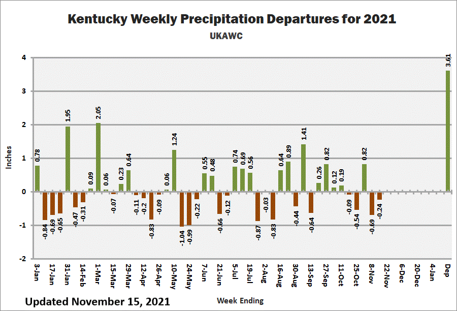
KY Weekly Rainfall Departures


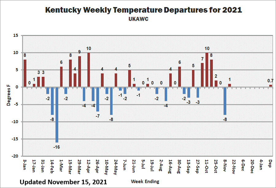
KY Weekly Temperature Departures
Ag Weather Center, Department of Biosystems & Agricultural Engineering, University of Kentucky