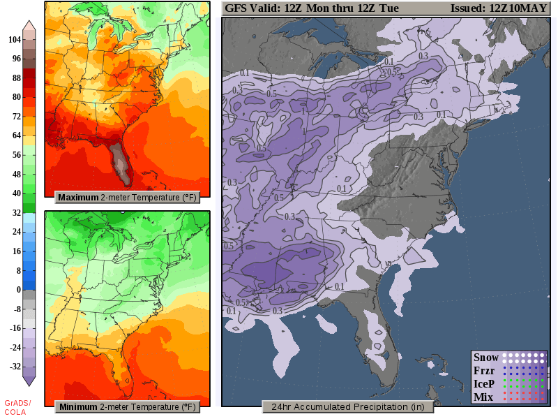
UKAWC WeatherWATCH (For Fast Connections):

Monday, June, 5, 2023, 15:23:10
Automatically Refreshes Every 10 minutes..Remember to clear your cache daily! NOTE: Click to enlarge/zoom...In most cases...Left click will zoom to a regional view...Right click will enlarge image!


Kentucky Agricultural Weather Outlook Updated Thursday Evening, December 9, 2021

Severe weather on the table

It has been a rather active weather pattern to start December. Through the 8th, the state has averaged 1.39 inches. Attention now turns to another round of showers and storms tomorrow and Saturday. Altogether, another half to 1.5 inches will be on the table. Coverage will start tomorrow scattered in nature. Highs will jump into the 60s across much of the area behind breezy southerly winds. Shower/storm coverage and intensity then increases tomorrow night and into Saturday morning. A line of storms is expected with damaging winds as the main threat, but tornadoes also very much possible. Heavy rain also presents a flooding threat, especially for low lying areas. Now is the time to get animals out of those spots. Bottom line, this will present an overnight threat, so please have a way to get warning (highly suggest a NOAA Weather Radio).

After a brief cool down for the latter half of the weekend, temperatures go on the uphill climb next week. Outlooks hint the warm air will hang around the area through the third full week of December. Any additional rain chances look to hold off until late workweek.
Based on observations at 300pm EDT, Monday June 05, 2023

Across Kentucky...temperatures are near 89 degrees west, near 84 degrees central, and near 80 degrees east. Current sky conditions are sunny west, partly sunny central, and mostly sunny east. In the west, relative humidity is near 32%, and the dew point is near 56 degrees. In the central part of the state, relative humidity is near 33%, and the dew point is near 52 degrees. In the east, relative humidity is near 36%, and the dew point is near 51 degrees. Current drying conditions are good west, good central, and good east. The livestock heat stress category is no stress west, no stress central, and no stress east. Winds are from the northeast at 7 mph west, where conditions are favorable for spraying. Winds are from the north at 5 mph central, where conditions are favorable for spraying. Winds are calm east, where conditions are favorable for spraying. Based on current available observations, the highest temperature is 89 degrees at Paducah. The lowest temperature is 79 degrees at Covington.

WESTERN KY AREA (including Paducah)

            Mon Jun  5 15:01:04 EDT 2023

McCracken-
Including the city of Paducah
158 PM CDT Mon Jun 5 2023

.THIS AFTERNOON...Sunny, hazy. Highs around 90. Northeast winds
5 to 10 mph. 
.TONIGHT...Partly cloudy. Hazy. Lows around 60. North winds
around 5 mph. 
.TUESDAY...Mostly sunny. Hazy. Highs in the upper 80s. North
winds around 5 mph. 
.TUESDAY NIGHT...Mostly clear. Lows in the lower 60s. Northeast
winds around 5 mph, becoming west after midnight. 
.WEDNESDAY...Mostly sunny. A chance of showers and thunderstorms
in the afternoon. Highs in the upper 80s. West winds 5 to 10 mph,
becoming north in the afternoon. Chance of rain 30 percent. 
.WEDNESDAY NIGHT...Partly cloudy. A slight chance of showers and
thunderstorms in the evening. Lows in the upper 50s. Chance of
rain 20 percent. 
.THURSDAY...Sunny. Highs in the mid 80s. 
.THURSDAY NIGHT...Mostly clear. Lows in the upper 50s. 
.FRIDAY...Sunny. Highs in the mid 80s. 
.FRIDAY NIGHT...Clear. Lows in the upper 50s. 
.SATURDAY...Sunny. Highs around 90. 
.SATURDAY NIGHT...Partly cloudy. A slight chance of showers in
the evening, then a chance of showers after midnight. Lows in the
mid 60s. Chance of rain 30 percent. 
.SUNDAY...Partly sunny. A chance of showers with a slight chance
of thunderstorms in the morning, then showers likely with a
chance of thunderstorms in the afternoon. Highs in the upper 80s.
Chance of rain 60 percent. 


CENTRAL KY AREA (including Lexington)
Mon Jun 5 14:36:38 EDT 2023 Fayette- Including the city of Lexington 236 PM EDT Mon Jun 5 2023 .TONIGHT...Partly cloudy. Hazy. Lows in the mid 50s. Northeast winds 5 to 10 mph. .TUESDAY...Mostly sunny. Hazy. Highs in the lower 80s. Northeast winds around 5 mph, becoming northwest around 5 mph in the afternoon. .TUESDAY NIGHT...Partly cloudy in the evening, then becoming mostly cloudy. Hazy in the evening. Lows in the upper 50s. Northwest winds around 5 mph. .WEDNESDAY...Mostly cloudy in the morning, then becoming partly sunny. A slight chance of thunderstorms. A chance of showers. Highs in the mid 70s. North winds around 5 mph. Chance of rain 50 percent. .WEDNESDAY NIGHT...Mostly clear. A chance of showers with a slight chance of thunderstorms in the evening. Lows around 50. North winds around 5 mph. Chance of rain 40 percent. .THURSDAY...Sunny. Highs in the upper 70s. .THURSDAY NIGHT...Mostly clear. Lows in the lower 50s. .FRIDAY...Sunny. Highs around 80. .FRIDAY NIGHT...Mostly clear. Lows in the mid 50s. .SATURDAY...Sunny. Highs in the mid 80s. .SATURDAY NIGHT...Mostly clear in the evening, then partly cloudy with a slight chance of showers after midnight. Lows around 60. Chance of rain 20 percent. .SUNDAY...Partly sunny with a chance of showers. A chance of thunderstorms in the afternoon. Highs in the lower 80s. Chance of rain 50 percent. .SUNDAY NIGHT...Mostly cloudy. A chance of showers and thunderstorms in the evening, then a chance of showers with a slight chance of thunderstorms after midnight. Lows in the upper 50s. Chance of rain 50 percent. .MONDAY...Mostly sunny. A slight chance of showers in the morning, then a chance of showers with a slight chance of thunderstorms in the afternoon. Highs in the upper 70s. Chance of rain 30 percent.

EASTERN KY AREA (including Jackson)
Mon Jun 5 14:05:48 EDT 2023 Jackson- Including the cities of McKee and Annville 205 PM EDT Mon Jun 5 2023 .REST OF TODAY...Mostly sunny. Highs in the mid 80s. North winds 5 to 10 mph. .TONIGHT...Partly cloudy in the evening, then becoming mostly clear. Hazy overnight. Lows in the lower 50s in the valleys and in the upper 50s on the ridges. Northeast winds around 5 mph. .TUESDAY...Sunny. Highs in the mid 80s. Northeast winds around 5 mph, becoming north around 5 mph in the afternoon. .TUESDAY NIGHT...Partly cloudy. Lows around 60. Northwest winds around 5 mph. .WEDNESDAY...Mostly cloudy with a chance of showers. A slight chance of thunderstorms in the morning, then a chance of thunderstorms in the afternoon. Not as warm with highs in the mid 70s. North winds around 5 mph. Chance of rain 40 percent. .WEDNESDAY NIGHT...Partly cloudy. A chance of showers and thunderstorms in the evening. Lows in the lower 50s. Chance of rain 30 percent. .THURSDAY...Sunny. Highs in the mid 70s. .THURSDAY NIGHT...Clear. Lows around 50. .FRIDAY...Sunny. Highs in the upper 70s. .FRIDAY NIGHT...Clear. Lows in the lower 50s. .SATURDAY...Sunny. Highs in the lower 80s. .SATURDAY NIGHT...Mostly clear. Lows in the upper 50s. .SUNDAY...Mostly sunny with a chance of showers. A chance of thunderstorms in the afternoon. Highs in the mid 80s. Chance of rain 40 percent.