 |
2012 Fall Ag. Update |
Go To MRCC To Check Out The Spring Ag. Update...click HERE!
The purpose of the web site is to summarize the latest information and
comments from Kentucky agriculture specialists concerning the impact frost and
freezing temperatures would have on Kentucky agriculture as Fall progresses.
Updates will occur on Monday and Friday thru the Fall Frost/Freeze season starting October 1st.
(10-15-13) Without a crop report, we are currently going primarily through county and faculty extension to get more in-depth information. Today, Dr. John Strang mentioned there is still plenty of horticulture that would be susceptible to a frost or freeze. These included peppers, tomatoes, winter squash, and green beans. Dr. Strang also mentioned apples are not quite a concern at this point and sweet potatoes may need to be monitored a bit more closely when a hard freeze comes into question. He also mentioned bringing in sensative house plants. We'll be continuing to talk to others throughout the early portions of this work week and issue updates.
Call me if you have questions. (859-257-3000 x 245 or 244 (Matt's number))/KT Priddy
Summary of Specialist's comments here:
![]()
![]()

Note to Specialists: if possible please email me your comments on Sunday(s)...and many thanks!
Small Grains (including wheat and barley):
Dr Herbek: (859)-257-9503 x 205
(2011) - Dr. Herbek -
Large Grains (corn):
- Dr. Chad Lee: (859)-338-5500
Horticulture:
Gardening:
State FSA Office:
Mr. Bob Finch: (859)-224-7696
(2011) -
Ag. Weather Trend: Tom Priddy (859)-257-3000 exts 244 & 245
Kentucky Climate Summary for the past 7 days
For the past 7 days...
Precipitation (liq. equ.) for the period totaled 0.48 inches statewide which was 0.72 inches below normal
and 40% of normal. Precipitation totals by climate division, West 0.68 inches, Central 0.62 inches,
Bluegrass 0.29 inches and East 0.31 inches, which was 0.64, 0.63, 0.84 and 0.79 inches below normal.
By station, precipitation totals ranged from a low of 0.03 inches at HOPKINSVILLE 6N to a high of 2.57
inches at EVANSVILLE ASOS.

Kentucky Climate Summary
For the Period 04-18-2024 to 04-24-2024
Temperatures for the period averaged 56 degrees across the state which was 2 degrees cooler than normal
and 10 degrees cooler than the previous period. High temperatures averaged from 68 in the West to 68
in the East. Departure from normal high temperatures ranged from 3 degrees cooler than normal in the West
to 3 degrees cooler than normal in the East. Low temperatures averaged from 46 degrees in the West
to 46 degrees in the East. Departure from normal low temperature ranged from 2 degrees cooler than normal
in the West to 2 degrees warmer than normal in the East. The extreme high temperature for the period
was 87 degrees at KOOMER RIDGE and the extreme low was 28 degrees at BRANDENBURG 4SW.
This week in Kentucky's growing season

Paducah NWS: 270-744-6440, Louisville NWS: 502-969-8842, Jackson NWS: 606-666-2560
Charleston NWS: 304-746-0180, Wilmington NWS: 937-383-0031
| Climate Tables | ||||||||||||
| Climate Narratives | ||||||||||||
| Rainfall Total Maps | ||||||||||||
| Rainfall Departure Maps | ||||||||||||
| Average Temperature Maps | ||||||||||||
| Average Temperature Departure Maps | ||||||||||||
| Max Temperature Maps | ||||||||||||
| Max Temperature Departure Maps | ||||||||||||
| Min Temperature Maps | ||||||||||||
| Min Temperature Departure Maps | ||||||||||||
| High Max Temperature Maps | ||||||||||||
| Low Min Temperature Maps | All Maps |
Past 14 days data here, 28 Days here.
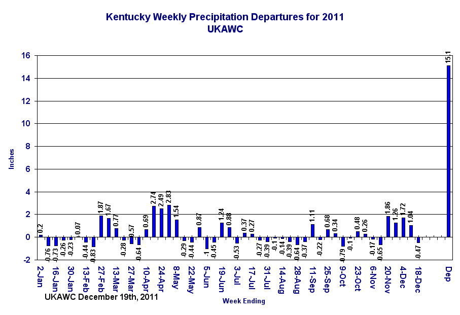 KY Weekly Rainfall Departures |
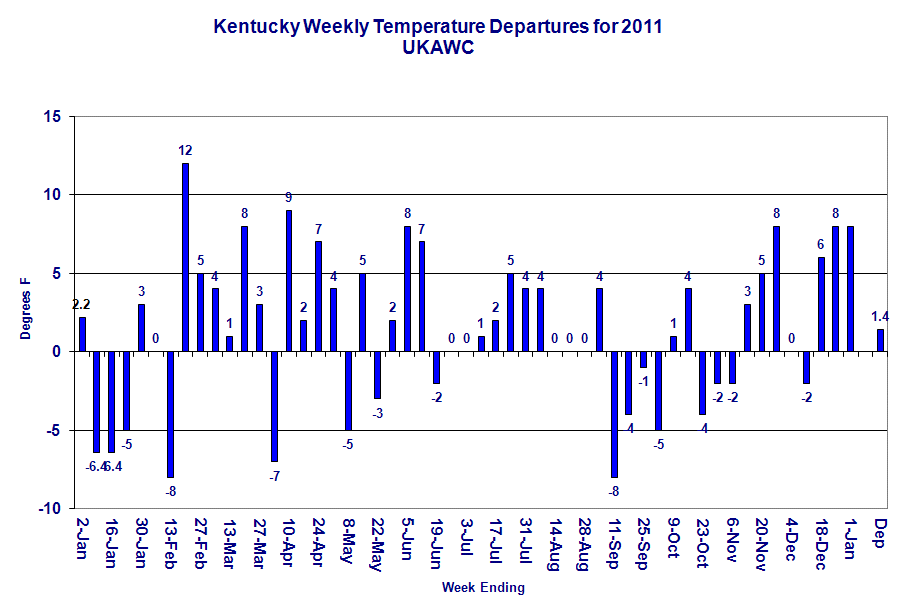 KY Weekly Temperature Departures |
From the Kentucky Crop Calendar:
October Crop Calendar....Click here.
 West: |
 Central: |
 East: |
Updated Thursday Evening, December 9, 2021It has been a rather active weather pattern to start December. Through the 8th, the state has averaged 1.39 inches. Attention now turns to another round of showers and storms tomorrow and Saturday. Altogether, another half to 1.5 inches will be on the table. Coverage will start tomorrow scattered in nature. Highs will jump into the 60s across much of the area behind breezy southerly winds. Shower/storm coverage and intensity then increases tomorrow night and into Saturday morning. A line of storms is expected with damaging winds as the main threat, but tornadoes also very much possible. Heavy rain also presents a flooding threat, especially for low lying areas. Now is the time to get animals out of those spots. Bottom line, this will present an overnight threat, so please have a way to get warning (highly suggest a NOAA Weather Radio).Severe weather on the table
After a brief cool down for the latter half of the weekend, temperatures go on the uphill
climb next week. Outlooks hint the warm air will hang around the area through the third
full week of December. Any additional rain chances look to hold off until late workweek.
Short Term Forecast for the Commonwealth:
Western KY
.OVERNIGHT...Cloudy with a 50 percent chance of showers. Near
steady temperature in the mid 50s. East winds 5 to 10 mph.

Central KY
.TODAY...Partly sunny. Isolated rain showers late in the
afternoon. Highs in the lower 70s. East winds 5 to 10 mph
shifting to the south 10 to 15 mph in the afternoon. Chance of
showers 20 percent.

Eastern KY
.TODAY...Areas of valley fog early. Partly sunny this
morning, then partly cloudy with isolated showers this afternoon.
Highs in the mid 70s. Southeast winds 5 to 10 mph, becoming south
this afternoon. Chance of rain 20 percent.
And here's Kentucky's medium and long range outlook! Click here.
7-Day Weather Forecast:
WEST:
Fri Apr 26 03:31:16 EDT 2024
McCracken-
Including the city of Paducah
229 AM CDT Fri Apr 26 2024
.OVERNIGHT...Cloudy with a 50 percent chance of showers. Near
steady temperature in the mid 50s. East winds 5 to 10 mph.
.FRIDAY...Mostly cloudy. A chance of showers in the morning.
Highs around 80. Southeast winds 10 to 15 mph. Chance of rain
40 percent.
.FRIDAY NIGHT...Mostly cloudy with a chance of showers. Lows in
the mid 60s. South winds around 15 mph with gusts up to 25 mph.
Chance of rain 50 percent.
.SATURDAY...Mostly sunny. Highs in the lower 80s. South winds
15 to 20 mph with gusts up to 30 mph.
.SATURDAY NIGHT...Partly cloudy. Lows in the upper 60s. South
winds around 15 mph with gusts up to 25 mph.
.SUNDAY...Mostly sunny. Highs in the mid 80s.
.SUNDAY NIGHT...Partly cloudy in the evening, then mostly cloudy
with a chance of showers and thunderstorms after midnight. Lows
in the mid 60s. Chance of rain 50 percent.
.MONDAY...A chance of thunderstorms. Showers. Highs in the mid
70s. Chance of rain 90 percent.
.MONDAY NIGHT...A chance of thunderstorms. Showers likely, mainly
in the evening. Lows in the lower 60s. Chance of rain 70 percent.
.TUESDAY...Mostly sunny. A chance of showers and thunderstorms in
the afternoon. Highs in the lower 80s. Chance of rain 40 percent.
.TUESDAY NIGHT...Mostly clear in the evening, then becoming
partly cloudy. Lows in the lower 60s.
.WEDNESDAY THROUGH THURSDAY...Partly cloudy with a chance of
showers and thunderstorms. Highs in the lower 80s. Lows in the
lower 60s. Chance of rain 40 percent.
CENTRAL:
Fri Apr 26 04:04:40 EDT 2024
Fayette-
Including the city of Lexington
403 AM EDT Fri Apr 26 2024
.TODAY...Partly sunny. Isolated rain showers late in the
afternoon. Highs in the lower 70s. East winds 5 to 10 mph
shifting to the south 10 to 15 mph in the afternoon. Chance of
showers 20 percent.
.TONIGHT...Warmer. Mostly cloudy. Isolated showers in the
evening. Lows around 60. South winds 10 to 15 mph. Gusts up to
30 mph after midnight. Chance of showers 20 percent.
.SATURDAY...Mostly cloudy. Highs in the upper 70s. South winds
15 to 20 mph.
.SATURDAY NIGHT...Mostly clear. Lows in the lower 60s. South
winds 10 to 15 mph.
.SUNDAY...Sunny. Highs in the lower 80s. South winds 10 to
15 mph.
.SUNDAY NIGHT...Mostly clear. Lows in the lower 60s.
.MONDAY...Mostly sunny. A 20 percent chance of thunderstorms in
the afternoon. Highs in the lower 80s.
.MONDAY NIGHT...Mostly cloudy. Chance of thunderstorms in the
evening, then showers likely and chance of thunderstorms after
midnight. Lows in the lower 60s. Chance of precipitation
70 percent.
.TUESDAY...Showers likely and chance of thunderstorms. Highs in
the upper 70s. Chance of precipitation 70 percent.
.TUESDAY NIGHT...Mostly clear. Chance of thunderstorms in the
evening, then slight chance of thunderstorms after midnight. Lows
in the upper 50s. Chance of thunderstorms 40 percent.
.WEDNESDAY...Mostly sunny. Chance of showers and slight chance of
thunderstorms in the morning, then chance of thunderstorms in the
afternoon. Highs in the lower 80s. Chance of precipitation
30 percent.
.WEDNESDAY NIGHT...Partly cloudy. Chance of thunderstorms in the
evening, then slight chance of thunderstorms after midnight. Lows
in the upper 50s. Chance of thunderstorms 30 percent.
.THURSDAY...Mostly sunny. Chance of showers and slight chance of
thunderstorms in the morning, then chance of thunderstorms in the
afternoon. Highs in the upper 70s. Chance of precipitation
40 percent.
EAST:
Fri Apr 26 03:53:11 EDT 2024
Jackson-
Including the cities of McKee and Annville
352 AM EDT Fri Apr 26 2024
.TODAY...Partly sunny this morning, then partly cloudy with
isolated showers this afternoon. Highs in the mid 70s. East winds
5 to 10 mph, becoming south with gusts up to 20 mph this
afternoon. Chance of rain 20 percent.
.TONIGHT...Mostly cloudy. Isolated showers in the evening. Not as
cool with lows around 60. South winds around 10 mph with gusts up
to 20 mph. Chance of rain 20 percent.
.SATURDAY...Mostly cloudy. Highs around 80. South winds 10 to
15 mph with gusts up to 25 mph.
.SATURDAY NIGHT...Partly cloudy in the evening, then clearing.
Lows in the upper 50s. South winds 10 to 15 mph.
.SUNDAY...Sunny. Highs in the lower 80s. South winds 5 to 10 mph.
.SUNDAY NIGHT...Clear. Lows around 60.
.MONDAY...Partly sunny. Highs in the mid 80s.
.MONDAY NIGHT...Partly cloudy in the evening, then mostly cloudy
with a chance of showers and thunderstorms overnight. Lows in the
lower 60s. Chance of rain 50 percent.
.TUESDAY...Mostly cloudy in the morning, then becoming partly
cloudy. A chance of thunderstorms. Showers likely, mainly in the
morning. Highs in the upper 70s. Chance of rain 60 percent.
.TUESDAY NIGHT...Partly cloudy with a slight chance of showers
and thunderstorms. Lows in the upper 50s. Chance of rain
20 percent.
.WEDNESDAY...Partly sunny. A slight chance of showers and
thunderstorms in the morning, then a chance of showers and
thunderstorms in the afternoon. Highs in the lower 80s. Chance of
rain 30 percent.
.WEDNESDAY NIGHT...Partly cloudy. A chance of showers and
thunderstorms in the evening, then a slight chance of showers and
thunderstorms overnight. Lows in the upper 50s. Chance of rain
30 percent.
.THURSDAY...Partly sunny. A slight chance of showers and
thunderstorms in the morning, then a chance of showers and
thunderstorms in the afternoon. Highs in the lower 80s. Chance of
rain 40 percent.
7-Day Hazardous Weather Outlook:
Click for West, Central or East for the 7-day forecast.
Click here if you want to view the Watches/Warnings/Statements..Alt.
By county.
Click here if you want to view the above forecast!
WEST:
Fri Apr 26 05:11:24 EDT 2024
Jefferson-Wayne IL-Edwards-Wabash-Perry IL-Franklin-Hamilton-
White-Jackson-Williamson-Saline-Gallatin-Union-Johnson-Pope-
Hardin-Alexander-Pulaski-Massac-Gibson-Pike-Posey-Vanderburgh-
Warrick-Spencer-Fulton-Hickman-Carlisle-Ballard-McCracken-Graves-
Livingston-Marshall-Calloway-Crittenden-Lyon-Trigg-Caldwell-
Union KY-Webster-Hopkins-Christian-Henderson-Daviess-McLean-
Muhlenberg-Todd-Perry MO-Bollinger-Cape Girardeau-Wayne MO-Carter-
Ripley-Butler-Stoddard-Scott-Mississippi-New Madrid-
411 AM CDT Fri Apr 26 2024 /511 AM EDT Fri Apr 26 2024/
This Hazardous Weather Outlook is for portions of southern
Illinois, southwest Indiana, western Kentucky, and southeast
Missouri.
.DAY ONE...Today and Tonight
Scattered thunderstorms will be possible mainly over southeast
Missouri and southern Illinois late this afternoon and tonight. A
few severe storms with a damaging wind and hail threat will be
possible mainly over southeast Missouri and southern Illinois.
.DAYS TWO THROUGH SEVEN...Saturday through Thursday
More widespread thunderstorms will push eastward across the region
beginning late Sunday and continuing through Monday. Some of the
initial storms Sunday afternoon and evening could be severe over
southeast Missouri and southern Illinois. Heavy rainfall and
flooding will also be more of a concern Sunday night and Monday.
South winds will gust 30 to 40 mph at times on Sunday.
.SPOTTER INFORMATION STATEMENT...
Spotter activation cannot be ruled out over southeast Missouri and
southern Illinois late this afternoon into tonight, and again
late Sunday afternoon through Sunday night.
CENTRAL:
Fri Apr 26 04:07:04 EDT 2024
Orange-Washington IN-Scott IN-Jefferson IN-Dubois-Crawford-Perry-
Harrison IN-Floyd-Clark IN-Hancock-Breckinridge-Meade-Ohio-Grayson-
Hardin-Bullitt-Jefferson-Oldham-Trimble-Henry-Shelby-Franklin-
Scott KY-Harrison KY-Spencer-Anderson-Woodford-Fayette-Bourbon-
Nicholas-Nelson-Washington KY-Mercer-Jessamine-Clark KY-Larue-Marion-
Boyle-Garrard-Madison-Butler-Edmonson-Hart-Green-Taylor-Casey-
Lincoln-Logan-Warren-Simpson-Allen-Barren-Monroe-Metcalfe-Adair-
Russell-Cumberland-Clinton-
406 AM EDT Fri Apr 26 2024 /306 AM CDT Fri Apr 26 2024/
This Hazardous Weather Outlook is for Indiana, south central
Indiana, east central Kentucky, north central Kentucky, northwest
Kentucky and south central Kentucky.
.DAY ONE...Today and tonight.
No hazardous weather is expected at this time.
.DAYS TWO THROUGH SEVEN...Saturday through Thursday.
No hazardous weather is expected at this time.
.SPOTTER INFORMATION STATEMENT...
Spotter activation is not expected at this time.
&&
More information, along with other weather, hydrological and
climate information can be found, at weather.gov/louisville.
EAST:
Fri Apr 26 04:10:13 EDT 2024
Fleming-Montgomery-Estill-Rockcastle-Jackson-Pulaski-Laurel-Wayne-
McCreary-Whitley-Knox-Bell-Harlan-Lee-Knott-Owsley-Perry-Clay-Leslie-
Letcher-Pike-
409 AM EDT Fri Apr 26 2024
This Hazardous Weather Outlook is for a portion of eastern Kentucky.
.DAY ONE...Today and tonight.
No hazardous weather is expected at this time.
.DAYS TWO THROUGH SEVEN...Saturday through Thursday.
Thunderstorms are possible at times from Monday afternoon through
Thursday.
.SPOTTER INFORMATION STATEMENT...
Spotter activation is not anticipated.
Kentucky Medium & Long Range Outlook:
KENTUCKY
---------------------------------------------
6 TO 10 DAY 8 TO 14 DAY 30 DAY 90 DAY
MAY 1-MAY 5 MAY 3-MAY 9 JUN JUN-AUG
----------- ----------- -------- ---------
Temperature: Above Above
Precipitation: Normal Normal
.... Medium and long range outlooks provided by NCEP/K. Thomas Priddy
![]()

