| ||||||
UKAWC: NEW weather pages here... A joint service of the UK Ag Weather Center and the National Weather Service. Current Agriculture, Lawn & Garden Weather Conditions in Kentucky Based on observations at 500am EDT, Thursday April 03, 2025 Across Kentucky...temperatures are near N/A degrees west, near 66 degrees central, and near 64 degrees east. Current sky conditions are not available west, light rain central, and light rain east. In the west, relative humidity is near N/A%, and the dew point is near N/A degrees. In the central part of the state, relative humidity is near 87%, and the dew point is near 62 degrees. In the east, relative humidity is near 83%, and the dew point is near 59 degrees. Current drying conditions are unavailable west, poor central, and poor east. Winds are unavailable west. Winds are from the southwest at 13 mph with gusts at 24 mph central, where conditions are not favorable for spraying due to strong winds and light rain. Winds are from the west at 15 mph with gusts at 40 mph east, where conditions are not favorable for spraying due to strong winds and light rain. Based on current available observations, the highest temperature is 74 degrees at London. The lowest temperature is 63 degrees at Henderson.
Radar: NWS Radar (NEW!), Bowling Green, KY Regional Radar, Hazardous Weather Outlook For County Hazardous report currently not available Current FORECAST not available Medium & Long Range Outlook For County, Kentucky
                             KENTUCKY
                 ---------------------------------------------
                 6 TO 10 DAY  8 TO 14 DAY   30 DAY    90 DAY
                    APR 8-12    APR 10-16    JUN       JUN-AUG
                 -----------  -----------  --------  ---------
   Temperature:      Below        Below
 Precipitation:     Normal        Below

....  Medium and long range outlooks provided by NCEP/K. Thomas Priddy
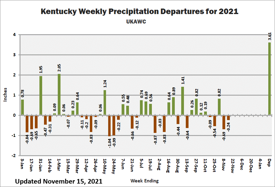
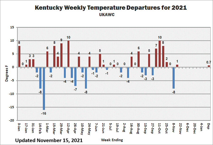
Kentucky Climate Summary Kentucky Climate Summary For the Period 03-26-2025 to 04-01-2025 Temperatures for the period averaged 57 degrees across the state which was 7 degrees warmer than normal and 6 degrees warmer than the previous period. High temperatures averaged from 71 in the West to 68 in the East. Departure from normal high temperatures ranged from 8 degrees warmer than normal in the West to 6 degrees warmer than normal in the East. Low temperatures averaged from 47 degrees in the West to 45 degrees in the East. Departure from normal low temperature ranged from 7 degrees warmer than normal in the West to 9 degrees warmer than normal in the East. The extreme high temperature for the period was 85 degrees at LOUISVILLE APT and the extreme low was 27 degrees at PAINTSVILLE 4W.Precipitation (liq. equ.) for the period totaled 0.97 inches statewide which was 0.06 inches below normal and 94% of normal. Precipitation totals by climate division, West 0.99 inches, Central 0.96 inches, Bluegrass 1.01 inches and East 0.93 inches, which was 0.06, 0.09, 0.03 and 0.05 inches below normal. By station, precipitation totals ranged from a low of 0.12 inches at PIKEVILLE AWOS to a high of 1.77 inches at LA GRANGE 6NW.
|


