Whitley County, Indiana Weather and Climate Synopsis |
[National] [International] [Learning] [EWOCK] [Reg Clim Ctrs] |
(Click image to zoom) or
Click Here
Satellite images from NOAA
Also see NWS Watch/Warning Maps |
A joint service of the UK Ag Weather Center and the National Weather Service.
Synopsis...
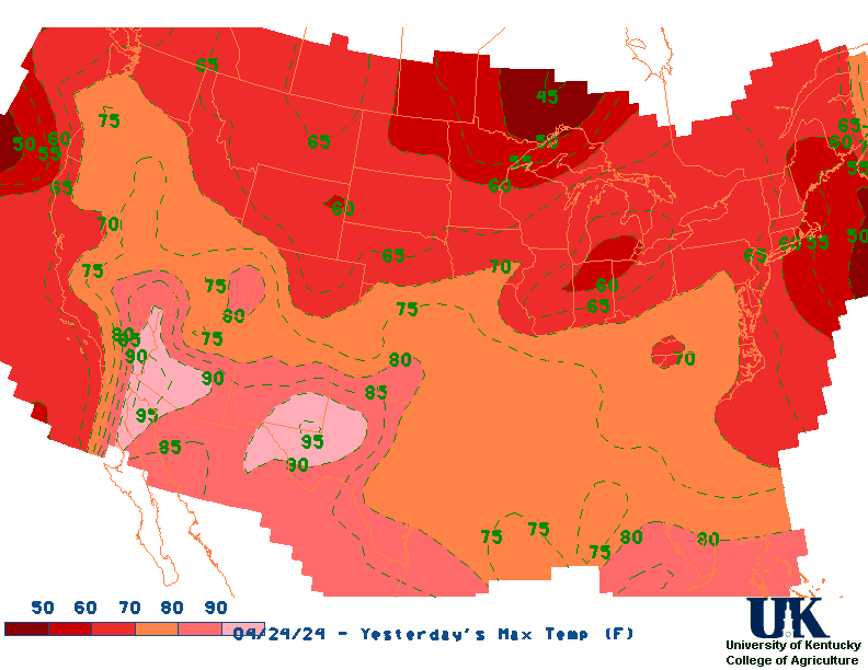
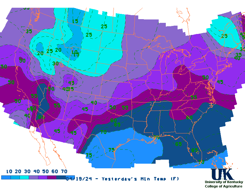
Current Surface Map, [2nd Source TWC], Yesterday's U.S. Highs, Lows
THE HOOSIER STATE SAW A RETURN TO MORE SEASONAL TEMPERATURES WEDNESDAY AFTERNOON AFTER SEVERAL DAYS BELOW NORMAL. READINGS CLIMBED INTO THE LOWER 80S AT MOST LOCATIONS. SKIES WERE MOSTLY SUNNY STATEWIDE TOO. TONIGHT WILL BE MOSTLY CLEAR OVER NORTH AND CENTRAL SECTIONS AND PARTLY CLOUDY IN THE FAR SOUTH. A WEAK RIDGE OF HIGH PRESSURE OVER INDIANA WILL DRIFT SLOWLY EASTWARD. HOWEVER IT SHOULD PROVIDE ONE MORE DAY OF DRY WEATHER OVER CENTRAL AND NORTHERN SECTIONS ON THURSDAY. LOW TEMPERATURES TONIGHT WILL RANGE FROM 60 TO 65 AND HIGH TEMPERATURES ON THURSDAY WILL BE IN THE MIDDLE 80S. AN AREA OF LOW PRESSURE IN THE UPPER ATMOSPHERE OVER THE CENTRAL U.S. WILL DRIFT TOWARDS THE OHIO VALLEY NEXT FEW DAYS. THIS SYSTEM MAY PRODUCE A FEW THUNDERSTORMS LATE THURSDAY OVER SOUTHWEST SECTIONS OF OUR STATE. THEN WE CAN EXPECT A BETTER CHANCE OF THUNDERSTORMS STATE WIDE BY FRIDAY. $$ JEH/CS IMPORTANT NOTICE...THIS WILL BE THE LAST ISSUANCE OF THIS PRODUCT. THIS PRODUCT WILL BE DISCONTINUED AFTER JUNE 30 2004. ALTERNATIVE PRODUCTS TO USE AFTER THAT DATE WITH INFORMATION SIMILAR TO THE STATE WEATHER SUMMARY INCLUDE THE WEATHER ROUNDUP FOR INDIANA /ASUS43 KIND SWRIN/...THE TABULAR STATE FORECAST FOR INDIANA /FPUS63 KIND SFTIN/...AND THE MAXIMUM/MINIMUM TEMPERATURE AND PRECIPITATION TABLE FOR INDIANA /ABUS21 KIND STPIN/. FOR GRAPHICS SHOWING THE LOCATIONS OF WEATHER SYSTEMS AND FRONTS GO TO WWW.WEATHER.GOV AND SELECT THE NATIONAL MAPS TAB. LAST
NORTHERN INDIANA CITY SKY/WX TMP DP RH WIND PRES REMARKS GARY* PTCLDY 48 28 46 NW21G29 30.12R VALPARAISO MOCLDY 48 29 47 W12 30.11R MICHIGAN CITY* PTCLDY 45 32 61 MISG 30.12R LAPORTE* MOCLDY 47 27 44 W9 30.11R KNOX* MOCLDY 46 27 46 W10 30.10S SOUTH BEND MOCLDY 49 30 48 W10 30.09R ELKHART* MOCLDY 48 29 48 W10 30.08S GOSHEN MOCLDY 47 31 53 W12 30.08R MONTICELLO* PTCLDY 46 33 61 W6 30.13S LOGANSPORT* PTCLDY 45 36 70 W8 30.14R ROCHESTER* PTCLDY 48 36 61 W7 30.11S PLYMOUTH* CLEAR 50 28 43 W8G15 30.09S WARSAW* MOCLDY 48 29 48 W10 30.09S AUBURN* MOCLDY 50 32 50 SW6 30.08S FORT WAYNE CLOUDY 50 34 54 W12 30.09S HUNTINGTON* MOCLDY 48 34 59 W8 30.10S PERU/GRISSOM CLOUDY 49 35 60 W12 30.10S
Current Temperatures, Dewpoint, Rh, Wind, Regional Obs., Station Model, Surface 4-Panel
Meteograms : South Bend , Fort Wayne , Lafayette , Indianapolis , Evansville
.REST OF TONIGHT...Mostly clear. Lows in the mid 30s. West winds around 10 mph with gusts up to 20 mph. .SATURDAY...Areas of frost in the morning. Mostly sunny. Highs in the upper 40s. West winds 10 to 15 mph with gusts up to 25 mph. .SATURDAY NIGHT...Mostly clear in the evening, then becoming partly cloudy. Lows in the lower 30s. Northwest winds 10 to 15 mph, becoming west around 5 mph after midnight. .SUNDAY...Areas of frost in the morning. Sunny. Highs in the mid 50s. West winds 10 to 15 mph. .SUNDAY NIGHT...Clear. Areas of frost after midnight. Lows in the mid 30s. Northwest winds 5 to 10 mph with gusts up to 20 mph, becoming west after midnight. .MONDAY...Areas of frost in the morning. Sunny. Highs in the lower 60s. .MONDAY NIGHT...Partly cloudy in the evening, then mostly cloudy with a slight chance of showers after midnight. Lows in the mid 40s. Chance of rain 20 percent. .TUESDAY...Mostly cloudy. A chance of showers in the morning, then showers likely with a slight chance of thunderstorms in the afternoon. Highs in the lower 60s. Chance of rain 60 percent. .TUESDAY NIGHT...Showers likely with a slight chance of thunderstorms. Lows in the lower 40s. Chance of rain 60 percent. .WEDNESDAY...Mostly sunny. A chance of showers in the morning. Highs in the mid 50s. Chance of rain 30 percent. .WEDNESDAY NIGHT...Clear. Widespread frost after midnight. Lows in the lower 30s. .THURSDAY...Widespread frost in the morning. Mostly sunny. Highs in the upper 50s. .THURSDAY NIGHT...Mostly clear in the evening, then partly cloudy with a slight chance of showers after midnight. Lows in the upper 30s. Chance of rain 20 percent. .FRIDAY...Partly cloudy. A slight chance of showers in the morning, then a chance of showers in the afternoon. Highs in the mid 60s. Chance of rain 40 percent.
12-48 Hr ETA Surface, 12-48 Hr ETA 500mb/Sfc, 24 Hr. Comparsion, TWC Forecast, Fire Danger, Day 1 Precip, Day 2
NGM 60 Hr Forecast Meteograms : South Bend , Fort Wayne , Lafayette , Indianapolis , Evansville
6 TO 10 DAY 8 TO 14 DAY 30 DAY 90 DAY 120 DAY 180 DAY NOV05 NOV05-JAN06 DEC05-FEB06 FEB06-APR06 ----------- ----------- -------- --------- --------- --------- Temperature: Below Below Above Normal Normal Normal Precipitation: Below Below Normal Normal Normal Normal .... Medium and long range outlooks provided by NCEP/K. Thomas Priddy6 to 10 Day , 8 to 14 Day , Text, 30-Day Outook, 90-Day Outook, 120-Day Outlook
Saturday April 20, 2024 the 111th Day of Year --------------------------------------------------- SUN Declination 12.040000 Distance 0.999719 AU Rise 06:59 EDT Set 20:29 EDT Transit Meridian 13:43 EDT Civil Twilight Begins 06:32 EDT Ends 20:57 EDT Calculations made for central point in the state. Time in ET -- and will vary due to location and elevation -- PriddyMap of 24 Hr U.S. Rainfall (7AM - 7AM EST), 7 Day Rainfall Animation
APRIL 20TH HISTORIC WEATHER EVENTS ...1901... A spring storm produced unusally heavy snow in northeast Ohio. Warren received 35.5 inches in thirty-six hours, and 28 inches fell at Green Hill. Akron OH established April records of 15.6 inches in 24 hours, and 26.6 inches for the month. Pittsburgh PA established April records of 12.7 inches in 24 hours, and 13.5 inches for the month. (David Ludlum) (The Weather Channel) ...1920... Tornadoes in Mississippi and Alabama killed 219 persons. (David Ludlum) ...2002... An unseasonably warm and moist air mass had settled across eastern Kentucky leading to record breaking temperatures at the Jackson Weather Office and the London Corbin Airport between the 16th and 21st of April. Jackson saw several days in a row with record high temperatures as well as maximum low records. On the 19th the mercury soared to a record high of 89 degrees at Jackson and a record tying 87 degrees at London. The low temperature at Jackson was a balmy 69 degrees good enough for a daily as well as a monthly maximum low temperature record. (NWS Jackson)