Weather and Climate Synopsis
|
|
County, Indiana Weather and Climate Synopsis |

[National] [International] [Learning] [EWOCK] [Reg Clim Ctrs] |
(Click image to zoom) or
Click Here
Satellite images from NOAA
Also see NWS Watch/Warning Maps |
A joint service of the UK Ag Weather Center and the National Weather Service.
Synopsis...

THE HOOSIER STATE SAW A RETURN TO MORE SEASONAL TEMPERATURES
WEDNESDAY AFTERNOON AFTER SEVERAL DAYS BELOW NORMAL. READINGS
CLIMBED INTO THE LOWER 80S AT MOST LOCATIONS. SKIES WERE MOSTLY
SUNNY STATEWIDE TOO.

TONIGHT WILL BE MOSTLY CLEAR OVER NORTH AND CENTRAL SECTIONS AND
PARTLY CLOUDY IN THE FAR SOUTH.  A WEAK RIDGE OF HIGH PRESSURE OVER
INDIANA WILL DRIFT SLOWLY EASTWARD.  HOWEVER IT SHOULD PROVIDE ONE
MORE DAY OF DRY WEATHER OVER CENTRAL AND NORTHERN SECTIONS ON
THURSDAY.

LOW TEMPERATURES TONIGHT WILL RANGE FROM 60 TO 65 AND HIGH
TEMPERATURES ON THURSDAY WILL BE IN THE MIDDLE 80S. AN AREA OF LOW
PRESSURE IN THE UPPER ATMOSPHERE OVER THE CENTRAL U.S. WILL DRIFT
TOWARDS THE OHIO VALLEY NEXT FEW DAYS.  THIS SYSTEM MAY PRODUCE A
FEW THUNDERSTORMS LATE THURSDAY OVER SOUTHWEST SECTIONS OF OUR
STATE.  THEN WE CAN EXPECT A BETTER CHANCE OF THUNDERSTORMS STATE
WIDE BY FRIDAY.

$$

JEH/CS

IMPORTANT NOTICE...THIS WILL BE THE LAST ISSUANCE OF THIS PRODUCT.
THIS PRODUCT WILL BE DISCONTINUED AFTER JUNE 30 2004. ALTERNATIVE
PRODUCTS TO USE AFTER THAT DATE WITH INFORMATION SIMILAR TO THE
STATE WEATHER SUMMARY INCLUDE THE WEATHER ROUNDUP FOR INDIANA
/ASUS43 KIND SWRIN/...THE TABULAR STATE FORECAST FOR INDIANA
/FPUS63 KIND SFTIN/...AND THE MAXIMUM/MINIMUM TEMPERATURE AND
PRECIPITATION TABLE FOR INDIANA /ABUS21 KIND STPIN/.

FOR GRAPHICS SHOWING THE LOCATIONS OF WEATHER SYSTEMS AND FRONTS GO
TO WWW.WEATHER.GOV AND SELECT THE NATIONAL MAPS TAB.

LAST
NORTHERN INDIANA

CITY           SKY/WX    TMP DP  RH WIND       PRES   REMARKS
GARY*          SUNNY     50  34  53 NE12      29.87S
VALPARAISO     SUNNY     68  32  26 E9        29.85F
MICHIGAN CITY* SUNNY     61  32  33 N7        29.86F
LAPORTE*       SUNNY     66  36  32 E10G16    29.85F
KNOX*          SUNNY     68  14  12 SE10      29.85S
SOUTH BEND     SUNNY     66  30  26 SE10G16   29.88S
GOSHEN         SUNNY     64  31  28 SE9       29.88F
MONTICELLO*    SUNNY     70  37  29 CALM      29.83F
LOGANSPORT*    SUNNY     68  37  32 E14       29.85F
ROCHESTER*     SUNNY     66  34  30 CALM      29.86S
PLYMOUTH*      SUNNY     64  32  29 E9        29.86S
WARSAW*        SUNNY     64  33  30 E9        29.87F
AUBURN*        SUNNY     61  32  33 E8        29.90F
FORT WAYNE     MOSUNNY   65  34  31 E12       29.89F
HUNTINGTON*    SUNNY     65  35  32 E8        29.87F
PERU/GRISSOM   SUNNY     69  37  30 E13       29.82F
![]() Current Temperatures, Dewpoint, Rh, Wind, Regional Obs., Station Model, Surface 4-Panel
Current Temperatures, Dewpoint, Rh, Wind, Regional Obs., Station Model, Surface 4-Panel
![]() Meteograms : South Bend , Fort Wayne , Lafayette , Indianapolis , Evansville
Meteograms : South Bend , Fort Wayne , Lafayette , Indianapolis , Evansville
...WIND ADVISORY NOW IN EFFECT FROM 4 PM FRIDAY TO 4 AM CDT
SATURDAY...
...HIGH WIND WATCH REMAINS IN EFFECT FROM SATURDAY MORNING
THROUGH SATURDAY AFTERNOON...
.TONIGHT...Clear in the evening, then becoming partly cloudy.
Lows in the upper 40s. East winds 5 to 10 mph in the evening,
becoming southeast after midnight.
.FRIDAY...Partly cloudy and windy. Highs in the upper 70s.
Unseasonably warm. Southeast winds 10 to 15 mph with gusts up to
30 mph through mid morning, increasing to south 15 to 25 mph with
gusts up to 40 mph in the afternoon.
.FRIDAY NIGHT...Showers. Thunderstorms likely, mainly in the
evening. Windy with lows in the mid 50s. Unseasonably warm. South
winds 20 to 30 mph through the early overnight, diminishing to
15 to 25 mph late. Gusts up to 45 mph. Chance of precipitation
near 100 percent.
.SATURDAY...Partly cloudy with a 20 percent chance of showers.
Windy with highs in the upper 60s. South winds 20 to 30 mph
through mid morning, increasing to southwest 25 to 35 mph in the
late morning and early afternoon, then diminishing to 20 to
30 mph late in the afternoon. Gusts up to 55 mph.
.SATURDAY NIGHT...Mostly cloudy with a 40 percent chance of
showers. Lows in the mid 30s. Southwest winds 10 to 15 mph with
gusts up to 25 mph in the evening, becoming west after midnight.
.SUNDAY...Mostly cloudy. A slight chance of rain and snow showers
in the morning. Highs in the mid 40s. Chance of precipitation
20 percent.
.SUNDAY NIGHT...Partly cloudy. Lows around 30.
.MONDAY...Partly cloudy in the morning, then becoming mostly
sunny. Highs in the upper 50s.
.MONDAY NIGHT...Mostly clear. Lows in the lower 40s.
.TUESDAY...Partly cloudy in the morning, then becoming mostly
cloudy. Breezy with highs around 70.
.TUESDAY NIGHT...Mostly cloudy. Lows in the upper 40s.
.WEDNESDAY...Mostly cloudy with a chance of showers. Highs in the
mid 60s. Chance of precipitation 50 percent.
.WEDNESDAY NIGHT...Rain showers likely. Lows in the lower 30s.
Chance of precipitation 70 percent.
.THURSDAY...Partly cloudy. A chance of rain and snow showers in
the morning. Highs in the upper 40s. Chance of precipitation
40 percent.
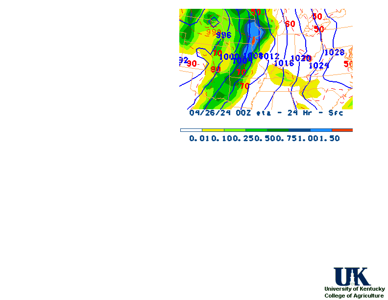
![]() 12-48 Hr ETA Surface, 12-48 Hr ETA 500mb/Sfc, 24 Hr. Comparsion, TWC Forecast, Fire Danger, Day 1 Precip, Day 2
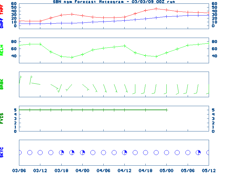
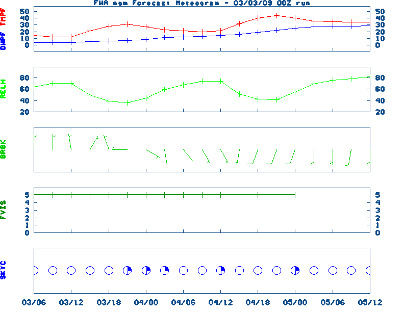
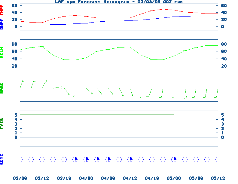
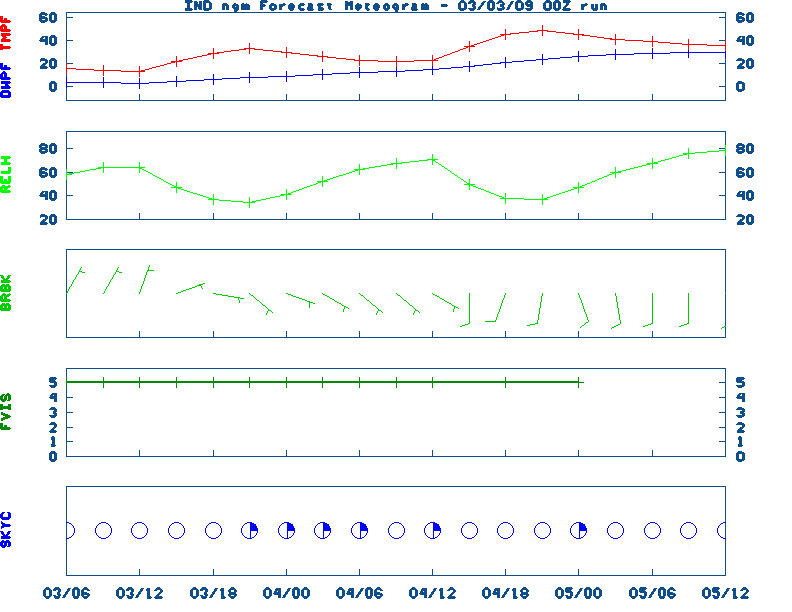
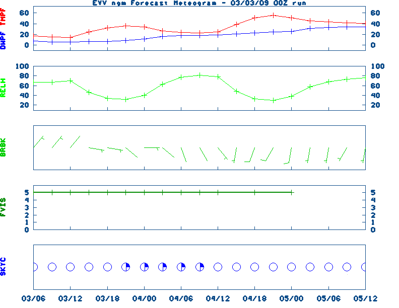
12-48 Hr ETA Surface, 12-48 Hr ETA 500mb/Sfc, 24 Hr. Comparsion, TWC Forecast, Fire Danger, Day 1 Precip, Day 2![]() NGM 60 Hr Forecast Meteograms : South Bend , Fort Wayne , Lafayette , Indianapolis , Evansville
NGM 60 Hr Forecast Meteograms : South Bend , Fort Wayne , Lafayette , Indianapolis , Evansville
                 6 TO 10 DAY  8 TO 14 DAY   30 DAY    90 DAY     120 DAY    180 DAY
                                           NOV05   NOV05-JAN06 DEC05-FEB06 FEB06-APR06
                 -----------  -----------  --------  ---------  ---------  ---------
   Temperature:      Below        Below      Above     Normal     Normal     Normal
 Precipitation:      Below        Below     Normal     Normal     Normal     Normal

....  Medium and long range outlooks provided by NCEP/K. Thomas Priddy
MARCH 13TH HISTORIC WEATHER EVENTS
...1907... A storm produced a record 5.22 inches of rain in 24 hours at
Cincinnati OH. (12th-13th) (The Weather Channel)
...1951...
The state of Iowa experienced a record snowstorm. The storm buried
Iowa City under 27 inches of snow. (David Ludlum)
...1977... Baltimore MD received an inch of rain in eight minutes.
(Sandra and Richard Sanders -1987)
...1987... A winter storm produced heavy snow in the Sierra Nevada Range
of California, and the Lake Tahoe area of Nevada. Mount Rose NV received 18
inches of new snow. (The National Weather Summary) (Storm Data)
...1988...
Unseasonably cold weather prevailed from the Plateau Region to the Appalachians.
Chadron NE, recently buried 33 inches of snow, was the cold spot in the nation
with a low of 19 degrees below zero. (The National Weather Summary)
...1990...
A major outbreak of tornadoes occurred in the Midwest.  59 tornadoes touched down.
A tornado rated F5 on the Fujita Scale tore through Hesston, Kansas, killed one
person and did 20 million dollars in damage.  Another tornado formed close to
the Hesston tornado while it was weakening and absorbed it.  This new tornado
was also an F5 and killed one person in Gossel, Kansas.  A family of tornadoes
up to F4 in intensity  tracked 124 miles through Nebraska.  In York County, 12
farms were hit and 10,000 geese were killed.  This outbreak produced  the
strongest tornadoes on record for so early in the season so far northwest in the
United States.
...1993...
The "Great Super Storm Blizzard of '93" clobbered the eastern U.S. on this day
and produced perhaps the largest swath of heavy snow ever recorded.  Heavy snow
was driven to the Gulf Coast with 3 inches falling at Mobile.  13 inches
blanketed Birmingham, Alabama to set not only a new 24 hour snowfall record for
any month, but also records for maximum snow depth, maximum snow for a single
storm, and maximum snow for a single month.  Tremendous snowfall amounts
occurred in the Appalachians.  Mount Leconte in Tennessee recorded an incredible
60 inches.  Mount Mitchell in North Carolina was not far behind with 50 inches.
Practically every official weather station in West Virginia set a new 24 hour
record snowfall.  Further to the north, Pittsburgh, Pennsylvania measured 25
inches, Albany, New York checked in with 27 inches, and Syracuse, New York was
buried under 43 inches. The major population corridor from Washington, DC to
Boston, Massachusetts was not spared this time as all the big cities got about a
foot of snow before a changeover to rain.  A rather large amount of thunderstorm
activity accompanied the heavy snow.  Winds to hurricane force in gusts were
widespread.  Boston recorded a gust to 81 mph, the highest wind gust at the
location since Hurricane Edna in 1954.  Numerous cities in the South and Mid
Atlantic recorded their lowest barometric pressure ever as the storm bottomed
out at 960 millibars (28.35 inches) over Chesapeake Bay.  208 people were killed
by the storm and total damage was estimated at 6 billion dollars -- the
costliest extratropical storm in history. This storm left behind up to 30
inches of snow across far southeast Kentucky. The winds associated with the
storm helped create 6 to 10 foot snow drifts in parts of Kentucky. At the
Weather Service Office near Jackson, KY over 19 inches of snow fell on this date.
...1999...
A big snowstorm dumped 19 inches of snow on Medford, Oklahoma.
...2001...
One inch diameter hail fell at Bonnieville, KY (Hart County) and Albany (Clinton
County), KY. (NWS Louisville)
|
|
|