Weather and Climate Synopsis
|
|
County, Illinois Weather and Climate Synopsis |

[National] [International] [Learning] [EWOCK] [Reg Clim Ctrs] |
(Click image to zoom) or
Click Here
Satellite images from NOAA
Also see NWS Watch/Warning Maps |
A joint service of the UK Ag Weather Center and the National Weather Service.
Synopsis...

A SURFACE LOW PRESSURE SYSTEM WAS ACROSS THE NORTHERN GREAT LAKES
AND PROVIDED MOSTLY CLOUDY SKIES OVERNIGHT AND INTO MONDAY MORNING.
EARLY MORNING LOW TEMPERATURES RANGED MAINLY FROM 45 TO 50
DEGREES ACROSS THE REGION.

COOLER TEMPERATURES WERE ACROSS ILLINOIS WITH MORNING. TEMPERATURES
WERE SLOWLY CLIMBING INTO THE UPPER 40S ACROSS NORTH CENTRAL
ILLINOIS. WITH SOME PATCHY SUN...TEMPERATURES CLIMBING INTO THE UPPER
50S ACROSS FAR SOUTHEAST ILLINOIS.  SCATTERED LIGHT RAIN HAD
DEVELOPED ACROSS PARTS OF NORTH CENTRAL ILLINOIS.

AS LOW PRESSURE IS ACROSS THE NORTHERN GREAT LAKES TODAY...MOSTLY
CLOUDY SKIES AND SCATTERED LIGHT RAIN CAN BE EXPECTED.
HIGH TEMPERATURES WILL RANGE FROM THE LOWER 50S ACROSS NORTH
CENTRAL ILLINOIS TO THE LOWER 60S ACROSS SOUTHEAST ILLINOIS. AS THE
LOW PRESSURE MOVES NORTHEAST INTO SOUTHERN CANADA...EXPECT A DECREASE
IN CLOUDS THIS EVENING AND OVERNIGHT ACROSS CENTRAL AND SOUTHEAST
ILLINOIS.

$$
NORTHWEST ILLINOIS

CITY           SKY/WX    TMP DP  RH WIND       PRES   REMARKS
MOLINE         SUNNY     64  37  36 N6        29.75S TC  18
STERLING*      SUNNY     62  36  37 N8        29.78S TC  17
![]() Current Temperatures, Dewpoint Map, RH, Wind, Regional Obs, Surface 4-Panel
Current Temperatures, Dewpoint Map, RH, Wind, Regional Obs, Surface 4-Panel
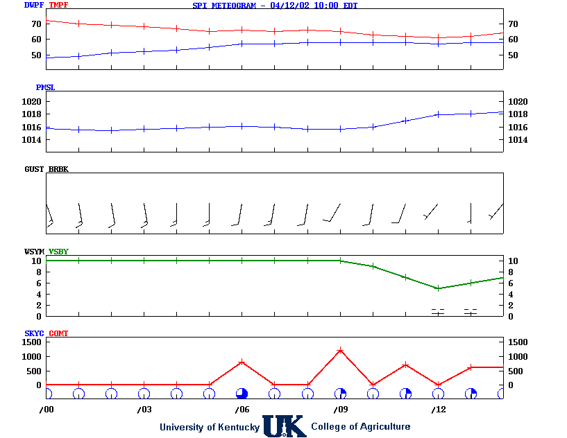
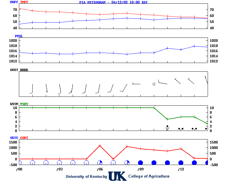
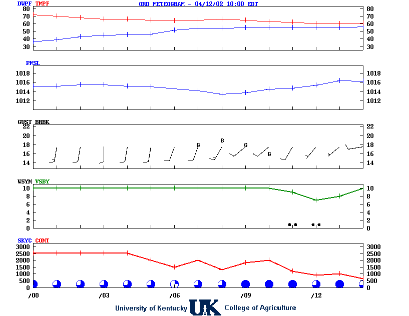
![]() Meteograms : Springfield , Peoria , Quad City , Chicago (O'Hare) , Rockford
Meteograms : Springfield , Peoria , Quad City , Chicago (O'Hare) , Rockford
.TONIGHT...Clear. Lows in the mid 30s. Light and variable winds,
becoming east around 5 mph.
.THURSDAY...Sunny. Highs in the mid 60s. East winds 5 to 10 mph.
.THURSDAY NIGHT...Mostly clear in the evening, then becoming
partly cloudy. Not as cool with lows in the upper 40s. Southeast
winds 5 to 10 mph.
.FRIDAY...Mostly sunny. Highs in the lower 70s. Southeast winds
15 to 20 mph with gusts up to 35 mph.
.FRIDAY NIGHT...Rain with a chance of thunderstorms in the
evening, then rain likely after midnight. Lows in the upper 40s.
Southeast winds 15 to 20 mph with gusts up to 35 mph. Chance of
rain near 100 percent.
.SATURDAY...Partly sunny in the morning, then becoming mostly
cloudy. A 50 percent chance of rain. Breezy and much cooler. Near
steady temperature in the lower 50s.
.SATURDAY NIGHT...Mostly cloudy. A chance of snow after midnight.
Much cooler with lows in the upper 20s. Chance of snow
40 percent.
.SUNDAY...Mostly sunny. Much cooler with highs in the lower 40s.
.SUNDAY NIGHT AND MONDAY...Mostly clear. Lows in the mid 20s.
Highs around 60.
.MONDAY NIGHT...Mostly clear in the evening, then becoming partly
cloudy. Not as cool with lows in the lower 40s.
.TUESDAY...Mostly sunny. Highs in the upper 60s.
.TUESDAY NIGHT...Mostly cloudy. A chance of rain after midnight.
Lows around 40. Chance of rain 30 percent.
.WEDNESDAY...Partly sunny with a 50 percent chance of rain.
Cooler with highs in the mid 50s.
![]() 12-48 Hr Surface, 12-48 Hr ETA 500mb/Sfc, TWC Forecast, Fire Danger, Day 1 Precip, Day 2
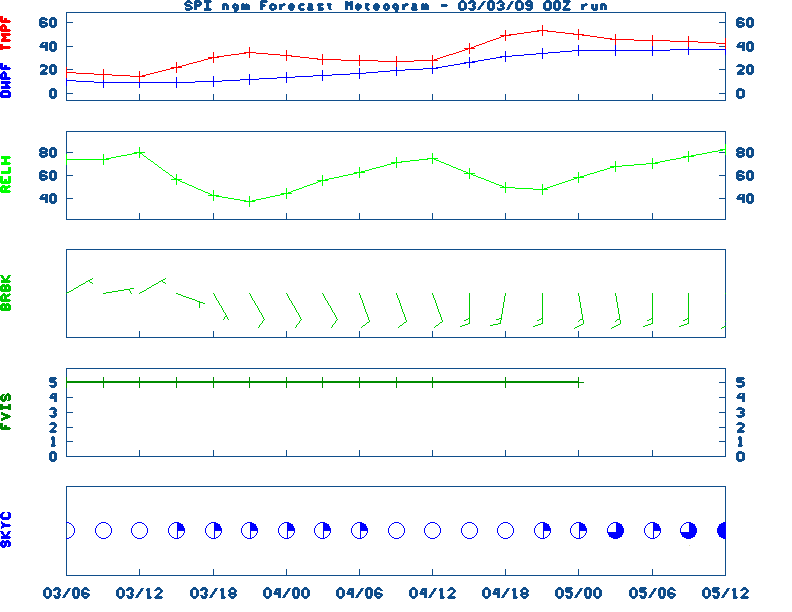
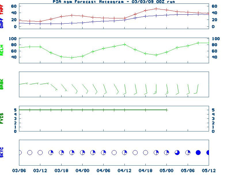
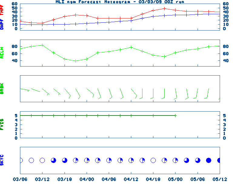
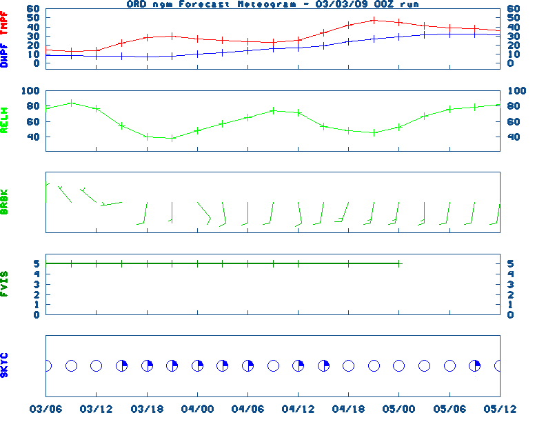
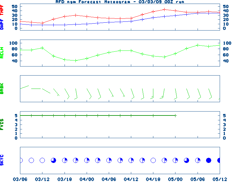
12-48 Hr Surface, 12-48 Hr ETA 500mb/Sfc, TWC Forecast, Fire Danger, Day 1 Precip, Day 2![]() NGM 60 Hr Forecast Meteograms : Springfield , Peoria , Quad City , Chicago (O'Hare) , Rockford ,
NGM 60 Hr Forecast Meteograms : Springfield , Peoria , Quad City , Chicago (O'Hare) , Rockford ,
                 6 TO 10 DAY  8 TO 14 DAY   30 DAY    90 DAY     120 DAY    180 DAY
                                           NOV05   NOV05-JAN06 DEC05-FEB06 FEB06-APR06
                 -----------  -----------  --------  ---------  ---------  ---------
   Temperature:      Below        Below      Above     Normal     Normal     Normal
 Precipitation:      Below        Below     Normal     Normal     Normal     Normal

....  Medium and long range outlooks provided by NCEP/K. Thomas Priddy
MARCH 12TH
HISTORIC WEATHER EVENTS

...1888...
One of the most vicious blizzards ever to strike the U.S. was in progress across
Northeast.  When the storm finally ended on the 13th, Saratoga, New York was
buried under 58 inches of new snow and 50 inches was recorded at Middletown,
Connecticut. Winds to hurricane force whipped drifts over 30 feet deep.  The
combination of snow, wind, and record cold temperatures claimed 400 lives.  New
York City received 20.7 inches of snow and Albany, New York had 46.7 inches.

...1923...
The record low pressure of 28.70 inches for Chicago, Illinois was set during a
winter storm.  Heavy snow, a thick glaze, gales, and much rain caused $800,000
damage.

...1954...
A blizzard raged from eastern Wyoming into the Black Hills of western South
Dakota while a severe ice storm was in progress from northeastern Nebraska to
central Iowa.  The ice storm isolated 153 towns in Iowa.  Dust from the Great
Plains caused brown snow, while hail and muddy rain fell over parts of
Wisconsin and Michigan.

...1967...
A tremendous four day storm was in progress across California. Winds to 90 mph
closed mountain passes, heavy rains flooded the lowlands, and in 60 hours
Squaw Valley was buried under 96 inches of snow.

...1990...
Unseasonably warm temperatures occurred from the Mississippi Valley to the
Atlantic coast.  Over 90 high temperature records for this date were broken or
tied.  Many of the records were topped by 15 degrees or more and some of the
records broken had been set 100 years ago or more.  The high temperature for the
nation was recorded in Baltimore, Maryland where the temperature reach 95
degrees.  Washington, DC and Richmond, Virginia both recorded 89 degrees.

...1993...
What was to become the "Great Blizzard of '93" began to develop as a huge
mesoscale convective complex formed in the western Gulf of Mexico.  As the low
pressure area moved eastward and intensified, howling north winds exceeding
hurricane force intensified behind the storm, were reported by platforms in the
Gulf.  One platform near 28.5N/92.5W recorded sustained winds of 85 mph with
gusts to 99 mph.  As the low crossed the coast around midnight near Panama City,
Florida, the central pressure was already down to 980 millibars (28.94 inches).
During the late evening into the early morning hours of the 13th, a vicious
squall line swept through Florida and spawned 11 tornadoes resulting in 5
fatalities.  Thunderstorm winds gusted to 110 mph at Alligator Point and 109 mph
at Dry Tortugas.  Extremely high tides occurred along the western Florida coast.
A 13 foot storm surge occurred in Taylor County, Florida, resulting in 10 deaths
with 57 residences destroyed.  A 5 to 8 foot storm surge moved ashore in Dixie
County.  Over 500 homes were destroyed with major damage to another 700
structures.
|
|
|