| |||||||
A joint service of the UK Ag Weather Center and the National Weather Service.
Updated Thursday Evening, December 9, 2021
Regional Hourly Observations For WOLFE County, Kentucky Issued at 500 PM EDT WED MAY 08 2024 SOUTHEAST KENTUCKY CITY SKY/WX TMP DP RH WIND PRES REMARKS JACKSON CLOUDY 70 62 76 CALM 29.81F LONDON CLOUDY 67 61 81 S7 29.81F SOMERSET PTSUNNY 68 66 94 SW6 29.79R THUNDER MIDDLESBORO CLOUDY 69 63 81 S5 29.85F MONTICELLO CLOUDY 70 68 93 S7 29.81F
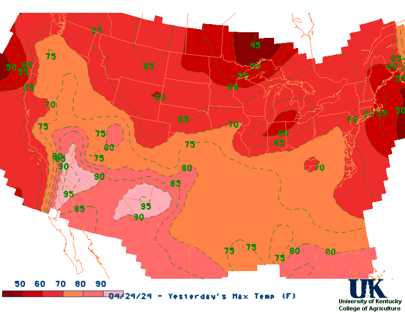
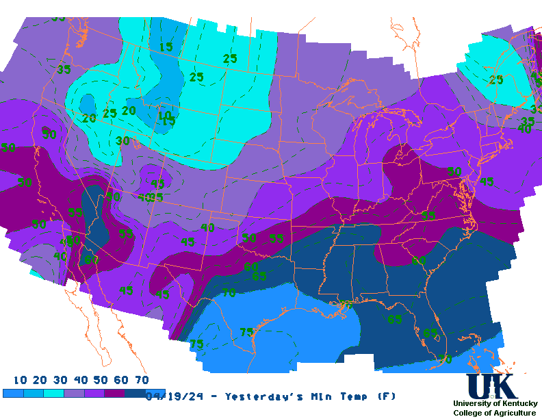
Current Agriculture, Lawn & Garden Weather Conditions in Kentucky Based on observations at 500pm EDT, Wednesday May 08, 2024 Across Kentucky...temperatures are near 82 degrees west, near 78 degrees central, and near 70 degrees east. Current sky conditions are partly sunny west, cloudy central, and cloudy east. In the west, relative humidity is near 71%, and the dew point is near 72 degrees. In the central part of the state, relative humidity is near 66%, and the dew point is near 66 degrees. In the east, relative humidity is near 76%, and the dew point is near 62 degrees. Current drying conditions are fair west, fair central, and fair east. The livestock heat stress category is no stress west, no stress central, and no stress east. Winds are from the south at 8 mph west, where conditions are favorable for spraying. Winds are from the southwest at 7 mph central, where conditions are favorable for spraying. Winds are calm east, where conditions are favorable for spraying. Based on current available observations, the highest temperature is 82 degrees at Paducah. The lowest temperature is 67 degrees at London and Henderson.
Current NOWCAST not available: Nowcasts are not issued routinely during fair weather. Only when precipitation or other significant weather is occuring in this county will these forecasts be issued. Currently, there is no short term forecast in effect. UKAWC Radar, NWS Radar (NEW!), SPC Radar, Regional Radar, NEXRAD, LSI Heat Index Hazardous Weather Outlook For WOLFE County, Kentucky Issued at: Wed May 8 15:59:08 EDT 2024
This Hazardous Weather Outlook is for a portion of eastern Kentucky.

.DAY ONE...Tonight.

Thunderstorms will affect the area at times today and tonight. Some
of these storms could be severe, mainly from this afternoon through
tonight. The greatest threats are large hail and damaging winds, but
there is also a risk of tornadoes. See our website for more
information.

Locally heavy rainfall from these storms could also lead to
instances of flooding. A Flood Watch is in effect through Thursday
morning.

.DAYS TWO THROUGH SEVEN...Thursday through Tuesday.

Thunderstorms are possible on Thursday. Locally heavy rainfall from
these storms could also lead to isolated instances of flooding into
early on Thursday.

There is a small chance of thunderstorms on Saturday and again on
Tuesday, primarily during the afternoon and early evening.

.SPOTTER INFORMATION STATEMENT...

Spotters are encouraged to report any instances of damaging winds,
large hail, heavy rain, or flooding that may occur through Thursday
morning.
RDF forecast not available WOLFE County, Kentucky Agriculture, Lawn & Garden Weather Advisory TODAY (6AM-5PM) Max Temperature...........................0 degrees.Precipitation (liq. eq. )...................0.00 inches (No rainfall). Precipitation area .........................0% of the county expected. Dewpoints.......................................near 30 Degrees. Min RH (Relative Humidity).........37%. Wind Speed..........near 10 mph Winds@4 .................................. at mph Spraying Conditions....................favorable Skies will be . RH < 50%........................................ for 7 hours RH > 80%.........................................for 0 hour No. of Hours Temp <=32 .............0 No. of Hours Temp <= 20 .............0 No. of Hours Temp <= 0 ...............0 The high today (6am-5pm) in Wolfe county, is expected to be near 0 degrees. No rainfall is expected. Temperature will be near 56 degrees. Dewpoints will be near 30 degrees. These dewpoints will combine with today (6am-5pm)'s temperatures resulting in relative humidity minimum of 37 minimum of 37%. Skies will be . Wind speed will be near 10 mph during the period. Winds at 4 will be out of the at mph, which is favorable spraying conditions in rain-free areas. Relative humidity will be less than 50% for 7 hours and greater than 80% for 0 hour TONIGHT (6PM-5AM) Min Temperature...........................0 degrees.Precipitation (liq. eq. )...................0.00 inches (No rainfall). Precipitation area .........................0% of the county expected. Dewpoints.......................................near 30 Degrees. Max RH (Relative Humidity)........37%. Wind Speed..........near 10 mph Winds@4 .................................. at mph Spraying Conditions....................favorable Sky Conditions Sky Conditions RH < 50%........................................ for 0 hour RH > 80%.........................................for 2 hours No. of Hours Temp <=32 .............0 No. of Hours Temp <= 20 .............0 No. of Hours Temp <= 0 ...............0 The low tonight (6pm-5am) in Wolfe county, is expected to be around 0 degrees. No rainfall is expected. Temperature will be near 56 degrees. Dewpoints will be near 30 degrees. These dewpoints will combine with tonight (6pm-5am)'s temperatures resulting in relative humidity maximum of 37 maximum of 37%. Skies will be . Wind speed will be near 10 mph during the period. Winds at 4 will be out of the at mph, which is favorable spraying conditions in rain-free areas. Relative humidity will be less than 50% for 0 hour and greater than 80% for 2 hours TOMORROW (6AM-5PM) Max Temperature...........................0 degrees.Precipitation (liq. eq. )...................0.00 inches (No rainfall). Precipitation area .........................0% of the county expected. Dewpoints.......................................near 30 Degrees. Min RH (Relative Humidity).........37%. Wind Speed..........near 10 mph Winds@4 .................................. at mph Spraying Conditions....................favorable Sky Conditions RH < 50%........................................ for 5 hours RH > 80%.........................................for 0 hour No. of Hours Temp <=32 .............0 No. of Hours Temp <= 20 .............0 No. of Hours Temp <= 0 ...............0 The high tomorrow (6am-5pm) in Wolfe county, is expected to be near 0 degrees. No rainfall is expected. Temperature will be near 56 degrees. Dewpoints will be near 30 degrees. These dewpoints will combine with tomorrow (6am-5pm)'s temperatures resulting in relative humidity minimum of 37 minimum of 37%. Skies will be . Wind speed will be near 10 mph during the period. Winds at 4 will be out of the at mph, which is favorable spraying conditions in rain-free areas. Relative humidity will be less than 50% for 5 hours and greater than 80% for 0 hour TOMORROW NIGHT (6PM-5AM) Min Temperature...........................0 degrees.Precipitation (liq. eq. )...................0.00 inches (No rainfall). Precipitation area .........................0% of the county expected. Dewpoints.......................................near 30 Degrees. Max RH (Relative Humidity)........37%. Wind Speed..........near 10 mph Winds@4 .................................. at mph Spraying Conditions....................favorable RH < 50%........................................ for 0 hour RH > 80%.........................................for 7 hours No. of Hours Temp <=32 .............0 No. of Hours Temp <= 20 .............0 No. of Hours Temp <= 0 ...............0 The low tomorrow night (6pm-5am) in Wolfe county, is expected to be around 0 degrees. No rainfall is expected. Temperature will be near 56 degrees. Dewpoints will be near 30 degrees. These dewpoints will combine with tomorrow night (6pm-5am)'s temperatures resulting in relative humidity maximum of 37 maximum of 37%. Skies will be . Wind speed will be near 10 mph during the period. Winds at 4 will be out of the at mph, which is favorable spraying conditions in rain-free areas. Relative humidity will be less than 50% for 0 hour and greater than 80% for 7 hours 72 HOUR SUMMARY The temperature is expected to be in the range from 35 degrees and 69 degrees. Dewpoints will range from 28 to 47 degrees. No measurable precipitation is expected.
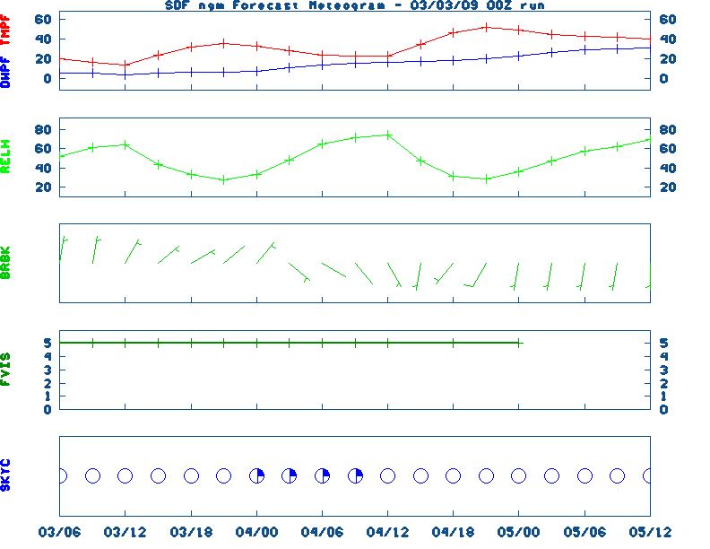
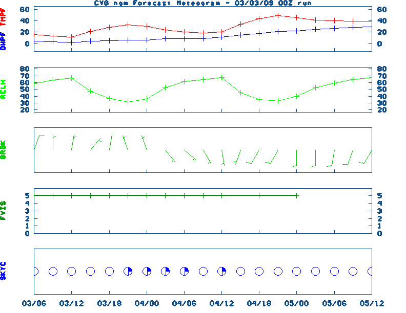
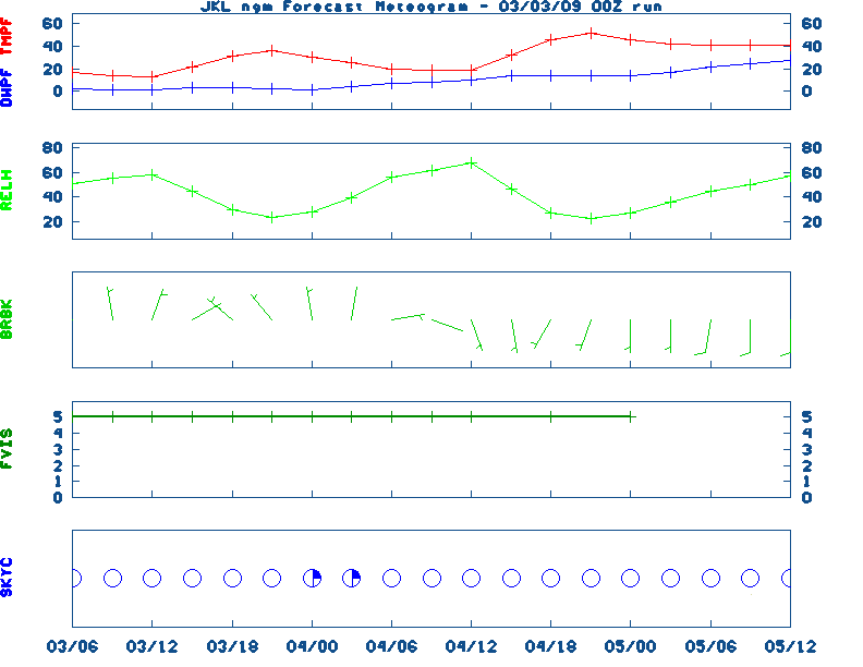
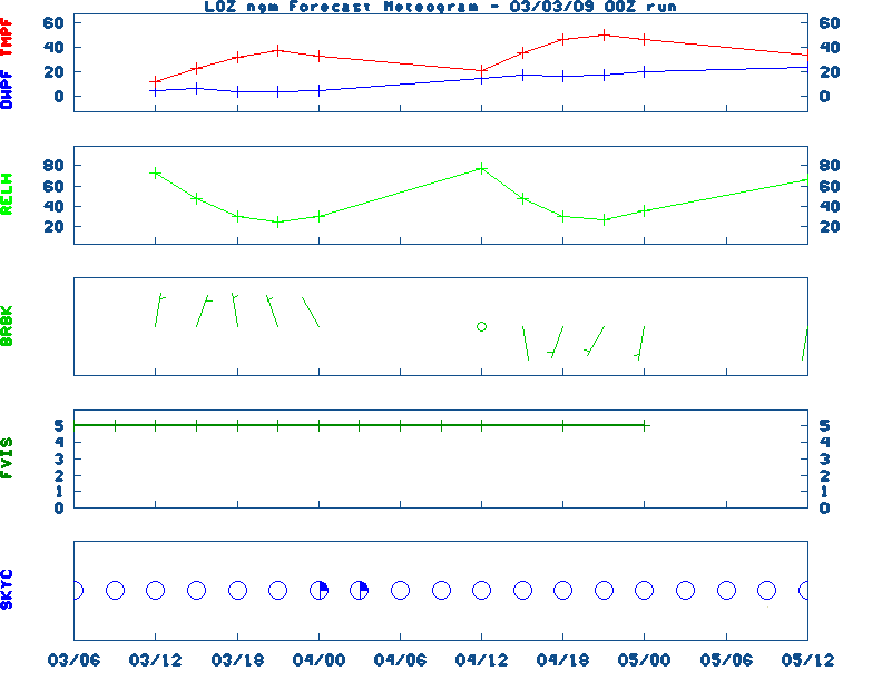
Extended Digital forecast not available Current FORECAST not available Kentucky Agricultural Weather Medium-Range Outlook (Based on the MEX Model) MEDIUM RANGE AG FORECAST: - Click
here for Graphical Ag. Weather Forecast - SATURDAY : SATURDAY : SATURDAY : SATURDAY : SATURDAY : SATURDAY : Raw Data: MEX(west),
MEX(central),
MEX(east)
Medium & Long Range Outlook For Kentucky
                             KENTUCKY
                 ---------------------------------------------
                 6 TO 10 DAY  8 TO 14 DAY   30 DAY    90 DAY
                   MAY 14-18    MAY 16-22    JUN       JUN-AUG
                 -----------  -----------  --------  ---------
   Temperature:      Above        Above
 Precipitation:      Above        Above

....  Medium and long range outlooks provided by NCEP/K. Thomas Priddy
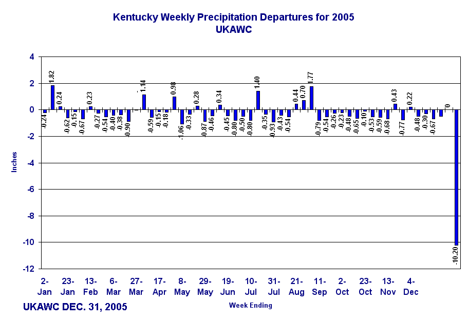
Precipitation Report: (liquid equivalent)
Total Precipitation and Deviation From Normal (in inches)
Valid May 27, 2012

The nearest available weather station for Wolfe County is Quicksand:

                      Past 7 days      Past 30 days   Jan 1 - Present
Station             Total     Dev     Total     Dev     Total     Dev
---------------     -----  ------     -----  ------    ------  ------
Quicksand            0.03   -0.98      4.14   -0.16     17.54   -1.55
Drought Status For WOLFE County, Kentucky (Based on the latest Palmer Drought Severity and Crop Moisture Indices) EASTERN KY CLIMATE DIVISION Hydrological Drought (PDSI) Situation: ------------------------------------------------------------------------------------ Current Long-term Hydrological Moisture Status: NEAR NORMAL (PDSI= 1.08) Rainfall Needed: 0.00 inches ABOVE NORMAL Crop Moisture (CMI) Situation: ---------------------------------------------------------------------------------------------------------- Current Short-term Crop Moisture Status: Favorable For Normal Growth And Fieldwork (CMI= 0.37) Change From Previous Week: DRIER SOILS ( -0.41) Note: Due to rainfall variability within each climate division, check Precip Reports/GIS Estimates and the Kentucky Climate Summary for the latest moisture information for this county.
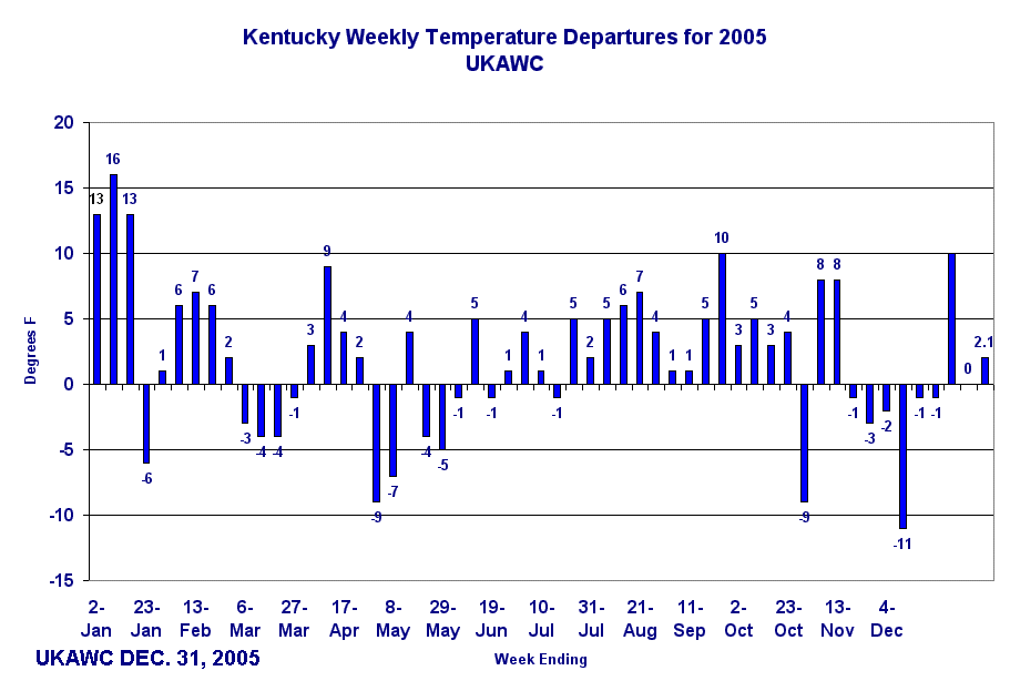
Kentucky Climate Summary normal. High temperatures averaged from 81 in the West to 79 in the East. Departure from normal high temperatures ranged from +3 degrees from normal in the West to +7 degrees from normal in the East. Low temperatures averaged from 63 degrees in the West to 60 degrees in the East. Departure from normal low temperature ranged from +10 degrees from normal in the West to +8 degrees from normal in the East. Precipitation (liq. equ.) for the period totaled 1.55 inches statewide which was + 0.49 inches from normal. Precipitation totals by climate division, West 1.75 inches, Central 1.73 inches, Bluegrass 1.10 inches and East 1.55 inches, which was + 0.64, + 0.62, + 0.08 and + 0.56 inches respectively from normal. By station, precipitation totals ranged from a low of 0 inches at Spindletop to a high of 2.99 inches at Williamstown. | |||||||


