Click on button above to view KY Watches/Warnings/Special Wx Statements.
Click here for all NWS Watch/Warning Map.

County, KY Weather And Climate Synopsis

To sign UKAWC'S guestbook...send us your comments concerning our web site and Kentucky weather...Click Here.

To access other UK Agricultural Weather Center Pages use the pull-down menu below.

(Click image to zoom) or Click Here

36 Hr. Forecast Map
All Radar images NOAA/UKAWC
All Satellite images NOAA

County Hazardous Weather Outlook County Weather for Emergency Managers County Drought Status
Weather Summary County Ag Weather Advisory Hourly Observations Nowcast 7 Day Forecast Medium & Long Range Outlook
Precipitation Report Kentucky Climate Summary GIS Estimates Almanac Precision Ag., Lawn & Garden Forecast Historical Facts


Soil Moisture Anomaly Loop


Current Spraying Conditions
Also see:


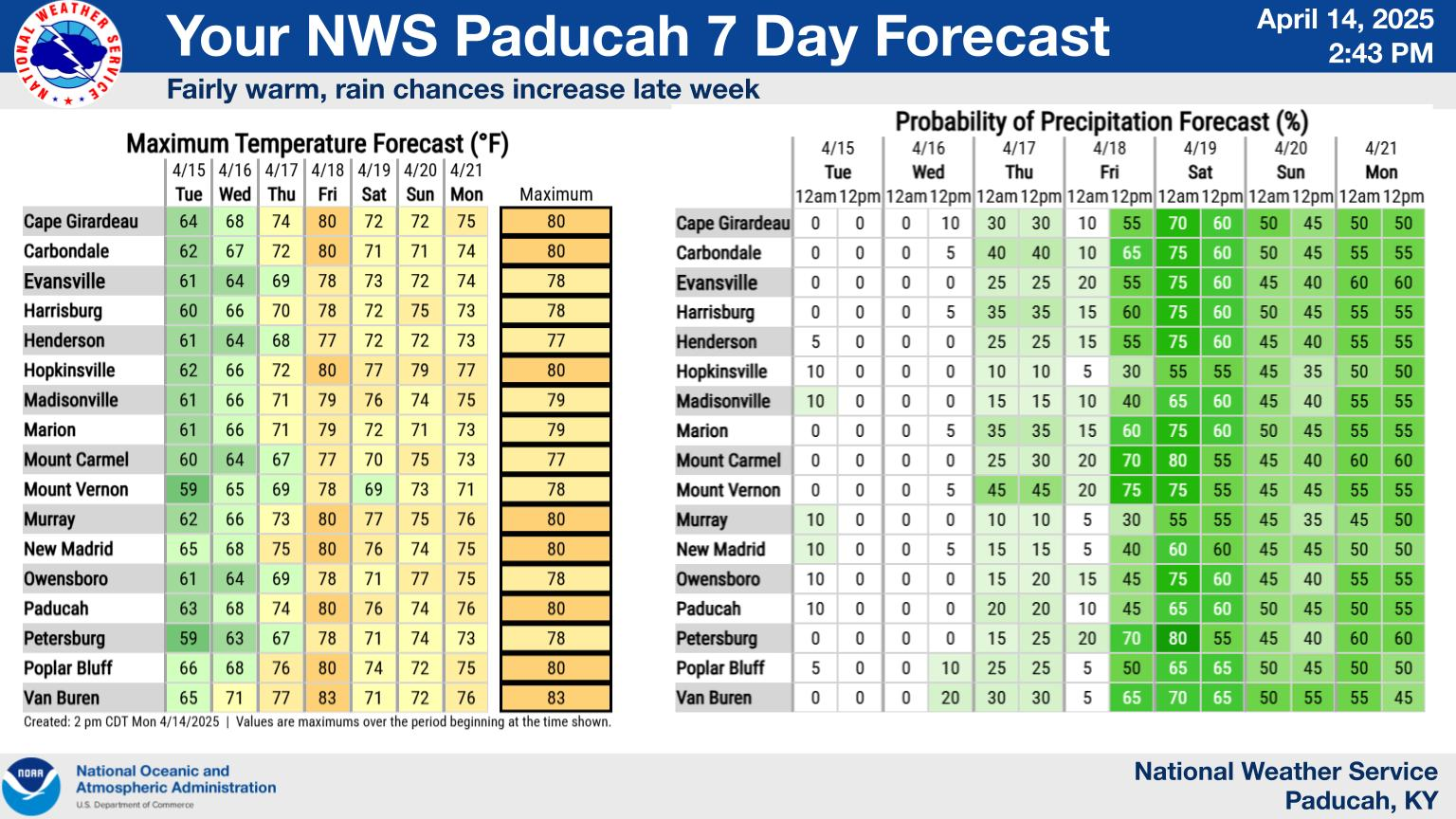
A joint service of the UK Ag Weather Center and the National Weather Service.


Kentucky State Forecast

Western KY:
Central KY:
Eastern KY:

Specific and detailed farm-by-farm weather forecast information is available in your
Point Ag Forecast. New County Ag Weather Page, Current Conditions:Kentucky, U.S.

USDA's Ag Weather:National Ag. Weather Outlook, International Ag. Weather Summary , Next Weather Event?
Current Surface Map, Regional, Composite, TWC, Yesterday's Highs, Lows ,
Upper Air
KY Round-up, Current Temperatures, Dewpoint, Rh, Wind, Regional Obs., Station Model, Surface 4-Panel, NWS Louisville
Meteograms: Paducah , Evansville , Bowling Green , Hopkinsville , Frankfort , Louisville , Lexington , Covington , Jackson , London , Shelby Co. Weather , Spindletop Research Weather Station , Woodford Co. Research Weather Station , About Meteograms


Current Agriculture, Lawn & Garden Weather Conditions in Kentucky
Based on observations at 900am EDT, Saturday March 29, 2025

Across Kentucky...temperatures are near 69 degrees west, near 66 degrees central, and near 66 degrees east. Current sky conditions are cloudy west, partly sunny central, and cloudy east. In the west, relative humidity is near 52%, and the dew point is near 51 degrees. In the central part of the state, relative humidity is near 48%, and the dew point is near 46 degrees. In the east, relative humidity is near 38%, and the dew point is near 40 degrees. Current drying conditions are fair west, good central, and good east. Winds are from the south at 9 mph west, where conditions are favorable for spraying. Winds are from the south at 9 mph central, where conditions are favorable for spraying. Winds are from the south at 5 mph east, where conditions are favorable for spraying. The livestock cold stress index is in the no stress category west, no stress category central, and no stress category east. Based on current available observations, the highest temperature is 69 degrees at Paducah and Hopkinsville. The lowest temperature is 58 degrees at London.

List of Agriculture, Lawn & Garden Weather Observations in Kentucky


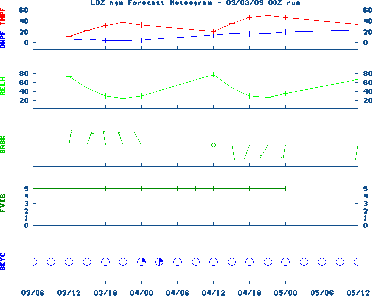
Current NOWCAST not available:
Nowcasts are not issued routinely during fair weather. Only when
precipitation or other significant weather is occuring in this county will these
forecasts be issued. Currently, there is no short term forecast in effect.

UKAWC Radar, NWS Radar (NEW!), SPC Radar, Regional Radar, NEXRAD, LSI Heat Index NWS Severe Weather Map , Convective Outlook

RDF forecast not available NEW NWS Experimental Weather Activity Planner: West, Central, East
NWS Experimental Point Forecasts (5 km x 5 km grid for Kentucky): West, Central, East

Ag. Weather Forecast Parameter Maps:Spraying Conditions , Dewpoint Temperatures, Livestock Heat Stress

Extended Digital forecast not available
Current FORECAST not available TWC Forecast, NWS Maps, Fire Danger, Day 1 Precip, Day 2, 5 Day Total, Days 1-5
NGM 60 Hr Forecast Meteograms: Paducah , Evansville , Bowling Green , Hopkinsville , Frankfort , Louisville , Lexington , Covington , Jackson , London, All Kentucky Hourly Model Guidance, About NGM Forecast Meteograms

Kentucky Agricultural Weather Medium-Range Outlook (Based on the MEX Model)

MEDIUM RANGE AG FORECAST:

- Click 
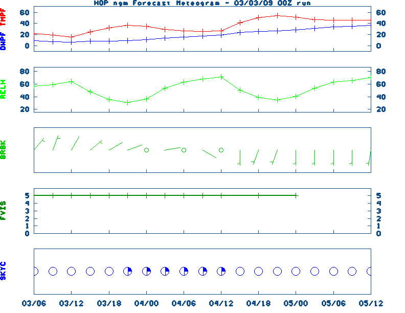
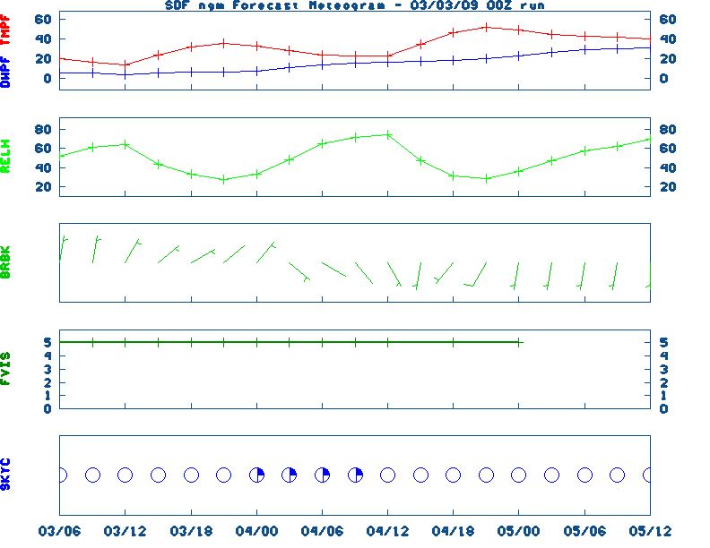
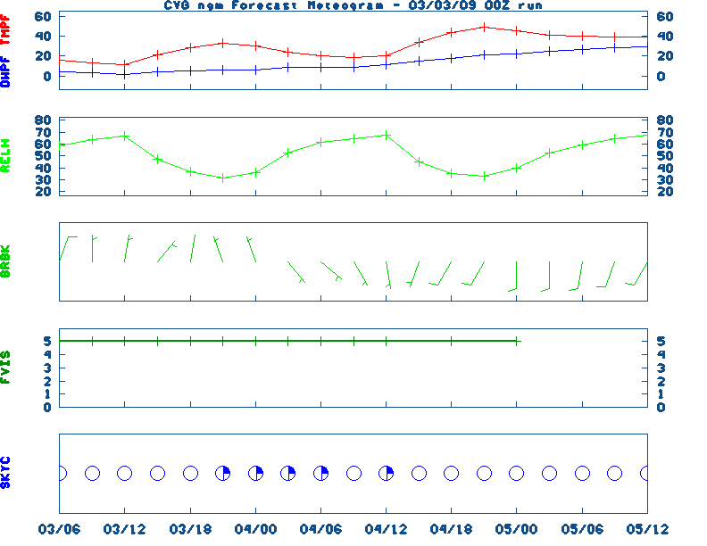
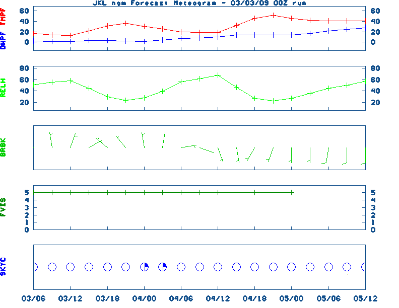
here for Graphical Ag. Weather Forecast -

SATURDAY :
Highs across the state will range from 0 West and 0 Central, to 0 East. Dewpoints will range from (% to 0/ West, (% to 0/ Central, and (% to 0/ East throughout the day. Rainfall amounts of 0 inches over (F)% of the area West, 0 inches over (F)% of the area Central, and 0 inches over (F)% of the area East should be expected. Lows Saturday will fall to 0/ West, 0/ Central, and 0/ East. Skies throughout the day will start out and end in the West, start and end Central, and start out and end East. The maximum livestock stress category will be West, Central, and East. There will be 0 corn growing degree days West, 0 Central, and 0 East. Wind speeds in the morning and afternoon will be around and mph , respectively, West, and mph Central, and and mph East.

SATURDAY :
Highs across the state will range from 0 West and 0 Central, to 0 East. Dewpoints will range from to 0/ West, to 0/ Central, and to 0/ East throughout the day. Rainfall amounts of 0 inches over 0/ % of the area West, 0 inches over 0/ % of the area Central, and 0 inches over 0/ % of the area East should be expected. Lows Saturday will fall to 0/ West, 0/ Central, and 0/ East. Skies throughout the day will start out and end in the West, start and end Central, and start out and end East. The maximum livestock stress category will be West, Central, and East. There will be 0 corn growing degree days West, 0 Central, and 0 East. Wind speeds in the morning and afternoon will be around and mph , respectively, West, and mph Central, and and mph East.

SATURDAY :
Highs across the state will range from 0 West and 0 Central, to 0 East. Dewpoints will range from to 0/ West, to 0/ Central, and to 0/ East throughout the day. Rainfall amounts of 0 inches over 0 % of the area West, 0 inches over 0 % of the area Central, and 0 inches over 0 % of the area East should be expected. Lows Saturday will fall to 0/ West, 0/ Central, and 0/ East. Skies throughout the day will start out and end in the West, start and end Central, and start out and end East. The maximum livestock stress category will be West, Central, and East. There will be 0 corn growing degree days West, 0 Central, and 0 East. Wind speeds in the morning and afternoon will be around and mph , respectively, West, and mph Central, and and mph East.

SATURDAY :
Highs across the state will range from 0 West and 0 Central, to 0 East. Dewpoints will range from to 0/ West, to 0/ Central, and to 0/ East throughout the day. Rainfall amounts of inches over 0/ % of the area West, inches over 0/ % of the area Central, and inches over 0/ % of the area East should be expected. Lows Saturday will fall to 0/ West, 0/ Central, and 0/ East. Skies throughout the day will start out and end in the West, start and end Central, and start out and end East. The maximum livestock stress category will be West, Central, and East. There will be 0 corn growing degree days West, 0 Central, and 0 East. Wind speeds in the morning and afternoon will be around and mph , respectively, West, and mph Central, and and mph East.

SATURDAY :
Highs across the state will range from 0 West and 0 Central, to 0 East. Dewpoints will range from to 0/ West, to 0/ Central, and to 0/ East throughout the day. Rainfall amounts of inches over 0 % of the area West, inches over 0 % of the area Central, and inches over 0 % of the area East should be expected. Lows Saturday will fall to 0/ West, 0/ Central, and 0/ East. Skies throughout the day will start out and end in the West, start and end Central, and start out and end East. The maximum livestock stress category will be West, Central, and East. There will be corn growing degree days West, Central, and East. Wind speeds in the morning and afternoon will be around and mph , respectively, West, and mph Central, and and mph East.

SATURDAY :
Highs across the state will range from West and Central, to East. Dewpoints will range from to 0/ West, to 0/ Central, and to 0/ East throughout the day. Rainfall amounts of inches over 0/ % of the area West, inches over 0/ % of the area Central, and inches over 0/ % of the area East should be expected. Lows Saturday will fall to West, Central, and East. Skies throughout the day will start out and end in the West, start and end Central, and start out and end East. The maximum livestock stress category will be West, Central, and East.There will be corn growing degree days West, Central, and East. Wind speeds in the morning and afternoon will be around and mph, respectively, West, and mph Central, and and mph East.

Raw Data: MEX(west), MEX(central), MEX(east)

* NOTE: See specific site Ag Wx Data and Summary files for further information.

Graphic Regional Ag. Weather Outlook, Tabular data for the Medium Range Outlook


Medium & Long Range Outlook For Kentucky
                             KENTUCKY                                                                     
                 ---------------------------------------------
                 6 TO 10 DAY  8 TO 14 DAY   30 DAY    90 DAY 
                 APR 3-APR 7 APR 5-APR 11    JUN       JUN-AUG                      
                 -----------  -----------  --------  ---------
   Temperature:      Above       Normal                                            
 Precipitation:      Above        Above                                            

....  Medium and long range outlooks provided by NCEP/K. Thomas Priddy
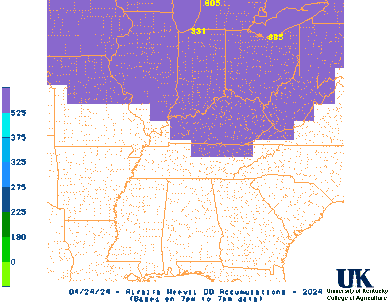
UKAWC 8 Day Forecast Maps, TWC Jet, 15-Day Jet,Trend, Max/Mins (80k)
6 to 10 Day , 8 to 14 Day , Text, 30-Day Outook, 90-Day Outook, 120-Day Outlook


PRECIPITATION is not available
List of Kentucky Weather Stations (1st Order & Ag. stations) Rainfall
UKAWC Regional Ag Weather Summary (Select Format): Spring , Summer , Fall
Additional Drought Info.: UKAWC Drought Page

Kentucky CLIMATE summary not available.
Kentucky Climate Summaries: Last 3 days, 7 days, 14 days, 21 days, 30 days
Yesterday's Weather Data, Kentucky Climate Analysis, Kentucky Climate in Review (2005)
ALFALFA WEEVIL DEGREE DAYS

CURRENT WESTERN CORN ROOTWORM DEGREE DAY TOTALS AND
PREDICTED DATES FOR CERTAIN SPECIFIC VALUES.

The nearest available weather station for  County is :
REAL data are used through 20250328
.
Beyond 20250328
, NORMAL data are used (adjusted by forecast values).

                  CURRENT              IMPORTANT DEGREE DAY VALUES        
LOCATION          DD TOTAL     190     226     276     326     376     526
---------------   --------    -----   -----   -----   -----   -----   -----
Bardstown            262       AO      AO      NA      NA      NA      NA   
Berea                249       AO      AO      NA      NA      NA      NA   
Bowling Green        309       AO      AO      AO      NA      NA      NA   
Bristol              257       AO      AO      NA      NA      NA      NA   
Buckhorn Lake        315       AO      AO      AO      NA      NA      NA   
Cape Girardeau       292       AO      AO      AO      NA      NA      NA   
Campbellsville       288       AO      AO      AO      NA      NA      NA   
Covington            222       AO      NA      NA      NA      NA      NA   
Cumberland Gap       280       AO      AO      AO      NA      NA      NA   
Dix Dam              248       AO      AO      NA      NA      NA      NA   
Evansville           265       AO      AO      NA      NA      NA      NA   
Glasgow              301       AO      AO      AO      NA      NA      NA   
Grayson              270       AO      AO      NA      NA      NA      NA   
Hardinsburg          249       AO      AO      NA      NA      NA      NA   
Henderson            238       AO      AO      NA      NA      NA      NA   
Huntington           280       AO      AO      AO      NA      NA      NA   
Jackson              287       AO      AO      AO      NA      NA      NA   
Lexington            286       AO      AO      AO      NA      NA      NA   
London               277       AO      AO      AO      NA      NA      NA   
Louisville           279       AO      AO      AO      NA      NA      NA   
Mayfield             316       AO      AO      AO      NA      NA      NA   
Nashville            451       AO      AO      AO      AO      AO      NA   
Nolin Lake           271       AO      AO      NA      NA      NA      NA   
Paducah              293       AO      AO      AO      NA      NA      NA   
Princeton            315       AO      AO      AO      NA      NA      NA   
Quicksand            283       AO      AO      AO      NA      NA      NA   
Somerset             261       AO      AO      NA      NA      NA      NA   
Spindletop           217       AO      NA      NA      NA      NA      NA   
Williamstown         205       AO      NA      NA      NA      NA      NA   

AO indicates event has already occurred.

Written by castall_gopher.pl.
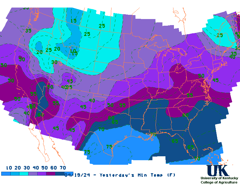
Note: A0 signifies already occurred.

Alfalfa Weevil Accumulation Map


GIS ESTIMATES not available

Almanac Information
Sunrise/Sunset/Moonrise/Moonset Computation (USN)
Yesterday's Weather Observation Report:
(liquid equivalent based on 7PM to 7PM observations.)

The nearest available weather station for  County is :

                AIR TEMP
STATION          MX  MN   PRECIP
Bardstown        80  56    0.00
Berea            80  50    0.00

Bowling Green    82  61    0.00
Bristol          77  45    0.00
Buckhorn Lake    81  50    0.00
Cape Girardeau   81  58    0.00
Campbellsville   81  56    0.00
Covington        81  52    0.00
Cumberland Gap   81  50    0.00
Dix Dam          79  54    0.00
Evansville       83  50    0.00
Glasgow          78  61    0.00
Grayson          84  48    0.00
Hardinsburg      80  53    0.00
Henderson        81  53    0.00
Huntington       83  52    0.01
Jackson          83  43    0.00
Lexington        83  57    0.00
London           81  50    0.00
Louisville       82  55    0.00
Mayfield         82  54    0.00
Nashville        81  64    0.00
Nolin Lake       81  56    1.29
Paducah          82  63    0.00
Princeton        82  58    0.00
Quicksand        83  43    0.00
Somerset         79  53    0.00
Spindletop       78  53    0.00
Williamstown     80  52    0.00

TEMPERATURES IN DEGREES F.
PRECIPITATION IN INCHES.
--------------------------------
Yesterday's U.S. Highs, Lows , KY's Highs/Lows/Precip, Daily Weather Data, Hourly Weather Data
Historical Weather And Climate Facts For Today
MARCH 29TH
HISTORIC WEATHER EVENTS
...1886...
Atlanta GA was drenched with a record 7.36 inches of rain in 24 hours. (The
Weather Channel)
...1920...
Clear Spring MD received 31 inches of snow in 24 hours to establish a state
record. (Sandra and TI Richard Sanders - 1987)
...1921...
The temperature in Washington D.C. dropped from 82 degrees to 26 degres
thus ending an early spring. (David Ludlum)
...1935...
A severe duststorm blanketed Amarillo TX for 84 hours. During one six hour
period the visibility was near zero. (28th-31st) (The Weather Channel)
...1945...
Providence RI hit 90 degrees to establish a March record for the New
England area. (The Weather Channel)
UKAWC Briefing Page

Ag Weather Center, Department of Biosystems & Agricultural Engineering, University of Kentucky