KENTUCKY CROP AND WEATHER REPORT--USDA
Listed below are the current USDA Crop & Weather Report/Kentucky Climate Summary
AND, in addition, previous week's reports for this year. The reports are
produced in a joint effort by the UK Ag. Weather Center, Cooperative Extension
Service County Agents, Farmers across the state, Kentucky Department of
Agriculture, and the US Department of Agriculture, National Agricultural
Statistics Service. Click here for the PDF version.
---
Kentucky Climate Summary
For the Period December 28, 2020 to January 3, 2021
Well Above Normal Temperatures and Above Normal Precipitation:
Rain was abundant as Kentucky closed 2020 and opened the new year. Following a quiet
and chilly start to the period, widespread rain showers accompanied a cold front
passing through the area Wednesday and lasting into Thursday morning. After a brief
break, widespread rain returned late Thursday night and continued into New Year’s Day
as an upper-level disturbance worked across the area. While the state did see some
light accumulations over the weekend, the brunt of the weekly state average fell on
either side of the holiday. Overall, the state averaged 1.69 inches for the period,
which is over three quarters of an inch above normal. Ahead of a cold front on
Friday, well above normal temperatures were seen across the state with highs jumping
into the 60s and even low 70s for much of South-Central Kentucky. Behind the
boundary, temperatures went on the downhill slide, only topping out in the upper 30s
to middle 40s on Sunday.
Temperatures for the period averaged 42 degrees across the state which was 8 degrees
warmer than normal and 6 degrees warmer than the previous period. High temperatures
averaged from 48 in the West to 52 in the East. Departure from normal high
temperatures ranged from 4 degrees warmer than normal in the West to 8 degrees
warmer than normal in the East. Low temperatures averaged from 34 degrees in the
West to 36 degrees in the East. Departure from normal low temperature ranged from 8
degrees warmer than normal in the West to 12 degrees warmer than normal in the
East. The extreme high temperature for the period was 73 degrees at BOWLING GREEN APT
and the extreme low was 20 degrees at MONTICELLO AWOS.
Precipitation (liq. equ.) for the period totaled 1.69 inches statewide which was 0.78
inches above normal and 186% of normal. Precipitation totals by climate division,
West 2.11 inches, Central 1.79 inches, Bluegrass 1.95 inches and East 0.93 inches,
which was 1.16, 0.81, 1.15 and 0.02 inches above normal. By station, precipitation
totals ranged from a low of 0.36 inches at WHITESBURG 2NW to a high of 2.59
inches at MADISONVILLE 4S.
---
Kentucky Climate Summary
For the Period December 21, 2020 to December 27, 2020
Near Normal Temperatures and Below Normal Precipitation:
The first half of the week ran unseasonably mild, peaking on Wednesday with highs
around 60 across the state. Big changes then arrived on Christmas Eve as a strong
cold front pushed through Kentucky. Rain transitioned to a wintry mix and eventually
snow after temperatures crashed quickly behind the front with strong northwest flow
in place. Snow continued into Thursday night and lingered into Christmas Day with the
most significant activity across Eastern Kentucky. Accumulations were generally
between 4 to 6 inches for this area. Some locations topped 8 inches. Low
temperatures dropped into the teens for Christmas morning and only warmed into the
upper teens to mid-20s during the day. Much of the eastern half of the state even
dropped into the single digits on Saturday morning. During this 48-hour timespan,
wind chills dropped into the single digits and even below zero at times, pushing the
livestock cold stress index into the Emergency category. Good news arrived over the
weekend as winds transitioned to the southwest and highs were back in the 50s by
Sunday.
Temperatures for the period averaged 36 degrees across the state which was
near normal and no change to the previous period. High temperatures averaged from
49 in the West to 46 in the East. Departure from normal high temperatures ranged
from 4 degrees warmer than normal in the West to near normal in the East.
Low temperatures averaged from 29 degrees in the West to 24 degrees in the East.
Departure from normal low temperature ranged from 1 degree warmer than normal in the
West to 2 degrees cooler than normal in the East. The extreme high temperature for
the period was 65 degrees at POPLAR BLUFF ASOS and the extreme low was 1 degree at
BARBOURVILLE 3E.
Precipitation (liq. equ.) for the period totaled 0.62 inches statewide which was 0.33
inches below normal and 66% of normal. Precipitation totals by climate division, West
0.51 inches, Central 0.48 inches, Bluegrass 0.40 inches and East 1.08 inches, which
was -0.50, -0.55, -0.43 and 0.17 inches respectively from normal. By station,
precipitation totals ranged from a low of 0.11 inches at FORT CAMPBELL to a high of
1.55 inches at JACKSON.
---
Kentucky Climate Summary
For the Period December 14, 2020 to December 20, 2020
Below Normal Temperatures and Above Normal Precipitation:
An active pattern led to multiple rounds of precipitation throughout the week. Many
of the rounds featured widespread coverage. Temperatures hovering around freezing
produced a wintry mix of precipitation from time to time. Overall, the state
averaged 1.12 inches, which was slightly above normal for the period. This ended a
stretch of four straight weeks where the state average ran below normal. The active
pattern resulted in limited sunshine throughout the week. High temperatures struggled
in the middle 30s to low 30s through Thursday, before rising into the middle to upper
40s over the weekend.
Temperatures for the period averaged 35 degrees across the state which was 2 degrees
cooler than normal and 10 degrees cooler than the previous period. High temperatures
averaged from 41 in the West to 41 in the East. Departure from normal high
temperatures ranged from 6 degrees cooler than normal in the West to 7 degrees
cooler than normal in the East. Low temperatures averaged from 29 degrees in the
West to 30 degrees in the East. Departure from normal low temperature ranged from
near normal in the West to 3 degrees warmer than normal in the East. The
extreme high temperature for the period was 52 degrees at BURKESVILLE 3W and the
extreme low was 17 degrees at BRANDENBURG 4SW.
Precipitation (liq. equ.) for the period totaled 1.12 inches statewide which was 0.15
inches above normal and 115% of normal. Precipitation totals by climate division,
West 0.63 inches, Central 1.38 inches, Bluegrass 0.89 inches and East 1.60 inches,
which was -0.44, 0.31, 0.05 and 0.68 inches respectively from normal. By station,
precipitation totals ranged from a low of 0.02 inches at CARBONDALE ASOS to a high of
2.20 inches at SCOTTSVILLE 2W.
---
Kentucky Climate Summary
For the Period December 7, 2020 to December 13, 2020
Above Normal Temperatures and Below Normal Precipitation:
The period started with chilly temperatures in place. Highs on Monday and Tuesday
struggled in the 30s and 40s across the state.Those temperatures did go on the
increase through the end of the work week, eventually topping out in the 60s on
Thursday and Friday, well above normal for this time of year. A cold front then
pushed through the region over the first half of the weekend, sparking a round of
rain showers. An addional round followed late on Sunday with some of these
accumulations reflected on the next week’s report. Overall, the state averaged under
a quarter inch, marking a fourth straight week of below normal precipitation. The
latest update of the US Drought Monitor introduced an area of abnormally dry
conditions to South Central Kentucky. Over the past 30 days, data at the UK Ag
Weather Center shows the state has only averaged 2.10 inches, which is 2.35 inches below
normal.
Temperatures for the period averaged 44 degrees across the state which was 5 degrees
warmer than normal and 8 degrees warmer than the previous period. High temperatures
averaged from 56 in the West to 53 in the East. Departure from normal high
temperatures ranged from 7 degrees warmer than normal in the West to 4 degrees
warmer than normal in the East. Low temperatures averaged from 35 degrees in the
West to 35 degrees in the East. Departure from normal low temperature ranged from 4
degrees warmer than normal in the West to 7 degrees warmer than normal in the East.
The extreme high temperature for the period was 71 degrees at FORT CAMPBELL and the
extreme low was 19 degrees at HARRODSBURG 3N.
Precipitation (liq. equ.) for the period totaled 0.21 inches statewide which was 0.84
inches below normal and 20% of normal. Precipitation totals by climate division, West
0.40 inches, Central 0.14 inches, Bluegrass 0.07 inches and East 0.24 inches, which
was 0.74, 1, 0.85 and 0.75 inches below normal. By station, precipitation totals
ranged from a low of 0.00 inches at CYNTHIANA 8N to a high of 1.26 inches at
POPLAR BLUFF ASOS.
---
Kentucky Climate Summary
For the Period November 30, 2020 to December 6, 2020
Below Normal Temperatures and Precipitation:
Kentucky saw the first accumulating snow of the season to start out the work week.
Most accumulations were limited to the eastern half state and grassy/elevated
surfaces. Activity started early Monday morning with some slushy accumulations.
Most of this snow melted during the day as temperatures rose above freezing, but
another round followed that evening/overnight. This led to accumulations of 1 to 2
inches across the eastern half of the state. Temperatures really struggled behind the
snow with highs on Tuesday limited to the 30s. Later that night, Kentucky saw the
coldest temperatures of the week as lows dipped into the middle teens to low 20s,
which pushed the livestock cold stress index into the danger category. Temperatures
did rise over the second half of the week, but not enough to end the trend of below
normal temperatures. Kentucky saw another round of precipitation on Thursday night
and Friday, but this time fell as all rain. Accumulations were highest across SE
Kentucky and lowest farther west. Overall, while Eastern Kentucky averaged 1.18
inches for the week, that number dropped to 0.28 for Western Kentucky.
Temperatures for the period averaged 36 degrees across the state which was 6 degrees
cooler than normal and 12 degrees cooler than the previous period. High temperatures
averaged from 46 in the West to 44 in the East. Departure from normal high
temperatures ranged from 6 degrees cooler than normal in the West to 8 degrees
cooler than normal in the East. Low temperatures averaged from 28 degrees in the
West to 29 degrees in the East. Departure from normal low temperature ranged from 5
degrees cooler than normal in the West to 1 degree cooler than normal in the East.
The extreme high temperature for the period was 57 degrees at CAPE GIRARDEAU ASOS and
the extreme low was 12 degrees at MONTICELLO AWOS.
Precipitation (liq. equ.) for the period totaled 0.87 inches statewide which was 0.22
inches below normal and 80% of normal. Precipitation totals by climate division, West
0.28 inches, Central 1.00 inches, Bluegrass 1.03 inches and East 1.18 inches, which
was -0.97, -0.16, 0.11 and 0.16 inches respectively from normal. By station,
precipitation totals ranged from a low of 0.00 inches at PADUCAH ASOS to a high of
1.94 inches at ALBANY 1N.
---
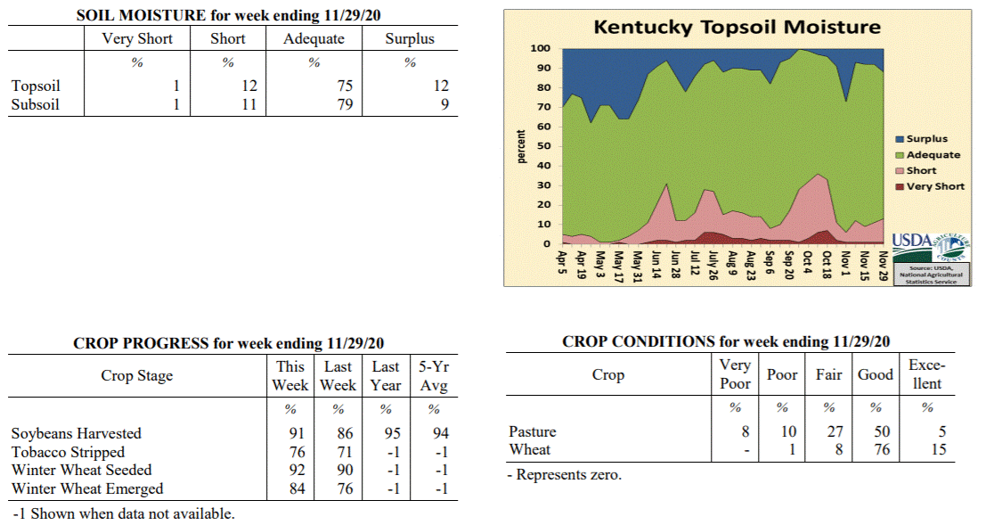
Kentucky Crop and Weather Report
Issued 4:00 P.M., November 30, 2020 37-20
Agricultural News: Kentucky experienced above normal temperatures and below normal
rainfall over the past week. Precipitation for the week totaled 0.50 inches, 0.56
inches below normal. Temperatures averaged 46 degrees for the week, 2 degrees above
normal. Topsoil moisture was rated 1 percent very short, 12 percent short, 75 percent
adequate, and 12 percent surplus. Subsoil moisture was rated 1 percent very short, 11
percent short, 79 percent adequate, and 9 percent surplus. Days suitable for
fieldwork averaged 4.7 out of a possible seven.
Primary activities for this week included continued harvest of soybeans, stripping
tobacco, and planting winter wheat. Weather through most of the week was conducive to
progress in the fields. Scattered rain mid-week stymied fieldwork gains for a short
period. Soybean harvest is nearing completion, but trails last year and the five-year
average for this juncture of the season. Eighty-four percent of the winter wheat crop
has emerged with ninety-two percent planted. Tobacco stripping, at seventy-six
percent complete, continues to steadily progress The condition of winter wheat
remains mostly good. Pastures are still in mostly good shape with farmers able to hold
off on feeding hay for the time being.
 Kentucky Climate Summary
For the Period November 23, 2020 to November 29, 2020
Above Normal Temperatures and Below Normal Rainfall:
The Commonwealth saw a few rounds of showers through the period, a couple coming
midweek and the other on Sunday. Coverage turned widespread with the earlier rounds
on Tuesday night and Wednesday. Accumulations were highest along the Ohio River (~ 1
inch) and decreased to the southeast (< 0.10 inches). Breezy conditions accompanied
the rain with many seeing peak gusts between 25 and 40 mph. A few dry days followed
before the week closed with some light rain showers pushing back into the area on
Sunday. Some of the rain fell after the data cutoff and will not be reflected in
this report. Overall though, the state averaged a half inch for the week, marking a
second straight week of below normal rainfall. Conditions also ran mild for much of
the period, which led to a fourth straight week of above normal temperatures.
Temperatures for the period averaged 46 degrees across the state which was 2 degrees
warmer than normal and 4 degrees cooler than the previous period. High temperatures
averaged from 55 in the West to 56 in the East. Departure from normal high
temperatures ranged from 1 degree warmer than normal in the West to 2 degrees
warmer than normal in the East. Low temperatures averaged from 37 degrees in the
West to 37 degrees in the East. Departure from normal low temperature ranged from 2
degrees warmer than normal in the West to 6 degrees warmer than normal in the East.
The extreme high temperature for the period was 67 degrees at FORT CAMPBELL and the
extreme low was 22 degrees at VANCEBURG 6W.
Precipitation (liq. equ.) for the period totaled 0.50 inches statewide which was 0.56
inches below normal and 47% of normal. Precipitation totals by climate division, West
0.89 inches, Central 0.29 inches, Bluegrass 0.58 inches and East 0.26 inches, which
was 0.34, 0.83, 0.32 and 0.72 inches below normal. By station, precipitation totals
ranged from a low of 0.07 inches at LIBERTY 3SW to a high of 1.57 inches at PADUCAH ASOS.
---
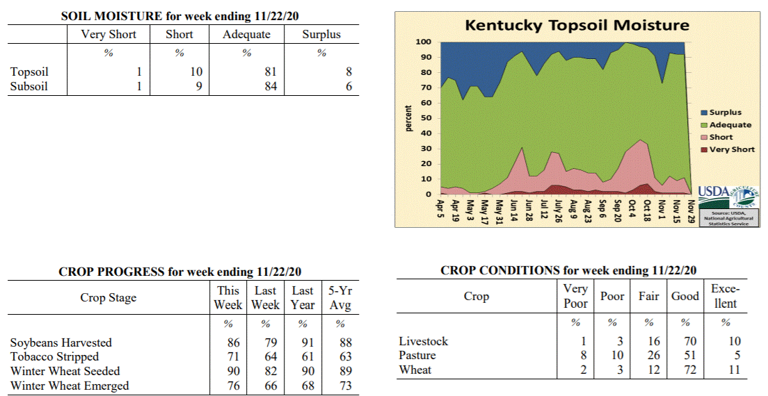
Kentucky Crop and Weather Report
Issued 4:00 P.M., November 23, 2020 36-20
Agricultural News: Kentucky experienced above normal temperatures and below normal
rainfall over the past week. Precipitation for the week totaled 0.15 inches, 0.84
inches below normal. Temperatures averaged 49 degrees for the week, 3 degrees above
normal. Topsoil moisture was rated 1 percent very short, 10 percent short, 81 percent
adequate, and 8 percent surplus. Subsoil moisture was rated 1 percent very short, 9
percent short, 84 percent adequate, and 6 percent surplus. Days suitable for
fieldwork averaged 5.4 out of a possible seven.
Primary activities for this week included continued harvest of soybeans, stripping
tobacco, and planting winter wheat. Mostly dry weather this week allowed farmers to
forge ahead with fieldwork. Progress was interrupted by scattered rain through the
weekend. Soybean harvest remains behind last year and the five year average. Tobacco
stripping is ahead of both last year and the five year average for this juncture.
Seventy-six percent of the winter wheat crop has emerged with ninety percent planted.
The condition of winter wheat remains mostly good. Pastures are still in mostly good
shape and have benefitted from pockets of warm weather. Livestock are still grazing
grass at this time as farmers reserve their hay for the winter months.
The overall hay supply was reported as mostly adequate.
Kentucky Climate Summary
For the Period November 23, 2020 to November 29, 2020
Above Normal Temperatures and Below Normal Rainfall:
The Commonwealth saw a few rounds of showers through the period, a couple coming
midweek and the other on Sunday. Coverage turned widespread with the earlier rounds
on Tuesday night and Wednesday. Accumulations were highest along the Ohio River (~ 1
inch) and decreased to the southeast (< 0.10 inches). Breezy conditions accompanied
the rain with many seeing peak gusts between 25 and 40 mph. A few dry days followed
before the week closed with some light rain showers pushing back into the area on
Sunday. Some of the rain fell after the data cutoff and will not be reflected in
this report. Overall though, the state averaged a half inch for the week, marking a
second straight week of below normal rainfall. Conditions also ran mild for much of
the period, which led to a fourth straight week of above normal temperatures.
Temperatures for the period averaged 46 degrees across the state which was 2 degrees
warmer than normal and 4 degrees cooler than the previous period. High temperatures
averaged from 55 in the West to 56 in the East. Departure from normal high
temperatures ranged from 1 degree warmer than normal in the West to 2 degrees
warmer than normal in the East. Low temperatures averaged from 37 degrees in the
West to 37 degrees in the East. Departure from normal low temperature ranged from 2
degrees warmer than normal in the West to 6 degrees warmer than normal in the East.
The extreme high temperature for the period was 67 degrees at FORT CAMPBELL and the
extreme low was 22 degrees at VANCEBURG 6W.
Precipitation (liq. equ.) for the period totaled 0.50 inches statewide which was 0.56
inches below normal and 47% of normal. Precipitation totals by climate division, West
0.89 inches, Central 0.29 inches, Bluegrass 0.58 inches and East 0.26 inches, which
was 0.34, 0.83, 0.32 and 0.72 inches below normal. By station, precipitation totals
ranged from a low of 0.07 inches at LIBERTY 3SW to a high of 1.57 inches at PADUCAH ASOS.
---
Kentucky Crop and Weather Report
Issued 4:00 P.M., November 23, 2020 36-20
Agricultural News: Kentucky experienced above normal temperatures and below normal
rainfall over the past week. Precipitation for the week totaled 0.15 inches, 0.84
inches below normal. Temperatures averaged 49 degrees for the week, 3 degrees above
normal. Topsoil moisture was rated 1 percent very short, 10 percent short, 81 percent
adequate, and 8 percent surplus. Subsoil moisture was rated 1 percent very short, 9
percent short, 84 percent adequate, and 6 percent surplus. Days suitable for
fieldwork averaged 5.4 out of a possible seven.
Primary activities for this week included continued harvest of soybeans, stripping
tobacco, and planting winter wheat. Mostly dry weather this week allowed farmers to
forge ahead with fieldwork. Progress was interrupted by scattered rain through the
weekend. Soybean harvest remains behind last year and the five year average. Tobacco
stripping is ahead of both last year and the five year average for this juncture.
Seventy-six percent of the winter wheat crop has emerged with ninety percent planted.
The condition of winter wheat remains mostly good. Pastures are still in mostly good
shape and have benefitted from pockets of warm weather. Livestock are still grazing
grass at this time as farmers reserve their hay for the winter months.
The overall hay supply was reported as mostly adequate.
 Kentucky Climate Summary
For the Period November 16, 2020 to November 22, 2020
Above Normal Temperatures and Below Normal Rainfall:
The week opened with dry and chilly conditions in place. The coldest temperatures
were seen Tuesday night as lows dropped into the 20s with clear skies in place. Even
had some stations drop into the low 20s. The second half of the workweek featured a
warming trend as winds transitioned to the south. Highs on Thursday and Friday rose
into the 60s. While it was mild, breezy conditions and low relativity humidity led
to an increased fire danger on Thursday. Rain returned over the weekend with the
passage of a cold front, but accumulations were very minimal. Despite some widespread
coverage, the state only averaged 0.15 inches. Some of the rain across Eastern
Kentucky fell after the data cutoff and will be reflected on the report next week.
Temperatures for the period averaged 49 degrees across the state which was 3 degrees
warmer than normal and 8 degrees cooler than the previous period. High temperatures
averaged from 61 in the West to 60 in the East. Departure from normal high
temperatures ranged from 4 degrees warmer than normal in the West to 4 degrees
warmer than normal in the East. Low temperatures averaged from 41 degrees in the
West to 37 degrees in the East. Departure from normal low temperature ranged from 4
degrees warmer than normal in the West to 4 degrees warmer than normal in the East.
The extreme high temperature for the period was 71 degrees at GREENVILLE 6N and the
extreme low was 20 degrees at VANCEBURG 6W.
Precipitation (liq. equ.) for the period totaled 0.15 inches statewide which was 0.84
inches below normal and 15% of normal. Precipitation totals by climate division, West
0.17 inches, Central 0.09 inches, Bluegrass 0.20 inches and East 0.13 inches, which
was 0.97, 0.96, 0.66 and 0.77 inches below normal. By station, precipitation totals
ranged from a low of 0.00 inches at BARBOURVILLE 3E to a high of 0.41 inches at
VANCEBURG 6W.
---
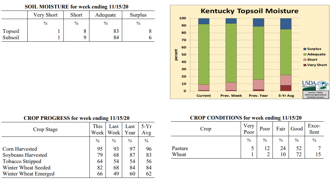
Kentucky Crop and Weather Report
Issued 4:00 P.M., November 16, 2020 35-20
Agricultural News: Kentucky experienced well above normal temperatures and above
normal rainfall over the past week. Precipitation for the week totaled 0.96 inches,
0.09 inches above normal. Temperatures averaged 56 degrees for the week, 7 degrees
above normal. Topsoil moisture was rated 1 percent very short, 8 percent short, 83
percent adequate, and 8 percent surplus. Subsoil moisture was rated 1 percent very
short, 9 percent short, 84 percent adequate, and 6 percent surplus. Days suitable for
fieldwork averaged 5.2 out of a possible seven.
Primary activities for this week included harvesting corn, soybeans, stripping
tobacco, and planting winter wheat. With warm, dry weather in the beginning of the
week farmers pushed ahead with fieldwork. As the weekend approached, conditions
became wet and much cooler in many areas of the state. Despite the late week weather,
corn is nearing harvest completion. Soybeans remain behind last year and the five
year average. Sixty-six percent of the winter wheat crop has emerged with eighty-two
percent planted. Higher humidity allowed tobacco stripping to move ahead.
The condition of winter wheat remains mostly good. Pastures are still in mostly good
shape and have had some late growth due to the conducive weather. The recent growth
will help preserve hay stocks as winter approaches.
Kentucky Climate Summary
For the Period November 16, 2020 to November 22, 2020
Above Normal Temperatures and Below Normal Rainfall:
The week opened with dry and chilly conditions in place. The coldest temperatures
were seen Tuesday night as lows dropped into the 20s with clear skies in place. Even
had some stations drop into the low 20s. The second half of the workweek featured a
warming trend as winds transitioned to the south. Highs on Thursday and Friday rose
into the 60s. While it was mild, breezy conditions and low relativity humidity led
to an increased fire danger on Thursday. Rain returned over the weekend with the
passage of a cold front, but accumulations were very minimal. Despite some widespread
coverage, the state only averaged 0.15 inches. Some of the rain across Eastern
Kentucky fell after the data cutoff and will be reflected on the report next week.
Temperatures for the period averaged 49 degrees across the state which was 3 degrees
warmer than normal and 8 degrees cooler than the previous period. High temperatures
averaged from 61 in the West to 60 in the East. Departure from normal high
temperatures ranged from 4 degrees warmer than normal in the West to 4 degrees
warmer than normal in the East. Low temperatures averaged from 41 degrees in the
West to 37 degrees in the East. Departure from normal low temperature ranged from 4
degrees warmer than normal in the West to 4 degrees warmer than normal in the East.
The extreme high temperature for the period was 71 degrees at GREENVILLE 6N and the
extreme low was 20 degrees at VANCEBURG 6W.
Precipitation (liq. equ.) for the period totaled 0.15 inches statewide which was 0.84
inches below normal and 15% of normal. Precipitation totals by climate division, West
0.17 inches, Central 0.09 inches, Bluegrass 0.20 inches and East 0.13 inches, which
was 0.97, 0.96, 0.66 and 0.77 inches below normal. By station, precipitation totals
ranged from a low of 0.00 inches at BARBOURVILLE 3E to a high of 0.41 inches at
VANCEBURG 6W.
---
Kentucky Crop and Weather Report
Issued 4:00 P.M., November 16, 2020 35-20
Agricultural News: Kentucky experienced well above normal temperatures and above
normal rainfall over the past week. Precipitation for the week totaled 0.96 inches,
0.09 inches above normal. Temperatures averaged 56 degrees for the week, 7 degrees
above normal. Topsoil moisture was rated 1 percent very short, 8 percent short, 83
percent adequate, and 8 percent surplus. Subsoil moisture was rated 1 percent very
short, 9 percent short, 84 percent adequate, and 6 percent surplus. Days suitable for
fieldwork averaged 5.2 out of a possible seven.
Primary activities for this week included harvesting corn, soybeans, stripping
tobacco, and planting winter wheat. With warm, dry weather in the beginning of the
week farmers pushed ahead with fieldwork. As the weekend approached, conditions
became wet and much cooler in many areas of the state. Despite the late week weather,
corn is nearing harvest completion. Soybeans remain behind last year and the five
year average. Sixty-six percent of the winter wheat crop has emerged with eighty-two
percent planted. Higher humidity allowed tobacco stripping to move ahead.
The condition of winter wheat remains mostly good. Pastures are still in mostly good
shape and have had some late growth due to the conducive weather. The recent growth
will help preserve hay stocks as winter approaches.
 Kentucky Climate Summary
For the Period November 9, 2020 to November 15, 2020
Well Above Normal Temperatures and Above Normal Rainfall:
The week opened with an extension of dry conditions from the previous period. The
dry weather was accompanied by well above normal temperatures, record breaking in
some cases. Highs on Monday and Tuesday rose into the middle 70s to low 80s. The
exceptional warmth then ended on Tuesday night and Wednesday with the passage of a
cold front, which dropped temperatures back closer to seasonable norms for the second
half of the week. The boundary also brought a round of rainfall with totals much
more significant across the eastern half of Kentucky compared to the western half.
Another front then pushed through the area over the weekend. Combined with the first
boundary earlier in the period, the state averaged about an inch for the week. The
bigger story with the cold front over the weekend was the very breezy conditions in
place. As the boundary pushed through the region, most across Kentucky saw peak
gusts between 40 and 50 mph.
Temperatures for the period averaged 56 degrees across the state which was 7 degrees
warmer than normal and 2 degrees warmer than the previous period. High temperatures
averaged from 67 in the West to 68 in the East. Departure from normal high
temperatures ranged from 7 degrees warmer than normal in the West to 8 degrees
warmer than normal in the East. Low temperatures averaged from 47 degrees in the
West to 46 degrees in the East. Departure from normal low temperature ranged from 8
degrees warmer than normal in the West to 11 degrees warmer than normal in the
East. The extreme high temperature for the period was 85 degrees at JACKSON AIRPORT
and the extreme low was 27 degrees at CARLISLE 5SW.
Precipitation (liq. equ.) for the period totaled 0.96 inches statewide which was 0.09
inches above normal and 110% of normal. Precipitation totals by climate division,
West 0.89 inches, Central 0.77 inches, Bluegrass 0.78 inches and East 1.39 inches,
which was -0.15, -0.14, 0.03 and 0.61 inches respectively from normal. By station,
precipitation totals ranged from a low of 0.46 inches at MAYSVILLE 3SW to a high of
2.80 inches at PEABODY.
---
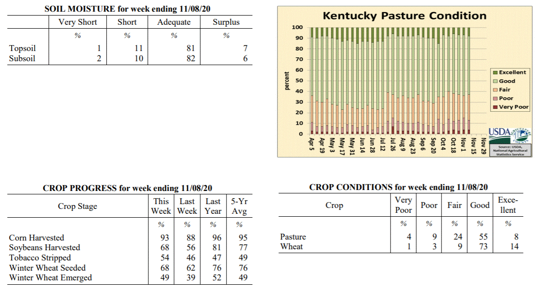
Kentucky Crop and Weather Report
Issued 4:00 P.M., November 9, 2020 34-20
Agricultural News: Kentucky experienced above normal temperatures and much below
normal rainfall over the past week. Precipitation for the week totaled 0.00 inches,
0.77 inches below normal. Temperatures averaged 54 degrees for the week, 3 degrees
above normal. Topsoil moisture was rated 1 percent very short, 11 percent short, 81
percent adequate, and 7 percent surplus. Subsoil moisture was rated 2 percent very
short, 10 percent short, 82 percent adequate, and 6 percent surplus. Days suitable
for fieldwork averaged 6.1 out of a possible seven.
Primary activities for this week included harvesting corn, soybeans, stripping
tobacco, and planting winter wheat. Weather for the week was conducive to strong
progress in the fields. Both the corn and soybean harvest trails last year at this
point in the season, however that margin will shrink as weather permits. Forty-nine
percent of the winter wheat crop has emerged with sixty-eight percent planted.
The condition of winter wheat remains good at this juncture. Pastures are still in
mostly good shape and will benefit from the warm weather this past week. Some farmers
were able to get a late season cutting of hay thanks to recent weather.
Kentucky Climate Summary
For the Period November 9, 2020 to November 15, 2020
Well Above Normal Temperatures and Above Normal Rainfall:
The week opened with an extension of dry conditions from the previous period. The
dry weather was accompanied by well above normal temperatures, record breaking in
some cases. Highs on Monday and Tuesday rose into the middle 70s to low 80s. The
exceptional warmth then ended on Tuesday night and Wednesday with the passage of a
cold front, which dropped temperatures back closer to seasonable norms for the second
half of the week. The boundary also brought a round of rainfall with totals much
more significant across the eastern half of Kentucky compared to the western half.
Another front then pushed through the area over the weekend. Combined with the first
boundary earlier in the period, the state averaged about an inch for the week. The
bigger story with the cold front over the weekend was the very breezy conditions in
place. As the boundary pushed through the region, most across Kentucky saw peak
gusts between 40 and 50 mph.
Temperatures for the period averaged 56 degrees across the state which was 7 degrees
warmer than normal and 2 degrees warmer than the previous period. High temperatures
averaged from 67 in the West to 68 in the East. Departure from normal high
temperatures ranged from 7 degrees warmer than normal in the West to 8 degrees
warmer than normal in the East. Low temperatures averaged from 47 degrees in the
West to 46 degrees in the East. Departure from normal low temperature ranged from 8
degrees warmer than normal in the West to 11 degrees warmer than normal in the
East. The extreme high temperature for the period was 85 degrees at JACKSON AIRPORT
and the extreme low was 27 degrees at CARLISLE 5SW.
Precipitation (liq. equ.) for the period totaled 0.96 inches statewide which was 0.09
inches above normal and 110% of normal. Precipitation totals by climate division,
West 0.89 inches, Central 0.77 inches, Bluegrass 0.78 inches and East 1.39 inches,
which was -0.15, -0.14, 0.03 and 0.61 inches respectively from normal. By station,
precipitation totals ranged from a low of 0.46 inches at MAYSVILLE 3SW to a high of
2.80 inches at PEABODY.
---
Kentucky Crop and Weather Report
Issued 4:00 P.M., November 9, 2020 34-20
Agricultural News: Kentucky experienced above normal temperatures and much below
normal rainfall over the past week. Precipitation for the week totaled 0.00 inches,
0.77 inches below normal. Temperatures averaged 54 degrees for the week, 3 degrees
above normal. Topsoil moisture was rated 1 percent very short, 11 percent short, 81
percent adequate, and 7 percent surplus. Subsoil moisture was rated 2 percent very
short, 10 percent short, 82 percent adequate, and 6 percent surplus. Days suitable
for fieldwork averaged 6.1 out of a possible seven.
Primary activities for this week included harvesting corn, soybeans, stripping
tobacco, and planting winter wheat. Weather for the week was conducive to strong
progress in the fields. Both the corn and soybean harvest trails last year at this
point in the season, however that margin will shrink as weather permits. Forty-nine
percent of the winter wheat crop has emerged with sixty-eight percent planted.
The condition of winter wheat remains good at this juncture. Pastures are still in
mostly good shape and will benefit from the warm weather this past week. Some farmers
were able to get a late season cutting of hay thanks to recent weather.
 Kentucky Climate Summary
For the Period November 2, 2020 to November 8, 2020
Above Normal Temperatures and Much Below Normal Rainfall:
A hard freeze brought an end to the 2020 growing season on Monday morning as lows
dipped well into the 20s across the state. Many in the low to middle 20s. Otherwise,
the first full week of November featured perfect harvest weather with dry conditions,
sunny skies, and increasing temperatures in place. After the chilly start to the
period, high temperatures were back to around 70 for the second half of the work week.
The warming trend continued into the weekend with some record-breaking temperatures
on Sunday with highs in the upper 70s to low 80s. Just to put into perspective, these
temperatures were about 20 degrees above normal highs, which average in the upper 50s
to low 60s for this time of year.
Temperatures for the period averaged 54 degrees across the state which was 3 degrees
warmer than normal and 2 degrees warmer than the previous period. High temperatures
averaged from 71 in the West to 68 in the East. Departure from normal high
temperatures ranged from 8 degrees warmer than normal in the West to 5 degrees warmer
than normal in the East. Low temperatures averaged from 41 degrees in the West to 37
degrees in the East. Departure from normal low temperature ranged from near normal in
the West to near normal in the East. The extreme high temperature for the period was
83 degrees at GREENVILLE 6N and the extreme low was 21 degrees at BRANDENBURG 4SW.
Precipitation (liq. equ.) for the period totaled 0.00 inches statewide which was 0.77
inches below normal and 0% of normal. Precipitation totals by climate division, West
0.00 inches, Central 0.00 inches, Bluegrass 0.00 inches and East 0.00 inches, which
was 0.88, 0.8, 0.7 and 0.71 inches below normal. By station, precipitation totals
ranged from a low of 0.00 inches at ALBANY 1N to a high of 0.05 inches at POPLAR BLUFF ASOS.
---
Kentucky Crop and Weather Report
Issued 4:00 P.M., November 2, 2020 33-20
Agricultural News: Kentucky experienced below normal temperatures and much above
normal rainfall over the past week. Precipitation for the week totaled 2.16 inches,
1.39 inches above normal. Temperatures averaged 52 degrees for the week, 1 degree
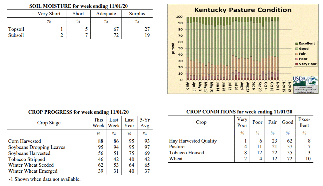
below normal. Topsoil moisture was rated 1 percent very short, 5 percent short, 67
percent adequate, and 27 percent surplus. Subsoil moisture was rated 2 percent very
short, 7 percent short, 72 percent adequate, and 19 percent surplus. Days suitable
for fieldwork averaged 3.0 out of a possible seven.
Primary activities for this week included harvesting corn, soybeans, and stripping
tobacco along with seeding winter wheat. Widespread rain this past week slowed
fieldwork progress. Conditions improved by the weekend, however the ground remained
very wet with cold temperatures hindering the drying process. Stripping of tobacco is
slightly ahead of last year at this juncture. Thirty-nine percent of the winter wheat
crop has emerged.
The condition of winter wheat remains good. Housed tobacco condition deteriorated
from last week, but continues to be mostly good. Pastures are still in mostly good
shape, however colder temperatures may begin to limit growth. At this time, sixty-
five percent of feed for cattle is being obtained from pasture. Overall quality of
harvested hay is rated as mostly good.
Kentucky Climate Summary
For the Period November 2, 2020 to November 8, 2020
Above Normal Temperatures and Much Below Normal Rainfall:
A hard freeze brought an end to the 2020 growing season on Monday morning as lows
dipped well into the 20s across the state. Many in the low to middle 20s. Otherwise,
the first full week of November featured perfect harvest weather with dry conditions,
sunny skies, and increasing temperatures in place. After the chilly start to the
period, high temperatures were back to around 70 for the second half of the work week.
The warming trend continued into the weekend with some record-breaking temperatures
on Sunday with highs in the upper 70s to low 80s. Just to put into perspective, these
temperatures were about 20 degrees above normal highs, which average in the upper 50s
to low 60s for this time of year.
Temperatures for the period averaged 54 degrees across the state which was 3 degrees
warmer than normal and 2 degrees warmer than the previous period. High temperatures
averaged from 71 in the West to 68 in the East. Departure from normal high
temperatures ranged from 8 degrees warmer than normal in the West to 5 degrees warmer
than normal in the East. Low temperatures averaged from 41 degrees in the West to 37
degrees in the East. Departure from normal low temperature ranged from near normal in
the West to near normal in the East. The extreme high temperature for the period was
83 degrees at GREENVILLE 6N and the extreme low was 21 degrees at BRANDENBURG 4SW.
Precipitation (liq. equ.) for the period totaled 0.00 inches statewide which was 0.77
inches below normal and 0% of normal. Precipitation totals by climate division, West
0.00 inches, Central 0.00 inches, Bluegrass 0.00 inches and East 0.00 inches, which
was 0.88, 0.8, 0.7 and 0.71 inches below normal. By station, precipitation totals
ranged from a low of 0.00 inches at ALBANY 1N to a high of 0.05 inches at POPLAR BLUFF ASOS.
---
Kentucky Crop and Weather Report
Issued 4:00 P.M., November 2, 2020 33-20
Agricultural News: Kentucky experienced below normal temperatures and much above
normal rainfall over the past week. Precipitation for the week totaled 2.16 inches,
1.39 inches above normal. Temperatures averaged 52 degrees for the week, 1 degree
below normal. Topsoil moisture was rated 1 percent very short, 5 percent short, 67
percent adequate, and 27 percent surplus. Subsoil moisture was rated 2 percent very
short, 7 percent short, 72 percent adequate, and 19 percent surplus. Days suitable
for fieldwork averaged 3.0 out of a possible seven.
Primary activities for this week included harvesting corn, soybeans, and stripping
tobacco along with seeding winter wheat. Widespread rain this past week slowed
fieldwork progress. Conditions improved by the weekend, however the ground remained
very wet with cold temperatures hindering the drying process. Stripping of tobacco is
slightly ahead of last year at this juncture. Thirty-nine percent of the winter wheat
crop has emerged.
The condition of winter wheat remains good. Housed tobacco condition deteriorated
from last week, but continues to be mostly good. Pastures are still in mostly good
shape, however colder temperatures may begin to limit growth. At this time, sixty-
five percent of feed for cattle is being obtained from pasture. Overall quality of
harvested hay is rated as mostly good.
 Kentucky Climate Summary
For the Period October 26, 2020 to November 1, 2020
Below Normal Temperatures and Much Above Normal Rainfall:
October closed with an active weather pattern in place. The most significant
accumulations were seen on Wednesday and Thursday as a combination of a strong
disturbance aloft and the remnants of Hurricane Zeta produced widespread rainfall
across the state. Over these 2 days, most of Kentucky saw 1 to 3+ inches. The higher
end of these totals were primarily across Western Kentucky and extending northeast
for a tier of two counties close to the Ohio River. Combined with lighter
accumulations earlier in the period, the state averaged 2.16 inches, marking a second
straight week of above normal rainfall. Behind the system on Thursday, much cooler
air filtered into the area on Friday and the weekend. Frost was prevalent on Saturday
morning as lows dipped into the low to middle 30s. A stronger cold front then swept
through the area on Sunday. While the frontal passage was dry, strong winds
accompanied the boundary, gusting between 30 and 40 mph from time to time. The cold
temperatures behind this front will be reflected on next week’s report.
Temperatures for the period averaged 52 degrees across the state which was 1 degree
cooler than normal and 10 degrees cooler than the previous period. High temperatures
averaged from 57 in the West to 61 in the East. Departure from normal high
temperatures ranged from 9 degrees cooler than normal in the West to 5 degrees
cooler than normal in the East. Low temperatures averaged from 44 degrees in the
West to 48 degrees in the East. Departure from normal low temperature ranged from 1
degree warmer than normal in the West to 9 degrees warmer than normal in the East.
The extreme high temperature for the period was 80 degrees at MIDDLESBORO AWOS and
the extreme low was 28 degrees at CARLISLE 5SW.
Precipitation (liq. equ.) for the period totaled 2.16 inches statewide which was 1.39
inches above normal and 280% of normal. Precipitation totals by climate division,
West 3.31 inches, Central 1.69 inches, Bluegrass 2.14 inches and East 1.50 inches,
which was 2.45, 0.89, 1.43 and 0.78 inches above normal. By station, precipitation
totals ranged from a low of 0.63 inches at ALBANY 1N to a high of 4.67 inches at
HENDERSON 5E.
---
Kentucky Crop and Weather Report
Issued 4:00 P.M., October 26, 2020 32-20
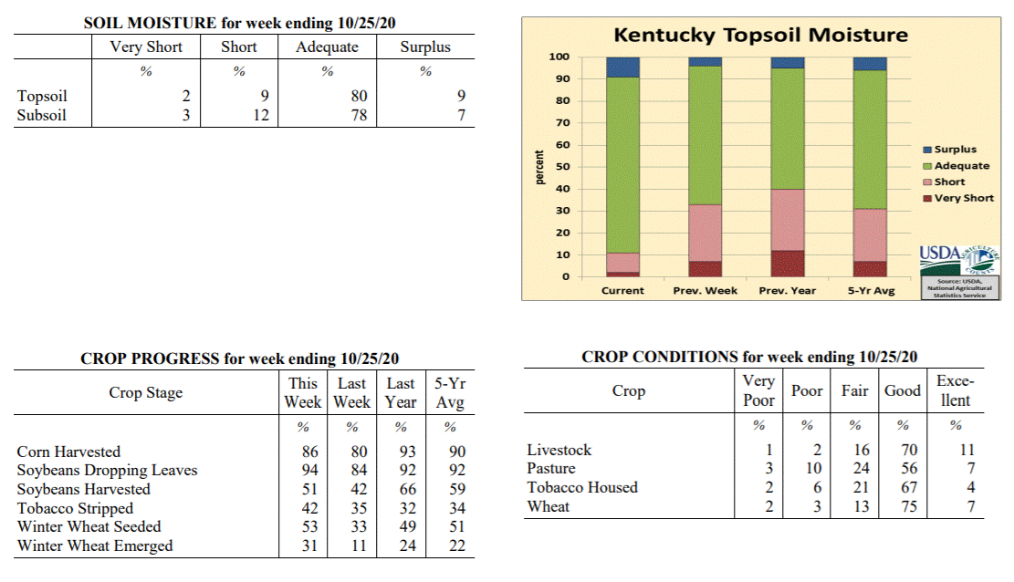
Agricultural News: Kentucky experienced above normal temperatures and rainfall over
the past week. Precipitation for the week totaled 1.68 inches, 0.98 inches above
normal. Temperatures averaged 62 degrees for the week, 6 degrees above normal.
Topsoil moisture was rated 2 percent very short, 9 percent short, 80 percent
adequate, and 9 percent surplus. Subsoil moisture was rated 3 percent very short, 12
percent short, 78 percent adequate, and 7 percent surplus. Days suitable for
fieldwork averaged 4.0 out of a possible seven.
Primary activities for this week included harvesting corn, soybeans, and stripping
tobacco, along with seeding winter wheat. Harvesting progress was stymied at times
due to widespread rainfall this past week. Although the precipitation was a hindrance
in the fields, it did help to promote some pasture growth, as many areas were getting
very dry. Many farmers have completed their last cutting of hay and additional
grazing time will protect hay stocks for the winter months.
The condition of winter wheat is mostly good at this juncture. Housed tobacco
condition declined slightly from the previous week, but remains mostly good. Pastures
are still in mostly good shape and, as mentioned above, will benefit from rain
this week. Livestock are in good shape, as farmers will allow grazing as long as
pasture growth permits.
Kentucky Climate Summary
For the Period October 26, 2020 to November 1, 2020
Below Normal Temperatures and Much Above Normal Rainfall:
October closed with an active weather pattern in place. The most significant
accumulations were seen on Wednesday and Thursday as a combination of a strong
disturbance aloft and the remnants of Hurricane Zeta produced widespread rainfall
across the state. Over these 2 days, most of Kentucky saw 1 to 3+ inches. The higher
end of these totals were primarily across Western Kentucky and extending northeast
for a tier of two counties close to the Ohio River. Combined with lighter
accumulations earlier in the period, the state averaged 2.16 inches, marking a second
straight week of above normal rainfall. Behind the system on Thursday, much cooler
air filtered into the area on Friday and the weekend. Frost was prevalent on Saturday
morning as lows dipped into the low to middle 30s. A stronger cold front then swept
through the area on Sunday. While the frontal passage was dry, strong winds
accompanied the boundary, gusting between 30 and 40 mph from time to time. The cold
temperatures behind this front will be reflected on next week’s report.
Temperatures for the period averaged 52 degrees across the state which was 1 degree
cooler than normal and 10 degrees cooler than the previous period. High temperatures
averaged from 57 in the West to 61 in the East. Departure from normal high
temperatures ranged from 9 degrees cooler than normal in the West to 5 degrees
cooler than normal in the East. Low temperatures averaged from 44 degrees in the
West to 48 degrees in the East. Departure from normal low temperature ranged from 1
degree warmer than normal in the West to 9 degrees warmer than normal in the East.
The extreme high temperature for the period was 80 degrees at MIDDLESBORO AWOS and
the extreme low was 28 degrees at CARLISLE 5SW.
Precipitation (liq. equ.) for the period totaled 2.16 inches statewide which was 1.39
inches above normal and 280% of normal. Precipitation totals by climate division,
West 3.31 inches, Central 1.69 inches, Bluegrass 2.14 inches and East 1.50 inches,
which was 2.45, 0.89, 1.43 and 0.78 inches above normal. By station, precipitation
totals ranged from a low of 0.63 inches at ALBANY 1N to a high of 4.67 inches at
HENDERSON 5E.
---
Kentucky Crop and Weather Report
Issued 4:00 P.M., October 26, 2020 32-20
Agricultural News: Kentucky experienced above normal temperatures and rainfall over
the past week. Precipitation for the week totaled 1.68 inches, 0.98 inches above
normal. Temperatures averaged 62 degrees for the week, 6 degrees above normal.
Topsoil moisture was rated 2 percent very short, 9 percent short, 80 percent
adequate, and 9 percent surplus. Subsoil moisture was rated 3 percent very short, 12
percent short, 78 percent adequate, and 7 percent surplus. Days suitable for
fieldwork averaged 4.0 out of a possible seven.
Primary activities for this week included harvesting corn, soybeans, and stripping
tobacco, along with seeding winter wheat. Harvesting progress was stymied at times
due to widespread rainfall this past week. Although the precipitation was a hindrance
in the fields, it did help to promote some pasture growth, as many areas were getting
very dry. Many farmers have completed their last cutting of hay and additional
grazing time will protect hay stocks for the winter months.
The condition of winter wheat is mostly good at this juncture. Housed tobacco
condition declined slightly from the previous week, but remains mostly good. Pastures
are still in mostly good shape and, as mentioned above, will benefit from rain
this week. Livestock are in good shape, as farmers will allow grazing as long as
pasture growth permits.
 Kentucky Climate Summary
For the Period October 19, 2020 to October 25, 2020
Above Normal Temperatures and Rainfall:
Leading into this period, Kentucky had been running on the dry side with five
straight weeks of below normal rainfall. The dry pattern came to an abrupt halt this
week as Kentucky averaged 1.68 inches behind multiple rounds of soaking rainfall. The
first event came on Monday as multiple disturbances passed over a stalled frontal
boundary. Warm and mild conditions followed for a few days, before a second round on
Friday as a strong cold front sparked scattered to numerous showers and storms across
the region. A cool weekend followed with occasional periods of light showers/drizzle.
Overall, the highest accumulations for the week were seen across Western/Central
Kentucky and up into the Bluegrass region. In fact, a large section of this area saw
2+ inches. Totals diminished farther east as Eastern Kentucky averaged a little under
a half inch for the week. After a dry first half of the month, this week of wet
weather has taken the state average closer to normal for the month of October.
Temperatures for the period averaged 62 degrees across the state which was 6 degrees
warmer than normal and 6 degrees warmer than the previous period. High temperatures
averaged from 69 in the West to 74 in the East. Departure from normal high
temperatures ranged from 1 degree cooler than normal in the West to 6 degrees
warmer than normal in the East. Low temperatures averaged from 53 degrees in the
West to 53 degrees in the East. Departure from normal low temperature ranged from 8
degrees warmer than normal in the West to 12 degrees warmer than normal in the
East. The extreme high temperature for the period was 85 degrees at CADIZ 4SW and the
extreme low was 43 degrees at ALEXANDRIA 5NW.
Precipitation (liq. equ.) for the period totaled 1.68 inches statewide which was 0.98
inches above normal and 238% of normal. Precipitation totals by climate division,
West 2.35 inches, Central 1.86 inches, Bluegrass 2.04 inches and East 0.48 inches,
which was 1.56, 1.15, 1.39 and -0.19 inches respectively from normal. By station,
precipitation totals ranged from a low of 0.16 inches at HINDMAN 5N to a high of 5.57
inches at SHEPHERDSVILLE 6SE.
---
Kentucky Crop and Weather Report
Issued 4:00 P.M., October 19, 2020 31-20
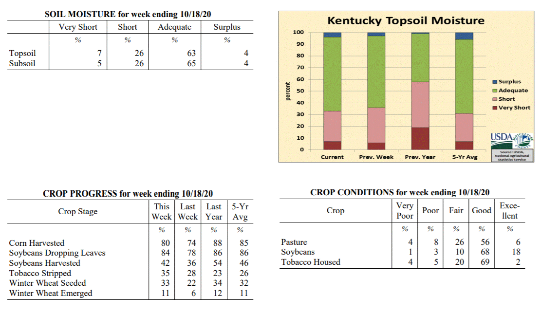
Agricultural News: Kentucky experienced near normal temperatures and below normal
rainfall over the past week. Precipitation for the week totaled 0.24 inches, 0.46
inches below normal. Temperatures averaged 57 degrees for the week, 6 degrees below
normal. Topsoil moisture was rated 7 percent very short, 26 percent short, 63 percent
adequate, and 4 percent surplus. Subsoil moisture was rated 5 percent very short, 26
percent short, 65 percent adequate, and 4 percent surplus. Days suitable for
fieldwork averaged 5.6 out of a possible seven.
Primary activities for this week included harvesting corn, soybeans, and stripping
tobacco along with seeding winter wheat. Despite a few scattered showers, harvesting
moved ahead as most of the week was cool and dry. Farmers continue to get the wheat
crop in the ground as a small portion has emerged.
The condition of the soybean crop continues to be good overall. Housed tobacco
condition declined slightly from the previous week, but remains mostly good at this
juncture. Pastures are still in mostly good shape, however as temperatures continue
to cool, growth will slow. Most farmers have completed their last hay cutting, but
stocks should be good overall.
Kentucky Climate Summary
For the Period October 19, 2020 to October 25, 2020
Above Normal Temperatures and Rainfall:
Leading into this period, Kentucky had been running on the dry side with five
straight weeks of below normal rainfall. The dry pattern came to an abrupt halt this
week as Kentucky averaged 1.68 inches behind multiple rounds of soaking rainfall. The
first event came on Monday as multiple disturbances passed over a stalled frontal
boundary. Warm and mild conditions followed for a few days, before a second round on
Friday as a strong cold front sparked scattered to numerous showers and storms across
the region. A cool weekend followed with occasional periods of light showers/drizzle.
Overall, the highest accumulations for the week were seen across Western/Central
Kentucky and up into the Bluegrass region. In fact, a large section of this area saw
2+ inches. Totals diminished farther east as Eastern Kentucky averaged a little under
a half inch for the week. After a dry first half of the month, this week of wet
weather has taken the state average closer to normal for the month of October.
Temperatures for the period averaged 62 degrees across the state which was 6 degrees
warmer than normal and 6 degrees warmer than the previous period. High temperatures
averaged from 69 in the West to 74 in the East. Departure from normal high
temperatures ranged from 1 degree cooler than normal in the West to 6 degrees
warmer than normal in the East. Low temperatures averaged from 53 degrees in the
West to 53 degrees in the East. Departure from normal low temperature ranged from 8
degrees warmer than normal in the West to 12 degrees warmer than normal in the
East. The extreme high temperature for the period was 85 degrees at CADIZ 4SW and the
extreme low was 43 degrees at ALEXANDRIA 5NW.
Precipitation (liq. equ.) for the period totaled 1.68 inches statewide which was 0.98
inches above normal and 238% of normal. Precipitation totals by climate division,
West 2.35 inches, Central 1.86 inches, Bluegrass 2.04 inches and East 0.48 inches,
which was 1.56, 1.15, 1.39 and -0.19 inches respectively from normal. By station,
precipitation totals ranged from a low of 0.16 inches at HINDMAN 5N to a high of 5.57
inches at SHEPHERDSVILLE 6SE.
---
Kentucky Crop and Weather Report
Issued 4:00 P.M., October 19, 2020 31-20
Agricultural News: Kentucky experienced near normal temperatures and below normal
rainfall over the past week. Precipitation for the week totaled 0.24 inches, 0.46
inches below normal. Temperatures averaged 57 degrees for the week, 6 degrees below
normal. Topsoil moisture was rated 7 percent very short, 26 percent short, 63 percent
adequate, and 4 percent surplus. Subsoil moisture was rated 5 percent very short, 26
percent short, 65 percent adequate, and 4 percent surplus. Days suitable for
fieldwork averaged 5.6 out of a possible seven.
Primary activities for this week included harvesting corn, soybeans, and stripping
tobacco along with seeding winter wheat. Despite a few scattered showers, harvesting
moved ahead as most of the week was cool and dry. Farmers continue to get the wheat
crop in the ground as a small portion has emerged.
The condition of the soybean crop continues to be good overall. Housed tobacco
condition declined slightly from the previous week, but remains mostly good at this
juncture. Pastures are still in mostly good shape, however as temperatures continue
to cool, growth will slow. Most farmers have completed their last hay cutting, but
stocks should be good overall.
 Kentucky Climate Summary
For the Period October 12, 2020 to October 18, 2020
Near Normal Temperatures and Below Normal Rainfall:
Focus for the week revolved around a couple cold fronts. The first pushed through the
area on Monday and Monday night, accompanied by a quick-hitting broken line of
showers. Most saw a quarter inch or less. The boundary was followed by a stronger
cold front on Thursday. This front was also accompanied by some light showers with
most under a tenth of an inch. The bigger change came in the way of temperatures.
Highs struggled in the 50s on Friday and was followed by a very cool night areawide.
The majority of Kentucky saw temperatures dip into the low to middle 30s. Several even
fell into the upper 20s. Looking at average freeze dates, most locations in Kentucky
see the first 32-degree temperature of the fall season over the second half of
October. Temperatures did trend a bit warmer over the weekend, and once again, the
state saw a light round of scattered showers on Sunday. Overall though, Kentucky
averaged about a quarter inch for the week, marking a fifth straight week that the
state average has ran below normal.
Temperatures for the period averaged 57 degrees across the state which was near
normal and 6 degrees cooler than the previous period. High temperatures averaged from
69 in the West to 68 in the East. Departure from normal high temperatures ranged from
3 degrees cooler than normal in the West to 2 degrees cooler than normal in the East.
Low temperatures averaged from 45 degrees in the West to 46 degrees in the East.
Departure from normal low temperature ranged from 2 degrees cooler than normal in the
West to 3 degrees warmer than normal in the East. The extreme high temperature for
the period was 83 degrees at BOWLING GREEN APT and the extreme low was 26 degrees
at CARLISLE 5SW.
Precipitation (liq. equ.) for the period totaled 0.24 inches statewide which was 0.46
inches below normal and 34% of normal. Precipitation totals by climate division, West
0.18 inches, Central 0.22 inches, Bluegrass 0.16 inches and East 0.38 inches, which
was 0.56, 0.5, 0.51 and 0.31 inches below normal. By station, precipitation totals
ranged from a low of 0.05 inches at CARBONDALE ASOS to a high of 0.67 inches at PEABODY.
---
Kentucky Crop and Weather Report
Issued 4:00 P.M., October 12, 2020 30-20
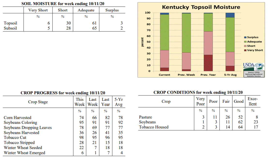
Agricultural News: Kentucky experienced above normal temperatures and below normal
rainfall over the past week. Precipitation for the week totaled 0.47 inches, 0.30
inches below normal. Temperatures averaged 63 degrees for the week, 3 degrees above
normal. Topsoil moisture was rated 6 percent very short, 30 percent short, 61 percent
adequate, and 3 percent surplus. Subsoil moisture was rated 5 percent very short, 28
percent short, 65 percent adequate, and 2 percent surplus. Days suitable for
fieldwork averaged 5.9 out of a possible seven.
Primary activities for this week included harvesting corn, soybeans, and stripping
tobacco, along with seeding winter wheat. Harvesting progress remains steady as dry
conditions prevailed over the previous week. Hurricane Delta brought some rain over
the weekend, however, it was not widespread. As winter wheat planting continues, a
small portion of the crop has emerged.
The condition of the soybean crop continues to be good overall. Housed tobacco
condition is mostly good, however, more houseburn was evident this week. While
pastures have benefitted from timely rain in some areas, others have seen reduced
growth from dry conditions. In parts of the state, cattle producers may start feeding
hay if the dry weather persists.
Kentucky Climate Summary
For the Period October 12, 2020 to October 18, 2020
Near Normal Temperatures and Below Normal Rainfall:
Focus for the week revolved around a couple cold fronts. The first pushed through the
area on Monday and Monday night, accompanied by a quick-hitting broken line of
showers. Most saw a quarter inch or less. The boundary was followed by a stronger
cold front on Thursday. This front was also accompanied by some light showers with
most under a tenth of an inch. The bigger change came in the way of temperatures.
Highs struggled in the 50s on Friday and was followed by a very cool night areawide.
The majority of Kentucky saw temperatures dip into the low to middle 30s. Several even
fell into the upper 20s. Looking at average freeze dates, most locations in Kentucky
see the first 32-degree temperature of the fall season over the second half of
October. Temperatures did trend a bit warmer over the weekend, and once again, the
state saw a light round of scattered showers on Sunday. Overall though, Kentucky
averaged about a quarter inch for the week, marking a fifth straight week that the
state average has ran below normal.
Temperatures for the period averaged 57 degrees across the state which was near
normal and 6 degrees cooler than the previous period. High temperatures averaged from
69 in the West to 68 in the East. Departure from normal high temperatures ranged from
3 degrees cooler than normal in the West to 2 degrees cooler than normal in the East.
Low temperatures averaged from 45 degrees in the West to 46 degrees in the East.
Departure from normal low temperature ranged from 2 degrees cooler than normal in the
West to 3 degrees warmer than normal in the East. The extreme high temperature for
the period was 83 degrees at BOWLING GREEN APT and the extreme low was 26 degrees
at CARLISLE 5SW.
Precipitation (liq. equ.) for the period totaled 0.24 inches statewide which was 0.46
inches below normal and 34% of normal. Precipitation totals by climate division, West
0.18 inches, Central 0.22 inches, Bluegrass 0.16 inches and East 0.38 inches, which
was 0.56, 0.5, 0.51 and 0.31 inches below normal. By station, precipitation totals
ranged from a low of 0.05 inches at CARBONDALE ASOS to a high of 0.67 inches at PEABODY.
---
Kentucky Crop and Weather Report
Issued 4:00 P.M., October 12, 2020 30-20
Agricultural News: Kentucky experienced above normal temperatures and below normal
rainfall over the past week. Precipitation for the week totaled 0.47 inches, 0.30
inches below normal. Temperatures averaged 63 degrees for the week, 3 degrees above
normal. Topsoil moisture was rated 6 percent very short, 30 percent short, 61 percent
adequate, and 3 percent surplus. Subsoil moisture was rated 5 percent very short, 28
percent short, 65 percent adequate, and 2 percent surplus. Days suitable for
fieldwork averaged 5.9 out of a possible seven.
Primary activities for this week included harvesting corn, soybeans, and stripping
tobacco, along with seeding winter wheat. Harvesting progress remains steady as dry
conditions prevailed over the previous week. Hurricane Delta brought some rain over
the weekend, however, it was not widespread. As winter wheat planting continues, a
small portion of the crop has emerged.
The condition of the soybean crop continues to be good overall. Housed tobacco
condition is mostly good, however, more houseburn was evident this week. While
pastures have benefitted from timely rain in some areas, others have seen reduced
growth from dry conditions. In parts of the state, cattle producers may start feeding
hay if the dry weather persists.
 Kentucky Climate Summary
For the Period October 5, 2020 to October 11, 2020
Above Normal Temperatures and Below Normal Rainfall:
The Commonwealth saw the remnants of Hurricane Delta pass through the region this
period, bringing widespread rainfall to predominantly Eastern Kentucky on Saturday
and Sunday. Much of Southeastern Kentucky saw between 0.75 and 1.5 inches. Totals
diminished greatly father west and north across the rest of Kentucky. In fact, while
Eastern Kentucky averaged over an inch for the week, Western Kentucky and the
Bluegrass region both averaged less than a quarter inch. This event accounted for
nearly all of the rainfall for the period as the state remained mostly dry throughout
the work week. Temperatures also remained mild for much of the period. The one
exception came on Monday with well below normal temperatures in place. Many woke up
on Monday morning to temperatures in the 30s. Much of Western and West-Central
Kentucky dipped into the low to middle 30s, resulting in some light patchy frost.
Temperatures for the period averaged 63 degrees across the state which was 3 degrees
warmer than normal and 6 degrees warmer than the previous period. High temperatures
averaged from 77 in the West to 72 in the East. Departure from normal high
temperatures ranged from 3 degrees warmer than normal in the West to near normal in
the East. Low temperatures averaged from 51 degrees in the West to 52 degrees in the
East. Departure from normal low temperature ranged from 2 degrees warmer than normal
in the West to 7 degrees warmer than normal in the East. The extreme high temperature
for the period was 87 degrees at CARBONDALE ASOS and the extreme low was 29 degrees
at HENDERSON 5E.
Precipitation (liq. equ.) for the period totaled 0.47 inches statewide which was 0.3
inches below normal and 61% of normal. Precipitation totals by climate division, West
0.22 inches, Central 0.41 inches, Bluegrass 0.19 inches and East 1.04 inches, which
was -0.56, -0.39, -0.54 and 0.27 inches respectively from normal. By station,
precipitation totals ranged from a low of 0.00 inches at CAPE GIRARDEAU ASOS to a
high of 1.50 inches at JACKSON 3SE.
---
Kentucky Crop and Weather Report
Issued 4:00 P.M., October 5, 2020 29-20
Agricultural News: Kentucky experienced below normal temperatures and rainfall over
the past week. Precipitation for the week totaled 0.62 inches, 0.18 inches below
normal. Temperatures averaged 58 degrees for the week, 4 degrees below normal.
Topsoil moisture was rated 3 percent very short, 29 percent short, 67 percent
adequate, and 1 percent surplus. Subsoil moisture was rated 4 percent very short, 22
percent short, 73 percent adequate, and 1 percent surplus. Days suitable for
fieldwork averaged 6.0 out of a possible seven.
Primary activities for this week included harvesting corn, soybeans, and tobacco.
Harvesting progress has been aided by mostly dry conditions throughout the state.
Planting of winter wheat continues with a small portion of the crop emerged.
The downfall of limited precipitation has been stress and early maturation for double
crop soybeans. Although the weather has been good for curing cut hay, yields may have
been affected in some cases. The condition of the soybean crop continues to be good
overall. Housed tobacco condition is mostly good as the houseburn reported was light.
Pastures are still replenishing as farmers are holding hay for the winter months.
Kentucky Climate Summary
For the Period October 5, 2020 to October 11, 2020
Above Normal Temperatures and Below Normal Rainfall:
The Commonwealth saw the remnants of Hurricane Delta pass through the region this
period, bringing widespread rainfall to predominantly Eastern Kentucky on Saturday
and Sunday. Much of Southeastern Kentucky saw between 0.75 and 1.5 inches. Totals
diminished greatly father west and north across the rest of Kentucky. In fact, while
Eastern Kentucky averaged over an inch for the week, Western Kentucky and the
Bluegrass region both averaged less than a quarter inch. This event accounted for
nearly all of the rainfall for the period as the state remained mostly dry throughout
the work week. Temperatures also remained mild for much of the period. The one
exception came on Monday with well below normal temperatures in place. Many woke up
on Monday morning to temperatures in the 30s. Much of Western and West-Central
Kentucky dipped into the low to middle 30s, resulting in some light patchy frost.
Temperatures for the period averaged 63 degrees across the state which was 3 degrees
warmer than normal and 6 degrees warmer than the previous period. High temperatures
averaged from 77 in the West to 72 in the East. Departure from normal high
temperatures ranged from 3 degrees warmer than normal in the West to near normal in
the East. Low temperatures averaged from 51 degrees in the West to 52 degrees in the
East. Departure from normal low temperature ranged from 2 degrees warmer than normal
in the West to 7 degrees warmer than normal in the East. The extreme high temperature
for the period was 87 degrees at CARBONDALE ASOS and the extreme low was 29 degrees
at HENDERSON 5E.
Precipitation (liq. equ.) for the period totaled 0.47 inches statewide which was 0.3
inches below normal and 61% of normal. Precipitation totals by climate division, West
0.22 inches, Central 0.41 inches, Bluegrass 0.19 inches and East 1.04 inches, which
was -0.56, -0.39, -0.54 and 0.27 inches respectively from normal. By station,
precipitation totals ranged from a low of 0.00 inches at CAPE GIRARDEAU ASOS to a
high of 1.50 inches at JACKSON 3SE.
---
Kentucky Crop and Weather Report
Issued 4:00 P.M., October 5, 2020 29-20
Agricultural News: Kentucky experienced below normal temperatures and rainfall over
the past week. Precipitation for the week totaled 0.62 inches, 0.18 inches below
normal. Temperatures averaged 58 degrees for the week, 4 degrees below normal.
Topsoil moisture was rated 3 percent very short, 29 percent short, 67 percent
adequate, and 1 percent surplus. Subsoil moisture was rated 4 percent very short, 22
percent short, 73 percent adequate, and 1 percent surplus. Days suitable for
fieldwork averaged 6.0 out of a possible seven.
Primary activities for this week included harvesting corn, soybeans, and tobacco.
Harvesting progress has been aided by mostly dry conditions throughout the state.
Planting of winter wheat continues with a small portion of the crop emerged.
The downfall of limited precipitation has been stress and early maturation for double
crop soybeans. Although the weather has been good for curing cut hay, yields may have
been affected in some cases. The condition of the soybean crop continues to be good
overall. Housed tobacco condition is mostly good as the houseburn reported was light.
Pastures are still replenishing as farmers are holding hay for the winter months.
 Kentucky Climate Summary
For the Period September 28, 2020 to October 4, 2020
Below Normal Temperatures and Rainfall:
Below normal rainfall continued for a third straight week, but unlike the previous
two, Kentucky did see some significant rainfall on Monday with the passage of a cold
front. Overall, the state averaged 0.62 inches for the week, most of which falling
with this boundary. Outside of some spotty light showers on Tuesday, Thursday, and
Sunday; the rest of the week followed a mostly dry and cool pattern. The coolest
temperatures were seen on Friday and over the weekend as highs struggled in the 60s.
Low temperatures both Friday and Saturday mornings dipped into the middle 30s to low
40s, opening the opportunity for some patchy frost in sheltered and low lying
locations. As a side note, the state has averaged 1.78 inches over the past 30 days,
which is about 1.75 inches below normal.
Temperatures for the period averaged 58 degrees across the state which was 4 degrees
cooler than normal and 6 degrees cooler than the previous period. High temperatures
averaged from 70 in the West to 68 in the East. Departure from normal high
temperatures ranged from 6 degrees cooler than normal in the West to 6 degrees cooler
than normal in the East. Low temperatures averaged from 46 degrees in the West to 48
degrees in the East. Departure from normal low temperature ranged from 6 degrees
cooler than normal in the West to near normal in the East. The extreme high
temperature for the period was 83 degrees at CARBONDALE ASOS and the extreme low was
34 degrees at CARLISLE 5SW.
Precipitation (liq. equ.) for the period totaled 0.62 inches statewide which was 0.18
inches below normal and 78% of normal. Precipitation totals by climate division, West
0.68 inches, Central 0.41 inches, Bluegrass 0.57 inches and East 0.84 inches, which
was -0.14, -0.44, -0.17 and 0.05 inches respectively from normal. By station,
precipitation totals ranged from a low of 0.16 inches at HODGENVILLE 2E to a high of
1.37 inches at TRIANGLE MOUNTAIN.
---
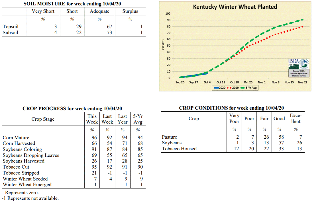
Kentucky Crop and Weather Report
Issued 4:00 P.M., September 28, 2020 28-20
Agricultural News: Kentucky experienced below normal temperatures and much below
normal rainfall over the past week. Precipitation for the week totaled 0.11 inches,
0.74 inches below normal. Temperatures averaged 64 degrees for the week, 2 degrees
below normal. Topsoil moisture was rated 1 percent very short, 27 percent short, and
72 percent adequate. Subsoil moisture was rated 1 percent very short, 20 percent
short, and 79 percent adequate. Days suitable for fieldwork averaged 5.9 out of a
possible seven.
Primary activities for this week included harvesting corn, soybeans, tobacco, and
hay. Winter wheat planting has begun, however the majority of the crop is not yet in
the ground. Dry weather of late has allowed farmers to push forward with all manner
of fieldwork. As the soybean and corn harvest continues, there is some optimism for
yields in areas of the state. With that said, later planted and double cropped
soybeans could be subject to stress as dry weather persists.
Both corn and soybeans are doing well overall as both crops saw an increase in the
amount reported as in excellent condition. Housed tobacco condition is mostly good as
the houseburn reported was light. Despite the dry conditions, pastureland and
livestock are in good shape. Hay supply is adequate at this juncture and is being
aided by the continuing growth in pastures.
Kentucky Climate Summary
For the Period September 28, 2020 to October 4, 2020
Below Normal Temperatures and Rainfall:
Below normal rainfall continued for a third straight week, but unlike the previous
two, Kentucky did see some significant rainfall on Monday with the passage of a cold
front. Overall, the state averaged 0.62 inches for the week, most of which falling
with this boundary. Outside of some spotty light showers on Tuesday, Thursday, and
Sunday; the rest of the week followed a mostly dry and cool pattern. The coolest
temperatures were seen on Friday and over the weekend as highs struggled in the 60s.
Low temperatures both Friday and Saturday mornings dipped into the middle 30s to low
40s, opening the opportunity for some patchy frost in sheltered and low lying
locations. As a side note, the state has averaged 1.78 inches over the past 30 days,
which is about 1.75 inches below normal.
Temperatures for the period averaged 58 degrees across the state which was 4 degrees
cooler than normal and 6 degrees cooler than the previous period. High temperatures
averaged from 70 in the West to 68 in the East. Departure from normal high
temperatures ranged from 6 degrees cooler than normal in the West to 6 degrees cooler
than normal in the East. Low temperatures averaged from 46 degrees in the West to 48
degrees in the East. Departure from normal low temperature ranged from 6 degrees
cooler than normal in the West to near normal in the East. The extreme high
temperature for the period was 83 degrees at CARBONDALE ASOS and the extreme low was
34 degrees at CARLISLE 5SW.
Precipitation (liq. equ.) for the period totaled 0.62 inches statewide which was 0.18
inches below normal and 78% of normal. Precipitation totals by climate division, West
0.68 inches, Central 0.41 inches, Bluegrass 0.57 inches and East 0.84 inches, which
was -0.14, -0.44, -0.17 and 0.05 inches respectively from normal. By station,
precipitation totals ranged from a low of 0.16 inches at HODGENVILLE 2E to a high of
1.37 inches at TRIANGLE MOUNTAIN.
---
Kentucky Crop and Weather Report
Issued 4:00 P.M., September 28, 2020 28-20
Agricultural News: Kentucky experienced below normal temperatures and much below
normal rainfall over the past week. Precipitation for the week totaled 0.11 inches,
0.74 inches below normal. Temperatures averaged 64 degrees for the week, 2 degrees
below normal. Topsoil moisture was rated 1 percent very short, 27 percent short, and
72 percent adequate. Subsoil moisture was rated 1 percent very short, 20 percent
short, and 79 percent adequate. Days suitable for fieldwork averaged 5.9 out of a
possible seven.
Primary activities for this week included harvesting corn, soybeans, tobacco, and
hay. Winter wheat planting has begun, however the majority of the crop is not yet in
the ground. Dry weather of late has allowed farmers to push forward with all manner
of fieldwork. As the soybean and corn harvest continues, there is some optimism for
yields in areas of the state. With that said, later planted and double cropped
soybeans could be subject to stress as dry weather persists.
Both corn and soybeans are doing well overall as both crops saw an increase in the
amount reported as in excellent condition. Housed tobacco condition is mostly good as
the houseburn reported was light. Despite the dry conditions, pastureland and
livestock are in good shape. Hay supply is adequate at this juncture and is being
aided by the continuing growth in pastures.
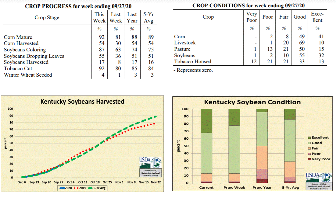 Kentucky Climate Summary
For the Period September 21, 2020 to September 27, 2020
Below Normal Temperatures and Much Below Normal Rainfall:
Weather conditions have trended dry recently. The state only averaged about a tenth
of an inch this period, marking a second straight week with most of the area seeing
very little to no rainfall. The rainfall that was seen occurred over the second half of
the workweek as the remnants of another tropical system, Beta, progressed across the
southern half of Kentucky. The highest accumulations were primarily across extreme
Southeastern Kentucky. Over the past 14 days, data at the Ag Weather Center shows the
state has averaged 0.12 inches, which is about 1.5 inches below normal for this time
of year. Despite the dry conditions, the Commonwealth did see pleasant fall weather
with below normal high temperatures in place for much of the workweek and only
warming slightly to seasonable norms over the weekend.
Temperatures for the period averaged 64 degrees across the state which was 2 degrees
cooler than normal and no change to the previous period. High temperatures averaged
from 73 in the West to 72 in the East. Departure from normal high temperatures
ranged from 6 degrees cooler than normal in the West to 5 degrees cooler than normal
in the East. Low temperatures averaged from 56 degrees in the West to 53 degrees in
the East. Departure from normal low temperature ranged from 1 degree warmer than
normal in the West to 1 degree warmer than normal in the East. The extreme high
temperature for the period was 84 degrees at COLUMBIA 3N and the extreme low was 38
degrees at CARLISLE 5SW.
Precipitation (liq. equ.) for the period totaled 0.11 inches statewide which was 0.74
inches below normal and 13% of normal. Precipitation totals by climate division, West
0.13 inches, Central 0.06 inches, Bluegrass 0.01 inches and East 0.22 inches, which
was 0.73, 0.87, 0.76 and 0.62 inches below normal. By station, precipitation totals
ranged from a low of 0.00 inches at ALEXANDRIA 5NW to a high of 1.16 inches at
MIDDLESBORO AWOS.
---
Kentucky Crop and Weather Report
Issued 4:00 P.M., September 21, 2020 27-20
Agricultural News: Kentucky experienced below normal temperatures and much below
rainfall over the past week. Precipitation for the week totaled 0.01 inches, 0.82
inches below normal. Temperatures averaged 66 degrees for the week, 2 degrees below
normal. Topsoil moisture was rated 2 percent very short, 15 percent short, 78 percent
adequate, and 5 percent surplus. Subsoil moisture was rated 2 percent very short, 13
percent short, 80 percent adequate, and 5 percent surplus. Days suitable for
fieldwork averaged 6.4 out of a possible seven.
Primary activities for this week included harvesting corn, soybeans, and tobacco.
Farmers made substantial progress in the fields this week thanks to mild temperatures
and dry conditions. As conducive weather presents itself, harvesting will move along
steadily. The extended dry spell has allowed farmers to get in some good late season
hay in hopes of having sufficient stock for the winter. Some late season and double
cropped soybeans are showing mild stress due to the dry weather, but overall the crop
seems to be doing well.
Corn and soybean conditions remain mostly good. Housed tobacco condition continues to
improve aided by the cool, dry weather. Pastures are in good shape and have not been
adversely affected by the dry weather at this point. Hay condition is good as
producers are getting good yields for this time of year, however rain will be needed
soon to help hay fields recover after cutting.
Kentucky Climate Summary
For the Period September 21, 2020 to September 27, 2020
Below Normal Temperatures and Much Below Normal Rainfall:
Weather conditions have trended dry recently. The state only averaged about a tenth
of an inch this period, marking a second straight week with most of the area seeing
very little to no rainfall. The rainfall that was seen occurred over the second half of
the workweek as the remnants of another tropical system, Beta, progressed across the
southern half of Kentucky. The highest accumulations were primarily across extreme
Southeastern Kentucky. Over the past 14 days, data at the Ag Weather Center shows the
state has averaged 0.12 inches, which is about 1.5 inches below normal for this time
of year. Despite the dry conditions, the Commonwealth did see pleasant fall weather
with below normal high temperatures in place for much of the workweek and only
warming slightly to seasonable norms over the weekend.
Temperatures for the period averaged 64 degrees across the state which was 2 degrees
cooler than normal and no change to the previous period. High temperatures averaged
from 73 in the West to 72 in the East. Departure from normal high temperatures
ranged from 6 degrees cooler than normal in the West to 5 degrees cooler than normal
in the East. Low temperatures averaged from 56 degrees in the West to 53 degrees in
the East. Departure from normal low temperature ranged from 1 degree warmer than
normal in the West to 1 degree warmer than normal in the East. The extreme high
temperature for the period was 84 degrees at COLUMBIA 3N and the extreme low was 38
degrees at CARLISLE 5SW.
Precipitation (liq. equ.) for the period totaled 0.11 inches statewide which was 0.74
inches below normal and 13% of normal. Precipitation totals by climate division, West
0.13 inches, Central 0.06 inches, Bluegrass 0.01 inches and East 0.22 inches, which
was 0.73, 0.87, 0.76 and 0.62 inches below normal. By station, precipitation totals
ranged from a low of 0.00 inches at ALEXANDRIA 5NW to a high of 1.16 inches at
MIDDLESBORO AWOS.
---
Kentucky Crop and Weather Report
Issued 4:00 P.M., September 21, 2020 27-20
Agricultural News: Kentucky experienced below normal temperatures and much below
rainfall over the past week. Precipitation for the week totaled 0.01 inches, 0.82
inches below normal. Temperatures averaged 66 degrees for the week, 2 degrees below
normal. Topsoil moisture was rated 2 percent very short, 15 percent short, 78 percent
adequate, and 5 percent surplus. Subsoil moisture was rated 2 percent very short, 13
percent short, 80 percent adequate, and 5 percent surplus. Days suitable for
fieldwork averaged 6.4 out of a possible seven.
Primary activities for this week included harvesting corn, soybeans, and tobacco.
Farmers made substantial progress in the fields this week thanks to mild temperatures
and dry conditions. As conducive weather presents itself, harvesting will move along
steadily. The extended dry spell has allowed farmers to get in some good late season
hay in hopes of having sufficient stock for the winter. Some late season and double
cropped soybeans are showing mild stress due to the dry weather, but overall the crop
seems to be doing well.
Corn and soybean conditions remain mostly good. Housed tobacco condition continues to
improve aided by the cool, dry weather. Pastures are in good shape and have not been
adversely affected by the dry weather at this point. Hay condition is good as
producers are getting good yields for this time of year, however rain will be needed
soon to help hay fields recover after cutting.
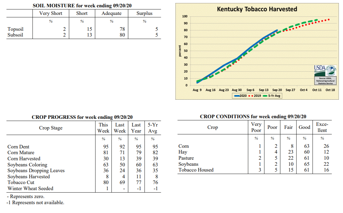 Kentucky Climate Summary
For the Period September 14, 2020 to September 20, 2020
Below Normal Temperatures and Much Below Normal Rainfall:
Dry conditions were the common theme throughout the week. In fact, other than
portions of Southeastern Kentucky that saw a brush of light rainfall from the
remnants of Hurricane Sally, most did not record anything for the period. The dry
conditions ended up breaking a stretch of five straight weeks that the state rainfall
average has ran above normal. Skies ran clear for most of the week, despite some
smoky haze filtering throughout the area from fires across the Western US. Cool
conditions accompanied the dry pattern, giving the Commonwealth its first taste of
fall weather. Following the passage of a dry cold front on Thursday, highs struggled
in the 60s and 70s over the weekend behind northeast flow. Lows each night fell
into the 40s. A handful of locations even dropped into the upper 30s. Normal lows for
the middle of September run in the middle to upper 50s.
Temperatures for the period averaged 66 degrees across the state which was 2 degrees
cooler than normal and 8 degrees cooler than the previous period. High temperatures
averaged from 79 in the West to 74 in the East. Departure from normal high
temperatures ranged from 3 degrees cooler than normal in the West to 6 degrees
cooler than normal in the East. Low temperatures averaged from 57 degrees in the
West to 57 degrees in the East. Departure from normal low temperature ranged from 1
degree cooler than normal in the West to 2 degrees warmer than normal in the East.
The extreme high temperature for the period was 87 degrees at MAYFIELD 6SW and the
extreme low was 37 degrees at CARLISLE 5SW.
Precipitation (liq. equ.) for the period totaled 0.01 inches statewide which was 0.82
inches below normal and 1% of normal. Precipitation totals by climate division, West
0.00 inches, Central 0.00 inches, Bluegrass 0.00 inches and East 0.04 inches, which
was 0.85, 0.91, 0.74 and 0.78 inches below normal. By station, precipitation totals
ranged from a low of 0.00 inches at ALBANY 1N to a high of 0.26 inches at PIKEVILLE 13S.
---
Kentucky Crop and Weather Report
Issued 4:00 P.M., September 14, 2020 26-20
Agricultural News: Kentucky experienced above normal temperatures and rainfall over
the past week. Precipitation for the week totaled 1.04 inches, 0.20 inches above
normal. Temperatures averaged 74 degrees for the week, 3 degrees above normal.
Topsoil moisture was rated 2 percent very short, 8 percent short, 83 percent
adequate, and 7 percent surplus. Subsoil moisture was rated 2 percent very short, 8
percent short, 83 percent adequate, and 7 percent surplus. Days suitable for
fieldwork averaged 5.7 out of a possible seven.
Primary activities for this week included topping and cutting tobacco along with corn
and soybean harvesting. Farmers made a considerable amount of progress in the fields
this week thanks to some mild and dry weather. The weekend brought in precipitation
and unstable weather for much of the state. Although in the early stages, corn and
soybean harvest is well underway. Producers will be harvesting steadily as conducive
weather presents itself. Nearly all the tobacco crop has been topped with well over
half cut at this juncture.
Corn and soybean conditions remain mostly good. Housed tobacco is mostly good and
showed marked improvement from last week due to largely dry conditions. Pastures are
in good shape as timely rain and mild temperatures have promoted strong
growth.
Kentucky Climate Summary
For the Period September 14, 2020 to September 20, 2020
Below Normal Temperatures and Much Below Normal Rainfall:
Dry conditions were the common theme throughout the week. In fact, other than
portions of Southeastern Kentucky that saw a brush of light rainfall from the
remnants of Hurricane Sally, most did not record anything for the period. The dry
conditions ended up breaking a stretch of five straight weeks that the state rainfall
average has ran above normal. Skies ran clear for most of the week, despite some
smoky haze filtering throughout the area from fires across the Western US. Cool
conditions accompanied the dry pattern, giving the Commonwealth its first taste of
fall weather. Following the passage of a dry cold front on Thursday, highs struggled
in the 60s and 70s over the weekend behind northeast flow. Lows each night fell
into the 40s. A handful of locations even dropped into the upper 30s. Normal lows for
the middle of September run in the middle to upper 50s.
Temperatures for the period averaged 66 degrees across the state which was 2 degrees
cooler than normal and 8 degrees cooler than the previous period. High temperatures
averaged from 79 in the West to 74 in the East. Departure from normal high
temperatures ranged from 3 degrees cooler than normal in the West to 6 degrees
cooler than normal in the East. Low temperatures averaged from 57 degrees in the
West to 57 degrees in the East. Departure from normal low temperature ranged from 1
degree cooler than normal in the West to 2 degrees warmer than normal in the East.
The extreme high temperature for the period was 87 degrees at MAYFIELD 6SW and the
extreme low was 37 degrees at CARLISLE 5SW.
Precipitation (liq. equ.) for the period totaled 0.01 inches statewide which was 0.82
inches below normal and 1% of normal. Precipitation totals by climate division, West
0.00 inches, Central 0.00 inches, Bluegrass 0.00 inches and East 0.04 inches, which
was 0.85, 0.91, 0.74 and 0.78 inches below normal. By station, precipitation totals
ranged from a low of 0.00 inches at ALBANY 1N to a high of 0.26 inches at PIKEVILLE 13S.
---
Kentucky Crop and Weather Report
Issued 4:00 P.M., September 14, 2020 26-20
Agricultural News: Kentucky experienced above normal temperatures and rainfall over
the past week. Precipitation for the week totaled 1.04 inches, 0.20 inches above
normal. Temperatures averaged 74 degrees for the week, 3 degrees above normal.
Topsoil moisture was rated 2 percent very short, 8 percent short, 83 percent
adequate, and 7 percent surplus. Subsoil moisture was rated 2 percent very short, 8
percent short, 83 percent adequate, and 7 percent surplus. Days suitable for
fieldwork averaged 5.7 out of a possible seven.
Primary activities for this week included topping and cutting tobacco along with corn
and soybean harvesting. Farmers made a considerable amount of progress in the fields
this week thanks to some mild and dry weather. The weekend brought in precipitation
and unstable weather for much of the state. Although in the early stages, corn and
soybean harvest is well underway. Producers will be harvesting steadily as conducive
weather presents itself. Nearly all the tobacco crop has been topped with well over
half cut at this juncture.
Corn and soybean conditions remain mostly good. Housed tobacco is mostly good and
showed marked improvement from last week due to largely dry conditions. Pastures are
in good shape as timely rain and mild temperatures have promoted strong
growth.
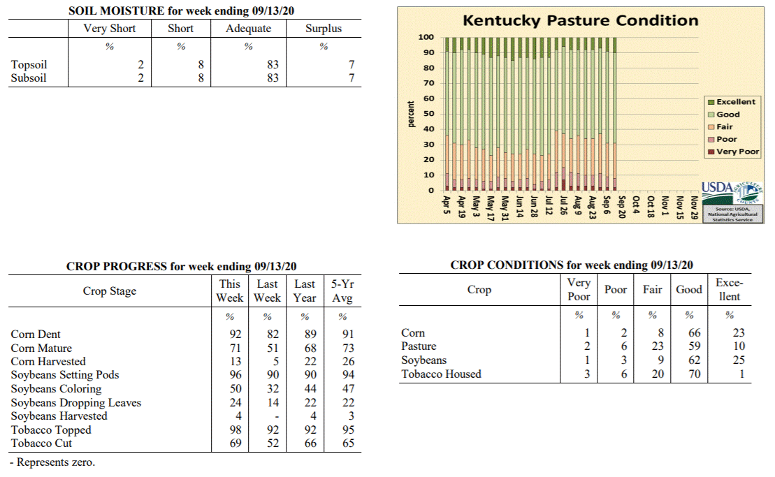 Kentucky Climate Summary
For the Period September 7, 2020 to September 13, 2020
Above Normal Temperatures and Rainfall:
The work week followed a rather stagnant pattern with dry and mild conditions in
place. Each day featured temperatures jumping into the mid to upper 80s, some hitting
the low 90s. This pattern changed drastically over the weekend for many across
Kentucky with multiple rounds of showers and storms. The most excessive
accumulations were seen across South Central Kentucky and extending into Northeastern
Kentucky where many received two or more inches. Some areas saw much more rain than
others, which was the case for Jackson, Morgan, Lincoln, and Casey Counties.
Portions of these counties saw 4 to 5+ inches, which did lead to significant flash
flooding. Total accumulations west of the line mentioned above were much less with
many under a half inch. In fact, Western Kentucky only averaged a third of an inch
for the week.
Temperatures for the period averaged 74 degrees across the state which was 3 degrees
warmer than normal and no change to the previous period. High temperatures averaged
from 86 in the West to 84 in the East. Departure from normal high temperatures
ranged from 2 degrees warmer than normal in the West to 2 degrees warmer than normal
in the East. Low temperatures averaged from 66 degrees in the West to 64 degrees in
the East. Departure from normal low temperature ranged from 5 degrees warmer than
normal in the West to 6 degrees warmer than normal in the East. The extreme high
temperature for the period was 92 degrees at LOUISVILLE APT and the extreme low was
55 degrees at MIDDLESBORO AWOS.
Precipitation (liq. equ.) for the period totaled 1.04 inches statewide which was 0.2
inches above normal and 125% of normal. Precipitation totals by climate division,
West 0.33 inches, Central 1.05 inches, Bluegrass 1.17 inches and East 1.60 inches,
which was -0.51, 0.12, 0.41 and 0.79 inches respectively from normal. By station,
precipitation totals ranged from a low of 0.00 inches at CALHOUN 5NW to a high of
4.94 inches at MCKEE 5S.
---
Kentucky Crop and Weather Report
Issued 4:00 P.M., September 7, 2020 25-20
Agricultural News: Kentucky experienced above normal temperatures and well above
normal rainfall over the past week. Precipitation for the week totaled 2.11 inches,
1.34 inches above normal. Temperatures averaged 74 degrees for the week, 1 degrees
above normal. Topsoil moisture was rated 2 percent very short, 6 percent short, 74
percent adequate, and 18 percent surplus. Subsoil moisture was rated 2 percent very
short, 6 percent short, 78 percent adequate, and 14 percent surplus. Days suitable
for fieldwork averaged 4.1 out of a possible seven.
Primary activities for this week included topping and cutting tobacco along with corn
harvesting. Fieldwork was stymied for much of the week due to widespread heavy
rainfall. The persistent showers led to some localized flooding and crop damage. The
precipitation has been beneficial in some areas promoting pasture growth, however
weeds may become a problem. The latter part of the week brought drier conditions and
farmers will likely make up for lost harvesting time.
Corn and soybean conditions continue to be mostly good despite the heavy rain this
past week. Tobacco is doing well overall with 65 percent of the crop in good
condition. Pastures are in mostly good condition and, as mentioned above, may see
strong growth from the persistent rain in some areas. Housed tobacco is in good
condition overall, however precipitation, along with moisture from dew and fog, may
be a detriment in some cases.
Kentucky Climate Summary
For the Period September 7, 2020 to September 13, 2020
Above Normal Temperatures and Rainfall:
The work week followed a rather stagnant pattern with dry and mild conditions in
place. Each day featured temperatures jumping into the mid to upper 80s, some hitting
the low 90s. This pattern changed drastically over the weekend for many across
Kentucky with multiple rounds of showers and storms. The most excessive
accumulations were seen across South Central Kentucky and extending into Northeastern
Kentucky where many received two or more inches. Some areas saw much more rain than
others, which was the case for Jackson, Morgan, Lincoln, and Casey Counties.
Portions of these counties saw 4 to 5+ inches, which did lead to significant flash
flooding. Total accumulations west of the line mentioned above were much less with
many under a half inch. In fact, Western Kentucky only averaged a third of an inch
for the week.
Temperatures for the period averaged 74 degrees across the state which was 3 degrees
warmer than normal and no change to the previous period. High temperatures averaged
from 86 in the West to 84 in the East. Departure from normal high temperatures
ranged from 2 degrees warmer than normal in the West to 2 degrees warmer than normal
in the East. Low temperatures averaged from 66 degrees in the West to 64 degrees in
the East. Departure from normal low temperature ranged from 5 degrees warmer than
normal in the West to 6 degrees warmer than normal in the East. The extreme high
temperature for the period was 92 degrees at LOUISVILLE APT and the extreme low was
55 degrees at MIDDLESBORO AWOS.
Precipitation (liq. equ.) for the period totaled 1.04 inches statewide which was 0.2
inches above normal and 125% of normal. Precipitation totals by climate division,
West 0.33 inches, Central 1.05 inches, Bluegrass 1.17 inches and East 1.60 inches,
which was -0.51, 0.12, 0.41 and 0.79 inches respectively from normal. By station,
precipitation totals ranged from a low of 0.00 inches at CALHOUN 5NW to a high of
4.94 inches at MCKEE 5S.
---
Kentucky Crop and Weather Report
Issued 4:00 P.M., September 7, 2020 25-20
Agricultural News: Kentucky experienced above normal temperatures and well above
normal rainfall over the past week. Precipitation for the week totaled 2.11 inches,
1.34 inches above normal. Temperatures averaged 74 degrees for the week, 1 degrees
above normal. Topsoil moisture was rated 2 percent very short, 6 percent short, 74
percent adequate, and 18 percent surplus. Subsoil moisture was rated 2 percent very
short, 6 percent short, 78 percent adequate, and 14 percent surplus. Days suitable
for fieldwork averaged 4.1 out of a possible seven.
Primary activities for this week included topping and cutting tobacco along with corn
harvesting. Fieldwork was stymied for much of the week due to widespread heavy
rainfall. The persistent showers led to some localized flooding and crop damage. The
precipitation has been beneficial in some areas promoting pasture growth, however
weeds may become a problem. The latter part of the week brought drier conditions and
farmers will likely make up for lost harvesting time.
Corn and soybean conditions continue to be mostly good despite the heavy rain this
past week. Tobacco is doing well overall with 65 percent of the crop in good
condition. Pastures are in mostly good condition and, as mentioned above, may see
strong growth from the persistent rain in some areas. Housed tobacco is in good
condition overall, however precipitation, along with moisture from dew and fog, may
be a detriment in some cases.
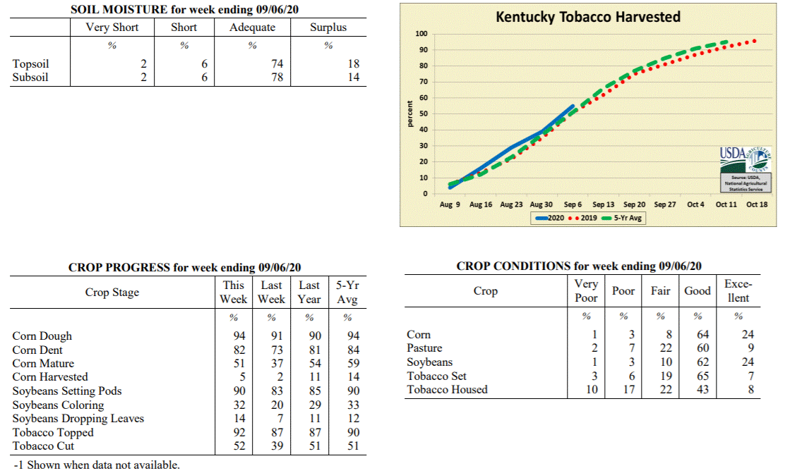 Kentucky Climate Summary
For the Period August 31, 2020 to September 6, 2020
Above Normal Temperatures and Well Above Normal Rainfall:
An active pattern led to excessive rainfall for much of the state this period. Most
of the rain fell between Monday through Thursday as the Kentucky saw daily rounds of
showers and storms. Coverage turned widespread at times and with a moist air mass in
place, storms were capable of producing very heavy rainfall and led to some localized
flooding. Overall, the state averaged 2.11 inches, which is well over an inch above
normal for this time of year. 1 to 2+ inch total accumulations were widespread across
Kentucky with very few stations below an inch. As a side-note, preliminary data from
August shows the state averaged 5.02 inches for the month, which would be good for an
11th straight month of above normal precipitation. All eyes then turned to Thursday
night and Friday as a cold front pushed through the Ohio Valley. This boundary opened
the door to a dry Labor Day weekend with cooler temperatures and lower humidity.
High temperatures for Derby Day were only in the upper 70s to middle 80s, before
taking a bit of a jump on Sunday. Lows each night dipped into the 50s.
Temperatures for the period averaged 74 degrees across the state which was 1 degree
warmer than normal and 4 degrees cooler than the previous period. High temperatures
averaged from 83 in the West to 83 in the East. Departure from normal high
temperatures ranged from 3 degrees cooler than normal in the West to 1 degree
cooler than normal in the East. Low temperatures averaged from 66 degrees in the
West to 66 degrees in the East. Departure from normal low temperature ranged from 3
degrees warmer than normal in the West to 6 degrees warmer than normal in the East.
The extreme high temperature for the period was 89 degrees at BOONEVILLE 2S and the
extreme low was 49 degrees at CYNTHIANA 8N.
Precipitation (liq. equ.) for the period totaled 2.11 inches statewide which was 1.34
inches above normal and 275% of normal. Precipitation totals by climate division,
West 2.31 inches, Central 2.20 inches, Bluegrass 2.06 inches and East 1.87 inches,
which was 1.6, 1.36, 1.33 and 1.08 inches above normal. By station, precipitation
totals ranged from a low of 0.65 inches at FORT KNOX to a high of 4.16 inches at
COLUMBIA 3N.
---
Kentucky Crop and Weather Report
Issued 4:00 P.M., August 31, 2020 24-20
Agricultural News: Kentucky experienced above normal temperatures and rainfall over
the past week. Precipitation for the week totaled 1.14 inches, 0.40 inches above
normal. Temperatures averaged 77 degrees for the week, 2 degrees above normal.
Topsoil moisture was rated 3 percent very short, 11 percent short, 75 percent
adequate, and 11 percent surplus. Subsoil moisture was rated 3 percent very short, 12
percent short, 77 percent adequate, and 8 percent surplus. Days suitable for
fieldwork averaged 4.6 out of a possible seven.
Primary activities for this week included cutting hay along with topping and cutting
tobacco. Corn harvest has begun for some producers, however the majority of the crop
is still in the field. Fieldwork was disrupted at times by scattered rain brought in
by the arrival of Hurricane Laura. There have been multiple reports of Southern Rust
on corn where spraying may no longer be of value due to the crop stage, however the
reports are focused in certain areas of the state and not widespread.
Even with Southern Rust present in some corn, the corn and soybean crops remain in
mostly good condition. Tobacco is doing well overall with 60 percent of the crop in
good condition. Pastures are in mostly good condition and have benefitted from the
scattered rain. Harvested hay was reported as in mostly good condition. With rains
promoting pasture growth, farmers hope to put away a lot of hay for
the winter months.
Kentucky Climate Summary
For the Period August 31, 2020 to September 6, 2020
Above Normal Temperatures and Well Above Normal Rainfall:
An active pattern led to excessive rainfall for much of the state this period. Most
of the rain fell between Monday through Thursday as the Kentucky saw daily rounds of
showers and storms. Coverage turned widespread at times and with a moist air mass in
place, storms were capable of producing very heavy rainfall and led to some localized
flooding. Overall, the state averaged 2.11 inches, which is well over an inch above
normal for this time of year. 1 to 2+ inch total accumulations were widespread across
Kentucky with very few stations below an inch. As a side-note, preliminary data from
August shows the state averaged 5.02 inches for the month, which would be good for an
11th straight month of above normal precipitation. All eyes then turned to Thursday
night and Friday as a cold front pushed through the Ohio Valley. This boundary opened
the door to a dry Labor Day weekend with cooler temperatures and lower humidity.
High temperatures for Derby Day were only in the upper 70s to middle 80s, before
taking a bit of a jump on Sunday. Lows each night dipped into the 50s.
Temperatures for the period averaged 74 degrees across the state which was 1 degree
warmer than normal and 4 degrees cooler than the previous period. High temperatures
averaged from 83 in the West to 83 in the East. Departure from normal high
temperatures ranged from 3 degrees cooler than normal in the West to 1 degree
cooler than normal in the East. Low temperatures averaged from 66 degrees in the
West to 66 degrees in the East. Departure from normal low temperature ranged from 3
degrees warmer than normal in the West to 6 degrees warmer than normal in the East.
The extreme high temperature for the period was 89 degrees at BOONEVILLE 2S and the
extreme low was 49 degrees at CYNTHIANA 8N.
Precipitation (liq. equ.) for the period totaled 2.11 inches statewide which was 1.34
inches above normal and 275% of normal. Precipitation totals by climate division,
West 2.31 inches, Central 2.20 inches, Bluegrass 2.06 inches and East 1.87 inches,
which was 1.6, 1.36, 1.33 and 1.08 inches above normal. By station, precipitation
totals ranged from a low of 0.65 inches at FORT KNOX to a high of 4.16 inches at
COLUMBIA 3N.
---
Kentucky Crop and Weather Report
Issued 4:00 P.M., August 31, 2020 24-20
Agricultural News: Kentucky experienced above normal temperatures and rainfall over
the past week. Precipitation for the week totaled 1.14 inches, 0.40 inches above
normal. Temperatures averaged 77 degrees for the week, 2 degrees above normal.
Topsoil moisture was rated 3 percent very short, 11 percent short, 75 percent
adequate, and 11 percent surplus. Subsoil moisture was rated 3 percent very short, 12
percent short, 77 percent adequate, and 8 percent surplus. Days suitable for
fieldwork averaged 4.6 out of a possible seven.
Primary activities for this week included cutting hay along with topping and cutting
tobacco. Corn harvest has begun for some producers, however the majority of the crop
is still in the field. Fieldwork was disrupted at times by scattered rain brought in
by the arrival of Hurricane Laura. There have been multiple reports of Southern Rust
on corn where spraying may no longer be of value due to the crop stage, however the
reports are focused in certain areas of the state and not widespread.
Even with Southern Rust present in some corn, the corn and soybean crops remain in
mostly good condition. Tobacco is doing well overall with 60 percent of the crop in
good condition. Pastures are in mostly good condition and have benefitted from the
scattered rain. Harvested hay was reported as in mostly good condition. With rains
promoting pasture growth, farmers hope to put away a lot of hay for
the winter months.
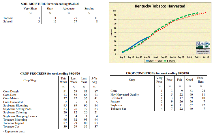 Kentucky Climate Summary
For the Period August 24, 2020 to August 30, 2020
Above Normal Temperatures and Rainfall:
Led by the remnants of Hurricane Laura tracking through Kentucky, rainfall ran above
normal for a third straight week. Overall, the state averaged 1.14 inches. Ahead of
the system, the Bluegrass State was situated within a typical summer-time air mass with
tropical heat and humidity in place between Monday and Thursday. Highs consistently
jumped into the middle 80s to low 90s, accompanied by isolated to scattered rain
coverage on a daily basis. The remnants of Laura quickly pushed through the region
over the course of Friday and early Saturday, bringing widespread rainfall to the
area. A cold front then followed on Saturday, leading to a break in heat on Sunday.
Looking back at the past three weeks, Kentucky has averaged 3.43 inches, which is about
an inch above normal.
Temperatures for the period averaged 77 degrees across the state which was 2 degrees
warmer than normal and 4 degrees warmer than the previous period. High temperatures
averaged from 86 in the West to 85 in the East. Departure from normal high
temperatures ranged from 2 degrees cooler than normal in the West to near normal in
the East. Low temperatures averaged from 69 degrees in the West to 68 degrees in the
East. Departure from normal low temperature ranged from 5 degrees warmer than normal
in the West to 7 degrees warmer than normal in the East. The extreme high temperature
for the period was 93 degrees at ELKTON 5SW and the extreme low was 56 degrees at
CARLISLE 5SW.
Precipitation (liq. equ.) for the period totaled 1.14 inches statewide which was 0.4
inches above normal and 153% of normal. Precipitation totals by climate division,
West 1.31 inches, Central 1.16 inches, Bluegrass 0.95 inches and East 1.15 inches,
which was 0.64, 0.38, 0.21 and 0.36 inches above normal. By station, precipitation
totals ranged from a low of 0.28 inches at HENDERSON 5E to a high of 4.25
inches at RUSSELLVILLE 2W.
---
Kentucky Crop and Weather Report
Issued 4:00 P.M., August 24, 2020 23-20
Agricultural News: Kentucky experienced below normal temperatures and above normal
rainfall over the past week. Precipitation for the week totaled 0.98 inches, 0.14
inches above normal. Temperatures averaged 73 degrees for the week, 2 degrees below
normal. Topsoil moisture was rated 2 percent very short, 12 percent short, 75 percent
adequate, and 11 percent surplus. Subsoil moisture was rated 2 percent very short, 14
percent short, 75 percent adequate, and 9 percent surplus. Days suitable for
fieldwork averaged 5.3 out of a possible seven.
Primary activities for this week included cutting hay along with topping and cutting
tobacco. Although temperatures were pleasant for the most part, heavy rain showers
deterred fieldwork at times. Some flooding likely occurred due to the slow moving
systems, however widespread flooding has not been observed at this time. Corn and
soybeans are being sprayed, but a fair amount of Southern Rust on corn has been
reported in portions of the state.
Corn and soybeans remain in mostly good condition on the whole. Tobacco is doing well
overall with 55 percent of the crop in good condition. Pastures are in mostly good
condition despite heavy rainfall at times. The state’s hay crop appears to be doing
well at this point in the season.
Kentucky Climate Summary
For the Period August 24, 2020 to August 30, 2020
Above Normal Temperatures and Rainfall:
Led by the remnants of Hurricane Laura tracking through Kentucky, rainfall ran above
normal for a third straight week. Overall, the state averaged 1.14 inches. Ahead of
the system, the Bluegrass State was situated within a typical summer-time air mass with
tropical heat and humidity in place between Monday and Thursday. Highs consistently
jumped into the middle 80s to low 90s, accompanied by isolated to scattered rain
coverage on a daily basis. The remnants of Laura quickly pushed through the region
over the course of Friday and early Saturday, bringing widespread rainfall to the
area. A cold front then followed on Saturday, leading to a break in heat on Sunday.
Looking back at the past three weeks, Kentucky has averaged 3.43 inches, which is about
an inch above normal.
Temperatures for the period averaged 77 degrees across the state which was 2 degrees
warmer than normal and 4 degrees warmer than the previous period. High temperatures
averaged from 86 in the West to 85 in the East. Departure from normal high
temperatures ranged from 2 degrees cooler than normal in the West to near normal in
the East. Low temperatures averaged from 69 degrees in the West to 68 degrees in the
East. Departure from normal low temperature ranged from 5 degrees warmer than normal
in the West to 7 degrees warmer than normal in the East. The extreme high temperature
for the period was 93 degrees at ELKTON 5SW and the extreme low was 56 degrees at
CARLISLE 5SW.
Precipitation (liq. equ.) for the period totaled 1.14 inches statewide which was 0.4
inches above normal and 153% of normal. Precipitation totals by climate division,
West 1.31 inches, Central 1.16 inches, Bluegrass 0.95 inches and East 1.15 inches,
which was 0.64, 0.38, 0.21 and 0.36 inches above normal. By station, precipitation
totals ranged from a low of 0.28 inches at HENDERSON 5E to a high of 4.25
inches at RUSSELLVILLE 2W.
---
Kentucky Crop and Weather Report
Issued 4:00 P.M., August 24, 2020 23-20
Agricultural News: Kentucky experienced below normal temperatures and above normal
rainfall over the past week. Precipitation for the week totaled 0.98 inches, 0.14
inches above normal. Temperatures averaged 73 degrees for the week, 2 degrees below
normal. Topsoil moisture was rated 2 percent very short, 12 percent short, 75 percent
adequate, and 11 percent surplus. Subsoil moisture was rated 2 percent very short, 14
percent short, 75 percent adequate, and 9 percent surplus. Days suitable for
fieldwork averaged 5.3 out of a possible seven.
Primary activities for this week included cutting hay along with topping and cutting
tobacco. Although temperatures were pleasant for the most part, heavy rain showers
deterred fieldwork at times. Some flooding likely occurred due to the slow moving
systems, however widespread flooding has not been observed at this time. Corn and
soybeans are being sprayed, but a fair amount of Southern Rust on corn has been
reported in portions of the state.
Corn and soybeans remain in mostly good condition on the whole. Tobacco is doing well
overall with 55 percent of the crop in good condition. Pastures are in mostly good
condition despite heavy rainfall at times. The state’s hay crop appears to be doing
well at this point in the season.
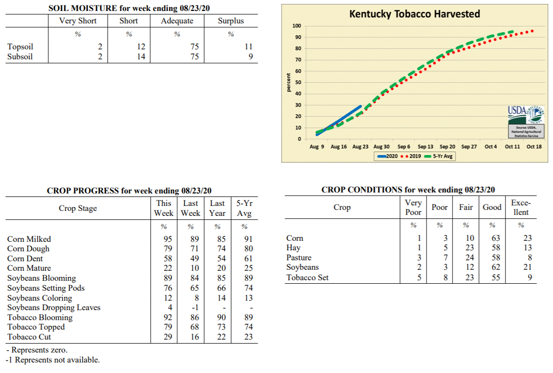 Kentucky Climate Summary
For the Period August 17, 2020 to August 23, 2020
Below Normal Temperatures and Above Normal Rainfall:
Focus early in the week was a cold front sinking into the region on Tuesday.
Scattered to numerous showers and storms accompanied the boundary during the
afternoon and evening hours. Some scattered activity was left across Southeastern
Kentucky on Wednesday, but otherwise, cooler and less humid air was ushered into the
area behind the front. Highs were only around 80 on Wednesday, before falling into
the mid 50s to low 60s that night. The rest of the period followed a similar pattern
with daily rounds of scattered showers/storms and cooler than normal temperatures.
Going with the common theme in recent weeks, storms were capable of producing very
heavy rainfall and with slow storm movements, opened the door to some flooding.
Overall, the state average was above normal, but totals were quite different from one
side of the state to the other. While Eastern Kentucky averaged 1.33 inches for the
week, that number dropped to 0.46 inches for Western Kentucky.
Temperatures for the period averaged 73 degrees across the state which was 2 degrees
cooler than normal and 4 degrees cooler than the previous period. High temperatures
averaged from 84 in the West to 82 in the East. Departure from normal high
temperatures ranged from 4 degrees cooler than normal in the West to 4 degrees
cooler than normal in the East. Low temperatures averaged from 64 degrees in the
West to 63 degrees in the East. Departure from normal low temperature ranged from 1
degree cooler than normal in the West to 1 degree warmer than normal in the East.
The extreme high temperature for the period was 91 degrees at POPLAR BLUFF ASOS and
the extreme low was 51 degrees at CARLISLE 5SW.
Precipitation (liq. equ.) for the period totaled 0.98 inches statewide which was 0.14
inches above normal and 116% of normal. Precipitation totals by climate division,
West 0.46 inches, Central 0.96 inches, Bluegrass 1.19 inches and East 1.33 inches,
which was -0.30, 0.11, 0.34 and 0.42 inches respectively from normal. By station,
precipitation totals ranged from a low of 0.00 inches at CAPE GIRARDEAU ASOS to a
high of 3.57 inches at FRANKFORT.
---
Kentucky Crop and Weather Report
Issued 4:00 P.M., August 17, 2020 22-20
Agricultural News: Kentucky experienced above normal temperatures and rainfall over
the past week. Precipitation for the week totaled 1.30 inches, 0.44 inches above
normal. Temperatures averaged 77 degrees for the week, 2 degrees above normal.
Topsoil moisture was rated 3 percent very short, 13 percent short, 74 percent
adequate, and 10 percent surplus. Subsoil moisture was rated 4 percent very short, 15
percent short, 73 percent adequate, and 8 percent surplus. Days suitable for
fieldwork averaged 4.9 out of a possible seven.
Primary activities for this week included topping and cutting tobacco, spraying, and
cutting hay. Scattered storms and rain disrupted field activities at times over the
past week. There were some areas that were subject to excessive rain and flooding,
however damage has not been evaluated at this juncture. The effect of Southern Rust
on corn where fungicide was not sprayed is not yet clear. Pasture and hay regrowth
will be promoted in areas where the rainfall was more moderate.
Corn and soybeans continue to be in good condition. Tobacco is doing well overall
with 54 percent of the crop in good condition. Pastures are in mostly good condition,
however heavy rain may have been a detriment in the areas where it occurred.
Kentucky Climate Summary
For the Period August 17, 2020 to August 23, 2020
Below Normal Temperatures and Above Normal Rainfall:
Focus early in the week was a cold front sinking into the region on Tuesday.
Scattered to numerous showers and storms accompanied the boundary during the
afternoon and evening hours. Some scattered activity was left across Southeastern
Kentucky on Wednesday, but otherwise, cooler and less humid air was ushered into the
area behind the front. Highs were only around 80 on Wednesday, before falling into
the mid 50s to low 60s that night. The rest of the period followed a similar pattern
with daily rounds of scattered showers/storms and cooler than normal temperatures.
Going with the common theme in recent weeks, storms were capable of producing very
heavy rainfall and with slow storm movements, opened the door to some flooding.
Overall, the state average was above normal, but totals were quite different from one
side of the state to the other. While Eastern Kentucky averaged 1.33 inches for the
week, that number dropped to 0.46 inches for Western Kentucky.
Temperatures for the period averaged 73 degrees across the state which was 2 degrees
cooler than normal and 4 degrees cooler than the previous period. High temperatures
averaged from 84 in the West to 82 in the East. Departure from normal high
temperatures ranged from 4 degrees cooler than normal in the West to 4 degrees
cooler than normal in the East. Low temperatures averaged from 64 degrees in the
West to 63 degrees in the East. Departure from normal low temperature ranged from 1
degree cooler than normal in the West to 1 degree warmer than normal in the East.
The extreme high temperature for the period was 91 degrees at POPLAR BLUFF ASOS and
the extreme low was 51 degrees at CARLISLE 5SW.
Precipitation (liq. equ.) for the period totaled 0.98 inches statewide which was 0.14
inches above normal and 116% of normal. Precipitation totals by climate division,
West 0.46 inches, Central 0.96 inches, Bluegrass 1.19 inches and East 1.33 inches,
which was -0.30, 0.11, 0.34 and 0.42 inches respectively from normal. By station,
precipitation totals ranged from a low of 0.00 inches at CAPE GIRARDEAU ASOS to a
high of 3.57 inches at FRANKFORT.
---
Kentucky Crop and Weather Report
Issued 4:00 P.M., August 17, 2020 22-20
Agricultural News: Kentucky experienced above normal temperatures and rainfall over
the past week. Precipitation for the week totaled 1.30 inches, 0.44 inches above
normal. Temperatures averaged 77 degrees for the week, 2 degrees above normal.
Topsoil moisture was rated 3 percent very short, 13 percent short, 74 percent
adequate, and 10 percent surplus. Subsoil moisture was rated 4 percent very short, 15
percent short, 73 percent adequate, and 8 percent surplus. Days suitable for
fieldwork averaged 4.9 out of a possible seven.
Primary activities for this week included topping and cutting tobacco, spraying, and
cutting hay. Scattered storms and rain disrupted field activities at times over the
past week. There were some areas that were subject to excessive rain and flooding,
however damage has not been evaluated at this juncture. The effect of Southern Rust
on corn where fungicide was not sprayed is not yet clear. Pasture and hay regrowth
will be promoted in areas where the rainfall was more moderate.
Corn and soybeans continue to be in good condition. Tobacco is doing well overall
with 54 percent of the crop in good condition. Pastures are in mostly good condition,
however heavy rain may have been a detriment in the areas where it occurred.
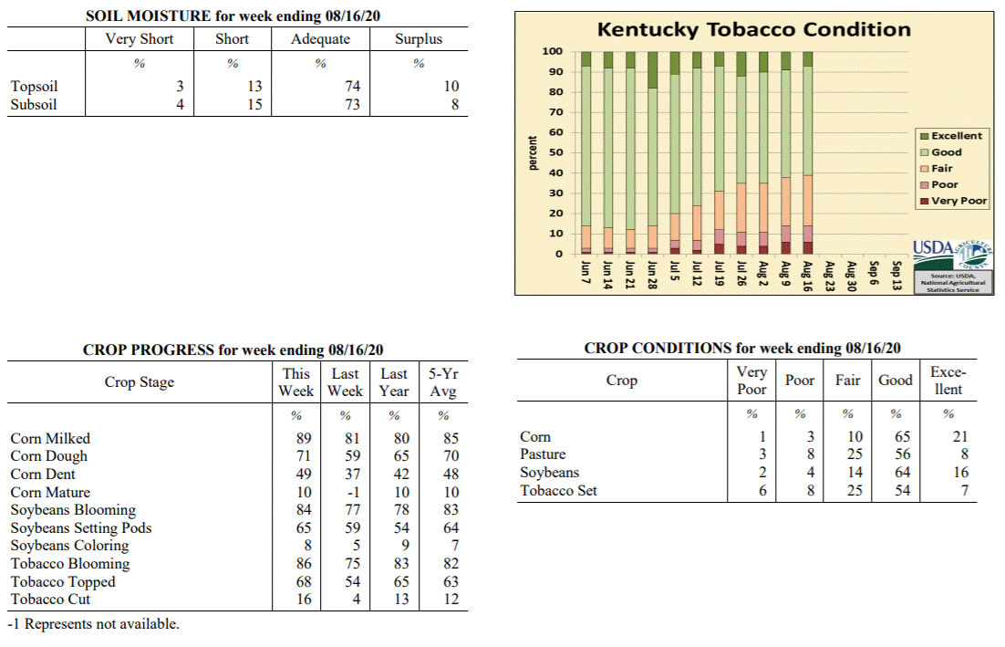 Kentucky Climate Summary
For the Period August 10, 2020 to August 16, 2020
Above Normal Temperatures and Rainfall:
Kentucky averaged 1.30 inches for the period, marking the third time in the past four
weeks that the state average has been above normal. The wet pattern persisted for
much of the week, starting with an area of light to moderate showers passing
southeast through the Bluegrass and Eastern Kentucky on Monday. Some of the most
significant activity occurred on Wednesday through Friday with scattered to numerous
showers and storms in place. The slow-moving nature of these storms, combined with
torrential rainfall, led to numerous bouts of flash flooding. 1 to 2+ inches was
common with the strongest storms. The week closed with the passage of a cold front on
Sunday, which pushed a broken line of showers and storms through mainly the eastern
half of the state. Looking back at the past 30 days, the state has averaged 5.30
inches, which is 1.31 inches above normal.
Temperatures for the period averaged 77 degrees across the state which was 2 degrees
warmer than normal and 4 degrees warmer than the previous period. High temperatures
averaged from 86 in the West to 85 in the East. Departure from normal high
temperatures ranged from 2 degrees cooler than normal in the West to 1 degree
cooler than normal in the East. Low temperatures averaged from 70 degrees in the
West to 68 degrees in the East. Departure from normal low temperature ranged from 4
degrees warmer than normal in the West to 5 degrees warmer than normal in the East.
The extreme high temperature for the period was 94 degrees at POPLAR BLUFF ASOS and
the extreme low was 61 degrees at MCKEE 5S.
Precipitation (liq. equ.) for the period totaled 1.30 inches statewide which was 0.44
inches above normal and 151% of normal. Precipitation totals by climate division,
West 1.21 inches, Central 1.90 inches, Bluegrass 0.88 inches and East 1.22 inches,
which was 0.41, 1.06, 0.01 and 0.28 inches above normal. By station, precipitation
totals ranged from a low of 0.08 inches at ELKTON 5SW to a high of 5.31 inches at FORT KNOX.
---
Kentucky Crop and Weather Report
Issued 4:00 P.M., August 10, 2020 21-20
Agricultural News: Kentucky experienced below normal temperatures and rainfall over
the past week. Precipitation for the week totaled 0.26 inches, 0.67 inches below
normal. Temperatures averaged 72 degrees for the week, 4 degrees below normal.
Topsoil moisture was rated 3 percent very short, 14 percent short, 73 percent
adequate, and 10 percent surplus. Subsoil moisture was rated 2 percent very short, 14
percent short, 75 percent adequate, and 9 percent surplus. Days suitable for
fieldwork averaged 5.4 out of a possible seven.
Primary activities for this week included topping tobacco, spraying field crops, and
cutting hay. Cool temperatures with some extended dry periods allowed farmers in the
fields this past week. The low humidity conditions were optimal for hay making. Corn
is being sprayed for Southern Rust with the late planted crop particularly
susceptible.
Corn and soybeans continue to be in good condition overall as the mild temperatures
have limited heat stress commonly occurring this time of year. Tobacco is doing
fairly well with 53 percent of the crop in good condition. Pressure from weed
growth is minimal in pastures. Cooler temperatures and scattered rain have also
encouraged healthy pastureland.
Kentucky Climate Summary
For the Period August 10, 2020 to August 16, 2020
Above Normal Temperatures and Rainfall:
Kentucky averaged 1.30 inches for the period, marking the third time in the past four
weeks that the state average has been above normal. The wet pattern persisted for
much of the week, starting with an area of light to moderate showers passing
southeast through the Bluegrass and Eastern Kentucky on Monday. Some of the most
significant activity occurred on Wednesday through Friday with scattered to numerous
showers and storms in place. The slow-moving nature of these storms, combined with
torrential rainfall, led to numerous bouts of flash flooding. 1 to 2+ inches was
common with the strongest storms. The week closed with the passage of a cold front on
Sunday, which pushed a broken line of showers and storms through mainly the eastern
half of the state. Looking back at the past 30 days, the state has averaged 5.30
inches, which is 1.31 inches above normal.
Temperatures for the period averaged 77 degrees across the state which was 2 degrees
warmer than normal and 4 degrees warmer than the previous period. High temperatures
averaged from 86 in the West to 85 in the East. Departure from normal high
temperatures ranged from 2 degrees cooler than normal in the West to 1 degree
cooler than normal in the East. Low temperatures averaged from 70 degrees in the
West to 68 degrees in the East. Departure from normal low temperature ranged from 4
degrees warmer than normal in the West to 5 degrees warmer than normal in the East.
The extreme high temperature for the period was 94 degrees at POPLAR BLUFF ASOS and
the extreme low was 61 degrees at MCKEE 5S.
Precipitation (liq. equ.) for the period totaled 1.30 inches statewide which was 0.44
inches above normal and 151% of normal. Precipitation totals by climate division,
West 1.21 inches, Central 1.90 inches, Bluegrass 0.88 inches and East 1.22 inches,
which was 0.41, 1.06, 0.01 and 0.28 inches above normal. By station, precipitation
totals ranged from a low of 0.08 inches at ELKTON 5SW to a high of 5.31 inches at FORT KNOX.
---
Kentucky Crop and Weather Report
Issued 4:00 P.M., August 10, 2020 21-20
Agricultural News: Kentucky experienced below normal temperatures and rainfall over
the past week. Precipitation for the week totaled 0.26 inches, 0.67 inches below
normal. Temperatures averaged 72 degrees for the week, 4 degrees below normal.
Topsoil moisture was rated 3 percent very short, 14 percent short, 73 percent
adequate, and 10 percent surplus. Subsoil moisture was rated 2 percent very short, 14
percent short, 75 percent adequate, and 9 percent surplus. Days suitable for
fieldwork averaged 5.4 out of a possible seven.
Primary activities for this week included topping tobacco, spraying field crops, and
cutting hay. Cool temperatures with some extended dry periods allowed farmers in the
fields this past week. The low humidity conditions were optimal for hay making. Corn
is being sprayed for Southern Rust with the late planted crop particularly
susceptible.
Corn and soybeans continue to be in good condition overall as the mild temperatures
have limited heat stress commonly occurring this time of year. Tobacco is doing
fairly well with 53 percent of the crop in good condition. Pressure from weed
growth is minimal in pastures. Cooler temperatures and scattered rain have also
encouraged healthy pastureland.
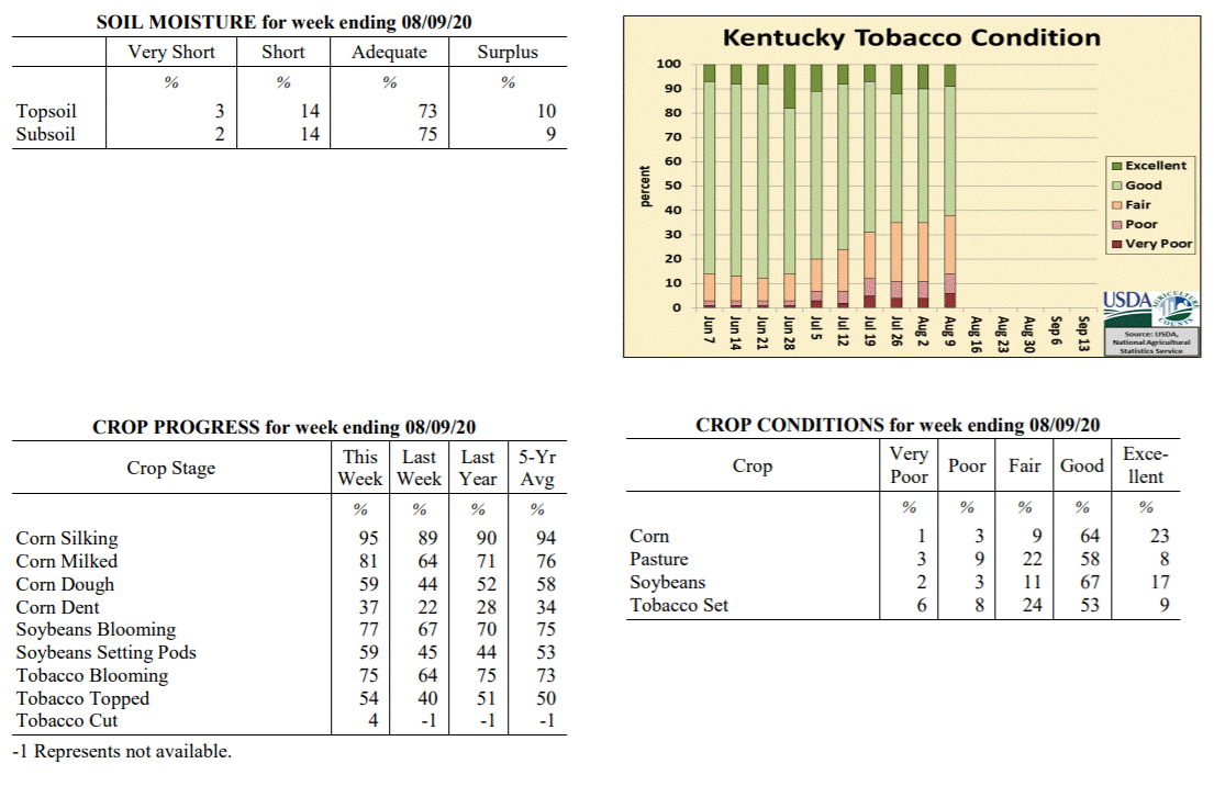 Kentucky Climate Summary
For the Period August 3, 2020 to August 9, 2020
Below Normal Temperatures and Rainfall:
Above normal rainfall has been the trend the past couple weeks, but that came to a
halt over the first full week of August. Other than portions of Central Kentucky,
rainfall was lacking for most of the state. Kentucky averaged about a quarter inch
for the period, most of which coming over the first half of the week with the passage
of a weak cold front. Coverage was lacking, staying isolated to scattered in nature.
Behind the frontal passage, Kentucky saw a break in the heat and humidity with fall-
like conditions in place. High temperatures only rose into the middle 70s to around
80 on Tuesday and Wednesday. This was accompanied by some unseasonably cool nights
with some seeing lows in the mid to upper 50s. These temperatures are more typical of
mid to late September in Kentucky. Saying that, the break did not last long as heat
returned for the weekend, along with isolated to scattered storms across the western
half of the state on Sunday.
Temperatures for the period averaged 72 degrees across the state which was 4 degrees
cooler than normal and 6 degrees cooler than the previous period. High temperatures
averaged from 83 in the West to 84 in the East. Departure from normal high
temperatures ranged from 5 degrees cooler than normal in the West to 2 degrees
cooler than normal in the East. Low temperatures averaged from 63 degrees in the
West to 63 degrees in the East. Departure from normal low temperature ranged from 3
degrees cooler than normal in the West to near normal in the East. The extreme high
temperature for the period was 92 degrees at KOOMER RIDGE and the extreme low was 53
degrees at BRANDENBURG 4SW.
Precipitation (liq. equ.) for the period totaled 0.26 inches statewide which was 0.67
inches below normal and 28% of normal. Precipitation totals by climate division, West
0.40 inches, Central 0.37 inches, Bluegrass 0.11 inches and East 0.15 inches, which
was 0.49, 0.53, 0.79 and 0.86 inches below normal. By station, precipitation totals
ranged from a low of 0.00 inches at ALBANY 1N to a high of 2.71 inches at EVANSVILLE ASOS.
---
Kentucky Crop and Weather Report
Issued 4:00 P.M., August 3, 2020 20-20
Agricultural News: Kentucky experienced near normal temperatures and much above
normal rainfall over the past week. Precipitation for the week totaled 2.45 inches,
1.48 inches above normal. Temperatures averaged 77 degrees for the week, unchanged
from normal. Topsoil moisture was rated 5 percent very short, 10 percent short, 73
percent adequate, and 12 percent surplus. Subsoil moisture was rated 3 percent very
short, 13 percent short, 74 percent adequate, and 10 percent surplus. Days suitable
for fieldwork averaged 4.4 out of a possible seven.
Primary activities for this week included topping tobacco, spraying field crops, and
cutting hay. Farmers finally saw reprieve from intense summer heat as cooler
temperatures and precipitation moved in. The rainfall was abundant and welcome as it
will help replenish pastures and help areas that were on the fringe of moderate
drought. The drawback of the wet pattern is the obstruction to hay cutting, however
the benefit to pasture growth may balance that out.
Corn and soybeans continue to be in mostly good condition as the cooler temperatures
will subdue heat stress. Tobacco is doing fairly well with 55 percent of the crop in
good condition. Pastures are in mostly good condition at this time and
should see strong growth from recent rain.
Kentucky Climate Summary
For the Period August 3, 2020 to August 9, 2020
Below Normal Temperatures and Rainfall:
Above normal rainfall has been the trend the past couple weeks, but that came to a
halt over the first full week of August. Other than portions of Central Kentucky,
rainfall was lacking for most of the state. Kentucky averaged about a quarter inch
for the period, most of which coming over the first half of the week with the passage
of a weak cold front. Coverage was lacking, staying isolated to scattered in nature.
Behind the frontal passage, Kentucky saw a break in the heat and humidity with fall-
like conditions in place. High temperatures only rose into the middle 70s to around
80 on Tuesday and Wednesday. This was accompanied by some unseasonably cool nights
with some seeing lows in the mid to upper 50s. These temperatures are more typical of
mid to late September in Kentucky. Saying that, the break did not last long as heat
returned for the weekend, along with isolated to scattered storms across the western
half of the state on Sunday.
Temperatures for the period averaged 72 degrees across the state which was 4 degrees
cooler than normal and 6 degrees cooler than the previous period. High temperatures
averaged from 83 in the West to 84 in the East. Departure from normal high
temperatures ranged from 5 degrees cooler than normal in the West to 2 degrees
cooler than normal in the East. Low temperatures averaged from 63 degrees in the
West to 63 degrees in the East. Departure from normal low temperature ranged from 3
degrees cooler than normal in the West to near normal in the East. The extreme high
temperature for the period was 92 degrees at KOOMER RIDGE and the extreme low was 53
degrees at BRANDENBURG 4SW.
Precipitation (liq. equ.) for the period totaled 0.26 inches statewide which was 0.67
inches below normal and 28% of normal. Precipitation totals by climate division, West
0.40 inches, Central 0.37 inches, Bluegrass 0.11 inches and East 0.15 inches, which
was 0.49, 0.53, 0.79 and 0.86 inches below normal. By station, precipitation totals
ranged from a low of 0.00 inches at ALBANY 1N to a high of 2.71 inches at EVANSVILLE ASOS.
---
Kentucky Crop and Weather Report
Issued 4:00 P.M., August 3, 2020 20-20
Agricultural News: Kentucky experienced near normal temperatures and much above
normal rainfall over the past week. Precipitation for the week totaled 2.45 inches,
1.48 inches above normal. Temperatures averaged 77 degrees for the week, unchanged
from normal. Topsoil moisture was rated 5 percent very short, 10 percent short, 73
percent adequate, and 12 percent surplus. Subsoil moisture was rated 3 percent very
short, 13 percent short, 74 percent adequate, and 10 percent surplus. Days suitable
for fieldwork averaged 4.4 out of a possible seven.
Primary activities for this week included topping tobacco, spraying field crops, and
cutting hay. Farmers finally saw reprieve from intense summer heat as cooler
temperatures and precipitation moved in. The rainfall was abundant and welcome as it
will help replenish pastures and help areas that were on the fringe of moderate
drought. The drawback of the wet pattern is the obstruction to hay cutting, however
the benefit to pasture growth may balance that out.
Corn and soybeans continue to be in mostly good condition as the cooler temperatures
will subdue heat stress. Tobacco is doing fairly well with 55 percent of the crop in
good condition. Pastures are in mostly good condition at this time and
should see strong growth from recent rain.
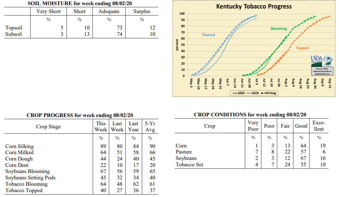 Kentucky Climate Summary
For the Period July 27, 2020 to August 2, 2020
Near Normal Temperatures and Much Above Normal Rainfall:
July closed and August opened with a very wet pattern in place as the state averaged
2.45 inches for the week. This amounted to a second straight week of above normal
rainfall for the Bluegrass State, which over the past 14 days has averaged 3.71
inches. The state saw daily rounds of rainfall, most of which the result of a cold
front pushing into the area and eventually stalling. Going with the trend of recent
weeks, storms were capable of producing very heavy rainfall within a short period of
time and led to some flash flooding. High accumulations were widespread across the
state. The rainfall was especially welcomed by areas of the southern Bluegrass and NE
Kentucky (predominantly Scott, Fayette, Clark, Bourbon, Lewis, Greenup, and Carter
Counties), which were recently upgraded into a ‘Moderate Drought’ by the US Drought
Monitor. The active pattern also gave a bit of a break from the heat of recent
weeks. Rain and added cloud cover kept highs in the low to middle 80s for many
between Thursday through Sunday. Some even in the upper 70s on Saturday and Sunday.
Temperatures for the period averaged 77 degrees across the state which was
near normal and 2 degrees cooler than the previous period. High temperatures
averaged from 85 in the West to 83 in the East. Departure from normal high
temperatures ranged from 4 degrees cooler than normal in the West to 4 degrees
cooler than normal in the East. Low temperatures averaged from 70 degrees in the
West to 68 degrees in the East. Departure from normal low temperature ranged from 3
degrees warmer than normal in the West to 4 degrees warmer than normal in the East.
The extreme high temperature for the period was 95 degrees at KOOMER RIDGE and the
extreme low was 59 degrees at MAYFIELD 6SW.
Precipitation (liq. equ.) for the period totaled 2.45 inches statewide which was 1.48
inches above normal and 252% of normal. Precipitation totals by climate division,
West 2.45 inches, Central 2.24 inches, Bluegrass 2.69 inches and East 2.43 inches,
which was 1.52, 1.28, 1.73 and 1.39 inches above normal. By station, precipitation
totals ranged from a low of 0.61 inches at BOWLING GREEN 4E to a high of 5.43
inches at CARROLLTON 2E.
---
Kentucky Crop and Weather Report
Issued 4:00 P.M., July 27, 2020 19-20
Agricultural News: Kentucky experienced above normal temperatures and rainfall over
the past week. Precipitation for the week totaled 1.25 inches, 0.29 inches above
normal. Temperatures averaged 79 degrees for the week, 2 degrees above normal.
Topsoil moisture was rated 6 percent very short, 21 percent short, 67 percent
adequate, and 6 percent surplus. Subsoil moisture was rated 5 percent very short, 20
percent short, 70 percent adequate, and 5 percent surplus. Days suitable for
fieldwork averaged 5.3 out of a possible seven.
Primary activities for this week included spraying, topping tobacco, and cutting hay.
Intense summer heat and scattered rain prevailed across the state this week. In most
instances the rain was welcome as a reprieve from the hot weather, however pockets of
the state are still seeing flood damage from heavy rain several weeks prior. Soybeans
have been planted in place of corn in some of the areas where extreme flooding
occurred. Where drier weather has been the norm, there was some reported dormancy in
forage grasses. With that said, many producers are seeing good hay yields when they
are able to avoid cutting interruption from the scattered rain. Farmers have been
scouting for disease in their crops and applying spray when necessary. Topping of
tobacco is progressing at a normal pace.
Both corn and soybeans remain in mostly good condition, however the unrelenting heat
open the door for added crop stress. Tobacco is doing fairly well with 53 percent of
the crop in good condition. Pastures are in mostly good condition at this time,
however heat may become a factor if conditions turn dry. Harvested hay is in mostly
good condition and supplies are adequate at this juncture.
Kentucky Climate Summary
For the Period July 27, 2020 to August 2, 2020
Near Normal Temperatures and Much Above Normal Rainfall:
July closed and August opened with a very wet pattern in place as the state averaged
2.45 inches for the week. This amounted to a second straight week of above normal
rainfall for the Bluegrass State, which over the past 14 days has averaged 3.71
inches. The state saw daily rounds of rainfall, most of which the result of a cold
front pushing into the area and eventually stalling. Going with the trend of recent
weeks, storms were capable of producing very heavy rainfall within a short period of
time and led to some flash flooding. High accumulations were widespread across the
state. The rainfall was especially welcomed by areas of the southern Bluegrass and NE
Kentucky (predominantly Scott, Fayette, Clark, Bourbon, Lewis, Greenup, and Carter
Counties), which were recently upgraded into a ‘Moderate Drought’ by the US Drought
Monitor. The active pattern also gave a bit of a break from the heat of recent
weeks. Rain and added cloud cover kept highs in the low to middle 80s for many
between Thursday through Sunday. Some even in the upper 70s on Saturday and Sunday.
Temperatures for the period averaged 77 degrees across the state which was
near normal and 2 degrees cooler than the previous period. High temperatures
averaged from 85 in the West to 83 in the East. Departure from normal high
temperatures ranged from 4 degrees cooler than normal in the West to 4 degrees
cooler than normal in the East. Low temperatures averaged from 70 degrees in the
West to 68 degrees in the East. Departure from normal low temperature ranged from 3
degrees warmer than normal in the West to 4 degrees warmer than normal in the East.
The extreme high temperature for the period was 95 degrees at KOOMER RIDGE and the
extreme low was 59 degrees at MAYFIELD 6SW.
Precipitation (liq. equ.) for the period totaled 2.45 inches statewide which was 1.48
inches above normal and 252% of normal. Precipitation totals by climate division,
West 2.45 inches, Central 2.24 inches, Bluegrass 2.69 inches and East 2.43 inches,
which was 1.52, 1.28, 1.73 and 1.39 inches above normal. By station, precipitation
totals ranged from a low of 0.61 inches at BOWLING GREEN 4E to a high of 5.43
inches at CARROLLTON 2E.
---
Kentucky Crop and Weather Report
Issued 4:00 P.M., July 27, 2020 19-20
Agricultural News: Kentucky experienced above normal temperatures and rainfall over
the past week. Precipitation for the week totaled 1.25 inches, 0.29 inches above
normal. Temperatures averaged 79 degrees for the week, 2 degrees above normal.
Topsoil moisture was rated 6 percent very short, 21 percent short, 67 percent
adequate, and 6 percent surplus. Subsoil moisture was rated 5 percent very short, 20
percent short, 70 percent adequate, and 5 percent surplus. Days suitable for
fieldwork averaged 5.3 out of a possible seven.
Primary activities for this week included spraying, topping tobacco, and cutting hay.
Intense summer heat and scattered rain prevailed across the state this week. In most
instances the rain was welcome as a reprieve from the hot weather, however pockets of
the state are still seeing flood damage from heavy rain several weeks prior. Soybeans
have been planted in place of corn in some of the areas where extreme flooding
occurred. Where drier weather has been the norm, there was some reported dormancy in
forage grasses. With that said, many producers are seeing good hay yields when they
are able to avoid cutting interruption from the scattered rain. Farmers have been
scouting for disease in their crops and applying spray when necessary. Topping of
tobacco is progressing at a normal pace.
Both corn and soybeans remain in mostly good condition, however the unrelenting heat
open the door for added crop stress. Tobacco is doing fairly well with 53 percent of
the crop in good condition. Pastures are in mostly good condition at this time,
however heat may become a factor if conditions turn dry. Harvested hay is in mostly
good condition and supplies are adequate at this juncture.
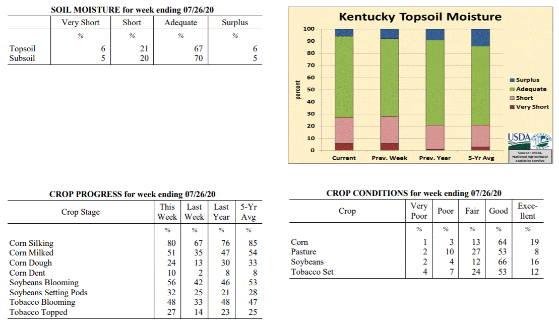 Kentucky Climate Summary
For the Period July 20, 2020 to July 26, 2020
Above Normal Temperatures and Rainfall:
Kentucky saw a typical summer-time weather pattern throughout the week with a warm,
moist, and unstable air mass in place. Heat was accompanied by daily rounds of storms
during the heat of the afternoon. Rain coverage was a bit more pronounced this
period. In doing so, other some isolated spots, most of Kentucky saw at least a half
inch. The state average 1.25 inches for the week, slightly above normal for this
time of year. Just like recent weeks, if caught under a storm, 1 to 2+ inches was
common. Looking at data from the Ag Weather Center over the past 30 days, rainfall
has been plentiful for most of Kentucky over that period. The state has averaged 5.46
inches, higher accumulations across Western and Central Kentucky (averages of 7.11
and 6.61, respectively) and lower across Eastern Kentucky (4.01 inches). Some
localized areas have been much drier compared to the surrounding area. This includes
portions of SE/NE Kentucky and the southern Bluegrass, which are roughly 1 to 2
inches below normal over the past 30 days.
Temperatures for the period averaged 79 degrees across the state which was 2 degrees
warmer than normal and 2 degrees warmer than the previous period. High temperatures
averaged from 90 in the West to 88 in the East. Departure from normal high
temperatures ranged from 1 degree warmer than normal in the West to 1 degree
warmer than normal in the East. Low temperatures averaged from 71 degrees in the
West to 69 degrees in the East. Departure from normal low temperature ranged from 4
degrees warmer than normal in the West to 5 degrees warmer than normal in the East.
The extreme high temperature for the period was 97 degrees at PEABODY and the extreme
low was 64 degrees at CYNTHIANA 8N.
Precipitation (liq. equ.) for the period totaled 1.25 inches statewide which was 0.29
inches above normal and 131% of normal. Precipitation totals by climate division,
West 1.33 inches, Central 1.40 inches, Bluegrass 1.08 inches and East 1.19 inches,
which was 0.42, 0.43, 0.13 and 0.19 inches above normal. By station, precipitation
totals ranged from a low of 0.02 inches at LEXINGTON 7S to a high of 4.16 inches at
BOWLING GREEN 5S.
---
Kentucky Crop and Weather Report
Issued 4:00 P.M., July 20, 2020 18-20
Agricultural News: Kentucky experienced above normal temperatures and below normal
rainfall over the past week. Precipitation for the week totaled 0.38 inches, 0.61
inches below normal. Temperatures averaged 78 degrees for the week, 1 degree above
normal. Topsoil moisture was rated 6 percent very short, 22 percent short, 64 percent
adequate, and 8 percent surplus. Subsoil moisture was rated 5 percent very short, 20
percent short, 68 percent adequate, and 7 percent surplus. Days suitable for
fieldwork averaged 5.8 out of a possible seven.
Primary activities for this week included scouting fields for disease, spraying,
topping tobacco, and cutting hay. Temperatures were very hot and rainfall was sparse
over the past week. Accumulations of rain across the state varied greatly with some
areas getting very dry. The excessive heat put stress on livestock and pasture
ground. Most forage is doing fair due to deep moisture from previous wet periods.
Fungicide is being applied to some of the corn crop at this juncture. Sixty-seven
percent of corn is in the silking stage while 35 percent of the crop is milking.
Forty-two percent of soybeans are blooming with 25 percent setting pods. Tobacco is
33 percent blooming. Fourteen percent of the crop has been topped at this time.
Both corn and soybeans remain in mostly good condition, however stress from intense
heat could development if current weather persists. Tobacco is doing well with 62
percent of the crop rated as in good condition. Pastures are in mostly good condition
at this time, however hot temperatures and dry weather could take a toll on growth.
Kentucky Climate Summary
For the Period July 20, 2020 to July 26, 2020
Above Normal Temperatures and Rainfall:
Kentucky saw a typical summer-time weather pattern throughout the week with a warm,
moist, and unstable air mass in place. Heat was accompanied by daily rounds of storms
during the heat of the afternoon. Rain coverage was a bit more pronounced this
period. In doing so, other some isolated spots, most of Kentucky saw at least a half
inch. The state average 1.25 inches for the week, slightly above normal for this
time of year. Just like recent weeks, if caught under a storm, 1 to 2+ inches was
common. Looking at data from the Ag Weather Center over the past 30 days, rainfall
has been plentiful for most of Kentucky over that period. The state has averaged 5.46
inches, higher accumulations across Western and Central Kentucky (averages of 7.11
and 6.61, respectively) and lower across Eastern Kentucky (4.01 inches). Some
localized areas have been much drier compared to the surrounding area. This includes
portions of SE/NE Kentucky and the southern Bluegrass, which are roughly 1 to 2
inches below normal over the past 30 days.
Temperatures for the period averaged 79 degrees across the state which was 2 degrees
warmer than normal and 2 degrees warmer than the previous period. High temperatures
averaged from 90 in the West to 88 in the East. Departure from normal high
temperatures ranged from 1 degree warmer than normal in the West to 1 degree
warmer than normal in the East. Low temperatures averaged from 71 degrees in the
West to 69 degrees in the East. Departure from normal low temperature ranged from 4
degrees warmer than normal in the West to 5 degrees warmer than normal in the East.
The extreme high temperature for the period was 97 degrees at PEABODY and the extreme
low was 64 degrees at CYNTHIANA 8N.
Precipitation (liq. equ.) for the period totaled 1.25 inches statewide which was 0.29
inches above normal and 131% of normal. Precipitation totals by climate division,
West 1.33 inches, Central 1.40 inches, Bluegrass 1.08 inches and East 1.19 inches,
which was 0.42, 0.43, 0.13 and 0.19 inches above normal. By station, precipitation
totals ranged from a low of 0.02 inches at LEXINGTON 7S to a high of 4.16 inches at
BOWLING GREEN 5S.
---
Kentucky Crop and Weather Report
Issued 4:00 P.M., July 20, 2020 18-20
Agricultural News: Kentucky experienced above normal temperatures and below normal
rainfall over the past week. Precipitation for the week totaled 0.38 inches, 0.61
inches below normal. Temperatures averaged 78 degrees for the week, 1 degree above
normal. Topsoil moisture was rated 6 percent very short, 22 percent short, 64 percent
adequate, and 8 percent surplus. Subsoil moisture was rated 5 percent very short, 20
percent short, 68 percent adequate, and 7 percent surplus. Days suitable for
fieldwork averaged 5.8 out of a possible seven.
Primary activities for this week included scouting fields for disease, spraying,
topping tobacco, and cutting hay. Temperatures were very hot and rainfall was sparse
over the past week. Accumulations of rain across the state varied greatly with some
areas getting very dry. The excessive heat put stress on livestock and pasture
ground. Most forage is doing fair due to deep moisture from previous wet periods.
Fungicide is being applied to some of the corn crop at this juncture. Sixty-seven
percent of corn is in the silking stage while 35 percent of the crop is milking.
Forty-two percent of soybeans are blooming with 25 percent setting pods. Tobacco is
33 percent blooming. Fourteen percent of the crop has been topped at this time.
Both corn and soybeans remain in mostly good condition, however stress from intense
heat could development if current weather persists. Tobacco is doing well with 62
percent of the crop rated as in good condition. Pastures are in mostly good condition
at this time, however hot temperatures and dry weather could take a toll on growth.
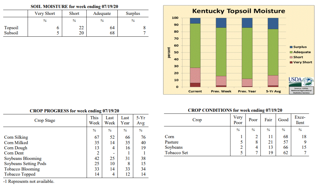 Kentucky Climate Summary
For the Period July 13, 2020 to July 19, 2020
Above Normal Temperatures and Below Normal Rainfall:
Summer heat was in full force over the course of the period, especially over the
latter half of the week when highs consistently jumping into the upper 80s to middle
90s. The most oppressive heat arrived on Sunday with the entire state in the low to
middle 90s. A heat advisory was issued for the western half of Kentucky and up into
the Northern Bluegrass/Northeastern Kentucky where high humidity pushed heat indices
into the 100 to 105 degree range. The intense heat led to stressful conditions for
livestock as the livestock heat stress index ran in the danger/emergency category
each afternoon and early evening. Looking at rainfall, the state only averaged 0.38
inches for the week, most of which fell on Thursday. Isolated to scattered coverage
was common throughout the week, which led to extremely variable accumulations. If
caught under a storm, 1 to 2 inches were common, but others missed out and saw very
little, many under a tenth of an inch.
Temperatures for the period averaged 78 degrees across the state which was 1 degree
warmer than normal and no change to the previous period. High temperatures averaged
from 89 in the West to 88 in the East. Departure from normal high temperatures
ranged from 1 degree cooler than normal in the West to 1 degree warmer than normal
in the East. Low temperatures averaged from 70 degrees in the West to 66 degrees in
the East. Departure from normal low temperature ranged from 2 degrees warmer than
normal in the West to 2 degrees warmer than normal in the East. The extreme high
temperature for the period was 96 degrees at LOUISA 1S and the extreme low was 58
degrees at BRANDENBURG 4SW.
Precipitation (liq. equ.) for the period totaled 0.38 inches statewide which was 0.61
inches below normal and 38% of normal. Precipitation totals by climate division, West
0.50 inches, Central 0.45 inches, Bluegrass 0.20 inches and East 0.36 inches, which
was 0.46, 0.56, 0.76 and 0.67 inches below normal. By station, precipitation totals
ranged from a low of 0.00 inches at ALBANY 1N to a high of 2.13 inches at POPLAR
BLUFF ASOS.
---
Kentucky Crop and Weather Report
Issued 4:00 P.M., July 13, 2020 17-20
Agricultural News: Kentucky experienced above normal temperatures and rainfall over
the past week. Precipitation for the week totaled 1.12 inches, 0.13 inches above
normal. Temperatures averaged 78 degrees for the week, 2 degrees above normal.
Topsoil moisture was rated 2 percent very short, 14 percent short, 70 percent
adequate, and 14 percent surplus. Subsoil moisture was rated 3 percent very short, 14
percent short, 75 percent adequate, and 8 percent surplus. Days suitable for
fieldwork averaged 5.1 out of a possible seven.
Primary activities for this week included the monitoring of field crops, cutting hay,
and some topping of tobacco. Hot, humid conditions this week produced scattered
thunderstorms and rain. The rain was heavy at times and led to some flash flooding in
certain areas. There have been some failed acres of corn and soybeans reported due to
excess rain. In some instances soybeans are being planted behind failed corn. The
flooding was not widespread as parts of the state actually needed rain and received
optimal amounts. Fifty-two percent of corn is in the silking stage while 14 percent
of the crop is milking. Four percent of corn is in the dough stage, just slightly
behind last year and the five year average. The soybean crop is 96 percent emerged.
Twenty-five percent of soybeans are blooming with 10 percent setting pods. Tobacco is
14 percent blooming and farmers are beginning to top the crop.
Both corn and soybeans remain in mostly good condition, however damage from flooding
will be assessed in the coming weeks in the affected areas. Tobacco is doing well
with 68 percent of the crop rated as in good condition. Pastures are in mostly good
condition at this time, however there may be stress from heavy rain. In some areas
dry conditions coupled with heat could cause some issues with pasture growth.
Kentucky Climate Summary
For the Period July 13, 2020 to July 19, 2020
Above Normal Temperatures and Below Normal Rainfall:
Summer heat was in full force over the course of the period, especially over the
latter half of the week when highs consistently jumping into the upper 80s to middle
90s. The most oppressive heat arrived on Sunday with the entire state in the low to
middle 90s. A heat advisory was issued for the western half of Kentucky and up into
the Northern Bluegrass/Northeastern Kentucky where high humidity pushed heat indices
into the 100 to 105 degree range. The intense heat led to stressful conditions for
livestock as the livestock heat stress index ran in the danger/emergency category
each afternoon and early evening. Looking at rainfall, the state only averaged 0.38
inches for the week, most of which fell on Thursday. Isolated to scattered coverage
was common throughout the week, which led to extremely variable accumulations. If
caught under a storm, 1 to 2 inches were common, but others missed out and saw very
little, many under a tenth of an inch.
Temperatures for the period averaged 78 degrees across the state which was 1 degree
warmer than normal and no change to the previous period. High temperatures averaged
from 89 in the West to 88 in the East. Departure from normal high temperatures
ranged from 1 degree cooler than normal in the West to 1 degree warmer than normal
in the East. Low temperatures averaged from 70 degrees in the West to 66 degrees in
the East. Departure from normal low temperature ranged from 2 degrees warmer than
normal in the West to 2 degrees warmer than normal in the East. The extreme high
temperature for the period was 96 degrees at LOUISA 1S and the extreme low was 58
degrees at BRANDENBURG 4SW.
Precipitation (liq. equ.) for the period totaled 0.38 inches statewide which was 0.61
inches below normal and 38% of normal. Precipitation totals by climate division, West
0.50 inches, Central 0.45 inches, Bluegrass 0.20 inches and East 0.36 inches, which
was 0.46, 0.56, 0.76 and 0.67 inches below normal. By station, precipitation totals
ranged from a low of 0.00 inches at ALBANY 1N to a high of 2.13 inches at POPLAR
BLUFF ASOS.
---
Kentucky Crop and Weather Report
Issued 4:00 P.M., July 13, 2020 17-20
Agricultural News: Kentucky experienced above normal temperatures and rainfall over
the past week. Precipitation for the week totaled 1.12 inches, 0.13 inches above
normal. Temperatures averaged 78 degrees for the week, 2 degrees above normal.
Topsoil moisture was rated 2 percent very short, 14 percent short, 70 percent
adequate, and 14 percent surplus. Subsoil moisture was rated 3 percent very short, 14
percent short, 75 percent adequate, and 8 percent surplus. Days suitable for
fieldwork averaged 5.1 out of a possible seven.
Primary activities for this week included the monitoring of field crops, cutting hay,
and some topping of tobacco. Hot, humid conditions this week produced scattered
thunderstorms and rain. The rain was heavy at times and led to some flash flooding in
certain areas. There have been some failed acres of corn and soybeans reported due to
excess rain. In some instances soybeans are being planted behind failed corn. The
flooding was not widespread as parts of the state actually needed rain and received
optimal amounts. Fifty-two percent of corn is in the silking stage while 14 percent
of the crop is milking. Four percent of corn is in the dough stage, just slightly
behind last year and the five year average. The soybean crop is 96 percent emerged.
Twenty-five percent of soybeans are blooming with 10 percent setting pods. Tobacco is
14 percent blooming and farmers are beginning to top the crop.
Both corn and soybeans remain in mostly good condition, however damage from flooding
will be assessed in the coming weeks in the affected areas. Tobacco is doing well
with 68 percent of the crop rated as in good condition. Pastures are in mostly good
condition at this time, however there may be stress from heavy rain. In some areas
dry conditions coupled with heat could cause some issues with pasture growth.
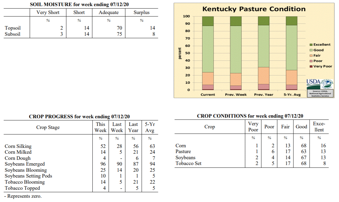 Kentucky Climate Summary
For the Period July 6, 2020 to July 12, 2020
Above Normal Temperatures and Rainfall:
This past week featured a ‘rinse and repeat’ pattern. Weather conditions were
essentially the same between Monday and Thursday. Highs jumped into the upper 80s to
middle 90s with humid conditions in place. Isolated to scattered storms formed each
day during the heat of the afternoon hours and dissipated later in the evening and
overnight. Once again, any storm that developed was capable of producing very heavy
rainfall and flash flooding. The pattern changed a bit Friday and into the weekend as
a couple cold fronts worked through Kentucky. The state saw several rounds of
rainfall, some with widespread coverage in place. Overall, the state averaged a
little over an inch for the week. This now makes the third straight week that the
state rainfall average has ran above normal. Over those 21 days, data at the Ag
Weather Center shows the state has averaged 4.45 inches, which is about 1.5 inches
above normal.
Temperatures for the period averaged 78 degrees across the state which was 2 degrees
warmer than normal and no change to the previous period. High temperatures averaged
from 89 in the West to 86 in the East. Departure from normal high temperatures
ranged from near normal in the West to 1 degree cooler than normal in the East. Low
temperatures averaged from 70 degrees in the West to 66 degrees in the East. Departure
from normal low temperature ranged from 3 degrees warmer than normal in the West to 3
degrees warmer than normal in the East. The extreme high temperature for the period was
95 degrees at CAPE GIRARDEAU ASOS and the extreme low was 61 degrees at BRANDENBURG 4SW.
Precipitation (liq. equ.) for the period totaled 1.12 inches statewide which was 0.13
inches above normal and 113% of normal. Precipitation totals by climate division,
West 1.24 inches, Central 1.21 inches, Bluegrass 1.27 inches and East 0.77 inches,
which was 0.26, 0.21, 0.30 and -0.23 inches respectively from normal. By station,
precipitation totals ranged from a low of 0.00 inches at CAPE GIRARDEAU ASOS to a
high of 4.05 inches at HARRODSBURG 3N.
---
Kentucky Crop and Weather Report
Issued 4:00 P.M., July 6, 2020 16-20
Agricultural News: Kentucky experienced above normal temperatures and rainfall over
the past week. Precipitation for the week totaled 1.08 inches, 0.09 inches above
normal. Temperatures averaged 77 degrees for the week, 1 degree above normal. Topsoil
moisture was rated 2 percent very short, 10 percent short, 66 percent adequate, and
22 percent surplus. Subsoil moisture was rated 2 percent very short, 9 percent short,
73 percent adequate, and 16 percent surplus. Days suitable for fieldwork averaged 4.1
out of a possible seven.
Primary activities for this week included the continued planting of soybeans, setting
tobacco, cutting hay, and harvesting wheat. Heavy precipitation in the early part of
the week proved to be a detriment to some crops as there were reports of extensive
flooding in parts of the state. There were reports of crops under water as well as
fields badly eroded from the heavy rain. The scope of the damage will be assessed as
the season progresses. The latter part of the week presented drier conditions, but
intense heat that led to stress on crops and livestock. Twenty-eight percent of corn
is in the silking stage while 5 percent of the crop is milking. Nearly all soybeans
have been planted at this juncture with 90 percent of the crop emerged. Fourteen
percent of soybeans are blooming with only 1 percent setting pods. The average height
of soybeans is 14 inches. Tobacco setting, at 98 percent complete, is ahead of last
year and the five year average. Of the tobacco in the ground 5 percent is blooming.
Winter wheat harvest is 95 percent complete.
Both corn and soybeans remain in mostly good condition. Tobacco is doing well with 69
percent of the crop rated as in good condition. Pastures are in mostly good condition
at this time, however the rain this week may have opened the door for deterioration
from livestock traffic due to excessive mud.
Kentucky Climate Summary
For the Period July 6, 2020 to July 12, 2020
Above Normal Temperatures and Rainfall:
This past week featured a ‘rinse and repeat’ pattern. Weather conditions were
essentially the same between Monday and Thursday. Highs jumped into the upper 80s to
middle 90s with humid conditions in place. Isolated to scattered storms formed each
day during the heat of the afternoon hours and dissipated later in the evening and
overnight. Once again, any storm that developed was capable of producing very heavy
rainfall and flash flooding. The pattern changed a bit Friday and into the weekend as
a couple cold fronts worked through Kentucky. The state saw several rounds of
rainfall, some with widespread coverage in place. Overall, the state averaged a
little over an inch for the week. This now makes the third straight week that the
state rainfall average has ran above normal. Over those 21 days, data at the Ag
Weather Center shows the state has averaged 4.45 inches, which is about 1.5 inches
above normal.
Temperatures for the period averaged 78 degrees across the state which was 2 degrees
warmer than normal and no change to the previous period. High temperatures averaged
from 89 in the West to 86 in the East. Departure from normal high temperatures
ranged from near normal in the West to 1 degree cooler than normal in the East. Low
temperatures averaged from 70 degrees in the West to 66 degrees in the East. Departure
from normal low temperature ranged from 3 degrees warmer than normal in the West to 3
degrees warmer than normal in the East. The extreme high temperature for the period was
95 degrees at CAPE GIRARDEAU ASOS and the extreme low was 61 degrees at BRANDENBURG 4SW.
Precipitation (liq. equ.) for the period totaled 1.12 inches statewide which was 0.13
inches above normal and 113% of normal. Precipitation totals by climate division,
West 1.24 inches, Central 1.21 inches, Bluegrass 1.27 inches and East 0.77 inches,
which was 0.26, 0.21, 0.30 and -0.23 inches respectively from normal. By station,
precipitation totals ranged from a low of 0.00 inches at CAPE GIRARDEAU ASOS to a
high of 4.05 inches at HARRODSBURG 3N.
---
Kentucky Crop and Weather Report
Issued 4:00 P.M., July 6, 2020 16-20
Agricultural News: Kentucky experienced above normal temperatures and rainfall over
the past week. Precipitation for the week totaled 1.08 inches, 0.09 inches above
normal. Temperatures averaged 77 degrees for the week, 1 degree above normal. Topsoil
moisture was rated 2 percent very short, 10 percent short, 66 percent adequate, and
22 percent surplus. Subsoil moisture was rated 2 percent very short, 9 percent short,
73 percent adequate, and 16 percent surplus. Days suitable for fieldwork averaged 4.1
out of a possible seven.
Primary activities for this week included the continued planting of soybeans, setting
tobacco, cutting hay, and harvesting wheat. Heavy precipitation in the early part of
the week proved to be a detriment to some crops as there were reports of extensive
flooding in parts of the state. There were reports of crops under water as well as
fields badly eroded from the heavy rain. The scope of the damage will be assessed as
the season progresses. The latter part of the week presented drier conditions, but
intense heat that led to stress on crops and livestock. Twenty-eight percent of corn
is in the silking stage while 5 percent of the crop is milking. Nearly all soybeans
have been planted at this juncture with 90 percent of the crop emerged. Fourteen
percent of soybeans are blooming with only 1 percent setting pods. The average height
of soybeans is 14 inches. Tobacco setting, at 98 percent complete, is ahead of last
year and the five year average. Of the tobacco in the ground 5 percent is blooming.
Winter wheat harvest is 95 percent complete.
Both corn and soybeans remain in mostly good condition. Tobacco is doing well with 69
percent of the crop rated as in good condition. Pastures are in mostly good condition
at this time, however the rain this week may have opened the door for deterioration
from livestock traffic due to excessive mud.
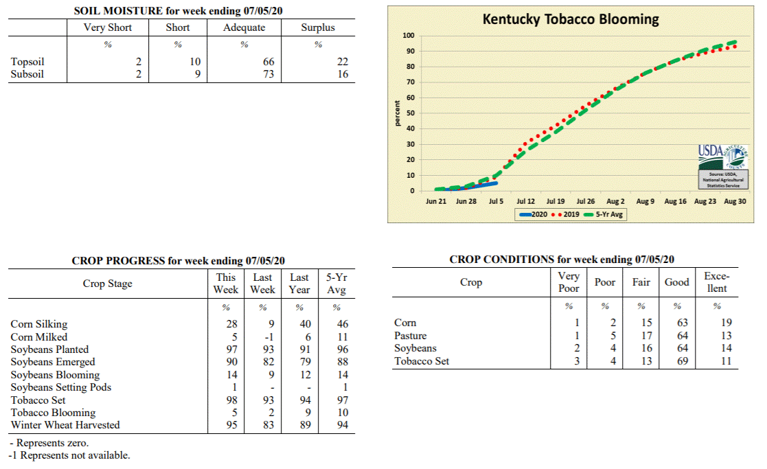 Kentucky Climate Summary
For the Period June 29, 2020 to July 5, 2020
Above Normal Temperatures and Rainfall:
The first half of the period featured a persistent wet pattern that carried over from
the previous weekend. Storms were scattered in coverage and within a very moist air
mass, led to heavy downpours. If caught under one of these slow-moving storms, flash
flooding was common with the excessive rainfall. Western Kentucky saw the most
widespread rainfall this week with most picking up more than an inch, but many over
two. A very hot and humid air mass accompanied the rainfall. The muggy conditions
made it feel more like it was around 100 for some locations on Monday. Conditions
turned mostly dry between Thursday and Independence Day. While humidity decreased a
bit, air temperatures remained high in the upper 80s to middle 90s, slightly above
normal for this time of year. Storms returned to the area on Sunday, most widespread
across Central Kentucky. Overall, Western Kentucky led the way, averaging over 2
inches for the week. That number decreased to just under a half inch for Eastern
Kentucky with more hit and miss storms. Despite some lower accumulations to the east,
other than extreme NE Kentucky, the Central Bluegrass, and a small section of SE
Kentucky; most have seen significant rainfall over the past 2 weeks.
Temperatures for the period averaged 77 degrees across the state which was 1 degree
warmer than normal and 2 degrees warmer than the previous period. High temperatures
averaged from 87 in the West to 86 in the East. Departure from normal high
temperatures ranged from 2 degrees cooler than normal in the West to near normal in
the East. Low temperatures averaged from 70 degrees in the West to 66 degrees in the
East. Departure from normal low temperature ranged from 3 degrees warmer than normal
in the West to 4 degrees warmer than normal in the East. The extreme high temperature
for the period was 96 degrees at FRANKFORT and the extreme low was 61 degrees at
PAINTSVILLE 4W.
Precipitation (liq. equ.) for the period totaled 1.08 inches statewide which was 0.09
inches above normal and 109% of normal. Precipitation totals by climate division,
West 2.14 inches, Central 1.00 inches, Bluegrass 0.68 inches and East 0.49 inches,
which was 1.15, 0.02, -0.28 and -0.53 inches respectively from normal. By station,
precipitation totals ranged from a low of 0.00 inches at LOUISA 1S to a high of 5.24
inches at LEBANON 8NW.
---
Kentucky Crop and Weather Report
Issued 4:00 P.M., June 29, 2020 15-20
Agricultural News: Kentucky experienced below normal temperatures and much above
normal rainfall over the past week. Precipitation for the week totaled 2.25 inches,
1.25 inches above normal. Temperatures averaged 74 degrees for the week, 1 degree
below normal. Topsoil moisture was rated 1 percent very short, 11 percent short, 74
percent adequate, and 14 percent surplus. Subsoil moisture was rated 2 percent very
short, 11 percent short, 77 percent adequate, and 10 percent surplus. Days suitable
for fieldwork averaged 5.1 out of a possible seven.
Primary activities for this week included the continued planting of soybeans, setting
tobacco, cutting hay, and harvesting wheat. With a good deal of precipitation this
past week fieldwork was halted at times. The rainfall was needed in some areas,
however the weekend brought very heavy downpours and flooding in several parts of the
state. Nine percent of the corn crop is in the silking stage. Soybean planting is
nearing completion with 93 percent of the crop is in the ground. The soybean crop is
82 percent emerged and 9 percent in the blooming stage. The average height of
soybeans at this juncture is 11 inches. Tobacco setting, at 93 percent complete, is
ahead of last year and slightly behind the five year average. Farmers are using every
available window to finish up planting. The average height of tobacco plants is 13
inches at this time with 2 percent of the crop in the blooming stage. Winter wheat
harvest is 83 percent complete as farmers have begun planting double crop soybeans.
It is of note that wheat yields have been adversely affected by the late spring
freeze in many cases.
Both corn and soybeans remain in mostly good condition. Tobacco is doing well with 78
percent of the crop rated as in good condition. Pastures are in mostly good condition
at this time. The rain this past week will benefit some pastures, however the areas
that received very heavy precipitation may see some damage from flooding and
livestock traffic. Livestock across the state are in good shape. The quality of
harvested hay is rated as 2 percent very poor, 5 percent poor, 20 percent fair, 61
percent good, and 12 percent excellent. Hay yields should be very good for the most
part as favorable weather prevailed during much of the harvest.
Kentucky Climate Summary
For the Period June 29, 2020 to July 5, 2020
Above Normal Temperatures and Rainfall:
The first half of the period featured a persistent wet pattern that carried over from
the previous weekend. Storms were scattered in coverage and within a very moist air
mass, led to heavy downpours. If caught under one of these slow-moving storms, flash
flooding was common with the excessive rainfall. Western Kentucky saw the most
widespread rainfall this week with most picking up more than an inch, but many over
two. A very hot and humid air mass accompanied the rainfall. The muggy conditions
made it feel more like it was around 100 for some locations on Monday. Conditions
turned mostly dry between Thursday and Independence Day. While humidity decreased a
bit, air temperatures remained high in the upper 80s to middle 90s, slightly above
normal for this time of year. Storms returned to the area on Sunday, most widespread
across Central Kentucky. Overall, Western Kentucky led the way, averaging over 2
inches for the week. That number decreased to just under a half inch for Eastern
Kentucky with more hit and miss storms. Despite some lower accumulations to the east,
other than extreme NE Kentucky, the Central Bluegrass, and a small section of SE
Kentucky; most have seen significant rainfall over the past 2 weeks.
Temperatures for the period averaged 77 degrees across the state which was 1 degree
warmer than normal and 2 degrees warmer than the previous period. High temperatures
averaged from 87 in the West to 86 in the East. Departure from normal high
temperatures ranged from 2 degrees cooler than normal in the West to near normal in
the East. Low temperatures averaged from 70 degrees in the West to 66 degrees in the
East. Departure from normal low temperature ranged from 3 degrees warmer than normal
in the West to 4 degrees warmer than normal in the East. The extreme high temperature
for the period was 96 degrees at FRANKFORT and the extreme low was 61 degrees at
PAINTSVILLE 4W.
Precipitation (liq. equ.) for the period totaled 1.08 inches statewide which was 0.09
inches above normal and 109% of normal. Precipitation totals by climate division,
West 2.14 inches, Central 1.00 inches, Bluegrass 0.68 inches and East 0.49 inches,
which was 1.15, 0.02, -0.28 and -0.53 inches respectively from normal. By station,
precipitation totals ranged from a low of 0.00 inches at LOUISA 1S to a high of 5.24
inches at LEBANON 8NW.
---
Kentucky Crop and Weather Report
Issued 4:00 P.M., June 29, 2020 15-20
Agricultural News: Kentucky experienced below normal temperatures and much above
normal rainfall over the past week. Precipitation for the week totaled 2.25 inches,
1.25 inches above normal. Temperatures averaged 74 degrees for the week, 1 degree
below normal. Topsoil moisture was rated 1 percent very short, 11 percent short, 74
percent adequate, and 14 percent surplus. Subsoil moisture was rated 2 percent very
short, 11 percent short, 77 percent adequate, and 10 percent surplus. Days suitable
for fieldwork averaged 5.1 out of a possible seven.
Primary activities for this week included the continued planting of soybeans, setting
tobacco, cutting hay, and harvesting wheat. With a good deal of precipitation this
past week fieldwork was halted at times. The rainfall was needed in some areas,
however the weekend brought very heavy downpours and flooding in several parts of the
state. Nine percent of the corn crop is in the silking stage. Soybean planting is
nearing completion with 93 percent of the crop is in the ground. The soybean crop is
82 percent emerged and 9 percent in the blooming stage. The average height of
soybeans at this juncture is 11 inches. Tobacco setting, at 93 percent complete, is
ahead of last year and slightly behind the five year average. Farmers are using every
available window to finish up planting. The average height of tobacco plants is 13
inches at this time with 2 percent of the crop in the blooming stage. Winter wheat
harvest is 83 percent complete as farmers have begun planting double crop soybeans.
It is of note that wheat yields have been adversely affected by the late spring
freeze in many cases.
Both corn and soybeans remain in mostly good condition. Tobacco is doing well with 78
percent of the crop rated as in good condition. Pastures are in mostly good condition
at this time. The rain this past week will benefit some pastures, however the areas
that received very heavy precipitation may see some damage from flooding and
livestock traffic. Livestock across the state are in good shape. The quality of
harvested hay is rated as 2 percent very poor, 5 percent poor, 20 percent fair, 61
percent good, and 12 percent excellent. Hay yields should be very good for the most
part as favorable weather prevailed during much of the harvest.
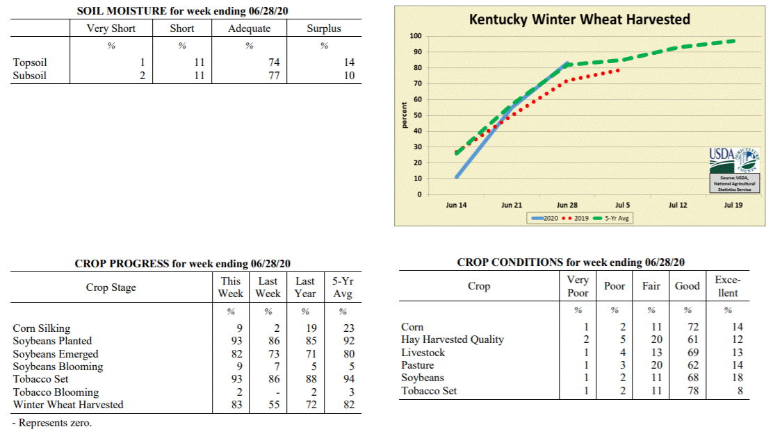 Kentucky Climate Summary
For the Period June 22, 2020 to June 28, 2020
Below Normal Temperatures and Much Above Normal Rainfall:
Exceptional rainfall fell across the Bluegrass State over this past week as the state
averaged 2.25 inches. This broke a four week stretch of below normal rainfall. While
the state saw numerous rounds of showers and storms through the period, the most
intense activity occurred over the weekend. Several waves of storms pushed through
Kentucky and as the state sat within a very moist air mass, torrential rainfall was
common. One of these waves led to substantial flooding across portions of West
Central Kentucky on Sunday. The three highest accumulations according to the Kentucky
Mesonet on Sunday came from Ohio, Muhlenberg, and McLean Counties with totals of 4 to
6+ inches. This wave carried southeast into South Central Kentucky with numerous
stations over two inches for the day.
Temperatures for the period averaged 74 degrees across the state which was 1 degree
cooler than normal and 4 degrees warmer than the previous period. High temperatures
averaged from 85 in the West to 81 in the East. Departure from normal high
temperatures ranged from 3 degrees cooler than normal in the West to 4 degrees
cooler than normal in the East. Low temperatures averaged from 67 degrees in the
West to 64 degrees in the East. Departure from normal low temperature ranged from 2
degrees warmer than normal in the West to 3 degrees warmer than normal in the East.
The extreme high temperature for the period was 94 degrees at CAPE GIRARDEAU ASOS and
the extreme low was 55 degrees at CYNTHIANA 8N.
Precipitation (liq. equ.) for the period totaled 2.25 inches statewide which was 1.25
inches above normal and 226% of normal. Precipitation totals by climate division,
West 2.35 inches, Central 2.99 inches, Bluegrass 1.79 inches and East 1.86 inches,
which was 1.36, 2.01, 0.81 and 0.83 inches above normal. By station, precipitation
totals ranged from a low of 0.00 inches at BIG SANDY to a high of 7.48 inches at
CALHOUN 5NW.
---
Kentucky Crop and Weather Report
Issued 4:00 P.M., June 22, 2020 14-20
Agricultural News: Kentucky experienced below normal temperatures and rainfall over
the past week. Precipitation for the week totaled 0.65 inches, 0.36 inches below
normal. Temperatures averaged 71 degrees for the week, 2 degrees below normal.
Topsoil moisture was rated 2 percent very short, 29 percent short, 63 percent
adequate, and 6 percent surplus. Subsoil moisture was rated 3 percent very short, 19
percent short, 72 percent adequate, and 6 percent surplus. Days suitable for
fieldwork averaged 6.0 out of a possible seven.
Primary activities for this week included the continued planting of soybeans, setting
tobacco, cutting hay, and harvesting wheat. Favorable weather allowed farmers to put
in a great deal of time in the fields. The corn crop is 95 percent emerged with 2
percent of the crop in the silking stage. Soybean planting is moving along at a
strong pace and continues to run ahead of last year and the five year average. The
soybean crop is 73 percent emerged and 7 percent in the blooming stage. The average
height of soybeans at this juncture is 4 inches. Tobacco setting is ahead of last
year and slightly behind the five year average. Some prosperous weather in the coming
week will allow farmers to near completion for setting. The average height of tobacco
plants is 10 inches at this time. Winter wheat harvest took a big jump this past week
thanks to the accommodating weather. With the crop at 92 percent mature, producers
pressed hard to get as much harvested as possible. Many farmers are ready to plant
double crop soybeans as the wheat is harvested.
The winter wheat crop is in mostly good condition. Both corn and soybeans are in good
shape as grain farmers push through the season. Tobacco is doing well thus far with
80 percent of the crop rated as in good condition. Pastures are still in good
condition, but would benefit from some precipitation to promote growth. Hay is in
good condition despite the dry conditions of late.
Kentucky Climate Summary
For the Period June 22, 2020 to June 28, 2020
Below Normal Temperatures and Much Above Normal Rainfall:
Exceptional rainfall fell across the Bluegrass State over this past week as the state
averaged 2.25 inches. This broke a four week stretch of below normal rainfall. While
the state saw numerous rounds of showers and storms through the period, the most
intense activity occurred over the weekend. Several waves of storms pushed through
Kentucky and as the state sat within a very moist air mass, torrential rainfall was
common. One of these waves led to substantial flooding across portions of West
Central Kentucky on Sunday. The three highest accumulations according to the Kentucky
Mesonet on Sunday came from Ohio, Muhlenberg, and McLean Counties with totals of 4 to
6+ inches. This wave carried southeast into South Central Kentucky with numerous
stations over two inches for the day.
Temperatures for the period averaged 74 degrees across the state which was 1 degree
cooler than normal and 4 degrees warmer than the previous period. High temperatures
averaged from 85 in the West to 81 in the East. Departure from normal high
temperatures ranged from 3 degrees cooler than normal in the West to 4 degrees
cooler than normal in the East. Low temperatures averaged from 67 degrees in the
West to 64 degrees in the East. Departure from normal low temperature ranged from 2
degrees warmer than normal in the West to 3 degrees warmer than normal in the East.
The extreme high temperature for the period was 94 degrees at CAPE GIRARDEAU ASOS and
the extreme low was 55 degrees at CYNTHIANA 8N.
Precipitation (liq. equ.) for the period totaled 2.25 inches statewide which was 1.25
inches above normal and 226% of normal. Precipitation totals by climate division,
West 2.35 inches, Central 2.99 inches, Bluegrass 1.79 inches and East 1.86 inches,
which was 1.36, 2.01, 0.81 and 0.83 inches above normal. By station, precipitation
totals ranged from a low of 0.00 inches at BIG SANDY to a high of 7.48 inches at
CALHOUN 5NW.
---
Kentucky Crop and Weather Report
Issued 4:00 P.M., June 22, 2020 14-20
Agricultural News: Kentucky experienced below normal temperatures and rainfall over
the past week. Precipitation for the week totaled 0.65 inches, 0.36 inches below
normal. Temperatures averaged 71 degrees for the week, 2 degrees below normal.
Topsoil moisture was rated 2 percent very short, 29 percent short, 63 percent
adequate, and 6 percent surplus. Subsoil moisture was rated 3 percent very short, 19
percent short, 72 percent adequate, and 6 percent surplus. Days suitable for
fieldwork averaged 6.0 out of a possible seven.
Primary activities for this week included the continued planting of soybeans, setting
tobacco, cutting hay, and harvesting wheat. Favorable weather allowed farmers to put
in a great deal of time in the fields. The corn crop is 95 percent emerged with 2
percent of the crop in the silking stage. Soybean planting is moving along at a
strong pace and continues to run ahead of last year and the five year average. The
soybean crop is 73 percent emerged and 7 percent in the blooming stage. The average
height of soybeans at this juncture is 4 inches. Tobacco setting is ahead of last
year and slightly behind the five year average. Some prosperous weather in the coming
week will allow farmers to near completion for setting. The average height of tobacco
plants is 10 inches at this time. Winter wheat harvest took a big jump this past week
thanks to the accommodating weather. With the crop at 92 percent mature, producers
pressed hard to get as much harvested as possible. Many farmers are ready to plant
double crop soybeans as the wheat is harvested.
The winter wheat crop is in mostly good condition. Both corn and soybeans are in good
shape as grain farmers push through the season. Tobacco is doing well thus far with
80 percent of the crop rated as in good condition. Pastures are still in good
condition, but would benefit from some precipitation to promote growth. Hay is in
good condition despite the dry conditions of late.
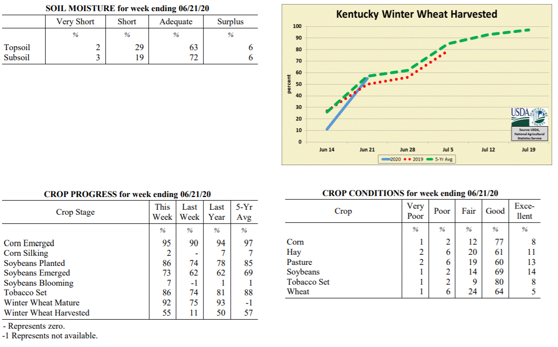 Kentucky Climate Summary
For the Period June 15, 2020 to June 21, 2020
Below Normal Temperatures and Rainfall:
Kentucky saw a fourth straight week of below normal rainfall. Focus for much of the
period was on a slow-moving area of low pressure aloft that hovered to the east of
the Bluegrass State. Conditions were mostly dry through Wednesday, but as the area of
low pressure slowly moved closer, scattered showers and storms returned to the
eastern half of Kentucky on Thursday. Coverage then turned more of the hit or miss
variety on Friday and Saturday, still mainly across the eastern half of the state.
The pattern changed by Sunday as the upper level low moved to the northeast and
another disturbance pushed into the area, producing much-needed widespread rain
coverage for the first time in quite a while. Saying that, accumulations were still
quite variable across Kentucky. Overall, the state averaged 0.65 inches for the week,
which is about a third of an inch below normal. Over the past 30 days, rainfall
deficits are over 1.5 inches below normal across the state. The extended period of
dry weather has led the US Drought Monitor to introduce an area of ‘Abnormally Dry’
conditions across mainly Western/West Central Kentucky.
Temperatures for the period averaged 71 degrees across the state which was 2 degrees
cooler than normal and 2 degrees cooler than the previous period. High temperatures
averaged from 84 in the West to 78 in the East. Departure from normal high
temperatures ranged from 3 degrees cooler than normal in the West to 6 degrees
cooler than normal in the East. Low temperatures averaged from 61 degrees in the
West to 59 degrees in the East. Departure from normal low temperature ranged from 3
degrees cooler than normal in the West to near normal in the East. The extreme high
temperature for the period was 94 degrees at MAYFIELD 6SW and the extreme low was 49
degrees at BRANDENBURG 4SW.
Precipitation (liq. equ.) for the period totaled 0.65 inches statewide which was 0.36
inches below normal and 64% of normal. Precipitation totals by climate division, West
0.62 inches, Central 0.60 inches, Bluegrass 0.64 inches and East 0.74 inches, which
was 0.38, 0.4, 0.38 and 0.29 inches below normal. By station, precipitation totals
ranged from a low of 0.01 inches at BIG SANDY to a high of 2.19 inches at MOREHEAD 4NE.
---
Kentucky Crop and Weather Report
Issued 4:00 P.M., June 15, 2020 13-20
Agricultural News: Kentucky experienced above normal temperatures and below normal
rainfall over the past week. Precipitation for the week totaled 0.38 inches, 0.65
inches below normal. Temperatures averaged 73 degrees for the week, 1 degrees above
normal. Topsoil moisture was rated 2 percent very short, 19 percent short, 70 percent
adequate, and 9 percent surplus. Subsoil moisture was rated 2 percent very short, 13
percent short, 76 percent adequate, and 9 percent surplus. Days suitable for
fieldwork averaged 6.0 out of a possible seven.
Primary activities for this week included the continued planting of corn and
soybeans, setting tobacco, spraying, and cutting hay. A very productive week in the
fields as weather was cooperative for the most part. Dry and warm conditions allowed
farmers to make a strong push on plantings and forage harvest. There are pockets
where the dry weather has been a detriment. In these areas the crops are a little
stressed and rain is needed to incorporate nitrogen that has been sprayed. With that
said, the week wasn’t completely void of rain, however rainfall was sparse and
generally not heavy in nature. Soybean planting is ahead of last year but just behind
the five year average. Corn planting is nearing completion and is on pace with both
last year and the five year average. The corn crop is 90 percent emerged while
soybeans are 62 percent emerged. The average height of corn at this juncture is 21
inches. Tobacco setting made a big leap this week and sits right between last year
and the five year average. The average height of tobacco is 6 inches.
The winter wheat harvest has begun in earnest, however progress is well below last
year and the five year average for this juncture of the season. Nearly all of the
crop is mature and mostly coloring. The condition of the wheat crop remains mostly
good despite the freeze event several weeks prior. Corn and soybean condition
continues to be reported as mostly good at this time. Pastures are healthy on the
whole and continue to show good growth. Planted tobacco is reported as in mostly
good condition at this time.
Kentucky Climate Summary
For the Period June 15, 2020 to June 21, 2020
Below Normal Temperatures and Rainfall:
Kentucky saw a fourth straight week of below normal rainfall. Focus for much of the
period was on a slow-moving area of low pressure aloft that hovered to the east of
the Bluegrass State. Conditions were mostly dry through Wednesday, but as the area of
low pressure slowly moved closer, scattered showers and storms returned to the
eastern half of Kentucky on Thursday. Coverage then turned more of the hit or miss
variety on Friday and Saturday, still mainly across the eastern half of the state.
The pattern changed by Sunday as the upper level low moved to the northeast and
another disturbance pushed into the area, producing much-needed widespread rain
coverage for the first time in quite a while. Saying that, accumulations were still
quite variable across Kentucky. Overall, the state averaged 0.65 inches for the week,
which is about a third of an inch below normal. Over the past 30 days, rainfall
deficits are over 1.5 inches below normal across the state. The extended period of
dry weather has led the US Drought Monitor to introduce an area of ‘Abnormally Dry’
conditions across mainly Western/West Central Kentucky.
Temperatures for the period averaged 71 degrees across the state which was 2 degrees
cooler than normal and 2 degrees cooler than the previous period. High temperatures
averaged from 84 in the West to 78 in the East. Departure from normal high
temperatures ranged from 3 degrees cooler than normal in the West to 6 degrees
cooler than normal in the East. Low temperatures averaged from 61 degrees in the
West to 59 degrees in the East. Departure from normal low temperature ranged from 3
degrees cooler than normal in the West to near normal in the East. The extreme high
temperature for the period was 94 degrees at MAYFIELD 6SW and the extreme low was 49
degrees at BRANDENBURG 4SW.
Precipitation (liq. equ.) for the period totaled 0.65 inches statewide which was 0.36
inches below normal and 64% of normal. Precipitation totals by climate division, West
0.62 inches, Central 0.60 inches, Bluegrass 0.64 inches and East 0.74 inches, which
was 0.38, 0.4, 0.38 and 0.29 inches below normal. By station, precipitation totals
ranged from a low of 0.01 inches at BIG SANDY to a high of 2.19 inches at MOREHEAD 4NE.
---
Kentucky Crop and Weather Report
Issued 4:00 P.M., June 15, 2020 13-20
Agricultural News: Kentucky experienced above normal temperatures and below normal
rainfall over the past week. Precipitation for the week totaled 0.38 inches, 0.65
inches below normal. Temperatures averaged 73 degrees for the week, 1 degrees above
normal. Topsoil moisture was rated 2 percent very short, 19 percent short, 70 percent
adequate, and 9 percent surplus. Subsoil moisture was rated 2 percent very short, 13
percent short, 76 percent adequate, and 9 percent surplus. Days suitable for
fieldwork averaged 6.0 out of a possible seven.
Primary activities for this week included the continued planting of corn and
soybeans, setting tobacco, spraying, and cutting hay. A very productive week in the
fields as weather was cooperative for the most part. Dry and warm conditions allowed
farmers to make a strong push on plantings and forage harvest. There are pockets
where the dry weather has been a detriment. In these areas the crops are a little
stressed and rain is needed to incorporate nitrogen that has been sprayed. With that
said, the week wasn’t completely void of rain, however rainfall was sparse and
generally not heavy in nature. Soybean planting is ahead of last year but just behind
the five year average. Corn planting is nearing completion and is on pace with both
last year and the five year average. The corn crop is 90 percent emerged while
soybeans are 62 percent emerged. The average height of corn at this juncture is 21
inches. Tobacco setting made a big leap this week and sits right between last year
and the five year average. The average height of tobacco is 6 inches.
The winter wheat harvest has begun in earnest, however progress is well below last
year and the five year average for this juncture of the season. Nearly all of the
crop is mature and mostly coloring. The condition of the wheat crop remains mostly
good despite the freeze event several weeks prior. Corn and soybean condition
continues to be reported as mostly good at this time. Pastures are healthy on the
whole and continue to show good growth. Planted tobacco is reported as in mostly
good condition at this time.
 Kentucky Climate Summary
For the Period June 8, 2020 to June 14, 2020
Above Normal Temperatures and Below Normal Rainfall:
Conditions have trended dry recently across Kentucky with three straight weeks of
below normal rainfall. Over this 21-day period, the state has only averaged two
inches of rainfall, which is over an inch below normal. Saying that, some locations
have received under an inch over that time period and over two inches below
normal. Looking at this past week, focus was on the remnants of Tropical Storm
Cristobal early in the period. This system ended up taking a track just west of
Kentucky and unfortunately, took the higher accumulations with it. Showers and storms
were scattered to numerous in nature across the western half of Kentucky and limited
father east. This was flipped on Wednesday as a strong cold front pushed through the
state. While the eastern half of Kentucky benefited from some rainfall, the western
half was left mostly dry. After a dry second half of the work week, light showers
again fell over the weekend, but nothing too significant. Overall, the state averaged
less than a half inch for the week.
Temperatures for the period averaged 73 degrees across the state which was 1 degree
warmer than normal and no change to the previous period. High temperatures averaged
from 84 in the West to 82 in the East. Departure from normal high temperatures
ranged from 1 degree cooler than normal in the West to 1 degree cooler than normal
in the East. Low temperatures averaged from 65 degrees in the West to 60 degrees in
the East. Departure from normal low temperature ranged from 2 degrees warmer than
normal in the West to 2 degrees warmer than normal in the East. The extreme high
temperature for the period was 93 degrees at BOWLING GREEN APT and the extreme low
was 50 degrees at CARLISLE 5SW.
Precipitation (liq. equ.) for the period totaled 0.38 inches statewide which was 0.65
inches below normal and 37% of normal. Precipitation totals by climate division, West
0.56 inches, Central 0.35 inches, Bluegrass 0.30 inches and East 0.30 inches, which
was 0.42, 0.69, 0.75 and 0.75 inches below normal. By station, precipitation totals
ranged from a low of 0.00 inches at HODGENVILLE 2E to a high of 1.10
inches at WINCHESTER 3NW.
---
Kentucky Crop and Weather Report
Issued 4:00 P.M., June 8, 2020 12-20
Agricultural News: Kentucky experienced above normal temperatures and below normal
rainfall over the past week. Precipitation for the week totaled 0.96 inches, 0.13
inches below normal. Temperatures averaged 74 degrees for the week, 4 degrees above
normal. Topsoil moisture was rated 1 percent very short, 10 percent short, 76 percent
adequate, and 13 percent surplus. Subsoil moisture was rated 1 percent very short, 7
percent short, 79 percent adequate, and 13 percent surplus. Days suitable for
fieldwork averaged 5.5 out of a possible seven.
Primary activities for this week included the continued planting of corn and
soybeans, setting tobacco, and cutting hay. Farmers were able to make a good deal of
headway in the fields this week thanks to accommodating weather. Planting progress
had been stunted by consistent rain in the prior weeks so drier conditions were a
welcome change. There was a great deal of hay cut this week as the weather was
conducive. As the cutting moved along, there was some expressed optimism regarding
yields. Soybean planting continues to outpace both last year and the five year
average. Corn planting is on par with last year and slightly behind the five year
average. The corn crop is 79 percent emerged while soybeans are 50 percent emerged.
The average height of corn at this juncture is 15 inches. Tobacco setting showed a
big jump in progress this past week and sits just behind last year and the five year
average for this point in the season.
The freeze event that occurred several weeks ago has been alluded to often when
discussing crop conditions. Despite this event, corn and soybeans remain in mostly
good condition and appear to have been largely spared. Winter wheat was damaged in
this event and there will be losses. With that being said, the overall wheat crop is
mostly fair to good, however the margins are closer than corn and soybeans. Tobacco
set is in good condition at this time. Pastures are doing well as the break in rain
has allowed more growth with less damage from livestock traffic.
Kentucky Climate Summary
For the Period June 8, 2020 to June 14, 2020
Above Normal Temperatures and Below Normal Rainfall:
Conditions have trended dry recently across Kentucky with three straight weeks of
below normal rainfall. Over this 21-day period, the state has only averaged two
inches of rainfall, which is over an inch below normal. Saying that, some locations
have received under an inch over that time period and over two inches below
normal. Looking at this past week, focus was on the remnants of Tropical Storm
Cristobal early in the period. This system ended up taking a track just west of
Kentucky and unfortunately, took the higher accumulations with it. Showers and storms
were scattered to numerous in nature across the western half of Kentucky and limited
father east. This was flipped on Wednesday as a strong cold front pushed through the
state. While the eastern half of Kentucky benefited from some rainfall, the western
half was left mostly dry. After a dry second half of the work week, light showers
again fell over the weekend, but nothing too significant. Overall, the state averaged
less than a half inch for the week.
Temperatures for the period averaged 73 degrees across the state which was 1 degree
warmer than normal and no change to the previous period. High temperatures averaged
from 84 in the West to 82 in the East. Departure from normal high temperatures
ranged from 1 degree cooler than normal in the West to 1 degree cooler than normal
in the East. Low temperatures averaged from 65 degrees in the West to 60 degrees in
the East. Departure from normal low temperature ranged from 2 degrees warmer than
normal in the West to 2 degrees warmer than normal in the East. The extreme high
temperature for the period was 93 degrees at BOWLING GREEN APT and the extreme low
was 50 degrees at CARLISLE 5SW.
Precipitation (liq. equ.) for the period totaled 0.38 inches statewide which was 0.65
inches below normal and 37% of normal. Precipitation totals by climate division, West
0.56 inches, Central 0.35 inches, Bluegrass 0.30 inches and East 0.30 inches, which
was 0.42, 0.69, 0.75 and 0.75 inches below normal. By station, precipitation totals
ranged from a low of 0.00 inches at HODGENVILLE 2E to a high of 1.10
inches at WINCHESTER 3NW.
---
Kentucky Crop and Weather Report
Issued 4:00 P.M., June 8, 2020 12-20
Agricultural News: Kentucky experienced above normal temperatures and below normal
rainfall over the past week. Precipitation for the week totaled 0.96 inches, 0.13
inches below normal. Temperatures averaged 74 degrees for the week, 4 degrees above
normal. Topsoil moisture was rated 1 percent very short, 10 percent short, 76 percent
adequate, and 13 percent surplus. Subsoil moisture was rated 1 percent very short, 7
percent short, 79 percent adequate, and 13 percent surplus. Days suitable for
fieldwork averaged 5.5 out of a possible seven.
Primary activities for this week included the continued planting of corn and
soybeans, setting tobacco, and cutting hay. Farmers were able to make a good deal of
headway in the fields this week thanks to accommodating weather. Planting progress
had been stunted by consistent rain in the prior weeks so drier conditions were a
welcome change. There was a great deal of hay cut this week as the weather was
conducive. As the cutting moved along, there was some expressed optimism regarding
yields. Soybean planting continues to outpace both last year and the five year
average. Corn planting is on par with last year and slightly behind the five year
average. The corn crop is 79 percent emerged while soybeans are 50 percent emerged.
The average height of corn at this juncture is 15 inches. Tobacco setting showed a
big jump in progress this past week and sits just behind last year and the five year
average for this point in the season.
The freeze event that occurred several weeks ago has been alluded to often when
discussing crop conditions. Despite this event, corn and soybeans remain in mostly
good condition and appear to have been largely spared. Winter wheat was damaged in
this event and there will be losses. With that being said, the overall wheat crop is
mostly fair to good, however the margins are closer than corn and soybeans. Tobacco
set is in good condition at this time. Pastures are doing well as the break in rain
has allowed more growth with less damage from livestock traffic.
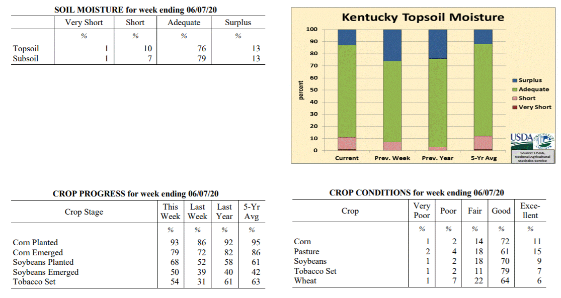 Kentucky Climate Summary
For the Period June 1, 2020 to June 7, 2020
Above Normal Temperatures and Below Normal Rainfall:
Kentucky saw a second straight week of below normal rainfall. According to data at
the Ag Weather Center, the state has averaged 1.62 inches over the past two weeks,
which is just over a half inch below normal. Carrying over from the previous weekend,
dry weather held for most of the state through Wednesday, giving the Commonwealth a 5
day stretch of dry conditions. Increasing temperatures and humidity accompanied this
dry weather with highs back in the mid 80s to low 90s for Tuesday and Wednesday.
Rainfall returned to the area on Thursday afternoon/evening with scattered to
numerous showers and storms in place. Any storms that formed were capable of
producing torrential rainfall. Totals varied tremendously based on the location of
those storms, with totals ranging from under a quarter inch to over 2 inches. This
was the only rainfall event across the week for most of Kentucky. Above normal
temperatures continued on Saturday, ahead of a weak frontal boundary moving through
the state. This boundary had little moisture to work with and for the most
part, just resulted in a temporary break from the humidity on Sunday.
Temperatures for the period averaged 74 degrees across the state which was 4 degrees
warmer than normal and 4 degrees warmer than the previous period. High temperatures
averaged from 87 in the West to 84 in the East. Departure from normal high
temperatures ranged from 4 degrees warmer than normal in the West to 3 degrees
warmer than normal in the East. Low temperatures averaged from 64 degrees in the
West to 61 degrees in the East. Departure from normal low temperature ranged from 3
degrees warmer than normal in the West to 5 degrees warmer than normal in the East.
The extreme high temperature for the period was 94 degrees at LOUISVILLE APT and the
extreme low was 41 degrees at OWINGSVILLE 4S.
Precipitation (liq. equ.) for the period totaled 0.96 inches statewide which was 0.13
inches below normal and 88% of normal. Precipitation totals by climate division, West
0.74 inches, Central 1.31 inches, Bluegrass 0.62 inches and East 1.16 inches, which
was -0.31, 0.21, -0.48 and 0.07 inches respectively from normal. By station,
precipitation totals ranged from a low of 0.05 inches at ALEXANDRIA 5NW to a high of
2.92 inches at OWENSBORO AWSS.
---
Kentucky Crop and Weather Report
Issued 4:00 P.M., June 1, 2020 11-20
Agricultural News: Kentucky experienced above normal temperatures and below normal
rainfall over the past week. Precipitation for the week totaled 0.66 inches, 0.46
inches below normal. Temperatures averaged 71 degrees for the week, 3 degrees above
normal. Topsoil moisture was rated 7 percent short, 67 percent adequate, and 26
percent surplus. Subsoil moisture was rated 4 percent short, 71 percent adequate, and
25 percent surplus. Days suitable for fieldwork averaged 4.3 out of a possible seven.
Primary activities for this week included planting of corn and soybeans, setting
tobacco, and cutting hay. Fieldwork was disrupted sporadically during the week as
farmers contended with scattered rain. The level of precipitation varied regionally
with some areas experiencing weather more conducive to progress in the fields. Drier
conditions prevailed statewide by the weekend allowing some headway on planting.
Cutting of forage has really picked up as farmers take advantage of every
opportunity. Soybean planting remains slightly ahead of both last year and the five
year average. Corn planting is equal to this time last year, but slightly behind the
five year average. The corn crop is 72 percent emerged while soybeans are 39 percent
emerged. The average height of corn at this juncture is 9 inches. Tobacco setting is
moving along at a steady pace, but is behind last year and the five year average.
The winter wheat crop was subject to damage from the freeze several weeks back. The
extent of this damage is becoming evident and losses are likely for many producers.
Despite the grim outlook for some wheat, the condition overall remains good. Corn and
soybean condition continues to be reported as mostly good at this time. Pastures are
showing good growth, but the persistent rain may take a toll from animal traffic.
Kentucky Climate Summary
For the Period June 1, 2020 to June 7, 2020
Above Normal Temperatures and Below Normal Rainfall:
Kentucky saw a second straight week of below normal rainfall. According to data at
the Ag Weather Center, the state has averaged 1.62 inches over the past two weeks,
which is just over a half inch below normal. Carrying over from the previous weekend,
dry weather held for most of the state through Wednesday, giving the Commonwealth a 5
day stretch of dry conditions. Increasing temperatures and humidity accompanied this
dry weather with highs back in the mid 80s to low 90s for Tuesday and Wednesday.
Rainfall returned to the area on Thursday afternoon/evening with scattered to
numerous showers and storms in place. Any storms that formed were capable of
producing torrential rainfall. Totals varied tremendously based on the location of
those storms, with totals ranging from under a quarter inch to over 2 inches. This
was the only rainfall event across the week for most of Kentucky. Above normal
temperatures continued on Saturday, ahead of a weak frontal boundary moving through
the state. This boundary had little moisture to work with and for the most
part, just resulted in a temporary break from the humidity on Sunday.
Temperatures for the period averaged 74 degrees across the state which was 4 degrees
warmer than normal and 4 degrees warmer than the previous period. High temperatures
averaged from 87 in the West to 84 in the East. Departure from normal high
temperatures ranged from 4 degrees warmer than normal in the West to 3 degrees
warmer than normal in the East. Low temperatures averaged from 64 degrees in the
West to 61 degrees in the East. Departure from normal low temperature ranged from 3
degrees warmer than normal in the West to 5 degrees warmer than normal in the East.
The extreme high temperature for the period was 94 degrees at LOUISVILLE APT and the
extreme low was 41 degrees at OWINGSVILLE 4S.
Precipitation (liq. equ.) for the period totaled 0.96 inches statewide which was 0.13
inches below normal and 88% of normal. Precipitation totals by climate division, West
0.74 inches, Central 1.31 inches, Bluegrass 0.62 inches and East 1.16 inches, which
was -0.31, 0.21, -0.48 and 0.07 inches respectively from normal. By station,
precipitation totals ranged from a low of 0.05 inches at ALEXANDRIA 5NW to a high of
2.92 inches at OWENSBORO AWSS.
---
Kentucky Crop and Weather Report
Issued 4:00 P.M., June 1, 2020 11-20
Agricultural News: Kentucky experienced above normal temperatures and below normal
rainfall over the past week. Precipitation for the week totaled 0.66 inches, 0.46
inches below normal. Temperatures averaged 71 degrees for the week, 3 degrees above
normal. Topsoil moisture was rated 7 percent short, 67 percent adequate, and 26
percent surplus. Subsoil moisture was rated 4 percent short, 71 percent adequate, and
25 percent surplus. Days suitable for fieldwork averaged 4.3 out of a possible seven.
Primary activities for this week included planting of corn and soybeans, setting
tobacco, and cutting hay. Fieldwork was disrupted sporadically during the week as
farmers contended with scattered rain. The level of precipitation varied regionally
with some areas experiencing weather more conducive to progress in the fields. Drier
conditions prevailed statewide by the weekend allowing some headway on planting.
Cutting of forage has really picked up as farmers take advantage of every
opportunity. Soybean planting remains slightly ahead of both last year and the five
year average. Corn planting is equal to this time last year, but slightly behind the
five year average. The corn crop is 72 percent emerged while soybeans are 39 percent
emerged. The average height of corn at this juncture is 9 inches. Tobacco setting is
moving along at a steady pace, but is behind last year and the five year average.
The winter wheat crop was subject to damage from the freeze several weeks back. The
extent of this damage is becoming evident and losses are likely for many producers.
Despite the grim outlook for some wheat, the condition overall remains good. Corn and
soybean condition continues to be reported as mostly good at this time. Pastures are
showing good growth, but the persistent rain may take a toll from animal traffic.
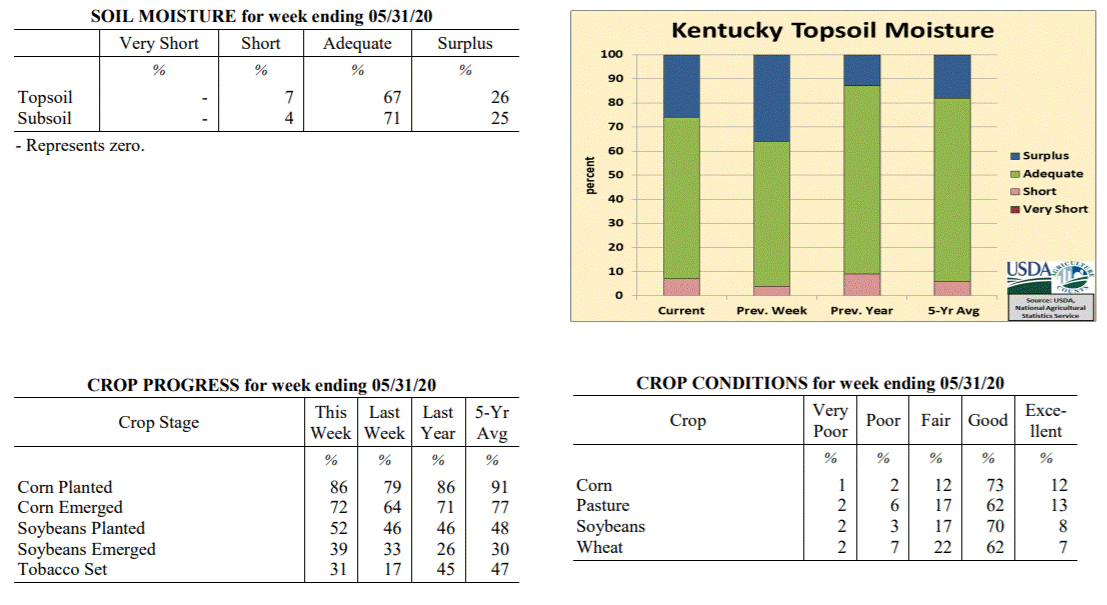 Kentucky Climate Summary
For the Period May 25, 2020 to May 31, 2020
Above Normal Temperatures and Below Normal Rainfall:
The closing week of May consisted of a summer-like pattern for Kentucky. The work
week saw daily rounds of showers and storms, most of which isolated to scattered in
nature. The one exception came Wednesday when much of West Central and Central
Kentucky saw a round of widespread showers. Overall for the week, the state averaged
0.66 inches. Averages were higher for the western half of the state with help from
the Wednesday event, closer to an inch. Those numbers dipped to well under a half
inch for the eastern half. Warm temperatures accompanied the active pattern, peaking
earlier in the week on Memorial Day when highs jumped into the middle 80s to low 90s.
A big change then occurred late in the week following the passage of a cold front on
Friday. Much cooler and dry conditions arrived for the weekend. Saturday and Sunday
both featured sunny skies, lower humidity, and high temperatures in the 70s/low 80s.
Temperatures for the period averaged 71 degrees across the state which was 3 degrees
warmer than normal and 6 degrees warmer than the previous period. High temperatures
averaged from 80 in the West to 80 in the East. Departure from normal high
temperatures ranged from 1 degree cooler than normal in the West to near normal in
the East. Low temperatures averaged from 63 degrees in the West to 61 degrees in the
East. Departure from normal low temperature ranged from 4 degrees warmer than normal
in the West to 7 degrees warmer than normal in the East. The extreme high temperature
for the period was 92 degrees at OWENSBORO AWSS and the extreme low was 47 degrees
at OWINGSVILLE 4S.
Precipitation (liq. equ.) for the period totaled 0.66 inches statewide which was 0.46
inches below normal and 59% of normal. Precipitation totals by climate division, West
0.99 inches, Central 0.92 inches, Bluegrass 0.32 inches and East 0.41 inches, which
was 0.11, 0.24, 0.77 and 0.71 inches below normal. By station, precipitation totals
ranged from a low of 0.07 inches at HINDMAN 5N to a high of 3.46 inches at
CAPE GIRARDEAU ASOS.
---
Kentucky Crop and Weather Report
Issued 4:00 P.M., May 26, 2020 10-20
Agricultural News: Kentucky experienced near normal temperatures and above normal
rainfall over the past week. Precipitation for the week totaled 2.16 inches, 1.05
inches above normal. Temperatures averaged 66 degrees for the week, unchanged from
normal. Topsoil moisture was rated 4 percent short, 60 percent adequate, and 36
percent surplus. Subsoil moisture was rated 3 percent short, 65 percent adequate, and
32 percent surplus. Days suitable for fieldwork averaged 3.3 out of a possible seven.
Primary activities for this week included planting of corn and soybeans, setting
tobacco, and cutting hay. Farmers continue to make headway with planting, but wet
conditions have hampered progress at times over the previous week. Producers need
successive days of dry weather to push through with getting crops in the ground.
Rainfall was heavy at times and there were reports of flooding and crop damage in
areas of the state. Forage is growing well, but the opportunity to cut has been
sparse. Soybean planting remains slightly ahead of both last year and the five year
average. Corn planting is on par with last year, but behind the five year average as
weather conditions have slowed the initial pace. The corn crop is 79 percent emerged
while soybeans are 33 percent emerged. The average height of corn at this juncture is
6 inches. Tobacco setting was able to make up some ground as very little progress was
reported last week.
Damage from the freeze event three weeks ago has been evaluated in full at this
point. Corn and soybean condition are both rated mostly good currently and the crops
appear to have been spared from widespread damage. Winter wheat is 96 percent headed
and the crop is in mostly good condition. Freeze damage to wheat was rated as 3
percent severe, 12 percent moderate, 40 percent light, and 45 percent with no damage.
Fruit crops proved vulnerable to the freeze and some loss is expected. Apple freeze
damage was reported as 8 percent severe, 24 percent moderate, 29 percent light, and
39 percent with no damage. Freeze damage to peaches was reported as 16 percent
severe, 29 percent moderate, 10 percent light, and 45 percent with no damage. Alfalfa
freeze damage was measured as 5 percent severe, 14 percent moderate, 36 percent
light, and 45 percent with no damage. The current hay supply is 8 percent very short,
26 percent short, 62 percent adequate, and 4 percent surplus. Strawberry condition was
rated as mostly good. Pasture condition is mostly good, despite wet conditions.
Kentucky Climate Summary
For the Period May 25, 2020 to May 31, 2020
Above Normal Temperatures and Below Normal Rainfall:
The closing week of May consisted of a summer-like pattern for Kentucky. The work
week saw daily rounds of showers and storms, most of which isolated to scattered in
nature. The one exception came Wednesday when much of West Central and Central
Kentucky saw a round of widespread showers. Overall for the week, the state averaged
0.66 inches. Averages were higher for the western half of the state with help from
the Wednesday event, closer to an inch. Those numbers dipped to well under a half
inch for the eastern half. Warm temperatures accompanied the active pattern, peaking
earlier in the week on Memorial Day when highs jumped into the middle 80s to low 90s.
A big change then occurred late in the week following the passage of a cold front on
Friday. Much cooler and dry conditions arrived for the weekend. Saturday and Sunday
both featured sunny skies, lower humidity, and high temperatures in the 70s/low 80s.
Temperatures for the period averaged 71 degrees across the state which was 3 degrees
warmer than normal and 6 degrees warmer than the previous period. High temperatures
averaged from 80 in the West to 80 in the East. Departure from normal high
temperatures ranged from 1 degree cooler than normal in the West to near normal in
the East. Low temperatures averaged from 63 degrees in the West to 61 degrees in the
East. Departure from normal low temperature ranged from 4 degrees warmer than normal
in the West to 7 degrees warmer than normal in the East. The extreme high temperature
for the period was 92 degrees at OWENSBORO AWSS and the extreme low was 47 degrees
at OWINGSVILLE 4S.
Precipitation (liq. equ.) for the period totaled 0.66 inches statewide which was 0.46
inches below normal and 59% of normal. Precipitation totals by climate division, West
0.99 inches, Central 0.92 inches, Bluegrass 0.32 inches and East 0.41 inches, which
was 0.11, 0.24, 0.77 and 0.71 inches below normal. By station, precipitation totals
ranged from a low of 0.07 inches at HINDMAN 5N to a high of 3.46 inches at
CAPE GIRARDEAU ASOS.
---
Kentucky Crop and Weather Report
Issued 4:00 P.M., May 26, 2020 10-20
Agricultural News: Kentucky experienced near normal temperatures and above normal
rainfall over the past week. Precipitation for the week totaled 2.16 inches, 1.05
inches above normal. Temperatures averaged 66 degrees for the week, unchanged from
normal. Topsoil moisture was rated 4 percent short, 60 percent adequate, and 36
percent surplus. Subsoil moisture was rated 3 percent short, 65 percent adequate, and
32 percent surplus. Days suitable for fieldwork averaged 3.3 out of a possible seven.
Primary activities for this week included planting of corn and soybeans, setting
tobacco, and cutting hay. Farmers continue to make headway with planting, but wet
conditions have hampered progress at times over the previous week. Producers need
successive days of dry weather to push through with getting crops in the ground.
Rainfall was heavy at times and there were reports of flooding and crop damage in
areas of the state. Forage is growing well, but the opportunity to cut has been
sparse. Soybean planting remains slightly ahead of both last year and the five year
average. Corn planting is on par with last year, but behind the five year average as
weather conditions have slowed the initial pace. The corn crop is 79 percent emerged
while soybeans are 33 percent emerged. The average height of corn at this juncture is
6 inches. Tobacco setting was able to make up some ground as very little progress was
reported last week.
Damage from the freeze event three weeks ago has been evaluated in full at this
point. Corn and soybean condition are both rated mostly good currently and the crops
appear to have been spared from widespread damage. Winter wheat is 96 percent headed
and the crop is in mostly good condition. Freeze damage to wheat was rated as 3
percent severe, 12 percent moderate, 40 percent light, and 45 percent with no damage.
Fruit crops proved vulnerable to the freeze and some loss is expected. Apple freeze
damage was reported as 8 percent severe, 24 percent moderate, 29 percent light, and
39 percent with no damage. Freeze damage to peaches was reported as 16 percent
severe, 29 percent moderate, 10 percent light, and 45 percent with no damage. Alfalfa
freeze damage was measured as 5 percent severe, 14 percent moderate, 36 percent
light, and 45 percent with no damage. The current hay supply is 8 percent very short,
26 percent short, 62 percent adequate, and 4 percent surplus. Strawberry condition was
rated as mostly good. Pasture condition is mostly good, despite wet conditions.
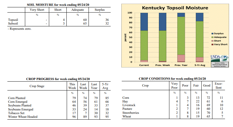 Kentucky Climate Summary
For the Period May 18, 2020 to May 24, 2020
Near Normal Temperatures and Above Normal Rainfall:
Depending on the exact location across Kentucky, this period was either exceptionally
wet or relatively dry. The focus over the first half of the week was a disturbance
aloft that didn’t move much, keeping cloudy and wet weather entrenched over the state
between Monday and Thursday. Rainfall was most extreme across the eastern half of
the state on Monday and Tuesday, especially-so just east of a line from Pulaski,
Fayette, and Boone Counties. When it was all said and done, this region saw 2 to 5+
inches of rainfall with a sharp cutoff to the west. The extreme rainfall within a
very short period of time led to saturated soils and in turn, moderate/major flooding
for a large portion of the Bluegrass Region and Eastern Kentucky. The rest of the
week featured daily bouts of rainfall, but only isolated to scattered in coverage.
Overall, the state averaged 2.16 inches for the week, but there was quite the range
across the state. While the Bluegrass Region and Eastern Kentucky averaged 3.90 and
3.16 inches respectively, Western Kentucky only averaged 0.69 inches. Looking at
temperatures, the period started with cooler weather in place, but summer heat
returned over the weekend. Highs jumped into the mid to upper 80s, some touching 90.
Dewpoints in the middle 60s to low 70s gave a much muggier feel to the air.
Temperatures for the period averaged 66 degrees across the state which was near normal
and 4 degrees warmer than the previous period. High temperatures averaged from 75 in
the West to 73 in the East. Departure from normal high temperatures ranged from 5
degrees cooler than normal in the West to 5 degrees cooler than normal in the East.
Low temperatures averaged from 60 degrees in the West to 57 degrees in the East.
Departure from normal low temperature ranged from 3 degrees warmer than normal in
the West to 5 degrees warmer than normal in the East. The extreme high temperature
for the period was 90 degrees at LOUISVILLE APT and the extreme low was 48 degrees
at SHEPHERDSVILLE 6SE.
Precipitation (liq. equ.) for the period totaled 2.16 inches statewide which was 1.05
inches above normal and 194% of normal. Precipitation totals by climate division, West
0.69 inches, Central 0.88 inches, Bluegrass 3.90 inches and East 3.16 inches, which
was -0.41, -0.28, 2.83 and 2.04 inches respectively from normal. By station, precipitation
totals ranged from a low of 0.23 inches at CARBONDALE ASOS to a high of 6.48 inches
at ALEXANDRIA 5NW.
---
Kentucky Crop and Weather Report
Issued 4:00 P.M., May 18, 2020 09-20
Agricultural News: Kentucky experienced below normal temperatures and rainfall over
the past week. Precipitation for the week totaled 0.73 inches, 0.40 inches below
normal. Temperatures averaged 62 degrees for the week, 2 degrees below normal.
Topsoil moisture was rated 1 percent very short, 1 percent short, 62 percent
adequate, and 36 percent surplus. Subsoil moisture was rated 1 percent very short, 1
percent short, 69 percent adequate, and 29 percent surplus. Days suitable for
fieldwork averaged 3.6 out of a possible seven.
Primary activities for this week included planting of corn and soybeans, setting
tobacco, and cutting hay. Fieldwork progress was slowed this week due to unstable
weather. Cool temperatures at the beginning of the week gave way to warmer conditions
accompanied by periodic rain. The weather stymied tobacco setting in particular when
compared with last week. Corn planting remains ahead of last year, however is now
behind the five year average for this juncture. Soybean progress is ahead of both the
five year average and the previous year. The corn crop is 56 percent emerged at this
time while soybeans are 24 percent emerged. Tobacco transplant supplies are 98
percent adequate and 2 percent surplus.
After the freeze event that occurred week before last, crops are still being
evaluated for damage. Corn condition is rated mostly good currently, however damage
from the freeze may become more evident this week. There were reports of stressed
corn in certain areas and soybeans were in a susceptible stage at the time of the
freeze. Winter wheat is 89 percent headed and the crop is in mostly good condition.
Freeze damage to wheat was rated as 2 percent severe, 12 percent moderate, 36 percent
light, and 50 percent with no damage. Fruits were subject to damage brought on by
cold temperatures with some producers fearing a loss. Apple freeze damage was
reported as 14 percent severe, 41 percent moderate, 21 percent light, and 24 percent
with no damage. Freeze damage to peaches was reported as 18 percent severe, 27
percent moderate, 16 percent light, and 39 percent with no damage. Alfalfa freeze
damage was measured as mostly light to no apparent damage. Strawberry condition was
rated as mostly good. Pasture condition is mostly good, despite the cool temperatures
and persistent rain.
Kentucky Climate Summary
For the Period May 18, 2020 to May 24, 2020
Near Normal Temperatures and Above Normal Rainfall:
Depending on the exact location across Kentucky, this period was either exceptionally
wet or relatively dry. The focus over the first half of the week was a disturbance
aloft that didn’t move much, keeping cloudy and wet weather entrenched over the state
between Monday and Thursday. Rainfall was most extreme across the eastern half of
the state on Monday and Tuesday, especially-so just east of a line from Pulaski,
Fayette, and Boone Counties. When it was all said and done, this region saw 2 to 5+
inches of rainfall with a sharp cutoff to the west. The extreme rainfall within a
very short period of time led to saturated soils and in turn, moderate/major flooding
for a large portion of the Bluegrass Region and Eastern Kentucky. The rest of the
week featured daily bouts of rainfall, but only isolated to scattered in coverage.
Overall, the state averaged 2.16 inches for the week, but there was quite the range
across the state. While the Bluegrass Region and Eastern Kentucky averaged 3.90 and
3.16 inches respectively, Western Kentucky only averaged 0.69 inches. Looking at
temperatures, the period started with cooler weather in place, but summer heat
returned over the weekend. Highs jumped into the mid to upper 80s, some touching 90.
Dewpoints in the middle 60s to low 70s gave a much muggier feel to the air.
Temperatures for the period averaged 66 degrees across the state which was near normal
and 4 degrees warmer than the previous period. High temperatures averaged from 75 in
the West to 73 in the East. Departure from normal high temperatures ranged from 5
degrees cooler than normal in the West to 5 degrees cooler than normal in the East.
Low temperatures averaged from 60 degrees in the West to 57 degrees in the East.
Departure from normal low temperature ranged from 3 degrees warmer than normal in
the West to 5 degrees warmer than normal in the East. The extreme high temperature
for the period was 90 degrees at LOUISVILLE APT and the extreme low was 48 degrees
at SHEPHERDSVILLE 6SE.
Precipitation (liq. equ.) for the period totaled 2.16 inches statewide which was 1.05
inches above normal and 194% of normal. Precipitation totals by climate division, West
0.69 inches, Central 0.88 inches, Bluegrass 3.90 inches and East 3.16 inches, which
was -0.41, -0.28, 2.83 and 2.04 inches respectively from normal. By station, precipitation
totals ranged from a low of 0.23 inches at CARBONDALE ASOS to a high of 6.48 inches
at ALEXANDRIA 5NW.
---
Kentucky Crop and Weather Report
Issued 4:00 P.M., May 18, 2020 09-20
Agricultural News: Kentucky experienced below normal temperatures and rainfall over
the past week. Precipitation for the week totaled 0.73 inches, 0.40 inches below
normal. Temperatures averaged 62 degrees for the week, 2 degrees below normal.
Topsoil moisture was rated 1 percent very short, 1 percent short, 62 percent
adequate, and 36 percent surplus. Subsoil moisture was rated 1 percent very short, 1
percent short, 69 percent adequate, and 29 percent surplus. Days suitable for
fieldwork averaged 3.6 out of a possible seven.
Primary activities for this week included planting of corn and soybeans, setting
tobacco, and cutting hay. Fieldwork progress was slowed this week due to unstable
weather. Cool temperatures at the beginning of the week gave way to warmer conditions
accompanied by periodic rain. The weather stymied tobacco setting in particular when
compared with last week. Corn planting remains ahead of last year, however is now
behind the five year average for this juncture. Soybean progress is ahead of both the
five year average and the previous year. The corn crop is 56 percent emerged at this
time while soybeans are 24 percent emerged. Tobacco transplant supplies are 98
percent adequate and 2 percent surplus.
After the freeze event that occurred week before last, crops are still being
evaluated for damage. Corn condition is rated mostly good currently, however damage
from the freeze may become more evident this week. There were reports of stressed
corn in certain areas and soybeans were in a susceptible stage at the time of the
freeze. Winter wheat is 89 percent headed and the crop is in mostly good condition.
Freeze damage to wheat was rated as 2 percent severe, 12 percent moderate, 36 percent
light, and 50 percent with no damage. Fruits were subject to damage brought on by
cold temperatures with some producers fearing a loss. Apple freeze damage was
reported as 14 percent severe, 41 percent moderate, 21 percent light, and 24 percent
with no damage. Freeze damage to peaches was reported as 18 percent severe, 27
percent moderate, 16 percent light, and 39 percent with no damage. Alfalfa freeze
damage was measured as mostly light to no apparent damage. Strawberry condition was
rated as mostly good. Pasture condition is mostly good, despite the cool temperatures
and persistent rain.
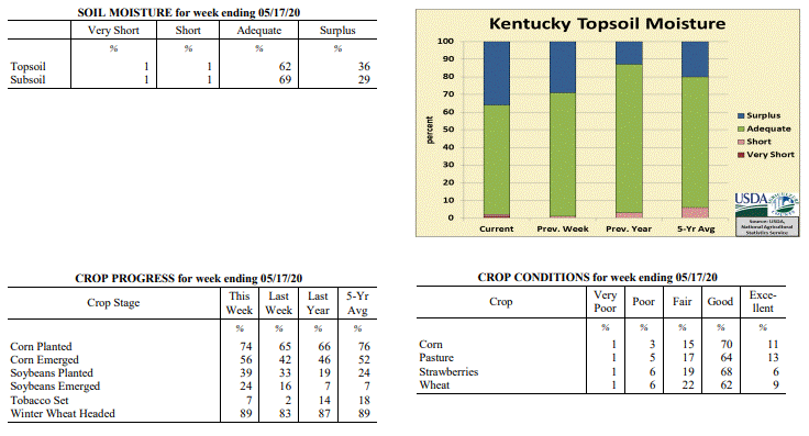 Kentucky Climate Summary
For the Period May 11, 2020 to May 17, 2020
Below Normal Temperatures and Rainfall:
The weather pattern flipped this week, starting the period with below normal
temperatures in place and ending more like summer. The period opened with
northwest flow limiting highs to the upper 40s to middle 50s for portions of the
state. Frost was again an issue Monday night across Eastern Kentucky as
lows dropped into the middle 30s. Cooler weather stuck around midweek along with
a return of widespread light showers across the region. Total accumulations were
higher across Western Kentucky with some exceeding an inch, but decreased
significantly farther east. After the rain moved out, southerly flow ushered
much warmer air into the Ohio Valley for the second half of the week. Highs
consistently rose into the upper 70s to middle 80s from Thursday onward, even
turning a bit muggy over the weekend. A more active pattern accompanied the
warmer temperatures on Friday and stuck around through the end of the period.
Multiple rounds of showers and storms traversed the state, mostly across the
northern half with a front stalled across the region. While the state averaged
0.73 inches fort the week, accumulations were much higher across Western Kentucky
and North Central Kentucky where many saw 1 to 2+ inches. Those totals dropped
dramatically to the east as Eastern Kentucky only averaged 0.26 inches for the
week.
Temperatures for the period averaged 62 degrees across the state which was 2
degrees cooler than normal and 8 degrees warmer than the previous period. High
temperatures averaged from 71 in the West to 71 in the East. Departure from
normal high temperatures ranged from 6 degrees cooler than normal in the West to
5 degrees cooler than normal in the East. Low temperatures averaged from 55
degrees in the West to 50 degrees in the East. Departure from normal low
temperature ranged from near normal in the West to 1 degree warmer than normal
in the East. The extreme high temperature for the period was 87 degrees at BIG
SANDY and the extreme low was 32 degrees at CARLISLE 5SW.
Precipitation (liq. equ.) for the period totaled 0.73 inches statewide which was
0.4 inches below normal and 64% of normal. Precipitation totals by climate
division, West 1.36 inches, Central 0.63 inches, Bluegrass 0.67 inches and East
0.26 inches, which was 0.18, -0.56, -0.40 and -0.83 inches respectively from
normal. By station, precipitation totals ranged from a low of 0.03 inches at BIG
SANDY to a high of 2.81 inches at POPLAR BLUFF ASOS.
---
Kentucky Crop and Weather Report
Issued 4:00 P.M., May 11, 2020 08-20
Agricultural News: Kentucky experienced well below normal temperatures and above
normal rainfall over the past week. Precipitation for the week totaled 1.37 inches,
0.28 inches above normal. Temperatures averaged 53 degrees for the week, 9 degrees
below normal. Topsoil moisture was rated 1 percent short, 70 percent adequate, and 29
percent surplus. Subsoil moisture was rated 1 percent short, 74 percent adequate, and
25 percent surplus. Days suitable for fieldwork averaged 3.5 out of a possible seven.
Primary activities for this week included planting of corn and soybeans, setting
tobacco, and spraying. The state experienced cool conditions and several periods of
rain that stymied field work. The weekend brought a freeze event that will be
evaluated this week. Despite the setbacks, corn and soybean planting continues to run
ahead of both last year and the five year average. The corn crop is 42 percent
emerged at this juncture while soybeans are 16 percent emerged. Tobacco setting is
still in the beginning stages for many producers with recent weather slowing
progress.
Thirteen percent of tobacco transplants were under 2 inches, with 50 percent 2-4
inches, and 37 percent above 4 inches. The supply of tobacco transplants was reported as
98 percent adequate, and 5 percent surplus.
Kentucky Climate Summary
For the Period May 11, 2020 to May 17, 2020
Below Normal Temperatures and Rainfall:
The weather pattern flipped this week, starting the period with below normal
temperatures in place and ending more like summer. The period opened with
northwest flow limiting highs to the upper 40s to middle 50s for portions of the
state. Frost was again an issue Monday night across Eastern Kentucky as
lows dropped into the middle 30s. Cooler weather stuck around midweek along with
a return of widespread light showers across the region. Total accumulations were
higher across Western Kentucky with some exceeding an inch, but decreased
significantly farther east. After the rain moved out, southerly flow ushered
much warmer air into the Ohio Valley for the second half of the week. Highs
consistently rose into the upper 70s to middle 80s from Thursday onward, even
turning a bit muggy over the weekend. A more active pattern accompanied the
warmer temperatures on Friday and stuck around through the end of the period.
Multiple rounds of showers and storms traversed the state, mostly across the
northern half with a front stalled across the region. While the state averaged
0.73 inches fort the week, accumulations were much higher across Western Kentucky
and North Central Kentucky where many saw 1 to 2+ inches. Those totals dropped
dramatically to the east as Eastern Kentucky only averaged 0.26 inches for the
week.
Temperatures for the period averaged 62 degrees across the state which was 2
degrees cooler than normal and 8 degrees warmer than the previous period. High
temperatures averaged from 71 in the West to 71 in the East. Departure from
normal high temperatures ranged from 6 degrees cooler than normal in the West to
5 degrees cooler than normal in the East. Low temperatures averaged from 55
degrees in the West to 50 degrees in the East. Departure from normal low
temperature ranged from near normal in the West to 1 degree warmer than normal
in the East. The extreme high temperature for the period was 87 degrees at BIG
SANDY and the extreme low was 32 degrees at CARLISLE 5SW.
Precipitation (liq. equ.) for the period totaled 0.73 inches statewide which was
0.4 inches below normal and 64% of normal. Precipitation totals by climate
division, West 1.36 inches, Central 0.63 inches, Bluegrass 0.67 inches and East
0.26 inches, which was 0.18, -0.56, -0.40 and -0.83 inches respectively from
normal. By station, precipitation totals ranged from a low of 0.03 inches at BIG
SANDY to a high of 2.81 inches at POPLAR BLUFF ASOS.
---
Kentucky Crop and Weather Report
Issued 4:00 P.M., May 11, 2020 08-20
Agricultural News: Kentucky experienced well below normal temperatures and above
normal rainfall over the past week. Precipitation for the week totaled 1.37 inches,
0.28 inches above normal. Temperatures averaged 53 degrees for the week, 9 degrees
below normal. Topsoil moisture was rated 1 percent short, 70 percent adequate, and 29
percent surplus. Subsoil moisture was rated 1 percent short, 74 percent adequate, and
25 percent surplus. Days suitable for fieldwork averaged 3.5 out of a possible seven.
Primary activities for this week included planting of corn and soybeans, setting
tobacco, and spraying. The state experienced cool conditions and several periods of
rain that stymied field work. The weekend brought a freeze event that will be
evaluated this week. Despite the setbacks, corn and soybean planting continues to run
ahead of both last year and the five year average. The corn crop is 42 percent
emerged at this juncture while soybeans are 16 percent emerged. Tobacco setting is
still in the beginning stages for many producers with recent weather slowing
progress.
Thirteen percent of tobacco transplants were under 2 inches, with 50 percent 2-4
inches, and 37 percent above 4 inches. The supply of tobacco transplants was reported as
98 percent adequate, and 5 percent surplus.
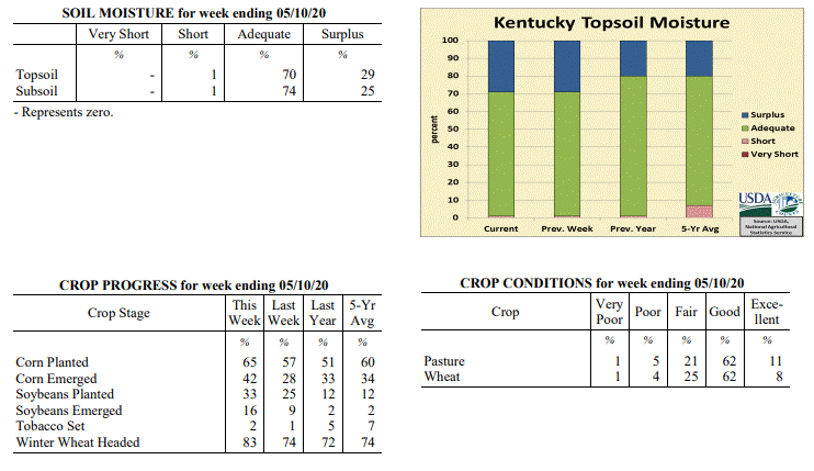 Kentucky Climate Summary
For the Period May 4, 2020 to May 10, 2020
Well Below Normal Temperatures and Above Normal Rainfall:
The big story for the week was a cold air outbreak late in the period that brought
record breaking temperatures to much of the Bluegrass State. The coldest temperatures
were seen early Saturday morning as many across the Commonwealth saw temperatures
plummet into the upper 20s to middle 30s. Coldest across the eastern half of the
state and increasing farther west. Putting these temperatures into perspective,
normal lows for this time of year are in the low to middle 50s. While Saturday
morning was the coldest, the state did see a few more rounds of frosty temperatures
throughout the week, most notable on Sunday morning across Eastern Kentucky, when
temperatures yet again dropped into the low to mid 30s for many locations. Cold air
of this extreme and this late in the spring season is quite rare across Kentucky.
Looking at frost occurrence data, having temperatures of 32 degrees or lower at this
time of the year is less than a 10% probability for many across the state. While
temperatures were well below normal for the week, the Commonwealth also saw multiple
rounds of widespread showers, one coming Monday night/Tuesday, another on Friday, and
ended with a closing round on Sunday. Altogether, the state averaged 1.37 inches
for the week.
Temperatures for the period averaged 53 degrees across the state which was 9 degrees
cooler than normal and 6 degrees cooler than the previous period. High temperatures
averaged from 66 in the West to 62 in the East. Departure from normal high
temperatures ranged from 9 degrees cooler than normal in the West to 12 degrees
cooler than normal in the East. Low temperatures averaged from 47 degrees in the
West to 41 degrees in the East. Departure from normal low temperature ranged from 5
degrees cooler than normal in the West to 6 degrees cooler than normal in the East.
The extreme high temperature for the period was 79 degrees at KOOMER RIDGE and the
extreme low was 26 degrees at CARLISLE 5SW.
Precipitation (liq. equ.) for the period totaled 1.37 inches statewide which was 0.28
inches above normal and 125% of normal. Precipitation totals by climate division,
West 1.12 inches, Central 1.60 inches, Bluegrass 1.04 inches and East 1.72 inches,
which was -0.04, 0.45, 0.03 and 0.67 inches respectively from normal. By station,
precipitation totals ranged from a low of 0.67 inches at YELLOW CREEK to a high of
4.05 inches at LIBERTY 3SW.
---
Kentucky Crop and Weather Report
Issued 4:00 P.M., May 4, 2020 07-20
Agricultural News: Kentucky experienced near normal temperatures and below normal
rainfall over the past week. Precipitation for the week totaled 0.88 inches, 0.19
inches below normal. Temperatures averaged 60 degrees for the week, unchanged from
normal. Topsoil moisture was rated 1 percent short, 70 percent adequate, and 29
percent surplus. Subsoil moisture was rated 1 percent short, 73 percent adequate, and
26 percent surplus. Days suitable for fieldwork averaged 3.8 out of a possible seven.
Primary activities for this week included continued planting of corn and soybeans
along with working cattle. Tobacco setting has begun in a small portion of the state
as weather has permitted. In some areas fields remained very wet and halted planting
progress. With that being said, corn and soybean planting is moving rapidly and both
are ahead of last year and the five year average. The corn crop is 28 percent emerged
at this juncture. Soybeans are 9 percent emerged. Tobacco transplants are in mostly
good condition with 24 percent less than two inches, 53 percent two to four inches,
and 23 percent larger than 4 inches. Supply of tobacco transplants was rated as 5
percent short, 90 percent adequate, and 5 percent surplus.
The average height of winter wheat was 23 inches with the condition mostly good
despite a light freeze several weeks prior. The average height of alfalfa is 14
inches at this time. Hay condition was reported as mostly good with supplies rated as
7 percent very short, 34 percent short, 56 percent adequate, and 3 percent surplus.
Rain and seasonably warm weather has kept pastureland in good condition. The
condition of strawberries was reported as 5 percent very poor, 8 percent poor, 22
percent fair, 56 percent good, and 9 percent excellent.
Kentucky Climate Summary
For the Period May 4, 2020 to May 10, 2020
Well Below Normal Temperatures and Above Normal Rainfall:
The big story for the week was a cold air outbreak late in the period that brought
record breaking temperatures to much of the Bluegrass State. The coldest temperatures
were seen early Saturday morning as many across the Commonwealth saw temperatures
plummet into the upper 20s to middle 30s. Coldest across the eastern half of the
state and increasing farther west. Putting these temperatures into perspective,
normal lows for this time of year are in the low to middle 50s. While Saturday
morning was the coldest, the state did see a few more rounds of frosty temperatures
throughout the week, most notable on Sunday morning across Eastern Kentucky, when
temperatures yet again dropped into the low to mid 30s for many locations. Cold air
of this extreme and this late in the spring season is quite rare across Kentucky.
Looking at frost occurrence data, having temperatures of 32 degrees or lower at this
time of the year is less than a 10% probability for many across the state. While
temperatures were well below normal for the week, the Commonwealth also saw multiple
rounds of widespread showers, one coming Monday night/Tuesday, another on Friday, and
ended with a closing round on Sunday. Altogether, the state averaged 1.37 inches
for the week.
Temperatures for the period averaged 53 degrees across the state which was 9 degrees
cooler than normal and 6 degrees cooler than the previous period. High temperatures
averaged from 66 in the West to 62 in the East. Departure from normal high
temperatures ranged from 9 degrees cooler than normal in the West to 12 degrees
cooler than normal in the East. Low temperatures averaged from 47 degrees in the
West to 41 degrees in the East. Departure from normal low temperature ranged from 5
degrees cooler than normal in the West to 6 degrees cooler than normal in the East.
The extreme high temperature for the period was 79 degrees at KOOMER RIDGE and the
extreme low was 26 degrees at CARLISLE 5SW.
Precipitation (liq. equ.) for the period totaled 1.37 inches statewide which was 0.28
inches above normal and 125% of normal. Precipitation totals by climate division,
West 1.12 inches, Central 1.60 inches, Bluegrass 1.04 inches and East 1.72 inches,
which was -0.04, 0.45, 0.03 and 0.67 inches respectively from normal. By station,
precipitation totals ranged from a low of 0.67 inches at YELLOW CREEK to a high of
4.05 inches at LIBERTY 3SW.
---
Kentucky Crop and Weather Report
Issued 4:00 P.M., May 4, 2020 07-20
Agricultural News: Kentucky experienced near normal temperatures and below normal
rainfall over the past week. Precipitation for the week totaled 0.88 inches, 0.19
inches below normal. Temperatures averaged 60 degrees for the week, unchanged from
normal. Topsoil moisture was rated 1 percent short, 70 percent adequate, and 29
percent surplus. Subsoil moisture was rated 1 percent short, 73 percent adequate, and
26 percent surplus. Days suitable for fieldwork averaged 3.8 out of a possible seven.
Primary activities for this week included continued planting of corn and soybeans
along with working cattle. Tobacco setting has begun in a small portion of the state
as weather has permitted. In some areas fields remained very wet and halted planting
progress. With that being said, corn and soybean planting is moving rapidly and both
are ahead of last year and the five year average. The corn crop is 28 percent emerged
at this juncture. Soybeans are 9 percent emerged. Tobacco transplants are in mostly
good condition with 24 percent less than two inches, 53 percent two to four inches,
and 23 percent larger than 4 inches. Supply of tobacco transplants was rated as 5
percent short, 90 percent adequate, and 5 percent surplus.
The average height of winter wheat was 23 inches with the condition mostly good
despite a light freeze several weeks prior. The average height of alfalfa is 14
inches at this time. Hay condition was reported as mostly good with supplies rated as
7 percent very short, 34 percent short, 56 percent adequate, and 3 percent surplus.
Rain and seasonably warm weather has kept pastureland in good condition. The
condition of strawberries was reported as 5 percent very poor, 8 percent poor, 22
percent fair, 56 percent good, and 9 percent excellent.
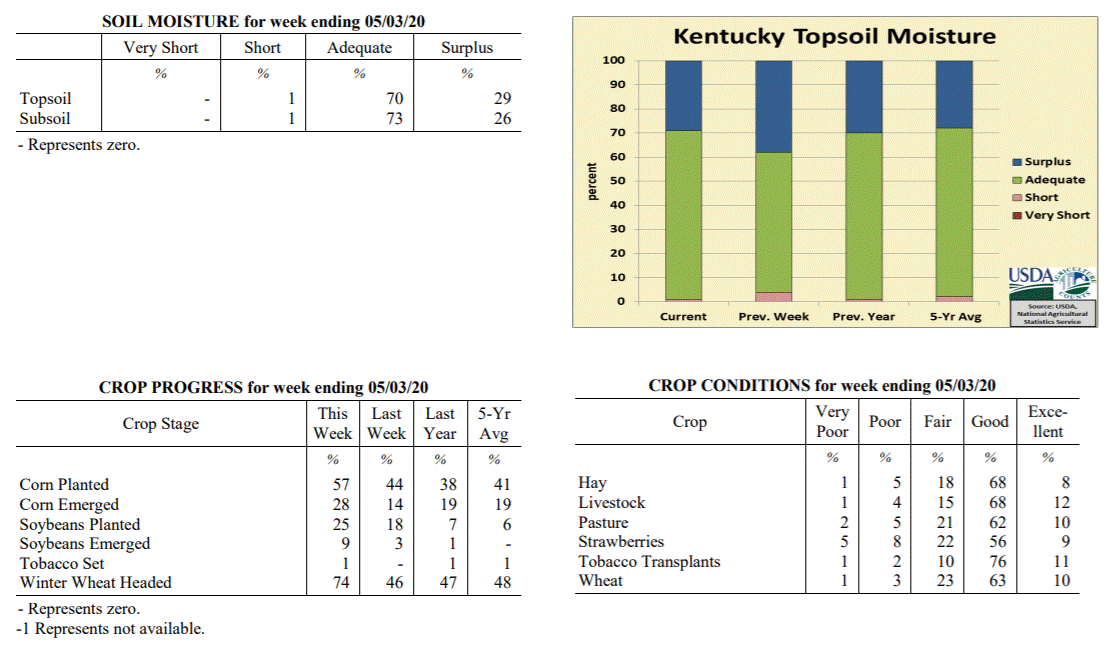 Kentucky Climate Summary
For the Period April 27, 2020 to May 3, 2020
Near Normal Temperatures and Below Normal Rainfall:
The work week started out on a dry and mild note with highs in the 60s and 70s. Along
and ahead of a cold front, widespread showers returned to the area Tuesday night and
into Wednesday. Lighter activity then continued into Thursday. The rain and heavy
cloud cover did lead to temperatures that were well below normal for the last day of
April as highs struggled in the upper 40s to middle 50s on Thursday. This followed a
cooler trend that has stuck around for much of the second half of April. Looking back
at the past month and while preliminary, data from the Ag Weather Center shows the
state saw its first month of below normal temperatures since November. Luckily, the
cool weather didn’t last long as highs rose into the 80s for many by Saturday. A
strong to at times, severe line of showers and storms then closed out the week on
Sunday. Totals did vary quite a bit across the state for the week. Combined with the
Wednesday/Thursday event, the western half of the state was about a half inch below
normal for the week, while the eastern half was actually above normal.
Temperatures for the period averaged 60 degrees across the state which was
near normal and 4 degrees warmer than the previous period. High temperatures
averaged from 73 in the West to 71 in the East. Departure from normal high
temperatures ranged from 1 degree cooler than normal in the West to 2 degrees
cooler than normal in the East. Low temperatures averaged from 51 degrees in the
West to 47 degrees in the East. Departure from normal low temperature ranged from 1
degree warmer than normal in the West to 2 degrees warmer than normal in the East.
The extreme high temperature for the period was 85 degrees at BOWLING GREEN APT and
the extreme low was 31 degrees at CYNTHIANA 8N.
Precipitation (liq. equ.) for the period totaled 0.88 inches statewide which was 0.19
inches below normal and 82% of normal. Precipitation totals by climate division, West
0.71 inches, Central 0.59 inches, Bluegrass 1.01 inches and East 1.20 inches, which
was -0.50, -0.51, 0.02 and 0.20 inches respectively from normal. By station,
precipitation totals ranged from a low of 0.15 inches at ELIZABETHTOWN 8W to a high
of 2.43 inches at OWINGSVILLE 4S.
---
Kentucky Crop and Weather Report
Issued 4:00 P.M., April 27, 2020 06-20
Agricultural News: Kentucky experienced below normal temperatures and above normal
rainfall over the past week. Precipitation for the week totaled 1.74 inches, 0.70
inches above normal. Temperatures averaged 55 degrees for the week, 3 degrees below
normal. Topsoil moisture was rated 4 percent short, 58 percent adequate, and 38
percent surplus. Subsoil moisture was rated 5 percent short, 65 percent adequate, and
30 percent surplus. Days suitable for fieldwork averaged 4.1 out of a possible seven.
Primary activities for this week included continued planting of corn and soybeans
along with seeding of tobacco transplants. Fieldwork was halted in the latter part of
the week due to periods of heavy rain. Despite the setback, corn and soybean planting
is moving rapidly with both crops substantially ahead of last year and the five year
average. The corn crop is 14 percent emerged at this juncture. Soybeans are 3 percent
emerged. Eighty-nine percent of tobacco transplants are seeded and remain in mostly
good condition. Thirtyseven percent of tobacco transplants were under 2 inches, with
44 percent 2-4 inches, and 19 percent above 4 inches.
The average height of winter wheat was 20 inches with the condition mostly good.
Freeze damage to alfalfa and winter wheat from two weeks ago has been assessed at
this point. Winter wheat freeze damage was reported as 1 percent severe, 8 percent
moderate, 23 percent light, and 68 percent with no damage. Alfalfa freeze damage was
reported as 1 percent severe, 10 percent moderate, 27 percent light, and 62 percent
with no damage. The average height of alfalfa is 10 inches at this time. Both peaches
and apples suffered some damage from the freeze two weeks ago. Apple damage was
reported as 10 percent severe, 36 percent moderate, 17 percent light, and 37 percent
with no damage. Freeze damage to peaches was reported as 27 percent severe, 16
percent moderate, 15 percent light, and 42 percent with no damage.
Kentucky Climate Summary
For the Period April 27, 2020 to May 3, 2020
Near Normal Temperatures and Below Normal Rainfall:
The work week started out on a dry and mild note with highs in the 60s and 70s. Along
and ahead of a cold front, widespread showers returned to the area Tuesday night and
into Wednesday. Lighter activity then continued into Thursday. The rain and heavy
cloud cover did lead to temperatures that were well below normal for the last day of
April as highs struggled in the upper 40s to middle 50s on Thursday. This followed a
cooler trend that has stuck around for much of the second half of April. Looking back
at the past month and while preliminary, data from the Ag Weather Center shows the
state saw its first month of below normal temperatures since November. Luckily, the
cool weather didn’t last long as highs rose into the 80s for many by Saturday. A
strong to at times, severe line of showers and storms then closed out the week on
Sunday. Totals did vary quite a bit across the state for the week. Combined with the
Wednesday/Thursday event, the western half of the state was about a half inch below
normal for the week, while the eastern half was actually above normal.
Temperatures for the period averaged 60 degrees across the state which was
near normal and 4 degrees warmer than the previous period. High temperatures
averaged from 73 in the West to 71 in the East. Departure from normal high
temperatures ranged from 1 degree cooler than normal in the West to 2 degrees
cooler than normal in the East. Low temperatures averaged from 51 degrees in the
West to 47 degrees in the East. Departure from normal low temperature ranged from 1
degree warmer than normal in the West to 2 degrees warmer than normal in the East.
The extreme high temperature for the period was 85 degrees at BOWLING GREEN APT and
the extreme low was 31 degrees at CYNTHIANA 8N.
Precipitation (liq. equ.) for the period totaled 0.88 inches statewide which was 0.19
inches below normal and 82% of normal. Precipitation totals by climate division, West
0.71 inches, Central 0.59 inches, Bluegrass 1.01 inches and East 1.20 inches, which
was -0.50, -0.51, 0.02 and 0.20 inches respectively from normal. By station,
precipitation totals ranged from a low of 0.15 inches at ELIZABETHTOWN 8W to a high
of 2.43 inches at OWINGSVILLE 4S.
---
Kentucky Crop and Weather Report
Issued 4:00 P.M., April 27, 2020 06-20
Agricultural News: Kentucky experienced below normal temperatures and above normal
rainfall over the past week. Precipitation for the week totaled 1.74 inches, 0.70
inches above normal. Temperatures averaged 55 degrees for the week, 3 degrees below
normal. Topsoil moisture was rated 4 percent short, 58 percent adequate, and 38
percent surplus. Subsoil moisture was rated 5 percent short, 65 percent adequate, and
30 percent surplus. Days suitable for fieldwork averaged 4.1 out of a possible seven.
Primary activities for this week included continued planting of corn and soybeans
along with seeding of tobacco transplants. Fieldwork was halted in the latter part of
the week due to periods of heavy rain. Despite the setback, corn and soybean planting
is moving rapidly with both crops substantially ahead of last year and the five year
average. The corn crop is 14 percent emerged at this juncture. Soybeans are 3 percent
emerged. Eighty-nine percent of tobacco transplants are seeded and remain in mostly
good condition. Thirtyseven percent of tobacco transplants were under 2 inches, with
44 percent 2-4 inches, and 19 percent above 4 inches.
The average height of winter wheat was 20 inches with the condition mostly good.
Freeze damage to alfalfa and winter wheat from two weeks ago has been assessed at
this point. Winter wheat freeze damage was reported as 1 percent severe, 8 percent
moderate, 23 percent light, and 68 percent with no damage. Alfalfa freeze damage was
reported as 1 percent severe, 10 percent moderate, 27 percent light, and 62 percent
with no damage. The average height of alfalfa is 10 inches at this time. Both peaches
and apples suffered some damage from the freeze two weeks ago. Apple damage was
reported as 10 percent severe, 36 percent moderate, 17 percent light, and 37 percent
with no damage. Freeze damage to peaches was reported as 27 percent severe, 16
percent moderate, 15 percent light, and 42 percent with no damage.
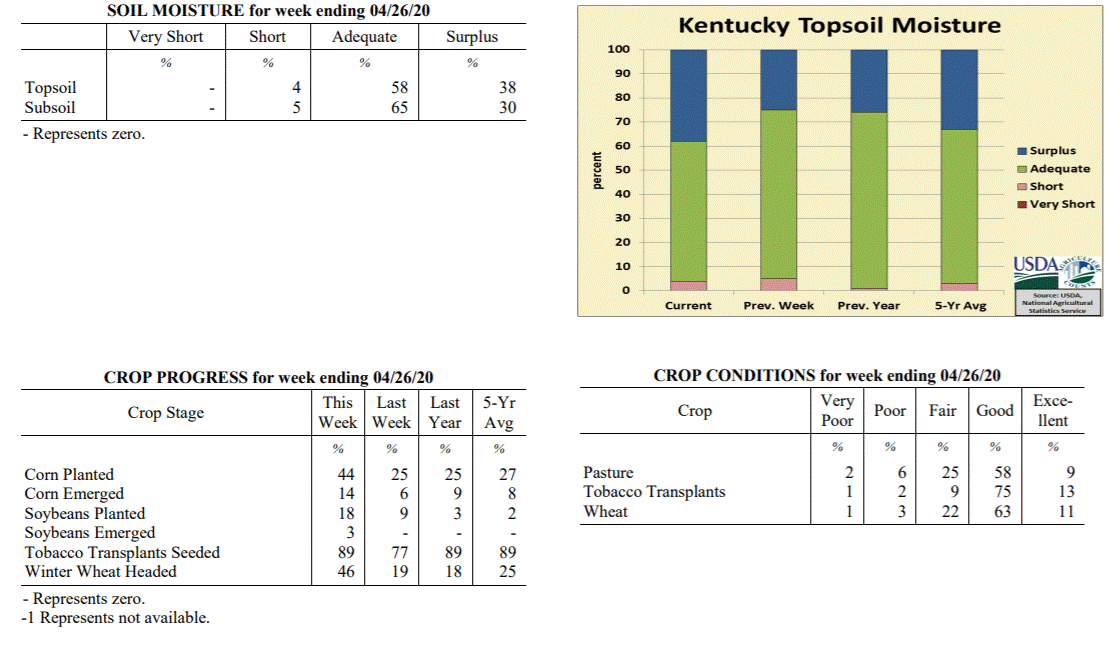 Kentucky Climate Summary
For the Period April 20, 2020 to April 26, 2020
Below Normal Temperatures and Above Normal Rainfall:
April rainfall has been below normal for much of the month, but that changed this
week as Kentucky saw multiple waves of widespread showers. Overall, the state
averaged 1.74 inches for the week, most of which fell Thursday and over the weekend.
Other than some portions of Western Kentucky that saw under an inch, 1 to 2+ inches
was common across the rest of the state. Temperatures continued to run cooler than
normal, but not as significant as the previous period. The coldest temperatures were
seen Tuesday night following the passage of a weak cold front through the area. Lows
fell into the 30s, prompting another threat of frost, especially so across the
eastern half of the state. A handful of counties once again fell into the upper 20s.
This led the way to a second straight week of below normal temperatures for the
Bluegrass State.
Temperatures for the period averaged 55 degrees across the state which was 3 degrees
cooler than normal and 8 degrees warmer than the previous period. High temperatures
averaged from 66 in the West to 64 in the East. Departure from normal high
temperatures ranged from 6 degrees cooler than normal in the West to 7 degrees
cooler than normal in the East. Low temperatures averaged from 48 degrees in the
West to 46 degrees in the East. Departure from normal low temperature ranged from
near normal in the West to 4 degrees warmer than normal in the East. The extreme
high temperature for the period was 76 degrees at POPLAR BLUFF ASOS and the extreme
low was 28 degrees at CARLISLE 5SW.
Precipitation (liq. equ.) for the period totaled 1.74 inches statewide which was 0.7
inches above normal and 168% of normal. Precipitation totals by climate division,
West 1.44 inches, Central 1.93 inches, Bluegrass 1.72 inches and East 1.87 inches,
which was 0.25, 0.88, 0.77 and 0.92 inches above normal. By station, precipitation
totals ranged from a low of 0.65 inches at PRINCETON 2SE to a high of 3.30 inches
at OWENSBORO AWSS.
---
Kentucky Crop and Weather Report
Issued 4:00 P.M., April 20, 2020 05-20
Agricultural News: Kentucky experienced well below normal temperatures and near
normal rainfall over the past week. Precipitation for the week totaled 1.06 inches,
0.07 inches above normal. Temperatures averaged 46 degrees for the week, 10 degrees
below normal. Topsoil moisture was rated 5 percent short, 70 percent adequate, and 25
percent surplus. Subsoil moisture was rated 6 percent short, 73 percent adequate, and
21 percent surplus. Days suitable for fieldwork averaged 4.5 out of a possible seven.
Primary activities for this week included continued planting of corn and soybeans
along with seeding of tobacco transplants. The state experienced a few light
overnight freezes this week with mild daytime temperatures. Rain in the early part of
the week disrupted fieldwork. Despite the weather setbacks, corn and soybean planting
continued with both crops ahead of last year and the five year average. The corn crop
is 6 percent emerged at this juncture. Soybeans did not sustain widespread freeze
damage due to the fact that they have not yet emerged. Tobacco transplants are in
mostly good condition.
The average height of winter wheat was 17 inches with the condition mostly good.
Winter wheat freeze damage was reported as 1 percent severe, 4 percent moderate, 37
percent light, and 58 percent with no damage. Alfalfa freeze damage was reported as 1
percent severe, 12 percent moderate, 32 percent light, and 55 percent with no damage.
It is of note that any damage may not be apparent until assessment this week. The average
height of alfalfa is 10 inches at this time.
Kentucky Climate Summary
For the Period April 20, 2020 to April 26, 2020
Below Normal Temperatures and Above Normal Rainfall:
April rainfall has been below normal for much of the month, but that changed this
week as Kentucky saw multiple waves of widespread showers. Overall, the state
averaged 1.74 inches for the week, most of which fell Thursday and over the weekend.
Other than some portions of Western Kentucky that saw under an inch, 1 to 2+ inches
was common across the rest of the state. Temperatures continued to run cooler than
normal, but not as significant as the previous period. The coldest temperatures were
seen Tuesday night following the passage of a weak cold front through the area. Lows
fell into the 30s, prompting another threat of frost, especially so across the
eastern half of the state. A handful of counties once again fell into the upper 20s.
This led the way to a second straight week of below normal temperatures for the
Bluegrass State.
Temperatures for the period averaged 55 degrees across the state which was 3 degrees
cooler than normal and 8 degrees warmer than the previous period. High temperatures
averaged from 66 in the West to 64 in the East. Departure from normal high
temperatures ranged from 6 degrees cooler than normal in the West to 7 degrees
cooler than normal in the East. Low temperatures averaged from 48 degrees in the
West to 46 degrees in the East. Departure from normal low temperature ranged from
near normal in the West to 4 degrees warmer than normal in the East. The extreme
high temperature for the period was 76 degrees at POPLAR BLUFF ASOS and the extreme
low was 28 degrees at CARLISLE 5SW.
Precipitation (liq. equ.) for the period totaled 1.74 inches statewide which was 0.7
inches above normal and 168% of normal. Precipitation totals by climate division,
West 1.44 inches, Central 1.93 inches, Bluegrass 1.72 inches and East 1.87 inches,
which was 0.25, 0.88, 0.77 and 0.92 inches above normal. By station, precipitation
totals ranged from a low of 0.65 inches at PRINCETON 2SE to a high of 3.30 inches
at OWENSBORO AWSS.
---
Kentucky Crop and Weather Report
Issued 4:00 P.M., April 20, 2020 05-20
Agricultural News: Kentucky experienced well below normal temperatures and near
normal rainfall over the past week. Precipitation for the week totaled 1.06 inches,
0.07 inches above normal. Temperatures averaged 46 degrees for the week, 10 degrees
below normal. Topsoil moisture was rated 5 percent short, 70 percent adequate, and 25
percent surplus. Subsoil moisture was rated 6 percent short, 73 percent adequate, and
21 percent surplus. Days suitable for fieldwork averaged 4.5 out of a possible seven.
Primary activities for this week included continued planting of corn and soybeans
along with seeding of tobacco transplants. The state experienced a few light
overnight freezes this week with mild daytime temperatures. Rain in the early part of
the week disrupted fieldwork. Despite the weather setbacks, corn and soybean planting
continued with both crops ahead of last year and the five year average. The corn crop
is 6 percent emerged at this juncture. Soybeans did not sustain widespread freeze
damage due to the fact that they have not yet emerged. Tobacco transplants are in
mostly good condition.
The average height of winter wheat was 17 inches with the condition mostly good.
Winter wheat freeze damage was reported as 1 percent severe, 4 percent moderate, 37
percent light, and 58 percent with no damage. Alfalfa freeze damage was reported as 1
percent severe, 12 percent moderate, 32 percent light, and 55 percent with no damage.
It is of note that any damage may not be apparent until assessment this week. The average
height of alfalfa is 10 inches at this time.
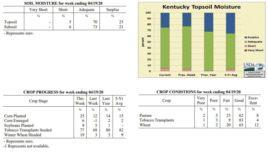 Kentucky Climate Summary
For the Period April 13, 2020 to April 19, 2020
Well Below Normal Temperatures and Near Normal Rainfall:
The week started with a line of showers and storms continuing to progress across the
state ahead of a cold front. Based on the data cutoff, some of this rainfall was on
last week’s report. While the state average was near normal this period, much of this
average came from this event. The rest of the week followed a much drier pattern with
only light accumulations throughout. In fact, most of the state saw less than half
inch of additional rainfall, most coming on Friday. Overall, through the 19th, the
state has averaged 2.14 inches for the month of April, which is roughly a half inch
below normal. Well below normal temperatures accompanied the dry conditions. Normal
high temperatures run in the middle 60s to around 70 for the middle of April, while
lows average in the middle to upper 40s. Over much of the period, high struggled in
the 50s, while also seeing multiple bouts of subfreezing temperatures. This was
especially the case Tuesday night as much of the state dropped below freezing and
some even experienced a hard freeze with lows dipping into the middle 20s to low 30s.
This was followed by another round on Wednesday night, but subfreezing temperatures
were primarily limited to the northern half of Kentucky. Altogether, the cold
temperatures throughout the period broke a six week streak of the state average
temperature running above normal.
Temperatures for the period averaged 46 degrees across the state which was 10 degrees
cooler than normal and 12 degrees cooler than the previous period. High temperatures
averaged from 59 in the West to 58 in the East. Departure from normal high
temperatures ranged from 11 degrees cooler than normal in the West to 11 degrees
cooler than normal in the East. Low temperatures averaged from 38 degrees in the
West to 34 degrees in the East. Departure from normal low temperature ranged from 8
degrees cooler than normal in the West to 7 degrees cooler than normal in the East.
The extreme high temperature for the period was 75 degrees at BOONEVILLE 2S and the
extreme low was 22 degrees at BRANDENBURG 4SW.
Precipitation (liq. equ.) for the period totaled 1.06 inches statewide which was 0.07
inches above normal and 108% of normal. Precipitation totals by climate division,
West 0.68 inches, Central 0.95 inches, Bluegrass 1.30 inches and East 1.31 inches,
which was -0.44, -0.04, 0.40 and 0.38 inches respectively from normal. By station,
precipitation totals ranged from a low of 0.09 inches at CAPE GIRARDEAU ASOS to a
high of 3.13 inches at YELLOW CREEK.
---
Kentucky Crop and Weather Report
Issued 4:00 P.M., April 13, 2020 04-20
Agricultural News: Kentucky experienced above normal temperatures and near normal
rainfall over the past week. Precipitation for the week totaled 1.05 inches, 0.03
inches above normal. Temperatures averaged 58 degrees for the week, 4 degrees above
normal. Topsoil moisture was rated 4 percent short, 73 percent adequate, and 23
percent surplus. Subsoil moisture was rated 5 percent short, 77 percent adequate, and
18 percent surplus. Days suitable for fieldwork averaged 5.4 out of a possible seven.
Primary activities for this week included seeding tobacco transplants, field
preparation, and planting of corn and soybeans. Through most of the week the state
experienced weather conducive to fieldwork. Corn and soybean planting is ahead of
both last year and the five year average at this juncture with producers getting
their crops in the ground steadily as weather has permitted. Tobacco transplants are
68 percent seeded, just behind last year and the five year average. Fifty-five
percent of apples are in full bloom while peaches are at 74 percent.
The average height of winter wheat is 14 inches at this time while 3 percent of the
crop has headed. The condition of winter wheat is mostly good to excellent. Pastures
are in mostly good condition and are showing good growth due to the seasonably warm
weather and intermittent rain.
Kentucky Climate Summary
For the Period April 13, 2020 to April 19, 2020
Well Below Normal Temperatures and Near Normal Rainfall:
The week started with a line of showers and storms continuing to progress across the
state ahead of a cold front. Based on the data cutoff, some of this rainfall was on
last week’s report. While the state average was near normal this period, much of this
average came from this event. The rest of the week followed a much drier pattern with
only light accumulations throughout. In fact, most of the state saw less than half
inch of additional rainfall, most coming on Friday. Overall, through the 19th, the
state has averaged 2.14 inches for the month of April, which is roughly a half inch
below normal. Well below normal temperatures accompanied the dry conditions. Normal
high temperatures run in the middle 60s to around 70 for the middle of April, while
lows average in the middle to upper 40s. Over much of the period, high struggled in
the 50s, while also seeing multiple bouts of subfreezing temperatures. This was
especially the case Tuesday night as much of the state dropped below freezing and
some even experienced a hard freeze with lows dipping into the middle 20s to low 30s.
This was followed by another round on Wednesday night, but subfreezing temperatures
were primarily limited to the northern half of Kentucky. Altogether, the cold
temperatures throughout the period broke a six week streak of the state average
temperature running above normal.
Temperatures for the period averaged 46 degrees across the state which was 10 degrees
cooler than normal and 12 degrees cooler than the previous period. High temperatures
averaged from 59 in the West to 58 in the East. Departure from normal high
temperatures ranged from 11 degrees cooler than normal in the West to 11 degrees
cooler than normal in the East. Low temperatures averaged from 38 degrees in the
West to 34 degrees in the East. Departure from normal low temperature ranged from 8
degrees cooler than normal in the West to 7 degrees cooler than normal in the East.
The extreme high temperature for the period was 75 degrees at BOONEVILLE 2S and the
extreme low was 22 degrees at BRANDENBURG 4SW.
Precipitation (liq. equ.) for the period totaled 1.06 inches statewide which was 0.07
inches above normal and 108% of normal. Precipitation totals by climate division,
West 0.68 inches, Central 0.95 inches, Bluegrass 1.30 inches and East 1.31 inches,
which was -0.44, -0.04, 0.40 and 0.38 inches respectively from normal. By station,
precipitation totals ranged from a low of 0.09 inches at CAPE GIRARDEAU ASOS to a
high of 3.13 inches at YELLOW CREEK.
---
Kentucky Crop and Weather Report
Issued 4:00 P.M., April 13, 2020 04-20
Agricultural News: Kentucky experienced above normal temperatures and near normal
rainfall over the past week. Precipitation for the week totaled 1.05 inches, 0.03
inches above normal. Temperatures averaged 58 degrees for the week, 4 degrees above
normal. Topsoil moisture was rated 4 percent short, 73 percent adequate, and 23
percent surplus. Subsoil moisture was rated 5 percent short, 77 percent adequate, and
18 percent surplus. Days suitable for fieldwork averaged 5.4 out of a possible seven.
Primary activities for this week included seeding tobacco transplants, field
preparation, and planting of corn and soybeans. Through most of the week the state
experienced weather conducive to fieldwork. Corn and soybean planting is ahead of
both last year and the five year average at this juncture with producers getting
their crops in the ground steadily as weather has permitted. Tobacco transplants are
68 percent seeded, just behind last year and the five year average. Fifty-five
percent of apples are in full bloom while peaches are at 74 percent.
The average height of winter wheat is 14 inches at this time while 3 percent of the
crop has headed. The condition of winter wheat is mostly good to excellent. Pastures
are in mostly good condition and are showing good growth due to the seasonably warm
weather and intermittent rain.
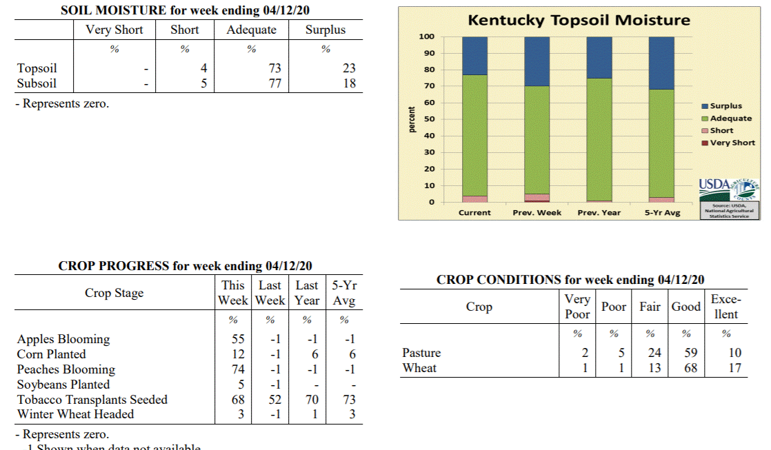 Kentucky Climate Summary
For the Period April 6, 2020 to April 12, 2020
Above Normal Temperatures and Near Normal Rainfall:
The period started with above normal temperatures and mostly dry conditions in place.
Highs consistently rose into the mid-70s to mid-80s with sunny skies. The tide turned
on Wednesday evening and Wednesday night as a strong cold front pushed through the
state. The highlight of the event was a strong to severe line of storms that formed
ahead of the frontal boundary. This line, in addition to some storms earlier in the
day, led to numerous reports of large hail and damaging winds. Behind the boundary,
breezy northwest winds ushered much cooler air into the area for the end of the work
week. Low temperatures dipped into the upper 20s to middle 30s Friday night,
prompting the first Freeze Warnings and Frost Advisories of the spring season.
Southerly flow brought temperatures back into the 60s over the weekend, but light to
moderate rain showers returned to the area Sunday afternoon. Some of this rain fell
after the data cutoff and will be reflected in next week’s report. Combined with the
Wednesday event, the state averaged just over an inch for the week, which is near
normal for this time of year.
Temperatures for the period averaged 58 degrees across the state which was 4 degrees
warmer than normal and 6 degrees warmer than the previous period. High temperatures
averaged from 69 in the West to 68 in the East. Departure from normal high
temperatures ranged from 1 degree warmer than normal in the West to 1 degree
warmer than normal in the East. Low temperatures averaged from 49 degrees in the
West to 47 degrees in the East. Departure from normal low temperature ranged from 5
degrees warmer than normal in the West to 8 degrees warmer than normal in the East.
The extreme high temperature for the period was 86 degrees at CARBONDALE ASOS and the
extreme low was 26 degrees at MONTICELLO AWOS.
Precipitation (liq. equ.) for the period totaled 1.05 inches statewide which was 0.03
inches above normal and 103% of normal. Precipitation totals by climate division,
West 0.72 inches, Central 1.21 inches, Bluegrass 1.26 inches and East 1.02 inches,
which was -0.44, 0.17, 0.34 and 0.08 inches respectively from normal. By station,
precipitation totals ranged from a low of 0.17 inches at EVANSVILLE ASOS to a high of
2.12 inches at SCOTTSVILLE 2W.
---
Kentucky Crop and Weather Report
Issued 4:00 P.M., April 6, 2020 03-20
Agricultural News: Kentucky experienced above normal temperatures and below normal
rainfall over the past week. Precipitation for the week totaled 0.41 inches, 0.58
inches below normal. Temperatures averaged 53 degrees for the week, 1 degree warmer
than normal. Topsoil moisture was rated 1 percent very short, 4 percent short, 65
percent adequate, and 30 percent surplus. Subsoil moisture was rated 1 percent very
short, 4 percent short, 69 percent adequate, and 26 percent surplus. Days suitable
for fieldwork averaged 5.0 out of a possible seven.
Primary activities for this week included seeding tobacco transplants along with
field preparation for the planting season. Mostly dry and seasonably warm conditions
this week have allowed opportunity for spraying as well as fertilizing for the 2020
crop season. Early corn and soybean planting has started in some areas. Winter wheat
is in mostly good condition and experienced very little freeze damage. Alfalfa freeze
damage was minimal.
Livestock condition is mostly good to fair at this time as recent weather has
promoted good pasture growth. Approximately 20 percent of feed for cattle and calves
was obtained from grazing. At this juncture pasture condition is rated as mostly good.
Kentucky Climate Summary
For the Period April 6, 2020 to April 12, 2020
Above Normal Temperatures and Near Normal Rainfall:
The period started with above normal temperatures and mostly dry conditions in place.
Highs consistently rose into the mid-70s to mid-80s with sunny skies. The tide turned
on Wednesday evening and Wednesday night as a strong cold front pushed through the
state. The highlight of the event was a strong to severe line of storms that formed
ahead of the frontal boundary. This line, in addition to some storms earlier in the
day, led to numerous reports of large hail and damaging winds. Behind the boundary,
breezy northwest winds ushered much cooler air into the area for the end of the work
week. Low temperatures dipped into the upper 20s to middle 30s Friday night,
prompting the first Freeze Warnings and Frost Advisories of the spring season.
Southerly flow brought temperatures back into the 60s over the weekend, but light to
moderate rain showers returned to the area Sunday afternoon. Some of this rain fell
after the data cutoff and will be reflected in next week’s report. Combined with the
Wednesday event, the state averaged just over an inch for the week, which is near
normal for this time of year.
Temperatures for the period averaged 58 degrees across the state which was 4 degrees
warmer than normal and 6 degrees warmer than the previous period. High temperatures
averaged from 69 in the West to 68 in the East. Departure from normal high
temperatures ranged from 1 degree warmer than normal in the West to 1 degree
warmer than normal in the East. Low temperatures averaged from 49 degrees in the
West to 47 degrees in the East. Departure from normal low temperature ranged from 5
degrees warmer than normal in the West to 8 degrees warmer than normal in the East.
The extreme high temperature for the period was 86 degrees at CARBONDALE ASOS and the
extreme low was 26 degrees at MONTICELLO AWOS.
Precipitation (liq. equ.) for the period totaled 1.05 inches statewide which was 0.03
inches above normal and 103% of normal. Precipitation totals by climate division,
West 0.72 inches, Central 1.21 inches, Bluegrass 1.26 inches and East 1.02 inches,
which was -0.44, 0.17, 0.34 and 0.08 inches respectively from normal. By station,
precipitation totals ranged from a low of 0.17 inches at EVANSVILLE ASOS to a high of
2.12 inches at SCOTTSVILLE 2W.
---
Kentucky Crop and Weather Report
Issued 4:00 P.M., April 6, 2020 03-20
Agricultural News: Kentucky experienced above normal temperatures and below normal
rainfall over the past week. Precipitation for the week totaled 0.41 inches, 0.58
inches below normal. Temperatures averaged 53 degrees for the week, 1 degree warmer
than normal. Topsoil moisture was rated 1 percent very short, 4 percent short, 65
percent adequate, and 30 percent surplus. Subsoil moisture was rated 1 percent very
short, 4 percent short, 69 percent adequate, and 26 percent surplus. Days suitable
for fieldwork averaged 5.0 out of a possible seven.
Primary activities for this week included seeding tobacco transplants along with
field preparation for the planting season. Mostly dry and seasonably warm conditions
this week have allowed opportunity for spraying as well as fertilizing for the 2020
crop season. Early corn and soybean planting has started in some areas. Winter wheat
is in mostly good condition and experienced very little freeze damage. Alfalfa freeze
damage was minimal.
Livestock condition is mostly good to fair at this time as recent weather has
promoted good pasture growth. Approximately 20 percent of feed for cattle and calves
was obtained from grazing. At this juncture pasture condition is rated as mostly good.
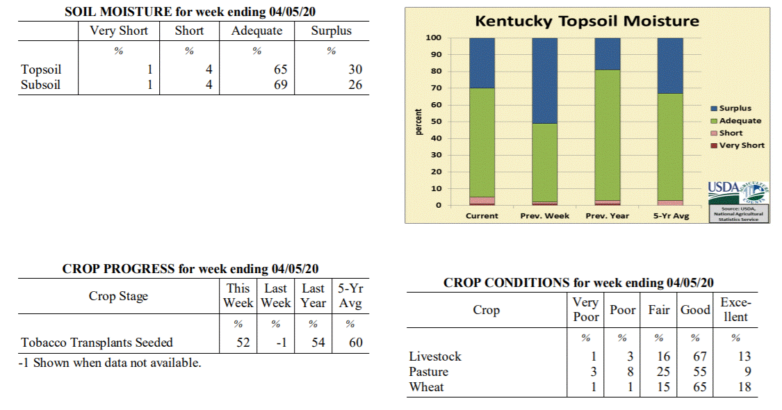 Kentucky Climate Summary
For the Period March 30, 2020 to April 5, 2020
Above Normal Temperatures and Below Normal Rainfall:
Following an exceptionally wet March, the first week of April opened with some much-
welcomed dry conditions. The only significant rainfall event passed through the
Bluegrass State on Tuesday. Total accumulations varied significantly, between a half
and one inch across the southern half of the state and less than a tenth of an inch
towards the northern fringes. Otherwise, the rest of the period was mostly dry.
Overall, the state averaged 0.41 inches, which marks the first week of below average
precipitation since the last week of February. The drier pattern was accompanied by
fluctuating temperatures for much of the week and partly to mostly sunny skies. High
temperatures ran below normal on Tuesday and Wednesday. Much of the state dipped
into the middle 30s to low 40s on Thursday morning. Some even hitting the lower 30s.
The cool conditions did not last long as the state was seeing highs back in the 60s
and 70s for the end of the work week and into the weekend.
Temperatures for the period averaged 53 degrees across the state which was 1 degree
warmer than normal and 6 degrees cooler than the previous period. High temperatures
averaged from 64 in the West to 63 in the East. Departure from normal high
temperatures ranged from 1 degree cooler than normal in the West to 1 degree
cooler than normal in the East. Low temperatures averaged from 44 degrees in the
West to 42 degrees in the East. Departure from normal low temperature ranged from 2
degrees warmer than normal in the West to 5 degrees warmer than normal in the East.
The extreme high temperature for the period was 79 degrees at PEABODY and the extreme
low was 28 degrees at MONTICELLO AWOS.
Precipitation (liq. equ.) for the period totaled 0.41 inches statewide which was 0.58
inches below normal and 41% of normal. Precipitation totals by climate division, West
0.36 inches, Central 0.34 inches, Bluegrass 0.16 inches and East 0.76 inches, which
was 0.73, 0.7, 0.74 and 0.19 inches below normal. By station, precipitation totals
ranged from a low of 0.00 inches at EVANSVILLE ASOS to a high of 1.14 inches at
BARBOURVILLE 3E.
---
Kentucky Climate Summary
For the Period March 23, 2020 to March 29, 2020
Well Above Normal Temperatures and Slightly Above Normal Rainfall:
Farmers welcomed some drier conditions this past week. While the state averaged 1.06
inches for the period, which is slightly above normal, this number was bumped higher
by higher accumulations across Southeastern Kentucky. Eastern Kentucky averaged 1.48
inches for the week, but the rest of the state was actually slightly below normal.
Light to moderate showers passed through the area on Tuesday as low pressure pushed
just south of the area. Other than some portions of the Northern Bluegrass that saw
scattered activity, this was followed by a few days of mostly dry and warm
weather. In fact, highs Thursday through Saturday were in the middle 70s to middle
80s behind breezy southerly flow. A strong storm system then pushed through the state
Saturday evening and overnight. Some storms became strong to severe with damaging
winds as the main hazard. A strong EF2 tornado even touched down in Henderson County
with estimated peak winds of 115 mph. Temperatures took a step back on Sunday with
highs in the 60s and very breezy conditions in place. Peak wind gusts between 35 and
45 mph were common across Kentucky, highest across the Bluegrass region.
Temperatures for the period averaged 59 degrees across the state which was 10 degrees
warmer than normal and 8 degrees warmer than the previous period. High temperatures
averaged from 68 in the West to 69 in the East. Departure from normal high
temperatures ranged from 5 degrees warmer than normal in the West to 7 degrees
warmer than normal in the East. Low temperatures averaged from 52 degrees in the
West to 51 degrees in the East. Departure from normal low temperature ranged from 12
degrees warmer than normal in the West to 16 degrees warmer than normal in the
East. The extreme high temperature for the period was 88 degrees at LOUISA 1S and the
extreme low was 32 degrees at PAINTSVILLE 4W.
Precipitation (liq. equ.) for the period totaled 1.09 inches statewide which was 0.06
inches above normal and 106% of normal. Precipitation totals by climate division,
West 0.97 inches, Central 1.07 inches, Bluegrass 0.83 inches and East 1.48 inches,
which was -0.14, -0.02, -0.10 and 0.48 inches respectively from normal. By station,
precipitation totals ranged from a low of 0.27 inches at HARDINSBURG 5SW to a high of
2.71 inches at BARBOURVILLE 3E.
---
Kentucky Climate Summary
For the Period March 16, 2020 to March 22, 2020
Above Normal Temperatures and Precipitation:
Mild and wet conditions have been the norm for much of March 2020 and that did not
change this period. After a light rainfall event on Monday/Monday night, more
significant activity arrived Wednesday and Thursday. Widespread rainfall fell on both
days. The latter produced scattered storms, which led to some bouts of heavy rain.
More showers accompanied the passage of a cold front on Friday and another
disturbance on Sunday. All together, the state averaged 1.84 inches, which is good
for a third straight week of above normal rainfall. Through the 22nd, the state has
now averaged over 5 inches since the start of March. Looking at temperatures, highs
jumped into the 60s and 70s Wednesday through Friday. Saying that, behind the cold
front on Friday, temperatures took an abrupt turn. Between Friday and Saturday, there
was a ~25 - 30 degree swing in high temperatures. Lows that night dropped into the
upper 20s to middle 30s.
Temperatures for the period averaged 51 degrees across the state which was 3 degrees
warmer than normal and no change to the previous period. High temperatures averaged
from 58 in the West to 60 in the East. Departure from normal high temperatures ranged
from 3 degrees cooler than normal in the West to near normal in the East. Low
temperatures averaged from 44 degrees in the West to 46 degrees in the East.
Departure from normal low temperature ranged from 6 degrees warmer than normal in the
West to 12 degrees warmer than normal in the East. The extreme high temperature for
the period was 79 degrees at YELLOW CREEK and the extreme low was 27 degrees at
ALEXANDRIA 5NW.
Precipitation (liq. equ.) for the period totaled 1.84 inches statewide which was 0.8
inches above normal and 177% of normal. Precipitation totals by climate division,
West 1.93 inches, Central 2.07 inches, Bluegrass 1.45 inches and East 1.92 inches,
which was 0.83, 0.97, 0.51 and 0.9 inches above normal. By station, precipitation
totals ranged from a low of 0.12 inches at MT STERLING AWOS to a high of 3.62
inches at BOWLING GREEN 5S.
---
Kentucky Climate Summary
For the Period March 9, 2020 to March 15, 2020
Above Normal Temperatures and Precipitation:
Mild and wet conditions continued for a second straight week. All together, the
state averaged 2.29 inches for the period as multiple rounds of showers and some
storms pushed through Kentucky. Activity was most significant on Thursday as some
storms became strong to severe. Severe weather involving damaging winds and large
hail was most common across primarily western Kentucky, while heavy rainfall was
more widespread across the state. Ahead of these storms, temperatures rose into the
60s and 70s. Following the event, a cold front worked through Kentucky on Friday.
Temperatures only rose into the 40s over the weekend and was accompanied by another
couple rounds of widespread showers on Saturday. Through March 15th, data at the Ag
Weather Center shows the state has averaged 3.57 inches for the month, which is about
1.5 inches above normal.
Temperatures for the period averaged 51 degrees across the state which was 6 degrees
warmer than normal and 2 degrees warmer than the previous period. High temperatures
averaged from 58 in the West to 60 in the East. Departure from normal high
temperatures ranged from 1 degree cooler than normal in the West to 2 degrees
warmer than normal in the East. Low temperatures averaged from 44 degrees in the
West to 45 degrees in the East. Departure from normal low temperature ranged from 8
degrees warmer than normal in the West to 13 degrees warmer than normal in the
East. The extreme high temperature for the period was 75 degrees at MURRAY 1W and the
extreme low was 28 degrees at JACKSON 3SE.
Precipitation (liq. equ.) for the period totaled 2.29 inches statewide which was 1.31
inches above normal and 234% of normal. Precipitation totals by climate division,
West 2.14 inches, Central 2.65 inches, Bluegrass 2.09 inches and East 2.28 inches,
which was 1.12, 1.62, 1.2 and 1.31 inches above normal. By station, precipitation
totals ranged from a low of 0.51 inches at FRANKLIN 4SW to a high of 4.69 inches at
RICHMOND 8E.
---
Kentucky Climate Summary
For the Period March 2, 2020 to March 8, 2020
Above Normal Temperatures and Precipitation:
The work week started with mild and wet conditions in place. Widespread showers
worked across the area Monday morning ahead of an upper level disturbance. After a
short break that afternoon, another round moved through Kentucky that evening and
overnight. This time though, numerous showers was accompanied by scattered storms.
Some storms became strong to severe across Western and South-Central Kentucky,
producing large hail and even a couple tornadoes. Overall, this accounted for the
brunt of the rainfall for the week with the state averaging 1.28 inches. Saying that,
portions of Western and South Central Kentucky saw more than two. The rest of the
week stayed quiet with fluctuating temperatures, cooling off toward the end of the
work week and warming up again over the weekend.
Temperatures for the period averaged 48 degrees across the state which was 4 degrees
warmer than normal and 8 degrees warmer than the previous period. High temperatures
averaged from 61 in the West to 59 in the East. Departure from normal high
temperatures ranged from 4 degrees warmer than normal in the West to 3 degrees
warmer than normal in the East. Low temperatures averaged from 39 degrees in the
West to 37 degrees in the East. Departure from normal low temperature ranged from 4
degrees warmer than normal in the West to 6 degrees warmer than normal in the East.
The extreme high temperature for the period was 69 degrees at FORT CAMPBELL and the
extreme low was 17 degrees at BRANDENBURG 4SW.
Precipitation (liq. equ.) for the period totaled 1.28 inches statewide which was 0.3
inches above normal and 131% of normal. Precipitation totals by climate division,
West 1.54 inches, Central 1.69 inches, Bluegrass 0.67 inches and East 1.21 inches,
which was 0.49, 0.66, -0.21 and 0.26 inches respectively from normal. By station,
precipitation totals ranged from a low of 0.27 inches at MAYSVILLE 3SW to a high of
3.21 inches at CADIZ 4SW.
---
Kentucky Climate Summary
For the Period February 24, 2020 to March 1, 2020
Below Normal Temperatures and Precipitation:
Wet conditions stuck around for most of the work week. Precipitation started out as
rain on Monday and Tuesday, but colder air filtering into the area on Wednesday led
to a couple light rounds of snow to end the work week. Dry conditions returned over
the weekend. Overall, the state averaged 0.86 inches for the week. Since February
1st, Kentucky has averaged 5.89 inches, almost two inches above normal over that time
span. Looking at temperatures, highs struggled in the 30s and 40s and lows dipped
into the 20s from Wednesday to Saturday. Despite temperatures back in the 60s on
Sunday, temperatures averaged a couple degrees below normal for the week. This broke
a streak of 8 straight weeks of near to above normal temperatures to start the year.
Temperatures for the period averaged 40 degrees across the state which was 2 degrees
cooler than normal and no change to the previous period. High temperatures averaged
from 49 in the West to 48 in the East. Departure from normal high temperatures
ranged from 5 degrees cooler than normal in the West to 6 degrees cooler than normal
in the East. Low temperatures averaged from 34 degrees in the West to 32 degrees in
the East. Departure from normal low temperature ranged from 1 degree warmer than
normal in the West to 3 degrees warmer than normal in the East. The extreme high
temperature for the period was 70 degrees at HARTFORD 3E and the extreme low was 15
degrees at CARLISLE 5SW.
Precipitation (liq. equ.) for the period totaled 0.86 inches statewide which was 0.13
inches below normal and 87% of normal. Precipitation totals by climate division, West
0.89 inches, Central 0.94 inches, Bluegrass 0.96 inches and East 0.67 inches, which
was -0.21, -0.11, 0.10 and -0.26 inches respectively from normal. By station,
precipitation totals ranged from a low of 0.36 inches at CARBONDALE ASOS to a high of
1.58 inches at POPLAR BLUFF ASOS.
---
Kentucky Climate Summary
For the Period February 17, 2020 to February 23, 2020
Near Normal Temperatures and Below Normal Precipitation:
After two straight weeks of exceptional rainfall to start the month of February, a
much welcomed drier pattern returned to the area this period. After a very mild
Monday, widespread light showers returned to the area Monday night and Tuesday, but
accumulations were under a half inch for most of the state. For much of Kentucky,
this ended up being the only precipitation event for the week as high pressure then
took control. Behind a cold front on Tuesday, temperatures went on the downhill slide
over the rest of the work week. Low temperatures dropped into the middle teens to low
20s both Friday and Saturday mornings. As high pressure moved east over the weekend,
winds transitioned to the south/southwest and pushed high temperatures back into the
50s.
Temperatures for the period averaged 39 degrees across the state which was
near normal and 2 degrees warmer than the previous period. High temperatures
averaged from 50 in the West to 50 in the East. Departure from normal high
temperatures ranged from 1 degree cooler than normal in the West to 1 degree
cooler than normal in the East. Low temperatures averaged from 30 degrees in the
West to 29 degrees in the East. Departure from normal low temperature ranged from
near normal in the West to 2 degrees warmer than normal in the East. The
extreme high temperature for the period was 68 degrees at FORT CAMPBELL and the
extreme low was 11 degrees at CYNTHIANA 8N.
Precipitation (liq. equ.) for the period totaled 0.37 inches statewide which was 0.56
inches below normal and 40% of normal. Precipitation totals by climate division, West
0.35 inches, Central 0.42 inches, Bluegrass 0.29 inches and East 0.41 inches, which
was 0.7, 0.58, 0.51 and 0.46 inches below normal. By station, precipitation totals
ranged from a low of 0.01 inches at CARBONDALE ASOS to a high of 0.93 inches at
ELKTON 5SW.
---
Kentucky Climate Summary
For the Period February 10, 2020 to February 16, 2020
Above Normal Temperatures and Much Above Normal Precipitation:
Kentucky has not been able to catch a break from excessive rainfall over the first
half of the February. Through February 16th, data at the Ag Weather Center shows the
state has averaged 4.66 inches, which is 2.64 inches above normal. About 2.5 inches
of that 4.66 total came over the past week. Rain came in two rounds, one on Monday
and the other on Wednesday/Wednesday night. While both rounds brought widespread
rainfall, the latter was more significant with 1 to 2+ inches falling across the
state ahead of a cold front. Saturated soils led to flash flooding in some areas.
Behind the cold front, temperatures took quite the dip. After starting the week in
the 50s, highs struggled in the 20s and 30s on Thursday and Friday. Lows dipped into
the teens both nights. Some sites even hit the single digits.
Temperatures for the period averaged 38 degrees across the state which was 1 degree
warmer than normal and 4 degrees cooler than the previous period. High temperatures
averaged from 44 in the West to 49 in the East. Departure from normal high
temperatures ranged from 4 degrees cooler than normal in the West to 1 degree
warmer than normal in the East. Low temperatures averaged from 30 degrees in the
West to 33 degrees in the East. Departure from normal low temperature ranged from 2
degrees warmer than normal in the West to 8 degrees warmer than normal in the East.
The extreme high temperature for the period was 63 degrees at ALBANY 1N and the
extreme low was 8 degrees at BRANDENBURG 4SW.
Precipitation (liq. equ.) for the period totaled 2.56 inches statewide which was 1.65
inches above normal and 282% of normal. Precipitation totals by climate division,
West 2.37 inches, Central 2.77 inches, Bluegrass 2.06 inches and East 3.04 inches,
which was 1.36, 1.78, 1.28 and 2.19 inches above normal. By station, precipitation
totals ranged from a low of 1.45 inches at CINCINNATI to a high of 4.34 inches at
BURKESVILLE 3W.
---
Kentucky Climate Summary
For the Period February 3, 2020 to February 9, 2020
Above Normal Temperatures and Much Above Normal Precipitation:
After three straight weeks of near to below normal precipitation, Kentucky averaged
more than two inches this period. Precipitation was seen on a near daily basis. The
most significant rounds fell Monday night/Tuesday and Wednesday night. Grounds
became saturated and while the state averaged 2 inches, many locations across
Southeastern Kentucky saw 3 to 5+ inches, which led to significant flooding in this
area. Temperatures then took a downhill turn and transitioned precipitation to snow
for Thursday night and Friday morning. Much of the state saw 1 to 2 inches, even
higher in parts of the Bluegrass and Eastern Kentucky. While mostly cloudy skies
remained into the weekend, temperatures did moderate to slightly above normal by
Sunday.
Temperatures for the period averaged 42 degrees across the state which was 7 degrees
warmer than normal and no change to the previous period. High temperatures averaged
from 50 in the West to 53 in the East. Departure from normal high temperatures
ranged from 4 degrees warmer than normal in the West to 7 degrees warmer than normal
in the East. Low temperatures averaged from 36 degrees in the West to 36 degrees in
the East. Departure from normal low temperature ranged from 10 degrees warmer than
normal in the West to 13 degrees warmer than normal in the East. The extreme high
temperature for the period was 75 degrees at MADISONVILLE 4S and the extreme low was
18 degrees at BRANDENBURG 4SW.
Precipitation (liq. equ.) for the period totaled 2.02 inches statewide which was 1.15
inches above normal and 232% of normal. Precipitation totals by climate division,
West 1.82 inches, Central 2.00 inches, Bluegrass 1.14 inches and East 3.10 inches,
which was 0.86, 1.05, 0.38 and 2.28 inches above normal. By station, precipitation
totals ranged from a low of 0.66 inches at LOUISVILLE APT to a high of 5.66 inches
at YELLOW CREEK.
---
Kentucky Climate Summary
For the Period January 27, 2020 to February 2, 2020
Above Normal Temperatures and Below Normal Precipitation:
January closed with a mostly cloudy and unsettled week for the Commonwealth. Sunshine
was limited throughout the period with multiple disturbances working through the
region. While the state did see multiple rounds of precipitation, mainly Tuesday
night through Saturday, accumulations were fairly light. Kentucky only averaged
about a quarter inch, which is good for a third straight week of below normal
precipitation. Saying that, preliminary data from the Ag Weather Center shows the
state averaged 4.42 inches for the month of January, which is over a half inch above
normal. The cloudy weather kept temperatures in the 30s and 40s for most of the
period, but the tide turned on Sunday. Breezy southwesterly flow pushed highs into
the 60s for Groundhogs Day.
Temperatures for the period averaged 40 degrees across the state which was 6 degrees
warmer than normal and 8 degrees warmer than the previous period. High temperatures
averaged from 46 in the West to 47 in the East. Departure from normal high
temperatures ranged from 2 degrees warmer than normal in the West to 3 degrees
warmer than normal in the East. Low temperatures averaged from 35 degrees in the
West to 35 degrees in the East. Departure from normal low temperature ranged from 10
degrees warmer than normal in the West to 13 degrees warmer than normal in the
East. The extreme high temperature for the period was 68 degrees at ELKTON 5SW and
the extreme low was 26 degrees at BURKESVILLE 3W.
Precipitation (liq. equ.) for the period totaled 0.28 inches statewide which was 0.54
inches below normal and 34% of normal. Precipitation totals by climate division, West
0.30 inches, Central 0.32 inches, Bluegrass 0.22 inches and East 0.27 inches, which
was 0.57, 0.57, 0.49 and 0.53 inches below normal. By station, precipitation totals
ranged from a low of 0.10 inches at CYNTHIANA 8N to a high of 0.61 inches at ALBANY 1N.
---
Kentucky Climate Summary
For the Period January 20, 2020 to January 26, 2020
Near Normal Temperatures and Precipitation:
Carrying over from the previous period, chilly conditions continued early in the
week. Low temperatures through Wednesday morning were generally in the teens for
much of Kentucky and highs struggled in the 20s and 30s. Wind chills even dipped into
the single digits again on Monday morning causing the livestock cold stress index to
once again dip into the danger to emergency categories. Dry conditions prevailed
until late Thursday and into Friday as a disturbance aloft worked through the region.
This system brought widespread rain back to the region and accounted for most of the
rainfall over the period. Most saw between a half to 1 inch. The state average for
the week was 0.78. Cloudy skies and patchy drizzle/light showers remained over the
weekend, but temperatures did go on the increase with highs back in the 40s.
Temperatures for the period averaged 33 degrees across the state which was
near normal and 10 degrees cooler than the previous period. High temperatures
averaged from 38 in the West to 41 in the East. Departure from normal high
temperatures ranged from 6 degrees cooler than normal in the West to 3 degrees
cooler than normal in the East. Low temperatures averaged from 27 degrees in the
West to 27 degrees in the East. Departure from normal low temperature ranged from 2
degrees warmer than normal in the West to 5 degrees warmer than normal in the East.
The extreme high temperature for the period was 57 degrees at JACKSON 3SE and the
extreme low was 10 degrees at CARLISLE 5SW.
Precipitation (liq. equ.) for the period totaled 0.78 inches statewide which was 0.03
inches below normal and 97% of normal. Precipitation totals by climate division, West
0.49 inches, Central 0.90 inches, Bluegrass 0.93 inches and East 0.80 inches, which
was -0.37, 0.04, 0.23 and -0.01 inches respectively from normal. By station,
precipitation totals ranged from a low of 0.26 inches at FORT CAMPBELL to a high of
1.64 inches at LIBERTY 3SW.
---
Kentucky Climate Summary
For the Period January 13, 2020 to January 19, 2020
Above Normal Temperatures and Below Normal Precipitation:
The week started out with unseasonably mild conditions in place with highs topping
out in the middle 50s to low 60s by Tuesday. This was the case despite mostly cloudy
skies and some showers on Tuesday. Rain was mostly confined to the southeastern side
of the state. This was followed by another round on Wednesday as a cold front passed
through the region. Ahead of the boundary, highs jumped into the 60s, but behind the
front, a northwest wind kept highs in the 30s and 40s for Thursday and Friday. The
active week continued into the weekend with light to moderate showers expanding
across the area Friday night and into Saturday. While rainfall was widespread, this
round followed the trend of the previous events this week and total accumulations
were not overly significant. Despite the active pattern, the state averaged 0.65
inches for the week, which is slightly below normal for this time of year. This broke
a four week streak of above normal precipitation. Behind a secondary cold front on
Saturday, Kentucky saw highs in the 20s on Sunday. Wind chills were even in the
single digits on Sunday morning with the livestock cold stress index hovering in the
danger to emergency categories.
Temperatures for the period averaged 42 degrees across the state which was 9 degrees
warmer than normal and 4 degrees cooler than the previous period. High temperatures
averaged from 50 in the West to 52 in the East. Departure from normal high
temperatures ranged from 7 degrees warmer than normal in the West to 9 degrees
warmer than normal in the East. Low temperatures averaged from 36 degrees in the
West to 36 degrees in the East. Departure from normal low temperature ranged from 11
degrees warmer than normal in the West to 13 degrees warmer than normal in the East.
The extreme high temperature for the period was 72 degrees at BOWLING GREEN APT and
the extreme low was 15 degrees at ALEXANDRIA 5NW.
Precipitation (liq. equ.) for the period totaled 0.65 inches statewide which was 0.19
inches below normal and 77% of normal. Precipitation totals by climate division, West
0.47 inches, Central 0.70 inches, Bluegrass 0.61 inches and East 0.80 inches, which
was 0.41, 0.19, 0.12 and 0.07 inches below normal. By station, precipitation totals
ranged from a low of 0.15 inches at OWENSBORO AWSS to a high of 1.62 inches at CARLISLE 5SW.
---
Kentucky Climate Summary
For the Period January 6, 2020 to January 12, 2020
Well Above Normal Temperatures and Precipitation:
It may be the middle of winter, but it sure doesn’t feel like it in Kentucky.
Temperatures ran above normal the entire week, peaking in the 60s and 70s on Friday
and Saturday. Putting this into perspective, normal high temperatures for this time
of year are in the low to middle 40s across the state. Other than a light
rainfall event across the southern half of the state on Tuesday morning, the primary
focus for the week was a strong system working through Kentucky on Friday and
Saturday. Winds were very gusty throughout the event, but most notable on Saturday
when gusts between 40 and 60 mph were common. This was especially the case as a couple
lines of showers worked through Kentucky, causing some bouts of damaging winds and
power outages. Otherwise, rainfall accumulations were highest across Western Kentucky
(>2 inches) and tapered farther east. Overall, the state averaged 1.66 inches for
the period.
Temperatures for the period averaged 47 degrees across the state which was 14
degrees warmer than normal and 2 degrees warmer than the previous period. High
temperatures averaged from 55 in the West to 57 in the East. Departure from
normal high temperatures ranged from 12 degrees warmer than normal in the West
to 13 degrees warmer than normal in the East. Low temperatures averaged from
37 degrees in the West to 38 degrees in the East. Departure from normal low
temperature ranged from 11 degrees warmer than normal in the West to 14 degrees
warmer than normal in the East. The extreme high temperature for the period
was 79 degrees at LOUISA 1S and the extreme low was 21 degrees at MONTICELLO AWOS.
Precipitation (liq. equ.) for the period totaled 1.66 inches statewide which was
0.78 inches above normal and 188% of normal. Precipitation totals by climate
division, West 2.62 inches, Central 1.68 inches, Bluegrass 1.08 inches and East
1.25 inches, which was 1.69, 0.74, 0.33 and 0.34 inches above normal. By
station, precipitation totals ranged from a low of 0.56 inches at VANCEBURG 6W
to a high of 4.39 inches at CAPE GIRARDEAU ASOS.
---
Kentucky Climate Summary
For the Period December 30, 2019 to January 5, 2020
Well Above Normal Temperatures and Precipitation:
The calendar turned the page to 2020 with warm and wet conditions continuing from the
end of 2019. Highs on New Year’s Day rose into the middle 40s to around 50 and then
remained in the 50s through Friday. While it was warm, the Bluegrass State saw
another round of exceptional rainfall between Thursday and Saturday. Periods of light
to moderate rain led to total accumulations of 1 to 2+ inches. Dating back into late
December, average rainfall across the state has been above normal for three straight
weeks. Over that time span, Kentucky has averaged nearly 5 inches of rainfall, which
is over 2 inches above normal.
Temperatures for the period averaged 44 degrees across the state which was 10 degrees
warmer than normal and 8 degrees cooler than the previous period. High temperatures
averaged from 50 in the West to 51 in the East. Departure from normal high
temperatures ranged from 7 degrees warmer than normal in the West to 7 degrees
warmer than normal in the East. Low temperatures averaged from 37 degrees in the
West to 39 degrees in the East. Departure from normal low temperature ranged from 11
degrees warmer than normal in the West to 15 degrees warmer than normal in the
East. The extreme high temperature for the period was 70 degrees at WHITESBURG 2NW
and the extreme low was 23 degrees at BRANDENBURG 4SW.
Precipitation (liq. equ.) for the period totaled 1.83 inches statewide which was 0.94
inches above normal and 204% of normal. Precipitation totals by climate division,
West 1.27 inches, Central 2.03 inches, Bluegrass 1.63 inches and East 2.39 inches,
which was 0.34, 1.06, 0.85 and 1.49 inches above normal. By station, precipitation
totals ranged from a low of 0.28 inches at CARBONDALE ASOS to a high of 3.64 inches
at WHITLEY CITY 3N.
Kentucky Climate Summary
For the Period March 30, 2020 to April 5, 2020
Above Normal Temperatures and Below Normal Rainfall:
Following an exceptionally wet March, the first week of April opened with some much-
welcomed dry conditions. The only significant rainfall event passed through the
Bluegrass State on Tuesday. Total accumulations varied significantly, between a half
and one inch across the southern half of the state and less than a tenth of an inch
towards the northern fringes. Otherwise, the rest of the period was mostly dry.
Overall, the state averaged 0.41 inches, which marks the first week of below average
precipitation since the last week of February. The drier pattern was accompanied by
fluctuating temperatures for much of the week and partly to mostly sunny skies. High
temperatures ran below normal on Tuesday and Wednesday. Much of the state dipped
into the middle 30s to low 40s on Thursday morning. Some even hitting the lower 30s.
The cool conditions did not last long as the state was seeing highs back in the 60s
and 70s for the end of the work week and into the weekend.
Temperatures for the period averaged 53 degrees across the state which was 1 degree
warmer than normal and 6 degrees cooler than the previous period. High temperatures
averaged from 64 in the West to 63 in the East. Departure from normal high
temperatures ranged from 1 degree cooler than normal in the West to 1 degree
cooler than normal in the East. Low temperatures averaged from 44 degrees in the
West to 42 degrees in the East. Departure from normal low temperature ranged from 2
degrees warmer than normal in the West to 5 degrees warmer than normal in the East.
The extreme high temperature for the period was 79 degrees at PEABODY and the extreme
low was 28 degrees at MONTICELLO AWOS.
Precipitation (liq. equ.) for the period totaled 0.41 inches statewide which was 0.58
inches below normal and 41% of normal. Precipitation totals by climate division, West
0.36 inches, Central 0.34 inches, Bluegrass 0.16 inches and East 0.76 inches, which
was 0.73, 0.7, 0.74 and 0.19 inches below normal. By station, precipitation totals
ranged from a low of 0.00 inches at EVANSVILLE ASOS to a high of 1.14 inches at
BARBOURVILLE 3E.
---
Kentucky Climate Summary
For the Period March 23, 2020 to March 29, 2020
Well Above Normal Temperatures and Slightly Above Normal Rainfall:
Farmers welcomed some drier conditions this past week. While the state averaged 1.06
inches for the period, which is slightly above normal, this number was bumped higher
by higher accumulations across Southeastern Kentucky. Eastern Kentucky averaged 1.48
inches for the week, but the rest of the state was actually slightly below normal.
Light to moderate showers passed through the area on Tuesday as low pressure pushed
just south of the area. Other than some portions of the Northern Bluegrass that saw
scattered activity, this was followed by a few days of mostly dry and warm
weather. In fact, highs Thursday through Saturday were in the middle 70s to middle
80s behind breezy southerly flow. A strong storm system then pushed through the state
Saturday evening and overnight. Some storms became strong to severe with damaging
winds as the main hazard. A strong EF2 tornado even touched down in Henderson County
with estimated peak winds of 115 mph. Temperatures took a step back on Sunday with
highs in the 60s and very breezy conditions in place. Peak wind gusts between 35 and
45 mph were common across Kentucky, highest across the Bluegrass region.
Temperatures for the period averaged 59 degrees across the state which was 10 degrees
warmer than normal and 8 degrees warmer than the previous period. High temperatures
averaged from 68 in the West to 69 in the East. Departure from normal high
temperatures ranged from 5 degrees warmer than normal in the West to 7 degrees
warmer than normal in the East. Low temperatures averaged from 52 degrees in the
West to 51 degrees in the East. Departure from normal low temperature ranged from 12
degrees warmer than normal in the West to 16 degrees warmer than normal in the
East. The extreme high temperature for the period was 88 degrees at LOUISA 1S and the
extreme low was 32 degrees at PAINTSVILLE 4W.
Precipitation (liq. equ.) for the period totaled 1.09 inches statewide which was 0.06
inches above normal and 106% of normal. Precipitation totals by climate division,
West 0.97 inches, Central 1.07 inches, Bluegrass 0.83 inches and East 1.48 inches,
which was -0.14, -0.02, -0.10 and 0.48 inches respectively from normal. By station,
precipitation totals ranged from a low of 0.27 inches at HARDINSBURG 5SW to a high of
2.71 inches at BARBOURVILLE 3E.
---
Kentucky Climate Summary
For the Period March 16, 2020 to March 22, 2020
Above Normal Temperatures and Precipitation:
Mild and wet conditions have been the norm for much of March 2020 and that did not
change this period. After a light rainfall event on Monday/Monday night, more
significant activity arrived Wednesday and Thursday. Widespread rainfall fell on both
days. The latter produced scattered storms, which led to some bouts of heavy rain.
More showers accompanied the passage of a cold front on Friday and another
disturbance on Sunday. All together, the state averaged 1.84 inches, which is good
for a third straight week of above normal rainfall. Through the 22nd, the state has
now averaged over 5 inches since the start of March. Looking at temperatures, highs
jumped into the 60s and 70s Wednesday through Friday. Saying that, behind the cold
front on Friday, temperatures took an abrupt turn. Between Friday and Saturday, there
was a ~25 - 30 degree swing in high temperatures. Lows that night dropped into the
upper 20s to middle 30s.
Temperatures for the period averaged 51 degrees across the state which was 3 degrees
warmer than normal and no change to the previous period. High temperatures averaged
from 58 in the West to 60 in the East. Departure from normal high temperatures ranged
from 3 degrees cooler than normal in the West to near normal in the East. Low
temperatures averaged from 44 degrees in the West to 46 degrees in the East.
Departure from normal low temperature ranged from 6 degrees warmer than normal in the
West to 12 degrees warmer than normal in the East. The extreme high temperature for
the period was 79 degrees at YELLOW CREEK and the extreme low was 27 degrees at
ALEXANDRIA 5NW.
Precipitation (liq. equ.) for the period totaled 1.84 inches statewide which was 0.8
inches above normal and 177% of normal. Precipitation totals by climate division,
West 1.93 inches, Central 2.07 inches, Bluegrass 1.45 inches and East 1.92 inches,
which was 0.83, 0.97, 0.51 and 0.9 inches above normal. By station, precipitation
totals ranged from a low of 0.12 inches at MT STERLING AWOS to a high of 3.62
inches at BOWLING GREEN 5S.
---
Kentucky Climate Summary
For the Period March 9, 2020 to March 15, 2020
Above Normal Temperatures and Precipitation:
Mild and wet conditions continued for a second straight week. All together, the
state averaged 2.29 inches for the period as multiple rounds of showers and some
storms pushed through Kentucky. Activity was most significant on Thursday as some
storms became strong to severe. Severe weather involving damaging winds and large
hail was most common across primarily western Kentucky, while heavy rainfall was
more widespread across the state. Ahead of these storms, temperatures rose into the
60s and 70s. Following the event, a cold front worked through Kentucky on Friday.
Temperatures only rose into the 40s over the weekend and was accompanied by another
couple rounds of widespread showers on Saturday. Through March 15th, data at the Ag
Weather Center shows the state has averaged 3.57 inches for the month, which is about
1.5 inches above normal.
Temperatures for the period averaged 51 degrees across the state which was 6 degrees
warmer than normal and 2 degrees warmer than the previous period. High temperatures
averaged from 58 in the West to 60 in the East. Departure from normal high
temperatures ranged from 1 degree cooler than normal in the West to 2 degrees
warmer than normal in the East. Low temperatures averaged from 44 degrees in the
West to 45 degrees in the East. Departure from normal low temperature ranged from 8
degrees warmer than normal in the West to 13 degrees warmer than normal in the
East. The extreme high temperature for the period was 75 degrees at MURRAY 1W and the
extreme low was 28 degrees at JACKSON 3SE.
Precipitation (liq. equ.) for the period totaled 2.29 inches statewide which was 1.31
inches above normal and 234% of normal. Precipitation totals by climate division,
West 2.14 inches, Central 2.65 inches, Bluegrass 2.09 inches and East 2.28 inches,
which was 1.12, 1.62, 1.2 and 1.31 inches above normal. By station, precipitation
totals ranged from a low of 0.51 inches at FRANKLIN 4SW to a high of 4.69 inches at
RICHMOND 8E.
---
Kentucky Climate Summary
For the Period March 2, 2020 to March 8, 2020
Above Normal Temperatures and Precipitation:
The work week started with mild and wet conditions in place. Widespread showers
worked across the area Monday morning ahead of an upper level disturbance. After a
short break that afternoon, another round moved through Kentucky that evening and
overnight. This time though, numerous showers was accompanied by scattered storms.
Some storms became strong to severe across Western and South-Central Kentucky,
producing large hail and even a couple tornadoes. Overall, this accounted for the
brunt of the rainfall for the week with the state averaging 1.28 inches. Saying that,
portions of Western and South Central Kentucky saw more than two. The rest of the
week stayed quiet with fluctuating temperatures, cooling off toward the end of the
work week and warming up again over the weekend.
Temperatures for the period averaged 48 degrees across the state which was 4 degrees
warmer than normal and 8 degrees warmer than the previous period. High temperatures
averaged from 61 in the West to 59 in the East. Departure from normal high
temperatures ranged from 4 degrees warmer than normal in the West to 3 degrees
warmer than normal in the East. Low temperatures averaged from 39 degrees in the
West to 37 degrees in the East. Departure from normal low temperature ranged from 4
degrees warmer than normal in the West to 6 degrees warmer than normal in the East.
The extreme high temperature for the period was 69 degrees at FORT CAMPBELL and the
extreme low was 17 degrees at BRANDENBURG 4SW.
Precipitation (liq. equ.) for the period totaled 1.28 inches statewide which was 0.3
inches above normal and 131% of normal. Precipitation totals by climate division,
West 1.54 inches, Central 1.69 inches, Bluegrass 0.67 inches and East 1.21 inches,
which was 0.49, 0.66, -0.21 and 0.26 inches respectively from normal. By station,
precipitation totals ranged from a low of 0.27 inches at MAYSVILLE 3SW to a high of
3.21 inches at CADIZ 4SW.
---
Kentucky Climate Summary
For the Period February 24, 2020 to March 1, 2020
Below Normal Temperatures and Precipitation:
Wet conditions stuck around for most of the work week. Precipitation started out as
rain on Monday and Tuesday, but colder air filtering into the area on Wednesday led
to a couple light rounds of snow to end the work week. Dry conditions returned over
the weekend. Overall, the state averaged 0.86 inches for the week. Since February
1st, Kentucky has averaged 5.89 inches, almost two inches above normal over that time
span. Looking at temperatures, highs struggled in the 30s and 40s and lows dipped
into the 20s from Wednesday to Saturday. Despite temperatures back in the 60s on
Sunday, temperatures averaged a couple degrees below normal for the week. This broke
a streak of 8 straight weeks of near to above normal temperatures to start the year.
Temperatures for the period averaged 40 degrees across the state which was 2 degrees
cooler than normal and no change to the previous period. High temperatures averaged
from 49 in the West to 48 in the East. Departure from normal high temperatures
ranged from 5 degrees cooler than normal in the West to 6 degrees cooler than normal
in the East. Low temperatures averaged from 34 degrees in the West to 32 degrees in
the East. Departure from normal low temperature ranged from 1 degree warmer than
normal in the West to 3 degrees warmer than normal in the East. The extreme high
temperature for the period was 70 degrees at HARTFORD 3E and the extreme low was 15
degrees at CARLISLE 5SW.
Precipitation (liq. equ.) for the period totaled 0.86 inches statewide which was 0.13
inches below normal and 87% of normal. Precipitation totals by climate division, West
0.89 inches, Central 0.94 inches, Bluegrass 0.96 inches and East 0.67 inches, which
was -0.21, -0.11, 0.10 and -0.26 inches respectively from normal. By station,
precipitation totals ranged from a low of 0.36 inches at CARBONDALE ASOS to a high of
1.58 inches at POPLAR BLUFF ASOS.
---
Kentucky Climate Summary
For the Period February 17, 2020 to February 23, 2020
Near Normal Temperatures and Below Normal Precipitation:
After two straight weeks of exceptional rainfall to start the month of February, a
much welcomed drier pattern returned to the area this period. After a very mild
Monday, widespread light showers returned to the area Monday night and Tuesday, but
accumulations were under a half inch for most of the state. For much of Kentucky,
this ended up being the only precipitation event for the week as high pressure then
took control. Behind a cold front on Tuesday, temperatures went on the downhill slide
over the rest of the work week. Low temperatures dropped into the middle teens to low
20s both Friday and Saturday mornings. As high pressure moved east over the weekend,
winds transitioned to the south/southwest and pushed high temperatures back into the
50s.
Temperatures for the period averaged 39 degrees across the state which was
near normal and 2 degrees warmer than the previous period. High temperatures
averaged from 50 in the West to 50 in the East. Departure from normal high
temperatures ranged from 1 degree cooler than normal in the West to 1 degree
cooler than normal in the East. Low temperatures averaged from 30 degrees in the
West to 29 degrees in the East. Departure from normal low temperature ranged from
near normal in the West to 2 degrees warmer than normal in the East. The
extreme high temperature for the period was 68 degrees at FORT CAMPBELL and the
extreme low was 11 degrees at CYNTHIANA 8N.
Precipitation (liq. equ.) for the period totaled 0.37 inches statewide which was 0.56
inches below normal and 40% of normal. Precipitation totals by climate division, West
0.35 inches, Central 0.42 inches, Bluegrass 0.29 inches and East 0.41 inches, which
was 0.7, 0.58, 0.51 and 0.46 inches below normal. By station, precipitation totals
ranged from a low of 0.01 inches at CARBONDALE ASOS to a high of 0.93 inches at
ELKTON 5SW.
---
Kentucky Climate Summary
For the Period February 10, 2020 to February 16, 2020
Above Normal Temperatures and Much Above Normal Precipitation:
Kentucky has not been able to catch a break from excessive rainfall over the first
half of the February. Through February 16th, data at the Ag Weather Center shows the
state has averaged 4.66 inches, which is 2.64 inches above normal. About 2.5 inches
of that 4.66 total came over the past week. Rain came in two rounds, one on Monday
and the other on Wednesday/Wednesday night. While both rounds brought widespread
rainfall, the latter was more significant with 1 to 2+ inches falling across the
state ahead of a cold front. Saturated soils led to flash flooding in some areas.
Behind the cold front, temperatures took quite the dip. After starting the week in
the 50s, highs struggled in the 20s and 30s on Thursday and Friday. Lows dipped into
the teens both nights. Some sites even hit the single digits.
Temperatures for the period averaged 38 degrees across the state which was 1 degree
warmer than normal and 4 degrees cooler than the previous period. High temperatures
averaged from 44 in the West to 49 in the East. Departure from normal high
temperatures ranged from 4 degrees cooler than normal in the West to 1 degree
warmer than normal in the East. Low temperatures averaged from 30 degrees in the
West to 33 degrees in the East. Departure from normal low temperature ranged from 2
degrees warmer than normal in the West to 8 degrees warmer than normal in the East.
The extreme high temperature for the period was 63 degrees at ALBANY 1N and the
extreme low was 8 degrees at BRANDENBURG 4SW.
Precipitation (liq. equ.) for the period totaled 2.56 inches statewide which was 1.65
inches above normal and 282% of normal. Precipitation totals by climate division,
West 2.37 inches, Central 2.77 inches, Bluegrass 2.06 inches and East 3.04 inches,
which was 1.36, 1.78, 1.28 and 2.19 inches above normal. By station, precipitation
totals ranged from a low of 1.45 inches at CINCINNATI to a high of 4.34 inches at
BURKESVILLE 3W.
---
Kentucky Climate Summary
For the Period February 3, 2020 to February 9, 2020
Above Normal Temperatures and Much Above Normal Precipitation:
After three straight weeks of near to below normal precipitation, Kentucky averaged
more than two inches this period. Precipitation was seen on a near daily basis. The
most significant rounds fell Monday night/Tuesday and Wednesday night. Grounds
became saturated and while the state averaged 2 inches, many locations across
Southeastern Kentucky saw 3 to 5+ inches, which led to significant flooding in this
area. Temperatures then took a downhill turn and transitioned precipitation to snow
for Thursday night and Friday morning. Much of the state saw 1 to 2 inches, even
higher in parts of the Bluegrass and Eastern Kentucky. While mostly cloudy skies
remained into the weekend, temperatures did moderate to slightly above normal by
Sunday.
Temperatures for the period averaged 42 degrees across the state which was 7 degrees
warmer than normal and no change to the previous period. High temperatures averaged
from 50 in the West to 53 in the East. Departure from normal high temperatures
ranged from 4 degrees warmer than normal in the West to 7 degrees warmer than normal
in the East. Low temperatures averaged from 36 degrees in the West to 36 degrees in
the East. Departure from normal low temperature ranged from 10 degrees warmer than
normal in the West to 13 degrees warmer than normal in the East. The extreme high
temperature for the period was 75 degrees at MADISONVILLE 4S and the extreme low was
18 degrees at BRANDENBURG 4SW.
Precipitation (liq. equ.) for the period totaled 2.02 inches statewide which was 1.15
inches above normal and 232% of normal. Precipitation totals by climate division,
West 1.82 inches, Central 2.00 inches, Bluegrass 1.14 inches and East 3.10 inches,
which was 0.86, 1.05, 0.38 and 2.28 inches above normal. By station, precipitation
totals ranged from a low of 0.66 inches at LOUISVILLE APT to a high of 5.66 inches
at YELLOW CREEK.
---
Kentucky Climate Summary
For the Period January 27, 2020 to February 2, 2020
Above Normal Temperatures and Below Normal Precipitation:
January closed with a mostly cloudy and unsettled week for the Commonwealth. Sunshine
was limited throughout the period with multiple disturbances working through the
region. While the state did see multiple rounds of precipitation, mainly Tuesday
night through Saturday, accumulations were fairly light. Kentucky only averaged
about a quarter inch, which is good for a third straight week of below normal
precipitation. Saying that, preliminary data from the Ag Weather Center shows the
state averaged 4.42 inches for the month of January, which is over a half inch above
normal. The cloudy weather kept temperatures in the 30s and 40s for most of the
period, but the tide turned on Sunday. Breezy southwesterly flow pushed highs into
the 60s for Groundhogs Day.
Temperatures for the period averaged 40 degrees across the state which was 6 degrees
warmer than normal and 8 degrees warmer than the previous period. High temperatures
averaged from 46 in the West to 47 in the East. Departure from normal high
temperatures ranged from 2 degrees warmer than normal in the West to 3 degrees
warmer than normal in the East. Low temperatures averaged from 35 degrees in the
West to 35 degrees in the East. Departure from normal low temperature ranged from 10
degrees warmer than normal in the West to 13 degrees warmer than normal in the
East. The extreme high temperature for the period was 68 degrees at ELKTON 5SW and
the extreme low was 26 degrees at BURKESVILLE 3W.
Precipitation (liq. equ.) for the period totaled 0.28 inches statewide which was 0.54
inches below normal and 34% of normal. Precipitation totals by climate division, West
0.30 inches, Central 0.32 inches, Bluegrass 0.22 inches and East 0.27 inches, which
was 0.57, 0.57, 0.49 and 0.53 inches below normal. By station, precipitation totals
ranged from a low of 0.10 inches at CYNTHIANA 8N to a high of 0.61 inches at ALBANY 1N.
---
Kentucky Climate Summary
For the Period January 20, 2020 to January 26, 2020
Near Normal Temperatures and Precipitation:
Carrying over from the previous period, chilly conditions continued early in the
week. Low temperatures through Wednesday morning were generally in the teens for
much of Kentucky and highs struggled in the 20s and 30s. Wind chills even dipped into
the single digits again on Monday morning causing the livestock cold stress index to
once again dip into the danger to emergency categories. Dry conditions prevailed
until late Thursday and into Friday as a disturbance aloft worked through the region.
This system brought widespread rain back to the region and accounted for most of the
rainfall over the period. Most saw between a half to 1 inch. The state average for
the week was 0.78. Cloudy skies and patchy drizzle/light showers remained over the
weekend, but temperatures did go on the increase with highs back in the 40s.
Temperatures for the period averaged 33 degrees across the state which was
near normal and 10 degrees cooler than the previous period. High temperatures
averaged from 38 in the West to 41 in the East. Departure from normal high
temperatures ranged from 6 degrees cooler than normal in the West to 3 degrees
cooler than normal in the East. Low temperatures averaged from 27 degrees in the
West to 27 degrees in the East. Departure from normal low temperature ranged from 2
degrees warmer than normal in the West to 5 degrees warmer than normal in the East.
The extreme high temperature for the period was 57 degrees at JACKSON 3SE and the
extreme low was 10 degrees at CARLISLE 5SW.
Precipitation (liq. equ.) for the period totaled 0.78 inches statewide which was 0.03
inches below normal and 97% of normal. Precipitation totals by climate division, West
0.49 inches, Central 0.90 inches, Bluegrass 0.93 inches and East 0.80 inches, which
was -0.37, 0.04, 0.23 and -0.01 inches respectively from normal. By station,
precipitation totals ranged from a low of 0.26 inches at FORT CAMPBELL to a high of
1.64 inches at LIBERTY 3SW.
---
Kentucky Climate Summary
For the Period January 13, 2020 to January 19, 2020
Above Normal Temperatures and Below Normal Precipitation:
The week started out with unseasonably mild conditions in place with highs topping
out in the middle 50s to low 60s by Tuesday. This was the case despite mostly cloudy
skies and some showers on Tuesday. Rain was mostly confined to the southeastern side
of the state. This was followed by another round on Wednesday as a cold front passed
through the region. Ahead of the boundary, highs jumped into the 60s, but behind the
front, a northwest wind kept highs in the 30s and 40s for Thursday and Friday. The
active week continued into the weekend with light to moderate showers expanding
across the area Friday night and into Saturday. While rainfall was widespread, this
round followed the trend of the previous events this week and total accumulations
were not overly significant. Despite the active pattern, the state averaged 0.65
inches for the week, which is slightly below normal for this time of year. This broke
a four week streak of above normal precipitation. Behind a secondary cold front on
Saturday, Kentucky saw highs in the 20s on Sunday. Wind chills were even in the
single digits on Sunday morning with the livestock cold stress index hovering in the
danger to emergency categories.
Temperatures for the period averaged 42 degrees across the state which was 9 degrees
warmer than normal and 4 degrees cooler than the previous period. High temperatures
averaged from 50 in the West to 52 in the East. Departure from normal high
temperatures ranged from 7 degrees warmer than normal in the West to 9 degrees
warmer than normal in the East. Low temperatures averaged from 36 degrees in the
West to 36 degrees in the East. Departure from normal low temperature ranged from 11
degrees warmer than normal in the West to 13 degrees warmer than normal in the East.
The extreme high temperature for the period was 72 degrees at BOWLING GREEN APT and
the extreme low was 15 degrees at ALEXANDRIA 5NW.
Precipitation (liq. equ.) for the period totaled 0.65 inches statewide which was 0.19
inches below normal and 77% of normal. Precipitation totals by climate division, West
0.47 inches, Central 0.70 inches, Bluegrass 0.61 inches and East 0.80 inches, which
was 0.41, 0.19, 0.12 and 0.07 inches below normal. By station, precipitation totals
ranged from a low of 0.15 inches at OWENSBORO AWSS to a high of 1.62 inches at CARLISLE 5SW.
---
Kentucky Climate Summary
For the Period January 6, 2020 to January 12, 2020
Well Above Normal Temperatures and Precipitation:
It may be the middle of winter, but it sure doesn’t feel like it in Kentucky.
Temperatures ran above normal the entire week, peaking in the 60s and 70s on Friday
and Saturday. Putting this into perspective, normal high temperatures for this time
of year are in the low to middle 40s across the state. Other than a light
rainfall event across the southern half of the state on Tuesday morning, the primary
focus for the week was a strong system working through Kentucky on Friday and
Saturday. Winds were very gusty throughout the event, but most notable on Saturday
when gusts between 40 and 60 mph were common. This was especially the case as a couple
lines of showers worked through Kentucky, causing some bouts of damaging winds and
power outages. Otherwise, rainfall accumulations were highest across Western Kentucky
(>2 inches) and tapered farther east. Overall, the state averaged 1.66 inches for
the period.
Temperatures for the period averaged 47 degrees across the state which was 14
degrees warmer than normal and 2 degrees warmer than the previous period. High
temperatures averaged from 55 in the West to 57 in the East. Departure from
normal high temperatures ranged from 12 degrees warmer than normal in the West
to 13 degrees warmer than normal in the East. Low temperatures averaged from
37 degrees in the West to 38 degrees in the East. Departure from normal low
temperature ranged from 11 degrees warmer than normal in the West to 14 degrees
warmer than normal in the East. The extreme high temperature for the period
was 79 degrees at LOUISA 1S and the extreme low was 21 degrees at MONTICELLO AWOS.
Precipitation (liq. equ.) for the period totaled 1.66 inches statewide which was
0.78 inches above normal and 188% of normal. Precipitation totals by climate
division, West 2.62 inches, Central 1.68 inches, Bluegrass 1.08 inches and East
1.25 inches, which was 1.69, 0.74, 0.33 and 0.34 inches above normal. By
station, precipitation totals ranged from a low of 0.56 inches at VANCEBURG 6W
to a high of 4.39 inches at CAPE GIRARDEAU ASOS.
---
Kentucky Climate Summary
For the Period December 30, 2019 to January 5, 2020
Well Above Normal Temperatures and Precipitation:
The calendar turned the page to 2020 with warm and wet conditions continuing from the
end of 2019. Highs on New Year’s Day rose into the middle 40s to around 50 and then
remained in the 50s through Friday. While it was warm, the Bluegrass State saw
another round of exceptional rainfall between Thursday and Saturday. Periods of light
to moderate rain led to total accumulations of 1 to 2+ inches. Dating back into late
December, average rainfall across the state has been above normal for three straight
weeks. Over that time span, Kentucky has averaged nearly 5 inches of rainfall, which
is over 2 inches above normal.
Temperatures for the period averaged 44 degrees across the state which was 10 degrees
warmer than normal and 8 degrees cooler than the previous period. High temperatures
averaged from 50 in the West to 51 in the East. Departure from normal high
temperatures ranged from 7 degrees warmer than normal in the West to 7 degrees
warmer than normal in the East. Low temperatures averaged from 37 degrees in the
West to 39 degrees in the East. Departure from normal low temperature ranged from 11
degrees warmer than normal in the West to 15 degrees warmer than normal in the
East. The extreme high temperature for the period was 70 degrees at WHITESBURG 2NW
and the extreme low was 23 degrees at BRANDENBURG 4SW.
Precipitation (liq. equ.) for the period totaled 1.83 inches statewide which was 0.94
inches above normal and 204% of normal. Precipitation totals by climate division,
West 1.27 inches, Central 2.03 inches, Bluegrass 1.63 inches and East 2.39 inches,
which was 0.34, 1.06, 0.85 and 1.49 inches above normal. By station, precipitation
totals ranged from a low of 0.28 inches at CARBONDALE ASOS to a high of 3.64 inches
at WHITLEY CITY 3N.