KENTUCKY CROP AND WEATHER REPORT--USDA
Listed below are the current USDA Crop & Weather Report/Kentucky Climate Summary
AND, in addition, previous week's reports for this year. The reports are
produced in a joint effort by the UK Ag. Weather Center, Cooperative Extension
Service County Agents, Farmers across the state, Kentucky Department of
Agriculture, and the US Department of Agriculture, National Agricultural
Statistics Service. Click here for the PDF version.
---
Kentucky Climate Summary
For the Period December 30, 2019 to January 5, 2020
Well Above Normal Temperatures and Precipitation:
The calendar turned the page to 2020 with warm and wet conditions continuing from the
end of 2019. Highs on New Year’s Day rose into the middle 40s to around 50 and then
remained in the 50s through Friday. While it was warm, the Bluegrass State saw
another round of exceptional rainfall between Thursday and Saturday. Periods of light
to moderate rain led to total accumulations of 1 to 2+ inches. Dating back into late
December, average rainfall across the state has been above normal for three straight
weeks. Over that time span, Kentucky has averaged nearly 5 inches of rainfall, which
is over 2 inches above normal.
Temperatures for the period averaged 44 degrees across the state which was 10 degrees
warmer than normal and 8 degrees cooler than the previous period. High temperatures
averaged from 50 in the West to 51 in the East. Departure from normal high
temperatures ranged from 7 degrees warmer than normal in the West to 7 degrees
warmer than normal in the East. Low temperatures averaged from 37 degrees in the
West to 39 degrees in the East. Departure from normal low temperature ranged from 11
degrees warmer than normal in the West to 15 degrees warmer than normal in the
East. The extreme high temperature for the period was 70 degrees at WHITESBURG 2NW
and the extreme low was 23 degrees at BRANDENBURG 4SW.
Precipitation (liq. equ.) for the period totaled 1.83 inches statewide which was 0.94
inches above normal and 204% of normal. Precipitation totals by climate division,
West 1.27 inches, Central 2.03 inches, Bluegrass 1.63 inches and East 2.39 inches,
which was 0.34, 1.06, 0.85 and 1.49 inches above normal. By station, precipitation
totals ranged from a low of 0.28 inches at CARBONDALE ASOS to a high of 3.64 inches
at WHITLEY CITY 3N.
---
Kentucky Climate Summary
For the Period December 23, 2019 to December 29, 2019
Well Above Normal Temperatures and Above Normal Precipitation:
Unseasonably mild temperatures was the highlight of the week. Daytime highs
hit the 60s on Christmas Eve/Day and stayed that way into the weekend. Even
hit 70 degrees for some locations across Western Kentucky. Putting this into
perspective, the state normally sees highs in the low to middle 40s for this time of
year. Widespread moderate to heavy rain then returned to the area on Saturday night
and into Sunday as an area of low pressure approached the Bluegrass State. The state
averaged 1.22 inches with some minor flooding in low spots and poor drainage areas.
Temperatures for the period averaged 54 degrees across the state which was 18 degrees
warmer than normal and 20 degrees warmer than the previous period. High temperatures
averaged from 65 in the West to 64 in the East. Departure from normal high
temperatures ranged from 20 degrees warmer than normal in the West to 18 degrees
warmer than normal in the East. Low temperatures averaged from 45 degrees in the
West to 42 degrees in the East. Departure from normal low temperature ranged from 18
degrees warmer than normal in the West to 16 degrees warmer than normal in the
East. The extreme high temperature for the period was 72 degrees at CADIZ 4SW and the
extreme low was 21 degrees at VANCEBURG 6W.
Precipitation (liq. equ.) for the period totaled 1.22 inches statewide which was 0.28
inches above normal and 130% of normal. Precipitation totals by climate division,
West 1.48 inches, Central 1.54 inches, Bluegrass 1.11 inches and East 0.75 inches,
which was 0.49, 0.52, 0.28 and -0.16 inches respectively from normal. By station,
precipitation totals ranged from a low of 0.00 inches at WHITESBURG 2NW to a high of
2.49 inches at BOWLING GREEN 4E.
---
Kentucky Climate Summary
For the Period December 16, 2019 to December 22, 2019
Below Normal Temperatures and Much Above Normal Precipitation:
An exceptional amount of rain fell across the area to start the period. Rainfall
intensity was moderate to heavy at times and led to an average of nearly two inches
falling across the Commonwealth. The excessive rainfall led to areal flood warnings
issued across the area. Behind the rain, much cooler air filtered into Kentucky.
Lingering cloud cover kept highs in the 30s on Tuesday and Wednesday. Skies then
cleared Wednesday night with lows dipping into the upper teens to low 20s. This was
followed by an abrupt warming trend the rest of the week, along with continued dry
conditions. By Sunday, high temperatures were several degrees above normal in the 50s.
Temperatures for the period averaged 36 degrees across the state which was 1 degree
cooler than normal and 4 degrees cooler than the previous period. High temperatures
averaged from 44 in the West to 47 in the East. Departure from normal high
temperatures ranged from 3 degrees cooler than normal in the West to 1 degree
cooler than normal in the East. Low temperatures averaged from 28 degrees in the
West to 29 degrees in the East. Departure from normal low temperature ranged from 1
degree cooler than normal in the West to 2 degrees warmer than normal in the East.
The extreme high temperature for the period was 65 degrees at BARBOURVILLE 3E and the
extreme low was 12 degrees at ALEXANDRIA 5NW.
Precipitation (liq. equ.) for the period totaled 1.91 inches statewide which was 0.94
inches above normal and 196% of normal. Precipitation totals by climate division,
West 1.31 inches, Central 2.31 inches, Bluegrass 2.02 inches and East 2.00 inches,
which was 0.24, 1.25, 1.18 and 1.08 inches above normal. By station, precipitation
totals ranged from a low of 0.49 inches at MORGANFIELD 4E to a high of 3.17
inches at OWINGSVILLE 4S.
---
Kentucky Climate Summary
For the Period December 9, 2019 to December 15, 2019
Above Normal Temperatures and Below Normal Precipitation:
The period started off very mild with highs jumping into the upper 50s to middle 60s
on Monday. Saying that, the warm weather was accompanied by periods of light to
moderate rain showers through the day and overnight with occasional gusty winds. A
strong cold front then swept through the Ohio Valley on Tuesday. Temperatures went
abruptly on the decrease and transitioned some rain to snow in southeastern counties,
but accumulations were limited. Lows that night dipped into the middle teens to low
20s across the state. Those temperatures went quickly on the rebound, back in the
40s on Wednesday. Cloudy and wet weather then arrived for the weekend with daily
rounds of light showers on Friday, Saturday, and Sunday. Even saw a wintry mix for
portions of Northern Kentucky on Sunday evening. Overall, the state averaged 0.76
inches, which is good for a second straight week of below normal precipitation.
Temperatures for the period averaged 40 degrees across the state which was 1 degree
warmer than normal and 2 degrees cooler than the previous period. High temperatures
averaged from 48 in the West to 50 in the East. Departure from normal high
temperatures ranged from 1 degree cooler than normal in the West to 1 degree
warmer than normal in the East. Low temperatures averaged from 33 degrees in the
West to 33 degrees in the East. Departure from normal low temperature ranged from 3
degrees warmer than normal in the West to 5 degrees warmer than normal in the East.
The extreme high temperature for the period was 64 degrees at ALBANY 1N and the
extreme low was 14 degrees at CARLISLE 5SW.
Precipitation (liq. equ.) for the period totaled 0.76 inches statewide which was 0.28
inches below normal and 73% of normal. Precipitation totals by climate division, West
0.27 inches, Central 0.62 inches, Bluegrass 0.83 inches and East 1.32 inches, which
was -0.85, -0.51, -0.08 and 0.34 inches respectively from normal. By station,
precipitation totals ranged from a low of 0.04 inches at POPLAR BLUFF ASOS to a high
of 1.95 inches at WHITESBURG 2NW.
---
Kentucky Climate Summary
For the Period December 2, 2019 to December 8, 2019
Near Normal Temperatures and Below Normal Precipitation:
After two straight weeks of above normal rainfall, Kentucky welcomed some drier
conditions this past week. The state only averaged 0.11 inches, which is almost an
inch below normal. The rainfall came in a couple different rounds, one on Monday and
the other on Friday. While coverage turned widespread for both, intensity was
lacking. A break was need as looking back over the past 30 days, data at the Ag Weather
Center shows the state has averaged 5.15 inches of precipitation.
Temperatures for the period averaged 41 degrees across the state which was
near normal and 6 degrees cooler than the previous period. High temperatures
averaged from 52 in the West to 47 in the East. Departure from normal high
temperatures ranged from 1 degree warmer than normal in the West to 5 degrees
cooler than normal in the East. Low temperatures averaged from 33 degrees in the
West to 32 degrees in the East. Departure from normal low temperature ranged from
near normal in the West to 2 degrees warmer than normal in the East. The extreme
high temperature for the period was 63 degrees at FORT CAMPBELL and the extreme
low was 19 degrees at CARLISLE 5SW.
Precipitation (liq. equ.) for the period totaled 0.11 inches statewide which was 0.97
inches below normal and 10% of normal. Precipitation totals by climate division, West
0.05 inches, Central 0.06 inches, Bluegrass 0.15 inches and East 0.16 inches, which
was 1.19, 1.1, 0.77 and 0.85 inches below normal. By station, precipitation totals
ranged from a low of 0.00 inches at PADUCAH ASOS to a high of 0.51 inches at VANCEBURG 6W.
---
Kentucky Climate Summary
For the Period November 25, 2019 to December 1, 2019
Above Normal Temperatures and Well Above Normal Precipitation:
Kentucky saw an exceptionally high amount of rainfall over the course of the week as
the state averaged 3.43 inches. Based on data at the UK Ag Weather Center, this would
be good for the third wettest week of the year. The rainfall was split between two
rounds, one coming Tuesday/Wednesday and the other on Friday/Saturday. Widespread
light to moderate rainfall accompanied each round, but the early weekend system was
much more prolonged and accounted for the brunt of the weekly accumulations. The
longevity of the event led to saturated soils and some minor flooding issues with
multiple area flood warnings put into effect. In addition to the rainfall, Kentucky
experienced very breezy conditions following the first round on Wednesday. Maximum
wind gusts of 40 to 50+ mph were common across Kentucky.
Temperatures for the period averaged 46 degrees across the state which was 3 degrees
warmer than normal and no change to the previous period. High temperatures averaged
from 56 in the West to 54 in the East. Departure from normal high temperatures ranged
from 2 degrees warmer than normal in the West to near normal in the East. Low
temperatures averaged from 40 degrees in the West to 38 degrees in the East.
Departure from normal low temperature ranged from 5 degrees warmer than normal in the
West to 7 degrees warmer than normal in the East. The extreme high temperature for
the period was 69 degrees at LOUISA 1S and the extreme low was 26 degrees at BOONEVILLE 2S.
Precipitation (liq. equ.) for the period totaled 3.43 inches statewide which was 2.36
inches above normal and 321% of normal. Precipitation totals by climate division,
West 2.94 inches, Central 4.31 inches, Bluegrass 3.19 inches and East 3.28 inches,
which was 1.69, 3.18, 2.29 and 2.28 inches above normal. By station, precipitation
totals ranged from a low of 1.22 inches at HICKMAN 2E to a high of 5.55 inches at
LIBERTY 3SW.
---
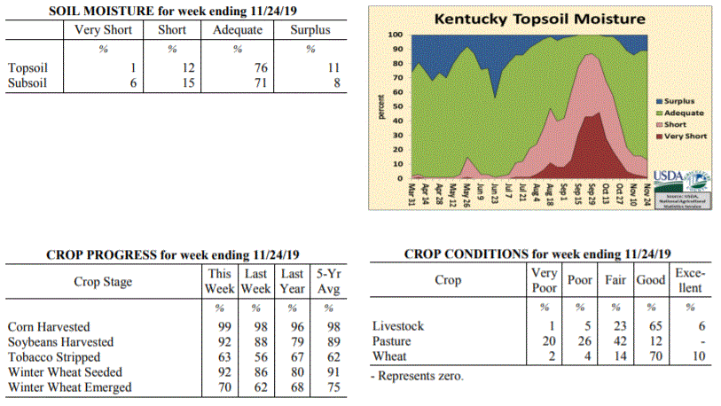
Kentucky Crop and Weather Report
Issued 4:00 P.M., November 25, 2019 37-19
Agricultural News: Kentucky experienced below normal temperatures and above normal
precipitation over the past week. Precipitation for the week totaled 1.37 inches,
0.37 inches above normal. Temperatures averaged 44 degrees for the week, 1 degrees
below normal. Topsoil moisture was rated 1 percent very short, 12 percent short, 76
percent adequate and 11 percent surplus. Subsoil moisture was rated 6 percent very
short, 15 percent short, 71 percent adequate, and 8 percent surplus. Days suitable
for fieldwork averaged 4.1 out of a possible seven.
Primary activities this week included harvesting corn and soybeans, stripping
tobacco, and planting wheat. Hay shortage continues be a problem for many producers
with some reports of selling off cattle because of limited supplies. Overall, hay and
roughage supplies were reported as 9 percent very short, 31 percent short,
57 percent adequate, and 3 percent surplus across the state.
 Kentucky Climate Summary
For the Period November 18, 2019 to November 24, 2019
Below Normal Temperatures and Above Normal Precipitation:
Overall, the period was quite active with multiple rounds of rainfall passing through
the region. The state averaged over an inch with the most significant activity having
occurred Thursday through Saturday. Even saw some thunderstorms across Southeastern
Kentucky on Saturday. While the state averaged an inch, accumulations were higher
across South Central and Western Kentucky with many receiving 1.5 to 2+ inches.
Those totals diminished to under an inch across the Northern Bluegrass. Looking at
temperatures, after a cool start to the week, temperatures did rise into the 50s by
Wednesday and Thursday, some hitting the 60s. The active pattern then brought temperatures
back to below seasonable norms for the weekend.
Temperatures for the period averaged 44 degrees across the state which was 1 degree
cooler than normal and 8 degrees warmer than the previous period. High temperatures
averaged from 53 in the West to 53 in the East. Departure from normal high
temperatures ranged from 3 degrees cooler than normal in the West to 3 degrees
cooler than normal in the East. Low temperatures averaged from 38 degrees in the
West to 38 degrees in the East. Departure from normal low temperature ranged from 1
degree warmer than normal in the West to 5 degrees warmer than normal in the East.
The extreme high temperature for the period was 68 degrees at MONTICELLO AWOS and the
extreme low was 24 degrees at HENDERSON 5E.
Precipitation (liq. equ.) for the period totaled 1.37 inches statewide which was 0.37
inches above normal and 137% of normal. Precipitation totals by climate division,
West 1.69 inches, Central 1.51 inches, Bluegrass 0.91 inches and East 1.37 inches,
which was 0.54, 0.45, 0.04 and 0.46 inches above normal. By station, precipitation
totals ranged from a low of 0.50 inches at ALEXANDRIA 5NW to a high of 2.41
inches at HICKMAN 2E.
---
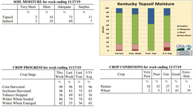
Kentucky Crop and Weather Report
Issued 4:00 P.M., November 18, 2019 36-19
Agricultural News: Kentucky experienced well below normal temperatures and below
normal precipitation over the past week. Precipitation for the week totaled 0.24
inches, 0.65 inches below normal. Temperatures averaged 35 degrees for the week, 13
degrees below normal. Topsoil moisture was rated 2 percent very short, 14 percent
short, 73 percent adequate and 11 percent surplus. Subsoil moisture was rated 5
percent very short, 19 percent short, 69 percent adequate, and 7 percent surplus.
Days suitable for fieldwork averaged 4.3 out of a possible seven.
Primary activities this week included harvesting corn and soybeans, stripping
tobacco, and planting wheat. A brief period of snow early in the week temporarily
slowed harvest. Pastures are gradually improving from much needed rain, but extreme
hay shortages are still on the horizon.
Kentucky Climate Summary
For the Period November 18, 2019 to November 24, 2019
Below Normal Temperatures and Above Normal Precipitation:
Overall, the period was quite active with multiple rounds of rainfall passing through
the region. The state averaged over an inch with the most significant activity having
occurred Thursday through Saturday. Even saw some thunderstorms across Southeastern
Kentucky on Saturday. While the state averaged an inch, accumulations were higher
across South Central and Western Kentucky with many receiving 1.5 to 2+ inches.
Those totals diminished to under an inch across the Northern Bluegrass. Looking at
temperatures, after a cool start to the week, temperatures did rise into the 50s by
Wednesday and Thursday, some hitting the 60s. The active pattern then brought temperatures
back to below seasonable norms for the weekend.
Temperatures for the period averaged 44 degrees across the state which was 1 degree
cooler than normal and 8 degrees warmer than the previous period. High temperatures
averaged from 53 in the West to 53 in the East. Departure from normal high
temperatures ranged from 3 degrees cooler than normal in the West to 3 degrees
cooler than normal in the East. Low temperatures averaged from 38 degrees in the
West to 38 degrees in the East. Departure from normal low temperature ranged from 1
degree warmer than normal in the West to 5 degrees warmer than normal in the East.
The extreme high temperature for the period was 68 degrees at MONTICELLO AWOS and the
extreme low was 24 degrees at HENDERSON 5E.
Precipitation (liq. equ.) for the period totaled 1.37 inches statewide which was 0.37
inches above normal and 137% of normal. Precipitation totals by climate division,
West 1.69 inches, Central 1.51 inches, Bluegrass 0.91 inches and East 1.37 inches,
which was 0.54, 0.45, 0.04 and 0.46 inches above normal. By station, precipitation
totals ranged from a low of 0.50 inches at ALEXANDRIA 5NW to a high of 2.41
inches at HICKMAN 2E.
---
Kentucky Crop and Weather Report
Issued 4:00 P.M., November 18, 2019 36-19
Agricultural News: Kentucky experienced well below normal temperatures and below
normal precipitation over the past week. Precipitation for the week totaled 0.24
inches, 0.65 inches below normal. Temperatures averaged 35 degrees for the week, 13
degrees below normal. Topsoil moisture was rated 2 percent very short, 14 percent
short, 73 percent adequate and 11 percent surplus. Subsoil moisture was rated 5
percent very short, 19 percent short, 69 percent adequate, and 7 percent surplus.
Days suitable for fieldwork averaged 4.3 out of a possible seven.
Primary activities this week included harvesting corn and soybeans, stripping
tobacco, and planting wheat. A brief period of snow early in the week temporarily
slowed harvest. Pastures are gradually improving from much needed rain, but extreme
hay shortages are still on the horizon.
 Kentucky Climate Summary
For the Period November 11, 2019 to November 17, 2019
Well Below Normal Temperatures and Below Normal Precipitation:
A slow moving cold front worked through the region on Monday. Precipitation started
out as rain, but eventually transitioned to snow that evening and overnight as arctic
air pushed into the area. One to two inches of snow was common across much of the
state. Otherwise, the most notable highlight was the extreme drop in temperatures.
Highs stayed in the 20s for much of Kentucky on Tuesday and then dropped into the
teens and single digits that night. The Kentucky Mesonet station in Henderson
recorded the lowest temperature of 2 degrees. Following Tuesday, temperatures went
on the uphill climb, eventually ending up in the upper 40s to middle 50s on Sunday.
Dry conditions prevailed with the rain/snow on Monday being the only precipitation
event for the week.
Temperatures for the period averaged 35 degrees across the state which was 13 degrees
cooler than normal and 8 degrees cooler than the previous period. High temperatures
averaged from 44 in the West to 49 in the East. Departure from normal high
temperatures ranged from 16 degrees cooler than normal in the West to 11 degrees
cooler than normal in the East. Low temperatures averaged from 22 degrees in the
West to 25 degrees in the East. Departure from normal low temperature ranged from 17
degrees cooler than normal in the West to 10 degrees cooler than normal in the
East. The extreme high temperature for the period was 69 degrees at LOUISA 1S and the
extreme low was 2 degrees at HENDERSON 5E.
Precipitation (liq. equ.) for the period totaled 0.24 inches statewide which was 0.65
inches below normal and 27% of normal. Precipitation totals by climate division, West
0.24 inches, Central 0.26 inches, Bluegrass 0.19 inches and East 0.27 inches, which
was 0.82, 0.67, 0.58 and 0.54 inches below normal. By station, precipitation totals
ranged from a low of 0.01 inches at BOWLING GREEN 4E to a high of 0.43 inches at LEBANON 8NW.
---
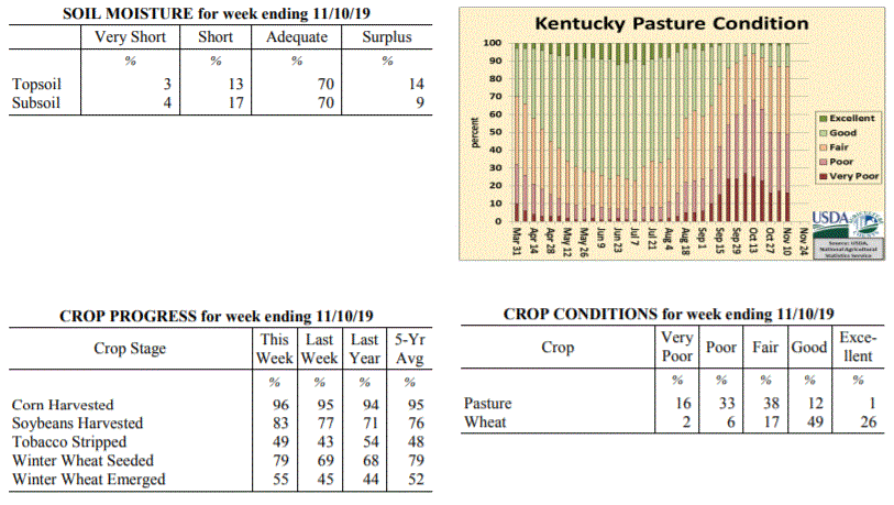
Kentucky Crop and Weather Report
Issued 4:00 P.M., November 12, 2019 35-19
Agricultural News: Kentucky experienced below normal temperatures and rainfall over
the past week. Precipitation for the week totaled 0.73 inches, 0.05 inches below
normal. Temperatures averaged 44 degrees for the week, 7 degrees below normal.
Topsoil moisture was rated 3 percent very short, 13 percent short, 70 percent
adequate and 14 percent surplus. Subsoil moisture was rated 4 percent very short, 17
percent short, 70 percent adequate, and 9 percent surplus. Days suitable for
fieldwork averaged 4.2 out of a possible seven.
Primary activities this week included harvesting corn and soybeans, stripping
tobacco, and planting wheat. Winter wheat seeding and grain harvests progressed
slowly as wet weather limited activity. Livestock producers continue to feed hay as
pasture conditions have not experienced much improvement.
Kentucky Climate Summary
For the Period November 11, 2019 to November 17, 2019
Well Below Normal Temperatures and Below Normal Precipitation:
A slow moving cold front worked through the region on Monday. Precipitation started
out as rain, but eventually transitioned to snow that evening and overnight as arctic
air pushed into the area. One to two inches of snow was common across much of the
state. Otherwise, the most notable highlight was the extreme drop in temperatures.
Highs stayed in the 20s for much of Kentucky on Tuesday and then dropped into the
teens and single digits that night. The Kentucky Mesonet station in Henderson
recorded the lowest temperature of 2 degrees. Following Tuesday, temperatures went
on the uphill climb, eventually ending up in the upper 40s to middle 50s on Sunday.
Dry conditions prevailed with the rain/snow on Monday being the only precipitation
event for the week.
Temperatures for the period averaged 35 degrees across the state which was 13 degrees
cooler than normal and 8 degrees cooler than the previous period. High temperatures
averaged from 44 in the West to 49 in the East. Departure from normal high
temperatures ranged from 16 degrees cooler than normal in the West to 11 degrees
cooler than normal in the East. Low temperatures averaged from 22 degrees in the
West to 25 degrees in the East. Departure from normal low temperature ranged from 17
degrees cooler than normal in the West to 10 degrees cooler than normal in the
East. The extreme high temperature for the period was 69 degrees at LOUISA 1S and the
extreme low was 2 degrees at HENDERSON 5E.
Precipitation (liq. equ.) for the period totaled 0.24 inches statewide which was 0.65
inches below normal and 27% of normal. Precipitation totals by climate division, West
0.24 inches, Central 0.26 inches, Bluegrass 0.19 inches and East 0.27 inches, which
was 0.82, 0.67, 0.58 and 0.54 inches below normal. By station, precipitation totals
ranged from a low of 0.01 inches at BOWLING GREEN 4E to a high of 0.43 inches at LEBANON 8NW.
---
Kentucky Crop and Weather Report
Issued 4:00 P.M., November 12, 2019 35-19
Agricultural News: Kentucky experienced below normal temperatures and rainfall over
the past week. Precipitation for the week totaled 0.73 inches, 0.05 inches below
normal. Temperatures averaged 44 degrees for the week, 7 degrees below normal.
Topsoil moisture was rated 3 percent very short, 13 percent short, 70 percent
adequate and 14 percent surplus. Subsoil moisture was rated 4 percent very short, 17
percent short, 70 percent adequate, and 9 percent surplus. Days suitable for
fieldwork averaged 4.2 out of a possible seven.
Primary activities this week included harvesting corn and soybeans, stripping
tobacco, and planting wheat. Winter wheat seeding and grain harvests progressed
slowly as wet weather limited activity. Livestock producers continue to feed hay as
pasture conditions have not experienced much improvement.
 Kentucky Climate Summary
For the Period November 4, 2019 to November 10, 2019
Below Normal Temperatures and Rainfall:
Following a dry and fairly warm start to the period, a cold front moved through the
area on Thursday. This boundary brought a round of widespread showers to the region
with accumulations between 0.5 to 1.25 inches for much of the state, highest totals
across Western Kentucky. Much cooler air of Canadian origin then filtered into
Kentucky that night and into Friday. In fact, temperatures both Friday and Saturday
mornings dropped into the low to middle 20s. A handful of locations even dropped
into the upper teens. Conditions remained dry for the weekend with temperatures going
on the increase, back to seasonable norms.
Temperatures for the period averaged 44 degrees across the state which was 7 degrees
cooler than normal and 4 degrees cooler than the previous period. High temperatures
averaged from 55 in the West to 56 in the East. Departure from normal high
temperatures ranged from 8 degrees cooler than normal in the West to 7 degrees
cooler than normal in the East. Low temperatures averaged from 33 degrees in the
West to 32 degrees in the East. Departure from normal low temperature ranged from 8
degrees cooler than normal in the West to 5 degrees cooler than normal in the East.
The extreme high temperature for the period was 70 degrees at BURKESVILLE 3W and the
extreme low was 17 degrees at MONTICELLO AWOS.
Precipitation (liq. equ.) for the period totaled 0.73 inches statewide which was 0.05
inches below normal and 94% of normal. Precipitation totals by climate division, West
1.20 inches, Central 0.65 inches, Bluegrass 0.63 inches and East 0.46 inches, which
was 0.31, -0.16, -0.06 and -0.25 inches respectively from normal. By station,
precipitation totals ranged from a low of 0.01 inches at MT STERLING AWOS to a high
of 2.61 inches at POPLAR BLUFF ASOS.
---
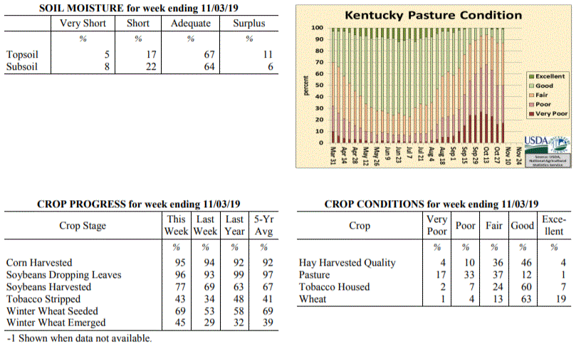
Kentucky Crop and Weather Report
Issued 4:00 P.M., November 4, 2019 34-19
Agricultural News: Kentucky experienced below normal temperatures and above normal
rainfall over the past week. Precipitation for the week totaled 1.73 inches, 0.96
inches above normal. Temperatures averaged 48 degrees for the week, 5 degrees below
normal. Topsoil moisture was rated 5 percent very short, 17 percent short, 67 percent
adequate and 11 percent surplus. Subsoil moisture was rated 8 percent very short, 22
percent short, 64 percent adequate, and 6 percent surplus. Days suitable for
fieldwork averaged 3.5 out of a possible seven.
Primary activities this week included harvesting corn and soybeans, stripping
tobacco, and seeding wheat. Eighty-two percent of the wheat crop is in good to
excellent condition. Heavy rains across the state halted crop harvests and wheat
planting. Pastures remain in mostly fair to poor condition and have not really
recovered despite recent rains. Cattle and calves obtained approximately 33 percent
of feed from pastures, while much hay is being fed.
Kentucky Climate Summary
For the Period November 4, 2019 to November 10, 2019
Below Normal Temperatures and Rainfall:
Following a dry and fairly warm start to the period, a cold front moved through the
area on Thursday. This boundary brought a round of widespread showers to the region
with accumulations between 0.5 to 1.25 inches for much of the state, highest totals
across Western Kentucky. Much cooler air of Canadian origin then filtered into
Kentucky that night and into Friday. In fact, temperatures both Friday and Saturday
mornings dropped into the low to middle 20s. A handful of locations even dropped
into the upper teens. Conditions remained dry for the weekend with temperatures going
on the increase, back to seasonable norms.
Temperatures for the period averaged 44 degrees across the state which was 7 degrees
cooler than normal and 4 degrees cooler than the previous period. High temperatures
averaged from 55 in the West to 56 in the East. Departure from normal high
temperatures ranged from 8 degrees cooler than normal in the West to 7 degrees
cooler than normal in the East. Low temperatures averaged from 33 degrees in the
West to 32 degrees in the East. Departure from normal low temperature ranged from 8
degrees cooler than normal in the West to 5 degrees cooler than normal in the East.
The extreme high temperature for the period was 70 degrees at BURKESVILLE 3W and the
extreme low was 17 degrees at MONTICELLO AWOS.
Precipitation (liq. equ.) for the period totaled 0.73 inches statewide which was 0.05
inches below normal and 94% of normal. Precipitation totals by climate division, West
1.20 inches, Central 0.65 inches, Bluegrass 0.63 inches and East 0.46 inches, which
was 0.31, -0.16, -0.06 and -0.25 inches respectively from normal. By station,
precipitation totals ranged from a low of 0.01 inches at MT STERLING AWOS to a high
of 2.61 inches at POPLAR BLUFF ASOS.
---
Kentucky Crop and Weather Report
Issued 4:00 P.M., November 4, 2019 34-19
Agricultural News: Kentucky experienced below normal temperatures and above normal
rainfall over the past week. Precipitation for the week totaled 1.73 inches, 0.96
inches above normal. Temperatures averaged 48 degrees for the week, 5 degrees below
normal. Topsoil moisture was rated 5 percent very short, 17 percent short, 67 percent
adequate and 11 percent surplus. Subsoil moisture was rated 8 percent very short, 22
percent short, 64 percent adequate, and 6 percent surplus. Days suitable for
fieldwork averaged 3.5 out of a possible seven.
Primary activities this week included harvesting corn and soybeans, stripping
tobacco, and seeding wheat. Eighty-two percent of the wheat crop is in good to
excellent condition. Heavy rains across the state halted crop harvests and wheat
planting. Pastures remain in mostly fair to poor condition and have not really
recovered despite recent rains. Cattle and calves obtained approximately 33 percent
of feed from pastures, while much hay is being fed.
 Kentucky Climate Summary
For the Period October 28, 2019 to November 3, 2019
Below Normal Temperatures and Above Normal Rainfall:
After a record breaking dry September, the Bluegrass State has seen exceptionally wet
conditions throughout October. That was no different for end of the month as a
frontal boundary interacted with multiple disturbances to spark a couple rounds of
widespread showers this past Wednesday and Thursday. Overall, the state averaged
1.73 inches, marking the third week out of the past four that the state has averaged
over an inch. A large swath of area running from South Central Kentucky to the
Northern Bluegrass received between 2 and 3 inches. Preliminary data suggests this
month will place in the top 5 wettest October’s on record. Following the passage of
the cold front on Thursday, an unseasonably cold air mass settled into the area. The
growing season essentially ended this past weekend with three straight days of below
freezing temperatures. Most saw lows drop into the middle 20s to around 30.
Temperatures for the period averaged 48 degrees across the state which was 5 degrees
cooler than normal and 8 degrees cooler than the previous period. High temperatures
averaged from 55 in the West to 62 in the East. Departure from normal high
temperatures ranged from 11 degrees cooler than normal in the West to 3 degrees
cooler than normal in the East. Low temperatures averaged from 38 degrees in the
West to 39 degrees in the East. Departure from normal low temperature ranged from 5
degrees cooler than normal in the West to 1 degree warmer than normal in the East.
The extreme high temperature for the period was 78 degrees at PEABODY and the extreme
low was 22 degrees at HARTFORD 3E.
Precipitation (liq. equ.) for the period totaled 1.73 inches statewide which was 0.96
inches above normal and 225% of normal. Precipitation totals by climate division,
West 1.50 inches, Central 2.25 inches, Bluegrass 1.95 inches and East 1.20 inches,
which was 0.64, 1.45, 1.24 and 0.49 inches above normal. By station, precipitation
totals ranged from a low of 0.61 inches at WHITESBURG 2NW to a high of 3.87 inches at
MUNFORDVILLE 6E.
---
Kentucky Crop and Weather Report
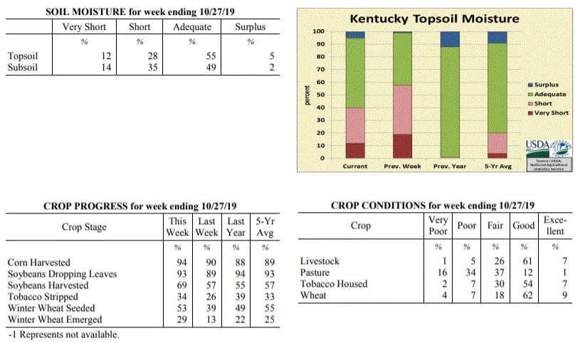
Issued 4:00 P.M., October 28, 2019 33-19
Agricultural News: Kentucky experienced above normal temperatures and rainfall over
the past week. Precipitation for the week totaled 1.89 inches, 1.18 inches above
normal. Temperatures averaged 57 degrees for the week, 2 degrees above normal.
Topsoil moisture was rated 12 percent very short, 28 percent short, 55 percent
adequate, and 5 percent surplus. Subsoil moisture was rated 14 percent very short, 35
percent short, 49 percent adequate, and 2 percent surplus. Days suitable for
fieldwork averaged 4.9 out of a possible seven.
Primary activities for this week included harvesting corn and soybeans, stripping
tobacco and seeding winter wheat. Most of the state received some precipitation this
week. The rain was a hindrance to fieldwork, but beneficial to pastureland.
Despite receiving some much needed rain, many producers are tapping into their winter
hay supplies. Pastures are mostly fair to poor, however they are improved from the
previous week. Housed tobacco is in mostly good condition at this juncture.
Kentucky Climate Summary
For the Period October 28, 2019 to November 3, 2019
Below Normal Temperatures and Above Normal Rainfall:
After a record breaking dry September, the Bluegrass State has seen exceptionally wet
conditions throughout October. That was no different for end of the month as a
frontal boundary interacted with multiple disturbances to spark a couple rounds of
widespread showers this past Wednesday and Thursday. Overall, the state averaged
1.73 inches, marking the third week out of the past four that the state has averaged
over an inch. A large swath of area running from South Central Kentucky to the
Northern Bluegrass received between 2 and 3 inches. Preliminary data suggests this
month will place in the top 5 wettest October’s on record. Following the passage of
the cold front on Thursday, an unseasonably cold air mass settled into the area. The
growing season essentially ended this past weekend with three straight days of below
freezing temperatures. Most saw lows drop into the middle 20s to around 30.
Temperatures for the period averaged 48 degrees across the state which was 5 degrees
cooler than normal and 8 degrees cooler than the previous period. High temperatures
averaged from 55 in the West to 62 in the East. Departure from normal high
temperatures ranged from 11 degrees cooler than normal in the West to 3 degrees
cooler than normal in the East. Low temperatures averaged from 38 degrees in the
West to 39 degrees in the East. Departure from normal low temperature ranged from 5
degrees cooler than normal in the West to 1 degree warmer than normal in the East.
The extreme high temperature for the period was 78 degrees at PEABODY and the extreme
low was 22 degrees at HARTFORD 3E.
Precipitation (liq. equ.) for the period totaled 1.73 inches statewide which was 0.96
inches above normal and 225% of normal. Precipitation totals by climate division,
West 1.50 inches, Central 2.25 inches, Bluegrass 1.95 inches and East 1.20 inches,
which was 0.64, 1.45, 1.24 and 0.49 inches above normal. By station, precipitation
totals ranged from a low of 0.61 inches at WHITESBURG 2NW to a high of 3.87 inches at
MUNFORDVILLE 6E.
---
Kentucky Crop and Weather Report
Issued 4:00 P.M., October 28, 2019 33-19
Agricultural News: Kentucky experienced above normal temperatures and rainfall over
the past week. Precipitation for the week totaled 1.89 inches, 1.18 inches above
normal. Temperatures averaged 57 degrees for the week, 2 degrees above normal.
Topsoil moisture was rated 12 percent very short, 28 percent short, 55 percent
adequate, and 5 percent surplus. Subsoil moisture was rated 14 percent very short, 35
percent short, 49 percent adequate, and 2 percent surplus. Days suitable for
fieldwork averaged 4.9 out of a possible seven.
Primary activities for this week included harvesting corn and soybeans, stripping
tobacco and seeding winter wheat. Most of the state received some precipitation this
week. The rain was a hindrance to fieldwork, but beneficial to pastureland.
Despite receiving some much needed rain, many producers are tapping into their winter
hay supplies. Pastures are mostly fair to poor, however they are improved from the
previous week. Housed tobacco is in mostly good condition at this juncture.
 Kentucky Climate Summary
For the Period October 21, 2019 to October 27, 2019
Above Normal Temperatures and Rainfall:
Significant rainfall fell across the state for a third straight week. The highest
accumulations were seen over the course of Friday night through Saturday night as the
remnants of Tropical Storm Olga pushed northeast through the area. This system sent
a high amount of moisture into the region, leading to moderate to heavy rainfall from
time to time. High winds accompanied some of the showers across Western Kentucky and
led to some severe warnings with gusts over 60 mph. Overall, in addition to rain
from another frontal passage earlier in the week, the state averaged 1.89 inches.
Saying that, totals were a bit higher across Western Kentucky, which came in at an
average of 2.62 inches. Through the 27th, the state has now averaged 4.85 inches for
the month, well above average for what is normally the driest month of the year. The
US Drought Monitor continues to make improvements across the state with severe
drought only covering 7% of Kentucky and moderate drought down to 26%.
Temperatures for the period averaged 57 degrees across the state which was 2 degrees
warmer than normal and 2 degrees warmer than the previous period. High temperatures
averaged from 66 in the West to 68 in the East. Departure from normal high
temperatures ranged from 3 degrees cooler than normal in the West to near normal in
the East. Low temperatures averaged from 48 degrees in the West to 47 degrees in the
East. Departure from normal low temperature ranged from 3 degrees warmer than normal
in the West to 7 degrees warmer than normal in the East. The extreme high temperature
for the period was 81 degrees at LOUISA 1S and the extreme low was 31 degrees at
BURKESVILLE 3W.
Precipitation (liq. equ.) for the period totaled 1.89 inches statewide which was 1.18
inches above normal and 264% of normal. Precipitation totals by climate division,
West 2.62 inches, Central 1.53 inches, Bluegrass 1.48 inches and East 1.94 inches,
which was 1.82, 0.81, 0.82 and 1.26 inches above normal. By station, precipitation
totals ranged from a low of 0.36 inches at BOWLING GREEN 4E to a high of 5.25
inches at CAPE GIRARDEAU ASOS.
---
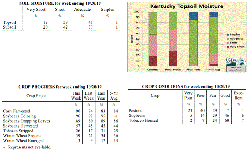
Kentucky Crop and Weather Report
Issued 4:00 P.M., October 21, 2019 32-19
Agricultural News: Kentucky experienced below normal temperatures and above normal
rainfall over the past week. Precipitation for the week totaled 0.81 inches, 0.10
inches above normal. Temperatures averaged 55 degrees for the week, 2 degrees below
normal. Topsoil moisture was rated 19 percent very short, 39 percent short, 41
percent adequate, and 1 percent surplus. Subsoil moisture was rated 20 percent very
short, 42 percent short, 37 percent adequate, and 1 percent surplus. Days suitable
for fieldwork averaged 5.5 out of a possible seven.
Primary activities for this week included harvesting corn and soybeans, stripping
tobacco, and seeding winter wheat. Much of the state received needed rain this week,
however there are still a few areas that remain very dry. The rain was an impedance
to the row crop harvest, but was needed to promote pasture growth as temperatures
remain cool.
Despite the recent precipitation, many farmers are still feeding hay at this juncture
putting stress on winter supplies. Pasture condition has improved, but the necessity
to supplement still exists. Soybeans and housed tobacco are both
in mostly good condition.
Kentucky Climate Summary
For the Period October 21, 2019 to October 27, 2019
Above Normal Temperatures and Rainfall:
Significant rainfall fell across the state for a third straight week. The highest
accumulations were seen over the course of Friday night through Saturday night as the
remnants of Tropical Storm Olga pushed northeast through the area. This system sent
a high amount of moisture into the region, leading to moderate to heavy rainfall from
time to time. High winds accompanied some of the showers across Western Kentucky and
led to some severe warnings with gusts over 60 mph. Overall, in addition to rain
from another frontal passage earlier in the week, the state averaged 1.89 inches.
Saying that, totals were a bit higher across Western Kentucky, which came in at an
average of 2.62 inches. Through the 27th, the state has now averaged 4.85 inches for
the month, well above average for what is normally the driest month of the year. The
US Drought Monitor continues to make improvements across the state with severe
drought only covering 7% of Kentucky and moderate drought down to 26%.
Temperatures for the period averaged 57 degrees across the state which was 2 degrees
warmer than normal and 2 degrees warmer than the previous period. High temperatures
averaged from 66 in the West to 68 in the East. Departure from normal high
temperatures ranged from 3 degrees cooler than normal in the West to near normal in
the East. Low temperatures averaged from 48 degrees in the West to 47 degrees in the
East. Departure from normal low temperature ranged from 3 degrees warmer than normal
in the West to 7 degrees warmer than normal in the East. The extreme high temperature
for the period was 81 degrees at LOUISA 1S and the extreme low was 31 degrees at
BURKESVILLE 3W.
Precipitation (liq. equ.) for the period totaled 1.89 inches statewide which was 1.18
inches above normal and 264% of normal. Precipitation totals by climate division,
West 2.62 inches, Central 1.53 inches, Bluegrass 1.48 inches and East 1.94 inches,
which was 1.82, 0.81, 0.82 and 1.26 inches above normal. By station, precipitation
totals ranged from a low of 0.36 inches at BOWLING GREEN 4E to a high of 5.25
inches at CAPE GIRARDEAU ASOS.
---
Kentucky Crop and Weather Report
Issued 4:00 P.M., October 21, 2019 32-19
Agricultural News: Kentucky experienced below normal temperatures and above normal
rainfall over the past week. Precipitation for the week totaled 0.81 inches, 0.10
inches above normal. Temperatures averaged 55 degrees for the week, 2 degrees below
normal. Topsoil moisture was rated 19 percent very short, 39 percent short, 41
percent adequate, and 1 percent surplus. Subsoil moisture was rated 20 percent very
short, 42 percent short, 37 percent adequate, and 1 percent surplus. Days suitable
for fieldwork averaged 5.5 out of a possible seven.
Primary activities for this week included harvesting corn and soybeans, stripping
tobacco, and seeding winter wheat. Much of the state received needed rain this week,
however there are still a few areas that remain very dry. The rain was an impedance
to the row crop harvest, but was needed to promote pasture growth as temperatures
remain cool.
Despite the recent precipitation, many farmers are still feeding hay at this juncture
putting stress on winter supplies. Pasture condition has improved, but the necessity
to supplement still exists. Soybeans and housed tobacco are both
in mostly good condition.
 Kentucky Climate Summary
For the Period October 14, 2019 to October 20, 2019
Below Normal Temperatures and Above Normal Rainfall:
The state averaged 0.81 inches for the period, marking a second straight week of
above normal rainfall. The higher totals was a result of two events. The first
event came Tuesday night as a cold front moved through the area. This boundary
sparked a quick hitting round of widespread showers with embedded storms.
Accumulations were generally between a half and one inch for most of the state. This
was followed by the second event on Saturday as moisture streaming into the state
around Tropical Storm Nestor sparked showers across primarily Southeastern Kentucky.
For the week, this area saw 1 to 2 inches of rainfall, which was especially
beneficial with recent dry conditions. While most of the state had seen major
improvements in recent weeks, Southeastern Kentucky actually saw drought worsen with
‘Extreme’ drought expanding across this area. Bottom line, after a record breaking
dry September, October is going in the opposite direction.
Temperatures for the period averaged 55 degrees across the state which was 2 degrees
cooler than normal and 4 degrees cooler than the previous period. High temperatures
averaged from 70 in the West to 66 in the East. Departure from normal high
temperatures ranged from 2 degrees cooler than normal in the West to 4 degrees
cooler than normal in the East. Low temperatures averaged from 42 degrees in the
West to 42 degrees in the East. Departure from normal low temperature ranged from 5
degrees cooler than normal in the West to near normal in the East. The extreme high
temperature for the period was 80 degrees at OWENSBORO AWSS and the extreme low was
29 degrees at HENDERSON 5E.
Precipitation (liq. equ.) for the period totaled 0.81 inches statewide which was 0.1
inches above normal and 115% of normal. Precipitation totals by climate division,
West 0.82 inches, Central 0.80 inches, Bluegrass 0.64 inches and East 0.97 inches,
which was 0.07, 0.08, -0.03 and 0.29 inches respectively from normal. By station,
precipitation totals ranged from a low of 0.00 inches at CARBONDALE ASOS to a high of
2.89 inches at BENTON 4N.
---
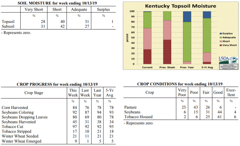
Kentucky Crop and Weather Report
Issued 4:00 P.M., October 15, 2019 31-19
Agricultural News: Kentucky experienced near normal temperatures and above normal
rainfall over the past week. Precipitation for the week totaled 1.67 inches, 0.92
inches above normal. Temperatures averaged 59 degrees for the week, unchanged from
normal. Topsoil moisture was rated 28 percent very short, 40 percent short, 31
percent adequate, and 1 percent surplus. Subsoil moisture was rated 31 percent very
short, 42 percent short, and 27 percent adequate. Days suitable for fieldwork
averaged 5.4 out of a possible seven.
Primary activities for this week included harvesting corn, soybeans, and tobacco
along with seeding winter wheat. While the week began with continued drought, the
weekend brought some much needed rain for most of the state. The precipitation was a
hindrance to fieldwork, but welcomed nonetheless. Temperatures have been cooler and
more typical of the season.
The widespread rain should promote pasture growth and replenish ponds, however many
farmers will still need to supplement with hay. Pasture condition was reported as 25
percent very poor, 43 percent poor, 26 percent fair, and 6 percent good. Tobacco
houseburn was reported as 3 percent severe, 7 percent moderate, 21 percent light, and
69 percent none evident.
Kentucky Climate Summary
For the Period October 14, 2019 to October 20, 2019
Below Normal Temperatures and Above Normal Rainfall:
The state averaged 0.81 inches for the period, marking a second straight week of
above normal rainfall. The higher totals was a result of two events. The first
event came Tuesday night as a cold front moved through the area. This boundary
sparked a quick hitting round of widespread showers with embedded storms.
Accumulations were generally between a half and one inch for most of the state. This
was followed by the second event on Saturday as moisture streaming into the state
around Tropical Storm Nestor sparked showers across primarily Southeastern Kentucky.
For the week, this area saw 1 to 2 inches of rainfall, which was especially
beneficial with recent dry conditions. While most of the state had seen major
improvements in recent weeks, Southeastern Kentucky actually saw drought worsen with
‘Extreme’ drought expanding across this area. Bottom line, after a record breaking
dry September, October is going in the opposite direction.
Temperatures for the period averaged 55 degrees across the state which was 2 degrees
cooler than normal and 4 degrees cooler than the previous period. High temperatures
averaged from 70 in the West to 66 in the East. Departure from normal high
temperatures ranged from 2 degrees cooler than normal in the West to 4 degrees
cooler than normal in the East. Low temperatures averaged from 42 degrees in the
West to 42 degrees in the East. Departure from normal low temperature ranged from 5
degrees cooler than normal in the West to near normal in the East. The extreme high
temperature for the period was 80 degrees at OWENSBORO AWSS and the extreme low was
29 degrees at HENDERSON 5E.
Precipitation (liq. equ.) for the period totaled 0.81 inches statewide which was 0.1
inches above normal and 115% of normal. Precipitation totals by climate division,
West 0.82 inches, Central 0.80 inches, Bluegrass 0.64 inches and East 0.97 inches,
which was 0.07, 0.08, -0.03 and 0.29 inches respectively from normal. By station,
precipitation totals ranged from a low of 0.00 inches at CARBONDALE ASOS to a high of
2.89 inches at BENTON 4N.
---
Kentucky Crop and Weather Report
Issued 4:00 P.M., October 15, 2019 31-19
Agricultural News: Kentucky experienced near normal temperatures and above normal
rainfall over the past week. Precipitation for the week totaled 1.67 inches, 0.92
inches above normal. Temperatures averaged 59 degrees for the week, unchanged from
normal. Topsoil moisture was rated 28 percent very short, 40 percent short, 31
percent adequate, and 1 percent surplus. Subsoil moisture was rated 31 percent very
short, 42 percent short, and 27 percent adequate. Days suitable for fieldwork
averaged 5.4 out of a possible seven.
Primary activities for this week included harvesting corn, soybeans, and tobacco
along with seeding winter wheat. While the week began with continued drought, the
weekend brought some much needed rain for most of the state. The precipitation was a
hindrance to fieldwork, but welcomed nonetheless. Temperatures have been cooler and
more typical of the season.
The widespread rain should promote pasture growth and replenish ponds, however many
farmers will still need to supplement with hay. Pasture condition was reported as 25
percent very poor, 43 percent poor, 26 percent fair, and 6 percent good. Tobacco
houseburn was reported as 3 percent severe, 7 percent moderate, 21 percent light, and
69 percent none evident.
 Kentucky Climate Summary
For the Period October 7, 2019 to October 13, 2019
Near Normal Temperatures and Above Normal Rainfall:
Carrying over from the previous period, a cold front continued to work through the
area on Monday morning. This boundary sparked numerous to widespread light to
moderate showers, leading to significant accumulations across the area. This was
followed by secondary cold front progressing through the area on Friday. Overall, the
state has averaged over two inches since the start of the month. This period broke a
five week streak of below normal rainfall. The significant rainfall led the US
Drought Monitor to make some improvements with roughly 17% of the state now under a
‘severe’ drought, down from 58% last week. The bigger highlight with the frontal
passage on Friday was the significant drop in temperatures, which led to frost
advisories issued across the area and state’s first real taste of fall. Temperatures
dropped well into the 30s over the weekend, Western Kentucky on Friday night and more
statewide on Saturday night. Henderson and Mayfield were the coolest
spots, each dropping down to 29.
Temperatures for the period averaged 59 degrees across the state which was
near normal and 16 degrees cooler than the previous period. High temperatures
averaged from 73 in the West to 71 in the East. Departure from normal high
temperatures ranged from 1 degree cooler than normal in the West to 1 degree
cooler than normal in the East. Low temperatures averaged from 45 degrees in the
West to 50 degrees in the East. Departure from normal low temperature ranged from 4
degrees cooler than normal in the West to 5 degrees warmer than normal in the East.
The extreme high temperature for the period was 87 degrees at HICKMAN 2E and the
extreme low was 29 degrees at HENDERSON 5E.
Precipitation (liq. equ.) for the period totaled 1.67 inches statewide which was 0.92
inches above normal and 221% of normal. Precipitation totals by climate division,
West 1.10 inches, Central 2.13 inches, Bluegrass 1.79 inches and East 1.64 inches,
which was 0.34, 1.35, 1.07 and 0.88 inches above normal. By station, precipitation
totals ranged from a low of 0.05 inches at MIDDLESBORO AWOS to a high of 4.59
inches at COLUMBIA 3N.
---
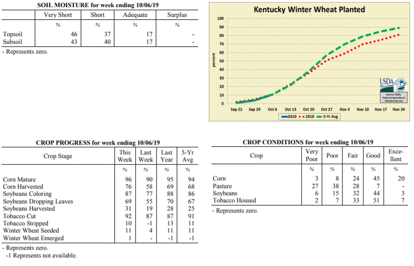
Kentucky Crop and Weather Report
Issued 4:00 P.M., October 7, 2019 30-19
Agricultural News: Kentucky experienced well above normal temperatures and below
normal rainfall over the past week. Precipitation for the week totaled 0.49 inches,
0.31 inches below normal. Temperatures averaged 75 degrees for the week, 13 degrees
above normal. Topsoil moisture was rated 46 percent very short, 37 percent short, and
17 percent adequate. Subsoil moisture was rated 43 percent very short, 40 percent
short, and 17 percent adequate. Days suitable for fieldwork averaged 6.5 out of a
possible seven.
Primary activities for this week included harvesting corn, soybeans, and tobacco.
Planting of winter wheat is continuing with a small percentage of the crop emerged.
Through most of the week dry conditions persisted, however the weekend brought some
much needed rain in parts of the state. Some later season soybeans are being
adversely affected by the long drought period.
Pastures are very stressed, however the rain late in the week may promote some
growth. With that being said, many farmers are feeding hay to compensate for the
sustained drought. Pasture condition was reported as 27 percent very poor, 38 percent
poor, 28 percent fair, and 7 percent good. Tobacco houseburn was reported as 2
percent severe, 6 percent moderate, 30 percent light, and 62 percent none evident.
Kentucky Climate Summary
For the Period October 7, 2019 to October 13, 2019
Near Normal Temperatures and Above Normal Rainfall:
Carrying over from the previous period, a cold front continued to work through the
area on Monday morning. This boundary sparked numerous to widespread light to
moderate showers, leading to significant accumulations across the area. This was
followed by secondary cold front progressing through the area on Friday. Overall, the
state has averaged over two inches since the start of the month. This period broke a
five week streak of below normal rainfall. The significant rainfall led the US
Drought Monitor to make some improvements with roughly 17% of the state now under a
‘severe’ drought, down from 58% last week. The bigger highlight with the frontal
passage on Friday was the significant drop in temperatures, which led to frost
advisories issued across the area and state’s first real taste of fall. Temperatures
dropped well into the 30s over the weekend, Western Kentucky on Friday night and more
statewide on Saturday night. Henderson and Mayfield were the coolest
spots, each dropping down to 29.
Temperatures for the period averaged 59 degrees across the state which was
near normal and 16 degrees cooler than the previous period. High temperatures
averaged from 73 in the West to 71 in the East. Departure from normal high
temperatures ranged from 1 degree cooler than normal in the West to 1 degree
cooler than normal in the East. Low temperatures averaged from 45 degrees in the
West to 50 degrees in the East. Departure from normal low temperature ranged from 4
degrees cooler than normal in the West to 5 degrees warmer than normal in the East.
The extreme high temperature for the period was 87 degrees at HICKMAN 2E and the
extreme low was 29 degrees at HENDERSON 5E.
Precipitation (liq. equ.) for the period totaled 1.67 inches statewide which was 0.92
inches above normal and 221% of normal. Precipitation totals by climate division,
West 1.10 inches, Central 2.13 inches, Bluegrass 1.79 inches and East 1.64 inches,
which was 0.34, 1.35, 1.07 and 0.88 inches above normal. By station, precipitation
totals ranged from a low of 0.05 inches at MIDDLESBORO AWOS to a high of 4.59
inches at COLUMBIA 3N.
---
Kentucky Crop and Weather Report
Issued 4:00 P.M., October 7, 2019 30-19
Agricultural News: Kentucky experienced well above normal temperatures and below
normal rainfall over the past week. Precipitation for the week totaled 0.49 inches,
0.31 inches below normal. Temperatures averaged 75 degrees for the week, 13 degrees
above normal. Topsoil moisture was rated 46 percent very short, 37 percent short, and
17 percent adequate. Subsoil moisture was rated 43 percent very short, 40 percent
short, and 17 percent adequate. Days suitable for fieldwork averaged 6.5 out of a
possible seven.
Primary activities for this week included harvesting corn, soybeans, and tobacco.
Planting of winter wheat is continuing with a small percentage of the crop emerged.
Through most of the week dry conditions persisted, however the weekend brought some
much needed rain in parts of the state. Some later season soybeans are being
adversely affected by the long drought period.
Pastures are very stressed, however the rain late in the week may promote some
growth. With that being said, many farmers are feeding hay to compensate for the
sustained drought. Pasture condition was reported as 27 percent very poor, 38 percent
poor, 28 percent fair, and 7 percent good. Tobacco houseburn was reported as 2
percent severe, 6 percent moderate, 30 percent light, and 62 percent none evident.
 Kentucky Climate Summary
For the Period September 30, 2019 to October 6, 2019
Well Above Normal Temperatures and Below Normal Rainfall:
Kentucky finally saw some significant rainfall on Sunday as a cold front moved
through the area. Scattered to numerous showers and some storms led to accumulations
of well over an inch for portions of North Central Kentucky. Rainfall did turn more
widespread that evening and carried over into the overnight. Much of these
accumulations fell after the data cutoff for this period and will be seen in the crop
report next week. This rainfall followed a very dry September. Data at the Ag Weather
Center shows the state only averaged 0.28 inches for the month, which would likely be
good for the driest September on record. For many, the rainfall on Sunday was the
first significant activity since the last week of August. The latest update to the US
Drought Monitor on Thursday upgraded a small portion of Southeastern Kentucky into an
‘Extreme’ drought, while also expanding ‘Severe’ drought to cover 58% of the state.
Much of the focus this week was on rainfall, but Kentucky also saw record breaking
warmth over the first half of the period with highs consistently jumping well into
the 90s. While daily records were broken, all-time highs for October were also
surpassed.
Temperatures for the period averaged 75 degrees across the state which was 13 degrees
warmer than normal and 2 degrees warmer than the previous period. High temperatures
averaged from 88 in the West to 88 in the East. Departure from normal high
temperatures ranged from 12 degrees warmer than normal in the West to 14 degrees
warmer than normal in the East. Low temperatures averaged from 62 degrees in the
West to 63 degrees in the East. Departure from normal low temperature ranged from 11
degrees warmer than normal in the West to 15 degrees warmer than normal in the
East. The extreme high temperature for the period was 98 degrees at BOWLING GREEN APT
and the extreme low was 42 degrees at RICHMOND 8E.
Precipitation (liq. equ.) for the period totaled 0.49 inches statewide which was 0.31
inches below normal and 61% of normal. Precipitation totals by climate division, West
0.42 inches, Central 0.71 inches, Bluegrass 0.34 inches and East 0.49 inches, which
was 0.4, 0.13, 0.4 and 0.3 inches below normal. By station, precipitation totals
ranged from a low of 0.00 inches at BARBOURVILLE 3E to a high of 1.93 inches at
BOONEVILLE 2S.
---
Kentucky Crop and Weather Report
Issued 4:00 P.M., September 30, 2019 29-19
Agricultural News: Kentucky experienced well above normal temperatures and much below
normal rainfall over the past week. Precipitation for the week totaled 0.16 inches,
0.69 inches below normal. Temperatures averaged 74 degrees for the week, 9 degrees
above normal. Topsoil moisture was rated 43 percent very short, 44 percent short, and
13 percent adequate. Subsoil moisture was rated 34 percent very short, 46 percent
short, and 20 percent adequate. Days suitable for fieldwork averaged 6.6 out of a
possible seven.
Primary activities for this week included harvesting corn, soybeans, tobacco, and
hay. Planting of winter wheat has begun, however the majority of the crop is not yet
in the ground. Hot and dry conditions persist throughout the state bringing concerns
to farmers. Both corn and soybeans are drying down quickly. Some farmers fear that
soybeans may be particularly susceptible to weather conditions due to the stage of
the crop at this juncture.
Pastures and livestock are very stressed due to the continued drought and heat. Many
farmers have begun feeding hay to compensate for the lack of pasture growth. Hay
supplies were reported as 10 percent very short, 28 percent short, 60 percent
adequate, and 2 percent surplus. Tobacco houseburn was reported as 2 percent severe,
8 percent moderate, 27 percent light, and 63 percent none evident.
Kentucky Climate Summary
For the Period September 30, 2019 to October 6, 2019
Well Above Normal Temperatures and Below Normal Rainfall:
Kentucky finally saw some significant rainfall on Sunday as a cold front moved
through the area. Scattered to numerous showers and some storms led to accumulations
of well over an inch for portions of North Central Kentucky. Rainfall did turn more
widespread that evening and carried over into the overnight. Much of these
accumulations fell after the data cutoff for this period and will be seen in the crop
report next week. This rainfall followed a very dry September. Data at the Ag Weather
Center shows the state only averaged 0.28 inches for the month, which would likely be
good for the driest September on record. For many, the rainfall on Sunday was the
first significant activity since the last week of August. The latest update to the US
Drought Monitor on Thursday upgraded a small portion of Southeastern Kentucky into an
‘Extreme’ drought, while also expanding ‘Severe’ drought to cover 58% of the state.
Much of the focus this week was on rainfall, but Kentucky also saw record breaking
warmth over the first half of the period with highs consistently jumping well into
the 90s. While daily records were broken, all-time highs for October were also
surpassed.
Temperatures for the period averaged 75 degrees across the state which was 13 degrees
warmer than normal and 2 degrees warmer than the previous period. High temperatures
averaged from 88 in the West to 88 in the East. Departure from normal high
temperatures ranged from 12 degrees warmer than normal in the West to 14 degrees
warmer than normal in the East. Low temperatures averaged from 62 degrees in the
West to 63 degrees in the East. Departure from normal low temperature ranged from 11
degrees warmer than normal in the West to 15 degrees warmer than normal in the
East. The extreme high temperature for the period was 98 degrees at BOWLING GREEN APT
and the extreme low was 42 degrees at RICHMOND 8E.
Precipitation (liq. equ.) for the period totaled 0.49 inches statewide which was 0.31
inches below normal and 61% of normal. Precipitation totals by climate division, West
0.42 inches, Central 0.71 inches, Bluegrass 0.34 inches and East 0.49 inches, which
was 0.4, 0.13, 0.4 and 0.3 inches below normal. By station, precipitation totals
ranged from a low of 0.00 inches at BARBOURVILLE 3E to a high of 1.93 inches at
BOONEVILLE 2S.
---
Kentucky Crop and Weather Report
Issued 4:00 P.M., September 30, 2019 29-19
Agricultural News: Kentucky experienced well above normal temperatures and much below
normal rainfall over the past week. Precipitation for the week totaled 0.16 inches,
0.69 inches below normal. Temperatures averaged 74 degrees for the week, 9 degrees
above normal. Topsoil moisture was rated 43 percent very short, 44 percent short, and
13 percent adequate. Subsoil moisture was rated 34 percent very short, 46 percent
short, and 20 percent adequate. Days suitable for fieldwork averaged 6.6 out of a
possible seven.
Primary activities for this week included harvesting corn, soybeans, tobacco, and
hay. Planting of winter wheat has begun, however the majority of the crop is not yet
in the ground. Hot and dry conditions persist throughout the state bringing concerns
to farmers. Both corn and soybeans are drying down quickly. Some farmers fear that
soybeans may be particularly susceptible to weather conditions due to the stage of
the crop at this juncture.
Pastures and livestock are very stressed due to the continued drought and heat. Many
farmers have begun feeding hay to compensate for the lack of pasture growth. Hay
supplies were reported as 10 percent very short, 28 percent short, 60 percent
adequate, and 2 percent surplus. Tobacco houseburn was reported as 2 percent severe,
8 percent moderate, 27 percent light, and 63 percent none evident.
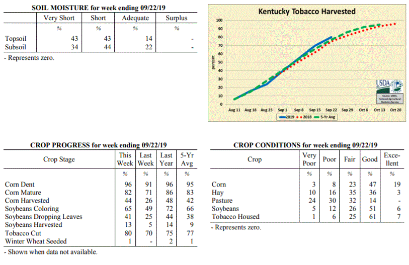
 Kentucky Climate Summary
For the Period September 23, 2019 to September 29, 2019
Well Above Normal Temperatures and Much Below Normal Rainfall:
The state of Kentucky has now went four straight weeks with much below normal
rainfall. Month-to-date rainfall through the 29th shows the Bluegrass State has only
averaged 0.27 inches for the month, which is over three inches below normal. The
state only averaged 0.16 inches for this period. Portions of Western Kentucky saw
better coverage on Thursday and came in at 0.31. Still though, Kentucky did not see
any drought busters. The US Drought Monitor upgraded portions of North Central and
Southeastern Kentucky into a ‘Severe’ drought, while also expanding ‘Moderate’
drought to cover over half of the state. Looking at temperatures, even though the
fall season arrived this past week, heat stuck around. Highs were back in the low to
middle 90s over the weekend. A combination of dry conditions, low humidity, and
breezy winds at times has led to an enhanced fire danger, prompting many counties to
issue burn bans.
Temperatures for the period averaged 74 degrees across the state which was 9 degrees
warmer than normal and 2 degrees cooler than the previous period. High temperatures
averaged from 86 in the West to 85 in the East. Departure from normal high
temperatures ranged from 7 degrees warmer than normal in the West to 9 degrees
warmer than normal in the East. Low temperatures averaged from 62 degrees in the
West to 60 degrees in the East. Departure from normal low temperature ranged from 8
degrees warmer than normal in the West to 9 degrees warmer than normal in the East.
The extreme high temperature for the period was 97 degrees at BOWLING GREEN APT and
the extreme low was 43 degrees at PAINTSVILLE 4W.
Precipitation (liq. equ.) for the period totaled 0.16 inches statewide which was 0.69
inches below normal and 19% of normal. Precipitation totals by climate division, West
0.31 inches, Central 0.13 inches, Bluegrass 0.07 inches and East 0.12 inches, which
was 0.55, 0.8, 0.7 and 0.71 inches below normal. By station, precipitation totals
ranged from a low of 0.00 inches at FORT KNOX to a high of 1.59 inches at CADIZ 4SW.
---
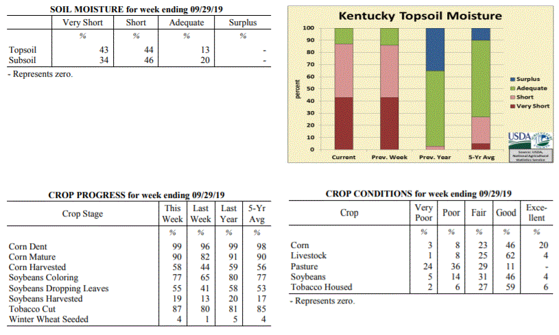
Kentucky Crop and Weather Report
Issued 4:00 P.M., September 23, 2019 28-19
Agricultural News: Kentucky experienced well above normal temperatures and much below
normal rainfall over the past week. Precipitation for the week totaled 0.05 inches,
0.78 inches below normal. Temperatures averaged 76 degrees for the week, 8 degrees
above normal. Topsoil moisture was rated 43 percent very short, 43 percent short, 14
percent adequate and 0 percent surplus. Subsoil moisture was rated 34 percent very
short, 44 percent short, 22 percent adequate, and 0 percent surplus. Days suitable
for fieldwork averaged 6.8 out of a possible seven.
Primary activities this week included harvesting corn, soybeans, and tobacco. Little
rainfall coupled with above average temperatures were experienced across the state
for a third consecutive week. According to the U.S. Drought Monitor the majority of
state is now classified in abnormally dry to moderate drought stage. Moisture levels
in corn and soybeans being harvested are extremely low. Pasture and hay conditions
continue to deteriorate.
Kentucky Climate Summary
For the Period September 23, 2019 to September 29, 2019
Well Above Normal Temperatures and Much Below Normal Rainfall:
The state of Kentucky has now went four straight weeks with much below normal
rainfall. Month-to-date rainfall through the 29th shows the Bluegrass State has only
averaged 0.27 inches for the month, which is over three inches below normal. The
state only averaged 0.16 inches for this period. Portions of Western Kentucky saw
better coverage on Thursday and came in at 0.31. Still though, Kentucky did not see
any drought busters. The US Drought Monitor upgraded portions of North Central and
Southeastern Kentucky into a ‘Severe’ drought, while also expanding ‘Moderate’
drought to cover over half of the state. Looking at temperatures, even though the
fall season arrived this past week, heat stuck around. Highs were back in the low to
middle 90s over the weekend. A combination of dry conditions, low humidity, and
breezy winds at times has led to an enhanced fire danger, prompting many counties to
issue burn bans.
Temperatures for the period averaged 74 degrees across the state which was 9 degrees
warmer than normal and 2 degrees cooler than the previous period. High temperatures
averaged from 86 in the West to 85 in the East. Departure from normal high
temperatures ranged from 7 degrees warmer than normal in the West to 9 degrees
warmer than normal in the East. Low temperatures averaged from 62 degrees in the
West to 60 degrees in the East. Departure from normal low temperature ranged from 8
degrees warmer than normal in the West to 9 degrees warmer than normal in the East.
The extreme high temperature for the period was 97 degrees at BOWLING GREEN APT and
the extreme low was 43 degrees at PAINTSVILLE 4W.
Precipitation (liq. equ.) for the period totaled 0.16 inches statewide which was 0.69
inches below normal and 19% of normal. Precipitation totals by climate division, West
0.31 inches, Central 0.13 inches, Bluegrass 0.07 inches and East 0.12 inches, which
was 0.55, 0.8, 0.7 and 0.71 inches below normal. By station, precipitation totals
ranged from a low of 0.00 inches at FORT KNOX to a high of 1.59 inches at CADIZ 4SW.
---
Kentucky Crop and Weather Report
Issued 4:00 P.M., September 23, 2019 28-19
Agricultural News: Kentucky experienced well above normal temperatures and much below
normal rainfall over the past week. Precipitation for the week totaled 0.05 inches,
0.78 inches below normal. Temperatures averaged 76 degrees for the week, 8 degrees
above normal. Topsoil moisture was rated 43 percent very short, 43 percent short, 14
percent adequate and 0 percent surplus. Subsoil moisture was rated 34 percent very
short, 44 percent short, 22 percent adequate, and 0 percent surplus. Days suitable
for fieldwork averaged 6.8 out of a possible seven.
Primary activities this week included harvesting corn, soybeans, and tobacco. Little
rainfall coupled with above average temperatures were experienced across the state
for a third consecutive week. According to the U.S. Drought Monitor the majority of
state is now classified in abnormally dry to moderate drought stage. Moisture levels
in corn and soybeans being harvested are extremely low. Pasture and hay conditions
continue to deteriorate.
 Kentucky Climate Summary
For the Period September 16, 2019 to September 22, 2019
Well Above Normal Temperatures and Much Below Normal Rainfall:
Rainfall ran scarce for a third straight week with many once again not recording any
accumulations. Looking at the table of weather data below, most stations have
recorded between 1 to 2 inches over the past four weeks. Saying that, the brunt of
these accumulations fell over the last week of August. Looking at some stations
across the state; Louisville, Bowling Green, Paducah, Lexington, and Jackson have all
not recorded any rainfall for at least 25 days. Some are at 27 days now. Going at
least 25 days without rainfall simply does not happen very often. The most recent
time this was matched of the five cities listed above was Paducah in 2010. The US
Drought Monitor expanded ‘Moderate Drought’ to include over a quarter of the state
with the latest update this past Thursday. This is the largest percentage of the
state in drought since December of 2016. Dry conditions have also helped push
temperatures higher. Highs continued to rise around 90 on daily basis with many
even jumping into the mid to upper 90s on Monday. Normal highs for this time of year
are in the middle 70s to low 80s.
Temperatures for the period averaged 76 degrees across the state which was 8 degrees
warmer than normal and 2 degrees cooler than the previous period. High temperatures
averaged from 91 in the West to 88 in the East. Departure from normal high
temperatures ranged from 10 degrees warmer than normal in the West to 9 degrees
warmer than normal in the East. Low temperatures averaged from 65 degrees in the
West to 62 degrees in the East. Departure from normal low temperature ranged from 8
degrees warmer than normal in the West to 7 degrees warmer than normal in the East.
The extreme high temperature for the period was 99 degrees at CAPE GIRARDEAU ASOS and
the extreme low was 51 degrees at BURKESVILLE 3W.
Precipitation (liq. equ.) for the period totaled 0.05 inches statewide which was 0.78
inches below normal and 6% of normal. Precipitation totals by climate division, West
0.13 inches, Central 0.03 inches, Bluegrass 0.04 inches and East 0.00 inches, which
was 0.72, 0.88, 0.71 and 0.82 inches below normal. By station, precipitation totals
ranged from a low of 0.00 inches at ALBANY 1N to a high of 2.25 inches at
CAPE GIRARDEAU ASOS.
---
Kentucky Crop and Weather Report
Issued 4:00 P.M., September 16, 2019 27-19
Agricultural News: Kentucky experienced well above normal temperatures and much below
normal rainfall over the past week. Precipitation for the week totaled 0.04 inches,
0.80 inches below normal. Temperatures averaged 78 degrees for the week, 8 degrees
above normal. Topsoil moisture was rated 31 percent very short, 47 percent short, 22
percent adequate and 0 percent surplus. Subsoil moisture was rated 21 percent very
short, 46 percent short, 33 percent adequate, and 0 percent surplus. Days suitable
for fieldwork averaged 6.8 out of a possible seven.
Primary activities this week included harvesting corn and soybeans as well as topping
and cutting tobacco. High temperatures coupled with low rainfall have caused crops to
mature much faster. Soybeans and pastures continue to show signs of stress. Some
livestock producers are beginning to look for other water sources as
ponds dry up. Corn yields remain variable across the state.
Kentucky Climate Summary
For the Period September 16, 2019 to September 22, 2019
Well Above Normal Temperatures and Much Below Normal Rainfall:
Rainfall ran scarce for a third straight week with many once again not recording any
accumulations. Looking at the table of weather data below, most stations have
recorded between 1 to 2 inches over the past four weeks. Saying that, the brunt of
these accumulations fell over the last week of August. Looking at some stations
across the state; Louisville, Bowling Green, Paducah, Lexington, and Jackson have all
not recorded any rainfall for at least 25 days. Some are at 27 days now. Going at
least 25 days without rainfall simply does not happen very often. The most recent
time this was matched of the five cities listed above was Paducah in 2010. The US
Drought Monitor expanded ‘Moderate Drought’ to include over a quarter of the state
with the latest update this past Thursday. This is the largest percentage of the
state in drought since December of 2016. Dry conditions have also helped push
temperatures higher. Highs continued to rise around 90 on daily basis with many
even jumping into the mid to upper 90s on Monday. Normal highs for this time of year
are in the middle 70s to low 80s.
Temperatures for the period averaged 76 degrees across the state which was 8 degrees
warmer than normal and 2 degrees cooler than the previous period. High temperatures
averaged from 91 in the West to 88 in the East. Departure from normal high
temperatures ranged from 10 degrees warmer than normal in the West to 9 degrees
warmer than normal in the East. Low temperatures averaged from 65 degrees in the
West to 62 degrees in the East. Departure from normal low temperature ranged from 8
degrees warmer than normal in the West to 7 degrees warmer than normal in the East.
The extreme high temperature for the period was 99 degrees at CAPE GIRARDEAU ASOS and
the extreme low was 51 degrees at BURKESVILLE 3W.
Precipitation (liq. equ.) for the period totaled 0.05 inches statewide which was 0.78
inches below normal and 6% of normal. Precipitation totals by climate division, West
0.13 inches, Central 0.03 inches, Bluegrass 0.04 inches and East 0.00 inches, which
was 0.72, 0.88, 0.71 and 0.82 inches below normal. By station, precipitation totals
ranged from a low of 0.00 inches at ALBANY 1N to a high of 2.25 inches at
CAPE GIRARDEAU ASOS.
---
Kentucky Crop and Weather Report
Issued 4:00 P.M., September 16, 2019 27-19
Agricultural News: Kentucky experienced well above normal temperatures and much below
normal rainfall over the past week. Precipitation for the week totaled 0.04 inches,
0.80 inches below normal. Temperatures averaged 78 degrees for the week, 8 degrees
above normal. Topsoil moisture was rated 31 percent very short, 47 percent short, 22
percent adequate and 0 percent surplus. Subsoil moisture was rated 21 percent very
short, 46 percent short, 33 percent adequate, and 0 percent surplus. Days suitable
for fieldwork averaged 6.8 out of a possible seven.
Primary activities this week included harvesting corn and soybeans as well as topping
and cutting tobacco. High temperatures coupled with low rainfall have caused crops to
mature much faster. Soybeans and pastures continue to show signs of stress. Some
livestock producers are beginning to look for other water sources as
ponds dry up. Corn yields remain variable across the state.
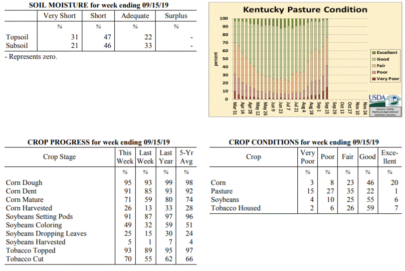 Kentucky Climate Summary
For the Period September 9, 2019 to September 15, 2019
Well Above Normal Temperatures and Much Below Normal Rainfall:
Dry weather and unrelenting heat has engulfed the Bluegrass State. According to data
at the Ag Weather Center, through the first 15 days of the month, the state has only
averaged 0.06 inches. The US Drought Monitor has reintroduced ‘Moderate Drought’ to
portions of North Central Kentucky and established a new area across Southeastern
Kentucky. This period was no different with the trend of mostly dry conditions
remaining in place. Other than some spotty showers and storms, this was a second
straight week where many locations saw no rainfall. In addition to the dry weather,
summer heat has remained entrenched across the area. Highs in the low to middle 90s
were common this past week, including many jumping into the upper 90s on Tuesday.
Lexington airport hit 100 degrees for the first time since 2012.
Temperatures for the period averaged 78 degrees across the state which was 8 degrees
warmer than normal and 6 degrees warmer than the previous period. High temperatures
averaged from 92 in the West to 92 in the East. Departure from normal high
temperatures ranged from 8 degrees warmer than normal in the West to 10 degrees
warmer than normal in the East. Low temperatures averaged from 65 degrees in the
West to 64 degrees in the East. Departure from normal low temperature ranged from 5
degrees warmer than normal in the West to 7 degrees warmer than normal in the East.
The extreme high temperature for the period was 100 degrees at LEXINGTON APT and the
extreme low was 49 degrees at RICHMOND 8E.
Precipitation (liq. equ.) for the period totaled 0.04 inches statewide which was 0.8
inches below normal and 5% of normal. Precipitation totals by climate division, West
0.01 inches, Central 0.03 inches, Bluegrass 0.00 inches and East 0.11 inches, which
was 0.84, 0.9, 0.76 and 0.7 inches below normal. By station, precipitation totals
ranged from a low of 0.00 inches at ALBANY 1N to a high of 0.75 inches at
MIDDLESBORO AWOS.
---
Kentucky Crop and Weather Report
Issued 4:00 P.M., September 9, 2019 26-19
Agricultural News: Kentucky experienced near normal temperatures and much below
normal rainfall over the past week. Precipitation for the week totaled 0.01 inches,
0.76 inches below normal. Temperatures averaged 73 degrees for the week, unchanged
from normal. Topsoil moisture was rated 13 percent very short, 48 percent short, 38
percent adequate and 1 percent surplus. Subsoil moisture was rated 11 percent very
short, 44 percent short, 44 percent adequate, and 1 percent surplus. Days suitable
for fieldwork averaged 6.7 out of a possible seven.
Primary activities for this week included harvesting corn and soybeans along with
topping and cutting tobacco. Temperatures were near normal with virtually no
precipitation across the state. Most areas are beginning to get dry again causing
stress on pastures, hay fields, and late planted crops. Some cattle producers are
feeding hay early fueling fears of a shortage this winter. Corn harvest is underway
with soybean harvest just beginning. Due to a very wet planting season, there is a
great deal of geographic variance in crop stages and yields.
Kentucky Climate Summary
For the Period September 9, 2019 to September 15, 2019
Well Above Normal Temperatures and Much Below Normal Rainfall:
Dry weather and unrelenting heat has engulfed the Bluegrass State. According to data
at the Ag Weather Center, through the first 15 days of the month, the state has only
averaged 0.06 inches. The US Drought Monitor has reintroduced ‘Moderate Drought’ to
portions of North Central Kentucky and established a new area across Southeastern
Kentucky. This period was no different with the trend of mostly dry conditions
remaining in place. Other than some spotty showers and storms, this was a second
straight week where many locations saw no rainfall. In addition to the dry weather,
summer heat has remained entrenched across the area. Highs in the low to middle 90s
were common this past week, including many jumping into the upper 90s on Tuesday.
Lexington airport hit 100 degrees for the first time since 2012.
Temperatures for the period averaged 78 degrees across the state which was 8 degrees
warmer than normal and 6 degrees warmer than the previous period. High temperatures
averaged from 92 in the West to 92 in the East. Departure from normal high
temperatures ranged from 8 degrees warmer than normal in the West to 10 degrees
warmer than normal in the East. Low temperatures averaged from 65 degrees in the
West to 64 degrees in the East. Departure from normal low temperature ranged from 5
degrees warmer than normal in the West to 7 degrees warmer than normal in the East.
The extreme high temperature for the period was 100 degrees at LEXINGTON APT and the
extreme low was 49 degrees at RICHMOND 8E.
Precipitation (liq. equ.) for the period totaled 0.04 inches statewide which was 0.8
inches below normal and 5% of normal. Precipitation totals by climate division, West
0.01 inches, Central 0.03 inches, Bluegrass 0.00 inches and East 0.11 inches, which
was 0.84, 0.9, 0.76 and 0.7 inches below normal. By station, precipitation totals
ranged from a low of 0.00 inches at ALBANY 1N to a high of 0.75 inches at
MIDDLESBORO AWOS.
---
Kentucky Crop and Weather Report
Issued 4:00 P.M., September 9, 2019 26-19
Agricultural News: Kentucky experienced near normal temperatures and much below
normal rainfall over the past week. Precipitation for the week totaled 0.01 inches,
0.76 inches below normal. Temperatures averaged 73 degrees for the week, unchanged
from normal. Topsoil moisture was rated 13 percent very short, 48 percent short, 38
percent adequate and 1 percent surplus. Subsoil moisture was rated 11 percent very
short, 44 percent short, 44 percent adequate, and 1 percent surplus. Days suitable
for fieldwork averaged 6.7 out of a possible seven.
Primary activities for this week included harvesting corn and soybeans along with
topping and cutting tobacco. Temperatures were near normal with virtually no
precipitation across the state. Most areas are beginning to get dry again causing
stress on pastures, hay fields, and late planted crops. Some cattle producers are
feeding hay early fueling fears of a shortage this winter. Corn harvest is underway
with soybean harvest just beginning. Due to a very wet planting season, there is a
great deal of geographic variance in crop stages and yields.
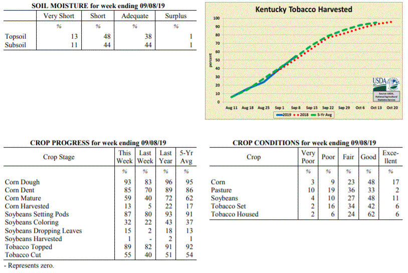 Kentucky Climate Summary
For the Period September 2, 2019 to September 8, 2019
Near Normal Temperatures and Much Below Normal Rainfall:
Looking at total accumulations, this is one of the driest weeks the state has seen in
quite some time. The state only averaged one hundreth of an inch with most not seeing
anything for the week. The last time Kentucky averaged under a tenth of an inch was back in
early February. The dry conditions broke a two week stretch of above normal rainfall.
Saying all this, September and October are climatologically, our two driest months of the
year. Two cold fronts did move through the area on Wednesday and Friday but were starved of
moisture. Noticeably cooler and less humid air moved into the area behind the
departing boundaries, especially the latter. Highs over the weekend were below normal
for this time of year with temperatures in the upper 70s to middle 80s and much more
comfortable humidity.
Temperatures for the period averaged 73 degrees across the state which was
near normal and no change to the previous period. High temperatures averaged from
86 in the West to 85 in the East. Departure from normal high temperatures ranged
from near normal in the West to 1 degree warmer than normal in the East.
Low temperatures averaged from 62 degrees in the West to 61 degrees in the East.
Departure from normal low temperature ranged from 1 degree cooler than normal in the
West to 1 degree warmer than normal in the East. The extreme high temperature for
the period was 95 degrees at POPLAR BLUFF ASOS and the extreme low was 49 degrees at
RICHMOND 8E.
Precipitation (liq. equ.) for the period totaled 0.01 inches statewide which was 0.76
inches below normal and 1% of normal. Precipitation totals by climate division, West
0.00 inches, Central 0.00 inches, Bluegrass 0.04 inches and East 0.01 inches, which
was 0.72, 0.85, 0.69 and 0.78 inches below normal. By station, precipitation totals
ranged from a low of 0.00 inches at ALBANY 1N to a high of 0.49 inches at CINCINNATI.
---
Kentucky Crop and Weather Report
Issued 4:00 P.M., September 3, 2019 25-19
Agricultural News: Kentucky experienced below normal temperatures and above normal
rainfall over the past week. Precipitation for the week totaled 1.26 inches, 0.52
inches above normal. Temperatures averaged 73 degrees for the week, 1 degree below
normal. Topsoil moisture was rated 8 percent very short, 34 percent short, 56 percent
adequate and 2 percent surplus. Subsoil moisture was rated 7 percent very short, 35
percent short, 56 percent adequate, and 2 percent surplus. Days suitable for
fieldwork averaged 5.7 out of a possible seven.
Primary activities for this week included harvesting corn and hay along with topping
and cutting tobacco. There was a period of cooler temperatures and widespread
precipitation this past week offering some drought relief. Corn harvest is still in
the early stages, but has been initiated. Due to a very wet planting season, there is
a great deal of geographic variance in crop stages. Pasture have benefitted from the
rain and cool temperatures, however another dry spell will halt the improvement.
Kentucky Climate Summary
For the Period September 2, 2019 to September 8, 2019
Near Normal Temperatures and Much Below Normal Rainfall:
Looking at total accumulations, this is one of the driest weeks the state has seen in
quite some time. The state only averaged one hundreth of an inch with most not seeing
anything for the week. The last time Kentucky averaged under a tenth of an inch was back in
early February. The dry conditions broke a two week stretch of above normal rainfall.
Saying all this, September and October are climatologically, our two driest months of the
year. Two cold fronts did move through the area on Wednesday and Friday but were starved of
moisture. Noticeably cooler and less humid air moved into the area behind the
departing boundaries, especially the latter. Highs over the weekend were below normal
for this time of year with temperatures in the upper 70s to middle 80s and much more
comfortable humidity.
Temperatures for the period averaged 73 degrees across the state which was
near normal and no change to the previous period. High temperatures averaged from
86 in the West to 85 in the East. Departure from normal high temperatures ranged
from near normal in the West to 1 degree warmer than normal in the East.
Low temperatures averaged from 62 degrees in the West to 61 degrees in the East.
Departure from normal low temperature ranged from 1 degree cooler than normal in the
West to 1 degree warmer than normal in the East. The extreme high temperature for
the period was 95 degrees at POPLAR BLUFF ASOS and the extreme low was 49 degrees at
RICHMOND 8E.
Precipitation (liq. equ.) for the period totaled 0.01 inches statewide which was 0.76
inches below normal and 1% of normal. Precipitation totals by climate division, West
0.00 inches, Central 0.00 inches, Bluegrass 0.04 inches and East 0.01 inches, which
was 0.72, 0.85, 0.69 and 0.78 inches below normal. By station, precipitation totals
ranged from a low of 0.00 inches at ALBANY 1N to a high of 0.49 inches at CINCINNATI.
---
Kentucky Crop and Weather Report
Issued 4:00 P.M., September 3, 2019 25-19
Agricultural News: Kentucky experienced below normal temperatures and above normal
rainfall over the past week. Precipitation for the week totaled 1.26 inches, 0.52
inches above normal. Temperatures averaged 73 degrees for the week, 1 degree below
normal. Topsoil moisture was rated 8 percent very short, 34 percent short, 56 percent
adequate and 2 percent surplus. Subsoil moisture was rated 7 percent very short, 35
percent short, 56 percent adequate, and 2 percent surplus. Days suitable for
fieldwork averaged 5.7 out of a possible seven.
Primary activities for this week included harvesting corn and hay along with topping
and cutting tobacco. There was a period of cooler temperatures and widespread
precipitation this past week offering some drought relief. Corn harvest is still in
the early stages, but has been initiated. Due to a very wet planting season, there is
a great deal of geographic variance in crop stages. Pasture have benefitted from the
rain and cool temperatures, however another dry spell will halt the improvement.
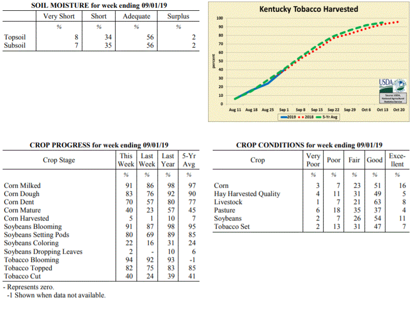 Kentucky Climate Summary
For the Period August 26, 2019 to September 1, 2019
Below Normal Temperatures and Above Normal Rainfall:
August came to a close with a second straight week of above normal rainfall. Overall,
the state averaged 1.26 inches behind multiple rounds of rainfall over the first half of the
period. Later in the week, a front stalled over the area and coverage became isolated
to widely scattered on a daily basis. Storms were slow movers and produced a
tremendous amount of rainfall, leading to some bouts of flooding and even some large
hail. The rainfall has improved conditions across the state and led the US
Drought Monitor to remove moderate drought from portions of North Central Kentucky.
Looking at temperatures, behind the passage of a cold front on Tuesday, Kentucky
received a dose of fall weather for a couple days. Highs were only in the upper 70s
to middles 80s both Wednesday and Thursday with low humidity. Those temperatures then
went on the increase through the weekend, back to around 90.
Temperatures for the period averaged 73 degrees across the state which was 1 degree
cooler than normal and 4 degrees cooler than the previous period. High temperatures
averaged from 85 in the West to 83 in the East. Departure from normal high
temperatures ranged from 3 degrees cooler than normal in the West to 2 degrees
cooler than normal in the East. Low temperatures averaged from 64 degrees in the
West to 62 degrees in the East. Departure from normal low temperature ranged from
near normal in the West to 1 degree warmer than normal in the East. The
extreme high temperature for the period was 92 degrees at LEXINGTON APT and the
extreme low was 50 degrees at MONTICELLO AWOS.
Precipitation (liq. equ.) for the period totaled 1.26 inches statewide which was 0.52
inches above normal and 170% of normal. Precipitation totals by climate division,
West 0.59 inches, Central 1.63 inches, Bluegrass 1.57 inches and East 1.27 inches,
which was -0.08, 0.85, 0.84 and 0.49 inches respectively from normal. By station,
precipitation totals ranged from a low of 0.02 inches at PADUCAH ASOS to a high of
4.87 inches at OWINGSVILLE 4S.
---
Kentucky Crop and Weather Report
Issued 4:00 P.M., August 26, 2019 24-19
Agricultural News: Kentucky experienced above normal temperatures and rainfall over
the past week. Precipitation for the week totaled 1.00 inches, 0.17 inches above
normal. Temperatures averaged 76 degrees for the week, 1 degree above normal. Topsoil
moisture was rated 8 percent very short, 32 percent short, 56 percent adequate, and 4
percent surplus. Subsoil moisture was rated 6 percent very short, 32 percent short,
60 percent adequate, and 2 percent surplus. Days suitable for fieldwork averaged 5.7
out of a possible seven.
Primary activities for this week included harvesting hay along with topping and
cutting tobacco. Pockets of the state received some much needed rainfall this week
while other areas continue to battle drought. Corn harvest has initiated, however
nearly all the crop is still in the field. Crop stages vary geographically as the
planting season was very wet for much of the state. Corn, soybeans, and tobacco
remain in mostly good condition despite the extended dry weather. Pasture is in
mostly fair condition as the heat and drought have taken a toll. Harvested hay is in
mostly good condition at this juncture, however producers are seeing low yields in
areas that are especially dry.
Kentucky Climate Summary
For the Period August 26, 2019 to September 1, 2019
Below Normal Temperatures and Above Normal Rainfall:
August came to a close with a second straight week of above normal rainfall. Overall,
the state averaged 1.26 inches behind multiple rounds of rainfall over the first half of the
period. Later in the week, a front stalled over the area and coverage became isolated
to widely scattered on a daily basis. Storms were slow movers and produced a
tremendous amount of rainfall, leading to some bouts of flooding and even some large
hail. The rainfall has improved conditions across the state and led the US
Drought Monitor to remove moderate drought from portions of North Central Kentucky.
Looking at temperatures, behind the passage of a cold front on Tuesday, Kentucky
received a dose of fall weather for a couple days. Highs were only in the upper 70s
to middles 80s both Wednesday and Thursday with low humidity. Those temperatures then
went on the increase through the weekend, back to around 90.
Temperatures for the period averaged 73 degrees across the state which was 1 degree
cooler than normal and 4 degrees cooler than the previous period. High temperatures
averaged from 85 in the West to 83 in the East. Departure from normal high
temperatures ranged from 3 degrees cooler than normal in the West to 2 degrees
cooler than normal in the East. Low temperatures averaged from 64 degrees in the
West to 62 degrees in the East. Departure from normal low temperature ranged from
near normal in the West to 1 degree warmer than normal in the East. The
extreme high temperature for the period was 92 degrees at LEXINGTON APT and the
extreme low was 50 degrees at MONTICELLO AWOS.
Precipitation (liq. equ.) for the period totaled 1.26 inches statewide which was 0.52
inches above normal and 170% of normal. Precipitation totals by climate division,
West 0.59 inches, Central 1.63 inches, Bluegrass 1.57 inches and East 1.27 inches,
which was -0.08, 0.85, 0.84 and 0.49 inches respectively from normal. By station,
precipitation totals ranged from a low of 0.02 inches at PADUCAH ASOS to a high of
4.87 inches at OWINGSVILLE 4S.
---
Kentucky Crop and Weather Report
Issued 4:00 P.M., August 26, 2019 24-19
Agricultural News: Kentucky experienced above normal temperatures and rainfall over
the past week. Precipitation for the week totaled 1.00 inches, 0.17 inches above
normal. Temperatures averaged 76 degrees for the week, 1 degree above normal. Topsoil
moisture was rated 8 percent very short, 32 percent short, 56 percent adequate, and 4
percent surplus. Subsoil moisture was rated 6 percent very short, 32 percent short,
60 percent adequate, and 2 percent surplus. Days suitable for fieldwork averaged 5.7
out of a possible seven.
Primary activities for this week included harvesting hay along with topping and
cutting tobacco. Pockets of the state received some much needed rainfall this week
while other areas continue to battle drought. Corn harvest has initiated, however
nearly all the crop is still in the field. Crop stages vary geographically as the
planting season was very wet for much of the state. Corn, soybeans, and tobacco
remain in mostly good condition despite the extended dry weather. Pasture is in
mostly fair condition as the heat and drought have taken a toll. Harvested hay is in
mostly good condition at this juncture, however producers are seeing low yields in
areas that are especially dry.
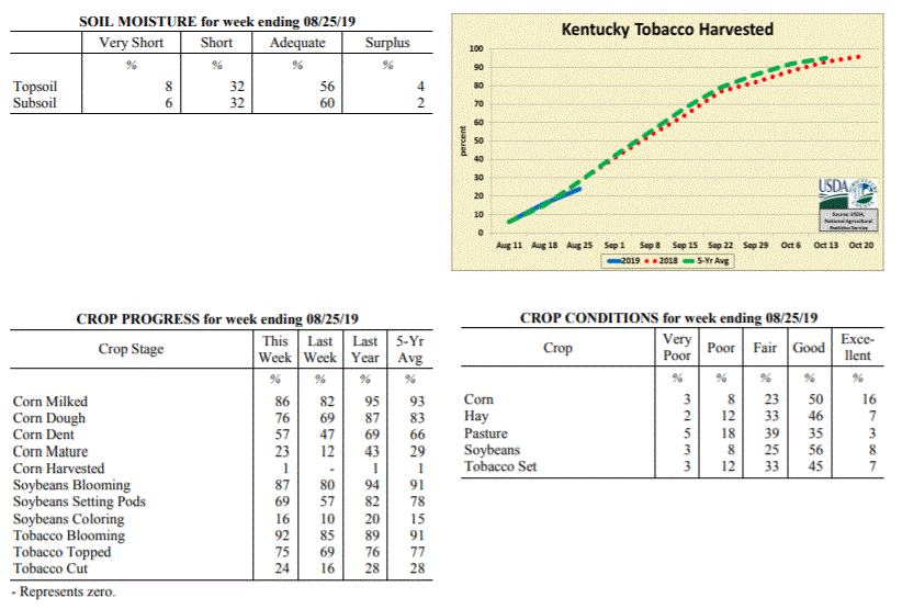 Kentucky Climate Summary
For the Period August 19, 2019 to August 25, 2019
Above Normal Temperatures and Rainfall:
After three straight weeks of below normal precipitation, the US Drought Monitor
introduced an area of ‘Moderate Drought’ to portions of North Central Kentucky with
the latest update. In addition, the area of ‘Abnormally Dry Conditions’ also
expanded to include nearly half of the state. Luckily, the state did finally see
some beneficial rainfall this past week as multiple rounds pushed through the area.
The unsettled pattern started on Tuesday evening as a line of storms pushed south
into the Bluegrass State. This was followed by an active pattern over the next few
days as a cold front was slow to pass through the region, each day featuring
scattered coverage of showers and storms. Overall, the state averaged an inch for
the week, but that number jumped to 1.66 for Western Kentucky. Some portions of this
area, including Paducah, saw more than three inches.
Temperatures for the period averaged 76 degrees across the state which was 1 degree
warmer than normal and 2 degrees cooler than the previous period. High temperatures
averaged from 86 in the West to 86 in the East. Departure from normal high
temperatures ranged from 2 degrees cooler than normal in the West to near
normal in the East. Low temperatures averaged from 68 degrees in the West to 66
degrees in the East. Departure from normal low temperature ranged from 3 degrees
warmer than normal in the West to 4 degrees warmer than normal in the East. The
extreme high temperature for the period was 99 degrees at LEXINGTON APT and the
extreme low was 52 degrees at PAINTSVILLE 4W.
Precipitation (liq. equ.) for the period totaled 1.00 inches statewide which was 0.17
inches above normal and 120% of normal. Precipitation totals by climate division,
West 1.66 inches, Central 0.98 inches, Bluegrass 0.78 inches and East 0.57 inches,
which was 0.91, 0.14, -0.06 and -0.32 inches respectively from normal. By station,
precipitation totals ranged from a low of 0.08 inches at BIG SANDY to a high of 4.21
inches at MAYFIELD 6SW.
---
Kentucky Crop and Weather Report
Issued 4:00 P.M., August 19, 2019 23-19
Agricultural News: Kentucky experienced above normal temperatures and below normal
rainfall over the past week. Precipitation for the week totaled 0.38 inches, 0.48
inches below normal. Temperatures averaged 78 degrees for the week, 2 degrees above
normal. Topsoil moisture was rated 11 percent very short, 38 percent short, 50
percent adequate, and 1 percent surplus. Subsoil moisture was rated 7 percent very
short, 34 percent short, 58 percent adequate, and 1 percent surplus. Days suitable
for fieldwork averaged 6.5 out of a possible seven.
Primary activities for this week included topping and cutting of tobacco along with
continued hay cutting. Pockets of the state received some much needed rainfall this
week, however conditions remain dry on the whole. Crop stages vary dramatically in
parts of the state as some crops were replanted due to adverse conditions in the
planting season. There were several reports of low hay yields due to the heat and
drought. Pastures are also being stressed by the persistent hot and dry conditions.
Kentucky Climate Summary
For the Period August 19, 2019 to August 25, 2019
Above Normal Temperatures and Rainfall:
After three straight weeks of below normal precipitation, the US Drought Monitor
introduced an area of ‘Moderate Drought’ to portions of North Central Kentucky with
the latest update. In addition, the area of ‘Abnormally Dry Conditions’ also
expanded to include nearly half of the state. Luckily, the state did finally see
some beneficial rainfall this past week as multiple rounds pushed through the area.
The unsettled pattern started on Tuesday evening as a line of storms pushed south
into the Bluegrass State. This was followed by an active pattern over the next few
days as a cold front was slow to pass through the region, each day featuring
scattered coverage of showers and storms. Overall, the state averaged an inch for
the week, but that number jumped to 1.66 for Western Kentucky. Some portions of this
area, including Paducah, saw more than three inches.
Temperatures for the period averaged 76 degrees across the state which was 1 degree
warmer than normal and 2 degrees cooler than the previous period. High temperatures
averaged from 86 in the West to 86 in the East. Departure from normal high
temperatures ranged from 2 degrees cooler than normal in the West to near
normal in the East. Low temperatures averaged from 68 degrees in the West to 66
degrees in the East. Departure from normal low temperature ranged from 3 degrees
warmer than normal in the West to 4 degrees warmer than normal in the East. The
extreme high temperature for the period was 99 degrees at LEXINGTON APT and the
extreme low was 52 degrees at PAINTSVILLE 4W.
Precipitation (liq. equ.) for the period totaled 1.00 inches statewide which was 0.17
inches above normal and 120% of normal. Precipitation totals by climate division,
West 1.66 inches, Central 0.98 inches, Bluegrass 0.78 inches and East 0.57 inches,
which was 0.91, 0.14, -0.06 and -0.32 inches respectively from normal. By station,
precipitation totals ranged from a low of 0.08 inches at BIG SANDY to a high of 4.21
inches at MAYFIELD 6SW.
---
Kentucky Crop and Weather Report
Issued 4:00 P.M., August 19, 2019 23-19
Agricultural News: Kentucky experienced above normal temperatures and below normal
rainfall over the past week. Precipitation for the week totaled 0.38 inches, 0.48
inches below normal. Temperatures averaged 78 degrees for the week, 2 degrees above
normal. Topsoil moisture was rated 11 percent very short, 38 percent short, 50
percent adequate, and 1 percent surplus. Subsoil moisture was rated 7 percent very
short, 34 percent short, 58 percent adequate, and 1 percent surplus. Days suitable
for fieldwork averaged 6.5 out of a possible seven.
Primary activities for this week included topping and cutting of tobacco along with
continued hay cutting. Pockets of the state received some much needed rainfall this
week, however conditions remain dry on the whole. Crop stages vary dramatically in
parts of the state as some crops were replanted due to adverse conditions in the
planting season. There were several reports of low hay yields due to the heat and
drought. Pastures are also being stressed by the persistent hot and dry conditions.
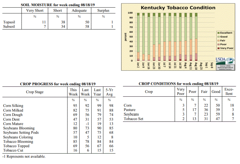 Kentucky Climate Summary
For the Period August 12, 2019 to August 18, 2019
Above Normal Temperatures and Below Normal Rainfall:
Kentucky has experienced a dry August thus far with three straight weeks of below
normal rainfall. Data at the UK Ag Weather Center shows the state has only averaged
0.92 inches through August 18th, which is almost 1.5 inches below normal. The
northern half of the state did see some widespread rainfall on Tuesday morning, but not
nearly enough. The rest of the week featured spotty rainfall with little, if any
falling across the southern half of the state. ‘Abnormally Dry Conditions’ were
expanded across North Central Kentucky with the Thursday update of the US Drought
Monitor, in addition to a small area introduced across Southeastern Kentucky. Bottom
line, it has been a dry August for the Bluegrass State. The heat has not helped matters
with highs in the middle 80s to low 90s common over the period. A handful of stations
even rose into the upper 90s on Sunday.
Temperatures for the period averaged 78 degrees across the state which was 2 degrees
warmer than normal and 2 degrees warmer than the previous period. High temperatures
averaged from 89 in the West to 88 in the East. Departure from normal high
temperatures ranged from 1 degree warmer than normal in the West to 2 degrees warmer
than normal in the East. Low temperatures averaged from 69 degrees in the West to 66
degrees in the East. Departure from normal low temperature ranged from 3 degrees
warmer than normal in the West to 3 degrees warmer than normal in the East. The
extreme high temperature for the period was 97 degrees at LEXINGTON APT and the extreme
low was 39 degrees at ALEXANDRIA 5NW.
Precipitation (liq. equ.) for the period totaled 0.38 inches statewide which was 0.48
inches below normal and 44% of normal. Precipitation totals by climate division, West
0.39 inches, Central 0.32 inches, Bluegrass 0.41 inches and East 0.38 inches, which
was 0.4, 0.52, 0.46 and 0.55 inches below normal. By station, precipitation totals
ranged from a low of 0.00 inches at BURKESVILLE 3W to a high of 2.62 inches at
EVANSVILLE ASOS.
---
Kentucky Crop and Weather Report
Issued 4:00 P.M., August 12, 2019 22-19
Agricultural News: Kentucky experienced near normal temperatures and below normal
rainfall over the past week. Precipitation for the week totaled 0.33 inches, 0.58
inches below normal. Temperatures averaged 76 degrees for the week, unchanged from
normal. Topsoil moisture was rated 6 percent very short, 29 percent short, 62 percent
adequate, and 3 percent surplus. Subsoil moisture was rated 4 percent very short, 28
percent short, 65 percent adequate, and 3 percent surplus. Days suitable for
fieldwork averaged 6.3 out of a possible seven.
Primary activities for this week included cutting hay, topping tobacco, and spraying
of field crops. A small portion of the tobacco crop has been cut according to
reports. Parts of the state received some rain last week, however dry conditions
persist. Drought coupled with hot weather has taken a toll on some of the pastureland
and hay. Later planted corn and soybeans could be damaged if the dry conditions continue.
Kentucky Climate Summary
For the Period August 12, 2019 to August 18, 2019
Above Normal Temperatures and Below Normal Rainfall:
Kentucky has experienced a dry August thus far with three straight weeks of below
normal rainfall. Data at the UK Ag Weather Center shows the state has only averaged
0.92 inches through August 18th, which is almost 1.5 inches below normal. The
northern half of the state did see some widespread rainfall on Tuesday morning, but not
nearly enough. The rest of the week featured spotty rainfall with little, if any
falling across the southern half of the state. ‘Abnormally Dry Conditions’ were
expanded across North Central Kentucky with the Thursday update of the US Drought
Monitor, in addition to a small area introduced across Southeastern Kentucky. Bottom
line, it has been a dry August for the Bluegrass State. The heat has not helped matters
with highs in the middle 80s to low 90s common over the period. A handful of stations
even rose into the upper 90s on Sunday.
Temperatures for the period averaged 78 degrees across the state which was 2 degrees
warmer than normal and 2 degrees warmer than the previous period. High temperatures
averaged from 89 in the West to 88 in the East. Departure from normal high
temperatures ranged from 1 degree warmer than normal in the West to 2 degrees warmer
than normal in the East. Low temperatures averaged from 69 degrees in the West to 66
degrees in the East. Departure from normal low temperature ranged from 3 degrees
warmer than normal in the West to 3 degrees warmer than normal in the East. The
extreme high temperature for the period was 97 degrees at LEXINGTON APT and the extreme
low was 39 degrees at ALEXANDRIA 5NW.
Precipitation (liq. equ.) for the period totaled 0.38 inches statewide which was 0.48
inches below normal and 44% of normal. Precipitation totals by climate division, West
0.39 inches, Central 0.32 inches, Bluegrass 0.41 inches and East 0.38 inches, which
was 0.4, 0.52, 0.46 and 0.55 inches below normal. By station, precipitation totals
ranged from a low of 0.00 inches at BURKESVILLE 3W to a high of 2.62 inches at
EVANSVILLE ASOS.
---
Kentucky Crop and Weather Report
Issued 4:00 P.M., August 12, 2019 22-19
Agricultural News: Kentucky experienced near normal temperatures and below normal
rainfall over the past week. Precipitation for the week totaled 0.33 inches, 0.58
inches below normal. Temperatures averaged 76 degrees for the week, unchanged from
normal. Topsoil moisture was rated 6 percent very short, 29 percent short, 62 percent
adequate, and 3 percent surplus. Subsoil moisture was rated 4 percent very short, 28
percent short, 65 percent adequate, and 3 percent surplus. Days suitable for
fieldwork averaged 6.3 out of a possible seven.
Primary activities for this week included cutting hay, topping tobacco, and spraying
of field crops. A small portion of the tobacco crop has been cut according to
reports. Parts of the state received some rain last week, however dry conditions
persist. Drought coupled with hot weather has taken a toll on some of the pastureland
and hay. Later planted corn and soybeans could be damaged if the dry conditions continue.
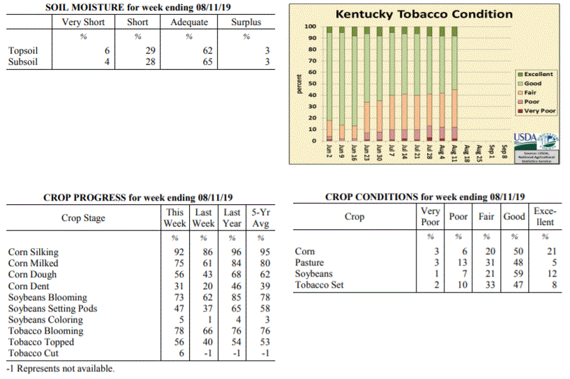 Kentucky Climate Summary
For the Period August 5, 2019 to August 11, 2019
Near Normal Temperatures and Below Normal Rainfall:
As summer heat continues, attention over recent weeks has turned toward increasingly
dry conditions for some areas of the state. A couple frontal boundaries moved
through the Lower Ohio Valley this past week, sparking isolated to scattered storms.
Rainfall accumulations were limited to mainly two areas of the state: Western/West
Central Kentucky and the Northern Bluegrass/Northeastern Kentucky. Between the two
(North Central Kentucky extending into Southeastern Kentucky), very little, if any
rainfall was seen. Overall, this pushed the state to a second straight week of below
normal rainfall. In addition, the US Drought Monitor introduced a large area of
‘Abnormally Dry Conditions’ for North Central Kentucky, which has missed most of the
rainfall over the past couple weeks.
Temperatures for the period averaged 76 degrees across the state which was near
normal and no change to the previous period. High temperatures averaged from 87 in
the West to 86 in the East. Departure from normal high temperatures ranged from 1
degree cooler than normal in the West to near normal in the East. Low temperatures
averaged from 67 degrees in the West to 64 degrees in the East. Departure from normal
low temperature ranged from 1 degree warmer than normal in the West to 1 degree
warmer than normal in the East. The extreme high temperature for the period was 95
degrees at LOUISVILLE APT and the extreme low was 53 degrees at VANCEBURG 6W.
Precipitation (liq. equ.) for the period totaled 0.33 inches statewide which was 0.58
inches below normal and 36% of normal. Precipitation totals by climate division, West
0.48 inches, Central 0.25 inches, Bluegrass 0.32 inches and East 0.25 inches, which
was 0.4, 0.64, 0.57 and 0.75 inches below normal. By station, precipitation totals
ranged from a low of 0.00 inches at BARBOURVILLE 3E to a high of 1.60 inches at
MOREHEAD 4NE.
---
Kentucky Crop and Weather Report
Issued 4:00 P.M., August 5, 2019 21-19
Agricultural News: Kentucky experienced near normal temperatures and below normal
rainfall over the past week. Precipitation for the week totaled 0.67 inches, 0.30
inches below normal. Temperatures averaged 76 degrees for the week, unchanged from
normal. Topsoil moisture was rated 3 percent very short, 21 percent short, 70 percent
adequate, and 6 percent surplus. Subsoil moisture was rated 2 percent very short, 20
percent short, 73 percent adequate, and 5 percent surplus. Days suitable for
fieldwork averaged 6.2 out of a possible seven.
Primary activities for this week included cutting hay, topping tobacco, and spraying
field crops. Pockets of the state are dealing with a recent dry spell that, if
prolonged, could be detrimental to pastureland and field crops. The dry conditions
coupled with hot temperatures has slowed pasture growth and is beginning to stress
crops in some areas. A few counties experienced heavy rain, however flooding was not
widespread.
Kentucky Climate Summary
For the Period August 5, 2019 to August 11, 2019
Near Normal Temperatures and Below Normal Rainfall:
As summer heat continues, attention over recent weeks has turned toward increasingly
dry conditions for some areas of the state. A couple frontal boundaries moved
through the Lower Ohio Valley this past week, sparking isolated to scattered storms.
Rainfall accumulations were limited to mainly two areas of the state: Western/West
Central Kentucky and the Northern Bluegrass/Northeastern Kentucky. Between the two
(North Central Kentucky extending into Southeastern Kentucky), very little, if any
rainfall was seen. Overall, this pushed the state to a second straight week of below
normal rainfall. In addition, the US Drought Monitor introduced a large area of
‘Abnormally Dry Conditions’ for North Central Kentucky, which has missed most of the
rainfall over the past couple weeks.
Temperatures for the period averaged 76 degrees across the state which was near
normal and no change to the previous period. High temperatures averaged from 87 in
the West to 86 in the East. Departure from normal high temperatures ranged from 1
degree cooler than normal in the West to near normal in the East. Low temperatures
averaged from 67 degrees in the West to 64 degrees in the East. Departure from normal
low temperature ranged from 1 degree warmer than normal in the West to 1 degree
warmer than normal in the East. The extreme high temperature for the period was 95
degrees at LOUISVILLE APT and the extreme low was 53 degrees at VANCEBURG 6W.
Precipitation (liq. equ.) for the period totaled 0.33 inches statewide which was 0.58
inches below normal and 36% of normal. Precipitation totals by climate division, West
0.48 inches, Central 0.25 inches, Bluegrass 0.32 inches and East 0.25 inches, which
was 0.4, 0.64, 0.57 and 0.75 inches below normal. By station, precipitation totals
ranged from a low of 0.00 inches at BARBOURVILLE 3E to a high of 1.60 inches at
MOREHEAD 4NE.
---
Kentucky Crop and Weather Report
Issued 4:00 P.M., August 5, 2019 21-19
Agricultural News: Kentucky experienced near normal temperatures and below normal
rainfall over the past week. Precipitation for the week totaled 0.67 inches, 0.30
inches below normal. Temperatures averaged 76 degrees for the week, unchanged from
normal. Topsoil moisture was rated 3 percent very short, 21 percent short, 70 percent
adequate, and 6 percent surplus. Subsoil moisture was rated 2 percent very short, 20
percent short, 73 percent adequate, and 5 percent surplus. Days suitable for
fieldwork averaged 6.2 out of a possible seven.
Primary activities for this week included cutting hay, topping tobacco, and spraying
field crops. Pockets of the state are dealing with a recent dry spell that, if
prolonged, could be detrimental to pastureland and field crops. The dry conditions
coupled with hot temperatures has slowed pasture growth and is beginning to stress
crops in some areas. A few counties experienced heavy rain, however flooding was not
widespread.
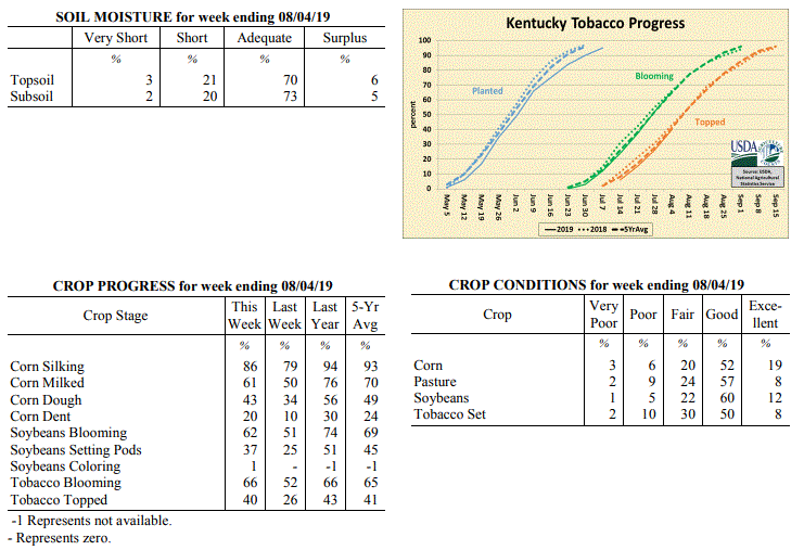 Kentucky Climate Summary
For the Period July 29, 2019 to August 4, 2019
Near Normal Temperatures and Below Normal Rainfall:
Overall, the state averaged 0.67 inches for the week, which is about a third of an
inch below normal. Coverage was more of the hit or miss variety, with isolated to
scattered showers and storms in place most of the week. While some areas saw very
little, others that got caught underneath slow-moving cells saw more than 1.5 inches.
Portions of North-Central Kentucky have trended to the drier side over the past two
weeks with rainfall departure of 1 to 2 inches below normal. Temperatures ran
around normal for the period with highs consistently getting into the middle 80s to
low 90s.
Temperatures for the period averaged 76 degrees across the state which was near
normal and 4 degrees warmer than the previous period. High temperatures averaged from
87 in the West to 86 in the East. Departure from normal high temperatures ranged from
2 degrees cooler than normal in the West to 1 degree cooler than normal in the East.
Low temperatures averaged from 66 degrees in the West to 65 degrees in the East.
Departure from normal low temperature ranged from 1 degree cooler than normal in the
West to 1 degree warmer than normal in the East. The extreme high temperature for the
period was 92 degrees at BOWLING GREEN APT and the extreme low was 58 degrees at
MAYSVILLE 3SW.
Precipitation (liq. equ.) for the period totaled 0.67 inches statewide which was 0.3
inches below normal and 69% of normal. Precipitation totals by climate division, West
0.71 inches, Central 0.54 inches, Bluegrass 0.91 inches and East 0.53 inches, which
was 0.22, 0.41, 0.05 and 0.51 inches below normal. By station, precipitation totals
ranged from a low of 0.00 inches at EDMONTON 5W to a high of 2.89 inches at COLUMBIA 3N.
---
Kentucky Crop and Weather Report
Issued 4:00 P.M., July 29, 2019 20-19
Agricultural News: Kentucky experienced below normal temperatures and above normal
rainfall over the past week. Precipitation for the week totaled 1.07 inches, 0.10
inches above normal. Temperatures averaged 72 degrees for the week, 4 degrees below
normal. Topsoil moisture was rated 1 percent very short, 20 percent short, 70 percent
adequate and 9 percent surplus. Subsoil moisture was rated 1 percent very short, 19
percent short, 72 percent adequate, and 8 percent surplus. Days suitable for
fieldwork averaged 6.0 out of a possible seven.
Primary activities this week included cutting hay, topping tobacco, and spraying
tobacco and corn fields. Limited rainfall has impacted pastures and crops, most
notably in central portions of the state. Farmers have noted good yields in the
second cutting of hay, with reports of better weed control. Hay and roughage supplies
were reported as 9 percent very short, 26 percent short, 61 percent adequate, and 4
percent surplus.
Kentucky Climate Summary
For the Period July 29, 2019 to August 4, 2019
Near Normal Temperatures and Below Normal Rainfall:
Overall, the state averaged 0.67 inches for the week, which is about a third of an
inch below normal. Coverage was more of the hit or miss variety, with isolated to
scattered showers and storms in place most of the week. While some areas saw very
little, others that got caught underneath slow-moving cells saw more than 1.5 inches.
Portions of North-Central Kentucky have trended to the drier side over the past two
weeks with rainfall departure of 1 to 2 inches below normal. Temperatures ran
around normal for the period with highs consistently getting into the middle 80s to
low 90s.
Temperatures for the period averaged 76 degrees across the state which was near
normal and 4 degrees warmer than the previous period. High temperatures averaged from
87 in the West to 86 in the East. Departure from normal high temperatures ranged from
2 degrees cooler than normal in the West to 1 degree cooler than normal in the East.
Low temperatures averaged from 66 degrees in the West to 65 degrees in the East.
Departure from normal low temperature ranged from 1 degree cooler than normal in the
West to 1 degree warmer than normal in the East. The extreme high temperature for the
period was 92 degrees at BOWLING GREEN APT and the extreme low was 58 degrees at
MAYSVILLE 3SW.
Precipitation (liq. equ.) for the period totaled 0.67 inches statewide which was 0.3
inches below normal and 69% of normal. Precipitation totals by climate division, West
0.71 inches, Central 0.54 inches, Bluegrass 0.91 inches and East 0.53 inches, which
was 0.22, 0.41, 0.05 and 0.51 inches below normal. By station, precipitation totals
ranged from a low of 0.00 inches at EDMONTON 5W to a high of 2.89 inches at COLUMBIA 3N.
---
Kentucky Crop and Weather Report
Issued 4:00 P.M., July 29, 2019 20-19
Agricultural News: Kentucky experienced below normal temperatures and above normal
rainfall over the past week. Precipitation for the week totaled 1.07 inches, 0.10
inches above normal. Temperatures averaged 72 degrees for the week, 4 degrees below
normal. Topsoil moisture was rated 1 percent very short, 20 percent short, 70 percent
adequate and 9 percent surplus. Subsoil moisture was rated 1 percent very short, 19
percent short, 72 percent adequate, and 8 percent surplus. Days suitable for
fieldwork averaged 6.0 out of a possible seven.
Primary activities this week included cutting hay, topping tobacco, and spraying
tobacco and corn fields. Limited rainfall has impacted pastures and crops, most
notably in central portions of the state. Farmers have noted good yields in the
second cutting of hay, with reports of better weed control. Hay and roughage supplies
were reported as 9 percent very short, 26 percent short, 61 percent adequate, and 4
percent surplus.
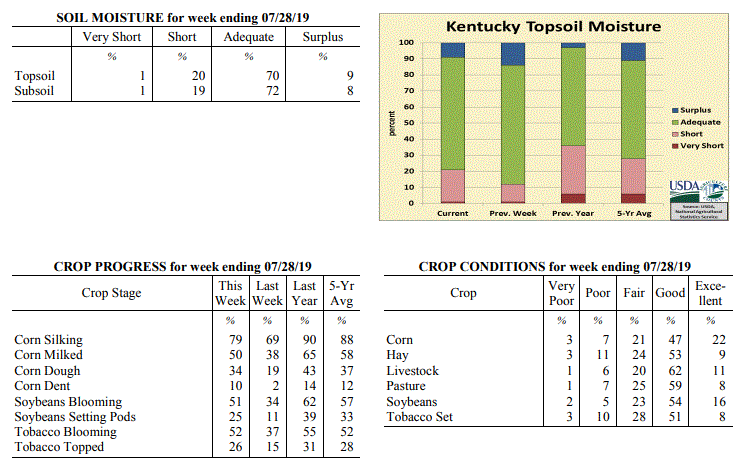 Kentucky Climate Summary
For the Period July 22, 2019 to July 28, 2019
Below Normal Temperatures and Above Normal Rainfall:
A cold front early in the week sparked multiple rounds of showers and storms across
the area. Once again, storms were capable of producing very heavy rainfall and led
to some flash flooding across the region. For most, this was the only rainfall for
the week as high pressure kept the area dry for the rest of the period. Saying that,
the state still averaged 1.07 inches, but accumulations varied greatly with the
scattered nature of the storms. Following the passage of the front, much cooler and
noticeably less humid air filtered into the Bluegrass State as winds transitioned to
the north. Dewpoints dropped into the 50s after being in the 70s most of last week.
Afternoon highs ranged in the upper 70s to middle 80s through Thursday, before going
back on the increase for the weekend. Still though, the cooler temperatures broke a
four week stretch of above normal temperatures.
Temperatures for the period averaged 72 degrees across the state which was 4 degrees
cooler than normal and 8 degrees cooler than the previous period. High temperatures
averaged from 83 in the West to 82 in the East. Departure from normal high
temperatures ranged from 6 degrees cooler than normal in the West to 5 degrees cooler
than normal in the East. Low temperatures averaged from 63 degrees in the West to 61
degrees in the East. Departure from normal low temperature ranged from 4 degrees
cooler than normal in the West to 3 degrees cooler than normal in the East. The
extreme high temperature for the period was 93 degrees at LOUISVILLE APT and the
extreme low was 53 degrees at WHITLEY CITY 3N.
Precipitation (liq. equ.) for the period totaled 1.07 inches statewide which was 0.1
inches above normal and 111% of normal. Precipitation totals by climate division,
West 1.25 inches, Central 1.02 inches, Bluegrass 0.68 inches and East 1.32 inches,
which was 0.33, 0.04, -0.28 and 0.31 inches respectively from normal. By station,
precipitation totals ranged from a low of 0.01 inches at PEABODY to a high of 3.99
inches at TRIANGLE MOUNTAIN.
---
Kentucky Crop and Weather Report
Issued 4:00 P.M., July 22, 2019 19-19
Agricultural News: Kentucky experienced above normal temperatures and rainfall over
the past week. Precipitation for the week totaled 1.40 inches, 0.42 inches above
normal. Temperatures averaged 80 degrees for the week, 3 degrees above normal.
Topsoil moisture was rated 1 percent very short, 11 percent short, 74 percent
adequate and 14 percent surplus. Subsoil moisture was rated 10 percent short, 76
percent adequate, and 14 percent surplus. Days suitable for fieldwork averaged 5.3
out of a possible seven.
Primary activities this week included scouting fields for incidences of disease,
topping tobacco, and cutting hay. Precipitation increased from remnants of Tropical
Storm Barry earlier in the week followed by excessive heat and humidity. Crops and
pastures showed signs of stress from the high temperatures and dry weather
later in the week. Livestock heat stress was also escalated during this period.
Kentucky Climate Summary
For the Period July 22, 2019 to July 28, 2019
Below Normal Temperatures and Above Normal Rainfall:
A cold front early in the week sparked multiple rounds of showers and storms across
the area. Once again, storms were capable of producing very heavy rainfall and led
to some flash flooding across the region. For most, this was the only rainfall for
the week as high pressure kept the area dry for the rest of the period. Saying that,
the state still averaged 1.07 inches, but accumulations varied greatly with the
scattered nature of the storms. Following the passage of the front, much cooler and
noticeably less humid air filtered into the Bluegrass State as winds transitioned to
the north. Dewpoints dropped into the 50s after being in the 70s most of last week.
Afternoon highs ranged in the upper 70s to middle 80s through Thursday, before going
back on the increase for the weekend. Still though, the cooler temperatures broke a
four week stretch of above normal temperatures.
Temperatures for the period averaged 72 degrees across the state which was 4 degrees
cooler than normal and 8 degrees cooler than the previous period. High temperatures
averaged from 83 in the West to 82 in the East. Departure from normal high
temperatures ranged from 6 degrees cooler than normal in the West to 5 degrees cooler
than normal in the East. Low temperatures averaged from 63 degrees in the West to 61
degrees in the East. Departure from normal low temperature ranged from 4 degrees
cooler than normal in the West to 3 degrees cooler than normal in the East. The
extreme high temperature for the period was 93 degrees at LOUISVILLE APT and the
extreme low was 53 degrees at WHITLEY CITY 3N.
Precipitation (liq. equ.) for the period totaled 1.07 inches statewide which was 0.1
inches above normal and 111% of normal. Precipitation totals by climate division,
West 1.25 inches, Central 1.02 inches, Bluegrass 0.68 inches and East 1.32 inches,
which was 0.33, 0.04, -0.28 and 0.31 inches respectively from normal. By station,
precipitation totals ranged from a low of 0.01 inches at PEABODY to a high of 3.99
inches at TRIANGLE MOUNTAIN.
---
Kentucky Crop and Weather Report
Issued 4:00 P.M., July 22, 2019 19-19
Agricultural News: Kentucky experienced above normal temperatures and rainfall over
the past week. Precipitation for the week totaled 1.40 inches, 0.42 inches above
normal. Temperatures averaged 80 degrees for the week, 3 degrees above normal.
Topsoil moisture was rated 1 percent very short, 11 percent short, 74 percent
adequate and 14 percent surplus. Subsoil moisture was rated 10 percent short, 76
percent adequate, and 14 percent surplus. Days suitable for fieldwork averaged 5.3
out of a possible seven.
Primary activities this week included scouting fields for incidences of disease,
topping tobacco, and cutting hay. Precipitation increased from remnants of Tropical
Storm Barry earlier in the week followed by excessive heat and humidity. Crops and
pastures showed signs of stress from the high temperatures and dry weather
later in the week. Livestock heat stress was also escalated during this period.
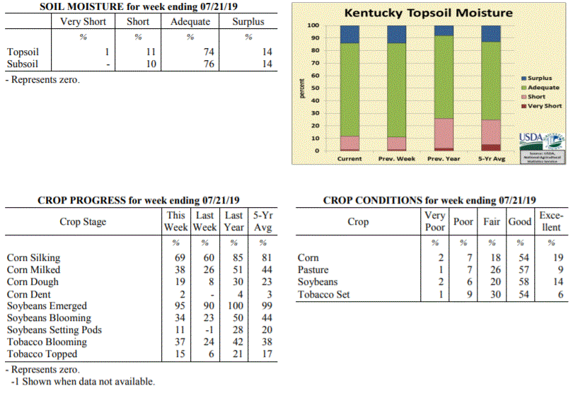 Kentucky Climate Summary
For the Period July 15, 2019 to July 21, 2019
Above Normal Temperatures and Rainfall:
The remnants of Tropical Storm Barry worked through the region over the first half of
the work week, resulting in multiple rounds of storms. Once again, a very moist air
mass led to torrential rainfall from time to time. The state averaged 1.40 inches for
the week, but several locations recorded 2 to 3+ inches. As the remnants of Barry
moved away from the region midweek, focus then turned to oppressive heat moving into
the area through the weekend. An ‘Excessive Heat Warning’ was issued for much of the
state as temperatures rose into the upper 80s to middle 90s for highs. A very sticky
air mass with dewpoints in the middle to upper 70s led to heat indices between
100 and 110 degrees during the day. This was ultimately the warmest period of the
year thus far and pushed livestock heat stress into the danger to emergency category
each day. Looking back, the state has now gone four straight weeks of above normal
temperatures.
Temperatures for the period averaged 80 degrees across the state which was 3 degrees
warmer than normal and 2 degrees warmer than the previous period. High temperatures
averaged from 87 in the West to 88 in the East. Departure from normal high
temperatures ranged from 3 degrees cooler than normal in the West to 1 degree
warmer than normal in the East. Low temperatures averaged from 73 degrees in the
West to 71 degrees in the East. Departure from normal low temperature ranged from 5
degrees warmer than normal in the West to 7 degrees warmer than normal in the East.
The extreme high temperature for the period was 96 degrees at LOUISVILLE APT and the
extreme low was 66 degrees at OWINGSVILLE 4S.
Precipitation (liq. equ.) for the period totaled 1.40 inches statewide which was 0.42
inches above normal and 143% of normal. Precipitation totals by climate division,
West 1.50 inches, Central 0.91 inches, Bluegrass 1.99 inches and East 1.20 inches,
which was 0.56, -0.09, 1.04 and 0.18 inches respectively from normal. By station,
precipitation totals ranged from a low of 0.05 inches at PEABODY to a high of 4.90
inches at POPLAR BLUFF ASOS.
---
Kentucky Crop and Weather Report
Issued 4:00 P.M., July 15, 2019 18-19
Agricultural News: Kentucky experienced above normal temperatures and below normal
rainfall over the past week. Precipitation for the week totaled 0.59 inches, 0.40
inches below normal. Temperatures averaged 79 degrees for the week, 2 degrees above
normal. Topsoil moisture was rated 1 percent very short, 10 percent short, 75
percent adequate and 14 percent surplus. Subsoil moisture was rated 1 percent very
short, 8 percent short, 76 percent adequate, and 15 percent surplus. Days suitable
for fieldwork averaged 5.2 out of a possible seven.
Primary activities this week included scouting fields, topping tobacco, cutting hay,
harvesting winter wheat, and planting soybeans. Varied precipitation across the state
has left some fields in standing water, other areas with scattered showers, to
extremely dry. In sections of the state that have experienced lower precipitation
recently, crops are showing signs of moisture and heat stress. Some tobacco producers
are reporting incidences of target and frog-eye leaf spot, and spraying fungicides to
help control.
Kentucky Climate Summary
For the Period July 15, 2019 to July 21, 2019
Above Normal Temperatures and Rainfall:
The remnants of Tropical Storm Barry worked through the region over the first half of
the work week, resulting in multiple rounds of storms. Once again, a very moist air
mass led to torrential rainfall from time to time. The state averaged 1.40 inches for
the week, but several locations recorded 2 to 3+ inches. As the remnants of Barry
moved away from the region midweek, focus then turned to oppressive heat moving into
the area through the weekend. An ‘Excessive Heat Warning’ was issued for much of the
state as temperatures rose into the upper 80s to middle 90s for highs. A very sticky
air mass with dewpoints in the middle to upper 70s led to heat indices between
100 and 110 degrees during the day. This was ultimately the warmest period of the
year thus far and pushed livestock heat stress into the danger to emergency category
each day. Looking back, the state has now gone four straight weeks of above normal
temperatures.
Temperatures for the period averaged 80 degrees across the state which was 3 degrees
warmer than normal and 2 degrees warmer than the previous period. High temperatures
averaged from 87 in the West to 88 in the East. Departure from normal high
temperatures ranged from 3 degrees cooler than normal in the West to 1 degree
warmer than normal in the East. Low temperatures averaged from 73 degrees in the
West to 71 degrees in the East. Departure from normal low temperature ranged from 5
degrees warmer than normal in the West to 7 degrees warmer than normal in the East.
The extreme high temperature for the period was 96 degrees at LOUISVILLE APT and the
extreme low was 66 degrees at OWINGSVILLE 4S.
Precipitation (liq. equ.) for the period totaled 1.40 inches statewide which was 0.42
inches above normal and 143% of normal. Precipitation totals by climate division,
West 1.50 inches, Central 0.91 inches, Bluegrass 1.99 inches and East 1.20 inches,
which was 0.56, -0.09, 1.04 and 0.18 inches respectively from normal. By station,
precipitation totals ranged from a low of 0.05 inches at PEABODY to a high of 4.90
inches at POPLAR BLUFF ASOS.
---
Kentucky Crop and Weather Report
Issued 4:00 P.M., July 15, 2019 18-19
Agricultural News: Kentucky experienced above normal temperatures and below normal
rainfall over the past week. Precipitation for the week totaled 0.59 inches, 0.40
inches below normal. Temperatures averaged 79 degrees for the week, 2 degrees above
normal. Topsoil moisture was rated 1 percent very short, 10 percent short, 75
percent adequate and 14 percent surplus. Subsoil moisture was rated 1 percent very
short, 8 percent short, 76 percent adequate, and 15 percent surplus. Days suitable
for fieldwork averaged 5.2 out of a possible seven.
Primary activities this week included scouting fields, topping tobacco, cutting hay,
harvesting winter wheat, and planting soybeans. Varied precipitation across the state
has left some fields in standing water, other areas with scattered showers, to
extremely dry. In sections of the state that have experienced lower precipitation
recently, crops are showing signs of moisture and heat stress. Some tobacco producers
are reporting incidences of target and frog-eye leaf spot, and spraying fungicides to
help control.
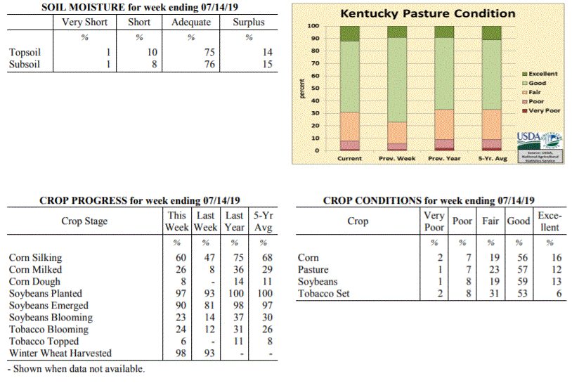 Kentucky Climate Summary
For the Period July 8, 2019 to July 14, 2019
Above Normal Temperatures and Below Normal Rainfall:
Conditions were drier across the area this period, while summer heat remained
entrenched across the area. High temperatures consistently reached into the upper
80s to lower 90s. Some even reaching the middle 90s across Western Kentucky.
Combined with dewpoints in the 70s, the livestock heat stress index remained elevated
in the danger to emergency categories. Most of the rainfall for the period fell
midweek with summer-time afternoon thunderstorms on Wednesday and followed by a cold
front pushing through the area on Thursday. Coverage remained isolated to scattered
with the state average for the week only coming in at 0.59 inches. Most of the
activity fell across Southwestern, South-Central, and Eastern Kentucky. North-
Central Kentucky and the Northern Bluegrass missed on most of the rain.
Temperatures for the period averaged 79 degrees across the state which was 2 degrees
warmer than normal and 2 degrees warmer than the previous period. High temperatures
averaged from 89 in the West to 87 in the East. Departure from normal high
temperatures ranged from near normal in the West to near normal in the East. Low
temperatures averaged from 70 degrees in the West to 68 degrees in the East.
Departure from normal low temperature ranged from 2 degrees warmer than normal in the
West to 5 degrees warmer than normal in the East. The extreme high temperature for
the period was 96 degrees at CAPE GIRARDEAU ASOS and the extreme low was 58 degrees
at CARROLLTON 2E.
Precipitation (liq. equ.) for the period totaled 0.59 inches statewide which was 0.4
inches below normal and 59% of normal. Precipitation totals by climate division, West
0.62 inches, Central 0.42 inches, Bluegrass 0.34 inches and East 1.00 inches, which
was 0.36, 0.58, 0.64 and 0.01 inches below normal. By station, precipitation totals
ranged from a low of 0.00 inches at BRANDENBURG 4SW to a high of 2.92 inches at
PADUCAH ASOS.
---
Kentucky Crop and Weather Report
Issued 4:00 P.M., July 8, 2019 17-19
Agricultural News: Kentucky experienced above normal temperatures and rainfall over
the past week. Precipitation for the week totaled 1.35 inches, 0.36 inches above
normal. Temperatures averaged 79 degrees for the week, 3 degrees above normal.
Topsoil moisture was rated 3 percent short, 78 percent adequate and 19 percent
surplus. Subsoil moisture was rated 3 percent short, 79 percent adequate, and 18
percent surplus. Days suitable for fieldwork averaged 4.4 out of a possible seven.
Primary activities this week included harvesting winter wheat, planting double crop
soybeans, setting tobacco, spraying crops, and clipping pastures. Low lying areas
continue to be impacted by excessive precipitation this season, including prevented
planting, drowned out crops, and damage to root systems. The average height of
emerged soybeans was 15 inches.
The excessive heat and humidity has started to stress some crops, pastures, and hay
fields. Farmers have been cutting hay, with some reports of over-maturity in the
first cutting due to wet weather and delays in harvesting.
Kentucky Climate Summary
For the Period July 8, 2019 to July 14, 2019
Above Normal Temperatures and Below Normal Rainfall:
Conditions were drier across the area this period, while summer heat remained
entrenched across the area. High temperatures consistently reached into the upper
80s to lower 90s. Some even reaching the middle 90s across Western Kentucky.
Combined with dewpoints in the 70s, the livestock heat stress index remained elevated
in the danger to emergency categories. Most of the rainfall for the period fell
midweek with summer-time afternoon thunderstorms on Wednesday and followed by a cold
front pushing through the area on Thursday. Coverage remained isolated to scattered
with the state average for the week only coming in at 0.59 inches. Most of the
activity fell across Southwestern, South-Central, and Eastern Kentucky. North-
Central Kentucky and the Northern Bluegrass missed on most of the rain.
Temperatures for the period averaged 79 degrees across the state which was 2 degrees
warmer than normal and 2 degrees warmer than the previous period. High temperatures
averaged from 89 in the West to 87 in the East. Departure from normal high
temperatures ranged from near normal in the West to near normal in the East. Low
temperatures averaged from 70 degrees in the West to 68 degrees in the East.
Departure from normal low temperature ranged from 2 degrees warmer than normal in the
West to 5 degrees warmer than normal in the East. The extreme high temperature for
the period was 96 degrees at CAPE GIRARDEAU ASOS and the extreme low was 58 degrees
at CARROLLTON 2E.
Precipitation (liq. equ.) for the period totaled 0.59 inches statewide which was 0.4
inches below normal and 59% of normal. Precipitation totals by climate division, West
0.62 inches, Central 0.42 inches, Bluegrass 0.34 inches and East 1.00 inches, which
was 0.36, 0.58, 0.64 and 0.01 inches below normal. By station, precipitation totals
ranged from a low of 0.00 inches at BRANDENBURG 4SW to a high of 2.92 inches at
PADUCAH ASOS.
---
Kentucky Crop and Weather Report
Issued 4:00 P.M., July 8, 2019 17-19
Agricultural News: Kentucky experienced above normal temperatures and rainfall over
the past week. Precipitation for the week totaled 1.35 inches, 0.36 inches above
normal. Temperatures averaged 79 degrees for the week, 3 degrees above normal.
Topsoil moisture was rated 3 percent short, 78 percent adequate and 19 percent
surplus. Subsoil moisture was rated 3 percent short, 79 percent adequate, and 18
percent surplus. Days suitable for fieldwork averaged 4.4 out of a possible seven.
Primary activities this week included harvesting winter wheat, planting double crop
soybeans, setting tobacco, spraying crops, and clipping pastures. Low lying areas
continue to be impacted by excessive precipitation this season, including prevented
planting, drowned out crops, and damage to root systems. The average height of
emerged soybeans was 15 inches.
The excessive heat and humidity has started to stress some crops, pastures, and hay
fields. Farmers have been cutting hay, with some reports of over-maturity in the
first cutting due to wet weather and delays in harvesting.
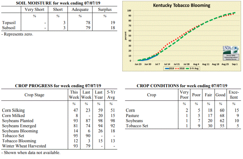 Kentucky Climate Summary
For the Period July 1, 2019 to July 7, 2019
Above Normal Temperatures and Rainfall:
The weather this past week followed a repetitive pattern. Each day started with
mostly to partly sunny skies, but by late morning to early afternoon, clouds were on
the increase. Peak heating brought diurnal rounds of scattered to numerous showers
and storms, mainly of the pulse variety and dissipating shortly after sunset. While
severe weather was minimal, a moist and very unstable air mass led to torrential
downpours, frequent lightning, and occasional gusty winds. Overall, the repetitive
pattern led to a state rainfall average of 1.35 inches for the week, over a third of
an inch above normal. As an extension to the last week of June, highs remained in
the middle 80s to low 90s throughout the week. High dew points pushed peak heat
indices into the middle 90s to around 100 at times and kept the livestock heat stress
index elevated in the danger category.
Temperatures for the period averaged 79 degrees across the state which was 3 degrees
warmer than normal and 2 degrees warmer than the previous period. High temperatures
averaged from 88 in the West to 86 in the East. Departure from normal high
temperatures ranged from 1 degree cooler than normal in the West to near
normal in the East. Low temperatures averaged from 71 degrees in the West to 67
degrees in the East. Departure from normal low temperature ranged from 4 degrees
warmer than normal in the West to 5 degrees warmer than normal in the East. The
extreme high temperature for the period was 96 degrees at PADUCAH ASOS and the
extreme low was 64 degrees at MT STERLING AWOS.
Precipitation (liq. equ.) for the period totaled 1.35 inches statewide which was 0.36
inches above normal and 136% of normal. Precipitation totals by climate division,
West 1.41 inches, Central 1.48 inches, Bluegrass 0.67 inches and East 1.83 inches,
which was 0.41, 0.49, -0.29 and 0.81 inches respectively from normal. By station,
precipitation totals ranged from a low of 0.00 inches at BURLINGTON 4S to a high of
5.00 inches at SOMERSET.
---
Kentucky Crop and Weather Report
Issued 4:00 P.M., July 1, 2019 16-19
Agricultural News: Kentucky experienced above normal temperatures and below normal
rainfall over the past week. Precipitation for the week totaled 0.81 inches, 0.18
inches below normal. Temperatures averaged 76 degrees for the week, 1 degree above
normal. Topsoil moisture was rated 2 percent short, 73 percent adequate and 25
percent surplus. Subsoil moisture was rated 2 percent short, 77 percent adequate, and
21 percent surplus. Days suitable for fieldwork averaged 4.0 out of a possible seven.
Primary activities this week included cutting hay, planting soybeans, harvesting hay,
and spraying fields. Drier conditions allowed for more fieldwork than previous weeks,
but the cumulative effects of persistent precipitation so far this season have led to
varying impacts. Damage reports included flooding in low lying areas, tobacco
scalding from hot and humid conditions, incidences of soybeans rotting before
emerging, and hay quality concerns due to over-maturity. The quality of harvested hay
was rated 60% in good to excellent condition.
The planting of double crop soybeans continues as significant progress was made in
harvesting winter wheat. The average height of emerged soybeans was 11 inches, compared
to 12 inches last year.
Kentucky Climate Summary
For the Period July 1, 2019 to July 7, 2019
Above Normal Temperatures and Rainfall:
The weather this past week followed a repetitive pattern. Each day started with
mostly to partly sunny skies, but by late morning to early afternoon, clouds were on
the increase. Peak heating brought diurnal rounds of scattered to numerous showers
and storms, mainly of the pulse variety and dissipating shortly after sunset. While
severe weather was minimal, a moist and very unstable air mass led to torrential
downpours, frequent lightning, and occasional gusty winds. Overall, the repetitive
pattern led to a state rainfall average of 1.35 inches for the week, over a third of
an inch above normal. As an extension to the last week of June, highs remained in
the middle 80s to low 90s throughout the week. High dew points pushed peak heat
indices into the middle 90s to around 100 at times and kept the livestock heat stress
index elevated in the danger category.
Temperatures for the period averaged 79 degrees across the state which was 3 degrees
warmer than normal and 2 degrees warmer than the previous period. High temperatures
averaged from 88 in the West to 86 in the East. Departure from normal high
temperatures ranged from 1 degree cooler than normal in the West to near
normal in the East. Low temperatures averaged from 71 degrees in the West to 67
degrees in the East. Departure from normal low temperature ranged from 4 degrees
warmer than normal in the West to 5 degrees warmer than normal in the East. The
extreme high temperature for the period was 96 degrees at PADUCAH ASOS and the
extreme low was 64 degrees at MT STERLING AWOS.
Precipitation (liq. equ.) for the period totaled 1.35 inches statewide which was 0.36
inches above normal and 136% of normal. Precipitation totals by climate division,
West 1.41 inches, Central 1.48 inches, Bluegrass 0.67 inches and East 1.83 inches,
which was 0.41, 0.49, -0.29 and 0.81 inches respectively from normal. By station,
precipitation totals ranged from a low of 0.00 inches at BURLINGTON 4S to a high of
5.00 inches at SOMERSET.
---
Kentucky Crop and Weather Report
Issued 4:00 P.M., July 1, 2019 16-19
Agricultural News: Kentucky experienced above normal temperatures and below normal
rainfall over the past week. Precipitation for the week totaled 0.81 inches, 0.18
inches below normal. Temperatures averaged 76 degrees for the week, 1 degree above
normal. Topsoil moisture was rated 2 percent short, 73 percent adequate and 25
percent surplus. Subsoil moisture was rated 2 percent short, 77 percent adequate, and
21 percent surplus. Days suitable for fieldwork averaged 4.0 out of a possible seven.
Primary activities this week included cutting hay, planting soybeans, harvesting hay,
and spraying fields. Drier conditions allowed for more fieldwork than previous weeks,
but the cumulative effects of persistent precipitation so far this season have led to
varying impacts. Damage reports included flooding in low lying areas, tobacco
scalding from hot and humid conditions, incidences of soybeans rotting before
emerging, and hay quality concerns due to over-maturity. The quality of harvested hay
was rated 60% in good to excellent condition.
The planting of double crop soybeans continues as significant progress was made in
harvesting winter wheat. The average height of emerged soybeans was 11 inches, compared
to 12 inches last year.
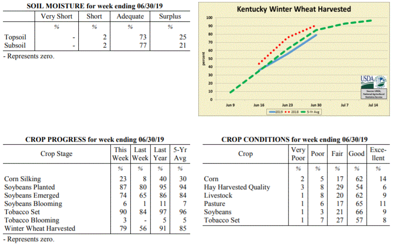 Kentucky Climate Summary
For the Period June 24, 2019 to June 30, 2019
Above Normal Temperatures and Below Normal Rainfall:
More summer-like conditions moved back into the area for the last week of June. Heat
really built into the state over the second half of the period with highs consistently
getting into the upper 80s to low 90s. Combined with higher humidity, the livestock
heat stress index jumped into the danger category each afternoon and evening.
Showers and storms were hit and miss for much of the week with only a few solid
chances of rainfall. The first came on Monday as a weak cold front produced
widespread showers and embedded storms. A second disturbance sparked scattered to
numerous activity across Western/Central Kentucky on Wednesday evening and then
Sunday, another round pushed south across the state. Overall, average total
accumulations were higher across Western Kentucky at 1.12 inches and lowest in the
Bluegrass Region with an average of 0.48. Data at the Ag Weather Center shows the
state averaged 7.70 inches for the month of June, which is over 3 inches above
normal.
Temperatures for the period averaged 76 degrees across the state which was 1 degree
warmer than normal and 2 degrees warmer than the previous period. High temperatures
averaged from 87 in the West to 87 in the East. Departure from normal high
temperatures ranged from 1 degree cooler than normal in the West to 2 degrees
warmer than normal in the East. Low temperatures averaged from 67 degrees in the
West to 65 degrees in the East. Departure from normal low temperature ranged from 1
degree warmer than normal in the West to 4 degrees warmer than normal in the East.
The extreme high temperature for the period was 95 degrees at PADUCAH ASOS and the
extreme low was 57 degrees at PAINTSVILLE 4W.
Precipitation (liq. equ.) for the period totaled 0.81 inches statewide which was 0.18
inches below normal and 82% of normal. Precipitation totals by climate division, West
1.12 inches, Central 0.94 inches, Bluegrass 0.48 inches and East 0.72 inches, which
was 0.14, -0.04, -0.49 and -0.31 inches respectively from normal. By station,
precipitation totals ranged from a low of 0.10 inches at PADUCAH ASOS to a high of
3.86 inches at FRANKLIN 4SW.
---
Kentucky Crop and Weather Report
Issued 4:00 P.M., June 24, 2019 15-19
Agricultural News: Kentucky experienced near normal temperatures and much above
normal rainfall over the past week. Precipitation for the week totaled 3.63 inches,
2.61 inches above normal. Temperatures averaged 74 degrees for the week, unchanged
from normal. Topsoil moisture was 1 percent short, 55 percent adequate, and 44
percent surplus. Subsoil moisture was rated 2 percent short, 62 percent adequate, and
36 percent surplus. Days suitable for fieldwork averaged 2.6 out of a possible seven.
Exceptionally wet conditions continue to plague the area. Dry weather has been hard
to find with daily rounds of showers and storms this past week. Overall, the state
averaged 3.63 inches for the period. Central Kentucky, in itself, even averaged 4.15,
marking the second time this month that this area has went over 4 inches. Kentucky
remained situated into a moist atmosphere for most of the week, which led to
torrential rainfall and localized flooding from time to time. Several lines of
storms pushed through the area, especially Friday and over the weekend. These lines
produced frequent lightning, damaging winds and even some tornadoes. Looking more at
the abundant rainfall, Kentucky typically averages 4.25 inches for the month of June.
Thus far, data at the Ag Weather Center shows the state has averaged 6.88 inches for
the month. This would place Kentucky in the top 10 wettest June’s of all time, but
still not close to the all-time record of 11.67 inches set in 1928.
Primary activities for this week included planting soybeans, tobacco setting, cutting
hay, and harvesting wheat. Yet another wet week has made it difficult for farmers to
complete fieldwork. The ground is saturated in most areas and concerns are beginning
to arise about the condition and outlook for crops already planted. Several reporters
noted standing water in low lying fields and wash out from the relentless
precipitation. The constant moisture could open the door for disease as well. Hay
harvest is running behind as farmers fear more rain moving in and some hay fields are
of poor quality. The average height of soybeans is 4 inches at this juncture.
Eighty four percent of the tobacco crop is in the ground, behind both last year and
the five year average. The crop is in mostly good condition with an average height of
13 inches. Although pastures and hay are in mostly good to fair condition, the
ongoing rain may begin to take a toll.
Kentucky Climate Summary
For the Period June 24, 2019 to June 30, 2019
Above Normal Temperatures and Below Normal Rainfall:
More summer-like conditions moved back into the area for the last week of June. Heat
really built into the state over the second half of the period with highs consistently
getting into the upper 80s to low 90s. Combined with higher humidity, the livestock
heat stress index jumped into the danger category each afternoon and evening.
Showers and storms were hit and miss for much of the week with only a few solid
chances of rainfall. The first came on Monday as a weak cold front produced
widespread showers and embedded storms. A second disturbance sparked scattered to
numerous activity across Western/Central Kentucky on Wednesday evening and then
Sunday, another round pushed south across the state. Overall, average total
accumulations were higher across Western Kentucky at 1.12 inches and lowest in the
Bluegrass Region with an average of 0.48. Data at the Ag Weather Center shows the
state averaged 7.70 inches for the month of June, which is over 3 inches above
normal.
Temperatures for the period averaged 76 degrees across the state which was 1 degree
warmer than normal and 2 degrees warmer than the previous period. High temperatures
averaged from 87 in the West to 87 in the East. Departure from normal high
temperatures ranged from 1 degree cooler than normal in the West to 2 degrees
warmer than normal in the East. Low temperatures averaged from 67 degrees in the
West to 65 degrees in the East. Departure from normal low temperature ranged from 1
degree warmer than normal in the West to 4 degrees warmer than normal in the East.
The extreme high temperature for the period was 95 degrees at PADUCAH ASOS and the
extreme low was 57 degrees at PAINTSVILLE 4W.
Precipitation (liq. equ.) for the period totaled 0.81 inches statewide which was 0.18
inches below normal and 82% of normal. Precipitation totals by climate division, West
1.12 inches, Central 0.94 inches, Bluegrass 0.48 inches and East 0.72 inches, which
was 0.14, -0.04, -0.49 and -0.31 inches respectively from normal. By station,
precipitation totals ranged from a low of 0.10 inches at PADUCAH ASOS to a high of
3.86 inches at FRANKLIN 4SW.
---
Kentucky Crop and Weather Report
Issued 4:00 P.M., June 24, 2019 15-19
Agricultural News: Kentucky experienced near normal temperatures and much above
normal rainfall over the past week. Precipitation for the week totaled 3.63 inches,
2.61 inches above normal. Temperatures averaged 74 degrees for the week, unchanged
from normal. Topsoil moisture was 1 percent short, 55 percent adequate, and 44
percent surplus. Subsoil moisture was rated 2 percent short, 62 percent adequate, and
36 percent surplus. Days suitable for fieldwork averaged 2.6 out of a possible seven.
Exceptionally wet conditions continue to plague the area. Dry weather has been hard
to find with daily rounds of showers and storms this past week. Overall, the state
averaged 3.63 inches for the period. Central Kentucky, in itself, even averaged 4.15,
marking the second time this month that this area has went over 4 inches. Kentucky
remained situated into a moist atmosphere for most of the week, which led to
torrential rainfall and localized flooding from time to time. Several lines of
storms pushed through the area, especially Friday and over the weekend. These lines
produced frequent lightning, damaging winds and even some tornadoes. Looking more at
the abundant rainfall, Kentucky typically averages 4.25 inches for the month of June.
Thus far, data at the Ag Weather Center shows the state has averaged 6.88 inches for
the month. This would place Kentucky in the top 10 wettest June’s of all time, but
still not close to the all-time record of 11.67 inches set in 1928.
Primary activities for this week included planting soybeans, tobacco setting, cutting
hay, and harvesting wheat. Yet another wet week has made it difficult for farmers to
complete fieldwork. The ground is saturated in most areas and concerns are beginning
to arise about the condition and outlook for crops already planted. Several reporters
noted standing water in low lying fields and wash out from the relentless
precipitation. The constant moisture could open the door for disease as well. Hay
harvest is running behind as farmers fear more rain moving in and some hay fields are
of poor quality. The average height of soybeans is 4 inches at this juncture.
Eighty four percent of the tobacco crop is in the ground, behind both last year and
the five year average. The crop is in mostly good condition with an average height of
13 inches. Although pastures and hay are in mostly good to fair condition, the
ongoing rain may begin to take a toll.
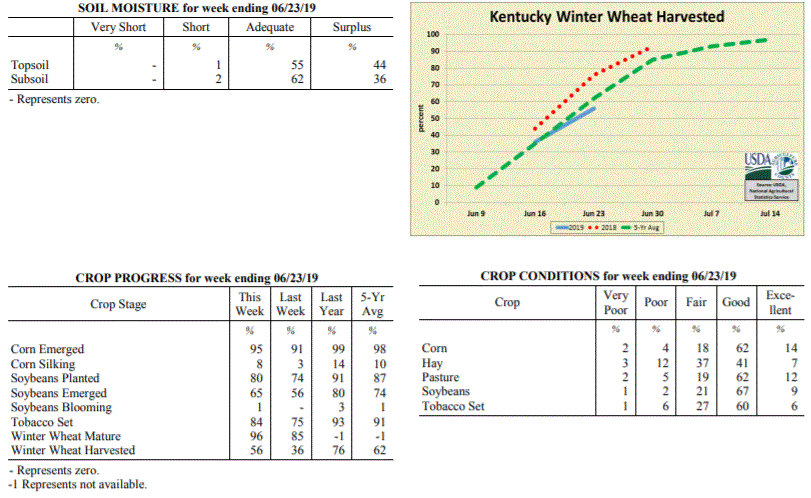 Kentucky Climate Summary
For the Period June 17, 2019 to June 23, 2019
Near Normal Temperatures and Much Above Normal Rainfall:
Exceptionally wet conditions continue to plague the area. Dry weather has been hard
to find with daily rounds of showers and storms this past week. Overall, the state
averaged 3.63 inches for the period. Central Kentucky, in itself, even averaged 4.15,
marking the second time this month that this area has went over 4 inches. Kentucky
remained situated into a moist atmosphere for most of the week, which led to
torrential rainfall and localized flooding from time to time. Several lines of
storms pushed through the area, especially Friday and over the weekend. These lines
produced frequent lightning, damaging winds and even some tornadoes. Looking more at
the abundant rainfall, Kentucky typically averages 4.25 inches for the month of June.
Thus far, data at the Ag Weather Center shows the state has averaged 6.88 inches for
the month. This would place Kentucky in the top 10 wettest June’s of all time, but
still not close to the all-time record of 11.67 inches set in 1928.
Temperatures for the period averaged 74 degrees across the state which was near
normal and 6 degrees warmer than the previous period. High temperatures
averaged from 84 in the West to 80 in the East. Departure from normal high
temperatures ranged from 3 degrees cooler than normal in the West to 4 degrees
cooler than normal in the East. Low temperatures averaged from 68 degrees in the
West to 65 degrees in the East. Departure from normal low temperature ranged from 4
degrees warmer than normal in the West to 5 degrees warmer than normal in the East.
The extreme high temperature for the period was 91 degrees at CAPE GIRARDEAU ASOS and
the extreme low was 57 degrees at CAMPBELLSVILLE 7W.
Precipitation (liq. equ.) for the period totaled 3.63 inches statewide which was 2.61
inches above normal and 357% of normal. Precipitation totals by climate division,
West 3.34 inches, Central 4.15 inches, Bluegrass 3.71 inches and East 3.33 inches,
which was 2.33, 3.14, 2.69 and 2.3 inches above normal. By station, precipitation
totals ranged from a low of 1.57 inches at BIG SANDY to a high of 6.58 inches at LONDON.
---
Kentucky Crop and Weather Report
Issued 4:00 P.M., June 17, 2019 14-19
Agricultural News: Kentucky experienced below normal temperatures and rainfall over
the past week. Precipitation for the week totaled 0.64 inches, 0.38 inches below
normal. Temperatures averaged 68 degrees for the week, 4 degrees below normal.
Topsoil moisture was rated 3 percent short, 74 percent adequate, and 23 percent
surplus. Subsoil moisture was rated 5 percent short, 78 percent adequate, and 17
percent surplus. Days suitable for fieldwork averaged 4.4 out of a possible seven.
Primary activities for this week included planting soybeans, tobacco setting, cutting
hay, harvesting wheat, and planting any remaining corn. Rain was scattered across the
state as some producers experienced weather conducive to fieldwork while others
continue to battle persistent rain. Showers were heavy in some regions causing
concern for planted crops as well as delaying the planting of others. There were
multiple reports of standing water in fields and visible crop stress due to excessive
precipitation. Many farmers have not been able to harvest hay after a very wet winter
that led to a shortage.
Tobacco setting remains behind last year and the five year average with 75 percent in
the ground. The average height of tobacco plants was 10 inches, same as last year and
just ahead of the five year average. Pasture condition remains in mostly
good condition despite the continued rain.
Kentucky Climate Summary
For the Period June 17, 2019 to June 23, 2019
Near Normal Temperatures and Much Above Normal Rainfall:
Exceptionally wet conditions continue to plague the area. Dry weather has been hard
to find with daily rounds of showers and storms this past week. Overall, the state
averaged 3.63 inches for the period. Central Kentucky, in itself, even averaged 4.15,
marking the second time this month that this area has went over 4 inches. Kentucky
remained situated into a moist atmosphere for most of the week, which led to
torrential rainfall and localized flooding from time to time. Several lines of
storms pushed through the area, especially Friday and over the weekend. These lines
produced frequent lightning, damaging winds and even some tornadoes. Looking more at
the abundant rainfall, Kentucky typically averages 4.25 inches for the month of June.
Thus far, data at the Ag Weather Center shows the state has averaged 6.88 inches for
the month. This would place Kentucky in the top 10 wettest June’s of all time, but
still not close to the all-time record of 11.67 inches set in 1928.
Temperatures for the period averaged 74 degrees across the state which was near
normal and 6 degrees warmer than the previous period. High temperatures
averaged from 84 in the West to 80 in the East. Departure from normal high
temperatures ranged from 3 degrees cooler than normal in the West to 4 degrees
cooler than normal in the East. Low temperatures averaged from 68 degrees in the
West to 65 degrees in the East. Departure from normal low temperature ranged from 4
degrees warmer than normal in the West to 5 degrees warmer than normal in the East.
The extreme high temperature for the period was 91 degrees at CAPE GIRARDEAU ASOS and
the extreme low was 57 degrees at CAMPBELLSVILLE 7W.
Precipitation (liq. equ.) for the period totaled 3.63 inches statewide which was 2.61
inches above normal and 357% of normal. Precipitation totals by climate division,
West 3.34 inches, Central 4.15 inches, Bluegrass 3.71 inches and East 3.33 inches,
which was 2.33, 3.14, 2.69 and 2.3 inches above normal. By station, precipitation
totals ranged from a low of 1.57 inches at BIG SANDY to a high of 6.58 inches at LONDON.
---
Kentucky Crop and Weather Report
Issued 4:00 P.M., June 17, 2019 14-19
Agricultural News: Kentucky experienced below normal temperatures and rainfall over
the past week. Precipitation for the week totaled 0.64 inches, 0.38 inches below
normal. Temperatures averaged 68 degrees for the week, 4 degrees below normal.
Topsoil moisture was rated 3 percent short, 74 percent adequate, and 23 percent
surplus. Subsoil moisture was rated 5 percent short, 78 percent adequate, and 17
percent surplus. Days suitable for fieldwork averaged 4.4 out of a possible seven.
Primary activities for this week included planting soybeans, tobacco setting, cutting
hay, harvesting wheat, and planting any remaining corn. Rain was scattered across the
state as some producers experienced weather conducive to fieldwork while others
continue to battle persistent rain. Showers were heavy in some regions causing
concern for planted crops as well as delaying the planting of others. There were
multiple reports of standing water in fields and visible crop stress due to excessive
precipitation. Many farmers have not been able to harvest hay after a very wet winter
that led to a shortage.
Tobacco setting remains behind last year and the five year average with 75 percent in
the ground. The average height of tobacco plants was 10 inches, same as last year and
just ahead of the five year average. Pasture condition remains in mostly
good condition despite the continued rain.
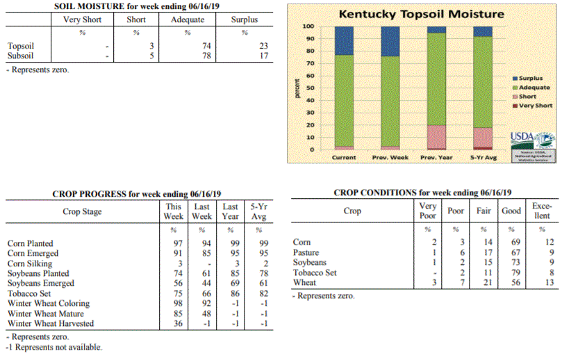 Kentucky Climate Summary
For the Period June 10, 2019 to June 16, 2019
Below Normal Temperatures and Rainfall:
Kentucky average rainfall was below normal for the week, but that does not tell the
whole story. Western and Central Kentucky each averaged under a quarter inch for the
week, well below normal. Accumulations increased farther east and especially north.
The Bluegrass area averaged 1.53 inches behind multiple rounds of rainfall, mainly
Wednesday and Sunday afternoons/evenings. Temperature-wise, it was a cooler week
overall for the Bluegrass State with the weekly state average coming in below normal
for this first time since March. The coolest period came Friday morning as clear
skies and calm winds sent lows into the middle to upper 40s!
Temperatures for the period averaged 68 degrees across the state which was 4 degrees
cooler than normal and 4 degrees cooler than the previous period. High temperatures
averaged from 80 in the West to 76 in the East. Departure from normal high
temperatures ranged from 5 degrees cooler than normal in the West to 7 degrees
cooler than normal in the East. Low temperatures averaged from 60 degrees in the
West to 57 degrees in the East. Departure from normal low temperature ranged from 3
degrees cooler than normal in the West to 1 degree cooler than normal in the East.
The extreme high temperature for the period was 91 degrees at BOWLING GREEN APT and
the extreme low was 43 degrees at CAMPBELLSVILLE 7W.
Precipitation (liq. equ.) for the period totaled 0.64 inches statewide which was 0.38
inches below normal and 63% of normal. Precipitation totals by climate division, West
0.18 inches, Central 0.24 inches, Bluegrass 1.53 inches and East 0.61 inches, which
was -0.79, -0.79, 0.49 and -0.43 inches respectively from normal. By station,
precipitation totals ranged from a low of 0.00 inches at BENTON 4N to a high of 3.58
inches at CINCINNATI.
---
Kentucky Crop and Weather Report
Issued 4:00 P.M., June 10, 2019 13-19
Agricultural News: Kentucky experienced above normal temperatures and much above
normal rainfall over the past week. Precipitation for the week totaled 2.57 inches,
1.49 inches above normal. Temperatures averaged 72 degrees for the week, 2 degrees
above normal. Topsoil moisture was rated 3 percent short, 73 percent adequate, and 24
percent surplus. Subsoil moisture was rated 4 percent short, 78 percent adequate, and
18 percent surplus. Days suitable for fieldwork averaged 3.9 out of a possible seven.
Primary activities for this week included planting corn and soybeans, tobacco
setting, and cutting hay when weather allowed. Farmers continue to battle persistent
rain when attempting to complete fieldwork. There were a few days of dry weather
which allowed progress, however rain moved in towards the end of the week. Rain was
heavy at times causing standing water in some fields. Corn and soybeans remain behind
both last year and the five year average at this juncture in the season. Several
producers have expressed growing concern over crop production due to the continuous
rain. The average height of corn was 21 inches, compared to 12 inches last week.
Sixty six percent of the tobacco crop is in the ground, behind both last year and the
five year average. The average height of tobacco plants was 6 inches. Although
pasture condition was reported as mostly good, the rain has caused some damage due
to mud and weed overgrowth.
Kentucky Climate Summary
For the Period June 10, 2019 to June 16, 2019
Below Normal Temperatures and Rainfall:
Kentucky average rainfall was below normal for the week, but that does not tell the
whole story. Western and Central Kentucky each averaged under a quarter inch for the
week, well below normal. Accumulations increased farther east and especially north.
The Bluegrass area averaged 1.53 inches behind multiple rounds of rainfall, mainly
Wednesday and Sunday afternoons/evenings. Temperature-wise, it was a cooler week
overall for the Bluegrass State with the weekly state average coming in below normal
for this first time since March. The coolest period came Friday morning as clear
skies and calm winds sent lows into the middle to upper 40s!
Temperatures for the period averaged 68 degrees across the state which was 4 degrees
cooler than normal and 4 degrees cooler than the previous period. High temperatures
averaged from 80 in the West to 76 in the East. Departure from normal high
temperatures ranged from 5 degrees cooler than normal in the West to 7 degrees
cooler than normal in the East. Low temperatures averaged from 60 degrees in the
West to 57 degrees in the East. Departure from normal low temperature ranged from 3
degrees cooler than normal in the West to 1 degree cooler than normal in the East.
The extreme high temperature for the period was 91 degrees at BOWLING GREEN APT and
the extreme low was 43 degrees at CAMPBELLSVILLE 7W.
Precipitation (liq. equ.) for the period totaled 0.64 inches statewide which was 0.38
inches below normal and 63% of normal. Precipitation totals by climate division, West
0.18 inches, Central 0.24 inches, Bluegrass 1.53 inches and East 0.61 inches, which
was -0.79, -0.79, 0.49 and -0.43 inches respectively from normal. By station,
precipitation totals ranged from a low of 0.00 inches at BENTON 4N to a high of 3.58
inches at CINCINNATI.
---
Kentucky Crop and Weather Report
Issued 4:00 P.M., June 10, 2019 13-19
Agricultural News: Kentucky experienced above normal temperatures and much above
normal rainfall over the past week. Precipitation for the week totaled 2.57 inches,
1.49 inches above normal. Temperatures averaged 72 degrees for the week, 2 degrees
above normal. Topsoil moisture was rated 3 percent short, 73 percent adequate, and 24
percent surplus. Subsoil moisture was rated 4 percent short, 78 percent adequate, and
18 percent surplus. Days suitable for fieldwork averaged 3.9 out of a possible seven.
Primary activities for this week included planting corn and soybeans, tobacco
setting, and cutting hay when weather allowed. Farmers continue to battle persistent
rain when attempting to complete fieldwork. There were a few days of dry weather
which allowed progress, however rain moved in towards the end of the week. Rain was
heavy at times causing standing water in some fields. Corn and soybeans remain behind
both last year and the five year average at this juncture in the season. Several
producers have expressed growing concern over crop production due to the continuous
rain. The average height of corn was 21 inches, compared to 12 inches last week.
Sixty six percent of the tobacco crop is in the ground, behind both last year and the
five year average. The average height of tobacco plants was 6 inches. Although
pasture condition was reported as mostly good, the rain has caused some damage due
to mud and weed overgrowth.
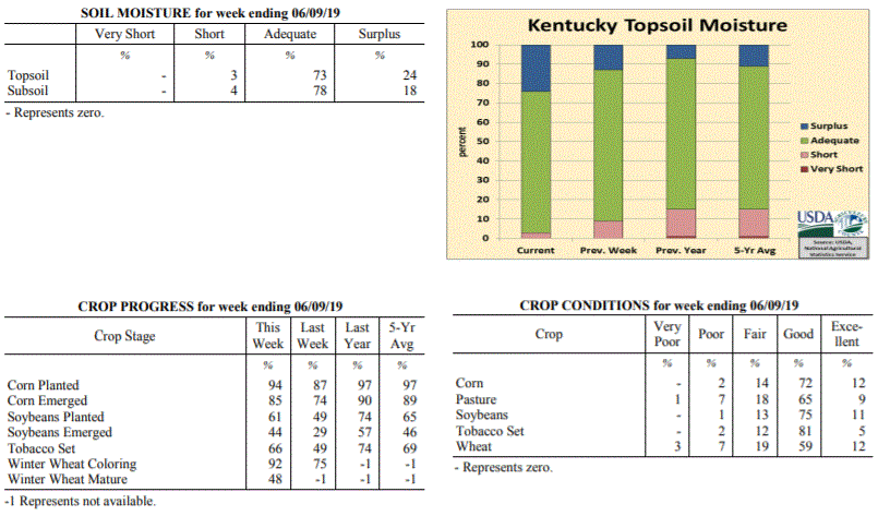 Kentucky Climate Summary
For the Period June 3, 2019 to June 9, 2019
Above Normal Temperatures and Much Above Normal Rainfall:
A very active pattern with daily bouts of rainfall between Wednesday and Sunday led
to an exceptionally wet week for the Commonwealth. Much of the activity fell across
Central Kentucky and areas to the east, scattered to numerous in coverage most of the
time. Thunderstorms tended to be slow-movers during the period and with a combination of
torrential rainfall and saturated ground, localized flooding was a possibility.
Central Kentucky, in itself, averaged 4.14 inches for the week. A handful of
locations were more than five inches. Putting this into perspective, Kentucky
averages 4.25 inches for the entire month of June. Western Kentucky saw the least,
but still came in at 1.55 inches. After portions of the state were starting to get
dry in May, the state has now went two straight weeks with above normal rainfall.
Temperatures for the period averaged 72 degrees across the state which was 2 degrees
warmer than normal and no change to the previous period. High temperatures averaged
from 82 in the West to 79 in the East. Departure from normal high temperatures
ranged from 2 degrees cooler than normal in the West to 3 degrees cooler than normal
in the East. Low temperatures averaged from 66 degrees in the West to 62 degrees in
the East. Departure from normal low temperature ranged from 5 degrees warmer than
normal in the West to 5 degrees warmer than normal in the East. The extreme high
temperature for the period was 94 degrees at FRANKLIN 4SW and the extreme low was 45
degrees at CYNTHIANA 8N.
Precipitation (liq. equ.) for the period totaled 2.57 inches statewide which was 1.49
inches above normal and 239% of normal. Precipitation totals by climate division,
West 1.55 inches, Central 4.14 inches, Bluegrass 1.97 inches and East 2.61 inches,
which was 0.51, 3.05, 0.87 and 1.53 inches above normal. By station, precipitation
totals ranged from a low of 0.23 inches at PRINCETON 2SE to a high of 6.72 inches at
GLASGOW 11W.
---
Kentucky Crop and Weather Report
Issued 4:00 P.M., June 3, 2019 12-19
Agricultural News: Kentucky experienced above normal temperatures and rainfall over
the past week. Precipitation for the week totaled 1.18 inches, 0.06 inches above
normal. Temperatures averaged 73 degrees for the week, 4 degrees above normal.
Topsoil moisture was rated 9 percent short, 78 percent adequate, and 13 percent
surplus. Subsoil moisture was rated 8 percent short, 83 percent adequate, and 9
percent surplus. Days suitable for fieldwork averaged 4.4 out of a possible seven.
Primary activities for this week included planting corn and soybeans, tobacco
setting, and cutting hay when weather permitted. Fieldwork was interrupted at times
by heavy rain, which in some cases led to standing water in low lying areas. Despite
the adverse conditions, farmers were able to make planting progress. Tobacco, corn,
and soybeans are all behind both last year and the five year average at this point in
the season. The average height of corn was 12 inches, compared to 9 inches last week.
Pastures remain in mostly good condition at this time. Farmers have had difficulty
finding a window to cut hay due to the persistent precipitation.
Kentucky Climate Summary
For the Period June 3, 2019 to June 9, 2019
Above Normal Temperatures and Much Above Normal Rainfall:
A very active pattern with daily bouts of rainfall between Wednesday and Sunday led
to an exceptionally wet week for the Commonwealth. Much of the activity fell across
Central Kentucky and areas to the east, scattered to numerous in coverage most of the
time. Thunderstorms tended to be slow-movers during the period and with a combination of
torrential rainfall and saturated ground, localized flooding was a possibility.
Central Kentucky, in itself, averaged 4.14 inches for the week. A handful of
locations were more than five inches. Putting this into perspective, Kentucky
averages 4.25 inches for the entire month of June. Western Kentucky saw the least,
but still came in at 1.55 inches. After portions of the state were starting to get
dry in May, the state has now went two straight weeks with above normal rainfall.
Temperatures for the period averaged 72 degrees across the state which was 2 degrees
warmer than normal and no change to the previous period. High temperatures averaged
from 82 in the West to 79 in the East. Departure from normal high temperatures
ranged from 2 degrees cooler than normal in the West to 3 degrees cooler than normal
in the East. Low temperatures averaged from 66 degrees in the West to 62 degrees in
the East. Departure from normal low temperature ranged from 5 degrees warmer than
normal in the West to 5 degrees warmer than normal in the East. The extreme high
temperature for the period was 94 degrees at FRANKLIN 4SW and the extreme low was 45
degrees at CYNTHIANA 8N.
Precipitation (liq. equ.) for the period totaled 2.57 inches statewide which was 1.49
inches above normal and 239% of normal. Precipitation totals by climate division,
West 1.55 inches, Central 4.14 inches, Bluegrass 1.97 inches and East 2.61 inches,
which was 0.51, 3.05, 0.87 and 1.53 inches above normal. By station, precipitation
totals ranged from a low of 0.23 inches at PRINCETON 2SE to a high of 6.72 inches at
GLASGOW 11W.
---
Kentucky Crop and Weather Report
Issued 4:00 P.M., June 3, 2019 12-19
Agricultural News: Kentucky experienced above normal temperatures and rainfall over
the past week. Precipitation for the week totaled 1.18 inches, 0.06 inches above
normal. Temperatures averaged 73 degrees for the week, 4 degrees above normal.
Topsoil moisture was rated 9 percent short, 78 percent adequate, and 13 percent
surplus. Subsoil moisture was rated 8 percent short, 83 percent adequate, and 9
percent surplus. Days suitable for fieldwork averaged 4.4 out of a possible seven.
Primary activities for this week included planting corn and soybeans, tobacco
setting, and cutting hay when weather permitted. Fieldwork was interrupted at times
by heavy rain, which in some cases led to standing water in low lying areas. Despite
the adverse conditions, farmers were able to make planting progress. Tobacco, corn,
and soybeans are all behind both last year and the five year average at this point in
the season. The average height of corn was 12 inches, compared to 9 inches last week.
Pastures remain in mostly good condition at this time. Farmers have had difficulty
finding a window to cut hay due to the persistent precipitation.
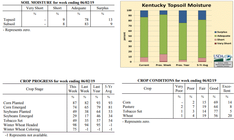 Kentucky Climate Summary
For the Period May 27, 2019 to June 2, 2019
Above Normal Temperatures and Rainfall:
Kentucky broke a three-week streak of below normal rainfall as the state averaged
1.18 inches for the period. While conditions were mostly dry on Memorial Day and
Tuesday, rain coverage increased over the second half of the workweek. A combination
of surface boundaries and unstable atmosphere sparked showers and storms on a daily
basis with some storms becoming strong to severe at times. While the state averaged
1.18 inches, that number increased to 1.76 across Western Kentucky. Some saw 3+ inches.
The rain came as some areas of the state were starting to get fairly dry. The US Drought
Monitor even introduced ‘Abnormally Dry’ conditions to portions of Central and Eastern
Kentucky with the latest update on May 30th.
Temperatures for the period averaged 73 degrees across the state which was 4 degrees
warmer than normal and 2 degrees cooler than the previous period. High temperatures
averaged from 83 in the West to 82 in the East. Departure from normal high
temperatures ranged from 1 degree warmer than normal in the West to 2 degrees
warmer than normal in the East. Low temperatures averaged from 66 degrees in the
West to 63 degrees in the East. Departure from normal low temperature ranged from 7
degrees warmer than normal in the West to 8 degrees warmer than normal in the East.
The extreme high temperature for the period was 91 degrees at BOWLING GREEN APT and
the extreme low was 53 degrees at HINDMAN 5N.
Precipitation (liq. equ.) for the period totaled 1.18 inches statewide which was 0.06
inches above normal and 105% of normal. Precipitation totals by climate division,
West 1.76 inches, Central 0.88 inches, Bluegrass 1.11 inches and East 0.97 inches,
which was 0.66, -0.28, 0.02 and -0.16 inches respectively from normal. By station,
precipitation totals ranged from a low of 0.12 inches at MIDDLESBORO AWOS to a high
of 3.56 inches at BENTON 4N.
---
Kentucky Crop and Weather Report
Issued 4:00 P.M., May 28, 2019 11-19
Agricultural News: Kentucky experienced well above normal temperatures and below
normal rainfall over the past week. Precipitation for the week totaled 0.61 inches,
0.50 inches below normal. Temperatures averaged 74 degrees for the week, 8 degrees
above normal. Topsoil moisture was rated 1 percent very short, 14 percent short, 77
percent adequate and 8 percent surplus. Subsoil moisture was rated 1 percent very
short, 10 percent short, 82 percent adequate, and 7 percent surplus. Days suitable
for fieldwork averaged 5.6 out of a possible seven.
Primary activities this week included planting corn and soybeans, setting tobacco,
and cutting hay. Some producers reported quality concerns in the first cutting of
hay, noting that recent humidity led to hay not drying well. Hay and roughage
supplies were reported as 12 percent very short, 26 percent short, 58 percent
adequate, and 4 percent surplus.
Limited rainfall allowed for more fieldwork to take place, but along with higher
temperatures this contributed to fields drying out. The average height of emerged
corn was 9 inches, consistent with the previous year.
Kentucky Climate Summary
For the Period May 27, 2019 to June 2, 2019
Above Normal Temperatures and Rainfall:
Kentucky broke a three-week streak of below normal rainfall as the state averaged
1.18 inches for the period. While conditions were mostly dry on Memorial Day and
Tuesday, rain coverage increased over the second half of the workweek. A combination
of surface boundaries and unstable atmosphere sparked showers and storms on a daily
basis with some storms becoming strong to severe at times. While the state averaged
1.18 inches, that number increased to 1.76 across Western Kentucky. Some saw 3+ inches.
The rain came as some areas of the state were starting to get fairly dry. The US Drought
Monitor even introduced ‘Abnormally Dry’ conditions to portions of Central and Eastern
Kentucky with the latest update on May 30th.
Temperatures for the period averaged 73 degrees across the state which was 4 degrees
warmer than normal and 2 degrees cooler than the previous period. High temperatures
averaged from 83 in the West to 82 in the East. Departure from normal high
temperatures ranged from 1 degree warmer than normal in the West to 2 degrees
warmer than normal in the East. Low temperatures averaged from 66 degrees in the
West to 63 degrees in the East. Departure from normal low temperature ranged from 7
degrees warmer than normal in the West to 8 degrees warmer than normal in the East.
The extreme high temperature for the period was 91 degrees at BOWLING GREEN APT and
the extreme low was 53 degrees at HINDMAN 5N.
Precipitation (liq. equ.) for the period totaled 1.18 inches statewide which was 0.06
inches above normal and 105% of normal. Precipitation totals by climate division,
West 1.76 inches, Central 0.88 inches, Bluegrass 1.11 inches and East 0.97 inches,
which was 0.66, -0.28, 0.02 and -0.16 inches respectively from normal. By station,
precipitation totals ranged from a low of 0.12 inches at MIDDLESBORO AWOS to a high
of 3.56 inches at BENTON 4N.
---
Kentucky Crop and Weather Report
Issued 4:00 P.M., May 28, 2019 11-19
Agricultural News: Kentucky experienced well above normal temperatures and below
normal rainfall over the past week. Precipitation for the week totaled 0.61 inches,
0.50 inches below normal. Temperatures averaged 74 degrees for the week, 8 degrees
above normal. Topsoil moisture was rated 1 percent very short, 14 percent short, 77
percent adequate and 8 percent surplus. Subsoil moisture was rated 1 percent very
short, 10 percent short, 82 percent adequate, and 7 percent surplus. Days suitable
for fieldwork averaged 5.6 out of a possible seven.
Primary activities this week included planting corn and soybeans, setting tobacco,
and cutting hay. Some producers reported quality concerns in the first cutting of
hay, noting that recent humidity led to hay not drying well. Hay and roughage
supplies were reported as 12 percent very short, 26 percent short, 58 percent
adequate, and 4 percent surplus.
Limited rainfall allowed for more fieldwork to take place, but along with higher
temperatures this contributed to fields drying out. The average height of emerged
corn was 9 inches, consistent with the previous year.
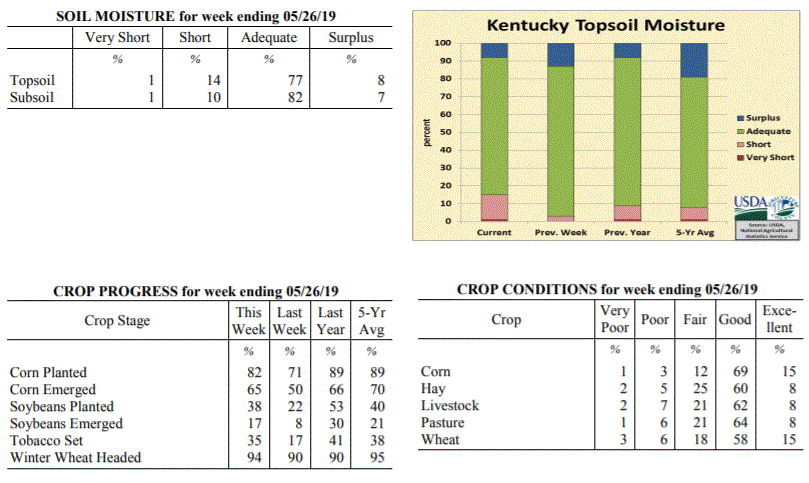 Kentucky Climate Summary
For the Period May 20, 2019 to May 26, 2019
Well Above Normal Temperatures and Below Normal Rainfall:
Kentucky has now went three straight weeks with below normal rainfall. The state
only averaged 0.61 inches for the week with higher totals across the Purchase area,
North Central Kentucky, and the Bluegrass. Totals diminished across Southern and
Southeastern Kentucky. The brunt of the activity came on Sunday as a disturbance
sparked scattered to numerous storms across primarily the northern half of Kentucky.
Storms were capable of heavy rain, frequent lightning, and some gusty winds.
Otherwise, the rest of the week featured hit-or-miss activity with most of the state
staying dry. Looking at temperatures, summer-like heat returned over the second half
of the week with highs jumping into the upper 80s to low 90s. This marked the ninth
straight week of near to above normal temperatures for the Bluegrass State.
Temperatures for the period averaged 74 degrees across the state which was 8 degrees
warmer than normal and 8 degrees warmer than the previous period. High temperatures
averaged from 86 in the West to 85 in the East. Departure from normal high
temperatures ranged from 6 degrees warmer than normal in the West to 7 degrees warmer
than normal in the East. Low temperatures averaged from 66 degrees in the West to 62
degrees in the East. Departure from normal low temperature ranged from 9 degrees
warmer than normal in the West to 10 degrees warmer than normal in the East. The
extreme high temperature for the period was 93 degrees at BURKESVILLE 3W and the
extreme low was 48 degrees at ALEXANDRIA 5NW.
Precipitation (liq. equ.) for the period totaled 0.61 inches statewide which was 0.5
inches below normal and 55% of normal. Precipitation totals by climate division, West
0.69 inches, Central 0.58 inches, Bluegrass 0.98 inches and East 0.20 inches, which
was 0.41, 0.57, 0.09 and 0.92 inches below normal. By station, precipitation totals
ranged from a low of 0.00 inches at BARBOURVILLE 3E to a high of 3.13 inches at
POPLAR BLUFF ASOS.
---
Kentucky Crop and Weather Report
Issued 4:00 P.M., May 20, 2019 10-19
Agricultural News: Kentucky experienced near normal temperatures and below normal
rainfall over the past week. Precipitation for the week totaled 0.40 inches, 0.73
inches below normal. Temperatures averaged 65 degrees for the week, near normal.
Topsoil moisture was rated 3 percent short, 84 percent adequate and 13 percent
surplus. Subsoil moisture was rated 2 percent short, 86 percent adequate, and 12
percent surplus. Days suitable for fieldwork averaged 4.9 out of a possible seven.
Primary activities this week included planting corn and soybeans, transplanting
tobacco, cutting hay, and spraying wheat. With continued dry weather, planting
progress is expected to pick up. Producers began sidedressing corn with nitrogen.
Some replanting of corn has occurred in fields where water had pooled. Spring
breeding of cattle is underway. Tobacco transplant supplies were reported as 1
percent very short, 3 percent short, 92 percent adequate, and 4 percent surplus.
Kentucky Climate Summary
For the Period May 20, 2019 to May 26, 2019
Well Above Normal Temperatures and Below Normal Rainfall:
Kentucky has now went three straight weeks with below normal rainfall. The state
only averaged 0.61 inches for the week with higher totals across the Purchase area,
North Central Kentucky, and the Bluegrass. Totals diminished across Southern and
Southeastern Kentucky. The brunt of the activity came on Sunday as a disturbance
sparked scattered to numerous storms across primarily the northern half of Kentucky.
Storms were capable of heavy rain, frequent lightning, and some gusty winds.
Otherwise, the rest of the week featured hit-or-miss activity with most of the state
staying dry. Looking at temperatures, summer-like heat returned over the second half
of the week with highs jumping into the upper 80s to low 90s. This marked the ninth
straight week of near to above normal temperatures for the Bluegrass State.
Temperatures for the period averaged 74 degrees across the state which was 8 degrees
warmer than normal and 8 degrees warmer than the previous period. High temperatures
averaged from 86 in the West to 85 in the East. Departure from normal high
temperatures ranged from 6 degrees warmer than normal in the West to 7 degrees warmer
than normal in the East. Low temperatures averaged from 66 degrees in the West to 62
degrees in the East. Departure from normal low temperature ranged from 9 degrees
warmer than normal in the West to 10 degrees warmer than normal in the East. The
extreme high temperature for the period was 93 degrees at BURKESVILLE 3W and the
extreme low was 48 degrees at ALEXANDRIA 5NW.
Precipitation (liq. equ.) for the period totaled 0.61 inches statewide which was 0.5
inches below normal and 55% of normal. Precipitation totals by climate division, West
0.69 inches, Central 0.58 inches, Bluegrass 0.98 inches and East 0.20 inches, which
was 0.41, 0.57, 0.09 and 0.92 inches below normal. By station, precipitation totals
ranged from a low of 0.00 inches at BARBOURVILLE 3E to a high of 3.13 inches at
POPLAR BLUFF ASOS.
---
Kentucky Crop and Weather Report
Issued 4:00 P.M., May 20, 2019 10-19
Agricultural News: Kentucky experienced near normal temperatures and below normal
rainfall over the past week. Precipitation for the week totaled 0.40 inches, 0.73
inches below normal. Temperatures averaged 65 degrees for the week, near normal.
Topsoil moisture was rated 3 percent short, 84 percent adequate and 13 percent
surplus. Subsoil moisture was rated 2 percent short, 86 percent adequate, and 12
percent surplus. Days suitable for fieldwork averaged 4.9 out of a possible seven.
Primary activities this week included planting corn and soybeans, transplanting
tobacco, cutting hay, and spraying wheat. With continued dry weather, planting
progress is expected to pick up. Producers began sidedressing corn with nitrogen.
Some replanting of corn has occurred in fields where water had pooled. Spring
breeding of cattle is underway. Tobacco transplant supplies were reported as 1
percent very short, 3 percent short, 92 percent adequate, and 4 percent surplus.
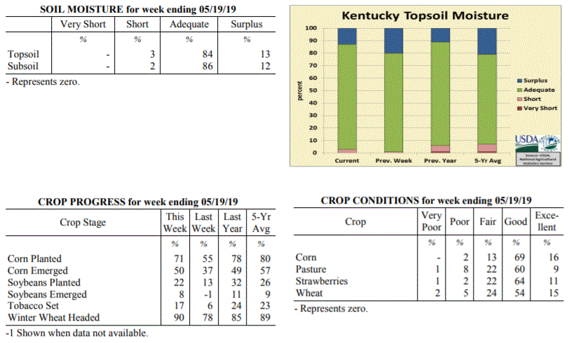 Kentucky Climate Summary
For the Period May 13, 2019 to May 19, 2019
Near Normal Temperatures and Below Normal Rainfall:
Kentucky rainfall has now been below normal for two straight weeks. Monday and
Tuesday started the period cool and dry, before a disturbance passed through Western
Kentucky on Wednesday. Many across this area saw anywhere from a quarter to an inch+,
while the rest of the state remained dry. This was followed by another disturbance
on Thursday evening and overnight, dropping through portions of Central and Eastern
Kentucky. Storms were capable of producing heavy rain and dangerous lightning. Mostly
dry conditions then returned for Friday and Saturday, accompanied by a return to
summer heat and humidity. Highs rose into the middle to upper 80s for most with some
even touching 90 degrees. Scattered activity returned on Sunday, but once again, most
stayed dry. Over the past two weeks, a large section of Central and Eastern Kentucky
are showing rainfall departures of 1 to 2 inches below normal. Some locations around
Bowling Green are more than 2 inches below.
Temperatures for the period averaged 65 degrees across the state which was
near normal and 2 degrees warmer than the previous period. High temperatures
averaged from 77 in the West to 75 in the East. Departure from normal high
temperatures ranged from 1 degree cooler than normal in the West to 1 degree
cooler than normal in the East. Low temperatures averaged from 56 degrees in the
West to 53 degrees in the East. Departure from normal low temperature ranged from 1
degree warmer than normal in the West to 3 degrees warmer than normal in the East.
The extreme high temperature for the period was 90 degrees at BURKESVILLE 3W and the
extreme low was 37 degrees at MONTICELLO AWOS.
Precipitation (liq. equ.) for the period totaled 0.40 inches statewide which was 0.73
inches below normal and 35% of normal. Precipitation totals by climate division, West
0.82 inches, Central 0.21 inches, Bluegrass 0.31 inches and East 0.27 inches, which
was 0.35, 0.98, 0.77 and 0.83 inches below normal. By station, precipitation totals
ranged from a low of 0.02 inches at COLUMBIA 3N to a high of 2.26 inches at PADUCAH ASOS.
---
Kentucky Crop and Weather Report
Issued 4:00 P.M., May 13, 2019 09-19
Agricultural News: Kentucky experienced above normal temperatures and below normal
rainfall over the past week. Precipitation for the week totaled 0.65 inches, 0.45
inches below normal. Temperatures averaged 64 degrees for the week, 2 degrees above
normal. Topsoil moisture was rated 1 percent short, 79 percent adequate and 20
percent surplus. Subsoil moisture was rated 1 percent short, 82 percent adequate, and
17 percent surplus. Days suitable for fieldwork averaged 4.0 out of a possible seven.
Primary activities this week included planting corn and soybeans, setting tobacco,
spraying fields, applying fungicides, and performing ground preparations. Producers
are monitoring upcoming weather forecasts closely to find windows for more planting
and hay cutting to take place. Pasture conditions are improving and greening up.
Tobacco transplant supplies were reported as 3 percent short, 92 percent adequate,
and 5 percent surplus. Twelve percent of tobacco transplants were under 2 inches,
with 47 percent between 2-4 inches, and 41 percent over 4 inches.
Kentucky Climate Summary
For the Period May 13, 2019 to May 19, 2019
Near Normal Temperatures and Below Normal Rainfall:
Kentucky rainfall has now been below normal for two straight weeks. Monday and
Tuesday started the period cool and dry, before a disturbance passed through Western
Kentucky on Wednesday. Many across this area saw anywhere from a quarter to an inch+,
while the rest of the state remained dry. This was followed by another disturbance
on Thursday evening and overnight, dropping through portions of Central and Eastern
Kentucky. Storms were capable of producing heavy rain and dangerous lightning. Mostly
dry conditions then returned for Friday and Saturday, accompanied by a return to
summer heat and humidity. Highs rose into the middle to upper 80s for most with some
even touching 90 degrees. Scattered activity returned on Sunday, but once again, most
stayed dry. Over the past two weeks, a large section of Central and Eastern Kentucky
are showing rainfall departures of 1 to 2 inches below normal. Some locations around
Bowling Green are more than 2 inches below.
Temperatures for the period averaged 65 degrees across the state which was
near normal and 2 degrees warmer than the previous period. High temperatures
averaged from 77 in the West to 75 in the East. Departure from normal high
temperatures ranged from 1 degree cooler than normal in the West to 1 degree
cooler than normal in the East. Low temperatures averaged from 56 degrees in the
West to 53 degrees in the East. Departure from normal low temperature ranged from 1
degree warmer than normal in the West to 3 degrees warmer than normal in the East.
The extreme high temperature for the period was 90 degrees at BURKESVILLE 3W and the
extreme low was 37 degrees at MONTICELLO AWOS.
Precipitation (liq. equ.) for the period totaled 0.40 inches statewide which was 0.73
inches below normal and 35% of normal. Precipitation totals by climate division, West
0.82 inches, Central 0.21 inches, Bluegrass 0.31 inches and East 0.27 inches, which
was 0.35, 0.98, 0.77 and 0.83 inches below normal. By station, precipitation totals
ranged from a low of 0.02 inches at COLUMBIA 3N to a high of 2.26 inches at PADUCAH ASOS.
---
Kentucky Crop and Weather Report
Issued 4:00 P.M., May 13, 2019 09-19
Agricultural News: Kentucky experienced above normal temperatures and below normal
rainfall over the past week. Precipitation for the week totaled 0.65 inches, 0.45
inches below normal. Temperatures averaged 64 degrees for the week, 2 degrees above
normal. Topsoil moisture was rated 1 percent short, 79 percent adequate and 20
percent surplus. Subsoil moisture was rated 1 percent short, 82 percent adequate, and
17 percent surplus. Days suitable for fieldwork averaged 4.0 out of a possible seven.
Primary activities this week included planting corn and soybeans, setting tobacco,
spraying fields, applying fungicides, and performing ground preparations. Producers
are monitoring upcoming weather forecasts closely to find windows for more planting
and hay cutting to take place. Pasture conditions are improving and greening up.
Tobacco transplant supplies were reported as 3 percent short, 92 percent adequate,
and 5 percent surplus. Twelve percent of tobacco transplants were under 2 inches,
with 47 percent between 2-4 inches, and 41 percent over 4 inches.
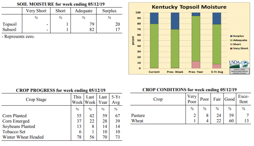 Kentucky Climate Summary
For the Period May 6, 2019 to May 12, 2019
Above Normal Temperatures and Below Normal Rainfall:
Weather-wise, the first and second halves of the period were nearly opposite to each
other. Dry and very warm conditions were in place for Monday through Wednesday. In
fact, highs rose solidly into the low to middle 80s across the state by Wednesday.
Combined with some elevated humidity, Kentucky got an early taste of summer.
Conditions then took a 180-degree turn for the second half of the week as wet and
cooler weather returned. The state saw several rounds of scattered to numerous
showers pass through the region, but total accumulations were fairly light for most
of the state. While portions of Southeastern Kentucky and the Northern Bluegrass saw
rainfall well in upwards of an inch, Western and Central Kentucky averaged less than
a half inch.
Temperatures for the period averaged 64 degrees across the state which was 2 degrees
warmer than normal and 4 degrees cooler than the previous period. High temperatures
averaged from 72 in the West to 75 in the East. Departure from normal high
temperatures ranged from 4 degrees cooler than normal in the West to near
normal in the East. Low temperatures averaged from 56 degrees in the West to 56
degrees in the East. Departure from normal low temperature ranged from 3 degrees
warmer than normal in the West to 9 degrees warmer than normal in the East. The
extreme high temperature for the period was 87 degrees at BOWLING GREEN APT and the
extreme low was 43 degrees at CYNTHIANA 8N.
Precipitation (liq. equ.) for the period totaled 0.65 inches statewide which was 0.45
inches below normal and 59% of normal. Precipitation totals by climate division, West
0.41 inches, Central 0.38 inches, Bluegrass 0.52 inches and East 1.30 inches, which
was -0.75, -0.78, -0.50 and 0.25 inches respectively from normal. By station,
precipitation totals ranged from a low of 0.13 inches at OWENSBORO AWSS to a high of
3.42 inches at MIDDLESBORO AWOS.
---
Kentucky Crop and Weather Report
Issued 4:00 P.M., May 6, 2019 08-19
Agricultural News: Kentucky experienced well above normal temperatures and above
normal rainfall over the past week. Precipitation for the week totaled 1.62 inches,
0.54 inches above normal. Temperatures averaged 68 degrees for the week, 8 degrees
above normal. Topsoil moisture was rated 1 percent short, 69 percent adequate and 30
percent surplus. Subsoil moisture was rated 1 percent short, 75 percent adequate, and
24 percent surplus. Days suitable for fieldwork averaged 4.0 out of a possible seven.
Primary activities this week included planting corn and soybeans, preparing fields,
and working cattle. Soils remain saturated throughout the state from the overall wet
spring and recent showers and storms. Farmers continue to make progress in planting
corn and soybeans, but timing has been an issue with monitoring precipitation
forecasts and field conditions. Wheat producers began to make fungicide applications
and some early hay fields were cut this past week. Cattle body condition remains of
concern coming out of the winter months, as producers expect a delay in putting
weight back on. As a result, calving intervals are expected to be impacted.
Tobacco transplant supplies were reported as 3 percent short, 93 percent adequate,
and 4 percent surplus. Twenty-one percent of tobacco transplants were under 2 inches,
with 49 percent between 2-4 inches, and 30 percent over 4 inches.
Kentucky Climate Summary
For the Period May 6, 2019 to May 12, 2019
Above Normal Temperatures and Below Normal Rainfall:
Weather-wise, the first and second halves of the period were nearly opposite to each
other. Dry and very warm conditions were in place for Monday through Wednesday. In
fact, highs rose solidly into the low to middle 80s across the state by Wednesday.
Combined with some elevated humidity, Kentucky got an early taste of summer.
Conditions then took a 180-degree turn for the second half of the week as wet and
cooler weather returned. The state saw several rounds of scattered to numerous
showers pass through the region, but total accumulations were fairly light for most
of the state. While portions of Southeastern Kentucky and the Northern Bluegrass saw
rainfall well in upwards of an inch, Western and Central Kentucky averaged less than
a half inch.
Temperatures for the period averaged 64 degrees across the state which was 2 degrees
warmer than normal and 4 degrees cooler than the previous period. High temperatures
averaged from 72 in the West to 75 in the East. Departure from normal high
temperatures ranged from 4 degrees cooler than normal in the West to near
normal in the East. Low temperatures averaged from 56 degrees in the West to 56
degrees in the East. Departure from normal low temperature ranged from 3 degrees
warmer than normal in the West to 9 degrees warmer than normal in the East. The
extreme high temperature for the period was 87 degrees at BOWLING GREEN APT and the
extreme low was 43 degrees at CYNTHIANA 8N.
Precipitation (liq. equ.) for the period totaled 0.65 inches statewide which was 0.45
inches below normal and 59% of normal. Precipitation totals by climate division, West
0.41 inches, Central 0.38 inches, Bluegrass 0.52 inches and East 1.30 inches, which
was -0.75, -0.78, -0.50 and 0.25 inches respectively from normal. By station,
precipitation totals ranged from a low of 0.13 inches at OWENSBORO AWSS to a high of
3.42 inches at MIDDLESBORO AWOS.
---
Kentucky Crop and Weather Report
Issued 4:00 P.M., May 6, 2019 08-19
Agricultural News: Kentucky experienced well above normal temperatures and above
normal rainfall over the past week. Precipitation for the week totaled 1.62 inches,
0.54 inches above normal. Temperatures averaged 68 degrees for the week, 8 degrees
above normal. Topsoil moisture was rated 1 percent short, 69 percent adequate and 30
percent surplus. Subsoil moisture was rated 1 percent short, 75 percent adequate, and
24 percent surplus. Days suitable for fieldwork averaged 4.0 out of a possible seven.
Primary activities this week included planting corn and soybeans, preparing fields,
and working cattle. Soils remain saturated throughout the state from the overall wet
spring and recent showers and storms. Farmers continue to make progress in planting
corn and soybeans, but timing has been an issue with monitoring precipitation
forecasts and field conditions. Wheat producers began to make fungicide applications
and some early hay fields were cut this past week. Cattle body condition remains of
concern coming out of the winter months, as producers expect a delay in putting
weight back on. As a result, calving intervals are expected to be impacted.
Tobacco transplant supplies were reported as 3 percent short, 93 percent adequate,
and 4 percent surplus. Twenty-one percent of tobacco transplants were under 2 inches,
with 49 percent between 2-4 inches, and 30 percent over 4 inches.
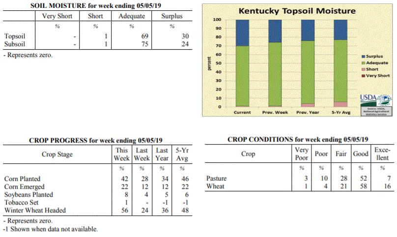 Kentucky Climate Summary
For the Period April 29, 2019 to May 5, 2019
Well Above Normal Temperatures and Above Normal Rainfall:
Extended periods of dry weather have been few over the past month. Data from the Ag
Weather Center shows that the state has averaged 6.05 inches over the past thirty
days. The wet trend continued this past week with several rounds of showers and storms
passing through the area from Wednesday and lasting through Derby Day. An unstable
and moist air mass in place led to moderate/heavy rainfall at times and even the
potential for flooding by later in the week. Rainfall coverage turned widespread
Thursday night/Friday morning and again on Saturday. Overall, the state averaged
1.62 inches for the week, which marks the third week out of the past four with above
normal rainfall. While it has been wet, temperatures have been running warm for this
time of year. Highs jumped into the 80s numerous times this past week.
Temperatures for the period averaged 68 degrees across the state which was 8 degrees
warmer than normal and 8 degrees warmer than the previous period. High temperatures
averaged from 76 in the West to 78 in the East. Departure from normal high
temperatures ranged from 2 degrees warmer than normal in the West to 5 degrees
warmer than normal in the East. Low temperatures averaged from 59 degrees in the
West to 58 degrees in the East. Departure from normal low temperature ranged from 8
degrees warmer than normal in the West to 13 degrees warmer than normal in the
East. The extreme high temperature for the period was 127 degrees at FRANKFORT 7S and
the extreme low was 34 degrees at FRANKFORT 7S.
Precipitation (liq. equ.) for the period totaled 1.62 inches statewide which was 0.54
inches above normal and 150% of normal. Precipitation totals by climate division,
West 1.92 inches, Central 1.52 inches, Bluegrass 1.38 inches and East 1.65 inches,
which was 0.71, 0.41, 0.39 and 0.64 inches above normal. By station, precipitation
totals ranged from a low of 0.13 inches at CADIZ 4SW to a high of 4.44 inches at
PADUCAH ASOS.
---
Kentucky Crop and Weather Report
Issued 4:00 P.M., April 29, 2019 07-19
Agricultural News: Kentucky experienced above normal temperatures and below normal
rainfall over the past week. Precipitation for the week totaled 0.74 inches, 0.30
inches below normal. Temperatures averaged 62 degrees for the week, 4 degrees above
normal. Topsoil moisture was rated 1 percent short, 73 percent adequate, and 26
percent surplus. Subsoil moisture was rated 1 percent short, 76 percent adequate, and
23 percent surplus. Days suitable for fieldwork averaged 4.0 out of a possible seven.
Primary activities for this week included corn and soybean planting along with
continued tobacco transplant seeding. While several regions battled persistent
precipitation, others received weather conducive to progress in the fields. Corn
planting is well ahead of last year at this time, but slightly below the five year
average. Soybean planting is ahead of both last year and the five year average at
this juncture. Ninety two percent of tobacco transplants have been seeded. The
average height of transplants were reported as 38 percent less than 2 inches, 48
percent 2-4 inches, and 14 percent larger than 4 inches.
The average height of winter wheat was 23 inches, up from 18 inches last week. The
average height of alfalfa was 9 inches, compared to 8 inches the previous week. There
has been a shortage of hay as pastures were adversely affected by the extremely wet
winter and spring. Hay supply was reported as 22 percent very short, 40 percent
short, 35 percent adequate, and 3 percent surplus. Strawberry condition was rated as
1 percent very poor, 2 percent poor, 24 percent fair, 60 percent good, and
13 percent excellent.
Kentucky Climate Summary
For the Period April 29, 2019 to May 5, 2019
Well Above Normal Temperatures and Above Normal Rainfall:
Extended periods of dry weather have been few over the past month. Data from the Ag
Weather Center shows that the state has averaged 6.05 inches over the past thirty
days. The wet trend continued this past week with several rounds of showers and storms
passing through the area from Wednesday and lasting through Derby Day. An unstable
and moist air mass in place led to moderate/heavy rainfall at times and even the
potential for flooding by later in the week. Rainfall coverage turned widespread
Thursday night/Friday morning and again on Saturday. Overall, the state averaged
1.62 inches for the week, which marks the third week out of the past four with above
normal rainfall. While it has been wet, temperatures have been running warm for this
time of year. Highs jumped into the 80s numerous times this past week.
Temperatures for the period averaged 68 degrees across the state which was 8 degrees
warmer than normal and 8 degrees warmer than the previous period. High temperatures
averaged from 76 in the West to 78 in the East. Departure from normal high
temperatures ranged from 2 degrees warmer than normal in the West to 5 degrees
warmer than normal in the East. Low temperatures averaged from 59 degrees in the
West to 58 degrees in the East. Departure from normal low temperature ranged from 8
degrees warmer than normal in the West to 13 degrees warmer than normal in the
East. The extreme high temperature for the period was 127 degrees at FRANKFORT 7S and
the extreme low was 34 degrees at FRANKFORT 7S.
Precipitation (liq. equ.) for the period totaled 1.62 inches statewide which was 0.54
inches above normal and 150% of normal. Precipitation totals by climate division,
West 1.92 inches, Central 1.52 inches, Bluegrass 1.38 inches and East 1.65 inches,
which was 0.71, 0.41, 0.39 and 0.64 inches above normal. By station, precipitation
totals ranged from a low of 0.13 inches at CADIZ 4SW to a high of 4.44 inches at
PADUCAH ASOS.
---
Kentucky Crop and Weather Report
Issued 4:00 P.M., April 29, 2019 07-19
Agricultural News: Kentucky experienced above normal temperatures and below normal
rainfall over the past week. Precipitation for the week totaled 0.74 inches, 0.30
inches below normal. Temperatures averaged 62 degrees for the week, 4 degrees above
normal. Topsoil moisture was rated 1 percent short, 73 percent adequate, and 26
percent surplus. Subsoil moisture was rated 1 percent short, 76 percent adequate, and
23 percent surplus. Days suitable for fieldwork averaged 4.0 out of a possible seven.
Primary activities for this week included corn and soybean planting along with
continued tobacco transplant seeding. While several regions battled persistent
precipitation, others received weather conducive to progress in the fields. Corn
planting is well ahead of last year at this time, but slightly below the five year
average. Soybean planting is ahead of both last year and the five year average at
this juncture. Ninety two percent of tobacco transplants have been seeded. The
average height of transplants were reported as 38 percent less than 2 inches, 48
percent 2-4 inches, and 14 percent larger than 4 inches.
The average height of winter wheat was 23 inches, up from 18 inches last week. The
average height of alfalfa was 9 inches, compared to 8 inches the previous week. There
has been a shortage of hay as pastures were adversely affected by the extremely wet
winter and spring. Hay supply was reported as 22 percent very short, 40 percent
short, 35 percent adequate, and 3 percent surplus. Strawberry condition was rated as
1 percent very poor, 2 percent poor, 24 percent fair, 60 percent good, and
13 percent excellent.
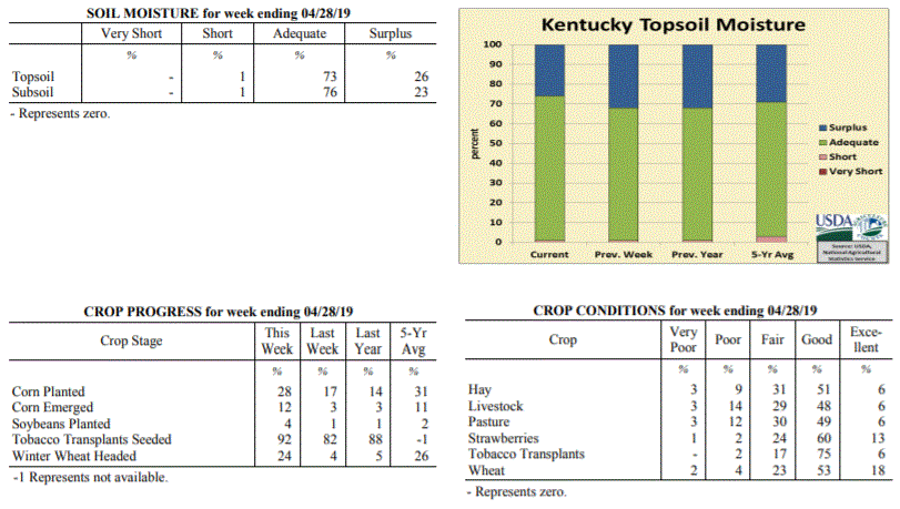 Kentucky Climate Summary
For the Period April 22, 2019 to April 28, 2019
Above Normal Temperatures and Below Normal Rainfall:
The first half of the work week started on the warm side with high temperatures
topping out in the middle 70s to low 80s for highs. After a dry Monday, a frontal
boundary sank into the area and with disturbances passing overhead, sparked several
rounds of showers and storms through Friday. The most widespread activity occurred
Thursday and Thursday night. Overall, the highest accumulations for the week were
confined to areas along the Ohio River and the Northern Bluegrass with around 1 to 2+
inches. Those numbers declined to the southern half of the state as most were under a
half inch for the week.
Temperatures for the period averaged 62 degrees across the state which was 4 degrees
warmer than normal and 6 degrees warmer than the previous period. High temperatures
averaged from 74 in the West to 74 in the East. Departure from normal high
temperatures ranged from 2 degrees warmer than normal in the West to 3 degrees warmer
than normal in the East. Low temperatures averaged from 52 degrees in the West to 50
degrees in the East. Departure from normal low temperature ranged from 3 degrees
warmer than normal in the West to 7 degrees warmer than normal in the East. The
extreme high temperature for the period was 86 degrees at LOUISA 1S and the extreme
low was 36 degrees at PAINTSVILLE 4W.
Precipitation (liq. equ.) for the period totaled 0.74 inches statewide which was 0.3
inches below normal and 71% of normal. Precipitation totals by climate division, West
0.70 inches, Central 0.49 inches, Bluegrass 1.24 inches and East 0.54 inches, which
was -0.50, -0.57, 0.28 and -0.42 inches respectively from normal. By station,
precipitation totals ranged from a low of 0.12 inches at BENTON 4N to a high of 2.87
inches at OWENTON 5E.
---
Kentucky Crop and Weather Report
Issued 4:00 P.M., April 22, 2019 06-19
Agricultural News: Kentucky experienced near normal temperatures and above normal
rainfall over the past week. Precipitation for the week totaled 1.78 inches, 0.80
inches above normal. Temperatures averaged 56 degrees for the week, unchanged from
normal. Topsoil moisture was rated 1 percent short, 67 percent adequate, and 32
percent surplus. Subsoil moisture was rated 1 percent short, 75 percent adequate, and
24 percent surplus. Days suitable for fieldwork averaged 3.5 out of a possible seven.
Primary activities for this week included continued corn planting and tobacco
transplant seeding. Fieldwork was interrupted by rain with cold temperatures moving
in at the end of the week. Despite the weather setbacks, corn producers were able to
make some planting progress. Planting is ahead of last year at this time, but
slightly below the five year average. Soybean planting is underway for some
producers, but very little is in the ground at this juncture. Fifty seven percent of
tobacco transplants were under 2 inches, with 34 percent 2-4 inches, and 9 percent
above 4 inches. Transplants remain in mostly fair to good condition.
The average height of winter wheat was 18 inches, up from 13 inches last week. The
average height of alfalfa was 8 inches, compared to 6 inches the previous week.
Freeze damage to apples was reported as 1 percent severe, 2 percent moderate, 22
percent light, and 75 percent with no damage. Peach freeze damage was reported as 1
percent severe, 2 percent moderate, 13 percent light, and 84 percent with no damage.
Kentucky Climate Summary
For the Period April 22, 2019 to April 28, 2019
Above Normal Temperatures and Below Normal Rainfall:
The first half of the work week started on the warm side with high temperatures
topping out in the middle 70s to low 80s for highs. After a dry Monday, a frontal
boundary sank into the area and with disturbances passing overhead, sparked several
rounds of showers and storms through Friday. The most widespread activity occurred
Thursday and Thursday night. Overall, the highest accumulations for the week were
confined to areas along the Ohio River and the Northern Bluegrass with around 1 to 2+
inches. Those numbers declined to the southern half of the state as most were under a
half inch for the week.
Temperatures for the period averaged 62 degrees across the state which was 4 degrees
warmer than normal and 6 degrees warmer than the previous period. High temperatures
averaged from 74 in the West to 74 in the East. Departure from normal high
temperatures ranged from 2 degrees warmer than normal in the West to 3 degrees warmer
than normal in the East. Low temperatures averaged from 52 degrees in the West to 50
degrees in the East. Departure from normal low temperature ranged from 3 degrees
warmer than normal in the West to 7 degrees warmer than normal in the East. The
extreme high temperature for the period was 86 degrees at LOUISA 1S and the extreme
low was 36 degrees at PAINTSVILLE 4W.
Precipitation (liq. equ.) for the period totaled 0.74 inches statewide which was 0.3
inches below normal and 71% of normal. Precipitation totals by climate division, West
0.70 inches, Central 0.49 inches, Bluegrass 1.24 inches and East 0.54 inches, which
was -0.50, -0.57, 0.28 and -0.42 inches respectively from normal. By station,
precipitation totals ranged from a low of 0.12 inches at BENTON 4N to a high of 2.87
inches at OWENTON 5E.
---
Kentucky Crop and Weather Report
Issued 4:00 P.M., April 22, 2019 06-19
Agricultural News: Kentucky experienced near normal temperatures and above normal
rainfall over the past week. Precipitation for the week totaled 1.78 inches, 0.80
inches above normal. Temperatures averaged 56 degrees for the week, unchanged from
normal. Topsoil moisture was rated 1 percent short, 67 percent adequate, and 32
percent surplus. Subsoil moisture was rated 1 percent short, 75 percent adequate, and
24 percent surplus. Days suitable for fieldwork averaged 3.5 out of a possible seven.
Primary activities for this week included continued corn planting and tobacco
transplant seeding. Fieldwork was interrupted by rain with cold temperatures moving
in at the end of the week. Despite the weather setbacks, corn producers were able to
make some planting progress. Planting is ahead of last year at this time, but
slightly below the five year average. Soybean planting is underway for some
producers, but very little is in the ground at this juncture. Fifty seven percent of
tobacco transplants were under 2 inches, with 34 percent 2-4 inches, and 9 percent
above 4 inches. Transplants remain in mostly fair to good condition.
The average height of winter wheat was 18 inches, up from 13 inches last week. The
average height of alfalfa was 8 inches, compared to 6 inches the previous week.
Freeze damage to apples was reported as 1 percent severe, 2 percent moderate, 22
percent light, and 75 percent with no damage. Peach freeze damage was reported as 1
percent severe, 2 percent moderate, 13 percent light, and 84 percent with no damage.
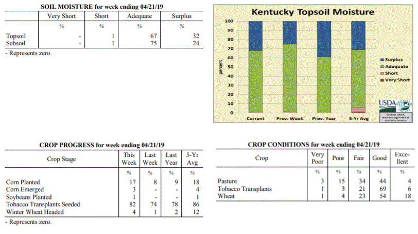 Kentucky Climate Summary
For the Period April 15, 2019 to April 21, 2019
Near Normal Temperatures and Above Normal Rainfall:
According to data with the UK Ag Weather Center, April has been a fairly wet month
thus far for the Bluegrass State with the state averaging 3.94 inches through the
21st. This is about an inch above normal over that time span. A good portion of
that total fell this past week as the state averaged 1.78 inches. Most of this
activity fell over a three day period, lasting from Thursday into Saturday as a cold
front and associated area of low pressure worked through the state. This marked the
second straight week of above normal rainfall. A substantial area of Western/Central
Kentucky and up into the Northern Bluegrass even received in excess of two inches
with this round.
Temperatures for the period averaged 56 degrees across the state which was near
normal and 6 degrees cooler than the previous period. High temperatures
averaged from 67 in the West to 67 in the East. Departure from normal high
temperatures ranged from 3 degrees cooler than normal in the West to 2 degrees
cooler than normal in the East. Low temperatures averaged from 46 degrees in the
West to 46 degrees in the East. Departure from normal low temperature ranged from 1
degree cooler than normal in the West to 5 degrees warmer than normal in the East.
The extreme high temperature for the period was 85 degrees at BIG SANDY and the
extreme low was 30 degrees at CARBONDALE ASOS.
Precipitation (liq. equ.) for the period totaled 1.78 inches statewide which was 0.8
inches above normal and 181% of normal. Precipitation totals by climate division,
West 2.25 inches, Central 2.20 inches, Bluegrass 1.79 inches and East 0.88 inches,
which was 1.12, 1.21, 0.89 and -0.04 inches respectively from normal. By station,
precipitation totals ranged from a low of 0.40 inches at WILLIAMSBURG AWOS to a high
of 3.84 inches at GREENVILLE 6N.
---
Kentucky Crop and Weather Report
Issued 4:00 P.M., April 15, 2019 05-19
Agricultural News: Kentucky experienced well above normal temperatures and above
normal rainfall over the past week. Precipitation for the week totaled 1.59 inches,
0.57 inches above normal. Temperatures averaged 63 degrees for the week, 8 degrees
above normal. Topsoil moisture was rated 1 percent short, 74 percent adequate, and 25
percent surplus. Subsoil moisture was rated 1 percent short, 73 percent adequate, and
26 percent surplus. Days suitable for fieldwork averaged 4.3 out of a possible seven.
Primary activities for this week included planting corn, seeding tobacco transplants,
and preparing fields. Farmers are performing fieldwork at every opportunity, however
intermittent rain continues to stymie progress. Corn producers are ready to get their
crop in the ground, but weather conditions have not been conducive in the early
planting season. The crop is ahead of last year, but considerably behind 2017 at this
juncture. Seventy five percent of tobacco transplants were under 2 inches, with 22
percent 2-4 inches, and 3 percent above 4 inches. Transplants were reported as in
mostly fair to good condition.
Winter wheat condition is mostly fair to good with an average height of 13 inches.
Freeze damage to winter wheat was reported as 1 percent moderate, 11 percent light,
and 88 percent with no damage. The average height of alfalfa was 6 inches. Freeze
damage to alfalfa was reported as 1 percent severe, 9 percent moderate, 29 percent
light, and 61 percent with no damage. Pastures are starting to show some growth
easing the demand for hay which is in short supply.
Kentucky Climate Summary
For the Period April 15, 2019 to April 21, 2019
Near Normal Temperatures and Above Normal Rainfall:
According to data with the UK Ag Weather Center, April has been a fairly wet month
thus far for the Bluegrass State with the state averaging 3.94 inches through the
21st. This is about an inch above normal over that time span. A good portion of
that total fell this past week as the state averaged 1.78 inches. Most of this
activity fell over a three day period, lasting from Thursday into Saturday as a cold
front and associated area of low pressure worked through the state. This marked the
second straight week of above normal rainfall. A substantial area of Western/Central
Kentucky and up into the Northern Bluegrass even received in excess of two inches
with this round.
Temperatures for the period averaged 56 degrees across the state which was near
normal and 6 degrees cooler than the previous period. High temperatures
averaged from 67 in the West to 67 in the East. Departure from normal high
temperatures ranged from 3 degrees cooler than normal in the West to 2 degrees
cooler than normal in the East. Low temperatures averaged from 46 degrees in the
West to 46 degrees in the East. Departure from normal low temperature ranged from 1
degree cooler than normal in the West to 5 degrees warmer than normal in the East.
The extreme high temperature for the period was 85 degrees at BIG SANDY and the
extreme low was 30 degrees at CARBONDALE ASOS.
Precipitation (liq. equ.) for the period totaled 1.78 inches statewide which was 0.8
inches above normal and 181% of normal. Precipitation totals by climate division,
West 2.25 inches, Central 2.20 inches, Bluegrass 1.79 inches and East 0.88 inches,
which was 1.12, 1.21, 0.89 and -0.04 inches respectively from normal. By station,
precipitation totals ranged from a low of 0.40 inches at WILLIAMSBURG AWOS to a high
of 3.84 inches at GREENVILLE 6N.
---
Kentucky Crop and Weather Report
Issued 4:00 P.M., April 15, 2019 05-19
Agricultural News: Kentucky experienced well above normal temperatures and above
normal rainfall over the past week. Precipitation for the week totaled 1.59 inches,
0.57 inches above normal. Temperatures averaged 63 degrees for the week, 8 degrees
above normal. Topsoil moisture was rated 1 percent short, 74 percent adequate, and 25
percent surplus. Subsoil moisture was rated 1 percent short, 73 percent adequate, and
26 percent surplus. Days suitable for fieldwork averaged 4.3 out of a possible seven.
Primary activities for this week included planting corn, seeding tobacco transplants,
and preparing fields. Farmers are performing fieldwork at every opportunity, however
intermittent rain continues to stymie progress. Corn producers are ready to get their
crop in the ground, but weather conditions have not been conducive in the early
planting season. The crop is ahead of last year, but considerably behind 2017 at this
juncture. Seventy five percent of tobacco transplants were under 2 inches, with 22
percent 2-4 inches, and 3 percent above 4 inches. Transplants were reported as in
mostly fair to good condition.
Winter wheat condition is mostly fair to good with an average height of 13 inches.
Freeze damage to winter wheat was reported as 1 percent moderate, 11 percent light,
and 88 percent with no damage. The average height of alfalfa was 6 inches. Freeze
damage to alfalfa was reported as 1 percent severe, 9 percent moderate, 29 percent
light, and 61 percent with no damage. Pastures are starting to show some growth
easing the demand for hay which is in short supply.
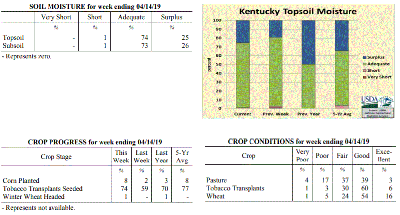 Kentucky Climate Summary
For the Period April 8, 2019 to April 14, 2019
Well Above Normal Temperatures and Above Normal Rainfall:
Kentucky saw above normal rainfall over the past week behind multiple rounds of
precipitation. Activity started on Monday as an upper level disturbance worked across
the area. Widespread coverage was focused more across the southern half of the state.
This was followed by a few mild and dry days. By Thursday, breezy southerly flow
ahead of an approaching area of low pressure pushed highs into the low to middle 80s
for much of the state. A cold front then swept through on Thursday night and into
Friday, bringing a quick-hitting round of showers and storms. Accumulations were
fairly light with this round, but was followed by another area of low pressure
working through the area on Saturday night and into Sunday. Overall, this system
accounted for the brunt of the 1.59 state average for the week. Accompanying the
weekend system was high winds with numerous gusts over 40 mph and some exceeding 50.
Temperatures for the period averaged 63 degrees across the state which was 8 degrees
warmer than normal and 10 degrees warmer than the previous period. High temperatures
averaged from 73 in the West to 74 in the East. Departure from normal high
temperatures ranged from 5 degrees warmer than normal in the West to 7 degrees
warmer than normal in the East. Low temperatures averaged from 52 degrees in the
West to 53 degrees in the East. Departure from normal low temperature ranged from 7
degrees warmer than normal in the West to 14 degrees warmer than normal in the
East. The extreme high temperature for the period was 86 degrees at JACKSON AIRPORT
and the extreme low was 36 degrees at PAINTSVILLE 4W.
Precipitation (liq. equ.) for the period totaled 1.59 inches statewide which was 0.57
inches above normal and 157% of normal. Precipitation totals by climate division,
West 1.92 inches, Central 1.71 inches, Bluegrass 1.27 inches and East 1.47 inches,
which was 0.76, 0.67, 0.35 and 0.53 inches above normal. By station, precipitation
totals ranged from a low of 0.75 inches at CINCINNATI to a high of 2.67
inches at HICKMAN 2E.
---
Kentucky Crop and Weather Report
Issued 4:00 P.M., April 8, 2019 04-19
Agricultural News: Kentucky experienced slightly above normal temperatures and below
normal rainfall over the past week. Precipitation for the week totaled 0.56 inches,
0.43 inches below normal. Temperatures averaged 53 degrees for the week, 1 degrees
above normal. Topsoil moisture was rated 1 percent very short, 2 percent short, 78
percent adequate, and 19 percent surplus. Subsoil moisture was rated 1 percent short,
79 percent adequate, and 20 percent surplus. Days suitable for fieldwork averaged 4.7
out of a possible seven.
Primary activities for this week included seeding tobacco transplants, field
preparation, and corn planting where weather would allow. The commonwealth has had
some drier conditions recently, however soil remains very moist in many areas
hampering fieldwork. A freeze at the beginning of the week was also of concern, but
normal spring weather returned as the week progressed. Although corn planting has
begun, very little is in the ground at this juncture. Pastures have begun to grow,
but an abundance of weeds are present due to the abnormally wet winter.
Many farmers are still feeding hay and supplies remain short. Winter wheat condition
is mostly good to fair with an average height of 7 inches. Twenty percent of apples
and 30 percent of peaches are in bloom at this time.
Kentucky Climate Summary
For the Period April 8, 2019 to April 14, 2019
Well Above Normal Temperatures and Above Normal Rainfall:
Kentucky saw above normal rainfall over the past week behind multiple rounds of
precipitation. Activity started on Monday as an upper level disturbance worked across
the area. Widespread coverage was focused more across the southern half of the state.
This was followed by a few mild and dry days. By Thursday, breezy southerly flow
ahead of an approaching area of low pressure pushed highs into the low to middle 80s
for much of the state. A cold front then swept through on Thursday night and into
Friday, bringing a quick-hitting round of showers and storms. Accumulations were
fairly light with this round, but was followed by another area of low pressure
working through the area on Saturday night and into Sunday. Overall, this system
accounted for the brunt of the 1.59 state average for the week. Accompanying the
weekend system was high winds with numerous gusts over 40 mph and some exceeding 50.
Temperatures for the period averaged 63 degrees across the state which was 8 degrees
warmer than normal and 10 degrees warmer than the previous period. High temperatures
averaged from 73 in the West to 74 in the East. Departure from normal high
temperatures ranged from 5 degrees warmer than normal in the West to 7 degrees
warmer than normal in the East. Low temperatures averaged from 52 degrees in the
West to 53 degrees in the East. Departure from normal low temperature ranged from 7
degrees warmer than normal in the West to 14 degrees warmer than normal in the
East. The extreme high temperature for the period was 86 degrees at JACKSON AIRPORT
and the extreme low was 36 degrees at PAINTSVILLE 4W.
Precipitation (liq. equ.) for the period totaled 1.59 inches statewide which was 0.57
inches above normal and 157% of normal. Precipitation totals by climate division,
West 1.92 inches, Central 1.71 inches, Bluegrass 1.27 inches and East 1.47 inches,
which was 0.76, 0.67, 0.35 and 0.53 inches above normal. By station, precipitation
totals ranged from a low of 0.75 inches at CINCINNATI to a high of 2.67
inches at HICKMAN 2E.
---
Kentucky Crop and Weather Report
Issued 4:00 P.M., April 8, 2019 04-19
Agricultural News: Kentucky experienced slightly above normal temperatures and below
normal rainfall over the past week. Precipitation for the week totaled 0.56 inches,
0.43 inches below normal. Temperatures averaged 53 degrees for the week, 1 degrees
above normal. Topsoil moisture was rated 1 percent very short, 2 percent short, 78
percent adequate, and 19 percent surplus. Subsoil moisture was rated 1 percent short,
79 percent adequate, and 20 percent surplus. Days suitable for fieldwork averaged 4.7
out of a possible seven.
Primary activities for this week included seeding tobacco transplants, field
preparation, and corn planting where weather would allow. The commonwealth has had
some drier conditions recently, however soil remains very moist in many areas
hampering fieldwork. A freeze at the beginning of the week was also of concern, but
normal spring weather returned as the week progressed. Although corn planting has
begun, very little is in the ground at this juncture. Pastures have begun to grow,
but an abundance of weeds are present due to the abnormally wet winter.
Many farmers are still feeding hay and supplies remain short. Winter wheat condition
is mostly good to fair with an average height of 7 inches. Twenty percent of apples
and 30 percent of peaches are in bloom at this time.
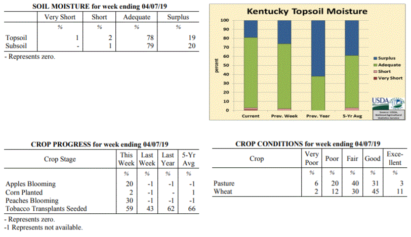 Kentucky Climate Summary
For the Period April 1, 2019 to April 7, 2019
Slightly Above Normal Temperatures and Below Normal Rainfall:
The month of April started on a cold note with low temperatures dipping well into the
20s on Monday morning. This prompted the first freeze warnings of the spring season
to be issued across the southern half of Kentucky. Dry conditions and warmer
temperatures then prevailed through midweek, eventually rising into the middle 60s to
around 70 on Wednesday. An upper level disturbance then brought light rain showers to
the region on Thursday night and into Friday. This was followed by a more intense
round on Sunday as showers and scattered storms pushed through the Bluegrass State.
Overall though, the state only averaged just over a half inch for the week.
Temperatures for the period averaged 53 degrees across the state which was 1 degree
warmer than normal and 2 degrees warmer than the previous period. High temperatures
averaged from 64 in the West to 66 in the East. Departure from normal high
temperatures ranged from 2 degrees cooler than normal in the West to 1 degree
warmer than normal in the East. Low temperatures averaged from 44 degrees in the
West to 41 degrees in the East. Departure from normal low temperature ranged from 2
degrees warmer than normal in the West to 4 degrees warmer than normal in the East.
The extreme high temperature for the period was 78 degrees at LOUISA 1S and the
extreme low was 19 degrees at PIKEVILLE 13S.
Precipitation (liq. equ.) for the period totaled 0.56 inches statewide which was 0.43
inches below normal and 57% of normal. Precipitation totals by climate division, West
0.39 inches, Central 0.78 inches, Bluegrass 0.57 inches and East 0.50 inches, which
was 0.7, 0.25, 0.33 and 0.44 inches below normal. By station, precipitation totals
ranged from a low of 0.08 inches at ALEXANDRIA 5NW to a high of 1.19 inches at
MUNFORDVILLE 6E.
---
Kentucky Crop and Weather Report
Issued 4:00 P.M., April 1, 2019 03-19
Agricultural News: Kentucky experienced near normal temperatures and above normal
precipitation over the past week. Precipitation for the week totaled 1.08 inches,
0.06 inches above normal. Temperatures averaged 50 degrees for the week, near normal.
Topsoil moisture was rated 2 percent short, 72 percent adequate, and 26 percent
surplus. Subsoil moisture was rated 1 percent very short, 1 percent short, 75 percent
adequate, and 23 percent surplus. Days suitable for fieldwork averaged 4.8 out of a
possible seven.
Primary activities for this week included seeding tobacco transplants along with
spraying and preparing fields for the planting season. Warm, dry conditions allowed
fields to start drying out before more rain and cooler temperatures moved in on the
weekend. There was very little freeze damage to winter wheat and the crop is in
mostly good condition. Alfalfa was also largely spared from freeze as small amounts
of light and moderate damage were reported.
Livestock condition is mostly good to fair at this juncture, however cattle have been
adversely affected by wet, muddy pastures and an overall hay shortage during the
winter months. In some cases cows will be moved to a fall breeding schedule due to
their current body conditions. Approximately 20 percent of feed for cattle and calves
was obtained from pastures. Pasture condition was rated as mostly fair at this time.
Kentucky Climate Summary
For the Period April 1, 2019 to April 7, 2019
Slightly Above Normal Temperatures and Below Normal Rainfall:
The month of April started on a cold note with low temperatures dipping well into the
20s on Monday morning. This prompted the first freeze warnings of the spring season
to be issued across the southern half of Kentucky. Dry conditions and warmer
temperatures then prevailed through midweek, eventually rising into the middle 60s to
around 70 on Wednesday. An upper level disturbance then brought light rain showers to
the region on Thursday night and into Friday. This was followed by a more intense
round on Sunday as showers and scattered storms pushed through the Bluegrass State.
Overall though, the state only averaged just over a half inch for the week.
Temperatures for the period averaged 53 degrees across the state which was 1 degree
warmer than normal and 2 degrees warmer than the previous period. High temperatures
averaged from 64 in the West to 66 in the East. Departure from normal high
temperatures ranged from 2 degrees cooler than normal in the West to 1 degree
warmer than normal in the East. Low temperatures averaged from 44 degrees in the
West to 41 degrees in the East. Departure from normal low temperature ranged from 2
degrees warmer than normal in the West to 4 degrees warmer than normal in the East.
The extreme high temperature for the period was 78 degrees at LOUISA 1S and the
extreme low was 19 degrees at PIKEVILLE 13S.
Precipitation (liq. equ.) for the period totaled 0.56 inches statewide which was 0.43
inches below normal and 57% of normal. Precipitation totals by climate division, West
0.39 inches, Central 0.78 inches, Bluegrass 0.57 inches and East 0.50 inches, which
was 0.7, 0.25, 0.33 and 0.44 inches below normal. By station, precipitation totals
ranged from a low of 0.08 inches at ALEXANDRIA 5NW to a high of 1.19 inches at
MUNFORDVILLE 6E.
---
Kentucky Crop and Weather Report
Issued 4:00 P.M., April 1, 2019 03-19
Agricultural News: Kentucky experienced near normal temperatures and above normal
precipitation over the past week. Precipitation for the week totaled 1.08 inches,
0.06 inches above normal. Temperatures averaged 50 degrees for the week, near normal.
Topsoil moisture was rated 2 percent short, 72 percent adequate, and 26 percent
surplus. Subsoil moisture was rated 1 percent very short, 1 percent short, 75 percent
adequate, and 23 percent surplus. Days suitable for fieldwork averaged 4.8 out of a
possible seven.
Primary activities for this week included seeding tobacco transplants along with
spraying and preparing fields for the planting season. Warm, dry conditions allowed
fields to start drying out before more rain and cooler temperatures moved in on the
weekend. There was very little freeze damage to winter wheat and the crop is in
mostly good condition. Alfalfa was also largely spared from freeze as small amounts
of light and moderate damage were reported.
Livestock condition is mostly good to fair at this juncture, however cattle have been
adversely affected by wet, muddy pastures and an overall hay shortage during the
winter months. In some cases cows will be moved to a fall breeding schedule due to
their current body conditions. Approximately 20 percent of feed for cattle and calves
was obtained from pastures. Pasture condition was rated as mostly fair at this time.
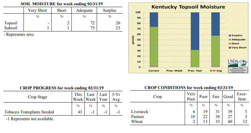 Kentucky Climate Summary
For the Period March 25, 2019 to March 31, 2019
Near Normal Temperatures and Above Normal Precipitation:
The month of March came to a close with a week of slightly above normal rainfall and
near normal temperatures. The period started with low pressure sliding southeast
across the area, sparking showers and isolated storms. A few dry days followed with
mostly sunny skies taking temperatures on the uphill climb. Highs were sitting in the
70s by Thursday for much of Kentucky. Rain chances then went on the increase again
starting Thursday night and lasting through Saturday. Rainfall totals were on the
light side early-on, but a strong cold front passed through the state on Saturday,
sparking a line of showers and storms. This line accounted for the brunt of the
rainfall for the week, a little over an inch on average. This broke a two week
stretch of below normal rainfall through the mid- section of March. Overall, data at
the Ag Weather Center shows Kentucky averaged 3.46 inches for month, which was the
first month of below normal precipitation since October of last year.
Temperatures for the period averaged 50 degrees across the state which was near
normaland 4 degrees warmer than the previous period. High temperatures
averaged from 60 in the West to 62 in the East. Departure from normal high
temperatures ranged from 3 degrees cooler than normal in the West to near
normal in the East. Low temperatures averaged from 41 degrees in the West to 40
degrees in the East. Departure from normal low temperature ranged from 1 degree
warmer than normal in the West to 5 degrees warmer than normal in the East. The
extreme high temperature for the period was 79 degrees at JACKSON and the extreme low
was 21 degrees at MONTICELLO AWOS.
Precipitation (liq. equ.) for the period totaled 1.08 inches statewide which was 0.06
inches above normal and 105% of normal. Precipitation totals by climate division,
West 1.24 inches, Central 0.95 inches, Bluegrass 1.45 inches and East 0.69 inches,
which was 0.14, -0.13, 0.53 and -0.31 inches respectively from normal. By station,
precipitation totals ranged from a low of 0.35 inches at SOMERSET AWOS to a high of
2.91 inches at CINCINNATI.
---
Kentucky Climate Summary
For the Period March 18, 2019 to March 24, 2019
Below Normal Temperatures and Much Below Normal Precipitation:
As opposed to February, the weather pattern has turned to dry one in March. Through
the 24th of the month, data at the Ag Weather Center shows the state has only
averaged 2.38 inches, which is over an inch below normal. This past week was the
driest of the month with Kentucky only averaging a little over a tenth of an inch and
marked the second straight week of below normal precipitation. High pressure kept
the area dry for most of the week. A couple systems did move through the area on
Wednesday night/Thursday and Sunday, but in the case of both, only amounted to light
accumulations.
Temperatures for the period averaged 45 degrees across the state which was 3 degrees
cooler than normal and 4 degrees cooler than the previous period. High temperatures
averaged from 59 in the West to 56 in the East. Departure from normal high
temperatures ranged from 2 degrees cooler than normal in the West to 4 degrees
cooler than normal in the East. Low temperatures averaged from 35 degrees in the
West to 32 degrees in the East. Departure from normal low temperature ranged from 4
degrees cooler than normal in the West to 2 degrees cooler than normal in the East.
The extreme high temperature for the period was 73 degrees at LOUISA 1S and the
extreme low was 20 degrees at PAINTSVILLE 4W.
Precipitation (liq. equ.) for the period totaled 0.11 inches statewide which was 0.93
inches below normal and 11% of normal. Precipitation totals by climate division, West
0.13 inches, Central 0.04 inches, Bluegrass 0.12 inches and East 0.14 inches, which
was 0.98, 1.06, 0.82 and 0.88 inches below normal. By station, precipitation totals
ranged from a low of 0.00 inches at FORT CAMPBELL to a high of 0.35
inches at BIG SANDY.
---
Kentucky Climate Summary
For the Period March 11, 2019 to March 17, 2019
Above Normal Temperatures and Below Normal Precipitation:
Dry conditions ruled to start the week, but that quickly changed by Thursday as a
strong low-pressure system worked through the area. Ahead of the low, temperatures
warmed into the upper 60s to middle 70s both Wednesday and Thursday. Showers and
storms arrived starting Wednesday night and intensified Thursday morning across
Western Kentucky. This area saw strong to severe storms with some producing
tornadoes, four in all, including an EF2 near Paducah. In addition to the storms,
very breezy winds were present all day on Thursday. A High Wind Warning was even
issued for portions of the state. Winds gusting between 40 and 50 mph was common
outside of thunderstorms, but there were also several reports over 50, including 69
mph in Fayette County! Precipitation was very slow to move east from Western Kentucky
and slowly diminished in strength and intensity. In doing so, while Western Kentucky
averaged 1.73 inches for the week and caused some flooding, Eastern Kentucky came in
at only 0.14 inches.
Temperatures for the period averaged 49 degrees across the state which was 3 degrees
warmer than normal and 14 degrees warmer than the previous period. High temperatures
averaged from 60 in the West to 61 in the East. Departure from normal high
temperatures ranged from 1 degree warmer than normal in the West to 3 degrees
warmer than normal in the East. Low temperatures averaged from 40 degrees in the
West to 38 degrees in the East. Departure from normal low temperature ranged from 3
degrees warmer than normal in the West to 6 degrees warmer than normal in the East.
The extreme high temperature for the period was 80 degrees at LOUISA 1S and the
extreme low was 21 degrees at CYNTHIANA 8N.
Precipitation (liq. equ.) for the period totaled 0.65 inches statewide which was 0.33
inches below normal and 66% of normal. Precipitation totals by climate division, West
1.73 inches, Central 0.28 inches, Bluegrass 0.47 inches and East 0.14 inches, which
was 0.70, -0.75, -0.43 and -0.84 inches respectively from normal. By station,
precipitation totals ranged from a low of 0.00 inches at BOWLING GREEN 4E to a high
of 3.67 inches at PADUCAH ASOS.
---
Kentucky Climate Summary
For the Period March 4, 2019 to March 10, 2019
Well Below Normal Temperatures and Above Normal Precipitation:
The period started off with very cold temperatures and dry conditions in place.
North/northwest flow brought some Arctic air into the region on Monday and Tuesday.
Kentuckians woke up to wind chills in the single digits each morning and highs only
reaching into the 20s and 30s, well below seasonable norms. Temperatures slightly increased
to end the work week, but not quite enough to prevent any wintry weather. Winter
Weather Advisories were issued for Thursday night and into Friday morning. Many
across the northern half of the state saw 1 to 2 inches of slushy snow. In typical
Ohio Valley fashion, the weather took a 180 degree turn for the weekend. High
temperatures jumped into the 50s and 60s ahead of a strong area of low pressure.
Several rounds of showers and storms progressed through the area during the day with
heavy rain as the primary threat. This accounted for the brunt of the precipitations
for the week as the state averaged 1.33 inches.
Temperatures for the period averaged 34 degrees across the state which was 10 degrees
cooler than normal and 6 degrees cooler than the previous period. High temperatures
averaged from 43 in the West to 43 in the East. Departure from normal high
temperatures ranged from 14 degrees cooler than normal in the West to 13 degrees
cooler than normal in the East. Low temperatures averaged from 27 degrees in the
West to 27 degrees in the East. Departure from normal low temperature ranged from 8
degrees cooler than normal in the West to 4 degrees cooler than normal in the East.
The extreme high temperature for the period was 72 degrees at YELLOW CREEK and the
extreme low was 6 degrees at ALEXANDRIA 5NW.
Precipitation (liq. equ.) for the period totaled 1.33 inches statewide which was 0.35
inches above normal and 136% of normal. Precipitation totals by climate division,
West 1.19 inches, Central 1.48 inches, Bluegrass 1.46 inches and East 1.18 inches,
which was 0.15, 0.45, 0.58 and 0.22 inches above normal. By station, precipitation
totals ranged from a low of 0.53 inches at WHITESBURG 2NW to a high of 2.23
inches at ELIZABETHTOWN 8W.
---
Kentucky Climate Summary
For the Period February 25, 2019 to March 3, 2019
Below Normal Temperatures and Precipitation:
Three straight weeks of well above normal precipitation has finally came in an end.
Kentucky experienced some drier conditions this week, only averaging about a quarter
inch. This followed what will go down as the second wettest February on record for
the Bluegrass State with data going back to 1895. Conditions were dry through
Wednesday with temperatures following a warming trend. Highs by Wednesday were in the
60s. A cold front then moved through the area late in the day, bringing cooler
temperatures back to the area for the rest of the week. This frontal passage was a
mostly dry one, but was followed by southern stream disturbance later on Thursday,
bringing some light rain to the region. Attention then turned to Sunday where a
couple waves aloft sparked a wintry mix across the region. Cold rain
across much of the region and some snow farther north.
Temperatures for the period averaged 40 degrees across the state which was 2
degrees cooler than normal and 2 degrees cooler than the previous period. High
temperatures averaged from 46 in the West to 50 in the East. Departure from
normal high temperatures ranged from 9 degrees cooler than normal in the West
to 4 degrees cooler than normal in the East. Low temperatures averaged from 31
degrees in the West to 33 degrees in the East. Departure from normal low
temperature ranged from 2 degrees cooler than normal in the West to 3 degrees
warmer than normal in the East. The extreme high temperature for the period
was 70 degrees at LOUISA 1S and the extreme low was 21 degrees at BRANDENBURG 4SW.
Precipitation (liq. equ.) for the period totaled 0.39 inches statewide which was
0.6 inches below normal and 40% of normal. Precipitation totals by climate
division, West 0.23 inches, Central 0.37 inches, Bluegrass 0.31 inches and East
0.66 inches, which was 0.87, 0.67, 0.56 and 0.27 inches below normal. By
station, precipitation totals ranged from a low of 0.00 inches at LONDON CORBIN
APRT to a high of 1.35 inches at PIKEVILLE 13S.
---
Kentucky Climate Summary
For the Period February 18 to February 24, 2019
Above Normal Temperatures and Much Above Normal Rainfall:
Kentucky can just simply not get a break from the wet pattern. The state has now
gone three straight weeks averaging over two inches of precipitation. In fact, this
week, the Bluegrass State averaged 3.86! The state saw some rare dry days on Monday
and most of Tuesday. Light rain started arriving again across Southern Kentucky on
Tuesday evening and expanded north overnight. Rain turned heavier overnight and by
daybreak on Wednesday, 1 to 2 inches of rainfall was common. Soaking rains continued
on Wednesday with a front stalled across the area. After a temporary break on
Thursday, precipitation returned that night, continuing into Friday and the first
half of the weekend. An additional 1 to 3 inches fell across the area, ending with a
complex of showers and storms Saturday evening. Much of the southern half of
Kentucky got 3 to 4+ inches over the course of the period. Major flooding ensued for
some along the Ohio River across Western Kentucky, in addition to counties bordering the
Cumberland and Kentucky Rivers. Many counties in Eastern Kentucky were under a State
of Emergency. Mudslides were common across this area. Lake Cumberland actually
recorded the highest lake level ever on February 25th at 755.49 feet.
Temperatures for the period averaged 42 degrees across the state which was 2 degrees
warmer than normal and no change to the previous period. High temperatures averaged
from 48 in the West to 50 in the East. Departure from normal high temperatures
ranged from 4 degrees cooler than normal in the West to 1 degree cooler than normal
in the East. Low temperatures averaged from 36 degrees in the West to 38 degrees in
the East. Departure from normal low temperature ranged from 5 degrees warmer than
normal in the West to 11 degrees warmer than normal in the East. The extreme high
temperature for the period was 67 degrees at WHITESBURG 2NW and the extreme low was
18 degrees at BURLINGTON 4S.
Precipitation (liq. equ.) for the period totaled 3.86 inches statewide which was 2.92
inches above normal and 411% of normal. Precipitation totals by climate division,
West 3.67 inches, Central 4.33 inches, Bluegrass 3.03 inches and East 4.42 inches,
which was 2.61, 3.32, 2.22 and 3.54 inches above normal. By station, precipitation
totals ranged from a low of 0.89 inches at CARBONDALE ASOS to a high of 5.91 inches
at MURRAY 1W.
---
Kentucky Climate Summary
For the Period February 11 to February 17, 2019
Above Normal Temperatures and Much Above Normal Rainfall:
Ground is waterlogged across the Commonwealth as the state went back to back weeks
with the state averaging over two inches of precipitation. Most of that rain fell
early in the week on Monday and Tuesday, moderate to heavy intensity from time to
time. Localized flooding was common, while river flooding continued to worsen across
the area. That activity ended with the passage of a cold front on Tuesday
morning/afternoon. After a warm start to the week in the 50s and 60s, temperatures
dipped back to seasonable norms on Wednesday and was followed by another cold front
Thursday night. Winter Weather Advisories and Winter Storm Warnings were issued to
end the workweek with 1 to 3 inches of snow across the southern half of the
state. Ice accumulations were limited to mainly Southwestern Kentucky. Light rain
returned on Sunday, capping a very wet week. Overall, the state averaged 2.71 inches,
almost two inches above normal for this time of year.
Temperatures for the period averaged 42 degrees across the state which was 4
degrees warmer than normal and 4 degrees cooler than the previous period. High
temperatures averaged from 49 in the West to 51 in the East. Departure from
normal high temperatures ranged from near normal in the West to 3 degrees warmer
than normal in the East. Low temperatures averaged from 35 degrees in the West
to 35 degrees in the East. Departure from normal low temperature ranged from 7
degrees warmer than normal in the West to 10 degrees warmer than normal in the
East. The extreme high temperature for the period was 65 degrees at WHITESBURG
2NW and the extreme low was 22 degrees at CARBONDALE ASOS.
Precipitation (liq. equ.) for the period totaled 2.71 inches statewide which was
1.8 inches above normal and 299% of normal. Precipitation totals by climate
division, West 3.27 inches, Central 2.96 inches, Bluegrass 2.12 inches and East
2.47 inches, which was 2.26, 1.97, 1.34 and 1.62 inches above normal. By
station, precipitation totals ranged from a low of 1.23 inches at MT STERLING
AWOS to a high of 4.81 inches at MAYFIELD 6SW.
---
Kentucky Climate Summary
For the Period February 4 to February 10, 2019
Well Above Normal Temperatures and Much Above Normal Precipitation:
Kentucky cannot seem to shake the wet pattern that has plagued the region for quite
some time. The state averaged almost 2.5 inches for the week behind multiple rounds
of rainfall. This was a statewide event with Western Kentucky the leader at an
average of 3.12, while Eastern Kentucky was on the low end at 1.98. The brunt of the
activity fell Tuesday through Thursday, leading to some flooding across the region.
Temperature-wise, the week started out with temperatures in the 60s and 70s, lasting
through Thursday. Behind a strong cold front, temperatures plummeted Thursday
night with lows dipping well into the 20s and the teens on Friday night, introducing
livestock cold stress to the Emergency category yet again.
Temperatures for the period averaged 46 degrees across the state which was 10 degrees
warmer than normal and 14 degrees warmer than the previous period. High temperatures
averaged from 51 in the West to 56 in the East. Departure from normal high
temperatures ranged from 5 degrees warmer than normal in the West to 10 degrees
warmer than normal in the East. Low temperatures averaged from 37 degrees in the
West to 39 degrees in the East. Departure from normal low temperature ranged from 10
degrees warmer than normal in the West to 15 degrees warmer than normal in the
East. The extreme high temperature for the period was 76 degrees at BOONEVILLE 2S and
the extreme low was 12 degrees at BURLINGTON 4S.
Precipitation (liq. equ.) for the period totaled 2.49 inches statewide which was 1.62
inches above normal and 285% of normal. Precipitation totals by climate division,
West 3.12 inches, Central 2.81 inches, Bluegrass 2.06 inches and East 1.98 inches,
which was 2.16, 1.85, 1.3 and 1.16 inches above normal. By station, precipitation
totals ranged from a low of 1.11 inches at BIG SANDY to a high of 4.27 inches at
BENTON 4N.
---
Kentucky Climate Summary
For the Period January 28 to February 3, 2019
Near Normal Temperatures and Much Below Normal Precipitation:
In typical Ohio Valley fashion, the weather changed drastically over the course of
the week. Starting out, temperatures jumped into the mid to upper 50s on Monday.
Behind a cold front, temperatures crashed, setting up a very cold few days as Arctic
air built into the area. Wind chills dropped all the way down to -10 to -20 below
zero Tuesday night and into Wednesday, pushing the livestock cold stress index into the
Emergency category for an extended period of time. The cold continued into the first
part of Thursday with some morning lows below zero. Luckily, a warming trend ensued
for the rest of the week, eventually making it back in the 50s and 60s over the
weekend. Even hitting the low 70s for some across Western and Central Kentucky.
While temperatures were up and down, the state did not see much in the way of
precipitation. Overall, the state averaged less than a tenth of an inch for the week.
Temperatures for the period averaged 33 degrees across the state which was near
normal and 2 degrees warmer than the previous period. High temperatures averaged from
45 in the West to 46 in the East. Departure from normal high temperatures ranged from
near normal in the West to 2 degrees warmer than normal in the East. Low temperatures
averaged from 24 degrees in the West to 22 degrees in the East. Departure from normal
low temperature ranged from 1 degree cooler than normal in the West to near normal in
the East. The extreme high temperature for the period was 71 degrees at FORT CAMPBELL
and the extreme low was -9 degrees at BURLINGTON 4S.
Precipitation (liq. equ.) for the period totaled 0.09 inches statewide which was 0.75
inches below normal and 11% of normal. Precipitation totals by climate division, West
0.08 inches, Central 0.08 inches, Bluegrass 0.10 inches and East 0.08 inches, which
was 0.82, 0.83, 0.62 and 0.73 inches below normal. By station, precipitation totals
ranged from a low of 0.00 inches at MIDDLESBORO AWOS to a high of 0.19 inches at
FRANKFORT 7S.
---
Kentucky Climate Summary
For the Period January 21 to January 27, 2019
Below Normal Temperatures and Above Normal Precipitation:
Extreme cold settled over the Bluegrass State, leading to the first week of 2019 with
below normal temperatures. The period started with temperatures in the single digits
to middle teens Monday morning and wind chills dropping to either side of zero. The
thermometer did go on the increase Tuesday and Wednesday, but quickly went back in
the opposite direction with the passage of a couple cold fronts. Lows dipped into the
low to middle teens that Thursday night, followed by highs on Friday only in the 20s.
Rain showers accompanied the first frontal boundary on Tuesday night and Wednesday
and combined with some other bouts of light snow accumulations, total precipitation
averaged a little over an inch for the Bluegrass State.
Temperatures for the period averaged 30 degrees across the state which was 5 degrees
cooler than normal and 4 degrees cooler.
Precipitation (liq. equ.) for the period totaled 1.03 inches statewide which was 0.22
inches above normal and 127% of normal. Precipitation totals by climate division,
West 1.07 inches, Central 1.09 inches, Bluegrass 0.82 inches and East 1.10 inches,
which was 0.18, 0.23, 0.11 and 0.31 inches above normal.
---
Kentucky Climate Summary
For the Period January 14 to January 20, 2019
Above Normal Temperatures and Precipitation:
The Bluegrass State saw dry and cool conditions over the first half of the period,
before a wet pattern took hold for the second. High temperatures on Monday only rose
into the lower to middle 30s under mostly cloudy skies. That cool and dry held
through Wednesday, before light rain showers overspread the region Wednesday night
and into Thursday as a weak system pushed through the state. Most only saw a third
of an inch or less. After a temporary break from the rain on Friday, a much more
significant disturbance progressed across Kentucky for the first half of the weekend.
Precipitation started as rain within a warm and moist air mass. Much of the
Commonwealth saw a half to 2 inches of rainfall. Cold, arctic air rushing into the
area behind the departing disturbance led to a transition over to snow. 1 to 3
inches fell across Western/Central Kentucky and up into the Bluegrass. Less-so across
Eastern Kentucky. The state finally saw some sunshine on Sunday, but highs only rose
into the 20s. Wind chills in the single digits kept the livestock cold stress index
in the Danger and Emergency categories.
Temperatures for the period averaged 35 degrees across the state which was 2 degrees
warmer than normal and 4 degrees cooler than the previous period. High temperatures
averaged from 41 in the West to 39 in the East. Departure from normal high
temperatures ranged from 2 degrees cooler than normal in the West to 4 degrees
cooler than normal in the East. Low temperatures averaged from 33 degrees in the
West to 31 degrees in the East. Departure from normal low temperature ranged from 8
degrees warmer than normal in the West to 8 degrees warmer than normal in the East.
The extreme high temperature for the period was 59 degrees at BOWLING GREEN APT and
the extreme low was 9 degrees at BURLINGTON 4S.
Precipitation (liq. equ.) for the period totaled 1.47 inches statewide which was 0.63
inches above normal and 176% of normal. Precipitation totals by climate division,
West 1.50 inches, Central 1.52 inches, Bluegrass 1.34 inches and East 1.52 inches,
which was 0.62, 0.63, 0.62 and 0.66 inches above normal. By station, precipitation
totals ranged from a low of 0.41 inches at WHITLEY CITY 3N to a high of 2.51
inches at ALBANY 1N.
---
Kentucky Climate Summary
For the Period January 7 to January 13, 2019
Above Normal Temperatures and Below Normal Precipitation:
The period started very warm with highs jumping into the 60s on Monday. This was
followed by the passage of a couple cold fronts through the region later on Monday
and again on Tuesday. Both brought gusty winds to the area, along with some light
rainfall accumulations. Behind the boundaries, highs struggled in the 30s and 40s
over the rest of the workweek, but with dry conditions in place. That changed yet
again over the weekend as an area of low pressure worked through Kentucky. This
system brought a variety of precipitation types with mainly snow Friday night and
transitioning to a cold rain on Saturday. One to three inches of snow fell for much
of the northern half of the state, while rain was the dominant type farther south.
All together, the state averaged a liquid equivalent of 0.62 inches for the week,
which was about a quarter inch below normal.
Temperatures for the period averaged 39 degrees across the state which was 6 degrees
warmer than normal and 6 degrees cooler than the previous period. High temperatures
averaged from 46 in the West to 46 in the East. Departure from normal high
temperatures ranged from 3 degrees warmer than normal in the West to 2 degrees
warmer than normal in the East. Low temperatures averaged from 35 degrees in the
West to 33 degrees in the East. Departure from normal low temperature ranged from 9
degrees warmer than normal in the West to 9 degrees warmer than normal in the East.
The extreme high temperature for the period was 69 degrees at BOONEVILLE 2S and the
extreme low was 13 degrees at HINDMAN 5N.
Precipitation (liq. equ.) for the period totaled 0.62 inches statewide which was 0.26
inches below normal and 70% of normal. Precipitation totals by climate division, West
0.62 inches, Central 0.60 inches, Bluegrass 0.67 inches and East 0.61 inches, which
was 0.3, 0.34, 0.08 and 0.3 inches below normal. By station, precipitation totals
ranged from a low of 0.22 inches at WILLIAMSBURG AWOS to a high of 0.98 inches at
CINCINNATI.
---
Kentucky Climate Summary
For the Period December 31 to January 6, 2019
Well Above Normal Temperatures and Precipitation:
The Bluegrass State cannot seem to get a break from continued rainfall. Kentucky saw
another couple of rounds this period, one coming on New Year’s Eve and the other
later in the workweek. Both brought widespread rounds of light to moderate showers
to the area, leading to some nuisance flooding. All together, the state average 2.14
inches for the first week of 2019, over an inch above normal for this time of year.
Following the unsettled workweek, dry conditions returned for the weekend with high
temperatures back in the 50s. This warmth pushed Kentucky to a fourth straight week
of above normal temperatures.
Temperatures for the period averaged 45 degrees across the state which was 11 degrees
warmer than normal and 2 degrees warmer than the previous period. High temperatures
averaged from 49 in the West to 55 in the East. Departure from normal high
temperatures ranged from 6 degrees warmer than normal in the West to 11 degrees
warmer than normal in the East. Low temperatures averaged from 38 degrees in the
West to 40 degrees in the East. Departure from normal low temperature ranged from 12
degrees warmer than normal in the West to 16 degrees warmer than normal in the
East. The extreme high temperature for the period was 73 degrees at WHITESBURG 2NW
and the extreme low was 27 degrees at CARBONDALE ASOS.
Precipitation (liq. equ.) for the period totaled 2.14 inches statewide which was 1.25
inches above normal and 240% of normal. Precipitation totals by climate division,
West 1.95 inches, Central 2.35 inches, Bluegrass 2.11 inches and East 2.14 inches,
which was 1.02, 1.39, 1.34 and 1.24 inches above normal. By station, precipitation
totals ranged from a low of 1.29 inches at LOUISA 1S to a high of 3.61 inches at
WHITLEY CITY 3N.
Kentucky Climate Summary
For the Period March 25, 2019 to March 31, 2019
Near Normal Temperatures and Above Normal Precipitation:
The month of March came to a close with a week of slightly above normal rainfall and
near normal temperatures. The period started with low pressure sliding southeast
across the area, sparking showers and isolated storms. A few dry days followed with
mostly sunny skies taking temperatures on the uphill climb. Highs were sitting in the
70s by Thursday for much of Kentucky. Rain chances then went on the increase again
starting Thursday night and lasting through Saturday. Rainfall totals were on the
light side early-on, but a strong cold front passed through the state on Saturday,
sparking a line of showers and storms. This line accounted for the brunt of the
rainfall for the week, a little over an inch on average. This broke a two week
stretch of below normal rainfall through the mid- section of March. Overall, data at
the Ag Weather Center shows Kentucky averaged 3.46 inches for month, which was the
first month of below normal precipitation since October of last year.
Temperatures for the period averaged 50 degrees across the state which was near
normaland 4 degrees warmer than the previous period. High temperatures
averaged from 60 in the West to 62 in the East. Departure from normal high
temperatures ranged from 3 degrees cooler than normal in the West to near
normal in the East. Low temperatures averaged from 41 degrees in the West to 40
degrees in the East. Departure from normal low temperature ranged from 1 degree
warmer than normal in the West to 5 degrees warmer than normal in the East. The
extreme high temperature for the period was 79 degrees at JACKSON and the extreme low
was 21 degrees at MONTICELLO AWOS.
Precipitation (liq. equ.) for the period totaled 1.08 inches statewide which was 0.06
inches above normal and 105% of normal. Precipitation totals by climate division,
West 1.24 inches, Central 0.95 inches, Bluegrass 1.45 inches and East 0.69 inches,
which was 0.14, -0.13, 0.53 and -0.31 inches respectively from normal. By station,
precipitation totals ranged from a low of 0.35 inches at SOMERSET AWOS to a high of
2.91 inches at CINCINNATI.
---
Kentucky Climate Summary
For the Period March 18, 2019 to March 24, 2019
Below Normal Temperatures and Much Below Normal Precipitation:
As opposed to February, the weather pattern has turned to dry one in March. Through
the 24th of the month, data at the Ag Weather Center shows the state has only
averaged 2.38 inches, which is over an inch below normal. This past week was the
driest of the month with Kentucky only averaging a little over a tenth of an inch and
marked the second straight week of below normal precipitation. High pressure kept
the area dry for most of the week. A couple systems did move through the area on
Wednesday night/Thursday and Sunday, but in the case of both, only amounted to light
accumulations.
Temperatures for the period averaged 45 degrees across the state which was 3 degrees
cooler than normal and 4 degrees cooler than the previous period. High temperatures
averaged from 59 in the West to 56 in the East. Departure from normal high
temperatures ranged from 2 degrees cooler than normal in the West to 4 degrees
cooler than normal in the East. Low temperatures averaged from 35 degrees in the
West to 32 degrees in the East. Departure from normal low temperature ranged from 4
degrees cooler than normal in the West to 2 degrees cooler than normal in the East.
The extreme high temperature for the period was 73 degrees at LOUISA 1S and the
extreme low was 20 degrees at PAINTSVILLE 4W.
Precipitation (liq. equ.) for the period totaled 0.11 inches statewide which was 0.93
inches below normal and 11% of normal. Precipitation totals by climate division, West
0.13 inches, Central 0.04 inches, Bluegrass 0.12 inches and East 0.14 inches, which
was 0.98, 1.06, 0.82 and 0.88 inches below normal. By station, precipitation totals
ranged from a low of 0.00 inches at FORT CAMPBELL to a high of 0.35
inches at BIG SANDY.
---
Kentucky Climate Summary
For the Period March 11, 2019 to March 17, 2019
Above Normal Temperatures and Below Normal Precipitation:
Dry conditions ruled to start the week, but that quickly changed by Thursday as a
strong low-pressure system worked through the area. Ahead of the low, temperatures
warmed into the upper 60s to middle 70s both Wednesday and Thursday. Showers and
storms arrived starting Wednesday night and intensified Thursday morning across
Western Kentucky. This area saw strong to severe storms with some producing
tornadoes, four in all, including an EF2 near Paducah. In addition to the storms,
very breezy winds were present all day on Thursday. A High Wind Warning was even
issued for portions of the state. Winds gusting between 40 and 50 mph was common
outside of thunderstorms, but there were also several reports over 50, including 69
mph in Fayette County! Precipitation was very slow to move east from Western Kentucky
and slowly diminished in strength and intensity. In doing so, while Western Kentucky
averaged 1.73 inches for the week and caused some flooding, Eastern Kentucky came in
at only 0.14 inches.
Temperatures for the period averaged 49 degrees across the state which was 3 degrees
warmer than normal and 14 degrees warmer than the previous period. High temperatures
averaged from 60 in the West to 61 in the East. Departure from normal high
temperatures ranged from 1 degree warmer than normal in the West to 3 degrees
warmer than normal in the East. Low temperatures averaged from 40 degrees in the
West to 38 degrees in the East. Departure from normal low temperature ranged from 3
degrees warmer than normal in the West to 6 degrees warmer than normal in the East.
The extreme high temperature for the period was 80 degrees at LOUISA 1S and the
extreme low was 21 degrees at CYNTHIANA 8N.
Precipitation (liq. equ.) for the period totaled 0.65 inches statewide which was 0.33
inches below normal and 66% of normal. Precipitation totals by climate division, West
1.73 inches, Central 0.28 inches, Bluegrass 0.47 inches and East 0.14 inches, which
was 0.70, -0.75, -0.43 and -0.84 inches respectively from normal. By station,
precipitation totals ranged from a low of 0.00 inches at BOWLING GREEN 4E to a high
of 3.67 inches at PADUCAH ASOS.
---
Kentucky Climate Summary
For the Period March 4, 2019 to March 10, 2019
Well Below Normal Temperatures and Above Normal Precipitation:
The period started off with very cold temperatures and dry conditions in place.
North/northwest flow brought some Arctic air into the region on Monday and Tuesday.
Kentuckians woke up to wind chills in the single digits each morning and highs only
reaching into the 20s and 30s, well below seasonable norms. Temperatures slightly increased
to end the work week, but not quite enough to prevent any wintry weather. Winter
Weather Advisories were issued for Thursday night and into Friday morning. Many
across the northern half of the state saw 1 to 2 inches of slushy snow. In typical
Ohio Valley fashion, the weather took a 180 degree turn for the weekend. High
temperatures jumped into the 50s and 60s ahead of a strong area of low pressure.
Several rounds of showers and storms progressed through the area during the day with
heavy rain as the primary threat. This accounted for the brunt of the precipitations
for the week as the state averaged 1.33 inches.
Temperatures for the period averaged 34 degrees across the state which was 10 degrees
cooler than normal and 6 degrees cooler than the previous period. High temperatures
averaged from 43 in the West to 43 in the East. Departure from normal high
temperatures ranged from 14 degrees cooler than normal in the West to 13 degrees
cooler than normal in the East. Low temperatures averaged from 27 degrees in the
West to 27 degrees in the East. Departure from normal low temperature ranged from 8
degrees cooler than normal in the West to 4 degrees cooler than normal in the East.
The extreme high temperature for the period was 72 degrees at YELLOW CREEK and the
extreme low was 6 degrees at ALEXANDRIA 5NW.
Precipitation (liq. equ.) for the period totaled 1.33 inches statewide which was 0.35
inches above normal and 136% of normal. Precipitation totals by climate division,
West 1.19 inches, Central 1.48 inches, Bluegrass 1.46 inches and East 1.18 inches,
which was 0.15, 0.45, 0.58 and 0.22 inches above normal. By station, precipitation
totals ranged from a low of 0.53 inches at WHITESBURG 2NW to a high of 2.23
inches at ELIZABETHTOWN 8W.
---
Kentucky Climate Summary
For the Period February 25, 2019 to March 3, 2019
Below Normal Temperatures and Precipitation:
Three straight weeks of well above normal precipitation has finally came in an end.
Kentucky experienced some drier conditions this week, only averaging about a quarter
inch. This followed what will go down as the second wettest February on record for
the Bluegrass State with data going back to 1895. Conditions were dry through
Wednesday with temperatures following a warming trend. Highs by Wednesday were in the
60s. A cold front then moved through the area late in the day, bringing cooler
temperatures back to the area for the rest of the week. This frontal passage was a
mostly dry one, but was followed by southern stream disturbance later on Thursday,
bringing some light rain to the region. Attention then turned to Sunday where a
couple waves aloft sparked a wintry mix across the region. Cold rain
across much of the region and some snow farther north.
Temperatures for the period averaged 40 degrees across the state which was 2
degrees cooler than normal and 2 degrees cooler than the previous period. High
temperatures averaged from 46 in the West to 50 in the East. Departure from
normal high temperatures ranged from 9 degrees cooler than normal in the West
to 4 degrees cooler than normal in the East. Low temperatures averaged from 31
degrees in the West to 33 degrees in the East. Departure from normal low
temperature ranged from 2 degrees cooler than normal in the West to 3 degrees
warmer than normal in the East. The extreme high temperature for the period
was 70 degrees at LOUISA 1S and the extreme low was 21 degrees at BRANDENBURG 4SW.
Precipitation (liq. equ.) for the period totaled 0.39 inches statewide which was
0.6 inches below normal and 40% of normal. Precipitation totals by climate
division, West 0.23 inches, Central 0.37 inches, Bluegrass 0.31 inches and East
0.66 inches, which was 0.87, 0.67, 0.56 and 0.27 inches below normal. By
station, precipitation totals ranged from a low of 0.00 inches at LONDON CORBIN
APRT to a high of 1.35 inches at PIKEVILLE 13S.
---
Kentucky Climate Summary
For the Period February 18 to February 24, 2019
Above Normal Temperatures and Much Above Normal Rainfall:
Kentucky can just simply not get a break from the wet pattern. The state has now
gone three straight weeks averaging over two inches of precipitation. In fact, this
week, the Bluegrass State averaged 3.86! The state saw some rare dry days on Monday
and most of Tuesday. Light rain started arriving again across Southern Kentucky on
Tuesday evening and expanded north overnight. Rain turned heavier overnight and by
daybreak on Wednesday, 1 to 2 inches of rainfall was common. Soaking rains continued
on Wednesday with a front stalled across the area. After a temporary break on
Thursday, precipitation returned that night, continuing into Friday and the first
half of the weekend. An additional 1 to 3 inches fell across the area, ending with a
complex of showers and storms Saturday evening. Much of the southern half of
Kentucky got 3 to 4+ inches over the course of the period. Major flooding ensued for
some along the Ohio River across Western Kentucky, in addition to counties bordering the
Cumberland and Kentucky Rivers. Many counties in Eastern Kentucky were under a State
of Emergency. Mudslides were common across this area. Lake Cumberland actually
recorded the highest lake level ever on February 25th at 755.49 feet.
Temperatures for the period averaged 42 degrees across the state which was 2 degrees
warmer than normal and no change to the previous period. High temperatures averaged
from 48 in the West to 50 in the East. Departure from normal high temperatures
ranged from 4 degrees cooler than normal in the West to 1 degree cooler than normal
in the East. Low temperatures averaged from 36 degrees in the West to 38 degrees in
the East. Departure from normal low temperature ranged from 5 degrees warmer than
normal in the West to 11 degrees warmer than normal in the East. The extreme high
temperature for the period was 67 degrees at WHITESBURG 2NW and the extreme low was
18 degrees at BURLINGTON 4S.
Precipitation (liq. equ.) for the period totaled 3.86 inches statewide which was 2.92
inches above normal and 411% of normal. Precipitation totals by climate division,
West 3.67 inches, Central 4.33 inches, Bluegrass 3.03 inches and East 4.42 inches,
which was 2.61, 3.32, 2.22 and 3.54 inches above normal. By station, precipitation
totals ranged from a low of 0.89 inches at CARBONDALE ASOS to a high of 5.91 inches
at MURRAY 1W.
---
Kentucky Climate Summary
For the Period February 11 to February 17, 2019
Above Normal Temperatures and Much Above Normal Rainfall:
Ground is waterlogged across the Commonwealth as the state went back to back weeks
with the state averaging over two inches of precipitation. Most of that rain fell
early in the week on Monday and Tuesday, moderate to heavy intensity from time to
time. Localized flooding was common, while river flooding continued to worsen across
the area. That activity ended with the passage of a cold front on Tuesday
morning/afternoon. After a warm start to the week in the 50s and 60s, temperatures
dipped back to seasonable norms on Wednesday and was followed by another cold front
Thursday night. Winter Weather Advisories and Winter Storm Warnings were issued to
end the workweek with 1 to 3 inches of snow across the southern half of the
state. Ice accumulations were limited to mainly Southwestern Kentucky. Light rain
returned on Sunday, capping a very wet week. Overall, the state averaged 2.71 inches,
almost two inches above normal for this time of year.
Temperatures for the period averaged 42 degrees across the state which was 4
degrees warmer than normal and 4 degrees cooler than the previous period. High
temperatures averaged from 49 in the West to 51 in the East. Departure from
normal high temperatures ranged from near normal in the West to 3 degrees warmer
than normal in the East. Low temperatures averaged from 35 degrees in the West
to 35 degrees in the East. Departure from normal low temperature ranged from 7
degrees warmer than normal in the West to 10 degrees warmer than normal in the
East. The extreme high temperature for the period was 65 degrees at WHITESBURG
2NW and the extreme low was 22 degrees at CARBONDALE ASOS.
Precipitation (liq. equ.) for the period totaled 2.71 inches statewide which was
1.8 inches above normal and 299% of normal. Precipitation totals by climate
division, West 3.27 inches, Central 2.96 inches, Bluegrass 2.12 inches and East
2.47 inches, which was 2.26, 1.97, 1.34 and 1.62 inches above normal. By
station, precipitation totals ranged from a low of 1.23 inches at MT STERLING
AWOS to a high of 4.81 inches at MAYFIELD 6SW.
---
Kentucky Climate Summary
For the Period February 4 to February 10, 2019
Well Above Normal Temperatures and Much Above Normal Precipitation:
Kentucky cannot seem to shake the wet pattern that has plagued the region for quite
some time. The state averaged almost 2.5 inches for the week behind multiple rounds
of rainfall. This was a statewide event with Western Kentucky the leader at an
average of 3.12, while Eastern Kentucky was on the low end at 1.98. The brunt of the
activity fell Tuesday through Thursday, leading to some flooding across the region.
Temperature-wise, the week started out with temperatures in the 60s and 70s, lasting
through Thursday. Behind a strong cold front, temperatures plummeted Thursday
night with lows dipping well into the 20s and the teens on Friday night, introducing
livestock cold stress to the Emergency category yet again.
Temperatures for the period averaged 46 degrees across the state which was 10 degrees
warmer than normal and 14 degrees warmer than the previous period. High temperatures
averaged from 51 in the West to 56 in the East. Departure from normal high
temperatures ranged from 5 degrees warmer than normal in the West to 10 degrees
warmer than normal in the East. Low temperatures averaged from 37 degrees in the
West to 39 degrees in the East. Departure from normal low temperature ranged from 10
degrees warmer than normal in the West to 15 degrees warmer than normal in the
East. The extreme high temperature for the period was 76 degrees at BOONEVILLE 2S and
the extreme low was 12 degrees at BURLINGTON 4S.
Precipitation (liq. equ.) for the period totaled 2.49 inches statewide which was 1.62
inches above normal and 285% of normal. Precipitation totals by climate division,
West 3.12 inches, Central 2.81 inches, Bluegrass 2.06 inches and East 1.98 inches,
which was 2.16, 1.85, 1.3 and 1.16 inches above normal. By station, precipitation
totals ranged from a low of 1.11 inches at BIG SANDY to a high of 4.27 inches at
BENTON 4N.
---
Kentucky Climate Summary
For the Period January 28 to February 3, 2019
Near Normal Temperatures and Much Below Normal Precipitation:
In typical Ohio Valley fashion, the weather changed drastically over the course of
the week. Starting out, temperatures jumped into the mid to upper 50s on Monday.
Behind a cold front, temperatures crashed, setting up a very cold few days as Arctic
air built into the area. Wind chills dropped all the way down to -10 to -20 below
zero Tuesday night and into Wednesday, pushing the livestock cold stress index into the
Emergency category for an extended period of time. The cold continued into the first
part of Thursday with some morning lows below zero. Luckily, a warming trend ensued
for the rest of the week, eventually making it back in the 50s and 60s over the
weekend. Even hitting the low 70s for some across Western and Central Kentucky.
While temperatures were up and down, the state did not see much in the way of
precipitation. Overall, the state averaged less than a tenth of an inch for the week.
Temperatures for the period averaged 33 degrees across the state which was near
normal and 2 degrees warmer than the previous period. High temperatures averaged from
45 in the West to 46 in the East. Departure from normal high temperatures ranged from
near normal in the West to 2 degrees warmer than normal in the East. Low temperatures
averaged from 24 degrees in the West to 22 degrees in the East. Departure from normal
low temperature ranged from 1 degree cooler than normal in the West to near normal in
the East. The extreme high temperature for the period was 71 degrees at FORT CAMPBELL
and the extreme low was -9 degrees at BURLINGTON 4S.
Precipitation (liq. equ.) for the period totaled 0.09 inches statewide which was 0.75
inches below normal and 11% of normal. Precipitation totals by climate division, West
0.08 inches, Central 0.08 inches, Bluegrass 0.10 inches and East 0.08 inches, which
was 0.82, 0.83, 0.62 and 0.73 inches below normal. By station, precipitation totals
ranged from a low of 0.00 inches at MIDDLESBORO AWOS to a high of 0.19 inches at
FRANKFORT 7S.
---
Kentucky Climate Summary
For the Period January 21 to January 27, 2019
Below Normal Temperatures and Above Normal Precipitation:
Extreme cold settled over the Bluegrass State, leading to the first week of 2019 with
below normal temperatures. The period started with temperatures in the single digits
to middle teens Monday morning and wind chills dropping to either side of zero. The
thermometer did go on the increase Tuesday and Wednesday, but quickly went back in
the opposite direction with the passage of a couple cold fronts. Lows dipped into the
low to middle teens that Thursday night, followed by highs on Friday only in the 20s.
Rain showers accompanied the first frontal boundary on Tuesday night and Wednesday
and combined with some other bouts of light snow accumulations, total precipitation
averaged a little over an inch for the Bluegrass State.
Temperatures for the period averaged 30 degrees across the state which was 5 degrees
cooler than normal and 4 degrees cooler.
Precipitation (liq. equ.) for the period totaled 1.03 inches statewide which was 0.22
inches above normal and 127% of normal. Precipitation totals by climate division,
West 1.07 inches, Central 1.09 inches, Bluegrass 0.82 inches and East 1.10 inches,
which was 0.18, 0.23, 0.11 and 0.31 inches above normal.
---
Kentucky Climate Summary
For the Period January 14 to January 20, 2019
Above Normal Temperatures and Precipitation:
The Bluegrass State saw dry and cool conditions over the first half of the period,
before a wet pattern took hold for the second. High temperatures on Monday only rose
into the lower to middle 30s under mostly cloudy skies. That cool and dry held
through Wednesday, before light rain showers overspread the region Wednesday night
and into Thursday as a weak system pushed through the state. Most only saw a third
of an inch or less. After a temporary break from the rain on Friday, a much more
significant disturbance progressed across Kentucky for the first half of the weekend.
Precipitation started as rain within a warm and moist air mass. Much of the
Commonwealth saw a half to 2 inches of rainfall. Cold, arctic air rushing into the
area behind the departing disturbance led to a transition over to snow. 1 to 3
inches fell across Western/Central Kentucky and up into the Bluegrass. Less-so across
Eastern Kentucky. The state finally saw some sunshine on Sunday, but highs only rose
into the 20s. Wind chills in the single digits kept the livestock cold stress index
in the Danger and Emergency categories.
Temperatures for the period averaged 35 degrees across the state which was 2 degrees
warmer than normal and 4 degrees cooler than the previous period. High temperatures
averaged from 41 in the West to 39 in the East. Departure from normal high
temperatures ranged from 2 degrees cooler than normal in the West to 4 degrees
cooler than normal in the East. Low temperatures averaged from 33 degrees in the
West to 31 degrees in the East. Departure from normal low temperature ranged from 8
degrees warmer than normal in the West to 8 degrees warmer than normal in the East.
The extreme high temperature for the period was 59 degrees at BOWLING GREEN APT and
the extreme low was 9 degrees at BURLINGTON 4S.
Precipitation (liq. equ.) for the period totaled 1.47 inches statewide which was 0.63
inches above normal and 176% of normal. Precipitation totals by climate division,
West 1.50 inches, Central 1.52 inches, Bluegrass 1.34 inches and East 1.52 inches,
which was 0.62, 0.63, 0.62 and 0.66 inches above normal. By station, precipitation
totals ranged from a low of 0.41 inches at WHITLEY CITY 3N to a high of 2.51
inches at ALBANY 1N.
---
Kentucky Climate Summary
For the Period January 7 to January 13, 2019
Above Normal Temperatures and Below Normal Precipitation:
The period started very warm with highs jumping into the 60s on Monday. This was
followed by the passage of a couple cold fronts through the region later on Monday
and again on Tuesday. Both brought gusty winds to the area, along with some light
rainfall accumulations. Behind the boundaries, highs struggled in the 30s and 40s
over the rest of the workweek, but with dry conditions in place. That changed yet
again over the weekend as an area of low pressure worked through Kentucky. This
system brought a variety of precipitation types with mainly snow Friday night and
transitioning to a cold rain on Saturday. One to three inches of snow fell for much
of the northern half of the state, while rain was the dominant type farther south.
All together, the state averaged a liquid equivalent of 0.62 inches for the week,
which was about a quarter inch below normal.
Temperatures for the period averaged 39 degrees across the state which was 6 degrees
warmer than normal and 6 degrees cooler than the previous period. High temperatures
averaged from 46 in the West to 46 in the East. Departure from normal high
temperatures ranged from 3 degrees warmer than normal in the West to 2 degrees
warmer than normal in the East. Low temperatures averaged from 35 degrees in the
West to 33 degrees in the East. Departure from normal low temperature ranged from 9
degrees warmer than normal in the West to 9 degrees warmer than normal in the East.
The extreme high temperature for the period was 69 degrees at BOONEVILLE 2S and the
extreme low was 13 degrees at HINDMAN 5N.
Precipitation (liq. equ.) for the period totaled 0.62 inches statewide which was 0.26
inches below normal and 70% of normal. Precipitation totals by climate division, West
0.62 inches, Central 0.60 inches, Bluegrass 0.67 inches and East 0.61 inches, which
was 0.3, 0.34, 0.08 and 0.3 inches below normal. By station, precipitation totals
ranged from a low of 0.22 inches at WILLIAMSBURG AWOS to a high of 0.98 inches at
CINCINNATI.
---
Kentucky Climate Summary
For the Period December 31 to January 6, 2019
Well Above Normal Temperatures and Precipitation:
The Bluegrass State cannot seem to get a break from continued rainfall. Kentucky saw
another couple of rounds this period, one coming on New Year’s Eve and the other
later in the workweek. Both brought widespread rounds of light to moderate showers
to the area, leading to some nuisance flooding. All together, the state average 2.14
inches for the first week of 2019, over an inch above normal for this time of year.
Following the unsettled workweek, dry conditions returned for the weekend with high
temperatures back in the 50s. This warmth pushed Kentucky to a fourth straight week
of above normal temperatures.
Temperatures for the period averaged 45 degrees across the state which was 11 degrees
warmer than normal and 2 degrees warmer than the previous period. High temperatures
averaged from 49 in the West to 55 in the East. Departure from normal high
temperatures ranged from 6 degrees warmer than normal in the West to 11 degrees
warmer than normal in the East. Low temperatures averaged from 38 degrees in the
West to 40 degrees in the East. Departure from normal low temperature ranged from 12
degrees warmer than normal in the West to 16 degrees warmer than normal in the
East. The extreme high temperature for the period was 73 degrees at WHITESBURG 2NW
and the extreme low was 27 degrees at CARBONDALE ASOS.
Precipitation (liq. equ.) for the period totaled 2.14 inches statewide which was 1.25
inches above normal and 240% of normal. Precipitation totals by climate division,
West 1.95 inches, Central 2.35 inches, Bluegrass 2.11 inches and East 2.14 inches,
which was 1.02, 1.39, 1.34 and 1.24 inches above normal. By station, precipitation
totals ranged from a low of 1.29 inches at LOUISA 1S to a high of 3.61 inches at
WHITLEY CITY 3N.