KENTUCKY CROP AND WEATHER REPORT--USDA
Listed below are the current USDA Crop & Weather Report/Kentucky Climate Summary
AND, in addition, previous week's reports for this year. The reports are
produced in a joint effort by the UK Ag. Weather Center, Cooperative Extension
Service County Agents, Farmers across the state, Kentucky Department of
Agriculture, and the US Department of Agriculture, National Agricultural
Statistics Service. Click here for the PDF version.
---
---
Kentucky Climate Summary
For the Period December 26, 2016 to January 1, 2017
Above Normal Temperatures And Rainfall:
The active weather pattern seen for much of December carried over into the last week
of 2016 with multiple opportunities for rainfall. The Commonwealth saw another
soaking rainfall early in the work week as a cold front worked through the area. By
Tuesday morning, totals were near or over an inch for some locations. After seeing
record highs on Monday in the 70s, temperatures returned back to near normal on
Tuesday behind the boundary. A quick-hitting system then pushed through the
Bluegrass State on Wednesday evening with storms capable of heavy rainfall and cloud
to ground lightning. Winds turned gusty behind the boundary on Thursday with gusts
around 25 to 30 mph. The active trend then continued into the weekend with another
couple rounds of light showers. Overall, the state averaged 1.34 inches, with was
nearly a half inch above normal.
Temperatures for the period averaged 44 degrees across the state which was 10
degrees warmer than normal and 6 degrees warmer than the previous period. High
temperatures averaged from 52 in the West to 53 in the East. Departure from
normal high temperatures ranged from 8 degrees warmer than normal in the West to
8 degrees warmer than normal in the East. Low temperatures averaged from 38
degrees in the West to 36 degrees in the East. Departure from normal low
temperature ranged from 12 degrees warmer than normal in the West to 11 degrees
warmer than normal in the East. The extreme high temperature for the period was
79 degrees at LOUISVILLE APT and the extreme low was 19 degrees at PAINTSVILLE 4W.
Precipitation (liq. equ.) for the period totaled 1.34 inches statewide which was
0.42 inches above normal and 145% of normal. Precipitation totals by climate
division, West 1.55 inches, Central 1.49 inches, Bluegrass 0.98 inches and East
1.33 inches, which was 0.58, 0.49, 0.16 and 0.42 inches above normal. By
station, precipitation totals ranged from a low of 0.01 inches at CARBONDALE
ASOS to a high of 2.81 inches at VANCEBURG 6W.
---
Kentucky Climate Summary
For the Period December 19 to December 25, 2016
Slightly Above Normal Temperatures And Slightly Below Normal Rainfall:
Precipitation and temperatures were near normal for the second to last week of
December. Much of the work week was dry with temperatures fluctuating throughout.
After starting the week with highs on in the middle 20s to lower 30s on Monday, high
pressure pushed east and winds shifted to the south, returning temperatures to the
40s on Wednesday. A dry cold front then swept through the area that night with
temperatures once again taking a dip heading into the latter half of the work week.
By Friday night, a deep southwest flow developed across the area, ushering much
warmer temperatures and higher moisture content into Kentucky. Widespread showers
developed along a surface front with many locations picking up between a half to one
inch of rainfall through Saturday. This front then lifted back to the north for
Christmas Day with temperatures soaring. Portions of Western and South Central
Kentucky rose into the lower 70s.
Temperatures for the period averaged 37 degrees across the state which was 1
degree warmer than normal and 2 degrees warmer than the previous period. High
temperatures averaged from 46 in the West to 47 in the East. Departure from
normal high temperatures were near normal across the state. Low temperatures
averaged from 28 degrees in the West to 31 degrees in the East. Departure from
normal low temperature ranged from near normal in the West to 5 degrees warmer
than normal in the East. The extreme high temperature for the period was 79
degrees at LOUISVILLE APT and the extreme low was 6 degrees at CARBONDALE ASOS.
Precipitation (liq. equ.) for the period totaled 0.85 inches statewide which was
0.10 inches below normal and 90% of normal. Precipitation totals by climate
division, West 0.74 inches, Central 0.99 inches, Bluegrass 0.71 inches and East
0.95 inches, which was -0.28, -0.04, -0.12 and 0.04 inches respectively from
normal. By station, precipitation totals ranged from a low of 0.43 inches at
LOUISVILLE APT to a high of 1.94 inches at OWENSBORO AWSS.
---
Kentucky Climate Summary
For the Period December 12, 2016 to December 18, 2016
Below Normal Temperatures and Much Above Normal Rainfall:
The Lower Ohio Valley saw a full range of weather conditions this past week as
drastic changes were seen on a near daily basis. Periodic rounds of light showers
worked through the Commonwealth to start the work week and was followed by the
passage of an Arctic front on Wednesday night. After staying in the 30s and 40s,
highs on Thursday only rose into the low to middle 20s. Low temperatures both
Wednesday and Thursday nights dropped into the teens. Some locations even hit the
single digits. Breezier conditions on Wednesday night and Thursday morning led to
winds chills on either side of zero for much of Northern Kentucky. By Friday, winds
transitioned back to the south, setting up a rapid warm-up ahead of another storm
system. Highs rose back into the 60s on Saturday, before another strong cold front
dove through the area later in the day and into the overnight. Rain coverage
increased Saturday afternoon and continued into the overnight. Severe weather
accompanied the passage of the cold front, along with heavy rain from time to time.
Behind the boundary, temperatures once again took quite the dip with some precipitation
transitioning to freezing rain, which led to some slick conditions. Overall, the
state averaged nearly 2.5 inches, which was the most Kentucky has seen in a single
week since the middle of August.
Temperatures for the period averaged 35 degrees across the state which was 3 degrees
cooler than normal and no change to the previous period. High temperatures averaged
from 41 in the West to 46 in the East. Departure from normal high temperatures
ranged from 7 degrees cooler than normal in the West to 2 degrees cooler than normal
in the East. Low temperatures averaged from 27 degrees in the West to 29 degrees in
the East. Departure from normal low temperature ranged from 2 degrees cooler than
normal in the West to 2 degrees warmer than normal in the East. The extreme high
temperature for the period was 76 degrees at BENTON 4N and the extreme low was 6
degrees at ALEXANDRIA 5NW.
Precipitation (liq. equ.) for the period totaled 2.41 inches statewide which was 1.42
inches above normal and 244% of normal. Precipitation totals by climate division,
West 1.84 inches, Central 2.52 inches, Bluegrass 2.77 inches and East 2.51 inches,
which was 0.76, 1.44, 1.92 and 1.57 inches above normal. By station, precipitation
totals ranged from a low of 0.15 inches at LOUISVILLE APT to a high of 3.46 inches
at VANCEBURG 6W.
---
Kentucky Climate Summary
For the Period December 5, 2016 to December 11, 2016
Above Normal Temperatures and Rainfall:
The Bluegrass State remained in a fairly active pattern this past week, but overall,
precipitation was slightly below normal. The most widespread rainfall came on Monday
night and into Tuesday. Accumulations were around a half to 1 inch for most. Dry
conditions then returned on Wednesday and was followed by a dry frontal passage that
night. Behind the cold front, temperatures took quite the dip leading into the
second half of the week. Highs on Thursday were in the 30s and slipped a bit further
on Friday. Each night saw temperatures drop into the middle teens to lower 20s. Even
had a couple locations dip into the single digits. Livestock cold stress moved into
the danger category for much of Kentucky. The state even saw some isolated snow
showers Thursday night and Friday morning, which led to a dusting for some locations.
Warmer temperatures and more widespread rainfall then returned on Sunday.
Temperatures for the period averaged 35 degrees across the state which was 5 degrees
cooler than normal and 12 degrees cooler than the previous period. High temperatures
averaged from 41 in the West to 43 in the East. Departure from normal high
temperatures ranged from 9 degrees cooler than normal in the West to 7 degrees
cooler than normal in the East. Low temperatures averaged from 29 degrees in the
West to 30 degrees in the East. Departure from normal low temperature ranged from 2
degrees cooler than normal in the West to 1 degree warmer than normal in the East.
The extreme high temperature for the period was 58 degrees at FORT CAMPBELL and the
extreme low was 9 degrees at LIBERTY 3SW.
Precipitation (liq. equ.) for the period totaled 0.84 inches statewide which was 0.22
inches below normal and 79% of normal. Precipitation totals by climate division, West
1.06 inches, Central 0.77 inches, Bluegrass 0.78 inches and East 0.75 inches, which
was 0.11, 0.38, 0.15 and 0.25 inches below normal. By station, precipitation totals
ranged from a low of 0.08 inches at SOMERSET to a high of 2.48 inches at MURRAY 1W.
---
Kentucky Climate Summary
For the Period November 28, 2016 to December 4, 2016
Above Normal Temperatures and Rainfall:
The Bluegrass State finally saw some beneficial rainfall this past week, ending a 10-
week streak of below normal precipitation. Overall, the state averaged over 1.5
inches, which was about a half inch above normal. Eastern Kentucky received the most
with totals averaging over 2 inches. The rain came in three separate rounds
throughout the week as Kentucky remained situated in a active pattern. While the
state did finally see some significant rainfall, long term deficits remain high.
Thus, the US Drought Monitor remained roughly status quo with only slight
improvements in the Purchase area of Western Kentucky and small northeastward
expansion of extreme drought in Eastern Kentucky. Behind the second round on
Wednesday and Thursday, temperatures took a dip heading into the second half of the
week. Highs consistently only rose into the 40s. While it may seem cool, these
temperatures were actually near to only slightly below normal for this time of year.
Temperatures for the period averaged 46 degrees across the state which was 4 degrees
warmer than normal and 4 degrees warmer than the previous period. High temperatures
averaged from 52 in the West to 53 in the East. Departure from normal high
temperatures were near normal across the state. Low temperatures averaged from 37
degrees in the West to 39 degrees in the East. Departure from normal low temperature
ranged from 3 degrees warmer than normal in the West to 8 degrees warmer than normal
in the East. The extreme high temperature for the period was 71 degrees at
BARBOURVILLE 3E and the extreme low was 21 degrees at MONTICELLO AWOS.
Precipitation (liq. equ.) for the period totaled 1.58 inches statewide which was 0.49
inches above normal and 144% of normal. Precipitation totals by climate division,
West 1.60 inches, Central 1.35 inches, Bluegrass 1.03 inches and East 2.32 inches,
which was 0.33, 0.18, 0.11 and 1.3 inches above normal. By station, precipitation
totals ranged from a low of 0.15 inches at LOUISVILLE APT to a high of 5.90
inches at YELLOW CREEK.
---
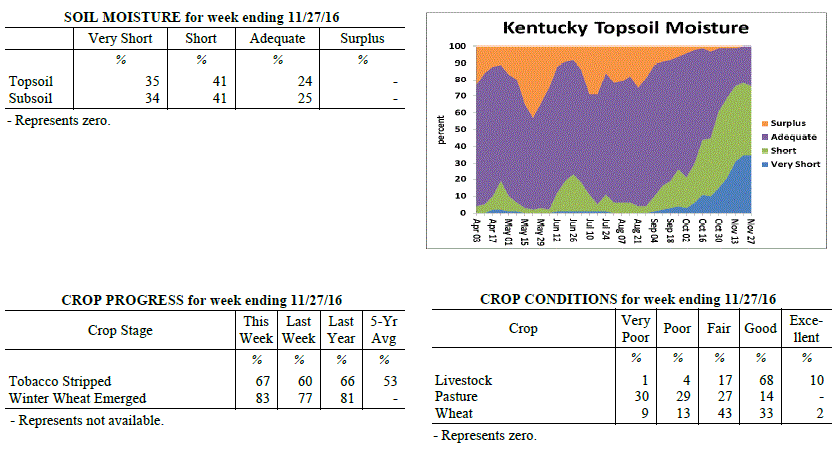
Agricultural Situation Report: November 28, 2016
(USDA's Crop Report with comments from Tom Priddy & Matt Dixon, UK Ag. Weather)
Agricultural News: Kentucky experienced below normal temperatures and below normal
rainfall over the past week. Precipitation for the week totaled 0.23 inches, 0.81
inches below normal. Temperatures averaged 43 degrees for the week, 1 degree below
normal. Topsoil moisture was rated 35 percent very short, 41 percent short, and 24
percent adequate. Subsoil moisture was rated 34 percent very short, 41 percent short,
and 25 percent adequate. Days suitable for fieldwork averaged 5.9 out of a possible
seven.
Primary activities this week included harvesting crops and stripping tobacco. Light
rainfall occurred, but soil and pasture conditions continue to remain very dry.
Germination problems for cover crops and winter wheat have been reported due to the
ongoing drought. Some farm ponds have dried up as well, causing water issues for
livestock producers. Many farmers have been feeding hay earlier as a result of
drought conditions late in the season. Hay and roughage supplies were reported as 2
percent very short, 12 percent short, 76 percent adequate, and 10 percent surplus.
Kentucky Climate Summary
 For the Period November 21, 2016 to November 27, 2016
Below Normal Temperatures and Below Normal Rainfall:
Temperatures for the period averaged 43 degrees across the state which was 1 degree
cooler than normal and 6 degrees cooler than the previous period. High temperatures
averaged from 52 in the West to 53 in the East. Departure from normal high
temperatures ranged from 3 degrees cooler than normal in the West to 2 degrees
cooler than normal in the East. Low temperatures averaged from 35 degrees in the
West to 33 degrees in the East. Departure from normal low temperature ranged from 1
degree cooler than normal in the West to 1 degree warmer than normal in the East.
The extreme high temperature for the period was 70 degrees at BURKESVILLE 3W and the
extreme low was 14 degrees at MONTICELLO AWOS.
Precipitation (liq. equ.) for the period totaled 0.23 inches statewide which was 0.81
inches below normal and 22% of normal. Precipitation totals by climate division, West
0.50 inches, Central 0.22 inches, Bluegrass 0.17 inches and East 0.03 inches, which
was 0.7, 0.88, 0.72 and 0.93 inches below normal. By station, precipitation totals
ranged from a low of 0.00 inches at BARBOURVILLE 3E to a high of 1.58 inches at
POPLAR BLUFF ASOS.
---
Agricultural Situation Report: November 21, 2016
(USDA's Crop Report with comments from Tom Priddy & Matt Dixon, UK Ag. Weather)
Agricultural News: Kentucky experienced above normal temperatures and below normal
rainfall over the past week. Precipitation for the week totaled 0.26 inches, 0.71
inches below normal. Temperatures averaged 50 degrees for the week, 3 degrees above
normal. Topsoil moisture was rated 35 percent very short, 43 percent short, and 22
percent adequate. Subsoil moisture was rated 33 percent very short, 43 percent short,
and 24 percent adequate. Days suitable for fieldwork averaged 6.5 out of a possible
seven.
Soybean harvest and winter wheat planting neared completion this week; tobacco
stripping continued. Most of the state is now in a severe drought according to the US
Drought Monitor, and burn bans remain in place for the majority of the state as well.
Some precipitation fell towards the end of the week, but had little impact on
reversing drought deficits. Soil and pasture conditions still remain very dry. Many
cattle farmers are concerned about hay supplies through the winter as drought conditions
forced early feeding. Fall breeding is ongoing.
For the Period November 21, 2016 to November 27, 2016
Below Normal Temperatures and Below Normal Rainfall:
Temperatures for the period averaged 43 degrees across the state which was 1 degree
cooler than normal and 6 degrees cooler than the previous period. High temperatures
averaged from 52 in the West to 53 in the East. Departure from normal high
temperatures ranged from 3 degrees cooler than normal in the West to 2 degrees
cooler than normal in the East. Low temperatures averaged from 35 degrees in the
West to 33 degrees in the East. Departure from normal low temperature ranged from 1
degree cooler than normal in the West to 1 degree warmer than normal in the East.
The extreme high temperature for the period was 70 degrees at BURKESVILLE 3W and the
extreme low was 14 degrees at MONTICELLO AWOS.
Precipitation (liq. equ.) for the period totaled 0.23 inches statewide which was 0.81
inches below normal and 22% of normal. Precipitation totals by climate division, West
0.50 inches, Central 0.22 inches, Bluegrass 0.17 inches and East 0.03 inches, which
was 0.7, 0.88, 0.72 and 0.93 inches below normal. By station, precipitation totals
ranged from a low of 0.00 inches at BARBOURVILLE 3E to a high of 1.58 inches at
POPLAR BLUFF ASOS.
---
Agricultural Situation Report: November 21, 2016
(USDA's Crop Report with comments from Tom Priddy & Matt Dixon, UK Ag. Weather)
Agricultural News: Kentucky experienced above normal temperatures and below normal
rainfall over the past week. Precipitation for the week totaled 0.26 inches, 0.71
inches below normal. Temperatures averaged 50 degrees for the week, 3 degrees above
normal. Topsoil moisture was rated 35 percent very short, 43 percent short, and 22
percent adequate. Subsoil moisture was rated 33 percent very short, 43 percent short,
and 24 percent adequate. Days suitable for fieldwork averaged 6.5 out of a possible
seven.
Soybean harvest and winter wheat planting neared completion this week; tobacco
stripping continued. Most of the state is now in a severe drought according to the US
Drought Monitor, and burn bans remain in place for the majority of the state as well.
Some precipitation fell towards the end of the week, but had little impact on
reversing drought deficits. Soil and pasture conditions still remain very dry. Many
cattle farmers are concerned about hay supplies through the winter as drought conditions
forced early feeding. Fall breeding is ongoing.
 Kentucky Climate Summary
For the Period November 14, 2016 to November 20, 2016
Above Normal Temperatures and Below Normal Rainfall:
Kentucky saw a major change in the weather pattern this past week as record warmth on
Friday was followed by a plunge in the thermometer over the weekend. Through the
second half of the work week, winds steadily increased from the south, leading to a
warming trend for the area. By Friday, winds were gusting to around 25 to 30 mph,
pushing high temperatures into the middle 70s to around 80 for much of Kentucky.
This was roughly 20 to 25 degrees above normal for this time of year. The record
warmth was followed by a strong cold front pushing through the Commonwealth late
Friday and into Friday night. A band of showers formed along and behind the front
with statewide accumulations around a couple tenths to half inch, highest readings in
Western Kentucky. While it was the highest totals seen in quite a while, it was
still not near enough to cut into drought deficits. According to the latest update to
the US Drought Monitor, nearly 83% of the state is now under a Severe Drought.
Temperatures dropped drastically behind the front over the weekend. Highs by Sunday
were only in the upper 30s to middle 40s.
Temperatures for the period averaged 50 degrees across the state which was 3 degrees
warmer than normal and no change to the previous period. High temperatures averaged
from 65 in the West to 63 in the East. Departure from normal high temperatures
ranged from 7 degrees warmer than normal in the West to 6 degrees warmer than normal
in the East. Low temperatures averaged from 39 degrees in the West to 35 degrees in
the East. Departure from normal low temperature ranged from 2 degrees warmer than
normal in the West to 1 degree warmer than normal in the East. The extreme high
temperature for the period was 81 degrees at GREENVILLE 6N and the extreme low was
19 degrees at BURKESVILLE 3W.
Precipitation (liq. equ.) for the period totaled 0.26 inches statewide which was 0.71
inches below normal and 27% of normal. Precipitation totals by climate division, West
0.47 inches, Central 0.19 inches, Bluegrass 0.16 inches and East 0.21 inches, which
was 0.65, 0.83, 0.68 and 0.68 inches below normal. By station, precipitation totals
ranged from a low of 0.01 inches at POPLAR BLUFF ASOS to a high of 1.17 inches at
MURRAY 1W.
---
Agricultural Situation Report: November 14, 2016
(USDA's Crop Report with comments from Tom Priddy & Matt Dixon, UK Ag. Weather)
Agricultural News: Kentucky experienced near normal temperatures and well below
normal rainfall over the past week. Precipitation for the week totaled 0.14 inches,
0.68 inches below normal. Temperatures averaged 49 degrees for the week, unchanged
from normal. Topsoil moisture was rated 31 percent very short, 45 percent short, 23
percent adequate and 1 percent surplus. Subsoil moisture was rated 28 percent very
short, 43 percent short, 28 percent adequate, and 1 percent surplus. Days suitable
for fieldwork averaged 6.5 out of a possible seven.
Primary activities this week included harvesting soybeans, stripping tobacco, and
seeding winter wheat. Most of the state remains under moderate drought conditions
according to the US Drought Monitor, with southern and southeastern portions now in a
severe drought. Very little growth is occurring for pastures, wheat, and cover crops
due to the lack of moisture; frosts were also reported this week. Livestock producers
continue to feed hay, and many are concerned about the water supply with ponds
beginning to dry up.
Kentucky Climate Summary
For the Period November 14, 2016 to November 20, 2016
Above Normal Temperatures and Below Normal Rainfall:
Kentucky saw a major change in the weather pattern this past week as record warmth on
Friday was followed by a plunge in the thermometer over the weekend. Through the
second half of the work week, winds steadily increased from the south, leading to a
warming trend for the area. By Friday, winds were gusting to around 25 to 30 mph,
pushing high temperatures into the middle 70s to around 80 for much of Kentucky.
This was roughly 20 to 25 degrees above normal for this time of year. The record
warmth was followed by a strong cold front pushing through the Commonwealth late
Friday and into Friday night. A band of showers formed along and behind the front
with statewide accumulations around a couple tenths to half inch, highest readings in
Western Kentucky. While it was the highest totals seen in quite a while, it was
still not near enough to cut into drought deficits. According to the latest update to
the US Drought Monitor, nearly 83% of the state is now under a Severe Drought.
Temperatures dropped drastically behind the front over the weekend. Highs by Sunday
were only in the upper 30s to middle 40s.
Temperatures for the period averaged 50 degrees across the state which was 3 degrees
warmer than normal and no change to the previous period. High temperatures averaged
from 65 in the West to 63 in the East. Departure from normal high temperatures
ranged from 7 degrees warmer than normal in the West to 6 degrees warmer than normal
in the East. Low temperatures averaged from 39 degrees in the West to 35 degrees in
the East. Departure from normal low temperature ranged from 2 degrees warmer than
normal in the West to 1 degree warmer than normal in the East. The extreme high
temperature for the period was 81 degrees at GREENVILLE 6N and the extreme low was
19 degrees at BURKESVILLE 3W.
Precipitation (liq. equ.) for the period totaled 0.26 inches statewide which was 0.71
inches below normal and 27% of normal. Precipitation totals by climate division, West
0.47 inches, Central 0.19 inches, Bluegrass 0.16 inches and East 0.21 inches, which
was 0.65, 0.83, 0.68 and 0.68 inches below normal. By station, precipitation totals
ranged from a low of 0.01 inches at POPLAR BLUFF ASOS to a high of 1.17 inches at
MURRAY 1W.
---
Agricultural Situation Report: November 14, 2016
(USDA's Crop Report with comments from Tom Priddy & Matt Dixon, UK Ag. Weather)
Agricultural News: Kentucky experienced near normal temperatures and well below
normal rainfall over the past week. Precipitation for the week totaled 0.14 inches,
0.68 inches below normal. Temperatures averaged 49 degrees for the week, unchanged
from normal. Topsoil moisture was rated 31 percent very short, 45 percent short, 23
percent adequate and 1 percent surplus. Subsoil moisture was rated 28 percent very
short, 43 percent short, 28 percent adequate, and 1 percent surplus. Days suitable
for fieldwork averaged 6.5 out of a possible seven.
Primary activities this week included harvesting soybeans, stripping tobacco, and
seeding winter wheat. Most of the state remains under moderate drought conditions
according to the US Drought Monitor, with southern and southeastern portions now in a
severe drought. Very little growth is occurring for pastures, wheat, and cover crops
due to the lack of moisture; frosts were also reported this week. Livestock producers
continue to feed hay, and many are concerned about the water supply with ponds
beginning to dry up.
 Kentucky Climate Summary
For the Period November 7, 2016 to November 13, 2016
Near Normal Temperatures and Well Below Normal Rainfall:
Much of South-Central and Southeastern Kentucky are now in a Severe Drought according
to the latest update to the US Drought Monitor. The state only averaged a little
over a tenth of an inch this past week with the passage of a cold front on Election
Day. Going back the past 60 days, the state has only averaged 2.71 inches, which is
nearly 4 inches below normal. While dry conditions continued, frost and freezing
temperatures returned, bringing an official end to the growing season. The first
occurrence came Thursday morning as lows dropped into the upper 20s to middle 30s
with widespread frost formation. The coldest temperatures of the fall season were
then seen on Saturday night and Sunday morning as high pressure of Canadian origin
moved overhead, leading to a hard freeze across the state. Skies cleared and allowed
lows to drop into the 20s for much of Kentucky. Some of the typical cooler spots even
hit the upper teens.
Temperatures for the period averaged 49 degrees across the state which was near
normal and 14 degrees cooler than the previous period. High temperatures averaged
from 64 in the West to 61 in the East. Departure from normal high temperatures ranged
from 3 degrees warmer than normal in the West to near normal in the East. Low
temperatures averaged from 37 degrees in the West to 36 degrees in the East.
Departure from normal low temperature ranged from 3 degrees cooler than normal in the
West to near normal in the East. The extreme high temperature for the period was 77
degrees at BOWLING GREEN APT and the extreme low was 19 degrees at CYNTHIANA 8N.
Precipitation (liq. equ.) for the period totaled 0.14 inches statewide which was 0.68
inches below normal and 17% of normal. Precipitation totals by climate division, West
0.10 inches, Central 0.12 inches, Bluegrass 0.22 inches and East 0.11 inches, which
was 0.88, 0.74, 0.49 and 0.63 inches below normal. By station, precipitation totals
ranged from a low of 0.00 inches at CAPE GIRARDEAU ASOS to a high of 0.47 inches at
CARLISLE 5SW.
---
Agricultural Situation Report: November 7, 2016
(USDA's Crop Report with comments from Tom Priddy & Matt Dixon, UK Ag. Weather)
Agricultural News: Kentucky experienced much above normal temperatures and well below
normal rainfall over the past week. Precipitation for the week totaled 0.06 inches,
0.70 inches below normal. Temperatures averaged 62 degrees for the week, 10 degrees
above normal. Topsoil moisture was rated 21 percent very short, 48 percent short, 30
percent adequate and 1 percent surplus. Subsoil moisture was rated 16 percent very
short, 51 percent short, 32 percent adequate, and 1 percent surplus. Days suitable
for fieldwork averaged 6.7 out of a possible seven.
Primary activities this week included harvesting corn and soybeans, stripping
tobacco, and sowing wheat. Dry weather continued this week, with most of the state
under moderate drought conditions according to the US Drought Monitor. Wheat and
cover crops have struggled to germinate with the limited moisture. Many livestock
producers are feeding hay or supplemental grain, and some have had to haul water with
farm ponds drying up. Cattle and calves obtained approximately 56 percent of feed
from pastures.
Kentucky Climate Summary
For the Period November 7, 2016 to November 13, 2016
Near Normal Temperatures and Well Below Normal Rainfall:
Much of South-Central and Southeastern Kentucky are now in a Severe Drought according
to the latest update to the US Drought Monitor. The state only averaged a little
over a tenth of an inch this past week with the passage of a cold front on Election
Day. Going back the past 60 days, the state has only averaged 2.71 inches, which is
nearly 4 inches below normal. While dry conditions continued, frost and freezing
temperatures returned, bringing an official end to the growing season. The first
occurrence came Thursday morning as lows dropped into the upper 20s to middle 30s
with widespread frost formation. The coldest temperatures of the fall season were
then seen on Saturday night and Sunday morning as high pressure of Canadian origin
moved overhead, leading to a hard freeze across the state. Skies cleared and allowed
lows to drop into the 20s for much of Kentucky. Some of the typical cooler spots even
hit the upper teens.
Temperatures for the period averaged 49 degrees across the state which was near
normal and 14 degrees cooler than the previous period. High temperatures averaged
from 64 in the West to 61 in the East. Departure from normal high temperatures ranged
from 3 degrees warmer than normal in the West to near normal in the East. Low
temperatures averaged from 37 degrees in the West to 36 degrees in the East.
Departure from normal low temperature ranged from 3 degrees cooler than normal in the
West to near normal in the East. The extreme high temperature for the period was 77
degrees at BOWLING GREEN APT and the extreme low was 19 degrees at CYNTHIANA 8N.
Precipitation (liq. equ.) for the period totaled 0.14 inches statewide which was 0.68
inches below normal and 17% of normal. Precipitation totals by climate division, West
0.10 inches, Central 0.12 inches, Bluegrass 0.22 inches and East 0.11 inches, which
was 0.88, 0.74, 0.49 and 0.63 inches below normal. By station, precipitation totals
ranged from a low of 0.00 inches at CAPE GIRARDEAU ASOS to a high of 0.47 inches at
CARLISLE 5SW.
---
Agricultural Situation Report: November 7, 2016
(USDA's Crop Report with comments from Tom Priddy & Matt Dixon, UK Ag. Weather)
Agricultural News: Kentucky experienced much above normal temperatures and well below
normal rainfall over the past week. Precipitation for the week totaled 0.06 inches,
0.70 inches below normal. Temperatures averaged 62 degrees for the week, 10 degrees
above normal. Topsoil moisture was rated 21 percent very short, 48 percent short, 30
percent adequate and 1 percent surplus. Subsoil moisture was rated 16 percent very
short, 51 percent short, 32 percent adequate, and 1 percent surplus. Days suitable
for fieldwork averaged 6.7 out of a possible seven.
Primary activities this week included harvesting corn and soybeans, stripping
tobacco, and sowing wheat. Dry weather continued this week, with most of the state
under moderate drought conditions according to the US Drought Monitor. Wheat and
cover crops have struggled to germinate with the limited moisture. Many livestock
producers are feeding hay or supplemental grain, and some have had to haul water with
farm ponds drying up. Cattle and calves obtained approximately 56 percent of feed
from pastures.
 Kentucky Climate Summary
For the Period October 31, 2016 to November 6, 2016
Much Above Normal Temperatures and Well Below Normal Rainfall:
Rainfall continues to run scarce for the Commonwealth as the state has now gone 7
straight weeks of seeing below normal precipitation. Most of Kentucky stayed under a
tenth of an inch for the week. The only rainfall event came mid-week with the
passage of a weak cold front, but coverage remained isolated to scattered and only
minimal accumulations, leading to no drought relief. Major changes were seen on the
US Drought Monitor as nearly 82% of the state is now under a 'Moderate Drought'. Well
above normal temperatures stuck around for the first half of the work week as highs
moved into the low to middle 80s. Kentucky had several locations break daily
records, but also some that broke November all-time highs. Following the passage of
the cold front mentioned above, winds shifted to the north and temperatures took a
downhill turn going into the weekend. Lows dropped into the middle 30s to low 40s
both Friday and Saturday nights, leading to some frost development. Saying that, for
the week, the state average temperature was about 10 degrees above normal for early
November.
Temperatures for the period averaged 62 degrees across the state which was 10 degrees
warmer than normal and no change to the previous period. High temperatures averaged
from 74 in the West to 73 in the East. Departure from normal high temperatures
ranged from 10 degrees warmer than normal in the West to 9 degrees warmer than
normal in the East. Low temperatures averaged from 52 degrees in the West to 50
degrees in the East. Departure from normal low temperature ranged from 10 degrees
warmer than normal in the West to 13 degrees warmer than normal in the East. The
extreme high temperature for the period was 87 degrees at BOWLING GREEN APT and the
extreme low was 30 degrees at MONTICELLO AWOS.
Precipitation (liq. equ.) for the period totaled 0.06 inches statewide which was 0.7
inches below normal and 8% of normal. Precipitation totals by climate division, West
0.02 inches, Central 0.03 inches, Bluegrass 0.08 inches and East 0.11 inches, which
was 0.83, 0.76, 0.62 and 0.59 inches below normal. By station, precipitation totals
ranged from a low of 0.00 inches at ALBANY 1N to a high of 0.49 inches at PEABODY.
---
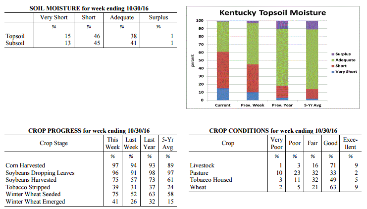
Agricultural Situation Report: October 31, 2016
(USDA's Crop Report with comments from Tom Priddy & Matt Dixon, UK Ag. Weather)
Agricultural News: Kentucky experienced above normal temperatures and below normal
rainfall over the past week. Precipitation for the week totaled 0.02 inches, 0.74
inches below normal. Temperatures averaged 61 degrees for the week, 7 degrees above
normal. Topsoil moisture was rated 15 percent very short, 46 percent short, 38
percent adequate and 1 percent surplus. Subsoil moisture was rated 13 percent very
short, 45 percent short, 41 percent adequate, and 1 percent surplus. Days suitable
for fieldwork averaged 6.5 out of a possible seven.
Primary activities this week included harvesting corn and soybeans, planting wheat
and cover crops, and stripping tobacco. Dry conditions allowed for harvest of corn
and soybeans to advance ahead of normal. The lack of moisture continues to be a
concern for germination of new seedings. Rain is needed to establish fall seeded
crops. Pastures are also in need of rain as many livestock producers have started
feeding hay earlier than normal.
Kentucky Climate Summary
For the Period October 31, 2016 to November 6, 2016
Much Above Normal Temperatures and Well Below Normal Rainfall:
Rainfall continues to run scarce for the Commonwealth as the state has now gone 7
straight weeks of seeing below normal precipitation. Most of Kentucky stayed under a
tenth of an inch for the week. The only rainfall event came mid-week with the
passage of a weak cold front, but coverage remained isolated to scattered and only
minimal accumulations, leading to no drought relief. Major changes were seen on the
US Drought Monitor as nearly 82% of the state is now under a 'Moderate Drought'. Well
above normal temperatures stuck around for the first half of the work week as highs
moved into the low to middle 80s. Kentucky had several locations break daily
records, but also some that broke November all-time highs. Following the passage of
the cold front mentioned above, winds shifted to the north and temperatures took a
downhill turn going into the weekend. Lows dropped into the middle 30s to low 40s
both Friday and Saturday nights, leading to some frost development. Saying that, for
the week, the state average temperature was about 10 degrees above normal for early
November.
Temperatures for the period averaged 62 degrees across the state which was 10 degrees
warmer than normal and no change to the previous period. High temperatures averaged
from 74 in the West to 73 in the East. Departure from normal high temperatures
ranged from 10 degrees warmer than normal in the West to 9 degrees warmer than
normal in the East. Low temperatures averaged from 52 degrees in the West to 50
degrees in the East. Departure from normal low temperature ranged from 10 degrees
warmer than normal in the West to 13 degrees warmer than normal in the East. The
extreme high temperature for the period was 87 degrees at BOWLING GREEN APT and the
extreme low was 30 degrees at MONTICELLO AWOS.
Precipitation (liq. equ.) for the period totaled 0.06 inches statewide which was 0.7
inches below normal and 8% of normal. Precipitation totals by climate division, West
0.02 inches, Central 0.03 inches, Bluegrass 0.08 inches and East 0.11 inches, which
was 0.83, 0.76, 0.62 and 0.59 inches below normal. By station, precipitation totals
ranged from a low of 0.00 inches at ALBANY 1N to a high of 0.49 inches at PEABODY.
---
Agricultural Situation Report: October 31, 2016
(USDA's Crop Report with comments from Tom Priddy & Matt Dixon, UK Ag. Weather)
Agricultural News: Kentucky experienced above normal temperatures and below normal
rainfall over the past week. Precipitation for the week totaled 0.02 inches, 0.74
inches below normal. Temperatures averaged 61 degrees for the week, 7 degrees above
normal. Topsoil moisture was rated 15 percent very short, 46 percent short, 38
percent adequate and 1 percent surplus. Subsoil moisture was rated 13 percent very
short, 45 percent short, 41 percent adequate, and 1 percent surplus. Days suitable
for fieldwork averaged 6.5 out of a possible seven.
Primary activities this week included harvesting corn and soybeans, planting wheat
and cover crops, and stripping tobacco. Dry conditions allowed for harvest of corn
and soybeans to advance ahead of normal. The lack of moisture continues to be a
concern for germination of new seedings. Rain is needed to establish fall seeded
crops. Pastures are also in need of rain as many livestock producers have started
feeding hay earlier than normal.
 Kentucky Climate Summary
For the Period October 24, 2016 to October 30, 2016
Much Above Normal Temperatures and Well Below Normal Rainfall:
Dry conditions continue to persist across the Lower Ohio Valley. Most of the state
did not see any rainfall this past week as high pressure remained in control. Any
locations that did see precipitation with a frontal passage midweek, only saw a
couple hundredths for the most part. Long-term deficits continue to worsen with six
straight weeks of below normal rainfall. The state is nearly 2.5 inches below normal
for the month of October and over 3.5 inches for the past 60 days. While the US
Drought Monitor kept much of the state under 'Abnormally Dry' conditions, 'Moderate
Drought' was expanded into Southcentral Kentucky. Temperatures also continued to run
well above normal. Over the weekend, gusty southwest flow pushed highs into the low
to middle 80s, breaking several records across the state. Normal high temperatures
for the last week of October are in the low to middle 60s. Climatologically
speaking, most of Kentucky has now surpassed the average date of first freeze.
Temperatures for the period averaged 61 degrees across the state which was 7 degrees
warmer than normal and 4 degrees cooler than the previous period. High temperatures
averaged from 77 in the West to 74 in the East. Departure from normal high
temperatures ranged from 10 degrees warmer than normal in the West to 7 degrees
warmer than normal in the East. Low temperatures averaged from 49 degrees in the
West to 47 degrees in the East. Departure from normal low temperature ranged from 5
degrees warmer than normal in the West to 8 degrees warmer than normal in the East.
The extreme high temperature for the period was 85 degrees at PADUCAH ASOS and the
extreme low was 32 degrees at BURKESVILLE 3W.
Precipitation (liq. equ.) for the period totaled 0.02 inches statewide which was 0.74
inches below normal and 3% of normal. Precipitation totals by climate division, West
0.03 inches, Central 0.01 inches, Bluegrass 0.01 inches and East 0.01 inches, which
was 0.82, 0.77, 0.68 and 0.7 inches below normal. By station, precipitation totals
ranged from a low of 0.00 inches at BIG SANDY to a high of 0.27 inches at
CARBONDALE ASOS.
---
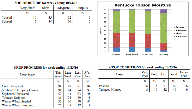
Agricultural Situation Report: October 24, 2016
(USDA's Crop Report with comments from Tom Priddy & Matt Dixon, UK Ag. Weather)
Agricultural News: Kentucky experienced above normal temperatures and below normal
rainfall over the past week. Precipitation for the week totaled 0.66 inches, 0.04
inches below normal. Temperatures averaged 65 degrees for the week, 8 degrees above
normal. Topsoil moisture was rated 10 percent very short, 35 percent short, 52
percent adequate and 3 percent surplus. Subsoil moisture was rated 7 percent very
short, 34 percent short, 56 percent adequate, and 3 percent surplus. Days suitable
for fieldwork averaged 5.6 out of a possible seven.
Primary activities this week included harvesting corn and soybeans, planting wheat
and cover crops, and stripping tobacco. The lack of moisture is of concern for
germination of new seedings. Most pastures are in need of rain as well. Livestock
producers have started feeding hay.
Kentucky Climate Summary
For the Period October 24, 2016 to October 30, 2016
Much Above Normal Temperatures and Well Below Normal Rainfall:
Dry conditions continue to persist across the Lower Ohio Valley. Most of the state
did not see any rainfall this past week as high pressure remained in control. Any
locations that did see precipitation with a frontal passage midweek, only saw a
couple hundredths for the most part. Long-term deficits continue to worsen with six
straight weeks of below normal rainfall. The state is nearly 2.5 inches below normal
for the month of October and over 3.5 inches for the past 60 days. While the US
Drought Monitor kept much of the state under 'Abnormally Dry' conditions, 'Moderate
Drought' was expanded into Southcentral Kentucky. Temperatures also continued to run
well above normal. Over the weekend, gusty southwest flow pushed highs into the low
to middle 80s, breaking several records across the state. Normal high temperatures
for the last week of October are in the low to middle 60s. Climatologically
speaking, most of Kentucky has now surpassed the average date of first freeze.
Temperatures for the period averaged 61 degrees across the state which was 7 degrees
warmer than normal and 4 degrees cooler than the previous period. High temperatures
averaged from 77 in the West to 74 in the East. Departure from normal high
temperatures ranged from 10 degrees warmer than normal in the West to 7 degrees
warmer than normal in the East. Low temperatures averaged from 49 degrees in the
West to 47 degrees in the East. Departure from normal low temperature ranged from 5
degrees warmer than normal in the West to 8 degrees warmer than normal in the East.
The extreme high temperature for the period was 85 degrees at PADUCAH ASOS and the
extreme low was 32 degrees at BURKESVILLE 3W.
Precipitation (liq. equ.) for the period totaled 0.02 inches statewide which was 0.74
inches below normal and 3% of normal. Precipitation totals by climate division, West
0.03 inches, Central 0.01 inches, Bluegrass 0.01 inches and East 0.01 inches, which
was 0.82, 0.77, 0.68 and 0.7 inches below normal. By station, precipitation totals
ranged from a low of 0.00 inches at BIG SANDY to a high of 0.27 inches at
CARBONDALE ASOS.
---
Agricultural Situation Report: October 24, 2016
(USDA's Crop Report with comments from Tom Priddy & Matt Dixon, UK Ag. Weather)
Agricultural News: Kentucky experienced above normal temperatures and below normal
rainfall over the past week. Precipitation for the week totaled 0.66 inches, 0.04
inches below normal. Temperatures averaged 65 degrees for the week, 8 degrees above
normal. Topsoil moisture was rated 10 percent very short, 35 percent short, 52
percent adequate and 3 percent surplus. Subsoil moisture was rated 7 percent very
short, 34 percent short, 56 percent adequate, and 3 percent surplus. Days suitable
for fieldwork averaged 5.6 out of a possible seven.
Primary activities this week included harvesting corn and soybeans, planting wheat
and cover crops, and stripping tobacco. The lack of moisture is of concern for
germination of new seedings. Most pastures are in need of rain as well. Livestock
producers have started feeding hay.
 Kentucky Climate Summary
For the Period October 17, 2016 to October 23, 2016
Above Normal Temperatures and Below Normal Rainfall:
This past week started off with very warm temperatures in place on Monday and
Tuesday, some even record breaking. Highs rose into the mid to upper 80s for much of
the state behind breezy southwest flow and mostly sunny skies. A cold front then
pushed through the Lower Ohio Valley over the second half of the work week, bringing
some much needed rainfall to the Commonwealth. While Western and Central Kentucky
averaged around a quarter to half inch, the Bluegrass and Eastern Kentucky were
closer to an inch. Prior to the event, the state had gone four straight weeks of
much below normal precipitation. The US Drought Monitor expanded ‘Abnormally Dry’
conditions across almost the entirety of the state, while ‘Moderate Drought’
continued to increase in coverage across Southeastern Kentucky. Behind the cold
front, much cooler air spilled into the Bluegrass State. Highs on Friday and
Saturday only got into the upper 50s to middle 60s. Skies cleared from west to east
on Friday night with lows dropping into the upper 30s to lower 40s. Several
locations across Eastern Kentucky dropped into the middle 30s on Saturday night, some
reporting frost.
Temperatures for the period averaged 65 degrees across the state which was 8 degrees
warmer than normal and 2 degrees warmer than the previous period. High temperatures
averaged from 76 in the West to 75 in the East. Departure from normal high
temperatures ranged from 6 degrees warmer than normal in the West to 6 degrees
warmer than normal in the East. Low temperatures averaged from 55 degrees in the
West to 52 degrees in the East. Departure from normal low temperature ranged from 9
degrees warmer than normal in the West to 11 degrees warmer than normal in the
East. The extreme high temperature for the period was 90 degrees at PEABODY and the
extreme low was 29 degrees at BURKESVILLE 3W.
Precipitation (liq. equ.) for the period totaled 0.66 inches statewide which was 0.04
inches below normal and 94% of normal. Precipitation totals by climate division, West
0.26 inches, Central 0.39 inches, Bluegrass 1.06 inches and East 0.92 inches, which
was -0.52, -0.32, 0.41 and 0.25 inches respectively from normal. By station,
precipitation totals ranged from a low of 0.01 inches at HENDERSON 5E to a high of
3.63 inches at BURLINGTON 4S.
---
Agricultural Situation Report: October 17, 2016
(USDA's Crop Report with comments from Tom Priddy & Matt Dixon, UK Ag. Weather)
Agricultural News: Kentucky experienced above normal temperatures and below normal
rainfall over the past week. Precipitation for the week totaled 0.05 inches, 0.67
inches below normal. Temperatures averaged 62 degrees for the week, 4 degrees above
normal. Topsoil moisture was rated 11 percent very short, 33 percent short, 55
percent adequate and 1 percent surplus. Subsoil moisture was rated 8 percent very
short, 29 percent short, 62 percent adequate, and 1 percent surplus. Days suitable
for fieldwork averaged 6.5 out of a possible seven.
Dry conditions continued throughout the state. Primary activities this week included
harvesting corn and soybeans, sowing wheat and stripping tobacco. Weather conditions
have not been optimal for tobacco curing. Some livestock producers have begun feeding
hay due to deteriorating pasture conditions. Rain would be welcome to improve pasture
conditions, bring tobacco in case and for establishment of newly seeded fields.
Kentucky Climate Summary
For the Period October 17, 2016 to October 23, 2016
Above Normal Temperatures and Below Normal Rainfall:
This past week started off with very warm temperatures in place on Monday and
Tuesday, some even record breaking. Highs rose into the mid to upper 80s for much of
the state behind breezy southwest flow and mostly sunny skies. A cold front then
pushed through the Lower Ohio Valley over the second half of the work week, bringing
some much needed rainfall to the Commonwealth. While Western and Central Kentucky
averaged around a quarter to half inch, the Bluegrass and Eastern Kentucky were
closer to an inch. Prior to the event, the state had gone four straight weeks of
much below normal precipitation. The US Drought Monitor expanded ‘Abnormally Dry’
conditions across almost the entirety of the state, while ‘Moderate Drought’
continued to increase in coverage across Southeastern Kentucky. Behind the cold
front, much cooler air spilled into the Bluegrass State. Highs on Friday and
Saturday only got into the upper 50s to middle 60s. Skies cleared from west to east
on Friday night with lows dropping into the upper 30s to lower 40s. Several
locations across Eastern Kentucky dropped into the middle 30s on Saturday night, some
reporting frost.
Temperatures for the period averaged 65 degrees across the state which was 8 degrees
warmer than normal and 2 degrees warmer than the previous period. High temperatures
averaged from 76 in the West to 75 in the East. Departure from normal high
temperatures ranged from 6 degrees warmer than normal in the West to 6 degrees
warmer than normal in the East. Low temperatures averaged from 55 degrees in the
West to 52 degrees in the East. Departure from normal low temperature ranged from 9
degrees warmer than normal in the West to 11 degrees warmer than normal in the
East. The extreme high temperature for the period was 90 degrees at PEABODY and the
extreme low was 29 degrees at BURKESVILLE 3W.
Precipitation (liq. equ.) for the period totaled 0.66 inches statewide which was 0.04
inches below normal and 94% of normal. Precipitation totals by climate division, West
0.26 inches, Central 0.39 inches, Bluegrass 1.06 inches and East 0.92 inches, which
was -0.52, -0.32, 0.41 and 0.25 inches respectively from normal. By station,
precipitation totals ranged from a low of 0.01 inches at HENDERSON 5E to a high of
3.63 inches at BURLINGTON 4S.
---
Agricultural Situation Report: October 17, 2016
(USDA's Crop Report with comments from Tom Priddy & Matt Dixon, UK Ag. Weather)
Agricultural News: Kentucky experienced above normal temperatures and below normal
rainfall over the past week. Precipitation for the week totaled 0.05 inches, 0.67
inches below normal. Temperatures averaged 62 degrees for the week, 4 degrees above
normal. Topsoil moisture was rated 11 percent very short, 33 percent short, 55
percent adequate and 1 percent surplus. Subsoil moisture was rated 8 percent very
short, 29 percent short, 62 percent adequate, and 1 percent surplus. Days suitable
for fieldwork averaged 6.5 out of a possible seven.
Dry conditions continued throughout the state. Primary activities this week included
harvesting corn and soybeans, sowing wheat and stripping tobacco. Weather conditions
have not been optimal for tobacco curing. Some livestock producers have begun feeding
hay due to deteriorating pasture conditions. Rain would be welcome to improve pasture
conditions, bring tobacco in case and for establishment of newly seeded fields.
 Kentucky Climate Summary
For the Period October 10, 2016 to October 16, 2016
Above Normal Temperatures and Well Below Normal Rainfall:
The Commonwealth didn't see much rainfall for a second straight week. High pressure
kept the area mostly dry with any passing disturbances not amounting to much in the
way of rainfall. Over the past 30 days, data at the UK Ag Weather Center shows the state
has only averaged 1.71 inches, which is 1.69 inches below normal for that time span.
The US Drought Monitor greatly expanded the area of Kentucky now showing signs of
'Abnormally Dry' conditions, now accounting for nearly 62% of the state. A small
section of Southeastern Kentucky was even upgraded to a 'Moderate Drought'. In
addition, temperatures continued to run above normal for a second straight week.
Weekend highs rose into the upper 70s to lower 80s for much of the area.
Temperatures for the period averaged 62 degrees across the state which was 4 degrees
warmer than normal and 4 degrees cooler than the previous period. High temperatures
averaged from 73 in the West to 72 in the East. Departure from normal high
temperatures ranged from near normal in the West to 1 degree warmer than normal in
the East. Low temperatures averaged from 53 degrees in the West to 49 degrees in the
East. Departure from normal low temperature ranged from 6 degrees warmer than normal
in the West to 6 degrees warmer than normal in the East. The extreme high temperature
for the period was 84 degrees at BOWLING GREEN APT and the extreme low was 36 degrees
at BARBOURVILLE 3E.
Precipitation (liq. equ.) for the period totaled 0.05 inches statewide which was 0.67
inches below normal and 7% of normal. Precipitation totals by climate division, West
0.10 inches, Central 0.04 inches, Bluegrass 0.01 inches and East 0.04 inches, which
was 0.64, 0.69, 0.68 and 0.67 inches below normal. By station, precipitation totals
ranged from a low of 0.00 inches at ALEXANDRIA 5NW to a high of 0.76 inches at
POPLAR BLUFF ASOS.
---
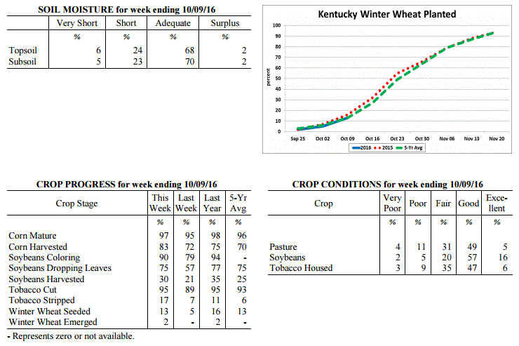
Agricultural Situation Report: October 11, 2016
(USDA's Crop Report with comments from Tom Priddy & Matt Dixon, UK Ag. Weather)
Agricultural News: Kentucky experienced above normal temperatures and below normal
rainfall over the past week. Precipitation for the week totaled 0.01 inches, 0.78
inches below normal. Temperatures averaged 66 degrees for the week, 6 degrees above
normal. Topsoil moisture was rated 6 percent very short, 24 percent short, 68 percent
adequate and 2 percent surplus. Subsoil moisture was rated 5 percent very short, 23
percent short, 70 percent adequate, and 2 percent surplus. Days suitable for
fieldwork averaged 6.7 out of a possible seven.
Dry conditions allowed farmers to make significant progress with all types of field
work. Primary activities this week included harvesting corn, soybeans, hay, and
tobacco. Tobacco harvest was winding down. Tobacco houseburn was reported as 2
percent heavy, 9 percent moderate, 17 percent light, with 72 percent experiencing
none. Some livestock producers have begun feeding hay due to dry conditions.
Kentucky Climate Summary
For the Period October 10, 2016 to October 16, 2016
Above Normal Temperatures and Well Below Normal Rainfall:
The Commonwealth didn't see much rainfall for a second straight week. High pressure
kept the area mostly dry with any passing disturbances not amounting to much in the
way of rainfall. Over the past 30 days, data at the UK Ag Weather Center shows the state
has only averaged 1.71 inches, which is 1.69 inches below normal for that time span.
The US Drought Monitor greatly expanded the area of Kentucky now showing signs of
'Abnormally Dry' conditions, now accounting for nearly 62% of the state. A small
section of Southeastern Kentucky was even upgraded to a 'Moderate Drought'. In
addition, temperatures continued to run above normal for a second straight week.
Weekend highs rose into the upper 70s to lower 80s for much of the area.
Temperatures for the period averaged 62 degrees across the state which was 4 degrees
warmer than normal and 4 degrees cooler than the previous period. High temperatures
averaged from 73 in the West to 72 in the East. Departure from normal high
temperatures ranged from near normal in the West to 1 degree warmer than normal in
the East. Low temperatures averaged from 53 degrees in the West to 49 degrees in the
East. Departure from normal low temperature ranged from 6 degrees warmer than normal
in the West to 6 degrees warmer than normal in the East. The extreme high temperature
for the period was 84 degrees at BOWLING GREEN APT and the extreme low was 36 degrees
at BARBOURVILLE 3E.
Precipitation (liq. equ.) for the period totaled 0.05 inches statewide which was 0.67
inches below normal and 7% of normal. Precipitation totals by climate division, West
0.10 inches, Central 0.04 inches, Bluegrass 0.01 inches and East 0.04 inches, which
was 0.64, 0.69, 0.68 and 0.67 inches below normal. By station, precipitation totals
ranged from a low of 0.00 inches at ALEXANDRIA 5NW to a high of 0.76 inches at
POPLAR BLUFF ASOS.
---
Agricultural Situation Report: October 11, 2016
(USDA's Crop Report with comments from Tom Priddy & Matt Dixon, UK Ag. Weather)
Agricultural News: Kentucky experienced above normal temperatures and below normal
rainfall over the past week. Precipitation for the week totaled 0.01 inches, 0.78
inches below normal. Temperatures averaged 66 degrees for the week, 6 degrees above
normal. Topsoil moisture was rated 6 percent very short, 24 percent short, 68 percent
adequate and 2 percent surplus. Subsoil moisture was rated 5 percent very short, 23
percent short, 70 percent adequate, and 2 percent surplus. Days suitable for
fieldwork averaged 6.7 out of a possible seven.
Dry conditions allowed farmers to make significant progress with all types of field
work. Primary activities this week included harvesting corn, soybeans, hay, and
tobacco. Tobacco harvest was winding down. Tobacco houseburn was reported as 2
percent heavy, 9 percent moderate, 17 percent light, with 72 percent experiencing
none. Some livestock producers have begun feeding hay due to dry conditions.
 Kentucky Climate Summary
For the Period October 3, 2016 to October 9, 2016
Above Normal Temperatures and Below Normal Rainfall:
For the second time in less than a month, most locations in Kentucky saw very little
to no precipitation over the course of the week. High pressure dominated the area,
bringing mostly clear skies and dry conditions. Temperatures were unseasonably warm
through the work week, rising into the low to middle 80s about each day. That changed
late Friday and Friday night as a cold front pushed through the Ohio Valley. Winds
turned to the north on Saturday, becoming breezy at times with gusts around 25 mph.
Highs over the weekend took a significant fall, only rising into the upper 60s to low
70s. Much cooler temperatures were seen Saturday night with much of the state
dropping into the low to middle 40s. Saying that, a handful of sheltered and typically
cooler spots even dropped into the 30s.
Temperatures for the period averaged 66 degrees across the state which was 6 degrees
warmer than normal and 4 degrees warmer than the previous period. High temperatures
averaged from 80 in the West to 77 in the East. Departure from normal high
temperatures ranged from 5 degrees warmer than normal in the West to 4 degrees warmer
than normal in the East. Low temperatures averaged from 55 degrees in the West to 53
degrees in the East. Departure from normal low temperature ranged from 5 degrees
warmer than normal in the West to 7 degrees warmer than normal in the East. The
extreme high temperature for the period was 88 degrees at BOWLING GREEN APT and the
extreme low was 35 degrees at VANCEBURG 6W.
Precipitation (liq. equ.) for the period totaled 0.01 inches statewide which was 0.78
inches below normal and 1% of normal. Precipitation totals by climate division, West
0.01 inches, Central 0.00 inches, Bluegrass 0.00 inches and East 0.01 inches, which
was 0.8, 0.82, 0.74 and 0.77 inches below normal. By station, precipitation totals
ranged from a low of 0.00 inches at ALBANY 1N to a high of 0.19 inches at PIKEVILLE 13S.
---
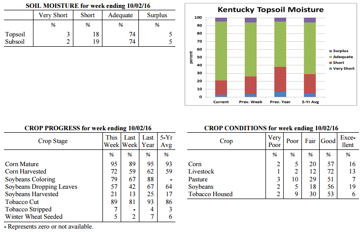
Agricultural Situation Report: October 3, 2016
(USDA's Crop Report with comments from Tom Priddy & Matt Dixon, UK Ag. Weather)
Agricultural News: Kentucky experienced below normal temperatures and rainfall over
the past week. Precipitation for the week totaled 0.68 inches, 0.13 inches below
normal. Temperatures averaged 62 degrees for the week, 1 degree below normal. Topsoil
moisture was rated 3 percent very short, 18 percent short, 74 percent adequate and 5
percent surplus. Subsoil moisture was rated 2 percent very short, 19 percent short,
74 percent adequate, and 5 percent surplus. Days suitable for fieldwork averaged 5.6
out of a possible seven.
Primary activities this week included harvesting corn, soybeans, hay, and tobacco.
Showers during the week slowed harvest progress somewhat, but corn harvest continued
at a rapid pace. Many farmers would welcome some rain as many areas of the state
remained relatively dry. Corn yields are varied depending on planting date and
location. Pasture conditions were rated mostly good to fair. Livestock were rated in
mostly good condition. Labor shortage being reported in some areas which is impacting
the tobacco harvest. Tobacco houseburn was reported as 2 percent heavy, 8 percent
moderate, 18 percent light, with 72 percent experiencing none.
Kentucky Climate Summary
For the Period October 3, 2016 to October 9, 2016
Above Normal Temperatures and Below Normal Rainfall:
For the second time in less than a month, most locations in Kentucky saw very little
to no precipitation over the course of the week. High pressure dominated the area,
bringing mostly clear skies and dry conditions. Temperatures were unseasonably warm
through the work week, rising into the low to middle 80s about each day. That changed
late Friday and Friday night as a cold front pushed through the Ohio Valley. Winds
turned to the north on Saturday, becoming breezy at times with gusts around 25 mph.
Highs over the weekend took a significant fall, only rising into the upper 60s to low
70s. Much cooler temperatures were seen Saturday night with much of the state
dropping into the low to middle 40s. Saying that, a handful of sheltered and typically
cooler spots even dropped into the 30s.
Temperatures for the period averaged 66 degrees across the state which was 6 degrees
warmer than normal and 4 degrees warmer than the previous period. High temperatures
averaged from 80 in the West to 77 in the East. Departure from normal high
temperatures ranged from 5 degrees warmer than normal in the West to 4 degrees warmer
than normal in the East. Low temperatures averaged from 55 degrees in the West to 53
degrees in the East. Departure from normal low temperature ranged from 5 degrees
warmer than normal in the West to 7 degrees warmer than normal in the East. The
extreme high temperature for the period was 88 degrees at BOWLING GREEN APT and the
extreme low was 35 degrees at VANCEBURG 6W.
Precipitation (liq. equ.) for the period totaled 0.01 inches statewide which was 0.78
inches below normal and 1% of normal. Precipitation totals by climate division, West
0.01 inches, Central 0.00 inches, Bluegrass 0.00 inches and East 0.01 inches, which
was 0.8, 0.82, 0.74 and 0.77 inches below normal. By station, precipitation totals
ranged from a low of 0.00 inches at ALBANY 1N to a high of 0.19 inches at PIKEVILLE 13S.
---
Agricultural Situation Report: October 3, 2016
(USDA's Crop Report with comments from Tom Priddy & Matt Dixon, UK Ag. Weather)
Agricultural News: Kentucky experienced below normal temperatures and rainfall over
the past week. Precipitation for the week totaled 0.68 inches, 0.13 inches below
normal. Temperatures averaged 62 degrees for the week, 1 degree below normal. Topsoil
moisture was rated 3 percent very short, 18 percent short, 74 percent adequate and 5
percent surplus. Subsoil moisture was rated 2 percent very short, 19 percent short,
74 percent adequate, and 5 percent surplus. Days suitable for fieldwork averaged 5.6
out of a possible seven.
Primary activities this week included harvesting corn, soybeans, hay, and tobacco.
Showers during the week slowed harvest progress somewhat, but corn harvest continued
at a rapid pace. Many farmers would welcome some rain as many areas of the state
remained relatively dry. Corn yields are varied depending on planting date and
location. Pasture conditions were rated mostly good to fair. Livestock were rated in
mostly good condition. Labor shortage being reported in some areas which is impacting
the tobacco harvest. Tobacco houseburn was reported as 2 percent heavy, 8 percent
moderate, 18 percent light, with 72 percent experiencing none.
 Kentucky Climate Summary
For the Period September 26, 2016 to October 2, 2016
Below Normal Temperatures and Rainfall:
Conditions finally started to feel like fall this past week. Temperatures were
slightly below normal with highs staying in the 60s and 70s for much of the period.
This broke a streak of 12 straight weeks with near to above normal temperatures. The
cooler air started filtering into the area on Monday as a cold front crossed the
region, followed by a brief period of high pressure. Early in the week, some
locations even saw lows drop into the low to middle 40s as skies cleared at night. A
disturbance aloft then slowly rotated over the area from Wednesday through Saturday.
This brought an extended period of unsettled weather with multiple rounds of showers.
Mostly cloudy skies kept temperatures much below normal during the day with highs
only in the 60s for most. Combining the rainfall seen on Monday with the several days
under the influence of the disturbance aloft, the state averaged 0.68 inches, which
was slightly below normal.
Temperatures for the period averaged 62 degrees across the state which was 1 degree
cooler than normal and 12 degrees cooler than the previous period. High temperatures
averaged from 72 in the West to 72 in the East. Departure from normal high
temperatures ranged from 5 degrees cooler than normal in the West to 3 degrees cooler
than normal in the East. Low temperatures averaged from 54 degrees in the West to 52
degrees in the East. Departure from normal low temperature ranged from 1 degree
warmer than normal in the West to 3 degrees warmer than normal in the East. The
extreme high temperature for the period was 86 degrees at PAINTSVILLE 4W and the
extreme low was 41 degrees at CYNTHIANA 8N.
Precipitation (liq. equ.) for the period totaled 0.68 inches statewide which was 0.13
inches below normal and 84% of normal. Precipitation totals by climate division, West
0.67 inches, Central 0.67 inches, Bluegrass 1.03 inches and East 0.33 inches, which
was -0.16, -0.20, 0.29 and -0.47 inches respectively from normal. By station,
precipitation totals ranged from a low of 0.00 inches at POPLAR BLUFF ASOS to a high
of 1.92 inches at EVANSVILLE ASOS.
---
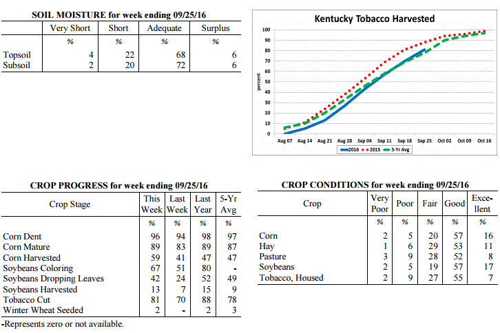
Agricultural Situation Report: September 26, 2016
(USDA's Crop Report with comments from Tom Priddy & Matt Dixon, UK Ag. Weather)
Agricultural News: Kentucky experienced well above normal temperatures and much below
normal rainfall over the past week. Precipitation for the week totaled 0.01 inches,
0.83 inches below normal. Temperatures averaged 74 degrees for the week, 8 degrees
above normal. Topsoil moisture was rated 4 percent very short, 22 percent short, 68
percent adequate and 6 percent surplus. Subsoil moisture was rated 2 percent very
short, 20 percent short, 72 percent adequate, and 6 percent surplus. Days suitable
for fieldwork averaged 6.6 out of a possible seven.
Primary activities this week included harvesting corn, soybeans, hay, and tobacco.
Most of the state remains dry, with few areas receiving any rainfall over the past
week. Corn yield reports range from below average to good, with some grain quality
problems due to the excessive wet weather during the growing season. Producers
reported early soybean yields as average or above-average. Dry conditions continue to
decrease pasture and hay growth, and have started to impact fall seeding. Tobacco
houseburn was reported as 1 percent severe, 10 percent moderate, and 18 percent light,
with 71 percent experiencing none.
Kentucky Climate Summary
For the Period September 26, 2016 to October 2, 2016
Below Normal Temperatures and Rainfall:
Conditions finally started to feel like fall this past week. Temperatures were
slightly below normal with highs staying in the 60s and 70s for much of the period.
This broke a streak of 12 straight weeks with near to above normal temperatures. The
cooler air started filtering into the area on Monday as a cold front crossed the
region, followed by a brief period of high pressure. Early in the week, some
locations even saw lows drop into the low to middle 40s as skies cleared at night. A
disturbance aloft then slowly rotated over the area from Wednesday through Saturday.
This brought an extended period of unsettled weather with multiple rounds of showers.
Mostly cloudy skies kept temperatures much below normal during the day with highs
only in the 60s for most. Combining the rainfall seen on Monday with the several days
under the influence of the disturbance aloft, the state averaged 0.68 inches, which
was slightly below normal.
Temperatures for the period averaged 62 degrees across the state which was 1 degree
cooler than normal and 12 degrees cooler than the previous period. High temperatures
averaged from 72 in the West to 72 in the East. Departure from normal high
temperatures ranged from 5 degrees cooler than normal in the West to 3 degrees cooler
than normal in the East. Low temperatures averaged from 54 degrees in the West to 52
degrees in the East. Departure from normal low temperature ranged from 1 degree
warmer than normal in the West to 3 degrees warmer than normal in the East. The
extreme high temperature for the period was 86 degrees at PAINTSVILLE 4W and the
extreme low was 41 degrees at CYNTHIANA 8N.
Precipitation (liq. equ.) for the period totaled 0.68 inches statewide which was 0.13
inches below normal and 84% of normal. Precipitation totals by climate division, West
0.67 inches, Central 0.67 inches, Bluegrass 1.03 inches and East 0.33 inches, which
was -0.16, -0.20, 0.29 and -0.47 inches respectively from normal. By station,
precipitation totals ranged from a low of 0.00 inches at POPLAR BLUFF ASOS to a high
of 1.92 inches at EVANSVILLE ASOS.
---
Agricultural Situation Report: September 26, 2016
(USDA's Crop Report with comments from Tom Priddy & Matt Dixon, UK Ag. Weather)
Agricultural News: Kentucky experienced well above normal temperatures and much below
normal rainfall over the past week. Precipitation for the week totaled 0.01 inches,
0.83 inches below normal. Temperatures averaged 74 degrees for the week, 8 degrees
above normal. Topsoil moisture was rated 4 percent very short, 22 percent short, 68
percent adequate and 6 percent surplus. Subsoil moisture was rated 2 percent very
short, 20 percent short, 72 percent adequate, and 6 percent surplus. Days suitable
for fieldwork averaged 6.6 out of a possible seven.
Primary activities this week included harvesting corn, soybeans, hay, and tobacco.
Most of the state remains dry, with few areas receiving any rainfall over the past
week. Corn yield reports range from below average to good, with some grain quality
problems due to the excessive wet weather during the growing season. Producers
reported early soybean yields as average or above-average. Dry conditions continue to
decrease pasture and hay growth, and have started to impact fall seeding. Tobacco
houseburn was reported as 1 percent severe, 10 percent moderate, and 18 percent light,
with 71 percent experiencing none.
 Kentucky Climate Summary
For the Period September 19, 2016 to September 25, 2016
Well Above Normal Temperatures and Much Below Normal Rainfall:
Fall officially began this past Thursday, but temperatures for the period felt more
like the middle of summer. High pressure at the surface and aloft led to an
extended period of hot and dry conditions. Under mostly clear skies for much of the
week, high temperatures consistently ran above normal, rising into the middle 80s to
lower 90s. Normal highs for this time of year are in the middle 70s to around 80.
For the week, much of the state also didn't see any precipitation. Kentucky has now
seen below normal rainfall four of the past five weeks. Over the past 30 days, data
at the Ag Weather Center shows that Kentucky is 1.52 inches below normal.
Temperatures for the period averaged 74 degrees across the state which was 8 degrees
warmer than normal and no change to the previous period. High temperatures averaged
from 89 in the West to 86 in the East. Departure from normal high temperatures ranged
from 9 degrees warmer than normal in the West to 8 degrees warmer than normal in the
East. Low temperatures averaged from 62 degrees in the West to 61 degrees in the
East. Departure from normal low temperature ranged from 6 degrees warmer than normal
in the West to 8 degrees warmer than normal in the East. The extreme high temperature
for the period was 94 degrees at EVANSVILLE ASOS and the extreme low was 53 degrees
at CYNTHIANA 8N.
Precipitation (liq. equ.) for the period totaled 0.01 inches statewide which was 0.83
inches below normal and 1% of normal. Precipitation totals by climate division, West
0.00 inches, Central 0.01 inches, Bluegrass 0.00 inches and East 0.01 inches, which
was 0.86, 0.92, 0.76 and 0.82 inches below normal. By station, precipitation totals
ranged from a low of 0.00 inches at ALEXANDRIA 5NW to a high of 0.17 inches at
ALBANY 1N.
---
Agricultural Situation Report: September 19, 2016
(USDA's Crop Report with comments from Tom Priddy & Matt Dixon, UK Ag. Weather)
Agricultural News: Kentucky experienced above normal temperatures and rainfall over
the past week. Precipitation for the week totaled 1.05 inches, 0.21 inches above
normal. Temperatures averaged 74 degrees for the week, 5 degrees above normal.
Topsoil moisture was rated 3 percent very short, 16 percent short, 73 percent
adequate and 8 percent surplus. Subsoil moisture was rated 1 percent very short, 14
percent short, 77 percent adequate, and 8 percent surplus. Days suitable for
fieldwork averaged 6.0 out of a possible seven.
Primary activities this week included cutting hay and tobacco, harvesting corn, and
seeding fall alfalfa and grass fields. Early corn yields are reported to be mostly
good. Harvest has also begun on some early soybean fields, with average or above-
average yield expectations. Dry conditions during the week led to crops drying down
quicker than normal, with some producers reporting reductions in kernel fill.
Pastures are drying as well. The fall calving season is underway.
Kentucky Climate Summary
For the Period September 19, 2016 to September 25, 2016
Well Above Normal Temperatures and Much Below Normal Rainfall:
Fall officially began this past Thursday, but temperatures for the period felt more
like the middle of summer. High pressure at the surface and aloft led to an
extended period of hot and dry conditions. Under mostly clear skies for much of the
week, high temperatures consistently ran above normal, rising into the middle 80s to
lower 90s. Normal highs for this time of year are in the middle 70s to around 80.
For the week, much of the state also didn't see any precipitation. Kentucky has now
seen below normal rainfall four of the past five weeks. Over the past 30 days, data
at the Ag Weather Center shows that Kentucky is 1.52 inches below normal.
Temperatures for the period averaged 74 degrees across the state which was 8 degrees
warmer than normal and no change to the previous period. High temperatures averaged
from 89 in the West to 86 in the East. Departure from normal high temperatures ranged
from 9 degrees warmer than normal in the West to 8 degrees warmer than normal in the
East. Low temperatures averaged from 62 degrees in the West to 61 degrees in the
East. Departure from normal low temperature ranged from 6 degrees warmer than normal
in the West to 8 degrees warmer than normal in the East. The extreme high temperature
for the period was 94 degrees at EVANSVILLE ASOS and the extreme low was 53 degrees
at CYNTHIANA 8N.
Precipitation (liq. equ.) for the period totaled 0.01 inches statewide which was 0.83
inches below normal and 1% of normal. Precipitation totals by climate division, West
0.00 inches, Central 0.01 inches, Bluegrass 0.00 inches and East 0.01 inches, which
was 0.86, 0.92, 0.76 and 0.82 inches below normal. By station, precipitation totals
ranged from a low of 0.00 inches at ALEXANDRIA 5NW to a high of 0.17 inches at
ALBANY 1N.
---
Agricultural Situation Report: September 19, 2016
(USDA's Crop Report with comments from Tom Priddy & Matt Dixon, UK Ag. Weather)
Agricultural News: Kentucky experienced above normal temperatures and rainfall over
the past week. Precipitation for the week totaled 1.05 inches, 0.21 inches above
normal. Temperatures averaged 74 degrees for the week, 5 degrees above normal.
Topsoil moisture was rated 3 percent very short, 16 percent short, 73 percent
adequate and 8 percent surplus. Subsoil moisture was rated 1 percent very short, 14
percent short, 77 percent adequate, and 8 percent surplus. Days suitable for
fieldwork averaged 6.0 out of a possible seven.
Primary activities this week included cutting hay and tobacco, harvesting corn, and
seeding fall alfalfa and grass fields. Early corn yields are reported to be mostly
good. Harvest has also begun on some early soybean fields, with average or above-
average yield expectations. Dry conditions during the week led to crops drying down
quicker than normal, with some producers reporting reductions in kernel fill.
Pastures are drying as well. The fall calving season is underway.
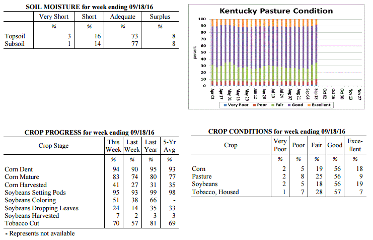 Kentucky Climate Summary
For the Period September 12, 2016 to September 18, 2016
Above Normal Temperatures and Rainfall:
Dry conditions continued through the first half of the work week as the Bluegrass
State remained under the influence of high pressure. After a relatively cool day on
Monday, temperatures increased on Tuesday and stayed that way through much of the
period. This led to a 11th straight week of near to above normal temperatures that
extends back into early July. Bottom line, it has been a warm summer. Showers and
storms returned over the latter half of the work week and into the weekend. Ahead of
a weak cold front, winds turned to the southwest, pulling moisture back into the
area. A solid band of showers developed within this flow and slowly inched eastward
over the course of the weekend. Conditions had been starting to turn dry with three
straight weeks of below normal precipitation. The US Drought Monitor even introduced
a couple small areas of 'Abnormally Dry' Conditions in South-Central and Eastern
Kentucky. For the week, the band of showers helped push the state rainfall average
over an inch, which was nearly a quarter inch above normal.
Temperatures for the period averaged 74 degrees across the state which was 5 degrees
warmer than normal and 4 degrees cooler than the previous period. High temperatures
averaged from 86 in the West to 86 in the East. Departure from normal high
temperatures ranged from 4 degrees warmer than normal in the West to 6 degrees
warmer than normal in the East. Low temperatures averaged from 65 degrees in the
West to 63 degrees in the East. Departure from normal low temperature ranged from 6
degrees warmer than normal in the West to 7 degrees warmer than normal in the East.
The extreme high temperature for the period was 94 degrees at HICKMAN 2E and the
extreme low was 49 degrees at MAYFIELD 6SW.
Precipitation (liq. equ.) for the period totaled 1.05 inches statewide which was 0.21
inches above normal and 125% of normal. Precipitation totals by climate division,
West 1.10 inches, Central 1.24 inches, Bluegrass 0.70 inches and East 1.18 inches,
which was 0.25, 0.31, -0.05 and 0.36 inches respectively from normal. By station,
precipitation totals ranged from a low of 0.02 inches at LOUISVILLE APT to a high of
3.63 inches at SCOTTSVILLE 2W.
---
Agricultural Situation Report: September 12, 2016
(USDA's Crop Report with comments from Tom Priddy & Matt Dixon, UK Ag. Weather)
Agricultural News: Kentucky experienced above normal temperatures and below normal
rainfall over the past week. Precipitation for the week totaled 0.50 inches, 0.31
inches below normal. Temperatures averaged 76 degrees for the week, 4 degrees above
normal. Topsoil moisture was rated 2 percent very short, 14 percent short, 75 percent
adequate and 9 percent surplus. Subsoil moisture was rated 1 percent very short, 12
percent short, 78 percent adequate, and 9 percent surplus. Days suitable for
fieldwork averaged 6.4 out of a possible seven.
Primary activities this week included cutting hay and tobacco, and harvesting corn
for grain; some corn silage was harvested as well. Continued hot and dry conditions
assisted dry-down in grain crops, but started to negatively affect pasture and hay
land. Farmers have concerns over labor shortages for harvesting tobacco, as well as
disease impacts and resulting weights. Various disease incidences were reported this
week including rust and diplodia ear rot on corn, and frogeye leaf spot and stem
canker on soybeans.
Kentucky Climate Summary
For the Period September 12, 2016 to September 18, 2016
Above Normal Temperatures and Rainfall:
Dry conditions continued through the first half of the work week as the Bluegrass
State remained under the influence of high pressure. After a relatively cool day on
Monday, temperatures increased on Tuesday and stayed that way through much of the
period. This led to a 11th straight week of near to above normal temperatures that
extends back into early July. Bottom line, it has been a warm summer. Showers and
storms returned over the latter half of the work week and into the weekend. Ahead of
a weak cold front, winds turned to the southwest, pulling moisture back into the
area. A solid band of showers developed within this flow and slowly inched eastward
over the course of the weekend. Conditions had been starting to turn dry with three
straight weeks of below normal precipitation. The US Drought Monitor even introduced
a couple small areas of 'Abnormally Dry' Conditions in South-Central and Eastern
Kentucky. For the week, the band of showers helped push the state rainfall average
over an inch, which was nearly a quarter inch above normal.
Temperatures for the period averaged 74 degrees across the state which was 5 degrees
warmer than normal and 4 degrees cooler than the previous period. High temperatures
averaged from 86 in the West to 86 in the East. Departure from normal high
temperatures ranged from 4 degrees warmer than normal in the West to 6 degrees
warmer than normal in the East. Low temperatures averaged from 65 degrees in the
West to 63 degrees in the East. Departure from normal low temperature ranged from 6
degrees warmer than normal in the West to 7 degrees warmer than normal in the East.
The extreme high temperature for the period was 94 degrees at HICKMAN 2E and the
extreme low was 49 degrees at MAYFIELD 6SW.
Precipitation (liq. equ.) for the period totaled 1.05 inches statewide which was 0.21
inches above normal and 125% of normal. Precipitation totals by climate division,
West 1.10 inches, Central 1.24 inches, Bluegrass 0.70 inches and East 1.18 inches,
which was 0.25, 0.31, -0.05 and 0.36 inches respectively from normal. By station,
precipitation totals ranged from a low of 0.02 inches at LOUISVILLE APT to a high of
3.63 inches at SCOTTSVILLE 2W.
---
Agricultural Situation Report: September 12, 2016
(USDA's Crop Report with comments from Tom Priddy & Matt Dixon, UK Ag. Weather)
Agricultural News: Kentucky experienced above normal temperatures and below normal
rainfall over the past week. Precipitation for the week totaled 0.50 inches, 0.31
inches below normal. Temperatures averaged 76 degrees for the week, 4 degrees above
normal. Topsoil moisture was rated 2 percent very short, 14 percent short, 75 percent
adequate and 9 percent surplus. Subsoil moisture was rated 1 percent very short, 12
percent short, 78 percent adequate, and 9 percent surplus. Days suitable for
fieldwork averaged 6.4 out of a possible seven.
Primary activities this week included cutting hay and tobacco, and harvesting corn
for grain; some corn silage was harvested as well. Continued hot and dry conditions
assisted dry-down in grain crops, but started to negatively affect pasture and hay
land. Farmers have concerns over labor shortages for harvesting tobacco, as well as
disease impacts and resulting weights. Various disease incidences were reported this
week including rust and diplodia ear rot on corn, and frogeye leaf spot and stem
canker on soybeans.
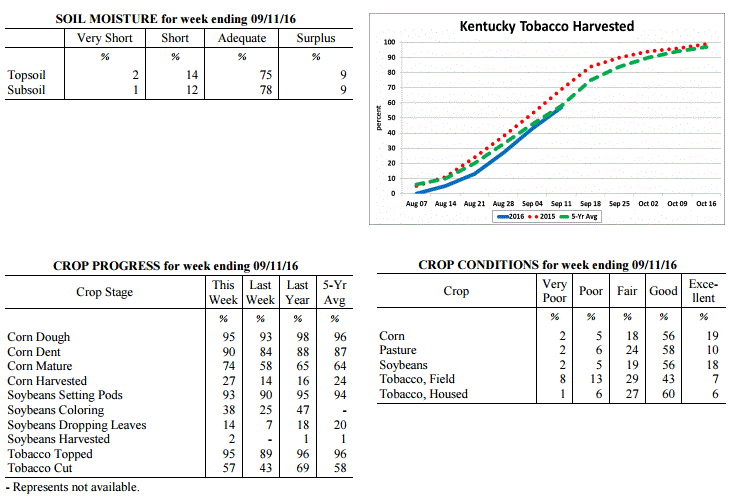 Kentucky Climate Summary
For the Period September 5, 2016 to September 11, 2016
Above Normal Temperatures and Below Normal Rainfall:
The state remained mostly dry on Labor Day and on through the work week as high
pressure remained in control aloft. Temperatures followed a warming trend with highs
back in the low to middle 90s statewide by Wednesday. The warm conditions pushed the
state to a tenth straight week of near to above normal temperatures. While there was
some isolated to scattered showers and storms on Thursday and Friday, better coverage
arrived over the weekend. A passing cold front sparked a broken line of showers and
storms that pushed through the region during the day on Saturday. Overall, the state
averaged a half inch for the week, which ended up being the third straight period
that Kentucky had seen below normal rainfall.
Temperatures for the period averaged 76 degrees across the state which was 4 degrees
warmer than normal and no change to the previous period. High temperatures averaged
from 88 in the West to 88 in the East. Departure from normal high temperatures ranged
from 3 degrees warmer than normal in the West to 5 degrees warmer than normal in the
East. Low temperatures averaged from 67 degrees in the West to 64 degrees in the
East. Departure from normal low temperature ranged from 6 degrees warmer than normal
in the West to 6 degrees warmer than normal in the East. The extreme high temperature
for the period was 95 degrees at EVANSVILLE ASOS and the extreme low was 52 degrees
at BRANDENBURG 4SW.
Precipitation (liq. equ.) for the period totaled 0.50 inches statewide which was 0.31
inches below normal and 62% of normal. Precipitation totals by climate division, West
0.78 inches, Central 0.57 inches, Bluegrass 0.44 inches and East 0.20 inches, which
was 0.01, 0.33, 0.31 and 0.6 inches below normal. By station, precipitation totals
ranged from a low of 0.00 inches at JACKSON 3SE to a high of 2.25 inches at
CAPE GIRARDEAU ASOS.
---
Agricultural Situation Report: September 6, 2016
(USDA's Crop Report with comments from Tom Priddy & Matt Dixon, UK Ag. Weather)
Agricultural News: Kentucky experienced above normal temperatures and rainfall over
the past week. Precipitation for the week totaled 1.46 inches, 0.51 inches above
normal. Temperatures averaged 79 degrees for the week, 3 degrees above normal.
Topsoil moisture was rated 0 percent very short, 6 percent short, 73 percent adequate
and 21 percent surplus. Subsoil moisture was rated 1 percent very short, 5 percent
short, 76 percent adequate, and 18 percent surplus. Days suitable for fieldwork
averaged 4.2 out of a possible seven.
Primary activities this week included spraying fungicides and cutting hay in between
rain showers. Reports of more serious black shank and target spot in tobacco have
producers concerned for anticipated harvest weights as preparations are made to start
cutting. Southern corn rust and gray leaf spot have also been confirmed, and grain
farmers are spraying fungicides. Corn and single crop soybeans are faring better
overall from the excessive wet weather this season. High heat and humidity throughout
the week put stress on livestock; pinkeye symptoms were also reported.
Kentucky Climate Summary
For the Period September 5, 2016 to September 11, 2016
Above Normal Temperatures and Below Normal Rainfall:
The state remained mostly dry on Labor Day and on through the work week as high
pressure remained in control aloft. Temperatures followed a warming trend with highs
back in the low to middle 90s statewide by Wednesday. The warm conditions pushed the
state to a tenth straight week of near to above normal temperatures. While there was
some isolated to scattered showers and storms on Thursday and Friday, better coverage
arrived over the weekend. A passing cold front sparked a broken line of showers and
storms that pushed through the region during the day on Saturday. Overall, the state
averaged a half inch for the week, which ended up being the third straight period
that Kentucky had seen below normal rainfall.
Temperatures for the period averaged 76 degrees across the state which was 4 degrees
warmer than normal and no change to the previous period. High temperatures averaged
from 88 in the West to 88 in the East. Departure from normal high temperatures ranged
from 3 degrees warmer than normal in the West to 5 degrees warmer than normal in the
East. Low temperatures averaged from 67 degrees in the West to 64 degrees in the
East. Departure from normal low temperature ranged from 6 degrees warmer than normal
in the West to 6 degrees warmer than normal in the East. The extreme high temperature
for the period was 95 degrees at EVANSVILLE ASOS and the extreme low was 52 degrees
at BRANDENBURG 4SW.
Precipitation (liq. equ.) for the period totaled 0.50 inches statewide which was 0.31
inches below normal and 62% of normal. Precipitation totals by climate division, West
0.78 inches, Central 0.57 inches, Bluegrass 0.44 inches and East 0.20 inches, which
was 0.01, 0.33, 0.31 and 0.6 inches below normal. By station, precipitation totals
ranged from a low of 0.00 inches at JACKSON 3SE to a high of 2.25 inches at
CAPE GIRARDEAU ASOS.
---
Agricultural Situation Report: September 6, 2016
(USDA's Crop Report with comments from Tom Priddy & Matt Dixon, UK Ag. Weather)
Agricultural News: Kentucky experienced above normal temperatures and rainfall over
the past week. Precipitation for the week totaled 1.46 inches, 0.51 inches above
normal. Temperatures averaged 79 degrees for the week, 3 degrees above normal.
Topsoil moisture was rated 0 percent very short, 6 percent short, 73 percent adequate
and 21 percent surplus. Subsoil moisture was rated 1 percent very short, 5 percent
short, 76 percent adequate, and 18 percent surplus. Days suitable for fieldwork
averaged 4.2 out of a possible seven.
Primary activities this week included spraying fungicides and cutting hay in between
rain showers. Reports of more serious black shank and target spot in tobacco have
producers concerned for anticipated harvest weights as preparations are made to start
cutting. Southern corn rust and gray leaf spot have also been confirmed, and grain
farmers are spraying fungicides. Corn and single crop soybeans are faring better
overall from the excessive wet weather this season. High heat and humidity throughout
the week put stress on livestock; pinkeye symptoms were also reported.
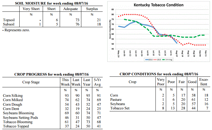 Kentucky Climate Summary
For the Period August 29, 2016 to September 4, 2016
Near Normal Temperatures and Below Normal Rainfall:
The Commonwealth did not see much rainfall for a second straight period as the state
averaged just over a tenth of an inch this past week. Other than some isolated
showers on Monday and Tuesday, most remained dry with high pressure aloft.
Temperatures each day remained above normal, along with high humidity. Scattered
showers and storms then returned on Wednesday, ahead of a passing cold front. Behind
the boundary, high pressure moved into the Great Lakes area. With Tropical Storm
Hermine off the Mid-Atlantic Coast, this set up a northeasterly flow into the Lower
Ohio Valley. Skies became mostly clear for the remainder of the week,
along with much cooler temperatures and less humid conditions.
Temperatures for the period averaged 74 degrees across the state which was near
normal and 4 degrees cooler than the previous period. High temperatures averaged
from 86 in the West to 85 in the East. Departure from normal high temperatures
ranged from 1 degree cooler than normal in the West to 1 degree warmer than
normal in the East. Low temperatures averaged from 65 degrees in the West to 63
degrees in the East. Departure from normal low temperature ranged from 2 degrees
warmer than normal in the West to 3 degrees warmer than normal in the East. The
extreme high temperature for the period was 95 degrees at MAYFIELD 6SW and the
extreme low was 50 degrees at CYNTHIANA 8N.
Precipitation (liq. equ.) for the period totaled 0.12 inches statewide which was
0.63 inches below normal and 16% of normal. Precipitation totals by climate
division, West 0.01 inches, Central 0.13 inches, Bluegrass 0.12 inches and East
0.21 inches, which was 0.68, 0.69, 0.61 and 0.57 inches below normal. By
station, precipitation totals ranged from a low of 0.00 inches at BARBOURVILLE
3E to a high of 1.54 inches at SOMERSET AWOS.
---
Agricultural Situation Report: August 29, 2016
(USDA's Crop Report with comments from Tom Priddy & Matt Dixon, UK Ag. Weather)
Agricultural News: Kentucky experienced above normal temperatures and below normal
rainfall over the past week. Precipitation for the week totaled 0.33 inches, 0.47
inches below normal. Temperatures averaged 77 degrees for the week, 2 degrees above
normal. Topsoil moisture was rated 0 percent very short, 4 percent short, 77 percent
adequate and 19 percent surplus. Subsoil moisture was rated 0 percent very short, 5
percent short, 76 percent adequate, and 19 percent surplus. Days suitable for
fieldwork averaged 5.6 out of a possible seven.
Primary activities this week included cutting hay, topping and cutting tobacco.
Disease and insect pressure continues for field crops. Soybeans were sprayed with
fungicides and insecticides where needed. Some tobacco fields are a complete loss due
to wet weather and disease. The corn harvest has begun in a few areas. Pasture
conditions remain in mostly good to excellent condition. Hot and humid weather
continues to be stressful for livestock. Producers are getting equipment ready
for the upcoming harvest.
Kentucky Climate Summary
For the Period August 29, 2016 to September 4, 2016
Near Normal Temperatures and Below Normal Rainfall:
The Commonwealth did not see much rainfall for a second straight period as the state
averaged just over a tenth of an inch this past week. Other than some isolated
showers on Monday and Tuesday, most remained dry with high pressure aloft.
Temperatures each day remained above normal, along with high humidity. Scattered
showers and storms then returned on Wednesday, ahead of a passing cold front. Behind
the boundary, high pressure moved into the Great Lakes area. With Tropical Storm
Hermine off the Mid-Atlantic Coast, this set up a northeasterly flow into the Lower
Ohio Valley. Skies became mostly clear for the remainder of the week,
along with much cooler temperatures and less humid conditions.
Temperatures for the period averaged 74 degrees across the state which was near
normal and 4 degrees cooler than the previous period. High temperatures averaged
from 86 in the West to 85 in the East. Departure from normal high temperatures
ranged from 1 degree cooler than normal in the West to 1 degree warmer than
normal in the East. Low temperatures averaged from 65 degrees in the West to 63
degrees in the East. Departure from normal low temperature ranged from 2 degrees
warmer than normal in the West to 3 degrees warmer than normal in the East. The
extreme high temperature for the period was 95 degrees at MAYFIELD 6SW and the
extreme low was 50 degrees at CYNTHIANA 8N.
Precipitation (liq. equ.) for the period totaled 0.12 inches statewide which was
0.63 inches below normal and 16% of normal. Precipitation totals by climate
division, West 0.01 inches, Central 0.13 inches, Bluegrass 0.12 inches and East
0.21 inches, which was 0.68, 0.69, 0.61 and 0.57 inches below normal. By
station, precipitation totals ranged from a low of 0.00 inches at BARBOURVILLE
3E to a high of 1.54 inches at SOMERSET AWOS.
---
Agricultural Situation Report: August 29, 2016
(USDA's Crop Report with comments from Tom Priddy & Matt Dixon, UK Ag. Weather)
Agricultural News: Kentucky experienced above normal temperatures and below normal
rainfall over the past week. Precipitation for the week totaled 0.33 inches, 0.47
inches below normal. Temperatures averaged 77 degrees for the week, 2 degrees above
normal. Topsoil moisture was rated 0 percent very short, 4 percent short, 77 percent
adequate and 19 percent surplus. Subsoil moisture was rated 0 percent very short, 5
percent short, 76 percent adequate, and 19 percent surplus. Days suitable for
fieldwork averaged 5.6 out of a possible seven.
Primary activities this week included cutting hay, topping and cutting tobacco.
Disease and insect pressure continues for field crops. Soybeans were sprayed with
fungicides and insecticides where needed. Some tobacco fields are a complete loss due
to wet weather and disease. The corn harvest has begun in a few areas. Pasture
conditions remain in mostly good to excellent condition. Hot and humid weather
continues to be stressful for livestock. Producers are getting equipment ready
for the upcoming harvest.
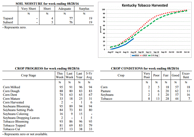 Kentucky Climate Summary
For the Period August 22, 2016 to August 28, 2016
Above Normal Temperatures and Below Normal Rainfall:
High pressure at the surface and aloft led to a mostly dry week for the Commonwealth.
The state only averaged a little over a quarter of an inch for the week, which was
about a half inch below normal. After a couple dry days on Monday and Tuesday,
rainfall remained isolated to scattered in coverage for the rest of the week. While
it was mostly dry, summertime temperatures and humidity made a return. Highs were
only in the upper 70s to middle 80s on Monday, but the cooler temperatures were short
lived. As high pressure moved east on Tuesday, winds shifted to the south, opening
the door to a warming trend and much more humid conditions. Heat indices increased to
around 100 by late in the work week and into the weekend with highs topping out in
the low to middle 90s, once again creating stressful conditions for livestock. This
pushed the Bluegrass State to an eighth straight week of near to above normal
temperatures.
Temperatures for the period averaged 77 degrees across the state which was 2
degrees warmer than normal and 2 degrees warmer than the previous period. High
temperatures averaged from 88 in the West to 88 in the East. Departure from
normal high temperatures ranged from near normal in the West to 3 degrees warmer
than normal in the East. Low temperatures averaged from 68 degrees in the West
to 65 degrees in the East. Departure from normal low temperature ranged from 3
degrees warmer than normal in the West to 3 degrees warmer than normal in the
East. The extreme high temperature for the period was 96 degrees at KOOMER RIDGE
and the extreme low was 53 degrees at RICHMOND 8E.
Precipitation (liq. equ.) for the period totaled 0.30 inches statewide which was
0.47 inches below normal and 39% of normal. Precipitation totals by climate
division, West 0.59 inches, Central 0.18 inches, Bluegrass 0.40 inches and East
0.05 inches, which was 0.11, 0.61, 0.36 and 0.77 inches below normal. By
station, precipitation totals ranged from a low of 0.00 inches at BARBOURVILLE
3E to a high of 3.22 inches at ALEXANDRIA 5NW.
---
Agricultural Situation Report: August 22, 2016
(USDA's Crop Report with comments from Tom Priddy & Matt Dixon, UK Ag. Weather)
Agricultural News: Kentucky experienced near normal temperatures and much above
normal rainfall over the past week. Precipitation for the week totaled 2.54 inches,
1.68 inches above normal. Temperatures averaged 76 degrees for the week, near normal.
Topsoil moisture was rated 0 percent very short, 4 percent short, 71 percent adequate
and 25 percent surplus. Subsoil moisture was rated 0 percent very short, 4 percent
short, 72 percent adequate, and 24 percent surplus. Days suitable for fieldwork
averaged 3.4 out of a possible seven.
Rain last week limited field work and resulted in flooding in some areas. Disease and
insect pressure continues for field crops. Fungicides have not been effective in some
fields. Corn, soybeans and tobacco all showed deterioration in percent rated as
excellent this past week. Dry weather is needed for hay producers eager to
harvest hay and to improve conditions of crops.
Kentucky Climate Summary
For the Period August 22, 2016 to August 28, 2016
Above Normal Temperatures and Below Normal Rainfall:
High pressure at the surface and aloft led to a mostly dry week for the Commonwealth.
The state only averaged a little over a quarter of an inch for the week, which was
about a half inch below normal. After a couple dry days on Monday and Tuesday,
rainfall remained isolated to scattered in coverage for the rest of the week. While
it was mostly dry, summertime temperatures and humidity made a return. Highs were
only in the upper 70s to middle 80s on Monday, but the cooler temperatures were short
lived. As high pressure moved east on Tuesday, winds shifted to the south, opening
the door to a warming trend and much more humid conditions. Heat indices increased to
around 100 by late in the work week and into the weekend with highs topping out in
the low to middle 90s, once again creating stressful conditions for livestock. This
pushed the Bluegrass State to an eighth straight week of near to above normal
temperatures.
Temperatures for the period averaged 77 degrees across the state which was 2
degrees warmer than normal and 2 degrees warmer than the previous period. High
temperatures averaged from 88 in the West to 88 in the East. Departure from
normal high temperatures ranged from near normal in the West to 3 degrees warmer
than normal in the East. Low temperatures averaged from 68 degrees in the West
to 65 degrees in the East. Departure from normal low temperature ranged from 3
degrees warmer than normal in the West to 3 degrees warmer than normal in the
East. The extreme high temperature for the period was 96 degrees at KOOMER RIDGE
and the extreme low was 53 degrees at RICHMOND 8E.
Precipitation (liq. equ.) for the period totaled 0.30 inches statewide which was
0.47 inches below normal and 39% of normal. Precipitation totals by climate
division, West 0.59 inches, Central 0.18 inches, Bluegrass 0.40 inches and East
0.05 inches, which was 0.11, 0.61, 0.36 and 0.77 inches below normal. By
station, precipitation totals ranged from a low of 0.00 inches at BARBOURVILLE
3E to a high of 3.22 inches at ALEXANDRIA 5NW.
---
Agricultural Situation Report: August 22, 2016
(USDA's Crop Report with comments from Tom Priddy & Matt Dixon, UK Ag. Weather)
Agricultural News: Kentucky experienced near normal temperatures and much above
normal rainfall over the past week. Precipitation for the week totaled 2.54 inches,
1.68 inches above normal. Temperatures averaged 76 degrees for the week, near normal.
Topsoil moisture was rated 0 percent very short, 4 percent short, 71 percent adequate
and 25 percent surplus. Subsoil moisture was rated 0 percent very short, 4 percent
short, 72 percent adequate, and 24 percent surplus. Days suitable for fieldwork
averaged 3.4 out of a possible seven.
Rain last week limited field work and resulted in flooding in some areas. Disease and
insect pressure continues for field crops. Fungicides have not been effective in some
fields. Corn, soybeans and tobacco all showed deterioration in percent rated as
excellent this past week. Dry weather is needed for hay producers eager to
harvest hay and to improve conditions of crops.
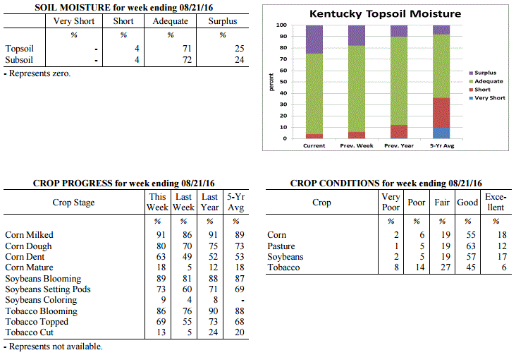 Kentucky Climate Summary
For the Period August 15, 2016 to August 21, 2016
Near Normal Temperatures and Much Above Normal Rainfall:
After another week of exceptionally high rainfall totals, the Bluegrass State has now
seen above normal rainfall three of the past four weeks. Over this past period, the
state averaged over 2.5 inches, which is over 1.5 above normal. According to data
with the Ag Weather Center, the state is now nearly 2 inches above normal for the
month of August with an average of 4.49 inches statewide. Just like recent weeks this
summer, an active pattern set up over the Lower Ohio Valley this past period with
several rounds of storms pushing through the area. Throughout much of the period, a
plume of moisture was positioned over the region, keeping heavy rain and localized
flooding as the main threats. Cloud cover and showers kept temperatures down during
the day and elevated at night, which brought average temperatures around normal for
the week. After the passage of a strong cold front, cooler and much less humid
conditions filtered into the area for the end of the weekend, finally giving the
Commonwealth a break from the summertime humidity.
Temperatures for the period averaged 76 degrees across the state which was near
normal and 4 degrees cooler than the previous period. High temperatures averaged from
82 in the West to 83 in the East. Departure from normal high temperatures ranged from
6 degrees cooler than normal in the West to 3 degrees cooler than normal in the East.
Low temperatures averaged from 71 degrees in the West to 69 degrees in the East.
Departure from normal low temperature ranged from 6 degrees warmer than normal in the
West to 7 degrees warmer than normal in the East. The extreme high temperature for
the period was 94 degrees at PAINTSVILLE 4W and the extreme low was 59 degrees at
BURKESVILLE 3W.
Precipitation (liq. equ.) for the period totaled 2.54 inches statewide which was 1.68
inches above normal and 296% of normal. Precipitation totals by climate division,
West 2.55 inches, Central 3.00 inches, Bluegrass 2.31 inches and East 2.32 inches,
which was 1.77, 2.14, 1.44 and 1.4 inches above normal. By station, precipitation
totals ranged from a low of 0.74 inches at MIDDLESBORO AWOS to a high of 5.39
inches at LEITCHFIELD 3W.
---
Agricultural Situation Report: August 15, 2016
(USDA's Crop Report with comments from Tom Priddy & Matt Dixon, UK Ag. Weather)
Agricultural News: Kentucky experienced above normal temperatures and below normal
rainfall over the past week. Precipitation for the week totaled 0.50 inches, 0.38
inches below normal. Temperatures averaged 80 degrees for the week, 4 degrees above
normal. Topsoil moisture was rated 0 percent very short, 6 percent short, 76 percent
adequate and 18 percent surplus. Subsoil moisture was rated 0 percent very short, 5
percent short, 79 percent adequate, and 16 percent surplus. Days suitable for
fieldwork averaged 5.1 out of a possible seven.
Rain showers in some areas has limited field work. Primary activities this week
included cutting hay, topping and cutting tobacco and spraying crops for disease and
insect control when conditions allowed. Some corn producers have reported pollination
issues in corn due to flooding and high heat. Wet conditions in some locations has
seriously impacted tobacco fields, resulting in disease and crop loss. Fifty-three
percent of tobacco is rated as good to excellent compared to twenty percent rated as
poor to very poor. High heat and humidity continue to put stress on livestock.
However, cattle are benefitting from pasture conditions which are holding up well
due to the moisture that has been received this year.
Kentucky Climate Summary
For the Period August 15, 2016 to August 21, 2016
Near Normal Temperatures and Much Above Normal Rainfall:
After another week of exceptionally high rainfall totals, the Bluegrass State has now
seen above normal rainfall three of the past four weeks. Over this past period, the
state averaged over 2.5 inches, which is over 1.5 above normal. According to data
with the Ag Weather Center, the state is now nearly 2 inches above normal for the
month of August with an average of 4.49 inches statewide. Just like recent weeks this
summer, an active pattern set up over the Lower Ohio Valley this past period with
several rounds of storms pushing through the area. Throughout much of the period, a
plume of moisture was positioned over the region, keeping heavy rain and localized
flooding as the main threats. Cloud cover and showers kept temperatures down during
the day and elevated at night, which brought average temperatures around normal for
the week. After the passage of a strong cold front, cooler and much less humid
conditions filtered into the area for the end of the weekend, finally giving the
Commonwealth a break from the summertime humidity.
Temperatures for the period averaged 76 degrees across the state which was near
normal and 4 degrees cooler than the previous period. High temperatures averaged from
82 in the West to 83 in the East. Departure from normal high temperatures ranged from
6 degrees cooler than normal in the West to 3 degrees cooler than normal in the East.
Low temperatures averaged from 71 degrees in the West to 69 degrees in the East.
Departure from normal low temperature ranged from 6 degrees warmer than normal in the
West to 7 degrees warmer than normal in the East. The extreme high temperature for
the period was 94 degrees at PAINTSVILLE 4W and the extreme low was 59 degrees at
BURKESVILLE 3W.
Precipitation (liq. equ.) for the period totaled 2.54 inches statewide which was 1.68
inches above normal and 296% of normal. Precipitation totals by climate division,
West 2.55 inches, Central 3.00 inches, Bluegrass 2.31 inches and East 2.32 inches,
which was 1.77, 2.14, 1.44 and 1.4 inches above normal. By station, precipitation
totals ranged from a low of 0.74 inches at MIDDLESBORO AWOS to a high of 5.39
inches at LEITCHFIELD 3W.
---
Agricultural Situation Report: August 15, 2016
(USDA's Crop Report with comments from Tom Priddy & Matt Dixon, UK Ag. Weather)
Agricultural News: Kentucky experienced above normal temperatures and below normal
rainfall over the past week. Precipitation for the week totaled 0.50 inches, 0.38
inches below normal. Temperatures averaged 80 degrees for the week, 4 degrees above
normal. Topsoil moisture was rated 0 percent very short, 6 percent short, 76 percent
adequate and 18 percent surplus. Subsoil moisture was rated 0 percent very short, 5
percent short, 79 percent adequate, and 16 percent surplus. Days suitable for
fieldwork averaged 5.1 out of a possible seven.
Rain showers in some areas has limited field work. Primary activities this week
included cutting hay, topping and cutting tobacco and spraying crops for disease and
insect control when conditions allowed. Some corn producers have reported pollination
issues in corn due to flooding and high heat. Wet conditions in some locations has
seriously impacted tobacco fields, resulting in disease and crop loss. Fifty-three
percent of tobacco is rated as good to excellent compared to twenty percent rated as
poor to very poor. High heat and humidity continue to put stress on livestock.
However, cattle are benefitting from pasture conditions which are holding up well
due to the moisture that has been received this year.
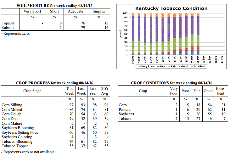 Kentucky Climate Summary
For the Period August 8, 2016 to August 14, 2016
Above Normal Temperatures and Below Normal Rainfall:
With the exception of Western Kentucky, much of the Bluegrass State saw below normal
rainfall this past week. While Western Kentucky averaged just over an inch, Central
and Eastern Kentucky dropped to around a quarter to a third of an inch. Much of the
heavier activity and flooding threat stayed west and north of the region. Showers
and storms were isolated to scattered in coverage on a daily basis, firing during the
day and waning overnight. Heavy rain continued to be the main threat as the
Commonwealth remained rooted in a very moist air mass. Dew points stayed in the 70s
and combined with warm temperatures to keep the livestock heat stress index in the
danger to emergency category. Looking back, the state has now seen 6 straight weeks
of above normal temperatures.
Temperatures for the period averaged 80 degrees across the state which was 4 degrees
warmer than normal and 2 degrees warmer than the previous period. High temperatures
averaged from 87 in the West to 89 in the East. Departure from normal high
temperatures ranged from 1 degree cooler than normal in the West to 3 degrees
warmer than normal in the East. Low temperatures averaged from 72 degrees in the
West to 71 degrees in the East. Departure from normal low temperature ranged from 6
degrees warmer than normal in the West to 8 degrees warmer than normal in the East.
The extreme high temperature for the period was 94 degrees at YELLOW CREEK and the
extreme low was 55 degrees at FORT KNOX.
Precipitation (liq. equ.) for the period totaled 0.50 inches statewide which was 0.38
inches below normal and 57% of normal. Precipitation totals by climate division, West
1.11 inches, Central 0.29 inches, Bluegrass 0.34 inches and East 0.24 inches, which
was 0.29, -0.56, -0.53 and -0.72 inches respectively from normal. By station,
precipitation totals ranged from a low of 0.00 inches at ALBANY 1N to a high of 4.40
inches at POPLAR BLUFF ASOS.
---
Agricultural Situation Report: August 8, 2016
(USDA's Crop Report with comments from Tom Priddy & Matt Dixon, UK Ag. Weather)
Agricultural News: Kentucky experienced above normal temperatures and rainfall over
the past week. Precipitation for the week totaled 1.46 inches, 0.51 inches above
normal. Temperatures averaged 79 degrees for the week, 3 degrees above normal.
Topsoil moisture was rated 0 percent very short, 6 percent short, 73 percent adequate
and 21 percent surplus. Subsoil moisture was rated 1 percent very short, 5 percent
short, 76 percent adequate, and 18 percent surplus. Days suitable for fieldwork
averaged 4.2 out of a possible seven.
Primary activities this week included spraying fungicides and cutting hay in between
rain showers. Reports of more serious black shank and target spot in tobacco have
producers concerned for anticipated harvest weights as preparations are made to start
cutting. Southern corn rust and gray leaf spot have also been confirmed, and grain
farmers are spraying fungicides. Corn and single crop soybeans are faring better
overall from the excessive wet weather this season. High heat and humidity throughout
the week put stress on livestock; pinkeye symptoms were also reported.
Kentucky Climate Summary
For the Period August 8, 2016 to August 14, 2016
Above Normal Temperatures and Below Normal Rainfall:
With the exception of Western Kentucky, much of the Bluegrass State saw below normal
rainfall this past week. While Western Kentucky averaged just over an inch, Central
and Eastern Kentucky dropped to around a quarter to a third of an inch. Much of the
heavier activity and flooding threat stayed west and north of the region. Showers
and storms were isolated to scattered in coverage on a daily basis, firing during the
day and waning overnight. Heavy rain continued to be the main threat as the
Commonwealth remained rooted in a very moist air mass. Dew points stayed in the 70s
and combined with warm temperatures to keep the livestock heat stress index in the
danger to emergency category. Looking back, the state has now seen 6 straight weeks
of above normal temperatures.
Temperatures for the period averaged 80 degrees across the state which was 4 degrees
warmer than normal and 2 degrees warmer than the previous period. High temperatures
averaged from 87 in the West to 89 in the East. Departure from normal high
temperatures ranged from 1 degree cooler than normal in the West to 3 degrees
warmer than normal in the East. Low temperatures averaged from 72 degrees in the
West to 71 degrees in the East. Departure from normal low temperature ranged from 6
degrees warmer than normal in the West to 8 degrees warmer than normal in the East.
The extreme high temperature for the period was 94 degrees at YELLOW CREEK and the
extreme low was 55 degrees at FORT KNOX.
Precipitation (liq. equ.) for the period totaled 0.50 inches statewide which was 0.38
inches below normal and 57% of normal. Precipitation totals by climate division, West
1.11 inches, Central 0.29 inches, Bluegrass 0.34 inches and East 0.24 inches, which
was 0.29, -0.56, -0.53 and -0.72 inches respectively from normal. By station,
precipitation totals ranged from a low of 0.00 inches at ALBANY 1N to a high of 4.40
inches at POPLAR BLUFF ASOS.
---
Agricultural Situation Report: August 8, 2016
(USDA's Crop Report with comments from Tom Priddy & Matt Dixon, UK Ag. Weather)
Agricultural News: Kentucky experienced above normal temperatures and rainfall over
the past week. Precipitation for the week totaled 1.46 inches, 0.51 inches above
normal. Temperatures averaged 79 degrees for the week, 3 degrees above normal.
Topsoil moisture was rated 0 percent very short, 6 percent short, 73 percent adequate
and 21 percent surplus. Subsoil moisture was rated 1 percent very short, 5 percent
short, 76 percent adequate, and 18 percent surplus. Days suitable for fieldwork
averaged 4.2 out of a possible seven.
Primary activities this week included spraying fungicides and cutting hay in between
rain showers. Reports of more serious black shank and target spot in tobacco have
producers concerned for anticipated harvest weights as preparations are made to start
cutting. Southern corn rust and gray leaf spot have also been confirmed, and grain
farmers are spraying fungicides. Corn and single crop soybeans are faring better
overall from the excessive wet weather this season. High heat and humidity throughout
the week put stress on livestock; pinkeye symptoms were also reported.
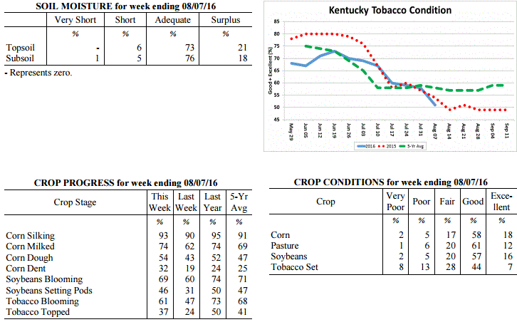 Kentucky Climate Summary
For the Period August 1, 2016 to August 7, 2016
Above Normal Temperatures and Rainfall:
Much like the month of July, an active pattern continued into the first week of
August with several rounds of rainfall. The entire state averaged over an inch with
Western Kentucky leading the way at 1.67. This resulted in a second straight week of
above normal rainfall and followed the state’s 3rd wettest July on record with data
going back to 1895. The humid air mass stayed in place through Saturday, keeping
torrential rainfall and occasional localized flooding in the picture. After the
final round of rainfall on Saturday along a cold front, a welcome change came for the
latter half of the weekend. Behind the boundary, dew points took a fall, bringing
much drier and less muggy conditions to the Bluegrass State. Saying that, for the
week overall, temperatures were yet again above normal. Ten of the past eleven weeks
have now seen near to above normal temperatures.
Temperatures for the period averaged 79 degrees across the state which was 3 degrees
warmer than normal and no change from the previous period. High temperatures
averaged from 88 in the West to 86 in the East. Departure from normal high
temperatures were near normal across the state. Low temperatures averaged from 71
degrees in the West to 69 degrees in the East. Departure from normal low temperature
ranged from 5 degrees warmer than normal in the West to 6 degrees warmer than normal
in the East. The extreme high temperature for the period was 98 degrees at LEBANON
8NW and the extreme low was 61 degrees at CYNTHIANA 8N.
Precipitation (liq. equ.) for the period totaled 1.46 inches statewide which was 0.51
inches above normal and 154% of normal. Precipitation totals by climate division,
West 1.67 inches, Central 1.39 inches, Bluegrass 1.56 inches and East 1.20 inches,
which was 0.76, 0.47, 0.64 and 0.17 inches above normal. By station, precipitation
totals ranged from a low of 0.00 inches at EVANSVILLE ASOS to a high of 6.06
inches at PADUCAH ASOS.
---
Agricultural Situation Report: August 1, 2016
(USDA's Crop Report with comments from Tom Priddy & Matt Dixon, UK Ag. Weather)
Agricultural News: Kentucky experienced above normal temperatures and much above
normal rainfall over the past week. Precipitation for the week totaled 2.76 inches,
1.78 inches above normal. Temperatures averaged 79 degrees for the week, 2 degrees
above normal. Topsoil moisture was rated 0 percent very short, 6 percent short, 72
percent adequate and 22 percent surplus. Subsoil moisture was rated 1 percent very
short, 6 percent short, 75 percent adequate, and 18 percent surplus. Days suitable
for fieldwork averaged 3.7 out of a possible seven.
Field work was limited this week as warm, wet weather continued. Activities included
spraying soybeans and tobacco, and topping tobacco. An increase in fungal disease
reports for tobacco include target spot, frog eye leaf, and black shank. Some soybean
diseases are now showing up, mostly septoria brown spot. Crop conditions and yield
expectations remain varied throughout the state, as some low lying areas are still
reporting standing water and slight flooding. High humidity this week had livestock
under heat stress.
Pasture and hay fields remain in mostly good condition, with hay cutting anticipated
as soon as the weather breaks. Hay and roughage supplies were reported as 1 percent
very short, 10 percent short, 77 percent adequate, and 12 percent surplus.
Kentucky Climate Summary
For the Period August 1, 2016 to August 7, 2016
Above Normal Temperatures and Rainfall:
Much like the month of July, an active pattern continued into the first week of
August with several rounds of rainfall. The entire state averaged over an inch with
Western Kentucky leading the way at 1.67. This resulted in a second straight week of
above normal rainfall and followed the state’s 3rd wettest July on record with data
going back to 1895. The humid air mass stayed in place through Saturday, keeping
torrential rainfall and occasional localized flooding in the picture. After the
final round of rainfall on Saturday along a cold front, a welcome change came for the
latter half of the weekend. Behind the boundary, dew points took a fall, bringing
much drier and less muggy conditions to the Bluegrass State. Saying that, for the
week overall, temperatures were yet again above normal. Ten of the past eleven weeks
have now seen near to above normal temperatures.
Temperatures for the period averaged 79 degrees across the state which was 3 degrees
warmer than normal and no change from the previous period. High temperatures
averaged from 88 in the West to 86 in the East. Departure from normal high
temperatures were near normal across the state. Low temperatures averaged from 71
degrees in the West to 69 degrees in the East. Departure from normal low temperature
ranged from 5 degrees warmer than normal in the West to 6 degrees warmer than normal
in the East. The extreme high temperature for the period was 98 degrees at LEBANON
8NW and the extreme low was 61 degrees at CYNTHIANA 8N.
Precipitation (liq. equ.) for the period totaled 1.46 inches statewide which was 0.51
inches above normal and 154% of normal. Precipitation totals by climate division,
West 1.67 inches, Central 1.39 inches, Bluegrass 1.56 inches and East 1.20 inches,
which was 0.76, 0.47, 0.64 and 0.17 inches above normal. By station, precipitation
totals ranged from a low of 0.00 inches at EVANSVILLE ASOS to a high of 6.06
inches at PADUCAH ASOS.
---
Agricultural Situation Report: August 1, 2016
(USDA's Crop Report with comments from Tom Priddy & Matt Dixon, UK Ag. Weather)
Agricultural News: Kentucky experienced above normal temperatures and much above
normal rainfall over the past week. Precipitation for the week totaled 2.76 inches,
1.78 inches above normal. Temperatures averaged 79 degrees for the week, 2 degrees
above normal. Topsoil moisture was rated 0 percent very short, 6 percent short, 72
percent adequate and 22 percent surplus. Subsoil moisture was rated 1 percent very
short, 6 percent short, 75 percent adequate, and 18 percent surplus. Days suitable
for fieldwork averaged 3.7 out of a possible seven.
Field work was limited this week as warm, wet weather continued. Activities included
spraying soybeans and tobacco, and topping tobacco. An increase in fungal disease
reports for tobacco include target spot, frog eye leaf, and black shank. Some soybean
diseases are now showing up, mostly septoria brown spot. Crop conditions and yield
expectations remain varied throughout the state, as some low lying areas are still
reporting standing water and slight flooding. High humidity this week had livestock
under heat stress.
Pasture and hay fields remain in mostly good condition, with hay cutting anticipated
as soon as the weather breaks. Hay and roughage supplies were reported as 1 percent
very short, 10 percent short, 77 percent adequate, and 12 percent surplus.
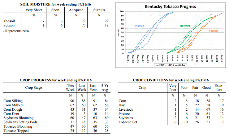 Kentucky Climate Summary
For the Period July 25, 2016 to August 1, 2016
Above Normal Temperatures and Much Above Normal Rainfall:
Much like it started, the month of July came to a close with yet another
exceptionally wet week. For the period, the state averaged over 2.5 inches. Showers
and storms formed about each day, scattered in coverage for much of the week. The one
exception came Wednesday night and through much of Thursday when activity became
widespread. The slow moving nature of storms and very moist atmosphere promoted heavy
rainfall from time to time, along with localized flash flooding. This all added to an
already extremely wet month of July. Preliminary data at the UK Ag Weather Center
shows that this could be one of the wettest July’s on record with the state averaging
8.86 inches. This is small in comparison to Western Kentucky alone, which averaged
over 12. Temperatures through the week also remained elevated with highs peaking in
the 90s from time to time. The average temperature for Kentucky remained above normal
for a fourth straight week.
Temperatures for the period averaged 79 degrees across the state which was 2 degrees
warmer than normal and 2 degrees cooler than the previous period. High temperatures
averaged from 88 in the West to 87 in the East. Departure from normal high
temperatures ranged from 1 degree cooler than normal in the West to near normal in
the East. Low temperatures averaged from 71 degrees in the West to 70 degrees in the
East. Departure from normal low temperature ranged from 4 degrees warmer than normal
in the West to 6 degrees warmer than normal in the East. The extreme high temperature
for the period was 96 degrees at KOOMER RIDGE and the extreme low was 65 degrees at
FRANKFORT 7S.
Precipitation (liq. equ.) for the period totaled 2.76 inches statewide which was 1.78
inches above normal and 283% of normal. Precipitation totals by climate division,
West 3.26 inches, Central 2.42 inches, Bluegrass 2.79 inches and East 2.58 inches,
which was 2.33, 1.45, 1.82 and 1.55 inches above normal. By station, precipitation
totals ranged from a low of 0.62 inches at BRANDENBURG 4SW to a high of 7.46
inches at ALEXANDRIA 5NW.
---
Agricultural Situation Report: July 25, 2016
(USDA's Crop Report with comments from Tom Priddy & Matt Dixon, UK Ag. Weather)
Agricultural News: Kentucky experienced above normal temperatures and below normal
rainfall over the past week. Precipitation for the week totaled 0.45 inches, 0.50
inches below normal. Temperatures averaged 80 degrees for the week, 4 degrees above
normal. Topsoil moisture was rated 1 percent very short, 10 percent short, 73 percent
adequate and 16 percent surplus. Subsoil moisture was rated 1 percent very short, 8
percent short, 77 percent adequate, and 14 percent surplus. Days suitable for
fieldwork averaged 5.5 out of a possible seven.
Primary activities this week included cutting hay, spraying herbicides, fungicide
applications and topping tobacco where conditions allowed. High moisture and humid
weather is resulting in heavy disease pressure on crops. Tobacco conditions remain in
the mostly good to fair range due to the lateness of the crop and excess water at the
wrong time. Black shank continues to be a concern. Some tobacco growers will have
significant losses to their crop. Pasture conditions remain in mostly good condition.
High temperatures and humidity over the past week pushed the livestock heat stress
into the emergency category. Livestock producers are treating cattle for pinkeye.
Kentucky Climate Summary
For the Period July 25, 2016 to August 1, 2016
Above Normal Temperatures and Much Above Normal Rainfall:
Much like it started, the month of July came to a close with yet another
exceptionally wet week. For the period, the state averaged over 2.5 inches. Showers
and storms formed about each day, scattered in coverage for much of the week. The one
exception came Wednesday night and through much of Thursday when activity became
widespread. The slow moving nature of storms and very moist atmosphere promoted heavy
rainfall from time to time, along with localized flash flooding. This all added to an
already extremely wet month of July. Preliminary data at the UK Ag Weather Center
shows that this could be one of the wettest July’s on record with the state averaging
8.86 inches. This is small in comparison to Western Kentucky alone, which averaged
over 12. Temperatures through the week also remained elevated with highs peaking in
the 90s from time to time. The average temperature for Kentucky remained above normal
for a fourth straight week.
Temperatures for the period averaged 79 degrees across the state which was 2 degrees
warmer than normal and 2 degrees cooler than the previous period. High temperatures
averaged from 88 in the West to 87 in the East. Departure from normal high
temperatures ranged from 1 degree cooler than normal in the West to near normal in
the East. Low temperatures averaged from 71 degrees in the West to 70 degrees in the
East. Departure from normal low temperature ranged from 4 degrees warmer than normal
in the West to 6 degrees warmer than normal in the East. The extreme high temperature
for the period was 96 degrees at KOOMER RIDGE and the extreme low was 65 degrees at
FRANKFORT 7S.
Precipitation (liq. equ.) for the period totaled 2.76 inches statewide which was 1.78
inches above normal and 283% of normal. Precipitation totals by climate division,
West 3.26 inches, Central 2.42 inches, Bluegrass 2.79 inches and East 2.58 inches,
which was 2.33, 1.45, 1.82 and 1.55 inches above normal. By station, precipitation
totals ranged from a low of 0.62 inches at BRANDENBURG 4SW to a high of 7.46
inches at ALEXANDRIA 5NW.
---
Agricultural Situation Report: July 25, 2016
(USDA's Crop Report with comments from Tom Priddy & Matt Dixon, UK Ag. Weather)
Agricultural News: Kentucky experienced above normal temperatures and below normal
rainfall over the past week. Precipitation for the week totaled 0.45 inches, 0.50
inches below normal. Temperatures averaged 80 degrees for the week, 4 degrees above
normal. Topsoil moisture was rated 1 percent very short, 10 percent short, 73 percent
adequate and 16 percent surplus. Subsoil moisture was rated 1 percent very short, 8
percent short, 77 percent adequate, and 14 percent surplus. Days suitable for
fieldwork averaged 5.5 out of a possible seven.
Primary activities this week included cutting hay, spraying herbicides, fungicide
applications and topping tobacco where conditions allowed. High moisture and humid
weather is resulting in heavy disease pressure on crops. Tobacco conditions remain in
the mostly good to fair range due to the lateness of the crop and excess water at the
wrong time. Black shank continues to be a concern. Some tobacco growers will have
significant losses to their crop. Pasture conditions remain in mostly good condition.
High temperatures and humidity over the past week pushed the livestock heat stress
into the emergency category. Livestock producers are treating cattle for pinkeye.
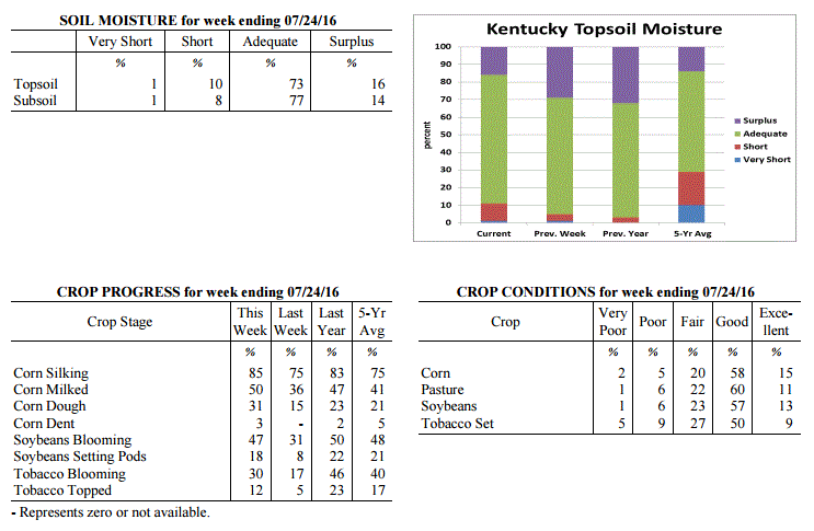 Kentucky Climate Summary
For the Period July 18, 2016 to July 24, 2016
Above Normal Temperatures and Below Normal Rainfall:
Extreme heat and humidity returned to the Bluegrass State this past week, but this
time, for a prolonged period of time. The heat wave consisted of high temperatures
routinely rising into the upper 80s to middle 90s each day, along with dew points in
the 70s. This repeatedly pushed heat indices over 100 for much of the state,
especially across the western half. Multiple heat advisories were issued throughout
the week, along with an Excessive Heat Advisory across the Purchase area of Western
Kentucky as heat indices approached 110 degrees in spots. Not much recovery was seen
at night either as temperatures and dew points remained elevated. The high heat and
humidity created dangerous conditions for livestock as the heat stress index rose
into the danger to emergency category each day. Looking longer term, this is now the
third straight week that Kentucky has seen above normal temperatures.
Temperatures for the period averaged 80 degrees across the state which was 4 degrees
warmer than normal and 2 degrees warmer than the previous period. High temperatures
averaged from 91 in the West to 90 in the East. Departure from normal high
temperatures ranged from 2 degrees warmer than normal in the West to 3 degrees
warmer than normal in the East. Low temperatures averaged from 73 degrees in the
West to 69 degrees in the East. Departure from normal low temperature ranged from 5
degrees warmer than normal in the West to 5 degrees warmer than normal in the East.
The extreme high temperature for the period was 96 degrees at POPLAR BLUFF ASOS and
the extreme low was 61 degrees at PAINTSVILLE 4W.
Precipitation (liq. equ.) for the period totaled 0.45 inches statewide which was 0.5
inches below normal and 47% of normal. Precipitation totals by climate division, West
0.73 inches, Central 0.44 inches, Bluegrass 0.29 inches and East 0.32 inches, which
was 0.17, 0.53, 0.65 and 0.68 inches below normal. By station, precipitation totals
ranged from a low of 0.00 inches at CYNTHIANA 8N to a high of 3.44 inches at HARTFORD 3E.
---
Agricultural Situation Report: July 18, 2016
(USDA's Crop Report with comments from Tom Priddy & Matt Dixon, UK Ag. Weather)
Agricultural News: Kentucky experienced above normal temperatures and below normal
rainfall over the past week. Precipitation for the week totaled 0.94 inches, 0.06
inches below normal. Temperatures averaged 78 degrees for the week, 1 degree above
normal. Topsoil moisture was rated 1 percent very short, 4 percent short, 66 percent
adequate and 29 percent surplus. Subsoil moisture was rated 1 percent very short, 6
percent short, 70 percent adequate, and 23 percent surplus. Days suitable for
fieldwork averaged 4.3 out of a possible seven.
Primary activities this week included cutting hay, spraying herbicides, and making
fungicide applications when weather conditions permitted. Scattered storms continued
over the past week with most of the accumulation in the western portion of the state.
Reports of flooding and standing water in low lying fields persisted, with some
farmers replanting soybeans in wet spots. Crop damage and expectations remain varied
throughout the state, with the potential for entire crop losses. Early planted crops
seem to be fairing much better than later planted crops. Many tobacco fields have
patches of scald, along with reports of black shank and overgrown weeds.
Kentucky Climate Summary
For the Period July 18, 2016 to July 24, 2016
Above Normal Temperatures and Below Normal Rainfall:
Extreme heat and humidity returned to the Bluegrass State this past week, but this
time, for a prolonged period of time. The heat wave consisted of high temperatures
routinely rising into the upper 80s to middle 90s each day, along with dew points in
the 70s. This repeatedly pushed heat indices over 100 for much of the state,
especially across the western half. Multiple heat advisories were issued throughout
the week, along with an Excessive Heat Advisory across the Purchase area of Western
Kentucky as heat indices approached 110 degrees in spots. Not much recovery was seen
at night either as temperatures and dew points remained elevated. The high heat and
humidity created dangerous conditions for livestock as the heat stress index rose
into the danger to emergency category each day. Looking longer term, this is now the
third straight week that Kentucky has seen above normal temperatures.
Temperatures for the period averaged 80 degrees across the state which was 4 degrees
warmer than normal and 2 degrees warmer than the previous period. High temperatures
averaged from 91 in the West to 90 in the East. Departure from normal high
temperatures ranged from 2 degrees warmer than normal in the West to 3 degrees
warmer than normal in the East. Low temperatures averaged from 73 degrees in the
West to 69 degrees in the East. Departure from normal low temperature ranged from 5
degrees warmer than normal in the West to 5 degrees warmer than normal in the East.
The extreme high temperature for the period was 96 degrees at POPLAR BLUFF ASOS and
the extreme low was 61 degrees at PAINTSVILLE 4W.
Precipitation (liq. equ.) for the period totaled 0.45 inches statewide which was 0.5
inches below normal and 47% of normal. Precipitation totals by climate division, West
0.73 inches, Central 0.44 inches, Bluegrass 0.29 inches and East 0.32 inches, which
was 0.17, 0.53, 0.65 and 0.68 inches below normal. By station, precipitation totals
ranged from a low of 0.00 inches at CYNTHIANA 8N to a high of 3.44 inches at HARTFORD 3E.
---
Agricultural Situation Report: July 18, 2016
(USDA's Crop Report with comments from Tom Priddy & Matt Dixon, UK Ag. Weather)
Agricultural News: Kentucky experienced above normal temperatures and below normal
rainfall over the past week. Precipitation for the week totaled 0.94 inches, 0.06
inches below normal. Temperatures averaged 78 degrees for the week, 1 degree above
normal. Topsoil moisture was rated 1 percent very short, 4 percent short, 66 percent
adequate and 29 percent surplus. Subsoil moisture was rated 1 percent very short, 6
percent short, 70 percent adequate, and 23 percent surplus. Days suitable for
fieldwork averaged 4.3 out of a possible seven.
Primary activities this week included cutting hay, spraying herbicides, and making
fungicide applications when weather conditions permitted. Scattered storms continued
over the past week with most of the accumulation in the western portion of the state.
Reports of flooding and standing water in low lying fields persisted, with some
farmers replanting soybeans in wet spots. Crop damage and expectations remain varied
throughout the state, with the potential for entire crop losses. Early planted crops
seem to be fairing much better than later planted crops. Many tobacco fields have
patches of scald, along with reports of black shank and overgrown weeds.
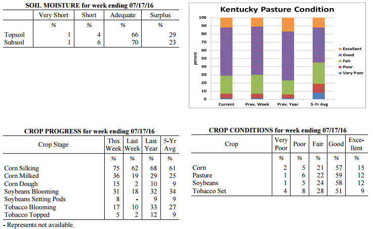 Kentucky Climate Summary
For the Period July 11, 2016 to July 17, 2016
Above Normal Temperatures and Below Normal Rainfall:
After one of the wettest weeks in years, an active pattern carried over into this
past period. Showers and storms developed about each day of the week, but coverage
was not as widespread across the state. While Western Kentucky averaged over 1.5
inches for the week, eastern portions of the state were around a half inch.
According to data at the Ag Weather Center, Western Kentucky has averaged 8.44 inches
of rainfall through July 17th, which is over 6 inches above normal. Any storms that
did develop through the period were heavy rainfall producers as the state remained
situated within a moist air mass. Temperatures were slightly above normal for a
second straight week. Normal high temperatures for this time of year rise into the
middle 80s to around 90, while lows drop into the middle 60s to around 70.
Temperatures for the period averaged 78 degrees across the state which was 1 degree
warmer than normal and no change to the previous period. High temperatures averaged
from 88 in the West to 87 in the East. Departure from normal high temperatures ranged
from 2 degrees cooler than normal in the West to near normal in the East. Low
temperatures averaged from 70 degrees in the West to 67 degrees in the East.
Departure from normal low temperature ranged from 2 degrees warmer than normal in the
West to 4 degrees warmer than normal in the East. The extreme high temperature for
the period was 93 degrees at BOWLING GREEN APT and the extreme low was 60 degrees at
BRANDENBURG 4SW.
Precipitation (liq. equ.) for the period totaled 0.94 inches statewide which was 0.06
inches below normal and 94% of normal. Precipitation totals by climate division, West
1.54 inches, Central 0.94 inches, Bluegrass 0.79 inches and East 0.50 inches, which
was 0.56, -0.08, -0.19 and -0.53 inches respectively from normal. By station,
precipitation totals ranged from a low of 0.02 inches at BIG SANDY to a high of 7.18
inches at CALHOUN 5NW.
---
Agricultural Situation Report: July 11, 2016
(USDA's Crop Report with comments from Tom Priddy & Matt Dixon, UK Ag. Weather)
Agricultural News: Kentucky experienced above normal temperatures and much above
normal rainfall over the past week. Precipitation for the week totaled 3.92 inches,
2.94 inches above normal. Temperatures averaged 77 degrees for the week, 1 degrees
above normal. Topsoil moisture was rated 1 percent very short, 10 percent short, 60
percent adequate and 29 percent surplus. Subsoil moisture was rated 1 percent very
short, 8 percent short, 70 percent adequate, and 21 percent surplus. Days suitable
for fieldwork averaged 2.4 out of a possible seven.
Heavy rains and storms led to flooding and delayed field activities this week,
hitting especially hard in western Kentucky. Some low lying fields still remain
saturated, and significant losses have been reported for corn, soybeans, and tobacco.
Tobacco in standing water has started to wilt and turn yellow, with heightened risk
for black shank. High winds also caused damage to crops and farm structures, with
several reports of corn being blown around and breaking off. Weather forecasts and
crop conditions continue to be evaluated. The average height of emerged soybeans was
14 inches, compared to 10 inches last week and 14 inches last year at this time. In
the eastern part of the state, vegetables are still producing well with some
anthracnose developing on beans.
Kentucky Climate Summary
For the Period July 11, 2016 to July 17, 2016
Above Normal Temperatures and Below Normal Rainfall:
After one of the wettest weeks in years, an active pattern carried over into this
past period. Showers and storms developed about each day of the week, but coverage
was not as widespread across the state. While Western Kentucky averaged over 1.5
inches for the week, eastern portions of the state were around a half inch.
According to data at the Ag Weather Center, Western Kentucky has averaged 8.44 inches
of rainfall through July 17th, which is over 6 inches above normal. Any storms that
did develop through the period were heavy rainfall producers as the state remained
situated within a moist air mass. Temperatures were slightly above normal for a
second straight week. Normal high temperatures for this time of year rise into the
middle 80s to around 90, while lows drop into the middle 60s to around 70.
Temperatures for the period averaged 78 degrees across the state which was 1 degree
warmer than normal and no change to the previous period. High temperatures averaged
from 88 in the West to 87 in the East. Departure from normal high temperatures ranged
from 2 degrees cooler than normal in the West to near normal in the East. Low
temperatures averaged from 70 degrees in the West to 67 degrees in the East.
Departure from normal low temperature ranged from 2 degrees warmer than normal in the
West to 4 degrees warmer than normal in the East. The extreme high temperature for
the period was 93 degrees at BOWLING GREEN APT and the extreme low was 60 degrees at
BRANDENBURG 4SW.
Precipitation (liq. equ.) for the period totaled 0.94 inches statewide which was 0.06
inches below normal and 94% of normal. Precipitation totals by climate division, West
1.54 inches, Central 0.94 inches, Bluegrass 0.79 inches and East 0.50 inches, which
was 0.56, -0.08, -0.19 and -0.53 inches respectively from normal. By station,
precipitation totals ranged from a low of 0.02 inches at BIG SANDY to a high of 7.18
inches at CALHOUN 5NW.
---
Agricultural Situation Report: July 11, 2016
(USDA's Crop Report with comments from Tom Priddy & Matt Dixon, UK Ag. Weather)
Agricultural News: Kentucky experienced above normal temperatures and much above
normal rainfall over the past week. Precipitation for the week totaled 3.92 inches,
2.94 inches above normal. Temperatures averaged 77 degrees for the week, 1 degrees
above normal. Topsoil moisture was rated 1 percent very short, 10 percent short, 60
percent adequate and 29 percent surplus. Subsoil moisture was rated 1 percent very
short, 8 percent short, 70 percent adequate, and 21 percent surplus. Days suitable
for fieldwork averaged 2.4 out of a possible seven.
Heavy rains and storms led to flooding and delayed field activities this week,
hitting especially hard in western Kentucky. Some low lying fields still remain
saturated, and significant losses have been reported for corn, soybeans, and tobacco.
Tobacco in standing water has started to wilt and turn yellow, with heightened risk
for black shank. High winds also caused damage to crops and farm structures, with
several reports of corn being blown around and breaking off. Weather forecasts and
crop conditions continue to be evaluated. The average height of emerged soybeans was
14 inches, compared to 10 inches last week and 14 inches last year at this time. In
the eastern part of the state, vegetables are still producing well with some
anthracnose developing on beans.
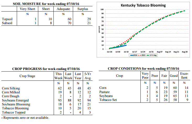 Kentucky Climate Summary
For the Period July 4, 2016 to July 10, 2016
Above Normal Temperatures and Much Above Normal Rainfall:
Not since May of 2010, has Kentucky seen an average rainfall total higher than what
was seen this past week. For the period, several rounds of rainfall led to the
wettest week of the year with an average of 3.92 inches for the Bluegrass State. This
number is actually small in comparison to Western Kentucky, which alone saw over 5.5
inches for the week. Throughout the work week, the Commonwealth was situated within
a warm and extremely moist air mass. Excessive rainfall fell on the 4th of July
holiday, leading to saturated ground in some locations. This was followed by a very
unsettled pattern over the course of the 6th and 7th as several rounds of strong to
severe thunderstorms pushed through Kentucky. This led to numerous reports of
damaging winds and especially flooding, as thunderstorms slowly tracked repeatedly
over the same areas. For the week, a handful of locations in Western Kentucky
recorded over 10 inches of rainfall. Since July 1st, the state has already averaged
4.72 inches of precipitation. Putting this data in perspective, Kentucky normally
only sees around 4 to 4.5 inches for the entire month of July.
Temperatures for the period averaged 77 degrees across the state which was 1 degree
warmer than normal and 4 degrees warmer than the previous period. High temperatures
averaged from 87 in the West to 85 in the East. Departure from normal high
temperatures ranged from 2 degrees cooler than normal in the West to 1 degree
cooler than normal in the East. Low temperatures averaged from 70 degrees in the
West to 68 degrees in the East. Departure from normal low temperature ranged from 3
degrees warmer than normal in the West to 5 degrees warmer than normal in the East.
The extreme high temperature for the period was 93 degrees at HICKMAN 2E and
the extreme low was 59 degrees at CYNTHIANA 8N.
Precipitation (liq. equ.) for the period totaled 3.92 inches statewide which was 2.94
inches above normal and 399% of normal. Precipitation totals by climate division,
West 5.68 inches, Central 4.13 inches, Bluegrass 2.06 inches and East 3.80 inches,
which was 4.7, 3.14, 1.1 and 2.8 inches above normal. By station, precipitation
totals ranged from a low of 0.50 inches at CARLISLE 5SW to a high of 12.06
inches at BENTON 4N.
---
Agricultural Situation Report: July 4, 2016
(USDA's Crop Report with comments from Tom Priddy & Matt Dixon, UK Ag. Weather)
Agricultural News: Kentucky experienced below normal temperatures and above normal
rainfall over the past week. Precipitation for the week totaled 1.15 inches, 0.16
inches above normal. Temperatures averaged 73 degrees for the week, 2 degrees below
normal. Topsoil moisture was rated 1 percent very short, 17 percent short, 68 percent
adequate and 14 percent surplus. Subsoil moisture was rated 1 percent very short, 15
percent short, 76 percent adequate, and 8 percent surplus. Days suitable for fieldwork
averaged 5.4 out of a possible seven.
Heavy rains over the weekend in western and central Kentucky left standing water in
some low lying areas, damage to crops has yet to be sufficiently evaluated as farmers
continue to monitor. Washing and drowning of corn and soybeans, and scalding and black
shank in tobacco are of concern. Fairly dry conditions persisted in eastern areas,
with reports of stressed crops in need of rain.
The average height of emerged soybeans was 10 inches, compared to 5 inches last week
and 13 inches last year at this time. Pastures, vegetables, and forages were reported
in overall good condition. Second cutting of hay has started. Some cattle producers
are dealing with pink eye.
Kentucky Climate Summary
For the Period July 4, 2016 to July 10, 2016
Above Normal Temperatures and Much Above Normal Rainfall:
Not since May of 2010, has Kentucky seen an average rainfall total higher than what
was seen this past week. For the period, several rounds of rainfall led to the
wettest week of the year with an average of 3.92 inches for the Bluegrass State. This
number is actually small in comparison to Western Kentucky, which alone saw over 5.5
inches for the week. Throughout the work week, the Commonwealth was situated within
a warm and extremely moist air mass. Excessive rainfall fell on the 4th of July
holiday, leading to saturated ground in some locations. This was followed by a very
unsettled pattern over the course of the 6th and 7th as several rounds of strong to
severe thunderstorms pushed through Kentucky. This led to numerous reports of
damaging winds and especially flooding, as thunderstorms slowly tracked repeatedly
over the same areas. For the week, a handful of locations in Western Kentucky
recorded over 10 inches of rainfall. Since July 1st, the state has already averaged
4.72 inches of precipitation. Putting this data in perspective, Kentucky normally
only sees around 4 to 4.5 inches for the entire month of July.
Temperatures for the period averaged 77 degrees across the state which was 1 degree
warmer than normal and 4 degrees warmer than the previous period. High temperatures
averaged from 87 in the West to 85 in the East. Departure from normal high
temperatures ranged from 2 degrees cooler than normal in the West to 1 degree
cooler than normal in the East. Low temperatures averaged from 70 degrees in the
West to 68 degrees in the East. Departure from normal low temperature ranged from 3
degrees warmer than normal in the West to 5 degrees warmer than normal in the East.
The extreme high temperature for the period was 93 degrees at HICKMAN 2E and
the extreme low was 59 degrees at CYNTHIANA 8N.
Precipitation (liq. equ.) for the period totaled 3.92 inches statewide which was 2.94
inches above normal and 399% of normal. Precipitation totals by climate division,
West 5.68 inches, Central 4.13 inches, Bluegrass 2.06 inches and East 3.80 inches,
which was 4.7, 3.14, 1.1 and 2.8 inches above normal. By station, precipitation
totals ranged from a low of 0.50 inches at CARLISLE 5SW to a high of 12.06
inches at BENTON 4N.
---
Agricultural Situation Report: July 4, 2016
(USDA's Crop Report with comments from Tom Priddy & Matt Dixon, UK Ag. Weather)
Agricultural News: Kentucky experienced below normal temperatures and above normal
rainfall over the past week. Precipitation for the week totaled 1.15 inches, 0.16
inches above normal. Temperatures averaged 73 degrees for the week, 2 degrees below
normal. Topsoil moisture was rated 1 percent very short, 17 percent short, 68 percent
adequate and 14 percent surplus. Subsoil moisture was rated 1 percent very short, 15
percent short, 76 percent adequate, and 8 percent surplus. Days suitable for fieldwork
averaged 5.4 out of a possible seven.
Heavy rains over the weekend in western and central Kentucky left standing water in
some low lying areas, damage to crops has yet to be sufficiently evaluated as farmers
continue to monitor. Washing and drowning of corn and soybeans, and scalding and black
shank in tobacco are of concern. Fairly dry conditions persisted in eastern areas,
with reports of stressed crops in need of rain.
The average height of emerged soybeans was 10 inches, compared to 5 inches last week
and 13 inches last year at this time. Pastures, vegetables, and forages were reported
in overall good condition. Second cutting of hay has started. Some cattle producers
are dealing with pink eye.
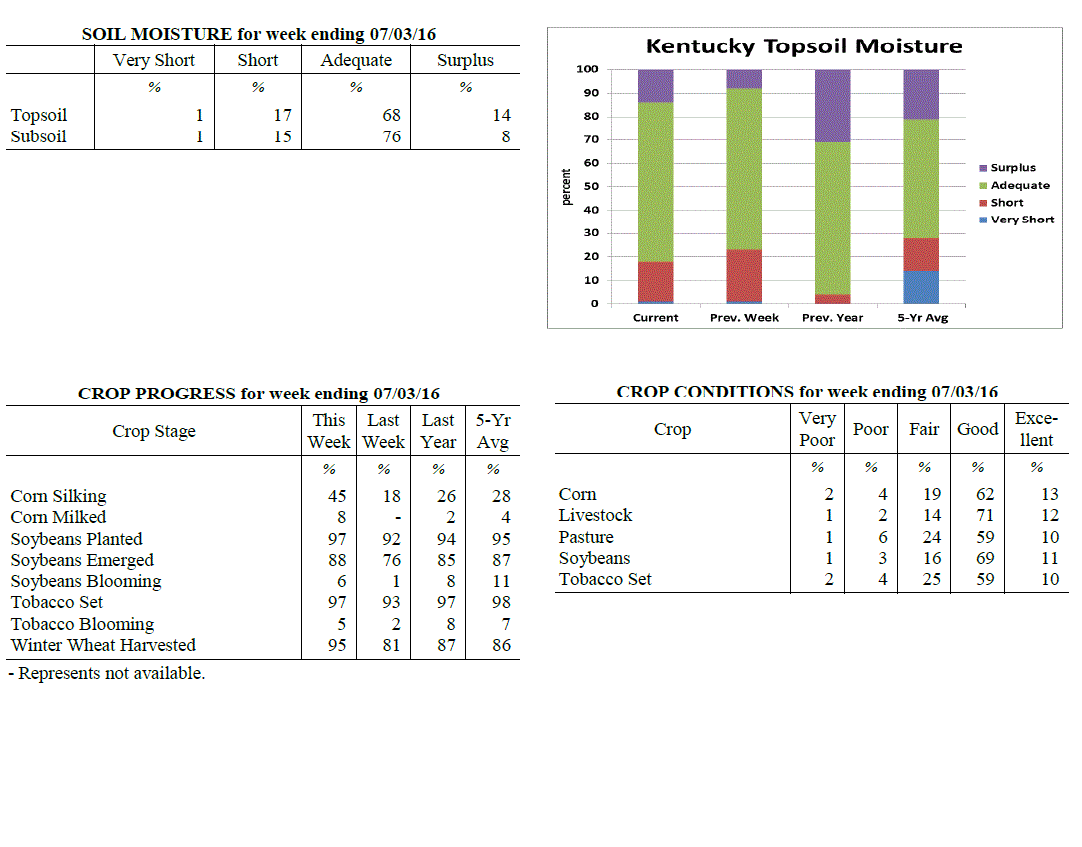 Kentucky Climate Summary
For the Period June 27, 2016 to July 3, 2016
Below Normal Temperatures and Above Normal Rainfall:
After seeing five straight weeks of near to above normal temperatures, the
Commonwealth caught a break this past period. Following a hot and muggy day on
Monday, a couple cold fronts dropped through the Lower Ohio Valley. Winds shifting
to the north/northwest led to much cooler and drier air filtering into the area.
Temperatures ran below normal on both Wednesday and Thursday with highs in the upper
70s to middle 80s across much of Kentucky. Other than some isolated to scattered
activity periodically through the week, most of the Bluegrass State remained dry
through Saturday. Widespread activity returned Sunday with storms erupting across
Western Kentucky and pushing east. Storms produced torrential rainfall and resulted
in significant rainfall accumulations across Western and Central Kentucky. Several
locations saw in upwards of an inch of rainfall, with some in excess of three.
Overall, this event pushed the state to a second straight week of above normal
rainfall.
Temperatures for the period averaged 73 degrees across the state which was 2
degrees cooler than normal and 6 degrees cooler than the previous period. High
temperatures averaged from 85 in the West to 83 in the East. Departure from
normal high temperatures ranged from 3 degrees cooler than normal in the West
to 3 degrees cooler than normal in the East. Low temperatures averaged from 65
degrees in the West to 63 degrees in the East. Departure from normal low
temperature ranged from 1 degree cooler than normal in the West to 1 degree
warmer than normal in the East. The extreme high temperature for the period
was 95 degrees at POPLAR BLUFF ASOS and the extreme low was 52 degrees at
BRANDENBURG 4SW.
Precipitation (liq. equ.) for the period totaled 1.15 inches statewide which was
0.16 inches above normal and 116% of normal. Precipitation totals by climate
division, West 1.76 inches, Central 1.45 inches, Bluegrass 0.78 inches and East
0.60 inches, which was 0.77, 0.47, -0.19 and -0.43 inches respectively from
normal. By station, precipitation totals ranged from a low of 0.00 inches at
BOONEVILLE 2S to a high of 4.75 inches at MURRAY 1W.
---
Agricultural Situation Report: June 27, 2016
(USDA's Crop Report with comments from Tom Priddy & Matt Dixon, UK Ag. Weather)
Agricultural News: Kentucky experienced above normal temperatures and rainfall over
the past week. Precipitation for the week totaled 1.23 inches, 0.22 inches above
normal. Temperatures averaged 79 degrees for the week, 5 degrees above normal.
Topsoil moisture was rated 1 percent very short, 22 percent short, 69 percent
adequate and 8 percent surplus. Subsoil moisture was rated 1 percent very short, 16
percent short, 76 percent adequate, and 7 percent surplus. Days suitable for
fieldwork averaged 5.7 out of a possible seven.
Portions of the state remained dry while other areas reported varied rainfall as
scattered storms occurred over the week. Conditions allowed farmers to make
considerable progress in harvesting wheat. Planting of doublecrop soybeans continued
as well, nearing completion. The average height of emerged soybeans was 5 inches,
compared to 6 inches last year. Tobacco planting is nearing completion as well, with
some reports of severe black shank. The average height of tobacco in the field was 13
inches, compared to 9 inches last week and 16 inches last year at this time. Large
amounts of hay continued to be harvested with mostly average quality. High
temperatures and humidity are putting some stress on livestock.
Kentucky Climate Summary
For the Period June 27, 2016 to July 3, 2016
Below Normal Temperatures and Above Normal Rainfall:
After seeing five straight weeks of near to above normal temperatures, the
Commonwealth caught a break this past period. Following a hot and muggy day on
Monday, a couple cold fronts dropped through the Lower Ohio Valley. Winds shifting
to the north/northwest led to much cooler and drier air filtering into the area.
Temperatures ran below normal on both Wednesday and Thursday with highs in the upper
70s to middle 80s across much of Kentucky. Other than some isolated to scattered
activity periodically through the week, most of the Bluegrass State remained dry
through Saturday. Widespread activity returned Sunday with storms erupting across
Western Kentucky and pushing east. Storms produced torrential rainfall and resulted
in significant rainfall accumulations across Western and Central Kentucky. Several
locations saw in upwards of an inch of rainfall, with some in excess of three.
Overall, this event pushed the state to a second straight week of above normal
rainfall.
Temperatures for the period averaged 73 degrees across the state which was 2
degrees cooler than normal and 6 degrees cooler than the previous period. High
temperatures averaged from 85 in the West to 83 in the East. Departure from
normal high temperatures ranged from 3 degrees cooler than normal in the West
to 3 degrees cooler than normal in the East. Low temperatures averaged from 65
degrees in the West to 63 degrees in the East. Departure from normal low
temperature ranged from 1 degree cooler than normal in the West to 1 degree
warmer than normal in the East. The extreme high temperature for the period
was 95 degrees at POPLAR BLUFF ASOS and the extreme low was 52 degrees at
BRANDENBURG 4SW.
Precipitation (liq. equ.) for the period totaled 1.15 inches statewide which was
0.16 inches above normal and 116% of normal. Precipitation totals by climate
division, West 1.76 inches, Central 1.45 inches, Bluegrass 0.78 inches and East
0.60 inches, which was 0.77, 0.47, -0.19 and -0.43 inches respectively from
normal. By station, precipitation totals ranged from a low of 0.00 inches at
BOONEVILLE 2S to a high of 4.75 inches at MURRAY 1W.
---
Agricultural Situation Report: June 27, 2016
(USDA's Crop Report with comments from Tom Priddy & Matt Dixon, UK Ag. Weather)
Agricultural News: Kentucky experienced above normal temperatures and rainfall over
the past week. Precipitation for the week totaled 1.23 inches, 0.22 inches above
normal. Temperatures averaged 79 degrees for the week, 5 degrees above normal.
Topsoil moisture was rated 1 percent very short, 22 percent short, 69 percent
adequate and 8 percent surplus. Subsoil moisture was rated 1 percent very short, 16
percent short, 76 percent adequate, and 7 percent surplus. Days suitable for
fieldwork averaged 5.7 out of a possible seven.
Portions of the state remained dry while other areas reported varied rainfall as
scattered storms occurred over the week. Conditions allowed farmers to make
considerable progress in harvesting wheat. Planting of doublecrop soybeans continued
as well, nearing completion. The average height of emerged soybeans was 5 inches,
compared to 6 inches last year. Tobacco planting is nearing completion as well, with
some reports of severe black shank. The average height of tobacco in the field was 13
inches, compared to 9 inches last week and 16 inches last year at this time. Large
amounts of hay continued to be harvested with mostly average quality. High
temperatures and humidity are putting some stress on livestock.
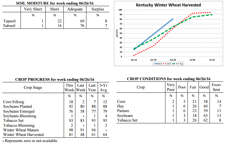 Kentucky Climate Summary
For the Period June 20, 2016 to June 26, 2016
Above Normal Temperatures and Rainfall:
Each period has gotten a step warmer over the past couple weeks. Statewide,
temperatures were 5 degrees above normal this past period, which was the fifth
straight week of near to above normal temperatures. The hot and humid pattern
continued with multiple days getting into the upper 80s to middle 90s. Thursday was
the warmest day with much of Western Kentucky under a Heat Advisory. Livestock heat
stress remained in the danger to emergency category about each afternoon and evening.
Looking at rainfall, an active pattern developed Tuesday through Thursday with
several rounds of thunderstorms. Located within a very unstable and moist air mass,
storms produced frequent cloud to ground lightning and heavy rainfall, in addition to
some instances of damaging winds and large hail. Other than Western Kentucky, the
rest of the state saw above normal rainfall for the week, averaging around 1.5
inches. According to data at the UK Ag Weather Center, Western Kentucky is now 1.64
inches below normal on average for the month of June.
Temperatures for the period averaged 79 degrees across the state which was 5 degrees
warmer than normal and 2 degrees warmer than the previous period. High temperatures
averaged from 92 in the West to 87 in the East. Departure from normal high
temperatures ranged from 5 degrees warmer than normal in the West to 2 degrees
warmer than normal in the East. Low temperatures averaged from 73 degrees in the
West to 66 degrees in the East. Departure from normal low temperature ranged from 8
degrees warmer than normal in the West to 6 degrees warmer than normal in the East.
The extreme high temperature for the period was 97 degrees at CAPE GIRARDEAU ASOS and
the extreme low was 57 degrees at YELLOW CREEK.
Precipitation (liq. equ.) for the period totaled 1.23 inches statewide which was 0.22
inches above normal and 122% of normal. Precipitation totals by climate division,
West 0.43 inches, Central 1.35 inches, Bluegrass 1.59 inches and East 1.57 inches,
which was -0.58, 0.35, 0.59 and 0.54 inches respectively from normal. By station,
precipitation totals ranged from a low of 0.00 inches at CAPE GIRARDEAU ASOS to a
high of 5.22 inches at LOUISA 1S.
---
Agricultural Situation Report: June 20, 2016
(USDA's Crop Report with comments from Tom Priddy & Matt Dixon, UK Ag. Weather)
Agricultural News: Kentucky experienced above normal temperatures and below normal
rainfall over the past week. Precipitation for the week totaled 0.63 inches, 0.37
inches below normal. Temperatures averaged 76 degrees for the week, 3 degrees above
normal. Topsoil moisture was rated 1 percent very short, 18 percent short, 72 percent
adequate and 9 percent surplus. Subsoil moisture was rated 1 percent very short, 13
percent short, 78 percent adequate, and 8 percent surplus. Days suitable for
fieldwork averaged 5.8 out of a possible seven.
Primary activities this week included planting soybeans and tobacco. Winter wheat
harvest for grain made good progress last week. Planting of double crop beans is
underway. Herbicides were being applied and fields continued to be side dressed. The
average height of emerged corn was 37 inches, compared to 34 inches last year. The
average height of tobacco in the field was 9 inches, compared to 11 inches last year.
Some areas have become abnormally dry with soils drying rapidly and showers would be
welcomed. Farmers once again took advantage of dry weather to cut and bale a
significant amount of hay. Heat is putting stress on cattle, but overall condition
is good.
Kentucky Climate Summary
For the Period June 20, 2016 to June 26, 2016
Above Normal Temperatures and Rainfall:
Each period has gotten a step warmer over the past couple weeks. Statewide,
temperatures were 5 degrees above normal this past period, which was the fifth
straight week of near to above normal temperatures. The hot and humid pattern
continued with multiple days getting into the upper 80s to middle 90s. Thursday was
the warmest day with much of Western Kentucky under a Heat Advisory. Livestock heat
stress remained in the danger to emergency category about each afternoon and evening.
Looking at rainfall, an active pattern developed Tuesday through Thursday with
several rounds of thunderstorms. Located within a very unstable and moist air mass,
storms produced frequent cloud to ground lightning and heavy rainfall, in addition to
some instances of damaging winds and large hail. Other than Western Kentucky, the
rest of the state saw above normal rainfall for the week, averaging around 1.5
inches. According to data at the UK Ag Weather Center, Western Kentucky is now 1.64
inches below normal on average for the month of June.
Temperatures for the period averaged 79 degrees across the state which was 5 degrees
warmer than normal and 2 degrees warmer than the previous period. High temperatures
averaged from 92 in the West to 87 in the East. Departure from normal high
temperatures ranged from 5 degrees warmer than normal in the West to 2 degrees
warmer than normal in the East. Low temperatures averaged from 73 degrees in the
West to 66 degrees in the East. Departure from normal low temperature ranged from 8
degrees warmer than normal in the West to 6 degrees warmer than normal in the East.
The extreme high temperature for the period was 97 degrees at CAPE GIRARDEAU ASOS and
the extreme low was 57 degrees at YELLOW CREEK.
Precipitation (liq. equ.) for the period totaled 1.23 inches statewide which was 0.22
inches above normal and 122% of normal. Precipitation totals by climate division,
West 0.43 inches, Central 1.35 inches, Bluegrass 1.59 inches and East 1.57 inches,
which was -0.58, 0.35, 0.59 and 0.54 inches respectively from normal. By station,
precipitation totals ranged from a low of 0.00 inches at CAPE GIRARDEAU ASOS to a
high of 5.22 inches at LOUISA 1S.
---
Agricultural Situation Report: June 20, 2016
(USDA's Crop Report with comments from Tom Priddy & Matt Dixon, UK Ag. Weather)
Agricultural News: Kentucky experienced above normal temperatures and below normal
rainfall over the past week. Precipitation for the week totaled 0.63 inches, 0.37
inches below normal. Temperatures averaged 76 degrees for the week, 3 degrees above
normal. Topsoil moisture was rated 1 percent very short, 18 percent short, 72 percent
adequate and 9 percent surplus. Subsoil moisture was rated 1 percent very short, 13
percent short, 78 percent adequate, and 8 percent surplus. Days suitable for
fieldwork averaged 5.8 out of a possible seven.
Primary activities this week included planting soybeans and tobacco. Winter wheat
harvest for grain made good progress last week. Planting of double crop beans is
underway. Herbicides were being applied and fields continued to be side dressed. The
average height of emerged corn was 37 inches, compared to 34 inches last year. The
average height of tobacco in the field was 9 inches, compared to 11 inches last year.
Some areas have become abnormally dry with soils drying rapidly and showers would be
welcomed. Farmers once again took advantage of dry weather to cut and bale a
significant amount of hay. Heat is putting stress on cattle, but overall condition
is good.
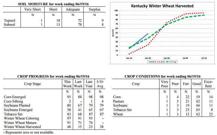 Kentucky Climate Summary
For the Period June 13, 2016 to June 19, 2016
Above Normal Temperatures and Below Normal Rainfall:
The Commonwealth remained in a warm and muggy pattern this past period, accounting
for a fourth straight week of near to above normal temperatures. Temperatures were
even a bit warmer than the previous week with highs averaging in the middle 80s to
around 90 from east to west. The warmest temperatures were seen on Thursday as the
majority of Kentucky rose into the low to middle 90s. Paducah and Fort Campbell saw
the first 100 degree readings of the season. The warm temperatures combined with
very humid conditions pushed the livestock heat stress index into the emergency
category across Western and West-Central Kentucky. For the week, the state averaged
just over a half inch of rainfall, below normal for a second straight week. Most of
the activity was seen Tuesday through Thursday with scattered to numerous coverage in
place. As the state was placed in a very moist and unstable air mass, storms were
capable of producing torrential rainfall and frequent lightning. Otherwise, high
pressure at the surface and aloft kept the area dry Friday and through the weekend.
Temperatures for the period averaged 76 degrees across the state which was 3 degrees
warmer than normal and 4 degrees warmer than the previous period. High temperatures
averaged from 90 in the West to 86 in the East. Departure from normal high
temperatures ranged from 4 degrees warmer than normal in the West to 2 degrees
warmer than normal in the East. Low temperatures averaged from 70 degrees in the
West to 63 degrees in the East. Departure from normal low temperature ranged from 6
degrees warmer than normal in the West to 4 degrees warmer than normal in the East.
The extreme high temperature for the period was 101 degrees at CAPE GIRARDEAU ASOS
and the extreme low was 50 degrees at VANCEBURG 6W.
Precipitation (liq. equ.) for the period totaled 0.63 inches statewide which was 0.37
inches below normal and 63% of normal. Precipitation totals by climate division, West
0.66 inches, Central 0.57 inches, Bluegrass 0.89 inches and East 0.39 inches, which
was 0.32, 0.43, 0.12 and 0.63 inches below normal. By station, precipitation totals
ranged from a low of 0.00 inches at JACKSON AIRPORT to a high of 2.08 inches at
SHELBYVILLE 10W.
---
Agricultural Situation Report: June 13, 2016
(USDA's Crop Report with comments from Tom Priddy & Matt Dixon, UK Ag. Weather)
Agricultural News: Kentucky experienced near normal temperatures and well below
normal rainfall over the past week. Precipitation for the week totaled 0.07 inches,
0.97 inches below normal. Temperatures averaged 71 degrees for the week, near normal.
Topsoil moisture was rated 1 percent very short, 11 percent short, 76 percent
adequate and 12 percent surplus. Subsoil moisture was rated 1 percent very short, 7
percent short, 80 percent adequate, and 12 percent surplus. Days suitable for
fieldwork averaged 6.3 out of a possible seven.
Conditions finally allowed producers to make strides in planting crops including
corn, soybeans and tobacco. Winter wheat harvest for grain was underway. Planting of
double crop beans will begin as soon as wheat is removed from fields. Farmers also
took advantage of dry weather to cut and bale a significant amount of hay. Herbicides
were being applied and fields were side dressed this week. The average height of
emerged corn was 24 inches, compared to 23 inches last year. The average height of
tobacco in the field was 6 inches, compared to 8 inches last year. Soils are drying
rapidly and farmers are hoping for showers as soon as they get caught up on their
field work.
Kentucky Climate Summary
For the Period June 13, 2016 to June 19, 2016
Above Normal Temperatures and Below Normal Rainfall:
The Commonwealth remained in a warm and muggy pattern this past period, accounting
for a fourth straight week of near to above normal temperatures. Temperatures were
even a bit warmer than the previous week with highs averaging in the middle 80s to
around 90 from east to west. The warmest temperatures were seen on Thursday as the
majority of Kentucky rose into the low to middle 90s. Paducah and Fort Campbell saw
the first 100 degree readings of the season. The warm temperatures combined with
very humid conditions pushed the livestock heat stress index into the emergency
category across Western and West-Central Kentucky. For the week, the state averaged
just over a half inch of rainfall, below normal for a second straight week. Most of
the activity was seen Tuesday through Thursday with scattered to numerous coverage in
place. As the state was placed in a very moist and unstable air mass, storms were
capable of producing torrential rainfall and frequent lightning. Otherwise, high
pressure at the surface and aloft kept the area dry Friday and through the weekend.
Temperatures for the period averaged 76 degrees across the state which was 3 degrees
warmer than normal and 4 degrees warmer than the previous period. High temperatures
averaged from 90 in the West to 86 in the East. Departure from normal high
temperatures ranged from 4 degrees warmer than normal in the West to 2 degrees
warmer than normal in the East. Low temperatures averaged from 70 degrees in the
West to 63 degrees in the East. Departure from normal low temperature ranged from 6
degrees warmer than normal in the West to 4 degrees warmer than normal in the East.
The extreme high temperature for the period was 101 degrees at CAPE GIRARDEAU ASOS
and the extreme low was 50 degrees at VANCEBURG 6W.
Precipitation (liq. equ.) for the period totaled 0.63 inches statewide which was 0.37
inches below normal and 63% of normal. Precipitation totals by climate division, West
0.66 inches, Central 0.57 inches, Bluegrass 0.89 inches and East 0.39 inches, which
was 0.32, 0.43, 0.12 and 0.63 inches below normal. By station, precipitation totals
ranged from a low of 0.00 inches at JACKSON AIRPORT to a high of 2.08 inches at
SHELBYVILLE 10W.
---
Agricultural Situation Report: June 13, 2016
(USDA's Crop Report with comments from Tom Priddy & Matt Dixon, UK Ag. Weather)
Agricultural News: Kentucky experienced near normal temperatures and well below
normal rainfall over the past week. Precipitation for the week totaled 0.07 inches,
0.97 inches below normal. Temperatures averaged 71 degrees for the week, near normal.
Topsoil moisture was rated 1 percent very short, 11 percent short, 76 percent
adequate and 12 percent surplus. Subsoil moisture was rated 1 percent very short, 7
percent short, 80 percent adequate, and 12 percent surplus. Days suitable for
fieldwork averaged 6.3 out of a possible seven.
Conditions finally allowed producers to make strides in planting crops including
corn, soybeans and tobacco. Winter wheat harvest for grain was underway. Planting of
double crop beans will begin as soon as wheat is removed from fields. Farmers also
took advantage of dry weather to cut and bale a significant amount of hay. Herbicides
were being applied and fields were side dressed this week. The average height of
emerged corn was 24 inches, compared to 23 inches last year. The average height of
tobacco in the field was 6 inches, compared to 8 inches last year. Soils are drying
rapidly and farmers are hoping for showers as soon as they get caught up on their
field work.
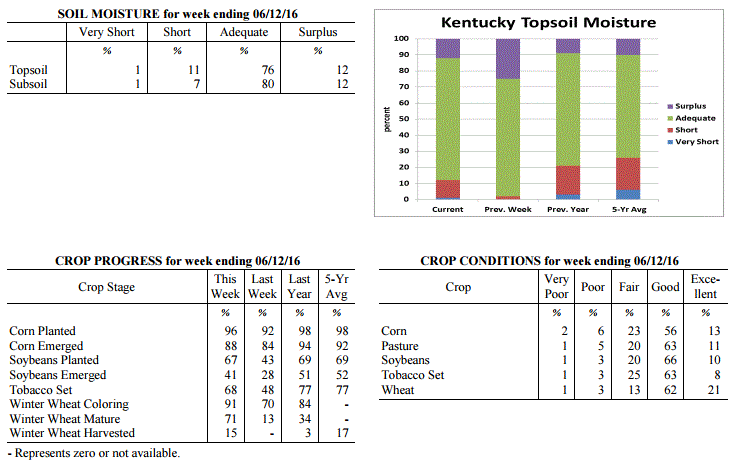 Kentucky Climate Summary
For the Period June 6, 2016 to June 12, 2016
Near Normal Temperatures and Much Below Normal Rainfall:
Exceptionally hot and humid conditions returned to the Bluegrass State this past
weekend, along with an overall very dry week. The period began with a cold front
pushing through the area on Monday with a few passing showers and storms. High
pressure then moved into Kentucky for the next few days bringing dry conditions, low
humidity, and unseasonably cool days with highs only topping out in the 70s. Saying
that, the cool spell was short lived as winds shifted to the south by the end of the
week, opening the door for the warmest temperatures of the year. Highs rose into the
low to mid 90s both Saturday and Sunday, along with increasing humidity. This led
to the livestock heat stress index moving into the danger category each afternoon and
evening. Another round of showers and storms moved through the northern half of
Kentucky on Sunday, but just like Monday, coverage was minimal. For the week, the
state only averaged 0.07 inches, with most of the state not seeing any rainfall at
all. Based on data at the UK Ag Weather Center, this was the driest week of 2016.
Temperatures for the period averaged 71 degrees across the state which was near
normal and 2 degrees cooler than the previous period. High temperatures averaged
from 86 in the West to 83 in the East. Departure from normal high temperatures
ranged from 2 degrees warmer than normal in the West to 1 degrees warmer than normal
in the East. Low temperatures averaged from 60 degrees in the West to 57 degrees in
the East. Departure from normal low temperature ranged from 2 degrees cooler than
normal in the West to 1 degree cooler than normal in the East. The extreme high
temperature for the period was 96 degrees at EVANSVILLE ASOS and the extreme low
was 44 degrees at PAINTSVILLE 4W.
Precipitation (liq. equ.) for the period totaled 0.07 inches statewide which was 0.97
inches below normal and 7% of normal. Precipitation totals by climate division, West
0.03 inches, Central 0.02 inches, Bluegrass 0.17 inches and East 0.05 inches, which
was 0.96, 1.04, 0.9 and 1.01 inches below normal. By station, precipitation totals
ranged from a low of 0.00 inches at ALBANY 1N to a high of 0.59 inches at ALEXANDRIA 5NW.
---
Agricultural Situation Report: June 6, 2016
(USDA's Crop Report with comments from Tom Priddy & Matt Dixon, UK Ag. Weather)
Agricultural News: Kentucky experienced above normal temperatures and near normal
rainfall over the past week. Precipitation for the week totaled 1.18 inches, 0.08
inches above normal. Temperatures averaged 74 degrees for the week, 4 degrees above
normal. Topsoil moisture was rated 2 percent short, 73 percent adequate and 25
percent surplus. Subsoil moisture was rated 3 percent short, 75 percent adequate, and
22 percent surplus. Days suitable for fieldwork averaged 4.4 out of a possible seven.
Similar to the previous period, conditions remained warm and muggy for much of
this past week. Temperatures were 4 degrees above normal as highs jumped
into the 80s each day, along with lows only dropping into the 60s. A handful of
locations even hit the 90-degree mark. High dew points accompanied the warm
temperatures, making for a very humid air mass. As showers and storms fired
over the second half of the work week and into the weekend, the moist atmosphere
allowed for torrential rainfall at times, leading to some short lived flooding
for a few locations. Some sites reported seeing more than an inch of rainfall in
less than an hour. Overall, the Bluegrass and Eastern Kentucky each saw above
normal rainfall, while Western and Central Kentucky were slightly below normal
for the week.
Planting of crops is still running behind normal due to wet conditions. Primary
activities this week included setting tobacco, harvesting hay, and planting corn and
soybeans when conditions allowed. Some corn fields were side dressed this week. The
average height of emerged corn was 16 inches, compared to 14 inches last year.
Weather conditions have not been favorable for harvesting hay in many areas as
quality continues to be a concern for some producers.
Kentucky Climate Summary
For the Period June 6, 2016 to June 12, 2016
Near Normal Temperatures and Much Below Normal Rainfall:
Exceptionally hot and humid conditions returned to the Bluegrass State this past
weekend, along with an overall very dry week. The period began with a cold front
pushing through the area on Monday with a few passing showers and storms. High
pressure then moved into Kentucky for the next few days bringing dry conditions, low
humidity, and unseasonably cool days with highs only topping out in the 70s. Saying
that, the cool spell was short lived as winds shifted to the south by the end of the
week, opening the door for the warmest temperatures of the year. Highs rose into the
low to mid 90s both Saturday and Sunday, along with increasing humidity. This led
to the livestock heat stress index moving into the danger category each afternoon and
evening. Another round of showers and storms moved through the northern half of
Kentucky on Sunday, but just like Monday, coverage was minimal. For the week, the
state only averaged 0.07 inches, with most of the state not seeing any rainfall at
all. Based on data at the UK Ag Weather Center, this was the driest week of 2016.
Temperatures for the period averaged 71 degrees across the state which was near
normal and 2 degrees cooler than the previous period. High temperatures averaged
from 86 in the West to 83 in the East. Departure from normal high temperatures
ranged from 2 degrees warmer than normal in the West to 1 degrees warmer than normal
in the East. Low temperatures averaged from 60 degrees in the West to 57 degrees in
the East. Departure from normal low temperature ranged from 2 degrees cooler than
normal in the West to 1 degree cooler than normal in the East. The extreme high
temperature for the period was 96 degrees at EVANSVILLE ASOS and the extreme low
was 44 degrees at PAINTSVILLE 4W.
Precipitation (liq. equ.) for the period totaled 0.07 inches statewide which was 0.97
inches below normal and 7% of normal. Precipitation totals by climate division, West
0.03 inches, Central 0.02 inches, Bluegrass 0.17 inches and East 0.05 inches, which
was 0.96, 1.04, 0.9 and 1.01 inches below normal. By station, precipitation totals
ranged from a low of 0.00 inches at ALBANY 1N to a high of 0.59 inches at ALEXANDRIA 5NW.
---
Agricultural Situation Report: June 6, 2016
(USDA's Crop Report with comments from Tom Priddy & Matt Dixon, UK Ag. Weather)
Agricultural News: Kentucky experienced above normal temperatures and near normal
rainfall over the past week. Precipitation for the week totaled 1.18 inches, 0.08
inches above normal. Temperatures averaged 74 degrees for the week, 4 degrees above
normal. Topsoil moisture was rated 2 percent short, 73 percent adequate and 25
percent surplus. Subsoil moisture was rated 3 percent short, 75 percent adequate, and
22 percent surplus. Days suitable for fieldwork averaged 4.4 out of a possible seven.
Similar to the previous period, conditions remained warm and muggy for much of
this past week. Temperatures were 4 degrees above normal as highs jumped
into the 80s each day, along with lows only dropping into the 60s. A handful of
locations even hit the 90-degree mark. High dew points accompanied the warm
temperatures, making for a very humid air mass. As showers and storms fired
over the second half of the work week and into the weekend, the moist atmosphere
allowed for torrential rainfall at times, leading to some short lived flooding
for a few locations. Some sites reported seeing more than an inch of rainfall in
less than an hour. Overall, the Bluegrass and Eastern Kentucky each saw above
normal rainfall, while Western and Central Kentucky were slightly below normal
for the week.
Planting of crops is still running behind normal due to wet conditions. Primary
activities this week included setting tobacco, harvesting hay, and planting corn and
soybeans when conditions allowed. Some corn fields were side dressed this week. The
average height of emerged corn was 16 inches, compared to 14 inches last year.
Weather conditions have not been favorable for harvesting hay in many areas as
quality continues to be a concern for some producers.
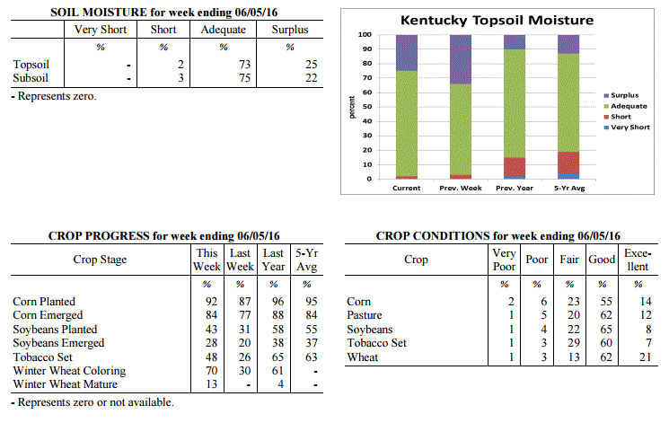 Kentucky Climate Summary
For the Period May 30, 2016 to June 5, 2016
Above Normal Temperatures and Near Normal Rainfall:
Similar to the previous period, conditions remained warm and muggy for much of
this past week. Temperatures were 4 degrees above normal as highs jumped
into the 80s each day, along with lows only dropping into the 60s. A handful of
locations even hit the 90-degree mark. High dew points accompanied the warm
temperatures, making for a very humid air mass. As showers and storms fired
over the second half of the work week and into the weekend, the moist atmosphere
allowed for torrential rainfall at times, leading to some short lived flooding
for a few locations. Some sites reported seeing more than an inch of rainfall in
less than an hour. Overall, the Bluegrass and Eastern Kentucky each saw above
normal rainfall, while Western and Central Kentucky were slightly below normal
for the week.
Temperatures for the period averaged 74 degrees across the state which was 4
degrees warmer than normal and 4 degrees warmer than the previous period. High
temperatures averaged from 83 in the West to 84 in the East. Departure from
normal high temperatures ranged from near normal in the West to 3 degrees warmer
than normal in the East. Low temperatures averaged from 65 degrees in the West
to 64 degrees in the East. Departure from normal low temperature ranged from 4
degrees warmer than normal in the West to 8 degrees warmer than normal in the
East. The extreme high temperature for the period was 91 degrees at PEABODY and
the extreme low was 56 degrees at MCKEE 5S.
Precipitation (liq. equ.) for the period totaled 1.18 inches statewide which was
0.08 inches above normal and 108% of normal. Precipitation totals by climate
division, West 1.00 inches, Central 0.81 inches, Bluegrass 1.37 inches and East
1.52 inches, which was -0.07, -0.31, 0.28 and 0.42 inches respectively from
normal. By station, precipitation totals ranged from a low of 0.16 inches at
PIKEVILLE 13S to a high of 3.71 inches at MOREHEAD 4NE.
---
Agricultural Situation Report: May 31, 2016
(USDA's Crop Report with comments from Tom Priddy & Matt Dixon, UK Ag. Weather)
Agricultural News: Kentucky experienced above normal temperatures and near normal
rainfall over the past week. Precipitation for the week totaled 1.09 inches, 0.02
inches below normal. Temperatures averaged 70 degrees for the week, 2 degrees above
normal. Topsoil moisture was rated 3 percent short, 63 percent adequate and 34
percent surplus. Subsoil moisture was rated 2 percent short, 70 percent adequate, and
28 percent surplus. Days suitable for fieldwork averaged 3.1 out of a possible seven.
Primary activities this week included setting tobacco, harvesting hay, and planting
corn and soybeans when conditions allowed. Isolated and severe storms left many
fields wet with some reports of damage to corn, soybeans, and wheat from hail, wind,
and flooding. Sidewall compaction may be an issue later in the season, especially for
crops planted in wet fields. Some emerged corn is yellowing and showing signs of
stress. Several corn and soybean fields have been or will need to be replanted. The
average height of emerged corn was 9 inches, compared to 11 inches last year.
Producers cut and wrapped wheat for silage this week. Weather conditions finally
allowed for some producers to cut hay and appears to be yielding well. However,
quality of hay is declining due to over maturity. Hay and roughage supplies were
reported as 1 percent very short, 10 percent short, 80 percent adequate, and 9
percent surplus.
Kentucky Climate Summary
For the Period May 30, 2016 to June 5, 2016
Above Normal Temperatures and Near Normal Rainfall:
Similar to the previous period, conditions remained warm and muggy for much of
this past week. Temperatures were 4 degrees above normal as highs jumped
into the 80s each day, along with lows only dropping into the 60s. A handful of
locations even hit the 90-degree mark. High dew points accompanied the warm
temperatures, making for a very humid air mass. As showers and storms fired
over the second half of the work week and into the weekend, the moist atmosphere
allowed for torrential rainfall at times, leading to some short lived flooding
for a few locations. Some sites reported seeing more than an inch of rainfall in
less than an hour. Overall, the Bluegrass and Eastern Kentucky each saw above
normal rainfall, while Western and Central Kentucky were slightly below normal
for the week.
Temperatures for the period averaged 74 degrees across the state which was 4
degrees warmer than normal and 4 degrees warmer than the previous period. High
temperatures averaged from 83 in the West to 84 in the East. Departure from
normal high temperatures ranged from near normal in the West to 3 degrees warmer
than normal in the East. Low temperatures averaged from 65 degrees in the West
to 64 degrees in the East. Departure from normal low temperature ranged from 4
degrees warmer than normal in the West to 8 degrees warmer than normal in the
East. The extreme high temperature for the period was 91 degrees at PEABODY and
the extreme low was 56 degrees at MCKEE 5S.
Precipitation (liq. equ.) for the period totaled 1.18 inches statewide which was
0.08 inches above normal and 108% of normal. Precipitation totals by climate
division, West 1.00 inches, Central 0.81 inches, Bluegrass 1.37 inches and East
1.52 inches, which was -0.07, -0.31, 0.28 and 0.42 inches respectively from
normal. By station, precipitation totals ranged from a low of 0.16 inches at
PIKEVILLE 13S to a high of 3.71 inches at MOREHEAD 4NE.
---
Agricultural Situation Report: May 31, 2016
(USDA's Crop Report with comments from Tom Priddy & Matt Dixon, UK Ag. Weather)
Agricultural News: Kentucky experienced above normal temperatures and near normal
rainfall over the past week. Precipitation for the week totaled 1.09 inches, 0.02
inches below normal. Temperatures averaged 70 degrees for the week, 2 degrees above
normal. Topsoil moisture was rated 3 percent short, 63 percent adequate and 34
percent surplus. Subsoil moisture was rated 2 percent short, 70 percent adequate, and
28 percent surplus. Days suitable for fieldwork averaged 3.1 out of a possible seven.
Primary activities this week included setting tobacco, harvesting hay, and planting
corn and soybeans when conditions allowed. Isolated and severe storms left many
fields wet with some reports of damage to corn, soybeans, and wheat from hail, wind,
and flooding. Sidewall compaction may be an issue later in the season, especially for
crops planted in wet fields. Some emerged corn is yellowing and showing signs of
stress. Several corn and soybean fields have been or will need to be replanted. The
average height of emerged corn was 9 inches, compared to 11 inches last year.
Producers cut and wrapped wheat for silage this week. Weather conditions finally
allowed for some producers to cut hay and appears to be yielding well. However,
quality of hay is declining due to over maturity. Hay and roughage supplies were
reported as 1 percent very short, 10 percent short, 80 percent adequate, and 9
percent surplus.
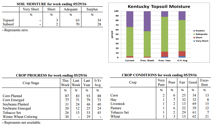 Kentucky Climate Summary
For the Period May 23, 2016 to May 29, 2016
Above Normal Temperatures and Near Normal Rainfall:
After three straight weeks of near to below normal temperatures, Kentucky became
situated within a summer-like pattern this past week. High temperatures were in the
80s about each day, with the hottest coming Friday as temperatures peaked in the mid
to upper 80s statewide. In addition, Gulf moisture started pushing into Kentucky by
Wednesday with muggy conditions sticking around through the end of the period. From
mid-week onward, isolated to scattered showers and storms were seen on a near daily
basis. The one exception came Thursday as most of the area saw rainfall as a line of
storms pushed through the Lower Ohio Valley. Situated within a moist and unstable
air mass for much of the period, storms were capable of frequent lightning and
torrential rainfall, leading to flash flooding at times. For the week, rainfall
totals were drastically different from one side of the state to the other. While
Western Kentucky averaged 1.79 inches for the week, Eastern Kentucky only saw an
average of 0.61.
Temperatures for the period averaged 70 degrees across the state which was 2 degrees
warmer than normal and 12 degrees warmer than the previous period. High temperatures
averaged from 82 in the West to 81 in the East. Departure from normal high
temperatures ranged from 1 degree warmer than normal in the West to 2 degrees
warmer than normal in the East. Low temperatures averaged from 62 degrees in the
West to 57 degrees in the East. Departure from normal low temperature ranged from 4
degrees warmer than normal in the West to 3 degrees warmer than normal in the East.
The extreme high temperature for the period was 89 degrees at VANCEBURG 6W and the
extreme low was 41 degrees at CYNTHIANA 8N.
Precipitation (liq. equ.) for the period totaled 1.09 inches statewide which was 0.02
inches below normal and 98% of normal. Precipitation totals by climate division, West
1.79 inches, Central 1.42 inches, Bluegrass 0.55 inches and East 0.61 inches, which
was 0.69, 0.26, -0.53 and -0.51 inches respectively from normal. By station,
precipitation totals ranged from a low of 0.07 inches at LOUISA 1S to a high of
5.01 inches at CAPE GIRARDEAU ASOS.
---
Agricultural Situation Report: May 23, 2016
(USDA's Crop Report with comments from Tom Priddy & Matt Dixon, UK Ag. Weather)
Agricultural News: Kentucky experienced below normal temperatures and above normal
rainfall over the past week. Precipitation for the week totaled 1.61 inches, 0.48
inches above normal. Temperatures averaged 58 degrees for the week, 8 degrees below
normal. Topsoil moisture was rated 0 percent very short, 2 percent short, 55 percent
adequate and 43 percent surplus. Subsoil moisture was rated 0 percent very short, 3
percent short, 66 percent adequate, and 31 percent surplus. Days suitable for
fieldwork averaged 1.8 out of a possible seven.
Wet weather persisted this week, causing additional delays for planting activities
and hay cutting. Where weather permitted, primary activities this week included
limited planting and spraying, with a small amount of hay being harvested. Some
producers intending to plant corn are changing to soybeans due to favorable prices
and continued wet fields. Corn is yellowing due to saturated soils, denitrification,
and leaching. The average height of emerged corn was 6 inches. Excessive rainfall has
resulted in the deterioration of hay conditions as many fields are well past their
ideal cutting date. Tobacco planting delays have left many plants in need of being
transplanted as soon as possible.
Kentucky Climate Summary
For the Period May 23, 2016 to May 29, 2016
Above Normal Temperatures and Near Normal Rainfall:
After three straight weeks of near to below normal temperatures, Kentucky became
situated within a summer-like pattern this past week. High temperatures were in the
80s about each day, with the hottest coming Friday as temperatures peaked in the mid
to upper 80s statewide. In addition, Gulf moisture started pushing into Kentucky by
Wednesday with muggy conditions sticking around through the end of the period. From
mid-week onward, isolated to scattered showers and storms were seen on a near daily
basis. The one exception came Thursday as most of the area saw rainfall as a line of
storms pushed through the Lower Ohio Valley. Situated within a moist and unstable
air mass for much of the period, storms were capable of frequent lightning and
torrential rainfall, leading to flash flooding at times. For the week, rainfall
totals were drastically different from one side of the state to the other. While
Western Kentucky averaged 1.79 inches for the week, Eastern Kentucky only saw an
average of 0.61.
Temperatures for the period averaged 70 degrees across the state which was 2 degrees
warmer than normal and 12 degrees warmer than the previous period. High temperatures
averaged from 82 in the West to 81 in the East. Departure from normal high
temperatures ranged from 1 degree warmer than normal in the West to 2 degrees
warmer than normal in the East. Low temperatures averaged from 62 degrees in the
West to 57 degrees in the East. Departure from normal low temperature ranged from 4
degrees warmer than normal in the West to 3 degrees warmer than normal in the East.
The extreme high temperature for the period was 89 degrees at VANCEBURG 6W and the
extreme low was 41 degrees at CYNTHIANA 8N.
Precipitation (liq. equ.) for the period totaled 1.09 inches statewide which was 0.02
inches below normal and 98% of normal. Precipitation totals by climate division, West
1.79 inches, Central 1.42 inches, Bluegrass 0.55 inches and East 0.61 inches, which
was 0.69, 0.26, -0.53 and -0.51 inches respectively from normal. By station,
precipitation totals ranged from a low of 0.07 inches at LOUISA 1S to a high of
5.01 inches at CAPE GIRARDEAU ASOS.
---
Agricultural Situation Report: May 23, 2016
(USDA's Crop Report with comments from Tom Priddy & Matt Dixon, UK Ag. Weather)
Agricultural News: Kentucky experienced below normal temperatures and above normal
rainfall over the past week. Precipitation for the week totaled 1.61 inches, 0.48
inches above normal. Temperatures averaged 58 degrees for the week, 8 degrees below
normal. Topsoil moisture was rated 0 percent very short, 2 percent short, 55 percent
adequate and 43 percent surplus. Subsoil moisture was rated 0 percent very short, 3
percent short, 66 percent adequate, and 31 percent surplus. Days suitable for
fieldwork averaged 1.8 out of a possible seven.
Wet weather persisted this week, causing additional delays for planting activities
and hay cutting. Where weather permitted, primary activities this week included
limited planting and spraying, with a small amount of hay being harvested. Some
producers intending to plant corn are changing to soybeans due to favorable prices
and continued wet fields. Corn is yellowing due to saturated soils, denitrification,
and leaching. The average height of emerged corn was 6 inches. Excessive rainfall has
resulted in the deterioration of hay conditions as many fields are well past their
ideal cutting date. Tobacco planting delays have left many plants in need of being
transplanted as soon as possible.
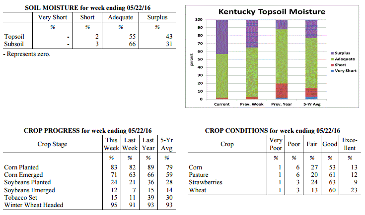 Kentucky Climate Summary
For the Period May 16, 2016 to May 22, 2016
Well Below Normal Temperatures and Above Normal Rainfall:
Unseasonably cool and wet conditions remained in place across Kentucky this past
week. The Bluegrass State saw a couple more rounds of widespread rainfall with the
most significant coming on Friday. Kentucky was situated within a very moist air
mass for this event and resulted in much of Central Kentucky seeing moderate to heavy
rainfall. Much of this region saw 1 to 2 inches. Overall, the state averaged 1.61
inches for the week, which was nearly a half inch above normal. May is typically the
wettest month of the year for Kentucky and May 2016 has been no different. Thus far,
the state has averaged 4.87 inches for the month. While the wet pattern remained in
place, Kentucky also saw some very cool temperatures for mid-May. A Frost Advisory
was even issued for Monday morning as lows dropped into the 30s for many locations.
Overall, Kentucky saw a third straight week of near to below normal temperatures.
Temperatures for the period averaged 58 degrees across the state which was 8 degrees
cooler than normal and 4 degrees cooler than the previous period. High temperatures
averaged from 67 in the West to 66 in the East. Departure from normal high
temperatures ranged from 12 degrees cooler than normal in the West to 11 degrees
cooler than normal in the East. Low temperatures averaged from 51 degrees in the
West to 48 degrees in the East. Departure from normal low temperature ranged from 5
degrees cooler than normal in the West to 3 degrees cooler than normal in the East.
The extreme high temperature for the period was 82 degrees at PADUCAH ASOS and the
extreme low was 32 degrees at OWENTON 5E.
Precipitation (liq. equ.) for the period totaled 1.61 inches statewide which was 0.48
inches above normal and 143% of normal. Precipitation totals by climate division,
West 1.27 inches, Central 2.17 inches, Bluegrass 1.62 inches and East 1.39 inches,
which was 0.15, 0.99, 0.54 and 0.26 inches above normal. By station, precipitation
totals ranged from a low of 0.54 inches at HICKMAN 2E to a high of 4.41 inches at
BOWLING GREEN 4E.
---
Agricultural Situation Report: May 16, 2016
(USDA's Crop Report with comments from Tom Priddy & Matt Dixon, UK Ag. Weather)
Agricultural News: Kentucky experienced near normal temperatures and above normal
rainfall over the past week. Precipitation for the week totaled 1.86 inches, 0.74
inches above normal. Temperatures averaged 63 degrees for the week, unchanged from
normal. Topsoil moisture was rated 3 percent short, 62 percent adequate and 35
percent surplus. Subsoil moisture was rated 3 percent short, 69 percent adequate, and
28 percent surplus. Days suitable for fieldwork averaged 2.1 out of a possible seven.
Primary activities this week included limited planting and spraying. Excessive rains
and storms this week led to flooding, with standing water in many fields. Some fields
will need to be replanted. There were also reports of crop damage due to large hail
and strong winds; tornado touchdowns also occurred. Some hay fields lodged due to
heavy rain and wind, with poor quality and harvest delays anticipated for first
cutting. There were reports of lodging as well as stripe rust in winter wheat.
Tobacco plant diseases are of concern due to damp weather conditions. Tobacco
transplant supplies were reported as 2 percent short, 93 percent adequate, and 5
percent surplus. Ten percent of tobacco transplants were under 2 inches, with 42
percent between 2-4 inches, and 48 percent over 4 inches.
Kentucky Climate Summary
For the Period May 16, 2016 to May 22, 2016
Well Below Normal Temperatures and Above Normal Rainfall:
Unseasonably cool and wet conditions remained in place across Kentucky this past
week. The Bluegrass State saw a couple more rounds of widespread rainfall with the
most significant coming on Friday. Kentucky was situated within a very moist air
mass for this event and resulted in much of Central Kentucky seeing moderate to heavy
rainfall. Much of this region saw 1 to 2 inches. Overall, the state averaged 1.61
inches for the week, which was nearly a half inch above normal. May is typically the
wettest month of the year for Kentucky and May 2016 has been no different. Thus far,
the state has averaged 4.87 inches for the month. While the wet pattern remained in
place, Kentucky also saw some very cool temperatures for mid-May. A Frost Advisory
was even issued for Monday morning as lows dropped into the 30s for many locations.
Overall, Kentucky saw a third straight week of near to below normal temperatures.
Temperatures for the period averaged 58 degrees across the state which was 8 degrees
cooler than normal and 4 degrees cooler than the previous period. High temperatures
averaged from 67 in the West to 66 in the East. Departure from normal high
temperatures ranged from 12 degrees cooler than normal in the West to 11 degrees
cooler than normal in the East. Low temperatures averaged from 51 degrees in the
West to 48 degrees in the East. Departure from normal low temperature ranged from 5
degrees cooler than normal in the West to 3 degrees cooler than normal in the East.
The extreme high temperature for the period was 82 degrees at PADUCAH ASOS and the
extreme low was 32 degrees at OWENTON 5E.
Precipitation (liq. equ.) for the period totaled 1.61 inches statewide which was 0.48
inches above normal and 143% of normal. Precipitation totals by climate division,
West 1.27 inches, Central 2.17 inches, Bluegrass 1.62 inches and East 1.39 inches,
which was 0.15, 0.99, 0.54 and 0.26 inches above normal. By station, precipitation
totals ranged from a low of 0.54 inches at HICKMAN 2E to a high of 4.41 inches at
BOWLING GREEN 4E.
---
Agricultural Situation Report: May 16, 2016
(USDA's Crop Report with comments from Tom Priddy & Matt Dixon, UK Ag. Weather)
Agricultural News: Kentucky experienced near normal temperatures and above normal
rainfall over the past week. Precipitation for the week totaled 1.86 inches, 0.74
inches above normal. Temperatures averaged 63 degrees for the week, unchanged from
normal. Topsoil moisture was rated 3 percent short, 62 percent adequate and 35
percent surplus. Subsoil moisture was rated 3 percent short, 69 percent adequate, and
28 percent surplus. Days suitable for fieldwork averaged 2.1 out of a possible seven.
Primary activities this week included limited planting and spraying. Excessive rains
and storms this week led to flooding, with standing water in many fields. Some fields
will need to be replanted. There were also reports of crop damage due to large hail
and strong winds; tornado touchdowns also occurred. Some hay fields lodged due to
heavy rain and wind, with poor quality and harvest delays anticipated for first
cutting. There were reports of lodging as well as stripe rust in winter wheat.
Tobacco plant diseases are of concern due to damp weather conditions. Tobacco
transplant supplies were reported as 2 percent short, 93 percent adequate, and 5
percent surplus. Ten percent of tobacco transplants were under 2 inches, with 42
percent between 2-4 inches, and 48 percent over 4 inches.
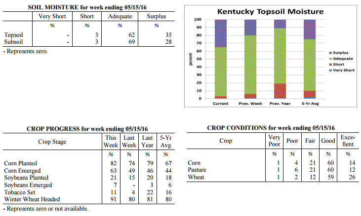 Kentucky Climate Summary
For the Period May 9, 2016 to May 15, 2016
Near Normal Temperatures and Above Normal Rainfall:
The Commonwealth saw several rounds of showers and storms throughout this past week,
followed by well below normal temperatures over the weekend. While the active pattern
started on Monday, the focus was on Tuesday through Thursday as Kentucky became
situated within a very unstable air mass. Strong to severe storms were seen each day
with most significant coming Tuesday as multiple tornadoes touched down in Western
and Central Kentucky. Damaging winds, large hail, and excessive lightning provided
additional hazards throughout the week, along with heavy rainfall from time to time.
Overall, the state averaged 1.86 inches for the period. Over the past three weeks,
the state has averaged 5.20 inches, which is nearly 2 inches above normal. By
Thursday, much of the state had been placed under a flash flood watch with already-
saturated grounds in place. Behind a passing cold front, attention then turned to a
very cool weekend. Partly to mostly cloudy skies and breezy northwest winds led to
highs in the upper 50s to middle 60s on Saturday. This was followed by lows Saturday
night dropping into the middle 30s to low 40s, roughly 15 to 20 degrees below normal
for mid-May.
Temperatures for the period averaged 63 degrees across the state which was near
normal and 4 degrees warmer than the previous period. High temperatures averaged
from 73 in the West to 72 in the East. Departure from normal high temperatures
ranged from 4 degrees cooler than normal in the West to 4 degrees cooler than normal
in the East. Low temperatures averaged from 55 degrees in the West to 54 degrees in
the East. Departure from normal low temperature ranged from 1 degree warmer than
normal in the West to 6 degrees warmer than normal in the East. The extreme high
temperature for the period was 86 degrees at PADUCAH ASOS and the extreme low was
34 degrees at HARTFORD 3E.
Precipitation (liq. equ.) for the period totaled 1.86 inches statewide which was 0.74
inches above normal and 166% of normal. Precipitation totals by climate division,
West 2.52 inches, Central 1.65 inches, Bluegrass 1.59 inches and East 1.68 inches,
which was 1.34, 0.47, 0.54 and 0.61 inches above normal. By station, precipitation
totals ranged from a low of 0.41 inches at ALBANY 1N to a high of 3.84 inches at
MORGANFIELD 4E.
---
Agricultural Situation Report: May 9, 2016
(USDA's Crop Report with comments from Tom Priddy & Matt Dixon, UK Ag. Weather)
Agricultural News: Kentucky experienced below normal temperatures and rainfall over
the past week. Precipitation for the week totaled 0.72 inches, 0.37 inches below
normal. Temperatures averaged 58 degrees for the week, 4 degrees below normal.
Topsoil moisture was rated 1 percent very short, 5 percent short, 74 percent adequate
and 20 percent surplus. Subsoil moisture was rated 1 percent very short, 5 percent
short, 80 percent adequate, and 14 percent surplus. Days suitable for fieldwork
averaged 3.2 out of a possible seven.
Primary activities this week included planting soybeans and setting tobacco; corn
planting has been progressing at a rapid pace. Some farmers are applying fungicides
to prevent head scab in wheat as wet and cool weather conditions persist. Wet
conditions are also delaying the cutting of alfalfa and wheat hay. There were reports
of hail during isolated thunderstorms in the middle of the week, although corn plants
are mostly projected to recover from any damage. Tobacco transplant supplies were
reported as 2 percent short, 93 percent adequate, and 5 percent surplus. Nineteen
percent of tobacco transplants were under 2 inches, with 41 percent between 2-4 inches,
and 40 percent over 4 inches.
Kentucky Climate Summary
For the Period May 9, 2016 to May 15, 2016
Near Normal Temperatures and Above Normal Rainfall:
The Commonwealth saw several rounds of showers and storms throughout this past week,
followed by well below normal temperatures over the weekend. While the active pattern
started on Monday, the focus was on Tuesday through Thursday as Kentucky became
situated within a very unstable air mass. Strong to severe storms were seen each day
with most significant coming Tuesday as multiple tornadoes touched down in Western
and Central Kentucky. Damaging winds, large hail, and excessive lightning provided
additional hazards throughout the week, along with heavy rainfall from time to time.
Overall, the state averaged 1.86 inches for the period. Over the past three weeks,
the state has averaged 5.20 inches, which is nearly 2 inches above normal. By
Thursday, much of the state had been placed under a flash flood watch with already-
saturated grounds in place. Behind a passing cold front, attention then turned to a
very cool weekend. Partly to mostly cloudy skies and breezy northwest winds led to
highs in the upper 50s to middle 60s on Saturday. This was followed by lows Saturday
night dropping into the middle 30s to low 40s, roughly 15 to 20 degrees below normal
for mid-May.
Temperatures for the period averaged 63 degrees across the state which was near
normal and 4 degrees warmer than the previous period. High temperatures averaged
from 73 in the West to 72 in the East. Departure from normal high temperatures
ranged from 4 degrees cooler than normal in the West to 4 degrees cooler than normal
in the East. Low temperatures averaged from 55 degrees in the West to 54 degrees in
the East. Departure from normal low temperature ranged from 1 degree warmer than
normal in the West to 6 degrees warmer than normal in the East. The extreme high
temperature for the period was 86 degrees at PADUCAH ASOS and the extreme low was
34 degrees at HARTFORD 3E.
Precipitation (liq. equ.) for the period totaled 1.86 inches statewide which was 0.74
inches above normal and 166% of normal. Precipitation totals by climate division,
West 2.52 inches, Central 1.65 inches, Bluegrass 1.59 inches and East 1.68 inches,
which was 1.34, 0.47, 0.54 and 0.61 inches above normal. By station, precipitation
totals ranged from a low of 0.41 inches at ALBANY 1N to a high of 3.84 inches at
MORGANFIELD 4E.
---
Agricultural Situation Report: May 9, 2016
(USDA's Crop Report with comments from Tom Priddy & Matt Dixon, UK Ag. Weather)
Agricultural News: Kentucky experienced below normal temperatures and rainfall over
the past week. Precipitation for the week totaled 0.72 inches, 0.37 inches below
normal. Temperatures averaged 58 degrees for the week, 4 degrees below normal.
Topsoil moisture was rated 1 percent very short, 5 percent short, 74 percent adequate
and 20 percent surplus. Subsoil moisture was rated 1 percent very short, 5 percent
short, 80 percent adequate, and 14 percent surplus. Days suitable for fieldwork
averaged 3.2 out of a possible seven.
Primary activities this week included planting soybeans and setting tobacco; corn
planting has been progressing at a rapid pace. Some farmers are applying fungicides
to prevent head scab in wheat as wet and cool weather conditions persist. Wet
conditions are also delaying the cutting of alfalfa and wheat hay. There were reports
of hail during isolated thunderstorms in the middle of the week, although corn plants
are mostly projected to recover from any damage. Tobacco transplant supplies were
reported as 2 percent short, 93 percent adequate, and 5 percent surplus. Nineteen
percent of tobacco transplants were under 2 inches, with 41 percent between 2-4 inches,
and 40 percent over 4 inches.
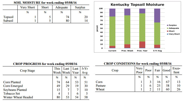 Kentucky Climate Summary
For the Period May 2, 2016 to May 8, 2016
Below Normal Temperatures and Rainfall:
An active pattern carried over for a second straight week in Kentucky with multiple
rounds of rainfall. Saying that, accumulations were not near as significant compared
to the previous week. The state still averaged just under three quarters of an inch
with the most falling across Eastern Kentucky. Over the past 14 days, Eastern
Kentucky has averaged over 4 inches of rainfall, which is over 2 inches about normal.
In response, the US Drought Monitor reduced the area of abnormally dry conditions to
roughly 23% of the state, mainly in Southcentral and Southeastern Kentucky, who are
still showing some long term deficits. Overall, temperatures for the week averaged
below normal for the first time in a month. The coldest period was Wednesday night
through Thursday night. Lows each night dropped into the low to middle 40s for much
of the state, but a number of locations even dropped into the upper 30s. In between,
highs on Thursday only rose into the middle 50s to low 60s, well below normal highs
for this time of year in the low to middle 70s.
Temperatures for the period averaged 58 degrees across the state which was 4 degrees
cooler than normal and 10 degrees cooler than the previous period. High temperatures
averaged from 71 in the West to 67 in the East. Departure from normal high
temperatures ranged from 4 degrees cooler than normal in the West to 7 degrees
cooler than normal in the East. Low temperatures averaged from 50 degrees in the
West to 49 degrees in the East. Departure from normal low temperature ranged from 2
degrees cooler than normal in the West to 3 degrees warmer than normal in the East.
The extreme high temperature for the period was 88 degrees at CAPE GIRARDEAU ASOS and
the extreme low was 38 degrees at BURKESVILLE 3W.
Precipitation (liq. equ.) for the period totaled 0.72 inches statewide which was 0.37
inches below normal and 66% of normal. Precipitation totals by climate division, West
0.21 inches, Central 0.77 inches, Bluegrass 0.72 inches and East 1.19 inches, which
was -0.97, -0.37, -0.29 and 0.16 inches respectively from normal. By station,
precipitation totals ranged from a low of 0.00 inches at CAPE GIRARDEAU ASOS to a
high of 2.09 inches at BOONEVILLE 2S.
---
Agricultural Situation Report: May 2, 2016
(USDA's Crop Report with comments from Tom Priddy & Matt Dixon, UK Ag. Weather)
Agricultural News: Kentucky experienced above normal temperatures and rainfall over
the past week. Precipitation for the week totaled 2.62 inches, 1.55 inches above
normal. Temperatures averaged 67 degrees for the week, 8 degrees above normal.
Topsoil moisture was rated 1 percent very short, 9 percent short, 73 percent adequate
and 17 percent surplus. Subsoil moisture was rated 1 percent very short, 8 percent
short, 77 percent adequate, and 14 percent surplus. Days suitable for fieldwork
averaged 3.8 out of a possible seven.
Primary activities this week included planting corn and soybeans. Weather conditions
did slow planting progress, with significant rainfall reported in several areas.
Wheat is still rated in mostly good condition. The average height of winter wheat was
24 inches, compared to 21 inches last week.
Much needed rain did help to improve pasture and hay growth. Alfalfa hay average
height was 15 inches, compared to 12 inches last week. Hay and roughage supplies were
reported as 2 percent very short, 14 percent short, 76 percent adequate, and 8
percent surplus. Tobacco transplant supplies were reported as 2 percent short, 93
percent adequate, and 5 percent surplus. Twenty-eight percent of tobacco transplants
were under 2 inches, with 44 percent between 2-4 inches, and 28 percent over 4 inches.
Kentucky Climate Summary
For the Period May 2, 2016 to May 8, 2016
Below Normal Temperatures and Rainfall:
An active pattern carried over for a second straight week in Kentucky with multiple
rounds of rainfall. Saying that, accumulations were not near as significant compared
to the previous week. The state still averaged just under three quarters of an inch
with the most falling across Eastern Kentucky. Over the past 14 days, Eastern
Kentucky has averaged over 4 inches of rainfall, which is over 2 inches about normal.
In response, the US Drought Monitor reduced the area of abnormally dry conditions to
roughly 23% of the state, mainly in Southcentral and Southeastern Kentucky, who are
still showing some long term deficits. Overall, temperatures for the week averaged
below normal for the first time in a month. The coldest period was Wednesday night
through Thursday night. Lows each night dropped into the low to middle 40s for much
of the state, but a number of locations even dropped into the upper 30s. In between,
highs on Thursday only rose into the middle 50s to low 60s, well below normal highs
for this time of year in the low to middle 70s.
Temperatures for the period averaged 58 degrees across the state which was 4 degrees
cooler than normal and 10 degrees cooler than the previous period. High temperatures
averaged from 71 in the West to 67 in the East. Departure from normal high
temperatures ranged from 4 degrees cooler than normal in the West to 7 degrees
cooler than normal in the East. Low temperatures averaged from 50 degrees in the
West to 49 degrees in the East. Departure from normal low temperature ranged from 2
degrees cooler than normal in the West to 3 degrees warmer than normal in the East.
The extreme high temperature for the period was 88 degrees at CAPE GIRARDEAU ASOS and
the extreme low was 38 degrees at BURKESVILLE 3W.
Precipitation (liq. equ.) for the period totaled 0.72 inches statewide which was 0.37
inches below normal and 66% of normal. Precipitation totals by climate division, West
0.21 inches, Central 0.77 inches, Bluegrass 0.72 inches and East 1.19 inches, which
was -0.97, -0.37, -0.29 and 0.16 inches respectively from normal. By station,
precipitation totals ranged from a low of 0.00 inches at CAPE GIRARDEAU ASOS to a
high of 2.09 inches at BOONEVILLE 2S.
---
Agricultural Situation Report: May 2, 2016
(USDA's Crop Report with comments from Tom Priddy & Matt Dixon, UK Ag. Weather)
Agricultural News: Kentucky experienced above normal temperatures and rainfall over
the past week. Precipitation for the week totaled 2.62 inches, 1.55 inches above
normal. Temperatures averaged 67 degrees for the week, 8 degrees above normal.
Topsoil moisture was rated 1 percent very short, 9 percent short, 73 percent adequate
and 17 percent surplus. Subsoil moisture was rated 1 percent very short, 8 percent
short, 77 percent adequate, and 14 percent surplus. Days suitable for fieldwork
averaged 3.8 out of a possible seven.
Primary activities this week included planting corn and soybeans. Weather conditions
did slow planting progress, with significant rainfall reported in several areas.
Wheat is still rated in mostly good condition. The average height of winter wheat was
24 inches, compared to 21 inches last week.
Much needed rain did help to improve pasture and hay growth. Alfalfa hay average
height was 15 inches, compared to 12 inches last week. Hay and roughage supplies were
reported as 2 percent very short, 14 percent short, 76 percent adequate, and 8
percent surplus. Tobacco transplant supplies were reported as 2 percent short, 93
percent adequate, and 5 percent surplus. Twenty-eight percent of tobacco transplants
were under 2 inches, with 44 percent between 2-4 inches, and 28 percent over 4 inches.
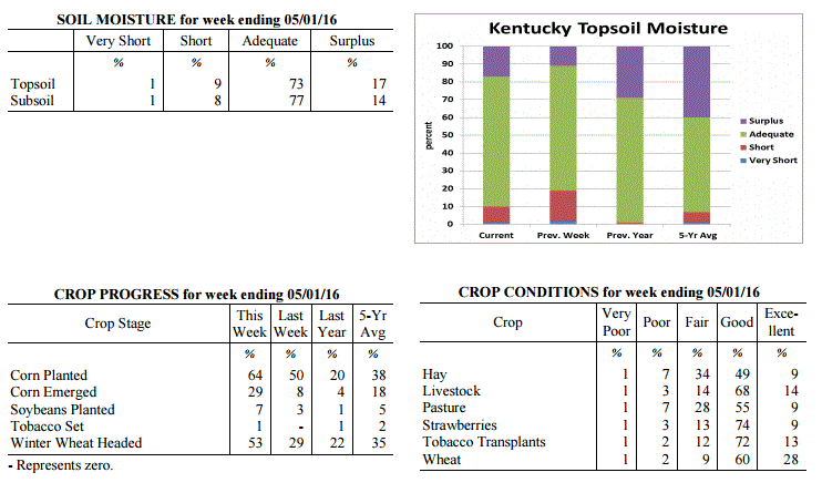 Kentucky Climate Summary
For the Period April 25, 2016 to May 1, 2016
Much Above Normal Temperatures and Rainfall:
Exceptionally wet conditions soaked the Bluegrass State this past week as an average
over 2.5 inches fell across the Commonwealth. This was over 1.5 inches above normal
and broke a three week streak of below normal precipitation. High rainfall totals
were the case for nearly the entirety of Kentucky as multiple rounds of showers and
storms rolled through the Lower Ohio Valley. On numerous occasions, storms became
strong to severe with damaging winds and hail as the main threats. Overall, this
past week was the wettest period of 2016. While the wet pattern was the highlight of
the period, unseasonably mild temperatures stuck around for yet another week. In
fact, seven of the past eight weeks have seen above normal temperatures. Temperatures
were highest on Monday and Tuesday as highs jumped into the low to middle 80s.
Temperatures for the period averaged 67 degrees across the state which was 8 degrees
warmer than normal and 2 degrees warmer than the previous period. High temperatures
averaged from 77 in the West to 77 in the East. Departure from normal high
temperatures ranged from 4 degrees warmer than normal in the West to 5 degrees
warmer than normal in the East. Low temperatures averaged from 59 degrees in the
West to 57 degrees in the East. Departure from normal low temperature ranged from 9
degrees warmer than normal in the West to 13 degrees warmer than normal in the
East. The extreme high temperature for the period was 87 degrees at BOWLING GREEN 4E
and the extreme low was 42 degrees at VANCEBURG 6W.
Precipitation (liq. equ.) for the period totaled 2.62 inches statewide which was 1.55
inches above normal and 245% of normal. Precipitation totals by climate division,
West 2.17 inches, Central 2.24 inches, Bluegrass 2.98 inches and East 3.09 inches,
which was 0.96, 1.15, 2 and 2.1 inches above normal. By station, precipitation totals
ranged from a low of 0.71 inches at BOWLING GREEN APT to a high of 4.78
inches at JACKSON AIRPORT.
---
Agricultural Situation Report: April 25, 2016
(USDA's Crop Report with comments from Tom Priddy & Matt Dixon, UK Ag. Weather)
Agricultural News: Kentucky experienced well above normal temperatures and below
normal precipitation over the past week. Precipitation for the week totaled 0.58
inches, 0.43 inches below normal. Temperatures averaged 64 degrees for the week, 7
degrees above normal. Topsoil moisture was rated 2 percent very short, 17 percent
short, 70 percent adequate and 11 percent surplus. Subsoil moisture was rated 2
percent very short, 15 percent short, 76 percent adequate, and 7 percent surplus.
Days suitable for fieldwork averaged 5.6 out of a possible seven.
Primary activities this week included preparing farm equipment for planting, planting
corn and seeding tobacco transplants. Corn planting was in full swing, while soybean
planting was just getting underway in many areas. Weather conditions allowed for
significant planting progress last week. Canola has bloomed and the crop continues to
look good. Wheat is still rated in mostly good condition. The average height of
winter wheat was 21 inches, compared to 17 inches last week. Harvest of small grains
utilized for hay and silage began in some locations.
Dry weather has put pressure on pasture and hay. Producers are need in more rainfall
soon to promote growth. Alfalfa hay average height was 12 inches, compared to 8
inches last week. Forty-six percent of tobacco transplants were under 2 inches, with
34 percent between 2- 4 inches, and 20 percent over 4 inches. Apple freeze damage was
reported as 1 percent severe, 7 percent moderate, 26 percent light, with 66 percent
experiencing none. Peach freeze damage was reported as 2 percent severe, 8 percent
moderate, 22 percent light, with 68 percent experiencing none.
Kentucky Climate Summary
For the Period April 25, 2016 to May 1, 2016
Much Above Normal Temperatures and Rainfall:
Exceptionally wet conditions soaked the Bluegrass State this past week as an average
over 2.5 inches fell across the Commonwealth. This was over 1.5 inches above normal
and broke a three week streak of below normal precipitation. High rainfall totals
were the case for nearly the entirety of Kentucky as multiple rounds of showers and
storms rolled through the Lower Ohio Valley. On numerous occasions, storms became
strong to severe with damaging winds and hail as the main threats. Overall, this
past week was the wettest period of 2016. While the wet pattern was the highlight of
the period, unseasonably mild temperatures stuck around for yet another week. In
fact, seven of the past eight weeks have seen above normal temperatures. Temperatures
were highest on Monday and Tuesday as highs jumped into the low to middle 80s.
Temperatures for the period averaged 67 degrees across the state which was 8 degrees
warmer than normal and 2 degrees warmer than the previous period. High temperatures
averaged from 77 in the West to 77 in the East. Departure from normal high
temperatures ranged from 4 degrees warmer than normal in the West to 5 degrees
warmer than normal in the East. Low temperatures averaged from 59 degrees in the
West to 57 degrees in the East. Departure from normal low temperature ranged from 9
degrees warmer than normal in the West to 13 degrees warmer than normal in the
East. The extreme high temperature for the period was 87 degrees at BOWLING GREEN 4E
and the extreme low was 42 degrees at VANCEBURG 6W.
Precipitation (liq. equ.) for the period totaled 2.62 inches statewide which was 1.55
inches above normal and 245% of normal. Precipitation totals by climate division,
West 2.17 inches, Central 2.24 inches, Bluegrass 2.98 inches and East 3.09 inches,
which was 0.96, 1.15, 2 and 2.1 inches above normal. By station, precipitation totals
ranged from a low of 0.71 inches at BOWLING GREEN APT to a high of 4.78
inches at JACKSON AIRPORT.
---
Agricultural Situation Report: April 25, 2016
(USDA's Crop Report with comments from Tom Priddy & Matt Dixon, UK Ag. Weather)
Agricultural News: Kentucky experienced well above normal temperatures and below
normal precipitation over the past week. Precipitation for the week totaled 0.58
inches, 0.43 inches below normal. Temperatures averaged 64 degrees for the week, 7
degrees above normal. Topsoil moisture was rated 2 percent very short, 17 percent
short, 70 percent adequate and 11 percent surplus. Subsoil moisture was rated 2
percent very short, 15 percent short, 76 percent adequate, and 7 percent surplus.
Days suitable for fieldwork averaged 5.6 out of a possible seven.
Primary activities this week included preparing farm equipment for planting, planting
corn and seeding tobacco transplants. Corn planting was in full swing, while soybean
planting was just getting underway in many areas. Weather conditions allowed for
significant planting progress last week. Canola has bloomed and the crop continues to
look good. Wheat is still rated in mostly good condition. The average height of
winter wheat was 21 inches, compared to 17 inches last week. Harvest of small grains
utilized for hay and silage began in some locations.
Dry weather has put pressure on pasture and hay. Producers are need in more rainfall
soon to promote growth. Alfalfa hay average height was 12 inches, compared to 8
inches last week. Forty-six percent of tobacco transplants were under 2 inches, with
34 percent between 2- 4 inches, and 20 percent over 4 inches. Apple freeze damage was
reported as 1 percent severe, 7 percent moderate, 26 percent light, with 66 percent
experiencing none. Peach freeze damage was reported as 2 percent severe, 8 percent
moderate, 22 percent light, with 68 percent experiencing none.
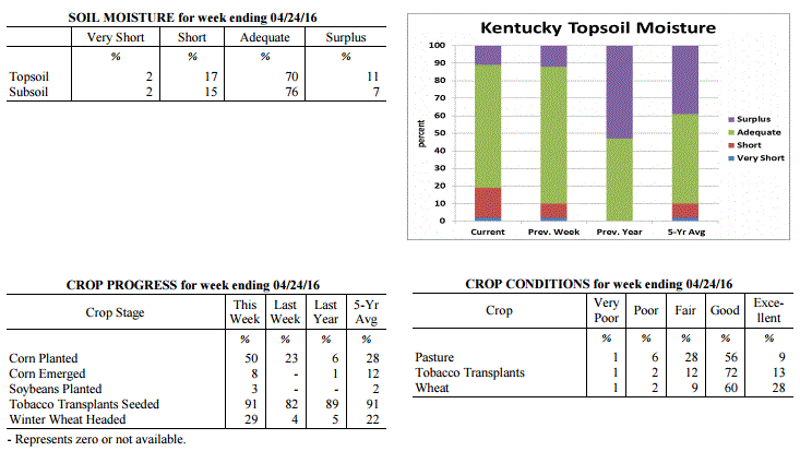 Kentucky Climate Summary
For the Period April 18, 2016 to April 24, 2016
Well Above Normal Temperatures and Below Normal Precipitation:
The latest update to the US Drought Monitor was released this past Thursday with
nearly 40% of the state now showing signs of ‘Abnormally Dry Conditions’. Most of
this area includes East-Central and Southeastern Kentucky, where precipitation has
been lacking over the past 30 to 60 days. Looking at this previous week, an upper
level disturbance slowly worked across the area over the second half of the work
week. While Western Kentucky saw near normal rainfall, totals diminished farther
east as Eastern Kentucky only saw an average of 0.42 inches, which was about a half inch
below normal. The state has now seen below normal precipitation five of the past six
weeks. Accompanying the dry conditions were seasonably mild temperatures. Other
than the unsettled end to the work week, the state was under the influence of high
pressure. This feature brought the state mostly clear skies with highs rising into
the 70s and 80s.
Temperatures for the period averaged 64 degrees across the state which was 7 degrees
warmer than normal and 4 degrees warmer than the previous period. High temperatures
averaged from 75 in the West to 78 in the East. Departure from normal high
temperatures ranged from 4 degrees warmer than normal in the West to 8 degrees
warmer than normal in the East. Low temperatures averaged from 53 degrees in the
West to 52 degrees in the East. Departure from normal low temperature ranged from 5
degrees warmer than normal in the West to 10 degrees warmer than normal in the
East. The extreme high temperature for the period was 88 degrees at KOOMER RIDGE and
the extreme low was 35 degrees at VANCEBURG 6W.
Precipitation (liq. equ.) for the period totaled 0.58 inches statewide which was 0.43
inches below normal and 57% of normal. Precipitation totals by climate division, West
1.16 inches, Central 0.41 inches, Bluegrass 0.32 inches and East 0.42 inches, which
was 0.01, 0.61, 0.61 and 0.51 inches below normal. By station, precipitation totals
ranged from a low of 0.12 inches at FRANKFORT to a high of 2.85 inches at
CAPE GIRARDEAU ASOS.
---
Agricultural Situation Report: April 18, 2016
(USDA's Crop Report with comments from Tom Priddy & Matt Dixon, UK Ag. Weather)
Agricultural News: Kentucky experienced above normal temperatures and below normal
precipitation over the past week. Precipitation for the week totaled 0.47 inches,
0.53 inches below normal. Temperatures averaged 58 degrees for the week, 2 degrees
above normal. Topsoil moisture was rated 2 percent very short, 8 percent short, 78
percent adequate and 12 percent surplus. Subsoil moisture was rated 2 percent very
short, 8 percent short, 82 percent adequate, and 8 percent surplus. Days suitable for
fieldwork averaged 5.6 out of a possible seven.
Primary activities this week included preparing farm equipment for planting, applying
fertilizer and burndown applications, planting corn and seeding tobacco transplants.
Soils are drying fast due to the warmer temperatures. Portions of eastern Kentucky
and southern Bluegrass are dry and in need of rain. Some producers are still feeding
livestock hay as dry conditions continue to affect pasture and hay growth. Late
freeze has impacted fruit crops, but full extent is unknown at this time.
The average height of winter wheat was 17 inches. Wheat winter freeze damage was
reported as 1 percent severe, 4 percent moderate, 12 percent light, with 83 percent
experiencing none. Alfalfa hay average height was 8 inches. Alfalfa hay freeze damage
was reported as 0 percent severe, 5 percent moderate, 20 percent light, with 75
percent experiencing none. Some weevil damage has been reported in Alfalfa due to
early infestations. Fifty-four percent of tobacco transplants were under 2 inches,
with 33 percent between 2-4 inches, and 13 percent over 4 inches.
Kentucky Climate Summary
For the Period April 18, 2016 to April 24, 2016
Well Above Normal Temperatures and Below Normal Precipitation:
The latest update to the US Drought Monitor was released this past Thursday with
nearly 40% of the state now showing signs of ‘Abnormally Dry Conditions’. Most of
this area includes East-Central and Southeastern Kentucky, where precipitation has
been lacking over the past 30 to 60 days. Looking at this previous week, an upper
level disturbance slowly worked across the area over the second half of the work
week. While Western Kentucky saw near normal rainfall, totals diminished farther
east as Eastern Kentucky only saw an average of 0.42 inches, which was about a half inch
below normal. The state has now seen below normal precipitation five of the past six
weeks. Accompanying the dry conditions were seasonably mild temperatures. Other
than the unsettled end to the work week, the state was under the influence of high
pressure. This feature brought the state mostly clear skies with highs rising into
the 70s and 80s.
Temperatures for the period averaged 64 degrees across the state which was 7 degrees
warmer than normal and 4 degrees warmer than the previous period. High temperatures
averaged from 75 in the West to 78 in the East. Departure from normal high
temperatures ranged from 4 degrees warmer than normal in the West to 8 degrees
warmer than normal in the East. Low temperatures averaged from 53 degrees in the
West to 52 degrees in the East. Departure from normal low temperature ranged from 5
degrees warmer than normal in the West to 10 degrees warmer than normal in the
East. The extreme high temperature for the period was 88 degrees at KOOMER RIDGE and
the extreme low was 35 degrees at VANCEBURG 6W.
Precipitation (liq. equ.) for the period totaled 0.58 inches statewide which was 0.43
inches below normal and 57% of normal. Precipitation totals by climate division, West
1.16 inches, Central 0.41 inches, Bluegrass 0.32 inches and East 0.42 inches, which
was 0.01, 0.61, 0.61 and 0.51 inches below normal. By station, precipitation totals
ranged from a low of 0.12 inches at FRANKFORT to a high of 2.85 inches at
CAPE GIRARDEAU ASOS.
---
Agricultural Situation Report: April 18, 2016
(USDA's Crop Report with comments from Tom Priddy & Matt Dixon, UK Ag. Weather)
Agricultural News: Kentucky experienced above normal temperatures and below normal
precipitation over the past week. Precipitation for the week totaled 0.47 inches,
0.53 inches below normal. Temperatures averaged 58 degrees for the week, 2 degrees
above normal. Topsoil moisture was rated 2 percent very short, 8 percent short, 78
percent adequate and 12 percent surplus. Subsoil moisture was rated 2 percent very
short, 8 percent short, 82 percent adequate, and 8 percent surplus. Days suitable for
fieldwork averaged 5.6 out of a possible seven.
Primary activities this week included preparing farm equipment for planting, applying
fertilizer and burndown applications, planting corn and seeding tobacco transplants.
Soils are drying fast due to the warmer temperatures. Portions of eastern Kentucky
and southern Bluegrass are dry and in need of rain. Some producers are still feeding
livestock hay as dry conditions continue to affect pasture and hay growth. Late
freeze has impacted fruit crops, but full extent is unknown at this time.
The average height of winter wheat was 17 inches. Wheat winter freeze damage was
reported as 1 percent severe, 4 percent moderate, 12 percent light, with 83 percent
experiencing none. Alfalfa hay average height was 8 inches. Alfalfa hay freeze damage
was reported as 0 percent severe, 5 percent moderate, 20 percent light, with 75
percent experiencing none. Some weevil damage has been reported in Alfalfa due to
early infestations. Fifty-four percent of tobacco transplants were under 2 inches,
with 33 percent between 2-4 inches, and 13 percent over 4 inches.
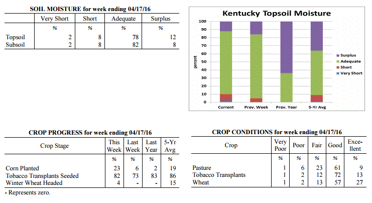 Kentucky Climate Summary
For the Period April 11, 2016 to April 17, 2016
Above Normal Temperatures and Below Normal Precipitation:
The Bluegrass State saw yet another period with below normal precipitation over this
past week. Other than a solid band of showers and a few thunderstorms on Monday, the
remainder of the period was mostly dry. Looking back at the past five weeks, four of
the five have seen below normal rainfall for the state of Kentucky. Over the past 30
days, the state is on average, 1.62 inches below normal. The dry conditions are even
more magnified in Eastern Kentucky where the area is 2.17 inches below normal for the
30 day period. In relation, the US Drought Monitor introduced Abnormally Dry
Conditions to portions of Eastern Kentucky and the Southern Bluegrass. While it
was a dry week, conditions were favorable for outdoor activities. By the weekend,
high pressure at the surface and aloft resulted in clear skies with highs rising into
the upper 70s to middle 80s.
Temperatures for the period averaged 58 degrees across the state which was 2 degrees
warmer than normal and 12 degrees warmer than the previous period. High temperatures
averaged from 72 in the West to 73 in the East. Departure from normal high
temperatures ranged from 3 degrees warmer than normal in the West to 5 degrees
warmer than normal in the East. Low temperatures averaged from 47 degrees in the
West to 45 degrees in the East. Departure from normal low temperature ranged from 1
degree warmer than normal in the West to 5 degrees warmer than normal in the East.
The extreme high temperature for the period was 84 degrees at KOOMER RIDGE and the
extreme low was 27 degrees at PAINTSVILLE 4W.
Precipitation (liq. equ.) for the period totaled 0.47 inches statewide which was 0.53
inches below normal and 47% of normal. Precipitation totals by climate division, West
0.53 inches, Central 0.43 inches, Bluegrass 0.73 inches and East 0.20 inches, which
was 0.6, 0.59, 0.18 and 0.75 inches below normal. By station, precipitation totals
ranged from a low of 0.01 inches at MIDDLESBORO AWOS to a high of 1.41 inches at
ALEXANDRIA 5NW.
---
Agricultural Situation Report: April 11, 2016
(USDA's Crop Report with comments from Tom Priddy & Matt Dixon, UK Ag. Weather)
Agricultural News: Kentucky experienced below normal temperatures and precipitation
over the past week. Precipitation for the week totaled 0.42 inches, 0.57 inches below
normal. Temperatures averaged 48 degrees for the week, 5 degrees below normal.
Topsoil moisture was rated 0 percent very short, 5 percent short, 79 percent adequate
and 16 percent surplus. Subsoil moisture was rated 1 percent very short, 5 percent
short, 84 percent adequate, and 10 percent surplus. Days suitable for fieldwork
averaged 4.3 out of a possible seven.
Primary activities this week included preparing farm equipment for planting, applying
fertilizer and burndown applications, and seeding tobacco transplants. Cool
temperatures last week resulted in planting delays. Limited corn planting took place
where conditions allowed, but should progress more rapidly later this week. Pasture
growth slowed last week as well due to colder weather. Livestock producers are still
feeding hay where necessary and if available. The impact of the cold temperatures
late in the week to fruit crops and wheat is unknown at this time. Some damage is
expected to fruit crop in some locations. But, there is optimism that temperatures
were not cold enough, for long enough to cause widespread damage to wheat. Eighty-two
percent of wheat is rated as good to excellent. The average height of winter wheat
was 8 inches.
Kentucky Climate Summary
For the Period April 11, 2016 to April 17, 2016
Above Normal Temperatures and Below Normal Precipitation:
The Bluegrass State saw yet another period with below normal precipitation over this
past week. Other than a solid band of showers and a few thunderstorms on Monday, the
remainder of the period was mostly dry. Looking back at the past five weeks, four of
the five have seen below normal rainfall for the state of Kentucky. Over the past 30
days, the state is on average, 1.62 inches below normal. The dry conditions are even
more magnified in Eastern Kentucky where the area is 2.17 inches below normal for the
30 day period. In relation, the US Drought Monitor introduced Abnormally Dry
Conditions to portions of Eastern Kentucky and the Southern Bluegrass. While it
was a dry week, conditions were favorable for outdoor activities. By the weekend,
high pressure at the surface and aloft resulted in clear skies with highs rising into
the upper 70s to middle 80s.
Temperatures for the period averaged 58 degrees across the state which was 2 degrees
warmer than normal and 12 degrees warmer than the previous period. High temperatures
averaged from 72 in the West to 73 in the East. Departure from normal high
temperatures ranged from 3 degrees warmer than normal in the West to 5 degrees
warmer than normal in the East. Low temperatures averaged from 47 degrees in the
West to 45 degrees in the East. Departure from normal low temperature ranged from 1
degree warmer than normal in the West to 5 degrees warmer than normal in the East.
The extreme high temperature for the period was 84 degrees at KOOMER RIDGE and the
extreme low was 27 degrees at PAINTSVILLE 4W.
Precipitation (liq. equ.) for the period totaled 0.47 inches statewide which was 0.53
inches below normal and 47% of normal. Precipitation totals by climate division, West
0.53 inches, Central 0.43 inches, Bluegrass 0.73 inches and East 0.20 inches, which
was 0.6, 0.59, 0.18 and 0.75 inches below normal. By station, precipitation totals
ranged from a low of 0.01 inches at MIDDLESBORO AWOS to a high of 1.41 inches at
ALEXANDRIA 5NW.
---
Agricultural Situation Report: April 11, 2016
(USDA's Crop Report with comments from Tom Priddy & Matt Dixon, UK Ag. Weather)
Agricultural News: Kentucky experienced below normal temperatures and precipitation
over the past week. Precipitation for the week totaled 0.42 inches, 0.57 inches below
normal. Temperatures averaged 48 degrees for the week, 5 degrees below normal.
Topsoil moisture was rated 0 percent very short, 5 percent short, 79 percent adequate
and 16 percent surplus. Subsoil moisture was rated 1 percent very short, 5 percent
short, 84 percent adequate, and 10 percent surplus. Days suitable for fieldwork
averaged 4.3 out of a possible seven.
Primary activities this week included preparing farm equipment for planting, applying
fertilizer and burndown applications, and seeding tobacco transplants. Cool
temperatures last week resulted in planting delays. Limited corn planting took place
where conditions allowed, but should progress more rapidly later this week. Pasture
growth slowed last week as well due to colder weather. Livestock producers are still
feeding hay where necessary and if available. The impact of the cold temperatures
late in the week to fruit crops and wheat is unknown at this time. Some damage is
expected to fruit crop in some locations. But, there is optimism that temperatures
were not cold enough, for long enough to cause widespread damage to wheat. Eighty-two
percent of wheat is rated as good to excellent. The average height of winter wheat
was 8 inches.
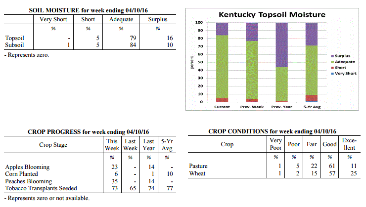 Kentucky Climate Summary
For the Period April 4, 2016 to April 10, 2016
Below Normal Temperatures and Precipitation:
For much of Kentucky, normal high temperatures for first half of April are in the mid
to upper 60s, while lows typically drop into the low to mid 40s. Looking at this past
week, temperatures were well below normal. In fact, multiple Freeze Warnings were
issued by the National Weather Service. The most significant cold spell occurred
Friday night through Saturday night. Behind a frontal passage on Friday, an
unseasonably cold air mass filtered into the area with lows dipping into the upper
20s to low 30s across much of the state. After only seeing highs on Saturday in
the 40s, lows that night dipped back into the 20s across mainly the eastern half of
the state. In addition to a rather cool period, conditions were also fairly dry and
windy. The state averaged 0.42 inches, which is over half inch below normal for the
seven day period. Multiple wind advisories were also issued throughout the period with
gusts exceeding 40 mph from time to time.
Temperatures for the period averaged 48 degrees across the state which was 5 degrees
cooler than normal and 4 degrees cooler than the previous period. High temperatures
averaged from 62 in the West to 57 in the East. Departure from normal high
temperatures ranged from 5 degrees cooler than normal in the West to 9 degrees
cooler than normal in the East. Low temperatures averaged from 41 degrees in the
West to 35 degrees in the East. Departure from normal low temperature ranged from 3
degrees cooler than normal in the West to 3 degrees cooler than normal in the East.
The extreme high temperature for the period was 79 degrees at POPLAR BLUFF ASOS and
the extreme low was 22 degrees at PAINTSVILLE 4W.
Precipitation (liq. equ.) for the period totaled 0.42 inches statewide which was 0.57
inches below normal and 42% of normal. Precipitation totals by climate division, West
0.31 inches, Central 0.27 inches, Bluegrass 0.45 inches and East 0.66 inches, which
was 0.82, 0.75, 0.45 and 0.27 inches below normal. By station, precipitation totals
ranged from a low of 0.04 inches at FORT KNOX to a high of 1.63 inches at
RUSSELLVILLE 2W.
---
Agricultural Situation Report: April 5, 2016
(USDA's Crop Report with comments from Tom Priddy & Matt Dixon, UK Ag. Weather)
Agricultural News: Kentucky experienced above normal temperatures and precipitation
over the past week. Precipitation for the week totaled 1.23 inches, 0.22 inches above
normal. Temperatures averaged 54 degrees for the week, 3 degrees above normal.
Topsoil moisture was rated 4 percent short, 73 percent adequate and 23 percent
surplus. Subsoil moisture was rated 1 percent very short, 4 percent short, 81 percent
adequate, and 14 percent surplus. Days suitable for fieldwork averaged 4.1 out of a
possible seven.
As the calendar turned to April, a typical spring pattern set up across the Lower Ohio
Valley. The Bluegrass State saw a warm start to the period with southerly flow
bumping readings up into the 70s by midweek, ahead of an approaching low pressure
system. This flow pattern helped Kentucky reach a 4th straight week of above normal
temperatures. As the system passed through the area, the state saw a couple rounds of
widespread showers and storms Wednesday night and Thursday. This ended up being the
only significant rainfall event for the week, but the state still averaged 1.23 inches.
This was slightly above normal, breaking a two week span of much below normal
precipitation. Attention then turned to Saturday as another cold front moved through
the area. During the day, winds became very breezy, so much so that a High Wind
Warning was issued for portions of Northern Kentucky. While most of the state saw
wind gust in excess of 40 mph, portions of Northern Kentucky exceeded 50. Winds
slackened later that night, prompting a Freeze Warning across the area. Lows by
early Sunday morning dipped into the upper 20s to low 30s.
Primary activities this week included preparing farm equipment for planting, applying
fertilizer, and seeding tobacco transplants. Some producers have applied burndown
applications in preparation for corn and soybean planting. A few producers have begun
planting corn. Producers are concerned about the potential for cold temperatures over
the next couple of weeks. Wheat winter freeze damage was reported as 1 percent
severe, 5 percent moderate, 14 percent light, with 80 percent experiencing none.
Alfalfa hay freeze damage was reported as 3 percent moderate, 21 percent light, with
76 percent experiencing none. Cattle and calves obtained approximately 53 percent of
feed from pastures, but some hay is being fed.
Kentucky Climate Summary
For the Period April 4, 2016 to April 10, 2016
Below Normal Temperatures and Precipitation:
For much of Kentucky, normal high temperatures for first half of April are in the mid
to upper 60s, while lows typically drop into the low to mid 40s. Looking at this past
week, temperatures were well below normal. In fact, multiple Freeze Warnings were
issued by the National Weather Service. The most significant cold spell occurred
Friday night through Saturday night. Behind a frontal passage on Friday, an
unseasonably cold air mass filtered into the area with lows dipping into the upper
20s to low 30s across much of the state. After only seeing highs on Saturday in
the 40s, lows that night dipped back into the 20s across mainly the eastern half of
the state. In addition to a rather cool period, conditions were also fairly dry and
windy. The state averaged 0.42 inches, which is over half inch below normal for the
seven day period. Multiple wind advisories were also issued throughout the period with
gusts exceeding 40 mph from time to time.
Temperatures for the period averaged 48 degrees across the state which was 5 degrees
cooler than normal and 4 degrees cooler than the previous period. High temperatures
averaged from 62 in the West to 57 in the East. Departure from normal high
temperatures ranged from 5 degrees cooler than normal in the West to 9 degrees
cooler than normal in the East. Low temperatures averaged from 41 degrees in the
West to 35 degrees in the East. Departure from normal low temperature ranged from 3
degrees cooler than normal in the West to 3 degrees cooler than normal in the East.
The extreme high temperature for the period was 79 degrees at POPLAR BLUFF ASOS and
the extreme low was 22 degrees at PAINTSVILLE 4W.
Precipitation (liq. equ.) for the period totaled 0.42 inches statewide which was 0.57
inches below normal and 42% of normal. Precipitation totals by climate division, West
0.31 inches, Central 0.27 inches, Bluegrass 0.45 inches and East 0.66 inches, which
was 0.82, 0.75, 0.45 and 0.27 inches below normal. By station, precipitation totals
ranged from a low of 0.04 inches at FORT KNOX to a high of 1.63 inches at
RUSSELLVILLE 2W.
---
Agricultural Situation Report: April 5, 2016
(USDA's Crop Report with comments from Tom Priddy & Matt Dixon, UK Ag. Weather)
Agricultural News: Kentucky experienced above normal temperatures and precipitation
over the past week. Precipitation for the week totaled 1.23 inches, 0.22 inches above
normal. Temperatures averaged 54 degrees for the week, 3 degrees above normal.
Topsoil moisture was rated 4 percent short, 73 percent adequate and 23 percent
surplus. Subsoil moisture was rated 1 percent very short, 4 percent short, 81 percent
adequate, and 14 percent surplus. Days suitable for fieldwork averaged 4.1 out of a
possible seven.
As the calendar turned to April, a typical spring pattern set up across the Lower Ohio
Valley. The Bluegrass State saw a warm start to the period with southerly flow
bumping readings up into the 70s by midweek, ahead of an approaching low pressure
system. This flow pattern helped Kentucky reach a 4th straight week of above normal
temperatures. As the system passed through the area, the state saw a couple rounds of
widespread showers and storms Wednesday night and Thursday. This ended up being the
only significant rainfall event for the week, but the state still averaged 1.23 inches.
This was slightly above normal, breaking a two week span of much below normal
precipitation. Attention then turned to Saturday as another cold front moved through
the area. During the day, winds became very breezy, so much so that a High Wind
Warning was issued for portions of Northern Kentucky. While most of the state saw
wind gust in excess of 40 mph, portions of Northern Kentucky exceeded 50. Winds
slackened later that night, prompting a Freeze Warning across the area. Lows by
early Sunday morning dipped into the upper 20s to low 30s.
Primary activities this week included preparing farm equipment for planting, applying
fertilizer, and seeding tobacco transplants. Some producers have applied burndown
applications in preparation for corn and soybean planting. A few producers have begun
planting corn. Producers are concerned about the potential for cold temperatures over
the next couple of weeks. Wheat winter freeze damage was reported as 1 percent
severe, 5 percent moderate, 14 percent light, with 80 percent experiencing none.
Alfalfa hay freeze damage was reported as 3 percent moderate, 21 percent light, with
76 percent experiencing none. Cattle and calves obtained approximately 53 percent of
feed from pastures, but some hay is being fed.
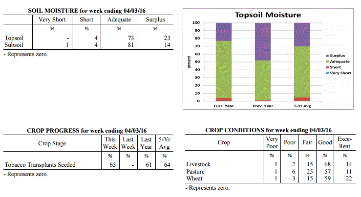 Kentucky Climate Summary
For the Period March 28, 2016 to April 3, 2016
Above Normal Temperatures and Precipitation:
As the calendar turned to April, a typical spring pattern set up across the Lower Ohio
Valley. The Bluegrass State saw a warm start to the period with southerly flow
bumping readings up into the 70s by midweek, ahead of an approaching low pressure
system. This flow pattern helped Kentucky reach a 4th straight week of above normal
temperatures. As the system passed through the area, the state saw a couple rounds of
widespread showers and storms Wednesday night and Thursday. This ended up being the
only significant rainfall event for the week, but the state still averaged 1.23 inches.
This was slightly above normal, breaking a two week span of much below normal
precipitation. Attention then turned to Saturday as another cold front moved through
the area. During the day, winds became very breezy, so much so that a High Wind
Warning was issued for portions of Northern Kentucky. While most of the state saw
wind gust in excess of 40 mph, portions of Northern Kentucky exceeded 50. Winds
slackened later that night, prompting a Freeze Warning across the area. Lows by
early Sunday morning dipped into the upper 20s to low 30s.
Temperatures for the period averaged 54 degrees across the state which was 3 degrees
warmer than normal and 2 degrees warmer than the previous period. High temperatures
averaged from 66 in the West to 65 in the East. Departure from normal high
temperatures ranged from 1 degree warmer than normal in the West to 2 degrees warmer
than normal in the East. Low temperatures averaged from 42 degrees in the West to 44
degrees in the East. Departure from normal low temperature ranged from 1 degree
warmer than normal in the West to 8 degrees warmer than normal in the East. The
extreme high temperature for the period was 78 degrees at LOUISA 1S and the
extreme low was 24 degrees at CYNTHIANA 8N.
Precipitation (liq. equ.) for the period totaled 1.23 inches statewide which was 0.22
inches above normal and 122% of normal. Precipitation totals by climate division,
West 1.85 inches, Central 1.35 inches, Bluegrass 1.07 inches and East 0.65 inches,
which was 0.75, 0.29, 0.16 and -0.31 inches respectively from normal. By station,
precipitation totals ranged from a low of 0.08 inches at OWINGSVILLE 4S to a high of
3.09 inches at POPLAR BLUFF ASOS.
---
Kentucky Climate Summary
For the Period March 21, 2016 to March 27, 2016
Above Normal Temperatures and Below Normal Precipitation:
This past period marked the third straight week of above normal temperatures and
second straight with below normal precipitation. The period started off with
temperatures on the climb and dry conditions in place. In fact, there was a
heightened fire danger on Tuesday across mainly the eastern half of the state as
winds became breezy and humidity levels dropped significantly. Showers and
thunderstorms returned Thursday and Thursday night as a cold front crossed the
region, before ending the week with dry and cooler conditions in place. Clear skies
set up a cold morning on Saturday with temperatures in the low to mid 30s for most.
A Frost Advisory was issued with some vegetation becoming increasingly susceptible.
While it was a cool start to the weekend, the state saw another warming trend through
Sunday, ahead of another cold front bringing showers and storms that evening and
overnight. The two systems passing through the area amounted to a state average of
0.53 inches, which is just over a half inch below normal for the seven day period.
Temperatures for the period averaged 53 degrees across the state which was 4 degrees
warmer than normal and 2 degrees cooler than the previous period. High temperatures
averaged from 65 in the West to 66 in the East. Departure from normal high
temperatures ranged from 3 degrees warmer than normal in the West to 5 degrees warmer
than normal in the East. Low temperatures averaged from 42 degrees in the West to 41
degrees in the East. Departure from normal low temperature ranged from 2 degrees
warmer than normal in the West to 6 degrees warmer than normal in the East. The
extreme high temperature for the period was 79 degrees at LOUISA 1S and the
extreme low was 22 degrees at BOONEVILLE 2S.
Precipitation (liq. equ.) for the period totaled 0.53 inches statewide which was 0.51
inches below normal and 51% of normal. Precipitation totals by climate division, West
0.53 inches, Central 0.57 inches, Bluegrass 0.55 inches and East 0.45 inches, which
was 0.58, 0.53, 0.39 and 0.57 inches below normal. By station, precipitation totals
ranged from a low of 0.07 inches at CADIZ 4SW to a high of 1.25 inches at MAYFIELD 6SW.
---
Kentucky Climate Summary
For the Period March 14, 2016 to March 20, 2016
Above Normal Temperatures and Below Normal Precipitation:
This past period signaled the last official week of winter 2015-16. Showers and
thunderstorms passed through the area over the course of Monday, before becoming dry
and warm on Tuesday. Highs peaked in the upper 70s to middle 80s across much of the
Commonwealth behind gusty southerly flow. Following the boundary, temperatures went
on the decline. Showers returned over the weekend, but were light in nature. Cloud
cover kept temperatures cool compared to what had been seen for much of the first
half of March. Highs on Saturday and Sunday stayed in the middle 40s to low 50s.
Overall, temperatures were still above normal for the week, but the state averaged
only a third of an inch of precipitation.
Temperatures for the period averaged 54 degrees across the state which was 7 degrees
warmer than normal and 8 degrees cooler than the previous period. High temperatures
averaged from 64 in the West to 65 in the East. Departure from normal high
temperatures ranged from 4 degrees warmer than normal in the West to 6 degrees
warmer than normal in the East. Low temperatures averaged from 44 degrees in the
West to 45 degrees in the East. Departure from normal low temperature ranged from 6
degrees warmer than normal in the West to 12 degrees warmer than normal in the
East. The extreme high temperature for the period was 87 degrees at MADISONVILLE 4S
and the extreme low was 23 degrees at VANCEBURG 6W.
Precipitation (liq. equ.) for the period totaled 0.33 inches statewide which was 0.7
inches below normal and 32% of normal. Precipitation totals by climate division, West
0.49 inches, Central 0.29 inches, Bluegrass 0.17 inches and East 0.36 inches, which
was 0.6, 0.8, 0.76 and 0.65 inches below normal. By station, precipitation totals
ranged from a low of 0.01 inches at HARRODSBURG 3N to a high of 1.58 inches at
GREENVILLE 6N.
---
Kentucky Climate Summary
For the Period March 7, 2016 to March 13, 2016
Much Above Normal Temperatures and Precipitation:
An extremely warm and wet pattern set up across the state of Kentucky this past week.
Over much of the period, a low pressure system sat over Northern Mexico and Texas,
while high pressure was entrenched off the east coast. This set up a southerly flow
pattern with warm and moist air being pushed into the Lower Ohio Valley. Highs for
much of the week stayed in the 60s and 70s, well above normal for this time of the
year. Showers increased in coverage starting midweek across Western Kentucky and up
along the Ohio River, into the Bluegrass. As high pressure pushed east, shower
coverage expanded south and east to end the work week. Going into the weekend, the
aforementioned low passed through the Lower Ohio Valley, bringing renewed showers
across the area. Overall, the state averaged 1.72 inches. Saying that, the plume of
moisture really increased values across Western Kentucky, where the area averaged
nearly 3.5 inches, which was over 2 inches above normal.
Temperatures for the period averaged 61 degrees across the state which was 16 degrees
warmer than normal and 20 degrees warmer than the previous period. High temperatures
averaged from 67 in the West to 72 in the East. Departure from normal high
temperatures ranged from 9 degrees warmer than normal in the West to 15 degrees
warmer than normal in the East. Low temperatures averaged from 54 degrees in the West
to 49 degrees in the East. Departure from normal low temperature ranged from 18
degrees warmer than normal in the West to 18 degrees warmer than normal in the East.
The extreme high temperature for the period was 81 degrees at HAZARD AWOS and
the extreme low was 2 degrees at SOMERSET AWOS.
Precipitation (liq. equ.) for the period totaled 1.72 inches statewide which was 0.74
inches above normal and 176% of normal. Precipitation totals by climate division,
West 3.47 inches, Central 1.59 inches, Bluegrass 1.42 inches and East 0.39 inches,
which was 2.45, 0.56, 0.52 and -0.58 inches respectively from normal. By station,
precipitation totals ranged from a low of 0.10 inches at JACKSON 3SE to a high of
6.00 inches at MURRAY 1W.
---
Kentucky Climate Summary
For the Period February 29, 2016 to March 6, 2016
Below Normal Temperatures and Precipitation:
The Bluegrass State saw multiple periods of precipitation this past period, but
overall, totals were slightly below normal with the state averaging 0.76 inches.
Most of the precipitation was seen on Tuesday as rain showers became widespread
across the region and was even accompanied by scattered thunderstorms. After
starting the week in the 50s and 60s, temperatures dropped behind a cold front with
highs on Wednesday only in the upper 30s to middle 40s. The next system on Thursday
brought moderate to heavy snow from time to time. This activity was most significant
across Eastern Kentucky, especially in the area of Morgan, Elliot, and Rowan
counties. Some locations in this region reported 6+ inches. Another system then
brought additional rain on Saturday, before temperatures went on the increase
Sunday behind mostly clear skies.
Temperatures for the period averaged 41 degrees across the state which was 2 degrees
cooler than normal and 2 degrees cooler than the previous period. High temperatures
averaged from 52 in the West to 49 in the East. Departure from normal high
temperatures ranged from 4 degrees cooler than normal in the West to 7 degrees cooler
than normal in the East. Low temperatures averaged from 34 degrees in the West to 33
degrees in the East. Departure from normal low temperature ranged from near normal in
the West to 3 degrees warmer than normal in the East. The extreme high temperature
for the period was 72 degrees at LOUISA 1S and the extreme low was 22 degrees at
PAINTSVILLE 4W.
Precipitation (liq. equ.) for the period totaled 0.76 inches statewide which was 0.2
inches below normal and 79% of normal. Precipitation totals by climate division, West
0.58 inches, Central 0.66 inches, Bluegrass 0.98 inches and East 0.82 inches, which
was -0.47, -0.35, 0.12 and -0.12 inches respectively from normal. By station,
precipitation totals ranged from a low of 0.23 inches at CALHOUN 5NW to a high of
2.67 inches at OWINGSVILLE 4S.
---
Kentucky Climate Summary
For the Period February 22, 2016 to February 28, 2016
Above Normal Temperatures and Precipitation:
Precipitation and temperatures remained above normal for a second straight week. The
Commonwealth saw several rounds of precipitation over the course of Tuesday night and
into Wednesday as a low pressure system worked across the region. With the exception
of Eastern Kentucky, much of the state saw 1 to 2 inches over the two day period.
After starting the work week on the warm side, temperatures quickly crashed behind
the system. This eventually transitioned precipitation over to snow, but no
significant accumulations were seen. Highs on Thursday and Friday only rose into the
upper 30s to middle 40s, but the cool period was short-lived. By Saturday, winds
transitioned to the south/southwest and then became breezy on Sunday. Highs on
Sunday rose into the middle 60s to around 70, well above normal for this time of year.
Temperatures for the period averaged 44 degrees across the state which was 2 degrees
warmer than normal and no change to the previous period. High temperatures averaged
from 53 in the West to 52 in the East. Departure from normal high temperatures
ranged from 1 degree cooler than normal in the West to 1 degree cooler than normal
in the East. Low temperatures averaged from 35 degrees in the West to 36 degrees in
the East. Departure from normal low temperature ranged from 3 degrees warmer than
normal in the West to 7 degrees warmer than normal in the East. The extreme high
temperature for the period was 71 degrees at GREENVILLE 6N and the extreme low was 17
degrees at MONTICELLO AWOS.
Precipitation (liq. equ.) for the period totaled 1.18 inches statewide which was 0.2
inches above normal and 120% of normal. Precipitation totals by climate division,
West 1.57 inches, Central 1.41 inches, Bluegrass 0.97 inches and East 0.76 inches,
which was 0.47, 0.36, 0.11 and -0.16 inches respectively from normal. By station,
precipitation totals ranged from a low of 0.34 inches at BIG SANDY to a high of 2.59
inches at CARBONDALE ASOS.
---
Kentucky Climate Summary
For the Period February 15, 2016 to February 21, 2016
Above Normal Temperatures and Precipitation:
Thus far, this past period was the wettest of 2016 with a state average of 1.70
inches. The Commonwealth saw several disturbances pass through the area with the
first coming Monday and Monday night as a surface low pushed just south of the state.
Rainfall became widespread that afternoon and evening, before changing to snow
overnight across primarily Eastern Kentucky. This was followed by a rain/snow mix on
Tuesday across the southern half of the state. After staying cool over the first
half of the work week, the state saw a warming trend to end the week. Southerly
winds became very breezy on Friday, ushering high temperatures into the 60s. Gusts in
excess of 40 mph were common across the area. Another warm day followed on Saturday
as much of the state rose into the upper 60s to middle 70s, well above normal for
this time of year. Widespread showers then returned again on Saturday night and into
Sunday as another surface low passed through the Lower Ohio Valley.
Temperatures for the period averaged 45 degrees across the state which was 6 degrees
warmer than normal and 20 degrees warmer than the previous period. High temperatures
averaged from 54 in the West to 50 in the East. Departure from normal high
temperatures ranged from 4 degrees warmer than normal in the West to near normal in
the East. Low temperatures averaged from 40 degrees in the West to 37 degrees in the
East. Departure from normal low temperature ranged from 10 degrees warmer than normal
in the West to 11 degrees warmer than normal in the East. The extreme high
temperature for the period was 76 degrees at LOUISVILLE APT and the extreme low was
19 degrees at BRANDENBURG 4SW.
Precipitation (liq. equ.) for the period totaled 1.70 inches statewide which was 0.79
inches above normal and 187% of normal. Precipitation totals by climate division,
West 0.69 inches, Central 1.45 inches, Bluegrass 1.69 inches and East 2.96 inches,
which was -0.34, 0.47, 0.91 and 2.11 inches respectively from normal. By station,
precipitation totals ranged from a low of 0.16 inches at BRANDENBURG 4SW to a high of
3.81 inches at OWINGSVILLE 4S.
---
Kentucky Climate Summary
For the Period February 8, 2016 to February 14, 2016
Well Below Normal Temperatures and Below Normal Precipitation:
Over this past period, the Commonwealth was situated within a rather active pattern
with several periods of scattered to numerous snow showers. Activity was heavy to
moderate from time to time through the work week, reducing visibility and producing
very quick, light accumulations. A more significant winter storm set up on Sunday,
producing 2 to 6+ inches for much of the state. Highest accumulations were located
across the southern half of Kentucky. The other story for the week was the cold
temperatures in place. Below normal temperatures were the norm over the course of
the period with coolest temperatures coming on Saturday. Highs only rose into the low
to mid 20s as an Arctic air mass moved into the region. Overall, the state average
temperature for the week was 12 degrees below normal.
Temperatures for the period averaged 24 degrees across the state which was 12 degrees
cooler than normal and 20 degrees cooler than the previous period. High temperatures
averaged from 32 in the West to 29 in the East. Departure from normal high
temperatures ranged from 16 degrees cooler than normal in the West to 18 degrees
cooler than normal in the East. Low temperatures averaged from 22 degrees in the
West to 19 degrees in the East. Departure from normal low temperature ranged from 6
degrees cooler than normal in the West to 5 degrees cooler than normal in the East.
The extreme high temperature for the period was 49 degrees at POPLAR BLUFF ASOS and
the extreme low was 6 degrees at VANCEBURG 6W.
Precipitation (liq. equ.) for the period totaled 0.45 inches statewide which was 0.45
inches below normal and 50% of normal. Precipitation totals by climate division, West
0.43 inches, Central 0.58 inches, Bluegrass 0.50 inches and East 0.29 inches, which
was 0.57, 0.4, 0.27 and 0.55 inches below normal. By station, precipitation totals
ranged from a low of 0.07 inches at BIG SANDY to a high of 2.26 inches at OWINGSVILLE 4S.
---
Kentucky Climate Summary
For the Period February 1, 2016 to February 7, 2016
Much Above Normal Temperatures and Above Normal Precipitation:
February started out extremely warm and active. Focus over the first half of the
week was on a strong storm system pushing through region. On Tuesday, a warm front
crossed the Commonwealth and sent temperatures into the upper 60s to low 70s behind
gusty southerly winds. Putting this into perspective, normal highs for this time of
the year are only in the low to mid 40s. Several lines of showers and thunderstorms
then moved through the state starting in the afternoon and lasting into the overnight
hours. Behind high rainfall rates, some locations saw some minor and short-lived
flooding. In addition to showers on Monday, the state averaged over an inch and a
half for the week. After a fairly cool end to the work week, temperatures were once
again above normal over the weekend. Highs peaked in the upper 40s to middle 50s.
Temperatures for the period averaged 44 degrees across the state which was 10 degrees
warmer than normal and 4 degrees warmer than the previous period. High temperatures
averaged from 55 in the West to 54 in the East. Departure from normal high
temperatures ranged from 10 degrees warmer than normal in the West to 9 degrees
warmer than normal in the East. Low temperatures averaged from 33 degrees in the
West to 35 degrees in the East. Departure from normal low temperature ranged from 7
degrees warmer than normal in the West to 12 degrees warmer than normal in the
East. The extreme high temperature for the period was 75 degrees at BOONEVILLE 2S and
the extreme low was 16 degrees at CYNTHIANA 8N.
Precipitation (liq. equ.) for the period totaled 1.53 inches statewide which was 0.66
inches above normal and 175% of normal. Precipitation totals by climate division,
West 1.33 inches, Central 1.75 inches, Bluegrass 1.49 inches and East 1.55 inches,
which was 0.38, 0.8, 0.73 and 0.72 inches above normal. By station, precipitation
totals ranged from a low of 0.04 inches at POPLAR BLUFF ASOS to a high of 2.53
inches at YELLOW CREEK.
---
Kentucky Climate Summary
For the Period January 25, 2016 to January 31, 2016
Much Below Normal Temperatures and Above Normal Precipitation:
The month of January ended with rather warm and dry conditions in place. The only
significant rainfall event came early in the week as a cold front passed through
the state on Monday night. After only seeing isolated to scattered rain showers
during the day, coverage increased overnight with much of the area seeing light
rainfall accumulations. A combination of warm temperatures and rainfall acted to
really diminish the leftover snowpack from the previous weekend. After a rather cool
couple of days on Tuesday and Wednesday, temperatures went on the increase for the
remainder of the week. Temperatures rose into the 40s for the end of the work week,
but the real change came over the weekend. High pressure moved off to the east,
setting up a southerly flow pattern for the Bluegrass State. High temperatures
pushed into the 60s each day for most of the state. Some areas even reached into the
70s. One of those stations was at the airport in Bowling Green with a reading of 72
on Sunday. Normal high temperatures are in the mid 40s for the end of January in
South-Central Kentucky.
Temperatures for the period averaged 41 degrees across the state which was 8 degrees
warmer than normal and 20 degrees warmer than the previous period. High temperatures
averaged from 54 in the West to 50 in the East. Departure from normal high
temperatures ranged from 10 degrees warmer than normal in the West to 6 degrees
warmer than normal in the East. Low temperatures averaged from 33 degrees in the
West to 29 degrees in the East. Departure from normal low temperature ranged from 8
degrees warmer than normal in the West to 7 degrees warmer than normal in the East.
The extreme high temperature for the period was 73 degrees at RUSSELLVILLE 2W and the
extreme low was 7 degrees at BURKESVILLE 3W.
Precipitation (liq. equ.) for the period totaled 0.12 inches statewide which was 0.67
inches below normal and 15% of normal. Precipitation totals by climate division, West
0.09 inches, Central 0.11 inches, Bluegrass 0.06 inches and East 0.24 inches, which
was 0.75, 0.74, 0.63 and 0.54 inches below normal. By station, precipitation totals
ranged from a low of 0.00 inches at CAPE GIRARDEAU ASOS to a high of 0.82 inches at
YELLOW CREEK.
---
Kentucky Climate Summary
For the Period January 18, 2016 to January 24, 2016
Much Below Normal Temperatures and Above Normal Precipitation:
Up until this past week, winter 2015-16 has progressed with little in the way of any
significant snowfall. That all came to an end this period as the state saw a couple
systems, highlighted by a major winter storm to end the work week. The period started
off with extremely cold temperatures in place. Lows by Monday and Tuesday mornings
dropped into the single digits to low teens, along with wind chills dipping below
zero at times. This arctic air led to a livestock cold stress emergency for much of
the state for an extended period of time. Temperatures went on the increase by
Wednesday, but the first of two systems brought significant snowfall to the area.
Accumulations were highest across the western half of the state with 1 to 4 inches
for most. After a dry day on Thursday, a major winter storm worked through the
Bluegrass State that night through Saturday morning. The entire state went under a
Winter Storm Warning. Initially, freezing rain led to some ice accumulations
across portions of southern Kentucky near the Tennessee border. As the day
progressed, all precipitation transitioned to snow with moderate to heavy activity
from time to time. The most significant activity was seen across South-Central and
Eastern Kentucky with a widespread swath of 12 to 18+ inches. Below is a map from the
National Weather Service in Jackson, Kentucky showing snowfall totals across the state.
Kentucky Climate Summary
For the Period March 28, 2016 to April 3, 2016
Above Normal Temperatures and Precipitation:
As the calendar turned to April, a typical spring pattern set up across the Lower Ohio
Valley. The Bluegrass State saw a warm start to the period with southerly flow
bumping readings up into the 70s by midweek, ahead of an approaching low pressure
system. This flow pattern helped Kentucky reach a 4th straight week of above normal
temperatures. As the system passed through the area, the state saw a couple rounds of
widespread showers and storms Wednesday night and Thursday. This ended up being the
only significant rainfall event for the week, but the state still averaged 1.23 inches.
This was slightly above normal, breaking a two week span of much below normal
precipitation. Attention then turned to Saturday as another cold front moved through
the area. During the day, winds became very breezy, so much so that a High Wind
Warning was issued for portions of Northern Kentucky. While most of the state saw
wind gust in excess of 40 mph, portions of Northern Kentucky exceeded 50. Winds
slackened later that night, prompting a Freeze Warning across the area. Lows by
early Sunday morning dipped into the upper 20s to low 30s.
Temperatures for the period averaged 54 degrees across the state which was 3 degrees
warmer than normal and 2 degrees warmer than the previous period. High temperatures
averaged from 66 in the West to 65 in the East. Departure from normal high
temperatures ranged from 1 degree warmer than normal in the West to 2 degrees warmer
than normal in the East. Low temperatures averaged from 42 degrees in the West to 44
degrees in the East. Departure from normal low temperature ranged from 1 degree
warmer than normal in the West to 8 degrees warmer than normal in the East. The
extreme high temperature for the period was 78 degrees at LOUISA 1S and the
extreme low was 24 degrees at CYNTHIANA 8N.
Precipitation (liq. equ.) for the period totaled 1.23 inches statewide which was 0.22
inches above normal and 122% of normal. Precipitation totals by climate division,
West 1.85 inches, Central 1.35 inches, Bluegrass 1.07 inches and East 0.65 inches,
which was 0.75, 0.29, 0.16 and -0.31 inches respectively from normal. By station,
precipitation totals ranged from a low of 0.08 inches at OWINGSVILLE 4S to a high of
3.09 inches at POPLAR BLUFF ASOS.
---
Kentucky Climate Summary
For the Period March 21, 2016 to March 27, 2016
Above Normal Temperatures and Below Normal Precipitation:
This past period marked the third straight week of above normal temperatures and
second straight with below normal precipitation. The period started off with
temperatures on the climb and dry conditions in place. In fact, there was a
heightened fire danger on Tuesday across mainly the eastern half of the state as
winds became breezy and humidity levels dropped significantly. Showers and
thunderstorms returned Thursday and Thursday night as a cold front crossed the
region, before ending the week with dry and cooler conditions in place. Clear skies
set up a cold morning on Saturday with temperatures in the low to mid 30s for most.
A Frost Advisory was issued with some vegetation becoming increasingly susceptible.
While it was a cool start to the weekend, the state saw another warming trend through
Sunday, ahead of another cold front bringing showers and storms that evening and
overnight. The two systems passing through the area amounted to a state average of
0.53 inches, which is just over a half inch below normal for the seven day period.
Temperatures for the period averaged 53 degrees across the state which was 4 degrees
warmer than normal and 2 degrees cooler than the previous period. High temperatures
averaged from 65 in the West to 66 in the East. Departure from normal high
temperatures ranged from 3 degrees warmer than normal in the West to 5 degrees warmer
than normal in the East. Low temperatures averaged from 42 degrees in the West to 41
degrees in the East. Departure from normal low temperature ranged from 2 degrees
warmer than normal in the West to 6 degrees warmer than normal in the East. The
extreme high temperature for the period was 79 degrees at LOUISA 1S and the
extreme low was 22 degrees at BOONEVILLE 2S.
Precipitation (liq. equ.) for the period totaled 0.53 inches statewide which was 0.51
inches below normal and 51% of normal. Precipitation totals by climate division, West
0.53 inches, Central 0.57 inches, Bluegrass 0.55 inches and East 0.45 inches, which
was 0.58, 0.53, 0.39 and 0.57 inches below normal. By station, precipitation totals
ranged from a low of 0.07 inches at CADIZ 4SW to a high of 1.25 inches at MAYFIELD 6SW.
---
Kentucky Climate Summary
For the Period March 14, 2016 to March 20, 2016
Above Normal Temperatures and Below Normal Precipitation:
This past period signaled the last official week of winter 2015-16. Showers and
thunderstorms passed through the area over the course of Monday, before becoming dry
and warm on Tuesday. Highs peaked in the upper 70s to middle 80s across much of the
Commonwealth behind gusty southerly flow. Following the boundary, temperatures went
on the decline. Showers returned over the weekend, but were light in nature. Cloud
cover kept temperatures cool compared to what had been seen for much of the first
half of March. Highs on Saturday and Sunday stayed in the middle 40s to low 50s.
Overall, temperatures were still above normal for the week, but the state averaged
only a third of an inch of precipitation.
Temperatures for the period averaged 54 degrees across the state which was 7 degrees
warmer than normal and 8 degrees cooler than the previous period. High temperatures
averaged from 64 in the West to 65 in the East. Departure from normal high
temperatures ranged from 4 degrees warmer than normal in the West to 6 degrees
warmer than normal in the East. Low temperatures averaged from 44 degrees in the
West to 45 degrees in the East. Departure from normal low temperature ranged from 6
degrees warmer than normal in the West to 12 degrees warmer than normal in the
East. The extreme high temperature for the period was 87 degrees at MADISONVILLE 4S
and the extreme low was 23 degrees at VANCEBURG 6W.
Precipitation (liq. equ.) for the period totaled 0.33 inches statewide which was 0.7
inches below normal and 32% of normal. Precipitation totals by climate division, West
0.49 inches, Central 0.29 inches, Bluegrass 0.17 inches and East 0.36 inches, which
was 0.6, 0.8, 0.76 and 0.65 inches below normal. By station, precipitation totals
ranged from a low of 0.01 inches at HARRODSBURG 3N to a high of 1.58 inches at
GREENVILLE 6N.
---
Kentucky Climate Summary
For the Period March 7, 2016 to March 13, 2016
Much Above Normal Temperatures and Precipitation:
An extremely warm and wet pattern set up across the state of Kentucky this past week.
Over much of the period, a low pressure system sat over Northern Mexico and Texas,
while high pressure was entrenched off the east coast. This set up a southerly flow
pattern with warm and moist air being pushed into the Lower Ohio Valley. Highs for
much of the week stayed in the 60s and 70s, well above normal for this time of the
year. Showers increased in coverage starting midweek across Western Kentucky and up
along the Ohio River, into the Bluegrass. As high pressure pushed east, shower
coverage expanded south and east to end the work week. Going into the weekend, the
aforementioned low passed through the Lower Ohio Valley, bringing renewed showers
across the area. Overall, the state averaged 1.72 inches. Saying that, the plume of
moisture really increased values across Western Kentucky, where the area averaged
nearly 3.5 inches, which was over 2 inches above normal.
Temperatures for the period averaged 61 degrees across the state which was 16 degrees
warmer than normal and 20 degrees warmer than the previous period. High temperatures
averaged from 67 in the West to 72 in the East. Departure from normal high
temperatures ranged from 9 degrees warmer than normal in the West to 15 degrees
warmer than normal in the East. Low temperatures averaged from 54 degrees in the West
to 49 degrees in the East. Departure from normal low temperature ranged from 18
degrees warmer than normal in the West to 18 degrees warmer than normal in the East.
The extreme high temperature for the period was 81 degrees at HAZARD AWOS and
the extreme low was 2 degrees at SOMERSET AWOS.
Precipitation (liq. equ.) for the period totaled 1.72 inches statewide which was 0.74
inches above normal and 176% of normal. Precipitation totals by climate division,
West 3.47 inches, Central 1.59 inches, Bluegrass 1.42 inches and East 0.39 inches,
which was 2.45, 0.56, 0.52 and -0.58 inches respectively from normal. By station,
precipitation totals ranged from a low of 0.10 inches at JACKSON 3SE to a high of
6.00 inches at MURRAY 1W.
---
Kentucky Climate Summary
For the Period February 29, 2016 to March 6, 2016
Below Normal Temperatures and Precipitation:
The Bluegrass State saw multiple periods of precipitation this past period, but
overall, totals were slightly below normal with the state averaging 0.76 inches.
Most of the precipitation was seen on Tuesday as rain showers became widespread
across the region and was even accompanied by scattered thunderstorms. After
starting the week in the 50s and 60s, temperatures dropped behind a cold front with
highs on Wednesday only in the upper 30s to middle 40s. The next system on Thursday
brought moderate to heavy snow from time to time. This activity was most significant
across Eastern Kentucky, especially in the area of Morgan, Elliot, and Rowan
counties. Some locations in this region reported 6+ inches. Another system then
brought additional rain on Saturday, before temperatures went on the increase
Sunday behind mostly clear skies.
Temperatures for the period averaged 41 degrees across the state which was 2 degrees
cooler than normal and 2 degrees cooler than the previous period. High temperatures
averaged from 52 in the West to 49 in the East. Departure from normal high
temperatures ranged from 4 degrees cooler than normal in the West to 7 degrees cooler
than normal in the East. Low temperatures averaged from 34 degrees in the West to 33
degrees in the East. Departure from normal low temperature ranged from near normal in
the West to 3 degrees warmer than normal in the East. The extreme high temperature
for the period was 72 degrees at LOUISA 1S and the extreme low was 22 degrees at
PAINTSVILLE 4W.
Precipitation (liq. equ.) for the period totaled 0.76 inches statewide which was 0.2
inches below normal and 79% of normal. Precipitation totals by climate division, West
0.58 inches, Central 0.66 inches, Bluegrass 0.98 inches and East 0.82 inches, which
was -0.47, -0.35, 0.12 and -0.12 inches respectively from normal. By station,
precipitation totals ranged from a low of 0.23 inches at CALHOUN 5NW to a high of
2.67 inches at OWINGSVILLE 4S.
---
Kentucky Climate Summary
For the Period February 22, 2016 to February 28, 2016
Above Normal Temperatures and Precipitation:
Precipitation and temperatures remained above normal for a second straight week. The
Commonwealth saw several rounds of precipitation over the course of Tuesday night and
into Wednesday as a low pressure system worked across the region. With the exception
of Eastern Kentucky, much of the state saw 1 to 2 inches over the two day period.
After starting the work week on the warm side, temperatures quickly crashed behind
the system. This eventually transitioned precipitation over to snow, but no
significant accumulations were seen. Highs on Thursday and Friday only rose into the
upper 30s to middle 40s, but the cool period was short-lived. By Saturday, winds
transitioned to the south/southwest and then became breezy on Sunday. Highs on
Sunday rose into the middle 60s to around 70, well above normal for this time of year.
Temperatures for the period averaged 44 degrees across the state which was 2 degrees
warmer than normal and no change to the previous period. High temperatures averaged
from 53 in the West to 52 in the East. Departure from normal high temperatures
ranged from 1 degree cooler than normal in the West to 1 degree cooler than normal
in the East. Low temperatures averaged from 35 degrees in the West to 36 degrees in
the East. Departure from normal low temperature ranged from 3 degrees warmer than
normal in the West to 7 degrees warmer than normal in the East. The extreme high
temperature for the period was 71 degrees at GREENVILLE 6N and the extreme low was 17
degrees at MONTICELLO AWOS.
Precipitation (liq. equ.) for the period totaled 1.18 inches statewide which was 0.2
inches above normal and 120% of normal. Precipitation totals by climate division,
West 1.57 inches, Central 1.41 inches, Bluegrass 0.97 inches and East 0.76 inches,
which was 0.47, 0.36, 0.11 and -0.16 inches respectively from normal. By station,
precipitation totals ranged from a low of 0.34 inches at BIG SANDY to a high of 2.59
inches at CARBONDALE ASOS.
---
Kentucky Climate Summary
For the Period February 15, 2016 to February 21, 2016
Above Normal Temperatures and Precipitation:
Thus far, this past period was the wettest of 2016 with a state average of 1.70
inches. The Commonwealth saw several disturbances pass through the area with the
first coming Monday and Monday night as a surface low pushed just south of the state.
Rainfall became widespread that afternoon and evening, before changing to snow
overnight across primarily Eastern Kentucky. This was followed by a rain/snow mix on
Tuesday across the southern half of the state. After staying cool over the first
half of the work week, the state saw a warming trend to end the week. Southerly
winds became very breezy on Friday, ushering high temperatures into the 60s. Gusts in
excess of 40 mph were common across the area. Another warm day followed on Saturday
as much of the state rose into the upper 60s to middle 70s, well above normal for
this time of year. Widespread showers then returned again on Saturday night and into
Sunday as another surface low passed through the Lower Ohio Valley.
Temperatures for the period averaged 45 degrees across the state which was 6 degrees
warmer than normal and 20 degrees warmer than the previous period. High temperatures
averaged from 54 in the West to 50 in the East. Departure from normal high
temperatures ranged from 4 degrees warmer than normal in the West to near normal in
the East. Low temperatures averaged from 40 degrees in the West to 37 degrees in the
East. Departure from normal low temperature ranged from 10 degrees warmer than normal
in the West to 11 degrees warmer than normal in the East. The extreme high
temperature for the period was 76 degrees at LOUISVILLE APT and the extreme low was
19 degrees at BRANDENBURG 4SW.
Precipitation (liq. equ.) for the period totaled 1.70 inches statewide which was 0.79
inches above normal and 187% of normal. Precipitation totals by climate division,
West 0.69 inches, Central 1.45 inches, Bluegrass 1.69 inches and East 2.96 inches,
which was -0.34, 0.47, 0.91 and 2.11 inches respectively from normal. By station,
precipitation totals ranged from a low of 0.16 inches at BRANDENBURG 4SW to a high of
3.81 inches at OWINGSVILLE 4S.
---
Kentucky Climate Summary
For the Period February 8, 2016 to February 14, 2016
Well Below Normal Temperatures and Below Normal Precipitation:
Over this past period, the Commonwealth was situated within a rather active pattern
with several periods of scattered to numerous snow showers. Activity was heavy to
moderate from time to time through the work week, reducing visibility and producing
very quick, light accumulations. A more significant winter storm set up on Sunday,
producing 2 to 6+ inches for much of the state. Highest accumulations were located
across the southern half of Kentucky. The other story for the week was the cold
temperatures in place. Below normal temperatures were the norm over the course of
the period with coolest temperatures coming on Saturday. Highs only rose into the low
to mid 20s as an Arctic air mass moved into the region. Overall, the state average
temperature for the week was 12 degrees below normal.
Temperatures for the period averaged 24 degrees across the state which was 12 degrees
cooler than normal and 20 degrees cooler than the previous period. High temperatures
averaged from 32 in the West to 29 in the East. Departure from normal high
temperatures ranged from 16 degrees cooler than normal in the West to 18 degrees
cooler than normal in the East. Low temperatures averaged from 22 degrees in the
West to 19 degrees in the East. Departure from normal low temperature ranged from 6
degrees cooler than normal in the West to 5 degrees cooler than normal in the East.
The extreme high temperature for the period was 49 degrees at POPLAR BLUFF ASOS and
the extreme low was 6 degrees at VANCEBURG 6W.
Precipitation (liq. equ.) for the period totaled 0.45 inches statewide which was 0.45
inches below normal and 50% of normal. Precipitation totals by climate division, West
0.43 inches, Central 0.58 inches, Bluegrass 0.50 inches and East 0.29 inches, which
was 0.57, 0.4, 0.27 and 0.55 inches below normal. By station, precipitation totals
ranged from a low of 0.07 inches at BIG SANDY to a high of 2.26 inches at OWINGSVILLE 4S.
---
Kentucky Climate Summary
For the Period February 1, 2016 to February 7, 2016
Much Above Normal Temperatures and Above Normal Precipitation:
February started out extremely warm and active. Focus over the first half of the
week was on a strong storm system pushing through region. On Tuesday, a warm front
crossed the Commonwealth and sent temperatures into the upper 60s to low 70s behind
gusty southerly winds. Putting this into perspective, normal highs for this time of
the year are only in the low to mid 40s. Several lines of showers and thunderstorms
then moved through the state starting in the afternoon and lasting into the overnight
hours. Behind high rainfall rates, some locations saw some minor and short-lived
flooding. In addition to showers on Monday, the state averaged over an inch and a
half for the week. After a fairly cool end to the work week, temperatures were once
again above normal over the weekend. Highs peaked in the upper 40s to middle 50s.
Temperatures for the period averaged 44 degrees across the state which was 10 degrees
warmer than normal and 4 degrees warmer than the previous period. High temperatures
averaged from 55 in the West to 54 in the East. Departure from normal high
temperatures ranged from 10 degrees warmer than normal in the West to 9 degrees
warmer than normal in the East. Low temperatures averaged from 33 degrees in the
West to 35 degrees in the East. Departure from normal low temperature ranged from 7
degrees warmer than normal in the West to 12 degrees warmer than normal in the
East. The extreme high temperature for the period was 75 degrees at BOONEVILLE 2S and
the extreme low was 16 degrees at CYNTHIANA 8N.
Precipitation (liq. equ.) for the period totaled 1.53 inches statewide which was 0.66
inches above normal and 175% of normal. Precipitation totals by climate division,
West 1.33 inches, Central 1.75 inches, Bluegrass 1.49 inches and East 1.55 inches,
which was 0.38, 0.8, 0.73 and 0.72 inches above normal. By station, precipitation
totals ranged from a low of 0.04 inches at POPLAR BLUFF ASOS to a high of 2.53
inches at YELLOW CREEK.
---
Kentucky Climate Summary
For the Period January 25, 2016 to January 31, 2016
Much Below Normal Temperatures and Above Normal Precipitation:
The month of January ended with rather warm and dry conditions in place. The only
significant rainfall event came early in the week as a cold front passed through
the state on Monday night. After only seeing isolated to scattered rain showers
during the day, coverage increased overnight with much of the area seeing light
rainfall accumulations. A combination of warm temperatures and rainfall acted to
really diminish the leftover snowpack from the previous weekend. After a rather cool
couple of days on Tuesday and Wednesday, temperatures went on the increase for the
remainder of the week. Temperatures rose into the 40s for the end of the work week,
but the real change came over the weekend. High pressure moved off to the east,
setting up a southerly flow pattern for the Bluegrass State. High temperatures
pushed into the 60s each day for most of the state. Some areas even reached into the
70s. One of those stations was at the airport in Bowling Green with a reading of 72
on Sunday. Normal high temperatures are in the mid 40s for the end of January in
South-Central Kentucky.
Temperatures for the period averaged 41 degrees across the state which was 8 degrees
warmer than normal and 20 degrees warmer than the previous period. High temperatures
averaged from 54 in the West to 50 in the East. Departure from normal high
temperatures ranged from 10 degrees warmer than normal in the West to 6 degrees
warmer than normal in the East. Low temperatures averaged from 33 degrees in the
West to 29 degrees in the East. Departure from normal low temperature ranged from 8
degrees warmer than normal in the West to 7 degrees warmer than normal in the East.
The extreme high temperature for the period was 73 degrees at RUSSELLVILLE 2W and the
extreme low was 7 degrees at BURKESVILLE 3W.
Precipitation (liq. equ.) for the period totaled 0.12 inches statewide which was 0.67
inches below normal and 15% of normal. Precipitation totals by climate division, West
0.09 inches, Central 0.11 inches, Bluegrass 0.06 inches and East 0.24 inches, which
was 0.75, 0.74, 0.63 and 0.54 inches below normal. By station, precipitation totals
ranged from a low of 0.00 inches at CAPE GIRARDEAU ASOS to a high of 0.82 inches at
YELLOW CREEK.
---
Kentucky Climate Summary
For the Period January 18, 2016 to January 24, 2016
Much Below Normal Temperatures and Above Normal Precipitation:
Up until this past week, winter 2015-16 has progressed with little in the way of any
significant snowfall. That all came to an end this period as the state saw a couple
systems, highlighted by a major winter storm to end the work week. The period started
off with extremely cold temperatures in place. Lows by Monday and Tuesday mornings
dropped into the single digits to low teens, along with wind chills dipping below
zero at times. This arctic air led to a livestock cold stress emergency for much of
the state for an extended period of time. Temperatures went on the increase by
Wednesday, but the first of two systems brought significant snowfall to the area.
Accumulations were highest across the western half of the state with 1 to 4 inches
for most. After a dry day on Thursday, a major winter storm worked through the
Bluegrass State that night through Saturday morning. The entire state went under a
Winter Storm Warning. Initially, freezing rain led to some ice accumulations
across portions of southern Kentucky near the Tennessee border. As the day
progressed, all precipitation transitioned to snow with moderate to heavy activity
from time to time. The most significant activity was seen across South-Central and
Eastern Kentucky with a widespread swath of 12 to 18+ inches. Below is a map from the
National Weather Service in Jackson, Kentucky showing snowfall totals across the state.
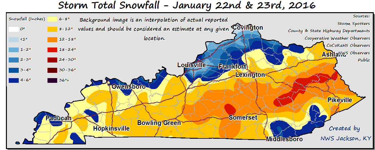 Mobile
By Saturday night, the Commonwealth became under the influence of high pressure. With
the snowpack in place and winds slackening, temperatures dropped into the single
digits and even below zero for several locations. The lowest temperature was seen in
Richmond with a reading of -9. Winds transitioned to the south by Sunday and helped
temperatures sneak back into the 30s. Overall, the state saw below normal temperatures
for a second straight week.
Temperatures for the period averaged 21 degrees across the state which was 12 degrees
cooler than normal and 12 degrees cooler than the previous period. High temperatures
averaged from 29 in the West to 27 in the East. Departure from normal high
temperatures ranged from 14 degrees cooler than normal in the West to 16 degrees
cooler than normal in the East. Low temperatures averaged from 17 degrees in the West
to 14 degrees in the East. Departure from normal low temperature ranged from 8
degrees cooler than normal in the West to 8 degrees cooler than normal in the East.
The extreme high temperature for the period was 42 degrees at CARBONDALE ASOS and the
extreme low was -9 degrees at RICHMOND 8E.
Precipitation (liq. equ.) for the period totaled 0.92 inches statewide which was 0.1
inches above normal and 112% of normal. Precipitation totals by climate division,
West 0.58 inches, Central 1.59 inches, Bluegrass 0.50 inches and East 1.01 inches,
which was -0.29, 0.72, -0.21 and 0.18 inches respectively from normal. By station,
precipitation totals ranged from a low of 0.06 inches at TRIANGLE MOUNTAIN to a
high of 6.26 inches at BOWLING GREEN 5S.
---
Kentucky Climate Summary
For the Period January 11, 2015 to January 17, 2016
Below Normal Temperatures and Precipitation:
Up until this past week, the winter had followed a rather warm trend with 12 straight
weeks of near to above normal temperatures, dating back to October. That streak came
to an end this past week, behind the passage of a few cold fronts. The first boundary
swept through the area on Tuesday. 1 to 2 inches of snowfall was seen across much of
the Northern Bluegrass, before diminishing across the remainder of the state. Skies
cleared later in the day, setting up a very cold overnight. Most reach the single
digits to lower teens by Wednesday morning, along with some locations seeing wind
chills go below zero. Rain showers returned on Friday along another cold front. After
a mild end to the work week, highs Saturday only rose into the 30s. The third and
final frontal passage occurred on Sunday. Not much in the way of precipitation was
seen, but Arctic air starting sinking into the region later in the day. Overall, the
state saw temperatures slightly below normal for the week.
Temperatures for the period averaged 32 degrees across the state which was 1 degree
cooler than normal and 4 degrees cooler than the previous period. High temperatures
averaged from 43 in the West to 41 in the East. Departure from normal high
temperatures ranged from near normal in the West to 3 degrees cooler than normal in
the East. Low temperatures averaged from 26 degrees in the West to 25 degrees in the
East. Departure from normal low temperature ranged from 1 degree warmer than normal
in the West to 2 degrees warmer than normal in the East. The extreme high temperature
for the period was 62 degrees at POPLAR BLUFF ASOS and the extreme low was 2 degrees
at BRANDENBURG 4SW.
Precipitation (liq. equ.) for the period totaled 0.18 inches statewide which was 0.68
inches below normal and 21% of normal. Precipitation totals by climate division, West
0.18 inches, Central 0.21 inches, Bluegrass 0.15 inches and East 0.18 inches, which
was 0.72, 0.7, 0.59 and 0.71 inches below normal. By station, precipitation totals
ranged from a low of 0.02 inches at CARBONDALE ASOS to a high of 0.50 inches at
FRANKLIN 4SW.
---
Kentucky Climate Summary
For the Period January 4, 2015 to January 10, 2016
Above Normal Temperatures and Below Normal Rainfall:
After seeing the warmest December on record, Kentucky caught a first glimpse of
winter this past period. The Bluegrass State started the week on the cold side with
highs on Monday only in the 30s. Lows that night dropped into the mid-teens to around
20, along with winds chills dropping into the single digits for some spots. This
pushed the livestock cold stress index into the danger/emergency categories for a
short period of time. Similar conditions were felt on Tuesday, before high pressure
shifted to the east and transitioned winds to the south by Wednesday. Highs rose back
into the 50s by Friday. The state saw a couple rounds of showers with the first
coming Thursday night and into Friday as a warm front lifted through the area. Most
saw under a quarter inch. Another surface low pushed through the Lower Ohio Valley
Saturday and Sunday. Rain showers were widespread in nature through Saturday. A
cold front then moved through Kentucky that night and into Sunday, transitioning
precipitation to snow. The highest accumulations were found right along the Ohio
River from around Paducah to Louisville with 1 to 3 inches. Much of the rest of the
state stayed under an inch.
Temperatures for the period averaged 37 degrees across the state which was 4 degrees
warmer than normal and 6 degrees cooler than the previous period. High temperatures
averaged from 44 in the West to 47 in the East. Departure from normal high
temperatures ranged from 1 degree warmer than normal in the West to 3 degrees
warmer than normal in the East. Low temperatures averaged from 29 degrees in the
West to 27 degrees in the East. Departure from normal low temperature ranged from 3
degrees warmer than normal in the West to 3 degrees warmer than normal in the East.
The extreme high temperature for the period was 60 degrees at HINDMAN 5N and the
extreme low was 10 degrees at PIKEVILLE 13S.
Precipitation (liq. equ.) for the period totaled 0.79 inches statewide which was 0.09
inches below normal and 89% of normal. Precipitation totals by climate division, West
1.44 inches, Central 0.40 inches, Bluegrass 0.67 inches and East 0.67 inches, which
was 0.51, -0.55, -0.08 and -0.24 inches respectively from normal. By station,
precipitation totals ranged from a low of 0.17 inches at BOWLING GREEN 5S to a high
of 9.49 inches at EVANSVILLE ASOS.
---
Kentucky Climate Summary
For the Period December 28, 2015 to January 3, 2016
Above Normal Temperatures and Much Above Normal Rainfall:
After seeing 3 to 5 inches the week before, another line of showers and storms moved
through the area on Monday. Flash flooding issues arose, along with some minor
flooding along rivers. The good news was that the remainder of 2015 and start of
2016 saw minimal in the way of new accumulations. Temperatures remained above normal
for most of the period, but much cooler than what was seen the previous week. The one
exception came New Year’s Eve and Day with highs in the mid 30s to low 40s. These
readings were actually slightly below normal, something the state had not seen in
quite awhile. Saying this, it was still not enough to break the warm trend. The
state has now gone 11 straight weeks of seeing near to above normal temperatures,
dating back to late October.
Temperatures for the period averaged 42 degrees across the state which was 8 degrees
warmer than normal and 16 degrees cooler than the previous period. High temperatures
averaged from 47 in the West to 52 in the East. Departure from normal high
temperatures ranged from 3 degrees warmer than normal in the West to 8 degrees
warmer than normal in the East. Low temperatures averaged from 34 degrees in the
West to 36 degrees in the East. Departure from normal low temperature ranged from 8
degrees warmer than normal in the West to 11 degrees warmer than normal in the
East. The extreme high temperature for the period was 75 degrees at WHITESBURG 2NW
and the extreme low was 18 degrees at BARBOURVILLE 3E.
Precipitation (liq. equ.) for the period totaled 0.78 inches statewide which was 0.13
inches below normal and 85% of normal. Precipitation totals by climate division, West
1.69 inches, Central 0.55 inches, Bluegrass 0.58 inches and East 0.29 inches, which
was 0.74, -0.44, -0.22 and -0.62 inches respectively from normal. By station,
precipitation totals ranged from a low of 0.00 inches at BRANDENBURG 4SW to a high of
3.14 inches at POPLAR BLUFF ASOS.
Mobile
By Saturday night, the Commonwealth became under the influence of high pressure. With
the snowpack in place and winds slackening, temperatures dropped into the single
digits and even below zero for several locations. The lowest temperature was seen in
Richmond with a reading of -9. Winds transitioned to the south by Sunday and helped
temperatures sneak back into the 30s. Overall, the state saw below normal temperatures
for a second straight week.
Temperatures for the period averaged 21 degrees across the state which was 12 degrees
cooler than normal and 12 degrees cooler than the previous period. High temperatures
averaged from 29 in the West to 27 in the East. Departure from normal high
temperatures ranged from 14 degrees cooler than normal in the West to 16 degrees
cooler than normal in the East. Low temperatures averaged from 17 degrees in the West
to 14 degrees in the East. Departure from normal low temperature ranged from 8
degrees cooler than normal in the West to 8 degrees cooler than normal in the East.
The extreme high temperature for the period was 42 degrees at CARBONDALE ASOS and the
extreme low was -9 degrees at RICHMOND 8E.
Precipitation (liq. equ.) for the period totaled 0.92 inches statewide which was 0.1
inches above normal and 112% of normal. Precipitation totals by climate division,
West 0.58 inches, Central 1.59 inches, Bluegrass 0.50 inches and East 1.01 inches,
which was -0.29, 0.72, -0.21 and 0.18 inches respectively from normal. By station,
precipitation totals ranged from a low of 0.06 inches at TRIANGLE MOUNTAIN to a
high of 6.26 inches at BOWLING GREEN 5S.
---
Kentucky Climate Summary
For the Period January 11, 2015 to January 17, 2016
Below Normal Temperatures and Precipitation:
Up until this past week, the winter had followed a rather warm trend with 12 straight
weeks of near to above normal temperatures, dating back to October. That streak came
to an end this past week, behind the passage of a few cold fronts. The first boundary
swept through the area on Tuesday. 1 to 2 inches of snowfall was seen across much of
the Northern Bluegrass, before diminishing across the remainder of the state. Skies
cleared later in the day, setting up a very cold overnight. Most reach the single
digits to lower teens by Wednesday morning, along with some locations seeing wind
chills go below zero. Rain showers returned on Friday along another cold front. After
a mild end to the work week, highs Saturday only rose into the 30s. The third and
final frontal passage occurred on Sunday. Not much in the way of precipitation was
seen, but Arctic air starting sinking into the region later in the day. Overall, the
state saw temperatures slightly below normal for the week.
Temperatures for the period averaged 32 degrees across the state which was 1 degree
cooler than normal and 4 degrees cooler than the previous period. High temperatures
averaged from 43 in the West to 41 in the East. Departure from normal high
temperatures ranged from near normal in the West to 3 degrees cooler than normal in
the East. Low temperatures averaged from 26 degrees in the West to 25 degrees in the
East. Departure from normal low temperature ranged from 1 degree warmer than normal
in the West to 2 degrees warmer than normal in the East. The extreme high temperature
for the period was 62 degrees at POPLAR BLUFF ASOS and the extreme low was 2 degrees
at BRANDENBURG 4SW.
Precipitation (liq. equ.) for the period totaled 0.18 inches statewide which was 0.68
inches below normal and 21% of normal. Precipitation totals by climate division, West
0.18 inches, Central 0.21 inches, Bluegrass 0.15 inches and East 0.18 inches, which
was 0.72, 0.7, 0.59 and 0.71 inches below normal. By station, precipitation totals
ranged from a low of 0.02 inches at CARBONDALE ASOS to a high of 0.50 inches at
FRANKLIN 4SW.
---
Kentucky Climate Summary
For the Period January 4, 2015 to January 10, 2016
Above Normal Temperatures and Below Normal Rainfall:
After seeing the warmest December on record, Kentucky caught a first glimpse of
winter this past period. The Bluegrass State started the week on the cold side with
highs on Monday only in the 30s. Lows that night dropped into the mid-teens to around
20, along with winds chills dropping into the single digits for some spots. This
pushed the livestock cold stress index into the danger/emergency categories for a
short period of time. Similar conditions were felt on Tuesday, before high pressure
shifted to the east and transitioned winds to the south by Wednesday. Highs rose back
into the 50s by Friday. The state saw a couple rounds of showers with the first
coming Thursday night and into Friday as a warm front lifted through the area. Most
saw under a quarter inch. Another surface low pushed through the Lower Ohio Valley
Saturday and Sunday. Rain showers were widespread in nature through Saturday. A
cold front then moved through Kentucky that night and into Sunday, transitioning
precipitation to snow. The highest accumulations were found right along the Ohio
River from around Paducah to Louisville with 1 to 3 inches. Much of the rest of the
state stayed under an inch.
Temperatures for the period averaged 37 degrees across the state which was 4 degrees
warmer than normal and 6 degrees cooler than the previous period. High temperatures
averaged from 44 in the West to 47 in the East. Departure from normal high
temperatures ranged from 1 degree warmer than normal in the West to 3 degrees
warmer than normal in the East. Low temperatures averaged from 29 degrees in the
West to 27 degrees in the East. Departure from normal low temperature ranged from 3
degrees warmer than normal in the West to 3 degrees warmer than normal in the East.
The extreme high temperature for the period was 60 degrees at HINDMAN 5N and the
extreme low was 10 degrees at PIKEVILLE 13S.
Precipitation (liq. equ.) for the period totaled 0.79 inches statewide which was 0.09
inches below normal and 89% of normal. Precipitation totals by climate division, West
1.44 inches, Central 0.40 inches, Bluegrass 0.67 inches and East 0.67 inches, which
was 0.51, -0.55, -0.08 and -0.24 inches respectively from normal. By station,
precipitation totals ranged from a low of 0.17 inches at BOWLING GREEN 5S to a high
of 9.49 inches at EVANSVILLE ASOS.
---
Kentucky Climate Summary
For the Period December 28, 2015 to January 3, 2016
Above Normal Temperatures and Much Above Normal Rainfall:
After seeing 3 to 5 inches the week before, another line of showers and storms moved
through the area on Monday. Flash flooding issues arose, along with some minor
flooding along rivers. The good news was that the remainder of 2015 and start of
2016 saw minimal in the way of new accumulations. Temperatures remained above normal
for most of the period, but much cooler than what was seen the previous week. The one
exception came New Year’s Eve and Day with highs in the mid 30s to low 40s. These
readings were actually slightly below normal, something the state had not seen in
quite awhile. Saying this, it was still not enough to break the warm trend. The
state has now gone 11 straight weeks of seeing near to above normal temperatures,
dating back to late October.
Temperatures for the period averaged 42 degrees across the state which was 8 degrees
warmer than normal and 16 degrees cooler than the previous period. High temperatures
averaged from 47 in the West to 52 in the East. Departure from normal high
temperatures ranged from 3 degrees warmer than normal in the West to 8 degrees
warmer than normal in the East. Low temperatures averaged from 34 degrees in the
West to 36 degrees in the East. Departure from normal low temperature ranged from 8
degrees warmer than normal in the West to 11 degrees warmer than normal in the
East. The extreme high temperature for the period was 75 degrees at WHITESBURG 2NW
and the extreme low was 18 degrees at BARBOURVILLE 3E.
Precipitation (liq. equ.) for the period totaled 0.78 inches statewide which was 0.13
inches below normal and 85% of normal. Precipitation totals by climate division, West
1.69 inches, Central 0.55 inches, Bluegrass 0.58 inches and East 0.29 inches, which
was 0.74, -0.44, -0.22 and -0.62 inches respectively from normal. By station,
precipitation totals ranged from a low of 0.00 inches at BRANDENBURG 4SW to a high of
3.14 inches at POPLAR BLUFF ASOS.