KENTUCKY CROP AND WEATHER REPORT--USDA
Listed below are the current USDA Crop & Weather Report/Kentucky Climate Summary
AND, in addition, previous week's reports for this year. The reports are
produced in a joint effort by the UK Ag. Weather Center, Cooperative Extension
Service County Agents, Farmers across the state, Kentucky Department of
Agriculture, and the US Department of Agriculture, National Agricultural
Statistics Service. Click here for the PDF version.
---
Kentucky Climate Summary
For the Period December 28, 2015 to January 3, 2016
Above Normal Temperatures and Much Above Normal Rainfall:
After seeing 3 to 5 inches the week before, another line of showers and storms moved
through the area on Monday. Flash flooding issues arose, along with some minor
flooding along rivers. The good news was that the remainder of 2015 and start of
2016 saw minimal in the way of new accumulations. Temperatures remained above normal
for most of the period, but much cooler than what was seen the previous week. The one
exception came New Year's Eve and Day with highs in the mid 30s to low 40s. These
readings were actually slightly below normal, something the state had not seen in
quite awhile. Saying this, it was still not enough to break the warm trend. The
state has now gone 11 straight weeks of seeing near to above normal temperatures,
dating back to late October.
Temperatures for the period averaged 42 degrees across the state which was 8 degrees
warmer than normal and 16 degrees cooler than the previous period. High temperatures
averaged from 47 in the West to 52 in the East. Departure from normal high
temperatures ranged from 3 degrees warmer than normal in the West to 8 degrees
warmer than normal in the East. Low temperatures averaged from 34 degrees in the
West to 36 degrees in the East. Departure from normal low temperature ranged from 8
degrees warmer than normal in the West to 11 degrees warmer than normal in the
East. The extreme high temperature for the period was 75 degrees at WHITESBURG 2NW
and the extreme low was 18 degrees at BARBOURVILLE 3E.
Precipitation (liq. equ.) for the period totaled 0.78 inches statewide which was 0.13
inches below normal and 85% of normal. Precipitation totals by climate division, West
1.69 inches, Central 0.55 inches, Bluegrass 0.58 inches and East 0.29 inches, which
was 0.74, -0.44, -0.22 and -0.62 inches respectively from normal. By station,
precipitation totals ranged from a low of 0.00 inches at BRANDENBURG 4SW to a high of
3.14 inches at POPLAR BLUFF ASOS.
---
Kentucky Climate Summary
For the Period December 21, 2015 to December 27, 2015
Well Above Normal Temperatures and Rainfall:
A very unusual weather pattern set up this past period across the Commonwealth,
bringing record-breaking temperatures and excessive rainfall to the Bluegrass State.
Taking a look at precipitation first, Kentucky saw numerous systems pass through the
area over the period, amounting to a state average of 3.56 inches. This was the
highest weekly average that the state had seen all year and was more than 2.5 inches
above normal. The most significant event occurred late on Wednesday and into the
overnight as a cold front swept through the area. A line of strong to severe storms
developed along the boundary, leading to a cold season severe weather event with
damaging winds as the main hazard. This was followed by a wet Christmas and holiday
weekend as multiple disturbances pushed through the Lower Ohio Valley. Periods of
moderate to heavy rain led to some water issues with saturated ground causing some
flooding in low lying areas. The wet weather was accompanied by very warm
temperatures for late December. The winter solstice occurred Monday night, but it
felt as though the calendar was turned back a couple months. High temperatures
consistently stayed in the 50s and 60s, even hitting the 70s on a couple occasions.
For the week, Kentucky saw average highs that were nearly 20 degrees above normal and
lows around 25 degrees above normal.
Temperatures for the period averaged 58 degrees across the state which was 22 degrees
warmer than normal and 14 degrees warmer than the previous period. High temperatures
averaged from 64 in the West to 66 in the East. Departure from normal high
temperatures ranged from 19 degrees warmer than normal in the West to 20 degrees
warmer than normal in the East. Low temperatures averaged from 49 degrees in the
West to 53 degrees in the East. Departure from normal low temperature ranged from 21
degrees warmer than normal in the West to 27 degrees warmer than normal in the
East. The extreme high temperature for the period was 78 degrees at BOONEVILLE 2S and
the extreme low was 31 degrees at PAINTSVILLE 4W.
Precipitation (liq. equ.) for the period totaled 3.56 inches statewide which was 2.62
inches above normal and 377% of normal. Precipitation totals by climate division,
West 4.13 inches, Central 3.84 inches, Bluegrass 3.98 inches and East 2.30 inches,
which was 3.12, 2.81, 3.15 and 1.39 inches above normal. By station, precipitation
totals ranged from a low of 0.73 inches at BRANDENBURG 4SW to a high of 6.52
inches at BENTON 4N.
---
Kentucky Climate Summary
For the Period December 14, 2015 to December 20, 2015
Above Normal Temperatures and Below Normal Rainfall:
The warm end to 2015 continued this past week as temperatures early in the period
topped out in the 50s and 60s. The Commonwealth has now gone 9 straight weeks with
near to above normal temperatures. Even when the state saw some cooler highs on
Friday and Saturday, in the upper 30s to middle 40s, it was still only slightly below
normal for this time of year. Looking at precipitation, the state averaged about
three quarters of an inch for the week behind a couple shields of rainfall moving
through the area. The more significant of the two came early on Monday.
Accompanying this band was very breezy conditions. A Wind Advisory was issued for
much of the state with many seeing winds gusts in excess of 40 mph.
Temperatures for the period averaged 44 degrees across the state which was 6 degrees
warmer than normal and 10 degrees cooler than the previous period. High temperatures
averaged from 53 in the West to 54 in the East. Departure from normal high
temperatures ranged from 6 degrees warmer than normal in the West to 6 degrees
warmer than normal in the East. Low temperatures averaged from 36 degrees in the
West to 36 degrees in the East. Departure from normal low temperature ranged from 7
degrees warmer than normal in the West to 9 degrees warmer than normal in the East.
The extreme high temperature for the period was 74 degrees at WHITESBURG 2NW and the
extreme low was 18 degrees at BARBOURVILLE 3E.
Precipitation (liq. equ.) for the period totaled 0.72 inches statewide which was 0.26
inches below normal and 74% of normal. Precipitation totals by climate division, West
0.59 inches, Central 0.72 inches, Bluegrass 0.61 inches and East 0.96 inches, which
was -0.48, -0.35, -0.23 and 0.03 inches respectively from normal. By station,
precipitation totals ranged from a low of 0.01 inches at BRANDENBURG 4SW to a high of
1.41 inches at YELLOW CREEK.
---
Kentucky Climate Summary
For the Period December 7, 2015 to December 13, 2015
Well Above Normal Temperatures and Much Below Normal Rainfall:
Stepping outside this past week, it was definitely not the typical weather conditions
that would be seen in December. Warm temperatures were present for nearly the entire
period. After starting the week in the upper 40s to middle 50s, temperatures climbed
into the upper 60s to middle 70s over the weekend behind a warm front. These
readings were roughly 20 to 25 degrees above normal and broke records across the
state. Looking at the week as a whole, temperatures were on average, 15 degrees above
normal across the state. The last time Kentucky had a deviation this high in
December was back in 2012. Looking at precipitation, it was a very dry week with most
disturbances only resulting in very light showers or a drizzle. Kentucky only
averaged 0.04 inches for the period.
Temperatures for the period averaged 54 degrees across the state which was 15 degrees
warmer than normal and 12 degrees warmer than the previous period. High temperatures
averaged from 64 in the West to 62 in the East. Departure from normal high
temperatures ranged from 15 degrees warmer than normal in the West to 12 degrees
warmer than normal in the East. Low temperatures averaged from 47 degrees in the
West to 44 degrees in the East. Departure from normal low temperature ranged from 16
degrees warmer than normal in the West to 16 degrees warmer than normal in the
East. The extreme high temperature for the period was 75 degrees at WHITESBURG 2NW
and the extreme low was 25 degrees at BRANDENBURG 4SW.
Precipitation (liq. equ.) for the period totaled 0.04 inches statewide which was 1.02
inches below normal and 4% of normal. Precipitation totals by climate division, West
0.01 inches, Central 0.01 inches, Bluegrass 0.06 inches and East 0.08 inches, which
was 1.15, 1.14, 0.87 and 0.92 inches below normal. By station, precipitation totals
ranged from a low of 0.00 inches at ALBANY 1N to a high of 0.33 inches at MOREHEAD 4NE.
---
Kentucky Climate Summary
For the Period November 30, 2015 to December 6, 2015
Above Normal Temperatures and Rainfall:
The month of December started with an active pattern in place. The Commonwealth saw
periods of widespread light to moderate rain showers on Monday and Tuesday as a
couple frontal boundaries pushed through the area. Overall, the state averaged over
an inch and a half for the event, enough to push Kentucky to a third straight week of
above normal precipitation. Drier conditions then pushed into Kentucky for the
remainder of the week as high pressure took control. The main focus during this
period was fog formation each morning. Fog became dense and widespread for some,
especially across Northern Kentucky. After seeing highs drop into the mid 40s to
around 50 on Wednesday, temperatures rose into the low to mid 50s over the weekend.
Overall, temperatures were slightly above normal for the week. This led to a seventh
straight period of near to above normal temperatures.
Temperatures for the period averaged 43 degrees across the state which was 1 degree
warmer than normal and 6 degrees cooler than the previous period. High temperatures
averaged from 52 in the West to 53 in the East. Departure from normal high
temperatures ranged from near normal in the West to 1 degree warmer than normal in
the East. Low temperatures averaged from 33 degrees in the West to 36 degrees in the
East. Departure from normal low temperature ranged from 1 degree cooler than normal
in the West to 6 degrees warmer than normal in the East. The extreme high temperature
for the period was 67 degrees at WHITESBURG 2NW and the extreme low was 19 degrees
at BOONEVILLE 2S.
Precipitation (liq. equ.) for the period totaled 1.59 inches statewide which was 0.5
inches above normal and 146% of normal. Precipitation totals by climate division,
West 0.71 inches, Central 1.74 inches, Bluegrass 1.39 inches and East 2.51 inches,
which was -0.55, 0.57, 0.47 and 1.49 inches respectively from normal. By station,
precipitation totals ranged from a low of 0.08 inches at CAPE GIRARDEAU ASOS to a
high of 3.40 inches at YELLOW CREEK.
---
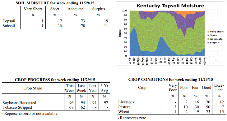
Kentucky Crop and Weather Report
Issued 4:00 P.M., November 30, 2015 39-15
Agricultural News: Kentucky experienced above normal temperatures and rainfall over
the past week. Precipitation for the week totaled 1.15 inches, 0.10 inches above
normal. Temperatures averaged 50 degrees for the week, 6 degrees above normal.
Topsoil moisture was rated 1 percent very short, 7 percent short, 73 percent adequate
and 19 percent surplus. Subsoil moisture was rated 1 percent very short, 10 percent
short, 78 percent adequate, and 11 percent surplus. Days suitable for fieldwork
averaged 4.0 out of a possible seven. Many producers have completed their grain
harvest. However, there were a few fields remaining to be harvested in some
locations. Tobacco stripping continues to progress well. Pastures are holding steady
at mostly good to fair condition. Livestock are reported to be in mostly good
condition with fall breeding taking place. Hay and roughage supplies were reported as
1 percent very short, 8 percent short, 82 percent adequate, and 9 percent surplus.
 Kentucky Climate Summary
For the Period November 23, 2015 to November 29, 2015
Above Normal Temperatures and Rainfall:
This past work week started off with very cold temperatures carrying over from the
previous weekend. The majority of the state woke up to readings in the upper teens
to low 20s on Monday morning, roughly 15 to 20 degrees below normal for this time of
the year. The good news is that a warming trend then followed through the
Thanksgiving holiday. By Thursday, temperatures were peaking in the mid 60s to
around 70 behind breezy southerly flow. After a dry week, a cold front slowly worked
through the area over the weekend. A plume of moisture led to periods of widespread
rainfall. Overall, totals diminished farther east. Western Kentucky averaged over 2
inches of rainfall, while much of the eastern half of the state only saw a little
over a half inch.
Temperatures for the period averaged 50 degrees across the state which was 6 degrees
warmer than normal and 2 degrees warmer than the previous period. High temperatures
averaged from 59 in the West to 61 in the East. Departure from normal high
temperatures ranged from 4 degrees warmer than normal in the West to 7 degrees
warmer than normal in the East. Low temperatures averaged from 42 degrees in the
West to 38 degrees in the East. Departure from normal low temperature ranged from 7
degrees warmer than normal in the West to 6 degrees warmer than normal in the East.
The extreme high temperature for the period was 72 degrees at JACKSON AIRPORT and the
extreme low was 15 degrees at BOONEVILLE 2S.
Precipitation (liq. equ.) for the period totaled 1.15 inches statewide which was 0.1
inches above normal and 110% of normal. Precipitation totals by climate division,
West 2.23 inches, Central 1.12 inches, Bluegrass 0.64 inches and East 0.61 inches,
which was 1.02, 0.01, -0.25 and -0.36 inches respectively from normal. By station,
precipitation totals ranged from a low of 0.35 inches at BIG SANDY to a high of 4.49
inches at HICKMAN 2E.
---
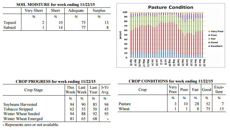
Kentucky Crop and Weather Report
Issued 4:00 P.M., November 23, 2015 38-15
Agricultural News: Kentucky experienced above normal temperatures and precipitation
over the past week. Precipitation for the week totaled 1.68 inches, 0.70 inches above
normal. Temperatures averaged 49 degrees for the week, 3 degrees above normal.
Topsoil moisture was rated 2 percent very short, 10 percent short, 75 percent
adequate and 13 percent surplus. Subsoil moisture was rated 1 percent very short, 14
percent short, 77 percent adequate, and 8 percent surplus. Days suitable for
fieldwork averaged 4.1 out of a possible seven. Grain harvest is winding down with
unharvested corn and soybean fields in need of dry conditions or frozen ground to
allow combines to get back in fields. Tobacco stripping is progressing well with some
reports of fat stems. Pastures are holding steady at mostly good to fair condition.
Kentucky Climate Summary
For the Period November 23, 2015 to November 29, 2015
Above Normal Temperatures and Rainfall:
This past work week started off with very cold temperatures carrying over from the
previous weekend. The majority of the state woke up to readings in the upper teens
to low 20s on Monday morning, roughly 15 to 20 degrees below normal for this time of
the year. The good news is that a warming trend then followed through the
Thanksgiving holiday. By Thursday, temperatures were peaking in the mid 60s to
around 70 behind breezy southerly flow. After a dry week, a cold front slowly worked
through the area over the weekend. A plume of moisture led to periods of widespread
rainfall. Overall, totals diminished farther east. Western Kentucky averaged over 2
inches of rainfall, while much of the eastern half of the state only saw a little
over a half inch.
Temperatures for the period averaged 50 degrees across the state which was 6 degrees
warmer than normal and 2 degrees warmer than the previous period. High temperatures
averaged from 59 in the West to 61 in the East. Departure from normal high
temperatures ranged from 4 degrees warmer than normal in the West to 7 degrees
warmer than normal in the East. Low temperatures averaged from 42 degrees in the
West to 38 degrees in the East. Departure from normal low temperature ranged from 7
degrees warmer than normal in the West to 6 degrees warmer than normal in the East.
The extreme high temperature for the period was 72 degrees at JACKSON AIRPORT and the
extreme low was 15 degrees at BOONEVILLE 2S.
Precipitation (liq. equ.) for the period totaled 1.15 inches statewide which was 0.1
inches above normal and 110% of normal. Precipitation totals by climate division,
West 2.23 inches, Central 1.12 inches, Bluegrass 0.64 inches and East 0.61 inches,
which was 1.02, 0.01, -0.25 and -0.36 inches respectively from normal. By station,
precipitation totals ranged from a low of 0.35 inches at BIG SANDY to a high of 4.49
inches at HICKMAN 2E.
---
Kentucky Crop and Weather Report
Issued 4:00 P.M., November 23, 2015 38-15
Agricultural News: Kentucky experienced above normal temperatures and precipitation
over the past week. Precipitation for the week totaled 1.68 inches, 0.70 inches above
normal. Temperatures averaged 49 degrees for the week, 3 degrees above normal.
Topsoil moisture was rated 2 percent very short, 10 percent short, 75 percent
adequate and 13 percent surplus. Subsoil moisture was rated 1 percent very short, 14
percent short, 77 percent adequate, and 8 percent surplus. Days suitable for
fieldwork averaged 4.1 out of a possible seven. Grain harvest is winding down with
unharvested corn and soybean fields in need of dry conditions or frozen ground to
allow combines to get back in fields. Tobacco stripping is progressing well with some
reports of fat stems. Pastures are holding steady at mostly good to fair condition.
 Kentucky Climate Summary
For the Period November 16, 2015 to November 22, 2015
Above Normal Temperatures and Precipitation:
A couple cold fronts this past week led to above normal precipitation for much of the
Bluegrass State, in addition to some of the coldest temperatures of the fall season.
After some light rain to start the week, a plume of moisture ahead of a cold front on
Wednesday led to widespread light to moderate rainfall across the area. This plume
slowly shifted east through the day with totals ranging between 1 and 2 inches for
much of Kentucky. After a brief period of dry conditions to end the work week,
another cold front pushed through the area on Saturday. This boundary once again
sparked scattered to numerous showers across the Bluegrass State. While totals were
not as significant, this system sent temperatures plummeting and led to the first
snow showers of the season for some areas. Lows on Saturday night dipped into the
20s, while highs on Sunday did not get out of the 30s.
Temperatures for the period averaged 49 degrees across the state which was 3 degrees
warmer than normal and no change to the previous period. High temperatures averaged
from 57 in the West to 59 in the East. Departure from normal high temperatures ranged
from near normal in the West to 2 degrees warmer than normal in the East. Low
temperatures averaged from 41 degrees in the West to 40 degrees in the East.
Departure from normal low temperature ranged from 4 degrees warmer than normal in the
West to 7 degrees warmer than normal in the East. The extreme high temperature for
the period was 74 degrees at PADUCAH ASOS and the extreme low was 19 degrees at
MADISONVILLE 4S.
Precipitation (liq. equ.) for the period totaled 1.68 inches statewide which was 0.7
inches above normal and 172% of normal. Precipitation totals by climate division,
West 2.91 inches, Central 1.90 inches, Bluegrass 1.15 inches and East 0.74 inches,
which was 1.78, 0.86, 0.30 and -0.15 inches respectively from normal. By station,
precipitation totals ranged from a low of 0.27 inches at LOUISA 1S to a high of 5.58
inches at POPLAR BLUFF ASOS.
---
Kentucky Crop and Weather Report
Issued 4:00 P.M., November 16, 2015 37-15
Agricultural News: Kentucky experienced near normal temperatures and below normal
rainfall over the past week. Precipitation for the week totaled 0.32 inches, 0.53
inches below normal. Temperatures averaged 49 degrees for the week, near normal.
Topsoil moisture was rated 2 percent very short, 12 percent short, 78 percent
adequate and 8 percent surplus. Subsoil moisture was rated 2 percent very short, 16
percent short, 78 percent adequate, and 4 percent surplus. Days suitable for
fieldwork averaged 4.9 out of a possible seven. Grain harvest is winding down in many
locations. Primary activities this week included harvesting corn and soybeans, sowing
wheat and stripping tobacco when conditions allowed. Pastures are in mostly good to
fair condition. Cattle producers continued weaning calves and many have begun feeding
hay.
Kentucky Climate Summary
For the Period November 16, 2015 to November 22, 2015
Above Normal Temperatures and Precipitation:
A couple cold fronts this past week led to above normal precipitation for much of the
Bluegrass State, in addition to some of the coldest temperatures of the fall season.
After some light rain to start the week, a plume of moisture ahead of a cold front on
Wednesday led to widespread light to moderate rainfall across the area. This plume
slowly shifted east through the day with totals ranging between 1 and 2 inches for
much of Kentucky. After a brief period of dry conditions to end the work week,
another cold front pushed through the area on Saturday. This boundary once again
sparked scattered to numerous showers across the Bluegrass State. While totals were
not as significant, this system sent temperatures plummeting and led to the first
snow showers of the season for some areas. Lows on Saturday night dipped into the
20s, while highs on Sunday did not get out of the 30s.
Temperatures for the period averaged 49 degrees across the state which was 3 degrees
warmer than normal and no change to the previous period. High temperatures averaged
from 57 in the West to 59 in the East. Departure from normal high temperatures ranged
from near normal in the West to 2 degrees warmer than normal in the East. Low
temperatures averaged from 41 degrees in the West to 40 degrees in the East.
Departure from normal low temperature ranged from 4 degrees warmer than normal in the
West to 7 degrees warmer than normal in the East. The extreme high temperature for
the period was 74 degrees at PADUCAH ASOS and the extreme low was 19 degrees at
MADISONVILLE 4S.
Precipitation (liq. equ.) for the period totaled 1.68 inches statewide which was 0.7
inches above normal and 172% of normal. Precipitation totals by climate division,
West 2.91 inches, Central 1.90 inches, Bluegrass 1.15 inches and East 0.74 inches,
which was 1.78, 0.86, 0.30 and -0.15 inches respectively from normal. By station,
precipitation totals ranged from a low of 0.27 inches at LOUISA 1S to a high of 5.58
inches at POPLAR BLUFF ASOS.
---
Kentucky Crop and Weather Report
Issued 4:00 P.M., November 16, 2015 37-15
Agricultural News: Kentucky experienced near normal temperatures and below normal
rainfall over the past week. Precipitation for the week totaled 0.32 inches, 0.53
inches below normal. Temperatures averaged 49 degrees for the week, near normal.
Topsoil moisture was rated 2 percent very short, 12 percent short, 78 percent
adequate and 8 percent surplus. Subsoil moisture was rated 2 percent very short, 16
percent short, 78 percent adequate, and 4 percent surplus. Days suitable for
fieldwork averaged 4.9 out of a possible seven. Grain harvest is winding down in many
locations. Primary activities this week included harvesting corn and soybeans, sowing
wheat and stripping tobacco when conditions allowed. Pastures are in mostly good to
fair condition. Cattle producers continued weaning calves and many have begun feeding
hay.
 Kentucky Climate Summary
For the Period November 9, 2015 to November 15, 2015
Near Normal Temperatures and Below Normal Rainfall:
As harvest began wrapping up, this past week followed an up and down weather pattern.
The start of the period brought a period of light rain Monday and Monday night as an
upper level low pressure system passed through the area. Dry conditions then pushed
into the region temporarily, before eyes turned to a strong cold front late Wednesday
and into Thursday morning. In addition to the Monday system, a couple lines of
showers along and ahead of the boundary resulted in a statewide average just under a
third of an inch for the week. Ahead of the cold front, temperatures peaked in the
60s on Wednesday. Winds then became gusty behind the front on Thursday and Friday
with peak gusts between 25 and 40 mph. Temperatures Friday night dove into the mid
20s to low 30s under mostly clear skies.
Temperatures for the period averaged 49 degrees across the state which was near
normal and 12 degrees cooler than the previous period. High temperatures averaged
from 63 in the West to 59 in the East. Departure from normal high temperatures
ranged from 2 degrees warmer than normal in the West to 1 degree cooler than normal
in the East. Low temperatures averaged from 38 degrees in the West to 38 degrees in
the East. Departure from normal low temperature ranged from 2 degrees cooler than
normal in the West to 3 degrees warmer than normal in the East. The extreme high
temperature for the period was 73 degrees at BENTON 4N and the extreme low was 21
degrees at CYNTHIANA 8N.
Precipitation (liq. equ.) for the period totaled 0.32 inches statewide which was 0.53
inches below normal and 38% of normal. Precipitation totals by climate division, West
0.34 inches, Central 0.50 inches, Bluegrass 0.26 inches and East 0.17 inches, which
was 0.67, 0.39, 0.47 and 0.59 inches below normal. By station, precipitation totals
ranged from a low of 0.03 inches at LONDON to a high of 1.19 inches at BRANDENBURG 4SW.
---
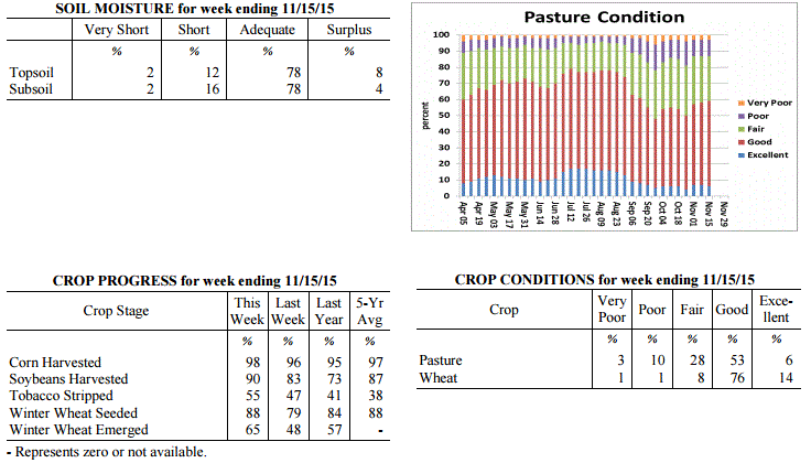
Kentucky Crop and Weather Report
Issued 4:00 P.M., November 9, 2015 36-15
Agricultural News: Kentucky experienced above normal temperatures and below normal
rainfall over the past week. Precipitation for the week totaled 0.59 inches, 0.18
inches below normal. Temperatures averaged 60 degrees for the week, 9 degrees above
normal. Topsoil moisture was rated 3 percent very short, 13 percent short, 74 percent
adequate and 10 percent surplus. Subsoil moisture was rated 2 percent very short, 19
percent short, 75 percent adequate, and 4 percent surplus. Days suitable for
fieldwork averaged 4.5 out of a possible seven. Primary activities this week included
harvesting corn and soybeans, sowing wheat and stripping tobacco when conditions
allowed. Harvest has been slowed in some areas due to wet field conditions. Pasture
conditions remained in mostly good condition. Cattle and calves obtained
approximately 65 percent of feed from pastures, but some hay is being fed.
Kentucky Climate Summary
For the Period November 9, 2015 to November 15, 2015
Near Normal Temperatures and Below Normal Rainfall:
As harvest began wrapping up, this past week followed an up and down weather pattern.
The start of the period brought a period of light rain Monday and Monday night as an
upper level low pressure system passed through the area. Dry conditions then pushed
into the region temporarily, before eyes turned to a strong cold front late Wednesday
and into Thursday morning. In addition to the Monday system, a couple lines of
showers along and ahead of the boundary resulted in a statewide average just under a
third of an inch for the week. Ahead of the cold front, temperatures peaked in the
60s on Wednesday. Winds then became gusty behind the front on Thursday and Friday
with peak gusts between 25 and 40 mph. Temperatures Friday night dove into the mid
20s to low 30s under mostly clear skies.
Temperatures for the period averaged 49 degrees across the state which was near
normal and 12 degrees cooler than the previous period. High temperatures averaged
from 63 in the West to 59 in the East. Departure from normal high temperatures
ranged from 2 degrees warmer than normal in the West to 1 degree cooler than normal
in the East. Low temperatures averaged from 38 degrees in the West to 38 degrees in
the East. Departure from normal low temperature ranged from 2 degrees cooler than
normal in the West to 3 degrees warmer than normal in the East. The extreme high
temperature for the period was 73 degrees at BENTON 4N and the extreme low was 21
degrees at CYNTHIANA 8N.
Precipitation (liq. equ.) for the period totaled 0.32 inches statewide which was 0.53
inches below normal and 38% of normal. Precipitation totals by climate division, West
0.34 inches, Central 0.50 inches, Bluegrass 0.26 inches and East 0.17 inches, which
was 0.67, 0.39, 0.47 and 0.59 inches below normal. By station, precipitation totals
ranged from a low of 0.03 inches at LONDON to a high of 1.19 inches at BRANDENBURG 4SW.
---
Kentucky Crop and Weather Report
Issued 4:00 P.M., November 9, 2015 36-15
Agricultural News: Kentucky experienced above normal temperatures and below normal
rainfall over the past week. Precipitation for the week totaled 0.59 inches, 0.18
inches below normal. Temperatures averaged 60 degrees for the week, 9 degrees above
normal. Topsoil moisture was rated 3 percent very short, 13 percent short, 74 percent
adequate and 10 percent surplus. Subsoil moisture was rated 2 percent very short, 19
percent short, 75 percent adequate, and 4 percent surplus. Days suitable for
fieldwork averaged 4.5 out of a possible seven. Primary activities this week included
harvesting corn and soybeans, sowing wheat and stripping tobacco when conditions
allowed. Harvest has been slowed in some areas due to wet field conditions. Pasture
conditions remained in mostly good condition. Cattle and calves obtained
approximately 65 percent of feed from pastures, but some hay is being fed.
 Kentucky Climate Summary
For the Period November 2, 2015 to November 8, 2015
Much Above Normal Temperatures and Below Normal Rainfall:
Normal high temperatures for the start of November are typically in the low to mid
60s across much of Kentucky. Over this past work week, highs bumped into the 70s
about each day behind a light southerly flow pattern and mostly sunny skies from time
to time. A few locations even jumped into the 80s. The area stayed dry through
Thursday, before a cold front worked through the region that night and into Friday. A
weakening line of widespread showers and some embedded storms were sparked ahead of
the boundary. Rainfall totals were highest along the Ohio River where many saw a half
to one inch plus, before diminishing farther to the southeast. Behind the activity,
dry and much cooler conditions moved into the area for the weekend. After a warm work
week, highs only peaked in the middle 50s to around 60 each day, before falling into
the 30s at night.
Temperatures for the period averaged 60 degrees across the state which was 9 degrees
warmer than normal and 4 degrees warmer than the previous period. High temperatures
averaged from 69 in the West to 70 in the East. Departure from normal high
temperatures ranged from 5 degrees warmer than normal in the West to 7 degrees
warmer than normal in the East. Low temperatures averaged from 52 degrees in the
West to 52 degrees in the East. Departure from normal low temperature ranged from 11
degrees warmer than normal in the West to 15 degrees warmer than normal in the
East. The extreme high temperature for the period was 82 degrees at PEABODY and the
extreme low was 30 degrees at CARBONDALE ASOS.
Precipitation (liq. equ.) for the period totaled 0.59 inches statewide which was 0.18
inches below normal and 77% of normal. Precipitation totals by climate division, West
0.88 inches, Central 0.62 inches, Bluegrass 0.68 inches and East 0.17 inches, which
was 0.02, -0.18, -0.02 and -0.53 inches respectively from normal. By station,
precipitation totals ranged from a low of 0.04 inches at BIG SANDY to a high of 2.03
inches at CAPE GIRARDEAU ASOS.
---
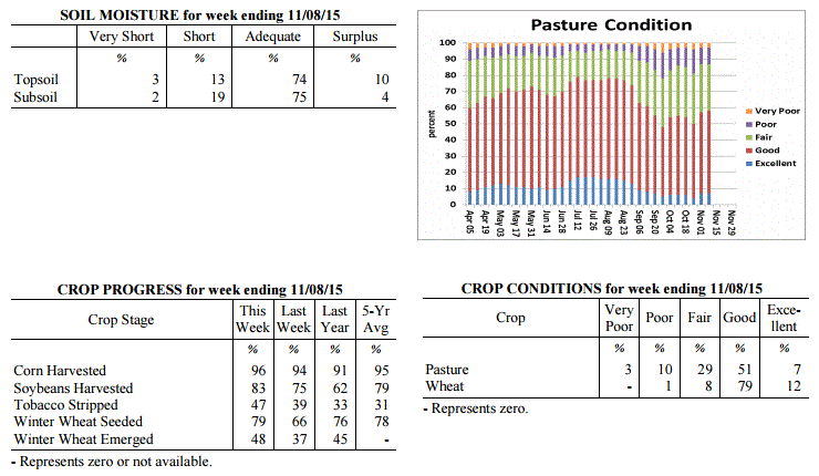
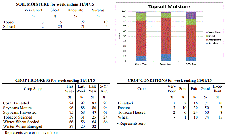
Kentucky Crop and Weather Report
Issued 4:00 P.M., November 2, 2015 35-15
Agricultural News: Kentucky experienced near normal temperatures and above normal
rainfall over the past week. Precipitation for the week totaled 2.09 inches, 1.32
inches above normal. Temperatures averaged 54 degrees for the week, near normal.
Topsoil moisture was rated 3 percent very short, 15 percent short, 72 percent
adequate and 10 percent surplus. Subsoil moisture was rated 2 percent very short, 23
percent short, 71 percent adequate, and 4 percent surplus. Days suitable for
fieldwork averaged 3.5 out of a possible seven. Rain events throughout the week
slowed or stopped harvest. Primary activities this week included harvesting corn and
soybeans, sowing wheat and stripping tobacco when conditions allowed. Pasture
conditions improved due to the rain received. Livestock were rated in mostly
good condition.
Kentucky Climate Summary
For the Period November 2, 2015 to November 8, 2015
Much Above Normal Temperatures and Below Normal Rainfall:
Normal high temperatures for the start of November are typically in the low to mid
60s across much of Kentucky. Over this past work week, highs bumped into the 70s
about each day behind a light southerly flow pattern and mostly sunny skies from time
to time. A few locations even jumped into the 80s. The area stayed dry through
Thursday, before a cold front worked through the region that night and into Friday. A
weakening line of widespread showers and some embedded storms were sparked ahead of
the boundary. Rainfall totals were highest along the Ohio River where many saw a half
to one inch plus, before diminishing farther to the southeast. Behind the activity,
dry and much cooler conditions moved into the area for the weekend. After a warm work
week, highs only peaked in the middle 50s to around 60 each day, before falling into
the 30s at night.
Temperatures for the period averaged 60 degrees across the state which was 9 degrees
warmer than normal and 4 degrees warmer than the previous period. High temperatures
averaged from 69 in the West to 70 in the East. Departure from normal high
temperatures ranged from 5 degrees warmer than normal in the West to 7 degrees
warmer than normal in the East. Low temperatures averaged from 52 degrees in the
West to 52 degrees in the East. Departure from normal low temperature ranged from 11
degrees warmer than normal in the West to 15 degrees warmer than normal in the
East. The extreme high temperature for the period was 82 degrees at PEABODY and the
extreme low was 30 degrees at CARBONDALE ASOS.
Precipitation (liq. equ.) for the period totaled 0.59 inches statewide which was 0.18
inches below normal and 77% of normal. Precipitation totals by climate division, West
0.88 inches, Central 0.62 inches, Bluegrass 0.68 inches and East 0.17 inches, which
was 0.02, -0.18, -0.02 and -0.53 inches respectively from normal. By station,
precipitation totals ranged from a low of 0.04 inches at BIG SANDY to a high of 2.03
inches at CAPE GIRARDEAU ASOS.
---
Kentucky Crop and Weather Report
Issued 4:00 P.M., November 2, 2015 35-15
Agricultural News: Kentucky experienced near normal temperatures and above normal
rainfall over the past week. Precipitation for the week totaled 2.09 inches, 1.32
inches above normal. Temperatures averaged 54 degrees for the week, near normal.
Topsoil moisture was rated 3 percent very short, 15 percent short, 72 percent
adequate and 10 percent surplus. Subsoil moisture was rated 2 percent very short, 23
percent short, 71 percent adequate, and 4 percent surplus. Days suitable for
fieldwork averaged 3.5 out of a possible seven. Rain events throughout the week
slowed or stopped harvest. Primary activities this week included harvesting corn and
soybeans, sowing wheat and stripping tobacco when conditions allowed. Pasture
conditions improved due to the rain received. Livestock were rated in mostly
good condition.
 Kentucky Climate Summary
For the Period October 26, 2015 to November 1, 2015
Near Normal Temperatures and Above Normal Rainfall:
After a fairly dry month, October ended with a wet pattern in place. Through the
first half of the work week, the Commonwealth saw multiple rounds of soaking showers
ahead of a low pressure system to the south. Activity was widespread at times, with
much of the state picking up between 1.5 to 2.5+ inches of rainfall. Dry conditions
returned Thursday and Friday, but only temporarily. Numerous to widespread light
showers returned by the evening of Halloween and pushed through the state overnight.
Many picked up an additional tenth to quarter inch. With the exception of Eastern
Kentucky, the majority of the Bluegrass State averaged over two inches for the week,
which broke a three week streak of below normal rainfall.
Temperatures for the period averaged 54 degrees across the state which was near
normal and 6 degrees cooler than the previous period. High temperatures averaged from
63 in the West to 61 in the East. Departure from normal high temperatures ranged
from 4 degrees cooler than normal in the West to 5 degrees cooler than normal in
the East. Low temperatures averaged from 50 degrees in the West to 47 degrees in the
East. Departure from normal low temperature ranged from 6 degrees warmer than normal
in the West to 8 degrees warmer than normal in the East. The extreme high temperature
for the period was 73 degrees at BOONEVILLE 2S and the extreme low was 31 degrees, at
the same location.
Precipitation (liq. equ.) for the period totaled 2.09 inches statewide which was 1.32
inches above normal and 273% of normal. Precipitation totals by climate division,
West 2.76 inches, Central 2.60 inches, Bluegrass 2.22 inches and East 0.78 inches,
which was 1.91, 1.81, 1.52 and 0.06 inches above normal. By station, precipitation
totals ranged from a low of 0.31 inches at BOONEVILLE 2S to a high of 4.52 inches at
HARDINSBURG 5SW.
---
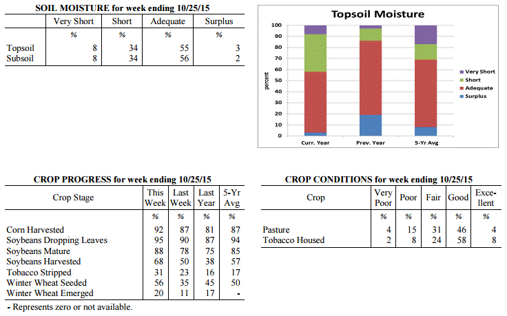
Kentucky Crop and Weather Report
Issued 4:00 P.M., October 26, 2015 34-15
Agricultural News: Kentucky experienced above normal temperatures and below normal
rainfall over the past week. Precipitation for the week totaled 0.33 inches, 0.37
inches below normal. Temperatures averaged 59 degrees for the week, 3 degrees above
normal. Topsoil moisture was rated 8 percent very short, 34 percent short, 55 percent
adequate and 3 percent surplus. Subsoil moisture was rated 8 percent very short, 34
percent short, 56 percent adequate, and 2 percent surplus. Days suitable for
fieldwork averaged 6.2 out of a possible seven. Primary activities this week included
harvesting corn and soybeans, sowing wheat and stripping tobacco. Most areas are in
need of rain to improve pastures and bring tobacco into case for stripping. Moisture
would also be beneficial for fall seeded crops. US Drought Monitor shows a little
over 14 percent of the state, mainly in Western and West-Central Kentucky, in a
Moderate Drought.
Kentucky Climate Summary
For the Period October 26, 2015 to November 1, 2015
Near Normal Temperatures and Above Normal Rainfall:
After a fairly dry month, October ended with a wet pattern in place. Through the
first half of the work week, the Commonwealth saw multiple rounds of soaking showers
ahead of a low pressure system to the south. Activity was widespread at times, with
much of the state picking up between 1.5 to 2.5+ inches of rainfall. Dry conditions
returned Thursday and Friday, but only temporarily. Numerous to widespread light
showers returned by the evening of Halloween and pushed through the state overnight.
Many picked up an additional tenth to quarter inch. With the exception of Eastern
Kentucky, the majority of the Bluegrass State averaged over two inches for the week,
which broke a three week streak of below normal rainfall.
Temperatures for the period averaged 54 degrees across the state which was near
normal and 6 degrees cooler than the previous period. High temperatures averaged from
63 in the West to 61 in the East. Departure from normal high temperatures ranged
from 4 degrees cooler than normal in the West to 5 degrees cooler than normal in
the East. Low temperatures averaged from 50 degrees in the West to 47 degrees in the
East. Departure from normal low temperature ranged from 6 degrees warmer than normal
in the West to 8 degrees warmer than normal in the East. The extreme high temperature
for the period was 73 degrees at BOONEVILLE 2S and the extreme low was 31 degrees, at
the same location.
Precipitation (liq. equ.) for the period totaled 2.09 inches statewide which was 1.32
inches above normal and 273% of normal. Precipitation totals by climate division,
West 2.76 inches, Central 2.60 inches, Bluegrass 2.22 inches and East 0.78 inches,
which was 1.91, 1.81, 1.52 and 0.06 inches above normal. By station, precipitation
totals ranged from a low of 0.31 inches at BOONEVILLE 2S to a high of 4.52 inches at
HARDINSBURG 5SW.
---
Kentucky Crop and Weather Report
Issued 4:00 P.M., October 26, 2015 34-15
Agricultural News: Kentucky experienced above normal temperatures and below normal
rainfall over the past week. Precipitation for the week totaled 0.33 inches, 0.37
inches below normal. Temperatures averaged 59 degrees for the week, 3 degrees above
normal. Topsoil moisture was rated 8 percent very short, 34 percent short, 55 percent
adequate and 3 percent surplus. Subsoil moisture was rated 8 percent very short, 34
percent short, 56 percent adequate, and 2 percent surplus. Days suitable for
fieldwork averaged 6.2 out of a possible seven. Primary activities this week included
harvesting corn and soybeans, sowing wheat and stripping tobacco. Most areas are in
need of rain to improve pastures and bring tobacco into case for stripping. Moisture
would also be beneficial for fall seeded crops. US Drought Monitor shows a little
over 14 percent of the state, mainly in Western and West-Central Kentucky, in a
Moderate Drought.
 Kentucky Climate Summary
For the Period October 19, 2015 to October 25, 2015
Above Normal Temperatures and Below Normal Rainfall:
Below normal rainfall continues to be the trend across the Lower Ohio Valley. The
Bluegrass State has now gone three straight weeks of seeing below normal
precipitation. Looking back further, seven of the past nine have been below normal.
This past period, high pressure kept the area dry and fairly mild through the work
week. A cold front then pushed through the area Saturday and into Saturday night with
showers becoming widespread at times. When it was all said and done, the state
averaged a third of an inch for the week, which is below normal by about the same.
The dry conditions have been more noticeable in Western Kentucky where month to date
rainfall is approaching two inches below normal. Looking longer term, this area is
more than four inches below normal over the past 60 days. In relation, the US Drought
Monitor has put a little over 14% of the state, mainly in Western and West-Central
Kentucky, in a Moderate Drought.
Temperatures for the period averaged 59 degrees across the state which was 3 degrees
warmer than normal and 4 degrees warmer than the previous period. High temperatures
averaged from 74 in the West to 71 in the East. Departure from normal high
temperatures ranged from 4 degrees warmer than normal in the West to 2 degrees
warmer than normal in the East. Low temperatures averaged from 48 degrees in the
West to 44 degrees in the East. Departure from normal low temperature ranged from 2
degrees warmer than normal in the West to 3 degrees warmer than normal in the East.
The extreme high temperature for the period was 83 degrees at BENTON 4N and the
extreme low was 26 degrees at VANCEBURG 6W.
Precipitation (liq. equ.) for the period totaled 0.33 inches statewide which was 0.37
inches below normal and 47% of normal. Precipitation totals by climate division, West
0.38 inches, Central 0.34 inches, Bluegrass 0.44 inches and East 0.18 inches, which
was 0.4, 0.37, 0.21 and 0.49 inches below normal. By station, precipitation totals
ranged from a low of 0.01 inches at CARBONDALE ASOS to a high of 2.03 inches at
STANFORD 4NE.
---
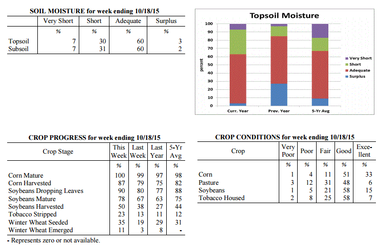
Kentucky Crop and Weather Report
Issued 4:00 P.M., October 19, 2015 33-15
Agricultural News: Kentucky experienced below normal temperatures and rainfall over
the past week. Precipitation for the week totaled 0.36 inches, 0.35 inches below
normal. Temperatures averaged 55 degrees for the week, 3 degrees below normal.
Topsoil moisture was rated 7 percent very short, 30 percent short, 60 percent
adequate and 3 percent surplus. Subsoil moisture was rated 7 percent very short, 31
percent short, 60 percent adequate, and 2 percent surplus. Days suitable for
fieldwork averaged 6.1 out of a possible seven. Primary activities this week included
harvesting corn and soybeans, sowing wheat and stripping tobacco. First
widespread frost was received this week. Some producers were feeding hay to their
livestock.
Kentucky Climate Summary
For the Period October 19, 2015 to October 25, 2015
Above Normal Temperatures and Below Normal Rainfall:
Below normal rainfall continues to be the trend across the Lower Ohio Valley. The
Bluegrass State has now gone three straight weeks of seeing below normal
precipitation. Looking back further, seven of the past nine have been below normal.
This past period, high pressure kept the area dry and fairly mild through the work
week. A cold front then pushed through the area Saturday and into Saturday night with
showers becoming widespread at times. When it was all said and done, the state
averaged a third of an inch for the week, which is below normal by about the same.
The dry conditions have been more noticeable in Western Kentucky where month to date
rainfall is approaching two inches below normal. Looking longer term, this area is
more than four inches below normal over the past 60 days. In relation, the US Drought
Monitor has put a little over 14% of the state, mainly in Western and West-Central
Kentucky, in a Moderate Drought.
Temperatures for the period averaged 59 degrees across the state which was 3 degrees
warmer than normal and 4 degrees warmer than the previous period. High temperatures
averaged from 74 in the West to 71 in the East. Departure from normal high
temperatures ranged from 4 degrees warmer than normal in the West to 2 degrees
warmer than normal in the East. Low temperatures averaged from 48 degrees in the
West to 44 degrees in the East. Departure from normal low temperature ranged from 2
degrees warmer than normal in the West to 3 degrees warmer than normal in the East.
The extreme high temperature for the period was 83 degrees at BENTON 4N and the
extreme low was 26 degrees at VANCEBURG 6W.
Precipitation (liq. equ.) for the period totaled 0.33 inches statewide which was 0.37
inches below normal and 47% of normal. Precipitation totals by climate division, West
0.38 inches, Central 0.34 inches, Bluegrass 0.44 inches and East 0.18 inches, which
was 0.4, 0.37, 0.21 and 0.49 inches below normal. By station, precipitation totals
ranged from a low of 0.01 inches at CARBONDALE ASOS to a high of 2.03 inches at
STANFORD 4NE.
---
Kentucky Crop and Weather Report
Issued 4:00 P.M., October 19, 2015 33-15
Agricultural News: Kentucky experienced below normal temperatures and rainfall over
the past week. Precipitation for the week totaled 0.36 inches, 0.35 inches below
normal. Temperatures averaged 55 degrees for the week, 3 degrees below normal.
Topsoil moisture was rated 7 percent very short, 30 percent short, 60 percent
adequate and 3 percent surplus. Subsoil moisture was rated 7 percent very short, 31
percent short, 60 percent adequate, and 2 percent surplus. Days suitable for
fieldwork averaged 6.1 out of a possible seven. Primary activities this week included
harvesting corn and soybeans, sowing wheat and stripping tobacco. First
widespread frost was received this week. Some producers were feeding hay to their
livestock.
 Kentucky Climate Summary
For the Period October 12, 2015 to October 18, 2015
Below Normal Temperatures and Rainfall:
This past week brought the Commonwealth a couple rounds of rainfall, in addition to
the first widespread frost of the young fall season. A cold front pushed through the
region Monday evening and into the overnight, producing a solid band of showers and
storms. This feature accounted for much of the rainfall this past week. Over the
period, the state averaged a little over a third of an inch, which was below normal
for a second straight week. A secondary cold front passed through the Ohio Valley on
Thursday night with not much in the way of precipitation. The bigger story was the
cold temperatures filtering into the area over the weekend. Areas of frost developed
both Friday and Saturday nights across the state. The coolest temperatures were seen
Saturday night and Sunday morning as the majority of Kentucky dropped below freezing.
Many rural locations dropped into the mid to upper 20s, which is around 15 to 20
degrees below normal for this time of year.
Temperatures for the period averaged 55 degrees across the state which was 3 degrees
cooler than normal and 10 degrees cooler than the previous period. High temperatures
averaged from 71 in the West to 66 in the East. Departure from normal high
temperatures ranged from 1 degree cooler than normal in the West to 4 degrees cooler
than normal in the East. Low temperatures averaged from 43 degrees in the West to 43
degrees in the East. Departure from normal low temperature ranged from 4 degrees
cooler than normal in the West to near normal in the East. The extreme high
temperature for the period was 86 degrees at MAYFIELD 6SW and the extreme low was 24
degrees at CYNTHIANA 8N.
Precipitation (liq. equ.) for the period totaled 0.36 inches statewide which was 0.35
inches below normal and 51% of normal. Precipitation totals by climate division, West
0.26 inches, Central 0.52 inches, Bluegrass 0.35 inches and East 0.30 inches, which
was 0.48, 0.2, 0.33 and 0.4 inches below normal. By station, precipitation totals
ranged from a low of 0.00 inches at CAPE GIRARDEAU ASOS to a high of 0.89
inches at BRANDENBURG 4SW.
---
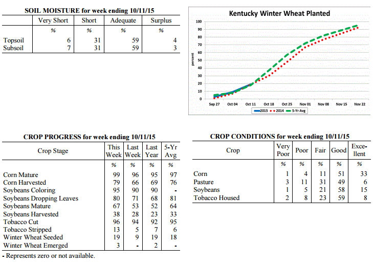
Kentucky Crop and Weather Report
Issued 4:00 P.M., October 13, 2015 32-15
Agricultural News: Kentucky experienced above normal temperatures and below normal
rainfall over the past week. Precipitation for the week totaled 0.22 inches, 0.56
inches below normal. Temperatures averaged 66 degrees for the week, 6 degrees above
normal. Topsoil moisture was rated 6 percent very short, 31 percent short, 59 percent
adequate and 4 percent surplus. Subsoil moisture was rated 7 percent very short, 31
percent short, 59 percent adequate, and 3 percent surplus. Days suitable for
fieldwork averaged 5.7 out of a possible seven. Tobacco houseburn was reported as 1
percent heavy, 5 percent moderate, 17 percent light, with 77 percent experiencing none.
Kentucky Climate Summary
For the Period October 12, 2015 to October 18, 2015
Below Normal Temperatures and Rainfall:
This past week brought the Commonwealth a couple rounds of rainfall, in addition to
the first widespread frost of the young fall season. A cold front pushed through the
region Monday evening and into the overnight, producing a solid band of showers and
storms. This feature accounted for much of the rainfall this past week. Over the
period, the state averaged a little over a third of an inch, which was below normal
for a second straight week. A secondary cold front passed through the Ohio Valley on
Thursday night with not much in the way of precipitation. The bigger story was the
cold temperatures filtering into the area over the weekend. Areas of frost developed
both Friday and Saturday nights across the state. The coolest temperatures were seen
Saturday night and Sunday morning as the majority of Kentucky dropped below freezing.
Many rural locations dropped into the mid to upper 20s, which is around 15 to 20
degrees below normal for this time of year.
Temperatures for the period averaged 55 degrees across the state which was 3 degrees
cooler than normal and 10 degrees cooler than the previous period. High temperatures
averaged from 71 in the West to 66 in the East. Departure from normal high
temperatures ranged from 1 degree cooler than normal in the West to 4 degrees cooler
than normal in the East. Low temperatures averaged from 43 degrees in the West to 43
degrees in the East. Departure from normal low temperature ranged from 4 degrees
cooler than normal in the West to near normal in the East. The extreme high
temperature for the period was 86 degrees at MAYFIELD 6SW and the extreme low was 24
degrees at CYNTHIANA 8N.
Precipitation (liq. equ.) for the period totaled 0.36 inches statewide which was 0.35
inches below normal and 51% of normal. Precipitation totals by climate division, West
0.26 inches, Central 0.52 inches, Bluegrass 0.35 inches and East 0.30 inches, which
was 0.48, 0.2, 0.33 and 0.4 inches below normal. By station, precipitation totals
ranged from a low of 0.00 inches at CAPE GIRARDEAU ASOS to a high of 0.89
inches at BRANDENBURG 4SW.
---
Kentucky Crop and Weather Report
Issued 4:00 P.M., October 13, 2015 32-15
Agricultural News: Kentucky experienced above normal temperatures and below normal
rainfall over the past week. Precipitation for the week totaled 0.22 inches, 0.56
inches below normal. Temperatures averaged 66 degrees for the week, 6 degrees above
normal. Topsoil moisture was rated 6 percent very short, 31 percent short, 59 percent
adequate and 4 percent surplus. Subsoil moisture was rated 7 percent very short, 31
percent short, 59 percent adequate, and 3 percent surplus. Days suitable for
fieldwork averaged 5.7 out of a possible seven. Tobacco houseburn was reported as 1
percent heavy, 5 percent moderate, 17 percent light, with 77 percent experiencing none.
 Kentucky Climate Summary
For the Period October 5, 2015 to October 11, 2015
Above Normal Temperatures and Below Normal Rainfall:
The Commonwealth saw mostly dry and unseasonably warm conditions for much of this
last period. High pressure at the surface and aloft kept the Commonwealth dry through
at least Thursday. Highs rose into the upper 70s to middle 80s about each day, well
above normal for this time of the year. A cold front pushed through the Ohio Valley on
Friday, sparking numerous to widespread showers and scattered thunderstorms across
much of the area. This was the only significant rainfall event for the week with the
state averaging between a tenth and third of an inch. Cooler and drier conditions
arrived for the weekend. Skies cleared Saturday night, opening the door for a cool
night ahead. Lows dropped into the low to mid 40s for many locations, but some even
moved into the upper 30s.
Temperatures for the period averaged 66 degrees across the state which was 6 degrees
warmer than normal and 4 degrees warmer than the previous period. High temperatures
averaged from 79 in the West to 76 in the East. Departure from normal high
temperatures ranged from 5 degrees warmer than normal in the West to 4 degrees
warmer than normal in the East. Low temperatures averaged from 55 degrees in the
West to 53 degrees in the East. Departure from normal low temperature ranged from 6
degrees warmer than normal in the West to 7 degrees warmer than normal in the East.
The extreme high temperature for the period was 87 degrees at BURLINGTON 4S and the
extreme low was 37 degrees at BRANDENBURG 4SW.
Precipitation (liq. equ.) for the period totaled 0.22 inches statewide which was 0.56
inches below normal and 28% of normal. Precipitation totals by climate division, West
0.16 inches, Central 0.29 inches, Bluegrass 0.13 inches and East 0.29 inches, which
was 0.64, 0.52, 0.61 and 0.49 inches below normal. By station, precipitation totals
ranged from a low of 0.00 inches at ALEXANDRIA 5NW to a high of 0.89 inches at
YELLOW CREEK.
---
Kentucky Crop and Weather Report
Issued 4:00 P.M., October 5, 2015 31-15
Agricultural News: Kentucky experienced below normal temperatures and above normal
rainfall over the past week. Precipitation for the week totaled 1.82 inches, 1.02
inches above normal. Temperatures averaged 62 degrees for the week, 1 degree below
normal. Topsoil moisture was rated 7 percent very short, 31 percent short, 57 percent
adequate and 5 percent surplus. Subsoil moisture was rated 7 percent very short, 30
percent short, 59 percent adequate, and 4 percent surplus. Days suitable for
fieldwork averaged 4.0 out of a possible seven.
Much needed rain was received this past week. However, it may have been too late to
improve yields for some double crop soybeans. Crops were harvested between rain
events where conditions allowed. Pasture conditions improved slightly due to the
moisture received. Livestock were rated in mostly good condition. Some producers had
begun feeding hay because of dry weather and welcomed the rainfall. Tobacco houseburn
was reported as 1 percent heavy, 5 percent moderate, 15 percent light, with 79 percent
experiencing none.
Kentucky Climate Summary
For the Period October 5, 2015 to October 11, 2015
Above Normal Temperatures and Below Normal Rainfall:
The Commonwealth saw mostly dry and unseasonably warm conditions for much of this
last period. High pressure at the surface and aloft kept the Commonwealth dry through
at least Thursday. Highs rose into the upper 70s to middle 80s about each day, well
above normal for this time of the year. A cold front pushed through the Ohio Valley on
Friday, sparking numerous to widespread showers and scattered thunderstorms across
much of the area. This was the only significant rainfall event for the week with the
state averaging between a tenth and third of an inch. Cooler and drier conditions
arrived for the weekend. Skies cleared Saturday night, opening the door for a cool
night ahead. Lows dropped into the low to mid 40s for many locations, but some even
moved into the upper 30s.
Temperatures for the period averaged 66 degrees across the state which was 6 degrees
warmer than normal and 4 degrees warmer than the previous period. High temperatures
averaged from 79 in the West to 76 in the East. Departure from normal high
temperatures ranged from 5 degrees warmer than normal in the West to 4 degrees
warmer than normal in the East. Low temperatures averaged from 55 degrees in the
West to 53 degrees in the East. Departure from normal low temperature ranged from 6
degrees warmer than normal in the West to 7 degrees warmer than normal in the East.
The extreme high temperature for the period was 87 degrees at BURLINGTON 4S and the
extreme low was 37 degrees at BRANDENBURG 4SW.
Precipitation (liq. equ.) for the period totaled 0.22 inches statewide which was 0.56
inches below normal and 28% of normal. Precipitation totals by climate division, West
0.16 inches, Central 0.29 inches, Bluegrass 0.13 inches and East 0.29 inches, which
was 0.64, 0.52, 0.61 and 0.49 inches below normal. By station, precipitation totals
ranged from a low of 0.00 inches at ALEXANDRIA 5NW to a high of 0.89 inches at
YELLOW CREEK.
---
Kentucky Crop and Weather Report
Issued 4:00 P.M., October 5, 2015 31-15
Agricultural News: Kentucky experienced below normal temperatures and above normal
rainfall over the past week. Precipitation for the week totaled 1.82 inches, 1.02
inches above normal. Temperatures averaged 62 degrees for the week, 1 degree below
normal. Topsoil moisture was rated 7 percent very short, 31 percent short, 57 percent
adequate and 5 percent surplus. Subsoil moisture was rated 7 percent very short, 30
percent short, 59 percent adequate, and 4 percent surplus. Days suitable for
fieldwork averaged 4.0 out of a possible seven.
Much needed rain was received this past week. However, it may have been too late to
improve yields for some double crop soybeans. Crops were harvested between rain
events where conditions allowed. Pasture conditions improved slightly due to the
moisture received. Livestock were rated in mostly good condition. Some producers had
begun feeding hay because of dry weather and welcomed the rainfall. Tobacco houseburn
was reported as 1 percent heavy, 5 percent moderate, 15 percent light, with 79 percent
experiencing none.
 Kentucky Climate Summary
For the Period September 28, 2015 to October 4, 2015
Below Normal Temperatures and Much Above Normal Rainfall:
The Commonwealth saw numerous rounds of beneficial rainfall this past week as the
state was situated within a rather unsettled pattern. Abundant moisture pushed into
the Lower Ohio Valley ahead of an upper level low pressure system by Tuesday, setting
the stage for a wet week ahead. Several disturbances kept the chance for rainfall in
the forecast through Saturday. The most significant and widespread activity was seen
over the midsection of the work week, before showers became confined to mainly the
eastern half of the state heading into the weekend. Showers and any accumulations
were rather light in nature by Friday and Saturday, with cooler temperatures as
the more noticeable impact. Northeast breezy flow combined with overcast skies to
keep highs in the 50s both days. The state averaged 1.82 inches of rainfall for the
week, which was over an inch above normal. This was the first time the state was an
inch above normal for a week since mid-July. South-central Kentucky saw the highest
accumulations over the 7 day period, with many locations coming in at 3 to 4+ inches.
Temperatures for the period averaged 62 degrees across the state which was 1 degree
cooler than normal and 6 degrees cooler than the previous period. High temperatures
averaged from 69 in the West to 67 in the East. Departure from normal high
temperatures ranged from 8 degrees cooler than normal in the West to 8 degrees cooler
than normal in the East. Low temperatures averaged from 57 degrees in the West to 58
degrees in the East. Departure from normal low temperature ranged from 5 degrees
warmer than normal in the West to 9 degrees warmer than normal in the East. The
extreme high temperature for the period was 86 degrees at BOWLING GREEN APT and the
extreme low was 45 degrees at TRIANGLE MOUNTAIN.
Precipitation (liq. equ.) for the period totaled 1.82 inches statewide which was 1.02
inches above normal and 227% of normal. Precipitation totals by climate division,
West 1.12 inches, Central 2.54 inches, Bluegrass 1.89 inches and East 1.72 inches,
which was 0.3, 1.68, 1.15 and 0.93 inches above normal. By station, precipitation
totals ranged from a low of 0.32 inches at POPLAR BLUFF ASOS to a high of 4.94
inches at CAMPBELLSVILLE 7W.
---
Kentucky Crop and Weather Report
Issued 4:00 P.M., September 28, 2015 30-15
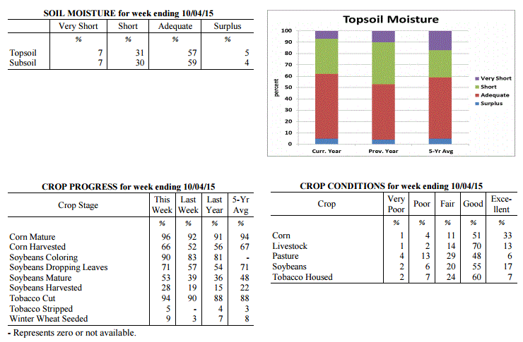
Agricultural News: Kentucky experienced above normal temperatures and below normal
rainfall over the past week. Precipitation for the week totaled 0.33 inches, 0.52
inches below normal. Temperatures averaged 68 degrees for the week, 2 degrees above
normal. Topsoil moisture was rated 17 percent very short, 41 percent short, 40 percent
adequate and 2 percent surplus. Subsoil moisture was rated 12 percent very short, 38
percent short, 49 percent adequate, and 1 percent surplus. Days suitable for fieldwork
averaged 6.5 out of a possible seven.
Primary activities this week included harvesting corn, soybeans and tobacco. The
Commonwealth remains dry but part of the state received much need rainfall late in the
week. Pasture conditions continue to decline due to the dry conditions. Moisture is
need to promote germination for fall seeding�s. Tobacco houseburn was reported as 1
percent heavy, 5 percent moderate, 14 percent light, with 80 percent experiencing
none.
Kentucky Climate Summary
For the Period September 28, 2015 to October 4, 2015
Below Normal Temperatures and Much Above Normal Rainfall:
The Commonwealth saw numerous rounds of beneficial rainfall this past week as the
state was situated within a rather unsettled pattern. Abundant moisture pushed into
the Lower Ohio Valley ahead of an upper level low pressure system by Tuesday, setting
the stage for a wet week ahead. Several disturbances kept the chance for rainfall in
the forecast through Saturday. The most significant and widespread activity was seen
over the midsection of the work week, before showers became confined to mainly the
eastern half of the state heading into the weekend. Showers and any accumulations
were rather light in nature by Friday and Saturday, with cooler temperatures as
the more noticeable impact. Northeast breezy flow combined with overcast skies to
keep highs in the 50s both days. The state averaged 1.82 inches of rainfall for the
week, which was over an inch above normal. This was the first time the state was an
inch above normal for a week since mid-July. South-central Kentucky saw the highest
accumulations over the 7 day period, with many locations coming in at 3 to 4+ inches.
Temperatures for the period averaged 62 degrees across the state which was 1 degree
cooler than normal and 6 degrees cooler than the previous period. High temperatures
averaged from 69 in the West to 67 in the East. Departure from normal high
temperatures ranged from 8 degrees cooler than normal in the West to 8 degrees cooler
than normal in the East. Low temperatures averaged from 57 degrees in the West to 58
degrees in the East. Departure from normal low temperature ranged from 5 degrees
warmer than normal in the West to 9 degrees warmer than normal in the East. The
extreme high temperature for the period was 86 degrees at BOWLING GREEN APT and the
extreme low was 45 degrees at TRIANGLE MOUNTAIN.
Precipitation (liq. equ.) for the period totaled 1.82 inches statewide which was 1.02
inches above normal and 227% of normal. Precipitation totals by climate division,
West 1.12 inches, Central 2.54 inches, Bluegrass 1.89 inches and East 1.72 inches,
which was 0.3, 1.68, 1.15 and 0.93 inches above normal. By station, precipitation
totals ranged from a low of 0.32 inches at POPLAR BLUFF ASOS to a high of 4.94
inches at CAMPBELLSVILLE 7W.
---
Kentucky Crop and Weather Report
Issued 4:00 P.M., September 28, 2015 30-15
Agricultural News: Kentucky experienced above normal temperatures and below normal
rainfall over the past week. Precipitation for the week totaled 0.33 inches, 0.52
inches below normal. Temperatures averaged 68 degrees for the week, 2 degrees above
normal. Topsoil moisture was rated 17 percent very short, 41 percent short, 40 percent
adequate and 2 percent surplus. Subsoil moisture was rated 12 percent very short, 38
percent short, 49 percent adequate, and 1 percent surplus. Days suitable for fieldwork
averaged 6.5 out of a possible seven.
Primary activities this week included harvesting corn, soybeans and tobacco. The
Commonwealth remains dry but part of the state received much need rainfall late in the
week. Pasture conditions continue to decline due to the dry conditions. Moisture is
need to promote germination for fall seeding�s. Tobacco houseburn was reported as 1
percent heavy, 5 percent moderate, 14 percent light, with 80 percent experiencing
none.
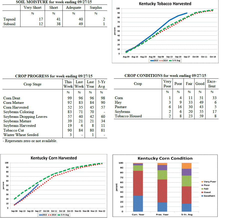 Kentucky Climate Summary
For the Period September 21, 2015 to September 27, 2015
Above Normal Temperatures and Below Normal Rainfall:
The US Drought Monitor upgraded a slight portion of Kentucky to 'Moderate Drought'
this past week, while over half remains 'Abnormally dry'. Depending on location, it
was either another dry period or beneficial rainfall was finally seen. While it was
mostly dry through Thursday, an upper level low pressure system worked into the Lower
Ohio Valley on Friday and into the weekend. Showers became widespread at times
Friday evening, but it was not a statewide event. Much of the activity was located
across mainly the eastern half of the state. This was followed by scattered coverage
on Saturday across the same general area, before diminishing that night. According to
data at the Ag Weather Center, light to moderate showers led to average totals of
0.39 and 0.71 inches in the Bluegrass and Eastern Kentucky, respectively. Western
and central portions of the state missed out on much of the activity and were much
below normal for a second straight week.
Temperatures for the period averaged 68 degrees across the state which was 2 degrees
warmer than normal and 2 degrees warmer than the previous period. High temperatures
averaged from 82 in the West to 76 in the East. Departure from normal high
temperatures ranged from 3 degrees warmer than normal in the West to 1 degree
cooler than normal in the East. Low temperatures averaged from 56 degrees in the
West to 57 degrees in the East. Departure from normal low temperature ranged from 1
degree warmer than normal in the West to 5 degrees warmer than normal in the East.
The extreme high temperature for the period was 92 degrees at BURLINGTON 4S and the
extreme low was 43 degrees at BRANDENBURG 4SW.
Precipitation (liq. equ.) for the period totaled 0.33 inches statewide which was 0.52
inches below normal and 39% of normal. Precipitation totals by climate division, West
0.07 inches, Central 0.17 inches, Bluegrass 0.39 inches and East 0.71 inches, which
was 0.79, 0.77, 0.38 and 0.13 inches below normal. By station, precipitation totals
ranged from a low of 0.00 inches at HICKMAN 2E to a high of 1.27 inches at STANFORD 4NE.
---
Kentucky Crop and Weather Report
Issued 4:00 P.M., September 21, 2015 29-15
Agricultural News: Kentucky experienced below normal temperatures and rainfall over
the past week. Precipitation for the week totaled 0.04 inches, 0.79 inches below
normal. Temperatures averaged 67 degrees for the week, 2 degrees below normal.
Topsoil moisture was rated 11 percent very short, 37 percent short, 49 percent
adequate and 3 percent surplus. Subsoil moisture was rated 9 percent very short, 31
percent short, 58 percent adequate, and 2 percent surplus. Days suitable for
fieldwork averaged 6.7 out of a possible seven.
Primary activities this week included cutting hay, tobacco and harvesting corn for
grain. Soybean harvest is underway in some locations. Early corn and soybean yields
are reported to be very good. Harvest has also begun on some early soybean fields.
Much of the state has experienced below normal rainfall over the past month and late
crops are in need of rain, especially soybeans. Pasture conditions have declined due
to the dry weather and some livestock producers are now feeding hay. Moisture is need
for fall seeding.
Kentucky Climate Summary
For the Period September 21, 2015 to September 27, 2015
Above Normal Temperatures and Below Normal Rainfall:
The US Drought Monitor upgraded a slight portion of Kentucky to 'Moderate Drought'
this past week, while over half remains 'Abnormally dry'. Depending on location, it
was either another dry period or beneficial rainfall was finally seen. While it was
mostly dry through Thursday, an upper level low pressure system worked into the Lower
Ohio Valley on Friday and into the weekend. Showers became widespread at times
Friday evening, but it was not a statewide event. Much of the activity was located
across mainly the eastern half of the state. This was followed by scattered coverage
on Saturday across the same general area, before diminishing that night. According to
data at the Ag Weather Center, light to moderate showers led to average totals of
0.39 and 0.71 inches in the Bluegrass and Eastern Kentucky, respectively. Western
and central portions of the state missed out on much of the activity and were much
below normal for a second straight week.
Temperatures for the period averaged 68 degrees across the state which was 2 degrees
warmer than normal and 2 degrees warmer than the previous period. High temperatures
averaged from 82 in the West to 76 in the East. Departure from normal high
temperatures ranged from 3 degrees warmer than normal in the West to 1 degree
cooler than normal in the East. Low temperatures averaged from 56 degrees in the
West to 57 degrees in the East. Departure from normal low temperature ranged from 1
degree warmer than normal in the West to 5 degrees warmer than normal in the East.
The extreme high temperature for the period was 92 degrees at BURLINGTON 4S and the
extreme low was 43 degrees at BRANDENBURG 4SW.
Precipitation (liq. equ.) for the period totaled 0.33 inches statewide which was 0.52
inches below normal and 39% of normal. Precipitation totals by climate division, West
0.07 inches, Central 0.17 inches, Bluegrass 0.39 inches and East 0.71 inches, which
was 0.79, 0.77, 0.38 and 0.13 inches below normal. By station, precipitation totals
ranged from a low of 0.00 inches at HICKMAN 2E to a high of 1.27 inches at STANFORD 4NE.
---
Kentucky Crop and Weather Report
Issued 4:00 P.M., September 21, 2015 29-15
Agricultural News: Kentucky experienced below normal temperatures and rainfall over
the past week. Precipitation for the week totaled 0.04 inches, 0.79 inches below
normal. Temperatures averaged 67 degrees for the week, 2 degrees below normal.
Topsoil moisture was rated 11 percent very short, 37 percent short, 49 percent
adequate and 3 percent surplus. Subsoil moisture was rated 9 percent very short, 31
percent short, 58 percent adequate, and 2 percent surplus. Days suitable for
fieldwork averaged 6.7 out of a possible seven.
Primary activities this week included cutting hay, tobacco and harvesting corn for
grain. Soybean harvest is underway in some locations. Early corn and soybean yields
are reported to be very good. Harvest has also begun on some early soybean fields.
Much of the state has experienced below normal rainfall over the past month and late
crops are in need of rain, especially soybeans. Pasture conditions have declined due
to the dry weather and some livestock producers are now feeding hay. Moisture is need
for fall seeding.
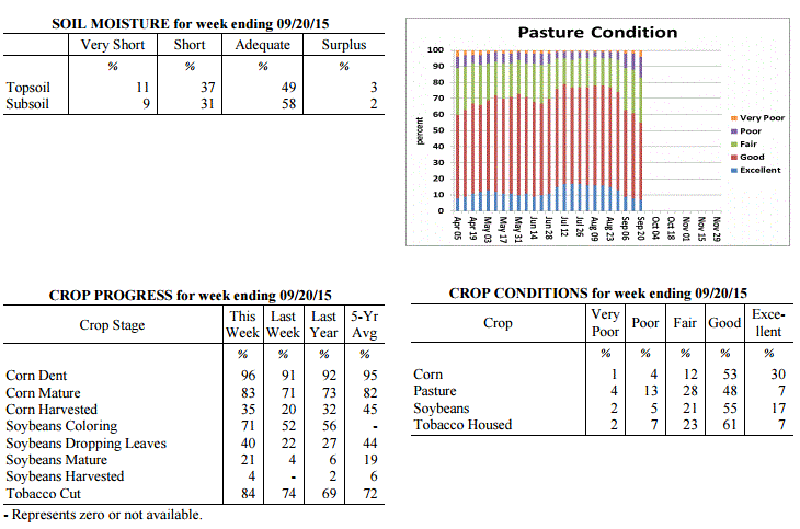 Kentucky Climate Summary
For the Period September 14, 2015 to September 20, 2015
Below Normal Temperatures and Rainfall:
Dry conditions led to excellent harvesting conditions this past week. The Bluegrass
State was under the influence of high pressure at the surface and aloft for much of
the period. This led to mostly clear skies during the day and at night. Throughout
the work week, temperatures saw a slight warming trend as surface high pressure
shifted east. Highs increased from the mid 70s to around 80 on Monday, to solidly in the
80s across the state by Friday. A cold front then worked through the region on
Saturday, leading to isolated to scattered showers. This was the only rainfall event for
the period, leading to another week of below normal rainfall. While this is typically
one of the drier times of the year, Kentucky has now seen much below normal rainfall
three of the past four weeks. As of this past Thursday, around half of the state is
now experiencing 'Abnormally Dry Conditions' according to the latest update
of the US Drought Monitor.
Temperatures for the period averaged 67 degrees across the state which was 2 degrees
cooler than normal and 4 degrees cooler than the previous period. High temperatures
averaged from 82 in the West to 79 in the East. Departure from normal high
temperatures ranged from near normal in the West to 1 degree cooler than normal in
the East. Low temperatures averaged from 55 degrees in the West to 53 degrees in the
East. Departure from normal low temperature ranged from 3 degrees cooler than normal
in the West to 2 degrees cooler than normal in the East. The extreme high temperature
for the period was 92 degrees at PADUCAH ASOS and the extreme low was 41 degrees at
CYNTHIANA 8N.
Precipitation (liq. equ.) for the period totaled 0.04 inches statewide which was 0.79
inches below normal and 5% of normal. Precipitation totals by climate division, West
0.03 inches, Central 0.00 inches, Bluegrass 0.04 inches and East 0.11 inches, which
was 0.82, 0.92, 0.7 and 0.71 inches below normal. By station, precipitation totals
ranged from a low of 0.00 inches at ALBANY 1N to a high of 0.92 inches at WHITESBURG 2NW.
---
Kentucky Crop and Weather Report
Issued 4:00 P.M., September 14, 2015 28-15
Agricultural News: Kentucky experienced near normal temperatures and above normal
rainfall over the past week. Precipitation for the week totaled 0.98 inches, 0.16
inches above normal. Temperatures averaged 71 degrees for the week, near normal.
Topsoil moisture was rated 6 percent very short, 33 percent short, 57 percent
adequate and 4 percent surplus. Subsoil moisture was rated 5 percent very short, 26
percent short, 66 percent adequate, and 3 percent surplus. Days suitable for
fieldwork averaged 5.8 out of a possible seven.
Primary activities this week included cutting hay and tobacco and harvesting corn for
grain in some locations. Scattered showers were beneficial to crops and pastures.
However, some areas did not receive rain and are in need of additional moisture.
Early corn yields are reported to be very good. Harvest has also begun on some
early soybean fields. Pastures and livestock remain in mostly good condition.
Kentucky Climate Summary
For the Period September 14, 2015 to September 20, 2015
Below Normal Temperatures and Rainfall:
Dry conditions led to excellent harvesting conditions this past week. The Bluegrass
State was under the influence of high pressure at the surface and aloft for much of
the period. This led to mostly clear skies during the day and at night. Throughout
the work week, temperatures saw a slight warming trend as surface high pressure
shifted east. Highs increased from the mid 70s to around 80 on Monday, to solidly in the
80s across the state by Friday. A cold front then worked through the region on
Saturday, leading to isolated to scattered showers. This was the only rainfall event for
the period, leading to another week of below normal rainfall. While this is typically
one of the drier times of the year, Kentucky has now seen much below normal rainfall
three of the past four weeks. As of this past Thursday, around half of the state is
now experiencing 'Abnormally Dry Conditions' according to the latest update
of the US Drought Monitor.
Temperatures for the period averaged 67 degrees across the state which was 2 degrees
cooler than normal and 4 degrees cooler than the previous period. High temperatures
averaged from 82 in the West to 79 in the East. Departure from normal high
temperatures ranged from near normal in the West to 1 degree cooler than normal in
the East. Low temperatures averaged from 55 degrees in the West to 53 degrees in the
East. Departure from normal low temperature ranged from 3 degrees cooler than normal
in the West to 2 degrees cooler than normal in the East. The extreme high temperature
for the period was 92 degrees at PADUCAH ASOS and the extreme low was 41 degrees at
CYNTHIANA 8N.
Precipitation (liq. equ.) for the period totaled 0.04 inches statewide which was 0.79
inches below normal and 5% of normal. Precipitation totals by climate division, West
0.03 inches, Central 0.00 inches, Bluegrass 0.04 inches and East 0.11 inches, which
was 0.82, 0.92, 0.7 and 0.71 inches below normal. By station, precipitation totals
ranged from a low of 0.00 inches at ALBANY 1N to a high of 0.92 inches at WHITESBURG 2NW.
---
Kentucky Crop and Weather Report
Issued 4:00 P.M., September 14, 2015 28-15
Agricultural News: Kentucky experienced near normal temperatures and above normal
rainfall over the past week. Precipitation for the week totaled 0.98 inches, 0.16
inches above normal. Temperatures averaged 71 degrees for the week, near normal.
Topsoil moisture was rated 6 percent very short, 33 percent short, 57 percent
adequate and 4 percent surplus. Subsoil moisture was rated 5 percent very short, 26
percent short, 66 percent adequate, and 3 percent surplus. Days suitable for
fieldwork averaged 5.8 out of a possible seven.
Primary activities this week included cutting hay and tobacco and harvesting corn for
grain in some locations. Scattered showers were beneficial to crops and pastures.
However, some areas did not receive rain and are in need of additional moisture.
Early corn yields are reported to be very good. Harvest has also begun on some
early soybean fields. Pastures and livestock remain in mostly good condition.
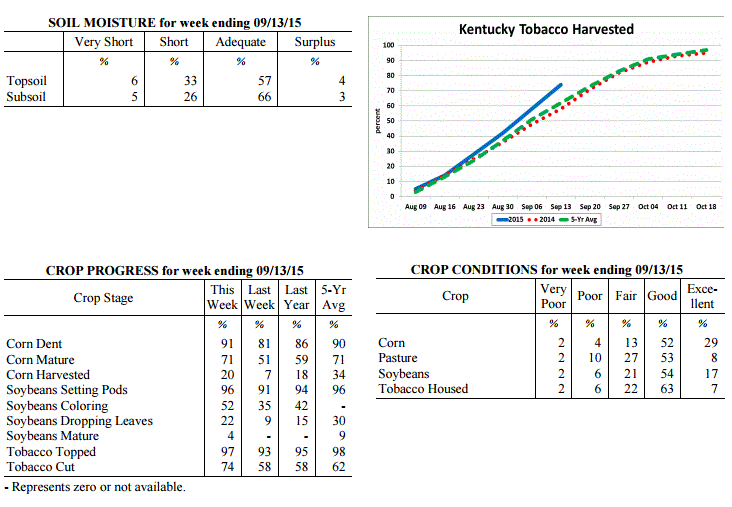 Kentucky Climate Summary
For the Period September 7, 2015 to September 13, 2015
Near Normal Temperatures and Above Normal Rainfall:
The Bluegrass State underwent a major pattern change this past week. The period
started off with above normal temperatures remaining in place. Through Tuesday,
southerly flow sent highs into the upper 80s to middle 90s for much of Kentucky,
continuing a warm and dry pattern for the beginning of September. That pattern broke
on Wednesday as a weak cold front pushed through the region. After a couple weeks of
mostly dry conditions, the Commonwealth saw some relief as scattered to numerous
showers and storms pushed through the Ohio Valley. An unsettled pattern continued
into the first half of the weekend. Overall, the state averaged just under an inch
for the week, which is slightly above normal for this time of the year. The period
ended with much drier and considerably cooler air in place. Clear skies on Saturday
night led to lows ranging from the middle 40s to around 50 for most, which is more
typical of mid to late October.
Temperatures for the period averaged 71 degrees across the state which was near
normal and 6 degrees cooler than the previous period. High temperatures averaged from
81 in the West to 79 in the East. Departure from normal high temperatures ranged
from 4 degrees cooler than normal in the West to 3 degrees cooler than normal in
the East. Low temperatures averaged from 62 degrees in the West to 62 degrees in the
East. Departure from normal low temperature ranged from 1 degree warmer than normal
in the West to 4 degrees warmer than normal in the East. The extreme high temperature
for the period was 94 degrees at LOUISA 1S and the extreme low was 41 degrees at
HENDERSON 5E.
Precipitation (liq. equ.) for the period totaled 0.98 inches statewide which was 0.16
inches above normal and 119% of normal. Precipitation totals by climate division,
West 0.52 inches, Central 0.88 inches, Bluegrass 1.12 inches and East 1.42 inches,
which was -0.30, -0.04, 0.37 and 0.62 inches respectively from normal. By station,
precipitation totals ranged from a low of 0.00 inches at GREENVILLE 6N to a high of
3.88 inches at STANFORD 4NE.
---
Kentucky Crop and Weather Report
Issued 4:00 P.M., September 8, 2015 27-15
Agricultural News: Kentucky experienced above normal temperatures and below normal
rainfall over the past week. Precipitation for the week totaled 0.09 inches, 0.67
inches below normal. Temperatures averaged 77 degrees for the week, 4 degrees above
normal. Topsoil moisture was rated 8 percent very short, 33 percent short, 57 percent
adequate and 2 percent surplus. Subsoil moisture was rated 5 percent very short, 27
percent short, 66 percent adequate, and 2 percent surplus. Days suitable for
fieldwork averaged 6.8 out of a possible seven.
Primary activities this week included cutting hay, topping and cutting tobacco. Corn
for grain harvest has begun in some locations. Corn is drying down fast due to dry
conditions. Most crops are in need of rain, especially soybeans. Soybean conditions
declined with seventy-one percent rated as good to excellent compared to seventy-five
percent last week. Pastures remain in mostly good condition, but are in decline due
to dry weather. Livestock remain in mostly good condition and producers are
optimistic about hay supplies. Producers continue to prepare equipment for the upcoming
harvest.
Kentucky Climate Summary
For the Period September 7, 2015 to September 13, 2015
Near Normal Temperatures and Above Normal Rainfall:
The Bluegrass State underwent a major pattern change this past week. The period
started off with above normal temperatures remaining in place. Through Tuesday,
southerly flow sent highs into the upper 80s to middle 90s for much of Kentucky,
continuing a warm and dry pattern for the beginning of September. That pattern broke
on Wednesday as a weak cold front pushed through the region. After a couple weeks of
mostly dry conditions, the Commonwealth saw some relief as scattered to numerous
showers and storms pushed through the Ohio Valley. An unsettled pattern continued
into the first half of the weekend. Overall, the state averaged just under an inch
for the week, which is slightly above normal for this time of the year. The period
ended with much drier and considerably cooler air in place. Clear skies on Saturday
night led to lows ranging from the middle 40s to around 50 for most, which is more
typical of mid to late October.
Temperatures for the period averaged 71 degrees across the state which was near
normal and 6 degrees cooler than the previous period. High temperatures averaged from
81 in the West to 79 in the East. Departure from normal high temperatures ranged
from 4 degrees cooler than normal in the West to 3 degrees cooler than normal in
the East. Low temperatures averaged from 62 degrees in the West to 62 degrees in the
East. Departure from normal low temperature ranged from 1 degree warmer than normal
in the West to 4 degrees warmer than normal in the East. The extreme high temperature
for the period was 94 degrees at LOUISA 1S and the extreme low was 41 degrees at
HENDERSON 5E.
Precipitation (liq. equ.) for the period totaled 0.98 inches statewide which was 0.16
inches above normal and 119% of normal. Precipitation totals by climate division,
West 0.52 inches, Central 0.88 inches, Bluegrass 1.12 inches and East 1.42 inches,
which was -0.30, -0.04, 0.37 and 0.62 inches respectively from normal. By station,
precipitation totals ranged from a low of 0.00 inches at GREENVILLE 6N to a high of
3.88 inches at STANFORD 4NE.
---
Kentucky Crop and Weather Report
Issued 4:00 P.M., September 8, 2015 27-15
Agricultural News: Kentucky experienced above normal temperatures and below normal
rainfall over the past week. Precipitation for the week totaled 0.09 inches, 0.67
inches below normal. Temperatures averaged 77 degrees for the week, 4 degrees above
normal. Topsoil moisture was rated 8 percent very short, 33 percent short, 57 percent
adequate and 2 percent surplus. Subsoil moisture was rated 5 percent very short, 27
percent short, 66 percent adequate, and 2 percent surplus. Days suitable for
fieldwork averaged 6.8 out of a possible seven.
Primary activities this week included cutting hay, topping and cutting tobacco. Corn
for grain harvest has begun in some locations. Corn is drying down fast due to dry
conditions. Most crops are in need of rain, especially soybeans. Soybean conditions
declined with seventy-one percent rated as good to excellent compared to seventy-five
percent last week. Pastures remain in mostly good condition, but are in decline due
to dry weather. Livestock remain in mostly good condition and producers are
optimistic about hay supplies. Producers continue to prepare equipment for the upcoming
harvest.
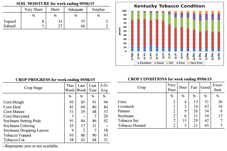 Kentucky Climate Summary
For the Period August 31, 2015 to September 6, 2015
Above Normal Temperatures and Below Normal Rainfall:
Summer made one last stand this past period with hot and humid conditions in place
for much of the week. Highs each day were above normal and increasing throughout the
period. By the holiday weekend, temperatures were consistently peaking in the low to
mid 90s for most. Looking at the week as a whole, the state averaged 90 degrees for
highs. Based on preliminary data at the Ag Weather Center, this threshold has not
been met since early August of 2012. High pressure also kept the area mostly dry
with only isolated to widely scattered coverage about each day. This led to a second
straight week of much below normal rainfall. The US Drought Monitor introduced
'Abnormally Dry Conditions' to a little over 13% of the state this past week.
Temperatures for the period averaged 77 degrees across the state which was 4 degrees
warmer than normal and 8 degrees warmer than the previous period. High temperatures
averaged from 91 in the West to 88 in the East. Departure from normal high
temperatures ranged from 4 degrees warmer than normal in the West to 4 degrees warmer
than normal in the East. Low temperatures averaged from 66 degrees in the West to 65
degrees in the East. Departure from normal low temperature ranged from 3 degrees
warmer than normal in the West to 5 degrees warmer than normal in the East. The
extreme high temperature for the period was 97 degrees at BOWLING GREEN APT and the
extreme low was 58 degrees at LIBERTY 3SW.
Precipitation (liq. equ.) for the period totaled 0.09 inches statewide which was 0.67
inches below normal and 12% of normal. Precipitation totals by climate division, West
0.01 inches, Central 0.07 inches, Bluegrass 0.20 inches and East 0.06 inches, which
was 0.69, 0.76, 0.53 and 0.72 inches below normal. By station, precipitation totals
ranged from a low of 0.00 inches at ALBANY 1N to a high of 1.45 inches at ALEXANDRIA 5NW.
---
Kentucky Crop and Weather Report
Issued 4:00 P.M., August 31, 2015 26-15
Agricultural News: Kentucky experienced below normal temperatures and rainfall over
the past week. Precipitation for the week totaled 0.09 inches, 0.66 inches below
normal. Temperatures averaged 69 degrees for the week, 6 degrees below normal.
Topsoil moisture was rated 3 percent very short, 22 percent short, 70 percent
adequate and 5 percent surplus. Subsoil moisture was rated 2 percent very short, 16
percent short, 77 percent adequate, and 5 percent surplus. Days suitable for
fieldwork averaged 6.6 out of a possible seven.
Primary activities this week included cutting hay, topping and cutting tobacco.
Disease and insect pressure remains a concern for field crops. There were reports of
southern rust and gray leaf spot in corn. Most locations are in need of rain as crops
are showing signs of stress due to lack of moisture. Soybeans are at a critical stage
of development and yields could be hampered if dry conditions continue. Yields are
expected to be light for grapes due to the harsh winter. Pastures remain in mostly
good condition, but are starting to decline due to dry weather. Housed tobacco is
reportedly curing well. Producers continue to prepare equipment for the upcoming
harvest.
Kentucky Climate Summary
For the Period August 31, 2015 to September 6, 2015
Above Normal Temperatures and Below Normal Rainfall:
Summer made one last stand this past period with hot and humid conditions in place
for much of the week. Highs each day were above normal and increasing throughout the
period. By the holiday weekend, temperatures were consistently peaking in the low to
mid 90s for most. Looking at the week as a whole, the state averaged 90 degrees for
highs. Based on preliminary data at the Ag Weather Center, this threshold has not
been met since early August of 2012. High pressure also kept the area mostly dry
with only isolated to widely scattered coverage about each day. This led to a second
straight week of much below normal rainfall. The US Drought Monitor introduced
'Abnormally Dry Conditions' to a little over 13% of the state this past week.
Temperatures for the period averaged 77 degrees across the state which was 4 degrees
warmer than normal and 8 degrees warmer than the previous period. High temperatures
averaged from 91 in the West to 88 in the East. Departure from normal high
temperatures ranged from 4 degrees warmer than normal in the West to 4 degrees warmer
than normal in the East. Low temperatures averaged from 66 degrees in the West to 65
degrees in the East. Departure from normal low temperature ranged from 3 degrees
warmer than normal in the West to 5 degrees warmer than normal in the East. The
extreme high temperature for the period was 97 degrees at BOWLING GREEN APT and the
extreme low was 58 degrees at LIBERTY 3SW.
Precipitation (liq. equ.) for the period totaled 0.09 inches statewide which was 0.67
inches below normal and 12% of normal. Precipitation totals by climate division, West
0.01 inches, Central 0.07 inches, Bluegrass 0.20 inches and East 0.06 inches, which
was 0.69, 0.76, 0.53 and 0.72 inches below normal. By station, precipitation totals
ranged from a low of 0.00 inches at ALBANY 1N to a high of 1.45 inches at ALEXANDRIA 5NW.
---
Kentucky Crop and Weather Report
Issued 4:00 P.M., August 31, 2015 26-15
Agricultural News: Kentucky experienced below normal temperatures and rainfall over
the past week. Precipitation for the week totaled 0.09 inches, 0.66 inches below
normal. Temperatures averaged 69 degrees for the week, 6 degrees below normal.
Topsoil moisture was rated 3 percent very short, 22 percent short, 70 percent
adequate and 5 percent surplus. Subsoil moisture was rated 2 percent very short, 16
percent short, 77 percent adequate, and 5 percent surplus. Days suitable for
fieldwork averaged 6.6 out of a possible seven.
Primary activities this week included cutting hay, topping and cutting tobacco.
Disease and insect pressure remains a concern for field crops. There were reports of
southern rust and gray leaf spot in corn. Most locations are in need of rain as crops
are showing signs of stress due to lack of moisture. Soybeans are at a critical stage
of development and yields could be hampered if dry conditions continue. Yields are
expected to be light for grapes due to the harsh winter. Pastures remain in mostly
good condition, but are starting to decline due to dry weather. Housed tobacco is
reportedly curing well. Producers continue to prepare equipment for the upcoming
harvest.
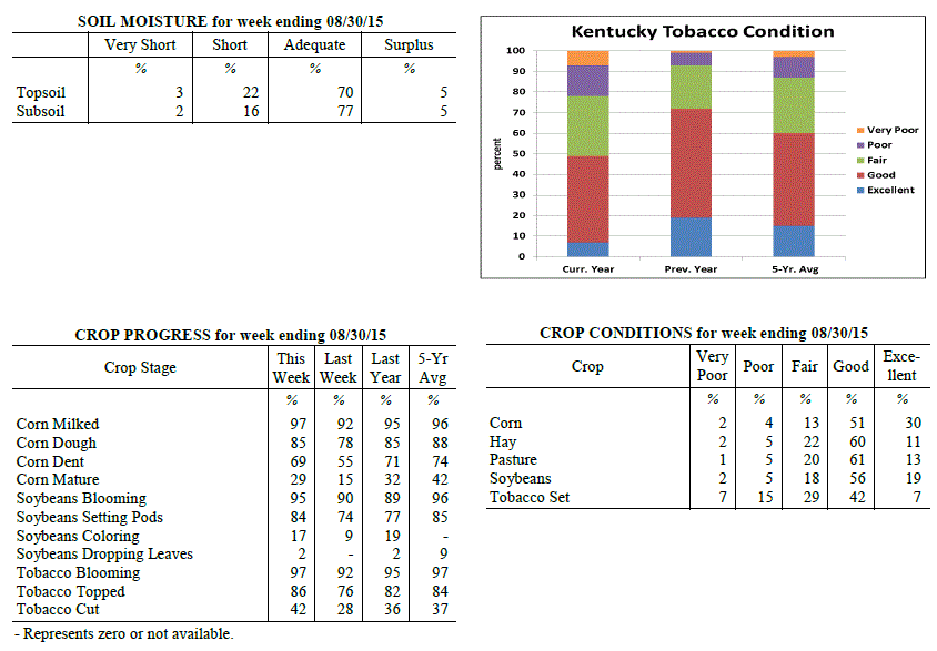 Kentucky Climate Summary
For the Period August 24, 2015 to August 30, 2015
Below Normal Temperatures and Rainfall:
Normally, the month of August brings the Commonwealth warm temperatures and high
humidity. August 2015 has been quite the opposite and that didn�t change over the
last week of the month. Cool conditions pushed the state to a fourth straight week
of below normal temperatures. Behind a strong cold front early on Monday, surface
high pressure built into the region for the remainder of the work week. Up until
Thursday, afternoon highs were only rising into the mid 70s to low 80s, before
dropping into the low to mid 50s at night. In fact, some locations even saw the
upper 40s. High pressure kept the area dry with any clouds developing in the
afternoon quickly clearing after sunset. In addition, low dewpoints made it feel
more like fall. The high shifted east by Friday and into the weekend, leading to
both moisture and temperatures on the increase. Within a moderately unstable
atmosphere, scattered showers and storms developed each day over the weekend. While
that was the case, rainfall was still much below normal for the week with many
stations not even recording a trace.
Temperatures for the period averaged 69 degrees across the state which was 6 degrees
cooler than normal and 4 degrees cooler than the previous period. High temperatures
averaged from 82 in the West to 80 in the East. Departure from normal high
temperatures ranged from 6 degrees cooler than normal in the West to 5 degrees
cooler than normal in the East. Low temperatures averaged from 58 degrees in the
West to 59 degrees in the East. Departure from normal low temperature ranged from 7
degrees cooler than normal in the West to 2 degrees cooler than normal in the East.
The extreme high temperature for the period was 91 degrees at ELKTON 5SW and the
extreme low was 48 degrees at BRANDENBURG 4SW.
Precipitation (liq. equ.) for the period totaled 0.09 inches statewide which was 0.66
inches below normal and 12% of normal. Precipitation totals by climate division, West
0.18 inches, Central 0.04 inches, Bluegrass 0.11 inches and East 0.03 inches, which
was 0.5, 0.74, 0.64 and 0.77 inches below normal. By station, precipitation totals
ranged from a low of 0.00 inches at ALBANY 1N to a high of 2.05 inches at CADIZ 4SW.
---
Kentucky Crop and Weather Report
Issued 4:00 P.M., August 24, 2015 25-15
Agricultural News: Kentucky experienced below normal temperatures and above normal
rainfall over the past week. Precipitation for the week totaled 1.02 inches, 0.17
inches above normal. Temperatures averaged 73 degrees for the week, 2 degrees below
normal. Topsoil moisture was rated 1 percent very short, 11 percent short, 78 percent
adequate and 10 percent surplus. Subsoil moisture was rated 1 percent very short, 9
percent short, 82 percent adequate, and 8 percent surplus. Days suitable for
fieldwork averaged 5.5 out of a possible seven.
Primary activities this week included cutting hay, topping and cutting tobacco.
Disease and insect pressure continues for field crops. Some locations are in need of
rain as crops are showing signs of lack of moisture. Early planted corn is beginning
to dry down in some areas. There is some concern over the possibility of weak corn
stalks this fall due to growing conditions this year. Pasture conditions remain in
mostly good to excellent condition. Producers are getting equipment ready for the
upcoming harvest.
Kentucky Climate Summary
For the Period August 24, 2015 to August 30, 2015
Below Normal Temperatures and Rainfall:
Normally, the month of August brings the Commonwealth warm temperatures and high
humidity. August 2015 has been quite the opposite and that didn�t change over the
last week of the month. Cool conditions pushed the state to a fourth straight week
of below normal temperatures. Behind a strong cold front early on Monday, surface
high pressure built into the region for the remainder of the work week. Up until
Thursday, afternoon highs were only rising into the mid 70s to low 80s, before
dropping into the low to mid 50s at night. In fact, some locations even saw the
upper 40s. High pressure kept the area dry with any clouds developing in the
afternoon quickly clearing after sunset. In addition, low dewpoints made it feel
more like fall. The high shifted east by Friday and into the weekend, leading to
both moisture and temperatures on the increase. Within a moderately unstable
atmosphere, scattered showers and storms developed each day over the weekend. While
that was the case, rainfall was still much below normal for the week with many
stations not even recording a trace.
Temperatures for the period averaged 69 degrees across the state which was 6 degrees
cooler than normal and 4 degrees cooler than the previous period. High temperatures
averaged from 82 in the West to 80 in the East. Departure from normal high
temperatures ranged from 6 degrees cooler than normal in the West to 5 degrees
cooler than normal in the East. Low temperatures averaged from 58 degrees in the
West to 59 degrees in the East. Departure from normal low temperature ranged from 7
degrees cooler than normal in the West to 2 degrees cooler than normal in the East.
The extreme high temperature for the period was 91 degrees at ELKTON 5SW and the
extreme low was 48 degrees at BRANDENBURG 4SW.
Precipitation (liq. equ.) for the period totaled 0.09 inches statewide which was 0.66
inches below normal and 12% of normal. Precipitation totals by climate division, West
0.18 inches, Central 0.04 inches, Bluegrass 0.11 inches and East 0.03 inches, which
was 0.5, 0.74, 0.64 and 0.77 inches below normal. By station, precipitation totals
ranged from a low of 0.00 inches at ALBANY 1N to a high of 2.05 inches at CADIZ 4SW.
---
Kentucky Crop and Weather Report
Issued 4:00 P.M., August 24, 2015 25-15
Agricultural News: Kentucky experienced below normal temperatures and above normal
rainfall over the past week. Precipitation for the week totaled 1.02 inches, 0.17
inches above normal. Temperatures averaged 73 degrees for the week, 2 degrees below
normal. Topsoil moisture was rated 1 percent very short, 11 percent short, 78 percent
adequate and 10 percent surplus. Subsoil moisture was rated 1 percent very short, 9
percent short, 82 percent adequate, and 8 percent surplus. Days suitable for
fieldwork averaged 5.5 out of a possible seven.
Primary activities this week included cutting hay, topping and cutting tobacco.
Disease and insect pressure continues for field crops. Some locations are in need of
rain as crops are showing signs of lack of moisture. Early planted corn is beginning
to dry down in some areas. There is some concern over the possibility of weak corn
stalks this fall due to growing conditions this year. Pasture conditions remain in
mostly good to excellent condition. Producers are getting equipment ready for the
upcoming harvest.
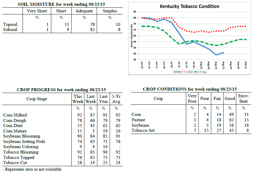 Kentucky Climate Summary
For the Period August 17, 2015 to August 23, 2015
Below Normal Temperatures and Above Normal Rainfall:
Behind a rather active first half of the work week, much of the Bluegrass State saw
near to above normal rainfall this past period. Most of the activity was seen on
Wednesday, ahead of a cold front passing through the Ohio Valley. Multiple rounds
were seen throughout the day with rainfall coverage increasing to widespread at
times. Precipitation came to an end on Thursday with surface high pressure working
into Kentucky. A noticeable change came to end the work week with unseasonably low
humidity in place and temperatures only rising into the 70s. Dry conditions held on
through Saturday, before the Bluegrass and Eastern Kentucky saw isolated to scattered
coverage on Sunday.
Temperatures for the period averaged 73 degrees across the state which was 2 degrees
cooler than normal and no change to the previous period. High temperatures averaged
from 82 in the West to 82 in the East. Departure from normal high temperatures
ranged from 6 degrees cooler than normal in the West to 4 degrees cooler than normal
in the East. Low temperatures averaged from 64 degrees in the West to 65 degrees in
the East. Departure from normal low temperature ranged from 1 degree cooler than
normal in the West to 3 degrees warmer than normal in the East. The extreme high
temperature for the period was 91 degrees at BOWLING GREEN 4E and the extreme low was
52 degrees at CYNTHIANA 8N.
Precipitation (liq. equ.) for the period totaled 1.02 inches statewide which was 0.17
inches above normal and 120% of normal. Precipitation totals by climate division,
West 1.19 inches, Central 0.80 inches, Bluegrass 0.85 inches and East 1.25 inches,
which was 0.42, -0.06, -0.01 and 0.33 inches respectively from normal. By station,
precipitation totals ranged from a low of 0.01 inches at PEABODY to a high of 2.56
inches at SHEPHERDSVILLE 6SE.
---
Kentucky Crop and Weather Report
Issued 4:00 P.M., August 17, 2015 24-15
Agricultural News: Kentucky experienced below normal temperatures and rainfall over
the past week. Precipitation for the week totaled 0.43 inches, 0.44 inches below
normal. Temperatures averaged 74 degrees for the week, 2 degrees below normal.
Topsoil moisture was rated 1 percent very short, 10 percent short, 78 percent
adequate and 11 percent surplus. Subsoil moisture was rated 0 percent very short, 7
percent short, 83 percent adequate, and 10 percent surplus. Days suitable for
fieldwork averaged 6.1 out of a possible seven.
Primary activities this week included cutting hay, topping and cutting tobacco and
spraying late soybeans for disease and insect control. Some previously flooded fields
were finally dry enough to allow for soybean replanting to occur. Crops are
experiencing disease and insect pressure, especially in fields that were unable to be
treated due to wet conditions. While some tobacco fields are recovering from the wet
conditions earlier in the season, overall conditions still reflect signs of stress.
Forty-nine percent of tobacco is rated as good to excellent compared to fifty-four
percent last week and sixty-nine percent last year. Pasture conditions are holding up
well due to the moisture that has been received this year, but growth is beginning to
slow due to recent drier weather. Livestock are reportedly in good shape and have
benefitted from good pasture conditions.
Kentucky Climate Summary
For the Period August 17, 2015 to August 23, 2015
Below Normal Temperatures and Above Normal Rainfall:
Behind a rather active first half of the work week, much of the Bluegrass State saw
near to above normal rainfall this past period. Most of the activity was seen on
Wednesday, ahead of a cold front passing through the Ohio Valley. Multiple rounds
were seen throughout the day with rainfall coverage increasing to widespread at
times. Precipitation came to an end on Thursday with surface high pressure working
into Kentucky. A noticeable change came to end the work week with unseasonably low
humidity in place and temperatures only rising into the 70s. Dry conditions held on
through Saturday, before the Bluegrass and Eastern Kentucky saw isolated to scattered
coverage on Sunday.
Temperatures for the period averaged 73 degrees across the state which was 2 degrees
cooler than normal and no change to the previous period. High temperatures averaged
from 82 in the West to 82 in the East. Departure from normal high temperatures
ranged from 6 degrees cooler than normal in the West to 4 degrees cooler than normal
in the East. Low temperatures averaged from 64 degrees in the West to 65 degrees in
the East. Departure from normal low temperature ranged from 1 degree cooler than
normal in the West to 3 degrees warmer than normal in the East. The extreme high
temperature for the period was 91 degrees at BOWLING GREEN 4E and the extreme low was
52 degrees at CYNTHIANA 8N.
Precipitation (liq. equ.) for the period totaled 1.02 inches statewide which was 0.17
inches above normal and 120% of normal. Precipitation totals by climate division,
West 1.19 inches, Central 0.80 inches, Bluegrass 0.85 inches and East 1.25 inches,
which was 0.42, -0.06, -0.01 and 0.33 inches respectively from normal. By station,
precipitation totals ranged from a low of 0.01 inches at PEABODY to a high of 2.56
inches at SHEPHERDSVILLE 6SE.
---
Kentucky Crop and Weather Report
Issued 4:00 P.M., August 17, 2015 24-15
Agricultural News: Kentucky experienced below normal temperatures and rainfall over
the past week. Precipitation for the week totaled 0.43 inches, 0.44 inches below
normal. Temperatures averaged 74 degrees for the week, 2 degrees below normal.
Topsoil moisture was rated 1 percent very short, 10 percent short, 78 percent
adequate and 11 percent surplus. Subsoil moisture was rated 0 percent very short, 7
percent short, 83 percent adequate, and 10 percent surplus. Days suitable for
fieldwork averaged 6.1 out of a possible seven.
Primary activities this week included cutting hay, topping and cutting tobacco and
spraying late soybeans for disease and insect control. Some previously flooded fields
were finally dry enough to allow for soybean replanting to occur. Crops are
experiencing disease and insect pressure, especially in fields that were unable to be
treated due to wet conditions. While some tobacco fields are recovering from the wet
conditions earlier in the season, overall conditions still reflect signs of stress.
Forty-nine percent of tobacco is rated as good to excellent compared to fifty-four
percent last week and sixty-nine percent last year. Pasture conditions are holding up
well due to the moisture that has been received this year, but growth is beginning to
slow due to recent drier weather. Livestock are reportedly in good shape and have
benefitted from good pasture conditions.
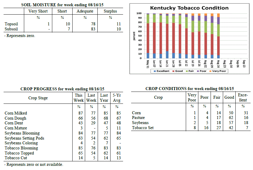 Kentucky Climate Summary
For the Period August 10, 2015 to August 16, 2015
Below Normal Temperatures and Rainfall:
This past period was mostly dry for much of the Bluegrass State. After a round of
scattered showers and storms ahead of a cold front on Monday, high pressure of
Canadian origin filtered into the Lower Ohio Valley by mid-week. This feature
brought unseasonably cool temperatures and low humidity to the area with highs on
Wednesday and Thursday only rising into the upper 70s to mid 80s. These readings would
be more typical of mid-September and led the state to a second straight week of
slightly below normal temperatures. Showers and storms returned over the weekend,
but remained isolated to widely scattered in coverage. Overall, the state was nearly
a half inch below normal for the period.
Temperatures for the period averaged 74 degrees across the state which was 2 degrees
cooler than normal and no change to the previous period. High temperatures averaged
from 85 in the West to 84 in the East. Departure from normal high temperatures
ranged from 3 degrees cooler than normal in the West to 2 degrees cooler than normal
in the East. Low temperatures averaged from 65 degrees in the West to 64 degrees in
the East. Departure from normal low temperature ranged from 1 degree cooler than
normal in the West to 1 degree warmer than normal in the East. The extreme high
temperature for the period was 92 degrees at LOUISVILLE APT and the extreme low was
54 degrees at MCKEE 5S.
Precipitation (liq. equ.) for the period totaled 0.43 inches statewide which was 0.44
inches below normal and 50% of normal. Precipitation totals by climate division, West
0.45 inches, Central 0.51 inches, Bluegrass 0.34 inches and East 0.44 inches, which
was 0.35, 0.34, 0.53 and 0.51 inches below normal. By station, precipitation totals
ranged from a low of 0.00 inches at ELKTON 5SW to a high of 2.03 inches at
BOWLING GREEN 5S.
---
Kentucky Crop and Weather Report
Issued 4:00 P.M., August 10, 2015 23-15
Agricultural News: Kentucky experienced below normal temperatures and above normal
rainfall over the past week. Precipitation for the week totaled 1.21 inches, 0.27
inches above normal. Temperatures averaged 75 degrees for the week, 1 degrees below
normal. Topsoil moisture was rated 0 percent very short, 5 percent short, 76 percent
adequate and 19 percent surplus. Subsoil moisture was rated 0 percent very short, 4
percent short, 80 percent adequate, and 16 percent surplus. Days suitable for
fieldwork averaged 4.6 out of a possible seven.
Primary activities this week included cutting hay, topping tobacco and spraying late
soybeans for disease and insect control. Tobacco harvest is underway across the
state. Excess rainfall has reportedly drowned out some tobacco acreage in low lying
areas. Diseases such as target spot and black shank have also taken a toll on some
producers as well. Many fields of double crop soybeans are behind normal progress,
but single crop beans appear to be at or ahead of normal. Timing of when crops were
planted will have an impact on yields as earlier planted crops were impacted less by
the abundance of rainfall in late June and July.
Kentucky Climate Summary
For the Period August 10, 2015 to August 16, 2015
Below Normal Temperatures and Rainfall:
This past period was mostly dry for much of the Bluegrass State. After a round of
scattered showers and storms ahead of a cold front on Monday, high pressure of
Canadian origin filtered into the Lower Ohio Valley by mid-week. This feature
brought unseasonably cool temperatures and low humidity to the area with highs on
Wednesday and Thursday only rising into the upper 70s to mid 80s. These readings would
be more typical of mid-September and led the state to a second straight week of
slightly below normal temperatures. Showers and storms returned over the weekend,
but remained isolated to widely scattered in coverage. Overall, the state was nearly
a half inch below normal for the period.
Temperatures for the period averaged 74 degrees across the state which was 2 degrees
cooler than normal and no change to the previous period. High temperatures averaged
from 85 in the West to 84 in the East. Departure from normal high temperatures
ranged from 3 degrees cooler than normal in the West to 2 degrees cooler than normal
in the East. Low temperatures averaged from 65 degrees in the West to 64 degrees in
the East. Departure from normal low temperature ranged from 1 degree cooler than
normal in the West to 1 degree warmer than normal in the East. The extreme high
temperature for the period was 92 degrees at LOUISVILLE APT and the extreme low was
54 degrees at MCKEE 5S.
Precipitation (liq. equ.) for the period totaled 0.43 inches statewide which was 0.44
inches below normal and 50% of normal. Precipitation totals by climate division, West
0.45 inches, Central 0.51 inches, Bluegrass 0.34 inches and East 0.44 inches, which
was 0.35, 0.34, 0.53 and 0.51 inches below normal. By station, precipitation totals
ranged from a low of 0.00 inches at ELKTON 5SW to a high of 2.03 inches at
BOWLING GREEN 5S.
---
Kentucky Crop and Weather Report
Issued 4:00 P.M., August 10, 2015 23-15
Agricultural News: Kentucky experienced below normal temperatures and above normal
rainfall over the past week. Precipitation for the week totaled 1.21 inches, 0.27
inches above normal. Temperatures averaged 75 degrees for the week, 1 degrees below
normal. Topsoil moisture was rated 0 percent very short, 5 percent short, 76 percent
adequate and 19 percent surplus. Subsoil moisture was rated 0 percent very short, 4
percent short, 80 percent adequate, and 16 percent surplus. Days suitable for
fieldwork averaged 4.6 out of a possible seven.
Primary activities this week included cutting hay, topping tobacco and spraying late
soybeans for disease and insect control. Tobacco harvest is underway across the
state. Excess rainfall has reportedly drowned out some tobacco acreage in low lying
areas. Diseases such as target spot and black shank have also taken a toll on some
producers as well. Many fields of double crop soybeans are behind normal progress,
but single crop beans appear to be at or ahead of normal. Timing of when crops were
planted will have an impact on yields as earlier planted crops were impacted less by
the abundance of rainfall in late June and July.
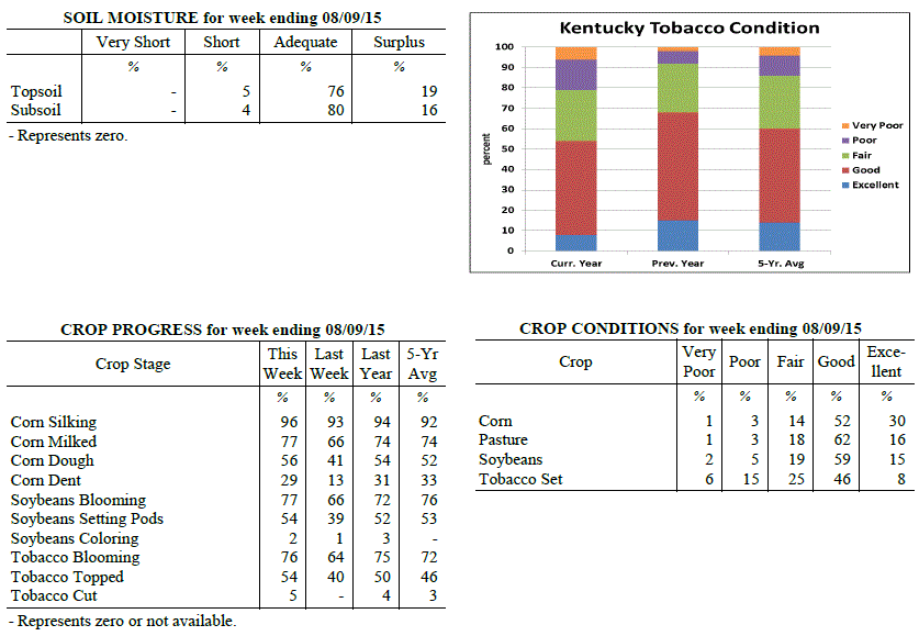 Kentucky Climate Summary
For the Period August 3, 2015 to August 9, 2015
Below Normal Temperatures and Above Normal Rainfall:
Record July rainfall for the state of Kentucky was followed by an active start to the
month of August. The Bluegrass State saw numerous rounds of rainfall through the work
week with the most notable coming over the second half. Low pressure slowly made way
across the Lower Ohio Valley, leading to repeated waves of precipitation and the
threat of more flash flooding. This activity lasted through Thursday night, before
dry conditions won out for the weekend. After starting the period with above normal
temperatures in place, cloud cover and rainfall brought cooler conditions back to the
area. Highs Thursday and Friday only averaged in the mid 70s to low 80s, much below
normal for this time of the year. Looking back at July, Kentucky averaged 8.99 inches
for the month, which ranks first on the 121 year record going back until 1895.
Temperatures for the period averaged 75 degrees across the state which was 1 degree
cooler than normal and 2 degrees cooler than the previous period. High temperatures
averaged from 84 in the West to 84 in the East. Departure from normal high
temperatures ranged from 4 degrees cooler than normal in the West to 2 degrees
cooler than normal in the East. Low temperatures averaged from 68 degrees in the
West to 65 degrees in the East. Departure from normal low temperature ranged from 2
degrees warmer than normal in the West to 2 degrees warmer than normal in the East.
The extreme high temperature for the period was 96 degrees at BOWLING GREEN 4E and
the extreme low was 57 degrees at PAINTSVILLE 4W.
Precipitation (liq. equ.) for the period totaled 1.21 inches statewide which was 0.27
inches above normal and 129% of normal. Precipitation totals by climate division,
West 1.19 inches, Central 0.94 inches, Bluegrass 1.36 inches and East 1.36 inches,
which was 0.29, 0.03, 0.45 and 0.34 inches above normal. By station, precipitation
totals ranged from a low of 0.02 inches at PEABODY to a high of 4.31 inches at
OWINGSVILLE 4S.
---
Kentucky Crop and Weather Report
Issued 4:00 P.M., August 3, 2015 22-15
Agricultural News: Kentucky experienced above normal temperatures and below normal
rainfall over the past week. Precipitation for the week totaled 0.77 inches, 0.20
inches below normal. Temperatures averaged 78 degrees for the week, 2 degrees above
normal. Topsoil moisture was rated 0 percent very short, 5 percent short, 71 percent
adequate and 24 percent surplus. Subsoil moisture was rated 0 percent very short, 3
percent short, 78 percent adequate, and 19 percent surplus. Days suitable for
fieldwork averaged 5.4 out of a possible seven.
Primary activities this week included cutting hay, topping tobacco and spraying
herbicides on late soybeans. Rivers have receded with crop losses varied in low lying
areas. Some bottom land acreage experienced total losses due to standing water. Some
farmers still plan on replanting double crop soybeans if weather remains dry. There
were reports of disease pressure due to wet weather and humid temperatures. Excessive
moisture has reportedly impacted some of the tobacco crop. The affected acreage may
recover if weather improves, but there is concern that yields and quality could be
impacted. Hay supplies should be adequate this year for most farmers, but quality
could be lacking due to the impact rains had on the timing of cutting hay as well as
getting wet before it could be baled. Some producers were unable to finish first
cutting until late July, therefore will not get a second cutting this year. Hay and
roughage supplies were reported as 2 percent very short, 16 percent short, 73 percent
adequate, and 9 percent surplus.
Kentucky Climate Summary
For the Period August 3, 2015 to August 9, 2015
Below Normal Temperatures and Above Normal Rainfall:
Record July rainfall for the state of Kentucky was followed by an active start to the
month of August. The Bluegrass State saw numerous rounds of rainfall through the work
week with the most notable coming over the second half. Low pressure slowly made way
across the Lower Ohio Valley, leading to repeated waves of precipitation and the
threat of more flash flooding. This activity lasted through Thursday night, before
dry conditions won out for the weekend. After starting the period with above normal
temperatures in place, cloud cover and rainfall brought cooler conditions back to the
area. Highs Thursday and Friday only averaged in the mid 70s to low 80s, much below
normal for this time of the year. Looking back at July, Kentucky averaged 8.99 inches
for the month, which ranks first on the 121 year record going back until 1895.
Temperatures for the period averaged 75 degrees across the state which was 1 degree
cooler than normal and 2 degrees cooler than the previous period. High temperatures
averaged from 84 in the West to 84 in the East. Departure from normal high
temperatures ranged from 4 degrees cooler than normal in the West to 2 degrees
cooler than normal in the East. Low temperatures averaged from 68 degrees in the
West to 65 degrees in the East. Departure from normal low temperature ranged from 2
degrees warmer than normal in the West to 2 degrees warmer than normal in the East.
The extreme high temperature for the period was 96 degrees at BOWLING GREEN 4E and
the extreme low was 57 degrees at PAINTSVILLE 4W.
Precipitation (liq. equ.) for the period totaled 1.21 inches statewide which was 0.27
inches above normal and 129% of normal. Precipitation totals by climate division,
West 1.19 inches, Central 0.94 inches, Bluegrass 1.36 inches and East 1.36 inches,
which was 0.29, 0.03, 0.45 and 0.34 inches above normal. By station, precipitation
totals ranged from a low of 0.02 inches at PEABODY to a high of 4.31 inches at
OWINGSVILLE 4S.
---
Kentucky Crop and Weather Report
Issued 4:00 P.M., August 3, 2015 22-15
Agricultural News: Kentucky experienced above normal temperatures and below normal
rainfall over the past week. Precipitation for the week totaled 0.77 inches, 0.20
inches below normal. Temperatures averaged 78 degrees for the week, 2 degrees above
normal. Topsoil moisture was rated 0 percent very short, 5 percent short, 71 percent
adequate and 24 percent surplus. Subsoil moisture was rated 0 percent very short, 3
percent short, 78 percent adequate, and 19 percent surplus. Days suitable for
fieldwork averaged 5.4 out of a possible seven.
Primary activities this week included cutting hay, topping tobacco and spraying
herbicides on late soybeans. Rivers have receded with crop losses varied in low lying
areas. Some bottom land acreage experienced total losses due to standing water. Some
farmers still plan on replanting double crop soybeans if weather remains dry. There
were reports of disease pressure due to wet weather and humid temperatures. Excessive
moisture has reportedly impacted some of the tobacco crop. The affected acreage may
recover if weather improves, but there is concern that yields and quality could be
impacted. Hay supplies should be adequate this year for most farmers, but quality
could be lacking due to the impact rains had on the timing of cutting hay as well as
getting wet before it could be baled. Some producers were unable to finish first
cutting until late July, therefore will not get a second cutting this year. Hay and
roughage supplies were reported as 2 percent very short, 16 percent short, 73 percent
adequate, and 9 percent surplus.
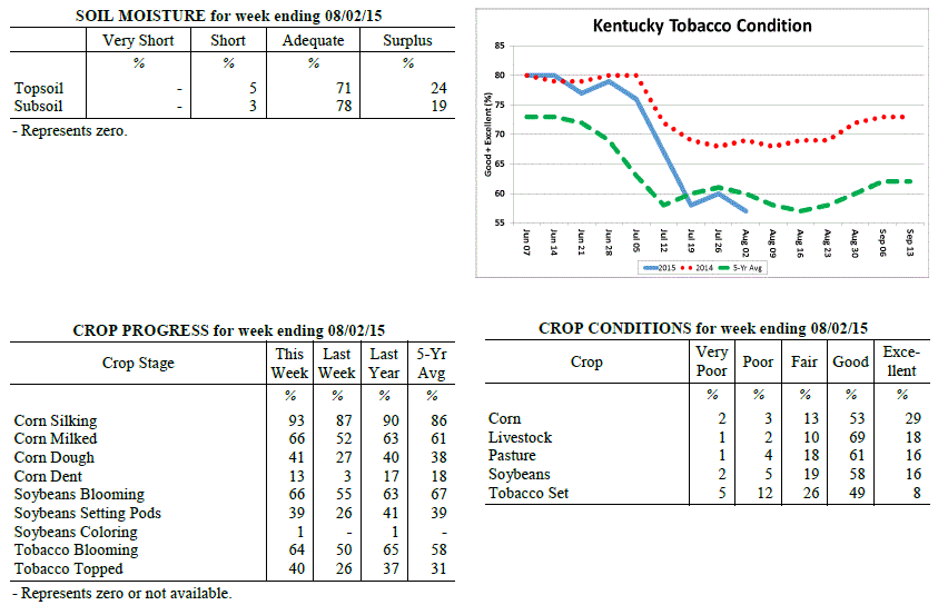 Kentucky Climate Summary
For the Period July 27, 2015 to August 2, 2015
Above Normal Temperatures and Below Normal Rainfall:
In typical Ohio Valley fashion, Kentucky saw an abrupt change to the weather pattern
halfway through this past period. The first half of the work week brought hot and
humid conditions, in addition to multiple opportunities for rainfall. Disturbances
passed through the state along the periphery of an upper level ridge of high
pressure. Storms were capable of torrential rainfall at times as Kentucky was
situated within a very moist air mass. The Bluegrass Region and Western Kentucky saw
the brunt of the rainfall and actually saw above normal rainfall for the week.
Eastern Kentucky missed out on much of the activity and was about three quarters of
inch below normal. During this time, highs were peaking in the upper 80s to mid 90s
with very muggy conditions in place. Luckily, a cold front passing through the area
on Wednesday brought a much different air mass to the region for the second half of
the week. Dewpoints dropped to much more comfortable levels, along with temperatures
returning to near seasonable norms for the start of August. In addition, surface
high pressure kept the area dry.
Temperatures for the period averaged 78 degrees across the state which was 2 degrees
warmer than normal and 2 degrees warmer than the previous period. High temperatures
averaged from 90 in the West to 87 in the East. Departure from normal high
temperatures ranged from 1 degree warmer than normal in the West to near normal in
the East. Low temperatures averaged from 69 degrees in the West to 66 degrees in the
East. Departure from normal low temperature ranged from 2 degrees warmer than normal
in the West to 2 degrees warmer than normal in the East. The extreme high temperature
for the period was 97 degrees at POPLAR BLUFF ASOS and the extreme low was 55 degrees
at MONTICELLO AWOS.
Precipitation (liq. equ.) for the period totaled 0.77 inches statewide which was 0.2
inches below normal and 79% of normal. Precipitation totals by climate division, West
1.03 inches, Central 0.60 inches, Bluegrass 1.19 inches and East 0.27 inches, which
was 0.10, -0.36, 0.23 and -0.76 inches respectively from normal. By station,
precipitation totals ranged from a low of 0.00 inches at HARTFORD 3E to a high of
3.30 inches at CADIZ 4SW.
---
Kentucky Crop and Weather Report
Issued 4:00 P.M., July 27, 2015 21-15
Agricultural News: Kentucky finally experienced a break from heavy rainfalls over the
past week. Precipitation for the week totaled 0.71 inches, 0.25 inches below normal.
Temperatures averaged 77 degrees for the week, unchanged from normal. Topsoil
moisture was rated 3 percent short, 65 percent adequate and 32 percent surplus.
Subsoil moisture was rated 3 percent short, 74 percent adequate, and 23 percent
surplus. Days suitable for fieldwork averaged 4.7 out of a possible seven.
Primary activities this week included cutting hay and topping tobacco where
conditions allowed. In most areas of Kentucky farmers were finally able to get back
in the field. Crops in areas near the Ohio River continue to remain under water,
however. Soybean and tobacco crops have been completely destroyed in a few areas.
Some farmers plan on replanting double cropped soybeans up into the beginning of
August. Tobacco condition increased slightly with sixty percent rated as good to
excellent compared to fifty-eight percent last week. However, target spot and black
shank are moving into some tobacco fields. Hay conditions have decreased since last
month with sixty- four percent rated as good to excellent compared to seventy-two
percent at the end of June. Pasture conditions remain in mostly good to excellent
condition.
Kentucky Climate Summary
For the Period July 27, 2015 to August 2, 2015
Above Normal Temperatures and Below Normal Rainfall:
In typical Ohio Valley fashion, Kentucky saw an abrupt change to the weather pattern
halfway through this past period. The first half of the work week brought hot and
humid conditions, in addition to multiple opportunities for rainfall. Disturbances
passed through the state along the periphery of an upper level ridge of high
pressure. Storms were capable of torrential rainfall at times as Kentucky was
situated within a very moist air mass. The Bluegrass Region and Western Kentucky saw
the brunt of the rainfall and actually saw above normal rainfall for the week.
Eastern Kentucky missed out on much of the activity and was about three quarters of
inch below normal. During this time, highs were peaking in the upper 80s to mid 90s
with very muggy conditions in place. Luckily, a cold front passing through the area
on Wednesday brought a much different air mass to the region for the second half of
the week. Dewpoints dropped to much more comfortable levels, along with temperatures
returning to near seasonable norms for the start of August. In addition, surface
high pressure kept the area dry.
Temperatures for the period averaged 78 degrees across the state which was 2 degrees
warmer than normal and 2 degrees warmer than the previous period. High temperatures
averaged from 90 in the West to 87 in the East. Departure from normal high
temperatures ranged from 1 degree warmer than normal in the West to near normal in
the East. Low temperatures averaged from 69 degrees in the West to 66 degrees in the
East. Departure from normal low temperature ranged from 2 degrees warmer than normal
in the West to 2 degrees warmer than normal in the East. The extreme high temperature
for the period was 97 degrees at POPLAR BLUFF ASOS and the extreme low was 55 degrees
at MONTICELLO AWOS.
Precipitation (liq. equ.) for the period totaled 0.77 inches statewide which was 0.2
inches below normal and 79% of normal. Precipitation totals by climate division, West
1.03 inches, Central 0.60 inches, Bluegrass 1.19 inches and East 0.27 inches, which
was 0.10, -0.36, 0.23 and -0.76 inches respectively from normal. By station,
precipitation totals ranged from a low of 0.00 inches at HARTFORD 3E to a high of
3.30 inches at CADIZ 4SW.
---
Kentucky Crop and Weather Report
Issued 4:00 P.M., July 27, 2015 21-15
Agricultural News: Kentucky finally experienced a break from heavy rainfalls over the
past week. Precipitation for the week totaled 0.71 inches, 0.25 inches below normal.
Temperatures averaged 77 degrees for the week, unchanged from normal. Topsoil
moisture was rated 3 percent short, 65 percent adequate and 32 percent surplus.
Subsoil moisture was rated 3 percent short, 74 percent adequate, and 23 percent
surplus. Days suitable for fieldwork averaged 4.7 out of a possible seven.
Primary activities this week included cutting hay and topping tobacco where
conditions allowed. In most areas of Kentucky farmers were finally able to get back
in the field. Crops in areas near the Ohio River continue to remain under water,
however. Soybean and tobacco crops have been completely destroyed in a few areas.
Some farmers plan on replanting double cropped soybeans up into the beginning of
August. Tobacco condition increased slightly with sixty percent rated as good to
excellent compared to fifty-eight percent last week. However, target spot and black
shank are moving into some tobacco fields. Hay conditions have decreased since last
month with sixty- four percent rated as good to excellent compared to seventy-two
percent at the end of June. Pasture conditions remain in mostly good to excellent
condition.
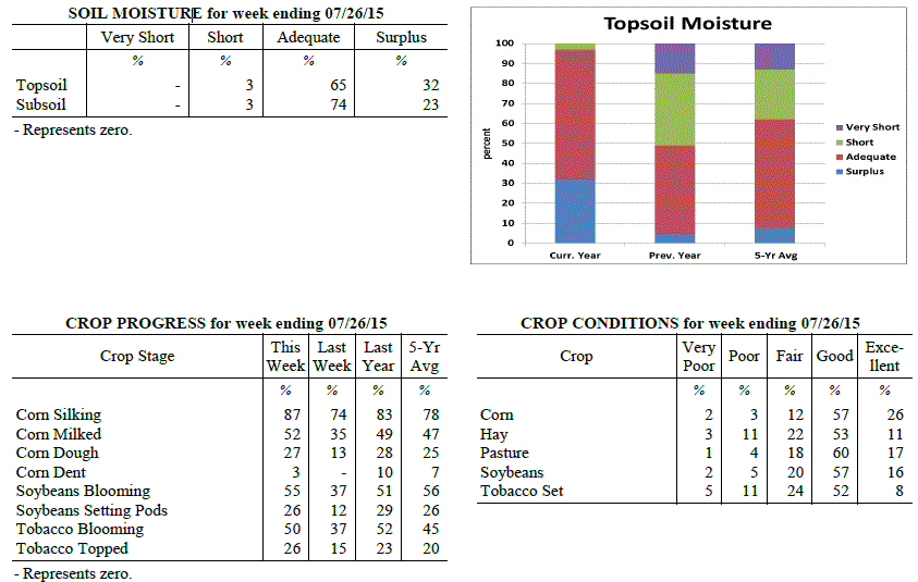 Kentucky Climate Summary
For the Period July 20, 2015 to July 26, 2015
Near Normal Temperatures and Below Normal Rainfall:
The Commonwealth saw another couple rounds of rainfall this past week, but overall,
much of the state finally got a break from weeks of much above normal precipitation.
The state average for the period was 0.71 inches, which was a quarter inch below
normal for the week. This broke a five week span of above normal precipitation that
extended back into mid-June. Looking at temperatures, it was an up and down pattern
through the week. After starting the period on the hot and humid side, a cold front
brought a much welcomed break. High temperatures dipped slightly below seasonable
norms by Wednesday, but the break was short lived. High pressure at the surface and
aloft pushed into the region for the weekend, bumping temperatures back into the
middle 80s to low 90s for most. During this time, evapotranspiration estimates
across the state were around 0.2 inches of water loss each day. The end of July is
normally the warmest time of the year for Kentucky with highs averaging in the middle
80s to around 90.
Temperatures for the period averaged 77 degrees across the state which was near
normal and 2 degrees cooler than the previous period. High temperatures averaged from
86 in the West to 85 in the East. Departure from normal high temperatures ranged from
3 degrees cooler than normal in the West to 2 degrees cooler than normal in the East.
Low temperatures averaged from 71 degrees in the West to 67 degrees in the East.
Departure from normal low temperature ranged from 4 degrees warmer than normal in the
West to 3 degrees warmer than normal in the East. The extreme high temperature for
the period was 93 degrees at POPLAR BLUFF ASOS and the extreme low was 57 degrees at
MOREHEAD 4NE.
Precipitation (liq. equ.) for the period totaled 0.71 inches statewide which was 0.25
inches below normal and 74% of normal. Precipitation totals by climate division, West
1.55 inches, Central 0.35 inches, Bluegrass 0.37 inches and East 0.56 inches, which
was 0.65, -0.62, -0.58 and -0.44 inches respectively from normal. By station,
precipitation totals ranged from a low of 0.00 inches at CARROLLTON 2E to a high of
4.81 inches at MURRAY 1W.
---
Kentucky Crop and Weather Report
Issued 4:00 P.M., July 20, 2015 20-15
Agricultural News: Kentucky experienced above normal temperatures and rainfall over
the past week. Precipitation for the week totaled 1.78 inches, 0.78 inches above
normal. Temperatures averaged 79 degrees for the week, 2 degrees above normal.
Topsoil moisture was rated 4 percent short, 55 percent adequate and 41 percent
surplus. Subsoil moisture was rated 3 percent short, 67 percent adequate, and 30
percent surplus. Days suitable for fieldwork averaged 3.9 out of a possible seven.
Primary activities this week included spraying crops for weeds, cutting hay and
topping tobacco where conditions allowed. Field activities continue to be interrupted
by rain. Rivers continue to rise and many low lying areas remain under water,
affecting corn, soybeans, and sorghum acreage. Corn rust and other diseases are
starting to appear. Early planted crops are withstanding the rainfall better than the
later crops. Weed pressure in crops remain a concern as many farmers have not been
able to get into fields to spray or plow. Corn, soybeans, and tobacco fields with
standing water are yellowing and showing signs of stress. Tobacco condition is
declining due to excess water, wind damage and disease pressure, with fifty-eight
percent rated as good to excellent, compared to sixty-seven percent last week.
Pasture conditions remain in mostly good to excellent condition and have benefitted
from the continued rainfall. High temperatures and humidity over the weekend pushed
the livestock heat stress into the emergency category.
Kentucky Climate Summary
For the Period July 20, 2015 to July 26, 2015
Near Normal Temperatures and Below Normal Rainfall:
The Commonwealth saw another couple rounds of rainfall this past week, but overall,
much of the state finally got a break from weeks of much above normal precipitation.
The state average for the period was 0.71 inches, which was a quarter inch below
normal for the week. This broke a five week span of above normal precipitation that
extended back into mid-June. Looking at temperatures, it was an up and down pattern
through the week. After starting the period on the hot and humid side, a cold front
brought a much welcomed break. High temperatures dipped slightly below seasonable
norms by Wednesday, but the break was short lived. High pressure at the surface and
aloft pushed into the region for the weekend, bumping temperatures back into the
middle 80s to low 90s for most. During this time, evapotranspiration estimates
across the state were around 0.2 inches of water loss each day. The end of July is
normally the warmest time of the year for Kentucky with highs averaging in the middle
80s to around 90.
Temperatures for the period averaged 77 degrees across the state which was near
normal and 2 degrees cooler than the previous period. High temperatures averaged from
86 in the West to 85 in the East. Departure from normal high temperatures ranged from
3 degrees cooler than normal in the West to 2 degrees cooler than normal in the East.
Low temperatures averaged from 71 degrees in the West to 67 degrees in the East.
Departure from normal low temperature ranged from 4 degrees warmer than normal in the
West to 3 degrees warmer than normal in the East. The extreme high temperature for
the period was 93 degrees at POPLAR BLUFF ASOS and the extreme low was 57 degrees at
MOREHEAD 4NE.
Precipitation (liq. equ.) for the period totaled 0.71 inches statewide which was 0.25
inches below normal and 74% of normal. Precipitation totals by climate division, West
1.55 inches, Central 0.35 inches, Bluegrass 0.37 inches and East 0.56 inches, which
was 0.65, -0.62, -0.58 and -0.44 inches respectively from normal. By station,
precipitation totals ranged from a low of 0.00 inches at CARROLLTON 2E to a high of
4.81 inches at MURRAY 1W.
---
Kentucky Crop and Weather Report
Issued 4:00 P.M., July 20, 2015 20-15
Agricultural News: Kentucky experienced above normal temperatures and rainfall over
the past week. Precipitation for the week totaled 1.78 inches, 0.78 inches above
normal. Temperatures averaged 79 degrees for the week, 2 degrees above normal.
Topsoil moisture was rated 4 percent short, 55 percent adequate and 41 percent
surplus. Subsoil moisture was rated 3 percent short, 67 percent adequate, and 30
percent surplus. Days suitable for fieldwork averaged 3.9 out of a possible seven.
Primary activities this week included spraying crops for weeds, cutting hay and
topping tobacco where conditions allowed. Field activities continue to be interrupted
by rain. Rivers continue to rise and many low lying areas remain under water,
affecting corn, soybeans, and sorghum acreage. Corn rust and other diseases are
starting to appear. Early planted crops are withstanding the rainfall better than the
later crops. Weed pressure in crops remain a concern as many farmers have not been
able to get into fields to spray or plow. Corn, soybeans, and tobacco fields with
standing water are yellowing and showing signs of stress. Tobacco condition is
declining due to excess water, wind damage and disease pressure, with fifty-eight
percent rated as good to excellent, compared to sixty-seven percent last week.
Pasture conditions remain in mostly good to excellent condition and have benefitted
from the continued rainfall. High temperatures and humidity over the weekend pushed
the livestock heat stress into the emergency category.
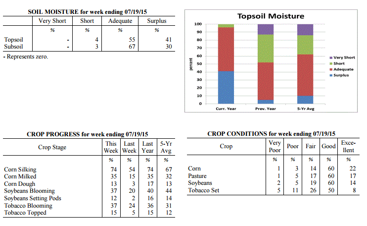 Kentucky Climate Summary
For the Period July 13, 2015 to July 19, 2015
Above Normal Temperatures and Rainfall:
Depending on location, this past week either brought another round of flooding or
dangerously hot and humid conditions. Starting off, the early work week saw numerous
rounds of storms pass through mainly the eastern half of the state, which gave way to
even more flash flooding. Over the course of the period, the Bluegrass and Eastern
Kentucky each saw an average of around two inches. Looking at data from the start of
July, these two regions are now over 4 inches above normal for the month. In
addition to the rainfall, storms merged into a couple of lines on Monday and Tuesday,
leading to widespread damaging winds. While the eastern half of the state saw a very
active pattern, Western Kentucky remained more under the influence of an upper level
ridge of high pressure. This kept the area dry with little to no rainfall. The
influence of this ridge was felt more-so on Friday and into the weekend. While
the entire state saw a rise in heat and humidity, it was most noticeable across the
western half of the state. Highs rose into the mid 90s and with high dewpoints, the
heat index was near 110 at times. This pushed the livestock heat stress index into
the emergency category for much of the weekend.
Temperatures for the period averaged 79 degrees across the state which was 2 degrees
warmer than normal and 2 degrees warmer than the previous period. High temperatures
averaged from 90 in the West to 86 in the East. Departure from normal high
temperatures ranged from near normal in the West to 1 degree cooler than
normal in the East. Low temperatures averaged from 75 degrees in the West to 67
degrees in the East. Departure from normal low temperature ranged from 7 degrees
warmer than normal in the West to 3 degrees warmer than normal in the East. The extreme
high temperature for the period was 95 degrees at BOWLING GREEN APT and the extreme low
was 60 degrees at ALEXANDRIA 5NW.
Precipitation (liq. equ.) for the period totaled 1.78 inches statewide which was 0.78
inches above normal and 178% of normal. Precipitation totals by climate division,
West 0.11 inches, Central 1.04 inches, Bluegrass 3.04 inches and East 2.91 inches,
which was -0.86, 0.02, 2.07 and 1.88 inches respectively from normal. By station,
precipitation totals ranged from a low of 0.00 inches at BENTON 4N to a high of 6.48
inches at LA GRANGE 6NW.
---
Kentucky Crop and Weather Report
Issued 4:00 P.M., July 13, 2015 19-15
Agricultural News: Kentucky experienced near normal temperatures and well above
normal rainfall over the past week. Precipitation for the week totaled 2.45 inches,
1.63 inches above normal. Temperatures averaged 76 degrees for the week, which was
near normal. Topsoil moisture was rated 0 percent very short, 2 percent short, 55
percent adequate and 43 percent surplus. Subsoil moisture was rated 0 percent very
short, 3 percent short, 67 percent adequate, and 30 percent surplus. Days suitable
for fieldwork averaged 2.0 out of a possible seven.
Field activities were once again hampered due to rains throughout the week. The
ground is saturated in many areas and some planted crops have been destroyed as
fields are under water. Early planted crops look good, but later crops are showing
effects of too much water, especially in low lying areas. Some soybeans may not get
planted due to wet conditions. Weed pressure in soybeans is a concern as farmers
cannot get in fields to spray. Corn and tobacco fields with standing water are
yellowing and some root rot has been reported in tobacco. Hay, both alfalfa and other
types, are in need of harvesting, but wet conditions continue to prevent any
progress. Hay quality continues to deteriorate due to over maturity and getting wet
after being cut. Vegetable growers have also been negatively impacted by the heavy
rains due to standing water and disease. Pasture conditions have benefitted from
all the moisture and grasses have really greened up and showed good growth.
Kentucky Climate Summary
For the Period July 13, 2015 to July 19, 2015
Above Normal Temperatures and Rainfall:
Depending on location, this past week either brought another round of flooding or
dangerously hot and humid conditions. Starting off, the early work week saw numerous
rounds of storms pass through mainly the eastern half of the state, which gave way to
even more flash flooding. Over the course of the period, the Bluegrass and Eastern
Kentucky each saw an average of around two inches. Looking at data from the start of
July, these two regions are now over 4 inches above normal for the month. In
addition to the rainfall, storms merged into a couple of lines on Monday and Tuesday,
leading to widespread damaging winds. While the eastern half of the state saw a very
active pattern, Western Kentucky remained more under the influence of an upper level
ridge of high pressure. This kept the area dry with little to no rainfall. The
influence of this ridge was felt more-so on Friday and into the weekend. While
the entire state saw a rise in heat and humidity, it was most noticeable across the
western half of the state. Highs rose into the mid 90s and with high dewpoints, the
heat index was near 110 at times. This pushed the livestock heat stress index into
the emergency category for much of the weekend.
Temperatures for the period averaged 79 degrees across the state which was 2 degrees
warmer than normal and 2 degrees warmer than the previous period. High temperatures
averaged from 90 in the West to 86 in the East. Departure from normal high
temperatures ranged from near normal in the West to 1 degree cooler than
normal in the East. Low temperatures averaged from 75 degrees in the West to 67
degrees in the East. Departure from normal low temperature ranged from 7 degrees
warmer than normal in the West to 3 degrees warmer than normal in the East. The extreme
high temperature for the period was 95 degrees at BOWLING GREEN APT and the extreme low
was 60 degrees at ALEXANDRIA 5NW.
Precipitation (liq. equ.) for the period totaled 1.78 inches statewide which was 0.78
inches above normal and 178% of normal. Precipitation totals by climate division,
West 0.11 inches, Central 1.04 inches, Bluegrass 3.04 inches and East 2.91 inches,
which was -0.86, 0.02, 2.07 and 1.88 inches respectively from normal. By station,
precipitation totals ranged from a low of 0.00 inches at BENTON 4N to a high of 6.48
inches at LA GRANGE 6NW.
---
Kentucky Crop and Weather Report
Issued 4:00 P.M., July 13, 2015 19-15
Agricultural News: Kentucky experienced near normal temperatures and well above
normal rainfall over the past week. Precipitation for the week totaled 2.45 inches,
1.63 inches above normal. Temperatures averaged 76 degrees for the week, which was
near normal. Topsoil moisture was rated 0 percent very short, 2 percent short, 55
percent adequate and 43 percent surplus. Subsoil moisture was rated 0 percent very
short, 3 percent short, 67 percent adequate, and 30 percent surplus. Days suitable
for fieldwork averaged 2.0 out of a possible seven.
Field activities were once again hampered due to rains throughout the week. The
ground is saturated in many areas and some planted crops have been destroyed as
fields are under water. Early planted crops look good, but later crops are showing
effects of too much water, especially in low lying areas. Some soybeans may not get
planted due to wet conditions. Weed pressure in soybeans is a concern as farmers
cannot get in fields to spray. Corn and tobacco fields with standing water are
yellowing and some root rot has been reported in tobacco. Hay, both alfalfa and other
types, are in need of harvesting, but wet conditions continue to prevent any
progress. Hay quality continues to deteriorate due to over maturity and getting wet
after being cut. Vegetable growers have also been negatively impacted by the heavy
rains due to standing water and disease. Pasture conditions have benefitted from
all the moisture and grasses have really greened up and showed good growth.
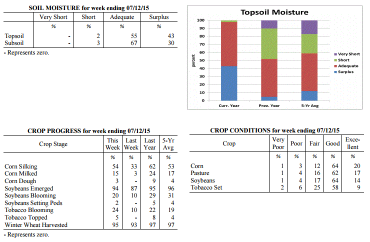 Kentucky Climate Summary
For the Period July 6, 2015 to July 12, 2015
Near Normal Temperatures and Much Above Normal Rainfall:
The Commonwealth cannot catch a break. Headlines did not change much this past week
as showers and storms continued to push through the Lower Ohio Valley. A combination
of frontal boundaries and disturbances aloft led to a very active period with
precipitation on a near daily basis. Over the course of the week, the state averaged
nearly two and a half inches of rainfall, which resulted in some flash flooding across
the Commonwealth. Looking back, three of the past four weeks have averaged over two
inches of rainfall.
Temperatures for the period averaged 76 degrees across the state which was near
normal and 3 degrees warmer than the previous period. Temperatures averaged from 78
in the West to 75 in the East. Departure from normal average temperatures ranged from
1 degree cooler than normal in the West to near normal in the East. The extreme high
temperature for the period was 93 degrees at BOWLING GREEN and the extreme low was 60
degrees at COVINGTON.
Precipitation (liq. equ.) for the period totaled 2.45 inches statewide which was 1.63
inches above normal and 298% of normal. Precipitation totals by climate division,
West 3.41 inches, Central 2.71 inches, Bluegrass 1.76 inches and East 1.99 inches,
which was 2.71, 1.93, 0.83 and 1.12 inches above normal. By station, precipitation
totals ranged from a low of 0.06 inches at Cumberland Gap to a high of 5.57 inches
at PADUCAH.
---
Kentucky Crop and Weather Report
Issued 4:00 P.M., July 6, 2015 18-15
Agricultural News: Kentucky experienced below normal temperatures and much above
normal rainfall over the past week. Precipitation for the week totaled 2.82
inches, 1.83 inches above normal. Temperatures averaged 73 degrees for the week,
2 degrees below normal. Topsoil moisture was rated 0 percent very short, 4
percent short, 65 percent adequate and 31 percent surplus. Subsoil moisture was
rated 0 percent very short, 5 percent short, 76 percent adequate, and 19 percent
surplus. Days suitable for fieldwork averaged 2.8 out of a possible seven.
Field activities were hampered due to rains throughout the week. Continued
rainfall is delaying second cutting of alfalfa in many areas, resulting in
deteriorating quality. Heavy rains caused some flooding last week resulting in
reports of damage to tobacco, corn and soybeans in low lying areas. The average
height of emerged soybeans was 14 inches, compared to 9 inches last week and 16
inches last year at this time. Cooler temperatures were welcomed by livestock.
Kentucky Climate Summary
For the Period July 6, 2015 to July 12, 2015
Near Normal Temperatures and Much Above Normal Rainfall:
The Commonwealth cannot catch a break. Headlines did not change much this past week
as showers and storms continued to push through the Lower Ohio Valley. A combination
of frontal boundaries and disturbances aloft led to a very active period with
precipitation on a near daily basis. Over the course of the week, the state averaged
nearly two and a half inches of rainfall, which resulted in some flash flooding across
the Commonwealth. Looking back, three of the past four weeks have averaged over two
inches of rainfall.
Temperatures for the period averaged 76 degrees across the state which was near
normal and 3 degrees warmer than the previous period. Temperatures averaged from 78
in the West to 75 in the East. Departure from normal average temperatures ranged from
1 degree cooler than normal in the West to near normal in the East. The extreme high
temperature for the period was 93 degrees at BOWLING GREEN and the extreme low was 60
degrees at COVINGTON.
Precipitation (liq. equ.) for the period totaled 2.45 inches statewide which was 1.63
inches above normal and 298% of normal. Precipitation totals by climate division,
West 3.41 inches, Central 2.71 inches, Bluegrass 1.76 inches and East 1.99 inches,
which was 2.71, 1.93, 0.83 and 1.12 inches above normal. By station, precipitation
totals ranged from a low of 0.06 inches at Cumberland Gap to a high of 5.57 inches
at PADUCAH.
---
Kentucky Crop and Weather Report
Issued 4:00 P.M., July 6, 2015 18-15
Agricultural News: Kentucky experienced below normal temperatures and much above
normal rainfall over the past week. Precipitation for the week totaled 2.82
inches, 1.83 inches above normal. Temperatures averaged 73 degrees for the week,
2 degrees below normal. Topsoil moisture was rated 0 percent very short, 4
percent short, 65 percent adequate and 31 percent surplus. Subsoil moisture was
rated 0 percent very short, 5 percent short, 76 percent adequate, and 19 percent
surplus. Days suitable for fieldwork averaged 2.8 out of a possible seven.
Field activities were hampered due to rains throughout the week. Continued
rainfall is delaying second cutting of alfalfa in many areas, resulting in
deteriorating quality. Heavy rains caused some flooding last week resulting in
reports of damage to tobacco, corn and soybeans in low lying areas. The average
height of emerged soybeans was 14 inches, compared to 9 inches last week and 16
inches last year at this time. Cooler temperatures were welcomed by livestock.
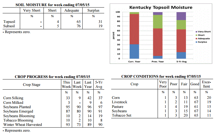 Kentucky Climate Summary
For the Period June 29, 2015 to July 5, 2015
Below Normal Temperatures and Much Above Normal Rainfall:
A very active pattern this past week led to a third straight period of above normal
rainfall for the Bluegrass State. For much of the week, Kentucky was situated within
a northwest flow aloft, allowing for multiple disturbances to interact with a stalled
frontal boundary at the surface. Showers and storms were sparked on a daily basis,
becoming widespread at times. The Commonwealth remained rooted in a very moist air
mass, which led to efficient rainfall producing storms. By the second half of the
work week, grounds were saturated and combined with heavy downpours at times, flash
flooding was a possibility. Overall, the state averaged nearly three inches for the
week, which was over an inch and a half above normal. The US Drought Monitor has now
entirely removed Moderate Drought across the state, with only a slight percentage of
abnormally dry conditions remaining. Cloud cover and the active pattern kept
temperatures down for the week, breaking a three week span of above normal temperatures.
Temperatures for the period averaged 73 degrees across the state which was 2 degrees
cooler than normal and 2 degrees cooler than the previous period. High temperatures
averaged from 83 in the West to 79 in the East. Departure from normal high
temperatures ranged from 5 degrees cooler than normal in the West to 7 degrees
cooler than normal in the East. Low temperatures averaged from 68 degrees in the
West to 64 degrees in the East. Departure from normal low temperature ranged from 2
degrees warmer than normal in the West to 2 degrees warmer than normal in the East.
The extreme high temperature for the period was 90 degrees at POPLAR BLUFF ASOS and
the extreme low was 51 degrees at PAINTSVILLE 4W.
Precipitation (liq. equ.) for the period totaled 2.82 inches statewide which was 1.83
inches above normal and 285% of normal. Precipitation totals by climate division,
West 2.34 inches, Central 3.44 inches, Bluegrass 2.68 inches and East 2.83 inches,
which was 1.35, 2.46, 1.71 and 1.81 inches above normal. By station, precipitation
totals ranged from a low of 0.00 inches at MONTICELLO AWOS to a high of 7.25
inches at SCOTTSVILLE 2W.
---
Kentucky Crop and Weather Report
Issued 4:00 P.M., June 29, 2015 17-15
Agricultural News: Kentucky experienced above normal temperatures and rainfall over
the past week. Precipitation for the week totaled 1.25 inches, 0.25 inches above
normal. Temperatures averaged 76 degrees for the week, 2 degrees above normal.
Topsoil moisture was rated 1 percent very short, 10 percent short, 77 percent
adequate and 12 percent surplus. Subsoil moisture was rated 1 percent very short, 12
percent short, 82 percent adequate, and 5 percent surplus. Days suitable for
fieldwork averaged 4.7 out of a possible seven.
Primary activities this week included planting soybeans and tobacco, harvesting
wheat, and baling hay. Some areas of the state are dry while others have received
adequate rain from storms and spotty showers. Wheat harvest is in full swing and
progressing well. Test weights, as well as yields, are reportedly very good. Later
wheat has higher incidence of head scab in some areas. Double crop soybeans are being
planted as wheat is harvested. Early soybeans are now starting to bloom. Soybean
average height was 9 inches, same as last year. Palmer amaranth being reported in
some fields. The average height of tobacco in the field was 17 inches, compared to 12
inches last week and 18 inches last year at this time. Very warm and humid conditions,
especially early in the week, resulted in continued heat stress for livestock.
Kentucky Climate Summary
For the Period June 29, 2015 to July 5, 2015
Below Normal Temperatures and Much Above Normal Rainfall:
A very active pattern this past week led to a third straight period of above normal
rainfall for the Bluegrass State. For much of the week, Kentucky was situated within
a northwest flow aloft, allowing for multiple disturbances to interact with a stalled
frontal boundary at the surface. Showers and storms were sparked on a daily basis,
becoming widespread at times. The Commonwealth remained rooted in a very moist air
mass, which led to efficient rainfall producing storms. By the second half of the
work week, grounds were saturated and combined with heavy downpours at times, flash
flooding was a possibility. Overall, the state averaged nearly three inches for the
week, which was over an inch and a half above normal. The US Drought Monitor has now
entirely removed Moderate Drought across the state, with only a slight percentage of
abnormally dry conditions remaining. Cloud cover and the active pattern kept
temperatures down for the week, breaking a three week span of above normal temperatures.
Temperatures for the period averaged 73 degrees across the state which was 2 degrees
cooler than normal and 2 degrees cooler than the previous period. High temperatures
averaged from 83 in the West to 79 in the East. Departure from normal high
temperatures ranged from 5 degrees cooler than normal in the West to 7 degrees
cooler than normal in the East. Low temperatures averaged from 68 degrees in the
West to 64 degrees in the East. Departure from normal low temperature ranged from 2
degrees warmer than normal in the West to 2 degrees warmer than normal in the East.
The extreme high temperature for the period was 90 degrees at POPLAR BLUFF ASOS and
the extreme low was 51 degrees at PAINTSVILLE 4W.
Precipitation (liq. equ.) for the period totaled 2.82 inches statewide which was 1.83
inches above normal and 285% of normal. Precipitation totals by climate division,
West 2.34 inches, Central 3.44 inches, Bluegrass 2.68 inches and East 2.83 inches,
which was 1.35, 2.46, 1.71 and 1.81 inches above normal. By station, precipitation
totals ranged from a low of 0.00 inches at MONTICELLO AWOS to a high of 7.25
inches at SCOTTSVILLE 2W.
---
Kentucky Crop and Weather Report
Issued 4:00 P.M., June 29, 2015 17-15
Agricultural News: Kentucky experienced above normal temperatures and rainfall over
the past week. Precipitation for the week totaled 1.25 inches, 0.25 inches above
normal. Temperatures averaged 76 degrees for the week, 2 degrees above normal.
Topsoil moisture was rated 1 percent very short, 10 percent short, 77 percent
adequate and 12 percent surplus. Subsoil moisture was rated 1 percent very short, 12
percent short, 82 percent adequate, and 5 percent surplus. Days suitable for
fieldwork averaged 4.7 out of a possible seven.
Primary activities this week included planting soybeans and tobacco, harvesting
wheat, and baling hay. Some areas of the state are dry while others have received
adequate rain from storms and spotty showers. Wheat harvest is in full swing and
progressing well. Test weights, as well as yields, are reportedly very good. Later
wheat has higher incidence of head scab in some areas. Double crop soybeans are being
planted as wheat is harvested. Early soybeans are now starting to bloom. Soybean
average height was 9 inches, same as last year. Palmer amaranth being reported in
some fields. The average height of tobacco in the field was 17 inches, compared to 12
inches last week and 18 inches last year at this time. Very warm and humid conditions,
especially early in the week, resulted in continued heat stress for livestock.
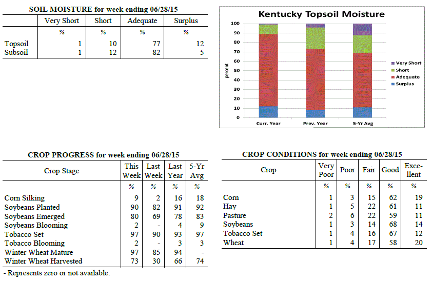 Kentucky Climate Summary
For the Period June 22, 2015 to June 28, 2015
Above Normal Temperatures and Rainfall:
Multiple disturbances and frontal boundaries passed through the Bluegrass State this
past week, leading to a second straight period of above normal rainfall. In doing so,
the US Drought Monitor diminished the coverage of Moderate Drought across the area,
down to 11%. The most widespread rainfall came later in the day on Friday and
lasting into Saturday as the Commonwealth remained within a moist and unstable air
mass. Overall, the state averaged 1.25 inches. Looking at temperatures, it was
quite the difference between start to end. Much of the work week saw highs peak in
the middle 80s to low 90s across the Lower Ohio Valley. High humidity made it feel
more like 100 at times. This helped push the livestock stock heat stress index into
the emergency category for the first time this year. Behind the passage of a cold
front on Saturday, temperatures took a downward turn. Highs stayed in the middle 70s
to low 80s Saturday and Sunday, along with much less humidity.
Temperatures for the period averaged 76 degrees across the state which was 2 degrees
warmer than normal and 2 degrees cooler than the previous period. High temperatures
averaged from 87 in the West to 84 in the East. Departure from normal high
temperatures ranged from 1 degree cooler than normal in the West to 1 degree
cooler than normal in the East. Low temperatures averaged from 69 degrees in the
West to 66 degrees in the East. Departure from normal low temperature ranged from 4
degrees warmer than normal in the West to 5 degrees warmer than normal in the East.
The extreme high temperature for the period was 96 degrees at BOWLING GREEN 4E and
the extreme low was 52 degrees at CAMPBELLSVILLE 7W.
Precipitation (liq. equ.) for the period totaled 1.25 inches statewide which was 0.25
inches above normal and 125% of normal. Precipitation totals by climate division,
West 0.62 inches, Central 1.61 inches, Bluegrass 1.27 inches and East 1.52 inches,
which was -0.38, 0.62, 0.28 and 0.49 inches respectively from normal. By station,
precipitation totals ranged from a low of 0.02 inches at HICKMAN 2E to a high of 2.89
inches at JACKSON.
---
Kentucky Crop and Weather Report
Issued 4:00 P.M., June 22, 2015 16-15
Agricultural News: Kentucky experienced above normal temperatures and rainfall over
the past week. Precipitation for the week totaled 2.36 inches, 1.35 inches above
normal. Temperatures averaged 79 degrees for the week, 6 degrees above normal.
Topsoil moisture was rated 2 percent very short, 13 percent short, 75 percent
adequate and 10 percent surplus. Subsoil moisture was rated 2 percent very short, 14
percent short, 78 percent adequate, and 6 percent surplus. Days suitable for
fieldwork averaged 4.7 out of a possible seven.
Some areas have received adequate rainfall, while many others remain dry. Primary
activities this week included planting soybeans and tobacco, harvesting wheat, and
baling hay. Activities were hampered late in the week due to rain. The average height
of emerged corn was 34 inches, compared to 23 inches last week, with eighty percent
rated as good to excellent. The early wheat harvest is going well. Test weights, as
well as yields, are reportedly very good. The average height of tobacco in the field
was 12 inches, compared to 9 inches last week. Very warm and humid conditions are
causing stress for livestock.
Kentucky Climate Summary
For the Period June 22, 2015 to June 28, 2015
Above Normal Temperatures and Rainfall:
Multiple disturbances and frontal boundaries passed through the Bluegrass State this
past week, leading to a second straight period of above normal rainfall. In doing so,
the US Drought Monitor diminished the coverage of Moderate Drought across the area,
down to 11%. The most widespread rainfall came later in the day on Friday and
lasting into Saturday as the Commonwealth remained within a moist and unstable air
mass. Overall, the state averaged 1.25 inches. Looking at temperatures, it was
quite the difference between start to end. Much of the work week saw highs peak in
the middle 80s to low 90s across the Lower Ohio Valley. High humidity made it feel
more like 100 at times. This helped push the livestock stock heat stress index into
the emergency category for the first time this year. Behind the passage of a cold
front on Saturday, temperatures took a downward turn. Highs stayed in the middle 70s
to low 80s Saturday and Sunday, along with much less humidity.
Temperatures for the period averaged 76 degrees across the state which was 2 degrees
warmer than normal and 2 degrees cooler than the previous period. High temperatures
averaged from 87 in the West to 84 in the East. Departure from normal high
temperatures ranged from 1 degree cooler than normal in the West to 1 degree
cooler than normal in the East. Low temperatures averaged from 69 degrees in the
West to 66 degrees in the East. Departure from normal low temperature ranged from 4
degrees warmer than normal in the West to 5 degrees warmer than normal in the East.
The extreme high temperature for the period was 96 degrees at BOWLING GREEN 4E and
the extreme low was 52 degrees at CAMPBELLSVILLE 7W.
Precipitation (liq. equ.) for the period totaled 1.25 inches statewide which was 0.25
inches above normal and 125% of normal. Precipitation totals by climate division,
West 0.62 inches, Central 1.61 inches, Bluegrass 1.27 inches and East 1.52 inches,
which was -0.38, 0.62, 0.28 and 0.49 inches respectively from normal. By station,
precipitation totals ranged from a low of 0.02 inches at HICKMAN 2E to a high of 2.89
inches at JACKSON.
---
Kentucky Crop and Weather Report
Issued 4:00 P.M., June 22, 2015 16-15
Agricultural News: Kentucky experienced above normal temperatures and rainfall over
the past week. Precipitation for the week totaled 2.36 inches, 1.35 inches above
normal. Temperatures averaged 79 degrees for the week, 6 degrees above normal.
Topsoil moisture was rated 2 percent very short, 13 percent short, 75 percent
adequate and 10 percent surplus. Subsoil moisture was rated 2 percent very short, 14
percent short, 78 percent adequate, and 6 percent surplus. Days suitable for
fieldwork averaged 4.7 out of a possible seven.
Some areas have received adequate rainfall, while many others remain dry. Primary
activities this week included planting soybeans and tobacco, harvesting wheat, and
baling hay. Activities were hampered late in the week due to rain. The average height
of emerged corn was 34 inches, compared to 23 inches last week, with eighty percent
rated as good to excellent. The early wheat harvest is going well. Test weights, as
well as yields, are reportedly very good. The average height of tobacco in the field
was 12 inches, compared to 9 inches last week. Very warm and humid conditions are
causing stress for livestock.
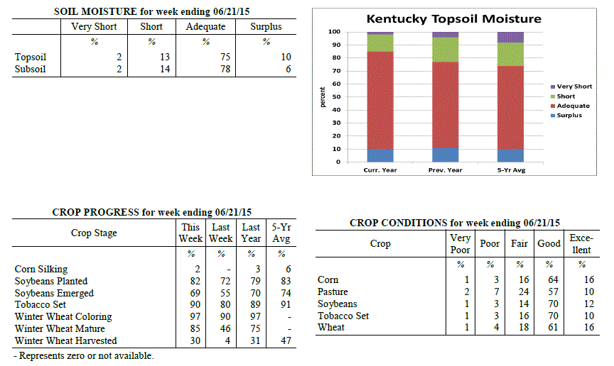 Kentucky Climate Summary
For the Period June 15, 2015 to June 21, 2015
Above Normal Temperatures and Rainfall:
Leading up to this period, dry conditions were becoming more and more evident across
the state. In fact, the US Drought Monitor introduced Moderate Drought to just over
34% of the state with last week's update. With lack a rainfall a concern, activity
increased dramatically this past period as the state saw a combination of frontal
boundaries, disturbances aloft, and even a remnant tropical system pass through the
area. Throughout the work week, the state was positioned within a very moist and
unstable air mass. Scattered to numerous showers and storms fired on a near daily
basis with heavy rainfall, cloud to ground lightning, and gusty winds as the main
concerns. Coverage increased Friday and Saturday as the remnants of Tropical Storm
Bill took an eastward track through the Lower Ohio Valley. Once again, a moist air
mass allowed for torrential rainfall at times. Over the course of the period, the
state averaged over two inches, breaking a four week streak of below normal rainfall.
Looking at temperatures, it was yet another hot and humid week. Temperatures
typically peaked in the mid 80s to low 90s about each day. Combined with lows only
dropping down to around 70, the Commonwealth saw a second straight week of above
normal temperatures.
Temperatures for the period averaged 79 degrees across the state which was 6 degrees
warmer than normal and 2 degrees warmer than the previous period. High temperatures
averaged from 88 in the West to 86 in the East. Departure from normal high
temperatures ranged from 2 degrees warmer than normal in the West to 2 degrees
warmer than normal in the East. Low temperatures averaged from 72 degrees in the
West to 69 degrees in the East. Departure from normal low temperature ranged from 8
degrees warmer than normal in the West to 10 degrees warmer than normal in the
East. The extreme high temperature for the period was 95 degrees at MAYFIELD 6SW and
the extreme low was 64 degrees at JACKSON 3SE.
Precipitation (liq. equ.) for the period totaled 2.36 inches statewide which was 1.35
inches above normal and 235% of normal. Precipitation totals by climate division,
West 2.41 inches, Central 2.03 inches, Bluegrass 3.14 inches and East 1.85 inches,
which was 1.42, 1.03, 2.13 and 0.83 inches above normal. By station, precipitation
totals ranged from a low of 0.41 inches at BOWLING GREEN APT to a high of 7.00
inches at MORGANFIELD 4E.
---
Kentucky Crop and Weather Report
Issued 4:00 P.M., June 15, 2015 15-15
Agricultural News: Kentucky experienced above normal temperatures and below normal
rainfall over the past week. Precipitation for the week totaled 0.69 inches, 0.35
inches below normal. Temperatures averaged 77 degrees for the week, 5 degrees above
normal. Topsoil moisture was rated 3 percent very short, 18 percent short, 70 percent
adequate and 9 percent surplus. Subsoil moisture was rated 2 percent very short, 16
percent short, 76 percent adequate, and 6 percent surplus. Days suitable for
fieldwork averaged 5.8 out of a possible seven.
Primary activities this week included planting soybeans and tobacco. Producers
continued side dressing corn and spraying post herbicide applications. Planting
progress was hampered early in the week in some areas due to showers, but other
locations remain dry and need rain. Soil compaction due to planting corn in wet field
conditions is a concern for some producers. The average height of emerged corn was 23
inches, compared to 14 inches last week, with seventy-nine percent rated as good to
excellent.
Most full season soybeans are planted and double crop plantings will begin as soon as
winter wheat is harvested. Winter wheat grain harvest is expected to begin in earnest
within the next 1-2 weeks, depending on location. First cutting hay still being made,
while some farmers were harvesting their second cutting of alfalfa. The average
height of tobacco in the field was 9 inches, compared to 4 inches last week.
Kentucky Climate Summary
For the Period June 15, 2015 to June 21, 2015
Above Normal Temperatures and Rainfall:
Leading up to this period, dry conditions were becoming more and more evident across
the state. In fact, the US Drought Monitor introduced Moderate Drought to just over
34% of the state with last week's update. With lack a rainfall a concern, activity
increased dramatically this past period as the state saw a combination of frontal
boundaries, disturbances aloft, and even a remnant tropical system pass through the
area. Throughout the work week, the state was positioned within a very moist and
unstable air mass. Scattered to numerous showers and storms fired on a near daily
basis with heavy rainfall, cloud to ground lightning, and gusty winds as the main
concerns. Coverage increased Friday and Saturday as the remnants of Tropical Storm
Bill took an eastward track through the Lower Ohio Valley. Once again, a moist air
mass allowed for torrential rainfall at times. Over the course of the period, the
state averaged over two inches, breaking a four week streak of below normal rainfall.
Looking at temperatures, it was yet another hot and humid week. Temperatures
typically peaked in the mid 80s to low 90s about each day. Combined with lows only
dropping down to around 70, the Commonwealth saw a second straight week of above
normal temperatures.
Temperatures for the period averaged 79 degrees across the state which was 6 degrees
warmer than normal and 2 degrees warmer than the previous period. High temperatures
averaged from 88 in the West to 86 in the East. Departure from normal high
temperatures ranged from 2 degrees warmer than normal in the West to 2 degrees
warmer than normal in the East. Low temperatures averaged from 72 degrees in the
West to 69 degrees in the East. Departure from normal low temperature ranged from 8
degrees warmer than normal in the West to 10 degrees warmer than normal in the
East. The extreme high temperature for the period was 95 degrees at MAYFIELD 6SW and
the extreme low was 64 degrees at JACKSON 3SE.
Precipitation (liq. equ.) for the period totaled 2.36 inches statewide which was 1.35
inches above normal and 235% of normal. Precipitation totals by climate division,
West 2.41 inches, Central 2.03 inches, Bluegrass 3.14 inches and East 1.85 inches,
which was 1.42, 1.03, 2.13 and 0.83 inches above normal. By station, precipitation
totals ranged from a low of 0.41 inches at BOWLING GREEN APT to a high of 7.00
inches at MORGANFIELD 4E.
---
Kentucky Crop and Weather Report
Issued 4:00 P.M., June 15, 2015 15-15
Agricultural News: Kentucky experienced above normal temperatures and below normal
rainfall over the past week. Precipitation for the week totaled 0.69 inches, 0.35
inches below normal. Temperatures averaged 77 degrees for the week, 5 degrees above
normal. Topsoil moisture was rated 3 percent very short, 18 percent short, 70 percent
adequate and 9 percent surplus. Subsoil moisture was rated 2 percent very short, 16
percent short, 76 percent adequate, and 6 percent surplus. Days suitable for
fieldwork averaged 5.8 out of a possible seven.
Primary activities this week included planting soybeans and tobacco. Producers
continued side dressing corn and spraying post herbicide applications. Planting
progress was hampered early in the week in some areas due to showers, but other
locations remain dry and need rain. Soil compaction due to planting corn in wet field
conditions is a concern for some producers. The average height of emerged corn was 23
inches, compared to 14 inches last week, with seventy-nine percent rated as good to
excellent.
Most full season soybeans are planted and double crop plantings will begin as soon as
winter wheat is harvested. Winter wheat grain harvest is expected to begin in earnest
within the next 1-2 weeks, depending on location. First cutting hay still being made,
while some farmers were harvesting their second cutting of alfalfa. The average
height of tobacco in the field was 9 inches, compared to 4 inches last week.
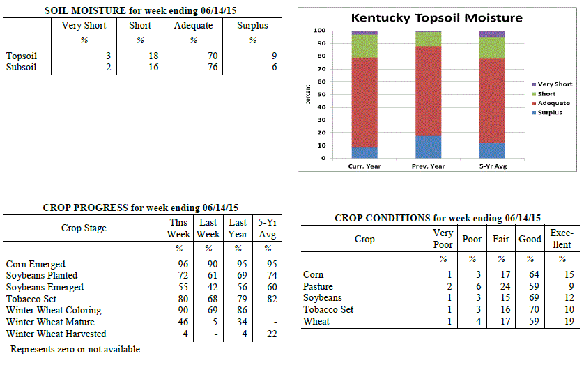 Kentucky Climate Summary
For the Period June 8, 2015 to June 14, 2015
Above Normal Temperatures and Below Normal Rainfall:
The Bluegrass State got an early taste of summer this past week as heat and humidity
were both on the rise. An upper level ridge of high pressure began to build into the
region over the second half of the work week and remained through the weekend. Highs
pushed into the mid 80s to low 90s on a daily basis. By the weekend, dewpoints were
in the upper 60s to low 70s, making for a very humid air mass. The combination of
high heat and humidity pushed the livestock heat stress index into the danger
category each afternoon and early evening. In addition, other than a couple waves of
rainfall on Monday, the ridge kept precipitation limited. Coverage remained isolated
to scattered each day, leading to a fourth straight week of below normal rainfall.
Going a step further, the state has seen below average precipitation seven of the past
eight weeks.
Temperatures for the period averaged 77 degrees across the state which was 5 degrees
warmer than normal and 10 degrees warmer than the previous period. High temperatures
averaged from 88 in the West to 86 in the East. Departure from normal high
temperatures ranged from 3 degrees warmer than normal in the West to 4 degrees
warmer than normal in the East. Low temperatures averaged from 69 degrees in the
West to 65 degrees in the East. Departure from normal low temperature ranged from 7
degrees warmer than normal in the West to 7 degrees warmer than normal in the East.
The extreme high temperature for the period was 95 degrees at CAPE GIRARDEAU ASOS and
the extreme low was 56 degrees at BRANDENBURG 4SW.
Precipitation (liq. equ.) for the period totaled 0.69 inches statewide which was 0.35
inches below normal and 67% of normal. Precipitation totals by climate division, West
0.79 inches, Central 0.72 inches, Bluegrass 0.51 inches and East 0.72 inches, which
was 0.19, 0.33, 0.55 and 0.34 inches below normal. By station, precipitation totals
ranged from a low of 0.05 inches at HICKMAN 2E to a high of 2.15 inches at HARRODSBURG 3N.
---
Kentucky Crop and Weather Report
Issued 4:00 P.M., June 8, 2015 14-15
Agricultural News: Kentucky experienced below normal temperatures and rainfall over
the past week. Precipitation for the week totaled 0.44 inches, 0.65 inches below
normal. Temperatures averaged 68 degrees for the week, 2 degrees below normal.
Topsoil moisture was rated 2 percent very short, 13 percent short, 75 percent
adequate and 10 percent surplus. Subsoil moisture was rated 2 percent very short, 12
percent short, 77 percent adequate, and 9 percent surplus. Days suitable for
fieldwork averaged 4.8 out of a possible seven.
Primary activities this week included planting corn, soybeans and tobacco. Some re-
planting occurred in locations that have received excess rainfall the past few weeks
that resulted in drowning out or poor stands. The average height of emerged corn was
14 inches, compared to 11 inches last week, with eighty percent rated as good to
excellent. Wheat producers were gearing up for the grain harvest which will begin in
the near future. Hay continued to be harvested on farms that had not been able to
complete their first cutting. The average height of tobacco in the field was 4 inches.
Kentucky Climate Summary
For the Period June 8, 2015 to June 14, 2015
Above Normal Temperatures and Below Normal Rainfall:
The Bluegrass State got an early taste of summer this past week as heat and humidity
were both on the rise. An upper level ridge of high pressure began to build into the
region over the second half of the work week and remained through the weekend. Highs
pushed into the mid 80s to low 90s on a daily basis. By the weekend, dewpoints were
in the upper 60s to low 70s, making for a very humid air mass. The combination of
high heat and humidity pushed the livestock heat stress index into the danger
category each afternoon and early evening. In addition, other than a couple waves of
rainfall on Monday, the ridge kept precipitation limited. Coverage remained isolated
to scattered each day, leading to a fourth straight week of below normal rainfall.
Going a step further, the state has seen below average precipitation seven of the past
eight weeks.
Temperatures for the period averaged 77 degrees across the state which was 5 degrees
warmer than normal and 10 degrees warmer than the previous period. High temperatures
averaged from 88 in the West to 86 in the East. Departure from normal high
temperatures ranged from 3 degrees warmer than normal in the West to 4 degrees
warmer than normal in the East. Low temperatures averaged from 69 degrees in the
West to 65 degrees in the East. Departure from normal low temperature ranged from 7
degrees warmer than normal in the West to 7 degrees warmer than normal in the East.
The extreme high temperature for the period was 95 degrees at CAPE GIRARDEAU ASOS and
the extreme low was 56 degrees at BRANDENBURG 4SW.
Precipitation (liq. equ.) for the period totaled 0.69 inches statewide which was 0.35
inches below normal and 67% of normal. Precipitation totals by climate division, West
0.79 inches, Central 0.72 inches, Bluegrass 0.51 inches and East 0.72 inches, which
was 0.19, 0.33, 0.55 and 0.34 inches below normal. By station, precipitation totals
ranged from a low of 0.05 inches at HICKMAN 2E to a high of 2.15 inches at HARRODSBURG 3N.
---
Kentucky Crop and Weather Report
Issued 4:00 P.M., June 8, 2015 14-15
Agricultural News: Kentucky experienced below normal temperatures and rainfall over
the past week. Precipitation for the week totaled 0.44 inches, 0.65 inches below
normal. Temperatures averaged 68 degrees for the week, 2 degrees below normal.
Topsoil moisture was rated 2 percent very short, 13 percent short, 75 percent
adequate and 10 percent surplus. Subsoil moisture was rated 2 percent very short, 12
percent short, 77 percent adequate, and 9 percent surplus. Days suitable for
fieldwork averaged 4.8 out of a possible seven.
Primary activities this week included planting corn, soybeans and tobacco. Some re-
planting occurred in locations that have received excess rainfall the past few weeks
that resulted in drowning out or poor stands. The average height of emerged corn was
14 inches, compared to 11 inches last week, with eighty percent rated as good to
excellent. Wheat producers were gearing up for the grain harvest which will begin in
the near future. Hay continued to be harvested on farms that had not been able to
complete their first cutting. The average height of tobacco in the field was 4 inches.
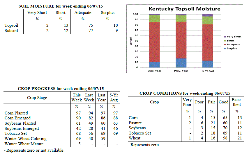 Kentucky Climate Summary
For the Period June 1, 2015 to June 7, 2015
Below Normal Temperatures and Rainfall:
June 1st signaled the first day of meteorological summer. The period got underway
with unseasonably cool conditions in place, but summer heat and humidity made a
return by the weekend. An upper level low slowly working across the area kept a
consistent cloud deck over much of the area for the first half of the work week.
This had quite the impact on high temperatures, especially on Monday and Tuesday,
when much of the Bluegrass State stayed in the upper 50s to middle 60s. High
pressure worked back into the region by Thursday, clearing skies and bringing back
temperatures closer to normal, in the low to mid 80s. Conditions remained dry over
the weekend with heat and humidity on the rise. Southwesterly flow bumped
temperatures into the upper 80s to low 90s on Sunday, bringing the feel that summer
had arrived. Other than some widespread showers on Monday, the remainder of the week
remained mostly dry. On average, the state was over a half inch below normal for the
period.
Temperatures for the period averaged 68 degrees across the state which was 2 degrees
cooler than normal and 4 degrees cooler than the previous period. High temperatures
averaged from 78 in the West to 78 in the East. Departure from normal high
temperatures ranged from 5 degrees cooler than normal in the West to 3 degrees
cooler than normal in the East. Low temperatures averaged from 60 degrees in the
West to 59 degrees in the East. Departure from normal low temperature ranged from 1
degree cooler than normal in the West to 3 degrees warmer than normal in the East.
The extreme high temperature for the period was 92 degrees at BURKESVILLE 3W and the
extreme low was 50 degrees at GREENVILLE 6N.
Precipitation (liq. equ.) for the period totaled 0.44 inches statewide which was 0.65
inches below normal and 40% of normal. Precipitation totals by climate division, West
0.34 inches, Central 0.41 inches, Bluegrass 0.45 inches and East 0.56 inches, which
was 0.72, 0.7, 0.64 and 0.54 inches below normal. By station, precipitation totals
ranged from a low of 0.00 inches at CAPE GIRARDEAU ASOS to a high of 1.42 inches at
PIKEVILLE 13S.
---
Kentucky Crop and Weather Report
Issued 4:00 P.M., June 1, 2015 13-15
Agricultural News: Kentucky experienced above normal temperatures and below normal
rainfall over the past week. Precipitation for the week totaled 1.06 inches, 0.05
inches below normal. Temperatures averaged 72 degrees for the week, 4 degrees above
normal. Topsoil moisture was rated 2 percent very short, 11 percent short, 75 percent
adequate and 12 percent surplus. Subsoil moisture was rated 2 percent very short, 10
percent short, 77 percent adequate, and 11 percent surplus. Days suitable for
fieldwork averaged 3.6 out of a possible seven.
Primary activities this week included planting corn, soybeans and tobacco, side
dressing crops with fertilizer, along with cutting and baling hay as weather allowed.
Planting progress was hampered in some areas due to wet conditions, but other
locations remain dry and in need of rain. Recent rain and wind caused wheat to lodge
in certain areas, especially where growth regulators were not used. The average
height of emerged corn was 11 inches, compared to 6 inches last week, with eighty-one
percent rated as good to excellent. There are reports of corn yellowing, uneven
stands and replanting due to weather issues. Hay and roughage supplies were reported
as 2 percent very short, 13 percent short, 79 percent adequate, and 6 percent
surplus.
Kentucky Climate Summary
For the Period June 1, 2015 to June 7, 2015
Below Normal Temperatures and Rainfall:
June 1st signaled the first day of meteorological summer. The period got underway
with unseasonably cool conditions in place, but summer heat and humidity made a
return by the weekend. An upper level low slowly working across the area kept a
consistent cloud deck over much of the area for the first half of the work week.
This had quite the impact on high temperatures, especially on Monday and Tuesday,
when much of the Bluegrass State stayed in the upper 50s to middle 60s. High
pressure worked back into the region by Thursday, clearing skies and bringing back
temperatures closer to normal, in the low to mid 80s. Conditions remained dry over
the weekend with heat and humidity on the rise. Southwesterly flow bumped
temperatures into the upper 80s to low 90s on Sunday, bringing the feel that summer
had arrived. Other than some widespread showers on Monday, the remainder of the week
remained mostly dry. On average, the state was over a half inch below normal for the
period.
Temperatures for the period averaged 68 degrees across the state which was 2 degrees
cooler than normal and 4 degrees cooler than the previous period. High temperatures
averaged from 78 in the West to 78 in the East. Departure from normal high
temperatures ranged from 5 degrees cooler than normal in the West to 3 degrees
cooler than normal in the East. Low temperatures averaged from 60 degrees in the
West to 59 degrees in the East. Departure from normal low temperature ranged from 1
degree cooler than normal in the West to 3 degrees warmer than normal in the East.
The extreme high temperature for the period was 92 degrees at BURKESVILLE 3W and the
extreme low was 50 degrees at GREENVILLE 6N.
Precipitation (liq. equ.) for the period totaled 0.44 inches statewide which was 0.65
inches below normal and 40% of normal. Precipitation totals by climate division, West
0.34 inches, Central 0.41 inches, Bluegrass 0.45 inches and East 0.56 inches, which
was 0.72, 0.7, 0.64 and 0.54 inches below normal. By station, precipitation totals
ranged from a low of 0.00 inches at CAPE GIRARDEAU ASOS to a high of 1.42 inches at
PIKEVILLE 13S.
---
Kentucky Crop and Weather Report
Issued 4:00 P.M., June 1, 2015 13-15
Agricultural News: Kentucky experienced above normal temperatures and below normal
rainfall over the past week. Precipitation for the week totaled 1.06 inches, 0.05
inches below normal. Temperatures averaged 72 degrees for the week, 4 degrees above
normal. Topsoil moisture was rated 2 percent very short, 11 percent short, 75 percent
adequate and 12 percent surplus. Subsoil moisture was rated 2 percent very short, 10
percent short, 77 percent adequate, and 11 percent surplus. Days suitable for
fieldwork averaged 3.6 out of a possible seven.
Primary activities this week included planting corn, soybeans and tobacco, side
dressing crops with fertilizer, along with cutting and baling hay as weather allowed.
Planting progress was hampered in some areas due to wet conditions, but other
locations remain dry and in need of rain. Recent rain and wind caused wheat to lodge
in certain areas, especially where growth regulators were not used. The average
height of emerged corn was 11 inches, compared to 6 inches last week, with eighty-one
percent rated as good to excellent. There are reports of corn yellowing, uneven
stands and replanting due to weather issues. Hay and roughage supplies were reported
as 2 percent very short, 13 percent short, 79 percent adequate, and 6 percent
surplus.
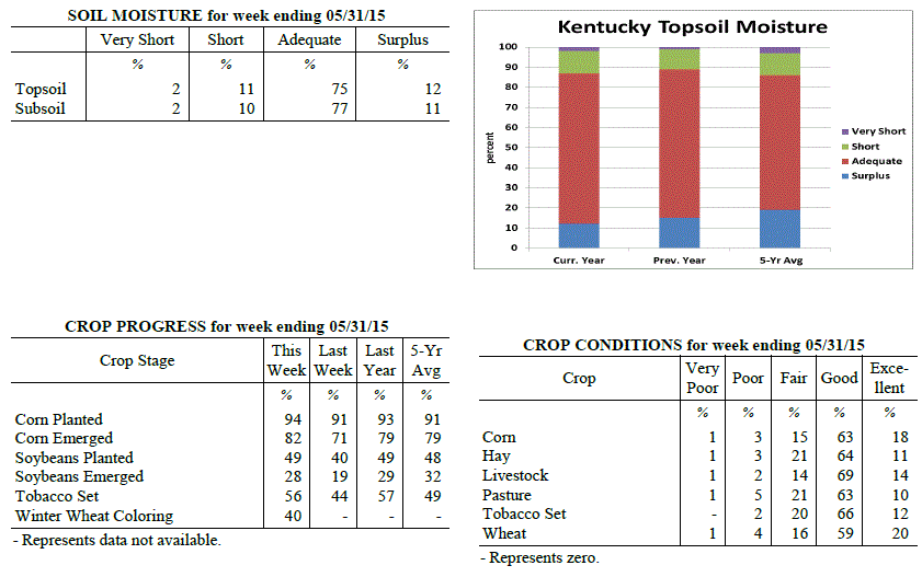 Kentucky Climate Summary
For the Period May 25, 2015 to May 31, 2015
Above Normal Temperatures and Below Normal Rainfall:
The last week of May brought the chance of showers and storms on a daily basis.
Throughout much of the period, the Commonwealth laid within a moist and unstable air
mass. While coverage was often scattered each day, most saw rainfall at some point. The
majority of the week saw storms remain below severe limits, but with dewpoints in the
60s, any storms that did develop were efficient rainfall producers. Even though it
was a rather active week, the state saw slightly below normal rainfall overall. Five
of the past six weeks have now seen below normal rainfall. Temperatures remained
elevated through most of the week with highs typically in the low to mid 80s and lows
only dropping into the 60s.
Temperatures for the period averaged 72 degrees across the state which was 4 degrees
warmer than normal and 8 degrees warmer than the previous period. High temperatures
averaged from 79 in the West to 83 in the East. Departure from normal high
temperatures ranged from 2 degrees cooler than normal in the West to 4 degrees
warmer than normal in the East. Low temperatures averaged from 65 degrees in the
West to 64 degrees in the East. Departure from normal low temperature ranged from 6
degrees warmer than normal in the West to 10 degrees warmer than normal in the
East. The extreme high temperature for the period was 88 degrees at BURKESVILLE 3W
and the extreme low was 52 degrees at JACKSON 3SE.
Precipitation (liq. equ.) for the period totaled 1.06 inches statewide which was 0.05
inches below normal and 95% of normal. Precipitation totals by climate division, West
1.29 inches, Central 1.24 inches, Bluegrass 1.01 inches and East 0.72 inches, which
was 0.19, 0.08, -0.07 and -0.40 inches respectively from normal. By station,
precipitation totals ranged from a low of 0.20 inches at TRIANGLE MOUNTAIN to a high
of 2.34 inches at ELKTON 5SW.
---
Kentucky Crop and Weather Report
Issued 4:00 P.M., May 26, 2015 12-15
Agricultural News: Kentucky experienced below normal temperatures and rainfall over
the past week. Precipitation for the week totaled 0.34 inches, 0.78 inches below
normal. Temperatures averaged 64 degrees for the week, 2 degrees below normal.
Topsoil moisture was rated 2 percent very short, 18 percent short, 68 percent
adequate and 12 percent surplus. Subsoil moisture was rated 2 percent very short, 12
percent short, 75 percent adequate, and 11 percent surplus. Days suitable for
fieldwork averaged 4.7 out of a possible seven. Dry conditions continued in many
locations. However, planting was on hold in some areas due to rains.
Primary activities this week included planting corn, soybeans and tobacco, spraying
herbicides as well as cutting and baling hay. Recent winds and rain has caused wheat
to lodge in certain areas. There were some reports of germination issues where corn
was planted in dry areas a couple of weeks ago. The average height of emerged corn
was 6 inches, with eighty-five percent rated as good to excellent. Producers are
scouting for army worms. Some locations are very dry and in need of rainfall. Dry
pasture conditions in these areas are resulting in hay being fed to cattle. Recent
heavy rains in some areas were detrimental to strawberries that were mature. Overall,
strawberries were rated in mostly good condition.
Kentucky Climate Summary
For the Period May 25, 2015 to May 31, 2015
Above Normal Temperatures and Below Normal Rainfall:
The last week of May brought the chance of showers and storms on a daily basis.
Throughout much of the period, the Commonwealth laid within a moist and unstable air
mass. While coverage was often scattered each day, most saw rainfall at some point. The
majority of the week saw storms remain below severe limits, but with dewpoints in the
60s, any storms that did develop were efficient rainfall producers. Even though it
was a rather active week, the state saw slightly below normal rainfall overall. Five
of the past six weeks have now seen below normal rainfall. Temperatures remained
elevated through most of the week with highs typically in the low to mid 80s and lows
only dropping into the 60s.
Temperatures for the period averaged 72 degrees across the state which was 4 degrees
warmer than normal and 8 degrees warmer than the previous period. High temperatures
averaged from 79 in the West to 83 in the East. Departure from normal high
temperatures ranged from 2 degrees cooler than normal in the West to 4 degrees
warmer than normal in the East. Low temperatures averaged from 65 degrees in the
West to 64 degrees in the East. Departure from normal low temperature ranged from 6
degrees warmer than normal in the West to 10 degrees warmer than normal in the
East. The extreme high temperature for the period was 88 degrees at BURKESVILLE 3W
and the extreme low was 52 degrees at JACKSON 3SE.
Precipitation (liq. equ.) for the period totaled 1.06 inches statewide which was 0.05
inches below normal and 95% of normal. Precipitation totals by climate division, West
1.29 inches, Central 1.24 inches, Bluegrass 1.01 inches and East 0.72 inches, which
was 0.19, 0.08, -0.07 and -0.40 inches respectively from normal. By station,
precipitation totals ranged from a low of 0.20 inches at TRIANGLE MOUNTAIN to a high
of 2.34 inches at ELKTON 5SW.
---
Kentucky Crop and Weather Report
Issued 4:00 P.M., May 26, 2015 12-15
Agricultural News: Kentucky experienced below normal temperatures and rainfall over
the past week. Precipitation for the week totaled 0.34 inches, 0.78 inches below
normal. Temperatures averaged 64 degrees for the week, 2 degrees below normal.
Topsoil moisture was rated 2 percent very short, 18 percent short, 68 percent
adequate and 12 percent surplus. Subsoil moisture was rated 2 percent very short, 12
percent short, 75 percent adequate, and 11 percent surplus. Days suitable for
fieldwork averaged 4.7 out of a possible seven. Dry conditions continued in many
locations. However, planting was on hold in some areas due to rains.
Primary activities this week included planting corn, soybeans and tobacco, spraying
herbicides as well as cutting and baling hay. Recent winds and rain has caused wheat
to lodge in certain areas. There were some reports of germination issues where corn
was planted in dry areas a couple of weeks ago. The average height of emerged corn
was 6 inches, with eighty-five percent rated as good to excellent. Producers are
scouting for army worms. Some locations are very dry and in need of rainfall. Dry
pasture conditions in these areas are resulting in hay being fed to cattle. Recent
heavy rains in some areas were detrimental to strawberries that were mature. Overall,
strawberries were rated in mostly good condition.
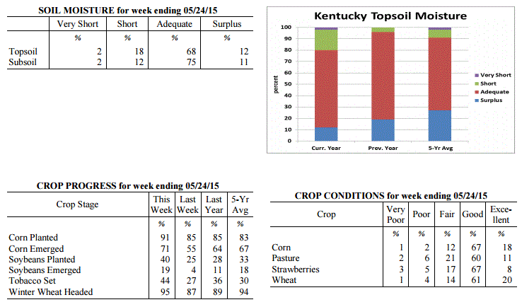 Kentucky Climate Summary
For the Period May 18, 2015 to May 24, 2015
Below Normal Temperatures and Rainfall:
The dry month of May continued this past week with below normal rainfall in place.
Following the second wettest April on record, month to date rainfall for May is now
almost 2 inches below normal. Over the course of this past period, the state
averaged 0.34 inches with most of it coming on Monday as a couple disturbances pushed
through the Lower Ohio Valley. A cold front passed through the area later that
night. This set the stage for a rather cool work week. Behind another weak
disturbance, many locations did not see highs get out of the 50s on Thursday. This
was around 20 degrees below normal for this time of the year. Later that night, some
saw the mercury dip into the 30s. Overall, temperatures were on average 2 degrees
below normal for the period, breaking a two week streak of above normal temperatures.
Temperatures for the period averaged 64 degrees across the state which was 2 degrees
cooler than normal and 4 degrees cooler than the previous period. High temperatures
averaged from 73 in the West to 75 in the East. Departure from normal high
temperatures ranged from 6 degrees cooler than normal in the West to 3 degrees
cooler than normal in the East. Low temperatures averaged from 55 degrees in the
West to 53 degrees in the East. Departure from normal low temperature ranged from 1
degree cooler than normal in the West to 2 degrees warmer than normal in the East.
The extreme high temperature for the period was 86 degrees at CALHOUN 5NW and the
extreme low was 36 degrees at CYNTHIANA 8N.
Precipitation (liq. equ.) for the period totaled 0.34 inches statewide which was 0.78
inches below normal and 30% of normal. Precipitation totals by climate division, West
0.66 inches, Central 0.23 inches, Bluegrass 0.08 inches and East 0.41 inches, which
was 0.45, 0.94, 1 and 0.72 inches below normal. By station, precipitation totals
ranged from a low of 0.00 inches at ALEXANDRIA 5NW to a high of 1.80 inches at YELLOW
CREEK.
---
Kentucky Crop and Weather Report
Issued 4:00 P.M., May 18, 2015 11-15
Agricultural News: Kentucky experienced above normal temperatures and rainfall over
the past week. Precipitation for the week totaled 1.25 inches, 0.12 inches above
normal. Temperatures averaged 68 degrees for the week, 4 degrees above normal.
Topsoil moisture was rated 1 percent very short, 18 percent short, 70 percent
adequate and 11 percent surplus. Subsoil moisture was rated 1 percent very short, 11
percent short, 77 percent adequate, and 11 percent surplus. Days suitable for
fieldwork averaged 6.0 out of a possible seven. Primary activities this week included
planting corn, soybeans and tobacco along with cutting and baling hay.
Planting progressed at a rapid pace, at least until the later part of the week. Rains
over the weekend caused some lodging in wheat, but eighty percent is still rated as
good to excellent. Producers continued harvesting wheat intended for hay or silage.
Some locations are very dry and in need of additional moisture. Dry pasture
conditions in these areas are resulting in hay being fed to cattle. Tobacco
transplant supplies were reported as 1 percent very short, 4 percent short, 87
percent adequate, and 8 percent surplus. Fifteen percent of tobacco transplants were
under 2 inches, with 38 percent between 2-4 inches, and 47 percent over 4 inches.
Kentucky Climate Summary
For the Period May 18, 2015 to May 24, 2015
Below Normal Temperatures and Rainfall:
The dry month of May continued this past week with below normal rainfall in place.
Following the second wettest April on record, month to date rainfall for May is now
almost 2 inches below normal. Over the course of this past period, the state
averaged 0.34 inches with most of it coming on Monday as a couple disturbances pushed
through the Lower Ohio Valley. A cold front passed through the area later that
night. This set the stage for a rather cool work week. Behind another weak
disturbance, many locations did not see highs get out of the 50s on Thursday. This
was around 20 degrees below normal for this time of the year. Later that night, some
saw the mercury dip into the 30s. Overall, temperatures were on average 2 degrees
below normal for the period, breaking a two week streak of above normal temperatures.
Temperatures for the period averaged 64 degrees across the state which was 2 degrees
cooler than normal and 4 degrees cooler than the previous period. High temperatures
averaged from 73 in the West to 75 in the East. Departure from normal high
temperatures ranged from 6 degrees cooler than normal in the West to 3 degrees
cooler than normal in the East. Low temperatures averaged from 55 degrees in the
West to 53 degrees in the East. Departure from normal low temperature ranged from 1
degree cooler than normal in the West to 2 degrees warmer than normal in the East.
The extreme high temperature for the period was 86 degrees at CALHOUN 5NW and the
extreme low was 36 degrees at CYNTHIANA 8N.
Precipitation (liq. equ.) for the period totaled 0.34 inches statewide which was 0.78
inches below normal and 30% of normal. Precipitation totals by climate division, West
0.66 inches, Central 0.23 inches, Bluegrass 0.08 inches and East 0.41 inches, which
was 0.45, 0.94, 1 and 0.72 inches below normal. By station, precipitation totals
ranged from a low of 0.00 inches at ALEXANDRIA 5NW to a high of 1.80 inches at YELLOW
CREEK.
---
Kentucky Crop and Weather Report
Issued 4:00 P.M., May 18, 2015 11-15
Agricultural News: Kentucky experienced above normal temperatures and rainfall over
the past week. Precipitation for the week totaled 1.25 inches, 0.12 inches above
normal. Temperatures averaged 68 degrees for the week, 4 degrees above normal.
Topsoil moisture was rated 1 percent very short, 18 percent short, 70 percent
adequate and 11 percent surplus. Subsoil moisture was rated 1 percent very short, 11
percent short, 77 percent adequate, and 11 percent surplus. Days suitable for
fieldwork averaged 6.0 out of a possible seven. Primary activities this week included
planting corn, soybeans and tobacco along with cutting and baling hay.
Planting progressed at a rapid pace, at least until the later part of the week. Rains
over the weekend caused some lodging in wheat, but eighty percent is still rated as
good to excellent. Producers continued harvesting wheat intended for hay or silage.
Some locations are very dry and in need of additional moisture. Dry pasture
conditions in these areas are resulting in hay being fed to cattle. Tobacco
transplant supplies were reported as 1 percent very short, 4 percent short, 87
percent adequate, and 8 percent surplus. Fifteen percent of tobacco transplants were
under 2 inches, with 38 percent between 2-4 inches, and 47 percent over 4 inches.
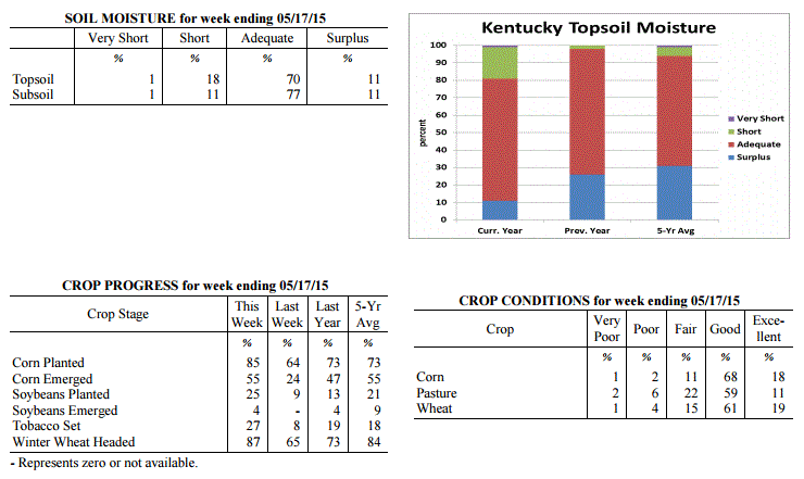 Kentucky Climate Summary
For the Period May 11, 2015 to May 17, 2015
Above Normal Temperatures and Rainfall:
The Commonwealth got some much needed rainfall this past period after the first couple
weeks of May brought extremely dry conditions. Throughout the period, Kentucky saw
several rounds of showers and storms. The first came on Monday as storms fired that
afternoon and evening within a moist and unstable air mass. The National Weather
Service did report some isolated events of damaging winds. Following a cold front
that night, noticeably drier and cooler air filtered into the Ohio Valley for the
next few days. Activity then once again picked up over the weekend. The most
widespread coverage was seen on Saturday. Just between Friday and Sunday, Western
Kentucky averaged 1.79 inches of rainfall. Totals diminished farther east with
Eastern Kentucky only averaging a little over a half inch through the three day
period. Over the entirety of the week, the state was slightly above normal, breaking
a streak of three straight weeks with below normal rainfall.
Temperatures for the period averaged 68 degrees across the state which was 4 degrees
warmer than normal and 4 degrees cooler than the previous period. High temperatures
averaged from 77 in the West to 79 in the East. Departure from normal high
temperatures ranged from near normal in the West to 3 degrees warmer than normal in
the East. Low temperatures averaged from 59 degrees in the West to 58 degrees in the
East. Departure from normal low temperature ranged from 5 degrees warmer than normal
in the West to 9 degrees warmer than normal in the East. The extreme high temperature
for the period was 89 degrees at JACKSON and the extreme low was 41 degrees at
BRANDENBURG 4SW.
Precipitation (liq. equ.) for the period totaled 1.25 inches statewide which was 0.12
inches above normal and 111% of normal. Precipitation totals by climate division,
West 2.06 inches, Central 1.37 inches, Bluegrass 0.81 inches and East 0.75 inches,
which was 0.88, 0.19, -0.25 and -0.33 inches respectively from normal. By station,
precipitation totals ranged from a low of 0.08 inches at STANFORD 4NE to a high of
4.36 inches at FORT CAMPBELL.
---
Kentucky Crop and Weather Report
Issued 4:00 P.M., May 11, 2015 10-15
Agricultural News: Kentucky experienced well above normal temperatures and much below
normal rainfall over the past week. Precipitation for the week totaled 0.14 inches,
0.95 inches below normal. Temperatures averaged 71 degrees for the week, 9 degrees
above normal. Topsoil moisture was rated 1 percent very short, 16 percent short, 71
percent adequate and 12 percent surplus. Subsoil moisture was rated 1 percent very
short, 7 percent short, 81 percent adequate, and 11 percent surplus. Days suitable
for fieldwork averaged 6.5 out of a possible seven.
Weather conditions allowed farmers to make excellent progress this past week in
planting crops. Primary activities this week included planting corn, soybeans and
tobacco. Producers were also busy harvesting wheat intended for hay or silage. Grain
producers were spraying wheat with fungicides. Farmers were also active cutting and
baling hay as conditions were excellent for drying. Tobacco transplant supplies were
reported as 1 percent very short, 4 percent short, 87 percent adequate, and 8 percent
surplus. Twenty-three percent of tobacco transplants were under 2 inches, with 41
percent between 2-4 inches, and 36 percent over 4 inches. Many locations could use
some rain now as topsoil has dried out rapidly.
Kentucky Climate Summary
For the Period May 11, 2015 to May 17, 2015
Above Normal Temperatures and Rainfall:
The Commonwealth got some much needed rainfall this past period after the first couple
weeks of May brought extremely dry conditions. Throughout the period, Kentucky saw
several rounds of showers and storms. The first came on Monday as storms fired that
afternoon and evening within a moist and unstable air mass. The National Weather
Service did report some isolated events of damaging winds. Following a cold front
that night, noticeably drier and cooler air filtered into the Ohio Valley for the
next few days. Activity then once again picked up over the weekend. The most
widespread coverage was seen on Saturday. Just between Friday and Sunday, Western
Kentucky averaged 1.79 inches of rainfall. Totals diminished farther east with
Eastern Kentucky only averaging a little over a half inch through the three day
period. Over the entirety of the week, the state was slightly above normal, breaking
a streak of three straight weeks with below normal rainfall.
Temperatures for the period averaged 68 degrees across the state which was 4 degrees
warmer than normal and 4 degrees cooler than the previous period. High temperatures
averaged from 77 in the West to 79 in the East. Departure from normal high
temperatures ranged from near normal in the West to 3 degrees warmer than normal in
the East. Low temperatures averaged from 59 degrees in the West to 58 degrees in the
East. Departure from normal low temperature ranged from 5 degrees warmer than normal
in the West to 9 degrees warmer than normal in the East. The extreme high temperature
for the period was 89 degrees at JACKSON and the extreme low was 41 degrees at
BRANDENBURG 4SW.
Precipitation (liq. equ.) for the period totaled 1.25 inches statewide which was 0.12
inches above normal and 111% of normal. Precipitation totals by climate division,
West 2.06 inches, Central 1.37 inches, Bluegrass 0.81 inches and East 0.75 inches,
which was 0.88, 0.19, -0.25 and -0.33 inches respectively from normal. By station,
precipitation totals ranged from a low of 0.08 inches at STANFORD 4NE to a high of
4.36 inches at FORT CAMPBELL.
---
Kentucky Crop and Weather Report
Issued 4:00 P.M., May 11, 2015 10-15
Agricultural News: Kentucky experienced well above normal temperatures and much below
normal rainfall over the past week. Precipitation for the week totaled 0.14 inches,
0.95 inches below normal. Temperatures averaged 71 degrees for the week, 9 degrees
above normal. Topsoil moisture was rated 1 percent very short, 16 percent short, 71
percent adequate and 12 percent surplus. Subsoil moisture was rated 1 percent very
short, 7 percent short, 81 percent adequate, and 11 percent surplus. Days suitable
for fieldwork averaged 6.5 out of a possible seven.
Weather conditions allowed farmers to make excellent progress this past week in
planting crops. Primary activities this week included planting corn, soybeans and
tobacco. Producers were also busy harvesting wheat intended for hay or silage. Grain
producers were spraying wheat with fungicides. Farmers were also active cutting and
baling hay as conditions were excellent for drying. Tobacco transplant supplies were
reported as 1 percent very short, 4 percent short, 87 percent adequate, and 8 percent
surplus. Twenty-three percent of tobacco transplants were under 2 inches, with 41
percent between 2-4 inches, and 36 percent over 4 inches. Many locations could use
some rain now as topsoil has dried out rapidly.
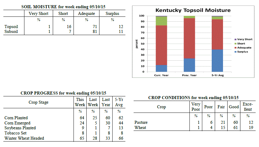 Kentucky Climate Summary
For the Period May 4, 2015 to May 10, 2015
Well Above Normal Temperatures and Much Below Normal Rainfall:
Dry conditions continued to lay claim across the Lower Ohio Valley this past period.
Throughout the work week, the state remained under the influence of high pressure at
the surface and aloft. Other than a stray shower or storm in the afternoon or
evening hours, most remained dry. Coverage slightly increased Friday and into the
weekend across Western Kentucky, but did not make much progress eastward. For a
second straight week, the Commonwealth was nearly an inch below normal. The month
of May is climatologically speaking, the wettest month of the year for Kentucky. In
addition, temperatures were more typical of summer throughout the period. Each day
saw highs jump into the 80s. A handful of locations even hit the 90 degree mark for
the first time this year. On average, high temperatures came in at an average of 84
degrees for the Bluegrass State, which is 10 degrees above normal for this time of
the year.
Temperatures for the period averaged 71 degrees across the state which was 9 degrees
warmer than normal and 14 degrees warmer than the previous period. High temperatures
averaged from 84 in the West to 85 in the East. Departure from normal high
temperatures ranged from 9 degrees warmer than normal in the West to 11 degrees
warmer than normal in the East. Low temperatures averaged from 60 degrees in the
West to 57 degrees in the East. Departure from normal low temperature ranged from 8
degrees warmer than normal in the West to 11 degrees warmer than normal in the
East. The extreme high temperature for the period was 90 degrees at BOWLING GREEN APT
and the extreme low was 44 degrees at JACKSON 3SE.
Precipitation (liq. equ.) for the period totaled 0.14 inches statewide which was 0.95
inches below normal and 13% of normal. Precipitation totals by climate division, West
0.37 inches, Central 0.07 inches, Bluegrass 0.03 inches and East 0.07 inches, which
was 0.8, 1.08, 0.98 and 0.97 inches below normal. By station, precipitation totals
ranged from a low of 0.00 inches at ALBANY 1N to a high of 2.50
inches at CAPE GIRARDEAU ASOS.
---
Kentucky Crop and Weather Report
Issued 4:00 P.M., May 4, 2015 9-15
Agricultural News: Kentucky experienced below normal temperatures and rainfall over
the past week. Precipitation for the week totaled 0.10 inches, 0.97 inches below
normal. Temperatures averaged 56 degrees for the week, 4 degrees below normal.
Topsoil moisture was rated 0 percent very short, 1 percent short, 70 percent adequate
and 29 percent surplus. Subsoil moisture was rated 0 percent very short, 2 percent
short, 69 percent adequate, and 29 percent surplus. Days suitable for fieldwork
averaged 5.2 out of a possible seven.
Primary activities this week included spraying and preparing land for planting,
planting corn, and cutting alfalfa hay. Corn planting was in full swing in many areas
last week. With drier conditions forecasted, excellent progress is expected this week
as more land dries out. Soybean planting is just getting underway. The average height
of winter wheat was 22 inches, compared to 17 inches last week. Seventy-eight percent
of wheat is rated as good to excellent. Tobacco transplant supplies were reported as
1 percent very short, 4 percent short, 87 percent adequate, and 8 percent surplus.
Forty-two percent of tobacco transplants were under 2 inches, with 38 percent between
2-4 inches, and 20 percent over 4 inches. Alfalfa Hay average height was 14 inches,
compared to 9 inches last week. Some producers cut hay this past week with good drying
weather forecasted.
Kentucky Climate Summary
For the Period May 4, 2015 to May 10, 2015
Well Above Normal Temperatures and Much Below Normal Rainfall:
Dry conditions continued to lay claim across the Lower Ohio Valley this past period.
Throughout the work week, the state remained under the influence of high pressure at
the surface and aloft. Other than a stray shower or storm in the afternoon or
evening hours, most remained dry. Coverage slightly increased Friday and into the
weekend across Western Kentucky, but did not make much progress eastward. For a
second straight week, the Commonwealth was nearly an inch below normal. The month
of May is climatologically speaking, the wettest month of the year for Kentucky. In
addition, temperatures were more typical of summer throughout the period. Each day
saw highs jump into the 80s. A handful of locations even hit the 90 degree mark for
the first time this year. On average, high temperatures came in at an average of 84
degrees for the Bluegrass State, which is 10 degrees above normal for this time of
the year.
Temperatures for the period averaged 71 degrees across the state which was 9 degrees
warmer than normal and 14 degrees warmer than the previous period. High temperatures
averaged from 84 in the West to 85 in the East. Departure from normal high
temperatures ranged from 9 degrees warmer than normal in the West to 11 degrees
warmer than normal in the East. Low temperatures averaged from 60 degrees in the
West to 57 degrees in the East. Departure from normal low temperature ranged from 8
degrees warmer than normal in the West to 11 degrees warmer than normal in the
East. The extreme high temperature for the period was 90 degrees at BOWLING GREEN APT
and the extreme low was 44 degrees at JACKSON 3SE.
Precipitation (liq. equ.) for the period totaled 0.14 inches statewide which was 0.95
inches below normal and 13% of normal. Precipitation totals by climate division, West
0.37 inches, Central 0.07 inches, Bluegrass 0.03 inches and East 0.07 inches, which
was 0.8, 1.08, 0.98 and 0.97 inches below normal. By station, precipitation totals
ranged from a low of 0.00 inches at ALBANY 1N to a high of 2.50
inches at CAPE GIRARDEAU ASOS.
---
Kentucky Crop and Weather Report
Issued 4:00 P.M., May 4, 2015 9-15
Agricultural News: Kentucky experienced below normal temperatures and rainfall over
the past week. Precipitation for the week totaled 0.10 inches, 0.97 inches below
normal. Temperatures averaged 56 degrees for the week, 4 degrees below normal.
Topsoil moisture was rated 0 percent very short, 1 percent short, 70 percent adequate
and 29 percent surplus. Subsoil moisture was rated 0 percent very short, 2 percent
short, 69 percent adequate, and 29 percent surplus. Days suitable for fieldwork
averaged 5.2 out of a possible seven.
Primary activities this week included spraying and preparing land for planting,
planting corn, and cutting alfalfa hay. Corn planting was in full swing in many areas
last week. With drier conditions forecasted, excellent progress is expected this week
as more land dries out. Soybean planting is just getting underway. The average height
of winter wheat was 22 inches, compared to 17 inches last week. Seventy-eight percent
of wheat is rated as good to excellent. Tobacco transplant supplies were reported as
1 percent very short, 4 percent short, 87 percent adequate, and 8 percent surplus.
Forty-two percent of tobacco transplants were under 2 inches, with 38 percent between
2-4 inches, and 20 percent over 4 inches. Alfalfa Hay average height was 14 inches,
compared to 9 inches last week. Some producers cut hay this past week with good drying
weather forecasted.
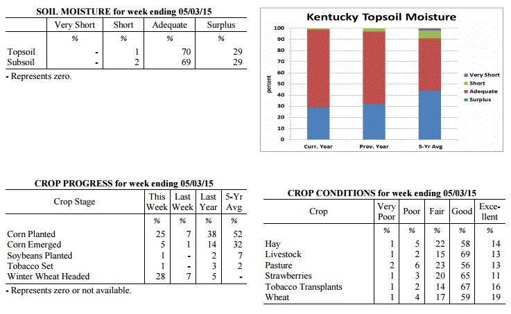 Kentucky Climate Summary
For the Period April 27, 2015 to May 3, 2015
Below Normal Temperatures and Much Below Normal Rainfall:
After a very wet April, the Commonwealth finally got a chance to dry out this past
period with well below normal rainfall in place. In fact, the state averaged just a
tenth of an inch. According to data at the Ag Weather Center, this was the third
driest week of 2015 for the Bluegrass State. The only significant chance of rainfall
came on Thursday when scattered to numerous showers and a few thunderstorms broke out
across the eastern half of the state. Otherwise, the majority of the week was mostly
dry with high pressure in the vicinity. Accompanying the dry pattern was cool
conditions over the course of the work week. A warming trend setup over the weekend,
but it was not enough to keep the state from a second straight week of below normal
temperatures.
Temperatures for the period averaged 56 degrees across the state which was 4 degrees
cooler than normal and 2 degrees warmer than the previous period. High temperatures
averaged from 70 in the West to 68 in the East. Departure from normal high
temperatures ranged from 3 degrees cooler than normal in the West to 4 degrees
cooler than normal in the East. Low temperatures averaged from 44 degrees in the
West to 41 degrees in the East. Departure from normal low temperature ranged from 6
degrees cooler than normal in the West to 3 degrees cooler than normal in the East.
The extreme high temperature for the period was 82 degrees at CAPE GIRARDEAU ASOS and
the extreme low was 31 degrees at VANCEBURG 6W.
Precipitation (liq. equ.) for the period totaled 0.10 inches statewide which was 0.97
inches below normal and 9% of normal. Precipitation totals by climate division, West
0.01 inches, Central 0.09 inches, Bluegrass 0.13 inches and East 0.18 inches, which
was 1.2, 1, 0.85 and 0.82 inches below normal. By station, precipitation totals
ranged from a low of 0.00 inches at BENTON 4N to a high of 0.67
inches at WHITESBURG 2NW.
---
Kentucky Crop and Weather Report
Issued 4:00 P.M., April 27, 2015 8-15
Agricultural News: Kentucky experienced below normal temperatures and rainfall over
the past week. Precipitation for the week totaled 0.88 inches, 0.14 inches below
normal. Temperatures averaged 54 degrees for the week, 4 degrees below normal.
Topsoil moisture was rated 0 percent very short, 0 percent short, 47 percent adequate
and 53 percent surplus. Subsoil moisture was rated 0 percent very short, 1 percent
short, 55 percent adequate, and 44 percent surplus. Days suitable for fieldwork
averaged 2.0 out of a possible seven.
Wet conditions continued to prevent most field activities last week. Corn planting
was reported in some areas where conditions allowed. The state is in need of sunshine
and dry conditions, which this week�s forecast should deliver, bringing optimism that
corn planting will show significant progress. Seventy-nine percent of wheat is rated
as good to excellent. Winter wheat began heading in some locations last week. The
average height of winter wheat was 17 inches, compared to 13 inches last week.
Tobacco transplants in the greenhouse are in need of warm, sunny weather. Fifty-four
percent of tobacco transplants were under 2 inches, with 34 percent between 2-4
inches, and 12 percent over 4 inches.
Alfalfa Hay average height was 9 inches, compared to 7 inches last week. Hay and
roughage supplies were reported as 5 percent very short, 23 percent short, 65 percent
adequate, and 7 percent surplus. The peach crop is expected to be minimal this year
due to the poor bloom caused by cold conditions earlier this year. While apples were
affected by weather conditions as well, the impact is reportedly less severe. Apple
freeze damage was reported as 2 percent severe, 14 percent moderate, 37 percent
light, with 47 percent experiencing none. Peach freeze damage was reported as 30
percent severe, 21 percent moderate, 18 percent light, with 31 percent experiencing
none.
Kentucky Climate Summary
For the Period April 27, 2015 to May 3, 2015
Below Normal Temperatures and Much Below Normal Rainfall:
After a very wet April, the Commonwealth finally got a chance to dry out this past
period with well below normal rainfall in place. In fact, the state averaged just a
tenth of an inch. According to data at the Ag Weather Center, this was the third
driest week of 2015 for the Bluegrass State. The only significant chance of rainfall
came on Thursday when scattered to numerous showers and a few thunderstorms broke out
across the eastern half of the state. Otherwise, the majority of the week was mostly
dry with high pressure in the vicinity. Accompanying the dry pattern was cool
conditions over the course of the work week. A warming trend setup over the weekend,
but it was not enough to keep the state from a second straight week of below normal
temperatures.
Temperatures for the period averaged 56 degrees across the state which was 4 degrees
cooler than normal and 2 degrees warmer than the previous period. High temperatures
averaged from 70 in the West to 68 in the East. Departure from normal high
temperatures ranged from 3 degrees cooler than normal in the West to 4 degrees
cooler than normal in the East. Low temperatures averaged from 44 degrees in the
West to 41 degrees in the East. Departure from normal low temperature ranged from 6
degrees cooler than normal in the West to 3 degrees cooler than normal in the East.
The extreme high temperature for the period was 82 degrees at CAPE GIRARDEAU ASOS and
the extreme low was 31 degrees at VANCEBURG 6W.
Precipitation (liq. equ.) for the period totaled 0.10 inches statewide which was 0.97
inches below normal and 9% of normal. Precipitation totals by climate division, West
0.01 inches, Central 0.09 inches, Bluegrass 0.13 inches and East 0.18 inches, which
was 1.2, 1, 0.85 and 0.82 inches below normal. By station, precipitation totals
ranged from a low of 0.00 inches at BENTON 4N to a high of 0.67
inches at WHITESBURG 2NW.
---
Kentucky Crop and Weather Report
Issued 4:00 P.M., April 27, 2015 8-15
Agricultural News: Kentucky experienced below normal temperatures and rainfall over
the past week. Precipitation for the week totaled 0.88 inches, 0.14 inches below
normal. Temperatures averaged 54 degrees for the week, 4 degrees below normal.
Topsoil moisture was rated 0 percent very short, 0 percent short, 47 percent adequate
and 53 percent surplus. Subsoil moisture was rated 0 percent very short, 1 percent
short, 55 percent adequate, and 44 percent surplus. Days suitable for fieldwork
averaged 2.0 out of a possible seven.
Wet conditions continued to prevent most field activities last week. Corn planting
was reported in some areas where conditions allowed. The state is in need of sunshine
and dry conditions, which this week�s forecast should deliver, bringing optimism that
corn planting will show significant progress. Seventy-nine percent of wheat is rated
as good to excellent. Winter wheat began heading in some locations last week. The
average height of winter wheat was 17 inches, compared to 13 inches last week.
Tobacco transplants in the greenhouse are in need of warm, sunny weather. Fifty-four
percent of tobacco transplants were under 2 inches, with 34 percent between 2-4
inches, and 12 percent over 4 inches.
Alfalfa Hay average height was 9 inches, compared to 7 inches last week. Hay and
roughage supplies were reported as 5 percent very short, 23 percent short, 65 percent
adequate, and 7 percent surplus. The peach crop is expected to be minimal this year
due to the poor bloom caused by cold conditions earlier this year. While apples were
affected by weather conditions as well, the impact is reportedly less severe. Apple
freeze damage was reported as 2 percent severe, 14 percent moderate, 37 percent
light, with 47 percent experiencing none. Peach freeze damage was reported as 30
percent severe, 21 percent moderate, 18 percent light, with 31 percent experiencing
none.
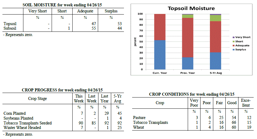 Kentucky Climate Summary
For the Period April 20, 2015 to April 26, 2015
Below Normal Temperatures and Rainfall:
The Commonwealth cannot catch much of a break this spring season. For the first time
since the last week of March, Kentucky saw below normal rainfall. With that in mind,
the state did see subfreezing temperatures later in the work week and a round of
severe weather on Saturday. The work week started out with a couple cold fronts
passing through the area on Monday and Wednesday. Scattered showers and isolated
thunderstorms developed with each round, but didn�t amount to much in the way of
accumulations. The bigger story was the very cool temperatures that filtered into
the area Wednesday and Thursday nights, bringing with it the threat of frost and
subfreezing temperatures. Temperatures fell into the low to mid 30s Wednesday night
for some locations, but was outdone Thursday night as high pressure shifted overhead.
Clearing skies and a calm wind led to many locations across the eastern half of the
state dropping into the upper 20s to low 30s. This was roughly 20 degrees below
normal for late April. Attention then turned to severe weather as a warm front hung
up across the Commonwealth on Saturday. Storms fired later in the evening within a
warm and unstable air mass. Some storms produced very large hail (multiple reports at
2 inches +), damaging winds, and a few tornadoes were also surveyed: EF2 in Edmonson
County, EF1 in Adair, and EF0 in Henderson. Through the event, the state averaged
just under a half inch.
Temperatures for the period averaged 54 degrees across the state which was 4 degrees
cooler than normal and 8 degrees cooler than the previous period. High temperatures
averaged from 66 in the West to 64 in the East. Departure from normal high
temperatures ranged from 6 degrees cooler than normal in the West to 7 degrees
cooler than normal in the East. Low temperatures averaged from 47 degrees in the
West to 43 degrees in the East. Departure from normal low temperature ranged from 1
degree cooler than normal in the West to 1 degree warmer than normal in the East.
The extreme high temperature for the period was 83 degrees at POPLAR BLUFF ASOS and
the extreme low was 26 degrees at FORT CAMPBELL.
Precipitation (liq. equ.) for the period totaled 0.88 inches statewide which was 0.14
inches below normal and 86% of normal. Precipitation totals by climate division, West
0.75 inches, Central 0.83 inches, Bluegrass 0.95 inches and East 1.00 inches, which
was -0.44, -0.20, 0.01 and 0.06 inches respectively from normal. By station,
precipitation totals ranged from a low of 0.31 inches at CARBONDALE ASOS to a high of
1.73 inches at WHITESBURG 2NW.
---
Kentucky Crop and Weather Report
Issued 4:00 P.M., April 20, 2015 7-15
Agricultural News: Kentucky experienced much above normal temperatures and rainfall
over the past week. Precipitation for the week totaled 2.69 inches, 1.70 inches above
normal. Temperatures averaged 64 degrees for the week, 8 degrees above normal.
Topsoil moisture was rated 0 percent very short, 0 percent short, 36 percent adequate
and 64 percent surplus. Subsoil moisture was rated 0 percent very short, 1 percent
short, 50 percent adequate, and 49 percent surplus. Days suitable for fieldwork
averaged 1.3 out of a possible seven.
Wet conditions continued as most ground is saturated and many low lying areas are
under water. The state is in need of sunshine and dry conditions as field work was
limited this week. Primary activities this week included preparing farm equipment for
planting, seeding pastures, and seeding tobacco transplants. Farmers are anxious to
plant corn as soon as field conditions permit. Many locations are now 2-3 weeks
behind schedule and considering switching some acres to soybeans or sorghum.
Canola has bloomed and the crop continues to look good. Wheat is still rated in
mostly good condition. However, some wheat is showing signs of too much water,
especially in low lying areas. Wheat will soon begin to head. Producers will be on
the lookout for Fusarium Head Blight which thrives in wet and warm weather. The
average height of winter wheat was 13 inches, compared to 7 inches last week.
Cloudy days have slowed the development of tobacco transplants in the greenhouse.
Sixty-one percent of tobacco transplants were under 2 inches, with 32 percent between
2-4 inches, and 7 percent over 4 inches. Lush pastures have reduced the need for hay,
but livestock producers are supplementing high magnesium mineral to reduce risk
of grass tetany. Rainy conditions have promoted good alfalfa hay growth with the average
height at 7 inches.
Kentucky Climate Summary
For the Period April 20, 2015 to April 26, 2015
Below Normal Temperatures and Rainfall:
The Commonwealth cannot catch much of a break this spring season. For the first time
since the last week of March, Kentucky saw below normal rainfall. With that in mind,
the state did see subfreezing temperatures later in the work week and a round of
severe weather on Saturday. The work week started out with a couple cold fronts
passing through the area on Monday and Wednesday. Scattered showers and isolated
thunderstorms developed with each round, but didn�t amount to much in the way of
accumulations. The bigger story was the very cool temperatures that filtered into
the area Wednesday and Thursday nights, bringing with it the threat of frost and
subfreezing temperatures. Temperatures fell into the low to mid 30s Wednesday night
for some locations, but was outdone Thursday night as high pressure shifted overhead.
Clearing skies and a calm wind led to many locations across the eastern half of the
state dropping into the upper 20s to low 30s. This was roughly 20 degrees below
normal for late April. Attention then turned to severe weather as a warm front hung
up across the Commonwealth on Saturday. Storms fired later in the evening within a
warm and unstable air mass. Some storms produced very large hail (multiple reports at
2 inches +), damaging winds, and a few tornadoes were also surveyed: EF2 in Edmonson
County, EF1 in Adair, and EF0 in Henderson. Through the event, the state averaged
just under a half inch.
Temperatures for the period averaged 54 degrees across the state which was 4 degrees
cooler than normal and 8 degrees cooler than the previous period. High temperatures
averaged from 66 in the West to 64 in the East. Departure from normal high
temperatures ranged from 6 degrees cooler than normal in the West to 7 degrees
cooler than normal in the East. Low temperatures averaged from 47 degrees in the
West to 43 degrees in the East. Departure from normal low temperature ranged from 1
degree cooler than normal in the West to 1 degree warmer than normal in the East.
The extreme high temperature for the period was 83 degrees at POPLAR BLUFF ASOS and
the extreme low was 26 degrees at FORT CAMPBELL.
Precipitation (liq. equ.) for the period totaled 0.88 inches statewide which was 0.14
inches below normal and 86% of normal. Precipitation totals by climate division, West
0.75 inches, Central 0.83 inches, Bluegrass 0.95 inches and East 1.00 inches, which
was -0.44, -0.20, 0.01 and 0.06 inches respectively from normal. By station,
precipitation totals ranged from a low of 0.31 inches at CARBONDALE ASOS to a high of
1.73 inches at WHITESBURG 2NW.
---
Kentucky Crop and Weather Report
Issued 4:00 P.M., April 20, 2015 7-15
Agricultural News: Kentucky experienced much above normal temperatures and rainfall
over the past week. Precipitation for the week totaled 2.69 inches, 1.70 inches above
normal. Temperatures averaged 64 degrees for the week, 8 degrees above normal.
Topsoil moisture was rated 0 percent very short, 0 percent short, 36 percent adequate
and 64 percent surplus. Subsoil moisture was rated 0 percent very short, 1 percent
short, 50 percent adequate, and 49 percent surplus. Days suitable for fieldwork
averaged 1.3 out of a possible seven.
Wet conditions continued as most ground is saturated and many low lying areas are
under water. The state is in need of sunshine and dry conditions as field work was
limited this week. Primary activities this week included preparing farm equipment for
planting, seeding pastures, and seeding tobacco transplants. Farmers are anxious to
plant corn as soon as field conditions permit. Many locations are now 2-3 weeks
behind schedule and considering switching some acres to soybeans or sorghum.
Canola has bloomed and the crop continues to look good. Wheat is still rated in
mostly good condition. However, some wheat is showing signs of too much water,
especially in low lying areas. Wheat will soon begin to head. Producers will be on
the lookout for Fusarium Head Blight which thrives in wet and warm weather. The
average height of winter wheat was 13 inches, compared to 7 inches last week.
Cloudy days have slowed the development of tobacco transplants in the greenhouse.
Sixty-one percent of tobacco transplants were under 2 inches, with 32 percent between
2-4 inches, and 7 percent over 4 inches. Lush pastures have reduced the need for hay,
but livestock producers are supplementing high magnesium mineral to reduce risk
of grass tetany. Rainy conditions have promoted good alfalfa hay growth with the average
height at 7 inches.
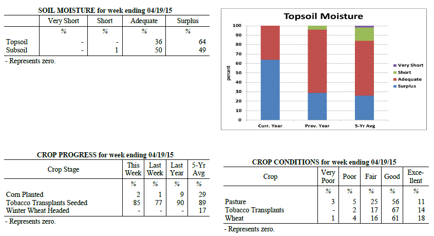 Kentucky Climate Summary
For the Period April 13, 2015 to April 19, 2015
Much Above Normal Temperatures and Rainfall:
The rain kept on coming for the Bluegrass State this past period as many continued to
inch toward a record breaking April. For the past week, the state averaged over two
and a half inches, which made for the third straight week of above normal rainfall.
Looking at data from the National Weather Service in Louisville, the cities of
Louisville, Lexington, Bowling Green, and Frankfort are already in the top five for
wettest April�s on record. Rainfall was consistent throughout the week with a near
daily chance for showers and storms. The only downtime was Friday and Saturday as
weak high pressure pushed into the area. Temperature-wise, it was once again another
mild week for the Commonwealth, mainly due to cloud cover keeping temperatures
elevated at night. Lows typically only dropped into the 50s each day. Normal low
temperatures for this time of the year are in the mid to upper 40s.
Temperatures for the period averaged 64 degrees across the state which was 8 degrees
warmer than normal and no change to the previous period. High temperatures averaged
from 72 in the West to 72 in the East. Departure from normal high temperatures
ranged from 2 degrees warmer than normal in the West to 3 degrees warmer than normal
in the East. Low temperatures averaged from 57 degrees in the West to 55 degrees in
the East. Departure from normal low temperature ranged from 11 degrees warmer than
normal in the West to 15 degrees warmer than normal in the East. The extreme high
temperature for the period was 85 degrees at LOUISA 1S and the extreme low was 43
degrees at VANCEBURG 6W.
Precipitation (liq. equ.) for the period totaled 2.69 inches statewide which was 1.7
inches above normal and 271% of normal. Precipitation totals by climate division,
West 2.94 inches, Central 3.57 inches, Bluegrass 1.87 inches and East 2.40 inches,
which was 1.82, 2.57, 0.96 and 1.46 inches above normal. By station, precipitation
totals ranged from a low of 0.71 inches at CARROLLTON 2E to a high of 5.09 inches
at BOWLING GREEN 5S.
---
Kentucky Crop and Weather Report
Issued 4:00 P.M., April 13, 2015 6-15
Agricultural News: Kentucky experienced above normal temperatures and rainfall over
the past week. Precipitation for the week totaled 1.61 inches, 0.60 inches above
normal. Temperatures averaged 63 degrees for the week, 9 degrees above normal.
Topsoil moisture was rated 1 percent short, 43 percent adequate and 56 percent
surplus. Subsoil moisture was rated 2 percent short, 60 percent adequate, and 38
percent surplus. Days suitable for fieldwork averaged 1.8 out of a possible seven.
Wet conditions continue to prevent most field work as corn planting is 2 weeks behind
normal in many locations. Farmers are conducting soil tests to determine fertilizer
applications, and applying when conditions allow. Producers are providing livestock
access to high magnesium mineral to reduce risk of grass tetany. The peach crop is
expected to be minimal this year due to the poor bloom caused by cold conditions.
Most canola has bloomed and the crop looks good. Eighty-one percent of wheat is rated
as good to excellent. The average height of winter wheat was 7 inches.
Kentucky Climate Summary
For the Period April 13, 2015 to April 19, 2015
Much Above Normal Temperatures and Rainfall:
The rain kept on coming for the Bluegrass State this past period as many continued to
inch toward a record breaking April. For the past week, the state averaged over two
and a half inches, which made for the third straight week of above normal rainfall.
Looking at data from the National Weather Service in Louisville, the cities of
Louisville, Lexington, Bowling Green, and Frankfort are already in the top five for
wettest April�s on record. Rainfall was consistent throughout the week with a near
daily chance for showers and storms. The only downtime was Friday and Saturday as
weak high pressure pushed into the area. Temperature-wise, it was once again another
mild week for the Commonwealth, mainly due to cloud cover keeping temperatures
elevated at night. Lows typically only dropped into the 50s each day. Normal low
temperatures for this time of the year are in the mid to upper 40s.
Temperatures for the period averaged 64 degrees across the state which was 8 degrees
warmer than normal and no change to the previous period. High temperatures averaged
from 72 in the West to 72 in the East. Departure from normal high temperatures
ranged from 2 degrees warmer than normal in the West to 3 degrees warmer than normal
in the East. Low temperatures averaged from 57 degrees in the West to 55 degrees in
the East. Departure from normal low temperature ranged from 11 degrees warmer than
normal in the West to 15 degrees warmer than normal in the East. The extreme high
temperature for the period was 85 degrees at LOUISA 1S and the extreme low was 43
degrees at VANCEBURG 6W.
Precipitation (liq. equ.) for the period totaled 2.69 inches statewide which was 1.7
inches above normal and 271% of normal. Precipitation totals by climate division,
West 2.94 inches, Central 3.57 inches, Bluegrass 1.87 inches and East 2.40 inches,
which was 1.82, 2.57, 0.96 and 1.46 inches above normal. By station, precipitation
totals ranged from a low of 0.71 inches at CARROLLTON 2E to a high of 5.09 inches
at BOWLING GREEN 5S.
---
Kentucky Crop and Weather Report
Issued 4:00 P.M., April 13, 2015 6-15
Agricultural News: Kentucky experienced above normal temperatures and rainfall over
the past week. Precipitation for the week totaled 1.61 inches, 0.60 inches above
normal. Temperatures averaged 63 degrees for the week, 9 degrees above normal.
Topsoil moisture was rated 1 percent short, 43 percent adequate and 56 percent
surplus. Subsoil moisture was rated 2 percent short, 60 percent adequate, and 38
percent surplus. Days suitable for fieldwork averaged 1.8 out of a possible seven.
Wet conditions continue to prevent most field work as corn planting is 2 weeks behind
normal in many locations. Farmers are conducting soil tests to determine fertilizer
applications, and applying when conditions allow. Producers are providing livestock
access to high magnesium mineral to reduce risk of grass tetany. The peach crop is
expected to be minimal this year due to the poor bloom caused by cold conditions.
Most canola has bloomed and the crop looks good. Eighty-one percent of wheat is rated
as good to excellent. The average height of winter wheat was 7 inches.
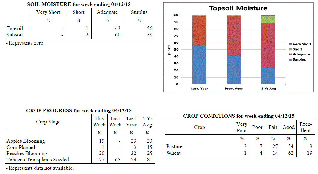 Kentucky Climate Summary
For the Period April 6, 2015 to April 12, 2015
Much Above Normal Temperatures and Above Normal Rainfall:
The wet pattern continued for a second straight period as rainfall was seen on a
daily basis over this past work week. Multiple disturbances pushed through the Lower
Ohio Valley and with plenty of moisture available, any storms that did develop were
efficient rainfall producers. Flash flooding was once again a concern for some
locations. Some rounds did produce a fair share of severe weather as the state was
placed within an unstable air mass. A couple weak tornadoes were seen in Madison
County on the 7th, while hail 2 inches in diameter fell on the 8th. The final round
pushed through the area on Thursday night and into Friday morning with the passage of
a cold front. Over the course of the period, the state average was a bit over an inch
and a half. Drier air worked into the area on Friday with the Commonwealth getting a
chance to dry out over the weekend with high pressure in place. Looking at
temperatures, it was one of the warmest weeks of 2015 thus far. The average state
temperature was 9 degrees above normal, mainly due to multiple days with highs in
the 70s/80s and lows only dropping into the 50s/60s.
Temperatures for the period averaged 63 degrees across the state which was 9 degrees
warmer than normal and 8 degrees warmer than the previous period. High temperatures
averaged from 74 in the West to 74 in the East. Departure from normal high
temperatures ranged from 6 degrees warmer than normal in the West to 7 degrees
warmer than normal in the East. Low temperatures averaged from 55 degrees in the
West to 51 degrees in the East. Departure from normal low temperature ranged from 11
degrees warmer than normal in the West to 12 degrees warmer than normal in the
East. The extreme high temperature for the period was 87 degrees at BOONEVILLE 2S and
the extreme low was 27 degrees at MONTICELLO AWOS.
Precipitation (liq. equ.) for the period totaled 1.61 inches statewide which was 0.6
inches above normal and 160% of normal. Precipitation totals by climate division,
West 1.10 inches, Central 1.65 inches, Bluegrass 1.85 inches and East 1.84 inches,
which was -0.05, 0.62, 0.94 and 0.91 inches respectively from normal. By station,
precipitation totals ranged from a low of 0.36 inches at PRINCETON 2SE to a high of
3.16 inches at BARBOURVILLE 3E.
---
Kentucky Crop and Weather Report
Issued 4:00 P.M., April 7, 2015 5-15
Agricultural News: Kentucky experienced excessive rainfall over the past week.
Precipitation for the week totaled 2.80 inches, 1.80 inches above normal.
Temperatures averaged 54 degrees for the week, 3 degrees above normal. Topsoil
moisture was rated 1 percent short, 51 percent adequate and 48 percent surplus.
Subsoil moisture was rated 3 percent short, 67 percent adequate, and 30 percent
surplus. Days suitable for fieldwork averaged 3.6 out of a possible seven.
Primary activities this week included preparing farm equipment for planting, applying
fertilizer, and seeding tobacco transplants. Excessive rainfall kept farmers out of
the fields and caused some flooding which resulted in crop and livestock losses.
Wheat winter freeze damage was reported as 1 percent severe, 4 percent moderate, 15
percent light, with 80 percent experiencing none. Alfalfa hay freeze damage was
reported as 2 percent severe, 12 percent moderate, 43 percent light, with 43 percent
experiencing none. Cattle and calves obtained approximately 39 percent of feed from
pastures, but some hay is being fed.
Kentucky Climate Summary
For the Period April 6, 2015 to April 12, 2015
Much Above Normal Temperatures and Above Normal Rainfall:
The wet pattern continued for a second straight period as rainfall was seen on a
daily basis over this past work week. Multiple disturbances pushed through the Lower
Ohio Valley and with plenty of moisture available, any storms that did develop were
efficient rainfall producers. Flash flooding was once again a concern for some
locations. Some rounds did produce a fair share of severe weather as the state was
placed within an unstable air mass. A couple weak tornadoes were seen in Madison
County on the 7th, while hail 2 inches in diameter fell on the 8th. The final round
pushed through the area on Thursday night and into Friday morning with the passage of
a cold front. Over the course of the period, the state average was a bit over an inch
and a half. Drier air worked into the area on Friday with the Commonwealth getting a
chance to dry out over the weekend with high pressure in place. Looking at
temperatures, it was one of the warmest weeks of 2015 thus far. The average state
temperature was 9 degrees above normal, mainly due to multiple days with highs in
the 70s/80s and lows only dropping into the 50s/60s.
Temperatures for the period averaged 63 degrees across the state which was 9 degrees
warmer than normal and 8 degrees warmer than the previous period. High temperatures
averaged from 74 in the West to 74 in the East. Departure from normal high
temperatures ranged from 6 degrees warmer than normal in the West to 7 degrees
warmer than normal in the East. Low temperatures averaged from 55 degrees in the
West to 51 degrees in the East. Departure from normal low temperature ranged from 11
degrees warmer than normal in the West to 12 degrees warmer than normal in the
East. The extreme high temperature for the period was 87 degrees at BOONEVILLE 2S and
the extreme low was 27 degrees at MONTICELLO AWOS.
Precipitation (liq. equ.) for the period totaled 1.61 inches statewide which was 0.6
inches above normal and 160% of normal. Precipitation totals by climate division,
West 1.10 inches, Central 1.65 inches, Bluegrass 1.85 inches and East 1.84 inches,
which was -0.05, 0.62, 0.94 and 0.91 inches respectively from normal. By station,
precipitation totals ranged from a low of 0.36 inches at PRINCETON 2SE to a high of
3.16 inches at BARBOURVILLE 3E.
---
Kentucky Crop and Weather Report
Issued 4:00 P.M., April 7, 2015 5-15
Agricultural News: Kentucky experienced excessive rainfall over the past week.
Precipitation for the week totaled 2.80 inches, 1.80 inches above normal.
Temperatures averaged 54 degrees for the week, 3 degrees above normal. Topsoil
moisture was rated 1 percent short, 51 percent adequate and 48 percent surplus.
Subsoil moisture was rated 3 percent short, 67 percent adequate, and 30 percent
surplus. Days suitable for fieldwork averaged 3.6 out of a possible seven.
Primary activities this week included preparing farm equipment for planting, applying
fertilizer, and seeding tobacco transplants. Excessive rainfall kept farmers out of
the fields and caused some flooding which resulted in crop and livestock losses.
Wheat winter freeze damage was reported as 1 percent severe, 4 percent moderate, 15
percent light, with 80 percent experiencing none. Alfalfa hay freeze damage was
reported as 2 percent severe, 12 percent moderate, 43 percent light, with 43 percent
experiencing none. Cattle and calves obtained approximately 39 percent of feed from
pastures, but some hay is being fed.
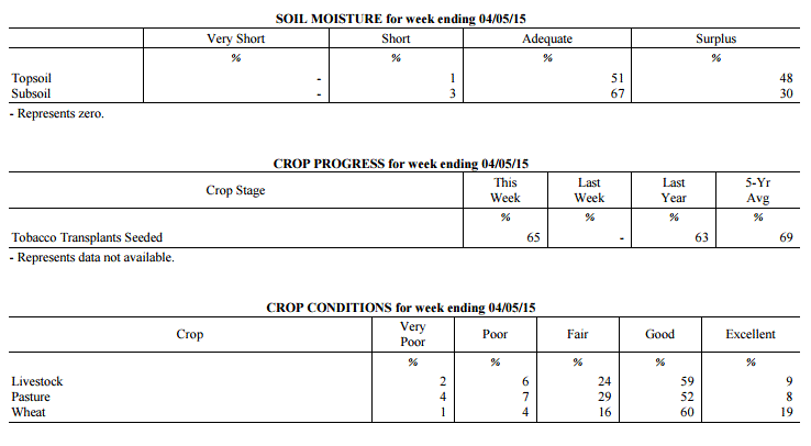 Kentucky Climate Summary
For the Period March 30, 2015 to April 5, 2015
Above Normal Temperatures and Much Above Normal Rainfall:
A very active pattern set up across the Lower Ohio Valley for the beginning of April,
leading to excessive rainfall for much of the state. In addition, after going much
of the winter without any thunderstorms, an unstable atmosphere led to the first
of the year for many locations. The main activity occurred over the second half of
the work week as a frontal boundary stalled across the area. The state as a whole,
averaged just under three inches for the week, but portions of the Bluegrass region
received much more. Along the I-64 corridor, many locations received five to more
than seven inches of rain over the two day period. Significant flooding was an issue
across much of the state as multiple thunderstorms trained over the same region.
Over the course of the week, rainfall was above normal by 1.8 inches, breaking a two
week run of below normal precipitation. The weekend brought dry conditions, but with
cooler temperatures in place. For the first time this year, frost advisories were
issued for Saturday night.
Temperatures for the period averaged 54 degrees across the state which was 3 degrees
warmer than normal and 8 degrees warmer than the previous period. High temperatures
averaged from 69 in the West to 67 in the East. Departure from normal high
temperatures ranged from 4 degrees warmer than normal in the West to 3 degrees
warmer than normal in the East. Low temperatures averaged from 44 degrees in the
West to 41 degrees in the East. Departure from normal low temperature ranged from 2
degrees warmer than normal in the West to 4 degrees warmer than normal in the East.
The extreme high temperature for the period was 81 degrees at HARTFORD 3E and the
extreme low was 26 degrees at MCKEE 5S.
Precipitation (liq. equ.) for the period totaled 2.80 inches statewide which was 1.8
inches above normal and 279% of normal. Precipitation totals by climate division,
West 1.97 inches, Central 2.48 inches, Bluegrass 4.28 inches and East 2.46 inches,
which was 0.88, 1.43, 3.37 and 1.5 inches above normal. By station, precipitation
totals ranged from a low of 0.83 inches at WHITESBURG 2NW to a high of 7.21
inches at FRANKFORT 7S.
---
Kentucky Climate Summary
For the Period March 23, 2015 to March 29, 2015
Below Normal Temperatures and Precipitation:
The Bluegrass State closed out the month of March with a second straight week of
below normal precipitation. Most of the activity was centered on a cold front that
worked through the area Wednesday night and into Thursday. Overall, totals averaged
about a half inch for the state. Ahead of the boundary, temperatures peaked in the
70s across much of Kentucky, before falling well below seasonable norms on Friday
and Saturday. Highs typically only rose into the 40s each day with lows falling into
the 20s. Some locations even dipped into the upper teens. Dr. John Strang (UK
Horticulture specialist) stated that temperatures in the 20s will not have much
impact. Apples and pears were in the 'Silver Tip' and 'Swollen bud' stages,
respectively. In order for 10% bud kill, a critical temperature of 15 degrees needed
to be reached for each. John stated that some peaches may have reached the 'Swollen
Bud' stage and in this case, 10 percent kill occurs with a critical temperature of 18
degrees.
Temperatures for the period averaged 46 degrees across the state which was 3 degrees
cooler than normal and 4 degrees cooler than the previous period. High temperatures
averaged from 59 in the West to 60 in the East. Departure from normal high
temperatures ranged from 4 degrees cooler than normal in the West to 2 degrees
cooler than normal in the East. Low temperatures averaged from 36 degrees in the
West to 34 degrees in the East. Departure from normal low temperature ranged from 4
degrees cooler than normal in the West to 1 degree cooler than normal in the East.
The extreme high temperature for the period was 79 degrees at GREENVILLE 6N and the
extreme low was 14 degrees at PAINTSVILLE 4W.
Precipitation (liq. equ.) for the period totaled 0.47 inches statewide which was 0.57
inches below normal and 45% of normal. Precipitation totals by climate division, West
0.70 inches, Central 0.36 inches, Bluegrass 0.43 inches and East 0.40 inches, which
was 0.41, 0.73, 0.5 and 0.61 inches below normal. By station, precipitation totals
ranged from a low of 0.07 inches at MIDDLESBORO AWOS to a high of 1.90 inches at
CAPE GIRARDEAU ASOS.
---
Kentucky Climate Summary
For the Period March 16, 2015 to March 22, 2015
Above Normal Temperatures and Below Normal Precipitation:
The Commonwealth finally got a chance to dry out this past period, along with another
week of above normal temperatures. The warmest day of 2015 occurred this past Monday
with the mercury reaching into the 70s statewide. A cold front then pushed through
the region on Tuesday, followed by Canadian high pressure building into the area that
night. This frontal passage ended up being a mostly dry one, but with much cooler
temperatures in place. Wednesday highs dropped back into the upper 40s to middle 50s.
Similar temperatures remained with the area through Friday, before another warming
trend over the weekend. Light showers fell on and off over the second half of the
work week as a few disturbances crossed the area. Total accumulations were minimal
with a state average of just under a quarter inch.
Temperatures for the period averaged 50 degrees across the state which was 2 degrees
warmer than normal and 2 degrees cooler than the previous period. High temperatures
averaged from 60 in the West to 59 in the East. Departure from normal high
temperatures ranged from near normal in the West to 1 degree cooler than
normal in the East. Low temperatures averaged from 43 degrees in the West to 41
degrees in the East. Departure from normal low temperature ranged from 5 degrees
warmer than normal in the West to 7 degrees warmer than normal in the East. The
extreme high temperature for the period was 79 degrees at LOUISA 1S and the extreme
low was 23 degrees at CYNTHIANA 8N.
Precipitation (liq. equ.) for the period totaled 0.22 inches statewide which was 0.82
inches below normal and 21% of normal. Precipitation totals by climate division, West
0.13 inches, Central 0.23 inches, Bluegrass 0.21 inches and East 0.33 inches, which
was 0.97, 0.87, 0.73 and 0.69 inches below normal. By station, precipitation totals
ranged from a low of 0.02 inches at CARBONDALE ASOS to a high of 0.79 inches at
WHITLEY CITY 3N.
---
Kentucky Climate Summary
For the Period March 9, 2015 to March 15, 2015
Much Above Normal Temperatures and Precipitation:
The Commonwealth finally got a first glimpse of spring temperatures this past period,
but not without an excessive amount of rainfall. Throughout the week, the state saw
a couple rounds of low pressure pass through the area, one over the first half of the
work week and the other lasting from Thursday night into Saturday. Each round
brought an average of 1 to 2 inches of rainfall for most. By the time the week was
over, the state average was over 3 inches, which was over 2 inches above normal.
This was the 3rd time over the past 4 weeks that the state average was over 2 inches.
In doing so, the US Drought Monitor removed any mention of abnormally dry conditions
across the Bluegrass State. Looking at temperatures, highs typically stayed in the
50s and 60s for much of the week. Some stations even broke 70 on the 12th and 15th.
The mild conditions broke a streak of 4 straight weeks of below normal temperatures.
Temperatures for the period averaged 52 degrees across the state which was 7 degrees
warmer than normal and 18 degrees warmer than the previous period. High temperatures
averaged from 61 in the West to 61 in the East. Departure from normal high
temperatures ranged from 3 degrees warmer than normal in the West to 4 degrees
warmer than normal in the East. Low temperatures averaged from 45 degrees in the
West to 45 degrees in the East. Departure from normal low temperature ranged from 9
degrees warmer than normal in the West to 13 degrees warmer than normal in the
East. The extreme high temperature for the period was 71 degrees at BOWLING GREEN 4E
and the extreme low was 31 degrees at CARROLLTON 2E.
Precipitation (liq. equ.) for the period totaled 3.12 inches statewide which was 2.15
inches above normal and 321% of normal. Precipitation totals by climate division,
West 3.50 inches, Central 3.32 inches, Bluegrass 3.67 inches and East 2.00 inches,
which was 2.49, 2.3, 2.78 and 1.03 inches above normal. By station, precipitation
totals ranged from a low of 1.14 inches at MIDDLESBORO AWOS to a high of 5.38
inches at PADUCAH ASOS.
---
Kentucky Climate Summary
For the Period March 2, 2015 to March 8, 2015
Well Below Normal Temperatures and Much Above Normal Precipitation:
The pause from recording breaking winter weather was short lived as the Commonwealth
was hit with another major winter storm this past period. The event started with warm
air and excessive rainfall in place Tuesday and through the overnight. Highs on
Tuesday reached the 50s. For many, this was the first time since February 9th that
this threshold had been met. The combination of rainfall and melting snow led to
flooding in some low lying areas and along creeks and rivers. Colder air started
working into the area on Wednesday with the mercury on the decline. Precipitation
transitioned to snow through the day from northwest to southeast. Moderate to heavy
snow continued through the overnight for many locations, leading to record breaking
snowfall totals. The heaviest occurred on a line that ran through Elizabethtown and
Frankfort where totals ranged between 18 to 24 inches. Lexington saw 17.1 inches and
was the heaviest 2 day snowfall total ever recorded. Arctic high pressure entered
from the northwest by Thursday with another shot of very cold air in place. With the
excessive amount of snow on the ground, record breaking temperatures were seen at
numerous locations that night. Many went below zero, which was over 30 degrees colder
than normal for that time of the year. The good news is that winds shifted to the
southwest for the weekend, ushering temperatures back into the 40s and 50s.
Temperatures for the period averaged 33 degrees across the state which was 11 degrees
cooler than normal and 6 degrees warmer than the previous period. High temperatures
averaged from 43 in the West to 49 in the East. Departure from normal high
temperatures ranged from 14 degrees cooler than normal in the West to 7 degrees
cooler than normal in the East. Low temperatures averaged from 21 degrees in the
West to 24 degrees in the East. Departure from normal low temperature ranged from 14
degrees cooler than normal in the West to 7 degrees cooler than normal in the East.
The extreme high temperature for the period was 66 degrees at FORT CAMPBELL and the
extreme low was -15 degrees at BRANDENBURG 4SW.
Precipitation (liq. equ.) for the period totaled 2.88 inches statewide which was 1.91
inches above normal and 296% of normal. Precipitation totals by climate division,
West 2.94 inches, Central 3.05 inches, Bluegrass 2.71 inches and East 2.82 inches,
which was 1.89, 2.03, 1.84 and 1.87 inches above normal. By station, precipitation
totals ranged from a low of 0.79 inches at CARBONDALE ASOS to a high of 3.99 inches
at WHITLEY CITY 3N.
---
Kentucky Climate Summary
For the Period February 23, 2015 to March 1, 2015
Well Below Normal Temperatures and Much Below Normal Precipitation:
The Commonwealth closed out the month of February with another very cold week. In
fact, this was the third straight week of well below normal temperatures as the
Bluegrass State saw another couple rounds of Arctic air. Highs for this time of the
year normally top out in the upper 40s to middle 50s with overnight lows in the low
to mid 30s. Over the course of the period, the Arctic air kept highs hovering in the 20s
to low 30s with lows dropping into the single digits to lower teens at times. After
a recording break week of snowfall, precipitation this past period was quite scarce.
Portions of South-Central and Southeastern Kentucky saw light snow accumulations
Wednesday night as low pressure passed just south of the state. Most snowfall totals
were below an inch. The northern periphery of the Kentucky then saw another period of
light snow and a wintry mix Saturday night and into Sunday morning, but once again,
accumulations were light. Over the course of the week, the majority of state saw
around a tenth of an inch of liquid equivalent.
Temperatures for the period averaged 26 degrees across the state which was 16 degrees
cooler than normal and 10 degrees warmer than the previous period. High temperatures
averaged from 32 in the West to 36 in the East. Departure from normal high
temperatures ranged from 22 degrees cooler than normal in the West to 18 degrees
cooler than normal in the East. Low temperatures averaged from 18 degrees in the
West to 20 degrees in the East. Departure from normal low temperature ranged from 15
degrees cooler than normal in the West to 9 degrees cooler than normal in the East.
The extreme high temperature for the period was 52 degrees at MONTICELLO AWOS and the
extreme low was -8 degrees at MAYSVILLE 3SW.
Precipitation (liq. equ.) for the period totaled 0.13 inches statewide which was 0.86
inches below normal and 13% of normal. Precipitation totals by climate division, West
0.09 inches, Central 0.13 inches, Bluegrass 0.19 inches and East 0.12 inches, which
was 1.01, 0.92, 0.67 and 0.81 inches below normal. By station, precipitation totals
ranged from a low of 0.01 inches at LONDON to a high of 0.35 inches at PIKEVILLE 13S.
---
Kentucky Climate Summary
For the Period February 16, 2015 to February 22, 2015
Well Below Normal Temperatures and Much Above Normal Precipitation:
It was an all-around, recording breaking week for the Lower Ohio Valley. The period
started off with a major winter storm pushing through the area on Monday. Significant
accumulations were seen across the entirety of the state with 8 to 12 inches common.
Snowfall was moderate to heavy at times with rates in the vicinity of 1 to 2 inches
per hour. Another cold front then dropped across the region Tuesday night and into
Wednesday morning, dropping another 1 to 2 inches. Following the snow, dangerously
cold air built into the Ohio Valley. The coldest period was Wednesday night through
Thursday night with the mercury pushing well below zero. Most fell between -5 and -
15 on Wednesday night, before only rising into the single digits on Thursday. Much of
the Bluegrass and Eastern Kentucky then dropped to between -10 and -20 on Thursday
night with Arctic high pressure shifting overhead. Some dropped even further. The
state record for low temperatures was set back in January of 1994 with a reading of -
37 degrees. Richmond got close with a low temperature of -32 on Thursday night.
Records were broken in Lexington, Louisville, Bowling Green, and Frankfort that
spanned back over 100 years, into the late 1800s.
The cold air was followed by yet another winter storm over the weekend. Temperatures
were actually on the increase Friday night and into Saturday, opening the window for
a wintry mix across the state. Ice was more common across the southern half of
Kentucky with minor snow accumulations further north. Another issue was the amount of
rainfall across the area. Much of the state saw 1 to 3 inches, with the highest
totals across the southern half of the state. In addition to the melting snowpack,
some flooding arose, especially in low lying areas. This was the first week that the
Bluegrass State has seen in 2015 with above normal rainfall and it came at a good
time as drought was expanding. Over the course of the period, the state was over 1.5
inches above normal. Looking at temperatures, the very cold Arctic air led Kentucky
to a week in which highs and lows were 25 and 19 degrees below normal, respectively.
Temperatures for the period averaged 17 degrees across the state which was 22 degrees
cooler than normal and 12 degrees cooler than the previous period. High temperatures
averaged from 27 in the West to 25 in the East. Departure from normal high
temperatures ranged from 24 degrees cooler than normal in the West to 25 degrees
cooler than normal in the East. Low temperatures averaged from 11 degrees in the
West to 9 degrees in the East. Departure from normal low temperature ranged from 19
degrees cooler than normal in the West to 17 degrees cooler than normal in the
East. The extreme high temperature for the period was 46 degrees at WHITESBURG 2NW
and the extreme low was -32 degrees at RICHMOND 8E.
Precipitation (liq. equ.) for the period totaled 2.69 inches statewide which was 1.77
inches above normal and 292% of normal. Precipitation totals by climate division,
West 3.11 inches, Central 3.06 inches, Bluegrass 1.83 inches and East 2.76 inches,
which was 2.07, 2.07, 1.04 and 1.9 inches above normal. By station, precipitation
totals ranged from a low of 1.05 inches at CARBONDALE ASOS to a high of 4.46
inches at MURRAY 1W.
---
Kentucky Climate Summary
For the Period February 9, 2015 to February 15, 2015
Much Below Normal Temperatures and Precipitation:
Dry conditions persisted this past period and were accompanied by a return to winter-
like temperatures. Focus centered around the passage of two strong cold fronts, one
on Thursday and the other on Saturday. The region saw light snow accumulations with
each event, along with gusty northwest winds. In particular, winds on Saturday gusted
to over 40 mph for many locations. After the passage of this front, lows plummeted
into the single digits by Sunday morning. Over the course of the week, precipitation
was once again scarce, only amounting to under a tenth of an inch on average across
the state. This made for the 7th straight week of below normal precipitation. For
2015, the state is on average, over 3 inches below normal. The US Drought Monitor now
displays over half the state in Moderate Drought.
Temperatures for the period averaged 29 degrees across the state which was 8 degrees
cooler than normal and 8 degrees cooler than the previous period. High temperatures
averaged from 40 in the West to 36 in the East. Departure from normal high
temperatures ranged from 8 degrees cooler than normal in the West to 12 degrees
cooler than normal in the East. Low temperatures averaged from 22 degrees in the
West to 21 degrees in the East. Departure from normal low temperature ranged from 6
degrees cooler than normal in the West to 4 degrees cooler than normal in the East.
The extreme high temperature for the period was 59 degrees at POPLAR BLUFF ASOS and
the extreme low was -3 degrees at PIKEVILLE 13S.
Precipitation (liq. equ.) for the period totaled 0.04 inches statewide which was 0.86
inches below normal and 4% of normal. Precipitation totals by climate division, West
0.00 inches, Central 0.04 inches, Bluegrass 0.04 inches and East 0.10 inches, which
was 1.01, 0.95, 0.74 and 0.74 inches below normal. By station, precipitation totals
ranged from a low of 0.00 inches at BENTON 4N to a high of 0.39 inches at WHITESBURG 2NW.
---
Kentucky Climate Summary
For the Period February 2, 2015 to February 8, 2015
Above Normal Temperatures and Below Normal Precipitation:
Thus far, conditions have been dry and fairly mild through the beginning of 2015.
That trend did not change this past period. Overall, the Commonwealth averaged less
than a quarter inch of precipitation. Much of the activity centered around the
passing of a couple cold fronts through the work week, each producing just minor snow
accumulations. This pushed the Bluegrass State to a sixth straight week of below
normal rainfall. The US Drought Monitor expanded abnormally dry conditions to
comprising nearly 80% of the state. The period ended with a very warm weekend with
above normal temperatures in place. Most saw highs rise into the mid 50s to around 60.
Temperatures for the period averaged 36 degrees across the state which was 2 degrees
warmer than normal and no change to the previous period. High temperatures averaged
from 47 in the West to 49 in the East. Departure from normal high temperatures ranged
from 1 degree warmer than normal in the West to 3 degrees warmer than normal in the
East. Low temperatures averaged from 26 degrees in the West to 25 degrees in the
East. Departure from normal low temperature ranged from near normal in the West to 2
degrees warmer than normal in the East. The extreme high temperature for the period
was 66 degrees at LOUISA 1S and the extreme low was 4 degrees at VANCEBURG 6W.
Precipitation (liq. equ.) for the period totaled 0.20 inches statewide which was 0.67
inches below normal and 23% of normal. Precipitation totals by climate division, West
0.04 inches, Central 0.17 inches, Bluegrass 0.20 inches and East 0.38 inches, which
was 0.91, 0.78, 0.56 and 0.45 inches below normal. By station, precipitation totals
ranged from a low of 0.00 inches at HICKMAN 2E to a high of 0.84 inches at PIKEVILLE 13S.
---
Kentucky Climate Summary
For the Period January 26, 2015 to February 1, 2015
Above Normal Temperatures and Below Normal Precipitation:
The Commonwealth saw a number of precipitation events this past week with the most
significant coming on Sunday as low pressure passed just north of the state.
Widespread light to moderate rainfall pushed through the area with rainfall totals
generally between a half to one inch for most. Saying this, overall, it was another
period in which precipitation was lacking. The state average was below normal for
the fifth straight week. Looking farther back, 12 of the past 15 weeks have seen
below normal precipitation. This has taken a toll across the state with the US
Drought Monitor expanding the area of abnormally dry conditions to accounting for
nearly 70% of the state. Moderate drought also expanded into Central Kentucky, which
is nearly 3.5 inches below normal over the past 60 days.
Temperatures for the period averaged 35 degrees across the state which was 2 degrees
warmer than normal and 2 degrees cooler than the previous period. High temperatures
averaged from 46 in the West to 42 in the East. Departure from normal high
temperatures ranged from 2 degrees warmer than normal in the West to 2 degrees
cooler than normal in the East. Low temperatures averaged from 32 degrees in the
West to 25 degrees in the East. Departure from normal low temperature ranged from 7
degrees warmer than normal in the West to 3 degrees warmer than normal in the East.
The extreme high temperature for the period was 62 degrees at FORT CAMPBELL and the
extreme low was 8 degrees at BLACK MOUNTAIN ARC.
Precipitation (liq. equ.) for the period totaled 0.73 inches statewide which was 0.07
inches below normal and 91% of normal. Precipitation totals by climate division, West
0.90 inches, Central 0.87 inches, Bluegrass 0.54 inches and East 0.61 inches, which
was 0.05, 0.01, -0.16 and -0.18 inches respectively from normal. By station,
precipitation totals ranged from a low of 0.28 inches at BOONEVILLE 2S to a high of
1.57 inches at POPLAR BLUFF ASOS.
---
Kentucky Climate Summary
For the Period January 19, 2015 to January 25, 2015
Above Normal Temperatures and Below Normal Precipitation:
Thus far, snowfall has been a rare occurrence this winter season for the Lower Ohio
Valley. That notion came to an end on Friday night and Saturday morning. As low
pressure passed just south and east of the state, a heavy snow band resulted in
significant snowfall totals across Central Kentucky and up into the Bluegrass. One
particular swath running through Elizabethtown and Lexington saw between 4 to 6
inches. The good news is that this event occurred between two relatively warm
periods. The week started off with temperatures well above normal, reaching the 50s
for most locations between Monday and Wednesday. The warm ground temperatures and
mild temperatures over the weekend took a toll on the snowpack. Overall, while the
state did see some significant snowfall, the liquid equivalent was just under a half
inch for the week. This pushed the Bluegrass State to a fourth straight week of below
normal precipitation. The US Drought Monitor remained relatively unchanged with a
little over 10% of the state in Moderate Drought.
Temperatures for the period averaged 38 degrees across the state which was 5 degrees
warmer than normal and 4 degrees warmer than the previous period. High temperatures
averaged from 50 in the West to 48 in the East. Departure from normal high
temperatures ranged from 7 degrees warmer than normal in the West to 4 degrees
warmer than normal in the East. Low temperatures averaged from 29 degrees in the
West to 30 degrees in the East. Departure from normal low temperature ranged from 4
degrees warmer than normal in the West to 8 degrees warmer than normal in the East.
The extreme high temperature for the period was 64 degrees at FORT CAMPBELL and the
extreme low was 15 degrees at ELKTON 5SW.
Precipitation (liq. equ.) for the period totaled 0.44 inches statewide which was 0.38
inches below normal and 54% of normal. Precipitation totals by climate division, West
0.50 inches, Central 0.40 inches, Bluegrass 0.38 inches and East 0.47 inches, which
was 0.37, 0.47, 0.33 and 0.35 inches below normal. By station, precipitation totals
ranged from a low of 0.09 inches at LA GRANGE 6NW to a high of 1.06 inches at PADUCAH
ASOS.
---
Kentucky Climate Summary
For the Period 01-12-2015 to 01-18-2015
Above Normal Temperatures and Below Normal Rainfall:
The big story this past week was the reversal of very cold temperatures to
moderating temperatures. This past week averaged 10 to 15 degrees warmer than the
previous week. Precipitation, on the other hand continued to be slim with the
drought tools starting to place some western and west-central sections in Moderate
hydrologic drought. Nearly 40% of the state was listed as in Moderate to abnormally
dry conditions.
Temperatures for the period averaged 35 degrees across the state which was 2 degrees
warmer than normal and 14 degrees warmer than the previous period. High temperatures
averaged from 42 in the West to 42 in the East. Departure from normal high
temperatures ranged from 1 degrees cooler than normal in the West to 1 degrees cooler
than normal in the East. Low temperatures averaged from 28 degrees in the West to 29
degrees in the East. Departure from normal low temperature ranged from 3 degrees
warmer than normal in the West to 6 degrees warmer than normal in the East. The
extreme high temperature for the period was 63 degrees at POPLAR BLUFF ASOS and the
extreme low was 14 degrees at CARBONDALE ASOS.
Precipitation (liq. equ.) for the period totaled 0.47 inches statewide which was 0.38
inches below normal and 55% of normal. Precipitation totals by climate division, West
0.43 inches, Central 0.57 inches, Bluegrass 0.37 inches and East 0.52 inches, which
was 0.46, 0.33, 0.36 and 0.36 inches below normal. By station, precipitation totals
ranged from a low of 0.24 inches at LOUISVILLE APT to a high of 1.01 inches at
EDMONTON 5W.
---
Kentucky Climate Summary
For the Period January 5, 2015 to January 11, 2015
Well Below Normal Temperatures and Precipitation:
The Commonwealth experienced the coldest temperatures of the young winter season this
past period. An Arctic front pushed through the area Tuesday night with temperatures
quickly on the decrease through the day on Wednesday. Breezy northwest winds pushed
the wind chill below zero Wednesday morning and stayed that way into Thursday. The
coldest temperatures were felt late Wednesday night and into Thursday morning as high
pressure moved overhead. Clear skies and calm winds led to lows dipping to either
side of zero. The cold air lasted through Saturday morning as another cold front
brought a reinforcing shot of Arctic air on Friday. Lows Friday night dipped into
the single digits. Over the period, the livestock cold stress index remained in the
emergency category. For the week, the average state temperature was 12 degrees below
normal. Other than some light snow showers along the previously mentioned Arctic
fronts, the only other significant shot at precipitation was on Sunday as light rain
showers fell across much of the region with the passage of an upper level
disturbance.
Temperatures for the period averaged 22 degrees across the state which was 12 degrees
cooler than normal and 14 degrees cooler than the previous period. High temperatures
averaged from 30 in the West to 32 in the East. Departure from normal high
temperatures ranged from 13 degrees cooler than normal in the West to 12 degrees
cooler than normal in the East. Low temperatures averaged from 15 degrees in the
West to 14 degrees in the East. Departure from normal low temperature ranged from 11
degrees cooler than normal in the West to 10 degrees cooler than normal in the
East. The extreme high temperature for the period was 48 degrees at MONTICELLO AWOS
and the extreme low was -9 degrees at BLACK MOUNTAIN ARC.
Precipitation (liq. equ.) for the period totaled 0.03 inches statewide which was 0.85
inches below normal and 3% of normal. Precipitation totals by climate division, West
0.05 inches, Central 0.02 inches, Bluegrass 0.02 inches and East 0.02 inches, which
was 0.88, 0.92, 0.73 and 0.89 inches below normal. By station, precipitation totals
ranged from a low of 0.00 inches at ALBANY 1N to a high of 0.27 inches at POPLAR
BLUFF ASOS.
---
Kentucky Climate Summary
For the Period December 29, 2014 to January 4, 2015
Above Normal Temperatures and Below Normal Precipitation:
2014 went out with a period of dry and cold conditions. High pressure took control
for the first half of the week. Highs generally only rose into the mid 30s to low
40s. Temperatures were coolest on Tuesday night with lows dropping into the mid-
teens to low 20s. After a fairly mild December, winter finally got the chance to
make an appearance, but it was short-lived as the Commonwealth rung in the New Year.
The thermometer was on the upward trend for much of the remaining week. As low
pressure moved northeast over the weekend, a warm front pushed highs into the 60s on
Saturday, about 20 to 25 degrees above normal. The system also brought multiple
rounds of showers to the region over the course of the weekend. Much of the state
saw a half to one inch, averaging out to slightly below normal for the week.
Temperatures for the period averaged 36 degrees across the state which was 2 degrees
warmer than normal and 10 degrees cooler than the previous period. High temperatures
averaged from 43 in the West to 44 in the East. Departure from normal high
temperatures were near normal across the state. Low temperatures averaged from 29
degrees in the West to 31 degrees in the East. Departure from normal low temperature
ranged from 3 degrees warmer than normal in the West to 7 degrees warmer than normal
in the East. The extreme high temperature for the period was 69 degrees at WHITESBURG
2NW and the extreme low was 13 degrees at BURLINGTON 4S.
Precipitation (liq. equ.) for the period totaled 0.83 inches statewide which was 0.08
inches below normal and 92% of normal. Precipitation totals by climate division, West
1.15 inches, Central 0.60 inches, Bluegrass 0.64 inches and East 0.92 inches, which
was 0.21, -0.38, -0.15 and 0.01 inches respectively from normal. By station,
precipitation totals ranged from a low of 0.19 inches at FORT CAMPBELL to a high of
4.35 inches at POPLAR BLUFF ASOS.
Kentucky Climate Summary
For the Period March 30, 2015 to April 5, 2015
Above Normal Temperatures and Much Above Normal Rainfall:
A very active pattern set up across the Lower Ohio Valley for the beginning of April,
leading to excessive rainfall for much of the state. In addition, after going much
of the winter without any thunderstorms, an unstable atmosphere led to the first
of the year for many locations. The main activity occurred over the second half of
the work week as a frontal boundary stalled across the area. The state as a whole,
averaged just under three inches for the week, but portions of the Bluegrass region
received much more. Along the I-64 corridor, many locations received five to more
than seven inches of rain over the two day period. Significant flooding was an issue
across much of the state as multiple thunderstorms trained over the same region.
Over the course of the week, rainfall was above normal by 1.8 inches, breaking a two
week run of below normal precipitation. The weekend brought dry conditions, but with
cooler temperatures in place. For the first time this year, frost advisories were
issued for Saturday night.
Temperatures for the period averaged 54 degrees across the state which was 3 degrees
warmer than normal and 8 degrees warmer than the previous period. High temperatures
averaged from 69 in the West to 67 in the East. Departure from normal high
temperatures ranged from 4 degrees warmer than normal in the West to 3 degrees
warmer than normal in the East. Low temperatures averaged from 44 degrees in the
West to 41 degrees in the East. Departure from normal low temperature ranged from 2
degrees warmer than normal in the West to 4 degrees warmer than normal in the East.
The extreme high temperature for the period was 81 degrees at HARTFORD 3E and the
extreme low was 26 degrees at MCKEE 5S.
Precipitation (liq. equ.) for the period totaled 2.80 inches statewide which was 1.8
inches above normal and 279% of normal. Precipitation totals by climate division,
West 1.97 inches, Central 2.48 inches, Bluegrass 4.28 inches and East 2.46 inches,
which was 0.88, 1.43, 3.37 and 1.5 inches above normal. By station, precipitation
totals ranged from a low of 0.83 inches at WHITESBURG 2NW to a high of 7.21
inches at FRANKFORT 7S.
---
Kentucky Climate Summary
For the Period March 23, 2015 to March 29, 2015
Below Normal Temperatures and Precipitation:
The Bluegrass State closed out the month of March with a second straight week of
below normal precipitation. Most of the activity was centered on a cold front that
worked through the area Wednesday night and into Thursday. Overall, totals averaged
about a half inch for the state. Ahead of the boundary, temperatures peaked in the
70s across much of Kentucky, before falling well below seasonable norms on Friday
and Saturday. Highs typically only rose into the 40s each day with lows falling into
the 20s. Some locations even dipped into the upper teens. Dr. John Strang (UK
Horticulture specialist) stated that temperatures in the 20s will not have much
impact. Apples and pears were in the 'Silver Tip' and 'Swollen bud' stages,
respectively. In order for 10% bud kill, a critical temperature of 15 degrees needed
to be reached for each. John stated that some peaches may have reached the 'Swollen
Bud' stage and in this case, 10 percent kill occurs with a critical temperature of 18
degrees.
Temperatures for the period averaged 46 degrees across the state which was 3 degrees
cooler than normal and 4 degrees cooler than the previous period. High temperatures
averaged from 59 in the West to 60 in the East. Departure from normal high
temperatures ranged from 4 degrees cooler than normal in the West to 2 degrees
cooler than normal in the East. Low temperatures averaged from 36 degrees in the
West to 34 degrees in the East. Departure from normal low temperature ranged from 4
degrees cooler than normal in the West to 1 degree cooler than normal in the East.
The extreme high temperature for the period was 79 degrees at GREENVILLE 6N and the
extreme low was 14 degrees at PAINTSVILLE 4W.
Precipitation (liq. equ.) for the period totaled 0.47 inches statewide which was 0.57
inches below normal and 45% of normal. Precipitation totals by climate division, West
0.70 inches, Central 0.36 inches, Bluegrass 0.43 inches and East 0.40 inches, which
was 0.41, 0.73, 0.5 and 0.61 inches below normal. By station, precipitation totals
ranged from a low of 0.07 inches at MIDDLESBORO AWOS to a high of 1.90 inches at
CAPE GIRARDEAU ASOS.
---
Kentucky Climate Summary
For the Period March 16, 2015 to March 22, 2015
Above Normal Temperatures and Below Normal Precipitation:
The Commonwealth finally got a chance to dry out this past period, along with another
week of above normal temperatures. The warmest day of 2015 occurred this past Monday
with the mercury reaching into the 70s statewide. A cold front then pushed through
the region on Tuesday, followed by Canadian high pressure building into the area that
night. This frontal passage ended up being a mostly dry one, but with much cooler
temperatures in place. Wednesday highs dropped back into the upper 40s to middle 50s.
Similar temperatures remained with the area through Friday, before another warming
trend over the weekend. Light showers fell on and off over the second half of the
work week as a few disturbances crossed the area. Total accumulations were minimal
with a state average of just under a quarter inch.
Temperatures for the period averaged 50 degrees across the state which was 2 degrees
warmer than normal and 2 degrees cooler than the previous period. High temperatures
averaged from 60 in the West to 59 in the East. Departure from normal high
temperatures ranged from near normal in the West to 1 degree cooler than
normal in the East. Low temperatures averaged from 43 degrees in the West to 41
degrees in the East. Departure from normal low temperature ranged from 5 degrees
warmer than normal in the West to 7 degrees warmer than normal in the East. The
extreme high temperature for the period was 79 degrees at LOUISA 1S and the extreme
low was 23 degrees at CYNTHIANA 8N.
Precipitation (liq. equ.) for the period totaled 0.22 inches statewide which was 0.82
inches below normal and 21% of normal. Precipitation totals by climate division, West
0.13 inches, Central 0.23 inches, Bluegrass 0.21 inches and East 0.33 inches, which
was 0.97, 0.87, 0.73 and 0.69 inches below normal. By station, precipitation totals
ranged from a low of 0.02 inches at CARBONDALE ASOS to a high of 0.79 inches at
WHITLEY CITY 3N.
---
Kentucky Climate Summary
For the Period March 9, 2015 to March 15, 2015
Much Above Normal Temperatures and Precipitation:
The Commonwealth finally got a first glimpse of spring temperatures this past period,
but not without an excessive amount of rainfall. Throughout the week, the state saw
a couple rounds of low pressure pass through the area, one over the first half of the
work week and the other lasting from Thursday night into Saturday. Each round
brought an average of 1 to 2 inches of rainfall for most. By the time the week was
over, the state average was over 3 inches, which was over 2 inches above normal.
This was the 3rd time over the past 4 weeks that the state average was over 2 inches.
In doing so, the US Drought Monitor removed any mention of abnormally dry conditions
across the Bluegrass State. Looking at temperatures, highs typically stayed in the
50s and 60s for much of the week. Some stations even broke 70 on the 12th and 15th.
The mild conditions broke a streak of 4 straight weeks of below normal temperatures.
Temperatures for the period averaged 52 degrees across the state which was 7 degrees
warmer than normal and 18 degrees warmer than the previous period. High temperatures
averaged from 61 in the West to 61 in the East. Departure from normal high
temperatures ranged from 3 degrees warmer than normal in the West to 4 degrees
warmer than normal in the East. Low temperatures averaged from 45 degrees in the
West to 45 degrees in the East. Departure from normal low temperature ranged from 9
degrees warmer than normal in the West to 13 degrees warmer than normal in the
East. The extreme high temperature for the period was 71 degrees at BOWLING GREEN 4E
and the extreme low was 31 degrees at CARROLLTON 2E.
Precipitation (liq. equ.) for the period totaled 3.12 inches statewide which was 2.15
inches above normal and 321% of normal. Precipitation totals by climate division,
West 3.50 inches, Central 3.32 inches, Bluegrass 3.67 inches and East 2.00 inches,
which was 2.49, 2.3, 2.78 and 1.03 inches above normal. By station, precipitation
totals ranged from a low of 1.14 inches at MIDDLESBORO AWOS to a high of 5.38
inches at PADUCAH ASOS.
---
Kentucky Climate Summary
For the Period March 2, 2015 to March 8, 2015
Well Below Normal Temperatures and Much Above Normal Precipitation:
The pause from recording breaking winter weather was short lived as the Commonwealth
was hit with another major winter storm this past period. The event started with warm
air and excessive rainfall in place Tuesday and through the overnight. Highs on
Tuesday reached the 50s. For many, this was the first time since February 9th that
this threshold had been met. The combination of rainfall and melting snow led to
flooding in some low lying areas and along creeks and rivers. Colder air started
working into the area on Wednesday with the mercury on the decline. Precipitation
transitioned to snow through the day from northwest to southeast. Moderate to heavy
snow continued through the overnight for many locations, leading to record breaking
snowfall totals. The heaviest occurred on a line that ran through Elizabethtown and
Frankfort where totals ranged between 18 to 24 inches. Lexington saw 17.1 inches and
was the heaviest 2 day snowfall total ever recorded. Arctic high pressure entered
from the northwest by Thursday with another shot of very cold air in place. With the
excessive amount of snow on the ground, record breaking temperatures were seen at
numerous locations that night. Many went below zero, which was over 30 degrees colder
than normal for that time of the year. The good news is that winds shifted to the
southwest for the weekend, ushering temperatures back into the 40s and 50s.
Temperatures for the period averaged 33 degrees across the state which was 11 degrees
cooler than normal and 6 degrees warmer than the previous period. High temperatures
averaged from 43 in the West to 49 in the East. Departure from normal high
temperatures ranged from 14 degrees cooler than normal in the West to 7 degrees
cooler than normal in the East. Low temperatures averaged from 21 degrees in the
West to 24 degrees in the East. Departure from normal low temperature ranged from 14
degrees cooler than normal in the West to 7 degrees cooler than normal in the East.
The extreme high temperature for the period was 66 degrees at FORT CAMPBELL and the
extreme low was -15 degrees at BRANDENBURG 4SW.
Precipitation (liq. equ.) for the period totaled 2.88 inches statewide which was 1.91
inches above normal and 296% of normal. Precipitation totals by climate division,
West 2.94 inches, Central 3.05 inches, Bluegrass 2.71 inches and East 2.82 inches,
which was 1.89, 2.03, 1.84 and 1.87 inches above normal. By station, precipitation
totals ranged from a low of 0.79 inches at CARBONDALE ASOS to a high of 3.99 inches
at WHITLEY CITY 3N.
---
Kentucky Climate Summary
For the Period February 23, 2015 to March 1, 2015
Well Below Normal Temperatures and Much Below Normal Precipitation:
The Commonwealth closed out the month of February with another very cold week. In
fact, this was the third straight week of well below normal temperatures as the
Bluegrass State saw another couple rounds of Arctic air. Highs for this time of the
year normally top out in the upper 40s to middle 50s with overnight lows in the low
to mid 30s. Over the course of the period, the Arctic air kept highs hovering in the 20s
to low 30s with lows dropping into the single digits to lower teens at times. After
a recording break week of snowfall, precipitation this past period was quite scarce.
Portions of South-Central and Southeastern Kentucky saw light snow accumulations
Wednesday night as low pressure passed just south of the state. Most snowfall totals
were below an inch. The northern periphery of the Kentucky then saw another period of
light snow and a wintry mix Saturday night and into Sunday morning, but once again,
accumulations were light. Over the course of the week, the majority of state saw
around a tenth of an inch of liquid equivalent.
Temperatures for the period averaged 26 degrees across the state which was 16 degrees
cooler than normal and 10 degrees warmer than the previous period. High temperatures
averaged from 32 in the West to 36 in the East. Departure from normal high
temperatures ranged from 22 degrees cooler than normal in the West to 18 degrees
cooler than normal in the East. Low temperatures averaged from 18 degrees in the
West to 20 degrees in the East. Departure from normal low temperature ranged from 15
degrees cooler than normal in the West to 9 degrees cooler than normal in the East.
The extreme high temperature for the period was 52 degrees at MONTICELLO AWOS and the
extreme low was -8 degrees at MAYSVILLE 3SW.
Precipitation (liq. equ.) for the period totaled 0.13 inches statewide which was 0.86
inches below normal and 13% of normal. Precipitation totals by climate division, West
0.09 inches, Central 0.13 inches, Bluegrass 0.19 inches and East 0.12 inches, which
was 1.01, 0.92, 0.67 and 0.81 inches below normal. By station, precipitation totals
ranged from a low of 0.01 inches at LONDON to a high of 0.35 inches at PIKEVILLE 13S.
---
Kentucky Climate Summary
For the Period February 16, 2015 to February 22, 2015
Well Below Normal Temperatures and Much Above Normal Precipitation:
It was an all-around, recording breaking week for the Lower Ohio Valley. The period
started off with a major winter storm pushing through the area on Monday. Significant
accumulations were seen across the entirety of the state with 8 to 12 inches common.
Snowfall was moderate to heavy at times with rates in the vicinity of 1 to 2 inches
per hour. Another cold front then dropped across the region Tuesday night and into
Wednesday morning, dropping another 1 to 2 inches. Following the snow, dangerously
cold air built into the Ohio Valley. The coldest period was Wednesday night through
Thursday night with the mercury pushing well below zero. Most fell between -5 and -
15 on Wednesday night, before only rising into the single digits on Thursday. Much of
the Bluegrass and Eastern Kentucky then dropped to between -10 and -20 on Thursday
night with Arctic high pressure shifting overhead. Some dropped even further. The
state record for low temperatures was set back in January of 1994 with a reading of -
37 degrees. Richmond got close with a low temperature of -32 on Thursday night.
Records were broken in Lexington, Louisville, Bowling Green, and Frankfort that
spanned back over 100 years, into the late 1800s.
The cold air was followed by yet another winter storm over the weekend. Temperatures
were actually on the increase Friday night and into Saturday, opening the window for
a wintry mix across the state. Ice was more common across the southern half of
Kentucky with minor snow accumulations further north. Another issue was the amount of
rainfall across the area. Much of the state saw 1 to 3 inches, with the highest
totals across the southern half of the state. In addition to the melting snowpack,
some flooding arose, especially in low lying areas. This was the first week that the
Bluegrass State has seen in 2015 with above normal rainfall and it came at a good
time as drought was expanding. Over the course of the period, the state was over 1.5
inches above normal. Looking at temperatures, the very cold Arctic air led Kentucky
to a week in which highs and lows were 25 and 19 degrees below normal, respectively.
Temperatures for the period averaged 17 degrees across the state which was 22 degrees
cooler than normal and 12 degrees cooler than the previous period. High temperatures
averaged from 27 in the West to 25 in the East. Departure from normal high
temperatures ranged from 24 degrees cooler than normal in the West to 25 degrees
cooler than normal in the East. Low temperatures averaged from 11 degrees in the
West to 9 degrees in the East. Departure from normal low temperature ranged from 19
degrees cooler than normal in the West to 17 degrees cooler than normal in the
East. The extreme high temperature for the period was 46 degrees at WHITESBURG 2NW
and the extreme low was -32 degrees at RICHMOND 8E.
Precipitation (liq. equ.) for the period totaled 2.69 inches statewide which was 1.77
inches above normal and 292% of normal. Precipitation totals by climate division,
West 3.11 inches, Central 3.06 inches, Bluegrass 1.83 inches and East 2.76 inches,
which was 2.07, 2.07, 1.04 and 1.9 inches above normal. By station, precipitation
totals ranged from a low of 1.05 inches at CARBONDALE ASOS to a high of 4.46
inches at MURRAY 1W.
---
Kentucky Climate Summary
For the Period February 9, 2015 to February 15, 2015
Much Below Normal Temperatures and Precipitation:
Dry conditions persisted this past period and were accompanied by a return to winter-
like temperatures. Focus centered around the passage of two strong cold fronts, one
on Thursday and the other on Saturday. The region saw light snow accumulations with
each event, along with gusty northwest winds. In particular, winds on Saturday gusted
to over 40 mph for many locations. After the passage of this front, lows plummeted
into the single digits by Sunday morning. Over the course of the week, precipitation
was once again scarce, only amounting to under a tenth of an inch on average across
the state. This made for the 7th straight week of below normal precipitation. For
2015, the state is on average, over 3 inches below normal. The US Drought Monitor now
displays over half the state in Moderate Drought.
Temperatures for the period averaged 29 degrees across the state which was 8 degrees
cooler than normal and 8 degrees cooler than the previous period. High temperatures
averaged from 40 in the West to 36 in the East. Departure from normal high
temperatures ranged from 8 degrees cooler than normal in the West to 12 degrees
cooler than normal in the East. Low temperatures averaged from 22 degrees in the
West to 21 degrees in the East. Departure from normal low temperature ranged from 6
degrees cooler than normal in the West to 4 degrees cooler than normal in the East.
The extreme high temperature for the period was 59 degrees at POPLAR BLUFF ASOS and
the extreme low was -3 degrees at PIKEVILLE 13S.
Precipitation (liq. equ.) for the period totaled 0.04 inches statewide which was 0.86
inches below normal and 4% of normal. Precipitation totals by climate division, West
0.00 inches, Central 0.04 inches, Bluegrass 0.04 inches and East 0.10 inches, which
was 1.01, 0.95, 0.74 and 0.74 inches below normal. By station, precipitation totals
ranged from a low of 0.00 inches at BENTON 4N to a high of 0.39 inches at WHITESBURG 2NW.
---
Kentucky Climate Summary
For the Period February 2, 2015 to February 8, 2015
Above Normal Temperatures and Below Normal Precipitation:
Thus far, conditions have been dry and fairly mild through the beginning of 2015.
That trend did not change this past period. Overall, the Commonwealth averaged less
than a quarter inch of precipitation. Much of the activity centered around the
passing of a couple cold fronts through the work week, each producing just minor snow
accumulations. This pushed the Bluegrass State to a sixth straight week of below
normal rainfall. The US Drought Monitor expanded abnormally dry conditions to
comprising nearly 80% of the state. The period ended with a very warm weekend with
above normal temperatures in place. Most saw highs rise into the mid 50s to around 60.
Temperatures for the period averaged 36 degrees across the state which was 2 degrees
warmer than normal and no change to the previous period. High temperatures averaged
from 47 in the West to 49 in the East. Departure from normal high temperatures ranged
from 1 degree warmer than normal in the West to 3 degrees warmer than normal in the
East. Low temperatures averaged from 26 degrees in the West to 25 degrees in the
East. Departure from normal low temperature ranged from near normal in the West to 2
degrees warmer than normal in the East. The extreme high temperature for the period
was 66 degrees at LOUISA 1S and the extreme low was 4 degrees at VANCEBURG 6W.
Precipitation (liq. equ.) for the period totaled 0.20 inches statewide which was 0.67
inches below normal and 23% of normal. Precipitation totals by climate division, West
0.04 inches, Central 0.17 inches, Bluegrass 0.20 inches and East 0.38 inches, which
was 0.91, 0.78, 0.56 and 0.45 inches below normal. By station, precipitation totals
ranged from a low of 0.00 inches at HICKMAN 2E to a high of 0.84 inches at PIKEVILLE 13S.
---
Kentucky Climate Summary
For the Period January 26, 2015 to February 1, 2015
Above Normal Temperatures and Below Normal Precipitation:
The Commonwealth saw a number of precipitation events this past week with the most
significant coming on Sunday as low pressure passed just north of the state.
Widespread light to moderate rainfall pushed through the area with rainfall totals
generally between a half to one inch for most. Saying this, overall, it was another
period in which precipitation was lacking. The state average was below normal for
the fifth straight week. Looking farther back, 12 of the past 15 weeks have seen
below normal precipitation. This has taken a toll across the state with the US
Drought Monitor expanding the area of abnormally dry conditions to accounting for
nearly 70% of the state. Moderate drought also expanded into Central Kentucky, which
is nearly 3.5 inches below normal over the past 60 days.
Temperatures for the period averaged 35 degrees across the state which was 2 degrees
warmer than normal and 2 degrees cooler than the previous period. High temperatures
averaged from 46 in the West to 42 in the East. Departure from normal high
temperatures ranged from 2 degrees warmer than normal in the West to 2 degrees
cooler than normal in the East. Low temperatures averaged from 32 degrees in the
West to 25 degrees in the East. Departure from normal low temperature ranged from 7
degrees warmer than normal in the West to 3 degrees warmer than normal in the East.
The extreme high temperature for the period was 62 degrees at FORT CAMPBELL and the
extreme low was 8 degrees at BLACK MOUNTAIN ARC.
Precipitation (liq. equ.) for the period totaled 0.73 inches statewide which was 0.07
inches below normal and 91% of normal. Precipitation totals by climate division, West
0.90 inches, Central 0.87 inches, Bluegrass 0.54 inches and East 0.61 inches, which
was 0.05, 0.01, -0.16 and -0.18 inches respectively from normal. By station,
precipitation totals ranged from a low of 0.28 inches at BOONEVILLE 2S to a high of
1.57 inches at POPLAR BLUFF ASOS.
---
Kentucky Climate Summary
For the Period January 19, 2015 to January 25, 2015
Above Normal Temperatures and Below Normal Precipitation:
Thus far, snowfall has been a rare occurrence this winter season for the Lower Ohio
Valley. That notion came to an end on Friday night and Saturday morning. As low
pressure passed just south and east of the state, a heavy snow band resulted in
significant snowfall totals across Central Kentucky and up into the Bluegrass. One
particular swath running through Elizabethtown and Lexington saw between 4 to 6
inches. The good news is that this event occurred between two relatively warm
periods. The week started off with temperatures well above normal, reaching the 50s
for most locations between Monday and Wednesday. The warm ground temperatures and
mild temperatures over the weekend took a toll on the snowpack. Overall, while the
state did see some significant snowfall, the liquid equivalent was just under a half
inch for the week. This pushed the Bluegrass State to a fourth straight week of below
normal precipitation. The US Drought Monitor remained relatively unchanged with a
little over 10% of the state in Moderate Drought.
Temperatures for the period averaged 38 degrees across the state which was 5 degrees
warmer than normal and 4 degrees warmer than the previous period. High temperatures
averaged from 50 in the West to 48 in the East. Departure from normal high
temperatures ranged from 7 degrees warmer than normal in the West to 4 degrees
warmer than normal in the East. Low temperatures averaged from 29 degrees in the
West to 30 degrees in the East. Departure from normal low temperature ranged from 4
degrees warmer than normal in the West to 8 degrees warmer than normal in the East.
The extreme high temperature for the period was 64 degrees at FORT CAMPBELL and the
extreme low was 15 degrees at ELKTON 5SW.
Precipitation (liq. equ.) for the period totaled 0.44 inches statewide which was 0.38
inches below normal and 54% of normal. Precipitation totals by climate division, West
0.50 inches, Central 0.40 inches, Bluegrass 0.38 inches and East 0.47 inches, which
was 0.37, 0.47, 0.33 and 0.35 inches below normal. By station, precipitation totals
ranged from a low of 0.09 inches at LA GRANGE 6NW to a high of 1.06 inches at PADUCAH
ASOS.
---
Kentucky Climate Summary
For the Period 01-12-2015 to 01-18-2015
Above Normal Temperatures and Below Normal Rainfall:
The big story this past week was the reversal of very cold temperatures to
moderating temperatures. This past week averaged 10 to 15 degrees warmer than the
previous week. Precipitation, on the other hand continued to be slim with the
drought tools starting to place some western and west-central sections in Moderate
hydrologic drought. Nearly 40% of the state was listed as in Moderate to abnormally
dry conditions.
Temperatures for the period averaged 35 degrees across the state which was 2 degrees
warmer than normal and 14 degrees warmer than the previous period. High temperatures
averaged from 42 in the West to 42 in the East. Departure from normal high
temperatures ranged from 1 degrees cooler than normal in the West to 1 degrees cooler
than normal in the East. Low temperatures averaged from 28 degrees in the West to 29
degrees in the East. Departure from normal low temperature ranged from 3 degrees
warmer than normal in the West to 6 degrees warmer than normal in the East. The
extreme high temperature for the period was 63 degrees at POPLAR BLUFF ASOS and the
extreme low was 14 degrees at CARBONDALE ASOS.
Precipitation (liq. equ.) for the period totaled 0.47 inches statewide which was 0.38
inches below normal and 55% of normal. Precipitation totals by climate division, West
0.43 inches, Central 0.57 inches, Bluegrass 0.37 inches and East 0.52 inches, which
was 0.46, 0.33, 0.36 and 0.36 inches below normal. By station, precipitation totals
ranged from a low of 0.24 inches at LOUISVILLE APT to a high of 1.01 inches at
EDMONTON 5W.
---
Kentucky Climate Summary
For the Period January 5, 2015 to January 11, 2015
Well Below Normal Temperatures and Precipitation:
The Commonwealth experienced the coldest temperatures of the young winter season this
past period. An Arctic front pushed through the area Tuesday night with temperatures
quickly on the decrease through the day on Wednesday. Breezy northwest winds pushed
the wind chill below zero Wednesday morning and stayed that way into Thursday. The
coldest temperatures were felt late Wednesday night and into Thursday morning as high
pressure moved overhead. Clear skies and calm winds led to lows dipping to either
side of zero. The cold air lasted through Saturday morning as another cold front
brought a reinforcing shot of Arctic air on Friday. Lows Friday night dipped into
the single digits. Over the period, the livestock cold stress index remained in the
emergency category. For the week, the average state temperature was 12 degrees below
normal. Other than some light snow showers along the previously mentioned Arctic
fronts, the only other significant shot at precipitation was on Sunday as light rain
showers fell across much of the region with the passage of an upper level
disturbance.
Temperatures for the period averaged 22 degrees across the state which was 12 degrees
cooler than normal and 14 degrees cooler than the previous period. High temperatures
averaged from 30 in the West to 32 in the East. Departure from normal high
temperatures ranged from 13 degrees cooler than normal in the West to 12 degrees
cooler than normal in the East. Low temperatures averaged from 15 degrees in the
West to 14 degrees in the East. Departure from normal low temperature ranged from 11
degrees cooler than normal in the West to 10 degrees cooler than normal in the
East. The extreme high temperature for the period was 48 degrees at MONTICELLO AWOS
and the extreme low was -9 degrees at BLACK MOUNTAIN ARC.
Precipitation (liq. equ.) for the period totaled 0.03 inches statewide which was 0.85
inches below normal and 3% of normal. Precipitation totals by climate division, West
0.05 inches, Central 0.02 inches, Bluegrass 0.02 inches and East 0.02 inches, which
was 0.88, 0.92, 0.73 and 0.89 inches below normal. By station, precipitation totals
ranged from a low of 0.00 inches at ALBANY 1N to a high of 0.27 inches at POPLAR
BLUFF ASOS.
---
Kentucky Climate Summary
For the Period December 29, 2014 to January 4, 2015
Above Normal Temperatures and Below Normal Precipitation:
2014 went out with a period of dry and cold conditions. High pressure took control
for the first half of the week. Highs generally only rose into the mid 30s to low
40s. Temperatures were coolest on Tuesday night with lows dropping into the mid-
teens to low 20s. After a fairly mild December, winter finally got the chance to
make an appearance, but it was short-lived as the Commonwealth rung in the New Year.
The thermometer was on the upward trend for much of the remaining week. As low
pressure moved northeast over the weekend, a warm front pushed highs into the 60s on
Saturday, about 20 to 25 degrees above normal. The system also brought multiple
rounds of showers to the region over the course of the weekend. Much of the state
saw a half to one inch, averaging out to slightly below normal for the week.
Temperatures for the period averaged 36 degrees across the state which was 2 degrees
warmer than normal and 10 degrees cooler than the previous period. High temperatures
averaged from 43 in the West to 44 in the East. Departure from normal high
temperatures were near normal across the state. Low temperatures averaged from 29
degrees in the West to 31 degrees in the East. Departure from normal low temperature
ranged from 3 degrees warmer than normal in the West to 7 degrees warmer than normal
in the East. The extreme high temperature for the period was 69 degrees at WHITESBURG
2NW and the extreme low was 13 degrees at BURLINGTON 4S.
Precipitation (liq. equ.) for the period totaled 0.83 inches statewide which was 0.08
inches below normal and 92% of normal. Precipitation totals by climate division, West
1.15 inches, Central 0.60 inches, Bluegrass 0.64 inches and East 0.92 inches, which
was 0.21, -0.38, -0.15 and 0.01 inches respectively from normal. By station,
precipitation totals ranged from a low of 0.19 inches at FORT CAMPBELL to a high of
4.35 inches at POPLAR BLUFF ASOS.