KENTUCKY CROP AND WEATHER REPORT--USDA
Listed below are the current USDA Crop & Weather Report/Kentucky Climate Summary
AND, in addition, previous week's reports for this year. The reports are
produced in a joint effort by the UK Ag. Weather Center, Cooperative Extension
Service County Agents, Farmers across the state, Kentucky Department of
Agriculture, and the US Department of Agriculture, National Agricultural
Statistics Service. Click here for the PDF version.
---
Kentucky Climate Summary
For the Period July 19, 2021 to July 25, 2021
Below Normal Temperatures and Much Below Normal Rainfall:
Following a very wet first half of July, the weather turned quiet this period leading
to mostly dry conditions across the state. The one exception came on Sunday as
scattered showers and storms formed across the area. Ultimately though, the state
averaged just 0.08 inches for the week. A number of locations missed the rain on
Sunday and did not record any rainfall for the week. Looking back, this was the
driest week for the Commonwealth since the second week of May. Temperatures ran
slightly below seasonable norms through most the workweek, brought down a bit by a
smokey haze originating from wildfires across the Western United States. Temperatures
and especially humidity increased over the weekend with some seeing the heat index top
the century mark.
Temperatures for the period averaged 75 degrees across the state which was 2 degrees
cooler than normal and 2 degrees cooler than the previous period. High temperatures
averaged from 87 in the West to 85 in the East. Departure from normal high
temperatures ranged from 2 degrees cooler than normal in the West to 2 degrees cooler
than normal in the East. Low temperatures averaged from 68 degrees in the West to 64
degrees in the East. Departure from normal low temperature ranged from near normal in
the West to near normal in the East. The extreme high temperature for the period was
95 degrees at CAPE GIRARDEAU ASOS and the extreme low was 55 degrees at MONTICELLO AWOS.
Precipitation (liq. equ.) for the period totaled 0.08 inches statewide which was 0.87
inches below normal and 8% of normal. Precipitation totals by climate division, West
0.12 inches, Central 0.04 inches, Bluegrass 0.03 inches and East 0.14 inches, which
was 0.78, 0.93, 0.91 and 0.86 inches below normal. By station, precipitation totals
ranged from a low of 0.00 inches at ALBANY 1N to a high of 1.11 inches at POPLAR BLUFF ASOS.
---
Kentucky Crop and Weather Report
Issued 4:00 P.M., July 19, 2021 20-21
Agricultural News: Kentucky experienced near normal temperatures and above normal
rainfall over the past week. Precipitation for the week totaled 1.56 inches, 0.56
inches above normal. Temperatures averaged 77 degrees for the week, unchanged from
normal. Topsoil moisture was rated 6 percent short, 81 percent adequate, and 13
percent surplus. Subsoil moisture was rated 9 percent short, 80 percent adequate, and
11 percent surplus. Days suitable for fieldwork averaged 4.2 out of a possible seven.
Primary activities for this week included spraying, cutting hay, topping tobacco, and
monitoring field crops. Frequent precipitation prevailed throughout this week as
temperatures cooled slightly. Rainfall was very heavy at times and lead to some
flooding in areas of the state. Crops in low-lying areas were particularly
susceptible. The persistent rain took a toll on some of the tobacco crop and opened
up corn to possible disease. To combat any possibility of adverse crop conditions,
farmers have been spraying fungicide. It is also of note that there were reports of
strong winds threatening stands of corn. Seventy percent of the corn crop is in the
silking stage while 34 percent of the crop is milking. Eight percent of corn is
doughing. Forty-six percent of soybeans are blooming while 21 percent are setting
pods. Tobacco topping is in the early stages with 29 percent of the crop blooming.
The condition of corn, soybeans, and tobacco all remain good at this juncture despite
the threat from heavy rain and wind.
Hay cutting was disrupted by the unstable weather this week. With that said, the rain
will aid in growth. Pastures are in mostly good condition despite excess mud.
Livestock traffic will take a toll on the soft ground, but that may be mitigated by
strong growth from recent rain as the weather stabilizes.
 Kentucky Climate Summary
For the Period July 12, 2021 to July 18, 2021
Near Normal Temperatures and Above Normal Rainfall:
Kentucky saw another active week with multiple rounds of showers and storms. Just
like the previous period, each day featured some amount of rainfall coverage. The
highest coverage occurred early in the week and again on Friday/over the weekend
with a cold front slowly progressing across the area. Storms were again capable of
producing frequent lightning, gusty winds, and torrential rainfall, which in some
cases led to localized flooding. The state rainfall average has now run above normal
for three straight weeks, which is the first time that has happened in 2021. Over
that three-week period, the state has averaged 4.96 inches, which is about 2 inches
above normal over that time span. Just to put into perspective, normal rainfall for
July in Kentucky is 4.86 inches.
Temperatures for the period averaged 77 degrees across the state which was near
normal and no change to the previous period. High temperatures averaged from
85 in the West to 84 in the East. Departure from normal high temperatures ranged
from 5 degrees cooler than normal in the West to 3 degrees cooler than normal in
the East. Low temperatures averaged from 70 degrees in the West to 68 degrees in the
East. Departure from normal low temperature ranged from 2 degrees warmer than normal
in the West to 5 degrees warmer than normal in the East. The extreme high
temperature for the period was 92 degrees at BOWLING GREEN APT and the extreme low
was 64 degrees at LOUISA 1S.
Precipitation (liq. equ.) for the period totaled 1.56 inches statewide which was 0.56
inches above normal and 156% of normal. Precipitation totals by climate division,
West 1.62 inches, Central 1.70 inches, Bluegrass 1.85 inches and East 1.09 inches,
which was 0.64, 0.68, 0.87 and 0.06 inches above normal. By station, precipitation
totals ranged from a low of 0.08 inches at BARBOURVILLE 3E to a high of 3.40 inches
at PADUCAH ASOS.
---
Kentucky Crop and Weather Report
Issued 4:00 P.M., July 12, 2021 19-21
Agricultural News: Kentucky experienced above normal temperatures and rainfall over
the past week. Precipitation for the week totaled 1.67 inches, 0.69 inches above
normal. Temperatures averaged 77 degrees for the week, 1 degree above normal. Topsoil
moisture was rated 15 percent short, 74 percent adequate, and 11 percent surplus.
Subsoil moisture was rated 1 percent very short, 16 percent short, 73 percent
adequate, and 10 percent surplus. Days suitable for fieldwork averaged 4.8 out of a
possible seven.
Primary activities for this week included harvesting wheat, cutting hay and
monitoring field crops. Scattered rain prevailed throughout the week. Despite the
spotty precipitation, farmers forged ahead with fieldwork when possible. There were
pockets of heavy rain and flooding, however widespread damage was not reported. For
most farmers, the rain was welcome as conditions had been very dry leading up to the
last couple of weeks. Fifty-three percent of the corn crop is in the silking stage
while 20 percent of the crop is milking. With double crop soybean planting wrapping
up this week, 37 percent of the crop is blooming. Ten percent of soybeans are setting
pods. The average height of soybeans is 18 inches at this time. Both the corn and
soybean crops remain in good overall condition. Tobacco condition is mostly good with
16 percent of the crop blooming. The tobacco crop is in mostly good condition at this
time.
Wheat harvest is nearing the finish line. Pasture condition is good and will benefit
from the recent rain. As many farmers wrap up first hay cuttings, low quality has
been reported in areas of the state. Hay ground will benefit from timely rainfall,
but the very hot, dry period prior will cost farmers some yield.
Kentucky Climate Summary
For the Period July 12, 2021 to July 18, 2021
Near Normal Temperatures and Above Normal Rainfall:
Kentucky saw another active week with multiple rounds of showers and storms. Just
like the previous period, each day featured some amount of rainfall coverage. The
highest coverage occurred early in the week and again on Friday/over the weekend
with a cold front slowly progressing across the area. Storms were again capable of
producing frequent lightning, gusty winds, and torrential rainfall, which in some
cases led to localized flooding. The state rainfall average has now run above normal
for three straight weeks, which is the first time that has happened in 2021. Over
that three-week period, the state has averaged 4.96 inches, which is about 2 inches
above normal over that time span. Just to put into perspective, normal rainfall for
July in Kentucky is 4.86 inches.
Temperatures for the period averaged 77 degrees across the state which was near
normal and no change to the previous period. High temperatures averaged from
85 in the West to 84 in the East. Departure from normal high temperatures ranged
from 5 degrees cooler than normal in the West to 3 degrees cooler than normal in
the East. Low temperatures averaged from 70 degrees in the West to 68 degrees in the
East. Departure from normal low temperature ranged from 2 degrees warmer than normal
in the West to 5 degrees warmer than normal in the East. The extreme high
temperature for the period was 92 degrees at BOWLING GREEN APT and the extreme low
was 64 degrees at LOUISA 1S.
Precipitation (liq. equ.) for the period totaled 1.56 inches statewide which was 0.56
inches above normal and 156% of normal. Precipitation totals by climate division,
West 1.62 inches, Central 1.70 inches, Bluegrass 1.85 inches and East 1.09 inches,
which was 0.64, 0.68, 0.87 and 0.06 inches above normal. By station, precipitation
totals ranged from a low of 0.08 inches at BARBOURVILLE 3E to a high of 3.40 inches
at PADUCAH ASOS.
---
Kentucky Crop and Weather Report
Issued 4:00 P.M., July 12, 2021 19-21
Agricultural News: Kentucky experienced above normal temperatures and rainfall over
the past week. Precipitation for the week totaled 1.67 inches, 0.69 inches above
normal. Temperatures averaged 77 degrees for the week, 1 degree above normal. Topsoil
moisture was rated 15 percent short, 74 percent adequate, and 11 percent surplus.
Subsoil moisture was rated 1 percent very short, 16 percent short, 73 percent
adequate, and 10 percent surplus. Days suitable for fieldwork averaged 4.8 out of a
possible seven.
Primary activities for this week included harvesting wheat, cutting hay and
monitoring field crops. Scattered rain prevailed throughout the week. Despite the
spotty precipitation, farmers forged ahead with fieldwork when possible. There were
pockets of heavy rain and flooding, however widespread damage was not reported. For
most farmers, the rain was welcome as conditions had been very dry leading up to the
last couple of weeks. Fifty-three percent of the corn crop is in the silking stage
while 20 percent of the crop is milking. With double crop soybean planting wrapping
up this week, 37 percent of the crop is blooming. Ten percent of soybeans are setting
pods. The average height of soybeans is 18 inches at this time. Both the corn and
soybean crops remain in good overall condition. Tobacco condition is mostly good with
16 percent of the crop blooming. The tobacco crop is in mostly good condition at this
time.
Wheat harvest is nearing the finish line. Pasture condition is good and will benefit
from the recent rain. As many farmers wrap up first hay cuttings, low quality has
been reported in areas of the state. Hay ground will benefit from timely rainfall,
but the very hot, dry period prior will cost farmers some yield.
 Kentucky Climate Summary
For the Period July 5, 2021 to July 11, 2021
Above Normal Temperatures and Rainfall:
The Commonwealth has seen a very active pattern as of late with two straight weeks
where the state rainfall average has run well above normal. In fact, the state has
averaged 3.39 inches over that two week span, which is nearly 1.5 inches above
normal. Outside of a mostly dry Friday this past week, the Commonwealth saw at least
isolated to scattered coverage on a daily basis. Activity really picked up on
Thursday with an advancing cold front and then again over the weekend with multiple
rounds of storms. Heavy rain continued to be the predominant threat, which led to
some bouts of localized flooding. While the state averaged 1.67 inches for the week,
a large number of locations saw more than two. Outside of storms, heat and humidity
remained with the Commonwealth throughout the period, but close to what we would
normally see at this time of year.
Temperatures for the period averaged 77 degrees across the state which was 1 degree
warmer than normal and 2 degrees warmer than the previous period. High temperatures
averaged from 87 in the West to 86 in the East. Departure from normal high
temperatures ranged from 2 degrees cooler than normal in the West to near
normal in the East. Low temperatures averaged from 68 degrees in the West to 67
degrees in the East. Departure from normal low temperature ranged from 1 degree
warmer than normal in the West to 4 degrees warmer than normal in the East. The
extreme high temperature for the period was 93 degrees at BOWLING GREEN APT and the
extreme low was 59 degrees at CARLISLE 5SW.
Precipitation (liq. equ.) for the period totaled 1.67 inches statewide which was 0.69
inches above normal and 170% of normal. Precipitation totals by climate division,
West 1.94 inches, Central 1.71 inches, Bluegrass 1.48 inches and East 1.53 inches,
which was 0.96, 0.72, 0.52 and 0.53 inches above normal. By station, precipitation
totals ranged from a low of 0.00 inches at BARBOURVILLE 3E to a high of 3.83
inches at MARION 4NE.
---
Kentucky Crop and Weather Report
Issued 4:00 P.M., July 6, 2021 18-21
Agricultural News: Kentucky experienced near normal temperatures and above normal
rainfall over the past week. Precipitation for the week totaled 1.73 inches, 0.74
inches above normal. Temperatures averaged 75 degrees for the week, unchanged from
normal. Topsoil moisture was rated 3 percent very short, 24 percent short, 67 percent
adequate, and 6 percent surplus. Subsoil moisture was rated 2 percent very short, 19
percent short, 75 percent adequate, and 4 percent surplus. Days suitable for
fieldwork averaged 5.8 out of a possible seven.
Primary activities for this week included planting soybeans, setting tobacco,
harvesting wheat, and cutting hay. Rain moved in as the week progressed bringing in
cooler temperatures. The precipitation was scattered with some areas getting
torrential downpours. Due to the isolated heavy rain, some flooding was reported.
With that said, farmers were still able to make a strong push in the fields with
soybean and tobacco planting nearing completion. Thirty-one percent of the corn crop
is in the silking stage. In areas of the state, corn has been stunted by recent dry
weather, but will hopefully benefit from recent precipitation. With most soybeans
planted, 20 percent of the crop is blooming. The average height of soybeans is 13
inches at this time. Both the corn and soybean crops remain in good overall
condition. Tobacco condition is mostly good with 98 percent of the crop set. Two
percent of the set tobacco is blooming at this juncture.
Wheat harvesting is progressing steadily as weather allows. With conducive weather,
farmers will be finishing up in the next couple of weeks. Pasture condition is good
and will benefit from the recent rain. Livestock are in good condition and should
have access to more lush pasture ground as growth accelerates. The quality of cut hay
is rated mostly good as cool season grasses continue to do well despite seasonably
hot weather.
Kentucky Climate Summary
For the Period July 5, 2021 to July 11, 2021
Above Normal Temperatures and Rainfall:
The Commonwealth has seen a very active pattern as of late with two straight weeks
where the state rainfall average has run well above normal. In fact, the state has
averaged 3.39 inches over that two week span, which is nearly 1.5 inches above
normal. Outside of a mostly dry Friday this past week, the Commonwealth saw at least
isolated to scattered coverage on a daily basis. Activity really picked up on
Thursday with an advancing cold front and then again over the weekend with multiple
rounds of storms. Heavy rain continued to be the predominant threat, which led to
some bouts of localized flooding. While the state averaged 1.67 inches for the week,
a large number of locations saw more than two. Outside of storms, heat and humidity
remained with the Commonwealth throughout the period, but close to what we would
normally see at this time of year.
Temperatures for the period averaged 77 degrees across the state which was 1 degree
warmer than normal and 2 degrees warmer than the previous period. High temperatures
averaged from 87 in the West to 86 in the East. Departure from normal high
temperatures ranged from 2 degrees cooler than normal in the West to near
normal in the East. Low temperatures averaged from 68 degrees in the West to 67
degrees in the East. Departure from normal low temperature ranged from 1 degree
warmer than normal in the West to 4 degrees warmer than normal in the East. The
extreme high temperature for the period was 93 degrees at BOWLING GREEN APT and the
extreme low was 59 degrees at CARLISLE 5SW.
Precipitation (liq. equ.) for the period totaled 1.67 inches statewide which was 0.69
inches above normal and 170% of normal. Precipitation totals by climate division,
West 1.94 inches, Central 1.71 inches, Bluegrass 1.48 inches and East 1.53 inches,
which was 0.96, 0.72, 0.52 and 0.53 inches above normal. By station, precipitation
totals ranged from a low of 0.00 inches at BARBOURVILLE 3E to a high of 3.83
inches at MARION 4NE.
---
Kentucky Crop and Weather Report
Issued 4:00 P.M., July 6, 2021 18-21
Agricultural News: Kentucky experienced near normal temperatures and above normal
rainfall over the past week. Precipitation for the week totaled 1.73 inches, 0.74
inches above normal. Temperatures averaged 75 degrees for the week, unchanged from
normal. Topsoil moisture was rated 3 percent very short, 24 percent short, 67 percent
adequate, and 6 percent surplus. Subsoil moisture was rated 2 percent very short, 19
percent short, 75 percent adequate, and 4 percent surplus. Days suitable for
fieldwork averaged 5.8 out of a possible seven.
Primary activities for this week included planting soybeans, setting tobacco,
harvesting wheat, and cutting hay. Rain moved in as the week progressed bringing in
cooler temperatures. The precipitation was scattered with some areas getting
torrential downpours. Due to the isolated heavy rain, some flooding was reported.
With that said, farmers were still able to make a strong push in the fields with
soybean and tobacco planting nearing completion. Thirty-one percent of the corn crop
is in the silking stage. In areas of the state, corn has been stunted by recent dry
weather, but will hopefully benefit from recent precipitation. With most soybeans
planted, 20 percent of the crop is blooming. The average height of soybeans is 13
inches at this time. Both the corn and soybean crops remain in good overall
condition. Tobacco condition is mostly good with 98 percent of the crop set. Two
percent of the set tobacco is blooming at this juncture.
Wheat harvesting is progressing steadily as weather allows. With conducive weather,
farmers will be finishing up in the next couple of weeks. Pasture condition is good
and will benefit from the recent rain. Livestock are in good condition and should
have access to more lush pasture ground as growth accelerates. The quality of cut hay
is rated mostly good as cool season grasses continue to do well despite seasonably
hot weather.
 Kentucky Climate Summary
For the Period June 28, 2021 to July 4, 2021
Near Normal Temperatures and Above Normal Rainfall:
Summer heat and humidity was in place to start the period with highs jumping into the
upper 80s to middle 90s on Monday and Tuesday. Isolated to scattered showers and
storms accompanied the heat, before increasing in coverage on Wednesday and
especially Thursday with the passage of a cold front. In fact, coverage turned
widespread on Thursday and with a very moist and unstable airmass in place,
torrential rainfall was once again on the table. This led to some bouts of flash
flooding across the state. Some of the more intense activity fell across Southern
Fayette and Clark Counties, which saw 4-6 inches. Otherwise, the state as a whole
averaged 1.73 inches for the week, the highest weekly average since early May.
Behind the cold front, conditions turned dry, cooler, and less humid for the end of
the work week and holiday weekend.
Temperatures for the period averaged 75 degrees across the state which was near
normal and 2 degrees warmer than the previous period. High temperatures
averaged from 85 in the West to 83 in the East. Departure from normal high
temperatures ranged from 3 degrees cooler than normal in the West to 3 degrees
cooler than normal in the East. Low temperatures averaged from 66 degrees in the
West to 64 degrees in the East. Departure from normal low temperature ranged from
near normal in the West to 2 degrees warmer than normal in the East. The
extreme high temperature for the period was 97 degrees at LOUISVILLE APT and the
extreme low was 51 degrees at MCKEE 5S.
Precipitation (liq. equ.) for the period totaled 1.73 inches statewide which was 0.74
inches above normal and 174% of normal. Precipitation totals by climate division,
West 1.60 inches, Central 1.29 inches, Bluegrass 2.43 inches and East 1.58 inches,
which was 0.61, 0.31, 1.46 and 0.55 inches above normal. By station, precipitation
totals ranged from a low of 0.16 inches at EDMONTON 5W to a high of 5.38 inches at
WINCHESTER 3NW.
---
Kentucky Crop and Weather Report
Issued 4:00 P.M., June 28, 2021 17-21
Agricultural News: Kentucky experienced below normal temperatures and rainfall over
the past week. Precipitation for the week totaled 0.89 inches, 0.12 inches below
normal. Temperatures averaged 73 degrees for the week, 1 degree below normal. Topsoil
moisture was rated 3 percent very short, 25 percent short, 67 percent adequate, and 5
percent surplus. Subsoil moisture was rated 2 percent very short, 16 percent short,
78 percent adequate, and 4 percent surplus. Days suitable for fieldwork averaged 5.9
out of a possible seven.
Primary activities for this week included planting soybeans, setting tobacco,
harvesting wheat, and cutting hay. With conducive weather through most of the week,
farmers were able to make a strong push in the fields. There was some heavy
precipitation at the beginning of the week, but it was focused to certain areas of
the state and gave way to drier conditions. Eleven percent of the corn crop is in the
silking stage. Soybean planting is nearing completion as most planting at this
juncture is either double crop or replants due to a wet, cold spring. Six percent of
the soybean crop is blooming. The average height of soybeans is 3 inches at this
time. Both the corn and soybean crops are in good overall condition. With that said,
there have been reports of slug damage in soybeans, however it is not known what the
impact on yields will be. Tobacco condition is mostly good with 94 percent of the
crop set. The average height of tobacco is 14 inches.
Wheat harvesting is moving swiftly with 95 percent of the crop mature. Pasture
condition is good, however if hot, dry conditions persist, growth will be stunted.
Hay condition is mostly good with a lot being cut this past week as weather allowed.
Some of the hay was first cutting and thus quality was affected due to over maturity.
Kentucky Climate Summary
For the Period June 28, 2021 to July 4, 2021
Near Normal Temperatures and Above Normal Rainfall:
Summer heat and humidity was in place to start the period with highs jumping into the
upper 80s to middle 90s on Monday and Tuesday. Isolated to scattered showers and
storms accompanied the heat, before increasing in coverage on Wednesday and
especially Thursday with the passage of a cold front. In fact, coverage turned
widespread on Thursday and with a very moist and unstable airmass in place,
torrential rainfall was once again on the table. This led to some bouts of flash
flooding across the state. Some of the more intense activity fell across Southern
Fayette and Clark Counties, which saw 4-6 inches. Otherwise, the state as a whole
averaged 1.73 inches for the week, the highest weekly average since early May.
Behind the cold front, conditions turned dry, cooler, and less humid for the end of
the work week and holiday weekend.
Temperatures for the period averaged 75 degrees across the state which was near
normal and 2 degrees warmer than the previous period. High temperatures
averaged from 85 in the West to 83 in the East. Departure from normal high
temperatures ranged from 3 degrees cooler than normal in the West to 3 degrees
cooler than normal in the East. Low temperatures averaged from 66 degrees in the
West to 64 degrees in the East. Departure from normal low temperature ranged from
near normal in the West to 2 degrees warmer than normal in the East. The
extreme high temperature for the period was 97 degrees at LOUISVILLE APT and the
extreme low was 51 degrees at MCKEE 5S.
Precipitation (liq. equ.) for the period totaled 1.73 inches statewide which was 0.74
inches above normal and 174% of normal. Precipitation totals by climate division,
West 1.60 inches, Central 1.29 inches, Bluegrass 2.43 inches and East 1.58 inches,
which was 0.61, 0.31, 1.46 and 0.55 inches above normal. By station, precipitation
totals ranged from a low of 0.16 inches at EDMONTON 5W to a high of 5.38 inches at
WINCHESTER 3NW.
---
Kentucky Crop and Weather Report
Issued 4:00 P.M., June 28, 2021 17-21
Agricultural News: Kentucky experienced below normal temperatures and rainfall over
the past week. Precipitation for the week totaled 0.89 inches, 0.12 inches below
normal. Temperatures averaged 73 degrees for the week, 1 degree below normal. Topsoil
moisture was rated 3 percent very short, 25 percent short, 67 percent adequate, and 5
percent surplus. Subsoil moisture was rated 2 percent very short, 16 percent short,
78 percent adequate, and 4 percent surplus. Days suitable for fieldwork averaged 5.9
out of a possible seven.
Primary activities for this week included planting soybeans, setting tobacco,
harvesting wheat, and cutting hay. With conducive weather through most of the week,
farmers were able to make a strong push in the fields. There was some heavy
precipitation at the beginning of the week, but it was focused to certain areas of
the state and gave way to drier conditions. Eleven percent of the corn crop is in the
silking stage. Soybean planting is nearing completion as most planting at this
juncture is either double crop or replants due to a wet, cold spring. Six percent of
the soybean crop is blooming. The average height of soybeans is 3 inches at this
time. Both the corn and soybean crops are in good overall condition. With that said,
there have been reports of slug damage in soybeans, however it is not known what the
impact on yields will be. Tobacco condition is mostly good with 94 percent of the
crop set. The average height of tobacco is 14 inches.
Wheat harvesting is moving swiftly with 95 percent of the crop mature. Pasture
condition is good, however if hot, dry conditions persist, growth will be stunted.
Hay condition is mostly good with a lot being cut this past week as weather allowed.
Some of the hay was first cutting and thus quality was affected due to over maturity.
 Kentucky Climate Summary
For the Period June 21, 2021 to June 27, 2021
Below Normal Temperatures and Rainfall:
The majority of the rainfall for the week fell on Monday as a cold front crossed the
area. A very moist airmass led to torrential rainfall rates at times with
accumulations of 1 to 1.5 inches for much of Kentucky. The exception was across South
Central Kentucky and along the Ohio River between Ballard County in Western Kentucky
to Campbell County in the Northern Bluegrass. These areas generally stayed under a
half inch. Outside of some spotty activity over the weekend, the rest of the period
followed a mostly dry pattern. Looking at temperatures, dehind the cold front early
in the week, highs fell below normal for a couple days. In fact,temperatures were
limited to the low to middle 70s on Tuesday. Saying that, it did not last long as
highs were back in the middle 80s to low 90s for the weekend, along with increased
humidity.
Temperatures for the period averaged 73 degrees across the state which was 1 degree
cooler than normal and 2 degrees cooler than the previous period. High temperatures
averaged from 84 in the West to 81 in the East. Departure from normal high
temperatures ranged from 3 degrees cooler than normal in the West to 4 degrees
cooler than normal in the East. Low temperatures averaged from 65 degrees in the
West to 61 degrees in the East. Departure from normal low temperature ranged from near
normal in the West to 1 degree warmer than normal in the East. The
extreme high temperature for the period was 94 degrees at BOWLING GREEN APT and the
extreme low was 44 degrees at OWINGSVILLE 4S.
Precipitation (liq. equ.) for the period totaled 0.89 inches statewide which was 0.12
inches below normal and 88% of normal. Precipitation totals by climate division, West
0.97 inches, Central 0.81 inches, Bluegrass 0.82 inches and East 0.95 inches, which
was 0.04, 0.19, 0.18 and 0.08 inches below normal. By station, precipitation totals
ranged from a low of 0.01 inches at EVANSVILLE ASOS to a high of 3.61 inches at
PRINCETON 2SE.
---
Kentucky Crop and Weather Report
Issued 4:00 P.M., June 21, 2021 16-21
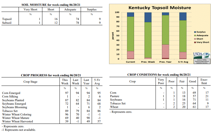
Agricultural News: Kentucky experienced above normal temperatures and below normal
rainfall over the past week. Precipitation for the week totaled 0.34 inches, 0.66
inches below normal. Temperatures averaged 74 degrees for the week, 1 degree above
normal. Topsoil moisture was rated 1 percent very short, 16 percent short, 74 percent
adequate, and 9 percent surplus. Subsoil moisture was rated 1 percent very short, 12
percent short, 78 percent adequate, and 9 percent surplus. Days suitable for
fieldwork averaged 5.9 out of a possible seven.
Primary activities for this week included planting soybeans, setting tobacco,
harvesting wheat, and cutting hay. Farmers were able to make strong progress in the
fields as dry weather prevailed across the state. The weekend brought the return of
hot temperatures, but much of the week was mild. It is of note that parts of the
state received some heavy rain, but it was very focused. Thanks to conducive weather,
grain producers were able to catch up on spraying. The corn crop is 97 percent
emerged with 1 percent of the crop in the silking stage. The average height of corn
is 31 inches, however some fields are uneven due to frequent spring rains. Soybean
planting is nearing completion with 72 percent of the crop emerged. One percent of
the soybean crop is blooming. Both the corn and soybean crops are in good overall
condition. Tobacco condition is mostly good with 89 percent of the crop set. The
average height of tobacco is 11 inches.
Wheat condition remains mostly good with 96 percent of the crop in the coloring stage
and 69 percent of the crop mature. Thirty-nine percent of the wheat crop has been
harvested. Lodging has been reported and may adversely affect yields. Pasture
condition is good and will stay intact for the time being as drier conditions prevail.
The recent weather has allowed livestock producers to catch up on hay cutting.
Kentucky Climate Summary
For the Period June 21, 2021 to June 27, 2021
Below Normal Temperatures and Rainfall:
The majority of the rainfall for the week fell on Monday as a cold front crossed the
area. A very moist airmass led to torrential rainfall rates at times with
accumulations of 1 to 1.5 inches for much of Kentucky. The exception was across South
Central Kentucky and along the Ohio River between Ballard County in Western Kentucky
to Campbell County in the Northern Bluegrass. These areas generally stayed under a
half inch. Outside of some spotty activity over the weekend, the rest of the period
followed a mostly dry pattern. Looking at temperatures, dehind the cold front early
in the week, highs fell below normal for a couple days. In fact,temperatures were
limited to the low to middle 70s on Tuesday. Saying that, it did not last long as
highs were back in the middle 80s to low 90s for the weekend, along with increased
humidity.
Temperatures for the period averaged 73 degrees across the state which was 1 degree
cooler than normal and 2 degrees cooler than the previous period. High temperatures
averaged from 84 in the West to 81 in the East. Departure from normal high
temperatures ranged from 3 degrees cooler than normal in the West to 4 degrees
cooler than normal in the East. Low temperatures averaged from 65 degrees in the
West to 61 degrees in the East. Departure from normal low temperature ranged from near
normal in the West to 1 degree warmer than normal in the East. The
extreme high temperature for the period was 94 degrees at BOWLING GREEN APT and the
extreme low was 44 degrees at OWINGSVILLE 4S.
Precipitation (liq. equ.) for the period totaled 0.89 inches statewide which was 0.12
inches below normal and 88% of normal. Precipitation totals by climate division, West
0.97 inches, Central 0.81 inches, Bluegrass 0.82 inches and East 0.95 inches, which
was 0.04, 0.19, 0.18 and 0.08 inches below normal. By station, precipitation totals
ranged from a low of 0.01 inches at EVANSVILLE ASOS to a high of 3.61 inches at
PRINCETON 2SE.
---
Kentucky Crop and Weather Report
Issued 4:00 P.M., June 21, 2021 16-21
Agricultural News: Kentucky experienced above normal temperatures and below normal
rainfall over the past week. Precipitation for the week totaled 0.34 inches, 0.66
inches below normal. Temperatures averaged 74 degrees for the week, 1 degree above
normal. Topsoil moisture was rated 1 percent very short, 16 percent short, 74 percent
adequate, and 9 percent surplus. Subsoil moisture was rated 1 percent very short, 12
percent short, 78 percent adequate, and 9 percent surplus. Days suitable for
fieldwork averaged 5.9 out of a possible seven.
Primary activities for this week included planting soybeans, setting tobacco,
harvesting wheat, and cutting hay. Farmers were able to make strong progress in the
fields as dry weather prevailed across the state. The weekend brought the return of
hot temperatures, but much of the week was mild. It is of note that parts of the
state received some heavy rain, but it was very focused. Thanks to conducive weather,
grain producers were able to catch up on spraying. The corn crop is 97 percent
emerged with 1 percent of the crop in the silking stage. The average height of corn
is 31 inches, however some fields are uneven due to frequent spring rains. Soybean
planting is nearing completion with 72 percent of the crop emerged. One percent of
the soybean crop is blooming. Both the corn and soybean crops are in good overall
condition. Tobacco condition is mostly good with 89 percent of the crop set. The
average height of tobacco is 11 inches.
Wheat condition remains mostly good with 96 percent of the crop in the coloring stage
and 69 percent of the crop mature. Thirty-nine percent of the wheat crop has been
harvested. Lodging has been reported and may adversely affect yields. Pasture
condition is good and will stay intact for the time being as drier conditions prevail.
The recent weather has allowed livestock producers to catch up on hay cutting.
 Kentucky Climate Summary
For the Period June 14, 2021 to June 20, 2021
Above Normal Temperatures and Below Normal Rainfall:
Kentucky opened the period with much cooler and less humid conditions filtering into
the area behind a couple cold fronts. Northerly flow brought the Canadian airmass
down into the Bluegrass State on Tuesday with highs only in the upper 70s to middle
80s. This pattern stuck around through midweek before heat started to return to the
area. In fact, by Friday, highs were back in the upper 80s to low 90s. This heat
stuck around through the weekend and in combo with high humidity, the livestock heat
stress index lifted into the danger category each afternoon. The majority of the week
ran dry for the state. The one exception came Friday night when heavy rains
fell across the Northern Bluegrass. Some locations saw in excess of 2 to 3 inches.
Temperatures for the period averaged 74 degrees across the state which was 1 degree
warmer than normal and 2 degrees cooler than the previous period. High temperatures
averaged from 88 in the West to 84 in the East. Departure from normal high
temperatures ranged from 2 degrees warmer than normal in the West to near
normal in the East. Low temperatures averaged from 66 degrees in the West to 61
degrees in the East. Departure from normal low temperature ranged from 2 degrees
warmer than normal in the West to 2 degrees warmer than normal in the East. The
extreme high temperature for the period was 93 degrees at HICKMAN 2E and the
extreme low was 47 degrees at PAINTSVILLE 4W.
Precipitation (liq. equ.) for the period totaled 0.34 inches statewide which was 0.66
inches below normal and 34% of normal. Precipitation totals by climate division, West
0.00 inches, Central 0.01 inches, Bluegrass 1.06 inches and East 0.27 inches, which
was -0.98, -0.99, 0.05 and -0.75 inches respectively from normal. By station,
precipitation totals ranged from a low of 0.00 inches at ALBANY 1N to a high of 3.77
inches at BURLINGTON 4S.
---
Kentucky Crop and Weather Report
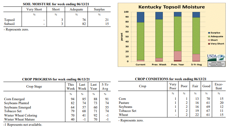
Issued 4:00 P.M., June 14, 2021 15-21
Agricultural News: Kentucky experienced above normal temperatures and rainfall over
the past week. Precipitation for the week totaled 1.52 inches, 0.48 inches above
normal. Temperatures averaged 76 degrees for the week, 5 degrees above normal.
Topsoil moisture was rated 3 percent short, 76 percent adequate, and 21 percent
surplus. Subsoil moisture was rated 3 percent short, 82 percent adequate, and 15
percent surplus. Days suitable for fieldwork averaged 3.2 out of a possible seven.
Primary activities for this week included planting soybeans, setting tobacco,
spraying, and cutting hay. Scattered rain stymied work in the fields this past week.
Rainfall was heavy at times and led to flooding in parts of the state. Even with the
weather being unstable, farmers were able to push ahead in the fields. With the
majority of the corn crop in the ground, condition remains good. Conditions vary
significantly based on the area however. The average height of corn is 18 inches with
94 percent of the crop emerged. Soybean planting remains ahead of where it is
historically at this juncture with 64 percent of the crop emerged. It is of note that
slug damage has been observed in soybeans and some acres are being replanted. Like
corn, the soybean crop is in mostly good condition. Tobacco condition is mostly good
with 79 percent of the crop set. The average height of tobacco is 7 inches.
Wheat condition remains mostly good with 70 percent of the crop in the coloring stage
and 40 percent of the crop mature. Recent weather patterns have slowed the maturation
of the wheat crop. Lodging has been reported and may adversely affect yields. Pasture
condition is good, but could be subject to damage from livestock traffic as the soil
remains wet. Farmers continue to cut hay when weather permits.
Kentucky Climate Summary
For the Period June 14, 2021 to June 20, 2021
Above Normal Temperatures and Below Normal Rainfall:
Kentucky opened the period with much cooler and less humid conditions filtering into
the area behind a couple cold fronts. Northerly flow brought the Canadian airmass
down into the Bluegrass State on Tuesday with highs only in the upper 70s to middle
80s. This pattern stuck around through midweek before heat started to return to the
area. In fact, by Friday, highs were back in the upper 80s to low 90s. This heat
stuck around through the weekend and in combo with high humidity, the livestock heat
stress index lifted into the danger category each afternoon. The majority of the week
ran dry for the state. The one exception came Friday night when heavy rains
fell across the Northern Bluegrass. Some locations saw in excess of 2 to 3 inches.
Temperatures for the period averaged 74 degrees across the state which was 1 degree
warmer than normal and 2 degrees cooler than the previous period. High temperatures
averaged from 88 in the West to 84 in the East. Departure from normal high
temperatures ranged from 2 degrees warmer than normal in the West to near
normal in the East. Low temperatures averaged from 66 degrees in the West to 61
degrees in the East. Departure from normal low temperature ranged from 2 degrees
warmer than normal in the West to 2 degrees warmer than normal in the East. The
extreme high temperature for the period was 93 degrees at HICKMAN 2E and the
extreme low was 47 degrees at PAINTSVILLE 4W.
Precipitation (liq. equ.) for the period totaled 0.34 inches statewide which was 0.66
inches below normal and 34% of normal. Precipitation totals by climate division, West
0.00 inches, Central 0.01 inches, Bluegrass 1.06 inches and East 0.27 inches, which
was -0.98, -0.99, 0.05 and -0.75 inches respectively from normal. By station,
precipitation totals ranged from a low of 0.00 inches at ALBANY 1N to a high of 3.77
inches at BURLINGTON 4S.
---
Kentucky Crop and Weather Report
Issued 4:00 P.M., June 14, 2021 15-21
Agricultural News: Kentucky experienced above normal temperatures and rainfall over
the past week. Precipitation for the week totaled 1.52 inches, 0.48 inches above
normal. Temperatures averaged 76 degrees for the week, 5 degrees above normal.
Topsoil moisture was rated 3 percent short, 76 percent adequate, and 21 percent
surplus. Subsoil moisture was rated 3 percent short, 82 percent adequate, and 15
percent surplus. Days suitable for fieldwork averaged 3.2 out of a possible seven.
Primary activities for this week included planting soybeans, setting tobacco,
spraying, and cutting hay. Scattered rain stymied work in the fields this past week.
Rainfall was heavy at times and led to flooding in parts of the state. Even with the
weather being unstable, farmers were able to push ahead in the fields. With the
majority of the corn crop in the ground, condition remains good. Conditions vary
significantly based on the area however. The average height of corn is 18 inches with
94 percent of the crop emerged. Soybean planting remains ahead of where it is
historically at this juncture with 64 percent of the crop emerged. It is of note that
slug damage has been observed in soybeans and some acres are being replanted. Like
corn, the soybean crop is in mostly good condition. Tobacco condition is mostly good
with 79 percent of the crop set. The average height of tobacco is 7 inches.
Wheat condition remains mostly good with 70 percent of the crop in the coloring stage
and 40 percent of the crop mature. Recent weather patterns have slowed the maturation
of the wheat crop. Lodging has been reported and may adversely affect yields. Pasture
condition is good, but could be subject to damage from livestock traffic as the soil
remains wet. Farmers continue to cut hay when weather permits.
 Kentucky Climate Summary
For the Period June 7, 2021 to June 13, 2021
Above Normal Temperatures and Rainfall:
A summertime pattern led to a warm, humid and active period for the Commonwealth.
The state saw daily rounds of scattered to numerous showers and thunderstorms through
the week. This activity was more of a diurnal pattern with coverage increasing by day
and decreasing overnight. A very moist air mass led to storms capable of producing
very heavy rainfall. As the week progressed, slow storms motions combined with
torrential rainfall rates, led to localized flooding. All this being said, it was not
a washout for everyone. The scattered coverage led to quite the range in total
accumulations. Some saw less than a quarter inch, more so across the western half of
Kentucky. Others saw in excess of two to three+ inches, which was common across the
eastern half. The very humid conditions led to oppressive heat at times. In fact,
portions of Western Kentucky jumped into the middle 90s on Saturday. Combined with
high humidity, heat indices rose well over the century mark.
Temperatures for the period averaged 76 degrees across the state which was 5 degrees
warmer than normal and 8 degrees warmer than the previous period. High temperatures
averaged from 85 in the West to 82 in the East. Departure from normal high
temperatures ranged from 1 degree warmer than normal in the West to near
normal in the East. Low temperatures averaged from 70 degrees in the West to 67
degrees in the East. Departure from normal low temperature ranged from 8 degrees
warmer than normal in the West to 9 degrees warmer than normal in the East. The
extreme high temperature for the period was 96 degrees at MORGANFIELD 4E and the
extreme low was 60 degrees at MCKEE 5S.
Precipitation (liq. equ.) for the period totaled 1.52 inches statewide which was 0.48
inches above normal and 145% of normal. Precipitation totals by climate division,
West 0.63 inches, Central 1.35 inches, Bluegrass 2.00 inches and East 2.11 inches,
which was -0.36, 0.29, 0.93 and 1.05 inches respectively from normal. By station,
precipitation totals ranged from a low of 0.04 inches at FRANKLIN 4SW to a high of
4.42 inches at LONDON.
---
Kentucky Crop and Weather Report
Issued 4:00 P.M., June 7, 2021 14-21
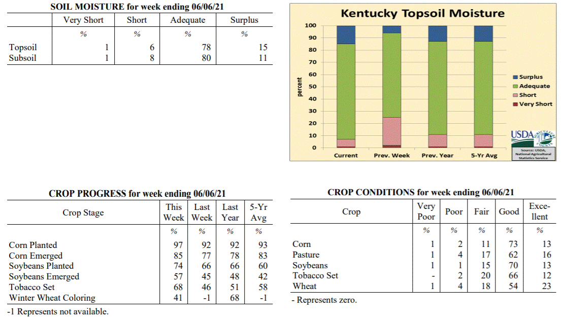
Agricultural News: Kentucky experienced below normal temperatures and above normal
rainfall over the past week. Precipitation for the week totaled 1.65 inches, 0.55
inches above normal. Temperatures averaged 68 degrees for the week, 2 degrees below
normal. Topsoil moisture was rated 1 percent very short, 6 percent short, 78 percent
adequate, and 15 percent surplus. Subsoil moisture was rated 1 percent very short, 8
percent short, 80 percent adequate, and 11 percent surplus. Days suitable for
fieldwork averaged 3.8 out of a possible seven.
Primary activities for this week included planting corn and soybeans, setting
tobacco, and cutting hay. Fieldwork activities were disrupted at times this past week
as heavy rain covered most of the state. With that said, farmers continue to show
strong planting progress and are taking advantage of breaks in the weather. This
evident progress includes acres replanted due to past flooding. Corn planting is
nearly complete with 85 percent of the crop emerged. The corn crop remains in mostly
good condition. The average height of corn is 12 inches. Soybean planting remains
ahead of where it is historically at this juncture with 57 percent of the crop
emerged. Like corn, the soybean crop is in mostly good condition.
Tobacco condition is mostly good with 68 percent of the crop set. Wheat condition
remains mostly good with 41 percent of the crop in the coloring stage. There have
been reports of wheat lodging and yields will be adversely affected in those cases.
Pasture condition is good and has benefitted from recent rain. Some hay has over
matured as unstable weather disrupts cutting.
Kentucky Climate Summary
For the Period June 7, 2021 to June 13, 2021
Above Normal Temperatures and Rainfall:
A summertime pattern led to a warm, humid and active period for the Commonwealth.
The state saw daily rounds of scattered to numerous showers and thunderstorms through
the week. This activity was more of a diurnal pattern with coverage increasing by day
and decreasing overnight. A very moist air mass led to storms capable of producing
very heavy rainfall. As the week progressed, slow storms motions combined with
torrential rainfall rates, led to localized flooding. All this being said, it was not
a washout for everyone. The scattered coverage led to quite the range in total
accumulations. Some saw less than a quarter inch, more so across the western half of
Kentucky. Others saw in excess of two to three+ inches, which was common across the
eastern half. The very humid conditions led to oppressive heat at times. In fact,
portions of Western Kentucky jumped into the middle 90s on Saturday. Combined with
high humidity, heat indices rose well over the century mark.
Temperatures for the period averaged 76 degrees across the state which was 5 degrees
warmer than normal and 8 degrees warmer than the previous period. High temperatures
averaged from 85 in the West to 82 in the East. Departure from normal high
temperatures ranged from 1 degree warmer than normal in the West to near
normal in the East. Low temperatures averaged from 70 degrees in the West to 67
degrees in the East. Departure from normal low temperature ranged from 8 degrees
warmer than normal in the West to 9 degrees warmer than normal in the East. The
extreme high temperature for the period was 96 degrees at MORGANFIELD 4E and the
extreme low was 60 degrees at MCKEE 5S.
Precipitation (liq. equ.) for the period totaled 1.52 inches statewide which was 0.48
inches above normal and 145% of normal. Precipitation totals by climate division,
West 0.63 inches, Central 1.35 inches, Bluegrass 2.00 inches and East 2.11 inches,
which was -0.36, 0.29, 0.93 and 1.05 inches respectively from normal. By station,
precipitation totals ranged from a low of 0.04 inches at FRANKLIN 4SW to a high of
4.42 inches at LONDON.
---
Kentucky Crop and Weather Report
Issued 4:00 P.M., June 7, 2021 14-21
Agricultural News: Kentucky experienced below normal temperatures and above normal
rainfall over the past week. Precipitation for the week totaled 1.65 inches, 0.55
inches above normal. Temperatures averaged 68 degrees for the week, 2 degrees below
normal. Topsoil moisture was rated 1 percent very short, 6 percent short, 78 percent
adequate, and 15 percent surplus. Subsoil moisture was rated 1 percent very short, 8
percent short, 80 percent adequate, and 11 percent surplus. Days suitable for
fieldwork averaged 3.8 out of a possible seven.
Primary activities for this week included planting corn and soybeans, setting
tobacco, and cutting hay. Fieldwork activities were disrupted at times this past week
as heavy rain covered most of the state. With that said, farmers continue to show
strong planting progress and are taking advantage of breaks in the weather. This
evident progress includes acres replanted due to past flooding. Corn planting is
nearly complete with 85 percent of the crop emerged. The corn crop remains in mostly
good condition. The average height of corn is 12 inches. Soybean planting remains
ahead of where it is historically at this juncture with 57 percent of the crop
emerged. Like corn, the soybean crop is in mostly good condition.
Tobacco condition is mostly good with 68 percent of the crop set. Wheat condition
remains mostly good with 41 percent of the crop in the coloring stage. There have
been reports of wheat lodging and yields will be adversely affected in those cases.
Pasture condition is good and has benefitted from recent rain. Some hay has over
matured as unstable weather disrupts cutting.
 Kentucky Climate Summary
For the Period May 31, 2021 to June 6, 2021
Below Normal Temperatures and Above Normal Rainfall:
Following a drier month of May, the Bluegrass State saw quite the active pattern for
the start of June. The brunt of the activity fell between Tuesday night and
Thursday. Just about everyone across the state saw significant widespread rainfall.
A large portion of Western Kentucky saw 2+ inches. Totals decreased to the east with
most in the 0.5 to 1.5 inch range. Some strong to severe storms accompanied the
activity on Thursday, producing gusty winds and moderate to heavy rainfall. During
this time frame, temperatures ran below normal, not seeing an increase until Friday
and Saturday. Highs on Saturday reached into the middle to upper 80s under partly to
mostly sunny skies. The week then closed with scattered precipitation in place on
Sunday. Overall, Western Kentucky averaged 2.46 inches for the week. Those numbers
decreased quite drastically to the east with Eastern Kentucky only averaging 1 inch.
Temperatures for the period averaged 68 degrees across the state which was 2 degrees
cooler than normal and no change to the previous period. High temperatures averaged
from 78 in the West to 78 in the East. Departure from normal high temperatures
ranged from 5 degrees cooler than normal in the West to 3 degrees cooler than normal
in the East. Low temperatures averaged from 60 degrees in the West to 58 degrees in
the East. Departure from normal low temperature ranged from 1 degree cooler than
normal in the West to 2 degrees warmer than normal in the East. The extreme high
temperature for the period was 89 degrees at BURKESVILLE 3W and the extreme low was
41 degrees at CARLISLE 5SW.
Precipitation (liq. equ.) for the period totaled 1.65 inches statewide which was 0.55
inches above normal and 151% of normal. Precipitation totals by climate division,
West 2.46 inches, Central 2.00 inches, Bluegrass 1.13 inches and East 1.00 inches,
which was 1.39, 0.88, 0.04 and -0.10 inches respectively from normal. By station,
precipitation totals ranged from a low of 0.24 inches at PIKEVILLE 13S to a high of
3.79 inches at CADIZ 4SW.
---
Kentucky Crop and Weather Report
Issued 4:00 P.M., June 1, 2021 13-21
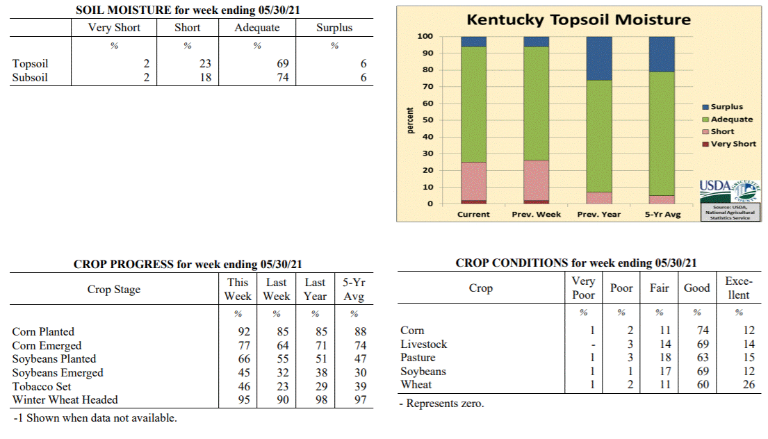
Agricultural News: Kentucky experienced below normal temperatures and rainfall over
the past week. Precipitation for the week totaled 0.89 inches, 0.22 inches below
normal. Temperatures averaged 67 degrees for the week, 1 degree below normal. Topsoil
moisture was rated 2 percent very short, 23 percent short, 69 percent adequate, and 6
percent surplus. Subsoil moisture was rated 2 percent very short, 18 percent short,
74 percent adequate, and 6 percent surplus. Days suitable for fieldwork averaged 5.3
out of a possible seven.
Primary activities for this week included planting corn and soybeans, setting
tobacco, and cutting hay. The week started with continued dry weather and high
temperatures. This pattern gave way in the middle of the week as rain moved in. The
weekend brought some unseasonably cold weather. Farmers forged ahead with planting
and made strong progress thanks to conducive weather through most of the week. As
corn planting nears completion, emergence is at 77 percent. The corn crop is rated
mostly good at this time, however the presence of insects has been noted. The average
height of corn is 7 inches. Soybean planting remains ahead of where it is
historically at this juncture with 45 percent of the crop emerged. Like corn, the
soybean crop is in mostly good condition. Tobacco setting is nearing the halfway
point as strong progress was evident over the past week. It is of note that some
crops were replanted due to previous flooding.
Wheat condition remains mostly good with 95 percent of the crop headed. The recent
cold snap did threaten wheat, however widespread damage is not expected. Pasture
condition is good and growth will pick up as temperatures normalize. The recent rain
will help to promote strong pasture growth as well. As farmers continue to cut hay,
the crop is in overall good condition. Hay supply is mostly adequate and should
remain in good shape as pasture growth ramps up. Many fall calves have been marketed
thus reducing the feed requirement.
Kentucky Climate Summary
For the Period May 31, 2021 to June 6, 2021
Below Normal Temperatures and Above Normal Rainfall:
Following a drier month of May, the Bluegrass State saw quite the active pattern for
the start of June. The brunt of the activity fell between Tuesday night and
Thursday. Just about everyone across the state saw significant widespread rainfall.
A large portion of Western Kentucky saw 2+ inches. Totals decreased to the east with
most in the 0.5 to 1.5 inch range. Some strong to severe storms accompanied the
activity on Thursday, producing gusty winds and moderate to heavy rainfall. During
this time frame, temperatures ran below normal, not seeing an increase until Friday
and Saturday. Highs on Saturday reached into the middle to upper 80s under partly to
mostly sunny skies. The week then closed with scattered precipitation in place on
Sunday. Overall, Western Kentucky averaged 2.46 inches for the week. Those numbers
decreased quite drastically to the east with Eastern Kentucky only averaging 1 inch.
Temperatures for the period averaged 68 degrees across the state which was 2 degrees
cooler than normal and no change to the previous period. High temperatures averaged
from 78 in the West to 78 in the East. Departure from normal high temperatures
ranged from 5 degrees cooler than normal in the West to 3 degrees cooler than normal
in the East. Low temperatures averaged from 60 degrees in the West to 58 degrees in
the East. Departure from normal low temperature ranged from 1 degree cooler than
normal in the West to 2 degrees warmer than normal in the East. The extreme high
temperature for the period was 89 degrees at BURKESVILLE 3W and the extreme low was
41 degrees at CARLISLE 5SW.
Precipitation (liq. equ.) for the period totaled 1.65 inches statewide which was 0.55
inches above normal and 151% of normal. Precipitation totals by climate division,
West 2.46 inches, Central 2.00 inches, Bluegrass 1.13 inches and East 1.00 inches,
which was 1.39, 0.88, 0.04 and -0.10 inches respectively from normal. By station,
precipitation totals ranged from a low of 0.24 inches at PIKEVILLE 13S to a high of
3.79 inches at CADIZ 4SW.
---
Kentucky Crop and Weather Report
Issued 4:00 P.M., June 1, 2021 13-21
Agricultural News: Kentucky experienced below normal temperatures and rainfall over
the past week. Precipitation for the week totaled 0.89 inches, 0.22 inches below
normal. Temperatures averaged 67 degrees for the week, 1 degree below normal. Topsoil
moisture was rated 2 percent very short, 23 percent short, 69 percent adequate, and 6
percent surplus. Subsoil moisture was rated 2 percent very short, 18 percent short,
74 percent adequate, and 6 percent surplus. Days suitable for fieldwork averaged 5.3
out of a possible seven.
Primary activities for this week included planting corn and soybeans, setting
tobacco, and cutting hay. The week started with continued dry weather and high
temperatures. This pattern gave way in the middle of the week as rain moved in. The
weekend brought some unseasonably cold weather. Farmers forged ahead with planting
and made strong progress thanks to conducive weather through most of the week. As
corn planting nears completion, emergence is at 77 percent. The corn crop is rated
mostly good at this time, however the presence of insects has been noted. The average
height of corn is 7 inches. Soybean planting remains ahead of where it is
historically at this juncture with 45 percent of the crop emerged. Like corn, the
soybean crop is in mostly good condition. Tobacco setting is nearing the halfway
point as strong progress was evident over the past week. It is of note that some
crops were replanted due to previous flooding.
Wheat condition remains mostly good with 95 percent of the crop headed. The recent
cold snap did threaten wheat, however widespread damage is not expected. Pasture
condition is good and growth will pick up as temperatures normalize. The recent rain
will help to promote strong pasture growth as well. As farmers continue to cut hay,
the crop is in overall good condition. Hay supply is mostly adequate and should
remain in good shape as pasture growth ramps up. Many fall calves have been marketed
thus reducing the feed requirement.
 Kentucky Climate Summary
For the Period May 24, 2021 to May 30, 2021
Below Normal Temperatures and Rainfall:
Kentucky saw an extension to the dry and warm pattern to start the workweek. Highs on
Monday and Tuesday jumped into the middle 80s to around 90, well above normal for
this time of year. The dry pattern finally broke over the second half of the
workweek with a couple rounds of showers and storms, one coming on Wednesday and the
other on Friday. In addition to some light activity on Saturday, the state averaged
0.89 inches for the week, which is still slightly below normal for this time of year.
Saying that, the rain was still a welcome sight after two straight weeks of well
below normal rainfall. Through May 30th, the state is running about 1.25 inches below
normal for the month of May. Behind the passage of a cold front on Friday, very
chilly air for May standards filtered into the region. In fact, highs on Saturday
struggled in the 50s with many locations setting all time record cool high
temperatures for the day.
Temperatures for the period averaged 67 degrees across the state which was 1 degree
cooler than normal and 4 degrees cooler than the previous period. High temperatures
averaged from 77 in the West to 75 in the East. Departure from normal high
temperatures ranged from 4 degrees cooler than normal in the West to 4 degrees
cooler than normal in the East. Low temperatures averaged from 59 degrees in the
West to 58 degrees in the East. Departure from normal low temperature ranged from 1
degree warmer than normal in the West to 4 degrees warmer than normal in the East.
The extreme high temperature for the period was 92 degrees at PADUCAH ASOS and the
extreme low was 38 degrees at BRANDENBURG 4SW.
Precipitation (liq. equ.) for the period totaled 0.89 inches statewide which was 0.22
inches below normal and 80% of normal. Precipitation totals by climate division, West
0.76 inches, Central 0.70 inches, Bluegrass 0.91 inches and East 1.20 inches, which
was -0.34, -0.46, -0.17 and 0.08 inches respectively from normal. By station,
precipitation totals ranged from a low of 0.11 inches at RUSSELLVILLE 2W to a high of
3.05 inches at TRIANGLE MOUNTAIN.
---
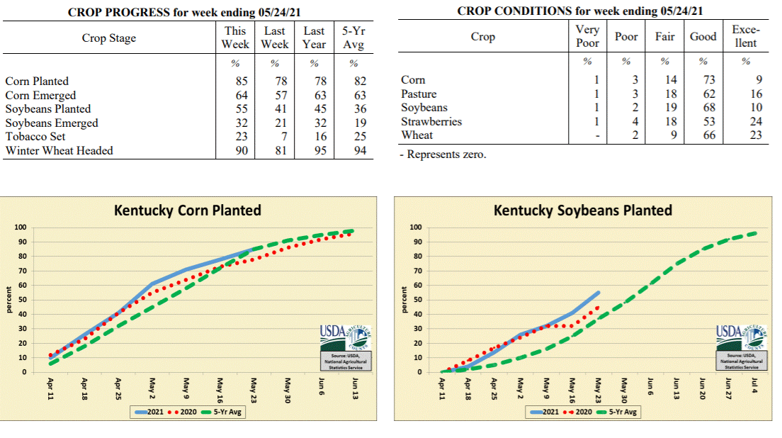
Kentucky Crop and Weather Report
Issued 4:00 P.M., May 24, 2021 12-21
Agricultural News: Kentucky experienced above normal temperatures and much below
normal rainfall over the past week. Precipitation for the week totaled 0.14 inches,
0.99 inches below normal. Temperatures averaged 70 degrees for the week, 4 degrees
above normal. Topsoil moisture was rated 2 percent very short, 24 percent short, 68
percent adequate, and 6 percent surplus. Subsoil moisture was rated 1 percent very
short, 13 percent short, 77 percent adequate, and 9 percent surplus. Days suitable
for fieldwork averaged 6.3 out of a possible seven.
Primary activities for this week included planting corn and soybeans, setting
tobacco, and cutting hay. Summer like temperatures and dry weather prevailed
throughout this past week. Farmers were able to make strong headway in the fields and
continue to be ahead of last year�s planting. If the dry conditions persist, field
crops may begin to show stress. Freshly planted seeds may become vulnerable with a
lack of precipitation. It is of note that insect issues have been reported in parts
of the state. As corn planting makes steady progress, emergence is at 64 percent. The
corn crop is rated mostly good at this time. Soybean planting remains ahead of where
it is historically at this juncture with 32 percent of the crop emerged. Like corn,
the soybean crop is in mostly good condition. Tobacco setting is now in high gear and
will move rapidly as weather allows. Tobacco transplant supplies are rated as 1
percent short, 96 percent adequate, and 3 percent surplus.
Wheat condition remains mostly good with 90 percent of the crop headed. Pasture
condition is good and growth is strong thanks to recent weather. Strawberries are in
mostly good condition and were not widely damaged by recent frosts. A good deal of
hay acreage was harvested this past week as weather conditions allowed.
Kentucky Climate Summary
For the Period May 24, 2021 to May 30, 2021
Below Normal Temperatures and Rainfall:
Kentucky saw an extension to the dry and warm pattern to start the workweek. Highs on
Monday and Tuesday jumped into the middle 80s to around 90, well above normal for
this time of year. The dry pattern finally broke over the second half of the
workweek with a couple rounds of showers and storms, one coming on Wednesday and the
other on Friday. In addition to some light activity on Saturday, the state averaged
0.89 inches for the week, which is still slightly below normal for this time of year.
Saying that, the rain was still a welcome sight after two straight weeks of well
below normal rainfall. Through May 30th, the state is running about 1.25 inches below
normal for the month of May. Behind the passage of a cold front on Friday, very
chilly air for May standards filtered into the region. In fact, highs on Saturday
struggled in the 50s with many locations setting all time record cool high
temperatures for the day.
Temperatures for the period averaged 67 degrees across the state which was 1 degree
cooler than normal and 4 degrees cooler than the previous period. High temperatures
averaged from 77 in the West to 75 in the East. Departure from normal high
temperatures ranged from 4 degrees cooler than normal in the West to 4 degrees
cooler than normal in the East. Low temperatures averaged from 59 degrees in the
West to 58 degrees in the East. Departure from normal low temperature ranged from 1
degree warmer than normal in the West to 4 degrees warmer than normal in the East.
The extreme high temperature for the period was 92 degrees at PADUCAH ASOS and the
extreme low was 38 degrees at BRANDENBURG 4SW.
Precipitation (liq. equ.) for the period totaled 0.89 inches statewide which was 0.22
inches below normal and 80% of normal. Precipitation totals by climate division, West
0.76 inches, Central 0.70 inches, Bluegrass 0.91 inches and East 1.20 inches, which
was -0.34, -0.46, -0.17 and 0.08 inches respectively from normal. By station,
precipitation totals ranged from a low of 0.11 inches at RUSSELLVILLE 2W to a high of
3.05 inches at TRIANGLE MOUNTAIN.
---
Kentucky Crop and Weather Report
Issued 4:00 P.M., May 24, 2021 12-21
Agricultural News: Kentucky experienced above normal temperatures and much below
normal rainfall over the past week. Precipitation for the week totaled 0.14 inches,
0.99 inches below normal. Temperatures averaged 70 degrees for the week, 4 degrees
above normal. Topsoil moisture was rated 2 percent very short, 24 percent short, 68
percent adequate, and 6 percent surplus. Subsoil moisture was rated 1 percent very
short, 13 percent short, 77 percent adequate, and 9 percent surplus. Days suitable
for fieldwork averaged 6.3 out of a possible seven.
Primary activities for this week included planting corn and soybeans, setting
tobacco, and cutting hay. Summer like temperatures and dry weather prevailed
throughout this past week. Farmers were able to make strong headway in the fields and
continue to be ahead of last year�s planting. If the dry conditions persist, field
crops may begin to show stress. Freshly planted seeds may become vulnerable with a
lack of precipitation. It is of note that insect issues have been reported in parts
of the state. As corn planting makes steady progress, emergence is at 64 percent. The
corn crop is rated mostly good at this time. Soybean planting remains ahead of where
it is historically at this juncture with 32 percent of the crop emerged. Like corn,
the soybean crop is in mostly good condition. Tobacco setting is now in high gear and
will move rapidly as weather allows. Tobacco transplant supplies are rated as 1
percent short, 96 percent adequate, and 3 percent surplus.
Wheat condition remains mostly good with 90 percent of the crop headed. Pasture
condition is good and growth is strong thanks to recent weather. Strawberries are in
mostly good condition and were not widely damaged by recent frosts. A good deal of
hay acreage was harvested this past week as weather conditions allowed.
 Kentucky Climate Summary
For the Period May 17, 2021 to May 23, 2021
Above Normal Temperatures and Much Below Normal Rainfall:
Kentucky saw a second straight week of below normal rainfall in what is typically the
wettest month of the year for the Bluegrass State. In fact, a number of locations
across Kentucky did not see any rainfall throughout the period. If accumulations
were seen, they were generally light in nature and confined to the first couple days
of the week. Over the past 14 days, the state has only averaged 0.23 inches, which
is just over two inches below normal. Summer-like temperatures accompanied the dry
conditions. Highs slowly inched upward throughout the period, peaking in the mid to
upper 80s for most everyone. Louisville even hit 90 for the first time this year.
Temperatures for the period averaged 70 degrees across the state which was 4 degrees
warmer than normal and 14 degrees warmer than the previous period. High temperatures
averaged from 82 in the West to 81 in the East. Departure from normal high
temperatures ranged from 3 degrees warmer than normal in the West to 4 degrees
warmer than normal in the East. Low temperatures averaged from 62 degrees in the
West to 57 degrees in the East. Departure from normal low temperature ranged from 6
degrees warmer than normal in the West to 6 degrees warmer than normal in the East.
The extreme high temperature for the period was 90 degrees at LOUISVILLE APT and the
extreme low was 48 degrees at BURKESVILLE 3W.
Precipitation (liq. equ.) for the period totaled 0.14 inches statewide which was 0.99
inches below normal and 12% of normal. Precipitation totals by climate division, West
0.19 inches, Central 0.00 inches, Bluegrass 0.27 inches and East 0.09 inches, which
was 0.93, 1.18, 0.81 and 1.04 inches below normal. By station, precipitation totals
ranged from a low of 0.00 inches at ALBANY 1N to a high of 1.38 inches at ALEXANDRIA 5NW.
---
Kentucky Crop and Weather Report
Issued 4:00 P.M., May 17, 2021 11-21
Agricultural News: Kentucky experienced well below normal temperatures and much below
normal rainfall over the past week. Precipitation for the week totaled 0.08 inches,
1.04 inches below normal. Temperatures averaged 56 degrees for the week, 8 degrees
below normal. Topsoil moisture was rated 3 percent short, 79 percent adequate, and 18
percent surplus. Subsoil moisture was rated 3 percent short, 79 percent adequate, and
18 percent surplus. Days suitable for fieldwork averaged 4.8 out of a possible seven.
Primary activities for this week included planting corn and soybeans, setting
tobacco, and cutting hay. Cool temperatures hampered field drying and slowed growth
of previously planted crops throughout the week. Farmers forged ahead with planting
despite some fields remaining fairly wet. Heavy rain the week before last has
relegated some farmers to replanting damaged crops. Bottom lands were particularly
affected by rain that week and were further assessed this week after any flooding had
retreated. Corn planting continues to outpace both last year and the five-year
average. Fifty-seven percent of the corn crop has emerged. Soybean planting is also
ahead of last year and the five-year average with 21 percent of the crop emerged.
Tobacco setting is beginning to pick up and will continue to do so. The average
height of tobacco transplants is 9 percent less than 2 inches, 33 percent two to four
inches, and 58 percent larger than 4 inches. Tobacco transplant supplies are rated as
8 percent short, 83 percent adequate, and 9 percent surplus.
Wheat condition remains mostly good with 81 percent of the crop headed. The drier
conditions this week allowed for the application of fungicide to wheat. Pasture
condition is good, however cool temperatures have impeded growth to an extent. Both
pasture and hay that received fertilizer are doing well at this juncture. Hay cutting
is slightly behind due to the frequent rain this spring.
Kentucky Climate Summary
For the Period May 17, 2021 to May 23, 2021
Above Normal Temperatures and Much Below Normal Rainfall:
Kentucky saw a second straight week of below normal rainfall in what is typically the
wettest month of the year for the Bluegrass State. In fact, a number of locations
across Kentucky did not see any rainfall throughout the period. If accumulations
were seen, they were generally light in nature and confined to the first couple days
of the week. Over the past 14 days, the state has only averaged 0.23 inches, which
is just over two inches below normal. Summer-like temperatures accompanied the dry
conditions. Highs slowly inched upward throughout the period, peaking in the mid to
upper 80s for most everyone. Louisville even hit 90 for the first time this year.
Temperatures for the period averaged 70 degrees across the state which was 4 degrees
warmer than normal and 14 degrees warmer than the previous period. High temperatures
averaged from 82 in the West to 81 in the East. Departure from normal high
temperatures ranged from 3 degrees warmer than normal in the West to 4 degrees
warmer than normal in the East. Low temperatures averaged from 62 degrees in the
West to 57 degrees in the East. Departure from normal low temperature ranged from 6
degrees warmer than normal in the West to 6 degrees warmer than normal in the East.
The extreme high temperature for the period was 90 degrees at LOUISVILLE APT and the
extreme low was 48 degrees at BURKESVILLE 3W.
Precipitation (liq. equ.) for the period totaled 0.14 inches statewide which was 0.99
inches below normal and 12% of normal. Precipitation totals by climate division, West
0.19 inches, Central 0.00 inches, Bluegrass 0.27 inches and East 0.09 inches, which
was 0.93, 1.18, 0.81 and 1.04 inches below normal. By station, precipitation totals
ranged from a low of 0.00 inches at ALBANY 1N to a high of 1.38 inches at ALEXANDRIA 5NW.
---
Kentucky Crop and Weather Report
Issued 4:00 P.M., May 17, 2021 11-21
Agricultural News: Kentucky experienced well below normal temperatures and much below
normal rainfall over the past week. Precipitation for the week totaled 0.08 inches,
1.04 inches below normal. Temperatures averaged 56 degrees for the week, 8 degrees
below normal. Topsoil moisture was rated 3 percent short, 79 percent adequate, and 18
percent surplus. Subsoil moisture was rated 3 percent short, 79 percent adequate, and
18 percent surplus. Days suitable for fieldwork averaged 4.8 out of a possible seven.
Primary activities for this week included planting corn and soybeans, setting
tobacco, and cutting hay. Cool temperatures hampered field drying and slowed growth
of previously planted crops throughout the week. Farmers forged ahead with planting
despite some fields remaining fairly wet. Heavy rain the week before last has
relegated some farmers to replanting damaged crops. Bottom lands were particularly
affected by rain that week and were further assessed this week after any flooding had
retreated. Corn planting continues to outpace both last year and the five-year
average. Fifty-seven percent of the corn crop has emerged. Soybean planting is also
ahead of last year and the five-year average with 21 percent of the crop emerged.
Tobacco setting is beginning to pick up and will continue to do so. The average
height of tobacco transplants is 9 percent less than 2 inches, 33 percent two to four
inches, and 58 percent larger than 4 inches. Tobacco transplant supplies are rated as
8 percent short, 83 percent adequate, and 9 percent surplus.
Wheat condition remains mostly good with 81 percent of the crop headed. The drier
conditions this week allowed for the application of fungicide to wheat. Pasture
condition is good, however cool temperatures have impeded growth to an extent. Both
pasture and hay that received fertilizer are doing well at this juncture. Hay cutting
is slightly behind due to the frequent rain this spring.
 Kentucky Climate Summary
For the Period May 10, 2021 to May 16, 2021
Well Below Normal Temperatures and Much Below Normal Rainfall:
Judging by May standards, Kentucky saw another dry and cool period. Temperatures ran
below normal the entirety of the week. Highs struggled in the 60s through Thursday,
before slowly inching higher over the weekend. Some patchy frost was even in the
picture late in the workweek for mainly the Bluegrass and Eastern Kentucky. Below
normal temperatures have been no stranger to Kentucky as of late. In fact, the state
average temperature has ran below normal four of the past five weeks. Through May
16th, high temperatures for the month have averaged about 6 degrees below normal. Low
temperatures have ran roughly 4 degrees below normal. Mostly dry conditions
accompanied the cooler temperatures. The state only averaged 0.08 inches for the
week, most of which fell over the latter half of the weekend.
Temperatures for the period averaged 56 degrees across the state which was 8 degrees
cooler than normal and 2 degrees cooler than the previous period. High temperatures
averaged from 68 in the West to 67 in the East. Departure from normal high
temperatures ranged from 9 degrees cooler than normal in the West to 9 degrees
cooler than normal in the East. Low temperatures averaged from 46 degrees in the
West to 44 degrees in the East. Departure from normal low temperature ranged from 8
degrees cooler than normal in the West to 4 degrees cooler than normal in the East.
The extreme high temperature for the period was 82 degrees at PADUCAH ASOS and the
extreme low was 32 degrees at VANCEBURG 6W.
Precipitation (liq. equ.) for the period totaled 0.08 inches statewide which was 1.04
inches below normal and 7% of normal. Precipitation totals by climate division, West
0.08 inches, Central 0.06 inches, Bluegrass 0.02 inches and East 0.17 inches, which
was 1.1, 1.12, 1.03 and 0.9 inches below normal. By station, precipitation totals
ranged from a low of 0.00 inches at ALEXANDRIA 5NW to a high of 0.47 inches at
WHITESBURG 2NW.
---
Kentucky Crop and Weather Report
Issued 4:00 P.M., May 10, 2021 10-21
Agricultural News: Kentucky experienced below normal temperatures and much above
normal rainfall over the past week. Precipitation for the week totaled 2.33 inches,
1.24 inches above normal. Temperatures averaged 59 degrees for the week, 2 degrees
below normal. Topsoil moisture was rated 60 percent adequate and 40 percent surplus.
Subsoil moisture was rated 68 percent adequate and 32 percent surplus. Days suitable
for fieldwork averaged 2.9 out of a possible seven.
Primary activities for this week included planting corn and soybeans along with
spraying. Persistent precipitation halted fieldwork throughout the week. Farmers had
very little opportunity for planting due to the wet conditions, but pushed forward as
the weather permitted. There were reports of flooding throughout the state with high
water being prevalent in river bottoms. Any damage will be assessed in the coming
week sparking the potential for replanting of some crops. The relentless rainfall was
accompanied by unseasonably cool temperatures further complicating crop condition.
Many farmers planted soybeans early and as such the crop is ahead of where it is
historically at this juncture. Corn planting is well ahead of last year and trends on
the higher side when compared historically. Tobacco setting has begun for some
producers however only 1 percent of the crop is in the ground. The average height of
tobacco transplants is 14 percent less than 2 inches, 35 percent two to four inches,
and 51 percent larger than 4 inches. Tobacco transplant supplies are rated as 3
percent short, 94 percent adequate, and 3 percent surplus.
Wheat condition remains mostly good with 68 percent of the crop headed. Overall
pasture condition is mostly good, however the cooler temperatures have stunted
growth. It is also of note that the heavy rains will muddy up a good deal of pasture
ground and open it up to damage from livestock traffic. Early hay cuttings may be
adversely affected by the recent frosts and freezes.
Kentucky Climate Summary
For the Period May 10, 2021 to May 16, 2021
Well Below Normal Temperatures and Much Below Normal Rainfall:
Judging by May standards, Kentucky saw another dry and cool period. Temperatures ran
below normal the entirety of the week. Highs struggled in the 60s through Thursday,
before slowly inching higher over the weekend. Some patchy frost was even in the
picture late in the workweek for mainly the Bluegrass and Eastern Kentucky. Below
normal temperatures have been no stranger to Kentucky as of late. In fact, the state
average temperature has ran below normal four of the past five weeks. Through May
16th, high temperatures for the month have averaged about 6 degrees below normal. Low
temperatures have ran roughly 4 degrees below normal. Mostly dry conditions
accompanied the cooler temperatures. The state only averaged 0.08 inches for the
week, most of which fell over the latter half of the weekend.
Temperatures for the period averaged 56 degrees across the state which was 8 degrees
cooler than normal and 2 degrees cooler than the previous period. High temperatures
averaged from 68 in the West to 67 in the East. Departure from normal high
temperatures ranged from 9 degrees cooler than normal in the West to 9 degrees
cooler than normal in the East. Low temperatures averaged from 46 degrees in the
West to 44 degrees in the East. Departure from normal low temperature ranged from 8
degrees cooler than normal in the West to 4 degrees cooler than normal in the East.
The extreme high temperature for the period was 82 degrees at PADUCAH ASOS and the
extreme low was 32 degrees at VANCEBURG 6W.
Precipitation (liq. equ.) for the period totaled 0.08 inches statewide which was 1.04
inches below normal and 7% of normal. Precipitation totals by climate division, West
0.08 inches, Central 0.06 inches, Bluegrass 0.02 inches and East 0.17 inches, which
was 1.1, 1.12, 1.03 and 0.9 inches below normal. By station, precipitation totals
ranged from a low of 0.00 inches at ALEXANDRIA 5NW to a high of 0.47 inches at
WHITESBURG 2NW.
---
Kentucky Crop and Weather Report
Issued 4:00 P.M., May 10, 2021 10-21
Agricultural News: Kentucky experienced below normal temperatures and much above
normal rainfall over the past week. Precipitation for the week totaled 2.33 inches,
1.24 inches above normal. Temperatures averaged 59 degrees for the week, 2 degrees
below normal. Topsoil moisture was rated 60 percent adequate and 40 percent surplus.
Subsoil moisture was rated 68 percent adequate and 32 percent surplus. Days suitable
for fieldwork averaged 2.9 out of a possible seven.
Primary activities for this week included planting corn and soybeans along with
spraying. Persistent precipitation halted fieldwork throughout the week. Farmers had
very little opportunity for planting due to the wet conditions, but pushed forward as
the weather permitted. There were reports of flooding throughout the state with high
water being prevalent in river bottoms. Any damage will be assessed in the coming
week sparking the potential for replanting of some crops. The relentless rainfall was
accompanied by unseasonably cool temperatures further complicating crop condition.
Many farmers planted soybeans early and as such the crop is ahead of where it is
historically at this juncture. Corn planting is well ahead of last year and trends on
the higher side when compared historically. Tobacco setting has begun for some
producers however only 1 percent of the crop is in the ground. The average height of
tobacco transplants is 14 percent less than 2 inches, 35 percent two to four inches,
and 51 percent larger than 4 inches. Tobacco transplant supplies are rated as 3
percent short, 94 percent adequate, and 3 percent surplus.
Wheat condition remains mostly good with 68 percent of the crop headed. Overall
pasture condition is mostly good, however the cooler temperatures have stunted
growth. It is also of note that the heavy rains will muddy up a good deal of pasture
ground and open it up to damage from livestock traffic. Early hay cuttings may be
adversely affected by the recent frosts and freezes.
 Kentucky Climate Summary
For the Period May 3, 2021 to May 9, 2021
Below Normal Temperatures and Much Above Normal Rainfall:
Kentucky has been stuck in a wet pattern as of late and this period was no different.
The most extensive activity fell over the first half of the workweek, especially-so
Monday night and into Tuesday morning across South Central Kentucky. Some saw 2-5+
inches in less than 6 hours, leading to numerous reports of flash flooding. A total
of five weak tornados and several reports of damaging winds also accompanied the heavy
rainfall across Western Kentucky. Cooler and active conditions remained for the rest
of the week. The state saw a couple quick-hitting rounds of rainfall on Thursday and
Friday, followed by more widespread activity on Sunday. Overall, the state averaged
2.33 inches for the week. The highest totals were centered around the Bowling Green
area with 4+ inches common. The Barren County Mesonet Station even recorded over 7
inches.
Temperatures for the period averaged 59 degrees across the state which was 2 degrees
cooler than normal and 4 degrees cooler than the previous period. High temperatures
averaged from 69 in the West to 68 in the East. Departure from normal high
temperatures ranged from 6 degrees cooler than normal in the West to 6 degrees cooler
than normal in the East. Low temperatures averaged from 52 degrees in the West to 50
degrees in the East. Departure from normal low temperature ranged from near normal in
the West to 4 degrees warmer than normal in the East. The extreme high temperature
for the period was 80 degrees at BOWLING GREEN APT and the extreme low was 35 degrees
at OWINGSVILLE 4S.
Precipitation (liq. equ.) for the period totaled 2.33 inches statewide which was 1.24
inches above normal and 214% of normal. Precipitation totals by climate division,
West 2.29 inches, Central 3.24 inches, Bluegrass 2.29 inches and East 1.49 inches,
which was 1.11, 2.1, 1.28 and 0.46 inches above normal. By station, precipitation
totals ranged from a low of 0.48 inches at BIG SANDY to a high of 7.55 inches at GLASGOW 11W.
---
Kentucky Crop and Weather Report
Issued 4:00 P.M., May 3, 2021 9-21
Agricultural News: Kentucky experienced above normal temperatures and rainfall over
the past week. Precipitation for the week totaled 1.13 inches, 0.06 inches above
normal. Temperatures averaged 64 degrees for the week, 4 degrees above normal.
Topsoil moisture was rated 1 percent short, 73 percent adequate, and 26 percent
surplus. Subsoil moisture was rated 3 percent short, 78 percent adequate, and 19
percent surplus. Days suitable for fieldwork averaged 4.1 out of a possible seven.
Primary activities for this week included planting corn and soybeans along with
seeding tobacco transplants. With rain showers halting fieldwork at times during the
week, farmers forged ahead with every opportunity. Soybean planting is ahead of where
it has been historically at this point in the season. Tobacco transplants are 95
percent seeded, slightly ahead of both last year and the five-year average. The
transplants are in mostly good condition at this time with height rated as 23 percent
less than 2 inches, 44 percent 2 � 4 inches, and 33 percent larger than 4 inches.
The average height of winter wheat is 23 inches at this time, while 38 percent of the
crop has headed. Wheat condition remains mostly good after being assessed for damage
from two significant freezes. Current freeze damage for wheat is rated as 2 percent
moderate, 17 percent light, and 81 percent with no damage. After a full week of
evaluation, alfalfa freeze damage is rated as 1 percent severe, 10 percent moderate,
27 percent light, and 62 percent with no damage. The average height of alfalfa is 13
inches at this time. The current hay supply is rated as 1 percent very short, 10
percent short, 79 percent adequate, and 10 percent surplus. Both peaches and apples
have been further observed after the recent snow event. Apple freeze damage is rated
as 7 percent severe, 15 percent moderate, 23 percent light, and 55 percent with no
damage. Peach freeze damage is rated as 4 percent severe, 11 percent moderate, 17
percent light, and 68 percent with no damage. The strawberry crop is in good overall
condition at this juncture of the season.
Kentucky Climate Summary
For the Period May 3, 2021 to May 9, 2021
Below Normal Temperatures and Much Above Normal Rainfall:
Kentucky has been stuck in a wet pattern as of late and this period was no different.
The most extensive activity fell over the first half of the workweek, especially-so
Monday night and into Tuesday morning across South Central Kentucky. Some saw 2-5+
inches in less than 6 hours, leading to numerous reports of flash flooding. A total
of five weak tornados and several reports of damaging winds also accompanied the heavy
rainfall across Western Kentucky. Cooler and active conditions remained for the rest
of the week. The state saw a couple quick-hitting rounds of rainfall on Thursday and
Friday, followed by more widespread activity on Sunday. Overall, the state averaged
2.33 inches for the week. The highest totals were centered around the Bowling Green
area with 4+ inches common. The Barren County Mesonet Station even recorded over 7
inches.
Temperatures for the period averaged 59 degrees across the state which was 2 degrees
cooler than normal and 4 degrees cooler than the previous period. High temperatures
averaged from 69 in the West to 68 in the East. Departure from normal high
temperatures ranged from 6 degrees cooler than normal in the West to 6 degrees cooler
than normal in the East. Low temperatures averaged from 52 degrees in the West to 50
degrees in the East. Departure from normal low temperature ranged from near normal in
the West to 4 degrees warmer than normal in the East. The extreme high temperature
for the period was 80 degrees at BOWLING GREEN APT and the extreme low was 35 degrees
at OWINGSVILLE 4S.
Precipitation (liq. equ.) for the period totaled 2.33 inches statewide which was 1.24
inches above normal and 214% of normal. Precipitation totals by climate division,
West 2.29 inches, Central 3.24 inches, Bluegrass 2.29 inches and East 1.49 inches,
which was 1.11, 2.1, 1.28 and 0.46 inches above normal. By station, precipitation
totals ranged from a low of 0.48 inches at BIG SANDY to a high of 7.55 inches at GLASGOW 11W.
---
Kentucky Crop and Weather Report
Issued 4:00 P.M., May 3, 2021 9-21
Agricultural News: Kentucky experienced above normal temperatures and rainfall over
the past week. Precipitation for the week totaled 1.13 inches, 0.06 inches above
normal. Temperatures averaged 64 degrees for the week, 4 degrees above normal.
Topsoil moisture was rated 1 percent short, 73 percent adequate, and 26 percent
surplus. Subsoil moisture was rated 3 percent short, 78 percent adequate, and 19
percent surplus. Days suitable for fieldwork averaged 4.1 out of a possible seven.
Primary activities for this week included planting corn and soybeans along with
seeding tobacco transplants. With rain showers halting fieldwork at times during the
week, farmers forged ahead with every opportunity. Soybean planting is ahead of where
it has been historically at this point in the season. Tobacco transplants are 95
percent seeded, slightly ahead of both last year and the five-year average. The
transplants are in mostly good condition at this time with height rated as 23 percent
less than 2 inches, 44 percent 2 � 4 inches, and 33 percent larger than 4 inches.
The average height of winter wheat is 23 inches at this time, while 38 percent of the
crop has headed. Wheat condition remains mostly good after being assessed for damage
from two significant freezes. Current freeze damage for wheat is rated as 2 percent
moderate, 17 percent light, and 81 percent with no damage. After a full week of
evaluation, alfalfa freeze damage is rated as 1 percent severe, 10 percent moderate,
27 percent light, and 62 percent with no damage. The average height of alfalfa is 13
inches at this time. The current hay supply is rated as 1 percent very short, 10
percent short, 79 percent adequate, and 10 percent surplus. Both peaches and apples
have been further observed after the recent snow event. Apple freeze damage is rated
as 7 percent severe, 15 percent moderate, 23 percent light, and 55 percent with no
damage. Peach freeze damage is rated as 4 percent severe, 11 percent moderate, 17
percent light, and 68 percent with no damage. The strawberry crop is in good overall
condition at this juncture of the season.
 Kentucky Climate Summary
For the Period April 26, 2021 to May 2, 2021
Above Normal Temperatures and Rainfall:
Unlike the previous couple weeks, temperatures ran near to above normal for much of
the period with highs peaking in the 70s about every day. Even reaching the low to
middle 80s statewide on Tuesday. The one exception came Friday night when the eastern
third of the state saw lows dip well into the 30s, opening the possibility of some
patchy frost in valley and sheltered locations. Looking at precipitation, an active
pattern setup across Kentucky on Wednesday and Thursday with multiple bouts of
moderate to heavy rainfall. The highest totals were seen across Western Kentucky and
locations to the northeast along the Ohio River. Following a couple near perfect days
for the running of the Oaks and Derby, light rain started to return to the area on
Sunday. Overall, total accumulations decreased from west to east for the week. While
Western Kentucky averaged 1.60 inches, Eastern Kentucky ran below normal at 0.65 inches.
Temperatures for the period averaged 64 degrees across the state which was 4 degrees
warmer than normal and 14 degrees warmer than the previous period. High temperatures
averaged from 76 in the West to 76 in the East. Departure from normal high
temperatures ranged from 3 degrees warmer than normal in the West to 4 degrees
warmer than normal in the East. Low temperatures averaged from 56 degrees in the
West to 51 degrees in the East. Departure from normal low temperature ranged from 6
degrees warmer than normal in the West to 7 degrees warmer than normal in the East.
The extreme high temperature for the period was 87 degrees at BIG SANDY and the
extreme low was 31 degrees at VANCEBURG 6W.
Precipitation (liq. equ.) for the period totaled 1.13 inches statewide which was 0.06
inches above normal and 106% of normal. Precipitation totals by climate division,
West 1.60 inches, Central 1.14 inches, Bluegrass 1.12 inches and East 0.65 inches,
which was 0.39, 0.05, 0.14 and -0.34 inches respectively from normal. By station,
precipitation totals ranged from a low of 0.15 inches at MIDDLESBORO AWOS to a high
of 4.37 inches at LEITCHFIELD 3W.
---
Kentucky Crop and Weather Report
Issued 4:00 P.M., April 26, 2021 8-21
Agricultural News: Kentucky experienced well below normal temperatures and slightly
below normal precipitation over the past week. Precipitation for the week totaled
0.92 inches, 0.09 inches below normal. Temperatures averaged 50 degrees for the week,
7 degrees below normal. Topsoil moisture was rated 4 percent short, 77 percent
adequate, and 19 percent surplus. Subsoil moisture was rated 4 percent short, 78
percent adequate, and 18 percent surplus. Days suitable for fieldwork averaged 4.6
out of a possible seven.
Primary activities for this week included planting corn and soybeans along with
seeding tobacco transplants. A cold snap this week that included snowfall halted
fieldwork and threatened previously planted crops. The weekend brought heavy rain
through most of the state. Despite the adverse weather, farmers forged ahead and
continued to make progress in the fields. Tobacco transplants are 86 percent seeded,
trailing both last year and the five-year average. The transplants are in mostly good
condition at this time with height rated as 35 percent less than 2 inches, 42 percent
2 � 4 inches, and 23 percent larger than 4 inches.
The average height of winter wheat is 19 inches at this time while 23 percent of the
crop has headed. Wheat condition remains mostly good despite being subjected to two
significant freezes. Current freeze damage for wheat is rated as 3 percent moderate,
20 percent light, and 77 percent with no damage. The crop will be observed for the
next couple of weeks to see the extent any possible damage. Alfalfa freeze damage is
rated as 10 percent moderate, 28 percent light, and 62 percent with no damage. Like
the wheat crop, alfalfa will continue to be evaluated for adverse effects. The
average height of alfalfa is 10 inches at this juncture. Both peaches and apples were
susceptible to the recent cold weather and will be further assessed in the coming
weeks. Apple freeze damage is rated as 5 percent severe, 25 percent moderate, 19
percent light, and 51 percent with no damage. Peach freeze damage is rated as 2
percent severe, 10 percent moderate, 16 percent light, and 72 percent with no
damage. Pasture growth should rebound with warmer weather on the horizon.
Kentucky Climate Summary
For the Period April 26, 2021 to May 2, 2021
Above Normal Temperatures and Rainfall:
Unlike the previous couple weeks, temperatures ran near to above normal for much of
the period with highs peaking in the 70s about every day. Even reaching the low to
middle 80s statewide on Tuesday. The one exception came Friday night when the eastern
third of the state saw lows dip well into the 30s, opening the possibility of some
patchy frost in valley and sheltered locations. Looking at precipitation, an active
pattern setup across Kentucky on Wednesday and Thursday with multiple bouts of
moderate to heavy rainfall. The highest totals were seen across Western Kentucky and
locations to the northeast along the Ohio River. Following a couple near perfect days
for the running of the Oaks and Derby, light rain started to return to the area on
Sunday. Overall, total accumulations decreased from west to east for the week. While
Western Kentucky averaged 1.60 inches, Eastern Kentucky ran below normal at 0.65 inches.
Temperatures for the period averaged 64 degrees across the state which was 4 degrees
warmer than normal and 14 degrees warmer than the previous period. High temperatures
averaged from 76 in the West to 76 in the East. Departure from normal high
temperatures ranged from 3 degrees warmer than normal in the West to 4 degrees
warmer than normal in the East. Low temperatures averaged from 56 degrees in the
West to 51 degrees in the East. Departure from normal low temperature ranged from 6
degrees warmer than normal in the West to 7 degrees warmer than normal in the East.
The extreme high temperature for the period was 87 degrees at BIG SANDY and the
extreme low was 31 degrees at VANCEBURG 6W.
Precipitation (liq. equ.) for the period totaled 1.13 inches statewide which was 0.06
inches above normal and 106% of normal. Precipitation totals by climate division,
West 1.60 inches, Central 1.14 inches, Bluegrass 1.12 inches and East 0.65 inches,
which was 0.39, 0.05, 0.14 and -0.34 inches respectively from normal. By station,
precipitation totals ranged from a low of 0.15 inches at MIDDLESBORO AWOS to a high
of 4.37 inches at LEITCHFIELD 3W.
---
Kentucky Crop and Weather Report
Issued 4:00 P.M., April 26, 2021 8-21
Agricultural News: Kentucky experienced well below normal temperatures and slightly
below normal precipitation over the past week. Precipitation for the week totaled
0.92 inches, 0.09 inches below normal. Temperatures averaged 50 degrees for the week,
7 degrees below normal. Topsoil moisture was rated 4 percent short, 77 percent
adequate, and 19 percent surplus. Subsoil moisture was rated 4 percent short, 78
percent adequate, and 18 percent surplus. Days suitable for fieldwork averaged 4.6
out of a possible seven.
Primary activities for this week included planting corn and soybeans along with
seeding tobacco transplants. A cold snap this week that included snowfall halted
fieldwork and threatened previously planted crops. The weekend brought heavy rain
through most of the state. Despite the adverse weather, farmers forged ahead and
continued to make progress in the fields. Tobacco transplants are 86 percent seeded,
trailing both last year and the five-year average. The transplants are in mostly good
condition at this time with height rated as 35 percent less than 2 inches, 42 percent
2 � 4 inches, and 23 percent larger than 4 inches.
The average height of winter wheat is 19 inches at this time while 23 percent of the
crop has headed. Wheat condition remains mostly good despite being subjected to two
significant freezes. Current freeze damage for wheat is rated as 3 percent moderate,
20 percent light, and 77 percent with no damage. The crop will be observed for the
next couple of weeks to see the extent any possible damage. Alfalfa freeze damage is
rated as 10 percent moderate, 28 percent light, and 62 percent with no damage. Like
the wheat crop, alfalfa will continue to be evaluated for adverse effects. The
average height of alfalfa is 10 inches at this juncture. Both peaches and apples were
susceptible to the recent cold weather and will be further assessed in the coming
weeks. Apple freeze damage is rated as 5 percent severe, 25 percent moderate, 19
percent light, and 51 percent with no damage. Peach freeze damage is rated as 2
percent severe, 10 percent moderate, 16 percent light, and 72 percent with no
damage. Pasture growth should rebound with warmer weather on the horizon.
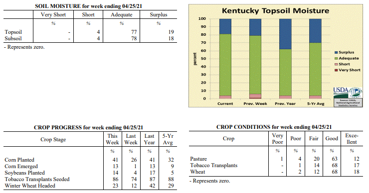 Kentucky Climate Summary
For the Period April 19, 2021 to April 25, 2021
Well Below Normal Temperatures and Slightly Below Normal Precipitation:
Despite being in the third week of April, Kentucky received another taste of winter
this past week. Following a mild and dry start to the workweek, a strong cold front
worked through the region on Tuesday night. Widespread showers accompanied the
boundary, but as temperatures plummeted, precipitation type turned to snow. Much of
the state saw some minor accumulations on grassy and elevated surfaces, peaking
across North Central Kentucky and the Bluegrass Region in the 1 to 2 inch range.
Snow melted pretty quickly, but chilly temperatures stuck around the next several
days with well below normal temperatures in place. Extreme minimum temperatures for
the week were down in the upper 20s to middle 30s for most of Kentucky. While
temperatures warmed up over the weekend, the state saw a round of widespread rainfall
on Saturday. Much of the state saw between a half and one inch of precipitation.
Southwestern Kentucky, including most of the Purchase and Pennyrile regions, were
between 1 and 1.5 inches.
Temperatures for the period averaged 50 degrees across the state which was 7 degrees
cooler than normal and 2 degrees cooler than the previous period. High temperatures
averaged from 62 in the West to 60 in the East. Departure from normal high
temperatures ranged from 9 degrees cooler than normal in the West to 10 degrees
cooler than normal in the East. Low temperatures averaged from 41 degrees in the
West to 38 degrees in the East. Departure from normal low temperature ranged from 7
degrees cooler than normal in the West to 4 degrees cooler than normal in the East.
The extreme high temperature for the period was 74 degrees at BOWLING GREEN APT and
the extreme low was 23 degrees at BARBOURVILLE 3E.
Precipitation (liq. equ.) for the period totaled 0.92 inches statewide which was 0.09
inches below normal and 91% of normal. Precipitation totals by climate division, West
1.24 inches, Central 1.05 inches, Bluegrass 0.78 inches and East 0.62 inches, which
was 0.07, 0.03, -0.15 and -0.31 inches respectively from normal. By station,
precipitation totals ranged from a low of 0.46 inches at JACKSON 3SE to a high of
2.00 inches at PRINCETON 2SE.
---
Kentucky Crop and Weather Report
Issued 4:00 P.M., April 19, 2021 7-21
Agricultural News: Kentucky experienced below normal temperatures and rainfall over
the past week. Precipitation for the week totaled 0.17 inches, 0.83 inches below
normal. Temperatures averaged 52 degrees for the week, 4 degrees below normal.
Topsoil moisture was rated 1 percent very short, 5 percent short, 73 percent
adequate, and 21 percent surplus. Subsoil moisture was rated 1 percent very short, 4
percent short, 76 percent adequate, and 19 percent surplus. Days suitable for
fieldwork averaged 5.4 out of a possible seven.
Primary activities for this week included planting corn and soybeans along with
seeding tobacco transplants. Scattered precipitation stymied fieldwork at times,
however planting continues at every opportunity. Crops that have just been planted
would benefit from some more warmth and sun as cooler weather has prevailed recently.
Corn is 1 percent emerged at this juncture. Tobacco transplants are 74 percent
seeded, trailing both last year and the five-year average. The transplants are in
mostly good condition at this time with height rated as 61 percent less than 2
inches, 32 percent 2 � 4 inches, and 7 percent larger than 4 inches.
The average height of winter wheat is 17 inches at this time while 12 percent of the
crop has headed. Wheat condition remains mostly good despite the freeze event several
weeks prior. Current freeze damage for wheat is rated as 1 percent severe, 4 percent
moderate, 44 percent light, and 51 percent with no damage. The crop will continue to
be evaluated for damage. Alfalfa freeze damage is rated as 1 percent severe, 7
percent moderate, 26 percent light, and 66 percent with no damage. Like the wheat
crop, alfalfa is still being evaluated for adverse effects. Conditions have been
conducive to good forage growth, however weevils have been detected in some alfalfa.
Kentucky Climate Summary
For the Period April 19, 2021 to April 25, 2021
Well Below Normal Temperatures and Slightly Below Normal Precipitation:
Despite being in the third week of April, Kentucky received another taste of winter
this past week. Following a mild and dry start to the workweek, a strong cold front
worked through the region on Tuesday night. Widespread showers accompanied the
boundary, but as temperatures plummeted, precipitation type turned to snow. Much of
the state saw some minor accumulations on grassy and elevated surfaces, peaking
across North Central Kentucky and the Bluegrass Region in the 1 to 2 inch range.
Snow melted pretty quickly, but chilly temperatures stuck around the next several
days with well below normal temperatures in place. Extreme minimum temperatures for
the week were down in the upper 20s to middle 30s for most of Kentucky. While
temperatures warmed up over the weekend, the state saw a round of widespread rainfall
on Saturday. Much of the state saw between a half and one inch of precipitation.
Southwestern Kentucky, including most of the Purchase and Pennyrile regions, were
between 1 and 1.5 inches.
Temperatures for the period averaged 50 degrees across the state which was 7 degrees
cooler than normal and 2 degrees cooler than the previous period. High temperatures
averaged from 62 in the West to 60 in the East. Departure from normal high
temperatures ranged from 9 degrees cooler than normal in the West to 10 degrees
cooler than normal in the East. Low temperatures averaged from 41 degrees in the
West to 38 degrees in the East. Departure from normal low temperature ranged from 7
degrees cooler than normal in the West to 4 degrees cooler than normal in the East.
The extreme high temperature for the period was 74 degrees at BOWLING GREEN APT and
the extreme low was 23 degrees at BARBOURVILLE 3E.
Precipitation (liq. equ.) for the period totaled 0.92 inches statewide which was 0.09
inches below normal and 91% of normal. Precipitation totals by climate division, West
1.24 inches, Central 1.05 inches, Bluegrass 0.78 inches and East 0.62 inches, which
was 0.07, 0.03, -0.15 and -0.31 inches respectively from normal. By station,
precipitation totals ranged from a low of 0.46 inches at JACKSON 3SE to a high of
2.00 inches at PRINCETON 2SE.
---
Kentucky Crop and Weather Report
Issued 4:00 P.M., April 19, 2021 7-21
Agricultural News: Kentucky experienced below normal temperatures and rainfall over
the past week. Precipitation for the week totaled 0.17 inches, 0.83 inches below
normal. Temperatures averaged 52 degrees for the week, 4 degrees below normal.
Topsoil moisture was rated 1 percent very short, 5 percent short, 73 percent
adequate, and 21 percent surplus. Subsoil moisture was rated 1 percent very short, 4
percent short, 76 percent adequate, and 19 percent surplus. Days suitable for
fieldwork averaged 5.4 out of a possible seven.
Primary activities for this week included planting corn and soybeans along with
seeding tobacco transplants. Scattered precipitation stymied fieldwork at times,
however planting continues at every opportunity. Crops that have just been planted
would benefit from some more warmth and sun as cooler weather has prevailed recently.
Corn is 1 percent emerged at this juncture. Tobacco transplants are 74 percent
seeded, trailing both last year and the five-year average. The transplants are in
mostly good condition at this time with height rated as 61 percent less than 2
inches, 32 percent 2 � 4 inches, and 7 percent larger than 4 inches.
The average height of winter wheat is 17 inches at this time while 12 percent of the
crop has headed. Wheat condition remains mostly good despite the freeze event several
weeks prior. Current freeze damage for wheat is rated as 1 percent severe, 4 percent
moderate, 44 percent light, and 51 percent with no damage. The crop will continue to
be evaluated for damage. Alfalfa freeze damage is rated as 1 percent severe, 7
percent moderate, 26 percent light, and 66 percent with no damage. Like the wheat
crop, alfalfa is still being evaluated for adverse effects. Conditions have been
conducive to good forage growth, however weevils have been detected in some alfalfa.
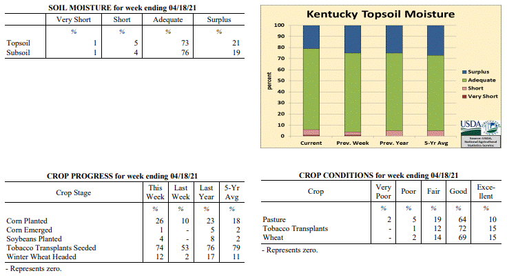 Kentucky Climate Summary
For the Period April 12, 2021 to April 18, 2021
Below Normal Temperatures and Rainfall:
The state saw multiple rounds of light rainfall pass through the region over the
course of the week, but in the end, didn't amount to much in the way of
accumulations. Overall, the state average ran below normal for a third straight week,
totaling 0.17 inches. Through April 18th, data at the Ag Weather Center shows the
state has only averaged 0.96 inches, which is over 1.5 inches below normal. Following
a mild start to the week, temperatures took a step back for the second half with
below normal temperatures in place. The coolest temperatures were seen on Friday
morning with most of Kentucky dropping into the low to middle 30s, opening up the
possibility of frost.
Temperatures for the period averaged 52 degrees across the state which was 4 degrees
cooler than normal and 12 degrees cooler than the previous period. High temperatures
averaged from 64 in the West to 63 in the East. Departure from normal high
temperatures ranged from 5 degrees cooler than normal in the West to 5 degrees
cooler than normal in the East. Low temperatures averaged from 44 degrees in the
West to 42 degrees in the East. Departure from normal low temperature ranged from 2
degrees cooler than normal in the West to 2 degrees warmer than normal in the East.
The extreme high temperature for the period was 76 degrees at BOWLING GREEN APT and
the extreme low was 29 degrees at BARBOURVILLE 3E.
Precipitation (liq. equ.) for the period totaled 0.17 inches statewide which was 0.83
inches below normal and 17% of normal. Precipitation totals by climate division, West
0.18 inches, Central 0.11 inches, Bluegrass 0.24 inches and East 0.16 inches, which
was 0.95, 0.91, 0.67 and 0.79 inches below normal. By station, precipitation totals
ranged from a low of 0.01 inches at ALEXANDRIA 5NW to a high of 0.49 inches at
CALHOUN 5NW.
---
Kentucky Crop and Weather Report
Issued 4:00 P.M., April 12, 2021 6-21
Agricultural News: Kentucky experienced well above normal temperatures and below
normal rainfall over the past week. Precipitation for the week totaled 0.79 inches,
0.20 inches below normal. Temperatures averaged 63 degrees for the week, 10 degrees
above normal. Topsoil moisture was rated 1 percent very short, 3 percent short, 71
percent adequate, and 25 percent surplus. Subsoil moisture was rated 1 percent very
short, 3 percent short, 72 percent adequate, and 24 percent surplus. Days suitable
for fieldwork averaged 5.1 out of a possible seven.
Primary activities for this week included seeding tobacco transplants, preparing
fields, and planting corn. Farmers are steadily planting as weather allows. It is of
note that some early season soybeans are in the ground and planting will increase in
the coming week. Fieldwork was stymied at times as rain moved in mid-week and after a
slight reprieve, returned over the weekend. Tobacco transplants are 53 percent
seeded, trailing both last year and the five-year average. Forty-two percent of
apples are in full bloom while peaches are at 60 percent.
The average height of winter wheat is 11 inches at this time while 2 percent of the
crop has headed. Wheat condition remains mostly good despite the recent freeze event.
Current freeze damage for wheat is rated as 3 percent moderate, 33 percent light, and
64 percent with no damage. The crop will continue to be assessed and further damage
may become apparent. Alfalfa freeze damage is rated as 1 percent severe, 8 percent
moderate, 26 percent light, and 65 percent with no damage. Like the wheat crop,
alfalfa is still being observed for possible adverse effects. Decent conditions have
allowed forages to stay ahead of weed growth thus far.
Kentucky Climate Summary
For the Period April 12, 2021 to April 18, 2021
Below Normal Temperatures and Rainfall:
The state saw multiple rounds of light rainfall pass through the region over the
course of the week, but in the end, didn't amount to much in the way of
accumulations. Overall, the state average ran below normal for a third straight week,
totaling 0.17 inches. Through April 18th, data at the Ag Weather Center shows the
state has only averaged 0.96 inches, which is over 1.5 inches below normal. Following
a mild start to the week, temperatures took a step back for the second half with
below normal temperatures in place. The coolest temperatures were seen on Friday
morning with most of Kentucky dropping into the low to middle 30s, opening up the
possibility of frost.
Temperatures for the period averaged 52 degrees across the state which was 4 degrees
cooler than normal and 12 degrees cooler than the previous period. High temperatures
averaged from 64 in the West to 63 in the East. Departure from normal high
temperatures ranged from 5 degrees cooler than normal in the West to 5 degrees
cooler than normal in the East. Low temperatures averaged from 44 degrees in the
West to 42 degrees in the East. Departure from normal low temperature ranged from 2
degrees cooler than normal in the West to 2 degrees warmer than normal in the East.
The extreme high temperature for the period was 76 degrees at BOWLING GREEN APT and
the extreme low was 29 degrees at BARBOURVILLE 3E.
Precipitation (liq. equ.) for the period totaled 0.17 inches statewide which was 0.83
inches below normal and 17% of normal. Precipitation totals by climate division, West
0.18 inches, Central 0.11 inches, Bluegrass 0.24 inches and East 0.16 inches, which
was 0.95, 0.91, 0.67 and 0.79 inches below normal. By station, precipitation totals
ranged from a low of 0.01 inches at ALEXANDRIA 5NW to a high of 0.49 inches at
CALHOUN 5NW.
---
Kentucky Crop and Weather Report
Issued 4:00 P.M., April 12, 2021 6-21
Agricultural News: Kentucky experienced well above normal temperatures and below
normal rainfall over the past week. Precipitation for the week totaled 0.79 inches,
0.20 inches below normal. Temperatures averaged 63 degrees for the week, 10 degrees
above normal. Topsoil moisture was rated 1 percent very short, 3 percent short, 71
percent adequate, and 25 percent surplus. Subsoil moisture was rated 1 percent very
short, 3 percent short, 72 percent adequate, and 24 percent surplus. Days suitable
for fieldwork averaged 5.1 out of a possible seven.
Primary activities for this week included seeding tobacco transplants, preparing
fields, and planting corn. Farmers are steadily planting as weather allows. It is of
note that some early season soybeans are in the ground and planting will increase in
the coming week. Fieldwork was stymied at times as rain moved in mid-week and after a
slight reprieve, returned over the weekend. Tobacco transplants are 53 percent
seeded, trailing both last year and the five-year average. Forty-two percent of
apples are in full bloom while peaches are at 60 percent.
The average height of winter wheat is 11 inches at this time while 2 percent of the
crop has headed. Wheat condition remains mostly good despite the recent freeze event.
Current freeze damage for wheat is rated as 3 percent moderate, 33 percent light, and
64 percent with no damage. The crop will continue to be assessed and further damage
may become apparent. Alfalfa freeze damage is rated as 1 percent severe, 8 percent
moderate, 26 percent light, and 65 percent with no damage. Like the wheat crop,
alfalfa is still being observed for possible adverse effects. Decent conditions have
allowed forages to stay ahead of weed growth thus far.
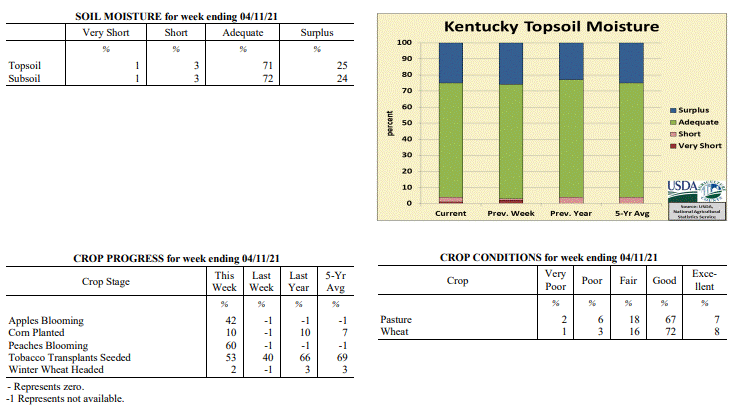 Kentucky Climate Summary
For the Period April 5, 2021 to April 11, 2021
Well Above Normal Temperatures and Below Normal Rainfall:
The period started with dry and very mild conditions in place. Highs Monday through
Wednesday rose into the middle 70s to low 80s behind southwest winds and mostly sunny
skies. Showers and storms returned to the area midweek, peaking in coverage on
Wednesday night and into Thursday with widespread showers in place. Kentucky then saw
a brief break from the rain on Friday with well above normal temperatures across the
state. In fact, portions of the western half of Kentucky jumped into the middle 80s,
about 15 to 20 degrees above normal for this time of year. Additional showers and storms
arrived over the weekend, most notably on Saturday and lingering across the northern
half of the state on Sunday. Overall, the state averaged 0.79 inches for the
the week, marking a 2nd straight week that the state average has ran slightly below
normal.
Temperatures for the period averaged 63 degrees across the state which was 10 degrees
warmer than normal and 16 degrees warmer than the previous period. High temperatures
averaged from 76 in the West to 75 in the East. Departure from normal high
temperatures ranged from 9 degrees warmer than normal in the West to 9 degrees
warmer than normal in the East. Low temperatures averaged from 54 degrees in the
West to 50 degrees in the East. Departure from normal low temperature ranged from 10
degrees warmer than normal in the West to 12 degrees warmer than normal in the
East. The extreme high temperature for the period was 86 degrees at EVANSVILLE ASOS
and the extreme low was 33 degrees at BARBOURVILLE 3E.
Precipitation (liq. equ.) for the period totaled 0.79 inches statewide which was 0.2
inches below normal and 79% of normal. Precipitation totals by climate division, West
0.63 inches, Central 0.74 inches, Bluegrass 0.93 inches and East 0.84 inches, which
was -0.50, -0.28, 0.03 and -0.09 inches respectively from normal. By station,
precipitation totals ranged from a low of 0.12 inches at OWENSBORO AWSS to a high of
1.68 inches at MAYFIELD 6SW.
---
Kentucky Crop and Weather Report
Issued 4:00 P.M., April 5, 2021 5-21
Agricultural News: Kentucky experienced below normal temperatures and rainfall over
the past week. Precipitation for the week totaled 0.90 inches, 0.11 inches below
normal. Temperatures averaged 47 degrees for the week, 4 degrees cooler than normal.
Topsoil moisture was rated 2 percent very short, 1 percent short, 71 percent
adequate, and 26 percent surplus. Subsoil moisture was rated 2 percent very short, 2
percent short, 73 percent adequate, and 23 percent surplus. Days suitable for
fieldwork averaged 4.2 out of a possible seven.
Primary activities for this week included seeding tobacco transplants and preparing
fields for planting. Cold temperatures were prevalent through most of the week before
giving way to warm weather over the weekend. The warm up allowed farmers to resume
spraying and fertilizing fields for the 2021 crop season. A very small amount of corn
has been planted at this juncture, however farmers will ramp up fieldwork in the
coming weeks.
Winter wheat is in mostly good condition at this time, however there were multiple
nights of sub-freezing temperatures across the state. With that said, very little
freeze damage is reported currently. Alfalfa also shows very little freeze damage,
however for both crops, the damage may not be readily apparent. Strawberries were
susceptible to the untimely freeze and like, alfalfa and wheat, will be monitored
over the foreseeable future.
Despite the cold snap, pastureland is in mostly good condition with 32 percent of
feed for cattle coming from grazing. Warmer weather should quickly nullify the damage
by the recent cold stretch and allow pasture growth to strengthen. Livestock condition
is good at this time and will continue to improve with spring weather.
Kentucky Climate Summary
For the Period April 5, 2021 to April 11, 2021
Well Above Normal Temperatures and Below Normal Rainfall:
The period started with dry and very mild conditions in place. Highs Monday through
Wednesday rose into the middle 70s to low 80s behind southwest winds and mostly sunny
skies. Showers and storms returned to the area midweek, peaking in coverage on
Wednesday night and into Thursday with widespread showers in place. Kentucky then saw
a brief break from the rain on Friday with well above normal temperatures across the
state. In fact, portions of the western half of Kentucky jumped into the middle 80s,
about 15 to 20 degrees above normal for this time of year. Additional showers and storms
arrived over the weekend, most notably on Saturday and lingering across the northern
half of the state on Sunday. Overall, the state averaged 0.79 inches for the
the week, marking a 2nd straight week that the state average has ran slightly below
normal.
Temperatures for the period averaged 63 degrees across the state which was 10 degrees
warmer than normal and 16 degrees warmer than the previous period. High temperatures
averaged from 76 in the West to 75 in the East. Departure from normal high
temperatures ranged from 9 degrees warmer than normal in the West to 9 degrees
warmer than normal in the East. Low temperatures averaged from 54 degrees in the
West to 50 degrees in the East. Departure from normal low temperature ranged from 10
degrees warmer than normal in the West to 12 degrees warmer than normal in the
East. The extreme high temperature for the period was 86 degrees at EVANSVILLE ASOS
and the extreme low was 33 degrees at BARBOURVILLE 3E.
Precipitation (liq. equ.) for the period totaled 0.79 inches statewide which was 0.2
inches below normal and 79% of normal. Precipitation totals by climate division, West
0.63 inches, Central 0.74 inches, Bluegrass 0.93 inches and East 0.84 inches, which
was -0.50, -0.28, 0.03 and -0.09 inches respectively from normal. By station,
precipitation totals ranged from a low of 0.12 inches at OWENSBORO AWSS to a high of
1.68 inches at MAYFIELD 6SW.
---
Kentucky Crop and Weather Report
Issued 4:00 P.M., April 5, 2021 5-21
Agricultural News: Kentucky experienced below normal temperatures and rainfall over
the past week. Precipitation for the week totaled 0.90 inches, 0.11 inches below
normal. Temperatures averaged 47 degrees for the week, 4 degrees cooler than normal.
Topsoil moisture was rated 2 percent very short, 1 percent short, 71 percent
adequate, and 26 percent surplus. Subsoil moisture was rated 2 percent very short, 2
percent short, 73 percent adequate, and 23 percent surplus. Days suitable for
fieldwork averaged 4.2 out of a possible seven.
Primary activities for this week included seeding tobacco transplants and preparing
fields for planting. Cold temperatures were prevalent through most of the week before
giving way to warm weather over the weekend. The warm up allowed farmers to resume
spraying and fertilizing fields for the 2021 crop season. A very small amount of corn
has been planted at this juncture, however farmers will ramp up fieldwork in the
coming weeks.
Winter wheat is in mostly good condition at this time, however there were multiple
nights of sub-freezing temperatures across the state. With that said, very little
freeze damage is reported currently. Alfalfa also shows very little freeze damage,
however for both crops, the damage may not be readily apparent. Strawberries were
susceptible to the untimely freeze and like, alfalfa and wheat, will be monitored
over the foreseeable future.
Despite the cold snap, pastureland is in mostly good condition with 32 percent of
feed for cattle coming from grazing. Warmer weather should quickly nullify the damage
by the recent cold stretch and allow pasture growth to strengthen. Livestock condition
is good at this time and will continue to improve with spring weather.
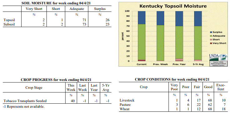 Kentucky Climate Summary
For the Period March 29, 2021 to April 4, 2021
Below Normal Temperatures and Rainfall:
Well below normal temperatures were the big story for the week with multiple nights
below the freezing mark. The week opened with frosty conditions in place on Monday
morning as lows dipped into the upper 20s to low 30s. Following a brief warmup on
Tuesday, a cold front pushed through the area on Tuesday night, accompanied by a
round of widespread rain showers. Overall, this was the only significant rainfall
event for the week with the state average at 0.90 inches. Much cooler air filtered
into the area behind the boundary with three straight nights of subfreezing
temperatures for much of the area. The most significant cold air arrived Thursday
night/Friday morning when lows dropped into the low to middle 20s for much of KY.
This is about 15 to 20 degrees below normal for this time of year. Luckily, the
Commonwealth saw a warming trend over the weekend, eventually back in the upper 60s
to middle 70s on Sunday with plenty of sunshine.
Temperatures for the period averaged 47 degrees across the state which was 4 degrees
cooler than normal and 12 degrees cooler than the previous period. High temperatures
averaged from 62 in the West to 59 in the East. Departure from normal high
temperatures ranged from 3 degrees cooler than normal in the West to 4 degrees
cooler than normal in the East. Low temperatures averaged from 35 degrees in the
West to 33 degrees in the East. Departure from normal low temperature ranged from 6
degrees cooler than normal in the West to 3 degrees cooler than normal in the East.
The extreme high temperature for the period was 78 degrees at LOUISA 1S and the
extreme low was 19 degrees at PIKEVILLE 13S.
Precipitation (liq. equ.) for the period totaled 0.90 inches statewide which was 0.11
inches below normal and 89% of normal. Precipitation totals by climate division, West
1.04 inches, Central 1.10 inches, Bluegrass 0.83 inches and East 0.62 inches, which
was -0.06, 0.04, -0.08 and -0.34 inches respectively from normal. By station,
precipitation totals ranged from a low of 0.08 inches at POPLAR BLUFF ASOS to a high
of 2.31 inches at MURRAY 1W.
---
Kentucky Climate Summary
For the Period March 22, 2021 to March 28, 2021
Well Above Normal Temperatures and Above Normal Rainfall:
Kentucky saw a third straight week of above normal temperatures. Highs generally rose
into the 60s and 70s about every day. Some even hit the low 80s on the 24th. While
the week started out on a quiet and dry note, Kentucky saw a strong storm system pass
through the region on Thursday. This event came in a couple rounds, one early in the
morning and the other that afternoon and into the overnight hours. The first round
produced widespread soaking showers, while the second brought some severe weather to
the region. Even some weak tornadoes. Another round of rain followed over the weekend
with high accumulations across South Central and Southeastern Kentucky. Two inches+
was common for this area and led to some significant flooding for the region. Overall,
the state averaged over 1.5 inches for the week, but Eastern Kentucky in itself, was
at 2.73 inches.
Temperatures for the period averaged 58 degrees across the state which was 9 degrees
warmer than normal and 8 degrees warmer than the previous period. High temperatures
averaged from 69 in the West to 69 in the East. Departure from normal high
temperatures ranged from 7 degrees warmer than normal in the West to 8 degrees
warmer than normal in the East. Low temperatures averaged from 50 degrees in the
West to 48 degrees in the East. Departure from normal low temperature ranged from 10
degrees warmer than normal in the West to 13 degrees warmer than normal in the
East. The extreme high temperature for the period was 81 degrees at LOUISA 1S and the
extreme low was 29 degrees at VANCEBURG 6W.
Precipitation (liq. equ.) for the period totaled 1.68 inches statewide which was 0.64
inches above normal and 161% of normal. Precipitation totals by climate division,
West 1.18 inches, Central 1.86 inches, Bluegrass 0.95 inches and East 2.73 inches,
which was 0.07, 0.76, 0.01 and 1.71 inches above normal. By station, precipitation
totals ranged from a low of 0.52 inches at MARION 4NE to a high of 6.46 inches at
YELLOW CREEK.
---
Kentucky Climate Summary
For the Period March 15, 2021 to March 21, 2021
Above Normal Temperatures and Rainfall:
The state averaged 1.26 inches for the period behind multiple bouts of widespread
rainfall through the workweek. The first round arrived on Monday as a band of
showers with embedded thunderstorms produced a tenth to half inch of rain across
the region. More activity then arrived on Wednesday and Thursday with a range of
accumulations between 0.5 and 1.5 inches. Some severe storms even pushed through
portions of far Eastern Kentucky on Thursday with the passage of cold front. Dry
conditions then followed on Friday and over the weekend with plenty of sunshine in
place. Highs on Saturday and Sunday each topped out in the 60s across the area.
Normal highs temperatures for this time of year range in the middle 50s to low 60s.
Temperatures for the period averaged 51 degrees across the state which was 4 degrees
warmer than normal and 2 degrees cooler than the previous period. High temperatures
averaged from 61 in the West to 63 in the East. Departure from normal high
temperatures ranged from 1 degrees warmer than normal in the West to 4 degrees
warmer than normal in the East. Low temperatures averaged from 42 degrees in the West
to 41 degrees in the East. Departure from normal low temperature ranged from 4
degrees warmer than normal in the West to 8 degrees warmer than normal in the East.
The extreme high temperature for the period was 76 degrees at BOONEVILLE 2S and the
extreme low was 22 degrees at VANCEBURG 6W.
Precipitation (liq. equ.) for the period totaled 1.26 inches statewide which was 0.23
inches above normal and 122% of normal. Precipitation totals by climate division,
West 1.57 inches, Central 1.09 inches, Bluegrass 0.98 inches and East 1.40 inches,
which was 0.48, 0.00, 0.05 and 0.39 inches respectively from normal. By station,
precipitation totals ranged from a low of 0.54 inches at LA GRANGE 6NW to a high of
2.81 inches at BARBOURVILLE 3E.
---
Kentucky Climate Summary
For the Period March 8, 2021 to March 14, 2021
Above Normal Temperatures and Below Normal Rainfall:
The Commonwealth ran dry for the first few days of the workweek, which ultimately led
to a 10-day stretch of dry conditions since the exceptional rainfall seen over the last
couple days of February. Well above normal temperatures accompanied the dry
conditions, peaking Tuesday through Thursday in the upper 60s to low 70s. Rain
returned to the area on Thursday and Thursday night with the passage of a cold front.
The highest accumulations were seen across counties bordering Southwestern Indiana
with values of 2+ inches. After another rainfall event Friday night/Saturday morning
for the Purchase and Pennyrile Regions, dry conditions and seasonable temperatures
returned for the weekend. Overall, Western Kentucky averaged 1.62 inches for the
week, while the rest of the climate divisions across Kentucky saw below normal
rainfall.
Temperatures for the period averaged 53 degrees across the state which was 8 degrees
warmer than normal and 12 degrees warmer than the previous period. High temperatures
averaged from 65 in the West to 64 in the East. Departure from normal high
temperatures ranged from 7 degrees warmer than normal in the West to 7 degrees
warmer than normal in the East. Low temperatures averaged from 46 degrees in the
West to 40 degrees in the East. Departure from normal low temperature ranged from 10
degrees warmer than normal in the West to 9 degrees warmer than normal in the East.
The extreme high temperature for the period was 76 degrees at JACKSON AIRPORT and the
extreme low was 16 degrees at VANCEBURG 6W.
Precipitation (liq. equ.) for the period totaled 0.91 inches statewide which was 0.07
inches below normal and 93% of normal. Precipitation totals by climate division, West
1.62 inches, Central 0.84 inches, Bluegrass 0.88 inches and East 0.31 inches, which
was 0.60, -0.19, -0.02 and -0.66 inches respectively from normal. By station,
precipitation totals ranged from a low of 0.08 inches at YELLOW CREEK to a high of
2.90 inches at CARBONDALE ASOS.
---
Kentucky Climate Summary
For the Period March 1, 2021 to March 7, 2021
Below Normal Temperatures and Above Normal Precipitation:
While dry conditions were in place for most of the week, state data shows Kentucky
averaged over an inch for the week. This is due to the fact that data for the
new period starts at 7PM on Sunday. Thus, this period takes into account a
significant portion of rainfall on the evening and overnight of the 28th. Dry
conditions then filtered into the area on Monday and stuck around the rest of the period,
giving the Commonwealth a much needed break from extreme rainfall. Otherwise,
temperatures fluctuated throughout the week with Kentucky ultimately a couple degrees
below normal for the period, but with plenty in the way sunshine.
Temperatures for the period averaged 42 degrees across the state which was 2 degrees
cooler than normal and 4 degrees cooler than the previous period. High temperatures
averaged from 56 in the West to 53 in the East. Departure from normal high
temperatures ranged from near normal in the West to 3 degrees cooler than
normal in the East. Low temperatures averaged from 32 degrees in the West to 29
degrees in the East. Departure from normal low temperature ranged from 2 degrees
cooler than normal in the West to 1 degree cooler than normal in the East. The
extreme high temperature for the period was 70 degrees at MONTICELLO AWOS and the
extreme low was 17 degrees at VANCEBURG 6W.
Precipitation (liq. equ.) for the period totaled 1.02 inches statewide which was 0.06
inches above normal and 106% of normal. Precipitation totals by climate division,
West 0.51 inches, Central 1.11 inches, Bluegrass 0.66 inches and East 1.81 inches,
which was -0.54, 0.10, -0.20 and 0.87 inches respectively from normal. By station,
precipitation totals ranged from a low of 0.00 inches at HARDINSBURG 5SW to a high of
3.37 inches at LONDON.
---
Kentucky Climate Summary
For the Period February 22, 2021 to February 28, 2021
Above Normal Temperatures and Much Above Normal Precipitation:
Exceptional rainfall fell across the Bluegrass State to end February, marking a third
straight week of very impactful weather conditions across the area. Overall, the state
averaged 2.81 inches over the last few days of the month behind multiple waves of
rainfall. The most impactful period of rainfall occurred Saturday night and Sunday
as widespread coverage combined with moderate to heavy intensity and led to numerous
bouts of flash flooding and river flooding. Some of the rain fell after the data
cutoff for the report this week, but overall, most of Kentucky saw 2 to 6+ inches
through Sunday night. Putting this into perspective, the state averages 3.67 inches
for the month of February as a whole. Looking at temperatures, the state finally saw
a break from the cold of previous weeks. In fact, the state saw multiple days with
highs in the 60s and some even hitting the 70s.
Temperatures for the period averaged 48 degrees across the state which was 6 degrees
warmer than normal and 26 degrees warmer than the previous period. High temperatures
averaged from 57 in the West to 57 in the East. Departure from normal high
temperatures ranged from 3 degrees warmer than normal in the West to 4 degrees
warmer than normal in the East. Low temperatures averaged from 41 degrees in the
West to 39 degrees in the East. Departure from normal low temperature ranged from 9
degrees warmer than normal in the West to 10 degrees warmer than normal in the
East. The extreme high temperature for the period was 74 degrees at BOONEVILLE 2S and
the extreme low was 12 degrees at PIKEVILLE 13S.
Precipitation (liq. equ.) for the period totaled 3.03 inches statewide which was 2.05
inches above normal and 308% of normal. Precipitation totals by climate division,
West 2.50 inches, Central 3.64 inches, Bluegrass 2.53 inches and East 3.44 inches,
which was 1.4, 2.59, 1.67 and 2.52 inches above normal. By station, precipitation
totals ranged from a low of 1.16 inches at POPLAR BLUFF ASOS to a high of 5.53
inches at BOWLING GREEN 4E.
---
Kentucky Climate Summary
For the Period February 15, 2021 to February 21, 2021
Well Below Normal Temperatures and Above Normal Precipitation:
It was a week to remember for the Bluegrass State with two major winter storms
pushing through the area. The first wave moved through the region on Monday and
Monday night, resulting in a mix of wintry precipitation across the state. In the
end, Eastern Kentucky was hit with another major ice storm for the second time in
less than a week. Many saw accumulations of a quarter to half inch+ in this region.
Once again, travel became treacherous and power outages increased with an estimated
peak of 150,000 customers without power. Heavy sleet and snow mixed in with the ice
farther to the north and west into Central KY (2-5+ inches), eventually transitioning
to mostly snow (5-9 inches) across Western Kentucky. Very chilly air followed on
Tuesday with highs struggling in the upper teens to middle 20s. Round two then swung
through the area on Wednesday and Thursday. Luckily, this storm brought more in the
way of snow showers, but was still impactful, leaving 3 to 5 inches across much of
the southern half of Kentucky, tapering to the north. Very chilly air followed the
next couple days with morning temperatures dipping into the single digits and even
below zero at times (first time since 2015).
Temperatures for the period averaged 22 degrees across the state which was 16 degrees
cooler than normal and 6 degrees cooler than the previous period. High temperatures
averaged from 28 in the West to 34 in the East. Departure from normal high
temperatures ranged from 22 degrees cooler than normal in the West to 16 degrees
cooler than normal in the East. Low temperatures averaged from 10 degrees in the
West to 18 degrees in the East. Departure from normal low temperature ranged from 20
degrees cooler than normal in the West to 8 degrees cooler than normal in the East.
The extreme high temperature for the period was 55 degrees at ALBANY 1N and the
extreme low was -6 degrees at HENDERSON 5E.
Precipitation (liq. equ.) for the period totaled 1.00 inches statewide which was 0.09
inches above normal and 110% of normal. Precipitation totals by climate division,
West 0.59 inches, Central 1.11 inches, Bluegrass 0.94 inches and East 1.35 inches,
which was -0.44, 0.13, 0.16 and 0.50 inches respectively from normal. By station,
precipitation totals ranged from a low of 0.02 inches at CARBONDALE ASOS to a high of
2.81 inches at HARDINSBURG 5SW.
---
Kentucky Climate Summary
For the Period February 8, 2021 to February 14, 2021
Well Below Normal Temperatures and Below Normal Precipitation:
The first significant and impactful winter storm of 2021 pushed through the state on
Wednesday and Thursday. Ice was the primary threat for most of the state with
accumulations ranging from a tenth to half inch+ for much of the area. The ice
resulted in hazardous driving conditions, tree damage and power outages, especially
across Eastern Kentucky. Additional rounds of light precipitation followed through
the rest of the period, along with some very cold air sliding into the area. Highs
struggled in the 20s and 30s through the weekend. Even teens across Western KY on Sunday.
Lows on Sunday morning ranged from the single digits across Western Kentucky to
middle 20s for Eastern Kentucky. Winds chills in the single digits and even below
zero, prompted the livestock cold stress index to dip into the Emergency Category.
Temperatures for the period averaged 28 degrees across the state which was 8 degrees
cooler than normal and 4 degrees cooler than the previous period. High temperatures
averaged from 28 in the West to 37 in the East. Departure from normal high
temperatures ranged from 20 degrees cooler than normal in the West to 10 degrees
cooler than normal in the East. Low temperatures averaged from 21 degrees in the
West to 27 degrees in the East. Departure from normal low temperature ranged from 7
degrees cooler than normal in the West to 3 degrees warmer than normal in the East.
The extreme high temperature for the period was 59 degrees at MIDDLESBORO AWOS and
the extreme low was 2 degrees at CARBONDALE ASOS.
Precipitation (liq. equ.) for the period totaled 0.59 inches statewide which was 0.31
inches below normal and 66% of normal. Precipitation totals by climate division, West
0.40 inches, Central 0.62 inches, Bluegrass 0.70 inches and East 0.66 inches, which
was 0.6, 0.36, 0.07 and 0.18 inches below normal. By station, precipitation totals
ranged from a low of 0.15 inches at HICKMAN 2E to a high of 1.31 inches at STANFORD 4NE.
---
Kentucky Climate Summary
For the Period February 1, 2021 to February 7, 2021
Below Normal Temperatures and Precipitation:
Feburary opened with widespread snow showers on Monday and Monday night, resulting in
light accumulations under 2 inches for most everyone. Dry conditions then took over
Tuesday and Wednesday with NW winds keeping temperatures near to below normal.
Southerly flow increased on Thursday ahead of a cold front. Gusty winds, sometimes
topping 30 mph, pushed highs into the middle 40s to low 50s across the state.
Widespread rainfall accompanied the boundary with most accumulations between a tenth
and half inch, highest across Western Kentucky and tapering to the east. Outside of
some minor disturbances bringing some light snow/rain showers over the weekend,
temperatures went on the downhill slide with highs on Sunday limited to the upper 20s
to middle 30s. Overall, the state averaged 0.40 inches for the week, which is about
a half inch below normal.
Temperatures for the period averaged 32 degrees across the state which was 2 degrees
cooler than normal and 4 degrees cooler than the previous period. High temperatures
averaged from 41 in the West to 40 in the East. Departure from normal high
temperatures ranged from 4 degrees cooler than normal in the West to 5 degrees cooler
than normal in the East. Low temperatures averaged from 26 degrees in the West to 26
degrees in the East. Departure from normal low temperature ranged from near normal in
the West to 3 degrees warmer than normal in the East. The extreme high temperature
for the period was 53 degrees at BURKESVILLE 3W and the extreme low was 9 degrees
at CARBONDALE ASOS.
Precipitation (liq. equ.) for the period totaled 0.40 inches statewide which was 0.47
inches below normal and 46% of normal. Precipitation totals by climate division, West
0.43 inches, Central 0.43 inches, Bluegrass 0.29 inches and East 0.46 inches, which
was 0.52, 0.52, 0.47 and 0.37 inches below normal. By station, precipitation totals
ranged from a low of 0.16 inches at RICHMOND 8E to a high of 0.90 inches at PIKEVILLE 13S.
---
Kentucky Climate Summary
For the Period January 25, 2021 to January 31, 2021
Above Normal Temperatures and Much Above Normal Precipitation:
An exceptional amount of rain fell across the state to start out the week as an area
of low pressure worked through the area. Widespread light to moderate showers led to
a soaking rainfall event, even accompanied by some storms. Overall, most of the
state saw 1 to 3+ inches. The highest totals were seen across Western and West-
Central Kentucky, which led to some flooding. This ended up breaking a three week
streak of the state precipitation average running below normal and wiped out any
mention of �abnormally dry conditions� on the US Drought Monitor across South-Central
Kentucky. This event was followed by a couple more rounds, one on Wednesday/Wednesday
night and the other over the weekend. The midweek system brought the area a round of
snow with 1 to 3 inches common across the eastern half of the state. Adding another
half inch+ of rain over the weekend, the state averaged 2.74 inches for the week.
Temperatures for the period averaged 36 degrees across the state which was 3 degrees
warmer than normal and no change to the previous period. High temperatures averaged
from 44 in the West to 43 in the East. Departure from normal high temperatures
ranged from near normal in the West to 1 degree cooler than normal in the East. Low
temperatures averaged from 32 degrees in the West to 30 degrees in the East. Departure
from normal low temperature ranged from 7 degrees warmer than normal in the West to 8
degrees warmer than normal in the East. The extreme high temperature for the period
was 64 degrees at MIDDLESBORO AWOS and the extreme low was 5 degrees at CYNTHIANA 8N.
Precipitation (liq. equ.) for the period totaled 2.74 inches statewide which was 1.95
inches above normal and 347% of normal. Precipitation totals by climate division,
West 3.15 inches, Central 3.08 inches, Bluegrass 2.43 inches and East 2.30 inches,
which was 2.31, 2.23, 1.74 and 1.52 inches above normal. By station, precipitation
totals ranged from a low of 1.01 inches at MIDDLESBORO AWOS to a high of 4.66
inches at BENTON 4N.
---
Kentucky Climate Summary
For the Period January 18, 2021 to January 24, 2021
Above Normal Temperatures and Below Normal Precipitation:
Dry conditions have been the norm for much of January. That trend did not change this
period as Kentucky saw a third straight week of below normal precipitation. While the
state did see a few rounds of precipitation throughout the week (Monday, Wednesday
night, and Sunday), each one featured only light accumulations. The highest totals
with each round were mainly between a tenth and two tenths of an inch. The trend in
dry weather has led the US Drought Monitor to reintroduce 'abnormally dry' conditions
across much of South Central Kentucky. While precipitation ran below normal once
again, temperatures followed an up and down pattern, ultimately ending the week above
normal. This marks a fifth straight week of near to above normal temperatures for the
Bluegrass State, dating back into late December.
Temperatures for the period averaged 36 degrees across the state which was 3 degrees
warmer than normal and 2 degrees warmer than the previous period. High temperatures
averaged from 45 in the West to 42 in the East. Departure from normal high
temperatures ranged from 2 degrees warmer than normal in the West to 1 degree
cooler than normal in the East. Low temperatures averaged from 31 degrees in the
West to 28 degrees in the East. Departure from normal low temperature ranged from 6
degrees warmer than normal in the West to 6 degrees warmer than normal in the East.
The extreme high temperature for the period was 55 degrees at BOWLING GREEN APT and
the extreme low was 10 degrees at BURLINGTON 4S.
Precipitation (liq. equ.) for the period totaled 0.17 inches statewide which was 0.65
inches below normal and 21% of normal. Precipitation totals by climate division, West
0.25 inches, Central 0.25 inches, Bluegrass 0.07 inches and East 0.12 inches, which
was 0.62, 0.62, 0.64 and 0.71 inches below normal. By station, precipitation totals
ranged from a low of 0.01 inches at LOUISA 1S to a high of 0.43 inches at MAYFIELD 6SW.
---
Kentucky Climate Summary
For the Period January 11, 2021 to January 17, 2021
Slightly Above Normal Temperatures and Below Normal Precipitation:
The Bluegrass State saw precipitation run below normal for a second straight week.
Just like precipitation events last week, any accumulations were very light in
nature. Despite seeing precipitation on a daily basis between Thursday night and
Sunday, the state average was 0.18 inches for the week. Much of that total came in
the form of snow over the weekend with periodic rounds of light accumulations. The
highest totals came Friday night and Saturday morning when several locations saw 1 to
2 inches. Warm ground temperatures tended to limit any impacts with accumulations
mainly on grassy and elevated surfaces. Over the past 14 days, the state has
averaged 0.22 inches, which is about 1.5 inches below normal.
Temperatures for the period averaged 34 degrees across the state which was 1 degree
warmer than normal and no change to the previous period. High temperatures averaged
from 42 in the West to 41 in the East. Departure from normal high temperatures
ranged from 1 degree cooler than normal in the West to 3 degrees cooler than normal
in the East. Low temperatures averaged from 29 degrees in the West to 28 degrees in
the East. Departure from normal low temperature ranged from 4 degrees warmer than
normal in the West to 5 degrees warmer than normal in the East. The extreme high
temperature for the period was 61 degrees at ELKTON 5SW and the extreme low was 12
degrees at MONTICELLO AWOS.
Precipitation (liq. equ.) for the period totaled 0.17 inches statewide which was 0.69
inches below normal and 20% of normal. Precipitation totals by climate division, West
0.07 inches, Central 0.15 inches, Bluegrass 0.23 inches and East 0.25 inches, which
was 0.83, 0.76, 0.51 and 0.64 inches below normal. By station, precipitation totals
ranged from a low of 0.00 inches at HICKMAN 2E to a high of 0.48 inches at PIKEVILLE 13S.
---
Kentucky Climate Summary
For the Period January 4, 2021 to January 10, 2021
Near Normal Temperatures and Much Below Normal Precipitation:
Cloud cover held steady throughout much the week, leading to chilly conditions.
Following a cold front on Monday night, highs struggled in the 30s to low 40s on a
daily basis, slightly below normal for this time of year. Very light rain/snow
showers accompanied the front. This was followed a disturbance passing to our south
on Thursday and Thursday night. Ultimately, this was another light snow event with
the highest accumulations across North Central Kentucky in the 0.5 to 2 inch range.
Still though, these accumulations were limited to grassy and elevated surfaces. Dry
conditions then followed through the weekend. Altogether, the state averaged 0.04
inches for the week. Saying that, the Thursday update of the US Drought Monitor did
remove any mention of abnormally dry conditions from the state with higher
accumulations around the start of 2021.
Temperatures for the period averaged 34 degrees across the state which was near
normal and 8 degrees cooler than the previous period. High temperatures
averaged from 41 in the West to 39 in the East. Departure from normal high
temperatures ranged from 2 degrees cooler than normal in the West to 5 degrees
cooler than normal in the East. Low temperatures averaged from 30 degrees in the
West to 30 degrees in the East. Departure from normal low temperature ranged from 4
degrees warmer than normal in the West to 6 degrees warmer than normal in the East.
The extreme high temperature for the period was 55 degrees at BOWLING GREEN APT and
the extreme low was 15 degrees at CARLISLE 5SW.
Precipitation (liq. equ.) for the period totaled 0.04 inches statewide which was 0.84
inches below normal and 5% of normal. Precipitation totals by climate division, West
0.02 inches, Central 0.01 inches, Bluegrass 0.02 inches and East 0.09 inches, which
was 0.91, 0.94, 0.73 and 0.82 inches below normal. By station, precipitation totals
ranged from a low of 0.00 inches at ALBANY 1N to a high of 0.36 inches at PIKEVILLE 13S.
---
Kentucky Climate Summary
For the Period December 28, 2020 to January 3, 2021
Well Above Normal Temperatures and Above Normal Precipitation:
Rain was abundant as Kentucky closed 2020 and opened the new year. Following a quiet
and chilly start to the period, widespread rain showers accompanied a cold front
passing through the area Wednesday and lasting into Thursday morning. After a brief
break, widespread rain returned late Thursday night and continued into New Year�s Day
as an upper-level disturbance worked across the area. While the state did see some
light accumulations over the weekend, the brunt of the weekly state average fell on
either side of the holiday. Overall, the state averaged 1.69 inches for the period,
which is over three quarters of an inch above normal. Ahead of a cold front on
Friday, well above normal temperatures were seen across the state with highs jumping
into the 60s and even low 70s for much of South-Central Kentucky. Behind the
boundary, temperatures went on the downhill slide, only topping out in the upper 30s
to middle 40s on Sunday.
Temperatures for the period averaged 42 degrees across the state which was 8 degrees
warmer than normal and 6 degrees warmer than the previous period. High temperatures
averaged from 48 in the West to 52 in the East. Departure from normal high
temperatures ranged from 4 degrees warmer than normal in the West to 8 degrees
warmer than normal in the East. Low temperatures averaged from 34 degrees in the
West to 36 degrees in the East. Departure from normal low temperature ranged from 8
degrees warmer than normal in the West to 12 degrees warmer than normal in the
East. The extreme high temperature for the period was 73 degrees at BOWLING GREEN APT
and the extreme low was 20 degrees at MONTICELLO AWOS.
Precipitation (liq. equ.) for the period totaled 1.69 inches statewide which was 0.78
inches above normal and 186% of normal. Precipitation totals by climate division,
West 2.11 inches, Central 1.79 inches, Bluegrass 1.95 inches and East 0.93 inches,
which was 1.16, 0.81, 1.15 and 0.02 inches above normal. By station, precipitation
totals ranged from a low of 0.36 inches at WHITESBURG 2NW to a high of 2.59
inches at MADISONVILLE 4S.
---
Kentucky Climate Summary
For the Period December 21, 2020 to December 27, 2020
Near Normal Temperatures and Below Normal Precipitation:
The first half of the week ran unseasonably mild, peaking on Wednesday with highs
around 60 across the state. Big changes then arrived on Christmas Eve as a strong
cold front pushed through Kentucky. Rain transitioned to a wintry mix and eventually
snow after temperatures crashed quickly behind the front with strong northwest flow
in place. Snow continued into Thursday night and lingered into Christmas Day with the
most significant activity across Eastern Kentucky. Accumulations were generally
between 4 to 6 inches for this area. Some locations topped 8 inches. Low
temperatures dropped into the teens for Christmas morning and only warmed into the
upper teens to mid-20s during the day. Much of the eastern half of the state even
dropped into the single digits on Saturday morning. During this 48-hour timespan,
wind chills dropped into the single digits and even below zero at times, pushing the
livestock cold stress index into the Emergency category. Good news arrived over the
weekend as winds transitioned to the southwest and highs were back in the 50s by
Sunday.
Temperatures for the period averaged 36 degrees across the state which was
near normal and no change to the previous period. High temperatures averaged from
49 in the West to 46 in the East. Departure from normal high temperatures ranged
from 4 degrees warmer than normal in the West to near normal in the East.
Low temperatures averaged from 29 degrees in the West to 24 degrees in the East.
Departure from normal low temperature ranged from 1 degree warmer than normal in the
West to 2 degrees cooler than normal in the East. The extreme high temperature for
the period was 65 degrees at POPLAR BLUFF ASOS and the extreme low was 1 degree at
BARBOURVILLE 3E.
Precipitation (liq. equ.) for the period totaled 0.62 inches statewide which was 0.33
inches below normal and 66% of normal. Precipitation totals by climate division, West
0.51 inches, Central 0.48 inches, Bluegrass 0.40 inches and East 1.08 inches, which
was -0.50, -0.55, -0.43 and 0.17 inches respectively from normal. By station,
precipitation totals ranged from a low of 0.11 inches at FORT CAMPBELL to a high of
1.55 inches at JACKSON.
---
Kentucky Climate Summary
For the Period December 14, 2020 to December 20, 2020
Below Normal Temperatures and Above Normal Precipitation:
An active pattern led to multiple rounds of precipitation throughout the week. Many
of the rounds featured widespread coverage. Temperatures hovering around freezing
produced a wintry mix of precipitation from time to time. Overall, the state
averaged 1.12 inches, which was slightly above normal for the period. This ended a
stretch of four straight weeks where the state average ran below normal. The active
pattern resulted in limited sunshine throughout the week. High temperatures struggled
in the middle 30s to low 30s through Thursday, before rising into the middle to upper
40s over the weekend.
Temperatures for the period averaged 35 degrees across the state which was 2 degrees
cooler than normal and 10 degrees cooler than the previous period. High temperatures
averaged from 41 in the West to 41 in the East. Departure from normal high
temperatures ranged from 6 degrees cooler than normal in the West to 7 degrees
cooler than normal in the East. Low temperatures averaged from 29 degrees in the
West to 30 degrees in the East. Departure from normal low temperature ranged from
near normal in the West to 3 degrees warmer than normal in the East. The
extreme high temperature for the period was 52 degrees at BURKESVILLE 3W and the
extreme low was 17 degrees at BRANDENBURG 4SW.
Precipitation (liq. equ.) for the period totaled 1.12 inches statewide which was 0.15
inches above normal and 115% of normal. Precipitation totals by climate division,
West 0.63 inches, Central 1.38 inches, Bluegrass 0.89 inches and East 1.60 inches,
which was -0.44, 0.31, 0.05 and 0.68 inches respectively from normal. By station,
precipitation totals ranged from a low of 0.02 inches at CARBONDALE ASOS to a high of
2.20 inches at SCOTTSVILLE 2W.
---
Kentucky Climate Summary
For the Period December 7, 2020 to December 13, 2020
Above Normal Temperatures and Below Normal Precipitation:
The period started with chilly temperatures in place. Highs on Monday and Tuesday
struggled in the 30s and 40s across the state.Those temperatures did go on the
increase through the end of the work week, eventually topping out in the 60s on
Thursday and Friday, well above normal for this time of year. A cold front then
pushed through the region over the first half of the weekend, sparking a round of
rain showers. An addional round followed late on Sunday with some of these
accumulations reflected on the next week�s report. Overall, the state averaged under
a quarter inch, marking a fourth straight week of below normal precipitation. The
latest update of the US Drought Monitor introduced an area of abnormally dry
conditions to South Central Kentucky. Over the past 30 days, data at the UK Ag
Weather Center shows the state has only averaged 2.10 inches, which is 2.35 inches below
normal.
Temperatures for the period averaged 44 degrees across the state which was 5 degrees
warmer than normal and 8 degrees warmer than the previous period. High temperatures
averaged from 56 in the West to 53 in the East. Departure from normal high
temperatures ranged from 7 degrees warmer than normal in the West to 4 degrees
warmer than normal in the East. Low temperatures averaged from 35 degrees in the
West to 35 degrees in the East. Departure from normal low temperature ranged from 4
degrees warmer than normal in the West to 7 degrees warmer than normal in the East.
The extreme high temperature for the period was 71 degrees at FORT CAMPBELL and the
extreme low was 19 degrees at HARRODSBURG 3N.
Precipitation (liq. equ.) for the period totaled 0.21 inches statewide which was 0.84
inches below normal and 20% of normal. Precipitation totals by climate division, West
0.40 inches, Central 0.14 inches, Bluegrass 0.07 inches and East 0.24 inches, which
was 0.74, 1, 0.85 and 0.75 inches below normal. By station, precipitation totals
ranged from a low of 0.00 inches at CYNTHIANA 8N to a high of 1.26 inches at
POPLAR BLUFF ASOS.
---
Kentucky Climate Summary
For the Period November 30, 2020 to December 6, 2020
Below Normal Temperatures and Precipitation:
Kentucky saw the first accumulating snow of the season to start out the work week.
Most accumulations were limited to the eastern half state and grassy/elevated
surfaces. Activity started early Monday morning with some slushy accumulations.
Most of this snow melted during the day as temperatures rose above freezing, but
another round followed that evening/overnight. This led to accumulations of 1 to 2
inches across the eastern half of the state. Temperatures really struggled behind the
snow with highs on Tuesday limited to the 30s. Later that night, Kentucky saw the
coldest temperatures of the week as lows dipped into the middle teens to low 20s,
which pushed the livestock cold stress index into the danger category. Temperatures
did rise over the second half of the week, but not enough to end the trend of below
normal temperatures. Kentucky saw another round of precipitation on Thursday night
and Friday, but this time fell as all rain. Accumulations were highest across SE
Kentucky and lowest farther west. Overall, while Eastern Kentucky averaged 1.18
inches for the week, that number dropped to 0.28 for Western Kentucky.
Temperatures for the period averaged 36 degrees across the state which was 6 degrees
cooler than normal and 12 degrees cooler than the previous period. High temperatures
averaged from 46 in the West to 44 in the East. Departure from normal high
temperatures ranged from 6 degrees cooler than normal in the West to 8 degrees
cooler than normal in the East. Low temperatures averaged from 28 degrees in the
West to 29 degrees in the East. Departure from normal low temperature ranged from 5
degrees cooler than normal in the West to 1 degree cooler than normal in the East.
The extreme high temperature for the period was 57 degrees at CAPE GIRARDEAU ASOS and
the extreme low was 12 degrees at MONTICELLO AWOS.
Precipitation (liq. equ.) for the period totaled 0.87 inches statewide which was 0.22
inches below normal and 80% of normal. Precipitation totals by climate division, West
0.28 inches, Central 1.00 inches, Bluegrass 1.03 inches and East 1.18 inches, which
was -0.97, -0.16, 0.11 and 0.16 inches respectively from normal. By station,
precipitation totals ranged from a low of 0.00 inches at PADUCAH ASOS to a high of
1.94 inches at ALBANY 1N.
---
Kentucky Crop and Weather Report
Issued 4:00 P.M., November 30, 2020 37-20
Agricultural News: Kentucky experienced above normal temperatures and below normal
rainfall over the past week. Precipitation for the week totaled 0.50 inches, 0.56
inches below normal. Temperatures averaged 46 degrees for the week, 2 degrees above
normal. Topsoil moisture was rated 1 percent very short, 12 percent short, 75 percent
adequate, and 12 percent surplus. Subsoil moisture was rated 1 percent very short, 11
percent short, 79 percent adequate, and 9 percent surplus. Days suitable for
fieldwork averaged 4.7 out of a possible seven.
Primary activities for this week included continued harvest of soybeans, stripping
tobacco, and planting winter wheat. Weather through most of the week was conducive to
progress in the fields. Scattered rain mid-week stymied fieldwork gains for a short
period. Soybean harvest is nearing completion, but trails last year and the five-year
average for this juncture of the season. Eighty-four percent of the winter wheat crop
has emerged with ninety-two percent planted. Tobacco stripping, at seventy-six
percent complete, continues to steadily progress The condition of winter wheat
remains mostly good. Pastures are still in mostly good shape with farmers able to hold
off on feeding hay for the time being.
Kentucky Climate Summary
For the Period March 29, 2021 to April 4, 2021
Below Normal Temperatures and Rainfall:
Well below normal temperatures were the big story for the week with multiple nights
below the freezing mark. The week opened with frosty conditions in place on Monday
morning as lows dipped into the upper 20s to low 30s. Following a brief warmup on
Tuesday, a cold front pushed through the area on Tuesday night, accompanied by a
round of widespread rain showers. Overall, this was the only significant rainfall
event for the week with the state average at 0.90 inches. Much cooler air filtered
into the area behind the boundary with three straight nights of subfreezing
temperatures for much of the area. The most significant cold air arrived Thursday
night/Friday morning when lows dropped into the low to middle 20s for much of KY.
This is about 15 to 20 degrees below normal for this time of year. Luckily, the
Commonwealth saw a warming trend over the weekend, eventually back in the upper 60s
to middle 70s on Sunday with plenty of sunshine.
Temperatures for the period averaged 47 degrees across the state which was 4 degrees
cooler than normal and 12 degrees cooler than the previous period. High temperatures
averaged from 62 in the West to 59 in the East. Departure from normal high
temperatures ranged from 3 degrees cooler than normal in the West to 4 degrees
cooler than normal in the East. Low temperatures averaged from 35 degrees in the
West to 33 degrees in the East. Departure from normal low temperature ranged from 6
degrees cooler than normal in the West to 3 degrees cooler than normal in the East.
The extreme high temperature for the period was 78 degrees at LOUISA 1S and the
extreme low was 19 degrees at PIKEVILLE 13S.
Precipitation (liq. equ.) for the period totaled 0.90 inches statewide which was 0.11
inches below normal and 89% of normal. Precipitation totals by climate division, West
1.04 inches, Central 1.10 inches, Bluegrass 0.83 inches and East 0.62 inches, which
was -0.06, 0.04, -0.08 and -0.34 inches respectively from normal. By station,
precipitation totals ranged from a low of 0.08 inches at POPLAR BLUFF ASOS to a high
of 2.31 inches at MURRAY 1W.
---
Kentucky Climate Summary
For the Period March 22, 2021 to March 28, 2021
Well Above Normal Temperatures and Above Normal Rainfall:
Kentucky saw a third straight week of above normal temperatures. Highs generally rose
into the 60s and 70s about every day. Some even hit the low 80s on the 24th. While
the week started out on a quiet and dry note, Kentucky saw a strong storm system pass
through the region on Thursday. This event came in a couple rounds, one early in the
morning and the other that afternoon and into the overnight hours. The first round
produced widespread soaking showers, while the second brought some severe weather to
the region. Even some weak tornadoes. Another round of rain followed over the weekend
with high accumulations across South Central and Southeastern Kentucky. Two inches+
was common for this area and led to some significant flooding for the region. Overall,
the state averaged over 1.5 inches for the week, but Eastern Kentucky in itself, was
at 2.73 inches.
Temperatures for the period averaged 58 degrees across the state which was 9 degrees
warmer than normal and 8 degrees warmer than the previous period. High temperatures
averaged from 69 in the West to 69 in the East. Departure from normal high
temperatures ranged from 7 degrees warmer than normal in the West to 8 degrees
warmer than normal in the East. Low temperatures averaged from 50 degrees in the
West to 48 degrees in the East. Departure from normal low temperature ranged from 10
degrees warmer than normal in the West to 13 degrees warmer than normal in the
East. The extreme high temperature for the period was 81 degrees at LOUISA 1S and the
extreme low was 29 degrees at VANCEBURG 6W.
Precipitation (liq. equ.) for the period totaled 1.68 inches statewide which was 0.64
inches above normal and 161% of normal. Precipitation totals by climate division,
West 1.18 inches, Central 1.86 inches, Bluegrass 0.95 inches and East 2.73 inches,
which was 0.07, 0.76, 0.01 and 1.71 inches above normal. By station, precipitation
totals ranged from a low of 0.52 inches at MARION 4NE to a high of 6.46 inches at
YELLOW CREEK.
---
Kentucky Climate Summary
For the Period March 15, 2021 to March 21, 2021
Above Normal Temperatures and Rainfall:
The state averaged 1.26 inches for the period behind multiple bouts of widespread
rainfall through the workweek. The first round arrived on Monday as a band of
showers with embedded thunderstorms produced a tenth to half inch of rain across
the region. More activity then arrived on Wednesday and Thursday with a range of
accumulations between 0.5 and 1.5 inches. Some severe storms even pushed through
portions of far Eastern Kentucky on Thursday with the passage of cold front. Dry
conditions then followed on Friday and over the weekend with plenty of sunshine in
place. Highs on Saturday and Sunday each topped out in the 60s across the area.
Normal highs temperatures for this time of year range in the middle 50s to low 60s.
Temperatures for the period averaged 51 degrees across the state which was 4 degrees
warmer than normal and 2 degrees cooler than the previous period. High temperatures
averaged from 61 in the West to 63 in the East. Departure from normal high
temperatures ranged from 1 degrees warmer than normal in the West to 4 degrees
warmer than normal in the East. Low temperatures averaged from 42 degrees in the West
to 41 degrees in the East. Departure from normal low temperature ranged from 4
degrees warmer than normal in the West to 8 degrees warmer than normal in the East.
The extreme high temperature for the period was 76 degrees at BOONEVILLE 2S and the
extreme low was 22 degrees at VANCEBURG 6W.
Precipitation (liq. equ.) for the period totaled 1.26 inches statewide which was 0.23
inches above normal and 122% of normal. Precipitation totals by climate division,
West 1.57 inches, Central 1.09 inches, Bluegrass 0.98 inches and East 1.40 inches,
which was 0.48, 0.00, 0.05 and 0.39 inches respectively from normal. By station,
precipitation totals ranged from a low of 0.54 inches at LA GRANGE 6NW to a high of
2.81 inches at BARBOURVILLE 3E.
---
Kentucky Climate Summary
For the Period March 8, 2021 to March 14, 2021
Above Normal Temperatures and Below Normal Rainfall:
The Commonwealth ran dry for the first few days of the workweek, which ultimately led
to a 10-day stretch of dry conditions since the exceptional rainfall seen over the last
couple days of February. Well above normal temperatures accompanied the dry
conditions, peaking Tuesday through Thursday in the upper 60s to low 70s. Rain
returned to the area on Thursday and Thursday night with the passage of a cold front.
The highest accumulations were seen across counties bordering Southwestern Indiana
with values of 2+ inches. After another rainfall event Friday night/Saturday morning
for the Purchase and Pennyrile Regions, dry conditions and seasonable temperatures
returned for the weekend. Overall, Western Kentucky averaged 1.62 inches for the
week, while the rest of the climate divisions across Kentucky saw below normal
rainfall.
Temperatures for the period averaged 53 degrees across the state which was 8 degrees
warmer than normal and 12 degrees warmer than the previous period. High temperatures
averaged from 65 in the West to 64 in the East. Departure from normal high
temperatures ranged from 7 degrees warmer than normal in the West to 7 degrees
warmer than normal in the East. Low temperatures averaged from 46 degrees in the
West to 40 degrees in the East. Departure from normal low temperature ranged from 10
degrees warmer than normal in the West to 9 degrees warmer than normal in the East.
The extreme high temperature for the period was 76 degrees at JACKSON AIRPORT and the
extreme low was 16 degrees at VANCEBURG 6W.
Precipitation (liq. equ.) for the period totaled 0.91 inches statewide which was 0.07
inches below normal and 93% of normal. Precipitation totals by climate division, West
1.62 inches, Central 0.84 inches, Bluegrass 0.88 inches and East 0.31 inches, which
was 0.60, -0.19, -0.02 and -0.66 inches respectively from normal. By station,
precipitation totals ranged from a low of 0.08 inches at YELLOW CREEK to a high of
2.90 inches at CARBONDALE ASOS.
---
Kentucky Climate Summary
For the Period March 1, 2021 to March 7, 2021
Below Normal Temperatures and Above Normal Precipitation:
While dry conditions were in place for most of the week, state data shows Kentucky
averaged over an inch for the week. This is due to the fact that data for the
new period starts at 7PM on Sunday. Thus, this period takes into account a
significant portion of rainfall on the evening and overnight of the 28th. Dry
conditions then filtered into the area on Monday and stuck around the rest of the period,
giving the Commonwealth a much needed break from extreme rainfall. Otherwise,
temperatures fluctuated throughout the week with Kentucky ultimately a couple degrees
below normal for the period, but with plenty in the way sunshine.
Temperatures for the period averaged 42 degrees across the state which was 2 degrees
cooler than normal and 4 degrees cooler than the previous period. High temperatures
averaged from 56 in the West to 53 in the East. Departure from normal high
temperatures ranged from near normal in the West to 3 degrees cooler than
normal in the East. Low temperatures averaged from 32 degrees in the West to 29
degrees in the East. Departure from normal low temperature ranged from 2 degrees
cooler than normal in the West to 1 degree cooler than normal in the East. The
extreme high temperature for the period was 70 degrees at MONTICELLO AWOS and the
extreme low was 17 degrees at VANCEBURG 6W.
Precipitation (liq. equ.) for the period totaled 1.02 inches statewide which was 0.06
inches above normal and 106% of normal. Precipitation totals by climate division,
West 0.51 inches, Central 1.11 inches, Bluegrass 0.66 inches and East 1.81 inches,
which was -0.54, 0.10, -0.20 and 0.87 inches respectively from normal. By station,
precipitation totals ranged from a low of 0.00 inches at HARDINSBURG 5SW to a high of
3.37 inches at LONDON.
---
Kentucky Climate Summary
For the Period February 22, 2021 to February 28, 2021
Above Normal Temperatures and Much Above Normal Precipitation:
Exceptional rainfall fell across the Bluegrass State to end February, marking a third
straight week of very impactful weather conditions across the area. Overall, the state
averaged 2.81 inches over the last few days of the month behind multiple waves of
rainfall. The most impactful period of rainfall occurred Saturday night and Sunday
as widespread coverage combined with moderate to heavy intensity and led to numerous
bouts of flash flooding and river flooding. Some of the rain fell after the data
cutoff for the report this week, but overall, most of Kentucky saw 2 to 6+ inches
through Sunday night. Putting this into perspective, the state averages 3.67 inches
for the month of February as a whole. Looking at temperatures, the state finally saw
a break from the cold of previous weeks. In fact, the state saw multiple days with
highs in the 60s and some even hitting the 70s.
Temperatures for the period averaged 48 degrees across the state which was 6 degrees
warmer than normal and 26 degrees warmer than the previous period. High temperatures
averaged from 57 in the West to 57 in the East. Departure from normal high
temperatures ranged from 3 degrees warmer than normal in the West to 4 degrees
warmer than normal in the East. Low temperatures averaged from 41 degrees in the
West to 39 degrees in the East. Departure from normal low temperature ranged from 9
degrees warmer than normal in the West to 10 degrees warmer than normal in the
East. The extreme high temperature for the period was 74 degrees at BOONEVILLE 2S and
the extreme low was 12 degrees at PIKEVILLE 13S.
Precipitation (liq. equ.) for the period totaled 3.03 inches statewide which was 2.05
inches above normal and 308% of normal. Precipitation totals by climate division,
West 2.50 inches, Central 3.64 inches, Bluegrass 2.53 inches and East 3.44 inches,
which was 1.4, 2.59, 1.67 and 2.52 inches above normal. By station, precipitation
totals ranged from a low of 1.16 inches at POPLAR BLUFF ASOS to a high of 5.53
inches at BOWLING GREEN 4E.
---
Kentucky Climate Summary
For the Period February 15, 2021 to February 21, 2021
Well Below Normal Temperatures and Above Normal Precipitation:
It was a week to remember for the Bluegrass State with two major winter storms
pushing through the area. The first wave moved through the region on Monday and
Monday night, resulting in a mix of wintry precipitation across the state. In the
end, Eastern Kentucky was hit with another major ice storm for the second time in
less than a week. Many saw accumulations of a quarter to half inch+ in this region.
Once again, travel became treacherous and power outages increased with an estimated
peak of 150,000 customers without power. Heavy sleet and snow mixed in with the ice
farther to the north and west into Central KY (2-5+ inches), eventually transitioning
to mostly snow (5-9 inches) across Western Kentucky. Very chilly air followed on
Tuesday with highs struggling in the upper teens to middle 20s. Round two then swung
through the area on Wednesday and Thursday. Luckily, this storm brought more in the
way of snow showers, but was still impactful, leaving 3 to 5 inches across much of
the southern half of Kentucky, tapering to the north. Very chilly air followed the
next couple days with morning temperatures dipping into the single digits and even
below zero at times (first time since 2015).
Temperatures for the period averaged 22 degrees across the state which was 16 degrees
cooler than normal and 6 degrees cooler than the previous period. High temperatures
averaged from 28 in the West to 34 in the East. Departure from normal high
temperatures ranged from 22 degrees cooler than normal in the West to 16 degrees
cooler than normal in the East. Low temperatures averaged from 10 degrees in the
West to 18 degrees in the East. Departure from normal low temperature ranged from 20
degrees cooler than normal in the West to 8 degrees cooler than normal in the East.
The extreme high temperature for the period was 55 degrees at ALBANY 1N and the
extreme low was -6 degrees at HENDERSON 5E.
Precipitation (liq. equ.) for the period totaled 1.00 inches statewide which was 0.09
inches above normal and 110% of normal. Precipitation totals by climate division,
West 0.59 inches, Central 1.11 inches, Bluegrass 0.94 inches and East 1.35 inches,
which was -0.44, 0.13, 0.16 and 0.50 inches respectively from normal. By station,
precipitation totals ranged from a low of 0.02 inches at CARBONDALE ASOS to a high of
2.81 inches at HARDINSBURG 5SW.
---
Kentucky Climate Summary
For the Period February 8, 2021 to February 14, 2021
Well Below Normal Temperatures and Below Normal Precipitation:
The first significant and impactful winter storm of 2021 pushed through the state on
Wednesday and Thursday. Ice was the primary threat for most of the state with
accumulations ranging from a tenth to half inch+ for much of the area. The ice
resulted in hazardous driving conditions, tree damage and power outages, especially
across Eastern Kentucky. Additional rounds of light precipitation followed through
the rest of the period, along with some very cold air sliding into the area. Highs
struggled in the 20s and 30s through the weekend. Even teens across Western KY on Sunday.
Lows on Sunday morning ranged from the single digits across Western Kentucky to
middle 20s for Eastern Kentucky. Winds chills in the single digits and even below
zero, prompted the livestock cold stress index to dip into the Emergency Category.
Temperatures for the period averaged 28 degrees across the state which was 8 degrees
cooler than normal and 4 degrees cooler than the previous period. High temperatures
averaged from 28 in the West to 37 in the East. Departure from normal high
temperatures ranged from 20 degrees cooler than normal in the West to 10 degrees
cooler than normal in the East. Low temperatures averaged from 21 degrees in the
West to 27 degrees in the East. Departure from normal low temperature ranged from 7
degrees cooler than normal in the West to 3 degrees warmer than normal in the East.
The extreme high temperature for the period was 59 degrees at MIDDLESBORO AWOS and
the extreme low was 2 degrees at CARBONDALE ASOS.
Precipitation (liq. equ.) for the period totaled 0.59 inches statewide which was 0.31
inches below normal and 66% of normal. Precipitation totals by climate division, West
0.40 inches, Central 0.62 inches, Bluegrass 0.70 inches and East 0.66 inches, which
was 0.6, 0.36, 0.07 and 0.18 inches below normal. By station, precipitation totals
ranged from a low of 0.15 inches at HICKMAN 2E to a high of 1.31 inches at STANFORD 4NE.
---
Kentucky Climate Summary
For the Period February 1, 2021 to February 7, 2021
Below Normal Temperatures and Precipitation:
Feburary opened with widespread snow showers on Monday and Monday night, resulting in
light accumulations under 2 inches for most everyone. Dry conditions then took over
Tuesday and Wednesday with NW winds keeping temperatures near to below normal.
Southerly flow increased on Thursday ahead of a cold front. Gusty winds, sometimes
topping 30 mph, pushed highs into the middle 40s to low 50s across the state.
Widespread rainfall accompanied the boundary with most accumulations between a tenth
and half inch, highest across Western Kentucky and tapering to the east. Outside of
some minor disturbances bringing some light snow/rain showers over the weekend,
temperatures went on the downhill slide with highs on Sunday limited to the upper 20s
to middle 30s. Overall, the state averaged 0.40 inches for the week, which is about
a half inch below normal.
Temperatures for the period averaged 32 degrees across the state which was 2 degrees
cooler than normal and 4 degrees cooler than the previous period. High temperatures
averaged from 41 in the West to 40 in the East. Departure from normal high
temperatures ranged from 4 degrees cooler than normal in the West to 5 degrees cooler
than normal in the East. Low temperatures averaged from 26 degrees in the West to 26
degrees in the East. Departure from normal low temperature ranged from near normal in
the West to 3 degrees warmer than normal in the East. The extreme high temperature
for the period was 53 degrees at BURKESVILLE 3W and the extreme low was 9 degrees
at CARBONDALE ASOS.
Precipitation (liq. equ.) for the period totaled 0.40 inches statewide which was 0.47
inches below normal and 46% of normal. Precipitation totals by climate division, West
0.43 inches, Central 0.43 inches, Bluegrass 0.29 inches and East 0.46 inches, which
was 0.52, 0.52, 0.47 and 0.37 inches below normal. By station, precipitation totals
ranged from a low of 0.16 inches at RICHMOND 8E to a high of 0.90 inches at PIKEVILLE 13S.
---
Kentucky Climate Summary
For the Period January 25, 2021 to January 31, 2021
Above Normal Temperatures and Much Above Normal Precipitation:
An exceptional amount of rain fell across the state to start out the week as an area
of low pressure worked through the area. Widespread light to moderate showers led to
a soaking rainfall event, even accompanied by some storms. Overall, most of the
state saw 1 to 3+ inches. The highest totals were seen across Western and West-
Central Kentucky, which led to some flooding. This ended up breaking a three week
streak of the state precipitation average running below normal and wiped out any
mention of �abnormally dry conditions� on the US Drought Monitor across South-Central
Kentucky. This event was followed by a couple more rounds, one on Wednesday/Wednesday
night and the other over the weekend. The midweek system brought the area a round of
snow with 1 to 3 inches common across the eastern half of the state. Adding another
half inch+ of rain over the weekend, the state averaged 2.74 inches for the week.
Temperatures for the period averaged 36 degrees across the state which was 3 degrees
warmer than normal and no change to the previous period. High temperatures averaged
from 44 in the West to 43 in the East. Departure from normal high temperatures
ranged from near normal in the West to 1 degree cooler than normal in the East. Low
temperatures averaged from 32 degrees in the West to 30 degrees in the East. Departure
from normal low temperature ranged from 7 degrees warmer than normal in the West to 8
degrees warmer than normal in the East. The extreme high temperature for the period
was 64 degrees at MIDDLESBORO AWOS and the extreme low was 5 degrees at CYNTHIANA 8N.
Precipitation (liq. equ.) for the period totaled 2.74 inches statewide which was 1.95
inches above normal and 347% of normal. Precipitation totals by climate division,
West 3.15 inches, Central 3.08 inches, Bluegrass 2.43 inches and East 2.30 inches,
which was 2.31, 2.23, 1.74 and 1.52 inches above normal. By station, precipitation
totals ranged from a low of 1.01 inches at MIDDLESBORO AWOS to a high of 4.66
inches at BENTON 4N.
---
Kentucky Climate Summary
For the Period January 18, 2021 to January 24, 2021
Above Normal Temperatures and Below Normal Precipitation:
Dry conditions have been the norm for much of January. That trend did not change this
period as Kentucky saw a third straight week of below normal precipitation. While the
state did see a few rounds of precipitation throughout the week (Monday, Wednesday
night, and Sunday), each one featured only light accumulations. The highest totals
with each round were mainly between a tenth and two tenths of an inch. The trend in
dry weather has led the US Drought Monitor to reintroduce 'abnormally dry' conditions
across much of South Central Kentucky. While precipitation ran below normal once
again, temperatures followed an up and down pattern, ultimately ending the week above
normal. This marks a fifth straight week of near to above normal temperatures for the
Bluegrass State, dating back into late December.
Temperatures for the period averaged 36 degrees across the state which was 3 degrees
warmer than normal and 2 degrees warmer than the previous period. High temperatures
averaged from 45 in the West to 42 in the East. Departure from normal high
temperatures ranged from 2 degrees warmer than normal in the West to 1 degree
cooler than normal in the East. Low temperatures averaged from 31 degrees in the
West to 28 degrees in the East. Departure from normal low temperature ranged from 6
degrees warmer than normal in the West to 6 degrees warmer than normal in the East.
The extreme high temperature for the period was 55 degrees at BOWLING GREEN APT and
the extreme low was 10 degrees at BURLINGTON 4S.
Precipitation (liq. equ.) for the period totaled 0.17 inches statewide which was 0.65
inches below normal and 21% of normal. Precipitation totals by climate division, West
0.25 inches, Central 0.25 inches, Bluegrass 0.07 inches and East 0.12 inches, which
was 0.62, 0.62, 0.64 and 0.71 inches below normal. By station, precipitation totals
ranged from a low of 0.01 inches at LOUISA 1S to a high of 0.43 inches at MAYFIELD 6SW.
---
Kentucky Climate Summary
For the Period January 11, 2021 to January 17, 2021
Slightly Above Normal Temperatures and Below Normal Precipitation:
The Bluegrass State saw precipitation run below normal for a second straight week.
Just like precipitation events last week, any accumulations were very light in
nature. Despite seeing precipitation on a daily basis between Thursday night and
Sunday, the state average was 0.18 inches for the week. Much of that total came in
the form of snow over the weekend with periodic rounds of light accumulations. The
highest totals came Friday night and Saturday morning when several locations saw 1 to
2 inches. Warm ground temperatures tended to limit any impacts with accumulations
mainly on grassy and elevated surfaces. Over the past 14 days, the state has
averaged 0.22 inches, which is about 1.5 inches below normal.
Temperatures for the period averaged 34 degrees across the state which was 1 degree
warmer than normal and no change to the previous period. High temperatures averaged
from 42 in the West to 41 in the East. Departure from normal high temperatures
ranged from 1 degree cooler than normal in the West to 3 degrees cooler than normal
in the East. Low temperatures averaged from 29 degrees in the West to 28 degrees in
the East. Departure from normal low temperature ranged from 4 degrees warmer than
normal in the West to 5 degrees warmer than normal in the East. The extreme high
temperature for the period was 61 degrees at ELKTON 5SW and the extreme low was 12
degrees at MONTICELLO AWOS.
Precipitation (liq. equ.) for the period totaled 0.17 inches statewide which was 0.69
inches below normal and 20% of normal. Precipitation totals by climate division, West
0.07 inches, Central 0.15 inches, Bluegrass 0.23 inches and East 0.25 inches, which
was 0.83, 0.76, 0.51 and 0.64 inches below normal. By station, precipitation totals
ranged from a low of 0.00 inches at HICKMAN 2E to a high of 0.48 inches at PIKEVILLE 13S.
---
Kentucky Climate Summary
For the Period January 4, 2021 to January 10, 2021
Near Normal Temperatures and Much Below Normal Precipitation:
Cloud cover held steady throughout much the week, leading to chilly conditions.
Following a cold front on Monday night, highs struggled in the 30s to low 40s on a
daily basis, slightly below normal for this time of year. Very light rain/snow
showers accompanied the front. This was followed a disturbance passing to our south
on Thursday and Thursday night. Ultimately, this was another light snow event with
the highest accumulations across North Central Kentucky in the 0.5 to 2 inch range.
Still though, these accumulations were limited to grassy and elevated surfaces. Dry
conditions then followed through the weekend. Altogether, the state averaged 0.04
inches for the week. Saying that, the Thursday update of the US Drought Monitor did
remove any mention of abnormally dry conditions from the state with higher
accumulations around the start of 2021.
Temperatures for the period averaged 34 degrees across the state which was near
normal and 8 degrees cooler than the previous period. High temperatures
averaged from 41 in the West to 39 in the East. Departure from normal high
temperatures ranged from 2 degrees cooler than normal in the West to 5 degrees
cooler than normal in the East. Low temperatures averaged from 30 degrees in the
West to 30 degrees in the East. Departure from normal low temperature ranged from 4
degrees warmer than normal in the West to 6 degrees warmer than normal in the East.
The extreme high temperature for the period was 55 degrees at BOWLING GREEN APT and
the extreme low was 15 degrees at CARLISLE 5SW.
Precipitation (liq. equ.) for the period totaled 0.04 inches statewide which was 0.84
inches below normal and 5% of normal. Precipitation totals by climate division, West
0.02 inches, Central 0.01 inches, Bluegrass 0.02 inches and East 0.09 inches, which
was 0.91, 0.94, 0.73 and 0.82 inches below normal. By station, precipitation totals
ranged from a low of 0.00 inches at ALBANY 1N to a high of 0.36 inches at PIKEVILLE 13S.
---
Kentucky Climate Summary
For the Period December 28, 2020 to January 3, 2021
Well Above Normal Temperatures and Above Normal Precipitation:
Rain was abundant as Kentucky closed 2020 and opened the new year. Following a quiet
and chilly start to the period, widespread rain showers accompanied a cold front
passing through the area Wednesday and lasting into Thursday morning. After a brief
break, widespread rain returned late Thursday night and continued into New Year�s Day
as an upper-level disturbance worked across the area. While the state did see some
light accumulations over the weekend, the brunt of the weekly state average fell on
either side of the holiday. Overall, the state averaged 1.69 inches for the period,
which is over three quarters of an inch above normal. Ahead of a cold front on
Friday, well above normal temperatures were seen across the state with highs jumping
into the 60s and even low 70s for much of South-Central Kentucky. Behind the
boundary, temperatures went on the downhill slide, only topping out in the upper 30s
to middle 40s on Sunday.
Temperatures for the period averaged 42 degrees across the state which was 8 degrees
warmer than normal and 6 degrees warmer than the previous period. High temperatures
averaged from 48 in the West to 52 in the East. Departure from normal high
temperatures ranged from 4 degrees warmer than normal in the West to 8 degrees
warmer than normal in the East. Low temperatures averaged from 34 degrees in the
West to 36 degrees in the East. Departure from normal low temperature ranged from 8
degrees warmer than normal in the West to 12 degrees warmer than normal in the
East. The extreme high temperature for the period was 73 degrees at BOWLING GREEN APT
and the extreme low was 20 degrees at MONTICELLO AWOS.
Precipitation (liq. equ.) for the period totaled 1.69 inches statewide which was 0.78
inches above normal and 186% of normal. Precipitation totals by climate division,
West 2.11 inches, Central 1.79 inches, Bluegrass 1.95 inches and East 0.93 inches,
which was 1.16, 0.81, 1.15 and 0.02 inches above normal. By station, precipitation
totals ranged from a low of 0.36 inches at WHITESBURG 2NW to a high of 2.59
inches at MADISONVILLE 4S.
---
Kentucky Climate Summary
For the Period December 21, 2020 to December 27, 2020
Near Normal Temperatures and Below Normal Precipitation:
The first half of the week ran unseasonably mild, peaking on Wednesday with highs
around 60 across the state. Big changes then arrived on Christmas Eve as a strong
cold front pushed through Kentucky. Rain transitioned to a wintry mix and eventually
snow after temperatures crashed quickly behind the front with strong northwest flow
in place. Snow continued into Thursday night and lingered into Christmas Day with the
most significant activity across Eastern Kentucky. Accumulations were generally
between 4 to 6 inches for this area. Some locations topped 8 inches. Low
temperatures dropped into the teens for Christmas morning and only warmed into the
upper teens to mid-20s during the day. Much of the eastern half of the state even
dropped into the single digits on Saturday morning. During this 48-hour timespan,
wind chills dropped into the single digits and even below zero at times, pushing the
livestock cold stress index into the Emergency category. Good news arrived over the
weekend as winds transitioned to the southwest and highs were back in the 50s by
Sunday.
Temperatures for the period averaged 36 degrees across the state which was
near normal and no change to the previous period. High temperatures averaged from
49 in the West to 46 in the East. Departure from normal high temperatures ranged
from 4 degrees warmer than normal in the West to near normal in the East.
Low temperatures averaged from 29 degrees in the West to 24 degrees in the East.
Departure from normal low temperature ranged from 1 degree warmer than normal in the
West to 2 degrees cooler than normal in the East. The extreme high temperature for
the period was 65 degrees at POPLAR BLUFF ASOS and the extreme low was 1 degree at
BARBOURVILLE 3E.
Precipitation (liq. equ.) for the period totaled 0.62 inches statewide which was 0.33
inches below normal and 66% of normal. Precipitation totals by climate division, West
0.51 inches, Central 0.48 inches, Bluegrass 0.40 inches and East 1.08 inches, which
was -0.50, -0.55, -0.43 and 0.17 inches respectively from normal. By station,
precipitation totals ranged from a low of 0.11 inches at FORT CAMPBELL to a high of
1.55 inches at JACKSON.
---
Kentucky Climate Summary
For the Period December 14, 2020 to December 20, 2020
Below Normal Temperatures and Above Normal Precipitation:
An active pattern led to multiple rounds of precipitation throughout the week. Many
of the rounds featured widespread coverage. Temperatures hovering around freezing
produced a wintry mix of precipitation from time to time. Overall, the state
averaged 1.12 inches, which was slightly above normal for the period. This ended a
stretch of four straight weeks where the state average ran below normal. The active
pattern resulted in limited sunshine throughout the week. High temperatures struggled
in the middle 30s to low 30s through Thursday, before rising into the middle to upper
40s over the weekend.
Temperatures for the period averaged 35 degrees across the state which was 2 degrees
cooler than normal and 10 degrees cooler than the previous period. High temperatures
averaged from 41 in the West to 41 in the East. Departure from normal high
temperatures ranged from 6 degrees cooler than normal in the West to 7 degrees
cooler than normal in the East. Low temperatures averaged from 29 degrees in the
West to 30 degrees in the East. Departure from normal low temperature ranged from
near normal in the West to 3 degrees warmer than normal in the East. The
extreme high temperature for the period was 52 degrees at BURKESVILLE 3W and the
extreme low was 17 degrees at BRANDENBURG 4SW.
Precipitation (liq. equ.) for the period totaled 1.12 inches statewide which was 0.15
inches above normal and 115% of normal. Precipitation totals by climate division,
West 0.63 inches, Central 1.38 inches, Bluegrass 0.89 inches and East 1.60 inches,
which was -0.44, 0.31, 0.05 and 0.68 inches respectively from normal. By station,
precipitation totals ranged from a low of 0.02 inches at CARBONDALE ASOS to a high of
2.20 inches at SCOTTSVILLE 2W.
---
Kentucky Climate Summary
For the Period December 7, 2020 to December 13, 2020
Above Normal Temperatures and Below Normal Precipitation:
The period started with chilly temperatures in place. Highs on Monday and Tuesday
struggled in the 30s and 40s across the state.Those temperatures did go on the
increase through the end of the work week, eventually topping out in the 60s on
Thursday and Friday, well above normal for this time of year. A cold front then
pushed through the region over the first half of the weekend, sparking a round of
rain showers. An addional round followed late on Sunday with some of these
accumulations reflected on the next week�s report. Overall, the state averaged under
a quarter inch, marking a fourth straight week of below normal precipitation. The
latest update of the US Drought Monitor introduced an area of abnormally dry
conditions to South Central Kentucky. Over the past 30 days, data at the UK Ag
Weather Center shows the state has only averaged 2.10 inches, which is 2.35 inches below
normal.
Temperatures for the period averaged 44 degrees across the state which was 5 degrees
warmer than normal and 8 degrees warmer than the previous period. High temperatures
averaged from 56 in the West to 53 in the East. Departure from normal high
temperatures ranged from 7 degrees warmer than normal in the West to 4 degrees
warmer than normal in the East. Low temperatures averaged from 35 degrees in the
West to 35 degrees in the East. Departure from normal low temperature ranged from 4
degrees warmer than normal in the West to 7 degrees warmer than normal in the East.
The extreme high temperature for the period was 71 degrees at FORT CAMPBELL and the
extreme low was 19 degrees at HARRODSBURG 3N.
Precipitation (liq. equ.) for the period totaled 0.21 inches statewide which was 0.84
inches below normal and 20% of normal. Precipitation totals by climate division, West
0.40 inches, Central 0.14 inches, Bluegrass 0.07 inches and East 0.24 inches, which
was 0.74, 1, 0.85 and 0.75 inches below normal. By station, precipitation totals
ranged from a low of 0.00 inches at CYNTHIANA 8N to a high of 1.26 inches at
POPLAR BLUFF ASOS.
---
Kentucky Climate Summary
For the Period November 30, 2020 to December 6, 2020
Below Normal Temperatures and Precipitation:
Kentucky saw the first accumulating snow of the season to start out the work week.
Most accumulations were limited to the eastern half state and grassy/elevated
surfaces. Activity started early Monday morning with some slushy accumulations.
Most of this snow melted during the day as temperatures rose above freezing, but
another round followed that evening/overnight. This led to accumulations of 1 to 2
inches across the eastern half of the state. Temperatures really struggled behind the
snow with highs on Tuesday limited to the 30s. Later that night, Kentucky saw the
coldest temperatures of the week as lows dipped into the middle teens to low 20s,
which pushed the livestock cold stress index into the danger category. Temperatures
did rise over the second half of the week, but not enough to end the trend of below
normal temperatures. Kentucky saw another round of precipitation on Thursday night
and Friday, but this time fell as all rain. Accumulations were highest across SE
Kentucky and lowest farther west. Overall, while Eastern Kentucky averaged 1.18
inches for the week, that number dropped to 0.28 for Western Kentucky.
Temperatures for the period averaged 36 degrees across the state which was 6 degrees
cooler than normal and 12 degrees cooler than the previous period. High temperatures
averaged from 46 in the West to 44 in the East. Departure from normal high
temperatures ranged from 6 degrees cooler than normal in the West to 8 degrees
cooler than normal in the East. Low temperatures averaged from 28 degrees in the
West to 29 degrees in the East. Departure from normal low temperature ranged from 5
degrees cooler than normal in the West to 1 degree cooler than normal in the East.
The extreme high temperature for the period was 57 degrees at CAPE GIRARDEAU ASOS and
the extreme low was 12 degrees at MONTICELLO AWOS.
Precipitation (liq. equ.) for the period totaled 0.87 inches statewide which was 0.22
inches below normal and 80% of normal. Precipitation totals by climate division, West
0.28 inches, Central 1.00 inches, Bluegrass 1.03 inches and East 1.18 inches, which
was -0.97, -0.16, 0.11 and 0.16 inches respectively from normal. By station,
precipitation totals ranged from a low of 0.00 inches at PADUCAH ASOS to a high of
1.94 inches at ALBANY 1N.
---
Kentucky Crop and Weather Report
Issued 4:00 P.M., November 30, 2020 37-20
Agricultural News: Kentucky experienced above normal temperatures and below normal
rainfall over the past week. Precipitation for the week totaled 0.50 inches, 0.56
inches below normal. Temperatures averaged 46 degrees for the week, 2 degrees above
normal. Topsoil moisture was rated 1 percent very short, 12 percent short, 75 percent
adequate, and 12 percent surplus. Subsoil moisture was rated 1 percent very short, 11
percent short, 79 percent adequate, and 9 percent surplus. Days suitable for
fieldwork averaged 4.7 out of a possible seven.
Primary activities for this week included continued harvest of soybeans, stripping
tobacco, and planting winter wheat. Weather through most of the week was conducive to
progress in the fields. Scattered rain mid-week stymied fieldwork gains for a short
period. Soybean harvest is nearing completion, but trails last year and the five-year
average for this juncture of the season. Eighty-four percent of the winter wheat crop
has emerged with ninety-two percent planted. Tobacco stripping, at seventy-six
percent complete, continues to steadily progress The condition of winter wheat
remains mostly good. Pastures are still in mostly good shape with farmers able to hold
off on feeding hay for the time being.
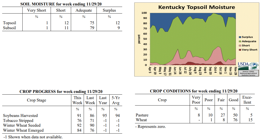 Kentucky Climate Summary
For the Period November 23, 2020 to November 29, 2020
Above Normal Temperatures and Below Normal Rainfall:
The Commonwealth saw a few rounds of showers through the period, a couple coming
midweek and the other on Sunday. Coverage turned widespread with the earlier rounds
on Tuesday night and Wednesday. Accumulations were highest along the Ohio River (~ 1
inch) and decreased to the southeast (< 0.10 inches). Breezy conditions accompanied
the rain with many seeing peak gusts between 25 and 40 mph. A few dry days followed
before the week closed with some light rain showers pushing back into the area on
Sunday. Some of the rain fell after the data cutoff and will not be reflected in
this report. Overall though, the state averaged a half inch for the week, marking a
second straight week of below normal rainfall. Conditions also ran mild for much of
the period, which led to a fourth straight week of above normal temperatures.
Temperatures for the period averaged 46 degrees across the state which was 2 degrees
warmer than normal and 4 degrees cooler than the previous period. High temperatures
averaged from 55 in the West to 56 in the East. Departure from normal high
temperatures ranged from 1 degree warmer than normal in the West to 2 degrees
warmer than normal in the East. Low temperatures averaged from 37 degrees in the
West to 37 degrees in the East. Departure from normal low temperature ranged from 2
degrees warmer than normal in the West to 6 degrees warmer than normal in the East.
The extreme high temperature for the period was 67 degrees at FORT CAMPBELL and the
extreme low was 22 degrees at VANCEBURG 6W.
Precipitation (liq. equ.) for the period totaled 0.50 inches statewide which was 0.56
inches below normal and 47% of normal. Precipitation totals by climate division, West
0.89 inches, Central 0.29 inches, Bluegrass 0.58 inches and East 0.26 inches, which
was 0.34, 0.83, 0.32 and 0.72 inches below normal. By station, precipitation totals
ranged from a low of 0.07 inches at LIBERTY 3SW to a high of 1.57 inches at PADUCAH ASOS.
---
Kentucky Crop and Weather Report
Issued 4:00 P.M., November 23, 2020 36-20
Agricultural News: Kentucky experienced above normal temperatures and below normal
rainfall over the past week. Precipitation for the week totaled 0.15 inches, 0.84
inches below normal. Temperatures averaged 49 degrees for the week, 3 degrees above
normal. Topsoil moisture was rated 1 percent very short, 10 percent short, 81 percent
adequate, and 8 percent surplus. Subsoil moisture was rated 1 percent very short, 9
percent short, 84 percent adequate, and 6 percent surplus. Days suitable for
fieldwork averaged 5.4 out of a possible seven.
Primary activities for this week included continued harvest of soybeans, stripping
tobacco, and planting winter wheat. Mostly dry weather this week allowed farmers to
forge ahead with fieldwork. Progress was interrupted by scattered rain through the
weekend. Soybean harvest remains behind last year and the five year average. Tobacco
stripping is ahead of both last year and the five year average for this juncture.
Seventy-six percent of the winter wheat crop has emerged with ninety percent planted.
The condition of winter wheat remains mostly good. Pastures are still in mostly good
shape and have benefitted from pockets of warm weather. Livestock are still grazing
grass at this time as farmers reserve their hay for the winter months.
The overall hay supply was reported as mostly adequate.
Kentucky Climate Summary
For the Period November 23, 2020 to November 29, 2020
Above Normal Temperatures and Below Normal Rainfall:
The Commonwealth saw a few rounds of showers through the period, a couple coming
midweek and the other on Sunday. Coverage turned widespread with the earlier rounds
on Tuesday night and Wednesday. Accumulations were highest along the Ohio River (~ 1
inch) and decreased to the southeast (< 0.10 inches). Breezy conditions accompanied
the rain with many seeing peak gusts between 25 and 40 mph. A few dry days followed
before the week closed with some light rain showers pushing back into the area on
Sunday. Some of the rain fell after the data cutoff and will not be reflected in
this report. Overall though, the state averaged a half inch for the week, marking a
second straight week of below normal rainfall. Conditions also ran mild for much of
the period, which led to a fourth straight week of above normal temperatures.
Temperatures for the period averaged 46 degrees across the state which was 2 degrees
warmer than normal and 4 degrees cooler than the previous period. High temperatures
averaged from 55 in the West to 56 in the East. Departure from normal high
temperatures ranged from 1 degree warmer than normal in the West to 2 degrees
warmer than normal in the East. Low temperatures averaged from 37 degrees in the
West to 37 degrees in the East. Departure from normal low temperature ranged from 2
degrees warmer than normal in the West to 6 degrees warmer than normal in the East.
The extreme high temperature for the period was 67 degrees at FORT CAMPBELL and the
extreme low was 22 degrees at VANCEBURG 6W.
Precipitation (liq. equ.) for the period totaled 0.50 inches statewide which was 0.56
inches below normal and 47% of normal. Precipitation totals by climate division, West
0.89 inches, Central 0.29 inches, Bluegrass 0.58 inches and East 0.26 inches, which
was 0.34, 0.83, 0.32 and 0.72 inches below normal. By station, precipitation totals
ranged from a low of 0.07 inches at LIBERTY 3SW to a high of 1.57 inches at PADUCAH ASOS.
---
Kentucky Crop and Weather Report
Issued 4:00 P.M., November 23, 2020 36-20
Agricultural News: Kentucky experienced above normal temperatures and below normal
rainfall over the past week. Precipitation for the week totaled 0.15 inches, 0.84
inches below normal. Temperatures averaged 49 degrees for the week, 3 degrees above
normal. Topsoil moisture was rated 1 percent very short, 10 percent short, 81 percent
adequate, and 8 percent surplus. Subsoil moisture was rated 1 percent very short, 9
percent short, 84 percent adequate, and 6 percent surplus. Days suitable for
fieldwork averaged 5.4 out of a possible seven.
Primary activities for this week included continued harvest of soybeans, stripping
tobacco, and planting winter wheat. Mostly dry weather this week allowed farmers to
forge ahead with fieldwork. Progress was interrupted by scattered rain through the
weekend. Soybean harvest remains behind last year and the five year average. Tobacco
stripping is ahead of both last year and the five year average for this juncture.
Seventy-six percent of the winter wheat crop has emerged with ninety percent planted.
The condition of winter wheat remains mostly good. Pastures are still in mostly good
shape and have benefitted from pockets of warm weather. Livestock are still grazing
grass at this time as farmers reserve their hay for the winter months.
The overall hay supply was reported as mostly adequate.
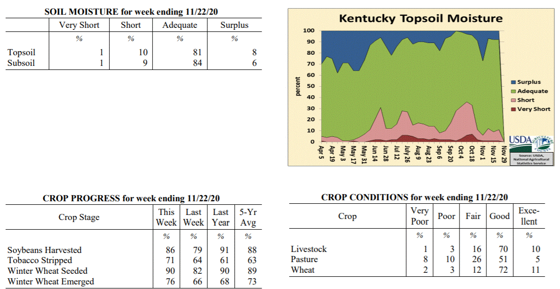 Kentucky Climate Summary
For the Period November 16, 2020 to November 22, 2020
Above Normal Temperatures and Below Normal Rainfall:
The week opened with dry and chilly conditions in place. The coldest temperatures
were seen Tuesday night as lows dropped into the 20s with clear skies in place. Even
had some stations drop into the low 20s. The second half of the workweek featured a
warming trend as winds transitioned to the south. Highs on Thursday and Friday rose
into the 60s. While it was mild, breezy conditions and low relativity humidity led
to an increased fire danger on Thursday. Rain returned over the weekend with the
passage of a cold front, but accumulations were very minimal. Despite some widespread
coverage, the state only averaged 0.15 inches. Some of the rain across Eastern
Kentucky fell after the data cutoff and will be reflected on the report next week.
Temperatures for the period averaged 49 degrees across the state which was 3 degrees
warmer than normal and 8 degrees cooler than the previous period. High temperatures
averaged from 61 in the West to 60 in the East. Departure from normal high
temperatures ranged from 4 degrees warmer than normal in the West to 4 degrees
warmer than normal in the East. Low temperatures averaged from 41 degrees in the
West to 37 degrees in the East. Departure from normal low temperature ranged from 4
degrees warmer than normal in the West to 4 degrees warmer than normal in the East.
The extreme high temperature for the period was 71 degrees at GREENVILLE 6N and the
extreme low was 20 degrees at VANCEBURG 6W.
Precipitation (liq. equ.) for the period totaled 0.15 inches statewide which was 0.84
inches below normal and 15% of normal. Precipitation totals by climate division, West
0.17 inches, Central 0.09 inches, Bluegrass 0.20 inches and East 0.13 inches, which
was 0.97, 0.96, 0.66 and 0.77 inches below normal. By station, precipitation totals
ranged from a low of 0.00 inches at BARBOURVILLE 3E to a high of 0.41 inches at
VANCEBURG 6W.
---
Kentucky Crop and Weather Report
Issued 4:00 P.M., November 16, 2020 35-20
Agricultural News: Kentucky experienced well above normal temperatures and above
normal rainfall over the past week. Precipitation for the week totaled 0.96 inches,
0.09 inches above normal. Temperatures averaged 56 degrees for the week, 7 degrees
above normal. Topsoil moisture was rated 1 percent very short, 8 percent short, 83
percent adequate, and 8 percent surplus. Subsoil moisture was rated 1 percent very
short, 9 percent short, 84 percent adequate, and 6 percent surplus. Days suitable for
fieldwork averaged 5.2 out of a possible seven.
Primary activities for this week included harvesting corn, soybeans, stripping
tobacco, and planting winter wheat. With warm, dry weather in the beginning of the
week farmers pushed ahead with fieldwork. As the weekend approached, conditions
became wet and much cooler in many areas of the state. Despite the late week weather,
corn is nearing harvest completion. Soybeans remain behind last year and the five
year average. Sixty-six percent of the winter wheat crop has emerged with eighty-two
percent planted. Higher humidity allowed tobacco stripping to move ahead.
The condition of winter wheat remains mostly good. Pastures are still in mostly good
shape and have had some late growth due to the conducive weather. The recent growth
will help preserve hay stocks as winter approaches.
Kentucky Climate Summary
For the Period November 16, 2020 to November 22, 2020
Above Normal Temperatures and Below Normal Rainfall:
The week opened with dry and chilly conditions in place. The coldest temperatures
were seen Tuesday night as lows dropped into the 20s with clear skies in place. Even
had some stations drop into the low 20s. The second half of the workweek featured a
warming trend as winds transitioned to the south. Highs on Thursday and Friday rose
into the 60s. While it was mild, breezy conditions and low relativity humidity led
to an increased fire danger on Thursday. Rain returned over the weekend with the
passage of a cold front, but accumulations were very minimal. Despite some widespread
coverage, the state only averaged 0.15 inches. Some of the rain across Eastern
Kentucky fell after the data cutoff and will be reflected on the report next week.
Temperatures for the period averaged 49 degrees across the state which was 3 degrees
warmer than normal and 8 degrees cooler than the previous period. High temperatures
averaged from 61 in the West to 60 in the East. Departure from normal high
temperatures ranged from 4 degrees warmer than normal in the West to 4 degrees
warmer than normal in the East. Low temperatures averaged from 41 degrees in the
West to 37 degrees in the East. Departure from normal low temperature ranged from 4
degrees warmer than normal in the West to 4 degrees warmer than normal in the East.
The extreme high temperature for the period was 71 degrees at GREENVILLE 6N and the
extreme low was 20 degrees at VANCEBURG 6W.
Precipitation (liq. equ.) for the period totaled 0.15 inches statewide which was 0.84
inches below normal and 15% of normal. Precipitation totals by climate division, West
0.17 inches, Central 0.09 inches, Bluegrass 0.20 inches and East 0.13 inches, which
was 0.97, 0.96, 0.66 and 0.77 inches below normal. By station, precipitation totals
ranged from a low of 0.00 inches at BARBOURVILLE 3E to a high of 0.41 inches at
VANCEBURG 6W.
---
Kentucky Crop and Weather Report
Issued 4:00 P.M., November 16, 2020 35-20
Agricultural News: Kentucky experienced well above normal temperatures and above
normal rainfall over the past week. Precipitation for the week totaled 0.96 inches,
0.09 inches above normal. Temperatures averaged 56 degrees for the week, 7 degrees
above normal. Topsoil moisture was rated 1 percent very short, 8 percent short, 83
percent adequate, and 8 percent surplus. Subsoil moisture was rated 1 percent very
short, 9 percent short, 84 percent adequate, and 6 percent surplus. Days suitable for
fieldwork averaged 5.2 out of a possible seven.
Primary activities for this week included harvesting corn, soybeans, stripping
tobacco, and planting winter wheat. With warm, dry weather in the beginning of the
week farmers pushed ahead with fieldwork. As the weekend approached, conditions
became wet and much cooler in many areas of the state. Despite the late week weather,
corn is nearing harvest completion. Soybeans remain behind last year and the five
year average. Sixty-six percent of the winter wheat crop has emerged with eighty-two
percent planted. Higher humidity allowed tobacco stripping to move ahead.
The condition of winter wheat remains mostly good. Pastures are still in mostly good
shape and have had some late growth due to the conducive weather. The recent growth
will help preserve hay stocks as winter approaches.
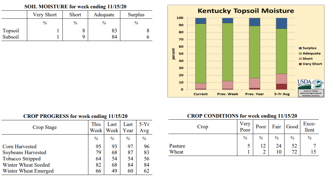 Kentucky Climate Summary
For the Period November 9, 2020 to November 15, 2020
Well Above Normal Temperatures and Above Normal Rainfall:
The week opened with an extension of dry conditions from the previous period. The
dry weather was accompanied by well above normal temperatures, record breaking in
some cases. Highs on Monday and Tuesday rose into the middle 70s to low 80s. The
exceptional warmth then ended on Tuesday night and Wednesday with the passage of a
cold front, which dropped temperatures back closer to seasonable norms for the second
half of the week. The boundary also brought a round of rainfall with totals much
more significant across the eastern half of Kentucky compared to the western half.
Another front then pushed through the area over the weekend. Combined with the first
boundary earlier in the period, the state averaged about an inch for the week. The
bigger story with the cold front over the weekend was the very breezy conditions in
place. As the boundary pushed through the region, most across Kentucky saw peak
gusts between 40 and 50 mph.
Temperatures for the period averaged 56 degrees across the state which was 7 degrees
warmer than normal and 2 degrees warmer than the previous period. High temperatures
averaged from 67 in the West to 68 in the East. Departure from normal high
temperatures ranged from 7 degrees warmer than normal in the West to 8 degrees
warmer than normal in the East. Low temperatures averaged from 47 degrees in the
West to 46 degrees in the East. Departure from normal low temperature ranged from 8
degrees warmer than normal in the West to 11 degrees warmer than normal in the
East. The extreme high temperature for the period was 85 degrees at JACKSON AIRPORT
and the extreme low was 27 degrees at CARLISLE 5SW.
Precipitation (liq. equ.) for the period totaled 0.96 inches statewide which was 0.09
inches above normal and 110% of normal. Precipitation totals by climate division,
West 0.89 inches, Central 0.77 inches, Bluegrass 0.78 inches and East 1.39 inches,
which was -0.15, -0.14, 0.03 and 0.61 inches respectively from normal. By station,
precipitation totals ranged from a low of 0.46 inches at MAYSVILLE 3SW to a high of
2.80 inches at PEABODY.
---
Kentucky Crop and Weather Report
Issued 4:00 P.M., November 9, 2020 34-20
Agricultural News: Kentucky experienced above normal temperatures and much below
normal rainfall over the past week. Precipitation for the week totaled 0.00 inches,
0.77 inches below normal. Temperatures averaged 54 degrees for the week, 3 degrees
above normal. Topsoil moisture was rated 1 percent very short, 11 percent short, 81
percent adequate, and 7 percent surplus. Subsoil moisture was rated 2 percent very
short, 10 percent short, 82 percent adequate, and 6 percent surplus. Days suitable
for fieldwork averaged 6.1 out of a possible seven.
Primary activities for this week included harvesting corn, soybeans, stripping
tobacco, and planting winter wheat. Weather for the week was conducive to strong
progress in the fields. Both the corn and soybean harvest trails last year at this
point in the season, however that margin will shrink as weather permits. Forty-nine
percent of the winter wheat crop has emerged with sixty-eight percent planted.
The condition of winter wheat remains good at this juncture. Pastures are still in
mostly good shape and will benefit from the warm weather this past week. Some farmers
were able to get a late season cutting of hay thanks to recent weather.
Kentucky Climate Summary
For the Period November 9, 2020 to November 15, 2020
Well Above Normal Temperatures and Above Normal Rainfall:
The week opened with an extension of dry conditions from the previous period. The
dry weather was accompanied by well above normal temperatures, record breaking in
some cases. Highs on Monday and Tuesday rose into the middle 70s to low 80s. The
exceptional warmth then ended on Tuesday night and Wednesday with the passage of a
cold front, which dropped temperatures back closer to seasonable norms for the second
half of the week. The boundary also brought a round of rainfall with totals much
more significant across the eastern half of Kentucky compared to the western half.
Another front then pushed through the area over the weekend. Combined with the first
boundary earlier in the period, the state averaged about an inch for the week. The
bigger story with the cold front over the weekend was the very breezy conditions in
place. As the boundary pushed through the region, most across Kentucky saw peak
gusts between 40 and 50 mph.
Temperatures for the period averaged 56 degrees across the state which was 7 degrees
warmer than normal and 2 degrees warmer than the previous period. High temperatures
averaged from 67 in the West to 68 in the East. Departure from normal high
temperatures ranged from 7 degrees warmer than normal in the West to 8 degrees
warmer than normal in the East. Low temperatures averaged from 47 degrees in the
West to 46 degrees in the East. Departure from normal low temperature ranged from 8
degrees warmer than normal in the West to 11 degrees warmer than normal in the
East. The extreme high temperature for the period was 85 degrees at JACKSON AIRPORT
and the extreme low was 27 degrees at CARLISLE 5SW.
Precipitation (liq. equ.) for the period totaled 0.96 inches statewide which was 0.09
inches above normal and 110% of normal. Precipitation totals by climate division,
West 0.89 inches, Central 0.77 inches, Bluegrass 0.78 inches and East 1.39 inches,
which was -0.15, -0.14, 0.03 and 0.61 inches respectively from normal. By station,
precipitation totals ranged from a low of 0.46 inches at MAYSVILLE 3SW to a high of
2.80 inches at PEABODY.
---
Kentucky Crop and Weather Report
Issued 4:00 P.M., November 9, 2020 34-20
Agricultural News: Kentucky experienced above normal temperatures and much below
normal rainfall over the past week. Precipitation for the week totaled 0.00 inches,
0.77 inches below normal. Temperatures averaged 54 degrees for the week, 3 degrees
above normal. Topsoil moisture was rated 1 percent very short, 11 percent short, 81
percent adequate, and 7 percent surplus. Subsoil moisture was rated 2 percent very
short, 10 percent short, 82 percent adequate, and 6 percent surplus. Days suitable
for fieldwork averaged 6.1 out of a possible seven.
Primary activities for this week included harvesting corn, soybeans, stripping
tobacco, and planting winter wheat. Weather for the week was conducive to strong
progress in the fields. Both the corn and soybean harvest trails last year at this
point in the season, however that margin will shrink as weather permits. Forty-nine
percent of the winter wheat crop has emerged with sixty-eight percent planted.
The condition of winter wheat remains good at this juncture. Pastures are still in
mostly good shape and will benefit from the warm weather this past week. Some farmers
were able to get a late season cutting of hay thanks to recent weather.
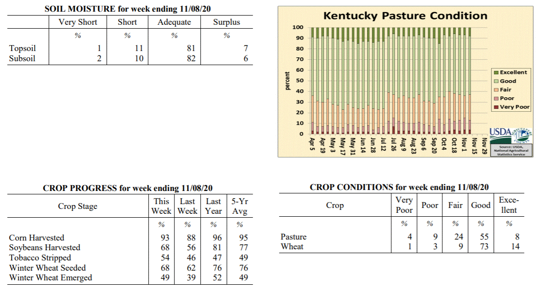 Kentucky Climate Summary
For the Period November 2, 2020 to November 8, 2020
Above Normal Temperatures and Much Below Normal Rainfall:
A hard freeze brought an end to the 2020 growing season on Monday morning as lows
dipped well into the 20s across the state. Many in the low to middle 20s. Otherwise,
the first full week of November featured perfect harvest weather with dry conditions,
sunny skies, and increasing temperatures in place. After the chilly start to the
period, high temperatures were back to around 70 for the second half of the work week.
The warming trend continued into the weekend with some record-breaking temperatures
on Sunday with highs in the upper 70s to low 80s. Just to put into perspective, these
temperatures were about 20 degrees above normal highs, which average in the upper 50s
to low 60s for this time of year.
Temperatures for the period averaged 54 degrees across the state which was 3 degrees
warmer than normal and 2 degrees warmer than the previous period. High temperatures
averaged from 71 in the West to 68 in the East. Departure from normal high
temperatures ranged from 8 degrees warmer than normal in the West to 5 degrees warmer
than normal in the East. Low temperatures averaged from 41 degrees in the West to 37
degrees in the East. Departure from normal low temperature ranged from near normal in
the West to near normal in the East. The extreme high temperature for the period was
83 degrees at GREENVILLE 6N and the extreme low was 21 degrees at BRANDENBURG 4SW.
Precipitation (liq. equ.) for the period totaled 0.00 inches statewide which was 0.77
inches below normal and 0% of normal. Precipitation totals by climate division, West
0.00 inches, Central 0.00 inches, Bluegrass 0.00 inches and East 0.00 inches, which
was 0.88, 0.8, 0.7 and 0.71 inches below normal. By station, precipitation totals
ranged from a low of 0.00 inches at ALBANY 1N to a high of 0.05 inches at POPLAR BLUFF ASOS.
---
Kentucky Crop and Weather Report
Issued 4:00 P.M., November 2, 2020 33-20
Agricultural News: Kentucky experienced below normal temperatures and much above
normal rainfall over the past week. Precipitation for the week totaled 2.16 inches,
1.39 inches above normal. Temperatures averaged 52 degrees for the week, 1 degree
below normal. Topsoil moisture was rated 1 percent very short, 5 percent short, 67
percent adequate, and 27 percent surplus. Subsoil moisture was rated 2 percent very
short, 7 percent short, 72 percent adequate, and 19 percent surplus. Days suitable
for fieldwork averaged 3.0 out of a possible seven.
Primary activities for this week included harvesting corn, soybeans, and stripping
tobacco along with seeding winter wheat. Widespread rain this past week slowed
fieldwork progress. Conditions improved by the weekend, however the ground remained
very wet with cold temperatures hindering the drying process. Stripping of tobacco is
slightly ahead of last year at this juncture. Thirty-nine percent of the winter wheat
crop has emerged.
The condition of winter wheat remains good. Housed tobacco condition deteriorated
from last week, but continues to be mostly good. Pastures are still in mostly good
shape, however colder temperatures may begin to limit growth. At this time, sixty-
five percent of feed for cattle is being obtained from pasture. Overall quality of
harvested hay is rated as mostly good.
Kentucky Climate Summary
For the Period November 2, 2020 to November 8, 2020
Above Normal Temperatures and Much Below Normal Rainfall:
A hard freeze brought an end to the 2020 growing season on Monday morning as lows
dipped well into the 20s across the state. Many in the low to middle 20s. Otherwise,
the first full week of November featured perfect harvest weather with dry conditions,
sunny skies, and increasing temperatures in place. After the chilly start to the
period, high temperatures were back to around 70 for the second half of the work week.
The warming trend continued into the weekend with some record-breaking temperatures
on Sunday with highs in the upper 70s to low 80s. Just to put into perspective, these
temperatures were about 20 degrees above normal highs, which average in the upper 50s
to low 60s for this time of year.
Temperatures for the period averaged 54 degrees across the state which was 3 degrees
warmer than normal and 2 degrees warmer than the previous period. High temperatures
averaged from 71 in the West to 68 in the East. Departure from normal high
temperatures ranged from 8 degrees warmer than normal in the West to 5 degrees warmer
than normal in the East. Low temperatures averaged from 41 degrees in the West to 37
degrees in the East. Departure from normal low temperature ranged from near normal in
the West to near normal in the East. The extreme high temperature for the period was
83 degrees at GREENVILLE 6N and the extreme low was 21 degrees at BRANDENBURG 4SW.
Precipitation (liq. equ.) for the period totaled 0.00 inches statewide which was 0.77
inches below normal and 0% of normal. Precipitation totals by climate division, West
0.00 inches, Central 0.00 inches, Bluegrass 0.00 inches and East 0.00 inches, which
was 0.88, 0.8, 0.7 and 0.71 inches below normal. By station, precipitation totals
ranged from a low of 0.00 inches at ALBANY 1N to a high of 0.05 inches at POPLAR BLUFF ASOS.
---
Kentucky Crop and Weather Report
Issued 4:00 P.M., November 2, 2020 33-20
Agricultural News: Kentucky experienced below normal temperatures and much above
normal rainfall over the past week. Precipitation for the week totaled 2.16 inches,
1.39 inches above normal. Temperatures averaged 52 degrees for the week, 1 degree
below normal. Topsoil moisture was rated 1 percent very short, 5 percent short, 67
percent adequate, and 27 percent surplus. Subsoil moisture was rated 2 percent very
short, 7 percent short, 72 percent adequate, and 19 percent surplus. Days suitable
for fieldwork averaged 3.0 out of a possible seven.
Primary activities for this week included harvesting corn, soybeans, and stripping
tobacco along with seeding winter wheat. Widespread rain this past week slowed
fieldwork progress. Conditions improved by the weekend, however the ground remained
very wet with cold temperatures hindering the drying process. Stripping of tobacco is
slightly ahead of last year at this juncture. Thirty-nine percent of the winter wheat
crop has emerged.
The condition of winter wheat remains good. Housed tobacco condition deteriorated
from last week, but continues to be mostly good. Pastures are still in mostly good
shape, however colder temperatures may begin to limit growth. At this time, sixty-
five percent of feed for cattle is being obtained from pasture. Overall quality of
harvested hay is rated as mostly good.
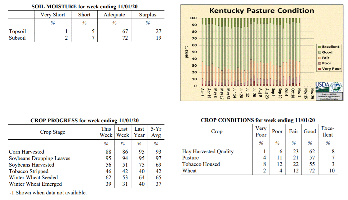 Kentucky Climate Summary
For the Period October 26, 2020 to November 1, 2020
Below Normal Temperatures and Much Above Normal Rainfall:
October closed with an active weather pattern in place. The most significant
accumulations were seen on Wednesday and Thursday as a combination of a strong
disturbance aloft and the remnants of Hurricane Zeta produced widespread rainfall
across the state. Over these 2 days, most of Kentucky saw 1 to 3+ inches. The higher
end of these totals were primarily across Western Kentucky and extending northeast
for a tier of two counties close to the Ohio River. Combined with lighter
accumulations earlier in the period, the state averaged 2.16 inches, marking a second
straight week of above normal rainfall. Behind the system on Thursday, much cooler
air filtered into the area on Friday and the weekend. Frost was prevalent on Saturday
morning as lows dipped into the low to middle 30s. A stronger cold front then swept
through the area on Sunday. While the frontal passage was dry, strong winds
accompanied the boundary, gusting between 30 and 40 mph from time to time. The cold
temperatures behind this front will be reflected on next week�s report.
Temperatures for the period averaged 52 degrees across the state which was 1 degree
cooler than normal and 10 degrees cooler than the previous period. High temperatures
averaged from 57 in the West to 61 in the East. Departure from normal high
temperatures ranged from 9 degrees cooler than normal in the West to 5 degrees
cooler than normal in the East. Low temperatures averaged from 44 degrees in the
West to 48 degrees in the East. Departure from normal low temperature ranged from 1
degree warmer than normal in the West to 9 degrees warmer than normal in the East.
The extreme high temperature for the period was 80 degrees at MIDDLESBORO AWOS and
the extreme low was 28 degrees at CARLISLE 5SW.
Precipitation (liq. equ.) for the period totaled 2.16 inches statewide which was 1.39
inches above normal and 280% of normal. Precipitation totals by climate division,
West 3.31 inches, Central 1.69 inches, Bluegrass 2.14 inches and East 1.50 inches,
which was 2.45, 0.89, 1.43 and 0.78 inches above normal. By station, precipitation
totals ranged from a low of 0.63 inches at ALBANY 1N to a high of 4.67 inches at
HENDERSON 5E.
---
Kentucky Crop and Weather Report
Issued 4:00 P.M., October 26, 2020 32-20
Agricultural News: Kentucky experienced above normal temperatures and rainfall over
the past week. Precipitation for the week totaled 1.68 inches, 0.98 inches above
normal. Temperatures averaged 62 degrees for the week, 6 degrees above normal.
Topsoil moisture was rated 2 percent very short, 9 percent short, 80 percent
adequate, and 9 percent surplus. Subsoil moisture was rated 3 percent very short, 12
percent short, 78 percent adequate, and 7 percent surplus. Days suitable for
fieldwork averaged 4.0 out of a possible seven.
Primary activities for this week included harvesting corn, soybeans, and stripping
tobacco, along with seeding winter wheat. Harvesting progress was stymied at times
due to widespread rainfall this past week. Although the precipitation was a hindrance
in the fields, it did help to promote some pasture growth, as many areas were getting
very dry. Many farmers have completed their last cutting of hay and additional
grazing time will protect hay stocks for the winter months.
The condition of winter wheat is mostly good at this juncture. Housed tobacco
condition declined slightly from the previous week, but remains mostly good. Pastures
are still in mostly good shape and, as mentioned above, will benefit from rain
this week. Livestock are in good shape, as farmers will allow grazing as long as
pasture growth permits.
Kentucky Climate Summary
For the Period October 26, 2020 to November 1, 2020
Below Normal Temperatures and Much Above Normal Rainfall:
October closed with an active weather pattern in place. The most significant
accumulations were seen on Wednesday and Thursday as a combination of a strong
disturbance aloft and the remnants of Hurricane Zeta produced widespread rainfall
across the state. Over these 2 days, most of Kentucky saw 1 to 3+ inches. The higher
end of these totals were primarily across Western Kentucky and extending northeast
for a tier of two counties close to the Ohio River. Combined with lighter
accumulations earlier in the period, the state averaged 2.16 inches, marking a second
straight week of above normal rainfall. Behind the system on Thursday, much cooler
air filtered into the area on Friday and the weekend. Frost was prevalent on Saturday
morning as lows dipped into the low to middle 30s. A stronger cold front then swept
through the area on Sunday. While the frontal passage was dry, strong winds
accompanied the boundary, gusting between 30 and 40 mph from time to time. The cold
temperatures behind this front will be reflected on next week�s report.
Temperatures for the period averaged 52 degrees across the state which was 1 degree
cooler than normal and 10 degrees cooler than the previous period. High temperatures
averaged from 57 in the West to 61 in the East. Departure from normal high
temperatures ranged from 9 degrees cooler than normal in the West to 5 degrees
cooler than normal in the East. Low temperatures averaged from 44 degrees in the
West to 48 degrees in the East. Departure from normal low temperature ranged from 1
degree warmer than normal in the West to 9 degrees warmer than normal in the East.
The extreme high temperature for the period was 80 degrees at MIDDLESBORO AWOS and
the extreme low was 28 degrees at CARLISLE 5SW.
Precipitation (liq. equ.) for the period totaled 2.16 inches statewide which was 1.39
inches above normal and 280% of normal. Precipitation totals by climate division,
West 3.31 inches, Central 1.69 inches, Bluegrass 2.14 inches and East 1.50 inches,
which was 2.45, 0.89, 1.43 and 0.78 inches above normal. By station, precipitation
totals ranged from a low of 0.63 inches at ALBANY 1N to a high of 4.67 inches at
HENDERSON 5E.
---
Kentucky Crop and Weather Report
Issued 4:00 P.M., October 26, 2020 32-20
Agricultural News: Kentucky experienced above normal temperatures and rainfall over
the past week. Precipitation for the week totaled 1.68 inches, 0.98 inches above
normal. Temperatures averaged 62 degrees for the week, 6 degrees above normal.
Topsoil moisture was rated 2 percent very short, 9 percent short, 80 percent
adequate, and 9 percent surplus. Subsoil moisture was rated 3 percent very short, 12
percent short, 78 percent adequate, and 7 percent surplus. Days suitable for
fieldwork averaged 4.0 out of a possible seven.
Primary activities for this week included harvesting corn, soybeans, and stripping
tobacco, along with seeding winter wheat. Harvesting progress was stymied at times
due to widespread rainfall this past week. Although the precipitation was a hindrance
in the fields, it did help to promote some pasture growth, as many areas were getting
very dry. Many farmers have completed their last cutting of hay and additional
grazing time will protect hay stocks for the winter months.
The condition of winter wheat is mostly good at this juncture. Housed tobacco
condition declined slightly from the previous week, but remains mostly good. Pastures
are still in mostly good shape and, as mentioned above, will benefit from rain
this week. Livestock are in good shape, as farmers will allow grazing as long as
pasture growth permits.
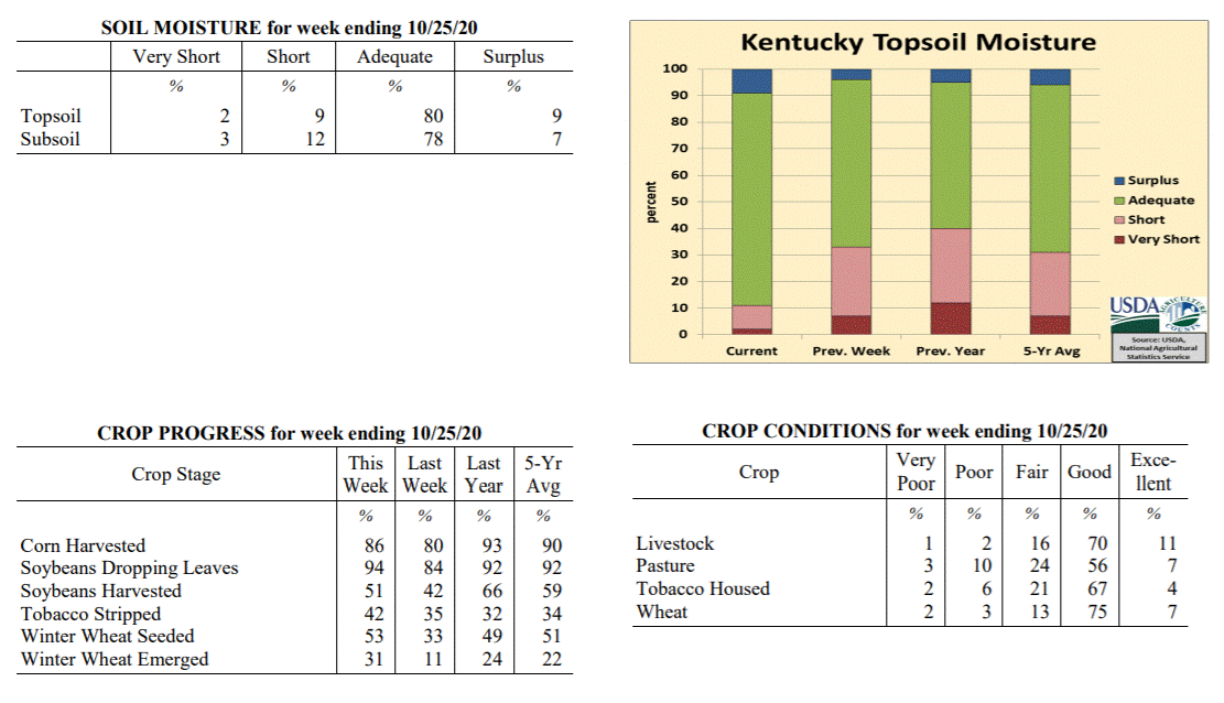 Kentucky Climate Summary
For the Period October 19, 2020 to October 25, 2020
Above Normal Temperatures and Rainfall:
Leading into this period, Kentucky had been running on the dry side with five
straight weeks of below normal rainfall. The dry pattern came to an abrupt halt this
week as Kentucky averaged 1.68 inches behind multiple rounds of soaking rainfall. The
first event came on Monday as multiple disturbances passed over a stalled frontal
boundary. Warm and mild conditions followed for a few days, before a second round on
Friday as a strong cold front sparked scattered to numerous showers and storms across
the region. A cool weekend followed with occasional periods of light showers/drizzle.
Overall, the highest accumulations for the week were seen across Western/Central
Kentucky and up into the Bluegrass region. In fact, a large section of this area saw
2+ inches. Totals diminished farther east as Eastern Kentucky averaged a little under
a half inch for the week. After a dry first half of the month, this week of wet
weather has taken the state average closer to normal for the month of October.
Temperatures for the period averaged 62 degrees across the state which was 6 degrees
warmer than normal and 6 degrees warmer than the previous period. High temperatures
averaged from 69 in the West to 74 in the East. Departure from normal high
temperatures ranged from 1 degree cooler than normal in the West to 6 degrees
warmer than normal in the East. Low temperatures averaged from 53 degrees in the
West to 53 degrees in the East. Departure from normal low temperature ranged from 8
degrees warmer than normal in the West to 12 degrees warmer than normal in the
East. The extreme high temperature for the period was 85 degrees at CADIZ 4SW and the
extreme low was 43 degrees at ALEXANDRIA 5NW.
Precipitation (liq. equ.) for the period totaled 1.68 inches statewide which was 0.98
inches above normal and 238% of normal. Precipitation totals by climate division,
West 2.35 inches, Central 1.86 inches, Bluegrass 2.04 inches and East 0.48 inches,
which was 1.56, 1.15, 1.39 and -0.19 inches respectively from normal. By station,
precipitation totals ranged from a low of 0.16 inches at HINDMAN 5N to a high of 5.57
inches at SHEPHERDSVILLE 6SE.
---
Kentucky Crop and Weather Report
Issued 4:00 P.M., October 19, 2020 31-20
Agricultural News: Kentucky experienced near normal temperatures and below normal
rainfall over the past week. Precipitation for the week totaled 0.24 inches, 0.46
inches below normal. Temperatures averaged 57 degrees for the week, 6 degrees below
normal. Topsoil moisture was rated 7 percent very short, 26 percent short, 63 percent
adequate, and 4 percent surplus. Subsoil moisture was rated 5 percent very short, 26
percent short, 65 percent adequate, and 4 percent surplus. Days suitable for
fieldwork averaged 5.6 out of a possible seven.
Primary activities for this week included harvesting corn, soybeans, and stripping
tobacco along with seeding winter wheat. Despite a few scattered showers, harvesting
moved ahead as most of the week was cool and dry. Farmers continue to get the wheat
crop in the ground as a small portion has emerged.
The condition of the soybean crop continues to be good overall. Housed tobacco
condition declined slightly from the previous week, but remains mostly good at this
juncture. Pastures are still in mostly good shape, however as temperatures continue
to cool, growth will slow. Most farmers have completed their last hay cutting, but
stocks should be good overall.
Kentucky Climate Summary
For the Period October 19, 2020 to October 25, 2020
Above Normal Temperatures and Rainfall:
Leading into this period, Kentucky had been running on the dry side with five
straight weeks of below normal rainfall. The dry pattern came to an abrupt halt this
week as Kentucky averaged 1.68 inches behind multiple rounds of soaking rainfall. The
first event came on Monday as multiple disturbances passed over a stalled frontal
boundary. Warm and mild conditions followed for a few days, before a second round on
Friday as a strong cold front sparked scattered to numerous showers and storms across
the region. A cool weekend followed with occasional periods of light showers/drizzle.
Overall, the highest accumulations for the week were seen across Western/Central
Kentucky and up into the Bluegrass region. In fact, a large section of this area saw
2+ inches. Totals diminished farther east as Eastern Kentucky averaged a little under
a half inch for the week. After a dry first half of the month, this week of wet
weather has taken the state average closer to normal for the month of October.
Temperatures for the period averaged 62 degrees across the state which was 6 degrees
warmer than normal and 6 degrees warmer than the previous period. High temperatures
averaged from 69 in the West to 74 in the East. Departure from normal high
temperatures ranged from 1 degree cooler than normal in the West to 6 degrees
warmer than normal in the East. Low temperatures averaged from 53 degrees in the
West to 53 degrees in the East. Departure from normal low temperature ranged from 8
degrees warmer than normal in the West to 12 degrees warmer than normal in the
East. The extreme high temperature for the period was 85 degrees at CADIZ 4SW and the
extreme low was 43 degrees at ALEXANDRIA 5NW.
Precipitation (liq. equ.) for the period totaled 1.68 inches statewide which was 0.98
inches above normal and 238% of normal. Precipitation totals by climate division,
West 2.35 inches, Central 1.86 inches, Bluegrass 2.04 inches and East 0.48 inches,
which was 1.56, 1.15, 1.39 and -0.19 inches respectively from normal. By station,
precipitation totals ranged from a low of 0.16 inches at HINDMAN 5N to a high of 5.57
inches at SHEPHERDSVILLE 6SE.
---
Kentucky Crop and Weather Report
Issued 4:00 P.M., October 19, 2020 31-20
Agricultural News: Kentucky experienced near normal temperatures and below normal
rainfall over the past week. Precipitation for the week totaled 0.24 inches, 0.46
inches below normal. Temperatures averaged 57 degrees for the week, 6 degrees below
normal. Topsoil moisture was rated 7 percent very short, 26 percent short, 63 percent
adequate, and 4 percent surplus. Subsoil moisture was rated 5 percent very short, 26
percent short, 65 percent adequate, and 4 percent surplus. Days suitable for
fieldwork averaged 5.6 out of a possible seven.
Primary activities for this week included harvesting corn, soybeans, and stripping
tobacco along with seeding winter wheat. Despite a few scattered showers, harvesting
moved ahead as most of the week was cool and dry. Farmers continue to get the wheat
crop in the ground as a small portion has emerged.
The condition of the soybean crop continues to be good overall. Housed tobacco
condition declined slightly from the previous week, but remains mostly good at this
juncture. Pastures are still in mostly good shape, however as temperatures continue
to cool, growth will slow. Most farmers have completed their last hay cutting, but
stocks should be good overall.
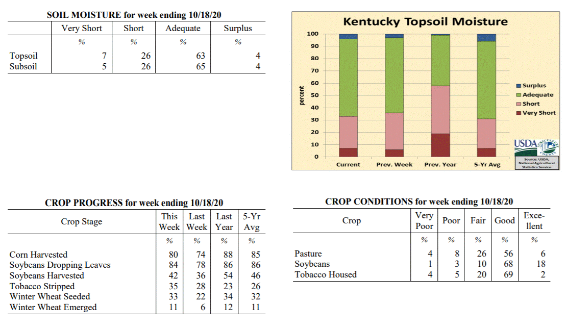 Kentucky Climate Summary
For the Period October 12, 2020 to October 18, 2020
Near Normal Temperatures and Below Normal Rainfall:
Focus for the week revolved around a couple cold fronts. The first pushed through the
area on Monday and Monday night, accompanied by a quick-hitting broken line of
showers. Most saw a quarter inch or less. The boundary was followed by a stronger
cold front on Thursday. This front was also accompanied by some light showers with
most under a tenth of an inch. The bigger change came in the way of temperatures.
Highs struggled in the 50s on Friday and was followed by a very cool night areawide.
The majority of Kentucky saw temperatures dip into the low to middle 30s. Several even
fell into the upper 20s. Looking at average freeze dates, most locations in Kentucky
see the first 32-degree temperature of the fall season over the second half of
October. Temperatures did trend a bit warmer over the weekend, and once again, the
state saw a light round of scattered showers on Sunday. Overall though, Kentucky
averaged about a quarter inch for the week, marking a fifth straight week that the
state average has ran below normal.
Temperatures for the period averaged 57 degrees across the state which was near
normal and 6 degrees cooler than the previous period. High temperatures averaged from
69 in the West to 68 in the East. Departure from normal high temperatures ranged from
3 degrees cooler than normal in the West to 2 degrees cooler than normal in the East.
Low temperatures averaged from 45 degrees in the West to 46 degrees in the East.
Departure from normal low temperature ranged from 2 degrees cooler than normal in the
West to 3 degrees warmer than normal in the East. The extreme high temperature for
the period was 83 degrees at BOWLING GREEN APT and the extreme low was 26 degrees
at CARLISLE 5SW.
Precipitation (liq. equ.) for the period totaled 0.24 inches statewide which was 0.46
inches below normal and 34% of normal. Precipitation totals by climate division, West
0.18 inches, Central 0.22 inches, Bluegrass 0.16 inches and East 0.38 inches, which
was 0.56, 0.5, 0.51 and 0.31 inches below normal. By station, precipitation totals
ranged from a low of 0.05 inches at CARBONDALE ASOS to a high of 0.67 inches at PEABODY.
---
Kentucky Crop and Weather Report
Issued 4:00 P.M., October 12, 2020 30-20
Agricultural News: Kentucky experienced above normal temperatures and below normal
rainfall over the past week. Precipitation for the week totaled 0.47 inches, 0.30
inches below normal. Temperatures averaged 63 degrees for the week, 3 degrees above
normal. Topsoil moisture was rated 6 percent very short, 30 percent short, 61 percent
adequate, and 3 percent surplus. Subsoil moisture was rated 5 percent very short, 28
percent short, 65 percent adequate, and 2 percent surplus. Days suitable for
fieldwork averaged 5.9 out of a possible seven.
Primary activities for this week included harvesting corn, soybeans, and stripping
tobacco, along with seeding winter wheat. Harvesting progress remains steady as dry
conditions prevailed over the previous week. Hurricane Delta brought some rain over
the weekend, however, it was not widespread. As winter wheat planting continues, a
small portion of the crop has emerged.
The condition of the soybean crop continues to be good overall. Housed tobacco
condition is mostly good, however, more houseburn was evident this week. While
pastures have benefitted from timely rain in some areas, others have seen reduced
growth from dry conditions. In parts of the state, cattle producers may start feeding
hay if the dry weather persists.
Kentucky Climate Summary
For the Period October 12, 2020 to October 18, 2020
Near Normal Temperatures and Below Normal Rainfall:
Focus for the week revolved around a couple cold fronts. The first pushed through the
area on Monday and Monday night, accompanied by a quick-hitting broken line of
showers. Most saw a quarter inch or less. The boundary was followed by a stronger
cold front on Thursday. This front was also accompanied by some light showers with
most under a tenth of an inch. The bigger change came in the way of temperatures.
Highs struggled in the 50s on Friday and was followed by a very cool night areawide.
The majority of Kentucky saw temperatures dip into the low to middle 30s. Several even
fell into the upper 20s. Looking at average freeze dates, most locations in Kentucky
see the first 32-degree temperature of the fall season over the second half of
October. Temperatures did trend a bit warmer over the weekend, and once again, the
state saw a light round of scattered showers on Sunday. Overall though, Kentucky
averaged about a quarter inch for the week, marking a fifth straight week that the
state average has ran below normal.
Temperatures for the period averaged 57 degrees across the state which was near
normal and 6 degrees cooler than the previous period. High temperatures averaged from
69 in the West to 68 in the East. Departure from normal high temperatures ranged from
3 degrees cooler than normal in the West to 2 degrees cooler than normal in the East.
Low temperatures averaged from 45 degrees in the West to 46 degrees in the East.
Departure from normal low temperature ranged from 2 degrees cooler than normal in the
West to 3 degrees warmer than normal in the East. The extreme high temperature for
the period was 83 degrees at BOWLING GREEN APT and the extreme low was 26 degrees
at CARLISLE 5SW.
Precipitation (liq. equ.) for the period totaled 0.24 inches statewide which was 0.46
inches below normal and 34% of normal. Precipitation totals by climate division, West
0.18 inches, Central 0.22 inches, Bluegrass 0.16 inches and East 0.38 inches, which
was 0.56, 0.5, 0.51 and 0.31 inches below normal. By station, precipitation totals
ranged from a low of 0.05 inches at CARBONDALE ASOS to a high of 0.67 inches at PEABODY.
---
Kentucky Crop and Weather Report
Issued 4:00 P.M., October 12, 2020 30-20
Agricultural News: Kentucky experienced above normal temperatures and below normal
rainfall over the past week. Precipitation for the week totaled 0.47 inches, 0.30
inches below normal. Temperatures averaged 63 degrees for the week, 3 degrees above
normal. Topsoil moisture was rated 6 percent very short, 30 percent short, 61 percent
adequate, and 3 percent surplus. Subsoil moisture was rated 5 percent very short, 28
percent short, 65 percent adequate, and 2 percent surplus. Days suitable for
fieldwork averaged 5.9 out of a possible seven.
Primary activities for this week included harvesting corn, soybeans, and stripping
tobacco, along with seeding winter wheat. Harvesting progress remains steady as dry
conditions prevailed over the previous week. Hurricane Delta brought some rain over
the weekend, however, it was not widespread. As winter wheat planting continues, a
small portion of the crop has emerged.
The condition of the soybean crop continues to be good overall. Housed tobacco
condition is mostly good, however, more houseburn was evident this week. While
pastures have benefitted from timely rain in some areas, others have seen reduced
growth from dry conditions. In parts of the state, cattle producers may start feeding
hay if the dry weather persists.
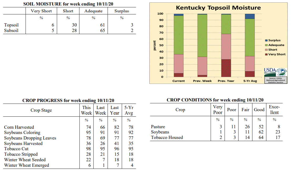 Kentucky Climate Summary
For the Period October 5, 2020 to October 11, 2020
Above Normal Temperatures and Below Normal Rainfall:
The Commonwealth saw the remnants of Hurricane Delta pass through the region this
period, bringing widespread rainfall to predominantly Eastern Kentucky on Saturday
and Sunday. Much of Southeastern Kentucky saw between 0.75 and 1.5 inches. Totals
diminished greatly father west and north across the rest of Kentucky. In fact, while
Eastern Kentucky averaged over an inch for the week, Western Kentucky and the
Bluegrass region both averaged less than a quarter inch. This event accounted for
nearly all of the rainfall for the period as the state remained mostly dry throughout
the work week. Temperatures also remained mild for much of the period. The one
exception came on Monday with well below normal temperatures in place. Many woke up
on Monday morning to temperatures in the 30s. Much of Western and West-Central
Kentucky dipped into the low to middle 30s, resulting in some light patchy frost.
Temperatures for the period averaged 63 degrees across the state which was 3 degrees
warmer than normal and 6 degrees warmer than the previous period. High temperatures
averaged from 77 in the West to 72 in the East. Departure from normal high
temperatures ranged from 3 degrees warmer than normal in the West to near normal in
the East. Low temperatures averaged from 51 degrees in the West to 52 degrees in the
East. Departure from normal low temperature ranged from 2 degrees warmer than normal
in the West to 7 degrees warmer than normal in the East. The extreme high temperature
for the period was 87 degrees at CARBONDALE ASOS and the extreme low was 29 degrees
at HENDERSON 5E.
Precipitation (liq. equ.) for the period totaled 0.47 inches statewide which was 0.3
inches below normal and 61% of normal. Precipitation totals by climate division, West
0.22 inches, Central 0.41 inches, Bluegrass 0.19 inches and East 1.04 inches, which
was -0.56, -0.39, -0.54 and 0.27 inches respectively from normal. By station,
precipitation totals ranged from a low of 0.00 inches at CAPE GIRARDEAU ASOS to a
high of 1.50 inches at JACKSON 3SE.
---
Kentucky Crop and Weather Report
Issued 4:00 P.M., October 5, 2020 29-20
Agricultural News: Kentucky experienced below normal temperatures and rainfall over
the past week. Precipitation for the week totaled 0.62 inches, 0.18 inches below
normal. Temperatures averaged 58 degrees for the week, 4 degrees below normal.
Topsoil moisture was rated 3 percent very short, 29 percent short, 67 percent
adequate, and 1 percent surplus. Subsoil moisture was rated 4 percent very short, 22
percent short, 73 percent adequate, and 1 percent surplus. Days suitable for
fieldwork averaged 6.0 out of a possible seven.
Primary activities for this week included harvesting corn, soybeans, and tobacco.
Harvesting progress has been aided by mostly dry conditions throughout the state.
Planting of winter wheat continues with a small portion of the crop emerged.
The downfall of limited precipitation has been stress and early maturation for double
crop soybeans. Although the weather has been good for curing cut hay, yields may have
been affected in some cases. The condition of the soybean crop continues to be good
overall. Housed tobacco condition is mostly good as the houseburn reported was light.
Pastures are still replenishing as farmers are holding hay for the winter months.
Kentucky Climate Summary
For the Period October 5, 2020 to October 11, 2020
Above Normal Temperatures and Below Normal Rainfall:
The Commonwealth saw the remnants of Hurricane Delta pass through the region this
period, bringing widespread rainfall to predominantly Eastern Kentucky on Saturday
and Sunday. Much of Southeastern Kentucky saw between 0.75 and 1.5 inches. Totals
diminished greatly father west and north across the rest of Kentucky. In fact, while
Eastern Kentucky averaged over an inch for the week, Western Kentucky and the
Bluegrass region both averaged less than a quarter inch. This event accounted for
nearly all of the rainfall for the period as the state remained mostly dry throughout
the work week. Temperatures also remained mild for much of the period. The one
exception came on Monday with well below normal temperatures in place. Many woke up
on Monday morning to temperatures in the 30s. Much of Western and West-Central
Kentucky dipped into the low to middle 30s, resulting in some light patchy frost.
Temperatures for the period averaged 63 degrees across the state which was 3 degrees
warmer than normal and 6 degrees warmer than the previous period. High temperatures
averaged from 77 in the West to 72 in the East. Departure from normal high
temperatures ranged from 3 degrees warmer than normal in the West to near normal in
the East. Low temperatures averaged from 51 degrees in the West to 52 degrees in the
East. Departure from normal low temperature ranged from 2 degrees warmer than normal
in the West to 7 degrees warmer than normal in the East. The extreme high temperature
for the period was 87 degrees at CARBONDALE ASOS and the extreme low was 29 degrees
at HENDERSON 5E.
Precipitation (liq. equ.) for the period totaled 0.47 inches statewide which was 0.3
inches below normal and 61% of normal. Precipitation totals by climate division, West
0.22 inches, Central 0.41 inches, Bluegrass 0.19 inches and East 1.04 inches, which
was -0.56, -0.39, -0.54 and 0.27 inches respectively from normal. By station,
precipitation totals ranged from a low of 0.00 inches at CAPE GIRARDEAU ASOS to a
high of 1.50 inches at JACKSON 3SE.
---
Kentucky Crop and Weather Report
Issued 4:00 P.M., October 5, 2020 29-20
Agricultural News: Kentucky experienced below normal temperatures and rainfall over
the past week. Precipitation for the week totaled 0.62 inches, 0.18 inches below
normal. Temperatures averaged 58 degrees for the week, 4 degrees below normal.
Topsoil moisture was rated 3 percent very short, 29 percent short, 67 percent
adequate, and 1 percent surplus. Subsoil moisture was rated 4 percent very short, 22
percent short, 73 percent adequate, and 1 percent surplus. Days suitable for
fieldwork averaged 6.0 out of a possible seven.
Primary activities for this week included harvesting corn, soybeans, and tobacco.
Harvesting progress has been aided by mostly dry conditions throughout the state.
Planting of winter wheat continues with a small portion of the crop emerged.
The downfall of limited precipitation has been stress and early maturation for double
crop soybeans. Although the weather has been good for curing cut hay, yields may have
been affected in some cases. The condition of the soybean crop continues to be good
overall. Housed tobacco condition is mostly good as the houseburn reported was light.
Pastures are still replenishing as farmers are holding hay for the winter months.
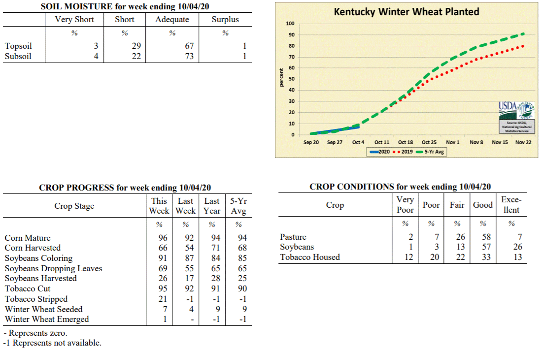 Kentucky Climate Summary
For the Period September 28, 2020 to October 4, 2020
Below Normal Temperatures and Rainfall:
Below normal rainfall continued for a third straight week, but unlike the previous
two, Kentucky did see some significant rainfall on Monday with the passage of a cold
front. Overall, the state averaged 0.62 inches for the week, most of which falling
with this boundary. Outside of some spotty light showers on Tuesday, Thursday, and
Sunday; the rest of the week followed a mostly dry and cool pattern. The coolest
temperatures were seen on Friday and over the weekend as highs struggled in the 60s.
Low temperatures both Friday and Saturday mornings dipped into the middle 30s to low
40s, opening the opportunity for some patchy frost in sheltered and low lying
locations. As a side note, the state has averaged 1.78 inches over the past 30 days,
which is about 1.75 inches below normal.
Temperatures for the period averaged 58 degrees across the state which was 4 degrees
cooler than normal and 6 degrees cooler than the previous period. High temperatures
averaged from 70 in the West to 68 in the East. Departure from normal high
temperatures ranged from 6 degrees cooler than normal in the West to 6 degrees cooler
than normal in the East. Low temperatures averaged from 46 degrees in the West to 48
degrees in the East. Departure from normal low temperature ranged from 6 degrees
cooler than normal in the West to near normal in the East. The extreme high
temperature for the period was 83 degrees at CARBONDALE ASOS and the extreme low was
34 degrees at CARLISLE 5SW.
Precipitation (liq. equ.) for the period totaled 0.62 inches statewide which was 0.18
inches below normal and 78% of normal. Precipitation totals by climate division, West
0.68 inches, Central 0.41 inches, Bluegrass 0.57 inches and East 0.84 inches, which
was -0.14, -0.44, -0.17 and 0.05 inches respectively from normal. By station,
precipitation totals ranged from a low of 0.16 inches at HODGENVILLE 2E to a high of
1.37 inches at TRIANGLE MOUNTAIN.
---
Kentucky Crop and Weather Report
Issued 4:00 P.M., September 28, 2020 28-20
Agricultural News: Kentucky experienced below normal temperatures and much below
normal rainfall over the past week. Precipitation for the week totaled 0.11 inches,
0.74 inches below normal. Temperatures averaged 64 degrees for the week, 2 degrees
below normal. Topsoil moisture was rated 1 percent very short, 27 percent short, and
72 percent adequate. Subsoil moisture was rated 1 percent very short, 20 percent
short, and 79 percent adequate. Days suitable for fieldwork averaged 5.9 out of a
possible seven.
Primary activities for this week included harvesting corn, soybeans, tobacco, and
hay. Winter wheat planting has begun, however the majority of the crop is not yet in
the ground. Dry weather of late has allowed farmers to push forward with all manner
of fieldwork. As the soybean and corn harvest continues, there is some optimism for
yields in areas of the state. With that said, later planted and double cropped
soybeans could be subject to stress as dry weather persists.
Both corn and soybeans are doing well overall as both crops saw an increase in the
amount reported as in excellent condition. Housed tobacco condition is mostly good as
the houseburn reported was light. Despite the dry conditions, pastureland and
livestock are in good shape. Hay supply is adequate at this juncture and is being
aided by the continuing growth in pastures.
Kentucky Climate Summary
For the Period September 28, 2020 to October 4, 2020
Below Normal Temperatures and Rainfall:
Below normal rainfall continued for a third straight week, but unlike the previous
two, Kentucky did see some significant rainfall on Monday with the passage of a cold
front. Overall, the state averaged 0.62 inches for the week, most of which falling
with this boundary. Outside of some spotty light showers on Tuesday, Thursday, and
Sunday; the rest of the week followed a mostly dry and cool pattern. The coolest
temperatures were seen on Friday and over the weekend as highs struggled in the 60s.
Low temperatures both Friday and Saturday mornings dipped into the middle 30s to low
40s, opening the opportunity for some patchy frost in sheltered and low lying
locations. As a side note, the state has averaged 1.78 inches over the past 30 days,
which is about 1.75 inches below normal.
Temperatures for the period averaged 58 degrees across the state which was 4 degrees
cooler than normal and 6 degrees cooler than the previous period. High temperatures
averaged from 70 in the West to 68 in the East. Departure from normal high
temperatures ranged from 6 degrees cooler than normal in the West to 6 degrees cooler
than normal in the East. Low temperatures averaged from 46 degrees in the West to 48
degrees in the East. Departure from normal low temperature ranged from 6 degrees
cooler than normal in the West to near normal in the East. The extreme high
temperature for the period was 83 degrees at CARBONDALE ASOS and the extreme low was
34 degrees at CARLISLE 5SW.
Precipitation (liq. equ.) for the period totaled 0.62 inches statewide which was 0.18
inches below normal and 78% of normal. Precipitation totals by climate division, West
0.68 inches, Central 0.41 inches, Bluegrass 0.57 inches and East 0.84 inches, which
was -0.14, -0.44, -0.17 and 0.05 inches respectively from normal. By station,
precipitation totals ranged from a low of 0.16 inches at HODGENVILLE 2E to a high of
1.37 inches at TRIANGLE MOUNTAIN.
---
Kentucky Crop and Weather Report
Issued 4:00 P.M., September 28, 2020 28-20
Agricultural News: Kentucky experienced below normal temperatures and much below
normal rainfall over the past week. Precipitation for the week totaled 0.11 inches,
0.74 inches below normal. Temperatures averaged 64 degrees for the week, 2 degrees
below normal. Topsoil moisture was rated 1 percent very short, 27 percent short, and
72 percent adequate. Subsoil moisture was rated 1 percent very short, 20 percent
short, and 79 percent adequate. Days suitable for fieldwork averaged 5.9 out of a
possible seven.
Primary activities for this week included harvesting corn, soybeans, tobacco, and
hay. Winter wheat planting has begun, however the majority of the crop is not yet in
the ground. Dry weather of late has allowed farmers to push forward with all manner
of fieldwork. As the soybean and corn harvest continues, there is some optimism for
yields in areas of the state. With that said, later planted and double cropped
soybeans could be subject to stress as dry weather persists.
Both corn and soybeans are doing well overall as both crops saw an increase in the
amount reported as in excellent condition. Housed tobacco condition is mostly good as
the houseburn reported was light. Despite the dry conditions, pastureland and
livestock are in good shape. Hay supply is adequate at this juncture and is being
aided by the continuing growth in pastures.
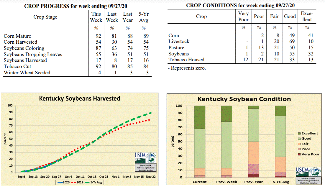 Kentucky Climate Summary
For the Period September 21, 2020 to September 27, 2020
Below Normal Temperatures and Much Below Normal Rainfall:
Weather conditions have trended dry recently. The state only averaged about a tenth
of an inch this period, marking a second straight week with most of the area seeing
very little to no rainfall. The rainfall that was seen occurred over the second half of
the workweek as the remnants of another tropical system, Beta, progressed across the
southern half of Kentucky. The highest accumulations were primarily across extreme
Southeastern Kentucky. Over the past 14 days, data at the Ag Weather Center shows the
state has averaged 0.12 inches, which is about 1.5 inches below normal for this time
of year. Despite the dry conditions, the Commonwealth did see pleasant fall weather
with below normal high temperatures in place for much of the workweek and only
warming slightly to seasonable norms over the weekend.
Temperatures for the period averaged 64 degrees across the state which was 2 degrees
cooler than normal and no change to the previous period. High temperatures averaged
from 73 in the West to 72 in the East. Departure from normal high temperatures
ranged from 6 degrees cooler than normal in the West to 5 degrees cooler than normal
in the East. Low temperatures averaged from 56 degrees in the West to 53 degrees in
the East. Departure from normal low temperature ranged from 1 degree warmer than
normal in the West to 1 degree warmer than normal in the East. The extreme high
temperature for the period was 84 degrees at COLUMBIA 3N and the extreme low was 38
degrees at CARLISLE 5SW.
Precipitation (liq. equ.) for the period totaled 0.11 inches statewide which was 0.74
inches below normal and 13% of normal. Precipitation totals by climate division, West
0.13 inches, Central 0.06 inches, Bluegrass 0.01 inches and East 0.22 inches, which
was 0.73, 0.87, 0.76 and 0.62 inches below normal. By station, precipitation totals
ranged from a low of 0.00 inches at ALEXANDRIA 5NW to a high of 1.16 inches at
MIDDLESBORO AWOS.
---
Kentucky Crop and Weather Report
Issued 4:00 P.M., September 21, 2020 27-20
Agricultural News: Kentucky experienced below normal temperatures and much below
rainfall over the past week. Precipitation for the week totaled 0.01 inches, 0.82
inches below normal. Temperatures averaged 66 degrees for the week, 2 degrees below
normal. Topsoil moisture was rated 2 percent very short, 15 percent short, 78 percent
adequate, and 5 percent surplus. Subsoil moisture was rated 2 percent very short, 13
percent short, 80 percent adequate, and 5 percent surplus. Days suitable for
fieldwork averaged 6.4 out of a possible seven.
Primary activities for this week included harvesting corn, soybeans, and tobacco.
Farmers made substantial progress in the fields this week thanks to mild temperatures
and dry conditions. As conducive weather presents itself, harvesting will move along
steadily. The extended dry spell has allowed farmers to get in some good late season
hay in hopes of having sufficient stock for the winter. Some late season and double
cropped soybeans are showing mild stress due to the dry weather, but overall the crop
seems to be doing well.
Corn and soybean conditions remain mostly good. Housed tobacco condition continues to
improve aided by the cool, dry weather. Pastures are in good shape and have not been
adversely affected by the dry weather at this point. Hay condition is good as
producers are getting good yields for this time of year, however rain will be needed
soon to help hay fields recover after cutting.
Kentucky Climate Summary
For the Period September 21, 2020 to September 27, 2020
Below Normal Temperatures and Much Below Normal Rainfall:
Weather conditions have trended dry recently. The state only averaged about a tenth
of an inch this period, marking a second straight week with most of the area seeing
very little to no rainfall. The rainfall that was seen occurred over the second half of
the workweek as the remnants of another tropical system, Beta, progressed across the
southern half of Kentucky. The highest accumulations were primarily across extreme
Southeastern Kentucky. Over the past 14 days, data at the Ag Weather Center shows the
state has averaged 0.12 inches, which is about 1.5 inches below normal for this time
of year. Despite the dry conditions, the Commonwealth did see pleasant fall weather
with below normal high temperatures in place for much of the workweek and only
warming slightly to seasonable norms over the weekend.
Temperatures for the period averaged 64 degrees across the state which was 2 degrees
cooler than normal and no change to the previous period. High temperatures averaged
from 73 in the West to 72 in the East. Departure from normal high temperatures
ranged from 6 degrees cooler than normal in the West to 5 degrees cooler than normal
in the East. Low temperatures averaged from 56 degrees in the West to 53 degrees in
the East. Departure from normal low temperature ranged from 1 degree warmer than
normal in the West to 1 degree warmer than normal in the East. The extreme high
temperature for the period was 84 degrees at COLUMBIA 3N and the extreme low was 38
degrees at CARLISLE 5SW.
Precipitation (liq. equ.) for the period totaled 0.11 inches statewide which was 0.74
inches below normal and 13% of normal. Precipitation totals by climate division, West
0.13 inches, Central 0.06 inches, Bluegrass 0.01 inches and East 0.22 inches, which
was 0.73, 0.87, 0.76 and 0.62 inches below normal. By station, precipitation totals
ranged from a low of 0.00 inches at ALEXANDRIA 5NW to a high of 1.16 inches at
MIDDLESBORO AWOS.
---
Kentucky Crop and Weather Report
Issued 4:00 P.M., September 21, 2020 27-20
Agricultural News: Kentucky experienced below normal temperatures and much below
rainfall over the past week. Precipitation for the week totaled 0.01 inches, 0.82
inches below normal. Temperatures averaged 66 degrees for the week, 2 degrees below
normal. Topsoil moisture was rated 2 percent very short, 15 percent short, 78 percent
adequate, and 5 percent surplus. Subsoil moisture was rated 2 percent very short, 13
percent short, 80 percent adequate, and 5 percent surplus. Days suitable for
fieldwork averaged 6.4 out of a possible seven.
Primary activities for this week included harvesting corn, soybeans, and tobacco.
Farmers made substantial progress in the fields this week thanks to mild temperatures
and dry conditions. As conducive weather presents itself, harvesting will move along
steadily. The extended dry spell has allowed farmers to get in some good late season
hay in hopes of having sufficient stock for the winter. Some late season and double
cropped soybeans are showing mild stress due to the dry weather, but overall the crop
seems to be doing well.
Corn and soybean conditions remain mostly good. Housed tobacco condition continues to
improve aided by the cool, dry weather. Pastures are in good shape and have not been
adversely affected by the dry weather at this point. Hay condition is good as
producers are getting good yields for this time of year, however rain will be needed
soon to help hay fields recover after cutting.
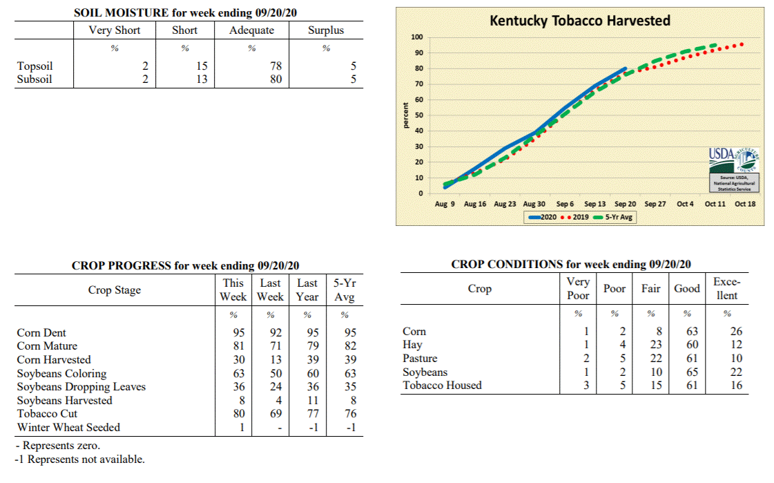 Kentucky Climate Summary
For the Period September 14, 2020 to September 20, 2020
Below Normal Temperatures and Much Below Normal Rainfall:
Dry conditions were the common theme throughout the week. In fact, other than
portions of Southeastern Kentucky that saw a brush of light rainfall from the
remnants of Hurricane Sally, most did not record anything for the period. The dry
conditions ended up breaking a stretch of five straight weeks that the state rainfall
average has ran above normal. Skies ran clear for most of the week, despite some
smoky haze filtering throughout the area from fires across the Western US. Cool
conditions accompanied the dry pattern, giving the Commonwealth its first taste of
fall weather. Following the passage of a dry cold front on Thursday, highs struggled
in the 60s and 70s over the weekend behind northeast flow. Lows each night fell
into the 40s. A handful of locations even dropped into the upper 30s. Normal lows for
the middle of September run in the middle to upper 50s.
Temperatures for the period averaged 66 degrees across the state which was 2 degrees
cooler than normal and 8 degrees cooler than the previous period. High temperatures
averaged from 79 in the West to 74 in the East. Departure from normal high
temperatures ranged from 3 degrees cooler than normal in the West to 6 degrees
cooler than normal in the East. Low temperatures averaged from 57 degrees in the
West to 57 degrees in the East. Departure from normal low temperature ranged from 1
degree cooler than normal in the West to 2 degrees warmer than normal in the East.
The extreme high temperature for the period was 87 degrees at MAYFIELD 6SW and the
extreme low was 37 degrees at CARLISLE 5SW.
Precipitation (liq. equ.) for the period totaled 0.01 inches statewide which was 0.82
inches below normal and 1% of normal. Precipitation totals by climate division, West
0.00 inches, Central 0.00 inches, Bluegrass 0.00 inches and East 0.04 inches, which
was 0.85, 0.91, 0.74 and 0.78 inches below normal. By station, precipitation totals
ranged from a low of 0.00 inches at ALBANY 1N to a high of 0.26 inches at PIKEVILLE 13S.
---
Kentucky Crop and Weather Report
Issued 4:00 P.M., September 14, 2020 26-20
Agricultural News: Kentucky experienced above normal temperatures and rainfall over
the past week. Precipitation for the week totaled 1.04 inches, 0.20 inches above
normal. Temperatures averaged 74 degrees for the week, 3 degrees above normal.
Topsoil moisture was rated 2 percent very short, 8 percent short, 83 percent
adequate, and 7 percent surplus. Subsoil moisture was rated 2 percent very short, 8
percent short, 83 percent adequate, and 7 percent surplus. Days suitable for
fieldwork averaged 5.7 out of a possible seven.
Primary activities for this week included topping and cutting tobacco along with corn
and soybean harvesting. Farmers made a considerable amount of progress in the fields
this week thanks to some mild and dry weather. The weekend brought in precipitation
and unstable weather for much of the state. Although in the early stages, corn and
soybean harvest is well underway. Producers will be harvesting steadily as conducive
weather presents itself. Nearly all the tobacco crop has been topped with well over
half cut at this juncture.
Corn and soybean conditions remain mostly good. Housed tobacco is mostly good and
showed marked improvement from last week due to largely dry conditions. Pastures are
in good shape as timely rain and mild temperatures have promoted strong
growth.
Kentucky Climate Summary
For the Period September 14, 2020 to September 20, 2020
Below Normal Temperatures and Much Below Normal Rainfall:
Dry conditions were the common theme throughout the week. In fact, other than
portions of Southeastern Kentucky that saw a brush of light rainfall from the
remnants of Hurricane Sally, most did not record anything for the period. The dry
conditions ended up breaking a stretch of five straight weeks that the state rainfall
average has ran above normal. Skies ran clear for most of the week, despite some
smoky haze filtering throughout the area from fires across the Western US. Cool
conditions accompanied the dry pattern, giving the Commonwealth its first taste of
fall weather. Following the passage of a dry cold front on Thursday, highs struggled
in the 60s and 70s over the weekend behind northeast flow. Lows each night fell
into the 40s. A handful of locations even dropped into the upper 30s. Normal lows for
the middle of September run in the middle to upper 50s.
Temperatures for the period averaged 66 degrees across the state which was 2 degrees
cooler than normal and 8 degrees cooler than the previous period. High temperatures
averaged from 79 in the West to 74 in the East. Departure from normal high
temperatures ranged from 3 degrees cooler than normal in the West to 6 degrees
cooler than normal in the East. Low temperatures averaged from 57 degrees in the
West to 57 degrees in the East. Departure from normal low temperature ranged from 1
degree cooler than normal in the West to 2 degrees warmer than normal in the East.
The extreme high temperature for the period was 87 degrees at MAYFIELD 6SW and the
extreme low was 37 degrees at CARLISLE 5SW.
Precipitation (liq. equ.) for the period totaled 0.01 inches statewide which was 0.82
inches below normal and 1% of normal. Precipitation totals by climate division, West
0.00 inches, Central 0.00 inches, Bluegrass 0.00 inches and East 0.04 inches, which
was 0.85, 0.91, 0.74 and 0.78 inches below normal. By station, precipitation totals
ranged from a low of 0.00 inches at ALBANY 1N to a high of 0.26 inches at PIKEVILLE 13S.
---
Kentucky Crop and Weather Report
Issued 4:00 P.M., September 14, 2020 26-20
Agricultural News: Kentucky experienced above normal temperatures and rainfall over
the past week. Precipitation for the week totaled 1.04 inches, 0.20 inches above
normal. Temperatures averaged 74 degrees for the week, 3 degrees above normal.
Topsoil moisture was rated 2 percent very short, 8 percent short, 83 percent
adequate, and 7 percent surplus. Subsoil moisture was rated 2 percent very short, 8
percent short, 83 percent adequate, and 7 percent surplus. Days suitable for
fieldwork averaged 5.7 out of a possible seven.
Primary activities for this week included topping and cutting tobacco along with corn
and soybean harvesting. Farmers made a considerable amount of progress in the fields
this week thanks to some mild and dry weather. The weekend brought in precipitation
and unstable weather for much of the state. Although in the early stages, corn and
soybean harvest is well underway. Producers will be harvesting steadily as conducive
weather presents itself. Nearly all the tobacco crop has been topped with well over
half cut at this juncture.
Corn and soybean conditions remain mostly good. Housed tobacco is mostly good and
showed marked improvement from last week due to largely dry conditions. Pastures are
in good shape as timely rain and mild temperatures have promoted strong
growth.
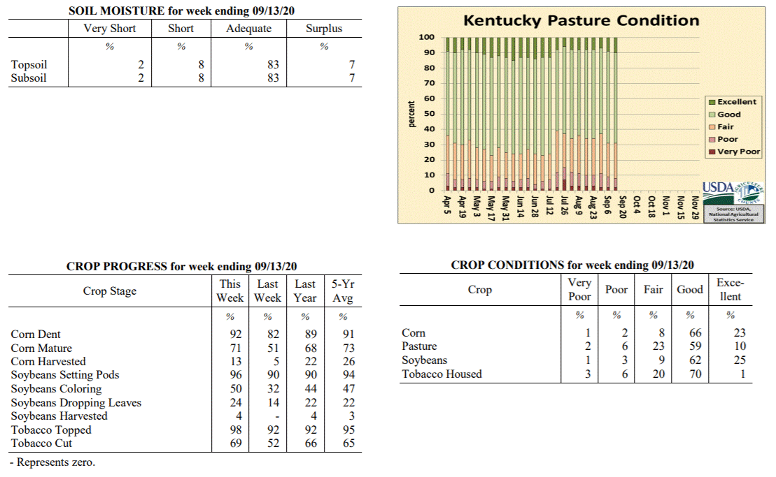 Kentucky Climate Summary
For the Period September 7, 2020 to September 13, 2020
Above Normal Temperatures and Rainfall:
The work week followed a rather stagnant pattern with dry and mild conditions in
place. Each day featured temperatures jumping into the mid to upper 80s, some hitting
the low 90s. This pattern changed drastically over the weekend for many across
Kentucky with multiple rounds of showers and storms. The most excessive
accumulations were seen across South Central Kentucky and extending into Northeastern
Kentucky where many received two or more inches. Some areas saw much more rain than
others, which was the case for Jackson, Morgan, Lincoln, and Casey Counties.
Portions of these counties saw 4 to 5+ inches, which did lead to significant flash
flooding. Total accumulations west of the line mentioned above were much less with
many under a half inch. In fact, Western Kentucky only averaged a third of an inch
for the week.
Temperatures for the period averaged 74 degrees across the state which was 3 degrees
warmer than normal and no change to the previous period. High temperatures averaged
from 86 in the West to 84 in the East. Departure from normal high temperatures
ranged from 2 degrees warmer than normal in the West to 2 degrees warmer than normal
in the East. Low temperatures averaged from 66 degrees in the West to 64 degrees in
the East. Departure from normal low temperature ranged from 5 degrees warmer than
normal in the West to 6 degrees warmer than normal in the East. The extreme high
temperature for the period was 92 degrees at LOUISVILLE APT and the extreme low was
55 degrees at MIDDLESBORO AWOS.
Precipitation (liq. equ.) for the period totaled 1.04 inches statewide which was 0.2
inches above normal and 125% of normal. Precipitation totals by climate division,
West 0.33 inches, Central 1.05 inches, Bluegrass 1.17 inches and East 1.60 inches,
which was -0.51, 0.12, 0.41 and 0.79 inches respectively from normal. By station,
precipitation totals ranged from a low of 0.00 inches at CALHOUN 5NW to a high of
4.94 inches at MCKEE 5S.
---
Kentucky Crop and Weather Report
Issued 4:00 P.M., September 7, 2020 25-20
Agricultural News: Kentucky experienced above normal temperatures and well above
normal rainfall over the past week. Precipitation for the week totaled 2.11 inches,
1.34 inches above normal. Temperatures averaged 74 degrees for the week, 1 degrees
above normal. Topsoil moisture was rated 2 percent very short, 6 percent short, 74
percent adequate, and 18 percent surplus. Subsoil moisture was rated 2 percent very
short, 6 percent short, 78 percent adequate, and 14 percent surplus. Days suitable
for fieldwork averaged 4.1 out of a possible seven.
Primary activities for this week included topping and cutting tobacco along with corn
harvesting. Fieldwork was stymied for much of the week due to widespread heavy
rainfall. The persistent showers led to some localized flooding and crop damage. The
precipitation has been beneficial in some areas promoting pasture growth, however
weeds may become a problem. The latter part of the week brought drier conditions and
farmers will likely make up for lost harvesting time.
Corn and soybean conditions continue to be mostly good despite the heavy rain this
past week. Tobacco is doing well overall with 65 percent of the crop in good
condition. Pastures are in mostly good condition and, as mentioned above, may see
strong growth from the persistent rain in some areas. Housed tobacco is in good
condition overall, however precipitation, along with moisture from dew and fog, may
be a detriment in some cases.
Kentucky Climate Summary
For the Period September 7, 2020 to September 13, 2020
Above Normal Temperatures and Rainfall:
The work week followed a rather stagnant pattern with dry and mild conditions in
place. Each day featured temperatures jumping into the mid to upper 80s, some hitting
the low 90s. This pattern changed drastically over the weekend for many across
Kentucky with multiple rounds of showers and storms. The most excessive
accumulations were seen across South Central Kentucky and extending into Northeastern
Kentucky where many received two or more inches. Some areas saw much more rain than
others, which was the case for Jackson, Morgan, Lincoln, and Casey Counties.
Portions of these counties saw 4 to 5+ inches, which did lead to significant flash
flooding. Total accumulations west of the line mentioned above were much less with
many under a half inch. In fact, Western Kentucky only averaged a third of an inch
for the week.
Temperatures for the period averaged 74 degrees across the state which was 3 degrees
warmer than normal and no change to the previous period. High temperatures averaged
from 86 in the West to 84 in the East. Departure from normal high temperatures
ranged from 2 degrees warmer than normal in the West to 2 degrees warmer than normal
in the East. Low temperatures averaged from 66 degrees in the West to 64 degrees in
the East. Departure from normal low temperature ranged from 5 degrees warmer than
normal in the West to 6 degrees warmer than normal in the East. The extreme high
temperature for the period was 92 degrees at LOUISVILLE APT and the extreme low was
55 degrees at MIDDLESBORO AWOS.
Precipitation (liq. equ.) for the period totaled 1.04 inches statewide which was 0.2
inches above normal and 125% of normal. Precipitation totals by climate division,
West 0.33 inches, Central 1.05 inches, Bluegrass 1.17 inches and East 1.60 inches,
which was -0.51, 0.12, 0.41 and 0.79 inches respectively from normal. By station,
precipitation totals ranged from a low of 0.00 inches at CALHOUN 5NW to a high of
4.94 inches at MCKEE 5S.
---
Kentucky Crop and Weather Report
Issued 4:00 P.M., September 7, 2020 25-20
Agricultural News: Kentucky experienced above normal temperatures and well above
normal rainfall over the past week. Precipitation for the week totaled 2.11 inches,
1.34 inches above normal. Temperatures averaged 74 degrees for the week, 1 degrees
above normal. Topsoil moisture was rated 2 percent very short, 6 percent short, 74
percent adequate, and 18 percent surplus. Subsoil moisture was rated 2 percent very
short, 6 percent short, 78 percent adequate, and 14 percent surplus. Days suitable
for fieldwork averaged 4.1 out of a possible seven.
Primary activities for this week included topping and cutting tobacco along with corn
harvesting. Fieldwork was stymied for much of the week due to widespread heavy
rainfall. The persistent showers led to some localized flooding and crop damage. The
precipitation has been beneficial in some areas promoting pasture growth, however
weeds may become a problem. The latter part of the week brought drier conditions and
farmers will likely make up for lost harvesting time.
Corn and soybean conditions continue to be mostly good despite the heavy rain this
past week. Tobacco is doing well overall with 65 percent of the crop in good
condition. Pastures are in mostly good condition and, as mentioned above, may see
strong growth from the persistent rain in some areas. Housed tobacco is in good
condition overall, however precipitation, along with moisture from dew and fog, may
be a detriment in some cases.
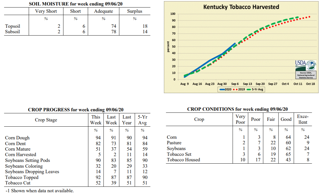 Kentucky Climate Summary
For the Period August 31, 2020 to September 6, 2020
Above Normal Temperatures and Well Above Normal Rainfall:
An active pattern led to excessive rainfall for much of the state this period. Most
of the rain fell between Monday through Thursday as the Kentucky saw daily rounds of
showers and storms. Coverage turned widespread at times and with a moist air mass in
place, storms were capable of producing very heavy rainfall and led to some localized
flooding. Overall, the state averaged 2.11 inches, which is well over an inch above
normal for this time of year. 1 to 2+ inch total accumulations were widespread across
Kentucky with very few stations below an inch. As a side-note, preliminary data from
August shows the state averaged 5.02 inches for the month, which would be good for an
11th straight month of above normal precipitation. All eyes then turned to Thursday
night and Friday as a cold front pushed through the Ohio Valley. This boundary opened
the door to a dry Labor Day weekend with cooler temperatures and lower humidity.
High temperatures for Derby Day were only in the upper 70s to middle 80s, before
taking a bit of a jump on Sunday. Lows each night dipped into the 50s.
Temperatures for the period averaged 74 degrees across the state which was 1 degree
warmer than normal and 4 degrees cooler than the previous period. High temperatures
averaged from 83 in the West to 83 in the East. Departure from normal high
temperatures ranged from 3 degrees cooler than normal in the West to 1 degree
cooler than normal in the East. Low temperatures averaged from 66 degrees in the
West to 66 degrees in the East. Departure from normal low temperature ranged from 3
degrees warmer than normal in the West to 6 degrees warmer than normal in the East.
The extreme high temperature for the period was 89 degrees at BOONEVILLE 2S and the
extreme low was 49 degrees at CYNTHIANA 8N.
Precipitation (liq. equ.) for the period totaled 2.11 inches statewide which was 1.34
inches above normal and 275% of normal. Precipitation totals by climate division,
West 2.31 inches, Central 2.20 inches, Bluegrass 2.06 inches and East 1.87 inches,
which was 1.6, 1.36, 1.33 and 1.08 inches above normal. By station, precipitation
totals ranged from a low of 0.65 inches at FORT KNOX to a high of 4.16 inches at
COLUMBIA 3N.
---
Kentucky Crop and Weather Report
Issued 4:00 P.M., August 31, 2020 24-20
Agricultural News: Kentucky experienced above normal temperatures and rainfall over
the past week. Precipitation for the week totaled 1.14 inches, 0.40 inches above
normal. Temperatures averaged 77 degrees for the week, 2 degrees above normal.
Topsoil moisture was rated 3 percent very short, 11 percent short, 75 percent
adequate, and 11 percent surplus. Subsoil moisture was rated 3 percent very short, 12
percent short, 77 percent adequate, and 8 percent surplus. Days suitable for
fieldwork averaged 4.6 out of a possible seven.
Primary activities for this week included cutting hay along with topping and cutting
tobacco. Corn harvest has begun for some producers, however the majority of the crop
is still in the field. Fieldwork was disrupted at times by scattered rain brought in
by the arrival of Hurricane Laura. There have been multiple reports of Southern Rust
on corn where spraying may no longer be of value due to the crop stage, however the
reports are focused in certain areas of the state and not widespread.
Even with Southern Rust present in some corn, the corn and soybean crops remain in
mostly good condition. Tobacco is doing well overall with 60 percent of the crop in
good condition. Pastures are in mostly good condition and have benefitted from the
scattered rain. Harvested hay was reported as in mostly good condition. With rains
promoting pasture growth, farmers hope to put away a lot of hay for
the winter months.
Kentucky Climate Summary
For the Period August 31, 2020 to September 6, 2020
Above Normal Temperatures and Well Above Normal Rainfall:
An active pattern led to excessive rainfall for much of the state this period. Most
of the rain fell between Monday through Thursday as the Kentucky saw daily rounds of
showers and storms. Coverage turned widespread at times and with a moist air mass in
place, storms were capable of producing very heavy rainfall and led to some localized
flooding. Overall, the state averaged 2.11 inches, which is well over an inch above
normal for this time of year. 1 to 2+ inch total accumulations were widespread across
Kentucky with very few stations below an inch. As a side-note, preliminary data from
August shows the state averaged 5.02 inches for the month, which would be good for an
11th straight month of above normal precipitation. All eyes then turned to Thursday
night and Friday as a cold front pushed through the Ohio Valley. This boundary opened
the door to a dry Labor Day weekend with cooler temperatures and lower humidity.
High temperatures for Derby Day were only in the upper 70s to middle 80s, before
taking a bit of a jump on Sunday. Lows each night dipped into the 50s.
Temperatures for the period averaged 74 degrees across the state which was 1 degree
warmer than normal and 4 degrees cooler than the previous period. High temperatures
averaged from 83 in the West to 83 in the East. Departure from normal high
temperatures ranged from 3 degrees cooler than normal in the West to 1 degree
cooler than normal in the East. Low temperatures averaged from 66 degrees in the
West to 66 degrees in the East. Departure from normal low temperature ranged from 3
degrees warmer than normal in the West to 6 degrees warmer than normal in the East.
The extreme high temperature for the period was 89 degrees at BOONEVILLE 2S and the
extreme low was 49 degrees at CYNTHIANA 8N.
Precipitation (liq. equ.) for the period totaled 2.11 inches statewide which was 1.34
inches above normal and 275% of normal. Precipitation totals by climate division,
West 2.31 inches, Central 2.20 inches, Bluegrass 2.06 inches and East 1.87 inches,
which was 1.6, 1.36, 1.33 and 1.08 inches above normal. By station, precipitation
totals ranged from a low of 0.65 inches at FORT KNOX to a high of 4.16 inches at
COLUMBIA 3N.
---
Kentucky Crop and Weather Report
Issued 4:00 P.M., August 31, 2020 24-20
Agricultural News: Kentucky experienced above normal temperatures and rainfall over
the past week. Precipitation for the week totaled 1.14 inches, 0.40 inches above
normal. Temperatures averaged 77 degrees for the week, 2 degrees above normal.
Topsoil moisture was rated 3 percent very short, 11 percent short, 75 percent
adequate, and 11 percent surplus. Subsoil moisture was rated 3 percent very short, 12
percent short, 77 percent adequate, and 8 percent surplus. Days suitable for
fieldwork averaged 4.6 out of a possible seven.
Primary activities for this week included cutting hay along with topping and cutting
tobacco. Corn harvest has begun for some producers, however the majority of the crop
is still in the field. Fieldwork was disrupted at times by scattered rain brought in
by the arrival of Hurricane Laura. There have been multiple reports of Southern Rust
on corn where spraying may no longer be of value due to the crop stage, however the
reports are focused in certain areas of the state and not widespread.
Even with Southern Rust present in some corn, the corn and soybean crops remain in
mostly good condition. Tobacco is doing well overall with 60 percent of the crop in
good condition. Pastures are in mostly good condition and have benefitted from the
scattered rain. Harvested hay was reported as in mostly good condition. With rains
promoting pasture growth, farmers hope to put away a lot of hay for
the winter months.
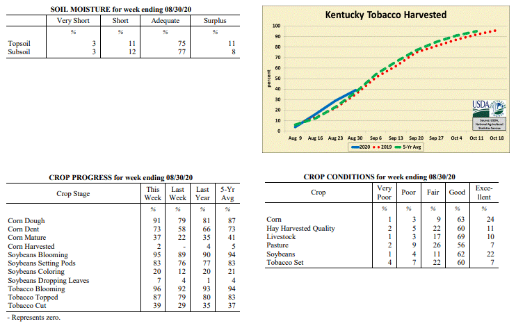 Kentucky Climate Summary
For the Period August 24, 2020 to August 30, 2020
Above Normal Temperatures and Rainfall:
Led by the remnants of Hurricane Laura tracking through Kentucky, rainfall ran above
normal for a third straight week. Overall, the state averaged 1.14 inches. Ahead of
the system, the Bluegrass State was situated within a typical summer-time air mass with
tropical heat and humidity in place between Monday and Thursday. Highs consistently
jumped into the middle 80s to low 90s, accompanied by isolated to scattered rain
coverage on a daily basis. The remnants of Laura quickly pushed through the region
over the course of Friday and early Saturday, bringing widespread rainfall to the
area. A cold front then followed on Saturday, leading to a break in heat on Sunday.
Looking back at the past three weeks, Kentucky has averaged 3.43 inches, which is about
an inch above normal.
Temperatures for the period averaged 77 degrees across the state which was 2 degrees
warmer than normal and 4 degrees warmer than the previous period. High temperatures
averaged from 86 in the West to 85 in the East. Departure from normal high
temperatures ranged from 2 degrees cooler than normal in the West to near normal in
the East. Low temperatures averaged from 69 degrees in the West to 68 degrees in the
East. Departure from normal low temperature ranged from 5 degrees warmer than normal
in the West to 7 degrees warmer than normal in the East. The extreme high temperature
for the period was 93 degrees at ELKTON 5SW and the extreme low was 56 degrees at
CARLISLE 5SW.
Precipitation (liq. equ.) for the period totaled 1.14 inches statewide which was 0.4
inches above normal and 153% of normal. Precipitation totals by climate division,
West 1.31 inches, Central 1.16 inches, Bluegrass 0.95 inches and East 1.15 inches,
which was 0.64, 0.38, 0.21 and 0.36 inches above normal. By station, precipitation
totals ranged from a low of 0.28 inches at HENDERSON 5E to a high of 4.25
inches at RUSSELLVILLE 2W.
---
Kentucky Crop and Weather Report
Issued 4:00 P.M., August 24, 2020 23-20
Agricultural News: Kentucky experienced below normal temperatures and above normal
rainfall over the past week. Precipitation for the week totaled 0.98 inches, 0.14
inches above normal. Temperatures averaged 73 degrees for the week, 2 degrees below
normal. Topsoil moisture was rated 2 percent very short, 12 percent short, 75 percent
adequate, and 11 percent surplus. Subsoil moisture was rated 2 percent very short, 14
percent short, 75 percent adequate, and 9 percent surplus. Days suitable for
fieldwork averaged 5.3 out of a possible seven.
Primary activities for this week included cutting hay along with topping and cutting
tobacco. Although temperatures were pleasant for the most part, heavy rain showers
deterred fieldwork at times. Some flooding likely occurred due to the slow moving
systems, however widespread flooding has not been observed at this time. Corn and
soybeans are being sprayed, but a fair amount of Southern Rust on corn has been
reported in portions of the state.
Corn and soybeans remain in mostly good condition on the whole. Tobacco is doing well
overall with 55 percent of the crop in good condition. Pastures are in mostly good
condition despite heavy rainfall at times. The state�s hay crop appears to be doing
well at this point in the season.
Kentucky Climate Summary
For the Period August 24, 2020 to August 30, 2020
Above Normal Temperatures and Rainfall:
Led by the remnants of Hurricane Laura tracking through Kentucky, rainfall ran above
normal for a third straight week. Overall, the state averaged 1.14 inches. Ahead of
the system, the Bluegrass State was situated within a typical summer-time air mass with
tropical heat and humidity in place between Monday and Thursday. Highs consistently
jumped into the middle 80s to low 90s, accompanied by isolated to scattered rain
coverage on a daily basis. The remnants of Laura quickly pushed through the region
over the course of Friday and early Saturday, bringing widespread rainfall to the
area. A cold front then followed on Saturday, leading to a break in heat on Sunday.
Looking back at the past three weeks, Kentucky has averaged 3.43 inches, which is about
an inch above normal.
Temperatures for the period averaged 77 degrees across the state which was 2 degrees
warmer than normal and 4 degrees warmer than the previous period. High temperatures
averaged from 86 in the West to 85 in the East. Departure from normal high
temperatures ranged from 2 degrees cooler than normal in the West to near normal in
the East. Low temperatures averaged from 69 degrees in the West to 68 degrees in the
East. Departure from normal low temperature ranged from 5 degrees warmer than normal
in the West to 7 degrees warmer than normal in the East. The extreme high temperature
for the period was 93 degrees at ELKTON 5SW and the extreme low was 56 degrees at
CARLISLE 5SW.
Precipitation (liq. equ.) for the period totaled 1.14 inches statewide which was 0.4
inches above normal and 153% of normal. Precipitation totals by climate division,
West 1.31 inches, Central 1.16 inches, Bluegrass 0.95 inches and East 1.15 inches,
which was 0.64, 0.38, 0.21 and 0.36 inches above normal. By station, precipitation
totals ranged from a low of 0.28 inches at HENDERSON 5E to a high of 4.25
inches at RUSSELLVILLE 2W.
---
Kentucky Crop and Weather Report
Issued 4:00 P.M., August 24, 2020 23-20
Agricultural News: Kentucky experienced below normal temperatures and above normal
rainfall over the past week. Precipitation for the week totaled 0.98 inches, 0.14
inches above normal. Temperatures averaged 73 degrees for the week, 2 degrees below
normal. Topsoil moisture was rated 2 percent very short, 12 percent short, 75 percent
adequate, and 11 percent surplus. Subsoil moisture was rated 2 percent very short, 14
percent short, 75 percent adequate, and 9 percent surplus. Days suitable for
fieldwork averaged 5.3 out of a possible seven.
Primary activities for this week included cutting hay along with topping and cutting
tobacco. Although temperatures were pleasant for the most part, heavy rain showers
deterred fieldwork at times. Some flooding likely occurred due to the slow moving
systems, however widespread flooding has not been observed at this time. Corn and
soybeans are being sprayed, but a fair amount of Southern Rust on corn has been
reported in portions of the state.
Corn and soybeans remain in mostly good condition on the whole. Tobacco is doing well
overall with 55 percent of the crop in good condition. Pastures are in mostly good
condition despite heavy rainfall at times. The state�s hay crop appears to be doing
well at this point in the season.
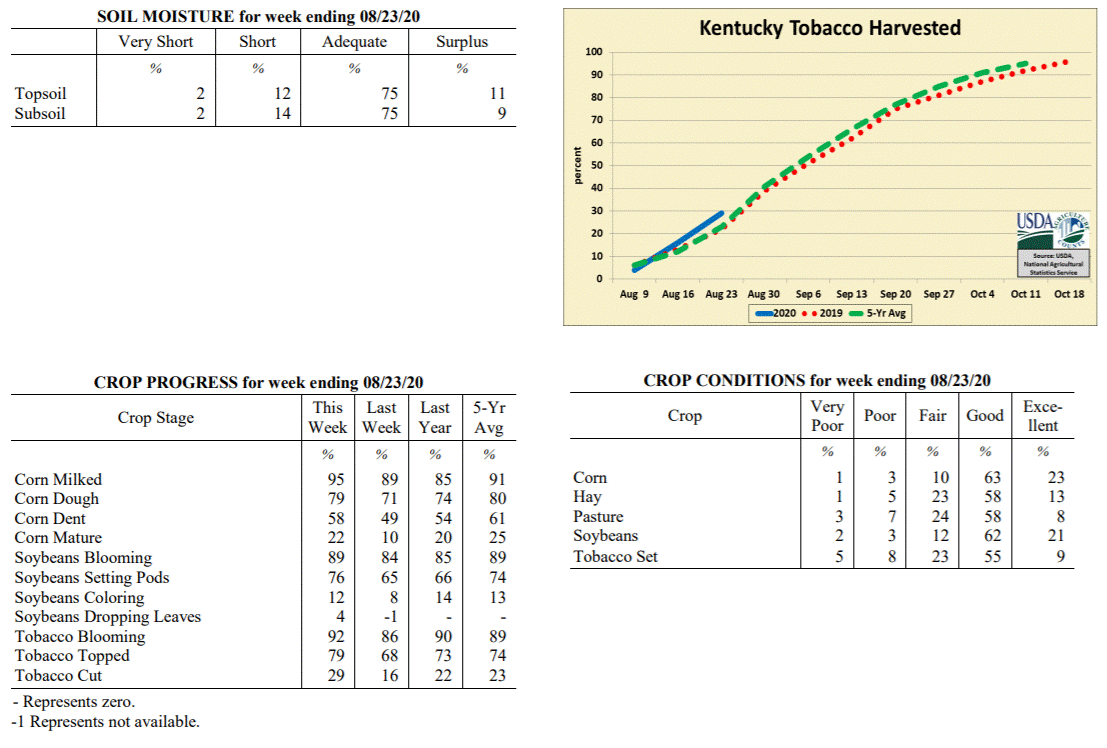 Kentucky Climate Summary
For the Period August 17, 2020 to August 23, 2020
Below Normal Temperatures and Above Normal Rainfall:
Focus early in the week was a cold front sinking into the region on Tuesday.
Scattered to numerous showers and storms accompanied the boundary during the
afternoon and evening hours. Some scattered activity was left across Southeastern
Kentucky on Wednesday, but otherwise, cooler and less humid air was ushered into the
area behind the front. Highs were only around 80 on Wednesday, before falling into
the mid 50s to low 60s that night. The rest of the period followed a similar pattern
with daily rounds of scattered showers/storms and cooler than normal temperatures.
Going with the common theme in recent weeks, storms were capable of producing very
heavy rainfall and with slow storm movements, opened the door to some flooding.
Overall, the state average was above normal, but totals were quite different from one
side of the state to the other. While Eastern Kentucky averaged 1.33 inches for the
week, that number dropped to 0.46 inches for Western Kentucky.
Temperatures for the period averaged 73 degrees across the state which was 2 degrees
cooler than normal and 4 degrees cooler than the previous period. High temperatures
averaged from 84 in the West to 82 in the East. Departure from normal high
temperatures ranged from 4 degrees cooler than normal in the West to 4 degrees
cooler than normal in the East. Low temperatures averaged from 64 degrees in the
West to 63 degrees in the East. Departure from normal low temperature ranged from 1
degree cooler than normal in the West to 1 degree warmer than normal in the East.
The extreme high temperature for the period was 91 degrees at POPLAR BLUFF ASOS and
the extreme low was 51 degrees at CARLISLE 5SW.
Precipitation (liq. equ.) for the period totaled 0.98 inches statewide which was 0.14
inches above normal and 116% of normal. Precipitation totals by climate division,
West 0.46 inches, Central 0.96 inches, Bluegrass 1.19 inches and East 1.33 inches,
which was -0.30, 0.11, 0.34 and 0.42 inches respectively from normal. By station,
precipitation totals ranged from a low of 0.00 inches at CAPE GIRARDEAU ASOS to a
high of 3.57 inches at FRANKFORT.
---
Kentucky Crop and Weather Report
Issued 4:00 P.M., August 17, 2020 22-20
Agricultural News: Kentucky experienced above normal temperatures and rainfall over
the past week. Precipitation for the week totaled 1.30 inches, 0.44 inches above
normal. Temperatures averaged 77 degrees for the week, 2 degrees above normal.
Topsoil moisture was rated 3 percent very short, 13 percent short, 74 percent
adequate, and 10 percent surplus. Subsoil moisture was rated 4 percent very short, 15
percent short, 73 percent adequate, and 8 percent surplus. Days suitable for
fieldwork averaged 4.9 out of a possible seven.
Primary activities for this week included topping and cutting tobacco, spraying, and
cutting hay. Scattered storms and rain disrupted field activities at times over the
past week. There were some areas that were subject to excessive rain and flooding,
however damage has not been evaluated at this juncture. The effect of Southern Rust
on corn where fungicide was not sprayed is not yet clear. Pasture and hay regrowth
will be promoted in areas where the rainfall was more moderate.
Corn and soybeans continue to be in good condition. Tobacco is doing well overall
with 54 percent of the crop in good condition. Pastures are in mostly good condition,
however heavy rain may have been a detriment in the areas where it occurred.
Kentucky Climate Summary
For the Period August 17, 2020 to August 23, 2020
Below Normal Temperatures and Above Normal Rainfall:
Focus early in the week was a cold front sinking into the region on Tuesday.
Scattered to numerous showers and storms accompanied the boundary during the
afternoon and evening hours. Some scattered activity was left across Southeastern
Kentucky on Wednesday, but otherwise, cooler and less humid air was ushered into the
area behind the front. Highs were only around 80 on Wednesday, before falling into
the mid 50s to low 60s that night. The rest of the period followed a similar pattern
with daily rounds of scattered showers/storms and cooler than normal temperatures.
Going with the common theme in recent weeks, storms were capable of producing very
heavy rainfall and with slow storm movements, opened the door to some flooding.
Overall, the state average was above normal, but totals were quite different from one
side of the state to the other. While Eastern Kentucky averaged 1.33 inches for the
week, that number dropped to 0.46 inches for Western Kentucky.
Temperatures for the period averaged 73 degrees across the state which was 2 degrees
cooler than normal and 4 degrees cooler than the previous period. High temperatures
averaged from 84 in the West to 82 in the East. Departure from normal high
temperatures ranged from 4 degrees cooler than normal in the West to 4 degrees
cooler than normal in the East. Low temperatures averaged from 64 degrees in the
West to 63 degrees in the East. Departure from normal low temperature ranged from 1
degree cooler than normal in the West to 1 degree warmer than normal in the East.
The extreme high temperature for the period was 91 degrees at POPLAR BLUFF ASOS and
the extreme low was 51 degrees at CARLISLE 5SW.
Precipitation (liq. equ.) for the period totaled 0.98 inches statewide which was 0.14
inches above normal and 116% of normal. Precipitation totals by climate division,
West 0.46 inches, Central 0.96 inches, Bluegrass 1.19 inches and East 1.33 inches,
which was -0.30, 0.11, 0.34 and 0.42 inches respectively from normal. By station,
precipitation totals ranged from a low of 0.00 inches at CAPE GIRARDEAU ASOS to a
high of 3.57 inches at FRANKFORT.
---
Kentucky Crop and Weather Report
Issued 4:00 P.M., August 17, 2020 22-20
Agricultural News: Kentucky experienced above normal temperatures and rainfall over
the past week. Precipitation for the week totaled 1.30 inches, 0.44 inches above
normal. Temperatures averaged 77 degrees for the week, 2 degrees above normal.
Topsoil moisture was rated 3 percent very short, 13 percent short, 74 percent
adequate, and 10 percent surplus. Subsoil moisture was rated 4 percent very short, 15
percent short, 73 percent adequate, and 8 percent surplus. Days suitable for
fieldwork averaged 4.9 out of a possible seven.
Primary activities for this week included topping and cutting tobacco, spraying, and
cutting hay. Scattered storms and rain disrupted field activities at times over the
past week. There were some areas that were subject to excessive rain and flooding,
however damage has not been evaluated at this juncture. The effect of Southern Rust
on corn where fungicide was not sprayed is not yet clear. Pasture and hay regrowth
will be promoted in areas where the rainfall was more moderate.
Corn and soybeans continue to be in good condition. Tobacco is doing well overall
with 54 percent of the crop in good condition. Pastures are in mostly good condition,
however heavy rain may have been a detriment in the areas where it occurred.
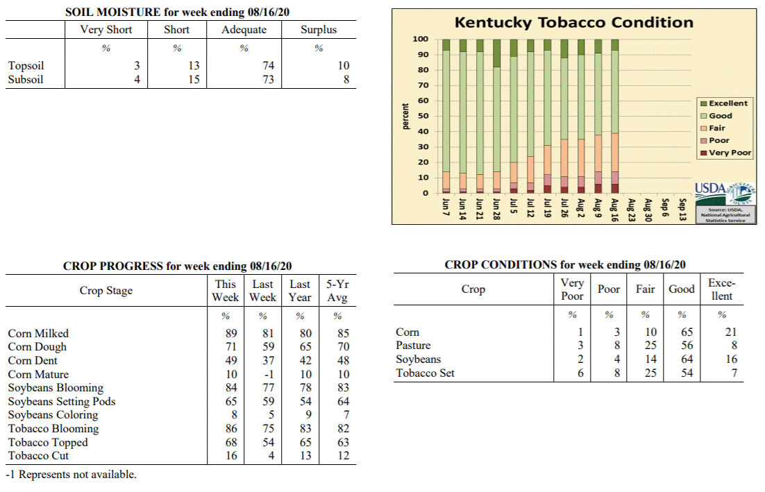 Kentucky Climate Summary
For the Period August 10, 2020 to August 16, 2020
Above Normal Temperatures and Rainfall:
Kentucky averaged 1.30 inches for the period, marking the third time in the past four
weeks that the state average has been above normal. The wet pattern persisted for
much of the week, starting with an area of light to moderate showers passing
southeast through the Bluegrass and Eastern Kentucky on Monday. Some of the most
significant activity occurred on Wednesday through Friday with scattered to numerous
showers and storms in place. The slow-moving nature of these storms, combined with
torrential rainfall, led to numerous bouts of flash flooding. 1 to 2+ inches was
common with the strongest storms. The week closed with the passage of a cold front on
Sunday, which pushed a broken line of showers and storms through mainly the eastern
half of the state. Looking back at the past 30 days, the state has averaged 5.30
inches, which is 1.31 inches above normal.
Temperatures for the period averaged 77 degrees across the state which was 2 degrees
warmer than normal and 4 degrees warmer than the previous period. High temperatures
averaged from 86 in the West to 85 in the East. Departure from normal high
temperatures ranged from 2 degrees cooler than normal in the West to 1 degree
cooler than normal in the East. Low temperatures averaged from 70 degrees in the
West to 68 degrees in the East. Departure from normal low temperature ranged from 4
degrees warmer than normal in the West to 5 degrees warmer than normal in the East.
The extreme high temperature for the period was 94 degrees at POPLAR BLUFF ASOS and
the extreme low was 61 degrees at MCKEE 5S.
Precipitation (liq. equ.) for the period totaled 1.30 inches statewide which was 0.44
inches above normal and 151% of normal. Precipitation totals by climate division,
West 1.21 inches, Central 1.90 inches, Bluegrass 0.88 inches and East 1.22 inches,
which was 0.41, 1.06, 0.01 and 0.28 inches above normal. By station, precipitation
totals ranged from a low of 0.08 inches at ELKTON 5SW to a high of 5.31 inches at FORT KNOX.
---
Kentucky Crop and Weather Report
Issued 4:00 P.M., August 10, 2020 21-20
Agricultural News: Kentucky experienced below normal temperatures and rainfall over
the past week. Precipitation for the week totaled 0.26 inches, 0.67 inches below
normal. Temperatures averaged 72 degrees for the week, 4 degrees below normal.
Topsoil moisture was rated 3 percent very short, 14 percent short, 73 percent
adequate, and 10 percent surplus. Subsoil moisture was rated 2 percent very short, 14
percent short, 75 percent adequate, and 9 percent surplus. Days suitable for
fieldwork averaged 5.4 out of a possible seven.
Primary activities for this week included topping tobacco, spraying field crops, and
cutting hay. Cool temperatures with some extended dry periods allowed farmers in the
fields this past week. The low humidity conditions were optimal for hay making. Corn
is being sprayed for Southern Rust with the late planted crop particularly
susceptible.
Corn and soybeans continue to be in good condition overall as the mild temperatures
have limited heat stress commonly occurring this time of year. Tobacco is doing
fairly well with 53 percent of the crop in good condition. Pressure from weed
growth is minimal in pastures. Cooler temperatures and scattered rain have also
encouraged healthy pastureland.
Kentucky Climate Summary
For the Period August 10, 2020 to August 16, 2020
Above Normal Temperatures and Rainfall:
Kentucky averaged 1.30 inches for the period, marking the third time in the past four
weeks that the state average has been above normal. The wet pattern persisted for
much of the week, starting with an area of light to moderate showers passing
southeast through the Bluegrass and Eastern Kentucky on Monday. Some of the most
significant activity occurred on Wednesday through Friday with scattered to numerous
showers and storms in place. The slow-moving nature of these storms, combined with
torrential rainfall, led to numerous bouts of flash flooding. 1 to 2+ inches was
common with the strongest storms. The week closed with the passage of a cold front on
Sunday, which pushed a broken line of showers and storms through mainly the eastern
half of the state. Looking back at the past 30 days, the state has averaged 5.30
inches, which is 1.31 inches above normal.
Temperatures for the period averaged 77 degrees across the state which was 2 degrees
warmer than normal and 4 degrees warmer than the previous period. High temperatures
averaged from 86 in the West to 85 in the East. Departure from normal high
temperatures ranged from 2 degrees cooler than normal in the West to 1 degree
cooler than normal in the East. Low temperatures averaged from 70 degrees in the
West to 68 degrees in the East. Departure from normal low temperature ranged from 4
degrees warmer than normal in the West to 5 degrees warmer than normal in the East.
The extreme high temperature for the period was 94 degrees at POPLAR BLUFF ASOS and
the extreme low was 61 degrees at MCKEE 5S.
Precipitation (liq. equ.) for the period totaled 1.30 inches statewide which was 0.44
inches above normal and 151% of normal. Precipitation totals by climate division,
West 1.21 inches, Central 1.90 inches, Bluegrass 0.88 inches and East 1.22 inches,
which was 0.41, 1.06, 0.01 and 0.28 inches above normal. By station, precipitation
totals ranged from a low of 0.08 inches at ELKTON 5SW to a high of 5.31 inches at FORT KNOX.
---
Kentucky Crop and Weather Report
Issued 4:00 P.M., August 10, 2020 21-20
Agricultural News: Kentucky experienced below normal temperatures and rainfall over
the past week. Precipitation for the week totaled 0.26 inches, 0.67 inches below
normal. Temperatures averaged 72 degrees for the week, 4 degrees below normal.
Topsoil moisture was rated 3 percent very short, 14 percent short, 73 percent
adequate, and 10 percent surplus. Subsoil moisture was rated 2 percent very short, 14
percent short, 75 percent adequate, and 9 percent surplus. Days suitable for
fieldwork averaged 5.4 out of a possible seven.
Primary activities for this week included topping tobacco, spraying field crops, and
cutting hay. Cool temperatures with some extended dry periods allowed farmers in the
fields this past week. The low humidity conditions were optimal for hay making. Corn
is being sprayed for Southern Rust with the late planted crop particularly
susceptible.
Corn and soybeans continue to be in good condition overall as the mild temperatures
have limited heat stress commonly occurring this time of year. Tobacco is doing
fairly well with 53 percent of the crop in good condition. Pressure from weed
growth is minimal in pastures. Cooler temperatures and scattered rain have also
encouraged healthy pastureland.
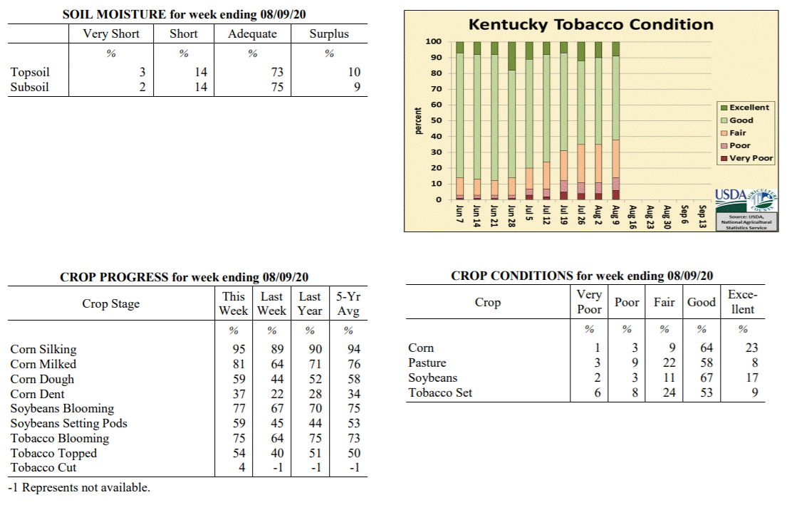 Kentucky Climate Summary
For the Period August 3, 2020 to August 9, 2020
Below Normal Temperatures and Rainfall:
Above normal rainfall has been the trend the past couple weeks, but that came to a
halt over the first full week of August. Other than portions of Central Kentucky,
rainfall was lacking for most of the state. Kentucky averaged about a quarter inch
for the period, most of which coming over the first half of the week with the passage
of a weak cold front. Coverage was lacking, staying isolated to scattered in nature.
Behind the frontal passage, Kentucky saw a break in the heat and humidity with fall-
like conditions in place. High temperatures only rose into the middle 70s to around
80 on Tuesday and Wednesday. This was accompanied by some unseasonably cool nights
with some seeing lows in the mid to upper 50s. These temperatures are more typical of
mid to late September in Kentucky. Saying that, the break did not last long as heat
returned for the weekend, along with isolated to scattered storms across the western
half of the state on Sunday.
Temperatures for the period averaged 72 degrees across the state which was 4 degrees
cooler than normal and 6 degrees cooler than the previous period. High temperatures
averaged from 83 in the West to 84 in the East. Departure from normal high
temperatures ranged from 5 degrees cooler than normal in the West to 2 degrees
cooler than normal in the East. Low temperatures averaged from 63 degrees in the
West to 63 degrees in the East. Departure from normal low temperature ranged from 3
degrees cooler than normal in the West to near normal in the East. The extreme high
temperature for the period was 92 degrees at KOOMER RIDGE and the extreme low was 53
degrees at BRANDENBURG 4SW.
Precipitation (liq. equ.) for the period totaled 0.26 inches statewide which was 0.67
inches below normal and 28% of normal. Precipitation totals by climate division, West
0.40 inches, Central 0.37 inches, Bluegrass 0.11 inches and East 0.15 inches, which
was 0.49, 0.53, 0.79 and 0.86 inches below normal. By station, precipitation totals
ranged from a low of 0.00 inches at ALBANY 1N to a high of 2.71 inches at EVANSVILLE ASOS.
---
Kentucky Crop and Weather Report
Issued 4:00 P.M., August 3, 2020 20-20
Agricultural News: Kentucky experienced near normal temperatures and much above
normal rainfall over the past week. Precipitation for the week totaled 2.45 inches,
1.48 inches above normal. Temperatures averaged 77 degrees for the week, unchanged
from normal. Topsoil moisture was rated 5 percent very short, 10 percent short, 73
percent adequate, and 12 percent surplus. Subsoil moisture was rated 3 percent very
short, 13 percent short, 74 percent adequate, and 10 percent surplus. Days suitable
for fieldwork averaged 4.4 out of a possible seven.
Primary activities for this week included topping tobacco, spraying field crops, and
cutting hay. Farmers finally saw reprieve from intense summer heat as cooler
temperatures and precipitation moved in. The rainfall was abundant and welcome as it
will help replenish pastures and help areas that were on the fringe of moderate
drought. The drawback of the wet pattern is the obstruction to hay cutting, however
the benefit to pasture growth may balance that out.
Corn and soybeans continue to be in mostly good condition as the cooler temperatures
will subdue heat stress. Tobacco is doing fairly well with 55 percent of the crop in
good condition. Pastures are in mostly good condition at this time and
should see strong growth from recent rain.
Kentucky Climate Summary
For the Period August 3, 2020 to August 9, 2020
Below Normal Temperatures and Rainfall:
Above normal rainfall has been the trend the past couple weeks, but that came to a
halt over the first full week of August. Other than portions of Central Kentucky,
rainfall was lacking for most of the state. Kentucky averaged about a quarter inch
for the period, most of which coming over the first half of the week with the passage
of a weak cold front. Coverage was lacking, staying isolated to scattered in nature.
Behind the frontal passage, Kentucky saw a break in the heat and humidity with fall-
like conditions in place. High temperatures only rose into the middle 70s to around
80 on Tuesday and Wednesday. This was accompanied by some unseasonably cool nights
with some seeing lows in the mid to upper 50s. These temperatures are more typical of
mid to late September in Kentucky. Saying that, the break did not last long as heat
returned for the weekend, along with isolated to scattered storms across the western
half of the state on Sunday.
Temperatures for the period averaged 72 degrees across the state which was 4 degrees
cooler than normal and 6 degrees cooler than the previous period. High temperatures
averaged from 83 in the West to 84 in the East. Departure from normal high
temperatures ranged from 5 degrees cooler than normal in the West to 2 degrees
cooler than normal in the East. Low temperatures averaged from 63 degrees in the
West to 63 degrees in the East. Departure from normal low temperature ranged from 3
degrees cooler than normal in the West to near normal in the East. The extreme high
temperature for the period was 92 degrees at KOOMER RIDGE and the extreme low was 53
degrees at BRANDENBURG 4SW.
Precipitation (liq. equ.) for the period totaled 0.26 inches statewide which was 0.67
inches below normal and 28% of normal. Precipitation totals by climate division, West
0.40 inches, Central 0.37 inches, Bluegrass 0.11 inches and East 0.15 inches, which
was 0.49, 0.53, 0.79 and 0.86 inches below normal. By station, precipitation totals
ranged from a low of 0.00 inches at ALBANY 1N to a high of 2.71 inches at EVANSVILLE ASOS.
---
Kentucky Crop and Weather Report
Issued 4:00 P.M., August 3, 2020 20-20
Agricultural News: Kentucky experienced near normal temperatures and much above
normal rainfall over the past week. Precipitation for the week totaled 2.45 inches,
1.48 inches above normal. Temperatures averaged 77 degrees for the week, unchanged
from normal. Topsoil moisture was rated 5 percent very short, 10 percent short, 73
percent adequate, and 12 percent surplus. Subsoil moisture was rated 3 percent very
short, 13 percent short, 74 percent adequate, and 10 percent surplus. Days suitable
for fieldwork averaged 4.4 out of a possible seven.
Primary activities for this week included topping tobacco, spraying field crops, and
cutting hay. Farmers finally saw reprieve from intense summer heat as cooler
temperatures and precipitation moved in. The rainfall was abundant and welcome as it
will help replenish pastures and help areas that were on the fringe of moderate
drought. The drawback of the wet pattern is the obstruction to hay cutting, however
the benefit to pasture growth may balance that out.
Corn and soybeans continue to be in mostly good condition as the cooler temperatures
will subdue heat stress. Tobacco is doing fairly well with 55 percent of the crop in
good condition. Pastures are in mostly good condition at this time and
should see strong growth from recent rain.
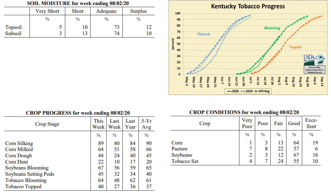 Kentucky Climate Summary
For the Period July 27, 2020 to August 2, 2020
Near Normal Temperatures and Much Above Normal Rainfall:
July closed and August opened with a very wet pattern in place as the state averaged
2.45 inches for the week. This amounted to a second straight week of above normal
rainfall for the Bluegrass State, which over the past 14 days has averaged 3.71
inches. The state saw daily rounds of rainfall, most of which the result of a cold
front pushing into the area and eventually stalling. Going with the trend of recent
weeks, storms were capable of producing very heavy rainfall within a short period of
time and led to some flash flooding. High accumulations were widespread across the
state. The rainfall was especially welcomed by areas of the southern Bluegrass and NE
Kentucky (predominantly Scott, Fayette, Clark, Bourbon, Lewis, Greenup, and Carter
Counties), which were recently upgraded into a �Moderate Drought� by the US Drought
Monitor. The active pattern also gave a bit of a break from the heat of recent
weeks. Rain and added cloud cover kept highs in the low to middle 80s for many
between Thursday through Sunday. Some even in the upper 70s on Saturday and Sunday.
Temperatures for the period averaged 77 degrees across the state which was
near normal and 2 degrees cooler than the previous period. High temperatures
averaged from 85 in the West to 83 in the East. Departure from normal high
temperatures ranged from 4 degrees cooler than normal in the West to 4 degrees
cooler than normal in the East. Low temperatures averaged from 70 degrees in the
West to 68 degrees in the East. Departure from normal low temperature ranged from 3
degrees warmer than normal in the West to 4 degrees warmer than normal in the East.
The extreme high temperature for the period was 95 degrees at KOOMER RIDGE and the
extreme low was 59 degrees at MAYFIELD 6SW.
Precipitation (liq. equ.) for the period totaled 2.45 inches statewide which was 1.48
inches above normal and 252% of normal. Precipitation totals by climate division,
West 2.45 inches, Central 2.24 inches, Bluegrass 2.69 inches and East 2.43 inches,
which was 1.52, 1.28, 1.73 and 1.39 inches above normal. By station, precipitation
totals ranged from a low of 0.61 inches at BOWLING GREEN 4E to a high of 5.43
inches at CARROLLTON 2E.
---
Kentucky Crop and Weather Report
Issued 4:00 P.M., July 27, 2020 19-20
Agricultural News: Kentucky experienced above normal temperatures and rainfall over
the past week. Precipitation for the week totaled 1.25 inches, 0.29 inches above
normal. Temperatures averaged 79 degrees for the week, 2 degrees above normal.
Topsoil moisture was rated 6 percent very short, 21 percent short, 67 percent
adequate, and 6 percent surplus. Subsoil moisture was rated 5 percent very short, 20
percent short, 70 percent adequate, and 5 percent surplus. Days suitable for
fieldwork averaged 5.3 out of a possible seven.
Primary activities for this week included spraying, topping tobacco, and cutting hay.
Intense summer heat and scattered rain prevailed across the state this week. In most
instances the rain was welcome as a reprieve from the hot weather, however pockets of
the state are still seeing flood damage from heavy rain several weeks prior. Soybeans
have been planted in place of corn in some of the areas where extreme flooding
occurred. Where drier weather has been the norm, there was some reported dormancy in
forage grasses. With that said, many producers are seeing good hay yields when they
are able to avoid cutting interruption from the scattered rain. Farmers have been
scouting for disease in their crops and applying spray when necessary. Topping of
tobacco is progressing at a normal pace.
Both corn and soybeans remain in mostly good condition, however the unrelenting heat
open the door for added crop stress. Tobacco is doing fairly well with 53 percent of
the crop in good condition. Pastures are in mostly good condition at this time,
however heat may become a factor if conditions turn dry. Harvested hay is in mostly
good condition and supplies are adequate at this juncture.
Kentucky Climate Summary
For the Period July 27, 2020 to August 2, 2020
Near Normal Temperatures and Much Above Normal Rainfall:
July closed and August opened with a very wet pattern in place as the state averaged
2.45 inches for the week. This amounted to a second straight week of above normal
rainfall for the Bluegrass State, which over the past 14 days has averaged 3.71
inches. The state saw daily rounds of rainfall, most of which the result of a cold
front pushing into the area and eventually stalling. Going with the trend of recent
weeks, storms were capable of producing very heavy rainfall within a short period of
time and led to some flash flooding. High accumulations were widespread across the
state. The rainfall was especially welcomed by areas of the southern Bluegrass and NE
Kentucky (predominantly Scott, Fayette, Clark, Bourbon, Lewis, Greenup, and Carter
Counties), which were recently upgraded into a �Moderate Drought� by the US Drought
Monitor. The active pattern also gave a bit of a break from the heat of recent
weeks. Rain and added cloud cover kept highs in the low to middle 80s for many
between Thursday through Sunday. Some even in the upper 70s on Saturday and Sunday.
Temperatures for the period averaged 77 degrees across the state which was
near normal and 2 degrees cooler than the previous period. High temperatures
averaged from 85 in the West to 83 in the East. Departure from normal high
temperatures ranged from 4 degrees cooler than normal in the West to 4 degrees
cooler than normal in the East. Low temperatures averaged from 70 degrees in the
West to 68 degrees in the East. Departure from normal low temperature ranged from 3
degrees warmer than normal in the West to 4 degrees warmer than normal in the East.
The extreme high temperature for the period was 95 degrees at KOOMER RIDGE and the
extreme low was 59 degrees at MAYFIELD 6SW.
Precipitation (liq. equ.) for the period totaled 2.45 inches statewide which was 1.48
inches above normal and 252% of normal. Precipitation totals by climate division,
West 2.45 inches, Central 2.24 inches, Bluegrass 2.69 inches and East 2.43 inches,
which was 1.52, 1.28, 1.73 and 1.39 inches above normal. By station, precipitation
totals ranged from a low of 0.61 inches at BOWLING GREEN 4E to a high of 5.43
inches at CARROLLTON 2E.
---
Kentucky Crop and Weather Report
Issued 4:00 P.M., July 27, 2020 19-20
Agricultural News: Kentucky experienced above normal temperatures and rainfall over
the past week. Precipitation for the week totaled 1.25 inches, 0.29 inches above
normal. Temperatures averaged 79 degrees for the week, 2 degrees above normal.
Topsoil moisture was rated 6 percent very short, 21 percent short, 67 percent
adequate, and 6 percent surplus. Subsoil moisture was rated 5 percent very short, 20
percent short, 70 percent adequate, and 5 percent surplus. Days suitable for
fieldwork averaged 5.3 out of a possible seven.
Primary activities for this week included spraying, topping tobacco, and cutting hay.
Intense summer heat and scattered rain prevailed across the state this week. In most
instances the rain was welcome as a reprieve from the hot weather, however pockets of
the state are still seeing flood damage from heavy rain several weeks prior. Soybeans
have been planted in place of corn in some of the areas where extreme flooding
occurred. Where drier weather has been the norm, there was some reported dormancy in
forage grasses. With that said, many producers are seeing good hay yields when they
are able to avoid cutting interruption from the scattered rain. Farmers have been
scouting for disease in their crops and applying spray when necessary. Topping of
tobacco is progressing at a normal pace.
Both corn and soybeans remain in mostly good condition, however the unrelenting heat
open the door for added crop stress. Tobacco is doing fairly well with 53 percent of
the crop in good condition. Pastures are in mostly good condition at this time,
however heat may become a factor if conditions turn dry. Harvested hay is in mostly
good condition and supplies are adequate at this juncture.
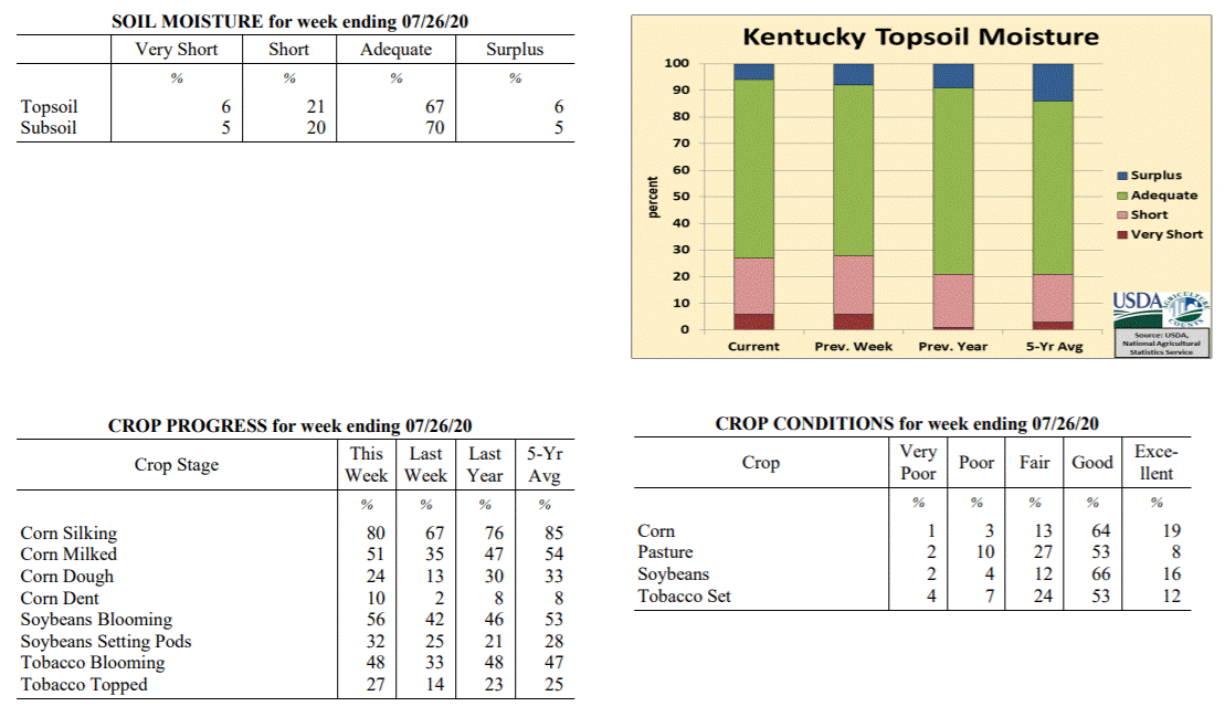 Kentucky Climate Summary
For the Period July 20, 2020 to July 26, 2020
Above Normal Temperatures and Rainfall:
Kentucky saw a typical summer-time weather pattern throughout the week with a warm,
moist, and unstable air mass in place. Heat was accompanied by daily rounds of storms
during the heat of the afternoon. Rain coverage was a bit more pronounced this
period. In doing so, other some isolated spots, most of Kentucky saw at least a half
inch. The state average 1.25 inches for the week, slightly above normal for this
time of year. Just like recent weeks, if caught under a storm, 1 to 2+ inches was
common. Looking at data from the Ag Weather Center over the past 30 days, rainfall
has been plentiful for most of Kentucky over that period. The state has averaged 5.46
inches, higher accumulations across Western and Central Kentucky (averages of 7.11
and 6.61, respectively) and lower across Eastern Kentucky (4.01 inches). Some
localized areas have been much drier compared to the surrounding area. This includes
portions of SE/NE Kentucky and the southern Bluegrass, which are roughly 1 to 2
inches below normal over the past 30 days.
Temperatures for the period averaged 79 degrees across the state which was 2 degrees
warmer than normal and 2 degrees warmer than the previous period. High temperatures
averaged from 90 in the West to 88 in the East. Departure from normal high
temperatures ranged from 1 degree warmer than normal in the West to 1 degree
warmer than normal in the East. Low temperatures averaged from 71 degrees in the
West to 69 degrees in the East. Departure from normal low temperature ranged from 4
degrees warmer than normal in the West to 5 degrees warmer than normal in the East.
The extreme high temperature for the period was 97 degrees at PEABODY and the extreme
low was 64 degrees at CYNTHIANA 8N.
Precipitation (liq. equ.) for the period totaled 1.25 inches statewide which was 0.29
inches above normal and 131% of normal. Precipitation totals by climate division,
West 1.33 inches, Central 1.40 inches, Bluegrass 1.08 inches and East 1.19 inches,
which was 0.42, 0.43, 0.13 and 0.19 inches above normal. By station, precipitation
totals ranged from a low of 0.02 inches at LEXINGTON 7S to a high of 4.16 inches at
BOWLING GREEN 5S.
---
Kentucky Crop and Weather Report
Issued 4:00 P.M., July 20, 2020 18-20
Agricultural News: Kentucky experienced above normal temperatures and below normal
rainfall over the past week. Precipitation for the week totaled 0.38 inches, 0.61
inches below normal. Temperatures averaged 78 degrees for the week, 1 degree above
normal. Topsoil moisture was rated 6 percent very short, 22 percent short, 64 percent
adequate, and 8 percent surplus. Subsoil moisture was rated 5 percent very short, 20
percent short, 68 percent adequate, and 7 percent surplus. Days suitable for
fieldwork averaged 5.8 out of a possible seven.
Primary activities for this week included scouting fields for disease, spraying,
topping tobacco, and cutting hay. Temperatures were very hot and rainfall was sparse
over the past week. Accumulations of rain across the state varied greatly with some
areas getting very dry. The excessive heat put stress on livestock and pasture
ground. Most forage is doing fair due to deep moisture from previous wet periods.
Fungicide is being applied to some of the corn crop at this juncture. Sixty-seven
percent of corn is in the silking stage while 35 percent of the crop is milking.
Forty-two percent of soybeans are blooming with 25 percent setting pods. Tobacco is
33 percent blooming. Fourteen percent of the crop has been topped at this time.
Both corn and soybeans remain in mostly good condition, however stress from intense
heat could development if current weather persists. Tobacco is doing well with 62
percent of the crop rated as in good condition. Pastures are in mostly good condition
at this time, however hot temperatures and dry weather could take a toll on growth.
Kentucky Climate Summary
For the Period July 20, 2020 to July 26, 2020
Above Normal Temperatures and Rainfall:
Kentucky saw a typical summer-time weather pattern throughout the week with a warm,
moist, and unstable air mass in place. Heat was accompanied by daily rounds of storms
during the heat of the afternoon. Rain coverage was a bit more pronounced this
period. In doing so, other some isolated spots, most of Kentucky saw at least a half
inch. The state average 1.25 inches for the week, slightly above normal for this
time of year. Just like recent weeks, if caught under a storm, 1 to 2+ inches was
common. Looking at data from the Ag Weather Center over the past 30 days, rainfall
has been plentiful for most of Kentucky over that period. The state has averaged 5.46
inches, higher accumulations across Western and Central Kentucky (averages of 7.11
and 6.61, respectively) and lower across Eastern Kentucky (4.01 inches). Some
localized areas have been much drier compared to the surrounding area. This includes
portions of SE/NE Kentucky and the southern Bluegrass, which are roughly 1 to 2
inches below normal over the past 30 days.
Temperatures for the period averaged 79 degrees across the state which was 2 degrees
warmer than normal and 2 degrees warmer than the previous period. High temperatures
averaged from 90 in the West to 88 in the East. Departure from normal high
temperatures ranged from 1 degree warmer than normal in the West to 1 degree
warmer than normal in the East. Low temperatures averaged from 71 degrees in the
West to 69 degrees in the East. Departure from normal low temperature ranged from 4
degrees warmer than normal in the West to 5 degrees warmer than normal in the East.
The extreme high temperature for the period was 97 degrees at PEABODY and the extreme
low was 64 degrees at CYNTHIANA 8N.
Precipitation (liq. equ.) for the period totaled 1.25 inches statewide which was 0.29
inches above normal and 131% of normal. Precipitation totals by climate division,
West 1.33 inches, Central 1.40 inches, Bluegrass 1.08 inches and East 1.19 inches,
which was 0.42, 0.43, 0.13 and 0.19 inches above normal. By station, precipitation
totals ranged from a low of 0.02 inches at LEXINGTON 7S to a high of 4.16 inches at
BOWLING GREEN 5S.
---
Kentucky Crop and Weather Report
Issued 4:00 P.M., July 20, 2020 18-20
Agricultural News: Kentucky experienced above normal temperatures and below normal
rainfall over the past week. Precipitation for the week totaled 0.38 inches, 0.61
inches below normal. Temperatures averaged 78 degrees for the week, 1 degree above
normal. Topsoil moisture was rated 6 percent very short, 22 percent short, 64 percent
adequate, and 8 percent surplus. Subsoil moisture was rated 5 percent very short, 20
percent short, 68 percent adequate, and 7 percent surplus. Days suitable for
fieldwork averaged 5.8 out of a possible seven.
Primary activities for this week included scouting fields for disease, spraying,
topping tobacco, and cutting hay. Temperatures were very hot and rainfall was sparse
over the past week. Accumulations of rain across the state varied greatly with some
areas getting very dry. The excessive heat put stress on livestock and pasture
ground. Most forage is doing fair due to deep moisture from previous wet periods.
Fungicide is being applied to some of the corn crop at this juncture. Sixty-seven
percent of corn is in the silking stage while 35 percent of the crop is milking.
Forty-two percent of soybeans are blooming with 25 percent setting pods. Tobacco is
33 percent blooming. Fourteen percent of the crop has been topped at this time.
Both corn and soybeans remain in mostly good condition, however stress from intense
heat could development if current weather persists. Tobacco is doing well with 62
percent of the crop rated as in good condition. Pastures are in mostly good condition
at this time, however hot temperatures and dry weather could take a toll on growth.
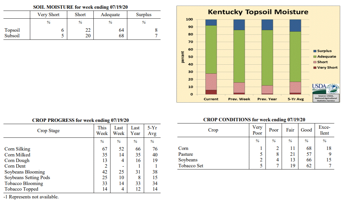 Kentucky Climate Summary
For the Period July 13, 2020 to July 19, 2020
Above Normal Temperatures and Below Normal Rainfall:
Summer heat was in full force over the course of the period, especially over the
latter half of the week when highs consistently jumping into the upper 80s to middle
90s. The most oppressive heat arrived on Sunday with the entire state in the low to
middle 90s. A heat advisory was issued for the western half of Kentucky and up into
the Northern Bluegrass/Northeastern Kentucky where high humidity pushed heat indices
into the 100 to 105 degree range. The intense heat led to stressful conditions for
livestock as the livestock heat stress index ran in the danger/emergency category
each afternoon and early evening. Looking at rainfall, the state only averaged 0.38
inches for the week, most of which fell on Thursday. Isolated to scattered coverage
was common throughout the week, which led to extremely variable accumulations. If
caught under a storm, 1 to 2 inches were common, but others missed out and saw very
little, many under a tenth of an inch.
Temperatures for the period averaged 78 degrees across the state which was 1 degree
warmer than normal and no change to the previous period. High temperatures averaged
from 89 in the West to 88 in the East. Departure from normal high temperatures
ranged from 1 degree cooler than normal in the West to 1 degree warmer than normal
in the East. Low temperatures averaged from 70 degrees in the West to 66 degrees in
the East. Departure from normal low temperature ranged from 2 degrees warmer than
normal in the West to 2 degrees warmer than normal in the East. The extreme high
temperature for the period was 96 degrees at LOUISA 1S and the extreme low was 58
degrees at BRANDENBURG 4SW.
Precipitation (liq. equ.) for the period totaled 0.38 inches statewide which was 0.61
inches below normal and 38% of normal. Precipitation totals by climate division, West
0.50 inches, Central 0.45 inches, Bluegrass 0.20 inches and East 0.36 inches, which
was 0.46, 0.56, 0.76 and 0.67 inches below normal. By station, precipitation totals
ranged from a low of 0.00 inches at ALBANY 1N to a high of 2.13 inches at POPLAR
BLUFF ASOS.
---
Kentucky Crop and Weather Report
Issued 4:00 P.M., July 13, 2020 17-20
Agricultural News: Kentucky experienced above normal temperatures and rainfall over
the past week. Precipitation for the week totaled 1.12 inches, 0.13 inches above
normal. Temperatures averaged 78 degrees for the week, 2 degrees above normal.
Topsoil moisture was rated 2 percent very short, 14 percent short, 70 percent
adequate, and 14 percent surplus. Subsoil moisture was rated 3 percent very short, 14
percent short, 75 percent adequate, and 8 percent surplus. Days suitable for
fieldwork averaged 5.1 out of a possible seven.
Primary activities for this week included the monitoring of field crops, cutting hay,
and some topping of tobacco. Hot, humid conditions this week produced scattered
thunderstorms and rain. The rain was heavy at times and led to some flash flooding in
certain areas. There have been some failed acres of corn and soybeans reported due to
excess rain. In some instances soybeans are being planted behind failed corn. The
flooding was not widespread as parts of the state actually needed rain and received
optimal amounts. Fifty-two percent of corn is in the silking stage while 14 percent
of the crop is milking. Four percent of corn is in the dough stage, just slightly
behind last year and the five year average. The soybean crop is 96 percent emerged.
Twenty-five percent of soybeans are blooming with 10 percent setting pods. Tobacco is
14 percent blooming and farmers are beginning to top the crop.
Both corn and soybeans remain in mostly good condition, however damage from flooding
will be assessed in the coming weeks in the affected areas. Tobacco is doing well
with 68 percent of the crop rated as in good condition. Pastures are in mostly good
condition at this time, however there may be stress from heavy rain. In some areas
dry conditions coupled with heat could cause some issues with pasture growth.
Kentucky Climate Summary
For the Period July 13, 2020 to July 19, 2020
Above Normal Temperatures and Below Normal Rainfall:
Summer heat was in full force over the course of the period, especially over the
latter half of the week when highs consistently jumping into the upper 80s to middle
90s. The most oppressive heat arrived on Sunday with the entire state in the low to
middle 90s. A heat advisory was issued for the western half of Kentucky and up into
the Northern Bluegrass/Northeastern Kentucky where high humidity pushed heat indices
into the 100 to 105 degree range. The intense heat led to stressful conditions for
livestock as the livestock heat stress index ran in the danger/emergency category
each afternoon and early evening. Looking at rainfall, the state only averaged 0.38
inches for the week, most of which fell on Thursday. Isolated to scattered coverage
was common throughout the week, which led to extremely variable accumulations. If
caught under a storm, 1 to 2 inches were common, but others missed out and saw very
little, many under a tenth of an inch.
Temperatures for the period averaged 78 degrees across the state which was 1 degree
warmer than normal and no change to the previous period. High temperatures averaged
from 89 in the West to 88 in the East. Departure from normal high temperatures
ranged from 1 degree cooler than normal in the West to 1 degree warmer than normal
in the East. Low temperatures averaged from 70 degrees in the West to 66 degrees in
the East. Departure from normal low temperature ranged from 2 degrees warmer than
normal in the West to 2 degrees warmer than normal in the East. The extreme high
temperature for the period was 96 degrees at LOUISA 1S and the extreme low was 58
degrees at BRANDENBURG 4SW.
Precipitation (liq. equ.) for the period totaled 0.38 inches statewide which was 0.61
inches below normal and 38% of normal. Precipitation totals by climate division, West
0.50 inches, Central 0.45 inches, Bluegrass 0.20 inches and East 0.36 inches, which
was 0.46, 0.56, 0.76 and 0.67 inches below normal. By station, precipitation totals
ranged from a low of 0.00 inches at ALBANY 1N to a high of 2.13 inches at POPLAR
BLUFF ASOS.
---
Kentucky Crop and Weather Report
Issued 4:00 P.M., July 13, 2020 17-20
Agricultural News: Kentucky experienced above normal temperatures and rainfall over
the past week. Precipitation for the week totaled 1.12 inches, 0.13 inches above
normal. Temperatures averaged 78 degrees for the week, 2 degrees above normal.
Topsoil moisture was rated 2 percent very short, 14 percent short, 70 percent
adequate, and 14 percent surplus. Subsoil moisture was rated 3 percent very short, 14
percent short, 75 percent adequate, and 8 percent surplus. Days suitable for
fieldwork averaged 5.1 out of a possible seven.
Primary activities for this week included the monitoring of field crops, cutting hay,
and some topping of tobacco. Hot, humid conditions this week produced scattered
thunderstorms and rain. The rain was heavy at times and led to some flash flooding in
certain areas. There have been some failed acres of corn and soybeans reported due to
excess rain. In some instances soybeans are being planted behind failed corn. The
flooding was not widespread as parts of the state actually needed rain and received
optimal amounts. Fifty-two percent of corn is in the silking stage while 14 percent
of the crop is milking. Four percent of corn is in the dough stage, just slightly
behind last year and the five year average. The soybean crop is 96 percent emerged.
Twenty-five percent of soybeans are blooming with 10 percent setting pods. Tobacco is
14 percent blooming and farmers are beginning to top the crop.
Both corn and soybeans remain in mostly good condition, however damage from flooding
will be assessed in the coming weeks in the affected areas. Tobacco is doing well
with 68 percent of the crop rated as in good condition. Pastures are in mostly good
condition at this time, however there may be stress from heavy rain. In some areas
dry conditions coupled with heat could cause some issues with pasture growth.
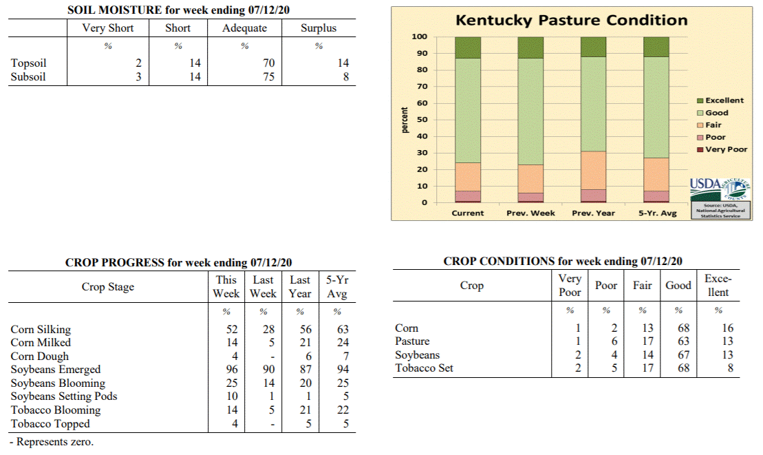 Kentucky Climate Summary
For the Period July 6, 2020 to July 12, 2020
Above Normal Temperatures and Rainfall:
This past week featured a �rinse and repeat� pattern. Weather conditions were
essentially the same between Monday and Thursday. Highs jumped into the upper 80s to
middle 90s with humid conditions in place. Isolated to scattered storms formed each
day during the heat of the afternoon hours and dissipated later in the evening and
overnight. Once again, any storm that developed was capable of producing very heavy
rainfall and flash flooding. The pattern changed a bit Friday and into the weekend as
a couple cold fronts worked through Kentucky. The state saw several rounds of
rainfall, some with widespread coverage in place. Overall, the state averaged a
little over an inch for the week. This now makes the third straight week that the
state rainfall average has ran above normal. Over those 21 days, data at the Ag
Weather Center shows the state has averaged 4.45 inches, which is about 1.5 inches
above normal.
Temperatures for the period averaged 78 degrees across the state which was 2 degrees
warmer than normal and no change to the previous period. High temperatures averaged
from 89 in the West to 86 in the East. Departure from normal high temperatures
ranged from near normal in the West to 1 degree cooler than normal in the East. Low
temperatures averaged from 70 degrees in the West to 66 degrees in the East. Departure
from normal low temperature ranged from 3 degrees warmer than normal in the West to 3
degrees warmer than normal in the East. The extreme high temperature for the period was
95 degrees at CAPE GIRARDEAU ASOS and the extreme low was 61 degrees at BRANDENBURG 4SW.
Precipitation (liq. equ.) for the period totaled 1.12 inches statewide which was 0.13
inches above normal and 113% of normal. Precipitation totals by climate division,
West 1.24 inches, Central 1.21 inches, Bluegrass 1.27 inches and East 0.77 inches,
which was 0.26, 0.21, 0.30 and -0.23 inches respectively from normal. By station,
precipitation totals ranged from a low of 0.00 inches at CAPE GIRARDEAU ASOS to a
high of 4.05 inches at HARRODSBURG 3N.
---
Kentucky Crop and Weather Report
Issued 4:00 P.M., July 6, 2020 16-20
Agricultural News: Kentucky experienced above normal temperatures and rainfall over
the past week. Precipitation for the week totaled 1.08 inches, 0.09 inches above
normal. Temperatures averaged 77 degrees for the week, 1 degree above normal. Topsoil
moisture was rated 2 percent very short, 10 percent short, 66 percent adequate, and
22 percent surplus. Subsoil moisture was rated 2 percent very short, 9 percent short,
73 percent adequate, and 16 percent surplus. Days suitable for fieldwork averaged 4.1
out of a possible seven.
Primary activities for this week included the continued planting of soybeans, setting
tobacco, cutting hay, and harvesting wheat. Heavy precipitation in the early part of
the week proved to be a detriment to some crops as there were reports of extensive
flooding in parts of the state. There were reports of crops under water as well as
fields badly eroded from the heavy rain. The scope of the damage will be assessed as
the season progresses. The latter part of the week presented drier conditions, but
intense heat that led to stress on crops and livestock. Twenty-eight percent of corn
is in the silking stage while 5 percent of the crop is milking. Nearly all soybeans
have been planted at this juncture with 90 percent of the crop emerged. Fourteen
percent of soybeans are blooming with only 1 percent setting pods. The average height
of soybeans is 14 inches. Tobacco setting, at 98 percent complete, is ahead of last
year and the five year average. Of the tobacco in the ground 5 percent is blooming.
Winter wheat harvest is 95 percent complete.
Both corn and soybeans remain in mostly good condition. Tobacco is doing well with 69
percent of the crop rated as in good condition. Pastures are in mostly good condition
at this time, however the rain this week may have opened the door for deterioration
from livestock traffic due to excessive mud.
Kentucky Climate Summary
For the Period July 6, 2020 to July 12, 2020
Above Normal Temperatures and Rainfall:
This past week featured a �rinse and repeat� pattern. Weather conditions were
essentially the same between Monday and Thursday. Highs jumped into the upper 80s to
middle 90s with humid conditions in place. Isolated to scattered storms formed each
day during the heat of the afternoon hours and dissipated later in the evening and
overnight. Once again, any storm that developed was capable of producing very heavy
rainfall and flash flooding. The pattern changed a bit Friday and into the weekend as
a couple cold fronts worked through Kentucky. The state saw several rounds of
rainfall, some with widespread coverage in place. Overall, the state averaged a
little over an inch for the week. This now makes the third straight week that the
state rainfall average has ran above normal. Over those 21 days, data at the Ag
Weather Center shows the state has averaged 4.45 inches, which is about 1.5 inches
above normal.
Temperatures for the period averaged 78 degrees across the state which was 2 degrees
warmer than normal and no change to the previous period. High temperatures averaged
from 89 in the West to 86 in the East. Departure from normal high temperatures
ranged from near normal in the West to 1 degree cooler than normal in the East. Low
temperatures averaged from 70 degrees in the West to 66 degrees in the East. Departure
from normal low temperature ranged from 3 degrees warmer than normal in the West to 3
degrees warmer than normal in the East. The extreme high temperature for the period was
95 degrees at CAPE GIRARDEAU ASOS and the extreme low was 61 degrees at BRANDENBURG 4SW.
Precipitation (liq. equ.) for the period totaled 1.12 inches statewide which was 0.13
inches above normal and 113% of normal. Precipitation totals by climate division,
West 1.24 inches, Central 1.21 inches, Bluegrass 1.27 inches and East 0.77 inches,
which was 0.26, 0.21, 0.30 and -0.23 inches respectively from normal. By station,
precipitation totals ranged from a low of 0.00 inches at CAPE GIRARDEAU ASOS to a
high of 4.05 inches at HARRODSBURG 3N.
---
Kentucky Crop and Weather Report
Issued 4:00 P.M., July 6, 2020 16-20
Agricultural News: Kentucky experienced above normal temperatures and rainfall over
the past week. Precipitation for the week totaled 1.08 inches, 0.09 inches above
normal. Temperatures averaged 77 degrees for the week, 1 degree above normal. Topsoil
moisture was rated 2 percent very short, 10 percent short, 66 percent adequate, and
22 percent surplus. Subsoil moisture was rated 2 percent very short, 9 percent short,
73 percent adequate, and 16 percent surplus. Days suitable for fieldwork averaged 4.1
out of a possible seven.
Primary activities for this week included the continued planting of soybeans, setting
tobacco, cutting hay, and harvesting wheat. Heavy precipitation in the early part of
the week proved to be a detriment to some crops as there were reports of extensive
flooding in parts of the state. There were reports of crops under water as well as
fields badly eroded from the heavy rain. The scope of the damage will be assessed as
the season progresses. The latter part of the week presented drier conditions, but
intense heat that led to stress on crops and livestock. Twenty-eight percent of corn
is in the silking stage while 5 percent of the crop is milking. Nearly all soybeans
have been planted at this juncture with 90 percent of the crop emerged. Fourteen
percent of soybeans are blooming with only 1 percent setting pods. The average height
of soybeans is 14 inches. Tobacco setting, at 98 percent complete, is ahead of last
year and the five year average. Of the tobacco in the ground 5 percent is blooming.
Winter wheat harvest is 95 percent complete.
Both corn and soybeans remain in mostly good condition. Tobacco is doing well with 69
percent of the crop rated as in good condition. Pastures are in mostly good condition
at this time, however the rain this week may have opened the door for deterioration
from livestock traffic due to excessive mud.
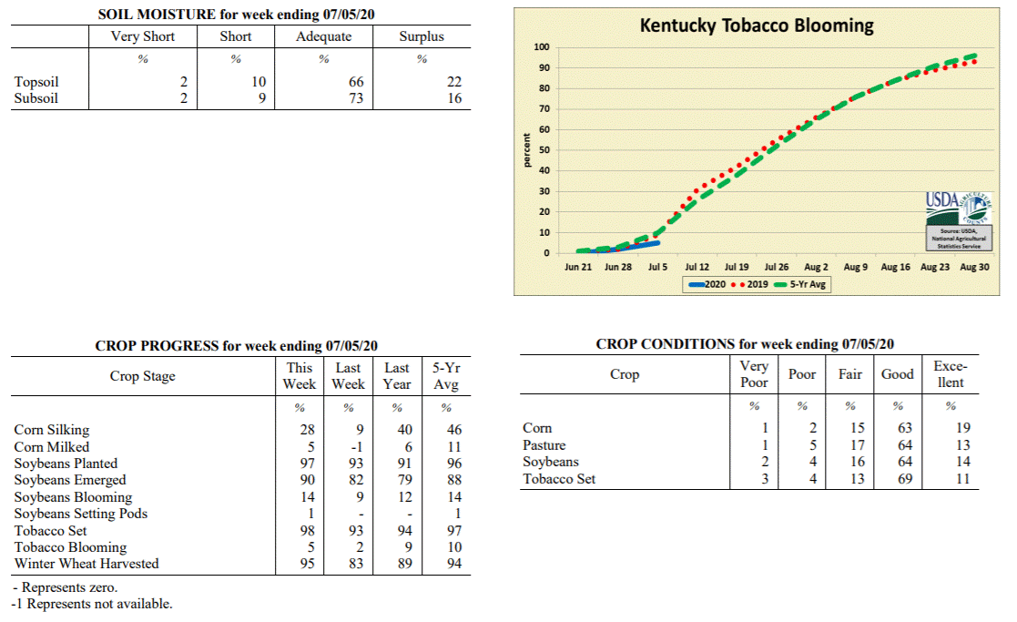 Kentucky Climate Summary
For the Period June 29, 2020 to July 5, 2020
Above Normal Temperatures and Rainfall:
The first half of the period featured a persistent wet pattern that carried over from
the previous weekend. Storms were scattered in coverage and within a very moist air
mass, led to heavy downpours. If caught under one of these slow-moving storms, flash
flooding was common with the excessive rainfall. Western Kentucky saw the most
widespread rainfall this week with most picking up more than an inch, but many over
two. A very hot and humid air mass accompanied the rainfall. The muggy conditions
made it feel more like it was around 100 for some locations on Monday. Conditions
turned mostly dry between Thursday and Independence Day. While humidity decreased a
bit, air temperatures remained high in the upper 80s to middle 90s, slightly above
normal for this time of year. Storms returned to the area on Sunday, most widespread
across Central Kentucky. Overall, Western Kentucky led the way, averaging over 2
inches for the week. That number decreased to just under a half inch for Eastern
Kentucky with more hit and miss storms. Despite some lower accumulations to the east,
other than extreme NE Kentucky, the Central Bluegrass, and a small section of SE
Kentucky; most have seen significant rainfall over the past 2 weeks.
Temperatures for the period averaged 77 degrees across the state which was 1 degree
warmer than normal and 2 degrees warmer than the previous period. High temperatures
averaged from 87 in the West to 86 in the East. Departure from normal high
temperatures ranged from 2 degrees cooler than normal in the West to near normal in
the East. Low temperatures averaged from 70 degrees in the West to 66 degrees in the
East. Departure from normal low temperature ranged from 3 degrees warmer than normal
in the West to 4 degrees warmer than normal in the East. The extreme high temperature
for the period was 96 degrees at FRANKFORT and the extreme low was 61 degrees at
PAINTSVILLE 4W.
Precipitation (liq. equ.) for the period totaled 1.08 inches statewide which was 0.09
inches above normal and 109% of normal. Precipitation totals by climate division,
West 2.14 inches, Central 1.00 inches, Bluegrass 0.68 inches and East 0.49 inches,
which was 1.15, 0.02, -0.28 and -0.53 inches respectively from normal. By station,
precipitation totals ranged from a low of 0.00 inches at LOUISA 1S to a high of 5.24
inches at LEBANON 8NW.
---
Kentucky Crop and Weather Report
Issued 4:00 P.M., June 29, 2020 15-20
Agricultural News: Kentucky experienced below normal temperatures and much above
normal rainfall over the past week. Precipitation for the week totaled 2.25 inches,
1.25 inches above normal. Temperatures averaged 74 degrees for the week, 1 degree
below normal. Topsoil moisture was rated 1 percent very short, 11 percent short, 74
percent adequate, and 14 percent surplus. Subsoil moisture was rated 2 percent very
short, 11 percent short, 77 percent adequate, and 10 percent surplus. Days suitable
for fieldwork averaged 5.1 out of a possible seven.
Primary activities for this week included the continued planting of soybeans, setting
tobacco, cutting hay, and harvesting wheat. With a good deal of precipitation this
past week fieldwork was halted at times. The rainfall was needed in some areas,
however the weekend brought very heavy downpours and flooding in several parts of the
state. Nine percent of the corn crop is in the silking stage. Soybean planting is
nearing completion with 93 percent of the crop is in the ground. The soybean crop is
82 percent emerged and 9 percent in the blooming stage. The average height of
soybeans at this juncture is 11 inches. Tobacco setting, at 93 percent complete, is
ahead of last year and slightly behind the five year average. Farmers are using every
available window to finish up planting. The average height of tobacco plants is 13
inches at this time with 2 percent of the crop in the blooming stage. Winter wheat
harvest is 83 percent complete as farmers have begun planting double crop soybeans.
It is of note that wheat yields have been adversely affected by the late spring
freeze in many cases.
Both corn and soybeans remain in mostly good condition. Tobacco is doing well with 78
percent of the crop rated as in good condition. Pastures are in mostly good condition
at this time. The rain this past week will benefit some pastures, however the areas
that received very heavy precipitation may see some damage from flooding and
livestock traffic. Livestock across the state are in good shape. The quality of
harvested hay is rated as 2 percent very poor, 5 percent poor, 20 percent fair, 61
percent good, and 12 percent excellent. Hay yields should be very good for the most
part as favorable weather prevailed during much of the harvest.
Kentucky Climate Summary
For the Period June 29, 2020 to July 5, 2020
Above Normal Temperatures and Rainfall:
The first half of the period featured a persistent wet pattern that carried over from
the previous weekend. Storms were scattered in coverage and within a very moist air
mass, led to heavy downpours. If caught under one of these slow-moving storms, flash
flooding was common with the excessive rainfall. Western Kentucky saw the most
widespread rainfall this week with most picking up more than an inch, but many over
two. A very hot and humid air mass accompanied the rainfall. The muggy conditions
made it feel more like it was around 100 for some locations on Monday. Conditions
turned mostly dry between Thursday and Independence Day. While humidity decreased a
bit, air temperatures remained high in the upper 80s to middle 90s, slightly above
normal for this time of year. Storms returned to the area on Sunday, most widespread
across Central Kentucky. Overall, Western Kentucky led the way, averaging over 2
inches for the week. That number decreased to just under a half inch for Eastern
Kentucky with more hit and miss storms. Despite some lower accumulations to the east,
other than extreme NE Kentucky, the Central Bluegrass, and a small section of SE
Kentucky; most have seen significant rainfall over the past 2 weeks.
Temperatures for the period averaged 77 degrees across the state which was 1 degree
warmer than normal and 2 degrees warmer than the previous period. High temperatures
averaged from 87 in the West to 86 in the East. Departure from normal high
temperatures ranged from 2 degrees cooler than normal in the West to near normal in
the East. Low temperatures averaged from 70 degrees in the West to 66 degrees in the
East. Departure from normal low temperature ranged from 3 degrees warmer than normal
in the West to 4 degrees warmer than normal in the East. The extreme high temperature
for the period was 96 degrees at FRANKFORT and the extreme low was 61 degrees at
PAINTSVILLE 4W.
Precipitation (liq. equ.) for the period totaled 1.08 inches statewide which was 0.09
inches above normal and 109% of normal. Precipitation totals by climate division,
West 2.14 inches, Central 1.00 inches, Bluegrass 0.68 inches and East 0.49 inches,
which was 1.15, 0.02, -0.28 and -0.53 inches respectively from normal. By station,
precipitation totals ranged from a low of 0.00 inches at LOUISA 1S to a high of 5.24
inches at LEBANON 8NW.
---
Kentucky Crop and Weather Report
Issued 4:00 P.M., June 29, 2020 15-20
Agricultural News: Kentucky experienced below normal temperatures and much above
normal rainfall over the past week. Precipitation for the week totaled 2.25 inches,
1.25 inches above normal. Temperatures averaged 74 degrees for the week, 1 degree
below normal. Topsoil moisture was rated 1 percent very short, 11 percent short, 74
percent adequate, and 14 percent surplus. Subsoil moisture was rated 2 percent very
short, 11 percent short, 77 percent adequate, and 10 percent surplus. Days suitable
for fieldwork averaged 5.1 out of a possible seven.
Primary activities for this week included the continued planting of soybeans, setting
tobacco, cutting hay, and harvesting wheat. With a good deal of precipitation this
past week fieldwork was halted at times. The rainfall was needed in some areas,
however the weekend brought very heavy downpours and flooding in several parts of the
state. Nine percent of the corn crop is in the silking stage. Soybean planting is
nearing completion with 93 percent of the crop is in the ground. The soybean crop is
82 percent emerged and 9 percent in the blooming stage. The average height of
soybeans at this juncture is 11 inches. Tobacco setting, at 93 percent complete, is
ahead of last year and slightly behind the five year average. Farmers are using every
available window to finish up planting. The average height of tobacco plants is 13
inches at this time with 2 percent of the crop in the blooming stage. Winter wheat
harvest is 83 percent complete as farmers have begun planting double crop soybeans.
It is of note that wheat yields have been adversely affected by the late spring
freeze in many cases.
Both corn and soybeans remain in mostly good condition. Tobacco is doing well with 78
percent of the crop rated as in good condition. Pastures are in mostly good condition
at this time. The rain this past week will benefit some pastures, however the areas
that received very heavy precipitation may see some damage from flooding and
livestock traffic. Livestock across the state are in good shape. The quality of
harvested hay is rated as 2 percent very poor, 5 percent poor, 20 percent fair, 61
percent good, and 12 percent excellent. Hay yields should be very good for the most
part as favorable weather prevailed during much of the harvest.
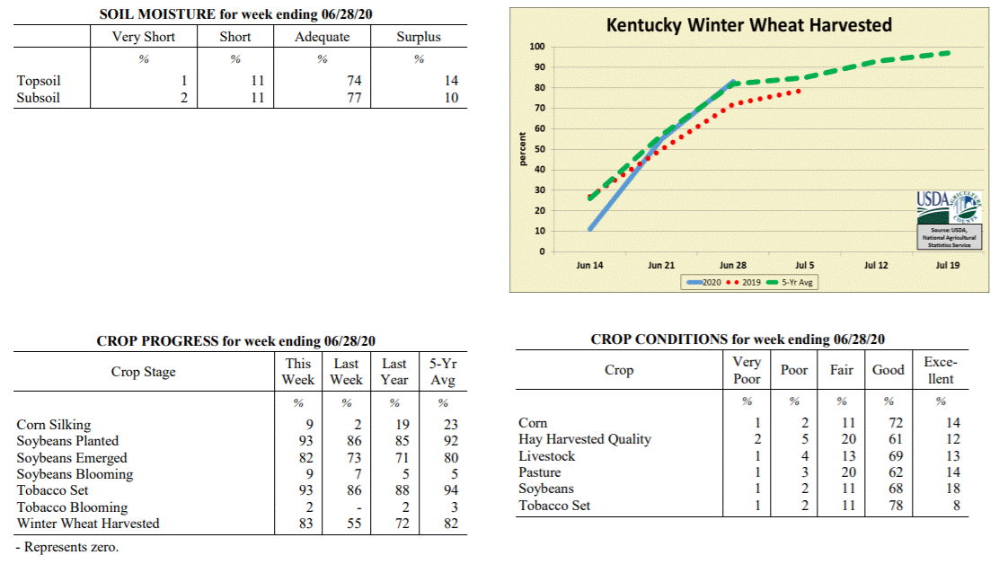 Kentucky Climate Summary
For the Period June 22, 2020 to June 28, 2020
Below Normal Temperatures and Much Above Normal Rainfall:
Exceptional rainfall fell across the Bluegrass State over this past week as the state
averaged 2.25 inches. This broke a four week stretch of below normal rainfall. While
the state saw numerous rounds of showers and storms through the period, the most
intense activity occurred over the weekend. Several waves of storms pushed through
Kentucky and as the state sat within a very moist air mass, torrential rainfall was
common. One of these waves led to substantial flooding across portions of West
Central Kentucky on Sunday. The three highest accumulations according to the Kentucky
Mesonet on Sunday came from Ohio, Muhlenberg, and McLean Counties with totals of 4 to
6+ inches. This wave carried southeast into South Central Kentucky with numerous
stations over two inches for the day.
Temperatures for the period averaged 74 degrees across the state which was 1 degree
cooler than normal and 4 degrees warmer than the previous period. High temperatures
averaged from 85 in the West to 81 in the East. Departure from normal high
temperatures ranged from 3 degrees cooler than normal in the West to 4 degrees
cooler than normal in the East. Low temperatures averaged from 67 degrees in the
West to 64 degrees in the East. Departure from normal low temperature ranged from 2
degrees warmer than normal in the West to 3 degrees warmer than normal in the East.
The extreme high temperature for the period was 94 degrees at CAPE GIRARDEAU ASOS and
the extreme low was 55 degrees at CYNTHIANA 8N.
Precipitation (liq. equ.) for the period totaled 2.25 inches statewide which was 1.25
inches above normal and 226% of normal. Precipitation totals by climate division,
West 2.35 inches, Central 2.99 inches, Bluegrass 1.79 inches and East 1.86 inches,
which was 1.36, 2.01, 0.81 and 0.83 inches above normal. By station, precipitation
totals ranged from a low of 0.00 inches at BIG SANDY to a high of 7.48 inches at
CALHOUN 5NW.
---
Kentucky Crop and Weather Report
Issued 4:00 P.M., June 22, 2020 14-20
Agricultural News: Kentucky experienced below normal temperatures and rainfall over
the past week. Precipitation for the week totaled 0.65 inches, 0.36 inches below
normal. Temperatures averaged 71 degrees for the week, 2 degrees below normal.
Topsoil moisture was rated 2 percent very short, 29 percent short, 63 percent
adequate, and 6 percent surplus. Subsoil moisture was rated 3 percent very short, 19
percent short, 72 percent adequate, and 6 percent surplus. Days suitable for
fieldwork averaged 6.0 out of a possible seven.
Primary activities for this week included the continued planting of soybeans, setting
tobacco, cutting hay, and harvesting wheat. Favorable weather allowed farmers to put
in a great deal of time in the fields. The corn crop is 95 percent emerged with 2
percent of the crop in the silking stage. Soybean planting is moving along at a
strong pace and continues to run ahead of last year and the five year average. The
soybean crop is 73 percent emerged and 7 percent in the blooming stage. The average
height of soybeans at this juncture is 4 inches. Tobacco setting is ahead of last
year and slightly behind the five year average. Some prosperous weather in the coming
week will allow farmers to near completion for setting. The average height of tobacco
plants is 10 inches at this time. Winter wheat harvest took a big jump this past week
thanks to the accommodating weather. With the crop at 92 percent mature, producers
pressed hard to get as much harvested as possible. Many farmers are ready to plant
double crop soybeans as the wheat is harvested.
The winter wheat crop is in mostly good condition. Both corn and soybeans are in good
shape as grain farmers push through the season. Tobacco is doing well thus far with
80 percent of the crop rated as in good condition. Pastures are still in good
condition, but would benefit from some precipitation to promote growth. Hay is in
good condition despite the dry conditions of late.
Kentucky Climate Summary
For the Period June 22, 2020 to June 28, 2020
Below Normal Temperatures and Much Above Normal Rainfall:
Exceptional rainfall fell across the Bluegrass State over this past week as the state
averaged 2.25 inches. This broke a four week stretch of below normal rainfall. While
the state saw numerous rounds of showers and storms through the period, the most
intense activity occurred over the weekend. Several waves of storms pushed through
Kentucky and as the state sat within a very moist air mass, torrential rainfall was
common. One of these waves led to substantial flooding across portions of West
Central Kentucky on Sunday. The three highest accumulations according to the Kentucky
Mesonet on Sunday came from Ohio, Muhlenberg, and McLean Counties with totals of 4 to
6+ inches. This wave carried southeast into South Central Kentucky with numerous
stations over two inches for the day.
Temperatures for the period averaged 74 degrees across the state which was 1 degree
cooler than normal and 4 degrees warmer than the previous period. High temperatures
averaged from 85 in the West to 81 in the East. Departure from normal high
temperatures ranged from 3 degrees cooler than normal in the West to 4 degrees
cooler than normal in the East. Low temperatures averaged from 67 degrees in the
West to 64 degrees in the East. Departure from normal low temperature ranged from 2
degrees warmer than normal in the West to 3 degrees warmer than normal in the East.
The extreme high temperature for the period was 94 degrees at CAPE GIRARDEAU ASOS and
the extreme low was 55 degrees at CYNTHIANA 8N.
Precipitation (liq. equ.) for the period totaled 2.25 inches statewide which was 1.25
inches above normal and 226% of normal. Precipitation totals by climate division,
West 2.35 inches, Central 2.99 inches, Bluegrass 1.79 inches and East 1.86 inches,
which was 1.36, 2.01, 0.81 and 0.83 inches above normal. By station, precipitation
totals ranged from a low of 0.00 inches at BIG SANDY to a high of 7.48 inches at
CALHOUN 5NW.
---
Kentucky Crop and Weather Report
Issued 4:00 P.M., June 22, 2020 14-20
Agricultural News: Kentucky experienced below normal temperatures and rainfall over
the past week. Precipitation for the week totaled 0.65 inches, 0.36 inches below
normal. Temperatures averaged 71 degrees for the week, 2 degrees below normal.
Topsoil moisture was rated 2 percent very short, 29 percent short, 63 percent
adequate, and 6 percent surplus. Subsoil moisture was rated 3 percent very short, 19
percent short, 72 percent adequate, and 6 percent surplus. Days suitable for
fieldwork averaged 6.0 out of a possible seven.
Primary activities for this week included the continued planting of soybeans, setting
tobacco, cutting hay, and harvesting wheat. Favorable weather allowed farmers to put
in a great deal of time in the fields. The corn crop is 95 percent emerged with 2
percent of the crop in the silking stage. Soybean planting is moving along at a
strong pace and continues to run ahead of last year and the five year average. The
soybean crop is 73 percent emerged and 7 percent in the blooming stage. The average
height of soybeans at this juncture is 4 inches. Tobacco setting is ahead of last
year and slightly behind the five year average. Some prosperous weather in the coming
week will allow farmers to near completion for setting. The average height of tobacco
plants is 10 inches at this time. Winter wheat harvest took a big jump this past week
thanks to the accommodating weather. With the crop at 92 percent mature, producers
pressed hard to get as much harvested as possible. Many farmers are ready to plant
double crop soybeans as the wheat is harvested.
The winter wheat crop is in mostly good condition. Both corn and soybeans are in good
shape as grain farmers push through the season. Tobacco is doing well thus far with
80 percent of the crop rated as in good condition. Pastures are still in good
condition, but would benefit from some precipitation to promote growth. Hay is in
good condition despite the dry conditions of late.
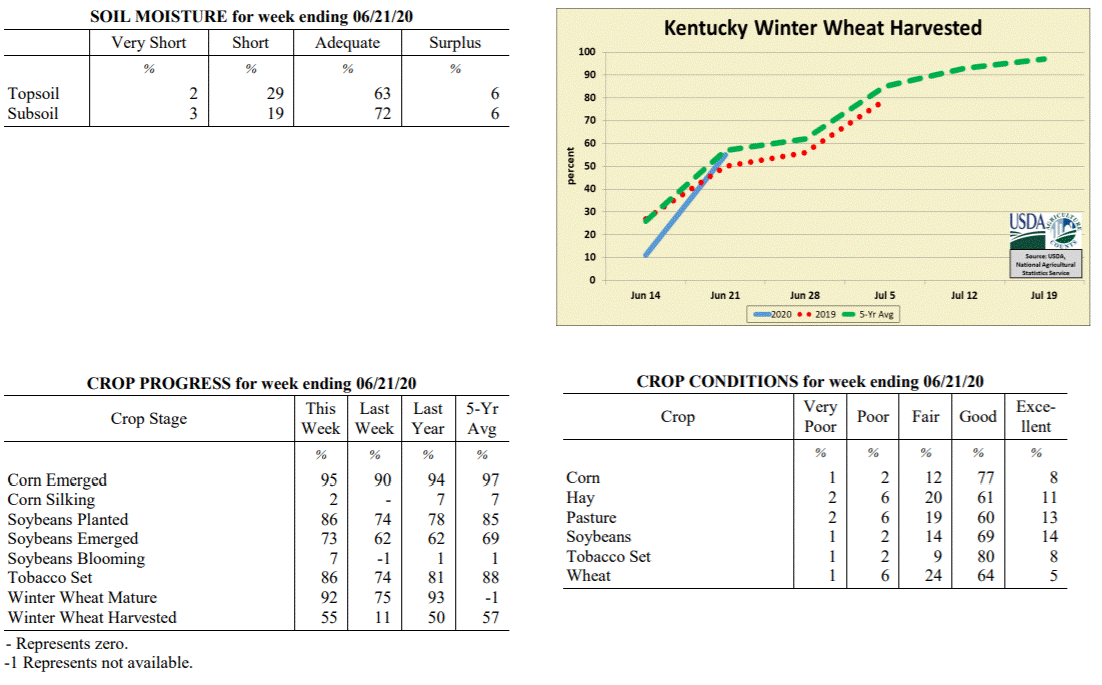 Kentucky Climate Summary
For the Period June 15, 2020 to June 21, 2020
Below Normal Temperatures and Rainfall:
Kentucky saw a fourth straight week of below normal rainfall. Focus for much of the
period was on a slow-moving area of low pressure aloft that hovered to the east of
the Bluegrass State. Conditions were mostly dry through Wednesday, but as the area of
low pressure slowly moved closer, scattered showers and storms returned to the
eastern half of Kentucky on Thursday. Coverage then turned more of the hit or miss
variety on Friday and Saturday, still mainly across the eastern half of the state.
The pattern changed by Sunday as the upper level low moved to the northeast and
another disturbance pushed into the area, producing much-needed widespread rain
coverage for the first time in quite a while. Saying that, accumulations were still
quite variable across Kentucky. Overall, the state averaged 0.65 inches for the week,
which is about a third of an inch below normal. Over the past 30 days, rainfall
deficits are over 1.5 inches below normal across the state. The extended period of
dry weather has led the US Drought Monitor to introduce an area of �Abnormally Dry�
conditions across mainly Western/West Central Kentucky.
Temperatures for the period averaged 71 degrees across the state which was 2 degrees
cooler than normal and 2 degrees cooler than the previous period. High temperatures
averaged from 84 in the West to 78 in the East. Departure from normal high
temperatures ranged from 3 degrees cooler than normal in the West to 6 degrees
cooler than normal in the East. Low temperatures averaged from 61 degrees in the
West to 59 degrees in the East. Departure from normal low temperature ranged from 3
degrees cooler than normal in the West to near normal in the East. The extreme high
temperature for the period was 94 degrees at MAYFIELD 6SW and the extreme low was 49
degrees at BRANDENBURG 4SW.
Precipitation (liq. equ.) for the period totaled 0.65 inches statewide which was 0.36
inches below normal and 64% of normal. Precipitation totals by climate division, West
0.62 inches, Central 0.60 inches, Bluegrass 0.64 inches and East 0.74 inches, which
was 0.38, 0.4, 0.38 and 0.29 inches below normal. By station, precipitation totals
ranged from a low of 0.01 inches at BIG SANDY to a high of 2.19 inches at MOREHEAD 4NE.
---
Kentucky Crop and Weather Report
Issued 4:00 P.M., June 15, 2020 13-20
Agricultural News: Kentucky experienced above normal temperatures and below normal
rainfall over the past week. Precipitation for the week totaled 0.38 inches, 0.65
inches below normal. Temperatures averaged 73 degrees for the week, 1 degrees above
normal. Topsoil moisture was rated 2 percent very short, 19 percent short, 70 percent
adequate, and 9 percent surplus. Subsoil moisture was rated 2 percent very short, 13
percent short, 76 percent adequate, and 9 percent surplus. Days suitable for
fieldwork averaged 6.0 out of a possible seven.
Primary activities for this week included the continued planting of corn and
soybeans, setting tobacco, spraying, and cutting hay. A very productive week in the
fields as weather was cooperative for the most part. Dry and warm conditions allowed
farmers to make a strong push on plantings and forage harvest. There are pockets
where the dry weather has been a detriment. In these areas the crops are a little
stressed and rain is needed to incorporate nitrogen that has been sprayed. With that
said, the week wasn�t completely void of rain, however rainfall was sparse and
generally not heavy in nature. Soybean planting is ahead of last year but just behind
the five year average. Corn planting is nearing completion and is on pace with both
last year and the five year average. The corn crop is 90 percent emerged while
soybeans are 62 percent emerged. The average height of corn at this juncture is 21
inches. Tobacco setting made a big leap this week and sits right between last year
and the five year average. The average height of tobacco is 6 inches.
The winter wheat harvest has begun in earnest, however progress is well below last
year and the five year average for this juncture of the season. Nearly all of the
crop is mature and mostly coloring. The condition of the wheat crop remains mostly
good despite the freeze event several weeks prior. Corn and soybean condition
continues to be reported as mostly good at this time. Pastures are healthy on the
whole and continue to show good growth. Planted tobacco is reported as in mostly
good condition at this time.
Kentucky Climate Summary
For the Period June 15, 2020 to June 21, 2020
Below Normal Temperatures and Rainfall:
Kentucky saw a fourth straight week of below normal rainfall. Focus for much of the
period was on a slow-moving area of low pressure aloft that hovered to the east of
the Bluegrass State. Conditions were mostly dry through Wednesday, but as the area of
low pressure slowly moved closer, scattered showers and storms returned to the
eastern half of Kentucky on Thursday. Coverage then turned more of the hit or miss
variety on Friday and Saturday, still mainly across the eastern half of the state.
The pattern changed by Sunday as the upper level low moved to the northeast and
another disturbance pushed into the area, producing much-needed widespread rain
coverage for the first time in quite a while. Saying that, accumulations were still
quite variable across Kentucky. Overall, the state averaged 0.65 inches for the week,
which is about a third of an inch below normal. Over the past 30 days, rainfall
deficits are over 1.5 inches below normal across the state. The extended period of
dry weather has led the US Drought Monitor to introduce an area of �Abnormally Dry�
conditions across mainly Western/West Central Kentucky.
Temperatures for the period averaged 71 degrees across the state which was 2 degrees
cooler than normal and 2 degrees cooler than the previous period. High temperatures
averaged from 84 in the West to 78 in the East. Departure from normal high
temperatures ranged from 3 degrees cooler than normal in the West to 6 degrees
cooler than normal in the East. Low temperatures averaged from 61 degrees in the
West to 59 degrees in the East. Departure from normal low temperature ranged from 3
degrees cooler than normal in the West to near normal in the East. The extreme high
temperature for the period was 94 degrees at MAYFIELD 6SW and the extreme low was 49
degrees at BRANDENBURG 4SW.
Precipitation (liq. equ.) for the period totaled 0.65 inches statewide which was 0.36
inches below normal and 64% of normal. Precipitation totals by climate division, West
0.62 inches, Central 0.60 inches, Bluegrass 0.64 inches and East 0.74 inches, which
was 0.38, 0.4, 0.38 and 0.29 inches below normal. By station, precipitation totals
ranged from a low of 0.01 inches at BIG SANDY to a high of 2.19 inches at MOREHEAD 4NE.
---
Kentucky Crop and Weather Report
Issued 4:00 P.M., June 15, 2020 13-20
Agricultural News: Kentucky experienced above normal temperatures and below normal
rainfall over the past week. Precipitation for the week totaled 0.38 inches, 0.65
inches below normal. Temperatures averaged 73 degrees for the week, 1 degrees above
normal. Topsoil moisture was rated 2 percent very short, 19 percent short, 70 percent
adequate, and 9 percent surplus. Subsoil moisture was rated 2 percent very short, 13
percent short, 76 percent adequate, and 9 percent surplus. Days suitable for
fieldwork averaged 6.0 out of a possible seven.
Primary activities for this week included the continued planting of corn and
soybeans, setting tobacco, spraying, and cutting hay. A very productive week in the
fields as weather was cooperative for the most part. Dry and warm conditions allowed
farmers to make a strong push on plantings and forage harvest. There are pockets
where the dry weather has been a detriment. In these areas the crops are a little
stressed and rain is needed to incorporate nitrogen that has been sprayed. With that
said, the week wasn�t completely void of rain, however rainfall was sparse and
generally not heavy in nature. Soybean planting is ahead of last year but just behind
the five year average. Corn planting is nearing completion and is on pace with both
last year and the five year average. The corn crop is 90 percent emerged while
soybeans are 62 percent emerged. The average height of corn at this juncture is 21
inches. Tobacco setting made a big leap this week and sits right between last year
and the five year average. The average height of tobacco is 6 inches.
The winter wheat harvest has begun in earnest, however progress is well below last
year and the five year average for this juncture of the season. Nearly all of the
crop is mature and mostly coloring. The condition of the wheat crop remains mostly
good despite the freeze event several weeks prior. Corn and soybean condition
continues to be reported as mostly good at this time. Pastures are healthy on the
whole and continue to show good growth. Planted tobacco is reported as in mostly
good condition at this time.
 Kentucky Climate Summary
For the Period June 8, 2020 to June 14, 2020
Above Normal Temperatures and Below Normal Rainfall:
Conditions have trended dry recently across Kentucky with three straight weeks of
below normal rainfall. Over this 21-day period, the state has only averaged two
inches of rainfall, which is over an inch below normal. Saying that, some locations
have received under an inch over that time period and over two inches below
normal. Looking at this past week, focus was on the remnants of Tropical Storm
Cristobal early in the period. This system ended up taking a track just west of
Kentucky and unfortunately, took the higher accumulations with it. Showers and storms
were scattered to numerous in nature across the western half of Kentucky and limited
father east. This was flipped on Wednesday as a strong cold front pushed through the
state. While the eastern half of Kentucky benefited from some rainfall, the western
half was left mostly dry. After a dry second half of the work week, light showers
again fell over the weekend, but nothing too significant. Overall, the state averaged
less than a half inch for the week.
Temperatures for the period averaged 73 degrees across the state which was 1 degree
warmer than normal and no change to the previous period. High temperatures averaged
from 84 in the West to 82 in the East. Departure from normal high temperatures
ranged from 1 degree cooler than normal in the West to 1 degree cooler than normal
in the East. Low temperatures averaged from 65 degrees in the West to 60 degrees in
the East. Departure from normal low temperature ranged from 2 degrees warmer than
normal in the West to 2 degrees warmer than normal in the East. The extreme high
temperature for the period was 93 degrees at BOWLING GREEN APT and the extreme low
was 50 degrees at CARLISLE 5SW.
Precipitation (liq. equ.) for the period totaled 0.38 inches statewide which was 0.65
inches below normal and 37% of normal. Precipitation totals by climate division, West
0.56 inches, Central 0.35 inches, Bluegrass 0.30 inches and East 0.30 inches, which
was 0.42, 0.69, 0.75 and 0.75 inches below normal. By station, precipitation totals
ranged from a low of 0.00 inches at HODGENVILLE 2E to a high of 1.10
inches at WINCHESTER 3NW.
---
Kentucky Crop and Weather Report
Issued 4:00 P.M., June 8, 2020 12-20
Agricultural News: Kentucky experienced above normal temperatures and below normal
rainfall over the past week. Precipitation for the week totaled 0.96 inches, 0.13
inches below normal. Temperatures averaged 74 degrees for the week, 4 degrees above
normal. Topsoil moisture was rated 1 percent very short, 10 percent short, 76 percent
adequate, and 13 percent surplus. Subsoil moisture was rated 1 percent very short, 7
percent short, 79 percent adequate, and 13 percent surplus. Days suitable for
fieldwork averaged 5.5 out of a possible seven.
Primary activities for this week included the continued planting of corn and
soybeans, setting tobacco, and cutting hay. Farmers were able to make a good deal of
headway in the fields this week thanks to accommodating weather. Planting progress
had been stunted by consistent rain in the prior weeks so drier conditions were a
welcome change. There was a great deal of hay cut this week as the weather was
conducive. As the cutting moved along, there was some expressed optimism regarding
yields. Soybean planting continues to outpace both last year and the five year
average. Corn planting is on par with last year and slightly behind the five year
average. The corn crop is 79 percent emerged while soybeans are 50 percent emerged.
The average height of corn at this juncture is 15 inches. Tobacco setting showed a
big jump in progress this past week and sits just behind last year and the five year
average for this point in the season.
The freeze event that occurred several weeks ago has been alluded to often when
discussing crop conditions. Despite this event, corn and soybeans remain in mostly
good condition and appear to have been largely spared. Winter wheat was damaged in
this event and there will be losses. With that being said, the overall wheat crop is
mostly fair to good, however the margins are closer than corn and soybeans. Tobacco
set is in good condition at this time. Pastures are doing well as the break in rain
has allowed more growth with less damage from livestock traffic.
Kentucky Climate Summary
For the Period June 8, 2020 to June 14, 2020
Above Normal Temperatures and Below Normal Rainfall:
Conditions have trended dry recently across Kentucky with three straight weeks of
below normal rainfall. Over this 21-day period, the state has only averaged two
inches of rainfall, which is over an inch below normal. Saying that, some locations
have received under an inch over that time period and over two inches below
normal. Looking at this past week, focus was on the remnants of Tropical Storm
Cristobal early in the period. This system ended up taking a track just west of
Kentucky and unfortunately, took the higher accumulations with it. Showers and storms
were scattered to numerous in nature across the western half of Kentucky and limited
father east. This was flipped on Wednesday as a strong cold front pushed through the
state. While the eastern half of Kentucky benefited from some rainfall, the western
half was left mostly dry. After a dry second half of the work week, light showers
again fell over the weekend, but nothing too significant. Overall, the state averaged
less than a half inch for the week.
Temperatures for the period averaged 73 degrees across the state which was 1 degree
warmer than normal and no change to the previous period. High temperatures averaged
from 84 in the West to 82 in the East. Departure from normal high temperatures
ranged from 1 degree cooler than normal in the West to 1 degree cooler than normal
in the East. Low temperatures averaged from 65 degrees in the West to 60 degrees in
the East. Departure from normal low temperature ranged from 2 degrees warmer than
normal in the West to 2 degrees warmer than normal in the East. The extreme high
temperature for the period was 93 degrees at BOWLING GREEN APT and the extreme low
was 50 degrees at CARLISLE 5SW.
Precipitation (liq. equ.) for the period totaled 0.38 inches statewide which was 0.65
inches below normal and 37% of normal. Precipitation totals by climate division, West
0.56 inches, Central 0.35 inches, Bluegrass 0.30 inches and East 0.30 inches, which
was 0.42, 0.69, 0.75 and 0.75 inches below normal. By station, precipitation totals
ranged from a low of 0.00 inches at HODGENVILLE 2E to a high of 1.10
inches at WINCHESTER 3NW.
---
Kentucky Crop and Weather Report
Issued 4:00 P.M., June 8, 2020 12-20
Agricultural News: Kentucky experienced above normal temperatures and below normal
rainfall over the past week. Precipitation for the week totaled 0.96 inches, 0.13
inches below normal. Temperatures averaged 74 degrees for the week, 4 degrees above
normal. Topsoil moisture was rated 1 percent very short, 10 percent short, 76 percent
adequate, and 13 percent surplus. Subsoil moisture was rated 1 percent very short, 7
percent short, 79 percent adequate, and 13 percent surplus. Days suitable for
fieldwork averaged 5.5 out of a possible seven.
Primary activities for this week included the continued planting of corn and
soybeans, setting tobacco, and cutting hay. Farmers were able to make a good deal of
headway in the fields this week thanks to accommodating weather. Planting progress
had been stunted by consistent rain in the prior weeks so drier conditions were a
welcome change. There was a great deal of hay cut this week as the weather was
conducive. As the cutting moved along, there was some expressed optimism regarding
yields. Soybean planting continues to outpace both last year and the five year
average. Corn planting is on par with last year and slightly behind the five year
average. The corn crop is 79 percent emerged while soybeans are 50 percent emerged.
The average height of corn at this juncture is 15 inches. Tobacco setting showed a
big jump in progress this past week and sits just behind last year and the five year
average for this point in the season.
The freeze event that occurred several weeks ago has been alluded to often when
discussing crop conditions. Despite this event, corn and soybeans remain in mostly
good condition and appear to have been largely spared. Winter wheat was damaged in
this event and there will be losses. With that being said, the overall wheat crop is
mostly fair to good, however the margins are closer than corn and soybeans. Tobacco
set is in good condition at this time. Pastures are doing well as the break in rain
has allowed more growth with less damage from livestock traffic.
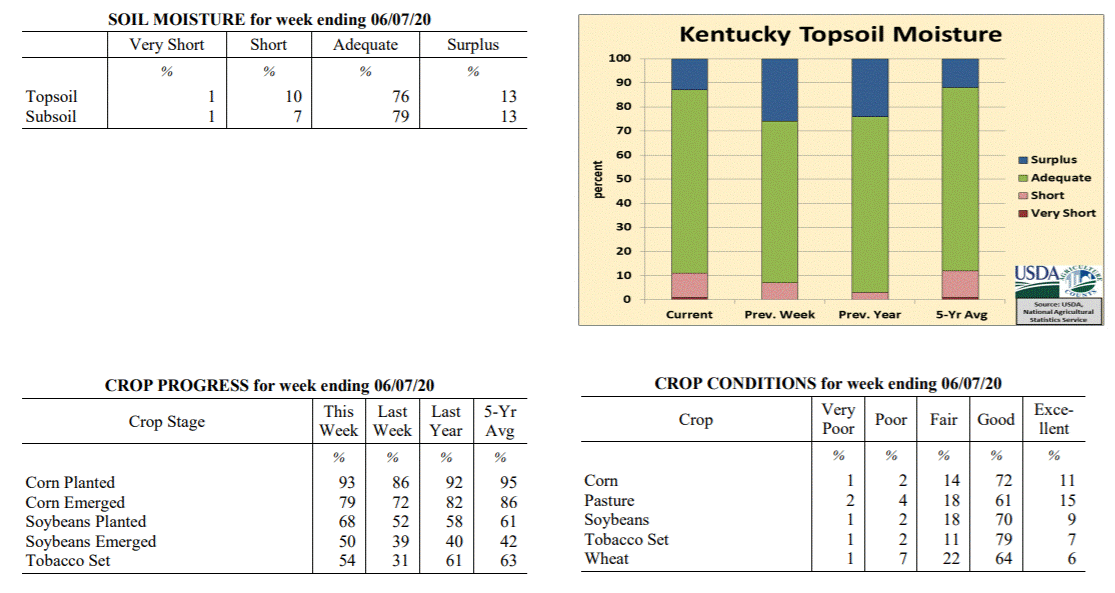 Kentucky Climate Summary
For the Period June 1, 2020 to June 7, 2020
Above Normal Temperatures and Below Normal Rainfall:
Kentucky saw a second straight week of below normal rainfall. According to data at
the Ag Weather Center, the state has averaged 1.62 inches over the past two weeks,
which is just over a half inch below normal. Carrying over from the previous weekend,
dry weather held for most of the state through Wednesday, giving the Commonwealth a 5
day stretch of dry conditions. Increasing temperatures and humidity accompanied this
dry weather with highs back in the mid 80s to low 90s for Tuesday and Wednesday.
Rainfall returned to the area on Thursday afternoon/evening with scattered to
numerous showers and storms in place. Any storms that formed were capable of
producing torrential rainfall. Totals varied tremendously based on the location of
those storms, with totals ranging from under a quarter inch to over 2 inches. This
was the only rainfall event across the week for most of Kentucky. Above normal
temperatures continued on Saturday, ahead of a weak frontal boundary moving through
the state. This boundary had little moisture to work with and for the most
part, just resulted in a temporary break from the humidity on Sunday.
Temperatures for the period averaged 74 degrees across the state which was 4 degrees
warmer than normal and 4 degrees warmer than the previous period. High temperatures
averaged from 87 in the West to 84 in the East. Departure from normal high
temperatures ranged from 4 degrees warmer than normal in the West to 3 degrees
warmer than normal in the East. Low temperatures averaged from 64 degrees in the
West to 61 degrees in the East. Departure from normal low temperature ranged from 3
degrees warmer than normal in the West to 5 degrees warmer than normal in the East.
The extreme high temperature for the period was 94 degrees at LOUISVILLE APT and the
extreme low was 41 degrees at OWINGSVILLE 4S.
Precipitation (liq. equ.) for the period totaled 0.96 inches statewide which was 0.13
inches below normal and 88% of normal. Precipitation totals by climate division, West
0.74 inches, Central 1.31 inches, Bluegrass 0.62 inches and East 1.16 inches, which
was -0.31, 0.21, -0.48 and 0.07 inches respectively from normal. By station,
precipitation totals ranged from a low of 0.05 inches at ALEXANDRIA 5NW to a high of
2.92 inches at OWENSBORO AWSS.
---
Kentucky Crop and Weather Report
Issued 4:00 P.M., June 1, 2020 11-20
Agricultural News: Kentucky experienced above normal temperatures and below normal
rainfall over the past week. Precipitation for the week totaled 0.66 inches, 0.46
inches below normal. Temperatures averaged 71 degrees for the week, 3 degrees above
normal. Topsoil moisture was rated 7 percent short, 67 percent adequate, and 26
percent surplus. Subsoil moisture was rated 4 percent short, 71 percent adequate, and
25 percent surplus. Days suitable for fieldwork averaged 4.3 out of a possible seven.
Primary activities for this week included planting of corn and soybeans, setting
tobacco, and cutting hay. Fieldwork was disrupted sporadically during the week as
farmers contended with scattered rain. The level of precipitation varied regionally
with some areas experiencing weather more conducive to progress in the fields. Drier
conditions prevailed statewide by the weekend allowing some headway on planting.
Cutting of forage has really picked up as farmers take advantage of every
opportunity. Soybean planting remains slightly ahead of both last year and the five
year average. Corn planting is equal to this time last year, but slightly behind the
five year average. The corn crop is 72 percent emerged while soybeans are 39 percent
emerged. The average height of corn at this juncture is 9 inches. Tobacco setting is
moving along at a steady pace, but is behind last year and the five year average.
The winter wheat crop was subject to damage from the freeze several weeks back. The
extent of this damage is becoming evident and losses are likely for many producers.
Despite the grim outlook for some wheat, the condition overall remains good. Corn and
soybean condition continues to be reported as mostly good at this time. Pastures are
showing good growth, but the persistent rain may take a toll from animal traffic.
Kentucky Climate Summary
For the Period June 1, 2020 to June 7, 2020
Above Normal Temperatures and Below Normal Rainfall:
Kentucky saw a second straight week of below normal rainfall. According to data at
the Ag Weather Center, the state has averaged 1.62 inches over the past two weeks,
which is just over a half inch below normal. Carrying over from the previous weekend,
dry weather held for most of the state through Wednesday, giving the Commonwealth a 5
day stretch of dry conditions. Increasing temperatures and humidity accompanied this
dry weather with highs back in the mid 80s to low 90s for Tuesday and Wednesday.
Rainfall returned to the area on Thursday afternoon/evening with scattered to
numerous showers and storms in place. Any storms that formed were capable of
producing torrential rainfall. Totals varied tremendously based on the location of
those storms, with totals ranging from under a quarter inch to over 2 inches. This
was the only rainfall event across the week for most of Kentucky. Above normal
temperatures continued on Saturday, ahead of a weak frontal boundary moving through
the state. This boundary had little moisture to work with and for the most
part, just resulted in a temporary break from the humidity on Sunday.
Temperatures for the period averaged 74 degrees across the state which was 4 degrees
warmer than normal and 4 degrees warmer than the previous period. High temperatures
averaged from 87 in the West to 84 in the East. Departure from normal high
temperatures ranged from 4 degrees warmer than normal in the West to 3 degrees
warmer than normal in the East. Low temperatures averaged from 64 degrees in the
West to 61 degrees in the East. Departure from normal low temperature ranged from 3
degrees warmer than normal in the West to 5 degrees warmer than normal in the East.
The extreme high temperature for the period was 94 degrees at LOUISVILLE APT and the
extreme low was 41 degrees at OWINGSVILLE 4S.
Precipitation (liq. equ.) for the period totaled 0.96 inches statewide which was 0.13
inches below normal and 88% of normal. Precipitation totals by climate division, West
0.74 inches, Central 1.31 inches, Bluegrass 0.62 inches and East 1.16 inches, which
was -0.31, 0.21, -0.48 and 0.07 inches respectively from normal. By station,
precipitation totals ranged from a low of 0.05 inches at ALEXANDRIA 5NW to a high of
2.92 inches at OWENSBORO AWSS.
---
Kentucky Crop and Weather Report
Issued 4:00 P.M., June 1, 2020 11-20
Agricultural News: Kentucky experienced above normal temperatures and below normal
rainfall over the past week. Precipitation for the week totaled 0.66 inches, 0.46
inches below normal. Temperatures averaged 71 degrees for the week, 3 degrees above
normal. Topsoil moisture was rated 7 percent short, 67 percent adequate, and 26
percent surplus. Subsoil moisture was rated 4 percent short, 71 percent adequate, and
25 percent surplus. Days suitable for fieldwork averaged 4.3 out of a possible seven.
Primary activities for this week included planting of corn and soybeans, setting
tobacco, and cutting hay. Fieldwork was disrupted sporadically during the week as
farmers contended with scattered rain. The level of precipitation varied regionally
with some areas experiencing weather more conducive to progress in the fields. Drier
conditions prevailed statewide by the weekend allowing some headway on planting.
Cutting of forage has really picked up as farmers take advantage of every
opportunity. Soybean planting remains slightly ahead of both last year and the five
year average. Corn planting is equal to this time last year, but slightly behind the
five year average. The corn crop is 72 percent emerged while soybeans are 39 percent
emerged. The average height of corn at this juncture is 9 inches. Tobacco setting is
moving along at a steady pace, but is behind last year and the five year average.
The winter wheat crop was subject to damage from the freeze several weeks back. The
extent of this damage is becoming evident and losses are likely for many producers.
Despite the grim outlook for some wheat, the condition overall remains good. Corn and
soybean condition continues to be reported as mostly good at this time. Pastures are
showing good growth, but the persistent rain may take a toll from animal traffic.
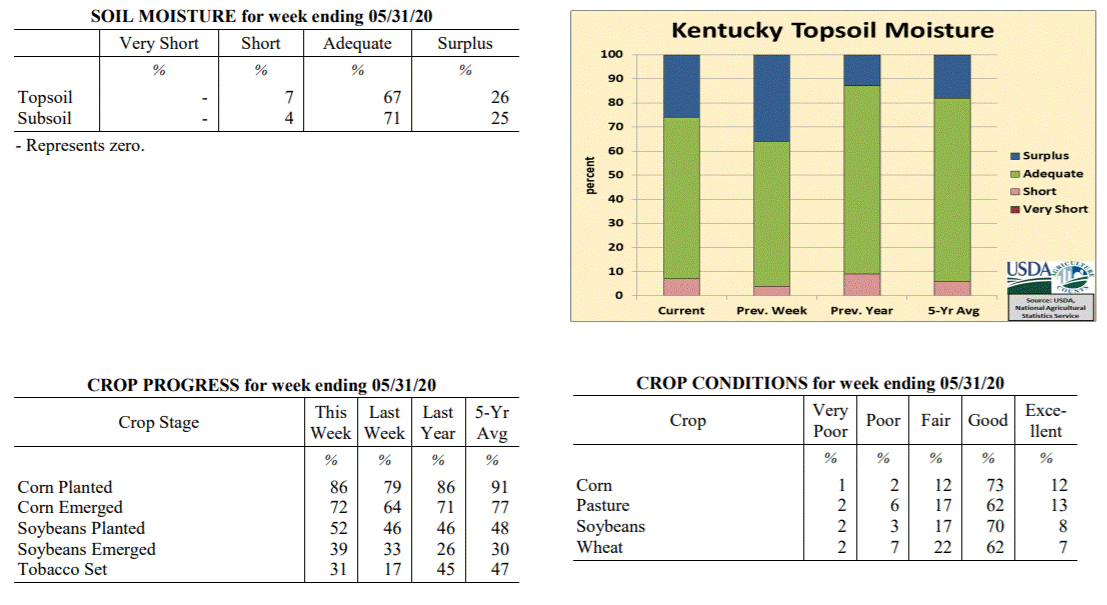 Kentucky Climate Summary
For the Period May 25, 2020 to May 31, 2020
Above Normal Temperatures and Below Normal Rainfall:
The closing week of May consisted of a summer-like pattern for Kentucky. The work
week saw daily rounds of showers and storms, most of which isolated to scattered in
nature. The one exception came Wednesday when much of West Central and Central
Kentucky saw a round of widespread showers. Overall for the week, the state averaged
0.66 inches. Averages were higher for the western half of the state with help from
the Wednesday event, closer to an inch. Those numbers dipped to well under a half
inch for the eastern half. Warm temperatures accompanied the active pattern, peaking
earlier in the week on Memorial Day when highs jumped into the middle 80s to low 90s.
A big change then occurred late in the week following the passage of a cold front on
Friday. Much cooler and dry conditions arrived for the weekend. Saturday and Sunday
both featured sunny skies, lower humidity, and high temperatures in the 70s/low 80s.
Temperatures for the period averaged 71 degrees across the state which was 3 degrees
warmer than normal and 6 degrees warmer than the previous period. High temperatures
averaged from 80 in the West to 80 in the East. Departure from normal high
temperatures ranged from 1 degree cooler than normal in the West to near normal in
the East. Low temperatures averaged from 63 degrees in the West to 61 degrees in the
East. Departure from normal low temperature ranged from 4 degrees warmer than normal
in the West to 7 degrees warmer than normal in the East. The extreme high temperature
for the period was 92 degrees at OWENSBORO AWSS and the extreme low was 47 degrees
at OWINGSVILLE 4S.
Precipitation (liq. equ.) for the period totaled 0.66 inches statewide which was 0.46
inches below normal and 59% of normal. Precipitation totals by climate division, West
0.99 inches, Central 0.92 inches, Bluegrass 0.32 inches and East 0.41 inches, which
was 0.11, 0.24, 0.77 and 0.71 inches below normal. By station, precipitation totals
ranged from a low of 0.07 inches at HINDMAN 5N to a high of 3.46 inches at
CAPE GIRARDEAU ASOS.
---
Kentucky Crop and Weather Report
Issued 4:00 P.M., May 26, 2020 10-20
Agricultural News: Kentucky experienced near normal temperatures and above normal
rainfall over the past week. Precipitation for the week totaled 2.16 inches, 1.05
inches above normal. Temperatures averaged 66 degrees for the week, unchanged from
normal. Topsoil moisture was rated 4 percent short, 60 percent adequate, and 36
percent surplus. Subsoil moisture was rated 3 percent short, 65 percent adequate, and
32 percent surplus. Days suitable for fieldwork averaged 3.3 out of a possible seven.
Primary activities for this week included planting of corn and soybeans, setting
tobacco, and cutting hay. Farmers continue to make headway with planting, but wet
conditions have hampered progress at times over the previous week. Producers need
successive days of dry weather to push through with getting crops in the ground.
Rainfall was heavy at times and there were reports of flooding and crop damage in
areas of the state. Forage is growing well, but the opportunity to cut has been
sparse. Soybean planting remains slightly ahead of both last year and the five year
average. Corn planting is on par with last year, but behind the five year average as
weather conditions have slowed the initial pace. The corn crop is 79 percent emerged
while soybeans are 33 percent emerged. The average height of corn at this juncture is
6 inches. Tobacco setting was able to make up some ground as very little progress was
reported last week.
Damage from the freeze event three weeks ago has been evaluated in full at this
point. Corn and soybean condition are both rated mostly good currently and the crops
appear to have been spared from widespread damage. Winter wheat is 96 percent headed
and the crop is in mostly good condition. Freeze damage to wheat was rated as 3
percent severe, 12 percent moderate, 40 percent light, and 45 percent with no damage.
Fruit crops proved vulnerable to the freeze and some loss is expected. Apple freeze
damage was reported as 8 percent severe, 24 percent moderate, 29 percent light, and
39 percent with no damage. Freeze damage to peaches was reported as 16 percent
severe, 29 percent moderate, 10 percent light, and 45 percent with no damage. Alfalfa
freeze damage was measured as 5 percent severe, 14 percent moderate, 36 percent
light, and 45 percent with no damage. The current hay supply is 8 percent very short,
26 percent short, 62 percent adequate, and 4 percent surplus. Strawberry condition was
rated as mostly good. Pasture condition is mostly good, despite wet conditions.
Kentucky Climate Summary
For the Period May 25, 2020 to May 31, 2020
Above Normal Temperatures and Below Normal Rainfall:
The closing week of May consisted of a summer-like pattern for Kentucky. The work
week saw daily rounds of showers and storms, most of which isolated to scattered in
nature. The one exception came Wednesday when much of West Central and Central
Kentucky saw a round of widespread showers. Overall for the week, the state averaged
0.66 inches. Averages were higher for the western half of the state with help from
the Wednesday event, closer to an inch. Those numbers dipped to well under a half
inch for the eastern half. Warm temperatures accompanied the active pattern, peaking
earlier in the week on Memorial Day when highs jumped into the middle 80s to low 90s.
A big change then occurred late in the week following the passage of a cold front on
Friday. Much cooler and dry conditions arrived for the weekend. Saturday and Sunday
both featured sunny skies, lower humidity, and high temperatures in the 70s/low 80s.
Temperatures for the period averaged 71 degrees across the state which was 3 degrees
warmer than normal and 6 degrees warmer than the previous period. High temperatures
averaged from 80 in the West to 80 in the East. Departure from normal high
temperatures ranged from 1 degree cooler than normal in the West to near normal in
the East. Low temperatures averaged from 63 degrees in the West to 61 degrees in the
East. Departure from normal low temperature ranged from 4 degrees warmer than normal
in the West to 7 degrees warmer than normal in the East. The extreme high temperature
for the period was 92 degrees at OWENSBORO AWSS and the extreme low was 47 degrees
at OWINGSVILLE 4S.
Precipitation (liq. equ.) for the period totaled 0.66 inches statewide which was 0.46
inches below normal and 59% of normal. Precipitation totals by climate division, West
0.99 inches, Central 0.92 inches, Bluegrass 0.32 inches and East 0.41 inches, which
was 0.11, 0.24, 0.77 and 0.71 inches below normal. By station, precipitation totals
ranged from a low of 0.07 inches at HINDMAN 5N to a high of 3.46 inches at
CAPE GIRARDEAU ASOS.
---
Kentucky Crop and Weather Report
Issued 4:00 P.M., May 26, 2020 10-20
Agricultural News: Kentucky experienced near normal temperatures and above normal
rainfall over the past week. Precipitation for the week totaled 2.16 inches, 1.05
inches above normal. Temperatures averaged 66 degrees for the week, unchanged from
normal. Topsoil moisture was rated 4 percent short, 60 percent adequate, and 36
percent surplus. Subsoil moisture was rated 3 percent short, 65 percent adequate, and
32 percent surplus. Days suitable for fieldwork averaged 3.3 out of a possible seven.
Primary activities for this week included planting of corn and soybeans, setting
tobacco, and cutting hay. Farmers continue to make headway with planting, but wet
conditions have hampered progress at times over the previous week. Producers need
successive days of dry weather to push through with getting crops in the ground.
Rainfall was heavy at times and there were reports of flooding and crop damage in
areas of the state. Forage is growing well, but the opportunity to cut has been
sparse. Soybean planting remains slightly ahead of both last year and the five year
average. Corn planting is on par with last year, but behind the five year average as
weather conditions have slowed the initial pace. The corn crop is 79 percent emerged
while soybeans are 33 percent emerged. The average height of corn at this juncture is
6 inches. Tobacco setting was able to make up some ground as very little progress was
reported last week.
Damage from the freeze event three weeks ago has been evaluated in full at this
point. Corn and soybean condition are both rated mostly good currently and the crops
appear to have been spared from widespread damage. Winter wheat is 96 percent headed
and the crop is in mostly good condition. Freeze damage to wheat was rated as 3
percent severe, 12 percent moderate, 40 percent light, and 45 percent with no damage.
Fruit crops proved vulnerable to the freeze and some loss is expected. Apple freeze
damage was reported as 8 percent severe, 24 percent moderate, 29 percent light, and
39 percent with no damage. Freeze damage to peaches was reported as 16 percent
severe, 29 percent moderate, 10 percent light, and 45 percent with no damage. Alfalfa
freeze damage was measured as 5 percent severe, 14 percent moderate, 36 percent
light, and 45 percent with no damage. The current hay supply is 8 percent very short,
26 percent short, 62 percent adequate, and 4 percent surplus. Strawberry condition was
rated as mostly good. Pasture condition is mostly good, despite wet conditions.
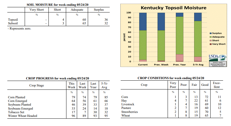 Kentucky Climate Summary
For the Period May 18, 2020 to May 24, 2020
Near Normal Temperatures and Above Normal Rainfall:
Depending on the exact location across Kentucky, this period was either exceptionally
wet or relatively dry. The focus over the first half of the week was a disturbance
aloft that didn�t move much, keeping cloudy and wet weather entrenched over the state
between Monday and Thursday. Rainfall was most extreme across the eastern half of
the state on Monday and Tuesday, especially-so just east of a line from Pulaski,
Fayette, and Boone Counties. When it was all said and done, this region saw 2 to 5+
inches of rainfall with a sharp cutoff to the west. The extreme rainfall within a
very short period of time led to saturated soils and in turn, moderate/major flooding
for a large portion of the Bluegrass Region and Eastern Kentucky. The rest of the
week featured daily bouts of rainfall, but only isolated to scattered in coverage.
Overall, the state averaged 2.16 inches for the week, but there was quite the range
across the state. While the Bluegrass Region and Eastern Kentucky averaged 3.90 and
3.16 inches respectively, Western Kentucky only averaged 0.69 inches. Looking at
temperatures, the period started with cooler weather in place, but summer heat
returned over the weekend. Highs jumped into the mid to upper 80s, some touching 90.
Dewpoints in the middle 60s to low 70s gave a much muggier feel to the air.
Temperatures for the period averaged 66 degrees across the state which was near normal
and 4 degrees warmer than the previous period. High temperatures averaged from 75 in
the West to 73 in the East. Departure from normal high temperatures ranged from 5
degrees cooler than normal in the West to 5 degrees cooler than normal in the East.
Low temperatures averaged from 60 degrees in the West to 57 degrees in the East.
Departure from normal low temperature ranged from 3 degrees warmer than normal in
the West to 5 degrees warmer than normal in the East. The extreme high temperature
for the period was 90 degrees at LOUISVILLE APT and the extreme low was 48 degrees
at SHEPHERDSVILLE 6SE.
Precipitation (liq. equ.) for the period totaled 2.16 inches statewide which was 1.05
inches above normal and 194% of normal. Precipitation totals by climate division, West
0.69 inches, Central 0.88 inches, Bluegrass 3.90 inches and East 3.16 inches, which
was -0.41, -0.28, 2.83 and 2.04 inches respectively from normal. By station, precipitation
totals ranged from a low of 0.23 inches at CARBONDALE ASOS to a high of 6.48 inches
at ALEXANDRIA 5NW.
---
Kentucky Crop and Weather Report
Issued 4:00 P.M., May 18, 2020 09-20
Agricultural News: Kentucky experienced below normal temperatures and rainfall over
the past week. Precipitation for the week totaled 0.73 inches, 0.40 inches below
normal. Temperatures averaged 62 degrees for the week, 2 degrees below normal.
Topsoil moisture was rated 1 percent very short, 1 percent short, 62 percent
adequate, and 36 percent surplus. Subsoil moisture was rated 1 percent very short, 1
percent short, 69 percent adequate, and 29 percent surplus. Days suitable for
fieldwork averaged 3.6 out of a possible seven.
Primary activities for this week included planting of corn and soybeans, setting
tobacco, and cutting hay. Fieldwork progress was slowed this week due to unstable
weather. Cool temperatures at the beginning of the week gave way to warmer conditions
accompanied by periodic rain. The weather stymied tobacco setting in particular when
compared with last week. Corn planting remains ahead of last year, however is now
behind the five year average for this juncture. Soybean progress is ahead of both the
five year average and the previous year. The corn crop is 56 percent emerged at this
time while soybeans are 24 percent emerged. Tobacco transplant supplies are 98
percent adequate and 2 percent surplus.
After the freeze event that occurred week before last, crops are still being
evaluated for damage. Corn condition is rated mostly good currently, however damage
from the freeze may become more evident this week. There were reports of stressed
corn in certain areas and soybeans were in a susceptible stage at the time of the
freeze. Winter wheat is 89 percent headed and the crop is in mostly good condition.
Freeze damage to wheat was rated as 2 percent severe, 12 percent moderate, 36 percent
light, and 50 percent with no damage. Fruits were subject to damage brought on by
cold temperatures with some producers fearing a loss. Apple freeze damage was
reported as 14 percent severe, 41 percent moderate, 21 percent light, and 24 percent
with no damage. Freeze damage to peaches was reported as 18 percent severe, 27
percent moderate, 16 percent light, and 39 percent with no damage. Alfalfa freeze
damage was measured as mostly light to no apparent damage. Strawberry condition was
rated as mostly good. Pasture condition is mostly good, despite the cool temperatures
and persistent rain.
Kentucky Climate Summary
For the Period May 18, 2020 to May 24, 2020
Near Normal Temperatures and Above Normal Rainfall:
Depending on the exact location across Kentucky, this period was either exceptionally
wet or relatively dry. The focus over the first half of the week was a disturbance
aloft that didn�t move much, keeping cloudy and wet weather entrenched over the state
between Monday and Thursday. Rainfall was most extreme across the eastern half of
the state on Monday and Tuesday, especially-so just east of a line from Pulaski,
Fayette, and Boone Counties. When it was all said and done, this region saw 2 to 5+
inches of rainfall with a sharp cutoff to the west. The extreme rainfall within a
very short period of time led to saturated soils and in turn, moderate/major flooding
for a large portion of the Bluegrass Region and Eastern Kentucky. The rest of the
week featured daily bouts of rainfall, but only isolated to scattered in coverage.
Overall, the state averaged 2.16 inches for the week, but there was quite the range
across the state. While the Bluegrass Region and Eastern Kentucky averaged 3.90 and
3.16 inches respectively, Western Kentucky only averaged 0.69 inches. Looking at
temperatures, the period started with cooler weather in place, but summer heat
returned over the weekend. Highs jumped into the mid to upper 80s, some touching 90.
Dewpoints in the middle 60s to low 70s gave a much muggier feel to the air.
Temperatures for the period averaged 66 degrees across the state which was near normal
and 4 degrees warmer than the previous period. High temperatures averaged from 75 in
the West to 73 in the East. Departure from normal high temperatures ranged from 5
degrees cooler than normal in the West to 5 degrees cooler than normal in the East.
Low temperatures averaged from 60 degrees in the West to 57 degrees in the East.
Departure from normal low temperature ranged from 3 degrees warmer than normal in
the West to 5 degrees warmer than normal in the East. The extreme high temperature
for the period was 90 degrees at LOUISVILLE APT and the extreme low was 48 degrees
at SHEPHERDSVILLE 6SE.
Precipitation (liq. equ.) for the period totaled 2.16 inches statewide which was 1.05
inches above normal and 194% of normal. Precipitation totals by climate division, West
0.69 inches, Central 0.88 inches, Bluegrass 3.90 inches and East 3.16 inches, which
was -0.41, -0.28, 2.83 and 2.04 inches respectively from normal. By station, precipitation
totals ranged from a low of 0.23 inches at CARBONDALE ASOS to a high of 6.48 inches
at ALEXANDRIA 5NW.
---
Kentucky Crop and Weather Report
Issued 4:00 P.M., May 18, 2020 09-20
Agricultural News: Kentucky experienced below normal temperatures and rainfall over
the past week. Precipitation for the week totaled 0.73 inches, 0.40 inches below
normal. Temperatures averaged 62 degrees for the week, 2 degrees below normal.
Topsoil moisture was rated 1 percent very short, 1 percent short, 62 percent
adequate, and 36 percent surplus. Subsoil moisture was rated 1 percent very short, 1
percent short, 69 percent adequate, and 29 percent surplus. Days suitable for
fieldwork averaged 3.6 out of a possible seven.
Primary activities for this week included planting of corn and soybeans, setting
tobacco, and cutting hay. Fieldwork progress was slowed this week due to unstable
weather. Cool temperatures at the beginning of the week gave way to warmer conditions
accompanied by periodic rain. The weather stymied tobacco setting in particular when
compared with last week. Corn planting remains ahead of last year, however is now
behind the five year average for this juncture. Soybean progress is ahead of both the
five year average and the previous year. The corn crop is 56 percent emerged at this
time while soybeans are 24 percent emerged. Tobacco transplant supplies are 98
percent adequate and 2 percent surplus.
After the freeze event that occurred week before last, crops are still being
evaluated for damage. Corn condition is rated mostly good currently, however damage
from the freeze may become more evident this week. There were reports of stressed
corn in certain areas and soybeans were in a susceptible stage at the time of the
freeze. Winter wheat is 89 percent headed and the crop is in mostly good condition.
Freeze damage to wheat was rated as 2 percent severe, 12 percent moderate, 36 percent
light, and 50 percent with no damage. Fruits were subject to damage brought on by
cold temperatures with some producers fearing a loss. Apple freeze damage was
reported as 14 percent severe, 41 percent moderate, 21 percent light, and 24 percent
with no damage. Freeze damage to peaches was reported as 18 percent severe, 27
percent moderate, 16 percent light, and 39 percent with no damage. Alfalfa freeze
damage was measured as mostly light to no apparent damage. Strawberry condition was
rated as mostly good. Pasture condition is mostly good, despite the cool temperatures
and persistent rain.
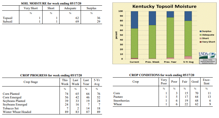 Kentucky Climate Summary
For the Period May 11, 2020 to May 17, 2020
Below Normal Temperatures and Rainfall:
The weather pattern flipped this week, starting the period with below normal
temperatures in place and ending more like summer. The period opened with
northwest flow limiting highs to the upper 40s to middle 50s for portions of the
state. Frost was again an issue Monday night across Eastern Kentucky as
lows dropped into the middle 30s. Cooler weather stuck around midweek along with
a return of widespread light showers across the region. Total accumulations were
higher across Western Kentucky with some exceeding an inch, but decreased
significantly farther east. After the rain moved out, southerly flow ushered
much warmer air into the Ohio Valley for the second half of the week. Highs
consistently rose into the upper 70s to middle 80s from Thursday onward, even
turning a bit muggy over the weekend. A more active pattern accompanied the
warmer temperatures on Friday and stuck around through the end of the period.
Multiple rounds of showers and storms traversed the state, mostly across the
northern half with a front stalled across the region. While the state averaged
0.73 inches fort the week, accumulations were much higher across Western Kentucky
and North Central Kentucky where many saw 1 to 2+ inches. Those totals dropped
dramatically to the east as Eastern Kentucky only averaged 0.26 inches for the
week.
Temperatures for the period averaged 62 degrees across the state which was 2
degrees cooler than normal and 8 degrees warmer than the previous period. High
temperatures averaged from 71 in the West to 71 in the East. Departure from
normal high temperatures ranged from 6 degrees cooler than normal in the West to
5 degrees cooler than normal in the East. Low temperatures averaged from 55
degrees in the West to 50 degrees in the East. Departure from normal low
temperature ranged from near normal in the West to 1 degree warmer than normal
in the East. The extreme high temperature for the period was 87 degrees at BIG
SANDY and the extreme low was 32 degrees at CARLISLE 5SW.
Precipitation (liq. equ.) for the period totaled 0.73 inches statewide which was
0.4 inches below normal and 64% of normal. Precipitation totals by climate
division, West 1.36 inches, Central 0.63 inches, Bluegrass 0.67 inches and East
0.26 inches, which was 0.18, -0.56, -0.40 and -0.83 inches respectively from
normal. By station, precipitation totals ranged from a low of 0.03 inches at BIG
SANDY to a high of 2.81 inches at POPLAR BLUFF ASOS.
---
Kentucky Crop and Weather Report
Issued 4:00 P.M., May 11, 2020 08-20
Agricultural News: Kentucky experienced well below normal temperatures and above
normal rainfall over the past week. Precipitation for the week totaled 1.37 inches,
0.28 inches above normal. Temperatures averaged 53 degrees for the week, 9 degrees
below normal. Topsoil moisture was rated 1 percent short, 70 percent adequate, and 29
percent surplus. Subsoil moisture was rated 1 percent short, 74 percent adequate, and
25 percent surplus. Days suitable for fieldwork averaged 3.5 out of a possible seven.
Primary activities for this week included planting of corn and soybeans, setting
tobacco, and spraying. The state experienced cool conditions and several periods of
rain that stymied field work. The weekend brought a freeze event that will be
evaluated this week. Despite the setbacks, corn and soybean planting continues to run
ahead of both last year and the five year average. The corn crop is 42 percent
emerged at this juncture while soybeans are 16 percent emerged. Tobacco setting is
still in the beginning stages for many producers with recent weather slowing
progress.
Thirteen percent of tobacco transplants were under 2 inches, with 50 percent 2-4
inches, and 37 percent above 4 inches. The supply of tobacco transplants was reported as
98 percent adequate, and 5 percent surplus.
Kentucky Climate Summary
For the Period May 11, 2020 to May 17, 2020
Below Normal Temperatures and Rainfall:
The weather pattern flipped this week, starting the period with below normal
temperatures in place and ending more like summer. The period opened with
northwest flow limiting highs to the upper 40s to middle 50s for portions of the
state. Frost was again an issue Monday night across Eastern Kentucky as
lows dropped into the middle 30s. Cooler weather stuck around midweek along with
a return of widespread light showers across the region. Total accumulations were
higher across Western Kentucky with some exceeding an inch, but decreased
significantly farther east. After the rain moved out, southerly flow ushered
much warmer air into the Ohio Valley for the second half of the week. Highs
consistently rose into the upper 70s to middle 80s from Thursday onward, even
turning a bit muggy over the weekend. A more active pattern accompanied the
warmer temperatures on Friday and stuck around through the end of the period.
Multiple rounds of showers and storms traversed the state, mostly across the
northern half with a front stalled across the region. While the state averaged
0.73 inches fort the week, accumulations were much higher across Western Kentucky
and North Central Kentucky where many saw 1 to 2+ inches. Those totals dropped
dramatically to the east as Eastern Kentucky only averaged 0.26 inches for the
week.
Temperatures for the period averaged 62 degrees across the state which was 2
degrees cooler than normal and 8 degrees warmer than the previous period. High
temperatures averaged from 71 in the West to 71 in the East. Departure from
normal high temperatures ranged from 6 degrees cooler than normal in the West to
5 degrees cooler than normal in the East. Low temperatures averaged from 55
degrees in the West to 50 degrees in the East. Departure from normal low
temperature ranged from near normal in the West to 1 degree warmer than normal
in the East. The extreme high temperature for the period was 87 degrees at BIG
SANDY and the extreme low was 32 degrees at CARLISLE 5SW.
Precipitation (liq. equ.) for the period totaled 0.73 inches statewide which was
0.4 inches below normal and 64% of normal. Precipitation totals by climate
division, West 1.36 inches, Central 0.63 inches, Bluegrass 0.67 inches and East
0.26 inches, which was 0.18, -0.56, -0.40 and -0.83 inches respectively from
normal. By station, precipitation totals ranged from a low of 0.03 inches at BIG
SANDY to a high of 2.81 inches at POPLAR BLUFF ASOS.
---
Kentucky Crop and Weather Report
Issued 4:00 P.M., May 11, 2020 08-20
Agricultural News: Kentucky experienced well below normal temperatures and above
normal rainfall over the past week. Precipitation for the week totaled 1.37 inches,
0.28 inches above normal. Temperatures averaged 53 degrees for the week, 9 degrees
below normal. Topsoil moisture was rated 1 percent short, 70 percent adequate, and 29
percent surplus. Subsoil moisture was rated 1 percent short, 74 percent adequate, and
25 percent surplus. Days suitable for fieldwork averaged 3.5 out of a possible seven.
Primary activities for this week included planting of corn and soybeans, setting
tobacco, and spraying. The state experienced cool conditions and several periods of
rain that stymied field work. The weekend brought a freeze event that will be
evaluated this week. Despite the setbacks, corn and soybean planting continues to run
ahead of both last year and the five year average. The corn crop is 42 percent
emerged at this juncture while soybeans are 16 percent emerged. Tobacco setting is
still in the beginning stages for many producers with recent weather slowing
progress.
Thirteen percent of tobacco transplants were under 2 inches, with 50 percent 2-4
inches, and 37 percent above 4 inches. The supply of tobacco transplants was reported as
98 percent adequate, and 5 percent surplus.
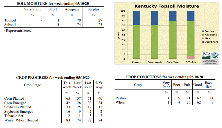 Kentucky Climate Summary
For the Period May 4, 2020 to May 10, 2020
Well Below Normal Temperatures and Above Normal Rainfall:
The big story for the week was a cold air outbreak late in the period that brought
record breaking temperatures to much of the Bluegrass State. The coldest temperatures
were seen early Saturday morning as many across the Commonwealth saw temperatures
plummet into the upper 20s to middle 30s. Coldest across the eastern half of the
state and increasing farther west. Putting these temperatures into perspective,
normal lows for this time of year are in the low to middle 50s. While Saturday
morning was the coldest, the state did see a few more rounds of frosty temperatures
throughout the week, most notable on Sunday morning across Eastern Kentucky, when
temperatures yet again dropped into the low to mid 30s for many locations. Cold air
of this extreme and this late in the spring season is quite rare across Kentucky.
Looking at frost occurrence data, having temperatures of 32 degrees or lower at this
time of the year is less than a 10% probability for many across the state. While
temperatures were well below normal for the week, the Commonwealth also saw multiple
rounds of widespread showers, one coming Monday night/Tuesday, another on Friday, and
ended with a closing round on Sunday. Altogether, the state averaged 1.37 inches
for the week.
Temperatures for the period averaged 53 degrees across the state which was 9 degrees
cooler than normal and 6 degrees cooler than the previous period. High temperatures
averaged from 66 in the West to 62 in the East. Departure from normal high
temperatures ranged from 9 degrees cooler than normal in the West to 12 degrees
cooler than normal in the East. Low temperatures averaged from 47 degrees in the
West to 41 degrees in the East. Departure from normal low temperature ranged from 5
degrees cooler than normal in the West to 6 degrees cooler than normal in the East.
The extreme high temperature for the period was 79 degrees at KOOMER RIDGE and the
extreme low was 26 degrees at CARLISLE 5SW.
Precipitation (liq. equ.) for the period totaled 1.37 inches statewide which was 0.28
inches above normal and 125% of normal. Precipitation totals by climate division,
West 1.12 inches, Central 1.60 inches, Bluegrass 1.04 inches and East 1.72 inches,
which was -0.04, 0.45, 0.03 and 0.67 inches respectively from normal. By station,
precipitation totals ranged from a low of 0.67 inches at YELLOW CREEK to a high of
4.05 inches at LIBERTY 3SW.
---
Kentucky Crop and Weather Report
Issued 4:00 P.M., May 4, 2020 07-20
Agricultural News: Kentucky experienced near normal temperatures and below normal
rainfall over the past week. Precipitation for the week totaled 0.88 inches, 0.19
inches below normal. Temperatures averaged 60 degrees for the week, unchanged from
normal. Topsoil moisture was rated 1 percent short, 70 percent adequate, and 29
percent surplus. Subsoil moisture was rated 1 percent short, 73 percent adequate, and
26 percent surplus. Days suitable for fieldwork averaged 3.8 out of a possible seven.
Primary activities for this week included continued planting of corn and soybeans
along with working cattle. Tobacco setting has begun in a small portion of the state
as weather has permitted. In some areas fields remained very wet and halted planting
progress. With that being said, corn and soybean planting is moving rapidly and both
are ahead of last year and the five year average. The corn crop is 28 percent emerged
at this juncture. Soybeans are 9 percent emerged. Tobacco transplants are in mostly
good condition with 24 percent less than two inches, 53 percent two to four inches,
and 23 percent larger than 4 inches. Supply of tobacco transplants was rated as 5
percent short, 90 percent adequate, and 5 percent surplus.
The average height of winter wheat was 23 inches with the condition mostly good
despite a light freeze several weeks prior. The average height of alfalfa is 14
inches at this time. Hay condition was reported as mostly good with supplies rated as
7 percent very short, 34 percent short, 56 percent adequate, and 3 percent surplus.
Rain and seasonably warm weather has kept pastureland in good condition. The
condition of strawberries was reported as 5 percent very poor, 8 percent poor, 22
percent fair, 56 percent good, and 9 percent excellent.
Kentucky Climate Summary
For the Period May 4, 2020 to May 10, 2020
Well Below Normal Temperatures and Above Normal Rainfall:
The big story for the week was a cold air outbreak late in the period that brought
record breaking temperatures to much of the Bluegrass State. The coldest temperatures
were seen early Saturday morning as many across the Commonwealth saw temperatures
plummet into the upper 20s to middle 30s. Coldest across the eastern half of the
state and increasing farther west. Putting these temperatures into perspective,
normal lows for this time of year are in the low to middle 50s. While Saturday
morning was the coldest, the state did see a few more rounds of frosty temperatures
throughout the week, most notable on Sunday morning across Eastern Kentucky, when
temperatures yet again dropped into the low to mid 30s for many locations. Cold air
of this extreme and this late in the spring season is quite rare across Kentucky.
Looking at frost occurrence data, having temperatures of 32 degrees or lower at this
time of the year is less than a 10% probability for many across the state. While
temperatures were well below normal for the week, the Commonwealth also saw multiple
rounds of widespread showers, one coming Monday night/Tuesday, another on Friday, and
ended with a closing round on Sunday. Altogether, the state averaged 1.37 inches
for the week.
Temperatures for the period averaged 53 degrees across the state which was 9 degrees
cooler than normal and 6 degrees cooler than the previous period. High temperatures
averaged from 66 in the West to 62 in the East. Departure from normal high
temperatures ranged from 9 degrees cooler than normal in the West to 12 degrees
cooler than normal in the East. Low temperatures averaged from 47 degrees in the
West to 41 degrees in the East. Departure from normal low temperature ranged from 5
degrees cooler than normal in the West to 6 degrees cooler than normal in the East.
The extreme high temperature for the period was 79 degrees at KOOMER RIDGE and the
extreme low was 26 degrees at CARLISLE 5SW.
Precipitation (liq. equ.) for the period totaled 1.37 inches statewide which was 0.28
inches above normal and 125% of normal. Precipitation totals by climate division,
West 1.12 inches, Central 1.60 inches, Bluegrass 1.04 inches and East 1.72 inches,
which was -0.04, 0.45, 0.03 and 0.67 inches respectively from normal. By station,
precipitation totals ranged from a low of 0.67 inches at YELLOW CREEK to a high of
4.05 inches at LIBERTY 3SW.
---
Kentucky Crop and Weather Report
Issued 4:00 P.M., May 4, 2020 07-20
Agricultural News: Kentucky experienced near normal temperatures and below normal
rainfall over the past week. Precipitation for the week totaled 0.88 inches, 0.19
inches below normal. Temperatures averaged 60 degrees for the week, unchanged from
normal. Topsoil moisture was rated 1 percent short, 70 percent adequate, and 29
percent surplus. Subsoil moisture was rated 1 percent short, 73 percent adequate, and
26 percent surplus. Days suitable for fieldwork averaged 3.8 out of a possible seven.
Primary activities for this week included continued planting of corn and soybeans
along with working cattle. Tobacco setting has begun in a small portion of the state
as weather has permitted. In some areas fields remained very wet and halted planting
progress. With that being said, corn and soybean planting is moving rapidly and both
are ahead of last year and the five year average. The corn crop is 28 percent emerged
at this juncture. Soybeans are 9 percent emerged. Tobacco transplants are in mostly
good condition with 24 percent less than two inches, 53 percent two to four inches,
and 23 percent larger than 4 inches. Supply of tobacco transplants was rated as 5
percent short, 90 percent adequate, and 5 percent surplus.
The average height of winter wheat was 23 inches with the condition mostly good
despite a light freeze several weeks prior. The average height of alfalfa is 14
inches at this time. Hay condition was reported as mostly good with supplies rated as
7 percent very short, 34 percent short, 56 percent adequate, and 3 percent surplus.
Rain and seasonably warm weather has kept pastureland in good condition. The
condition of strawberries was reported as 5 percent very poor, 8 percent poor, 22
percent fair, 56 percent good, and 9 percent excellent.
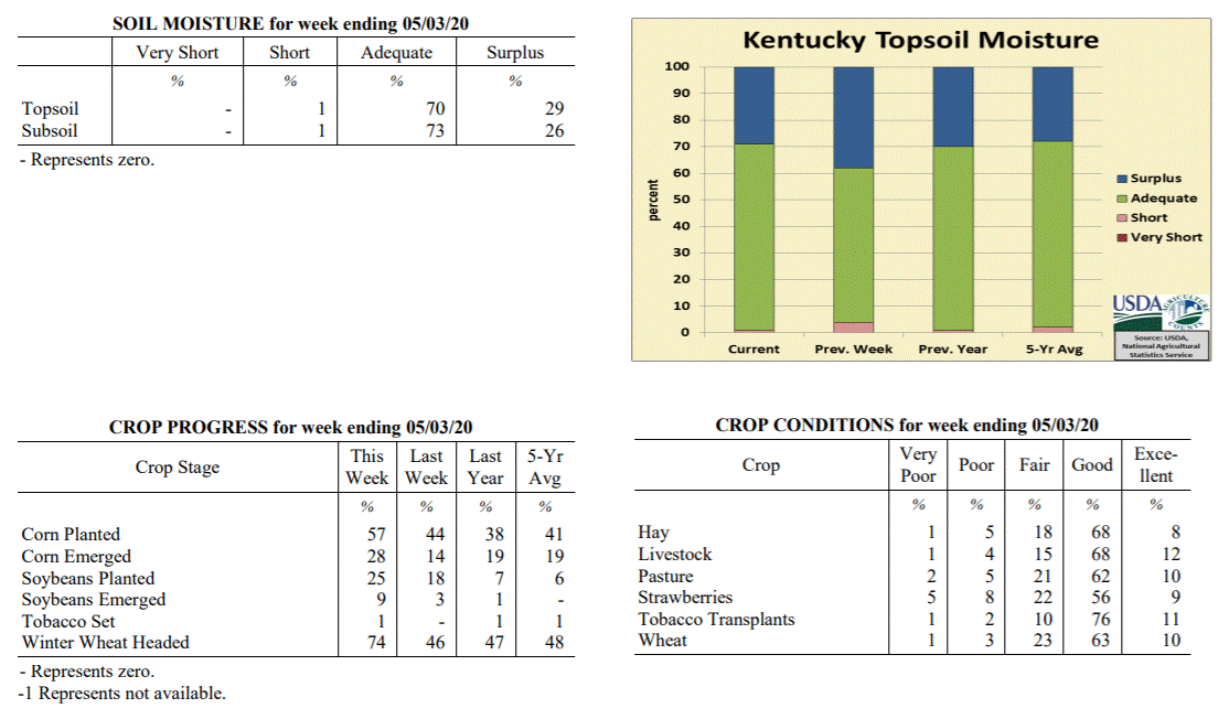 Kentucky Climate Summary
For the Period April 27, 2020 to May 3, 2020
Near Normal Temperatures and Below Normal Rainfall:
The work week started out on a dry and mild note with highs in the 60s and 70s. Along
and ahead of a cold front, widespread showers returned to the area Tuesday night and
into Wednesday. Lighter activity then continued into Thursday. The rain and heavy
cloud cover did lead to temperatures that were well below normal for the last day of
April as highs struggled in the upper 40s to middle 50s on Thursday. This followed a
cooler trend that has stuck around for much of the second half of April. Looking back
at the past month and while preliminary, data from the Ag Weather Center shows the
state saw its first month of below normal temperatures since November. Luckily, the
cool weather didn�t last long as highs rose into the 80s for many by Saturday. A
strong to at times, severe line of showers and storms then closed out the week on
Sunday. Totals did vary quite a bit across the state for the week. Combined with the
Wednesday/Thursday event, the western half of the state was about a half inch below
normal for the week, while the eastern half was actually above normal.
Temperatures for the period averaged 60 degrees across the state which was
near normal and 4 degrees warmer than the previous period. High temperatures
averaged from 73 in the West to 71 in the East. Departure from normal high
temperatures ranged from 1 degree cooler than normal in the West to 2 degrees
cooler than normal in the East. Low temperatures averaged from 51 degrees in the
West to 47 degrees in the East. Departure from normal low temperature ranged from 1
degree warmer than normal in the West to 2 degrees warmer than normal in the East.
The extreme high temperature for the period was 85 degrees at BOWLING GREEN APT and
the extreme low was 31 degrees at CYNTHIANA 8N.
Precipitation (liq. equ.) for the period totaled 0.88 inches statewide which was 0.19
inches below normal and 82% of normal. Precipitation totals by climate division, West
0.71 inches, Central 0.59 inches, Bluegrass 1.01 inches and East 1.20 inches, which
was -0.50, -0.51, 0.02 and 0.20 inches respectively from normal. By station,
precipitation totals ranged from a low of 0.15 inches at ELIZABETHTOWN 8W to a high
of 2.43 inches at OWINGSVILLE 4S.
---
Kentucky Crop and Weather Report
Issued 4:00 P.M., April 27, 2020 06-20
Agricultural News: Kentucky experienced below normal temperatures and above normal
rainfall over the past week. Precipitation for the week totaled 1.74 inches, 0.70
inches above normal. Temperatures averaged 55 degrees for the week, 3 degrees below
normal. Topsoil moisture was rated 4 percent short, 58 percent adequate, and 38
percent surplus. Subsoil moisture was rated 5 percent short, 65 percent adequate, and
30 percent surplus. Days suitable for fieldwork averaged 4.1 out of a possible seven.
Primary activities for this week included continued planting of corn and soybeans
along with seeding of tobacco transplants. Fieldwork was halted in the latter part of
the week due to periods of heavy rain. Despite the setback, corn and soybean planting
is moving rapidly with both crops substantially ahead of last year and the five year
average. The corn crop is 14 percent emerged at this juncture. Soybeans are 3 percent
emerged. Eighty-nine percent of tobacco transplants are seeded and remain in mostly
good condition. Thirtyseven percent of tobacco transplants were under 2 inches, with
44 percent 2-4 inches, and 19 percent above 4 inches.
The average height of winter wheat was 20 inches with the condition mostly good.
Freeze damage to alfalfa and winter wheat from two weeks ago has been assessed at
this point. Winter wheat freeze damage was reported as 1 percent severe, 8 percent
moderate, 23 percent light, and 68 percent with no damage. Alfalfa freeze damage was
reported as 1 percent severe, 10 percent moderate, 27 percent light, and 62 percent
with no damage. The average height of alfalfa is 10 inches at this time. Both peaches
and apples suffered some damage from the freeze two weeks ago. Apple damage was
reported as 10 percent severe, 36 percent moderate, 17 percent light, and 37 percent
with no damage. Freeze damage to peaches was reported as 27 percent severe, 16
percent moderate, 15 percent light, and 42 percent with no damage.
Kentucky Climate Summary
For the Period April 27, 2020 to May 3, 2020
Near Normal Temperatures and Below Normal Rainfall:
The work week started out on a dry and mild note with highs in the 60s and 70s. Along
and ahead of a cold front, widespread showers returned to the area Tuesday night and
into Wednesday. Lighter activity then continued into Thursday. The rain and heavy
cloud cover did lead to temperatures that were well below normal for the last day of
April as highs struggled in the upper 40s to middle 50s on Thursday. This followed a
cooler trend that has stuck around for much of the second half of April. Looking back
at the past month and while preliminary, data from the Ag Weather Center shows the
state saw its first month of below normal temperatures since November. Luckily, the
cool weather didn�t last long as highs rose into the 80s for many by Saturday. A
strong to at times, severe line of showers and storms then closed out the week on
Sunday. Totals did vary quite a bit across the state for the week. Combined with the
Wednesday/Thursday event, the western half of the state was about a half inch below
normal for the week, while the eastern half was actually above normal.
Temperatures for the period averaged 60 degrees across the state which was
near normal and 4 degrees warmer than the previous period. High temperatures
averaged from 73 in the West to 71 in the East. Departure from normal high
temperatures ranged from 1 degree cooler than normal in the West to 2 degrees
cooler than normal in the East. Low temperatures averaged from 51 degrees in the
West to 47 degrees in the East. Departure from normal low temperature ranged from 1
degree warmer than normal in the West to 2 degrees warmer than normal in the East.
The extreme high temperature for the period was 85 degrees at BOWLING GREEN APT and
the extreme low was 31 degrees at CYNTHIANA 8N.
Precipitation (liq. equ.) for the period totaled 0.88 inches statewide which was 0.19
inches below normal and 82% of normal. Precipitation totals by climate division, West
0.71 inches, Central 0.59 inches, Bluegrass 1.01 inches and East 1.20 inches, which
was -0.50, -0.51, 0.02 and 0.20 inches respectively from normal. By station,
precipitation totals ranged from a low of 0.15 inches at ELIZABETHTOWN 8W to a high
of 2.43 inches at OWINGSVILLE 4S.
---
Kentucky Crop and Weather Report
Issued 4:00 P.M., April 27, 2020 06-20
Agricultural News: Kentucky experienced below normal temperatures and above normal
rainfall over the past week. Precipitation for the week totaled 1.74 inches, 0.70
inches above normal. Temperatures averaged 55 degrees for the week, 3 degrees below
normal. Topsoil moisture was rated 4 percent short, 58 percent adequate, and 38
percent surplus. Subsoil moisture was rated 5 percent short, 65 percent adequate, and
30 percent surplus. Days suitable for fieldwork averaged 4.1 out of a possible seven.
Primary activities for this week included continued planting of corn and soybeans
along with seeding of tobacco transplants. Fieldwork was halted in the latter part of
the week due to periods of heavy rain. Despite the setback, corn and soybean planting
is moving rapidly with both crops substantially ahead of last year and the five year
average. The corn crop is 14 percent emerged at this juncture. Soybeans are 3 percent
emerged. Eighty-nine percent of tobacco transplants are seeded and remain in mostly
good condition. Thirtyseven percent of tobacco transplants were under 2 inches, with
44 percent 2-4 inches, and 19 percent above 4 inches.
The average height of winter wheat was 20 inches with the condition mostly good.
Freeze damage to alfalfa and winter wheat from two weeks ago has been assessed at
this point. Winter wheat freeze damage was reported as 1 percent severe, 8 percent
moderate, 23 percent light, and 68 percent with no damage. Alfalfa freeze damage was
reported as 1 percent severe, 10 percent moderate, 27 percent light, and 62 percent
with no damage. The average height of alfalfa is 10 inches at this time. Both peaches
and apples suffered some damage from the freeze two weeks ago. Apple damage was
reported as 10 percent severe, 36 percent moderate, 17 percent light, and 37 percent
with no damage. Freeze damage to peaches was reported as 27 percent severe, 16
percent moderate, 15 percent light, and 42 percent with no damage.
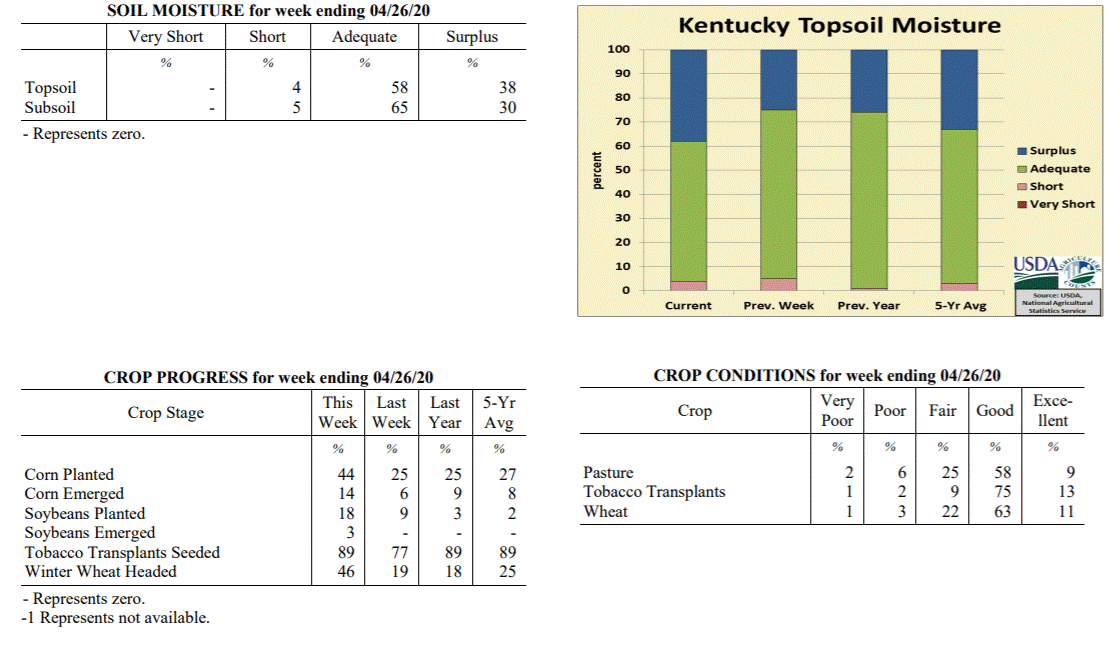 Kentucky Climate Summary
For the Period April 20, 2020 to April 26, 2020
Below Normal Temperatures and Above Normal Rainfall:
April rainfall has been below normal for much of the month, but that changed this
week as Kentucky saw multiple waves of widespread showers. Overall, the state
averaged 1.74 inches for the week, most of which fell Thursday and over the weekend.
Other than some portions of Western Kentucky that saw under an inch, 1 to 2+ inches
was common across the rest of the state. Temperatures continued to run cooler than
normal, but not as significant as the previous period. The coldest temperatures were
seen Tuesday night following the passage of a weak cold front through the area. Lows
fell into the 30s, prompting another threat of frost, especially so across the
eastern half of the state. A handful of counties once again fell into the upper 20s.
This led the way to a second straight week of below normal temperatures for the
Bluegrass State.
Temperatures for the period averaged 55 degrees across the state which was 3 degrees
cooler than normal and 8 degrees warmer than the previous period. High temperatures
averaged from 66 in the West to 64 in the East. Departure from normal high
temperatures ranged from 6 degrees cooler than normal in the West to 7 degrees
cooler than normal in the East. Low temperatures averaged from 48 degrees in the
West to 46 degrees in the East. Departure from normal low temperature ranged from
near normal in the West to 4 degrees warmer than normal in the East. The extreme
high temperature for the period was 76 degrees at POPLAR BLUFF ASOS and the extreme
low was 28 degrees at CARLISLE 5SW.
Precipitation (liq. equ.) for the period totaled 1.74 inches statewide which was 0.7
inches above normal and 168% of normal. Precipitation totals by climate division,
West 1.44 inches, Central 1.93 inches, Bluegrass 1.72 inches and East 1.87 inches,
which was 0.25, 0.88, 0.77 and 0.92 inches above normal. By station, precipitation
totals ranged from a low of 0.65 inches at PRINCETON 2SE to a high of 3.30 inches
at OWENSBORO AWSS.
---
Kentucky Crop and Weather Report
Issued 4:00 P.M., April 20, 2020 05-20
Agricultural News: Kentucky experienced well below normal temperatures and near
normal rainfall over the past week. Precipitation for the week totaled 1.06 inches,
0.07 inches above normal. Temperatures averaged 46 degrees for the week, 10 degrees
below normal. Topsoil moisture was rated 5 percent short, 70 percent adequate, and 25
percent surplus. Subsoil moisture was rated 6 percent short, 73 percent adequate, and
21 percent surplus. Days suitable for fieldwork averaged 4.5 out of a possible seven.
Primary activities for this week included continued planting of corn and soybeans
along with seeding of tobacco transplants. The state experienced a few light
overnight freezes this week with mild daytime temperatures. Rain in the early part of
the week disrupted fieldwork. Despite the weather setbacks, corn and soybean planting
continued with both crops ahead of last year and the five year average. The corn crop
is 6 percent emerged at this juncture. Soybeans did not sustain widespread freeze
damage due to the fact that they have not yet emerged. Tobacco transplants are in
mostly good condition.
The average height of winter wheat was 17 inches with the condition mostly good.
Winter wheat freeze damage was reported as 1 percent severe, 4 percent moderate, 37
percent light, and 58 percent with no damage. Alfalfa freeze damage was reported as 1
percent severe, 12 percent moderate, 32 percent light, and 55 percent with no damage.
It is of note that any damage may not be apparent until assessment this week. The average
height of alfalfa is 10 inches at this time.
Kentucky Climate Summary
For the Period April 20, 2020 to April 26, 2020
Below Normal Temperatures and Above Normal Rainfall:
April rainfall has been below normal for much of the month, but that changed this
week as Kentucky saw multiple waves of widespread showers. Overall, the state
averaged 1.74 inches for the week, most of which fell Thursday and over the weekend.
Other than some portions of Western Kentucky that saw under an inch, 1 to 2+ inches
was common across the rest of the state. Temperatures continued to run cooler than
normal, but not as significant as the previous period. The coldest temperatures were
seen Tuesday night following the passage of a weak cold front through the area. Lows
fell into the 30s, prompting another threat of frost, especially so across the
eastern half of the state. A handful of counties once again fell into the upper 20s.
This led the way to a second straight week of below normal temperatures for the
Bluegrass State.
Temperatures for the period averaged 55 degrees across the state which was 3 degrees
cooler than normal and 8 degrees warmer than the previous period. High temperatures
averaged from 66 in the West to 64 in the East. Departure from normal high
temperatures ranged from 6 degrees cooler than normal in the West to 7 degrees
cooler than normal in the East. Low temperatures averaged from 48 degrees in the
West to 46 degrees in the East. Departure from normal low temperature ranged from
near normal in the West to 4 degrees warmer than normal in the East. The extreme
high temperature for the period was 76 degrees at POPLAR BLUFF ASOS and the extreme
low was 28 degrees at CARLISLE 5SW.
Precipitation (liq. equ.) for the period totaled 1.74 inches statewide which was 0.7
inches above normal and 168% of normal. Precipitation totals by climate division,
West 1.44 inches, Central 1.93 inches, Bluegrass 1.72 inches and East 1.87 inches,
which was 0.25, 0.88, 0.77 and 0.92 inches above normal. By station, precipitation
totals ranged from a low of 0.65 inches at PRINCETON 2SE to a high of 3.30 inches
at OWENSBORO AWSS.
---
Kentucky Crop and Weather Report
Issued 4:00 P.M., April 20, 2020 05-20
Agricultural News: Kentucky experienced well below normal temperatures and near
normal rainfall over the past week. Precipitation for the week totaled 1.06 inches,
0.07 inches above normal. Temperatures averaged 46 degrees for the week, 10 degrees
below normal. Topsoil moisture was rated 5 percent short, 70 percent adequate, and 25
percent surplus. Subsoil moisture was rated 6 percent short, 73 percent adequate, and
21 percent surplus. Days suitable for fieldwork averaged 4.5 out of a possible seven.
Primary activities for this week included continued planting of corn and soybeans
along with seeding of tobacco transplants. The state experienced a few light
overnight freezes this week with mild daytime temperatures. Rain in the early part of
the week disrupted fieldwork. Despite the weather setbacks, corn and soybean planting
continued with both crops ahead of last year and the five year average. The corn crop
is 6 percent emerged at this juncture. Soybeans did not sustain widespread freeze
damage due to the fact that they have not yet emerged. Tobacco transplants are in
mostly good condition.
The average height of winter wheat was 17 inches with the condition mostly good.
Winter wheat freeze damage was reported as 1 percent severe, 4 percent moderate, 37
percent light, and 58 percent with no damage. Alfalfa freeze damage was reported as 1
percent severe, 12 percent moderate, 32 percent light, and 55 percent with no damage.
It is of note that any damage may not be apparent until assessment this week. The average
height of alfalfa is 10 inches at this time.
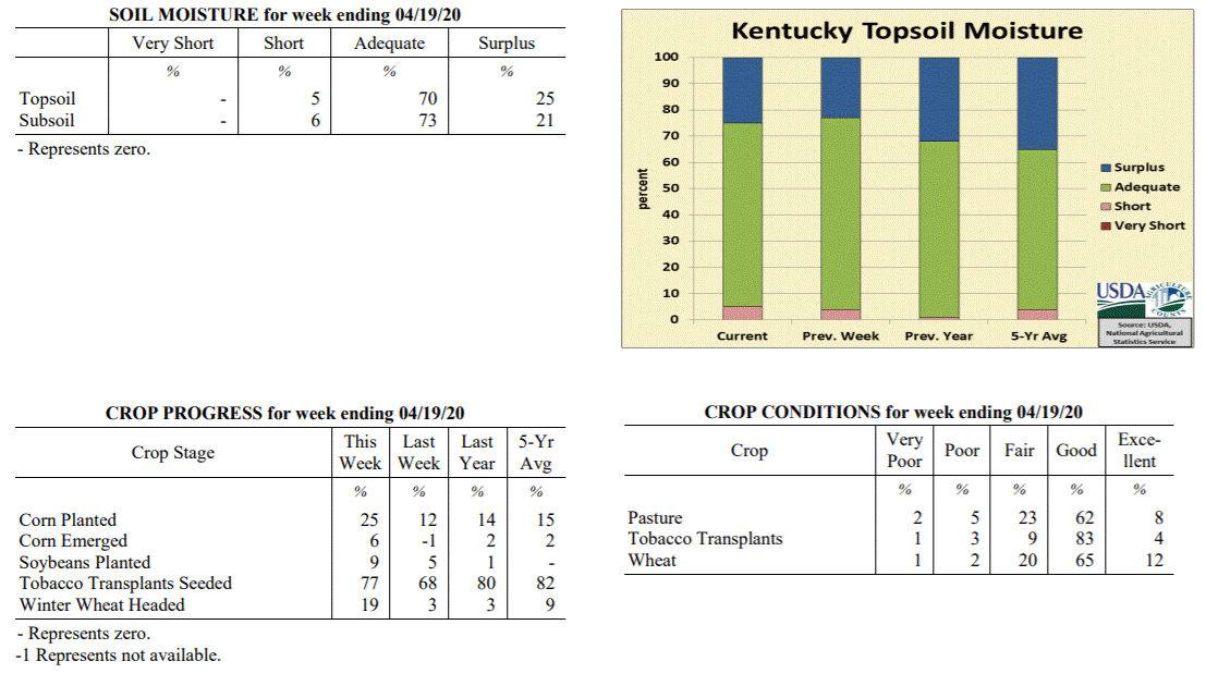 Kentucky Climate Summary
For the Period April 13, 2020 to April 19, 2020
Well Below Normal Temperatures and Near Normal Rainfall:
The week started with a line of showers and storms continuing to progress across the
state ahead of a cold front. Based on the data cutoff, some of this rainfall was on
last week�s report. While the state average was near normal this period, much of this
average came from this event. The rest of the week followed a much drier pattern with
only light accumulations throughout. In fact, most of the state saw less than half
inch of additional rainfall, most coming on Friday. Overall, through the 19th, the
state has averaged 2.14 inches for the month of April, which is roughly a half inch
below normal. Well below normal temperatures accompanied the dry conditions. Normal
high temperatures run in the middle 60s to around 70 for the middle of April, while
lows average in the middle to upper 40s. Over much of the period, high struggled in
the 50s, while also seeing multiple bouts of subfreezing temperatures. This was
especially the case Tuesday night as much of the state dropped below freezing and
some even experienced a hard freeze with lows dipping into the middle 20s to low 30s.
This was followed by another round on Wednesday night, but subfreezing temperatures
were primarily limited to the northern half of Kentucky. Altogether, the cold
temperatures throughout the period broke a six week streak of the state average
temperature running above normal.
Temperatures for the period averaged 46 degrees across the state which was 10 degrees
cooler than normal and 12 degrees cooler than the previous period. High temperatures
averaged from 59 in the West to 58 in the East. Departure from normal high
temperatures ranged from 11 degrees cooler than normal in the West to 11 degrees
cooler than normal in the East. Low temperatures averaged from 38 degrees in the
West to 34 degrees in the East. Departure from normal low temperature ranged from 8
degrees cooler than normal in the West to 7 degrees cooler than normal in the East.
The extreme high temperature for the period was 75 degrees at BOONEVILLE 2S and the
extreme low was 22 degrees at BRANDENBURG 4SW.
Precipitation (liq. equ.) for the period totaled 1.06 inches statewide which was 0.07
inches above normal and 108% of normal. Precipitation totals by climate division,
West 0.68 inches, Central 0.95 inches, Bluegrass 1.30 inches and East 1.31 inches,
which was -0.44, -0.04, 0.40 and 0.38 inches respectively from normal. By station,
precipitation totals ranged from a low of 0.09 inches at CAPE GIRARDEAU ASOS to a
high of 3.13 inches at YELLOW CREEK.
---
Kentucky Crop and Weather Report
Issued 4:00 P.M., April 13, 2020 04-20
Agricultural News: Kentucky experienced above normal temperatures and near normal
rainfall over the past week. Precipitation for the week totaled 1.05 inches, 0.03
inches above normal. Temperatures averaged 58 degrees for the week, 4 degrees above
normal. Topsoil moisture was rated 4 percent short, 73 percent adequate, and 23
percent surplus. Subsoil moisture was rated 5 percent short, 77 percent adequate, and
18 percent surplus. Days suitable for fieldwork averaged 5.4 out of a possible seven.
Primary activities for this week included seeding tobacco transplants, field
preparation, and planting of corn and soybeans. Through most of the week the state
experienced weather conducive to fieldwork. Corn and soybean planting is ahead of
both last year and the five year average at this juncture with producers getting
their crops in the ground steadily as weather has permitted. Tobacco transplants are
68 percent seeded, just behind last year and the five year average. Fifty-five
percent of apples are in full bloom while peaches are at 74 percent.
The average height of winter wheat is 14 inches at this time while 3 percent of the
crop has headed. The condition of winter wheat is mostly good to excellent. Pastures
are in mostly good condition and are showing good growth due to the seasonably warm
weather and intermittent rain.
Kentucky Climate Summary
For the Period April 13, 2020 to April 19, 2020
Well Below Normal Temperatures and Near Normal Rainfall:
The week started with a line of showers and storms continuing to progress across the
state ahead of a cold front. Based on the data cutoff, some of this rainfall was on
last week�s report. While the state average was near normal this period, much of this
average came from this event. The rest of the week followed a much drier pattern with
only light accumulations throughout. In fact, most of the state saw less than half
inch of additional rainfall, most coming on Friday. Overall, through the 19th, the
state has averaged 2.14 inches for the month of April, which is roughly a half inch
below normal. Well below normal temperatures accompanied the dry conditions. Normal
high temperatures run in the middle 60s to around 70 for the middle of April, while
lows average in the middle to upper 40s. Over much of the period, high struggled in
the 50s, while also seeing multiple bouts of subfreezing temperatures. This was
especially the case Tuesday night as much of the state dropped below freezing and
some even experienced a hard freeze with lows dipping into the middle 20s to low 30s.
This was followed by another round on Wednesday night, but subfreezing temperatures
were primarily limited to the northern half of Kentucky. Altogether, the cold
temperatures throughout the period broke a six week streak of the state average
temperature running above normal.
Temperatures for the period averaged 46 degrees across the state which was 10 degrees
cooler than normal and 12 degrees cooler than the previous period. High temperatures
averaged from 59 in the West to 58 in the East. Departure from normal high
temperatures ranged from 11 degrees cooler than normal in the West to 11 degrees
cooler than normal in the East. Low temperatures averaged from 38 degrees in the
West to 34 degrees in the East. Departure from normal low temperature ranged from 8
degrees cooler than normal in the West to 7 degrees cooler than normal in the East.
The extreme high temperature for the period was 75 degrees at BOONEVILLE 2S and the
extreme low was 22 degrees at BRANDENBURG 4SW.
Precipitation (liq. equ.) for the period totaled 1.06 inches statewide which was 0.07
inches above normal and 108% of normal. Precipitation totals by climate division,
West 0.68 inches, Central 0.95 inches, Bluegrass 1.30 inches and East 1.31 inches,
which was -0.44, -0.04, 0.40 and 0.38 inches respectively from normal. By station,
precipitation totals ranged from a low of 0.09 inches at CAPE GIRARDEAU ASOS to a
high of 3.13 inches at YELLOW CREEK.
---
Kentucky Crop and Weather Report
Issued 4:00 P.M., April 13, 2020 04-20
Agricultural News: Kentucky experienced above normal temperatures and near normal
rainfall over the past week. Precipitation for the week totaled 1.05 inches, 0.03
inches above normal. Temperatures averaged 58 degrees for the week, 4 degrees above
normal. Topsoil moisture was rated 4 percent short, 73 percent adequate, and 23
percent surplus. Subsoil moisture was rated 5 percent short, 77 percent adequate, and
18 percent surplus. Days suitable for fieldwork averaged 5.4 out of a possible seven.
Primary activities for this week included seeding tobacco transplants, field
preparation, and planting of corn and soybeans. Through most of the week the state
experienced weather conducive to fieldwork. Corn and soybean planting is ahead of
both last year and the five year average at this juncture with producers getting
their crops in the ground steadily as weather has permitted. Tobacco transplants are
68 percent seeded, just behind last year and the five year average. Fifty-five
percent of apples are in full bloom while peaches are at 74 percent.
The average height of winter wheat is 14 inches at this time while 3 percent of the
crop has headed. The condition of winter wheat is mostly good to excellent. Pastures
are in mostly good condition and are showing good growth due to the seasonably warm
weather and intermittent rain.
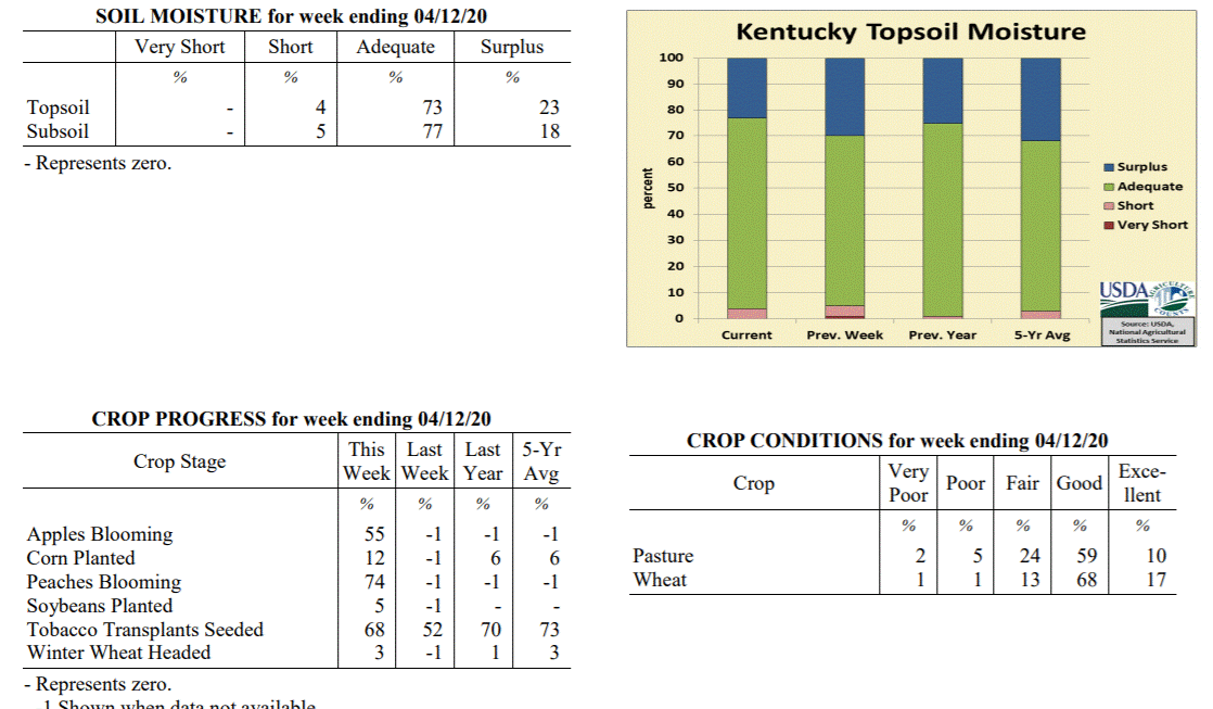 Kentucky Climate Summary
For the Period April 6, 2020 to April 12, 2020
Above Normal Temperatures and Near Normal Rainfall:
The period started with above normal temperatures and mostly dry conditions in place.
Highs consistently rose into the mid-70s to mid-80s with sunny skies. The tide turned
on Wednesday evening and Wednesday night as a strong cold front pushed through the
state. The highlight of the event was a strong to severe line of storms that formed
ahead of the frontal boundary. This line, in addition to some storms earlier in the
day, led to numerous reports of large hail and damaging winds. Behind the boundary,
breezy northwest winds ushered much cooler air into the area for the end of the work
week. Low temperatures dipped into the upper 20s to middle 30s Friday night,
prompting the first Freeze Warnings and Frost Advisories of the spring season.
Southerly flow brought temperatures back into the 60s over the weekend, but light to
moderate rain showers returned to the area Sunday afternoon. Some of this rain fell
after the data cutoff and will be reflected in next week�s report. Combined with the
Wednesday event, the state averaged just over an inch for the week, which is near
normal for this time of year.
Temperatures for the period averaged 58 degrees across the state which was 4 degrees
warmer than normal and 6 degrees warmer than the previous period. High temperatures
averaged from 69 in the West to 68 in the East. Departure from normal high
temperatures ranged from 1 degree warmer than normal in the West to 1 degree
warmer than normal in the East. Low temperatures averaged from 49 degrees in the
West to 47 degrees in the East. Departure from normal low temperature ranged from 5
degrees warmer than normal in the West to 8 degrees warmer than normal in the East.
The extreme high temperature for the period was 86 degrees at CARBONDALE ASOS and the
extreme low was 26 degrees at MONTICELLO AWOS.
Precipitation (liq. equ.) for the period totaled 1.05 inches statewide which was 0.03
inches above normal and 103% of normal. Precipitation totals by climate division,
West 0.72 inches, Central 1.21 inches, Bluegrass 1.26 inches and East 1.02 inches,
which was -0.44, 0.17, 0.34 and 0.08 inches respectively from normal. By station,
precipitation totals ranged from a low of 0.17 inches at EVANSVILLE ASOS to a high of
2.12 inches at SCOTTSVILLE 2W.
---
Kentucky Crop and Weather Report
Issued 4:00 P.M., April 6, 2020 03-20
Agricultural News: Kentucky experienced above normal temperatures and below normal
rainfall over the past week. Precipitation for the week totaled 0.41 inches, 0.58
inches below normal. Temperatures averaged 53 degrees for the week, 1 degree warmer
than normal. Topsoil moisture was rated 1 percent very short, 4 percent short, 65
percent adequate, and 30 percent surplus. Subsoil moisture was rated 1 percent very
short, 4 percent short, 69 percent adequate, and 26 percent surplus. Days suitable
for fieldwork averaged 5.0 out of a possible seven.
Primary activities for this week included seeding tobacco transplants along with
field preparation for the planting season. Mostly dry and seasonably warm conditions
this week have allowed opportunity for spraying as well as fertilizing for the 2020
crop season. Early corn and soybean planting has started in some areas. Winter wheat
is in mostly good condition and experienced very little freeze damage. Alfalfa freeze
damage was minimal.
Livestock condition is mostly good to fair at this time as recent weather has
promoted good pasture growth. Approximately 20 percent of feed for cattle and calves
was obtained from grazing. At this juncture pasture condition is rated as mostly good.
Kentucky Climate Summary
For the Period April 6, 2020 to April 12, 2020
Above Normal Temperatures and Near Normal Rainfall:
The period started with above normal temperatures and mostly dry conditions in place.
Highs consistently rose into the mid-70s to mid-80s with sunny skies. The tide turned
on Wednesday evening and Wednesday night as a strong cold front pushed through the
state. The highlight of the event was a strong to severe line of storms that formed
ahead of the frontal boundary. This line, in addition to some storms earlier in the
day, led to numerous reports of large hail and damaging winds. Behind the boundary,
breezy northwest winds ushered much cooler air into the area for the end of the work
week. Low temperatures dipped into the upper 20s to middle 30s Friday night,
prompting the first Freeze Warnings and Frost Advisories of the spring season.
Southerly flow brought temperatures back into the 60s over the weekend, but light to
moderate rain showers returned to the area Sunday afternoon. Some of this rain fell
after the data cutoff and will be reflected in next week�s report. Combined with the
Wednesday event, the state averaged just over an inch for the week, which is near
normal for this time of year.
Temperatures for the period averaged 58 degrees across the state which was 4 degrees
warmer than normal and 6 degrees warmer than the previous period. High temperatures
averaged from 69 in the West to 68 in the East. Departure from normal high
temperatures ranged from 1 degree warmer than normal in the West to 1 degree
warmer than normal in the East. Low temperatures averaged from 49 degrees in the
West to 47 degrees in the East. Departure from normal low temperature ranged from 5
degrees warmer than normal in the West to 8 degrees warmer than normal in the East.
The extreme high temperature for the period was 86 degrees at CARBONDALE ASOS and the
extreme low was 26 degrees at MONTICELLO AWOS.
Precipitation (liq. equ.) for the period totaled 1.05 inches statewide which was 0.03
inches above normal and 103% of normal. Precipitation totals by climate division,
West 0.72 inches, Central 1.21 inches, Bluegrass 1.26 inches and East 1.02 inches,
which was -0.44, 0.17, 0.34 and 0.08 inches respectively from normal. By station,
precipitation totals ranged from a low of 0.17 inches at EVANSVILLE ASOS to a high of
2.12 inches at SCOTTSVILLE 2W.
---
Kentucky Crop and Weather Report
Issued 4:00 P.M., April 6, 2020 03-20
Agricultural News: Kentucky experienced above normal temperatures and below normal
rainfall over the past week. Precipitation for the week totaled 0.41 inches, 0.58
inches below normal. Temperatures averaged 53 degrees for the week, 1 degree warmer
than normal. Topsoil moisture was rated 1 percent very short, 4 percent short, 65
percent adequate, and 30 percent surplus. Subsoil moisture was rated 1 percent very
short, 4 percent short, 69 percent adequate, and 26 percent surplus. Days suitable
for fieldwork averaged 5.0 out of a possible seven.
Primary activities for this week included seeding tobacco transplants along with
field preparation for the planting season. Mostly dry and seasonably warm conditions
this week have allowed opportunity for spraying as well as fertilizing for the 2020
crop season. Early corn and soybean planting has started in some areas. Winter wheat
is in mostly good condition and experienced very little freeze damage. Alfalfa freeze
damage was minimal.
Livestock condition is mostly good to fair at this time as recent weather has
promoted good pasture growth. Approximately 20 percent of feed for cattle and calves
was obtained from grazing. At this juncture pasture condition is rated as mostly good.
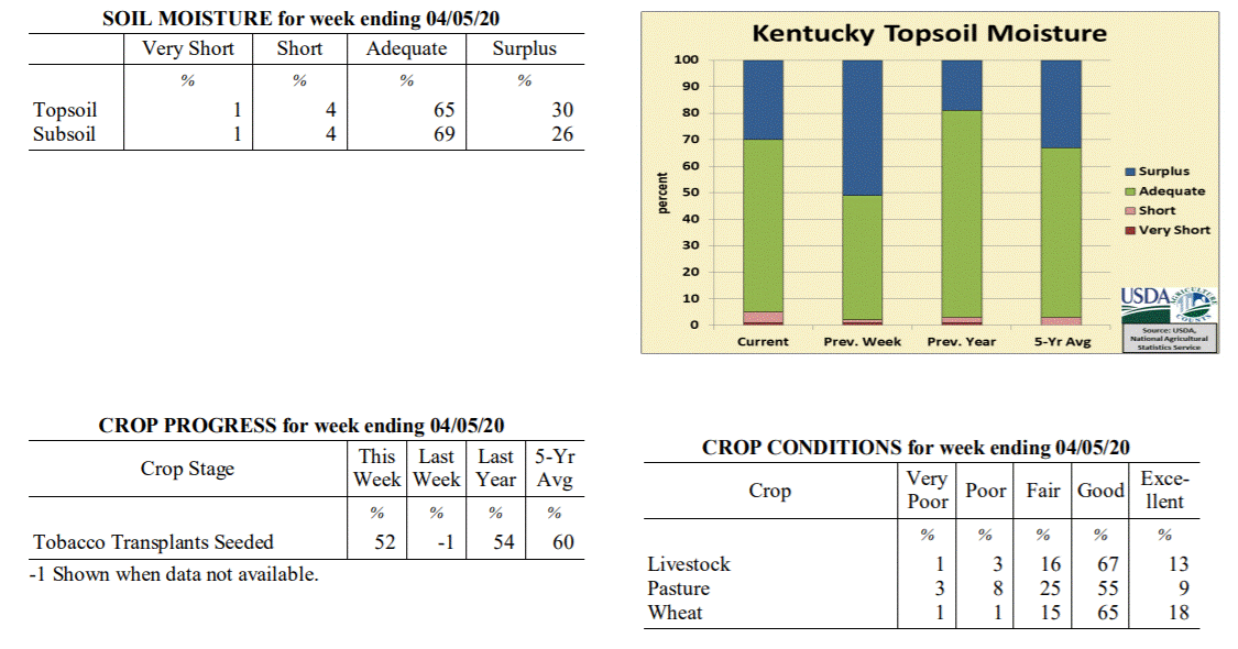 Kentucky Climate Summary
For the Period March 30, 2020 to April 5, 2020
Above Normal Temperatures and Below Normal Rainfall:
Following an exceptionally wet March, the first week of April opened with some much-
welcomed dry conditions. The only significant rainfall event passed through the
Bluegrass State on Tuesday. Total accumulations varied significantly, between a half
and one inch across the southern half of the state and less than a tenth of an inch
towards the northern fringes. Otherwise, the rest of the period was mostly dry.
Overall, the state averaged 0.41 inches, which marks the first week of below average
precipitation since the last week of February. The drier pattern was accompanied by
fluctuating temperatures for much of the week and partly to mostly sunny skies. High
temperatures ran below normal on Tuesday and Wednesday. Much of the state dipped
into the middle 30s to low 40s on Thursday morning. Some even hitting the lower 30s.
The cool conditions did not last long as the state was seeing highs back in the 60s
and 70s for the end of the work week and into the weekend.
Temperatures for the period averaged 53 degrees across the state which was 1 degree
warmer than normal and 6 degrees cooler than the previous period. High temperatures
averaged from 64 in the West to 63 in the East. Departure from normal high
temperatures ranged from 1 degree cooler than normal in the West to 1 degree
cooler than normal in the East. Low temperatures averaged from 44 degrees in the
West to 42 degrees in the East. Departure from normal low temperature ranged from 2
degrees warmer than normal in the West to 5 degrees warmer than normal in the East.
The extreme high temperature for the period was 79 degrees at PEABODY and the extreme
low was 28 degrees at MONTICELLO AWOS.
Precipitation (liq. equ.) for the period totaled 0.41 inches statewide which was 0.58
inches below normal and 41% of normal. Precipitation totals by climate division, West
0.36 inches, Central 0.34 inches, Bluegrass 0.16 inches and East 0.76 inches, which
was 0.73, 0.7, 0.74 and 0.19 inches below normal. By station, precipitation totals
ranged from a low of 0.00 inches at EVANSVILLE ASOS to a high of 1.14 inches at
BARBOURVILLE 3E.
---
Kentucky Climate Summary
For the Period March 23, 2020 to March 29, 2020
Well Above Normal Temperatures and Slightly Above Normal Rainfall:
Farmers welcomed some drier conditions this past week. While the state averaged 1.06
inches for the period, which is slightly above normal, this number was bumped higher
by higher accumulations across Southeastern Kentucky. Eastern Kentucky averaged 1.48
inches for the week, but the rest of the state was actually slightly below normal.
Light to moderate showers passed through the area on Tuesday as low pressure pushed
just south of the area. Other than some portions of the Northern Bluegrass that saw
scattered activity, this was followed by a few days of mostly dry and warm
weather. In fact, highs Thursday through Saturday were in the middle 70s to middle
80s behind breezy southerly flow. A strong storm system then pushed through the state
Saturday evening and overnight. Some storms became strong to severe with damaging
winds as the main hazard. A strong EF2 tornado even touched down in Henderson County
with estimated peak winds of 115 mph. Temperatures took a step back on Sunday with
highs in the 60s and very breezy conditions in place. Peak wind gusts between 35 and
45 mph were common across Kentucky, highest across the Bluegrass region.
Temperatures for the period averaged 59 degrees across the state which was 10 degrees
warmer than normal and 8 degrees warmer than the previous period. High temperatures
averaged from 68 in the West to 69 in the East. Departure from normal high
temperatures ranged from 5 degrees warmer than normal in the West to 7 degrees
warmer than normal in the East. Low temperatures averaged from 52 degrees in the
West to 51 degrees in the East. Departure from normal low temperature ranged from 12
degrees warmer than normal in the West to 16 degrees warmer than normal in the
East. The extreme high temperature for the period was 88 degrees at LOUISA 1S and the
extreme low was 32 degrees at PAINTSVILLE 4W.
Precipitation (liq. equ.) for the period totaled 1.09 inches statewide which was 0.06
inches above normal and 106% of normal. Precipitation totals by climate division,
West 0.97 inches, Central 1.07 inches, Bluegrass 0.83 inches and East 1.48 inches,
which was -0.14, -0.02, -0.10 and 0.48 inches respectively from normal. By station,
precipitation totals ranged from a low of 0.27 inches at HARDINSBURG 5SW to a high of
2.71 inches at BARBOURVILLE 3E.
---
Kentucky Climate Summary
For the Period March 16, 2020 to March 22, 2020
Above Normal Temperatures and Precipitation:
Mild and wet conditions have been the norm for much of March 2020 and that did not
change this period. After a light rainfall event on Monday/Monday night, more
significant activity arrived Wednesday and Thursday. Widespread rainfall fell on both
days. The latter produced scattered storms, which led to some bouts of heavy rain.
More showers accompanied the passage of a cold front on Friday and another
disturbance on Sunday. All together, the state averaged 1.84 inches, which is good
for a third straight week of above normal rainfall. Through the 22nd, the state has
now averaged over 5 inches since the start of March. Looking at temperatures, highs
jumped into the 60s and 70s Wednesday through Friday. Saying that, behind the cold
front on Friday, temperatures took an abrupt turn. Between Friday and Saturday, there
was a ~25 - 30 degree swing in high temperatures. Lows that night dropped into the
upper 20s to middle 30s.
Temperatures for the period averaged 51 degrees across the state which was 3 degrees
warmer than normal and no change to the previous period. High temperatures averaged
from 58 in the West to 60 in the East. Departure from normal high temperatures ranged
from 3 degrees cooler than normal in the West to near normal in the East. Low
temperatures averaged from 44 degrees in the West to 46 degrees in the East.
Departure from normal low temperature ranged from 6 degrees warmer than normal in the
West to 12 degrees warmer than normal in the East. The extreme high temperature for
the period was 79 degrees at YELLOW CREEK and the extreme low was 27 degrees at
ALEXANDRIA 5NW.
Precipitation (liq. equ.) for the period totaled 1.84 inches statewide which was 0.8
inches above normal and 177% of normal. Precipitation totals by climate division,
West 1.93 inches, Central 2.07 inches, Bluegrass 1.45 inches and East 1.92 inches,
which was 0.83, 0.97, 0.51 and 0.9 inches above normal. By station, precipitation
totals ranged from a low of 0.12 inches at MT STERLING AWOS to a high of 3.62
inches at BOWLING GREEN 5S.
---
Kentucky Climate Summary
For the Period March 9, 2020 to March 15, 2020
Above Normal Temperatures and Precipitation:
Mild and wet conditions continued for a second straight week. All together, the
state averaged 2.29 inches for the period as multiple rounds of showers and some
storms pushed through Kentucky. Activity was most significant on Thursday as some
storms became strong to severe. Severe weather involving damaging winds and large
hail was most common across primarily western Kentucky, while heavy rainfall was
more widespread across the state. Ahead of these storms, temperatures rose into the
60s and 70s. Following the event, a cold front worked through Kentucky on Friday.
Temperatures only rose into the 40s over the weekend and was accompanied by another
couple rounds of widespread showers on Saturday. Through March 15th, data at the Ag
Weather Center shows the state has averaged 3.57 inches for the month, which is about
1.5 inches above normal.
Temperatures for the period averaged 51 degrees across the state which was 6 degrees
warmer than normal and 2 degrees warmer than the previous period. High temperatures
averaged from 58 in the West to 60 in the East. Departure from normal high
temperatures ranged from 1 degree cooler than normal in the West to 2 degrees
warmer than normal in the East. Low temperatures averaged from 44 degrees in the
West to 45 degrees in the East. Departure from normal low temperature ranged from 8
degrees warmer than normal in the West to 13 degrees warmer than normal in the
East. The extreme high temperature for the period was 75 degrees at MURRAY 1W and the
extreme low was 28 degrees at JACKSON 3SE.
Precipitation (liq. equ.) for the period totaled 2.29 inches statewide which was 1.31
inches above normal and 234% of normal. Precipitation totals by climate division,
West 2.14 inches, Central 2.65 inches, Bluegrass 2.09 inches and East 2.28 inches,
which was 1.12, 1.62, 1.2 and 1.31 inches above normal. By station, precipitation
totals ranged from a low of 0.51 inches at FRANKLIN 4SW to a high of 4.69 inches at
RICHMOND 8E.
---
Kentucky Climate Summary
For the Period March 2, 2020 to March 8, 2020
Above Normal Temperatures and Precipitation:
The work week started with mild and wet conditions in place. Widespread showers
worked across the area Monday morning ahead of an upper level disturbance. After a
short break that afternoon, another round moved through Kentucky that evening and
overnight. This time though, numerous showers was accompanied by scattered storms.
Some storms became strong to severe across Western and South-Central Kentucky,
producing large hail and even a couple tornadoes. Overall, this accounted for the
brunt of the rainfall for the week with the state averaging 1.28 inches. Saying that,
portions of Western and South Central Kentucky saw more than two. The rest of the
week stayed quiet with fluctuating temperatures, cooling off toward the end of the
work week and warming up again over the weekend.
Temperatures for the period averaged 48 degrees across the state which was 4 degrees
warmer than normal and 8 degrees warmer than the previous period. High temperatures
averaged from 61 in the West to 59 in the East. Departure from normal high
temperatures ranged from 4 degrees warmer than normal in the West to 3 degrees
warmer than normal in the East. Low temperatures averaged from 39 degrees in the
West to 37 degrees in the East. Departure from normal low temperature ranged from 4
degrees warmer than normal in the West to 6 degrees warmer than normal in the East.
The extreme high temperature for the period was 69 degrees at FORT CAMPBELL and the
extreme low was 17 degrees at BRANDENBURG 4SW.
Precipitation (liq. equ.) for the period totaled 1.28 inches statewide which was 0.3
inches above normal and 131% of normal. Precipitation totals by climate division,
West 1.54 inches, Central 1.69 inches, Bluegrass 0.67 inches and East 1.21 inches,
which was 0.49, 0.66, -0.21 and 0.26 inches respectively from normal. By station,
precipitation totals ranged from a low of 0.27 inches at MAYSVILLE 3SW to a high of
3.21 inches at CADIZ 4SW.
---
Kentucky Climate Summary
For the Period February 24, 2020 to March 1, 2020
Below Normal Temperatures and Precipitation:
Wet conditions stuck around for most of the work week. Precipitation started out as
rain on Monday and Tuesday, but colder air filtering into the area on Wednesday led
to a couple light rounds of snow to end the work week. Dry conditions returned over
the weekend. Overall, the state averaged 0.86 inches for the week. Since February
1st, Kentucky has averaged 5.89 inches, almost two inches above normal over that time
span. Looking at temperatures, highs struggled in the 30s and 40s and lows dipped
into the 20s from Wednesday to Saturday. Despite temperatures back in the 60s on
Sunday, temperatures averaged a couple degrees below normal for the week. This broke
a streak of 8 straight weeks of near to above normal temperatures to start the year.
Temperatures for the period averaged 40 degrees across the state which was 2 degrees
cooler than normal and no change to the previous period. High temperatures averaged
from 49 in the West to 48 in the East. Departure from normal high temperatures
ranged from 5 degrees cooler than normal in the West to 6 degrees cooler than normal
in the East. Low temperatures averaged from 34 degrees in the West to 32 degrees in
the East. Departure from normal low temperature ranged from 1 degree warmer than
normal in the West to 3 degrees warmer than normal in the East. The extreme high
temperature for the period was 70 degrees at HARTFORD 3E and the extreme low was 15
degrees at CARLISLE 5SW.
Precipitation (liq. equ.) for the period totaled 0.86 inches statewide which was 0.13
inches below normal and 87% of normal. Precipitation totals by climate division, West
0.89 inches, Central 0.94 inches, Bluegrass 0.96 inches and East 0.67 inches, which
was -0.21, -0.11, 0.10 and -0.26 inches respectively from normal. By station,
precipitation totals ranged from a low of 0.36 inches at CARBONDALE ASOS to a high of
1.58 inches at POPLAR BLUFF ASOS.
---
Kentucky Climate Summary
For the Period February 17, 2020 to February 23, 2020
Near Normal Temperatures and Below Normal Precipitation:
After two straight weeks of exceptional rainfall to start the month of February, a
much welcomed drier pattern returned to the area this period. After a very mild
Monday, widespread light showers returned to the area Monday night and Tuesday, but
accumulations were under a half inch for most of the state. For much of Kentucky,
this ended up being the only precipitation event for the week as high pressure then
took control. Behind a cold front on Tuesday, temperatures went on the downhill slide
over the rest of the work week. Low temperatures dropped into the middle teens to low
20s both Friday and Saturday mornings. As high pressure moved east over the weekend,
winds transitioned to the south/southwest and pushed high temperatures back into the
50s.
Temperatures for the period averaged 39 degrees across the state which was
near normal and 2 degrees warmer than the previous period. High temperatures
averaged from 50 in the West to 50 in the East. Departure from normal high
temperatures ranged from 1 degree cooler than normal in the West to 1 degree
cooler than normal in the East. Low temperatures averaged from 30 degrees in the
West to 29 degrees in the East. Departure from normal low temperature ranged from
near normal in the West to 2 degrees warmer than normal in the East. The
extreme high temperature for the period was 68 degrees at FORT CAMPBELL and the
extreme low was 11 degrees at CYNTHIANA 8N.
Precipitation (liq. equ.) for the period totaled 0.37 inches statewide which was 0.56
inches below normal and 40% of normal. Precipitation totals by climate division, West
0.35 inches, Central 0.42 inches, Bluegrass 0.29 inches and East 0.41 inches, which
was 0.7, 0.58, 0.51 and 0.46 inches below normal. By station, precipitation totals
ranged from a low of 0.01 inches at CARBONDALE ASOS to a high of 0.93 inches at
ELKTON 5SW.
---
Kentucky Climate Summary
For the Period February 10, 2020 to February 16, 2020
Above Normal Temperatures and Much Above Normal Precipitation:
Kentucky has not been able to catch a break from excessive rainfall over the first
half of the February. Through February 16th, data at the Ag Weather Center shows the
state has averaged 4.66 inches, which is 2.64 inches above normal. About 2.5 inches
of that 4.66 total came over the past week. Rain came in two rounds, one on Monday
and the other on Wednesday/Wednesday night. While both rounds brought widespread
rainfall, the latter was more significant with 1 to 2+ inches falling across the
state ahead of a cold front. Saturated soils led to flash flooding in some areas.
Behind the cold front, temperatures took quite the dip. After starting the week in
the 50s, highs struggled in the 20s and 30s on Thursday and Friday. Lows dipped into
the teens both nights. Some sites even hit the single digits.
Temperatures for the period averaged 38 degrees across the state which was 1 degree
warmer than normal and 4 degrees cooler than the previous period. High temperatures
averaged from 44 in the West to 49 in the East. Departure from normal high
temperatures ranged from 4 degrees cooler than normal in the West to 1 degree
warmer than normal in the East. Low temperatures averaged from 30 degrees in the
West to 33 degrees in the East. Departure from normal low temperature ranged from 2
degrees warmer than normal in the West to 8 degrees warmer than normal in the East.
The extreme high temperature for the period was 63 degrees at ALBANY 1N and the
extreme low was 8 degrees at BRANDENBURG 4SW.
Precipitation (liq. equ.) for the period totaled 2.56 inches statewide which was 1.65
inches above normal and 282% of normal. Precipitation totals by climate division,
West 2.37 inches, Central 2.77 inches, Bluegrass 2.06 inches and East 3.04 inches,
which was 1.36, 1.78, 1.28 and 2.19 inches above normal. By station, precipitation
totals ranged from a low of 1.45 inches at CINCINNATI to a high of 4.34 inches at
BURKESVILLE 3W.
---
Kentucky Climate Summary
For the Period February 3, 2020 to February 9, 2020
Above Normal Temperatures and Much Above Normal Precipitation:
After three straight weeks of near to below normal precipitation, Kentucky averaged
more than two inches this period. Precipitation was seen on a near daily basis. The
most significant rounds fell Monday night/Tuesday and Wednesday night. Grounds
became saturated and while the state averaged 2 inches, many locations across
Southeastern Kentucky saw 3 to 5+ inches, which led to significant flooding in this
area. Temperatures then took a downhill turn and transitioned precipitation to snow
for Thursday night and Friday morning. Much of the state saw 1 to 2 inches, even
higher in parts of the Bluegrass and Eastern Kentucky. While mostly cloudy skies
remained into the weekend, temperatures did moderate to slightly above normal by
Sunday.
Temperatures for the period averaged 42 degrees across the state which was 7 degrees
warmer than normal and no change to the previous period. High temperatures averaged
from 50 in the West to 53 in the East. Departure from normal high temperatures
ranged from 4 degrees warmer than normal in the West to 7 degrees warmer than normal
in the East. Low temperatures averaged from 36 degrees in the West to 36 degrees in
the East. Departure from normal low temperature ranged from 10 degrees warmer than
normal in the West to 13 degrees warmer than normal in the East. The extreme high
temperature for the period was 75 degrees at MADISONVILLE 4S and the extreme low was
18 degrees at BRANDENBURG 4SW.
Precipitation (liq. equ.) for the period totaled 2.02 inches statewide which was 1.15
inches above normal and 232% of normal. Precipitation totals by climate division,
West 1.82 inches, Central 2.00 inches, Bluegrass 1.14 inches and East 3.10 inches,
which was 0.86, 1.05, 0.38 and 2.28 inches above normal. By station, precipitation
totals ranged from a low of 0.66 inches at LOUISVILLE APT to a high of 5.66 inches
at YELLOW CREEK.
---
Kentucky Climate Summary
For the Period January 27, 2020 to February 2, 2020
Above Normal Temperatures and Below Normal Precipitation:
January closed with a mostly cloudy and unsettled week for the Commonwealth. Sunshine
was limited throughout the period with multiple disturbances working through the
region. While the state did see multiple rounds of precipitation, mainly Tuesday
night through Saturday, accumulations were fairly light. Kentucky only averaged
about a quarter inch, which is good for a third straight week of below normal
precipitation. Saying that, preliminary data from the Ag Weather Center shows the
state averaged 4.42 inches for the month of January, which is over a half inch above
normal. The cloudy weather kept temperatures in the 30s and 40s for most of the
period, but the tide turned on Sunday. Breezy southwesterly flow pushed highs into
the 60s for Groundhogs Day.
Temperatures for the period averaged 40 degrees across the state which was 6 degrees
warmer than normal and 8 degrees warmer than the previous period. High temperatures
averaged from 46 in the West to 47 in the East. Departure from normal high
temperatures ranged from 2 degrees warmer than normal in the West to 3 degrees
warmer than normal in the East. Low temperatures averaged from 35 degrees in the
West to 35 degrees in the East. Departure from normal low temperature ranged from 10
degrees warmer than normal in the West to 13 degrees warmer than normal in the
East. The extreme high temperature for the period was 68 degrees at ELKTON 5SW and
the extreme low was 26 degrees at BURKESVILLE 3W.
Precipitation (liq. equ.) for the period totaled 0.28 inches statewide which was 0.54
inches below normal and 34% of normal. Precipitation totals by climate division, West
0.30 inches, Central 0.32 inches, Bluegrass 0.22 inches and East 0.27 inches, which
was 0.57, 0.57, 0.49 and 0.53 inches below normal. By station, precipitation totals
ranged from a low of 0.10 inches at CYNTHIANA 8N to a high of 0.61 inches at ALBANY 1N.
---
Kentucky Climate Summary
For the Period January 20, 2020 to January 26, 2020
Near Normal Temperatures and Precipitation:
Carrying over from the previous period, chilly conditions continued early in the
week. Low temperatures through Wednesday morning were generally in the teens for
much of Kentucky and highs struggled in the 20s and 30s. Wind chills even dipped into
the single digits again on Monday morning causing the livestock cold stress index to
once again dip into the danger to emergency categories. Dry conditions prevailed
until late Thursday and into Friday as a disturbance aloft worked through the region.
This system brought widespread rain back to the region and accounted for most of the
rainfall over the period. Most saw between a half to 1 inch. The state average for
the week was 0.78. Cloudy skies and patchy drizzle/light showers remained over the
weekend, but temperatures did go on the increase with highs back in the 40s.
Temperatures for the period averaged 33 degrees across the state which was
near normal and 10 degrees cooler than the previous period. High temperatures
averaged from 38 in the West to 41 in the East. Departure from normal high
temperatures ranged from 6 degrees cooler than normal in the West to 3 degrees
cooler than normal in the East. Low temperatures averaged from 27 degrees in the
West to 27 degrees in the East. Departure from normal low temperature ranged from 2
degrees warmer than normal in the West to 5 degrees warmer than normal in the East.
The extreme high temperature for the period was 57 degrees at JACKSON 3SE and the
extreme low was 10 degrees at CARLISLE 5SW.
Precipitation (liq. equ.) for the period totaled 0.78 inches statewide which was 0.03
inches below normal and 97% of normal. Precipitation totals by climate division, West
0.49 inches, Central 0.90 inches, Bluegrass 0.93 inches and East 0.80 inches, which
was -0.37, 0.04, 0.23 and -0.01 inches respectively from normal. By station,
precipitation totals ranged from a low of 0.26 inches at FORT CAMPBELL to a high of
1.64 inches at LIBERTY 3SW.
---
Kentucky Climate Summary
For the Period January 13, 2020 to January 19, 2020
Above Normal Temperatures and Below Normal Precipitation:
The week started out with unseasonably mild conditions in place with highs topping
out in the middle 50s to low 60s by Tuesday. This was the case despite mostly cloudy
skies and some showers on Tuesday. Rain was mostly confined to the southeastern side
of the state. This was followed by another round on Wednesday as a cold front passed
through the region. Ahead of the boundary, highs jumped into the 60s, but behind the
front, a northwest wind kept highs in the 30s and 40s for Thursday and Friday. The
active week continued into the weekend with light to moderate showers expanding
across the area Friday night and into Saturday. While rainfall was widespread, this
round followed the trend of the previous events this week and total accumulations
were not overly significant. Despite the active pattern, the state averaged 0.65
inches for the week, which is slightly below normal for this time of year. This broke
a four week streak of above normal precipitation. Behind a secondary cold front on
Saturday, Kentucky saw highs in the 20s on Sunday. Wind chills were even in the
single digits on Sunday morning with the livestock cold stress index hovering in the
danger to emergency categories.
Temperatures for the period averaged 42 degrees across the state which was 9 degrees
warmer than normal and 4 degrees cooler than the previous period. High temperatures
averaged from 50 in the West to 52 in the East. Departure from normal high
temperatures ranged from 7 degrees warmer than normal in the West to 9 degrees
warmer than normal in the East. Low temperatures averaged from 36 degrees in the
West to 36 degrees in the East. Departure from normal low temperature ranged from 11
degrees warmer than normal in the West to 13 degrees warmer than normal in the East.
The extreme high temperature for the period was 72 degrees at BOWLING GREEN APT and
the extreme low was 15 degrees at ALEXANDRIA 5NW.
Precipitation (liq. equ.) for the period totaled 0.65 inches statewide which was 0.19
inches below normal and 77% of normal. Precipitation totals by climate division, West
0.47 inches, Central 0.70 inches, Bluegrass 0.61 inches and East 0.80 inches, which
was 0.41, 0.19, 0.12 and 0.07 inches below normal. By station, precipitation totals
ranged from a low of 0.15 inches at OWENSBORO AWSS to a high of 1.62 inches at CARLISLE 5SW.
---
Kentucky Climate Summary
For the Period January 6, 2020 to January 12, 2020
Well Above Normal Temperatures and Precipitation:
It may be the middle of winter, but it sure doesn�t feel like it in Kentucky.
Temperatures ran above normal the entire week, peaking in the 60s and 70s on Friday
and Saturday. Putting this into perspective, normal high temperatures for this time
of year are in the low to middle 40s across the state. Other than a light
rainfall event across the southern half of the state on Tuesday morning, the primary
focus for the week was a strong system working through Kentucky on Friday and
Saturday. Winds were very gusty throughout the event, but most notable on Saturday
when gusts between 40 and 60 mph were common. This was especially the case as a couple
lines of showers worked through Kentucky, causing some bouts of damaging winds and
power outages. Otherwise, rainfall accumulations were highest across Western Kentucky
(>2 inches) and tapered farther east. Overall, the state averaged 1.66 inches for
the period.
Temperatures for the period averaged 47 degrees across the state which was 14
degrees warmer than normal and 2 degrees warmer than the previous period. High
temperatures averaged from 55 in the West to 57 in the East. Departure from
normal high temperatures ranged from 12 degrees warmer than normal in the West
to 13 degrees warmer than normal in the East. Low temperatures averaged from
37 degrees in the West to 38 degrees in the East. Departure from normal low
temperature ranged from 11 degrees warmer than normal in the West to 14 degrees
warmer than normal in the East. The extreme high temperature for the period
was 79 degrees at LOUISA 1S and the extreme low was 21 degrees at MONTICELLO AWOS.
Precipitation (liq. equ.) for the period totaled 1.66 inches statewide which was
0.78 inches above normal and 188% of normal. Precipitation totals by climate
division, West 2.62 inches, Central 1.68 inches, Bluegrass 1.08 inches and East
1.25 inches, which was 1.69, 0.74, 0.33 and 0.34 inches above normal. By
station, precipitation totals ranged from a low of 0.56 inches at VANCEBURG 6W
to a high of 4.39 inches at CAPE GIRARDEAU ASOS.
---
Kentucky Climate Summary
For the Period December 30, 2019 to January 5, 2020
Well Above Normal Temperatures and Precipitation:
The calendar turned the page to 2020 with warm and wet conditions continuing from the
end of 2019. Highs on New Year�s Day rose into the middle 40s to around 50 and then
remained in the 50s through Friday. While it was warm, the Bluegrass State saw
another round of exceptional rainfall between Thursday and Saturday. Periods of light
to moderate rain led to total accumulations of 1 to 2+ inches. Dating back into late
December, average rainfall across the state has been above normal for three straight
weeks. Over that time span, Kentucky has averaged nearly 5 inches of rainfall, which
is over 2 inches above normal.
Temperatures for the period averaged 44 degrees across the state which was 10 degrees
warmer than normal and 8 degrees cooler than the previous period. High temperatures
averaged from 50 in the West to 51 in the East. Departure from normal high
temperatures ranged from 7 degrees warmer than normal in the West to 7 degrees
warmer than normal in the East. Low temperatures averaged from 37 degrees in the
West to 39 degrees in the East. Departure from normal low temperature ranged from 11
degrees warmer than normal in the West to 15 degrees warmer than normal in the
East. The extreme high temperature for the period was 70 degrees at WHITESBURG 2NW
and the extreme low was 23 degrees at BRANDENBURG 4SW.
Precipitation (liq. equ.) for the period totaled 1.83 inches statewide which was 0.94
inches above normal and 204% of normal. Precipitation totals by climate division,
West 1.27 inches, Central 2.03 inches, Bluegrass 1.63 inches and East 2.39 inches,
which was 0.34, 1.06, 0.85 and 1.49 inches above normal. By station, precipitation
totals ranged from a low of 0.28 inches at CARBONDALE ASOS to a high of 3.64 inches
at WHITLEY CITY 3N.
---
Kentucky Climate Summary
For the Period December 23, 2019 to December 29, 2019
Well Above Normal Temperatures and Above Normal Precipitation:
Unseasonably mild temperatures was the highlight of the week. Daytime highs
hit the 60s on Christmas Eve/Day and stayed that way into the weekend. Even
hit 70 degrees for some locations across Western Kentucky. Putting this into
perspective, the state normally sees highs in the low to middle 40s for this time of
year. Widespread moderate to heavy rain then returned to the area on Saturday night
and into Sunday as an area of low pressure approached the Bluegrass State. The state
averaged 1.22 inches with some minor flooding in low spots and poor drainage areas.
Temperatures for the period averaged 54 degrees across the state which was 18 degrees
warmer than normal and 20 degrees warmer than the previous period. High temperatures
averaged from 65 in the West to 64 in the East. Departure from normal high
temperatures ranged from 20 degrees warmer than normal in the West to 18 degrees
warmer than normal in the East. Low temperatures averaged from 45 degrees in the
West to 42 degrees in the East. Departure from normal low temperature ranged from 18
degrees warmer than normal in the West to 16 degrees warmer than normal in the
East. The extreme high temperature for the period was 72 degrees at CADIZ 4SW and the
extreme low was 21 degrees at VANCEBURG 6W.
Precipitation (liq. equ.) for the period totaled 1.22 inches statewide which was 0.28
inches above normal and 130% of normal. Precipitation totals by climate division,
West 1.48 inches, Central 1.54 inches, Bluegrass 1.11 inches and East 0.75 inches,
which was 0.49, 0.52, 0.28 and -0.16 inches respectively from normal. By station,
precipitation totals ranged from a low of 0.00 inches at WHITESBURG 2NW to a high of
2.49 inches at BOWLING GREEN 4E.
---
Kentucky Climate Summary
For the Period December 16, 2019 to December 22, 2019
Below Normal Temperatures and Much Above Normal Precipitation:
An exceptional amount of rain fell across the area to start the period. Rainfall
intensity was moderate to heavy at times and led to an average of nearly two inches
falling across the Commonwealth. The excessive rainfall led to areal flood warnings
issued across the area. Behind the rain, much cooler air filtered into Kentucky.
Lingering cloud cover kept highs in the 30s on Tuesday and Wednesday. Skies then
cleared Wednesday night with lows dipping into the upper teens to low 20s. This was
followed by an abrupt warming trend the rest of the week, along with continued dry
conditions. By Sunday, high temperatures were several degrees above normal in the 50s.
Temperatures for the period averaged 36 degrees across the state which was 1 degree
cooler than normal and 4 degrees cooler than the previous period. High temperatures
averaged from 44 in the West to 47 in the East. Departure from normal high
temperatures ranged from 3 degrees cooler than normal in the West to 1 degree
cooler than normal in the East. Low temperatures averaged from 28 degrees in the
West to 29 degrees in the East. Departure from normal low temperature ranged from 1
degree cooler than normal in the West to 2 degrees warmer than normal in the East.
The extreme high temperature for the period was 65 degrees at BARBOURVILLE 3E and the
extreme low was 12 degrees at ALEXANDRIA 5NW.
Precipitation (liq. equ.) for the period totaled 1.91 inches statewide which was 0.94
inches above normal and 196% of normal. Precipitation totals by climate division,
West 1.31 inches, Central 2.31 inches, Bluegrass 2.02 inches and East 2.00 inches,
which was 0.24, 1.25, 1.18 and 1.08 inches above normal. By station, precipitation
totals ranged from a low of 0.49 inches at MORGANFIELD 4E to a high of 3.17
inches at OWINGSVILLE 4S.
---
Kentucky Climate Summary
For the Period December 9, 2019 to December 15, 2019
Above Normal Temperatures and Below Normal Precipitation:
The period started off very mild with highs jumping into the upper 50s to middle 60s
on Monday. Saying that, the warm weather was accompanied by periods of light to
moderate rain showers through the day and overnight with occasional gusty winds. A
strong cold front then swept through the Ohio Valley on Tuesday. Temperatures went
abruptly on the decrease and transitioned some rain to snow in southeastern counties,
but accumulations were limited. Lows that night dipped into the middle teens to low
20s across the state. Those temperatures went quickly on the rebound, back in the
40s on Wednesday. Cloudy and wet weather then arrived for the weekend with daily
rounds of light showers on Friday, Saturday, and Sunday. Even saw a wintry mix for
portions of Northern Kentucky on Sunday evening. Overall, the state averaged 0.76
inches, which is good for a second straight week of below normal precipitation.
Temperatures for the period averaged 40 degrees across the state which was 1 degree
warmer than normal and 2 degrees cooler than the previous period. High temperatures
averaged from 48 in the West to 50 in the East. Departure from normal high
temperatures ranged from 1 degree cooler than normal in the West to 1 degree
warmer than normal in the East. Low temperatures averaged from 33 degrees in the
West to 33 degrees in the East. Departure from normal low temperature ranged from 3
degrees warmer than normal in the West to 5 degrees warmer than normal in the East.
The extreme high temperature for the period was 64 degrees at ALBANY 1N and the
extreme low was 14 degrees at CARLISLE 5SW.
Precipitation (liq. equ.) for the period totaled 0.76 inches statewide which was 0.28
inches below normal and 73% of normal. Precipitation totals by climate division, West
0.27 inches, Central 0.62 inches, Bluegrass 0.83 inches and East 1.32 inches, which
was -0.85, -0.51, -0.08 and 0.34 inches respectively from normal. By station,
precipitation totals ranged from a low of 0.04 inches at POPLAR BLUFF ASOS to a high
of 1.95 inches at WHITESBURG 2NW.
---
Kentucky Climate Summary
For the Period December 2, 2019 to December 8, 2019
Near Normal Temperatures and Below Normal Precipitation:
After two straight weeks of above normal rainfall, Kentucky welcomed some drier
conditions this past week. The state only averaged 0.11 inches, which is almost an
inch below normal. The rainfall came in a couple different rounds, one on Monday and
the other on Friday. While coverage turned widespread for both, intensity was
lacking. A break was need as looking back over the past 30 days, data at the Ag Weather
Center shows the state has averaged 5.15 inches of precipitation.
Temperatures for the period averaged 41 degrees across the state which was
near normal and 6 degrees cooler than the previous period. High temperatures
averaged from 52 in the West to 47 in the East. Departure from normal high
temperatures ranged from 1 degree warmer than normal in the West to 5 degrees
cooler than normal in the East. Low temperatures averaged from 33 degrees in the
West to 32 degrees in the East. Departure from normal low temperature ranged from
near normal in the West to 2 degrees warmer than normal in the East. The extreme
high temperature for the period was 63 degrees at FORT CAMPBELL and the extreme
low was 19 degrees at CARLISLE 5SW.
Precipitation (liq. equ.) for the period totaled 0.11 inches statewide which was 0.97
inches below normal and 10% of normal. Precipitation totals by climate division, West
0.05 inches, Central 0.06 inches, Bluegrass 0.15 inches and East 0.16 inches, which
was 1.19, 1.1, 0.77 and 0.85 inches below normal. By station, precipitation totals
ranged from a low of 0.00 inches at PADUCAH ASOS to a high of 0.51 inches at VANCEBURG 6W.
---
Kentucky Climate Summary
For the Period November 25, 2019 to December 1, 2019
Above Normal Temperatures and Well Above Normal Precipitation:
Kentucky saw an exceptionally high amount of rainfall over the course of the week as
the state averaged 3.43 inches. Based on data at the UK Ag Weather Center, this would
be good for the third wettest week of the year. The rainfall was split between two
rounds, one coming Tuesday/Wednesday and the other on Friday/Saturday. Widespread
light to moderate rainfall accompanied each round, but the early weekend system was
much more prolonged and accounted for the brunt of the weekly accumulations. The
longevity of the event led to saturated soils and some minor flooding issues with
multiple area flood warnings put into effect. In addition to the rainfall, Kentucky
experienced very breezy conditions following the first round on Wednesday. Maximum
wind gusts of 40 to 50+ mph were common across Kentucky.
Temperatures for the period averaged 46 degrees across the state which was 3 degrees
warmer than normal and no change to the previous period. High temperatures averaged
from 56 in the West to 54 in the East. Departure from normal high temperatures ranged
from 2 degrees warmer than normal in the West to near normal in the East. Low
temperatures averaged from 40 degrees in the West to 38 degrees in the East.
Departure from normal low temperature ranged from 5 degrees warmer than normal in the
West to 7 degrees warmer than normal in the East. The extreme high temperature for
the period was 69 degrees at LOUISA 1S and the extreme low was 26 degrees at BOONEVILLE 2S.
Precipitation (liq. equ.) for the period totaled 3.43 inches statewide which was 2.36
inches above normal and 321% of normal. Precipitation totals by climate division,
West 2.94 inches, Central 4.31 inches, Bluegrass 3.19 inches and East 3.28 inches,
which was 1.69, 3.18, 2.29 and 2.28 inches above normal. By station, precipitation
totals ranged from a low of 1.22 inches at HICKMAN 2E to a high of 5.55 inches at
LIBERTY 3SW.
---
Kentucky Crop and Weather Report
Issued 4:00 P.M., November 25, 2019 37-19
Agricultural News: Kentucky experienced below normal temperatures and above normal
precipitation over the past week. Precipitation for the week totaled 1.37 inches,
0.37 inches above normal. Temperatures averaged 44 degrees for the week, 1 degrees
below normal. Topsoil moisture was rated 1 percent very short, 12 percent short, 76
percent adequate and 11 percent surplus. Subsoil moisture was rated 6 percent very
short, 15 percent short, 71 percent adequate, and 8 percent surplus. Days suitable
for fieldwork averaged 4.1 out of a possible seven.
Primary activities this week included harvesting corn and soybeans, stripping
tobacco, and planting wheat. Hay shortage continues be a problem for many producers
with some reports of selling off cattle because of limited supplies. Overall, hay and
roughage supplies were reported as 9 percent very short, 31 percent short,
57 percent adequate, and 3 percent surplus across the state.
Kentucky Climate Summary
For the Period March 30, 2020 to April 5, 2020
Above Normal Temperatures and Below Normal Rainfall:
Following an exceptionally wet March, the first week of April opened with some much-
welcomed dry conditions. The only significant rainfall event passed through the
Bluegrass State on Tuesday. Total accumulations varied significantly, between a half
and one inch across the southern half of the state and less than a tenth of an inch
towards the northern fringes. Otherwise, the rest of the period was mostly dry.
Overall, the state averaged 0.41 inches, which marks the first week of below average
precipitation since the last week of February. The drier pattern was accompanied by
fluctuating temperatures for much of the week and partly to mostly sunny skies. High
temperatures ran below normal on Tuesday and Wednesday. Much of the state dipped
into the middle 30s to low 40s on Thursday morning. Some even hitting the lower 30s.
The cool conditions did not last long as the state was seeing highs back in the 60s
and 70s for the end of the work week and into the weekend.
Temperatures for the period averaged 53 degrees across the state which was 1 degree
warmer than normal and 6 degrees cooler than the previous period. High temperatures
averaged from 64 in the West to 63 in the East. Departure from normal high
temperatures ranged from 1 degree cooler than normal in the West to 1 degree
cooler than normal in the East. Low temperatures averaged from 44 degrees in the
West to 42 degrees in the East. Departure from normal low temperature ranged from 2
degrees warmer than normal in the West to 5 degrees warmer than normal in the East.
The extreme high temperature for the period was 79 degrees at PEABODY and the extreme
low was 28 degrees at MONTICELLO AWOS.
Precipitation (liq. equ.) for the period totaled 0.41 inches statewide which was 0.58
inches below normal and 41% of normal. Precipitation totals by climate division, West
0.36 inches, Central 0.34 inches, Bluegrass 0.16 inches and East 0.76 inches, which
was 0.73, 0.7, 0.74 and 0.19 inches below normal. By station, precipitation totals
ranged from a low of 0.00 inches at EVANSVILLE ASOS to a high of 1.14 inches at
BARBOURVILLE 3E.
---
Kentucky Climate Summary
For the Period March 23, 2020 to March 29, 2020
Well Above Normal Temperatures and Slightly Above Normal Rainfall:
Farmers welcomed some drier conditions this past week. While the state averaged 1.06
inches for the period, which is slightly above normal, this number was bumped higher
by higher accumulations across Southeastern Kentucky. Eastern Kentucky averaged 1.48
inches for the week, but the rest of the state was actually slightly below normal.
Light to moderate showers passed through the area on Tuesday as low pressure pushed
just south of the area. Other than some portions of the Northern Bluegrass that saw
scattered activity, this was followed by a few days of mostly dry and warm
weather. In fact, highs Thursday through Saturday were in the middle 70s to middle
80s behind breezy southerly flow. A strong storm system then pushed through the state
Saturday evening and overnight. Some storms became strong to severe with damaging
winds as the main hazard. A strong EF2 tornado even touched down in Henderson County
with estimated peak winds of 115 mph. Temperatures took a step back on Sunday with
highs in the 60s and very breezy conditions in place. Peak wind gusts between 35 and
45 mph were common across Kentucky, highest across the Bluegrass region.
Temperatures for the period averaged 59 degrees across the state which was 10 degrees
warmer than normal and 8 degrees warmer than the previous period. High temperatures
averaged from 68 in the West to 69 in the East. Departure from normal high
temperatures ranged from 5 degrees warmer than normal in the West to 7 degrees
warmer than normal in the East. Low temperatures averaged from 52 degrees in the
West to 51 degrees in the East. Departure from normal low temperature ranged from 12
degrees warmer than normal in the West to 16 degrees warmer than normal in the
East. The extreme high temperature for the period was 88 degrees at LOUISA 1S and the
extreme low was 32 degrees at PAINTSVILLE 4W.
Precipitation (liq. equ.) for the period totaled 1.09 inches statewide which was 0.06
inches above normal and 106% of normal. Precipitation totals by climate division,
West 0.97 inches, Central 1.07 inches, Bluegrass 0.83 inches and East 1.48 inches,
which was -0.14, -0.02, -0.10 and 0.48 inches respectively from normal. By station,
precipitation totals ranged from a low of 0.27 inches at HARDINSBURG 5SW to a high of
2.71 inches at BARBOURVILLE 3E.
---
Kentucky Climate Summary
For the Period March 16, 2020 to March 22, 2020
Above Normal Temperatures and Precipitation:
Mild and wet conditions have been the norm for much of March 2020 and that did not
change this period. After a light rainfall event on Monday/Monday night, more
significant activity arrived Wednesday and Thursday. Widespread rainfall fell on both
days. The latter produced scattered storms, which led to some bouts of heavy rain.
More showers accompanied the passage of a cold front on Friday and another
disturbance on Sunday. All together, the state averaged 1.84 inches, which is good
for a third straight week of above normal rainfall. Through the 22nd, the state has
now averaged over 5 inches since the start of March. Looking at temperatures, highs
jumped into the 60s and 70s Wednesday through Friday. Saying that, behind the cold
front on Friday, temperatures took an abrupt turn. Between Friday and Saturday, there
was a ~25 - 30 degree swing in high temperatures. Lows that night dropped into the
upper 20s to middle 30s.
Temperatures for the period averaged 51 degrees across the state which was 3 degrees
warmer than normal and no change to the previous period. High temperatures averaged
from 58 in the West to 60 in the East. Departure from normal high temperatures ranged
from 3 degrees cooler than normal in the West to near normal in the East. Low
temperatures averaged from 44 degrees in the West to 46 degrees in the East.
Departure from normal low temperature ranged from 6 degrees warmer than normal in the
West to 12 degrees warmer than normal in the East. The extreme high temperature for
the period was 79 degrees at YELLOW CREEK and the extreme low was 27 degrees at
ALEXANDRIA 5NW.
Precipitation (liq. equ.) for the period totaled 1.84 inches statewide which was 0.8
inches above normal and 177% of normal. Precipitation totals by climate division,
West 1.93 inches, Central 2.07 inches, Bluegrass 1.45 inches and East 1.92 inches,
which was 0.83, 0.97, 0.51 and 0.9 inches above normal. By station, precipitation
totals ranged from a low of 0.12 inches at MT STERLING AWOS to a high of 3.62
inches at BOWLING GREEN 5S.
---
Kentucky Climate Summary
For the Period March 9, 2020 to March 15, 2020
Above Normal Temperatures and Precipitation:
Mild and wet conditions continued for a second straight week. All together, the
state averaged 2.29 inches for the period as multiple rounds of showers and some
storms pushed through Kentucky. Activity was most significant on Thursday as some
storms became strong to severe. Severe weather involving damaging winds and large
hail was most common across primarily western Kentucky, while heavy rainfall was
more widespread across the state. Ahead of these storms, temperatures rose into the
60s and 70s. Following the event, a cold front worked through Kentucky on Friday.
Temperatures only rose into the 40s over the weekend and was accompanied by another
couple rounds of widespread showers on Saturday. Through March 15th, data at the Ag
Weather Center shows the state has averaged 3.57 inches for the month, which is about
1.5 inches above normal.
Temperatures for the period averaged 51 degrees across the state which was 6 degrees
warmer than normal and 2 degrees warmer than the previous period. High temperatures
averaged from 58 in the West to 60 in the East. Departure from normal high
temperatures ranged from 1 degree cooler than normal in the West to 2 degrees
warmer than normal in the East. Low temperatures averaged from 44 degrees in the
West to 45 degrees in the East. Departure from normal low temperature ranged from 8
degrees warmer than normal in the West to 13 degrees warmer than normal in the
East. The extreme high temperature for the period was 75 degrees at MURRAY 1W and the
extreme low was 28 degrees at JACKSON 3SE.
Precipitation (liq. equ.) for the period totaled 2.29 inches statewide which was 1.31
inches above normal and 234% of normal. Precipitation totals by climate division,
West 2.14 inches, Central 2.65 inches, Bluegrass 2.09 inches and East 2.28 inches,
which was 1.12, 1.62, 1.2 and 1.31 inches above normal. By station, precipitation
totals ranged from a low of 0.51 inches at FRANKLIN 4SW to a high of 4.69 inches at
RICHMOND 8E.
---
Kentucky Climate Summary
For the Period March 2, 2020 to March 8, 2020
Above Normal Temperatures and Precipitation:
The work week started with mild and wet conditions in place. Widespread showers
worked across the area Monday morning ahead of an upper level disturbance. After a
short break that afternoon, another round moved through Kentucky that evening and
overnight. This time though, numerous showers was accompanied by scattered storms.
Some storms became strong to severe across Western and South-Central Kentucky,
producing large hail and even a couple tornadoes. Overall, this accounted for the
brunt of the rainfall for the week with the state averaging 1.28 inches. Saying that,
portions of Western and South Central Kentucky saw more than two. The rest of the
week stayed quiet with fluctuating temperatures, cooling off toward the end of the
work week and warming up again over the weekend.
Temperatures for the period averaged 48 degrees across the state which was 4 degrees
warmer than normal and 8 degrees warmer than the previous period. High temperatures
averaged from 61 in the West to 59 in the East. Departure from normal high
temperatures ranged from 4 degrees warmer than normal in the West to 3 degrees
warmer than normal in the East. Low temperatures averaged from 39 degrees in the
West to 37 degrees in the East. Departure from normal low temperature ranged from 4
degrees warmer than normal in the West to 6 degrees warmer than normal in the East.
The extreme high temperature for the period was 69 degrees at FORT CAMPBELL and the
extreme low was 17 degrees at BRANDENBURG 4SW.
Precipitation (liq. equ.) for the period totaled 1.28 inches statewide which was 0.3
inches above normal and 131% of normal. Precipitation totals by climate division,
West 1.54 inches, Central 1.69 inches, Bluegrass 0.67 inches and East 1.21 inches,
which was 0.49, 0.66, -0.21 and 0.26 inches respectively from normal. By station,
precipitation totals ranged from a low of 0.27 inches at MAYSVILLE 3SW to a high of
3.21 inches at CADIZ 4SW.
---
Kentucky Climate Summary
For the Period February 24, 2020 to March 1, 2020
Below Normal Temperatures and Precipitation:
Wet conditions stuck around for most of the work week. Precipitation started out as
rain on Monday and Tuesday, but colder air filtering into the area on Wednesday led
to a couple light rounds of snow to end the work week. Dry conditions returned over
the weekend. Overall, the state averaged 0.86 inches for the week. Since February
1st, Kentucky has averaged 5.89 inches, almost two inches above normal over that time
span. Looking at temperatures, highs struggled in the 30s and 40s and lows dipped
into the 20s from Wednesday to Saturday. Despite temperatures back in the 60s on
Sunday, temperatures averaged a couple degrees below normal for the week. This broke
a streak of 8 straight weeks of near to above normal temperatures to start the year.
Temperatures for the period averaged 40 degrees across the state which was 2 degrees
cooler than normal and no change to the previous period. High temperatures averaged
from 49 in the West to 48 in the East. Departure from normal high temperatures
ranged from 5 degrees cooler than normal in the West to 6 degrees cooler than normal
in the East. Low temperatures averaged from 34 degrees in the West to 32 degrees in
the East. Departure from normal low temperature ranged from 1 degree warmer than
normal in the West to 3 degrees warmer than normal in the East. The extreme high
temperature for the period was 70 degrees at HARTFORD 3E and the extreme low was 15
degrees at CARLISLE 5SW.
Precipitation (liq. equ.) for the period totaled 0.86 inches statewide which was 0.13
inches below normal and 87% of normal. Precipitation totals by climate division, West
0.89 inches, Central 0.94 inches, Bluegrass 0.96 inches and East 0.67 inches, which
was -0.21, -0.11, 0.10 and -0.26 inches respectively from normal. By station,
precipitation totals ranged from a low of 0.36 inches at CARBONDALE ASOS to a high of
1.58 inches at POPLAR BLUFF ASOS.
---
Kentucky Climate Summary
For the Period February 17, 2020 to February 23, 2020
Near Normal Temperatures and Below Normal Precipitation:
After two straight weeks of exceptional rainfall to start the month of February, a
much welcomed drier pattern returned to the area this period. After a very mild
Monday, widespread light showers returned to the area Monday night and Tuesday, but
accumulations were under a half inch for most of the state. For much of Kentucky,
this ended up being the only precipitation event for the week as high pressure then
took control. Behind a cold front on Tuesday, temperatures went on the downhill slide
over the rest of the work week. Low temperatures dropped into the middle teens to low
20s both Friday and Saturday mornings. As high pressure moved east over the weekend,
winds transitioned to the south/southwest and pushed high temperatures back into the
50s.
Temperatures for the period averaged 39 degrees across the state which was
near normal and 2 degrees warmer than the previous period. High temperatures
averaged from 50 in the West to 50 in the East. Departure from normal high
temperatures ranged from 1 degree cooler than normal in the West to 1 degree
cooler than normal in the East. Low temperatures averaged from 30 degrees in the
West to 29 degrees in the East. Departure from normal low temperature ranged from
near normal in the West to 2 degrees warmer than normal in the East. The
extreme high temperature for the period was 68 degrees at FORT CAMPBELL and the
extreme low was 11 degrees at CYNTHIANA 8N.
Precipitation (liq. equ.) for the period totaled 0.37 inches statewide which was 0.56
inches below normal and 40% of normal. Precipitation totals by climate division, West
0.35 inches, Central 0.42 inches, Bluegrass 0.29 inches and East 0.41 inches, which
was 0.7, 0.58, 0.51 and 0.46 inches below normal. By station, precipitation totals
ranged from a low of 0.01 inches at CARBONDALE ASOS to a high of 0.93 inches at
ELKTON 5SW.
---
Kentucky Climate Summary
For the Period February 10, 2020 to February 16, 2020
Above Normal Temperatures and Much Above Normal Precipitation:
Kentucky has not been able to catch a break from excessive rainfall over the first
half of the February. Through February 16th, data at the Ag Weather Center shows the
state has averaged 4.66 inches, which is 2.64 inches above normal. About 2.5 inches
of that 4.66 total came over the past week. Rain came in two rounds, one on Monday
and the other on Wednesday/Wednesday night. While both rounds brought widespread
rainfall, the latter was more significant with 1 to 2+ inches falling across the
state ahead of a cold front. Saturated soils led to flash flooding in some areas.
Behind the cold front, temperatures took quite the dip. After starting the week in
the 50s, highs struggled in the 20s and 30s on Thursday and Friday. Lows dipped into
the teens both nights. Some sites even hit the single digits.
Temperatures for the period averaged 38 degrees across the state which was 1 degree
warmer than normal and 4 degrees cooler than the previous period. High temperatures
averaged from 44 in the West to 49 in the East. Departure from normal high
temperatures ranged from 4 degrees cooler than normal in the West to 1 degree
warmer than normal in the East. Low temperatures averaged from 30 degrees in the
West to 33 degrees in the East. Departure from normal low temperature ranged from 2
degrees warmer than normal in the West to 8 degrees warmer than normal in the East.
The extreme high temperature for the period was 63 degrees at ALBANY 1N and the
extreme low was 8 degrees at BRANDENBURG 4SW.
Precipitation (liq. equ.) for the period totaled 2.56 inches statewide which was 1.65
inches above normal and 282% of normal. Precipitation totals by climate division,
West 2.37 inches, Central 2.77 inches, Bluegrass 2.06 inches and East 3.04 inches,
which was 1.36, 1.78, 1.28 and 2.19 inches above normal. By station, precipitation
totals ranged from a low of 1.45 inches at CINCINNATI to a high of 4.34 inches at
BURKESVILLE 3W.
---
Kentucky Climate Summary
For the Period February 3, 2020 to February 9, 2020
Above Normal Temperatures and Much Above Normal Precipitation:
After three straight weeks of near to below normal precipitation, Kentucky averaged
more than two inches this period. Precipitation was seen on a near daily basis. The
most significant rounds fell Monday night/Tuesday and Wednesday night. Grounds
became saturated and while the state averaged 2 inches, many locations across
Southeastern Kentucky saw 3 to 5+ inches, which led to significant flooding in this
area. Temperatures then took a downhill turn and transitioned precipitation to snow
for Thursday night and Friday morning. Much of the state saw 1 to 2 inches, even
higher in parts of the Bluegrass and Eastern Kentucky. While mostly cloudy skies
remained into the weekend, temperatures did moderate to slightly above normal by
Sunday.
Temperatures for the period averaged 42 degrees across the state which was 7 degrees
warmer than normal and no change to the previous period. High temperatures averaged
from 50 in the West to 53 in the East. Departure from normal high temperatures
ranged from 4 degrees warmer than normal in the West to 7 degrees warmer than normal
in the East. Low temperatures averaged from 36 degrees in the West to 36 degrees in
the East. Departure from normal low temperature ranged from 10 degrees warmer than
normal in the West to 13 degrees warmer than normal in the East. The extreme high
temperature for the period was 75 degrees at MADISONVILLE 4S and the extreme low was
18 degrees at BRANDENBURG 4SW.
Precipitation (liq. equ.) for the period totaled 2.02 inches statewide which was 1.15
inches above normal and 232% of normal. Precipitation totals by climate division,
West 1.82 inches, Central 2.00 inches, Bluegrass 1.14 inches and East 3.10 inches,
which was 0.86, 1.05, 0.38 and 2.28 inches above normal. By station, precipitation
totals ranged from a low of 0.66 inches at LOUISVILLE APT to a high of 5.66 inches
at YELLOW CREEK.
---
Kentucky Climate Summary
For the Period January 27, 2020 to February 2, 2020
Above Normal Temperatures and Below Normal Precipitation:
January closed with a mostly cloudy and unsettled week for the Commonwealth. Sunshine
was limited throughout the period with multiple disturbances working through the
region. While the state did see multiple rounds of precipitation, mainly Tuesday
night through Saturday, accumulations were fairly light. Kentucky only averaged
about a quarter inch, which is good for a third straight week of below normal
precipitation. Saying that, preliminary data from the Ag Weather Center shows the
state averaged 4.42 inches for the month of January, which is over a half inch above
normal. The cloudy weather kept temperatures in the 30s and 40s for most of the
period, but the tide turned on Sunday. Breezy southwesterly flow pushed highs into
the 60s for Groundhogs Day.
Temperatures for the period averaged 40 degrees across the state which was 6 degrees
warmer than normal and 8 degrees warmer than the previous period. High temperatures
averaged from 46 in the West to 47 in the East. Departure from normal high
temperatures ranged from 2 degrees warmer than normal in the West to 3 degrees
warmer than normal in the East. Low temperatures averaged from 35 degrees in the
West to 35 degrees in the East. Departure from normal low temperature ranged from 10
degrees warmer than normal in the West to 13 degrees warmer than normal in the
East. The extreme high temperature for the period was 68 degrees at ELKTON 5SW and
the extreme low was 26 degrees at BURKESVILLE 3W.
Precipitation (liq. equ.) for the period totaled 0.28 inches statewide which was 0.54
inches below normal and 34% of normal. Precipitation totals by climate division, West
0.30 inches, Central 0.32 inches, Bluegrass 0.22 inches and East 0.27 inches, which
was 0.57, 0.57, 0.49 and 0.53 inches below normal. By station, precipitation totals
ranged from a low of 0.10 inches at CYNTHIANA 8N to a high of 0.61 inches at ALBANY 1N.
---
Kentucky Climate Summary
For the Period January 20, 2020 to January 26, 2020
Near Normal Temperatures and Precipitation:
Carrying over from the previous period, chilly conditions continued early in the
week. Low temperatures through Wednesday morning were generally in the teens for
much of Kentucky and highs struggled in the 20s and 30s. Wind chills even dipped into
the single digits again on Monday morning causing the livestock cold stress index to
once again dip into the danger to emergency categories. Dry conditions prevailed
until late Thursday and into Friday as a disturbance aloft worked through the region.
This system brought widespread rain back to the region and accounted for most of the
rainfall over the period. Most saw between a half to 1 inch. The state average for
the week was 0.78. Cloudy skies and patchy drizzle/light showers remained over the
weekend, but temperatures did go on the increase with highs back in the 40s.
Temperatures for the period averaged 33 degrees across the state which was
near normal and 10 degrees cooler than the previous period. High temperatures
averaged from 38 in the West to 41 in the East. Departure from normal high
temperatures ranged from 6 degrees cooler than normal in the West to 3 degrees
cooler than normal in the East. Low temperatures averaged from 27 degrees in the
West to 27 degrees in the East. Departure from normal low temperature ranged from 2
degrees warmer than normal in the West to 5 degrees warmer than normal in the East.
The extreme high temperature for the period was 57 degrees at JACKSON 3SE and the
extreme low was 10 degrees at CARLISLE 5SW.
Precipitation (liq. equ.) for the period totaled 0.78 inches statewide which was 0.03
inches below normal and 97% of normal. Precipitation totals by climate division, West
0.49 inches, Central 0.90 inches, Bluegrass 0.93 inches and East 0.80 inches, which
was -0.37, 0.04, 0.23 and -0.01 inches respectively from normal. By station,
precipitation totals ranged from a low of 0.26 inches at FORT CAMPBELL to a high of
1.64 inches at LIBERTY 3SW.
---
Kentucky Climate Summary
For the Period January 13, 2020 to January 19, 2020
Above Normal Temperatures and Below Normal Precipitation:
The week started out with unseasonably mild conditions in place with highs topping
out in the middle 50s to low 60s by Tuesday. This was the case despite mostly cloudy
skies and some showers on Tuesday. Rain was mostly confined to the southeastern side
of the state. This was followed by another round on Wednesday as a cold front passed
through the region. Ahead of the boundary, highs jumped into the 60s, but behind the
front, a northwest wind kept highs in the 30s and 40s for Thursday and Friday. The
active week continued into the weekend with light to moderate showers expanding
across the area Friday night and into Saturday. While rainfall was widespread, this
round followed the trend of the previous events this week and total accumulations
were not overly significant. Despite the active pattern, the state averaged 0.65
inches for the week, which is slightly below normal for this time of year. This broke
a four week streak of above normal precipitation. Behind a secondary cold front on
Saturday, Kentucky saw highs in the 20s on Sunday. Wind chills were even in the
single digits on Sunday morning with the livestock cold stress index hovering in the
danger to emergency categories.
Temperatures for the period averaged 42 degrees across the state which was 9 degrees
warmer than normal and 4 degrees cooler than the previous period. High temperatures
averaged from 50 in the West to 52 in the East. Departure from normal high
temperatures ranged from 7 degrees warmer than normal in the West to 9 degrees
warmer than normal in the East. Low temperatures averaged from 36 degrees in the
West to 36 degrees in the East. Departure from normal low temperature ranged from 11
degrees warmer than normal in the West to 13 degrees warmer than normal in the East.
The extreme high temperature for the period was 72 degrees at BOWLING GREEN APT and
the extreme low was 15 degrees at ALEXANDRIA 5NW.
Precipitation (liq. equ.) for the period totaled 0.65 inches statewide which was 0.19
inches below normal and 77% of normal. Precipitation totals by climate division, West
0.47 inches, Central 0.70 inches, Bluegrass 0.61 inches and East 0.80 inches, which
was 0.41, 0.19, 0.12 and 0.07 inches below normal. By station, precipitation totals
ranged from a low of 0.15 inches at OWENSBORO AWSS to a high of 1.62 inches at CARLISLE 5SW.
---
Kentucky Climate Summary
For the Period January 6, 2020 to January 12, 2020
Well Above Normal Temperatures and Precipitation:
It may be the middle of winter, but it sure doesn�t feel like it in Kentucky.
Temperatures ran above normal the entire week, peaking in the 60s and 70s on Friday
and Saturday. Putting this into perspective, normal high temperatures for this time
of year are in the low to middle 40s across the state. Other than a light
rainfall event across the southern half of the state on Tuesday morning, the primary
focus for the week was a strong system working through Kentucky on Friday and
Saturday. Winds were very gusty throughout the event, but most notable on Saturday
when gusts between 40 and 60 mph were common. This was especially the case as a couple
lines of showers worked through Kentucky, causing some bouts of damaging winds and
power outages. Otherwise, rainfall accumulations were highest across Western Kentucky
(>2 inches) and tapered farther east. Overall, the state averaged 1.66 inches for
the period.
Temperatures for the period averaged 47 degrees across the state which was 14
degrees warmer than normal and 2 degrees warmer than the previous period. High
temperatures averaged from 55 in the West to 57 in the East. Departure from
normal high temperatures ranged from 12 degrees warmer than normal in the West
to 13 degrees warmer than normal in the East. Low temperatures averaged from
37 degrees in the West to 38 degrees in the East. Departure from normal low
temperature ranged from 11 degrees warmer than normal in the West to 14 degrees
warmer than normal in the East. The extreme high temperature for the period
was 79 degrees at LOUISA 1S and the extreme low was 21 degrees at MONTICELLO AWOS.
Precipitation (liq. equ.) for the period totaled 1.66 inches statewide which was
0.78 inches above normal and 188% of normal. Precipitation totals by climate
division, West 2.62 inches, Central 1.68 inches, Bluegrass 1.08 inches and East
1.25 inches, which was 1.69, 0.74, 0.33 and 0.34 inches above normal. By
station, precipitation totals ranged from a low of 0.56 inches at VANCEBURG 6W
to a high of 4.39 inches at CAPE GIRARDEAU ASOS.
---
Kentucky Climate Summary
For the Period December 30, 2019 to January 5, 2020
Well Above Normal Temperatures and Precipitation:
The calendar turned the page to 2020 with warm and wet conditions continuing from the
end of 2019. Highs on New Year�s Day rose into the middle 40s to around 50 and then
remained in the 50s through Friday. While it was warm, the Bluegrass State saw
another round of exceptional rainfall between Thursday and Saturday. Periods of light
to moderate rain led to total accumulations of 1 to 2+ inches. Dating back into late
December, average rainfall across the state has been above normal for three straight
weeks. Over that time span, Kentucky has averaged nearly 5 inches of rainfall, which
is over 2 inches above normal.
Temperatures for the period averaged 44 degrees across the state which was 10 degrees
warmer than normal and 8 degrees cooler than the previous period. High temperatures
averaged from 50 in the West to 51 in the East. Departure from normal high
temperatures ranged from 7 degrees warmer than normal in the West to 7 degrees
warmer than normal in the East. Low temperatures averaged from 37 degrees in the
West to 39 degrees in the East. Departure from normal low temperature ranged from 11
degrees warmer than normal in the West to 15 degrees warmer than normal in the
East. The extreme high temperature for the period was 70 degrees at WHITESBURG 2NW
and the extreme low was 23 degrees at BRANDENBURG 4SW.
Precipitation (liq. equ.) for the period totaled 1.83 inches statewide which was 0.94
inches above normal and 204% of normal. Precipitation totals by climate division,
West 1.27 inches, Central 2.03 inches, Bluegrass 1.63 inches and East 2.39 inches,
which was 0.34, 1.06, 0.85 and 1.49 inches above normal. By station, precipitation
totals ranged from a low of 0.28 inches at CARBONDALE ASOS to a high of 3.64 inches
at WHITLEY CITY 3N.
---
Kentucky Climate Summary
For the Period December 23, 2019 to December 29, 2019
Well Above Normal Temperatures and Above Normal Precipitation:
Unseasonably mild temperatures was the highlight of the week. Daytime highs
hit the 60s on Christmas Eve/Day and stayed that way into the weekend. Even
hit 70 degrees for some locations across Western Kentucky. Putting this into
perspective, the state normally sees highs in the low to middle 40s for this time of
year. Widespread moderate to heavy rain then returned to the area on Saturday night
and into Sunday as an area of low pressure approached the Bluegrass State. The state
averaged 1.22 inches with some minor flooding in low spots and poor drainage areas.
Temperatures for the period averaged 54 degrees across the state which was 18 degrees
warmer than normal and 20 degrees warmer than the previous period. High temperatures
averaged from 65 in the West to 64 in the East. Departure from normal high
temperatures ranged from 20 degrees warmer than normal in the West to 18 degrees
warmer than normal in the East. Low temperatures averaged from 45 degrees in the
West to 42 degrees in the East. Departure from normal low temperature ranged from 18
degrees warmer than normal in the West to 16 degrees warmer than normal in the
East. The extreme high temperature for the period was 72 degrees at CADIZ 4SW and the
extreme low was 21 degrees at VANCEBURG 6W.
Precipitation (liq. equ.) for the period totaled 1.22 inches statewide which was 0.28
inches above normal and 130% of normal. Precipitation totals by climate division,
West 1.48 inches, Central 1.54 inches, Bluegrass 1.11 inches and East 0.75 inches,
which was 0.49, 0.52, 0.28 and -0.16 inches respectively from normal. By station,
precipitation totals ranged from a low of 0.00 inches at WHITESBURG 2NW to a high of
2.49 inches at BOWLING GREEN 4E.
---
Kentucky Climate Summary
For the Period December 16, 2019 to December 22, 2019
Below Normal Temperatures and Much Above Normal Precipitation:
An exceptional amount of rain fell across the area to start the period. Rainfall
intensity was moderate to heavy at times and led to an average of nearly two inches
falling across the Commonwealth. The excessive rainfall led to areal flood warnings
issued across the area. Behind the rain, much cooler air filtered into Kentucky.
Lingering cloud cover kept highs in the 30s on Tuesday and Wednesday. Skies then
cleared Wednesday night with lows dipping into the upper teens to low 20s. This was
followed by an abrupt warming trend the rest of the week, along with continued dry
conditions. By Sunday, high temperatures were several degrees above normal in the 50s.
Temperatures for the period averaged 36 degrees across the state which was 1 degree
cooler than normal and 4 degrees cooler than the previous period. High temperatures
averaged from 44 in the West to 47 in the East. Departure from normal high
temperatures ranged from 3 degrees cooler than normal in the West to 1 degree
cooler than normal in the East. Low temperatures averaged from 28 degrees in the
West to 29 degrees in the East. Departure from normal low temperature ranged from 1
degree cooler than normal in the West to 2 degrees warmer than normal in the East.
The extreme high temperature for the period was 65 degrees at BARBOURVILLE 3E and the
extreme low was 12 degrees at ALEXANDRIA 5NW.
Precipitation (liq. equ.) for the period totaled 1.91 inches statewide which was 0.94
inches above normal and 196% of normal. Precipitation totals by climate division,
West 1.31 inches, Central 2.31 inches, Bluegrass 2.02 inches and East 2.00 inches,
which was 0.24, 1.25, 1.18 and 1.08 inches above normal. By station, precipitation
totals ranged from a low of 0.49 inches at MORGANFIELD 4E to a high of 3.17
inches at OWINGSVILLE 4S.
---
Kentucky Climate Summary
For the Period December 9, 2019 to December 15, 2019
Above Normal Temperatures and Below Normal Precipitation:
The period started off very mild with highs jumping into the upper 50s to middle 60s
on Monday. Saying that, the warm weather was accompanied by periods of light to
moderate rain showers through the day and overnight with occasional gusty winds. A
strong cold front then swept through the Ohio Valley on Tuesday. Temperatures went
abruptly on the decrease and transitioned some rain to snow in southeastern counties,
but accumulations were limited. Lows that night dipped into the middle teens to low
20s across the state. Those temperatures went quickly on the rebound, back in the
40s on Wednesday. Cloudy and wet weather then arrived for the weekend with daily
rounds of light showers on Friday, Saturday, and Sunday. Even saw a wintry mix for
portions of Northern Kentucky on Sunday evening. Overall, the state averaged 0.76
inches, which is good for a second straight week of below normal precipitation.
Temperatures for the period averaged 40 degrees across the state which was 1 degree
warmer than normal and 2 degrees cooler than the previous period. High temperatures
averaged from 48 in the West to 50 in the East. Departure from normal high
temperatures ranged from 1 degree cooler than normal in the West to 1 degree
warmer than normal in the East. Low temperatures averaged from 33 degrees in the
West to 33 degrees in the East. Departure from normal low temperature ranged from 3
degrees warmer than normal in the West to 5 degrees warmer than normal in the East.
The extreme high temperature for the period was 64 degrees at ALBANY 1N and the
extreme low was 14 degrees at CARLISLE 5SW.
Precipitation (liq. equ.) for the period totaled 0.76 inches statewide which was 0.28
inches below normal and 73% of normal. Precipitation totals by climate division, West
0.27 inches, Central 0.62 inches, Bluegrass 0.83 inches and East 1.32 inches, which
was -0.85, -0.51, -0.08 and 0.34 inches respectively from normal. By station,
precipitation totals ranged from a low of 0.04 inches at POPLAR BLUFF ASOS to a high
of 1.95 inches at WHITESBURG 2NW.
---
Kentucky Climate Summary
For the Period December 2, 2019 to December 8, 2019
Near Normal Temperatures and Below Normal Precipitation:
After two straight weeks of above normal rainfall, Kentucky welcomed some drier
conditions this past week. The state only averaged 0.11 inches, which is almost an
inch below normal. The rainfall came in a couple different rounds, one on Monday and
the other on Friday. While coverage turned widespread for both, intensity was
lacking. A break was need as looking back over the past 30 days, data at the Ag Weather
Center shows the state has averaged 5.15 inches of precipitation.
Temperatures for the period averaged 41 degrees across the state which was
near normal and 6 degrees cooler than the previous period. High temperatures
averaged from 52 in the West to 47 in the East. Departure from normal high
temperatures ranged from 1 degree warmer than normal in the West to 5 degrees
cooler than normal in the East. Low temperatures averaged from 33 degrees in the
West to 32 degrees in the East. Departure from normal low temperature ranged from
near normal in the West to 2 degrees warmer than normal in the East. The extreme
high temperature for the period was 63 degrees at FORT CAMPBELL and the extreme
low was 19 degrees at CARLISLE 5SW.
Precipitation (liq. equ.) for the period totaled 0.11 inches statewide which was 0.97
inches below normal and 10% of normal. Precipitation totals by climate division, West
0.05 inches, Central 0.06 inches, Bluegrass 0.15 inches and East 0.16 inches, which
was 1.19, 1.1, 0.77 and 0.85 inches below normal. By station, precipitation totals
ranged from a low of 0.00 inches at PADUCAH ASOS to a high of 0.51 inches at VANCEBURG 6W.
---
Kentucky Climate Summary
For the Period November 25, 2019 to December 1, 2019
Above Normal Temperatures and Well Above Normal Precipitation:
Kentucky saw an exceptionally high amount of rainfall over the course of the week as
the state averaged 3.43 inches. Based on data at the UK Ag Weather Center, this would
be good for the third wettest week of the year. The rainfall was split between two
rounds, one coming Tuesday/Wednesday and the other on Friday/Saturday. Widespread
light to moderate rainfall accompanied each round, but the early weekend system was
much more prolonged and accounted for the brunt of the weekly accumulations. The
longevity of the event led to saturated soils and some minor flooding issues with
multiple area flood warnings put into effect. In addition to the rainfall, Kentucky
experienced very breezy conditions following the first round on Wednesday. Maximum
wind gusts of 40 to 50+ mph were common across Kentucky.
Temperatures for the period averaged 46 degrees across the state which was 3 degrees
warmer than normal and no change to the previous period. High temperatures averaged
from 56 in the West to 54 in the East. Departure from normal high temperatures ranged
from 2 degrees warmer than normal in the West to near normal in the East. Low
temperatures averaged from 40 degrees in the West to 38 degrees in the East.
Departure from normal low temperature ranged from 5 degrees warmer than normal in the
West to 7 degrees warmer than normal in the East. The extreme high temperature for
the period was 69 degrees at LOUISA 1S and the extreme low was 26 degrees at BOONEVILLE 2S.
Precipitation (liq. equ.) for the period totaled 3.43 inches statewide which was 2.36
inches above normal and 321% of normal. Precipitation totals by climate division,
West 2.94 inches, Central 4.31 inches, Bluegrass 3.19 inches and East 3.28 inches,
which was 1.69, 3.18, 2.29 and 2.28 inches above normal. By station, precipitation
totals ranged from a low of 1.22 inches at HICKMAN 2E to a high of 5.55 inches at
LIBERTY 3SW.
---
Kentucky Crop and Weather Report
Issued 4:00 P.M., November 25, 2019 37-19
Agricultural News: Kentucky experienced below normal temperatures and above normal
precipitation over the past week. Precipitation for the week totaled 1.37 inches,
0.37 inches above normal. Temperatures averaged 44 degrees for the week, 1 degrees
below normal. Topsoil moisture was rated 1 percent very short, 12 percent short, 76
percent adequate and 11 percent surplus. Subsoil moisture was rated 6 percent very
short, 15 percent short, 71 percent adequate, and 8 percent surplus. Days suitable
for fieldwork averaged 4.1 out of a possible seven.
Primary activities this week included harvesting corn and soybeans, stripping
tobacco, and planting wheat. Hay shortage continues be a problem for many producers
with some reports of selling off cattle because of limited supplies. Overall, hay and
roughage supplies were reported as 9 percent very short, 31 percent short,
57 percent adequate, and 3 percent surplus across the state.
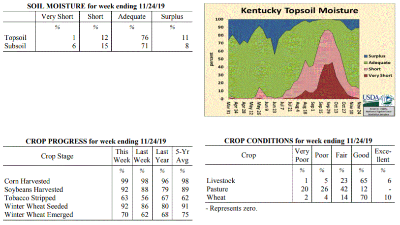 Kentucky Climate Summary
For the Period November 18, 2019 to November 24, 2019
Below Normal Temperatures and Above Normal Precipitation:
Overall, the period was quite active with multiple rounds of rainfall passing through
the region. The state averaged over an inch with the most significant activity having
occurred Thursday through Saturday. Even saw some thunderstorms across Southeastern
Kentucky on Saturday. While the state averaged an inch, accumulations were higher
across South Central and Western Kentucky with many receiving 1.5 to 2+ inches.
Those totals diminished to under an inch across the Northern Bluegrass. Looking at
temperatures, after a cool start to the week, temperatures did rise into the 50s by
Wednesday and Thursday, some hitting the 60s. The active pattern then brought temperatures
back to below seasonable norms for the weekend.
Temperatures for the period averaged 44 degrees across the state which was 1 degree
cooler than normal and 8 degrees warmer than the previous period. High temperatures
averaged from 53 in the West to 53 in the East. Departure from normal high
temperatures ranged from 3 degrees cooler than normal in the West to 3 degrees
cooler than normal in the East. Low temperatures averaged from 38 degrees in the
West to 38 degrees in the East. Departure from normal low temperature ranged from 1
degree warmer than normal in the West to 5 degrees warmer than normal in the East.
The extreme high temperature for the period was 68 degrees at MONTICELLO AWOS and the
extreme low was 24 degrees at HENDERSON 5E.
Precipitation (liq. equ.) for the period totaled 1.37 inches statewide which was 0.37
inches above normal and 137% of normal. Precipitation totals by climate division,
West 1.69 inches, Central 1.51 inches, Bluegrass 0.91 inches and East 1.37 inches,
which was 0.54, 0.45, 0.04 and 0.46 inches above normal. By station, precipitation
totals ranged from a low of 0.50 inches at ALEXANDRIA 5NW to a high of 2.41
inches at HICKMAN 2E.
---
Kentucky Crop and Weather Report
Issued 4:00 P.M., November 18, 2019 36-19
Agricultural News: Kentucky experienced well below normal temperatures and below
normal precipitation over the past week. Precipitation for the week totaled 0.24
inches, 0.65 inches below normal. Temperatures averaged 35 degrees for the week, 13
degrees below normal. Topsoil moisture was rated 2 percent very short, 14 percent
short, 73 percent adequate and 11 percent surplus. Subsoil moisture was rated 5
percent very short, 19 percent short, 69 percent adequate, and 7 percent surplus.
Days suitable for fieldwork averaged 4.3 out of a possible seven.
Primary activities this week included harvesting corn and soybeans, stripping
tobacco, and planting wheat. A brief period of snow early in the week temporarily
slowed harvest. Pastures are gradually improving from much needed rain, but extreme
hay shortages are still on the horizon.
Kentucky Climate Summary
For the Period November 18, 2019 to November 24, 2019
Below Normal Temperatures and Above Normal Precipitation:
Overall, the period was quite active with multiple rounds of rainfall passing through
the region. The state averaged over an inch with the most significant activity having
occurred Thursday through Saturday. Even saw some thunderstorms across Southeastern
Kentucky on Saturday. While the state averaged an inch, accumulations were higher
across South Central and Western Kentucky with many receiving 1.5 to 2+ inches.
Those totals diminished to under an inch across the Northern Bluegrass. Looking at
temperatures, after a cool start to the week, temperatures did rise into the 50s by
Wednesday and Thursday, some hitting the 60s. The active pattern then brought temperatures
back to below seasonable norms for the weekend.
Temperatures for the period averaged 44 degrees across the state which was 1 degree
cooler than normal and 8 degrees warmer than the previous period. High temperatures
averaged from 53 in the West to 53 in the East. Departure from normal high
temperatures ranged from 3 degrees cooler than normal in the West to 3 degrees
cooler than normal in the East. Low temperatures averaged from 38 degrees in the
West to 38 degrees in the East. Departure from normal low temperature ranged from 1
degree warmer than normal in the West to 5 degrees warmer than normal in the East.
The extreme high temperature for the period was 68 degrees at MONTICELLO AWOS and the
extreme low was 24 degrees at HENDERSON 5E.
Precipitation (liq. equ.) for the period totaled 1.37 inches statewide which was 0.37
inches above normal and 137% of normal. Precipitation totals by climate division,
West 1.69 inches, Central 1.51 inches, Bluegrass 0.91 inches and East 1.37 inches,
which was 0.54, 0.45, 0.04 and 0.46 inches above normal. By station, precipitation
totals ranged from a low of 0.50 inches at ALEXANDRIA 5NW to a high of 2.41
inches at HICKMAN 2E.
---
Kentucky Crop and Weather Report
Issued 4:00 P.M., November 18, 2019 36-19
Agricultural News: Kentucky experienced well below normal temperatures and below
normal precipitation over the past week. Precipitation for the week totaled 0.24
inches, 0.65 inches below normal. Temperatures averaged 35 degrees for the week, 13
degrees below normal. Topsoil moisture was rated 2 percent very short, 14 percent
short, 73 percent adequate and 11 percent surplus. Subsoil moisture was rated 5
percent very short, 19 percent short, 69 percent adequate, and 7 percent surplus.
Days suitable for fieldwork averaged 4.3 out of a possible seven.
Primary activities this week included harvesting corn and soybeans, stripping
tobacco, and planting wheat. A brief period of snow early in the week temporarily
slowed harvest. Pastures are gradually improving from much needed rain, but extreme
hay shortages are still on the horizon.
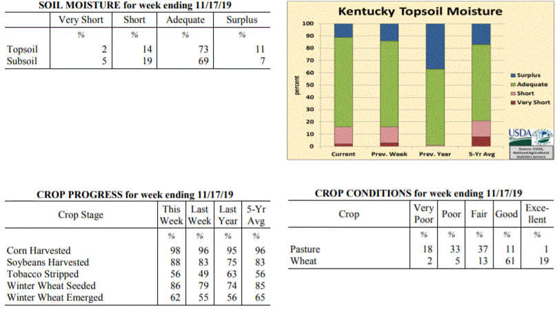 Kentucky Climate Summary
For the Period November 11, 2019 to November 17, 2019
Well Below Normal Temperatures and Below Normal Precipitation:
A slow moving cold front worked through the region on Monday. Precipitation started
out as rain, but eventually transitioned to snow that evening and overnight as arctic
air pushed into the area. One to two inches of snow was common across much of the
state. Otherwise, the most notable highlight was the extreme drop in temperatures.
Highs stayed in the 20s for much of Kentucky on Tuesday and then dropped into the
teens and single digits that night. The Kentucky Mesonet station in Henderson
recorded the lowest temperature of 2 degrees. Following Tuesday, temperatures went
on the uphill climb, eventually ending up in the upper 40s to middle 50s on Sunday.
Dry conditions prevailed with the rain/snow on Monday being the only precipitation
event for the week.
Temperatures for the period averaged 35 degrees across the state which was 13 degrees
cooler than normal and 8 degrees cooler than the previous period. High temperatures
averaged from 44 in the West to 49 in the East. Departure from normal high
temperatures ranged from 16 degrees cooler than normal in the West to 11 degrees
cooler than normal in the East. Low temperatures averaged from 22 degrees in the
West to 25 degrees in the East. Departure from normal low temperature ranged from 17
degrees cooler than normal in the West to 10 degrees cooler than normal in the
East. The extreme high temperature for the period was 69 degrees at LOUISA 1S and the
extreme low was 2 degrees at HENDERSON 5E.
Precipitation (liq. equ.) for the period totaled 0.24 inches statewide which was 0.65
inches below normal and 27% of normal. Precipitation totals by climate division, West
0.24 inches, Central 0.26 inches, Bluegrass 0.19 inches and East 0.27 inches, which
was 0.82, 0.67, 0.58 and 0.54 inches below normal. By station, precipitation totals
ranged from a low of 0.01 inches at BOWLING GREEN 4E to a high of 0.43 inches at LEBANON 8NW.
---
Kentucky Crop and Weather Report
Issued 4:00 P.M., November 12, 2019 35-19
Agricultural News: Kentucky experienced below normal temperatures and rainfall over
the past week. Precipitation for the week totaled 0.73 inches, 0.05 inches below
normal. Temperatures averaged 44 degrees for the week, 7 degrees below normal.
Topsoil moisture was rated 3 percent very short, 13 percent short, 70 percent
adequate and 14 percent surplus. Subsoil moisture was rated 4 percent very short, 17
percent short, 70 percent adequate, and 9 percent surplus. Days suitable for
fieldwork averaged 4.2 out of a possible seven.
Primary activities this week included harvesting corn and soybeans, stripping
tobacco, and planting wheat. Winter wheat seeding and grain harvests progressed
slowly as wet weather limited activity. Livestock producers continue to feed hay as
pasture conditions have not experienced much improvement.
Kentucky Climate Summary
For the Period November 11, 2019 to November 17, 2019
Well Below Normal Temperatures and Below Normal Precipitation:
A slow moving cold front worked through the region on Monday. Precipitation started
out as rain, but eventually transitioned to snow that evening and overnight as arctic
air pushed into the area. One to two inches of snow was common across much of the
state. Otherwise, the most notable highlight was the extreme drop in temperatures.
Highs stayed in the 20s for much of Kentucky on Tuesday and then dropped into the
teens and single digits that night. The Kentucky Mesonet station in Henderson
recorded the lowest temperature of 2 degrees. Following Tuesday, temperatures went
on the uphill climb, eventually ending up in the upper 40s to middle 50s on Sunday.
Dry conditions prevailed with the rain/snow on Monday being the only precipitation
event for the week.
Temperatures for the period averaged 35 degrees across the state which was 13 degrees
cooler than normal and 8 degrees cooler than the previous period. High temperatures
averaged from 44 in the West to 49 in the East. Departure from normal high
temperatures ranged from 16 degrees cooler than normal in the West to 11 degrees
cooler than normal in the East. Low temperatures averaged from 22 degrees in the
West to 25 degrees in the East. Departure from normal low temperature ranged from 17
degrees cooler than normal in the West to 10 degrees cooler than normal in the
East. The extreme high temperature for the period was 69 degrees at LOUISA 1S and the
extreme low was 2 degrees at HENDERSON 5E.
Precipitation (liq. equ.) for the period totaled 0.24 inches statewide which was 0.65
inches below normal and 27% of normal. Precipitation totals by climate division, West
0.24 inches, Central 0.26 inches, Bluegrass 0.19 inches and East 0.27 inches, which
was 0.82, 0.67, 0.58 and 0.54 inches below normal. By station, precipitation totals
ranged from a low of 0.01 inches at BOWLING GREEN 4E to a high of 0.43 inches at LEBANON 8NW.
---
Kentucky Crop and Weather Report
Issued 4:00 P.M., November 12, 2019 35-19
Agricultural News: Kentucky experienced below normal temperatures and rainfall over
the past week. Precipitation for the week totaled 0.73 inches, 0.05 inches below
normal. Temperatures averaged 44 degrees for the week, 7 degrees below normal.
Topsoil moisture was rated 3 percent very short, 13 percent short, 70 percent
adequate and 14 percent surplus. Subsoil moisture was rated 4 percent very short, 17
percent short, 70 percent adequate, and 9 percent surplus. Days suitable for
fieldwork averaged 4.2 out of a possible seven.
Primary activities this week included harvesting corn and soybeans, stripping
tobacco, and planting wheat. Winter wheat seeding and grain harvests progressed
slowly as wet weather limited activity. Livestock producers continue to feed hay as
pasture conditions have not experienced much improvement.
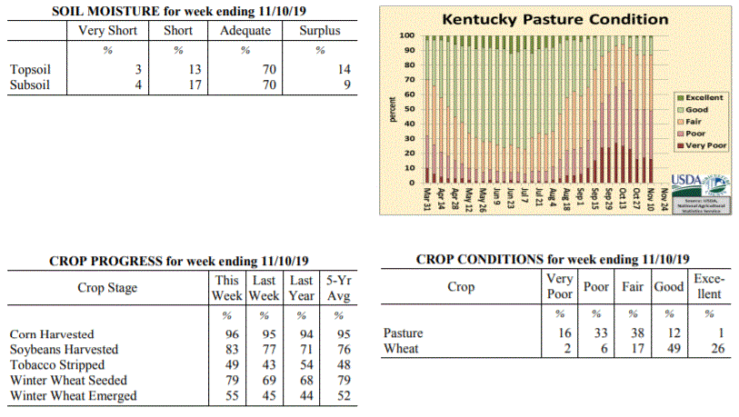 Kentucky Climate Summary
For the Period November 4, 2019 to November 10, 2019
Below Normal Temperatures and Rainfall:
Following a dry and fairly warm start to the period, a cold front moved through the
area on Thursday. This boundary brought a round of widespread showers to the region
with accumulations between 0.5 to 1.25 inches for much of the state, highest totals
across Western Kentucky. Much cooler air of Canadian origin then filtered into
Kentucky that night and into Friday. In fact, temperatures both Friday and Saturday
mornings dropped into the low to middle 20s. A handful of locations even dropped
into the upper teens. Conditions remained dry for the weekend with temperatures going
on the increase, back to seasonable norms.
Temperatures for the period averaged 44 degrees across the state which was 7 degrees
cooler than normal and 4 degrees cooler than the previous period. High temperatures
averaged from 55 in the West to 56 in the East. Departure from normal high
temperatures ranged from 8 degrees cooler than normal in the West to 7 degrees
cooler than normal in the East. Low temperatures averaged from 33 degrees in the
West to 32 degrees in the East. Departure from normal low temperature ranged from 8
degrees cooler than normal in the West to 5 degrees cooler than normal in the East.
The extreme high temperature for the period was 70 degrees at BURKESVILLE 3W and the
extreme low was 17 degrees at MONTICELLO AWOS.
Precipitation (liq. equ.) for the period totaled 0.73 inches statewide which was 0.05
inches below normal and 94% of normal. Precipitation totals by climate division, West
1.20 inches, Central 0.65 inches, Bluegrass 0.63 inches and East 0.46 inches, which
was 0.31, -0.16, -0.06 and -0.25 inches respectively from normal. By station,
precipitation totals ranged from a low of 0.01 inches at MT STERLING AWOS to a high
of 2.61 inches at POPLAR BLUFF ASOS.
---
Kentucky Crop and Weather Report
Issued 4:00 P.M., November 4, 2019 34-19
Agricultural News: Kentucky experienced below normal temperatures and above normal
rainfall over the past week. Precipitation for the week totaled 1.73 inches, 0.96
inches above normal. Temperatures averaged 48 degrees for the week, 5 degrees below
normal. Topsoil moisture was rated 5 percent very short, 17 percent short, 67 percent
adequate and 11 percent surplus. Subsoil moisture was rated 8 percent very short, 22
percent short, 64 percent adequate, and 6 percent surplus. Days suitable for
fieldwork averaged 3.5 out of a possible seven.
Primary activities this week included harvesting corn and soybeans, stripping
tobacco, and seeding wheat. Eighty-two percent of the wheat crop is in good to
excellent condition. Heavy rains across the state halted crop harvests and wheat
planting. Pastures remain in mostly fair to poor condition and have not really
recovered despite recent rains. Cattle and calves obtained approximately 33 percent
of feed from pastures, while much hay is being fed.
Kentucky Climate Summary
For the Period November 4, 2019 to November 10, 2019
Below Normal Temperatures and Rainfall:
Following a dry and fairly warm start to the period, a cold front moved through the
area on Thursday. This boundary brought a round of widespread showers to the region
with accumulations between 0.5 to 1.25 inches for much of the state, highest totals
across Western Kentucky. Much cooler air of Canadian origin then filtered into
Kentucky that night and into Friday. In fact, temperatures both Friday and Saturday
mornings dropped into the low to middle 20s. A handful of locations even dropped
into the upper teens. Conditions remained dry for the weekend with temperatures going
on the increase, back to seasonable norms.
Temperatures for the period averaged 44 degrees across the state which was 7 degrees
cooler than normal and 4 degrees cooler than the previous period. High temperatures
averaged from 55 in the West to 56 in the East. Departure from normal high
temperatures ranged from 8 degrees cooler than normal in the West to 7 degrees
cooler than normal in the East. Low temperatures averaged from 33 degrees in the
West to 32 degrees in the East. Departure from normal low temperature ranged from 8
degrees cooler than normal in the West to 5 degrees cooler than normal in the East.
The extreme high temperature for the period was 70 degrees at BURKESVILLE 3W and the
extreme low was 17 degrees at MONTICELLO AWOS.
Precipitation (liq. equ.) for the period totaled 0.73 inches statewide which was 0.05
inches below normal and 94% of normal. Precipitation totals by climate division, West
1.20 inches, Central 0.65 inches, Bluegrass 0.63 inches and East 0.46 inches, which
was 0.31, -0.16, -0.06 and -0.25 inches respectively from normal. By station,
precipitation totals ranged from a low of 0.01 inches at MT STERLING AWOS to a high
of 2.61 inches at POPLAR BLUFF ASOS.
---
Kentucky Crop and Weather Report
Issued 4:00 P.M., November 4, 2019 34-19
Agricultural News: Kentucky experienced below normal temperatures and above normal
rainfall over the past week. Precipitation for the week totaled 1.73 inches, 0.96
inches above normal. Temperatures averaged 48 degrees for the week, 5 degrees below
normal. Topsoil moisture was rated 5 percent very short, 17 percent short, 67 percent
adequate and 11 percent surplus. Subsoil moisture was rated 8 percent very short, 22
percent short, 64 percent adequate, and 6 percent surplus. Days suitable for
fieldwork averaged 3.5 out of a possible seven.
Primary activities this week included harvesting corn and soybeans, stripping
tobacco, and seeding wheat. Eighty-two percent of the wheat crop is in good to
excellent condition. Heavy rains across the state halted crop harvests and wheat
planting. Pastures remain in mostly fair to poor condition and have not really
recovered despite recent rains. Cattle and calves obtained approximately 33 percent
of feed from pastures, while much hay is being fed.
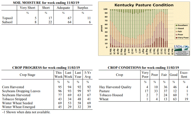 Kentucky Climate Summary
For the Period October 28, 2019 to November 3, 2019
Below Normal Temperatures and Above Normal Rainfall:
After a record breaking dry September, the Bluegrass State has seen exceptionally wet
conditions throughout October. That was no different for end of the month as a
frontal boundary interacted with multiple disturbances to spark a couple rounds of
widespread showers this past Wednesday and Thursday. Overall, the state averaged
1.73 inches, marking the third week out of the past four that the state has averaged
over an inch. A large swath of area running from South Central Kentucky to the
Northern Bluegrass received between 2 and 3 inches. Preliminary data suggests this
month will place in the top 5 wettest October�s on record. Following the passage of
the cold front on Thursday, an unseasonably cold air mass settled into the area. The
growing season essentially ended this past weekend with three straight days of below
freezing temperatures. Most saw lows drop into the middle 20s to around 30.
Temperatures for the period averaged 48 degrees across the state which was 5 degrees
cooler than normal and 8 degrees cooler than the previous period. High temperatures
averaged from 55 in the West to 62 in the East. Departure from normal high
temperatures ranged from 11 degrees cooler than normal in the West to 3 degrees
cooler than normal in the East. Low temperatures averaged from 38 degrees in the
West to 39 degrees in the East. Departure from normal low temperature ranged from 5
degrees cooler than normal in the West to 1 degree warmer than normal in the East.
The extreme high temperature for the period was 78 degrees at PEABODY and the extreme
low was 22 degrees at HARTFORD 3E.
Precipitation (liq. equ.) for the period totaled 1.73 inches statewide which was 0.96
inches above normal and 225% of normal. Precipitation totals by climate division,
West 1.50 inches, Central 2.25 inches, Bluegrass 1.95 inches and East 1.20 inches,
which was 0.64, 1.45, 1.24 and 0.49 inches above normal. By station, precipitation
totals ranged from a low of 0.61 inches at WHITESBURG 2NW to a high of 3.87 inches at
MUNFORDVILLE 6E.
---
Kentucky Crop and Weather Report
Issued 4:00 P.M., October 28, 2019 33-19
Agricultural News: Kentucky experienced above normal temperatures and rainfall over
the past week. Precipitation for the week totaled 1.89 inches, 1.18 inches above
normal. Temperatures averaged 57 degrees for the week, 2 degrees above normal.
Topsoil moisture was rated 12 percent very short, 28 percent short, 55 percent
adequate, and 5 percent surplus. Subsoil moisture was rated 14 percent very short, 35
percent short, 49 percent adequate, and 2 percent surplus. Days suitable for
fieldwork averaged 4.9 out of a possible seven.
Primary activities for this week included harvesting corn and soybeans, stripping
tobacco and seeding winter wheat. Most of the state received some precipitation this
week. The rain was a hindrance to fieldwork, but beneficial to pastureland.
Despite receiving some much needed rain, many producers are tapping into their winter
hay supplies. Pastures are mostly fair to poor, however they are improved from the
previous week. Housed tobacco is in mostly good condition at this juncture.
Kentucky Climate Summary
For the Period October 28, 2019 to November 3, 2019
Below Normal Temperatures and Above Normal Rainfall:
After a record breaking dry September, the Bluegrass State has seen exceptionally wet
conditions throughout October. That was no different for end of the month as a
frontal boundary interacted with multiple disturbances to spark a couple rounds of
widespread showers this past Wednesday and Thursday. Overall, the state averaged
1.73 inches, marking the third week out of the past four that the state has averaged
over an inch. A large swath of area running from South Central Kentucky to the
Northern Bluegrass received between 2 and 3 inches. Preliminary data suggests this
month will place in the top 5 wettest October�s on record. Following the passage of
the cold front on Thursday, an unseasonably cold air mass settled into the area. The
growing season essentially ended this past weekend with three straight days of below
freezing temperatures. Most saw lows drop into the middle 20s to around 30.
Temperatures for the period averaged 48 degrees across the state which was 5 degrees
cooler than normal and 8 degrees cooler than the previous period. High temperatures
averaged from 55 in the West to 62 in the East. Departure from normal high
temperatures ranged from 11 degrees cooler than normal in the West to 3 degrees
cooler than normal in the East. Low temperatures averaged from 38 degrees in the
West to 39 degrees in the East. Departure from normal low temperature ranged from 5
degrees cooler than normal in the West to 1 degree warmer than normal in the East.
The extreme high temperature for the period was 78 degrees at PEABODY and the extreme
low was 22 degrees at HARTFORD 3E.
Precipitation (liq. equ.) for the period totaled 1.73 inches statewide which was 0.96
inches above normal and 225% of normal. Precipitation totals by climate division,
West 1.50 inches, Central 2.25 inches, Bluegrass 1.95 inches and East 1.20 inches,
which was 0.64, 1.45, 1.24 and 0.49 inches above normal. By station, precipitation
totals ranged from a low of 0.61 inches at WHITESBURG 2NW to a high of 3.87 inches at
MUNFORDVILLE 6E.
---
Kentucky Crop and Weather Report
Issued 4:00 P.M., October 28, 2019 33-19
Agricultural News: Kentucky experienced above normal temperatures and rainfall over
the past week. Precipitation for the week totaled 1.89 inches, 1.18 inches above
normal. Temperatures averaged 57 degrees for the week, 2 degrees above normal.
Topsoil moisture was rated 12 percent very short, 28 percent short, 55 percent
adequate, and 5 percent surplus. Subsoil moisture was rated 14 percent very short, 35
percent short, 49 percent adequate, and 2 percent surplus. Days suitable for
fieldwork averaged 4.9 out of a possible seven.
Primary activities for this week included harvesting corn and soybeans, stripping
tobacco and seeding winter wheat. Most of the state received some precipitation this
week. The rain was a hindrance to fieldwork, but beneficial to pastureland.
Despite receiving some much needed rain, many producers are tapping into their winter
hay supplies. Pastures are mostly fair to poor, however they are improved from the
previous week. Housed tobacco is in mostly good condition at this juncture.
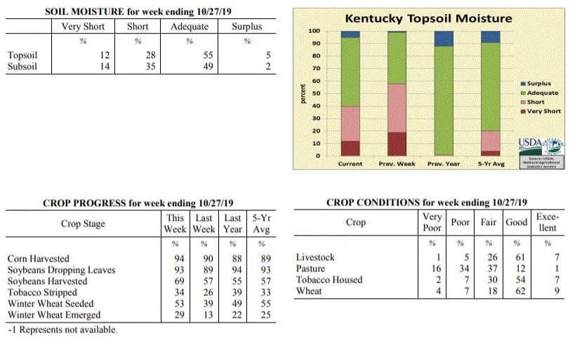 Kentucky Climate Summary
For the Period October 21, 2019 to October 27, 2019
Above Normal Temperatures and Rainfall:
Significant rainfall fell across the state for a third straight week. The highest
accumulations were seen over the course of Friday night through Saturday night as the
remnants of Tropical Storm Olga pushed northeast through the area. This system sent
a high amount of moisture into the region, leading to moderate to heavy rainfall from
time to time. High winds accompanied some of the showers across Western Kentucky and
led to some severe warnings with gusts over 60 mph. Overall, in addition to rain
from another frontal passage earlier in the week, the state averaged 1.89 inches.
Saying that, totals were a bit higher across Western Kentucky, which came in at an
average of 2.62 inches. Through the 27th, the state has now averaged 4.85 inches for
the month, well above average for what is normally the driest month of the year. The
US Drought Monitor continues to make improvements across the state with severe
drought only covering 7% of Kentucky and moderate drought down to 26%.
Temperatures for the period averaged 57 degrees across the state which was 2 degrees
warmer than normal and 2 degrees warmer than the previous period. High temperatures
averaged from 66 in the West to 68 in the East. Departure from normal high
temperatures ranged from 3 degrees cooler than normal in the West to near normal in
the East. Low temperatures averaged from 48 degrees in the West to 47 degrees in the
East. Departure from normal low temperature ranged from 3 degrees warmer than normal
in the West to 7 degrees warmer than normal in the East. The extreme high temperature
for the period was 81 degrees at LOUISA 1S and the extreme low was 31 degrees at
BURKESVILLE 3W.
Precipitation (liq. equ.) for the period totaled 1.89 inches statewide which was 1.18
inches above normal and 264% of normal. Precipitation totals by climate division,
West 2.62 inches, Central 1.53 inches, Bluegrass 1.48 inches and East 1.94 inches,
which was 1.82, 0.81, 0.82 and 1.26 inches above normal. By station, precipitation
totals ranged from a low of 0.36 inches at BOWLING GREEN 4E to a high of 5.25
inches at CAPE GIRARDEAU ASOS.
---
Kentucky Crop and Weather Report
Issued 4:00 P.M., October 21, 2019 32-19
Agricultural News: Kentucky experienced below normal temperatures and above normal
rainfall over the past week. Precipitation for the week totaled 0.81 inches, 0.10
inches above normal. Temperatures averaged 55 degrees for the week, 2 degrees below
normal. Topsoil moisture was rated 19 percent very short, 39 percent short, 41
percent adequate, and 1 percent surplus. Subsoil moisture was rated 20 percent very
short, 42 percent short, 37 percent adequate, and 1 percent surplus. Days suitable
for fieldwork averaged 5.5 out of a possible seven.
Primary activities for this week included harvesting corn and soybeans, stripping
tobacco, and seeding winter wheat. Much of the state received needed rain this week,
however there are still a few areas that remain very dry. The rain was an impedance
to the row crop harvest, but was needed to promote pasture growth as temperatures
remain cool.
Despite the recent precipitation, many farmers are still feeding hay at this juncture
putting stress on winter supplies. Pasture condition has improved, but the necessity
to supplement still exists. Soybeans and housed tobacco are both
in mostly good condition.
Kentucky Climate Summary
For the Period October 21, 2019 to October 27, 2019
Above Normal Temperatures and Rainfall:
Significant rainfall fell across the state for a third straight week. The highest
accumulations were seen over the course of Friday night through Saturday night as the
remnants of Tropical Storm Olga pushed northeast through the area. This system sent
a high amount of moisture into the region, leading to moderate to heavy rainfall from
time to time. High winds accompanied some of the showers across Western Kentucky and
led to some severe warnings with gusts over 60 mph. Overall, in addition to rain
from another frontal passage earlier in the week, the state averaged 1.89 inches.
Saying that, totals were a bit higher across Western Kentucky, which came in at an
average of 2.62 inches. Through the 27th, the state has now averaged 4.85 inches for
the month, well above average for what is normally the driest month of the year. The
US Drought Monitor continues to make improvements across the state with severe
drought only covering 7% of Kentucky and moderate drought down to 26%.
Temperatures for the period averaged 57 degrees across the state which was 2 degrees
warmer than normal and 2 degrees warmer than the previous period. High temperatures
averaged from 66 in the West to 68 in the East. Departure from normal high
temperatures ranged from 3 degrees cooler than normal in the West to near normal in
the East. Low temperatures averaged from 48 degrees in the West to 47 degrees in the
East. Departure from normal low temperature ranged from 3 degrees warmer than normal
in the West to 7 degrees warmer than normal in the East. The extreme high temperature
for the period was 81 degrees at LOUISA 1S and the extreme low was 31 degrees at
BURKESVILLE 3W.
Precipitation (liq. equ.) for the period totaled 1.89 inches statewide which was 1.18
inches above normal and 264% of normal. Precipitation totals by climate division,
West 2.62 inches, Central 1.53 inches, Bluegrass 1.48 inches and East 1.94 inches,
which was 1.82, 0.81, 0.82 and 1.26 inches above normal. By station, precipitation
totals ranged from a low of 0.36 inches at BOWLING GREEN 4E to a high of 5.25
inches at CAPE GIRARDEAU ASOS.
---
Kentucky Crop and Weather Report
Issued 4:00 P.M., October 21, 2019 32-19
Agricultural News: Kentucky experienced below normal temperatures and above normal
rainfall over the past week. Precipitation for the week totaled 0.81 inches, 0.10
inches above normal. Temperatures averaged 55 degrees for the week, 2 degrees below
normal. Topsoil moisture was rated 19 percent very short, 39 percent short, 41
percent adequate, and 1 percent surplus. Subsoil moisture was rated 20 percent very
short, 42 percent short, 37 percent adequate, and 1 percent surplus. Days suitable
for fieldwork averaged 5.5 out of a possible seven.
Primary activities for this week included harvesting corn and soybeans, stripping
tobacco, and seeding winter wheat. Much of the state received needed rain this week,
however there are still a few areas that remain very dry. The rain was an impedance
to the row crop harvest, but was needed to promote pasture growth as temperatures
remain cool.
Despite the recent precipitation, many farmers are still feeding hay at this juncture
putting stress on winter supplies. Pasture condition has improved, but the necessity
to supplement still exists. Soybeans and housed tobacco are both
in mostly good condition.
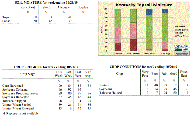 Kentucky Climate Summary
For the Period October 14, 2019 to October 20, 2019
Below Normal Temperatures and Above Normal Rainfall:
The state averaged 0.81 inches for the period, marking a second straight week of
above normal rainfall. The higher totals was a result of two events. The first
event came Tuesday night as a cold front moved through the area. This boundary
sparked a quick hitting round of widespread showers with embedded storms.
Accumulations were generally between a half and one inch for most of the state. This
was followed by the second event on Saturday as moisture streaming into the state
around Tropical Storm Nestor sparked showers across primarily Southeastern Kentucky.
For the week, this area saw 1 to 2 inches of rainfall, which was especially
beneficial with recent dry conditions. While most of the state had seen major
improvements in recent weeks, Southeastern Kentucky actually saw drought worsen with
�Extreme� drought expanding across this area. Bottom line, after a record breaking
dry September, October is going in the opposite direction.
Temperatures for the period averaged 55 degrees across the state which was 2 degrees
cooler than normal and 4 degrees cooler than the previous period. High temperatures
averaged from 70 in the West to 66 in the East. Departure from normal high
temperatures ranged from 2 degrees cooler than normal in the West to 4 degrees
cooler than normal in the East. Low temperatures averaged from 42 degrees in the
West to 42 degrees in the East. Departure from normal low temperature ranged from 5
degrees cooler than normal in the West to near normal in the East. The extreme high
temperature for the period was 80 degrees at OWENSBORO AWSS and the extreme low was
29 degrees at HENDERSON 5E.
Precipitation (liq. equ.) for the period totaled 0.81 inches statewide which was 0.1
inches above normal and 115% of normal. Precipitation totals by climate division,
West 0.82 inches, Central 0.80 inches, Bluegrass 0.64 inches and East 0.97 inches,
which was 0.07, 0.08, -0.03 and 0.29 inches respectively from normal. By station,
precipitation totals ranged from a low of 0.00 inches at CARBONDALE ASOS to a high of
2.89 inches at BENTON 4N.
---
Kentucky Crop and Weather Report
Issued 4:00 P.M., October 15, 2019 31-19
Agricultural News: Kentucky experienced near normal temperatures and above normal
rainfall over the past week. Precipitation for the week totaled 1.67 inches, 0.92
inches above normal. Temperatures averaged 59 degrees for the week, unchanged from
normal. Topsoil moisture was rated 28 percent very short, 40 percent short, 31
percent adequate, and 1 percent surplus. Subsoil moisture was rated 31 percent very
short, 42 percent short, and 27 percent adequate. Days suitable for fieldwork
averaged 5.4 out of a possible seven.
Primary activities for this week included harvesting corn, soybeans, and tobacco
along with seeding winter wheat. While the week began with continued drought, the
weekend brought some much needed rain for most of the state. The precipitation was a
hindrance to fieldwork, but welcomed nonetheless. Temperatures have been cooler and
more typical of the season.
The widespread rain should promote pasture growth and replenish ponds, however many
farmers will still need to supplement with hay. Pasture condition was reported as 25
percent very poor, 43 percent poor, 26 percent fair, and 6 percent good. Tobacco
houseburn was reported as 3 percent severe, 7 percent moderate, 21 percent light, and
69 percent none evident.
Kentucky Climate Summary
For the Period October 14, 2019 to October 20, 2019
Below Normal Temperatures and Above Normal Rainfall:
The state averaged 0.81 inches for the period, marking a second straight week of
above normal rainfall. The higher totals was a result of two events. The first
event came Tuesday night as a cold front moved through the area. This boundary
sparked a quick hitting round of widespread showers with embedded storms.
Accumulations were generally between a half and one inch for most of the state. This
was followed by the second event on Saturday as moisture streaming into the state
around Tropical Storm Nestor sparked showers across primarily Southeastern Kentucky.
For the week, this area saw 1 to 2 inches of rainfall, which was especially
beneficial with recent dry conditions. While most of the state had seen major
improvements in recent weeks, Southeastern Kentucky actually saw drought worsen with
�Extreme� drought expanding across this area. Bottom line, after a record breaking
dry September, October is going in the opposite direction.
Temperatures for the period averaged 55 degrees across the state which was 2 degrees
cooler than normal and 4 degrees cooler than the previous period. High temperatures
averaged from 70 in the West to 66 in the East. Departure from normal high
temperatures ranged from 2 degrees cooler than normal in the West to 4 degrees
cooler than normal in the East. Low temperatures averaged from 42 degrees in the
West to 42 degrees in the East. Departure from normal low temperature ranged from 5
degrees cooler than normal in the West to near normal in the East. The extreme high
temperature for the period was 80 degrees at OWENSBORO AWSS and the extreme low was
29 degrees at HENDERSON 5E.
Precipitation (liq. equ.) for the period totaled 0.81 inches statewide which was 0.1
inches above normal and 115% of normal. Precipitation totals by climate division,
West 0.82 inches, Central 0.80 inches, Bluegrass 0.64 inches and East 0.97 inches,
which was 0.07, 0.08, -0.03 and 0.29 inches respectively from normal. By station,
precipitation totals ranged from a low of 0.00 inches at CARBONDALE ASOS to a high of
2.89 inches at BENTON 4N.
---
Kentucky Crop and Weather Report
Issued 4:00 P.M., October 15, 2019 31-19
Agricultural News: Kentucky experienced near normal temperatures and above normal
rainfall over the past week. Precipitation for the week totaled 1.67 inches, 0.92
inches above normal. Temperatures averaged 59 degrees for the week, unchanged from
normal. Topsoil moisture was rated 28 percent very short, 40 percent short, 31
percent adequate, and 1 percent surplus. Subsoil moisture was rated 31 percent very
short, 42 percent short, and 27 percent adequate. Days suitable for fieldwork
averaged 5.4 out of a possible seven.
Primary activities for this week included harvesting corn, soybeans, and tobacco
along with seeding winter wheat. While the week began with continued drought, the
weekend brought some much needed rain for most of the state. The precipitation was a
hindrance to fieldwork, but welcomed nonetheless. Temperatures have been cooler and
more typical of the season.
The widespread rain should promote pasture growth and replenish ponds, however many
farmers will still need to supplement with hay. Pasture condition was reported as 25
percent very poor, 43 percent poor, 26 percent fair, and 6 percent good. Tobacco
houseburn was reported as 3 percent severe, 7 percent moderate, 21 percent light, and
69 percent none evident.
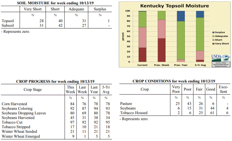 Kentucky Climate Summary
For the Period October 7, 2019 to October 13, 2019
Near Normal Temperatures and Above Normal Rainfall:
Carrying over from the previous period, a cold front continued to work through the
area on Monday morning. This boundary sparked numerous to widespread light to
moderate showers, leading to significant accumulations across the area. This was
followed by secondary cold front progressing through the area on Friday. Overall, the
state has averaged over two inches since the start of the month. This period broke a
five week streak of below normal rainfall. The significant rainfall led the US
Drought Monitor to make some improvements with roughly 17% of the state now under a
�severe� drought, down from 58% last week. The bigger highlight with the frontal
passage on Friday was the significant drop in temperatures, which led to frost
advisories issued across the area and state�s first real taste of fall. Temperatures
dropped well into the 30s over the weekend, Western Kentucky on Friday night and more
statewide on Saturday night. Henderson and Mayfield were the coolest
spots, each dropping down to 29.
Temperatures for the period averaged 59 degrees across the state which was
near normal and 16 degrees cooler than the previous period. High temperatures
averaged from 73 in the West to 71 in the East. Departure from normal high
temperatures ranged from 1 degree cooler than normal in the West to 1 degree
cooler than normal in the East. Low temperatures averaged from 45 degrees in the
West to 50 degrees in the East. Departure from normal low temperature ranged from 4
degrees cooler than normal in the West to 5 degrees warmer than normal in the East.
The extreme high temperature for the period was 87 degrees at HICKMAN 2E and the
extreme low was 29 degrees at HENDERSON 5E.
Precipitation (liq. equ.) for the period totaled 1.67 inches statewide which was 0.92
inches above normal and 221% of normal. Precipitation totals by climate division,
West 1.10 inches, Central 2.13 inches, Bluegrass 1.79 inches and East 1.64 inches,
which was 0.34, 1.35, 1.07 and 0.88 inches above normal. By station, precipitation
totals ranged from a low of 0.05 inches at MIDDLESBORO AWOS to a high of 4.59
inches at COLUMBIA 3N.
---
Kentucky Crop and Weather Report
Issued 4:00 P.M., October 7, 2019 30-19
Agricultural News: Kentucky experienced well above normal temperatures and below
normal rainfall over the past week. Precipitation for the week totaled 0.49 inches,
0.31 inches below normal. Temperatures averaged 75 degrees for the week, 13 degrees
above normal. Topsoil moisture was rated 46 percent very short, 37 percent short, and
17 percent adequate. Subsoil moisture was rated 43 percent very short, 40 percent
short, and 17 percent adequate. Days suitable for fieldwork averaged 6.5 out of a
possible seven.
Primary activities for this week included harvesting corn, soybeans, and tobacco.
Planting of winter wheat is continuing with a small percentage of the crop emerged.
Through most of the week dry conditions persisted, however the weekend brought some
much needed rain in parts of the state. Some later season soybeans are being
adversely affected by the long drought period.
Pastures are very stressed, however the rain late in the week may promote some
growth. With that being said, many farmers are feeding hay to compensate for the
sustained drought. Pasture condition was reported as 27 percent very poor, 38 percent
poor, 28 percent fair, and 7 percent good. Tobacco houseburn was reported as 2
percent severe, 6 percent moderate, 30 percent light, and 62 percent none evident.
Kentucky Climate Summary
For the Period October 7, 2019 to October 13, 2019
Near Normal Temperatures and Above Normal Rainfall:
Carrying over from the previous period, a cold front continued to work through the
area on Monday morning. This boundary sparked numerous to widespread light to
moderate showers, leading to significant accumulations across the area. This was
followed by secondary cold front progressing through the area on Friday. Overall, the
state has averaged over two inches since the start of the month. This period broke a
five week streak of below normal rainfall. The significant rainfall led the US
Drought Monitor to make some improvements with roughly 17% of the state now under a
�severe� drought, down from 58% last week. The bigger highlight with the frontal
passage on Friday was the significant drop in temperatures, which led to frost
advisories issued across the area and state�s first real taste of fall. Temperatures
dropped well into the 30s over the weekend, Western Kentucky on Friday night and more
statewide on Saturday night. Henderson and Mayfield were the coolest
spots, each dropping down to 29.
Temperatures for the period averaged 59 degrees across the state which was
near normal and 16 degrees cooler than the previous period. High temperatures
averaged from 73 in the West to 71 in the East. Departure from normal high
temperatures ranged from 1 degree cooler than normal in the West to 1 degree
cooler than normal in the East. Low temperatures averaged from 45 degrees in the
West to 50 degrees in the East. Departure from normal low temperature ranged from 4
degrees cooler than normal in the West to 5 degrees warmer than normal in the East.
The extreme high temperature for the period was 87 degrees at HICKMAN 2E and the
extreme low was 29 degrees at HENDERSON 5E.
Precipitation (liq. equ.) for the period totaled 1.67 inches statewide which was 0.92
inches above normal and 221% of normal. Precipitation totals by climate division,
West 1.10 inches, Central 2.13 inches, Bluegrass 1.79 inches and East 1.64 inches,
which was 0.34, 1.35, 1.07 and 0.88 inches above normal. By station, precipitation
totals ranged from a low of 0.05 inches at MIDDLESBORO AWOS to a high of 4.59
inches at COLUMBIA 3N.
---
Kentucky Crop and Weather Report
Issued 4:00 P.M., October 7, 2019 30-19
Agricultural News: Kentucky experienced well above normal temperatures and below
normal rainfall over the past week. Precipitation for the week totaled 0.49 inches,
0.31 inches below normal. Temperatures averaged 75 degrees for the week, 13 degrees
above normal. Topsoil moisture was rated 46 percent very short, 37 percent short, and
17 percent adequate. Subsoil moisture was rated 43 percent very short, 40 percent
short, and 17 percent adequate. Days suitable for fieldwork averaged 6.5 out of a
possible seven.
Primary activities for this week included harvesting corn, soybeans, and tobacco.
Planting of winter wheat is continuing with a small percentage of the crop emerged.
Through most of the week dry conditions persisted, however the weekend brought some
much needed rain in parts of the state. Some later season soybeans are being
adversely affected by the long drought period.
Pastures are very stressed, however the rain late in the week may promote some
growth. With that being said, many farmers are feeding hay to compensate for the
sustained drought. Pasture condition was reported as 27 percent very poor, 38 percent
poor, 28 percent fair, and 7 percent good. Tobacco houseburn was reported as 2
percent severe, 6 percent moderate, 30 percent light, and 62 percent none evident.
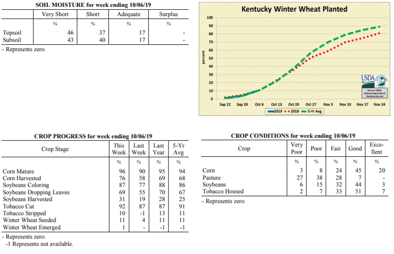 Kentucky Climate Summary
For the Period September 30, 2019 to October 6, 2019
Well Above Normal Temperatures and Below Normal Rainfall:
Kentucky finally saw some significant rainfall on Sunday as a cold front moved
through the area. Scattered to numerous showers and some storms led to accumulations
of well over an inch for portions of North Central Kentucky. Rainfall did turn more
widespread that evening and carried over into the overnight. Much of these
accumulations fell after the data cutoff for this period and will be seen in the crop
report next week. This rainfall followed a very dry September. Data at the Ag Weather
Center shows the state only averaged 0.28 inches for the month, which would likely be
good for the driest September on record. For many, the rainfall on Sunday was the
first significant activity since the last week of August. The latest update to the US
Drought Monitor on Thursday upgraded a small portion of Southeastern Kentucky into an
�Extreme� drought, while also expanding �Severe� drought to cover 58% of the state.
Much of the focus this week was on rainfall, but Kentucky also saw record breaking
warmth over the first half of the period with highs consistently jumping well into
the 90s. While daily records were broken, all-time highs for October were also
surpassed.
Temperatures for the period averaged 75 degrees across the state which was 13 degrees
warmer than normal and 2 degrees warmer than the previous period. High temperatures
averaged from 88 in the West to 88 in the East. Departure from normal high
temperatures ranged from 12 degrees warmer than normal in the West to 14 degrees
warmer than normal in the East. Low temperatures averaged from 62 degrees in the
West to 63 degrees in the East. Departure from normal low temperature ranged from 11
degrees warmer than normal in the West to 15 degrees warmer than normal in the
East. The extreme high temperature for the period was 98 degrees at BOWLING GREEN APT
and the extreme low was 42 degrees at RICHMOND 8E.
Precipitation (liq. equ.) for the period totaled 0.49 inches statewide which was 0.31
inches below normal and 61% of normal. Precipitation totals by climate division, West
0.42 inches, Central 0.71 inches, Bluegrass 0.34 inches and East 0.49 inches, which
was 0.4, 0.13, 0.4 and 0.3 inches below normal. By station, precipitation totals
ranged from a low of 0.00 inches at BARBOURVILLE 3E to a high of 1.93 inches at
BOONEVILLE 2S.
---
Kentucky Crop and Weather Report
Issued 4:00 P.M., September 30, 2019 29-19
Agricultural News: Kentucky experienced well above normal temperatures and much below
normal rainfall over the past week. Precipitation for the week totaled 0.16 inches,
0.69 inches below normal. Temperatures averaged 74 degrees for the week, 9 degrees
above normal. Topsoil moisture was rated 43 percent very short, 44 percent short, and
13 percent adequate. Subsoil moisture was rated 34 percent very short, 46 percent
short, and 20 percent adequate. Days suitable for fieldwork averaged 6.6 out of a
possible seven.
Primary activities for this week included harvesting corn, soybeans, tobacco, and
hay. Planting of winter wheat has begun, however the majority of the crop is not yet
in the ground. Hot and dry conditions persist throughout the state bringing concerns
to farmers. Both corn and soybeans are drying down quickly. Some farmers fear that
soybeans may be particularly susceptible to weather conditions due to the stage of
the crop at this juncture.
Pastures and livestock are very stressed due to the continued drought and heat. Many
farmers have begun feeding hay to compensate for the lack of pasture growth. Hay
supplies were reported as 10 percent very short, 28 percent short, 60 percent
adequate, and 2 percent surplus. Tobacco houseburn was reported as 2 percent severe,
8 percent moderate, 27 percent light, and 63 percent none evident.
Kentucky Climate Summary
For the Period September 30, 2019 to October 6, 2019
Well Above Normal Temperatures and Below Normal Rainfall:
Kentucky finally saw some significant rainfall on Sunday as a cold front moved
through the area. Scattered to numerous showers and some storms led to accumulations
of well over an inch for portions of North Central Kentucky. Rainfall did turn more
widespread that evening and carried over into the overnight. Much of these
accumulations fell after the data cutoff for this period and will be seen in the crop
report next week. This rainfall followed a very dry September. Data at the Ag Weather
Center shows the state only averaged 0.28 inches for the month, which would likely be
good for the driest September on record. For many, the rainfall on Sunday was the
first significant activity since the last week of August. The latest update to the US
Drought Monitor on Thursday upgraded a small portion of Southeastern Kentucky into an
�Extreme� drought, while also expanding �Severe� drought to cover 58% of the state.
Much of the focus this week was on rainfall, but Kentucky also saw record breaking
warmth over the first half of the period with highs consistently jumping well into
the 90s. While daily records were broken, all-time highs for October were also
surpassed.
Temperatures for the period averaged 75 degrees across the state which was 13 degrees
warmer than normal and 2 degrees warmer than the previous period. High temperatures
averaged from 88 in the West to 88 in the East. Departure from normal high
temperatures ranged from 12 degrees warmer than normal in the West to 14 degrees
warmer than normal in the East. Low temperatures averaged from 62 degrees in the
West to 63 degrees in the East. Departure from normal low temperature ranged from 11
degrees warmer than normal in the West to 15 degrees warmer than normal in the
East. The extreme high temperature for the period was 98 degrees at BOWLING GREEN APT
and the extreme low was 42 degrees at RICHMOND 8E.
Precipitation (liq. equ.) for the period totaled 0.49 inches statewide which was 0.31
inches below normal and 61% of normal. Precipitation totals by climate division, West
0.42 inches, Central 0.71 inches, Bluegrass 0.34 inches and East 0.49 inches, which
was 0.4, 0.13, 0.4 and 0.3 inches below normal. By station, precipitation totals
ranged from a low of 0.00 inches at BARBOURVILLE 3E to a high of 1.93 inches at
BOONEVILLE 2S.
---
Kentucky Crop and Weather Report
Issued 4:00 P.M., September 30, 2019 29-19
Agricultural News: Kentucky experienced well above normal temperatures and much below
normal rainfall over the past week. Precipitation for the week totaled 0.16 inches,
0.69 inches below normal. Temperatures averaged 74 degrees for the week, 9 degrees
above normal. Topsoil moisture was rated 43 percent very short, 44 percent short, and
13 percent adequate. Subsoil moisture was rated 34 percent very short, 46 percent
short, and 20 percent adequate. Days suitable for fieldwork averaged 6.6 out of a
possible seven.
Primary activities for this week included harvesting corn, soybeans, tobacco, and
hay. Planting of winter wheat has begun, however the majority of the crop is not yet
in the ground. Hot and dry conditions persist throughout the state bringing concerns
to farmers. Both corn and soybeans are drying down quickly. Some farmers fear that
soybeans may be particularly susceptible to weather conditions due to the stage of
the crop at this juncture.
Pastures and livestock are very stressed due to the continued drought and heat. Many
farmers have begun feeding hay to compensate for the lack of pasture growth. Hay
supplies were reported as 10 percent very short, 28 percent short, 60 percent
adequate, and 2 percent surplus. Tobacco houseburn was reported as 2 percent severe,
8 percent moderate, 27 percent light, and 63 percent none evident.
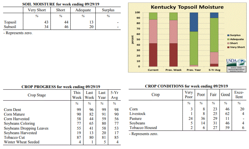 Kentucky Climate Summary
For the Period September 23, 2019 to September 29, 2019
Well Above Normal Temperatures and Much Below Normal Rainfall:
The state of Kentucky has now went four straight weeks with much below normal
rainfall. Month-to-date rainfall through the 29th shows the Bluegrass State has only
averaged 0.27 inches for the month, which is over three inches below normal. The
state only averaged 0.16 inches for this period. Portions of Western Kentucky saw
better coverage on Thursday and came in at 0.31. Still though, Kentucky did not see
any drought busters. The US Drought Monitor upgraded portions of North Central and
Southeastern Kentucky into a �Severe� drought, while also expanding �Moderate�
drought to cover over half of the state. Looking at temperatures, even though the
fall season arrived this past week, heat stuck around. Highs were back in the low to
middle 90s over the weekend. A combination of dry conditions, low humidity, and
breezy winds at times has led to an enhanced fire danger, prompting many counties to
issue burn bans.
Temperatures for the period averaged 74 degrees across the state which was 9 degrees
warmer than normal and 2 degrees cooler than the previous period. High temperatures
averaged from 86 in the West to 85 in the East. Departure from normal high
temperatures ranged from 7 degrees warmer than normal in the West to 9 degrees
warmer than normal in the East. Low temperatures averaged from 62 degrees in the
West to 60 degrees in the East. Departure from normal low temperature ranged from 8
degrees warmer than normal in the West to 9 degrees warmer than normal in the East.
The extreme high temperature for the period was 97 degrees at BOWLING GREEN APT and
the extreme low was 43 degrees at PAINTSVILLE 4W.
Precipitation (liq. equ.) for the period totaled 0.16 inches statewide which was 0.69
inches below normal and 19% of normal. Precipitation totals by climate division, West
0.31 inches, Central 0.13 inches, Bluegrass 0.07 inches and East 0.12 inches, which
was 0.55, 0.8, 0.7 and 0.71 inches below normal. By station, precipitation totals
ranged from a low of 0.00 inches at FORT KNOX to a high of 1.59 inches at CADIZ 4SW.
---
Kentucky Crop and Weather Report
Issued 4:00 P.M., September 23, 2019 28-19
Agricultural News: Kentucky experienced well above normal temperatures and much below
normal rainfall over the past week. Precipitation for the week totaled 0.05 inches,
0.78 inches below normal. Temperatures averaged 76 degrees for the week, 8 degrees
above normal. Topsoil moisture was rated 43 percent very short, 43 percent short, 14
percent adequate and 0 percent surplus. Subsoil moisture was rated 34 percent very
short, 44 percent short, 22 percent adequate, and 0 percent surplus. Days suitable
for fieldwork averaged 6.8 out of a possible seven.
Primary activities this week included harvesting corn, soybeans, and tobacco. Little
rainfall coupled with above average temperatures were experienced across the state
for a third consecutive week. According to the U.S. Drought Monitor the majority of
state is now classified in abnormally dry to moderate drought stage. Moisture levels
in corn and soybeans being harvested are extremely low. Pasture and hay conditions
continue to deteriorate.
Kentucky Climate Summary
For the Period September 23, 2019 to September 29, 2019
Well Above Normal Temperatures and Much Below Normal Rainfall:
The state of Kentucky has now went four straight weeks with much below normal
rainfall. Month-to-date rainfall through the 29th shows the Bluegrass State has only
averaged 0.27 inches for the month, which is over three inches below normal. The
state only averaged 0.16 inches for this period. Portions of Western Kentucky saw
better coverage on Thursday and came in at 0.31. Still though, Kentucky did not see
any drought busters. The US Drought Monitor upgraded portions of North Central and
Southeastern Kentucky into a �Severe� drought, while also expanding �Moderate�
drought to cover over half of the state. Looking at temperatures, even though the
fall season arrived this past week, heat stuck around. Highs were back in the low to
middle 90s over the weekend. A combination of dry conditions, low humidity, and
breezy winds at times has led to an enhanced fire danger, prompting many counties to
issue burn bans.
Temperatures for the period averaged 74 degrees across the state which was 9 degrees
warmer than normal and 2 degrees cooler than the previous period. High temperatures
averaged from 86 in the West to 85 in the East. Departure from normal high
temperatures ranged from 7 degrees warmer than normal in the West to 9 degrees
warmer than normal in the East. Low temperatures averaged from 62 degrees in the
West to 60 degrees in the East. Departure from normal low temperature ranged from 8
degrees warmer than normal in the West to 9 degrees warmer than normal in the East.
The extreme high temperature for the period was 97 degrees at BOWLING GREEN APT and
the extreme low was 43 degrees at PAINTSVILLE 4W.
Precipitation (liq. equ.) for the period totaled 0.16 inches statewide which was 0.69
inches below normal and 19% of normal. Precipitation totals by climate division, West
0.31 inches, Central 0.13 inches, Bluegrass 0.07 inches and East 0.12 inches, which
was 0.55, 0.8, 0.7 and 0.71 inches below normal. By station, precipitation totals
ranged from a low of 0.00 inches at FORT KNOX to a high of 1.59 inches at CADIZ 4SW.
---
Kentucky Crop and Weather Report
Issued 4:00 P.M., September 23, 2019 28-19
Agricultural News: Kentucky experienced well above normal temperatures and much below
normal rainfall over the past week. Precipitation for the week totaled 0.05 inches,
0.78 inches below normal. Temperatures averaged 76 degrees for the week, 8 degrees
above normal. Topsoil moisture was rated 43 percent very short, 43 percent short, 14
percent adequate and 0 percent surplus. Subsoil moisture was rated 34 percent very
short, 44 percent short, 22 percent adequate, and 0 percent surplus. Days suitable
for fieldwork averaged 6.8 out of a possible seven.
Primary activities this week included harvesting corn, soybeans, and tobacco. Little
rainfall coupled with above average temperatures were experienced across the state
for a third consecutive week. According to the U.S. Drought Monitor the majority of
state is now classified in abnormally dry to moderate drought stage. Moisture levels
in corn and soybeans being harvested are extremely low. Pasture and hay conditions
continue to deteriorate.
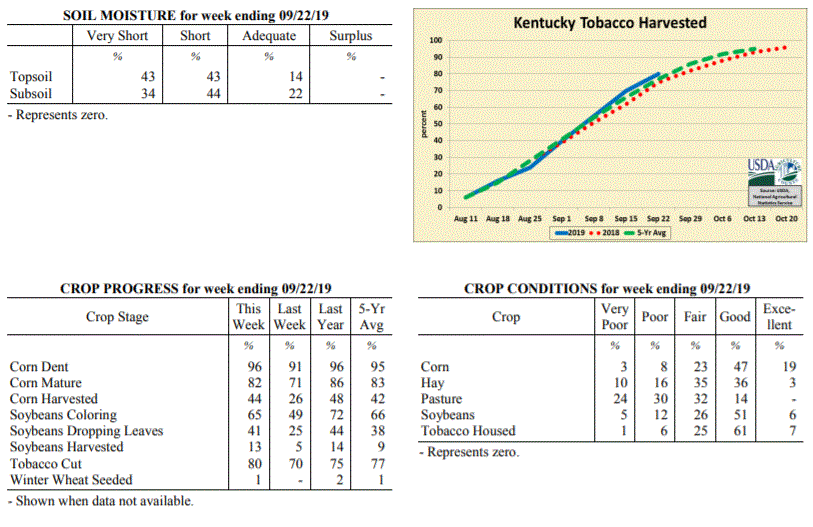 Kentucky Climate Summary
For the Period September 16, 2019 to September 22, 2019
Well Above Normal Temperatures and Much Below Normal Rainfall:
Rainfall ran scarce for a third straight week with many once again not recording any
accumulations. Looking at the table of weather data below, most stations have
recorded between 1 to 2 inches over the past four weeks. Saying that, the brunt of
these accumulations fell over the last week of August. Looking at some stations
across the state; Louisville, Bowling Green, Paducah, Lexington, and Jackson have all
not recorded any rainfall for at least 25 days. Some are at 27 days now. Going at
least 25 days without rainfall simply does not happen very often. The most recent
time this was matched of the five cities listed above was Paducah in 2010. The US
Drought Monitor expanded �Moderate Drought� to include over a quarter of the state
with the latest update this past Thursday. This is the largest percentage of the
state in drought since December of 2016. Dry conditions have also helped push
temperatures higher. Highs continued to rise around 90 on daily basis with many
even jumping into the mid to upper 90s on Monday. Normal highs for this time of year
are in the middle 70s to low 80s.
Temperatures for the period averaged 76 degrees across the state which was 8 degrees
warmer than normal and 2 degrees cooler than the previous period. High temperatures
averaged from 91 in the West to 88 in the East. Departure from normal high
temperatures ranged from 10 degrees warmer than normal in the West to 9 degrees
warmer than normal in the East. Low temperatures averaged from 65 degrees in the
West to 62 degrees in the East. Departure from normal low temperature ranged from 8
degrees warmer than normal in the West to 7 degrees warmer than normal in the East.
The extreme high temperature for the period was 99 degrees at CAPE GIRARDEAU ASOS and
the extreme low was 51 degrees at BURKESVILLE 3W.
Precipitation (liq. equ.) for the period totaled 0.05 inches statewide which was 0.78
inches below normal and 6% of normal. Precipitation totals by climate division, West
0.13 inches, Central 0.03 inches, Bluegrass 0.04 inches and East 0.00 inches, which
was 0.72, 0.88, 0.71 and 0.82 inches below normal. By station, precipitation totals
ranged from a low of 0.00 inches at ALBANY 1N to a high of 2.25 inches at
CAPE GIRARDEAU ASOS.
---
Kentucky Crop and Weather Report
Issued 4:00 P.M., September 16, 2019 27-19
Agricultural News: Kentucky experienced well above normal temperatures and much below
normal rainfall over the past week. Precipitation for the week totaled 0.04 inches,
0.80 inches below normal. Temperatures averaged 78 degrees for the week, 8 degrees
above normal. Topsoil moisture was rated 31 percent very short, 47 percent short, 22
percent adequate and 0 percent surplus. Subsoil moisture was rated 21 percent very
short, 46 percent short, 33 percent adequate, and 0 percent surplus. Days suitable
for fieldwork averaged 6.8 out of a possible seven.
Primary activities this week included harvesting corn and soybeans as well as topping
and cutting tobacco. High temperatures coupled with low rainfall have caused crops to
mature much faster. Soybeans and pastures continue to show signs of stress. Some
livestock producers are beginning to look for other water sources as
ponds dry up. Corn yields remain variable across the state.
Kentucky Climate Summary
For the Period September 16, 2019 to September 22, 2019
Well Above Normal Temperatures and Much Below Normal Rainfall:
Rainfall ran scarce for a third straight week with many once again not recording any
accumulations. Looking at the table of weather data below, most stations have
recorded between 1 to 2 inches over the past four weeks. Saying that, the brunt of
these accumulations fell over the last week of August. Looking at some stations
across the state; Louisville, Bowling Green, Paducah, Lexington, and Jackson have all
not recorded any rainfall for at least 25 days. Some are at 27 days now. Going at
least 25 days without rainfall simply does not happen very often. The most recent
time this was matched of the five cities listed above was Paducah in 2010. The US
Drought Monitor expanded �Moderate Drought� to include over a quarter of the state
with the latest update this past Thursday. This is the largest percentage of the
state in drought since December of 2016. Dry conditions have also helped push
temperatures higher. Highs continued to rise around 90 on daily basis with many
even jumping into the mid to upper 90s on Monday. Normal highs for this time of year
are in the middle 70s to low 80s.
Temperatures for the period averaged 76 degrees across the state which was 8 degrees
warmer than normal and 2 degrees cooler than the previous period. High temperatures
averaged from 91 in the West to 88 in the East. Departure from normal high
temperatures ranged from 10 degrees warmer than normal in the West to 9 degrees
warmer than normal in the East. Low temperatures averaged from 65 degrees in the
West to 62 degrees in the East. Departure from normal low temperature ranged from 8
degrees warmer than normal in the West to 7 degrees warmer than normal in the East.
The extreme high temperature for the period was 99 degrees at CAPE GIRARDEAU ASOS and
the extreme low was 51 degrees at BURKESVILLE 3W.
Precipitation (liq. equ.) for the period totaled 0.05 inches statewide which was 0.78
inches below normal and 6% of normal. Precipitation totals by climate division, West
0.13 inches, Central 0.03 inches, Bluegrass 0.04 inches and East 0.00 inches, which
was 0.72, 0.88, 0.71 and 0.82 inches below normal. By station, precipitation totals
ranged from a low of 0.00 inches at ALBANY 1N to a high of 2.25 inches at
CAPE GIRARDEAU ASOS.
---
Kentucky Crop and Weather Report
Issued 4:00 P.M., September 16, 2019 27-19
Agricultural News: Kentucky experienced well above normal temperatures and much below
normal rainfall over the past week. Precipitation for the week totaled 0.04 inches,
0.80 inches below normal. Temperatures averaged 78 degrees for the week, 8 degrees
above normal. Topsoil moisture was rated 31 percent very short, 47 percent short, 22
percent adequate and 0 percent surplus. Subsoil moisture was rated 21 percent very
short, 46 percent short, 33 percent adequate, and 0 percent surplus. Days suitable
for fieldwork averaged 6.8 out of a possible seven.
Primary activities this week included harvesting corn and soybeans as well as topping
and cutting tobacco. High temperatures coupled with low rainfall have caused crops to
mature much faster. Soybeans and pastures continue to show signs of stress. Some
livestock producers are beginning to look for other water sources as
ponds dry up. Corn yields remain variable across the state.
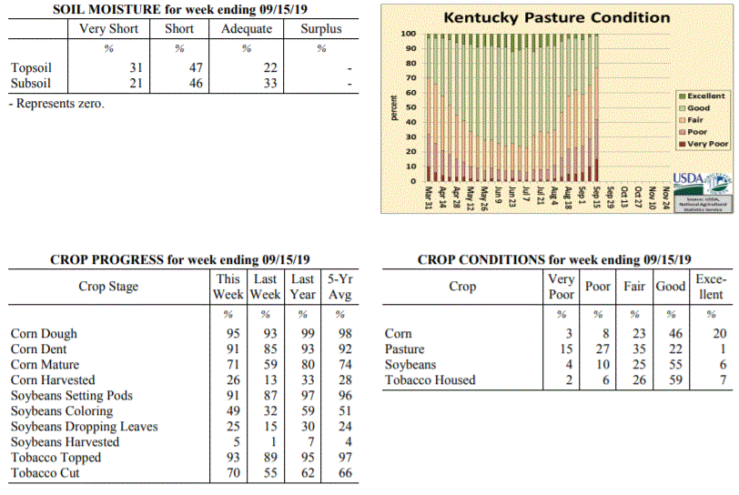 Kentucky Climate Summary
For the Period September 9, 2019 to September 15, 2019
Well Above Normal Temperatures and Much Below Normal Rainfall:
Dry weather and unrelenting heat has engulfed the Bluegrass State. According to data
at the Ag Weather Center, through the first 15 days of the month, the state has only
averaged 0.06 inches. The US Drought Monitor has reintroduced �Moderate Drought� to
portions of North Central Kentucky and established a new area across Southeastern
Kentucky. This period was no different with the trend of mostly dry conditions
remaining in place. Other than some spotty showers and storms, this was a second
straight week where many locations saw no rainfall. In addition to the dry weather,
summer heat has remained entrenched across the area. Highs in the low to middle 90s
were common this past week, including many jumping into the upper 90s on Tuesday.
Lexington airport hit 100 degrees for the first time since 2012.
Temperatures for the period averaged 78 degrees across the state which was 8 degrees
warmer than normal and 6 degrees warmer than the previous period. High temperatures
averaged from 92 in the West to 92 in the East. Departure from normal high
temperatures ranged from 8 degrees warmer than normal in the West to 10 degrees
warmer than normal in the East. Low temperatures averaged from 65 degrees in the
West to 64 degrees in the East. Departure from normal low temperature ranged from 5
degrees warmer than normal in the West to 7 degrees warmer than normal in the East.
The extreme high temperature for the period was 100 degrees at LEXINGTON APT and the
extreme low was 49 degrees at RICHMOND 8E.
Precipitation (liq. equ.) for the period totaled 0.04 inches statewide which was 0.8
inches below normal and 5% of normal. Precipitation totals by climate division, West
0.01 inches, Central 0.03 inches, Bluegrass 0.00 inches and East 0.11 inches, which
was 0.84, 0.9, 0.76 and 0.7 inches below normal. By station, precipitation totals
ranged from a low of 0.00 inches at ALBANY 1N to a high of 0.75 inches at
MIDDLESBORO AWOS.
---
Kentucky Crop and Weather Report
Issued 4:00 P.M., September 9, 2019 26-19
Agricultural News: Kentucky experienced near normal temperatures and much below
normal rainfall over the past week. Precipitation for the week totaled 0.01 inches,
0.76 inches below normal. Temperatures averaged 73 degrees for the week, unchanged
from normal. Topsoil moisture was rated 13 percent very short, 48 percent short, 38
percent adequate and 1 percent surplus. Subsoil moisture was rated 11 percent very
short, 44 percent short, 44 percent adequate, and 1 percent surplus. Days suitable
for fieldwork averaged 6.7 out of a possible seven.
Primary activities for this week included harvesting corn and soybeans along with
topping and cutting tobacco. Temperatures were near normal with virtually no
precipitation across the state. Most areas are beginning to get dry again causing
stress on pastures, hay fields, and late planted crops. Some cattle producers are
feeding hay early fueling fears of a shortage this winter. Corn harvest is underway
with soybean harvest just beginning. Due to a very wet planting season, there is a
great deal of geographic variance in crop stages and yields.
Kentucky Climate Summary
For the Period September 9, 2019 to September 15, 2019
Well Above Normal Temperatures and Much Below Normal Rainfall:
Dry weather and unrelenting heat has engulfed the Bluegrass State. According to data
at the Ag Weather Center, through the first 15 days of the month, the state has only
averaged 0.06 inches. The US Drought Monitor has reintroduced �Moderate Drought� to
portions of North Central Kentucky and established a new area across Southeastern
Kentucky. This period was no different with the trend of mostly dry conditions
remaining in place. Other than some spotty showers and storms, this was a second
straight week where many locations saw no rainfall. In addition to the dry weather,
summer heat has remained entrenched across the area. Highs in the low to middle 90s
were common this past week, including many jumping into the upper 90s on Tuesday.
Lexington airport hit 100 degrees for the first time since 2012.
Temperatures for the period averaged 78 degrees across the state which was 8 degrees
warmer than normal and 6 degrees warmer than the previous period. High temperatures
averaged from 92 in the West to 92 in the East. Departure from normal high
temperatures ranged from 8 degrees warmer than normal in the West to 10 degrees
warmer than normal in the East. Low temperatures averaged from 65 degrees in the
West to 64 degrees in the East. Departure from normal low temperature ranged from 5
degrees warmer than normal in the West to 7 degrees warmer than normal in the East.
The extreme high temperature for the period was 100 degrees at LEXINGTON APT and the
extreme low was 49 degrees at RICHMOND 8E.
Precipitation (liq. equ.) for the period totaled 0.04 inches statewide which was 0.8
inches below normal and 5% of normal. Precipitation totals by climate division, West
0.01 inches, Central 0.03 inches, Bluegrass 0.00 inches and East 0.11 inches, which
was 0.84, 0.9, 0.76 and 0.7 inches below normal. By station, precipitation totals
ranged from a low of 0.00 inches at ALBANY 1N to a high of 0.75 inches at
MIDDLESBORO AWOS.
---
Kentucky Crop and Weather Report
Issued 4:00 P.M., September 9, 2019 26-19
Agricultural News: Kentucky experienced near normal temperatures and much below
normal rainfall over the past week. Precipitation for the week totaled 0.01 inches,
0.76 inches below normal. Temperatures averaged 73 degrees for the week, unchanged
from normal. Topsoil moisture was rated 13 percent very short, 48 percent short, 38
percent adequate and 1 percent surplus. Subsoil moisture was rated 11 percent very
short, 44 percent short, 44 percent adequate, and 1 percent surplus. Days suitable
for fieldwork averaged 6.7 out of a possible seven.
Primary activities for this week included harvesting corn and soybeans along with
topping and cutting tobacco. Temperatures were near normal with virtually no
precipitation across the state. Most areas are beginning to get dry again causing
stress on pastures, hay fields, and late planted crops. Some cattle producers are
feeding hay early fueling fears of a shortage this winter. Corn harvest is underway
with soybean harvest just beginning. Due to a very wet planting season, there is a
great deal of geographic variance in crop stages and yields.
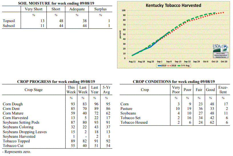 Kentucky Climate Summary
For the Period September 2, 2019 to September 8, 2019
Near Normal Temperatures and Much Below Normal Rainfall:
Looking at total accumulations, this is one of the driest weeks the state has seen in
quite some time. The state only averaged one hundreth of an inch with most not seeing
anything for the week. The last time Kentucky averaged under a tenth of an inch was back in
early February. The dry conditions broke a two week stretch of above normal rainfall.
Saying all this, September and October are climatologically, our two driest months of the
year. Two cold fronts did move through the area on Wednesday and Friday but were starved of
moisture. Noticeably cooler and less humid air moved into the area behind the
departing boundaries, especially the latter. Highs over the weekend were below normal
for this time of year with temperatures in the upper 70s to middle 80s and much more
comfortable humidity.
Temperatures for the period averaged 73 degrees across the state which was
near normal and no change to the previous period. High temperatures averaged from
86 in the West to 85 in the East. Departure from normal high temperatures ranged
from near normal in the West to 1 degree warmer than normal in the East.
Low temperatures averaged from 62 degrees in the West to 61 degrees in the East.
Departure from normal low temperature ranged from 1 degree cooler than normal in the
West to 1 degree warmer than normal in the East. The extreme high temperature for
the period was 95 degrees at POPLAR BLUFF ASOS and the extreme low was 49 degrees at
RICHMOND 8E.
Precipitation (liq. equ.) for the period totaled 0.01 inches statewide which was 0.76
inches below normal and 1% of normal. Precipitation totals by climate division, West
0.00 inches, Central 0.00 inches, Bluegrass 0.04 inches and East 0.01 inches, which
was 0.72, 0.85, 0.69 and 0.78 inches below normal. By station, precipitation totals
ranged from a low of 0.00 inches at ALBANY 1N to a high of 0.49 inches at CINCINNATI.
---
Kentucky Crop and Weather Report
Issued 4:00 P.M., September 3, 2019 25-19
Agricultural News: Kentucky experienced below normal temperatures and above normal
rainfall over the past week. Precipitation for the week totaled 1.26 inches, 0.52
inches above normal. Temperatures averaged 73 degrees for the week, 1 degree below
normal. Topsoil moisture was rated 8 percent very short, 34 percent short, 56 percent
adequate and 2 percent surplus. Subsoil moisture was rated 7 percent very short, 35
percent short, 56 percent adequate, and 2 percent surplus. Days suitable for
fieldwork averaged 5.7 out of a possible seven.
Primary activities for this week included harvesting corn and hay along with topping
and cutting tobacco. There was a period of cooler temperatures and widespread
precipitation this past week offering some drought relief. Corn harvest is still in
the early stages, but has been initiated. Due to a very wet planting season, there is
a great deal of geographic variance in crop stages. Pasture have benefitted from the
rain and cool temperatures, however another dry spell will halt the improvement.
Kentucky Climate Summary
For the Period September 2, 2019 to September 8, 2019
Near Normal Temperatures and Much Below Normal Rainfall:
Looking at total accumulations, this is one of the driest weeks the state has seen in
quite some time. The state only averaged one hundreth of an inch with most not seeing
anything for the week. The last time Kentucky averaged under a tenth of an inch was back in
early February. The dry conditions broke a two week stretch of above normal rainfall.
Saying all this, September and October are climatologically, our two driest months of the
year. Two cold fronts did move through the area on Wednesday and Friday but were starved of
moisture. Noticeably cooler and less humid air moved into the area behind the
departing boundaries, especially the latter. Highs over the weekend were below normal
for this time of year with temperatures in the upper 70s to middle 80s and much more
comfortable humidity.
Temperatures for the period averaged 73 degrees across the state which was
near normal and no change to the previous period. High temperatures averaged from
86 in the West to 85 in the East. Departure from normal high temperatures ranged
from near normal in the West to 1 degree warmer than normal in the East.
Low temperatures averaged from 62 degrees in the West to 61 degrees in the East.
Departure from normal low temperature ranged from 1 degree cooler than normal in the
West to 1 degree warmer than normal in the East. The extreme high temperature for
the period was 95 degrees at POPLAR BLUFF ASOS and the extreme low was 49 degrees at
RICHMOND 8E.
Precipitation (liq. equ.) for the period totaled 0.01 inches statewide which was 0.76
inches below normal and 1% of normal. Precipitation totals by climate division, West
0.00 inches, Central 0.00 inches, Bluegrass 0.04 inches and East 0.01 inches, which
was 0.72, 0.85, 0.69 and 0.78 inches below normal. By station, precipitation totals
ranged from a low of 0.00 inches at ALBANY 1N to a high of 0.49 inches at CINCINNATI.
---
Kentucky Crop and Weather Report
Issued 4:00 P.M., September 3, 2019 25-19
Agricultural News: Kentucky experienced below normal temperatures and above normal
rainfall over the past week. Precipitation for the week totaled 1.26 inches, 0.52
inches above normal. Temperatures averaged 73 degrees for the week, 1 degree below
normal. Topsoil moisture was rated 8 percent very short, 34 percent short, 56 percent
adequate and 2 percent surplus. Subsoil moisture was rated 7 percent very short, 35
percent short, 56 percent adequate, and 2 percent surplus. Days suitable for
fieldwork averaged 5.7 out of a possible seven.
Primary activities for this week included harvesting corn and hay along with topping
and cutting tobacco. There was a period of cooler temperatures and widespread
precipitation this past week offering some drought relief. Corn harvest is still in
the early stages, but has been initiated. Due to a very wet planting season, there is
a great deal of geographic variance in crop stages. Pasture have benefitted from the
rain and cool temperatures, however another dry spell will halt the improvement.
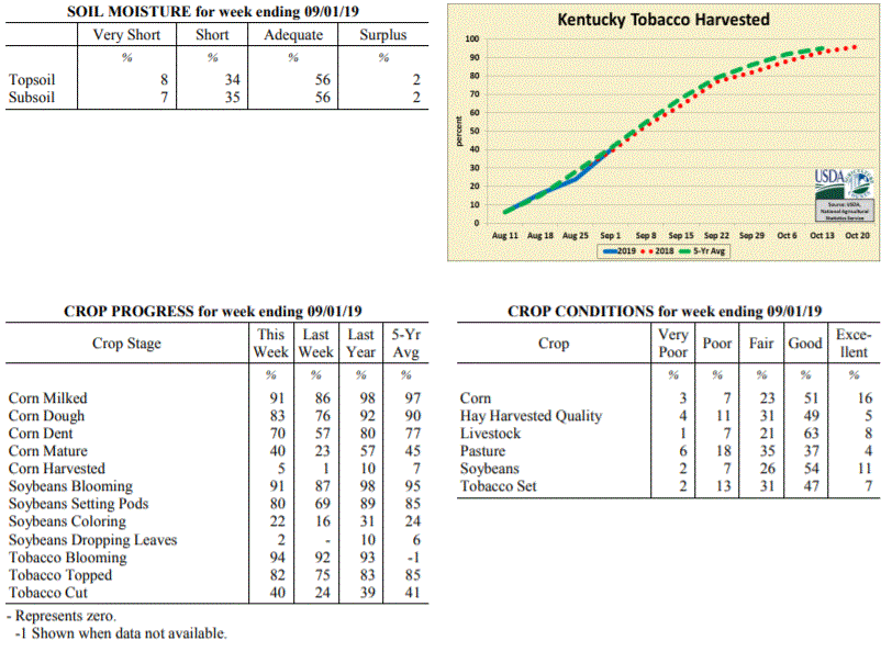 Kentucky Climate Summary
For the Period August 26, 2019 to September 1, 2019
Below Normal Temperatures and Above Normal Rainfall:
August came to a close with a second straight week of above normal rainfall. Overall,
the state averaged 1.26 inches behind multiple rounds of rainfall over the first half of the
period. Later in the week, a front stalled over the area and coverage became isolated
to widely scattered on a daily basis. Storms were slow movers and produced a
tremendous amount of rainfall, leading to some bouts of flooding and even some large
hail. The rainfall has improved conditions across the state and led the US
Drought Monitor to remove moderate drought from portions of North Central Kentucky.
Looking at temperatures, behind the passage of a cold front on Tuesday, Kentucky
received a dose of fall weather for a couple days. Highs were only in the upper 70s
to middles 80s both Wednesday and Thursday with low humidity. Those temperatures then
went on the increase through the weekend, back to around 90.
Temperatures for the period averaged 73 degrees across the state which was 1 degree
cooler than normal and 4 degrees cooler than the previous period. High temperatures
averaged from 85 in the West to 83 in the East. Departure from normal high
temperatures ranged from 3 degrees cooler than normal in the West to 2 degrees
cooler than normal in the East. Low temperatures averaged from 64 degrees in the
West to 62 degrees in the East. Departure from normal low temperature ranged from
near normal in the West to 1 degree warmer than normal in the East. The
extreme high temperature for the period was 92 degrees at LEXINGTON APT and the
extreme low was 50 degrees at MONTICELLO AWOS.
Precipitation (liq. equ.) for the period totaled 1.26 inches statewide which was 0.52
inches above normal and 170% of normal. Precipitation totals by climate division,
West 0.59 inches, Central 1.63 inches, Bluegrass 1.57 inches and East 1.27 inches,
which was -0.08, 0.85, 0.84 and 0.49 inches respectively from normal. By station,
precipitation totals ranged from a low of 0.02 inches at PADUCAH ASOS to a high of
4.87 inches at OWINGSVILLE 4S.
---
Kentucky Crop and Weather Report
Issued 4:00 P.M., August 26, 2019 24-19
Agricultural News: Kentucky experienced above normal temperatures and rainfall over
the past week. Precipitation for the week totaled 1.00 inches, 0.17 inches above
normal. Temperatures averaged 76 degrees for the week, 1 degree above normal. Topsoil
moisture was rated 8 percent very short, 32 percent short, 56 percent adequate, and 4
percent surplus. Subsoil moisture was rated 6 percent very short, 32 percent short,
60 percent adequate, and 2 percent surplus. Days suitable for fieldwork averaged 5.7
out of a possible seven.
Primary activities for this week included harvesting hay along with topping and
cutting tobacco. Pockets of the state received some much needed rainfall this week
while other areas continue to battle drought. Corn harvest has initiated, however
nearly all the crop is still in the field. Crop stages vary geographically as the
planting season was very wet for much of the state. Corn, soybeans, and tobacco
remain in mostly good condition despite the extended dry weather. Pasture is in
mostly fair condition as the heat and drought have taken a toll. Harvested hay is in
mostly good condition at this juncture, however producers are seeing low yields in
areas that are especially dry.
Kentucky Climate Summary
For the Period August 26, 2019 to September 1, 2019
Below Normal Temperatures and Above Normal Rainfall:
August came to a close with a second straight week of above normal rainfall. Overall,
the state averaged 1.26 inches behind multiple rounds of rainfall over the first half of the
period. Later in the week, a front stalled over the area and coverage became isolated
to widely scattered on a daily basis. Storms were slow movers and produced a
tremendous amount of rainfall, leading to some bouts of flooding and even some large
hail. The rainfall has improved conditions across the state and led the US
Drought Monitor to remove moderate drought from portions of North Central Kentucky.
Looking at temperatures, behind the passage of a cold front on Tuesday, Kentucky
received a dose of fall weather for a couple days. Highs were only in the upper 70s
to middles 80s both Wednesday and Thursday with low humidity. Those temperatures then
went on the increase through the weekend, back to around 90.
Temperatures for the period averaged 73 degrees across the state which was 1 degree
cooler than normal and 4 degrees cooler than the previous period. High temperatures
averaged from 85 in the West to 83 in the East. Departure from normal high
temperatures ranged from 3 degrees cooler than normal in the West to 2 degrees
cooler than normal in the East. Low temperatures averaged from 64 degrees in the
West to 62 degrees in the East. Departure from normal low temperature ranged from
near normal in the West to 1 degree warmer than normal in the East. The
extreme high temperature for the period was 92 degrees at LEXINGTON APT and the
extreme low was 50 degrees at MONTICELLO AWOS.
Precipitation (liq. equ.) for the period totaled 1.26 inches statewide which was 0.52
inches above normal and 170% of normal. Precipitation totals by climate division,
West 0.59 inches, Central 1.63 inches, Bluegrass 1.57 inches and East 1.27 inches,
which was -0.08, 0.85, 0.84 and 0.49 inches respectively from normal. By station,
precipitation totals ranged from a low of 0.02 inches at PADUCAH ASOS to a high of
4.87 inches at OWINGSVILLE 4S.
---
Kentucky Crop and Weather Report
Issued 4:00 P.M., August 26, 2019 24-19
Agricultural News: Kentucky experienced above normal temperatures and rainfall over
the past week. Precipitation for the week totaled 1.00 inches, 0.17 inches above
normal. Temperatures averaged 76 degrees for the week, 1 degree above normal. Topsoil
moisture was rated 8 percent very short, 32 percent short, 56 percent adequate, and 4
percent surplus. Subsoil moisture was rated 6 percent very short, 32 percent short,
60 percent adequate, and 2 percent surplus. Days suitable for fieldwork averaged 5.7
out of a possible seven.
Primary activities for this week included harvesting hay along with topping and
cutting tobacco. Pockets of the state received some much needed rainfall this week
while other areas continue to battle drought. Corn harvest has initiated, however
nearly all the crop is still in the field. Crop stages vary geographically as the
planting season was very wet for much of the state. Corn, soybeans, and tobacco
remain in mostly good condition despite the extended dry weather. Pasture is in
mostly fair condition as the heat and drought have taken a toll. Harvested hay is in
mostly good condition at this juncture, however producers are seeing low yields in
areas that are especially dry.
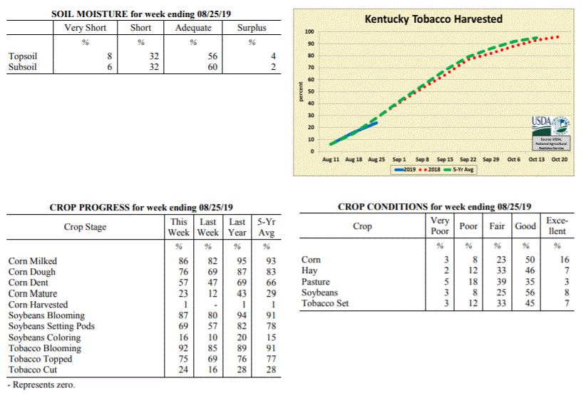 Kentucky Climate Summary
For the Period August 19, 2019 to August 25, 2019
Above Normal Temperatures and Rainfall:
After three straight weeks of below normal precipitation, the US Drought Monitor
introduced an area of �Moderate Drought� to portions of North Central Kentucky with
the latest update. In addition, the area of �Abnormally Dry Conditions� also
expanded to include nearly half of the state. Luckily, the state did finally see
some beneficial rainfall this past week as multiple rounds pushed through the area.
The unsettled pattern started on Tuesday evening as a line of storms pushed south
into the Bluegrass State. This was followed by an active pattern over the next few
days as a cold front was slow to pass through the region, each day featuring
scattered coverage of showers and storms. Overall, the state averaged an inch for
the week, but that number jumped to 1.66 for Western Kentucky. Some portions of this
area, including Paducah, saw more than three inches.
Temperatures for the period averaged 76 degrees across the state which was 1 degree
warmer than normal and 2 degrees cooler than the previous period. High temperatures
averaged from 86 in the West to 86 in the East. Departure from normal high
temperatures ranged from 2 degrees cooler than normal in the West to near
normal in the East. Low temperatures averaged from 68 degrees in the West to 66
degrees in the East. Departure from normal low temperature ranged from 3 degrees
warmer than normal in the West to 4 degrees warmer than normal in the East. The
extreme high temperature for the period was 99 degrees at LEXINGTON APT and the
extreme low was 52 degrees at PAINTSVILLE 4W.
Precipitation (liq. equ.) for the period totaled 1.00 inches statewide which was 0.17
inches above normal and 120% of normal. Precipitation totals by climate division,
West 1.66 inches, Central 0.98 inches, Bluegrass 0.78 inches and East 0.57 inches,
which was 0.91, 0.14, -0.06 and -0.32 inches respectively from normal. By station,
precipitation totals ranged from a low of 0.08 inches at BIG SANDY to a high of 4.21
inches at MAYFIELD 6SW.
---
Kentucky Crop and Weather Report
Issued 4:00 P.M., August 19, 2019 23-19
Agricultural News: Kentucky experienced above normal temperatures and below normal
rainfall over the past week. Precipitation for the week totaled 0.38 inches, 0.48
inches below normal. Temperatures averaged 78 degrees for the week, 2 degrees above
normal. Topsoil moisture was rated 11 percent very short, 38 percent short, 50
percent adequate, and 1 percent surplus. Subsoil moisture was rated 7 percent very
short, 34 percent short, 58 percent adequate, and 1 percent surplus. Days suitable
for fieldwork averaged 6.5 out of a possible seven.
Primary activities for this week included topping and cutting of tobacco along with
continued hay cutting. Pockets of the state received some much needed rainfall this
week, however conditions remain dry on the whole. Crop stages vary dramatically in
parts of the state as some crops were replanted due to adverse conditions in the
planting season. There were several reports of low hay yields due to the heat and
drought. Pastures are also being stressed by the persistent hot and dry conditions.
Kentucky Climate Summary
For the Period August 19, 2019 to August 25, 2019
Above Normal Temperatures and Rainfall:
After three straight weeks of below normal precipitation, the US Drought Monitor
introduced an area of �Moderate Drought� to portions of North Central Kentucky with
the latest update. In addition, the area of �Abnormally Dry Conditions� also
expanded to include nearly half of the state. Luckily, the state did finally see
some beneficial rainfall this past week as multiple rounds pushed through the area.
The unsettled pattern started on Tuesday evening as a line of storms pushed south
into the Bluegrass State. This was followed by an active pattern over the next few
days as a cold front was slow to pass through the region, each day featuring
scattered coverage of showers and storms. Overall, the state averaged an inch for
the week, but that number jumped to 1.66 for Western Kentucky. Some portions of this
area, including Paducah, saw more than three inches.
Temperatures for the period averaged 76 degrees across the state which was 1 degree
warmer than normal and 2 degrees cooler than the previous period. High temperatures
averaged from 86 in the West to 86 in the East. Departure from normal high
temperatures ranged from 2 degrees cooler than normal in the West to near
normal in the East. Low temperatures averaged from 68 degrees in the West to 66
degrees in the East. Departure from normal low temperature ranged from 3 degrees
warmer than normal in the West to 4 degrees warmer than normal in the East. The
extreme high temperature for the period was 99 degrees at LEXINGTON APT and the
extreme low was 52 degrees at PAINTSVILLE 4W.
Precipitation (liq. equ.) for the period totaled 1.00 inches statewide which was 0.17
inches above normal and 120% of normal. Precipitation totals by climate division,
West 1.66 inches, Central 0.98 inches, Bluegrass 0.78 inches and East 0.57 inches,
which was 0.91, 0.14, -0.06 and -0.32 inches respectively from normal. By station,
precipitation totals ranged from a low of 0.08 inches at BIG SANDY to a high of 4.21
inches at MAYFIELD 6SW.
---
Kentucky Crop and Weather Report
Issued 4:00 P.M., August 19, 2019 23-19
Agricultural News: Kentucky experienced above normal temperatures and below normal
rainfall over the past week. Precipitation for the week totaled 0.38 inches, 0.48
inches below normal. Temperatures averaged 78 degrees for the week, 2 degrees above
normal. Topsoil moisture was rated 11 percent very short, 38 percent short, 50
percent adequate, and 1 percent surplus. Subsoil moisture was rated 7 percent very
short, 34 percent short, 58 percent adequate, and 1 percent surplus. Days suitable
for fieldwork averaged 6.5 out of a possible seven.
Primary activities for this week included topping and cutting of tobacco along with
continued hay cutting. Pockets of the state received some much needed rainfall this
week, however conditions remain dry on the whole. Crop stages vary dramatically in
parts of the state as some crops were replanted due to adverse conditions in the
planting season. There were several reports of low hay yields due to the heat and
drought. Pastures are also being stressed by the persistent hot and dry conditions.
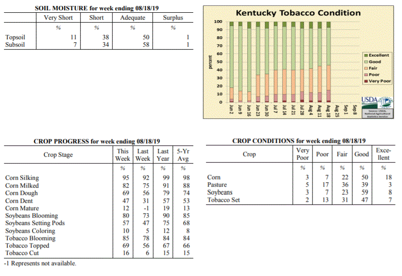 Kentucky Climate Summary
For the Period August 12, 2019 to August 18, 2019
Above Normal Temperatures and Below Normal Rainfall:
Kentucky has experienced a dry August thus far with three straight weeks of below
normal rainfall. Data at the UK Ag Weather Center shows the state has only averaged
0.92 inches through August 18th, which is almost 1.5 inches below normal. The
northern half of the state did see some widespread rainfall on Tuesday morning, but not
nearly enough. The rest of the week featured spotty rainfall with little, if any
falling across the southern half of the state. �Abnormally Dry Conditions� were
expanded across North Central Kentucky with the Thursday update of the US Drought
Monitor, in addition to a small area introduced across Southeastern Kentucky. Bottom
line, it has been a dry August for the Bluegrass State. The heat has not helped matters
with highs in the middle 80s to low 90s common over the period. A handful of stations
even rose into the upper 90s on Sunday.
Temperatures for the period averaged 78 degrees across the state which was 2 degrees
warmer than normal and 2 degrees warmer than the previous period. High temperatures
averaged from 89 in the West to 88 in the East. Departure from normal high
temperatures ranged from 1 degree warmer than normal in the West to 2 degrees warmer
than normal in the East. Low temperatures averaged from 69 degrees in the West to 66
degrees in the East. Departure from normal low temperature ranged from 3 degrees
warmer than normal in the West to 3 degrees warmer than normal in the East. The
extreme high temperature for the period was 97 degrees at LEXINGTON APT and the extreme
low was 39 degrees at ALEXANDRIA 5NW.
Precipitation (liq. equ.) for the period totaled 0.38 inches statewide which was 0.48
inches below normal and 44% of normal. Precipitation totals by climate division, West
0.39 inches, Central 0.32 inches, Bluegrass 0.41 inches and East 0.38 inches, which
was 0.4, 0.52, 0.46 and 0.55 inches below normal. By station, precipitation totals
ranged from a low of 0.00 inches at BURKESVILLE 3W to a high of 2.62 inches at
EVANSVILLE ASOS.
---
Kentucky Crop and Weather Report
Issued 4:00 P.M., August 12, 2019 22-19
Agricultural News: Kentucky experienced near normal temperatures and below normal
rainfall over the past week. Precipitation for the week totaled 0.33 inches, 0.58
inches below normal. Temperatures averaged 76 degrees for the week, unchanged from
normal. Topsoil moisture was rated 6 percent very short, 29 percent short, 62 percent
adequate, and 3 percent surplus. Subsoil moisture was rated 4 percent very short, 28
percent short, 65 percent adequate, and 3 percent surplus. Days suitable for
fieldwork averaged 6.3 out of a possible seven.
Primary activities for this week included cutting hay, topping tobacco, and spraying
of field crops. A small portion of the tobacco crop has been cut according to
reports. Parts of the state received some rain last week, however dry conditions
persist. Drought coupled with hot weather has taken a toll on some of the pastureland
and hay. Later planted corn and soybeans could be damaged if the dry conditions continue.
Kentucky Climate Summary
For the Period August 12, 2019 to August 18, 2019
Above Normal Temperatures and Below Normal Rainfall:
Kentucky has experienced a dry August thus far with three straight weeks of below
normal rainfall. Data at the UK Ag Weather Center shows the state has only averaged
0.92 inches through August 18th, which is almost 1.5 inches below normal. The
northern half of the state did see some widespread rainfall on Tuesday morning, but not
nearly enough. The rest of the week featured spotty rainfall with little, if any
falling across the southern half of the state. �Abnormally Dry Conditions� were
expanded across North Central Kentucky with the Thursday update of the US Drought
Monitor, in addition to a small area introduced across Southeastern Kentucky. Bottom
line, it has been a dry August for the Bluegrass State. The heat has not helped matters
with highs in the middle 80s to low 90s common over the period. A handful of stations
even rose into the upper 90s on Sunday.
Temperatures for the period averaged 78 degrees across the state which was 2 degrees
warmer than normal and 2 degrees warmer than the previous period. High temperatures
averaged from 89 in the West to 88 in the East. Departure from normal high
temperatures ranged from 1 degree warmer than normal in the West to 2 degrees warmer
than normal in the East. Low temperatures averaged from 69 degrees in the West to 66
degrees in the East. Departure from normal low temperature ranged from 3 degrees
warmer than normal in the West to 3 degrees warmer than normal in the East. The
extreme high temperature for the period was 97 degrees at LEXINGTON APT and the extreme
low was 39 degrees at ALEXANDRIA 5NW.
Precipitation (liq. equ.) for the period totaled 0.38 inches statewide which was 0.48
inches below normal and 44% of normal. Precipitation totals by climate division, West
0.39 inches, Central 0.32 inches, Bluegrass 0.41 inches and East 0.38 inches, which
was 0.4, 0.52, 0.46 and 0.55 inches below normal. By station, precipitation totals
ranged from a low of 0.00 inches at BURKESVILLE 3W to a high of 2.62 inches at
EVANSVILLE ASOS.
---
Kentucky Crop and Weather Report
Issued 4:00 P.M., August 12, 2019 22-19
Agricultural News: Kentucky experienced near normal temperatures and below normal
rainfall over the past week. Precipitation for the week totaled 0.33 inches, 0.58
inches below normal. Temperatures averaged 76 degrees for the week, unchanged from
normal. Topsoil moisture was rated 6 percent very short, 29 percent short, 62 percent
adequate, and 3 percent surplus. Subsoil moisture was rated 4 percent very short, 28
percent short, 65 percent adequate, and 3 percent surplus. Days suitable for
fieldwork averaged 6.3 out of a possible seven.
Primary activities for this week included cutting hay, topping tobacco, and spraying
of field crops. A small portion of the tobacco crop has been cut according to
reports. Parts of the state received some rain last week, however dry conditions
persist. Drought coupled with hot weather has taken a toll on some of the pastureland
and hay. Later planted corn and soybeans could be damaged if the dry conditions continue.
 Kentucky Climate Summary
For the Period August 5, 2019 to August 11, 2019
Near Normal Temperatures and Below Normal Rainfall:
As summer heat continues, attention over recent weeks has turned toward increasingly
dry conditions for some areas of the state. A couple frontal boundaries moved
through the Lower Ohio Valley this past week, sparking isolated to scattered storms.
Rainfall accumulations were limited to mainly two areas of the state: Western/West
Central Kentucky and the Northern Bluegrass/Northeastern Kentucky. Between the two
(North Central Kentucky extending into Southeastern Kentucky), very little, if any
rainfall was seen. Overall, this pushed the state to a second straight week of below
normal rainfall. In addition, the US Drought Monitor introduced a large area of
�Abnormally Dry Conditions� for North Central Kentucky, which has missed most of the
rainfall over the past couple weeks.
Temperatures for the period averaged 76 degrees across the state which was near
normal and no change to the previous period. High temperatures averaged from 87 in
the West to 86 in the East. Departure from normal high temperatures ranged from 1
degree cooler than normal in the West to near normal in the East. Low temperatures
averaged from 67 degrees in the West to 64 degrees in the East. Departure from normal
low temperature ranged from 1 degree warmer than normal in the West to 1 degree
warmer than normal in the East. The extreme high temperature for the period was 95
degrees at LOUISVILLE APT and the extreme low was 53 degrees at VANCEBURG 6W.
Precipitation (liq. equ.) for the period totaled 0.33 inches statewide which was 0.58
inches below normal and 36% of normal. Precipitation totals by climate division, West
0.48 inches, Central 0.25 inches, Bluegrass 0.32 inches and East 0.25 inches, which
was 0.4, 0.64, 0.57 and 0.75 inches below normal. By station, precipitation totals
ranged from a low of 0.00 inches at BARBOURVILLE 3E to a high of 1.60 inches at
MOREHEAD 4NE.
---
Kentucky Crop and Weather Report
Issued 4:00 P.M., August 5, 2019 21-19
Agricultural News: Kentucky experienced near normal temperatures and below normal
rainfall over the past week. Precipitation for the week totaled 0.67 inches, 0.30
inches below normal. Temperatures averaged 76 degrees for the week, unchanged from
normal. Topsoil moisture was rated 3 percent very short, 21 percent short, 70 percent
adequate, and 6 percent surplus. Subsoil moisture was rated 2 percent very short, 20
percent short, 73 percent adequate, and 5 percent surplus. Days suitable for
fieldwork averaged 6.2 out of a possible seven.
Primary activities for this week included cutting hay, topping tobacco, and spraying
field crops. Pockets of the state are dealing with a recent dry spell that, if
prolonged, could be detrimental to pastureland and field crops. The dry conditions
coupled with hot temperatures has slowed pasture growth and is beginning to stress
crops in some areas. A few counties experienced heavy rain, however flooding was not
widespread.
Kentucky Climate Summary
For the Period August 5, 2019 to August 11, 2019
Near Normal Temperatures and Below Normal Rainfall:
As summer heat continues, attention over recent weeks has turned toward increasingly
dry conditions for some areas of the state. A couple frontal boundaries moved
through the Lower Ohio Valley this past week, sparking isolated to scattered storms.
Rainfall accumulations were limited to mainly two areas of the state: Western/West
Central Kentucky and the Northern Bluegrass/Northeastern Kentucky. Between the two
(North Central Kentucky extending into Southeastern Kentucky), very little, if any
rainfall was seen. Overall, this pushed the state to a second straight week of below
normal rainfall. In addition, the US Drought Monitor introduced a large area of
�Abnormally Dry Conditions� for North Central Kentucky, which has missed most of the
rainfall over the past couple weeks.
Temperatures for the period averaged 76 degrees across the state which was near
normal and no change to the previous period. High temperatures averaged from 87 in
the West to 86 in the East. Departure from normal high temperatures ranged from 1
degree cooler than normal in the West to near normal in the East. Low temperatures
averaged from 67 degrees in the West to 64 degrees in the East. Departure from normal
low temperature ranged from 1 degree warmer than normal in the West to 1 degree
warmer than normal in the East. The extreme high temperature for the period was 95
degrees at LOUISVILLE APT and the extreme low was 53 degrees at VANCEBURG 6W.
Precipitation (liq. equ.) for the period totaled 0.33 inches statewide which was 0.58
inches below normal and 36% of normal. Precipitation totals by climate division, West
0.48 inches, Central 0.25 inches, Bluegrass 0.32 inches and East 0.25 inches, which
was 0.4, 0.64, 0.57 and 0.75 inches below normal. By station, precipitation totals
ranged from a low of 0.00 inches at BARBOURVILLE 3E to a high of 1.60 inches at
MOREHEAD 4NE.
---
Kentucky Crop and Weather Report
Issued 4:00 P.M., August 5, 2019 21-19
Agricultural News: Kentucky experienced near normal temperatures and below normal
rainfall over the past week. Precipitation for the week totaled 0.67 inches, 0.30
inches below normal. Temperatures averaged 76 degrees for the week, unchanged from
normal. Topsoil moisture was rated 3 percent very short, 21 percent short, 70 percent
adequate, and 6 percent surplus. Subsoil moisture was rated 2 percent very short, 20
percent short, 73 percent adequate, and 5 percent surplus. Days suitable for
fieldwork averaged 6.2 out of a possible seven.
Primary activities for this week included cutting hay, topping tobacco, and spraying
field crops. Pockets of the state are dealing with a recent dry spell that, if
prolonged, could be detrimental to pastureland and field crops. The dry conditions
coupled with hot temperatures has slowed pasture growth and is beginning to stress
crops in some areas. A few counties experienced heavy rain, however flooding was not
widespread.
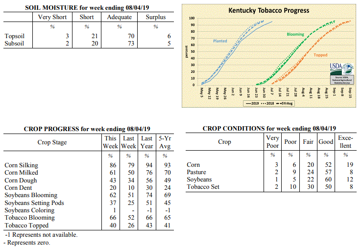 Kentucky Climate Summary
For the Period July 29, 2019 to August 4, 2019
Near Normal Temperatures and Below Normal Rainfall:
Overall, the state averaged 0.67 inches for the week, which is about a third of an
inch below normal. Coverage was more of the hit or miss variety, with isolated to
scattered showers and storms in place most of the week. While some areas saw very
little, others that got caught underneath slow-moving cells saw more than 1.5 inches.
Portions of North-Central Kentucky have trended to the drier side over the past two
weeks with rainfall departure of 1 to 2 inches below normal. Temperatures ran
around normal for the period with highs consistently getting into the middle 80s to
low 90s.
Temperatures for the period averaged 76 degrees across the state which was near
normal and 4 degrees warmer than the previous period. High temperatures averaged from
87 in the West to 86 in the East. Departure from normal high temperatures ranged from
2 degrees cooler than normal in the West to 1 degree cooler than normal in the East.
Low temperatures averaged from 66 degrees in the West to 65 degrees in the East.
Departure from normal low temperature ranged from 1 degree cooler than normal in the
West to 1 degree warmer than normal in the East. The extreme high temperature for the
period was 92 degrees at BOWLING GREEN APT and the extreme low was 58 degrees at
MAYSVILLE 3SW.
Precipitation (liq. equ.) for the period totaled 0.67 inches statewide which was 0.3
inches below normal and 69% of normal. Precipitation totals by climate division, West
0.71 inches, Central 0.54 inches, Bluegrass 0.91 inches and East 0.53 inches, which
was 0.22, 0.41, 0.05 and 0.51 inches below normal. By station, precipitation totals
ranged from a low of 0.00 inches at EDMONTON 5W to a high of 2.89 inches at COLUMBIA 3N.
---
Kentucky Crop and Weather Report
Issued 4:00 P.M., July 29, 2019 20-19
Agricultural News: Kentucky experienced below normal temperatures and above normal
rainfall over the past week. Precipitation for the week totaled 1.07 inches, 0.10
inches above normal. Temperatures averaged 72 degrees for the week, 4 degrees below
normal. Topsoil moisture was rated 1 percent very short, 20 percent short, 70 percent
adequate and 9 percent surplus. Subsoil moisture was rated 1 percent very short, 19
percent short, 72 percent adequate, and 8 percent surplus. Days suitable for
fieldwork averaged 6.0 out of a possible seven.
Primary activities this week included cutting hay, topping tobacco, and spraying
tobacco and corn fields. Limited rainfall has impacted pastures and crops, most
notably in central portions of the state. Farmers have noted good yields in the
second cutting of hay, with reports of better weed control. Hay and roughage supplies
were reported as 9 percent very short, 26 percent short, 61 percent adequate, and 4
percent surplus.
Kentucky Climate Summary
For the Period July 29, 2019 to August 4, 2019
Near Normal Temperatures and Below Normal Rainfall:
Overall, the state averaged 0.67 inches for the week, which is about a third of an
inch below normal. Coverage was more of the hit or miss variety, with isolated to
scattered showers and storms in place most of the week. While some areas saw very
little, others that got caught underneath slow-moving cells saw more than 1.5 inches.
Portions of North-Central Kentucky have trended to the drier side over the past two
weeks with rainfall departure of 1 to 2 inches below normal. Temperatures ran
around normal for the period with highs consistently getting into the middle 80s to
low 90s.
Temperatures for the period averaged 76 degrees across the state which was near
normal and 4 degrees warmer than the previous period. High temperatures averaged from
87 in the West to 86 in the East. Departure from normal high temperatures ranged from
2 degrees cooler than normal in the West to 1 degree cooler than normal in the East.
Low temperatures averaged from 66 degrees in the West to 65 degrees in the East.
Departure from normal low temperature ranged from 1 degree cooler than normal in the
West to 1 degree warmer than normal in the East. The extreme high temperature for the
period was 92 degrees at BOWLING GREEN APT and the extreme low was 58 degrees at
MAYSVILLE 3SW.
Precipitation (liq. equ.) for the period totaled 0.67 inches statewide which was 0.3
inches below normal and 69% of normal. Precipitation totals by climate division, West
0.71 inches, Central 0.54 inches, Bluegrass 0.91 inches and East 0.53 inches, which
was 0.22, 0.41, 0.05 and 0.51 inches below normal. By station, precipitation totals
ranged from a low of 0.00 inches at EDMONTON 5W to a high of 2.89 inches at COLUMBIA 3N.
---
Kentucky Crop and Weather Report
Issued 4:00 P.M., July 29, 2019 20-19
Agricultural News: Kentucky experienced below normal temperatures and above normal
rainfall over the past week. Precipitation for the week totaled 1.07 inches, 0.10
inches above normal. Temperatures averaged 72 degrees for the week, 4 degrees below
normal. Topsoil moisture was rated 1 percent very short, 20 percent short, 70 percent
adequate and 9 percent surplus. Subsoil moisture was rated 1 percent very short, 19
percent short, 72 percent adequate, and 8 percent surplus. Days suitable for
fieldwork averaged 6.0 out of a possible seven.
Primary activities this week included cutting hay, topping tobacco, and spraying
tobacco and corn fields. Limited rainfall has impacted pastures and crops, most
notably in central portions of the state. Farmers have noted good yields in the
second cutting of hay, with reports of better weed control. Hay and roughage supplies
were reported as 9 percent very short, 26 percent short, 61 percent adequate, and 4
percent surplus.
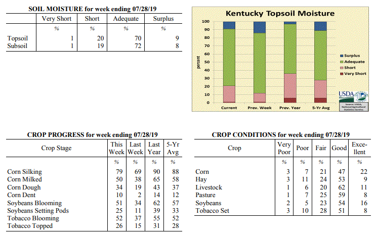 Kentucky Climate Summary
For the Period July 22, 2019 to July 28, 2019
Below Normal Temperatures and Above Normal Rainfall:
A cold front early in the week sparked multiple rounds of showers and storms across
the area. Once again, storms were capable of producing very heavy rainfall and led
to some flash flooding across the region. For most, this was the only rainfall for
the week as high pressure kept the area dry for the rest of the period. Saying that,
the state still averaged 1.07 inches, but accumulations varied greatly with the
scattered nature of the storms. Following the passage of the front, much cooler and
noticeably less humid air filtered into the Bluegrass State as winds transitioned to
the north. Dewpoints dropped into the 50s after being in the 70s most of last week.
Afternoon highs ranged in the upper 70s to middle 80s through Thursday, before going
back on the increase for the weekend. Still though, the cooler temperatures broke a
four week stretch of above normal temperatures.
Temperatures for the period averaged 72 degrees across the state which was 4 degrees
cooler than normal and 8 degrees cooler than the previous period. High temperatures
averaged from 83 in the West to 82 in the East. Departure from normal high
temperatures ranged from 6 degrees cooler than normal in the West to 5 degrees cooler
than normal in the East. Low temperatures averaged from 63 degrees in the West to 61
degrees in the East. Departure from normal low temperature ranged from 4 degrees
cooler than normal in the West to 3 degrees cooler than normal in the East. The
extreme high temperature for the period was 93 degrees at LOUISVILLE APT and the
extreme low was 53 degrees at WHITLEY CITY 3N.
Precipitation (liq. equ.) for the period totaled 1.07 inches statewide which was 0.1
inches above normal and 111% of normal. Precipitation totals by climate division,
West 1.25 inches, Central 1.02 inches, Bluegrass 0.68 inches and East 1.32 inches,
which was 0.33, 0.04, -0.28 and 0.31 inches respectively from normal. By station,
precipitation totals ranged from a low of 0.01 inches at PEABODY to a high of 3.99
inches at TRIANGLE MOUNTAIN.
---
Kentucky Crop and Weather Report
Issued 4:00 P.M., July 22, 2019 19-19
Agricultural News: Kentucky experienced above normal temperatures and rainfall over
the past week. Precipitation for the week totaled 1.40 inches, 0.42 inches above
normal. Temperatures averaged 80 degrees for the week, 3 degrees above normal.
Topsoil moisture was rated 1 percent very short, 11 percent short, 74 percent
adequate and 14 percent surplus. Subsoil moisture was rated 10 percent short, 76
percent adequate, and 14 percent surplus. Days suitable for fieldwork averaged 5.3
out of a possible seven.
Primary activities this week included scouting fields for incidences of disease,
topping tobacco, and cutting hay. Precipitation increased from remnants of Tropical
Storm Barry earlier in the week followed by excessive heat and humidity. Crops and
pastures showed signs of stress from the high temperatures and dry weather
later in the week. Livestock heat stress was also escalated during this period.
Kentucky Climate Summary
For the Period July 22, 2019 to July 28, 2019
Below Normal Temperatures and Above Normal Rainfall:
A cold front early in the week sparked multiple rounds of showers and storms across
the area. Once again, storms were capable of producing very heavy rainfall and led
to some flash flooding across the region. For most, this was the only rainfall for
the week as high pressure kept the area dry for the rest of the period. Saying that,
the state still averaged 1.07 inches, but accumulations varied greatly with the
scattered nature of the storms. Following the passage of the front, much cooler and
noticeably less humid air filtered into the Bluegrass State as winds transitioned to
the north. Dewpoints dropped into the 50s after being in the 70s most of last week.
Afternoon highs ranged in the upper 70s to middle 80s through Thursday, before going
back on the increase for the weekend. Still though, the cooler temperatures broke a
four week stretch of above normal temperatures.
Temperatures for the period averaged 72 degrees across the state which was 4 degrees
cooler than normal and 8 degrees cooler than the previous period. High temperatures
averaged from 83 in the West to 82 in the East. Departure from normal high
temperatures ranged from 6 degrees cooler than normal in the West to 5 degrees cooler
than normal in the East. Low temperatures averaged from 63 degrees in the West to 61
degrees in the East. Departure from normal low temperature ranged from 4 degrees
cooler than normal in the West to 3 degrees cooler than normal in the East. The
extreme high temperature for the period was 93 degrees at LOUISVILLE APT and the
extreme low was 53 degrees at WHITLEY CITY 3N.
Precipitation (liq. equ.) for the period totaled 1.07 inches statewide which was 0.1
inches above normal and 111% of normal. Precipitation totals by climate division,
West 1.25 inches, Central 1.02 inches, Bluegrass 0.68 inches and East 1.32 inches,
which was 0.33, 0.04, -0.28 and 0.31 inches respectively from normal. By station,
precipitation totals ranged from a low of 0.01 inches at PEABODY to a high of 3.99
inches at TRIANGLE MOUNTAIN.
---
Kentucky Crop and Weather Report
Issued 4:00 P.M., July 22, 2019 19-19
Agricultural News: Kentucky experienced above normal temperatures and rainfall over
the past week. Precipitation for the week totaled 1.40 inches, 0.42 inches above
normal. Temperatures averaged 80 degrees for the week, 3 degrees above normal.
Topsoil moisture was rated 1 percent very short, 11 percent short, 74 percent
adequate and 14 percent surplus. Subsoil moisture was rated 10 percent short, 76
percent adequate, and 14 percent surplus. Days suitable for fieldwork averaged 5.3
out of a possible seven.
Primary activities this week included scouting fields for incidences of disease,
topping tobacco, and cutting hay. Precipitation increased from remnants of Tropical
Storm Barry earlier in the week followed by excessive heat and humidity. Crops and
pastures showed signs of stress from the high temperatures and dry weather
later in the week. Livestock heat stress was also escalated during this period.
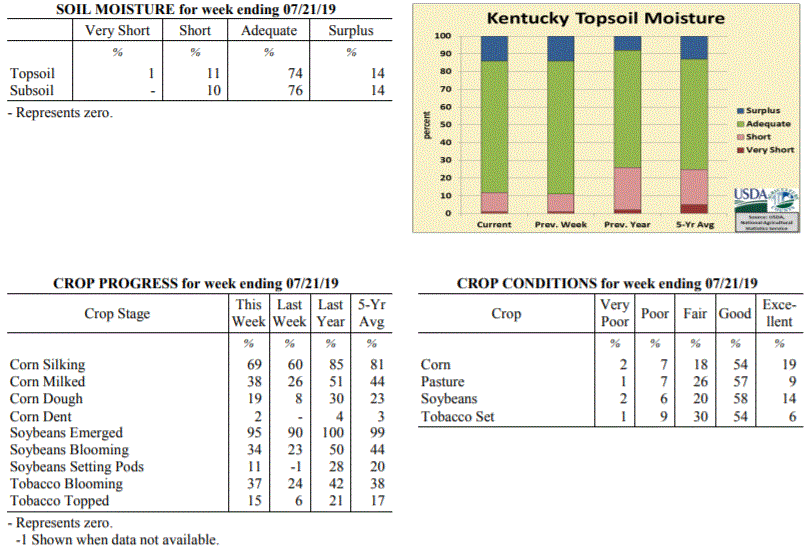 Kentucky Climate Summary
For the Period July 15, 2019 to July 21, 2019
Above Normal Temperatures and Rainfall:
The remnants of Tropical Storm Barry worked through the region over the first half of
the work week, resulting in multiple rounds of storms. Once again, a very moist air
mass led to torrential rainfall from time to time. The state averaged 1.40 inches for
the week, but several locations recorded 2 to 3+ inches. As the remnants of Barry
moved away from the region midweek, focus then turned to oppressive heat moving into
the area through the weekend. An �Excessive Heat Warning� was issued for much of the
state as temperatures rose into the upper 80s to middle 90s for highs. A very sticky
air mass with dewpoints in the middle to upper 70s led to heat indices between
100 and 110 degrees during the day. This was ultimately the warmest period of the
year thus far and pushed livestock heat stress into the danger to emergency category
each day. Looking back, the state has now gone four straight weeks of above normal
temperatures.
Temperatures for the period averaged 80 degrees across the state which was 3 degrees
warmer than normal and 2 degrees warmer than the previous period. High temperatures
averaged from 87 in the West to 88 in the East. Departure from normal high
temperatures ranged from 3 degrees cooler than normal in the West to 1 degree
warmer than normal in the East. Low temperatures averaged from 73 degrees in the
West to 71 degrees in the East. Departure from normal low temperature ranged from 5
degrees warmer than normal in the West to 7 degrees warmer than normal in the East.
The extreme high temperature for the period was 96 degrees at LOUISVILLE APT and the
extreme low was 66 degrees at OWINGSVILLE 4S.
Precipitation (liq. equ.) for the period totaled 1.40 inches statewide which was 0.42
inches above normal and 143% of normal. Precipitation totals by climate division,
West 1.50 inches, Central 0.91 inches, Bluegrass 1.99 inches and East 1.20 inches,
which was 0.56, -0.09, 1.04 and 0.18 inches respectively from normal. By station,
precipitation totals ranged from a low of 0.05 inches at PEABODY to a high of 4.90
inches at POPLAR BLUFF ASOS.
---
Kentucky Crop and Weather Report
Issued 4:00 P.M., July 15, 2019 18-19
Agricultural News: Kentucky experienced above normal temperatures and below normal
rainfall over the past week. Precipitation for the week totaled 0.59 inches, 0.40
inches below normal. Temperatures averaged 79 degrees for the week, 2 degrees above
normal. Topsoil moisture was rated 1 percent very short, 10 percent short, 75
percent adequate and 14 percent surplus. Subsoil moisture was rated 1 percent very
short, 8 percent short, 76 percent adequate, and 15 percent surplus. Days suitable
for fieldwork averaged 5.2 out of a possible seven.
Primary activities this week included scouting fields, topping tobacco, cutting hay,
harvesting winter wheat, and planting soybeans. Varied precipitation across the state
has left some fields in standing water, other areas with scattered showers, to
extremely dry. In sections of the state that have experienced lower precipitation
recently, crops are showing signs of moisture and heat stress. Some tobacco producers
are reporting incidences of target and frog-eye leaf spot, and spraying fungicides to
help control.
Kentucky Climate Summary
For the Period July 15, 2019 to July 21, 2019
Above Normal Temperatures and Rainfall:
The remnants of Tropical Storm Barry worked through the region over the first half of
the work week, resulting in multiple rounds of storms. Once again, a very moist air
mass led to torrential rainfall from time to time. The state averaged 1.40 inches for
the week, but several locations recorded 2 to 3+ inches. As the remnants of Barry
moved away from the region midweek, focus then turned to oppressive heat moving into
the area through the weekend. An �Excessive Heat Warning� was issued for much of the
state as temperatures rose into the upper 80s to middle 90s for highs. A very sticky
air mass with dewpoints in the middle to upper 70s led to heat indices between
100 and 110 degrees during the day. This was ultimately the warmest period of the
year thus far and pushed livestock heat stress into the danger to emergency category
each day. Looking back, the state has now gone four straight weeks of above normal
temperatures.
Temperatures for the period averaged 80 degrees across the state which was 3 degrees
warmer than normal and 2 degrees warmer than the previous period. High temperatures
averaged from 87 in the West to 88 in the East. Departure from normal high
temperatures ranged from 3 degrees cooler than normal in the West to 1 degree
warmer than normal in the East. Low temperatures averaged from 73 degrees in the
West to 71 degrees in the East. Departure from normal low temperature ranged from 5
degrees warmer than normal in the West to 7 degrees warmer than normal in the East.
The extreme high temperature for the period was 96 degrees at LOUISVILLE APT and the
extreme low was 66 degrees at OWINGSVILLE 4S.
Precipitation (liq. equ.) for the period totaled 1.40 inches statewide which was 0.42
inches above normal and 143% of normal. Precipitation totals by climate division,
West 1.50 inches, Central 0.91 inches, Bluegrass 1.99 inches and East 1.20 inches,
which was 0.56, -0.09, 1.04 and 0.18 inches respectively from normal. By station,
precipitation totals ranged from a low of 0.05 inches at PEABODY to a high of 4.90
inches at POPLAR BLUFF ASOS.
---
Kentucky Crop and Weather Report
Issued 4:00 P.M., July 15, 2019 18-19
Agricultural News: Kentucky experienced above normal temperatures and below normal
rainfall over the past week. Precipitation for the week totaled 0.59 inches, 0.40
inches below normal. Temperatures averaged 79 degrees for the week, 2 degrees above
normal. Topsoil moisture was rated 1 percent very short, 10 percent short, 75
percent adequate and 14 percent surplus. Subsoil moisture was rated 1 percent very
short, 8 percent short, 76 percent adequate, and 15 percent surplus. Days suitable
for fieldwork averaged 5.2 out of a possible seven.
Primary activities this week included scouting fields, topping tobacco, cutting hay,
harvesting winter wheat, and planting soybeans. Varied precipitation across the state
has left some fields in standing water, other areas with scattered showers, to
extremely dry. In sections of the state that have experienced lower precipitation
recently, crops are showing signs of moisture and heat stress. Some tobacco producers
are reporting incidences of target and frog-eye leaf spot, and spraying fungicides to
help control.
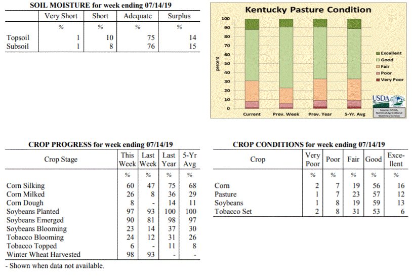 Kentucky Climate Summary
For the Period July 8, 2019 to July 14, 2019
Above Normal Temperatures and Below Normal Rainfall:
Conditions were drier across the area this period, while summer heat remained
entrenched across the area. High temperatures consistently reached into the upper
80s to lower 90s. Some even reaching the middle 90s across Western Kentucky.
Combined with dewpoints in the 70s, the livestock heat stress index remained elevated
in the danger to emergency categories. Most of the rainfall for the period fell
midweek with summer-time afternoon thunderstorms on Wednesday and followed by a cold
front pushing through the area on Thursday. Coverage remained isolated to scattered
with the state average for the week only coming in at 0.59 inches. Most of the
activity fell across Southwestern, South-Central, and Eastern Kentucky. North-
Central Kentucky and the Northern Bluegrass missed on most of the rain.
Temperatures for the period averaged 79 degrees across the state which was 2 degrees
warmer than normal and 2 degrees warmer than the previous period. High temperatures
averaged from 89 in the West to 87 in the East. Departure from normal high
temperatures ranged from near normal in the West to near normal in the East. Low
temperatures averaged from 70 degrees in the West to 68 degrees in the East.
Departure from normal low temperature ranged from 2 degrees warmer than normal in the
West to 5 degrees warmer than normal in the East. The extreme high temperature for
the period was 96 degrees at CAPE GIRARDEAU ASOS and the extreme low was 58 degrees
at CARROLLTON 2E.
Precipitation (liq. equ.) for the period totaled 0.59 inches statewide which was 0.4
inches below normal and 59% of normal. Precipitation totals by climate division, West
0.62 inches, Central 0.42 inches, Bluegrass 0.34 inches and East 1.00 inches, which
was 0.36, 0.58, 0.64 and 0.01 inches below normal. By station, precipitation totals
ranged from a low of 0.00 inches at BRANDENBURG 4SW to a high of 2.92 inches at
PADUCAH ASOS.
---
Kentucky Crop and Weather Report
Issued 4:00 P.M., July 8, 2019 17-19
Agricultural News: Kentucky experienced above normal temperatures and rainfall over
the past week. Precipitation for the week totaled 1.35 inches, 0.36 inches above
normal. Temperatures averaged 79 degrees for the week, 3 degrees above normal.
Topsoil moisture was rated 3 percent short, 78 percent adequate and 19 percent
surplus. Subsoil moisture was rated 3 percent short, 79 percent adequate, and 18
percent surplus. Days suitable for fieldwork averaged 4.4 out of a possible seven.
Primary activities this week included harvesting winter wheat, planting double crop
soybeans, setting tobacco, spraying crops, and clipping pastures. Low lying areas
continue to be impacted by excessive precipitation this season, including prevented
planting, drowned out crops, and damage to root systems. The average height of
emerged soybeans was 15 inches.
The excessive heat and humidity has started to stress some crops, pastures, and hay
fields. Farmers have been cutting hay, with some reports of over-maturity in the
first cutting due to wet weather and delays in harvesting.
Kentucky Climate Summary
For the Period July 8, 2019 to July 14, 2019
Above Normal Temperatures and Below Normal Rainfall:
Conditions were drier across the area this period, while summer heat remained
entrenched across the area. High temperatures consistently reached into the upper
80s to lower 90s. Some even reaching the middle 90s across Western Kentucky.
Combined with dewpoints in the 70s, the livestock heat stress index remained elevated
in the danger to emergency categories. Most of the rainfall for the period fell
midweek with summer-time afternoon thunderstorms on Wednesday and followed by a cold
front pushing through the area on Thursday. Coverage remained isolated to scattered
with the state average for the week only coming in at 0.59 inches. Most of the
activity fell across Southwestern, South-Central, and Eastern Kentucky. North-
Central Kentucky and the Northern Bluegrass missed on most of the rain.
Temperatures for the period averaged 79 degrees across the state which was 2 degrees
warmer than normal and 2 degrees warmer than the previous period. High temperatures
averaged from 89 in the West to 87 in the East. Departure from normal high
temperatures ranged from near normal in the West to near normal in the East. Low
temperatures averaged from 70 degrees in the West to 68 degrees in the East.
Departure from normal low temperature ranged from 2 degrees warmer than normal in the
West to 5 degrees warmer than normal in the East. The extreme high temperature for
the period was 96 degrees at CAPE GIRARDEAU ASOS and the extreme low was 58 degrees
at CARROLLTON 2E.
Precipitation (liq. equ.) for the period totaled 0.59 inches statewide which was 0.4
inches below normal and 59% of normal. Precipitation totals by climate division, West
0.62 inches, Central 0.42 inches, Bluegrass 0.34 inches and East 1.00 inches, which
was 0.36, 0.58, 0.64 and 0.01 inches below normal. By station, precipitation totals
ranged from a low of 0.00 inches at BRANDENBURG 4SW to a high of 2.92 inches at
PADUCAH ASOS.
---
Kentucky Crop and Weather Report
Issued 4:00 P.M., July 8, 2019 17-19
Agricultural News: Kentucky experienced above normal temperatures and rainfall over
the past week. Precipitation for the week totaled 1.35 inches, 0.36 inches above
normal. Temperatures averaged 79 degrees for the week, 3 degrees above normal.
Topsoil moisture was rated 3 percent short, 78 percent adequate and 19 percent
surplus. Subsoil moisture was rated 3 percent short, 79 percent adequate, and 18
percent surplus. Days suitable for fieldwork averaged 4.4 out of a possible seven.
Primary activities this week included harvesting winter wheat, planting double crop
soybeans, setting tobacco, spraying crops, and clipping pastures. Low lying areas
continue to be impacted by excessive precipitation this season, including prevented
planting, drowned out crops, and damage to root systems. The average height of
emerged soybeans was 15 inches.
The excessive heat and humidity has started to stress some crops, pastures, and hay
fields. Farmers have been cutting hay, with some reports of over-maturity in the
first cutting due to wet weather and delays in harvesting.
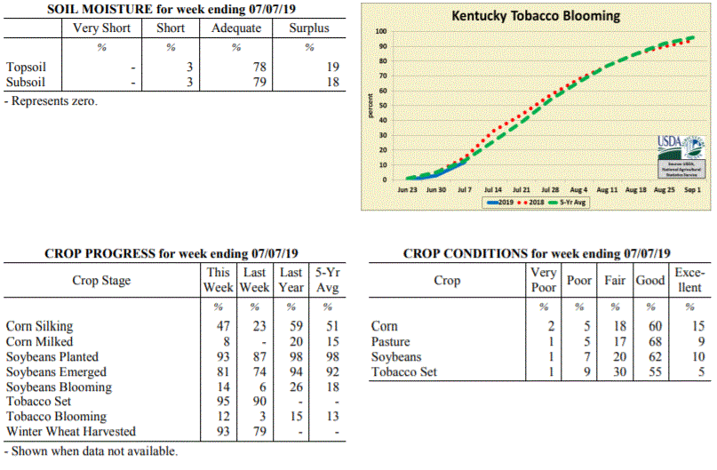 Kentucky Climate Summary
For the Period July 1, 2019 to July 7, 2019
Above Normal Temperatures and Rainfall:
The weather this past week followed a repetitive pattern. Each day started with
mostly to partly sunny skies, but by late morning to early afternoon, clouds were on
the increase. Peak heating brought diurnal rounds of scattered to numerous showers
and storms, mainly of the pulse variety and dissipating shortly after sunset. While
severe weather was minimal, a moist and very unstable air mass led to torrential
downpours, frequent lightning, and occasional gusty winds. Overall, the repetitive
pattern led to a state rainfall average of 1.35 inches for the week, over a third of
an inch above normal. As an extension to the last week of June, highs remained in
the middle 80s to low 90s throughout the week. High dew points pushed peak heat
indices into the middle 90s to around 100 at times and kept the livestock heat stress
index elevated in the danger category.
Temperatures for the period averaged 79 degrees across the state which was 3 degrees
warmer than normal and 2 degrees warmer than the previous period. High temperatures
averaged from 88 in the West to 86 in the East. Departure from normal high
temperatures ranged from 1 degree cooler than normal in the West to near
normal in the East. Low temperatures averaged from 71 degrees in the West to 67
degrees in the East. Departure from normal low temperature ranged from 4 degrees
warmer than normal in the West to 5 degrees warmer than normal in the East. The
extreme high temperature for the period was 96 degrees at PADUCAH ASOS and the
extreme low was 64 degrees at MT STERLING AWOS.
Precipitation (liq. equ.) for the period totaled 1.35 inches statewide which was 0.36
inches above normal and 136% of normal. Precipitation totals by climate division,
West 1.41 inches, Central 1.48 inches, Bluegrass 0.67 inches and East 1.83 inches,
which was 0.41, 0.49, -0.29 and 0.81 inches respectively from normal. By station,
precipitation totals ranged from a low of 0.00 inches at BURLINGTON 4S to a high of
5.00 inches at SOMERSET.
---
Kentucky Crop and Weather Report
Issued 4:00 P.M., July 1, 2019 16-19
Agricultural News: Kentucky experienced above normal temperatures and below normal
rainfall over the past week. Precipitation for the week totaled 0.81 inches, 0.18
inches below normal. Temperatures averaged 76 degrees for the week, 1 degree above
normal. Topsoil moisture was rated 2 percent short, 73 percent adequate and 25
percent surplus. Subsoil moisture was rated 2 percent short, 77 percent adequate, and
21 percent surplus. Days suitable for fieldwork averaged 4.0 out of a possible seven.
Primary activities this week included cutting hay, planting soybeans, harvesting hay,
and spraying fields. Drier conditions allowed for more fieldwork than previous weeks,
but the cumulative effects of persistent precipitation so far this season have led to
varying impacts. Damage reports included flooding in low lying areas, tobacco
scalding from hot and humid conditions, incidences of soybeans rotting before
emerging, and hay quality concerns due to over-maturity. The quality of harvested hay
was rated 60% in good to excellent condition.
The planting of double crop soybeans continues as significant progress was made in
harvesting winter wheat. The average height of emerged soybeans was 11 inches, compared
to 12 inches last year.
Kentucky Climate Summary
For the Period July 1, 2019 to July 7, 2019
Above Normal Temperatures and Rainfall:
The weather this past week followed a repetitive pattern. Each day started with
mostly to partly sunny skies, but by late morning to early afternoon, clouds were on
the increase. Peak heating brought diurnal rounds of scattered to numerous showers
and storms, mainly of the pulse variety and dissipating shortly after sunset. While
severe weather was minimal, a moist and very unstable air mass led to torrential
downpours, frequent lightning, and occasional gusty winds. Overall, the repetitive
pattern led to a state rainfall average of 1.35 inches for the week, over a third of
an inch above normal. As an extension to the last week of June, highs remained in
the middle 80s to low 90s throughout the week. High dew points pushed peak heat
indices into the middle 90s to around 100 at times and kept the livestock heat stress
index elevated in the danger category.
Temperatures for the period averaged 79 degrees across the state which was 3 degrees
warmer than normal and 2 degrees warmer than the previous period. High temperatures
averaged from 88 in the West to 86 in the East. Departure from normal high
temperatures ranged from 1 degree cooler than normal in the West to near
normal in the East. Low temperatures averaged from 71 degrees in the West to 67
degrees in the East. Departure from normal low temperature ranged from 4 degrees
warmer than normal in the West to 5 degrees warmer than normal in the East. The
extreme high temperature for the period was 96 degrees at PADUCAH ASOS and the
extreme low was 64 degrees at MT STERLING AWOS.
Precipitation (liq. equ.) for the period totaled 1.35 inches statewide which was 0.36
inches above normal and 136% of normal. Precipitation totals by climate division,
West 1.41 inches, Central 1.48 inches, Bluegrass 0.67 inches and East 1.83 inches,
which was 0.41, 0.49, -0.29 and 0.81 inches respectively from normal. By station,
precipitation totals ranged from a low of 0.00 inches at BURLINGTON 4S to a high of
5.00 inches at SOMERSET.
---
Kentucky Crop and Weather Report
Issued 4:00 P.M., July 1, 2019 16-19
Agricultural News: Kentucky experienced above normal temperatures and below normal
rainfall over the past week. Precipitation for the week totaled 0.81 inches, 0.18
inches below normal. Temperatures averaged 76 degrees for the week, 1 degree above
normal. Topsoil moisture was rated 2 percent short, 73 percent adequate and 25
percent surplus. Subsoil moisture was rated 2 percent short, 77 percent adequate, and
21 percent surplus. Days suitable for fieldwork averaged 4.0 out of a possible seven.
Primary activities this week included cutting hay, planting soybeans, harvesting hay,
and spraying fields. Drier conditions allowed for more fieldwork than previous weeks,
but the cumulative effects of persistent precipitation so far this season have led to
varying impacts. Damage reports included flooding in low lying areas, tobacco
scalding from hot and humid conditions, incidences of soybeans rotting before
emerging, and hay quality concerns due to over-maturity. The quality of harvested hay
was rated 60% in good to excellent condition.
The planting of double crop soybeans continues as significant progress was made in
harvesting winter wheat. The average height of emerged soybeans was 11 inches, compared
to 12 inches last year.
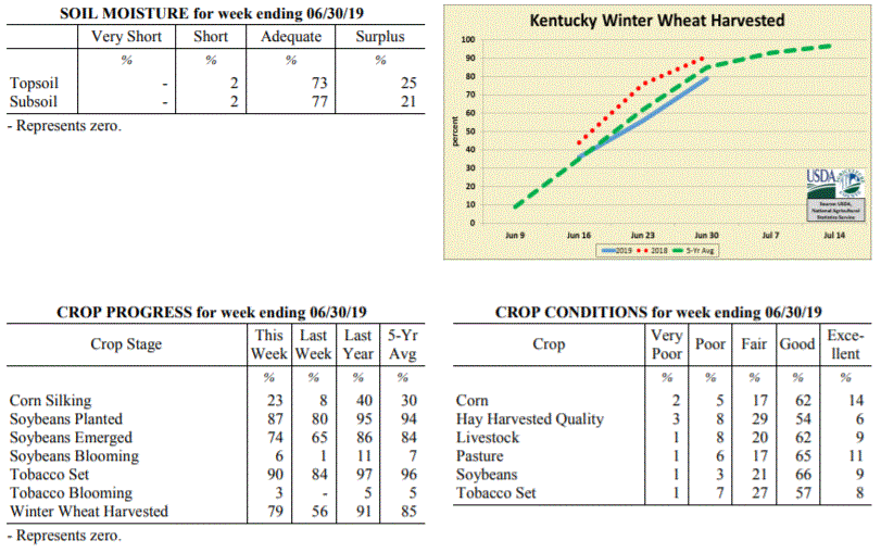 Kentucky Climate Summary
For the Period June 24, 2019 to June 30, 2019
Above Normal Temperatures and Below Normal Rainfall:
More summer-like conditions moved back into the area for the last week of June. Heat
really built into the state over the second half of the period with highs consistently
getting into the upper 80s to low 90s. Combined with higher humidity, the livestock
heat stress index jumped into the danger category each afternoon and evening.
Showers and storms were hit and miss for much of the week with only a few solid
chances of rainfall. The first came on Monday as a weak cold front produced
widespread showers and embedded storms. A second disturbance sparked scattered to
numerous activity across Western/Central Kentucky on Wednesday evening and then
Sunday, another round pushed south across the state. Overall, average total
accumulations were higher across Western Kentucky at 1.12 inches and lowest in the
Bluegrass Region with an average of 0.48. Data at the Ag Weather Center shows the
state averaged 7.70 inches for the month of June, which is over 3 inches above
normal.
Temperatures for the period averaged 76 degrees across the state which was 1 degree
warmer than normal and 2 degrees warmer than the previous period. High temperatures
averaged from 87 in the West to 87 in the East. Departure from normal high
temperatures ranged from 1 degree cooler than normal in the West to 2 degrees
warmer than normal in the East. Low temperatures averaged from 67 degrees in the
West to 65 degrees in the East. Departure from normal low temperature ranged from 1
degree warmer than normal in the West to 4 degrees warmer than normal in the East.
The extreme high temperature for the period was 95 degrees at PADUCAH ASOS and the
extreme low was 57 degrees at PAINTSVILLE 4W.
Precipitation (liq. equ.) for the period totaled 0.81 inches statewide which was 0.18
inches below normal and 82% of normal. Precipitation totals by climate division, West
1.12 inches, Central 0.94 inches, Bluegrass 0.48 inches and East 0.72 inches, which
was 0.14, -0.04, -0.49 and -0.31 inches respectively from normal. By station,
precipitation totals ranged from a low of 0.10 inches at PADUCAH ASOS to a high of
3.86 inches at FRANKLIN 4SW.
---
Kentucky Crop and Weather Report
Issued 4:00 P.M., June 24, 2019 15-19
Agricultural News: Kentucky experienced near normal temperatures and much above
normal rainfall over the past week. Precipitation for the week totaled 3.63 inches,
2.61 inches above normal. Temperatures averaged 74 degrees for the week, unchanged
from normal. Topsoil moisture was 1 percent short, 55 percent adequate, and 44
percent surplus. Subsoil moisture was rated 2 percent short, 62 percent adequate, and
36 percent surplus. Days suitable for fieldwork averaged 2.6 out of a possible seven.
Exceptionally wet conditions continue to plague the area. Dry weather has been hard
to find with daily rounds of showers and storms this past week. Overall, the state
averaged 3.63 inches for the period. Central Kentucky, in itself, even averaged 4.15,
marking the second time this month that this area has went over 4 inches. Kentucky
remained situated into a moist atmosphere for most of the week, which led to
torrential rainfall and localized flooding from time to time. Several lines of
storms pushed through the area, especially Friday and over the weekend. These lines
produced frequent lightning, damaging winds and even some tornadoes. Looking more at
the abundant rainfall, Kentucky typically averages 4.25 inches for the month of June.
Thus far, data at the Ag Weather Center shows the state has averaged 6.88 inches for
the month. This would place Kentucky in the top 10 wettest June�s of all time, but
still not close to the all-time record of 11.67 inches set in 1928.
Primary activities for this week included planting soybeans, tobacco setting, cutting
hay, and harvesting wheat. Yet another wet week has made it difficult for farmers to
complete fieldwork. The ground is saturated in most areas and concerns are beginning
to arise about the condition and outlook for crops already planted. Several reporters
noted standing water in low lying fields and wash out from the relentless
precipitation. The constant moisture could open the door for disease as well. Hay
harvest is running behind as farmers fear more rain moving in and some hay fields are
of poor quality. The average height of soybeans is 4 inches at this juncture.
Eighty four percent of the tobacco crop is in the ground, behind both last year and
the five year average. The crop is in mostly good condition with an average height of
13 inches. Although pastures and hay are in mostly good to fair condition, the
ongoing rain may begin to take a toll.
Kentucky Climate Summary
For the Period June 24, 2019 to June 30, 2019
Above Normal Temperatures and Below Normal Rainfall:
More summer-like conditions moved back into the area for the last week of June. Heat
really built into the state over the second half of the period with highs consistently
getting into the upper 80s to low 90s. Combined with higher humidity, the livestock
heat stress index jumped into the danger category each afternoon and evening.
Showers and storms were hit and miss for much of the week with only a few solid
chances of rainfall. The first came on Monday as a weak cold front produced
widespread showers and embedded storms. A second disturbance sparked scattered to
numerous activity across Western/Central Kentucky on Wednesday evening and then
Sunday, another round pushed south across the state. Overall, average total
accumulations were higher across Western Kentucky at 1.12 inches and lowest in the
Bluegrass Region with an average of 0.48. Data at the Ag Weather Center shows the
state averaged 7.70 inches for the month of June, which is over 3 inches above
normal.
Temperatures for the period averaged 76 degrees across the state which was 1 degree
warmer than normal and 2 degrees warmer than the previous period. High temperatures
averaged from 87 in the West to 87 in the East. Departure from normal high
temperatures ranged from 1 degree cooler than normal in the West to 2 degrees
warmer than normal in the East. Low temperatures averaged from 67 degrees in the
West to 65 degrees in the East. Departure from normal low temperature ranged from 1
degree warmer than normal in the West to 4 degrees warmer than normal in the East.
The extreme high temperature for the period was 95 degrees at PADUCAH ASOS and the
extreme low was 57 degrees at PAINTSVILLE 4W.
Precipitation (liq. equ.) for the period totaled 0.81 inches statewide which was 0.18
inches below normal and 82% of normal. Precipitation totals by climate division, West
1.12 inches, Central 0.94 inches, Bluegrass 0.48 inches and East 0.72 inches, which
was 0.14, -0.04, -0.49 and -0.31 inches respectively from normal. By station,
precipitation totals ranged from a low of 0.10 inches at PADUCAH ASOS to a high of
3.86 inches at FRANKLIN 4SW.
---
Kentucky Crop and Weather Report
Issued 4:00 P.M., June 24, 2019 15-19
Agricultural News: Kentucky experienced near normal temperatures and much above
normal rainfall over the past week. Precipitation for the week totaled 3.63 inches,
2.61 inches above normal. Temperatures averaged 74 degrees for the week, unchanged
from normal. Topsoil moisture was 1 percent short, 55 percent adequate, and 44
percent surplus. Subsoil moisture was rated 2 percent short, 62 percent adequate, and
36 percent surplus. Days suitable for fieldwork averaged 2.6 out of a possible seven.
Exceptionally wet conditions continue to plague the area. Dry weather has been hard
to find with daily rounds of showers and storms this past week. Overall, the state
averaged 3.63 inches for the period. Central Kentucky, in itself, even averaged 4.15,
marking the second time this month that this area has went over 4 inches. Kentucky
remained situated into a moist atmosphere for most of the week, which led to
torrential rainfall and localized flooding from time to time. Several lines of
storms pushed through the area, especially Friday and over the weekend. These lines
produced frequent lightning, damaging winds and even some tornadoes. Looking more at
the abundant rainfall, Kentucky typically averages 4.25 inches for the month of June.
Thus far, data at the Ag Weather Center shows the state has averaged 6.88 inches for
the month. This would place Kentucky in the top 10 wettest June�s of all time, but
still not close to the all-time record of 11.67 inches set in 1928.
Primary activities for this week included planting soybeans, tobacco setting, cutting
hay, and harvesting wheat. Yet another wet week has made it difficult for farmers to
complete fieldwork. The ground is saturated in most areas and concerns are beginning
to arise about the condition and outlook for crops already planted. Several reporters
noted standing water in low lying fields and wash out from the relentless
precipitation. The constant moisture could open the door for disease as well. Hay
harvest is running behind as farmers fear more rain moving in and some hay fields are
of poor quality. The average height of soybeans is 4 inches at this juncture.
Eighty four percent of the tobacco crop is in the ground, behind both last year and
the five year average. The crop is in mostly good condition with an average height of
13 inches. Although pastures and hay are in mostly good to fair condition, the
ongoing rain may begin to take a toll.
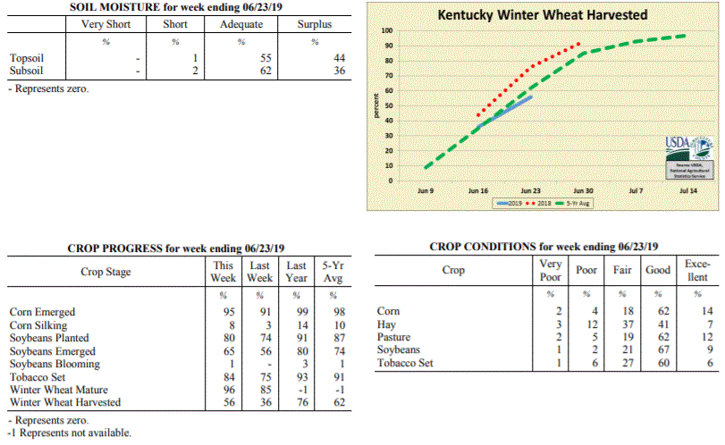 Kentucky Climate Summary
For the Period June 17, 2019 to June 23, 2019
Near Normal Temperatures and Much Above Normal Rainfall:
Exceptionally wet conditions continue to plague the area. Dry weather has been hard
to find with daily rounds of showers and storms this past week. Overall, the state
averaged 3.63 inches for the period. Central Kentucky, in itself, even averaged 4.15,
marking the second time this month that this area has went over 4 inches. Kentucky
remained situated into a moist atmosphere for most of the week, which led to
torrential rainfall and localized flooding from time to time. Several lines of
storms pushed through the area, especially Friday and over the weekend. These lines
produced frequent lightning, damaging winds and even some tornadoes. Looking more at
the abundant rainfall, Kentucky typically averages 4.25 inches for the month of June.
Thus far, data at the Ag Weather Center shows the state has averaged 6.88 inches for
the month. This would place Kentucky in the top 10 wettest June�s of all time, but
still not close to the all-time record of 11.67 inches set in 1928.
Temperatures for the period averaged 74 degrees across the state which was near
normal and 6 degrees warmer than the previous period. High temperatures
averaged from 84 in the West to 80 in the East. Departure from normal high
temperatures ranged from 3 degrees cooler than normal in the West to 4 degrees
cooler than normal in the East. Low temperatures averaged from 68 degrees in the
West to 65 degrees in the East. Departure from normal low temperature ranged from 4
degrees warmer than normal in the West to 5 degrees warmer than normal in the East.
The extreme high temperature for the period was 91 degrees at CAPE GIRARDEAU ASOS and
the extreme low was 57 degrees at CAMPBELLSVILLE 7W.
Precipitation (liq. equ.) for the period totaled 3.63 inches statewide which was 2.61
inches above normal and 357% of normal. Precipitation totals by climate division,
West 3.34 inches, Central 4.15 inches, Bluegrass 3.71 inches and East 3.33 inches,
which was 2.33, 3.14, 2.69 and 2.3 inches above normal. By station, precipitation
totals ranged from a low of 1.57 inches at BIG SANDY to a high of 6.58 inches at LONDON.
---
Kentucky Crop and Weather Report
Issued 4:00 P.M., June 17, 2019 14-19
Agricultural News: Kentucky experienced below normal temperatures and rainfall over
the past week. Precipitation for the week totaled 0.64 inches, 0.38 inches below
normal. Temperatures averaged 68 degrees for the week, 4 degrees below normal.
Topsoil moisture was rated 3 percent short, 74 percent adequate, and 23 percent
surplus. Subsoil moisture was rated 5 percent short, 78 percent adequate, and 17
percent surplus. Days suitable for fieldwork averaged 4.4 out of a possible seven.
Primary activities for this week included planting soybeans, tobacco setting, cutting
hay, harvesting wheat, and planting any remaining corn. Rain was scattered across the
state as some producers experienced weather conducive to fieldwork while others
continue to battle persistent rain. Showers were heavy in some regions causing
concern for planted crops as well as delaying the planting of others. There were
multiple reports of standing water in fields and visible crop stress due to excessive
precipitation. Many farmers have not been able to harvest hay after a very wet winter
that led to a shortage.
Tobacco setting remains behind last year and the five year average with 75 percent in
the ground. The average height of tobacco plants was 10 inches, same as last year and
just ahead of the five year average. Pasture condition remains in mostly
good condition despite the continued rain.
Kentucky Climate Summary
For the Period June 17, 2019 to June 23, 2019
Near Normal Temperatures and Much Above Normal Rainfall:
Exceptionally wet conditions continue to plague the area. Dry weather has been hard
to find with daily rounds of showers and storms this past week. Overall, the state
averaged 3.63 inches for the period. Central Kentucky, in itself, even averaged 4.15,
marking the second time this month that this area has went over 4 inches. Kentucky
remained situated into a moist atmosphere for most of the week, which led to
torrential rainfall and localized flooding from time to time. Several lines of
storms pushed through the area, especially Friday and over the weekend. These lines
produced frequent lightning, damaging winds and even some tornadoes. Looking more at
the abundant rainfall, Kentucky typically averages 4.25 inches for the month of June.
Thus far, data at the Ag Weather Center shows the state has averaged 6.88 inches for
the month. This would place Kentucky in the top 10 wettest June�s of all time, but
still not close to the all-time record of 11.67 inches set in 1928.
Temperatures for the period averaged 74 degrees across the state which was near
normal and 6 degrees warmer than the previous period. High temperatures
averaged from 84 in the West to 80 in the East. Departure from normal high
temperatures ranged from 3 degrees cooler than normal in the West to 4 degrees
cooler than normal in the East. Low temperatures averaged from 68 degrees in the
West to 65 degrees in the East. Departure from normal low temperature ranged from 4
degrees warmer than normal in the West to 5 degrees warmer than normal in the East.
The extreme high temperature for the period was 91 degrees at CAPE GIRARDEAU ASOS and
the extreme low was 57 degrees at CAMPBELLSVILLE 7W.
Precipitation (liq. equ.) for the period totaled 3.63 inches statewide which was 2.61
inches above normal and 357% of normal. Precipitation totals by climate division,
West 3.34 inches, Central 4.15 inches, Bluegrass 3.71 inches and East 3.33 inches,
which was 2.33, 3.14, 2.69 and 2.3 inches above normal. By station, precipitation
totals ranged from a low of 1.57 inches at BIG SANDY to a high of 6.58 inches at LONDON.
---
Kentucky Crop and Weather Report
Issued 4:00 P.M., June 17, 2019 14-19
Agricultural News: Kentucky experienced below normal temperatures and rainfall over
the past week. Precipitation for the week totaled 0.64 inches, 0.38 inches below
normal. Temperatures averaged 68 degrees for the week, 4 degrees below normal.
Topsoil moisture was rated 3 percent short, 74 percent adequate, and 23 percent
surplus. Subsoil moisture was rated 5 percent short, 78 percent adequate, and 17
percent surplus. Days suitable for fieldwork averaged 4.4 out of a possible seven.
Primary activities for this week included planting soybeans, tobacco setting, cutting
hay, harvesting wheat, and planting any remaining corn. Rain was scattered across the
state as some producers experienced weather conducive to fieldwork while others
continue to battle persistent rain. Showers were heavy in some regions causing
concern for planted crops as well as delaying the planting of others. There were
multiple reports of standing water in fields and visible crop stress due to excessive
precipitation. Many farmers have not been able to harvest hay after a very wet winter
that led to a shortage.
Tobacco setting remains behind last year and the five year average with 75 percent in
the ground. The average height of tobacco plants was 10 inches, same as last year and
just ahead of the five year average. Pasture condition remains in mostly
good condition despite the continued rain.
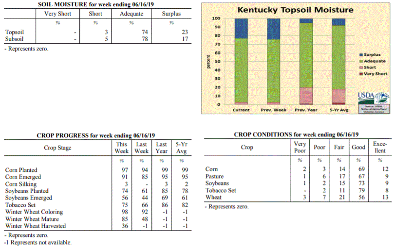 Kentucky Climate Summary
For the Period June 10, 2019 to June 16, 2019
Below Normal Temperatures and Rainfall:
Kentucky average rainfall was below normal for the week, but that does not tell the
whole story. Western and Central Kentucky each averaged under a quarter inch for the
week, well below normal. Accumulations increased farther east and especially north.
The Bluegrass area averaged 1.53 inches behind multiple rounds of rainfall, mainly
Wednesday and Sunday afternoons/evenings. Temperature-wise, it was a cooler week
overall for the Bluegrass State with the weekly state average coming in below normal
for this first time since March. The coolest period came Friday morning as clear
skies and calm winds sent lows into the middle to upper 40s!
Temperatures for the period averaged 68 degrees across the state which was 4 degrees
cooler than normal and 4 degrees cooler than the previous period. High temperatures
averaged from 80 in the West to 76 in the East. Departure from normal high
temperatures ranged from 5 degrees cooler than normal in the West to 7 degrees
cooler than normal in the East. Low temperatures averaged from 60 degrees in the
West to 57 degrees in the East. Departure from normal low temperature ranged from 3
degrees cooler than normal in the West to 1 degree cooler than normal in the East.
The extreme high temperature for the period was 91 degrees at BOWLING GREEN APT and
the extreme low was 43 degrees at CAMPBELLSVILLE 7W.
Precipitation (liq. equ.) for the period totaled 0.64 inches statewide which was 0.38
inches below normal and 63% of normal. Precipitation totals by climate division, West
0.18 inches, Central 0.24 inches, Bluegrass 1.53 inches and East 0.61 inches, which
was -0.79, -0.79, 0.49 and -0.43 inches respectively from normal. By station,
precipitation totals ranged from a low of 0.00 inches at BENTON 4N to a high of 3.58
inches at CINCINNATI.
---
Kentucky Crop and Weather Report
Issued 4:00 P.M., June 10, 2019 13-19
Agricultural News: Kentucky experienced above normal temperatures and much above
normal rainfall over the past week. Precipitation for the week totaled 2.57 inches,
1.49 inches above normal. Temperatures averaged 72 degrees for the week, 2 degrees
above normal. Topsoil moisture was rated 3 percent short, 73 percent adequate, and 24
percent surplus. Subsoil moisture was rated 4 percent short, 78 percent adequate, and
18 percent surplus. Days suitable for fieldwork averaged 3.9 out of a possible seven.
Primary activities for this week included planting corn and soybeans, tobacco
setting, and cutting hay when weather allowed. Farmers continue to battle persistent
rain when attempting to complete fieldwork. There were a few days of dry weather
which allowed progress, however rain moved in towards the end of the week. Rain was
heavy at times causing standing water in some fields. Corn and soybeans remain behind
both last year and the five year average at this juncture in the season. Several
producers have expressed growing concern over crop production due to the continuous
rain. The average height of corn was 21 inches, compared to 12 inches last week.
Sixty six percent of the tobacco crop is in the ground, behind both last year and the
five year average. The average height of tobacco plants was 6 inches. Although
pasture condition was reported as mostly good, the rain has caused some damage due
to mud and weed overgrowth.
Kentucky Climate Summary
For the Period June 10, 2019 to June 16, 2019
Below Normal Temperatures and Rainfall:
Kentucky average rainfall was below normal for the week, but that does not tell the
whole story. Western and Central Kentucky each averaged under a quarter inch for the
week, well below normal. Accumulations increased farther east and especially north.
The Bluegrass area averaged 1.53 inches behind multiple rounds of rainfall, mainly
Wednesday and Sunday afternoons/evenings. Temperature-wise, it was a cooler week
overall for the Bluegrass State with the weekly state average coming in below normal
for this first time since March. The coolest period came Friday morning as clear
skies and calm winds sent lows into the middle to upper 40s!
Temperatures for the period averaged 68 degrees across the state which was 4 degrees
cooler than normal and 4 degrees cooler than the previous period. High temperatures
averaged from 80 in the West to 76 in the East. Departure from normal high
temperatures ranged from 5 degrees cooler than normal in the West to 7 degrees
cooler than normal in the East. Low temperatures averaged from 60 degrees in the
West to 57 degrees in the East. Departure from normal low temperature ranged from 3
degrees cooler than normal in the West to 1 degree cooler than normal in the East.
The extreme high temperature for the period was 91 degrees at BOWLING GREEN APT and
the extreme low was 43 degrees at CAMPBELLSVILLE 7W.
Precipitation (liq. equ.) for the period totaled 0.64 inches statewide which was 0.38
inches below normal and 63% of normal. Precipitation totals by climate division, West
0.18 inches, Central 0.24 inches, Bluegrass 1.53 inches and East 0.61 inches, which
was -0.79, -0.79, 0.49 and -0.43 inches respectively from normal. By station,
precipitation totals ranged from a low of 0.00 inches at BENTON 4N to a high of 3.58
inches at CINCINNATI.
---
Kentucky Crop and Weather Report
Issued 4:00 P.M., June 10, 2019 13-19
Agricultural News: Kentucky experienced above normal temperatures and much above
normal rainfall over the past week. Precipitation for the week totaled 2.57 inches,
1.49 inches above normal. Temperatures averaged 72 degrees for the week, 2 degrees
above normal. Topsoil moisture was rated 3 percent short, 73 percent adequate, and 24
percent surplus. Subsoil moisture was rated 4 percent short, 78 percent adequate, and
18 percent surplus. Days suitable for fieldwork averaged 3.9 out of a possible seven.
Primary activities for this week included planting corn and soybeans, tobacco
setting, and cutting hay when weather allowed. Farmers continue to battle persistent
rain when attempting to complete fieldwork. There were a few days of dry weather
which allowed progress, however rain moved in towards the end of the week. Rain was
heavy at times causing standing water in some fields. Corn and soybeans remain behind
both last year and the five year average at this juncture in the season. Several
producers have expressed growing concern over crop production due to the continuous
rain. The average height of corn was 21 inches, compared to 12 inches last week.
Sixty six percent of the tobacco crop is in the ground, behind both last year and the
five year average. The average height of tobacco plants was 6 inches. Although
pasture condition was reported as mostly good, the rain has caused some damage due
to mud and weed overgrowth.
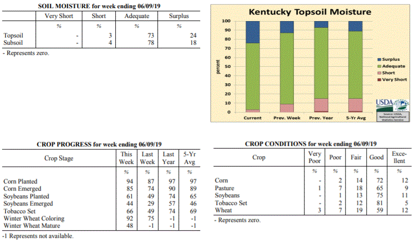 Kentucky Climate Summary
For the Period June 3, 2019 to June 9, 2019
Above Normal Temperatures and Much Above Normal Rainfall:
A very active pattern with daily bouts of rainfall between Wednesday and Sunday led
to an exceptionally wet week for the Commonwealth. Much of the activity fell across
Central Kentucky and areas to the east, scattered to numerous in coverage most of the
time. Thunderstorms tended to be slow-movers during the period and with a combination of
torrential rainfall and saturated ground, localized flooding was a possibility.
Central Kentucky, in itself, averaged 4.14 inches for the week. A handful of
locations were more than five inches. Putting this into perspective, Kentucky
averages 4.25 inches for the entire month of June. Western Kentucky saw the least,
but still came in at 1.55 inches. After portions of the state were starting to get
dry in May, the state has now went two straight weeks with above normal rainfall.
Temperatures for the period averaged 72 degrees across the state which was 2 degrees
warmer than normal and no change to the previous period. High temperatures averaged
from 82 in the West to 79 in the East. Departure from normal high temperatures
ranged from 2 degrees cooler than normal in the West to 3 degrees cooler than normal
in the East. Low temperatures averaged from 66 degrees in the West to 62 degrees in
the East. Departure from normal low temperature ranged from 5 degrees warmer than
normal in the West to 5 degrees warmer than normal in the East. The extreme high
temperature for the period was 94 degrees at FRANKLIN 4SW and the extreme low was 45
degrees at CYNTHIANA 8N.
Precipitation (liq. equ.) for the period totaled 2.57 inches statewide which was 1.49
inches above normal and 239% of normal. Precipitation totals by climate division,
West 1.55 inches, Central 4.14 inches, Bluegrass 1.97 inches and East 2.61 inches,
which was 0.51, 3.05, 0.87 and 1.53 inches above normal. By station, precipitation
totals ranged from a low of 0.23 inches at PRINCETON 2SE to a high of 6.72 inches at
GLASGOW 11W.
---
Kentucky Crop and Weather Report
Issued 4:00 P.M., June 3, 2019 12-19
Agricultural News: Kentucky experienced above normal temperatures and rainfall over
the past week. Precipitation for the week totaled 1.18 inches, 0.06 inches above
normal. Temperatures averaged 73 degrees for the week, 4 degrees above normal.
Topsoil moisture was rated 9 percent short, 78 percent adequate, and 13 percent
surplus. Subsoil moisture was rated 8 percent short, 83 percent adequate, and 9
percent surplus. Days suitable for fieldwork averaged 4.4 out of a possible seven.
Primary activities for this week included planting corn and soybeans, tobacco
setting, and cutting hay when weather permitted. Fieldwork was interrupted at times
by heavy rain, which in some cases led to standing water in low lying areas. Despite
the adverse conditions, farmers were able to make planting progress. Tobacco, corn,
and soybeans are all behind both last year and the five year average at this point in
the season. The average height of corn was 12 inches, compared to 9 inches last week.
Pastures remain in mostly good condition at this time. Farmers have had difficulty
finding a window to cut hay due to the persistent precipitation.
Kentucky Climate Summary
For the Period June 3, 2019 to June 9, 2019
Above Normal Temperatures and Much Above Normal Rainfall:
A very active pattern with daily bouts of rainfall between Wednesday and Sunday led
to an exceptionally wet week for the Commonwealth. Much of the activity fell across
Central Kentucky and areas to the east, scattered to numerous in coverage most of the
time. Thunderstorms tended to be slow-movers during the period and with a combination of
torrential rainfall and saturated ground, localized flooding was a possibility.
Central Kentucky, in itself, averaged 4.14 inches for the week. A handful of
locations were more than five inches. Putting this into perspective, Kentucky
averages 4.25 inches for the entire month of June. Western Kentucky saw the least,
but still came in at 1.55 inches. After portions of the state were starting to get
dry in May, the state has now went two straight weeks with above normal rainfall.
Temperatures for the period averaged 72 degrees across the state which was 2 degrees
warmer than normal and no change to the previous period. High temperatures averaged
from 82 in the West to 79 in the East. Departure from normal high temperatures
ranged from 2 degrees cooler than normal in the West to 3 degrees cooler than normal
in the East. Low temperatures averaged from 66 degrees in the West to 62 degrees in
the East. Departure from normal low temperature ranged from 5 degrees warmer than
normal in the West to 5 degrees warmer than normal in the East. The extreme high
temperature for the period was 94 degrees at FRANKLIN 4SW and the extreme low was 45
degrees at CYNTHIANA 8N.
Precipitation (liq. equ.) for the period totaled 2.57 inches statewide which was 1.49
inches above normal and 239% of normal. Precipitation totals by climate division,
West 1.55 inches, Central 4.14 inches, Bluegrass 1.97 inches and East 2.61 inches,
which was 0.51, 3.05, 0.87 and 1.53 inches above normal. By station, precipitation
totals ranged from a low of 0.23 inches at PRINCETON 2SE to a high of 6.72 inches at
GLASGOW 11W.
---
Kentucky Crop and Weather Report
Issued 4:00 P.M., June 3, 2019 12-19
Agricultural News: Kentucky experienced above normal temperatures and rainfall over
the past week. Precipitation for the week totaled 1.18 inches, 0.06 inches above
normal. Temperatures averaged 73 degrees for the week, 4 degrees above normal.
Topsoil moisture was rated 9 percent short, 78 percent adequate, and 13 percent
surplus. Subsoil moisture was rated 8 percent short, 83 percent adequate, and 9
percent surplus. Days suitable for fieldwork averaged 4.4 out of a possible seven.
Primary activities for this week included planting corn and soybeans, tobacco
setting, and cutting hay when weather permitted. Fieldwork was interrupted at times
by heavy rain, which in some cases led to standing water in low lying areas. Despite
the adverse conditions, farmers were able to make planting progress. Tobacco, corn,
and soybeans are all behind both last year and the five year average at this point in
the season. The average height of corn was 12 inches, compared to 9 inches last week.
Pastures remain in mostly good condition at this time. Farmers have had difficulty
finding a window to cut hay due to the persistent precipitation.
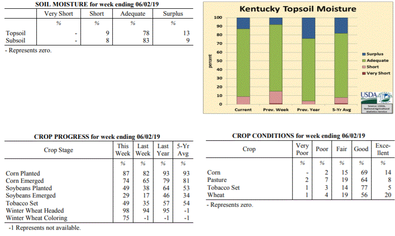 Kentucky Climate Summary
For the Period May 27, 2019 to June 2, 2019
Above Normal Temperatures and Rainfall:
Kentucky broke a three-week streak of below normal rainfall as the state averaged
1.18 inches for the period. While conditions were mostly dry on Memorial Day and
Tuesday, rain coverage increased over the second half of the workweek. A combination
of surface boundaries and unstable atmosphere sparked showers and storms on a daily
basis with some storms becoming strong to severe at times. While the state averaged
1.18 inches, that number increased to 1.76 across Western Kentucky. Some saw 3+ inches.
The rain came as some areas of the state were starting to get fairly dry. The US Drought
Monitor even introduced �Abnormally Dry� conditions to portions of Central and Eastern
Kentucky with the latest update on May 30th.
Temperatures for the period averaged 73 degrees across the state which was 4 degrees
warmer than normal and 2 degrees cooler than the previous period. High temperatures
averaged from 83 in the West to 82 in the East. Departure from normal high
temperatures ranged from 1 degree warmer than normal in the West to 2 degrees
warmer than normal in the East. Low temperatures averaged from 66 degrees in the
West to 63 degrees in the East. Departure from normal low temperature ranged from 7
degrees warmer than normal in the West to 8 degrees warmer than normal in the East.
The extreme high temperature for the period was 91 degrees at BOWLING GREEN APT and
the extreme low was 53 degrees at HINDMAN 5N.
Precipitation (liq. equ.) for the period totaled 1.18 inches statewide which was 0.06
inches above normal and 105% of normal. Precipitation totals by climate division,
West 1.76 inches, Central 0.88 inches, Bluegrass 1.11 inches and East 0.97 inches,
which was 0.66, -0.28, 0.02 and -0.16 inches respectively from normal. By station,
precipitation totals ranged from a low of 0.12 inches at MIDDLESBORO AWOS to a high
of 3.56 inches at BENTON 4N.
---
Kentucky Crop and Weather Report
Issued 4:00 P.M., May 28, 2019 11-19
Agricultural News: Kentucky experienced well above normal temperatures and below
normal rainfall over the past week. Precipitation for the week totaled 0.61 inches,
0.50 inches below normal. Temperatures averaged 74 degrees for the week, 8 degrees
above normal. Topsoil moisture was rated 1 percent very short, 14 percent short, 77
percent adequate and 8 percent surplus. Subsoil moisture was rated 1 percent very
short, 10 percent short, 82 percent adequate, and 7 percent surplus. Days suitable
for fieldwork averaged 5.6 out of a possible seven.
Primary activities this week included planting corn and soybeans, setting tobacco,
and cutting hay. Some producers reported quality concerns in the first cutting of
hay, noting that recent humidity led to hay not drying well. Hay and roughage
supplies were reported as 12 percent very short, 26 percent short, 58 percent
adequate, and 4 percent surplus.
Limited rainfall allowed for more fieldwork to take place, but along with higher
temperatures this contributed to fields drying out. The average height of emerged
corn was 9 inches, consistent with the previous year.
Kentucky Climate Summary
For the Period May 27, 2019 to June 2, 2019
Above Normal Temperatures and Rainfall:
Kentucky broke a three-week streak of below normal rainfall as the state averaged
1.18 inches for the period. While conditions were mostly dry on Memorial Day and
Tuesday, rain coverage increased over the second half of the workweek. A combination
of surface boundaries and unstable atmosphere sparked showers and storms on a daily
basis with some storms becoming strong to severe at times. While the state averaged
1.18 inches, that number increased to 1.76 across Western Kentucky. Some saw 3+ inches.
The rain came as some areas of the state were starting to get fairly dry. The US Drought
Monitor even introduced �Abnormally Dry� conditions to portions of Central and Eastern
Kentucky with the latest update on May 30th.
Temperatures for the period averaged 73 degrees across the state which was 4 degrees
warmer than normal and 2 degrees cooler than the previous period. High temperatures
averaged from 83 in the West to 82 in the East. Departure from normal high
temperatures ranged from 1 degree warmer than normal in the West to 2 degrees
warmer than normal in the East. Low temperatures averaged from 66 degrees in the
West to 63 degrees in the East. Departure from normal low temperature ranged from 7
degrees warmer than normal in the West to 8 degrees warmer than normal in the East.
The extreme high temperature for the period was 91 degrees at BOWLING GREEN APT and
the extreme low was 53 degrees at HINDMAN 5N.
Precipitation (liq. equ.) for the period totaled 1.18 inches statewide which was 0.06
inches above normal and 105% of normal. Precipitation totals by climate division,
West 1.76 inches, Central 0.88 inches, Bluegrass 1.11 inches and East 0.97 inches,
which was 0.66, -0.28, 0.02 and -0.16 inches respectively from normal. By station,
precipitation totals ranged from a low of 0.12 inches at MIDDLESBORO AWOS to a high
of 3.56 inches at BENTON 4N.
---
Kentucky Crop and Weather Report
Issued 4:00 P.M., May 28, 2019 11-19
Agricultural News: Kentucky experienced well above normal temperatures and below
normal rainfall over the past week. Precipitation for the week totaled 0.61 inches,
0.50 inches below normal. Temperatures averaged 74 degrees for the week, 8 degrees
above normal. Topsoil moisture was rated 1 percent very short, 14 percent short, 77
percent adequate and 8 percent surplus. Subsoil moisture was rated 1 percent very
short, 10 percent short, 82 percent adequate, and 7 percent surplus. Days suitable
for fieldwork averaged 5.6 out of a possible seven.
Primary activities this week included planting corn and soybeans, setting tobacco,
and cutting hay. Some producers reported quality concerns in the first cutting of
hay, noting that recent humidity led to hay not drying well. Hay and roughage
supplies were reported as 12 percent very short, 26 percent short, 58 percent
adequate, and 4 percent surplus.
Limited rainfall allowed for more fieldwork to take place, but along with higher
temperatures this contributed to fields drying out. The average height of emerged
corn was 9 inches, consistent with the previous year.
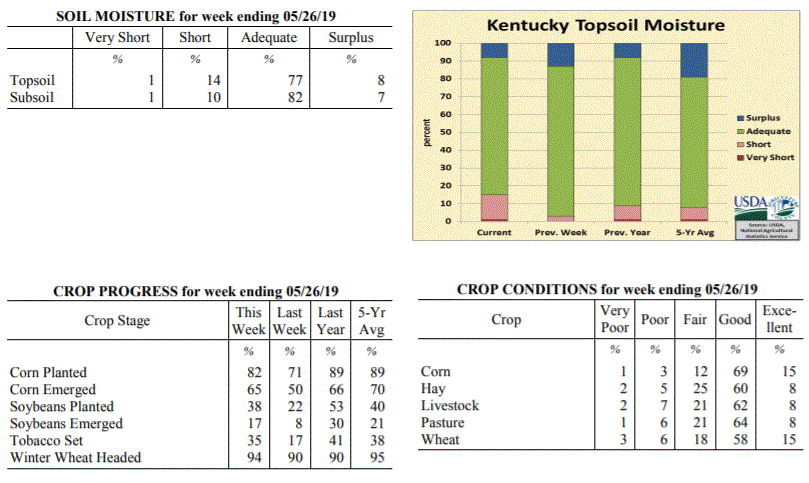 Kentucky Climate Summary
For the Period May 20, 2019 to May 26, 2019
Well Above Normal Temperatures and Below Normal Rainfall:
Kentucky has now went three straight weeks with below normal rainfall. The state
only averaged 0.61 inches for the week with higher totals across the Purchase area,
North Central Kentucky, and the Bluegrass. Totals diminished across Southern and
Southeastern Kentucky. The brunt of the activity came on Sunday as a disturbance
sparked scattered to numerous storms across primarily the northern half of Kentucky.
Storms were capable of heavy rain, frequent lightning, and some gusty winds.
Otherwise, the rest of the week featured hit-or-miss activity with most of the state
staying dry. Looking at temperatures, summer-like heat returned over the second half
of the week with highs jumping into the upper 80s to low 90s. This marked the ninth
straight week of near to above normal temperatures for the Bluegrass State.
Temperatures for the period averaged 74 degrees across the state which was 8 degrees
warmer than normal and 8 degrees warmer than the previous period. High temperatures
averaged from 86 in the West to 85 in the East. Departure from normal high
temperatures ranged from 6 degrees warmer than normal in the West to 7 degrees warmer
than normal in the East. Low temperatures averaged from 66 degrees in the West to 62
degrees in the East. Departure from normal low temperature ranged from 9 degrees
warmer than normal in the West to 10 degrees warmer than normal in the East. The
extreme high temperature for the period was 93 degrees at BURKESVILLE 3W and the
extreme low was 48 degrees at ALEXANDRIA 5NW.
Precipitation (liq. equ.) for the period totaled 0.61 inches statewide which was 0.5
inches below normal and 55% of normal. Precipitation totals by climate division, West
0.69 inches, Central 0.58 inches, Bluegrass 0.98 inches and East 0.20 inches, which
was 0.41, 0.57, 0.09 and 0.92 inches below normal. By station, precipitation totals
ranged from a low of 0.00 inches at BARBOURVILLE 3E to a high of 3.13 inches at
POPLAR BLUFF ASOS.
---
Kentucky Crop and Weather Report
Issued 4:00 P.M., May 20, 2019 10-19
Agricultural News: Kentucky experienced near normal temperatures and below normal
rainfall over the past week. Precipitation for the week totaled 0.40 inches, 0.73
inches below normal. Temperatures averaged 65 degrees for the week, near normal.
Topsoil moisture was rated 3 percent short, 84 percent adequate and 13 percent
surplus. Subsoil moisture was rated 2 percent short, 86 percent adequate, and 12
percent surplus. Days suitable for fieldwork averaged 4.9 out of a possible seven.
Primary activities this week included planting corn and soybeans, transplanting
tobacco, cutting hay, and spraying wheat. With continued dry weather, planting
progress is expected to pick up. Producers began sidedressing corn with nitrogen.
Some replanting of corn has occurred in fields where water had pooled. Spring
breeding of cattle is underway. Tobacco transplant supplies were reported as 1
percent very short, 3 percent short, 92 percent adequate, and 4 percent surplus.
Kentucky Climate Summary
For the Period May 20, 2019 to May 26, 2019
Well Above Normal Temperatures and Below Normal Rainfall:
Kentucky has now went three straight weeks with below normal rainfall. The state
only averaged 0.61 inches for the week with higher totals across the Purchase area,
North Central Kentucky, and the Bluegrass. Totals diminished across Southern and
Southeastern Kentucky. The brunt of the activity came on Sunday as a disturbance
sparked scattered to numerous storms across primarily the northern half of Kentucky.
Storms were capable of heavy rain, frequent lightning, and some gusty winds.
Otherwise, the rest of the week featured hit-or-miss activity with most of the state
staying dry. Looking at temperatures, summer-like heat returned over the second half
of the week with highs jumping into the upper 80s to low 90s. This marked the ninth
straight week of near to above normal temperatures for the Bluegrass State.
Temperatures for the period averaged 74 degrees across the state which was 8 degrees
warmer than normal and 8 degrees warmer than the previous period. High temperatures
averaged from 86 in the West to 85 in the East. Departure from normal high
temperatures ranged from 6 degrees warmer than normal in the West to 7 degrees warmer
than normal in the East. Low temperatures averaged from 66 degrees in the West to 62
degrees in the East. Departure from normal low temperature ranged from 9 degrees
warmer than normal in the West to 10 degrees warmer than normal in the East. The
extreme high temperature for the period was 93 degrees at BURKESVILLE 3W and the
extreme low was 48 degrees at ALEXANDRIA 5NW.
Precipitation (liq. equ.) for the period totaled 0.61 inches statewide which was 0.5
inches below normal and 55% of normal. Precipitation totals by climate division, West
0.69 inches, Central 0.58 inches, Bluegrass 0.98 inches and East 0.20 inches, which
was 0.41, 0.57, 0.09 and 0.92 inches below normal. By station, precipitation totals
ranged from a low of 0.00 inches at BARBOURVILLE 3E to a high of 3.13 inches at
POPLAR BLUFF ASOS.
---
Kentucky Crop and Weather Report
Issued 4:00 P.M., May 20, 2019 10-19
Agricultural News: Kentucky experienced near normal temperatures and below normal
rainfall over the past week. Precipitation for the week totaled 0.40 inches, 0.73
inches below normal. Temperatures averaged 65 degrees for the week, near normal.
Topsoil moisture was rated 3 percent short, 84 percent adequate and 13 percent
surplus. Subsoil moisture was rated 2 percent short, 86 percent adequate, and 12
percent surplus. Days suitable for fieldwork averaged 4.9 out of a possible seven.
Primary activities this week included planting corn and soybeans, transplanting
tobacco, cutting hay, and spraying wheat. With continued dry weather, planting
progress is expected to pick up. Producers began sidedressing corn with nitrogen.
Some replanting of corn has occurred in fields where water had pooled. Spring
breeding of cattle is underway. Tobacco transplant supplies were reported as 1
percent very short, 3 percent short, 92 percent adequate, and 4 percent surplus.
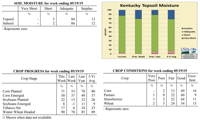 Kentucky Climate Summary
For the Period May 13, 2019 to May 19, 2019
Near Normal Temperatures and Below Normal Rainfall:
Kentucky rainfall has now been below normal for two straight weeks. Monday and
Tuesday started the period cool and dry, before a disturbance passed through Western
Kentucky on Wednesday. Many across this area saw anywhere from a quarter to an inch+,
while the rest of the state remained dry. This was followed by another disturbance
on Thursday evening and overnight, dropping through portions of Central and Eastern
Kentucky. Storms were capable of producing heavy rain and dangerous lightning. Mostly
dry conditions then returned for Friday and Saturday, accompanied by a return to
summer heat and humidity. Highs rose into the middle to upper 80s for most with some
even touching 90 degrees. Scattered activity returned on Sunday, but once again, most
stayed dry. Over the past two weeks, a large section of Central and Eastern Kentucky
are showing rainfall departures of 1 to 2 inches below normal. Some locations around
Bowling Green are more than 2 inches below.
Temperatures for the period averaged 65 degrees across the state which was
near normal and 2 degrees warmer than the previous period. High temperatures
averaged from 77 in the West to 75 in the East. Departure from normal high
temperatures ranged from 1 degree cooler than normal in the West to 1 degree
cooler than normal in the East. Low temperatures averaged from 56 degrees in the
West to 53 degrees in the East. Departure from normal low temperature ranged from 1
degree warmer than normal in the West to 3 degrees warmer than normal in the East.
The extreme high temperature for the period was 90 degrees at BURKESVILLE 3W and the
extreme low was 37 degrees at MONTICELLO AWOS.
Precipitation (liq. equ.) for the period totaled 0.40 inches statewide which was 0.73
inches below normal and 35% of normal. Precipitation totals by climate division, West
0.82 inches, Central 0.21 inches, Bluegrass 0.31 inches and East 0.27 inches, which
was 0.35, 0.98, 0.77 and 0.83 inches below normal. By station, precipitation totals
ranged from a low of 0.02 inches at COLUMBIA 3N to a high of 2.26 inches at PADUCAH ASOS.
---
Kentucky Crop and Weather Report
Issued 4:00 P.M., May 13, 2019 09-19
Agricultural News: Kentucky experienced above normal temperatures and below normal
rainfall over the past week. Precipitation for the week totaled 0.65 inches, 0.45
inches below normal. Temperatures averaged 64 degrees for the week, 2 degrees above
normal. Topsoil moisture was rated 1 percent short, 79 percent adequate and 20
percent surplus. Subsoil moisture was rated 1 percent short, 82 percent adequate, and
17 percent surplus. Days suitable for fieldwork averaged 4.0 out of a possible seven.
Primary activities this week included planting corn and soybeans, setting tobacco,
spraying fields, applying fungicides, and performing ground preparations. Producers
are monitoring upcoming weather forecasts closely to find windows for more planting
and hay cutting to take place. Pasture conditions are improving and greening up.
Tobacco transplant supplies were reported as 3 percent short, 92 percent adequate,
and 5 percent surplus. Twelve percent of tobacco transplants were under 2 inches,
with 47 percent between 2-4 inches, and 41 percent over 4 inches.
Kentucky Climate Summary
For the Period May 13, 2019 to May 19, 2019
Near Normal Temperatures and Below Normal Rainfall:
Kentucky rainfall has now been below normal for two straight weeks. Monday and
Tuesday started the period cool and dry, before a disturbance passed through Western
Kentucky on Wednesday. Many across this area saw anywhere from a quarter to an inch+,
while the rest of the state remained dry. This was followed by another disturbance
on Thursday evening and overnight, dropping through portions of Central and Eastern
Kentucky. Storms were capable of producing heavy rain and dangerous lightning. Mostly
dry conditions then returned for Friday and Saturday, accompanied by a return to
summer heat and humidity. Highs rose into the middle to upper 80s for most with some
even touching 90 degrees. Scattered activity returned on Sunday, but once again, most
stayed dry. Over the past two weeks, a large section of Central and Eastern Kentucky
are showing rainfall departures of 1 to 2 inches below normal. Some locations around
Bowling Green are more than 2 inches below.
Temperatures for the period averaged 65 degrees across the state which was
near normal and 2 degrees warmer than the previous period. High temperatures
averaged from 77 in the West to 75 in the East. Departure from normal high
temperatures ranged from 1 degree cooler than normal in the West to 1 degree
cooler than normal in the East. Low temperatures averaged from 56 degrees in the
West to 53 degrees in the East. Departure from normal low temperature ranged from 1
degree warmer than normal in the West to 3 degrees warmer than normal in the East.
The extreme high temperature for the period was 90 degrees at BURKESVILLE 3W and the
extreme low was 37 degrees at MONTICELLO AWOS.
Precipitation (liq. equ.) for the period totaled 0.40 inches statewide which was 0.73
inches below normal and 35% of normal. Precipitation totals by climate division, West
0.82 inches, Central 0.21 inches, Bluegrass 0.31 inches and East 0.27 inches, which
was 0.35, 0.98, 0.77 and 0.83 inches below normal. By station, precipitation totals
ranged from a low of 0.02 inches at COLUMBIA 3N to a high of 2.26 inches at PADUCAH ASOS.
---
Kentucky Crop and Weather Report
Issued 4:00 P.M., May 13, 2019 09-19
Agricultural News: Kentucky experienced above normal temperatures and below normal
rainfall over the past week. Precipitation for the week totaled 0.65 inches, 0.45
inches below normal. Temperatures averaged 64 degrees for the week, 2 degrees above
normal. Topsoil moisture was rated 1 percent short, 79 percent adequate and 20
percent surplus. Subsoil moisture was rated 1 percent short, 82 percent adequate, and
17 percent surplus. Days suitable for fieldwork averaged 4.0 out of a possible seven.
Primary activities this week included planting corn and soybeans, setting tobacco,
spraying fields, applying fungicides, and performing ground preparations. Producers
are monitoring upcoming weather forecasts closely to find windows for more planting
and hay cutting to take place. Pasture conditions are improving and greening up.
Tobacco transplant supplies were reported as 3 percent short, 92 percent adequate,
and 5 percent surplus. Twelve percent of tobacco transplants were under 2 inches,
with 47 percent between 2-4 inches, and 41 percent over 4 inches.
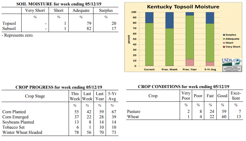 Kentucky Climate Summary
For the Period May 6, 2019 to May 12, 2019
Above Normal Temperatures and Below Normal Rainfall:
Weather-wise, the first and second halves of the period were nearly opposite to each
other. Dry and very warm conditions were in place for Monday through Wednesday. In
fact, highs rose solidly into the low to middle 80s across the state by Wednesday.
Combined with some elevated humidity, Kentucky got an early taste of summer.
Conditions then took a 180-degree turn for the second half of the week as wet and
cooler weather returned. The state saw several rounds of scattered to numerous
showers pass through the region, but total accumulations were fairly light for most
of the state. While portions of Southeastern Kentucky and the Northern Bluegrass saw
rainfall well in upwards of an inch, Western and Central Kentucky averaged less than
a half inch.
Temperatures for the period averaged 64 degrees across the state which was 2 degrees
warmer than normal and 4 degrees cooler than the previous period. High temperatures
averaged from 72 in the West to 75 in the East. Departure from normal high
temperatures ranged from 4 degrees cooler than normal in the West to near
normal in the East. Low temperatures averaged from 56 degrees in the West to 56
degrees in the East. Departure from normal low temperature ranged from 3 degrees
warmer than normal in the West to 9 degrees warmer than normal in the East. The
extreme high temperature for the period was 87 degrees at BOWLING GREEN APT and the
extreme low was 43 degrees at CYNTHIANA 8N.
Precipitation (liq. equ.) for the period totaled 0.65 inches statewide which was 0.45
inches below normal and 59% of normal. Precipitation totals by climate division, West
0.41 inches, Central 0.38 inches, Bluegrass 0.52 inches and East 1.30 inches, which
was -0.75, -0.78, -0.50 and 0.25 inches respectively from normal. By station,
precipitation totals ranged from a low of 0.13 inches at OWENSBORO AWSS to a high of
3.42 inches at MIDDLESBORO AWOS.
---
Kentucky Crop and Weather Report
Issued 4:00 P.M., May 6, 2019 08-19
Agricultural News: Kentucky experienced well above normal temperatures and above
normal rainfall over the past week. Precipitation for the week totaled 1.62 inches,
0.54 inches above normal. Temperatures averaged 68 degrees for the week, 8 degrees
above normal. Topsoil moisture was rated 1 percent short, 69 percent adequate and 30
percent surplus. Subsoil moisture was rated 1 percent short, 75 percent adequate, and
24 percent surplus. Days suitable for fieldwork averaged 4.0 out of a possible seven.
Primary activities this week included planting corn and soybeans, preparing fields,
and working cattle. Soils remain saturated throughout the state from the overall wet
spring and recent showers and storms. Farmers continue to make progress in planting
corn and soybeans, but timing has been an issue with monitoring precipitation
forecasts and field conditions. Wheat producers began to make fungicide applications
and some early hay fields were cut this past week. Cattle body condition remains of
concern coming out of the winter months, as producers expect a delay in putting
weight back on. As a result, calving intervals are expected to be impacted.
Tobacco transplant supplies were reported as 3 percent short, 93 percent adequate,
and 4 percent surplus. Twenty-one percent of tobacco transplants were under 2 inches,
with 49 percent between 2-4 inches, and 30 percent over 4 inches.
Kentucky Climate Summary
For the Period May 6, 2019 to May 12, 2019
Above Normal Temperatures and Below Normal Rainfall:
Weather-wise, the first and second halves of the period were nearly opposite to each
other. Dry and very warm conditions were in place for Monday through Wednesday. In
fact, highs rose solidly into the low to middle 80s across the state by Wednesday.
Combined with some elevated humidity, Kentucky got an early taste of summer.
Conditions then took a 180-degree turn for the second half of the week as wet and
cooler weather returned. The state saw several rounds of scattered to numerous
showers pass through the region, but total accumulations were fairly light for most
of the state. While portions of Southeastern Kentucky and the Northern Bluegrass saw
rainfall well in upwards of an inch, Western and Central Kentucky averaged less than
a half inch.
Temperatures for the period averaged 64 degrees across the state which was 2 degrees
warmer than normal and 4 degrees cooler than the previous period. High temperatures
averaged from 72 in the West to 75 in the East. Departure from normal high
temperatures ranged from 4 degrees cooler than normal in the West to near
normal in the East. Low temperatures averaged from 56 degrees in the West to 56
degrees in the East. Departure from normal low temperature ranged from 3 degrees
warmer than normal in the West to 9 degrees warmer than normal in the East. The
extreme high temperature for the period was 87 degrees at BOWLING GREEN APT and the
extreme low was 43 degrees at CYNTHIANA 8N.
Precipitation (liq. equ.) for the period totaled 0.65 inches statewide which was 0.45
inches below normal and 59% of normal. Precipitation totals by climate division, West
0.41 inches, Central 0.38 inches, Bluegrass 0.52 inches and East 1.30 inches, which
was -0.75, -0.78, -0.50 and 0.25 inches respectively from normal. By station,
precipitation totals ranged from a low of 0.13 inches at OWENSBORO AWSS to a high of
3.42 inches at MIDDLESBORO AWOS.
---
Kentucky Crop and Weather Report
Issued 4:00 P.M., May 6, 2019 08-19
Agricultural News: Kentucky experienced well above normal temperatures and above
normal rainfall over the past week. Precipitation for the week totaled 1.62 inches,
0.54 inches above normal. Temperatures averaged 68 degrees for the week, 8 degrees
above normal. Topsoil moisture was rated 1 percent short, 69 percent adequate and 30
percent surplus. Subsoil moisture was rated 1 percent short, 75 percent adequate, and
24 percent surplus. Days suitable for fieldwork averaged 4.0 out of a possible seven.
Primary activities this week included planting corn and soybeans, preparing fields,
and working cattle. Soils remain saturated throughout the state from the overall wet
spring and recent showers and storms. Farmers continue to make progress in planting
corn and soybeans, but timing has been an issue with monitoring precipitation
forecasts and field conditions. Wheat producers began to make fungicide applications
and some early hay fields were cut this past week. Cattle body condition remains of
concern coming out of the winter months, as producers expect a delay in putting
weight back on. As a result, calving intervals are expected to be impacted.
Tobacco transplant supplies were reported as 3 percent short, 93 percent adequate,
and 4 percent surplus. Twenty-one percent of tobacco transplants were under 2 inches,
with 49 percent between 2-4 inches, and 30 percent over 4 inches.
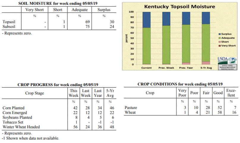 Kentucky Climate Summary
For the Period April 29, 2019 to May 5, 2019
Well Above Normal Temperatures and Above Normal Rainfall:
Extended periods of dry weather have been few over the past month. Data from the Ag
Weather Center shows that the state has averaged 6.05 inches over the past thirty
days. The wet trend continued this past week with several rounds of showers and storms
passing through the area from Wednesday and lasting through Derby Day. An unstable
and moist air mass in place led to moderate/heavy rainfall at times and even the
potential for flooding by later in the week. Rainfall coverage turned widespread
Thursday night/Friday morning and again on Saturday. Overall, the state averaged
1.62 inches for the week, which marks the third week out of the past four with above
normal rainfall. While it has been wet, temperatures have been running warm for this
time of year. Highs jumped into the 80s numerous times this past week.
Temperatures for the period averaged 68 degrees across the state which was 8 degrees
warmer than normal and 8 degrees warmer than the previous period. High temperatures
averaged from 76 in the West to 78 in the East. Departure from normal high
temperatures ranged from 2 degrees warmer than normal in the West to 5 degrees
warmer than normal in the East. Low temperatures averaged from 59 degrees in the
West to 58 degrees in the East. Departure from normal low temperature ranged from 8
degrees warmer than normal in the West to 13 degrees warmer than normal in the
East. The extreme high temperature for the period was 127 degrees at FRANKFORT 7S and
the extreme low was 34 degrees at FRANKFORT 7S.
Precipitation (liq. equ.) for the period totaled 1.62 inches statewide which was 0.54
inches above normal and 150% of normal. Precipitation totals by climate division,
West 1.92 inches, Central 1.52 inches, Bluegrass 1.38 inches and East 1.65 inches,
which was 0.71, 0.41, 0.39 and 0.64 inches above normal. By station, precipitation
totals ranged from a low of 0.13 inches at CADIZ 4SW to a high of 4.44 inches at
PADUCAH ASOS.
---
Kentucky Crop and Weather Report
Issued 4:00 P.M., April 29, 2019 07-19
Agricultural News: Kentucky experienced above normal temperatures and below normal
rainfall over the past week. Precipitation for the week totaled 0.74 inches, 0.30
inches below normal. Temperatures averaged 62 degrees for the week, 4 degrees above
normal. Topsoil moisture was rated 1 percent short, 73 percent adequate, and 26
percent surplus. Subsoil moisture was rated 1 percent short, 76 percent adequate, and
23 percent surplus. Days suitable for fieldwork averaged 4.0 out of a possible seven.
Primary activities for this week included corn and soybean planting along with
continued tobacco transplant seeding. While several regions battled persistent
precipitation, others received weather conducive to progress in the fields. Corn
planting is well ahead of last year at this time, but slightly below the five year
average. Soybean planting is ahead of both last year and the five year average at
this juncture. Ninety two percent of tobacco transplants have been seeded. The
average height of transplants were reported as 38 percent less than 2 inches, 48
percent 2-4 inches, and 14 percent larger than 4 inches.
The average height of winter wheat was 23 inches, up from 18 inches last week. The
average height of alfalfa was 9 inches, compared to 8 inches the previous week. There
has been a shortage of hay as pastures were adversely affected by the extremely wet
winter and spring. Hay supply was reported as 22 percent very short, 40 percent
short, 35 percent adequate, and 3 percent surplus. Strawberry condition was rated as
1 percent very poor, 2 percent poor, 24 percent fair, 60 percent good, and
13 percent excellent.
Kentucky Climate Summary
For the Period April 29, 2019 to May 5, 2019
Well Above Normal Temperatures and Above Normal Rainfall:
Extended periods of dry weather have been few over the past month. Data from the Ag
Weather Center shows that the state has averaged 6.05 inches over the past thirty
days. The wet trend continued this past week with several rounds of showers and storms
passing through the area from Wednesday and lasting through Derby Day. An unstable
and moist air mass in place led to moderate/heavy rainfall at times and even the
potential for flooding by later in the week. Rainfall coverage turned widespread
Thursday night/Friday morning and again on Saturday. Overall, the state averaged
1.62 inches for the week, which marks the third week out of the past four with above
normal rainfall. While it has been wet, temperatures have been running warm for this
time of year. Highs jumped into the 80s numerous times this past week.
Temperatures for the period averaged 68 degrees across the state which was 8 degrees
warmer than normal and 8 degrees warmer than the previous period. High temperatures
averaged from 76 in the West to 78 in the East. Departure from normal high
temperatures ranged from 2 degrees warmer than normal in the West to 5 degrees
warmer than normal in the East. Low temperatures averaged from 59 degrees in the
West to 58 degrees in the East. Departure from normal low temperature ranged from 8
degrees warmer than normal in the West to 13 degrees warmer than normal in the
East. The extreme high temperature for the period was 127 degrees at FRANKFORT 7S and
the extreme low was 34 degrees at FRANKFORT 7S.
Precipitation (liq. equ.) for the period totaled 1.62 inches statewide which was 0.54
inches above normal and 150% of normal. Precipitation totals by climate division,
West 1.92 inches, Central 1.52 inches, Bluegrass 1.38 inches and East 1.65 inches,
which was 0.71, 0.41, 0.39 and 0.64 inches above normal. By station, precipitation
totals ranged from a low of 0.13 inches at CADIZ 4SW to a high of 4.44 inches at
PADUCAH ASOS.
---
Kentucky Crop and Weather Report
Issued 4:00 P.M., April 29, 2019 07-19
Agricultural News: Kentucky experienced above normal temperatures and below normal
rainfall over the past week. Precipitation for the week totaled 0.74 inches, 0.30
inches below normal. Temperatures averaged 62 degrees for the week, 4 degrees above
normal. Topsoil moisture was rated 1 percent short, 73 percent adequate, and 26
percent surplus. Subsoil moisture was rated 1 percent short, 76 percent adequate, and
23 percent surplus. Days suitable for fieldwork averaged 4.0 out of a possible seven.
Primary activities for this week included corn and soybean planting along with
continued tobacco transplant seeding. While several regions battled persistent
precipitation, others received weather conducive to progress in the fields. Corn
planting is well ahead of last year at this time, but slightly below the five year
average. Soybean planting is ahead of both last year and the five year average at
this juncture. Ninety two percent of tobacco transplants have been seeded. The
average height of transplants were reported as 38 percent less than 2 inches, 48
percent 2-4 inches, and 14 percent larger than 4 inches.
The average height of winter wheat was 23 inches, up from 18 inches last week. The
average height of alfalfa was 9 inches, compared to 8 inches the previous week. There
has been a shortage of hay as pastures were adversely affected by the extremely wet
winter and spring. Hay supply was reported as 22 percent very short, 40 percent
short, 35 percent adequate, and 3 percent surplus. Strawberry condition was rated as
1 percent very poor, 2 percent poor, 24 percent fair, 60 percent good, and
13 percent excellent.
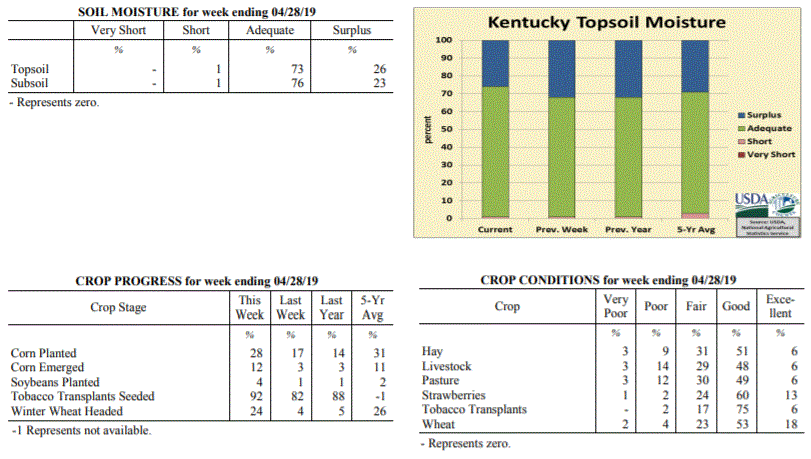 Kentucky Climate Summary
For the Period April 22, 2019 to April 28, 2019
Above Normal Temperatures and Below Normal Rainfall:
The first half of the work week started on the warm side with high temperatures
topping out in the middle 70s to low 80s for highs. After a dry Monday, a frontal
boundary sank into the area and with disturbances passing overhead, sparked several
rounds of showers and storms through Friday. The most widespread activity occurred
Thursday and Thursday night. Overall, the highest accumulations for the week were
confined to areas along the Ohio River and the Northern Bluegrass with around 1 to 2+
inches. Those numbers declined to the southern half of the state as most were under a
half inch for the week.
Temperatures for the period averaged 62 degrees across the state which was 4 degrees
warmer than normal and 6 degrees warmer than the previous period. High temperatures
averaged from 74 in the West to 74 in the East. Departure from normal high
temperatures ranged from 2 degrees warmer than normal in the West to 3 degrees warmer
than normal in the East. Low temperatures averaged from 52 degrees in the West to 50
degrees in the East. Departure from normal low temperature ranged from 3 degrees
warmer than normal in the West to 7 degrees warmer than normal in the East. The
extreme high temperature for the period was 86 degrees at LOUISA 1S and the extreme
low was 36 degrees at PAINTSVILLE 4W.
Precipitation (liq. equ.) for the period totaled 0.74 inches statewide which was 0.3
inches below normal and 71% of normal. Precipitation totals by climate division, West
0.70 inches, Central 0.49 inches, Bluegrass 1.24 inches and East 0.54 inches, which
was -0.50, -0.57, 0.28 and -0.42 inches respectively from normal. By station,
precipitation totals ranged from a low of 0.12 inches at BENTON 4N to a high of 2.87
inches at OWENTON 5E.
---
Kentucky Crop and Weather Report
Issued 4:00 P.M., April 22, 2019 06-19
Agricultural News: Kentucky experienced near normal temperatures and above normal
rainfall over the past week. Precipitation for the week totaled 1.78 inches, 0.80
inches above normal. Temperatures averaged 56 degrees for the week, unchanged from
normal. Topsoil moisture was rated 1 percent short, 67 percent adequate, and 32
percent surplus. Subsoil moisture was rated 1 percent short, 75 percent adequate, and
24 percent surplus. Days suitable for fieldwork averaged 3.5 out of a possible seven.
Primary activities for this week included continued corn planting and tobacco
transplant seeding. Fieldwork was interrupted by rain with cold temperatures moving
in at the end of the week. Despite the weather setbacks, corn producers were able to
make some planting progress. Planting is ahead of last year at this time, but
slightly below the five year average. Soybean planting is underway for some
producers, but very little is in the ground at this juncture. Fifty seven percent of
tobacco transplants were under 2 inches, with 34 percent 2-4 inches, and 9 percent
above 4 inches. Transplants remain in mostly fair to good condition.
The average height of winter wheat was 18 inches, up from 13 inches last week. The
average height of alfalfa was 8 inches, compared to 6 inches the previous week.
Freeze damage to apples was reported as 1 percent severe, 2 percent moderate, 22
percent light, and 75 percent with no damage. Peach freeze damage was reported as 1
percent severe, 2 percent moderate, 13 percent light, and 84 percent with no damage.
Kentucky Climate Summary
For the Period April 22, 2019 to April 28, 2019
Above Normal Temperatures and Below Normal Rainfall:
The first half of the work week started on the warm side with high temperatures
topping out in the middle 70s to low 80s for highs. After a dry Monday, a frontal
boundary sank into the area and with disturbances passing overhead, sparked several
rounds of showers and storms through Friday. The most widespread activity occurred
Thursday and Thursday night. Overall, the highest accumulations for the week were
confined to areas along the Ohio River and the Northern Bluegrass with around 1 to 2+
inches. Those numbers declined to the southern half of the state as most were under a
half inch for the week.
Temperatures for the period averaged 62 degrees across the state which was 4 degrees
warmer than normal and 6 degrees warmer than the previous period. High temperatures
averaged from 74 in the West to 74 in the East. Departure from normal high
temperatures ranged from 2 degrees warmer than normal in the West to 3 degrees warmer
than normal in the East. Low temperatures averaged from 52 degrees in the West to 50
degrees in the East. Departure from normal low temperature ranged from 3 degrees
warmer than normal in the West to 7 degrees warmer than normal in the East. The
extreme high temperature for the period was 86 degrees at LOUISA 1S and the extreme
low was 36 degrees at PAINTSVILLE 4W.
Precipitation (liq. equ.) for the period totaled 0.74 inches statewide which was 0.3
inches below normal and 71% of normal. Precipitation totals by climate division, West
0.70 inches, Central 0.49 inches, Bluegrass 1.24 inches and East 0.54 inches, which
was -0.50, -0.57, 0.28 and -0.42 inches respectively from normal. By station,
precipitation totals ranged from a low of 0.12 inches at BENTON 4N to a high of 2.87
inches at OWENTON 5E.
---
Kentucky Crop and Weather Report
Issued 4:00 P.M., April 22, 2019 06-19
Agricultural News: Kentucky experienced near normal temperatures and above normal
rainfall over the past week. Precipitation for the week totaled 1.78 inches, 0.80
inches above normal. Temperatures averaged 56 degrees for the week, unchanged from
normal. Topsoil moisture was rated 1 percent short, 67 percent adequate, and 32
percent surplus. Subsoil moisture was rated 1 percent short, 75 percent adequate, and
24 percent surplus. Days suitable for fieldwork averaged 3.5 out of a possible seven.
Primary activities for this week included continued corn planting and tobacco
transplant seeding. Fieldwork was interrupted by rain with cold temperatures moving
in at the end of the week. Despite the weather setbacks, corn producers were able to
make some planting progress. Planting is ahead of last year at this time, but
slightly below the five year average. Soybean planting is underway for some
producers, but very little is in the ground at this juncture. Fifty seven percent of
tobacco transplants were under 2 inches, with 34 percent 2-4 inches, and 9 percent
above 4 inches. Transplants remain in mostly fair to good condition.
The average height of winter wheat was 18 inches, up from 13 inches last week. The
average height of alfalfa was 8 inches, compared to 6 inches the previous week.
Freeze damage to apples was reported as 1 percent severe, 2 percent moderate, 22
percent light, and 75 percent with no damage. Peach freeze damage was reported as 1
percent severe, 2 percent moderate, 13 percent light, and 84 percent with no damage.
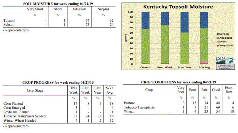 Kentucky Climate Summary
For the Period April 15, 2019 to April 21, 2019
Near Normal Temperatures and Above Normal Rainfall:
According to data with the UK Ag Weather Center, April has been a fairly wet month
thus far for the Bluegrass State with the state averaging 3.94 inches through the
21st. This is about an inch above normal over that time span. A good portion of
that total fell this past week as the state averaged 1.78 inches. Most of this
activity fell over a three day period, lasting from Thursday into Saturday as a cold
front and associated area of low pressure worked through the state. This marked the
second straight week of above normal rainfall. A substantial area of Western/Central
Kentucky and up into the Northern Bluegrass even received in excess of two inches
with this round.
Temperatures for the period averaged 56 degrees across the state which was near
normal and 6 degrees cooler than the previous period. High temperatures
averaged from 67 in the West to 67 in the East. Departure from normal high
temperatures ranged from 3 degrees cooler than normal in the West to 2 degrees
cooler than normal in the East. Low temperatures averaged from 46 degrees in the
West to 46 degrees in the East. Departure from normal low temperature ranged from 1
degree cooler than normal in the West to 5 degrees warmer than normal in the East.
The extreme high temperature for the period was 85 degrees at BIG SANDY and the
extreme low was 30 degrees at CARBONDALE ASOS.
Precipitation (liq. equ.) for the period totaled 1.78 inches statewide which was 0.8
inches above normal and 181% of normal. Precipitation totals by climate division,
West 2.25 inches, Central 2.20 inches, Bluegrass 1.79 inches and East 0.88 inches,
which was 1.12, 1.21, 0.89 and -0.04 inches respectively from normal. By station,
precipitation totals ranged from a low of 0.40 inches at WILLIAMSBURG AWOS to a high
of 3.84 inches at GREENVILLE 6N.
---
Kentucky Crop and Weather Report
Issued 4:00 P.M., April 15, 2019 05-19
Agricultural News: Kentucky experienced well above normal temperatures and above
normal rainfall over the past week. Precipitation for the week totaled 1.59 inches,
0.57 inches above normal. Temperatures averaged 63 degrees for the week, 8 degrees
above normal. Topsoil moisture was rated 1 percent short, 74 percent adequate, and 25
percent surplus. Subsoil moisture was rated 1 percent short, 73 percent adequate, and
26 percent surplus. Days suitable for fieldwork averaged 4.3 out of a possible seven.
Primary activities for this week included planting corn, seeding tobacco transplants,
and preparing fields. Farmers are performing fieldwork at every opportunity, however
intermittent rain continues to stymie progress. Corn producers are ready to get their
crop in the ground, but weather conditions have not been conducive in the early
planting season. The crop is ahead of last year, but considerably behind 2017 at this
juncture. Seventy five percent of tobacco transplants were under 2 inches, with 22
percent 2-4 inches, and 3 percent above 4 inches. Transplants were reported as in
mostly fair to good condition.
Winter wheat condition is mostly fair to good with an average height of 13 inches.
Freeze damage to winter wheat was reported as 1 percent moderate, 11 percent light,
and 88 percent with no damage. The average height of alfalfa was 6 inches. Freeze
damage to alfalfa was reported as 1 percent severe, 9 percent moderate, 29 percent
light, and 61 percent with no damage. Pastures are starting to show some growth
easing the demand for hay which is in short supply.
Kentucky Climate Summary
For the Period April 15, 2019 to April 21, 2019
Near Normal Temperatures and Above Normal Rainfall:
According to data with the UK Ag Weather Center, April has been a fairly wet month
thus far for the Bluegrass State with the state averaging 3.94 inches through the
21st. This is about an inch above normal over that time span. A good portion of
that total fell this past week as the state averaged 1.78 inches. Most of this
activity fell over a three day period, lasting from Thursday into Saturday as a cold
front and associated area of low pressure worked through the state. This marked the
second straight week of above normal rainfall. A substantial area of Western/Central
Kentucky and up into the Northern Bluegrass even received in excess of two inches
with this round.
Temperatures for the period averaged 56 degrees across the state which was near
normal and 6 degrees cooler than the previous period. High temperatures
averaged from 67 in the West to 67 in the East. Departure from normal high
temperatures ranged from 3 degrees cooler than normal in the West to 2 degrees
cooler than normal in the East. Low temperatures averaged from 46 degrees in the
West to 46 degrees in the East. Departure from normal low temperature ranged from 1
degree cooler than normal in the West to 5 degrees warmer than normal in the East.
The extreme high temperature for the period was 85 degrees at BIG SANDY and the
extreme low was 30 degrees at CARBONDALE ASOS.
Precipitation (liq. equ.) for the period totaled 1.78 inches statewide which was 0.8
inches above normal and 181% of normal. Precipitation totals by climate division,
West 2.25 inches, Central 2.20 inches, Bluegrass 1.79 inches and East 0.88 inches,
which was 1.12, 1.21, 0.89 and -0.04 inches respectively from normal. By station,
precipitation totals ranged from a low of 0.40 inches at WILLIAMSBURG AWOS to a high
of 3.84 inches at GREENVILLE 6N.
---
Kentucky Crop and Weather Report
Issued 4:00 P.M., April 15, 2019 05-19
Agricultural News: Kentucky experienced well above normal temperatures and above
normal rainfall over the past week. Precipitation for the week totaled 1.59 inches,
0.57 inches above normal. Temperatures averaged 63 degrees for the week, 8 degrees
above normal. Topsoil moisture was rated 1 percent short, 74 percent adequate, and 25
percent surplus. Subsoil moisture was rated 1 percent short, 73 percent adequate, and
26 percent surplus. Days suitable for fieldwork averaged 4.3 out of a possible seven.
Primary activities for this week included planting corn, seeding tobacco transplants,
and preparing fields. Farmers are performing fieldwork at every opportunity, however
intermittent rain continues to stymie progress. Corn producers are ready to get their
crop in the ground, but weather conditions have not been conducive in the early
planting season. The crop is ahead of last year, but considerably behind 2017 at this
juncture. Seventy five percent of tobacco transplants were under 2 inches, with 22
percent 2-4 inches, and 3 percent above 4 inches. Transplants were reported as in
mostly fair to good condition.
Winter wheat condition is mostly fair to good with an average height of 13 inches.
Freeze damage to winter wheat was reported as 1 percent moderate, 11 percent light,
and 88 percent with no damage. The average height of alfalfa was 6 inches. Freeze
damage to alfalfa was reported as 1 percent severe, 9 percent moderate, 29 percent
light, and 61 percent with no damage. Pastures are starting to show some growth
easing the demand for hay which is in short supply.
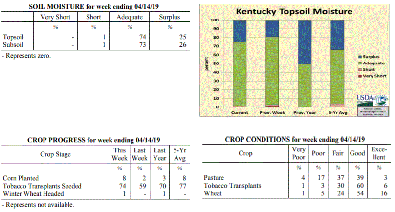 Kentucky Climate Summary
For the Period April 8, 2019 to April 14, 2019
Well Above Normal Temperatures and Above Normal Rainfall:
Kentucky saw above normal rainfall over the past week behind multiple rounds of
precipitation. Activity started on Monday as an upper level disturbance worked across
the area. Widespread coverage was focused more across the southern half of the state.
This was followed by a few mild and dry days. By Thursday, breezy southerly flow
ahead of an approaching area of low pressure pushed highs into the low to middle 80s
for much of the state. A cold front then swept through on Thursday night and into
Friday, bringing a quick-hitting round of showers and storms. Accumulations were
fairly light with this round, but was followed by another area of low pressure
working through the area on Saturday night and into Sunday. Overall, this system
accounted for the brunt of the 1.59 state average for the week. Accompanying the
weekend system was high winds with numerous gusts over 40 mph and some exceeding 50.
Temperatures for the period averaged 63 degrees across the state which was 8 degrees
warmer than normal and 10 degrees warmer than the previous period. High temperatures
averaged from 73 in the West to 74 in the East. Departure from normal high
temperatures ranged from 5 degrees warmer than normal in the West to 7 degrees
warmer than normal in the East. Low temperatures averaged from 52 degrees in the
West to 53 degrees in the East. Departure from normal low temperature ranged from 7
degrees warmer than normal in the West to 14 degrees warmer than normal in the
East. The extreme high temperature for the period was 86 degrees at JACKSON AIRPORT
and the extreme low was 36 degrees at PAINTSVILLE 4W.
Precipitation (liq. equ.) for the period totaled 1.59 inches statewide which was 0.57
inches above normal and 157% of normal. Precipitation totals by climate division,
West 1.92 inches, Central 1.71 inches, Bluegrass 1.27 inches and East 1.47 inches,
which was 0.76, 0.67, 0.35 and 0.53 inches above normal. By station, precipitation
totals ranged from a low of 0.75 inches at CINCINNATI to a high of 2.67
inches at HICKMAN 2E.
---
Kentucky Crop and Weather Report
Issued 4:00 P.M., April 8, 2019 04-19
Agricultural News: Kentucky experienced slightly above normal temperatures and below
normal rainfall over the past week. Precipitation for the week totaled 0.56 inches,
0.43 inches below normal. Temperatures averaged 53 degrees for the week, 1 degrees
above normal. Topsoil moisture was rated 1 percent very short, 2 percent short, 78
percent adequate, and 19 percent surplus. Subsoil moisture was rated 1 percent short,
79 percent adequate, and 20 percent surplus. Days suitable for fieldwork averaged 4.7
out of a possible seven.
Primary activities for this week included seeding tobacco transplants, field
preparation, and corn planting where weather would allow. The commonwealth has had
some drier conditions recently, however soil remains very moist in many areas
hampering fieldwork. A freeze at the beginning of the week was also of concern, but
normal spring weather returned as the week progressed. Although corn planting has
begun, very little is in the ground at this juncture. Pastures have begun to grow,
but an abundance of weeds are present due to the abnormally wet winter.
Many farmers are still feeding hay and supplies remain short. Winter wheat condition
is mostly good to fair with an average height of 7 inches. Twenty percent of apples
and 30 percent of peaches are in bloom at this time.
Kentucky Climate Summary
For the Period April 8, 2019 to April 14, 2019
Well Above Normal Temperatures and Above Normal Rainfall:
Kentucky saw above normal rainfall over the past week behind multiple rounds of
precipitation. Activity started on Monday as an upper level disturbance worked across
the area. Widespread coverage was focused more across the southern half of the state.
This was followed by a few mild and dry days. By Thursday, breezy southerly flow
ahead of an approaching area of low pressure pushed highs into the low to middle 80s
for much of the state. A cold front then swept through on Thursday night and into
Friday, bringing a quick-hitting round of showers and storms. Accumulations were
fairly light with this round, but was followed by another area of low pressure
working through the area on Saturday night and into Sunday. Overall, this system
accounted for the brunt of the 1.59 state average for the week. Accompanying the
weekend system was high winds with numerous gusts over 40 mph and some exceeding 50.
Temperatures for the period averaged 63 degrees across the state which was 8 degrees
warmer than normal and 10 degrees warmer than the previous period. High temperatures
averaged from 73 in the West to 74 in the East. Departure from normal high
temperatures ranged from 5 degrees warmer than normal in the West to 7 degrees
warmer than normal in the East. Low temperatures averaged from 52 degrees in the
West to 53 degrees in the East. Departure from normal low temperature ranged from 7
degrees warmer than normal in the West to 14 degrees warmer than normal in the
East. The extreme high temperature for the period was 86 degrees at JACKSON AIRPORT
and the extreme low was 36 degrees at PAINTSVILLE 4W.
Precipitation (liq. equ.) for the period totaled 1.59 inches statewide which was 0.57
inches above normal and 157% of normal. Precipitation totals by climate division,
West 1.92 inches, Central 1.71 inches, Bluegrass 1.27 inches and East 1.47 inches,
which was 0.76, 0.67, 0.35 and 0.53 inches above normal. By station, precipitation
totals ranged from a low of 0.75 inches at CINCINNATI to a high of 2.67
inches at HICKMAN 2E.
---
Kentucky Crop and Weather Report
Issued 4:00 P.M., April 8, 2019 04-19
Agricultural News: Kentucky experienced slightly above normal temperatures and below
normal rainfall over the past week. Precipitation for the week totaled 0.56 inches,
0.43 inches below normal. Temperatures averaged 53 degrees for the week, 1 degrees
above normal. Topsoil moisture was rated 1 percent very short, 2 percent short, 78
percent adequate, and 19 percent surplus. Subsoil moisture was rated 1 percent short,
79 percent adequate, and 20 percent surplus. Days suitable for fieldwork averaged 4.7
out of a possible seven.
Primary activities for this week included seeding tobacco transplants, field
preparation, and corn planting where weather would allow. The commonwealth has had
some drier conditions recently, however soil remains very moist in many areas
hampering fieldwork. A freeze at the beginning of the week was also of concern, but
normal spring weather returned as the week progressed. Although corn planting has
begun, very little is in the ground at this juncture. Pastures have begun to grow,
but an abundance of weeds are present due to the abnormally wet winter.
Many farmers are still feeding hay and supplies remain short. Winter wheat condition
is mostly good to fair with an average height of 7 inches. Twenty percent of apples
and 30 percent of peaches are in bloom at this time.
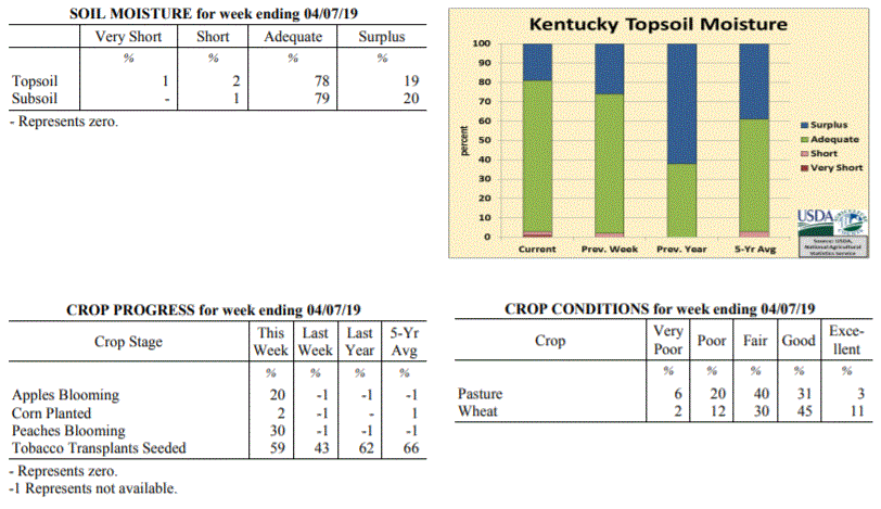 Kentucky Climate Summary
For the Period April 1, 2019 to April 7, 2019
Slightly Above Normal Temperatures and Below Normal Rainfall:
The month of April started on a cold note with low temperatures dipping well into the
20s on Monday morning. This prompted the first freeze warnings of the spring season
to be issued across the southern half of Kentucky. Dry conditions and warmer
temperatures then prevailed through midweek, eventually rising into the middle 60s to
around 70 on Wednesday. An upper level disturbance then brought light rain showers to
the region on Thursday night and into Friday. This was followed by a more intense
round on Sunday as showers and scattered storms pushed through the Bluegrass State.
Overall though, the state only averaged just over a half inch for the week.
Temperatures for the period averaged 53 degrees across the state which was 1 degree
warmer than normal and 2 degrees warmer than the previous period. High temperatures
averaged from 64 in the West to 66 in the East. Departure from normal high
temperatures ranged from 2 degrees cooler than normal in the West to 1 degree
warmer than normal in the East. Low temperatures averaged from 44 degrees in the
West to 41 degrees in the East. Departure from normal low temperature ranged from 2
degrees warmer than normal in the West to 4 degrees warmer than normal in the East.
The extreme high temperature for the period was 78 degrees at LOUISA 1S and the
extreme low was 19 degrees at PIKEVILLE 13S.
Precipitation (liq. equ.) for the period totaled 0.56 inches statewide which was 0.43
inches below normal and 57% of normal. Precipitation totals by climate division, West
0.39 inches, Central 0.78 inches, Bluegrass 0.57 inches and East 0.50 inches, which
was 0.7, 0.25, 0.33 and 0.44 inches below normal. By station, precipitation totals
ranged from a low of 0.08 inches at ALEXANDRIA 5NW to a high of 1.19 inches at
MUNFORDVILLE 6E.
---
Kentucky Crop and Weather Report
Issued 4:00 P.M., April 1, 2019 03-19
Agricultural News: Kentucky experienced near normal temperatures and above normal
precipitation over the past week. Precipitation for the week totaled 1.08 inches,
0.06 inches above normal. Temperatures averaged 50 degrees for the week, near normal.
Topsoil moisture was rated 2 percent short, 72 percent adequate, and 26 percent
surplus. Subsoil moisture was rated 1 percent very short, 1 percent short, 75 percent
adequate, and 23 percent surplus. Days suitable for fieldwork averaged 4.8 out of a
possible seven.
Primary activities for this week included seeding tobacco transplants along with
spraying and preparing fields for the planting season. Warm, dry conditions allowed
fields to start drying out before more rain and cooler temperatures moved in on the
weekend. There was very little freeze damage to winter wheat and the crop is in
mostly good condition. Alfalfa was also largely spared from freeze as small amounts
of light and moderate damage were reported.
Livestock condition is mostly good to fair at this juncture, however cattle have been
adversely affected by wet, muddy pastures and an overall hay shortage during the
winter months. In some cases cows will be moved to a fall breeding schedule due to
their current body conditions. Approximately 20 percent of feed for cattle and calves
was obtained from pastures. Pasture condition was rated as mostly fair at this time.
Kentucky Climate Summary
For the Period April 1, 2019 to April 7, 2019
Slightly Above Normal Temperatures and Below Normal Rainfall:
The month of April started on a cold note with low temperatures dipping well into the
20s on Monday morning. This prompted the first freeze warnings of the spring season
to be issued across the southern half of Kentucky. Dry conditions and warmer
temperatures then prevailed through midweek, eventually rising into the middle 60s to
around 70 on Wednesday. An upper level disturbance then brought light rain showers to
the region on Thursday night and into Friday. This was followed by a more intense
round on Sunday as showers and scattered storms pushed through the Bluegrass State.
Overall though, the state only averaged just over a half inch for the week.
Temperatures for the period averaged 53 degrees across the state which was 1 degree
warmer than normal and 2 degrees warmer than the previous period. High temperatures
averaged from 64 in the West to 66 in the East. Departure from normal high
temperatures ranged from 2 degrees cooler than normal in the West to 1 degree
warmer than normal in the East. Low temperatures averaged from 44 degrees in the
West to 41 degrees in the East. Departure from normal low temperature ranged from 2
degrees warmer than normal in the West to 4 degrees warmer than normal in the East.
The extreme high temperature for the period was 78 degrees at LOUISA 1S and the
extreme low was 19 degrees at PIKEVILLE 13S.
Precipitation (liq. equ.) for the period totaled 0.56 inches statewide which was 0.43
inches below normal and 57% of normal. Precipitation totals by climate division, West
0.39 inches, Central 0.78 inches, Bluegrass 0.57 inches and East 0.50 inches, which
was 0.7, 0.25, 0.33 and 0.44 inches below normal. By station, precipitation totals
ranged from a low of 0.08 inches at ALEXANDRIA 5NW to a high of 1.19 inches at
MUNFORDVILLE 6E.
---
Kentucky Crop and Weather Report
Issued 4:00 P.M., April 1, 2019 03-19
Agricultural News: Kentucky experienced near normal temperatures and above normal
precipitation over the past week. Precipitation for the week totaled 1.08 inches,
0.06 inches above normal. Temperatures averaged 50 degrees for the week, near normal.
Topsoil moisture was rated 2 percent short, 72 percent adequate, and 26 percent
surplus. Subsoil moisture was rated 1 percent very short, 1 percent short, 75 percent
adequate, and 23 percent surplus. Days suitable for fieldwork averaged 4.8 out of a
possible seven.
Primary activities for this week included seeding tobacco transplants along with
spraying and preparing fields for the planting season. Warm, dry conditions allowed
fields to start drying out before more rain and cooler temperatures moved in on the
weekend. There was very little freeze damage to winter wheat and the crop is in
mostly good condition. Alfalfa was also largely spared from freeze as small amounts
of light and moderate damage were reported.
Livestock condition is mostly good to fair at this juncture, however cattle have been
adversely affected by wet, muddy pastures and an overall hay shortage during the
winter months. In some cases cows will be moved to a fall breeding schedule due to
their current body conditions. Approximately 20 percent of feed for cattle and calves
was obtained from pastures. Pasture condition was rated as mostly fair at this time.
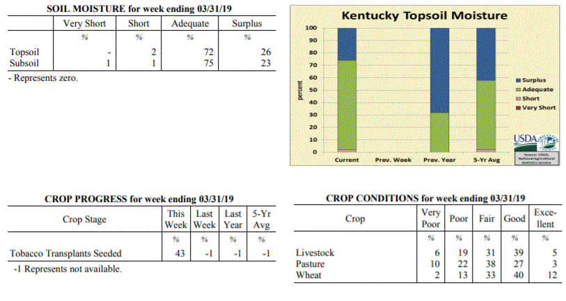 Kentucky Climate Summary
For the Period March 25, 2019 to March 31, 2019
Near Normal Temperatures and Above Normal Precipitation:
The month of March came to a close with a week of slightly above normal rainfall and
near normal temperatures. The period started with low pressure sliding southeast
across the area, sparking showers and isolated storms. A few dry days followed with
mostly sunny skies taking temperatures on the uphill climb. Highs were sitting in the
70s by Thursday for much of Kentucky. Rain chances then went on the increase again
starting Thursday night and lasting through Saturday. Rainfall totals were on the
light side early-on, but a strong cold front passed through the state on Saturday,
sparking a line of showers and storms. This line accounted for the brunt of the
rainfall for the week, a little over an inch on average. This broke a two week
stretch of below normal rainfall through the mid- section of March. Overall, data at
the Ag Weather Center shows Kentucky averaged 3.46 inches for month, which was the
first month of below normal precipitation since October of last year.
Temperatures for the period averaged 50 degrees across the state which was near
normaland 4 degrees warmer than the previous period. High temperatures
averaged from 60 in the West to 62 in the East. Departure from normal high
temperatures ranged from 3 degrees cooler than normal in the West to near
normal in the East. Low temperatures averaged from 41 degrees in the West to 40
degrees in the East. Departure from normal low temperature ranged from 1 degree
warmer than normal in the West to 5 degrees warmer than normal in the East. The
extreme high temperature for the period was 79 degrees at JACKSON and the extreme low
was 21 degrees at MONTICELLO AWOS.
Precipitation (liq. equ.) for the period totaled 1.08 inches statewide which was 0.06
inches above normal and 105% of normal. Precipitation totals by climate division,
West 1.24 inches, Central 0.95 inches, Bluegrass 1.45 inches and East 0.69 inches,
which was 0.14, -0.13, 0.53 and -0.31 inches respectively from normal. By station,
precipitation totals ranged from a low of 0.35 inches at SOMERSET AWOS to a high of
2.91 inches at CINCINNATI.
---
Kentucky Climate Summary
For the Period March 18, 2019 to March 24, 2019
Below Normal Temperatures and Much Below Normal Precipitation:
As opposed to February, the weather pattern has turned to dry one in March. Through
the 24th of the month, data at the Ag Weather Center shows the state has only
averaged 2.38 inches, which is over an inch below normal. This past week was the
driest of the month with Kentucky only averaging a little over a tenth of an inch and
marked the second straight week of below normal precipitation. High pressure kept
the area dry for most of the week. A couple systems did move through the area on
Wednesday night/Thursday and Sunday, but in the case of both, only amounted to light
accumulations.
Temperatures for the period averaged 45 degrees across the state which was 3 degrees
cooler than normal and 4 degrees cooler than the previous period. High temperatures
averaged from 59 in the West to 56 in the East. Departure from normal high
temperatures ranged from 2 degrees cooler than normal in the West to 4 degrees
cooler than normal in the East. Low temperatures averaged from 35 degrees in the
West to 32 degrees in the East. Departure from normal low temperature ranged from 4
degrees cooler than normal in the West to 2 degrees cooler than normal in the East.
The extreme high temperature for the period was 73 degrees at LOUISA 1S and the
extreme low was 20 degrees at PAINTSVILLE 4W.
Precipitation (liq. equ.) for the period totaled 0.11 inches statewide which was 0.93
inches below normal and 11% of normal. Precipitation totals by climate division, West
0.13 inches, Central 0.04 inches, Bluegrass 0.12 inches and East 0.14 inches, which
was 0.98, 1.06, 0.82 and 0.88 inches below normal. By station, precipitation totals
ranged from a low of 0.00 inches at FORT CAMPBELL to a high of 0.35
inches at BIG SANDY.
---
Kentucky Climate Summary
For the Period March 11, 2019 to March 17, 2019
Above Normal Temperatures and Below Normal Precipitation:
Dry conditions ruled to start the week, but that quickly changed by Thursday as a
strong low-pressure system worked through the area. Ahead of the low, temperatures
warmed into the upper 60s to middle 70s both Wednesday and Thursday. Showers and
storms arrived starting Wednesday night and intensified Thursday morning across
Western Kentucky. This area saw strong to severe storms with some producing
tornadoes, four in all, including an EF2 near Paducah. In addition to the storms,
very breezy winds were present all day on Thursday. A High Wind Warning was even
issued for portions of the state. Winds gusting between 40 and 50 mph was common
outside of thunderstorms, but there were also several reports over 50, including 69
mph in Fayette County! Precipitation was very slow to move east from Western Kentucky
and slowly diminished in strength and intensity. In doing so, while Western Kentucky
averaged 1.73 inches for the week and caused some flooding, Eastern Kentucky came in
at only 0.14 inches.
Temperatures for the period averaged 49 degrees across the state which was 3 degrees
warmer than normal and 14 degrees warmer than the previous period. High temperatures
averaged from 60 in the West to 61 in the East. Departure from normal high
temperatures ranged from 1 degree warmer than normal in the West to 3 degrees
warmer than normal in the East. Low temperatures averaged from 40 degrees in the
West to 38 degrees in the East. Departure from normal low temperature ranged from 3
degrees warmer than normal in the West to 6 degrees warmer than normal in the East.
The extreme high temperature for the period was 80 degrees at LOUISA 1S and the
extreme low was 21 degrees at CYNTHIANA 8N.
Precipitation (liq. equ.) for the period totaled 0.65 inches statewide which was 0.33
inches below normal and 66% of normal. Precipitation totals by climate division, West
1.73 inches, Central 0.28 inches, Bluegrass 0.47 inches and East 0.14 inches, which
was 0.70, -0.75, -0.43 and -0.84 inches respectively from normal. By station,
precipitation totals ranged from a low of 0.00 inches at BOWLING GREEN 4E to a high
of 3.67 inches at PADUCAH ASOS.
---
Kentucky Climate Summary
For the Period March 4, 2019 to March 10, 2019
Well Below Normal Temperatures and Above Normal Precipitation:
The period started off with very cold temperatures and dry conditions in place.
North/northwest flow brought some Arctic air into the region on Monday and Tuesday.
Kentuckians woke up to wind chills in the single digits each morning and highs only
reaching into the 20s and 30s, well below seasonable norms. Temperatures slightly increased
to end the work week, but not quite enough to prevent any wintry weather. Winter
Weather Advisories were issued for Thursday night and into Friday morning. Many
across the northern half of the state saw 1 to 2 inches of slushy snow. In typical
Ohio Valley fashion, the weather took a 180 degree turn for the weekend. High
temperatures jumped into the 50s and 60s ahead of a strong area of low pressure.
Several rounds of showers and storms progressed through the area during the day with
heavy rain as the primary threat. This accounted for the brunt of the precipitations
for the week as the state averaged 1.33 inches.
Temperatures for the period averaged 34 degrees across the state which was 10 degrees
cooler than normal and 6 degrees cooler than the previous period. High temperatures
averaged from 43 in the West to 43 in the East. Departure from normal high
temperatures ranged from 14 degrees cooler than normal in the West to 13 degrees
cooler than normal in the East. Low temperatures averaged from 27 degrees in the
West to 27 degrees in the East. Departure from normal low temperature ranged from 8
degrees cooler than normal in the West to 4 degrees cooler than normal in the East.
The extreme high temperature for the period was 72 degrees at YELLOW CREEK and the
extreme low was 6 degrees at ALEXANDRIA 5NW.
Precipitation (liq. equ.) for the period totaled 1.33 inches statewide which was 0.35
inches above normal and 136% of normal. Precipitation totals by climate division,
West 1.19 inches, Central 1.48 inches, Bluegrass 1.46 inches and East 1.18 inches,
which was 0.15, 0.45, 0.58 and 0.22 inches above normal. By station, precipitation
totals ranged from a low of 0.53 inches at WHITESBURG 2NW to a high of 2.23
inches at ELIZABETHTOWN 8W.
---
Kentucky Climate Summary
For the Period February 25, 2019 to March 3, 2019
Below Normal Temperatures and Precipitation:
Three straight weeks of well above normal precipitation has finally came in an end.
Kentucky experienced some drier conditions this week, only averaging about a quarter
inch. This followed what will go down as the second wettest February on record for
the Bluegrass State with data going back to 1895. Conditions were dry through
Wednesday with temperatures following a warming trend. Highs by Wednesday were in the
60s. A cold front then moved through the area late in the day, bringing cooler
temperatures back to the area for the rest of the week. This frontal passage was a
mostly dry one, but was followed by southern stream disturbance later on Thursday,
bringing some light rain to the region. Attention then turned to Sunday where a
couple waves aloft sparked a wintry mix across the region. Cold rain
across much of the region and some snow farther north.
Temperatures for the period averaged 40 degrees across the state which was 2
degrees cooler than normal and 2 degrees cooler than the previous period. High
temperatures averaged from 46 in the West to 50 in the East. Departure from
normal high temperatures ranged from 9 degrees cooler than normal in the West
to 4 degrees cooler than normal in the East. Low temperatures averaged from 31
degrees in the West to 33 degrees in the East. Departure from normal low
temperature ranged from 2 degrees cooler than normal in the West to 3 degrees
warmer than normal in the East. The extreme high temperature for the period
was 70 degrees at LOUISA 1S and the extreme low was 21 degrees at BRANDENBURG 4SW.
Precipitation (liq. equ.) for the period totaled 0.39 inches statewide which was
0.6 inches below normal and 40% of normal. Precipitation totals by climate
division, West 0.23 inches, Central 0.37 inches, Bluegrass 0.31 inches and East
0.66 inches, which was 0.87, 0.67, 0.56 and 0.27 inches below normal. By
station, precipitation totals ranged from a low of 0.00 inches at LONDON CORBIN
APRT to a high of 1.35 inches at PIKEVILLE 13S.
---
Kentucky Climate Summary
For the Period February 18 to February 24, 2019
Above Normal Temperatures and Much Above Normal Rainfall:
Kentucky can just simply not get a break from the wet pattern. The state has now
gone three straight weeks averaging over two inches of precipitation. In fact, this
week, the Bluegrass State averaged 3.86! The state saw some rare dry days on Monday
and most of Tuesday. Light rain started arriving again across Southern Kentucky on
Tuesday evening and expanded north overnight. Rain turned heavier overnight and by
daybreak on Wednesday, 1 to 2 inches of rainfall was common. Soaking rains continued
on Wednesday with a front stalled across the area. After a temporary break on
Thursday, precipitation returned that night, continuing into Friday and the first
half of the weekend. An additional 1 to 3 inches fell across the area, ending with a
complex of showers and storms Saturday evening. Much of the southern half of
Kentucky got 3 to 4+ inches over the course of the period. Major flooding ensued for
some along the Ohio River across Western Kentucky, in addition to counties bordering the
Cumberland and Kentucky Rivers. Many counties in Eastern Kentucky were under a State
of Emergency. Mudslides were common across this area. Lake Cumberland actually
recorded the highest lake level ever on February 25th at 755.49 feet.
Temperatures for the period averaged 42 degrees across the state which was 2 degrees
warmer than normal and no change to the previous period. High temperatures averaged
from 48 in the West to 50 in the East. Departure from normal high temperatures
ranged from 4 degrees cooler than normal in the West to 1 degree cooler than normal
in the East. Low temperatures averaged from 36 degrees in the West to 38 degrees in
the East. Departure from normal low temperature ranged from 5 degrees warmer than
normal in the West to 11 degrees warmer than normal in the East. The extreme high
temperature for the period was 67 degrees at WHITESBURG 2NW and the extreme low was
18 degrees at BURLINGTON 4S.
Precipitation (liq. equ.) for the period totaled 3.86 inches statewide which was 2.92
inches above normal and 411% of normal. Precipitation totals by climate division,
West 3.67 inches, Central 4.33 inches, Bluegrass 3.03 inches and East 4.42 inches,
which was 2.61, 3.32, 2.22 and 3.54 inches above normal. By station, precipitation
totals ranged from a low of 0.89 inches at CARBONDALE ASOS to a high of 5.91 inches
at MURRAY 1W.
---
Kentucky Climate Summary
For the Period February 11 to February 17, 2019
Above Normal Temperatures and Much Above Normal Rainfall:
Ground is waterlogged across the Commonwealth as the state went back to back weeks
with the state averaging over two inches of precipitation. Most of that rain fell
early in the week on Monday and Tuesday, moderate to heavy intensity from time to
time. Localized flooding was common, while river flooding continued to worsen across
the area. That activity ended with the passage of a cold front on Tuesday
morning/afternoon. After a warm start to the week in the 50s and 60s, temperatures
dipped back to seasonable norms on Wednesday and was followed by another cold front
Thursday night. Winter Weather Advisories and Winter Storm Warnings were issued to
end the workweek with 1 to 3 inches of snow across the southern half of the
state. Ice accumulations were limited to mainly Southwestern Kentucky. Light rain
returned on Sunday, capping a very wet week. Overall, the state averaged 2.71 inches,
almost two inches above normal for this time of year.
Temperatures for the period averaged 42 degrees across the state which was 4
degrees warmer than normal and 4 degrees cooler than the previous period. High
temperatures averaged from 49 in the West to 51 in the East. Departure from
normal high temperatures ranged from near normal in the West to 3 degrees warmer
than normal in the East. Low temperatures averaged from 35 degrees in the West
to 35 degrees in the East. Departure from normal low temperature ranged from 7
degrees warmer than normal in the West to 10 degrees warmer than normal in the
East. The extreme high temperature for the period was 65 degrees at WHITESBURG
2NW and the extreme low was 22 degrees at CARBONDALE ASOS.
Precipitation (liq. equ.) for the period totaled 2.71 inches statewide which was
1.8 inches above normal and 299% of normal. Precipitation totals by climate
division, West 3.27 inches, Central 2.96 inches, Bluegrass 2.12 inches and East
2.47 inches, which was 2.26, 1.97, 1.34 and 1.62 inches above normal. By
station, precipitation totals ranged from a low of 1.23 inches at MT STERLING
AWOS to a high of 4.81 inches at MAYFIELD 6SW.
---
Kentucky Climate Summary
For the Period February 4 to February 10, 2019
Well Above Normal Temperatures and Much Above Normal Precipitation:
Kentucky cannot seem to shake the wet pattern that has plagued the region for quite
some time. The state averaged almost 2.5 inches for the week behind multiple rounds
of rainfall. This was a statewide event with Western Kentucky the leader at an
average of 3.12, while Eastern Kentucky was on the low end at 1.98. The brunt of the
activity fell Tuesday through Thursday, leading to some flooding across the region.
Temperature-wise, the week started out with temperatures in the 60s and 70s, lasting
through Thursday. Behind a strong cold front, temperatures plummeted Thursday
night with lows dipping well into the 20s and the teens on Friday night, introducing
livestock cold stress to the Emergency category yet again.
Temperatures for the period averaged 46 degrees across the state which was 10 degrees
warmer than normal and 14 degrees warmer than the previous period. High temperatures
averaged from 51 in the West to 56 in the East. Departure from normal high
temperatures ranged from 5 degrees warmer than normal in the West to 10 degrees
warmer than normal in the East. Low temperatures averaged from 37 degrees in the
West to 39 degrees in the East. Departure from normal low temperature ranged from 10
degrees warmer than normal in the West to 15 degrees warmer than normal in the
East. The extreme high temperature for the period was 76 degrees at BOONEVILLE 2S and
the extreme low was 12 degrees at BURLINGTON 4S.
Precipitation (liq. equ.) for the period totaled 2.49 inches statewide which was 1.62
inches above normal and 285% of normal. Precipitation totals by climate division,
West 3.12 inches, Central 2.81 inches, Bluegrass 2.06 inches and East 1.98 inches,
which was 2.16, 1.85, 1.3 and 1.16 inches above normal. By station, precipitation
totals ranged from a low of 1.11 inches at BIG SANDY to a high of 4.27 inches at
BENTON 4N.
---
Kentucky Climate Summary
For the Period January 28 to February 3, 2019
Near Normal Temperatures and Much Below Normal Precipitation:
In typical Ohio Valley fashion, the weather changed drastically over the course of
the week. Starting out, temperatures jumped into the mid to upper 50s on Monday.
Behind a cold front, temperatures crashed, setting up a very cold few days as Arctic
air built into the area. Wind chills dropped all the way down to -10 to -20 below
zero Tuesday night and into Wednesday, pushing the livestock cold stress index into the
Emergency category for an extended period of time. The cold continued into the first
part of Thursday with some morning lows below zero. Luckily, a warming trend ensued
for the rest of the week, eventually making it back in the 50s and 60s over the
weekend. Even hitting the low 70s for some across Western and Central Kentucky.
While temperatures were up and down, the state did not see much in the way of
precipitation. Overall, the state averaged less than a tenth of an inch for the week.
Temperatures for the period averaged 33 degrees across the state which was near
normal and 2 degrees warmer than the previous period. High temperatures averaged from
45 in the West to 46 in the East. Departure from normal high temperatures ranged from
near normal in the West to 2 degrees warmer than normal in the East. Low temperatures
averaged from 24 degrees in the West to 22 degrees in the East. Departure from normal
low temperature ranged from 1 degree cooler than normal in the West to near normal in
the East. The extreme high temperature for the period was 71 degrees at FORT CAMPBELL
and the extreme low was -9 degrees at BURLINGTON 4S.
Precipitation (liq. equ.) for the period totaled 0.09 inches statewide which was 0.75
inches below normal and 11% of normal. Precipitation totals by climate division, West
0.08 inches, Central 0.08 inches, Bluegrass 0.10 inches and East 0.08 inches, which
was 0.82, 0.83, 0.62 and 0.73 inches below normal. By station, precipitation totals
ranged from a low of 0.00 inches at MIDDLESBORO AWOS to a high of 0.19 inches at
FRANKFORT 7S.
---
Kentucky Climate Summary
For the Period January 21 to January 27, 2019
Below Normal Temperatures and Above Normal Precipitation:
Extreme cold settled over the Bluegrass State, leading to the first week of 2019 with
below normal temperatures. The period started with temperatures in the single digits
to middle teens Monday morning and wind chills dropping to either side of zero. The
thermometer did go on the increase Tuesday and Wednesday, but quickly went back in
the opposite direction with the passage of a couple cold fronts. Lows dipped into the
low to middle teens that Thursday night, followed by highs on Friday only in the 20s.
Rain showers accompanied the first frontal boundary on Tuesday night and Wednesday
and combined with some other bouts of light snow accumulations, total precipitation
averaged a little over an inch for the Bluegrass State.
Temperatures for the period averaged 30 degrees across the state which was 5 degrees
cooler than normal and 4 degrees cooler.
Precipitation (liq. equ.) for the period totaled 1.03 inches statewide which was 0.22
inches above normal and 127% of normal. Precipitation totals by climate division,
West 1.07 inches, Central 1.09 inches, Bluegrass 0.82 inches and East 1.10 inches,
which was 0.18, 0.23, 0.11 and 0.31 inches above normal.
---
Kentucky Climate Summary
For the Period January 14 to January 20, 2019
Above Normal Temperatures and Precipitation:
The Bluegrass State saw dry and cool conditions over the first half of the period,
before a wet pattern took hold for the second. High temperatures on Monday only rose
into the lower to middle 30s under mostly cloudy skies. That cool and dry held
through Wednesday, before light rain showers overspread the region Wednesday night
and into Thursday as a weak system pushed through the state. Most only saw a third
of an inch or less. After a temporary break from the rain on Friday, a much more
significant disturbance progressed across Kentucky for the first half of the weekend.
Precipitation started as rain within a warm and moist air mass. Much of the
Commonwealth saw a half to 2 inches of rainfall. Cold, arctic air rushing into the
area behind the departing disturbance led to a transition over to snow. 1 to 3
inches fell across Western/Central Kentucky and up into the Bluegrass. Less-so across
Eastern Kentucky. The state finally saw some sunshine on Sunday, but highs only rose
into the 20s. Wind chills in the single digits kept the livestock cold stress index
in the Danger and Emergency categories.
Temperatures for the period averaged 35 degrees across the state which was 2 degrees
warmer than normal and 4 degrees cooler than the previous period. High temperatures
averaged from 41 in the West to 39 in the East. Departure from normal high
temperatures ranged from 2 degrees cooler than normal in the West to 4 degrees
cooler than normal in the East. Low temperatures averaged from 33 degrees in the
West to 31 degrees in the East. Departure from normal low temperature ranged from 8
degrees warmer than normal in the West to 8 degrees warmer than normal in the East.
The extreme high temperature for the period was 59 degrees at BOWLING GREEN APT and
the extreme low was 9 degrees at BURLINGTON 4S.
Precipitation (liq. equ.) for the period totaled 1.47 inches statewide which was 0.63
inches above normal and 176% of normal. Precipitation totals by climate division,
West 1.50 inches, Central 1.52 inches, Bluegrass 1.34 inches and East 1.52 inches,
which was 0.62, 0.63, 0.62 and 0.66 inches above normal. By station, precipitation
totals ranged from a low of 0.41 inches at WHITLEY CITY 3N to a high of 2.51
inches at ALBANY 1N.
---
Kentucky Climate Summary
For the Period January 7 to January 13, 2019
Above Normal Temperatures and Below Normal Precipitation:
The period started very warm with highs jumping into the 60s on Monday. This was
followed by the passage of a couple cold fronts through the region later on Monday
and again on Tuesday. Both brought gusty winds to the area, along with some light
rainfall accumulations. Behind the boundaries, highs struggled in the 30s and 40s
over the rest of the workweek, but with dry conditions in place. That changed yet
again over the weekend as an area of low pressure worked through Kentucky. This
system brought a variety of precipitation types with mainly snow Friday night and
transitioning to a cold rain on Saturday. One to three inches of snow fell for much
of the northern half of the state, while rain was the dominant type farther south.
All together, the state averaged a liquid equivalent of 0.62 inches for the week,
which was about a quarter inch below normal.
Temperatures for the period averaged 39 degrees across the state which was 6 degrees
warmer than normal and 6 degrees cooler than the previous period. High temperatures
averaged from 46 in the West to 46 in the East. Departure from normal high
temperatures ranged from 3 degrees warmer than normal in the West to 2 degrees
warmer than normal in the East. Low temperatures averaged from 35 degrees in the
West to 33 degrees in the East. Departure from normal low temperature ranged from 9
degrees warmer than normal in the West to 9 degrees warmer than normal in the East.
The extreme high temperature for the period was 69 degrees at BOONEVILLE 2S and the
extreme low was 13 degrees at HINDMAN 5N.
Precipitation (liq. equ.) for the period totaled 0.62 inches statewide which was 0.26
inches below normal and 70% of normal. Precipitation totals by climate division, West
0.62 inches, Central 0.60 inches, Bluegrass 0.67 inches and East 0.61 inches, which
was 0.3, 0.34, 0.08 and 0.3 inches below normal. By station, precipitation totals
ranged from a low of 0.22 inches at WILLIAMSBURG AWOS to a high of 0.98 inches at
CINCINNATI.
---
Kentucky Climate Summary
For the Period December 31 to January 6, 2019
Well Above Normal Temperatures and Precipitation:
The Bluegrass State cannot seem to get a break from continued rainfall. Kentucky saw
another couple of rounds this period, one coming on New Year�s Eve and the other
later in the workweek. Both brought widespread rounds of light to moderate showers
to the area, leading to some nuisance flooding. All together, the state average 2.14
inches for the first week of 2019, over an inch above normal for this time of year.
Following the unsettled workweek, dry conditions returned for the weekend with high
temperatures back in the 50s. This warmth pushed Kentucky to a fourth straight week
of above normal temperatures.
Temperatures for the period averaged 45 degrees across the state which was 11 degrees
warmer than normal and 2 degrees warmer than the previous period. High temperatures
averaged from 49 in the West to 55 in the East. Departure from normal high
temperatures ranged from 6 degrees warmer than normal in the West to 11 degrees
warmer than normal in the East. Low temperatures averaged from 38 degrees in the
West to 40 degrees in the East. Departure from normal low temperature ranged from 12
degrees warmer than normal in the West to 16 degrees warmer than normal in the
East. The extreme high temperature for the period was 73 degrees at WHITESBURG 2NW
and the extreme low was 27 degrees at CARBONDALE ASOS.
Precipitation (liq. equ.) for the period totaled 2.14 inches statewide which was 1.25
inches above normal and 240% of normal. Precipitation totals by climate division,
West 1.95 inches, Central 2.35 inches, Bluegrass 2.11 inches and East 2.14 inches,
which was 1.02, 1.39, 1.34 and 1.24 inches above normal. By station, precipitation
totals ranged from a low of 1.29 inches at LOUISA 1S to a high of 3.61 inches at
WHITLEY CITY 3N.
---
Kentucky Climate Summary
For the Period December 24 to December 30, 2018
Above Normal Temperatures and Below Normal Precipitation:
Mild weather highlighted the final week of 2018. The first half of the week,
including the Christmas holiday, was dry for the Bluegrass State with high
temperatures increasing through the 40s and into the 50s. Widespread showers
returned on Thursday and Thursday night as a couple disturbances moved through the
state. Winds did get very breezy with gusts in excess of 40s mph and isolated 50 mph
wind gusts. Overall, this was the only rain event for the week as the state averaged
0.58 inches. Mild and dry conditions returned over the weekend with above normal
temperatures back in place. Kentucky ended up closing 2018 with three straight weeks
of above normal temperatures.
Temperatures for the period averaged 42 degrees across the state which was 7 degrees
warmer than normal and 2 degrees warmer than the previous period. High temperatures
averaged from 51 in the West to 51 in the East. Departure from normal high
temperatures ranged from 6 degrees warmer than normal in the West to 5 degrees warmer
than normal in the East. Low temperatures averaged from 34 degrees in the West to 34
degrees in the East. Departure from normal low temperature ranged from 7 degrees
warmer than normal in the West to 8 degrees warmer than normal in the East. The
extreme high temperature for the period was 64 degrees at BOONEVILLE 2S and the
extreme low was 20 degrees at CYNTHIANA 8N.
Precipitation (liq. equ.) for the period totaled 0.58 inches statewide which was 0.35
inches below normal and 62% of normal. Precipitation totals by climate division, West
0.57 inches, Central 0.63 inches, Bluegrass 0.34 inches and East 0.77 inches, which
was 0.41, 0.38, 0.49 and 0.14 inches below normal. By station, precipitation totals
ranged from a low of 0.13 inches at MT STERLING AWOS to
a high of 1.86 inches at WHITLEY CITY 3N.
---
Kentucky Climate Summary
For the Period December 17 to December 23, 2018
Above Normal Temperatures and Precipitation:
Sunny skies and mild conditions opened up the first half of the period with high
pressure in place. As this high shifted east on Wednesday, southerly flow bumped
high temperatures into the middle 50s to around 60. Showers then started working into
the area on Wednesday night and expanding across the entire state on Thursday.
Widespread light to moderate rain led to a soaking rainfall and was then followed by
additional light showers on Friday. Overall, the state averaged just over an inch
with higher accumulations across Eastern Kentucky and less so across Western
Kentucky. This marked the second straight week of above normal precipitation for the
state.
Temperatures for the period averaged 40 degrees across the state which was 3 degrees
warmer than normal and 2 degrees cooler than the previous period. High temperatures
averaged from 49 in the West to 47 in the East. Departure from normal high
temperatures ranged from 2 degrees warmer than normal in the West to near normal in
the East. Low temperatures averaged from 33 degrees in the West to 33 degrees in the
East. Departure from normal low temperature ranged from 4 degrees warmer than normal
in the West to 6 degrees warmer than normal in the East. The extreme high temperature
for the period was 61 degrees at FORT CAMPBELL and the extreme low was 22 degrees at
CYNTHIANA 8N.
Precipitation (liq. equ.) for the period totaled 1.05 inches statewide which was 0.08
inches above normal and 108% of normal. Precipitation totals by climate division,
West 0.40 inches, Central 1.14 inches, Bluegrass 1.09 inches and East 1.59 inches,
which was -0.66, 0.08, 0.25 and 0.67 inches respectively from normal. By station,
precipitation totals ranged from a low of 0.10 inches at HICKMAN 2E to a high of 2.71
inches at PIKEVILLE 13S.
---
Kentucky Climate Summary
For the Period December 10 to December 16, 2018
Above Normal Temperatures and Precipitation:
The week started out with dry and cold conditions in place. Clearing skies and calm
winds Monday night led to lows dropping well into the teens across the state. The
good news was that the rest of the week followed a much milder pattern with daily
highs getting into the 40s and 50s. In fact, it was the first week since the middle
of October that the state average temperature for the week was above normal. While it
was warmer, low pressure working across the area led to a soggy pattern for the
second half of the work week and lasting through Saturday. Periods of showers fell
across the area, widespread at times. All total, the state averaged 1.46 inches,
about a half inch above normal for this time of year.
Temperatures for the period averaged 43 degrees across the state which was 5 degrees
warmer than normal and 10 degrees warmer than the previous period. High temperatures
averaged from 51 in the West to 49 in the East. Departure from normal high
temperatures ranged from 3 degrees warmer than normal in the West to near normal in
the East. Low temperatures averaged from 36 degrees in the West to 35 degrees in the
East. Departure from normal low temperature ranged from 6 degrees warmer than normal
in the West to 7 degrees warmer than normal in the East. The extreme high temperature
for the period was 63 degrees at BOWLING GREEN APT and the
extreme low was 11 degrees at MONTICELLO AWOS.
Precipitation (liq. equ.) for the period totaled 1.46 inches statewide which was 0.44
inches above normal and 143% of normal. Precipitation totals by climate division,
West 2.02 inches, Central 0.99 inches, Bluegrass 1.21 inches and East 1.64 inches,
which was 0.91, -0.13, 0.32 and 0.67 inches respectively from normal. By station,
precipitation totals ranged from a low of 0.21 inches at SCOTTSVILLE 2W to a high of
3.41 inches at MORGANFIELD 4E.
---
Kentucky Climate Summary
For the Period December 3 to December 9, 2018
Below Normal Temperatures and Precipitation:
Kentucky has not quite reached the official start of winter, but it has seemed Mother
Nature has had different plans. This period marked the 8th straight week of near to
below normal temperatures. Winter cold stuck around the entirety of the week. Cloud
cover associated with a few disturbances kept temperatures in the 30s Monday thru
Wednesday, but also led to some periods of wintry weather. After some additional
light rounds later in the workweek, a major winter storm took shape over the weekend. South
Central Kentucky and Southeastern Kentucky saw the most impacts. Freezing rain fell
across South Central Kentucky with ice accumulations of a tenth to quarter inch. Snow
was the dominant type for Southeastern Kentucky with three to six+ inches common
across this area.
Temperatures for the period averaged 34 degrees across the state which was 7 degrees
cooler than normal and 8 degrees cooler than the previous period. High temperatures
averaged from 39 in the West to 38 in the East. Departure from normal high
temperatures ranged from 12 degrees cooler than normal in the West to 13 degrees
cooler than normal in the East. Low temperatures averaged from 31 degrees in the
West to 30 degrees in the East. Departure from normal low temperature ranged from 1
degree cooler than normal in the West to near normal in the East. The extreme high
temperature for the period was 57 degrees at MIDDLESBORO AWOS and the extreme low was
17 degrees at BURKESVILLE 3W.
Precipitation (liq. equ.) for the period totaled 0.30 inches statewide which was 0.78
inches below normal and 28% of normal. Precipitation totals by climate division, West
0.16 inches, Central 0.35 inches, Bluegrass 0.04 inches and East 0.65 inches, which
was 1.06, 0.8, 0.89 and 0.36 inches below normal. By station, precipitation totals
ranged from a low of 0.00 inches at FRANKFORT to a high of 1.72
inches at YELLOW CREEK.
---
Kentucky Climate Summary
For the Period November 26 to December 2, 2018
Below Normal Temperatures and Above Normal Precipitation:
In typical Kentucky fashion, the weather pattern changed drastically through the
week. Starting out, temperatures ran well below normal Monday and Tuesday. Breezy
conditions pushed wind chills into the 20s on Monday and teens later that night. High
temperatures then only made it to around 30 on Tuesday and with clouds breaking up
that night, plummeted into the teens. Along with the cold came some bouts of snow
showers, but that all came to an end rather quickly. By Friday, highs were back in
the 50s and 60s, staying that way through the weekend. Even had a few stations break
70. Along with the warmth, multiple rounds of rainfall pushed through the region.
While lighter rainfall fell Thursday and Friday, more significant activity swept
through the area Friday night and Saturday. After widespread showers early on with
the passage of a warm front, scattered thunderstorms formed later in the day.
Overall, the state averaged 1.67 inches of rainfall for the week. As a side note,
the annual rainfall record was broke in Lexington with a month remaining in the year!
As of December 3rd, Lexington has recorded 67.02 inches, which breaks the old record
of 66.35 set in 2011.
Temperatures for the period averaged 42 degrees across the state which was 1 degree
cooler than normal and 2 degrees cooler than the previous period. High temperatures
averaged from 49 in the West to 49 in the East. Departure from normal high
temperatures ranged from 5 degrees cooler than normal in the West to 5 degrees
cooler than normal in the East. Low temperatures averaged from 36 degrees in the
West to 35 degrees in the East. Departure from normal low temperature ranged from 1
degree warmer than normal in the West to 4 degrees warmer than normal in the East.
The extreme high temperature for the period was 71 degrees at BOONEVILLE 2S and the extreme
low was 11 degrees at HARTFORD 3E.
Precipitation (liq. equ.) for the period totaled 1.67 inches statewide which was 0.59
inches above normal and 154% of normal. Precipitation totals by climate division,
West 1.77 inches, Central 1.91 inches, Bluegrass 1.75 inches and East 1.25 inches,
which was 0.51, 0.76, 0.84 and 0.24 inches above normal. By station, precipitation
totals ranged from a low of 0.65 inches at MIDDLESBORO AWOS to a high of 2.80
inches at GLASGOW 11W.
---
Kentucky Crop and Weather Report
Issued 4:00 P.M., November 26, 2018 40-18
Agricultural News: Kentucky experienced below normal temperatures and precipitation
over the past week. Precipitation for the week totaled 0.32 inches, 0.69 inches below
normal. Temperatures averaged 43 degrees for the week, 2 degrees below normal.
Topsoil moisture was rated 65 percent adequate and 35 percent surplus. Subsoil
moisture was rated 1 percent short, 68 percent adequate, and 31 percent surplus. Days
suitable for fieldwork averaged 3.3 out of a possible seven.
Primary activities this week included harvesting corn and soybeans, and stripping
tobacco. Soybean harvest has been continuously stalled by precipitation and poor
drying conditions for most of November. Yields and quality remain of concern, with
reports of farmers being docked for deteriorated quality and disease. Fields and
pastures remain saturated, some of the last cuttings of hay were lost due to the
inability to dry and bale. Hay and roughage supplies were reported as mostly
adequate. Some producers have �mudded in� the rest of their wheat crop, and any
remaining acres to be planted may likely be abandoned unless more favorable weather
conditions occur very soon.
Kentucky Climate Summary
For the Period March 25, 2019 to March 31, 2019
Near Normal Temperatures and Above Normal Precipitation:
The month of March came to a close with a week of slightly above normal rainfall and
near normal temperatures. The period started with low pressure sliding southeast
across the area, sparking showers and isolated storms. A few dry days followed with
mostly sunny skies taking temperatures on the uphill climb. Highs were sitting in the
70s by Thursday for much of Kentucky. Rain chances then went on the increase again
starting Thursday night and lasting through Saturday. Rainfall totals were on the
light side early-on, but a strong cold front passed through the state on Saturday,
sparking a line of showers and storms. This line accounted for the brunt of the
rainfall for the week, a little over an inch on average. This broke a two week
stretch of below normal rainfall through the mid- section of March. Overall, data at
the Ag Weather Center shows Kentucky averaged 3.46 inches for month, which was the
first month of below normal precipitation since October of last year.
Temperatures for the period averaged 50 degrees across the state which was near
normaland 4 degrees warmer than the previous period. High temperatures
averaged from 60 in the West to 62 in the East. Departure from normal high
temperatures ranged from 3 degrees cooler than normal in the West to near
normal in the East. Low temperatures averaged from 41 degrees in the West to 40
degrees in the East. Departure from normal low temperature ranged from 1 degree
warmer than normal in the West to 5 degrees warmer than normal in the East. The
extreme high temperature for the period was 79 degrees at JACKSON and the extreme low
was 21 degrees at MONTICELLO AWOS.
Precipitation (liq. equ.) for the period totaled 1.08 inches statewide which was 0.06
inches above normal and 105% of normal. Precipitation totals by climate division,
West 1.24 inches, Central 0.95 inches, Bluegrass 1.45 inches and East 0.69 inches,
which was 0.14, -0.13, 0.53 and -0.31 inches respectively from normal. By station,
precipitation totals ranged from a low of 0.35 inches at SOMERSET AWOS to a high of
2.91 inches at CINCINNATI.
---
Kentucky Climate Summary
For the Period March 18, 2019 to March 24, 2019
Below Normal Temperatures and Much Below Normal Precipitation:
As opposed to February, the weather pattern has turned to dry one in March. Through
the 24th of the month, data at the Ag Weather Center shows the state has only
averaged 2.38 inches, which is over an inch below normal. This past week was the
driest of the month with Kentucky only averaging a little over a tenth of an inch and
marked the second straight week of below normal precipitation. High pressure kept
the area dry for most of the week. A couple systems did move through the area on
Wednesday night/Thursday and Sunday, but in the case of both, only amounted to light
accumulations.
Temperatures for the period averaged 45 degrees across the state which was 3 degrees
cooler than normal and 4 degrees cooler than the previous period. High temperatures
averaged from 59 in the West to 56 in the East. Departure from normal high
temperatures ranged from 2 degrees cooler than normal in the West to 4 degrees
cooler than normal in the East. Low temperatures averaged from 35 degrees in the
West to 32 degrees in the East. Departure from normal low temperature ranged from 4
degrees cooler than normal in the West to 2 degrees cooler than normal in the East.
The extreme high temperature for the period was 73 degrees at LOUISA 1S and the
extreme low was 20 degrees at PAINTSVILLE 4W.
Precipitation (liq. equ.) for the period totaled 0.11 inches statewide which was 0.93
inches below normal and 11% of normal. Precipitation totals by climate division, West
0.13 inches, Central 0.04 inches, Bluegrass 0.12 inches and East 0.14 inches, which
was 0.98, 1.06, 0.82 and 0.88 inches below normal. By station, precipitation totals
ranged from a low of 0.00 inches at FORT CAMPBELL to a high of 0.35
inches at BIG SANDY.
---
Kentucky Climate Summary
For the Period March 11, 2019 to March 17, 2019
Above Normal Temperatures and Below Normal Precipitation:
Dry conditions ruled to start the week, but that quickly changed by Thursday as a
strong low-pressure system worked through the area. Ahead of the low, temperatures
warmed into the upper 60s to middle 70s both Wednesday and Thursday. Showers and
storms arrived starting Wednesday night and intensified Thursday morning across
Western Kentucky. This area saw strong to severe storms with some producing
tornadoes, four in all, including an EF2 near Paducah. In addition to the storms,
very breezy winds were present all day on Thursday. A High Wind Warning was even
issued for portions of the state. Winds gusting between 40 and 50 mph was common
outside of thunderstorms, but there were also several reports over 50, including 69
mph in Fayette County! Precipitation was very slow to move east from Western Kentucky
and slowly diminished in strength and intensity. In doing so, while Western Kentucky
averaged 1.73 inches for the week and caused some flooding, Eastern Kentucky came in
at only 0.14 inches.
Temperatures for the period averaged 49 degrees across the state which was 3 degrees
warmer than normal and 14 degrees warmer than the previous period. High temperatures
averaged from 60 in the West to 61 in the East. Departure from normal high
temperatures ranged from 1 degree warmer than normal in the West to 3 degrees
warmer than normal in the East. Low temperatures averaged from 40 degrees in the
West to 38 degrees in the East. Departure from normal low temperature ranged from 3
degrees warmer than normal in the West to 6 degrees warmer than normal in the East.
The extreme high temperature for the period was 80 degrees at LOUISA 1S and the
extreme low was 21 degrees at CYNTHIANA 8N.
Precipitation (liq. equ.) for the period totaled 0.65 inches statewide which was 0.33
inches below normal and 66% of normal. Precipitation totals by climate division, West
1.73 inches, Central 0.28 inches, Bluegrass 0.47 inches and East 0.14 inches, which
was 0.70, -0.75, -0.43 and -0.84 inches respectively from normal. By station,
precipitation totals ranged from a low of 0.00 inches at BOWLING GREEN 4E to a high
of 3.67 inches at PADUCAH ASOS.
---
Kentucky Climate Summary
For the Period March 4, 2019 to March 10, 2019
Well Below Normal Temperatures and Above Normal Precipitation:
The period started off with very cold temperatures and dry conditions in place.
North/northwest flow brought some Arctic air into the region on Monday and Tuesday.
Kentuckians woke up to wind chills in the single digits each morning and highs only
reaching into the 20s and 30s, well below seasonable norms. Temperatures slightly increased
to end the work week, but not quite enough to prevent any wintry weather. Winter
Weather Advisories were issued for Thursday night and into Friday morning. Many
across the northern half of the state saw 1 to 2 inches of slushy snow. In typical
Ohio Valley fashion, the weather took a 180 degree turn for the weekend. High
temperatures jumped into the 50s and 60s ahead of a strong area of low pressure.
Several rounds of showers and storms progressed through the area during the day with
heavy rain as the primary threat. This accounted for the brunt of the precipitations
for the week as the state averaged 1.33 inches.
Temperatures for the period averaged 34 degrees across the state which was 10 degrees
cooler than normal and 6 degrees cooler than the previous period. High temperatures
averaged from 43 in the West to 43 in the East. Departure from normal high
temperatures ranged from 14 degrees cooler than normal in the West to 13 degrees
cooler than normal in the East. Low temperatures averaged from 27 degrees in the
West to 27 degrees in the East. Departure from normal low temperature ranged from 8
degrees cooler than normal in the West to 4 degrees cooler than normal in the East.
The extreme high temperature for the period was 72 degrees at YELLOW CREEK and the
extreme low was 6 degrees at ALEXANDRIA 5NW.
Precipitation (liq. equ.) for the period totaled 1.33 inches statewide which was 0.35
inches above normal and 136% of normal. Precipitation totals by climate division,
West 1.19 inches, Central 1.48 inches, Bluegrass 1.46 inches and East 1.18 inches,
which was 0.15, 0.45, 0.58 and 0.22 inches above normal. By station, precipitation
totals ranged from a low of 0.53 inches at WHITESBURG 2NW to a high of 2.23
inches at ELIZABETHTOWN 8W.
---
Kentucky Climate Summary
For the Period February 25, 2019 to March 3, 2019
Below Normal Temperatures and Precipitation:
Three straight weeks of well above normal precipitation has finally came in an end.
Kentucky experienced some drier conditions this week, only averaging about a quarter
inch. This followed what will go down as the second wettest February on record for
the Bluegrass State with data going back to 1895. Conditions were dry through
Wednesday with temperatures following a warming trend. Highs by Wednesday were in the
60s. A cold front then moved through the area late in the day, bringing cooler
temperatures back to the area for the rest of the week. This frontal passage was a
mostly dry one, but was followed by southern stream disturbance later on Thursday,
bringing some light rain to the region. Attention then turned to Sunday where a
couple waves aloft sparked a wintry mix across the region. Cold rain
across much of the region and some snow farther north.
Temperatures for the period averaged 40 degrees across the state which was 2
degrees cooler than normal and 2 degrees cooler than the previous period. High
temperatures averaged from 46 in the West to 50 in the East. Departure from
normal high temperatures ranged from 9 degrees cooler than normal in the West
to 4 degrees cooler than normal in the East. Low temperatures averaged from 31
degrees in the West to 33 degrees in the East. Departure from normal low
temperature ranged from 2 degrees cooler than normal in the West to 3 degrees
warmer than normal in the East. The extreme high temperature for the period
was 70 degrees at LOUISA 1S and the extreme low was 21 degrees at BRANDENBURG 4SW.
Precipitation (liq. equ.) for the period totaled 0.39 inches statewide which was
0.6 inches below normal and 40% of normal. Precipitation totals by climate
division, West 0.23 inches, Central 0.37 inches, Bluegrass 0.31 inches and East
0.66 inches, which was 0.87, 0.67, 0.56 and 0.27 inches below normal. By
station, precipitation totals ranged from a low of 0.00 inches at LONDON CORBIN
APRT to a high of 1.35 inches at PIKEVILLE 13S.
---
Kentucky Climate Summary
For the Period February 18 to February 24, 2019
Above Normal Temperatures and Much Above Normal Rainfall:
Kentucky can just simply not get a break from the wet pattern. The state has now
gone three straight weeks averaging over two inches of precipitation. In fact, this
week, the Bluegrass State averaged 3.86! The state saw some rare dry days on Monday
and most of Tuesday. Light rain started arriving again across Southern Kentucky on
Tuesday evening and expanded north overnight. Rain turned heavier overnight and by
daybreak on Wednesday, 1 to 2 inches of rainfall was common. Soaking rains continued
on Wednesday with a front stalled across the area. After a temporary break on
Thursday, precipitation returned that night, continuing into Friday and the first
half of the weekend. An additional 1 to 3 inches fell across the area, ending with a
complex of showers and storms Saturday evening. Much of the southern half of
Kentucky got 3 to 4+ inches over the course of the period. Major flooding ensued for
some along the Ohio River across Western Kentucky, in addition to counties bordering the
Cumberland and Kentucky Rivers. Many counties in Eastern Kentucky were under a State
of Emergency. Mudslides were common across this area. Lake Cumberland actually
recorded the highest lake level ever on February 25th at 755.49 feet.
Temperatures for the period averaged 42 degrees across the state which was 2 degrees
warmer than normal and no change to the previous period. High temperatures averaged
from 48 in the West to 50 in the East. Departure from normal high temperatures
ranged from 4 degrees cooler than normal in the West to 1 degree cooler than normal
in the East. Low temperatures averaged from 36 degrees in the West to 38 degrees in
the East. Departure from normal low temperature ranged from 5 degrees warmer than
normal in the West to 11 degrees warmer than normal in the East. The extreme high
temperature for the period was 67 degrees at WHITESBURG 2NW and the extreme low was
18 degrees at BURLINGTON 4S.
Precipitation (liq. equ.) for the period totaled 3.86 inches statewide which was 2.92
inches above normal and 411% of normal. Precipitation totals by climate division,
West 3.67 inches, Central 4.33 inches, Bluegrass 3.03 inches and East 4.42 inches,
which was 2.61, 3.32, 2.22 and 3.54 inches above normal. By station, precipitation
totals ranged from a low of 0.89 inches at CARBONDALE ASOS to a high of 5.91 inches
at MURRAY 1W.
---
Kentucky Climate Summary
For the Period February 11 to February 17, 2019
Above Normal Temperatures and Much Above Normal Rainfall:
Ground is waterlogged across the Commonwealth as the state went back to back weeks
with the state averaging over two inches of precipitation. Most of that rain fell
early in the week on Monday and Tuesday, moderate to heavy intensity from time to
time. Localized flooding was common, while river flooding continued to worsen across
the area. That activity ended with the passage of a cold front on Tuesday
morning/afternoon. After a warm start to the week in the 50s and 60s, temperatures
dipped back to seasonable norms on Wednesday and was followed by another cold front
Thursday night. Winter Weather Advisories and Winter Storm Warnings were issued to
end the workweek with 1 to 3 inches of snow across the southern half of the
state. Ice accumulations were limited to mainly Southwestern Kentucky. Light rain
returned on Sunday, capping a very wet week. Overall, the state averaged 2.71 inches,
almost two inches above normal for this time of year.
Temperatures for the period averaged 42 degrees across the state which was 4
degrees warmer than normal and 4 degrees cooler than the previous period. High
temperatures averaged from 49 in the West to 51 in the East. Departure from
normal high temperatures ranged from near normal in the West to 3 degrees warmer
than normal in the East. Low temperatures averaged from 35 degrees in the West
to 35 degrees in the East. Departure from normal low temperature ranged from 7
degrees warmer than normal in the West to 10 degrees warmer than normal in the
East. The extreme high temperature for the period was 65 degrees at WHITESBURG
2NW and the extreme low was 22 degrees at CARBONDALE ASOS.
Precipitation (liq. equ.) for the period totaled 2.71 inches statewide which was
1.8 inches above normal and 299% of normal. Precipitation totals by climate
division, West 3.27 inches, Central 2.96 inches, Bluegrass 2.12 inches and East
2.47 inches, which was 2.26, 1.97, 1.34 and 1.62 inches above normal. By
station, precipitation totals ranged from a low of 1.23 inches at MT STERLING
AWOS to a high of 4.81 inches at MAYFIELD 6SW.
---
Kentucky Climate Summary
For the Period February 4 to February 10, 2019
Well Above Normal Temperatures and Much Above Normal Precipitation:
Kentucky cannot seem to shake the wet pattern that has plagued the region for quite
some time. The state averaged almost 2.5 inches for the week behind multiple rounds
of rainfall. This was a statewide event with Western Kentucky the leader at an
average of 3.12, while Eastern Kentucky was on the low end at 1.98. The brunt of the
activity fell Tuesday through Thursday, leading to some flooding across the region.
Temperature-wise, the week started out with temperatures in the 60s and 70s, lasting
through Thursday. Behind a strong cold front, temperatures plummeted Thursday
night with lows dipping well into the 20s and the teens on Friday night, introducing
livestock cold stress to the Emergency category yet again.
Temperatures for the period averaged 46 degrees across the state which was 10 degrees
warmer than normal and 14 degrees warmer than the previous period. High temperatures
averaged from 51 in the West to 56 in the East. Departure from normal high
temperatures ranged from 5 degrees warmer than normal in the West to 10 degrees
warmer than normal in the East. Low temperatures averaged from 37 degrees in the
West to 39 degrees in the East. Departure from normal low temperature ranged from 10
degrees warmer than normal in the West to 15 degrees warmer than normal in the
East. The extreme high temperature for the period was 76 degrees at BOONEVILLE 2S and
the extreme low was 12 degrees at BURLINGTON 4S.
Precipitation (liq. equ.) for the period totaled 2.49 inches statewide which was 1.62
inches above normal and 285% of normal. Precipitation totals by climate division,
West 3.12 inches, Central 2.81 inches, Bluegrass 2.06 inches and East 1.98 inches,
which was 2.16, 1.85, 1.3 and 1.16 inches above normal. By station, precipitation
totals ranged from a low of 1.11 inches at BIG SANDY to a high of 4.27 inches at
BENTON 4N.
---
Kentucky Climate Summary
For the Period January 28 to February 3, 2019
Near Normal Temperatures and Much Below Normal Precipitation:
In typical Ohio Valley fashion, the weather changed drastically over the course of
the week. Starting out, temperatures jumped into the mid to upper 50s on Monday.
Behind a cold front, temperatures crashed, setting up a very cold few days as Arctic
air built into the area. Wind chills dropped all the way down to -10 to -20 below
zero Tuesday night and into Wednesday, pushing the livestock cold stress index into the
Emergency category for an extended period of time. The cold continued into the first
part of Thursday with some morning lows below zero. Luckily, a warming trend ensued
for the rest of the week, eventually making it back in the 50s and 60s over the
weekend. Even hitting the low 70s for some across Western and Central Kentucky.
While temperatures were up and down, the state did not see much in the way of
precipitation. Overall, the state averaged less than a tenth of an inch for the week.
Temperatures for the period averaged 33 degrees across the state which was near
normal and 2 degrees warmer than the previous period. High temperatures averaged from
45 in the West to 46 in the East. Departure from normal high temperatures ranged from
near normal in the West to 2 degrees warmer than normal in the East. Low temperatures
averaged from 24 degrees in the West to 22 degrees in the East. Departure from normal
low temperature ranged from 1 degree cooler than normal in the West to near normal in
the East. The extreme high temperature for the period was 71 degrees at FORT CAMPBELL
and the extreme low was -9 degrees at BURLINGTON 4S.
Precipitation (liq. equ.) for the period totaled 0.09 inches statewide which was 0.75
inches below normal and 11% of normal. Precipitation totals by climate division, West
0.08 inches, Central 0.08 inches, Bluegrass 0.10 inches and East 0.08 inches, which
was 0.82, 0.83, 0.62 and 0.73 inches below normal. By station, precipitation totals
ranged from a low of 0.00 inches at MIDDLESBORO AWOS to a high of 0.19 inches at
FRANKFORT 7S.
---
Kentucky Climate Summary
For the Period January 21 to January 27, 2019
Below Normal Temperatures and Above Normal Precipitation:
Extreme cold settled over the Bluegrass State, leading to the first week of 2019 with
below normal temperatures. The period started with temperatures in the single digits
to middle teens Monday morning and wind chills dropping to either side of zero. The
thermometer did go on the increase Tuesday and Wednesday, but quickly went back in
the opposite direction with the passage of a couple cold fronts. Lows dipped into the
low to middle teens that Thursday night, followed by highs on Friday only in the 20s.
Rain showers accompanied the first frontal boundary on Tuesday night and Wednesday
and combined with some other bouts of light snow accumulations, total precipitation
averaged a little over an inch for the Bluegrass State.
Temperatures for the period averaged 30 degrees across the state which was 5 degrees
cooler than normal and 4 degrees cooler.
Precipitation (liq. equ.) for the period totaled 1.03 inches statewide which was 0.22
inches above normal and 127% of normal. Precipitation totals by climate division,
West 1.07 inches, Central 1.09 inches, Bluegrass 0.82 inches and East 1.10 inches,
which was 0.18, 0.23, 0.11 and 0.31 inches above normal.
---
Kentucky Climate Summary
For the Period January 14 to January 20, 2019
Above Normal Temperatures and Precipitation:
The Bluegrass State saw dry and cool conditions over the first half of the period,
before a wet pattern took hold for the second. High temperatures on Monday only rose
into the lower to middle 30s under mostly cloudy skies. That cool and dry held
through Wednesday, before light rain showers overspread the region Wednesday night
and into Thursday as a weak system pushed through the state. Most only saw a third
of an inch or less. After a temporary break from the rain on Friday, a much more
significant disturbance progressed across Kentucky for the first half of the weekend.
Precipitation started as rain within a warm and moist air mass. Much of the
Commonwealth saw a half to 2 inches of rainfall. Cold, arctic air rushing into the
area behind the departing disturbance led to a transition over to snow. 1 to 3
inches fell across Western/Central Kentucky and up into the Bluegrass. Less-so across
Eastern Kentucky. The state finally saw some sunshine on Sunday, but highs only rose
into the 20s. Wind chills in the single digits kept the livestock cold stress index
in the Danger and Emergency categories.
Temperatures for the period averaged 35 degrees across the state which was 2 degrees
warmer than normal and 4 degrees cooler than the previous period. High temperatures
averaged from 41 in the West to 39 in the East. Departure from normal high
temperatures ranged from 2 degrees cooler than normal in the West to 4 degrees
cooler than normal in the East. Low temperatures averaged from 33 degrees in the
West to 31 degrees in the East. Departure from normal low temperature ranged from 8
degrees warmer than normal in the West to 8 degrees warmer than normal in the East.
The extreme high temperature for the period was 59 degrees at BOWLING GREEN APT and
the extreme low was 9 degrees at BURLINGTON 4S.
Precipitation (liq. equ.) for the period totaled 1.47 inches statewide which was 0.63
inches above normal and 176% of normal. Precipitation totals by climate division,
West 1.50 inches, Central 1.52 inches, Bluegrass 1.34 inches and East 1.52 inches,
which was 0.62, 0.63, 0.62 and 0.66 inches above normal. By station, precipitation
totals ranged from a low of 0.41 inches at WHITLEY CITY 3N to a high of 2.51
inches at ALBANY 1N.
---
Kentucky Climate Summary
For the Period January 7 to January 13, 2019
Above Normal Temperatures and Below Normal Precipitation:
The period started very warm with highs jumping into the 60s on Monday. This was
followed by the passage of a couple cold fronts through the region later on Monday
and again on Tuesday. Both brought gusty winds to the area, along with some light
rainfall accumulations. Behind the boundaries, highs struggled in the 30s and 40s
over the rest of the workweek, but with dry conditions in place. That changed yet
again over the weekend as an area of low pressure worked through Kentucky. This
system brought a variety of precipitation types with mainly snow Friday night and
transitioning to a cold rain on Saturday. One to three inches of snow fell for much
of the northern half of the state, while rain was the dominant type farther south.
All together, the state averaged a liquid equivalent of 0.62 inches for the week,
which was about a quarter inch below normal.
Temperatures for the period averaged 39 degrees across the state which was 6 degrees
warmer than normal and 6 degrees cooler than the previous period. High temperatures
averaged from 46 in the West to 46 in the East. Departure from normal high
temperatures ranged from 3 degrees warmer than normal in the West to 2 degrees
warmer than normal in the East. Low temperatures averaged from 35 degrees in the
West to 33 degrees in the East. Departure from normal low temperature ranged from 9
degrees warmer than normal in the West to 9 degrees warmer than normal in the East.
The extreme high temperature for the period was 69 degrees at BOONEVILLE 2S and the
extreme low was 13 degrees at HINDMAN 5N.
Precipitation (liq. equ.) for the period totaled 0.62 inches statewide which was 0.26
inches below normal and 70% of normal. Precipitation totals by climate division, West
0.62 inches, Central 0.60 inches, Bluegrass 0.67 inches and East 0.61 inches, which
was 0.3, 0.34, 0.08 and 0.3 inches below normal. By station, precipitation totals
ranged from a low of 0.22 inches at WILLIAMSBURG AWOS to a high of 0.98 inches at
CINCINNATI.
---
Kentucky Climate Summary
For the Period December 31 to January 6, 2019
Well Above Normal Temperatures and Precipitation:
The Bluegrass State cannot seem to get a break from continued rainfall. Kentucky saw
another couple of rounds this period, one coming on New Year�s Eve and the other
later in the workweek. Both brought widespread rounds of light to moderate showers
to the area, leading to some nuisance flooding. All together, the state average 2.14
inches for the first week of 2019, over an inch above normal for this time of year.
Following the unsettled workweek, dry conditions returned for the weekend with high
temperatures back in the 50s. This warmth pushed Kentucky to a fourth straight week
of above normal temperatures.
Temperatures for the period averaged 45 degrees across the state which was 11 degrees
warmer than normal and 2 degrees warmer than the previous period. High temperatures
averaged from 49 in the West to 55 in the East. Departure from normal high
temperatures ranged from 6 degrees warmer than normal in the West to 11 degrees
warmer than normal in the East. Low temperatures averaged from 38 degrees in the
West to 40 degrees in the East. Departure from normal low temperature ranged from 12
degrees warmer than normal in the West to 16 degrees warmer than normal in the
East. The extreme high temperature for the period was 73 degrees at WHITESBURG 2NW
and the extreme low was 27 degrees at CARBONDALE ASOS.
Precipitation (liq. equ.) for the period totaled 2.14 inches statewide which was 1.25
inches above normal and 240% of normal. Precipitation totals by climate division,
West 1.95 inches, Central 2.35 inches, Bluegrass 2.11 inches and East 2.14 inches,
which was 1.02, 1.39, 1.34 and 1.24 inches above normal. By station, precipitation
totals ranged from a low of 1.29 inches at LOUISA 1S to a high of 3.61 inches at
WHITLEY CITY 3N.
---
Kentucky Climate Summary
For the Period December 24 to December 30, 2018
Above Normal Temperatures and Below Normal Precipitation:
Mild weather highlighted the final week of 2018. The first half of the week,
including the Christmas holiday, was dry for the Bluegrass State with high
temperatures increasing through the 40s and into the 50s. Widespread showers
returned on Thursday and Thursday night as a couple disturbances moved through the
state. Winds did get very breezy with gusts in excess of 40s mph and isolated 50 mph
wind gusts. Overall, this was the only rain event for the week as the state averaged
0.58 inches. Mild and dry conditions returned over the weekend with above normal
temperatures back in place. Kentucky ended up closing 2018 with three straight weeks
of above normal temperatures.
Temperatures for the period averaged 42 degrees across the state which was 7 degrees
warmer than normal and 2 degrees warmer than the previous period. High temperatures
averaged from 51 in the West to 51 in the East. Departure from normal high
temperatures ranged from 6 degrees warmer than normal in the West to 5 degrees warmer
than normal in the East. Low temperatures averaged from 34 degrees in the West to 34
degrees in the East. Departure from normal low temperature ranged from 7 degrees
warmer than normal in the West to 8 degrees warmer than normal in the East. The
extreme high temperature for the period was 64 degrees at BOONEVILLE 2S and the
extreme low was 20 degrees at CYNTHIANA 8N.
Precipitation (liq. equ.) for the period totaled 0.58 inches statewide which was 0.35
inches below normal and 62% of normal. Precipitation totals by climate division, West
0.57 inches, Central 0.63 inches, Bluegrass 0.34 inches and East 0.77 inches, which
was 0.41, 0.38, 0.49 and 0.14 inches below normal. By station, precipitation totals
ranged from a low of 0.13 inches at MT STERLING AWOS to
a high of 1.86 inches at WHITLEY CITY 3N.
---
Kentucky Climate Summary
For the Period December 17 to December 23, 2018
Above Normal Temperatures and Precipitation:
Sunny skies and mild conditions opened up the first half of the period with high
pressure in place. As this high shifted east on Wednesday, southerly flow bumped
high temperatures into the middle 50s to around 60. Showers then started working into
the area on Wednesday night and expanding across the entire state on Thursday.
Widespread light to moderate rain led to a soaking rainfall and was then followed by
additional light showers on Friday. Overall, the state averaged just over an inch
with higher accumulations across Eastern Kentucky and less so across Western
Kentucky. This marked the second straight week of above normal precipitation for the
state.
Temperatures for the period averaged 40 degrees across the state which was 3 degrees
warmer than normal and 2 degrees cooler than the previous period. High temperatures
averaged from 49 in the West to 47 in the East. Departure from normal high
temperatures ranged from 2 degrees warmer than normal in the West to near normal in
the East. Low temperatures averaged from 33 degrees in the West to 33 degrees in the
East. Departure from normal low temperature ranged from 4 degrees warmer than normal
in the West to 6 degrees warmer than normal in the East. The extreme high temperature
for the period was 61 degrees at FORT CAMPBELL and the extreme low was 22 degrees at
CYNTHIANA 8N.
Precipitation (liq. equ.) for the period totaled 1.05 inches statewide which was 0.08
inches above normal and 108% of normal. Precipitation totals by climate division,
West 0.40 inches, Central 1.14 inches, Bluegrass 1.09 inches and East 1.59 inches,
which was -0.66, 0.08, 0.25 and 0.67 inches respectively from normal. By station,
precipitation totals ranged from a low of 0.10 inches at HICKMAN 2E to a high of 2.71
inches at PIKEVILLE 13S.
---
Kentucky Climate Summary
For the Period December 10 to December 16, 2018
Above Normal Temperatures and Precipitation:
The week started out with dry and cold conditions in place. Clearing skies and calm
winds Monday night led to lows dropping well into the teens across the state. The
good news was that the rest of the week followed a much milder pattern with daily
highs getting into the 40s and 50s. In fact, it was the first week since the middle
of October that the state average temperature for the week was above normal. While it
was warmer, low pressure working across the area led to a soggy pattern for the
second half of the work week and lasting through Saturday. Periods of showers fell
across the area, widespread at times. All total, the state averaged 1.46 inches,
about a half inch above normal for this time of year.
Temperatures for the period averaged 43 degrees across the state which was 5 degrees
warmer than normal and 10 degrees warmer than the previous period. High temperatures
averaged from 51 in the West to 49 in the East. Departure from normal high
temperatures ranged from 3 degrees warmer than normal in the West to near normal in
the East. Low temperatures averaged from 36 degrees in the West to 35 degrees in the
East. Departure from normal low temperature ranged from 6 degrees warmer than normal
in the West to 7 degrees warmer than normal in the East. The extreme high temperature
for the period was 63 degrees at BOWLING GREEN APT and the
extreme low was 11 degrees at MONTICELLO AWOS.
Precipitation (liq. equ.) for the period totaled 1.46 inches statewide which was 0.44
inches above normal and 143% of normal. Precipitation totals by climate division,
West 2.02 inches, Central 0.99 inches, Bluegrass 1.21 inches and East 1.64 inches,
which was 0.91, -0.13, 0.32 and 0.67 inches respectively from normal. By station,
precipitation totals ranged from a low of 0.21 inches at SCOTTSVILLE 2W to a high of
3.41 inches at MORGANFIELD 4E.
---
Kentucky Climate Summary
For the Period December 3 to December 9, 2018
Below Normal Temperatures and Precipitation:
Kentucky has not quite reached the official start of winter, but it has seemed Mother
Nature has had different plans. This period marked the 8th straight week of near to
below normal temperatures. Winter cold stuck around the entirety of the week. Cloud
cover associated with a few disturbances kept temperatures in the 30s Monday thru
Wednesday, but also led to some periods of wintry weather. After some additional
light rounds later in the workweek, a major winter storm took shape over the weekend. South
Central Kentucky and Southeastern Kentucky saw the most impacts. Freezing rain fell
across South Central Kentucky with ice accumulations of a tenth to quarter inch. Snow
was the dominant type for Southeastern Kentucky with three to six+ inches common
across this area.
Temperatures for the period averaged 34 degrees across the state which was 7 degrees
cooler than normal and 8 degrees cooler than the previous period. High temperatures
averaged from 39 in the West to 38 in the East. Departure from normal high
temperatures ranged from 12 degrees cooler than normal in the West to 13 degrees
cooler than normal in the East. Low temperatures averaged from 31 degrees in the
West to 30 degrees in the East. Departure from normal low temperature ranged from 1
degree cooler than normal in the West to near normal in the East. The extreme high
temperature for the period was 57 degrees at MIDDLESBORO AWOS and the extreme low was
17 degrees at BURKESVILLE 3W.
Precipitation (liq. equ.) for the period totaled 0.30 inches statewide which was 0.78
inches below normal and 28% of normal. Precipitation totals by climate division, West
0.16 inches, Central 0.35 inches, Bluegrass 0.04 inches and East 0.65 inches, which
was 1.06, 0.8, 0.89 and 0.36 inches below normal. By station, precipitation totals
ranged from a low of 0.00 inches at FRANKFORT to a high of 1.72
inches at YELLOW CREEK.
---
Kentucky Climate Summary
For the Period November 26 to December 2, 2018
Below Normal Temperatures and Above Normal Precipitation:
In typical Kentucky fashion, the weather pattern changed drastically through the
week. Starting out, temperatures ran well below normal Monday and Tuesday. Breezy
conditions pushed wind chills into the 20s on Monday and teens later that night. High
temperatures then only made it to around 30 on Tuesday and with clouds breaking up
that night, plummeted into the teens. Along with the cold came some bouts of snow
showers, but that all came to an end rather quickly. By Friday, highs were back in
the 50s and 60s, staying that way through the weekend. Even had a few stations break
70. Along with the warmth, multiple rounds of rainfall pushed through the region.
While lighter rainfall fell Thursday and Friday, more significant activity swept
through the area Friday night and Saturday. After widespread showers early on with
the passage of a warm front, scattered thunderstorms formed later in the day.
Overall, the state averaged 1.67 inches of rainfall for the week. As a side note,
the annual rainfall record was broke in Lexington with a month remaining in the year!
As of December 3rd, Lexington has recorded 67.02 inches, which breaks the old record
of 66.35 set in 2011.
Temperatures for the period averaged 42 degrees across the state which was 1 degree
cooler than normal and 2 degrees cooler than the previous period. High temperatures
averaged from 49 in the West to 49 in the East. Departure from normal high
temperatures ranged from 5 degrees cooler than normal in the West to 5 degrees
cooler than normal in the East. Low temperatures averaged from 36 degrees in the
West to 35 degrees in the East. Departure from normal low temperature ranged from 1
degree warmer than normal in the West to 4 degrees warmer than normal in the East.
The extreme high temperature for the period was 71 degrees at BOONEVILLE 2S and the extreme
low was 11 degrees at HARTFORD 3E.
Precipitation (liq. equ.) for the period totaled 1.67 inches statewide which was 0.59
inches above normal and 154% of normal. Precipitation totals by climate division,
West 1.77 inches, Central 1.91 inches, Bluegrass 1.75 inches and East 1.25 inches,
which was 0.51, 0.76, 0.84 and 0.24 inches above normal. By station, precipitation
totals ranged from a low of 0.65 inches at MIDDLESBORO AWOS to a high of 2.80
inches at GLASGOW 11W.
---
Kentucky Crop and Weather Report
Issued 4:00 P.M., November 26, 2018 40-18
Agricultural News: Kentucky experienced below normal temperatures and precipitation
over the past week. Precipitation for the week totaled 0.32 inches, 0.69 inches below
normal. Temperatures averaged 43 degrees for the week, 2 degrees below normal.
Topsoil moisture was rated 65 percent adequate and 35 percent surplus. Subsoil
moisture was rated 1 percent short, 68 percent adequate, and 31 percent surplus. Days
suitable for fieldwork averaged 3.3 out of a possible seven.
Primary activities this week included harvesting corn and soybeans, and stripping
tobacco. Soybean harvest has been continuously stalled by precipitation and poor
drying conditions for most of November. Yields and quality remain of concern, with
reports of farmers being docked for deteriorated quality and disease. Fields and
pastures remain saturated, some of the last cuttings of hay were lost due to the
inability to dry and bale. Hay and roughage supplies were reported as mostly
adequate. Some producers have �mudded in� the rest of their wheat crop, and any
remaining acres to be planted may likely be abandoned unless more favorable weather
conditions occur very soon.
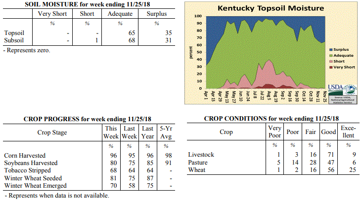 Kentucky Climate Summary
For the Period November 19 to November 25, 2018
Below Normal Temperatures and Precipitation:
The period started with cool, cloudy, and light rain showers in place on Monday.
That cloud cover stayed with the area through Tuesday, before diminishing for
Wednesday and the Thanksgiving holiday. Temperatures went on a warming trend through
the week, starting with highs in the 40s and eventually making it into the 50s and
60s by Friday and into the weekend. Light rain showers returned to the area Friday
night with a disturbance passing aloft and then again late Sunday.Overall, the state
as a whole averaged less than a third of an inch for the week and ended a three-week
stretch of above normal precipitation. Looking at the growing season from April to
October, data shows that 2018 was the sixth wettest on record for the Bluegrass State
with data going back to 1895.
Temperatures for the period averaged 43 degrees across the state which was 2 degrees
cooler than normal and 6 degrees warmer than the previous period. High temperatures
averaged from 53 in the West to 53 in the East. Departure from normal high
temperatures ranged from 3 degrees cooler than normal in the West to 3 degrees
cooler than normal in the East. Low temperatures averaged from 35 degrees in the
West to 35 degrees in the East. Departure from normal low temperature ranged from 1
degree cooler than normal in the West to 2 degrees warmer than normal in the East.
The extreme high temperature for the period was 64 degrees at CARBONDALE ASOS and the
extreme low was 19 degrees at ELKTON 5SW.
Precipitation (liq. equ.) for the period totaled 0.32 inches statewide which was 0.69
inches below normal and 32% of normal. Precipitation totals by climate division, West
0.22 inches, Central 0.27 inches, Bluegrass 0.42 inches and East 0.38 inches, which
was 0.94, 0.8, 0.46 and 0.54 inches below normal. By station, precipitation totals
ranged from a low of 0.08 inches at OWENSBORO AWSS to a high of 0.81 inches at
VANCEBURG 6W.
---
Kentucky Crop and Weather Report
Issued 4:00 P.M., November 19, 2018 39-18
Agricultural News: Kentucky experienced well below normal temperatures and above
normal precipitation over the past week. Precipitation for the week totaled 1.38
inches, 0.46 inches above normal. Temperatures averaged 38 degrees for the week, 10
degrees below normal. Topsoil moisture was rated 1 percent short, 62 percent adequate
and 37 percent surplus. Subsoil moisture was rated 68 percent adequate, and 32
percent surplus. Days suitable for fieldwork averaged 2.5 out of a possible seven.
Primary activities this week included harvesting corn and soybeans, stripping
tobacco, and planting winter wheat when weather conditions permitted. Harvesting and
planting continued to be limited this week by rainfall, freezing rain, and snowfall
across most of the state. The ice accumulation caused some lodging in unharvested
soybeans, and delays in harvesting have some beans starting to pop resulting in lower
yields and quality.
Wheat planting has been delayed for several weeks due to weather conditions, and some
producers are considering abandoning winter wheat acres and taking prevented planting
through crop insurance. The winter wheat that has been planted is slow to germinate
due to the cold and wet soils. Fall breeding of cattle has begun; pastures remain
muddy from frequent precipitation events this fall.
Kentucky Climate Summary
For the Period November 19 to November 25, 2018
Below Normal Temperatures and Precipitation:
The period started with cool, cloudy, and light rain showers in place on Monday.
That cloud cover stayed with the area through Tuesday, before diminishing for
Wednesday and the Thanksgiving holiday. Temperatures went on a warming trend through
the week, starting with highs in the 40s and eventually making it into the 50s and
60s by Friday and into the weekend. Light rain showers returned to the area Friday
night with a disturbance passing aloft and then again late Sunday.Overall, the state
as a whole averaged less than a third of an inch for the week and ended a three-week
stretch of above normal precipitation. Looking at the growing season from April to
October, data shows that 2018 was the sixth wettest on record for the Bluegrass State
with data going back to 1895.
Temperatures for the period averaged 43 degrees across the state which was 2 degrees
cooler than normal and 6 degrees warmer than the previous period. High temperatures
averaged from 53 in the West to 53 in the East. Departure from normal high
temperatures ranged from 3 degrees cooler than normal in the West to 3 degrees
cooler than normal in the East. Low temperatures averaged from 35 degrees in the
West to 35 degrees in the East. Departure from normal low temperature ranged from 1
degree cooler than normal in the West to 2 degrees warmer than normal in the East.
The extreme high temperature for the period was 64 degrees at CARBONDALE ASOS and the
extreme low was 19 degrees at ELKTON 5SW.
Precipitation (liq. equ.) for the period totaled 0.32 inches statewide which was 0.69
inches below normal and 32% of normal. Precipitation totals by climate division, West
0.22 inches, Central 0.27 inches, Bluegrass 0.42 inches and East 0.38 inches, which
was 0.94, 0.8, 0.46 and 0.54 inches below normal. By station, precipitation totals
ranged from a low of 0.08 inches at OWENSBORO AWSS to a high of 0.81 inches at
VANCEBURG 6W.
---
Kentucky Crop and Weather Report
Issued 4:00 P.M., November 19, 2018 39-18
Agricultural News: Kentucky experienced well below normal temperatures and above
normal precipitation over the past week. Precipitation for the week totaled 1.38
inches, 0.46 inches above normal. Temperatures averaged 38 degrees for the week, 10
degrees below normal. Topsoil moisture was rated 1 percent short, 62 percent adequate
and 37 percent surplus. Subsoil moisture was rated 68 percent adequate, and 32
percent surplus. Days suitable for fieldwork averaged 2.5 out of a possible seven.
Primary activities this week included harvesting corn and soybeans, stripping
tobacco, and planting winter wheat when weather conditions permitted. Harvesting and
planting continued to be limited this week by rainfall, freezing rain, and snowfall
across most of the state. The ice accumulation caused some lodging in unharvested
soybeans, and delays in harvesting have some beans starting to pop resulting in lower
yields and quality.
Wheat planting has been delayed for several weeks due to weather conditions, and some
producers are considering abandoning winter wheat acres and taking prevented planting
through crop insurance. The winter wheat that has been planted is slow to germinate
due to the cold and wet soils. Fall breeding of cattle has begun; pastures remain
muddy from frequent precipitation events this fall.
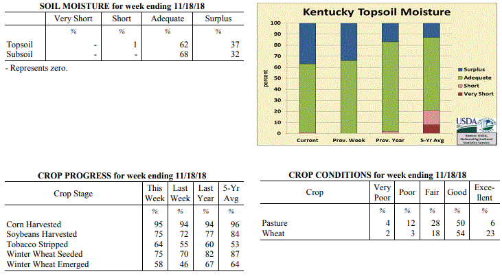 Kentucky Climate Summary
For the Period November 12 to November 18, 2018
Well Below Normal Temperatures and Above Normal Rainfall:
Winter came early for the Bluegrass State as temperatures ran below normal for a
second straight week and a wintry mix of precipitation fell on several occasions. The
most significant event came Wednesday night and into Thursday. A Winter Weather
Advisory was issued for the majority of the state. Freezing rain fell across much of
Central Kentucky and the Bluegrass with numerous accumulations between a tenth and
quarter inch. Ice accumulations were mainly limited to elevated surfaces with warm
ground temperatures in place. While this mitigated road impacts, the ice did lead to
many downed limbs and associated power outages. Precipitation fell in the form of
snow for extreme portions of Western Kentucky with accumulations between 1 and 2
inches. Combined with additional rain showers on Monday/Sunday and other light snow
events, accumulations averaged 1.2 inches for the week. Behind the winter weather,
Kentucky saw a warming trend through the weekend, increasing into the 50s on Saturday
and Sunday.
Temperatures for the period averaged 38 degrees across the state which was 10 degrees
cooler than normal and 6 degrees cooler than the previous period. High temperatures
averaged from 43 in the West to 46 in the East. Departure from normal high
temperatures ranged from 16 degrees cooler than normal in the West to 13 degrees
cooler than normal in the East. Low temperatures averaged from 31 degrees in the
West to 32 degrees in the East. Departure from normal low temperature ranged from 8
degrees cooler than normal in the West to 3 degrees cooler than normal in the East.
The extreme high temperature for the period was 65 degrees at BENTON 4N and the
extreme low was 18 degrees at CARBONDALE ASOS.
Precipitation (liq. equ.) for the period totaled 1.38 inches statewide which was 0.46
inches above normal and 151% of normal. Precipitation totals by climate division,
West 0.77 inches, Central 1.68 inches, Bluegrass 1.44 inches and East 1.61 inches,
which was -0.31, 0.72, 0.65 and 0.78 inches respectively from normal. By station,
precipitation totals ranged from a low of 0.14 inches at POPLAR BLUFF ASOS to a high
of 2.59 inches at GREENVILLE 6N.
---
Kentucky Crop and Weather Report
Issued 4:00 P.M., November 13, 2018 38-18
Agricultural News: Kentucky experienced below normal temperatures and above normal
rainfall over the past week. Precipitation for the week totaled 2.06 inches, 1.28
inches above normal. Temperatures averaged 45 degrees for the week, 5 degrees below
normal. Topsoil moisture was rated 66 percent adequate and 34 percent surplus.
Subsoil moisture was rated 1 percent short, 69 percent adequate, and 30 percent
surplus. Days suitable for fieldwork averaged 2.8 out of a possible seven.
Primary activities this week included harvesting corn and soybeans, planting wheat,
and stripping tobacco. Continued precipitation and forecasted rainfall in the
upcoming week led to delays in fieldwork without adequate time for fields to dry out.
Soybean quality and yields remain of concern with over-maturity, saturated soils, and
deteriorated pods. Some low lying soybean fields have been flooded, and as a result
winter wheat planting decisions are in question in these areas due to the water level.
Kentucky Climate Summary
For the Period November 12 to November 18, 2018
Well Below Normal Temperatures and Above Normal Rainfall:
Winter came early for the Bluegrass State as temperatures ran below normal for a
second straight week and a wintry mix of precipitation fell on several occasions. The
most significant event came Wednesday night and into Thursday. A Winter Weather
Advisory was issued for the majority of the state. Freezing rain fell across much of
Central Kentucky and the Bluegrass with numerous accumulations between a tenth and
quarter inch. Ice accumulations were mainly limited to elevated surfaces with warm
ground temperatures in place. While this mitigated road impacts, the ice did lead to
many downed limbs and associated power outages. Precipitation fell in the form of
snow for extreme portions of Western Kentucky with accumulations between 1 and 2
inches. Combined with additional rain showers on Monday/Sunday and other light snow
events, accumulations averaged 1.2 inches for the week. Behind the winter weather,
Kentucky saw a warming trend through the weekend, increasing into the 50s on Saturday
and Sunday.
Temperatures for the period averaged 38 degrees across the state which was 10 degrees
cooler than normal and 6 degrees cooler than the previous period. High temperatures
averaged from 43 in the West to 46 in the East. Departure from normal high
temperatures ranged from 16 degrees cooler than normal in the West to 13 degrees
cooler than normal in the East. Low temperatures averaged from 31 degrees in the
West to 32 degrees in the East. Departure from normal low temperature ranged from 8
degrees cooler than normal in the West to 3 degrees cooler than normal in the East.
The extreme high temperature for the period was 65 degrees at BENTON 4N and the
extreme low was 18 degrees at CARBONDALE ASOS.
Precipitation (liq. equ.) for the period totaled 1.38 inches statewide which was 0.46
inches above normal and 151% of normal. Precipitation totals by climate division,
West 0.77 inches, Central 1.68 inches, Bluegrass 1.44 inches and East 1.61 inches,
which was -0.31, 0.72, 0.65 and 0.78 inches respectively from normal. By station,
precipitation totals ranged from a low of 0.14 inches at POPLAR BLUFF ASOS to a high
of 2.59 inches at GREENVILLE 6N.
---
Kentucky Crop and Weather Report
Issued 4:00 P.M., November 13, 2018 38-18
Agricultural News: Kentucky experienced below normal temperatures and above normal
rainfall over the past week. Precipitation for the week totaled 2.06 inches, 1.28
inches above normal. Temperatures averaged 45 degrees for the week, 5 degrees below
normal. Topsoil moisture was rated 66 percent adequate and 34 percent surplus.
Subsoil moisture was rated 1 percent short, 69 percent adequate, and 30 percent
surplus. Days suitable for fieldwork averaged 2.8 out of a possible seven.
Primary activities this week included harvesting corn and soybeans, planting wheat,
and stripping tobacco. Continued precipitation and forecasted rainfall in the
upcoming week led to delays in fieldwork without adequate time for fields to dry out.
Soybean quality and yields remain of concern with over-maturity, saturated soils, and
deteriorated pods. Some low lying soybean fields have been flooded, and as a result
winter wheat planting decisions are in question in these areas due to the water level.
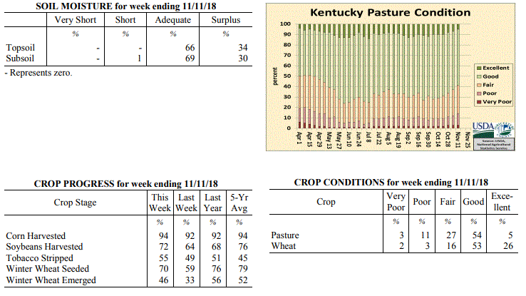 Kentucky Climate Summary
For the Period November 5 to November 11, 2018
Below Normal Temperatures and Above Normal Rainfall:
Kentucky saw a second straight week of above normal precipitation with a state
average over two inches for the period. The brunt of the rainfall fell Monday night
as widespread showers formed ahead of a cold front. A very moist air mass in place
led to moderate to heavy rainfall at times and produced between 1 and 2 inches across
much of the Commonwealth with this system alone. Numerous to widespread showers
formed yet again Thursday night and into Friday with highest accumulations closer to
an inch across Eastern Kentucky. Overall, it has been a very wet start to November
with data at the Ag Weather Center showing a state average of 3.27 inches through the
first eleven days of the month. Behind the second system, the coldest temperatures
of the fall season were seen Saturday and Sunday mornings with temperatures dipping
into the upper teens to middle 20s for much of the state.
Temperatures for the period averaged 45 degrees across the state which was 5 degrees
cooler than normal and 8 degrees cooler than the previous period. High temperatures
averaged from 52 in the West to 54 in the East. Departure from normal high
temperatures ranged from 11 degrees cooler than normal in the West to 8 degrees
cooler than normal in the East. Low temperatures averaged from 37 degrees in the
West to 38 degrees in the East. Departure from normal low temperature ranged from 4
degrees cooler than normal in the West to 2 degrees warmer than normal in the East.
The extreme high temperature for the period was 71 degrees at WHITESBURG 2NW and the
extreme low was 16 degrees at BRANDENBURG 4SW.
Precipitation (liq. equ.) for the period totaled 2.06 inches statewide which was 1.28
inches above normal and 263% of normal. Precipitation totals by climate division,
West 1.60 inches, Central 2.25 inches, Bluegrass 2.14 inches and East 2.24 inches,
which was 0.69, 1.43, 1.45 and 1.53 inches above normal. By station, precipitation
totals ranged from a low of 0.59 inches at FORT KNOX to a high of 3.62 inches at
CYNTHIANA 8N.
---
Kentucky Crop and Weather Report
Issued 4:00 P.M., November 5, 2018 36-18
Agricultural News: Kentucky experienced near normal temperatures and above normal
rainfall over the past week. Precipitation for the week totaled 1.64 inches, 0.88
inches above normal. Temperatures averaged 53 degrees for the week, near normal.
Topsoil moisture was rated 0 percent very short, 1 percent short, 70 percent adequate
and 29 percent surplus. Subsoil moisture was rated 1 percent very short, 1 percent
short, 77 percent adequate, and 21 percent surplus. Days suitable for fieldwork
averaged 3.7 out of a possible seven.
Primary activities for the week included harvesting corn and soybeans, sowing wheat,
and stripping tobacco. However, wet conditions hampered field activity and resulted
in some reports of quality issues in soybeans, lodging in corn and houseburn in
tobacco. Pastures are in mostly good condition with cattle and calves obtaining 59
percent of feed from them. Some hay is being fed. Eighty percent of the current wheat
crop is in good to excellent condition.
Kentucky Climate Summary
For the Period November 5 to November 11, 2018
Below Normal Temperatures and Above Normal Rainfall:
Kentucky saw a second straight week of above normal precipitation with a state
average over two inches for the period. The brunt of the rainfall fell Monday night
as widespread showers formed ahead of a cold front. A very moist air mass in place
led to moderate to heavy rainfall at times and produced between 1 and 2 inches across
much of the Commonwealth with this system alone. Numerous to widespread showers
formed yet again Thursday night and into Friday with highest accumulations closer to
an inch across Eastern Kentucky. Overall, it has been a very wet start to November
with data at the Ag Weather Center showing a state average of 3.27 inches through the
first eleven days of the month. Behind the second system, the coldest temperatures
of the fall season were seen Saturday and Sunday mornings with temperatures dipping
into the upper teens to middle 20s for much of the state.
Temperatures for the period averaged 45 degrees across the state which was 5 degrees
cooler than normal and 8 degrees cooler than the previous period. High temperatures
averaged from 52 in the West to 54 in the East. Departure from normal high
temperatures ranged from 11 degrees cooler than normal in the West to 8 degrees
cooler than normal in the East. Low temperatures averaged from 37 degrees in the
West to 38 degrees in the East. Departure from normal low temperature ranged from 4
degrees cooler than normal in the West to 2 degrees warmer than normal in the East.
The extreme high temperature for the period was 71 degrees at WHITESBURG 2NW and the
extreme low was 16 degrees at BRANDENBURG 4SW.
Precipitation (liq. equ.) for the period totaled 2.06 inches statewide which was 1.28
inches above normal and 263% of normal. Precipitation totals by climate division,
West 1.60 inches, Central 2.25 inches, Bluegrass 2.14 inches and East 2.24 inches,
which was 0.69, 1.43, 1.45 and 1.53 inches above normal. By station, precipitation
totals ranged from a low of 0.59 inches at FORT KNOX to a high of 3.62 inches at
CYNTHIANA 8N.
---
Kentucky Crop and Weather Report
Issued 4:00 P.M., November 5, 2018 36-18
Agricultural News: Kentucky experienced near normal temperatures and above normal
rainfall over the past week. Precipitation for the week totaled 1.64 inches, 0.88
inches above normal. Temperatures averaged 53 degrees for the week, near normal.
Topsoil moisture was rated 0 percent very short, 1 percent short, 70 percent adequate
and 29 percent surplus. Subsoil moisture was rated 1 percent very short, 1 percent
short, 77 percent adequate, and 21 percent surplus. Days suitable for fieldwork
averaged 3.7 out of a possible seven.
Primary activities for the week included harvesting corn and soybeans, sowing wheat,
and stripping tobacco. However, wet conditions hampered field activity and resulted
in some reports of quality issues in soybeans, lodging in corn and houseburn in
tobacco. Pastures are in mostly good condition with cattle and calves obtaining 59
percent of feed from them. Some hay is being fed. Eighty percent of the current wheat
crop is in good to excellent condition.
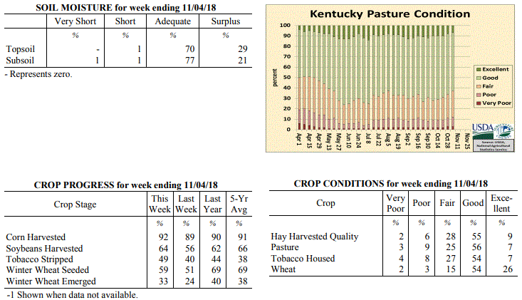 Kentucky Climate Summary
For the Period October 29 to November 4, 2018
Near Normal Temperatures and Above Normal Rainfall:
The period started with near perfect weather in place as high pressure slowly worked
across the area. This feature provided dry weather, mostly sunny skies, and warming
temperatures, peaking in the upper 60s to middle 70s on Tuesday. Conditions
deteriorated on Halloween and the first day of November as a cold front was very slow
to work through the region. Widespread rains fell across the Commonwealth, but the
majority of the soaking rainfall fell across Western Kentucky and areas northeast up
into the Bluegrass. Many in this area saw 2 to 4+ inches for the week. Areas to the
southeast missed out on much of the rainfall as the boundary stalled and only
averaged a quarter to 1 inch for the week. Additional rain fell Friday and Sunday, but
with much less in the way of any accumulations.
Temperatures for the period averaged 53 degrees across the state which was near
normal and 2 degrees warmer than the previous period. High temperatures
averaged from 63 in the West to 63 in the East. Departure from normal high
temperatures ranged from 2 degrees cooler than normal in the West to 2 degrees
cooler than normal in the East. Low temperatures averaged from 45 degrees in the
West to 43 degrees in the East. Departure from normal low temperature ranged from 2
degrees warmer than normal in the West to 5 degrees warmer than normal in the East.
The extreme high temperature for the period was 80 degrees at PADUCAH ASOS and the
extreme low was 30 degrees at CAMPBELLSVILLE 7W.
Precipitation (liq. equ.) for the period totaled 1.64 inches statewide which was 0.88
inches above normal and 215% of normal. Precipitation totals by climate division,
West 3.20 inches, Central 1.28 inches, Bluegrass 1.75 inches and East 0.34 inches,
which was 2.35, 0.49, 1.05 and -0.37 inches respectively from normal. By station,
precipitation totals ranged from a low of 0.07 inches at PAINTSVILLE 4W to a high of
5.18 inches at PADUCAH ASOS.
---
Kentucky Crop and Weather Report
Issued 4:00 P.M., October 29, 2018 35-18
Agricultural News: Kentucky experienced below normal temperatures and rainfall over
the past week. Precipitation for the week totaled 0.47 inches, 0.25 inches below
normal. Temperatures averaged 48 degrees for the week, 8 degrees below normal.
Topsoil moisture was rated 1 percent short, 87 percent adequate, and 12 percent
surplus. Subsoil moisture was rated 1 percent very short, 3 percent short, 86 percent
adequate, and 10 percent surplus. Days suitable for fieldwork averaged 4.9 out of a
possible seven.
Primary activities for this week included continuing harvest of corn and soybeans,
stripping tobacco, and planting winter wheat. Scattered precipitation and seasonably
cool temperatures hampered field work to a degree, however farmers were able to push
ahead.
Livestock and pasture condition is mostly good at this time despite cool temperatures
and wet weather. Housed tobacco is also in mostly good condition at this juncture.
Kentucky Climate Summary
For the Period October 29 to November 4, 2018
Near Normal Temperatures and Above Normal Rainfall:
The period started with near perfect weather in place as high pressure slowly worked
across the area. This feature provided dry weather, mostly sunny skies, and warming
temperatures, peaking in the upper 60s to middle 70s on Tuesday. Conditions
deteriorated on Halloween and the first day of November as a cold front was very slow
to work through the region. Widespread rains fell across the Commonwealth, but the
majority of the soaking rainfall fell across Western Kentucky and areas northeast up
into the Bluegrass. Many in this area saw 2 to 4+ inches for the week. Areas to the
southeast missed out on much of the rainfall as the boundary stalled and only
averaged a quarter to 1 inch for the week. Additional rain fell Friday and Sunday, but
with much less in the way of any accumulations.
Temperatures for the period averaged 53 degrees across the state which was near
normal and 2 degrees warmer than the previous period. High temperatures
averaged from 63 in the West to 63 in the East. Departure from normal high
temperatures ranged from 2 degrees cooler than normal in the West to 2 degrees
cooler than normal in the East. Low temperatures averaged from 45 degrees in the
West to 43 degrees in the East. Departure from normal low temperature ranged from 2
degrees warmer than normal in the West to 5 degrees warmer than normal in the East.
The extreme high temperature for the period was 80 degrees at PADUCAH ASOS and the
extreme low was 30 degrees at CAMPBELLSVILLE 7W.
Precipitation (liq. equ.) for the period totaled 1.64 inches statewide which was 0.88
inches above normal and 215% of normal. Precipitation totals by climate division,
West 3.20 inches, Central 1.28 inches, Bluegrass 1.75 inches and East 0.34 inches,
which was 2.35, 0.49, 1.05 and -0.37 inches respectively from normal. By station,
precipitation totals ranged from a low of 0.07 inches at PAINTSVILLE 4W to a high of
5.18 inches at PADUCAH ASOS.
---
Kentucky Crop and Weather Report
Issued 4:00 P.M., October 29, 2018 35-18
Agricultural News: Kentucky experienced below normal temperatures and rainfall over
the past week. Precipitation for the week totaled 0.47 inches, 0.25 inches below
normal. Temperatures averaged 48 degrees for the week, 8 degrees below normal.
Topsoil moisture was rated 1 percent short, 87 percent adequate, and 12 percent
surplus. Subsoil moisture was rated 1 percent very short, 3 percent short, 86 percent
adequate, and 10 percent surplus. Days suitable for fieldwork averaged 4.9 out of a
possible seven.
Primary activities for this week included continuing harvest of corn and soybeans,
stripping tobacco, and planting winter wheat. Scattered precipitation and seasonably
cool temperatures hampered field work to a degree, however farmers were able to push
ahead.
Livestock and pasture condition is mostly good at this time despite cool temperatures
and wet weather. Housed tobacco is also in mostly good condition at this juncture.
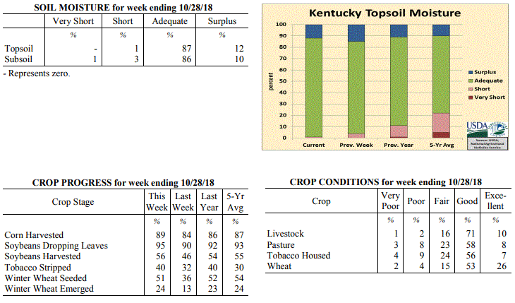 Kentucky Climate Summary
For the Period October 22 to October 28, 2018
Below Normal Temperatures and Rainfall:
Cool conditions pushed Kentucky to a second straight week of below normal
temperatures. The cold was most noteworthy Monday morning as the majority of state
dropped below freezing, into the upper 20s to low 30s. The first half of the workweek
remained dry, but an area of low pressure sparked widespread light showers Thursday
night and into Friday. Scattered coverage remained on Saturday, before a final round
on Sunday with the passage of a cold front. All together, the state averaged about a
half inch, a bit less across Western Kentucky and more so across Eastern Kentucky. The
frontal passage to end the period was accompanied by another round of high winds with
gusts in excess of 40 mph at times.
Temperatures for the period averaged 48 degrees across the state which was 8 degrees
cooler than normal and 4 degrees cooler than the previous period. High temperatures
averaged from 60 in the West to 57 in the East. Departure from normal high
temperatures ranged from 9 degrees cooler than normal in the West to 11 degrees
cooler than normal in the East. Low temperatures averaged from 40 degrees in the
West to 38 degrees in the East. Departure from normal low temperature ranged from 5
degrees cooler than normal in the West to 2 degrees cooler than normal in the East.
The extreme high temperature for the period was 74 degrees at PADUCAH ASOS and the
extreme low was 26 degrees at HENDERSON 5E.
Precipitation (liq. equ.) for the period totaled 0.47 inches statewide which was 0.25
inches below normal and 66% of normal. Precipitation totals by climate division, West
0.31 inches, Central 0.49 inches, Bluegrass 0.43 inches and East 0.66 inches, which
was 0.49, 0.23, 0.23 and 0.02 inches below normal. By station, precipitation totals
ranged from a low of 0.17 inches at OWENSBORO AWSS to a high of 1.24 inches at
WHITLEY CITY 3N.
---
Kentucky Crop and Weather Report
Issued 4:00 P.M., October 22, 2018 34-18
Agricultural News: Kentucky experienced below normal temperatures and above normal
rainfall over the past week. Precipitation for the week totaled 1.06 inches, 0.36
inches above normal. Temperatures averaged 50 degrees for the week, 7 degrees below
normal. Topsoil moisture was rated 4 percent short, 81 percent adequate, and 15
percent surplus. Subsoil moisture was rated 1 percent very short, 6 percent short, 82
percent adequate, and 11 percent surplus. Days suitable for fieldwork averaged 4.3
out of a possible seven.
Primary activities for this week included harvesting corn and soybeans, stripping
tobacco, and planting winter wheat. Cool temperatures and some scattered rain
hindered fieldwork at times, however harvest continues to progress.
Pasture condition is mostly good at this time with cooler temperatures and light
frost slowing growth. Soybeans and housed tobacco were both reported as in mostly
good condition.
Kentucky Climate Summary
For the Period October 22 to October 28, 2018
Below Normal Temperatures and Rainfall:
Cool conditions pushed Kentucky to a second straight week of below normal
temperatures. The cold was most noteworthy Monday morning as the majority of state
dropped below freezing, into the upper 20s to low 30s. The first half of the workweek
remained dry, but an area of low pressure sparked widespread light showers Thursday
night and into Friday. Scattered coverage remained on Saturday, before a final round
on Sunday with the passage of a cold front. All together, the state averaged about a
half inch, a bit less across Western Kentucky and more so across Eastern Kentucky. The
frontal passage to end the period was accompanied by another round of high winds with
gusts in excess of 40 mph at times.
Temperatures for the period averaged 48 degrees across the state which was 8 degrees
cooler than normal and 4 degrees cooler than the previous period. High temperatures
averaged from 60 in the West to 57 in the East. Departure from normal high
temperatures ranged from 9 degrees cooler than normal in the West to 11 degrees
cooler than normal in the East. Low temperatures averaged from 40 degrees in the
West to 38 degrees in the East. Departure from normal low temperature ranged from 5
degrees cooler than normal in the West to 2 degrees cooler than normal in the East.
The extreme high temperature for the period was 74 degrees at PADUCAH ASOS and the
extreme low was 26 degrees at HENDERSON 5E.
Precipitation (liq. equ.) for the period totaled 0.47 inches statewide which was 0.25
inches below normal and 66% of normal. Precipitation totals by climate division, West
0.31 inches, Central 0.49 inches, Bluegrass 0.43 inches and East 0.66 inches, which
was 0.49, 0.23, 0.23 and 0.02 inches below normal. By station, precipitation totals
ranged from a low of 0.17 inches at OWENSBORO AWSS to a high of 1.24 inches at
WHITLEY CITY 3N.
---
Kentucky Crop and Weather Report
Issued 4:00 P.M., October 22, 2018 34-18
Agricultural News: Kentucky experienced below normal temperatures and above normal
rainfall over the past week. Precipitation for the week totaled 1.06 inches, 0.36
inches above normal. Temperatures averaged 50 degrees for the week, 7 degrees below
normal. Topsoil moisture was rated 4 percent short, 81 percent adequate, and 15
percent surplus. Subsoil moisture was rated 1 percent very short, 6 percent short, 82
percent adequate, and 11 percent surplus. Days suitable for fieldwork averaged 4.3
out of a possible seven.
Primary activities for this week included harvesting corn and soybeans, stripping
tobacco, and planting winter wheat. Cool temperatures and some scattered rain
hindered fieldwork at times, however harvest continues to progress.
Pasture condition is mostly good at this time with cooler temperatures and light
frost slowing growth. Soybeans and housed tobacco were both reported as in mostly
good condition.
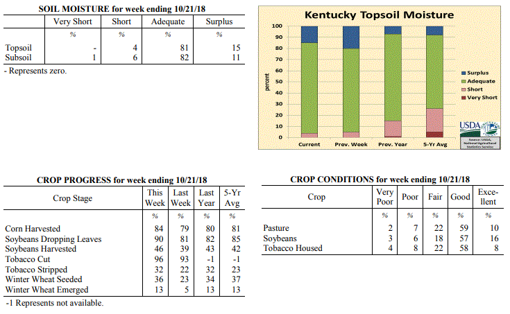 Kentucky Climate Summary
For the Period October 15 to October 21, 2018
Below Normal Temperatures and Above Normal Rainfall:
The passage of multiple cold fronts kept a cooler air mass situated over the
Bluegrass State for much of the period. Frost Advisories and Freeze Warnings were
issued on multiple occasions. Most of the state saw extreme low temperatures drop
into the upper 20s to middle 30s at some point over the past week. This was
especially the case Saturday night, behind the passage of a strong cold front. This
frontal boundary was the focus for high winds late Saturday with gusts in excess of
40 mph at times. Overall, the state average temperature for the week was 7 degrees
below normal, which broke a seven week streak of above normal temperatures.
Precipitation averaged about an inch with a couple widespread rounds of light to
moderate showers, one coming on Monday and the other on Friday, carring over into
the early stages of Saturday.
Temperatures for the period averaged 50 degrees across the state which was 7 degrees
cooler than normal and 12 degrees cooler than the previous period. High temperatures
averaged from 61 in the West to 60 in the East. Departure from normal high
temperatures ranged from 10 degrees cooler than normal in the West to 10 degrees
cooler than normal in the East. Low temperatures averaged from 40 degrees in the
West to 43 degrees in the East. Departure from normal low temperature ranged from 6
degrees cooler than normal in the West to 1 degree warmer than normal in the East.
The extreme high temperature for the period was 74 degrees at BURKESVILLE 3W and the
extreme low was 26 degrees at HENDERSON 5E.
Precipitation (liq. equ.) for the period totaled 1.06 inches statewide which was 0.36
inches above normal and 151% of normal. Precipitation totals by climate division,
West 0.96 inches, Central 1.62 inches, Bluegrass 0.72 inches and East 0.94 inches,
which was 0.2, 0.91, 0.06 and 0.27 inches above normal. By station, precipitation
totals ranged from a low of 0.11 inches at CARROLLTON 2E to a high of 2.82 inches
at RUSSELLVILLE 2W.
---
Kentucky Crop and Weather Report
Issued 4:00 P.M., October 15, 2018 33-18
Agricultural News: Kentucky experienced normal temperatures and rainfall over the
past week. Precipitation for the week totaled 0.80 inches, 0.06 inches above normal.
Temperatures averaged 62 degrees for the week, 3 degrees above normal. Topsoil
moisture was rated 5 percent short, 75 percent adequate, and 20 percent surplus.
Subsoil moisture was rated 5 percent short, 79 percent adequate, and 16 percent
surplus. Days suitable for fieldwork averaged 4.8 out of a possible seven.
Primary activities for this week included the continued harvest of corn, soybeans,
and tobacco along with winter wheat planting and tobacco stripping. While
temperatures were seasonably cool as the week progressed, scattered rain interrupted
fieldwork at times.
Pasture condition is mostly good at this time with cooler temperatures slowing
growth. The condition of housed tobacco was reported as mostly good as were soybeans.
Although the majority of winter wheat is yet to be planted, a small portion
of the crop has begun to emerge.
Kentucky Climate Summary
For the Period October 15 to October 21, 2018
Below Normal Temperatures and Above Normal Rainfall:
The passage of multiple cold fronts kept a cooler air mass situated over the
Bluegrass State for much of the period. Frost Advisories and Freeze Warnings were
issued on multiple occasions. Most of the state saw extreme low temperatures drop
into the upper 20s to middle 30s at some point over the past week. This was
especially the case Saturday night, behind the passage of a strong cold front. This
frontal boundary was the focus for high winds late Saturday with gusts in excess of
40 mph at times. Overall, the state average temperature for the week was 7 degrees
below normal, which broke a seven week streak of above normal temperatures.
Precipitation averaged about an inch with a couple widespread rounds of light to
moderate showers, one coming on Monday and the other on Friday, carring over into
the early stages of Saturday.
Temperatures for the period averaged 50 degrees across the state which was 7 degrees
cooler than normal and 12 degrees cooler than the previous period. High temperatures
averaged from 61 in the West to 60 in the East. Departure from normal high
temperatures ranged from 10 degrees cooler than normal in the West to 10 degrees
cooler than normal in the East. Low temperatures averaged from 40 degrees in the
West to 43 degrees in the East. Departure from normal low temperature ranged from 6
degrees cooler than normal in the West to 1 degree warmer than normal in the East.
The extreme high temperature for the period was 74 degrees at BURKESVILLE 3W and the
extreme low was 26 degrees at HENDERSON 5E.
Precipitation (liq. equ.) for the period totaled 1.06 inches statewide which was 0.36
inches above normal and 151% of normal. Precipitation totals by climate division,
West 0.96 inches, Central 1.62 inches, Bluegrass 0.72 inches and East 0.94 inches,
which was 0.2, 0.91, 0.06 and 0.27 inches above normal. By station, precipitation
totals ranged from a low of 0.11 inches at CARROLLTON 2E to a high of 2.82 inches
at RUSSELLVILLE 2W.
---
Kentucky Crop and Weather Report
Issued 4:00 P.M., October 15, 2018 33-18
Agricultural News: Kentucky experienced normal temperatures and rainfall over the
past week. Precipitation for the week totaled 0.80 inches, 0.06 inches above normal.
Temperatures averaged 62 degrees for the week, 3 degrees above normal. Topsoil
moisture was rated 5 percent short, 75 percent adequate, and 20 percent surplus.
Subsoil moisture was rated 5 percent short, 79 percent adequate, and 16 percent
surplus. Days suitable for fieldwork averaged 4.8 out of a possible seven.
Primary activities for this week included the continued harvest of corn, soybeans,
and tobacco along with winter wheat planting and tobacco stripping. While
temperatures were seasonably cool as the week progressed, scattered rain interrupted
fieldwork at times.
Pasture condition is mostly good at this time with cooler temperatures slowing
growth. The condition of housed tobacco was reported as mostly good as were soybeans.
Although the majority of winter wheat is yet to be planted, a small portion
of the crop has begun to emerge.
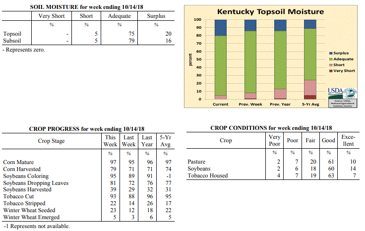 Kentucky Climate Summary
For the Period October 8 to October 14, 2018
Above Normal Temperatures and Rainfall:
The transitional season of fall to cooler weather was in full effect this period. The
week started with unseasonably warm temperatures and mostly dry conditions in place.
High temperatures jumped into the mid to upper 80s on Monday and Tuesday, before a
strong cold front pushed through the area on Wednesday. The boundary was the focus
for periods of showers through the day, but the bigger story was an abrupt change to
fall weather. Behind the front, northwest flow ushered much cooler and drier air into
the Bluegrass State for the second half of the week. Low temperatures dropped into
the upper 30s to middle 40s both Friday and Saturday mornings. Even had some spots drop
into the middle 30s. Additional disturbances moved through the area over the weekend,
sparking light to occasionally moderate showers. Overall, the state averaged 0.80
inches for the week, which was slightly above normal for this time of year.
Temperatures for the period averaged 62 degrees across the state which was 3 degrees
warmer than normal and 14 degrees cooler than the previous period. High temperatures
averaged from 70 in the West to 70 in the East. Departure from normal high
temperatures ranged from 4 degrees cooler than normal in the West to 1 degree
cooler than normal in the East. Low temperatures averaged from 56 degrees in the
West to 54 degrees in the East. Departure from normal low temperature ranged from 8
degrees warmer than normal in the West to 10 degrees warmer than normal in the
East. The extreme high temperature for the period was 90 degrees at OWENSBORO AWSS
and the extreme low was 35 degrees at HENDERSON 5E.
Precipitation (liq. equ.) for the period totaled 0.80 inches statewide which was 0.06
inches above normal and 108% of normal. Precipitation totals by climate division,
West 0.79 inches, Central 0.80 inches, Bluegrass 0.70 inches and East 0.90 inches,
which was 0.04, 0.03, -0.01 and 0.16 inches respectively from normal. By station,
precipitation totals ranged from a low of 0.00 inches at MONTICELLO AWOS to a high of
2.18 inches at BURKESVILLE 3W.
---
Kentucky Crop and Weather Report
Issued 4:00 P.M., October 8, 2018 32-18
Agricultural News: Kentucky experienced well above normal temperatures and below
normal rainfall over the past week. Precipitation for the week totaled 0.47 inches,
0.33 inches below normal. Temperatures averaged 76 degrees for the week, 14 degrees
above normal. Topsoil moisture was rated 1 percent very short, 7 percent short, 78
percent adequate, and 14 percent surplus. Subsoil moisture was rated 1 percent very
short, 7 percent short, 80 percent adequate, and 12 percent surplus. Days suitable
for fieldwork averaged 5.2 out of a possible seven.
Primary activities for this week included the ongoing harvest of corn, soybeans, and
tobacco. Winter wheat planting is continuing with a small percentage of the crop
beginning to emerge. For most of the state the weather was hot and dry allowing
farmers to move ahead with fieldwork.
Pasture condition is mostly good at this time, however the unseasonal heat may have a
negative effect going forward without some rain. Housed tobacco is in mostly good
condition with evident houseburn rated as 7 percent severe, 13 percent moderate, 29
percent light, and 51 percent with none.
Kentucky Climate Summary
For the Period October 8 to October 14, 2018
Above Normal Temperatures and Rainfall:
The transitional season of fall to cooler weather was in full effect this period. The
week started with unseasonably warm temperatures and mostly dry conditions in place.
High temperatures jumped into the mid to upper 80s on Monday and Tuesday, before a
strong cold front pushed through the area on Wednesday. The boundary was the focus
for periods of showers through the day, but the bigger story was an abrupt change to
fall weather. Behind the front, northwest flow ushered much cooler and drier air into
the Bluegrass State for the second half of the week. Low temperatures dropped into
the upper 30s to middle 40s both Friday and Saturday mornings. Even had some spots drop
into the middle 30s. Additional disturbances moved through the area over the weekend,
sparking light to occasionally moderate showers. Overall, the state averaged 0.80
inches for the week, which was slightly above normal for this time of year.
Temperatures for the period averaged 62 degrees across the state which was 3 degrees
warmer than normal and 14 degrees cooler than the previous period. High temperatures
averaged from 70 in the West to 70 in the East. Departure from normal high
temperatures ranged from 4 degrees cooler than normal in the West to 1 degree
cooler than normal in the East. Low temperatures averaged from 56 degrees in the
West to 54 degrees in the East. Departure from normal low temperature ranged from 8
degrees warmer than normal in the West to 10 degrees warmer than normal in the
East. The extreme high temperature for the period was 90 degrees at OWENSBORO AWSS
and the extreme low was 35 degrees at HENDERSON 5E.
Precipitation (liq. equ.) for the period totaled 0.80 inches statewide which was 0.06
inches above normal and 108% of normal. Precipitation totals by climate division,
West 0.79 inches, Central 0.80 inches, Bluegrass 0.70 inches and East 0.90 inches,
which was 0.04, 0.03, -0.01 and 0.16 inches respectively from normal. By station,
precipitation totals ranged from a low of 0.00 inches at MONTICELLO AWOS to a high of
2.18 inches at BURKESVILLE 3W.
---
Kentucky Crop and Weather Report
Issued 4:00 P.M., October 8, 2018 32-18
Agricultural News: Kentucky experienced well above normal temperatures and below
normal rainfall over the past week. Precipitation for the week totaled 0.47 inches,
0.33 inches below normal. Temperatures averaged 76 degrees for the week, 14 degrees
above normal. Topsoil moisture was rated 1 percent very short, 7 percent short, 78
percent adequate, and 14 percent surplus. Subsoil moisture was rated 1 percent very
short, 7 percent short, 80 percent adequate, and 12 percent surplus. Days suitable
for fieldwork averaged 5.2 out of a possible seven.
Primary activities for this week included the ongoing harvest of corn, soybeans, and
tobacco. Winter wheat planting is continuing with a small percentage of the crop
beginning to emerge. For most of the state the weather was hot and dry allowing
farmers to move ahead with fieldwork.
Pasture condition is mostly good at this time, however the unseasonal heat may have a
negative effect going forward without some rain. Housed tobacco is in mostly good
condition with evident houseburn rated as 7 percent severe, 13 percent moderate, 29
percent light, and 51 percent with none.
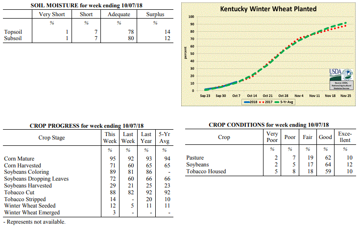 Kentucky Climate Summary
For the Period October 1 to October 7, 2018
Well Above Normal Temperatures and Below Normal Rainfall:
Unseasonably warm and dry for much of the Bluegrass State over the past 7 days.
Showers and thunderstorms were mostly scattered at the start and midpoint of the
workweek. Then summer-like conditions provided very warm and muggy weather with only
isolated showers and thunderstorms for the remainder of the workweek and weekend.
Western Kentucky missed out on much of the rainfall and averaged less than a tenth of
an inch, while the rest of the state was around a half. Temperature-wise, highs
jumped into the upper 80s to low 90s at times across the state. Normal high
temperatures for the first week of October are in the low to middle 70s. Kentucky has
now seen six straight weeks of above normal temperatures.
Temperatures for the period averaged 76 degrees across the state which was 14 degrees
warmer than normal and 8 degrees warmer than the previous period. High temperatures
averaged from 88 in the West to 84 in the East. Departure from normal high
temperatures ranged from 12 degrees warmer than normal in the West to 10 degrees
warmer than normal in the East. Low temperatures averaged from 67 degrees in the
West to 65 degrees in the East. Departure from normal low temperature ranged from 16
degrees warmer than normal in the West to 18 degrees warmer than normal in the
East. The extreme high temperature for the period was 92 degrees at GREENVILLE 6N and
the extreme low was 54 degrees at CARBONDALE ASOS.
Precipitation (liq. equ.) for the period totaled 0.47 inches statewide which was 0.33
inches below normal and 59% of normal. Precipitation totals by climate division, West
0.09 inches, Central 0.48 inches, Bluegrass 0.65 inches and East 0.65 inches, which
was 0.73, 0.36, 0.09 and 0.14 inches below normal. By station, precipitation totals
ranged from a low of 0.00 inches at BARBOURVILLE 3E to a high of 3.88 inches at
LEXINGTON APT.
---
Kentucky Crop and Weather Report
Issued 4:00 P.M., October 1, 2018 31-18
Agricultural News: Kentucky experienced above normal temperatures and well above
normal rainfall over the past week. Precipitation for the week totaled 2.58 inches,
1.74 inches above normal. Temperatures averaged 67 degrees for the week, 2 degrees
above normal. Topsoil moisture was rated 3 percent short, 62 percent adequate, and 35
percent surplus. Subsoil moisture was rated 1 percent very short, 5 percent short, 66
percent adequate, and 28 percent surplus. Days suitable for fieldwork averaged 2.4
out of a possible seven.
Primary activities for this week included the continued harvest of tobacco, corn,
soybeans, and hay along with the early stages of winter wheat planting. Although
fieldwork was limited in the early part of the week due to precipitation, the latter
part of the week presented favorable conditions. Rain was very heavy in areas of the
state leading to the flooding of some fields, however crop damage does not appear to
be widespread. Crop conditions and disease possibility will be monitored carefully as
fields begin to dry.
Livestock and pasture conditions are mostly good at this time despite the heavy rain.
Hay supplies were reported as 3 percent very short, 17 percent short, 70 percent
adequate, and 10 percent surplus. Tobacco houseburn was reported as 4 percent severe,
12 percent moderate, 32 percent light, and 52 percent experiencing none.
Kentucky Climate Summary
For the Period October 1 to October 7, 2018
Well Above Normal Temperatures and Below Normal Rainfall:
Unseasonably warm and dry for much of the Bluegrass State over the past 7 days.
Showers and thunderstorms were mostly scattered at the start and midpoint of the
workweek. Then summer-like conditions provided very warm and muggy weather with only
isolated showers and thunderstorms for the remainder of the workweek and weekend.
Western Kentucky missed out on much of the rainfall and averaged less than a tenth of
an inch, while the rest of the state was around a half. Temperature-wise, highs
jumped into the upper 80s to low 90s at times across the state. Normal high
temperatures for the first week of October are in the low to middle 70s. Kentucky has
now seen six straight weeks of above normal temperatures.
Temperatures for the period averaged 76 degrees across the state which was 14 degrees
warmer than normal and 8 degrees warmer than the previous period. High temperatures
averaged from 88 in the West to 84 in the East. Departure from normal high
temperatures ranged from 12 degrees warmer than normal in the West to 10 degrees
warmer than normal in the East. Low temperatures averaged from 67 degrees in the
West to 65 degrees in the East. Departure from normal low temperature ranged from 16
degrees warmer than normal in the West to 18 degrees warmer than normal in the
East. The extreme high temperature for the period was 92 degrees at GREENVILLE 6N and
the extreme low was 54 degrees at CARBONDALE ASOS.
Precipitation (liq. equ.) for the period totaled 0.47 inches statewide which was 0.33
inches below normal and 59% of normal. Precipitation totals by climate division, West
0.09 inches, Central 0.48 inches, Bluegrass 0.65 inches and East 0.65 inches, which
was 0.73, 0.36, 0.09 and 0.14 inches below normal. By station, precipitation totals
ranged from a low of 0.00 inches at BARBOURVILLE 3E to a high of 3.88 inches at
LEXINGTON APT.
---
Kentucky Crop and Weather Report
Issued 4:00 P.M., October 1, 2018 31-18
Agricultural News: Kentucky experienced above normal temperatures and well above
normal rainfall over the past week. Precipitation for the week totaled 2.58 inches,
1.74 inches above normal. Temperatures averaged 67 degrees for the week, 2 degrees
above normal. Topsoil moisture was rated 3 percent short, 62 percent adequate, and 35
percent surplus. Subsoil moisture was rated 1 percent very short, 5 percent short, 66
percent adequate, and 28 percent surplus. Days suitable for fieldwork averaged 2.4
out of a possible seven.
Primary activities for this week included the continued harvest of tobacco, corn,
soybeans, and hay along with the early stages of winter wheat planting. Although
fieldwork was limited in the early part of the week due to precipitation, the latter
part of the week presented favorable conditions. Rain was very heavy in areas of the
state leading to the flooding of some fields, however crop damage does not appear to
be widespread. Crop conditions and disease possibility will be monitored carefully as
fields begin to dry.
Livestock and pasture conditions are mostly good at this time despite the heavy rain.
Hay supplies were reported as 3 percent very short, 17 percent short, 70 percent
adequate, and 10 percent surplus. Tobacco houseburn was reported as 4 percent severe,
12 percent moderate, 32 percent light, and 52 percent experiencing none.
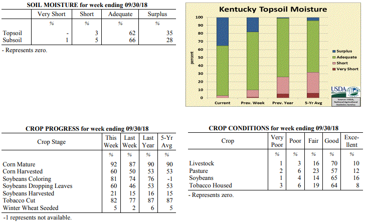 Kentucky Climate Summary
For the Period September 24 to September 30, 2018
Above Normal Temperatures and Well Above Normal Rainfall:
Carrying over from the previous weekend, a wet pattern continued through Thursday
with daily showers and some storms. A combination of frontal passages and
disturbances aloft sparked this activity within a very moist air mass. Rainfall was
widespread at times and did aggravate ongoing flooding issues from the weekend before
with already saturated grounds for many locations. A week after averaging 2.19
inches, the Commonwealth turned around and averaged another 2.58 inches. Preliminary
data from the Ag Weather Center suggest September 2018 will place in the top 5
wettest September�s on record for the state of Kentucky. Following the passage of a
disturbance aloft on Thursday, dry conditions and seasonable temperatures worked into
the area for the remainder of the period.
Temperatures for the period averaged 67 degrees across the state which was 2 degrees
warmer than normal and 8 degrees cooler than the previous period. High temperatures
averaged from 76 in the West to 74 in the East. Departure from normal high
temperatures ranged from 2 degrees cooler than normal in the West to 2 degrees
cooler than normal in the East. Low temperatures averaged from 60 degrees in the
West to 60 degrees in the East. Departure from normal low temperature ranged from 6
degrees warmer than normal in the West to 9 degrees warmer than normal in the East.
The extreme high temperature for the period was 86 degrees at PADUCAH ASOS and the
extreme low was 45 degrees at CINCINNATI.
Precipitation (liq. equ.) for the period totaled 2.58 inches statewide which was 1.74
inches above normal and 306% of normal. Precipitation totals by climate division,
West 2.49 inches, Central 2.69 inches, Bluegrass 2.44 inches and East 2.69 inches,
which was 1.63, 1.77, 1.68 and 1.86 inches above normal. By station, precipitation
totals ranged from a low of 0.75 inches at OWENSBORO AWSS to a high of 4.21 inches at
YELLOW CREEK.
---
Kentucky Crop and Weather Report
Issued 4:00 P.M., September 24, 2018 30-18
Agricultural News: Kentucky experienced above normal temperatures and well above
normal rainfall over the past week. Precipitation for the week totaled 2.19 inches,
1.36 inches above normal. Temperatures averaged 75 degrees for the week, 8 degrees
above normal. Topsoil moisture was rated 1 percent very short, 9 percent short, 72
percent adequate and 18 percent surplus. Subsoil moisture was rated 3 percent very
short, 11 percent short, 71 percent adequate, and 15 percent surplus. Days suitable
for fieldwork averaged 5.1 out of a possible seven.
Primary activities this week included harvesting corn, soybeans, tobacco, and hay.
Wet weather over most of the state from remnants of Florence delayed fieldwork at
times and made harvesting activities difficult. Northern and eastern counties that
have experienced higher precipitation totals over the season have some flooded fields
and are reporting increased disease pressure. Rainfall and higher temperatures this
week, as well as forecasted rain next week, have some tobacco producers concerned
over harvesting fields in time and house burn exposure.
Kentucky Climate Summary
For the Period September 24 to September 30, 2018
Above Normal Temperatures and Well Above Normal Rainfall:
Carrying over from the previous weekend, a wet pattern continued through Thursday
with daily showers and some storms. A combination of frontal passages and
disturbances aloft sparked this activity within a very moist air mass. Rainfall was
widespread at times and did aggravate ongoing flooding issues from the weekend before
with already saturated grounds for many locations. A week after averaging 2.19
inches, the Commonwealth turned around and averaged another 2.58 inches. Preliminary
data from the Ag Weather Center suggest September 2018 will place in the top 5
wettest September�s on record for the state of Kentucky. Following the passage of a
disturbance aloft on Thursday, dry conditions and seasonable temperatures worked into
the area for the remainder of the period.
Temperatures for the period averaged 67 degrees across the state which was 2 degrees
warmer than normal and 8 degrees cooler than the previous period. High temperatures
averaged from 76 in the West to 74 in the East. Departure from normal high
temperatures ranged from 2 degrees cooler than normal in the West to 2 degrees
cooler than normal in the East. Low temperatures averaged from 60 degrees in the
West to 60 degrees in the East. Departure from normal low temperature ranged from 6
degrees warmer than normal in the West to 9 degrees warmer than normal in the East.
The extreme high temperature for the period was 86 degrees at PADUCAH ASOS and the
extreme low was 45 degrees at CINCINNATI.
Precipitation (liq. equ.) for the period totaled 2.58 inches statewide which was 1.74
inches above normal and 306% of normal. Precipitation totals by climate division,
West 2.49 inches, Central 2.69 inches, Bluegrass 2.44 inches and East 2.69 inches,
which was 1.63, 1.77, 1.68 and 1.86 inches above normal. By station, precipitation
totals ranged from a low of 0.75 inches at OWENSBORO AWSS to a high of 4.21 inches at
YELLOW CREEK.
---
Kentucky Crop and Weather Report
Issued 4:00 P.M., September 24, 2018 30-18
Agricultural News: Kentucky experienced above normal temperatures and well above
normal rainfall over the past week. Precipitation for the week totaled 2.19 inches,
1.36 inches above normal. Temperatures averaged 75 degrees for the week, 8 degrees
above normal. Topsoil moisture was rated 1 percent very short, 9 percent short, 72
percent adequate and 18 percent surplus. Subsoil moisture was rated 3 percent very
short, 11 percent short, 71 percent adequate, and 15 percent surplus. Days suitable
for fieldwork averaged 5.1 out of a possible seven.
Primary activities this week included harvesting corn, soybeans, tobacco, and hay.
Wet weather over most of the state from remnants of Florence delayed fieldwork at
times and made harvesting activities difficult. Northern and eastern counties that
have experienced higher precipitation totals over the season have some flooded fields
and are reporting increased disease pressure. Rainfall and higher temperatures this
week, as well as forecasted rain next week, have some tobacco producers concerned
over harvesting fields in time and house burn exposure.
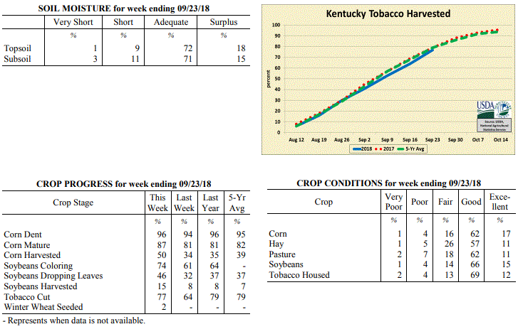 Kentucky Climate Summary
For the Period September 17 to September 23, 2018
Above Normal Temperatures and Well Above Normal Rainfall:
This past week added to an already wet month for the Bluegrass State. Starting
out, the remnant low of Florence drifted north across the eastern border of
Kentucky on Monday. Light to moderate showers continued to fall across primarily
the eastern half of the state, before the system moved out of the area that
night. Summer heat and isolated afternoon storms then returned the next few
days. Highs jumped into the low to middle 90s, much above normal highs of upper
70s to low 80s for this time of year. With that said, a strong cold front passed
through the area Friday and Friday night. Ahead and along the boundary,
thunderstorms developed within an unstable atmosphere, even forming a line at
one point, producing gusty winds and heavy rain. While cooler temperatures
arrived for the first day of fall on Saturday, the frontal passage signaled the
start of a very active weekend in which several rounds of showers pushed through
the state. Steady moderate showers even led to substantial flooding across
portions of the Southern Bluegrass and Northeast Kentucky. Overall, the state
averaged 1.75 inches over the past 3 days and 2.19 inches for the week.
Temperatures for the period averaged 75 degrees across the state which was 8
degrees warmer than normal and 4 degrees warmer than the previous period. High
temperatures averaged from 86 in the West to 81 in the East. Departure from
normal high temperatures ranged from 5 degrees warmer than normal in the West to
2 degrees warmer than normal in the East. Low temperatures averaged from 66
degrees in the West to 67 degrees in the East. Departure from normal low
temperature ranged from 9 degrees warmer than normal in the West to 13 degrees
warmer than normal in the East. The extreme high temperature for the period
was 99 degrees at MADISONVILLE 4S and the extreme low was 57 degrees at ALEXANDRIA
5NW.
Precipitation (liq. equ.) for the period totaled 2.19 inches statewide which was
1.36 inches above normal and 263% of normal. Precipitation totals by climate
division, West 1.48 inches, Central 2.29 inches, Bluegrass 2.46 inches and East
2.52 inches, which was 0.63, 1.38, 1.71 and 1.7 inches above normal. By station,
precipitation totals ranged from a low of 0.29 inches at EVANSVILLE ASOS to a
high of 5.20 inches at MUNFORDVILLE 6E.
---
Kentucky Crop and Weather Report
Issued 4:00 P.M., September 17, 2018 29-18
Agricultural News: Kentucky experienced above normal temperatures and below normal
rainfall over the past week. Precipitation for the week totaled 0.16 inches, 0.68
inches below normal. Temperatures averaged 72 degrees for the week, 2 degrees above
normal. Topsoil moisture was rated 3 percent very short, 14 percent short, 68 percent
adequate and 15 percent surplus. Subsoil moisture was rated 3 percent very short, 15
percent short, 72 percent adequate, and 10 percent surplus. Days suitable for
fieldwork averaged 5.4 out of a possible seven.
Primary activities this week included harvesting corn and soybeans, making hay, and
cutting tobacco. Several tobacco producers have noted that finding labor for
harvesting is an ongoing challenge. Northeastern counties experienced heavy rain
showers and humidity at times, leading to house burn in curing tobacco. Cattle
producers are preparing for fall breeding and securing supplies.
Kentucky Climate Summary
For the Period September 17 to September 23, 2018
Above Normal Temperatures and Well Above Normal Rainfall:
This past week added to an already wet month for the Bluegrass State. Starting
out, the remnant low of Florence drifted north across the eastern border of
Kentucky on Monday. Light to moderate showers continued to fall across primarily
the eastern half of the state, before the system moved out of the area that
night. Summer heat and isolated afternoon storms then returned the next few
days. Highs jumped into the low to middle 90s, much above normal highs of upper
70s to low 80s for this time of year. With that said, a strong cold front passed
through the area Friday and Friday night. Ahead and along the boundary,
thunderstorms developed within an unstable atmosphere, even forming a line at
one point, producing gusty winds and heavy rain. While cooler temperatures
arrived for the first day of fall on Saturday, the frontal passage signaled the
start of a very active weekend in which several rounds of showers pushed through
the state. Steady moderate showers even led to substantial flooding across
portions of the Southern Bluegrass and Northeast Kentucky. Overall, the state
averaged 1.75 inches over the past 3 days and 2.19 inches for the week.
Temperatures for the period averaged 75 degrees across the state which was 8
degrees warmer than normal and 4 degrees warmer than the previous period. High
temperatures averaged from 86 in the West to 81 in the East. Departure from
normal high temperatures ranged from 5 degrees warmer than normal in the West to
2 degrees warmer than normal in the East. Low temperatures averaged from 66
degrees in the West to 67 degrees in the East. Departure from normal low
temperature ranged from 9 degrees warmer than normal in the West to 13 degrees
warmer than normal in the East. The extreme high temperature for the period
was 99 degrees at MADISONVILLE 4S and the extreme low was 57 degrees at ALEXANDRIA
5NW.
Precipitation (liq. equ.) for the period totaled 2.19 inches statewide which was
1.36 inches above normal and 263% of normal. Precipitation totals by climate
division, West 1.48 inches, Central 2.29 inches, Bluegrass 2.46 inches and East
2.52 inches, which was 0.63, 1.38, 1.71 and 1.7 inches above normal. By station,
precipitation totals ranged from a low of 0.29 inches at EVANSVILLE ASOS to a
high of 5.20 inches at MUNFORDVILLE 6E.
---
Kentucky Crop and Weather Report
Issued 4:00 P.M., September 17, 2018 29-18
Agricultural News: Kentucky experienced above normal temperatures and below normal
rainfall over the past week. Precipitation for the week totaled 0.16 inches, 0.68
inches below normal. Temperatures averaged 72 degrees for the week, 2 degrees above
normal. Topsoil moisture was rated 3 percent very short, 14 percent short, 68 percent
adequate and 15 percent surplus. Subsoil moisture was rated 3 percent very short, 15
percent short, 72 percent adequate, and 10 percent surplus. Days suitable for
fieldwork averaged 5.4 out of a possible seven.
Primary activities this week included harvesting corn and soybeans, making hay, and
cutting tobacco. Several tobacco producers have noted that finding labor for
harvesting is an ongoing challenge. Northeastern counties experienced heavy rain
showers and humidity at times, leading to house burn in curing tobacco. Cattle
producers are preparing for fall breeding and securing supplies.
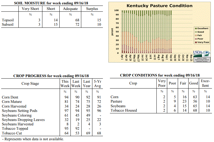 Kentucky Climate Summary
For the Period September 10 to September 16, 2018
Above Normal Temperatures and Below Normal Rainfall:
Tropical Depression Florence started working through Kentucky over the latter half of
the weekend. This became the third tropical system to make an appearance across the
Commonwealth this year, along with remnants of Alberto and Gordon. Light to
occasionally moderate showers associated with Florence were mainly confined to the
eastern half of the state and for many, was the only precipitation seen for the week.
While Eastern Kentucky averaged just over a half inch for the period, Western and
Central Kentucky did not receive any significant rainfall. Most across this area
either did not see accumulations or totals were below a tenth of an inch.
Temperatures for the period averaged 72 degrees across the state which was 2 degrees
warmer than normal and 6 degrees cooler than the previous period. High temperatures
averaged from 83 in the West to 80 in the East. Departure from normal high
temperatures ranged from near normal in the West to 1 degree cooler than
normal in the East. Low temperatures averaged from 62 degrees in the West to 65
degrees in the East. Departure from normal low temperature ranged from 2 degrees
warmer than normal in the West to 8 degrees warmer than normal in the East. The
extreme high temperature for the period was 95 degrees at MADISONVILLE 4S and the
extreme low was 52 degrees at CALHOUN 5NW.
Precipitation (liq. equ.) for the period totaled 0.16 inches statewide which was 0.68
inches below normal and 19% of normal. Precipitation totals by climate division, West
0.01 inches, Central 0.03 inches, Bluegrass 0.06 inches and East 0.54 inches, which
was 0.85, 0.91, 0.7 and 0.28 inches below normal. By station, precipitation totals
ranged from a low of 0.00 inches at BENTON 4N to a high of 1.36 inches at MIDDLESBORO AWOS.
---
Kentucky Crop and Weather Report
Issued 4:00 P.M., September 10, 2018 28-18
Agricultural News: Kentucky experienced above normal temperatures and much above
normal rainfall over the past week. Precipitation for the week totaled 2.52 inches,
1.74 inches above normal. Temperatures averaged 78 degrees for the week, 6 degrees
above normal. Topsoil moisture was rated 3 percent very short, 14 percent short, 71
percent adequate and 12 percent surplus. Subsoil moisture was rated 4 percent very
short, 15 percent short, 70 percent adequate, and 11 percent surplus. Days suitable
for fieldwork averaged 5.1 out of a possible seven.
Primary activities this week included harvesting corn, and cutting hay and tobacco.
Heavy rain later in the week and over the weekend from remnants of Tropical Storm
Gordon led to minor flooding; rains were mostly absorbed into the soil from past dry
weather. Fieldwork was delayed towards the end of the week, as farmers held off on
harvesting crops. Recent wet weather has tobacco producers concerned over house burn
and curing conditions. Excessive rainfall in areas has increased weed pressures in
fields and pastures.
Kentucky Climate Summary
For the Period September 10 to September 16, 2018
Above Normal Temperatures and Below Normal Rainfall:
Tropical Depression Florence started working through Kentucky over the latter half of
the weekend. This became the third tropical system to make an appearance across the
Commonwealth this year, along with remnants of Alberto and Gordon. Light to
occasionally moderate showers associated with Florence were mainly confined to the
eastern half of the state and for many, was the only precipitation seen for the week.
While Eastern Kentucky averaged just over a half inch for the period, Western and
Central Kentucky did not receive any significant rainfall. Most across this area
either did not see accumulations or totals were below a tenth of an inch.
Temperatures for the period averaged 72 degrees across the state which was 2 degrees
warmer than normal and 6 degrees cooler than the previous period. High temperatures
averaged from 83 in the West to 80 in the East. Departure from normal high
temperatures ranged from near normal in the West to 1 degree cooler than
normal in the East. Low temperatures averaged from 62 degrees in the West to 65
degrees in the East. Departure from normal low temperature ranged from 2 degrees
warmer than normal in the West to 8 degrees warmer than normal in the East. The
extreme high temperature for the period was 95 degrees at MADISONVILLE 4S and the
extreme low was 52 degrees at CALHOUN 5NW.
Precipitation (liq. equ.) for the period totaled 0.16 inches statewide which was 0.68
inches below normal and 19% of normal. Precipitation totals by climate division, West
0.01 inches, Central 0.03 inches, Bluegrass 0.06 inches and East 0.54 inches, which
was 0.85, 0.91, 0.7 and 0.28 inches below normal. By station, precipitation totals
ranged from a low of 0.00 inches at BENTON 4N to a high of 1.36 inches at MIDDLESBORO AWOS.
---
Kentucky Crop and Weather Report
Issued 4:00 P.M., September 10, 2018 28-18
Agricultural News: Kentucky experienced above normal temperatures and much above
normal rainfall over the past week. Precipitation for the week totaled 2.52 inches,
1.74 inches above normal. Temperatures averaged 78 degrees for the week, 6 degrees
above normal. Topsoil moisture was rated 3 percent very short, 14 percent short, 71
percent adequate and 12 percent surplus. Subsoil moisture was rated 4 percent very
short, 15 percent short, 70 percent adequate, and 11 percent surplus. Days suitable
for fieldwork averaged 5.1 out of a possible seven.
Primary activities this week included harvesting corn, and cutting hay and tobacco.
Heavy rain later in the week and over the weekend from remnants of Tropical Storm
Gordon led to minor flooding; rains were mostly absorbed into the soil from past dry
weather. Fieldwork was delayed towards the end of the week, as farmers held off on
harvesting crops. Recent wet weather has tobacco producers concerned over house burn
and curing conditions. Excessive rainfall in areas has increased weed pressures in
fields and pastures.
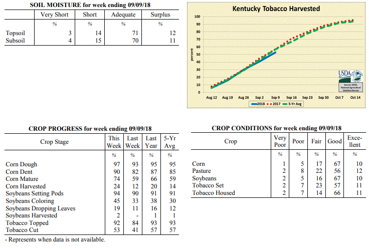 Kentucky Climate Summary
For the Period September 3 to September 9, 2018
Above Normal Temperatures and Much Above Normal Rainfall:
The remnants of Tropical Storm Gordon left much of the state wet and soggy this past
period. The system started impacting the area on Wednesday as tropical moisture was
pulled northward into the Ohio Valley. While showers and storms were scattered in
nature on Wednesday and Thursday, coverage grew upscale Friday and over the weekend
as the remnant system slowly worked across the area. The abundance of rainfall and
high intensity at times led to several bouts of flash flooding and even sent some
rivers into minor flood stages. While the state averaged a little over 2.5 inches
for the week, much higher totals were seen across counties bordering the Ohio River,
in addition to Northeastern Kentucky. Many were over 4 inches. Temperature-wise,
above normal temperatures and high humidity continued over the first half of the week
with highs jumping into the low to middle 90s. Saying that, cloud cover and rainfall
from Gordon brought temperatures back below seasonable norms by the end of the week
with highs on Sunday only in the 60s and 70s.
Temperatures for the period averaged 78 degrees across the state which was 6 degrees
warmer than normal and no change to the previous period. High temperatures averaged
from 87 in the West to 87 in the East. Departure from normal high temperatures
ranged from 1 degree warmer than normal in the West to 3 degrees warmer than normal
in the East. Low temperatures averaged from 69 degrees in the West to 69 degrees in
the East. Departure from normal low temperature ranged from 7 degrees warmer than
normal in the West to 10 degrees warmer than normal in the East. The extreme high
temperature for the period was 98 degrees at GREENVILLE 6N and the extreme low was 57
degrees at ALEXANDRIA 5NW.
Precipitation (liq. equ.) for the period totaled 2.52 inches statewide which was 1.74
inches above normal and 323% of normal. Precipitation totals by climate division,
West 1.88 inches, Central 1.68 inches, Bluegrass 4.60 inches and East 1.90 inches,
which was 1.14, 0.82, 3.87 and 1.11 inches above normal. By station, precipitation
totals ranged from a low of 0.03 inches at MONTICELLO AWOS to a high of 8.79 inches
at OWINGSVILLE 4S.
---
Kentucky Crop and Weather Report
Issued 4:00 P.M., September 4, 2018 27-18
Agricultural News: Kentucky experienced above normal temperatures and below normal
rainfall over the past week. Precipitation for the week totaled 0.67 inches, 0.07
inches below normal. Temperatures averaged 79 degrees for the week, 5 degrees above
normal. Topsoil moisture was rated 5 percent very short, 19 percent short, 71 percent
adequate and 5 percent surplus. Subsoil moisture was rated 5 percent very short, 21
percent short, 68 percent adequate, and 6 percent surplus. Days suitable for
fieldwork averaged 6.0 out of a possible seven.
Primary activities this week included harvesting corn and hay, topping and cutting
tobacco, and preparing equipment for upcoming harvests. Dry weather has helped in
drying down corn, but needed rainfall in western and central counties would improve
pastures, hay, and soybeans to fend off early signs of drought stress.
Kentucky Climate Summary
For the Period September 3 to September 9, 2018
Above Normal Temperatures and Much Above Normal Rainfall:
The remnants of Tropical Storm Gordon left much of the state wet and soggy this past
period. The system started impacting the area on Wednesday as tropical moisture was
pulled northward into the Ohio Valley. While showers and storms were scattered in
nature on Wednesday and Thursday, coverage grew upscale Friday and over the weekend
as the remnant system slowly worked across the area. The abundance of rainfall and
high intensity at times led to several bouts of flash flooding and even sent some
rivers into minor flood stages. While the state averaged a little over 2.5 inches
for the week, much higher totals were seen across counties bordering the Ohio River,
in addition to Northeastern Kentucky. Many were over 4 inches. Temperature-wise,
above normal temperatures and high humidity continued over the first half of the week
with highs jumping into the low to middle 90s. Saying that, cloud cover and rainfall
from Gordon brought temperatures back below seasonable norms by the end of the week
with highs on Sunday only in the 60s and 70s.
Temperatures for the period averaged 78 degrees across the state which was 6 degrees
warmer than normal and no change to the previous period. High temperatures averaged
from 87 in the West to 87 in the East. Departure from normal high temperatures
ranged from 1 degree warmer than normal in the West to 3 degrees warmer than normal
in the East. Low temperatures averaged from 69 degrees in the West to 69 degrees in
the East. Departure from normal low temperature ranged from 7 degrees warmer than
normal in the West to 10 degrees warmer than normal in the East. The extreme high
temperature for the period was 98 degrees at GREENVILLE 6N and the extreme low was 57
degrees at ALEXANDRIA 5NW.
Precipitation (liq. equ.) for the period totaled 2.52 inches statewide which was 1.74
inches above normal and 323% of normal. Precipitation totals by climate division,
West 1.88 inches, Central 1.68 inches, Bluegrass 4.60 inches and East 1.90 inches,
which was 1.14, 0.82, 3.87 and 1.11 inches above normal. By station, precipitation
totals ranged from a low of 0.03 inches at MONTICELLO AWOS to a high of 8.79 inches
at OWINGSVILLE 4S.
---
Kentucky Crop and Weather Report
Issued 4:00 P.M., September 4, 2018 27-18
Agricultural News: Kentucky experienced above normal temperatures and below normal
rainfall over the past week. Precipitation for the week totaled 0.67 inches, 0.07
inches below normal. Temperatures averaged 79 degrees for the week, 5 degrees above
normal. Topsoil moisture was rated 5 percent very short, 19 percent short, 71 percent
adequate and 5 percent surplus. Subsoil moisture was rated 5 percent very short, 21
percent short, 68 percent adequate, and 6 percent surplus. Days suitable for
fieldwork averaged 6.0 out of a possible seven.
Primary activities this week included harvesting corn and hay, topping and cutting
tobacco, and preparing equipment for upcoming harvests. Dry weather has helped in
drying down corn, but needed rainfall in western and central counties would improve
pastures, hay, and soybeans to fend off early signs of drought stress.
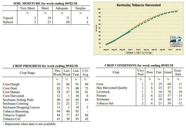 Kentucky Climate Summary
For the Period August 27 to September 2, 2018
Above Normal Temperatures and Below Normal Rainfall:
It may be the first week of September, but Kentucky saw some of the hottest
temperatures of the year over the period. The state average maximum temperature of
89 degrees for the week was only equaled one other time this year in early July.
The majority of Kentucky saw peak temperatures in the low to middle 90s at some
point. Normal high temperatures for early September run in the middle 80s. Combined
with no relief from the muggy conditions, heat indices continued to run close to 100
at times. Rainfall remained isolated to scattered throughout most of the week,
keeping some areas dry, while others saw torrential rainfall. Central Kentucky
and points east were around normal for the week, but Western Kentucky missed much of the
activity and only averaged 0.44 inches.
Temperatures for the period averaged 79 degrees across the state which was 5 degrees
warmer than normal and 6 degrees warmer than the previous period. High temperatures
averaged from 90 in the West to 88 in the East. Departure from normal high
temperatures ranged from 3 degrees warmer than normal in the West to 3 degrees
warmer than normal in the East. Low temperatures averaged from 70 degrees in the
West to 68 degrees in the East. Departure from normal low temperature ranged from 6
degrees warmer than normal in the West to 7 degrees warmer than normal in the East.
The extreme high temperature for the period was 98 degrees at MADISONVILLE 4S and the
extreme low was 63 degrees at MONTICELLO AWOS.
Precipitation (liq. equ.) for the period totaled 0.67 inches statewide which was 0.07
inches below normal and 91% of normal. Precipitation totals by climate division, West
0.44 inches, Central 0.73 inches, Bluegrass 0.67 inches and East 0.83 inches, which
was -0.23, -0.06, -0.06 and 0.06 inches respectively from normal. By station,
precipitation totals ranged from a low of 0.00 inches at EVANSVILLE ASOS to a high of
3.33 inches at HICKMAN 2E.
---
Kentucky Crop and Weather Report
Issued 4:00 P.M., August 27, 2018 26-18
Agricultural News: Kentucky experienced below normal temperatures and rainfall over
the past week. Precipitation for the week totaled 0.55 inches, 0.27 inches below
normal. Temperatures averaged 73 degrees for the week, 2 degrees below normal.
Topsoil moisture was rated 2 percent very short, 18 percent short, 73 percent
adequate, and 7 percent surplus. Subsoil moisture was rated 4 percent very short, 19
percent short, 70 percent adequate, and 7 percent surplus. Days suitable for
fieldwork averaged 5.4 out of a possible seven.
Primary activities for this week included cutting and topping tobacco along with
continued hay harvesting. Although fieldwork was limited at times due to scattered
rain, progress was evident. Corn harvest has begun, but is still in the initial
stage. Corn, soybeans, tobacco, and pasture remain in mostly good condition at this
juncture. Harvested hay was also reported as in mostly good condition.
Kentucky Climate Summary
For the Period August 27 to September 2, 2018
Above Normal Temperatures and Below Normal Rainfall:
It may be the first week of September, but Kentucky saw some of the hottest
temperatures of the year over the period. The state average maximum temperature of
89 degrees for the week was only equaled one other time this year in early July.
The majority of Kentucky saw peak temperatures in the low to middle 90s at some
point. Normal high temperatures for early September run in the middle 80s. Combined
with no relief from the muggy conditions, heat indices continued to run close to 100
at times. Rainfall remained isolated to scattered throughout most of the week,
keeping some areas dry, while others saw torrential rainfall. Central Kentucky
and points east were around normal for the week, but Western Kentucky missed much of the
activity and only averaged 0.44 inches.
Temperatures for the period averaged 79 degrees across the state which was 5 degrees
warmer than normal and 6 degrees warmer than the previous period. High temperatures
averaged from 90 in the West to 88 in the East. Departure from normal high
temperatures ranged from 3 degrees warmer than normal in the West to 3 degrees
warmer than normal in the East. Low temperatures averaged from 70 degrees in the
West to 68 degrees in the East. Departure from normal low temperature ranged from 6
degrees warmer than normal in the West to 7 degrees warmer than normal in the East.
The extreme high temperature for the period was 98 degrees at MADISONVILLE 4S and the
extreme low was 63 degrees at MONTICELLO AWOS.
Precipitation (liq. equ.) for the period totaled 0.67 inches statewide which was 0.07
inches below normal and 91% of normal. Precipitation totals by climate division, West
0.44 inches, Central 0.73 inches, Bluegrass 0.67 inches and East 0.83 inches, which
was -0.23, -0.06, -0.06 and 0.06 inches respectively from normal. By station,
precipitation totals ranged from a low of 0.00 inches at EVANSVILLE ASOS to a high of
3.33 inches at HICKMAN 2E.
---
Kentucky Crop and Weather Report
Issued 4:00 P.M., August 27, 2018 26-18
Agricultural News: Kentucky experienced below normal temperatures and rainfall over
the past week. Precipitation for the week totaled 0.55 inches, 0.27 inches below
normal. Temperatures averaged 73 degrees for the week, 2 degrees below normal.
Topsoil moisture was rated 2 percent very short, 18 percent short, 73 percent
adequate, and 7 percent surplus. Subsoil moisture was rated 4 percent very short, 19
percent short, 70 percent adequate, and 7 percent surplus. Days suitable for
fieldwork averaged 5.4 out of a possible seven.
Primary activities for this week included cutting and topping tobacco along with
continued hay harvesting. Although fieldwork was limited at times due to scattered
rain, progress was evident. Corn harvest has begun, but is still in the initial
stage. Corn, soybeans, tobacco, and pasture remain in mostly good condition at this
juncture. Harvested hay was also reported as in mostly good condition.
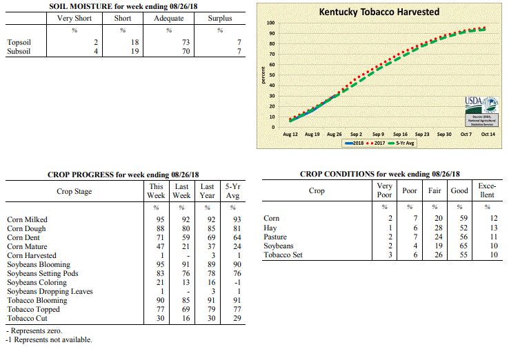 Kentucky Climate Summary
For the Period August 20 to August 26, 2018
Below Normal Temperatures and Rainfall:
Rainfall was scattered in coverage for most of the week, leading to quite different
totals from one location to another. While some locations picked up more than an
inch of rainfall, others were under a tenth. A couple rounds of storms early in the
period ended on Tuesday with the passage of a cold front. Behind the boundary, much
cooler and drier air filtered into the Bluegrass State, bringing the area a glimpse
of fall. Highs only rose into the 70s midweek and lows dropped into the 50s. Saying
that, the fall-like air mass was short lived as heat and humidity gradually returned
over the weekend. By Sunday, high temperatures were back to around 90 with the heat
index in the middle 90s to around 100.
Temperatures for the period averaged 73 degrees across the state which was 2 degrees
cooler than normal and 2 degrees cooler than the previous period. High temperatures
averaged from 82 in the West to 82 in the East. Departure from normal high
temperatures ranged from 6 degrees cooler than normal in the West to 4 degrees
cooler than normal in the East. Low temperatures averaged from 65 degrees in the
West to 63 degrees in the East. Departure from normal low temperature ranged from
near normal in the West to 1 degree warmer than normal in the East. The extreme high
temperature for the period was 94 degrees at GREENVILLE 6N and the extreme low was
49 degrees at MCKEE 5S.
Precipitation (liq. equ.) for the period totaled 0.55 inches statewide which was 0.27
inches below normal and 67% of normal. Precipitation totals by climate division, West
0.54 inches, Central 0.59 inches, Bluegrass 0.70 inches and East 0.37 inches, which
was 0.2, 0.24, 0.12 and 0.51 inches below normal. By station, precipitation totals
ranged from a low of 0.00 inches at MCKEE 5S to a high of 1.55 inches at CAMPBELLSVILLE 7W.
---
Kentucky Crop and Weather Report
Issued 4:00 P.M., August 20, 2018 25-18
Agricultural News: Kentucky experienced near normal temperatures and above normal
rainfall over the past week. Precipitation for the week totaled 1.70 inches, 0.84
inches above normal. Temperatures averaged 76 degrees for the week, unchanged from
normal. Topsoil moisture was rated 1 percent very short, 18 percent short, 68 percent
adequate, and 13 percent surplus. Subsoil moisture was rated 3 percent very short, 22
percent short, 64 percent adequate, and 11 percent surplus. Days suitable for
fieldwork averaged 4.3 out of a possible seven.
Primary activities for this week included continued hay harvesting along with topping
and cutting tobacco. Corn harvest preparations have begun for some farmers. In areas
of the state fieldwork progress was hampered by scattered precipitation. Rain was
heavy at times, however widespread crop damage was not reported. Corn, soybeans, tobacco,
and pasture remain in mostly good condition at this juncture.
Kentucky Climate Summary
For the Period August 20 to August 26, 2018
Below Normal Temperatures and Rainfall:
Rainfall was scattered in coverage for most of the week, leading to quite different
totals from one location to another. While some locations picked up more than an
inch of rainfall, others were under a tenth. A couple rounds of storms early in the
period ended on Tuesday with the passage of a cold front. Behind the boundary, much
cooler and drier air filtered into the Bluegrass State, bringing the area a glimpse
of fall. Highs only rose into the 70s midweek and lows dropped into the 50s. Saying
that, the fall-like air mass was short lived as heat and humidity gradually returned
over the weekend. By Sunday, high temperatures were back to around 90 with the heat
index in the middle 90s to around 100.
Temperatures for the period averaged 73 degrees across the state which was 2 degrees
cooler than normal and 2 degrees cooler than the previous period. High temperatures
averaged from 82 in the West to 82 in the East. Departure from normal high
temperatures ranged from 6 degrees cooler than normal in the West to 4 degrees
cooler than normal in the East. Low temperatures averaged from 65 degrees in the
West to 63 degrees in the East. Departure from normal low temperature ranged from
near normal in the West to 1 degree warmer than normal in the East. The extreme high
temperature for the period was 94 degrees at GREENVILLE 6N and the extreme low was
49 degrees at MCKEE 5S.
Precipitation (liq. equ.) for the period totaled 0.55 inches statewide which was 0.27
inches below normal and 67% of normal. Precipitation totals by climate division, West
0.54 inches, Central 0.59 inches, Bluegrass 0.70 inches and East 0.37 inches, which
was 0.2, 0.24, 0.12 and 0.51 inches below normal. By station, precipitation totals
ranged from a low of 0.00 inches at MCKEE 5S to a high of 1.55 inches at CAMPBELLSVILLE 7W.
---
Kentucky Crop and Weather Report
Issued 4:00 P.M., August 20, 2018 25-18
Agricultural News: Kentucky experienced near normal temperatures and above normal
rainfall over the past week. Precipitation for the week totaled 1.70 inches, 0.84
inches above normal. Temperatures averaged 76 degrees for the week, unchanged from
normal. Topsoil moisture was rated 1 percent very short, 18 percent short, 68 percent
adequate, and 13 percent surplus. Subsoil moisture was rated 3 percent very short, 22
percent short, 64 percent adequate, and 11 percent surplus. Days suitable for
fieldwork averaged 4.3 out of a possible seven.
Primary activities for this week included continued hay harvesting along with topping
and cutting tobacco. Corn harvest preparations have begun for some farmers. In areas
of the state fieldwork progress was hampered by scattered precipitation. Rain was
heavy at times, however widespread crop damage was not reported. Corn, soybeans, tobacco,
and pasture remain in mostly good condition at this juncture.
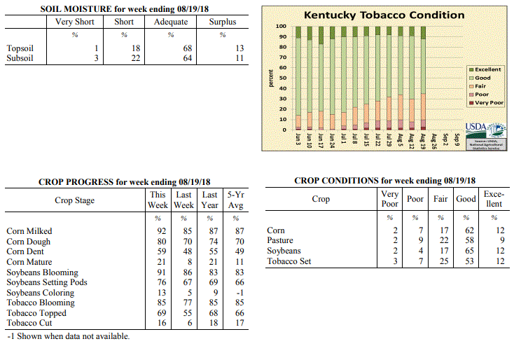 Kentucky Climate Summary
For the Period August 13 to August 19, 2018
Near Normal Temperatures and Above Normal Rainfall:
Kentucky saw above normal rainfall for a third straight week as the Lower Ohio Valley
was confined to yet another wet pattern. A combination of frontal boundaries and
upper level disturbances sparked numerous rounds throughout the period, especially
over the second half of the workweek. With a tropical air mass in place, storms
produced torrential rainfall at times leading to excessive accumulations for some
portions of Kentucky. This was the case for some North Central Kentucky counties,
which received in excess of three inches over the period. Overall, Central Kentucky
and the Bluegrass Region each averaged over two inches for the week, while Western
and Eastern Kentucky were closer to an inch.
Temperatures for the period averaged 76 degrees across the state which was near
normal and no change to the previous period. High temperatures averaged from
87 in the West to 83 in the East. Departure from normal high temperatures ranged
from 1 degree cooler than normal in the West to 3 degrees cooler than normal in
the East. Low temperatures averaged from 68 degrees in the West to 66 degrees in the
East. Departure from normal low temperature ranged from 2 degrees warmer than normal
in the West to 3 degrees warmer than normal in the East. The extreme high
temperature for the period was 94 degrees at MADISONVILLE 4S and the extreme low was
58 degrees at RICHMOND 8E.
Precipitation (liq. equ.) for the period totaled 1.70 inches statewide which was 0.84
inches above normal and 198% of normal. Precipitation totals by climate division,
West 0.87 inches, Central 2.34 inches, Bluegrass 2.50 inches and East 1.08 inches,
which was 0.09, 1.49, 1.63 and 0.15 inches above normal. By station, precipitation
totals ranged from a low of 0.13 inches at FORT CAMPBELL to a high of 5.45 inches at
CINCINNATI.
---
Kentucky Crop and Weather Report
Issued 4:00 P.M., August 13, 2018 24-18
Agricultural News: Kentucky experienced above normal temperatures and rainfall over
the past week. Precipitation for the week totaled 1.25 inches, 0.34 inches above
normal. Temperatures averaged 77 degrees for the week, 1 degrees above normal.
Topsoil moisture was rated 5 percent very short, 30 percent short, 60 percent
adequate, and 5 percent surplus. Subsoil moisture was rated 4 percent very short,
31 percent short, 59 percent adequate, and 6 percent surplus. Days suitable for
fieldwork averaged 5.3 out of a possible seven.
Primary activities for this week included hay harvesting, topping of tobacco, and
spraying. There were also reports of a small portion of the tobacco crop being cut.
In parts of the state scattered rain showers limited field activity, but improved
conditions. There were a few pockets of the state that received heavy rain, however
crop damage was not seen on a large scale. Corn, soybeans, and tobacco are in mostly
good condition at this point in the season as was pasture ground.
Kentucky Climate Summary
For the Period August 13 to August 19, 2018
Near Normal Temperatures and Above Normal Rainfall:
Kentucky saw above normal rainfall for a third straight week as the Lower Ohio Valley
was confined to yet another wet pattern. A combination of frontal boundaries and
upper level disturbances sparked numerous rounds throughout the period, especially
over the second half of the workweek. With a tropical air mass in place, storms
produced torrential rainfall at times leading to excessive accumulations for some
portions of Kentucky. This was the case for some North Central Kentucky counties,
which received in excess of three inches over the period. Overall, Central Kentucky
and the Bluegrass Region each averaged over two inches for the week, while Western
and Eastern Kentucky were closer to an inch.
Temperatures for the period averaged 76 degrees across the state which was near
normal and no change to the previous period. High temperatures averaged from
87 in the West to 83 in the East. Departure from normal high temperatures ranged
from 1 degree cooler than normal in the West to 3 degrees cooler than normal in
the East. Low temperatures averaged from 68 degrees in the West to 66 degrees in the
East. Departure from normal low temperature ranged from 2 degrees warmer than normal
in the West to 3 degrees warmer than normal in the East. The extreme high
temperature for the period was 94 degrees at MADISONVILLE 4S and the extreme low was
58 degrees at RICHMOND 8E.
Precipitation (liq. equ.) for the period totaled 1.70 inches statewide which was 0.84
inches above normal and 198% of normal. Precipitation totals by climate division,
West 0.87 inches, Central 2.34 inches, Bluegrass 2.50 inches and East 1.08 inches,
which was 0.09, 1.49, 1.63 and 0.15 inches above normal. By station, precipitation
totals ranged from a low of 0.13 inches at FORT CAMPBELL to a high of 5.45 inches at
CINCINNATI.
---
Kentucky Crop and Weather Report
Issued 4:00 P.M., August 13, 2018 24-18
Agricultural News: Kentucky experienced above normal temperatures and rainfall over
the past week. Precipitation for the week totaled 1.25 inches, 0.34 inches above
normal. Temperatures averaged 77 degrees for the week, 1 degrees above normal.
Topsoil moisture was rated 5 percent very short, 30 percent short, 60 percent
adequate, and 5 percent surplus. Subsoil moisture was rated 4 percent very short,
31 percent short, 59 percent adequate, and 6 percent surplus. Days suitable for
fieldwork averaged 5.3 out of a possible seven.
Primary activities for this week included hay harvesting, topping of tobacco, and
spraying. There were also reports of a small portion of the tobacco crop being cut.
In parts of the state scattered rain showers limited field activity, but improved
conditions. There were a few pockets of the state that received heavy rain, however
crop damage was not seen on a large scale. Corn, soybeans, and tobacco are in mostly
good condition at this point in the season as was pasture ground.
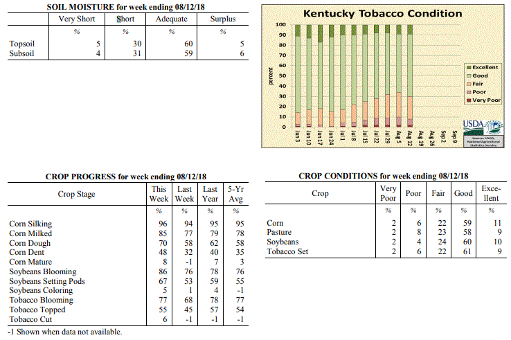 Kentucky Climate Summary
For the Period August 6 to August 12, 2018
Above Normal Temperatures and Rainfall:
The state remained situated within an active pattern for a second straight week as
Kentucky saw near daily bouts of showers and storms. While not everyone saw rainfall
each day, the repetitive nature of the storms led to significant accumulations for
much of Kentucky. The highest totals were seen across the Bluegrass, South-Central,
and Southeastern Kentucky where 2+ inches was observed for many locations, even
prompting some flooding issues. Portions of the Purchase area across Western
Kentucky also benefited with an inch+. The much-welcomed rainfall occurred as the US
Drought Monitor downgraded portions of the Purchase area into a Moderate drought with
the latest update on Thursday. Until this period, Western Kentucky had gone three
straight weeks of seeing below normal rainfall. While much of the state did see
significant rainfall, one exception was counties bordering the Ohio River from Union
County to roughly Jefferson, which received minimal amounts for the period.
Temperatures for the period averaged 77 degrees across the state which was 1 degree
warmer than normal and 2 degrees warmer than the previous period. High temperatures
averaged from 88 in the West to 84 in the East. Departure from normal high
temperatures ranged from near normal in the West to 2 degrees cooler than
normal in the East. Low temperatures averaged from 69 degrees in the West to 68
degrees in the East. Departure from normal low temperature ranged from 3 degrees
warmer than normal in the West to 5 degrees warmer than normal in the East. The
extreme high temperature for the period was 97 degrees at MADISONVILLE 4S and the
extreme low was 61 degrees at MCKEE 5S.
Precipitation (liq. equ.) for the period totaled 1.25 inches statewide which was 0.34
inches above normal and 138% of normal. Precipitation totals by climate division,
West 1.08 inches, Central 1.07 inches, Bluegrass 1.43 inches and East 1.42 inches,
which was 0.22, 0.19, 0.55 and 0.42 inches above normal. By station, precipitation
totals ranged from a low of 0.03 inches at EVANSVILLE ASOS to a high of 4.14
inches at PIKEVILLE 13S.
---
Kentucky Crop and Weather Report
Issued 4:00 P.M., August 6, 2018 23-18
Agricultural News: Kentucky experienced near normal temperatures and above normal
rainfall over the past week. Precipitation for the week totaled 1.21 inches, 0.24
inches above normal. Temperatures averaged 76 degrees for the week, unchanged from
normal. Topsoil moisture was rated 6 percent very short, 34 percent short, 55 percent
adequate and 5 percent surplus. Subsoil moisture was rated 5 percent very short, 32
percent short, 59 percent adequate, and 4 percent surplus. Days suitable for
fieldwork averaged 5.6 out of a possible seven.
Primary activities this week included scouting crops for disease, topping tobacco,
and harvesting hay. Conditions were mixed across the state, with western counties
remaining mostly dry and scattered precipitation falling in mainly central and
eastern counties. Limited rainfall had some tobacco farmers in the west irrigating
their crops, while excessive rainfall in the east had some tobacco crops turning
yellow. Continued rainfall increased forage growth as well as weed pressures in the
eastern portion of the state.
Kentucky Climate Summary
For the Period August 6 to August 12, 2018
Above Normal Temperatures and Rainfall:
The state remained situated within an active pattern for a second straight week as
Kentucky saw near daily bouts of showers and storms. While not everyone saw rainfall
each day, the repetitive nature of the storms led to significant accumulations for
much of Kentucky. The highest totals were seen across the Bluegrass, South-Central,
and Southeastern Kentucky where 2+ inches was observed for many locations, even
prompting some flooding issues. Portions of the Purchase area across Western
Kentucky also benefited with an inch+. The much-welcomed rainfall occurred as the US
Drought Monitor downgraded portions of the Purchase area into a Moderate drought with
the latest update on Thursday. Until this period, Western Kentucky had gone three
straight weeks of seeing below normal rainfall. While much of the state did see
significant rainfall, one exception was counties bordering the Ohio River from Union
County to roughly Jefferson, which received minimal amounts for the period.
Temperatures for the period averaged 77 degrees across the state which was 1 degree
warmer than normal and 2 degrees warmer than the previous period. High temperatures
averaged from 88 in the West to 84 in the East. Departure from normal high
temperatures ranged from near normal in the West to 2 degrees cooler than
normal in the East. Low temperatures averaged from 69 degrees in the West to 68
degrees in the East. Departure from normal low temperature ranged from 3 degrees
warmer than normal in the West to 5 degrees warmer than normal in the East. The
extreme high temperature for the period was 97 degrees at MADISONVILLE 4S and the
extreme low was 61 degrees at MCKEE 5S.
Precipitation (liq. equ.) for the period totaled 1.25 inches statewide which was 0.34
inches above normal and 138% of normal. Precipitation totals by climate division,
West 1.08 inches, Central 1.07 inches, Bluegrass 1.43 inches and East 1.42 inches,
which was 0.22, 0.19, 0.55 and 0.42 inches above normal. By station, precipitation
totals ranged from a low of 0.03 inches at EVANSVILLE ASOS to a high of 4.14
inches at PIKEVILLE 13S.
---
Kentucky Crop and Weather Report
Issued 4:00 P.M., August 6, 2018 23-18
Agricultural News: Kentucky experienced near normal temperatures and above normal
rainfall over the past week. Precipitation for the week totaled 1.21 inches, 0.24
inches above normal. Temperatures averaged 76 degrees for the week, unchanged from
normal. Topsoil moisture was rated 6 percent very short, 34 percent short, 55 percent
adequate and 5 percent surplus. Subsoil moisture was rated 5 percent very short, 32
percent short, 59 percent adequate, and 4 percent surplus. Days suitable for
fieldwork averaged 5.6 out of a possible seven.
Primary activities this week included scouting crops for disease, topping tobacco,
and harvesting hay. Conditions were mixed across the state, with western counties
remaining mostly dry and scattered precipitation falling in mainly central and
eastern counties. Limited rainfall had some tobacco farmers in the west irrigating
their crops, while excessive rainfall in the east had some tobacco crops turning
yellow. Continued rainfall increased forage growth as well as weed pressures in the
eastern portion of the state.
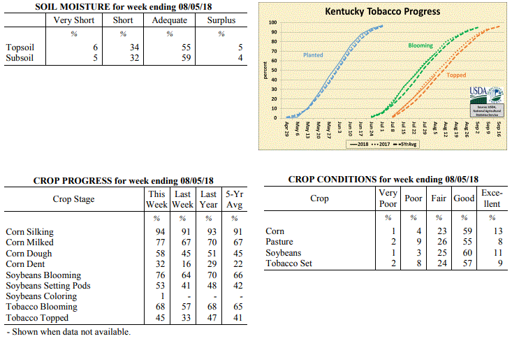 Kentucky Climate Summary
For the Period July 30 to August 5, 2018
Near Normal Temperatures and Above Normal Rainfall:
An active pattern set up for much of the Bluegrass State over the first half of the
week with multiple rounds of rainfall. The Bluegrass area of Northern Kentucky saw
the brunt of the rainfall, averaging two inches for the week. While Central and
Eastern Kentucky still averaged around an inch, Western Kentucky continued to see
lower amounts compared to the rest of Kentucky. This was especially true for the
Purchase area, where the US Drought Monitor expanded the area of �Abnormally dry�
conditions a bit farther east and north. Rain showers and cloud cover kept
temperatures below seasonable norms through the first half of the week, but by the
weekend, temperatures were once again back around 90 with summer-like humidity.
Temperatures for the period averaged 76 degrees across the state which was near
normal and 2 degrees warmer than the previous period. High temperatures averaged
from 86 in the West to 84 in the East. Departure from normal high temperatures ranged
from 3 degrees cooler than normal in the West to 3 degrees cooler than normal in
the East. Low temperatures averaged from 66 degrees in the West to 66 degrees in the
East. Departure from normal low temperature ranged from 1 degree cooler than normal
in the West to 2 degrees warmer than normal in the East. The extreme high temperature
for the period was 97 degrees at MADISONVILLE 4S and the extreme low was 56 degrees
at MAYFIELD 6SW.
Precipitation (liq. equ.) for the period totaled 1.21 inches statewide which was 0.24
inches above normal and 125% of normal. Precipitation totals by climate division,
West 0.79 inches, Central 1.07 inches, Bluegrass 2.01 inches and East 0.95 inches,
which was -0.14, 0.13, 1.06 and -0.09 inches respectively from normal. By station,
precipitation totals ranged from a low of 0.01 inches at BOWLING GREEN APT to a high
of 4.02 inches at OWINGSVILLE 4S.
---
Kentucky Crop and Weather Report
Issued 4:00 P.M., July 30, 2018 22-18
Agricultural News: Kentucky experienced below normal temperatures and rainfall over
the past week. Precipitation for the week totaled 0.18 inches, 0.79 inches below
normal. Temperatures averaged 73 degrees for the week, 4 degrees below normal.
Topsoil moisture was rated 6 percent very short, 30 percent short, 61 percent
adequate and 3 percent surplus. Subsoil moisture was rated 3 percent very short, 22
percent short, 71 percent adequate, and 4 percent surplus. Days suitable for
fieldwork averaged 6.0 out of a possible seven.
Primary activities this week included harvesting hay, spraying soybeans, and topping
tobacco. Dry conditions continued for western Kentucky, as central and western
portions of the state saw little rainfall this week. Overall, crop conditions have
started to decline as many areas are in need of precipitation. When scouting fields
some farmers have noticed corn pollination problems from the heat and humidity
earlier in the summer.
Throughout the season, the high frequency of rain events delayed producers from
harvesting hay on time. Most expect second and third cuttings to be of higher
quality. In eastern counties, where more ample rainfall has fallen recently, weed
pressures have increased in hayfields and pastures. Hay and roughage supplies were
reported as 4 percent very short, 19 percent short, 71 percent adequate, and 6
percent surplus.
Kentucky Climate Summary
For the Period July 30 to August 5, 2018
Near Normal Temperatures and Above Normal Rainfall:
An active pattern set up for much of the Bluegrass State over the first half of the
week with multiple rounds of rainfall. The Bluegrass area of Northern Kentucky saw
the brunt of the rainfall, averaging two inches for the week. While Central and
Eastern Kentucky still averaged around an inch, Western Kentucky continued to see
lower amounts compared to the rest of Kentucky. This was especially true for the
Purchase area, where the US Drought Monitor expanded the area of �Abnormally dry�
conditions a bit farther east and north. Rain showers and cloud cover kept
temperatures below seasonable norms through the first half of the week, but by the
weekend, temperatures were once again back around 90 with summer-like humidity.
Temperatures for the period averaged 76 degrees across the state which was near
normal and 2 degrees warmer than the previous period. High temperatures averaged
from 86 in the West to 84 in the East. Departure from normal high temperatures ranged
from 3 degrees cooler than normal in the West to 3 degrees cooler than normal in
the East. Low temperatures averaged from 66 degrees in the West to 66 degrees in the
East. Departure from normal low temperature ranged from 1 degree cooler than normal
in the West to 2 degrees warmer than normal in the East. The extreme high temperature
for the period was 97 degrees at MADISONVILLE 4S and the extreme low was 56 degrees
at MAYFIELD 6SW.
Precipitation (liq. equ.) for the period totaled 1.21 inches statewide which was 0.24
inches above normal and 125% of normal. Precipitation totals by climate division,
West 0.79 inches, Central 1.07 inches, Bluegrass 2.01 inches and East 0.95 inches,
which was -0.14, 0.13, 1.06 and -0.09 inches respectively from normal. By station,
precipitation totals ranged from a low of 0.01 inches at BOWLING GREEN APT to a high
of 4.02 inches at OWINGSVILLE 4S.
---
Kentucky Crop and Weather Report
Issued 4:00 P.M., July 30, 2018 22-18
Agricultural News: Kentucky experienced below normal temperatures and rainfall over
the past week. Precipitation for the week totaled 0.18 inches, 0.79 inches below
normal. Temperatures averaged 73 degrees for the week, 4 degrees below normal.
Topsoil moisture was rated 6 percent very short, 30 percent short, 61 percent
adequate and 3 percent surplus. Subsoil moisture was rated 3 percent very short, 22
percent short, 71 percent adequate, and 4 percent surplus. Days suitable for
fieldwork averaged 6.0 out of a possible seven.
Primary activities this week included harvesting hay, spraying soybeans, and topping
tobacco. Dry conditions continued for western Kentucky, as central and western
portions of the state saw little rainfall this week. Overall, crop conditions have
started to decline as many areas are in need of precipitation. When scouting fields
some farmers have noticed corn pollination problems from the heat and humidity
earlier in the summer.
Throughout the season, the high frequency of rain events delayed producers from
harvesting hay on time. Most expect second and third cuttings to be of higher
quality. In eastern counties, where more ample rainfall has fallen recently, weed
pressures have increased in hayfields and pastures. Hay and roughage supplies were
reported as 4 percent very short, 19 percent short, 71 percent adequate, and 6
percent surplus.
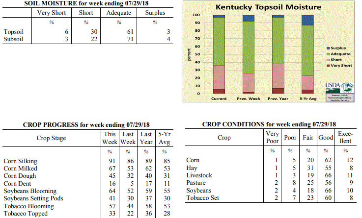 Kentucky Climate Summary
For the Period July 23 to July 29, 2018
Below Normal Temperatures and Rainfall:
Rainfall was minimal for most of the state over the course of the period. Other than
a few rounds of isolated to scattered showers/storms through the workweek, high
pressure kept the area dry. The state only averaged 0.18 inches and that number
diminished to less than a tenth of an inch across Western and Central Kentucky.
Western Kentucky missed out on much of the precipitation the week beforehand and has
now gone two straight weeks with well below normal rainfall. This has pushed portions
of far Western Kentucky into the �Abnormally Dry� category by the US Drought Monitor.
While it was dry, Kentucky continued to benefit from a break in temperatures and
humidity. An upper level disturbance provided plenty of cloud cover early in the week
to keep temperatures in the middle 70s to middle 80s. While increasing midweek, a
cold front again brought temperatures and humidity back to seasonably cool and
comfortable conditions for the weekend.
Temperatures for the period averaged 73 degrees across the state which was 4 degrees
cooler than normal and 4 degrees cooler than the previous period. High temperatures
averaged from 86 in the West to 83 in the East. Departure from normal high
temperatures ranged from 3 degrees cooler than normal in the West to 4 degrees
cooler than normal in the East. Low temperatures averaged from 64 degrees in the
West to 63 degrees in the East. Departure from normal low temperature ranged from 3
degrees cooler than normal in the West to 1 degree cooler than normal in the East.
The extreme high temperature for the period was 95 degrees at POPLAR BLUFF ASOS and
the extreme low was 54 degrees at MOREHEAD 4NE.
Precipitation (liq. equ.) for the period totaled 0.18 inches statewide which was 0.79
inches below normal and 19% of normal. Precipitation totals by climate division, West
0.06 inches, Central 0.02 inches, Bluegrass 0.23 inches and East 0.41 inches, which
was 0.87, 0.96, 0.74 and 0.6 inches below normal. By station, precipitation totals
ranged from a low of 0.00 inches at BOWLING GREEN APT to a high of 2.32 inches at
RICHMOND 8E.
---
Kentucky Crop and Weather Report
Issued 4:00 P.M., July 23, 2018 21-18
Agricultural News: Kentucky experienced below normal temperatures and above normal
rainfall over the past week. Precipitation for the week totaled 1.85 inches, 0.88
inches above normal. Temperatures averaged 76 degrees for the week, 1 degree below
normal. Topsoil moisture was rated 2 percent very short, 24 percent short, 66 percent
adequate and 8 percent surplus. Subsoil moisture was rated 2 percent very short, 21
percent short, 73 percent adequate, and 4 percent surplus. Days suitable for
fieldwork averaged 5.3 out of a possible seven.
Primary activities this week included applying herbicides and fungicides, topping
tobacco, and scouting fields for damage from recent storms.
The above normal rainfall fell mostly in central and eastern portions of the state,
which did help to improve crop and pasture conditions in these areas. Western
counties still experienced below normal rainfall and continued dry conditions. The
severe storms over the weekend brought heavy rainfall, hail, and strong winds. There
were some reports of blown over tobacco, lodged corn, and damaged soybean fields.
Kentucky Climate Summary
For the Period July 23 to July 29, 2018
Below Normal Temperatures and Rainfall:
Rainfall was minimal for most of the state over the course of the period. Other than
a few rounds of isolated to scattered showers/storms through the workweek, high
pressure kept the area dry. The state only averaged 0.18 inches and that number
diminished to less than a tenth of an inch across Western and Central Kentucky.
Western Kentucky missed out on much of the precipitation the week beforehand and has
now gone two straight weeks with well below normal rainfall. This has pushed portions
of far Western Kentucky into the �Abnormally Dry� category by the US Drought Monitor.
While it was dry, Kentucky continued to benefit from a break in temperatures and
humidity. An upper level disturbance provided plenty of cloud cover early in the week
to keep temperatures in the middle 70s to middle 80s. While increasing midweek, a
cold front again brought temperatures and humidity back to seasonably cool and
comfortable conditions for the weekend.
Temperatures for the period averaged 73 degrees across the state which was 4 degrees
cooler than normal and 4 degrees cooler than the previous period. High temperatures
averaged from 86 in the West to 83 in the East. Departure from normal high
temperatures ranged from 3 degrees cooler than normal in the West to 4 degrees
cooler than normal in the East. Low temperatures averaged from 64 degrees in the
West to 63 degrees in the East. Departure from normal low temperature ranged from 3
degrees cooler than normal in the West to 1 degree cooler than normal in the East.
The extreme high temperature for the period was 95 degrees at POPLAR BLUFF ASOS and
the extreme low was 54 degrees at MOREHEAD 4NE.
Precipitation (liq. equ.) for the period totaled 0.18 inches statewide which was 0.79
inches below normal and 19% of normal. Precipitation totals by climate division, West
0.06 inches, Central 0.02 inches, Bluegrass 0.23 inches and East 0.41 inches, which
was 0.87, 0.96, 0.74 and 0.6 inches below normal. By station, precipitation totals
ranged from a low of 0.00 inches at BOWLING GREEN APT to a high of 2.32 inches at
RICHMOND 8E.
---
Kentucky Crop and Weather Report
Issued 4:00 P.M., July 23, 2018 21-18
Agricultural News: Kentucky experienced below normal temperatures and above normal
rainfall over the past week. Precipitation for the week totaled 1.85 inches, 0.88
inches above normal. Temperatures averaged 76 degrees for the week, 1 degree below
normal. Topsoil moisture was rated 2 percent very short, 24 percent short, 66 percent
adequate and 8 percent surplus. Subsoil moisture was rated 2 percent very short, 21
percent short, 73 percent adequate, and 4 percent surplus. Days suitable for
fieldwork averaged 5.3 out of a possible seven.
Primary activities this week included applying herbicides and fungicides, topping
tobacco, and scouting fields for damage from recent storms.
The above normal rainfall fell mostly in central and eastern portions of the state,
which did help to improve crop and pasture conditions in these areas. Western
counties still experienced below normal rainfall and continued dry conditions. The
severe storms over the weekend brought heavy rainfall, hail, and strong winds. There
were some reports of blown over tobacco, lodged corn, and damaged soybean fields.
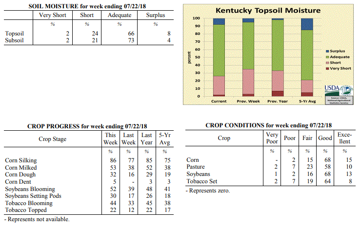 Kentucky Climate Summary
For the Period July 16 to July 22, 2018
Below Normal Temperatures and Above Normal Rainfall:
Damaging storms developed this past week, in addition to a long awaited break in
summer heat. The main focus was Friday as the state sat within a very unstable air
mass. Multiple rounds of severe storms moved through the area during the afternoon
hours and carrying into the evening/overnight, producing everything from torrential
rainfall, large hail, damaging winds, and even a few weak tornadoes. The majority of
the severe weather and rainfall was situated across the Bluegrass and Central/Eastern
Kentucky. In addition to activity early in the period and over the weekend, these
areas averaged over two inches for the week. Western Kentucky missed out on much of
the rainfall and averaged under a third of an inch. Temperature-wise, conditions
were a bit cooler for the week, especially over the weekend as showers and cloud
cover kept highs limited to the middle 70s to middle 80s. Overall, Kentucky temperatures
averaged below normal for the week, which is the first time that had happened since
the end of April.
Temperatures for the period averaged 76 degrees across the state which was 1 degree
cooler than normal and 2 degrees cooler than the previous period. High temperatures
averaged from 88 in the West to 85 in the East. Departure from normal high
temperatures ranged from 2 degrees cooler than normal in the West to 2 degrees
cooler than normal in the East. Low temperatures averaged from 69 degrees in the
West to 66 degrees in the East. Departure from normal low temperature ranged from 1
degree warmer than normal in the West to 2 degrees warmer than normal in the East.
The extreme high temperature for the period was 96 degrees at POPLAR BLUFF ASOS and
the extreme low was 55 degrees at PAINTSVILLE 4W.
Precipitation (liq. equ.) for the period totaled 1.85 inches statewide which was 0.88
inches above normal and 191% of normal. Precipitation totals by climate division,
West 0.29 inches, Central 1.93 inches, Bluegrass 2.74 inches and East 2.43 inches,
which was -0.64, 0.94, 1.80 and 1.42 inches respectively from normal. By station,
precipitation totals ranged from a low of 0.00 inches at CAMPBELLSVILLE 7W to a high
of 5.86 inches at MCKEE 5S.
---
Kentucky Crop and Weather Report
Issued 4:00 P.M., July 16, 2018 20-18
Agricultural News: Kentucky experienced above normal temperatures and below
normal rainfall over the past week. Precipitation for the week totaled 0.41
inches, 0.58 inches below normal. Temperatures averaged 78 degrees for the week,
1 degree above normal. Topsoil moisture was rated 3 percent very short, 32
percent short, 60 percent adequate and 5 percent surplus. Subsoil moisture was
rated 2 percent very short, 24 percent short, 70 percent adequate, and 4 percent
surplus. Days suitable for fieldwork averaged 6.4 out of a possible seven.
Primary activities this week included spraying soybeans, applying fungicides to
corn, baling hay, and scouting fields. The high temperatures and limited
rainfall have continued to show effects of stress on crops and pastures.
Scattered showers during the week varied the impacts of moisture stress
throughout the state. The dry weather did allow farmers to catch up on
fieldwork. Depleted pastures had some cattle producers feeding hay and
supplementing.
Farmers continue to monitor tobacco fields for disease; some incidences of black
shank have been reported.
Kentucky Climate Summary
For the Period July 16 to July 22, 2018
Below Normal Temperatures and Above Normal Rainfall:
Damaging storms developed this past week, in addition to a long awaited break in
summer heat. The main focus was Friday as the state sat within a very unstable air
mass. Multiple rounds of severe storms moved through the area during the afternoon
hours and carrying into the evening/overnight, producing everything from torrential
rainfall, large hail, damaging winds, and even a few weak tornadoes. The majority of
the severe weather and rainfall was situated across the Bluegrass and Central/Eastern
Kentucky. In addition to activity early in the period and over the weekend, these
areas averaged over two inches for the week. Western Kentucky missed out on much of
the rainfall and averaged under a third of an inch. Temperature-wise, conditions
were a bit cooler for the week, especially over the weekend as showers and cloud
cover kept highs limited to the middle 70s to middle 80s. Overall, Kentucky temperatures
averaged below normal for the week, which is the first time that had happened since
the end of April.
Temperatures for the period averaged 76 degrees across the state which was 1 degree
cooler than normal and 2 degrees cooler than the previous period. High temperatures
averaged from 88 in the West to 85 in the East. Departure from normal high
temperatures ranged from 2 degrees cooler than normal in the West to 2 degrees
cooler than normal in the East. Low temperatures averaged from 69 degrees in the
West to 66 degrees in the East. Departure from normal low temperature ranged from 1
degree warmer than normal in the West to 2 degrees warmer than normal in the East.
The extreme high temperature for the period was 96 degrees at POPLAR BLUFF ASOS and
the extreme low was 55 degrees at PAINTSVILLE 4W.
Precipitation (liq. equ.) for the period totaled 1.85 inches statewide which was 0.88
inches above normal and 191% of normal. Precipitation totals by climate division,
West 0.29 inches, Central 1.93 inches, Bluegrass 2.74 inches and East 2.43 inches,
which was -0.64, 0.94, 1.80 and 1.42 inches respectively from normal. By station,
precipitation totals ranged from a low of 0.00 inches at CAMPBELLSVILLE 7W to a high
of 5.86 inches at MCKEE 5S.
---
Kentucky Crop and Weather Report
Issued 4:00 P.M., July 16, 2018 20-18
Agricultural News: Kentucky experienced above normal temperatures and below
normal rainfall over the past week. Precipitation for the week totaled 0.41
inches, 0.58 inches below normal. Temperatures averaged 78 degrees for the week,
1 degree above normal. Topsoil moisture was rated 3 percent very short, 32
percent short, 60 percent adequate and 5 percent surplus. Subsoil moisture was
rated 2 percent very short, 24 percent short, 70 percent adequate, and 4 percent
surplus. Days suitable for fieldwork averaged 6.4 out of a possible seven.
Primary activities this week included spraying soybeans, applying fungicides to
corn, baling hay, and scouting fields. The high temperatures and limited
rainfall have continued to show effects of stress on crops and pastures.
Scattered showers during the week varied the impacts of moisture stress
throughout the state. The dry weather did allow farmers to catch up on
fieldwork. Depleted pastures had some cattle producers feeding hay and
supplementing.
Farmers continue to monitor tobacco fields for disease; some incidences of black
shank have been reported.
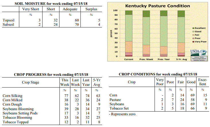 Kentucky Climate Summary
For the Period July 09 to July 15, 2018
Above Normal Temperatures and Below Normal Rainfall:
The second week straight in July with dry conditions was unlike the very wet
first-half of the year for the Bluegrass State. Several counties in the west did
a little bit better on the rain than the remainder of the state pushing the
western climate division above normal for rainfall. The west also had more of
the heat than the remainder of the state but a couple of slightly cooler days
occurred at mid-week. Yet, the trend of warmer than normal temperatures
continued for the week and for the past 11 weeks.
Temperatures for the period averaged 78 degrees across the state which was 1
degree warmer than normal and 2 degrees cooler than the previous period. High
temperatures averaged from 90 in the West to 88 in the East. Departure from
normal high temperatures ranged from near in the West to 1 degree warmer than
normal in the East. Low temperatures averaged from 70 degrees in the West to 66
degrees in the East. Departure from normal low temperature ranged from 2 degrees
warmer than normal in the West to 3 degrees warmer than normal in the East. The
extreme high temperature for the period was 98 degrees at PADUCAH ASOS and the
extreme low was 57 degrees at MONTICELLO AWOS.
Kentucky Climate Summary
For the Period July 09 to July 15, 2018
Above Normal Temperatures and Below Normal Rainfall:
The second week straight in July with dry conditions was unlike the very wet
first-half of the year for the Bluegrass State. Several counties in the west did
a little bit better on the rain than the remainder of the state pushing the
western climate division above normal for rainfall. The west also had more of
the heat than the remainder of the state but a couple of slightly cooler days
occurred at mid-week. Yet, the trend of warmer than normal temperatures
continued for the week and for the past 11 weeks.
Temperatures for the period averaged 78 degrees across the state which was 1
degree warmer than normal and 2 degrees cooler than the previous period. High
temperatures averaged from 90 in the West to 88 in the East. Departure from
normal high temperatures ranged from near in the West to 1 degree warmer than
normal in the East. Low temperatures averaged from 70 degrees in the West to 66
degrees in the East. Departure from normal low temperature ranged from 2 degrees
warmer than normal in the West to 3 degrees warmer than normal in the East. The
extreme high temperature for the period was 98 degrees at PADUCAH ASOS and the
extreme low was 57 degrees at MONTICELLO AWOS.
Precipitation (liq. equ.) for the period totaled 0.41 inches statewide which was
0.58 inches below normal and 41% of normal. Precipitation totals by climate
division, West 1.10 inches, Central 0.28 inches, Bluegrass 0.08 inches and East
0.16 inches, which was 0.12, -0.72, -0.90 and -0.85 inches respectively from
normal. By station, precipitation totals ranged from a low of 0.00 inches at
ALEXANDRIA 5NW to a high of 2.52 inches at CADIZ 4SW.
Summarized and averaged data for the period 20180709 to 20180715(Last 7 Days)
(Not for Legal purposes. Departure from Norms based on climate divisional Averages)
AIR TEMPERATURE PRECIPITATION ExtremeTemp
STATION MAX DEV MIN DEV AVR DEV TOTAL DEV %NORM HI LO
--------------------------------------------------------------------------------
WEST(CD1) 90 0 70 2 80 1 1.10 0.12 112 98 62
CENTRAL(CD2) 88 0 68 2 78 1 0.28 -0.72 28 95 58
BLUEGRASS(CD3) 88 1 67 2 77 1 0.08 -0.90 8 94 58
EAST(CD4) 88 1 66 3 77 2 0.16 -0.85 16 93 57
--------------------------------------------------------------------------------
STATE 88 0 68 2 78 1 0.41 -0.58 41 98 57
---
Kentucky Crop and Weather Report
Issued 4:00 P.M., July 9, 2018 19-18
Agricultural News: Kentucky experienced above normal temperatures and below normal
rainfall over the past week. Precipitation for the week totaled 0.62 inches, 0.37
inches below normal. Temperatures averaged 79 degrees for the week, 3 degrees above
normal. Topsoil moisture was rated 1 percent very short, 11 percent short, 78 percent
adequate, and 10 percent surplus. Subsoil moisture was rated 1 percent very short, 9
percent short, 81 percent adequate, and 9 percent surplus. Days suitable for
fieldwork averaged 5.5 out of a possible seven.
Primary activities for this week included cutting hay and spraying crops. Corn,
soybeans, and tobacco are in mostly good condition at this time despite several
reports of damage from heavy rain and disease. The average height of emerged soybeans
was 20 inches.
Pasture land is in mostly good condition and has started improving in some areas due
to rain this past week. Farmers continue to cut hay and the hay crop should be aided
by the precipitation in some areas.
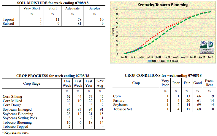 Kentucky Climate Summary
For the Period July 2 to July 8, 2018
Above Normal Temperatures and Below Normal Rainfall:
Oppressive heat continued across the Lower Ohio Valley for the first week of July.
Temperatures peaked on the 4th and the 5th with highs getting into the low to middle
90s. Even some upper 90s in spots. �Heat Advisories� and even some �Excessive Heat
Warnings� were issued as heat indices topped out around 110 degrees at times.
Luckily, the Commonwealth did see a cold front push through the area on Friday.
While temperatures stayed in the 80s for Saturday, conditions were noticeably less
humid. Even with the frontal passage, the heat won out and led to a 10th straight
week of above normal temperatures, dating back to the start of May. Looking at
rainfall, coverage was scattered to numerous at times, but not nearly as frequent as
weeks past. Still, torrential downpours continued to be an issue for anyone that did
see a storm. Overall, the state averaged 0.62 inches for the week, but totals varied
widely across Kentucky with the scattered coverage in place. While some saw in excess
of 1.5 inches, other locations were less than a tenth of an inch.
Temperatures for the period averaged 79 degrees across the state which was 3 degrees
warmer than normal and 2 degrees warmer than the previous period. High temperatures
averaged from 90 in the West to 89 in the East. Departure from normal high
temperatures ranged from 1 degree warmer than normal in the West to 3 degrees
warmer than normal in the East. Low temperatures averaged from 72 degrees in the
West to 68 degrees in the East. Departure from normal low temperature ranged from 5
degrees warmer than normal in the West to 6 degrees warmer than normal in the East.
The extreme high temperature for the period was 98 degrees at CAPE GIRARDEAU ASOS and
the extreme low was 56 degrees at CYNTHIANA 8N.
Precipitation (liq. equ.) for the period totaled 0.62 inches statewide which was 0.37
inches below normal and 63% of normal. Precipitation totals by climate division, West
0.41 inches, Central 0.75 inches, Bluegrass 0.59 inches and East 0.73 inches, which
was 0.59, 0.24, 0.37 and 0.28 inches below normal. By station, precipitation totals
ranged from a low of 0.00 inches at BIG SANDY to a high of 2.84 inches at BOWLING GREEN 4E.
---
Kentucky Crop and Weather Report
Issued 4:00 P.M., July 2, 2018 18-18
Agricultural News: Kentucky experienced above normal temperatures and much above
normal rainfall over the past week. Precipitation for the week totaled 2.70 inches,
1.72 inches above normal. Temperatures averaged 78 degrees for the week, 3 degrees
above normal. Topsoil moisture was rated 4 percent short, 74 percent adequate and 22
percent surplus. Subsoil moisture was rated 5 percent short, 78 percent adequate, and
17 percent surplus. Days suitable for fieldwork averaged 3.3 out of a possible seven.
Primary activities this week included harvesting wheat and hay, planting soybeans,
spraying fungicides, and scouting fields for damage from recent weather. Heavy
rainfall, high winds, heat, and humidity over the past week had varied impacts across
the state. Damage reports included crop stress, tobacco laid over from winds, and
excessive moisture in pastures and crop fields. Fieldwork was delayed at times as
farmers tried to finish up winter wheat harvest and soybean planting. The average
height of emerged soybeans was 13 inches, compared with 10 inches last year.
Several reports of hay yields being low and of marginal quality due to over-maturity
from harvesting delays. The quality of harvested hay was rated 64% in good to
excellent condition. Producers are more optimistic for second cutting yields from
recent rains.
Kentucky Climate Summary
For the Period July 2 to July 8, 2018
Above Normal Temperatures and Below Normal Rainfall:
Oppressive heat continued across the Lower Ohio Valley for the first week of July.
Temperatures peaked on the 4th and the 5th with highs getting into the low to middle
90s. Even some upper 90s in spots. �Heat Advisories� and even some �Excessive Heat
Warnings� were issued as heat indices topped out around 110 degrees at times.
Luckily, the Commonwealth did see a cold front push through the area on Friday.
While temperatures stayed in the 80s for Saturday, conditions were noticeably less
humid. Even with the frontal passage, the heat won out and led to a 10th straight
week of above normal temperatures, dating back to the start of May. Looking at
rainfall, coverage was scattered to numerous at times, but not nearly as frequent as
weeks past. Still, torrential downpours continued to be an issue for anyone that did
see a storm. Overall, the state averaged 0.62 inches for the week, but totals varied
widely across Kentucky with the scattered coverage in place. While some saw in excess
of 1.5 inches, other locations were less than a tenth of an inch.
Temperatures for the period averaged 79 degrees across the state which was 3 degrees
warmer than normal and 2 degrees warmer than the previous period. High temperatures
averaged from 90 in the West to 89 in the East. Departure from normal high
temperatures ranged from 1 degree warmer than normal in the West to 3 degrees
warmer than normal in the East. Low temperatures averaged from 72 degrees in the
West to 68 degrees in the East. Departure from normal low temperature ranged from 5
degrees warmer than normal in the West to 6 degrees warmer than normal in the East.
The extreme high temperature for the period was 98 degrees at CAPE GIRARDEAU ASOS and
the extreme low was 56 degrees at CYNTHIANA 8N.
Precipitation (liq. equ.) for the period totaled 0.62 inches statewide which was 0.37
inches below normal and 63% of normal. Precipitation totals by climate division, West
0.41 inches, Central 0.75 inches, Bluegrass 0.59 inches and East 0.73 inches, which
was 0.59, 0.24, 0.37 and 0.28 inches below normal. By station, precipitation totals
ranged from a low of 0.00 inches at BIG SANDY to a high of 2.84 inches at BOWLING GREEN 4E.
---
Kentucky Crop and Weather Report
Issued 4:00 P.M., July 2, 2018 18-18
Agricultural News: Kentucky experienced above normal temperatures and much above
normal rainfall over the past week. Precipitation for the week totaled 2.70 inches,
1.72 inches above normal. Temperatures averaged 78 degrees for the week, 3 degrees
above normal. Topsoil moisture was rated 4 percent short, 74 percent adequate and 22
percent surplus. Subsoil moisture was rated 5 percent short, 78 percent adequate, and
17 percent surplus. Days suitable for fieldwork averaged 3.3 out of a possible seven.
Primary activities this week included harvesting wheat and hay, planting soybeans,
spraying fungicides, and scouting fields for damage from recent weather. Heavy
rainfall, high winds, heat, and humidity over the past week had varied impacts across
the state. Damage reports included crop stress, tobacco laid over from winds, and
excessive moisture in pastures and crop fields. Fieldwork was delayed at times as
farmers tried to finish up winter wheat harvest and soybean planting. The average
height of emerged soybeans was 13 inches, compared with 10 inches last year.
Several reports of hay yields being low and of marginal quality due to over-maturity
from harvesting delays. The quality of harvested hay was rated 64% in good to
excellent condition. Producers are more optimistic for second cutting yields from
recent rains.
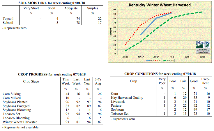 Kentucky Climate Summary
For the Period June 25 to July 1, 2018
Above Normal Temperatures and Much Above Normal Rainfall:
Excessively wet conditions were the highlight of the period. Kentucky saw several
rounds of storms push through the region over the course of the week. The more
intense period lasted from Monday through Thursday with clusters and lines of storms
producing torrential rainfall, damaging winds and even a few confirmed tornadoes.
Tropical-like downpours and repeated rounds of rainfall led to many bouts of
localized flash flooding. Overall, the state averaged 2.70 inches for the week,
which is the most Kentucky had seen in one week since February. While there was
additional isolated to scattered activity over the weekend, the bigger story was the
heat. Temperatures peaked in the low to middle 90s each day. Combined with dew
points in the 70s, heat indices topped well over the century mark. This prompted a
heat advisory to be issued for much of the western half of Kentucky and led to a
ninth straight week of above normal temperatures for the Bluegrass State. The
elevated heat continued to pose a concern for livestock as the heat stress index ran
in the danger to emergency categories.
Temperatures for the period averaged 78 degrees across the state which was 3 degrees
warmer than normal and no change to the previous period. High temperatures averaged
from 89 in the West to 85 in the East. Departure from normal high temperatures ranged
from 1 degree warmer than normal in the West to near normal in the East. Low
temperatures averaged from 71 degrees in the West to 68 degrees in the East.
Departure from normal low temperature ranged from 5 degrees warmer than normal in the
West to 7 degrees warmer than normal in the East. The extreme high temperature for
the period was 96 degrees at MAYSVILLE 3SW and the extreme low was 61 degrees at
PIKEVILLE 13S.
Precipitation (liq. equ.) for the period totaled 2.70 inches statewide which was 1.72
inches above normal and 274% of normal. Precipitation totals by climate division,
West 2.97 inches, Central 3.36 inches, Bluegrass 2.09 inches and East 2.37 inches,
which was 1.99, 2.39, 1.12 and 1.35 inches above normal. By station, precipitation
totals ranged from a low of 0.54 inches at TRIANGLE MOUNTAIN to a high of 6.15
inches at CAPE GIRARDEAU ASOS.
---
Kentucky Crop and Weather Report
Issued 4:00 P.M., June 25, 2018 17-18
Agricultural News: Kentucky experienced above normal temperatures and rainfall over
the past week. Precipitation for the week totaled 1.25 inches, 0.23 inches above
normal. Temperatures averaged 78 degrees for the week, 4 degrees above normal.
Topsoil moisture was rated 1 percent very short, 11 percent short, 77 percent
adequate, and 11 percent surplus. Subsoil moisture was rated 1 percent very short, 8
percent short, 84 percent adequate, and 7 percent surplus. Days suitable for
fieldwork averaged 5.0 out of a possible seven.
Primary activities for this week included harvesting wheat, cutting hay, and planting
soybeans. The weather early in the week was suitable for fieldwork, however as the
week progressed rain and cooler temperatures arrived. The average height of emerged
soybeans was 5 inches. Corn, soybeans, and wheat are all in mostly good condition at
this time.
Ninety four percent of the tobacco crop is in the ground, slightly ahead of both last
year and the five year average. The crop is in mostly good condition with the average
height of plants at 16 inches. Both pastures and hay are in mostly good condition at
this juncture.
Kentucky Climate Summary
For the Period June 25 to July 1, 2018
Above Normal Temperatures and Much Above Normal Rainfall:
Excessively wet conditions were the highlight of the period. Kentucky saw several
rounds of storms push through the region over the course of the week. The more
intense period lasted from Monday through Thursday with clusters and lines of storms
producing torrential rainfall, damaging winds and even a few confirmed tornadoes.
Tropical-like downpours and repeated rounds of rainfall led to many bouts of
localized flash flooding. Overall, the state averaged 2.70 inches for the week,
which is the most Kentucky had seen in one week since February. While there was
additional isolated to scattered activity over the weekend, the bigger story was the
heat. Temperatures peaked in the low to middle 90s each day. Combined with dew
points in the 70s, heat indices topped well over the century mark. This prompted a
heat advisory to be issued for much of the western half of Kentucky and led to a
ninth straight week of above normal temperatures for the Bluegrass State. The
elevated heat continued to pose a concern for livestock as the heat stress index ran
in the danger to emergency categories.
Temperatures for the period averaged 78 degrees across the state which was 3 degrees
warmer than normal and no change to the previous period. High temperatures averaged
from 89 in the West to 85 in the East. Departure from normal high temperatures ranged
from 1 degree warmer than normal in the West to near normal in the East. Low
temperatures averaged from 71 degrees in the West to 68 degrees in the East.
Departure from normal low temperature ranged from 5 degrees warmer than normal in the
West to 7 degrees warmer than normal in the East. The extreme high temperature for
the period was 96 degrees at MAYSVILLE 3SW and the extreme low was 61 degrees at
PIKEVILLE 13S.
Precipitation (liq. equ.) for the period totaled 2.70 inches statewide which was 1.72
inches above normal and 274% of normal. Precipitation totals by climate division,
West 2.97 inches, Central 3.36 inches, Bluegrass 2.09 inches and East 2.37 inches,
which was 1.99, 2.39, 1.12 and 1.35 inches above normal. By station, precipitation
totals ranged from a low of 0.54 inches at TRIANGLE MOUNTAIN to a high of 6.15
inches at CAPE GIRARDEAU ASOS.
---
Kentucky Crop and Weather Report
Issued 4:00 P.M., June 25, 2018 17-18
Agricultural News: Kentucky experienced above normal temperatures and rainfall over
the past week. Precipitation for the week totaled 1.25 inches, 0.23 inches above
normal. Temperatures averaged 78 degrees for the week, 4 degrees above normal.
Topsoil moisture was rated 1 percent very short, 11 percent short, 77 percent
adequate, and 11 percent surplus. Subsoil moisture was rated 1 percent very short, 8
percent short, 84 percent adequate, and 7 percent surplus. Days suitable for
fieldwork averaged 5.0 out of a possible seven.
Primary activities for this week included harvesting wheat, cutting hay, and planting
soybeans. The weather early in the week was suitable for fieldwork, however as the
week progressed rain and cooler temperatures arrived. The average height of emerged
soybeans was 5 inches. Corn, soybeans, and wheat are all in mostly good condition at
this time.
Ninety four percent of the tobacco crop is in the ground, slightly ahead of both last
year and the five year average. The crop is in mostly good condition with the average
height of plants at 16 inches. Both pastures and hay are in mostly good condition at
this juncture.
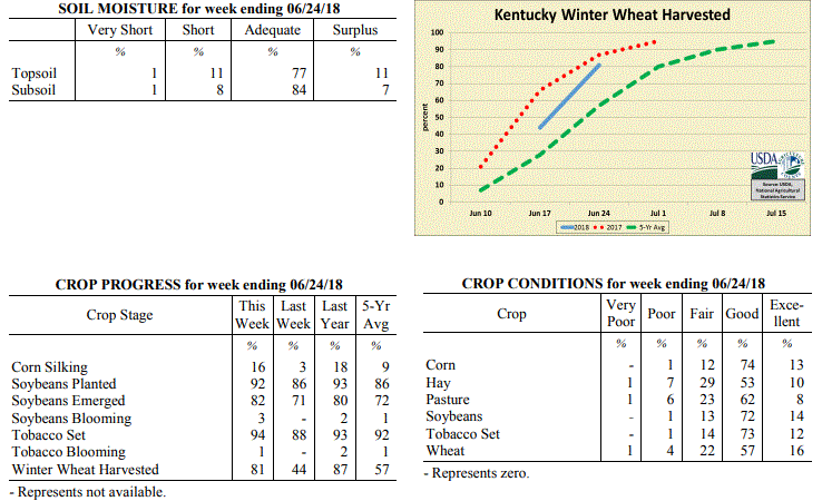 Kentucky Climate Summary
For the Period June 18 to June 24, 2018
Above Normal Temperatures and Rainfall:
Heat and humidity has been unrelenting recently and that trend continued over the
course of the period, especially early in the week. Continuing from the hot and humid
weekend beforehand, temperatures on Monday and Tuesday reached into the upper 80s to
middle 90s for much of the state. Combined with dew points in the 70s, heat indices
topped out around 100 at times. This led the way in pushing Kentucky to an eighth
straight week of above normal temperatures. In addition to the warmth, an active
pattern led to several rounds of rainfall. Most of the time, storms remained isolated
to scattered in coverage, but unlike recent weeks, the state did see a round of
widespread showers on Thursday. Even with the scattered coverage, the repetitive
nature of the storms did lead to accumulations of more than an inch for most of Kentucky.
Temperatures for the period averaged 78 degrees across the state which was 4 degrees
warmer than normal and 2 degrees warmer than the previous period. High temperatures
averaged from 86 in the West to 86 in the East. Departure from normal high
temperatures ranged from 1 degree cooler than normal in the West to 2 degrees
warmer than normal in the East. Low temperatures averaged from 69 degrees in the
West to 68 degrees in the East. Departure from normal low temperature ranged from 5
degrees warmer than normal in the West to 8 degrees warmer than normal in the East.
The extreme high temperature for the period was 96 degrees at LOUISA 1S and the
extreme low was 62 degrees at BARBOURVILLE 3E.
Precipitation (liq. equ.) for the period totaled 1.25 inches statewide which was 0.23
inches above normal and 123% of normal. Precipitation totals by climate division,
West 1.18 inches, Central 1.15 inches, Bluegrass 1.33 inches and East 1.35 inches,
which was 0.17, 0.14, 0.31 and 0.32 inches above normal. By station, precipitation
totals ranged from a low of 0.16 inches at MONTICELLO AWOS to a high of 4.00 inches
at VANCEBURG 6W.
---
Kentucky Crop and Weather Report
Issued 4:00 P.M., June 18, 2018 16-18
Agricultural News: Kentucky experienced above normal temperatures and near normal
rainfall over the past week. Precipitation for the week totaled 1.03 inches, 0.01
inches above normal. Temperatures averaged 77 degrees for the week, 5 degrees above
normal. Topsoil moisture was rated 1 percent very short, 19 percent short, 75 percent
adequate and 5 percent surplus. Subsoil moisture was rated 1 percent very short, 12
percent short, 82 percent adequate, and 5 percent surplus. Days suitable for
fieldwork averaged 5.3 out of a possible seven.
Primary activities this week included harvesting wheat, cutting hay, planting
soybeans and tobacco, as well as applying fertilizers and herbicides. Scattered
showers during the week delayed fieldwork at times. Overall, the hot and dry weather
have crop fields and pastures starting to show signs of stress. The heat has made for
good hay curing weather though. The average height of emerged corn was 34 inches,
compared to 38 inches last year. The average height of tobacco in the field was 11
inches, compared to 9 inches last year.
Some producers have noted low test weights for wheat, and higher temperatures in the
spring and short grain fill as contributing factors. Additionally, farmers are
anticipating initial hay yields to be lower than the first cuttings for last year.
Kentucky Climate Summary
For the Period June 18 to June 24, 2018
Above Normal Temperatures and Rainfall:
Heat and humidity has been unrelenting recently and that trend continued over the
course of the period, especially early in the week. Continuing from the hot and humid
weekend beforehand, temperatures on Monday and Tuesday reached into the upper 80s to
middle 90s for much of the state. Combined with dew points in the 70s, heat indices
topped out around 100 at times. This led the way in pushing Kentucky to an eighth
straight week of above normal temperatures. In addition to the warmth, an active
pattern led to several rounds of rainfall. Most of the time, storms remained isolated
to scattered in coverage, but unlike recent weeks, the state did see a round of
widespread showers on Thursday. Even with the scattered coverage, the repetitive
nature of the storms did lead to accumulations of more than an inch for most of Kentucky.
Temperatures for the period averaged 78 degrees across the state which was 4 degrees
warmer than normal and 2 degrees warmer than the previous period. High temperatures
averaged from 86 in the West to 86 in the East. Departure from normal high
temperatures ranged from 1 degree cooler than normal in the West to 2 degrees
warmer than normal in the East. Low temperatures averaged from 69 degrees in the
West to 68 degrees in the East. Departure from normal low temperature ranged from 5
degrees warmer than normal in the West to 8 degrees warmer than normal in the East.
The extreme high temperature for the period was 96 degrees at LOUISA 1S and the
extreme low was 62 degrees at BARBOURVILLE 3E.
Precipitation (liq. equ.) for the period totaled 1.25 inches statewide which was 0.23
inches above normal and 123% of normal. Precipitation totals by climate division,
West 1.18 inches, Central 1.15 inches, Bluegrass 1.33 inches and East 1.35 inches,
which was 0.17, 0.14, 0.31 and 0.32 inches above normal. By station, precipitation
totals ranged from a low of 0.16 inches at MONTICELLO AWOS to a high of 4.00 inches
at VANCEBURG 6W.
---
Kentucky Crop and Weather Report
Issued 4:00 P.M., June 18, 2018 16-18
Agricultural News: Kentucky experienced above normal temperatures and near normal
rainfall over the past week. Precipitation for the week totaled 1.03 inches, 0.01
inches above normal. Temperatures averaged 77 degrees for the week, 5 degrees above
normal. Topsoil moisture was rated 1 percent very short, 19 percent short, 75 percent
adequate and 5 percent surplus. Subsoil moisture was rated 1 percent very short, 12
percent short, 82 percent adequate, and 5 percent surplus. Days suitable for
fieldwork averaged 5.3 out of a possible seven.
Primary activities this week included harvesting wheat, cutting hay, planting
soybeans and tobacco, as well as applying fertilizers and herbicides. Scattered
showers during the week delayed fieldwork at times. Overall, the hot and dry weather
have crop fields and pastures starting to show signs of stress. The heat has made for
good hay curing weather though. The average height of emerged corn was 34 inches,
compared to 38 inches last year. The average height of tobacco in the field was 11
inches, compared to 9 inches last year.
Some producers have noted low test weights for wheat, and higher temperatures in the
spring and short grain fill as contributing factors. Additionally, farmers are
anticipating initial hay yields to be lower than the first cuttings for last year.
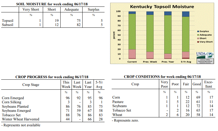 Kentucky Climate Summary
For the Period June 11 to June 17, 2018
Above Normal Temperatures and Near Normal Rainfall:
The period opened with active weather continuing from the previous weekend. Multiple
rounds of scattered to numerous storms formed on Monday and Tuesday as Kentucky sat
within an unstable air mass. Heavy rain continued to lead to localized flooding at
times, as a very moist air mass remained across the region. Strong to severe storms
even formed Monday evening with some storms producing damaging winds and small hail.
Overall, the state averaged an inch of rainfall, but just like previous weeks, the
scattered coverage of the storms led to a wide range of accumulations. After the
passage of a front late Wednesday and into the overnight, the remainder of the period
was mostly dry, but with the thermometer on the climb. Temperatures and humidity
peaked over the weekend with highs rising into the upper 80s to middle 90s and heat
indices around 100 at times. This kept the livestock heat stress index running in
the Danger category during the better part of the day.
Temperatures for the period averaged 77 degrees across the state which was 5 degrees
warmer than normal and 4 degrees warmer than the previous period. High temperatures
averaged from 90 in the West to 85 in the East. Departure from normal high
temperatures ranged from 5 degrees warmer than normal in the West to 2 degrees
warmer than normal in the East. Low temperatures averaged from 70 degrees in the
West to 65 degrees in the East. Departure from normal low temperature ranged from 7
degrees warmer than normal in the West to 7 degrees warmer than normal in the East.
The extreme high temperature for the period was 97 degrees at BOWLING GREEN APT and
the extreme low was 56 degrees at PAINTSVILLE 4W.
Precipitation (liq. equ.) for the period totaled 1.03 inches statewide which was 0.01
inches above normal and 101% of normal. Precipitation totals by climate division,
West 0.97 inches, Central 0.87 inches, Bluegrass 1.31 inches and East 0.98 inches,
which was 0.00, -0.15, 0.28 and -0.06 inches respectively from normal. By station,
precipitation totals ranged from a low of 0.00 inches at MONTICELLO AWOS to a high of
3.88 inches at STANFORD 4NE.
---
Kentucky Crop and Weather Report
Issued 4:00 P.M., June 11, 2018 15-18
Agricultural News: Kentucky experienced above normal temperatures and below normal
rainfall over the past week. Precipitation for the week totaled 0.21 inches, 0.86
inches below normal. Temperatures averaged 73 degrees for the week, 2 degrees above
normal. Topsoil moisture was rated 1 percent very short, 14 percent short, 78 percent
adequate, and 7 percent surplus. Subsoil moisture was rated 1 percent very short, 7
percent short, 85 percent adequate, and 7 percent surplus. Days suitable for
fieldwork averaged 6.0 out of a possible seven.
Primary activities for this week included planting tobacco and soybeans, hay
harvesting, and spraying crops where necessary. Mostly dry and warm weather this past
week afforded farmers a much needed break from wet weather to catch up on fieldwork.
Although there was a good deal of progress on the hay harvest this week, there is
still some concern regarding yields and tight supplies coming out of the winter.
Several producers reported that they have started harvesting wheat which will pave
the way for double crop soybean planting to begin. The average height of emerged corn
is 23 inches, matching last year at this juncture.
Seventy six percent of the tobacco crop is in the ground, slightly ahead of both last
year and the five year average. The crop is in mostly good condition with the average
height of plants at 6 inches. Pastures remain in mostly good condition at
this time.
Kentucky Climate Summary
For the Period June 11 to June 17, 2018
Above Normal Temperatures and Near Normal Rainfall:
The period opened with active weather continuing from the previous weekend. Multiple
rounds of scattered to numerous storms formed on Monday and Tuesday as Kentucky sat
within an unstable air mass. Heavy rain continued to lead to localized flooding at
times, as a very moist air mass remained across the region. Strong to severe storms
even formed Monday evening with some storms producing damaging winds and small hail.
Overall, the state averaged an inch of rainfall, but just like previous weeks, the
scattered coverage of the storms led to a wide range of accumulations. After the
passage of a front late Wednesday and into the overnight, the remainder of the period
was mostly dry, but with the thermometer on the climb. Temperatures and humidity
peaked over the weekend with highs rising into the upper 80s to middle 90s and heat
indices around 100 at times. This kept the livestock heat stress index running in
the Danger category during the better part of the day.
Temperatures for the period averaged 77 degrees across the state which was 5 degrees
warmer than normal and 4 degrees warmer than the previous period. High temperatures
averaged from 90 in the West to 85 in the East. Departure from normal high
temperatures ranged from 5 degrees warmer than normal in the West to 2 degrees
warmer than normal in the East. Low temperatures averaged from 70 degrees in the
West to 65 degrees in the East. Departure from normal low temperature ranged from 7
degrees warmer than normal in the West to 7 degrees warmer than normal in the East.
The extreme high temperature for the period was 97 degrees at BOWLING GREEN APT and
the extreme low was 56 degrees at PAINTSVILLE 4W.
Precipitation (liq. equ.) for the period totaled 1.03 inches statewide which was 0.01
inches above normal and 101% of normal. Precipitation totals by climate division,
West 0.97 inches, Central 0.87 inches, Bluegrass 1.31 inches and East 0.98 inches,
which was 0.00, -0.15, 0.28 and -0.06 inches respectively from normal. By station,
precipitation totals ranged from a low of 0.00 inches at MONTICELLO AWOS to a high of
3.88 inches at STANFORD 4NE.
---
Kentucky Crop and Weather Report
Issued 4:00 P.M., June 11, 2018 15-18
Agricultural News: Kentucky experienced above normal temperatures and below normal
rainfall over the past week. Precipitation for the week totaled 0.21 inches, 0.86
inches below normal. Temperatures averaged 73 degrees for the week, 2 degrees above
normal. Topsoil moisture was rated 1 percent very short, 14 percent short, 78 percent
adequate, and 7 percent surplus. Subsoil moisture was rated 1 percent very short, 7
percent short, 85 percent adequate, and 7 percent surplus. Days suitable for
fieldwork averaged 6.0 out of a possible seven.
Primary activities for this week included planting tobacco and soybeans, hay
harvesting, and spraying crops where necessary. Mostly dry and warm weather this past
week afforded farmers a much needed break from wet weather to catch up on fieldwork.
Although there was a good deal of progress on the hay harvest this week, there is
still some concern regarding yields and tight supplies coming out of the winter.
Several producers reported that they have started harvesting wheat which will pave
the way for double crop soybean planting to begin. The average height of emerged corn
is 23 inches, matching last year at this juncture.
Seventy six percent of the tobacco crop is in the ground, slightly ahead of both last
year and the five year average. The crop is in mostly good condition with the average
height of plants at 6 inches. Pastures remain in mostly good condition at
this time.
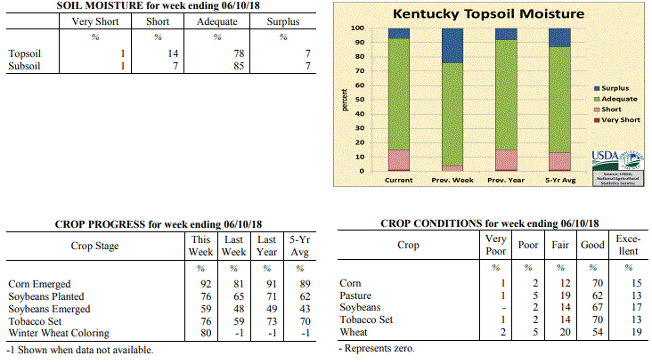 Kentucky Climate Summary
For the Period June 4 to June 10, 2018
Above Normal Temperatures and Below Normal Rainfall:
Through the first half of the work week, Kentucky saw dry, cooler, and noticeably
less humid conditions, resulting in quite the difference compared to past weeks.
Saying that, it turned into a rather short-lived break as heat and humidity returned
over the second half. Highs on Friday peaked in the upper 80s to low 90s statewide,
warmest temperatures across Western and Central Kentucky. This helped push the state
to a sixth straight week of temperatures averaging above normal. While mostly dry
conditions continued through Friday, an unstable atmosphere led to scattered to
numerous showers and storms over the weekend. The highest coverage was seen on
Sunday as multiple storm complexes progressed through Kentucky. Just like previous
weeks, heavy rainfall, lightning, and occasional gusty winds continued to be the main
hazards. Much of the rainfall on Sunday evening occurred after the data cut-off for
this period and will be reflected in the report next week.
Temperatures for the period averaged 73 degrees across the state which was 2 degrees
warmer than normal and 2 degrees cooler than the previous period. High temperatures
averaged from 88 in the West to 83 in the East. Departure from normal high
temperatures ranged from 4 degrees warmer than normal in the West to 1 degree
warmer than normal in the East. Low temperatures averaged from 64 degrees in the
West to 58 degrees in the East. Departure from normal low temperature ranged from 2
degrees warmer than normal in the West to 1 degree warmer than normal in the East.
The extreme high temperature for the period was 95 degrees at CAPE GIRARDEAU ASOS and
the extreme low was 49 degrees at CYNTHIANA 8N.
Precipitation (liq. equ.) for the period totaled 0.21 inches statewide which was 0.86
inches below normal and 20% of normal. Precipitation totals by climate division, West
0.26 inches, Central 0.12 inches, Bluegrass 0.23 inches and East 0.23 inches, which
was 0.76, 0.96, 0.86 and 0.85 inches below normal. By station, precipitation totals
ranged from a low of 0.00 inches at ALBANY 1N to a high of 1.25 inches at HENDERSON 5E.
---
Kentucky Crop and Weather Report
Issued 4:00 P.M., June 5, 2018 14-18
Agricultural News: Kentucky experienced above normal temperatures and much above
normal rainfall over the past week. Precipitation for the week totaled 1.86 inches,
0.75 inches above normal. Temperatures averaged 76 degrees for the week, 7 degrees
above normal. Topsoil moisture was rated 4 percent short, 72 percent adequate, and 24
percent surplus. Subsoil moisture was rated 2 percent short, 81 percent adequate, and
17 percent surplus. Days suitable for fieldwork averaged 3.3 out of a possible seven.
Primary activities for this week included planting corn and soybeans along with
tobacco setting when the weather allowed. Fieldwork progress was stunted as hot
weather brought several rounds of rain. Some areas in the state received very heavy
rain leading to standing water in fields. Even with the recurring precipitation, corn
planting is nearing completion with 94 percent in the ground. Farmers sprayed the
corn crop when there were opportunities between rain showers. The average height of
corn was 14 inches, compared to 9 inches last week.
Pastures continue to be in mostly good condition and are improving in many areas of
the state. The hay harvest is behind at this juncture, but with favorable weather a
recovery is possible.
Kentucky Climate Summary
For the Period June 4 to June 10, 2018
Above Normal Temperatures and Below Normal Rainfall:
Through the first half of the work week, Kentucky saw dry, cooler, and noticeably
less humid conditions, resulting in quite the difference compared to past weeks.
Saying that, it turned into a rather short-lived break as heat and humidity returned
over the second half. Highs on Friday peaked in the upper 80s to low 90s statewide,
warmest temperatures across Western and Central Kentucky. This helped push the state
to a sixth straight week of temperatures averaging above normal. While mostly dry
conditions continued through Friday, an unstable atmosphere led to scattered to
numerous showers and storms over the weekend. The highest coverage was seen on
Sunday as multiple storm complexes progressed through Kentucky. Just like previous
weeks, heavy rainfall, lightning, and occasional gusty winds continued to be the main
hazards. Much of the rainfall on Sunday evening occurred after the data cut-off for
this period and will be reflected in the report next week.
Temperatures for the period averaged 73 degrees across the state which was 2 degrees
warmer than normal and 2 degrees cooler than the previous period. High temperatures
averaged from 88 in the West to 83 in the East. Departure from normal high
temperatures ranged from 4 degrees warmer than normal in the West to 1 degree
warmer than normal in the East. Low temperatures averaged from 64 degrees in the
West to 58 degrees in the East. Departure from normal low temperature ranged from 2
degrees warmer than normal in the West to 1 degree warmer than normal in the East.
The extreme high temperature for the period was 95 degrees at CAPE GIRARDEAU ASOS and
the extreme low was 49 degrees at CYNTHIANA 8N.
Precipitation (liq. equ.) for the period totaled 0.21 inches statewide which was 0.86
inches below normal and 20% of normal. Precipitation totals by climate division, West
0.26 inches, Central 0.12 inches, Bluegrass 0.23 inches and East 0.23 inches, which
was 0.76, 0.96, 0.86 and 0.85 inches below normal. By station, precipitation totals
ranged from a low of 0.00 inches at ALBANY 1N to a high of 1.25 inches at HENDERSON 5E.
---
Kentucky Crop and Weather Report
Issued 4:00 P.M., June 5, 2018 14-18
Agricultural News: Kentucky experienced above normal temperatures and much above
normal rainfall over the past week. Precipitation for the week totaled 1.86 inches,
0.75 inches above normal. Temperatures averaged 76 degrees for the week, 7 degrees
above normal. Topsoil moisture was rated 4 percent short, 72 percent adequate, and 24
percent surplus. Subsoil moisture was rated 2 percent short, 81 percent adequate, and
17 percent surplus. Days suitable for fieldwork averaged 3.3 out of a possible seven.
Primary activities for this week included planting corn and soybeans along with
tobacco setting when the weather allowed. Fieldwork progress was stunted as hot
weather brought several rounds of rain. Some areas in the state received very heavy
rain leading to standing water in fields. Even with the recurring precipitation, corn
planting is nearing completion with 94 percent in the ground. Farmers sprayed the
corn crop when there were opportunities between rain showers. The average height of
corn was 14 inches, compared to 9 inches last week.
Pastures continue to be in mostly good condition and are improving in many areas of
the state. The hay harvest is behind at this juncture, but with favorable weather a
recovery is possible.
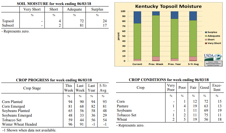 Kentucky Climate Summary
For the Period May 28 to June 3, 2018
Above Normal Temperatures and Much Above Normal Rainfall:
It may be early in the year to be talking about tropical storms, but Kentucky had to
deal with the remnants of Subtropical Depression Alberto early in the period. Outer
bands on the north side of Alberto started affecting the region on Monday with
scattered to numerous showers/storms in place. More of the same followed on Tuesday
and Wednesday as the remnants passed through Western Kentucky and north of the
region. A very moist atmosphere in place with dew points in the 70s led storms
producing torrential rainfall at times and in turn, localized flash flooding. While
the state had already seen an abundant amount of rainfall, more rounds followed over
the second half of the period, highlighted by a passing disturbance on Thursday with
a couple rounds of strong to severe storms. While heavy rain and flooding continued
to be an issue, these storms also produced damaging winds across much of the state.
Overall, the state averaged nearly two inches for the week, but several locations
across Western and Central Kentucky saw more than three. As a side note,
temperatures continued to run above normal and based on preliminary data at the UK Ag
Weather Center, this past month would be the warmest May on record for the state of
Kentucky.
Temperatures for the period averaged 76 degrees across the state which was 7 degrees
warmer than normal and 2 degrees warmer than the previous period. High temperatures
averaged from 86 in the West to 82 in the East. Departure from normal high
temperatures ranged from 4 degrees warmer than normal in the West to 2 degrees
warmer than normal in the East. Low temperatures averaged from 69 degrees in the
West to 66 degrees in the East. Departure from normal low temperature ranged from 9
degrees warmer than normal in the West to 11 degrees warmer than normal in the
East. The extreme high temperature for the period was 92 degrees at EVANSVILLE ASOS
and the extreme low was 61 degrees at PAINTSVILLE 4W.
Precipitation (liq. equ.) for the period totaled 1.86 inches statewide which was 0.75
inches above normal and 167% of normal. Precipitation totals by climate division,
West 2.48 inches, Central 2.14 inches, Bluegrass 1.54 inches and East 1.28 inches,
which was 1.39, 0.99, 0.45 and 0.16 inches above normal. By station, precipitation
totals ranged from a low of 0.23 inches at POPLAR BLUFF ASOS to a high of 5.77
inches at HOPKINSVILLE 6N.
---
Kentucky Crop and Weather Report
Issued 4:00 P.M., May 29, 2018 13-18
Agricultural News: Kentucky experienced well above normal temperatures and below
normal rainfall over the past week. Precipitation for the week totaled 0.88 inches,
0.23 inches below normal. Temperatures averaged 74 degrees for the week, 7 degrees
above normal. Topsoil moisture was rated 1 percent very short, 8 percent short, 83
percent adequate, and 8 percent surplus. Subsoil moisture was rated 1 percent very
short, 5 percent short, 88 percent adequate, and 6 percent surplus. Days suitable for
fieldwork averaged 5.0 out of a possible seven.
Primary activities for this week included planting corn, soybeans, and tobacco along
with cutting hay and spraying. Although there was some rain this week, farmers were
still able to make steady progress on field work. Corn planting was on par with last
year while soybeans and tobacco are slightly ahead of 2017 for this juncture in the
season. The average height of corn was 9 inches, matching last year. Winter wheat is
91 percent headed
Pasture and livestock are in mostly good condition at this time. Hay and roughage
supplies were reported as 4 percent very short, 20 percent short, 72 percent
adequate, and 4 percent surplus. The majority of hay was reported in good condition
although a few producers expressed yield concerns due to a very wet season and late
first cuttings.
Kentucky Climate Summary
For the Period May 28 to June 3, 2018
Above Normal Temperatures and Much Above Normal Rainfall:
It may be early in the year to be talking about tropical storms, but Kentucky had to
deal with the remnants of Subtropical Depression Alberto early in the period. Outer
bands on the north side of Alberto started affecting the region on Monday with
scattered to numerous showers/storms in place. More of the same followed on Tuesday
and Wednesday as the remnants passed through Western Kentucky and north of the
region. A very moist atmosphere in place with dew points in the 70s led storms
producing torrential rainfall at times and in turn, localized flash flooding. While
the state had already seen an abundant amount of rainfall, more rounds followed over
the second half of the period, highlighted by a passing disturbance on Thursday with
a couple rounds of strong to severe storms. While heavy rain and flooding continued
to be an issue, these storms also produced damaging winds across much of the state.
Overall, the state averaged nearly two inches for the week, but several locations
across Western and Central Kentucky saw more than three. As a side note,
temperatures continued to run above normal and based on preliminary data at the UK Ag
Weather Center, this past month would be the warmest May on record for the state of
Kentucky.
Temperatures for the period averaged 76 degrees across the state which was 7 degrees
warmer than normal and 2 degrees warmer than the previous period. High temperatures
averaged from 86 in the West to 82 in the East. Departure from normal high
temperatures ranged from 4 degrees warmer than normal in the West to 2 degrees
warmer than normal in the East. Low temperatures averaged from 69 degrees in the
West to 66 degrees in the East. Departure from normal low temperature ranged from 9
degrees warmer than normal in the West to 11 degrees warmer than normal in the
East. The extreme high temperature for the period was 92 degrees at EVANSVILLE ASOS
and the extreme low was 61 degrees at PAINTSVILLE 4W.
Precipitation (liq. equ.) for the period totaled 1.86 inches statewide which was 0.75
inches above normal and 167% of normal. Precipitation totals by climate division,
West 2.48 inches, Central 2.14 inches, Bluegrass 1.54 inches and East 1.28 inches,
which was 1.39, 0.99, 0.45 and 0.16 inches above normal. By station, precipitation
totals ranged from a low of 0.23 inches at POPLAR BLUFF ASOS to a high of 5.77
inches at HOPKINSVILLE 6N.
---
Kentucky Crop and Weather Report
Issued 4:00 P.M., May 29, 2018 13-18
Agricultural News: Kentucky experienced well above normal temperatures and below
normal rainfall over the past week. Precipitation for the week totaled 0.88 inches,
0.23 inches below normal. Temperatures averaged 74 degrees for the week, 7 degrees
above normal. Topsoil moisture was rated 1 percent very short, 8 percent short, 83
percent adequate, and 8 percent surplus. Subsoil moisture was rated 1 percent very
short, 5 percent short, 88 percent adequate, and 6 percent surplus. Days suitable for
fieldwork averaged 5.0 out of a possible seven.
Primary activities for this week included planting corn, soybeans, and tobacco along
with cutting hay and spraying. Although there was some rain this week, farmers were
still able to make steady progress on field work. Corn planting was on par with last
year while soybeans and tobacco are slightly ahead of 2017 for this juncture in the
season. The average height of corn was 9 inches, matching last year. Winter wheat is
91 percent headed
Pasture and livestock are in mostly good condition at this time. Hay and roughage
supplies were reported as 4 percent very short, 20 percent short, 72 percent
adequate, and 4 percent surplus. The majority of hay was reported in good condition
although a few producers expressed yield concerns due to a very wet season and late
first cuttings.
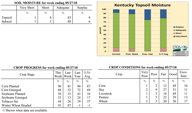 Kentucky Climate Summary
For the Period May 21 to May 27, 2018
Well Above Normal Temperatures and Below Normal Rainfall:
Kentucky remained situated within a hot and humid air mass this past week. High
temperatures continued to run solidly in the 80s, topping out Friday and into the
weekend with the majority of the state in the middle 80s to around 90. Normal high
temperatures for late May run in the upper 70s to low 80s. The state has now gone
four straight weeks with above normal temperatures in place. Just like the previous
period, the Bluegrass State saw scattered showers and storms develop during the
afternoon and evening hours throughout much of the week. With a very moist air mass
in place, heavy down pours continued to be an issue, in addition to frequent
lightning and gusty winds at times. Overall, the state averaged 0.88 inches, but that
number may be a bit misleading as the scattered nature led to a wide range of
accumulations. While some received less than a quarter inch for the week,
others saw in excess of two.
Temperatures for the period averaged 74 degrees across the state which was 7 degrees
warmer than normal and no change to the previous period. High temperatures averaged
from 86 in the West to 83 in the East. Departure from normal high temperatures
ranged from 6 degrees warmer than normal in the West to 5 degrees warmer than normal
in the East. Low temperatures averaged from 66 degrees in the West to 64 degrees in
the East. Departure from normal low temperature ranged from 9 degrees warmer than
normal in the West to 12 degrees warmer than normal in the East. The extreme high
temperature for the period was 94 degrees at EVANSVILLE ASOS and the extreme low was
53 degrees at BLACK MOUNTAIN ARC.
Precipitation (liq. equ.) for the period totaled 0.88 inches statewide which was 0.23
inches below normal and 79% of normal. Precipitation totals by climate division, West
0.54 inches, Central 0.85 inches, Bluegrass 1.02 inches and East 1.11 inches, which
was 0.56, 0.31, 0.05 and 0.01 inches below normal. By station, precipitation totals
ranged from a low of 0.03 inches at GREENVILLE 6N to a high of 3.23 inches at MOREHEAD 4NE.
---
Kentucky Crop and Weather Report
Issued 4:00 P.M., May 21, 2018 12-18
Agricultural News: Kentucky experienced well above normal temperatures and above
normal rainfall over the past week. Precipitation for the week totaled 1.23 inches,
0.09 inches above normal. Temperatures averaged 74 degrees for the week, 9 degrees
above normal. Topsoil moisture was rated 1 percent very short, 5 percent short, 83
percent adequate and 11 percent surplus. Subsoil moisture was rated 3 percent short,
88 percent adequate, and 9 percent surplus. Days suitable for fieldwork averaged 5.0
out of a possible seven.
Primary activities this week included planting corn and soybeans, setting tobacco,
and spraying fields. Periodic afternoon rainfall postponed fieldwork at times.
Tobacco transplant supplies were reported as 2 percent short, 91 percent adequate,
and 7 percent surplus.
Hay cutting continued this week for areas that experienced good drying conditions,
although producers are noting lower yields. Scattered thunderstorms delayed some
farmers from fieldwork, mostly in far eastern and western counties where
precipitation totals were higher. There are concerns of forages becoming over mature
and leading to lower quality, due to rainfall delays in cutting. Spring breeding of
cattle is underway.
Kentucky Climate Summary
For the Period May 21 to May 27, 2018
Well Above Normal Temperatures and Below Normal Rainfall:
Kentucky remained situated within a hot and humid air mass this past week. High
temperatures continued to run solidly in the 80s, topping out Friday and into the
weekend with the majority of the state in the middle 80s to around 90. Normal high
temperatures for late May run in the upper 70s to low 80s. The state has now gone
four straight weeks with above normal temperatures in place. Just like the previous
period, the Bluegrass State saw scattered showers and storms develop during the
afternoon and evening hours throughout much of the week. With a very moist air mass
in place, heavy down pours continued to be an issue, in addition to frequent
lightning and gusty winds at times. Overall, the state averaged 0.88 inches, but that
number may be a bit misleading as the scattered nature led to a wide range of
accumulations. While some received less than a quarter inch for the week,
others saw in excess of two.
Temperatures for the period averaged 74 degrees across the state which was 7 degrees
warmer than normal and no change to the previous period. High temperatures averaged
from 86 in the West to 83 in the East. Departure from normal high temperatures
ranged from 6 degrees warmer than normal in the West to 5 degrees warmer than normal
in the East. Low temperatures averaged from 66 degrees in the West to 64 degrees in
the East. Departure from normal low temperature ranged from 9 degrees warmer than
normal in the West to 12 degrees warmer than normal in the East. The extreme high
temperature for the period was 94 degrees at EVANSVILLE ASOS and the extreme low was
53 degrees at BLACK MOUNTAIN ARC.
Precipitation (liq. equ.) for the period totaled 0.88 inches statewide which was 0.23
inches below normal and 79% of normal. Precipitation totals by climate division, West
0.54 inches, Central 0.85 inches, Bluegrass 1.02 inches and East 1.11 inches, which
was 0.56, 0.31, 0.05 and 0.01 inches below normal. By station, precipitation totals
ranged from a low of 0.03 inches at GREENVILLE 6N to a high of 3.23 inches at MOREHEAD 4NE.
---
Kentucky Crop and Weather Report
Issued 4:00 P.M., May 21, 2018 12-18
Agricultural News: Kentucky experienced well above normal temperatures and above
normal rainfall over the past week. Precipitation for the week totaled 1.23 inches,
0.09 inches above normal. Temperatures averaged 74 degrees for the week, 9 degrees
above normal. Topsoil moisture was rated 1 percent very short, 5 percent short, 83
percent adequate and 11 percent surplus. Subsoil moisture was rated 3 percent short,
88 percent adequate, and 9 percent surplus. Days suitable for fieldwork averaged 5.0
out of a possible seven.
Primary activities this week included planting corn and soybeans, setting tobacco,
and spraying fields. Periodic afternoon rainfall postponed fieldwork at times.
Tobacco transplant supplies were reported as 2 percent short, 91 percent adequate,
and 7 percent surplus.
Hay cutting continued this week for areas that experienced good drying conditions,
although producers are noting lower yields. Scattered thunderstorms delayed some
farmers from fieldwork, mostly in far eastern and western counties where
precipitation totals were higher. There are concerns of forages becoming over mature
and leading to lower quality, due to rainfall delays in cutting. Spring breeding of
cattle is underway.
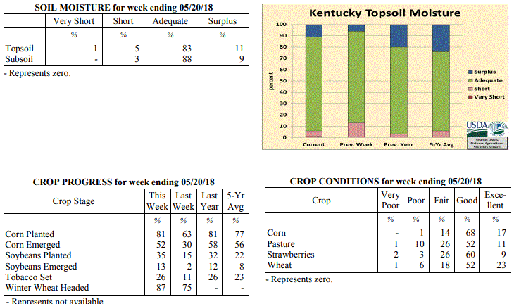 Kentucky Climate Summary
For the Period May 14 to May 20, 2018
Well Above Normal Temperatures and Above Normal Rainfall:
A summerlike pattern continued for a second straight week, but unlike the previous
period, Kentucky saw daily rounds of showers and storms. Each day was a near replay
of the previous as scattered showers and storms fired each afternoon and evening,
before diminishing overnight. While coverage was not widespread, much of Kentucky
still managed to pick up more than inch for the week. This was mostly due to the
very moist and unstable atmosphere in place, which led to torrential rainfall at
times and in turn, localized flooding. Temperatures remained very warm for this time
of year, peaking early in the week. Kentucky saw record heat on Monday as highs
pushed into the upper 80s to low 90s statewide.
Temperatures for the period averaged 74 degrees across the state which was 9 degrees
warmer than normal and 4 degrees warmer than the previous period. High temperatures
averaged from 85 in the West to 83 in the East. Departure from normal high
temperatures ranged from 7 degrees warmer than normal in the West to 6 degrees
warmer than normal in the East. Low temperatures averaged from 65 degrees in the
West to 63 degrees in the East. Departure from normal low temperature ranged from 10
degrees warmer than normal in the West to 13 degrees warmer than normal in the
East. The extreme high temperature for the period was 93 degrees at HENDERSON 5E and
the extreme low was 58 degrees at BARBOURVILLE 3E.
Precipitation (liq. equ.) for the period totaled 1.23 inches statewide which was 0.09
inches above normal and 108% of normal. Precipitation totals by climate division,
West 1.35 inches, Central 0.71 inches, Bluegrass 1.57 inches and East 1.29 inches,
which was 0.19, -0.48, 0.49 and 0.18 inches respectively from normal. By station,
precipitation totals ranged from a low of 0.24 inches at HARDINSBURG 5SW to a high of
3.19 inches at MOREHEAD 4NE.
---
Kentucky Crop and Weather Report
Issued 4:00 P.M., May 14, 2018 11-18
Agricultural News: Kentucky experienced well above normal temperatures and below
normal rainfall over the past week. Precipitation for the week totaled 0.15 inches,
0.95 inches below normal. Temperatures averaged 71 degrees for the week, 8 degrees
above normal. Topsoil moisture was rated 13 percent short, 81 percent adequate and 6
percent surplus. Subsoil moisture was rated 5 percent short, 86 percent adequate, and
9 percent surplus. Days suitable for fieldwork averaged 6.0 out of a possible seven.
Primary activities this week included planting corn, soybeans, and vegetables,
setting tobacco, cutting hay, and fertilizing fields. Initial reports from some
producers note that first cutting hay yields are poor due to the late spring.
Favorable warm and dry weather over the past week helped to improve pastures and hay,
and allowed for significant planting progress to be made. Weather forecasts for rain
in the next week have delayed some farmers from cutting hay to allow for enough time
to bale. Cattle producers are preparing for spring breeding.
Tobacco transplant supplies were reported as 2 percent short, 90 percent adequate,
and 8 percent surplus. Eighteen percent of tobacco transplants were under 2 inches,
with 43 percent between 2-4 inches, and 39 percent
over 4 inches.
Kentucky Climate Summary
For the Period May 14 to May 20, 2018
Well Above Normal Temperatures and Above Normal Rainfall:
A summerlike pattern continued for a second straight week, but unlike the previous
period, Kentucky saw daily rounds of showers and storms. Each day was a near replay
of the previous as scattered showers and storms fired each afternoon and evening,
before diminishing overnight. While coverage was not widespread, much of Kentucky
still managed to pick up more than inch for the week. This was mostly due to the
very moist and unstable atmosphere in place, which led to torrential rainfall at
times and in turn, localized flooding. Temperatures remained very warm for this time
of year, peaking early in the week. Kentucky saw record heat on Monday as highs
pushed into the upper 80s to low 90s statewide.
Temperatures for the period averaged 74 degrees across the state which was 9 degrees
warmer than normal and 4 degrees warmer than the previous period. High temperatures
averaged from 85 in the West to 83 in the East. Departure from normal high
temperatures ranged from 7 degrees warmer than normal in the West to 6 degrees
warmer than normal in the East. Low temperatures averaged from 65 degrees in the
West to 63 degrees in the East. Departure from normal low temperature ranged from 10
degrees warmer than normal in the West to 13 degrees warmer than normal in the
East. The extreme high temperature for the period was 93 degrees at HENDERSON 5E and
the extreme low was 58 degrees at BARBOURVILLE 3E.
Precipitation (liq. equ.) for the period totaled 1.23 inches statewide which was 0.09
inches above normal and 108% of normal. Precipitation totals by climate division,
West 1.35 inches, Central 0.71 inches, Bluegrass 1.57 inches and East 1.29 inches,
which was 0.19, -0.48, 0.49 and 0.18 inches respectively from normal. By station,
precipitation totals ranged from a low of 0.24 inches at HARDINSBURG 5SW to a high of
3.19 inches at MOREHEAD 4NE.
---
Kentucky Crop and Weather Report
Issued 4:00 P.M., May 14, 2018 11-18
Agricultural News: Kentucky experienced well above normal temperatures and below
normal rainfall over the past week. Precipitation for the week totaled 0.15 inches,
0.95 inches below normal. Temperatures averaged 71 degrees for the week, 8 degrees
above normal. Topsoil moisture was rated 13 percent short, 81 percent adequate and 6
percent surplus. Subsoil moisture was rated 5 percent short, 86 percent adequate, and
9 percent surplus. Days suitable for fieldwork averaged 6.0 out of a possible seven.
Primary activities this week included planting corn, soybeans, and vegetables,
setting tobacco, cutting hay, and fertilizing fields. Initial reports from some
producers note that first cutting hay yields are poor due to the late spring.
Favorable warm and dry weather over the past week helped to improve pastures and hay,
and allowed for significant planting progress to be made. Weather forecasts for rain
in the next week have delayed some farmers from cutting hay to allow for enough time
to bale. Cattle producers are preparing for spring breeding.
Tobacco transplant supplies were reported as 2 percent short, 90 percent adequate,
and 8 percent surplus. Eighteen percent of tobacco transplants were under 2 inches,
with 43 percent between 2-4 inches, and 39 percent
over 4 inches.
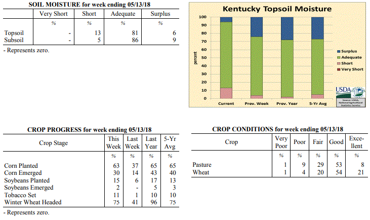 Kentucky Climate Summary
For the Period May 7 to May 13, 2018
Well Above Normal Temperatures and Below Normal Rainfall:
It might be a month early, but it felt more like summer for much of the period.
Temperatures and humidity gradually increased throughout the week. The Bluegrass
State started with highs in the upper 60s to middle 70s on Monday and ended with
middle 80s to low 90s on Sunday. The livestock heat stress index even increased into
the danger category for short time periods late in the week during the afternoon and
early evening hours. The summerlike conditions led to the first time since late
February/early March that the Commonwealth had consecutive weeks of above normal
temperatures. Other than some occasional isolated showers and storms through the
workweek, Kentucky was dry for the majority of the period. In fact, the state was
almost an inch below normal for the week.
Temperatures for the period averaged 71 degrees across the state which was 8 degrees
warmer than normal and 4 degrees warmer than the previous period. High temperatures
averaged from 84 in the West to 83 in the East. Departure from normal high
temperatures ranged from 8 degrees warmer than normal in the West to 8 degrees
warmer than normal in the East. Low temperatures averaged from 60 degrees in the
West to 58 degrees in the East. Departure from normal low temperature ranged from 7
degrees warmer than normal in the West to 11 degrees warmer than normal in the
East. The extreme high temperature for the period was 91 degrees at MAYFIELD 6SW and
the extreme low was 43 degrees at BRANDENBURG 4SW.
Precipitation (liq. equ.) for the period totaled 0.15 inches statewide which was 0.95
inches below normal and 14% of normal. Precipitation totals by climate division, West
0.10 inches, Central 0.22 inches, Bluegrass 0.11 inches and East 0.17 inches, which
was 1.06, 0.94, 0.91 and 0.89 inches below normal. By station, precipitation totals
ranged from a low of 0.00 inches at BENTON 4N to a high of 0.62 inches at MUNFORDVILLE 6E.
---
Kentucky Crop and Weather Report
Issued 4:00 P.M., May 7, 2018 10-18
Agricultural News: Kentucky experienced above normal temperatures and rainfall over
the past week. Precipitation for the week totaled 1.33 inches, 0.24 inches above
normal. Temperatures averaged 66 degrees for the week, 5 degrees above normal.
Topsoil moisture was rated 4 percent short, 72 percent adequate and 24 percent
surplus. Subsoil moisture was rated 1 percent short, 76 percent adequate, and 23
percent surplus. Days suitable for fieldwork averaged 5.0 out of a possible seven.
Rising temperatures helped in drying out fields this week. Primary activities
included planting corn and soybeans, setting tobacco, as well as spraying,
fertilizing, and field preparations. Rain and scattered storms over the weekend did
limit fieldwork.
Overall, the wet and cool start to spring has led to several issues including short
and thin hay, little stem elongation in wheat heads, slugs in wheat fields, and poor
emergence in corn. Some corn fields are being replanted as a result. Pastures and
forages are growing faster from the recent warmer temperatures.
Tobacco transplant supplies were reported as 2 percent short, 90 percent adequate,
and 8 percent surplus. Twenty-six percent of tobacco transplants were under 2 inches,
with 43 percent between 2-4 inches, and 31 percent
over 4 inches.
Kentucky Climate Summary
For the Period May 7 to May 13, 2018
Well Above Normal Temperatures and Below Normal Rainfall:
It might be a month early, but it felt more like summer for much of the period.
Temperatures and humidity gradually increased throughout the week. The Bluegrass
State started with highs in the upper 60s to middle 70s on Monday and ended with
middle 80s to low 90s on Sunday. The livestock heat stress index even increased into
the danger category for short time periods late in the week during the afternoon and
early evening hours. The summerlike conditions led to the first time since late
February/early March that the Commonwealth had consecutive weeks of above normal
temperatures. Other than some occasional isolated showers and storms through the
workweek, Kentucky was dry for the majority of the period. In fact, the state was
almost an inch below normal for the week.
Temperatures for the period averaged 71 degrees across the state which was 8 degrees
warmer than normal and 4 degrees warmer than the previous period. High temperatures
averaged from 84 in the West to 83 in the East. Departure from normal high
temperatures ranged from 8 degrees warmer than normal in the West to 8 degrees
warmer than normal in the East. Low temperatures averaged from 60 degrees in the
West to 58 degrees in the East. Departure from normal low temperature ranged from 7
degrees warmer than normal in the West to 11 degrees warmer than normal in the
East. The extreme high temperature for the period was 91 degrees at MAYFIELD 6SW and
the extreme low was 43 degrees at BRANDENBURG 4SW.
Precipitation (liq. equ.) for the period totaled 0.15 inches statewide which was 0.95
inches below normal and 14% of normal. Precipitation totals by climate division, West
0.10 inches, Central 0.22 inches, Bluegrass 0.11 inches and East 0.17 inches, which
was 1.06, 0.94, 0.91 and 0.89 inches below normal. By station, precipitation totals
ranged from a low of 0.00 inches at BENTON 4N to a high of 0.62 inches at MUNFORDVILLE 6E.
---
Kentucky Crop and Weather Report
Issued 4:00 P.M., May 7, 2018 10-18
Agricultural News: Kentucky experienced above normal temperatures and rainfall over
the past week. Precipitation for the week totaled 1.33 inches, 0.24 inches above
normal. Temperatures averaged 66 degrees for the week, 5 degrees above normal.
Topsoil moisture was rated 4 percent short, 72 percent adequate and 24 percent
surplus. Subsoil moisture was rated 1 percent short, 76 percent adequate, and 23
percent surplus. Days suitable for fieldwork averaged 5.0 out of a possible seven.
Rising temperatures helped in drying out fields this week. Primary activities
included planting corn and soybeans, setting tobacco, as well as spraying,
fertilizing, and field preparations. Rain and scattered storms over the weekend did
limit fieldwork.
Overall, the wet and cool start to spring has led to several issues including short
and thin hay, little stem elongation in wheat heads, slugs in wheat fields, and poor
emergence in corn. Some corn fields are being replanted as a result. Pastures and
forages are growing faster from the recent warmer temperatures.
Tobacco transplant supplies were reported as 2 percent short, 90 percent adequate,
and 8 percent surplus. Twenty-six percent of tobacco transplants were under 2 inches,
with 43 percent between 2-4 inches, and 31 percent
over 4 inches.
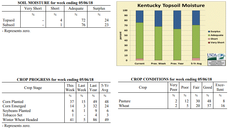 Kentucky Climate Summary
For the Period April 30 to May 6, 2018
Above Normal Temperatures and Rainfall:
The first couple days of May featured dry conditions and above normal temperatures
as high pressure took control of the Ohio Valley early in the period. By
Wednesday, high temperatures soared into the low to middle 80s behind breezy
southwest flow and it even felt a bit humid outside as dew points inched into the
60s. Showers and storms then returned for the latter half of the period, starting
with a weakening line of storms on Thursday morning pushing east. Scattered to
numerous showers and storms followed on Friday with the passage of a cold front,
before coverage turned widespread for Derby Day. In fact, Louisville International
Airport recorded over three inches for the one-day period on Saturday. After another
round of scattered storms Sunday afternoon/evening, Kentucky averaged 1.33 inches for
the week, marking the second straight period of above normal rainfall.
Temperatures for the period averaged 66 degrees across the state which was 5 degrees
warmer than normal and 8 degrees warmer than the previous period. High temperatures
averaged from 78 in the West to 78 in the East. Departure from normal high
temperatures ranged from 4 degrees warmer than normal in the West to 5 degrees
warmer than normal in the East. Low temperatures averaged from 57 degrees in the
West to 53 degrees in the East. Departure from normal low temperature ranged from 6
degrees warmer than normal in the West to 8 degrees warmer than normal in the East.
The extreme high temperature for the period was 90 degrees at LOUISA 1S and the
extreme low was 28 degrees at BOONEVILLE 2S.
Precipitation (liq. equ.) for the period totaled 1.33 inches statewide which was 0.24
inches above normal and 122% of normal. Precipitation totals by climate division,
West 1.02 inches, Central 1.59 inches, Bluegrass 1.49 inches and East 1.23 inches,
which was -0.19, 0.47, 0.49 and 0.21 inches respectively from normal. By station,
precipitation totals ranged from a low of 0.11 inches at YELLOW CREEK to a high of
3.20 inches at LOUISVILLE APT.
---
Kentucky Crop and Weather Report
Issued 4:00 P.M., April 30, 2018 09-18
Agricultural News: Kentucky experienced below normal temperatures and above normal
rainfall over the past week. Precipitation for the week totaled 1.16 inches, 0.11
inches above normal. Temperatures averaged 56 degrees for the week, 3 degrees below
normal. Topsoil moisture was rated 1 percent short, 67 percent adequate, and 32
percent surplus. Subsoil moisture was rated 65 percent adequate and 35 percent
surplus. Days suitable for fieldwork averaged 3.4 out of a possible seven.
Primary activities for this week included planting corn and soybeans when possible
along with seeding of tobacco transplants. Corn planting progress is well behind both
last year and the five year average for this point in the season due to continuing
rain and cool temperatures. Warm and dry conditions arrived towards the end of the
week and farmers will be trying to catch up while the weather holds out. Soybean
planting has just begun at 1 percent in the ground. The average height of winter
wheat was reported as 18 inches, compared to 17 inches last week.
Pastures and hay growth have suffered due to the consistent rain and cool
temperatures, however hay supply is mostly adequate and the condition is mostly good.
Hay supply was reported as 8 percent very short, 30 percent short, 59 percent
adequate, and 3 percent surplus. Alfalfa hay average height was 10 inches, compared
to 9 inches last week. Greenhouse tobacco plants were reported as in mostly good
condition. Forty three percent of tobacco transplants were under 2 inches, with 38
percent 2-4 inches, and 19 percent over 4 inches. Strawberry condition was rated as 1
percent very poor, 3 percent poor, 38 percent fair, 51 percent good, and 7 percent
excellent.
Kentucky Climate Summary
For the Period April 30 to May 6, 2018
Above Normal Temperatures and Rainfall:
The first couple days of May featured dry conditions and above normal temperatures
as high pressure took control of the Ohio Valley early in the period. By
Wednesday, high temperatures soared into the low to middle 80s behind breezy
southwest flow and it even felt a bit humid outside as dew points inched into the
60s. Showers and storms then returned for the latter half of the period, starting
with a weakening line of storms on Thursday morning pushing east. Scattered to
numerous showers and storms followed on Friday with the passage of a cold front,
before coverage turned widespread for Derby Day. In fact, Louisville International
Airport recorded over three inches for the one-day period on Saturday. After another
round of scattered storms Sunday afternoon/evening, Kentucky averaged 1.33 inches for
the week, marking the second straight period of above normal rainfall.
Temperatures for the period averaged 66 degrees across the state which was 5 degrees
warmer than normal and 8 degrees warmer than the previous period. High temperatures
averaged from 78 in the West to 78 in the East. Departure from normal high
temperatures ranged from 4 degrees warmer than normal in the West to 5 degrees
warmer than normal in the East. Low temperatures averaged from 57 degrees in the
West to 53 degrees in the East. Departure from normal low temperature ranged from 6
degrees warmer than normal in the West to 8 degrees warmer than normal in the East.
The extreme high temperature for the period was 90 degrees at LOUISA 1S and the
extreme low was 28 degrees at BOONEVILLE 2S.
Precipitation (liq. equ.) for the period totaled 1.33 inches statewide which was 0.24
inches above normal and 122% of normal. Precipitation totals by climate division,
West 1.02 inches, Central 1.59 inches, Bluegrass 1.49 inches and East 1.23 inches,
which was -0.19, 0.47, 0.49 and 0.21 inches respectively from normal. By station,
precipitation totals ranged from a low of 0.11 inches at YELLOW CREEK to a high of
3.20 inches at LOUISVILLE APT.
---
Kentucky Crop and Weather Report
Issued 4:00 P.M., April 30, 2018 09-18
Agricultural News: Kentucky experienced below normal temperatures and above normal
rainfall over the past week. Precipitation for the week totaled 1.16 inches, 0.11
inches above normal. Temperatures averaged 56 degrees for the week, 3 degrees below
normal. Topsoil moisture was rated 1 percent short, 67 percent adequate, and 32
percent surplus. Subsoil moisture was rated 65 percent adequate and 35 percent
surplus. Days suitable for fieldwork averaged 3.4 out of a possible seven.
Primary activities for this week included planting corn and soybeans when possible
along with seeding of tobacco transplants. Corn planting progress is well behind both
last year and the five year average for this point in the season due to continuing
rain and cool temperatures. Warm and dry conditions arrived towards the end of the
week and farmers will be trying to catch up while the weather holds out. Soybean
planting has just begun at 1 percent in the ground. The average height of winter
wheat was reported as 18 inches, compared to 17 inches last week.
Pastures and hay growth have suffered due to the consistent rain and cool
temperatures, however hay supply is mostly adequate and the condition is mostly good.
Hay supply was reported as 8 percent very short, 30 percent short, 59 percent
adequate, and 3 percent surplus. Alfalfa hay average height was 10 inches, compared
to 9 inches last week. Greenhouse tobacco plants were reported as in mostly good
condition. Forty three percent of tobacco transplants were under 2 inches, with 38
percent 2-4 inches, and 19 percent over 4 inches. Strawberry condition was rated as 1
percent very poor, 3 percent poor, 38 percent fair, 51 percent good, and 7 percent
excellent.
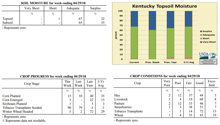 Kentucky Climate Summary
For the Period April 23 to April 29, 2018
Below Normal Temperatures and Above Normal Rainfall:
An area of low pressure aloft slowly progressed across the region to begin the
period. This kept Kentucky in a wet pattern with bands of light to moderate rain
showers moving through the area. In addition to some light rainfall on Thursday
across the southern half of Kentucky, total accumulations for the week averaged just
over an inch for the state. The clouds and precipitation kept temperatures below
normal by day and above normal at night. Sunshine returned for the weekend, but a
frontal passage early on Saturday kept temperatures below normal as high pressure
filtered cooler air from Canada down into the Bluegrass State. In fact, lows on
Saturday night/Sunday morning dipped into the low to middle 30s across the eastern
half of Kentucky, leading to some patchy light frost.
Temperatures for the period averaged 56 degrees across the state which was 3 degrees
cooler than normal and 6 degrees warmer than the previous period. High temperatures
averaged from 66 in the West to 64 in the East. Departure from normal high
temperatures ranged from 6 degrees cooler than normal in the West to 7 degrees cooler
than normal in the East. Low temperatures averaged from 49 degrees in the West to 48
degrees in the East. Departure from normal low temperature ranged from near normal in
the West to 5 degrees warmer than normal in the East. The extreme high temperature
for the period was 76 degrees at LOUISVILLE APT and the extreme low was 29 degrees at
BRANDENBURG 4SW.
Precipitation (liq. equ.) for the period totaled 1.16 inches statewide which was 0.11
inches above normal and 110% of normal. Precipitation totals by climate division,
West 1.45 inches, Central 0.98 inches, Bluegrass 1.07 inches and East 1.12 inches,
which was 0.25, -0.09, 0.10 and 0.15 inches respectively from normal. By station,
precipitation totals ranged from a low of 0.27 inches at FORT KNOX to a high of 3.42
inches at MAYFIELD 6SW.
---
Kentucky Crop and Weather Report
Issued 4:00 P.M., April 23, 2018 08-18
Agricultural News: Kentucky experienced below normal temperatures and precipitation
over the past week. Precipitation for the week totaled 0.29 inches, 0.70 inches below
normal. Temperatures averaged 50 degrees for the week, 6 degrees below normal.
Topsoil moisture was rated 61 percent adequate and 39 percent surplus. Subsoil
moisture was rated 65 percent adequate and 35 percent surplus. Days suitable for
fieldwork averaged 3.6 out of a possible seven.
Primary activities for this week included the continuation of corn planting and
tobacco transplant seeding. The weather continues to impede progress in the fields as
cool, wet conditions persist. Corn planting, at 10 percent, is well behind last year
at 28 percent, and the five year average of 21 percent. Sixty three percent of
tobacco transplants are under 2 inches, with 26 percent 2-4 inches, and 11 percent
over 4 inches. Soybean planting has been restricted by the weather and the lag in
corn planting progress.
The average height of winter wheat was 17 inches, up from 13 inches last week.
Average height of alfalfa hay was 9 inches, compared to 7 inches the previous week.
Apple freeze damage was reported as 2 percent severe, 11 percent moderate, 31 percent
light, and 56 percent with no damage. Peach freeze damage was reported as 4 percent
severe, 13 percent moderate, 32 percent light, and 51 percent with no damage.
Kentucky Climate Summary
For the Period April 23 to April 29, 2018
Below Normal Temperatures and Above Normal Rainfall:
An area of low pressure aloft slowly progressed across the region to begin the
period. This kept Kentucky in a wet pattern with bands of light to moderate rain
showers moving through the area. In addition to some light rainfall on Thursday
across the southern half of Kentucky, total accumulations for the week averaged just
over an inch for the state. The clouds and precipitation kept temperatures below
normal by day and above normal at night. Sunshine returned for the weekend, but a
frontal passage early on Saturday kept temperatures below normal as high pressure
filtered cooler air from Canada down into the Bluegrass State. In fact, lows on
Saturday night/Sunday morning dipped into the low to middle 30s across the eastern
half of Kentucky, leading to some patchy light frost.
Temperatures for the period averaged 56 degrees across the state which was 3 degrees
cooler than normal and 6 degrees warmer than the previous period. High temperatures
averaged from 66 in the West to 64 in the East. Departure from normal high
temperatures ranged from 6 degrees cooler than normal in the West to 7 degrees cooler
than normal in the East. Low temperatures averaged from 49 degrees in the West to 48
degrees in the East. Departure from normal low temperature ranged from near normal in
the West to 5 degrees warmer than normal in the East. The extreme high temperature
for the period was 76 degrees at LOUISVILLE APT and the extreme low was 29 degrees at
BRANDENBURG 4SW.
Precipitation (liq. equ.) for the period totaled 1.16 inches statewide which was 0.11
inches above normal and 110% of normal. Precipitation totals by climate division,
West 1.45 inches, Central 0.98 inches, Bluegrass 1.07 inches and East 1.12 inches,
which was 0.25, -0.09, 0.10 and 0.15 inches respectively from normal. By station,
precipitation totals ranged from a low of 0.27 inches at FORT KNOX to a high of 3.42
inches at MAYFIELD 6SW.
---
Kentucky Crop and Weather Report
Issued 4:00 P.M., April 23, 2018 08-18
Agricultural News: Kentucky experienced below normal temperatures and precipitation
over the past week. Precipitation for the week totaled 0.29 inches, 0.70 inches below
normal. Temperatures averaged 50 degrees for the week, 6 degrees below normal.
Topsoil moisture was rated 61 percent adequate and 39 percent surplus. Subsoil
moisture was rated 65 percent adequate and 35 percent surplus. Days suitable for
fieldwork averaged 3.6 out of a possible seven.
Primary activities for this week included the continuation of corn planting and
tobacco transplant seeding. The weather continues to impede progress in the fields as
cool, wet conditions persist. Corn planting, at 10 percent, is well behind last year
at 28 percent, and the five year average of 21 percent. Sixty three percent of
tobacco transplants are under 2 inches, with 26 percent 2-4 inches, and 11 percent
over 4 inches. Soybean planting has been restricted by the weather and the lag in
corn planting progress.
The average height of winter wheat was 17 inches, up from 13 inches last week.
Average height of alfalfa hay was 9 inches, compared to 7 inches the previous week.
Apple freeze damage was reported as 2 percent severe, 11 percent moderate, 31 percent
light, and 56 percent with no damage. Peach freeze damage was reported as 4 percent
severe, 13 percent moderate, 32 percent light, and 51 percent with no damage.
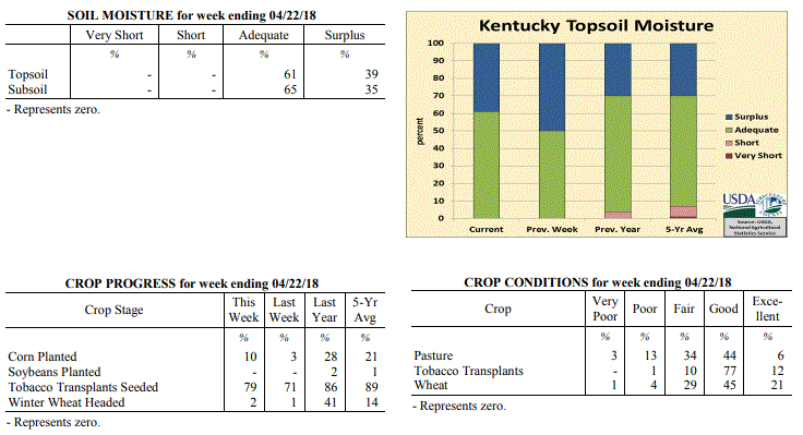 Kentucky Climate Summary
For the Period April 16 to April 22, 2018
Below Normal Temperatures and Precipitation:
Winter-like weather continues to make an appearance across the Bluegrass State. The
period started with well below normal temperatures on Monday and even some bursts of
intense snow showers that led to reduced visibilities at times. Lows that night
dipped into the upper 20s to low 30s, which produced some patchy areas of frost.
Temperatures quickly took a turn for the better on Tuesday and Wednesday with highs
back in the 60s and 70s behind breezy southwesterly winds. Another cold front then
moved through the area Wednesday and that night, producing a line of light to
moderate showers. Yet again, this sent temperatures below normal. More frost
followed the following couple of mornings, before warmth returned again over the
weekend. The period closed with an upper level disturbance moving into the Ohio
Valley on Sunday, producing showers across the southern half of the state. Overall,
the state averaged just over a quarter inch for the week.
Temperatures for the period averaged 50 degrees across the state which was 6 degrees
cooler than normal and 6 degrees cooler than the previous period. High temperatures
averaged from 63 in the West to 64 in the East. Departure from normal high
temperatures ranged from 7 degrees cooler than normal in the West to 5 degrees
cooler than normal in the East. Low temperatures averaged from 40 degrees in the
West to 36 degrees in the East. Departure from normal low temperature ranged from 7
degrees cooler than normal in the West to 5 degrees cooler than normal in the East.
The extreme high temperature for the period was 83 degrees at JACKSON and the extreme
low was 22 degrees at MONTICELLO AWOS.
Precipitation (liq. equ.) for the period totaled 0.29 inches statewide which was 0.7
inches below normal and 29% of normal. Precipitation totals by climate division, West
0.62 inches, Central 0.16 inches, Bluegrass 0.19 inches and East 0.19 inches, which
was 0.52, 0.83, 0.72 and 0.73 inches below normal. By station, precipitation totals
ranged from a low of 0.00 inches at CAMPBELLSVILLE 7W to a high of 1.74 inches at
MAYFIELD 6SW.
---
Kentucky Crop and Weather Report
Issued 4:00 P.M., April 16, 2018 07-18
Agricultural News: Kentucky experienced above normal temperatures and precipitation
over the past week. Precipitation for the week totaled 1.40 inches, 0.38 inches above
normal. Temperatures averaged 56 degrees for the week, 1 degree above normal. Topsoil
moisture was rated 50 percent adequate and 50 percent surplus. Subsoil moisture was
rated 55 percent adequate and 45 percent surplus. Days suitable for fieldwork
averaged 3.6 out of a possible seven.
Primary activities for this week included seeding of tobacco transplants, corn
planting, and fertilizer application when weather permitted. There were a few days
conducive to field work, however cold temperatures and rain returned for the weekend.
Corn planting continues to lag behind 2016 and 2017 at this juncture of the season.
Seventy-two percent of tobacco transplants were under 4 inches, with 24 percent 2-4
inches, and 4 percent above 4 inches.
The majority of winter wheat and alfalfa were not subjected to freeze damage. Winter
wheat freeze damage was reported as 2 percent moderate, 20 percent light, and 78
percent experiencing none. The average height of winter wheat was 13 inches. Alfalfa
freeze damage was reported as 1 percent severe, 12 percent moderate, 33 percent
light, and 54 percent experiencing none. The average height of alfalfa was 7 inches.
The return of rain and cold temperatures is taking a toll on pastures and some producers
reported a shortage of hay.
Kentucky Climate Summary
For the Period April 16 to April 22, 2018
Below Normal Temperatures and Precipitation:
Winter-like weather continues to make an appearance across the Bluegrass State. The
period started with well below normal temperatures on Monday and even some bursts of
intense snow showers that led to reduced visibilities at times. Lows that night
dipped into the upper 20s to low 30s, which produced some patchy areas of frost.
Temperatures quickly took a turn for the better on Tuesday and Wednesday with highs
back in the 60s and 70s behind breezy southwesterly winds. Another cold front then
moved through the area Wednesday and that night, producing a line of light to
moderate showers. Yet again, this sent temperatures below normal. More frost
followed the following couple of mornings, before warmth returned again over the
weekend. The period closed with an upper level disturbance moving into the Ohio
Valley on Sunday, producing showers across the southern half of the state. Overall,
the state averaged just over a quarter inch for the week.
Temperatures for the period averaged 50 degrees across the state which was 6 degrees
cooler than normal and 6 degrees cooler than the previous period. High temperatures
averaged from 63 in the West to 64 in the East. Departure from normal high
temperatures ranged from 7 degrees cooler than normal in the West to 5 degrees
cooler than normal in the East. Low temperatures averaged from 40 degrees in the
West to 36 degrees in the East. Departure from normal low temperature ranged from 7
degrees cooler than normal in the West to 5 degrees cooler than normal in the East.
The extreme high temperature for the period was 83 degrees at JACKSON and the extreme
low was 22 degrees at MONTICELLO AWOS.
Precipitation (liq. equ.) for the period totaled 0.29 inches statewide which was 0.7
inches below normal and 29% of normal. Precipitation totals by climate division, West
0.62 inches, Central 0.16 inches, Bluegrass 0.19 inches and East 0.19 inches, which
was 0.52, 0.83, 0.72 and 0.73 inches below normal. By station, precipitation totals
ranged from a low of 0.00 inches at CAMPBELLSVILLE 7W to a high of 1.74 inches at
MAYFIELD 6SW.
---
Kentucky Crop and Weather Report
Issued 4:00 P.M., April 16, 2018 07-18
Agricultural News: Kentucky experienced above normal temperatures and precipitation
over the past week. Precipitation for the week totaled 1.40 inches, 0.38 inches above
normal. Temperatures averaged 56 degrees for the week, 1 degree above normal. Topsoil
moisture was rated 50 percent adequate and 50 percent surplus. Subsoil moisture was
rated 55 percent adequate and 45 percent surplus. Days suitable for fieldwork
averaged 3.6 out of a possible seven.
Primary activities for this week included seeding of tobacco transplants, corn
planting, and fertilizer application when weather permitted. There were a few days
conducive to field work, however cold temperatures and rain returned for the weekend.
Corn planting continues to lag behind 2016 and 2017 at this juncture of the season.
Seventy-two percent of tobacco transplants were under 4 inches, with 24 percent 2-4
inches, and 4 percent above 4 inches.
The majority of winter wheat and alfalfa were not subjected to freeze damage. Winter
wheat freeze damage was reported as 2 percent moderate, 20 percent light, and 78
percent experiencing none. The average height of winter wheat was 13 inches. Alfalfa
freeze damage was reported as 1 percent severe, 12 percent moderate, 33 percent
light, and 54 percent experiencing none. The average height of alfalfa was 7 inches.
The return of rain and cold temperatures is taking a toll on pastures and some producers
reported a shortage of hay.
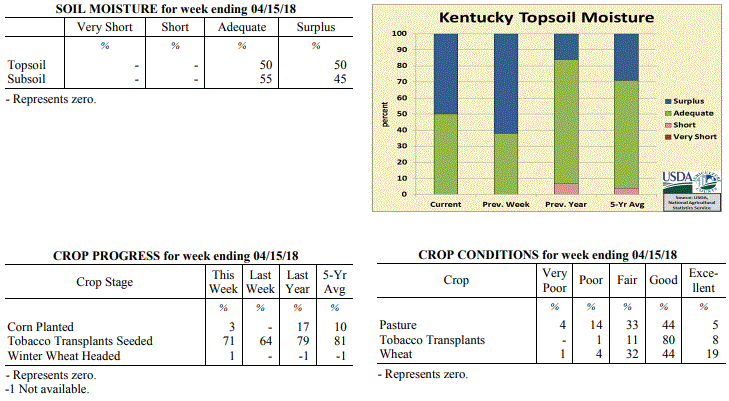 Kentucky Climate Summary
For the Period April 9 to April 15, 2018
Above Normal Temperatures and Precipitation:
High pressure kept the area dry through the workweek, but with a large swing in
temperatures. With the center of the high situated east of the state on Monday and
Tuesday, northerly flow kept temperatures well below normal. Lows dropped into the
upper 20s to middle 30s on Tuesday night, prompting Freeze Warnings and Frost
Advisories to be issued. As the high moved east of Kentucky on Wednesday, breezy
southwest flow led to an abrupt warm up across the area, eventually hitting the upper
70s to low 80s on Friday. While it did get warm, a combination of high winds, low
humidity, and dry fuels did lead to some fire weather concerns. Kentucky soils did
get a chance to dry out through Friday, but rounds of rainfall returned over the
weekend. A light and steady rainfall led to a soaking 1 to 2+ inches for
most of Kentucky. Overall, the state averaged 1.40 inches, which led to a fourth
straight week of above normal rainfall.
Temperatures for the period averaged 56 degrees across the state which was 1 degree
warmer than normal and 12 degrees warmer than the previous period. High temperatures
averaged from 65 in the West to 68 in the East. Departure from normal high
temperatures ranged from 4 degrees cooler than normal in the West to near normal in
the East. Low temperatures averaged from 46 degrees in the West to 44 degrees in the
East. Departure from normal low temperature ranged from 1 degree warmer than normal
in the West to 4 degrees warmer than normal in the East. The extreme high temperature
for the period was 86 degrees at LOUISA 1S and the extreme low was 24 degrees at
BRANDENBURG 4SW.
Precipitation (liq. equ.) for the period totaled 1.40 inches statewide which was 0.38
inches above normal and 137% of normal. Precipitation totals by climate division,
West 1.56 inches, Central 1.41 inches, Bluegrass 1.37 inches and East 1.27 inches,
which was 0.4, 0.37, 0.44 and 0.32 inches above normal. By station, precipitation
totals ranged from a low of 0.04 inches at MONTICELLO AWOS to a high of 3.34
inches at WHITLEY CITY 3N.
---
Kentucky Crop and Weather Report
Issued 4:00 P.M., April 9, 2018 06-18
Agricultural News: Kentucky experienced below normal temperatures and above normal
precipitation over the past week. Precipitation for the week totaled 1.34 inches,
0.35 inches above normal. Temperatures averaged 44 degrees for the week, 8 degrees
below normal. Topsoil moisture was rated 38 percent adequate and 62 percent surplus.
Subsoil moisture was rated 46 percent adequate and 54 percent surplus. Days suitable
for fieldwork averaged 1.4 out of a possible seven.
Primary activities for this week included seeding of tobacco transplants and planting
preparation for field crops. Continuous wet weather has kept farmers from making
progress in terms of fieldwork. There was some tornadic activity early in the week
across the western and central portions of the state. This severe weather gave way to
more precipitation and cold temperatures as the weekend approached. A freeze and some
snow over the weekend threatens growth of wheat, pasture, and hay. There were reports
of hay shortage as some pastures are being damaged due to the excess rain coupled
with livestock traffic.
The average height of winter wheat is 10 inches at this time. Eighteen percent of
apples and 21 percent of peaches are in bloom at this juncture.
Kentucky Climate Summary
For the Period April 9 to April 15, 2018
Above Normal Temperatures and Precipitation:
High pressure kept the area dry through the workweek, but with a large swing in
temperatures. With the center of the high situated east of the state on Monday and
Tuesday, northerly flow kept temperatures well below normal. Lows dropped into the
upper 20s to middle 30s on Tuesday night, prompting Freeze Warnings and Frost
Advisories to be issued. As the high moved east of Kentucky on Wednesday, breezy
southwest flow led to an abrupt warm up across the area, eventually hitting the upper
70s to low 80s on Friday. While it did get warm, a combination of high winds, low
humidity, and dry fuels did lead to some fire weather concerns. Kentucky soils did
get a chance to dry out through Friday, but rounds of rainfall returned over the
weekend. A light and steady rainfall led to a soaking 1 to 2+ inches for
most of Kentucky. Overall, the state averaged 1.40 inches, which led to a fourth
straight week of above normal rainfall.
Temperatures for the period averaged 56 degrees across the state which was 1 degree
warmer than normal and 12 degrees warmer than the previous period. High temperatures
averaged from 65 in the West to 68 in the East. Departure from normal high
temperatures ranged from 4 degrees cooler than normal in the West to near normal in
the East. Low temperatures averaged from 46 degrees in the West to 44 degrees in the
East. Departure from normal low temperature ranged from 1 degree warmer than normal
in the West to 4 degrees warmer than normal in the East. The extreme high temperature
for the period was 86 degrees at LOUISA 1S and the extreme low was 24 degrees at
BRANDENBURG 4SW.
Precipitation (liq. equ.) for the period totaled 1.40 inches statewide which was 0.38
inches above normal and 137% of normal. Precipitation totals by climate division,
West 1.56 inches, Central 1.41 inches, Bluegrass 1.37 inches and East 1.27 inches,
which was 0.4, 0.37, 0.44 and 0.32 inches above normal. By station, precipitation
totals ranged from a low of 0.04 inches at MONTICELLO AWOS to a high of 3.34
inches at WHITLEY CITY 3N.
---
Kentucky Crop and Weather Report
Issued 4:00 P.M., April 9, 2018 06-18
Agricultural News: Kentucky experienced below normal temperatures and above normal
precipitation over the past week. Precipitation for the week totaled 1.34 inches,
0.35 inches above normal. Temperatures averaged 44 degrees for the week, 8 degrees
below normal. Topsoil moisture was rated 38 percent adequate and 62 percent surplus.
Subsoil moisture was rated 46 percent adequate and 54 percent surplus. Days suitable
for fieldwork averaged 1.4 out of a possible seven.
Primary activities for this week included seeding of tobacco transplants and planting
preparation for field crops. Continuous wet weather has kept farmers from making
progress in terms of fieldwork. There was some tornadic activity early in the week
across the western and central portions of the state. This severe weather gave way to
more precipitation and cold temperatures as the weekend approached. A freeze and some
snow over the weekend threatens growth of wheat, pasture, and hay. There were reports
of hay shortage as some pastures are being damaged due to the excess rain coupled
with livestock traffic.
The average height of winter wheat is 10 inches at this time. Eighteen percent of
apples and 21 percent of peaches are in bloom at this juncture.
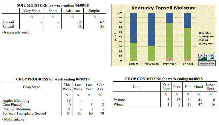 Kentucky Climate Summary
For the Period April 2 to April 8, 2018
Well Below Normal Temperatures and Above Normal Precipitation:
Weather-wise, Kentucky went through a rollercoaster this past week, seeing glimpses
of both winter and spring. Early in the week, focus was on severe weather. With the
state located within an unstable air mass, strong to severe storms formed ahead and
along a strong cold Tuesday evening and into the overnight. Several tornadoes were
confirmed across Western and Central Kentucky, in addition to damaging winds. Ahead
of the boundary, temperatures soared into the 70s, but then took quite the step back
with the frontal passage and Canadian high pressure building into the Ohio Valley.
Thursday morning lows dipped into the middle 20s to low 30s, prompting the first
freeze warnings of the spring season to be issued as some agriculture becomes
susceptible. While mild on Friday, another cold front pushed through the area Friday
night. Precipitation transitioned to a wet snow and led to some minor accumulations
with most under an inch. Skies cleared Saturday night and another freeze warning was
issued with lows dipping again into the 20s. Even had several locations in the upper
teens to low 20s.
Temperatures for the period averaged 44 degrees across the state which was 8 degrees
cooler than normal and 10 degrees cooler than the previous period. High temperatures
averaged from 54 in the West to 56 in the East. Departure from normal high
temperatures ranged from 12 degrees cooler than normal in the West to 9 degrees
cooler than normal in the East. Low temperatures averaged from 36 degrees in the
West to 34 degrees in the East. Departure from normal low temperature ranged from 7
degrees cooler than normal in the West to 3 degrees cooler than normal in the East.
The extreme high temperature for the period was 80 degrees at FORT CAMPBELL and the
extreme low was 19 degrees at RICHMOND 8E.
Precipitation (liq. equ.) for the period totaled 1.34 inches statewide which was 0.35
inches above normal and 136% of normal. Precipitation totals by climate division,
West 0.80 inches, Central 1.21 inches, Bluegrass 1.57 inches and East 1.80 inches,
which was -0.29, 0.19, 0.67 and 0.86 inches respectively from normal. By station,
precipitation totals ranged from a low of 0.41 inches at CAPE GIRARDEAU ASOS to a
high of 3.46 inches at JACKSON AIRPORT.
---
Kentucky Crop and Weather Report
Issued 4:00 P.M., April 2, 2018 05-18
Agricultural News: Kentucky experienced above normal temperatures and precipitation
over the past week. Precipitation for the week totaled 1.95 inches, 0.93 inches above
normal. Temperatures averaged 54 degrees for the week, 4 degrees above normal.
Topsoil moisture was rated 32 percent adequate and 68 percent surplus. Subsoil
moisture was rated 40 percent adequate and 60 percent surplus. Days suitable for
fieldwork averaged 1 out of a possible seven.
Primary activity for this week was seeding of tobacco transplants. Persistent
rainfall and cool temperatures statewide have kept farmers from working the fields in
preparation for spring planting. The ground is saturated in many areas with some
ponding reported in low lying fields. There was very little freeze damage reported
for winter wheat and the crop is in mostly good condition at this time. Freeze damage
to Alfalfa was not prevalent in the state and was reported as light where it existed.
Livestock operations are looking ahead to spring calving and monitoring the condition
of their herds. The condition of livestock was rated as 1 percent very poor, 4
percent poor, 20 percent fair, 68 percent good, and 7 percent excellent.
Approximately 30 percent of feed for cattle and calves was obtained from pastures.
The condition of pastures was reported as 6 percent very poor, 13 percent poor, 31
percent fair, 46 percent good, and 4 percent excellent. The muddy conditions and
temperature swings have had an effect on cattle according to some producers. Hay
supplies are getting short for some farmers as they await spring rejuvenation of
pastures. The extremely wet conditions have caused a good deal of damage to some grazing
land due to livestock traffic.
Kentucky Climate Summary
For the Period April 2 to April 8, 2018
Well Below Normal Temperatures and Above Normal Precipitation:
Weather-wise, Kentucky went through a rollercoaster this past week, seeing glimpses
of both winter and spring. Early in the week, focus was on severe weather. With the
state located within an unstable air mass, strong to severe storms formed ahead and
along a strong cold Tuesday evening and into the overnight. Several tornadoes were
confirmed across Western and Central Kentucky, in addition to damaging winds. Ahead
of the boundary, temperatures soared into the 70s, but then took quite the step back
with the frontal passage and Canadian high pressure building into the Ohio Valley.
Thursday morning lows dipped into the middle 20s to low 30s, prompting the first
freeze warnings of the spring season to be issued as some agriculture becomes
susceptible. While mild on Friday, another cold front pushed through the area Friday
night. Precipitation transitioned to a wet snow and led to some minor accumulations
with most under an inch. Skies cleared Saturday night and another freeze warning was
issued with lows dipping again into the 20s. Even had several locations in the upper
teens to low 20s.
Temperatures for the period averaged 44 degrees across the state which was 8 degrees
cooler than normal and 10 degrees cooler than the previous period. High temperatures
averaged from 54 in the West to 56 in the East. Departure from normal high
temperatures ranged from 12 degrees cooler than normal in the West to 9 degrees
cooler than normal in the East. Low temperatures averaged from 36 degrees in the
West to 34 degrees in the East. Departure from normal low temperature ranged from 7
degrees cooler than normal in the West to 3 degrees cooler than normal in the East.
The extreme high temperature for the period was 80 degrees at FORT CAMPBELL and the
extreme low was 19 degrees at RICHMOND 8E.
Precipitation (liq. equ.) for the period totaled 1.34 inches statewide which was 0.35
inches above normal and 136% of normal. Precipitation totals by climate division,
West 0.80 inches, Central 1.21 inches, Bluegrass 1.57 inches and East 1.80 inches,
which was -0.29, 0.19, 0.67 and 0.86 inches respectively from normal. By station,
precipitation totals ranged from a low of 0.41 inches at CAPE GIRARDEAU ASOS to a
high of 3.46 inches at JACKSON AIRPORT.
---
Kentucky Crop and Weather Report
Issued 4:00 P.M., April 2, 2018 05-18
Agricultural News: Kentucky experienced above normal temperatures and precipitation
over the past week. Precipitation for the week totaled 1.95 inches, 0.93 inches above
normal. Temperatures averaged 54 degrees for the week, 4 degrees above normal.
Topsoil moisture was rated 32 percent adequate and 68 percent surplus. Subsoil
moisture was rated 40 percent adequate and 60 percent surplus. Days suitable for
fieldwork averaged 1 out of a possible seven.
Primary activity for this week was seeding of tobacco transplants. Persistent
rainfall and cool temperatures statewide have kept farmers from working the fields in
preparation for spring planting. The ground is saturated in many areas with some
ponding reported in low lying fields. There was very little freeze damage reported
for winter wheat and the crop is in mostly good condition at this time. Freeze damage
to Alfalfa was not prevalent in the state and was reported as light where it existed.
Livestock operations are looking ahead to spring calving and monitoring the condition
of their herds. The condition of livestock was rated as 1 percent very poor, 4
percent poor, 20 percent fair, 68 percent good, and 7 percent excellent.
Approximately 30 percent of feed for cattle and calves was obtained from pastures.
The condition of pastures was reported as 6 percent very poor, 13 percent poor, 31
percent fair, 46 percent good, and 4 percent excellent. The muddy conditions and
temperature swings have had an effect on cattle according to some producers. Hay
supplies are getting short for some farmers as they await spring rejuvenation of
pastures. The extremely wet conditions have caused a good deal of damage to some grazing
land due to livestock traffic.
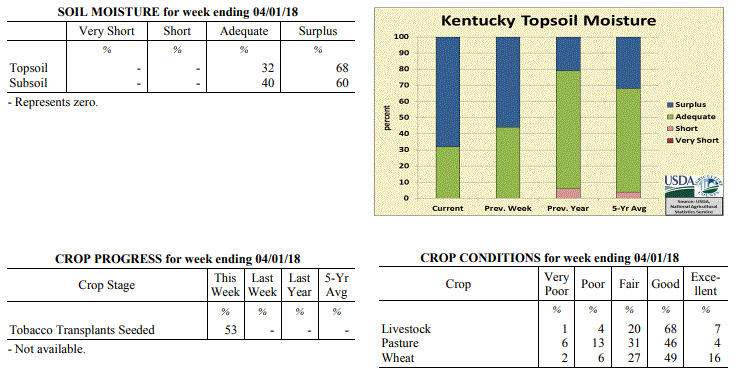 Kentucky Climate Summary
For the Period March 26 to April 1, 2018
Above Normal Temperatures and Precipitation:
As the growing season comes to a start, Kentucky grounds are saturated behind
excessively wet conditions over the last week of March. From Tuesday through Friday,
a frontal boundary remained in the vicinity of Kentucky and was the focus for
multiple rounds of rainfall as disturbances passed overhead. A deep plume of
moisture from the Gulf led to a very moist atmosphere and moderate to heavy rainfall
from time to time. While the main show came over the course of the workweek, a
couple more rounds arrived over the weekend. Overall, Kentucky averaged nearly two
inches for the week, which led to a second straight week of above normal
precipitation for Kentucky. Temperature-wise, highs jumped into the 50s and 60s on a
daily basis. Even hit the 70s in some spots. This period marked the first time that
Kentucky temperatures had averaged above normal since the first week of March.
Temperatures for the period averaged 54 degrees across the state which was 4 degrees
warmer than normal and 14 degrees warmer than the previous period. High temperatures
averaged from 61 in the West to 63 in the East. Departure from normal high
temperatures ranged from 3 degrees cooler than normal in the West to 1 degree
warmer than normal in the East. Low temperatures averaged from 46 degrees in the
West to 46 degrees in the East. Departure from normal low temperature ranged from 6
degrees warmer than normal in the West to 10 degrees warmer than normal in the
East. The extreme high temperature for the period was 78 degrees at WHITESBURG 2NW
and the extreme low was 29 degrees at BRANDENBURG 4SW.
Precipitation (liq. equ.) for the period totaled 1.95 inches statewide which was 0.93
inches above normal and 191% of normal. Precipitation totals by climate division,
West 2.39 inches, Central 2.19 inches, Bluegrass 1.75 inches and East 1.47 inches,
which was 1.29, 1.11, 0.83 and 0.48 inches above normal. By station, precipitation
totals ranged from a low of 0.29 inches at YELLOW CREEK to a high of 4.23
inches at CARBONDALE ASOS.
---
Kentucky Climate Summary
For the Period March 19 to March 25, 2018
Well Below Normal Temperatures and Above Normal Precipitation:
The calendar said spring arrived on Tuesday, but it seemed to be nowhere in sight.
For a third consecutive week, temperatures averaged below normal. Cold enough that
Kentucky saw a couple more rounds of wintry weather, one on Tuesday/Tuesday night and
another on Friday night/Saturday. The first event brought 5 to 10 inches of snow to
portions of North Central Kentucky. 1 to 3 for other sections. Snow diminished on
Wednesday, but with a combination of snow cover, mostly cloudy skies, and northwest
flow, temperatures struggled to rise much. Clouds cleared that night with much of
the state in the low to middle 20s and some in the upper teens. While it was dry on
Thursday and Friday, another disturbance crossed the area on Friday night and into
Saturday. Accumulating snow fell in the Bluegrass Region, but eventually
transitioned to rain. This event pushed precipitation above normal for the week,
marking the first time that had happened since late February.
Temperatures for the period averaged 41 degrees across the state which was 7 degrees
cooler than normal and 2 degrees cooler than the previous period. High temperatures
averaged from 53 in the West to 49 in the East. Departure from normal high
temperatures ranged from 8 degrees cooler than normal in the West to 12 degrees
cooler than normal in the East. Low temperatures averaged from 37 degrees in the
West to 31 degrees in the East. Departure from normal low temperature ranged from 2
degrees cooler than normal in the West to 3 degrees cooler than normal in the East.
The extreme high temperature for the period was 76 degrees at POPLAR BLUFF ASOS and
the extreme low was 16 degrees at CYNTHIANA 8N.
Precipitation (liq. equ.) for the period totaled 1.64 inches statewide which was 0.6
inches above normal and 158% of normal. Precipitation totals by climate division,
West 1.16 inches, Central 1.92 inches, Bluegrass 1.65 inches and East 1.84 inches,
which was 0.05, 0.82, 0.71 and 0.83 inches above normal. By station, precipitation
totals ranged from a low of 0.43 inches at FORT CAMPBELL to a high of 3.06 inches at
SHEPHERDSVILLE 6SE.
---
Kentucky Climate Summary
For the Period March 12 to March 18, 2018
Below Normal Temperatures and Precipitation:
Even with spring right around the corner, Old Man Winter is making his presence
known. The week started with a major winter storm in progress. A large portion of
the state�s midsection received in upwards of 4 inches. The highest accumulations
were saw around Lexington, Danville, and Richmond with 8 to 10 inches in spots.
Unlike the snow events of 2015, Kentucky did not have Arctic air in place. In fact,
temperatures rose above freezing into the upper 30s to low 40s on Monday. Saying
that, the heavy/wet nature of the snow caused some trees to fall and
corresponding power outages. Temperatures more typical of January continued through
Wednesday with another round of wintry weather on Tuesday night. After a warm up to
end the work week, more showers and even storms arrived for the first half of the
weekend. Overall, the state averaged just over a half inch for the week, marking the
third straight week of below normal precipitation for the state.
Temperatures for the period averaged 42 degrees across the state which was 4 degrees
cooler than normal and no change to the previous period. High temperatures averaged
from 55 in the West to 52 in the East. Departure from normal high temperatures
ranged from 4 degrees cooler than normal in the West to 6 degrees cooler than normal
in the East. Low temperatures averaged from 36 degrees in the West to 31 degrees in
the East. Departure from normal low temperature ranged from 1 degree cooler than
normal in the West to 1 degree cooler than normal in the East. The extreme high
temperature for the period was 78 degrees at BARBOURVILLE 3E and the extreme low was
17 degrees at HARRODSBURG 3N.
Precipitation (liq. equ.) for the period totaled 0.57 inches statewide which was 0.43
inches below normal and 57% of normal. Precipitation totals by climate division, West
0.49 inches, Central 0.57 inches, Bluegrass 0.51 inches and East 0.73 inches, which
was 0.56, 0.48, 0.4 and 0.26 inches below normal. By station, precipitation totals
ranged from a low of 0.16 inches at BURLINGTON 4S to a high of 1.47 inches at WHITLEY
CITY 3N.
---
Kentucky Climate Summary
For the Period March 5 to March 11, 2018
Below Normal Temperatures and Precipitation:
After a warm end to February and start to March, winter weather has made a return.
Temperatures were warm early in the week, topping out in the upper 50s to low 60s on
Tuesday, but a cold front moved through the area that night. Cloudy and cool
conditions were seen on Wednesday, before temperatures took quite the plunge. Lows
both Thursday and Friday mornings dipped into the 20s. This set the stage for
snowfall to return. While the state did see some light rounds during the latter half
of the workweek, more significant activity arrived for the weekend. The first round
on Friday night brought a slushy one-inch of accumulation to the Bluegrass, in
addition to portions of Central and Eastern Kentucky. This snow melted rather quickly
with warm temperatures on Saturday, but a major winter storm then started to progress
across the area later in the day on Sunday. Most of the precipitation from this
system fell after the cutoff time for this period and will be addressed in the next
weekly summary.
Temperatures for the period averaged 41 degrees across the state which was 4 degrees
cooler than normal and 6 degrees cooler than the previous period. High temperatures
averaged from 51 in the West to 50 in the East. Departure from normal high
temperatures ranged from 6 degrees cooler than normal in the West to 7 degrees
cooler than normal in the East. Low temperatures averaged from 34 degrees in the
West to 32 degrees in the East. Departure from normal low temperature ranged from 1
degree cooler than normal in the West to 1 degree warmer than normal in the East.
The extreme high temperature for the period was 64 degrees at BOONEVILLE 2S and the
extreme low was 15 degrees at MONTICELLO AWOS.
Precipitation (liq. equ.) for the period totaled 0.47 inches statewide which was 0.51
inches below normal and 48% of normal. Precipitation totals by climate division, West
0.69 inches, Central 0.50 inches, Bluegrass 0.39 inches and East 0.30 inches, which
was 0.34, 0.53, 0.5 and 0.66 inches below normal. By station, precipitation totals
ranged from a low of 0.03 inches at ALEXANDRIA 5NW to a high of 1.66 inches at CAPE
GIRARDEAU ASOS.
---
Kentucky Climate Summary
For the Period February 26 to March 4, 2018
Above Normal Temperatures and Below Normal Precipitation:
Kentucky needed to see some drier conditions after getting drenched in February.
While not completely dry, the state did see below normal precipitation for the
period, breaking a three week streak of well above normal rainfall. The state
averaged about a half inch over the course of Tuesday night through Thursday, ending
with the passage of a cold front. The rest of the period remained dry and seasonably
warm with high pressure in place.
Temperatures for the period averaged 47 degrees across the state which was 4 degrees
warmer than normal and 12 degrees cooler than the previous period. High temperatures
averaged from 58 in the West to 55 in the East. Departure from normal high
temperatures ranged from 3 degrees warmer than normal in the West to near normal in
the East. Low temperatures averaged from 39 degrees in the West to 37 degrees in the
East. Departure from normal low temperature ranged from 5 degrees warmer than normal
in the West to 7 degrees warmer than normal in the East. The extreme high temperature
for the period was 68 degrees at BENTON 4N and the extreme low was 21 degrees at BOONEVILLE 2S.
Precipitation (liq. equ.) for the period totaled 0.53 inches statewide which was 0.45
inches below normal and 54% of normal. Precipitation totals by climate division, West
0.59 inches, Central 0.50 inches, Bluegrass 0.33 inches and East 0.71 inches, which
was 0.5, 0.53, 0.53 and 0.22 inches below normal. By station, precipitation totals
ranged from a low of 0.06 inches at OWENSBORO AWSS to a high of 1.29 inches at WHITLEY CITY 3N.
---
Kentucky Climate Summary
For the Period February 19 to February 25, 2018
Well Above Normal Temperatures and Precipitation:
Flooding became a real problem over the course of the week as the state averaged
almost four inches on top of already saturated grounds, which is nearly three inches
above normal. The prolonged and widespread nature of this event made it unique.
Widespread rains fell on a daily basis from Wednesday through the latter half of the
weekend, ending with the passage of a strong to severe line of storms Saturday night.
Many locations from Western Kentucky and up into the Bluegrass recorded more than 6
inches. This pushed many area rivers into minor/moderate flood stages. While the
high rainfall totals were the big issue, the state did get to enjoy some very warm
weather for late February, especially early in the workweek. High temperatures jumped
into the upper 70s to low 80s on Tuesday behind breezy southwest flow. Some locations
broke all-time record highs for the month of February.
Temperatures for the period averaged 60 degrees across the state which was 20 degrees
warmer than normal and 14 degrees warmer than the previous period. High temperatures
averaged from 66 in the West to 72 in the East. Departure from normal high
temperatures ranged from 14 degrees warmer than normal in the West to 20 degrees
warmer than normal in the East. Low temperatures averaged from 49 degrees in the
West to 54 degrees in the East. Departure from normal low temperature ranged from 18
degrees warmer than normal in the West to 27 degrees warmer than normal in the
East. The extreme high temperature for the period was 82 degrees at BOONEVILLE 2S and
the extreme low was 34 degrees at CAPE GIRARDEAU ASOS.
Precipitation (liq. equ.) for the period totaled 3.76 inches statewide which was 2.8
inches above normal and 394% of normal. Precipitation totals by climate division,
West 5.48 inches, Central 4.15 inches, Bluegrass 3.78 inches and East 1.62 inches,
which was 4.4, 3.12, 2.96 and 0.73 inches above normal. By station, precipitation
totals ranged from a low of 0.73 inches at BIG SANDY to a high of 7.48 inches at
CAPE GIRARDEAU ASOS.
---
Kentucky Climate Summary
For the Period February 12 to February 18, 2018
Well Above Normal Temperatures and Precipitation:
Soils have become saturated across the majority of Kentucky with multiple rounds of
passing rainfall. Kentucky averaged over 1.5 inches this period, marking the
second straight week the state has exceeded that mark. While the week started with
a wintry mix in place, temperatures quickly jumped by Tuesday and continued that
trend through Thursday, ahead of a cold front. Most everyone in the state eventually
got into the low to middle 70s. The warm temperatures were accompanied by abundant
moisture being funneled into the region from the Gulf of Mexico. This led to
moderate to heavy rain at times, pushing rivers and streams to start running high and
prompting many river flood warnings to be issued. The two week state average now
sits at 4.03 inches, which is over 2.25 inches above normal. To put that in
perspective, average February rainfall for Kentucky is 3.68.
Temperatures for the period averaged 47 degrees across the state which was 10 degrees
warmer than normal and 10 degrees warmer than the previous period. High temperatures
averaged from 56 in the West to 56 in the East. Departure from normal high
temperatures ranged from 7 degrees warmer than normal in the West to 7 degrees
warmer than normal in the East. Low temperatures averaged from 38 degrees in the
West to 40 degrees in the East. Departure from normal low temperature ranged from 9
degrees warmer than normal in the West to 15 degrees warmer than normal in the
East. The extreme high temperature for the period was 77 degrees at BOONEVILLE 2S and
the extreme low was 19 degrees at CAPE GIRARDEAU ASOS.
Precipitation (liq. equ.) for the period totaled 1.71 inches statewide which was 0.81
inches above normal and 189% of normal. Precipitation totals by climate division,
West 1.27 inches, Central 1.55 inches, Bluegrass 2.02 inches and East 2.00 inches,
which was 0.26, 0.57, 1.24 and 1.16 inches above normal. By station, precipitation
totals ranged from a low of 0.92 inches at FORT CAMPBELL to a high of 3.06 inches at
WHITLEY CITY 3N.
---
Kentucky Climate Summary
For the Period February 5 to February 11, 2018
Near Normal Temperatures and Well Above Normal Precipitation:
A very active period led to extremely high precipitation totals across the area. The
first half of the week saw a continuation of winter weather. The most significant
came Tuesday night and into Wednesday morning as low pressure moved northeast through
the area. Precipitation fell as freezing rain on the north side of the system,
resulting in impactful ice accumulations along the Ohio River around a tenth to
quarter inch. Elsewhere to the south, most precipitation fell as rain with
accumulations of 1 to 2 inches. Dry conditions prevailed for the end of the
workweek, but a very slow moving frontal boundary led to a wet weekend. An
additional two to three inches fell across South-Central and Southeastern Kentucky
with a very moist atmosphere in place. This led to many flood warnings and advisories
across the area. Overall, the state averaged over two inches of liquid precipitation
at 2.32, the most in one week since the end of August and start of September last year.
Temperatures for the period averaged 36 degrees across the state which was near
normal and 4 degrees warmer than the previous period. High temperatures
averaged from 42 in the West to 48 in the East. Departure from normal high
temperatures ranged from 5 degrees cooler than normal in the West to 1 degree
warmer than normal in the East. Low temperatures averaged from 27 degrees in the
West to 31 degrees in the East. Departure from normal low temperature ranged from
near normal in the West to 7 degrees warmer than normal in the East. The
extreme high temperature for the period was 68 degrees at WHITESBURG 2NW and the
extreme low was 5 degrees at CARBONDALE ASOS.
Precipitation (liq. equ.) for the period totaled 2.32 inches statewide which was 1.44
inches above normal and 264% of normal. Precipitation totals by climate division,
West 1.26 inches, Central 2.71 inches, Bluegrass 1.84 inches and East 3.46 inches,
which was 0.29, 1.75, 1.08 and 2.63 inches above normal. By station, precipitation
totals ranged from a low of 0.23 inches at CAPE GIRARDEAU ASOS to a high of 5.42
inches at BARBOURVILLE 3E.
---
Kentucky Climate Summary
For the Period January 29 to February 4, 2018
Below Normal Temperatures and Precipitation:
Throughout the period, the Bluegrass State saw several rounds of wintry weather,
starting the forecast of Punxsutawney Phil on a good note that there will be six more
weeks of winter. Regarding accumulations, all tended to stay on the light side.
Most staying under an inch of snow with each passing round. This kept precipitation
below normal for the week. Even with statewide precipitation below normal by an inch
for the year, the US Drought Monitor only shows abnormally dry conditions showing up
in Southeastern Kentucky as of the latest update. Temperatures were up and down throughout
the week, ending the period only slightly below normal.
Temperatures for the period averaged 33 degrees across the state which was 1 degree
cooler than normal and 12 degrees cooler than the previous period. High temperatures
averaged from 42 in the West to 42 in the East. Departure from normal high
temperatures ranged from 3 degrees cooler than normal in the West to 3 degrees
cooler than normal in the East. Low temperatures averaged from 25 degrees in the
West to 24 degrees in the East. Departure from normal low temperature ranged from 1
degree cooler than normal in the West to 2 degrees warmer than normal in the East.
The extreme high temperature for the period was 61 degrees at HICKMAN 2E and the
extreme low was 6 degrees at CALHOUN 5NW.
Precipitation (liq. equ.) for the period totaled 0.57 inches statewide which was 0.28
inches below normal and 67% of normal. Precipitation totals by climate division, West
0.41 inches, Central 0.57 inches, Bluegrass 0.32 inches and East 0.99 inches, which
was -0.51, -0.35, -0.41 and 0.17 inches respectively from normal. By station,
precipitation totals ranged from a low of 0.06 inches at CARBONDALE ASOS to a high of
1.60 inches at PIKEVILLE AWOS.
---
Kentucky Climate Summary
For the Period January 22 to January 28, 2018
Well Above Normal Temperatures and Above Normal Precipitation:
Kentucky enjoyed a rather warm week relative to where the state has been. Other than
a short-lived cold spell midweek, much of the area saw highs jump into the 50s for
the remainder of the period. After not seeing much precipitation the week before,
Kentucky had a couple systems pass through the region throughout the period, one
coming on Monday and the other on Saturday. Both brought a round of widespread
rainfall. The Saturday event ended up being the more significant as a band of
showers made slow progress across the state. Most of the Commonwealth saw between a
half to one inch of accumulation. With that said, the Monday event did bring
something that has not been seen in a while, a round of scattered thunderstorms that
did lead to gusts around 50 mph for some locations.
Temperatures for the period averaged 46 degrees across the state which was 13 degrees
warmer than normal and 18 degrees warmer than the previous period. High temperatures
averaged from 54 in the West to 53 in the East. Departure from normal high
temperatures ranged from 10 degrees warmer than normal in the West to 9 degrees
warmer than normal in the East. Low temperatures averaged from 39 degrees in the
West to 37 degrees in the East. Departure from normal low temperature ranged from 14
degrees warmer than normal in the West to 15 degrees warmer than normal in the
East. The extreme high temperature for the period was 68 degrees at LOUISA 1S and the
extreme low was 14 degrees at MONTICELLO AWOS.
Precipitation (liq. equ.) for the period totaled 0.89 inches statewide which was 0.1
inches above normal and 113% of normal. Precipitation totals by climate division,
West 1.05 inches, Central 0.95 inches, Bluegrass 0.83 inches and East 0.72 inches,
which was 0.21, 0.11, 0.14 and -0.07 inches respectively from normal. By station,
precipitation totals ranged from a low of 0.19 inches at MONTICELLO AWOS to a high of
1.47 inches at MUNFORDVILLE 6E.
---
Kentucky Climate Summary
For the Period January 15 to January 21, 2018
Below Normal Temperatures and Precipitation:
A second round of winter storms arrived to start the period. A slow moving band of
light to moderate snow progressed across the area over the course of Monday and
Tuesday. As opposed to the previous system, temperatures were cold enough for a
total snow event. While liquid-equivalent precipitation accumulations were under two
tenths of an inch for the week, it did not take much moisture to produce significant
snowfall totals. Overall, most of the state received at least 2 inches of snowfall,
but a large percentage received in excess of four. Six to eight inches in some
spots, especially Western Kentucky.
Arctic air filtered back into the area with the snowfall. Temperatures dropped back
down into the single digits for a few nights and even well below zero for some. This
was the case Wednesday night when Monticello dropped to -17. Not a typo! Luckily,
the thermometer when on the warming trend through the remainder of the week,
eventually hitting the upper 50s to low 60s on Sunday.
Temperatures for the period averaged 28 degrees across the state which was 5 degrees
cooler than normal and 8 degrees cooler than the previous period. High temperatures
averaged from 35 in the West to 40 in the East. Departure from normal high
temperatures ranged from 8 degrees cooler than normal in the West to 3 degrees
cooler than normal in the East. Low temperatures averaged from 19 degrees in the
West to 17 degrees in the East. Departure from normal low temperature ranged from 6
degrees cooler than normal in the West to 6 degrees cooler than normal in the East.
The extreme high temperature for the period was 67 degrees at BOONEVILLE 2S and the
extreme low was -17 degrees at MONTICELLO AWOS.
Precipitation (liq. equ.) for the period totaled 0.15 inches statewide which was 0.68
inches below normal and 18% of normal. Precipitation totals by climate division, West
0.15 inches, Central 0.15 inches, Bluegrass 0.17 inches and East 0.15 inches, which
was 0.73, 0.73, 0.55 and 0.71 inches below normal. By station, precipitation totals
ranged from a low of 0.01 inches at FORT CAMPBELL to a high of 0.41 inches at JACKSON
AIRPORT.
---
Kentucky Climate Summary
For the Period January 8 to January 14, 2018
Above Normal Temperatures and Precipitation:
After a deep freeze the week before, Kentucky started to thaw out over the first half
of the period. South/southwest flow became established on Wednesday and Thursday
with highs pushing into the 50s and 60s. With that said, the warmth did not last long
as another Arctic front pushed through the Ohio Valley Thursday night and into
Friday. Widespread precipitation progressed across the region during this period and
with temperatures dropping, Kentucky saw the first significant winter storm of the
season. Most everyone saw a period of a wintry mix before changing to all snow, some
longer than others. Ice accumulations were highest across the western half of
Kentucky with a quarter inch in some spots. Snow accumulations across the state
ranged from as little as 1 inch to 6+ inches south of Paducah. Snow tapered off on
Saturday, but the cold remained. A fresh snowpack on Saturday night took many areas
back down to around zero for lows.
Temperatures for the period averaged 37 degrees across the state which was 4 degrees
warmer than normal and 22 degrees warmer than the previous period. High temperatures
averaged from 42 in the West to 47 in the East. Departure from normal high
temperatures ranged from 1 degree cooler than normal in the West to 3 degrees
warmer than normal in the East. Low temperatures averaged from 30 degrees in the
West to 30 degrees in the East. Departure from normal low temperature ranged from 4
degrees warmer than normal in the West to 6 degrees warmer than normal in the
East. The extreme high temperature for the period was 74 degrees at LOUISA 1S and
the extreme low was -10 degrees at VANCEBURG 6W.
Precipitation (liq. equ.) for the period totaled 1.27 inches statewide which was 0.4
inches below normal and 145% of normal. Precipitation totals by climate division, West
2.09 inches, Central 1.04 inches, Bluegrass 1.06 inches and East 0.89 inches, which
was 1.17, 0.11, 0.31 and -0.01 inches respectively from normal. By station, precipitation
totals ranged from a low of 0.12 inches at MONTICELLO AWOS to a high of 3.67 inches at
CINCINNATI.
---
Kentucky Climate Summary
For the Period January 1 to January 7, 2018
Well Below Normal Temperatures and Precipitation:
The New Year started with extremely cold conditions in place and that may very well
be an understatement. For the week, low temperatures averaged in the single digits,
which is roughly 20 degrees below normal. Low temperatures on the morning of the 2nd
even dipped below zero for much of Kentucky, marking the first time this had happened
since late winter of 2015. Wind chills consistently dropped below zero, prompting
Wind Chill Advisory�s to be issued at times. This continued the extended period of
livestock cold stress conditions in the emergency category. As Arctic high pressure
finally shifted east late in the weekend, the state did see some southerly flow that
actually sent temperatures above the freezing mark. For much of Kentucky, this was
the first time it happened since December 23rd. Every now and then, the state would
see some isolated to scattered flurries and snow showers, but nothing that really
amounted to much in the way of accumulation. With that said, most of Kentucky did
not see any precipitation for the week, marking a second straight week of similar
conditions.
Temperatures for the period averaged 15 degrees across the state which was 18 degrees
cooler than normal and 6 degrees cooler than the previous period. High temperatures
averaged from 26 in the West to 26 in the East. Departure from normal high
temperatures ranged from 17 degrees cooler than normal in the West to 18 degrees
cooler than normal in the East. Low temperatures averaged from 6 degrees in the
West to 5 degrees in the East. Departure from normal low temperature ranged from 20
degrees cooler than normal in the West to 19 degrees cooler than normal in the
East. The extreme high temperature for the period was 46 degrees at HARTFORD 3E and
the extreme low was -9 degrees at ALEXANDRIA 5NW.
Precipitation (liq. equ.) for the period totaled 0.00 inches statewide which was 0.89
inches below normal and 0% of normal. Precipitation totals by climate division, West
0.01 inches, Central 0.00 inches, Bluegrass 0.00 inches and East 0.00 inches, which
was 0.92, 0.96, 0.76 and 0.9 inches below normal. By station, precipitation totals
ranged from a low of 0.00 inches at ALBANY 1N to a high of 0.07 inches at
CAPE GIRARDEAU ASOS.
---
Kentucky Climate Summary
For the Period December 25 to December 31, 2017
Below Normal Temperatures and Precipitation:
2017 ended with a very cold and dry week. Extreme highs did not get out of the 30s
for the period and those occurred early in the week. Midway through the period,
Arctic high pressure pushed into the area. High temperatures only rose into
the middle teens to low 20s on Wednesday. That night, lows dipped into the single
digits to lower teens. Wind chills dropped below zero for portions of the Lower Ohio
Valley. This was followed by another Arctic front on Saturday with Sunday morning
wind chills back to around zero. The cold conditions led to an extended period of
livestock cold stress in the Emergency category.
Temperatures for the period averaged 22 degrees across the state which was 13 degrees
cooler than normal and 24 degrees cooler than the previous period. High temperatures
averaged from 29 in the West to 28 in the East. Departure from normal high
temperatures ranged from 15 degrees cooler than normal in the West to 17 degrees
cooler than normal in the East. Low temperatures averaged from 17 degrees in the West
to 17 degrees in the East. Departure from normal low temperature ranged from 10
degrees cooler than normal in the West to 8 degrees cooler than normal in the East.
The extreme high temperature for the period was 39 degrees at HICKMAN 2E and the
extreme low was 2 degrees at ALEXANDRIA 5NW.
Precipitation (liq. equ.) for the period totaled 0.01 inches statewide which was 0.92
inches below normal and 1% of normal. Precipitation totals by climate division, West
0.00 inches, Central 0.00 inches, Bluegrass 0.02 inches and East 0.04 inches, which
was 0.97, 1.01, 0.81 and 0.87 inches below normal. By station, precipitation totals
ranged from a low of 0.00 inches at ALBANY 1N to a high of 0.15 inches at WHITESBURG 2NW.
---
Kentucky Climate Summary
For the Period December 18 to December 24, 2017
Above Normal Temperatures and Precipitation:
Just as Kentucky was slipping into abnormally dry conditions, the tide turned and the
state saw a period of excessive rainfall. The most significant rainfall came over
the course of Friday and Saturday as an area of low pressure moved northeast across
the state. Ahead of the system, an abundant amount of moisture was lifted into the
area, leading to moderate to heavy rainfall at times. Overall, much of the state
averaged more than 1.5 inches, but portions of western and south central Kentucky
topped 2.5 inches. Temperatures ahead of the low pushed into the 50s and 60s, but a
cold front on Saturday sent temperatures back into the 30s on Sunday. Accompanying
the cold was a period of wintry weather on Christmas Eve as portions of the Bluegrass
area saw some light snow accumulations.
---
Kentucky Climate Summary
For the Period December 11 to December 17, 2017
Below Normal Temperatures and Precipitation:
Conditions continued to run dry in the Ohio Valley. Kentucky only averaged a few
hundredths of an inch for the period, which was almost an inch below normal. The
state did have a few systems pass through the area, but they only amounted to light
snow or rain showers with very little accumulations. Over the past 30 days, Kentucky
has only averaged a little over an inch, which is over three inches below normal.
The US Drought Monitor has taken notice with 32% of the state now experiencing
abnormally dry conditions (Southern Kentucky). Temperature were up and down
throughout the week. The coldest period occurred Tuesday through Thursday night.
Combined with gusty winds, wind chills even dropped into the single digits on Tuesday
night, pushing the livestock cold stress index into the emergency category for a
short time.
Temperatures for the period averaged 36 degrees across the state which was 2 degrees
cooler than normal and no change to the previous period. High temperatures averaged
from 49 in the West to 45 in the East. Departure from normal high temperatures ranged
from 1 degree warmer than normal in the West to 4 degrees cooler than normal in the
East. Low temperatures averaged from 29 degrees in the West to 27 degrees in the
East. Departure from normal low temperature ranged from 1 degree cooler than normal
in the West to near normal in the East. The extreme high temperature for the period
was 68 degrees at POPLAR BLUFF ASOS and the extreme low was 11 degrees at PAINTSVILLE 4W.
Precipitation (liq. equ.) for the period totaled 0.03 inches statewide which was 0.98
inches below normal and 3% of normal. Precipitation totals by climate division, West
0.05 inches, Central 0.02 inches, Bluegrass 0.02 inches and East 0.02 inches, which
was 1.05, 1.09, 0.86 and 0.94 inches below normal. By station, precipitation totals
ranged from a low of 0.00 inches at ALEXANDRIA 5NW to a high of 0.19 inches at
POPLAR BLUFF ASOS.
---
Kentucky Climate Summary
For the Period December 4 to December 10, 2017
Below Normal Temperatures and Precipitation:
The Commonwealth got a taste of winter with below normal temperatures in place and
even some early season snowfall. Precipitation came in a couple different rounds,
one on Monday night/Tuesday and the other on Saturday. The first brought a round of
widespread showers and gusty winds along a cold front. Most received between a half
to three quarters inch. High temperatures cooled back into the 40s on Wednesday, but
the state received another reinforcing shot of cold air on Thursday. Highs from
Thursday onward stayed in the 30s for most, with lows dropping into the teens at
times. Saturday brought the second round of precipitation, but with cold air already
in place, snow accumulated for many locations. With that said, most accumulations
were under a half inch.
Temperatures for the period averaged 36 degrees across the state which was 4 degrees
cooler than normal and 12 degrees cooler than the previous period. High temperatures
averaged from 48 in the West to 45 in the East. Departure from normal high
temperatures ranged from 3 degrees cooler than normal in the West to 6 degrees
cooler than normal in the East. Low temperatures averaged from 28 degrees in the
West to 29 degrees in the East. Departure from normal low temperature ranged from 4
degrees cooler than normal in the West to near normal in the East. The extreme high
temperature for the period was 71 degrees at BURKESVILLE 3W and the extreme low was
12 degrees at CARBONDALE ASOS.
Precipitation (liq. equ.) for the period totaled 0.64 inches statewide which was 0.43
inches below normal and 60% of normal. Precipitation totals by climate division, West
0.71 inches, Central 0.66 inches, Bluegrass 0.63 inches and East 0.55 inches, which
was 0.5, 0.49, 0.3 and 0.46 inches below normal. By station, precipitation totals
ranged from a low of 0.14 inches at MONTICELLO AWOS to a high of 1.10 inches at MURRAY 1W.
---
Kentucky Climate Summary
For the Period November 27 to December 3, 2017
Above Normal Temperatures and Much Below Normal Rainfall:
Dry conditions continued for a second straight week. In fact, it has been 2 weeks in
a row that the state rainfall average was over an inch below normal. With the
exception of a frontal passage on Thursday, most of the state stayed dry for six of
the seven days. With that said, most locations that did see rainfall on Thursday
stayed under a tenth of an inch. Some even missed on the Thursday event with
scattered coverage in place. Based on preliminary data with the Ag Weather Center,
Kentucky averaged under 2.23 inches for November, which was 1.67 inches below normal.
Looking at temperatures, daytime highs routinely jumped above normal into the 50s and 60s,
but lows dipped into the 20s and 30s each night. Overall, warmer temperatures won
out and snapped a three week streak of below normal temperatures.
Temperatures for the period averaged 47 degrees across the state which was 4 degrees
warmer than normal and 4 degrees warmer than the previous period. High temperatures
averaged from 63 in the West to 61 in the East. Departure from normal high
temperatures ranged from 10 degrees warmer than normal in the West to 8 degrees
warmer than normal in the East. Low temperatures averaged from 36 degrees in the
West to 33 degrees in the East. Departure from normal low temperature ranged from 2
degrees warmer than normal in the West to 2 degrees warmer than normal in the East.
The extreme high temperature for the period was 69 degrees at GREENVILLE 6N and the
extreme low was 21 degrees at BURKESVILLE 3W.
Precipitation (liq. equ.) for the period totaled 0.03 inches statewide which was 1.05
inches below normal and 3% of normal. Precipitation totals by climate division, West
0.03 inches, Central 0.03 inches, Bluegrass 0.03 inches and East 0.04 inches, which
was 1.23, 1.13, 0.88 and 0.97 inches below normal. By station, precipitation totals
ranged from a low of 0.00 inches at ALBANY 1N to a high of 0.14 inches at PIKEVILLE 13S.
---
Kentucky Crop and Weather Report
Issued 4:00 P.M., November 27, 2017 39-17
Agricultural News: Kentucky experienced below normal temperatures and rainfall over
the past week. Precipitation for the week totaled 0.00 inches, 1.02 inches below
normal. Temperatures averaged 43 degrees for the week, 2 degrees below normal.
Topsoil moisture was rated 5 percent short, 89 percent adequate, and 6 percent
surplus. Subsoil moisture was rated 1 percent very short, 5 percent short, 88 percent
adequate, and 6 percent surplus. Days suitable for fieldwork averaged 5.8 out of a
possible seven.
Primary activities for the week included harvesting corn and soybeans along with
tobacco stripping. Farmers were finally able to get back in the fields this week as
the weather stayed dry and temperatures were relatively mild. With that being said,
the harvest of both corn and soybeans remains behind both last year and the five year
average due to wet conditions through most of November. The percentage of tobacco
stripped is on pace with last year. The current supply of hay and roughage is mostly
adequate at this time and will be aided by good pasture conditions. The condition of
planted winter wheat was reported as mostly good with seventy six percent of
the crop emerged.
Kentucky Climate Summary
For the Period March 26 to April 1, 2018
Above Normal Temperatures and Precipitation:
As the growing season comes to a start, Kentucky grounds are saturated behind
excessively wet conditions over the last week of March. From Tuesday through Friday,
a frontal boundary remained in the vicinity of Kentucky and was the focus for
multiple rounds of rainfall as disturbances passed overhead. A deep plume of
moisture from the Gulf led to a very moist atmosphere and moderate to heavy rainfall
from time to time. While the main show came over the course of the workweek, a
couple more rounds arrived over the weekend. Overall, Kentucky averaged nearly two
inches for the week, which led to a second straight week of above normal
precipitation for Kentucky. Temperature-wise, highs jumped into the 50s and 60s on a
daily basis. Even hit the 70s in some spots. This period marked the first time that
Kentucky temperatures had averaged above normal since the first week of March.
Temperatures for the period averaged 54 degrees across the state which was 4 degrees
warmer than normal and 14 degrees warmer than the previous period. High temperatures
averaged from 61 in the West to 63 in the East. Departure from normal high
temperatures ranged from 3 degrees cooler than normal in the West to 1 degree
warmer than normal in the East. Low temperatures averaged from 46 degrees in the
West to 46 degrees in the East. Departure from normal low temperature ranged from 6
degrees warmer than normal in the West to 10 degrees warmer than normal in the
East. The extreme high temperature for the period was 78 degrees at WHITESBURG 2NW
and the extreme low was 29 degrees at BRANDENBURG 4SW.
Precipitation (liq. equ.) for the period totaled 1.95 inches statewide which was 0.93
inches above normal and 191% of normal. Precipitation totals by climate division,
West 2.39 inches, Central 2.19 inches, Bluegrass 1.75 inches and East 1.47 inches,
which was 1.29, 1.11, 0.83 and 0.48 inches above normal. By station, precipitation
totals ranged from a low of 0.29 inches at YELLOW CREEK to a high of 4.23
inches at CARBONDALE ASOS.
---
Kentucky Climate Summary
For the Period March 19 to March 25, 2018
Well Below Normal Temperatures and Above Normal Precipitation:
The calendar said spring arrived on Tuesday, but it seemed to be nowhere in sight.
For a third consecutive week, temperatures averaged below normal. Cold enough that
Kentucky saw a couple more rounds of wintry weather, one on Tuesday/Tuesday night and
another on Friday night/Saturday. The first event brought 5 to 10 inches of snow to
portions of North Central Kentucky. 1 to 3 for other sections. Snow diminished on
Wednesday, but with a combination of snow cover, mostly cloudy skies, and northwest
flow, temperatures struggled to rise much. Clouds cleared that night with much of
the state in the low to middle 20s and some in the upper teens. While it was dry on
Thursday and Friday, another disturbance crossed the area on Friday night and into
Saturday. Accumulating snow fell in the Bluegrass Region, but eventually
transitioned to rain. This event pushed precipitation above normal for the week,
marking the first time that had happened since late February.
Temperatures for the period averaged 41 degrees across the state which was 7 degrees
cooler than normal and 2 degrees cooler than the previous period. High temperatures
averaged from 53 in the West to 49 in the East. Departure from normal high
temperatures ranged from 8 degrees cooler than normal in the West to 12 degrees
cooler than normal in the East. Low temperatures averaged from 37 degrees in the
West to 31 degrees in the East. Departure from normal low temperature ranged from 2
degrees cooler than normal in the West to 3 degrees cooler than normal in the East.
The extreme high temperature for the period was 76 degrees at POPLAR BLUFF ASOS and
the extreme low was 16 degrees at CYNTHIANA 8N.
Precipitation (liq. equ.) for the period totaled 1.64 inches statewide which was 0.6
inches above normal and 158% of normal. Precipitation totals by climate division,
West 1.16 inches, Central 1.92 inches, Bluegrass 1.65 inches and East 1.84 inches,
which was 0.05, 0.82, 0.71 and 0.83 inches above normal. By station, precipitation
totals ranged from a low of 0.43 inches at FORT CAMPBELL to a high of 3.06 inches at
SHEPHERDSVILLE 6SE.
---
Kentucky Climate Summary
For the Period March 12 to March 18, 2018
Below Normal Temperatures and Precipitation:
Even with spring right around the corner, Old Man Winter is making his presence
known. The week started with a major winter storm in progress. A large portion of
the state�s midsection received in upwards of 4 inches. The highest accumulations
were saw around Lexington, Danville, and Richmond with 8 to 10 inches in spots.
Unlike the snow events of 2015, Kentucky did not have Arctic air in place. In fact,
temperatures rose above freezing into the upper 30s to low 40s on Monday. Saying
that, the heavy/wet nature of the snow caused some trees to fall and
corresponding power outages. Temperatures more typical of January continued through
Wednesday with another round of wintry weather on Tuesday night. After a warm up to
end the work week, more showers and even storms arrived for the first half of the
weekend. Overall, the state averaged just over a half inch for the week, marking the
third straight week of below normal precipitation for the state.
Temperatures for the period averaged 42 degrees across the state which was 4 degrees
cooler than normal and no change to the previous period. High temperatures averaged
from 55 in the West to 52 in the East. Departure from normal high temperatures
ranged from 4 degrees cooler than normal in the West to 6 degrees cooler than normal
in the East. Low temperatures averaged from 36 degrees in the West to 31 degrees in
the East. Departure from normal low temperature ranged from 1 degree cooler than
normal in the West to 1 degree cooler than normal in the East. The extreme high
temperature for the period was 78 degrees at BARBOURVILLE 3E and the extreme low was
17 degrees at HARRODSBURG 3N.
Precipitation (liq. equ.) for the period totaled 0.57 inches statewide which was 0.43
inches below normal and 57% of normal. Precipitation totals by climate division, West
0.49 inches, Central 0.57 inches, Bluegrass 0.51 inches and East 0.73 inches, which
was 0.56, 0.48, 0.4 and 0.26 inches below normal. By station, precipitation totals
ranged from a low of 0.16 inches at BURLINGTON 4S to a high of 1.47 inches at WHITLEY
CITY 3N.
---
Kentucky Climate Summary
For the Period March 5 to March 11, 2018
Below Normal Temperatures and Precipitation:
After a warm end to February and start to March, winter weather has made a return.
Temperatures were warm early in the week, topping out in the upper 50s to low 60s on
Tuesday, but a cold front moved through the area that night. Cloudy and cool
conditions were seen on Wednesday, before temperatures took quite the plunge. Lows
both Thursday and Friday mornings dipped into the 20s. This set the stage for
snowfall to return. While the state did see some light rounds during the latter half
of the workweek, more significant activity arrived for the weekend. The first round
on Friday night brought a slushy one-inch of accumulation to the Bluegrass, in
addition to portions of Central and Eastern Kentucky. This snow melted rather quickly
with warm temperatures on Saturday, but a major winter storm then started to progress
across the area later in the day on Sunday. Most of the precipitation from this
system fell after the cutoff time for this period and will be addressed in the next
weekly summary.
Temperatures for the period averaged 41 degrees across the state which was 4 degrees
cooler than normal and 6 degrees cooler than the previous period. High temperatures
averaged from 51 in the West to 50 in the East. Departure from normal high
temperatures ranged from 6 degrees cooler than normal in the West to 7 degrees
cooler than normal in the East. Low temperatures averaged from 34 degrees in the
West to 32 degrees in the East. Departure from normal low temperature ranged from 1
degree cooler than normal in the West to 1 degree warmer than normal in the East.
The extreme high temperature for the period was 64 degrees at BOONEVILLE 2S and the
extreme low was 15 degrees at MONTICELLO AWOS.
Precipitation (liq. equ.) for the period totaled 0.47 inches statewide which was 0.51
inches below normal and 48% of normal. Precipitation totals by climate division, West
0.69 inches, Central 0.50 inches, Bluegrass 0.39 inches and East 0.30 inches, which
was 0.34, 0.53, 0.5 and 0.66 inches below normal. By station, precipitation totals
ranged from a low of 0.03 inches at ALEXANDRIA 5NW to a high of 1.66 inches at CAPE
GIRARDEAU ASOS.
---
Kentucky Climate Summary
For the Period February 26 to March 4, 2018
Above Normal Temperatures and Below Normal Precipitation:
Kentucky needed to see some drier conditions after getting drenched in February.
While not completely dry, the state did see below normal precipitation for the
period, breaking a three week streak of well above normal rainfall. The state
averaged about a half inch over the course of Tuesday night through Thursday, ending
with the passage of a cold front. The rest of the period remained dry and seasonably
warm with high pressure in place.
Temperatures for the period averaged 47 degrees across the state which was 4 degrees
warmer than normal and 12 degrees cooler than the previous period. High temperatures
averaged from 58 in the West to 55 in the East. Departure from normal high
temperatures ranged from 3 degrees warmer than normal in the West to near normal in
the East. Low temperatures averaged from 39 degrees in the West to 37 degrees in the
East. Departure from normal low temperature ranged from 5 degrees warmer than normal
in the West to 7 degrees warmer than normal in the East. The extreme high temperature
for the period was 68 degrees at BENTON 4N and the extreme low was 21 degrees at BOONEVILLE 2S.
Precipitation (liq. equ.) for the period totaled 0.53 inches statewide which was 0.45
inches below normal and 54% of normal. Precipitation totals by climate division, West
0.59 inches, Central 0.50 inches, Bluegrass 0.33 inches and East 0.71 inches, which
was 0.5, 0.53, 0.53 and 0.22 inches below normal. By station, precipitation totals
ranged from a low of 0.06 inches at OWENSBORO AWSS to a high of 1.29 inches at WHITLEY CITY 3N.
---
Kentucky Climate Summary
For the Period February 19 to February 25, 2018
Well Above Normal Temperatures and Precipitation:
Flooding became a real problem over the course of the week as the state averaged
almost four inches on top of already saturated grounds, which is nearly three inches
above normal. The prolonged and widespread nature of this event made it unique.
Widespread rains fell on a daily basis from Wednesday through the latter half of the
weekend, ending with the passage of a strong to severe line of storms Saturday night.
Many locations from Western Kentucky and up into the Bluegrass recorded more than 6
inches. This pushed many area rivers into minor/moderate flood stages. While the
high rainfall totals were the big issue, the state did get to enjoy some very warm
weather for late February, especially early in the workweek. High temperatures jumped
into the upper 70s to low 80s on Tuesday behind breezy southwest flow. Some locations
broke all-time record highs for the month of February.
Temperatures for the period averaged 60 degrees across the state which was 20 degrees
warmer than normal and 14 degrees warmer than the previous period. High temperatures
averaged from 66 in the West to 72 in the East. Departure from normal high
temperatures ranged from 14 degrees warmer than normal in the West to 20 degrees
warmer than normal in the East. Low temperatures averaged from 49 degrees in the
West to 54 degrees in the East. Departure from normal low temperature ranged from 18
degrees warmer than normal in the West to 27 degrees warmer than normal in the
East. The extreme high temperature for the period was 82 degrees at BOONEVILLE 2S and
the extreme low was 34 degrees at CAPE GIRARDEAU ASOS.
Precipitation (liq. equ.) for the period totaled 3.76 inches statewide which was 2.8
inches above normal and 394% of normal. Precipitation totals by climate division,
West 5.48 inches, Central 4.15 inches, Bluegrass 3.78 inches and East 1.62 inches,
which was 4.4, 3.12, 2.96 and 0.73 inches above normal. By station, precipitation
totals ranged from a low of 0.73 inches at BIG SANDY to a high of 7.48 inches at
CAPE GIRARDEAU ASOS.
---
Kentucky Climate Summary
For the Period February 12 to February 18, 2018
Well Above Normal Temperatures and Precipitation:
Soils have become saturated across the majority of Kentucky with multiple rounds of
passing rainfall. Kentucky averaged over 1.5 inches this period, marking the
second straight week the state has exceeded that mark. While the week started with
a wintry mix in place, temperatures quickly jumped by Tuesday and continued that
trend through Thursday, ahead of a cold front. Most everyone in the state eventually
got into the low to middle 70s. The warm temperatures were accompanied by abundant
moisture being funneled into the region from the Gulf of Mexico. This led to
moderate to heavy rain at times, pushing rivers and streams to start running high and
prompting many river flood warnings to be issued. The two week state average now
sits at 4.03 inches, which is over 2.25 inches above normal. To put that in
perspective, average February rainfall for Kentucky is 3.68.
Temperatures for the period averaged 47 degrees across the state which was 10 degrees
warmer than normal and 10 degrees warmer than the previous period. High temperatures
averaged from 56 in the West to 56 in the East. Departure from normal high
temperatures ranged from 7 degrees warmer than normal in the West to 7 degrees
warmer than normal in the East. Low temperatures averaged from 38 degrees in the
West to 40 degrees in the East. Departure from normal low temperature ranged from 9
degrees warmer than normal in the West to 15 degrees warmer than normal in the
East. The extreme high temperature for the period was 77 degrees at BOONEVILLE 2S and
the extreme low was 19 degrees at CAPE GIRARDEAU ASOS.
Precipitation (liq. equ.) for the period totaled 1.71 inches statewide which was 0.81
inches above normal and 189% of normal. Precipitation totals by climate division,
West 1.27 inches, Central 1.55 inches, Bluegrass 2.02 inches and East 2.00 inches,
which was 0.26, 0.57, 1.24 and 1.16 inches above normal. By station, precipitation
totals ranged from a low of 0.92 inches at FORT CAMPBELL to a high of 3.06 inches at
WHITLEY CITY 3N.
---
Kentucky Climate Summary
For the Period February 5 to February 11, 2018
Near Normal Temperatures and Well Above Normal Precipitation:
A very active period led to extremely high precipitation totals across the area. The
first half of the week saw a continuation of winter weather. The most significant
came Tuesday night and into Wednesday morning as low pressure moved northeast through
the area. Precipitation fell as freezing rain on the north side of the system,
resulting in impactful ice accumulations along the Ohio River around a tenth to
quarter inch. Elsewhere to the south, most precipitation fell as rain with
accumulations of 1 to 2 inches. Dry conditions prevailed for the end of the
workweek, but a very slow moving frontal boundary led to a wet weekend. An
additional two to three inches fell across South-Central and Southeastern Kentucky
with a very moist atmosphere in place. This led to many flood warnings and advisories
across the area. Overall, the state averaged over two inches of liquid precipitation
at 2.32, the most in one week since the end of August and start of September last year.
Temperatures for the period averaged 36 degrees across the state which was near
normal and 4 degrees warmer than the previous period. High temperatures
averaged from 42 in the West to 48 in the East. Departure from normal high
temperatures ranged from 5 degrees cooler than normal in the West to 1 degree
warmer than normal in the East. Low temperatures averaged from 27 degrees in the
West to 31 degrees in the East. Departure from normal low temperature ranged from
near normal in the West to 7 degrees warmer than normal in the East. The
extreme high temperature for the period was 68 degrees at WHITESBURG 2NW and the
extreme low was 5 degrees at CARBONDALE ASOS.
Precipitation (liq. equ.) for the period totaled 2.32 inches statewide which was 1.44
inches above normal and 264% of normal. Precipitation totals by climate division,
West 1.26 inches, Central 2.71 inches, Bluegrass 1.84 inches and East 3.46 inches,
which was 0.29, 1.75, 1.08 and 2.63 inches above normal. By station, precipitation
totals ranged from a low of 0.23 inches at CAPE GIRARDEAU ASOS to a high of 5.42
inches at BARBOURVILLE 3E.
---
Kentucky Climate Summary
For the Period January 29 to February 4, 2018
Below Normal Temperatures and Precipitation:
Throughout the period, the Bluegrass State saw several rounds of wintry weather,
starting the forecast of Punxsutawney Phil on a good note that there will be six more
weeks of winter. Regarding accumulations, all tended to stay on the light side.
Most staying under an inch of snow with each passing round. This kept precipitation
below normal for the week. Even with statewide precipitation below normal by an inch
for the year, the US Drought Monitor only shows abnormally dry conditions showing up
in Southeastern Kentucky as of the latest update. Temperatures were up and down throughout
the week, ending the period only slightly below normal.
Temperatures for the period averaged 33 degrees across the state which was 1 degree
cooler than normal and 12 degrees cooler than the previous period. High temperatures
averaged from 42 in the West to 42 in the East. Departure from normal high
temperatures ranged from 3 degrees cooler than normal in the West to 3 degrees
cooler than normal in the East. Low temperatures averaged from 25 degrees in the
West to 24 degrees in the East. Departure from normal low temperature ranged from 1
degree cooler than normal in the West to 2 degrees warmer than normal in the East.
The extreme high temperature for the period was 61 degrees at HICKMAN 2E and the
extreme low was 6 degrees at CALHOUN 5NW.
Precipitation (liq. equ.) for the period totaled 0.57 inches statewide which was 0.28
inches below normal and 67% of normal. Precipitation totals by climate division, West
0.41 inches, Central 0.57 inches, Bluegrass 0.32 inches and East 0.99 inches, which
was -0.51, -0.35, -0.41 and 0.17 inches respectively from normal. By station,
precipitation totals ranged from a low of 0.06 inches at CARBONDALE ASOS to a high of
1.60 inches at PIKEVILLE AWOS.
---
Kentucky Climate Summary
For the Period January 22 to January 28, 2018
Well Above Normal Temperatures and Above Normal Precipitation:
Kentucky enjoyed a rather warm week relative to where the state has been. Other than
a short-lived cold spell midweek, much of the area saw highs jump into the 50s for
the remainder of the period. After not seeing much precipitation the week before,
Kentucky had a couple systems pass through the region throughout the period, one
coming on Monday and the other on Saturday. Both brought a round of widespread
rainfall. The Saturday event ended up being the more significant as a band of
showers made slow progress across the state. Most of the Commonwealth saw between a
half to one inch of accumulation. With that said, the Monday event did bring
something that has not been seen in a while, a round of scattered thunderstorms that
did lead to gusts around 50 mph for some locations.
Temperatures for the period averaged 46 degrees across the state which was 13 degrees
warmer than normal and 18 degrees warmer than the previous period. High temperatures
averaged from 54 in the West to 53 in the East. Departure from normal high
temperatures ranged from 10 degrees warmer than normal in the West to 9 degrees
warmer than normal in the East. Low temperatures averaged from 39 degrees in the
West to 37 degrees in the East. Departure from normal low temperature ranged from 14
degrees warmer than normal in the West to 15 degrees warmer than normal in the
East. The extreme high temperature for the period was 68 degrees at LOUISA 1S and the
extreme low was 14 degrees at MONTICELLO AWOS.
Precipitation (liq. equ.) for the period totaled 0.89 inches statewide which was 0.1
inches above normal and 113% of normal. Precipitation totals by climate division,
West 1.05 inches, Central 0.95 inches, Bluegrass 0.83 inches and East 0.72 inches,
which was 0.21, 0.11, 0.14 and -0.07 inches respectively from normal. By station,
precipitation totals ranged from a low of 0.19 inches at MONTICELLO AWOS to a high of
1.47 inches at MUNFORDVILLE 6E.
---
Kentucky Climate Summary
For the Period January 15 to January 21, 2018
Below Normal Temperatures and Precipitation:
A second round of winter storms arrived to start the period. A slow moving band of
light to moderate snow progressed across the area over the course of Monday and
Tuesday. As opposed to the previous system, temperatures were cold enough for a
total snow event. While liquid-equivalent precipitation accumulations were under two
tenths of an inch for the week, it did not take much moisture to produce significant
snowfall totals. Overall, most of the state received at least 2 inches of snowfall,
but a large percentage received in excess of four. Six to eight inches in some
spots, especially Western Kentucky.
Arctic air filtered back into the area with the snowfall. Temperatures dropped back
down into the single digits for a few nights and even well below zero for some. This
was the case Wednesday night when Monticello dropped to -17. Not a typo! Luckily,
the thermometer when on the warming trend through the remainder of the week,
eventually hitting the upper 50s to low 60s on Sunday.
Temperatures for the period averaged 28 degrees across the state which was 5 degrees
cooler than normal and 8 degrees cooler than the previous period. High temperatures
averaged from 35 in the West to 40 in the East. Departure from normal high
temperatures ranged from 8 degrees cooler than normal in the West to 3 degrees
cooler than normal in the East. Low temperatures averaged from 19 degrees in the
West to 17 degrees in the East. Departure from normal low temperature ranged from 6
degrees cooler than normal in the West to 6 degrees cooler than normal in the East.
The extreme high temperature for the period was 67 degrees at BOONEVILLE 2S and the
extreme low was -17 degrees at MONTICELLO AWOS.
Precipitation (liq. equ.) for the period totaled 0.15 inches statewide which was 0.68
inches below normal and 18% of normal. Precipitation totals by climate division, West
0.15 inches, Central 0.15 inches, Bluegrass 0.17 inches and East 0.15 inches, which
was 0.73, 0.73, 0.55 and 0.71 inches below normal. By station, precipitation totals
ranged from a low of 0.01 inches at FORT CAMPBELL to a high of 0.41 inches at JACKSON
AIRPORT.
---
Kentucky Climate Summary
For the Period January 8 to January 14, 2018
Above Normal Temperatures and Precipitation:
After a deep freeze the week before, Kentucky started to thaw out over the first half
of the period. South/southwest flow became established on Wednesday and Thursday
with highs pushing into the 50s and 60s. With that said, the warmth did not last long
as another Arctic front pushed through the Ohio Valley Thursday night and into
Friday. Widespread precipitation progressed across the region during this period and
with temperatures dropping, Kentucky saw the first significant winter storm of the
season. Most everyone saw a period of a wintry mix before changing to all snow, some
longer than others. Ice accumulations were highest across the western half of
Kentucky with a quarter inch in some spots. Snow accumulations across the state
ranged from as little as 1 inch to 6+ inches south of Paducah. Snow tapered off on
Saturday, but the cold remained. A fresh snowpack on Saturday night took many areas
back down to around zero for lows.
Temperatures for the period averaged 37 degrees across the state which was 4 degrees
warmer than normal and 22 degrees warmer than the previous period. High temperatures
averaged from 42 in the West to 47 in the East. Departure from normal high
temperatures ranged from 1 degree cooler than normal in the West to 3 degrees
warmer than normal in the East. Low temperatures averaged from 30 degrees in the
West to 30 degrees in the East. Departure from normal low temperature ranged from 4
degrees warmer than normal in the West to 6 degrees warmer than normal in the
East. The extreme high temperature for the period was 74 degrees at LOUISA 1S and
the extreme low was -10 degrees at VANCEBURG 6W.
Precipitation (liq. equ.) for the period totaled 1.27 inches statewide which was 0.4
inches below normal and 145% of normal. Precipitation totals by climate division, West
2.09 inches, Central 1.04 inches, Bluegrass 1.06 inches and East 0.89 inches, which
was 1.17, 0.11, 0.31 and -0.01 inches respectively from normal. By station, precipitation
totals ranged from a low of 0.12 inches at MONTICELLO AWOS to a high of 3.67 inches at
CINCINNATI.
---
Kentucky Climate Summary
For the Period January 1 to January 7, 2018
Well Below Normal Temperatures and Precipitation:
The New Year started with extremely cold conditions in place and that may very well
be an understatement. For the week, low temperatures averaged in the single digits,
which is roughly 20 degrees below normal. Low temperatures on the morning of the 2nd
even dipped below zero for much of Kentucky, marking the first time this had happened
since late winter of 2015. Wind chills consistently dropped below zero, prompting
Wind Chill Advisory�s to be issued at times. This continued the extended period of
livestock cold stress conditions in the emergency category. As Arctic high pressure
finally shifted east late in the weekend, the state did see some southerly flow that
actually sent temperatures above the freezing mark. For much of Kentucky, this was
the first time it happened since December 23rd. Every now and then, the state would
see some isolated to scattered flurries and snow showers, but nothing that really
amounted to much in the way of accumulation. With that said, most of Kentucky did
not see any precipitation for the week, marking a second straight week of similar
conditions.
Temperatures for the period averaged 15 degrees across the state which was 18 degrees
cooler than normal and 6 degrees cooler than the previous period. High temperatures
averaged from 26 in the West to 26 in the East. Departure from normal high
temperatures ranged from 17 degrees cooler than normal in the West to 18 degrees
cooler than normal in the East. Low temperatures averaged from 6 degrees in the
West to 5 degrees in the East. Departure from normal low temperature ranged from 20
degrees cooler than normal in the West to 19 degrees cooler than normal in the
East. The extreme high temperature for the period was 46 degrees at HARTFORD 3E and
the extreme low was -9 degrees at ALEXANDRIA 5NW.
Precipitation (liq. equ.) for the period totaled 0.00 inches statewide which was 0.89
inches below normal and 0% of normal. Precipitation totals by climate division, West
0.01 inches, Central 0.00 inches, Bluegrass 0.00 inches and East 0.00 inches, which
was 0.92, 0.96, 0.76 and 0.9 inches below normal. By station, precipitation totals
ranged from a low of 0.00 inches at ALBANY 1N to a high of 0.07 inches at
CAPE GIRARDEAU ASOS.
---
Kentucky Climate Summary
For the Period December 25 to December 31, 2017
Below Normal Temperatures and Precipitation:
2017 ended with a very cold and dry week. Extreme highs did not get out of the 30s
for the period and those occurred early in the week. Midway through the period,
Arctic high pressure pushed into the area. High temperatures only rose into
the middle teens to low 20s on Wednesday. That night, lows dipped into the single
digits to lower teens. Wind chills dropped below zero for portions of the Lower Ohio
Valley. This was followed by another Arctic front on Saturday with Sunday morning
wind chills back to around zero. The cold conditions led to an extended period of
livestock cold stress in the Emergency category.
Temperatures for the period averaged 22 degrees across the state which was 13 degrees
cooler than normal and 24 degrees cooler than the previous period. High temperatures
averaged from 29 in the West to 28 in the East. Departure from normal high
temperatures ranged from 15 degrees cooler than normal in the West to 17 degrees
cooler than normal in the East. Low temperatures averaged from 17 degrees in the West
to 17 degrees in the East. Departure from normal low temperature ranged from 10
degrees cooler than normal in the West to 8 degrees cooler than normal in the East.
The extreme high temperature for the period was 39 degrees at HICKMAN 2E and the
extreme low was 2 degrees at ALEXANDRIA 5NW.
Precipitation (liq. equ.) for the period totaled 0.01 inches statewide which was 0.92
inches below normal and 1% of normal. Precipitation totals by climate division, West
0.00 inches, Central 0.00 inches, Bluegrass 0.02 inches and East 0.04 inches, which
was 0.97, 1.01, 0.81 and 0.87 inches below normal. By station, precipitation totals
ranged from a low of 0.00 inches at ALBANY 1N to a high of 0.15 inches at WHITESBURG 2NW.
---
Kentucky Climate Summary
For the Period December 18 to December 24, 2017
Above Normal Temperatures and Precipitation:
Just as Kentucky was slipping into abnormally dry conditions, the tide turned and the
state saw a period of excessive rainfall. The most significant rainfall came over
the course of Friday and Saturday as an area of low pressure moved northeast across
the state. Ahead of the system, an abundant amount of moisture was lifted into the
area, leading to moderate to heavy rainfall at times. Overall, much of the state
averaged more than 1.5 inches, but portions of western and south central Kentucky
topped 2.5 inches. Temperatures ahead of the low pushed into the 50s and 60s, but a
cold front on Saturday sent temperatures back into the 30s on Sunday. Accompanying
the cold was a period of wintry weather on Christmas Eve as portions of the Bluegrass
area saw some light snow accumulations.
---
Kentucky Climate Summary
For the Period December 11 to December 17, 2017
Below Normal Temperatures and Precipitation:
Conditions continued to run dry in the Ohio Valley. Kentucky only averaged a few
hundredths of an inch for the period, which was almost an inch below normal. The
state did have a few systems pass through the area, but they only amounted to light
snow or rain showers with very little accumulations. Over the past 30 days, Kentucky
has only averaged a little over an inch, which is over three inches below normal.
The US Drought Monitor has taken notice with 32% of the state now experiencing
abnormally dry conditions (Southern Kentucky). Temperature were up and down
throughout the week. The coldest period occurred Tuesday through Thursday night.
Combined with gusty winds, wind chills even dropped into the single digits on Tuesday
night, pushing the livestock cold stress index into the emergency category for a
short time.
Temperatures for the period averaged 36 degrees across the state which was 2 degrees
cooler than normal and no change to the previous period. High temperatures averaged
from 49 in the West to 45 in the East. Departure from normal high temperatures ranged
from 1 degree warmer than normal in the West to 4 degrees cooler than normal in the
East. Low temperatures averaged from 29 degrees in the West to 27 degrees in the
East. Departure from normal low temperature ranged from 1 degree cooler than normal
in the West to near normal in the East. The extreme high temperature for the period
was 68 degrees at POPLAR BLUFF ASOS and the extreme low was 11 degrees at PAINTSVILLE 4W.
Precipitation (liq. equ.) for the period totaled 0.03 inches statewide which was 0.98
inches below normal and 3% of normal. Precipitation totals by climate division, West
0.05 inches, Central 0.02 inches, Bluegrass 0.02 inches and East 0.02 inches, which
was 1.05, 1.09, 0.86 and 0.94 inches below normal. By station, precipitation totals
ranged from a low of 0.00 inches at ALEXANDRIA 5NW to a high of 0.19 inches at
POPLAR BLUFF ASOS.
---
Kentucky Climate Summary
For the Period December 4 to December 10, 2017
Below Normal Temperatures and Precipitation:
The Commonwealth got a taste of winter with below normal temperatures in place and
even some early season snowfall. Precipitation came in a couple different rounds,
one on Monday night/Tuesday and the other on Saturday. The first brought a round of
widespread showers and gusty winds along a cold front. Most received between a half
to three quarters inch. High temperatures cooled back into the 40s on Wednesday, but
the state received another reinforcing shot of cold air on Thursday. Highs from
Thursday onward stayed in the 30s for most, with lows dropping into the teens at
times. Saturday brought the second round of precipitation, but with cold air already
in place, snow accumulated for many locations. With that said, most accumulations
were under a half inch.
Temperatures for the period averaged 36 degrees across the state which was 4 degrees
cooler than normal and 12 degrees cooler than the previous period. High temperatures
averaged from 48 in the West to 45 in the East. Departure from normal high
temperatures ranged from 3 degrees cooler than normal in the West to 6 degrees
cooler than normal in the East. Low temperatures averaged from 28 degrees in the
West to 29 degrees in the East. Departure from normal low temperature ranged from 4
degrees cooler than normal in the West to near normal in the East. The extreme high
temperature for the period was 71 degrees at BURKESVILLE 3W and the extreme low was
12 degrees at CARBONDALE ASOS.
Precipitation (liq. equ.) for the period totaled 0.64 inches statewide which was 0.43
inches below normal and 60% of normal. Precipitation totals by climate division, West
0.71 inches, Central 0.66 inches, Bluegrass 0.63 inches and East 0.55 inches, which
was 0.5, 0.49, 0.3 and 0.46 inches below normal. By station, precipitation totals
ranged from a low of 0.14 inches at MONTICELLO AWOS to a high of 1.10 inches at MURRAY 1W.
---
Kentucky Climate Summary
For the Period November 27 to December 3, 2017
Above Normal Temperatures and Much Below Normal Rainfall:
Dry conditions continued for a second straight week. In fact, it has been 2 weeks in
a row that the state rainfall average was over an inch below normal. With the
exception of a frontal passage on Thursday, most of the state stayed dry for six of
the seven days. With that said, most locations that did see rainfall on Thursday
stayed under a tenth of an inch. Some even missed on the Thursday event with
scattered coverage in place. Based on preliminary data with the Ag Weather Center,
Kentucky averaged under 2.23 inches for November, which was 1.67 inches below normal.
Looking at temperatures, daytime highs routinely jumped above normal into the 50s and 60s,
but lows dipped into the 20s and 30s each night. Overall, warmer temperatures won
out and snapped a three week streak of below normal temperatures.
Temperatures for the period averaged 47 degrees across the state which was 4 degrees
warmer than normal and 4 degrees warmer than the previous period. High temperatures
averaged from 63 in the West to 61 in the East. Departure from normal high
temperatures ranged from 10 degrees warmer than normal in the West to 8 degrees
warmer than normal in the East. Low temperatures averaged from 36 degrees in the
West to 33 degrees in the East. Departure from normal low temperature ranged from 2
degrees warmer than normal in the West to 2 degrees warmer than normal in the East.
The extreme high temperature for the period was 69 degrees at GREENVILLE 6N and the
extreme low was 21 degrees at BURKESVILLE 3W.
Precipitation (liq. equ.) for the period totaled 0.03 inches statewide which was 1.05
inches below normal and 3% of normal. Precipitation totals by climate division, West
0.03 inches, Central 0.03 inches, Bluegrass 0.03 inches and East 0.04 inches, which
was 1.23, 1.13, 0.88 and 0.97 inches below normal. By station, precipitation totals
ranged from a low of 0.00 inches at ALBANY 1N to a high of 0.14 inches at PIKEVILLE 13S.
---
Kentucky Crop and Weather Report
Issued 4:00 P.M., November 27, 2017 39-17
Agricultural News: Kentucky experienced below normal temperatures and rainfall over
the past week. Precipitation for the week totaled 0.00 inches, 1.02 inches below
normal. Temperatures averaged 43 degrees for the week, 2 degrees below normal.
Topsoil moisture was rated 5 percent short, 89 percent adequate, and 6 percent
surplus. Subsoil moisture was rated 1 percent very short, 5 percent short, 88 percent
adequate, and 6 percent surplus. Days suitable for fieldwork averaged 5.8 out of a
possible seven.
Primary activities for the week included harvesting corn and soybeans along with
tobacco stripping. Farmers were finally able to get back in the fields this week as
the weather stayed dry and temperatures were relatively mild. With that being said,
the harvest of both corn and soybeans remains behind both last year and the five year
average due to wet conditions through most of November. The percentage of tobacco
stripped is on pace with last year. The current supply of hay and roughage is mostly
adequate at this time and will be aided by good pasture conditions. The condition of
planted winter wheat was reported as mostly good with seventy six percent of
the crop emerged.
 Kentucky Climate Summary
For the Period November 20 to November 26, 2017
Below Normal Temperatures and Rainfall:
Fall harvest was helped along with an entire week of dry conditions and mostly sunny
skies. High pressure was in control for most of the period, keeping the area rain-
free. Even a couple cold fronts ended up in mostly dry passages through the
Bluegrass State. Looking at the 95-station database with the UK Ag Weather Center,
only three stations recorded rainfall for the week and the maximum was three
hundredths. Bottom line, the majority of the state did not see any rainfall and led
to a second straight week of below normal precipitation.
Temperatures for the period averaged 43 degrees across the state which was 2 degrees
cooler than normal and 2 degrees cooler than the previous period. High temperatures
averaged from 57 in the West to 56 in the East. Departure from normal high
temperatures ranged from 1 degree warmer than normal in the West to 1 degree
warmer than normal in the East. Low temperatures averaged from 31 degrees in the
West to 30 degrees in the East. Departure from normal low temperature ranged from 5
degrees cooler than normal in the West to 2 degrees cooler than normal in the East.
The extreme high temperature for the period was 66 degrees at LOUISA 1S and the
extreme low was 17 degrees at VANCEBURG 6W.
Precipitation (liq. equ.) for the period totaled 0.00 inches statewide which was 1.02
inches below normal and 0% of normal. Precipitation totals by climate division, West
0.00 inches, Central 0.00 inches, Bluegrass 0.00 inches and East 0.00 inches, which
was 1.18, 1.09, 0.89 and 0.94 inches below normal. By station, precipitation totals
ranged from a low of 0.00 inches at ALBANY 1N to a high of 0.03 inches at CINCINNATI.
---
Kentucky Crop and Weather Report
Issued 4:00 P.M., November 20, 2017 38-17
Agricultural News: Kentucky experienced below normal temperatures and rainfall over
the past week. Precipitation for the week totaled 0.65 inches, 0.29 inches below
normal. Temperatures averaged 45 degrees for the week, 2 degrees below normal.
Topsoil moisture was rated 2 percent short, 81 percent adequate and 17 percent
surplus. Subsoil moisture was rated 3 percent short, 84 percent adequate, and 13
percent surplus. Days suitable for fieldwork averaged 3.9 out of a possible seven.
Primary activities for the week included the continued harvesting of corn and
soybeans, tobacco stripping, and seeding of winter wheat. Farmers have had a
difficult time getting into fields as wet conditions persist and continue to hamper
progress. Corn harvest, soybean harvest, and wheat seeding are all behind both the
five year average and the previous year at this time. Some farmers have begun feeding
hay to cattle, however many rotational grazers won�t begin for another couple of
weeks. Planted winter wheat and pastures remain in
mostly good condition.
Kentucky Climate Summary
For the Period November 20 to November 26, 2017
Below Normal Temperatures and Rainfall:
Fall harvest was helped along with an entire week of dry conditions and mostly sunny
skies. High pressure was in control for most of the period, keeping the area rain-
free. Even a couple cold fronts ended up in mostly dry passages through the
Bluegrass State. Looking at the 95-station database with the UK Ag Weather Center,
only three stations recorded rainfall for the week and the maximum was three
hundredths. Bottom line, the majority of the state did not see any rainfall and led
to a second straight week of below normal precipitation.
Temperatures for the period averaged 43 degrees across the state which was 2 degrees
cooler than normal and 2 degrees cooler than the previous period. High temperatures
averaged from 57 in the West to 56 in the East. Departure from normal high
temperatures ranged from 1 degree warmer than normal in the West to 1 degree
warmer than normal in the East. Low temperatures averaged from 31 degrees in the
West to 30 degrees in the East. Departure from normal low temperature ranged from 5
degrees cooler than normal in the West to 2 degrees cooler than normal in the East.
The extreme high temperature for the period was 66 degrees at LOUISA 1S and the
extreme low was 17 degrees at VANCEBURG 6W.
Precipitation (liq. equ.) for the period totaled 0.00 inches statewide which was 1.02
inches below normal and 0% of normal. Precipitation totals by climate division, West
0.00 inches, Central 0.00 inches, Bluegrass 0.00 inches and East 0.00 inches, which
was 1.18, 1.09, 0.89 and 0.94 inches below normal. By station, precipitation totals
ranged from a low of 0.00 inches at ALBANY 1N to a high of 0.03 inches at CINCINNATI.
---
Kentucky Crop and Weather Report
Issued 4:00 P.M., November 20, 2017 38-17
Agricultural News: Kentucky experienced below normal temperatures and rainfall over
the past week. Precipitation for the week totaled 0.65 inches, 0.29 inches below
normal. Temperatures averaged 45 degrees for the week, 2 degrees below normal.
Topsoil moisture was rated 2 percent short, 81 percent adequate and 17 percent
surplus. Subsoil moisture was rated 3 percent short, 84 percent adequate, and 13
percent surplus. Days suitable for fieldwork averaged 3.9 out of a possible seven.
Primary activities for the week included the continued harvesting of corn and
soybeans, tobacco stripping, and seeding of winter wheat. Farmers have had a
difficult time getting into fields as wet conditions persist and continue to hamper
progress. Corn harvest, soybean harvest, and wheat seeding are all behind both the
five year average and the previous year at this time. Some farmers have begun feeding
hay to cattle, however many rotational grazers won�t begin for another couple of
weeks. Planted winter wheat and pastures remain in
mostly good condition.
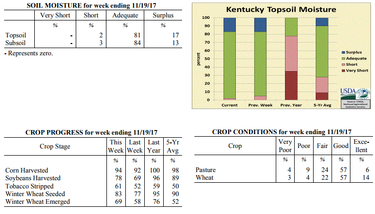 Kentucky Climate Summary
For the Period November 13 to November 19, 2017
Below Normal Temperatures and Rainfall:
A good stretch of dry conditions has been hard to find as of late. The Bluegrass
State saw a couple more frontal systems pass through the area keeping soil conditions
on the moist side. The first round occurred on Wednesday with a passing cold front.
Much of the state stayed under a quarter inch. The more significant system arrived on
Saturday. Winds became very breezy for an extended period of time ahead of, along,
and behind a strong cold front. A Wind Advisory was issued with gusts topping 40 mph
at times. A strong to severe line of showers and storms accompanied the frontal
boundary, producing damaging winds in isolated spots and a few weak tornadoes. In
addition to the rainfall on Wednesday, much of Kentucky saw at least a half inch for
the week.
Temperatures for the period averaged 45 degrees across the state which was 2 degrees
cooler than normal and 2 degrees cooler than the previous period. High temperatures
averaged from 55 in the West to 54 in the East. Departure from normal high
temperatures ranged from 4 degrees cooler than normal in the West to 4 degrees
cooler than normal in the East. Low temperatures averaged from 36 degrees in the
West to 38 degrees in the East. Departure from normal low temperature ranged from 2
degrees cooler than normal in the West to 4 degrees warmer than normal in the East.
The extreme high temperature for the period was 72 degrees at HICKMAN 2E and the
extreme low was 25 degrees at PAINTSVILLE 4W.
Precipitation (liq. equ.) for the period totaled 0.65 inches statewide which was 0.29
inches below normal and 70% of normal. Precipitation totals by climate division, West
0.54 inches, Central 0.62 inches, Bluegrass 0.80 inches and East 0.64 inches, which
was 0.56, 0.36, 0.01 and 0.21 inches below normal. By station, precipitation totals
ranged from a low of 0.16 inches at SOMERSET AWOS to a high of 1.25 inches at
CARROLLTON 2E.
---
Kentucky Crop and Weather Report
Issued 4:00 P.M., November 13, 2017 37-17
Agricultural News: Kentucky experienced below normal temperatures and above normal
rainfall over the past week. Precipitation for the week totaled 0.94 inches, 0.15
inches above normal. Temperatures averaged 45 degrees for the week, 5 degrees below
normal. Topsoil moisture was rated 5 percent short, 78 percent adequate, and 17
percent surplus. Subsoil moisture was rated 5 percent short, 82 percent adequate, and
13 percent surplus. Days suitable for fieldwork averaged 3.7 out of a possible seven.
Primary activities for the week included harvesting corn and soybeans, sowing wheat,
and stripping tobacco. Farmers are still awaiting favorable conditions to make good
progress in the fields as November has been a wet month thus far. The precipitation
along with cool, cloudy days has kept the fields from drying out adequately and
hampered corn and soybean harvest. Sowing of winter wheat has also been stalled due
to the weather conditions. Both planted winter wheat and pastures are in mostly good
condition at this time.
Kentucky Climate Summary
For the Period November 13 to November 19, 2017
Below Normal Temperatures and Rainfall:
A good stretch of dry conditions has been hard to find as of late. The Bluegrass
State saw a couple more frontal systems pass through the area keeping soil conditions
on the moist side. The first round occurred on Wednesday with a passing cold front.
Much of the state stayed under a quarter inch. The more significant system arrived on
Saturday. Winds became very breezy for an extended period of time ahead of, along,
and behind a strong cold front. A Wind Advisory was issued with gusts topping 40 mph
at times. A strong to severe line of showers and storms accompanied the frontal
boundary, producing damaging winds in isolated spots and a few weak tornadoes. In
addition to the rainfall on Wednesday, much of Kentucky saw at least a half inch for
the week.
Temperatures for the period averaged 45 degrees across the state which was 2 degrees
cooler than normal and 2 degrees cooler than the previous period. High temperatures
averaged from 55 in the West to 54 in the East. Departure from normal high
temperatures ranged from 4 degrees cooler than normal in the West to 4 degrees
cooler than normal in the East. Low temperatures averaged from 36 degrees in the
West to 38 degrees in the East. Departure from normal low temperature ranged from 2
degrees cooler than normal in the West to 4 degrees warmer than normal in the East.
The extreme high temperature for the period was 72 degrees at HICKMAN 2E and the
extreme low was 25 degrees at PAINTSVILLE 4W.
Precipitation (liq. equ.) for the period totaled 0.65 inches statewide which was 0.29
inches below normal and 70% of normal. Precipitation totals by climate division, West
0.54 inches, Central 0.62 inches, Bluegrass 0.80 inches and East 0.64 inches, which
was 0.56, 0.36, 0.01 and 0.21 inches below normal. By station, precipitation totals
ranged from a low of 0.16 inches at SOMERSET AWOS to a high of 1.25 inches at
CARROLLTON 2E.
---
Kentucky Crop and Weather Report
Issued 4:00 P.M., November 13, 2017 37-17
Agricultural News: Kentucky experienced below normal temperatures and above normal
rainfall over the past week. Precipitation for the week totaled 0.94 inches, 0.15
inches above normal. Temperatures averaged 45 degrees for the week, 5 degrees below
normal. Topsoil moisture was rated 5 percent short, 78 percent adequate, and 17
percent surplus. Subsoil moisture was rated 5 percent short, 82 percent adequate, and
13 percent surplus. Days suitable for fieldwork averaged 3.7 out of a possible seven.
Primary activities for the week included harvesting corn and soybeans, sowing wheat,
and stripping tobacco. Farmers are still awaiting favorable conditions to make good
progress in the fields as November has been a wet month thus far. The precipitation
along with cool, cloudy days has kept the fields from drying out adequately and
hampered corn and soybean harvest. Sowing of winter wheat has also been stalled due
to the weather conditions. Both planted winter wheat and pastures are in mostly good
condition at this time.
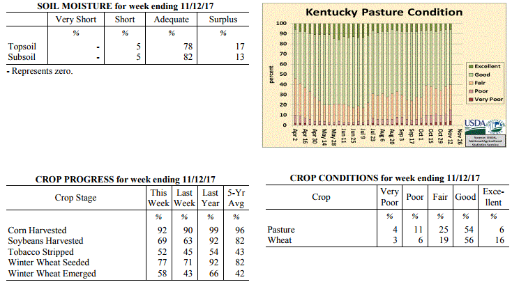 Kentucky Climate Summary
For the Period November 6 to November 12, 2017
Below Normal Temperatures and Above Normal Rainfall:
The period started with a strong cold front passing through the Bluegrass State. This
boundary sparked a strong line of showers and storms during the overnight hours of
Monday morning. This was followed by another widespread round of showers Monday
night and Tuesday as an area of low pressure moved through the area. In addition to
some light showers on Sunday, much of the state saw at least a half inch of rainfall
for the week. Saying that, quite a few locations did record over an inch, especially
across Western Kentucky and the Bluegrass. Looking at temperatures, Kentucky saw
the coldest temperatures of the fall season following the passage of a dry cold front
late in the workweek. Lows both Friday and Saturday mornings dipped into the middle
20s to low 30s for most of the state. Highs on Friday were only in the upper 30s to
middle 40s, which was roughly 20 degrees below normal for this time of year.
Temperatures for the period averaged 45 degrees across the state which was 5 degrees
cooler than normal and 12 degrees cooler than the previous period. High temperatures
averaged from 53 in the West to 53 in the East. Departure from normal high
temperatures ranged from 9 degrees cooler than normal in the West to 9 degrees cooler
than normal in the East. Low temperatures averaged from 40 degrees in the West to 39
degrees in the East. Departure from normal low temperature ranged from near normal in
the West to 3 degrees warmer than normal in the East. The extreme high temperature
for the period was 76 degrees at MIDDLESBORO AWOS and the extreme low was 22 degrees at
PAINTSVILLE 4W.
Precipitation (liq. equ.) for the period totaled 0.94 inches statewide which was 0.15
inches above normal and 119% of normal. Precipitation totals by climate division,
West 1.07 inches, Central 0.75 inches, Bluegrass 1.26 inches and East 0.66 inches,
which was 0.14, -0.08, 0.57 and -0.06 inches respectively from normal. By station,
precipitation totals ranged from a low of 0.23 inches at JACKSON AIRPORT to a high of
3.05 inches at BURLINGTON 4S.
---
Kentucky Crop and Weather Report
Issued 4:00 P.M., November 6, 2017 36-17
Agricultural News: Kentucky experienced above normal temperatures and below normal
rainfall over the past week. Precipitation for the week totaled 0.62 inches, 0.14
inches below normal. Temperatures averaged 57 degrees for the week, 5 degrees above
normal. Topsoil moisture was rated 1 percent very short, 5 percent short, 76 percent
adequate and 18 percent surplus. Subsoil moisture was rated 2 percent very short, 6
percent short, 82 percent adequate, and 10 percent surplus. Days suitable for
fieldwork averaged 3.3 out of a possible seven.
Primary activities for the week included harvesting corn and soybeans, sowing wheat,
and stripping tobacco. With a wet start to November, progress in the fields was
slowed considerably statewide this past week. Pastures are in mostly good condition
with cattle and calves obtaining 59 percent of feed from them. Eighty percent of the
current wheat crop is in good to excellent condition at this juncture. The majority
of the harvested hay crop is in good condition. Farmers will make up ground on corn
and soybean harvest as the weather permits.
Kentucky Climate Summary
For the Period November 6 to November 12, 2017
Below Normal Temperatures and Above Normal Rainfall:
The period started with a strong cold front passing through the Bluegrass State. This
boundary sparked a strong line of showers and storms during the overnight hours of
Monday morning. This was followed by another widespread round of showers Monday
night and Tuesday as an area of low pressure moved through the area. In addition to
some light showers on Sunday, much of the state saw at least a half inch of rainfall
for the week. Saying that, quite a few locations did record over an inch, especially
across Western Kentucky and the Bluegrass. Looking at temperatures, Kentucky saw
the coldest temperatures of the fall season following the passage of a dry cold front
late in the workweek. Lows both Friday and Saturday mornings dipped into the middle
20s to low 30s for most of the state. Highs on Friday were only in the upper 30s to
middle 40s, which was roughly 20 degrees below normal for this time of year.
Temperatures for the period averaged 45 degrees across the state which was 5 degrees
cooler than normal and 12 degrees cooler than the previous period. High temperatures
averaged from 53 in the West to 53 in the East. Departure from normal high
temperatures ranged from 9 degrees cooler than normal in the West to 9 degrees cooler
than normal in the East. Low temperatures averaged from 40 degrees in the West to 39
degrees in the East. Departure from normal low temperature ranged from near normal in
the West to 3 degrees warmer than normal in the East. The extreme high temperature
for the period was 76 degrees at MIDDLESBORO AWOS and the extreme low was 22 degrees at
PAINTSVILLE 4W.
Precipitation (liq. equ.) for the period totaled 0.94 inches statewide which was 0.15
inches above normal and 119% of normal. Precipitation totals by climate division,
West 1.07 inches, Central 0.75 inches, Bluegrass 1.26 inches and East 0.66 inches,
which was 0.14, -0.08, 0.57 and -0.06 inches respectively from normal. By station,
precipitation totals ranged from a low of 0.23 inches at JACKSON AIRPORT to a high of
3.05 inches at BURLINGTON 4S.
---
Kentucky Crop and Weather Report
Issued 4:00 P.M., November 6, 2017 36-17
Agricultural News: Kentucky experienced above normal temperatures and below normal
rainfall over the past week. Precipitation for the week totaled 0.62 inches, 0.14
inches below normal. Temperatures averaged 57 degrees for the week, 5 degrees above
normal. Topsoil moisture was rated 1 percent very short, 5 percent short, 76 percent
adequate and 18 percent surplus. Subsoil moisture was rated 2 percent very short, 6
percent short, 82 percent adequate, and 10 percent surplus. Days suitable for
fieldwork averaged 3.3 out of a possible seven.
Primary activities for the week included harvesting corn and soybeans, sowing wheat,
and stripping tobacco. With a wet start to November, progress in the fields was
slowed considerably statewide this past week. Pastures are in mostly good condition
with cattle and calves obtaining 59 percent of feed from them. Eighty percent of the
current wheat crop is in good to excellent condition at this juncture. The majority
of the harvested hay crop is in good condition. Farmers will make up ground on corn
and soybean harvest as the weather permits.
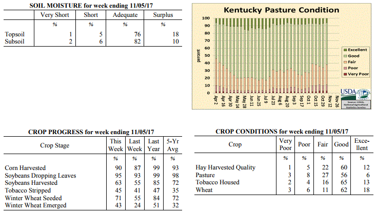 Kentucky Climate Summary
For the Period October 30 to November 5, 2017
Above Normal Temperatures and Below Normal Rainfall:
An active pattern remained in place as warm and cold fronts pushed north and south
through the area. This led to multiple opportunities for rainfall, along with
fluctuations in daily temperatures. While it was an active week with rainfall
widespread at times, accumulations tended to stay under an inch for the week. While
Western and Central Kentucky averaged around three quarters of an inch, Eastern Kentucky
came in well below at under a quarter inch for the period. The rainfall associated
with the stronger cold front late in the weekend will be reflected in next week's
data. The period started with clear skies in place and temperatures in the middle
20s to low 30s, resulting in a Freeze Warning for part of the area. Temperatures
did show a warming trend through the end of the week, topping in the 70s over the weekend.
Temperatures for the period averaged 57 degrees across the state which was 5 degrees
warmer than normal and 8 degrees warmer than the previous period. High temperatures
averaged from 66 in the West to 67 in the East. Departure from normal high
temperatures ranged from 1 degree warmer than normal in the West to 3 degrees
warmer than normal in the East. Low temperatures averaged from 50 degrees in the
West to 48 degrees in the East. Departure from normal low temperature ranged from 8
degrees warmer than normal in the West to 10 degrees warmer than normal in the
East. The extreme high temperature for the period was 81 degrees at BOWLING GREEN APT
and the extreme low was 24 degrees at LIBERTY 3SW.
Precipitation (liq. equ.) for the period totaled 0.62 inches statewide which was 0.14
inches below normal and 81% of normal. Precipitation totals by climate division, West
0.71 inches, Central 0.68 inches, Bluegrass 0.87 inches and East 0.21 inches, which
was -0.14, -0.11, 0.17 and -0.50 inches respectively from normal. By station,
precipitation totals ranged from a low of 0.00 inches at MONTICELLO AWOS to a high of
1.80 inches at LA GRANGE 6NW.
---
Kentucky Crop and Weather Report
Issued 4:00 P.M., October 30, 2017 35-17
Agricultural News: Kentucky experienced below normal temperatures and much above
normal rainfall over the past week. Precipitation for the week totaled 2.00 inches,
1.26 inches above normal. Temperatures averaged 49 degrees for the week, 6 degrees
below normal. Topsoil moisture was rated 1 percent very short, 10 percent short, 78
percent adequate and 11 percent surplus. Subsoil moisture was rated 1 percent very
short, 11 percent short, 82 percent adequate, and 6 percent surplus. Days suitable
for fieldwork averaged 4.3 out of a possible seven.
Primary activities this week included harvesting corn and soybeans, stripping
tobacco, and planting winter wheat and cover crops as the weather permitted. Heavy
widespread rainfall delayed fieldwork, and most of the state also experienced a
frost/freeze event over the past week. Conditions of crops still in the field
continue to be evaluated for damage from recent accumulations and the dip in
temperatures.
Kentucky Climate Summary
For the Period October 30 to November 5, 2017
Above Normal Temperatures and Below Normal Rainfall:
An active pattern remained in place as warm and cold fronts pushed north and south
through the area. This led to multiple opportunities for rainfall, along with
fluctuations in daily temperatures. While it was an active week with rainfall
widespread at times, accumulations tended to stay under an inch for the week. While
Western and Central Kentucky averaged around three quarters of an inch, Eastern Kentucky
came in well below at under a quarter inch for the period. The rainfall associated
with the stronger cold front late in the weekend will be reflected in next week's
data. The period started with clear skies in place and temperatures in the middle
20s to low 30s, resulting in a Freeze Warning for part of the area. Temperatures
did show a warming trend through the end of the week, topping in the 70s over the weekend.
Temperatures for the period averaged 57 degrees across the state which was 5 degrees
warmer than normal and 8 degrees warmer than the previous period. High temperatures
averaged from 66 in the West to 67 in the East. Departure from normal high
temperatures ranged from 1 degree warmer than normal in the West to 3 degrees
warmer than normal in the East. Low temperatures averaged from 50 degrees in the
West to 48 degrees in the East. Departure from normal low temperature ranged from 8
degrees warmer than normal in the West to 10 degrees warmer than normal in the
East. The extreme high temperature for the period was 81 degrees at BOWLING GREEN APT
and the extreme low was 24 degrees at LIBERTY 3SW.
Precipitation (liq. equ.) for the period totaled 0.62 inches statewide which was 0.14
inches below normal and 81% of normal. Precipitation totals by climate division, West
0.71 inches, Central 0.68 inches, Bluegrass 0.87 inches and East 0.21 inches, which
was -0.14, -0.11, 0.17 and -0.50 inches respectively from normal. By station,
precipitation totals ranged from a low of 0.00 inches at MONTICELLO AWOS to a high of
1.80 inches at LA GRANGE 6NW.
---
Kentucky Crop and Weather Report
Issued 4:00 P.M., October 30, 2017 35-17
Agricultural News: Kentucky experienced below normal temperatures and much above
normal rainfall over the past week. Precipitation for the week totaled 2.00 inches,
1.26 inches above normal. Temperatures averaged 49 degrees for the week, 6 degrees
below normal. Topsoil moisture was rated 1 percent very short, 10 percent short, 78
percent adequate and 11 percent surplus. Subsoil moisture was rated 1 percent very
short, 11 percent short, 82 percent adequate, and 6 percent surplus. Days suitable
for fieldwork averaged 4.3 out of a possible seven.
Primary activities this week included harvesting corn and soybeans, stripping
tobacco, and planting winter wheat and cover crops as the weather permitted. Heavy
widespread rainfall delayed fieldwork, and most of the state also experienced a
frost/freeze event over the past week. Conditions of crops still in the field
continue to be evaluated for damage from recent accumulations and the dip in
temperatures.
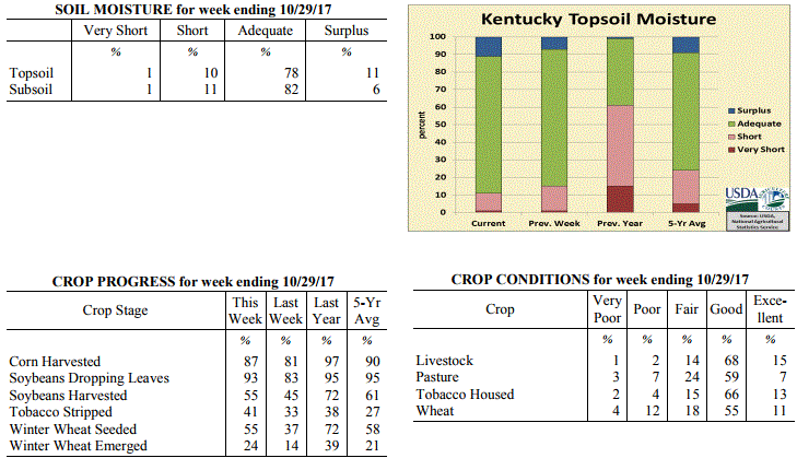 Kentucky Climate Summary
For the Period October 23 to October 29, 2017
Below Normal Temperatures and Much Above Normal Rainfall:
Kentucky saw multiple rounds of rainfall this period, widespread early in the week
and yet again Friday and Saturday with the passage of a slow moving cold front. Each
of these rounds brought significant accumulations with the state averaging two inches
for the week. This added to an already wet October with the state average over 5
inches. The wet pattern was accompanied by a return to colder temperatures. A good
portion of the area saw a frost/freeze. At some point through the period, the entirety
of the state dropped into the low to middle 30s. Some even into the upper 20s. The
coldest temperatures were seen behind the passage of the cold front over the weekend.
Highs only topped out in the upper 30s to middle 40s on Saturday and Sunday.
Temperatures for the period averaged 49 degrees across the state which was 6 degrees
cooler than normal and 10 degrees cooler than the previous period. High temperatures
averaged from 58 in the West to 58 in the East. Departure from normal high
temperatures ranged from 10 degrees cooler than normal in the West to 9 degrees
cooler than normal in the East. Low temperatures averaged from 40 degrees in the
West to 41 degrees in the East. Departure from normal low temperature ranged from 5
degrees cooler than normal in the West to 1 degree warmer than normal in the East.
The extreme high temperature for the period was 79 degrees at POPLAR BLUFF ASOS and
the extreme low was 26 degrees at POPLAR BLUFF ASOS.
Precipitation (liq. equ.) for the period totaled 2.00 inches statewide which was 1.26
inches above normal and 271% of normal. Precipitation totals by climate division,
West 2.01 inches, Central 2.13 inches, Bluegrass 1.76 inches and East 2.09 inches,
which was 1.19, 1.38, 1.08 and 1.39 inches above normal. By station, precipitation
totals ranged from a low of 0.44 inches at POPLAR BLUFF ASOS to a high of 3.71 inches
at HOPKINSVILLE 6N.
---
Kentucky Crop and Weather Report
Issued 4:00 P.M., October 23, 2017 34-17
Agricultural News: Kentucky experienced above normal temperatures and much below
normal rainfall over the past week. Precipitation for the week totaled 0.07 inches,
0.63 inches below normal. Temperatures averaged 58 degrees for the week, 1 degrees
above normal. Topsoil moisture was rated 1 percent very short, 14 percent short, 78
percent adequate, and 7 percent surplus. Subsoil moisture was rated 2 percent very
short, 14 percent short, 80 percent adequate, and 4 percent surplus. Days suitable
for fieldwork averaged 6.0 out of a possible seven.
Primary activities this week included harvesting corn and soybeans, stripping
tobacco, and planting winter wheat. Dry weather conditions also allowed for some late
hay baling to occur. Farmers continued to tend to fields by spreading manure, and
applying fall fertilization and weed control treatments. Cattle producers are
administering shots and preparing for fall breeding.
Kentucky Climate Summary
For the Period October 23 to October 29, 2017
Below Normal Temperatures and Much Above Normal Rainfall:
Kentucky saw multiple rounds of rainfall this period, widespread early in the week
and yet again Friday and Saturday with the passage of a slow moving cold front. Each
of these rounds brought significant accumulations with the state averaging two inches
for the week. This added to an already wet October with the state average over 5
inches. The wet pattern was accompanied by a return to colder temperatures. A good
portion of the area saw a frost/freeze. At some point through the period, the entirety
of the state dropped into the low to middle 30s. Some even into the upper 20s. The
coldest temperatures were seen behind the passage of the cold front over the weekend.
Highs only topped out in the upper 30s to middle 40s on Saturday and Sunday.
Temperatures for the period averaged 49 degrees across the state which was 6 degrees
cooler than normal and 10 degrees cooler than the previous period. High temperatures
averaged from 58 in the West to 58 in the East. Departure from normal high
temperatures ranged from 10 degrees cooler than normal in the West to 9 degrees
cooler than normal in the East. Low temperatures averaged from 40 degrees in the
West to 41 degrees in the East. Departure from normal low temperature ranged from 5
degrees cooler than normal in the West to 1 degree warmer than normal in the East.
The extreme high temperature for the period was 79 degrees at POPLAR BLUFF ASOS and
the extreme low was 26 degrees at POPLAR BLUFF ASOS.
Precipitation (liq. equ.) for the period totaled 2.00 inches statewide which was 1.26
inches above normal and 271% of normal. Precipitation totals by climate division,
West 2.01 inches, Central 2.13 inches, Bluegrass 1.76 inches and East 2.09 inches,
which was 1.19, 1.38, 1.08 and 1.39 inches above normal. By station, precipitation
totals ranged from a low of 0.44 inches at POPLAR BLUFF ASOS to a high of 3.71 inches
at HOPKINSVILLE 6N.
---
Kentucky Crop and Weather Report
Issued 4:00 P.M., October 23, 2017 34-17
Agricultural News: Kentucky experienced above normal temperatures and much below
normal rainfall over the past week. Precipitation for the week totaled 0.07 inches,
0.63 inches below normal. Temperatures averaged 58 degrees for the week, 1 degrees
above normal. Topsoil moisture was rated 1 percent very short, 14 percent short, 78
percent adequate, and 7 percent surplus. Subsoil moisture was rated 2 percent very
short, 14 percent short, 80 percent adequate, and 4 percent surplus. Days suitable
for fieldwork averaged 6.0 out of a possible seven.
Primary activities this week included harvesting corn and soybeans, stripping
tobacco, and planting winter wheat. Dry weather conditions also allowed for some late
hay baling to occur. Farmers continued to tend to fields by spreading manure, and
applying fall fertilization and weed control treatments. Cattle producers are
administering shots and preparing for fall breeding.
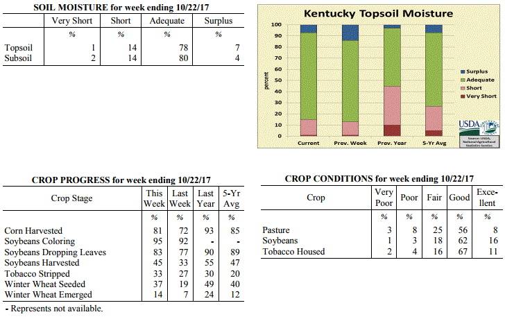 Kentucky Climate Summary
For the Period October 16 to October 22, 2017
Above Normal Temperatures and Much Below Normal Rainfall:
Kentucky experienced a mostly dry week with much of the state recording little to no
rainfall. One exception was for locations across Western Kentucky that did see some
significant precipitation ahead of a cold front late on Sunday. The rest of the rainfall
associated with this frontal passage will be reflected in next week's data.
Temperatures continued to fluctuate throughout the week. Early in the period,
temperatures were below normal with lows dropping into the middle 30s to low 40s both
Monday and Tuesday nights. High pressure then moved east for the remainder of the
week, which shifted winds to the south. This led to a steady increase in
temperatures throughout the week, eventually peaking in the middle 70s to low 80s on
Sunday. The second half of the period with warm temperatures in place pushed
Kentucky to a fifth straight week of temperatures averaging above normal.
Temperatures for the period averaged 58 degrees across the state which was 1 degree
warmer than normal and 10 degrees cooler than the previous period. High temperatures
averaged from 73 in the West to 71 in the East. Departure from normal high
temperatures ranged from 2 degrees warmer than normal in the West to 2 degrees
warmer than normal in the East. Low temperatures averaged from 46 degrees in the
West to 43 degrees in the East. Departure from normal low temperature ranged from
near normal in the West to 1 degree warmer than normal in the East. The
extreme high temperature for the period was 83 degrees at CAPE GIRARDEAU ASOS and the
extreme low was 33 degrees, also at CAPE GIRARDEAU ASOS.
Precipitation (liq. equ.) for the period totaled 0.07 inches statewide which was 0.63
inches below normal and 10% of normal. Precipitation totals by climate division, West
0.17 inches, Central 0.01 inches, Bluegrass 0.00 inches and East 0.09 inches, which
was 0.59, 0.7, 0.65 and 0.58 inches below normal. By station, precipitation totals
ranged from a low of 0.00 inches at ALEXANDRIA 5NW to a high of 0.72 inches at
HICKMAN 2E.
---
Kentucky Crop and Weather Report
Issued 4:00 P.M., October 16, 2017 33-17
Agricultural News: Kentucky experienced above normal temperatures and rainfall over
the past week. Precipitation for the week totaled 1.05 inches, 0.32 inches above
normal. Temperatures averaged 68 degrees for the week, 9 degrees above normal.
Topsoil moisture was rated 1 percent very short, 12 percent short, 73 percent
adequate and 14 percent surplus. Subsoil moisture was rated 2 percent very short, 12
percent short, 77 percent adequate, and 9 percent surplus. Days suitable for
fieldwork averaged 3.9 out of a possible seven.
Primary activities this week included harvesting corn and soybeans, planting winter
wheat, and cutting and stripping tobacco. Widespread rainfall across much of the
state left some low-lying corn and soybean fields in standing water. Fieldwork was
delayed as a result of showers this week, and any resulting damage continues to be
evaluated. Pasture and hay fields had been showing signs of stress from previous dry
weather, but recent precipitation has started to improve conditions.
Kentucky Climate Summary
For the Period October 16 to October 22, 2017
Above Normal Temperatures and Much Below Normal Rainfall:
Kentucky experienced a mostly dry week with much of the state recording little to no
rainfall. One exception was for locations across Western Kentucky that did see some
significant precipitation ahead of a cold front late on Sunday. The rest of the rainfall
associated with this frontal passage will be reflected in next week's data.
Temperatures continued to fluctuate throughout the week. Early in the period,
temperatures were below normal with lows dropping into the middle 30s to low 40s both
Monday and Tuesday nights. High pressure then moved east for the remainder of the
week, which shifted winds to the south. This led to a steady increase in
temperatures throughout the week, eventually peaking in the middle 70s to low 80s on
Sunday. The second half of the period with warm temperatures in place pushed
Kentucky to a fifth straight week of temperatures averaging above normal.
Temperatures for the period averaged 58 degrees across the state which was 1 degree
warmer than normal and 10 degrees cooler than the previous period. High temperatures
averaged from 73 in the West to 71 in the East. Departure from normal high
temperatures ranged from 2 degrees warmer than normal in the West to 2 degrees
warmer than normal in the East. Low temperatures averaged from 46 degrees in the
West to 43 degrees in the East. Departure from normal low temperature ranged from
near normal in the West to 1 degree warmer than normal in the East. The
extreme high temperature for the period was 83 degrees at CAPE GIRARDEAU ASOS and the
extreme low was 33 degrees, also at CAPE GIRARDEAU ASOS.
Precipitation (liq. equ.) for the period totaled 0.07 inches statewide which was 0.63
inches below normal and 10% of normal. Precipitation totals by climate division, West
0.17 inches, Central 0.01 inches, Bluegrass 0.00 inches and East 0.09 inches, which
was 0.59, 0.7, 0.65 and 0.58 inches below normal. By station, precipitation totals
ranged from a low of 0.00 inches at ALEXANDRIA 5NW to a high of 0.72 inches at
HICKMAN 2E.
---
Kentucky Crop and Weather Report
Issued 4:00 P.M., October 16, 2017 33-17
Agricultural News: Kentucky experienced above normal temperatures and rainfall over
the past week. Precipitation for the week totaled 1.05 inches, 0.32 inches above
normal. Temperatures averaged 68 degrees for the week, 9 degrees above normal.
Topsoil moisture was rated 1 percent very short, 12 percent short, 73 percent
adequate and 14 percent surplus. Subsoil moisture was rated 2 percent very short, 12
percent short, 77 percent adequate, and 9 percent surplus. Days suitable for
fieldwork averaged 3.9 out of a possible seven.
Primary activities this week included harvesting corn and soybeans, planting winter
wheat, and cutting and stripping tobacco. Widespread rainfall across much of the
state left some low-lying corn and soybean fields in standing water. Fieldwork was
delayed as a result of showers this week, and any resulting damage continues to be
evaluated. Pasture and hay fields had been showing signs of stress from previous dry
weather, but recent precipitation has started to improve conditions.
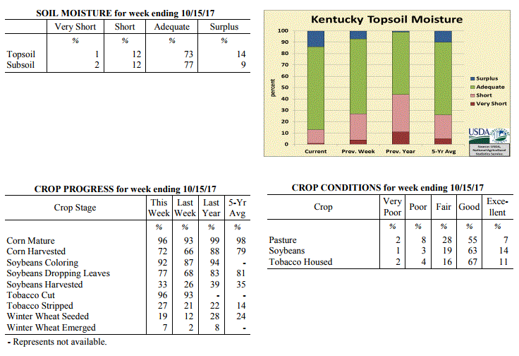 Kentucky Climate Summary
For the Period October 9 to October 15, 2017
Above Normal Temperatures and Rainfall:
Wet conditions remained for a second straight week with the passage of a couple
frontal systems. The first arrived on Tuesday as a warm front lifted north across
the area. Widespread showers slowly pushed east/northeast across Kentucky during the
day, before eventually becoming scattered overnight. The trailing cold front arrived
on Wednesday and with moisture trapped in the low levels, mostly cloudy skies
remained through Thursday. Skies cleared for the end of the workweek and start of
the weekend with above normal temperatures returning to the area, but a secondary
cold front quickly followed on Sunday. While accumulations were light with the
frontal passage, winds became gusty behind the front at 30 to 40+ mph, ushering
significantly cooler air into the area.
Temperatures for the period averaged 68 degrees across the state which was 9 degrees
warmer than normal and no change to the previous period. High temperatures averaged
from 76 in the West to 79 in the East. Departure from normal high temperatures
ranged from 3 degrees warmer than normal in the West to 8 degrees warmer than normal
in the East. Low temperatures averaged from 58 degrees in the West to 60 degrees in
the East. Departure from normal low temperature ranged from 10 degrees warmer than
normal in the West to 16 degrees warmer than normal in the East. The extreme high
temperature for the period was 90 degrees at CAPE GIRARDEAU ASOS and the extreme low
was 44 degrees at ELKTON 5SW.
Precipitation (liq. equ.) for the period totaled 1.05 inches statewide which was 0.32
inches above normal and 143% of normal. Precipitation totals by climate division,
West 1.00 inches, Central 1.07 inches, Bluegrass 0.89 inches and East 1.22 inches,
which was 0.26, 0.31, 0.18 and 0.49 inches above normal. By station, precipitation
totals ranged from a low of 0.14 inches at CADIZ 4SW to a high of 4.64 inches at
GREENVILLE 6N.
---
Kentucky Crop and Weather Report
Issued 4:00 P.M., October 10, 2017 32-17
Agricultural News: Kentucky experienced above normal temperatures and much above
normal rainfall over the past week. Precipitation for the week totaled 2.06 inches,
1.27 inches above normal. Temperatures averaged 68 degrees for the week, 6 degrees
above normal. Topsoil moisture was rated 4 percent very short, 23 percent short, 66
percent adequate and 7 percent surplus. Subsoil moisture was rated 5 percent very
short, 22 percent short, 70 percent adequate, and 3 percent surplus. Days suitable
for fieldwork averaged 5.9 out of a possible seven.
Primary activities this week included harvesting corn, soybeans, hay, and tobacco.
Heavy rainfall occurred across much of the state from remnants of tropical storm
Nate. Some low lying fields experienced flooding, with reports of soybeans being
waterlogged. Pastures continue to show signs of stress from extended dry conditions
during previous weeks.
Tobacco growers have reported difficulty in finding labor to house the crop.
Producers continue to monitor weather forecasts for potential fall frosts. Tobacco
houseburn was reported as 2 percent heavy, 3 percent moderate, 13 percent light, with
82 percent experiencing none.
Kentucky Climate Summary
For the Period October 9 to October 15, 2017
Above Normal Temperatures and Rainfall:
Wet conditions remained for a second straight week with the passage of a couple
frontal systems. The first arrived on Tuesday as a warm front lifted north across
the area. Widespread showers slowly pushed east/northeast across Kentucky during the
day, before eventually becoming scattered overnight. The trailing cold front arrived
on Wednesday and with moisture trapped in the low levels, mostly cloudy skies
remained through Thursday. Skies cleared for the end of the workweek and start of
the weekend with above normal temperatures returning to the area, but a secondary
cold front quickly followed on Sunday. While accumulations were light with the
frontal passage, winds became gusty behind the front at 30 to 40+ mph, ushering
significantly cooler air into the area.
Temperatures for the period averaged 68 degrees across the state which was 9 degrees
warmer than normal and no change to the previous period. High temperatures averaged
from 76 in the West to 79 in the East. Departure from normal high temperatures
ranged from 3 degrees warmer than normal in the West to 8 degrees warmer than normal
in the East. Low temperatures averaged from 58 degrees in the West to 60 degrees in
the East. Departure from normal low temperature ranged from 10 degrees warmer than
normal in the West to 16 degrees warmer than normal in the East. The extreme high
temperature for the period was 90 degrees at CAPE GIRARDEAU ASOS and the extreme low
was 44 degrees at ELKTON 5SW.
Precipitation (liq. equ.) for the period totaled 1.05 inches statewide which was 0.32
inches above normal and 143% of normal. Precipitation totals by climate division,
West 1.00 inches, Central 1.07 inches, Bluegrass 0.89 inches and East 1.22 inches,
which was 0.26, 0.31, 0.18 and 0.49 inches above normal. By station, precipitation
totals ranged from a low of 0.14 inches at CADIZ 4SW to a high of 4.64 inches at
GREENVILLE 6N.
---
Kentucky Crop and Weather Report
Issued 4:00 P.M., October 10, 2017 32-17
Agricultural News: Kentucky experienced above normal temperatures and much above
normal rainfall over the past week. Precipitation for the week totaled 2.06 inches,
1.27 inches above normal. Temperatures averaged 68 degrees for the week, 6 degrees
above normal. Topsoil moisture was rated 4 percent very short, 23 percent short, 66
percent adequate and 7 percent surplus. Subsoil moisture was rated 5 percent very
short, 22 percent short, 70 percent adequate, and 3 percent surplus. Days suitable
for fieldwork averaged 5.9 out of a possible seven.
Primary activities this week included harvesting corn, soybeans, hay, and tobacco.
Heavy rainfall occurred across much of the state from remnants of tropical storm
Nate. Some low lying fields experienced flooding, with reports of soybeans being
waterlogged. Pastures continue to show signs of stress from extended dry conditions
during previous weeks.
Tobacco growers have reported difficulty in finding labor to house the crop.
Producers continue to monitor weather forecasts for potential fall frosts. Tobacco
houseburn was reported as 2 percent heavy, 3 percent moderate, 13 percent light, with
82 percent experiencing none.
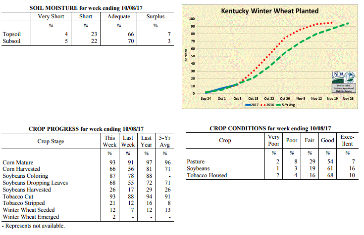 Kentucky Climate Summary
For the Period October 2 to October 8, 2017
Well Above Normal Temperatures and Much Above Normal Rainfall:
For the third time this year, Kentucky had a remnant tropical system provide the area
with widespread rainfall. This time, the remnant system of Nate interacted with a
cold front over the weekend. Widespread showers with embedded storms started moving
into the area on Saturday and lasted through much of the day on Sunday. Showers were
heavy at times, especially early in the event, as Nate was pushing tropical moisture
northward into the region. Overall, the state averaged over 2 inches, which was over
an inch above normal. The state was becoming fairly dry as most had gone over 2
weeks without any rainfall. In the latest update to the US Drought Monitor,
abnormally dry conditions was introduced into portions of Western Kentucky.
Temperatures for the period averaged 68 degrees across the state which was 6 degrees
warmer than normal and no change to the previous period. High temperatures averaged
from 81 in the West to 80 in the East. Departure from normal high temperatures
ranged from 6 degrees warmer than normal in the West to 7 degrees warmer than normal
in the East. Low temperatures averaged from 61 degrees in the West to 54 degrees in
the East. Departure from normal low temperature ranged from 10 degrees warmer than
normal in the West to 7 degrees warmer than normal in the East. The extreme high
temperature for the period was 90 degrees at POPLAR BLUFF ASOS and the extreme low was 39
degrees at PAINTSVILLE 4W .
Precipitation (liq. equ.) for the period totaled 2.06 inches statewide which was 1.27
inches above normal and 259% of normal. Precipitation totals by climate division,
West 2.21 inches, Central 2.15 inches, Bluegrass 2.34 inches and East 1.56 inches,
which was 1.39, 1.32, 1.6 and 0.77 inches above normal. By station, precipitation
totals ranged from a low of 0.00 inches at OWINGSVILLE 4S to a high of 4.99 inches at
LEITCHFIELD 3W.
---
Kentucky Crop and Weather Report
Issued 4:00 P.M., October 2, 2017 31-17
Agricultural News: Kentucky experienced above normal temperatures and much below
normal rainfall over the past week. Precipitation for the week totaled 0.00 inches,
0.83 inches below normal. Temperatures averaged 68 degrees for the week, 4 degrees
above normal. Topsoil moisture was rated 5 percent very short, 21 percent short, 73
percent adequate and 1 percent surplus. Subsoil moisture was rated 5 percent very
short, 19 percent short, 75 percent adequate, and 1 percent surplus. Days suitable
for fieldwork averaged 6.6 out of a possible seven.
Primary activities this week included harvesting corn, soybeans, hay, and tobacco.
Dry weather has advanced harvesting activities, but additional rain would benefit
pastures and remaining soybeans. In between few spotty showers producers cut and
housed tobacco. Tobacco houseburn was reported as 1 percent heavy, 3 percent
moderate, 13 percent light, with 83 percent experiencing none.
Corn and soybean yield reports so far are mostly good, with overall crop conditions
rated similarly. Some farmers have started to put up the last of fall hay cuttings.
Hay and roughage supplies were reported as 1 percent very short, 7 percent short, 81
percent adequate, and 11 percent surplus.
Kentucky Climate Summary
For the Period October 2 to October 8, 2017
Well Above Normal Temperatures and Much Above Normal Rainfall:
For the third time this year, Kentucky had a remnant tropical system provide the area
with widespread rainfall. This time, the remnant system of Nate interacted with a
cold front over the weekend. Widespread showers with embedded storms started moving
into the area on Saturday and lasted through much of the day on Sunday. Showers were
heavy at times, especially early in the event, as Nate was pushing tropical moisture
northward into the region. Overall, the state averaged over 2 inches, which was over
an inch above normal. The state was becoming fairly dry as most had gone over 2
weeks without any rainfall. In the latest update to the US Drought Monitor,
abnormally dry conditions was introduced into portions of Western Kentucky.
Temperatures for the period averaged 68 degrees across the state which was 6 degrees
warmer than normal and no change to the previous period. High temperatures averaged
from 81 in the West to 80 in the East. Departure from normal high temperatures
ranged from 6 degrees warmer than normal in the West to 7 degrees warmer than normal
in the East. Low temperatures averaged from 61 degrees in the West to 54 degrees in
the East. Departure from normal low temperature ranged from 10 degrees warmer than
normal in the West to 7 degrees warmer than normal in the East. The extreme high
temperature for the period was 90 degrees at POPLAR BLUFF ASOS and the extreme low was 39
degrees at PAINTSVILLE 4W .
Precipitation (liq. equ.) for the period totaled 2.06 inches statewide which was 1.27
inches above normal and 259% of normal. Precipitation totals by climate division,
West 2.21 inches, Central 2.15 inches, Bluegrass 2.34 inches and East 1.56 inches,
which was 1.39, 1.32, 1.6 and 0.77 inches above normal. By station, precipitation
totals ranged from a low of 0.00 inches at OWINGSVILLE 4S to a high of 4.99 inches at
LEITCHFIELD 3W.
---
Kentucky Crop and Weather Report
Issued 4:00 P.M., October 2, 2017 31-17
Agricultural News: Kentucky experienced above normal temperatures and much below
normal rainfall over the past week. Precipitation for the week totaled 0.00 inches,
0.83 inches below normal. Temperatures averaged 68 degrees for the week, 4 degrees
above normal. Topsoil moisture was rated 5 percent very short, 21 percent short, 73
percent adequate and 1 percent surplus. Subsoil moisture was rated 5 percent very
short, 19 percent short, 75 percent adequate, and 1 percent surplus. Days suitable
for fieldwork averaged 6.6 out of a possible seven.
Primary activities this week included harvesting corn, soybeans, hay, and tobacco.
Dry weather has advanced harvesting activities, but additional rain would benefit
pastures and remaining soybeans. In between few spotty showers producers cut and
housed tobacco. Tobacco houseburn was reported as 1 percent heavy, 3 percent
moderate, 13 percent light, with 83 percent experiencing none.
Corn and soybean yield reports so far are mostly good, with overall crop conditions
rated similarly. Some farmers have started to put up the last of fall hay cuttings.
Hay and roughage supplies were reported as 1 percent very short, 7 percent short, 81
percent adequate, and 11 percent surplus.
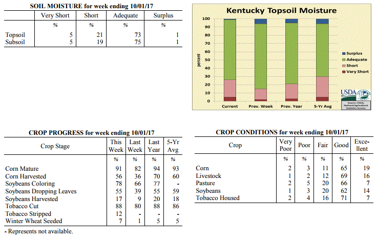 Kentucky Climate Summary
For the Period September 25 to October 1, 2017
Above Normal Temperatures and Much Below Normal Rainfall:
Kentucky is trending toward the dry side with yet another week of below normal
rainfall. In fact, most of the state did not see any precipitation for the week.
This now makes four straight weeks of below normal rainfall. The period started out
dry and very warm with highs peaking in the upper 80s to low 90s for much of
Kentucky. The extended late season heat wave, carrying over from the previous week,
finally ended on Wednesday with the passage of a strong cold front through the area.
The boundary did not have much moisture to work with and only amounted to isolated
showers and minimal accumulations (hundredths). Much cooler air then filtered into
the state for the remainder of the week with highs only topping out in the 70s.
Temperatures were coolest on Saturday night when several locations across Eastern
Kentucky and the Bluegrass dipped into the low to middle 40s, some in the upper 30s.
Temperatures for the period averaged 68 degrees across the state which was 4 degrees
warmer than normal and 8 degrees cooler than the previous period. High temperatures
averaged from 83 in the West to 80 in the East. Departure from normal high
temperatures ranged from 5 degrees warmer than normal in the West to 4 degrees
warmer than normal in the East. Low temperatures averaged from 57 degrees in the
West to 55 degrees in the East. Departure from normal low temperature ranged from 4
degrees warmer than normal in the West to 5 degrees warmer than normal in the East.
The extreme high temperature for the period was 92 degrees at LOUISVILLE APT and the
extreme low was 38 degrees at CYNTHIANA 8N.
Precipitation (liq. equ.) for the period totaled 0.00 inches statewide which was 0.83
inches below normal and 0% of normal. Precipitation totals by climate division, West
0.00 inches, Central 0.01 inches, Bluegrass 0.00 inches and East 0.00 inches, which
was 0.85, 0.89, 0.76 and 0.82 inches below normal. By station, precipitation totals
ranged from a low of 0.00 inches at ALBANY 1N to a high of 0.09 inches at ELIZABETHTOWN 8W.
---
Kentucky Crop and Weather Report
Issued 4:00 P.M., September 25, 2017 30-17
Agricultural News: Kentucky experienced well above normal temperatures and below
normal rainfall over the past week. Precipitation for the week totaled 0.34 inches,
0.50 inches below normal. Temperatures averaged 75 degrees for the week, 8 degrees
above normal. Topsoil moisture was rated 2 percent very short, 13 percent short, 79
percent adequate and 6 percent surplus. Subsoil moisture was rated 3 percent very
short, 14 percent short, 78 percent adequate, and 5 percent surplus. Days suitable
for fieldwork averaged 5.7 out of a possible seven.
Primary activities for the week included harvesting corn, soybeans, tobacco, and hay.
The majority of the state experienced hot and dry conditions this week allowing for
good progress in the fields. Harvesting of corn and soybeans is behind last year at
this time while tobacco cutting is slightly ahead. Early yields for corn and soybeans
are looking positive with condition rated as mostly good for both crops. Condition of
housed tobacco was rated as mostly good, however it is noteworthy that there was some
reported house burn due to the hot weather this week. Pasture conditions remain good,
but the heatwave did stress cattle in several areas.
Kentucky Climate Summary
For the Period September 25 to October 1, 2017
Above Normal Temperatures and Much Below Normal Rainfall:
Kentucky is trending toward the dry side with yet another week of below normal
rainfall. In fact, most of the state did not see any precipitation for the week.
This now makes four straight weeks of below normal rainfall. The period started out
dry and very warm with highs peaking in the upper 80s to low 90s for much of
Kentucky. The extended late season heat wave, carrying over from the previous week,
finally ended on Wednesday with the passage of a strong cold front through the area.
The boundary did not have much moisture to work with and only amounted to isolated
showers and minimal accumulations (hundredths). Much cooler air then filtered into
the state for the remainder of the week with highs only topping out in the 70s.
Temperatures were coolest on Saturday night when several locations across Eastern
Kentucky and the Bluegrass dipped into the low to middle 40s, some in the upper 30s.
Temperatures for the period averaged 68 degrees across the state which was 4 degrees
warmer than normal and 8 degrees cooler than the previous period. High temperatures
averaged from 83 in the West to 80 in the East. Departure from normal high
temperatures ranged from 5 degrees warmer than normal in the West to 4 degrees
warmer than normal in the East. Low temperatures averaged from 57 degrees in the
West to 55 degrees in the East. Departure from normal low temperature ranged from 4
degrees warmer than normal in the West to 5 degrees warmer than normal in the East.
The extreme high temperature for the period was 92 degrees at LOUISVILLE APT and the
extreme low was 38 degrees at CYNTHIANA 8N.
Precipitation (liq. equ.) for the period totaled 0.00 inches statewide which was 0.83
inches below normal and 0% of normal. Precipitation totals by climate division, West
0.00 inches, Central 0.01 inches, Bluegrass 0.00 inches and East 0.00 inches, which
was 0.85, 0.89, 0.76 and 0.82 inches below normal. By station, precipitation totals
ranged from a low of 0.00 inches at ALBANY 1N to a high of 0.09 inches at ELIZABETHTOWN 8W.
---
Kentucky Crop and Weather Report
Issued 4:00 P.M., September 25, 2017 30-17
Agricultural News: Kentucky experienced well above normal temperatures and below
normal rainfall over the past week. Precipitation for the week totaled 0.34 inches,
0.50 inches below normal. Temperatures averaged 75 degrees for the week, 8 degrees
above normal. Topsoil moisture was rated 2 percent very short, 13 percent short, 79
percent adequate and 6 percent surplus. Subsoil moisture was rated 3 percent very
short, 14 percent short, 78 percent adequate, and 5 percent surplus. Days suitable
for fieldwork averaged 5.7 out of a possible seven.
Primary activities for the week included harvesting corn, soybeans, tobacco, and hay.
The majority of the state experienced hot and dry conditions this week allowing for
good progress in the fields. Harvesting of corn and soybeans is behind last year at
this time while tobacco cutting is slightly ahead. Early yields for corn and soybeans
are looking positive with condition rated as mostly good for both crops. Condition of
housed tobacco was rated as mostly good, however it is noteworthy that there was some
reported house burn due to the hot weather this week. Pasture conditions remain good,
but the heatwave did stress cattle in several areas.
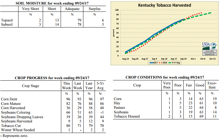 Kentucky Climate Summary
For the Period September 18 to September 24, 2017
Well Above Normal Temperatures and Below Normal Rainfall:
Fall officially started on the 22nd, but it sure did not feel like it. Kentucky
temperatures averaged 8 degrees above normal for the week as summer heat and humidity
returned to the area. Temperatures routinely peaked in the middle 80s to low 90s for
most of the period. This broke a four-week streak of below normal temperatures in
Kentucky. Scattered to numerous showers and storms pushed through the area on Monday
and Tuesday. The highest accumulations were across Western Kentucky, which averaged
a half inch. That number diminished to under a tenth of an inch across Eastern
Kentucky. Other than those two days, the rest of the week featured mostly dry
conditions with high pressure in place.
Temperatures for the period averaged 75 degrees across the state which was 8 degrees
warmer than normal and 8 degrees warmer than the previous period. High temperatures
averaged from 89 in the West to 85 in the East. Departure from normal high
temperatures ranged from 8 degrees warmer than normal in the West to 7 degrees
warmer than normal in the East. Low temperatures averaged from 66 degrees in the
West to 62 degrees in the East. Departure from normal low temperature ranged from 9
degrees warmer than normal in the West to 8 degrees warmer than normal in the East.
The extreme high temperature for the period was 95 degrees at CAPE GIRARDEAU ASOS and
the extreme low was 54 degrees at RICHMOND 8E.
Precipitation (liq. equ.) for the period totaled 0.34 inches statewide which was 0.5
inches below normal and 40% of normal. Precipitation totals by climate division, West
0.53 inches, Central 0.33 inches, Bluegrass 0.40 inches and East 0.08 inches, which
was 0.32, 0.59, 0.36 and 0.75 inches below normal. By station, precipitation totals
ranged from a low of 0.00 inches at CAMPBELLSVILLE 7W to a high of 2.03 inches at
FRANKLIN 4SW.
---
Kentucky Crop and Weather Report
Issued 4:00 P.M., September 18, 2017 29-17
Agricultural News: Kentucky experienced below normal temperatures and rainfall over
the past week. Precipitation for the week totaled 0.75 inches, 0.09 inches below
normal. Temperatures averaged 67 degrees for the week, 3 degrees below normal.
Topsoil moisture was rated 1 percent very short, 7 percent short, 85 percent adequate
and 7 percent surplus. Subsoil moisture was rated 3 percent very short, 11 percent
short, 81 percent adequate, and 5 percent surplus. Days suitable for fieldwork
averaged 4.5 out of a possible seven.
Primary activities this week included harvesting tobacco, hay, corn, and soybeans.
Recent rainfall delayed fieldwork at times, but helped in germinating fall grass
seedings and reviving pastures. Farmers continue to monitor grain moisture content in
harvesting corn. Livestock producers are preparing for fall breeding and vaccinating
cattle.
Kentucky Climate Summary
For the Period September 18 to September 24, 2017
Well Above Normal Temperatures and Below Normal Rainfall:
Fall officially started on the 22nd, but it sure did not feel like it. Kentucky
temperatures averaged 8 degrees above normal for the week as summer heat and humidity
returned to the area. Temperatures routinely peaked in the middle 80s to low 90s for
most of the period. This broke a four-week streak of below normal temperatures in
Kentucky. Scattered to numerous showers and storms pushed through the area on Monday
and Tuesday. The highest accumulations were across Western Kentucky, which averaged
a half inch. That number diminished to under a tenth of an inch across Eastern
Kentucky. Other than those two days, the rest of the week featured mostly dry
conditions with high pressure in place.
Temperatures for the period averaged 75 degrees across the state which was 8 degrees
warmer than normal and 8 degrees warmer than the previous period. High temperatures
averaged from 89 in the West to 85 in the East. Departure from normal high
temperatures ranged from 8 degrees warmer than normal in the West to 7 degrees
warmer than normal in the East. Low temperatures averaged from 66 degrees in the
West to 62 degrees in the East. Departure from normal low temperature ranged from 9
degrees warmer than normal in the West to 8 degrees warmer than normal in the East.
The extreme high temperature for the period was 95 degrees at CAPE GIRARDEAU ASOS and
the extreme low was 54 degrees at RICHMOND 8E.
Precipitation (liq. equ.) for the period totaled 0.34 inches statewide which was 0.5
inches below normal and 40% of normal. Precipitation totals by climate division, West
0.53 inches, Central 0.33 inches, Bluegrass 0.40 inches and East 0.08 inches, which
was 0.32, 0.59, 0.36 and 0.75 inches below normal. By station, precipitation totals
ranged from a low of 0.00 inches at CAMPBELLSVILLE 7W to a high of 2.03 inches at
FRANKLIN 4SW.
---
Kentucky Crop and Weather Report
Issued 4:00 P.M., September 18, 2017 29-17
Agricultural News: Kentucky experienced below normal temperatures and rainfall over
the past week. Precipitation for the week totaled 0.75 inches, 0.09 inches below
normal. Temperatures averaged 67 degrees for the week, 3 degrees below normal.
Topsoil moisture was rated 1 percent very short, 7 percent short, 85 percent adequate
and 7 percent surplus. Subsoil moisture was rated 3 percent very short, 11 percent
short, 81 percent adequate, and 5 percent surplus. Days suitable for fieldwork
averaged 4.5 out of a possible seven.
Primary activities this week included harvesting tobacco, hay, corn, and soybeans.
Recent rainfall delayed fieldwork at times, but helped in germinating fall grass
seedings and reviving pastures. Farmers continue to monitor grain moisture content in
harvesting corn. Livestock producers are preparing for fall breeding and vaccinating
cattle.
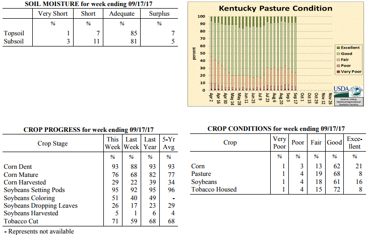 Kentucky Climate Summary
For the Period September 11 to September 17, 2017
Below Normal Temperatures and Rainfall:
For the second time this year, Kentucky had a remnant tropical system pass through
the area. This time, it was the remnant system of Irma as is it moved from Florida
to the Tennessee Valley by Tuesday and then through the Bluegrass State on Wednesday.
This brought roughly a two to three day period of on and off showers. Unlike Harvey
a couple weeks ago, even though coverage was widespread at times, rainfall was light
to moderate throughout the event, leading to less in the way of accumulations.
Overall, the state averaged three quarters of inch, which was slightly below normal
for this time of year. The thick cloud cover and rain showers kept temperatures on
the low side for the first half of the period, before a warming trend took the state
back to near normal over the weekend.
Temperatures for the period averaged 67 degrees across the state which was 3 degrees
cooler than normal and 2 degrees warmer than the previous period. High temperatures
averaged from 79 in the West to 74 in the East. Departure from normal high
temperatures ranged from 4 degrees cooler than normal in the West to 7 degrees
cooler than normal in the East. Low temperatures averaged from 60 degrees in the
West to 58 degrees in the East. Departure from normal low temperature ranged from 1
degree warmer than normal in the West to 1 degree warmer than normal in the East.
The extreme high temperature for the period was 90 degrees at CAPE GIRARDEAU ASOS and
the extreme low was 44 degrees at CARBONDALE ASOS.
Precipitation (liq. equ.) for the period totaled 0.75 inches statewide which was 0.09
inches below normal and 89% of normal. Precipitation totals by climate division, West
0.80 inches, Central 0.91 inches, Bluegrass 0.76 inches and East 0.55 inches, which
was -0.06, -0.03, 0.00 and -0.27 inches respectively from normal. By station,
precipitation totals ranged from a low of 0.05 inches at POPLAR BLUFF ASOS to a high
of 1.83 inches at LIBERTY 3SW.
---
Kentucky Crop and Weather Report
Issued 4:00 P.M., September 11, 2017 28-17
Agricultural News: Kentucky experienced well below normal temperatures and below
normal rainfall over the past week. Precipitation for the week totaled 0.39 inches,
0.40 inches below normal. Temperatures averaged 64 degrees for the week, 8 degrees
below normal. Topsoil moisture was rated 2 percent very short, 9 percent short, 80
percent adequate and 9 percent surplus. Subsoil moisture was rated 3 percent very
short, 11 percent short, 79 percent adequate, and 7 percent surplus. Days suitable
for fieldwork averaged 5.2 out of a possible seven.
Primary activities this week included cutting hay and tobacco along with corn
harvesting. Soybean harvest has just begun, but it is on par with last year and the
five year average. There was some rain and cool temperatures this week to alleviate
the dry conditions in parts of the state. Much of the state received heavy rainfall
from Hurricane Harvey the previous week and the ground moisture has remained
sufficient for crop development. There is considerable weed pressure, however crops
have been able to compete due to continued growth.
Kentucky Climate Summary
For the Period September 11 to September 17, 2017
Below Normal Temperatures and Rainfall:
For the second time this year, Kentucky had a remnant tropical system pass through
the area. This time, it was the remnant system of Irma as is it moved from Florida
to the Tennessee Valley by Tuesday and then through the Bluegrass State on Wednesday.
This brought roughly a two to three day period of on and off showers. Unlike Harvey
a couple weeks ago, even though coverage was widespread at times, rainfall was light
to moderate throughout the event, leading to less in the way of accumulations.
Overall, the state averaged three quarters of inch, which was slightly below normal
for this time of year. The thick cloud cover and rain showers kept temperatures on
the low side for the first half of the period, before a warming trend took the state
back to near normal over the weekend.
Temperatures for the period averaged 67 degrees across the state which was 3 degrees
cooler than normal and 2 degrees warmer than the previous period. High temperatures
averaged from 79 in the West to 74 in the East. Departure from normal high
temperatures ranged from 4 degrees cooler than normal in the West to 7 degrees
cooler than normal in the East. Low temperatures averaged from 60 degrees in the
West to 58 degrees in the East. Departure from normal low temperature ranged from 1
degree warmer than normal in the West to 1 degree warmer than normal in the East.
The extreme high temperature for the period was 90 degrees at CAPE GIRARDEAU ASOS and
the extreme low was 44 degrees at CARBONDALE ASOS.
Precipitation (liq. equ.) for the period totaled 0.75 inches statewide which was 0.09
inches below normal and 89% of normal. Precipitation totals by climate division, West
0.80 inches, Central 0.91 inches, Bluegrass 0.76 inches and East 0.55 inches, which
was -0.06, -0.03, 0.00 and -0.27 inches respectively from normal. By station,
precipitation totals ranged from a low of 0.05 inches at POPLAR BLUFF ASOS to a high
of 1.83 inches at LIBERTY 3SW.
---
Kentucky Crop and Weather Report
Issued 4:00 P.M., September 11, 2017 28-17
Agricultural News: Kentucky experienced well below normal temperatures and below
normal rainfall over the past week. Precipitation for the week totaled 0.39 inches,
0.40 inches below normal. Temperatures averaged 64 degrees for the week, 8 degrees
below normal. Topsoil moisture was rated 2 percent very short, 9 percent short, 80
percent adequate and 9 percent surplus. Subsoil moisture was rated 3 percent very
short, 11 percent short, 79 percent adequate, and 7 percent surplus. Days suitable
for fieldwork averaged 5.2 out of a possible seven.
Primary activities this week included cutting hay and tobacco along with corn
harvesting. Soybean harvest has just begun, but it is on par with last year and the
five year average. There was some rain and cool temperatures this week to alleviate
the dry conditions in parts of the state. Much of the state received heavy rainfall
from Hurricane Harvey the previous week and the ground moisture has remained
sufficient for crop development. There is considerable weed pressure, however crops
have been able to compete due to continued growth.
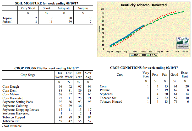 Kentucky Climate Summary
For the Period September 4 to September 10, 2017
Well Below Normal Temperatures and Below Normal Rainfall:
Much of the area got a chance to dry out from the excessive rainfall that the remnants of
Harvey had brought the period before. The only showers and storms occurred early in
the week with the passage of a strong cold front. While there were some locally higher
accumulations, scattered to numerous coverage on Tuesday gave way to totals under a
half inch for most of the state. Following the boundary passage, Kentucky stayed
under the influence of high pressure for the remainder of the period. This feature
kept the area dry and unseasonably cool. High temperatures typically stayed in the
upper 60s to middle 70s for much of the area. From Tuesday night onward, at least
some portion of the state dipped into the 40s. In fact, Wednesday night/Thursday
morning was the coolest night of the week with the majority of the state in the 40s,
which is more typical of the latter half of October. The lowest readings came in at
42 degrees. This pushed Kentucky to a third straight week of below normal temperatures.
Temperatures for the period averaged 64 degrees across the state which was 8 degrees
cooler than normal and 4 degrees cooler than the previous period. High temperatures
averaged from 78 in the West to 73 in the East. Departure from normal high
temperatures ranged from 8 degrees cooler than normal in the West to 10 degrees
cooler than normal in the East. Low temperatures averaged from 54 degrees in the
West to 52 degrees in the East. Departure from normal low temperature ranged from 8
degrees cooler than normal in the West to 7 degrees cooler than normal in the East.
The extreme high temperature for the period was 91 degrees at CAPE GIRARDEAU ASOS and
the extreme low was 42 degrees at CYNTHIANA 8N.
Precipitation (liq. equ.) for the period totaled 0.39 inches statewide which was 0.4
inches below normal and 49% of normal. Precipitation totals by climate division, West
0.29 inches, Central 0.50 inches, Bluegrass 0.24 inches and East 0.51 inches, which
was 0.46, 0.38, 0.5 and 0.28 inches below normal. By station, precipitation totals
ranged from a low of 0.00 inches at ALEXANDRIA 5NW to a high of 1.98 inches at ALBANY 1N.
---
Kentucky Crop and Weather Report
Issued 4:00 P.M., September 5, 2017 27-17
Agricultural News: Kentucky experienced below normal temperatures and much above
normal rainfall over the past week. Precipitation for the week totaled 3.25 inches,
2.50 inches above normal. Temperatures averaged 69 degrees for the week, 5 degrees
below normal. Topsoil moisture was rated 2 percent very short, 15 percent short, 69
percent adequate and 14 percent surplus. Subsoil moisture was rated 4 percent very
short, 16 percent short, 69 percent adequate, and 11 percent surplus. Days suitable
for fieldwork averaged 4.5 out of a possible seven.
Primary activities for the week including harvesting hay, cutting and topping
tobacco, and the beginning of the corn harvest. A good deal of rain brought on by
Hurricane Harvey covered most of the state by the weekend. The steady rainfall was
much needed in a few dry areas, however some portions of the state had flooding and
high winds to the detriment of field crops. There were several reports of damage to
the tobacco crop, but it was not widespread.
Kentucky Climate Summary
For the Period September 4 to September 10, 2017
Well Below Normal Temperatures and Below Normal Rainfall:
Much of the area got a chance to dry out from the excessive rainfall that the remnants of
Harvey had brought the period before. The only showers and storms occurred early in
the week with the passage of a strong cold front. While there were some locally higher
accumulations, scattered to numerous coverage on Tuesday gave way to totals under a
half inch for most of the state. Following the boundary passage, Kentucky stayed
under the influence of high pressure for the remainder of the period. This feature
kept the area dry and unseasonably cool. High temperatures typically stayed in the
upper 60s to middle 70s for much of the area. From Tuesday night onward, at least
some portion of the state dipped into the 40s. In fact, Wednesday night/Thursday
morning was the coolest night of the week with the majority of the state in the 40s,
which is more typical of the latter half of October. The lowest readings came in at
42 degrees. This pushed Kentucky to a third straight week of below normal temperatures.
Temperatures for the period averaged 64 degrees across the state which was 8 degrees
cooler than normal and 4 degrees cooler than the previous period. High temperatures
averaged from 78 in the West to 73 in the East. Departure from normal high
temperatures ranged from 8 degrees cooler than normal in the West to 10 degrees
cooler than normal in the East. Low temperatures averaged from 54 degrees in the
West to 52 degrees in the East. Departure from normal low temperature ranged from 8
degrees cooler than normal in the West to 7 degrees cooler than normal in the East.
The extreme high temperature for the period was 91 degrees at CAPE GIRARDEAU ASOS and
the extreme low was 42 degrees at CYNTHIANA 8N.
Precipitation (liq. equ.) for the period totaled 0.39 inches statewide which was 0.4
inches below normal and 49% of normal. Precipitation totals by climate division, West
0.29 inches, Central 0.50 inches, Bluegrass 0.24 inches and East 0.51 inches, which
was 0.46, 0.38, 0.5 and 0.28 inches below normal. By station, precipitation totals
ranged from a low of 0.00 inches at ALEXANDRIA 5NW to a high of 1.98 inches at ALBANY 1N.
---
Kentucky Crop and Weather Report
Issued 4:00 P.M., September 5, 2017 27-17
Agricultural News: Kentucky experienced below normal temperatures and much above
normal rainfall over the past week. Precipitation for the week totaled 3.25 inches,
2.50 inches above normal. Temperatures averaged 69 degrees for the week, 5 degrees
below normal. Topsoil moisture was rated 2 percent very short, 15 percent short, 69
percent adequate and 14 percent surplus. Subsoil moisture was rated 4 percent very
short, 16 percent short, 69 percent adequate, and 11 percent surplus. Days suitable
for fieldwork averaged 4.5 out of a possible seven.
Primary activities for the week including harvesting hay, cutting and topping
tobacco, and the beginning of the corn harvest. A good deal of rain brought on by
Hurricane Harvey covered most of the state by the weekend. The steady rainfall was
much needed in a few dry areas, however some portions of the state had flooding and
high winds to the detriment of field crops. There were several reports of damage to
the tobacco crop, but it was not widespread.
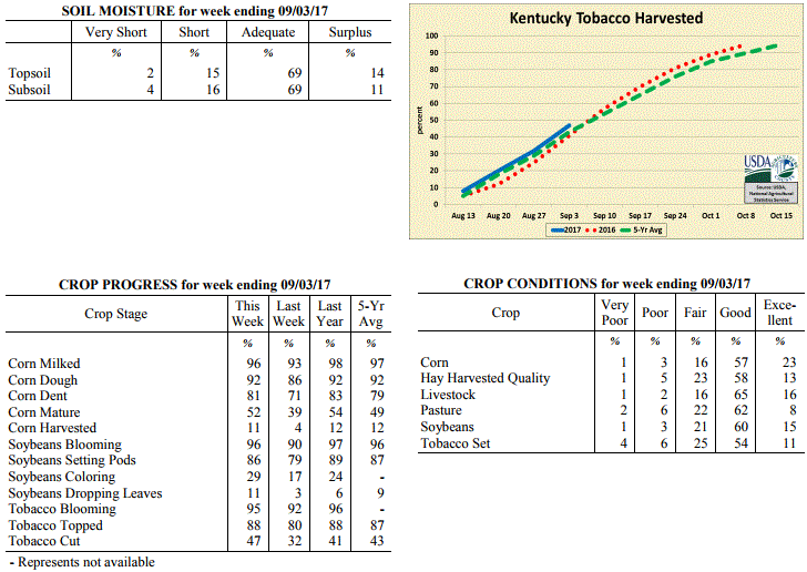 Kentucky Climate Summary
For the Period August 28 to September 3, 2017
Below Normal Temperatures and Much Above Normal Rainfall:
The remnants of Hurricane Harvey brought a tremendous amount of rainfall in a short
period of time. Showers from the system started lifting through the area Thursday
morning and lasted into Saturday. The heaviest activity occurred from Thursday night
and lasted through the day on Friday. Widespread moderate to locally heavy showers
were most prevalent across Central Kentucky, where combined with activity earlier in
the week, averaged nearly 5.5 inches. This was over 4.5 inches above normal and more
than what would typically be seen during the entire month of September. A number of
locations even recorded over 7 inches. While Central Kentucky saw the brunt of the
activity, most everyone saw significant rainfall for the week as the state averaged
3.25 inches. This was by far the wettest week of 2017 in Kentucky and highest
average total since early July of 2016. This amount of rainfall in such a short
period led to numerous flood warnings over the course of the event. Winds also
increased with 30 to 40+ mph wind gusts from time to time. The combination of
precipitation and low clouds led to very cool temperatures both Friday and Saturday
with many not getting out of the 60s for highs. This pushed Kentucky to the fourth
week out of the past five with temperatures averaging below normal.
Temperatures for the period averaged 69 degrees across the state which was 5 degrees
cooler than normal and 2 degrees cooler than the previous period. High temperatures
averaged from 81 in the West to 75 in the East. Departure from normal high
temperatures ranged from 6 degrees cooler than normal in the West to 10 degrees
cooler than normal in the East. Low temperatures averaged from 61 degrees in the
West to 61 degrees in the East. Departure from normal low temperature ranged from 3
degrees cooler than normal in the West to near normal in the East. The extreme high
temperature for the period was 89 degrees at CAPE GIRARDEAU ASOS and the extreme low
was 49 degrees at CAPE GIRARDEAU ASOS.
Precipitation (liq. equ.) for the period totaled 3.25 inches statewide which was 2.5
inches above normal and 436% of normal. Precipitation totals by climate division,
West 2.89 inches, Central 5.37 inches, Bluegrass 2.80 inches and East 1.94 inches,
which was 2.21, 4.57, 2.07 and 1.17 inches above normal. By station, precipitation
totals ranged from a low of 0.00 inches at CAPE GIRARDEAU ASOS to a high of 9.47
inches at GLASGOW 11W.
---
Kentucky Crop and Weather Report
Issued 4:00 P.M., August 28, 2017 26-17
Agricultural News: Kentucky experienced below normal temperatures and rainfall over
the past week. Precipitation for the week totaled 0.52 inches, 0.28 inches below
normal. Temperatures averaged 72 degrees for the week, 3 degrees below normal.
Topsoil moisture was rated 6 percent very short, 31 percent short, 62 percent
adequate and 1 percent surplus. Subsoil moisture was rated 6 percent very short, 26
percent short, 67 percent adequate, and 1 percent surplus. Days suitable for
fieldwork averaged 6.0 out of a possible seven.
Primary activities this week included topping and cutting tobacco, and harvesting
hay. Producers cut silage, and the harvest of corn for grain started in a few areas.
Western and central portions of the state continued to experience dry conditions,
with some improvements reported in eastern counties this past week from scattered
storms.
Kentucky Climate Summary
For the Period August 28 to September 3, 2017
Below Normal Temperatures and Much Above Normal Rainfall:
The remnants of Hurricane Harvey brought a tremendous amount of rainfall in a short
period of time. Showers from the system started lifting through the area Thursday
morning and lasted into Saturday. The heaviest activity occurred from Thursday night
and lasted through the day on Friday. Widespread moderate to locally heavy showers
were most prevalent across Central Kentucky, where combined with activity earlier in
the week, averaged nearly 5.5 inches. This was over 4.5 inches above normal and more
than what would typically be seen during the entire month of September. A number of
locations even recorded over 7 inches. While Central Kentucky saw the brunt of the
activity, most everyone saw significant rainfall for the week as the state averaged
3.25 inches. This was by far the wettest week of 2017 in Kentucky and highest
average total since early July of 2016. This amount of rainfall in such a short
period led to numerous flood warnings over the course of the event. Winds also
increased with 30 to 40+ mph wind gusts from time to time. The combination of
precipitation and low clouds led to very cool temperatures both Friday and Saturday
with many not getting out of the 60s for highs. This pushed Kentucky to the fourth
week out of the past five with temperatures averaging below normal.
Temperatures for the period averaged 69 degrees across the state which was 5 degrees
cooler than normal and 2 degrees cooler than the previous period. High temperatures
averaged from 81 in the West to 75 in the East. Departure from normal high
temperatures ranged from 6 degrees cooler than normal in the West to 10 degrees
cooler than normal in the East. Low temperatures averaged from 61 degrees in the
West to 61 degrees in the East. Departure from normal low temperature ranged from 3
degrees cooler than normal in the West to near normal in the East. The extreme high
temperature for the period was 89 degrees at CAPE GIRARDEAU ASOS and the extreme low
was 49 degrees at CAPE GIRARDEAU ASOS.
Precipitation (liq. equ.) for the period totaled 3.25 inches statewide which was 2.5
inches above normal and 436% of normal. Precipitation totals by climate division,
West 2.89 inches, Central 5.37 inches, Bluegrass 2.80 inches and East 1.94 inches,
which was 2.21, 4.57, 2.07 and 1.17 inches above normal. By station, precipitation
totals ranged from a low of 0.00 inches at CAPE GIRARDEAU ASOS to a high of 9.47
inches at GLASGOW 11W.
---
Kentucky Crop and Weather Report
Issued 4:00 P.M., August 28, 2017 26-17
Agricultural News: Kentucky experienced below normal temperatures and rainfall over
the past week. Precipitation for the week totaled 0.52 inches, 0.28 inches below
normal. Temperatures averaged 72 degrees for the week, 3 degrees below normal.
Topsoil moisture was rated 6 percent very short, 31 percent short, 62 percent
adequate and 1 percent surplus. Subsoil moisture was rated 6 percent very short, 26
percent short, 67 percent adequate, and 1 percent surplus. Days suitable for
fieldwork averaged 6.0 out of a possible seven.
Primary activities this week included topping and cutting tobacco, and harvesting
hay. Producers cut silage, and the harvest of corn for grain started in a few areas.
Western and central portions of the state continued to experience dry conditions,
with some improvements reported in eastern counties this past week from scattered
storms.
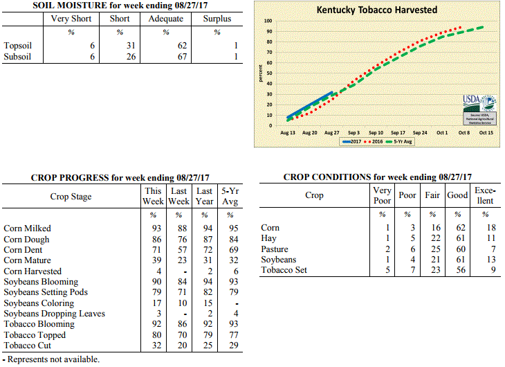 Kentucky Climate Summary
For the Period August 21 to August 27, 2017
Below Normal Temperatures and Rainfall:
The much-anticipated solar eclipse came and went on a hot and humid Monday. Highs
peaked in the low 90s after taking a dip of more than 5 degrees in some areas of
Western Kentucky during totality. The heat did not last long as a strong cold front
swung through the area on Tuesday. This boundary sparked a line of storms, some
strong to severe, with damaging winds as the main threat. Overall, this was the only
rainfall event for the week, but with a moist air mass in place, the state still
averaged a half inch. Some areas received much more than others. A more fall-like air
mass then moved into the area for the remainder of the period. High temperatures
peaked in the upper 70s to middle 80s with lows dropping into the 50s, which is more
typical of mid to late September. Some of the typical cooler spots even dipped
into the 40s. This continued the trend of a cooler August as temperatures have
averaged below normal three of the past four weeks in Kentucky.
Temperatures for the period averaged 72 degrees across the state which was 3 degrees
cooler than normal and 6 degrees cooler than the previous period. High temperatures
averaged from 85 in the West to 82 in the East. Departure from normal high
temperatures ranged from 3 degrees cooler than normal in the West to 4 degrees
cooler than normal in the East. Low temperatures averaged from 62 degrees in the
West to 60 degrees in the East. Departure from normal low temperature ranged from 3
degrees cooler than normal in the West to 2 degrees cooler than normal in the East.
The extreme high temperature for the period was 94 degrees at MADISONVILLE 4S and the
extreme low was 49 degrees at CYNTHIANA 8N.
Precipitation (liq. equ.) for the period totaled 0.52 inches statewide which was 0.28
inches below normal and 65% of normal. Precipitation totals by climate division, West
0.38 inches, Central 0.32 inches, Bluegrass 0.71 inches and East 0.66 inches, which
was 0.34, 0.49, 0.09 and 0.2 inches below normal. By station, precipitation totals
ranged from a low of 0.00 inches at CAPE GIRARDEAU ASOS to a high of 1.75
inches at VANCEBURG 6W.
---
Kentucky Crop and Weather Report
Issued 4:00 P.M., August 21, 2017 25-17
Agricultural News: Kentucky experienced above normal temperatures and rainfall over
the past week. Precipitation for the week totaled 0.99 inches, 0.13 inches above
normal. Temperatures averaged 78 degrees for the week, 2 degrees above normal.
Topsoil moisture was rated 4 percent very short, 23 percent short, 70 percent
adequate and 3 percent surplus. Subsoil moisture was rated 3 percent very short, 23
percent short, 72 percent adequate, and 2 percent surplus. Days suitable for
fieldwork averaged 5.7 out of a possible seven.
Primary activities this week included cutting hay, topping and cutting tobacco. Early
planted corn is drying down; some producers are chopping silage. Varied rainfall was
experienced across the state this week, with more precipitation in central and
eastern portions of the state. Some areas remain dry with rainfall needed to
replenish pastures and finish out crops. Showers delayed fieldwork at times,
including topping tobacco and cutting hay. Pastures are holding well in most locations,
but higher temperatures this week affected cattle grazing times.
Kentucky Climate Summary
For the Period August 21 to August 27, 2017
Below Normal Temperatures and Rainfall:
The much-anticipated solar eclipse came and went on a hot and humid Monday. Highs
peaked in the low 90s after taking a dip of more than 5 degrees in some areas of
Western Kentucky during totality. The heat did not last long as a strong cold front
swung through the area on Tuesday. This boundary sparked a line of storms, some
strong to severe, with damaging winds as the main threat. Overall, this was the only
rainfall event for the week, but with a moist air mass in place, the state still
averaged a half inch. Some areas received much more than others. A more fall-like air
mass then moved into the area for the remainder of the period. High temperatures
peaked in the upper 70s to middle 80s with lows dropping into the 50s, which is more
typical of mid to late September. Some of the typical cooler spots even dipped
into the 40s. This continued the trend of a cooler August as temperatures have
averaged below normal three of the past four weeks in Kentucky.
Temperatures for the period averaged 72 degrees across the state which was 3 degrees
cooler than normal and 6 degrees cooler than the previous period. High temperatures
averaged from 85 in the West to 82 in the East. Departure from normal high
temperatures ranged from 3 degrees cooler than normal in the West to 4 degrees
cooler than normal in the East. Low temperatures averaged from 62 degrees in the
West to 60 degrees in the East. Departure from normal low temperature ranged from 3
degrees cooler than normal in the West to 2 degrees cooler than normal in the East.
The extreme high temperature for the period was 94 degrees at MADISONVILLE 4S and the
extreme low was 49 degrees at CYNTHIANA 8N.
Precipitation (liq. equ.) for the period totaled 0.52 inches statewide which was 0.28
inches below normal and 65% of normal. Precipitation totals by climate division, West
0.38 inches, Central 0.32 inches, Bluegrass 0.71 inches and East 0.66 inches, which
was 0.34, 0.49, 0.09 and 0.2 inches below normal. By station, precipitation totals
ranged from a low of 0.00 inches at CAPE GIRARDEAU ASOS to a high of 1.75
inches at VANCEBURG 6W.
---
Kentucky Crop and Weather Report
Issued 4:00 P.M., August 21, 2017 25-17
Agricultural News: Kentucky experienced above normal temperatures and rainfall over
the past week. Precipitation for the week totaled 0.99 inches, 0.13 inches above
normal. Temperatures averaged 78 degrees for the week, 2 degrees above normal.
Topsoil moisture was rated 4 percent very short, 23 percent short, 70 percent
adequate and 3 percent surplus. Subsoil moisture was rated 3 percent very short, 23
percent short, 72 percent adequate, and 2 percent surplus. Days suitable for
fieldwork averaged 5.7 out of a possible seven.
Primary activities this week included cutting hay, topping and cutting tobacco. Early
planted corn is drying down; some producers are chopping silage. Varied rainfall was
experienced across the state this week, with more precipitation in central and
eastern portions of the state. Some areas remain dry with rainfall needed to
replenish pastures and finish out crops. Showers delayed fieldwork at times,
including topping tobacco and cutting hay. Pastures are holding well in most locations,
but higher temperatures this week affected cattle grazing times.
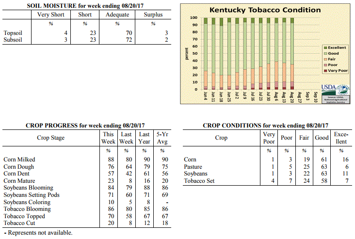 Kentucky Climate Summary
For the Period August 14 to August 20, 2017
Above Normal Temperatures and Rainfall:
The Bluegrass State saw a second straight week of above normal rainfall, while summer
heat and humidity returned to the area after a two-week absence. Scattered to
numerous showers and storms returned on Wednesday and Thursday, diminishing going
into the day on Friday with the passage of a cold front. Combined with some activity
on Monday, much of the area saw more than a half inch of rainfall, peaking in Eastern
Kentucky with an average of nearly 1.5 inches. With that said, the moist air mass in
place and multiple rounds of storms led to some locally higher amounts in the 2 to 3
inch range. Ahead of the front, temperatures consistently lifted into the middle 80s
to lower 90s for much of Kentucky. High dew points gave the feel that summer had
returned, pushing heat indices well into the 90s and even approaching 100. Even with
the passage of a cold front going into the weekend, temperatures did not break much
with only less muggy conditions in place.
Temperatures for the period averaged 78 degrees across the state which was 2 degrees
warmer than normal and 6 degrees warmer than the previous period. High temperatures
averaged from 87 in the West to 85 in the East. Departure from normal high
temperatures ranged from 1 degree cooler than normal in the West to 1 degrees
cooler than normal in the East. Low temperatures averaged from 69 degrees in the
West to 68 degrees in the East. Departure from normal low temperature ranged from 3
degrees warmer than normal in the West to 6 degrees warmer than normal in the East.
The extreme high temperature for the period was 96 degrees at LOUISVILLE APT and the
extreme low was 48 degrees at BURKESVILLE 3W.
Precipitation (liq. equ.) for the period totaled 0.99 inches statewide which was 0.13
inches above normal and 115% of normal. Precipitation totals by climate division,
West 0.60 inches, Central 0.87 inches, Bluegrass 1.01 inches and East 1.47 inches,
which was -0.18, 0.02, 0.14 and 0.54 inches respectively from normal. By station,
precipitation totals ranged from a low of 0.02 inches at FORT KNOX to a high of 4.03
inches at SOMERSET.
---
Kentucky Crop and Weather Report
Issued 4:00 P.M., August 14, 2017 24-17
Agricultural News: Kentucky experienced below normal temperatures and above normal
rainfall over the past week. Precipitation for the week totaled 1.50 inches, 0.60
inches above normal. Temperatures averaged 72 degrees for the week, 4 degrees below
normal. Topsoil moisture was rated 3 percent very short, 22 percent short, 72 percent
adequate and 3 percent surplus. Subsoil moisture was rated 4 percent very short, 24
percent short, 70 percent adequate, and 2 percent surplus. Days suitable for
fieldwork averaged 5.6 out of a possible seven.
Primary activities this week included cutting hay, topping and cutting tobacco, and
monitoring fields for disease. Corn harvesting has begun in areas that received
favorable weather. Some producers reported corn stress due to dry weather during
pollination. Double crop soybeans are also struggling in some areas due to heat and
dry weather. Even with the sometimes adverse conditions, corn was rated seventy nine
percent good to excellent. Soybeans were rated as seventy four percent good to excellent.
Tobacco was in mostly good to fair condition based on producer reports.
Kentucky Climate Summary
For the Period August 14 to August 20, 2017
Above Normal Temperatures and Rainfall:
The Bluegrass State saw a second straight week of above normal rainfall, while summer
heat and humidity returned to the area after a two-week absence. Scattered to
numerous showers and storms returned on Wednesday and Thursday, diminishing going
into the day on Friday with the passage of a cold front. Combined with some activity
on Monday, much of the area saw more than a half inch of rainfall, peaking in Eastern
Kentucky with an average of nearly 1.5 inches. With that said, the moist air mass in
place and multiple rounds of storms led to some locally higher amounts in the 2 to 3
inch range. Ahead of the front, temperatures consistently lifted into the middle 80s
to lower 90s for much of Kentucky. High dew points gave the feel that summer had
returned, pushing heat indices well into the 90s and even approaching 100. Even with
the passage of a cold front going into the weekend, temperatures did not break much
with only less muggy conditions in place.
Temperatures for the period averaged 78 degrees across the state which was 2 degrees
warmer than normal and 6 degrees warmer than the previous period. High temperatures
averaged from 87 in the West to 85 in the East. Departure from normal high
temperatures ranged from 1 degree cooler than normal in the West to 1 degrees
cooler than normal in the East. Low temperatures averaged from 69 degrees in the
West to 68 degrees in the East. Departure from normal low temperature ranged from 3
degrees warmer than normal in the West to 6 degrees warmer than normal in the East.
The extreme high temperature for the period was 96 degrees at LOUISVILLE APT and the
extreme low was 48 degrees at BURKESVILLE 3W.
Precipitation (liq. equ.) for the period totaled 0.99 inches statewide which was 0.13
inches above normal and 115% of normal. Precipitation totals by climate division,
West 0.60 inches, Central 0.87 inches, Bluegrass 1.01 inches and East 1.47 inches,
which was -0.18, 0.02, 0.14 and 0.54 inches respectively from normal. By station,
precipitation totals ranged from a low of 0.02 inches at FORT KNOX to a high of 4.03
inches at SOMERSET.
---
Kentucky Crop and Weather Report
Issued 4:00 P.M., August 14, 2017 24-17
Agricultural News: Kentucky experienced below normal temperatures and above normal
rainfall over the past week. Precipitation for the week totaled 1.50 inches, 0.60
inches above normal. Temperatures averaged 72 degrees for the week, 4 degrees below
normal. Topsoil moisture was rated 3 percent very short, 22 percent short, 72 percent
adequate and 3 percent surplus. Subsoil moisture was rated 4 percent very short, 24
percent short, 70 percent adequate, and 2 percent surplus. Days suitable for
fieldwork averaged 5.6 out of a possible seven.
Primary activities this week included cutting hay, topping and cutting tobacco, and
monitoring fields for disease. Corn harvesting has begun in areas that received
favorable weather. Some producers reported corn stress due to dry weather during
pollination. Double crop soybeans are also struggling in some areas due to heat and
dry weather. Even with the sometimes adverse conditions, corn was rated seventy nine
percent good to excellent. Soybeans were rated as seventy four percent good to excellent.
Tobacco was in mostly good to fair condition based on producer reports.
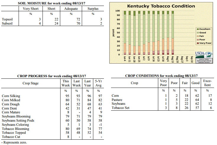 Kentucky Climate Summary
For the Period August 7 to August 13, 2017
Below Normal Temperatures and Above Normal Rainfall:
Carrying over from the previous period, widespread showers continued to fall early
Monday with a passing area of low pressure. Scattered coverage remained later in the
day before diminishing going into Tuesday with high pressure building into the
Bluegrass State. After a couple of dry days, isolated to scattered showers returned
Thursday through Saturday, ending with the passage of a weak cold front. Central and
Eastern Kentucky were the focus for any accumulations. Overall, Eastern Kentucky
came out well ahead of other portions of Kentucky, averaging over 2.5 inches for the
week. The active pattern led to a second straight week of unseasonably cool
temperatures.
Temperatures for the period averaged 72 degrees across the state which was 4 degrees
cooler than normal and no change to the previous period. High temperatures averaged
from 83 in the West to 80 in the East. Departure from normal high temperatures
ranged from 5 degrees cooler than normal in the West to 6 degrees cooler than normal
in the East. Low temperatures averaged from 64 degrees in the West to 64 degrees in
the East. Departure from normal low temperature ranged from 2 degrees cooler than
normal in the West to 1 degree warmer than normal in the East. The extreme high
temperature for the period was 90 degrees at PADUCAH ASOS and the extreme low was 52
degrees at CYNTHIANA 8N.
Precipitation (liq. equ.) for the period totaled 1.50 inches statewide which was 0.6
inches above normal and 167% of normal. Precipitation totals by climate division,
West 0.80 inches, Central 1.77 inches, Bluegrass 0.76 inches and East 2.67 inches,
which was -0.05, 0.90, -0.12 and 1.68 inches respectively from normal. By station,
precipitation totals ranged from a low of 0.17 inches at CALHOUN 5NW to a high of
5.22 inches at ALBANY 1N.
---
Kentucky Crop and Weather Report
Issued 4:00 P.M., August 7, 2017 23-17
Agricultural News: Kentucky experienced below normal temperatures and rainfall over
the past week. Precipitation for the week totaled 0.80 inches, 0.16 inches below
normal. Temperatures averaged 72 degrees for the week, 4 degrees below normal.
Topsoil moisture was rated 5 percent very short, 25 percent short, 66 percent
adequate and 4 percent surplus. Subsoil moisture was rated 4 percent very short, 23
percent short, 70 percent adequate, and 3 percent surplus. Days suitable for
fieldwork averaged 5.6 out of a possible seven.
Primary activities this week included scouting crops for disease, spraying
fungicides, and cutting hay. Preparations for cutting tobacco are underway, with some
reports of harvesting starting in western counties. Heat, scattered storms, and
disease are having varied impacts on crops across the state. Some disease incidence
reports include sugarcane aphids on sorghum, common and southern rust in corn, and
downy mildew on soybeans.
Kentucky Climate Summary
For the Period August 7 to August 13, 2017
Below Normal Temperatures and Above Normal Rainfall:
Carrying over from the previous period, widespread showers continued to fall early
Monday with a passing area of low pressure. Scattered coverage remained later in the
day before diminishing going into Tuesday with high pressure building into the
Bluegrass State. After a couple of dry days, isolated to scattered showers returned
Thursday through Saturday, ending with the passage of a weak cold front. Central and
Eastern Kentucky were the focus for any accumulations. Overall, Eastern Kentucky
came out well ahead of other portions of Kentucky, averaging over 2.5 inches for the
week. The active pattern led to a second straight week of unseasonably cool
temperatures.
Temperatures for the period averaged 72 degrees across the state which was 4 degrees
cooler than normal and no change to the previous period. High temperatures averaged
from 83 in the West to 80 in the East. Departure from normal high temperatures
ranged from 5 degrees cooler than normal in the West to 6 degrees cooler than normal
in the East. Low temperatures averaged from 64 degrees in the West to 64 degrees in
the East. Departure from normal low temperature ranged from 2 degrees cooler than
normal in the West to 1 degree warmer than normal in the East. The extreme high
temperature for the period was 90 degrees at PADUCAH ASOS and the extreme low was 52
degrees at CYNTHIANA 8N.
Precipitation (liq. equ.) for the period totaled 1.50 inches statewide which was 0.6
inches above normal and 167% of normal. Precipitation totals by climate division,
West 0.80 inches, Central 1.77 inches, Bluegrass 0.76 inches and East 2.67 inches,
which was -0.05, 0.90, -0.12 and 1.68 inches respectively from normal. By station,
precipitation totals ranged from a low of 0.17 inches at CALHOUN 5NW to a high of
5.22 inches at ALBANY 1N.
---
Kentucky Crop and Weather Report
Issued 4:00 P.M., August 7, 2017 23-17
Agricultural News: Kentucky experienced below normal temperatures and rainfall over
the past week. Precipitation for the week totaled 0.80 inches, 0.16 inches below
normal. Temperatures averaged 72 degrees for the week, 4 degrees below normal.
Topsoil moisture was rated 5 percent very short, 25 percent short, 66 percent
adequate and 4 percent surplus. Subsoil moisture was rated 4 percent very short, 23
percent short, 70 percent adequate, and 3 percent surplus. Days suitable for
fieldwork averaged 5.6 out of a possible seven.
Primary activities this week included scouting crops for disease, spraying
fungicides, and cutting hay. Preparations for cutting tobacco are underway, with some
reports of harvesting starting in western counties. Heat, scattered storms, and
disease are having varied impacts on crops across the state. Some disease incidence
reports include sugarcane aphids on sorghum, common and southern rust in corn, and
downy mildew on soybeans.
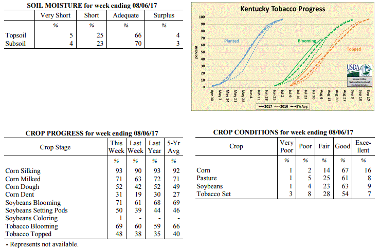 Kentucky Climate Summary
For the Period July 31 to August 6, 2017
Below Normal Temperatures and Rainfall:
The week started with high pressure in place, keeping the area dry. From there on
out, an active pattern set up for much of the remaining period. Isolated to scattered
coverage was seen Tuesday through Friday, eventually ending with the passage of a
cold front. This boundary really sent temperatures and moisture on the downhill
slide as high pressure of Canadian origin moved into the area. Fall-like
temperatures were seen over the weekend with lows dipping well into the 50s and highs
only in the 70s. Showers and storms returned on Sunday, eventually becoming
widespread later in the day. Rainfall continued into the overnight and surpassed the
cutoff time for data entry into this period (represented in next week�s summary).
Temperatures for the period averaged 72 degrees across the state which was 4 degrees
cooler than normal and 4 degrees cooler than the previous period. High temperatures
averaged from 83 in the West to 82 in the East. Departure from normal high
temperatures ranged from 6 degrees cooler than normal in the West to 5 degrees
cooler than normal in the East. Low temperatures averaged from 64 degrees in the
West to 60 degrees in the East. Departure from normal low temperature ranged from 3
degrees cooler than normal in the West to 3 degrees cooler than normal in the East.
The extreme high temperature for the period was 92 degrees at MADISONVILLE 4S and the
extreme low was 50 degrees at CARBONDALE ASOS.
Precipitation (liq. equ.) for the period totaled 0.80 inches statewide which was 0.16
inches below normal and 84% of normal. Precipitation totals by climate division, West
0.92 inches, Central 0.64 inches, Bluegrass 1.05 inches and East 0.60 inches, which
was 0.00, -0.29, 0.11 and -0.44 inches respectively from normal. By station,
precipitation totals ranged from a low of 0.01 inches at FORT KNOX to a high of 2.20
inches at OWENTON 5E.
---
Kentucky Crop and Weather Report
Issued 4:00 P.M., July 31, 2017 22-17
Agricultural News: Kentucky experienced near normal temperatures and above normal
rainfall over the past week. Precipitation for the week totaled 1.14 inches, 0.16
inches above normal. Temperatures averaged 76 degrees for the week, unchanged from
normal. Topsoil moisture was rated 7 percent very short, 31 percent short, 59 percent
adequate, and 3 percent surplus. Subsoil moisture was rated 6 percent very short, 25
percent short, 67 percent adequate, and 2 percent surplus. Days suitable for
fieldwork averaged 5.7 out of a possible seven.
Kentucky finally saw some relief from both the dry conditions and extreme
heat/humidity. This relief came in the form of a cold front late in the workweek.
After only seeing isolated coverage early in the period, scattered to numerous
showers and storms formed late Thursday. This activity continued into the overnight
and until the eventual passage of the cold front later in the day on Friday. Eastern
Kentucky came out well ahead of other portions of the state, averaging more than 2
inches for the seven-day period. That number decreased down to about a half inch for
Western Kentucky. The above normal temperatures early in the week turned below normal
for the weekend. High pressure of Canadian origin kept the Commonwealth much cooler
and noticeably less humid.
Primary activities this week included cutting hay, topping tobacco, and monitoring of
corn and soybeans. There was some relief from the hot/dry conditions this week as
scattered rain brought in cooler temperatures. Even with the recent precipitation
some areas are still very dry and stress can be seen in the crops. It is of note that
some areas received very heavy rain and some tobacco was reported as damaged from
flooding. Tobacco, corn, and soybean conditions remain mostly good despite
unpredictable weather.
Pasture and hay fields are in mostly good condition. Hay supplies are 2 percent very
short, 9 percent short, 77 percent adequate, and 12 percent surplus.
Kentucky Climate Summary
For the Period July 31 to August 6, 2017
Below Normal Temperatures and Rainfall:
The week started with high pressure in place, keeping the area dry. From there on
out, an active pattern set up for much of the remaining period. Isolated to scattered
coverage was seen Tuesday through Friday, eventually ending with the passage of a
cold front. This boundary really sent temperatures and moisture on the downhill
slide as high pressure of Canadian origin moved into the area. Fall-like
temperatures were seen over the weekend with lows dipping well into the 50s and highs
only in the 70s. Showers and storms returned on Sunday, eventually becoming
widespread later in the day. Rainfall continued into the overnight and surpassed the
cutoff time for data entry into this period (represented in next week�s summary).
Temperatures for the period averaged 72 degrees across the state which was 4 degrees
cooler than normal and 4 degrees cooler than the previous period. High temperatures
averaged from 83 in the West to 82 in the East. Departure from normal high
temperatures ranged from 6 degrees cooler than normal in the West to 5 degrees
cooler than normal in the East. Low temperatures averaged from 64 degrees in the
West to 60 degrees in the East. Departure from normal low temperature ranged from 3
degrees cooler than normal in the West to 3 degrees cooler than normal in the East.
The extreme high temperature for the period was 92 degrees at MADISONVILLE 4S and the
extreme low was 50 degrees at CARBONDALE ASOS.
Precipitation (liq. equ.) for the period totaled 0.80 inches statewide which was 0.16
inches below normal and 84% of normal. Precipitation totals by climate division, West
0.92 inches, Central 0.64 inches, Bluegrass 1.05 inches and East 0.60 inches, which
was 0.00, -0.29, 0.11 and -0.44 inches respectively from normal. By station,
precipitation totals ranged from a low of 0.01 inches at FORT KNOX to a high of 2.20
inches at OWENTON 5E.
---
Kentucky Crop and Weather Report
Issued 4:00 P.M., July 31, 2017 22-17
Agricultural News: Kentucky experienced near normal temperatures and above normal
rainfall over the past week. Precipitation for the week totaled 1.14 inches, 0.16
inches above normal. Temperatures averaged 76 degrees for the week, unchanged from
normal. Topsoil moisture was rated 7 percent very short, 31 percent short, 59 percent
adequate, and 3 percent surplus. Subsoil moisture was rated 6 percent very short, 25
percent short, 67 percent adequate, and 2 percent surplus. Days suitable for
fieldwork averaged 5.7 out of a possible seven.
Kentucky finally saw some relief from both the dry conditions and extreme
heat/humidity. This relief came in the form of a cold front late in the workweek.
After only seeing isolated coverage early in the period, scattered to numerous
showers and storms formed late Thursday. This activity continued into the overnight
and until the eventual passage of the cold front later in the day on Friday. Eastern
Kentucky came out well ahead of other portions of the state, averaging more than 2
inches for the seven-day period. That number decreased down to about a half inch for
Western Kentucky. The above normal temperatures early in the week turned below normal
for the weekend. High pressure of Canadian origin kept the Commonwealth much cooler
and noticeably less humid.
Primary activities this week included cutting hay, topping tobacco, and monitoring of
corn and soybeans. There was some relief from the hot/dry conditions this week as
scattered rain brought in cooler temperatures. Even with the recent precipitation
some areas are still very dry and stress can be seen in the crops. It is of note that
some areas received very heavy rain and some tobacco was reported as damaged from
flooding. Tobacco, corn, and soybean conditions remain mostly good despite
unpredictable weather.
Pasture and hay fields are in mostly good condition. Hay supplies are 2 percent very
short, 9 percent short, 77 percent adequate, and 12 percent surplus.
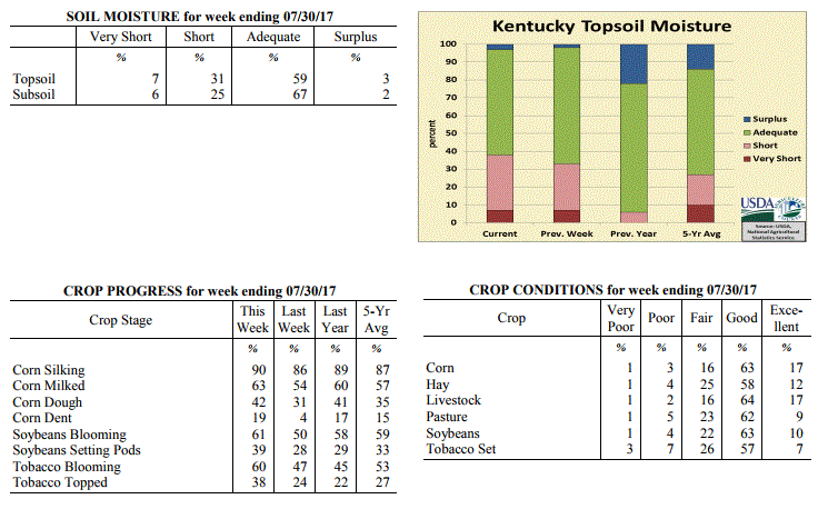 Kentucky Climate Summary
For the Period July 24 to July 30, 2017
Near Normal Temperatures and Above Normal Rainfall:
Kentucky finally saw some relief from both the dry conditions and extreme
heat/humidity. This relief came in the form of a cold front late in the workweek.
After only seeing isolated coverage early in the period, scattered to numerous
showers and storms formed late Thursday. This activity continued into the overnight
and until the eventual passage of the cold front later in the day on Friday. Eastern
Kentucky came out well ahead of other portions of the state, averaging more than 2
inches for the seven-day period. That number decreased down to about a half inch for
Western Kentucky. The above normal temperatures early in the week turned below normal
for the weekend. High pressure of Canadian origin kept the Commonwealth much cooler
and noticeably less humid.
Temperatures for the period averaged 76 degrees across the state which was
near normal and 4 degrees cooler than the previous period. High temperatures
averaged from 88 in the West to 83 in the East. Departure from normal high
temperatures ranged from 1 degree cooler than normal in the West to 4 degrees
cooler than normal in the East. Low temperatures averaged from 69 degrees in the
West to 65 degrees in the East. Departure from normal low temperature ranged from 2
degrees warmer than normal in the West to 1 degree warmer than normal in the East.
The extreme high temperature for the period was 97 degrees at EVANSVILLE ASOS and the
extreme low was 52 degrees at MOREHEAD 4NE.
Precipitation (liq. equ.) for the period totaled 1.14 inches statewide which was 0.16
inches above normal and 116% of normal. Precipitation totals by climate division,
West 0.55 inches, Central 0.66 inches, Bluegrass 1.27 inches and East 2.07 inches,
which was -0.39, -0.33, 0.30 and 1.05 inches respectively from normal. By station,
precipitation totals ranged from a low of 0.00 inches at MAYFIELD 6SW to a high of
4.42 inches at BIG SANDY.
---
Kentucky Crop and Weather Report
Issued 4:00 P.M., July 24, 2017 21-17
Agricultural News: Kentucky experienced above normal temperatures and below normal
rainfall over the past week. Precipitation for the week totaled 0.66 inches, 0.31
inches below normal. Temperatures averaged 80 degrees for the week, 3 degrees above
normal. Topsoil moisture was rated 7 percent very short, 26 percent short, 65 percent
adequate and 2 percent surplus. Subsoil moisture was rated 5 percent very short, 20
percent short, 73 percent adequate, and 2 percent surplus. Days suitable for
fieldwork averaged 6.4 out of a possible seven.
Primary activities this week included spraying of tobacco, corn, and soybeans.
Extreme heat and dry conditions have stressed both crops and pasture. Weather impact
has been especially visible in pollinating corn and blooming soybeans. There have
been some cases of disease in both crops, however not widespread. Even with the dry
and hot weather, corn, soybean, and tobacco conditions remain mostly good to fair at
this time. Rain over the weekend should improve conditions in some areas.
Kentucky Climate Summary
For the Period July 24 to July 30, 2017
Near Normal Temperatures and Above Normal Rainfall:
Kentucky finally saw some relief from both the dry conditions and extreme
heat/humidity. This relief came in the form of a cold front late in the workweek.
After only seeing isolated coverage early in the period, scattered to numerous
showers and storms formed late Thursday. This activity continued into the overnight
and until the eventual passage of the cold front later in the day on Friday. Eastern
Kentucky came out well ahead of other portions of the state, averaging more than 2
inches for the seven-day period. That number decreased down to about a half inch for
Western Kentucky. The above normal temperatures early in the week turned below normal
for the weekend. High pressure of Canadian origin kept the Commonwealth much cooler
and noticeably less humid.
Temperatures for the period averaged 76 degrees across the state which was
near normal and 4 degrees cooler than the previous period. High temperatures
averaged from 88 in the West to 83 in the East. Departure from normal high
temperatures ranged from 1 degree cooler than normal in the West to 4 degrees
cooler than normal in the East. Low temperatures averaged from 69 degrees in the
West to 65 degrees in the East. Departure from normal low temperature ranged from 2
degrees warmer than normal in the West to 1 degree warmer than normal in the East.
The extreme high temperature for the period was 97 degrees at EVANSVILLE ASOS and the
extreme low was 52 degrees at MOREHEAD 4NE.
Precipitation (liq. equ.) for the period totaled 1.14 inches statewide which was 0.16
inches above normal and 116% of normal. Precipitation totals by climate division,
West 0.55 inches, Central 0.66 inches, Bluegrass 1.27 inches and East 2.07 inches,
which was -0.39, -0.33, 0.30 and 1.05 inches respectively from normal. By station,
precipitation totals ranged from a low of 0.00 inches at MAYFIELD 6SW to a high of
4.42 inches at BIG SANDY.
---
Kentucky Crop and Weather Report
Issued 4:00 P.M., July 24, 2017 21-17
Agricultural News: Kentucky experienced above normal temperatures and below normal
rainfall over the past week. Precipitation for the week totaled 0.66 inches, 0.31
inches below normal. Temperatures averaged 80 degrees for the week, 3 degrees above
normal. Topsoil moisture was rated 7 percent very short, 26 percent short, 65 percent
adequate and 2 percent surplus. Subsoil moisture was rated 5 percent very short, 20
percent short, 73 percent adequate, and 2 percent surplus. Days suitable for
fieldwork averaged 6.4 out of a possible seven.
Primary activities this week included spraying of tobacco, corn, and soybeans.
Extreme heat and dry conditions have stressed both crops and pasture. Weather impact
has been especially visible in pollinating corn and blooming soybeans. There have
been some cases of disease in both crops, however not widespread. Even with the dry
and hot weather, corn, soybean, and tobacco conditions remain mostly good to fair at
this time. Rain over the weekend should improve conditions in some areas.
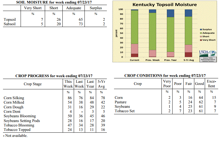 Kentucky Climate Summary
For the Period July 17 to July 23, 2017
Above Normal Temperatures and Below Normal Rainfall:
Kentucky saw an extended stretch of heat and humidity build into the area. The heat
peaked on Friday and Saturday with the majority of the state in the low to middle
90s, but some locations even jumped into the upper 90s. While temperatures for the
week were not too far from normal, it was the amount of moisture in the air that led
to oppressive conditions. Dew points in the low to middle 70s sent heat indices well
over 100, approaching 110 at times. A Heat Advisory was issued for much of the
state. Livestock heat stress continued to run in the danger to emergency category
with not much recovery seen during the overnight hours. Up until the weekend,
rainfall continued to be lacking. Only isolated activity was seen over the course of
much of the period. That changed for the northern half of Kentucky late Saturday and
into Sunday as a couple clusters of storms brought numerous to widespread rain
coverage. Overall, other than the Bluegrass area, rainfall was below normal for a
second straight week.
Temperatures for the period averaged 80 degrees across the state which was 3 degrees
warmer than normal and 2 degrees warmer than the previous period. High temperatures
averaged from 92 in the West to 90 in the East. Departure from normal high
temperatures ranged from 2 degrees warmer than normal in the West to 3 degrees
warmer than normal in the East. Low temperatures averaged from 71 degrees in the
West to 68 degrees in the East. Departure from normal low temperature ranged from 3
degrees warmer than normal in the West to 4 degrees warmer than normal in the East.
The extreme high temperature for the period was 99 degrees at EVANSVILLE ASOS and the
extreme low was 59 degrees at BURKESVILLE 3W.
Precipitation (liq. equ.) for the period totaled 0.66 inches statewide which was 0.31
inches below normal and 68% of normal. Precipitation totals by climate division, West
0.41 inches, Central 0.45 inches, Bluegrass 1.11 inches and East 0.66 inches, which
was -0.51, -0.54, 0.17 and -0.35 inches respectively from normal. By station,
precipitation totals ranged from a low of 0.00 inches at BENTON 4N to a high of 6.77
inches at MAYSVILLE 3SW.
---
Kentucky Crop and Weather Report
Issued 4:00 P.M., July 17, 2017 20-17
Agricultural News: Kentucky experienced slightly above normal temperatures and below
normal rainfall over the past week. Precipitation for the week totaled 0.30 inches,
0.70 inches below normal. Temperatures averaged 78 degrees for the week, 1 degrees
above normal. Topsoil moisture was rated 1 percent very short, 14 percent short, 78
percent adequate, and 7 percent surplus. Subsoil moisture was rated 1 percent very
short, 12 percent short, 81 percent adequate, and 6 percent surplus. Days suitable
for fieldwork averaged 6.0 out of a possible seven.
Primary activities this week included cutting hay and spraying row crops. Very wet
weather early in the month gave way to hot, dry conditions typical for this point in
the season. There is a presence of disease in some crops, but it is not widespread.
Some crops were helped by the drier conditions, however others have been stressed by
the intense heat throughout the state. Also pasture condition has been negatively
affected by the hot, dry weather in some areas.
Kentucky Climate Summary
For the Period July 17 to July 23, 2017
Above Normal Temperatures and Below Normal Rainfall:
Kentucky saw an extended stretch of heat and humidity build into the area. The heat
peaked on Friday and Saturday with the majority of the state in the low to middle
90s, but some locations even jumped into the upper 90s. While temperatures for the
week were not too far from normal, it was the amount of moisture in the air that led
to oppressive conditions. Dew points in the low to middle 70s sent heat indices well
over 100, approaching 110 at times. A Heat Advisory was issued for much of the
state. Livestock heat stress continued to run in the danger to emergency category
with not much recovery seen during the overnight hours. Up until the weekend,
rainfall continued to be lacking. Only isolated activity was seen over the course of
much of the period. That changed for the northern half of Kentucky late Saturday and
into Sunday as a couple clusters of storms brought numerous to widespread rain
coverage. Overall, other than the Bluegrass area, rainfall was below normal for a
second straight week.
Temperatures for the period averaged 80 degrees across the state which was 3 degrees
warmer than normal and 2 degrees warmer than the previous period. High temperatures
averaged from 92 in the West to 90 in the East. Departure from normal high
temperatures ranged from 2 degrees warmer than normal in the West to 3 degrees
warmer than normal in the East. Low temperatures averaged from 71 degrees in the
West to 68 degrees in the East. Departure from normal low temperature ranged from 3
degrees warmer than normal in the West to 4 degrees warmer than normal in the East.
The extreme high temperature for the period was 99 degrees at EVANSVILLE ASOS and the
extreme low was 59 degrees at BURKESVILLE 3W.
Precipitation (liq. equ.) for the period totaled 0.66 inches statewide which was 0.31
inches below normal and 68% of normal. Precipitation totals by climate division, West
0.41 inches, Central 0.45 inches, Bluegrass 1.11 inches and East 0.66 inches, which
was -0.51, -0.54, 0.17 and -0.35 inches respectively from normal. By station,
precipitation totals ranged from a low of 0.00 inches at BENTON 4N to a high of 6.77
inches at MAYSVILLE 3SW.
---
Kentucky Crop and Weather Report
Issued 4:00 P.M., July 17, 2017 20-17
Agricultural News: Kentucky experienced slightly above normal temperatures and below
normal rainfall over the past week. Precipitation for the week totaled 0.30 inches,
0.70 inches below normal. Temperatures averaged 78 degrees for the week, 1 degrees
above normal. Topsoil moisture was rated 1 percent very short, 14 percent short, 78
percent adequate, and 7 percent surplus. Subsoil moisture was rated 1 percent very
short, 12 percent short, 81 percent adequate, and 6 percent surplus. Days suitable
for fieldwork averaged 6.0 out of a possible seven.
Primary activities this week included cutting hay and spraying row crops. Very wet
weather early in the month gave way to hot, dry conditions typical for this point in
the season. There is a presence of disease in some crops, but it is not widespread.
Some crops were helped by the drier conditions, however others have been stressed by
the intense heat throughout the state. Also pasture condition has been negatively
affected by the hot, dry weather in some areas.
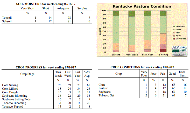 Kentucky Climate Summary
For the Period July 10 to July 16, 2017
Slightly Above Normal Temperatures and Below Normal Rainfall:
Hot and muggy conditions stuck around for much of the period, but comparing to what
Kentucky typically sees in July, it was not that far from normal. Highs typically
rose into the upper 80s to low 90s, but a handful of locations even jumped into the
middle 90s. Combined with high dew points in the 70s, heat indices increased well
into the 90s and low 100s at times, creating stressful conditions for livestock in
the afternoon and evening hours. Mostly dry conditions accompanied the heat.
Coverage at any point through the period was isolated to scattered at best. While
some areas saw some beneficial rainfall, many locations received less than a tenth of an
inch for the week. When looking at statewide accumulations, this was one of the
driest weeks of the 2017 growing season.
Temperatures for the period averaged 78 degrees across the state which was 1 degree
warmer than normal and 2 degrees warmer than the previous period. High temperatures
averaged from 89 in the West to 87 in the East. Departure from normal high
temperatures ranged from 1 degree cooler than normal in the West to near normal in
the East. Low temperatures averaged from 69 degrees in the West to 66 degrees in the
East. Departure from normal low temperature ranged from 1 degree warmer than normal
in the West to 3 degrees warmer than normal in the East. The extreme high temperature
for the period was 95 degrees at PADUCAH ASOS and the extreme low was 56 degrees at
PAINTSVILLE 4W.
Precipitation (liq. equ.) for the period totaled 0.30 inches statewide which was 0.7
inches below normal and 30% of normal. Precipitation totals by climate division, West
0.15 inches, Central 0.19 inches, Bluegrass 0.42 inches and East 0.46 inches, which
was 0.83, 0.82, 0.56 and 0.56 inches below normal. By station, precipitation totals
ranged from a low of 0.00 inches at ALBANY 1N to a high of 2.48 inches at PIKEVILLE 13S.
---
Kentucky Crop and Weather Report
Issued 4:00 P.M., July 10, 2017 19-17
Agricultural News: Kentucky experienced normal temperatures and much above normal
rainfall over the past week. Precipitation for the week totaled 1.91 inches, 0.92
inches above normal. Temperatures averaged 76 degrees for the week, unchanged from
normal. Topsoil moisture was rated 1 percent very short, 6 percent short, 78 percent
adequate and 15 percent surplus. Subsoil moisture was rated 1 percent very short, 8
percent short, 81 percent adequate, and 10 percent surplus. Days suitable for
fieldwork averaged 4.0 out of a possible seven.
Wet conditions throughout the week hindered progress in the fields. Farmers need some
dry weather to cut hay and apply herbicides to soybean fields with heavy weed growth.
Average height of soybeans was 17 inches, compared to 11 inches last week, and 13
inches at this time last year.
Kentucky Climate Summary
For the Period July 10 to July 16, 2017
Slightly Above Normal Temperatures and Below Normal Rainfall:
Hot and muggy conditions stuck around for much of the period, but comparing to what
Kentucky typically sees in July, it was not that far from normal. Highs typically
rose into the upper 80s to low 90s, but a handful of locations even jumped into the
middle 90s. Combined with high dew points in the 70s, heat indices increased well
into the 90s and low 100s at times, creating stressful conditions for livestock in
the afternoon and evening hours. Mostly dry conditions accompanied the heat.
Coverage at any point through the period was isolated to scattered at best. While
some areas saw some beneficial rainfall, many locations received less than a tenth of an
inch for the week. When looking at statewide accumulations, this was one of the
driest weeks of the 2017 growing season.
Temperatures for the period averaged 78 degrees across the state which was 1 degree
warmer than normal and 2 degrees warmer than the previous period. High temperatures
averaged from 89 in the West to 87 in the East. Departure from normal high
temperatures ranged from 1 degree cooler than normal in the West to near normal in
the East. Low temperatures averaged from 69 degrees in the West to 66 degrees in the
East. Departure from normal low temperature ranged from 1 degree warmer than normal
in the West to 3 degrees warmer than normal in the East. The extreme high temperature
for the period was 95 degrees at PADUCAH ASOS and the extreme low was 56 degrees at
PAINTSVILLE 4W.
Precipitation (liq. equ.) for the period totaled 0.30 inches statewide which was 0.7
inches below normal and 30% of normal. Precipitation totals by climate division, West
0.15 inches, Central 0.19 inches, Bluegrass 0.42 inches and East 0.46 inches, which
was 0.83, 0.82, 0.56 and 0.56 inches below normal. By station, precipitation totals
ranged from a low of 0.00 inches at ALBANY 1N to a high of 2.48 inches at PIKEVILLE 13S.
---
Kentucky Crop and Weather Report
Issued 4:00 P.M., July 10, 2017 19-17
Agricultural News: Kentucky experienced normal temperatures and much above normal
rainfall over the past week. Precipitation for the week totaled 1.91 inches, 0.92
inches above normal. Temperatures averaged 76 degrees for the week, unchanged from
normal. Topsoil moisture was rated 1 percent very short, 6 percent short, 78 percent
adequate and 15 percent surplus. Subsoil moisture was rated 1 percent very short, 8
percent short, 81 percent adequate, and 10 percent surplus. Days suitable for
fieldwork averaged 4.0 out of a possible seven.
Wet conditions throughout the week hindered progress in the fields. Farmers need some
dry weather to cut hay and apply herbicides to soybean fields with heavy weed growth.
Average height of soybeans was 17 inches, compared to 11 inches last week, and 13
inches at this time last year.
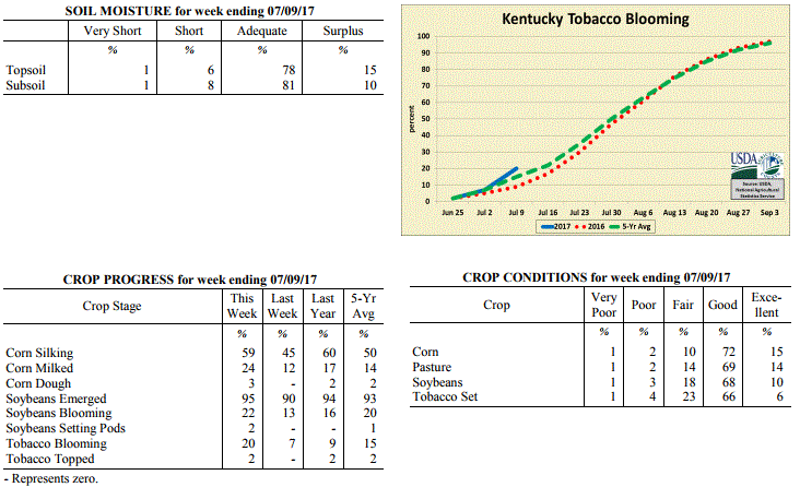 Kentucky Climate Summary
For the Period July 3 to July 9, 2017
Near Normal Temperatures and Much Above Normal Rainfall:
The Commonwealth saw an extended stretch of humid and wet weather that lasted through
Friday. As several disturbances moved through the area, showers and storms developed
on a daily basis. Storms were capable of very heavy rainfall as the state sat within
a very moist air mass. The unsettled pattern ended with the passage of a cold front
on Friday, bringing a line of strong to severe storms through the Lower Ohio Valley.
Overall, the state averaged nearly 2 inches for the week, which was almost an inch
above normal. This made for the second time in three weeks that the state had
averaged over 1.5 inches. Dry conditions returned for the weekend with lower
humidity in place.
Temperatures for the period averaged 76 degrees across the state which was
near normal and 4 degrees warmer than the previous period. High temperatures
averaged from 85 in the West to 83 in the East. Departure from normal high
temperatures ranged from 4 degrees cooler than normal in the West to 3 degrees
cooler than normal in the East. Low temperatures averaged from 69 degrees in the
West to 66 degrees in the East. Departure from normal low temperature ranged from 2
degrees warmer than normal in the West to 4 degrees warmer than normal in the East.
The extreme high temperature for the period was 91 degrees at CARBONDALE ASOS and the
extreme low was 56 degrees at CINCINNATI.
Precipitation (liq. equ.) for the period totaled 1.91 inches statewide which was 0.92
inches above normal and 193% of normal. Precipitation totals by climate division,
West 1.57 inches, Central 2.40 inches, Bluegrass 1.82 inches and East 1.84 inches,
which was 0.57, 1.41, 0.86 and 0.83 inches above normal. By station, precipitation
totals ranged from a low of 0.65 inches at MADISONVILLE 4S to a high of 3.88
inches at MCKEE 5S.
---
Kentucky Crop and Weather Report
Issued 4:00 P.M., July 5, 2017 18-17
Agricultural News: Kentucky experienced below normal temperatures and rainfall over
the past week. Precipitation for the week totaled 0.40 inches, 0.58 inches below
normal. Temperatures averaged 72 degrees for the week, 3 degrees below normal.
Topsoil moisture was rated 1 percent very short, 12 percent short, 76 percent
adequate and 11 percent surplus. Subsoil moisture was rated 1 percent very short, 11
percent short, 80 percent adequate, and 8 percent surplus. Days suitable for
fieldwork averaged 5.2 out of a possible seven.
Rainfall was scattered across the state with some areas getting heavy precipitation
while others remain very dry. As a result of the heavy showers there was some
drowning out of tobacco and some sign of disease. These conditions were very
concentrated and not widespread. Primary activities for the week when weather
permitted were hay baling and any necessary replanting of tobacco, corn, and
soybeans.
The average height of emerged soybeans was 11 inches, compared to 6 inches last week,
and 9 inches for this time last year. The quality of hay made was 1 percent very poor,
5 percent poor, 23 percent fair, 60 percent good, and 11 percent excellent.
Kentucky Climate Summary
For the Period July 3 to July 9, 2017
Near Normal Temperatures and Much Above Normal Rainfall:
The Commonwealth saw an extended stretch of humid and wet weather that lasted through
Friday. As several disturbances moved through the area, showers and storms developed
on a daily basis. Storms were capable of very heavy rainfall as the state sat within
a very moist air mass. The unsettled pattern ended with the passage of a cold front
on Friday, bringing a line of strong to severe storms through the Lower Ohio Valley.
Overall, the state averaged nearly 2 inches for the week, which was almost an inch
above normal. This made for the second time in three weeks that the state had
averaged over 1.5 inches. Dry conditions returned for the weekend with lower
humidity in place.
Temperatures for the period averaged 76 degrees across the state which was
near normal and 4 degrees warmer than the previous period. High temperatures
averaged from 85 in the West to 83 in the East. Departure from normal high
temperatures ranged from 4 degrees cooler than normal in the West to 3 degrees
cooler than normal in the East. Low temperatures averaged from 69 degrees in the
West to 66 degrees in the East. Departure from normal low temperature ranged from 2
degrees warmer than normal in the West to 4 degrees warmer than normal in the East.
The extreme high temperature for the period was 91 degrees at CARBONDALE ASOS and the
extreme low was 56 degrees at CINCINNATI.
Precipitation (liq. equ.) for the period totaled 1.91 inches statewide which was 0.92
inches above normal and 193% of normal. Precipitation totals by climate division,
West 1.57 inches, Central 2.40 inches, Bluegrass 1.82 inches and East 1.84 inches,
which was 0.57, 1.41, 0.86 and 0.83 inches above normal. By station, precipitation
totals ranged from a low of 0.65 inches at MADISONVILLE 4S to a high of 3.88
inches at MCKEE 5S.
---
Kentucky Crop and Weather Report
Issued 4:00 P.M., July 5, 2017 18-17
Agricultural News: Kentucky experienced below normal temperatures and rainfall over
the past week. Precipitation for the week totaled 0.40 inches, 0.58 inches below
normal. Temperatures averaged 72 degrees for the week, 3 degrees below normal.
Topsoil moisture was rated 1 percent very short, 12 percent short, 76 percent
adequate and 11 percent surplus. Subsoil moisture was rated 1 percent very short, 11
percent short, 80 percent adequate, and 8 percent surplus. Days suitable for
fieldwork averaged 5.2 out of a possible seven.
Rainfall was scattered across the state with some areas getting heavy precipitation
while others remain very dry. As a result of the heavy showers there was some
drowning out of tobacco and some sign of disease. These conditions were very
concentrated and not widespread. Primary activities for the week when weather
permitted were hay baling and any necessary replanting of tobacco, corn, and
soybeans.
The average height of emerged soybeans was 11 inches, compared to 6 inches last week,
and 9 inches for this time last year. The quality of hay made was 1 percent very poor,
5 percent poor, 23 percent fair, 60 percent good, and 11 percent excellent.
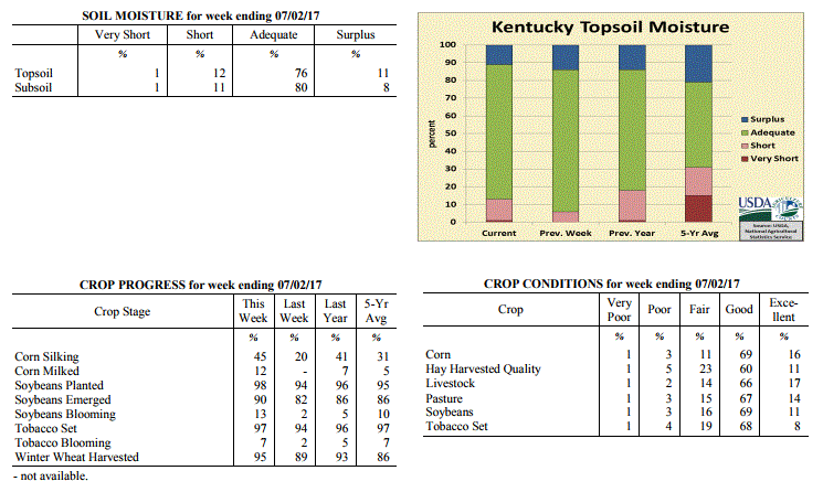 Kentucky Climate Summary
For the Period June 26 to July 2, 2017
Below Normal Temperatures and Rainfall:
The period opened up with unseasonably cool temperatures and low humidity in place
behind a departing cold front. A dry northwest flow kept high temperatures down in
the middle to upper 70s both Monday and Tuesday. This pattern was short-lived as
high pressure shifted to the east on Wednesday, turning winds to the south.
Temperatures and humidity gradually increased across the area, returning to more
seasonable norms. After a mostly dry first half of the period, showers and storms
returned on a daily basis between Thursday and Sunday, ending with the passage of a
cold front. Even with the unsettled pattern in place, rainfall coverage and
accumulations were lacking. The state ended the week over a half inch below normal on
average.
Temperatures for the period averaged 72 degrees across the state which was 3 degrees
cooler than normal and no change to the previous period. High temperatures averaged
from 84 in the West to 81 in the East. Departure from normal high temperatures
ranged from 4 degrees cooler than normal in the West to 4 degrees cooler than normal
in the East. Low temperatures averaged from 64 degrees in the West to 60 degrees in
the East. Departure from normal low temperature ranged from 2 degrees cooler than
normal in the West to 1 degree cooler than normal in the East. The extreme high
temperature for the period was 92 degrees at PADUCAH ASOS and the extreme low was 46
degrees at PAINTSVILLE 4W.
Precipitation (liq. equ.) for the period totaled 0.40 inches statewide which was 0.58
inches below normal and 41% of normal. Precipitation totals by climate division, West
0.54 inches, Central 0.67 inches, Bluegrass 0.24 inches and East 0.13 inches, which
was 0.44, 0.3, 0.73 and 0.89 inches below normal. By station, precipitation totals
ranged from a low of 0.00 inches at BIG SANDY to a high of 2.04 inches at ELKTON 5SW.
---
Kentucky Crop and Weather Report
Issued 4:00 P.M., June 26, 2017 17-17
Agricultural News: Kentucky experienced below normal temperatures and much above
normal rainfall over the past week. Precipitation for the week totaled 2.32 inches,
1.30 inches above normal. Temperatures averaged 73 degrees for the week, 1 degree
below normal. Topsoil moisture was rated 6 percent short, 80 percent adequate and 14
percent surplus. Subsoil moisture was rated 7 percent short, 83 percent adequate, and
10 percent surplus. Days suitable for fieldwork averaged 4.7 out of a possible seven.
Extremely wet conditions returned to the Bluegrass State as the remnants of Tropical
Storm Cindy and a cold front interacted with one another over the latter half of the
workweek. The state saw a couple rounds of widespread showers and storms, the first
coming on Thursday and the other Friday. With abundant moisture in place, torrential
downpours were common across the area. This led to numerous reports of flash
flooding and creeks/streams on the rise, more so on Friday. Overall, much of the
state saw over an inch for the week, but some areas in the Bluegrass hardest hit by
flooding received in upwards of 2 to 3 inches. Just like earlier in the
workweek, the passing cold front signaled the start of a cooler, less humid,
and dry pattern for the weekend.
Primary activities this week included harvesting wheat, planting soybeans, cutting
hay, and scouting fields for pests and diseases. Heavy rain towards the end of the
week from Tropical Storm Cindy delayed fieldwork, with reports of flash flooding and
crop damage. Producers are monitoring crop conditions to determine if any replanting
is needed. The average height of emerged soybeans was 6 inches. The average height of
tobacco in the field was 14 inches, compared to 10 inches last week and 12 inches last
year at this time.
Kentucky Climate Summary
For the Period June 26 to July 2, 2017
Below Normal Temperatures and Rainfall:
The period opened up with unseasonably cool temperatures and low humidity in place
behind a departing cold front. A dry northwest flow kept high temperatures down in
the middle to upper 70s both Monday and Tuesday. This pattern was short-lived as
high pressure shifted to the east on Wednesday, turning winds to the south.
Temperatures and humidity gradually increased across the area, returning to more
seasonable norms. After a mostly dry first half of the period, showers and storms
returned on a daily basis between Thursday and Sunday, ending with the passage of a
cold front. Even with the unsettled pattern in place, rainfall coverage and
accumulations were lacking. The state ended the week over a half inch below normal on
average.
Temperatures for the period averaged 72 degrees across the state which was 3 degrees
cooler than normal and no change to the previous period. High temperatures averaged
from 84 in the West to 81 in the East. Departure from normal high temperatures
ranged from 4 degrees cooler than normal in the West to 4 degrees cooler than normal
in the East. Low temperatures averaged from 64 degrees in the West to 60 degrees in
the East. Departure from normal low temperature ranged from 2 degrees cooler than
normal in the West to 1 degree cooler than normal in the East. The extreme high
temperature for the period was 92 degrees at PADUCAH ASOS and the extreme low was 46
degrees at PAINTSVILLE 4W.
Precipitation (liq. equ.) for the period totaled 0.40 inches statewide which was 0.58
inches below normal and 41% of normal. Precipitation totals by climate division, West
0.54 inches, Central 0.67 inches, Bluegrass 0.24 inches and East 0.13 inches, which
was 0.44, 0.3, 0.73 and 0.89 inches below normal. By station, precipitation totals
ranged from a low of 0.00 inches at BIG SANDY to a high of 2.04 inches at ELKTON 5SW.
---
Kentucky Crop and Weather Report
Issued 4:00 P.M., June 26, 2017 17-17
Agricultural News: Kentucky experienced below normal temperatures and much above
normal rainfall over the past week. Precipitation for the week totaled 2.32 inches,
1.30 inches above normal. Temperatures averaged 73 degrees for the week, 1 degree
below normal. Topsoil moisture was rated 6 percent short, 80 percent adequate and 14
percent surplus. Subsoil moisture was rated 7 percent short, 83 percent adequate, and
10 percent surplus. Days suitable for fieldwork averaged 4.7 out of a possible seven.
Extremely wet conditions returned to the Bluegrass State as the remnants of Tropical
Storm Cindy and a cold front interacted with one another over the latter half of the
workweek. The state saw a couple rounds of widespread showers and storms, the first
coming on Thursday and the other Friday. With abundant moisture in place, torrential
downpours were common across the area. This led to numerous reports of flash
flooding and creeks/streams on the rise, more so on Friday. Overall, much of the
state saw over an inch for the week, but some areas in the Bluegrass hardest hit by
flooding received in upwards of 2 to 3 inches. Just like earlier in the
workweek, the passing cold front signaled the start of a cooler, less humid,
and dry pattern for the weekend.
Primary activities this week included harvesting wheat, planting soybeans, cutting
hay, and scouting fields for pests and diseases. Heavy rain towards the end of the
week from Tropical Storm Cindy delayed fieldwork, with reports of flash flooding and
crop damage. Producers are monitoring crop conditions to determine if any replanting
is needed. The average height of emerged soybeans was 6 inches. The average height of
tobacco in the field was 14 inches, compared to 10 inches last week and 12 inches last
year at this time.
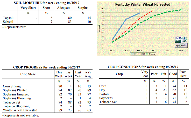 Kentucky Climate Summary
For the Period June 19 to June 25, 2017
Below Normal Temperatures and Much Above Normal Rainfall:
Extremely wet conditions returned to the Bluegrass State as the remnants of Tropical
Storm Cindy and a cold front interacted with one another over the latter half of the
workweek. The state saw a couple rounds of widespread showers and storms, the first
coming on Thursday and the other Friday. With abundant moisture in place, torrential
downpours were common across the area. This led to numerous reports of flash
flooding and creeks/streams on the rise, more so on Friday. Overall, much of the
state saw over an inch for the week, but some areas in the Bluegrass hardest hit by
flooding received in upwards of 2 to 3 inches. Just like earlier in the
workweek, the passing cold front signaled the start of a cooler, less humid,
and dry pattern for the weekend.
Temperatures for the period averaged 73 degrees across the state which was 1 degree
cooler than normal and 4 degrees cooler than the previous period. High temperatures
averaged from 84 in the West to 80 in the East. Departure from normal high
temperatures ranged from 3 degrees cooler than normal in the West to 4 degrees
cooler than normal in the East. Low temperatures averaged from 65 degrees in the
West to 64 degrees in the East. Departure from normal low temperature ranged from
near normal in the West to 4 degrees warmer than normal in the East. The
extreme high temperature for the period was 93 degrees at LOUISVILLE APT and the
extreme low was 51 degrees at CINCINNATI.
Precipitation (liq. equ.) for the period totaled 2.32 inches statewide which was 1.3
inches above normal and 229% of normal. Precipitation totals by climate division,
West 1.77 inches, Central 2.46 inches, Bluegrass 3.01 inches and East 2.05 inches,
which was 0.76, 1.45, 2 and 1.02 inches above normal. By station, precipitation
totals ranged from a low of 0.08 inches at YELLOW CREEK to a high of 4.94
inches at ELIZABETHTOWN 8W.
---
Kentucky Crop and Weather Report
Issued 4:00 P.M., June 19, 2017 16-17
Agricultural News: Kentucky experienced above normal temperatures and rainfall over
the past week. Precipitation for the week totaled 1.41 inches, 0.40 inches above
normal. Temperatures averaged 77 degrees for the week, 4 degrees above normal.
Topsoil moisture was rated 1 percent very short, 10 percent short, 81 percent
adequate and 8 percent surplus. Subsoil moisture was rated 1 percent very short, 10
percent short, 83 percent adequate, and 6 percent surplus. Days suitable for
fieldwork averaged 5.2 out of a possible seven.
Primary activities this week included harvesting wheat, cutting hay, planting
soybeans and tobacco, and scouting crops. Spotty showers and rainfall events led to
some reports of local flooding in low-lying fields and delayed fieldwork
periodically. Precipitation has helped to green-up pastures and hay fields. The first
cutting of hay is finishing up in most areas. The average height of emerged corn was
38 inches, compared to 37 inches last year. The average height of tobacco in the
field was 10 inches, compared to 9 inches last year.
Some disease and insect pressure has been reported in fruit and vegetable crops.
Livestock heat stress was of concern this week due to high temperatures and humidity.
Kentucky Climate Summary
For the Period June 19 to June 25, 2017
Below Normal Temperatures and Much Above Normal Rainfall:
Extremely wet conditions returned to the Bluegrass State as the remnants of Tropical
Storm Cindy and a cold front interacted with one another over the latter half of the
workweek. The state saw a couple rounds of widespread showers and storms, the first
coming on Thursday and the other Friday. With abundant moisture in place, torrential
downpours were common across the area. This led to numerous reports of flash
flooding and creeks/streams on the rise, more so on Friday. Overall, much of the
state saw over an inch for the week, but some areas in the Bluegrass hardest hit by
flooding received in upwards of 2 to 3 inches. Just like earlier in the
workweek, the passing cold front signaled the start of a cooler, less humid,
and dry pattern for the weekend.
Temperatures for the period averaged 73 degrees across the state which was 1 degree
cooler than normal and 4 degrees cooler than the previous period. High temperatures
averaged from 84 in the West to 80 in the East. Departure from normal high
temperatures ranged from 3 degrees cooler than normal in the West to 4 degrees
cooler than normal in the East. Low temperatures averaged from 65 degrees in the
West to 64 degrees in the East. Departure from normal low temperature ranged from
near normal in the West to 4 degrees warmer than normal in the East. The
extreme high temperature for the period was 93 degrees at LOUISVILLE APT and the
extreme low was 51 degrees at CINCINNATI.
Precipitation (liq. equ.) for the period totaled 2.32 inches statewide which was 1.3
inches above normal and 229% of normal. Precipitation totals by climate division,
West 1.77 inches, Central 2.46 inches, Bluegrass 3.01 inches and East 2.05 inches,
which was 0.76, 1.45, 2 and 1.02 inches above normal. By station, precipitation
totals ranged from a low of 0.08 inches at YELLOW CREEK to a high of 4.94
inches at ELIZABETHTOWN 8W.
---
Kentucky Crop and Weather Report
Issued 4:00 P.M., June 19, 2017 16-17
Agricultural News: Kentucky experienced above normal temperatures and rainfall over
the past week. Precipitation for the week totaled 1.41 inches, 0.40 inches above
normal. Temperatures averaged 77 degrees for the week, 4 degrees above normal.
Topsoil moisture was rated 1 percent very short, 10 percent short, 81 percent
adequate and 8 percent surplus. Subsoil moisture was rated 1 percent very short, 10
percent short, 83 percent adequate, and 6 percent surplus. Days suitable for
fieldwork averaged 5.2 out of a possible seven.
Primary activities this week included harvesting wheat, cutting hay, planting
soybeans and tobacco, and scouting crops. Spotty showers and rainfall events led to
some reports of local flooding in low-lying fields and delayed fieldwork
periodically. Precipitation has helped to green-up pastures and hay fields. The first
cutting of hay is finishing up in most areas. The average height of emerged corn was
38 inches, compared to 37 inches last year. The average height of tobacco in the
field was 10 inches, compared to 9 inches last year.
Some disease and insect pressure has been reported in fruit and vegetable crops.
Livestock heat stress was of concern this week due to high temperatures and humidity.
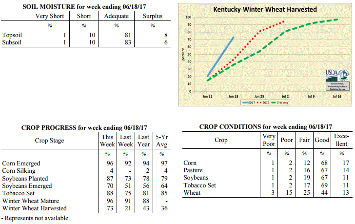 Kentucky Climate Summary
For the Period June 12 to June 18, 2017
Above Normal Temperatures and Rainfall:
The Commonwealth saw an early start to summer as heat, humidity, and an unsettled
pattern returned to the area. Highs consistently rose into the middle 80s to low 90s
throughout the week. Combined with high humidity, heat indices increased well into
the 90s. This pushed the livestock heat stress index into the danger category
through the afternoon and early evening hours each day. With the heat and humidity in
place, an unstable air mass developed almost each day of the week, leading to
isolated to scattered storms. Even numerous coverage on Sunday. The very moist air
led to torrential rainfall from time to time. Overall, the state averaged well over an
inch for the week, just short of a half inch above normal.
Temperatures for the period averaged 77 degrees across the state which was 4 degrees
warmer than normal and 10 degrees warmer than the previous period. High temperatures
averaged from 88 in the West to 86 in the East. Departure from normal high
temperatures ranged from 2 degrees warmer than normal in the West to 3 degrees
warmer than normal in the East. Low temperatures averaged from 69 degrees in the
West to 66 degrees in the East. Departure from normal low temperature ranged from 6
degrees warmer than normal in the West to 7 degrees warmer than normal in the East.
The extreme high temperature for the period was 94 degrees at LOUISVILLE APT and
the extreme low was 60 degrees at PAINTSVILLE 4W.
Precipitation (liq. equ.) for the period totaled 1.41 inches statewide which was 0.4
inches above normal and 140% of normal. Precipitation totals by climate division,
West 1.43 inches, Central 1.14 inches, Bluegrass 1.59 inches and East 1.46 inches,
which was 0.46, 0.13, 0.57 and 0.43 inches above normal. By station, precipitation
totals ranged from a low of 0.16 inches at WHITESBURG 2NW to a high of 3.62
inches at FRANKFORT 7S.
---
Kentucky Crop and Weather Report
Issued 4:00 P.M., June 12, 2017 15-17
Agricultural News: Kentucky experienced below normal temperatures and rainfall over
the past week. Precipitation for the week totaled 0.91 inches, 0.16 inches below
normal. Temperatures averaged 68 degrees for the week, 3 degrees below normal.
Topsoil moisture was rated 1 percent very short, 14 percent short, 77 percent
adequate and 8 percent surplus. Subsoil moisture was rated 1 percent very short, 10
percent short, 80 percent adequate, and 9 percent surplus. Days suitable for
fieldwork averaged 5.5 out of a possible seven.
The week started out with a very moist air mass in place. Showers and storms
progressed through the area over the course of Monday, ending with the passage of a
cold front. For much of the state, this was the only rainfall for the week. Following
the cold front, much cooler and less humid air pushed into Kentucky for the next few
days. Most stayed in the 70s, but some in the Bluegrass only saw highs in the 60s on
Wednesday. Other than some very light showers across the Bluegrass and Eastern
Kentucky, most remained dry. The dry stretch continued into the weekend, but with
southerly flow in place, temperatures rose each day. By Sunday, highs were once again
in the middle to upper 80s.
Primary activities this week included harvesting wheat, and planting soybeans and
tobacco. Some soybean fields continue to be replanted due to damage from slugs and
heavy rainfall events earlier in the season. Prevailing dry conditions allowed
farmers to cut and bale hay during the week. Double crop soybean planting has started
as winter wheat begins to be removed from fields. The average height of emerged corn
was 23 inches, compared to 24 inches last year. The tobacco crop is rated in mostly
good condition. The average height of tobacco in the field was 6 inches.
Kentucky Climate Summary
For the Period June 12 to June 18, 2017
Above Normal Temperatures and Rainfall:
The Commonwealth saw an early start to summer as heat, humidity, and an unsettled
pattern returned to the area. Highs consistently rose into the middle 80s to low 90s
throughout the week. Combined with high humidity, heat indices increased well into
the 90s. This pushed the livestock heat stress index into the danger category
through the afternoon and early evening hours each day. With the heat and humidity in
place, an unstable air mass developed almost each day of the week, leading to
isolated to scattered storms. Even numerous coverage on Sunday. The very moist air
led to torrential rainfall from time to time. Overall, the state averaged well over an
inch for the week, just short of a half inch above normal.
Temperatures for the period averaged 77 degrees across the state which was 4 degrees
warmer than normal and 10 degrees warmer than the previous period. High temperatures
averaged from 88 in the West to 86 in the East. Departure from normal high
temperatures ranged from 2 degrees warmer than normal in the West to 3 degrees
warmer than normal in the East. Low temperatures averaged from 69 degrees in the
West to 66 degrees in the East. Departure from normal low temperature ranged from 6
degrees warmer than normal in the West to 7 degrees warmer than normal in the East.
The extreme high temperature for the period was 94 degrees at LOUISVILLE APT and
the extreme low was 60 degrees at PAINTSVILLE 4W.
Precipitation (liq. equ.) for the period totaled 1.41 inches statewide which was 0.4
inches above normal and 140% of normal. Precipitation totals by climate division,
West 1.43 inches, Central 1.14 inches, Bluegrass 1.59 inches and East 1.46 inches,
which was 0.46, 0.13, 0.57 and 0.43 inches above normal. By station, precipitation
totals ranged from a low of 0.16 inches at WHITESBURG 2NW to a high of 3.62
inches at FRANKFORT 7S.
---
Kentucky Crop and Weather Report
Issued 4:00 P.M., June 12, 2017 15-17
Agricultural News: Kentucky experienced below normal temperatures and rainfall over
the past week. Precipitation for the week totaled 0.91 inches, 0.16 inches below
normal. Temperatures averaged 68 degrees for the week, 3 degrees below normal.
Topsoil moisture was rated 1 percent very short, 14 percent short, 77 percent
adequate and 8 percent surplus. Subsoil moisture was rated 1 percent very short, 10
percent short, 80 percent adequate, and 9 percent surplus. Days suitable for
fieldwork averaged 5.5 out of a possible seven.
The week started out with a very moist air mass in place. Showers and storms
progressed through the area over the course of Monday, ending with the passage of a
cold front. For much of the state, this was the only rainfall for the week. Following
the cold front, much cooler and less humid air pushed into Kentucky for the next few
days. Most stayed in the 70s, but some in the Bluegrass only saw highs in the 60s on
Wednesday. Other than some very light showers across the Bluegrass and Eastern
Kentucky, most remained dry. The dry stretch continued into the weekend, but with
southerly flow in place, temperatures rose each day. By Sunday, highs were once again
in the middle to upper 80s.
Primary activities this week included harvesting wheat, and planting soybeans and
tobacco. Some soybean fields continue to be replanted due to damage from slugs and
heavy rainfall events earlier in the season. Prevailing dry conditions allowed
farmers to cut and bale hay during the week. Double crop soybean planting has started
as winter wheat begins to be removed from fields. The average height of emerged corn
was 23 inches, compared to 24 inches last year. The tobacco crop is rated in mostly
good condition. The average height of tobacco in the field was 6 inches.
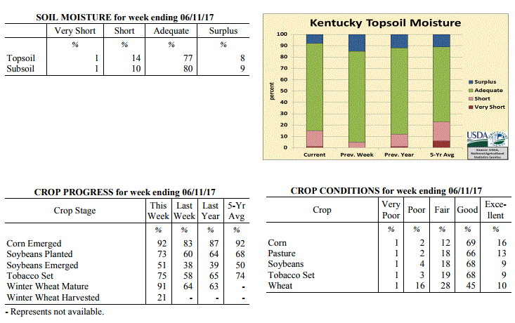 Kentucky Climate Summary
For the Period June 5 to June 11, 2017
Below Normal Temperatures and Rainfall:
The week started out with a very moist air mass in place. Showers and storms
progressed through the area over the course of Monday, ending with the passage of a
cold front. For much of the state, this was the only rainfall for the week. Following
the cold front, much cooler and less humid air pushed into Kentucky for the next few
days. Most stayed in the 70s, but some in the Bluegrass only saw highs in the 60s on
Wednesday. Other than some very light showers across the Bluegrass and Eastern
Kentucky, most remained dry. The dry stretch continued into the weekend, but with
southerly flow in place, temperatures rose each day. By Sunday, highs were once again
in the middle to upper 80s.
Temperatures for the period averaged 68 degrees across the state which was 3 degrees
cooler than normal and 2 degrees cooler than the previous period. High temperatures
averaged from 81 in the West to 77 in the East. Departure from normal high
temperatures ranged from 3 degrees cooler than normal in the West to 5 degrees
cooler than normal in the East. Low temperatures averaged from 60 degrees in the
West to 57 degrees in the East. Departure from normal low temperature ranged from 2
degrees cooler than normal in the West to near normal in the East. The
extreme high temperature for the period was 91 degrees at CAPE GIRARDEAU ASOS and the
extreme low was 47 degrees at OWINGSVILLE 4S.
Precipitation (liq. equ.) for the period totaled 0.91 inches statewide which was 0.16
inches below normal and 85% of normal. Precipitation totals by climate division, West
1.13 inches, Central 1.09 inches, Bluegrass 0.45 inches and East 0.98 inches, which
was 0.11, 0.01, -0.64 and -0.09 inches respectively from normal. By station,
precipitation totals ranged from a low of 0.05 inches at HICKMAN 2E to a high of 3.96
inches at FORT CAMPBELL.
---
Kentucky Crop and Weather Report
Issued 4:00 P.M., June 5, 2017 14-17
Agricultural News: Kentucky experienced above normal temperatures and below normal
rainfall over the past week. Precipitation for the week totaled 0.32 inches, 0.78
inches below normal. Temperatures averaged 70 degrees for the week, 1 degree above
normal. Topsoil moisture was rated 5 percent short, 80 percent adequate and 15
percent surplus. Subsoil moisture was rated 1 percent very short, 4 percent short, 82
percent adequate, and 13 percent surplus. Days suitable for fieldwork averaged 5.3
out of a possible seven.
Primary activities this week included planting corn and soybeans, and setting
tobacco. Corn planting is nearing completion for the season. Other activities
included sidedressing corn with nitrogen and spraying fields. The average height of
emerged corn was 16 inches, compared to 9 inches last week.
Weather conditions were favorable this week, providing an opportunity to harvest and
bale hay. Some earlier planted soybeans are being replanted in fields that were
severely damaged by excessive rainfall and slugs. Producers continue to monitor wheat
conditions and test weights in preparation for harvest.
Kentucky Climate Summary
For the Period June 5 to June 11, 2017
Below Normal Temperatures and Rainfall:
The week started out with a very moist air mass in place. Showers and storms
progressed through the area over the course of Monday, ending with the passage of a
cold front. For much of the state, this was the only rainfall for the week. Following
the cold front, much cooler and less humid air pushed into Kentucky for the next few
days. Most stayed in the 70s, but some in the Bluegrass only saw highs in the 60s on
Wednesday. Other than some very light showers across the Bluegrass and Eastern
Kentucky, most remained dry. The dry stretch continued into the weekend, but with
southerly flow in place, temperatures rose each day. By Sunday, highs were once again
in the middle to upper 80s.
Temperatures for the period averaged 68 degrees across the state which was 3 degrees
cooler than normal and 2 degrees cooler than the previous period. High temperatures
averaged from 81 in the West to 77 in the East. Departure from normal high
temperatures ranged from 3 degrees cooler than normal in the West to 5 degrees
cooler than normal in the East. Low temperatures averaged from 60 degrees in the
West to 57 degrees in the East. Departure from normal low temperature ranged from 2
degrees cooler than normal in the West to near normal in the East. The
extreme high temperature for the period was 91 degrees at CAPE GIRARDEAU ASOS and the
extreme low was 47 degrees at OWINGSVILLE 4S.
Precipitation (liq. equ.) for the period totaled 0.91 inches statewide which was 0.16
inches below normal and 85% of normal. Precipitation totals by climate division, West
1.13 inches, Central 1.09 inches, Bluegrass 0.45 inches and East 0.98 inches, which
was 0.11, 0.01, -0.64 and -0.09 inches respectively from normal. By station,
precipitation totals ranged from a low of 0.05 inches at HICKMAN 2E to a high of 3.96
inches at FORT CAMPBELL.
---
Kentucky Crop and Weather Report
Issued 4:00 P.M., June 5, 2017 14-17
Agricultural News: Kentucky experienced above normal temperatures and below normal
rainfall over the past week. Precipitation for the week totaled 0.32 inches, 0.78
inches below normal. Temperatures averaged 70 degrees for the week, 1 degree above
normal. Topsoil moisture was rated 5 percent short, 80 percent adequate and 15
percent surplus. Subsoil moisture was rated 1 percent very short, 4 percent short, 82
percent adequate, and 13 percent surplus. Days suitable for fieldwork averaged 5.3
out of a possible seven.
Primary activities this week included planting corn and soybeans, and setting
tobacco. Corn planting is nearing completion for the season. Other activities
included sidedressing corn with nitrogen and spraying fields. The average height of
emerged corn was 16 inches, compared to 9 inches last week.
Weather conditions were favorable this week, providing an opportunity to harvest and
bale hay. Some earlier planted soybeans are being replanted in fields that were
severely damaged by excessive rainfall and slugs. Producers continue to monitor wheat
conditions and test weights in preparation for harvest.
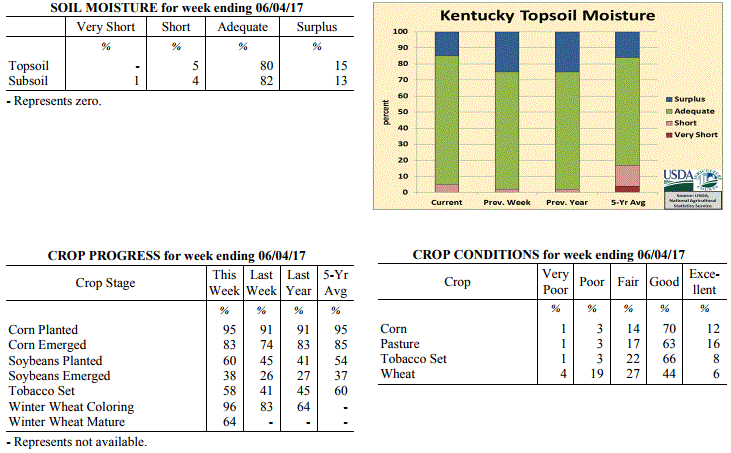 Kentucky Climate Summary
For the Period May 29 to June 4, 2017
Above Normal Temperatures and Below Normal Rainfall:
The Bluegrass State averaged slightly under a third of an inch this past week, which
marked one of the driest weeks the state has seen in quite a while. In fact,
according to data with the UK Ag Weather Center, the second week of February was the
last time there was a lower average. Until Sunday, rainfall coverage was fairly low
each day throughout the week. Most remained dry more times than not. Sunday brought
more coverage, mainly across the western and south-central Kentucky, as more moisture
streamed into the area. While the week ended on the dry side, temperatures mostly
stayed in the 80s throughout the week, finishing slightly above normal.
Temperatures for the period averaged 70 degrees across the state which was 1 degree
warmer than normal and 4 degrees warmer than the previous period. High temperatures
averaged from 84 in the West to 81 in the East. Departure from normal high
temperatures ranged from 2 degrees warmer than normal in the West to 1 degree
warmer than normal in the East. Low temperatures averaged from 62 degrees in the
West to 57 degrees in the East. Departure from normal low temperature ranged from 2
degrees warmer than normal in the West to 2 degrees warmer than normal in the East.
The extreme high temperature for the period was 90 degrees at LOUISVILLE APT and the
extreme low was 47 degrees at VANCEBURG 6W.
Precipitation (liq. equ.) for the period totaled 0.32 inches statewide which was 0.78
inches below normal and 29% of normal. Precipitation totals by climate division, West
0.49 inches, Central 0.43 inches, Bluegrass 0.13 inches and East 0.22 inches, which
was 0.59, 0.71, 0.95 and 0.89 inches below normal. By station, precipitation totals
ranged from a low of 0.00 inches at BRANDENBURG 4SW to a high of 2.29 inches at
BOWLING GREEN APT.
---
Kentucky Crop and Weather Report
Issued 4:00 P.M., May 30, 2017 13-17
Agricultural News: Kentucky experienced below normal temperatures and above normal
rainfall over the past week. Precipitation for the week totaled 1.88 inches, 0.77
inches above normal. Temperatures averaged 66 degrees for the week, 1 degree below
normal. Topsoil moisture was rated 2 percent short, 73 percent adequate and 25
percent surplus. Subsoil moisture was rated 2 percent short, 80 percent adequate, and
18 percent surplus. Days suitable for fieldwork averaged 3.8 out of a possible seven.
Storms and heavy rain led to delays in fieldwork this week and caused damage, with
some reports of lodging in wheat. When weather conditions permitted, primary
activities included planting corn and soybeans, and transplanting tobacco. Continued
wet conditions have producers concerned for controlling weeds and pests. The average
height of emerged corn was 9 inches.
During dry stretches producers were able to cut hay. Hay and roughage supplies were
reported as 2 percent very short, 9 percent short, 78 percent adequate, and 11
percent surplus. Spring breeding of cattle is also underway.
Kentucky Climate Summary
For the Period May 29 to June 4, 2017
Above Normal Temperatures and Below Normal Rainfall:
The Bluegrass State averaged slightly under a third of an inch this past week, which
marked one of the driest weeks the state has seen in quite a while. In fact,
according to data with the UK Ag Weather Center, the second week of February was the
last time there was a lower average. Until Sunday, rainfall coverage was fairly low
each day throughout the week. Most remained dry more times than not. Sunday brought
more coverage, mainly across the western and south-central Kentucky, as more moisture
streamed into the area. While the week ended on the dry side, temperatures mostly
stayed in the 80s throughout the week, finishing slightly above normal.
Temperatures for the period averaged 70 degrees across the state which was 1 degree
warmer than normal and 4 degrees warmer than the previous period. High temperatures
averaged from 84 in the West to 81 in the East. Departure from normal high
temperatures ranged from 2 degrees warmer than normal in the West to 1 degree
warmer than normal in the East. Low temperatures averaged from 62 degrees in the
West to 57 degrees in the East. Departure from normal low temperature ranged from 2
degrees warmer than normal in the West to 2 degrees warmer than normal in the East.
The extreme high temperature for the period was 90 degrees at LOUISVILLE APT and the
extreme low was 47 degrees at VANCEBURG 6W.
Precipitation (liq. equ.) for the period totaled 0.32 inches statewide which was 0.78
inches below normal and 29% of normal. Precipitation totals by climate division, West
0.49 inches, Central 0.43 inches, Bluegrass 0.13 inches and East 0.22 inches, which
was 0.59, 0.71, 0.95 and 0.89 inches below normal. By station, precipitation totals
ranged from a low of 0.00 inches at BRANDENBURG 4SW to a high of 2.29 inches at
BOWLING GREEN APT.
---
Kentucky Crop and Weather Report
Issued 4:00 P.M., May 30, 2017 13-17
Agricultural News: Kentucky experienced below normal temperatures and above normal
rainfall over the past week. Precipitation for the week totaled 1.88 inches, 0.77
inches above normal. Temperatures averaged 66 degrees for the week, 1 degree below
normal. Topsoil moisture was rated 2 percent short, 73 percent adequate and 25
percent surplus. Subsoil moisture was rated 2 percent short, 80 percent adequate, and
18 percent surplus. Days suitable for fieldwork averaged 3.8 out of a possible seven.
Storms and heavy rain led to delays in fieldwork this week and caused damage, with
some reports of lodging in wheat. When weather conditions permitted, primary
activities included planting corn and soybeans, and transplanting tobacco. Continued
wet conditions have producers concerned for controlling weeds and pests. The average
height of emerged corn was 9 inches.
During dry stretches producers were able to cut hay. Hay and roughage supplies were
reported as 2 percent very short, 9 percent short, 78 percent adequate, and 11
percent surplus. Spring breeding of cattle is also underway.
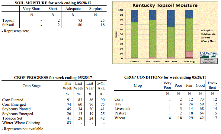 Kentucky Climate Summary
For the Period May 22 to May 28, 2017
Below Normal Temperatures and Above Normal Rainfall:
An active pattern once again led to multiple rounds of showers and storms throughout
the week. The state averaged 1.88 inches, which was about three quarters of an inch
above normal. This added to an already wet May, where Central/Eastern Kentucky and
the Bluegrass have all averaged over 6 inches. Showers and storms were most widespread
both Wednesday and Saturday with a couple passing low-pressure systems. With a very
moist air mass in place, storms were very efficient rainfall producers, leading to
flash flooding at times. The very unstable air mass on Saturday also produced
numerous strong to severe storms with some producing damaging winds and large hail.
With the active pattern in place, cloud cover and precipitation kept temperatures on
the low side for most of the week leading to the second week in May with below normal
temperatures.
Temperatures for the period averaged 66 degrees across the state which was 1 degree
cooler than normal and 8 degrees cooler than the previous period. High temperatures
averaged from 76 in the West to 72 in the East. Departure from normal high
temperatures ranged from 4 degrees cooler than normal in the West to 7 degrees cooler
than normal in the East. Low temperatures averaged from 58 degrees in the West to 58
degrees in the East. Departure from normal low temperature ranged from near normal
in the West to 5 degrees warmer than normal in the East. The extreme high temperature
for the period was 88 degrees at EVANSVILLE ASOS and the extreme low was 46 degrees at
MONTICELLO AWOS.
Precipitation (liq. equ.) for the period totaled 1.88 inches statewide which was 0.77
inches above normal and 169% of normal. Precipitation totals by climate division,
West 1.56 inches, Central 1.90 inches, Bluegrass 1.80 inches and East 2.25 inches,
which was 0.46, 0.74, 0.73 and 1.13 inches above normal. By station, precipitation
totals ranged from a low of 0.53 inches at CAPE GIRARDEAU ASOS to a high of 4.58
inches at SOMERSET.
---
Kentucky Crop and Weather Report
Issued 4:00 P.M., May 22, 2017 12-17
Agricultural News: Kentucky experienced well above normal temperatures and above
normal rainfall over the past week. Precipitation for the week totaled 1.31 inches,
0.18 inches above normal. Temperatures averaged 74 degrees for the week, 9 degrees
above normal. Topsoil moisture was rated 3 percent short, 77 percent adequate and 20
percent surplus. Subsoil moisture was rated 3 percent short, 82 percent adequate, and
15 percent surplus. Days suitable for fieldwork averaged 5.3 out of a possible seven.
While it was the middle of May, it felt more like summer for much of the week as warm
and muggy conditions returned to the Bluegrass State. Until the last day of the
period, each day saw highs rise into the 80s for much of the area. Normal
temperatures for this time of the year are in the middle to upper 70s. Depending on
location, the period started with 3 to 4 days of mostly clear and dry conditions, but
showers and storms returned for the latter half of the week. Starting Wednesday
night, several rounds of scattered storms pushed across Kentucky through Sunday. Just
like previous weeks, storms were capable of very heavy rain from time to time, along
with intense lightning. Even with a few days of dry weather, most of the state still
averaged over an inch for the week.
Farmers were able to make some progress in the fields thanks to several days of warm
temperatures and dry weather early in the week. The dry weather gave way to heavy
rain towards the end of the week. Primary activities for the week included planting
of corn, soybeans, and tobacco along with hay cutting. Producers expect good hay
yields in most areas, however there were reports of low yields for first cuttings as
well.
Kentucky Climate Summary
For the Period May 22 to May 28, 2017
Below Normal Temperatures and Above Normal Rainfall:
An active pattern once again led to multiple rounds of showers and storms throughout
the week. The state averaged 1.88 inches, which was about three quarters of an inch
above normal. This added to an already wet May, where Central/Eastern Kentucky and
the Bluegrass have all averaged over 6 inches. Showers and storms were most widespread
both Wednesday and Saturday with a couple passing low-pressure systems. With a very
moist air mass in place, storms were very efficient rainfall producers, leading to
flash flooding at times. The very unstable air mass on Saturday also produced
numerous strong to severe storms with some producing damaging winds and large hail.
With the active pattern in place, cloud cover and precipitation kept temperatures on
the low side for most of the week leading to the second week in May with below normal
temperatures.
Temperatures for the period averaged 66 degrees across the state which was 1 degree
cooler than normal and 8 degrees cooler than the previous period. High temperatures
averaged from 76 in the West to 72 in the East. Departure from normal high
temperatures ranged from 4 degrees cooler than normal in the West to 7 degrees cooler
than normal in the East. Low temperatures averaged from 58 degrees in the West to 58
degrees in the East. Departure from normal low temperature ranged from near normal
in the West to 5 degrees warmer than normal in the East. The extreme high temperature
for the period was 88 degrees at EVANSVILLE ASOS and the extreme low was 46 degrees at
MONTICELLO AWOS.
Precipitation (liq. equ.) for the period totaled 1.88 inches statewide which was 0.77
inches above normal and 169% of normal. Precipitation totals by climate division,
West 1.56 inches, Central 1.90 inches, Bluegrass 1.80 inches and East 2.25 inches,
which was 0.46, 0.74, 0.73 and 1.13 inches above normal. By station, precipitation
totals ranged from a low of 0.53 inches at CAPE GIRARDEAU ASOS to a high of 4.58
inches at SOMERSET.
---
Kentucky Crop and Weather Report
Issued 4:00 P.M., May 22, 2017 12-17
Agricultural News: Kentucky experienced well above normal temperatures and above
normal rainfall over the past week. Precipitation for the week totaled 1.31 inches,
0.18 inches above normal. Temperatures averaged 74 degrees for the week, 9 degrees
above normal. Topsoil moisture was rated 3 percent short, 77 percent adequate and 20
percent surplus. Subsoil moisture was rated 3 percent short, 82 percent adequate, and
15 percent surplus. Days suitable for fieldwork averaged 5.3 out of a possible seven.
While it was the middle of May, it felt more like summer for much of the week as warm
and muggy conditions returned to the Bluegrass State. Until the last day of the
period, each day saw highs rise into the 80s for much of the area. Normal
temperatures for this time of the year are in the middle to upper 70s. Depending on
location, the period started with 3 to 4 days of mostly clear and dry conditions, but
showers and storms returned for the latter half of the week. Starting Wednesday
night, several rounds of scattered storms pushed across Kentucky through Sunday. Just
like previous weeks, storms were capable of very heavy rain from time to time, along
with intense lightning. Even with a few days of dry weather, most of the state still
averaged over an inch for the week.
Farmers were able to make some progress in the fields thanks to several days of warm
temperatures and dry weather early in the week. The dry weather gave way to heavy
rain towards the end of the week. Primary activities for the week included planting
of corn, soybeans, and tobacco along with hay cutting. Producers expect good hay
yields in most areas, however there were reports of low yields for first cuttings as
well.
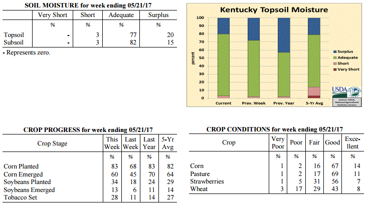 Kentucky Climate Summary
For the Period May 15 to May 21, 2017
Well Above Normal Temperatures and Above Normal Rainfall:
While it was the middle of May, it felt more like summer for much of the week as warm
and muggy conditions returned to the Bluegrass State. Until the last day of the
period, each day saw highs rise into the 80s for much of the area. Normal
temperatures for this time of the year are in the middle to upper 70s. Depending on
location, the period started with 3 to 4 days of mostly clear and dry conditions, but
showers and storms returned for the latter half of the week. Starting Wednesday
night, several rounds of scattered storms pushed across Kentucky through Sunday. Just
like previous weeks, storms were capable of very heavy rain from time to time, along
with intense lightning. Even with a few days of dry weather, most of the state still
averaged over an inch for the week.
Temperatures for the period averaged 74 degrees across the state which was 9 degrees
warmer than normal and 10 degrees warmer than the previous period. High temperatures
averaged from 84 in the West to 83 in the East. Departure from normal high
temperatures ranged from 6 degrees warmer than normal in the West to 6 degrees
warmer than normal in the East. Low temperatures averaged from 66 degrees in the
West to 62 degrees in the East. Departure from normal low temperature ranged from 10
degrees warmer than normal in the West to 12 degrees warmer than normal in the
East. The extreme high temperature for the period was 91 degrees at BURKESVILLE 3W
and the extreme low was 50 degrees at BARBOURVILLE 3E.
Precipitation (liq. equ.) for the period totaled 1.31 inches statewide which was 0.18
inches above normal and 115% of normal. Precipitation totals by climate division,
West 0.72 inches, Central 1.79 inches, Bluegrass 1.29 inches and East 1.45 inches,
which was -0.43, 0.60, 0.21 and 0.33 inches respectively from normal. By station,
precipitation totals ranged from a low of 0.02 inches at PADUCAH ASOS to a high of
5.99 inches at SCOTTSVILLE 2W.
---
Kentucky Crop and Weather Report
Issued 4:00 P.M., May 15, 2017 11-17
Agricultural News: Kentucky experienced near normal temperatures and rainfall over
the past week. Precipitation for the week totaled 1.05 inches, 0.05 inches below
normal. Temperatures averaged 64 degrees for the week, 1 degrees above normal.
Topsoil moisture was rated 2 percent short, 70 percent adequate and 28 percent
surplus. Subsoil moisture was rated 2 percent short, 81 percent adequate, and 17
percent surplus. Days suitable for fieldwork averaged 4.2 out of a possible seven.
The Bluegrass State remained in an active pattern for the workweek as a frontal
boundary slowly worked north and south across the Lower Ohio Valley. Most of the
showers and storms were seen across the northern half of the state to start the
period, but slowly shifted south into the latter half of the workweek. Widespread
showers and storms developed Thursday and Friday with some producing torrential
rainfall and gusty winds at times. After three straight weeks with rainfall totals
averaging above 1.5 inches, Western Kentucky finally got a break, only averaging less
than a half inch for the week. The rest of the state was over an inch. Conditions
then finally became dry heading into the weekend with mostly clear skies and
temperatures on the rise. Temperature-wise, the week started with well below normal
temperatures in place. Clear skies led to temperatures plummeting Monday morning
across the eastern half of Kentucky. Many dipped into the 30s. Otherwise, highs rose
back into the 70s and 80s for much of the period.
Primary activities this week included corn and soybean planting, spraying, and hay
cutting. There were a few days of relief from the wet weather that allowed farmers to
resume fieldwork. Tobacco setting is moving forward steadily as farmers are
optimizing their time when the weather permits. Tobacco transplant supplies were
reported as 1 percent very short, 3 percent short, 89 percent adequate, and 7 percent
surplus. Twelve percent of tobacco transplants were under 2 inches, with 37 percent
between 2-4 inches, and 51 percent over 4 inches.
Kentucky Climate Summary
For the Period May 15 to May 21, 2017
Well Above Normal Temperatures and Above Normal Rainfall:
While it was the middle of May, it felt more like summer for much of the week as warm
and muggy conditions returned to the Bluegrass State. Until the last day of the
period, each day saw highs rise into the 80s for much of the area. Normal
temperatures for this time of the year are in the middle to upper 70s. Depending on
location, the period started with 3 to 4 days of mostly clear and dry conditions, but
showers and storms returned for the latter half of the week. Starting Wednesday
night, several rounds of scattered storms pushed across Kentucky through Sunday. Just
like previous weeks, storms were capable of very heavy rain from time to time, along
with intense lightning. Even with a few days of dry weather, most of the state still
averaged over an inch for the week.
Temperatures for the period averaged 74 degrees across the state which was 9 degrees
warmer than normal and 10 degrees warmer than the previous period. High temperatures
averaged from 84 in the West to 83 in the East. Departure from normal high
temperatures ranged from 6 degrees warmer than normal in the West to 6 degrees
warmer than normal in the East. Low temperatures averaged from 66 degrees in the
West to 62 degrees in the East. Departure from normal low temperature ranged from 10
degrees warmer than normal in the West to 12 degrees warmer than normal in the
East. The extreme high temperature for the period was 91 degrees at BURKESVILLE 3W
and the extreme low was 50 degrees at BARBOURVILLE 3E.
Precipitation (liq. equ.) for the period totaled 1.31 inches statewide which was 0.18
inches above normal and 115% of normal. Precipitation totals by climate division,
West 0.72 inches, Central 1.79 inches, Bluegrass 1.29 inches and East 1.45 inches,
which was -0.43, 0.60, 0.21 and 0.33 inches respectively from normal. By station,
precipitation totals ranged from a low of 0.02 inches at PADUCAH ASOS to a high of
5.99 inches at SCOTTSVILLE 2W.
---
Kentucky Crop and Weather Report
Issued 4:00 P.M., May 15, 2017 11-17
Agricultural News: Kentucky experienced near normal temperatures and rainfall over
the past week. Precipitation for the week totaled 1.05 inches, 0.05 inches below
normal. Temperatures averaged 64 degrees for the week, 1 degrees above normal.
Topsoil moisture was rated 2 percent short, 70 percent adequate and 28 percent
surplus. Subsoil moisture was rated 2 percent short, 81 percent adequate, and 17
percent surplus. Days suitable for fieldwork averaged 4.2 out of a possible seven.
The Bluegrass State remained in an active pattern for the workweek as a frontal
boundary slowly worked north and south across the Lower Ohio Valley. Most of the
showers and storms were seen across the northern half of the state to start the
period, but slowly shifted south into the latter half of the workweek. Widespread
showers and storms developed Thursday and Friday with some producing torrential
rainfall and gusty winds at times. After three straight weeks with rainfall totals
averaging above 1.5 inches, Western Kentucky finally got a break, only averaging less
than a half inch for the week. The rest of the state was over an inch. Conditions
then finally became dry heading into the weekend with mostly clear skies and
temperatures on the rise. Temperature-wise, the week started with well below normal
temperatures in place. Clear skies led to temperatures plummeting Monday morning
across the eastern half of Kentucky. Many dipped into the 30s. Otherwise, highs rose
back into the 70s and 80s for much of the period.
Primary activities this week included corn and soybean planting, spraying, and hay
cutting. There were a few days of relief from the wet weather that allowed farmers to
resume fieldwork. Tobacco setting is moving forward steadily as farmers are
optimizing their time when the weather permits. Tobacco transplant supplies were
reported as 1 percent very short, 3 percent short, 89 percent adequate, and 7 percent
surplus. Twelve percent of tobacco transplants were under 2 inches, with 37 percent
between 2-4 inches, and 51 percent over 4 inches.
 Kentucky Climate Summary
For the Period May 8 to May 14, 2017
Near Normal Temperatures and Rainfall:
The Bluegrass State remained in an active pattern for the workweek as a frontal
boundary slowly worked north and south across the Lower Ohio Valley. Most of the
showers and storms were seen across the northern half of the state to start the
period, but slowly shifted south into the latter half of the workweek. Widespread
showers and storms developed Thursday and Friday with some producing torrential
rainfall and gusty winds at times. After three straight weeks with rainfall totals
averaging above 1.5 inches, Western Kentucky finally got a break, only averaging less
than a half inch for the week. The rest of the state was over an inch. Conditions
then finally became dry heading into the weekend with mostly clear skies and
temperatures on the rise. Temperature-wise, the week started with well below normal
temperatures in place. Clear skies led to temperatures plummeting Monday morning
across the eastern half of Kentucky. Many dipped into the 30s. Otherwise, highs rose
back into the 70s and 80s for much of the period.
Temperatures for the period averaged 64 degrees across the state which was 1 degree
warmer than normal and 8 degrees warmer than the previous period. High temperatures
averaged from 79 in the West to 74 in the East. Departure from normal high
temperatures ranged from 3 degrees warmer than normal in the West to 1 degree
cooler than normal in the East. Low temperatures averaged from 57 degrees in the
West to 52 degrees in the East. Departure from normal low temperature ranged from 4
degrees warmer than normal in the West to 4 degrees warmer than normal in the East.
The extreme high temperature for the period was 87 degrees at LOUISVILLE APT and the
extreme low was 30 degrees at CINCINNATI.
Precipitation (liq. equ.) for the period totaled 1.05 inches statewide which was 0.05
inches below normal and 95% of normal. Precipitation totals by climate division, West
0.44 inches, Central 1.12 inches, Bluegrass 1.30 inches and East 1.34 inches, which
was -0.72, -0.04, 0.27 and 0.28 inches respectively from normal. By station,
precipitation totals ranged from a low of 0.01 inches at MUNFORDVILLE 6E to a high of
2.76 inches at OWINGSVILLE 4S.
---
Kentucky Crop and Weather Report
Issued 4:00 P.M., May 8, 2017 10-17
Agricultural News: Kentucky experienced below normal temperatures and above normal
rainfall over the past week. Precipitation for the week totaled 1.70 inches, 0.61
inches above normal. Temperatures averaged 56 degrees for the week, 5 degrees below
normal. Topsoil moisture was rated 1 percent short, 62 percent adequate and 37
percent surplus. Subsoil moisture was rated 2 percent short, 72 percent adequate, and
26 percent surplus. Days suitable for fieldwork averaged 2.7 out of a possible seven.
The wet pattern continued across the Bluegrass State, but this time, high
accumulations were seen statewide. After a very active week, the state averaged 1.70
inches, which was over a half inch above normal. Most fell over the second half of
the workweek as low pressure slowly worked across the area, leading to multiple
rounds of widespread showers. Following a fast moving disturbance on Saturday and
some lingering light showers, conditions finally dried off for the latter half of the
weekend. The unsettled pattern kept temperatures running below normal for much of the
period. Highs only rose into the middle 50s to low 60s on Friday, which was well
below normal for this time of year. Skies cleared Saturday night and led to lows
dropping into the 30s for much of Central/Eastern Kentucky and the Bluegrass. This
period marked only the third time this year that the Bluegrass State had temperatures
average below normal.
Primary activities this week included the continuation of corn and soybean planting
along with tobacco setting when the weather permitted. Excess precipitation and cool
temperatures over the past week delayed planting progress for many producers across
the state. While some farmers are optimistic about wheat production, others are
expecting short yields due to a freeze in mid-March. That same March freeze may
affect first cut Alfalfa yields as well. Tobacco transplant supplies were reported as
2 percent short, 92 percent adequate, and 6 percent surplus. Nineteen percent of
tobacco transplants were under 2 inches, with 39 percent between 2-4 inches, and 42
percent over 4 inches.
Kentucky Climate Summary
For the Period May 8 to May 14, 2017
Near Normal Temperatures and Rainfall:
The Bluegrass State remained in an active pattern for the workweek as a frontal
boundary slowly worked north and south across the Lower Ohio Valley. Most of the
showers and storms were seen across the northern half of the state to start the
period, but slowly shifted south into the latter half of the workweek. Widespread
showers and storms developed Thursday and Friday with some producing torrential
rainfall and gusty winds at times. After three straight weeks with rainfall totals
averaging above 1.5 inches, Western Kentucky finally got a break, only averaging less
than a half inch for the week. The rest of the state was over an inch. Conditions
then finally became dry heading into the weekend with mostly clear skies and
temperatures on the rise. Temperature-wise, the week started with well below normal
temperatures in place. Clear skies led to temperatures plummeting Monday morning
across the eastern half of Kentucky. Many dipped into the 30s. Otherwise, highs rose
back into the 70s and 80s for much of the period.
Temperatures for the period averaged 64 degrees across the state which was 1 degree
warmer than normal and 8 degrees warmer than the previous period. High temperatures
averaged from 79 in the West to 74 in the East. Departure from normal high
temperatures ranged from 3 degrees warmer than normal in the West to 1 degree
cooler than normal in the East. Low temperatures averaged from 57 degrees in the
West to 52 degrees in the East. Departure from normal low temperature ranged from 4
degrees warmer than normal in the West to 4 degrees warmer than normal in the East.
The extreme high temperature for the period was 87 degrees at LOUISVILLE APT and the
extreme low was 30 degrees at CINCINNATI.
Precipitation (liq. equ.) for the period totaled 1.05 inches statewide which was 0.05
inches below normal and 95% of normal. Precipitation totals by climate division, West
0.44 inches, Central 1.12 inches, Bluegrass 1.30 inches and East 1.34 inches, which
was -0.72, -0.04, 0.27 and 0.28 inches respectively from normal. By station,
precipitation totals ranged from a low of 0.01 inches at MUNFORDVILLE 6E to a high of
2.76 inches at OWINGSVILLE 4S.
---
Kentucky Crop and Weather Report
Issued 4:00 P.M., May 8, 2017 10-17
Agricultural News: Kentucky experienced below normal temperatures and above normal
rainfall over the past week. Precipitation for the week totaled 1.70 inches, 0.61
inches above normal. Temperatures averaged 56 degrees for the week, 5 degrees below
normal. Topsoil moisture was rated 1 percent short, 62 percent adequate and 37
percent surplus. Subsoil moisture was rated 2 percent short, 72 percent adequate, and
26 percent surplus. Days suitable for fieldwork averaged 2.7 out of a possible seven.
The wet pattern continued across the Bluegrass State, but this time, high
accumulations were seen statewide. After a very active week, the state averaged 1.70
inches, which was over a half inch above normal. Most fell over the second half of
the workweek as low pressure slowly worked across the area, leading to multiple
rounds of widespread showers. Following a fast moving disturbance on Saturday and
some lingering light showers, conditions finally dried off for the latter half of the
weekend. The unsettled pattern kept temperatures running below normal for much of the
period. Highs only rose into the middle 50s to low 60s on Friday, which was well
below normal for this time of year. Skies cleared Saturday night and led to lows
dropping into the 30s for much of Central/Eastern Kentucky and the Bluegrass. This
period marked only the third time this year that the Bluegrass State had temperatures
average below normal.
Primary activities this week included the continuation of corn and soybean planting
along with tobacco setting when the weather permitted. Excess precipitation and cool
temperatures over the past week delayed planting progress for many producers across
the state. While some farmers are optimistic about wheat production, others are
expecting short yields due to a freeze in mid-March. That same March freeze may
affect first cut Alfalfa yields as well. Tobacco transplant supplies were reported as
2 percent short, 92 percent adequate, and 6 percent surplus. Nineteen percent of
tobacco transplants were under 2 inches, with 39 percent between 2-4 inches, and 42
percent over 4 inches.
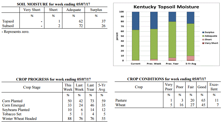 Kentucky Climate Summary
For the Period May 1 to May 7, 2017
Below Normal Temperatures and Above Normal Rainfall:
The wet pattern continued across the Bluegrass State, but this time, high
accumulations were seen statewide. After a very active week, the state averaged 1.70
inches, which was over a half inch above normal. Most fell over the second half of
the workweek as low pressure slowly worked across the area, leading to multiple
rounds of widespread showers. Following a fast moving disturbance on Saturday and
some lingering light showers, conditions finally dried off for the latter half of the
weekend. The unsettled pattern kept temperatures running below normal for much of the
period. Highs only rose into the middle 50s to low 60s on Friday, which was well
below normal for this time of year. Skies cleared Saturday night and led to lows
dropping into the 30s for much of Central/Eastern Kentucky and the Bluegrass. This
period marked only the third time this year that the Bluegrass State had temperatures
average below normal.
Temperatures for the period averaged 56 degrees across the state which was 5 degrees
cooler than normal and 12 degrees cooler than the previous period. High temperatures
averaged from 66 in the West to 66 in the East. Departure from normal high
temperatures ranged from 8 degrees cooler than normal in the West to 7 degrees
cooler than normal in the East. Low temperatures averaged from 47 degrees in the
West to 48 degrees in the East. Departure from normal low temperature ranged from 4
degrees cooler than normal in the West to 3 degrees warmer than normal in the East.
The extreme high temperature for the period was 81 degrees at LOUISA 1S and the
extreme low was 33 degrees at CYNTHIANA 8N.
Precipitation (liq. equ.) for the period totaled 1.70 inches statewide which was 0.61
inches above normal and 156% of normal. Precipitation totals by climate division,
West 1.64 inches, Central 1.83 inches, Bluegrass 1.66 inches and East 1.66 inches,
which was 0.44, 0.7, 0.65 and 0.64 inches above normal. By station, precipitation
totals ranged from a low of 0.60 inches at HINDMAN 5N to a high of 3.55 inches at
WHITLEY CITY 3N.
---
Kentucky Crop and Weather Report
Issued 4:00 P.M., May 1, 2017 09-17
Agricultural News: Kentucky experienced above normal temperatures and near normal
rainfall over the past week. Precipitation for the week totaled 1.02 inches, 0.04
inches above normal. Temperatures averaged 68 degrees for the week, 9 degrees above
normal. Topsoil moisture was rated 3 percent short, 62 percent adequate and 35
percent surplus. Subsoil moisture was rated 7 percent short, 65 percent adequate, and
28 percent surplus. Days suitable for fieldwork averaged 3.5 out of a possible seven.
Primary activities this week included planting corn and soybeans. Portions of the
state continue to deal with wet conditions halting progress in the fields. Producers
sprayed wheat for head scab and stripe rust when weather permitted. The average
height of winter wheat was 26 inches, compared to 24 inches last week.
Most hay has not been cut at this point as producers are awaiting a break in the wet
weather. Alfalfa hay average height was 13 inches, compared to 10 inches last week.
Hay and roughage supplies were reported as 2 percent very short, 12 percent short, 74
percent adequate, and 12 percent surplus. Tobacco transplant supplies were reported
as 3 percent short, 89 percent adequate, and 8 percent surplus. Twenty-six percent of
tobacco transplants were under 2 inches, with 46 percent between 2-4 inches, and 28
percent over 4 inches.
Kentucky Climate Summary
For the Period May 1 to May 7, 2017
Below Normal Temperatures and Above Normal Rainfall:
The wet pattern continued across the Bluegrass State, but this time, high
accumulations were seen statewide. After a very active week, the state averaged 1.70
inches, which was over a half inch above normal. Most fell over the second half of
the workweek as low pressure slowly worked across the area, leading to multiple
rounds of widespread showers. Following a fast moving disturbance on Saturday and
some lingering light showers, conditions finally dried off for the latter half of the
weekend. The unsettled pattern kept temperatures running below normal for much of the
period. Highs only rose into the middle 50s to low 60s on Friday, which was well
below normal for this time of year. Skies cleared Saturday night and led to lows
dropping into the 30s for much of Central/Eastern Kentucky and the Bluegrass. This
period marked only the third time this year that the Bluegrass State had temperatures
average below normal.
Temperatures for the period averaged 56 degrees across the state which was 5 degrees
cooler than normal and 12 degrees cooler than the previous period. High temperatures
averaged from 66 in the West to 66 in the East. Departure from normal high
temperatures ranged from 8 degrees cooler than normal in the West to 7 degrees
cooler than normal in the East. Low temperatures averaged from 47 degrees in the
West to 48 degrees in the East. Departure from normal low temperature ranged from 4
degrees cooler than normal in the West to 3 degrees warmer than normal in the East.
The extreme high temperature for the period was 81 degrees at LOUISA 1S and the
extreme low was 33 degrees at CYNTHIANA 8N.
Precipitation (liq. equ.) for the period totaled 1.70 inches statewide which was 0.61
inches above normal and 156% of normal. Precipitation totals by climate division,
West 1.64 inches, Central 1.83 inches, Bluegrass 1.66 inches and East 1.66 inches,
which was 0.44, 0.7, 0.65 and 0.64 inches above normal. By station, precipitation
totals ranged from a low of 0.60 inches at HINDMAN 5N to a high of 3.55 inches at
WHITLEY CITY 3N.
---
Kentucky Crop and Weather Report
Issued 4:00 P.M., May 1, 2017 09-17
Agricultural News: Kentucky experienced above normal temperatures and near normal
rainfall over the past week. Precipitation for the week totaled 1.02 inches, 0.04
inches above normal. Temperatures averaged 68 degrees for the week, 9 degrees above
normal. Topsoil moisture was rated 3 percent short, 62 percent adequate and 35
percent surplus. Subsoil moisture was rated 7 percent short, 65 percent adequate, and
28 percent surplus. Days suitable for fieldwork averaged 3.5 out of a possible seven.
Primary activities this week included planting corn and soybeans. Portions of the
state continue to deal with wet conditions halting progress in the fields. Producers
sprayed wheat for head scab and stripe rust when weather permitted. The average
height of winter wheat was 26 inches, compared to 24 inches last week.
Most hay has not been cut at this point as producers are awaiting a break in the wet
weather. Alfalfa hay average height was 13 inches, compared to 10 inches last week.
Hay and roughage supplies were reported as 2 percent very short, 12 percent short, 74
percent adequate, and 12 percent surplus. Tobacco transplant supplies were reported
as 3 percent short, 89 percent adequate, and 8 percent surplus. Twenty-six percent of
tobacco transplants were under 2 inches, with 46 percent between 2-4 inches, and 28
percent over 4 inches.
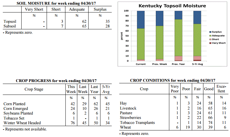 Kentucky Climate Summary
For the Period April 24 to April 30, 2017
Above Normal Temperatures and Near Normal Rainfall:
Depending on location, it was either a very wet or a dry week in Kentucky. Portions
of the Commonwealth along the Ohio River, running from Western Kentucky and up into
the Northern Bluegrass, saw the highest accumulations for the period. Western
Kentucky averaged over 2 inches for a second straight week. In fact, the western-
most couple tiers of counties accumulated 3 to 4+ inches. These totals diminished
rapidly farther east as Eastern Kentucky averaged just 0.26 inches for the week.
Most of the showers and storms passed through Kentucky Wednesday night/Thursday
morning and another few rounds over the weekend. As the state sat within a very
moist air mass, storms were capable of producing very heavy rainfall. Combined with
repeated rounds of thunderstorms, this led to numerous reports of flash flooding for
the areas mentioned above.
Temperatures for the period averaged 68 degrees across the state which was 9 degrees
warmer than normal and 6 degrees warmer than the previous period. High temperatures
averaged from 76 in the West to 79 in the East. Departure from normal high
temperatures ranged from 3 degrees warmer than normal in the West to 7 degrees
warmer than normal in the East. Low temperatures averaged from 57 degrees in the
West to 56 degrees in the East. Departure from normal low temperature ranged from 8
degrees warmer than normal in the West to 13 degrees warmer than normal in the
East. The extreme high temperature for the period was 92 degrees at BURKESVILLE 3W
and the extreme low was 42 degrees at CYNTHIANA 8N.
Precipitation (liq. equ.) for the period totaled 1.02 inches statewide which was 0.04
inches below normal and 96% of normal. Precipitation totals by climate division, West
2.09 inches, Central 0.54 inches, Bluegrass 1.20 inches and East 0.26 inches, which
was 0.89, -0.54, 0.23 and -0.72 inches respectively from normal. By station,
precipitation totals ranged from a low of 0.00 inches at RICHMOND 8E to a high of
5.96 inches at EVANSVILLE ASOS.
---
Kentucky Crop and Weather Report
Issued 4:00 P.M., April 24, 2017 08-17
Agricultural News: Kentucky experienced above normal temperatures and much above
normal rainfall over the past week. Precipitation for the week totaled 2.10 inches,
1.11 inches above normal. Temperatures averaged 63 degrees for the week, 6 degrees
above normal. Topsoil moisture was rated 4 percent short, 66 percent adequate and 30
percent surplus. Subsoil moisture was rated 1 percent very short, 6 percent short, 73
percent adequate, and 20 percent surplus. Days suitable for fieldwork averaged 3.0
out of a possible seven.
Primary activities for the week included the continuation of corn planting and
seeding of tobacco transplants. Corn producers are showing planting restraint to
avoid soil compaction due to excess precipitation. Forty two percent of tobacco
transplants were under 2 inches, with 45 percent 2-4 inches, and 13 percent over 4
inches. Soybean planting has just begun and has been restricted by the weather just
as corn has. Wet conditions throughout the state kept farmers out of the fields most
of the week.
The average height of winter wheat was 24 inches, compared to 21 inches last week.
Wheat growers are in need favorable weather conditions to spray fungicides,
particularly for scab and stripe rust. Average height of Alfalfa hay was 10 inches,
compared to 8 inches last week. Apple freeze damage was reported as 2 percent severe,
9 percent moderate, 35 percent light, and 54 percent with no damage. Peach freeze
damage was reported as 10 percent severe, 22 percent moderate, 27 percent light, and
41 percent with no damage.
Kentucky Climate Summary
For the Period April 24 to April 30, 2017
Above Normal Temperatures and Near Normal Rainfall:
Depending on location, it was either a very wet or a dry week in Kentucky. Portions
of the Commonwealth along the Ohio River, running from Western Kentucky and up into
the Northern Bluegrass, saw the highest accumulations for the period. Western
Kentucky averaged over 2 inches for a second straight week. In fact, the western-
most couple tiers of counties accumulated 3 to 4+ inches. These totals diminished
rapidly farther east as Eastern Kentucky averaged just 0.26 inches for the week.
Most of the showers and storms passed through Kentucky Wednesday night/Thursday
morning and another few rounds over the weekend. As the state sat within a very
moist air mass, storms were capable of producing very heavy rainfall. Combined with
repeated rounds of thunderstorms, this led to numerous reports of flash flooding for
the areas mentioned above.
Temperatures for the period averaged 68 degrees across the state which was 9 degrees
warmer than normal and 6 degrees warmer than the previous period. High temperatures
averaged from 76 in the West to 79 in the East. Departure from normal high
temperatures ranged from 3 degrees warmer than normal in the West to 7 degrees
warmer than normal in the East. Low temperatures averaged from 57 degrees in the
West to 56 degrees in the East. Departure from normal low temperature ranged from 8
degrees warmer than normal in the West to 13 degrees warmer than normal in the
East. The extreme high temperature for the period was 92 degrees at BURKESVILLE 3W
and the extreme low was 42 degrees at CYNTHIANA 8N.
Precipitation (liq. equ.) for the period totaled 1.02 inches statewide which was 0.04
inches below normal and 96% of normal. Precipitation totals by climate division, West
2.09 inches, Central 0.54 inches, Bluegrass 1.20 inches and East 0.26 inches, which
was 0.89, -0.54, 0.23 and -0.72 inches respectively from normal. By station,
precipitation totals ranged from a low of 0.00 inches at RICHMOND 8E to a high of
5.96 inches at EVANSVILLE ASOS.
---
Kentucky Crop and Weather Report
Issued 4:00 P.M., April 24, 2017 08-17
Agricultural News: Kentucky experienced above normal temperatures and much above
normal rainfall over the past week. Precipitation for the week totaled 2.10 inches,
1.11 inches above normal. Temperatures averaged 63 degrees for the week, 6 degrees
above normal. Topsoil moisture was rated 4 percent short, 66 percent adequate and 30
percent surplus. Subsoil moisture was rated 1 percent very short, 6 percent short, 73
percent adequate, and 20 percent surplus. Days suitable for fieldwork averaged 3.0
out of a possible seven.
Primary activities for the week included the continuation of corn planting and
seeding of tobacco transplants. Corn producers are showing planting restraint to
avoid soil compaction due to excess precipitation. Forty two percent of tobacco
transplants were under 2 inches, with 45 percent 2-4 inches, and 13 percent over 4
inches. Soybean planting has just begun and has been restricted by the weather just
as corn has. Wet conditions throughout the state kept farmers out of the fields most
of the week.
The average height of winter wheat was 24 inches, compared to 21 inches last week.
Wheat growers are in need favorable weather conditions to spray fungicides,
particularly for scab and stripe rust. Average height of Alfalfa hay was 10 inches,
compared to 8 inches last week. Apple freeze damage was reported as 2 percent severe,
9 percent moderate, 35 percent light, and 54 percent with no damage. Peach freeze
damage was reported as 10 percent severe, 22 percent moderate, 27 percent light, and
41 percent with no damage.
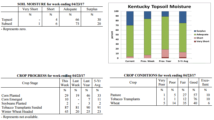 Kentucky Climate Summary
For the Period April 17 to April 23, 2017
Above Normal Temperatures and Much Above Normal Rainfall:
The state saw exceptionally wet conditions over the course of the period. When
looking at average statewide rainfall, this was the wettest week of 2017. Kentucky
averaged 2.10 inches, which was over an inch above normal. Some areas, especially
Southeastern Kentucky, accumulated 3+ inches. The Commonwealth became situated within
a very active pattern with multiple frontal boundaries and disturbances pushing
through the area. At least some portion of the state recorded rain each day of the
week. While most of the workweek feature isolated to scattered precipitation, more
widespread coverage arrived late Friday and into the first half of the weekend. This
led to some minor river flooding across Eastern Kentucky. While Saturday and Sunday
featured highs in the 50s, the rest of the period remained fairly warm, leading to a
5th straight week of above normal temperatures. On average, the state typically runs
in the upper 60s to middle 70s for the last couple weeks of April.
Temperatures for the period averaged 63 degrees across the state which was 6 degrees
warmer than normal and 2 degrees cooler than the previous period. High temperatures
averaged from 70 in the West to 69 in the East. Departure from normal high
temperatures ranged from 1 degree cooler than normal in the West to 1 degree
cooler than normal in the East. Low temperatures averaged from 56 degrees in the
West to 56 degrees in the East. Departure from normal low temperature ranged from 9
degrees warmer than normal in the West to 15 degrees warmer than normal in the
East. The extreme high temperature for the period was 85 degrees at LOUISVILLE APT
and the extreme low was 36 degrees at VANCEBURG 6W.
Precipitation (liq. equ.) for the period totaled 2.10 inches statewide which was 1.11
inches above normal and 212% of normal. Precipitation totals by climate division,
West 2.39 inches, Central 1.99 inches, Bluegrass 1.11 inches and East 2.90 inches,
which was 1.24, 1, 0.2 and 1.98 inches above normal. By station, precipitation totals
ranged from a low of 0.46 inches at CARLISLE 5SW to a high of 7.26 inches at
WHITLEY CITY 3N.
---
Kentucky Crop and Weather Report
Issued 4:00 P.M., April 17, 2017 07-17
Agricultural News: Kentucky experienced well above normal temperatures and below
normal rainfall over the past week. Precipitation for the week totaled 0.67 inches,
0.34 inches below normal. Temperatures averaged 66 degrees for the week, 11 degrees
above normal. Topsoil moisture was rated 7 percent short, 77 percent adequate and 16
percent surplus. Subsoil moisture was rated 1 percent very short, 9 percent short, 81
percent adequate, and 9 percent surplus. Days suitable for fieldwork averaged 5.1 out
of a possible seven.
Primary activities this week included planting corn, applying fertilizer and burndown
applications, and seeding tobacco transplants. Fifty-one percent of tobacco
transplants were under 2 inches, with 39 percent between 2-4 inches, and 10 percent
over 4 inches. Varied rainfall across the state slowed fieldwork and corn planting
progress at times during the week.
Some winter wheat fields appear to be recovering from freeze damage, but crop
conditions and disease pressures continue to be monitored. The average height of
winter wheat was 21 inches. Wheat winter freeze damage was reported as 11 percent
severe, 26 percent moderate, 27 percent light, with 36 percent experiencing none.
Alfalfa hay average height was 8 inches. Alfalfa hay freeze damage was reported as 6
percent severe, 16 percent moderate, 32 percent light, with 46 percent experiencing
none. Alfalfa weevil activity and damage continues to be reported.
Kentucky Climate Summary
For the Period April 17 to April 23, 2017
Above Normal Temperatures and Much Above Normal Rainfall:
The state saw exceptionally wet conditions over the course of the period. When
looking at average statewide rainfall, this was the wettest week of 2017. Kentucky
averaged 2.10 inches, which was over an inch above normal. Some areas, especially
Southeastern Kentucky, accumulated 3+ inches. The Commonwealth became situated within
a very active pattern with multiple frontal boundaries and disturbances pushing
through the area. At least some portion of the state recorded rain each day of the
week. While most of the workweek feature isolated to scattered precipitation, more
widespread coverage arrived late Friday and into the first half of the weekend. This
led to some minor river flooding across Eastern Kentucky. While Saturday and Sunday
featured highs in the 50s, the rest of the period remained fairly warm, leading to a
5th straight week of above normal temperatures. On average, the state typically runs
in the upper 60s to middle 70s for the last couple weeks of April.
Temperatures for the period averaged 63 degrees across the state which was 6 degrees
warmer than normal and 2 degrees cooler than the previous period. High temperatures
averaged from 70 in the West to 69 in the East. Departure from normal high
temperatures ranged from 1 degree cooler than normal in the West to 1 degree
cooler than normal in the East. Low temperatures averaged from 56 degrees in the
West to 56 degrees in the East. Departure from normal low temperature ranged from 9
degrees warmer than normal in the West to 15 degrees warmer than normal in the
East. The extreme high temperature for the period was 85 degrees at LOUISVILLE APT
and the extreme low was 36 degrees at VANCEBURG 6W.
Precipitation (liq. equ.) for the period totaled 2.10 inches statewide which was 1.11
inches above normal and 212% of normal. Precipitation totals by climate division,
West 2.39 inches, Central 1.99 inches, Bluegrass 1.11 inches and East 2.90 inches,
which was 1.24, 1, 0.2 and 1.98 inches above normal. By station, precipitation totals
ranged from a low of 0.46 inches at CARLISLE 5SW to a high of 7.26 inches at
WHITLEY CITY 3N.
---
Kentucky Crop and Weather Report
Issued 4:00 P.M., April 17, 2017 07-17
Agricultural News: Kentucky experienced well above normal temperatures and below
normal rainfall over the past week. Precipitation for the week totaled 0.67 inches,
0.34 inches below normal. Temperatures averaged 66 degrees for the week, 11 degrees
above normal. Topsoil moisture was rated 7 percent short, 77 percent adequate and 16
percent surplus. Subsoil moisture was rated 1 percent very short, 9 percent short, 81
percent adequate, and 9 percent surplus. Days suitable for fieldwork averaged 5.1 out
of a possible seven.
Primary activities this week included planting corn, applying fertilizer and burndown
applications, and seeding tobacco transplants. Fifty-one percent of tobacco
transplants were under 2 inches, with 39 percent between 2-4 inches, and 10 percent
over 4 inches. Varied rainfall across the state slowed fieldwork and corn planting
progress at times during the week.
Some winter wheat fields appear to be recovering from freeze damage, but crop
conditions and disease pressures continue to be monitored. The average height of
winter wheat was 21 inches. Wheat winter freeze damage was reported as 11 percent
severe, 26 percent moderate, 27 percent light, with 36 percent experiencing none.
Alfalfa hay average height was 8 inches. Alfalfa hay freeze damage was reported as 6
percent severe, 16 percent moderate, 32 percent light, with 46 percent experiencing
none. Alfalfa weevil activity and damage continues to be reported.
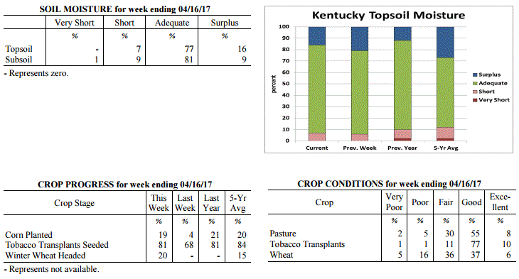 Kentucky Climate Summary
For the Period April 10 to April 16, 2017
Well Above Normal Temperatures and Below Normal Rainfall:
Above normal temperatures remained in place throughout the period, peaking Friday and
Saturday with highs in the low to middle 80s for much of Kentucky. This pushed
Kentucky to a fourth straight week of above normal temperatures. Gusty winds from the
southwest and low relative humidity led to an elevated fire danger on Monday, but was
followed by a frontal passage the next day. This boundary sparked isolated to
scattered showers with most staying under a half inch. Conditions then remained dry
through Saturday, before showers returned for the second half of the weekend. Storms
fired within an unstable atmosphere ahead of a cold front.While the severe threat
was low, storms were capable of producing heavy rainfall.
Temperatures for the period averaged 66 degrees across the state which was 11 degrees
warmer than normal and 12 degrees warmer than the previous period. High temperatures
averaged from 77 in the West to 78 in the East. Departure from normal high
temperatures ranged from 8 degrees warmer than normal in the West to 10 degrees
warmer than normal in the East. Low temperatures averaged from 57 degrees in the
West to 53 degrees in the East. Departure from normal low temperature ranged from 12
degrees warmer than normal in the West to 13 degrees warmer than normal in the
East. The extreme high temperature for the period was 88 degrees at PEABODY and the
extreme low was 33 degrees at MIDDLESBORO AWOS.
Precipitation (liq. equ.) for the period totaled 0.67 inches statewide which was 0.34
inches below normal and 66% of normal. Precipitation totals by climate division, West
0.54 inches, Central 0.84 inches, Bluegrass 0.80 inches and East 0.49 inches, which
was 0.61, 0.2, 0.12 and 0.46 inches below normal. By station, precipitation totals
ranged from a low of 0.02 inches at SOMERSET to a high of 2.45 inches at CARROLLTON 2E.
---
Kentucky Crop and Weather Report
Issued 4:00 P.M., April 10, 2017 06-17
Agricultural News: Kentucky experienced above normal temperatures and below normal
rainfall over the past week. Precipitation for the week totaled 0.85 inches, 0.14
inches below normal. Temperatures averaged 56 degrees for the week, 3 degrees above
normal. Topsoil moisture was rated 6 percent short, 73 percent adequate and 21
percent surplus. Subsoil moisture was rated 8 percent short, 77 percent adequate, and
15 percent surplus. Days suitable for fieldwork averaged 3.5 out of a possible seven.
Primary activities this week included seeding tobacco transplants, preparing farm
equipment for planting, and applying fertilizer and burndown treatments. Wet and
windy weather delayed fieldwork, with limited corn planting this week. A severe storm
on Wednesday produced large hail, strong winds, and tornado touchdowns throughout
Central Kentucky, damaging fields and structures.
The extent of freeze damage continues to be monitored in alfalfa hay, fruit trees,
and winter wheat. The average height of winter wheat was 14 inches.
Kentucky Climate Summary
For the Period April 10 to April 16, 2017
Well Above Normal Temperatures and Below Normal Rainfall:
Above normal temperatures remained in place throughout the period, peaking Friday and
Saturday with highs in the low to middle 80s for much of Kentucky. This pushed
Kentucky to a fourth straight week of above normal temperatures. Gusty winds from the
southwest and low relative humidity led to an elevated fire danger on Monday, but was
followed by a frontal passage the next day. This boundary sparked isolated to
scattered showers with most staying under a half inch. Conditions then remained dry
through Saturday, before showers returned for the second half of the weekend. Storms
fired within an unstable atmosphere ahead of a cold front.While the severe threat
was low, storms were capable of producing heavy rainfall.
Temperatures for the period averaged 66 degrees across the state which was 11 degrees
warmer than normal and 12 degrees warmer than the previous period. High temperatures
averaged from 77 in the West to 78 in the East. Departure from normal high
temperatures ranged from 8 degrees warmer than normal in the West to 10 degrees
warmer than normal in the East. Low temperatures averaged from 57 degrees in the
West to 53 degrees in the East. Departure from normal low temperature ranged from 12
degrees warmer than normal in the West to 13 degrees warmer than normal in the
East. The extreme high temperature for the period was 88 degrees at PEABODY and the
extreme low was 33 degrees at MIDDLESBORO AWOS.
Precipitation (liq. equ.) for the period totaled 0.67 inches statewide which was 0.34
inches below normal and 66% of normal. Precipitation totals by climate division, West
0.54 inches, Central 0.84 inches, Bluegrass 0.80 inches and East 0.49 inches, which
was 0.61, 0.2, 0.12 and 0.46 inches below normal. By station, precipitation totals
ranged from a low of 0.02 inches at SOMERSET to a high of 2.45 inches at CARROLLTON 2E.
---
Kentucky Crop and Weather Report
Issued 4:00 P.M., April 10, 2017 06-17
Agricultural News: Kentucky experienced above normal temperatures and below normal
rainfall over the past week. Precipitation for the week totaled 0.85 inches, 0.14
inches below normal. Temperatures averaged 56 degrees for the week, 3 degrees above
normal. Topsoil moisture was rated 6 percent short, 73 percent adequate and 21
percent surplus. Subsoil moisture was rated 8 percent short, 77 percent adequate, and
15 percent surplus. Days suitable for fieldwork averaged 3.5 out of a possible seven.
Primary activities this week included seeding tobacco transplants, preparing farm
equipment for planting, and applying fertilizer and burndown treatments. Wet and
windy weather delayed fieldwork, with limited corn planting this week. A severe storm
on Wednesday produced large hail, strong winds, and tornado touchdowns throughout
Central Kentucky, damaging fields and structures.
The extent of freeze damage continues to be monitored in alfalfa hay, fruit trees,
and winter wheat. The average height of winter wheat was 14 inches.
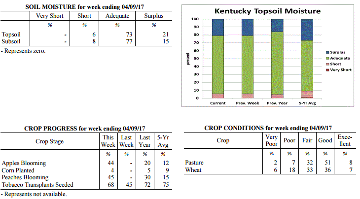 Kentucky Climate Summary
For the Period April 3 to April 9, 2017
Above Normal Temperatures and Below Normal Rainfall:
The active start to spring continued with a couple rounds of strong to severe storms
pushing through the state. The strongest system moved through the area Wednesday
afternoon and into the early overnight hours. As low pressure moved north of the
state, Kentucky became situated within a very unstable atmosphere. Scattered storms
developed in the afternoon hours, some becoming severe, before merging into a line
across the eastern half of Kentucky. Large hail, damaging winds, and even a handful
of tornadoes were seen across the area. Combined with an unsettled pattern earlier in
the week and showery activity on Thursday, the Bluegrass State averaged 0.85 inches,
which was slightly below normal for the week. Temperatures continued the above normal
trend with highs jumping into the 60s and 70s for most of the period. The one
exception came Thursday and Friday when temperatures struggled to rise behind a
departing cold front. Lows were coolest on Friday night/Saturday morning with
temperatures in the 30s for most and some in the Bluegrass and Eastern Kentucky
dropping below freezing.
Temperatures for the period averaged 56 degrees across the state which was 3 degrees
warmer than normal and 2 degrees cooler than the previous period. High temperatures
averaged from 68 in the West to 65 in the East. Departure from normal high
temperatures ranged from 2 degrees warmer than normal in the West to near normal in
the East. Low temperatures averaged from 48 degrees in the West to 45 degrees in the
East. Departure from normal low temperature ranged from 5 degrees warmer than normal
in the West to 7 degrees warmer than normal in the East. The extreme high temperature
for the period was 83 degrees at BOONEVILLE 2S and the extreme low was 27 degrees at
CYNTHIANA 8N.
Precipitation (liq. equ.) for the period totaled 0.85 inches statewide which was 0.14
inches below normal and 86% of normal. Precipitation totals by climate division, West
0.58 inches, Central 0.79 inches, Bluegrass 0.91 inches and East 1.11 inches, which
was -0.52, -0.23, 0.01 and 0.18 inches respectively from normal. By station,
precipitation totals ranged from a low of 0.25 inches at PADUCAH ASOS to a high of
2.38 inches at OWINGSVILLE 4S.
---
Kentucky Crop and Weather Report
Issued 4:00 P.M., April 3, 2017 05-17
Agricultural News: Kentucky experienced well above normal temperatures and above
normal rainfall over the past week. Precipitation for the week totaled 1.18 inches,
0.16 inches above normal. Temperatures averaged 58 degrees for the week, 8 degrees
above normal. Topsoil moisture was rated 6 percent short, 73 percent adequate, and 21
percent surplus. Subsoil moisture was rated 1 percent very short, 8 percent short, 75
percent adequate, and 16 percent surplus. Days suitable for fieldwork averaged 3.3
out of a possible seven.
Primary activities this week included seeding tobacco transplants, applying
fertilizer and burndown treatments, and preparing for spring planting as weather
conditions allowed. Alfalfa producers remain concerned about crop conditions as a
result of Alfalfa Weevil infestations and freeze damage. Several alfalfa fields were
sprayed this past week. Alfalfa hay freeze damage was reported as 5 percent severe,
16 percent moderate, 39 percent light, with 40 percent experiencing none.
Freeze damage to winter wheat has been variable across the state depending on the
crop stage, as the relatively mild winter had accelerated growth. Wheat winter freeze
damage was reported as 6 percent severe, 26 percent moderate, 27 percent light, with
41 percent experiencing none.
Livestock operations are preparing for spring calving and monitoring body condition.
Cattle and calves obtained approximately 38 percent of feed from pastures.
Kentucky Climate Summary
For the Period April 3 to April 9, 2017
Above Normal Temperatures and Below Normal Rainfall:
The active start to spring continued with a couple rounds of strong to severe storms
pushing through the state. The strongest system moved through the area Wednesday
afternoon and into the early overnight hours. As low pressure moved north of the
state, Kentucky became situated within a very unstable atmosphere. Scattered storms
developed in the afternoon hours, some becoming severe, before merging into a line
across the eastern half of Kentucky. Large hail, damaging winds, and even a handful
of tornadoes were seen across the area. Combined with an unsettled pattern earlier in
the week and showery activity on Thursday, the Bluegrass State averaged 0.85 inches,
which was slightly below normal for the week. Temperatures continued the above normal
trend with highs jumping into the 60s and 70s for most of the period. The one
exception came Thursday and Friday when temperatures struggled to rise behind a
departing cold front. Lows were coolest on Friday night/Saturday morning with
temperatures in the 30s for most and some in the Bluegrass and Eastern Kentucky
dropping below freezing.
Temperatures for the period averaged 56 degrees across the state which was 3 degrees
warmer than normal and 2 degrees cooler than the previous period. High temperatures
averaged from 68 in the West to 65 in the East. Departure from normal high
temperatures ranged from 2 degrees warmer than normal in the West to near normal in
the East. Low temperatures averaged from 48 degrees in the West to 45 degrees in the
East. Departure from normal low temperature ranged from 5 degrees warmer than normal
in the West to 7 degrees warmer than normal in the East. The extreme high temperature
for the period was 83 degrees at BOONEVILLE 2S and the extreme low was 27 degrees at
CYNTHIANA 8N.
Precipitation (liq. equ.) for the period totaled 0.85 inches statewide which was 0.14
inches below normal and 86% of normal. Precipitation totals by climate division, West
0.58 inches, Central 0.79 inches, Bluegrass 0.91 inches and East 1.11 inches, which
was -0.52, -0.23, 0.01 and 0.18 inches respectively from normal. By station,
precipitation totals ranged from a low of 0.25 inches at PADUCAH ASOS to a high of
2.38 inches at OWINGSVILLE 4S.
---
Kentucky Crop and Weather Report
Issued 4:00 P.M., April 3, 2017 05-17
Agricultural News: Kentucky experienced well above normal temperatures and above
normal rainfall over the past week. Precipitation for the week totaled 1.18 inches,
0.16 inches above normal. Temperatures averaged 58 degrees for the week, 8 degrees
above normal. Topsoil moisture was rated 6 percent short, 73 percent adequate, and 21
percent surplus. Subsoil moisture was rated 1 percent very short, 8 percent short, 75
percent adequate, and 16 percent surplus. Days suitable for fieldwork averaged 3.3
out of a possible seven.
Primary activities this week included seeding tobacco transplants, applying
fertilizer and burndown treatments, and preparing for spring planting as weather
conditions allowed. Alfalfa producers remain concerned about crop conditions as a
result of Alfalfa Weevil infestations and freeze damage. Several alfalfa fields were
sprayed this past week. Alfalfa hay freeze damage was reported as 5 percent severe,
16 percent moderate, 39 percent light, with 40 percent experiencing none.
Freeze damage to winter wheat has been variable across the state depending on the
crop stage, as the relatively mild winter had accelerated growth. Wheat winter freeze
damage was reported as 6 percent severe, 26 percent moderate, 27 percent light, with
41 percent experiencing none.
Livestock operations are preparing for spring calving and monitoring body condition.
Cattle and calves obtained approximately 38 percent of feed from pastures.
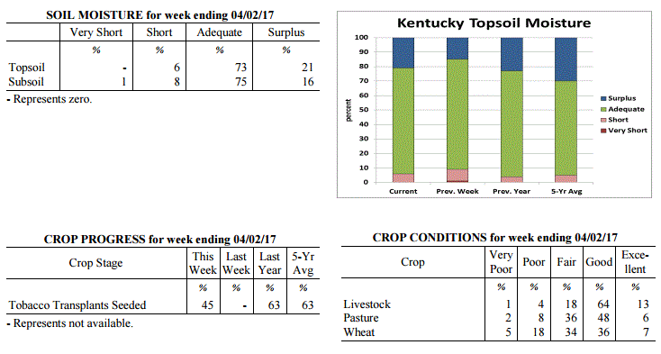 Kentucky Climate Summary
For the Period March 27 to April 2, 2017
Well Above Normal Temperatures and Above Normal Rainfall:
The Lower Ohio Valley saw an active spring pattern this past week with multiple
rounds of rainfall. Strong to severe storms pushed through the area on a couple
occasions, one coming on Monday and the other on Thursday as low pressure tracked
just north of the area. Storms fired ahead of a couple cold fronts, resulting in some
reports of damaging winds and hail. The second round was followed by cooler end to
the workweek and start of the weekend as cloud cover remain entrenched over the area.
Saying that, the rest of the period remained very warm with above normal temperatures
in place. Other than Friday and Saturday, most of the state reached into the 60s and
70s each day, even hitting the 80s for some on Thursday. This marked the second
straight week of above normal temperatures and 12th out of 14 since the start of 2017.
Temperatures for the period averaged 58 degrees across the state which was 8 degrees
warmer than normal and 2 degrees warmer than the previous period. High temperatures
averaged from 67 in the West to 68 in the East. Departure from normal high
temperatures ranged from 3 degrees warmer than normal in the West to 5 degrees
warmer than normal in the East. Low temperatures averaged from 50 degrees in the
West to 49 degrees in the East. Departure from normal low temperature ranged from 9
degrees warmer than normal in the West to 13 degrees warmer than normal in the
East. The extreme high temperature for the period was 83 degrees at BOONEVILLE 2S and
the extreme low was 35 degrees at BURKESVILLE 3W.
Precipitation (liq. equ.) for the period totaled 1.18 inches statewide which was 0.16
inches above normal and 116% of normal. Precipitation totals by climate division,
West 1.06 inches, Central 1.13 inches, Bluegrass 1.45 inches and East 1.08 inches,
which was -0.04, 0.06, 0.53 and 0.10 inches respectively from normal. By station,
precipitation totals ranged from a low of 0.46 inches at CAPE GIRARDEAU ASOS to a
high of 2.98 inches at STANFORD 4NE.
---
Kentucky Climate Summary
For the Period March 20 to March 26, 2017
Well Above Normal Temperatures and Below Normal Precipitation:
The first week of spring brought a return to mild and active conditions for the
Commonwealth. Temperatures peaked in the 60s and 70s for several days throughout the
period, well above normal for this time of year. While it was warm, a couple Freeze
Warnings were issued on Wednesday and Thursday mornings as lows dipped into the
middle 20s to low 30s for much of the Bluegrass and Eastern Kentucky. While rainfall
only averaged 0.65 inches for the week, the state did see several rounds throughout.
The most significant even came over the weekend as low pressure worked across the
area. A plume of moisture from the Gulf of Mexico led to deep moisture across the
Bluegrass State and a soaking rainfall.
Temperatures for the period averaged 56 degrees across the state which was 8 degrees
warmer than normal and 18 degrees warmer than the previous period. High temperatures
averaged from 68 in the West to 66 in the East. Departure from normal high
temperatures ranged from 6 degrees warmer than normal in the West to 5 degrees
warmer than normal in the East. Low temperatures averaged from 49 degrees in the
West to 43 degrees in the East. Departure from normal low temperature ranged from 10
degrees warmer than normal in the West to 9 degrees warmer than normal in the East.
The extreme high temperature for the period was 84 degrees at PADUCAH ASOS and the
extreme low was 21 degrees at PAINTSVILLE 4W.
Precipitation (liq. equ.) for the period totaled 0.65 inches statewide which was 0.39
inches below normal and 62% of normal. Precipitation totals by climate division, West
0.69 inches, Central 0.50 inches, Bluegrass 0.77 inches and East 0.64 inches, which
was 0.42, 0.6, 0.17 and 0.37 inches below normal. By station, precipitation totals
ranged from a low of 0.18 inches at WHITESBURG 2NW to a high of 1.85 inches at HICKMAN 2E.
---
Kentucky Climate Summary
For the Period March 13 to March 19, 2017
Well Below Normal Temperatures and Below Normal Precipitation:
The last week of winter brought a return to unseasonably cold conditions in Kentucky.
For just the second time this year, Kentucky saw below normal temperatures. The
coldest temperatures were seen Tuesday and Wednesday nights as lows dipped into the
middle teens to low 20s for much of the Bluegrass State. Freeze Warnings were issued
each night with winter wheat, plasticulture strawberries, peaches, and other fruit
trees all in advanced growth stages for this time of year. The good news was that a
warming trend followed for the rest of the period. Highs were back into the 50s by
Sunday. The state did see a couple rounds of showers through the week, averaging just
over a half inch across Kentucky.
Temperatures for the period averaged 37 degrees across the state which was 10 degrees
cooler than normal and 10 degrees cooler than the previous period. High temperatures
averaged from 48 in the West to 46 in the East. Departure from normal high
temperatures ranged from 11 degrees cooler than normal in the West to 13 degrees
cooler than normal in the East. Low temperatures averaged from 31 degrees in the
West to 26 degrees in the East. Departure from normal low temperature ranged from 6
degrees cooler than normal in the West to 7 degrees cooler than normal in the East.
The extreme high temperature for the period was 70 degrees at POPLAR BLUFF ASOS and
the extreme low was 8 degrees at PIKEVILLE 13S.
Precipitation (liq. equ.) for the period totaled 0.53 inches statewide which was 0.48
inches below normal and 53% of normal. Precipitation totals by climate division, West
0.31 inches, Central 0.61 inches, Bluegrass 0.28 inches and East 0.90 inches, which
was 0.75, 0.45, 0.64 and 0.09 inches below normal. By station, precipitation totals
ranged from a low of 0.11 inches at LOUISVILLE APT to a high of 2.76 inches at WHITLEY
CITY 3N.
---
Kentucky Climate Summary
For the Period March 6 to March 12, 2017
Above Normal Temperatures and Above Normal Precipitation:
Winter has returned to the Bluegrass State. Most of the workweek remained warm, the
reason for a 9th straight week of above normal temperatures, but a strong cold front
passed through the state Thursday night. Breezy northerly flow pulled Canadian air
down into the Commonwealth, setting up a cold weekend ahead. Temperatures dropped
into the 20s for much of the state both Friday and Saturday nights. The typically
cooler locations even dipped into the teens. Despite being the second week of March,
a Freeze Warning was issued both nights with some agriculture already susceptible to
the cold temperatures. According to other specialists with UK, peaches, plasticulture
strawberries, and winter wheat were most susceptible at the time.
Temperatures for the period averaged 48 degrees across the state which was 3 degrees
warmer than normal and 2 degrees warmer than the previous period. High temperatures
averaged from 59 in the West to 57 in the East. Departure from normal high
temperatures ranged from 1 degree warmer than normal in the West to near
normal in the East. Low temperatures averaged from 39 degrees in the West to 37
degrees in the East. Departure from normal low temperature ranged from 4 degrees
warmer than normal in the West to 6 degrees warmer than normal in the East. The
extreme high temperature for the period was 78 degrees at MADISONVILLE 4S and the
extreme low was 17 degrees at CYNTHIANA 8N.
Precipitation (liq. equ.) for the period totaled 1.03 inches statewide which was 0.05
inches above normal and 105% of normal. Precipitation totals by climate division,
West 1.73 inches, Central 0.89 inches, Bluegrass 0.59 inches and East 0.90 inches,
which was 0.70, -0.14, -0.31 and -0.07 inches respectively from normal. By station,
precipitation totals ranged from a low of 0.00 inches at VANCEBURG 6W to a high of
3.20 inches at MAYFIELD 6SW.
---
Kentucky Climate Summary
For the Period February 27 to March 5, 2017
Well Above Normal Temperatures and Above Normal Rainfall:
A storm system led to strong to severe storms pushing across the area this past
Tuesday and Wednesday. The worst of the event occurred Tuesday night and Wednesday,
ahead of the passage of a cold front. Cells forming Tuesday night were capable of
producing damaging winds, hail, and even tornadoes. A line of strong to severe
storms then passed through Wednesday morning, producing damaging winds ahead of a
cold front. Overall, a handful of tornadoes were confirmed across the state with the
strongest in Warren County. Peak winds were estimated at 110 mph. Cooler and drier
conditions then returned for the end of the workweek. Kentucky saw a few nights when
lows dipped into the 20s, but the cool conditions were short lived. As high pressure
worked east over the weekend, winds shifted back to the south, pushing highs back
into the 60s by Sunday.
Temperatures for the period averaged 47 degrees across the state which was 4 degrees
warmer than normal and 8 degrees cooler than the previous period. High temperatures
averaged from 61 in the West to 56 in the East. Departure from normal high
temperatures ranged from 5 degrees warmer than normal in the West to 1 degree
warmer than normal in the East. Low temperatures averaged from 39 degrees in the
West to 35 degrees in the East. Departure from normal low temperature ranged from 5
degrees warmer than normal in the West to 5 degrees warmer than normal in the East.
The extreme high temperature for the period was 74 degrees at POPLAR BLUFF ASOS and
the extreme low was 17 degrees at MONTICELLO AWOS.
Precipitation (liq. equ.) for the period totaled 1.38 inches statewide which was 0.41
inches above normal and 142% of normal. Precipitation totals by climate division,
West 0.92 inches, Central 1.33 inches, Bluegrass 2.16 inches and East 1.12 inches,
which was -0.15, 0.31, 1.30 and 0.18 inches respectively from normal. By station,
precipitation totals ranged from a low of 0.16 inches at CAPE GIRARDEAU ASOS to a
high of 3.29 inches at ALEXANDRIA 5NW.
---
Kentucky Climate Summary
For the Period February 20 to February 26, 2017
Well Above Normal Temperatures and Below Normal Rainfall:
All of the attention for the past couple months has been on the unseasonably warm
temperatures and for good reason. The state has now seen seven straight weeks of
above normal temperatures. Ahead of a strong cold front this past Friday night, high
temperatures even peaked in the upper 70s to low 80s for many locations across
Kentucky. With that said, temperatures dropped significantly behind the boundary
with lows Saturday night dipping into the low to middle 20s. The Commonwealth saw a
couple rounds of showers throughout the period also, but was again below normal for the
fourth time in five weeks. Looking at the month of February, the state is nearly 2
inches of precipitation below normal.
Temperatures for the period averaged 55 degrees across the state which was 14 degrees
warmer than normal and 10 degrees warmer than the previous period. High temperatures
averaged from 66 in the West to 67 in the East. Departure from normal high
temperatures ranged from 13 degrees warmer than normal in the West to 15 degrees
warmer than normal in the East. Low temperatures averaged from 46 degrees in the
West to 43 degrees in the East. Departure from normal low temperature ranged from 15
degrees warmer than normal in the West to 15 degrees warmer than normal in the
East. The extreme high temperature for the period was 82 degrees at HARTFORD 3E and
the extreme low was 16 degrees at LEITCHFIELD 3W.
Precipitation (liq. equ.) for the period totaled 0.41 inches statewide which was 0.56
inches below normal and 42% of normal. Precipitation totals by climate division, West
0.11 inches, Central 0.33 inches, Bluegrass 0.47 inches and East 0.75 inches, which
was 0.98, 0.71, 0.37 and 0.15 inches below normal. By station, precipitation totals
ranged from a low of 0.02 inches at MARION 4NE to a high of 1.19 inches at BARBOURVILLE 3E.
---
Kentucky Climate Summary
For the Period February 13 to February 19, 2017
Well Above Normal Temperatures and Below Normal Rainfall:
A very mild pattern keeps giving the feel of an early spring here in the Bluegrass
State. Once again, temperatures were well above normal, topping out in the 60s and
even 70s at times. This makes six straight weeks of above normal temperatures for
the Commonwealth. The state saw a couple rounds of light rainfall, the first coming
Tuesday evening/night across mainly the southern fringes of Kentucky. A secondary
round came Saturday as an upper level low sparked scattered to numerous showers
throughout the area. Overall, most stayed under a quarter inch for the week, over a
half inch below normal.
Temperatures for the period averaged 45 degrees across the state which was 8 degrees
warmer than normal and 4 degrees cooler than the previous period. High temperatures
averaged from 56 in the West to 54 in the East. Departure from normal high
temperatures ranged from 6 degrees warmer than normal in the West to 5 degrees
warmer than normal in the East. Low temperatures averaged from 37 degrees in the
West to 34 degrees in the East. Departure from normal low temperature ranged from 8
degrees warmer than normal in the West to 9 degrees warmer than normal in the East.
The extreme high temperature for the period was 71 degrees at HARTFORD 3E and the
extreme low was 19 degrees at MONTICELLO AWOS.
Precipitation (liq. equ.) for the period totaled 0.23 inches statewide which was 0.67
inches below normal and 26% of normal. Precipitation totals by climate division, West
0.43 inches, Central 0.22 inches, Bluegrass 0.08 inches and East 0.20 inches, which
was 0.58, 0.76, 0.69 and 0.64 inches below normal. By station, precipitation totals
ranged from a low of 0.00 inches at VANCEBURG 6W to a high of 1.06 inches at POPLAR
BLUFF ASOS.
---
Kentucky Climate Summary
For the Period February 6 to February 12, 2017
Well Above Normal Temperatures and Above Normal Rainfall:
Winter is still absent in the Commonwealth. Temperatures were 12 degrees above
normal, marking the 5th straight week of above normal temperatures. Temperatures
jumped into the 60s for at least some portion of the state, six out of the seven
days. Even saw some 70s. Normal high temperatures for this time of year are only in
the mid to upper 40s. The warmth was accompanied by above normal rainfall, most of
which came over the first half of the work week. A low pressure system led to soaking
rainfall for much of the area as deep moisture worked into the region. Accumulations
were around an inch for most. Other than some light rain showers Saturday night,
conditions were mostly dry for the remainder of the week.
Temperatures for the period averaged 48 degrees across the state which was 12 degrees
warmer than normal and 10 degrees warmer than the previous period. High temperatures
averaged from 58 in the West to 60 in the East. Departure from normal high
temperatures ranged from 11 degrees warmer than normal in the West to 13 degrees
warmer than normal in the East. Low temperatures averaged from 40 degrees in the
West to 41 degrees in the East. Departure from normal low temperature ranged from 13
degrees warmer than normal in the West to 17 degrees warmer than normal in the
East. The extreme high temperature for the period was 78 degrees at POPLAR BLUFF ASOS
and the extreme low was 14 degrees at OWENTON 5E.
Precipitation (liq. equ.) for the period totaled 0.95 inches statewide which was 0.06
inches above normal and 107% of normal. Precipitation totals by climate division,
West 1.05 inches, Central 1.18 inches, Bluegrass 0.93 inches and East 0.62 inches,
which was 0.07, 0.21, 0.16 and -0.21 inches respectively from normal. By station,
precipitation totals ranged from a low of 0.00 inches at VANCEBURG 6W to a high of
2.74 inches at CADIZ 4SW.
---
Kentucky Climate Summary
For the Period January 30 to February 5, 2017
Above Normal Temperatures and Below Normal Rainfall:
Mostly dry conditions were accompanied by mild temperatures for a second straight week
in Kentucky. After starting the week with some lingering light snow showers, the
weather pattern turned relatively quiet for the remainder of the period, pushing the
focus on temperatures. For the most part, high temperatures stayed in the 40s and 50s
for most of the week. The coldest period came Friday night and into Saturday morning.
With high pressure moving overhead, skies cleared and winds became calm, leading to
lows in the teens for much of Kentucky. Even had some single digits for a few
locations. Otherwise temperatures were mild, leading to a fourth
straight week of above normal temperatures.
Temperatures for the period averaged 38 degrees across the state which was 4 degrees
warmer than normal and 2 degrees cooler than the previous period. High temperatures
averaged from 48 in the West to 46 in the East. Departure from normal high
temperatures ranged from 3 degrees warmer than normal in the West to 1 degree warmer
than normal in the East. Low temperatures averaged from 30 degrees in the West to 28
degrees in the East. Departure from normal low temperature ranged from 4 degrees
warmer than normal in the West to 5 degrees warmer than normal in the East. The
extreme high temperature for the period was 65 degrees at BURKESVILLE 3W and the
extreme low was 7 degrees at CYNTHIANA 8N.
Precipitation (liq. equ.) for the period totaled 0.02 inches statewide which was 0.84
inches below normal and 2% of normal. Precipitation totals by climate division, West
0.00 inches, Central 0.01 inches, Bluegrass 0.03 inches and East 0.05 inches, which
was 0.94, 0.93, 0.71 and 0.77 inches below normal. By station, precipitation totals
ranged from a low of 0.00 inches at BENTON 4N to a high of 0.63 inches at VANCEBURG 6W.
---
Kentucky Climate Summary
For the Period January 23 to January 29, 2017
Well Above Normal Temperatures and Above Normal Rainfall:
It seems as though winter has been absent for the month of January. After starting
out the month with frigid temperatures in place, mild air has ruled for most of
January. That mild air carried over into the last full week of the month. Highs
remained in the 40s, 50s, and even to around 60 over the first half of the workweek,
but winter had to return at some point. A strong cold front pushed through Kentucky
later Wednesday night, pushing high temperatures slightly below seasonable norms for
the rest of the period. Accompanying the cooler temperatures were a parade of
disturbances, bringing waves of light snow showers. The most significant wave came
Sunday as a Winter Weather Advisory was issued for the eastern half of Kentucky.
Much of Eastern Kentucky ended up seeing 1 to 2 inches with totals diminishing
farther west.
Temperatures for the period averaged 41 degrees across the state which was 8 degrees
warmer than normal and 10 degrees cooler than the previous period. High temperatures
averaged from 48 in the West to 47 in the East. Departure from normal high
temperatures ranged from 4 degrees warmer than normal in the West to 3 degrees warmer
than normal in the East. Low temperatures averaged from 35 degrees in the West to 34
degrees in the East. Departure from normal low temperature ranged from 10 degrees
warmer than normal in the West to 12 degrees warmer than normal in the East. The
extreme high temperature for the period was 68 degrees at MADISONVILLE 4S
and the extreme low was 17 degrees at MONTICELLO AWOS.
Precipitation (liq. equ.) for the period totaled 0.47 inches statewide which was 0.31
inches below normal and 60% of normal. Precipitation totals by climate division, West
0.06 inches, Central 0.23 inches, Bluegrass 0.46 inches and East 1.15 inches, which
was -0.77, -0.60, -0.22 and 0.37 inches respectively from normal. By station,
precipitation totals ranged from a low of 0.00 inches at BOWLING GREEN 4E to a high
of 2.37 inches at PIKEVILLE 13S.
---
Kentucky Climate Summary
For the Period January 16 to January 22, 2017
Well Above Normal Temperatures and Above Normal Rainfall:
A very unsettled pattern continued for a second straight week, bringing the
Commonwealth multiple rounds of widespread rainfall. This amounted to most of the
state seeing over an inch of additional precipitation. Through the 22nd of January,
the state has averaged about 3.5 inches, which is around an inch above normal. While
the rain kept on coming, it definitely did not feel like January outside.
Temperatures averaged 19 degrees above normal with daytime highs staying in the 50s
and 60s. Saturday was the warmest day of the week with temperatures topping out in
the upper 60s to lower 70s. Normal high temperatures for this time of year are in
the low to middle 40s.
Temperatures for the period averaged 52 degrees across the state which was 19 degrees
warmer than normal and 6 degrees warmer than the previous period. High temperatures
averaged from 60 in the West to 60 in the East. Departure from normal high
temperatures ranged from 17 degrees warmer than normal in the West to 17 degrees
warmer than normal in the East. Low temperatures averaged from 47 degrees in the
West to 45 degrees in the East. Departure from normal low temperature ranged from 22
degrees warmer than normal in the West to 22 degrees warmer than normal in the
East. The extreme high temperature for the period was 72 degrees at BURKESVILLE 3W and
the extreme low was 31 degrees at PAINTSVILLE 4W.
Precipitation (liq. equ.) for the period totaled 1.43 inches statewide which was 0.6
inches above normal and 172% of normal. Precipitation totals by climate division,
West 1.54 inches, Central 1.85 inches, Bluegrass 1.29 inches and East 1.04 inches,
which was 0.66, 0.97, 0.57 and 0.19 inches above normal. By station, precipitation
totals ranged from a low of 0.19 inches at CAPE GIRARDEAU ASOS to a high of 3.00
inches at BENTON 4N.
---
Kentucky Climate Summary
For the Period January 9 to January 15, 2017
Above Normal Temperatures and Above Normal Rainfall:
A very mild and wet week for the Bluegrass State. The highest temperatures rose
to 73 degrees and the extreme low temperature was 3 degrees. Rainfall occurred
nearly every day with the entire state receiving over 150 percent of normal.
Temperatures for the 2nd week of this year averaged 45 degrees across the state
which was 12 degrees warmer than normal and 16 degrees warmer than the previous
period. High temperatures averaged from 51 in the West to 53 in the East.
Departure from normal high temperatures ranged from 8 degrees warmer than normal
in the West to 9 degrees warmer than normal in the East. Low temperatures
averaged from 38 degrees in the West to 39 degrees in the East. Departure from
normal low temperature ranged from 12 degrees warmer than normal in the West to
16 degrees warmer than normal in the East. The extreme high temperature for the
period was 73 degrees at POPLAR BLUFF ASOS and the extreme low was 3 degrees
at PAINTSVILLE 4W.
Precipitation (liq. equ.) for the period totaled 1.38 inches statewide which was
0.51 inches above normal and 158% of normal. Precipitation totals by climate
division, West 1.32 inches, Central 1.49 inches, Bluegrass 1.52 inches and East
1.20 inches, which was 0.41, 0.56, 0.77 and 0.3 inches above normal. By station,
precipitation totals ranged from a low of 0.52 inches at FRANKLIN 4SW to a high
of 2.28 inches at MARION 4NE.
---
Kentucky Climate Summary
For the Period January 1 to January 7, 2017
Below Normal Temperatures and Below Normal Rainfall:
For the first full week of 2017 in the Bluegrass State, wintertime temperatures
dominated along with 1 to 3 inches of snow with locally 4+ inches in some
locations along the Ohio River and in the eastern highlands. Very mild
temperatures occurred at the beginning of the new year but by the weekend bitter
cold temperatures and wind chills below zero ruled the commonwealth. Livestock
cold stress drops into the emergency category for at least 3 days. From the last
week during 2016, average temperatures drop 14 degrees! So the downward change
in temperature was drastic. Add in a few inches of snow on the ground and Kentucky
was turned into a winter-wonder-land! According to the National Operational Hydrologic
Remote Sensing Center (NOHRSC), 48 of 50 states had snow and/or ice on the
ground this past week.
Temperatures for the week averaged 30 degrees across the state which was 4
degrees cooler than normal and 14 degrees cooler than the previous period. High
temperatures averaged from 35 in the West to 38 in the East. Departure from
normal high temperatures ranged from 8 degrees cooler than normal in the West
to 6 degrees cooler than normal in the East. Low temperatures averaged from 23
degrees in the West to 27 degrees in the East. Departure from normal low
temperature ranged from 3 degrees cooler than normal in the West to 3 degrees
warmer than normal in the East. The extreme high temperature for the period
was 70 degrees at WHITESBURG 2NW and the extreme low was -3 degrees at
CAMPBELLSVILLE 7W.
Kentucky Climate Summary
For the Period March 27 to April 2, 2017
Well Above Normal Temperatures and Above Normal Rainfall:
The Lower Ohio Valley saw an active spring pattern this past week with multiple
rounds of rainfall. Strong to severe storms pushed through the area on a couple
occasions, one coming on Monday and the other on Thursday as low pressure tracked
just north of the area. Storms fired ahead of a couple cold fronts, resulting in some
reports of damaging winds and hail. The second round was followed by cooler end to
the workweek and start of the weekend as cloud cover remain entrenched over the area.
Saying that, the rest of the period remained very warm with above normal temperatures
in place. Other than Friday and Saturday, most of the state reached into the 60s and
70s each day, even hitting the 80s for some on Thursday. This marked the second
straight week of above normal temperatures and 12th out of 14 since the start of 2017.
Temperatures for the period averaged 58 degrees across the state which was 8 degrees
warmer than normal and 2 degrees warmer than the previous period. High temperatures
averaged from 67 in the West to 68 in the East. Departure from normal high
temperatures ranged from 3 degrees warmer than normal in the West to 5 degrees
warmer than normal in the East. Low temperatures averaged from 50 degrees in the
West to 49 degrees in the East. Departure from normal low temperature ranged from 9
degrees warmer than normal in the West to 13 degrees warmer than normal in the
East. The extreme high temperature for the period was 83 degrees at BOONEVILLE 2S and
the extreme low was 35 degrees at BURKESVILLE 3W.
Precipitation (liq. equ.) for the period totaled 1.18 inches statewide which was 0.16
inches above normal and 116% of normal. Precipitation totals by climate division,
West 1.06 inches, Central 1.13 inches, Bluegrass 1.45 inches and East 1.08 inches,
which was -0.04, 0.06, 0.53 and 0.10 inches respectively from normal. By station,
precipitation totals ranged from a low of 0.46 inches at CAPE GIRARDEAU ASOS to a
high of 2.98 inches at STANFORD 4NE.
---
Kentucky Climate Summary
For the Period March 20 to March 26, 2017
Well Above Normal Temperatures and Below Normal Precipitation:
The first week of spring brought a return to mild and active conditions for the
Commonwealth. Temperatures peaked in the 60s and 70s for several days throughout the
period, well above normal for this time of year. While it was warm, a couple Freeze
Warnings were issued on Wednesday and Thursday mornings as lows dipped into the
middle 20s to low 30s for much of the Bluegrass and Eastern Kentucky. While rainfall
only averaged 0.65 inches for the week, the state did see several rounds throughout.
The most significant even came over the weekend as low pressure worked across the
area. A plume of moisture from the Gulf of Mexico led to deep moisture across the
Bluegrass State and a soaking rainfall.
Temperatures for the period averaged 56 degrees across the state which was 8 degrees
warmer than normal and 18 degrees warmer than the previous period. High temperatures
averaged from 68 in the West to 66 in the East. Departure from normal high
temperatures ranged from 6 degrees warmer than normal in the West to 5 degrees
warmer than normal in the East. Low temperatures averaged from 49 degrees in the
West to 43 degrees in the East. Departure from normal low temperature ranged from 10
degrees warmer than normal in the West to 9 degrees warmer than normal in the East.
The extreme high temperature for the period was 84 degrees at PADUCAH ASOS and the
extreme low was 21 degrees at PAINTSVILLE 4W.
Precipitation (liq. equ.) for the period totaled 0.65 inches statewide which was 0.39
inches below normal and 62% of normal. Precipitation totals by climate division, West
0.69 inches, Central 0.50 inches, Bluegrass 0.77 inches and East 0.64 inches, which
was 0.42, 0.6, 0.17 and 0.37 inches below normal. By station, precipitation totals
ranged from a low of 0.18 inches at WHITESBURG 2NW to a high of 1.85 inches at HICKMAN 2E.
---
Kentucky Climate Summary
For the Period March 13 to March 19, 2017
Well Below Normal Temperatures and Below Normal Precipitation:
The last week of winter brought a return to unseasonably cold conditions in Kentucky.
For just the second time this year, Kentucky saw below normal temperatures. The
coldest temperatures were seen Tuesday and Wednesday nights as lows dipped into the
middle teens to low 20s for much of the Bluegrass State. Freeze Warnings were issued
each night with winter wheat, plasticulture strawberries, peaches, and other fruit
trees all in advanced growth stages for this time of year. The good news was that a
warming trend followed for the rest of the period. Highs were back into the 50s by
Sunday. The state did see a couple rounds of showers through the week, averaging just
over a half inch across Kentucky.
Temperatures for the period averaged 37 degrees across the state which was 10 degrees
cooler than normal and 10 degrees cooler than the previous period. High temperatures
averaged from 48 in the West to 46 in the East. Departure from normal high
temperatures ranged from 11 degrees cooler than normal in the West to 13 degrees
cooler than normal in the East. Low temperatures averaged from 31 degrees in the
West to 26 degrees in the East. Departure from normal low temperature ranged from 6
degrees cooler than normal in the West to 7 degrees cooler than normal in the East.
The extreme high temperature for the period was 70 degrees at POPLAR BLUFF ASOS and
the extreme low was 8 degrees at PIKEVILLE 13S.
Precipitation (liq. equ.) for the period totaled 0.53 inches statewide which was 0.48
inches below normal and 53% of normal. Precipitation totals by climate division, West
0.31 inches, Central 0.61 inches, Bluegrass 0.28 inches and East 0.90 inches, which
was 0.75, 0.45, 0.64 and 0.09 inches below normal. By station, precipitation totals
ranged from a low of 0.11 inches at LOUISVILLE APT to a high of 2.76 inches at WHITLEY
CITY 3N.
---
Kentucky Climate Summary
For the Period March 6 to March 12, 2017
Above Normal Temperatures and Above Normal Precipitation:
Winter has returned to the Bluegrass State. Most of the workweek remained warm, the
reason for a 9th straight week of above normal temperatures, but a strong cold front
passed through the state Thursday night. Breezy northerly flow pulled Canadian air
down into the Commonwealth, setting up a cold weekend ahead. Temperatures dropped
into the 20s for much of the state both Friday and Saturday nights. The typically
cooler locations even dipped into the teens. Despite being the second week of March,
a Freeze Warning was issued both nights with some agriculture already susceptible to
the cold temperatures. According to other specialists with UK, peaches, plasticulture
strawberries, and winter wheat were most susceptible at the time.
Temperatures for the period averaged 48 degrees across the state which was 3 degrees
warmer than normal and 2 degrees warmer than the previous period. High temperatures
averaged from 59 in the West to 57 in the East. Departure from normal high
temperatures ranged from 1 degree warmer than normal in the West to near
normal in the East. Low temperatures averaged from 39 degrees in the West to 37
degrees in the East. Departure from normal low temperature ranged from 4 degrees
warmer than normal in the West to 6 degrees warmer than normal in the East. The
extreme high temperature for the period was 78 degrees at MADISONVILLE 4S and the
extreme low was 17 degrees at CYNTHIANA 8N.
Precipitation (liq. equ.) for the period totaled 1.03 inches statewide which was 0.05
inches above normal and 105% of normal. Precipitation totals by climate division,
West 1.73 inches, Central 0.89 inches, Bluegrass 0.59 inches and East 0.90 inches,
which was 0.70, -0.14, -0.31 and -0.07 inches respectively from normal. By station,
precipitation totals ranged from a low of 0.00 inches at VANCEBURG 6W to a high of
3.20 inches at MAYFIELD 6SW.
---
Kentucky Climate Summary
For the Period February 27 to March 5, 2017
Well Above Normal Temperatures and Above Normal Rainfall:
A storm system led to strong to severe storms pushing across the area this past
Tuesday and Wednesday. The worst of the event occurred Tuesday night and Wednesday,
ahead of the passage of a cold front. Cells forming Tuesday night were capable of
producing damaging winds, hail, and even tornadoes. A line of strong to severe
storms then passed through Wednesday morning, producing damaging winds ahead of a
cold front. Overall, a handful of tornadoes were confirmed across the state with the
strongest in Warren County. Peak winds were estimated at 110 mph. Cooler and drier
conditions then returned for the end of the workweek. Kentucky saw a few nights when
lows dipped into the 20s, but the cool conditions were short lived. As high pressure
worked east over the weekend, winds shifted back to the south, pushing highs back
into the 60s by Sunday.
Temperatures for the period averaged 47 degrees across the state which was 4 degrees
warmer than normal and 8 degrees cooler than the previous period. High temperatures
averaged from 61 in the West to 56 in the East. Departure from normal high
temperatures ranged from 5 degrees warmer than normal in the West to 1 degree
warmer than normal in the East. Low temperatures averaged from 39 degrees in the
West to 35 degrees in the East. Departure from normal low temperature ranged from 5
degrees warmer than normal in the West to 5 degrees warmer than normal in the East.
The extreme high temperature for the period was 74 degrees at POPLAR BLUFF ASOS and
the extreme low was 17 degrees at MONTICELLO AWOS.
Precipitation (liq. equ.) for the period totaled 1.38 inches statewide which was 0.41
inches above normal and 142% of normal. Precipitation totals by climate division,
West 0.92 inches, Central 1.33 inches, Bluegrass 2.16 inches and East 1.12 inches,
which was -0.15, 0.31, 1.30 and 0.18 inches respectively from normal. By station,
precipitation totals ranged from a low of 0.16 inches at CAPE GIRARDEAU ASOS to a
high of 3.29 inches at ALEXANDRIA 5NW.
---
Kentucky Climate Summary
For the Period February 20 to February 26, 2017
Well Above Normal Temperatures and Below Normal Rainfall:
All of the attention for the past couple months has been on the unseasonably warm
temperatures and for good reason. The state has now seen seven straight weeks of
above normal temperatures. Ahead of a strong cold front this past Friday night, high
temperatures even peaked in the upper 70s to low 80s for many locations across
Kentucky. With that said, temperatures dropped significantly behind the boundary
with lows Saturday night dipping into the low to middle 20s. The Commonwealth saw a
couple rounds of showers throughout the period also, but was again below normal for the
fourth time in five weeks. Looking at the month of February, the state is nearly 2
inches of precipitation below normal.
Temperatures for the period averaged 55 degrees across the state which was 14 degrees
warmer than normal and 10 degrees warmer than the previous period. High temperatures
averaged from 66 in the West to 67 in the East. Departure from normal high
temperatures ranged from 13 degrees warmer than normal in the West to 15 degrees
warmer than normal in the East. Low temperatures averaged from 46 degrees in the
West to 43 degrees in the East. Departure from normal low temperature ranged from 15
degrees warmer than normal in the West to 15 degrees warmer than normal in the
East. The extreme high temperature for the period was 82 degrees at HARTFORD 3E and
the extreme low was 16 degrees at LEITCHFIELD 3W.
Precipitation (liq. equ.) for the period totaled 0.41 inches statewide which was 0.56
inches below normal and 42% of normal. Precipitation totals by climate division, West
0.11 inches, Central 0.33 inches, Bluegrass 0.47 inches and East 0.75 inches, which
was 0.98, 0.71, 0.37 and 0.15 inches below normal. By station, precipitation totals
ranged from a low of 0.02 inches at MARION 4NE to a high of 1.19 inches at BARBOURVILLE 3E.
---
Kentucky Climate Summary
For the Period February 13 to February 19, 2017
Well Above Normal Temperatures and Below Normal Rainfall:
A very mild pattern keeps giving the feel of an early spring here in the Bluegrass
State. Once again, temperatures were well above normal, topping out in the 60s and
even 70s at times. This makes six straight weeks of above normal temperatures for
the Commonwealth. The state saw a couple rounds of light rainfall, the first coming
Tuesday evening/night across mainly the southern fringes of Kentucky. A secondary
round came Saturday as an upper level low sparked scattered to numerous showers
throughout the area. Overall, most stayed under a quarter inch for the week, over a
half inch below normal.
Temperatures for the period averaged 45 degrees across the state which was 8 degrees
warmer than normal and 4 degrees cooler than the previous period. High temperatures
averaged from 56 in the West to 54 in the East. Departure from normal high
temperatures ranged from 6 degrees warmer than normal in the West to 5 degrees
warmer than normal in the East. Low temperatures averaged from 37 degrees in the
West to 34 degrees in the East. Departure from normal low temperature ranged from 8
degrees warmer than normal in the West to 9 degrees warmer than normal in the East.
The extreme high temperature for the period was 71 degrees at HARTFORD 3E and the
extreme low was 19 degrees at MONTICELLO AWOS.
Precipitation (liq. equ.) for the period totaled 0.23 inches statewide which was 0.67
inches below normal and 26% of normal. Precipitation totals by climate division, West
0.43 inches, Central 0.22 inches, Bluegrass 0.08 inches and East 0.20 inches, which
was 0.58, 0.76, 0.69 and 0.64 inches below normal. By station, precipitation totals
ranged from a low of 0.00 inches at VANCEBURG 6W to a high of 1.06 inches at POPLAR
BLUFF ASOS.
---
Kentucky Climate Summary
For the Period February 6 to February 12, 2017
Well Above Normal Temperatures and Above Normal Rainfall:
Winter is still absent in the Commonwealth. Temperatures were 12 degrees above
normal, marking the 5th straight week of above normal temperatures. Temperatures
jumped into the 60s for at least some portion of the state, six out of the seven
days. Even saw some 70s. Normal high temperatures for this time of year are only in
the mid to upper 40s. The warmth was accompanied by above normal rainfall, most of
which came over the first half of the work week. A low pressure system led to soaking
rainfall for much of the area as deep moisture worked into the region. Accumulations
were around an inch for most. Other than some light rain showers Saturday night,
conditions were mostly dry for the remainder of the week.
Temperatures for the period averaged 48 degrees across the state which was 12 degrees
warmer than normal and 10 degrees warmer than the previous period. High temperatures
averaged from 58 in the West to 60 in the East. Departure from normal high
temperatures ranged from 11 degrees warmer than normal in the West to 13 degrees
warmer than normal in the East. Low temperatures averaged from 40 degrees in the
West to 41 degrees in the East. Departure from normal low temperature ranged from 13
degrees warmer than normal in the West to 17 degrees warmer than normal in the
East. The extreme high temperature for the period was 78 degrees at POPLAR BLUFF ASOS
and the extreme low was 14 degrees at OWENTON 5E.
Precipitation (liq. equ.) for the period totaled 0.95 inches statewide which was 0.06
inches above normal and 107% of normal. Precipitation totals by climate division,
West 1.05 inches, Central 1.18 inches, Bluegrass 0.93 inches and East 0.62 inches,
which was 0.07, 0.21, 0.16 and -0.21 inches respectively from normal. By station,
precipitation totals ranged from a low of 0.00 inches at VANCEBURG 6W to a high of
2.74 inches at CADIZ 4SW.
---
Kentucky Climate Summary
For the Period January 30 to February 5, 2017
Above Normal Temperatures and Below Normal Rainfall:
Mostly dry conditions were accompanied by mild temperatures for a second straight week
in Kentucky. After starting the week with some lingering light snow showers, the
weather pattern turned relatively quiet for the remainder of the period, pushing the
focus on temperatures. For the most part, high temperatures stayed in the 40s and 50s
for most of the week. The coldest period came Friday night and into Saturday morning.
With high pressure moving overhead, skies cleared and winds became calm, leading to
lows in the teens for much of Kentucky. Even had some single digits for a few
locations. Otherwise temperatures were mild, leading to a fourth
straight week of above normal temperatures.
Temperatures for the period averaged 38 degrees across the state which was 4 degrees
warmer than normal and 2 degrees cooler than the previous period. High temperatures
averaged from 48 in the West to 46 in the East. Departure from normal high
temperatures ranged from 3 degrees warmer than normal in the West to 1 degree warmer
than normal in the East. Low temperatures averaged from 30 degrees in the West to 28
degrees in the East. Departure from normal low temperature ranged from 4 degrees
warmer than normal in the West to 5 degrees warmer than normal in the East. The
extreme high temperature for the period was 65 degrees at BURKESVILLE 3W and the
extreme low was 7 degrees at CYNTHIANA 8N.
Precipitation (liq. equ.) for the period totaled 0.02 inches statewide which was 0.84
inches below normal and 2% of normal. Precipitation totals by climate division, West
0.00 inches, Central 0.01 inches, Bluegrass 0.03 inches and East 0.05 inches, which
was 0.94, 0.93, 0.71 and 0.77 inches below normal. By station, precipitation totals
ranged from a low of 0.00 inches at BENTON 4N to a high of 0.63 inches at VANCEBURG 6W.
---
Kentucky Climate Summary
For the Period January 23 to January 29, 2017
Well Above Normal Temperatures and Above Normal Rainfall:
It seems as though winter has been absent for the month of January. After starting
out the month with frigid temperatures in place, mild air has ruled for most of
January. That mild air carried over into the last full week of the month. Highs
remained in the 40s, 50s, and even to around 60 over the first half of the workweek,
but winter had to return at some point. A strong cold front pushed through Kentucky
later Wednesday night, pushing high temperatures slightly below seasonable norms for
the rest of the period. Accompanying the cooler temperatures were a parade of
disturbances, bringing waves of light snow showers. The most significant wave came
Sunday as a Winter Weather Advisory was issued for the eastern half of Kentucky.
Much of Eastern Kentucky ended up seeing 1 to 2 inches with totals diminishing
farther west.
Temperatures for the period averaged 41 degrees across the state which was 8 degrees
warmer than normal and 10 degrees cooler than the previous period. High temperatures
averaged from 48 in the West to 47 in the East. Departure from normal high
temperatures ranged from 4 degrees warmer than normal in the West to 3 degrees warmer
than normal in the East. Low temperatures averaged from 35 degrees in the West to 34
degrees in the East. Departure from normal low temperature ranged from 10 degrees
warmer than normal in the West to 12 degrees warmer than normal in the East. The
extreme high temperature for the period was 68 degrees at MADISONVILLE 4S
and the extreme low was 17 degrees at MONTICELLO AWOS.
Precipitation (liq. equ.) for the period totaled 0.47 inches statewide which was 0.31
inches below normal and 60% of normal. Precipitation totals by climate division, West
0.06 inches, Central 0.23 inches, Bluegrass 0.46 inches and East 1.15 inches, which
was -0.77, -0.60, -0.22 and 0.37 inches respectively from normal. By station,
precipitation totals ranged from a low of 0.00 inches at BOWLING GREEN 4E to a high
of 2.37 inches at PIKEVILLE 13S.
---
Kentucky Climate Summary
For the Period January 16 to January 22, 2017
Well Above Normal Temperatures and Above Normal Rainfall:
A very unsettled pattern continued for a second straight week, bringing the
Commonwealth multiple rounds of widespread rainfall. This amounted to most of the
state seeing over an inch of additional precipitation. Through the 22nd of January,
the state has averaged about 3.5 inches, which is around an inch above normal. While
the rain kept on coming, it definitely did not feel like January outside.
Temperatures averaged 19 degrees above normal with daytime highs staying in the 50s
and 60s. Saturday was the warmest day of the week with temperatures topping out in
the upper 60s to lower 70s. Normal high temperatures for this time of year are in
the low to middle 40s.
Temperatures for the period averaged 52 degrees across the state which was 19 degrees
warmer than normal and 6 degrees warmer than the previous period. High temperatures
averaged from 60 in the West to 60 in the East. Departure from normal high
temperatures ranged from 17 degrees warmer than normal in the West to 17 degrees
warmer than normal in the East. Low temperatures averaged from 47 degrees in the
West to 45 degrees in the East. Departure from normal low temperature ranged from 22
degrees warmer than normal in the West to 22 degrees warmer than normal in the
East. The extreme high temperature for the period was 72 degrees at BURKESVILLE 3W and
the extreme low was 31 degrees at PAINTSVILLE 4W.
Precipitation (liq. equ.) for the period totaled 1.43 inches statewide which was 0.6
inches above normal and 172% of normal. Precipitation totals by climate division,
West 1.54 inches, Central 1.85 inches, Bluegrass 1.29 inches and East 1.04 inches,
which was 0.66, 0.97, 0.57 and 0.19 inches above normal. By station, precipitation
totals ranged from a low of 0.19 inches at CAPE GIRARDEAU ASOS to a high of 3.00
inches at BENTON 4N.
---
Kentucky Climate Summary
For the Period January 9 to January 15, 2017
Above Normal Temperatures and Above Normal Rainfall:
A very mild and wet week for the Bluegrass State. The highest temperatures rose
to 73 degrees and the extreme low temperature was 3 degrees. Rainfall occurred
nearly every day with the entire state receiving over 150 percent of normal.
Temperatures for the 2nd week of this year averaged 45 degrees across the state
which was 12 degrees warmer than normal and 16 degrees warmer than the previous
period. High temperatures averaged from 51 in the West to 53 in the East.
Departure from normal high temperatures ranged from 8 degrees warmer than normal
in the West to 9 degrees warmer than normal in the East. Low temperatures
averaged from 38 degrees in the West to 39 degrees in the East. Departure from
normal low temperature ranged from 12 degrees warmer than normal in the West to
16 degrees warmer than normal in the East. The extreme high temperature for the
period was 73 degrees at POPLAR BLUFF ASOS and the extreme low was 3 degrees
at PAINTSVILLE 4W.
Precipitation (liq. equ.) for the period totaled 1.38 inches statewide which was
0.51 inches above normal and 158% of normal. Precipitation totals by climate
division, West 1.32 inches, Central 1.49 inches, Bluegrass 1.52 inches and East
1.20 inches, which was 0.41, 0.56, 0.77 and 0.3 inches above normal. By station,
precipitation totals ranged from a low of 0.52 inches at FRANKLIN 4SW to a high
of 2.28 inches at MARION 4NE.
---
Kentucky Climate Summary
For the Period January 1 to January 7, 2017
Below Normal Temperatures and Below Normal Rainfall:
For the first full week of 2017 in the Bluegrass State, wintertime temperatures
dominated along with 1 to 3 inches of snow with locally 4+ inches in some
locations along the Ohio River and in the eastern highlands. Very mild
temperatures occurred at the beginning of the new year but by the weekend bitter
cold temperatures and wind chills below zero ruled the commonwealth. Livestock
cold stress drops into the emergency category for at least 3 days. From the last
week during 2016, average temperatures drop 14 degrees! So the downward change
in temperature was drastic. Add in a few inches of snow on the ground and Kentucky
was turned into a winter-wonder-land! According to the National Operational Hydrologic
Remote Sensing Center (NOHRSC), 48 of 50 states had snow and/or ice on the
ground this past week.
Temperatures for the week averaged 30 degrees across the state which was 4
degrees cooler than normal and 14 degrees cooler than the previous period. High
temperatures averaged from 35 in the West to 38 in the East. Departure from
normal high temperatures ranged from 8 degrees cooler than normal in the West
to 6 degrees cooler than normal in the East. Low temperatures averaged from 23
degrees in the West to 27 degrees in the East. Departure from normal low
temperature ranged from 3 degrees cooler than normal in the West to 3 degrees
warmer than normal in the East. The extreme high temperature for the period
was 70 degrees at WHITESBURG 2NW and the extreme low was -3 degrees at
CAMPBELLSVILLE 7W.
Precipitation (liq. equ.) for the week totaled 0.68 inches statewide which was
0.21 inches below normal and 76% of normal. Precipitation totals by climate
division, West 0.48 inches, Central 0.73 inches, Bluegrass 0.77 inches and East
0.73 inches, which was -0.45, -0.23, 0.01 and -0.18 inches respectively from
normal. By station, precipitation totals ranged from a low of 0.15 inches at
CAPE GIRARDEAU ASOS to a high of 2.12 inches at VANCEBURG 6W.
---
Kentucky Climate Summary
For the Period December 26, 2016 to January 1, 2017
Above Normal Temperatures And Rainfall:
The active weather pattern seen for much of December carried over into the last week
of 2016 with multiple opportunities for rainfall. The Commonwealth saw another
soaking rainfall early in the work week as a cold front worked through the area. By
Tuesday morning, totals were near or over an inch for some locations. After seeing
record highs on Monday in the 70s, temperatures returned back to near normal on
Tuesday behind the boundary. A quick-hitting system then pushed through the
Bluegrass State on Wednesday evening with storms capable of heavy rainfall and cloud
to ground lightning. Winds turned gusty behind the boundary on Thursday with gusts
around 25 to 30 mph. The active trend then continued into the weekend with another
couple rounds of light showers. Overall, the state averaged 1.34 inches, with was
nearly a half inch above normal.
Temperatures for the period averaged 44 degrees across the state which was 10
degrees warmer than normal and 6 degrees warmer than the previous period. High
temperatures averaged from 52 in the West to 53 in the East. Departure from
normal high temperatures ranged from 8 degrees warmer than normal in the West to
8 degrees warmer than normal in the East. Low temperatures averaged from 38
degrees in the West to 36 degrees in the East. Departure from normal low
temperature ranged from 12 degrees warmer than normal in the West to 11 degrees
warmer than normal in the East. The extreme high temperature for the period was
79 degrees at LOUISVILLE APT and the extreme low was 19 degrees at PAINTSVILLE 4W.
Precipitation (liq. equ.) for the period totaled 1.34 inches statewide which was
0.42 inches above normal and 145% of normal. Precipitation totals by climate
division, West 1.55 inches, Central 1.49 inches, Bluegrass 0.98 inches and East
1.33 inches, which was 0.58, 0.49, 0.16 and 0.42 inches above normal. By
station, precipitation totals ranged from a low of 0.01 inches at CARBONDALE
ASOS to a high of 2.81 inches at VANCEBURG 6W.
---
Kentucky Climate Summary
For the Period December 19 to December 25, 2016
Slightly Above Normal Temperatures And Slightly Below Normal Rainfall:
Precipitation and temperatures were near normal for the second to last week of
December. Much of the work week was dry with temperatures fluctuating throughout.
After starting the week with highs on in the middle 20s to lower 30s on Monday, high
pressure pushed east and winds shifted to the south, returning temperatures to the
40s on Wednesday. A dry cold front then swept through the area that night with
temperatures once again taking a dip heading into the latter half of the work week.
By Friday night, a deep southwest flow developed across the area, ushering much
warmer temperatures and higher moisture content into Kentucky. Widespread showers
developed along a surface front with many locations picking up between a half to one
inch of rainfall through Saturday. This front then lifted back to the north for
Christmas Day with temperatures soaring. Portions of Western and South Central
Kentucky rose into the lower 70s.
Temperatures for the period averaged 37 degrees across the state which was 1
degree warmer than normal and 2 degrees warmer than the previous period. High
temperatures averaged from 46 in the West to 47 in the East. Departure from
normal high temperatures were near normal across the state. Low temperatures
averaged from 28 degrees in the West to 31 degrees in the East. Departure from
normal low temperature ranged from near normal in the West to 5 degrees warmer
than normal in the East. The extreme high temperature for the period was 79
degrees at LOUISVILLE APT and the extreme low was 6 degrees at CARBONDALE ASOS.
Precipitation (liq. equ.) for the period totaled 0.85 inches statewide which was
0.10 inches below normal and 90% of normal. Precipitation totals by climate
division, West 0.74 inches, Central 0.99 inches, Bluegrass 0.71 inches and East
0.95 inches, which was -0.28, -0.04, -0.12 and 0.04 inches respectively from
normal. By station, precipitation totals ranged from a low of 0.43 inches at
LOUISVILLE APT to a high of 1.94 inches at OWENSBORO AWSS.
---
Kentucky Climate Summary
For the Period December 12, 2016 to December 18, 2016
Below Normal Temperatures and Much Above Normal Rainfall:
The Lower Ohio Valley saw a full range of weather conditions this past week as
drastic changes were seen on a near daily basis. Periodic rounds of light showers
worked through the Commonwealth to start the work week and was followed by the
passage of an Arctic front on Wednesday night. After staying in the 30s and 40s,
highs on Thursday only rose into the low to middle 20s. Low temperatures both
Wednesday and Thursday nights dropped into the teens. Some locations even hit the
single digits. Breezier conditions on Wednesday night and Thursday morning led to
winds chills on either side of zero for much of Northern Kentucky. By Friday, winds
transitioned back to the south, setting up a rapid warm-up ahead of another storm
system. Highs rose back into the 60s on Saturday, before another strong cold front
dove through the area later in the day and into the overnight. Rain coverage
increased Saturday afternoon and continued into the overnight. Severe weather
accompanied the passage of the cold front, along with heavy rain from time to time.
Behind the boundary, temperatures once again took quite the dip with some precipitation
transitioning to freezing rain, which led to some slick conditions. Overall, the
state averaged nearly 2.5 inches, which was the most Kentucky has seen in a single
week since the middle of August.
Temperatures for the period averaged 35 degrees across the state which was 3 degrees
cooler than normal and no change to the previous period. High temperatures averaged
from 41 in the West to 46 in the East. Departure from normal high temperatures
ranged from 7 degrees cooler than normal in the West to 2 degrees cooler than normal
in the East. Low temperatures averaged from 27 degrees in the West to 29 degrees in
the East. Departure from normal low temperature ranged from 2 degrees cooler than
normal in the West to 2 degrees warmer than normal in the East. The extreme high
temperature for the period was 76 degrees at BENTON 4N and the extreme low was 6
degrees at ALEXANDRIA 5NW.
Precipitation (liq. equ.) for the period totaled 2.41 inches statewide which was 1.42
inches above normal and 244% of normal. Precipitation totals by climate division,
West 1.84 inches, Central 2.52 inches, Bluegrass 2.77 inches and East 2.51 inches,
which was 0.76, 1.44, 1.92 and 1.57 inches above normal. By station, precipitation
totals ranged from a low of 0.15 inches at LOUISVILLE APT to a high of 3.46 inches
at VANCEBURG 6W.
---
Kentucky Climate Summary
For the Period December 5, 2016 to December 11, 2016
Above Normal Temperatures and Rainfall:
The Bluegrass State remained in a fairly active pattern this past week, but overall,
precipitation was slightly below normal. The most widespread rainfall came on Monday
night and into Tuesday. Accumulations were around a half to 1 inch for most. Dry
conditions then returned on Wednesday and was followed by a dry frontal passage that
night. Behind the cold front, temperatures took quite the dip leading into the
second half of the week. Highs on Thursday were in the 30s and slipped a bit further
on Friday. Each night saw temperatures drop into the middle teens to lower 20s. Even
had a couple locations dip into the single digits. Livestock cold stress moved into
the danger category for much of Kentucky. The state even saw some isolated snow
showers Thursday night and Friday morning, which led to a dusting for some locations.
Warmer temperatures and more widespread rainfall then returned on Sunday.
Temperatures for the period averaged 35 degrees across the state which was 5 degrees
cooler than normal and 12 degrees cooler than the previous period. High temperatures
averaged from 41 in the West to 43 in the East. Departure from normal high
temperatures ranged from 9 degrees cooler than normal in the West to 7 degrees
cooler than normal in the East. Low temperatures averaged from 29 degrees in the
West to 30 degrees in the East. Departure from normal low temperature ranged from 2
degrees cooler than normal in the West to 1 degree warmer than normal in the East.
The extreme high temperature for the period was 58 degrees at FORT CAMPBELL and the
extreme low was 9 degrees at LIBERTY 3SW.
Precipitation (liq. equ.) for the period totaled 0.84 inches statewide which was 0.22
inches below normal and 79% of normal. Precipitation totals by climate division, West
1.06 inches, Central 0.77 inches, Bluegrass 0.78 inches and East 0.75 inches, which
was 0.11, 0.38, 0.15 and 0.25 inches below normal. By station, precipitation totals
ranged from a low of 0.08 inches at SOMERSET to a high of 2.48 inches at MURRAY 1W.
---
Kentucky Climate Summary
For the Period November 28, 2016 to December 4, 2016
Above Normal Temperatures and Rainfall:
The Bluegrass State finally saw some beneficial rainfall this past week, ending a 10-
week streak of below normal precipitation. Overall, the state averaged over 1.5
inches, which was about a half inch above normal. Eastern Kentucky received the most
with totals averaging over 2 inches. The rain came in three separate rounds
throughout the week as Kentucky remained situated in a active pattern. While the
state did finally see some significant rainfall, long term deficits remain high.
Thus, the US Drought Monitor remained roughly status quo with only slight
improvements in the Purchase area of Western Kentucky and small northeastward
expansion of extreme drought in Eastern Kentucky. Behind the second round on
Wednesday and Thursday, temperatures took a dip heading into the second half of the
week. Highs consistently only rose into the 40s. While it may seem cool, these
temperatures were actually near to only slightly below normal for this time of year.
Temperatures for the period averaged 46 degrees across the state which was 4 degrees
warmer than normal and 4 degrees warmer than the previous period. High temperatures
averaged from 52 in the West to 53 in the East. Departure from normal high
temperatures were near normal across the state. Low temperatures averaged from 37
degrees in the West to 39 degrees in the East. Departure from normal low temperature
ranged from 3 degrees warmer than normal in the West to 8 degrees warmer than normal
in the East. The extreme high temperature for the period was 71 degrees at
BARBOURVILLE 3E and the extreme low was 21 degrees at MONTICELLO AWOS.
Precipitation (liq. equ.) for the period totaled 1.58 inches statewide which was 0.49
inches above normal and 144% of normal. Precipitation totals by climate division,
West 1.60 inches, Central 1.35 inches, Bluegrass 1.03 inches and East 2.32 inches,
which was 0.33, 0.18, 0.11 and 1.3 inches above normal. By station, precipitation
totals ranged from a low of 0.15 inches at LOUISVILLE APT to a high of 5.90
inches at YELLOW CREEK.
---
Agricultural Situation Report: October 28, 2016
(USDA's Crop Report with comments from Tom Priddy & Matt Dixon, UK Ag. Weather)
Agricultural News: Kentucky experienced below normal temperatures and below normal
rainfall over the past week. Precipitation for the week totaled 0.23 inches, 0.81
inches below normal. Temperatures averaged 43 degrees for the week, 1 degree below
normal. Topsoil moisture was rated 35 percent very short, 41 percent short, and 24
percent adequate. Subsoil moisture was rated 34 percent very short, 41 percent short,
and 25 percent adequate. Days suitable for fieldwork averaged 5.9 out of a possible
seven.
Primary activities this week included harvesting crops and stripping tobacco. Light
rainfall occurred, but soil and pasture conditions continue to remain very dry.
Germination problems for cover crops and winter wheat have been reported due to the
ongoing drought. Some farm ponds have dried up as well, causing water issues for
livestock producers. Many farmers have been feeding hay earlier as a result of
drought conditions late in the season. Hay and roughage supplies were reported as 2
percent very short, 12 percent short, 76 percent adequate, and 10 percent surplus.
Kentucky Climate Summary
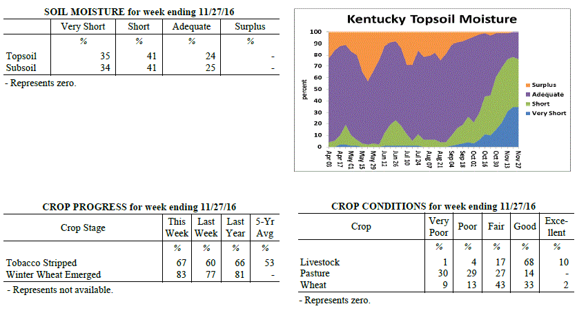 For the Period November 21, 2016 to November 27, 2016
Below Normal Temperatures and Below Normal Rainfall:
Temperatures for the period averaged 43 degrees across the state which was 1 degree
cooler than normal and 6 degrees cooler than the previous period. High temperatures
averaged from 52 in the West to 53 in the East. Departure from normal high
temperatures ranged from 3 degrees cooler than normal in the West to 2 degrees
cooler than normal in the East. Low temperatures averaged from 35 degrees in the
West to 33 degrees in the East. Departure from normal low temperature ranged from 1
degree cooler than normal in the West to 1 degree warmer than normal in the East.
The extreme high temperature for the period was 70 degrees at BURKESVILLE 3W and the
extreme low was 14 degrees at MONTICELLO AWOS.
Precipitation (liq. equ.) for the period totaled 0.23 inches statewide which was 0.81
inches below normal and 22% of normal. Precipitation totals by climate division, West
0.50 inches, Central 0.22 inches, Bluegrass 0.17 inches and East 0.03 inches, which
was 0.7, 0.88, 0.72 and 0.93 inches below normal. By station, precipitation totals
ranged from a low of 0.00 inches at BARBOURVILLE 3E to a high of 1.58 inches at
POPLAR BLUFF ASOS.
---
Agricultural Situation Report: October 21, 2016
(USDA's Crop Report with comments from Tom Priddy & Matt Dixon, UK Ag. Weather)
Agricultural News: Kentucky experienced above normal temperatures and below normal
rainfall over the past week. Precipitation for the week totaled 0.26 inches, 0.71
inches below normal. Temperatures averaged 50 degrees for the week, 3 degrees above
normal. Topsoil moisture was rated 35 percent very short, 43 percent short, and 22
percent adequate. Subsoil moisture was rated 33 percent very short, 43 percent short,
and 24 percent adequate. Days suitable for fieldwork averaged 6.5 out of a possible
seven.
Soybean harvest and winter wheat planting neared completion this week; tobacco
stripping continued. Most of the state is now in a severe drought according to the US
Drought Monitor, and burn bans remain in place for the majority of the state as well.
Some precipitation fell towards the end of the week, but had little impact on
reversing drought deficits. Soil and pasture conditions still remain very dry. Many
cattle farmers are concerned about hay supplies through the winter as drought conditions
forced early feeding. Fall breeding is ongoing.
For the Period November 21, 2016 to November 27, 2016
Below Normal Temperatures and Below Normal Rainfall:
Temperatures for the period averaged 43 degrees across the state which was 1 degree
cooler than normal and 6 degrees cooler than the previous period. High temperatures
averaged from 52 in the West to 53 in the East. Departure from normal high
temperatures ranged from 3 degrees cooler than normal in the West to 2 degrees
cooler than normal in the East. Low temperatures averaged from 35 degrees in the
West to 33 degrees in the East. Departure from normal low temperature ranged from 1
degree cooler than normal in the West to 1 degree warmer than normal in the East.
The extreme high temperature for the period was 70 degrees at BURKESVILLE 3W and the
extreme low was 14 degrees at MONTICELLO AWOS.
Precipitation (liq. equ.) for the period totaled 0.23 inches statewide which was 0.81
inches below normal and 22% of normal. Precipitation totals by climate division, West
0.50 inches, Central 0.22 inches, Bluegrass 0.17 inches and East 0.03 inches, which
was 0.7, 0.88, 0.72 and 0.93 inches below normal. By station, precipitation totals
ranged from a low of 0.00 inches at BARBOURVILLE 3E to a high of 1.58 inches at
POPLAR BLUFF ASOS.
---
Agricultural Situation Report: October 21, 2016
(USDA's Crop Report with comments from Tom Priddy & Matt Dixon, UK Ag. Weather)
Agricultural News: Kentucky experienced above normal temperatures and below normal
rainfall over the past week. Precipitation for the week totaled 0.26 inches, 0.71
inches below normal. Temperatures averaged 50 degrees for the week, 3 degrees above
normal. Topsoil moisture was rated 35 percent very short, 43 percent short, and 22
percent adequate. Subsoil moisture was rated 33 percent very short, 43 percent short,
and 24 percent adequate. Days suitable for fieldwork averaged 6.5 out of a possible
seven.
Soybean harvest and winter wheat planting neared completion this week; tobacco
stripping continued. Most of the state is now in a severe drought according to the US
Drought Monitor, and burn bans remain in place for the majority of the state as well.
Some precipitation fell towards the end of the week, but had little impact on
reversing drought deficits. Soil and pasture conditions still remain very dry. Many
cattle farmers are concerned about hay supplies through the winter as drought conditions
forced early feeding. Fall breeding is ongoing.
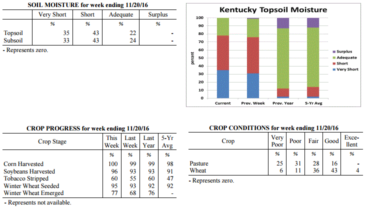 Kentucky Climate Summary
For the Period November 14, 2016 to November 20, 2016
Above Normal Temperatures and Below Normal Rainfall:
Kentucky saw a major change in the weather pattern this past week as record warmth on
Friday was followed by a plunge in the thermometer over the weekend. Through the
second half of the work week, winds steadily increased from the south, leading to a
warming trend for the area. By Friday, winds were gusting to around 25 to 30 mph,
pushing high temperatures into the middle 70s to around 80 for much of Kentucky.
This was roughly 20 to 25 degrees above normal for this time of year. The record
warmth was followed by a strong cold front pushing through the Commonwealth late
Friday and into Friday night. A band of showers formed along and behind the front
with statewide accumulations around a couple tenths to half inch, highest readings in
Western Kentucky. While it was the highest totals seen in quite a while, it was
still not near enough to cut into drought deficits. According to the latest update to
the US Drought Monitor, nearly 83% of the state is now under a Severe Drought.
Temperatures dropped drastically behind the front over the weekend. Highs by Sunday
were only in the upper 30s to middle 40s.
Temperatures for the period averaged 50 degrees across the state which was 3 degrees
warmer than normal and no change to the previous period. High temperatures averaged
from 65 in the West to 63 in the East. Departure from normal high temperatures
ranged from 7 degrees warmer than normal in the West to 6 degrees warmer than normal
in the East. Low temperatures averaged from 39 degrees in the West to 35 degrees in
the East. Departure from normal low temperature ranged from 2 degrees warmer than
normal in the West to 1 degree warmer than normal in the East. The extreme high
temperature for the period was 81 degrees at GREENVILLE 6N and the extreme low was
19 degrees at BURKESVILLE 3W.
Precipitation (liq. equ.) for the period totaled 0.26 inches statewide which was 0.71
inches below normal and 27% of normal. Precipitation totals by climate division, West
0.47 inches, Central 0.19 inches, Bluegrass 0.16 inches and East 0.21 inches, which
was 0.65, 0.83, 0.68 and 0.68 inches below normal. By station, precipitation totals
ranged from a low of 0.01 inches at POPLAR BLUFF ASOS to a high of 1.17 inches at
MURRAY 1W.
---
Agricultural Situation Report: October 14, 2016
(USDA's Crop Report with comments from Tom Priddy & Matt Dixon, UK Ag. Weather)
Agricultural News: Kentucky experienced near normal temperatures and well below
normal rainfall over the past week. Precipitation for the week totaled 0.14 inches,
0.68 inches below normal. Temperatures averaged 49 degrees for the week, unchanged
from normal. Topsoil moisture was rated 31 percent very short, 45 percent short, 23
percent adequate and 1 percent surplus. Subsoil moisture was rated 28 percent very
short, 43 percent short, 28 percent adequate, and 1 percent surplus. Days suitable
for fieldwork averaged 6.5 out of a possible seven.
Primary activities this week included harvesting soybeans, stripping tobacco, and
seeding winter wheat. Most of the state remains under moderate drought conditions
according to the US Drought Monitor, with southern and southeastern portions now in a
severe drought. Very little growth is occurring for pastures, wheat, and cover crops
due to the lack of moisture; frosts were also reported this week. Livestock producers
continue to feed hay, and many are concerned about the water supply with ponds
beginning to dry up.
Kentucky Climate Summary
For the Period November 14, 2016 to November 20, 2016
Above Normal Temperatures and Below Normal Rainfall:
Kentucky saw a major change in the weather pattern this past week as record warmth on
Friday was followed by a plunge in the thermometer over the weekend. Through the
second half of the work week, winds steadily increased from the south, leading to a
warming trend for the area. By Friday, winds were gusting to around 25 to 30 mph,
pushing high temperatures into the middle 70s to around 80 for much of Kentucky.
This was roughly 20 to 25 degrees above normal for this time of year. The record
warmth was followed by a strong cold front pushing through the Commonwealth late
Friday and into Friday night. A band of showers formed along and behind the front
with statewide accumulations around a couple tenths to half inch, highest readings in
Western Kentucky. While it was the highest totals seen in quite a while, it was
still not near enough to cut into drought deficits. According to the latest update to
the US Drought Monitor, nearly 83% of the state is now under a Severe Drought.
Temperatures dropped drastically behind the front over the weekend. Highs by Sunday
were only in the upper 30s to middle 40s.
Temperatures for the period averaged 50 degrees across the state which was 3 degrees
warmer than normal and no change to the previous period. High temperatures averaged
from 65 in the West to 63 in the East. Departure from normal high temperatures
ranged from 7 degrees warmer than normal in the West to 6 degrees warmer than normal
in the East. Low temperatures averaged from 39 degrees in the West to 35 degrees in
the East. Departure from normal low temperature ranged from 2 degrees warmer than
normal in the West to 1 degree warmer than normal in the East. The extreme high
temperature for the period was 81 degrees at GREENVILLE 6N and the extreme low was
19 degrees at BURKESVILLE 3W.
Precipitation (liq. equ.) for the period totaled 0.26 inches statewide which was 0.71
inches below normal and 27% of normal. Precipitation totals by climate division, West
0.47 inches, Central 0.19 inches, Bluegrass 0.16 inches and East 0.21 inches, which
was 0.65, 0.83, 0.68 and 0.68 inches below normal. By station, precipitation totals
ranged from a low of 0.01 inches at POPLAR BLUFF ASOS to a high of 1.17 inches at
MURRAY 1W.
---
Agricultural Situation Report: October 14, 2016
(USDA's Crop Report with comments from Tom Priddy & Matt Dixon, UK Ag. Weather)
Agricultural News: Kentucky experienced near normal temperatures and well below
normal rainfall over the past week. Precipitation for the week totaled 0.14 inches,
0.68 inches below normal. Temperatures averaged 49 degrees for the week, unchanged
from normal. Topsoil moisture was rated 31 percent very short, 45 percent short, 23
percent adequate and 1 percent surplus. Subsoil moisture was rated 28 percent very
short, 43 percent short, 28 percent adequate, and 1 percent surplus. Days suitable
for fieldwork averaged 6.5 out of a possible seven.
Primary activities this week included harvesting soybeans, stripping tobacco, and
seeding winter wheat. Most of the state remains under moderate drought conditions
according to the US Drought Monitor, with southern and southeastern portions now in a
severe drought. Very little growth is occurring for pastures, wheat, and cover crops
due to the lack of moisture; frosts were also reported this week. Livestock producers
continue to feed hay, and many are concerned about the water supply with ponds
beginning to dry up.
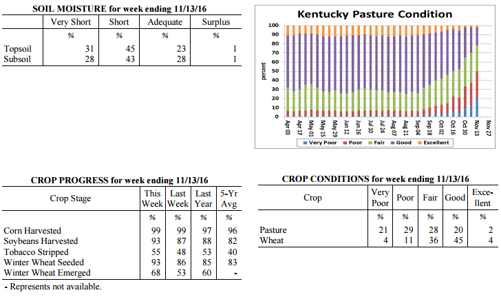 Kentucky Climate Summary
For the Period November 7, 2016 to November 13, 2016
Near Normal Temperatures and Well Below Normal Rainfall:
Much of South-Central and Southeastern Kentucky are now in a Severe Drought according
to the latest update to the US Drought Monitor. The state only averaged a little
over a tenth of an inch this past week with the passage of a cold front on Election
Day. Going back the past 60 days, the state has only averaged 2.71 inches, which is
nearly 4 inches below normal. While dry conditions continued, frost and freezing
temperatures returned, bringing an official end to the growing season. The first
occurrence came Thursday morning as lows dropped into the upper 20s to middle 30s
with widespread frost formation. The coldest temperatures of the fall season were
then seen on Saturday night and Sunday morning as high pressure of Canadian origin
moved overhead, leading to a hard freeze across the state. Skies cleared and allowed
lows to drop into the 20s for much of Kentucky. Some of the typical cooler spots even
hit the upper teens.
Temperatures for the period averaged 49 degrees across the state which was near
normal and 14 degrees cooler than the previous period. High temperatures averaged
from 64 in the West to 61 in the East. Departure from normal high temperatures ranged
from 3 degrees warmer than normal in the West to near normal in the East. Low
temperatures averaged from 37 degrees in the West to 36 degrees in the East.
Departure from normal low temperature ranged from 3 degrees cooler than normal in the
West to near normal in the East. The extreme high temperature for the period was 77
degrees at BOWLING GREEN APT and the extreme low was 19 degrees at CYNTHIANA 8N.
Precipitation (liq. equ.) for the period totaled 0.14 inches statewide which was 0.68
inches below normal and 17% of normal. Precipitation totals by climate division, West
0.10 inches, Central 0.12 inches, Bluegrass 0.22 inches and East 0.11 inches, which
was 0.88, 0.74, 0.49 and 0.63 inches below normal. By station, precipitation totals
ranged from a low of 0.00 inches at CAPE GIRARDEAU ASOS to a high of 0.47 inches at
CARLISLE 5SW.
---
Agricultural Situation Report: October 7, 2016
(USDA's Crop Report with comments from Tom Priddy & Matt Dixon, UK Ag. Weather)
Agricultural News: Kentucky experienced much above normal temperatures and well below
normal rainfall over the past week. Precipitation for the week totaled 0.06 inches,
0.70 inches below normal. Temperatures averaged 62 degrees for the week, 10 degrees
above normal. Topsoil moisture was rated 21 percent very short, 48 percent short, 30
percent adequate and 1 percent surplus. Subsoil moisture was rated 16 percent very
short, 51 percent short, 32 percent adequate, and 1 percent surplus. Days suitable
for fieldwork averaged 6.7 out of a possible seven.
Primary activities this week included harvesting corn and soybeans, stripping
tobacco, and sowing wheat. Dry weather continued this week, with most of the state
under moderate drought conditions according to the US Drought Monitor. Wheat and
cover crops have struggled to germinate with the limited moisture. Many livestock
producers are feeding hay or supplemental grain, and some have had to haul water with
farm ponds drying up. Cattle and calves obtained approximately 56 percent of feed
from pastures.
Kentucky Climate Summary
For the Period November 7, 2016 to November 13, 2016
Near Normal Temperatures and Well Below Normal Rainfall:
Much of South-Central and Southeastern Kentucky are now in a Severe Drought according
to the latest update to the US Drought Monitor. The state only averaged a little
over a tenth of an inch this past week with the passage of a cold front on Election
Day. Going back the past 60 days, the state has only averaged 2.71 inches, which is
nearly 4 inches below normal. While dry conditions continued, frost and freezing
temperatures returned, bringing an official end to the growing season. The first
occurrence came Thursday morning as lows dropped into the upper 20s to middle 30s
with widespread frost formation. The coldest temperatures of the fall season were
then seen on Saturday night and Sunday morning as high pressure of Canadian origin
moved overhead, leading to a hard freeze across the state. Skies cleared and allowed
lows to drop into the 20s for much of Kentucky. Some of the typical cooler spots even
hit the upper teens.
Temperatures for the period averaged 49 degrees across the state which was near
normal and 14 degrees cooler than the previous period. High temperatures averaged
from 64 in the West to 61 in the East. Departure from normal high temperatures ranged
from 3 degrees warmer than normal in the West to near normal in the East. Low
temperatures averaged from 37 degrees in the West to 36 degrees in the East.
Departure from normal low temperature ranged from 3 degrees cooler than normal in the
West to near normal in the East. The extreme high temperature for the period was 77
degrees at BOWLING GREEN APT and the extreme low was 19 degrees at CYNTHIANA 8N.
Precipitation (liq. equ.) for the period totaled 0.14 inches statewide which was 0.68
inches below normal and 17% of normal. Precipitation totals by climate division, West
0.10 inches, Central 0.12 inches, Bluegrass 0.22 inches and East 0.11 inches, which
was 0.88, 0.74, 0.49 and 0.63 inches below normal. By station, precipitation totals
ranged from a low of 0.00 inches at CAPE GIRARDEAU ASOS to a high of 0.47 inches at
CARLISLE 5SW.
---
Agricultural Situation Report: October 7, 2016
(USDA's Crop Report with comments from Tom Priddy & Matt Dixon, UK Ag. Weather)
Agricultural News: Kentucky experienced much above normal temperatures and well below
normal rainfall over the past week. Precipitation for the week totaled 0.06 inches,
0.70 inches below normal. Temperatures averaged 62 degrees for the week, 10 degrees
above normal. Topsoil moisture was rated 21 percent very short, 48 percent short, 30
percent adequate and 1 percent surplus. Subsoil moisture was rated 16 percent very
short, 51 percent short, 32 percent adequate, and 1 percent surplus. Days suitable
for fieldwork averaged 6.7 out of a possible seven.
Primary activities this week included harvesting corn and soybeans, stripping
tobacco, and sowing wheat. Dry weather continued this week, with most of the state
under moderate drought conditions according to the US Drought Monitor. Wheat and
cover crops have struggled to germinate with the limited moisture. Many livestock
producers are feeding hay or supplemental grain, and some have had to haul water with
farm ponds drying up. Cattle and calves obtained approximately 56 percent of feed
from pastures.
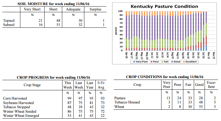 Kentucky Climate Summary
For the Period October 31, 2016 to November 6, 2016
Much Above Normal Temperatures and Well Below Normal Rainfall:
Rainfall continues to run scarce for the Commonwealth as the state has now gone 7
straight weeks of seeing below normal precipitation. Most of Kentucky stayed under a
tenth of an inch for the week. The only rainfall event came mid-week with the
passage of a weak cold front, but coverage remained isolated to scattered and only
minimal accumulations, leading to no drought relief. Major changes were seen on the
US Drought Monitor as nearly 82% of the state is now under a 'Moderate Drought'. Well
above normal temperatures stuck around for the first half of the work week as highs
moved into the low to middle 80s. Kentucky had several locations break daily
records, but also some that broke November all-time highs. Following the passage of
the cold front mentioned above, winds shifted to the north and temperatures took a
downhill turn going into the weekend. Lows dropped into the middle 30s to low 40s
both Friday and Saturday nights, leading to some frost development. Saying that, for
the week, the state average temperature was about 10 degrees above normal for early
November.
Temperatures for the period averaged 62 degrees across the state which was 10 degrees
warmer than normal and no change to the previous period. High temperatures averaged
from 74 in the West to 73 in the East. Departure from normal high temperatures
ranged from 10 degrees warmer than normal in the West to 9 degrees warmer than
normal in the East. Low temperatures averaged from 52 degrees in the West to 50
degrees in the East. Departure from normal low temperature ranged from 10 degrees
warmer than normal in the West to 13 degrees warmer than normal in the East. The
extreme high temperature for the period was 87 degrees at BOWLING GREEN APT and the
extreme low was 30 degrees at MONTICELLO AWOS.
Precipitation (liq. equ.) for the period totaled 0.06 inches statewide which was 0.7
inches below normal and 8% of normal. Precipitation totals by climate division, West
0.02 inches, Central 0.03 inches, Bluegrass 0.08 inches and East 0.11 inches, which
was 0.83, 0.76, 0.62 and 0.59 inches below normal. By station, precipitation totals
ranged from a low of 0.00 inches at ALBANY 1N to a high of 0.49 inches at PEABODY.
---
Agricultural Situation Report: October 31, 2016
(USDA's Crop Report with comments from Tom Priddy & Matt Dixon, UK Ag. Weather)
Agricultural News: Kentucky experienced above normal temperatures and below normal
rainfall over the past week. Precipitation for the week totaled 0.02 inches, 0.74
inches below normal. Temperatures averaged 61 degrees for the week, 7 degrees above
normal. Topsoil moisture was rated 15 percent very short, 46 percent short, 38
percent adequate and 1 percent surplus. Subsoil moisture was rated 13 percent very
short, 45 percent short, 41 percent adequate, and 1 percent surplus. Days suitable
for fieldwork averaged 6.5 out of a possible seven.
Primary activities this week included harvesting corn and soybeans, planting wheat
and cover crops, and stripping tobacco. Dry conditions allowed for harvest of corn
and soybeans to advance ahead of normal. The lack of moisture continues to be a
concern for germination of new seedings. Rain is needed to establish fall seeded
crops. Pastures are also in need of rain as many livestock producers have started
feeding hay earlier than normal.
Kentucky Climate Summary
For the Period October 31, 2016 to November 6, 2016
Much Above Normal Temperatures and Well Below Normal Rainfall:
Rainfall continues to run scarce for the Commonwealth as the state has now gone 7
straight weeks of seeing below normal precipitation. Most of Kentucky stayed under a
tenth of an inch for the week. The only rainfall event came mid-week with the
passage of a weak cold front, but coverage remained isolated to scattered and only
minimal accumulations, leading to no drought relief. Major changes were seen on the
US Drought Monitor as nearly 82% of the state is now under a 'Moderate Drought'. Well
above normal temperatures stuck around for the first half of the work week as highs
moved into the low to middle 80s. Kentucky had several locations break daily
records, but also some that broke November all-time highs. Following the passage of
the cold front mentioned above, winds shifted to the north and temperatures took a
downhill turn going into the weekend. Lows dropped into the middle 30s to low 40s
both Friday and Saturday nights, leading to some frost development. Saying that, for
the week, the state average temperature was about 10 degrees above normal for early
November.
Temperatures for the period averaged 62 degrees across the state which was 10 degrees
warmer than normal and no change to the previous period. High temperatures averaged
from 74 in the West to 73 in the East. Departure from normal high temperatures
ranged from 10 degrees warmer than normal in the West to 9 degrees warmer than
normal in the East. Low temperatures averaged from 52 degrees in the West to 50
degrees in the East. Departure from normal low temperature ranged from 10 degrees
warmer than normal in the West to 13 degrees warmer than normal in the East. The
extreme high temperature for the period was 87 degrees at BOWLING GREEN APT and the
extreme low was 30 degrees at MONTICELLO AWOS.
Precipitation (liq. equ.) for the period totaled 0.06 inches statewide which was 0.7
inches below normal and 8% of normal. Precipitation totals by climate division, West
0.02 inches, Central 0.03 inches, Bluegrass 0.08 inches and East 0.11 inches, which
was 0.83, 0.76, 0.62 and 0.59 inches below normal. By station, precipitation totals
ranged from a low of 0.00 inches at ALBANY 1N to a high of 0.49 inches at PEABODY.
---
Agricultural Situation Report: October 31, 2016
(USDA's Crop Report with comments from Tom Priddy & Matt Dixon, UK Ag. Weather)
Agricultural News: Kentucky experienced above normal temperatures and below normal
rainfall over the past week. Precipitation for the week totaled 0.02 inches, 0.74
inches below normal. Temperatures averaged 61 degrees for the week, 7 degrees above
normal. Topsoil moisture was rated 15 percent very short, 46 percent short, 38
percent adequate and 1 percent surplus. Subsoil moisture was rated 13 percent very
short, 45 percent short, 41 percent adequate, and 1 percent surplus. Days suitable
for fieldwork averaged 6.5 out of a possible seven.
Primary activities this week included harvesting corn and soybeans, planting wheat
and cover crops, and stripping tobacco. Dry conditions allowed for harvest of corn
and soybeans to advance ahead of normal. The lack of moisture continues to be a
concern for germination of new seedings. Rain is needed to establish fall seeded
crops. Pastures are also in need of rain as many livestock producers have started
feeding hay earlier than normal.
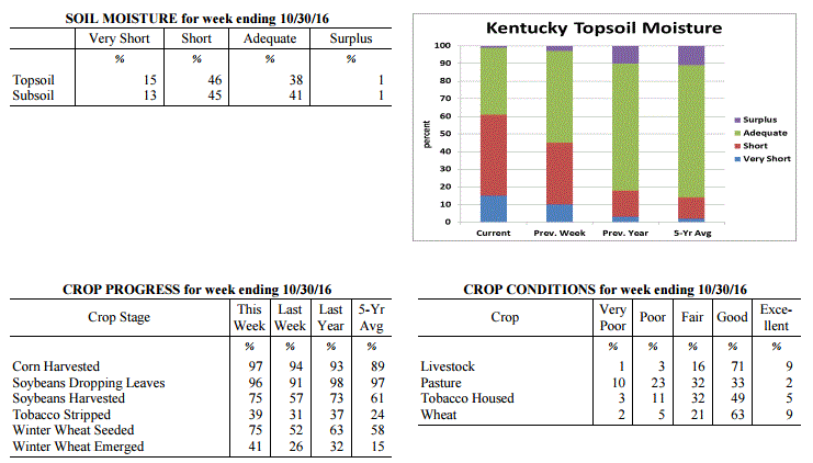 Kentucky Climate Summary
For the Period October 24, 2016 to October 30, 2016
Much Above Normal Temperatures and Well Below Normal Rainfall:
Dry conditions continue to persist across the Lower Ohio Valley. Most of the state
did not see any rainfall this past week as high pressure remained in control. Any
locations that did see precipitation with a frontal passage midweek, only saw a
couple hundredths for the most part. Long-term deficits continue to worsen with six
straight weeks of below normal rainfall. The state is nearly 2.5 inches below normal
for the month of October and over 3.5 inches for the past 60 days. While the US
Drought Monitor kept much of the state under 'Abnormally Dry' conditions, 'Moderate
Drought' was expanded into Southcentral Kentucky. Temperatures also continued to run
well above normal. Over the weekend, gusty southwest flow pushed highs into the low
to middle 80s, breaking several records across the state. Normal high temperatures
for the last week of October are in the low to middle 60s. Climatologically
speaking, most of Kentucky has now surpassed the average date of first freeze.
Temperatures for the period averaged 61 degrees across the state which was 7 degrees
warmer than normal and 4 degrees cooler than the previous period. High temperatures
averaged from 77 in the West to 74 in the East. Departure from normal high
temperatures ranged from 10 degrees warmer than normal in the West to 7 degrees
warmer than normal in the East. Low temperatures averaged from 49 degrees in the
West to 47 degrees in the East. Departure from normal low temperature ranged from 5
degrees warmer than normal in the West to 8 degrees warmer than normal in the East.
The extreme high temperature for the period was 85 degrees at PADUCAH ASOS and the
extreme low was 32 degrees at BURKESVILLE 3W.
Precipitation (liq. equ.) for the period totaled 0.02 inches statewide which was 0.74
inches below normal and 3% of normal. Precipitation totals by climate division, West
0.03 inches, Central 0.01 inches, Bluegrass 0.01 inches and East 0.01 inches, which
was 0.82, 0.77, 0.68 and 0.7 inches below normal. By station, precipitation totals
ranged from a low of 0.00 inches at BIG SANDY to a high of 0.27 inches at
CARBONDALE ASOS.
---
Agricultural Situation Report: October 24, 2016
(USDA's Crop Report with comments from Tom Priddy & Matt Dixon, UK Ag. Weather)
Agricultural News: Kentucky experienced above normal temperatures and below normal
rainfall over the past week. Precipitation for the week totaled 0.66 inches, 0.04
inches below normal. Temperatures averaged 65 degrees for the week, 8 degrees above
normal. Topsoil moisture was rated 10 percent very short, 35 percent short, 52
percent adequate and 3 percent surplus. Subsoil moisture was rated 7 percent very
short, 34 percent short, 56 percent adequate, and 3 percent surplus. Days suitable
for fieldwork averaged 5.6 out of a possible seven.
Primary activities this week included harvesting corn and soybeans, planting wheat
and cover crops, and stripping tobacco. The lack of moisture is of concern for
germination of new seedings. Most pastures are in need of rain as well. Livestock
producers have started feeding hay.
Kentucky Climate Summary
For the Period October 24, 2016 to October 30, 2016
Much Above Normal Temperatures and Well Below Normal Rainfall:
Dry conditions continue to persist across the Lower Ohio Valley. Most of the state
did not see any rainfall this past week as high pressure remained in control. Any
locations that did see precipitation with a frontal passage midweek, only saw a
couple hundredths for the most part. Long-term deficits continue to worsen with six
straight weeks of below normal rainfall. The state is nearly 2.5 inches below normal
for the month of October and over 3.5 inches for the past 60 days. While the US
Drought Monitor kept much of the state under 'Abnormally Dry' conditions, 'Moderate
Drought' was expanded into Southcentral Kentucky. Temperatures also continued to run
well above normal. Over the weekend, gusty southwest flow pushed highs into the low
to middle 80s, breaking several records across the state. Normal high temperatures
for the last week of October are in the low to middle 60s. Climatologically
speaking, most of Kentucky has now surpassed the average date of first freeze.
Temperatures for the period averaged 61 degrees across the state which was 7 degrees
warmer than normal and 4 degrees cooler than the previous period. High temperatures
averaged from 77 in the West to 74 in the East. Departure from normal high
temperatures ranged from 10 degrees warmer than normal in the West to 7 degrees
warmer than normal in the East. Low temperatures averaged from 49 degrees in the
West to 47 degrees in the East. Departure from normal low temperature ranged from 5
degrees warmer than normal in the West to 8 degrees warmer than normal in the East.
The extreme high temperature for the period was 85 degrees at PADUCAH ASOS and the
extreme low was 32 degrees at BURKESVILLE 3W.
Precipitation (liq. equ.) for the period totaled 0.02 inches statewide which was 0.74
inches below normal and 3% of normal. Precipitation totals by climate division, West
0.03 inches, Central 0.01 inches, Bluegrass 0.01 inches and East 0.01 inches, which
was 0.82, 0.77, 0.68 and 0.7 inches below normal. By station, precipitation totals
ranged from a low of 0.00 inches at BIG SANDY to a high of 0.27 inches at
CARBONDALE ASOS.
---
Agricultural Situation Report: October 24, 2016
(USDA's Crop Report with comments from Tom Priddy & Matt Dixon, UK Ag. Weather)
Agricultural News: Kentucky experienced above normal temperatures and below normal
rainfall over the past week. Precipitation for the week totaled 0.66 inches, 0.04
inches below normal. Temperatures averaged 65 degrees for the week, 8 degrees above
normal. Topsoil moisture was rated 10 percent very short, 35 percent short, 52
percent adequate and 3 percent surplus. Subsoil moisture was rated 7 percent very
short, 34 percent short, 56 percent adequate, and 3 percent surplus. Days suitable
for fieldwork averaged 5.6 out of a possible seven.
Primary activities this week included harvesting corn and soybeans, planting wheat
and cover crops, and stripping tobacco. The lack of moisture is of concern for
germination of new seedings. Most pastures are in need of rain as well. Livestock
producers have started feeding hay.
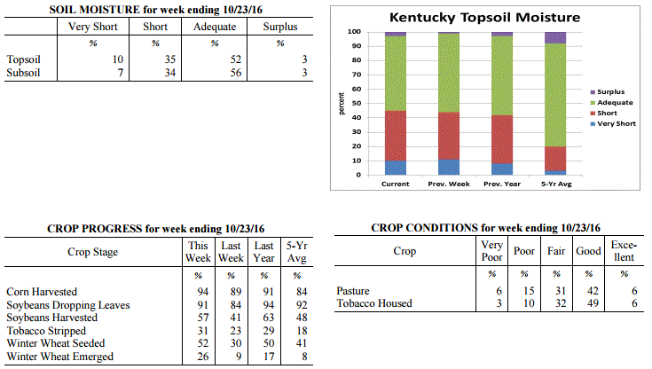 Kentucky Climate Summary
For the Period October 17, 2016 to October 23, 2016
Above Normal Temperatures and Below Normal Rainfall:
This past week started off with very warm temperatures in place on Monday and
Tuesday, some even record breaking. Highs rose into the mid to upper 80s for much of
the state behind breezy southwest flow and mostly sunny skies. A cold front then
pushed through the Lower Ohio Valley over the second half of the work week, bringing
some much needed rainfall to the Commonwealth. While Western and Central Kentucky
averaged around a quarter to half inch, the Bluegrass and Eastern Kentucky were
closer to an inch. Prior to the event, the state had gone four straight weeks of
much below normal precipitation. The US Drought Monitor expanded �Abnormally Dry�
conditions across almost the entirety of the state, while �Moderate Drought�
continued to increase in coverage across Southeastern Kentucky. Behind the cold
front, much cooler air spilled into the Bluegrass State. Highs on Friday and
Saturday only got into the upper 50s to middle 60s. Skies cleared from west to east
on Friday night with lows dropping into the upper 30s to lower 40s. Several
locations across Eastern Kentucky dropped into the middle 30s on Saturday night, some
reporting frost.
Temperatures for the period averaged 65 degrees across the state which was 8 degrees
warmer than normal and 2 degrees warmer than the previous period. High temperatures
averaged from 76 in the West to 75 in the East. Departure from normal high
temperatures ranged from 6 degrees warmer than normal in the West to 6 degrees
warmer than normal in the East. Low temperatures averaged from 55 degrees in the
West to 52 degrees in the East. Departure from normal low temperature ranged from 9
degrees warmer than normal in the West to 11 degrees warmer than normal in the
East. The extreme high temperature for the period was 90 degrees at PEABODY and the
extreme low was 29 degrees at BURKESVILLE 3W.
Precipitation (liq. equ.) for the period totaled 0.66 inches statewide which was 0.04
inches below normal and 94% of normal. Precipitation totals by climate division, West
0.26 inches, Central 0.39 inches, Bluegrass 1.06 inches and East 0.92 inches, which
was -0.52, -0.32, 0.41 and 0.25 inches respectively from normal. By station,
precipitation totals ranged from a low of 0.01 inches at HENDERSON 5E to a high of
3.63 inches at BURLINGTON 4S.
---
Agricultural Situation Report: October 17, 2016
(USDA's Crop Report with comments from Tom Priddy & Matt Dixon, UK Ag. Weather)
Agricultural News: Kentucky experienced above normal temperatures and below normal
rainfall over the past week. Precipitation for the week totaled 0.05 inches, 0.67
inches below normal. Temperatures averaged 62 degrees for the week, 4 degrees above
normal. Topsoil moisture was rated 11 percent very short, 33 percent short, 55
percent adequate and 1 percent surplus. Subsoil moisture was rated 8 percent very
short, 29 percent short, 62 percent adequate, and 1 percent surplus. Days suitable
for fieldwork averaged 6.5 out of a possible seven.
Dry conditions continued throughout the state. Primary activities this week included
harvesting corn and soybeans, sowing wheat and stripping tobacco. Weather conditions
have not been optimal for tobacco curing. Some livestock producers have begun feeding
hay due to deteriorating pasture conditions. Rain would be welcome to improve pasture
conditions, bring tobacco in case and for establishment of newly seeded fields.
Kentucky Climate Summary
For the Period October 17, 2016 to October 23, 2016
Above Normal Temperatures and Below Normal Rainfall:
This past week started off with very warm temperatures in place on Monday and
Tuesday, some even record breaking. Highs rose into the mid to upper 80s for much of
the state behind breezy southwest flow and mostly sunny skies. A cold front then
pushed through the Lower Ohio Valley over the second half of the work week, bringing
some much needed rainfall to the Commonwealth. While Western and Central Kentucky
averaged around a quarter to half inch, the Bluegrass and Eastern Kentucky were
closer to an inch. Prior to the event, the state had gone four straight weeks of
much below normal precipitation. The US Drought Monitor expanded �Abnormally Dry�
conditions across almost the entirety of the state, while �Moderate Drought�
continued to increase in coverage across Southeastern Kentucky. Behind the cold
front, much cooler air spilled into the Bluegrass State. Highs on Friday and
Saturday only got into the upper 50s to middle 60s. Skies cleared from west to east
on Friday night with lows dropping into the upper 30s to lower 40s. Several
locations across Eastern Kentucky dropped into the middle 30s on Saturday night, some
reporting frost.
Temperatures for the period averaged 65 degrees across the state which was 8 degrees
warmer than normal and 2 degrees warmer than the previous period. High temperatures
averaged from 76 in the West to 75 in the East. Departure from normal high
temperatures ranged from 6 degrees warmer than normal in the West to 6 degrees
warmer than normal in the East. Low temperatures averaged from 55 degrees in the
West to 52 degrees in the East. Departure from normal low temperature ranged from 9
degrees warmer than normal in the West to 11 degrees warmer than normal in the
East. The extreme high temperature for the period was 90 degrees at PEABODY and the
extreme low was 29 degrees at BURKESVILLE 3W.
Precipitation (liq. equ.) for the period totaled 0.66 inches statewide which was 0.04
inches below normal and 94% of normal. Precipitation totals by climate division, West
0.26 inches, Central 0.39 inches, Bluegrass 1.06 inches and East 0.92 inches, which
was -0.52, -0.32, 0.41 and 0.25 inches respectively from normal. By station,
precipitation totals ranged from a low of 0.01 inches at HENDERSON 5E to a high of
3.63 inches at BURLINGTON 4S.
---
Agricultural Situation Report: October 17, 2016
(USDA's Crop Report with comments from Tom Priddy & Matt Dixon, UK Ag. Weather)
Agricultural News: Kentucky experienced above normal temperatures and below normal
rainfall over the past week. Precipitation for the week totaled 0.05 inches, 0.67
inches below normal. Temperatures averaged 62 degrees for the week, 4 degrees above
normal. Topsoil moisture was rated 11 percent very short, 33 percent short, 55
percent adequate and 1 percent surplus. Subsoil moisture was rated 8 percent very
short, 29 percent short, 62 percent adequate, and 1 percent surplus. Days suitable
for fieldwork averaged 6.5 out of a possible seven.
Dry conditions continued throughout the state. Primary activities this week included
harvesting corn and soybeans, sowing wheat and stripping tobacco. Weather conditions
have not been optimal for tobacco curing. Some livestock producers have begun feeding
hay due to deteriorating pasture conditions. Rain would be welcome to improve pasture
conditions, bring tobacco in case and for establishment of newly seeded fields.
 Kentucky Climate Summary
For the Period October 10, 2016 to October 16, 2016
Above Normal Temperatures and Well Below Normal Rainfall:
The Commonwealth didn't see much rainfall for a second straight week. High pressure
kept the area mostly dry with any passing disturbances not amounting to much in the
way of rainfall. Over the past 30 days, data at the UK Ag Weather Center shows the state
has only averaged 1.71 inches, which is 1.69 inches below normal for that time span.
The US Drought Monitor greatly expanded the area of Kentucky now showing signs of
'Abnormally Dry' conditions, now accounting for nearly 62% of the state. A small
section of Southeastern Kentucky was even upgraded to a 'Moderate Drought'. In
addition, temperatures continued to run above normal for a second straight week.
Weekend highs rose into the upper 70s to lower 80s for much of the area.
Temperatures for the period averaged 62 degrees across the state which was 4 degrees
warmer than normal and 4 degrees cooler than the previous period. High temperatures
averaged from 73 in the West to 72 in the East. Departure from normal high
temperatures ranged from near normal in the West to 1 degree warmer than normal in
the East. Low temperatures averaged from 53 degrees in the West to 49 degrees in the
East. Departure from normal low temperature ranged from 6 degrees warmer than normal
in the West to 6 degrees warmer than normal in the East. The extreme high temperature
for the period was 84 degrees at BOWLING GREEN APT and the extreme low was 36 degrees
at BARBOURVILLE 3E.
Precipitation (liq. equ.) for the period totaled 0.05 inches statewide which was 0.67
inches below normal and 7% of normal. Precipitation totals by climate division, West
0.10 inches, Central 0.04 inches, Bluegrass 0.01 inches and East 0.04 inches, which
was 0.64, 0.69, 0.68 and 0.67 inches below normal. By station, precipitation totals
ranged from a low of 0.00 inches at ALEXANDRIA 5NW to a high of 0.76 inches at
POPLAR BLUFF ASOS.
---
Agricultural Situation Report: October 11, 2016
(USDA's Crop Report with comments from Tom Priddy & Matt Dixon, UK Ag. Weather)
Agricultural News: Kentucky experienced above normal temperatures and below normal
rainfall over the past week. Precipitation for the week totaled 0.01 inches, 0.78
inches below normal. Temperatures averaged 66 degrees for the week, 6 degrees above
normal. Topsoil moisture was rated 6 percent very short, 24 percent short, 68 percent
adequate and 2 percent surplus. Subsoil moisture was rated 5 percent very short, 23
percent short, 70 percent adequate, and 2 percent surplus. Days suitable for
fieldwork averaged 6.7 out of a possible seven.
Dry conditions allowed farmers to make significant progress with all types of field
work. Primary activities this week included harvesting corn, soybeans, hay, and
tobacco. Tobacco harvest was winding down. Tobacco houseburn was reported as 2
percent heavy, 9 percent moderate, 17 percent light, with 72 percent experiencing
none. Some livestock producers have begun feeding hay due to dry conditions.
Kentucky Climate Summary
For the Period October 10, 2016 to October 16, 2016
Above Normal Temperatures and Well Below Normal Rainfall:
The Commonwealth didn't see much rainfall for a second straight week. High pressure
kept the area mostly dry with any passing disturbances not amounting to much in the
way of rainfall. Over the past 30 days, data at the UK Ag Weather Center shows the state
has only averaged 1.71 inches, which is 1.69 inches below normal for that time span.
The US Drought Monitor greatly expanded the area of Kentucky now showing signs of
'Abnormally Dry' conditions, now accounting for nearly 62% of the state. A small
section of Southeastern Kentucky was even upgraded to a 'Moderate Drought'. In
addition, temperatures continued to run above normal for a second straight week.
Weekend highs rose into the upper 70s to lower 80s for much of the area.
Temperatures for the period averaged 62 degrees across the state which was 4 degrees
warmer than normal and 4 degrees cooler than the previous period. High temperatures
averaged from 73 in the West to 72 in the East. Departure from normal high
temperatures ranged from near normal in the West to 1 degree warmer than normal in
the East. Low temperatures averaged from 53 degrees in the West to 49 degrees in the
East. Departure from normal low temperature ranged from 6 degrees warmer than normal
in the West to 6 degrees warmer than normal in the East. The extreme high temperature
for the period was 84 degrees at BOWLING GREEN APT and the extreme low was 36 degrees
at BARBOURVILLE 3E.
Precipitation (liq. equ.) for the period totaled 0.05 inches statewide which was 0.67
inches below normal and 7% of normal. Precipitation totals by climate division, West
0.10 inches, Central 0.04 inches, Bluegrass 0.01 inches and East 0.04 inches, which
was 0.64, 0.69, 0.68 and 0.67 inches below normal. By station, precipitation totals
ranged from a low of 0.00 inches at ALEXANDRIA 5NW to a high of 0.76 inches at
POPLAR BLUFF ASOS.
---
Agricultural Situation Report: October 11, 2016
(USDA's Crop Report with comments from Tom Priddy & Matt Dixon, UK Ag. Weather)
Agricultural News: Kentucky experienced above normal temperatures and below normal
rainfall over the past week. Precipitation for the week totaled 0.01 inches, 0.78
inches below normal. Temperatures averaged 66 degrees for the week, 6 degrees above
normal. Topsoil moisture was rated 6 percent very short, 24 percent short, 68 percent
adequate and 2 percent surplus. Subsoil moisture was rated 5 percent very short, 23
percent short, 70 percent adequate, and 2 percent surplus. Days suitable for
fieldwork averaged 6.7 out of a possible seven.
Dry conditions allowed farmers to make significant progress with all types of field
work. Primary activities this week included harvesting corn, soybeans, hay, and
tobacco. Tobacco harvest was winding down. Tobacco houseburn was reported as 2
percent heavy, 9 percent moderate, 17 percent light, with 72 percent experiencing
none. Some livestock producers have begun feeding hay due to dry conditions.
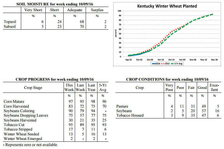 Kentucky Climate Summary
For the Period October 3, 2016 to October 9, 2016
Above Normal Temperatures and Below Normal Rainfall:
For the second time in less than a month, most locations in Kentucky saw very little
to no precipitation over the course of the week. High pressure dominated the area,
bringing mostly clear skies and dry conditions. Temperatures were unseasonably warm
through the work week, rising into the low to middle 80s about each day. That changed
late Friday and Friday night as a cold front pushed through the Ohio Valley. Winds
turned to the north on Saturday, becoming breezy at times with gusts around 25 mph.
Highs over the weekend took a significant fall, only rising into the upper 60s to low
70s. Much cooler temperatures were seen Saturday night with much of the state
dropping into the low to middle 40s. Saying that, a handful of sheltered and typically
cooler spots even dropped into the 30s.
Temperatures for the period averaged 66 degrees across the state which was 6 degrees
warmer than normal and 4 degrees warmer than the previous period. High temperatures
averaged from 80 in the West to 77 in the East. Departure from normal high
temperatures ranged from 5 degrees warmer than normal in the West to 4 degrees warmer
than normal in the East. Low temperatures averaged from 55 degrees in the West to 53
degrees in the East. Departure from normal low temperature ranged from 5 degrees
warmer than normal in the West to 7 degrees warmer than normal in the East. The
extreme high temperature for the period was 88 degrees at BOWLING GREEN APT and the
extreme low was 35 degrees at VANCEBURG 6W.
Precipitation (liq. equ.) for the period totaled 0.01 inches statewide which was 0.78
inches below normal and 1% of normal. Precipitation totals by climate division, West
0.01 inches, Central 0.00 inches, Bluegrass 0.00 inches and East 0.01 inches, which
was 0.8, 0.82, 0.74 and 0.77 inches below normal. By station, precipitation totals
ranged from a low of 0.00 inches at ALBANY 1N to a high of 0.19 inches at PIKEVILLE 13S.
---
Agricultural Situation Report: October 3, 2016
(USDA's Crop Report with comments from Tom Priddy & Matt Dixon, UK Ag. Weather)
Agricultural News: Kentucky experienced below normal temperatures and rainfall over
the past week. Precipitation for the week totaled 0.68 inches, 0.13 inches below
normal. Temperatures averaged 62 degrees for the week, 1 degree below normal. Topsoil
moisture was rated 3 percent very short, 18 percent short, 74 percent adequate and 5
percent surplus. Subsoil moisture was rated 2 percent very short, 19 percent short,
74 percent adequate, and 5 percent surplus. Days suitable for fieldwork averaged 5.6
out of a possible seven.
Primary activities this week included harvesting corn, soybeans, hay, and tobacco.
Showers during the week slowed harvest progress somewhat, but corn harvest continued
at a rapid pace. Many farmers would welcome some rain as many areas of the state
remained relatively dry. Corn yields are varied depending on planting date and
location. Pasture conditions were rated mostly good to fair. Livestock were rated in
mostly good condition. Labor shortage being reported in some areas which is impacting
the tobacco harvest. Tobacco houseburn was reported as 2 percent heavy, 8 percent
moderate, 18 percent light, with 72 percent experiencing none.
Kentucky Climate Summary
For the Period October 3, 2016 to October 9, 2016
Above Normal Temperatures and Below Normal Rainfall:
For the second time in less than a month, most locations in Kentucky saw very little
to no precipitation over the course of the week. High pressure dominated the area,
bringing mostly clear skies and dry conditions. Temperatures were unseasonably warm
through the work week, rising into the low to middle 80s about each day. That changed
late Friday and Friday night as a cold front pushed through the Ohio Valley. Winds
turned to the north on Saturday, becoming breezy at times with gusts around 25 mph.
Highs over the weekend took a significant fall, only rising into the upper 60s to low
70s. Much cooler temperatures were seen Saturday night with much of the state
dropping into the low to middle 40s. Saying that, a handful of sheltered and typically
cooler spots even dropped into the 30s.
Temperatures for the period averaged 66 degrees across the state which was 6 degrees
warmer than normal and 4 degrees warmer than the previous period. High temperatures
averaged from 80 in the West to 77 in the East. Departure from normal high
temperatures ranged from 5 degrees warmer than normal in the West to 4 degrees warmer
than normal in the East. Low temperatures averaged from 55 degrees in the West to 53
degrees in the East. Departure from normal low temperature ranged from 5 degrees
warmer than normal in the West to 7 degrees warmer than normal in the East. The
extreme high temperature for the period was 88 degrees at BOWLING GREEN APT and the
extreme low was 35 degrees at VANCEBURG 6W.
Precipitation (liq. equ.) for the period totaled 0.01 inches statewide which was 0.78
inches below normal and 1% of normal. Precipitation totals by climate division, West
0.01 inches, Central 0.00 inches, Bluegrass 0.00 inches and East 0.01 inches, which
was 0.8, 0.82, 0.74 and 0.77 inches below normal. By station, precipitation totals
ranged from a low of 0.00 inches at ALBANY 1N to a high of 0.19 inches at PIKEVILLE 13S.
---
Agricultural Situation Report: October 3, 2016
(USDA's Crop Report with comments from Tom Priddy & Matt Dixon, UK Ag. Weather)
Agricultural News: Kentucky experienced below normal temperatures and rainfall over
the past week. Precipitation for the week totaled 0.68 inches, 0.13 inches below
normal. Temperatures averaged 62 degrees for the week, 1 degree below normal. Topsoil
moisture was rated 3 percent very short, 18 percent short, 74 percent adequate and 5
percent surplus. Subsoil moisture was rated 2 percent very short, 19 percent short,
74 percent adequate, and 5 percent surplus. Days suitable for fieldwork averaged 5.6
out of a possible seven.
Primary activities this week included harvesting corn, soybeans, hay, and tobacco.
Showers during the week slowed harvest progress somewhat, but corn harvest continued
at a rapid pace. Many farmers would welcome some rain as many areas of the state
remained relatively dry. Corn yields are varied depending on planting date and
location. Pasture conditions were rated mostly good to fair. Livestock were rated in
mostly good condition. Labor shortage being reported in some areas which is impacting
the tobacco harvest. Tobacco houseburn was reported as 2 percent heavy, 8 percent
moderate, 18 percent light, with 72 percent experiencing none.
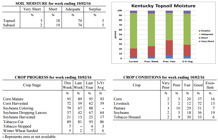 Kentucky Climate Summary
For the Period September 26, 2016 to October 2, 2016
Below Normal Temperatures and Rainfall:
Conditions finally started to feel like fall this past week. Temperatures were
slightly below normal with highs staying in the 60s and 70s for much of the period.
This broke a streak of 12 straight weeks with near to above normal temperatures. The
cooler air started filtering into the area on Monday as a cold front crossed the
region, followed by a brief period of high pressure. Early in the week, some
locations even saw lows drop into the low to middle 40s as skies cleared at night. A
disturbance aloft then slowly rotated over the area from Wednesday through Saturday.
This brought an extended period of unsettled weather with multiple rounds of showers.
Mostly cloudy skies kept temperatures much below normal during the day with highs
only in the 60s for most. Combining the rainfall seen on Monday with the several days
under the influence of the disturbance aloft, the state averaged 0.68 inches, which
was slightly below normal.
Temperatures for the period averaged 62 degrees across the state which was 1 degree
cooler than normal and 12 degrees cooler than the previous period. High temperatures
averaged from 72 in the West to 72 in the East. Departure from normal high
temperatures ranged from 5 degrees cooler than normal in the West to 3 degrees cooler
than normal in the East. Low temperatures averaged from 54 degrees in the West to 52
degrees in the East. Departure from normal low temperature ranged from 1 degree
warmer than normal in the West to 3 degrees warmer than normal in the East. The
extreme high temperature for the period was 86 degrees at PAINTSVILLE 4W and the
extreme low was 41 degrees at CYNTHIANA 8N.
Precipitation (liq. equ.) for the period totaled 0.68 inches statewide which was 0.13
inches below normal and 84% of normal. Precipitation totals by climate division, West
0.67 inches, Central 0.67 inches, Bluegrass 1.03 inches and East 0.33 inches, which
was -0.16, -0.20, 0.29 and -0.47 inches respectively from normal. By station,
precipitation totals ranged from a low of 0.00 inches at POPLAR BLUFF ASOS to a high
of 1.92 inches at EVANSVILLE ASOS.
---
Agricultural Situation Report: September 26, 2016
(USDA's Crop Report with comments from Tom Priddy & Matt Dixon, UK Ag. Weather)
Agricultural News: Kentucky experienced well above normal temperatures and much below
normal rainfall over the past week. Precipitation for the week totaled 0.01 inches,
0.83 inches below normal. Temperatures averaged 74 degrees for the week, 8 degrees
above normal. Topsoil moisture was rated 4 percent very short, 22 percent short, 68
percent adequate and 6 percent surplus. Subsoil moisture was rated 2 percent very
short, 20 percent short, 72 percent adequate, and 6 percent surplus. Days suitable
for fieldwork averaged 6.6 out of a possible seven.
Primary activities this week included harvesting corn, soybeans, hay, and tobacco.
Most of the state remains dry, with few areas receiving any rainfall over the past
week. Corn yield reports range from below average to good, with some grain quality
problems due to the excessive wet weather during the growing season. Producers
reported early soybean yields as average or above-average. Dry conditions continue to
decrease pasture and hay growth, and have started to impact fall seeding. Tobacco
houseburn was reported as 1 percent severe, 10 percent moderate, and 18 percent light,
with 71 percent experiencing none.
Kentucky Climate Summary
For the Period September 26, 2016 to October 2, 2016
Below Normal Temperatures and Rainfall:
Conditions finally started to feel like fall this past week. Temperatures were
slightly below normal with highs staying in the 60s and 70s for much of the period.
This broke a streak of 12 straight weeks with near to above normal temperatures. The
cooler air started filtering into the area on Monday as a cold front crossed the
region, followed by a brief period of high pressure. Early in the week, some
locations even saw lows drop into the low to middle 40s as skies cleared at night. A
disturbance aloft then slowly rotated over the area from Wednesday through Saturday.
This brought an extended period of unsettled weather with multiple rounds of showers.
Mostly cloudy skies kept temperatures much below normal during the day with highs
only in the 60s for most. Combining the rainfall seen on Monday with the several days
under the influence of the disturbance aloft, the state averaged 0.68 inches, which
was slightly below normal.
Temperatures for the period averaged 62 degrees across the state which was 1 degree
cooler than normal and 12 degrees cooler than the previous period. High temperatures
averaged from 72 in the West to 72 in the East. Departure from normal high
temperatures ranged from 5 degrees cooler than normal in the West to 3 degrees cooler
than normal in the East. Low temperatures averaged from 54 degrees in the West to 52
degrees in the East. Departure from normal low temperature ranged from 1 degree
warmer than normal in the West to 3 degrees warmer than normal in the East. The
extreme high temperature for the period was 86 degrees at PAINTSVILLE 4W and the
extreme low was 41 degrees at CYNTHIANA 8N.
Precipitation (liq. equ.) for the period totaled 0.68 inches statewide which was 0.13
inches below normal and 84% of normal. Precipitation totals by climate division, West
0.67 inches, Central 0.67 inches, Bluegrass 1.03 inches and East 0.33 inches, which
was -0.16, -0.20, 0.29 and -0.47 inches respectively from normal. By station,
precipitation totals ranged from a low of 0.00 inches at POPLAR BLUFF ASOS to a high
of 1.92 inches at EVANSVILLE ASOS.
---
Agricultural Situation Report: September 26, 2016
(USDA's Crop Report with comments from Tom Priddy & Matt Dixon, UK Ag. Weather)
Agricultural News: Kentucky experienced well above normal temperatures and much below
normal rainfall over the past week. Precipitation for the week totaled 0.01 inches,
0.83 inches below normal. Temperatures averaged 74 degrees for the week, 8 degrees
above normal. Topsoil moisture was rated 4 percent very short, 22 percent short, 68
percent adequate and 6 percent surplus. Subsoil moisture was rated 2 percent very
short, 20 percent short, 72 percent adequate, and 6 percent surplus. Days suitable
for fieldwork averaged 6.6 out of a possible seven.
Primary activities this week included harvesting corn, soybeans, hay, and tobacco.
Most of the state remains dry, with few areas receiving any rainfall over the past
week. Corn yield reports range from below average to good, with some grain quality
problems due to the excessive wet weather during the growing season. Producers
reported early soybean yields as average or above-average. Dry conditions continue to
decrease pasture and hay growth, and have started to impact fall seeding. Tobacco
houseburn was reported as 1 percent severe, 10 percent moderate, and 18 percent light,
with 71 percent experiencing none.
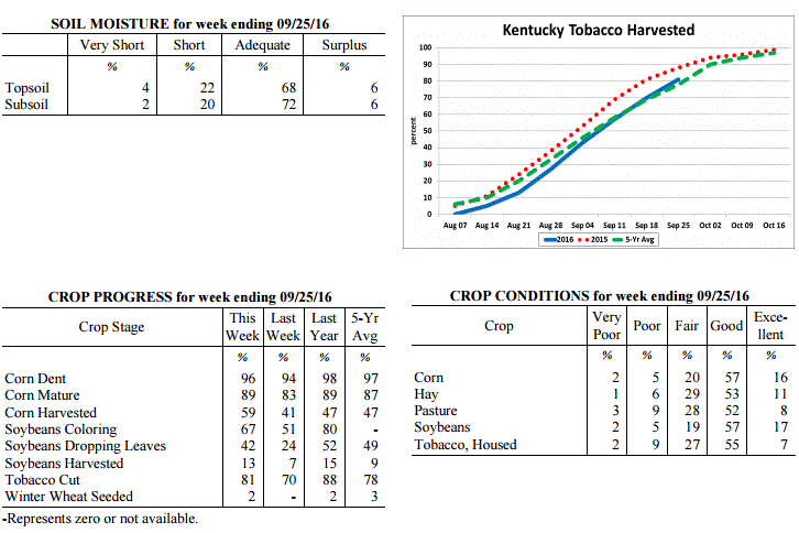 Kentucky Climate Summary
For the Period September 19, 2016 to September 25, 2016
Well Above Normal Temperatures and Much Below Normal Rainfall:
Fall officially began this past Thursday, but temperatures for the period felt more
like the middle of summer. High pressure at the surface and aloft led to an
extended period of hot and dry conditions. Under mostly clear skies for much of the
week, high temperatures consistently ran above normal, rising into the middle 80s to
lower 90s. Normal highs for this time of year are in the middle 70s to around 80.
For the week, much of the state also didn't see any precipitation. Kentucky has now
seen below normal rainfall four of the past five weeks. Over the past 30 days, data
at the Ag Weather Center shows that Kentucky is 1.52 inches below normal.
Temperatures for the period averaged 74 degrees across the state which was 8 degrees
warmer than normal and no change to the previous period. High temperatures averaged
from 89 in the West to 86 in the East. Departure from normal high temperatures ranged
from 9 degrees warmer than normal in the West to 8 degrees warmer than normal in the
East. Low temperatures averaged from 62 degrees in the West to 61 degrees in the
East. Departure from normal low temperature ranged from 6 degrees warmer than normal
in the West to 8 degrees warmer than normal in the East. The extreme high temperature
for the period was 94 degrees at EVANSVILLE ASOS and the extreme low was 53 degrees
at CYNTHIANA 8N.
Precipitation (liq. equ.) for the period totaled 0.01 inches statewide which was 0.83
inches below normal and 1% of normal. Precipitation totals by climate division, West
0.00 inches, Central 0.01 inches, Bluegrass 0.00 inches and East 0.01 inches, which
was 0.86, 0.92, 0.76 and 0.82 inches below normal. By station, precipitation totals
ranged from a low of 0.00 inches at ALEXANDRIA 5NW to a high of 0.17 inches at
ALBANY 1N.
---
Agricultural Situation Report: September 19, 2016
(USDA's Crop Report with comments from Tom Priddy & Matt Dixon, UK Ag. Weather)
Agricultural News: Kentucky experienced above normal temperatures and rainfall over
the past week. Precipitation for the week totaled 1.05 inches, 0.21 inches above
normal. Temperatures averaged 74 degrees for the week, 5 degrees above normal.
Topsoil moisture was rated 3 percent very short, 16 percent short, 73 percent
adequate and 8 percent surplus. Subsoil moisture was rated 1 percent very short, 14
percent short, 77 percent adequate, and 8 percent surplus. Days suitable for
fieldwork averaged 6.0 out of a possible seven.
Primary activities this week included cutting hay and tobacco, harvesting corn, and
seeding fall alfalfa and grass fields. Early corn yields are reported to be mostly
good. Harvest has also begun on some early soybean fields, with average or above-
average yield expectations. Dry conditions during the week led to crops drying down
quicker than normal, with some producers reporting reductions in kernel fill.
Pastures are drying as well. The fall calving season is underway.
Kentucky Climate Summary
For the Period September 19, 2016 to September 25, 2016
Well Above Normal Temperatures and Much Below Normal Rainfall:
Fall officially began this past Thursday, but temperatures for the period felt more
like the middle of summer. High pressure at the surface and aloft led to an
extended period of hot and dry conditions. Under mostly clear skies for much of the
week, high temperatures consistently ran above normal, rising into the middle 80s to
lower 90s. Normal highs for this time of year are in the middle 70s to around 80.
For the week, much of the state also didn't see any precipitation. Kentucky has now
seen below normal rainfall four of the past five weeks. Over the past 30 days, data
at the Ag Weather Center shows that Kentucky is 1.52 inches below normal.
Temperatures for the period averaged 74 degrees across the state which was 8 degrees
warmer than normal and no change to the previous period. High temperatures averaged
from 89 in the West to 86 in the East. Departure from normal high temperatures ranged
from 9 degrees warmer than normal in the West to 8 degrees warmer than normal in the
East. Low temperatures averaged from 62 degrees in the West to 61 degrees in the
East. Departure from normal low temperature ranged from 6 degrees warmer than normal
in the West to 8 degrees warmer than normal in the East. The extreme high temperature
for the period was 94 degrees at EVANSVILLE ASOS and the extreme low was 53 degrees
at CYNTHIANA 8N.
Precipitation (liq. equ.) for the period totaled 0.01 inches statewide which was 0.83
inches below normal and 1% of normal. Precipitation totals by climate division, West
0.00 inches, Central 0.01 inches, Bluegrass 0.00 inches and East 0.01 inches, which
was 0.86, 0.92, 0.76 and 0.82 inches below normal. By station, precipitation totals
ranged from a low of 0.00 inches at ALEXANDRIA 5NW to a high of 0.17 inches at
ALBANY 1N.
---
Agricultural Situation Report: September 19, 2016
(USDA's Crop Report with comments from Tom Priddy & Matt Dixon, UK Ag. Weather)
Agricultural News: Kentucky experienced above normal temperatures and rainfall over
the past week. Precipitation for the week totaled 1.05 inches, 0.21 inches above
normal. Temperatures averaged 74 degrees for the week, 5 degrees above normal.
Topsoil moisture was rated 3 percent very short, 16 percent short, 73 percent
adequate and 8 percent surplus. Subsoil moisture was rated 1 percent very short, 14
percent short, 77 percent adequate, and 8 percent surplus. Days suitable for
fieldwork averaged 6.0 out of a possible seven.
Primary activities this week included cutting hay and tobacco, harvesting corn, and
seeding fall alfalfa and grass fields. Early corn yields are reported to be mostly
good. Harvest has also begun on some early soybean fields, with average or above-
average yield expectations. Dry conditions during the week led to crops drying down
quicker than normal, with some producers reporting reductions in kernel fill.
Pastures are drying as well. The fall calving season is underway.
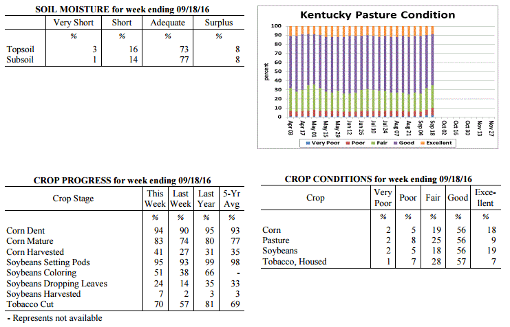 Kentucky Climate Summary
For the Period September 12, 2016 to September 18, 2016
Above Normal Temperatures and Rainfall:
Dry conditions continued through the first half of the work week as the Bluegrass
State remained under the influence of high pressure. After a relatively cool day on
Monday, temperatures increased on Tuesday and stayed that way through much of the
period. This led to a 11th straight week of near to above normal temperatures that
extends back into early July. Bottom line, it has been a warm summer. Showers and
storms returned over the latter half of the work week and into the weekend. Ahead of
a weak cold front, winds turned to the southwest, pulling moisture back into the
area. A solid band of showers developed within this flow and slowly inched eastward
over the course of the weekend. Conditions had been starting to turn dry with three
straight weeks of below normal precipitation. The US Drought Monitor even introduced
a couple small areas of 'Abnormally Dry' Conditions in South-Central and Eastern
Kentucky. For the week, the band of showers helped push the state rainfall average
over an inch, which was nearly a quarter inch above normal.
Temperatures for the period averaged 74 degrees across the state which was 5 degrees
warmer than normal and 4 degrees cooler than the previous period. High temperatures
averaged from 86 in the West to 86 in the East. Departure from normal high
temperatures ranged from 4 degrees warmer than normal in the West to 6 degrees
warmer than normal in the East. Low temperatures averaged from 65 degrees in the
West to 63 degrees in the East. Departure from normal low temperature ranged from 6
degrees warmer than normal in the West to 7 degrees warmer than normal in the East.
The extreme high temperature for the period was 94 degrees at HICKMAN 2E and the
extreme low was 49 degrees at MAYFIELD 6SW.
Precipitation (liq. equ.) for the period totaled 1.05 inches statewide which was 0.21
inches above normal and 125% of normal. Precipitation totals by climate division,
West 1.10 inches, Central 1.24 inches, Bluegrass 0.70 inches and East 1.18 inches,
which was 0.25, 0.31, -0.05 and 0.36 inches respectively from normal. By station,
precipitation totals ranged from a low of 0.02 inches at LOUISVILLE APT to a high of
3.63 inches at SCOTTSVILLE 2W.
---
Agricultural Situation Report: September 12, 2016
(USDA's Crop Report with comments from Tom Priddy & Matt Dixon, UK Ag. Weather)
Agricultural News: Kentucky experienced above normal temperatures and below normal
rainfall over the past week. Precipitation for the week totaled 0.50 inches, 0.31
inches below normal. Temperatures averaged 76 degrees for the week, 4 degrees above
normal. Topsoil moisture was rated 2 percent very short, 14 percent short, 75 percent
adequate and 9 percent surplus. Subsoil moisture was rated 1 percent very short, 12
percent short, 78 percent adequate, and 9 percent surplus. Days suitable for
fieldwork averaged 6.4 out of a possible seven.
Primary activities this week included cutting hay and tobacco, and harvesting corn
for grain; some corn silage was harvested as well. Continued hot and dry conditions
assisted dry-down in grain crops, but started to negatively affect pasture and hay
land. Farmers have concerns over labor shortages for harvesting tobacco, as well as
disease impacts and resulting weights. Various disease incidences were reported this
week including rust and diplodia ear rot on corn, and frogeye leaf spot and stem
canker on soybeans.
Kentucky Climate Summary
For the Period September 12, 2016 to September 18, 2016
Above Normal Temperatures and Rainfall:
Dry conditions continued through the first half of the work week as the Bluegrass
State remained under the influence of high pressure. After a relatively cool day on
Monday, temperatures increased on Tuesday and stayed that way through much of the
period. This led to a 11th straight week of near to above normal temperatures that
extends back into early July. Bottom line, it has been a warm summer. Showers and
storms returned over the latter half of the work week and into the weekend. Ahead of
a weak cold front, winds turned to the southwest, pulling moisture back into the
area. A solid band of showers developed within this flow and slowly inched eastward
over the course of the weekend. Conditions had been starting to turn dry with three
straight weeks of below normal precipitation. The US Drought Monitor even introduced
a couple small areas of 'Abnormally Dry' Conditions in South-Central and Eastern
Kentucky. For the week, the band of showers helped push the state rainfall average
over an inch, which was nearly a quarter inch above normal.
Temperatures for the period averaged 74 degrees across the state which was 5 degrees
warmer than normal and 4 degrees cooler than the previous period. High temperatures
averaged from 86 in the West to 86 in the East. Departure from normal high
temperatures ranged from 4 degrees warmer than normal in the West to 6 degrees
warmer than normal in the East. Low temperatures averaged from 65 degrees in the
West to 63 degrees in the East. Departure from normal low temperature ranged from 6
degrees warmer than normal in the West to 7 degrees warmer than normal in the East.
The extreme high temperature for the period was 94 degrees at HICKMAN 2E and the
extreme low was 49 degrees at MAYFIELD 6SW.
Precipitation (liq. equ.) for the period totaled 1.05 inches statewide which was 0.21
inches above normal and 125% of normal. Precipitation totals by climate division,
West 1.10 inches, Central 1.24 inches, Bluegrass 0.70 inches and East 1.18 inches,
which was 0.25, 0.31, -0.05 and 0.36 inches respectively from normal. By station,
precipitation totals ranged from a low of 0.02 inches at LOUISVILLE APT to a high of
3.63 inches at SCOTTSVILLE 2W.
---
Agricultural Situation Report: September 12, 2016
(USDA's Crop Report with comments from Tom Priddy & Matt Dixon, UK Ag. Weather)
Agricultural News: Kentucky experienced above normal temperatures and below normal
rainfall over the past week. Precipitation for the week totaled 0.50 inches, 0.31
inches below normal. Temperatures averaged 76 degrees for the week, 4 degrees above
normal. Topsoil moisture was rated 2 percent very short, 14 percent short, 75 percent
adequate and 9 percent surplus. Subsoil moisture was rated 1 percent very short, 12
percent short, 78 percent adequate, and 9 percent surplus. Days suitable for
fieldwork averaged 6.4 out of a possible seven.
Primary activities this week included cutting hay and tobacco, and harvesting corn
for grain; some corn silage was harvested as well. Continued hot and dry conditions
assisted dry-down in grain crops, but started to negatively affect pasture and hay
land. Farmers have concerns over labor shortages for harvesting tobacco, as well as
disease impacts and resulting weights. Various disease incidences were reported this
week including rust and diplodia ear rot on corn, and frogeye leaf spot and stem
canker on soybeans.
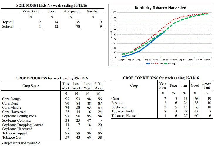 Kentucky Climate Summary
For the Period September 5, 2016 to September 11, 2016
Above Normal Temperatures and Below Normal Rainfall:
The state remained mostly dry on Labor Day and on through the work week as high
pressure remained in control aloft. Temperatures followed a warming trend with highs
back in the low to middle 90s statewide by Wednesday. The warm conditions pushed the
state to a tenth straight week of near to above normal temperatures. While there was
some isolated to scattered showers and storms on Thursday and Friday, better coverage
arrived over the weekend. A passing cold front sparked a broken line of showers and
storms that pushed through the region during the day on Saturday. Overall, the state
averaged a half inch for the week, which ended up being the third straight period
that Kentucky had seen below normal rainfall.
Temperatures for the period averaged 76 degrees across the state which was 4 degrees
warmer than normal and no change to the previous period. High temperatures averaged
from 88 in the West to 88 in the East. Departure from normal high temperatures ranged
from 3 degrees warmer than normal in the West to 5 degrees warmer than normal in the
East. Low temperatures averaged from 67 degrees in the West to 64 degrees in the
East. Departure from normal low temperature ranged from 6 degrees warmer than normal
in the West to 6 degrees warmer than normal in the East. The extreme high temperature
for the period was 95 degrees at EVANSVILLE ASOS and the extreme low was 52 degrees
at BRANDENBURG 4SW.
Precipitation (liq. equ.) for the period totaled 0.50 inches statewide which was 0.31
inches below normal and 62% of normal. Precipitation totals by climate division, West
0.78 inches, Central 0.57 inches, Bluegrass 0.44 inches and East 0.20 inches, which
was 0.01, 0.33, 0.31 and 0.6 inches below normal. By station, precipitation totals
ranged from a low of 0.00 inches at JACKSON 3SE to a high of 2.25 inches at
CAPE GIRARDEAU ASOS.
---
Agricultural Situation Report: September 6, 2016
(USDA's Crop Report with comments from Tom Priddy & Matt Dixon, UK Ag. Weather)
Agricultural News: Kentucky experienced above normal temperatures and rainfall over
the past week. Precipitation for the week totaled 1.46 inches, 0.51 inches above
normal. Temperatures averaged 79 degrees for the week, 3 degrees above normal.
Topsoil moisture was rated 0 percent very short, 6 percent short, 73 percent adequate
and 21 percent surplus. Subsoil moisture was rated 1 percent very short, 5 percent
short, 76 percent adequate, and 18 percent surplus. Days suitable for fieldwork
averaged 4.2 out of a possible seven.
Primary activities this week included spraying fungicides and cutting hay in between
rain showers. Reports of more serious black shank and target spot in tobacco have
producers concerned for anticipated harvest weights as preparations are made to start
cutting. Southern corn rust and gray leaf spot have also been confirmed, and grain
farmers are spraying fungicides. Corn and single crop soybeans are faring better
overall from the excessive wet weather this season. High heat and humidity throughout
the week put stress on livestock; pinkeye symptoms were also reported.
Kentucky Climate Summary
For the Period September 5, 2016 to September 11, 2016
Above Normal Temperatures and Below Normal Rainfall:
The state remained mostly dry on Labor Day and on through the work week as high
pressure remained in control aloft. Temperatures followed a warming trend with highs
back in the low to middle 90s statewide by Wednesday. The warm conditions pushed the
state to a tenth straight week of near to above normal temperatures. While there was
some isolated to scattered showers and storms on Thursday and Friday, better coverage
arrived over the weekend. A passing cold front sparked a broken line of showers and
storms that pushed through the region during the day on Saturday. Overall, the state
averaged a half inch for the week, which ended up being the third straight period
that Kentucky had seen below normal rainfall.
Temperatures for the period averaged 76 degrees across the state which was 4 degrees
warmer than normal and no change to the previous period. High temperatures averaged
from 88 in the West to 88 in the East. Departure from normal high temperatures ranged
from 3 degrees warmer than normal in the West to 5 degrees warmer than normal in the
East. Low temperatures averaged from 67 degrees in the West to 64 degrees in the
East. Departure from normal low temperature ranged from 6 degrees warmer than normal
in the West to 6 degrees warmer than normal in the East. The extreme high temperature
for the period was 95 degrees at EVANSVILLE ASOS and the extreme low was 52 degrees
at BRANDENBURG 4SW.
Precipitation (liq. equ.) for the period totaled 0.50 inches statewide which was 0.31
inches below normal and 62% of normal. Precipitation totals by climate division, West
0.78 inches, Central 0.57 inches, Bluegrass 0.44 inches and East 0.20 inches, which
was 0.01, 0.33, 0.31 and 0.6 inches below normal. By station, precipitation totals
ranged from a low of 0.00 inches at JACKSON 3SE to a high of 2.25 inches at
CAPE GIRARDEAU ASOS.
---
Agricultural Situation Report: September 6, 2016
(USDA's Crop Report with comments from Tom Priddy & Matt Dixon, UK Ag. Weather)
Agricultural News: Kentucky experienced above normal temperatures and rainfall over
the past week. Precipitation for the week totaled 1.46 inches, 0.51 inches above
normal. Temperatures averaged 79 degrees for the week, 3 degrees above normal.
Topsoil moisture was rated 0 percent very short, 6 percent short, 73 percent adequate
and 21 percent surplus. Subsoil moisture was rated 1 percent very short, 5 percent
short, 76 percent adequate, and 18 percent surplus. Days suitable for fieldwork
averaged 4.2 out of a possible seven.
Primary activities this week included spraying fungicides and cutting hay in between
rain showers. Reports of more serious black shank and target spot in tobacco have
producers concerned for anticipated harvest weights as preparations are made to start
cutting. Southern corn rust and gray leaf spot have also been confirmed, and grain
farmers are spraying fungicides. Corn and single crop soybeans are faring better
overall from the excessive wet weather this season. High heat and humidity throughout
the week put stress on livestock; pinkeye symptoms were also reported.
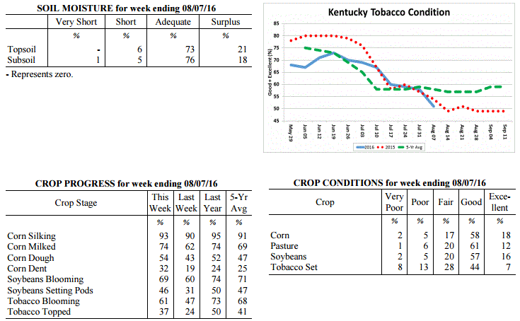 Kentucky Climate Summary
For the Period August 29, 2016 to September 4, 2016
Near Normal Temperatures and Below Normal Rainfall:
The Commonwealth did not see much rainfall for a second straight period as the state
averaged just over a tenth of an inch this past week. Other than some isolated
showers on Monday and Tuesday, most remained dry with high pressure aloft.
Temperatures each day remained above normal, along with high humidity. Scattered
showers and storms then returned on Wednesday, ahead of a passing cold front. Behind
the boundary, high pressure moved into the Great Lakes area. With Tropical Storm
Hermine off the Mid-Atlantic Coast, this set up a northeasterly flow into the Lower
Ohio Valley. Skies became mostly clear for the remainder of the week,
along with much cooler temperatures and less humid conditions.
Temperatures for the period averaged 74 degrees across the state which was near
normal and 4 degrees cooler than the previous period. High temperatures averaged
from 86 in the West to 85 in the East. Departure from normal high temperatures
ranged from 1 degree cooler than normal in the West to 1 degree warmer than
normal in the East. Low temperatures averaged from 65 degrees in the West to 63
degrees in the East. Departure from normal low temperature ranged from 2 degrees
warmer than normal in the West to 3 degrees warmer than normal in the East. The
extreme high temperature for the period was 95 degrees at MAYFIELD 6SW and the
extreme low was 50 degrees at CYNTHIANA 8N.
Precipitation (liq. equ.) for the period totaled 0.12 inches statewide which was
0.63 inches below normal and 16% of normal. Precipitation totals by climate
division, West 0.01 inches, Central 0.13 inches, Bluegrass 0.12 inches and East
0.21 inches, which was 0.68, 0.69, 0.61 and 0.57 inches below normal. By
station, precipitation totals ranged from a low of 0.00 inches at BARBOURVILLE
3E to a high of 1.54 inches at SOMERSET AWOS.
---
Agricultural Situation Report: August 29, 2016
(USDA's Crop Report with comments from Tom Priddy & Matt Dixon, UK Ag. Weather)
Agricultural News: Kentucky experienced above normal temperatures and below normal
rainfall over the past week. Precipitation for the week totaled 0.33 inches, 0.47
inches below normal. Temperatures averaged 77 degrees for the week, 2 degrees above
normal. Topsoil moisture was rated 0 percent very short, 4 percent short, 77 percent
adequate and 19 percent surplus. Subsoil moisture was rated 0 percent very short, 5
percent short, 76 percent adequate, and 19 percent surplus. Days suitable for
fieldwork averaged 5.6 out of a possible seven.
Primary activities this week included cutting hay, topping and cutting tobacco.
Disease and insect pressure continues for field crops. Soybeans were sprayed with
fungicides and insecticides where needed. Some tobacco fields are a complete loss due
to wet weather and disease. The corn harvest has begun in a few areas. Pasture
conditions remain in mostly good to excellent condition. Hot and humid weather
continues to be stressful for livestock. Producers are getting equipment ready
for the upcoming harvest.
Kentucky Climate Summary
For the Period August 29, 2016 to September 4, 2016
Near Normal Temperatures and Below Normal Rainfall:
The Commonwealth did not see much rainfall for a second straight period as the state
averaged just over a tenth of an inch this past week. Other than some isolated
showers on Monday and Tuesday, most remained dry with high pressure aloft.
Temperatures each day remained above normal, along with high humidity. Scattered
showers and storms then returned on Wednesday, ahead of a passing cold front. Behind
the boundary, high pressure moved into the Great Lakes area. With Tropical Storm
Hermine off the Mid-Atlantic Coast, this set up a northeasterly flow into the Lower
Ohio Valley. Skies became mostly clear for the remainder of the week,
along with much cooler temperatures and less humid conditions.
Temperatures for the period averaged 74 degrees across the state which was near
normal and 4 degrees cooler than the previous period. High temperatures averaged
from 86 in the West to 85 in the East. Departure from normal high temperatures
ranged from 1 degree cooler than normal in the West to 1 degree warmer than
normal in the East. Low temperatures averaged from 65 degrees in the West to 63
degrees in the East. Departure from normal low temperature ranged from 2 degrees
warmer than normal in the West to 3 degrees warmer than normal in the East. The
extreme high temperature for the period was 95 degrees at MAYFIELD 6SW and the
extreme low was 50 degrees at CYNTHIANA 8N.
Precipitation (liq. equ.) for the period totaled 0.12 inches statewide which was
0.63 inches below normal and 16% of normal. Precipitation totals by climate
division, West 0.01 inches, Central 0.13 inches, Bluegrass 0.12 inches and East
0.21 inches, which was 0.68, 0.69, 0.61 and 0.57 inches below normal. By
station, precipitation totals ranged from a low of 0.00 inches at BARBOURVILLE
3E to a high of 1.54 inches at SOMERSET AWOS.
---
Agricultural Situation Report: August 29, 2016
(USDA's Crop Report with comments from Tom Priddy & Matt Dixon, UK Ag. Weather)
Agricultural News: Kentucky experienced above normal temperatures and below normal
rainfall over the past week. Precipitation for the week totaled 0.33 inches, 0.47
inches below normal. Temperatures averaged 77 degrees for the week, 2 degrees above
normal. Topsoil moisture was rated 0 percent very short, 4 percent short, 77 percent
adequate and 19 percent surplus. Subsoil moisture was rated 0 percent very short, 5
percent short, 76 percent adequate, and 19 percent surplus. Days suitable for
fieldwork averaged 5.6 out of a possible seven.
Primary activities this week included cutting hay, topping and cutting tobacco.
Disease and insect pressure continues for field crops. Soybeans were sprayed with
fungicides and insecticides where needed. Some tobacco fields are a complete loss due
to wet weather and disease. The corn harvest has begun in a few areas. Pasture
conditions remain in mostly good to excellent condition. Hot and humid weather
continues to be stressful for livestock. Producers are getting equipment ready
for the upcoming harvest.
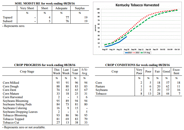 Kentucky Climate Summary
For the Period August 22, 2016 to August 28, 2016
Above Normal Temperatures and Below Normal Rainfall:
High pressure at the surface and aloft led to a mostly dry week for the Commonwealth.
The state only averaged a little over a quarter of an inch for the week, which was
about a half inch below normal. After a couple dry days on Monday and Tuesday,
rainfall remained isolated to scattered in coverage for the rest of the week. While
it was mostly dry, summertime temperatures and humidity made a return. Highs were
only in the upper 70s to middle 80s on Monday, but the cooler temperatures were short
lived. As high pressure moved east on Tuesday, winds shifted to the south, opening
the door to a warming trend and much more humid conditions. Heat indices increased to
around 100 by late in the work week and into the weekend with highs topping out in
the low to middle 90s, once again creating stressful conditions for livestock. This
pushed the Bluegrass State to an eighth straight week of near to above normal
temperatures.
Temperatures for the period averaged 77 degrees across the state which was 2
degrees warmer than normal and 2 degrees warmer than the previous period. High
temperatures averaged from 88 in the West to 88 in the East. Departure from
normal high temperatures ranged from near normal in the West to 3 degrees warmer
than normal in the East. Low temperatures averaged from 68 degrees in the West
to 65 degrees in the East. Departure from normal low temperature ranged from 3
degrees warmer than normal in the West to 3 degrees warmer than normal in the
East. The extreme high temperature for the period was 96 degrees at KOOMER RIDGE
and the extreme low was 53 degrees at RICHMOND 8E.
Precipitation (liq. equ.) for the period totaled 0.30 inches statewide which was
0.47 inches below normal and 39% of normal. Precipitation totals by climate
division, West 0.59 inches, Central 0.18 inches, Bluegrass 0.40 inches and East
0.05 inches, which was 0.11, 0.61, 0.36 and 0.77 inches below normal. By
station, precipitation totals ranged from a low of 0.00 inches at BARBOURVILLE
3E to a high of 3.22 inches at ALEXANDRIA 5NW.
---
Agricultural Situation Report: August 22, 2016
(USDA's Crop Report with comments from Tom Priddy & Matt Dixon, UK Ag. Weather)
Agricultural News: Kentucky experienced near normal temperatures and much above
normal rainfall over the past week. Precipitation for the week totaled 2.54 inches,
1.68 inches above normal. Temperatures averaged 76 degrees for the week, near normal.
Topsoil moisture was rated 0 percent very short, 4 percent short, 71 percent adequate
and 25 percent surplus. Subsoil moisture was rated 0 percent very short, 4 percent
short, 72 percent adequate, and 24 percent surplus. Days suitable for fieldwork
averaged 3.4 out of a possible seven.
Rain last week limited field work and resulted in flooding in some areas. Disease and
insect pressure continues for field crops. Fungicides have not been effective in some
fields. Corn, soybeans and tobacco all showed deterioration in percent rated as
excellent this past week. Dry weather is needed for hay producers eager to
harvest hay and to improve conditions of crops.
Kentucky Climate Summary
For the Period August 22, 2016 to August 28, 2016
Above Normal Temperatures and Below Normal Rainfall:
High pressure at the surface and aloft led to a mostly dry week for the Commonwealth.
The state only averaged a little over a quarter of an inch for the week, which was
about a half inch below normal. After a couple dry days on Monday and Tuesday,
rainfall remained isolated to scattered in coverage for the rest of the week. While
it was mostly dry, summertime temperatures and humidity made a return. Highs were
only in the upper 70s to middle 80s on Monday, but the cooler temperatures were short
lived. As high pressure moved east on Tuesday, winds shifted to the south, opening
the door to a warming trend and much more humid conditions. Heat indices increased to
around 100 by late in the work week and into the weekend with highs topping out in
the low to middle 90s, once again creating stressful conditions for livestock. This
pushed the Bluegrass State to an eighth straight week of near to above normal
temperatures.
Temperatures for the period averaged 77 degrees across the state which was 2
degrees warmer than normal and 2 degrees warmer than the previous period. High
temperatures averaged from 88 in the West to 88 in the East. Departure from
normal high temperatures ranged from near normal in the West to 3 degrees warmer
than normal in the East. Low temperatures averaged from 68 degrees in the West
to 65 degrees in the East. Departure from normal low temperature ranged from 3
degrees warmer than normal in the West to 3 degrees warmer than normal in the
East. The extreme high temperature for the period was 96 degrees at KOOMER RIDGE
and the extreme low was 53 degrees at RICHMOND 8E.
Precipitation (liq. equ.) for the period totaled 0.30 inches statewide which was
0.47 inches below normal and 39% of normal. Precipitation totals by climate
division, West 0.59 inches, Central 0.18 inches, Bluegrass 0.40 inches and East
0.05 inches, which was 0.11, 0.61, 0.36 and 0.77 inches below normal. By
station, precipitation totals ranged from a low of 0.00 inches at BARBOURVILLE
3E to a high of 3.22 inches at ALEXANDRIA 5NW.
---
Agricultural Situation Report: August 22, 2016
(USDA's Crop Report with comments from Tom Priddy & Matt Dixon, UK Ag. Weather)
Agricultural News: Kentucky experienced near normal temperatures and much above
normal rainfall over the past week. Precipitation for the week totaled 2.54 inches,
1.68 inches above normal. Temperatures averaged 76 degrees for the week, near normal.
Topsoil moisture was rated 0 percent very short, 4 percent short, 71 percent adequate
and 25 percent surplus. Subsoil moisture was rated 0 percent very short, 4 percent
short, 72 percent adequate, and 24 percent surplus. Days suitable for fieldwork
averaged 3.4 out of a possible seven.
Rain last week limited field work and resulted in flooding in some areas. Disease and
insect pressure continues for field crops. Fungicides have not been effective in some
fields. Corn, soybeans and tobacco all showed deterioration in percent rated as
excellent this past week. Dry weather is needed for hay producers eager to
harvest hay and to improve conditions of crops.
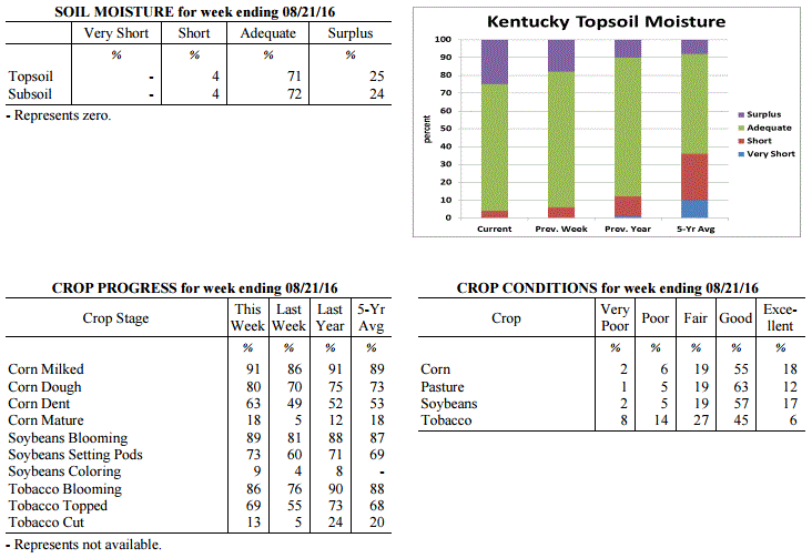 Kentucky Climate Summary
For the Period August 15, 2016 to August 21, 2016
Near Normal Temperatures and Much Above Normal Rainfall:
After another week of exceptionally high rainfall totals, the Bluegrass State has now
seen above normal rainfall three of the past four weeks. Over this past period, the
state averaged over 2.5 inches, which is over 1.5 above normal. According to data
with the Ag Weather Center, the state is now nearly 2 inches above normal for the
month of August with an average of 4.49 inches statewide. Just like recent weeks this
summer, an active pattern set up over the Lower Ohio Valley this past period with
several rounds of storms pushing through the area. Throughout much of the period, a
plume of moisture was positioned over the region, keeping heavy rain and localized
flooding as the main threats. Cloud cover and showers kept temperatures down during
the day and elevated at night, which brought average temperatures around normal for
the week. After the passage of a strong cold front, cooler and much less humid
conditions filtered into the area for the end of the weekend, finally giving the
Commonwealth a break from the summertime humidity.
Temperatures for the period averaged 76 degrees across the state which was near
normal and 4 degrees cooler than the previous period. High temperatures averaged from
82 in the West to 83 in the East. Departure from normal high temperatures ranged from
6 degrees cooler than normal in the West to 3 degrees cooler than normal in the East.
Low temperatures averaged from 71 degrees in the West to 69 degrees in the East.
Departure from normal low temperature ranged from 6 degrees warmer than normal in the
West to 7 degrees warmer than normal in the East. The extreme high temperature for
the period was 94 degrees at PAINTSVILLE 4W and the extreme low was 59 degrees at
BURKESVILLE 3W.
Precipitation (liq. equ.) for the period totaled 2.54 inches statewide which was 1.68
inches above normal and 296% of normal. Precipitation totals by climate division,
West 2.55 inches, Central 3.00 inches, Bluegrass 2.31 inches and East 2.32 inches,
which was 1.77, 2.14, 1.44 and 1.4 inches above normal. By station, precipitation
totals ranged from a low of 0.74 inches at MIDDLESBORO AWOS to a high of 5.39
inches at LEITCHFIELD 3W.
---
Agricultural Situation Report: August 15, 2016
(USDA's Crop Report with comments from Tom Priddy & Matt Dixon, UK Ag. Weather)
Agricultural News: Kentucky experienced above normal temperatures and below normal
rainfall over the past week. Precipitation for the week totaled 0.50 inches, 0.38
inches below normal. Temperatures averaged 80 degrees for the week, 4 degrees above
normal. Topsoil moisture was rated 0 percent very short, 6 percent short, 76 percent
adequate and 18 percent surplus. Subsoil moisture was rated 0 percent very short, 5
percent short, 79 percent adequate, and 16 percent surplus. Days suitable for
fieldwork averaged 5.1 out of a possible seven.
Rain showers in some areas has limited field work. Primary activities this week
included cutting hay, topping and cutting tobacco and spraying crops for disease and
insect control when conditions allowed. Some corn producers have reported pollination
issues in corn due to flooding and high heat. Wet conditions in some locations has
seriously impacted tobacco fields, resulting in disease and crop loss. Fifty-three
percent of tobacco is rated as good to excellent compared to twenty percent rated as
poor to very poor. High heat and humidity continue to put stress on livestock.
However, cattle are benefitting from pasture conditions which are holding up well
due to the moisture that has been received this year.
Kentucky Climate Summary
For the Period August 15, 2016 to August 21, 2016
Near Normal Temperatures and Much Above Normal Rainfall:
After another week of exceptionally high rainfall totals, the Bluegrass State has now
seen above normal rainfall three of the past four weeks. Over this past period, the
state averaged over 2.5 inches, which is over 1.5 above normal. According to data
with the Ag Weather Center, the state is now nearly 2 inches above normal for the
month of August with an average of 4.49 inches statewide. Just like recent weeks this
summer, an active pattern set up over the Lower Ohio Valley this past period with
several rounds of storms pushing through the area. Throughout much of the period, a
plume of moisture was positioned over the region, keeping heavy rain and localized
flooding as the main threats. Cloud cover and showers kept temperatures down during
the day and elevated at night, which brought average temperatures around normal for
the week. After the passage of a strong cold front, cooler and much less humid
conditions filtered into the area for the end of the weekend, finally giving the
Commonwealth a break from the summertime humidity.
Temperatures for the period averaged 76 degrees across the state which was near
normal and 4 degrees cooler than the previous period. High temperatures averaged from
82 in the West to 83 in the East. Departure from normal high temperatures ranged from
6 degrees cooler than normal in the West to 3 degrees cooler than normal in the East.
Low temperatures averaged from 71 degrees in the West to 69 degrees in the East.
Departure from normal low temperature ranged from 6 degrees warmer than normal in the
West to 7 degrees warmer than normal in the East. The extreme high temperature for
the period was 94 degrees at PAINTSVILLE 4W and the extreme low was 59 degrees at
BURKESVILLE 3W.
Precipitation (liq. equ.) for the period totaled 2.54 inches statewide which was 1.68
inches above normal and 296% of normal. Precipitation totals by climate division,
West 2.55 inches, Central 3.00 inches, Bluegrass 2.31 inches and East 2.32 inches,
which was 1.77, 2.14, 1.44 and 1.4 inches above normal. By station, precipitation
totals ranged from a low of 0.74 inches at MIDDLESBORO AWOS to a high of 5.39
inches at LEITCHFIELD 3W.
---
Agricultural Situation Report: August 15, 2016
(USDA's Crop Report with comments from Tom Priddy & Matt Dixon, UK Ag. Weather)
Agricultural News: Kentucky experienced above normal temperatures and below normal
rainfall over the past week. Precipitation for the week totaled 0.50 inches, 0.38
inches below normal. Temperatures averaged 80 degrees for the week, 4 degrees above
normal. Topsoil moisture was rated 0 percent very short, 6 percent short, 76 percent
adequate and 18 percent surplus. Subsoil moisture was rated 0 percent very short, 5
percent short, 79 percent adequate, and 16 percent surplus. Days suitable for
fieldwork averaged 5.1 out of a possible seven.
Rain showers in some areas has limited field work. Primary activities this week
included cutting hay, topping and cutting tobacco and spraying crops for disease and
insect control when conditions allowed. Some corn producers have reported pollination
issues in corn due to flooding and high heat. Wet conditions in some locations has
seriously impacted tobacco fields, resulting in disease and crop loss. Fifty-three
percent of tobacco is rated as good to excellent compared to twenty percent rated as
poor to very poor. High heat and humidity continue to put stress on livestock.
However, cattle are benefitting from pasture conditions which are holding up well
due to the moisture that has been received this year.
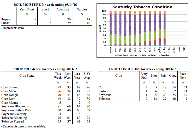 Kentucky Climate Summary
For the Period August 8, 2016 to August 14, 2016
Above Normal Temperatures and Below Normal Rainfall:
With the exception of Western Kentucky, much of the Bluegrass State saw below normal
rainfall this past week. While Western Kentucky averaged just over an inch, Central
and Eastern Kentucky dropped to around a quarter to a third of an inch. Much of the
heavier activity and flooding threat stayed west and north of the region. Showers
and storms were isolated to scattered in coverage on a daily basis, firing during the
day and waning overnight. Heavy rain continued to be the main threat as the
Commonwealth remained rooted in a very moist air mass. Dew points stayed in the 70s
and combined with warm temperatures to keep the livestock heat stress index in the
danger to emergency category. Looking back, the state has now seen 6 straight weeks
of above normal temperatures.
Temperatures for the period averaged 80 degrees across the state which was 4 degrees
warmer than normal and 2 degrees warmer than the previous period. High temperatures
averaged from 87 in the West to 89 in the East. Departure from normal high
temperatures ranged from 1 degree cooler than normal in the West to 3 degrees
warmer than normal in the East. Low temperatures averaged from 72 degrees in the
West to 71 degrees in the East. Departure from normal low temperature ranged from 6
degrees warmer than normal in the West to 8 degrees warmer than normal in the East.
The extreme high temperature for the period was 94 degrees at YELLOW CREEK and the
extreme low was 55 degrees at FORT KNOX.
Precipitation (liq. equ.) for the period totaled 0.50 inches statewide which was 0.38
inches below normal and 57% of normal. Precipitation totals by climate division, West
1.11 inches, Central 0.29 inches, Bluegrass 0.34 inches and East 0.24 inches, which
was 0.29, -0.56, -0.53 and -0.72 inches respectively from normal. By station,
precipitation totals ranged from a low of 0.00 inches at ALBANY 1N to a high of 4.40
inches at POPLAR BLUFF ASOS.
---
Agricultural Situation Report: August 8, 2016
(USDA's Crop Report with comments from Tom Priddy & Matt Dixon, UK Ag. Weather)
Agricultural News: Kentucky experienced above normal temperatures and rainfall over
the past week. Precipitation for the week totaled 1.46 inches, 0.51 inches above
normal. Temperatures averaged 79 degrees for the week, 3 degrees above normal.
Topsoil moisture was rated 0 percent very short, 6 percent short, 73 percent adequate
and 21 percent surplus. Subsoil moisture was rated 1 percent very short, 5 percent
short, 76 percent adequate, and 18 percent surplus. Days suitable for fieldwork
averaged 4.2 out of a possible seven.
Primary activities this week included spraying fungicides and cutting hay in between
rain showers. Reports of more serious black shank and target spot in tobacco have
producers concerned for anticipated harvest weights as preparations are made to start
cutting. Southern corn rust and gray leaf spot have also been confirmed, and grain
farmers are spraying fungicides. Corn and single crop soybeans are faring better
overall from the excessive wet weather this season. High heat and humidity throughout
the week put stress on livestock; pinkeye symptoms were also reported.
Kentucky Climate Summary
For the Period August 8, 2016 to August 14, 2016
Above Normal Temperatures and Below Normal Rainfall:
With the exception of Western Kentucky, much of the Bluegrass State saw below normal
rainfall this past week. While Western Kentucky averaged just over an inch, Central
and Eastern Kentucky dropped to around a quarter to a third of an inch. Much of the
heavier activity and flooding threat stayed west and north of the region. Showers
and storms were isolated to scattered in coverage on a daily basis, firing during the
day and waning overnight. Heavy rain continued to be the main threat as the
Commonwealth remained rooted in a very moist air mass. Dew points stayed in the 70s
and combined with warm temperatures to keep the livestock heat stress index in the
danger to emergency category. Looking back, the state has now seen 6 straight weeks
of above normal temperatures.
Temperatures for the period averaged 80 degrees across the state which was 4 degrees
warmer than normal and 2 degrees warmer than the previous period. High temperatures
averaged from 87 in the West to 89 in the East. Departure from normal high
temperatures ranged from 1 degree cooler than normal in the West to 3 degrees
warmer than normal in the East. Low temperatures averaged from 72 degrees in the
West to 71 degrees in the East. Departure from normal low temperature ranged from 6
degrees warmer than normal in the West to 8 degrees warmer than normal in the East.
The extreme high temperature for the period was 94 degrees at YELLOW CREEK and the
extreme low was 55 degrees at FORT KNOX.
Precipitation (liq. equ.) for the period totaled 0.50 inches statewide which was 0.38
inches below normal and 57% of normal. Precipitation totals by climate division, West
1.11 inches, Central 0.29 inches, Bluegrass 0.34 inches and East 0.24 inches, which
was 0.29, -0.56, -0.53 and -0.72 inches respectively from normal. By station,
precipitation totals ranged from a low of 0.00 inches at ALBANY 1N to a high of 4.40
inches at POPLAR BLUFF ASOS.
---
Agricultural Situation Report: August 8, 2016
(USDA's Crop Report with comments from Tom Priddy & Matt Dixon, UK Ag. Weather)
Agricultural News: Kentucky experienced above normal temperatures and rainfall over
the past week. Precipitation for the week totaled 1.46 inches, 0.51 inches above
normal. Temperatures averaged 79 degrees for the week, 3 degrees above normal.
Topsoil moisture was rated 0 percent very short, 6 percent short, 73 percent adequate
and 21 percent surplus. Subsoil moisture was rated 1 percent very short, 5 percent
short, 76 percent adequate, and 18 percent surplus. Days suitable for fieldwork
averaged 4.2 out of a possible seven.
Primary activities this week included spraying fungicides and cutting hay in between
rain showers. Reports of more serious black shank and target spot in tobacco have
producers concerned for anticipated harvest weights as preparations are made to start
cutting. Southern corn rust and gray leaf spot have also been confirmed, and grain
farmers are spraying fungicides. Corn and single crop soybeans are faring better
overall from the excessive wet weather this season. High heat and humidity throughout
the week put stress on livestock; pinkeye symptoms were also reported.
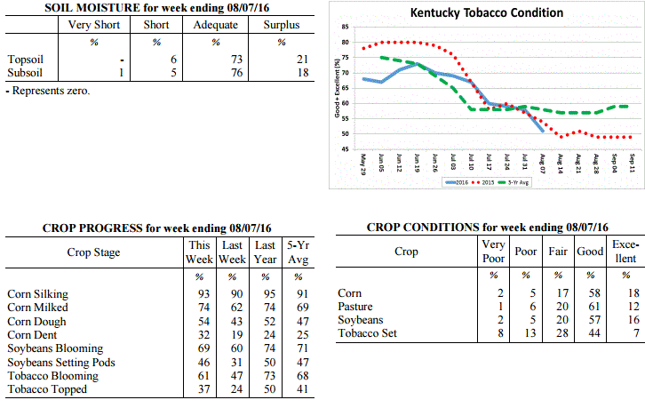 Kentucky Climate Summary
For the Period August 1, 2016 to August 7, 2016
Above Normal Temperatures and Rainfall:
Much like the month of July, an active pattern continued into the first week of
August with several rounds of rainfall. The entire state averaged over an inch with
Western Kentucky leading the way at 1.67. This resulted in a second straight week of
above normal rainfall and followed the state�s 3rd wettest July on record with data
going back to 1895. The humid air mass stayed in place through Saturday, keeping
torrential rainfall and occasional localized flooding in the picture. After the
final round of rainfall on Saturday along a cold front, a welcome change came for the
latter half of the weekend. Behind the boundary, dew points took a fall, bringing
much drier and less muggy conditions to the Bluegrass State. Saying that, for the
week overall, temperatures were yet again above normal. Ten of the past eleven weeks
have now seen near to above normal temperatures.
Temperatures for the period averaged 79 degrees across the state which was 3 degrees
warmer than normal and no change from the previous period. High temperatures
averaged from 88 in the West to 86 in the East. Departure from normal high
temperatures were near normal across the state. Low temperatures averaged from 71
degrees in the West to 69 degrees in the East. Departure from normal low temperature
ranged from 5 degrees warmer than normal in the West to 6 degrees warmer than normal
in the East. The extreme high temperature for the period was 98 degrees at LEBANON
8NW and the extreme low was 61 degrees at CYNTHIANA 8N.
Precipitation (liq. equ.) for the period totaled 1.46 inches statewide which was 0.51
inches above normal and 154% of normal. Precipitation totals by climate division,
West 1.67 inches, Central 1.39 inches, Bluegrass 1.56 inches and East 1.20 inches,
which was 0.76, 0.47, 0.64 and 0.17 inches above normal. By station, precipitation
totals ranged from a low of 0.00 inches at EVANSVILLE ASOS to a high of 6.06
inches at PADUCAH ASOS.
---
Agricultural Situation Report: August 1, 2016
(USDA's Crop Report with comments from Tom Priddy & Matt Dixon, UK Ag. Weather)
Agricultural News: Kentucky experienced above normal temperatures and much above
normal rainfall over the past week. Precipitation for the week totaled 2.76 inches,
1.78 inches above normal. Temperatures averaged 79 degrees for the week, 2 degrees
above normal. Topsoil moisture was rated 0 percent very short, 6 percent short, 72
percent adequate and 22 percent surplus. Subsoil moisture was rated 1 percent very
short, 6 percent short, 75 percent adequate, and 18 percent surplus. Days suitable
for fieldwork averaged 3.7 out of a possible seven.
Field work was limited this week as warm, wet weather continued. Activities included
spraying soybeans and tobacco, and topping tobacco. An increase in fungal disease
reports for tobacco include target spot, frog eye leaf, and black shank. Some soybean
diseases are now showing up, mostly septoria brown spot. Crop conditions and yield
expectations remain varied throughout the state, as some low lying areas are still
reporting standing water and slight flooding. High humidity this week had livestock
under heat stress.
Pasture and hay fields remain in mostly good condition, with hay cutting anticipated
as soon as the weather breaks. Hay and roughage supplies were reported as 1 percent
very short, 10 percent short, 77 percent adequate, and 12 percent surplus.
Kentucky Climate Summary
For the Period August 1, 2016 to August 7, 2016
Above Normal Temperatures and Rainfall:
Much like the month of July, an active pattern continued into the first week of
August with several rounds of rainfall. The entire state averaged over an inch with
Western Kentucky leading the way at 1.67. This resulted in a second straight week of
above normal rainfall and followed the state�s 3rd wettest July on record with data
going back to 1895. The humid air mass stayed in place through Saturday, keeping
torrential rainfall and occasional localized flooding in the picture. After the
final round of rainfall on Saturday along a cold front, a welcome change came for the
latter half of the weekend. Behind the boundary, dew points took a fall, bringing
much drier and less muggy conditions to the Bluegrass State. Saying that, for the
week overall, temperatures were yet again above normal. Ten of the past eleven weeks
have now seen near to above normal temperatures.
Temperatures for the period averaged 79 degrees across the state which was 3 degrees
warmer than normal and no change from the previous period. High temperatures
averaged from 88 in the West to 86 in the East. Departure from normal high
temperatures were near normal across the state. Low temperatures averaged from 71
degrees in the West to 69 degrees in the East. Departure from normal low temperature
ranged from 5 degrees warmer than normal in the West to 6 degrees warmer than normal
in the East. The extreme high temperature for the period was 98 degrees at LEBANON
8NW and the extreme low was 61 degrees at CYNTHIANA 8N.
Precipitation (liq. equ.) for the period totaled 1.46 inches statewide which was 0.51
inches above normal and 154% of normal. Precipitation totals by climate division,
West 1.67 inches, Central 1.39 inches, Bluegrass 1.56 inches and East 1.20 inches,
which was 0.76, 0.47, 0.64 and 0.17 inches above normal. By station, precipitation
totals ranged from a low of 0.00 inches at EVANSVILLE ASOS to a high of 6.06
inches at PADUCAH ASOS.
---
Agricultural Situation Report: August 1, 2016
(USDA's Crop Report with comments from Tom Priddy & Matt Dixon, UK Ag. Weather)
Agricultural News: Kentucky experienced above normal temperatures and much above
normal rainfall over the past week. Precipitation for the week totaled 2.76 inches,
1.78 inches above normal. Temperatures averaged 79 degrees for the week, 2 degrees
above normal. Topsoil moisture was rated 0 percent very short, 6 percent short, 72
percent adequate and 22 percent surplus. Subsoil moisture was rated 1 percent very
short, 6 percent short, 75 percent adequate, and 18 percent surplus. Days suitable
for fieldwork averaged 3.7 out of a possible seven.
Field work was limited this week as warm, wet weather continued. Activities included
spraying soybeans and tobacco, and topping tobacco. An increase in fungal disease
reports for tobacco include target spot, frog eye leaf, and black shank. Some soybean
diseases are now showing up, mostly septoria brown spot. Crop conditions and yield
expectations remain varied throughout the state, as some low lying areas are still
reporting standing water and slight flooding. High humidity this week had livestock
under heat stress.
Pasture and hay fields remain in mostly good condition, with hay cutting anticipated
as soon as the weather breaks. Hay and roughage supplies were reported as 1 percent
very short, 10 percent short, 77 percent adequate, and 12 percent surplus.
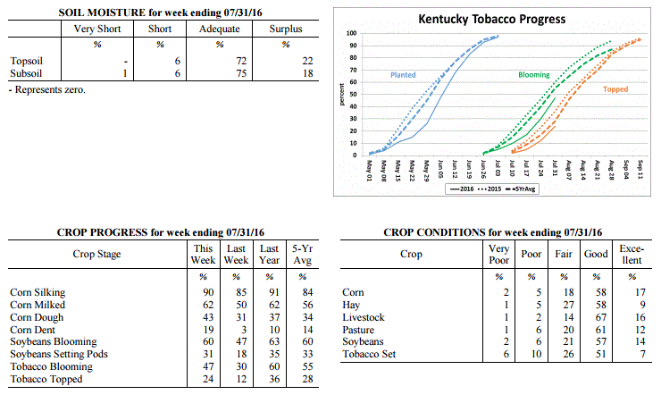 Kentucky Climate Summary
For the Period July 25, 2016 to August 1, 2016
Above Normal Temperatures and Much Above Normal Rainfall:
Much like it started, the month of July came to a close with yet another
exceptionally wet week. For the period, the state averaged over 2.5 inches. Showers
and storms formed about each day, scattered in coverage for much of the week. The one
exception came Wednesday night and through much of Thursday when activity became
widespread. The slow moving nature of storms and very moist atmosphere promoted heavy
rainfall from time to time, along with localized flash flooding. This all added to an
already extremely wet month of July. Preliminary data at the UK Ag Weather Center
shows that this could be one of the wettest July�s on record with the state averaging
8.86 inches. This is small in comparison to Western Kentucky alone, which averaged
over 12. Temperatures through the week also remained elevated with highs peaking in
the 90s from time to time. The average temperature for Kentucky remained above normal
for a fourth straight week.
Temperatures for the period averaged 79 degrees across the state which was 2 degrees
warmer than normal and 2 degrees cooler than the previous period. High temperatures
averaged from 88 in the West to 87 in the East. Departure from normal high
temperatures ranged from 1 degree cooler than normal in the West to near normal in
the East. Low temperatures averaged from 71 degrees in the West to 70 degrees in the
East. Departure from normal low temperature ranged from 4 degrees warmer than normal
in the West to 6 degrees warmer than normal in the East. The extreme high temperature
for the period was 96 degrees at KOOMER RIDGE and the extreme low was 65 degrees at
FRANKFORT 7S.
Precipitation (liq. equ.) for the period totaled 2.76 inches statewide which was 1.78
inches above normal and 283% of normal. Precipitation totals by climate division,
West 3.26 inches, Central 2.42 inches, Bluegrass 2.79 inches and East 2.58 inches,
which was 2.33, 1.45, 1.82 and 1.55 inches above normal. By station, precipitation
totals ranged from a low of 0.62 inches at BRANDENBURG 4SW to a high of 7.46
inches at ALEXANDRIA 5NW.
---
Agricultural Situation Report: July 25, 2016
(USDA's Crop Report with comments from Tom Priddy & Matt Dixon, UK Ag. Weather)
Agricultural News: Kentucky experienced above normal temperatures and below normal
rainfall over the past week. Precipitation for the week totaled 0.45 inches, 0.50
inches below normal. Temperatures averaged 80 degrees for the week, 4 degrees above
normal. Topsoil moisture was rated 1 percent very short, 10 percent short, 73 percent
adequate and 16 percent surplus. Subsoil moisture was rated 1 percent very short, 8
percent short, 77 percent adequate, and 14 percent surplus. Days suitable for
fieldwork averaged 5.5 out of a possible seven.
Primary activities this week included cutting hay, spraying herbicides, fungicide
applications and topping tobacco where conditions allowed. High moisture and humid
weather is resulting in heavy disease pressure on crops. Tobacco conditions remain in
the mostly good to fair range due to the lateness of the crop and excess water at the
wrong time. Black shank continues to be a concern. Some tobacco growers will have
significant losses to their crop. Pasture conditions remain in mostly good condition.
High temperatures and humidity over the past week pushed the livestock heat stress
into the emergency category. Livestock producers are treating cattle for pinkeye.
Kentucky Climate Summary
For the Period July 25, 2016 to August 1, 2016
Above Normal Temperatures and Much Above Normal Rainfall:
Much like it started, the month of July came to a close with yet another
exceptionally wet week. For the period, the state averaged over 2.5 inches. Showers
and storms formed about each day, scattered in coverage for much of the week. The one
exception came Wednesday night and through much of Thursday when activity became
widespread. The slow moving nature of storms and very moist atmosphere promoted heavy
rainfall from time to time, along with localized flash flooding. This all added to an
already extremely wet month of July. Preliminary data at the UK Ag Weather Center
shows that this could be one of the wettest July�s on record with the state averaging
8.86 inches. This is small in comparison to Western Kentucky alone, which averaged
over 12. Temperatures through the week also remained elevated with highs peaking in
the 90s from time to time. The average temperature for Kentucky remained above normal
for a fourth straight week.
Temperatures for the period averaged 79 degrees across the state which was 2 degrees
warmer than normal and 2 degrees cooler than the previous period. High temperatures
averaged from 88 in the West to 87 in the East. Departure from normal high
temperatures ranged from 1 degree cooler than normal in the West to near normal in
the East. Low temperatures averaged from 71 degrees in the West to 70 degrees in the
East. Departure from normal low temperature ranged from 4 degrees warmer than normal
in the West to 6 degrees warmer than normal in the East. The extreme high temperature
for the period was 96 degrees at KOOMER RIDGE and the extreme low was 65 degrees at
FRANKFORT 7S.
Precipitation (liq. equ.) for the period totaled 2.76 inches statewide which was 1.78
inches above normal and 283% of normal. Precipitation totals by climate division,
West 3.26 inches, Central 2.42 inches, Bluegrass 2.79 inches and East 2.58 inches,
which was 2.33, 1.45, 1.82 and 1.55 inches above normal. By station, precipitation
totals ranged from a low of 0.62 inches at BRANDENBURG 4SW to a high of 7.46
inches at ALEXANDRIA 5NW.
---
Agricultural Situation Report: July 25, 2016
(USDA's Crop Report with comments from Tom Priddy & Matt Dixon, UK Ag. Weather)
Agricultural News: Kentucky experienced above normal temperatures and below normal
rainfall over the past week. Precipitation for the week totaled 0.45 inches, 0.50
inches below normal. Temperatures averaged 80 degrees for the week, 4 degrees above
normal. Topsoil moisture was rated 1 percent very short, 10 percent short, 73 percent
adequate and 16 percent surplus. Subsoil moisture was rated 1 percent very short, 8
percent short, 77 percent adequate, and 14 percent surplus. Days suitable for
fieldwork averaged 5.5 out of a possible seven.
Primary activities this week included cutting hay, spraying herbicides, fungicide
applications and topping tobacco where conditions allowed. High moisture and humid
weather is resulting in heavy disease pressure on crops. Tobacco conditions remain in
the mostly good to fair range due to the lateness of the crop and excess water at the
wrong time. Black shank continues to be a concern. Some tobacco growers will have
significant losses to their crop. Pasture conditions remain in mostly good condition.
High temperatures and humidity over the past week pushed the livestock heat stress
into the emergency category. Livestock producers are treating cattle for pinkeye.
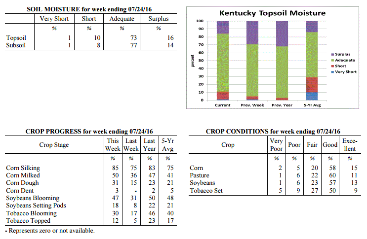 Kentucky Climate Summary
For the Period July 18, 2016 to July 24, 2016
Above Normal Temperatures and Below Normal Rainfall:
Extreme heat and humidity returned to the Bluegrass State this past week, but this
time, for a prolonged period of time. The heat wave consisted of high temperatures
routinely rising into the upper 80s to middle 90s each day, along with dew points in
the 70s. This repeatedly pushed heat indices over 100 for much of the state,
especially across the western half. Multiple heat advisories were issued throughout
the week, along with an Excessive Heat Advisory across the Purchase area of Western
Kentucky as heat indices approached 110 degrees in spots. Not much recovery was seen
at night either as temperatures and dew points remained elevated. The high heat and
humidity created dangerous conditions for livestock as the heat stress index rose
into the danger to emergency category each day. Looking longer term, this is now the
third straight week that Kentucky has seen above normal temperatures.
Temperatures for the period averaged 80 degrees across the state which was 4 degrees
warmer than normal and 2 degrees warmer than the previous period. High temperatures
averaged from 91 in the West to 90 in the East. Departure from normal high
temperatures ranged from 2 degrees warmer than normal in the West to 3 degrees
warmer than normal in the East. Low temperatures averaged from 73 degrees in the
West to 69 degrees in the East. Departure from normal low temperature ranged from 5
degrees warmer than normal in the West to 5 degrees warmer than normal in the East.
The extreme high temperature for the period was 96 degrees at POPLAR BLUFF ASOS and
the extreme low was 61 degrees at PAINTSVILLE 4W.
Precipitation (liq. equ.) for the period totaled 0.45 inches statewide which was 0.5
inches below normal and 47% of normal. Precipitation totals by climate division, West
0.73 inches, Central 0.44 inches, Bluegrass 0.29 inches and East 0.32 inches, which
was 0.17, 0.53, 0.65 and 0.68 inches below normal. By station, precipitation totals
ranged from a low of 0.00 inches at CYNTHIANA 8N to a high of 3.44 inches at HARTFORD 3E.
---
Agricultural Situation Report: July 18, 2016
(USDA's Crop Report with comments from Tom Priddy & Matt Dixon, UK Ag. Weather)
Agricultural News: Kentucky experienced above normal temperatures and below normal
rainfall over the past week. Precipitation for the week totaled 0.94 inches, 0.06
inches below normal. Temperatures averaged 78 degrees for the week, 1 degree above
normal. Topsoil moisture was rated 1 percent very short, 4 percent short, 66 percent
adequate and 29 percent surplus. Subsoil moisture was rated 1 percent very short, 6
percent short, 70 percent adequate, and 23 percent surplus. Days suitable for
fieldwork averaged 4.3 out of a possible seven.
Primary activities this week included cutting hay, spraying herbicides, and making
fungicide applications when weather conditions permitted. Scattered storms continued
over the past week with most of the accumulation in the western portion of the state.
Reports of flooding and standing water in low lying fields persisted, with some
farmers replanting soybeans in wet spots. Crop damage and expectations remain varied
throughout the state, with the potential for entire crop losses. Early planted crops
seem to be fairing much better than later planted crops. Many tobacco fields have
patches of scald, along with reports of black shank and overgrown weeds.
Kentucky Climate Summary
For the Period July 18, 2016 to July 24, 2016
Above Normal Temperatures and Below Normal Rainfall:
Extreme heat and humidity returned to the Bluegrass State this past week, but this
time, for a prolonged period of time. The heat wave consisted of high temperatures
routinely rising into the upper 80s to middle 90s each day, along with dew points in
the 70s. This repeatedly pushed heat indices over 100 for much of the state,
especially across the western half. Multiple heat advisories were issued throughout
the week, along with an Excessive Heat Advisory across the Purchase area of Western
Kentucky as heat indices approached 110 degrees in spots. Not much recovery was seen
at night either as temperatures and dew points remained elevated. The high heat and
humidity created dangerous conditions for livestock as the heat stress index rose
into the danger to emergency category each day. Looking longer term, this is now the
third straight week that Kentucky has seen above normal temperatures.
Temperatures for the period averaged 80 degrees across the state which was 4 degrees
warmer than normal and 2 degrees warmer than the previous period. High temperatures
averaged from 91 in the West to 90 in the East. Departure from normal high
temperatures ranged from 2 degrees warmer than normal in the West to 3 degrees
warmer than normal in the East. Low temperatures averaged from 73 degrees in the
West to 69 degrees in the East. Departure from normal low temperature ranged from 5
degrees warmer than normal in the West to 5 degrees warmer than normal in the East.
The extreme high temperature for the period was 96 degrees at POPLAR BLUFF ASOS and
the extreme low was 61 degrees at PAINTSVILLE 4W.
Precipitation (liq. equ.) for the period totaled 0.45 inches statewide which was 0.5
inches below normal and 47% of normal. Precipitation totals by climate division, West
0.73 inches, Central 0.44 inches, Bluegrass 0.29 inches and East 0.32 inches, which
was 0.17, 0.53, 0.65 and 0.68 inches below normal. By station, precipitation totals
ranged from a low of 0.00 inches at CYNTHIANA 8N to a high of 3.44 inches at HARTFORD 3E.
---
Agricultural Situation Report: July 18, 2016
(USDA's Crop Report with comments from Tom Priddy & Matt Dixon, UK Ag. Weather)
Agricultural News: Kentucky experienced above normal temperatures and below normal
rainfall over the past week. Precipitation for the week totaled 0.94 inches, 0.06
inches below normal. Temperatures averaged 78 degrees for the week, 1 degree above
normal. Topsoil moisture was rated 1 percent very short, 4 percent short, 66 percent
adequate and 29 percent surplus. Subsoil moisture was rated 1 percent very short, 6
percent short, 70 percent adequate, and 23 percent surplus. Days suitable for
fieldwork averaged 4.3 out of a possible seven.
Primary activities this week included cutting hay, spraying herbicides, and making
fungicide applications when weather conditions permitted. Scattered storms continued
over the past week with most of the accumulation in the western portion of the state.
Reports of flooding and standing water in low lying fields persisted, with some
farmers replanting soybeans in wet spots. Crop damage and expectations remain varied
throughout the state, with the potential for entire crop losses. Early planted crops
seem to be fairing much better than later planted crops. Many tobacco fields have
patches of scald, along with reports of black shank and overgrown weeds.
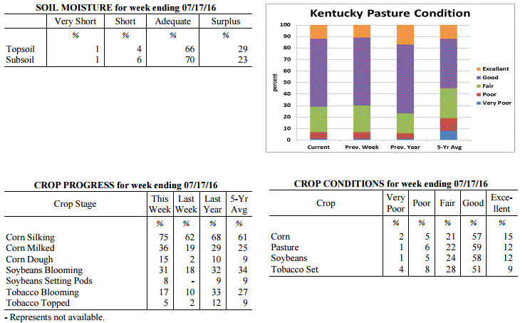 Kentucky Climate Summary
For the Period July 11, 2016 to July 17, 2016
Above Normal Temperatures and Below Normal Rainfall:
After one of the wettest weeks in years, an active pattern carried over into this
past period. Showers and storms developed about each day of the week, but coverage
was not as widespread across the state. While Western Kentucky averaged over 1.5
inches for the week, eastern portions of the state were around a half inch.
According to data at the Ag Weather Center, Western Kentucky has averaged 8.44 inches
of rainfall through July 17th, which is over 6 inches above normal. Any storms that
did develop through the period were heavy rainfall producers as the state remained
situated within a moist air mass. Temperatures were slightly above normal for a
second straight week. Normal high temperatures for this time of year rise into the
middle 80s to around 90, while lows drop into the middle 60s to around 70.
Temperatures for the period averaged 78 degrees across the state which was 1 degree
warmer than normal and no change to the previous period. High temperatures averaged
from 88 in the West to 87 in the East. Departure from normal high temperatures ranged
from 2 degrees cooler than normal in the West to near normal in the East. Low
temperatures averaged from 70 degrees in the West to 67 degrees in the East.
Departure from normal low temperature ranged from 2 degrees warmer than normal in the
West to 4 degrees warmer than normal in the East. The extreme high temperature for
the period was 93 degrees at BOWLING GREEN APT and the extreme low was 60 degrees at
BRANDENBURG 4SW.
Precipitation (liq. equ.) for the period totaled 0.94 inches statewide which was 0.06
inches below normal and 94% of normal. Precipitation totals by climate division, West
1.54 inches, Central 0.94 inches, Bluegrass 0.79 inches and East 0.50 inches, which
was 0.56, -0.08, -0.19 and -0.53 inches respectively from normal. By station,
precipitation totals ranged from a low of 0.02 inches at BIG SANDY to a high of 7.18
inches at CALHOUN 5NW.
---
Agricultural Situation Report: July 11, 2016
(USDA's Crop Report with comments from Tom Priddy & Matt Dixon, UK Ag. Weather)
Agricultural News: Kentucky experienced above normal temperatures and much above
normal rainfall over the past week. Precipitation for the week totaled 3.92 inches,
2.94 inches above normal. Temperatures averaged 77 degrees for the week, 1 degrees
above normal. Topsoil moisture was rated 1 percent very short, 10 percent short, 60
percent adequate and 29 percent surplus. Subsoil moisture was rated 1 percent very
short, 8 percent short, 70 percent adequate, and 21 percent surplus. Days suitable
for fieldwork averaged 2.4 out of a possible seven.
Heavy rains and storms led to flooding and delayed field activities this week,
hitting especially hard in western Kentucky. Some low lying fields still remain
saturated, and significant losses have been reported for corn, soybeans, and tobacco.
Tobacco in standing water has started to wilt and turn yellow, with heightened risk
for black shank. High winds also caused damage to crops and farm structures, with
several reports of corn being blown around and breaking off. Weather forecasts and
crop conditions continue to be evaluated. The average height of emerged soybeans was
14 inches, compared to 10 inches last week and 14 inches last year at this time. In
the eastern part of the state, vegetables are still producing well with some
anthracnose developing on beans.
Kentucky Climate Summary
For the Period July 11, 2016 to July 17, 2016
Above Normal Temperatures and Below Normal Rainfall:
After one of the wettest weeks in years, an active pattern carried over into this
past period. Showers and storms developed about each day of the week, but coverage
was not as widespread across the state. While Western Kentucky averaged over 1.5
inches for the week, eastern portions of the state were around a half inch.
According to data at the Ag Weather Center, Western Kentucky has averaged 8.44 inches
of rainfall through July 17th, which is over 6 inches above normal. Any storms that
did develop through the period were heavy rainfall producers as the state remained
situated within a moist air mass. Temperatures were slightly above normal for a
second straight week. Normal high temperatures for this time of year rise into the
middle 80s to around 90, while lows drop into the middle 60s to around 70.
Temperatures for the period averaged 78 degrees across the state which was 1 degree
warmer than normal and no change to the previous period. High temperatures averaged
from 88 in the West to 87 in the East. Departure from normal high temperatures ranged
from 2 degrees cooler than normal in the West to near normal in the East. Low
temperatures averaged from 70 degrees in the West to 67 degrees in the East.
Departure from normal low temperature ranged from 2 degrees warmer than normal in the
West to 4 degrees warmer than normal in the East. The extreme high temperature for
the period was 93 degrees at BOWLING GREEN APT and the extreme low was 60 degrees at
BRANDENBURG 4SW.
Precipitation (liq. equ.) for the period totaled 0.94 inches statewide which was 0.06
inches below normal and 94% of normal. Precipitation totals by climate division, West
1.54 inches, Central 0.94 inches, Bluegrass 0.79 inches and East 0.50 inches, which
was 0.56, -0.08, -0.19 and -0.53 inches respectively from normal. By station,
precipitation totals ranged from a low of 0.02 inches at BIG SANDY to a high of 7.18
inches at CALHOUN 5NW.
---
Agricultural Situation Report: July 11, 2016
(USDA's Crop Report with comments from Tom Priddy & Matt Dixon, UK Ag. Weather)
Agricultural News: Kentucky experienced above normal temperatures and much above
normal rainfall over the past week. Precipitation for the week totaled 3.92 inches,
2.94 inches above normal. Temperatures averaged 77 degrees for the week, 1 degrees
above normal. Topsoil moisture was rated 1 percent very short, 10 percent short, 60
percent adequate and 29 percent surplus. Subsoil moisture was rated 1 percent very
short, 8 percent short, 70 percent adequate, and 21 percent surplus. Days suitable
for fieldwork averaged 2.4 out of a possible seven.
Heavy rains and storms led to flooding and delayed field activities this week,
hitting especially hard in western Kentucky. Some low lying fields still remain
saturated, and significant losses have been reported for corn, soybeans, and tobacco.
Tobacco in standing water has started to wilt and turn yellow, with heightened risk
for black shank. High winds also caused damage to crops and farm structures, with
several reports of corn being blown around and breaking off. Weather forecasts and
crop conditions continue to be evaluated. The average height of emerged soybeans was
14 inches, compared to 10 inches last week and 14 inches last year at this time. In
the eastern part of the state, vegetables are still producing well with some
anthracnose developing on beans.
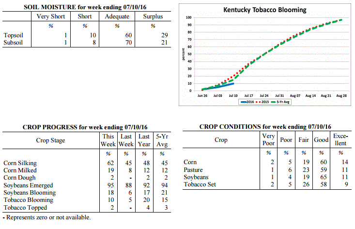 Kentucky Climate Summary
For the Period July 4, 2016 to July 10, 2016
Above Normal Temperatures and Much Above Normal Rainfall:
Not since May of 2010, has Kentucky seen an average rainfall total higher than what
was seen this past week. For the period, several rounds of rainfall led to the
wettest week of the year with an average of 3.92 inches for the Bluegrass State. This
number is actually small in comparison to Western Kentucky, which alone saw over 5.5
inches for the week. Throughout the work week, the Commonwealth was situated within
a warm and extremely moist air mass. Excessive rainfall fell on the 4th of July
holiday, leading to saturated ground in some locations. This was followed by a very
unsettled pattern over the course of the 6th and 7th as several rounds of strong to
severe thunderstorms pushed through Kentucky. This led to numerous reports of
damaging winds and especially flooding, as thunderstorms slowly tracked repeatedly
over the same areas. For the week, a handful of locations in Western Kentucky
recorded over 10 inches of rainfall. Since July 1st, the state has already averaged
4.72 inches of precipitation. Putting this data in perspective, Kentucky normally
only sees around 4 to 4.5 inches for the entire month of July.
Temperatures for the period averaged 77 degrees across the state which was 1 degree
warmer than normal and 4 degrees warmer than the previous period. High temperatures
averaged from 87 in the West to 85 in the East. Departure from normal high
temperatures ranged from 2 degrees cooler than normal in the West to 1 degree
cooler than normal in the East. Low temperatures averaged from 70 degrees in the
West to 68 degrees in the East. Departure from normal low temperature ranged from 3
degrees warmer than normal in the West to 5 degrees warmer than normal in the East.
The extreme high temperature for the period was 93 degrees at HICKMAN 2E and
the extreme low was 59 degrees at CYNTHIANA 8N.
Precipitation (liq. equ.) for the period totaled 3.92 inches statewide which was 2.94
inches above normal and 399% of normal. Precipitation totals by climate division,
West 5.68 inches, Central 4.13 inches, Bluegrass 2.06 inches and East 3.80 inches,
which was 4.7, 3.14, 1.1 and 2.8 inches above normal. By station, precipitation
totals ranged from a low of 0.50 inches at CARLISLE 5SW to a high of 12.06
inches at BENTON 4N.
---
Agricultural Situation Report: July 4, 2016
(USDA's Crop Report with comments from Tom Priddy & Matt Dixon, UK Ag. Weather)
Agricultural News: Kentucky experienced below normal temperatures and above normal
rainfall over the past week. Precipitation for the week totaled 1.15 inches, 0.16
inches above normal. Temperatures averaged 73 degrees for the week, 2 degrees below
normal. Topsoil moisture was rated 1 percent very short, 17 percent short, 68 percent
adequate and 14 percent surplus. Subsoil moisture was rated 1 percent very short, 15
percent short, 76 percent adequate, and 8 percent surplus. Days suitable for fieldwork
averaged 5.4 out of a possible seven.
Heavy rains over the weekend in western and central Kentucky left standing water in
some low lying areas, damage to crops has yet to be sufficiently evaluated as farmers
continue to monitor. Washing and drowning of corn and soybeans, and scalding and black
shank in tobacco are of concern. Fairly dry conditions persisted in eastern areas,
with reports of stressed crops in need of rain.
The average height of emerged soybeans was 10 inches, compared to 5 inches last week
and 13 inches last year at this time. Pastures, vegetables, and forages were reported
in overall good condition. Second cutting of hay has started. Some cattle producers
are dealing with pink eye.
Kentucky Climate Summary
For the Period July 4, 2016 to July 10, 2016
Above Normal Temperatures and Much Above Normal Rainfall:
Not since May of 2010, has Kentucky seen an average rainfall total higher than what
was seen this past week. For the period, several rounds of rainfall led to the
wettest week of the year with an average of 3.92 inches for the Bluegrass State. This
number is actually small in comparison to Western Kentucky, which alone saw over 5.5
inches for the week. Throughout the work week, the Commonwealth was situated within
a warm and extremely moist air mass. Excessive rainfall fell on the 4th of July
holiday, leading to saturated ground in some locations. This was followed by a very
unsettled pattern over the course of the 6th and 7th as several rounds of strong to
severe thunderstorms pushed through Kentucky. This led to numerous reports of
damaging winds and especially flooding, as thunderstorms slowly tracked repeatedly
over the same areas. For the week, a handful of locations in Western Kentucky
recorded over 10 inches of rainfall. Since July 1st, the state has already averaged
4.72 inches of precipitation. Putting this data in perspective, Kentucky normally
only sees around 4 to 4.5 inches for the entire month of July.
Temperatures for the period averaged 77 degrees across the state which was 1 degree
warmer than normal and 4 degrees warmer than the previous period. High temperatures
averaged from 87 in the West to 85 in the East. Departure from normal high
temperatures ranged from 2 degrees cooler than normal in the West to 1 degree
cooler than normal in the East. Low temperatures averaged from 70 degrees in the
West to 68 degrees in the East. Departure from normal low temperature ranged from 3
degrees warmer than normal in the West to 5 degrees warmer than normal in the East.
The extreme high temperature for the period was 93 degrees at HICKMAN 2E and
the extreme low was 59 degrees at CYNTHIANA 8N.
Precipitation (liq. equ.) for the period totaled 3.92 inches statewide which was 2.94
inches above normal and 399% of normal. Precipitation totals by climate division,
West 5.68 inches, Central 4.13 inches, Bluegrass 2.06 inches and East 3.80 inches,
which was 4.7, 3.14, 1.1 and 2.8 inches above normal. By station, precipitation
totals ranged from a low of 0.50 inches at CARLISLE 5SW to a high of 12.06
inches at BENTON 4N.
---
Agricultural Situation Report: July 4, 2016
(USDA's Crop Report with comments from Tom Priddy & Matt Dixon, UK Ag. Weather)
Agricultural News: Kentucky experienced below normal temperatures and above normal
rainfall over the past week. Precipitation for the week totaled 1.15 inches, 0.16
inches above normal. Temperatures averaged 73 degrees for the week, 2 degrees below
normal. Topsoil moisture was rated 1 percent very short, 17 percent short, 68 percent
adequate and 14 percent surplus. Subsoil moisture was rated 1 percent very short, 15
percent short, 76 percent adequate, and 8 percent surplus. Days suitable for fieldwork
averaged 5.4 out of a possible seven.
Heavy rains over the weekend in western and central Kentucky left standing water in
some low lying areas, damage to crops has yet to be sufficiently evaluated as farmers
continue to monitor. Washing and drowning of corn and soybeans, and scalding and black
shank in tobacco are of concern. Fairly dry conditions persisted in eastern areas,
with reports of stressed crops in need of rain.
The average height of emerged soybeans was 10 inches, compared to 5 inches last week
and 13 inches last year at this time. Pastures, vegetables, and forages were reported
in overall good condition. Second cutting of hay has started. Some cattle producers
are dealing with pink eye.
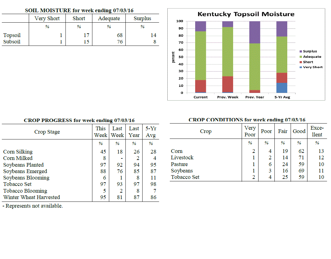 Kentucky Climate Summary
For the Period June 27, 2016 to July 3, 2016
Below Normal Temperatures and Above Normal Rainfall:
After seeing five straight weeks of near to above normal temperatures, the
Commonwealth caught a break this past period. Following a hot and muggy day on
Monday, a couple cold fronts dropped through the Lower Ohio Valley. Winds shifting
to the north/northwest led to much cooler and drier air filtering into the area.
Temperatures ran below normal on both Wednesday and Thursday with highs in the upper
70s to middle 80s across much of Kentucky. Other than some isolated to scattered
activity periodically through the week, most of the Bluegrass State remained dry
through Saturday. Widespread activity returned Sunday with storms erupting across
Western Kentucky and pushing east. Storms produced torrential rainfall and resulted
in significant rainfall accumulations across Western and Central Kentucky. Several
locations saw in upwards of an inch of rainfall, with some in excess of three.
Overall, this event pushed the state to a second straight week of above normal
rainfall.
Temperatures for the period averaged 73 degrees across the state which was 2
degrees cooler than normal and 6 degrees cooler than the previous period. High
temperatures averaged from 85 in the West to 83 in the East. Departure from
normal high temperatures ranged from 3 degrees cooler than normal in the West
to 3 degrees cooler than normal in the East. Low temperatures averaged from 65
degrees in the West to 63 degrees in the East. Departure from normal low
temperature ranged from 1 degree cooler than normal in the West to 1 degree
warmer than normal in the East. The extreme high temperature for the period
was 95 degrees at POPLAR BLUFF ASOS and the extreme low was 52 degrees at
BRANDENBURG 4SW.
Precipitation (liq. equ.) for the period totaled 1.15 inches statewide which was
0.16 inches above normal and 116% of normal. Precipitation totals by climate
division, West 1.76 inches, Central 1.45 inches, Bluegrass 0.78 inches and East
0.60 inches, which was 0.77, 0.47, -0.19 and -0.43 inches respectively from
normal. By station, precipitation totals ranged from a low of 0.00 inches at
BOONEVILLE 2S to a high of 4.75 inches at MURRAY 1W.
---
Agricultural Situation Report: June 27, 2016
(USDA's Crop Report with comments from Tom Priddy & Matt Dixon, UK Ag. Weather)
Agricultural News: Kentucky experienced above normal temperatures and rainfall over
the past week. Precipitation for the week totaled 1.23 inches, 0.22 inches above
normal. Temperatures averaged 79 degrees for the week, 5 degrees above normal.
Topsoil moisture was rated 1 percent very short, 22 percent short, 69 percent
adequate and 8 percent surplus. Subsoil moisture was rated 1 percent very short, 16
percent short, 76 percent adequate, and 7 percent surplus. Days suitable for
fieldwork averaged 5.7 out of a possible seven.
Portions of the state remained dry while other areas reported varied rainfall as
scattered storms occurred over the week. Conditions allowed farmers to make
considerable progress in harvesting wheat. Planting of doublecrop soybeans continued
as well, nearing completion. The average height of emerged soybeans was 5 inches,
compared to 6 inches last year. Tobacco planting is nearing completion as well, with
some reports of severe black shank. The average height of tobacco in the field was 13
inches, compared to 9 inches last week and 16 inches last year at this time. Large
amounts of hay continued to be harvested with mostly average quality. High
temperatures and humidity are putting some stress on livestock.
Kentucky Climate Summary
For the Period June 27, 2016 to July 3, 2016
Below Normal Temperatures and Above Normal Rainfall:
After seeing five straight weeks of near to above normal temperatures, the
Commonwealth caught a break this past period. Following a hot and muggy day on
Monday, a couple cold fronts dropped through the Lower Ohio Valley. Winds shifting
to the north/northwest led to much cooler and drier air filtering into the area.
Temperatures ran below normal on both Wednesday and Thursday with highs in the upper
70s to middle 80s across much of Kentucky. Other than some isolated to scattered
activity periodically through the week, most of the Bluegrass State remained dry
through Saturday. Widespread activity returned Sunday with storms erupting across
Western Kentucky and pushing east. Storms produced torrential rainfall and resulted
in significant rainfall accumulations across Western and Central Kentucky. Several
locations saw in upwards of an inch of rainfall, with some in excess of three.
Overall, this event pushed the state to a second straight week of above normal
rainfall.
Temperatures for the period averaged 73 degrees across the state which was 2
degrees cooler than normal and 6 degrees cooler than the previous period. High
temperatures averaged from 85 in the West to 83 in the East. Departure from
normal high temperatures ranged from 3 degrees cooler than normal in the West
to 3 degrees cooler than normal in the East. Low temperatures averaged from 65
degrees in the West to 63 degrees in the East. Departure from normal low
temperature ranged from 1 degree cooler than normal in the West to 1 degree
warmer than normal in the East. The extreme high temperature for the period
was 95 degrees at POPLAR BLUFF ASOS and the extreme low was 52 degrees at
BRANDENBURG 4SW.
Precipitation (liq. equ.) for the period totaled 1.15 inches statewide which was
0.16 inches above normal and 116% of normal. Precipitation totals by climate
division, West 1.76 inches, Central 1.45 inches, Bluegrass 0.78 inches and East
0.60 inches, which was 0.77, 0.47, -0.19 and -0.43 inches respectively from
normal. By station, precipitation totals ranged from a low of 0.00 inches at
BOONEVILLE 2S to a high of 4.75 inches at MURRAY 1W.
---
Agricultural Situation Report: June 27, 2016
(USDA's Crop Report with comments from Tom Priddy & Matt Dixon, UK Ag. Weather)
Agricultural News: Kentucky experienced above normal temperatures and rainfall over
the past week. Precipitation for the week totaled 1.23 inches, 0.22 inches above
normal. Temperatures averaged 79 degrees for the week, 5 degrees above normal.
Topsoil moisture was rated 1 percent very short, 22 percent short, 69 percent
adequate and 8 percent surplus. Subsoil moisture was rated 1 percent very short, 16
percent short, 76 percent adequate, and 7 percent surplus. Days suitable for
fieldwork averaged 5.7 out of a possible seven.
Portions of the state remained dry while other areas reported varied rainfall as
scattered storms occurred over the week. Conditions allowed farmers to make
considerable progress in harvesting wheat. Planting of doublecrop soybeans continued
as well, nearing completion. The average height of emerged soybeans was 5 inches,
compared to 6 inches last year. Tobacco planting is nearing completion as well, with
some reports of severe black shank. The average height of tobacco in the field was 13
inches, compared to 9 inches last week and 16 inches last year at this time. Large
amounts of hay continued to be harvested with mostly average quality. High
temperatures and humidity are putting some stress on livestock.
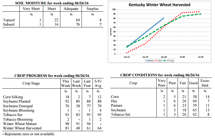 Kentucky Climate Summary
For the Period June 20, 2016 to June 26, 2016
Above Normal Temperatures and Rainfall:
Each period has gotten a step warmer over the past couple weeks. Statewide,
temperatures were 5 degrees above normal this past period, which was the fifth
straight week of near to above normal temperatures. The hot and humid pattern
continued with multiple days getting into the upper 80s to middle 90s. Thursday was
the warmest day with much of Western Kentucky under a Heat Advisory. Livestock heat
stress remained in the danger to emergency category about each afternoon and evening.
Looking at rainfall, an active pattern developed Tuesday through Thursday with
several rounds of thunderstorms. Located within a very unstable and moist air mass,
storms produced frequent cloud to ground lightning and heavy rainfall, in addition to
some instances of damaging winds and large hail. Other than Western Kentucky, the
rest of the state saw above normal rainfall for the week, averaging around 1.5
inches. According to data at the UK Ag Weather Center, Western Kentucky is now 1.64
inches below normal on average for the month of June.
Temperatures for the period averaged 79 degrees across the state which was 5 degrees
warmer than normal and 2 degrees warmer than the previous period. High temperatures
averaged from 92 in the West to 87 in the East. Departure from normal high
temperatures ranged from 5 degrees warmer than normal in the West to 2 degrees
warmer than normal in the East. Low temperatures averaged from 73 degrees in the
West to 66 degrees in the East. Departure from normal low temperature ranged from 8
degrees warmer than normal in the West to 6 degrees warmer than normal in the East.
The extreme high temperature for the period was 97 degrees at CAPE GIRARDEAU ASOS and
the extreme low was 57 degrees at YELLOW CREEK.
Precipitation (liq. equ.) for the period totaled 1.23 inches statewide which was 0.22
inches above normal and 122% of normal. Precipitation totals by climate division,
West 0.43 inches, Central 1.35 inches, Bluegrass 1.59 inches and East 1.57 inches,
which was -0.58, 0.35, 0.59 and 0.54 inches respectively from normal. By station,
precipitation totals ranged from a low of 0.00 inches at CAPE GIRARDEAU ASOS to a
high of 5.22 inches at LOUISA 1S.
---
Agricultural Situation Report: June 20, 2016
(USDA's Crop Report with comments from Tom Priddy & Matt Dixon, UK Ag. Weather)
Agricultural News: Kentucky experienced above normal temperatures and below normal
rainfall over the past week. Precipitation for the week totaled 0.63 inches, 0.37
inches below normal. Temperatures averaged 76 degrees for the week, 3 degrees above
normal. Topsoil moisture was rated 1 percent very short, 18 percent short, 72 percent
adequate and 9 percent surplus. Subsoil moisture was rated 1 percent very short, 13
percent short, 78 percent adequate, and 8 percent surplus. Days suitable for
fieldwork averaged 5.8 out of a possible seven.
Primary activities this week included planting soybeans and tobacco. Winter wheat
harvest for grain made good progress last week. Planting of double crop beans is
underway. Herbicides were being applied and fields continued to be side dressed. The
average height of emerged corn was 37 inches, compared to 34 inches last year. The
average height of tobacco in the field was 9 inches, compared to 11 inches last year.
Some areas have become abnormally dry with soils drying rapidly and showers would be
welcomed. Farmers once again took advantage of dry weather to cut and bale a
significant amount of hay. Heat is putting stress on cattle, but overall condition
is good.
Kentucky Climate Summary
For the Period June 20, 2016 to June 26, 2016
Above Normal Temperatures and Rainfall:
Each period has gotten a step warmer over the past couple weeks. Statewide,
temperatures were 5 degrees above normal this past period, which was the fifth
straight week of near to above normal temperatures. The hot and humid pattern
continued with multiple days getting into the upper 80s to middle 90s. Thursday was
the warmest day with much of Western Kentucky under a Heat Advisory. Livestock heat
stress remained in the danger to emergency category about each afternoon and evening.
Looking at rainfall, an active pattern developed Tuesday through Thursday with
several rounds of thunderstorms. Located within a very unstable and moist air mass,
storms produced frequent cloud to ground lightning and heavy rainfall, in addition to
some instances of damaging winds and large hail. Other than Western Kentucky, the
rest of the state saw above normal rainfall for the week, averaging around 1.5
inches. According to data at the UK Ag Weather Center, Western Kentucky is now 1.64
inches below normal on average for the month of June.
Temperatures for the period averaged 79 degrees across the state which was 5 degrees
warmer than normal and 2 degrees warmer than the previous period. High temperatures
averaged from 92 in the West to 87 in the East. Departure from normal high
temperatures ranged from 5 degrees warmer than normal in the West to 2 degrees
warmer than normal in the East. Low temperatures averaged from 73 degrees in the
West to 66 degrees in the East. Departure from normal low temperature ranged from 8
degrees warmer than normal in the West to 6 degrees warmer than normal in the East.
The extreme high temperature for the period was 97 degrees at CAPE GIRARDEAU ASOS and
the extreme low was 57 degrees at YELLOW CREEK.
Precipitation (liq. equ.) for the period totaled 1.23 inches statewide which was 0.22
inches above normal and 122% of normal. Precipitation totals by climate division,
West 0.43 inches, Central 1.35 inches, Bluegrass 1.59 inches and East 1.57 inches,
which was -0.58, 0.35, 0.59 and 0.54 inches respectively from normal. By station,
precipitation totals ranged from a low of 0.00 inches at CAPE GIRARDEAU ASOS to a
high of 5.22 inches at LOUISA 1S.
---
Agricultural Situation Report: June 20, 2016
(USDA's Crop Report with comments from Tom Priddy & Matt Dixon, UK Ag. Weather)
Agricultural News: Kentucky experienced above normal temperatures and below normal
rainfall over the past week. Precipitation for the week totaled 0.63 inches, 0.37
inches below normal. Temperatures averaged 76 degrees for the week, 3 degrees above
normal. Topsoil moisture was rated 1 percent very short, 18 percent short, 72 percent
adequate and 9 percent surplus. Subsoil moisture was rated 1 percent very short, 13
percent short, 78 percent adequate, and 8 percent surplus. Days suitable for
fieldwork averaged 5.8 out of a possible seven.
Primary activities this week included planting soybeans and tobacco. Winter wheat
harvest for grain made good progress last week. Planting of double crop beans is
underway. Herbicides were being applied and fields continued to be side dressed. The
average height of emerged corn was 37 inches, compared to 34 inches last year. The
average height of tobacco in the field was 9 inches, compared to 11 inches last year.
Some areas have become abnormally dry with soils drying rapidly and showers would be
welcomed. Farmers once again took advantage of dry weather to cut and bale a
significant amount of hay. Heat is putting stress on cattle, but overall condition
is good.
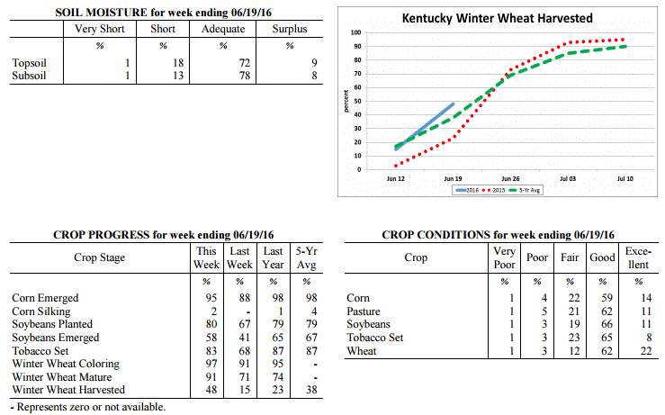 Kentucky Climate Summary
For the Period June 13, 2016 to June 19, 2016
Above Normal Temperatures and Below Normal Rainfall:
The Commonwealth remained in a warm and muggy pattern this past period, accounting
for a fourth straight week of near to above normal temperatures. Temperatures were
even a bit warmer than the previous week with highs averaging in the middle 80s to
around 90 from east to west. The warmest temperatures were seen on Thursday as the
majority of Kentucky rose into the low to middle 90s. Paducah and Fort Campbell saw
the first 100 degree readings of the season. The warm temperatures combined with
very humid conditions pushed the livestock heat stress index into the emergency
category across Western and West-Central Kentucky. For the week, the state averaged
just over a half inch of rainfall, below normal for a second straight week. Most of
the activity was seen Tuesday through Thursday with scattered to numerous coverage in
place. As the state was placed in a very moist and unstable air mass, storms were
capable of producing torrential rainfall and frequent lightning. Otherwise, high
pressure at the surface and aloft kept the area dry Friday and through the weekend.
Temperatures for the period averaged 76 degrees across the state which was 3 degrees
warmer than normal and 4 degrees warmer than the previous period. High temperatures
averaged from 90 in the West to 86 in the East. Departure from normal high
temperatures ranged from 4 degrees warmer than normal in the West to 2 degrees
warmer than normal in the East. Low temperatures averaged from 70 degrees in the
West to 63 degrees in the East. Departure from normal low temperature ranged from 6
degrees warmer than normal in the West to 4 degrees warmer than normal in the East.
The extreme high temperature for the period was 101 degrees at CAPE GIRARDEAU ASOS
and the extreme low was 50 degrees at VANCEBURG 6W.
Precipitation (liq. equ.) for the period totaled 0.63 inches statewide which was 0.37
inches below normal and 63% of normal. Precipitation totals by climate division, West
0.66 inches, Central 0.57 inches, Bluegrass 0.89 inches and East 0.39 inches, which
was 0.32, 0.43, 0.12 and 0.63 inches below normal. By station, precipitation totals
ranged from a low of 0.00 inches at JACKSON AIRPORT to a high of 2.08 inches at
SHELBYVILLE 10W.
---
Agricultural Situation Report: June 13, 2016
(USDA's Crop Report with comments from Tom Priddy & Matt Dixon, UK Ag. Weather)
Agricultural News: Kentucky experienced near normal temperatures and well below
normal rainfall over the past week. Precipitation for the week totaled 0.07 inches,
0.97 inches below normal. Temperatures averaged 71 degrees for the week, near normal.
Topsoil moisture was rated 1 percent very short, 11 percent short, 76 percent
adequate and 12 percent surplus. Subsoil moisture was rated 1 percent very short, 7
percent short, 80 percent adequate, and 12 percent surplus. Days suitable for
fieldwork averaged 6.3 out of a possible seven.
Conditions finally allowed producers to make strides in planting crops including
corn, soybeans and tobacco. Winter wheat harvest for grain was underway. Planting of
double crop beans will begin as soon as wheat is removed from fields. Farmers also
took advantage of dry weather to cut and bale a significant amount of hay. Herbicides
were being applied and fields were side dressed this week. The average height of
emerged corn was 24 inches, compared to 23 inches last year. The average height of
tobacco in the field was 6 inches, compared to 8 inches last year. Soils are drying
rapidly and farmers are hoping for showers as soon as they get caught up on their
field work.
Kentucky Climate Summary
For the Period June 13, 2016 to June 19, 2016
Above Normal Temperatures and Below Normal Rainfall:
The Commonwealth remained in a warm and muggy pattern this past period, accounting
for a fourth straight week of near to above normal temperatures. Temperatures were
even a bit warmer than the previous week with highs averaging in the middle 80s to
around 90 from east to west. The warmest temperatures were seen on Thursday as the
majority of Kentucky rose into the low to middle 90s. Paducah and Fort Campbell saw
the first 100 degree readings of the season. The warm temperatures combined with
very humid conditions pushed the livestock heat stress index into the emergency
category across Western and West-Central Kentucky. For the week, the state averaged
just over a half inch of rainfall, below normal for a second straight week. Most of
the activity was seen Tuesday through Thursday with scattered to numerous coverage in
place. As the state was placed in a very moist and unstable air mass, storms were
capable of producing torrential rainfall and frequent lightning. Otherwise, high
pressure at the surface and aloft kept the area dry Friday and through the weekend.
Temperatures for the period averaged 76 degrees across the state which was 3 degrees
warmer than normal and 4 degrees warmer than the previous period. High temperatures
averaged from 90 in the West to 86 in the East. Departure from normal high
temperatures ranged from 4 degrees warmer than normal in the West to 2 degrees
warmer than normal in the East. Low temperatures averaged from 70 degrees in the
West to 63 degrees in the East. Departure from normal low temperature ranged from 6
degrees warmer than normal in the West to 4 degrees warmer than normal in the East.
The extreme high temperature for the period was 101 degrees at CAPE GIRARDEAU ASOS
and the extreme low was 50 degrees at VANCEBURG 6W.
Precipitation (liq. equ.) for the period totaled 0.63 inches statewide which was 0.37
inches below normal and 63% of normal. Precipitation totals by climate division, West
0.66 inches, Central 0.57 inches, Bluegrass 0.89 inches and East 0.39 inches, which
was 0.32, 0.43, 0.12 and 0.63 inches below normal. By station, precipitation totals
ranged from a low of 0.00 inches at JACKSON AIRPORT to a high of 2.08 inches at
SHELBYVILLE 10W.
---
Agricultural Situation Report: June 13, 2016
(USDA's Crop Report with comments from Tom Priddy & Matt Dixon, UK Ag. Weather)
Agricultural News: Kentucky experienced near normal temperatures and well below
normal rainfall over the past week. Precipitation for the week totaled 0.07 inches,
0.97 inches below normal. Temperatures averaged 71 degrees for the week, near normal.
Topsoil moisture was rated 1 percent very short, 11 percent short, 76 percent
adequate and 12 percent surplus. Subsoil moisture was rated 1 percent very short, 7
percent short, 80 percent adequate, and 12 percent surplus. Days suitable for
fieldwork averaged 6.3 out of a possible seven.
Conditions finally allowed producers to make strides in planting crops including
corn, soybeans and tobacco. Winter wheat harvest for grain was underway. Planting of
double crop beans will begin as soon as wheat is removed from fields. Farmers also
took advantage of dry weather to cut and bale a significant amount of hay. Herbicides
were being applied and fields were side dressed this week. The average height of
emerged corn was 24 inches, compared to 23 inches last year. The average height of
tobacco in the field was 6 inches, compared to 8 inches last year. Soils are drying
rapidly and farmers are hoping for showers as soon as they get caught up on their
field work.
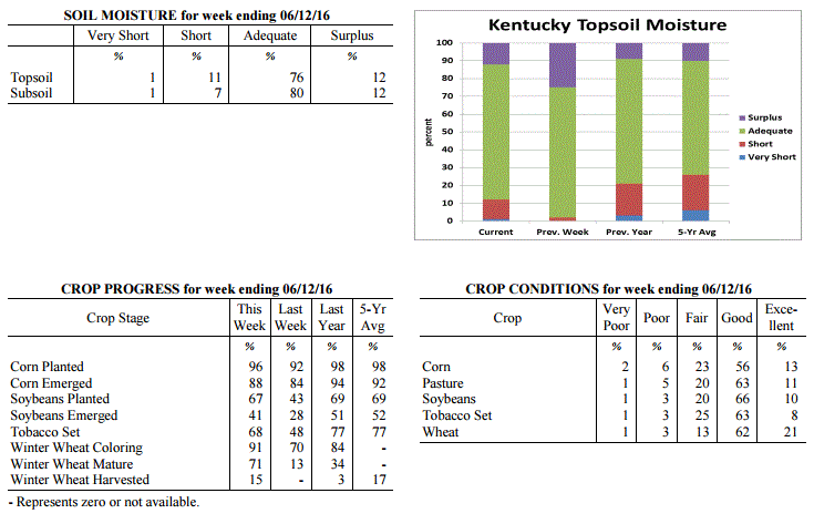 Kentucky Climate Summary
For the Period June 6, 2016 to June 12, 2016
Near Normal Temperatures and Much Below Normal Rainfall:
Exceptionally hot and humid conditions returned to the Bluegrass State this past
weekend, along with an overall very dry week. The period began with a cold front
pushing through the area on Monday with a few passing showers and storms. High
pressure then moved into Kentucky for the next few days bringing dry conditions, low
humidity, and unseasonably cool days with highs only topping out in the 70s. Saying
that, the cool spell was short lived as winds shifted to the south by the end of the
week, opening the door for the warmest temperatures of the year. Highs rose into the
low to mid 90s both Saturday and Sunday, along with increasing humidity. This led
to the livestock heat stress index moving into the danger category each afternoon and
evening. Another round of showers and storms moved through the northern half of
Kentucky on Sunday, but just like Monday, coverage was minimal. For the week, the
state only averaged 0.07 inches, with most of the state not seeing any rainfall at
all. Based on data at the UK Ag Weather Center, this was the driest week of 2016.
Temperatures for the period averaged 71 degrees across the state which was near
normal and 2 degrees cooler than the previous period. High temperatures averaged
from 86 in the West to 83 in the East. Departure from normal high temperatures
ranged from 2 degrees warmer than normal in the West to 1 degrees warmer than normal
in the East. Low temperatures averaged from 60 degrees in the West to 57 degrees in
the East. Departure from normal low temperature ranged from 2 degrees cooler than
normal in the West to 1 degree cooler than normal in the East. The extreme high
temperature for the period was 96 degrees at EVANSVILLE ASOS and the extreme low
was 44 degrees at PAINTSVILLE 4W.
Precipitation (liq. equ.) for the period totaled 0.07 inches statewide which was 0.97
inches below normal and 7% of normal. Precipitation totals by climate division, West
0.03 inches, Central 0.02 inches, Bluegrass 0.17 inches and East 0.05 inches, which
was 0.96, 1.04, 0.9 and 1.01 inches below normal. By station, precipitation totals
ranged from a low of 0.00 inches at ALBANY 1N to a high of 0.59 inches at ALEXANDRIA 5NW.
---
Agricultural Situation Report: June 6, 2016
(USDA's Crop Report with comments from Tom Priddy & Matt Dixon, UK Ag. Weather)
Agricultural News: Kentucky experienced above normal temperatures and near normal
rainfall over the past week. Precipitation for the week totaled 1.18 inches, 0.08
inches above normal. Temperatures averaged 74 degrees for the week, 4 degrees above
normal. Topsoil moisture was rated 2 percent short, 73 percent adequate and 25
percent surplus. Subsoil moisture was rated 3 percent short, 75 percent adequate, and
22 percent surplus. Days suitable for fieldwork averaged 4.4 out of a possible seven.
Similar to the previous period, conditions remained warm and muggy for much of
this past week. Temperatures were 4 degrees above normal as highs jumped
into the 80s each day, along with lows only dropping into the 60s. A handful of
locations even hit the 90-degree mark. High dew points accompanied the warm
temperatures, making for a very humid air mass. As showers and storms fired
over the second half of the work week and into the weekend, the moist atmosphere
allowed for torrential rainfall at times, leading to some short lived flooding
for a few locations. Some sites reported seeing more than an inch of rainfall in
less than an hour. Overall, the Bluegrass and Eastern Kentucky each saw above
normal rainfall, while Western and Central Kentucky were slightly below normal
for the week.
Planting of crops is still running behind normal due to wet conditions. Primary
activities this week included setting tobacco, harvesting hay, and planting corn and
soybeans when conditions allowed. Some corn fields were side dressed this week. The
average height of emerged corn was 16 inches, compared to 14 inches last year.
Weather conditions have not been favorable for harvesting hay in many areas as
quality continues to be a concern for some producers.
Kentucky Climate Summary
For the Period June 6, 2016 to June 12, 2016
Near Normal Temperatures and Much Below Normal Rainfall:
Exceptionally hot and humid conditions returned to the Bluegrass State this past
weekend, along with an overall very dry week. The period began with a cold front
pushing through the area on Monday with a few passing showers and storms. High
pressure then moved into Kentucky for the next few days bringing dry conditions, low
humidity, and unseasonably cool days with highs only topping out in the 70s. Saying
that, the cool spell was short lived as winds shifted to the south by the end of the
week, opening the door for the warmest temperatures of the year. Highs rose into the
low to mid 90s both Saturday and Sunday, along with increasing humidity. This led
to the livestock heat stress index moving into the danger category each afternoon and
evening. Another round of showers and storms moved through the northern half of
Kentucky on Sunday, but just like Monday, coverage was minimal. For the week, the
state only averaged 0.07 inches, with most of the state not seeing any rainfall at
all. Based on data at the UK Ag Weather Center, this was the driest week of 2016.
Temperatures for the period averaged 71 degrees across the state which was near
normal and 2 degrees cooler than the previous period. High temperatures averaged
from 86 in the West to 83 in the East. Departure from normal high temperatures
ranged from 2 degrees warmer than normal in the West to 1 degrees warmer than normal
in the East. Low temperatures averaged from 60 degrees in the West to 57 degrees in
the East. Departure from normal low temperature ranged from 2 degrees cooler than
normal in the West to 1 degree cooler than normal in the East. The extreme high
temperature for the period was 96 degrees at EVANSVILLE ASOS and the extreme low
was 44 degrees at PAINTSVILLE 4W.
Precipitation (liq. equ.) for the period totaled 0.07 inches statewide which was 0.97
inches below normal and 7% of normal. Precipitation totals by climate division, West
0.03 inches, Central 0.02 inches, Bluegrass 0.17 inches and East 0.05 inches, which
was 0.96, 1.04, 0.9 and 1.01 inches below normal. By station, precipitation totals
ranged from a low of 0.00 inches at ALBANY 1N to a high of 0.59 inches at ALEXANDRIA 5NW.
---
Agricultural Situation Report: June 6, 2016
(USDA's Crop Report with comments from Tom Priddy & Matt Dixon, UK Ag. Weather)
Agricultural News: Kentucky experienced above normal temperatures and near normal
rainfall over the past week. Precipitation for the week totaled 1.18 inches, 0.08
inches above normal. Temperatures averaged 74 degrees for the week, 4 degrees above
normal. Topsoil moisture was rated 2 percent short, 73 percent adequate and 25
percent surplus. Subsoil moisture was rated 3 percent short, 75 percent adequate, and
22 percent surplus. Days suitable for fieldwork averaged 4.4 out of a possible seven.
Similar to the previous period, conditions remained warm and muggy for much of
this past week. Temperatures were 4 degrees above normal as highs jumped
into the 80s each day, along with lows only dropping into the 60s. A handful of
locations even hit the 90-degree mark. High dew points accompanied the warm
temperatures, making for a very humid air mass. As showers and storms fired
over the second half of the work week and into the weekend, the moist atmosphere
allowed for torrential rainfall at times, leading to some short lived flooding
for a few locations. Some sites reported seeing more than an inch of rainfall in
less than an hour. Overall, the Bluegrass and Eastern Kentucky each saw above
normal rainfall, while Western and Central Kentucky were slightly below normal
for the week.
Planting of crops is still running behind normal due to wet conditions. Primary
activities this week included setting tobacco, harvesting hay, and planting corn and
soybeans when conditions allowed. Some corn fields were side dressed this week. The
average height of emerged corn was 16 inches, compared to 14 inches last year.
Weather conditions have not been favorable for harvesting hay in many areas as
quality continues to be a concern for some producers.
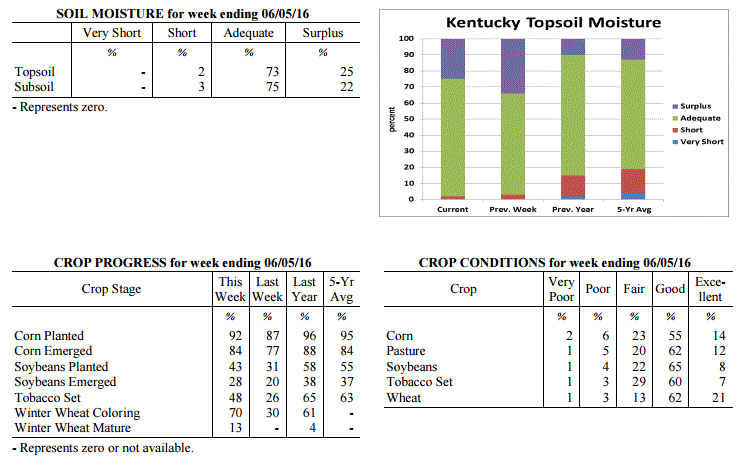 Kentucky Climate Summary
For the Period May 30, 2016 to June 5, 2016
Above Normal Temperatures and Near Normal Rainfall:
Similar to the previous period, conditions remained warm and muggy for much of
this past week. Temperatures were 4 degrees above normal as highs jumped
into the 80s each day, along with lows only dropping into the 60s. A handful of
locations even hit the 90-degree mark. High dew points accompanied the warm
temperatures, making for a very humid air mass. As showers and storms fired
over the second half of the work week and into the weekend, the moist atmosphere
allowed for torrential rainfall at times, leading to some short lived flooding
for a few locations. Some sites reported seeing more than an inch of rainfall in
less than an hour. Overall, the Bluegrass and Eastern Kentucky each saw above
normal rainfall, while Western and Central Kentucky were slightly below normal
for the week.
Temperatures for the period averaged 74 degrees across the state which was 4
degrees warmer than normal and 4 degrees warmer than the previous period. High
temperatures averaged from 83 in the West to 84 in the East. Departure from
normal high temperatures ranged from near normal in the West to 3 degrees warmer
than normal in the East. Low temperatures averaged from 65 degrees in the West
to 64 degrees in the East. Departure from normal low temperature ranged from 4
degrees warmer than normal in the West to 8 degrees warmer than normal in the
East. The extreme high temperature for the period was 91 degrees at PEABODY and
the extreme low was 56 degrees at MCKEE 5S.
Precipitation (liq. equ.) for the period totaled 1.18 inches statewide which was
0.08 inches above normal and 108% of normal. Precipitation totals by climate
division, West 1.00 inches, Central 0.81 inches, Bluegrass 1.37 inches and East
1.52 inches, which was -0.07, -0.31, 0.28 and 0.42 inches respectively from
normal. By station, precipitation totals ranged from a low of 0.16 inches at
PIKEVILLE 13S to a high of 3.71 inches at MOREHEAD 4NE.
---
Agricultural Situation Report: May 31, 2016
(USDA's Crop Report with comments from Tom Priddy & Matt Dixon, UK Ag. Weather)
Agricultural News: Kentucky experienced above normal temperatures and near normal
rainfall over the past week. Precipitation for the week totaled 1.09 inches, 0.02
inches below normal. Temperatures averaged 70 degrees for the week, 2 degrees above
normal. Topsoil moisture was rated 3 percent short, 63 percent adequate and 34
percent surplus. Subsoil moisture was rated 2 percent short, 70 percent adequate, and
28 percent surplus. Days suitable for fieldwork averaged 3.1 out of a possible seven.
Primary activities this week included setting tobacco, harvesting hay, and planting
corn and soybeans when conditions allowed. Isolated and severe storms left many
fields wet with some reports of damage to corn, soybeans, and wheat from hail, wind,
and flooding. Sidewall compaction may be an issue later in the season, especially for
crops planted in wet fields. Some emerged corn is yellowing and showing signs of
stress. Several corn and soybean fields have been or will need to be replanted. The
average height of emerged corn was 9 inches, compared to 11 inches last year.
Producers cut and wrapped wheat for silage this week. Weather conditions finally
allowed for some producers to cut hay and appears to be yielding well. However,
quality of hay is declining due to over maturity. Hay and roughage supplies were
reported as 1 percent very short, 10 percent short, 80 percent adequate, and 9
percent surplus.
Kentucky Climate Summary
For the Period May 30, 2016 to June 5, 2016
Above Normal Temperatures and Near Normal Rainfall:
Similar to the previous period, conditions remained warm and muggy for much of
this past week. Temperatures were 4 degrees above normal as highs jumped
into the 80s each day, along with lows only dropping into the 60s. A handful of
locations even hit the 90-degree mark. High dew points accompanied the warm
temperatures, making for a very humid air mass. As showers and storms fired
over the second half of the work week and into the weekend, the moist atmosphere
allowed for torrential rainfall at times, leading to some short lived flooding
for a few locations. Some sites reported seeing more than an inch of rainfall in
less than an hour. Overall, the Bluegrass and Eastern Kentucky each saw above
normal rainfall, while Western and Central Kentucky were slightly below normal
for the week.
Temperatures for the period averaged 74 degrees across the state which was 4
degrees warmer than normal and 4 degrees warmer than the previous period. High
temperatures averaged from 83 in the West to 84 in the East. Departure from
normal high temperatures ranged from near normal in the West to 3 degrees warmer
than normal in the East. Low temperatures averaged from 65 degrees in the West
to 64 degrees in the East. Departure from normal low temperature ranged from 4
degrees warmer than normal in the West to 8 degrees warmer than normal in the
East. The extreme high temperature for the period was 91 degrees at PEABODY and
the extreme low was 56 degrees at MCKEE 5S.
Precipitation (liq. equ.) for the period totaled 1.18 inches statewide which was
0.08 inches above normal and 108% of normal. Precipitation totals by climate
division, West 1.00 inches, Central 0.81 inches, Bluegrass 1.37 inches and East
1.52 inches, which was -0.07, -0.31, 0.28 and 0.42 inches respectively from
normal. By station, precipitation totals ranged from a low of 0.16 inches at
PIKEVILLE 13S to a high of 3.71 inches at MOREHEAD 4NE.
---
Agricultural Situation Report: May 31, 2016
(USDA's Crop Report with comments from Tom Priddy & Matt Dixon, UK Ag. Weather)
Agricultural News: Kentucky experienced above normal temperatures and near normal
rainfall over the past week. Precipitation for the week totaled 1.09 inches, 0.02
inches below normal. Temperatures averaged 70 degrees for the week, 2 degrees above
normal. Topsoil moisture was rated 3 percent short, 63 percent adequate and 34
percent surplus. Subsoil moisture was rated 2 percent short, 70 percent adequate, and
28 percent surplus. Days suitable for fieldwork averaged 3.1 out of a possible seven.
Primary activities this week included setting tobacco, harvesting hay, and planting
corn and soybeans when conditions allowed. Isolated and severe storms left many
fields wet with some reports of damage to corn, soybeans, and wheat from hail, wind,
and flooding. Sidewall compaction may be an issue later in the season, especially for
crops planted in wet fields. Some emerged corn is yellowing and showing signs of
stress. Several corn and soybean fields have been or will need to be replanted. The
average height of emerged corn was 9 inches, compared to 11 inches last year.
Producers cut and wrapped wheat for silage this week. Weather conditions finally
allowed for some producers to cut hay and appears to be yielding well. However,
quality of hay is declining due to over maturity. Hay and roughage supplies were
reported as 1 percent very short, 10 percent short, 80 percent adequate, and 9
percent surplus.
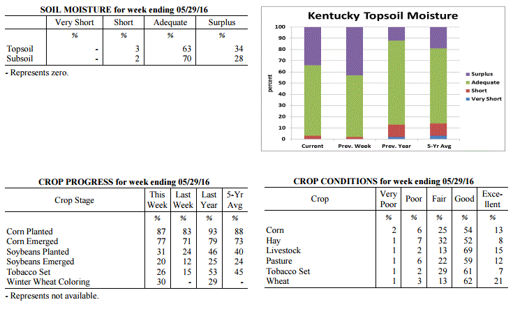 Kentucky Climate Summary
For the Period May 23, 2016 to May 29, 2016
Above Normal Temperatures and Near Normal Rainfall:
After three straight weeks of near to below normal temperatures, Kentucky became
situated within a summer-like pattern this past week. High temperatures were in the
80s about each day, with the hottest coming Friday as temperatures peaked in the mid
to upper 80s statewide. In addition, Gulf moisture started pushing into Kentucky by
Wednesday with muggy conditions sticking around through the end of the period. From
mid-week onward, isolated to scattered showers and storms were seen on a near daily
basis. The one exception came Thursday as most of the area saw rainfall as a line of
storms pushed through the Lower Ohio Valley. Situated within a moist and unstable
air mass for much of the period, storms were capable of frequent lightning and
torrential rainfall, leading to flash flooding at times. For the week, rainfall
totals were drastically different from one side of the state to the other. While
Western Kentucky averaged 1.79 inches for the week, Eastern Kentucky only saw an
average of 0.61.
Temperatures for the period averaged 70 degrees across the state which was 2 degrees
warmer than normal and 12 degrees warmer than the previous period. High temperatures
averaged from 82 in the West to 81 in the East. Departure from normal high
temperatures ranged from 1 degree warmer than normal in the West to 2 degrees
warmer than normal in the East. Low temperatures averaged from 62 degrees in the
West to 57 degrees in the East. Departure from normal low temperature ranged from 4
degrees warmer than normal in the West to 3 degrees warmer than normal in the East.
The extreme high temperature for the period was 89 degrees at VANCEBURG 6W and the
extreme low was 41 degrees at CYNTHIANA 8N.
Precipitation (liq. equ.) for the period totaled 1.09 inches statewide which was 0.02
inches below normal and 98% of normal. Precipitation totals by climate division, West
1.79 inches, Central 1.42 inches, Bluegrass 0.55 inches and East 0.61 inches, which
was 0.69, 0.26, -0.53 and -0.51 inches respectively from normal. By station,
precipitation totals ranged from a low of 0.07 inches at LOUISA 1S to a high of
5.01 inches at CAPE GIRARDEAU ASOS.
---
Agricultural Situation Report: May 23, 2016
(USDA's Crop Report with comments from Tom Priddy & Matt Dixon, UK Ag. Weather)
Agricultural News: Kentucky experienced below normal temperatures and above normal
rainfall over the past week. Precipitation for the week totaled 1.61 inches, 0.48
inches above normal. Temperatures averaged 58 degrees for the week, 8 degrees below
normal. Topsoil moisture was rated 0 percent very short, 2 percent short, 55 percent
adequate and 43 percent surplus. Subsoil moisture was rated 0 percent very short, 3
percent short, 66 percent adequate, and 31 percent surplus. Days suitable for
fieldwork averaged 1.8 out of a possible seven.
Wet weather persisted this week, causing additional delays for planting activities
and hay cutting. Where weather permitted, primary activities this week included
limited planting and spraying, with a small amount of hay being harvested. Some
producers intending to plant corn are changing to soybeans due to favorable prices
and continued wet fields. Corn is yellowing due to saturated soils, denitrification,
and leaching. The average height of emerged corn was 6 inches. Excessive rainfall has
resulted in the deterioration of hay conditions as many fields are well past their
ideal cutting date. Tobacco planting delays have left many plants in need of being
transplanted as soon as possible.
Kentucky Climate Summary
For the Period May 23, 2016 to May 29, 2016
Above Normal Temperatures and Near Normal Rainfall:
After three straight weeks of near to below normal temperatures, Kentucky became
situated within a summer-like pattern this past week. High temperatures were in the
80s about each day, with the hottest coming Friday as temperatures peaked in the mid
to upper 80s statewide. In addition, Gulf moisture started pushing into Kentucky by
Wednesday with muggy conditions sticking around through the end of the period. From
mid-week onward, isolated to scattered showers and storms were seen on a near daily
basis. The one exception came Thursday as most of the area saw rainfall as a line of
storms pushed through the Lower Ohio Valley. Situated within a moist and unstable
air mass for much of the period, storms were capable of frequent lightning and
torrential rainfall, leading to flash flooding at times. For the week, rainfall
totals were drastically different from one side of the state to the other. While
Western Kentucky averaged 1.79 inches for the week, Eastern Kentucky only saw an
average of 0.61.
Temperatures for the period averaged 70 degrees across the state which was 2 degrees
warmer than normal and 12 degrees warmer than the previous period. High temperatures
averaged from 82 in the West to 81 in the East. Departure from normal high
temperatures ranged from 1 degree warmer than normal in the West to 2 degrees
warmer than normal in the East. Low temperatures averaged from 62 degrees in the
West to 57 degrees in the East. Departure from normal low temperature ranged from 4
degrees warmer than normal in the West to 3 degrees warmer than normal in the East.
The extreme high temperature for the period was 89 degrees at VANCEBURG 6W and the
extreme low was 41 degrees at CYNTHIANA 8N.
Precipitation (liq. equ.) for the period totaled 1.09 inches statewide which was 0.02
inches below normal and 98% of normal. Precipitation totals by climate division, West
1.79 inches, Central 1.42 inches, Bluegrass 0.55 inches and East 0.61 inches, which
was 0.69, 0.26, -0.53 and -0.51 inches respectively from normal. By station,
precipitation totals ranged from a low of 0.07 inches at LOUISA 1S to a high of
5.01 inches at CAPE GIRARDEAU ASOS.
---
Agricultural Situation Report: May 23, 2016
(USDA's Crop Report with comments from Tom Priddy & Matt Dixon, UK Ag. Weather)
Agricultural News: Kentucky experienced below normal temperatures and above normal
rainfall over the past week. Precipitation for the week totaled 1.61 inches, 0.48
inches above normal. Temperatures averaged 58 degrees for the week, 8 degrees below
normal. Topsoil moisture was rated 0 percent very short, 2 percent short, 55 percent
adequate and 43 percent surplus. Subsoil moisture was rated 0 percent very short, 3
percent short, 66 percent adequate, and 31 percent surplus. Days suitable for
fieldwork averaged 1.8 out of a possible seven.
Wet weather persisted this week, causing additional delays for planting activities
and hay cutting. Where weather permitted, primary activities this week included
limited planting and spraying, with a small amount of hay being harvested. Some
producers intending to plant corn are changing to soybeans due to favorable prices
and continued wet fields. Corn is yellowing due to saturated soils, denitrification,
and leaching. The average height of emerged corn was 6 inches. Excessive rainfall has
resulted in the deterioration of hay conditions as many fields are well past their
ideal cutting date. Tobacco planting delays have left many plants in need of being
transplanted as soon as possible.
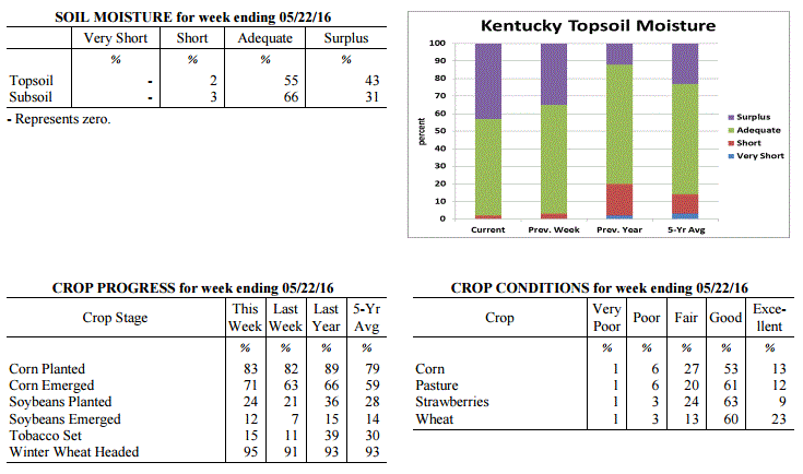 Kentucky Climate Summary
For the Period May 16, 2016 to May 22, 2016
Well Below Normal Temperatures and Above Normal Rainfall:
Unseasonably cool and wet conditions remained in place across Kentucky this past
week. The Bluegrass State saw a couple more rounds of widespread rainfall with the
most significant coming on Friday. Kentucky was situated within a very moist air
mass for this event and resulted in much of Central Kentucky seeing moderate to heavy
rainfall. Much of this region saw 1 to 2 inches. Overall, the state averaged 1.61
inches for the week, which was nearly a half inch above normal. May is typically the
wettest month of the year for Kentucky and May 2016 has been no different. Thus far,
the state has averaged 4.87 inches for the month. While the wet pattern remained in
place, Kentucky also saw some very cool temperatures for mid-May. A Frost Advisory
was even issued for Monday morning as lows dropped into the 30s for many locations.
Overall, Kentucky saw a third straight week of near to below normal temperatures.
Temperatures for the period averaged 58 degrees across the state which was 8 degrees
cooler than normal and 4 degrees cooler than the previous period. High temperatures
averaged from 67 in the West to 66 in the East. Departure from normal high
temperatures ranged from 12 degrees cooler than normal in the West to 11 degrees
cooler than normal in the East. Low temperatures averaged from 51 degrees in the
West to 48 degrees in the East. Departure from normal low temperature ranged from 5
degrees cooler than normal in the West to 3 degrees cooler than normal in the East.
The extreme high temperature for the period was 82 degrees at PADUCAH ASOS and the
extreme low was 32 degrees at OWENTON 5E.
Precipitation (liq. equ.) for the period totaled 1.61 inches statewide which was 0.48
inches above normal and 143% of normal. Precipitation totals by climate division,
West 1.27 inches, Central 2.17 inches, Bluegrass 1.62 inches and East 1.39 inches,
which was 0.15, 0.99, 0.54 and 0.26 inches above normal. By station, precipitation
totals ranged from a low of 0.54 inches at HICKMAN 2E to a high of 4.41 inches at
BOWLING GREEN 4E.
---
Agricultural Situation Report: May 16, 2016
(USDA's Crop Report with comments from Tom Priddy & Matt Dixon, UK Ag. Weather)
Agricultural News: Kentucky experienced near normal temperatures and above normal
rainfall over the past week. Precipitation for the week totaled 1.86 inches, 0.74
inches above normal. Temperatures averaged 63 degrees for the week, unchanged from
normal. Topsoil moisture was rated 3 percent short, 62 percent adequate and 35
percent surplus. Subsoil moisture was rated 3 percent short, 69 percent adequate, and
28 percent surplus. Days suitable for fieldwork averaged 2.1 out of a possible seven.
Primary activities this week included limited planting and spraying. Excessive rains
and storms this week led to flooding, with standing water in many fields. Some fields
will need to be replanted. There were also reports of crop damage due to large hail
and strong winds; tornado touchdowns also occurred. Some hay fields lodged due to
heavy rain and wind, with poor quality and harvest delays anticipated for first
cutting. There were reports of lodging as well as stripe rust in winter wheat.
Tobacco plant diseases are of concern due to damp weather conditions. Tobacco
transplant supplies were reported as 2 percent short, 93 percent adequate, and 5
percent surplus. Ten percent of tobacco transplants were under 2 inches, with 42
percent between 2-4 inches, and 48 percent over 4 inches.
Kentucky Climate Summary
For the Period May 16, 2016 to May 22, 2016
Well Below Normal Temperatures and Above Normal Rainfall:
Unseasonably cool and wet conditions remained in place across Kentucky this past
week. The Bluegrass State saw a couple more rounds of widespread rainfall with the
most significant coming on Friday. Kentucky was situated within a very moist air
mass for this event and resulted in much of Central Kentucky seeing moderate to heavy
rainfall. Much of this region saw 1 to 2 inches. Overall, the state averaged 1.61
inches for the week, which was nearly a half inch above normal. May is typically the
wettest month of the year for Kentucky and May 2016 has been no different. Thus far,
the state has averaged 4.87 inches for the month. While the wet pattern remained in
place, Kentucky also saw some very cool temperatures for mid-May. A Frost Advisory
was even issued for Monday morning as lows dropped into the 30s for many locations.
Overall, Kentucky saw a third straight week of near to below normal temperatures.
Temperatures for the period averaged 58 degrees across the state which was 8 degrees
cooler than normal and 4 degrees cooler than the previous period. High temperatures
averaged from 67 in the West to 66 in the East. Departure from normal high
temperatures ranged from 12 degrees cooler than normal in the West to 11 degrees
cooler than normal in the East. Low temperatures averaged from 51 degrees in the
West to 48 degrees in the East. Departure from normal low temperature ranged from 5
degrees cooler than normal in the West to 3 degrees cooler than normal in the East.
The extreme high temperature for the period was 82 degrees at PADUCAH ASOS and the
extreme low was 32 degrees at OWENTON 5E.
Precipitation (liq. equ.) for the period totaled 1.61 inches statewide which was 0.48
inches above normal and 143% of normal. Precipitation totals by climate division,
West 1.27 inches, Central 2.17 inches, Bluegrass 1.62 inches and East 1.39 inches,
which was 0.15, 0.99, 0.54 and 0.26 inches above normal. By station, precipitation
totals ranged from a low of 0.54 inches at HICKMAN 2E to a high of 4.41 inches at
BOWLING GREEN 4E.
---
Agricultural Situation Report: May 16, 2016
(USDA's Crop Report with comments from Tom Priddy & Matt Dixon, UK Ag. Weather)
Agricultural News: Kentucky experienced near normal temperatures and above normal
rainfall over the past week. Precipitation for the week totaled 1.86 inches, 0.74
inches above normal. Temperatures averaged 63 degrees for the week, unchanged from
normal. Topsoil moisture was rated 3 percent short, 62 percent adequate and 35
percent surplus. Subsoil moisture was rated 3 percent short, 69 percent adequate, and
28 percent surplus. Days suitable for fieldwork averaged 2.1 out of a possible seven.
Primary activities this week included limited planting and spraying. Excessive rains
and storms this week led to flooding, with standing water in many fields. Some fields
will need to be replanted. There were also reports of crop damage due to large hail
and strong winds; tornado touchdowns also occurred. Some hay fields lodged due to
heavy rain and wind, with poor quality and harvest delays anticipated for first
cutting. There were reports of lodging as well as stripe rust in winter wheat.
Tobacco plant diseases are of concern due to damp weather conditions. Tobacco
transplant supplies were reported as 2 percent short, 93 percent adequate, and 5
percent surplus. Ten percent of tobacco transplants were under 2 inches, with 42
percent between 2-4 inches, and 48 percent over 4 inches.
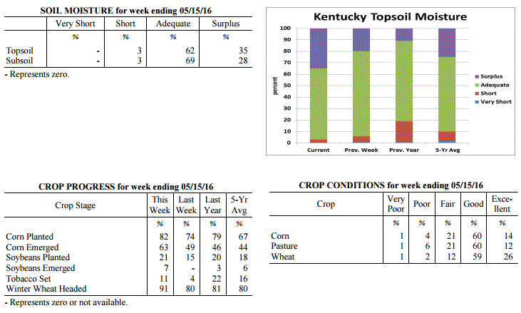 Kentucky Climate Summary
For the Period May 9, 2016 to May 15, 2016
Near Normal Temperatures and Above Normal Rainfall:
The Commonwealth saw several rounds of showers and storms throughout this past week,
followed by well below normal temperatures over the weekend. While the active pattern
started on Monday, the focus was on Tuesday through Thursday as Kentucky became
situated within a very unstable air mass. Strong to severe storms were seen each day
with most significant coming Tuesday as multiple tornadoes touched down in Western
and Central Kentucky. Damaging winds, large hail, and excessive lightning provided
additional hazards throughout the week, along with heavy rainfall from time to time.
Overall, the state averaged 1.86 inches for the period. Over the past three weeks,
the state has averaged 5.20 inches, which is nearly 2 inches above normal. By
Thursday, much of the state had been placed under a flash flood watch with already-
saturated grounds in place. Behind a passing cold front, attention then turned to a
very cool weekend. Partly to mostly cloudy skies and breezy northwest winds led to
highs in the upper 50s to middle 60s on Saturday. This was followed by lows Saturday
night dropping into the middle 30s to low 40s, roughly 15 to 20 degrees below normal
for mid-May.
Temperatures for the period averaged 63 degrees across the state which was near
normal and 4 degrees warmer than the previous period. High temperatures averaged
from 73 in the West to 72 in the East. Departure from normal high temperatures
ranged from 4 degrees cooler than normal in the West to 4 degrees cooler than normal
in the East. Low temperatures averaged from 55 degrees in the West to 54 degrees in
the East. Departure from normal low temperature ranged from 1 degree warmer than
normal in the West to 6 degrees warmer than normal in the East. The extreme high
temperature for the period was 86 degrees at PADUCAH ASOS and the extreme low was
34 degrees at HARTFORD 3E.
Precipitation (liq. equ.) for the period totaled 1.86 inches statewide which was 0.74
inches above normal and 166% of normal. Precipitation totals by climate division,
West 2.52 inches, Central 1.65 inches, Bluegrass 1.59 inches and East 1.68 inches,
which was 1.34, 0.47, 0.54 and 0.61 inches above normal. By station, precipitation
totals ranged from a low of 0.41 inches at ALBANY 1N to a high of 3.84 inches at
MORGANFIELD 4E.
---
Agricultural Situation Report: May 9, 2016
(USDA's Crop Report with comments from Tom Priddy & Matt Dixon, UK Ag. Weather)
Agricultural News: Kentucky experienced below normal temperatures and rainfall over
the past week. Precipitation for the week totaled 0.72 inches, 0.37 inches below
normal. Temperatures averaged 58 degrees for the week, 4 degrees below normal.
Topsoil moisture was rated 1 percent very short, 5 percent short, 74 percent adequate
and 20 percent surplus. Subsoil moisture was rated 1 percent very short, 5 percent
short, 80 percent adequate, and 14 percent surplus. Days suitable for fieldwork
averaged 3.2 out of a possible seven.
Primary activities this week included planting soybeans and setting tobacco; corn
planting has been progressing at a rapid pace. Some farmers are applying fungicides
to prevent head scab in wheat as wet and cool weather conditions persist. Wet
conditions are also delaying the cutting of alfalfa and wheat hay. There were reports
of hail during isolated thunderstorms in the middle of the week, although corn plants
are mostly projected to recover from any damage. Tobacco transplant supplies were
reported as 2 percent short, 93 percent adequate, and 5 percent surplus. Nineteen
percent of tobacco transplants were under 2 inches, with 41 percent between 2-4 inches,
and 40 percent over 4 inches.
Kentucky Climate Summary
For the Period May 9, 2016 to May 15, 2016
Near Normal Temperatures and Above Normal Rainfall:
The Commonwealth saw several rounds of showers and storms throughout this past week,
followed by well below normal temperatures over the weekend. While the active pattern
started on Monday, the focus was on Tuesday through Thursday as Kentucky became
situated within a very unstable air mass. Strong to severe storms were seen each day
with most significant coming Tuesday as multiple tornadoes touched down in Western
and Central Kentucky. Damaging winds, large hail, and excessive lightning provided
additional hazards throughout the week, along with heavy rainfall from time to time.
Overall, the state averaged 1.86 inches for the period. Over the past three weeks,
the state has averaged 5.20 inches, which is nearly 2 inches above normal. By
Thursday, much of the state had been placed under a flash flood watch with already-
saturated grounds in place. Behind a passing cold front, attention then turned to a
very cool weekend. Partly to mostly cloudy skies and breezy northwest winds led to
highs in the upper 50s to middle 60s on Saturday. This was followed by lows Saturday
night dropping into the middle 30s to low 40s, roughly 15 to 20 degrees below normal
for mid-May.
Temperatures for the period averaged 63 degrees across the state which was near
normal and 4 degrees warmer than the previous period. High temperatures averaged
from 73 in the West to 72 in the East. Departure from normal high temperatures
ranged from 4 degrees cooler than normal in the West to 4 degrees cooler than normal
in the East. Low temperatures averaged from 55 degrees in the West to 54 degrees in
the East. Departure from normal low temperature ranged from 1 degree warmer than
normal in the West to 6 degrees warmer than normal in the East. The extreme high
temperature for the period was 86 degrees at PADUCAH ASOS and the extreme low was
34 degrees at HARTFORD 3E.
Precipitation (liq. equ.) for the period totaled 1.86 inches statewide which was 0.74
inches above normal and 166% of normal. Precipitation totals by climate division,
West 2.52 inches, Central 1.65 inches, Bluegrass 1.59 inches and East 1.68 inches,
which was 1.34, 0.47, 0.54 and 0.61 inches above normal. By station, precipitation
totals ranged from a low of 0.41 inches at ALBANY 1N to a high of 3.84 inches at
MORGANFIELD 4E.
---
Agricultural Situation Report: May 9, 2016
(USDA's Crop Report with comments from Tom Priddy & Matt Dixon, UK Ag. Weather)
Agricultural News: Kentucky experienced below normal temperatures and rainfall over
the past week. Precipitation for the week totaled 0.72 inches, 0.37 inches below
normal. Temperatures averaged 58 degrees for the week, 4 degrees below normal.
Topsoil moisture was rated 1 percent very short, 5 percent short, 74 percent adequate
and 20 percent surplus. Subsoil moisture was rated 1 percent very short, 5 percent
short, 80 percent adequate, and 14 percent surplus. Days suitable for fieldwork
averaged 3.2 out of a possible seven.
Primary activities this week included planting soybeans and setting tobacco; corn
planting has been progressing at a rapid pace. Some farmers are applying fungicides
to prevent head scab in wheat as wet and cool weather conditions persist. Wet
conditions are also delaying the cutting of alfalfa and wheat hay. There were reports
of hail during isolated thunderstorms in the middle of the week, although corn plants
are mostly projected to recover from any damage. Tobacco transplant supplies were
reported as 2 percent short, 93 percent adequate, and 5 percent surplus. Nineteen
percent of tobacco transplants were under 2 inches, with 41 percent between 2-4 inches,
and 40 percent over 4 inches.
 Kentucky Climate Summary
For the Period May 2, 2016 to May 8, 2016
Below Normal Temperatures and Rainfall:
An active pattern carried over for a second straight week in Kentucky with multiple
rounds of rainfall. Saying that, accumulations were not near as significant compared
to the previous week. The state still averaged just under three quarters of an inch
with the most falling across Eastern Kentucky. Over the past 14 days, Eastern
Kentucky has averaged over 4 inches of rainfall, which is over 2 inches about normal.
In response, the US Drought Monitor reduced the area of abnormally dry conditions to
roughly 23% of the state, mainly in Southcentral and Southeastern Kentucky, who are
still showing some long term deficits. Overall, temperatures for the week averaged
below normal for the first time in a month. The coldest period was Wednesday night
through Thursday night. Lows each night dropped into the low to middle 40s for much
of the state, but a number of locations even dropped into the upper 30s. In between,
highs on Thursday only rose into the middle 50s to low 60s, well below normal highs
for this time of year in the low to middle 70s.
Temperatures for the period averaged 58 degrees across the state which was 4 degrees
cooler than normal and 10 degrees cooler than the previous period. High temperatures
averaged from 71 in the West to 67 in the East. Departure from normal high
temperatures ranged from 4 degrees cooler than normal in the West to 7 degrees
cooler than normal in the East. Low temperatures averaged from 50 degrees in the
West to 49 degrees in the East. Departure from normal low temperature ranged from 2
degrees cooler than normal in the West to 3 degrees warmer than normal in the East.
The extreme high temperature for the period was 88 degrees at CAPE GIRARDEAU ASOS and
the extreme low was 38 degrees at BURKESVILLE 3W.
Precipitation (liq. equ.) for the period totaled 0.72 inches statewide which was 0.37
inches below normal and 66% of normal. Precipitation totals by climate division, West
0.21 inches, Central 0.77 inches, Bluegrass 0.72 inches and East 1.19 inches, which
was -0.97, -0.37, -0.29 and 0.16 inches respectively from normal. By station,
precipitation totals ranged from a low of 0.00 inches at CAPE GIRARDEAU ASOS to a
high of 2.09 inches at BOONEVILLE 2S.
---
Agricultural Situation Report: May 2, 2016
(USDA's Crop Report with comments from Tom Priddy & Matt Dixon, UK Ag. Weather)
Agricultural News: Kentucky experienced above normal temperatures and rainfall over
the past week. Precipitation for the week totaled 2.62 inches, 1.55 inches above
normal. Temperatures averaged 67 degrees for the week, 8 degrees above normal.
Topsoil moisture was rated 1 percent very short, 9 percent short, 73 percent adequate
and 17 percent surplus. Subsoil moisture was rated 1 percent very short, 8 percent
short, 77 percent adequate, and 14 percent surplus. Days suitable for fieldwork
averaged 3.8 out of a possible seven.
Primary activities this week included planting corn and soybeans. Weather conditions
did slow planting progress, with significant rainfall reported in several areas.
Wheat is still rated in mostly good condition. The average height of winter wheat was
24 inches, compared to 21 inches last week.
Much needed rain did help to improve pasture and hay growth. Alfalfa hay average
height was 15 inches, compared to 12 inches last week. Hay and roughage supplies were
reported as 2 percent very short, 14 percent short, 76 percent adequate, and 8
percent surplus. Tobacco transplant supplies were reported as 2 percent short, 93
percent adequate, and 5 percent surplus. Twenty-eight percent of tobacco transplants
were under 2 inches, with 44 percent between 2-4 inches, and 28 percent over 4 inches.
Kentucky Climate Summary
For the Period May 2, 2016 to May 8, 2016
Below Normal Temperatures and Rainfall:
An active pattern carried over for a second straight week in Kentucky with multiple
rounds of rainfall. Saying that, accumulations were not near as significant compared
to the previous week. The state still averaged just under three quarters of an inch
with the most falling across Eastern Kentucky. Over the past 14 days, Eastern
Kentucky has averaged over 4 inches of rainfall, which is over 2 inches about normal.
In response, the US Drought Monitor reduced the area of abnormally dry conditions to
roughly 23% of the state, mainly in Southcentral and Southeastern Kentucky, who are
still showing some long term deficits. Overall, temperatures for the week averaged
below normal for the first time in a month. The coldest period was Wednesday night
through Thursday night. Lows each night dropped into the low to middle 40s for much
of the state, but a number of locations even dropped into the upper 30s. In between,
highs on Thursday only rose into the middle 50s to low 60s, well below normal highs
for this time of year in the low to middle 70s.
Temperatures for the period averaged 58 degrees across the state which was 4 degrees
cooler than normal and 10 degrees cooler than the previous period. High temperatures
averaged from 71 in the West to 67 in the East. Departure from normal high
temperatures ranged from 4 degrees cooler than normal in the West to 7 degrees
cooler than normal in the East. Low temperatures averaged from 50 degrees in the
West to 49 degrees in the East. Departure from normal low temperature ranged from 2
degrees cooler than normal in the West to 3 degrees warmer than normal in the East.
The extreme high temperature for the period was 88 degrees at CAPE GIRARDEAU ASOS and
the extreme low was 38 degrees at BURKESVILLE 3W.
Precipitation (liq. equ.) for the period totaled 0.72 inches statewide which was 0.37
inches below normal and 66% of normal. Precipitation totals by climate division, West
0.21 inches, Central 0.77 inches, Bluegrass 0.72 inches and East 1.19 inches, which
was -0.97, -0.37, -0.29 and 0.16 inches respectively from normal. By station,
precipitation totals ranged from a low of 0.00 inches at CAPE GIRARDEAU ASOS to a
high of 2.09 inches at BOONEVILLE 2S.
---
Agricultural Situation Report: May 2, 2016
(USDA's Crop Report with comments from Tom Priddy & Matt Dixon, UK Ag. Weather)
Agricultural News: Kentucky experienced above normal temperatures and rainfall over
the past week. Precipitation for the week totaled 2.62 inches, 1.55 inches above
normal. Temperatures averaged 67 degrees for the week, 8 degrees above normal.
Topsoil moisture was rated 1 percent very short, 9 percent short, 73 percent adequate
and 17 percent surplus. Subsoil moisture was rated 1 percent very short, 8 percent
short, 77 percent adequate, and 14 percent surplus. Days suitable for fieldwork
averaged 3.8 out of a possible seven.
Primary activities this week included planting corn and soybeans. Weather conditions
did slow planting progress, with significant rainfall reported in several areas.
Wheat is still rated in mostly good condition. The average height of winter wheat was
24 inches, compared to 21 inches last week.
Much needed rain did help to improve pasture and hay growth. Alfalfa hay average
height was 15 inches, compared to 12 inches last week. Hay and roughage supplies were
reported as 2 percent very short, 14 percent short, 76 percent adequate, and 8
percent surplus. Tobacco transplant supplies were reported as 2 percent short, 93
percent adequate, and 5 percent surplus. Twenty-eight percent of tobacco transplants
were under 2 inches, with 44 percent between 2-4 inches, and 28 percent over 4 inches.
 Kentucky Climate Summary
For the Period April 25, 2016 to May 1, 2016
Much Above Normal Temperatures and Rainfall:
Exceptionally wet conditions soaked the Bluegrass State this past week as an average
over 2.5 inches fell across the Commonwealth. This was over 1.5 inches above normal
and broke a three week streak of below normal precipitation. High rainfall totals
were the case for nearly the entirety of Kentucky as multiple rounds of showers and
storms rolled through the Lower Ohio Valley. On numerous occasions, storms became
strong to severe with damaging winds and hail as the main threats. Overall, this
past week was the wettest period of 2016. While the wet pattern was the highlight of
the period, unseasonably mild temperatures stuck around for yet another week. In
fact, seven of the past eight weeks have seen above normal temperatures. Temperatures
were highest on Monday and Tuesday as highs jumped into the low to middle 80s.
Temperatures for the period averaged 67 degrees across the state which was 8 degrees
warmer than normal and 2 degrees warmer than the previous period. High temperatures
averaged from 77 in the West to 77 in the East. Departure from normal high
temperatures ranged from 4 degrees warmer than normal in the West to 5 degrees
warmer than normal in the East. Low temperatures averaged from 59 degrees in the
West to 57 degrees in the East. Departure from normal low temperature ranged from 9
degrees warmer than normal in the West to 13 degrees warmer than normal in the
East. The extreme high temperature for the period was 87 degrees at BOWLING GREEN 4E
and the extreme low was 42 degrees at VANCEBURG 6W.
Precipitation (liq. equ.) for the period totaled 2.62 inches statewide which was 1.55
inches above normal and 245% of normal. Precipitation totals by climate division,
West 2.17 inches, Central 2.24 inches, Bluegrass 2.98 inches and East 3.09 inches,
which was 0.96, 1.15, 2 and 2.1 inches above normal. By station, precipitation totals
ranged from a low of 0.71 inches at BOWLING GREEN APT to a high of 4.78
inches at JACKSON AIRPORT.
---
Agricultural Situation Report: April 25, 2016
(USDA's Crop Report with comments from Tom Priddy & Matt Dixon, UK Ag. Weather)
Agricultural News: Kentucky experienced well above normal temperatures and below
normal precipitation over the past week. Precipitation for the week totaled 0.58
inches, 0.43 inches below normal. Temperatures averaged 64 degrees for the week, 7
degrees above normal. Topsoil moisture was rated 2 percent very short, 17 percent
short, 70 percent adequate and 11 percent surplus. Subsoil moisture was rated 2
percent very short, 15 percent short, 76 percent adequate, and 7 percent surplus.
Days suitable for fieldwork averaged 5.6 out of a possible seven.
Primary activities this week included preparing farm equipment for planting, planting
corn and seeding tobacco transplants. Corn planting was in full swing, while soybean
planting was just getting underway in many areas. Weather conditions allowed for
significant planting progress last week. Canola has bloomed and the crop continues to
look good. Wheat is still rated in mostly good condition. The average height of
winter wheat was 21 inches, compared to 17 inches last week. Harvest of small grains
utilized for hay and silage began in some locations.
Dry weather has put pressure on pasture and hay. Producers are need in more rainfall
soon to promote growth. Alfalfa hay average height was 12 inches, compared to 8
inches last week. Forty-six percent of tobacco transplants were under 2 inches, with
34 percent between 2- 4 inches, and 20 percent over 4 inches. Apple freeze damage was
reported as 1 percent severe, 7 percent moderate, 26 percent light, with 66 percent
experiencing none. Peach freeze damage was reported as 2 percent severe, 8 percent
moderate, 22 percent light, with 68 percent experiencing none.
Kentucky Climate Summary
For the Period April 25, 2016 to May 1, 2016
Much Above Normal Temperatures and Rainfall:
Exceptionally wet conditions soaked the Bluegrass State this past week as an average
over 2.5 inches fell across the Commonwealth. This was over 1.5 inches above normal
and broke a three week streak of below normal precipitation. High rainfall totals
were the case for nearly the entirety of Kentucky as multiple rounds of showers and
storms rolled through the Lower Ohio Valley. On numerous occasions, storms became
strong to severe with damaging winds and hail as the main threats. Overall, this
past week was the wettest period of 2016. While the wet pattern was the highlight of
the period, unseasonably mild temperatures stuck around for yet another week. In
fact, seven of the past eight weeks have seen above normal temperatures. Temperatures
were highest on Monday and Tuesday as highs jumped into the low to middle 80s.
Temperatures for the period averaged 67 degrees across the state which was 8 degrees
warmer than normal and 2 degrees warmer than the previous period. High temperatures
averaged from 77 in the West to 77 in the East. Departure from normal high
temperatures ranged from 4 degrees warmer than normal in the West to 5 degrees
warmer than normal in the East. Low temperatures averaged from 59 degrees in the
West to 57 degrees in the East. Departure from normal low temperature ranged from 9
degrees warmer than normal in the West to 13 degrees warmer than normal in the
East. The extreme high temperature for the period was 87 degrees at BOWLING GREEN 4E
and the extreme low was 42 degrees at VANCEBURG 6W.
Precipitation (liq. equ.) for the period totaled 2.62 inches statewide which was 1.55
inches above normal and 245% of normal. Precipitation totals by climate division,
West 2.17 inches, Central 2.24 inches, Bluegrass 2.98 inches and East 3.09 inches,
which was 0.96, 1.15, 2 and 2.1 inches above normal. By station, precipitation totals
ranged from a low of 0.71 inches at BOWLING GREEN APT to a high of 4.78
inches at JACKSON AIRPORT.
---
Agricultural Situation Report: April 25, 2016
(USDA's Crop Report with comments from Tom Priddy & Matt Dixon, UK Ag. Weather)
Agricultural News: Kentucky experienced well above normal temperatures and below
normal precipitation over the past week. Precipitation for the week totaled 0.58
inches, 0.43 inches below normal. Temperatures averaged 64 degrees for the week, 7
degrees above normal. Topsoil moisture was rated 2 percent very short, 17 percent
short, 70 percent adequate and 11 percent surplus. Subsoil moisture was rated 2
percent very short, 15 percent short, 76 percent adequate, and 7 percent surplus.
Days suitable for fieldwork averaged 5.6 out of a possible seven.
Primary activities this week included preparing farm equipment for planting, planting
corn and seeding tobacco transplants. Corn planting was in full swing, while soybean
planting was just getting underway in many areas. Weather conditions allowed for
significant planting progress last week. Canola has bloomed and the crop continues to
look good. Wheat is still rated in mostly good condition. The average height of
winter wheat was 21 inches, compared to 17 inches last week. Harvest of small grains
utilized for hay and silage began in some locations.
Dry weather has put pressure on pasture and hay. Producers are need in more rainfall
soon to promote growth. Alfalfa hay average height was 12 inches, compared to 8
inches last week. Forty-six percent of tobacco transplants were under 2 inches, with
34 percent between 2- 4 inches, and 20 percent over 4 inches. Apple freeze damage was
reported as 1 percent severe, 7 percent moderate, 26 percent light, with 66 percent
experiencing none. Peach freeze damage was reported as 2 percent severe, 8 percent
moderate, 22 percent light, with 68 percent experiencing none.
 Kentucky Climate Summary
For the Period April 18, 2016 to April 24, 2016
Well Above Normal Temperatures and Below Normal Precipitation:
The latest update to the US Drought Monitor was released this past Thursday with
nearly 40% of the state now showing signs of �Abnormally Dry Conditions�. Most of
this area includes East-Central and Southeastern Kentucky, where precipitation has
been lacking over the past 30 to 60 days. Looking at this previous week, an upper
level disturbance slowly worked across the area over the second half of the work
week. While Western Kentucky saw near normal rainfall, totals diminished farther
east as Eastern Kentucky only saw an average of 0.42 inches, which was about a half inch
below normal. The state has now seen below normal precipitation five of the past six
weeks. Accompanying the dry conditions were seasonably mild temperatures. Other
than the unsettled end to the work week, the state was under the influence of high
pressure. This feature brought the state mostly clear skies with highs rising into
the 70s and 80s.
Temperatures for the period averaged 64 degrees across the state which was 7 degrees
warmer than normal and 4 degrees warmer than the previous period. High temperatures
averaged from 75 in the West to 78 in the East. Departure from normal high
temperatures ranged from 4 degrees warmer than normal in the West to 8 degrees
warmer than normal in the East. Low temperatures averaged from 53 degrees in the
West to 52 degrees in the East. Departure from normal low temperature ranged from 5
degrees warmer than normal in the West to 10 degrees warmer than normal in the
East. The extreme high temperature for the period was 88 degrees at KOOMER RIDGE and
the extreme low was 35 degrees at VANCEBURG 6W.
Precipitation (liq. equ.) for the period totaled 0.58 inches statewide which was 0.43
inches below normal and 57% of normal. Precipitation totals by climate division, West
1.16 inches, Central 0.41 inches, Bluegrass 0.32 inches and East 0.42 inches, which
was 0.01, 0.61, 0.61 and 0.51 inches below normal. By station, precipitation totals
ranged from a low of 0.12 inches at FRANKFORT to a high of 2.85 inches at
CAPE GIRARDEAU ASOS.
---
Agricultural Situation Report: April 18, 2016
(USDA's Crop Report with comments from Tom Priddy & Matt Dixon, UK Ag. Weather)
Agricultural News: Kentucky experienced above normal temperatures and below normal
precipitation over the past week. Precipitation for the week totaled 0.47 inches,
0.53 inches below normal. Temperatures averaged 58 degrees for the week, 2 degrees
above normal. Topsoil moisture was rated 2 percent very short, 8 percent short, 78
percent adequate and 12 percent surplus. Subsoil moisture was rated 2 percent very
short, 8 percent short, 82 percent adequate, and 8 percent surplus. Days suitable for
fieldwork averaged 5.6 out of a possible seven.
Primary activities this week included preparing farm equipment for planting, applying
fertilizer and burndown applications, planting corn and seeding tobacco transplants.
Soils are drying fast due to the warmer temperatures. Portions of eastern Kentucky
and southern Bluegrass are dry and in need of rain. Some producers are still feeding
livestock hay as dry conditions continue to affect pasture and hay growth. Late
freeze has impacted fruit crops, but full extent is unknown at this time.
The average height of winter wheat was 17 inches. Wheat winter freeze damage was
reported as 1 percent severe, 4 percent moderate, 12 percent light, with 83 percent
experiencing none. Alfalfa hay average height was 8 inches. Alfalfa hay freeze damage
was reported as 0 percent severe, 5 percent moderate, 20 percent light, with 75
percent experiencing none. Some weevil damage has been reported in Alfalfa due to
early infestations. Fifty-four percent of tobacco transplants were under 2 inches,
with 33 percent between 2-4 inches, and 13 percent over 4 inches.
Kentucky Climate Summary
For the Period April 18, 2016 to April 24, 2016
Well Above Normal Temperatures and Below Normal Precipitation:
The latest update to the US Drought Monitor was released this past Thursday with
nearly 40% of the state now showing signs of �Abnormally Dry Conditions�. Most of
this area includes East-Central and Southeastern Kentucky, where precipitation has
been lacking over the past 30 to 60 days. Looking at this previous week, an upper
level disturbance slowly worked across the area over the second half of the work
week. While Western Kentucky saw near normal rainfall, totals diminished farther
east as Eastern Kentucky only saw an average of 0.42 inches, which was about a half inch
below normal. The state has now seen below normal precipitation five of the past six
weeks. Accompanying the dry conditions were seasonably mild temperatures. Other
than the unsettled end to the work week, the state was under the influence of high
pressure. This feature brought the state mostly clear skies with highs rising into
the 70s and 80s.
Temperatures for the period averaged 64 degrees across the state which was 7 degrees
warmer than normal and 4 degrees warmer than the previous period. High temperatures
averaged from 75 in the West to 78 in the East. Departure from normal high
temperatures ranged from 4 degrees warmer than normal in the West to 8 degrees
warmer than normal in the East. Low temperatures averaged from 53 degrees in the
West to 52 degrees in the East. Departure from normal low temperature ranged from 5
degrees warmer than normal in the West to 10 degrees warmer than normal in the
East. The extreme high temperature for the period was 88 degrees at KOOMER RIDGE and
the extreme low was 35 degrees at VANCEBURG 6W.
Precipitation (liq. equ.) for the period totaled 0.58 inches statewide which was 0.43
inches below normal and 57% of normal. Precipitation totals by climate division, West
1.16 inches, Central 0.41 inches, Bluegrass 0.32 inches and East 0.42 inches, which
was 0.01, 0.61, 0.61 and 0.51 inches below normal. By station, precipitation totals
ranged from a low of 0.12 inches at FRANKFORT to a high of 2.85 inches at
CAPE GIRARDEAU ASOS.
---
Agricultural Situation Report: April 18, 2016
(USDA's Crop Report with comments from Tom Priddy & Matt Dixon, UK Ag. Weather)
Agricultural News: Kentucky experienced above normal temperatures and below normal
precipitation over the past week. Precipitation for the week totaled 0.47 inches,
0.53 inches below normal. Temperatures averaged 58 degrees for the week, 2 degrees
above normal. Topsoil moisture was rated 2 percent very short, 8 percent short, 78
percent adequate and 12 percent surplus. Subsoil moisture was rated 2 percent very
short, 8 percent short, 82 percent adequate, and 8 percent surplus. Days suitable for
fieldwork averaged 5.6 out of a possible seven.
Primary activities this week included preparing farm equipment for planting, applying
fertilizer and burndown applications, planting corn and seeding tobacco transplants.
Soils are drying fast due to the warmer temperatures. Portions of eastern Kentucky
and southern Bluegrass are dry and in need of rain. Some producers are still feeding
livestock hay as dry conditions continue to affect pasture and hay growth. Late
freeze has impacted fruit crops, but full extent is unknown at this time.
The average height of winter wheat was 17 inches. Wheat winter freeze damage was
reported as 1 percent severe, 4 percent moderate, 12 percent light, with 83 percent
experiencing none. Alfalfa hay average height was 8 inches. Alfalfa hay freeze damage
was reported as 0 percent severe, 5 percent moderate, 20 percent light, with 75
percent experiencing none. Some weevil damage has been reported in Alfalfa due to
early infestations. Fifty-four percent of tobacco transplants were under 2 inches,
with 33 percent between 2-4 inches, and 13 percent over 4 inches.
 Kentucky Climate Summary
For the Period April 11, 2016 to April 17, 2016
Above Normal Temperatures and Below Normal Precipitation:
The Bluegrass State saw yet another period with below normal precipitation over this
past week. Other than a solid band of showers and a few thunderstorms on Monday, the
remainder of the period was mostly dry. Looking back at the past five weeks, four of
the five have seen below normal rainfall for the state of Kentucky. Over the past 30
days, the state is on average, 1.62 inches below normal. The dry conditions are even
more magnified in Eastern Kentucky where the area is 2.17 inches below normal for the
30 day period. In relation, the US Drought Monitor introduced Abnormally Dry
Conditions to portions of Eastern Kentucky and the Southern Bluegrass. While it
was a dry week, conditions were favorable for outdoor activities. By the weekend,
high pressure at the surface and aloft resulted in clear skies with highs rising into
the upper 70s to middle 80s.
Temperatures for the period averaged 58 degrees across the state which was 2 degrees
warmer than normal and 12 degrees warmer than the previous period. High temperatures
averaged from 72 in the West to 73 in the East. Departure from normal high
temperatures ranged from 3 degrees warmer than normal in the West to 5 degrees
warmer than normal in the East. Low temperatures averaged from 47 degrees in the
West to 45 degrees in the East. Departure from normal low temperature ranged from 1
degree warmer than normal in the West to 5 degrees warmer than normal in the East.
The extreme high temperature for the period was 84 degrees at KOOMER RIDGE and the
extreme low was 27 degrees at PAINTSVILLE 4W.
Precipitation (liq. equ.) for the period totaled 0.47 inches statewide which was 0.53
inches below normal and 47% of normal. Precipitation totals by climate division, West
0.53 inches, Central 0.43 inches, Bluegrass 0.73 inches and East 0.20 inches, which
was 0.6, 0.59, 0.18 and 0.75 inches below normal. By station, precipitation totals
ranged from a low of 0.01 inches at MIDDLESBORO AWOS to a high of 1.41 inches at
ALEXANDRIA 5NW.
---
Agricultural Situation Report: April 11, 2016
(USDA's Crop Report with comments from Tom Priddy & Matt Dixon, UK Ag. Weather)
Agricultural News: Kentucky experienced below normal temperatures and precipitation
over the past week. Precipitation for the week totaled 0.42 inches, 0.57 inches below
normal. Temperatures averaged 48 degrees for the week, 5 degrees below normal.
Topsoil moisture was rated 0 percent very short, 5 percent short, 79 percent adequate
and 16 percent surplus. Subsoil moisture was rated 1 percent very short, 5 percent
short, 84 percent adequate, and 10 percent surplus. Days suitable for fieldwork
averaged 4.3 out of a possible seven.
Primary activities this week included preparing farm equipment for planting, applying
fertilizer and burndown applications, and seeding tobacco transplants. Cool
temperatures last week resulted in planting delays. Limited corn planting took place
where conditions allowed, but should progress more rapidly later this week. Pasture
growth slowed last week as well due to colder weather. Livestock producers are still
feeding hay where necessary and if available. The impact of the cold temperatures
late in the week to fruit crops and wheat is unknown at this time. Some damage is
expected to fruit crop in some locations. But, there is optimism that temperatures
were not cold enough, for long enough to cause widespread damage to wheat. Eighty-two
percent of wheat is rated as good to excellent. The average height of winter wheat
was 8 inches.
Kentucky Climate Summary
For the Period April 11, 2016 to April 17, 2016
Above Normal Temperatures and Below Normal Precipitation:
The Bluegrass State saw yet another period with below normal precipitation over this
past week. Other than a solid band of showers and a few thunderstorms on Monday, the
remainder of the period was mostly dry. Looking back at the past five weeks, four of
the five have seen below normal rainfall for the state of Kentucky. Over the past 30
days, the state is on average, 1.62 inches below normal. The dry conditions are even
more magnified in Eastern Kentucky where the area is 2.17 inches below normal for the
30 day period. In relation, the US Drought Monitor introduced Abnormally Dry
Conditions to portions of Eastern Kentucky and the Southern Bluegrass. While it
was a dry week, conditions were favorable for outdoor activities. By the weekend,
high pressure at the surface and aloft resulted in clear skies with highs rising into
the upper 70s to middle 80s.
Temperatures for the period averaged 58 degrees across the state which was 2 degrees
warmer than normal and 12 degrees warmer than the previous period. High temperatures
averaged from 72 in the West to 73 in the East. Departure from normal high
temperatures ranged from 3 degrees warmer than normal in the West to 5 degrees
warmer than normal in the East. Low temperatures averaged from 47 degrees in the
West to 45 degrees in the East. Departure from normal low temperature ranged from 1
degree warmer than normal in the West to 5 degrees warmer than normal in the East.
The extreme high temperature for the period was 84 degrees at KOOMER RIDGE and the
extreme low was 27 degrees at PAINTSVILLE 4W.
Precipitation (liq. equ.) for the period totaled 0.47 inches statewide which was 0.53
inches below normal and 47% of normal. Precipitation totals by climate division, West
0.53 inches, Central 0.43 inches, Bluegrass 0.73 inches and East 0.20 inches, which
was 0.6, 0.59, 0.18 and 0.75 inches below normal. By station, precipitation totals
ranged from a low of 0.01 inches at MIDDLESBORO AWOS to a high of 1.41 inches at
ALEXANDRIA 5NW.
---
Agricultural Situation Report: April 11, 2016
(USDA's Crop Report with comments from Tom Priddy & Matt Dixon, UK Ag. Weather)
Agricultural News: Kentucky experienced below normal temperatures and precipitation
over the past week. Precipitation for the week totaled 0.42 inches, 0.57 inches below
normal. Temperatures averaged 48 degrees for the week, 5 degrees below normal.
Topsoil moisture was rated 0 percent very short, 5 percent short, 79 percent adequate
and 16 percent surplus. Subsoil moisture was rated 1 percent very short, 5 percent
short, 84 percent adequate, and 10 percent surplus. Days suitable for fieldwork
averaged 4.3 out of a possible seven.
Primary activities this week included preparing farm equipment for planting, applying
fertilizer and burndown applications, and seeding tobacco transplants. Cool
temperatures last week resulted in planting delays. Limited corn planting took place
where conditions allowed, but should progress more rapidly later this week. Pasture
growth slowed last week as well due to colder weather. Livestock producers are still
feeding hay where necessary and if available. The impact of the cold temperatures
late in the week to fruit crops and wheat is unknown at this time. Some damage is
expected to fruit crop in some locations. But, there is optimism that temperatures
were not cold enough, for long enough to cause widespread damage to wheat. Eighty-two
percent of wheat is rated as good to excellent. The average height of winter wheat
was 8 inches.
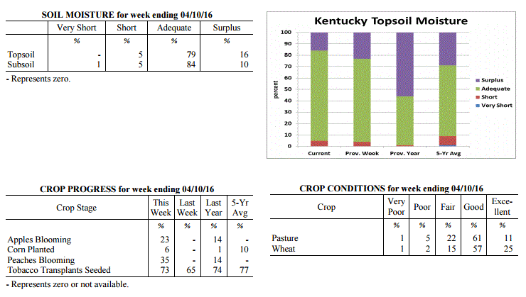 Kentucky Climate Summary
For the Period April 4, 2016 to April 10, 2016
Below Normal Temperatures and Precipitation:
For much of Kentucky, normal high temperatures for first half of April are in the mid
to upper 60s, while lows typically drop into the low to mid 40s. Looking at this past
week, temperatures were well below normal. In fact, multiple Freeze Warnings were
issued by the National Weather Service. The most significant cold spell occurred
Friday night through Saturday night. Behind a frontal passage on Friday, an
unseasonably cold air mass filtered into the area with lows dipping into the upper
20s to low 30s across much of the state. After only seeing highs on Saturday in
the 40s, lows that night dipped back into the 20s across mainly the eastern half of
the state. In addition to a rather cool period, conditions were also fairly dry and
windy. The state averaged 0.42 inches, which is over half inch below normal for the
seven day period. Multiple wind advisories were also issued throughout the period with
gusts exceeding 40 mph from time to time.
Temperatures for the period averaged 48 degrees across the state which was 5 degrees
cooler than normal and 4 degrees cooler than the previous period. High temperatures
averaged from 62 in the West to 57 in the East. Departure from normal high
temperatures ranged from 5 degrees cooler than normal in the West to 9 degrees
cooler than normal in the East. Low temperatures averaged from 41 degrees in the
West to 35 degrees in the East. Departure from normal low temperature ranged from 3
degrees cooler than normal in the West to 3 degrees cooler than normal in the East.
The extreme high temperature for the period was 79 degrees at POPLAR BLUFF ASOS and
the extreme low was 22 degrees at PAINTSVILLE 4W.
Precipitation (liq. equ.) for the period totaled 0.42 inches statewide which was 0.57
inches below normal and 42% of normal. Precipitation totals by climate division, West
0.31 inches, Central 0.27 inches, Bluegrass 0.45 inches and East 0.66 inches, which
was 0.82, 0.75, 0.45 and 0.27 inches below normal. By station, precipitation totals
ranged from a low of 0.04 inches at FORT KNOX to a high of 1.63 inches at
RUSSELLVILLE 2W.
---
Agricultural Situation Report: April 5, 2016
(USDA's Crop Report with comments from Tom Priddy & Matt Dixon, UK Ag. Weather)
Agricultural News: Kentucky experienced above normal temperatures and precipitation
over the past week. Precipitation for the week totaled 1.23 inches, 0.22 inches above
normal. Temperatures averaged 54 degrees for the week, 3 degrees above normal.
Topsoil moisture was rated 4 percent short, 73 percent adequate and 23 percent
surplus. Subsoil moisture was rated 1 percent very short, 4 percent short, 81 percent
adequate, and 14 percent surplus. Days suitable for fieldwork averaged 4.1 out of a
possible seven.
As the calendar turned to April, a typical spring pattern set up across the Lower Ohio
Valley. The Bluegrass State saw a warm start to the period with southerly flow
bumping readings up into the 70s by midweek, ahead of an approaching low pressure
system. This flow pattern helped Kentucky reach a 4th straight week of above normal
temperatures. As the system passed through the area, the state saw a couple rounds of
widespread showers and storms Wednesday night and Thursday. This ended up being the
only significant rainfall event for the week, but the state still averaged 1.23 inches.
This was slightly above normal, breaking a two week span of much below normal
precipitation. Attention then turned to Saturday as another cold front moved through
the area. During the day, winds became very breezy, so much so that a High Wind
Warning was issued for portions of Northern Kentucky. While most of the state saw
wind gust in excess of 40 mph, portions of Northern Kentucky exceeded 50. Winds
slackened later that night, prompting a Freeze Warning across the area. Lows by
early Sunday morning dipped into the upper 20s to low 30s.
Primary activities this week included preparing farm equipment for planting, applying
fertilizer, and seeding tobacco transplants. Some producers have applied burndown
applications in preparation for corn and soybean planting. A few producers have begun
planting corn. Producers are concerned about the potential for cold temperatures over
the next couple of weeks. Wheat winter freeze damage was reported as 1 percent
severe, 5 percent moderate, 14 percent light, with 80 percent experiencing none.
Alfalfa hay freeze damage was reported as 3 percent moderate, 21 percent light, with
76 percent experiencing none. Cattle and calves obtained approximately 53 percent of
feed from pastures, but some hay is being fed.
Kentucky Climate Summary
For the Period April 4, 2016 to April 10, 2016
Below Normal Temperatures and Precipitation:
For much of Kentucky, normal high temperatures for first half of April are in the mid
to upper 60s, while lows typically drop into the low to mid 40s. Looking at this past
week, temperatures were well below normal. In fact, multiple Freeze Warnings were
issued by the National Weather Service. The most significant cold spell occurred
Friday night through Saturday night. Behind a frontal passage on Friday, an
unseasonably cold air mass filtered into the area with lows dipping into the upper
20s to low 30s across much of the state. After only seeing highs on Saturday in
the 40s, lows that night dipped back into the 20s across mainly the eastern half of
the state. In addition to a rather cool period, conditions were also fairly dry and
windy. The state averaged 0.42 inches, which is over half inch below normal for the
seven day period. Multiple wind advisories were also issued throughout the period with
gusts exceeding 40 mph from time to time.
Temperatures for the period averaged 48 degrees across the state which was 5 degrees
cooler than normal and 4 degrees cooler than the previous period. High temperatures
averaged from 62 in the West to 57 in the East. Departure from normal high
temperatures ranged from 5 degrees cooler than normal in the West to 9 degrees
cooler than normal in the East. Low temperatures averaged from 41 degrees in the
West to 35 degrees in the East. Departure from normal low temperature ranged from 3
degrees cooler than normal in the West to 3 degrees cooler than normal in the East.
The extreme high temperature for the period was 79 degrees at POPLAR BLUFF ASOS and
the extreme low was 22 degrees at PAINTSVILLE 4W.
Precipitation (liq. equ.) for the period totaled 0.42 inches statewide which was 0.57
inches below normal and 42% of normal. Precipitation totals by climate division, West
0.31 inches, Central 0.27 inches, Bluegrass 0.45 inches and East 0.66 inches, which
was 0.82, 0.75, 0.45 and 0.27 inches below normal. By station, precipitation totals
ranged from a low of 0.04 inches at FORT KNOX to a high of 1.63 inches at
RUSSELLVILLE 2W.
---
Agricultural Situation Report: April 5, 2016
(USDA's Crop Report with comments from Tom Priddy & Matt Dixon, UK Ag. Weather)
Agricultural News: Kentucky experienced above normal temperatures and precipitation
over the past week. Precipitation for the week totaled 1.23 inches, 0.22 inches above
normal. Temperatures averaged 54 degrees for the week, 3 degrees above normal.
Topsoil moisture was rated 4 percent short, 73 percent adequate and 23 percent
surplus. Subsoil moisture was rated 1 percent very short, 4 percent short, 81 percent
adequate, and 14 percent surplus. Days suitable for fieldwork averaged 4.1 out of a
possible seven.
As the calendar turned to April, a typical spring pattern set up across the Lower Ohio
Valley. The Bluegrass State saw a warm start to the period with southerly flow
bumping readings up into the 70s by midweek, ahead of an approaching low pressure
system. This flow pattern helped Kentucky reach a 4th straight week of above normal
temperatures. As the system passed through the area, the state saw a couple rounds of
widespread showers and storms Wednesday night and Thursday. This ended up being the
only significant rainfall event for the week, but the state still averaged 1.23 inches.
This was slightly above normal, breaking a two week span of much below normal
precipitation. Attention then turned to Saturday as another cold front moved through
the area. During the day, winds became very breezy, so much so that a High Wind
Warning was issued for portions of Northern Kentucky. While most of the state saw
wind gust in excess of 40 mph, portions of Northern Kentucky exceeded 50. Winds
slackened later that night, prompting a Freeze Warning across the area. Lows by
early Sunday morning dipped into the upper 20s to low 30s.
Primary activities this week included preparing farm equipment for planting, applying
fertilizer, and seeding tobacco transplants. Some producers have applied burndown
applications in preparation for corn and soybean planting. A few producers have begun
planting corn. Producers are concerned about the potential for cold temperatures over
the next couple of weeks. Wheat winter freeze damage was reported as 1 percent
severe, 5 percent moderate, 14 percent light, with 80 percent experiencing none.
Alfalfa hay freeze damage was reported as 3 percent moderate, 21 percent light, with
76 percent experiencing none. Cattle and calves obtained approximately 53 percent of
feed from pastures, but some hay is being fed.
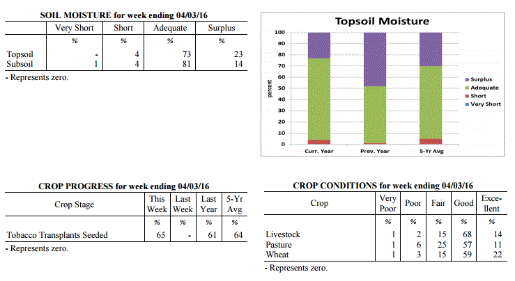 Kentucky Climate Summary
For the Period March 28, 2016 to April 3, 2016
Above Normal Temperatures and Precipitation:
As the calendar turned to April, a typical spring pattern set up across the Lower Ohio
Valley. The Bluegrass State saw a warm start to the period with southerly flow
bumping readings up into the 70s by midweek, ahead of an approaching low pressure
system. This flow pattern helped Kentucky reach a 4th straight week of above normal
temperatures. As the system passed through the area, the state saw a couple rounds of
widespread showers and storms Wednesday night and Thursday. This ended up being the
only significant rainfall event for the week, but the state still averaged 1.23 inches.
This was slightly above normal, breaking a two week span of much below normal
precipitation. Attention then turned to Saturday as another cold front moved through
the area. During the day, winds became very breezy, so much so that a High Wind
Warning was issued for portions of Northern Kentucky. While most of the state saw
wind gust in excess of 40 mph, portions of Northern Kentucky exceeded 50. Winds
slackened later that night, prompting a Freeze Warning across the area. Lows by
early Sunday morning dipped into the upper 20s to low 30s.
Temperatures for the period averaged 54 degrees across the state which was 3 degrees
warmer than normal and 2 degrees warmer than the previous period. High temperatures
averaged from 66 in the West to 65 in the East. Departure from normal high
temperatures ranged from 1 degree warmer than normal in the West to 2 degrees warmer
than normal in the East. Low temperatures averaged from 42 degrees in the West to 44
degrees in the East. Departure from normal low temperature ranged from 1 degree
warmer than normal in the West to 8 degrees warmer than normal in the East. The
extreme high temperature for the period was 78 degrees at LOUISA 1S and the
extreme low was 24 degrees at CYNTHIANA 8N.
Precipitation (liq. equ.) for the period totaled 1.23 inches statewide which was 0.22
inches above normal and 122% of normal. Precipitation totals by climate division,
West 1.85 inches, Central 1.35 inches, Bluegrass 1.07 inches and East 0.65 inches,
which was 0.75, 0.29, 0.16 and -0.31 inches respectively from normal. By station,
precipitation totals ranged from a low of 0.08 inches at OWINGSVILLE 4S to a high of
3.09 inches at POPLAR BLUFF ASOS.
---
Kentucky Climate Summary
For the Period March 21, 2016 to March 27, 2016
Above Normal Temperatures and Below Normal Precipitation:
This past period marked the third straight week of above normal temperatures and
second straight with below normal precipitation. The period started off with
temperatures on the climb and dry conditions in place. In fact, there was a
heightened fire danger on Tuesday across mainly the eastern half of the state as
winds became breezy and humidity levels dropped significantly. Showers and
thunderstorms returned Thursday and Thursday night as a cold front crossed the
region, before ending the week with dry and cooler conditions in place. Clear skies
set up a cold morning on Saturday with temperatures in the low to mid 30s for most.
A Frost Advisory was issued with some vegetation becoming increasingly susceptible.
While it was a cool start to the weekend, the state saw another warming trend through
Sunday, ahead of another cold front bringing showers and storms that evening and
overnight. The two systems passing through the area amounted to a state average of
0.53 inches, which is just over a half inch below normal for the seven day period.
Temperatures for the period averaged 53 degrees across the state which was 4 degrees
warmer than normal and 2 degrees cooler than the previous period. High temperatures
averaged from 65 in the West to 66 in the East. Departure from normal high
temperatures ranged from 3 degrees warmer than normal in the West to 5 degrees warmer
than normal in the East. Low temperatures averaged from 42 degrees in the West to 41
degrees in the East. Departure from normal low temperature ranged from 2 degrees
warmer than normal in the West to 6 degrees warmer than normal in the East. The
extreme high temperature for the period was 79 degrees at LOUISA 1S and the
extreme low was 22 degrees at BOONEVILLE 2S.
Precipitation (liq. equ.) for the period totaled 0.53 inches statewide which was 0.51
inches below normal and 51% of normal. Precipitation totals by climate division, West
0.53 inches, Central 0.57 inches, Bluegrass 0.55 inches and East 0.45 inches, which
was 0.58, 0.53, 0.39 and 0.57 inches below normal. By station, precipitation totals
ranged from a low of 0.07 inches at CADIZ 4SW to a high of 1.25 inches at MAYFIELD 6SW.
---
Kentucky Climate Summary
For the Period March 14, 2016 to March 20, 2016
Above Normal Temperatures and Below Normal Precipitation:
This past period signaled the last official week of winter 2015-16. Showers and
thunderstorms passed through the area over the course of Monday, before becoming dry
and warm on Tuesday. Highs peaked in the upper 70s to middle 80s across much of the
Commonwealth behind gusty southerly flow. Following the boundary, temperatures went
on the decline. Showers returned over the weekend, but were light in nature. Cloud
cover kept temperatures cool compared to what had been seen for much of the first
half of March. Highs on Saturday and Sunday stayed in the middle 40s to low 50s.
Overall, temperatures were still above normal for the week, but the state averaged
only a third of an inch of precipitation.
Temperatures for the period averaged 54 degrees across the state which was 7 degrees
warmer than normal and 8 degrees cooler than the previous period. High temperatures
averaged from 64 in the West to 65 in the East. Departure from normal high
temperatures ranged from 4 degrees warmer than normal in the West to 6 degrees
warmer than normal in the East. Low temperatures averaged from 44 degrees in the
West to 45 degrees in the East. Departure from normal low temperature ranged from 6
degrees warmer than normal in the West to 12 degrees warmer than normal in the
East. The extreme high temperature for the period was 87 degrees at MADISONVILLE 4S
and the extreme low was 23 degrees at VANCEBURG 6W.
Precipitation (liq. equ.) for the period totaled 0.33 inches statewide which was 0.7
inches below normal and 32% of normal. Precipitation totals by climate division, West
0.49 inches, Central 0.29 inches, Bluegrass 0.17 inches and East 0.36 inches, which
was 0.6, 0.8, 0.76 and 0.65 inches below normal. By station, precipitation totals
ranged from a low of 0.01 inches at HARRODSBURG 3N to a high of 1.58 inches at
GREENVILLE 6N.
---
Kentucky Climate Summary
For the Period March 7, 2016 to March 13, 2016
Much Above Normal Temperatures and Precipitation:
An extremely warm and wet pattern set up across the state of Kentucky this past week.
Over much of the period, a low pressure system sat over Northern Mexico and Texas,
while high pressure was entrenched off the east coast. This set up a southerly flow
pattern with warm and moist air being pushed into the Lower Ohio Valley. Highs for
much of the week stayed in the 60s and 70s, well above normal for this time of the
year. Showers increased in coverage starting midweek across Western Kentucky and up
along the Ohio River, into the Bluegrass. As high pressure pushed east, shower
coverage expanded south and east to end the work week. Going into the weekend, the
aforementioned low passed through the Lower Ohio Valley, bringing renewed showers
across the area. Overall, the state averaged 1.72 inches. Saying that, the plume of
moisture really increased values across Western Kentucky, where the area averaged
nearly 3.5 inches, which was over 2 inches above normal.
Temperatures for the period averaged 61 degrees across the state which was 16 degrees
warmer than normal and 20 degrees warmer than the previous period. High temperatures
averaged from 67 in the West to 72 in the East. Departure from normal high
temperatures ranged from 9 degrees warmer than normal in the West to 15 degrees
warmer than normal in the East. Low temperatures averaged from 54 degrees in the West
to 49 degrees in the East. Departure from normal low temperature ranged from 18
degrees warmer than normal in the West to 18 degrees warmer than normal in the East.
The extreme high temperature for the period was 81 degrees at HAZARD AWOS and
the extreme low was 2 degrees at SOMERSET AWOS.
Precipitation (liq. equ.) for the period totaled 1.72 inches statewide which was 0.74
inches above normal and 176% of normal. Precipitation totals by climate division,
West 3.47 inches, Central 1.59 inches, Bluegrass 1.42 inches and East 0.39 inches,
which was 2.45, 0.56, 0.52 and -0.58 inches respectively from normal. By station,
precipitation totals ranged from a low of 0.10 inches at JACKSON 3SE to a high of
6.00 inches at MURRAY 1W.
---
Kentucky Climate Summary
For the Period February 29, 2016 to March 6, 2016
Below Normal Temperatures and Precipitation:
The Bluegrass State saw multiple periods of precipitation this past period, but
overall, totals were slightly below normal with the state averaging 0.76 inches.
Most of the precipitation was seen on Tuesday as rain showers became widespread
across the region and was even accompanied by scattered thunderstorms. After
starting the week in the 50s and 60s, temperatures dropped behind a cold front with
highs on Wednesday only in the upper 30s to middle 40s. The next system on Thursday
brought moderate to heavy snow from time to time. This activity was most significant
across Eastern Kentucky, especially in the area of Morgan, Elliot, and Rowan
counties. Some locations in this region reported 6+ inches. Another system then
brought additional rain on Saturday, before temperatures went on the increase
Sunday behind mostly clear skies.
Temperatures for the period averaged 41 degrees across the state which was 2 degrees
cooler than normal and 2 degrees cooler than the previous period. High temperatures
averaged from 52 in the West to 49 in the East. Departure from normal high
temperatures ranged from 4 degrees cooler than normal in the West to 7 degrees cooler
than normal in the East. Low temperatures averaged from 34 degrees in the West to 33
degrees in the East. Departure from normal low temperature ranged from near normal in
the West to 3 degrees warmer than normal in the East. The extreme high temperature
for the period was 72 degrees at LOUISA 1S and the extreme low was 22 degrees at
PAINTSVILLE 4W.
Precipitation (liq. equ.) for the period totaled 0.76 inches statewide which was 0.2
inches below normal and 79% of normal. Precipitation totals by climate division, West
0.58 inches, Central 0.66 inches, Bluegrass 0.98 inches and East 0.82 inches, which
was -0.47, -0.35, 0.12 and -0.12 inches respectively from normal. By station,
precipitation totals ranged from a low of 0.23 inches at CALHOUN 5NW to a high of
2.67 inches at OWINGSVILLE 4S.
---
Kentucky Climate Summary
For the Period February 22, 2016 to February 28, 2016
Above Normal Temperatures and Precipitation:
Precipitation and temperatures remained above normal for a second straight week. The
Commonwealth saw several rounds of precipitation over the course of Tuesday night and
into Wednesday as a low pressure system worked across the region. With the exception
of Eastern Kentucky, much of the state saw 1 to 2 inches over the two day period.
After starting the work week on the warm side, temperatures quickly crashed behind
the system. This eventually transitioned precipitation over to snow, but no
significant accumulations were seen. Highs on Thursday and Friday only rose into the
upper 30s to middle 40s, but the cool period was short-lived. By Saturday, winds
transitioned to the south/southwest and then became breezy on Sunday. Highs on
Sunday rose into the middle 60s to around 70, well above normal for this time of year.
Temperatures for the period averaged 44 degrees across the state which was 2 degrees
warmer than normal and no change to the previous period. High temperatures averaged
from 53 in the West to 52 in the East. Departure from normal high temperatures
ranged from 1 degree cooler than normal in the West to 1 degree cooler than normal
in the East. Low temperatures averaged from 35 degrees in the West to 36 degrees in
the East. Departure from normal low temperature ranged from 3 degrees warmer than
normal in the West to 7 degrees warmer than normal in the East. The extreme high
temperature for the period was 71 degrees at GREENVILLE 6N and the extreme low was 17
degrees at MONTICELLO AWOS.
Precipitation (liq. equ.) for the period totaled 1.18 inches statewide which was 0.2
inches above normal and 120% of normal. Precipitation totals by climate division,
West 1.57 inches, Central 1.41 inches, Bluegrass 0.97 inches and East 0.76 inches,
which was 0.47, 0.36, 0.11 and -0.16 inches respectively from normal. By station,
precipitation totals ranged from a low of 0.34 inches at BIG SANDY to a high of 2.59
inches at CARBONDALE ASOS.
---
Kentucky Climate Summary
For the Period February 15, 2016 to February 21, 2016
Above Normal Temperatures and Precipitation:
Thus far, this past period was the wettest of 2016 with a state average of 1.70
inches. The Commonwealth saw several disturbances pass through the area with the
first coming Monday and Monday night as a surface low pushed just south of the state.
Rainfall became widespread that afternoon and evening, before changing to snow
overnight across primarily Eastern Kentucky. This was followed by a rain/snow mix on
Tuesday across the southern half of the state. After staying cool over the first
half of the work week, the state saw a warming trend to end the week. Southerly
winds became very breezy on Friday, ushering high temperatures into the 60s. Gusts in
excess of 40 mph were common across the area. Another warm day followed on Saturday
as much of the state rose into the upper 60s to middle 70s, well above normal for
this time of year. Widespread showers then returned again on Saturday night and into
Sunday as another surface low passed through the Lower Ohio Valley.
Temperatures for the period averaged 45 degrees across the state which was 6 degrees
warmer than normal and 20 degrees warmer than the previous period. High temperatures
averaged from 54 in the West to 50 in the East. Departure from normal high
temperatures ranged from 4 degrees warmer than normal in the West to near normal in
the East. Low temperatures averaged from 40 degrees in the West to 37 degrees in the
East. Departure from normal low temperature ranged from 10 degrees warmer than normal
in the West to 11 degrees warmer than normal in the East. The extreme high
temperature for the period was 76 degrees at LOUISVILLE APT and the extreme low was
19 degrees at BRANDENBURG 4SW.
Precipitation (liq. equ.) for the period totaled 1.70 inches statewide which was 0.79
inches above normal and 187% of normal. Precipitation totals by climate division,
West 0.69 inches, Central 1.45 inches, Bluegrass 1.69 inches and East 2.96 inches,
which was -0.34, 0.47, 0.91 and 2.11 inches respectively from normal. By station,
precipitation totals ranged from a low of 0.16 inches at BRANDENBURG 4SW to a high of
3.81 inches at OWINGSVILLE 4S.
---
Kentucky Climate Summary
For the Period February 8, 2016 to February 14, 2016
Well Below Normal Temperatures and Below Normal Precipitation:
Over this past period, the Commonwealth was situated within a rather active pattern
with several periods of scattered to numerous snow showers. Activity was heavy to
moderate from time to time through the work week, reducing visibility and producing
very quick, light accumulations. A more significant winter storm set up on Sunday,
producing 2 to 6+ inches for much of the state. Highest accumulations were located
across the southern half of Kentucky. The other story for the week was the cold
temperatures in place. Below normal temperatures were the norm over the course of
the period with coolest temperatures coming on Saturday. Highs only rose into the low
to mid 20s as an Arctic air mass moved into the region. Overall, the state average
temperature for the week was 12 degrees below normal.
Temperatures for the period averaged 24 degrees across the state which was 12 degrees
cooler than normal and 20 degrees cooler than the previous period. High temperatures
averaged from 32 in the West to 29 in the East. Departure from normal high
temperatures ranged from 16 degrees cooler than normal in the West to 18 degrees
cooler than normal in the East. Low temperatures averaged from 22 degrees in the
West to 19 degrees in the East. Departure from normal low temperature ranged from 6
degrees cooler than normal in the West to 5 degrees cooler than normal in the East.
The extreme high temperature for the period was 49 degrees at POPLAR BLUFF ASOS and
the extreme low was 6 degrees at VANCEBURG 6W.
Precipitation (liq. equ.) for the period totaled 0.45 inches statewide which was 0.45
inches below normal and 50% of normal. Precipitation totals by climate division, West
0.43 inches, Central 0.58 inches, Bluegrass 0.50 inches and East 0.29 inches, which
was 0.57, 0.4, 0.27 and 0.55 inches below normal. By station, precipitation totals
ranged from a low of 0.07 inches at BIG SANDY to a high of 2.26 inches at OWINGSVILLE 4S.
---
Kentucky Climate Summary
For the Period February 1, 2016 to February 7, 2016
Much Above Normal Temperatures and Above Normal Precipitation:
February started out extremely warm and active. Focus over the first half of the
week was on a strong storm system pushing through region. On Tuesday, a warm front
crossed the Commonwealth and sent temperatures into the upper 60s to low 70s behind
gusty southerly winds. Putting this into perspective, normal highs for this time of
the year are only in the low to mid 40s. Several lines of showers and thunderstorms
then moved through the state starting in the afternoon and lasting into the overnight
hours. Behind high rainfall rates, some locations saw some minor and short-lived
flooding. In addition to showers on Monday, the state averaged over an inch and a
half for the week. After a fairly cool end to the work week, temperatures were once
again above normal over the weekend. Highs peaked in the upper 40s to middle 50s.
Temperatures for the period averaged 44 degrees across the state which was 10 degrees
warmer than normal and 4 degrees warmer than the previous period. High temperatures
averaged from 55 in the West to 54 in the East. Departure from normal high
temperatures ranged from 10 degrees warmer than normal in the West to 9 degrees
warmer than normal in the East. Low temperatures averaged from 33 degrees in the
West to 35 degrees in the East. Departure from normal low temperature ranged from 7
degrees warmer than normal in the West to 12 degrees warmer than normal in the
East. The extreme high temperature for the period was 75 degrees at BOONEVILLE 2S and
the extreme low was 16 degrees at CYNTHIANA 8N.
Precipitation (liq. equ.) for the period totaled 1.53 inches statewide which was 0.66
inches above normal and 175% of normal. Precipitation totals by climate division,
West 1.33 inches, Central 1.75 inches, Bluegrass 1.49 inches and East 1.55 inches,
which was 0.38, 0.8, 0.73 and 0.72 inches above normal. By station, precipitation
totals ranged from a low of 0.04 inches at POPLAR BLUFF ASOS to a high of 2.53
inches at YELLOW CREEK.
---
Kentucky Climate Summary
For the Period January 25, 2016 to January 31, 2016
Much Below Normal Temperatures and Above Normal Precipitation:
The month of January ended with rather warm and dry conditions in place. The only
significant rainfall event came early in the week as a cold front passed through
the state on Monday night. After only seeing isolated to scattered rain showers
during the day, coverage increased overnight with much of the area seeing light
rainfall accumulations. A combination of warm temperatures and rainfall acted to
really diminish the leftover snowpack from the previous weekend. After a rather cool
couple of days on Tuesday and Wednesday, temperatures went on the increase for the
remainder of the week. Temperatures rose into the 40s for the end of the work week,
but the real change came over the weekend. High pressure moved off to the east,
setting up a southerly flow pattern for the Bluegrass State. High temperatures
pushed into the 60s each day for most of the state. Some areas even reached into the
70s. One of those stations was at the airport in Bowling Green with a reading of 72
on Sunday. Normal high temperatures are in the mid 40s for the end of January in
South-Central Kentucky.
Temperatures for the period averaged 41 degrees across the state which was 8 degrees
warmer than normal and 20 degrees warmer than the previous period. High temperatures
averaged from 54 in the West to 50 in the East. Departure from normal high
temperatures ranged from 10 degrees warmer than normal in the West to 6 degrees
warmer than normal in the East. Low temperatures averaged from 33 degrees in the
West to 29 degrees in the East. Departure from normal low temperature ranged from 8
degrees warmer than normal in the West to 7 degrees warmer than normal in the East.
The extreme high temperature for the period was 73 degrees at RUSSELLVILLE 2W and the
extreme low was 7 degrees at BURKESVILLE 3W.
Precipitation (liq. equ.) for the period totaled 0.12 inches statewide which was 0.67
inches below normal and 15% of normal. Precipitation totals by climate division, West
0.09 inches, Central 0.11 inches, Bluegrass 0.06 inches and East 0.24 inches, which
was 0.75, 0.74, 0.63 and 0.54 inches below normal. By station, precipitation totals
ranged from a low of 0.00 inches at CAPE GIRARDEAU ASOS to a high of 0.82 inches at
YELLOW CREEK.
---
Kentucky Climate Summary
For the Period January 18, 2016 to January 24, 2016
Much Below Normal Temperatures and Above Normal Precipitation:
Up until this past week, winter 2015-16 has progressed with little in the way of any
significant snowfall. That all came to an end this period as the state saw a couple
systems, highlighted by a major winter storm to end the work week. The period started
off with extremely cold temperatures in place. Lows by Monday and Tuesday mornings
dropped into the single digits to low teens, along with wind chills dipping below
zero at times. This arctic air led to a livestock cold stress emergency for much of
the state for an extended period of time. Temperatures went on the increase by
Wednesday, but the first of two systems brought significant snowfall to the area.
Accumulations were highest across the western half of the state with 1 to 4 inches
for most. After a dry day on Thursday, a major winter storm worked through the
Bluegrass State that night through Saturday morning. The entire state went under a
Winter Storm Warning. Initially, freezing rain led to some ice accumulations
across portions of southern Kentucky near the Tennessee border. As the day
progressed, all precipitation transitioned to snow with moderate to heavy activity
from time to time. The most significant activity was seen across South-Central and
Eastern Kentucky with a widespread swath of 12 to 18+ inches. Below is a map from the
National Weather Service in Jackson, Kentucky showing snowfall totals across the state.
Kentucky Climate Summary
For the Period March 28, 2016 to April 3, 2016
Above Normal Temperatures and Precipitation:
As the calendar turned to April, a typical spring pattern set up across the Lower Ohio
Valley. The Bluegrass State saw a warm start to the period with southerly flow
bumping readings up into the 70s by midweek, ahead of an approaching low pressure
system. This flow pattern helped Kentucky reach a 4th straight week of above normal
temperatures. As the system passed through the area, the state saw a couple rounds of
widespread showers and storms Wednesday night and Thursday. This ended up being the
only significant rainfall event for the week, but the state still averaged 1.23 inches.
This was slightly above normal, breaking a two week span of much below normal
precipitation. Attention then turned to Saturday as another cold front moved through
the area. During the day, winds became very breezy, so much so that a High Wind
Warning was issued for portions of Northern Kentucky. While most of the state saw
wind gust in excess of 40 mph, portions of Northern Kentucky exceeded 50. Winds
slackened later that night, prompting a Freeze Warning across the area. Lows by
early Sunday morning dipped into the upper 20s to low 30s.
Temperatures for the period averaged 54 degrees across the state which was 3 degrees
warmer than normal and 2 degrees warmer than the previous period. High temperatures
averaged from 66 in the West to 65 in the East. Departure from normal high
temperatures ranged from 1 degree warmer than normal in the West to 2 degrees warmer
than normal in the East. Low temperatures averaged from 42 degrees in the West to 44
degrees in the East. Departure from normal low temperature ranged from 1 degree
warmer than normal in the West to 8 degrees warmer than normal in the East. The
extreme high temperature for the period was 78 degrees at LOUISA 1S and the
extreme low was 24 degrees at CYNTHIANA 8N.
Precipitation (liq. equ.) for the period totaled 1.23 inches statewide which was 0.22
inches above normal and 122% of normal. Precipitation totals by climate division,
West 1.85 inches, Central 1.35 inches, Bluegrass 1.07 inches and East 0.65 inches,
which was 0.75, 0.29, 0.16 and -0.31 inches respectively from normal. By station,
precipitation totals ranged from a low of 0.08 inches at OWINGSVILLE 4S to a high of
3.09 inches at POPLAR BLUFF ASOS.
---
Kentucky Climate Summary
For the Period March 21, 2016 to March 27, 2016
Above Normal Temperatures and Below Normal Precipitation:
This past period marked the third straight week of above normal temperatures and
second straight with below normal precipitation. The period started off with
temperatures on the climb and dry conditions in place. In fact, there was a
heightened fire danger on Tuesday across mainly the eastern half of the state as
winds became breezy and humidity levels dropped significantly. Showers and
thunderstorms returned Thursday and Thursday night as a cold front crossed the
region, before ending the week with dry and cooler conditions in place. Clear skies
set up a cold morning on Saturday with temperatures in the low to mid 30s for most.
A Frost Advisory was issued with some vegetation becoming increasingly susceptible.
While it was a cool start to the weekend, the state saw another warming trend through
Sunday, ahead of another cold front bringing showers and storms that evening and
overnight. The two systems passing through the area amounted to a state average of
0.53 inches, which is just over a half inch below normal for the seven day period.
Temperatures for the period averaged 53 degrees across the state which was 4 degrees
warmer than normal and 2 degrees cooler than the previous period. High temperatures
averaged from 65 in the West to 66 in the East. Departure from normal high
temperatures ranged from 3 degrees warmer than normal in the West to 5 degrees warmer
than normal in the East. Low temperatures averaged from 42 degrees in the West to 41
degrees in the East. Departure from normal low temperature ranged from 2 degrees
warmer than normal in the West to 6 degrees warmer than normal in the East. The
extreme high temperature for the period was 79 degrees at LOUISA 1S and the
extreme low was 22 degrees at BOONEVILLE 2S.
Precipitation (liq. equ.) for the period totaled 0.53 inches statewide which was 0.51
inches below normal and 51% of normal. Precipitation totals by climate division, West
0.53 inches, Central 0.57 inches, Bluegrass 0.55 inches and East 0.45 inches, which
was 0.58, 0.53, 0.39 and 0.57 inches below normal. By station, precipitation totals
ranged from a low of 0.07 inches at CADIZ 4SW to a high of 1.25 inches at MAYFIELD 6SW.
---
Kentucky Climate Summary
For the Period March 14, 2016 to March 20, 2016
Above Normal Temperatures and Below Normal Precipitation:
This past period signaled the last official week of winter 2015-16. Showers and
thunderstorms passed through the area over the course of Monday, before becoming dry
and warm on Tuesday. Highs peaked in the upper 70s to middle 80s across much of the
Commonwealth behind gusty southerly flow. Following the boundary, temperatures went
on the decline. Showers returned over the weekend, but were light in nature. Cloud
cover kept temperatures cool compared to what had been seen for much of the first
half of March. Highs on Saturday and Sunday stayed in the middle 40s to low 50s.
Overall, temperatures were still above normal for the week, but the state averaged
only a third of an inch of precipitation.
Temperatures for the period averaged 54 degrees across the state which was 7 degrees
warmer than normal and 8 degrees cooler than the previous period. High temperatures
averaged from 64 in the West to 65 in the East. Departure from normal high
temperatures ranged from 4 degrees warmer than normal in the West to 6 degrees
warmer than normal in the East. Low temperatures averaged from 44 degrees in the
West to 45 degrees in the East. Departure from normal low temperature ranged from 6
degrees warmer than normal in the West to 12 degrees warmer than normal in the
East. The extreme high temperature for the period was 87 degrees at MADISONVILLE 4S
and the extreme low was 23 degrees at VANCEBURG 6W.
Precipitation (liq. equ.) for the period totaled 0.33 inches statewide which was 0.7
inches below normal and 32% of normal. Precipitation totals by climate division, West
0.49 inches, Central 0.29 inches, Bluegrass 0.17 inches and East 0.36 inches, which
was 0.6, 0.8, 0.76 and 0.65 inches below normal. By station, precipitation totals
ranged from a low of 0.01 inches at HARRODSBURG 3N to a high of 1.58 inches at
GREENVILLE 6N.
---
Kentucky Climate Summary
For the Period March 7, 2016 to March 13, 2016
Much Above Normal Temperatures and Precipitation:
An extremely warm and wet pattern set up across the state of Kentucky this past week.
Over much of the period, a low pressure system sat over Northern Mexico and Texas,
while high pressure was entrenched off the east coast. This set up a southerly flow
pattern with warm and moist air being pushed into the Lower Ohio Valley. Highs for
much of the week stayed in the 60s and 70s, well above normal for this time of the
year. Showers increased in coverage starting midweek across Western Kentucky and up
along the Ohio River, into the Bluegrass. As high pressure pushed east, shower
coverage expanded south and east to end the work week. Going into the weekend, the
aforementioned low passed through the Lower Ohio Valley, bringing renewed showers
across the area. Overall, the state averaged 1.72 inches. Saying that, the plume of
moisture really increased values across Western Kentucky, where the area averaged
nearly 3.5 inches, which was over 2 inches above normal.
Temperatures for the period averaged 61 degrees across the state which was 16 degrees
warmer than normal and 20 degrees warmer than the previous period. High temperatures
averaged from 67 in the West to 72 in the East. Departure from normal high
temperatures ranged from 9 degrees warmer than normal in the West to 15 degrees
warmer than normal in the East. Low temperatures averaged from 54 degrees in the West
to 49 degrees in the East. Departure from normal low temperature ranged from 18
degrees warmer than normal in the West to 18 degrees warmer than normal in the East.
The extreme high temperature for the period was 81 degrees at HAZARD AWOS and
the extreme low was 2 degrees at SOMERSET AWOS.
Precipitation (liq. equ.) for the period totaled 1.72 inches statewide which was 0.74
inches above normal and 176% of normal. Precipitation totals by climate division,
West 3.47 inches, Central 1.59 inches, Bluegrass 1.42 inches and East 0.39 inches,
which was 2.45, 0.56, 0.52 and -0.58 inches respectively from normal. By station,
precipitation totals ranged from a low of 0.10 inches at JACKSON 3SE to a high of
6.00 inches at MURRAY 1W.
---
Kentucky Climate Summary
For the Period February 29, 2016 to March 6, 2016
Below Normal Temperatures and Precipitation:
The Bluegrass State saw multiple periods of precipitation this past period, but
overall, totals were slightly below normal with the state averaging 0.76 inches.
Most of the precipitation was seen on Tuesday as rain showers became widespread
across the region and was even accompanied by scattered thunderstorms. After
starting the week in the 50s and 60s, temperatures dropped behind a cold front with
highs on Wednesday only in the upper 30s to middle 40s. The next system on Thursday
brought moderate to heavy snow from time to time. This activity was most significant
across Eastern Kentucky, especially in the area of Morgan, Elliot, and Rowan
counties. Some locations in this region reported 6+ inches. Another system then
brought additional rain on Saturday, before temperatures went on the increase
Sunday behind mostly clear skies.
Temperatures for the period averaged 41 degrees across the state which was 2 degrees
cooler than normal and 2 degrees cooler than the previous period. High temperatures
averaged from 52 in the West to 49 in the East. Departure from normal high
temperatures ranged from 4 degrees cooler than normal in the West to 7 degrees cooler
than normal in the East. Low temperatures averaged from 34 degrees in the West to 33
degrees in the East. Departure from normal low temperature ranged from near normal in
the West to 3 degrees warmer than normal in the East. The extreme high temperature
for the period was 72 degrees at LOUISA 1S and the extreme low was 22 degrees at
PAINTSVILLE 4W.
Precipitation (liq. equ.) for the period totaled 0.76 inches statewide which was 0.2
inches below normal and 79% of normal. Precipitation totals by climate division, West
0.58 inches, Central 0.66 inches, Bluegrass 0.98 inches and East 0.82 inches, which
was -0.47, -0.35, 0.12 and -0.12 inches respectively from normal. By station,
precipitation totals ranged from a low of 0.23 inches at CALHOUN 5NW to a high of
2.67 inches at OWINGSVILLE 4S.
---
Kentucky Climate Summary
For the Period February 22, 2016 to February 28, 2016
Above Normal Temperatures and Precipitation:
Precipitation and temperatures remained above normal for a second straight week. The
Commonwealth saw several rounds of precipitation over the course of Tuesday night and
into Wednesday as a low pressure system worked across the region. With the exception
of Eastern Kentucky, much of the state saw 1 to 2 inches over the two day period.
After starting the work week on the warm side, temperatures quickly crashed behind
the system. This eventually transitioned precipitation over to snow, but no
significant accumulations were seen. Highs on Thursday and Friday only rose into the
upper 30s to middle 40s, but the cool period was short-lived. By Saturday, winds
transitioned to the south/southwest and then became breezy on Sunday. Highs on
Sunday rose into the middle 60s to around 70, well above normal for this time of year.
Temperatures for the period averaged 44 degrees across the state which was 2 degrees
warmer than normal and no change to the previous period. High temperatures averaged
from 53 in the West to 52 in the East. Departure from normal high temperatures
ranged from 1 degree cooler than normal in the West to 1 degree cooler than normal
in the East. Low temperatures averaged from 35 degrees in the West to 36 degrees in
the East. Departure from normal low temperature ranged from 3 degrees warmer than
normal in the West to 7 degrees warmer than normal in the East. The extreme high
temperature for the period was 71 degrees at GREENVILLE 6N and the extreme low was 17
degrees at MONTICELLO AWOS.
Precipitation (liq. equ.) for the period totaled 1.18 inches statewide which was 0.2
inches above normal and 120% of normal. Precipitation totals by climate division,
West 1.57 inches, Central 1.41 inches, Bluegrass 0.97 inches and East 0.76 inches,
which was 0.47, 0.36, 0.11 and -0.16 inches respectively from normal. By station,
precipitation totals ranged from a low of 0.34 inches at BIG SANDY to a high of 2.59
inches at CARBONDALE ASOS.
---
Kentucky Climate Summary
For the Period February 15, 2016 to February 21, 2016
Above Normal Temperatures and Precipitation:
Thus far, this past period was the wettest of 2016 with a state average of 1.70
inches. The Commonwealth saw several disturbances pass through the area with the
first coming Monday and Monday night as a surface low pushed just south of the state.
Rainfall became widespread that afternoon and evening, before changing to snow
overnight across primarily Eastern Kentucky. This was followed by a rain/snow mix on
Tuesday across the southern half of the state. After staying cool over the first
half of the work week, the state saw a warming trend to end the week. Southerly
winds became very breezy on Friday, ushering high temperatures into the 60s. Gusts in
excess of 40 mph were common across the area. Another warm day followed on Saturday
as much of the state rose into the upper 60s to middle 70s, well above normal for
this time of year. Widespread showers then returned again on Saturday night and into
Sunday as another surface low passed through the Lower Ohio Valley.
Temperatures for the period averaged 45 degrees across the state which was 6 degrees
warmer than normal and 20 degrees warmer than the previous period. High temperatures
averaged from 54 in the West to 50 in the East. Departure from normal high
temperatures ranged from 4 degrees warmer than normal in the West to near normal in
the East. Low temperatures averaged from 40 degrees in the West to 37 degrees in the
East. Departure from normal low temperature ranged from 10 degrees warmer than normal
in the West to 11 degrees warmer than normal in the East. The extreme high
temperature for the period was 76 degrees at LOUISVILLE APT and the extreme low was
19 degrees at BRANDENBURG 4SW.
Precipitation (liq. equ.) for the period totaled 1.70 inches statewide which was 0.79
inches above normal and 187% of normal. Precipitation totals by climate division,
West 0.69 inches, Central 1.45 inches, Bluegrass 1.69 inches and East 2.96 inches,
which was -0.34, 0.47, 0.91 and 2.11 inches respectively from normal. By station,
precipitation totals ranged from a low of 0.16 inches at BRANDENBURG 4SW to a high of
3.81 inches at OWINGSVILLE 4S.
---
Kentucky Climate Summary
For the Period February 8, 2016 to February 14, 2016
Well Below Normal Temperatures and Below Normal Precipitation:
Over this past period, the Commonwealth was situated within a rather active pattern
with several periods of scattered to numerous snow showers. Activity was heavy to
moderate from time to time through the work week, reducing visibility and producing
very quick, light accumulations. A more significant winter storm set up on Sunday,
producing 2 to 6+ inches for much of the state. Highest accumulations were located
across the southern half of Kentucky. The other story for the week was the cold
temperatures in place. Below normal temperatures were the norm over the course of
the period with coolest temperatures coming on Saturday. Highs only rose into the low
to mid 20s as an Arctic air mass moved into the region. Overall, the state average
temperature for the week was 12 degrees below normal.
Temperatures for the period averaged 24 degrees across the state which was 12 degrees
cooler than normal and 20 degrees cooler than the previous period. High temperatures
averaged from 32 in the West to 29 in the East. Departure from normal high
temperatures ranged from 16 degrees cooler than normal in the West to 18 degrees
cooler than normal in the East. Low temperatures averaged from 22 degrees in the
West to 19 degrees in the East. Departure from normal low temperature ranged from 6
degrees cooler than normal in the West to 5 degrees cooler than normal in the East.
The extreme high temperature for the period was 49 degrees at POPLAR BLUFF ASOS and
the extreme low was 6 degrees at VANCEBURG 6W.
Precipitation (liq. equ.) for the period totaled 0.45 inches statewide which was 0.45
inches below normal and 50% of normal. Precipitation totals by climate division, West
0.43 inches, Central 0.58 inches, Bluegrass 0.50 inches and East 0.29 inches, which
was 0.57, 0.4, 0.27 and 0.55 inches below normal. By station, precipitation totals
ranged from a low of 0.07 inches at BIG SANDY to a high of 2.26 inches at OWINGSVILLE 4S.
---
Kentucky Climate Summary
For the Period February 1, 2016 to February 7, 2016
Much Above Normal Temperatures and Above Normal Precipitation:
February started out extremely warm and active. Focus over the first half of the
week was on a strong storm system pushing through region. On Tuesday, a warm front
crossed the Commonwealth and sent temperatures into the upper 60s to low 70s behind
gusty southerly winds. Putting this into perspective, normal highs for this time of
the year are only in the low to mid 40s. Several lines of showers and thunderstorms
then moved through the state starting in the afternoon and lasting into the overnight
hours. Behind high rainfall rates, some locations saw some minor and short-lived
flooding. In addition to showers on Monday, the state averaged over an inch and a
half for the week. After a fairly cool end to the work week, temperatures were once
again above normal over the weekend. Highs peaked in the upper 40s to middle 50s.
Temperatures for the period averaged 44 degrees across the state which was 10 degrees
warmer than normal and 4 degrees warmer than the previous period. High temperatures
averaged from 55 in the West to 54 in the East. Departure from normal high
temperatures ranged from 10 degrees warmer than normal in the West to 9 degrees
warmer than normal in the East. Low temperatures averaged from 33 degrees in the
West to 35 degrees in the East. Departure from normal low temperature ranged from 7
degrees warmer than normal in the West to 12 degrees warmer than normal in the
East. The extreme high temperature for the period was 75 degrees at BOONEVILLE 2S and
the extreme low was 16 degrees at CYNTHIANA 8N.
Precipitation (liq. equ.) for the period totaled 1.53 inches statewide which was 0.66
inches above normal and 175% of normal. Precipitation totals by climate division,
West 1.33 inches, Central 1.75 inches, Bluegrass 1.49 inches and East 1.55 inches,
which was 0.38, 0.8, 0.73 and 0.72 inches above normal. By station, precipitation
totals ranged from a low of 0.04 inches at POPLAR BLUFF ASOS to a high of 2.53
inches at YELLOW CREEK.
---
Kentucky Climate Summary
For the Period January 25, 2016 to January 31, 2016
Much Below Normal Temperatures and Above Normal Precipitation:
The month of January ended with rather warm and dry conditions in place. The only
significant rainfall event came early in the week as a cold front passed through
the state on Monday night. After only seeing isolated to scattered rain showers
during the day, coverage increased overnight with much of the area seeing light
rainfall accumulations. A combination of warm temperatures and rainfall acted to
really diminish the leftover snowpack from the previous weekend. After a rather cool
couple of days on Tuesday and Wednesday, temperatures went on the increase for the
remainder of the week. Temperatures rose into the 40s for the end of the work week,
but the real change came over the weekend. High pressure moved off to the east,
setting up a southerly flow pattern for the Bluegrass State. High temperatures
pushed into the 60s each day for most of the state. Some areas even reached into the
70s. One of those stations was at the airport in Bowling Green with a reading of 72
on Sunday. Normal high temperatures are in the mid 40s for the end of January in
South-Central Kentucky.
Temperatures for the period averaged 41 degrees across the state which was 8 degrees
warmer than normal and 20 degrees warmer than the previous period. High temperatures
averaged from 54 in the West to 50 in the East. Departure from normal high
temperatures ranged from 10 degrees warmer than normal in the West to 6 degrees
warmer than normal in the East. Low temperatures averaged from 33 degrees in the
West to 29 degrees in the East. Departure from normal low temperature ranged from 8
degrees warmer than normal in the West to 7 degrees warmer than normal in the East.
The extreme high temperature for the period was 73 degrees at RUSSELLVILLE 2W and the
extreme low was 7 degrees at BURKESVILLE 3W.
Precipitation (liq. equ.) for the period totaled 0.12 inches statewide which was 0.67
inches below normal and 15% of normal. Precipitation totals by climate division, West
0.09 inches, Central 0.11 inches, Bluegrass 0.06 inches and East 0.24 inches, which
was 0.75, 0.74, 0.63 and 0.54 inches below normal. By station, precipitation totals
ranged from a low of 0.00 inches at CAPE GIRARDEAU ASOS to a high of 0.82 inches at
YELLOW CREEK.
---
Kentucky Climate Summary
For the Period January 18, 2016 to January 24, 2016
Much Below Normal Temperatures and Above Normal Precipitation:
Up until this past week, winter 2015-16 has progressed with little in the way of any
significant snowfall. That all came to an end this period as the state saw a couple
systems, highlighted by a major winter storm to end the work week. The period started
off with extremely cold temperatures in place. Lows by Monday and Tuesday mornings
dropped into the single digits to low teens, along with wind chills dipping below
zero at times. This arctic air led to a livestock cold stress emergency for much of
the state for an extended period of time. Temperatures went on the increase by
Wednesday, but the first of two systems brought significant snowfall to the area.
Accumulations were highest across the western half of the state with 1 to 4 inches
for most. After a dry day on Thursday, a major winter storm worked through the
Bluegrass State that night through Saturday morning. The entire state went under a
Winter Storm Warning. Initially, freezing rain led to some ice accumulations
across portions of southern Kentucky near the Tennessee border. As the day
progressed, all precipitation transitioned to snow with moderate to heavy activity
from time to time. The most significant activity was seen across South-Central and
Eastern Kentucky with a widespread swath of 12 to 18+ inches. Below is a map from the
National Weather Service in Jackson, Kentucky showing snowfall totals across the state.
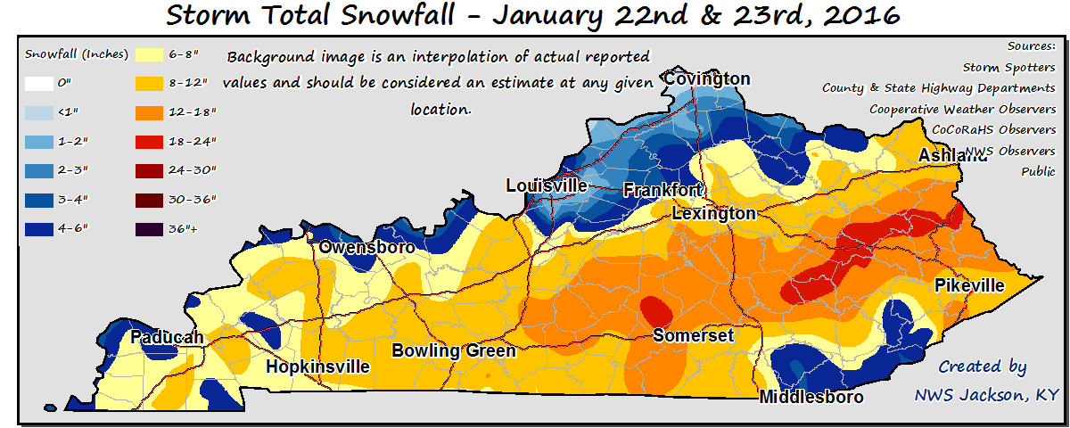 Mobile
By Saturday night, the Commonwealth became under the influence of high pressure. With
the snowpack in place and winds slackening, temperatures dropped into the single
digits and even below zero for several locations. The lowest temperature was seen in
Richmond with a reading of -9. Winds transitioned to the south by Sunday and helped
temperatures sneak back into the 30s. Overall, the state saw below normal temperatures
for a second straight week.
Temperatures for the period averaged 21 degrees across the state which was 12 degrees
cooler than normal and 12 degrees cooler than the previous period. High temperatures
averaged from 29 in the West to 27 in the East. Departure from normal high
temperatures ranged from 14 degrees cooler than normal in the West to 16 degrees
cooler than normal in the East. Low temperatures averaged from 17 degrees in the West
to 14 degrees in the East. Departure from normal low temperature ranged from 8
degrees cooler than normal in the West to 8 degrees cooler than normal in the East.
The extreme high temperature for the period was 42 degrees at CARBONDALE ASOS and the
extreme low was -9 degrees at RICHMOND 8E.
Precipitation (liq. equ.) for the period totaled 0.92 inches statewide which was 0.1
inches above normal and 112% of normal. Precipitation totals by climate division,
West 0.58 inches, Central 1.59 inches, Bluegrass 0.50 inches and East 1.01 inches,
which was -0.29, 0.72, -0.21 and 0.18 inches respectively from normal. By station,
precipitation totals ranged from a low of 0.06 inches at TRIANGLE MOUNTAIN to a
high of 6.26 inches at BOWLING GREEN 5S.
---
Kentucky Climate Summary
For the Period January 11, 2015 to January 17, 2016
Below Normal Temperatures and Precipitation:
Up until this past week, the winter had followed a rather warm trend with 12 straight
weeks of near to above normal temperatures, dating back to October. That streak came
to an end this past week, behind the passage of a few cold fronts. The first boundary
swept through the area on Tuesday. 1 to 2 inches of snowfall was seen across much of
the Northern Bluegrass, before diminishing across the remainder of the state. Skies
cleared later in the day, setting up a very cold overnight. Most reach the single
digits to lower teens by Wednesday morning, along with some locations seeing wind
chills go below zero. Rain showers returned on Friday along another cold front. After
a mild end to the work week, highs Saturday only rose into the 30s. The third and
final frontal passage occurred on Sunday. Not much in the way of precipitation was
seen, but Arctic air starting sinking into the region later in the day. Overall, the
state saw temperatures slightly below normal for the week.
Temperatures for the period averaged 32 degrees across the state which was 1 degree
cooler than normal and 4 degrees cooler than the previous period. High temperatures
averaged from 43 in the West to 41 in the East. Departure from normal high
temperatures ranged from near normal in the West to 3 degrees cooler than normal in
the East. Low temperatures averaged from 26 degrees in the West to 25 degrees in the
East. Departure from normal low temperature ranged from 1 degree warmer than normal
in the West to 2 degrees warmer than normal in the East. The extreme high temperature
for the period was 62 degrees at POPLAR BLUFF ASOS and the extreme low was 2 degrees
at BRANDENBURG 4SW.
Precipitation (liq. equ.) for the period totaled 0.18 inches statewide which was 0.68
inches below normal and 21% of normal. Precipitation totals by climate division, West
0.18 inches, Central 0.21 inches, Bluegrass 0.15 inches and East 0.18 inches, which
was 0.72, 0.7, 0.59 and 0.71 inches below normal. By station, precipitation totals
ranged from a low of 0.02 inches at CARBONDALE ASOS to a high of 0.50 inches at
FRANKLIN 4SW.
---
Kentucky Climate Summary
For the Period January 4, 2015 to January 10, 2016
Above Normal Temperatures and Below Normal Rainfall:
After seeing the warmest December on record, Kentucky caught a first glimpse of
winter this past period. The Bluegrass State started the week on the cold side with
highs on Monday only in the 30s. Lows that night dropped into the mid-teens to around
20, along with winds chills dropping into the single digits for some spots. This
pushed the livestock cold stress index into the danger/emergency categories for a
short period of time. Similar conditions were felt on Tuesday, before high pressure
shifted to the east and transitioned winds to the south by Wednesday. Highs rose back
into the 50s by Friday. The state saw a couple rounds of showers with the first
coming Thursday night and into Friday as a warm front lifted through the area. Most
saw under a quarter inch. Another surface low pushed through the Lower Ohio Valley
Saturday and Sunday. Rain showers were widespread in nature through Saturday. A
cold front then moved through Kentucky that night and into Sunday, transitioning
precipitation to snow. The highest accumulations were found right along the Ohio
River from around Paducah to Louisville with 1 to 3 inches. Much of the rest of the
state stayed under an inch.
Temperatures for the period averaged 37 degrees across the state which was 4 degrees
warmer than normal and 6 degrees cooler than the previous period. High temperatures
averaged from 44 in the West to 47 in the East. Departure from normal high
temperatures ranged from 1 degree warmer than normal in the West to 3 degrees
warmer than normal in the East. Low temperatures averaged from 29 degrees in the
West to 27 degrees in the East. Departure from normal low temperature ranged from 3
degrees warmer than normal in the West to 3 degrees warmer than normal in the East.
The extreme high temperature for the period was 60 degrees at HINDMAN 5N and the
extreme low was 10 degrees at PIKEVILLE 13S.
Precipitation (liq. equ.) for the period totaled 0.79 inches statewide which was 0.09
inches below normal and 89% of normal. Precipitation totals by climate division, West
1.44 inches, Central 0.40 inches, Bluegrass 0.67 inches and East 0.67 inches, which
was 0.51, -0.55, -0.08 and -0.24 inches respectively from normal. By station,
precipitation totals ranged from a low of 0.17 inches at BOWLING GREEN 5S to a high
of 9.49 inches at EVANSVILLE ASOS.
---
Kentucky Climate Summary
For the Period December 28, 2015 to January 3, 2016
Above Normal Temperatures and Much Above Normal Rainfall:
After seeing 3 to 5 inches the week before, another line of showers and storms moved
through the area on Monday. Flash flooding issues arose, along with some minor
flooding along rivers. The good news was that the remainder of 2015 and start of
2016 saw minimal in the way of new accumulations. Temperatures remained above normal
for most of the period, but much cooler than what was seen the previous week. The one
exception came New Year�s Eve and Day with highs in the mid 30s to low 40s. These
readings were actually slightly below normal, something the state had not seen in
quite awhile. Saying this, it was still not enough to break the warm trend. The
state has now gone 11 straight weeks of seeing near to above normal temperatures,
dating back to late October.
Temperatures for the period averaged 42 degrees across the state which was 8 degrees
warmer than normal and 16 degrees cooler than the previous period. High temperatures
averaged from 47 in the West to 52 in the East. Departure from normal high
temperatures ranged from 3 degrees warmer than normal in the West to 8 degrees
warmer than normal in the East. Low temperatures averaged from 34 degrees in the
West to 36 degrees in the East. Departure from normal low temperature ranged from 8
degrees warmer than normal in the West to 11 degrees warmer than normal in the
East. The extreme high temperature for the period was 75 degrees at WHITESBURG 2NW
and the extreme low was 18 degrees at BARBOURVILLE 3E.
Precipitation (liq. equ.) for the period totaled 0.78 inches statewide which was 0.13
inches below normal and 85% of normal. Precipitation totals by climate division, West
1.69 inches, Central 0.55 inches, Bluegrass 0.58 inches and East 0.29 inches, which
was 0.74, -0.44, -0.22 and -0.62 inches respectively from normal. By station,
precipitation totals ranged from a low of 0.00 inches at BRANDENBURG 4SW to a high of
3.14 inches at POPLAR BLUFF ASOS.
---
Kentucky Climate Summary
For the Period December 21, 2015 to December 27, 2015
Well Above Normal Temperatures and Rainfall:
A very unusual weather pattern set up this past period across the Commonwealth,
bringing record-breaking temperatures and excessive rainfall to the Bluegrass State.
Taking a look at precipitation first, Kentucky saw numerous systems pass through the
area over the period, amounting to a state average of 3.56 inches. This was the
highest weekly average that the state had seen all year and was more than 2.5 inches
above normal. The most significant event occurred late on Wednesday and into the
overnight as a cold front swept through the area. A line of strong to severe storms
developed along the boundary, leading to a cold season severe weather event with
damaging winds as the main hazard. This was followed by a wet Christmas and holiday
weekend as multiple disturbances pushed through the Lower Ohio Valley. Periods of
moderate to heavy rain led to some water issues with saturated ground causing some
flooding in low lying areas. The wet weather was accompanied by very warm
temperatures for late December. The winter solstice occurred Monday night, but it
felt as though the calendar was turned back a couple months. High temperatures
consistently stayed in the 50s and 60s, even hitting the 70s on a couple occasions.
For the week, Kentucky saw average highs that were nearly 20 degrees above normal and
lows around 25 degrees above normal.
Temperatures for the period averaged 58 degrees across the state which was 22 degrees
warmer than normal and 14 degrees warmer than the previous period. High temperatures
averaged from 64 in the West to 66 in the East. Departure from normal high
temperatures ranged from 19 degrees warmer than normal in the West to 20 degrees
warmer than normal in the East. Low temperatures averaged from 49 degrees in the
West to 53 degrees in the East. Departure from normal low temperature ranged from 21
degrees warmer than normal in the West to 27 degrees warmer than normal in the
East. The extreme high temperature for the period was 78 degrees at BOONEVILLE 2S and
the extreme low was 31 degrees at PAINTSVILLE 4W.
Precipitation (liq. equ.) for the period totaled 3.56 inches statewide which was 2.62
inches above normal and 377% of normal. Precipitation totals by climate division,
West 4.13 inches, Central 3.84 inches, Bluegrass 3.98 inches and East 2.30 inches,
which was 3.12, 2.81, 3.15 and 1.39 inches above normal. By station, precipitation
totals ranged from a low of 0.73 inches at BRANDENBURG 4SW to a high of 6.52
inches at BENTON 4N.
---
Kentucky Climate Summary
For the Period December 14, 2015 to December 20, 2015
Above Normal Temperatures and Below Normal Rainfall:
The warm end to 2015 continued this past week as temperatures early in the period
topped out in the 50s and 60s. The Commonwealth has now gone 9 straight weeks with
near to above normal temperatures. Even when the state saw some cooler highs on
Friday and Saturday, in the upper 30s to middle 40s, it was still only slightly below
normal for this time of year. Looking at precipitation, the state averaged about
three quarters of an inch for the week behind a couple shields of rainfall moving
through the area. The more significant of the two came early on Monday.
Accompanying this band was very breezy conditions. A Wind Advisory was issued for
much of the state with many seeing winds gusts in excess of 40 mph.
Temperatures for the period averaged 44 degrees across the state which was 6 degrees
warmer than normal and 10 degrees cooler than the previous period. High temperatures
averaged from 53 in the West to 54 in the East. Departure from normal high
temperatures ranged from 6 degrees warmer than normal in the West to 6 degrees
warmer than normal in the East. Low temperatures averaged from 36 degrees in the
West to 36 degrees in the East. Departure from normal low temperature ranged from 7
degrees warmer than normal in the West to 9 degrees warmer than normal in the East.
The extreme high temperature for the period was 74 degrees at WHITESBURG 2NW and the
extreme low was 18 degrees at BARBOURVILLE 3E.
Precipitation (liq. equ.) for the period totaled 0.72 inches statewide which was 0.26
inches below normal and 74% of normal. Precipitation totals by climate division, West
0.59 inches, Central 0.72 inches, Bluegrass 0.61 inches and East 0.96 inches, which
was -0.48, -0.35, -0.23 and 0.03 inches respectively from normal. By station,
precipitation totals ranged from a low of 0.01 inches at BRANDENBURG 4SW to a high of
1.41 inches at YELLOW CREEK.
---
Kentucky Climate Summary
For the Period December 7, 2015 to December 13, 2015
Well Above Normal Temperatures and Much Below Normal Rainfall:
Stepping outside this past week, it was definitely not the typical weather conditions
that would be seen in December. Warm temperatures were present for nearly the entire
period. After starting the week in the upper 40s to middle 50s, temperatures climbed
into the upper 60s to middle 70s over the weekend behind a warm front. These
readings were roughly 20 to 25 degrees above normal and broke records across the
state. Looking at the week as a whole, temperatures were on average, 15 degrees above
normal across the state. The last time Kentucky had a deviation this high in
December was back in 2012. Looking at precipitation, it was a very dry week with most
disturbances only resulting in very light showers or a drizzle. Kentucky only
averaged 0.04 inches for the period.
Temperatures for the period averaged 54 degrees across the state which was 15 degrees
warmer than normal and 12 degrees warmer than the previous period. High temperatures
averaged from 64 in the West to 62 in the East. Departure from normal high
temperatures ranged from 15 degrees warmer than normal in the West to 12 degrees
warmer than normal in the East. Low temperatures averaged from 47 degrees in the
West to 44 degrees in the East. Departure from normal low temperature ranged from 16
degrees warmer than normal in the West to 16 degrees warmer than normal in the
East. The extreme high temperature for the period was 75 degrees at WHITESBURG 2NW
and the extreme low was 25 degrees at BRANDENBURG 4SW.
Precipitation (liq. equ.) for the period totaled 0.04 inches statewide which was 1.02
inches below normal and 4% of normal. Precipitation totals by climate division, West
0.01 inches, Central 0.01 inches, Bluegrass 0.06 inches and East 0.08 inches, which
was 1.15, 1.14, 0.87 and 0.92 inches below normal. By station, precipitation totals
ranged from a low of 0.00 inches at ALBANY 1N to a high of 0.33 inches at MOREHEAD 4NE.
---
Kentucky Climate Summary
For the Period November 30, 2015 to December 6, 2015
Above Normal Temperatures and Rainfall:
The month of December started with an active pattern in place. The Commonwealth saw
periods of widespread light to moderate rain showers on Monday and Tuesday as a
couple frontal boundaries pushed through the area. Overall, the state averaged over
an inch and a half for the event, enough to push Kentucky to a third straight week of
above normal precipitation. Drier conditions then pushed into Kentucky for the
remainder of the week as high pressure took control. The main focus during this
period was fog formation each morning. Fog became dense and widespread for some,
especially across Northern Kentucky. After seeing highs drop into the mid 40s to
around 50 on Wednesday, temperatures rose into the low to mid 50s over the weekend.
Overall, temperatures were slightly above normal for the week. This led to a seventh
straight period of near to above normal temperatures.
Temperatures for the period averaged 43 degrees across the state which was 1 degree
warmer than normal and 6 degrees cooler than the previous period. High temperatures
averaged from 52 in the West to 53 in the East. Departure from normal high
temperatures ranged from near normal in the West to 1 degree warmer than normal in
the East. Low temperatures averaged from 33 degrees in the West to 36 degrees in the
East. Departure from normal low temperature ranged from 1 degree cooler than normal
in the West to 6 degrees warmer than normal in the East. The extreme high temperature
for the period was 67 degrees at WHITESBURG 2NW and the extreme low was 19 degrees
at BOONEVILLE 2S.
Precipitation (liq. equ.) for the period totaled 1.59 inches statewide which was 0.5
inches above normal and 146% of normal. Precipitation totals by climate division,
West 0.71 inches, Central 1.74 inches, Bluegrass 1.39 inches and East 2.51 inches,
which was -0.55, 0.57, 0.47 and 1.49 inches respectively from normal. By station,
precipitation totals ranged from a low of 0.08 inches at CAPE GIRARDEAU ASOS to a
high of 3.40 inches at YELLOW CREEK.
---
Kentucky Crop and Weather Report
Issued 4:00 P.M., November 30, 2015 39-15
Agricultural News: Kentucky experienced above normal temperatures and rainfall over
the past week. Precipitation for the week totaled 1.15 inches, 0.10 inches above
normal. Temperatures averaged 50 degrees for the week, 6 degrees above normal.
Topsoil moisture was rated 1 percent very short, 7 percent short, 73 percent adequate
and 19 percent surplus. Subsoil moisture was rated 1 percent very short, 10 percent
short, 78 percent adequate, and 11 percent surplus. Days suitable for fieldwork
averaged 4.0 out of a possible seven. Many producers have completed their grain
harvest. However, there were a few fields remaining to be harvested in some
locations. Tobacco stripping continues to progress well. Pastures are holding steady
at mostly good to fair condition. Livestock are reported to be in mostly good
condition with fall breeding taking place. Hay and roughage supplies were reported as
1 percent very short, 8 percent short, 82 percent adequate, and 9 percent surplus.
Mobile
By Saturday night, the Commonwealth became under the influence of high pressure. With
the snowpack in place and winds slackening, temperatures dropped into the single
digits and even below zero for several locations. The lowest temperature was seen in
Richmond with a reading of -9. Winds transitioned to the south by Sunday and helped
temperatures sneak back into the 30s. Overall, the state saw below normal temperatures
for a second straight week.
Temperatures for the period averaged 21 degrees across the state which was 12 degrees
cooler than normal and 12 degrees cooler than the previous period. High temperatures
averaged from 29 in the West to 27 in the East. Departure from normal high
temperatures ranged from 14 degrees cooler than normal in the West to 16 degrees
cooler than normal in the East. Low temperatures averaged from 17 degrees in the West
to 14 degrees in the East. Departure from normal low temperature ranged from 8
degrees cooler than normal in the West to 8 degrees cooler than normal in the East.
The extreme high temperature for the period was 42 degrees at CARBONDALE ASOS and the
extreme low was -9 degrees at RICHMOND 8E.
Precipitation (liq. equ.) for the period totaled 0.92 inches statewide which was 0.1
inches above normal and 112% of normal. Precipitation totals by climate division,
West 0.58 inches, Central 1.59 inches, Bluegrass 0.50 inches and East 1.01 inches,
which was -0.29, 0.72, -0.21 and 0.18 inches respectively from normal. By station,
precipitation totals ranged from a low of 0.06 inches at TRIANGLE MOUNTAIN to a
high of 6.26 inches at BOWLING GREEN 5S.
---
Kentucky Climate Summary
For the Period January 11, 2015 to January 17, 2016
Below Normal Temperatures and Precipitation:
Up until this past week, the winter had followed a rather warm trend with 12 straight
weeks of near to above normal temperatures, dating back to October. That streak came
to an end this past week, behind the passage of a few cold fronts. The first boundary
swept through the area on Tuesday. 1 to 2 inches of snowfall was seen across much of
the Northern Bluegrass, before diminishing across the remainder of the state. Skies
cleared later in the day, setting up a very cold overnight. Most reach the single
digits to lower teens by Wednesday morning, along with some locations seeing wind
chills go below zero. Rain showers returned on Friday along another cold front. After
a mild end to the work week, highs Saturday only rose into the 30s. The third and
final frontal passage occurred on Sunday. Not much in the way of precipitation was
seen, but Arctic air starting sinking into the region later in the day. Overall, the
state saw temperatures slightly below normal for the week.
Temperatures for the period averaged 32 degrees across the state which was 1 degree
cooler than normal and 4 degrees cooler than the previous period. High temperatures
averaged from 43 in the West to 41 in the East. Departure from normal high
temperatures ranged from near normal in the West to 3 degrees cooler than normal in
the East. Low temperatures averaged from 26 degrees in the West to 25 degrees in the
East. Departure from normal low temperature ranged from 1 degree warmer than normal
in the West to 2 degrees warmer than normal in the East. The extreme high temperature
for the period was 62 degrees at POPLAR BLUFF ASOS and the extreme low was 2 degrees
at BRANDENBURG 4SW.
Precipitation (liq. equ.) for the period totaled 0.18 inches statewide which was 0.68
inches below normal and 21% of normal. Precipitation totals by climate division, West
0.18 inches, Central 0.21 inches, Bluegrass 0.15 inches and East 0.18 inches, which
was 0.72, 0.7, 0.59 and 0.71 inches below normal. By station, precipitation totals
ranged from a low of 0.02 inches at CARBONDALE ASOS to a high of 0.50 inches at
FRANKLIN 4SW.
---
Kentucky Climate Summary
For the Period January 4, 2015 to January 10, 2016
Above Normal Temperatures and Below Normal Rainfall:
After seeing the warmest December on record, Kentucky caught a first glimpse of
winter this past period. The Bluegrass State started the week on the cold side with
highs on Monday only in the 30s. Lows that night dropped into the mid-teens to around
20, along with winds chills dropping into the single digits for some spots. This
pushed the livestock cold stress index into the danger/emergency categories for a
short period of time. Similar conditions were felt on Tuesday, before high pressure
shifted to the east and transitioned winds to the south by Wednesday. Highs rose back
into the 50s by Friday. The state saw a couple rounds of showers with the first
coming Thursday night and into Friday as a warm front lifted through the area. Most
saw under a quarter inch. Another surface low pushed through the Lower Ohio Valley
Saturday and Sunday. Rain showers were widespread in nature through Saturday. A
cold front then moved through Kentucky that night and into Sunday, transitioning
precipitation to snow. The highest accumulations were found right along the Ohio
River from around Paducah to Louisville with 1 to 3 inches. Much of the rest of the
state stayed under an inch.
Temperatures for the period averaged 37 degrees across the state which was 4 degrees
warmer than normal and 6 degrees cooler than the previous period. High temperatures
averaged from 44 in the West to 47 in the East. Departure from normal high
temperatures ranged from 1 degree warmer than normal in the West to 3 degrees
warmer than normal in the East. Low temperatures averaged from 29 degrees in the
West to 27 degrees in the East. Departure from normal low temperature ranged from 3
degrees warmer than normal in the West to 3 degrees warmer than normal in the East.
The extreme high temperature for the period was 60 degrees at HINDMAN 5N and the
extreme low was 10 degrees at PIKEVILLE 13S.
Precipitation (liq. equ.) for the period totaled 0.79 inches statewide which was 0.09
inches below normal and 89% of normal. Precipitation totals by climate division, West
1.44 inches, Central 0.40 inches, Bluegrass 0.67 inches and East 0.67 inches, which
was 0.51, -0.55, -0.08 and -0.24 inches respectively from normal. By station,
precipitation totals ranged from a low of 0.17 inches at BOWLING GREEN 5S to a high
of 9.49 inches at EVANSVILLE ASOS.
---
Kentucky Climate Summary
For the Period December 28, 2015 to January 3, 2016
Above Normal Temperatures and Much Above Normal Rainfall:
After seeing 3 to 5 inches the week before, another line of showers and storms moved
through the area on Monday. Flash flooding issues arose, along with some minor
flooding along rivers. The good news was that the remainder of 2015 and start of
2016 saw minimal in the way of new accumulations. Temperatures remained above normal
for most of the period, but much cooler than what was seen the previous week. The one
exception came New Year�s Eve and Day with highs in the mid 30s to low 40s. These
readings were actually slightly below normal, something the state had not seen in
quite awhile. Saying this, it was still not enough to break the warm trend. The
state has now gone 11 straight weeks of seeing near to above normal temperatures,
dating back to late October.
Temperatures for the period averaged 42 degrees across the state which was 8 degrees
warmer than normal and 16 degrees cooler than the previous period. High temperatures
averaged from 47 in the West to 52 in the East. Departure from normal high
temperatures ranged from 3 degrees warmer than normal in the West to 8 degrees
warmer than normal in the East. Low temperatures averaged from 34 degrees in the
West to 36 degrees in the East. Departure from normal low temperature ranged from 8
degrees warmer than normal in the West to 11 degrees warmer than normal in the
East. The extreme high temperature for the period was 75 degrees at WHITESBURG 2NW
and the extreme low was 18 degrees at BARBOURVILLE 3E.
Precipitation (liq. equ.) for the period totaled 0.78 inches statewide which was 0.13
inches below normal and 85% of normal. Precipitation totals by climate division, West
1.69 inches, Central 0.55 inches, Bluegrass 0.58 inches and East 0.29 inches, which
was 0.74, -0.44, -0.22 and -0.62 inches respectively from normal. By station,
precipitation totals ranged from a low of 0.00 inches at BRANDENBURG 4SW to a high of
3.14 inches at POPLAR BLUFF ASOS.
---
Kentucky Climate Summary
For the Period December 21, 2015 to December 27, 2015
Well Above Normal Temperatures and Rainfall:
A very unusual weather pattern set up this past period across the Commonwealth,
bringing record-breaking temperatures and excessive rainfall to the Bluegrass State.
Taking a look at precipitation first, Kentucky saw numerous systems pass through the
area over the period, amounting to a state average of 3.56 inches. This was the
highest weekly average that the state had seen all year and was more than 2.5 inches
above normal. The most significant event occurred late on Wednesday and into the
overnight as a cold front swept through the area. A line of strong to severe storms
developed along the boundary, leading to a cold season severe weather event with
damaging winds as the main hazard. This was followed by a wet Christmas and holiday
weekend as multiple disturbances pushed through the Lower Ohio Valley. Periods of
moderate to heavy rain led to some water issues with saturated ground causing some
flooding in low lying areas. The wet weather was accompanied by very warm
temperatures for late December. The winter solstice occurred Monday night, but it
felt as though the calendar was turned back a couple months. High temperatures
consistently stayed in the 50s and 60s, even hitting the 70s on a couple occasions.
For the week, Kentucky saw average highs that were nearly 20 degrees above normal and
lows around 25 degrees above normal.
Temperatures for the period averaged 58 degrees across the state which was 22 degrees
warmer than normal and 14 degrees warmer than the previous period. High temperatures
averaged from 64 in the West to 66 in the East. Departure from normal high
temperatures ranged from 19 degrees warmer than normal in the West to 20 degrees
warmer than normal in the East. Low temperatures averaged from 49 degrees in the
West to 53 degrees in the East. Departure from normal low temperature ranged from 21
degrees warmer than normal in the West to 27 degrees warmer than normal in the
East. The extreme high temperature for the period was 78 degrees at BOONEVILLE 2S and
the extreme low was 31 degrees at PAINTSVILLE 4W.
Precipitation (liq. equ.) for the period totaled 3.56 inches statewide which was 2.62
inches above normal and 377% of normal. Precipitation totals by climate division,
West 4.13 inches, Central 3.84 inches, Bluegrass 3.98 inches and East 2.30 inches,
which was 3.12, 2.81, 3.15 and 1.39 inches above normal. By station, precipitation
totals ranged from a low of 0.73 inches at BRANDENBURG 4SW to a high of 6.52
inches at BENTON 4N.
---
Kentucky Climate Summary
For the Period December 14, 2015 to December 20, 2015
Above Normal Temperatures and Below Normal Rainfall:
The warm end to 2015 continued this past week as temperatures early in the period
topped out in the 50s and 60s. The Commonwealth has now gone 9 straight weeks with
near to above normal temperatures. Even when the state saw some cooler highs on
Friday and Saturday, in the upper 30s to middle 40s, it was still only slightly below
normal for this time of year. Looking at precipitation, the state averaged about
three quarters of an inch for the week behind a couple shields of rainfall moving
through the area. The more significant of the two came early on Monday.
Accompanying this band was very breezy conditions. A Wind Advisory was issued for
much of the state with many seeing winds gusts in excess of 40 mph.
Temperatures for the period averaged 44 degrees across the state which was 6 degrees
warmer than normal and 10 degrees cooler than the previous period. High temperatures
averaged from 53 in the West to 54 in the East. Departure from normal high
temperatures ranged from 6 degrees warmer than normal in the West to 6 degrees
warmer than normal in the East. Low temperatures averaged from 36 degrees in the
West to 36 degrees in the East. Departure from normal low temperature ranged from 7
degrees warmer than normal in the West to 9 degrees warmer than normal in the East.
The extreme high temperature for the period was 74 degrees at WHITESBURG 2NW and the
extreme low was 18 degrees at BARBOURVILLE 3E.
Precipitation (liq. equ.) for the period totaled 0.72 inches statewide which was 0.26
inches below normal and 74% of normal. Precipitation totals by climate division, West
0.59 inches, Central 0.72 inches, Bluegrass 0.61 inches and East 0.96 inches, which
was -0.48, -0.35, -0.23 and 0.03 inches respectively from normal. By station,
precipitation totals ranged from a low of 0.01 inches at BRANDENBURG 4SW to a high of
1.41 inches at YELLOW CREEK.
---
Kentucky Climate Summary
For the Period December 7, 2015 to December 13, 2015
Well Above Normal Temperatures and Much Below Normal Rainfall:
Stepping outside this past week, it was definitely not the typical weather conditions
that would be seen in December. Warm temperatures were present for nearly the entire
period. After starting the week in the upper 40s to middle 50s, temperatures climbed
into the upper 60s to middle 70s over the weekend behind a warm front. These
readings were roughly 20 to 25 degrees above normal and broke records across the
state. Looking at the week as a whole, temperatures were on average, 15 degrees above
normal across the state. The last time Kentucky had a deviation this high in
December was back in 2012. Looking at precipitation, it was a very dry week with most
disturbances only resulting in very light showers or a drizzle. Kentucky only
averaged 0.04 inches for the period.
Temperatures for the period averaged 54 degrees across the state which was 15 degrees
warmer than normal and 12 degrees warmer than the previous period. High temperatures
averaged from 64 in the West to 62 in the East. Departure from normal high
temperatures ranged from 15 degrees warmer than normal in the West to 12 degrees
warmer than normal in the East. Low temperatures averaged from 47 degrees in the
West to 44 degrees in the East. Departure from normal low temperature ranged from 16
degrees warmer than normal in the West to 16 degrees warmer than normal in the
East. The extreme high temperature for the period was 75 degrees at WHITESBURG 2NW
and the extreme low was 25 degrees at BRANDENBURG 4SW.
Precipitation (liq. equ.) for the period totaled 0.04 inches statewide which was 1.02
inches below normal and 4% of normal. Precipitation totals by climate division, West
0.01 inches, Central 0.01 inches, Bluegrass 0.06 inches and East 0.08 inches, which
was 1.15, 1.14, 0.87 and 0.92 inches below normal. By station, precipitation totals
ranged from a low of 0.00 inches at ALBANY 1N to a high of 0.33 inches at MOREHEAD 4NE.
---
Kentucky Climate Summary
For the Period November 30, 2015 to December 6, 2015
Above Normal Temperatures and Rainfall:
The month of December started with an active pattern in place. The Commonwealth saw
periods of widespread light to moderate rain showers on Monday and Tuesday as a
couple frontal boundaries pushed through the area. Overall, the state averaged over
an inch and a half for the event, enough to push Kentucky to a third straight week of
above normal precipitation. Drier conditions then pushed into Kentucky for the
remainder of the week as high pressure took control. The main focus during this
period was fog formation each morning. Fog became dense and widespread for some,
especially across Northern Kentucky. After seeing highs drop into the mid 40s to
around 50 on Wednesday, temperatures rose into the low to mid 50s over the weekend.
Overall, temperatures were slightly above normal for the week. This led to a seventh
straight period of near to above normal temperatures.
Temperatures for the period averaged 43 degrees across the state which was 1 degree
warmer than normal and 6 degrees cooler than the previous period. High temperatures
averaged from 52 in the West to 53 in the East. Departure from normal high
temperatures ranged from near normal in the West to 1 degree warmer than normal in
the East. Low temperatures averaged from 33 degrees in the West to 36 degrees in the
East. Departure from normal low temperature ranged from 1 degree cooler than normal
in the West to 6 degrees warmer than normal in the East. The extreme high temperature
for the period was 67 degrees at WHITESBURG 2NW and the extreme low was 19 degrees
at BOONEVILLE 2S.
Precipitation (liq. equ.) for the period totaled 1.59 inches statewide which was 0.5
inches above normal and 146% of normal. Precipitation totals by climate division,
West 0.71 inches, Central 1.74 inches, Bluegrass 1.39 inches and East 2.51 inches,
which was -0.55, 0.57, 0.47 and 1.49 inches respectively from normal. By station,
precipitation totals ranged from a low of 0.08 inches at CAPE GIRARDEAU ASOS to a
high of 3.40 inches at YELLOW CREEK.
---
Kentucky Crop and Weather Report
Issued 4:00 P.M., November 30, 2015 39-15
Agricultural News: Kentucky experienced above normal temperatures and rainfall over
the past week. Precipitation for the week totaled 1.15 inches, 0.10 inches above
normal. Temperatures averaged 50 degrees for the week, 6 degrees above normal.
Topsoil moisture was rated 1 percent very short, 7 percent short, 73 percent adequate
and 19 percent surplus. Subsoil moisture was rated 1 percent very short, 10 percent
short, 78 percent adequate, and 11 percent surplus. Days suitable for fieldwork
averaged 4.0 out of a possible seven. Many producers have completed their grain
harvest. However, there were a few fields remaining to be harvested in some
locations. Tobacco stripping continues to progress well. Pastures are holding steady
at mostly good to fair condition. Livestock are reported to be in mostly good
condition with fall breeding taking place. Hay and roughage supplies were reported as
1 percent very short, 8 percent short, 82 percent adequate, and 9 percent surplus.
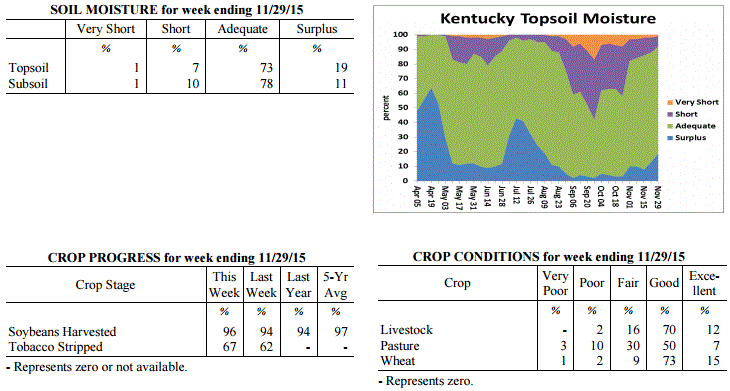 Kentucky Climate Summary
For the Period November 23, 2015 to November 29, 2015
Above Normal Temperatures and Rainfall:
This past work week started off with very cold temperatures carrying over from the
previous weekend. The majority of the state woke up to readings in the upper teens
to low 20s on Monday morning, roughly 15 to 20 degrees below normal for this time of
the year. The good news is that a warming trend then followed through the
Thanksgiving holiday. By Thursday, temperatures were peaking in the mid 60s to
around 70 behind breezy southerly flow. After a dry week, a cold front slowly worked
through the area over the weekend. A plume of moisture led to periods of widespread
rainfall. Overall, totals diminished farther east. Western Kentucky averaged over 2
inches of rainfall, while much of the eastern half of the state only saw a little
over a half inch.
Temperatures for the period averaged 50 degrees across the state which was 6 degrees
warmer than normal and 2 degrees warmer than the previous period. High temperatures
averaged from 59 in the West to 61 in the East. Departure from normal high
temperatures ranged from 4 degrees warmer than normal in the West to 7 degrees
warmer than normal in the East. Low temperatures averaged from 42 degrees in the
West to 38 degrees in the East. Departure from normal low temperature ranged from 7
degrees warmer than normal in the West to 6 degrees warmer than normal in the East.
The extreme high temperature for the period was 72 degrees at JACKSON AIRPORT and the
extreme low was 15 degrees at BOONEVILLE 2S.
Precipitation (liq. equ.) for the period totaled 1.15 inches statewide which was 0.1
inches above normal and 110% of normal. Precipitation totals by climate division,
West 2.23 inches, Central 1.12 inches, Bluegrass 0.64 inches and East 0.61 inches,
which was 1.02, 0.01, -0.25 and -0.36 inches respectively from normal. By station,
precipitation totals ranged from a low of 0.35 inches at BIG SANDY to a high of 4.49
inches at HICKMAN 2E.
---
Kentucky Crop and Weather Report
Issued 4:00 P.M., November 23, 2015 38-15
Agricultural News: Kentucky experienced above normal temperatures and precipitation
over the past week. Precipitation for the week totaled 1.68 inches, 0.70 inches above
normal. Temperatures averaged 49 degrees for the week, 3 degrees above normal.
Topsoil moisture was rated 2 percent very short, 10 percent short, 75 percent
adequate and 13 percent surplus. Subsoil moisture was rated 1 percent very short, 14
percent short, 77 percent adequate, and 8 percent surplus. Days suitable for
fieldwork averaged 4.1 out of a possible seven. Grain harvest is winding down with
unharvested corn and soybean fields in need of dry conditions or frozen ground to
allow combines to get back in fields. Tobacco stripping is progressing well with some
reports of fat stems. Pastures are holding steady at mostly good to fair condition.
Kentucky Climate Summary
For the Period November 23, 2015 to November 29, 2015
Above Normal Temperatures and Rainfall:
This past work week started off with very cold temperatures carrying over from the
previous weekend. The majority of the state woke up to readings in the upper teens
to low 20s on Monday morning, roughly 15 to 20 degrees below normal for this time of
the year. The good news is that a warming trend then followed through the
Thanksgiving holiday. By Thursday, temperatures were peaking in the mid 60s to
around 70 behind breezy southerly flow. After a dry week, a cold front slowly worked
through the area over the weekend. A plume of moisture led to periods of widespread
rainfall. Overall, totals diminished farther east. Western Kentucky averaged over 2
inches of rainfall, while much of the eastern half of the state only saw a little
over a half inch.
Temperatures for the period averaged 50 degrees across the state which was 6 degrees
warmer than normal and 2 degrees warmer than the previous period. High temperatures
averaged from 59 in the West to 61 in the East. Departure from normal high
temperatures ranged from 4 degrees warmer than normal in the West to 7 degrees
warmer than normal in the East. Low temperatures averaged from 42 degrees in the
West to 38 degrees in the East. Departure from normal low temperature ranged from 7
degrees warmer than normal in the West to 6 degrees warmer than normal in the East.
The extreme high temperature for the period was 72 degrees at JACKSON AIRPORT and the
extreme low was 15 degrees at BOONEVILLE 2S.
Precipitation (liq. equ.) for the period totaled 1.15 inches statewide which was 0.1
inches above normal and 110% of normal. Precipitation totals by climate division,
West 2.23 inches, Central 1.12 inches, Bluegrass 0.64 inches and East 0.61 inches,
which was 1.02, 0.01, -0.25 and -0.36 inches respectively from normal. By station,
precipitation totals ranged from a low of 0.35 inches at BIG SANDY to a high of 4.49
inches at HICKMAN 2E.
---
Kentucky Crop and Weather Report
Issued 4:00 P.M., November 23, 2015 38-15
Agricultural News: Kentucky experienced above normal temperatures and precipitation
over the past week. Precipitation for the week totaled 1.68 inches, 0.70 inches above
normal. Temperatures averaged 49 degrees for the week, 3 degrees above normal.
Topsoil moisture was rated 2 percent very short, 10 percent short, 75 percent
adequate and 13 percent surplus. Subsoil moisture was rated 1 percent very short, 14
percent short, 77 percent adequate, and 8 percent surplus. Days suitable for
fieldwork averaged 4.1 out of a possible seven. Grain harvest is winding down with
unharvested corn and soybean fields in need of dry conditions or frozen ground to
allow combines to get back in fields. Tobacco stripping is progressing well with some
reports of fat stems. Pastures are holding steady at mostly good to fair condition.
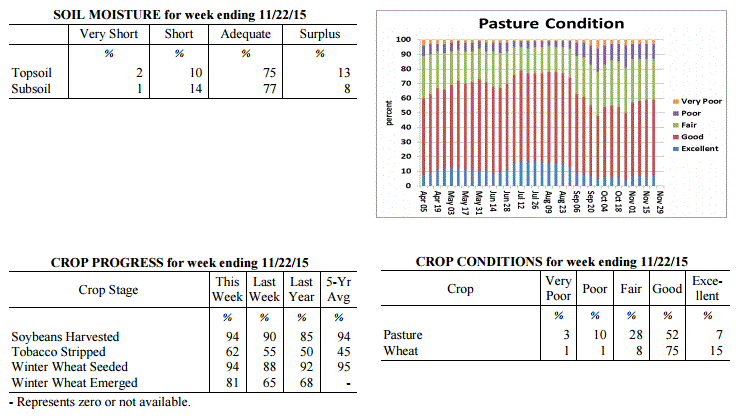 Kentucky Climate Summary
For the Period November 16, 2015 to November 22, 2015
Above Normal Temperatures and Precipitation:
A couple cold fronts this past week led to above normal precipitation for much of the
Bluegrass State, in addition to some of the coldest temperatures of the fall season.
After some light rain to start the week, a plume of moisture ahead of a cold front on
Wednesday led to widespread light to moderate rainfall across the area. This plume
slowly shifted east through the day with totals ranging between 1 and 2 inches for
much of Kentucky. After a brief period of dry conditions to end the work week,
another cold front pushed through the area on Saturday. This boundary once again
sparked scattered to numerous showers across the Bluegrass State. While totals were
not as significant, this system sent temperatures plummeting and led to the first
snow showers of the season for some areas. Lows on Saturday night dipped into the
20s, while highs on Sunday did not get out of the 30s.
Temperatures for the period averaged 49 degrees across the state which was 3 degrees
warmer than normal and no change to the previous period. High temperatures averaged
from 57 in the West to 59 in the East. Departure from normal high temperatures ranged
from near normal in the West to 2 degrees warmer than normal in the East. Low
temperatures averaged from 41 degrees in the West to 40 degrees in the East.
Departure from normal low temperature ranged from 4 degrees warmer than normal in the
West to 7 degrees warmer than normal in the East. The extreme high temperature for
the period was 74 degrees at PADUCAH ASOS and the extreme low was 19 degrees at
MADISONVILLE 4S.
Precipitation (liq. equ.) for the period totaled 1.68 inches statewide which was 0.7
inches above normal and 172% of normal. Precipitation totals by climate division,
West 2.91 inches, Central 1.90 inches, Bluegrass 1.15 inches and East 0.74 inches,
which was 1.78, 0.86, 0.30 and -0.15 inches respectively from normal. By station,
precipitation totals ranged from a low of 0.27 inches at LOUISA 1S to a high of 5.58
inches at POPLAR BLUFF ASOS.
---
Kentucky Crop and Weather Report
Issued 4:00 P.M., November 16, 2015 37-15
Agricultural News: Kentucky experienced near normal temperatures and below normal
rainfall over the past week. Precipitation for the week totaled 0.32 inches, 0.53
inches below normal. Temperatures averaged 49 degrees for the week, near normal.
Topsoil moisture was rated 2 percent very short, 12 percent short, 78 percent
adequate and 8 percent surplus. Subsoil moisture was rated 2 percent very short, 16
percent short, 78 percent adequate, and 4 percent surplus. Days suitable for
fieldwork averaged 4.9 out of a possible seven. Grain harvest is winding down in many
locations. Primary activities this week included harvesting corn and soybeans, sowing
wheat and stripping tobacco when conditions allowed. Pastures are in mostly good to
fair condition. Cattle producers continued weaning calves and many have begun feeding
hay.
Kentucky Climate Summary
For the Period November 16, 2015 to November 22, 2015
Above Normal Temperatures and Precipitation:
A couple cold fronts this past week led to above normal precipitation for much of the
Bluegrass State, in addition to some of the coldest temperatures of the fall season.
After some light rain to start the week, a plume of moisture ahead of a cold front on
Wednesday led to widespread light to moderate rainfall across the area. This plume
slowly shifted east through the day with totals ranging between 1 and 2 inches for
much of Kentucky. After a brief period of dry conditions to end the work week,
another cold front pushed through the area on Saturday. This boundary once again
sparked scattered to numerous showers across the Bluegrass State. While totals were
not as significant, this system sent temperatures plummeting and led to the first
snow showers of the season for some areas. Lows on Saturday night dipped into the
20s, while highs on Sunday did not get out of the 30s.
Temperatures for the period averaged 49 degrees across the state which was 3 degrees
warmer than normal and no change to the previous period. High temperatures averaged
from 57 in the West to 59 in the East. Departure from normal high temperatures ranged
from near normal in the West to 2 degrees warmer than normal in the East. Low
temperatures averaged from 41 degrees in the West to 40 degrees in the East.
Departure from normal low temperature ranged from 4 degrees warmer than normal in the
West to 7 degrees warmer than normal in the East. The extreme high temperature for
the period was 74 degrees at PADUCAH ASOS and the extreme low was 19 degrees at
MADISONVILLE 4S.
Precipitation (liq. equ.) for the period totaled 1.68 inches statewide which was 0.7
inches above normal and 172% of normal. Precipitation totals by climate division,
West 2.91 inches, Central 1.90 inches, Bluegrass 1.15 inches and East 0.74 inches,
which was 1.78, 0.86, 0.30 and -0.15 inches respectively from normal. By station,
precipitation totals ranged from a low of 0.27 inches at LOUISA 1S to a high of 5.58
inches at POPLAR BLUFF ASOS.
---
Kentucky Crop and Weather Report
Issued 4:00 P.M., November 16, 2015 37-15
Agricultural News: Kentucky experienced near normal temperatures and below normal
rainfall over the past week. Precipitation for the week totaled 0.32 inches, 0.53
inches below normal. Temperatures averaged 49 degrees for the week, near normal.
Topsoil moisture was rated 2 percent very short, 12 percent short, 78 percent
adequate and 8 percent surplus. Subsoil moisture was rated 2 percent very short, 16
percent short, 78 percent adequate, and 4 percent surplus. Days suitable for
fieldwork averaged 4.9 out of a possible seven. Grain harvest is winding down in many
locations. Primary activities this week included harvesting corn and soybeans, sowing
wheat and stripping tobacco when conditions allowed. Pastures are in mostly good to
fair condition. Cattle producers continued weaning calves and many have begun feeding
hay.
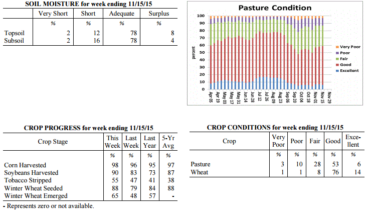 Kentucky Climate Summary
For the Period November 9, 2015 to November 15, 2015
Near Normal Temperatures and Below Normal Rainfall:
As harvest began wrapping up, this past week followed an up and down weather pattern.
The start of the period brought a period of light rain Monday and Monday night as an
upper level low pressure system passed through the area. Dry conditions then pushed
into the region temporarily, before eyes turned to a strong cold front late Wednesday
and into Thursday morning. In addition to the Monday system, a couple lines of
showers along and ahead of the boundary resulted in a statewide average just under a
third of an inch for the week. Ahead of the cold front, temperatures peaked in the
60s on Wednesday. Winds then became gusty behind the front on Thursday and Friday
with peak gusts between 25 and 40 mph. Temperatures Friday night dove into the mid
20s to low 30s under mostly clear skies.
Temperatures for the period averaged 49 degrees across the state which was near
normal and 12 degrees cooler than the previous period. High temperatures averaged
from 63 in the West to 59 in the East. Departure from normal high temperatures
ranged from 2 degrees warmer than normal in the West to 1 degree cooler than normal
in the East. Low temperatures averaged from 38 degrees in the West to 38 degrees in
the East. Departure from normal low temperature ranged from 2 degrees cooler than
normal in the West to 3 degrees warmer than normal in the East. The extreme high
temperature for the period was 73 degrees at BENTON 4N and the extreme low was 21
degrees at CYNTHIANA 8N.
Precipitation (liq. equ.) for the period totaled 0.32 inches statewide which was 0.53
inches below normal and 38% of normal. Precipitation totals by climate division, West
0.34 inches, Central 0.50 inches, Bluegrass 0.26 inches and East 0.17 inches, which
was 0.67, 0.39, 0.47 and 0.59 inches below normal. By station, precipitation totals
ranged from a low of 0.03 inches at LONDON to a high of 1.19 inches at BRANDENBURG 4SW.
---
Kentucky Crop and Weather Report
Issued 4:00 P.M., November 9, 2015 36-15
Agricultural News: Kentucky experienced above normal temperatures and below normal
rainfall over the past week. Precipitation for the week totaled 0.59 inches, 0.18
inches below normal. Temperatures averaged 60 degrees for the week, 9 degrees above
normal. Topsoil moisture was rated 3 percent very short, 13 percent short, 74 percent
adequate and 10 percent surplus. Subsoil moisture was rated 2 percent very short, 19
percent short, 75 percent adequate, and 4 percent surplus. Days suitable for
fieldwork averaged 4.5 out of a possible seven. Primary activities this week included
harvesting corn and soybeans, sowing wheat and stripping tobacco when conditions
allowed. Harvest has been slowed in some areas due to wet field conditions. Pasture
conditions remained in mostly good condition. Cattle and calves obtained
approximately 65 percent of feed from pastures, but some hay is being fed.
Kentucky Climate Summary
For the Period November 9, 2015 to November 15, 2015
Near Normal Temperatures and Below Normal Rainfall:
As harvest began wrapping up, this past week followed an up and down weather pattern.
The start of the period brought a period of light rain Monday and Monday night as an
upper level low pressure system passed through the area. Dry conditions then pushed
into the region temporarily, before eyes turned to a strong cold front late Wednesday
and into Thursday morning. In addition to the Monday system, a couple lines of
showers along and ahead of the boundary resulted in a statewide average just under a
third of an inch for the week. Ahead of the cold front, temperatures peaked in the
60s on Wednesday. Winds then became gusty behind the front on Thursday and Friday
with peak gusts between 25 and 40 mph. Temperatures Friday night dove into the mid
20s to low 30s under mostly clear skies.
Temperatures for the period averaged 49 degrees across the state which was near
normal and 12 degrees cooler than the previous period. High temperatures averaged
from 63 in the West to 59 in the East. Departure from normal high temperatures
ranged from 2 degrees warmer than normal in the West to 1 degree cooler than normal
in the East. Low temperatures averaged from 38 degrees in the West to 38 degrees in
the East. Departure from normal low temperature ranged from 2 degrees cooler than
normal in the West to 3 degrees warmer than normal in the East. The extreme high
temperature for the period was 73 degrees at BENTON 4N and the extreme low was 21
degrees at CYNTHIANA 8N.
Precipitation (liq. equ.) for the period totaled 0.32 inches statewide which was 0.53
inches below normal and 38% of normal. Precipitation totals by climate division, West
0.34 inches, Central 0.50 inches, Bluegrass 0.26 inches and East 0.17 inches, which
was 0.67, 0.39, 0.47 and 0.59 inches below normal. By station, precipitation totals
ranged from a low of 0.03 inches at LONDON to a high of 1.19 inches at BRANDENBURG 4SW.
---
Kentucky Crop and Weather Report
Issued 4:00 P.M., November 9, 2015 36-15
Agricultural News: Kentucky experienced above normal temperatures and below normal
rainfall over the past week. Precipitation for the week totaled 0.59 inches, 0.18
inches below normal. Temperatures averaged 60 degrees for the week, 9 degrees above
normal. Topsoil moisture was rated 3 percent very short, 13 percent short, 74 percent
adequate and 10 percent surplus. Subsoil moisture was rated 2 percent very short, 19
percent short, 75 percent adequate, and 4 percent surplus. Days suitable for
fieldwork averaged 4.5 out of a possible seven. Primary activities this week included
harvesting corn and soybeans, sowing wheat and stripping tobacco when conditions
allowed. Harvest has been slowed in some areas due to wet field conditions. Pasture
conditions remained in mostly good condition. Cattle and calves obtained
approximately 65 percent of feed from pastures, but some hay is being fed.
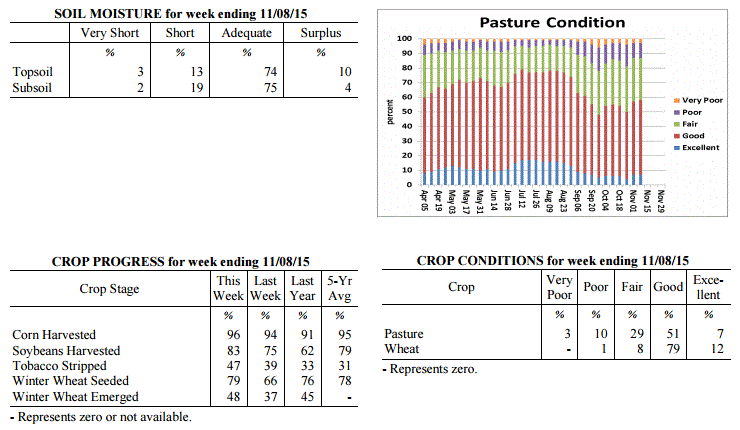 Kentucky Climate Summary
For the Period November 2, 2015 to November 8, 2015
Much Above Normal Temperatures and Below Normal Rainfall:
Normal high temperatures for the start of November are typically in the low to mid
60s across much of Kentucky. Over this past work week, highs bumped into the 70s
about each day behind a light southerly flow pattern and mostly sunny skies from time
to time. A few locations even jumped into the 80s. The area stayed dry through
Thursday, before a cold front worked through the region that night and into Friday. A
weakening line of widespread showers and some embedded storms were sparked ahead of
the boundary. Rainfall totals were highest along the Ohio River where many saw a half
to one inch plus, before diminishing farther to the southeast. Behind the activity,
dry and much cooler conditions moved into the area for the weekend. After a warm work
week, highs only peaked in the middle 50s to around 60 each day, before falling into
the 30s at night.
Temperatures for the period averaged 60 degrees across the state which was 9 degrees
warmer than normal and 4 degrees warmer than the previous period. High temperatures
averaged from 69 in the West to 70 in the East. Departure from normal high
temperatures ranged from 5 degrees warmer than normal in the West to 7 degrees
warmer than normal in the East. Low temperatures averaged from 52 degrees in the
West to 52 degrees in the East. Departure from normal low temperature ranged from 11
degrees warmer than normal in the West to 15 degrees warmer than normal in the
East. The extreme high temperature for the period was 82 degrees at PEABODY and the
extreme low was 30 degrees at CARBONDALE ASOS.
Precipitation (liq. equ.) for the period totaled 0.59 inches statewide which was 0.18
inches below normal and 77% of normal. Precipitation totals by climate division, West
0.88 inches, Central 0.62 inches, Bluegrass 0.68 inches and East 0.17 inches, which
was 0.02, -0.18, -0.02 and -0.53 inches respectively from normal. By station,
precipitation totals ranged from a low of 0.04 inches at BIG SANDY to a high of 2.03
inches at CAPE GIRARDEAU ASOS.
---
Kentucky Crop and Weather Report
Issued 4:00 P.M., November 2, 2015 35-15
Agricultural News: Kentucky experienced near normal temperatures and above normal
rainfall over the past week. Precipitation for the week totaled 2.09 inches, 1.32
inches above normal. Temperatures averaged 54 degrees for the week, near normal.
Topsoil moisture was rated 3 percent very short, 15 percent short, 72 percent
adequate and 10 percent surplus. Subsoil moisture was rated 2 percent very short, 23
percent short, 71 percent adequate, and 4 percent surplus. Days suitable for
fieldwork averaged 3.5 out of a possible seven. Rain events throughout the week
slowed or stopped harvest. Primary activities this week included harvesting corn and
soybeans, sowing wheat and stripping tobacco when conditions allowed. Pasture
conditions improved due to the rain received. Livestock were rated in mostly
good condition.
Kentucky Climate Summary
For the Period November 2, 2015 to November 8, 2015
Much Above Normal Temperatures and Below Normal Rainfall:
Normal high temperatures for the start of November are typically in the low to mid
60s across much of Kentucky. Over this past work week, highs bumped into the 70s
about each day behind a light southerly flow pattern and mostly sunny skies from time
to time. A few locations even jumped into the 80s. The area stayed dry through
Thursday, before a cold front worked through the region that night and into Friday. A
weakening line of widespread showers and some embedded storms were sparked ahead of
the boundary. Rainfall totals were highest along the Ohio River where many saw a half
to one inch plus, before diminishing farther to the southeast. Behind the activity,
dry and much cooler conditions moved into the area for the weekend. After a warm work
week, highs only peaked in the middle 50s to around 60 each day, before falling into
the 30s at night.
Temperatures for the period averaged 60 degrees across the state which was 9 degrees
warmer than normal and 4 degrees warmer than the previous period. High temperatures
averaged from 69 in the West to 70 in the East. Departure from normal high
temperatures ranged from 5 degrees warmer than normal in the West to 7 degrees
warmer than normal in the East. Low temperatures averaged from 52 degrees in the
West to 52 degrees in the East. Departure from normal low temperature ranged from 11
degrees warmer than normal in the West to 15 degrees warmer than normal in the
East. The extreme high temperature for the period was 82 degrees at PEABODY and the
extreme low was 30 degrees at CARBONDALE ASOS.
Precipitation (liq. equ.) for the period totaled 0.59 inches statewide which was 0.18
inches below normal and 77% of normal. Precipitation totals by climate division, West
0.88 inches, Central 0.62 inches, Bluegrass 0.68 inches and East 0.17 inches, which
was 0.02, -0.18, -0.02 and -0.53 inches respectively from normal. By station,
precipitation totals ranged from a low of 0.04 inches at BIG SANDY to a high of 2.03
inches at CAPE GIRARDEAU ASOS.
---
Kentucky Crop and Weather Report
Issued 4:00 P.M., November 2, 2015 35-15
Agricultural News: Kentucky experienced near normal temperatures and above normal
rainfall over the past week. Precipitation for the week totaled 2.09 inches, 1.32
inches above normal. Temperatures averaged 54 degrees for the week, near normal.
Topsoil moisture was rated 3 percent very short, 15 percent short, 72 percent
adequate and 10 percent surplus. Subsoil moisture was rated 2 percent very short, 23
percent short, 71 percent adequate, and 4 percent surplus. Days suitable for
fieldwork averaged 3.5 out of a possible seven. Rain events throughout the week
slowed or stopped harvest. Primary activities this week included harvesting corn and
soybeans, sowing wheat and stripping tobacco when conditions allowed. Pasture
conditions improved due to the rain received. Livestock were rated in mostly
good condition.
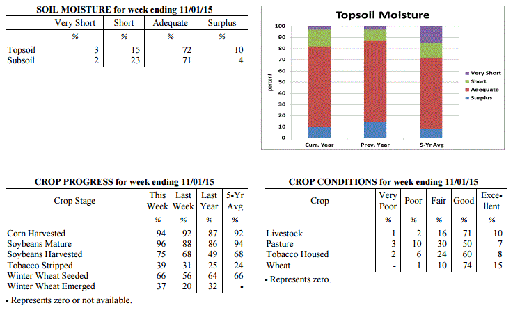 Kentucky Climate Summary
For the Period October 26, 2015 to November 1, 2015
Near Normal Temperatures and Above Normal Rainfall:
After a fairly dry month, October ended with a wet pattern in place. Through the
first half of the work week, the Commonwealth saw multiple rounds of soaking showers
ahead of a low pressure system to the south. Activity was widespread at times, with
much of the state picking up between 1.5 to 2.5+ inches of rainfall. Dry conditions
returned Thursday and Friday, but only temporarily. Numerous to widespread light
showers returned by the evening of Halloween and pushed through the state overnight.
Many picked up an additional tenth to quarter inch. With the exception of Eastern
Kentucky, the majority of the Bluegrass State averaged over two inches for the week,
which broke a three week streak of below normal rainfall.
Temperatures for the period averaged 54 degrees across the state which was near
normal and 6 degrees cooler than the previous period. High temperatures averaged from
63 in the West to 61 in the East. Departure from normal high temperatures ranged
from 4 degrees cooler than normal in the West to 5 degrees cooler than normal in
the East. Low temperatures averaged from 50 degrees in the West to 47 degrees in the
East. Departure from normal low temperature ranged from 6 degrees warmer than normal
in the West to 8 degrees warmer than normal in the East. The extreme high temperature
for the period was 73 degrees at BOONEVILLE 2S and the extreme low was 31 degrees, at
the same location.
Precipitation (liq. equ.) for the period totaled 2.09 inches statewide which was 1.32
inches above normal and 273% of normal. Precipitation totals by climate division,
West 2.76 inches, Central 2.60 inches, Bluegrass 2.22 inches and East 0.78 inches,
which was 1.91, 1.81, 1.52 and 0.06 inches above normal. By station, precipitation
totals ranged from a low of 0.31 inches at BOONEVILLE 2S to a high of 4.52 inches at
HARDINSBURG 5SW.
---
Kentucky Crop and Weather Report
Issued 4:00 P.M., October 26, 2015 34-15
Agricultural News: Kentucky experienced above normal temperatures and below normal
rainfall over the past week. Precipitation for the week totaled 0.33 inches, 0.37
inches below normal. Temperatures averaged 59 degrees for the week, 3 degrees above
normal. Topsoil moisture was rated 8 percent very short, 34 percent short, 55 percent
adequate and 3 percent surplus. Subsoil moisture was rated 8 percent very short, 34
percent short, 56 percent adequate, and 2 percent surplus. Days suitable for
fieldwork averaged 6.2 out of a possible seven. Primary activities this week included
harvesting corn and soybeans, sowing wheat and stripping tobacco. Most areas are in
need of rain to improve pastures and bring tobacco into case for stripping. Moisture
would also be beneficial for fall seeded crops. US Drought Monitor shows a little
over 14 percent of the state, mainly in Western and West-Central Kentucky, in a
Moderate Drought.
Kentucky Climate Summary
For the Period October 26, 2015 to November 1, 2015
Near Normal Temperatures and Above Normal Rainfall:
After a fairly dry month, October ended with a wet pattern in place. Through the
first half of the work week, the Commonwealth saw multiple rounds of soaking showers
ahead of a low pressure system to the south. Activity was widespread at times, with
much of the state picking up between 1.5 to 2.5+ inches of rainfall. Dry conditions
returned Thursday and Friday, but only temporarily. Numerous to widespread light
showers returned by the evening of Halloween and pushed through the state overnight.
Many picked up an additional tenth to quarter inch. With the exception of Eastern
Kentucky, the majority of the Bluegrass State averaged over two inches for the week,
which broke a three week streak of below normal rainfall.
Temperatures for the period averaged 54 degrees across the state which was near
normal and 6 degrees cooler than the previous period. High temperatures averaged from
63 in the West to 61 in the East. Departure from normal high temperatures ranged
from 4 degrees cooler than normal in the West to 5 degrees cooler than normal in
the East. Low temperatures averaged from 50 degrees in the West to 47 degrees in the
East. Departure from normal low temperature ranged from 6 degrees warmer than normal
in the West to 8 degrees warmer than normal in the East. The extreme high temperature
for the period was 73 degrees at BOONEVILLE 2S and the extreme low was 31 degrees, at
the same location.
Precipitation (liq. equ.) for the period totaled 2.09 inches statewide which was 1.32
inches above normal and 273% of normal. Precipitation totals by climate division,
West 2.76 inches, Central 2.60 inches, Bluegrass 2.22 inches and East 0.78 inches,
which was 1.91, 1.81, 1.52 and 0.06 inches above normal. By station, precipitation
totals ranged from a low of 0.31 inches at BOONEVILLE 2S to a high of 4.52 inches at
HARDINSBURG 5SW.
---
Kentucky Crop and Weather Report
Issued 4:00 P.M., October 26, 2015 34-15
Agricultural News: Kentucky experienced above normal temperatures and below normal
rainfall over the past week. Precipitation for the week totaled 0.33 inches, 0.37
inches below normal. Temperatures averaged 59 degrees for the week, 3 degrees above
normal. Topsoil moisture was rated 8 percent very short, 34 percent short, 55 percent
adequate and 3 percent surplus. Subsoil moisture was rated 8 percent very short, 34
percent short, 56 percent adequate, and 2 percent surplus. Days suitable for
fieldwork averaged 6.2 out of a possible seven. Primary activities this week included
harvesting corn and soybeans, sowing wheat and stripping tobacco. Most areas are in
need of rain to improve pastures and bring tobacco into case for stripping. Moisture
would also be beneficial for fall seeded crops. US Drought Monitor shows a little
over 14 percent of the state, mainly in Western and West-Central Kentucky, in a
Moderate Drought.
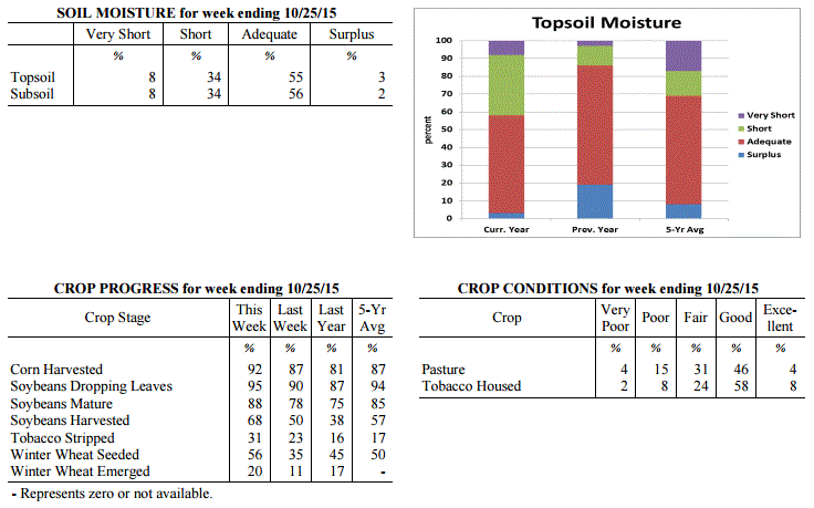 Kentucky Climate Summary
For the Period October 19, 2015 to October 25, 2015
Above Normal Temperatures and Below Normal Rainfall:
Below normal rainfall continues to be the trend across the Lower Ohio Valley. The
Bluegrass State has now gone three straight weeks of seeing below normal
precipitation. Looking back further, seven of the past nine have been below normal.
This past period, high pressure kept the area dry and fairly mild through the work
week. A cold front then pushed through the area Saturday and into Saturday night with
showers becoming widespread at times. When it was all said and done, the state
averaged a third of an inch for the week, which is below normal by about the same.
The dry conditions have been more noticeable in Western Kentucky where month to date
rainfall is approaching two inches below normal. Looking longer term, this area is
more than four inches below normal over the past 60 days. In relation, the US Drought
Monitor has put a little over 14% of the state, mainly in Western and West-Central
Kentucky, in a Moderate Drought.
Temperatures for the period averaged 59 degrees across the state which was 3 degrees
warmer than normal and 4 degrees warmer than the previous period. High temperatures
averaged from 74 in the West to 71 in the East. Departure from normal high
temperatures ranged from 4 degrees warmer than normal in the West to 2 degrees
warmer than normal in the East. Low temperatures averaged from 48 degrees in the
West to 44 degrees in the East. Departure from normal low temperature ranged from 2
degrees warmer than normal in the West to 3 degrees warmer than normal in the East.
The extreme high temperature for the period was 83 degrees at BENTON 4N and the
extreme low was 26 degrees at VANCEBURG 6W.
Precipitation (liq. equ.) for the period totaled 0.33 inches statewide which was 0.37
inches below normal and 47% of normal. Precipitation totals by climate division, West
0.38 inches, Central 0.34 inches, Bluegrass 0.44 inches and East 0.18 inches, which
was 0.4, 0.37, 0.21 and 0.49 inches below normal. By station, precipitation totals
ranged from a low of 0.01 inches at CARBONDALE ASOS to a high of 2.03 inches at
STANFORD 4NE.
---
Kentucky Crop and Weather Report
Issued 4:00 P.M., October 19, 2015 33-15
Agricultural News: Kentucky experienced below normal temperatures and rainfall over
the past week. Precipitation for the week totaled 0.36 inches, 0.35 inches below
normal. Temperatures averaged 55 degrees for the week, 3 degrees below normal.
Topsoil moisture was rated 7 percent very short, 30 percent short, 60 percent
adequate and 3 percent surplus. Subsoil moisture was rated 7 percent very short, 31
percent short, 60 percent adequate, and 2 percent surplus. Days suitable for
fieldwork averaged 6.1 out of a possible seven. Primary activities this week included
harvesting corn and soybeans, sowing wheat and stripping tobacco. First
widespread frost was received this week. Some producers were feeding hay to their
livestock.
Kentucky Climate Summary
For the Period October 19, 2015 to October 25, 2015
Above Normal Temperatures and Below Normal Rainfall:
Below normal rainfall continues to be the trend across the Lower Ohio Valley. The
Bluegrass State has now gone three straight weeks of seeing below normal
precipitation. Looking back further, seven of the past nine have been below normal.
This past period, high pressure kept the area dry and fairly mild through the work
week. A cold front then pushed through the area Saturday and into Saturday night with
showers becoming widespread at times. When it was all said and done, the state
averaged a third of an inch for the week, which is below normal by about the same.
The dry conditions have been more noticeable in Western Kentucky where month to date
rainfall is approaching two inches below normal. Looking longer term, this area is
more than four inches below normal over the past 60 days. In relation, the US Drought
Monitor has put a little over 14% of the state, mainly in Western and West-Central
Kentucky, in a Moderate Drought.
Temperatures for the period averaged 59 degrees across the state which was 3 degrees
warmer than normal and 4 degrees warmer than the previous period. High temperatures
averaged from 74 in the West to 71 in the East. Departure from normal high
temperatures ranged from 4 degrees warmer than normal in the West to 2 degrees
warmer than normal in the East. Low temperatures averaged from 48 degrees in the
West to 44 degrees in the East. Departure from normal low temperature ranged from 2
degrees warmer than normal in the West to 3 degrees warmer than normal in the East.
The extreme high temperature for the period was 83 degrees at BENTON 4N and the
extreme low was 26 degrees at VANCEBURG 6W.
Precipitation (liq. equ.) for the period totaled 0.33 inches statewide which was 0.37
inches below normal and 47% of normal. Precipitation totals by climate division, West
0.38 inches, Central 0.34 inches, Bluegrass 0.44 inches and East 0.18 inches, which
was 0.4, 0.37, 0.21 and 0.49 inches below normal. By station, precipitation totals
ranged from a low of 0.01 inches at CARBONDALE ASOS to a high of 2.03 inches at
STANFORD 4NE.
---
Kentucky Crop and Weather Report
Issued 4:00 P.M., October 19, 2015 33-15
Agricultural News: Kentucky experienced below normal temperatures and rainfall over
the past week. Precipitation for the week totaled 0.36 inches, 0.35 inches below
normal. Temperatures averaged 55 degrees for the week, 3 degrees below normal.
Topsoil moisture was rated 7 percent very short, 30 percent short, 60 percent
adequate and 3 percent surplus. Subsoil moisture was rated 7 percent very short, 31
percent short, 60 percent adequate, and 2 percent surplus. Days suitable for
fieldwork averaged 6.1 out of a possible seven. Primary activities this week included
harvesting corn and soybeans, sowing wheat and stripping tobacco. First
widespread frost was received this week. Some producers were feeding hay to their
livestock.
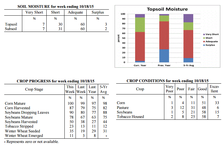 Kentucky Climate Summary
For the Period October 12, 2015 to October 18, 2015
Below Normal Temperatures and Rainfall:
This past week brought the Commonwealth a couple rounds of rainfall, in addition to
the first widespread frost of the young fall season. A cold front pushed through the
region Monday evening and into the overnight, producing a solid band of showers and
storms. This feature accounted for much of the rainfall this past week. Over the
period, the state averaged a little over a third of an inch, which was below normal
for a second straight week. A secondary cold front passed through the Ohio Valley on
Thursday night with not much in the way of precipitation. The bigger story was the
cold temperatures filtering into the area over the weekend. Areas of frost developed
both Friday and Saturday nights across the state. The coolest temperatures were seen
Saturday night and Sunday morning as the majority of Kentucky dropped below freezing.
Many rural locations dropped into the mid to upper 20s, which is around 15 to 20
degrees below normal for this time of year.
Temperatures for the period averaged 55 degrees across the state which was 3 degrees
cooler than normal and 10 degrees cooler than the previous period. High temperatures
averaged from 71 in the West to 66 in the East. Departure from normal high
temperatures ranged from 1 degree cooler than normal in the West to 4 degrees cooler
than normal in the East. Low temperatures averaged from 43 degrees in the West to 43
degrees in the East. Departure from normal low temperature ranged from 4 degrees
cooler than normal in the West to near normal in the East. The extreme high
temperature for the period was 86 degrees at MAYFIELD 6SW and the extreme low was 24
degrees at CYNTHIANA 8N.
Precipitation (liq. equ.) for the period totaled 0.36 inches statewide which was 0.35
inches below normal and 51% of normal. Precipitation totals by climate division, West
0.26 inches, Central 0.52 inches, Bluegrass 0.35 inches and East 0.30 inches, which
was 0.48, 0.2, 0.33 and 0.4 inches below normal. By station, precipitation totals
ranged from a low of 0.00 inches at CAPE GIRARDEAU ASOS to a high of 0.89
inches at BRANDENBURG 4SW.
---
Kentucky Crop and Weather Report
Issued 4:00 P.M., October 13, 2015 32-15
Agricultural News: Kentucky experienced above normal temperatures and below normal
rainfall over the past week. Precipitation for the week totaled 0.22 inches, 0.56
inches below normal. Temperatures averaged 66 degrees for the week, 6 degrees above
normal. Topsoil moisture was rated 6 percent very short, 31 percent short, 59 percent
adequate and 4 percent surplus. Subsoil moisture was rated 7 percent very short, 31
percent short, 59 percent adequate, and 3 percent surplus. Days suitable for
fieldwork averaged 5.7 out of a possible seven. Tobacco houseburn was reported as 1
percent heavy, 5 percent moderate, 17 percent light, with 77 percent experiencing none.
Kentucky Climate Summary
For the Period October 12, 2015 to October 18, 2015
Below Normal Temperatures and Rainfall:
This past week brought the Commonwealth a couple rounds of rainfall, in addition to
the first widespread frost of the young fall season. A cold front pushed through the
region Monday evening and into the overnight, producing a solid band of showers and
storms. This feature accounted for much of the rainfall this past week. Over the
period, the state averaged a little over a third of an inch, which was below normal
for a second straight week. A secondary cold front passed through the Ohio Valley on
Thursday night with not much in the way of precipitation. The bigger story was the
cold temperatures filtering into the area over the weekend. Areas of frost developed
both Friday and Saturday nights across the state. The coolest temperatures were seen
Saturday night and Sunday morning as the majority of Kentucky dropped below freezing.
Many rural locations dropped into the mid to upper 20s, which is around 15 to 20
degrees below normal for this time of year.
Temperatures for the period averaged 55 degrees across the state which was 3 degrees
cooler than normal and 10 degrees cooler than the previous period. High temperatures
averaged from 71 in the West to 66 in the East. Departure from normal high
temperatures ranged from 1 degree cooler than normal in the West to 4 degrees cooler
than normal in the East. Low temperatures averaged from 43 degrees in the West to 43
degrees in the East. Departure from normal low temperature ranged from 4 degrees
cooler than normal in the West to near normal in the East. The extreme high
temperature for the period was 86 degrees at MAYFIELD 6SW and the extreme low was 24
degrees at CYNTHIANA 8N.
Precipitation (liq. equ.) for the period totaled 0.36 inches statewide which was 0.35
inches below normal and 51% of normal. Precipitation totals by climate division, West
0.26 inches, Central 0.52 inches, Bluegrass 0.35 inches and East 0.30 inches, which
was 0.48, 0.2, 0.33 and 0.4 inches below normal. By station, precipitation totals
ranged from a low of 0.00 inches at CAPE GIRARDEAU ASOS to a high of 0.89
inches at BRANDENBURG 4SW.
---
Kentucky Crop and Weather Report
Issued 4:00 P.M., October 13, 2015 32-15
Agricultural News: Kentucky experienced above normal temperatures and below normal
rainfall over the past week. Precipitation for the week totaled 0.22 inches, 0.56
inches below normal. Temperatures averaged 66 degrees for the week, 6 degrees above
normal. Topsoil moisture was rated 6 percent very short, 31 percent short, 59 percent
adequate and 4 percent surplus. Subsoil moisture was rated 7 percent very short, 31
percent short, 59 percent adequate, and 3 percent surplus. Days suitable for
fieldwork averaged 5.7 out of a possible seven. Tobacco houseburn was reported as 1
percent heavy, 5 percent moderate, 17 percent light, with 77 percent experiencing none.
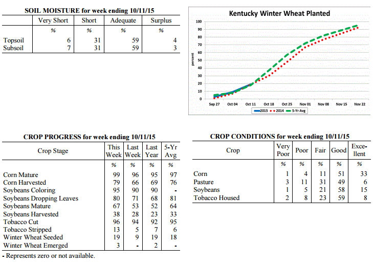 Kentucky Climate Summary
For the Period October 5, 2015 to October 11, 2015
Above Normal Temperatures and Below Normal Rainfall:
The Commonwealth saw mostly dry and unseasonably warm conditions for much of this
last period. High pressure at the surface and aloft kept the Commonwealth dry through
at least Thursday. Highs rose into the upper 70s to middle 80s about each day, well
above normal for this time of the year. A cold front pushed through the Ohio Valley on
Friday, sparking numerous to widespread showers and scattered thunderstorms across
much of the area. This was the only significant rainfall event for the week with the
state averaging between a tenth and third of an inch. Cooler and drier conditions
arrived for the weekend. Skies cleared Saturday night, opening the door for a cool
night ahead. Lows dropped into the low to mid 40s for many locations, but some even
moved into the upper 30s.
Temperatures for the period averaged 66 degrees across the state which was 6 degrees
warmer than normal and 4 degrees warmer than the previous period. High temperatures
averaged from 79 in the West to 76 in the East. Departure from normal high
temperatures ranged from 5 degrees warmer than normal in the West to 4 degrees
warmer than normal in the East. Low temperatures averaged from 55 degrees in the
West to 53 degrees in the East. Departure from normal low temperature ranged from 6
degrees warmer than normal in the West to 7 degrees warmer than normal in the East.
The extreme high temperature for the period was 87 degrees at BURLINGTON 4S and the
extreme low was 37 degrees at BRANDENBURG 4SW.
Precipitation (liq. equ.) for the period totaled 0.22 inches statewide which was 0.56
inches below normal and 28% of normal. Precipitation totals by climate division, West
0.16 inches, Central 0.29 inches, Bluegrass 0.13 inches and East 0.29 inches, which
was 0.64, 0.52, 0.61 and 0.49 inches below normal. By station, precipitation totals
ranged from a low of 0.00 inches at ALEXANDRIA 5NW to a high of 0.89 inches at
YELLOW CREEK.
---
Kentucky Crop and Weather Report
Issued 4:00 P.M., October 5, 2015 31-15
Agricultural News: Kentucky experienced below normal temperatures and above normal
rainfall over the past week. Precipitation for the week totaled 1.82 inches, 1.02
inches above normal. Temperatures averaged 62 degrees for the week, 1 degree below
normal. Topsoil moisture was rated 7 percent very short, 31 percent short, 57 percent
adequate and 5 percent surplus. Subsoil moisture was rated 7 percent very short, 30
percent short, 59 percent adequate, and 4 percent surplus. Days suitable for
fieldwork averaged 4.0 out of a possible seven.
Much needed rain was received this past week. However, it may have been too late to
improve yields for some double crop soybeans. Crops were harvested between rain
events where conditions allowed. Pasture conditions improved slightly due to the
moisture received. Livestock were rated in mostly good condition. Some producers had
begun feeding hay because of dry weather and welcomed the rainfall. Tobacco houseburn
was reported as 1 percent heavy, 5 percent moderate, 15 percent light, with 79 percent
experiencing none.
Kentucky Climate Summary
For the Period October 5, 2015 to October 11, 2015
Above Normal Temperatures and Below Normal Rainfall:
The Commonwealth saw mostly dry and unseasonably warm conditions for much of this
last period. High pressure at the surface and aloft kept the Commonwealth dry through
at least Thursday. Highs rose into the upper 70s to middle 80s about each day, well
above normal for this time of the year. A cold front pushed through the Ohio Valley on
Friday, sparking numerous to widespread showers and scattered thunderstorms across
much of the area. This was the only significant rainfall event for the week with the
state averaging between a tenth and third of an inch. Cooler and drier conditions
arrived for the weekend. Skies cleared Saturday night, opening the door for a cool
night ahead. Lows dropped into the low to mid 40s for many locations, but some even
moved into the upper 30s.
Temperatures for the period averaged 66 degrees across the state which was 6 degrees
warmer than normal and 4 degrees warmer than the previous period. High temperatures
averaged from 79 in the West to 76 in the East. Departure from normal high
temperatures ranged from 5 degrees warmer than normal in the West to 4 degrees
warmer than normal in the East. Low temperatures averaged from 55 degrees in the
West to 53 degrees in the East. Departure from normal low temperature ranged from 6
degrees warmer than normal in the West to 7 degrees warmer than normal in the East.
The extreme high temperature for the period was 87 degrees at BURLINGTON 4S and the
extreme low was 37 degrees at BRANDENBURG 4SW.
Precipitation (liq. equ.) for the period totaled 0.22 inches statewide which was 0.56
inches below normal and 28% of normal. Precipitation totals by climate division, West
0.16 inches, Central 0.29 inches, Bluegrass 0.13 inches and East 0.29 inches, which
was 0.64, 0.52, 0.61 and 0.49 inches below normal. By station, precipitation totals
ranged from a low of 0.00 inches at ALEXANDRIA 5NW to a high of 0.89 inches at
YELLOW CREEK.
---
Kentucky Crop and Weather Report
Issued 4:00 P.M., October 5, 2015 31-15
Agricultural News: Kentucky experienced below normal temperatures and above normal
rainfall over the past week. Precipitation for the week totaled 1.82 inches, 1.02
inches above normal. Temperatures averaged 62 degrees for the week, 1 degree below
normal. Topsoil moisture was rated 7 percent very short, 31 percent short, 57 percent
adequate and 5 percent surplus. Subsoil moisture was rated 7 percent very short, 30
percent short, 59 percent adequate, and 4 percent surplus. Days suitable for
fieldwork averaged 4.0 out of a possible seven.
Much needed rain was received this past week. However, it may have been too late to
improve yields for some double crop soybeans. Crops were harvested between rain
events where conditions allowed. Pasture conditions improved slightly due to the
moisture received. Livestock were rated in mostly good condition. Some producers had
begun feeding hay because of dry weather and welcomed the rainfall. Tobacco houseburn
was reported as 1 percent heavy, 5 percent moderate, 15 percent light, with 79 percent
experiencing none.
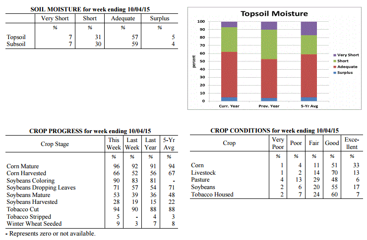 Kentucky Climate Summary
For the Period September 28, 2015 to October 4, 2015
Below Normal Temperatures and Much Above Normal Rainfall:
The Commonwealth saw numerous rounds of beneficial rainfall this past week as the
state was situated within a rather unsettled pattern. Abundant moisture pushed into
the Lower Ohio Valley ahead of an upper level low pressure system by Tuesday, setting
the stage for a wet week ahead. Several disturbances kept the chance for rainfall in
the forecast through Saturday. The most significant and widespread activity was seen
over the midsection of the work week, before showers became confined to mainly the
eastern half of the state heading into the weekend. Showers and any accumulations
were rather light in nature by Friday and Saturday, with cooler temperatures as
the more noticeable impact. Northeast breezy flow combined with overcast skies to
keep highs in the 50s both days. The state averaged 1.82 inches of rainfall for the
week, which was over an inch above normal. This was the first time the state was an
inch above normal for a week since mid-July. South-central Kentucky saw the highest
accumulations over the 7 day period, with many locations coming in at 3 to 4+ inches.
Temperatures for the period averaged 62 degrees across the state which was 1 degree
cooler than normal and 6 degrees cooler than the previous period. High temperatures
averaged from 69 in the West to 67 in the East. Departure from normal high
temperatures ranged from 8 degrees cooler than normal in the West to 8 degrees cooler
than normal in the East. Low temperatures averaged from 57 degrees in the West to 58
degrees in the East. Departure from normal low temperature ranged from 5 degrees
warmer than normal in the West to 9 degrees warmer than normal in the East. The
extreme high temperature for the period was 86 degrees at BOWLING GREEN APT and the
extreme low was 45 degrees at TRIANGLE MOUNTAIN.
Precipitation (liq. equ.) for the period totaled 1.82 inches statewide which was 1.02
inches above normal and 227% of normal. Precipitation totals by climate division,
West 1.12 inches, Central 2.54 inches, Bluegrass 1.89 inches and East 1.72 inches,
which was 0.3, 1.68, 1.15 and 0.93 inches above normal. By station, precipitation
totals ranged from a low of 0.32 inches at POPLAR BLUFF ASOS to a high of 4.94
inches at CAMPBELLSVILLE 7W.
---
Kentucky Crop and Weather Report
Issued 4:00 P.M., September 28, 2015 30-15
Agricultural News: Kentucky experienced above normal temperatures and below normal
rainfall over the past week. Precipitation for the week totaled 0.33 inches, 0.52
inches below normal. Temperatures averaged 68 degrees for the week, 2 degrees above
normal. Topsoil moisture was rated 17 percent very short, 41 percent short, 40 percent
adequate and 2 percent surplus. Subsoil moisture was rated 12 percent very short, 38
percent short, 49 percent adequate, and 1 percent surplus. Days suitable for fieldwork
averaged 6.5 out of a possible seven.
Primary activities this week included harvesting corn, soybeans and tobacco. The
Commonwealth remains dry but part of the state received much need rainfall late in the
week. Pasture conditions continue to decline due to the dry conditions. Moisture is
need to promote germination for fall seeding�s. Tobacco houseburn was reported as 1
percent heavy, 5 percent moderate, 14 percent light, with 80 percent experiencing
none.
Kentucky Climate Summary
For the Period September 28, 2015 to October 4, 2015
Below Normal Temperatures and Much Above Normal Rainfall:
The Commonwealth saw numerous rounds of beneficial rainfall this past week as the
state was situated within a rather unsettled pattern. Abundant moisture pushed into
the Lower Ohio Valley ahead of an upper level low pressure system by Tuesday, setting
the stage for a wet week ahead. Several disturbances kept the chance for rainfall in
the forecast through Saturday. The most significant and widespread activity was seen
over the midsection of the work week, before showers became confined to mainly the
eastern half of the state heading into the weekend. Showers and any accumulations
were rather light in nature by Friday and Saturday, with cooler temperatures as
the more noticeable impact. Northeast breezy flow combined with overcast skies to
keep highs in the 50s both days. The state averaged 1.82 inches of rainfall for the
week, which was over an inch above normal. This was the first time the state was an
inch above normal for a week since mid-July. South-central Kentucky saw the highest
accumulations over the 7 day period, with many locations coming in at 3 to 4+ inches.
Temperatures for the period averaged 62 degrees across the state which was 1 degree
cooler than normal and 6 degrees cooler than the previous period. High temperatures
averaged from 69 in the West to 67 in the East. Departure from normal high
temperatures ranged from 8 degrees cooler than normal in the West to 8 degrees cooler
than normal in the East. Low temperatures averaged from 57 degrees in the West to 58
degrees in the East. Departure from normal low temperature ranged from 5 degrees
warmer than normal in the West to 9 degrees warmer than normal in the East. The
extreme high temperature for the period was 86 degrees at BOWLING GREEN APT and the
extreme low was 45 degrees at TRIANGLE MOUNTAIN.
Precipitation (liq. equ.) for the period totaled 1.82 inches statewide which was 1.02
inches above normal and 227% of normal. Precipitation totals by climate division,
West 1.12 inches, Central 2.54 inches, Bluegrass 1.89 inches and East 1.72 inches,
which was 0.3, 1.68, 1.15 and 0.93 inches above normal. By station, precipitation
totals ranged from a low of 0.32 inches at POPLAR BLUFF ASOS to a high of 4.94
inches at CAMPBELLSVILLE 7W.
---
Kentucky Crop and Weather Report
Issued 4:00 P.M., September 28, 2015 30-15
Agricultural News: Kentucky experienced above normal temperatures and below normal
rainfall over the past week. Precipitation for the week totaled 0.33 inches, 0.52
inches below normal. Temperatures averaged 68 degrees for the week, 2 degrees above
normal. Topsoil moisture was rated 17 percent very short, 41 percent short, 40 percent
adequate and 2 percent surplus. Subsoil moisture was rated 12 percent very short, 38
percent short, 49 percent adequate, and 1 percent surplus. Days suitable for fieldwork
averaged 6.5 out of a possible seven.
Primary activities this week included harvesting corn, soybeans and tobacco. The
Commonwealth remains dry but part of the state received much need rainfall late in the
week. Pasture conditions continue to decline due to the dry conditions. Moisture is
need to promote germination for fall seeding�s. Tobacco houseburn was reported as 1
percent heavy, 5 percent moderate, 14 percent light, with 80 percent experiencing
none.
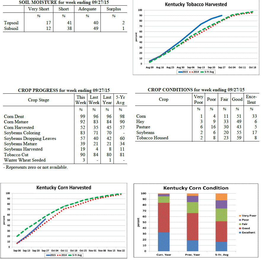 Kentucky Climate Summary
For the Period September 21, 2015 to September 27, 2015
Above Normal Temperatures and Below Normal Rainfall:
The US Drought Monitor upgraded a slight portion of Kentucky to 'Moderate Drought'
this past week, while over half remains 'Abnormally dry'. Depending on location, it
was either another dry period or beneficial rainfall was finally seen. While it was
mostly dry through Thursday, an upper level low pressure system worked into the Lower
Ohio Valley on Friday and into the weekend. Showers became widespread at times
Friday evening, but it was not a statewide event. Much of the activity was located
across mainly the eastern half of the state. This was followed by scattered coverage
on Saturday across the same general area, before diminishing that night. According to
data at the Ag Weather Center, light to moderate showers led to average totals of
0.39 and 0.71 inches in the Bluegrass and Eastern Kentucky, respectively. Western
and central portions of the state missed out on much of the activity and were much
below normal for a second straight week.
Temperatures for the period averaged 68 degrees across the state which was 2 degrees
warmer than normal and 2 degrees warmer than the previous period. High temperatures
averaged from 82 in the West to 76 in the East. Departure from normal high
temperatures ranged from 3 degrees warmer than normal in the West to 1 degree
cooler than normal in the East. Low temperatures averaged from 56 degrees in the
West to 57 degrees in the East. Departure from normal low temperature ranged from 1
degree warmer than normal in the West to 5 degrees warmer than normal in the East.
The extreme high temperature for the period was 92 degrees at BURLINGTON 4S and the
extreme low was 43 degrees at BRANDENBURG 4SW.
Precipitation (liq. equ.) for the period totaled 0.33 inches statewide which was 0.52
inches below normal and 39% of normal. Precipitation totals by climate division, West
0.07 inches, Central 0.17 inches, Bluegrass 0.39 inches and East 0.71 inches, which
was 0.79, 0.77, 0.38 and 0.13 inches below normal. By station, precipitation totals
ranged from a low of 0.00 inches at HICKMAN 2E to a high of 1.27 inches at STANFORD 4NE.
---
Kentucky Crop and Weather Report
Issued 4:00 P.M., September 21, 2015 29-15
Agricultural News: Kentucky experienced below normal temperatures and rainfall over
the past week. Precipitation for the week totaled 0.04 inches, 0.79 inches below
normal. Temperatures averaged 67 degrees for the week, 2 degrees below normal.
Topsoil moisture was rated 11 percent very short, 37 percent short, 49 percent
adequate and 3 percent surplus. Subsoil moisture was rated 9 percent very short, 31
percent short, 58 percent adequate, and 2 percent surplus. Days suitable for
fieldwork averaged 6.7 out of a possible seven.
Primary activities this week included cutting hay, tobacco and harvesting corn for
grain. Soybean harvest is underway in some locations. Early corn and soybean yields
are reported to be very good. Harvest has also begun on some early soybean fields.
Much of the state has experienced below normal rainfall over the past month and late
crops are in need of rain, especially soybeans. Pasture conditions have declined due
to the dry weather and some livestock producers are now feeding hay. Moisture is need
for fall seeding.
Kentucky Climate Summary
For the Period September 21, 2015 to September 27, 2015
Above Normal Temperatures and Below Normal Rainfall:
The US Drought Monitor upgraded a slight portion of Kentucky to 'Moderate Drought'
this past week, while over half remains 'Abnormally dry'. Depending on location, it
was either another dry period or beneficial rainfall was finally seen. While it was
mostly dry through Thursday, an upper level low pressure system worked into the Lower
Ohio Valley on Friday and into the weekend. Showers became widespread at times
Friday evening, but it was not a statewide event. Much of the activity was located
across mainly the eastern half of the state. This was followed by scattered coverage
on Saturday across the same general area, before diminishing that night. According to
data at the Ag Weather Center, light to moderate showers led to average totals of
0.39 and 0.71 inches in the Bluegrass and Eastern Kentucky, respectively. Western
and central portions of the state missed out on much of the activity and were much
below normal for a second straight week.
Temperatures for the period averaged 68 degrees across the state which was 2 degrees
warmer than normal and 2 degrees warmer than the previous period. High temperatures
averaged from 82 in the West to 76 in the East. Departure from normal high
temperatures ranged from 3 degrees warmer than normal in the West to 1 degree
cooler than normal in the East. Low temperatures averaged from 56 degrees in the
West to 57 degrees in the East. Departure from normal low temperature ranged from 1
degree warmer than normal in the West to 5 degrees warmer than normal in the East.
The extreme high temperature for the period was 92 degrees at BURLINGTON 4S and the
extreme low was 43 degrees at BRANDENBURG 4SW.
Precipitation (liq. equ.) for the period totaled 0.33 inches statewide which was 0.52
inches below normal and 39% of normal. Precipitation totals by climate division, West
0.07 inches, Central 0.17 inches, Bluegrass 0.39 inches and East 0.71 inches, which
was 0.79, 0.77, 0.38 and 0.13 inches below normal. By station, precipitation totals
ranged from a low of 0.00 inches at HICKMAN 2E to a high of 1.27 inches at STANFORD 4NE.
---
Kentucky Crop and Weather Report
Issued 4:00 P.M., September 21, 2015 29-15
Agricultural News: Kentucky experienced below normal temperatures and rainfall over
the past week. Precipitation for the week totaled 0.04 inches, 0.79 inches below
normal. Temperatures averaged 67 degrees for the week, 2 degrees below normal.
Topsoil moisture was rated 11 percent very short, 37 percent short, 49 percent
adequate and 3 percent surplus. Subsoil moisture was rated 9 percent very short, 31
percent short, 58 percent adequate, and 2 percent surplus. Days suitable for
fieldwork averaged 6.7 out of a possible seven.
Primary activities this week included cutting hay, tobacco and harvesting corn for
grain. Soybean harvest is underway in some locations. Early corn and soybean yields
are reported to be very good. Harvest has also begun on some early soybean fields.
Much of the state has experienced below normal rainfall over the past month and late
crops are in need of rain, especially soybeans. Pasture conditions have declined due
to the dry weather and some livestock producers are now feeding hay. Moisture is need
for fall seeding.
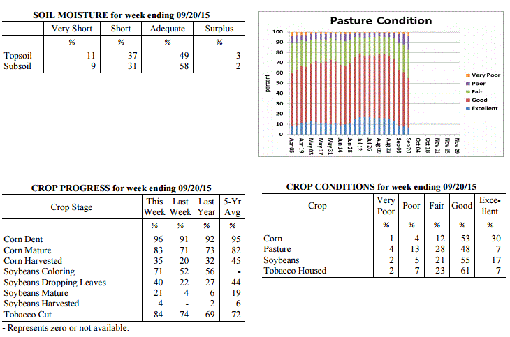 Kentucky Climate Summary
For the Period September 14, 2015 to September 20, 2015
Below Normal Temperatures and Rainfall:
Dry conditions led to excellent harvesting conditions this past week. The Bluegrass
State was under the influence of high pressure at the surface and aloft for much of
the period. This led to mostly clear skies during the day and at night. Throughout
the work week, temperatures saw a slight warming trend as surface high pressure
shifted east. Highs increased from the mid 70s to around 80 on Monday, to solidly in the
80s across the state by Friday. A cold front then worked through the region on
Saturday, leading to isolated to scattered showers. This was the only rainfall event for
the period, leading to another week of below normal rainfall. While this is typically
one of the drier times of the year, Kentucky has now seen much below normal rainfall
three of the past four weeks. As of this past Thursday, around half of the state is
now experiencing 'Abnormally Dry Conditions' according to the latest update
of the US Drought Monitor.
Temperatures for the period averaged 67 degrees across the state which was 2 degrees
cooler than normal and 4 degrees cooler than the previous period. High temperatures
averaged from 82 in the West to 79 in the East. Departure from normal high
temperatures ranged from near normal in the West to 1 degree cooler than normal in
the East. Low temperatures averaged from 55 degrees in the West to 53 degrees in the
East. Departure from normal low temperature ranged from 3 degrees cooler than normal
in the West to 2 degrees cooler than normal in the East. The extreme high temperature
for the period was 92 degrees at PADUCAH ASOS and the extreme low was 41 degrees at
CYNTHIANA 8N.
Precipitation (liq. equ.) for the period totaled 0.04 inches statewide which was 0.79
inches below normal and 5% of normal. Precipitation totals by climate division, West
0.03 inches, Central 0.00 inches, Bluegrass 0.04 inches and East 0.11 inches, which
was 0.82, 0.92, 0.7 and 0.71 inches below normal. By station, precipitation totals
ranged from a low of 0.00 inches at ALBANY 1N to a high of 0.92 inches at WHITESBURG 2NW.
---
Kentucky Crop and Weather Report
Issued 4:00 P.M., September 14, 2015 28-15
Agricultural News: Kentucky experienced near normal temperatures and above normal
rainfall over the past week. Precipitation for the week totaled 0.98 inches, 0.16
inches above normal. Temperatures averaged 71 degrees for the week, near normal.
Topsoil moisture was rated 6 percent very short, 33 percent short, 57 percent
adequate and 4 percent surplus. Subsoil moisture was rated 5 percent very short, 26
percent short, 66 percent adequate, and 3 percent surplus. Days suitable for
fieldwork averaged 5.8 out of a possible seven.
Primary activities this week included cutting hay and tobacco and harvesting corn for
grain in some locations. Scattered showers were beneficial to crops and pastures.
However, some areas did not receive rain and are in need of additional moisture.
Early corn yields are reported to be very good. Harvest has also begun on some
early soybean fields. Pastures and livestock remain in mostly good condition.
Kentucky Climate Summary
For the Period September 14, 2015 to September 20, 2015
Below Normal Temperatures and Rainfall:
Dry conditions led to excellent harvesting conditions this past week. The Bluegrass
State was under the influence of high pressure at the surface and aloft for much of
the period. This led to mostly clear skies during the day and at night. Throughout
the work week, temperatures saw a slight warming trend as surface high pressure
shifted east. Highs increased from the mid 70s to around 80 on Monday, to solidly in the
80s across the state by Friday. A cold front then worked through the region on
Saturday, leading to isolated to scattered showers. This was the only rainfall event for
the period, leading to another week of below normal rainfall. While this is typically
one of the drier times of the year, Kentucky has now seen much below normal rainfall
three of the past four weeks. As of this past Thursday, around half of the state is
now experiencing 'Abnormally Dry Conditions' according to the latest update
of the US Drought Monitor.
Temperatures for the period averaged 67 degrees across the state which was 2 degrees
cooler than normal and 4 degrees cooler than the previous period. High temperatures
averaged from 82 in the West to 79 in the East. Departure from normal high
temperatures ranged from near normal in the West to 1 degree cooler than normal in
the East. Low temperatures averaged from 55 degrees in the West to 53 degrees in the
East. Departure from normal low temperature ranged from 3 degrees cooler than normal
in the West to 2 degrees cooler than normal in the East. The extreme high temperature
for the period was 92 degrees at PADUCAH ASOS and the extreme low was 41 degrees at
CYNTHIANA 8N.
Precipitation (liq. equ.) for the period totaled 0.04 inches statewide which was 0.79
inches below normal and 5% of normal. Precipitation totals by climate division, West
0.03 inches, Central 0.00 inches, Bluegrass 0.04 inches and East 0.11 inches, which
was 0.82, 0.92, 0.7 and 0.71 inches below normal. By station, precipitation totals
ranged from a low of 0.00 inches at ALBANY 1N to a high of 0.92 inches at WHITESBURG 2NW.
---
Kentucky Crop and Weather Report
Issued 4:00 P.M., September 14, 2015 28-15
Agricultural News: Kentucky experienced near normal temperatures and above normal
rainfall over the past week. Precipitation for the week totaled 0.98 inches, 0.16
inches above normal. Temperatures averaged 71 degrees for the week, near normal.
Topsoil moisture was rated 6 percent very short, 33 percent short, 57 percent
adequate and 4 percent surplus. Subsoil moisture was rated 5 percent very short, 26
percent short, 66 percent adequate, and 3 percent surplus. Days suitable for
fieldwork averaged 5.8 out of a possible seven.
Primary activities this week included cutting hay and tobacco and harvesting corn for
grain in some locations. Scattered showers were beneficial to crops and pastures.
However, some areas did not receive rain and are in need of additional moisture.
Early corn yields are reported to be very good. Harvest has also begun on some
early soybean fields. Pastures and livestock remain in mostly good condition.
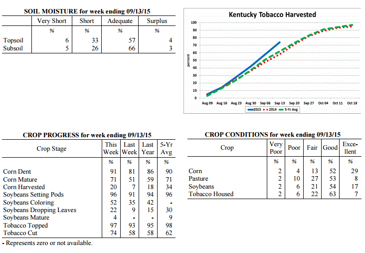 Kentucky Climate Summary
For the Period September 7, 2015 to September 13, 2015
Near Normal Temperatures and Above Normal Rainfall:
The Bluegrass State underwent a major pattern change this past week. The period
started off with above normal temperatures remaining in place. Through Tuesday,
southerly flow sent highs into the upper 80s to middle 90s for much of Kentucky,
continuing a warm and dry pattern for the beginning of September. That pattern broke
on Wednesday as a weak cold front pushed through the region. After a couple weeks of
mostly dry conditions, the Commonwealth saw some relief as scattered to numerous
showers and storms pushed through the Ohio Valley. An unsettled pattern continued
into the first half of the weekend. Overall, the state averaged just under an inch
for the week, which is slightly above normal for this time of the year. The period
ended with much drier and considerably cooler air in place. Clear skies on Saturday
night led to lows ranging from the middle 40s to around 50 for most, which is more
typical of mid to late October.
Temperatures for the period averaged 71 degrees across the state which was near
normal and 6 degrees cooler than the previous period. High temperatures averaged from
81 in the West to 79 in the East. Departure from normal high temperatures ranged
from 4 degrees cooler than normal in the West to 3 degrees cooler than normal in
the East. Low temperatures averaged from 62 degrees in the West to 62 degrees in the
East. Departure from normal low temperature ranged from 1 degree warmer than normal
in the West to 4 degrees warmer than normal in the East. The extreme high temperature
for the period was 94 degrees at LOUISA 1S and the extreme low was 41 degrees at
HENDERSON 5E.
Precipitation (liq. equ.) for the period totaled 0.98 inches statewide which was 0.16
inches above normal and 119% of normal. Precipitation totals by climate division,
West 0.52 inches, Central 0.88 inches, Bluegrass 1.12 inches and East 1.42 inches,
which was -0.30, -0.04, 0.37 and 0.62 inches respectively from normal. By station,
precipitation totals ranged from a low of 0.00 inches at GREENVILLE 6N to a high of
3.88 inches at STANFORD 4NE.
---
Kentucky Crop and Weather Report
Issued 4:00 P.M., September 8, 2015 27-15
Agricultural News: Kentucky experienced above normal temperatures and below normal
rainfall over the past week. Precipitation for the week totaled 0.09 inches, 0.67
inches below normal. Temperatures averaged 77 degrees for the week, 4 degrees above
normal. Topsoil moisture was rated 8 percent very short, 33 percent short, 57 percent
adequate and 2 percent surplus. Subsoil moisture was rated 5 percent very short, 27
percent short, 66 percent adequate, and 2 percent surplus. Days suitable for
fieldwork averaged 6.8 out of a possible seven.
Primary activities this week included cutting hay, topping and cutting tobacco. Corn
for grain harvest has begun in some locations. Corn is drying down fast due to dry
conditions. Most crops are in need of rain, especially soybeans. Soybean conditions
declined with seventy-one percent rated as good to excellent compared to seventy-five
percent last week. Pastures remain in mostly good condition, but are in decline due
to dry weather. Livestock remain in mostly good condition and producers are
optimistic about hay supplies. Producers continue to prepare equipment for the upcoming
harvest.
Kentucky Climate Summary
For the Period September 7, 2015 to September 13, 2015
Near Normal Temperatures and Above Normal Rainfall:
The Bluegrass State underwent a major pattern change this past week. The period
started off with above normal temperatures remaining in place. Through Tuesday,
southerly flow sent highs into the upper 80s to middle 90s for much of Kentucky,
continuing a warm and dry pattern for the beginning of September. That pattern broke
on Wednesday as a weak cold front pushed through the region. After a couple weeks of
mostly dry conditions, the Commonwealth saw some relief as scattered to numerous
showers and storms pushed through the Ohio Valley. An unsettled pattern continued
into the first half of the weekend. Overall, the state averaged just under an inch
for the week, which is slightly above normal for this time of the year. The period
ended with much drier and considerably cooler air in place. Clear skies on Saturday
night led to lows ranging from the middle 40s to around 50 for most, which is more
typical of mid to late October.
Temperatures for the period averaged 71 degrees across the state which was near
normal and 6 degrees cooler than the previous period. High temperatures averaged from
81 in the West to 79 in the East. Departure from normal high temperatures ranged
from 4 degrees cooler than normal in the West to 3 degrees cooler than normal in
the East. Low temperatures averaged from 62 degrees in the West to 62 degrees in the
East. Departure from normal low temperature ranged from 1 degree warmer than normal
in the West to 4 degrees warmer than normal in the East. The extreme high temperature
for the period was 94 degrees at LOUISA 1S and the extreme low was 41 degrees at
HENDERSON 5E.
Precipitation (liq. equ.) for the period totaled 0.98 inches statewide which was 0.16
inches above normal and 119% of normal. Precipitation totals by climate division,
West 0.52 inches, Central 0.88 inches, Bluegrass 1.12 inches and East 1.42 inches,
which was -0.30, -0.04, 0.37 and 0.62 inches respectively from normal. By station,
precipitation totals ranged from a low of 0.00 inches at GREENVILLE 6N to a high of
3.88 inches at STANFORD 4NE.
---
Kentucky Crop and Weather Report
Issued 4:00 P.M., September 8, 2015 27-15
Agricultural News: Kentucky experienced above normal temperatures and below normal
rainfall over the past week. Precipitation for the week totaled 0.09 inches, 0.67
inches below normal. Temperatures averaged 77 degrees for the week, 4 degrees above
normal. Topsoil moisture was rated 8 percent very short, 33 percent short, 57 percent
adequate and 2 percent surplus. Subsoil moisture was rated 5 percent very short, 27
percent short, 66 percent adequate, and 2 percent surplus. Days suitable for
fieldwork averaged 6.8 out of a possible seven.
Primary activities this week included cutting hay, topping and cutting tobacco. Corn
for grain harvest has begun in some locations. Corn is drying down fast due to dry
conditions. Most crops are in need of rain, especially soybeans. Soybean conditions
declined with seventy-one percent rated as good to excellent compared to seventy-five
percent last week. Pastures remain in mostly good condition, but are in decline due
to dry weather. Livestock remain in mostly good condition and producers are
optimistic about hay supplies. Producers continue to prepare equipment for the upcoming
harvest.
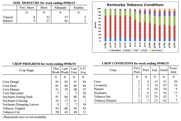 Kentucky Climate Summary
For the Period August 31, 2015 to September 6, 2015
Above Normal Temperatures and Below Normal Rainfall:
Summer made one last stand this past period with hot and humid conditions in place
for much of the week. Highs each day were above normal and increasing throughout the
period. By the holiday weekend, temperatures were consistently peaking in the low to
mid 90s for most. Looking at the week as a whole, the state averaged 90 degrees for
highs. Based on preliminary data at the Ag Weather Center, this threshold has not
been met since early August of 2012. High pressure also kept the area mostly dry
with only isolated to widely scattered coverage about each day. This led to a second
straight week of much below normal rainfall. The US Drought Monitor introduced
'Abnormally Dry Conditions' to a little over 13% of the state this past week.
Temperatures for the period averaged 77 degrees across the state which was 4 degrees
warmer than normal and 8 degrees warmer than the previous period. High temperatures
averaged from 91 in the West to 88 in the East. Departure from normal high
temperatures ranged from 4 degrees warmer than normal in the West to 4 degrees warmer
than normal in the East. Low temperatures averaged from 66 degrees in the West to 65
degrees in the East. Departure from normal low temperature ranged from 3 degrees
warmer than normal in the West to 5 degrees warmer than normal in the East. The
extreme high temperature for the period was 97 degrees at BOWLING GREEN APT and the
extreme low was 58 degrees at LIBERTY 3SW.
Precipitation (liq. equ.) for the period totaled 0.09 inches statewide which was 0.67
inches below normal and 12% of normal. Precipitation totals by climate division, West
0.01 inches, Central 0.07 inches, Bluegrass 0.20 inches and East 0.06 inches, which
was 0.69, 0.76, 0.53 and 0.72 inches below normal. By station, precipitation totals
ranged from a low of 0.00 inches at ALBANY 1N to a high of 1.45 inches at ALEXANDRIA 5NW.
---
Kentucky Crop and Weather Report
Issued 4:00 P.M., August 31, 2015 26-15
Agricultural News: Kentucky experienced below normal temperatures and rainfall over
the past week. Precipitation for the week totaled 0.09 inches, 0.66 inches below
normal. Temperatures averaged 69 degrees for the week, 6 degrees below normal.
Topsoil moisture was rated 3 percent very short, 22 percent short, 70 percent
adequate and 5 percent surplus. Subsoil moisture was rated 2 percent very short, 16
percent short, 77 percent adequate, and 5 percent surplus. Days suitable for
fieldwork averaged 6.6 out of a possible seven.
Primary activities this week included cutting hay, topping and cutting tobacco.
Disease and insect pressure remains a concern for field crops. There were reports of
southern rust and gray leaf spot in corn. Most locations are in need of rain as crops
are showing signs of stress due to lack of moisture. Soybeans are at a critical stage
of development and yields could be hampered if dry conditions continue. Yields are
expected to be light for grapes due to the harsh winter. Pastures remain in mostly
good condition, but are starting to decline due to dry weather. Housed tobacco is
reportedly curing well. Producers continue to prepare equipment for the upcoming
harvest.
Kentucky Climate Summary
For the Period August 31, 2015 to September 6, 2015
Above Normal Temperatures and Below Normal Rainfall:
Summer made one last stand this past period with hot and humid conditions in place
for much of the week. Highs each day were above normal and increasing throughout the
period. By the holiday weekend, temperatures were consistently peaking in the low to
mid 90s for most. Looking at the week as a whole, the state averaged 90 degrees for
highs. Based on preliminary data at the Ag Weather Center, this threshold has not
been met since early August of 2012. High pressure also kept the area mostly dry
with only isolated to widely scattered coverage about each day. This led to a second
straight week of much below normal rainfall. The US Drought Monitor introduced
'Abnormally Dry Conditions' to a little over 13% of the state this past week.
Temperatures for the period averaged 77 degrees across the state which was 4 degrees
warmer than normal and 8 degrees warmer than the previous period. High temperatures
averaged from 91 in the West to 88 in the East. Departure from normal high
temperatures ranged from 4 degrees warmer than normal in the West to 4 degrees warmer
than normal in the East. Low temperatures averaged from 66 degrees in the West to 65
degrees in the East. Departure from normal low temperature ranged from 3 degrees
warmer than normal in the West to 5 degrees warmer than normal in the East. The
extreme high temperature for the period was 97 degrees at BOWLING GREEN APT and the
extreme low was 58 degrees at LIBERTY 3SW.
Precipitation (liq. equ.) for the period totaled 0.09 inches statewide which was 0.67
inches below normal and 12% of normal. Precipitation totals by climate division, West
0.01 inches, Central 0.07 inches, Bluegrass 0.20 inches and East 0.06 inches, which
was 0.69, 0.76, 0.53 and 0.72 inches below normal. By station, precipitation totals
ranged from a low of 0.00 inches at ALBANY 1N to a high of 1.45 inches at ALEXANDRIA 5NW.
---
Kentucky Crop and Weather Report
Issued 4:00 P.M., August 31, 2015 26-15
Agricultural News: Kentucky experienced below normal temperatures and rainfall over
the past week. Precipitation for the week totaled 0.09 inches, 0.66 inches below
normal. Temperatures averaged 69 degrees for the week, 6 degrees below normal.
Topsoil moisture was rated 3 percent very short, 22 percent short, 70 percent
adequate and 5 percent surplus. Subsoil moisture was rated 2 percent very short, 16
percent short, 77 percent adequate, and 5 percent surplus. Days suitable for
fieldwork averaged 6.6 out of a possible seven.
Primary activities this week included cutting hay, topping and cutting tobacco.
Disease and insect pressure remains a concern for field crops. There were reports of
southern rust and gray leaf spot in corn. Most locations are in need of rain as crops
are showing signs of stress due to lack of moisture. Soybeans are at a critical stage
of development and yields could be hampered if dry conditions continue. Yields are
expected to be light for grapes due to the harsh winter. Pastures remain in mostly
good condition, but are starting to decline due to dry weather. Housed tobacco is
reportedly curing well. Producers continue to prepare equipment for the upcoming
harvest.
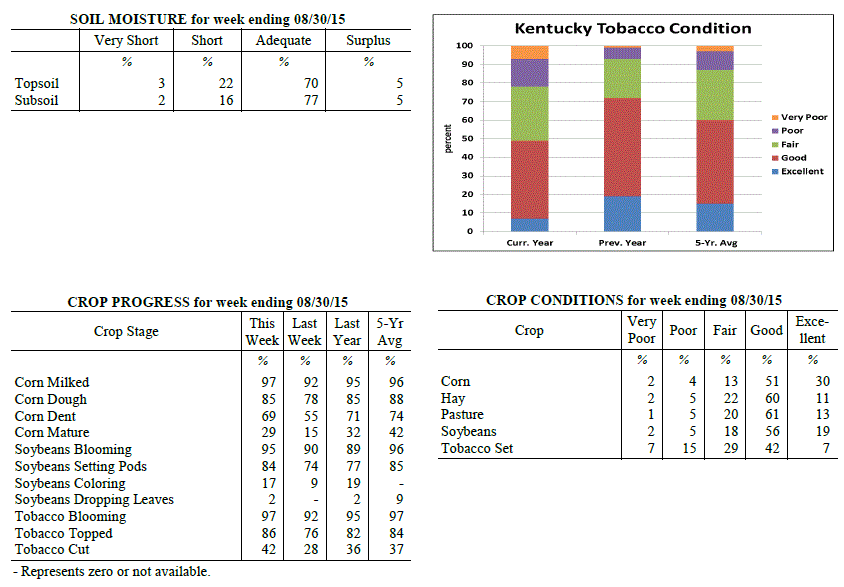 Kentucky Climate Summary
For the Period August 24, 2015 to August 30, 2015
Below Normal Temperatures and Rainfall:
Normally, the month of August brings the Commonwealth warm temperatures and high
humidity. August 2015 has been quite the opposite and that didn�t change over the
last week of the month. Cool conditions pushed the state to a fourth straight week
of below normal temperatures. Behind a strong cold front early on Monday, surface
high pressure built into the region for the remainder of the work week. Up until
Thursday, afternoon highs were only rising into the mid 70s to low 80s, before
dropping into the low to mid 50s at night. In fact, some locations even saw the
upper 40s. High pressure kept the area dry with any clouds developing in the
afternoon quickly clearing after sunset. In addition, low dewpoints made it feel
more like fall. The high shifted east by Friday and into the weekend, leading to
both moisture and temperatures on the increase. Within a moderately unstable
atmosphere, scattered showers and storms developed each day over the weekend. While
that was the case, rainfall was still much below normal for the week with many
stations not even recording a trace.
Temperatures for the period averaged 69 degrees across the state which was 6 degrees
cooler than normal and 4 degrees cooler than the previous period. High temperatures
averaged from 82 in the West to 80 in the East. Departure from normal high
temperatures ranged from 6 degrees cooler than normal in the West to 5 degrees
cooler than normal in the East. Low temperatures averaged from 58 degrees in the
West to 59 degrees in the East. Departure from normal low temperature ranged from 7
degrees cooler than normal in the West to 2 degrees cooler than normal in the East.
The extreme high temperature for the period was 91 degrees at ELKTON 5SW and the
extreme low was 48 degrees at BRANDENBURG 4SW.
Precipitation (liq. equ.) for the period totaled 0.09 inches statewide which was 0.66
inches below normal and 12% of normal. Precipitation totals by climate division, West
0.18 inches, Central 0.04 inches, Bluegrass 0.11 inches and East 0.03 inches, which
was 0.5, 0.74, 0.64 and 0.77 inches below normal. By station, precipitation totals
ranged from a low of 0.00 inches at ALBANY 1N to a high of 2.05 inches at CADIZ 4SW.
---
Kentucky Crop and Weather Report
Issued 4:00 P.M., August 24, 2015 25-15
Agricultural News: Kentucky experienced below normal temperatures and above normal
rainfall over the past week. Precipitation for the week totaled 1.02 inches, 0.17
inches above normal. Temperatures averaged 73 degrees for the week, 2 degrees below
normal. Topsoil moisture was rated 1 percent very short, 11 percent short, 78 percent
adequate and 10 percent surplus. Subsoil moisture was rated 1 percent very short, 9
percent short, 82 percent adequate, and 8 percent surplus. Days suitable for
fieldwork averaged 5.5 out of a possible seven.
Primary activities this week included cutting hay, topping and cutting tobacco.
Disease and insect pressure continues for field crops. Some locations are in need of
rain as crops are showing signs of lack of moisture. Early planted corn is beginning
to dry down in some areas. There is some concern over the possibility of weak corn
stalks this fall due to growing conditions this year. Pasture conditions remain in
mostly good to excellent condition. Producers are getting equipment ready for the
upcoming harvest.
Kentucky Climate Summary
For the Period August 24, 2015 to August 30, 2015
Below Normal Temperatures and Rainfall:
Normally, the month of August brings the Commonwealth warm temperatures and high
humidity. August 2015 has been quite the opposite and that didn�t change over the
last week of the month. Cool conditions pushed the state to a fourth straight week
of below normal temperatures. Behind a strong cold front early on Monday, surface
high pressure built into the region for the remainder of the work week. Up until
Thursday, afternoon highs were only rising into the mid 70s to low 80s, before
dropping into the low to mid 50s at night. In fact, some locations even saw the
upper 40s. High pressure kept the area dry with any clouds developing in the
afternoon quickly clearing after sunset. In addition, low dewpoints made it feel
more like fall. The high shifted east by Friday and into the weekend, leading to
both moisture and temperatures on the increase. Within a moderately unstable
atmosphere, scattered showers and storms developed each day over the weekend. While
that was the case, rainfall was still much below normal for the week with many
stations not even recording a trace.
Temperatures for the period averaged 69 degrees across the state which was 6 degrees
cooler than normal and 4 degrees cooler than the previous period. High temperatures
averaged from 82 in the West to 80 in the East. Departure from normal high
temperatures ranged from 6 degrees cooler than normal in the West to 5 degrees
cooler than normal in the East. Low temperatures averaged from 58 degrees in the
West to 59 degrees in the East. Departure from normal low temperature ranged from 7
degrees cooler than normal in the West to 2 degrees cooler than normal in the East.
The extreme high temperature for the period was 91 degrees at ELKTON 5SW and the
extreme low was 48 degrees at BRANDENBURG 4SW.
Precipitation (liq. equ.) for the period totaled 0.09 inches statewide which was 0.66
inches below normal and 12% of normal. Precipitation totals by climate division, West
0.18 inches, Central 0.04 inches, Bluegrass 0.11 inches and East 0.03 inches, which
was 0.5, 0.74, 0.64 and 0.77 inches below normal. By station, precipitation totals
ranged from a low of 0.00 inches at ALBANY 1N to a high of 2.05 inches at CADIZ 4SW.
---
Kentucky Crop and Weather Report
Issued 4:00 P.M., August 24, 2015 25-15
Agricultural News: Kentucky experienced below normal temperatures and above normal
rainfall over the past week. Precipitation for the week totaled 1.02 inches, 0.17
inches above normal. Temperatures averaged 73 degrees for the week, 2 degrees below
normal. Topsoil moisture was rated 1 percent very short, 11 percent short, 78 percent
adequate and 10 percent surplus. Subsoil moisture was rated 1 percent very short, 9
percent short, 82 percent adequate, and 8 percent surplus. Days suitable for
fieldwork averaged 5.5 out of a possible seven.
Primary activities this week included cutting hay, topping and cutting tobacco.
Disease and insect pressure continues for field crops. Some locations are in need of
rain as crops are showing signs of lack of moisture. Early planted corn is beginning
to dry down in some areas. There is some concern over the possibility of weak corn
stalks this fall due to growing conditions this year. Pasture conditions remain in
mostly good to excellent condition. Producers are getting equipment ready for the
upcoming harvest.
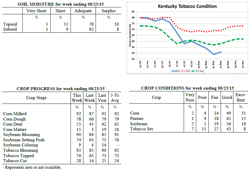 Kentucky Climate Summary
For the Period August 17, 2015 to August 23, 2015
Below Normal Temperatures and Above Normal Rainfall:
Behind a rather active first half of the work week, much of the Bluegrass State saw
near to above normal rainfall this past period. Most of the activity was seen on
Wednesday, ahead of a cold front passing through the Ohio Valley. Multiple rounds
were seen throughout the day with rainfall coverage increasing to widespread at
times. Precipitation came to an end on Thursday with surface high pressure working
into Kentucky. A noticeable change came to end the work week with unseasonably low
humidity in place and temperatures only rising into the 70s. Dry conditions held on
through Saturday, before the Bluegrass and Eastern Kentucky saw isolated to scattered
coverage on Sunday.
Temperatures for the period averaged 73 degrees across the state which was 2 degrees
cooler than normal and no change to the previous period. High temperatures averaged
from 82 in the West to 82 in the East. Departure from normal high temperatures
ranged from 6 degrees cooler than normal in the West to 4 degrees cooler than normal
in the East. Low temperatures averaged from 64 degrees in the West to 65 degrees in
the East. Departure from normal low temperature ranged from 1 degree cooler than
normal in the West to 3 degrees warmer than normal in the East. The extreme high
temperature for the period was 91 degrees at BOWLING GREEN 4E and the extreme low was
52 degrees at CYNTHIANA 8N.
Precipitation (liq. equ.) for the period totaled 1.02 inches statewide which was 0.17
inches above normal and 120% of normal. Precipitation totals by climate division,
West 1.19 inches, Central 0.80 inches, Bluegrass 0.85 inches and East 1.25 inches,
which was 0.42, -0.06, -0.01 and 0.33 inches respectively from normal. By station,
precipitation totals ranged from a low of 0.01 inches at PEABODY to a high of 2.56
inches at SHEPHERDSVILLE 6SE.
---
Kentucky Crop and Weather Report
Issued 4:00 P.M., August 17, 2015 24-15
Agricultural News: Kentucky experienced below normal temperatures and rainfall over
the past week. Precipitation for the week totaled 0.43 inches, 0.44 inches below
normal. Temperatures averaged 74 degrees for the week, 2 degrees below normal.
Topsoil moisture was rated 1 percent very short, 10 percent short, 78 percent
adequate and 11 percent surplus. Subsoil moisture was rated 0 percent very short, 7
percent short, 83 percent adequate, and 10 percent surplus. Days suitable for
fieldwork averaged 6.1 out of a possible seven.
Primary activities this week included cutting hay, topping and cutting tobacco and
spraying late soybeans for disease and insect control. Some previously flooded fields
were finally dry enough to allow for soybean replanting to occur. Crops are
experiencing disease and insect pressure, especially in fields that were unable to be
treated due to wet conditions. While some tobacco fields are recovering from the wet
conditions earlier in the season, overall conditions still reflect signs of stress.
Forty-nine percent of tobacco is rated as good to excellent compared to fifty-four
percent last week and sixty-nine percent last year. Pasture conditions are holding up
well due to the moisture that has been received this year, but growth is beginning to
slow due to recent drier weather. Livestock are reportedly in good shape and have
benefitted from good pasture conditions.
Kentucky Climate Summary
For the Period August 17, 2015 to August 23, 2015
Below Normal Temperatures and Above Normal Rainfall:
Behind a rather active first half of the work week, much of the Bluegrass State saw
near to above normal rainfall this past period. Most of the activity was seen on
Wednesday, ahead of a cold front passing through the Ohio Valley. Multiple rounds
were seen throughout the day with rainfall coverage increasing to widespread at
times. Precipitation came to an end on Thursday with surface high pressure working
into Kentucky. A noticeable change came to end the work week with unseasonably low
humidity in place and temperatures only rising into the 70s. Dry conditions held on
through Saturday, before the Bluegrass and Eastern Kentucky saw isolated to scattered
coverage on Sunday.
Temperatures for the period averaged 73 degrees across the state which was 2 degrees
cooler than normal and no change to the previous period. High temperatures averaged
from 82 in the West to 82 in the East. Departure from normal high temperatures
ranged from 6 degrees cooler than normal in the West to 4 degrees cooler than normal
in the East. Low temperatures averaged from 64 degrees in the West to 65 degrees in
the East. Departure from normal low temperature ranged from 1 degree cooler than
normal in the West to 3 degrees warmer than normal in the East. The extreme high
temperature for the period was 91 degrees at BOWLING GREEN 4E and the extreme low was
52 degrees at CYNTHIANA 8N.
Precipitation (liq. equ.) for the period totaled 1.02 inches statewide which was 0.17
inches above normal and 120% of normal. Precipitation totals by climate division,
West 1.19 inches, Central 0.80 inches, Bluegrass 0.85 inches and East 1.25 inches,
which was 0.42, -0.06, -0.01 and 0.33 inches respectively from normal. By station,
precipitation totals ranged from a low of 0.01 inches at PEABODY to a high of 2.56
inches at SHEPHERDSVILLE 6SE.
---
Kentucky Crop and Weather Report
Issued 4:00 P.M., August 17, 2015 24-15
Agricultural News: Kentucky experienced below normal temperatures and rainfall over
the past week. Precipitation for the week totaled 0.43 inches, 0.44 inches below
normal. Temperatures averaged 74 degrees for the week, 2 degrees below normal.
Topsoil moisture was rated 1 percent very short, 10 percent short, 78 percent
adequate and 11 percent surplus. Subsoil moisture was rated 0 percent very short, 7
percent short, 83 percent adequate, and 10 percent surplus. Days suitable for
fieldwork averaged 6.1 out of a possible seven.
Primary activities this week included cutting hay, topping and cutting tobacco and
spraying late soybeans for disease and insect control. Some previously flooded fields
were finally dry enough to allow for soybean replanting to occur. Crops are
experiencing disease and insect pressure, especially in fields that were unable to be
treated due to wet conditions. While some tobacco fields are recovering from the wet
conditions earlier in the season, overall conditions still reflect signs of stress.
Forty-nine percent of tobacco is rated as good to excellent compared to fifty-four
percent last week and sixty-nine percent last year. Pasture conditions are holding up
well due to the moisture that has been received this year, but growth is beginning to
slow due to recent drier weather. Livestock are reportedly in good shape and have
benefitted from good pasture conditions.
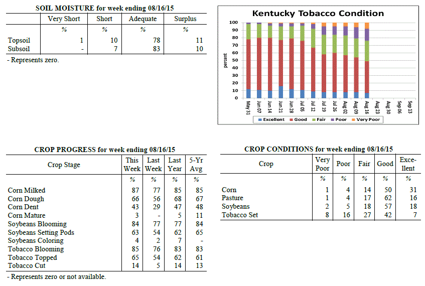 Kentucky Climate Summary
For the Period August 10, 2015 to August 16, 2015
Below Normal Temperatures and Rainfall:
This past period was mostly dry for much of the Bluegrass State. After a round of
scattered showers and storms ahead of a cold front on Monday, high pressure of
Canadian origin filtered into the Lower Ohio Valley by mid-week. This feature
brought unseasonably cool temperatures and low humidity to the area with highs on
Wednesday and Thursday only rising into the upper 70s to mid 80s. These readings would
be more typical of mid-September and led the state to a second straight week of
slightly below normal temperatures. Showers and storms returned over the weekend,
but remained isolated to widely scattered in coverage. Overall, the state was nearly
a half inch below normal for the period.
Temperatures for the period averaged 74 degrees across the state which was 2 degrees
cooler than normal and no change to the previous period. High temperatures averaged
from 85 in the West to 84 in the East. Departure from normal high temperatures
ranged from 3 degrees cooler than normal in the West to 2 degrees cooler than normal
in the East. Low temperatures averaged from 65 degrees in the West to 64 degrees in
the East. Departure from normal low temperature ranged from 1 degree cooler than
normal in the West to 1 degree warmer than normal in the East. The extreme high
temperature for the period was 92 degrees at LOUISVILLE APT and the extreme low was
54 degrees at MCKEE 5S.
Precipitation (liq. equ.) for the period totaled 0.43 inches statewide which was 0.44
inches below normal and 50% of normal. Precipitation totals by climate division, West
0.45 inches, Central 0.51 inches, Bluegrass 0.34 inches and East 0.44 inches, which
was 0.35, 0.34, 0.53 and 0.51 inches below normal. By station, precipitation totals
ranged from a low of 0.00 inches at ELKTON 5SW to a high of 2.03 inches at
BOWLING GREEN 5S.
---
Kentucky Crop and Weather Report
Issued 4:00 P.M., August 10, 2015 23-15
Agricultural News: Kentucky experienced below normal temperatures and above normal
rainfall over the past week. Precipitation for the week totaled 1.21 inches, 0.27
inches above normal. Temperatures averaged 75 degrees for the week, 1 degrees below
normal. Topsoil moisture was rated 0 percent very short, 5 percent short, 76 percent
adequate and 19 percent surplus. Subsoil moisture was rated 0 percent very short, 4
percent short, 80 percent adequate, and 16 percent surplus. Days suitable for
fieldwork averaged 4.6 out of a possible seven.
Primary activities this week included cutting hay, topping tobacco and spraying late
soybeans for disease and insect control. Tobacco harvest is underway across the
state. Excess rainfall has reportedly drowned out some tobacco acreage in low lying
areas. Diseases such as target spot and black shank have also taken a toll on some
producers as well. Many fields of double crop soybeans are behind normal progress,
but single crop beans appear to be at or ahead of normal. Timing of when crops were
planted will have an impact on yields as earlier planted crops were impacted less by
the abundance of rainfall in late June and July.
Kentucky Climate Summary
For the Period August 10, 2015 to August 16, 2015
Below Normal Temperatures and Rainfall:
This past period was mostly dry for much of the Bluegrass State. After a round of
scattered showers and storms ahead of a cold front on Monday, high pressure of
Canadian origin filtered into the Lower Ohio Valley by mid-week. This feature
brought unseasonably cool temperatures and low humidity to the area with highs on
Wednesday and Thursday only rising into the upper 70s to mid 80s. These readings would
be more typical of mid-September and led the state to a second straight week of
slightly below normal temperatures. Showers and storms returned over the weekend,
but remained isolated to widely scattered in coverage. Overall, the state was nearly
a half inch below normal for the period.
Temperatures for the period averaged 74 degrees across the state which was 2 degrees
cooler than normal and no change to the previous period. High temperatures averaged
from 85 in the West to 84 in the East. Departure from normal high temperatures
ranged from 3 degrees cooler than normal in the West to 2 degrees cooler than normal
in the East. Low temperatures averaged from 65 degrees in the West to 64 degrees in
the East. Departure from normal low temperature ranged from 1 degree cooler than
normal in the West to 1 degree warmer than normal in the East. The extreme high
temperature for the period was 92 degrees at LOUISVILLE APT and the extreme low was
54 degrees at MCKEE 5S.
Precipitation (liq. equ.) for the period totaled 0.43 inches statewide which was 0.44
inches below normal and 50% of normal. Precipitation totals by climate division, West
0.45 inches, Central 0.51 inches, Bluegrass 0.34 inches and East 0.44 inches, which
was 0.35, 0.34, 0.53 and 0.51 inches below normal. By station, precipitation totals
ranged from a low of 0.00 inches at ELKTON 5SW to a high of 2.03 inches at
BOWLING GREEN 5S.
---
Kentucky Crop and Weather Report
Issued 4:00 P.M., August 10, 2015 23-15
Agricultural News: Kentucky experienced below normal temperatures and above normal
rainfall over the past week. Precipitation for the week totaled 1.21 inches, 0.27
inches above normal. Temperatures averaged 75 degrees for the week, 1 degrees below
normal. Topsoil moisture was rated 0 percent very short, 5 percent short, 76 percent
adequate and 19 percent surplus. Subsoil moisture was rated 0 percent very short, 4
percent short, 80 percent adequate, and 16 percent surplus. Days suitable for
fieldwork averaged 4.6 out of a possible seven.
Primary activities this week included cutting hay, topping tobacco and spraying late
soybeans for disease and insect control. Tobacco harvest is underway across the
state. Excess rainfall has reportedly drowned out some tobacco acreage in low lying
areas. Diseases such as target spot and black shank have also taken a toll on some
producers as well. Many fields of double crop soybeans are behind normal progress,
but single crop beans appear to be at or ahead of normal. Timing of when crops were
planted will have an impact on yields as earlier planted crops were impacted less by
the abundance of rainfall in late June and July.
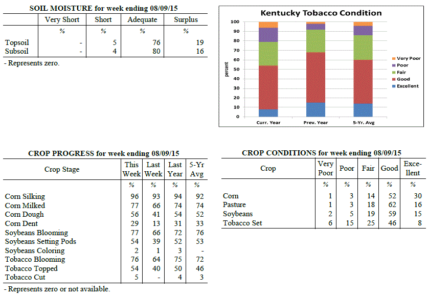 Kentucky Climate Summary
For the Period August 3, 2015 to August 9, 2015
Below Normal Temperatures and Above Normal Rainfall:
Record July rainfall for the state of Kentucky was followed by an active start to the
month of August. The Bluegrass State saw numerous rounds of rainfall through the work
week with the most notable coming over the second half. Low pressure slowly made way
across the Lower Ohio Valley, leading to repeated waves of precipitation and the
threat of more flash flooding. This activity lasted through Thursday night, before
dry conditions won out for the weekend. After starting the period with above normal
temperatures in place, cloud cover and rainfall brought cooler conditions back to the
area. Highs Thursday and Friday only averaged in the mid 70s to low 80s, much below
normal for this time of the year. Looking back at July, Kentucky averaged 8.99 inches
for the month, which ranks first on the 121 year record going back until 1895.
Temperatures for the period averaged 75 degrees across the state which was 1 degree
cooler than normal and 2 degrees cooler than the previous period. High temperatures
averaged from 84 in the West to 84 in the East. Departure from normal high
temperatures ranged from 4 degrees cooler than normal in the West to 2 degrees
cooler than normal in the East. Low temperatures averaged from 68 degrees in the
West to 65 degrees in the East. Departure from normal low temperature ranged from 2
degrees warmer than normal in the West to 2 degrees warmer than normal in the East.
The extreme high temperature for the period was 96 degrees at BOWLING GREEN 4E and
the extreme low was 57 degrees at PAINTSVILLE 4W.
Precipitation (liq. equ.) for the period totaled 1.21 inches statewide which was 0.27
inches above normal and 129% of normal. Precipitation totals by climate division,
West 1.19 inches, Central 0.94 inches, Bluegrass 1.36 inches and East 1.36 inches,
which was 0.29, 0.03, 0.45 and 0.34 inches above normal. By station, precipitation
totals ranged from a low of 0.02 inches at PEABODY to a high of 4.31 inches at
OWINGSVILLE 4S.
---
Kentucky Crop and Weather Report
Issued 4:00 P.M., August 3, 2015 22-15
Agricultural News: Kentucky experienced above normal temperatures and below normal
rainfall over the past week. Precipitation for the week totaled 0.77 inches, 0.20
inches below normal. Temperatures averaged 78 degrees for the week, 2 degrees above
normal. Topsoil moisture was rated 0 percent very short, 5 percent short, 71 percent
adequate and 24 percent surplus. Subsoil moisture was rated 0 percent very short, 3
percent short, 78 percent adequate, and 19 percent surplus. Days suitable for
fieldwork averaged 5.4 out of a possible seven.
Primary activities this week included cutting hay, topping tobacco and spraying
herbicides on late soybeans. Rivers have receded with crop losses varied in low lying
areas. Some bottom land acreage experienced total losses due to standing water. Some
farmers still plan on replanting double crop soybeans if weather remains dry. There
were reports of disease pressure due to wet weather and humid temperatures. Excessive
moisture has reportedly impacted some of the tobacco crop. The affected acreage may
recover if weather improves, but there is concern that yields and quality could be
impacted. Hay supplies should be adequate this year for most farmers, but quality
could be lacking due to the impact rains had on the timing of cutting hay as well as
getting wet before it could be baled. Some producers were unable to finish first
cutting until late July, therefore will not get a second cutting this year. Hay and
roughage supplies were reported as 2 percent very short, 16 percent short, 73 percent
adequate, and 9 percent surplus.
Kentucky Climate Summary
For the Period August 3, 2015 to August 9, 2015
Below Normal Temperatures and Above Normal Rainfall:
Record July rainfall for the state of Kentucky was followed by an active start to the
month of August. The Bluegrass State saw numerous rounds of rainfall through the work
week with the most notable coming over the second half. Low pressure slowly made way
across the Lower Ohio Valley, leading to repeated waves of precipitation and the
threat of more flash flooding. This activity lasted through Thursday night, before
dry conditions won out for the weekend. After starting the period with above normal
temperatures in place, cloud cover and rainfall brought cooler conditions back to the
area. Highs Thursday and Friday only averaged in the mid 70s to low 80s, much below
normal for this time of the year. Looking back at July, Kentucky averaged 8.99 inches
for the month, which ranks first on the 121 year record going back until 1895.
Temperatures for the period averaged 75 degrees across the state which was 1 degree
cooler than normal and 2 degrees cooler than the previous period. High temperatures
averaged from 84 in the West to 84 in the East. Departure from normal high
temperatures ranged from 4 degrees cooler than normal in the West to 2 degrees
cooler than normal in the East. Low temperatures averaged from 68 degrees in the
West to 65 degrees in the East. Departure from normal low temperature ranged from 2
degrees warmer than normal in the West to 2 degrees warmer than normal in the East.
The extreme high temperature for the period was 96 degrees at BOWLING GREEN 4E and
the extreme low was 57 degrees at PAINTSVILLE 4W.
Precipitation (liq. equ.) for the period totaled 1.21 inches statewide which was 0.27
inches above normal and 129% of normal. Precipitation totals by climate division,
West 1.19 inches, Central 0.94 inches, Bluegrass 1.36 inches and East 1.36 inches,
which was 0.29, 0.03, 0.45 and 0.34 inches above normal. By station, precipitation
totals ranged from a low of 0.02 inches at PEABODY to a high of 4.31 inches at
OWINGSVILLE 4S.
---
Kentucky Crop and Weather Report
Issued 4:00 P.M., August 3, 2015 22-15
Agricultural News: Kentucky experienced above normal temperatures and below normal
rainfall over the past week. Precipitation for the week totaled 0.77 inches, 0.20
inches below normal. Temperatures averaged 78 degrees for the week, 2 degrees above
normal. Topsoil moisture was rated 0 percent very short, 5 percent short, 71 percent
adequate and 24 percent surplus. Subsoil moisture was rated 0 percent very short, 3
percent short, 78 percent adequate, and 19 percent surplus. Days suitable for
fieldwork averaged 5.4 out of a possible seven.
Primary activities this week included cutting hay, topping tobacco and spraying
herbicides on late soybeans. Rivers have receded with crop losses varied in low lying
areas. Some bottom land acreage experienced total losses due to standing water. Some
farmers still plan on replanting double crop soybeans if weather remains dry. There
were reports of disease pressure due to wet weather and humid temperatures. Excessive
moisture has reportedly impacted some of the tobacco crop. The affected acreage may
recover if weather improves, but there is concern that yields and quality could be
impacted. Hay supplies should be adequate this year for most farmers, but quality
could be lacking due to the impact rains had on the timing of cutting hay as well as
getting wet before it could be baled. Some producers were unable to finish first
cutting until late July, therefore will not get a second cutting this year. Hay and
roughage supplies were reported as 2 percent very short, 16 percent short, 73 percent
adequate, and 9 percent surplus.
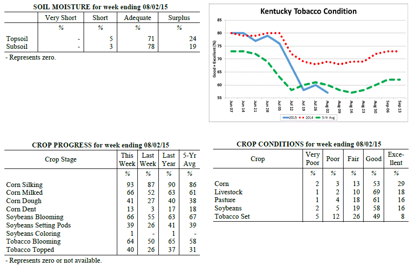 Kentucky Climate Summary
For the Period July 27, 2015 to August 2, 2015
Above Normal Temperatures and Below Normal Rainfall:
In typical Ohio Valley fashion, Kentucky saw an abrupt change to the weather pattern
halfway through this past period. The first half of the work week brought hot and
humid conditions, in addition to multiple opportunities for rainfall. Disturbances
passed through the state along the periphery of an upper level ridge of high
pressure. Storms were capable of torrential rainfall at times as Kentucky was
situated within a very moist air mass. The Bluegrass Region and Western Kentucky saw
the brunt of the rainfall and actually saw above normal rainfall for the week.
Eastern Kentucky missed out on much of the activity and was about three quarters of
inch below normal. During this time, highs were peaking in the upper 80s to mid 90s
with very muggy conditions in place. Luckily, a cold front passing through the area
on Wednesday brought a much different air mass to the region for the second half of
the week. Dewpoints dropped to much more comfortable levels, along with temperatures
returning to near seasonable norms for the start of August. In addition, surface
high pressure kept the area dry.
Temperatures for the period averaged 78 degrees across the state which was 2 degrees
warmer than normal and 2 degrees warmer than the previous period. High temperatures
averaged from 90 in the West to 87 in the East. Departure from normal high
temperatures ranged from 1 degree warmer than normal in the West to near normal in
the East. Low temperatures averaged from 69 degrees in the West to 66 degrees in the
East. Departure from normal low temperature ranged from 2 degrees warmer than normal
in the West to 2 degrees warmer than normal in the East. The extreme high temperature
for the period was 97 degrees at POPLAR BLUFF ASOS and the extreme low was 55 degrees
at MONTICELLO AWOS.
Precipitation (liq. equ.) for the period totaled 0.77 inches statewide which was 0.2
inches below normal and 79% of normal. Precipitation totals by climate division, West
1.03 inches, Central 0.60 inches, Bluegrass 1.19 inches and East 0.27 inches, which
was 0.10, -0.36, 0.23 and -0.76 inches respectively from normal. By station,
precipitation totals ranged from a low of 0.00 inches at HARTFORD 3E to a high of
3.30 inches at CADIZ 4SW.
---
Kentucky Crop and Weather Report
Issued 4:00 P.M., July 27, 2015 21-15
Agricultural News: Kentucky finally experienced a break from heavy rainfalls over the
past week. Precipitation for the week totaled 0.71 inches, 0.25 inches below normal.
Temperatures averaged 77 degrees for the week, unchanged from normal. Topsoil
moisture was rated 3 percent short, 65 percent adequate and 32 percent surplus.
Subsoil moisture was rated 3 percent short, 74 percent adequate, and 23 percent
surplus. Days suitable for fieldwork averaged 4.7 out of a possible seven.
Primary activities this week included cutting hay and topping tobacco where
conditions allowed. In most areas of Kentucky farmers were finally able to get back
in the field. Crops in areas near the Ohio River continue to remain under water,
however. Soybean and tobacco crops have been completely destroyed in a few areas.
Some farmers plan on replanting double cropped soybeans up into the beginning of
August. Tobacco condition increased slightly with sixty percent rated as good to
excellent compared to fifty-eight percent last week. However, target spot and black
shank are moving into some tobacco fields. Hay conditions have decreased since last
month with sixty- four percent rated as good to excellent compared to seventy-two
percent at the end of June. Pasture conditions remain in mostly good to excellent
condition.
Kentucky Climate Summary
For the Period July 27, 2015 to August 2, 2015
Above Normal Temperatures and Below Normal Rainfall:
In typical Ohio Valley fashion, Kentucky saw an abrupt change to the weather pattern
halfway through this past period. The first half of the work week brought hot and
humid conditions, in addition to multiple opportunities for rainfall. Disturbances
passed through the state along the periphery of an upper level ridge of high
pressure. Storms were capable of torrential rainfall at times as Kentucky was
situated within a very moist air mass. The Bluegrass Region and Western Kentucky saw
the brunt of the rainfall and actually saw above normal rainfall for the week.
Eastern Kentucky missed out on much of the activity and was about three quarters of
inch below normal. During this time, highs were peaking in the upper 80s to mid 90s
with very muggy conditions in place. Luckily, a cold front passing through the area
on Wednesday brought a much different air mass to the region for the second half of
the week. Dewpoints dropped to much more comfortable levels, along with temperatures
returning to near seasonable norms for the start of August. In addition, surface
high pressure kept the area dry.
Temperatures for the period averaged 78 degrees across the state which was 2 degrees
warmer than normal and 2 degrees warmer than the previous period. High temperatures
averaged from 90 in the West to 87 in the East. Departure from normal high
temperatures ranged from 1 degree warmer than normal in the West to near normal in
the East. Low temperatures averaged from 69 degrees in the West to 66 degrees in the
East. Departure from normal low temperature ranged from 2 degrees warmer than normal
in the West to 2 degrees warmer than normal in the East. The extreme high temperature
for the period was 97 degrees at POPLAR BLUFF ASOS and the extreme low was 55 degrees
at MONTICELLO AWOS.
Precipitation (liq. equ.) for the period totaled 0.77 inches statewide which was 0.2
inches below normal and 79% of normal. Precipitation totals by climate division, West
1.03 inches, Central 0.60 inches, Bluegrass 1.19 inches and East 0.27 inches, which
was 0.10, -0.36, 0.23 and -0.76 inches respectively from normal. By station,
precipitation totals ranged from a low of 0.00 inches at HARTFORD 3E to a high of
3.30 inches at CADIZ 4SW.
---
Kentucky Crop and Weather Report
Issued 4:00 P.M., July 27, 2015 21-15
Agricultural News: Kentucky finally experienced a break from heavy rainfalls over the
past week. Precipitation for the week totaled 0.71 inches, 0.25 inches below normal.
Temperatures averaged 77 degrees for the week, unchanged from normal. Topsoil
moisture was rated 3 percent short, 65 percent adequate and 32 percent surplus.
Subsoil moisture was rated 3 percent short, 74 percent adequate, and 23 percent
surplus. Days suitable for fieldwork averaged 4.7 out of a possible seven.
Primary activities this week included cutting hay and topping tobacco where
conditions allowed. In most areas of Kentucky farmers were finally able to get back
in the field. Crops in areas near the Ohio River continue to remain under water,
however. Soybean and tobacco crops have been completely destroyed in a few areas.
Some farmers plan on replanting double cropped soybeans up into the beginning of
August. Tobacco condition increased slightly with sixty percent rated as good to
excellent compared to fifty-eight percent last week. However, target spot and black
shank are moving into some tobacco fields. Hay conditions have decreased since last
month with sixty- four percent rated as good to excellent compared to seventy-two
percent at the end of June. Pasture conditions remain in mostly good to excellent
condition.
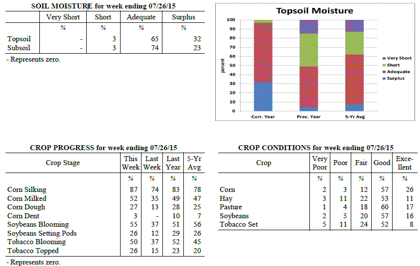 Kentucky Climate Summary
For the Period July 20, 2015 to July 26, 2015
Near Normal Temperatures and Below Normal Rainfall:
The Commonwealth saw another couple rounds of rainfall this past week, but overall,
much of the state finally got a break from weeks of much above normal precipitation.
The state average for the period was 0.71 inches, which was a quarter inch below
normal for the week. This broke a five week span of above normal precipitation that
extended back into mid-June. Looking at temperatures, it was an up and down pattern
through the week. After starting the period on the hot and humid side, a cold front
brought a much welcomed break. High temperatures dipped slightly below seasonable
norms by Wednesday, but the break was short lived. High pressure at the surface and
aloft pushed into the region for the weekend, bumping temperatures back into the
middle 80s to low 90s for most. During this time, evapotranspiration estimates
across the state were around 0.2 inches of water loss each day. The end of July is
normally the warmest time of the year for Kentucky with highs averaging in the middle
80s to around 90.
Temperatures for the period averaged 77 degrees across the state which was near
normal and 2 degrees cooler than the previous period. High temperatures averaged from
86 in the West to 85 in the East. Departure from normal high temperatures ranged from
3 degrees cooler than normal in the West to 2 degrees cooler than normal in the East.
Low temperatures averaged from 71 degrees in the West to 67 degrees in the East.
Departure from normal low temperature ranged from 4 degrees warmer than normal in the
West to 3 degrees warmer than normal in the East. The extreme high temperature for
the period was 93 degrees at POPLAR BLUFF ASOS and the extreme low was 57 degrees at
MOREHEAD 4NE.
Precipitation (liq. equ.) for the period totaled 0.71 inches statewide which was 0.25
inches below normal and 74% of normal. Precipitation totals by climate division, West
1.55 inches, Central 0.35 inches, Bluegrass 0.37 inches and East 0.56 inches, which
was 0.65, -0.62, -0.58 and -0.44 inches respectively from normal. By station,
precipitation totals ranged from a low of 0.00 inches at CARROLLTON 2E to a high of
4.81 inches at MURRAY 1W.
---
Kentucky Crop and Weather Report
Issued 4:00 P.M., July 20, 2015 20-15
Agricultural News: Kentucky experienced above normal temperatures and rainfall over
the past week. Precipitation for the week totaled 1.78 inches, 0.78 inches above
normal. Temperatures averaged 79 degrees for the week, 2 degrees above normal.
Topsoil moisture was rated 4 percent short, 55 percent adequate and 41 percent
surplus. Subsoil moisture was rated 3 percent short, 67 percent adequate, and 30
percent surplus. Days suitable for fieldwork averaged 3.9 out of a possible seven.
Primary activities this week included spraying crops for weeds, cutting hay and
topping tobacco where conditions allowed. Field activities continue to be interrupted
by rain. Rivers continue to rise and many low lying areas remain under water,
affecting corn, soybeans, and sorghum acreage. Corn rust and other diseases are
starting to appear. Early planted crops are withstanding the rainfall better than the
later crops. Weed pressure in crops remain a concern as many farmers have not been
able to get into fields to spray or plow. Corn, soybeans, and tobacco fields with
standing water are yellowing and showing signs of stress. Tobacco condition is
declining due to excess water, wind damage and disease pressure, with fifty-eight
percent rated as good to excellent, compared to sixty-seven percent last week.
Pasture conditions remain in mostly good to excellent condition and have benefitted
from the continued rainfall. High temperatures and humidity over the weekend pushed
the livestock heat stress into the emergency category.
Kentucky Climate Summary
For the Period July 20, 2015 to July 26, 2015
Near Normal Temperatures and Below Normal Rainfall:
The Commonwealth saw another couple rounds of rainfall this past week, but overall,
much of the state finally got a break from weeks of much above normal precipitation.
The state average for the period was 0.71 inches, which was a quarter inch below
normal for the week. This broke a five week span of above normal precipitation that
extended back into mid-June. Looking at temperatures, it was an up and down pattern
through the week. After starting the period on the hot and humid side, a cold front
brought a much welcomed break. High temperatures dipped slightly below seasonable
norms by Wednesday, but the break was short lived. High pressure at the surface and
aloft pushed into the region for the weekend, bumping temperatures back into the
middle 80s to low 90s for most. During this time, evapotranspiration estimates
across the state were around 0.2 inches of water loss each day. The end of July is
normally the warmest time of the year for Kentucky with highs averaging in the middle
80s to around 90.
Temperatures for the period averaged 77 degrees across the state which was near
normal and 2 degrees cooler than the previous period. High temperatures averaged from
86 in the West to 85 in the East. Departure from normal high temperatures ranged from
3 degrees cooler than normal in the West to 2 degrees cooler than normal in the East.
Low temperatures averaged from 71 degrees in the West to 67 degrees in the East.
Departure from normal low temperature ranged from 4 degrees warmer than normal in the
West to 3 degrees warmer than normal in the East. The extreme high temperature for
the period was 93 degrees at POPLAR BLUFF ASOS and the extreme low was 57 degrees at
MOREHEAD 4NE.
Precipitation (liq. equ.) for the period totaled 0.71 inches statewide which was 0.25
inches below normal and 74% of normal. Precipitation totals by climate division, West
1.55 inches, Central 0.35 inches, Bluegrass 0.37 inches and East 0.56 inches, which
was 0.65, -0.62, -0.58 and -0.44 inches respectively from normal. By station,
precipitation totals ranged from a low of 0.00 inches at CARROLLTON 2E to a high of
4.81 inches at MURRAY 1W.
---
Kentucky Crop and Weather Report
Issued 4:00 P.M., July 20, 2015 20-15
Agricultural News: Kentucky experienced above normal temperatures and rainfall over
the past week. Precipitation for the week totaled 1.78 inches, 0.78 inches above
normal. Temperatures averaged 79 degrees for the week, 2 degrees above normal.
Topsoil moisture was rated 4 percent short, 55 percent adequate and 41 percent
surplus. Subsoil moisture was rated 3 percent short, 67 percent adequate, and 30
percent surplus. Days suitable for fieldwork averaged 3.9 out of a possible seven.
Primary activities this week included spraying crops for weeds, cutting hay and
topping tobacco where conditions allowed. Field activities continue to be interrupted
by rain. Rivers continue to rise and many low lying areas remain under water,
affecting corn, soybeans, and sorghum acreage. Corn rust and other diseases are
starting to appear. Early planted crops are withstanding the rainfall better than the
later crops. Weed pressure in crops remain a concern as many farmers have not been
able to get into fields to spray or plow. Corn, soybeans, and tobacco fields with
standing water are yellowing and showing signs of stress. Tobacco condition is
declining due to excess water, wind damage and disease pressure, with fifty-eight
percent rated as good to excellent, compared to sixty-seven percent last week.
Pasture conditions remain in mostly good to excellent condition and have benefitted
from the continued rainfall. High temperatures and humidity over the weekend pushed
the livestock heat stress into the emergency category.
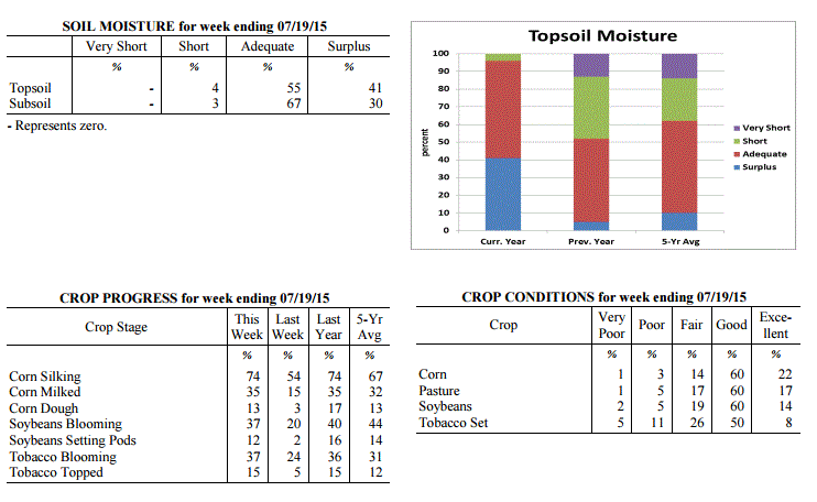 Kentucky Climate Summary
For the Period July 13, 2015 to July 19, 2015
Above Normal Temperatures and Rainfall:
Depending on location, this past week either brought another round of flooding or
dangerously hot and humid conditions. Starting off, the early work week saw numerous
rounds of storms pass through mainly the eastern half of the state, which gave way to
even more flash flooding. Over the course of the period, the Bluegrass and Eastern
Kentucky each saw an average of around two inches. Looking at data from the start of
July, these two regions are now over 4 inches above normal for the month. In
addition to the rainfall, storms merged into a couple of lines on Monday and Tuesday,
leading to widespread damaging winds. While the eastern half of the state saw a very
active pattern, Western Kentucky remained more under the influence of an upper level
ridge of high pressure. This kept the area dry with little to no rainfall. The
influence of this ridge was felt more-so on Friday and into the weekend. While
the entire state saw a rise in heat and humidity, it was most noticeable across the
western half of the state. Highs rose into the mid 90s and with high dewpoints, the
heat index was near 110 at times. This pushed the livestock heat stress index into
the emergency category for much of the weekend.
Temperatures for the period averaged 79 degrees across the state which was 2 degrees
warmer than normal and 2 degrees warmer than the previous period. High temperatures
averaged from 90 in the West to 86 in the East. Departure from normal high
temperatures ranged from near normal in the West to 1 degree cooler than
normal in the East. Low temperatures averaged from 75 degrees in the West to 67
degrees in the East. Departure from normal low temperature ranged from 7 degrees
warmer than normal in the West to 3 degrees warmer than normal in the East. The extreme
high temperature for the period was 95 degrees at BOWLING GREEN APT and the extreme low
was 60 degrees at ALEXANDRIA 5NW.
Precipitation (liq. equ.) for the period totaled 1.78 inches statewide which was 0.78
inches above normal and 178% of normal. Precipitation totals by climate division,
West 0.11 inches, Central 1.04 inches, Bluegrass 3.04 inches and East 2.91 inches,
which was -0.86, 0.02, 2.07 and 1.88 inches respectively from normal. By station,
precipitation totals ranged from a low of 0.00 inches at BENTON 4N to a high of 6.48
inches at LA GRANGE 6NW.
---
Kentucky Crop and Weather Report
Issued 4:00 P.M., July 13, 2015 19-15
Agricultural News: Kentucky experienced near normal temperatures and well above
normal rainfall over the past week. Precipitation for the week totaled 2.45 inches,
1.63 inches above normal. Temperatures averaged 76 degrees for the week, which was
near normal. Topsoil moisture was rated 0 percent very short, 2 percent short, 55
percent adequate and 43 percent surplus. Subsoil moisture was rated 0 percent very
short, 3 percent short, 67 percent adequate, and 30 percent surplus. Days suitable
for fieldwork averaged 2.0 out of a possible seven.
Field activities were once again hampered due to rains throughout the week. The
ground is saturated in many areas and some planted crops have been destroyed as
fields are under water. Early planted crops look good, but later crops are showing
effects of too much water, especially in low lying areas. Some soybeans may not get
planted due to wet conditions. Weed pressure in soybeans is a concern as farmers
cannot get in fields to spray. Corn and tobacco fields with standing water are
yellowing and some root rot has been reported in tobacco. Hay, both alfalfa and other
types, are in need of harvesting, but wet conditions continue to prevent any
progress. Hay quality continues to deteriorate due to over maturity and getting wet
after being cut. Vegetable growers have also been negatively impacted by the heavy
rains due to standing water and disease. Pasture conditions have benefitted from
all the moisture and grasses have really greened up and showed good growth.
Kentucky Climate Summary
For the Period July 13, 2015 to July 19, 2015
Above Normal Temperatures and Rainfall:
Depending on location, this past week either brought another round of flooding or
dangerously hot and humid conditions. Starting off, the early work week saw numerous
rounds of storms pass through mainly the eastern half of the state, which gave way to
even more flash flooding. Over the course of the period, the Bluegrass and Eastern
Kentucky each saw an average of around two inches. Looking at data from the start of
July, these two regions are now over 4 inches above normal for the month. In
addition to the rainfall, storms merged into a couple of lines on Monday and Tuesday,
leading to widespread damaging winds. While the eastern half of the state saw a very
active pattern, Western Kentucky remained more under the influence of an upper level
ridge of high pressure. This kept the area dry with little to no rainfall. The
influence of this ridge was felt more-so on Friday and into the weekend. While
the entire state saw a rise in heat and humidity, it was most noticeable across the
western half of the state. Highs rose into the mid 90s and with high dewpoints, the
heat index was near 110 at times. This pushed the livestock heat stress index into
the emergency category for much of the weekend.
Temperatures for the period averaged 79 degrees across the state which was 2 degrees
warmer than normal and 2 degrees warmer than the previous period. High temperatures
averaged from 90 in the West to 86 in the East. Departure from normal high
temperatures ranged from near normal in the West to 1 degree cooler than
normal in the East. Low temperatures averaged from 75 degrees in the West to 67
degrees in the East. Departure from normal low temperature ranged from 7 degrees
warmer than normal in the West to 3 degrees warmer than normal in the East. The extreme
high temperature for the period was 95 degrees at BOWLING GREEN APT and the extreme low
was 60 degrees at ALEXANDRIA 5NW.
Precipitation (liq. equ.) for the period totaled 1.78 inches statewide which was 0.78
inches above normal and 178% of normal. Precipitation totals by climate division,
West 0.11 inches, Central 1.04 inches, Bluegrass 3.04 inches and East 2.91 inches,
which was -0.86, 0.02, 2.07 and 1.88 inches respectively from normal. By station,
precipitation totals ranged from a low of 0.00 inches at BENTON 4N to a high of 6.48
inches at LA GRANGE 6NW.
---
Kentucky Crop and Weather Report
Issued 4:00 P.M., July 13, 2015 19-15
Agricultural News: Kentucky experienced near normal temperatures and well above
normal rainfall over the past week. Precipitation for the week totaled 2.45 inches,
1.63 inches above normal. Temperatures averaged 76 degrees for the week, which was
near normal. Topsoil moisture was rated 0 percent very short, 2 percent short, 55
percent adequate and 43 percent surplus. Subsoil moisture was rated 0 percent very
short, 3 percent short, 67 percent adequate, and 30 percent surplus. Days suitable
for fieldwork averaged 2.0 out of a possible seven.
Field activities were once again hampered due to rains throughout the week. The
ground is saturated in many areas and some planted crops have been destroyed as
fields are under water. Early planted crops look good, but later crops are showing
effects of too much water, especially in low lying areas. Some soybeans may not get
planted due to wet conditions. Weed pressure in soybeans is a concern as farmers
cannot get in fields to spray. Corn and tobacco fields with standing water are
yellowing and some root rot has been reported in tobacco. Hay, both alfalfa and other
types, are in need of harvesting, but wet conditions continue to prevent any
progress. Hay quality continues to deteriorate due to over maturity and getting wet
after being cut. Vegetable growers have also been negatively impacted by the heavy
rains due to standing water and disease. Pasture conditions have benefitted from
all the moisture and grasses have really greened up and showed good growth.
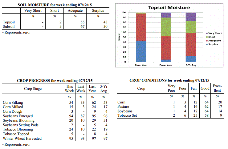 Kentucky Climate Summary
For the Period July 6, 2015 to July 12, 2015
Near Normal Temperatures and Much Above Normal Rainfall:
The Commonwealth cannot catch a break. Headlines did not change much this past week
as showers and storms continued to push through the Lower Ohio Valley. A combination
of frontal boundaries and disturbances aloft led to a very active period with
precipitation on a near daily basis. Over the course of the week, the state averaged
nearly two and a half inches of rainfall, which resulted in some flash flooding across
the Commonwealth. Looking back, three of the past four weeks have averaged over two
inches of rainfall.
Temperatures for the period averaged 76 degrees across the state which was near
normal and 3 degrees warmer than the previous period. Temperatures averaged from 78
in the West to 75 in the East. Departure from normal average temperatures ranged from
1 degree cooler than normal in the West to near normal in the East. The extreme high
temperature for the period was 93 degrees at BOWLING GREEN and the extreme low was 60
degrees at COVINGTON.
Precipitation (liq. equ.) for the period totaled 2.45 inches statewide which was 1.63
inches above normal and 298% of normal. Precipitation totals by climate division,
West 3.41 inches, Central 2.71 inches, Bluegrass 1.76 inches and East 1.99 inches,
which was 2.71, 1.93, 0.83 and 1.12 inches above normal. By station, precipitation
totals ranged from a low of 0.06 inches at Cumberland Gap to a high of 5.57 inches
at PADUCAH.
---
Kentucky Crop and Weather Report
Issued 4:00 P.M., July 6, 2015 18-15
Agricultural News: Kentucky experienced below normal temperatures and much above
normal rainfall over the past week. Precipitation for the week totaled 2.82
inches, 1.83 inches above normal. Temperatures averaged 73 degrees for the week,
2 degrees below normal. Topsoil moisture was rated 0 percent very short, 4
percent short, 65 percent adequate and 31 percent surplus. Subsoil moisture was
rated 0 percent very short, 5 percent short, 76 percent adequate, and 19 percent
surplus. Days suitable for fieldwork averaged 2.8 out of a possible seven.
Field activities were hampered due to rains throughout the week. Continued
rainfall is delaying second cutting of alfalfa in many areas, resulting in
deteriorating quality. Heavy rains caused some flooding last week resulting in
reports of damage to tobacco, corn and soybeans in low lying areas. The average
height of emerged soybeans was 14 inches, compared to 9 inches last week and 16
inches last year at this time. Cooler temperatures were welcomed by livestock.
Kentucky Climate Summary
For the Period July 6, 2015 to July 12, 2015
Near Normal Temperatures and Much Above Normal Rainfall:
The Commonwealth cannot catch a break. Headlines did not change much this past week
as showers and storms continued to push through the Lower Ohio Valley. A combination
of frontal boundaries and disturbances aloft led to a very active period with
precipitation on a near daily basis. Over the course of the week, the state averaged
nearly two and a half inches of rainfall, which resulted in some flash flooding across
the Commonwealth. Looking back, three of the past four weeks have averaged over two
inches of rainfall.
Temperatures for the period averaged 76 degrees across the state which was near
normal and 3 degrees warmer than the previous period. Temperatures averaged from 78
in the West to 75 in the East. Departure from normal average temperatures ranged from
1 degree cooler than normal in the West to near normal in the East. The extreme high
temperature for the period was 93 degrees at BOWLING GREEN and the extreme low was 60
degrees at COVINGTON.
Precipitation (liq. equ.) for the period totaled 2.45 inches statewide which was 1.63
inches above normal and 298% of normal. Precipitation totals by climate division,
West 3.41 inches, Central 2.71 inches, Bluegrass 1.76 inches and East 1.99 inches,
which was 2.71, 1.93, 0.83 and 1.12 inches above normal. By station, precipitation
totals ranged from a low of 0.06 inches at Cumberland Gap to a high of 5.57 inches
at PADUCAH.
---
Kentucky Crop and Weather Report
Issued 4:00 P.M., July 6, 2015 18-15
Agricultural News: Kentucky experienced below normal temperatures and much above
normal rainfall over the past week. Precipitation for the week totaled 2.82
inches, 1.83 inches above normal. Temperatures averaged 73 degrees for the week,
2 degrees below normal. Topsoil moisture was rated 0 percent very short, 4
percent short, 65 percent adequate and 31 percent surplus. Subsoil moisture was
rated 0 percent very short, 5 percent short, 76 percent adequate, and 19 percent
surplus. Days suitable for fieldwork averaged 2.8 out of a possible seven.
Field activities were hampered due to rains throughout the week. Continued
rainfall is delaying second cutting of alfalfa in many areas, resulting in
deteriorating quality. Heavy rains caused some flooding last week resulting in
reports of damage to tobacco, corn and soybeans in low lying areas. The average
height of emerged soybeans was 14 inches, compared to 9 inches last week and 16
inches last year at this time. Cooler temperatures were welcomed by livestock.
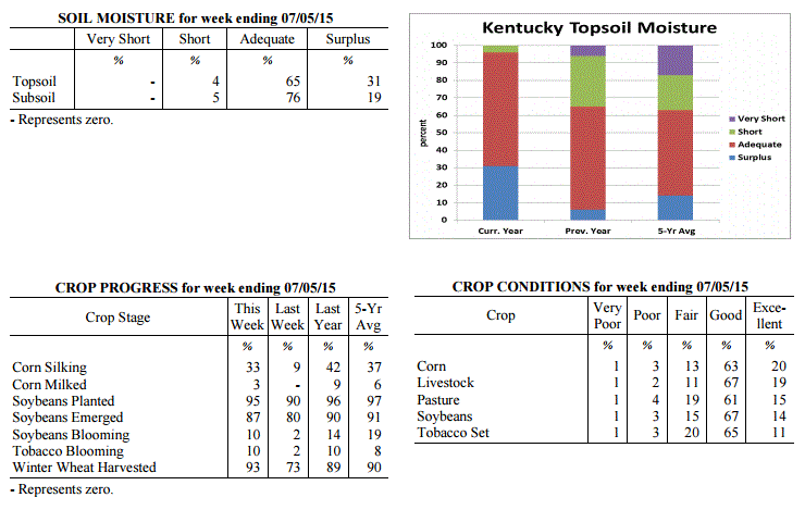 Kentucky Climate Summary
For the Period June 29, 2015 to July 5, 2015
Below Normal Temperatures and Much Above Normal Rainfall:
A very active pattern this past week led to a third straight period of above normal
rainfall for the Bluegrass State. For much of the week, Kentucky was situated within
a northwest flow aloft, allowing for multiple disturbances to interact with a stalled
frontal boundary at the surface. Showers and storms were sparked on a daily basis,
becoming widespread at times. The Commonwealth remained rooted in a very moist air
mass, which led to efficient rainfall producing storms. By the second half of the
work week, grounds were saturated and combined with heavy downpours at times, flash
flooding was a possibility. Overall, the state averaged nearly three inches for the
week, which was over an inch and a half above normal. The US Drought Monitor has now
entirely removed Moderate Drought across the state, with only a slight percentage of
abnormally dry conditions remaining. Cloud cover and the active pattern kept
temperatures down for the week, breaking a three week span of above normal temperatures.
Temperatures for the period averaged 73 degrees across the state which was 2 degrees
cooler than normal and 2 degrees cooler than the previous period. High temperatures
averaged from 83 in the West to 79 in the East. Departure from normal high
temperatures ranged from 5 degrees cooler than normal in the West to 7 degrees
cooler than normal in the East. Low temperatures averaged from 68 degrees in the
West to 64 degrees in the East. Departure from normal low temperature ranged from 2
degrees warmer than normal in the West to 2 degrees warmer than normal in the East.
The extreme high temperature for the period was 90 degrees at POPLAR BLUFF ASOS and
the extreme low was 51 degrees at PAINTSVILLE 4W.
Precipitation (liq. equ.) for the period totaled 2.82 inches statewide which was 1.83
inches above normal and 285% of normal. Precipitation totals by climate division,
West 2.34 inches, Central 3.44 inches, Bluegrass 2.68 inches and East 2.83 inches,
which was 1.35, 2.46, 1.71 and 1.81 inches above normal. By station, precipitation
totals ranged from a low of 0.00 inches at MONTICELLO AWOS to a high of 7.25
inches at SCOTTSVILLE 2W.
---
Kentucky Crop and Weather Report
Issued 4:00 P.M., June 29, 2015 17-15
Agricultural News: Kentucky experienced above normal temperatures and rainfall over
the past week. Precipitation for the week totaled 1.25 inches, 0.25 inches above
normal. Temperatures averaged 76 degrees for the week, 2 degrees above normal.
Topsoil moisture was rated 1 percent very short, 10 percent short, 77 percent
adequate and 12 percent surplus. Subsoil moisture was rated 1 percent very short, 12
percent short, 82 percent adequate, and 5 percent surplus. Days suitable for
fieldwork averaged 4.7 out of a possible seven.
Primary activities this week included planting soybeans and tobacco, harvesting
wheat, and baling hay. Some areas of the state are dry while others have received
adequate rain from storms and spotty showers. Wheat harvest is in full swing and
progressing well. Test weights, as well as yields, are reportedly very good. Later
wheat has higher incidence of head scab in some areas. Double crop soybeans are being
planted as wheat is harvested. Early soybeans are now starting to bloom. Soybean
average height was 9 inches, same as last year. Palmer amaranth being reported in
some fields. The average height of tobacco in the field was 17 inches, compared to 12
inches last week and 18 inches last year at this time. Very warm and humid conditions,
especially early in the week, resulted in continued heat stress for livestock.
Kentucky Climate Summary
For the Period June 29, 2015 to July 5, 2015
Below Normal Temperatures and Much Above Normal Rainfall:
A very active pattern this past week led to a third straight period of above normal
rainfall for the Bluegrass State. For much of the week, Kentucky was situated within
a northwest flow aloft, allowing for multiple disturbances to interact with a stalled
frontal boundary at the surface. Showers and storms were sparked on a daily basis,
becoming widespread at times. The Commonwealth remained rooted in a very moist air
mass, which led to efficient rainfall producing storms. By the second half of the
work week, grounds were saturated and combined with heavy downpours at times, flash
flooding was a possibility. Overall, the state averaged nearly three inches for the
week, which was over an inch and a half above normal. The US Drought Monitor has now
entirely removed Moderate Drought across the state, with only a slight percentage of
abnormally dry conditions remaining. Cloud cover and the active pattern kept
temperatures down for the week, breaking a three week span of above normal temperatures.
Temperatures for the period averaged 73 degrees across the state which was 2 degrees
cooler than normal and 2 degrees cooler than the previous period. High temperatures
averaged from 83 in the West to 79 in the East. Departure from normal high
temperatures ranged from 5 degrees cooler than normal in the West to 7 degrees
cooler than normal in the East. Low temperatures averaged from 68 degrees in the
West to 64 degrees in the East. Departure from normal low temperature ranged from 2
degrees warmer than normal in the West to 2 degrees warmer than normal in the East.
The extreme high temperature for the period was 90 degrees at POPLAR BLUFF ASOS and
the extreme low was 51 degrees at PAINTSVILLE 4W.
Precipitation (liq. equ.) for the period totaled 2.82 inches statewide which was 1.83
inches above normal and 285% of normal. Precipitation totals by climate division,
West 2.34 inches, Central 3.44 inches, Bluegrass 2.68 inches and East 2.83 inches,
which was 1.35, 2.46, 1.71 and 1.81 inches above normal. By station, precipitation
totals ranged from a low of 0.00 inches at MONTICELLO AWOS to a high of 7.25
inches at SCOTTSVILLE 2W.
---
Kentucky Crop and Weather Report
Issued 4:00 P.M., June 29, 2015 17-15
Agricultural News: Kentucky experienced above normal temperatures and rainfall over
the past week. Precipitation for the week totaled 1.25 inches, 0.25 inches above
normal. Temperatures averaged 76 degrees for the week, 2 degrees above normal.
Topsoil moisture was rated 1 percent very short, 10 percent short, 77 percent
adequate and 12 percent surplus. Subsoil moisture was rated 1 percent very short, 12
percent short, 82 percent adequate, and 5 percent surplus. Days suitable for
fieldwork averaged 4.7 out of a possible seven.
Primary activities this week included planting soybeans and tobacco, harvesting
wheat, and baling hay. Some areas of the state are dry while others have received
adequate rain from storms and spotty showers. Wheat harvest is in full swing and
progressing well. Test weights, as well as yields, are reportedly very good. Later
wheat has higher incidence of head scab in some areas. Double crop soybeans are being
planted as wheat is harvested. Early soybeans are now starting to bloom. Soybean
average height was 9 inches, same as last year. Palmer amaranth being reported in
some fields. The average height of tobacco in the field was 17 inches, compared to 12
inches last week and 18 inches last year at this time. Very warm and humid conditions,
especially early in the week, resulted in continued heat stress for livestock.
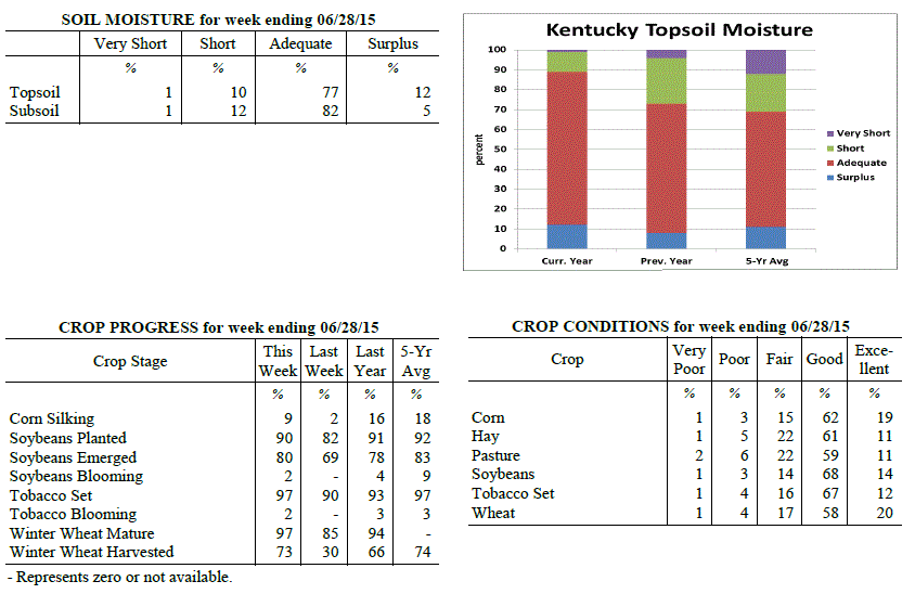 Kentucky Climate Summary
For the Period June 22, 2015 to June 28, 2015
Above Normal Temperatures and Rainfall:
Multiple disturbances and frontal boundaries passed through the Bluegrass State this
past week, leading to a second straight period of above normal rainfall. In doing so,
the US Drought Monitor diminished the coverage of Moderate Drought across the area,
down to 11%. The most widespread rainfall came later in the day on Friday and
lasting into Saturday as the Commonwealth remained within a moist and unstable air
mass. Overall, the state averaged 1.25 inches. Looking at temperatures, it was
quite the difference between start to end. Much of the work week saw highs peak in
the middle 80s to low 90s across the Lower Ohio Valley. High humidity made it feel
more like 100 at times. This helped push the livestock stock heat stress index into
the emergency category for the first time this year. Behind the passage of a cold
front on Saturday, temperatures took a downward turn. Highs stayed in the middle 70s
to low 80s Saturday and Sunday, along with much less humidity.
Temperatures for the period averaged 76 degrees across the state which was 2 degrees
warmer than normal and 2 degrees cooler than the previous period. High temperatures
averaged from 87 in the West to 84 in the East. Departure from normal high
temperatures ranged from 1 degree cooler than normal in the West to 1 degree
cooler than normal in the East. Low temperatures averaged from 69 degrees in the
West to 66 degrees in the East. Departure from normal low temperature ranged from 4
degrees warmer than normal in the West to 5 degrees warmer than normal in the East.
The extreme high temperature for the period was 96 degrees at BOWLING GREEN 4E and
the extreme low was 52 degrees at CAMPBELLSVILLE 7W.
Precipitation (liq. equ.) for the period totaled 1.25 inches statewide which was 0.25
inches above normal and 125% of normal. Precipitation totals by climate division,
West 0.62 inches, Central 1.61 inches, Bluegrass 1.27 inches and East 1.52 inches,
which was -0.38, 0.62, 0.28 and 0.49 inches respectively from normal. By station,
precipitation totals ranged from a low of 0.02 inches at HICKMAN 2E to a high of 2.89
inches at JACKSON.
---
Kentucky Crop and Weather Report
Issued 4:00 P.M., June 22, 2015 16-15
Agricultural News: Kentucky experienced above normal temperatures and rainfall over
the past week. Precipitation for the week totaled 2.36 inches, 1.35 inches above
normal. Temperatures averaged 79 degrees for the week, 6 degrees above normal.
Topsoil moisture was rated 2 percent very short, 13 percent short, 75 percent
adequate and 10 percent surplus. Subsoil moisture was rated 2 percent very short, 14
percent short, 78 percent adequate, and 6 percent surplus. Days suitable for
fieldwork averaged 4.7 out of a possible seven.
Some areas have received adequate rainfall, while many others remain dry. Primary
activities this week included planting soybeans and tobacco, harvesting wheat, and
baling hay. Activities were hampered late in the week due to rain. The average height
of emerged corn was 34 inches, compared to 23 inches last week, with eighty percent
rated as good to excellent. The early wheat harvest is going well. Test weights, as
well as yields, are reportedly very good. The average height of tobacco in the field
was 12 inches, compared to 9 inches last week. Very warm and humid conditions are
causing stress for livestock.
Kentucky Climate Summary
For the Period June 22, 2015 to June 28, 2015
Above Normal Temperatures and Rainfall:
Multiple disturbances and frontal boundaries passed through the Bluegrass State this
past week, leading to a second straight period of above normal rainfall. In doing so,
the US Drought Monitor diminished the coverage of Moderate Drought across the area,
down to 11%. The most widespread rainfall came later in the day on Friday and
lasting into Saturday as the Commonwealth remained within a moist and unstable air
mass. Overall, the state averaged 1.25 inches. Looking at temperatures, it was
quite the difference between start to end. Much of the work week saw highs peak in
the middle 80s to low 90s across the Lower Ohio Valley. High humidity made it feel
more like 100 at times. This helped push the livestock stock heat stress index into
the emergency category for the first time this year. Behind the passage of a cold
front on Saturday, temperatures took a downward turn. Highs stayed in the middle 70s
to low 80s Saturday and Sunday, along with much less humidity.
Temperatures for the period averaged 76 degrees across the state which was 2 degrees
warmer than normal and 2 degrees cooler than the previous period. High temperatures
averaged from 87 in the West to 84 in the East. Departure from normal high
temperatures ranged from 1 degree cooler than normal in the West to 1 degree
cooler than normal in the East. Low temperatures averaged from 69 degrees in the
West to 66 degrees in the East. Departure from normal low temperature ranged from 4
degrees warmer than normal in the West to 5 degrees warmer than normal in the East.
The extreme high temperature for the period was 96 degrees at BOWLING GREEN 4E and
the extreme low was 52 degrees at CAMPBELLSVILLE 7W.
Precipitation (liq. equ.) for the period totaled 1.25 inches statewide which was 0.25
inches above normal and 125% of normal. Precipitation totals by climate division,
West 0.62 inches, Central 1.61 inches, Bluegrass 1.27 inches and East 1.52 inches,
which was -0.38, 0.62, 0.28 and 0.49 inches respectively from normal. By station,
precipitation totals ranged from a low of 0.02 inches at HICKMAN 2E to a high of 2.89
inches at JACKSON.
---
Kentucky Crop and Weather Report
Issued 4:00 P.M., June 22, 2015 16-15
Agricultural News: Kentucky experienced above normal temperatures and rainfall over
the past week. Precipitation for the week totaled 2.36 inches, 1.35 inches above
normal. Temperatures averaged 79 degrees for the week, 6 degrees above normal.
Topsoil moisture was rated 2 percent very short, 13 percent short, 75 percent
adequate and 10 percent surplus. Subsoil moisture was rated 2 percent very short, 14
percent short, 78 percent adequate, and 6 percent surplus. Days suitable for
fieldwork averaged 4.7 out of a possible seven.
Some areas have received adequate rainfall, while many others remain dry. Primary
activities this week included planting soybeans and tobacco, harvesting wheat, and
baling hay. Activities were hampered late in the week due to rain. The average height
of emerged corn was 34 inches, compared to 23 inches last week, with eighty percent
rated as good to excellent. The early wheat harvest is going well. Test weights, as
well as yields, are reportedly very good. The average height of tobacco in the field
was 12 inches, compared to 9 inches last week. Very warm and humid conditions are
causing stress for livestock.
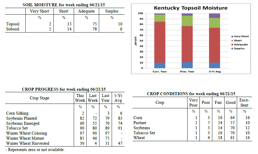 Kentucky Climate Summary
For the Period June 15, 2015 to June 21, 2015
Above Normal Temperatures and Rainfall:
Leading up to this period, dry conditions were becoming more and more evident across
the state. In fact, the US Drought Monitor introduced Moderate Drought to just over
34% of the state with last week's update. With lack a rainfall a concern, activity
increased dramatically this past period as the state saw a combination of frontal
boundaries, disturbances aloft, and even a remnant tropical system pass through the
area. Throughout the work week, the state was positioned within a very moist and
unstable air mass. Scattered to numerous showers and storms fired on a near daily
basis with heavy rainfall, cloud to ground lightning, and gusty winds as the main
concerns. Coverage increased Friday and Saturday as the remnants of Tropical Storm
Bill took an eastward track through the Lower Ohio Valley. Once again, a moist air
mass allowed for torrential rainfall at times. Over the course of the period, the
state averaged over two inches, breaking a four week streak of below normal rainfall.
Looking at temperatures, it was yet another hot and humid week. Temperatures
typically peaked in the mid 80s to low 90s about each day. Combined with lows only
dropping down to around 70, the Commonwealth saw a second straight week of above
normal temperatures.
Temperatures for the period averaged 79 degrees across the state which was 6 degrees
warmer than normal and 2 degrees warmer than the previous period. High temperatures
averaged from 88 in the West to 86 in the East. Departure from normal high
temperatures ranged from 2 degrees warmer than normal in the West to 2 degrees
warmer than normal in the East. Low temperatures averaged from 72 degrees in the
West to 69 degrees in the East. Departure from normal low temperature ranged from 8
degrees warmer than normal in the West to 10 degrees warmer than normal in the
East. The extreme high temperature for the period was 95 degrees at MAYFIELD 6SW and
the extreme low was 64 degrees at JACKSON 3SE.
Precipitation (liq. equ.) for the period totaled 2.36 inches statewide which was 1.35
inches above normal and 235% of normal. Precipitation totals by climate division,
West 2.41 inches, Central 2.03 inches, Bluegrass 3.14 inches and East 1.85 inches,
which was 1.42, 1.03, 2.13 and 0.83 inches above normal. By station, precipitation
totals ranged from a low of 0.41 inches at BOWLING GREEN APT to a high of 7.00
inches at MORGANFIELD 4E.
---
Kentucky Crop and Weather Report
Issued 4:00 P.M., June 15, 2015 15-15
Agricultural News: Kentucky experienced above normal temperatures and below normal
rainfall over the past week. Precipitation for the week totaled 0.69 inches, 0.35
inches below normal. Temperatures averaged 77 degrees for the week, 5 degrees above
normal. Topsoil moisture was rated 3 percent very short, 18 percent short, 70 percent
adequate and 9 percent surplus. Subsoil moisture was rated 2 percent very short, 16
percent short, 76 percent adequate, and 6 percent surplus. Days suitable for
fieldwork averaged 5.8 out of a possible seven.
Primary activities this week included planting soybeans and tobacco. Producers
continued side dressing corn and spraying post herbicide applications. Planting
progress was hampered early in the week in some areas due to showers, but other
locations remain dry and need rain. Soil compaction due to planting corn in wet field
conditions is a concern for some producers. The average height of emerged corn was 23
inches, compared to 14 inches last week, with seventy-nine percent rated as good to
excellent.
Most full season soybeans are planted and double crop plantings will begin as soon as
winter wheat is harvested. Winter wheat grain harvest is expected to begin in earnest
within the next 1-2 weeks, depending on location. First cutting hay still being made,
while some farmers were harvesting their second cutting of alfalfa. The average
height of tobacco in the field was 9 inches, compared to 4 inches last week.
Kentucky Climate Summary
For the Period June 15, 2015 to June 21, 2015
Above Normal Temperatures and Rainfall:
Leading up to this period, dry conditions were becoming more and more evident across
the state. In fact, the US Drought Monitor introduced Moderate Drought to just over
34% of the state with last week's update. With lack a rainfall a concern, activity
increased dramatically this past period as the state saw a combination of frontal
boundaries, disturbances aloft, and even a remnant tropical system pass through the
area. Throughout the work week, the state was positioned within a very moist and
unstable air mass. Scattered to numerous showers and storms fired on a near daily
basis with heavy rainfall, cloud to ground lightning, and gusty winds as the main
concerns. Coverage increased Friday and Saturday as the remnants of Tropical Storm
Bill took an eastward track through the Lower Ohio Valley. Once again, a moist air
mass allowed for torrential rainfall at times. Over the course of the period, the
state averaged over two inches, breaking a four week streak of below normal rainfall.
Looking at temperatures, it was yet another hot and humid week. Temperatures
typically peaked in the mid 80s to low 90s about each day. Combined with lows only
dropping down to around 70, the Commonwealth saw a second straight week of above
normal temperatures.
Temperatures for the period averaged 79 degrees across the state which was 6 degrees
warmer than normal and 2 degrees warmer than the previous period. High temperatures
averaged from 88 in the West to 86 in the East. Departure from normal high
temperatures ranged from 2 degrees warmer than normal in the West to 2 degrees
warmer than normal in the East. Low temperatures averaged from 72 degrees in the
West to 69 degrees in the East. Departure from normal low temperature ranged from 8
degrees warmer than normal in the West to 10 degrees warmer than normal in the
East. The extreme high temperature for the period was 95 degrees at MAYFIELD 6SW and
the extreme low was 64 degrees at JACKSON 3SE.
Precipitation (liq. equ.) for the period totaled 2.36 inches statewide which was 1.35
inches above normal and 235% of normal. Precipitation totals by climate division,
West 2.41 inches, Central 2.03 inches, Bluegrass 3.14 inches and East 1.85 inches,
which was 1.42, 1.03, 2.13 and 0.83 inches above normal. By station, precipitation
totals ranged from a low of 0.41 inches at BOWLING GREEN APT to a high of 7.00
inches at MORGANFIELD 4E.
---
Kentucky Crop and Weather Report
Issued 4:00 P.M., June 15, 2015 15-15
Agricultural News: Kentucky experienced above normal temperatures and below normal
rainfall over the past week. Precipitation for the week totaled 0.69 inches, 0.35
inches below normal. Temperatures averaged 77 degrees for the week, 5 degrees above
normal. Topsoil moisture was rated 3 percent very short, 18 percent short, 70 percent
adequate and 9 percent surplus. Subsoil moisture was rated 2 percent very short, 16
percent short, 76 percent adequate, and 6 percent surplus. Days suitable for
fieldwork averaged 5.8 out of a possible seven.
Primary activities this week included planting soybeans and tobacco. Producers
continued side dressing corn and spraying post herbicide applications. Planting
progress was hampered early in the week in some areas due to showers, but other
locations remain dry and need rain. Soil compaction due to planting corn in wet field
conditions is a concern for some producers. The average height of emerged corn was 23
inches, compared to 14 inches last week, with seventy-nine percent rated as good to
excellent.
Most full season soybeans are planted and double crop plantings will begin as soon as
winter wheat is harvested. Winter wheat grain harvest is expected to begin in earnest
within the next 1-2 weeks, depending on location. First cutting hay still being made,
while some farmers were harvesting their second cutting of alfalfa. The average
height of tobacco in the field was 9 inches, compared to 4 inches last week.
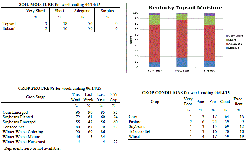 Kentucky Climate Summary
For the Period June 8, 2015 to June 14, 2015
Above Normal Temperatures and Below Normal Rainfall:
The Bluegrass State got an early taste of summer this past week as heat and humidity
were both on the rise. An upper level ridge of high pressure began to build into the
region over the second half of the work week and remained through the weekend. Highs
pushed into the mid 80s to low 90s on a daily basis. By the weekend, dewpoints were
in the upper 60s to low 70s, making for a very humid air mass. The combination of
high heat and humidity pushed the livestock heat stress index into the danger
category each afternoon and early evening. In addition, other than a couple waves of
rainfall on Monday, the ridge kept precipitation limited. Coverage remained isolated
to scattered each day, leading to a fourth straight week of below normal rainfall.
Going a step further, the state has seen below average precipitation seven of the past
eight weeks.
Temperatures for the period averaged 77 degrees across the state which was 5 degrees
warmer than normal and 10 degrees warmer than the previous period. High temperatures
averaged from 88 in the West to 86 in the East. Departure from normal high
temperatures ranged from 3 degrees warmer than normal in the West to 4 degrees
warmer than normal in the East. Low temperatures averaged from 69 degrees in the
West to 65 degrees in the East. Departure from normal low temperature ranged from 7
degrees warmer than normal in the West to 7 degrees warmer than normal in the East.
The extreme high temperature for the period was 95 degrees at CAPE GIRARDEAU ASOS and
the extreme low was 56 degrees at BRANDENBURG 4SW.
Precipitation (liq. equ.) for the period totaled 0.69 inches statewide which was 0.35
inches below normal and 67% of normal. Precipitation totals by climate division, West
0.79 inches, Central 0.72 inches, Bluegrass 0.51 inches and East 0.72 inches, which
was 0.19, 0.33, 0.55 and 0.34 inches below normal. By station, precipitation totals
ranged from a low of 0.05 inches at HICKMAN 2E to a high of 2.15 inches at HARRODSBURG 3N.
---
Kentucky Crop and Weather Report
Issued 4:00 P.M., June 8, 2015 14-15
Agricultural News: Kentucky experienced below normal temperatures and rainfall over
the past week. Precipitation for the week totaled 0.44 inches, 0.65 inches below
normal. Temperatures averaged 68 degrees for the week, 2 degrees below normal.
Topsoil moisture was rated 2 percent very short, 13 percent short, 75 percent
adequate and 10 percent surplus. Subsoil moisture was rated 2 percent very short, 12
percent short, 77 percent adequate, and 9 percent surplus. Days suitable for
fieldwork averaged 4.8 out of a possible seven.
Primary activities this week included planting corn, soybeans and tobacco. Some re-
planting occurred in locations that have received excess rainfall the past few weeks
that resulted in drowning out or poor stands. The average height of emerged corn was
14 inches, compared to 11 inches last week, with eighty percent rated as good to
excellent. Wheat producers were gearing up for the grain harvest which will begin in
the near future. Hay continued to be harvested on farms that had not been able to
complete their first cutting. The average height of tobacco in the field was 4 inches.
Kentucky Climate Summary
For the Period June 8, 2015 to June 14, 2015
Above Normal Temperatures and Below Normal Rainfall:
The Bluegrass State got an early taste of summer this past week as heat and humidity
were both on the rise. An upper level ridge of high pressure began to build into the
region over the second half of the work week and remained through the weekend. Highs
pushed into the mid 80s to low 90s on a daily basis. By the weekend, dewpoints were
in the upper 60s to low 70s, making for a very humid air mass. The combination of
high heat and humidity pushed the livestock heat stress index into the danger
category each afternoon and early evening. In addition, other than a couple waves of
rainfall on Monday, the ridge kept precipitation limited. Coverage remained isolated
to scattered each day, leading to a fourth straight week of below normal rainfall.
Going a step further, the state has seen below average precipitation seven of the past
eight weeks.
Temperatures for the period averaged 77 degrees across the state which was 5 degrees
warmer than normal and 10 degrees warmer than the previous period. High temperatures
averaged from 88 in the West to 86 in the East. Departure from normal high
temperatures ranged from 3 degrees warmer than normal in the West to 4 degrees
warmer than normal in the East. Low temperatures averaged from 69 degrees in the
West to 65 degrees in the East. Departure from normal low temperature ranged from 7
degrees warmer than normal in the West to 7 degrees warmer than normal in the East.
The extreme high temperature for the period was 95 degrees at CAPE GIRARDEAU ASOS and
the extreme low was 56 degrees at BRANDENBURG 4SW.
Precipitation (liq. equ.) for the period totaled 0.69 inches statewide which was 0.35
inches below normal and 67% of normal. Precipitation totals by climate division, West
0.79 inches, Central 0.72 inches, Bluegrass 0.51 inches and East 0.72 inches, which
was 0.19, 0.33, 0.55 and 0.34 inches below normal. By station, precipitation totals
ranged from a low of 0.05 inches at HICKMAN 2E to a high of 2.15 inches at HARRODSBURG 3N.
---
Kentucky Crop and Weather Report
Issued 4:00 P.M., June 8, 2015 14-15
Agricultural News: Kentucky experienced below normal temperatures and rainfall over
the past week. Precipitation for the week totaled 0.44 inches, 0.65 inches below
normal. Temperatures averaged 68 degrees for the week, 2 degrees below normal.
Topsoil moisture was rated 2 percent very short, 13 percent short, 75 percent
adequate and 10 percent surplus. Subsoil moisture was rated 2 percent very short, 12
percent short, 77 percent adequate, and 9 percent surplus. Days suitable for
fieldwork averaged 4.8 out of a possible seven.
Primary activities this week included planting corn, soybeans and tobacco. Some re-
planting occurred in locations that have received excess rainfall the past few weeks
that resulted in drowning out or poor stands. The average height of emerged corn was
14 inches, compared to 11 inches last week, with eighty percent rated as good to
excellent. Wheat producers were gearing up for the grain harvest which will begin in
the near future. Hay continued to be harvested on farms that had not been able to
complete their first cutting. The average height of tobacco in the field was 4 inches.
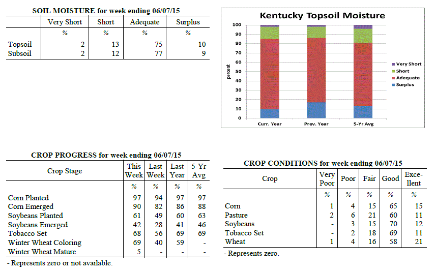 Kentucky Climate Summary
For the Period June 1, 2015 to June 7, 2015
Below Normal Temperatures and Rainfall:
June 1st signaled the first day of meteorological summer. The period got underway
with unseasonably cool conditions in place, but summer heat and humidity made a
return by the weekend. An upper level low slowly working across the area kept a
consistent cloud deck over much of the area for the first half of the work week.
This had quite the impact on high temperatures, especially on Monday and Tuesday,
when much of the Bluegrass State stayed in the upper 50s to middle 60s. High
pressure worked back into the region by Thursday, clearing skies and bringing back
temperatures closer to normal, in the low to mid 80s. Conditions remained dry over
the weekend with heat and humidity on the rise. Southwesterly flow bumped
temperatures into the upper 80s to low 90s on Sunday, bringing the feel that summer
had arrived. Other than some widespread showers on Monday, the remainder of the week
remained mostly dry. On average, the state was over a half inch below normal for the
period.
Temperatures for the period averaged 68 degrees across the state which was 2 degrees
cooler than normal and 4 degrees cooler than the previous period. High temperatures
averaged from 78 in the West to 78 in the East. Departure from normal high
temperatures ranged from 5 degrees cooler than normal in the West to 3 degrees
cooler than normal in the East. Low temperatures averaged from 60 degrees in the
West to 59 degrees in the East. Departure from normal low temperature ranged from 1
degree cooler than normal in the West to 3 degrees warmer than normal in the East.
The extreme high temperature for the period was 92 degrees at BURKESVILLE 3W and the
extreme low was 50 degrees at GREENVILLE 6N.
Precipitation (liq. equ.) for the period totaled 0.44 inches statewide which was 0.65
inches below normal and 40% of normal. Precipitation totals by climate division, West
0.34 inches, Central 0.41 inches, Bluegrass 0.45 inches and East 0.56 inches, which
was 0.72, 0.7, 0.64 and 0.54 inches below normal. By station, precipitation totals
ranged from a low of 0.00 inches at CAPE GIRARDEAU ASOS to a high of 1.42 inches at
PIKEVILLE 13S.
---
Kentucky Crop and Weather Report
Issued 4:00 P.M., June 1, 2015 13-15
Agricultural News: Kentucky experienced above normal temperatures and below normal
rainfall over the past week. Precipitation for the week totaled 1.06 inches, 0.05
inches below normal. Temperatures averaged 72 degrees for the week, 4 degrees above
normal. Topsoil moisture was rated 2 percent very short, 11 percent short, 75 percent
adequate and 12 percent surplus. Subsoil moisture was rated 2 percent very short, 10
percent short, 77 percent adequate, and 11 percent surplus. Days suitable for
fieldwork averaged 3.6 out of a possible seven.
Primary activities this week included planting corn, soybeans and tobacco, side
dressing crops with fertilizer, along with cutting and baling hay as weather allowed.
Planting progress was hampered in some areas due to wet conditions, but other
locations remain dry and in need of rain. Recent rain and wind caused wheat to lodge
in certain areas, especially where growth regulators were not used. The average
height of emerged corn was 11 inches, compared to 6 inches last week, with eighty-one
percent rated as good to excellent. There are reports of corn yellowing, uneven
stands and replanting due to weather issues. Hay and roughage supplies were reported
as 2 percent very short, 13 percent short, 79 percent adequate, and 6 percent
surplus.
Kentucky Climate Summary
For the Period June 1, 2015 to June 7, 2015
Below Normal Temperatures and Rainfall:
June 1st signaled the first day of meteorological summer. The period got underway
with unseasonably cool conditions in place, but summer heat and humidity made a
return by the weekend. An upper level low slowly working across the area kept a
consistent cloud deck over much of the area for the first half of the work week.
This had quite the impact on high temperatures, especially on Monday and Tuesday,
when much of the Bluegrass State stayed in the upper 50s to middle 60s. High
pressure worked back into the region by Thursday, clearing skies and bringing back
temperatures closer to normal, in the low to mid 80s. Conditions remained dry over
the weekend with heat and humidity on the rise. Southwesterly flow bumped
temperatures into the upper 80s to low 90s on Sunday, bringing the feel that summer
had arrived. Other than some widespread showers on Monday, the remainder of the week
remained mostly dry. On average, the state was over a half inch below normal for the
period.
Temperatures for the period averaged 68 degrees across the state which was 2 degrees
cooler than normal and 4 degrees cooler than the previous period. High temperatures
averaged from 78 in the West to 78 in the East. Departure from normal high
temperatures ranged from 5 degrees cooler than normal in the West to 3 degrees
cooler than normal in the East. Low temperatures averaged from 60 degrees in the
West to 59 degrees in the East. Departure from normal low temperature ranged from 1
degree cooler than normal in the West to 3 degrees warmer than normal in the East.
The extreme high temperature for the period was 92 degrees at BURKESVILLE 3W and the
extreme low was 50 degrees at GREENVILLE 6N.
Precipitation (liq. equ.) for the period totaled 0.44 inches statewide which was 0.65
inches below normal and 40% of normal. Precipitation totals by climate division, West
0.34 inches, Central 0.41 inches, Bluegrass 0.45 inches and East 0.56 inches, which
was 0.72, 0.7, 0.64 and 0.54 inches below normal. By station, precipitation totals
ranged from a low of 0.00 inches at CAPE GIRARDEAU ASOS to a high of 1.42 inches at
PIKEVILLE 13S.
---
Kentucky Crop and Weather Report
Issued 4:00 P.M., June 1, 2015 13-15
Agricultural News: Kentucky experienced above normal temperatures and below normal
rainfall over the past week. Precipitation for the week totaled 1.06 inches, 0.05
inches below normal. Temperatures averaged 72 degrees for the week, 4 degrees above
normal. Topsoil moisture was rated 2 percent very short, 11 percent short, 75 percent
adequate and 12 percent surplus. Subsoil moisture was rated 2 percent very short, 10
percent short, 77 percent adequate, and 11 percent surplus. Days suitable for
fieldwork averaged 3.6 out of a possible seven.
Primary activities this week included planting corn, soybeans and tobacco, side
dressing crops with fertilizer, along with cutting and baling hay as weather allowed.
Planting progress was hampered in some areas due to wet conditions, but other
locations remain dry and in need of rain. Recent rain and wind caused wheat to lodge
in certain areas, especially where growth regulators were not used. The average
height of emerged corn was 11 inches, compared to 6 inches last week, with eighty-one
percent rated as good to excellent. There are reports of corn yellowing, uneven
stands and replanting due to weather issues. Hay and roughage supplies were reported
as 2 percent very short, 13 percent short, 79 percent adequate, and 6 percent
surplus.
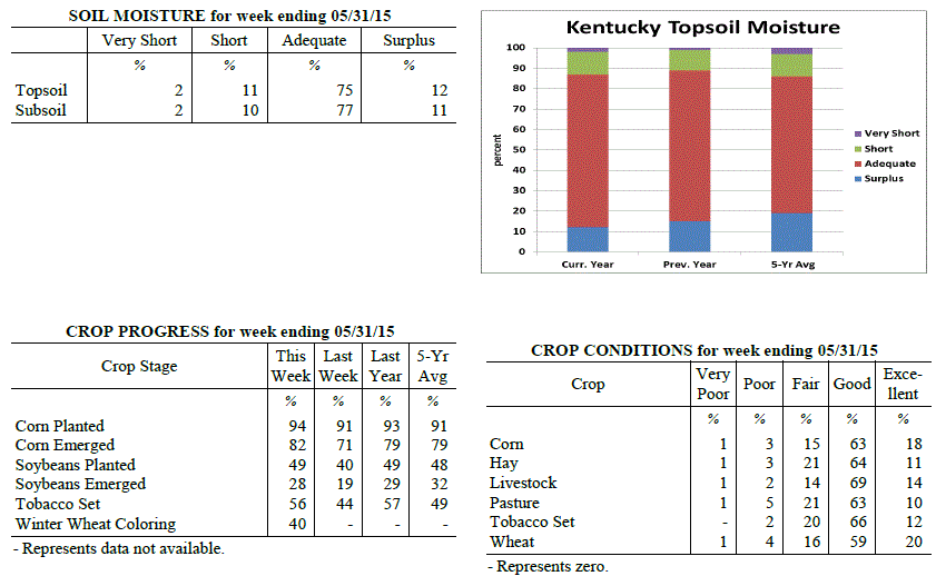 Kentucky Climate Summary
For the Period May 25, 2015 to May 31, 2015
Above Normal Temperatures and Below Normal Rainfall:
The last week of May brought the chance of showers and storms on a daily basis.
Throughout much of the period, the Commonwealth laid within a moist and unstable air
mass. While coverage was often scattered each day, most saw rainfall at some point. The
majority of the week saw storms remain below severe limits, but with dewpoints in the
60s, any storms that did develop were efficient rainfall producers. Even though it
was a rather active week, the state saw slightly below normal rainfall overall. Five
of the past six weeks have now seen below normal rainfall. Temperatures remained
elevated through most of the week with highs typically in the low to mid 80s and lows
only dropping into the 60s.
Temperatures for the period averaged 72 degrees across the state which was 4 degrees
warmer than normal and 8 degrees warmer than the previous period. High temperatures
averaged from 79 in the West to 83 in the East. Departure from normal high
temperatures ranged from 2 degrees cooler than normal in the West to 4 degrees
warmer than normal in the East. Low temperatures averaged from 65 degrees in the
West to 64 degrees in the East. Departure from normal low temperature ranged from 6
degrees warmer than normal in the West to 10 degrees warmer than normal in the
East. The extreme high temperature for the period was 88 degrees at BURKESVILLE 3W
and the extreme low was 52 degrees at JACKSON 3SE.
Precipitation (liq. equ.) for the period totaled 1.06 inches statewide which was 0.05
inches below normal and 95% of normal. Precipitation totals by climate division, West
1.29 inches, Central 1.24 inches, Bluegrass 1.01 inches and East 0.72 inches, which
was 0.19, 0.08, -0.07 and -0.40 inches respectively from normal. By station,
precipitation totals ranged from a low of 0.20 inches at TRIANGLE MOUNTAIN to a high
of 2.34 inches at ELKTON 5SW.
---
Kentucky Crop and Weather Report
Issued 4:00 P.M., May 26, 2015 12-15
Agricultural News: Kentucky experienced below normal temperatures and rainfall over
the past week. Precipitation for the week totaled 0.34 inches, 0.78 inches below
normal. Temperatures averaged 64 degrees for the week, 2 degrees below normal.
Topsoil moisture was rated 2 percent very short, 18 percent short, 68 percent
adequate and 12 percent surplus. Subsoil moisture was rated 2 percent very short, 12
percent short, 75 percent adequate, and 11 percent surplus. Days suitable for
fieldwork averaged 4.7 out of a possible seven. Dry conditions continued in many
locations. However, planting was on hold in some areas due to rains.
Primary activities this week included planting corn, soybeans and tobacco, spraying
herbicides as well as cutting and baling hay. Recent winds and rain has caused wheat
to lodge in certain areas. There were some reports of germination issues where corn
was planted in dry areas a couple of weeks ago. The average height of emerged corn
was 6 inches, with eighty-five percent rated as good to excellent. Producers are
scouting for army worms. Some locations are very dry and in need of rainfall. Dry
pasture conditions in these areas are resulting in hay being fed to cattle. Recent
heavy rains in some areas were detrimental to strawberries that were mature. Overall,
strawberries were rated in mostly good condition.
Kentucky Climate Summary
For the Period May 25, 2015 to May 31, 2015
Above Normal Temperatures and Below Normal Rainfall:
The last week of May brought the chance of showers and storms on a daily basis.
Throughout much of the period, the Commonwealth laid within a moist and unstable air
mass. While coverage was often scattered each day, most saw rainfall at some point. The
majority of the week saw storms remain below severe limits, but with dewpoints in the
60s, any storms that did develop were efficient rainfall producers. Even though it
was a rather active week, the state saw slightly below normal rainfall overall. Five
of the past six weeks have now seen below normal rainfall. Temperatures remained
elevated through most of the week with highs typically in the low to mid 80s and lows
only dropping into the 60s.
Temperatures for the period averaged 72 degrees across the state which was 4 degrees
warmer than normal and 8 degrees warmer than the previous period. High temperatures
averaged from 79 in the West to 83 in the East. Departure from normal high
temperatures ranged from 2 degrees cooler than normal in the West to 4 degrees
warmer than normal in the East. Low temperatures averaged from 65 degrees in the
West to 64 degrees in the East. Departure from normal low temperature ranged from 6
degrees warmer than normal in the West to 10 degrees warmer than normal in the
East. The extreme high temperature for the period was 88 degrees at BURKESVILLE 3W
and the extreme low was 52 degrees at JACKSON 3SE.
Precipitation (liq. equ.) for the period totaled 1.06 inches statewide which was 0.05
inches below normal and 95% of normal. Precipitation totals by climate division, West
1.29 inches, Central 1.24 inches, Bluegrass 1.01 inches and East 0.72 inches, which
was 0.19, 0.08, -0.07 and -0.40 inches respectively from normal. By station,
precipitation totals ranged from a low of 0.20 inches at TRIANGLE MOUNTAIN to a high
of 2.34 inches at ELKTON 5SW.
---
Kentucky Crop and Weather Report
Issued 4:00 P.M., May 26, 2015 12-15
Agricultural News: Kentucky experienced below normal temperatures and rainfall over
the past week. Precipitation for the week totaled 0.34 inches, 0.78 inches below
normal. Temperatures averaged 64 degrees for the week, 2 degrees below normal.
Topsoil moisture was rated 2 percent very short, 18 percent short, 68 percent
adequate and 12 percent surplus. Subsoil moisture was rated 2 percent very short, 12
percent short, 75 percent adequate, and 11 percent surplus. Days suitable for
fieldwork averaged 4.7 out of a possible seven. Dry conditions continued in many
locations. However, planting was on hold in some areas due to rains.
Primary activities this week included planting corn, soybeans and tobacco, spraying
herbicides as well as cutting and baling hay. Recent winds and rain has caused wheat
to lodge in certain areas. There were some reports of germination issues where corn
was planted in dry areas a couple of weeks ago. The average height of emerged corn
was 6 inches, with eighty-five percent rated as good to excellent. Producers are
scouting for army worms. Some locations are very dry and in need of rainfall. Dry
pasture conditions in these areas are resulting in hay being fed to cattle. Recent
heavy rains in some areas were detrimental to strawberries that were mature. Overall,
strawberries were rated in mostly good condition.
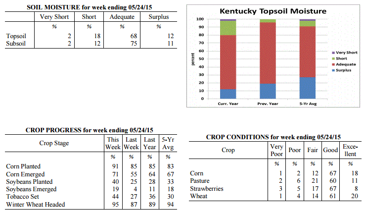 Kentucky Climate Summary
For the Period May 18, 2015 to May 24, 2015
Below Normal Temperatures and Rainfall:
The dry month of May continued this past week with below normal rainfall in place.
Following the second wettest April on record, month to date rainfall for May is now
almost 2 inches below normal. Over the course of this past period, the state
averaged 0.34 inches with most of it coming on Monday as a couple disturbances pushed
through the Lower Ohio Valley. A cold front passed through the area later that
night. This set the stage for a rather cool work week. Behind another weak
disturbance, many locations did not see highs get out of the 50s on Thursday. This
was around 20 degrees below normal for this time of the year. Later that night, some
saw the mercury dip into the 30s. Overall, temperatures were on average 2 degrees
below normal for the period, breaking a two week streak of above normal temperatures.
Temperatures for the period averaged 64 degrees across the state which was 2 degrees
cooler than normal and 4 degrees cooler than the previous period. High temperatures
averaged from 73 in the West to 75 in the East. Departure from normal high
temperatures ranged from 6 degrees cooler than normal in the West to 3 degrees
cooler than normal in the East. Low temperatures averaged from 55 degrees in the
West to 53 degrees in the East. Departure from normal low temperature ranged from 1
degree cooler than normal in the West to 2 degrees warmer than normal in the East.
The extreme high temperature for the period was 86 degrees at CALHOUN 5NW and the
extreme low was 36 degrees at CYNTHIANA 8N.
Precipitation (liq. equ.) for the period totaled 0.34 inches statewide which was 0.78
inches below normal and 30% of normal. Precipitation totals by climate division, West
0.66 inches, Central 0.23 inches, Bluegrass 0.08 inches and East 0.41 inches, which
was 0.45, 0.94, 1 and 0.72 inches below normal. By station, precipitation totals
ranged from a low of 0.00 inches at ALEXANDRIA 5NW to a high of 1.80 inches at YELLOW
CREEK.
---
Kentucky Crop and Weather Report
Issued 4:00 P.M., May 18, 2015 11-15
Agricultural News: Kentucky experienced above normal temperatures and rainfall over
the past week. Precipitation for the week totaled 1.25 inches, 0.12 inches above
normal. Temperatures averaged 68 degrees for the week, 4 degrees above normal.
Topsoil moisture was rated 1 percent very short, 18 percent short, 70 percent
adequate and 11 percent surplus. Subsoil moisture was rated 1 percent very short, 11
percent short, 77 percent adequate, and 11 percent surplus. Days suitable for
fieldwork averaged 6.0 out of a possible seven. Primary activities this week included
planting corn, soybeans and tobacco along with cutting and baling hay.
Planting progressed at a rapid pace, at least until the later part of the week. Rains
over the weekend caused some lodging in wheat, but eighty percent is still rated as
good to excellent. Producers continued harvesting wheat intended for hay or silage.
Some locations are very dry and in need of additional moisture. Dry pasture
conditions in these areas are resulting in hay being fed to cattle. Tobacco
transplant supplies were reported as 1 percent very short, 4 percent short, 87
percent adequate, and 8 percent surplus. Fifteen percent of tobacco transplants were
under 2 inches, with 38 percent between 2-4 inches, and 47 percent over 4 inches.
Kentucky Climate Summary
For the Period May 18, 2015 to May 24, 2015
Below Normal Temperatures and Rainfall:
The dry month of May continued this past week with below normal rainfall in place.
Following the second wettest April on record, month to date rainfall for May is now
almost 2 inches below normal. Over the course of this past period, the state
averaged 0.34 inches with most of it coming on Monday as a couple disturbances pushed
through the Lower Ohio Valley. A cold front passed through the area later that
night. This set the stage for a rather cool work week. Behind another weak
disturbance, many locations did not see highs get out of the 50s on Thursday. This
was around 20 degrees below normal for this time of the year. Later that night, some
saw the mercury dip into the 30s. Overall, temperatures were on average 2 degrees
below normal for the period, breaking a two week streak of above normal temperatures.
Temperatures for the period averaged 64 degrees across the state which was 2 degrees
cooler than normal and 4 degrees cooler than the previous period. High temperatures
averaged from 73 in the West to 75 in the East. Departure from normal high
temperatures ranged from 6 degrees cooler than normal in the West to 3 degrees
cooler than normal in the East. Low temperatures averaged from 55 degrees in the
West to 53 degrees in the East. Departure from normal low temperature ranged from 1
degree cooler than normal in the West to 2 degrees warmer than normal in the East.
The extreme high temperature for the period was 86 degrees at CALHOUN 5NW and the
extreme low was 36 degrees at CYNTHIANA 8N.
Precipitation (liq. equ.) for the period totaled 0.34 inches statewide which was 0.78
inches below normal and 30% of normal. Precipitation totals by climate division, West
0.66 inches, Central 0.23 inches, Bluegrass 0.08 inches and East 0.41 inches, which
was 0.45, 0.94, 1 and 0.72 inches below normal. By station, precipitation totals
ranged from a low of 0.00 inches at ALEXANDRIA 5NW to a high of 1.80 inches at YELLOW
CREEK.
---
Kentucky Crop and Weather Report
Issued 4:00 P.M., May 18, 2015 11-15
Agricultural News: Kentucky experienced above normal temperatures and rainfall over
the past week. Precipitation for the week totaled 1.25 inches, 0.12 inches above
normal. Temperatures averaged 68 degrees for the week, 4 degrees above normal.
Topsoil moisture was rated 1 percent very short, 18 percent short, 70 percent
adequate and 11 percent surplus. Subsoil moisture was rated 1 percent very short, 11
percent short, 77 percent adequate, and 11 percent surplus. Days suitable for
fieldwork averaged 6.0 out of a possible seven. Primary activities this week included
planting corn, soybeans and tobacco along with cutting and baling hay.
Planting progressed at a rapid pace, at least until the later part of the week. Rains
over the weekend caused some lodging in wheat, but eighty percent is still rated as
good to excellent. Producers continued harvesting wheat intended for hay or silage.
Some locations are very dry and in need of additional moisture. Dry pasture
conditions in these areas are resulting in hay being fed to cattle. Tobacco
transplant supplies were reported as 1 percent very short, 4 percent short, 87
percent adequate, and 8 percent surplus. Fifteen percent of tobacco transplants were
under 2 inches, with 38 percent between 2-4 inches, and 47 percent over 4 inches.
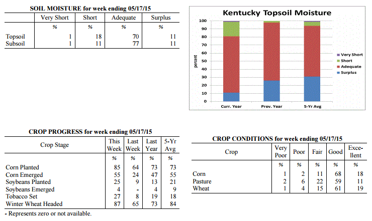 Kentucky Climate Summary
For the Period May 11, 2015 to May 17, 2015
Above Normal Temperatures and Rainfall:
The Commonwealth got some much needed rainfall this past period after the first couple
weeks of May brought extremely dry conditions. Throughout the period, Kentucky saw
several rounds of showers and storms. The first came on Monday as storms fired that
afternoon and evening within a moist and unstable air mass. The National Weather
Service did report some isolated events of damaging winds. Following a cold front
that night, noticeably drier and cooler air filtered into the Ohio Valley for the
next few days. Activity then once again picked up over the weekend. The most
widespread coverage was seen on Saturday. Just between Friday and Sunday, Western
Kentucky averaged 1.79 inches of rainfall. Totals diminished farther east with
Eastern Kentucky only averaging a little over a half inch through the three day
period. Over the entirety of the week, the state was slightly above normal, breaking
a streak of three straight weeks with below normal rainfall.
Temperatures for the period averaged 68 degrees across the state which was 4 degrees
warmer than normal and 4 degrees cooler than the previous period. High temperatures
averaged from 77 in the West to 79 in the East. Departure from normal high
temperatures ranged from near normal in the West to 3 degrees warmer than normal in
the East. Low temperatures averaged from 59 degrees in the West to 58 degrees in the
East. Departure from normal low temperature ranged from 5 degrees warmer than normal
in the West to 9 degrees warmer than normal in the East. The extreme high temperature
for the period was 89 degrees at JACKSON and the extreme low was 41 degrees at
BRANDENBURG 4SW.
Precipitation (liq. equ.) for the period totaled 1.25 inches statewide which was 0.12
inches above normal and 111% of normal. Precipitation totals by climate division,
West 2.06 inches, Central 1.37 inches, Bluegrass 0.81 inches and East 0.75 inches,
which was 0.88, 0.19, -0.25 and -0.33 inches respectively from normal. By station,
precipitation totals ranged from a low of 0.08 inches at STANFORD 4NE to a high of
4.36 inches at FORT CAMPBELL.
---
Kentucky Crop and Weather Report
Issued 4:00 P.M., May 11, 2015 10-15
Agricultural News: Kentucky experienced well above normal temperatures and much below
normal rainfall over the past week. Precipitation for the week totaled 0.14 inches,
0.95 inches below normal. Temperatures averaged 71 degrees for the week, 9 degrees
above normal. Topsoil moisture was rated 1 percent very short, 16 percent short, 71
percent adequate and 12 percent surplus. Subsoil moisture was rated 1 percent very
short, 7 percent short, 81 percent adequate, and 11 percent surplus. Days suitable
for fieldwork averaged 6.5 out of a possible seven.
Weather conditions allowed farmers to make excellent progress this past week in
planting crops. Primary activities this week included planting corn, soybeans and
tobacco. Producers were also busy harvesting wheat intended for hay or silage. Grain
producers were spraying wheat with fungicides. Farmers were also active cutting and
baling hay as conditions were excellent for drying. Tobacco transplant supplies were
reported as 1 percent very short, 4 percent short, 87 percent adequate, and 8 percent
surplus. Twenty-three percent of tobacco transplants were under 2 inches, with 41
percent between 2-4 inches, and 36 percent over 4 inches. Many locations could use
some rain now as topsoil has dried out rapidly.
Kentucky Climate Summary
For the Period May 11, 2015 to May 17, 2015
Above Normal Temperatures and Rainfall:
The Commonwealth got some much needed rainfall this past period after the first couple
weeks of May brought extremely dry conditions. Throughout the period, Kentucky saw
several rounds of showers and storms. The first came on Monday as storms fired that
afternoon and evening within a moist and unstable air mass. The National Weather
Service did report some isolated events of damaging winds. Following a cold front
that night, noticeably drier and cooler air filtered into the Ohio Valley for the
next few days. Activity then once again picked up over the weekend. The most
widespread coverage was seen on Saturday. Just between Friday and Sunday, Western
Kentucky averaged 1.79 inches of rainfall. Totals diminished farther east with
Eastern Kentucky only averaging a little over a half inch through the three day
period. Over the entirety of the week, the state was slightly above normal, breaking
a streak of three straight weeks with below normal rainfall.
Temperatures for the period averaged 68 degrees across the state which was 4 degrees
warmer than normal and 4 degrees cooler than the previous period. High temperatures
averaged from 77 in the West to 79 in the East. Departure from normal high
temperatures ranged from near normal in the West to 3 degrees warmer than normal in
the East. Low temperatures averaged from 59 degrees in the West to 58 degrees in the
East. Departure from normal low temperature ranged from 5 degrees warmer than normal
in the West to 9 degrees warmer than normal in the East. The extreme high temperature
for the period was 89 degrees at JACKSON and the extreme low was 41 degrees at
BRANDENBURG 4SW.
Precipitation (liq. equ.) for the period totaled 1.25 inches statewide which was 0.12
inches above normal and 111% of normal. Precipitation totals by climate division,
West 2.06 inches, Central 1.37 inches, Bluegrass 0.81 inches and East 0.75 inches,
which was 0.88, 0.19, -0.25 and -0.33 inches respectively from normal. By station,
precipitation totals ranged from a low of 0.08 inches at STANFORD 4NE to a high of
4.36 inches at FORT CAMPBELL.
---
Kentucky Crop and Weather Report
Issued 4:00 P.M., May 11, 2015 10-15
Agricultural News: Kentucky experienced well above normal temperatures and much below
normal rainfall over the past week. Precipitation for the week totaled 0.14 inches,
0.95 inches below normal. Temperatures averaged 71 degrees for the week, 9 degrees
above normal. Topsoil moisture was rated 1 percent very short, 16 percent short, 71
percent adequate and 12 percent surplus. Subsoil moisture was rated 1 percent very
short, 7 percent short, 81 percent adequate, and 11 percent surplus. Days suitable
for fieldwork averaged 6.5 out of a possible seven.
Weather conditions allowed farmers to make excellent progress this past week in
planting crops. Primary activities this week included planting corn, soybeans and
tobacco. Producers were also busy harvesting wheat intended for hay or silage. Grain
producers were spraying wheat with fungicides. Farmers were also active cutting and
baling hay as conditions were excellent for drying. Tobacco transplant supplies were
reported as 1 percent very short, 4 percent short, 87 percent adequate, and 8 percent
surplus. Twenty-three percent of tobacco transplants were under 2 inches, with 41
percent between 2-4 inches, and 36 percent over 4 inches. Many locations could use
some rain now as topsoil has dried out rapidly.
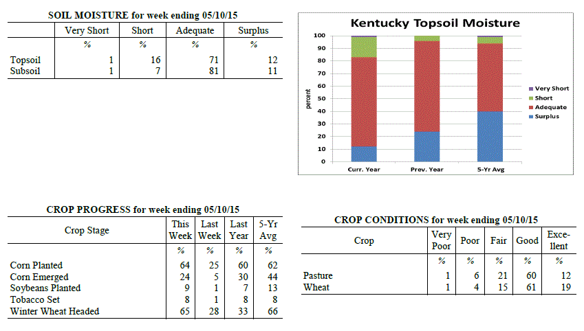 Kentucky Climate Summary
For the Period May 4, 2015 to May 10, 2015
Well Above Normal Temperatures and Much Below Normal Rainfall:
Dry conditions continued to lay claim across the Lower Ohio Valley this past period.
Throughout the work week, the state remained under the influence of high pressure at
the surface and aloft. Other than a stray shower or storm in the afternoon or
evening hours, most remained dry. Coverage slightly increased Friday and into the
weekend across Western Kentucky, but did not make much progress eastward. For a
second straight week, the Commonwealth was nearly an inch below normal. The month
of May is climatologically speaking, the wettest month of the year for Kentucky. In
addition, temperatures were more typical of summer throughout the period. Each day
saw highs jump into the 80s. A handful of locations even hit the 90 degree mark for
the first time this year. On average, high temperatures came in at an average of 84
degrees for the Bluegrass State, which is 10 degrees above normal for this time of
the year.
Temperatures for the period averaged 71 degrees across the state which was 9 degrees
warmer than normal and 14 degrees warmer than the previous period. High temperatures
averaged from 84 in the West to 85 in the East. Departure from normal high
temperatures ranged from 9 degrees warmer than normal in the West to 11 degrees
warmer than normal in the East. Low temperatures averaged from 60 degrees in the
West to 57 degrees in the East. Departure from normal low temperature ranged from 8
degrees warmer than normal in the West to 11 degrees warmer than normal in the
East. The extreme high temperature for the period was 90 degrees at BOWLING GREEN APT
and the extreme low was 44 degrees at JACKSON 3SE.
Precipitation (liq. equ.) for the period totaled 0.14 inches statewide which was 0.95
inches below normal and 13% of normal. Precipitation totals by climate division, West
0.37 inches, Central 0.07 inches, Bluegrass 0.03 inches and East 0.07 inches, which
was 0.8, 1.08, 0.98 and 0.97 inches below normal. By station, precipitation totals
ranged from a low of 0.00 inches at ALBANY 1N to a high of 2.50
inches at CAPE GIRARDEAU ASOS.
---
Kentucky Crop and Weather Report
Issued 4:00 P.M., May 4, 2015 9-15
Agricultural News: Kentucky experienced below normal temperatures and rainfall over
the past week. Precipitation for the week totaled 0.10 inches, 0.97 inches below
normal. Temperatures averaged 56 degrees for the week, 4 degrees below normal.
Topsoil moisture was rated 0 percent very short, 1 percent short, 70 percent adequate
and 29 percent surplus. Subsoil moisture was rated 0 percent very short, 2 percent
short, 69 percent adequate, and 29 percent surplus. Days suitable for fieldwork
averaged 5.2 out of a possible seven.
Primary activities this week included spraying and preparing land for planting,
planting corn, and cutting alfalfa hay. Corn planting was in full swing in many areas
last week. With drier conditions forecasted, excellent progress is expected this week
as more land dries out. Soybean planting is just getting underway. The average height
of winter wheat was 22 inches, compared to 17 inches last week. Seventy-eight percent
of wheat is rated as good to excellent. Tobacco transplant supplies were reported as
1 percent very short, 4 percent short, 87 percent adequate, and 8 percent surplus.
Forty-two percent of tobacco transplants were under 2 inches, with 38 percent between
2-4 inches, and 20 percent over 4 inches. Alfalfa Hay average height was 14 inches,
compared to 9 inches last week. Some producers cut hay this past week with good drying
weather forecasted.
Kentucky Climate Summary
For the Period May 4, 2015 to May 10, 2015
Well Above Normal Temperatures and Much Below Normal Rainfall:
Dry conditions continued to lay claim across the Lower Ohio Valley this past period.
Throughout the work week, the state remained under the influence of high pressure at
the surface and aloft. Other than a stray shower or storm in the afternoon or
evening hours, most remained dry. Coverage slightly increased Friday and into the
weekend across Western Kentucky, but did not make much progress eastward. For a
second straight week, the Commonwealth was nearly an inch below normal. The month
of May is climatologically speaking, the wettest month of the year for Kentucky. In
addition, temperatures were more typical of summer throughout the period. Each day
saw highs jump into the 80s. A handful of locations even hit the 90 degree mark for
the first time this year. On average, high temperatures came in at an average of 84
degrees for the Bluegrass State, which is 10 degrees above normal for this time of
the year.
Temperatures for the period averaged 71 degrees across the state which was 9 degrees
warmer than normal and 14 degrees warmer than the previous period. High temperatures
averaged from 84 in the West to 85 in the East. Departure from normal high
temperatures ranged from 9 degrees warmer than normal in the West to 11 degrees
warmer than normal in the East. Low temperatures averaged from 60 degrees in the
West to 57 degrees in the East. Departure from normal low temperature ranged from 8
degrees warmer than normal in the West to 11 degrees warmer than normal in the
East. The extreme high temperature for the period was 90 degrees at BOWLING GREEN APT
and the extreme low was 44 degrees at JACKSON 3SE.
Precipitation (liq. equ.) for the period totaled 0.14 inches statewide which was 0.95
inches below normal and 13% of normal. Precipitation totals by climate division, West
0.37 inches, Central 0.07 inches, Bluegrass 0.03 inches and East 0.07 inches, which
was 0.8, 1.08, 0.98 and 0.97 inches below normal. By station, precipitation totals
ranged from a low of 0.00 inches at ALBANY 1N to a high of 2.50
inches at CAPE GIRARDEAU ASOS.
---
Kentucky Crop and Weather Report
Issued 4:00 P.M., May 4, 2015 9-15
Agricultural News: Kentucky experienced below normal temperatures and rainfall over
the past week. Precipitation for the week totaled 0.10 inches, 0.97 inches below
normal. Temperatures averaged 56 degrees for the week, 4 degrees below normal.
Topsoil moisture was rated 0 percent very short, 1 percent short, 70 percent adequate
and 29 percent surplus. Subsoil moisture was rated 0 percent very short, 2 percent
short, 69 percent adequate, and 29 percent surplus. Days suitable for fieldwork
averaged 5.2 out of a possible seven.
Primary activities this week included spraying and preparing land for planting,
planting corn, and cutting alfalfa hay. Corn planting was in full swing in many areas
last week. With drier conditions forecasted, excellent progress is expected this week
as more land dries out. Soybean planting is just getting underway. The average height
of winter wheat was 22 inches, compared to 17 inches last week. Seventy-eight percent
of wheat is rated as good to excellent. Tobacco transplant supplies were reported as
1 percent very short, 4 percent short, 87 percent adequate, and 8 percent surplus.
Forty-two percent of tobacco transplants were under 2 inches, with 38 percent between
2-4 inches, and 20 percent over 4 inches. Alfalfa Hay average height was 14 inches,
compared to 9 inches last week. Some producers cut hay this past week with good drying
weather forecasted.
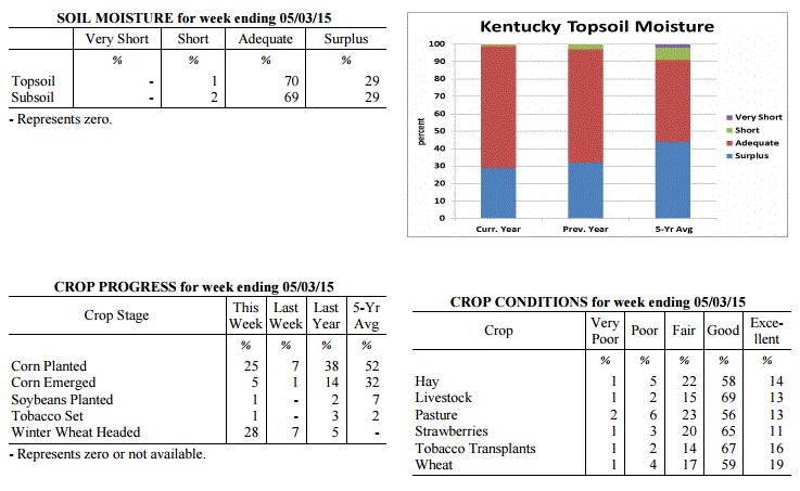 Kentucky Climate Summary
For the Period April 27, 2015 to May 3, 2015
Below Normal Temperatures and Much Below Normal Rainfall:
After a very wet April, the Commonwealth finally got a chance to dry out this past
period with well below normal rainfall in place. In fact, the state averaged just a
tenth of an inch. According to data at the Ag Weather Center, this was the third
driest week of 2015 for the Bluegrass State. The only significant chance of rainfall
came on Thursday when scattered to numerous showers and a few thunderstorms broke out
across the eastern half of the state. Otherwise, the majority of the week was mostly
dry with high pressure in the vicinity. Accompanying the dry pattern was cool
conditions over the course of the work week. A warming trend setup over the weekend,
but it was not enough to keep the state from a second straight week of below normal
temperatures.
Temperatures for the period averaged 56 degrees across the state which was 4 degrees
cooler than normal and 2 degrees warmer than the previous period. High temperatures
averaged from 70 in the West to 68 in the East. Departure from normal high
temperatures ranged from 3 degrees cooler than normal in the West to 4 degrees
cooler than normal in the East. Low temperatures averaged from 44 degrees in the
West to 41 degrees in the East. Departure from normal low temperature ranged from 6
degrees cooler than normal in the West to 3 degrees cooler than normal in the East.
The extreme high temperature for the period was 82 degrees at CAPE GIRARDEAU ASOS and
the extreme low was 31 degrees at VANCEBURG 6W.
Precipitation (liq. equ.) for the period totaled 0.10 inches statewide which was 0.97
inches below normal and 9% of normal. Precipitation totals by climate division, West
0.01 inches, Central 0.09 inches, Bluegrass 0.13 inches and East 0.18 inches, which
was 1.2, 1, 0.85 and 0.82 inches below normal. By station, precipitation totals
ranged from a low of 0.00 inches at BENTON 4N to a high of 0.67
inches at WHITESBURG 2NW.
---
Kentucky Crop and Weather Report
Issued 4:00 P.M., April 27, 2015 8-15
Agricultural News: Kentucky experienced below normal temperatures and rainfall over
the past week. Precipitation for the week totaled 0.88 inches, 0.14 inches below
normal. Temperatures averaged 54 degrees for the week, 4 degrees below normal.
Topsoil moisture was rated 0 percent very short, 0 percent short, 47 percent adequate
and 53 percent surplus. Subsoil moisture was rated 0 percent very short, 1 percent
short, 55 percent adequate, and 44 percent surplus. Days suitable for fieldwork
averaged 2.0 out of a possible seven.
Wet conditions continued to prevent most field activities last week. Corn planting
was reported in some areas where conditions allowed. The state is in need of sunshine
and dry conditions, which this week�s forecast should deliver, bringing optimism that
corn planting will show significant progress. Seventy-nine percent of wheat is rated
as good to excellent. Winter wheat began heading in some locations last week. The
average height of winter wheat was 17 inches, compared to 13 inches last week.
Tobacco transplants in the greenhouse are in need of warm, sunny weather. Fifty-four
percent of tobacco transplants were under 2 inches, with 34 percent between 2-4
inches, and 12 percent over 4 inches.
Alfalfa Hay average height was 9 inches, compared to 7 inches last week. Hay and
roughage supplies were reported as 5 percent very short, 23 percent short, 65 percent
adequate, and 7 percent surplus. The peach crop is expected to be minimal this year
due to the poor bloom caused by cold conditions earlier this year. While apples were
affected by weather conditions as well, the impact is reportedly less severe. Apple
freeze damage was reported as 2 percent severe, 14 percent moderate, 37 percent
light, with 47 percent experiencing none. Peach freeze damage was reported as 30
percent severe, 21 percent moderate, 18 percent light, with 31 percent experiencing
none.
Kentucky Climate Summary
For the Period April 27, 2015 to May 3, 2015
Below Normal Temperatures and Much Below Normal Rainfall:
After a very wet April, the Commonwealth finally got a chance to dry out this past
period with well below normal rainfall in place. In fact, the state averaged just a
tenth of an inch. According to data at the Ag Weather Center, this was the third
driest week of 2015 for the Bluegrass State. The only significant chance of rainfall
came on Thursday when scattered to numerous showers and a few thunderstorms broke out
across the eastern half of the state. Otherwise, the majority of the week was mostly
dry with high pressure in the vicinity. Accompanying the dry pattern was cool
conditions over the course of the work week. A warming trend setup over the weekend,
but it was not enough to keep the state from a second straight week of below normal
temperatures.
Temperatures for the period averaged 56 degrees across the state which was 4 degrees
cooler than normal and 2 degrees warmer than the previous period. High temperatures
averaged from 70 in the West to 68 in the East. Departure from normal high
temperatures ranged from 3 degrees cooler than normal in the West to 4 degrees
cooler than normal in the East. Low temperatures averaged from 44 degrees in the
West to 41 degrees in the East. Departure from normal low temperature ranged from 6
degrees cooler than normal in the West to 3 degrees cooler than normal in the East.
The extreme high temperature for the period was 82 degrees at CAPE GIRARDEAU ASOS and
the extreme low was 31 degrees at VANCEBURG 6W.
Precipitation (liq. equ.) for the period totaled 0.10 inches statewide which was 0.97
inches below normal and 9% of normal. Precipitation totals by climate division, West
0.01 inches, Central 0.09 inches, Bluegrass 0.13 inches and East 0.18 inches, which
was 1.2, 1, 0.85 and 0.82 inches below normal. By station, precipitation totals
ranged from a low of 0.00 inches at BENTON 4N to a high of 0.67
inches at WHITESBURG 2NW.
---
Kentucky Crop and Weather Report
Issued 4:00 P.M., April 27, 2015 8-15
Agricultural News: Kentucky experienced below normal temperatures and rainfall over
the past week. Precipitation for the week totaled 0.88 inches, 0.14 inches below
normal. Temperatures averaged 54 degrees for the week, 4 degrees below normal.
Topsoil moisture was rated 0 percent very short, 0 percent short, 47 percent adequate
and 53 percent surplus. Subsoil moisture was rated 0 percent very short, 1 percent
short, 55 percent adequate, and 44 percent surplus. Days suitable for fieldwork
averaged 2.0 out of a possible seven.
Wet conditions continued to prevent most field activities last week. Corn planting
was reported in some areas where conditions allowed. The state is in need of sunshine
and dry conditions, which this week�s forecast should deliver, bringing optimism that
corn planting will show significant progress. Seventy-nine percent of wheat is rated
as good to excellent. Winter wheat began heading in some locations last week. The
average height of winter wheat was 17 inches, compared to 13 inches last week.
Tobacco transplants in the greenhouse are in need of warm, sunny weather. Fifty-four
percent of tobacco transplants were under 2 inches, with 34 percent between 2-4
inches, and 12 percent over 4 inches.
Alfalfa Hay average height was 9 inches, compared to 7 inches last week. Hay and
roughage supplies were reported as 5 percent very short, 23 percent short, 65 percent
adequate, and 7 percent surplus. The peach crop is expected to be minimal this year
due to the poor bloom caused by cold conditions earlier this year. While apples were
affected by weather conditions as well, the impact is reportedly less severe. Apple
freeze damage was reported as 2 percent severe, 14 percent moderate, 37 percent
light, with 47 percent experiencing none. Peach freeze damage was reported as 30
percent severe, 21 percent moderate, 18 percent light, with 31 percent experiencing
none.
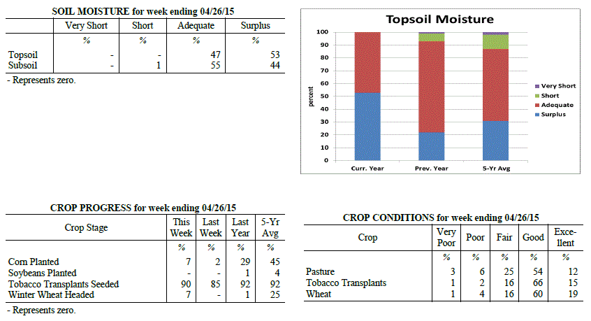 Kentucky Climate Summary
For the Period April 20, 2015 to April 26, 2015
Below Normal Temperatures and Rainfall:
The Commonwealth cannot catch much of a break this spring season. For the first time
since the last week of March, Kentucky saw below normal rainfall. With that in mind,
the state did see subfreezing temperatures later in the work week and a round of
severe weather on Saturday. The work week started out with a couple cold fronts
passing through the area on Monday and Wednesday. Scattered showers and isolated
thunderstorms developed with each round, but didn�t amount to much in the way of
accumulations. The bigger story was the very cool temperatures that filtered into
the area Wednesday and Thursday nights, bringing with it the threat of frost and
subfreezing temperatures. Temperatures fell into the low to mid 30s Wednesday night
for some locations, but was outdone Thursday night as high pressure shifted overhead.
Clearing skies and a calm wind led to many locations across the eastern half of the
state dropping into the upper 20s to low 30s. This was roughly 20 degrees below
normal for late April. Attention then turned to severe weather as a warm front hung
up across the Commonwealth on Saturday. Storms fired later in the evening within a
warm and unstable air mass. Some storms produced very large hail (multiple reports at
2 inches +), damaging winds, and a few tornadoes were also surveyed: EF2 in Edmonson
County, EF1 in Adair, and EF0 in Henderson. Through the event, the state averaged
just under a half inch.
Temperatures for the period averaged 54 degrees across the state which was 4 degrees
cooler than normal and 8 degrees cooler than the previous period. High temperatures
averaged from 66 in the West to 64 in the East. Departure from normal high
temperatures ranged from 6 degrees cooler than normal in the West to 7 degrees
cooler than normal in the East. Low temperatures averaged from 47 degrees in the
West to 43 degrees in the East. Departure from normal low temperature ranged from 1
degree cooler than normal in the West to 1 degree warmer than normal in the East.
The extreme high temperature for the period was 83 degrees at POPLAR BLUFF ASOS and
the extreme low was 26 degrees at FORT CAMPBELL.
Precipitation (liq. equ.) for the period totaled 0.88 inches statewide which was 0.14
inches below normal and 86% of normal. Precipitation totals by climate division, West
0.75 inches, Central 0.83 inches, Bluegrass 0.95 inches and East 1.00 inches, which
was -0.44, -0.20, 0.01 and 0.06 inches respectively from normal. By station,
precipitation totals ranged from a low of 0.31 inches at CARBONDALE ASOS to a high of
1.73 inches at WHITESBURG 2NW.
---
Kentucky Crop and Weather Report
Issued 4:00 P.M., April 20, 2015 7-15
Agricultural News: Kentucky experienced much above normal temperatures and rainfall
over the past week. Precipitation for the week totaled 2.69 inches, 1.70 inches above
normal. Temperatures averaged 64 degrees for the week, 8 degrees above normal.
Topsoil moisture was rated 0 percent very short, 0 percent short, 36 percent adequate
and 64 percent surplus. Subsoil moisture was rated 0 percent very short, 1 percent
short, 50 percent adequate, and 49 percent surplus. Days suitable for fieldwork
averaged 1.3 out of a possible seven.
Wet conditions continued as most ground is saturated and many low lying areas are
under water. The state is in need of sunshine and dry conditions as field work was
limited this week. Primary activities this week included preparing farm equipment for
planting, seeding pastures, and seeding tobacco transplants. Farmers are anxious to
plant corn as soon as field conditions permit. Many locations are now 2-3 weeks
behind schedule and considering switching some acres to soybeans or sorghum.
Canola has bloomed and the crop continues to look good. Wheat is still rated in
mostly good condition. However, some wheat is showing signs of too much water,
especially in low lying areas. Wheat will soon begin to head. Producers will be on
the lookout for Fusarium Head Blight which thrives in wet and warm weather. The
average height of winter wheat was 13 inches, compared to 7 inches last week.
Cloudy days have slowed the development of tobacco transplants in the greenhouse.
Sixty-one percent of tobacco transplants were under 2 inches, with 32 percent between
2-4 inches, and 7 percent over 4 inches. Lush pastures have reduced the need for hay,
but livestock producers are supplementing high magnesium mineral to reduce risk
of grass tetany. Rainy conditions have promoted good alfalfa hay growth with the average
height at 7 inches.
Kentucky Climate Summary
For the Period April 20, 2015 to April 26, 2015
Below Normal Temperatures and Rainfall:
The Commonwealth cannot catch much of a break this spring season. For the first time
since the last week of March, Kentucky saw below normal rainfall. With that in mind,
the state did see subfreezing temperatures later in the work week and a round of
severe weather on Saturday. The work week started out with a couple cold fronts
passing through the area on Monday and Wednesday. Scattered showers and isolated
thunderstorms developed with each round, but didn�t amount to much in the way of
accumulations. The bigger story was the very cool temperatures that filtered into
the area Wednesday and Thursday nights, bringing with it the threat of frost and
subfreezing temperatures. Temperatures fell into the low to mid 30s Wednesday night
for some locations, but was outdone Thursday night as high pressure shifted overhead.
Clearing skies and a calm wind led to many locations across the eastern half of the
state dropping into the upper 20s to low 30s. This was roughly 20 degrees below
normal for late April. Attention then turned to severe weather as a warm front hung
up across the Commonwealth on Saturday. Storms fired later in the evening within a
warm and unstable air mass. Some storms produced very large hail (multiple reports at
2 inches +), damaging winds, and a few tornadoes were also surveyed: EF2 in Edmonson
County, EF1 in Adair, and EF0 in Henderson. Through the event, the state averaged
just under a half inch.
Temperatures for the period averaged 54 degrees across the state which was 4 degrees
cooler than normal and 8 degrees cooler than the previous period. High temperatures
averaged from 66 in the West to 64 in the East. Departure from normal high
temperatures ranged from 6 degrees cooler than normal in the West to 7 degrees
cooler than normal in the East. Low temperatures averaged from 47 degrees in the
West to 43 degrees in the East. Departure from normal low temperature ranged from 1
degree cooler than normal in the West to 1 degree warmer than normal in the East.
The extreme high temperature for the period was 83 degrees at POPLAR BLUFF ASOS and
the extreme low was 26 degrees at FORT CAMPBELL.
Precipitation (liq. equ.) for the period totaled 0.88 inches statewide which was 0.14
inches below normal and 86% of normal. Precipitation totals by climate division, West
0.75 inches, Central 0.83 inches, Bluegrass 0.95 inches and East 1.00 inches, which
was -0.44, -0.20, 0.01 and 0.06 inches respectively from normal. By station,
precipitation totals ranged from a low of 0.31 inches at CARBONDALE ASOS to a high of
1.73 inches at WHITESBURG 2NW.
---
Kentucky Crop and Weather Report
Issued 4:00 P.M., April 20, 2015 7-15
Agricultural News: Kentucky experienced much above normal temperatures and rainfall
over the past week. Precipitation for the week totaled 2.69 inches, 1.70 inches above
normal. Temperatures averaged 64 degrees for the week, 8 degrees above normal.
Topsoil moisture was rated 0 percent very short, 0 percent short, 36 percent adequate
and 64 percent surplus. Subsoil moisture was rated 0 percent very short, 1 percent
short, 50 percent adequate, and 49 percent surplus. Days suitable for fieldwork
averaged 1.3 out of a possible seven.
Wet conditions continued as most ground is saturated and many low lying areas are
under water. The state is in need of sunshine and dry conditions as field work was
limited this week. Primary activities this week included preparing farm equipment for
planting, seeding pastures, and seeding tobacco transplants. Farmers are anxious to
plant corn as soon as field conditions permit. Many locations are now 2-3 weeks
behind schedule and considering switching some acres to soybeans or sorghum.
Canola has bloomed and the crop continues to look good. Wheat is still rated in
mostly good condition. However, some wheat is showing signs of too much water,
especially in low lying areas. Wheat will soon begin to head. Producers will be on
the lookout for Fusarium Head Blight which thrives in wet and warm weather. The
average height of winter wheat was 13 inches, compared to 7 inches last week.
Cloudy days have slowed the development of tobacco transplants in the greenhouse.
Sixty-one percent of tobacco transplants were under 2 inches, with 32 percent between
2-4 inches, and 7 percent over 4 inches. Lush pastures have reduced the need for hay,
but livestock producers are supplementing high magnesium mineral to reduce risk
of grass tetany. Rainy conditions have promoted good alfalfa hay growth with the average
height at 7 inches.
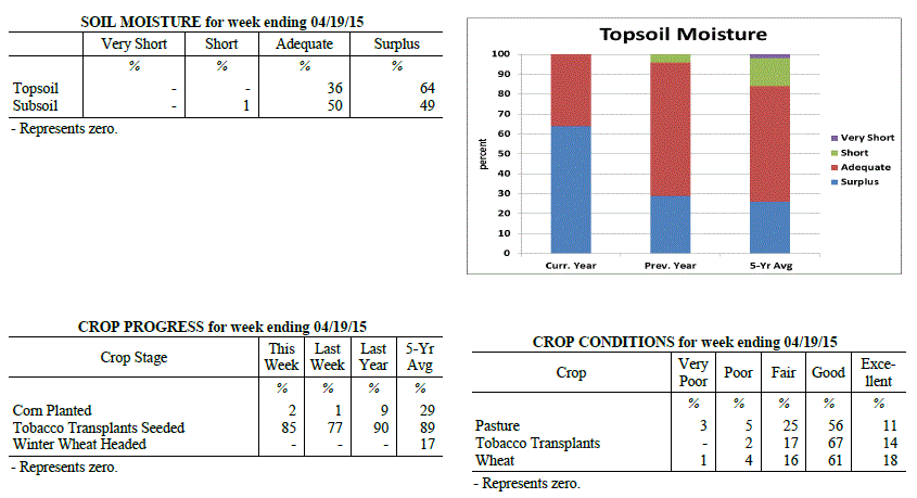 Kentucky Climate Summary
For the Period April 13, 2015 to April 19, 2015
Much Above Normal Temperatures and Rainfall:
The rain kept on coming for the Bluegrass State this past period as many continued to
inch toward a record breaking April. For the past week, the state averaged over two
and a half inches, which made for the third straight week of above normal rainfall.
Looking at data from the National Weather Service in Louisville, the cities of
Louisville, Lexington, Bowling Green, and Frankfort are already in the top five for
wettest April�s on record. Rainfall was consistent throughout the week with a near
daily chance for showers and storms. The only downtime was Friday and Saturday as
weak high pressure pushed into the area. Temperature-wise, it was once again another
mild week for the Commonwealth, mainly due to cloud cover keeping temperatures
elevated at night. Lows typically only dropped into the 50s each day. Normal low
temperatures for this time of the year are in the mid to upper 40s.
Temperatures for the period averaged 64 degrees across the state which was 8 degrees
warmer than normal and no change to the previous period. High temperatures averaged
from 72 in the West to 72 in the East. Departure from normal high temperatures
ranged from 2 degrees warmer than normal in the West to 3 degrees warmer than normal
in the East. Low temperatures averaged from 57 degrees in the West to 55 degrees in
the East. Departure from normal low temperature ranged from 11 degrees warmer than
normal in the West to 15 degrees warmer than normal in the East. The extreme high
temperature for the period was 85 degrees at LOUISA 1S and the extreme low was 43
degrees at VANCEBURG 6W.
Precipitation (liq. equ.) for the period totaled 2.69 inches statewide which was 1.7
inches above normal and 271% of normal. Precipitation totals by climate division,
West 2.94 inches, Central 3.57 inches, Bluegrass 1.87 inches and East 2.40 inches,
which was 1.82, 2.57, 0.96 and 1.46 inches above normal. By station, precipitation
totals ranged from a low of 0.71 inches at CARROLLTON 2E to a high of 5.09 inches
at BOWLING GREEN 5S.
---
Kentucky Crop and Weather Report
Issued 4:00 P.M., April 13, 2015 6-15
Agricultural News: Kentucky experienced above normal temperatures and rainfall over
the past week. Precipitation for the week totaled 1.61 inches, 0.60 inches above
normal. Temperatures averaged 63 degrees for the week, 9 degrees above normal.
Topsoil moisture was rated 1 percent short, 43 percent adequate and 56 percent
surplus. Subsoil moisture was rated 2 percent short, 60 percent adequate, and 38
percent surplus. Days suitable for fieldwork averaged 1.8 out of a possible seven.
Wet conditions continue to prevent most field work as corn planting is 2 weeks behind
normal in many locations. Farmers are conducting soil tests to determine fertilizer
applications, and applying when conditions allow. Producers are providing livestock
access to high magnesium mineral to reduce risk of grass tetany. The peach crop is
expected to be minimal this year due to the poor bloom caused by cold conditions.
Most canola has bloomed and the crop looks good. Eighty-one percent of wheat is rated
as good to excellent. The average height of winter wheat was 7 inches.
Kentucky Climate Summary
For the Period April 13, 2015 to April 19, 2015
Much Above Normal Temperatures and Rainfall:
The rain kept on coming for the Bluegrass State this past period as many continued to
inch toward a record breaking April. For the past week, the state averaged over two
and a half inches, which made for the third straight week of above normal rainfall.
Looking at data from the National Weather Service in Louisville, the cities of
Louisville, Lexington, Bowling Green, and Frankfort are already in the top five for
wettest April�s on record. Rainfall was consistent throughout the week with a near
daily chance for showers and storms. The only downtime was Friday and Saturday as
weak high pressure pushed into the area. Temperature-wise, it was once again another
mild week for the Commonwealth, mainly due to cloud cover keeping temperatures
elevated at night. Lows typically only dropped into the 50s each day. Normal low
temperatures for this time of the year are in the mid to upper 40s.
Temperatures for the period averaged 64 degrees across the state which was 8 degrees
warmer than normal and no change to the previous period. High temperatures averaged
from 72 in the West to 72 in the East. Departure from normal high temperatures
ranged from 2 degrees warmer than normal in the West to 3 degrees warmer than normal
in the East. Low temperatures averaged from 57 degrees in the West to 55 degrees in
the East. Departure from normal low temperature ranged from 11 degrees warmer than
normal in the West to 15 degrees warmer than normal in the East. The extreme high
temperature for the period was 85 degrees at LOUISA 1S and the extreme low was 43
degrees at VANCEBURG 6W.
Precipitation (liq. equ.) for the period totaled 2.69 inches statewide which was 1.7
inches above normal and 271% of normal. Precipitation totals by climate division,
West 2.94 inches, Central 3.57 inches, Bluegrass 1.87 inches and East 2.40 inches,
which was 1.82, 2.57, 0.96 and 1.46 inches above normal. By station, precipitation
totals ranged from a low of 0.71 inches at CARROLLTON 2E to a high of 5.09 inches
at BOWLING GREEN 5S.
---
Kentucky Crop and Weather Report
Issued 4:00 P.M., April 13, 2015 6-15
Agricultural News: Kentucky experienced above normal temperatures and rainfall over
the past week. Precipitation for the week totaled 1.61 inches, 0.60 inches above
normal. Temperatures averaged 63 degrees for the week, 9 degrees above normal.
Topsoil moisture was rated 1 percent short, 43 percent adequate and 56 percent
surplus. Subsoil moisture was rated 2 percent short, 60 percent adequate, and 38
percent surplus. Days suitable for fieldwork averaged 1.8 out of a possible seven.
Wet conditions continue to prevent most field work as corn planting is 2 weeks behind
normal in many locations. Farmers are conducting soil tests to determine fertilizer
applications, and applying when conditions allow. Producers are providing livestock
access to high magnesium mineral to reduce risk of grass tetany. The peach crop is
expected to be minimal this year due to the poor bloom caused by cold conditions.
Most canola has bloomed and the crop looks good. Eighty-one percent of wheat is rated
as good to excellent. The average height of winter wheat was 7 inches.
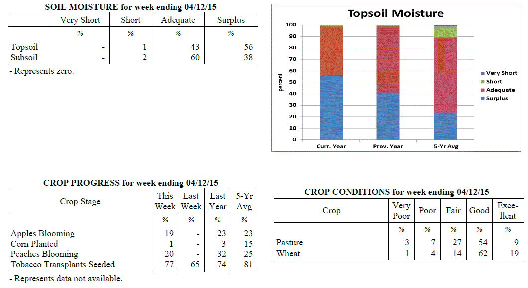 Kentucky Climate Summary
For the Period April 6, 2015 to April 12, 2015
Much Above Normal Temperatures and Above Normal Rainfall:
The wet pattern continued for a second straight period as rainfall was seen on a
daily basis over this past work week. Multiple disturbances pushed through the Lower
Ohio Valley and with plenty of moisture available, any storms that did develop were
efficient rainfall producers. Flash flooding was once again a concern for some
locations. Some rounds did produce a fair share of severe weather as the state was
placed within an unstable air mass. A couple weak tornadoes were seen in Madison
County on the 7th, while hail 2 inches in diameter fell on the 8th. The final round
pushed through the area on Thursday night and into Friday morning with the passage of
a cold front. Over the course of the period, the state average was a bit over an inch
and a half. Drier air worked into the area on Friday with the Commonwealth getting a
chance to dry out over the weekend with high pressure in place. Looking at
temperatures, it was one of the warmest weeks of 2015 thus far. The average state
temperature was 9 degrees above normal, mainly due to multiple days with highs in
the 70s/80s and lows only dropping into the 50s/60s.
Temperatures for the period averaged 63 degrees across the state which was 9 degrees
warmer than normal and 8 degrees warmer than the previous period. High temperatures
averaged from 74 in the West to 74 in the East. Departure from normal high
temperatures ranged from 6 degrees warmer than normal in the West to 7 degrees
warmer than normal in the East. Low temperatures averaged from 55 degrees in the
West to 51 degrees in the East. Departure from normal low temperature ranged from 11
degrees warmer than normal in the West to 12 degrees warmer than normal in the
East. The extreme high temperature for the period was 87 degrees at BOONEVILLE 2S and
the extreme low was 27 degrees at MONTICELLO AWOS.
Precipitation (liq. equ.) for the period totaled 1.61 inches statewide which was 0.6
inches above normal and 160% of normal. Precipitation totals by climate division,
West 1.10 inches, Central 1.65 inches, Bluegrass 1.85 inches and East 1.84 inches,
which was -0.05, 0.62, 0.94 and 0.91 inches respectively from normal. By station,
precipitation totals ranged from a low of 0.36 inches at PRINCETON 2SE to a high of
3.16 inches at BARBOURVILLE 3E.
---
Kentucky Crop and Weather Report
Issued 4:00 P.M., April 7, 2015 5-15
Agricultural News: Kentucky experienced excessive rainfall over the past week.
Precipitation for the week totaled 2.80 inches, 1.80 inches above normal.
Temperatures averaged 54 degrees for the week, 3 degrees above normal. Topsoil
moisture was rated 1 percent short, 51 percent adequate and 48 percent surplus.
Subsoil moisture was rated 3 percent short, 67 percent adequate, and 30 percent
surplus. Days suitable for fieldwork averaged 3.6 out of a possible seven.
Primary activities this week included preparing farm equipment for planting, applying
fertilizer, and seeding tobacco transplants. Excessive rainfall kept farmers out of
the fields and caused some flooding which resulted in crop and livestock losses.
Wheat winter freeze damage was reported as 1 percent severe, 4 percent moderate, 15
percent light, with 80 percent experiencing none. Alfalfa hay freeze damage was
reported as 2 percent severe, 12 percent moderate, 43 percent light, with 43 percent
experiencing none. Cattle and calves obtained approximately 39 percent of feed from
pastures, but some hay is being fed.
Kentucky Climate Summary
For the Period April 6, 2015 to April 12, 2015
Much Above Normal Temperatures and Above Normal Rainfall:
The wet pattern continued for a second straight period as rainfall was seen on a
daily basis over this past work week. Multiple disturbances pushed through the Lower
Ohio Valley and with plenty of moisture available, any storms that did develop were
efficient rainfall producers. Flash flooding was once again a concern for some
locations. Some rounds did produce a fair share of severe weather as the state was
placed within an unstable air mass. A couple weak tornadoes were seen in Madison
County on the 7th, while hail 2 inches in diameter fell on the 8th. The final round
pushed through the area on Thursday night and into Friday morning with the passage of
a cold front. Over the course of the period, the state average was a bit over an inch
and a half. Drier air worked into the area on Friday with the Commonwealth getting a
chance to dry out over the weekend with high pressure in place. Looking at
temperatures, it was one of the warmest weeks of 2015 thus far. The average state
temperature was 9 degrees above normal, mainly due to multiple days with highs in
the 70s/80s and lows only dropping into the 50s/60s.
Temperatures for the period averaged 63 degrees across the state which was 9 degrees
warmer than normal and 8 degrees warmer than the previous period. High temperatures
averaged from 74 in the West to 74 in the East. Departure from normal high
temperatures ranged from 6 degrees warmer than normal in the West to 7 degrees
warmer than normal in the East. Low temperatures averaged from 55 degrees in the
West to 51 degrees in the East. Departure from normal low temperature ranged from 11
degrees warmer than normal in the West to 12 degrees warmer than normal in the
East. The extreme high temperature for the period was 87 degrees at BOONEVILLE 2S and
the extreme low was 27 degrees at MONTICELLO AWOS.
Precipitation (liq. equ.) for the period totaled 1.61 inches statewide which was 0.6
inches above normal and 160% of normal. Precipitation totals by climate division,
West 1.10 inches, Central 1.65 inches, Bluegrass 1.85 inches and East 1.84 inches,
which was -0.05, 0.62, 0.94 and 0.91 inches respectively from normal. By station,
precipitation totals ranged from a low of 0.36 inches at PRINCETON 2SE to a high of
3.16 inches at BARBOURVILLE 3E.
---
Kentucky Crop and Weather Report
Issued 4:00 P.M., April 7, 2015 5-15
Agricultural News: Kentucky experienced excessive rainfall over the past week.
Precipitation for the week totaled 2.80 inches, 1.80 inches above normal.
Temperatures averaged 54 degrees for the week, 3 degrees above normal. Topsoil
moisture was rated 1 percent short, 51 percent adequate and 48 percent surplus.
Subsoil moisture was rated 3 percent short, 67 percent adequate, and 30 percent
surplus. Days suitable for fieldwork averaged 3.6 out of a possible seven.
Primary activities this week included preparing farm equipment for planting, applying
fertilizer, and seeding tobacco transplants. Excessive rainfall kept farmers out of
the fields and caused some flooding which resulted in crop and livestock losses.
Wheat winter freeze damage was reported as 1 percent severe, 4 percent moderate, 15
percent light, with 80 percent experiencing none. Alfalfa hay freeze damage was
reported as 2 percent severe, 12 percent moderate, 43 percent light, with 43 percent
experiencing none. Cattle and calves obtained approximately 39 percent of feed from
pastures, but some hay is being fed.
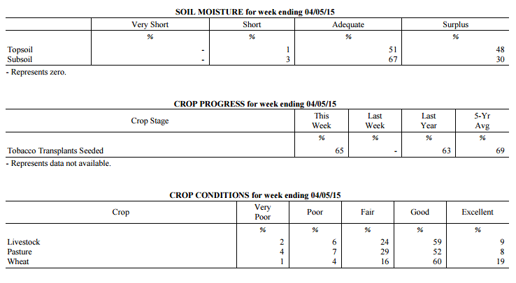 Kentucky Climate Summary
For the Period March 30, 2015 to April 5, 2015
Above Normal Temperatures and Much Above Normal Rainfall:
A very active pattern set up across the Lower Ohio Valley for the beginning of April,
leading to excessive rainfall for much of the state. In addition, after going much
of the winter without any thunderstorms, an unstable atmosphere led to the first
of the year for many locations. The main activity occurred over the second half of
the work week as a frontal boundary stalled across the area. The state as a whole,
averaged just under three inches for the week, but portions of the Bluegrass region
received much more. Along the I-64 corridor, many locations received five to more
than seven inches of rain over the two day period. Significant flooding was an issue
across much of the state as multiple thunderstorms trained over the same region.
Over the course of the week, rainfall was above normal by 1.8 inches, breaking a two
week run of below normal precipitation. The weekend brought dry conditions, but with
cooler temperatures in place. For the first time this year, frost advisories were
issued for Saturday night.
Temperatures for the period averaged 54 degrees across the state which was 3 degrees
warmer than normal and 8 degrees warmer than the previous period. High temperatures
averaged from 69 in the West to 67 in the East. Departure from normal high
temperatures ranged from 4 degrees warmer than normal in the West to 3 degrees
warmer than normal in the East. Low temperatures averaged from 44 degrees in the
West to 41 degrees in the East. Departure from normal low temperature ranged from 2
degrees warmer than normal in the West to 4 degrees warmer than normal in the East.
The extreme high temperature for the period was 81 degrees at HARTFORD 3E and the
extreme low was 26 degrees at MCKEE 5S.
Precipitation (liq. equ.) for the period totaled 2.80 inches statewide which was 1.8
inches above normal and 279% of normal. Precipitation totals by climate division,
West 1.97 inches, Central 2.48 inches, Bluegrass 4.28 inches and East 2.46 inches,
which was 0.88, 1.43, 3.37 and 1.5 inches above normal. By station, precipitation
totals ranged from a low of 0.83 inches at WHITESBURG 2NW to a high of 7.21
inches at FRANKFORT 7S.
---
Kentucky Climate Summary
For the Period March 23, 2015 to March 29, 2015
Below Normal Temperatures and Precipitation:
The Bluegrass State closed out the month of March with a second straight week of
below normal precipitation. Most of the activity was centered on a cold front that
worked through the area Wednesday night and into Thursday. Overall, totals averaged
about a half inch for the state. Ahead of the boundary, temperatures peaked in the
70s across much of Kentucky, before falling well below seasonable norms on Friday
and Saturday. Highs typically only rose into the 40s each day with lows falling into
the 20s. Some locations even dipped into the upper teens. Dr. John Strang (UK
Horticulture specialist) stated that temperatures in the 20s will not have much
impact. Apples and pears were in the 'Silver Tip' and 'Swollen bud' stages,
respectively. In order for 10% bud kill, a critical temperature of 15 degrees needed
to be reached for each. John stated that some peaches may have reached the 'Swollen
Bud' stage and in this case, 10 percent kill occurs with a critical temperature of 18
degrees.
Temperatures for the period averaged 46 degrees across the state which was 3 degrees
cooler than normal and 4 degrees cooler than the previous period. High temperatures
averaged from 59 in the West to 60 in the East. Departure from normal high
temperatures ranged from 4 degrees cooler than normal in the West to 2 degrees
cooler than normal in the East. Low temperatures averaged from 36 degrees in the
West to 34 degrees in the East. Departure from normal low temperature ranged from 4
degrees cooler than normal in the West to 1 degree cooler than normal in the East.
The extreme high temperature for the period was 79 degrees at GREENVILLE 6N and the
extreme low was 14 degrees at PAINTSVILLE 4W.
Precipitation (liq. equ.) for the period totaled 0.47 inches statewide which was 0.57
inches below normal and 45% of normal. Precipitation totals by climate division, West
0.70 inches, Central 0.36 inches, Bluegrass 0.43 inches and East 0.40 inches, which
was 0.41, 0.73, 0.5 and 0.61 inches below normal. By station, precipitation totals
ranged from a low of 0.07 inches at MIDDLESBORO AWOS to a high of 1.90 inches at
CAPE GIRARDEAU ASOS.
---
Kentucky Climate Summary
For the Period March 16, 2015 to March 22, 2015
Above Normal Temperatures and Below Normal Precipitation:
The Commonwealth finally got a chance to dry out this past period, along with another
week of above normal temperatures. The warmest day of 2015 occurred this past Monday
with the mercury reaching into the 70s statewide. A cold front then pushed through
the region on Tuesday, followed by Canadian high pressure building into the area that
night. This frontal passage ended up being a mostly dry one, but with much cooler
temperatures in place. Wednesday highs dropped back into the upper 40s to middle 50s.
Similar temperatures remained with the area through Friday, before another warming
trend over the weekend. Light showers fell on and off over the second half of the
work week as a few disturbances crossed the area. Total accumulations were minimal
with a state average of just under a quarter inch.
Temperatures for the period averaged 50 degrees across the state which was 2 degrees
warmer than normal and 2 degrees cooler than the previous period. High temperatures
averaged from 60 in the West to 59 in the East. Departure from normal high
temperatures ranged from near normal in the West to 1 degree cooler than
normal in the East. Low temperatures averaged from 43 degrees in the West to 41
degrees in the East. Departure from normal low temperature ranged from 5 degrees
warmer than normal in the West to 7 degrees warmer than normal in the East. The
extreme high temperature for the period was 79 degrees at LOUISA 1S and the extreme
low was 23 degrees at CYNTHIANA 8N.
Precipitation (liq. equ.) for the period totaled 0.22 inches statewide which was 0.82
inches below normal and 21% of normal. Precipitation totals by climate division, West
0.13 inches, Central 0.23 inches, Bluegrass 0.21 inches and East 0.33 inches, which
was 0.97, 0.87, 0.73 and 0.69 inches below normal. By station, precipitation totals
ranged from a low of 0.02 inches at CARBONDALE ASOS to a high of 0.79 inches at
WHITLEY CITY 3N.
---
Kentucky Climate Summary
For the Period March 9, 2015 to March 15, 2015
Much Above Normal Temperatures and Precipitation:
The Commonwealth finally got a first glimpse of spring temperatures this past period,
but not without an excessive amount of rainfall. Throughout the week, the state saw
a couple rounds of low pressure pass through the area, one over the first half of the
work week and the other lasting from Thursday night into Saturday. Each round
brought an average of 1 to 2 inches of rainfall for most. By the time the week was
over, the state average was over 3 inches, which was over 2 inches above normal.
This was the 3rd time over the past 4 weeks that the state average was over 2 inches.
In doing so, the US Drought Monitor removed any mention of abnormally dry conditions
across the Bluegrass State. Looking at temperatures, highs typically stayed in the
50s and 60s for much of the week. Some stations even broke 70 on the 12th and 15th.
The mild conditions broke a streak of 4 straight weeks of below normal temperatures.
Temperatures for the period averaged 52 degrees across the state which was 7 degrees
warmer than normal and 18 degrees warmer than the previous period. High temperatures
averaged from 61 in the West to 61 in the East. Departure from normal high
temperatures ranged from 3 degrees warmer than normal in the West to 4 degrees
warmer than normal in the East. Low temperatures averaged from 45 degrees in the
West to 45 degrees in the East. Departure from normal low temperature ranged from 9
degrees warmer than normal in the West to 13 degrees warmer than normal in the
East. The extreme high temperature for the period was 71 degrees at BOWLING GREEN 4E
and the extreme low was 31 degrees at CARROLLTON 2E.
Precipitation (liq. equ.) for the period totaled 3.12 inches statewide which was 2.15
inches above normal and 321% of normal. Precipitation totals by climate division,
West 3.50 inches, Central 3.32 inches, Bluegrass 3.67 inches and East 2.00 inches,
which was 2.49, 2.3, 2.78 and 1.03 inches above normal. By station, precipitation
totals ranged from a low of 1.14 inches at MIDDLESBORO AWOS to a high of 5.38
inches at PADUCAH ASOS.
---
Kentucky Climate Summary
For the Period March 2, 2015 to March 8, 2015
Well Below Normal Temperatures and Much Above Normal Precipitation:
The pause from recording breaking winter weather was short lived as the Commonwealth
was hit with another major winter storm this past period. The event started with warm
air and excessive rainfall in place Tuesday and through the overnight. Highs on
Tuesday reached the 50s. For many, this was the first time since February 9th that
this threshold had been met. The combination of rainfall and melting snow led to
flooding in some low lying areas and along creeks and rivers. Colder air started
working into the area on Wednesday with the mercury on the decline. Precipitation
transitioned to snow through the day from northwest to southeast. Moderate to heavy
snow continued through the overnight for many locations, leading to record breaking
snowfall totals. The heaviest occurred on a line that ran through Elizabethtown and
Frankfort where totals ranged between 18 to 24 inches. Lexington saw 17.1 inches and
was the heaviest 2 day snowfall total ever recorded. Arctic high pressure entered
from the northwest by Thursday with another shot of very cold air in place. With the
excessive amount of snow on the ground, record breaking temperatures were seen at
numerous locations that night. Many went below zero, which was over 30 degrees colder
than normal for that time of the year. The good news is that winds shifted to the
southwest for the weekend, ushering temperatures back into the 40s and 50s.
Temperatures for the period averaged 33 degrees across the state which was 11 degrees
cooler than normal and 6 degrees warmer than the previous period. High temperatures
averaged from 43 in the West to 49 in the East. Departure from normal high
temperatures ranged from 14 degrees cooler than normal in the West to 7 degrees
cooler than normal in the East. Low temperatures averaged from 21 degrees in the
West to 24 degrees in the East. Departure from normal low temperature ranged from 14
degrees cooler than normal in the West to 7 degrees cooler than normal in the East.
The extreme high temperature for the period was 66 degrees at FORT CAMPBELL and the
extreme low was -15 degrees at BRANDENBURG 4SW.
Precipitation (liq. equ.) for the period totaled 2.88 inches statewide which was 1.91
inches above normal and 296% of normal. Precipitation totals by climate division,
West 2.94 inches, Central 3.05 inches, Bluegrass 2.71 inches and East 2.82 inches,
which was 1.89, 2.03, 1.84 and 1.87 inches above normal. By station, precipitation
totals ranged from a low of 0.79 inches at CARBONDALE ASOS to a high of 3.99 inches
at WHITLEY CITY 3N.
---
Kentucky Climate Summary
For the Period February 23, 2015 to March 1, 2015
Well Below Normal Temperatures and Much Below Normal Precipitation:
The Commonwealth closed out the month of February with another very cold week. In
fact, this was the third straight week of well below normal temperatures as the
Bluegrass State saw another couple rounds of Arctic air. Highs for this time of the
year normally top out in the upper 40s to middle 50s with overnight lows in the low
to mid 30s. Over the course of the period, the Arctic air kept highs hovering in the 20s
to low 30s with lows dropping into the single digits to lower teens at times. After
a recording break week of snowfall, precipitation this past period was quite scarce.
Portions of South-Central and Southeastern Kentucky saw light snow accumulations
Wednesday night as low pressure passed just south of the state. Most snowfall totals
were below an inch. The northern periphery of the Kentucky then saw another period of
light snow and a wintry mix Saturday night and into Sunday morning, but once again,
accumulations were light. Over the course of the week, the majority of state saw
around a tenth of an inch of liquid equivalent.
Temperatures for the period averaged 26 degrees across the state which was 16 degrees
cooler than normal and 10 degrees warmer than the previous period. High temperatures
averaged from 32 in the West to 36 in the East. Departure from normal high
temperatures ranged from 22 degrees cooler than normal in the West to 18 degrees
cooler than normal in the East. Low temperatures averaged from 18 degrees in the
West to 20 degrees in the East. Departure from normal low temperature ranged from 15
degrees cooler than normal in the West to 9 degrees cooler than normal in the East.
The extreme high temperature for the period was 52 degrees at MONTICELLO AWOS and the
extreme low was -8 degrees at MAYSVILLE 3SW.
Precipitation (liq. equ.) for the period totaled 0.13 inches statewide which was 0.86
inches below normal and 13% of normal. Precipitation totals by climate division, West
0.09 inches, Central 0.13 inches, Bluegrass 0.19 inches and East 0.12 inches, which
was 1.01, 0.92, 0.67 and 0.81 inches below normal. By station, precipitation totals
ranged from a low of 0.01 inches at LONDON to a high of 0.35 inches at PIKEVILLE 13S.
---
Kentucky Climate Summary
For the Period February 16, 2015 to February 22, 2015
Well Below Normal Temperatures and Much Above Normal Precipitation:
It was an all-around, recording breaking week for the Lower Ohio Valley. The period
started off with a major winter storm pushing through the area on Monday. Significant
accumulations were seen across the entirety of the state with 8 to 12 inches common.
Snowfall was moderate to heavy at times with rates in the vicinity of 1 to 2 inches
per hour. Another cold front then dropped across the region Tuesday night and into
Wednesday morning, dropping another 1 to 2 inches. Following the snow, dangerously
cold air built into the Ohio Valley. The coldest period was Wednesday night through
Thursday night with the mercury pushing well below zero. Most fell between -5 and -
15 on Wednesday night, before only rising into the single digits on Thursday. Much of
the Bluegrass and Eastern Kentucky then dropped to between -10 and -20 on Thursday
night with Arctic high pressure shifting overhead. Some dropped even further. The
state record for low temperatures was set back in January of 1994 with a reading of -
37 degrees. Richmond got close with a low temperature of -32 on Thursday night.
Records were broken in Lexington, Louisville, Bowling Green, and Frankfort that
spanned back over 100 years, into the late 1800s.
The cold air was followed by yet another winter storm over the weekend. Temperatures
were actually on the increase Friday night and into Saturday, opening the window for
a wintry mix across the state. Ice was more common across the southern half of
Kentucky with minor snow accumulations further north. Another issue was the amount of
rainfall across the area. Much of the state saw 1 to 3 inches, with the highest
totals across the southern half of the state. In addition to the melting snowpack,
some flooding arose, especially in low lying areas. This was the first week that the
Bluegrass State has seen in 2015 with above normal rainfall and it came at a good
time as drought was expanding. Over the course of the period, the state was over 1.5
inches above normal. Looking at temperatures, the very cold Arctic air led Kentucky
to a week in which highs and lows were 25 and 19 degrees below normal, respectively.
Temperatures for the period averaged 17 degrees across the state which was 22 degrees
cooler than normal and 12 degrees cooler than the previous period. High temperatures
averaged from 27 in the West to 25 in the East. Departure from normal high
temperatures ranged from 24 degrees cooler than normal in the West to 25 degrees
cooler than normal in the East. Low temperatures averaged from 11 degrees in the
West to 9 degrees in the East. Departure from normal low temperature ranged from 19
degrees cooler than normal in the West to 17 degrees cooler than normal in the
East. The extreme high temperature for the period was 46 degrees at WHITESBURG 2NW
and the extreme low was -32 degrees at RICHMOND 8E.
Precipitation (liq. equ.) for the period totaled 2.69 inches statewide which was 1.77
inches above normal and 292% of normal. Precipitation totals by climate division,
West 3.11 inches, Central 3.06 inches, Bluegrass 1.83 inches and East 2.76 inches,
which was 2.07, 2.07, 1.04 and 1.9 inches above normal. By station, precipitation
totals ranged from a low of 1.05 inches at CARBONDALE ASOS to a high of 4.46
inches at MURRAY 1W.
---
Kentucky Climate Summary
For the Period February 9, 2015 to February 15, 2015
Much Below Normal Temperatures and Precipitation:
Dry conditions persisted this past period and were accompanied by a return to winter-
like temperatures. Focus centered around the passage of two strong cold fronts, one
on Thursday and the other on Saturday. The region saw light snow accumulations with
each event, along with gusty northwest winds. In particular, winds on Saturday gusted
to over 40 mph for many locations. After the passage of this front, lows plummeted
into the single digits by Sunday morning. Over the course of the week, precipitation
was once again scarce, only amounting to under a tenth of an inch on average across
the state. This made for the 7th straight week of below normal precipitation. For
2015, the state is on average, over 3 inches below normal. The US Drought Monitor now
displays over half the state in Moderate Drought.
Temperatures for the period averaged 29 degrees across the state which was 8 degrees
cooler than normal and 8 degrees cooler than the previous period. High temperatures
averaged from 40 in the West to 36 in the East. Departure from normal high
temperatures ranged from 8 degrees cooler than normal in the West to 12 degrees
cooler than normal in the East. Low temperatures averaged from 22 degrees in the
West to 21 degrees in the East. Departure from normal low temperature ranged from 6
degrees cooler than normal in the West to 4 degrees cooler than normal in the East.
The extreme high temperature for the period was 59 degrees at POPLAR BLUFF ASOS and
the extreme low was -3 degrees at PIKEVILLE 13S.
Precipitation (liq. equ.) for the period totaled 0.04 inches statewide which was 0.86
inches below normal and 4% of normal. Precipitation totals by climate division, West
0.00 inches, Central 0.04 inches, Bluegrass 0.04 inches and East 0.10 inches, which
was 1.01, 0.95, 0.74 and 0.74 inches below normal. By station, precipitation totals
ranged from a low of 0.00 inches at BENTON 4N to a high of 0.39 inches at WHITESBURG 2NW.
---
Kentucky Climate Summary
For the Period February 2, 2015 to February 8, 2015
Above Normal Temperatures and Below Normal Precipitation:
Thus far, conditions have been dry and fairly mild through the beginning of 2015.
That trend did not change this past period. Overall, the Commonwealth averaged less
than a quarter inch of precipitation. Much of the activity centered around the
passing of a couple cold fronts through the work week, each producing just minor snow
accumulations. This pushed the Bluegrass State to a sixth straight week of below
normal rainfall. The US Drought Monitor expanded abnormally dry conditions to
comprising nearly 80% of the state. The period ended with a very warm weekend with
above normal temperatures in place. Most saw highs rise into the mid 50s to around 60.
Temperatures for the period averaged 36 degrees across the state which was 2 degrees
warmer than normal and no change to the previous period. High temperatures averaged
from 47 in the West to 49 in the East. Departure from normal high temperatures ranged
from 1 degree warmer than normal in the West to 3 degrees warmer than normal in the
East. Low temperatures averaged from 26 degrees in the West to 25 degrees in the
East. Departure from normal low temperature ranged from near normal in the West to 2
degrees warmer than normal in the East. The extreme high temperature for the period
was 66 degrees at LOUISA 1S and the extreme low was 4 degrees at VANCEBURG 6W.
Precipitation (liq. equ.) for the period totaled 0.20 inches statewide which was 0.67
inches below normal and 23% of normal. Precipitation totals by climate division, West
0.04 inches, Central 0.17 inches, Bluegrass 0.20 inches and East 0.38 inches, which
was 0.91, 0.78, 0.56 and 0.45 inches below normal. By station, precipitation totals
ranged from a low of 0.00 inches at HICKMAN 2E to a high of 0.84 inches at PIKEVILLE 13S.
---
Kentucky Climate Summary
For the Period January 26, 2015 to February 1, 2015
Above Normal Temperatures and Below Normal Precipitation:
The Commonwealth saw a number of precipitation events this past week with the most
significant coming on Sunday as low pressure passed just north of the state.
Widespread light to moderate rainfall pushed through the area with rainfall totals
generally between a half to one inch for most. Saying this, overall, it was another
period in which precipitation was lacking. The state average was below normal for
the fifth straight week. Looking farther back, 12 of the past 15 weeks have seen
below normal precipitation. This has taken a toll across the state with the US
Drought Monitor expanding the area of abnormally dry conditions to accounting for
nearly 70% of the state. Moderate drought also expanded into Central Kentucky, which
is nearly 3.5 inches below normal over the past 60 days.
Temperatures for the period averaged 35 degrees across the state which was 2 degrees
warmer than normal and 2 degrees cooler than the previous period. High temperatures
averaged from 46 in the West to 42 in the East. Departure from normal high
temperatures ranged from 2 degrees warmer than normal in the West to 2 degrees
cooler than normal in the East. Low temperatures averaged from 32 degrees in the
West to 25 degrees in the East. Departure from normal low temperature ranged from 7
degrees warmer than normal in the West to 3 degrees warmer than normal in the East.
The extreme high temperature for the period was 62 degrees at FORT CAMPBELL and the
extreme low was 8 degrees at BLACK MOUNTAIN ARC.
Precipitation (liq. equ.) for the period totaled 0.73 inches statewide which was 0.07
inches below normal and 91% of normal. Precipitation totals by climate division, West
0.90 inches, Central 0.87 inches, Bluegrass 0.54 inches and East 0.61 inches, which
was 0.05, 0.01, -0.16 and -0.18 inches respectively from normal. By station,
precipitation totals ranged from a low of 0.28 inches at BOONEVILLE 2S to a high of
1.57 inches at POPLAR BLUFF ASOS.
---
Kentucky Climate Summary
For the Period January 19, 2015 to January 25, 2015
Above Normal Temperatures and Below Normal Precipitation:
Thus far, snowfall has been a rare occurrence this winter season for the Lower Ohio
Valley. That notion came to an end on Friday night and Saturday morning. As low
pressure passed just south and east of the state, a heavy snow band resulted in
significant snowfall totals across Central Kentucky and up into the Bluegrass. One
particular swath running through Elizabethtown and Lexington saw between 4 to 6
inches. The good news is that this event occurred between two relatively warm
periods. The week started off with temperatures well above normal, reaching the 50s
for most locations between Monday and Wednesday. The warm ground temperatures and
mild temperatures over the weekend took a toll on the snowpack. Overall, while the
state did see some significant snowfall, the liquid equivalent was just under a half
inch for the week. This pushed the Bluegrass State to a fourth straight week of below
normal precipitation. The US Drought Monitor remained relatively unchanged with a
little over 10% of the state in Moderate Drought.
Temperatures for the period averaged 38 degrees across the state which was 5 degrees
warmer than normal and 4 degrees warmer than the previous period. High temperatures
averaged from 50 in the West to 48 in the East. Departure from normal high
temperatures ranged from 7 degrees warmer than normal in the West to 4 degrees
warmer than normal in the East. Low temperatures averaged from 29 degrees in the
West to 30 degrees in the East. Departure from normal low temperature ranged from 4
degrees warmer than normal in the West to 8 degrees warmer than normal in the East.
The extreme high temperature for the period was 64 degrees at FORT CAMPBELL and the
extreme low was 15 degrees at ELKTON 5SW.
Precipitation (liq. equ.) for the period totaled 0.44 inches statewide which was 0.38
inches below normal and 54% of normal. Precipitation totals by climate division, West
0.50 inches, Central 0.40 inches, Bluegrass 0.38 inches and East 0.47 inches, which
was 0.37, 0.47, 0.33 and 0.35 inches below normal. By station, precipitation totals
ranged from a low of 0.09 inches at LA GRANGE 6NW to a high of 1.06 inches at PADUCAH
ASOS.
---
Kentucky Climate Summary
For the Period 01-12-2015 to 01-18-2015
Above Normal Temperatures and Below Normal Rainfall:
The big story this past week was the reversal of very cold temperatures to
moderating temperatures. This past week averaged 10 to 15 degrees warmer than the
previous week. Precipitation, on the other hand continued to be slim with the
drought tools starting to place some western and west-central sections in Moderate
hydrologic drought. Nearly 40% of the state was listed as in Moderate to abnormally
dry conditions.
Temperatures for the period averaged 35 degrees across the state which was 2 degrees
warmer than normal and 14 degrees warmer than the previous period. High temperatures
averaged from 42 in the West to 42 in the East. Departure from normal high
temperatures ranged from 1 degrees cooler than normal in the West to 1 degrees cooler
than normal in the East. Low temperatures averaged from 28 degrees in the West to 29
degrees in the East. Departure from normal low temperature ranged from 3 degrees
warmer than normal in the West to 6 degrees warmer than normal in the East. The
extreme high temperature for the period was 63 degrees at POPLAR BLUFF ASOS and the
extreme low was 14 degrees at CARBONDALE ASOS.
Precipitation (liq. equ.) for the period totaled 0.47 inches statewide which was 0.38
inches below normal and 55% of normal. Precipitation totals by climate division, West
0.43 inches, Central 0.57 inches, Bluegrass 0.37 inches and East 0.52 inches, which
was 0.46, 0.33, 0.36 and 0.36 inches below normal. By station, precipitation totals
ranged from a low of 0.24 inches at LOUISVILLE APT to a high of 1.01 inches at
EDMONTON 5W.
---
Kentucky Climate Summary
For the Period January 5, 2015 to January 11, 2015
Well Below Normal Temperatures and Precipitation:
The Commonwealth experienced the coldest temperatures of the young winter season this
past period. An Arctic front pushed through the area Tuesday night with temperatures
quickly on the decrease through the day on Wednesday. Breezy northwest winds pushed
the wind chill below zero Wednesday morning and stayed that way into Thursday. The
coldest temperatures were felt late Wednesday night and into Thursday morning as high
pressure moved overhead. Clear skies and calm winds led to lows dipping to either
side of zero. The cold air lasted through Saturday morning as another cold front
brought a reinforcing shot of Arctic air on Friday. Lows Friday night dipped into
the single digits. Over the period, the livestock cold stress index remained in the
emergency category. For the week, the average state temperature was 12 degrees below
normal. Other than some light snow showers along the previously mentioned Arctic
fronts, the only other significant shot at precipitation was on Sunday as light rain
showers fell across much of the region with the passage of an upper level
disturbance.
Temperatures for the period averaged 22 degrees across the state which was 12 degrees
cooler than normal and 14 degrees cooler than the previous period. High temperatures
averaged from 30 in the West to 32 in the East. Departure from normal high
temperatures ranged from 13 degrees cooler than normal in the West to 12 degrees
cooler than normal in the East. Low temperatures averaged from 15 degrees in the
West to 14 degrees in the East. Departure from normal low temperature ranged from 11
degrees cooler than normal in the West to 10 degrees cooler than normal in the
East. The extreme high temperature for the period was 48 degrees at MONTICELLO AWOS
and the extreme low was -9 degrees at BLACK MOUNTAIN ARC.
Precipitation (liq. equ.) for the period totaled 0.03 inches statewide which was 0.85
inches below normal and 3% of normal. Precipitation totals by climate division, West
0.05 inches, Central 0.02 inches, Bluegrass 0.02 inches and East 0.02 inches, which
was 0.88, 0.92, 0.73 and 0.89 inches below normal. By station, precipitation totals
ranged from a low of 0.00 inches at ALBANY 1N to a high of 0.27 inches at POPLAR
BLUFF ASOS.
---
Kentucky Climate Summary
For the Period December 29, 2014 to January 4, 2014
Above Normal Temperatures and Below Normal Precipitation:
2014 went out with a period of dry and cold conditions. High pressure took control
for the first half of the week. Highs generally only rose into the mid 30s to low
40s. Temperatures were coolest on Tuesday night with lows dropping into the mid-
teens to low 20s. After a fairly mild December, winter finally got the chance to
make an appearance, but it was short-lived as the Commonwealth rung in the New Year.
The thermometer was on the upward trend for much of the remaining week. As low
pressure moved northeast over the weekend, a warm front pushed highs into the 60s on
Saturday, about 20 to 25 degrees above normal. The system also brought multiple
rounds of showers to the region over the course of the weekend. Much of the state
saw a half to one inch, averaging out to slightly below normal for the week.
Temperatures for the period averaged 36 degrees across the state which was 2 degrees
warmer than normal and 10 degrees cooler than the previous period. High temperatures
averaged from 43 in the West to 44 in the East. Departure from normal high
temperatures were near normal across the state. Low temperatures averaged from 29
degrees in the West to 31 degrees in the East. Departure from normal low temperature
ranged from 3 degrees warmer than normal in the West to 7 degrees warmer than normal
in the East. The extreme high temperature for the period was 69 degrees at WHITESBURG
2NW and the extreme low was 13 degrees at BURLINGTON 4S.
Precipitation (liq. equ.) for the period totaled 0.83 inches statewide which was 0.08
inches below normal and 92% of normal. Precipitation totals by climate division, West
1.15 inches, Central 0.60 inches, Bluegrass 0.64 inches and East 0.92 inches, which
was 0.21, -0.38, -0.15 and 0.01 inches respectively from normal. By station,
precipitation totals ranged from a low of 0.19 inches at FORT CAMPBELL to a high of
4.35 inches at POPLAR BLUFF ASOS.
---
Kentucky Climate Summary
For the Period December 22, 2014 to December 28, 2014
Above Normal Temperatures and Precipitation:
Unseasonably mild temperatures and multiple rounds of rainfall were the highlights
of this past week. Southerly flow brought a warm and a moist air mass to the state
to start off the period. Highs jumped into the mid 50s to low 60s, lasting
through Christmas Eve when a cold front passed through the area. Breezy conditions
accompanied the frontal passage with gusts over 40 mph at times. Temperatures
dropped to near normal for the holiday, before jumping back into the 50s for the
remainder of the week. The mild temperatures led to the highest above normal
deviation seen all year for the Bluegrass State, 10 degrees above normal. Accompanying
the warm temperatures was a rather wet period. Multiple disturbances crossed the
region over the first half of the work week, followed by a cold front over the weekend.
Much of the Commonwealth averaged around an inch.
Temperatures for the period averaged 46 degrees across the state which was 10 degrees
warmer than normal and 10 degrees warmer than the previous period. High temperatures
averaged from 50 in the West to 56 in the East. Departure from normal high
temperatures ranged from 5 degrees warmer than normal in the West to 10 degrees
warmer than normal in the East. Low temperatures averaged from 39 degrees in the
West to 39 degrees in the East. Departure from normal low temperature ranged from 11
degrees warmer than normal in the West to 13 degrees warmer than normal in the
East. The extreme high temperature for the period was 69 degrees at JACKSON 3SE and
the extreme low was 21 degrees at VANCEBURG 6W.
Precipitation (liq. equ.) for the period totaled 1.08 inches statewide which was 0.14
inches above normal and 114% of normal. Precipitation totals by climate division,
West 0.99 inches, Central 1.03 inches, Bluegrass 0.86 inches and East 1.44 inches,
which was -0.02, 0.00, 0.03 and 0.53 inches respectively from normal. By station,
precipitation totals ranged from a low of 0.39 inches at HARRODSBURG 3N to a high of
2.74 inches at ALBANY 1N.
---
Kentucky Climate Summary
For the Period December 15, 2014 to December 21, 2014
Near Normal Temperatures and Much Below Normal Precipitation:
The dry trend across Kentucky remained in place this past period. The state averaged
less than a quarter inch with most of that total coming on Monday and Tuesday as a
cold front moved through the region. Surface high pressure dominated for much of the
remainder of the week with a couple weak disturbances mixed within. Overall, while
clouds stuck around for much of the period, precipitation was scarce. Four of the
past six weeks have now seen precipitation below normal by at least a half inch.
Abnormally dry conditions have resurfaced in portions of Western and Central Kentucky
according to the US Drought Monitor.
Temperatures for the period averaged 37 degrees across the state which was near
normal and 2 degrees cooler than the previous period. High temperatures
averaged from 44 in the West to 44 in the East. Departure from normal high
temperatures ranged from 3 degrees cooler than normal in the West to 4 degrees
cooler than normal in the East. Low temperatures averaged from 32 degrees in the
West to 31 degrees in the East. Departure from normal low temperature ranged from 3
degrees warmer than normal in the West to 4 degrees warmer than normal in the East.
The extreme high temperature for the period was 58 degrees at PEABODY and the extreme
low was 17 degrees at CAMPBELLSVILLE 7W.
Precipitation (liq. equ.) for the period totaled 0.15 inches statewide which was 0.82
inches below normal and 15% of normal. Precipitation totals by climate division, West
0.27 inches, Central 0.09 inches, Bluegrass 0.14 inches and East 0.11 inches, which
was 0.8, 0.98, 0.7 and 0.81 inches below normal. By station, precipitation totals ranged
from a low of 0.00 inches at EDMONTON 5W to a high of 0.90 inches at POPLAR BLUFF ASOS.
---
Kentucky Climate Summary
For the Period December 8, 2014 to December 14, 2014
Below Normal Temperatures and Much Below Normal Precipitation:
A very dry pattern set up across the Bluegrass State this past week. The
Commonwealth only averaged 0.02 inches, which was over an inch below normal. In fact,
this was the highest below normal deviation the state had seen all year. The only
focus for drizzle and light showers was over the first half of the work week as a
weak cold front moved through the area. The rest of the period remained dry with
clouds persisting. After a fairly cool work week with highs typically only rising
into the upper 30s to low 40s, high pressure moved over Kentucky for the weekend.
Despite clouds hanging around, the state saw a gradual warm-up with highs in the
middle 40s to low 50s by Sunday.
Temperatures for the period averaged 38 degrees across the state which was 1 degree
cooler than normal and 6 degrees cooler than the previous period. High temperatures
averaged from 46 in the West to 42 in the East. Departure from normal high
temperatures ranged from 3 degrees cooler than normal in the West to 7 degrees
cooler than normal in the East. Low temperatures averaged from 33 degrees in the
West to 31 degrees in the East. Departure from normal low temperature ranged from 2
degrees warmer than normal in the West to 3 degrees warmer than normal in the East.
The extreme high temperature for the period was 62 degrees at POPLAR BLUFF ASOS and
the extreme low was 17 degrees at MONTICELLO AWOS.
Precipitation (liq. equ.) for the period totaled 0.02 inches statewide which was 1.03
inches below normal and 2% of normal. Precipitation totals by climate division, West
0.00 inches, Central 0.01 inches, Bluegrass 0.03 inches and East 0.05 inches, which
was 1.14, 1.13, 0.89 and 0.94 inches below normal. By station, precipitation totals
ranged from a low of 0.00 inches at BENTON 4N to a high of 0.19 inches at PIKEVILLE 13S.
---
Kentucky Climate Summary
For the Period December 1, 2014 to December 7, 2014
Above Normal Temperatures and Precipitation:
Sunshine was a rare sight this past period. Much of the week was dominated by an
unsettled, wet pattern with multiple rounds of precipitation. Over the course of the
period, most locations picked up 1 to 2 inches. When there was no rain showers
present, conditions remained damp with a persistent light drizzle sticking around.
The most significant rainfall was over the latter half of the work week and into
Saturday as low pressure pushed through the Bluegrass State. Conditions then improved
over the latter half of the weekend with skies finally opening up. While it was a
wet and damp week, temperature hovered near to above normal for much of the period.
Overall, the state was 2 degrees above normal, which was the first time since mid-
October.
Temperatures for the period averaged 44 degrees across the state which was 2 degrees
warmer than normal and no change to the previous period. High temperatures averaged
from 49 in the West to 53 in the East. Departure from normal high temperatures
ranged from 3 degrees cooler than normal in the West to 1 degree warmer than normal
in the East. Low temperatures averaged from 38 degrees in the West to 38 degrees in
the East. Departure from normal low temperature ranged from 5 degrees warmer than
normal in the West to 8 degrees warmer than normal in the East. The extreme high
temperature for the period was 66 degrees at BURKESVILLE 3W and the extreme low was
24 degrees at MAYSVILLE 3SW.
Precipitation (liq. equ.) for the period totaled 1.78 inches statewide which was 0.69
inches above normal and 164% of normal. Precipitation totals by climate division,
West 1.34 inches, Central 1.81 inches, Bluegrass 2.28 inches and East 1.68 inches,
which was 0.09, 0.65, 1.36 and 0.66 inches above normal. By station, precipitation
totals ranged from a low of 0.88 inches at PRINCETON 2SE to a high of 3.14 inches at
MOREHEAD 4NE.
---
Kentucky Climate Summary
For the Period November 24, 2014 to November 30, 2014
Below Normal Temperatures and Precipitation:
A winter-like pattern remained in place for the last week of November. A low pressure
system moved through the Great Lakes on Monday and dragged a cold front through the
area, bringing widespread showers to the region. Accompanying the boundary were
strong winds with gusts over 40 mph at times. Low temperatures that night dropped
into the 20s across much of the state. Attention then moved to a fast moving clipper
system that tracked through Kentucky on Wednesday night. Most precipitation was
oriented to the southern half of the state with a transition to snow through the
overnight. Warm ground temperatures limited accumulations. Temperatures took a dip
behind the system for the Thanksgiving holiday, only rising into the mid 30s to
around 40. Lows that night dipped back into the low to mid 20s, leading the way to a
6th straight week of below normal temperatures. Saying that, high pressure shifted
east over the weekend. Breezy southwest winds brought seasonably mild temperatures
with the mercury topping out in the mid to upper 60s by Sunday.
Temperatures for the period averaged 43 degrees across the state which was 1 degree
cooler than normal and 8 degrees warmer than the previous period. High temperatures
averaged from 51 in the West to 52 in the East. Departure from normal high
temperatures ranged from 3 degrees cooler than normal in the West to 2 degrees cooler
than normal in the East. Low temperatures averaged from 35 degrees in the West to 37
degrees in the East. Departure from normal low temperature ranged from near normal in
the West to 6 degrees warmer than normal in the East. The extreme high temperature
for the period was 72 degrees at LOUISA 1S and the extreme low was 15 degrees at BLACK
MOUNTAIN ARC.
Precipitation (liq. equ.) for the period totaled 0.24 inches statewide which was 0.82
inches below normal and 23% of normal. Precipitation totals by climate division, West
0.36 inches, Central 0.25 inches, Bluegrass 0.25 inches and East 0.12 inches, which
was 0.87, 0.87, 0.65 and 0.86 inches below normal. By station, precipitation totals
ranged from a low of 0.02 inches at JACKSON AIRPORT to a high of 0.89 inches at
EVANSVILLE ASOS.
---
USDA's Kentucky Crop and Weather Report
Issued 4:00 P.M., November 24, 2014, 34-14
Agricultural News: Kentucky experienced below normal temperatures and above normal
precipitation over the past week. Precipitation for the week totaled 1.05 inches,
0.06 inches above normal. Temperatures averaged 35 degrees for the week, 11 degrees
below normal. Topsoil moisture was rated 2 percent very short, 7 percent short, 74
percent adequate and 17 percent surplus. Subsoil moisture was rated 2 percent very
short, 9 percent short, 80 percent adequate, and 9 percent surplus. Days suitable for
fieldwork averaged 4.2 out of a possible seven. Hay and roughage supplies were
reported as 1 percent very short, 12 percent short, 78 percent adequate, and 9
percent surplus.
Primary activities this week included harvesting crops and stripping tobacco. Recent
cold temperatures may impact young wheat depending on the timing of emergence.
***Last Issue of the Year. Publication of the 2015 series will begin about the
first week of April.***
Kentucky Climate Summary
For the Period March 30, 2015 to April 5, 2015
Above Normal Temperatures and Much Above Normal Rainfall:
A very active pattern set up across the Lower Ohio Valley for the beginning of April,
leading to excessive rainfall for much of the state. In addition, after going much
of the winter without any thunderstorms, an unstable atmosphere led to the first
of the year for many locations. The main activity occurred over the second half of
the work week as a frontal boundary stalled across the area. The state as a whole,
averaged just under three inches for the week, but portions of the Bluegrass region
received much more. Along the I-64 corridor, many locations received five to more
than seven inches of rain over the two day period. Significant flooding was an issue
across much of the state as multiple thunderstorms trained over the same region.
Over the course of the week, rainfall was above normal by 1.8 inches, breaking a two
week run of below normal precipitation. The weekend brought dry conditions, but with
cooler temperatures in place. For the first time this year, frost advisories were
issued for Saturday night.
Temperatures for the period averaged 54 degrees across the state which was 3 degrees
warmer than normal and 8 degrees warmer than the previous period. High temperatures
averaged from 69 in the West to 67 in the East. Departure from normal high
temperatures ranged from 4 degrees warmer than normal in the West to 3 degrees
warmer than normal in the East. Low temperatures averaged from 44 degrees in the
West to 41 degrees in the East. Departure from normal low temperature ranged from 2
degrees warmer than normal in the West to 4 degrees warmer than normal in the East.
The extreme high temperature for the period was 81 degrees at HARTFORD 3E and the
extreme low was 26 degrees at MCKEE 5S.
Precipitation (liq. equ.) for the period totaled 2.80 inches statewide which was 1.8
inches above normal and 279% of normal. Precipitation totals by climate division,
West 1.97 inches, Central 2.48 inches, Bluegrass 4.28 inches and East 2.46 inches,
which was 0.88, 1.43, 3.37 and 1.5 inches above normal. By station, precipitation
totals ranged from a low of 0.83 inches at WHITESBURG 2NW to a high of 7.21
inches at FRANKFORT 7S.
---
Kentucky Climate Summary
For the Period March 23, 2015 to March 29, 2015
Below Normal Temperatures and Precipitation:
The Bluegrass State closed out the month of March with a second straight week of
below normal precipitation. Most of the activity was centered on a cold front that
worked through the area Wednesday night and into Thursday. Overall, totals averaged
about a half inch for the state. Ahead of the boundary, temperatures peaked in the
70s across much of Kentucky, before falling well below seasonable norms on Friday
and Saturday. Highs typically only rose into the 40s each day with lows falling into
the 20s. Some locations even dipped into the upper teens. Dr. John Strang (UK
Horticulture specialist) stated that temperatures in the 20s will not have much
impact. Apples and pears were in the 'Silver Tip' and 'Swollen bud' stages,
respectively. In order for 10% bud kill, a critical temperature of 15 degrees needed
to be reached for each. John stated that some peaches may have reached the 'Swollen
Bud' stage and in this case, 10 percent kill occurs with a critical temperature of 18
degrees.
Temperatures for the period averaged 46 degrees across the state which was 3 degrees
cooler than normal and 4 degrees cooler than the previous period. High temperatures
averaged from 59 in the West to 60 in the East. Departure from normal high
temperatures ranged from 4 degrees cooler than normal in the West to 2 degrees
cooler than normal in the East. Low temperatures averaged from 36 degrees in the
West to 34 degrees in the East. Departure from normal low temperature ranged from 4
degrees cooler than normal in the West to 1 degree cooler than normal in the East.
The extreme high temperature for the period was 79 degrees at GREENVILLE 6N and the
extreme low was 14 degrees at PAINTSVILLE 4W.
Precipitation (liq. equ.) for the period totaled 0.47 inches statewide which was 0.57
inches below normal and 45% of normal. Precipitation totals by climate division, West
0.70 inches, Central 0.36 inches, Bluegrass 0.43 inches and East 0.40 inches, which
was 0.41, 0.73, 0.5 and 0.61 inches below normal. By station, precipitation totals
ranged from a low of 0.07 inches at MIDDLESBORO AWOS to a high of 1.90 inches at
CAPE GIRARDEAU ASOS.
---
Kentucky Climate Summary
For the Period March 16, 2015 to March 22, 2015
Above Normal Temperatures and Below Normal Precipitation:
The Commonwealth finally got a chance to dry out this past period, along with another
week of above normal temperatures. The warmest day of 2015 occurred this past Monday
with the mercury reaching into the 70s statewide. A cold front then pushed through
the region on Tuesday, followed by Canadian high pressure building into the area that
night. This frontal passage ended up being a mostly dry one, but with much cooler
temperatures in place. Wednesday highs dropped back into the upper 40s to middle 50s.
Similar temperatures remained with the area through Friday, before another warming
trend over the weekend. Light showers fell on and off over the second half of the
work week as a few disturbances crossed the area. Total accumulations were minimal
with a state average of just under a quarter inch.
Temperatures for the period averaged 50 degrees across the state which was 2 degrees
warmer than normal and 2 degrees cooler than the previous period. High temperatures
averaged from 60 in the West to 59 in the East. Departure from normal high
temperatures ranged from near normal in the West to 1 degree cooler than
normal in the East. Low temperatures averaged from 43 degrees in the West to 41
degrees in the East. Departure from normal low temperature ranged from 5 degrees
warmer than normal in the West to 7 degrees warmer than normal in the East. The
extreme high temperature for the period was 79 degrees at LOUISA 1S and the extreme
low was 23 degrees at CYNTHIANA 8N.
Precipitation (liq. equ.) for the period totaled 0.22 inches statewide which was 0.82
inches below normal and 21% of normal. Precipitation totals by climate division, West
0.13 inches, Central 0.23 inches, Bluegrass 0.21 inches and East 0.33 inches, which
was 0.97, 0.87, 0.73 and 0.69 inches below normal. By station, precipitation totals
ranged from a low of 0.02 inches at CARBONDALE ASOS to a high of 0.79 inches at
WHITLEY CITY 3N.
---
Kentucky Climate Summary
For the Period March 9, 2015 to March 15, 2015
Much Above Normal Temperatures and Precipitation:
The Commonwealth finally got a first glimpse of spring temperatures this past period,
but not without an excessive amount of rainfall. Throughout the week, the state saw
a couple rounds of low pressure pass through the area, one over the first half of the
work week and the other lasting from Thursday night into Saturday. Each round
brought an average of 1 to 2 inches of rainfall for most. By the time the week was
over, the state average was over 3 inches, which was over 2 inches above normal.
This was the 3rd time over the past 4 weeks that the state average was over 2 inches.
In doing so, the US Drought Monitor removed any mention of abnormally dry conditions
across the Bluegrass State. Looking at temperatures, highs typically stayed in the
50s and 60s for much of the week. Some stations even broke 70 on the 12th and 15th.
The mild conditions broke a streak of 4 straight weeks of below normal temperatures.
Temperatures for the period averaged 52 degrees across the state which was 7 degrees
warmer than normal and 18 degrees warmer than the previous period. High temperatures
averaged from 61 in the West to 61 in the East. Departure from normal high
temperatures ranged from 3 degrees warmer than normal in the West to 4 degrees
warmer than normal in the East. Low temperatures averaged from 45 degrees in the
West to 45 degrees in the East. Departure from normal low temperature ranged from 9
degrees warmer than normal in the West to 13 degrees warmer than normal in the
East. The extreme high temperature for the period was 71 degrees at BOWLING GREEN 4E
and the extreme low was 31 degrees at CARROLLTON 2E.
Precipitation (liq. equ.) for the period totaled 3.12 inches statewide which was 2.15
inches above normal and 321% of normal. Precipitation totals by climate division,
West 3.50 inches, Central 3.32 inches, Bluegrass 3.67 inches and East 2.00 inches,
which was 2.49, 2.3, 2.78 and 1.03 inches above normal. By station, precipitation
totals ranged from a low of 1.14 inches at MIDDLESBORO AWOS to a high of 5.38
inches at PADUCAH ASOS.
---
Kentucky Climate Summary
For the Period March 2, 2015 to March 8, 2015
Well Below Normal Temperatures and Much Above Normal Precipitation:
The pause from recording breaking winter weather was short lived as the Commonwealth
was hit with another major winter storm this past period. The event started with warm
air and excessive rainfall in place Tuesday and through the overnight. Highs on
Tuesday reached the 50s. For many, this was the first time since February 9th that
this threshold had been met. The combination of rainfall and melting snow led to
flooding in some low lying areas and along creeks and rivers. Colder air started
working into the area on Wednesday with the mercury on the decline. Precipitation
transitioned to snow through the day from northwest to southeast. Moderate to heavy
snow continued through the overnight for many locations, leading to record breaking
snowfall totals. The heaviest occurred on a line that ran through Elizabethtown and
Frankfort where totals ranged between 18 to 24 inches. Lexington saw 17.1 inches and
was the heaviest 2 day snowfall total ever recorded. Arctic high pressure entered
from the northwest by Thursday with another shot of very cold air in place. With the
excessive amount of snow on the ground, record breaking temperatures were seen at
numerous locations that night. Many went below zero, which was over 30 degrees colder
than normal for that time of the year. The good news is that winds shifted to the
southwest for the weekend, ushering temperatures back into the 40s and 50s.
Temperatures for the period averaged 33 degrees across the state which was 11 degrees
cooler than normal and 6 degrees warmer than the previous period. High temperatures
averaged from 43 in the West to 49 in the East. Departure from normal high
temperatures ranged from 14 degrees cooler than normal in the West to 7 degrees
cooler than normal in the East. Low temperatures averaged from 21 degrees in the
West to 24 degrees in the East. Departure from normal low temperature ranged from 14
degrees cooler than normal in the West to 7 degrees cooler than normal in the East.
The extreme high temperature for the period was 66 degrees at FORT CAMPBELL and the
extreme low was -15 degrees at BRANDENBURG 4SW.
Precipitation (liq. equ.) for the period totaled 2.88 inches statewide which was 1.91
inches above normal and 296% of normal. Precipitation totals by climate division,
West 2.94 inches, Central 3.05 inches, Bluegrass 2.71 inches and East 2.82 inches,
which was 1.89, 2.03, 1.84 and 1.87 inches above normal. By station, precipitation
totals ranged from a low of 0.79 inches at CARBONDALE ASOS to a high of 3.99 inches
at WHITLEY CITY 3N.
---
Kentucky Climate Summary
For the Period February 23, 2015 to March 1, 2015
Well Below Normal Temperatures and Much Below Normal Precipitation:
The Commonwealth closed out the month of February with another very cold week. In
fact, this was the third straight week of well below normal temperatures as the
Bluegrass State saw another couple rounds of Arctic air. Highs for this time of the
year normally top out in the upper 40s to middle 50s with overnight lows in the low
to mid 30s. Over the course of the period, the Arctic air kept highs hovering in the 20s
to low 30s with lows dropping into the single digits to lower teens at times. After
a recording break week of snowfall, precipitation this past period was quite scarce.
Portions of South-Central and Southeastern Kentucky saw light snow accumulations
Wednesday night as low pressure passed just south of the state. Most snowfall totals
were below an inch. The northern periphery of the Kentucky then saw another period of
light snow and a wintry mix Saturday night and into Sunday morning, but once again,
accumulations were light. Over the course of the week, the majority of state saw
around a tenth of an inch of liquid equivalent.
Temperatures for the period averaged 26 degrees across the state which was 16 degrees
cooler than normal and 10 degrees warmer than the previous period. High temperatures
averaged from 32 in the West to 36 in the East. Departure from normal high
temperatures ranged from 22 degrees cooler than normal in the West to 18 degrees
cooler than normal in the East. Low temperatures averaged from 18 degrees in the
West to 20 degrees in the East. Departure from normal low temperature ranged from 15
degrees cooler than normal in the West to 9 degrees cooler than normal in the East.
The extreme high temperature for the period was 52 degrees at MONTICELLO AWOS and the
extreme low was -8 degrees at MAYSVILLE 3SW.
Precipitation (liq. equ.) for the period totaled 0.13 inches statewide which was 0.86
inches below normal and 13% of normal. Precipitation totals by climate division, West
0.09 inches, Central 0.13 inches, Bluegrass 0.19 inches and East 0.12 inches, which
was 1.01, 0.92, 0.67 and 0.81 inches below normal. By station, precipitation totals
ranged from a low of 0.01 inches at LONDON to a high of 0.35 inches at PIKEVILLE 13S.
---
Kentucky Climate Summary
For the Period February 16, 2015 to February 22, 2015
Well Below Normal Temperatures and Much Above Normal Precipitation:
It was an all-around, recording breaking week for the Lower Ohio Valley. The period
started off with a major winter storm pushing through the area on Monday. Significant
accumulations were seen across the entirety of the state with 8 to 12 inches common.
Snowfall was moderate to heavy at times with rates in the vicinity of 1 to 2 inches
per hour. Another cold front then dropped across the region Tuesday night and into
Wednesday morning, dropping another 1 to 2 inches. Following the snow, dangerously
cold air built into the Ohio Valley. The coldest period was Wednesday night through
Thursday night with the mercury pushing well below zero. Most fell between -5 and -
15 on Wednesday night, before only rising into the single digits on Thursday. Much of
the Bluegrass and Eastern Kentucky then dropped to between -10 and -20 on Thursday
night with Arctic high pressure shifting overhead. Some dropped even further. The
state record for low temperatures was set back in January of 1994 with a reading of -
37 degrees. Richmond got close with a low temperature of -32 on Thursday night.
Records were broken in Lexington, Louisville, Bowling Green, and Frankfort that
spanned back over 100 years, into the late 1800s.
The cold air was followed by yet another winter storm over the weekend. Temperatures
were actually on the increase Friday night and into Saturday, opening the window for
a wintry mix across the state. Ice was more common across the southern half of
Kentucky with minor snow accumulations further north. Another issue was the amount of
rainfall across the area. Much of the state saw 1 to 3 inches, with the highest
totals across the southern half of the state. In addition to the melting snowpack,
some flooding arose, especially in low lying areas. This was the first week that the
Bluegrass State has seen in 2015 with above normal rainfall and it came at a good
time as drought was expanding. Over the course of the period, the state was over 1.5
inches above normal. Looking at temperatures, the very cold Arctic air led Kentucky
to a week in which highs and lows were 25 and 19 degrees below normal, respectively.
Temperatures for the period averaged 17 degrees across the state which was 22 degrees
cooler than normal and 12 degrees cooler than the previous period. High temperatures
averaged from 27 in the West to 25 in the East. Departure from normal high
temperatures ranged from 24 degrees cooler than normal in the West to 25 degrees
cooler than normal in the East. Low temperatures averaged from 11 degrees in the
West to 9 degrees in the East. Departure from normal low temperature ranged from 19
degrees cooler than normal in the West to 17 degrees cooler than normal in the
East. The extreme high temperature for the period was 46 degrees at WHITESBURG 2NW
and the extreme low was -32 degrees at RICHMOND 8E.
Precipitation (liq. equ.) for the period totaled 2.69 inches statewide which was 1.77
inches above normal and 292% of normal. Precipitation totals by climate division,
West 3.11 inches, Central 3.06 inches, Bluegrass 1.83 inches and East 2.76 inches,
which was 2.07, 2.07, 1.04 and 1.9 inches above normal. By station, precipitation
totals ranged from a low of 1.05 inches at CARBONDALE ASOS to a high of 4.46
inches at MURRAY 1W.
---
Kentucky Climate Summary
For the Period February 9, 2015 to February 15, 2015
Much Below Normal Temperatures and Precipitation:
Dry conditions persisted this past period and were accompanied by a return to winter-
like temperatures. Focus centered around the passage of two strong cold fronts, one
on Thursday and the other on Saturday. The region saw light snow accumulations with
each event, along with gusty northwest winds. In particular, winds on Saturday gusted
to over 40 mph for many locations. After the passage of this front, lows plummeted
into the single digits by Sunday morning. Over the course of the week, precipitation
was once again scarce, only amounting to under a tenth of an inch on average across
the state. This made for the 7th straight week of below normal precipitation. For
2015, the state is on average, over 3 inches below normal. The US Drought Monitor now
displays over half the state in Moderate Drought.
Temperatures for the period averaged 29 degrees across the state which was 8 degrees
cooler than normal and 8 degrees cooler than the previous period. High temperatures
averaged from 40 in the West to 36 in the East. Departure from normal high
temperatures ranged from 8 degrees cooler than normal in the West to 12 degrees
cooler than normal in the East. Low temperatures averaged from 22 degrees in the
West to 21 degrees in the East. Departure from normal low temperature ranged from 6
degrees cooler than normal in the West to 4 degrees cooler than normal in the East.
The extreme high temperature for the period was 59 degrees at POPLAR BLUFF ASOS and
the extreme low was -3 degrees at PIKEVILLE 13S.
Precipitation (liq. equ.) for the period totaled 0.04 inches statewide which was 0.86
inches below normal and 4% of normal. Precipitation totals by climate division, West
0.00 inches, Central 0.04 inches, Bluegrass 0.04 inches and East 0.10 inches, which
was 1.01, 0.95, 0.74 and 0.74 inches below normal. By station, precipitation totals
ranged from a low of 0.00 inches at BENTON 4N to a high of 0.39 inches at WHITESBURG 2NW.
---
Kentucky Climate Summary
For the Period February 2, 2015 to February 8, 2015
Above Normal Temperatures and Below Normal Precipitation:
Thus far, conditions have been dry and fairly mild through the beginning of 2015.
That trend did not change this past period. Overall, the Commonwealth averaged less
than a quarter inch of precipitation. Much of the activity centered around the
passing of a couple cold fronts through the work week, each producing just minor snow
accumulations. This pushed the Bluegrass State to a sixth straight week of below
normal rainfall. The US Drought Monitor expanded abnormally dry conditions to
comprising nearly 80% of the state. The period ended with a very warm weekend with
above normal temperatures in place. Most saw highs rise into the mid 50s to around 60.
Temperatures for the period averaged 36 degrees across the state which was 2 degrees
warmer than normal and no change to the previous period. High temperatures averaged
from 47 in the West to 49 in the East. Departure from normal high temperatures ranged
from 1 degree warmer than normal in the West to 3 degrees warmer than normal in the
East. Low temperatures averaged from 26 degrees in the West to 25 degrees in the
East. Departure from normal low temperature ranged from near normal in the West to 2
degrees warmer than normal in the East. The extreme high temperature for the period
was 66 degrees at LOUISA 1S and the extreme low was 4 degrees at VANCEBURG 6W.
Precipitation (liq. equ.) for the period totaled 0.20 inches statewide which was 0.67
inches below normal and 23% of normal. Precipitation totals by climate division, West
0.04 inches, Central 0.17 inches, Bluegrass 0.20 inches and East 0.38 inches, which
was 0.91, 0.78, 0.56 and 0.45 inches below normal. By station, precipitation totals
ranged from a low of 0.00 inches at HICKMAN 2E to a high of 0.84 inches at PIKEVILLE 13S.
---
Kentucky Climate Summary
For the Period January 26, 2015 to February 1, 2015
Above Normal Temperatures and Below Normal Precipitation:
The Commonwealth saw a number of precipitation events this past week with the most
significant coming on Sunday as low pressure passed just north of the state.
Widespread light to moderate rainfall pushed through the area with rainfall totals
generally between a half to one inch for most. Saying this, overall, it was another
period in which precipitation was lacking. The state average was below normal for
the fifth straight week. Looking farther back, 12 of the past 15 weeks have seen
below normal precipitation. This has taken a toll across the state with the US
Drought Monitor expanding the area of abnormally dry conditions to accounting for
nearly 70% of the state. Moderate drought also expanded into Central Kentucky, which
is nearly 3.5 inches below normal over the past 60 days.
Temperatures for the period averaged 35 degrees across the state which was 2 degrees
warmer than normal and 2 degrees cooler than the previous period. High temperatures
averaged from 46 in the West to 42 in the East. Departure from normal high
temperatures ranged from 2 degrees warmer than normal in the West to 2 degrees
cooler than normal in the East. Low temperatures averaged from 32 degrees in the
West to 25 degrees in the East. Departure from normal low temperature ranged from 7
degrees warmer than normal in the West to 3 degrees warmer than normal in the East.
The extreme high temperature for the period was 62 degrees at FORT CAMPBELL and the
extreme low was 8 degrees at BLACK MOUNTAIN ARC.
Precipitation (liq. equ.) for the period totaled 0.73 inches statewide which was 0.07
inches below normal and 91% of normal. Precipitation totals by climate division, West
0.90 inches, Central 0.87 inches, Bluegrass 0.54 inches and East 0.61 inches, which
was 0.05, 0.01, -0.16 and -0.18 inches respectively from normal. By station,
precipitation totals ranged from a low of 0.28 inches at BOONEVILLE 2S to a high of
1.57 inches at POPLAR BLUFF ASOS.
---
Kentucky Climate Summary
For the Period January 19, 2015 to January 25, 2015
Above Normal Temperatures and Below Normal Precipitation:
Thus far, snowfall has been a rare occurrence this winter season for the Lower Ohio
Valley. That notion came to an end on Friday night and Saturday morning. As low
pressure passed just south and east of the state, a heavy snow band resulted in
significant snowfall totals across Central Kentucky and up into the Bluegrass. One
particular swath running through Elizabethtown and Lexington saw between 4 to 6
inches. The good news is that this event occurred between two relatively warm
periods. The week started off with temperatures well above normal, reaching the 50s
for most locations between Monday and Wednesday. The warm ground temperatures and
mild temperatures over the weekend took a toll on the snowpack. Overall, while the
state did see some significant snowfall, the liquid equivalent was just under a half
inch for the week. This pushed the Bluegrass State to a fourth straight week of below
normal precipitation. The US Drought Monitor remained relatively unchanged with a
little over 10% of the state in Moderate Drought.
Temperatures for the period averaged 38 degrees across the state which was 5 degrees
warmer than normal and 4 degrees warmer than the previous period. High temperatures
averaged from 50 in the West to 48 in the East. Departure from normal high
temperatures ranged from 7 degrees warmer than normal in the West to 4 degrees
warmer than normal in the East. Low temperatures averaged from 29 degrees in the
West to 30 degrees in the East. Departure from normal low temperature ranged from 4
degrees warmer than normal in the West to 8 degrees warmer than normal in the East.
The extreme high temperature for the period was 64 degrees at FORT CAMPBELL and the
extreme low was 15 degrees at ELKTON 5SW.
Precipitation (liq. equ.) for the period totaled 0.44 inches statewide which was 0.38
inches below normal and 54% of normal. Precipitation totals by climate division, West
0.50 inches, Central 0.40 inches, Bluegrass 0.38 inches and East 0.47 inches, which
was 0.37, 0.47, 0.33 and 0.35 inches below normal. By station, precipitation totals
ranged from a low of 0.09 inches at LA GRANGE 6NW to a high of 1.06 inches at PADUCAH
ASOS.
---
Kentucky Climate Summary
For the Period 01-12-2015 to 01-18-2015
Above Normal Temperatures and Below Normal Rainfall:
The big story this past week was the reversal of very cold temperatures to
moderating temperatures. This past week averaged 10 to 15 degrees warmer than the
previous week. Precipitation, on the other hand continued to be slim with the
drought tools starting to place some western and west-central sections in Moderate
hydrologic drought. Nearly 40% of the state was listed as in Moderate to abnormally
dry conditions.
Temperatures for the period averaged 35 degrees across the state which was 2 degrees
warmer than normal and 14 degrees warmer than the previous period. High temperatures
averaged from 42 in the West to 42 in the East. Departure from normal high
temperatures ranged from 1 degrees cooler than normal in the West to 1 degrees cooler
than normal in the East. Low temperatures averaged from 28 degrees in the West to 29
degrees in the East. Departure from normal low temperature ranged from 3 degrees
warmer than normal in the West to 6 degrees warmer than normal in the East. The
extreme high temperature for the period was 63 degrees at POPLAR BLUFF ASOS and the
extreme low was 14 degrees at CARBONDALE ASOS.
Precipitation (liq. equ.) for the period totaled 0.47 inches statewide which was 0.38
inches below normal and 55% of normal. Precipitation totals by climate division, West
0.43 inches, Central 0.57 inches, Bluegrass 0.37 inches and East 0.52 inches, which
was 0.46, 0.33, 0.36 and 0.36 inches below normal. By station, precipitation totals
ranged from a low of 0.24 inches at LOUISVILLE APT to a high of 1.01 inches at
EDMONTON 5W.
---
Kentucky Climate Summary
For the Period January 5, 2015 to January 11, 2015
Well Below Normal Temperatures and Precipitation:
The Commonwealth experienced the coldest temperatures of the young winter season this
past period. An Arctic front pushed through the area Tuesday night with temperatures
quickly on the decrease through the day on Wednesday. Breezy northwest winds pushed
the wind chill below zero Wednesday morning and stayed that way into Thursday. The
coldest temperatures were felt late Wednesday night and into Thursday morning as high
pressure moved overhead. Clear skies and calm winds led to lows dipping to either
side of zero. The cold air lasted through Saturday morning as another cold front
brought a reinforcing shot of Arctic air on Friday. Lows Friday night dipped into
the single digits. Over the period, the livestock cold stress index remained in the
emergency category. For the week, the average state temperature was 12 degrees below
normal. Other than some light snow showers along the previously mentioned Arctic
fronts, the only other significant shot at precipitation was on Sunday as light rain
showers fell across much of the region with the passage of an upper level
disturbance.
Temperatures for the period averaged 22 degrees across the state which was 12 degrees
cooler than normal and 14 degrees cooler than the previous period. High temperatures
averaged from 30 in the West to 32 in the East. Departure from normal high
temperatures ranged from 13 degrees cooler than normal in the West to 12 degrees
cooler than normal in the East. Low temperatures averaged from 15 degrees in the
West to 14 degrees in the East. Departure from normal low temperature ranged from 11
degrees cooler than normal in the West to 10 degrees cooler than normal in the
East. The extreme high temperature for the period was 48 degrees at MONTICELLO AWOS
and the extreme low was -9 degrees at BLACK MOUNTAIN ARC.
Precipitation (liq. equ.) for the period totaled 0.03 inches statewide which was 0.85
inches below normal and 3% of normal. Precipitation totals by climate division, West
0.05 inches, Central 0.02 inches, Bluegrass 0.02 inches and East 0.02 inches, which
was 0.88, 0.92, 0.73 and 0.89 inches below normal. By station, precipitation totals
ranged from a low of 0.00 inches at ALBANY 1N to a high of 0.27 inches at POPLAR
BLUFF ASOS.
---
Kentucky Climate Summary
For the Period December 29, 2014 to January 4, 2014
Above Normal Temperatures and Below Normal Precipitation:
2014 went out with a period of dry and cold conditions. High pressure took control
for the first half of the week. Highs generally only rose into the mid 30s to low
40s. Temperatures were coolest on Tuesday night with lows dropping into the mid-
teens to low 20s. After a fairly mild December, winter finally got the chance to
make an appearance, but it was short-lived as the Commonwealth rung in the New Year.
The thermometer was on the upward trend for much of the remaining week. As low
pressure moved northeast over the weekend, a warm front pushed highs into the 60s on
Saturday, about 20 to 25 degrees above normal. The system also brought multiple
rounds of showers to the region over the course of the weekend. Much of the state
saw a half to one inch, averaging out to slightly below normal for the week.
Temperatures for the period averaged 36 degrees across the state which was 2 degrees
warmer than normal and 10 degrees cooler than the previous period. High temperatures
averaged from 43 in the West to 44 in the East. Departure from normal high
temperatures were near normal across the state. Low temperatures averaged from 29
degrees in the West to 31 degrees in the East. Departure from normal low temperature
ranged from 3 degrees warmer than normal in the West to 7 degrees warmer than normal
in the East. The extreme high temperature for the period was 69 degrees at WHITESBURG
2NW and the extreme low was 13 degrees at BURLINGTON 4S.
Precipitation (liq. equ.) for the period totaled 0.83 inches statewide which was 0.08
inches below normal and 92% of normal. Precipitation totals by climate division, West
1.15 inches, Central 0.60 inches, Bluegrass 0.64 inches and East 0.92 inches, which
was 0.21, -0.38, -0.15 and 0.01 inches respectively from normal. By station,
precipitation totals ranged from a low of 0.19 inches at FORT CAMPBELL to a high of
4.35 inches at POPLAR BLUFF ASOS.
---
Kentucky Climate Summary
For the Period December 22, 2014 to December 28, 2014
Above Normal Temperatures and Precipitation:
Unseasonably mild temperatures and multiple rounds of rainfall were the highlights
of this past week. Southerly flow brought a warm and a moist air mass to the state
to start off the period. Highs jumped into the mid 50s to low 60s, lasting
through Christmas Eve when a cold front passed through the area. Breezy conditions
accompanied the frontal passage with gusts over 40 mph at times. Temperatures
dropped to near normal for the holiday, before jumping back into the 50s for the
remainder of the week. The mild temperatures led to the highest above normal
deviation seen all year for the Bluegrass State, 10 degrees above normal. Accompanying
the warm temperatures was a rather wet period. Multiple disturbances crossed the
region over the first half of the work week, followed by a cold front over the weekend.
Much of the Commonwealth averaged around an inch.
Temperatures for the period averaged 46 degrees across the state which was 10 degrees
warmer than normal and 10 degrees warmer than the previous period. High temperatures
averaged from 50 in the West to 56 in the East. Departure from normal high
temperatures ranged from 5 degrees warmer than normal in the West to 10 degrees
warmer than normal in the East. Low temperatures averaged from 39 degrees in the
West to 39 degrees in the East. Departure from normal low temperature ranged from 11
degrees warmer than normal in the West to 13 degrees warmer than normal in the
East. The extreme high temperature for the period was 69 degrees at JACKSON 3SE and
the extreme low was 21 degrees at VANCEBURG 6W.
Precipitation (liq. equ.) for the period totaled 1.08 inches statewide which was 0.14
inches above normal and 114% of normal. Precipitation totals by climate division,
West 0.99 inches, Central 1.03 inches, Bluegrass 0.86 inches and East 1.44 inches,
which was -0.02, 0.00, 0.03 and 0.53 inches respectively from normal. By station,
precipitation totals ranged from a low of 0.39 inches at HARRODSBURG 3N to a high of
2.74 inches at ALBANY 1N.
---
Kentucky Climate Summary
For the Period December 15, 2014 to December 21, 2014
Near Normal Temperatures and Much Below Normal Precipitation:
The dry trend across Kentucky remained in place this past period. The state averaged
less than a quarter inch with most of that total coming on Monday and Tuesday as a
cold front moved through the region. Surface high pressure dominated for much of the
remainder of the week with a couple weak disturbances mixed within. Overall, while
clouds stuck around for much of the period, precipitation was scarce. Four of the
past six weeks have now seen precipitation below normal by at least a half inch.
Abnormally dry conditions have resurfaced in portions of Western and Central Kentucky
according to the US Drought Monitor.
Temperatures for the period averaged 37 degrees across the state which was near
normal and 2 degrees cooler than the previous period. High temperatures
averaged from 44 in the West to 44 in the East. Departure from normal high
temperatures ranged from 3 degrees cooler than normal in the West to 4 degrees
cooler than normal in the East. Low temperatures averaged from 32 degrees in the
West to 31 degrees in the East. Departure from normal low temperature ranged from 3
degrees warmer than normal in the West to 4 degrees warmer than normal in the East.
The extreme high temperature for the period was 58 degrees at PEABODY and the extreme
low was 17 degrees at CAMPBELLSVILLE 7W.
Precipitation (liq. equ.) for the period totaled 0.15 inches statewide which was 0.82
inches below normal and 15% of normal. Precipitation totals by climate division, West
0.27 inches, Central 0.09 inches, Bluegrass 0.14 inches and East 0.11 inches, which
was 0.8, 0.98, 0.7 and 0.81 inches below normal. By station, precipitation totals ranged
from a low of 0.00 inches at EDMONTON 5W to a high of 0.90 inches at POPLAR BLUFF ASOS.
---
Kentucky Climate Summary
For the Period December 8, 2014 to December 14, 2014
Below Normal Temperatures and Much Below Normal Precipitation:
A very dry pattern set up across the Bluegrass State this past week. The
Commonwealth only averaged 0.02 inches, which was over an inch below normal. In fact,
this was the highest below normal deviation the state had seen all year. The only
focus for drizzle and light showers was over the first half of the work week as a
weak cold front moved through the area. The rest of the period remained dry with
clouds persisting. After a fairly cool work week with highs typically only rising
into the upper 30s to low 40s, high pressure moved over Kentucky for the weekend.
Despite clouds hanging around, the state saw a gradual warm-up with highs in the
middle 40s to low 50s by Sunday.
Temperatures for the period averaged 38 degrees across the state which was 1 degree
cooler than normal and 6 degrees cooler than the previous period. High temperatures
averaged from 46 in the West to 42 in the East. Departure from normal high
temperatures ranged from 3 degrees cooler than normal in the West to 7 degrees
cooler than normal in the East. Low temperatures averaged from 33 degrees in the
West to 31 degrees in the East. Departure from normal low temperature ranged from 2
degrees warmer than normal in the West to 3 degrees warmer than normal in the East.
The extreme high temperature for the period was 62 degrees at POPLAR BLUFF ASOS and
the extreme low was 17 degrees at MONTICELLO AWOS.
Precipitation (liq. equ.) for the period totaled 0.02 inches statewide which was 1.03
inches below normal and 2% of normal. Precipitation totals by climate division, West
0.00 inches, Central 0.01 inches, Bluegrass 0.03 inches and East 0.05 inches, which
was 1.14, 1.13, 0.89 and 0.94 inches below normal. By station, precipitation totals
ranged from a low of 0.00 inches at BENTON 4N to a high of 0.19 inches at PIKEVILLE 13S.
---
Kentucky Climate Summary
For the Period December 1, 2014 to December 7, 2014
Above Normal Temperatures and Precipitation:
Sunshine was a rare sight this past period. Much of the week was dominated by an
unsettled, wet pattern with multiple rounds of precipitation. Over the course of the
period, most locations picked up 1 to 2 inches. When there was no rain showers
present, conditions remained damp with a persistent light drizzle sticking around.
The most significant rainfall was over the latter half of the work week and into
Saturday as low pressure pushed through the Bluegrass State. Conditions then improved
over the latter half of the weekend with skies finally opening up. While it was a
wet and damp week, temperature hovered near to above normal for much of the period.
Overall, the state was 2 degrees above normal, which was the first time since mid-
October.
Temperatures for the period averaged 44 degrees across the state which was 2 degrees
warmer than normal and no change to the previous period. High temperatures averaged
from 49 in the West to 53 in the East. Departure from normal high temperatures
ranged from 3 degrees cooler than normal in the West to 1 degree warmer than normal
in the East. Low temperatures averaged from 38 degrees in the West to 38 degrees in
the East. Departure from normal low temperature ranged from 5 degrees warmer than
normal in the West to 8 degrees warmer than normal in the East. The extreme high
temperature for the period was 66 degrees at BURKESVILLE 3W and the extreme low was
24 degrees at MAYSVILLE 3SW.
Precipitation (liq. equ.) for the period totaled 1.78 inches statewide which was 0.69
inches above normal and 164% of normal. Precipitation totals by climate division,
West 1.34 inches, Central 1.81 inches, Bluegrass 2.28 inches and East 1.68 inches,
which was 0.09, 0.65, 1.36 and 0.66 inches above normal. By station, precipitation
totals ranged from a low of 0.88 inches at PRINCETON 2SE to a high of 3.14 inches at
MOREHEAD 4NE.
---
Kentucky Climate Summary
For the Period November 24, 2014 to November 30, 2014
Below Normal Temperatures and Precipitation:
A winter-like pattern remained in place for the last week of November. A low pressure
system moved through the Great Lakes on Monday and dragged a cold front through the
area, bringing widespread showers to the region. Accompanying the boundary were
strong winds with gusts over 40 mph at times. Low temperatures that night dropped
into the 20s across much of the state. Attention then moved to a fast moving clipper
system that tracked through Kentucky on Wednesday night. Most precipitation was
oriented to the southern half of the state with a transition to snow through the
overnight. Warm ground temperatures limited accumulations. Temperatures took a dip
behind the system for the Thanksgiving holiday, only rising into the mid 30s to
around 40. Lows that night dipped back into the low to mid 20s, leading the way to a
6th straight week of below normal temperatures. Saying that, high pressure shifted
east over the weekend. Breezy southwest winds brought seasonably mild temperatures
with the mercury topping out in the mid to upper 60s by Sunday.
Temperatures for the period averaged 43 degrees across the state which was 1 degree
cooler than normal and 8 degrees warmer than the previous period. High temperatures
averaged from 51 in the West to 52 in the East. Departure from normal high
temperatures ranged from 3 degrees cooler than normal in the West to 2 degrees cooler
than normal in the East. Low temperatures averaged from 35 degrees in the West to 37
degrees in the East. Departure from normal low temperature ranged from near normal in
the West to 6 degrees warmer than normal in the East. The extreme high temperature
for the period was 72 degrees at LOUISA 1S and the extreme low was 15 degrees at BLACK
MOUNTAIN ARC.
Precipitation (liq. equ.) for the period totaled 0.24 inches statewide which was 0.82
inches below normal and 23% of normal. Precipitation totals by climate division, West
0.36 inches, Central 0.25 inches, Bluegrass 0.25 inches and East 0.12 inches, which
was 0.87, 0.87, 0.65 and 0.86 inches below normal. By station, precipitation totals
ranged from a low of 0.02 inches at JACKSON AIRPORT to a high of 0.89 inches at
EVANSVILLE ASOS.
---
USDA's Kentucky Crop and Weather Report
Issued 4:00 P.M., November 24, 2014, 34-14
Agricultural News: Kentucky experienced below normal temperatures and above normal
precipitation over the past week. Precipitation for the week totaled 1.05 inches,
0.06 inches above normal. Temperatures averaged 35 degrees for the week, 11 degrees
below normal. Topsoil moisture was rated 2 percent very short, 7 percent short, 74
percent adequate and 17 percent surplus. Subsoil moisture was rated 2 percent very
short, 9 percent short, 80 percent adequate, and 9 percent surplus. Days suitable for
fieldwork averaged 4.2 out of a possible seven. Hay and roughage supplies were
reported as 1 percent very short, 12 percent short, 78 percent adequate, and 9
percent surplus.
Primary activities this week included harvesting crops and stripping tobacco. Recent
cold temperatures may impact young wheat depending on the timing of emergence.
***Last Issue of the Year. Publication of the 2015 series will begin about the
first week of April.***
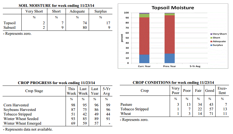 Kentucky Climate Summary
For the Period November 17, 2014 to November 23, 2014
Much Below Normal Temperatures and Above Normal Precipitation:
A winter-like weather pattern was the highlight of this past period. The work week
started off with an early season winter storm as low pressure meandered along the
Appalachian Mountains. Record cold air filtered into Kentucky on the backside of the
system, transitioning any rain to snow as Monday morning progressed. Snowfall totals
were most significant along the Ohio River, where most locations saw 3 to 5 inches.
Accumulations then gradually decreased to the southeast. Attention then turned toward
the northwest as the Commonwealth got another shot of Arctic air. Lows fell into the
teens Monday and Tuesday night. Some locations even dipped into the single digits.
Highs on Tuesday were only in the 20s, which was roughly 30 degrees below normal.
Wind chills dipped into the single digits for an extended period of time, prompting
the livestock cold stress index to fall into the emergency category. Temperatures
were finally on the upward swing on Friday and eventually went above normal over the
weekend. Widespread rain showers developed on Sunday and helped to end a 4 week span
of below normal precipitation as the state averaged slightly more than an inch.
Temperatures for the period averaged 35 degrees across the state which was 11 degrees
cooler than normal and 2 degrees cooler than the previous period. High temperatures
averaged from 46 in the West to 45 in the East. Departure from normal high
temperatures ranged from 11 degrees cooler than normal in the West to 11 degrees
cooler than normal in the East. Low temperatures averaged from 27 degrees in the
West to 25 degrees in the East. Departure from normal low temperature ranged from 10
degrees cooler than normal in the West to 8 degrees cooler than normal in the East.
The extreme high temperature for the period was 67 degrees at CADIZ 4SW and the
extreme low was 2 degrees at HENDERSON 5E. Kentucky has experienced 5 straight
weeks of below normal temperatures.
Precipitation (liq. equ.) for the period totaled 1.05 inches statewide which was 0.06
inches above normal and 106% of normal. Precipitation totals by climate division,
West 0.95 inches, Central 1.12 inches, Bluegrass 1.08 inches and East 1.04 inches,
which was -0.19, 0.07, 0.22 and 0.14 inches respectively from normal. By station,
precipitation totals ranged from a low of 0.52 inches at FORT CAMPBELL to a high of
1.59 inches at ALBANY 1N.
---
USDA's Kentucky Crop and Weather Report
Issued 4:00 P.M., November 17, 2014, 33-14
Agricultural News: Kentucky experienced below normal temperatures and below normal
precipitation over the past week. Precipitation for the week totaled 0.29 inches,
0.58 inches below normal. Temperatures averaged 38 degrees for the week, 11 degrees
below normal. Topsoil moisture was rated 2 percent very short, 9 percent short, 76
percent adequate and 13 percent surplus. Subsoil moisture was rated 2 percent very
short, 11 percent short, 78 percent adequate, and 9 percent surplus. Days suitable
for fieldwork averaged 5.1 out of a possible seven.
Primary activities this week included stripping tobacco and harvesting crops. Some
farmers experienced delays in these activities due to cold and wet conditions.
Kentucky Climate Summary
For the Period November 17, 2014 to November 23, 2014
Much Below Normal Temperatures and Above Normal Precipitation:
A winter-like weather pattern was the highlight of this past period. The work week
started off with an early season winter storm as low pressure meandered along the
Appalachian Mountains. Record cold air filtered into Kentucky on the backside of the
system, transitioning any rain to snow as Monday morning progressed. Snowfall totals
were most significant along the Ohio River, where most locations saw 3 to 5 inches.
Accumulations then gradually decreased to the southeast. Attention then turned toward
the northwest as the Commonwealth got another shot of Arctic air. Lows fell into the
teens Monday and Tuesday night. Some locations even dipped into the single digits.
Highs on Tuesday were only in the 20s, which was roughly 30 degrees below normal.
Wind chills dipped into the single digits for an extended period of time, prompting
the livestock cold stress index to fall into the emergency category. Temperatures
were finally on the upward swing on Friday and eventually went above normal over the
weekend. Widespread rain showers developed on Sunday and helped to end a 4 week span
of below normal precipitation as the state averaged slightly more than an inch.
Temperatures for the period averaged 35 degrees across the state which was 11 degrees
cooler than normal and 2 degrees cooler than the previous period. High temperatures
averaged from 46 in the West to 45 in the East. Departure from normal high
temperatures ranged from 11 degrees cooler than normal in the West to 11 degrees
cooler than normal in the East. Low temperatures averaged from 27 degrees in the
West to 25 degrees in the East. Departure from normal low temperature ranged from 10
degrees cooler than normal in the West to 8 degrees cooler than normal in the East.
The extreme high temperature for the period was 67 degrees at CADIZ 4SW and the
extreme low was 2 degrees at HENDERSON 5E. Kentucky has experienced 5 straight
weeks of below normal temperatures.
Precipitation (liq. equ.) for the period totaled 1.05 inches statewide which was 0.06
inches above normal and 106% of normal. Precipitation totals by climate division,
West 0.95 inches, Central 1.12 inches, Bluegrass 1.08 inches and East 1.04 inches,
which was -0.19, 0.07, 0.22 and 0.14 inches respectively from normal. By station,
precipitation totals ranged from a low of 0.52 inches at FORT CAMPBELL to a high of
1.59 inches at ALBANY 1N.
---
USDA's Kentucky Crop and Weather Report
Issued 4:00 P.M., November 17, 2014, 33-14
Agricultural News: Kentucky experienced below normal temperatures and below normal
precipitation over the past week. Precipitation for the week totaled 0.29 inches,
0.58 inches below normal. Temperatures averaged 38 degrees for the week, 11 degrees
below normal. Topsoil moisture was rated 2 percent very short, 9 percent short, 76
percent adequate and 13 percent surplus. Subsoil moisture was rated 2 percent very
short, 11 percent short, 78 percent adequate, and 9 percent surplus. Days suitable
for fieldwork averaged 5.1 out of a possible seven.
Primary activities this week included stripping tobacco and harvesting crops. Some
farmers experienced delays in these activities due to cold and wet conditions.
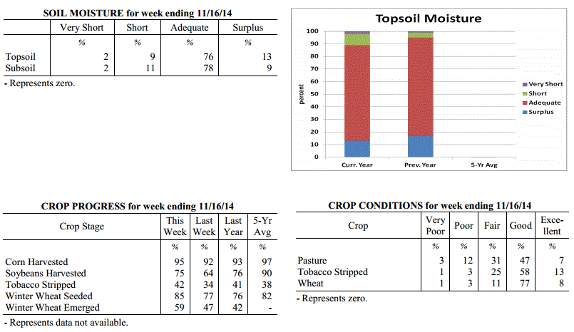 Kentucky Climate Summary
For the Period November 10, 2014 to November 16, 2014
Much Below Normal Temperatures and Below Normal Precipitation:
Believe it or not, Arctic air this past week led to the highest below normal
deviation in temperatures that the Commonwealth had seen all year. Over the course of
the period, the average statewide temperature stood at 38 degrees, which is 11
degrees below normal. The frigid period started after a cold front moved through the
area on Tuesday. Behind the boundary, Arctic high pressure proceeded to build into
the area over the next few days. Highs only peaked in the 30s for most through
Friday. Lows were coolest Friday night as high pressure moved overhead. Clear skies
and a calm wind allowed for the mercury to plummet into the upper teens to low 20s.
This is around 20 degrees below normal for this time of the year. Attention then
turned toward a couple disturbances pushing through the Ohio Valley over the weekend.
The first of the two on Saturday night only amounted to a dusting of snow for most.
The second was just starting as the period ended with light snow being reported in
Western Kentucky.
Temperatures for the period averaged 38 degrees across the state which was 11 degrees
cooler than normal and 10 degrees cooler than the previous period. High temperatures
averaged from 45 in the West to 48 in the East. Departure from normal high
temperatures ranged from 15 degrees cooler than normal in the West to 12 degrees
cooler than normal in the East. Low temperatures averaged from 29 degrees in the
West to 30 degrees in the East. Departure from normal low temperature ranged from 10
degrees cooler than normal in the West to 5 degrees cooler than normal in the East.
The extreme high temperature for the period was 74 degrees at BIG SANDY and the
extreme low was 10 degrees at BLACK MOUNTAIN ARC.
Precipitation (liq. equ.) for the period totaled 0.29 inches statewide which was 0.58
inches below normal and 33% of normal. Precipitation totals by climate division, West
0.21 inches, Central 0.39 inches, Bluegrass 0.19 inches and East 0.38 inches, which
was 0.83, 0.52, 0.56 and 0.4 inches below normal. By station, precipitation totals
ranged from a low of 0.03 inches at CARBONDALE ASOS to a high of 0.77 inches at
WHITLEY CITY 3N.
---
USDA's Kentucky Crop and Weather Report
Issued 4:00 P.M., November 10, 2014, 32-14
Agricultural News: Kentucky experienced below normal temperatures and rainfall over
the past week. Precipitation for the week totaled 0.72 inches, 0.05 inches below
normal. Temperatures averaged 48 degrees for the week, 3 degrees below normal.
Topsoil moisture was rated 3 percent very short, 8 percent short, 75 percent adequate
and 14 percent surplus. Subsoil moisture was rated 2 percent very short, 11 percent
short, 79 percent adequate, and 8 percent surplus. Days suitable for fieldwork
averaged 4.4 out of a possible seven.
Primary activities this week included harvesting corn and soybeans. Producers were
also sowing wheat and stripping tobacco as conditions allowed. While some producers
have finished harvest, wet conditions have delayed harvest and many are behind
schedule. Tobacco in high case has prevented some growers from making more progress
on stripping. Cattle and calves obtained approximately 73 percent of feed from
pastures, but some hay is being fed.
Kentucky Climate Summary
For the Period November 10, 2014 to November 16, 2014
Much Below Normal Temperatures and Below Normal Precipitation:
Believe it or not, Arctic air this past week led to the highest below normal
deviation in temperatures that the Commonwealth had seen all year. Over the course of
the period, the average statewide temperature stood at 38 degrees, which is 11
degrees below normal. The frigid period started after a cold front moved through the
area on Tuesday. Behind the boundary, Arctic high pressure proceeded to build into
the area over the next few days. Highs only peaked in the 30s for most through
Friday. Lows were coolest Friday night as high pressure moved overhead. Clear skies
and a calm wind allowed for the mercury to plummet into the upper teens to low 20s.
This is around 20 degrees below normal for this time of the year. Attention then
turned toward a couple disturbances pushing through the Ohio Valley over the weekend.
The first of the two on Saturday night only amounted to a dusting of snow for most.
The second was just starting as the period ended with light snow being reported in
Western Kentucky.
Temperatures for the period averaged 38 degrees across the state which was 11 degrees
cooler than normal and 10 degrees cooler than the previous period. High temperatures
averaged from 45 in the West to 48 in the East. Departure from normal high
temperatures ranged from 15 degrees cooler than normal in the West to 12 degrees
cooler than normal in the East. Low temperatures averaged from 29 degrees in the
West to 30 degrees in the East. Departure from normal low temperature ranged from 10
degrees cooler than normal in the West to 5 degrees cooler than normal in the East.
The extreme high temperature for the period was 74 degrees at BIG SANDY and the
extreme low was 10 degrees at BLACK MOUNTAIN ARC.
Precipitation (liq. equ.) for the period totaled 0.29 inches statewide which was 0.58
inches below normal and 33% of normal. Precipitation totals by climate division, West
0.21 inches, Central 0.39 inches, Bluegrass 0.19 inches and East 0.38 inches, which
was 0.83, 0.52, 0.56 and 0.4 inches below normal. By station, precipitation totals
ranged from a low of 0.03 inches at CARBONDALE ASOS to a high of 0.77 inches at
WHITLEY CITY 3N.
---
USDA's Kentucky Crop and Weather Report
Issued 4:00 P.M., November 10, 2014, 32-14
Agricultural News: Kentucky experienced below normal temperatures and rainfall over
the past week. Precipitation for the week totaled 0.72 inches, 0.05 inches below
normal. Temperatures averaged 48 degrees for the week, 3 degrees below normal.
Topsoil moisture was rated 3 percent very short, 8 percent short, 75 percent adequate
and 14 percent surplus. Subsoil moisture was rated 2 percent very short, 11 percent
short, 79 percent adequate, and 8 percent surplus. Days suitable for fieldwork
averaged 4.4 out of a possible seven.
Primary activities this week included harvesting corn and soybeans. Producers were
also sowing wheat and stripping tobacco as conditions allowed. While some producers
have finished harvest, wet conditions have delayed harvest and many are behind
schedule. Tobacco in high case has prevented some growers from making more progress
on stripping. Cattle and calves obtained approximately 73 percent of feed from
pastures, but some hay is being fed.
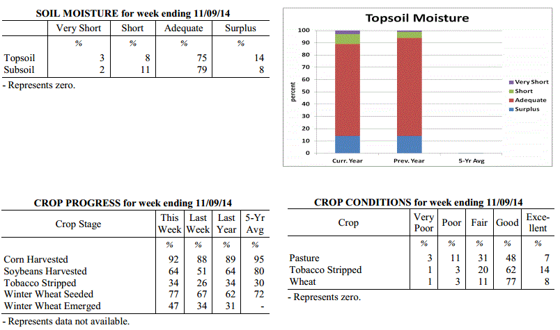 Kentucky Climate Summary
For the Period November 3, 2014 to November 9, 2014
Below Normal Temperatures and Rainfall:
Fall transition was in full swing this past period with the Bluegrass State seeing
the thermometer rise and dive on numerous occasions. The work week started off fairly
mild for early November as surface high pressure was positioned east of the area.
Southwesterly flow, breezy at times, pushed highs into the 60s on both Monday and
Tuesday. Conditions then went on the decline for the next couple days as a cold front
made slow progress across the area. Light to moderate rainfall was widespread in
coverage with most locations picking up a half to one inch with the highest amounts
across Eastern Kentucky. Surface high pressure moved back into the area for the end
of the work week. Highs only topped out in the mid 40s to low 50s on Friday with
lows dipping into the upper 20s to mid 30s. The Commonwealth did see the mercury climb
once again over the weekend, but it was not enough to deny a third straight week of
below normal temperatures.
Temperatures for the period averaged 48 degrees across the state which was 3 degrees
cooler than normal and 2 degrees cooler than the previous period. High temperatures
averaged from 58 in the West to 58 in the East. Departure from normal high
temperatures ranged from 5 degrees cooler than normal in the West to 5 degrees cooler
than normal in the East. Low temperatures averaged from 40 degrees in the West to 39
degrees in the East. Departure from normal low temperature ranged from 1 degree
cooler than normal in the West to 2 degrees warmer than normal in the East. The
extreme high temperature for the period for the period was 70 degrees at BURKESVILLE
3W and the extreme low was 23 degrees at VANCEBURG 6W.
Precipitation (liq. equ.) for the period totaled 0.72 inches statewide which was 0.05
inches below normal and 93% of normal. Precipitation totals by climate division, West
0.60 inches, Central 0.84 inches, Bluegrass 0.47 inches and East 0.99 inches, which
was -0.28, 0.04, -0.23 and 0.28 inches respectively from normal. By station,
precipitation totals ranged from a low of 0.11 inches at CINCINNATI to a high of 1.70
inches at YELLOW CREEK.
---
USDA's Kentucky Crop and Weather Report
Issued 4:00 P.M., November 3, 2014, 31-14
Agricultural News: Kentucky experienced colder weather this past week. Precipitation
for the week totaled 0.65 inches, 0.12 inches below normal. Temperatures averaged 50
degrees for the week, 3 degrees below normal. Topsoil moisture was rated 3 percent
very short, 10 percent short, 74 percent adequate and 13 percent surplus. Subsoil
moisture was rated 2 percent very short, 12 percent short, 77 percent adequate, and 9
percent surplus. Days suitable for fieldwork averaged 5.2 out of a possible seven.
Primary activities this week included planting wheat, harvesting corn and soybeans,
and tending to livestock.
Kentucky Climate Summary
For the Period November 3, 2014 to November 9, 2014
Below Normal Temperatures and Rainfall:
Fall transition was in full swing this past period with the Bluegrass State seeing
the thermometer rise and dive on numerous occasions. The work week started off fairly
mild for early November as surface high pressure was positioned east of the area.
Southwesterly flow, breezy at times, pushed highs into the 60s on both Monday and
Tuesday. Conditions then went on the decline for the next couple days as a cold front
made slow progress across the area. Light to moderate rainfall was widespread in
coverage with most locations picking up a half to one inch with the highest amounts
across Eastern Kentucky. Surface high pressure moved back into the area for the end
of the work week. Highs only topped out in the mid 40s to low 50s on Friday with
lows dipping into the upper 20s to mid 30s. The Commonwealth did see the mercury climb
once again over the weekend, but it was not enough to deny a third straight week of
below normal temperatures.
Temperatures for the period averaged 48 degrees across the state which was 3 degrees
cooler than normal and 2 degrees cooler than the previous period. High temperatures
averaged from 58 in the West to 58 in the East. Departure from normal high
temperatures ranged from 5 degrees cooler than normal in the West to 5 degrees cooler
than normal in the East. Low temperatures averaged from 40 degrees in the West to 39
degrees in the East. Departure from normal low temperature ranged from 1 degree
cooler than normal in the West to 2 degrees warmer than normal in the East. The
extreme high temperature for the period for the period was 70 degrees at BURKESVILLE
3W and the extreme low was 23 degrees at VANCEBURG 6W.
Precipitation (liq. equ.) for the period totaled 0.72 inches statewide which was 0.05
inches below normal and 93% of normal. Precipitation totals by climate division, West
0.60 inches, Central 0.84 inches, Bluegrass 0.47 inches and East 0.99 inches, which
was -0.28, 0.04, -0.23 and 0.28 inches respectively from normal. By station,
precipitation totals ranged from a low of 0.11 inches at CINCINNATI to a high of 1.70
inches at YELLOW CREEK.
---
USDA's Kentucky Crop and Weather Report
Issued 4:00 P.M., November 3, 2014, 31-14
Agricultural News: Kentucky experienced colder weather this past week. Precipitation
for the week totaled 0.65 inches, 0.12 inches below normal. Temperatures averaged 50
degrees for the week, 3 degrees below normal. Topsoil moisture was rated 3 percent
very short, 10 percent short, 74 percent adequate and 13 percent surplus. Subsoil
moisture was rated 2 percent very short, 12 percent short, 77 percent adequate, and 9
percent surplus. Days suitable for fieldwork averaged 5.2 out of a possible seven.
Primary activities this week included planting wheat, harvesting corn and soybeans,
and tending to livestock.
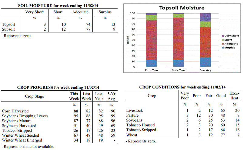 Kentucky Climate Summary
For the Period October 27, 2014 to November 2, 2014
Below Normal Temperatures and Rainfall:
It seemed that the Commonwealth saw a glimpse of each season this past period, with
the last resulting in the end of the growing season. A warm front pushed north of
Kentucky on Monday, pushing temperatures well above normal for the end of October.
Breezy southwesterly flow sent highs soaring into the low to middle 80s. Louisville
rose to 85 degrees, breaking a record that had stood since 1940. Conditions then took
a downhill turn as a cold front pushed through the area on Tuesday, spreading showers
across the area. Rainfall totals were below a half inch for much of the state. The
one exception came across Eastern Kentucky, where a narrow corridor saw between 1 to
2 inches. After a couple days of typical fall conditions, Kentuckians got a glimpse
of winter on Friday and Saturday as another cold front pushed through the Ohio
Valley. Behind the boundary, winds became gusty from the northwest, dropping
temperatures to around freezing by Saturday morning. Some locations across the
eastern half of the state saw some snow, but other than some of the higher
elevations, accumulations were minor due to warm ground temperatures. High pressure
of Canadian origin then built overhead Saturday night. Clear skies and a calm wind
allowed for a killing freeze as the mercury dipped into the low to mid 20s area wide,
effectively bringing an end to the growing season.
Temperatures for the period averaged 50 degrees across the state which was 3 degrees
cooler than normal and 4 degrees cooler than the previous period. High temperatures
averaged from 62 in the West to 58 in the East. Departure from normal high
temperatures ranged from 4 degrees cooler than normal in the West to 8 degrees
cooler than normal in the East. Low temperatures averaged from 41 degrees in the
West to 40 degrees in the East. Departure from normal low temperature ranged from 2
degrees cooler than normal in the West to 1 degree warmer than normal in the East.
The extreme high temperature for the period was 85 degrees at LOUISVILLE APT and the
extreme low was 19 degrees at WILLIAMSBURG AWOS.
Precipitation (liq. equ.) for the period totaled 0.65 inches statewide which was 0.12
inches below normal and 84% of normal. Precipitation totals by climate division, West
0.46 inches, Central 0.43 inches, Bluegrass 0.53 inches and East 1.16 inches, which
was -0.40, -0.37, -0.18 and 0.44 inches respectively from normal. By station,
precipitation totals ranged from a low of 0.11 inches at HARDINSBURG 5SW to a high of
2.09 inches at BARBOURVILLE 3E.
---
USDA's Kentucky Crop and Weather Report
Issued 4:00 P.M., October 27, 2014, 30-14
Agricultural News: Kentucky experienced drier conditions over the past week.
Precipitation for the week totaled 0.03 inches, 0.67 inches below normal.
Temperatures averaged 54 degrees for the week, 2 degrees below normal. Topsoil
moisture was rated 3 percent very short, 11 percent short, 69 percent adequate and 17
percent surplus. Subsoil moisture was rated 2 percent very short, 14 percent short,
73 percent adequate, and 11 percent surplus. Days suitable for fieldwork averaged 5.8
out of a possible seven.
Primary activities this week included harvesting corn and soybeans and planting
winter wheat as fields finally got a chance to dry out. Seventeen percent of tobacco
has been stripped, with 29 percent ready to be stripped and 54 percent not ready for
stripping.
Kentucky Climate Summary
For the Period October 27, 2014 to November 2, 2014
Below Normal Temperatures and Rainfall:
It seemed that the Commonwealth saw a glimpse of each season this past period, with
the last resulting in the end of the growing season. A warm front pushed north of
Kentucky on Monday, pushing temperatures well above normal for the end of October.
Breezy southwesterly flow sent highs soaring into the low to middle 80s. Louisville
rose to 85 degrees, breaking a record that had stood since 1940. Conditions then took
a downhill turn as a cold front pushed through the area on Tuesday, spreading showers
across the area. Rainfall totals were below a half inch for much of the state. The
one exception came across Eastern Kentucky, where a narrow corridor saw between 1 to
2 inches. After a couple days of typical fall conditions, Kentuckians got a glimpse
of winter on Friday and Saturday as another cold front pushed through the Ohio
Valley. Behind the boundary, winds became gusty from the northwest, dropping
temperatures to around freezing by Saturday morning. Some locations across the
eastern half of the state saw some snow, but other than some of the higher
elevations, accumulations were minor due to warm ground temperatures. High pressure
of Canadian origin then built overhead Saturday night. Clear skies and a calm wind
allowed for a killing freeze as the mercury dipped into the low to mid 20s area wide,
effectively bringing an end to the growing season.
Temperatures for the period averaged 50 degrees across the state which was 3 degrees
cooler than normal and 4 degrees cooler than the previous period. High temperatures
averaged from 62 in the West to 58 in the East. Departure from normal high
temperatures ranged from 4 degrees cooler than normal in the West to 8 degrees
cooler than normal in the East. Low temperatures averaged from 41 degrees in the
West to 40 degrees in the East. Departure from normal low temperature ranged from 2
degrees cooler than normal in the West to 1 degree warmer than normal in the East.
The extreme high temperature for the period was 85 degrees at LOUISVILLE APT and the
extreme low was 19 degrees at WILLIAMSBURG AWOS.
Precipitation (liq. equ.) for the period totaled 0.65 inches statewide which was 0.12
inches below normal and 84% of normal. Precipitation totals by climate division, West
0.46 inches, Central 0.43 inches, Bluegrass 0.53 inches and East 1.16 inches, which
was -0.40, -0.37, -0.18 and 0.44 inches respectively from normal. By station,
precipitation totals ranged from a low of 0.11 inches at HARDINSBURG 5SW to a high of
2.09 inches at BARBOURVILLE 3E.
---
USDA's Kentucky Crop and Weather Report
Issued 4:00 P.M., October 27, 2014, 30-14
Agricultural News: Kentucky experienced drier conditions over the past week.
Precipitation for the week totaled 0.03 inches, 0.67 inches below normal.
Temperatures averaged 54 degrees for the week, 2 degrees below normal. Topsoil
moisture was rated 3 percent very short, 11 percent short, 69 percent adequate and 17
percent surplus. Subsoil moisture was rated 2 percent very short, 14 percent short,
73 percent adequate, and 11 percent surplus. Days suitable for fieldwork averaged 5.8
out of a possible seven.
Primary activities this week included harvesting corn and soybeans and planting
winter wheat as fields finally got a chance to dry out. Seventeen percent of tobacco
has been stripped, with 29 percent ready to be stripped and 54 percent not ready for
stripping.
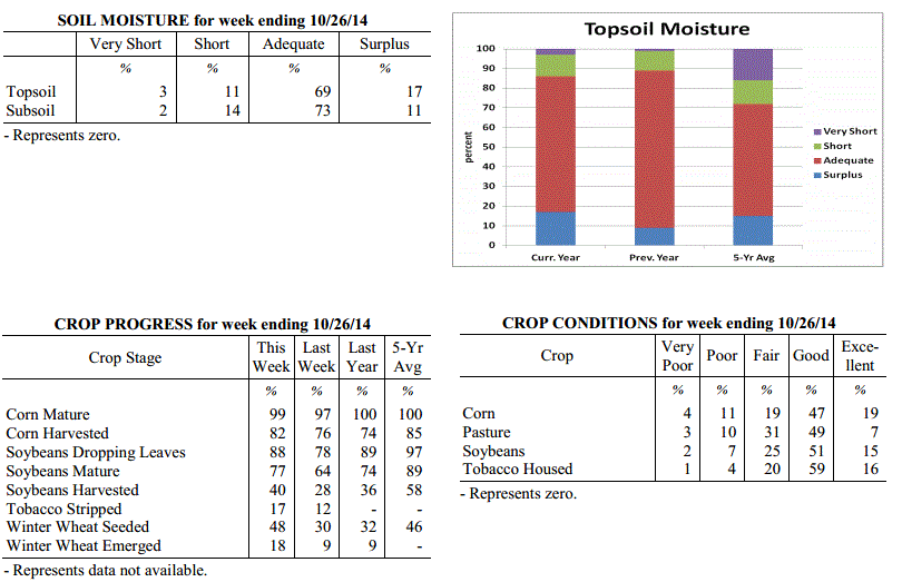 Kentucky Climate Summary
For the Period October 20, 2014 to October 26, 2014
Below Normal Temperatures and Rainfall:
After two straight weeks of much above normal rainfall, the Commonwealth finally got
a chance to dry out this past period. The only mentionable precipitation came Monday
and Tuesday as a couple weak disturbances passed through the region. Showers were
light in nature with the majority of rainfall totals under a tenth of an inch.
Starting Wednesday, the Bluegrass State was under the influence of high pressure for
most of the remainder of the week. This kept conditions dry with focus turning to
temperatures. The coolest readings came Wednesday night and into Thursday morning.
Much of Western and Central Kentucky saw lows dip into the low to mid 30s. Cloud
cover kept the mercury elevated in Eastern Kentucky. After a cool work week,
temperatures became mild for the weekend. Highs rose into the 70s for most. A
handful of locations in Western Kentucky reached the lower 80s, well above normal
for this time of the year.
Temperatures for the period averaged 54 degrees across the state which was 2 degrees
cooler than normal and 4 degrees cooler than the previous period. High temperatures
averaged from 71 in the West to 63 in the East. Departure from normal high
temperatures ranged from 1 degree warmer than normal in the West to 5 degrees
cooler than normal in the East. Low temperatures averaged from 43 degrees in the
West to 42 degrees in the East. Departure from normal low temperature ranged from 2
degrees cooler than normal in the West to 1 degree warmer than normal in the East.
The extreme high temperature for the period was 84 degrees at POPLAR BLUFF ASOS and
the extreme low was 31 degrees at BRANDENBURG 4SW.
Precipitation (liq. equ.) for the period totaled 0.03 inches statewide which was 0.67
inches below normal and 4% of normal. Precipitation totals by climate division, West
0.01 inches, Central 0.03 inches, Bluegrass 0.05 inches and East 0.04 inches, which
was 0.78, 0.68, 0.6 and 0.63 inches below normal. By station, precipitation totals
ranged from a low of 0.00 inches at ALBANY 1N to a high of 0.19 inches at LOUISVILLE APT.
---
USDA's Kentucky Crop and Weather Report
Issued 4:00 P.M., October 20, 2014, 29-14
Agricultural News: Kentucky experienced very rainy conditions over the past week.
Precipitation for the week totaled 2.05 inches, 1.34 inches above normal.
Temperatures averaged 59 degrees for the week, 2 degrees above normal. Topsoil
moisture was rated 3 percent very short, 11 percent short, 57 percent adequate and 29
percent surplus. Subsoil moisture was rated 2 percent very short, 15 percent short,
66 percent adequate, and 17 percent surplus. Days suitable for fieldwork averaged 1.9
out of a possible seven.
Primary activities this week included harvesting corn and soybeans and planting
winter wheat when conditions allowed. Rainfall has continued to slow harvest and some
hail damage was reported on tobacco and corn in the Bluegrass area. Twelve percent of
tobacco has been stripped, with 22 percent ready to be stripped and 66
percent not ready for stripping.
Kentucky Climate Summary
For the Period October 20, 2014 to October 26, 2014
Below Normal Temperatures and Rainfall:
After two straight weeks of much above normal rainfall, the Commonwealth finally got
a chance to dry out this past period. The only mentionable precipitation came Monday
and Tuesday as a couple weak disturbances passed through the region. Showers were
light in nature with the majority of rainfall totals under a tenth of an inch.
Starting Wednesday, the Bluegrass State was under the influence of high pressure for
most of the remainder of the week. This kept conditions dry with focus turning to
temperatures. The coolest readings came Wednesday night and into Thursday morning.
Much of Western and Central Kentucky saw lows dip into the low to mid 30s. Cloud
cover kept the mercury elevated in Eastern Kentucky. After a cool work week,
temperatures became mild for the weekend. Highs rose into the 70s for most. A
handful of locations in Western Kentucky reached the lower 80s, well above normal
for this time of the year.
Temperatures for the period averaged 54 degrees across the state which was 2 degrees
cooler than normal and 4 degrees cooler than the previous period. High temperatures
averaged from 71 in the West to 63 in the East. Departure from normal high
temperatures ranged from 1 degree warmer than normal in the West to 5 degrees
cooler than normal in the East. Low temperatures averaged from 43 degrees in the
West to 42 degrees in the East. Departure from normal low temperature ranged from 2
degrees cooler than normal in the West to 1 degree warmer than normal in the East.
The extreme high temperature for the period was 84 degrees at POPLAR BLUFF ASOS and
the extreme low was 31 degrees at BRANDENBURG 4SW.
Precipitation (liq. equ.) for the period totaled 0.03 inches statewide which was 0.67
inches below normal and 4% of normal. Precipitation totals by climate division, West
0.01 inches, Central 0.03 inches, Bluegrass 0.05 inches and East 0.04 inches, which
was 0.78, 0.68, 0.6 and 0.63 inches below normal. By station, precipitation totals
ranged from a low of 0.00 inches at ALBANY 1N to a high of 0.19 inches at LOUISVILLE APT.
---
USDA's Kentucky Crop and Weather Report
Issued 4:00 P.M., October 20, 2014, 29-14
Agricultural News: Kentucky experienced very rainy conditions over the past week.
Precipitation for the week totaled 2.05 inches, 1.34 inches above normal.
Temperatures averaged 59 degrees for the week, 2 degrees above normal. Topsoil
moisture was rated 3 percent very short, 11 percent short, 57 percent adequate and 29
percent surplus. Subsoil moisture was rated 2 percent very short, 15 percent short,
66 percent adequate, and 17 percent surplus. Days suitable for fieldwork averaged 1.9
out of a possible seven.
Primary activities this week included harvesting corn and soybeans and planting
winter wheat when conditions allowed. Rainfall has continued to slow harvest and some
hail damage was reported on tobacco and corn in the Bluegrass area. Twelve percent of
tobacco has been stripped, with 22 percent ready to be stripped and 66
percent not ready for stripping.
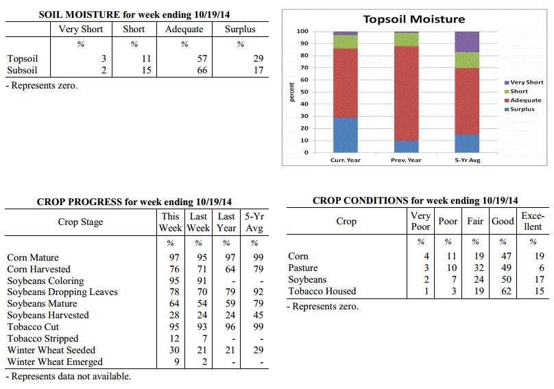 Kentucky Climate Summary
For the Period October 13, 2014 to October 19, 2014
Above Normal Temperatures and Rainfall:
The showers kept on coming this past period as the state averaged over 2 inches for
the second straight week. The wet pattern continued as a cold front made slow
progression across the Commonwealth Monday and Tuesday. A squall line pushed through
the area Monday evening, before diminishing in strength going into the overnight
period and Tuesday. Showers were widespread across the area with most picking up
between 1 to 3 inches. Scattered to numerous light showers then continued to fall
Wednesday and Thursday as an upper level area of low pressure meandered across the
region. This just added to an extremely wet first half of October. Over the past 2
weeks, the Commonwealth has averaged over 4 inches of rainfall. This is more than
what the state normally sees over the entire month of October. Preliminary data at
the Ag Weather Center suggest that the Commonwealth has already cracked the top
20 for the wettest October periods on record.
Temperatures for the period averaged 59 degrees across the state which was 2 degrees
warmer than normal and 2 degrees cooler than the previous period. High temperatures
averaged from 67 in the West to 66 in the East. Departure from normal high
temperatures ranged from 5 degrees cooler than normal in the West to 4 degrees
cooler than normal in the East. Low temperatures averaged from 51 degrees in the
West to 52 degrees in the East. Departure from normal low temperature ranged from 4
degrees warmer than normal in the West to 9 degrees warmer than normal in the East.
The extreme high temperature for the period was 82 degrees at LOUISA 1S and the
extreme low was 34 degrees at CARBONDALE ASOS.
Precipitation (liq. equ.) for the period totaled 2.05 inches statewide which was 1.34
inches above normal and 291% of normal. Precipitation totals by climate division,
West 2.21 inches, Central 2.55 inches, Bluegrass 1.74 inches and East 1.69 inches,
which was 1.47, 1.83, 1.07 and 1 inches above normal. By station, precipitation
totals ranged from a low of 0.80 inches at CAPE GIRARDEAU ASOS to a high of 4.05
inches at ELKTON 5SW.
---
USDA's Kentucky Crop and Weather Report
Issued 4:00 P.M., October 14, 2014, 28-14
Agricultural News: Kentucky experienced scattered severe weather over the past week.
Precipitation for the week totaled 2.23 inches, 1.46 inches above normal.
Temperatures averaged 61 degrees for the week, 1 degree above normal. Topsoil
moisture was rated 5 percent very short, 20 percent short, 60 percent adequate and 15
percent surplus. Subsoil moisture was rated 4 percent very short, 23 percent short,
65 percent adequate, and 8 percent surplus. Days suitable for fieldwork averaged 3.8
out of a possible seven.
Primary activities this week included harvesting corn and soybeans and planting
winter wheat. Continued rainfall has slowed harvests and some areas of the state
reported damage from large hail. A tornado touched down in the northern part of the
state which resulted in damage and loss of stored hay and housed tobacco. Tobacco
houseburn was reported as 1 percent heavy, 6 percent moderate, 16 percent light, with
77 percent experiencing none. Seven percent of tobacco has been stripped, with 18 percent
ready to be stripped and 75 percent not ready for stripping.
Kentucky Climate Summary
For the Period October 13, 2014 to October 19, 2014
Above Normal Temperatures and Rainfall:
The showers kept on coming this past period as the state averaged over 2 inches for
the second straight week. The wet pattern continued as a cold front made slow
progression across the Commonwealth Monday and Tuesday. A squall line pushed through
the area Monday evening, before diminishing in strength going into the overnight
period and Tuesday. Showers were widespread across the area with most picking up
between 1 to 3 inches. Scattered to numerous light showers then continued to fall
Wednesday and Thursday as an upper level area of low pressure meandered across the
region. This just added to an extremely wet first half of October. Over the past 2
weeks, the Commonwealth has averaged over 4 inches of rainfall. This is more than
what the state normally sees over the entire month of October. Preliminary data at
the Ag Weather Center suggest that the Commonwealth has already cracked the top
20 for the wettest October periods on record.
Temperatures for the period averaged 59 degrees across the state which was 2 degrees
warmer than normal and 2 degrees cooler than the previous period. High temperatures
averaged from 67 in the West to 66 in the East. Departure from normal high
temperatures ranged from 5 degrees cooler than normal in the West to 4 degrees
cooler than normal in the East. Low temperatures averaged from 51 degrees in the
West to 52 degrees in the East. Departure from normal low temperature ranged from 4
degrees warmer than normal in the West to 9 degrees warmer than normal in the East.
The extreme high temperature for the period was 82 degrees at LOUISA 1S and the
extreme low was 34 degrees at CARBONDALE ASOS.
Precipitation (liq. equ.) for the period totaled 2.05 inches statewide which was 1.34
inches above normal and 291% of normal. Precipitation totals by climate division,
West 2.21 inches, Central 2.55 inches, Bluegrass 1.74 inches and East 1.69 inches,
which was 1.47, 1.83, 1.07 and 1 inches above normal. By station, precipitation
totals ranged from a low of 0.80 inches at CAPE GIRARDEAU ASOS to a high of 4.05
inches at ELKTON 5SW.
---
USDA's Kentucky Crop and Weather Report
Issued 4:00 P.M., October 14, 2014, 28-14
Agricultural News: Kentucky experienced scattered severe weather over the past week.
Precipitation for the week totaled 2.23 inches, 1.46 inches above normal.
Temperatures averaged 61 degrees for the week, 1 degree above normal. Topsoil
moisture was rated 5 percent very short, 20 percent short, 60 percent adequate and 15
percent surplus. Subsoil moisture was rated 4 percent very short, 23 percent short,
65 percent adequate, and 8 percent surplus. Days suitable for fieldwork averaged 3.8
out of a possible seven.
Primary activities this week included harvesting corn and soybeans and planting
winter wheat. Continued rainfall has slowed harvests and some areas of the state
reported damage from large hail. A tornado touched down in the northern part of the
state which resulted in damage and loss of stored hay and housed tobacco. Tobacco
houseburn was reported as 1 percent heavy, 6 percent moderate, 16 percent light, with
77 percent experiencing none. Seven percent of tobacco has been stripped, with 18 percent
ready to be stripped and 75 percent not ready for stripping.
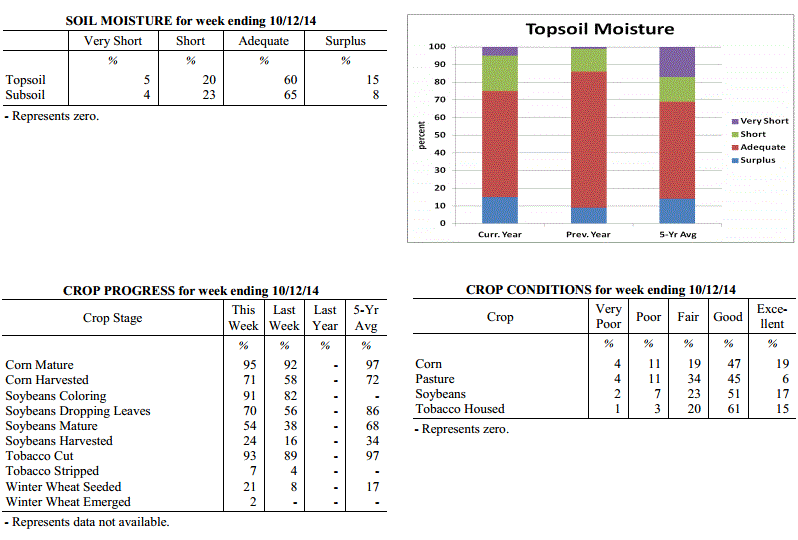 Kentucky Climate Summary
For the Period October 6, 2014 to October 12, 2014
Above Normal Temperatures and Rainfall:
The second week of October brought one of the more active severe weather periods the
Commonwealth has seen in quite some time. An unsettled pattern was setup to begin
the work week with multiple upper level disturbances passing through the region. Each
wave sparked scattered to numerous showers and storms across the Commonwealth.
Supercell thunderstorms developed in some cases, leading to the development of multiple
tornadoes, large hail, and damaging winds. The most prominent system came Tuesday
afternoon and evening with multiple reports of hail at the size of a golf ball and 9
confirmed tornadoes. Conditions temporarily dried out for Wednesday, before the wet
pattern continued for much of the remainder of the week. Multiple disturbances
overrode a frontal boundary hovering across the area, leading to several rounds of
showers and storms. For the week as a whole, the eastern portion of the state came
out the winners with over three inches on average. Nonetheless, the state as a whole
averaged over 2 inches, which was nearly 1.5 inches above normal. This brought an
end to a three week span of below average rainfall across the state.
Temperatures for the period averaged 61 degrees across the state which was 1 degrees
warmer than normal and 2 degrees cooler than the previous period. High temperatures
averaged from 73 in the West to 67 in the East. Departure from normal high
temperatures ranged from 1 degree cooler than normal in the West to 5 degrees cooler
than normal in the East. Low temperatures averaged from 54 degrees in the West to 52
degrees in the East. Departure from normal low temperature ranged from 5 degrees
warmer than normal in the West to 7 degrees warmer than normal in the East. The
extreme high temperature for the period for was 84 degrees at POPLAR BLUFF ASOS and
the extreme low was 40 degrees at CYNTHIANA 8N.
Precipitation (liq. equ.) for the period totaled 2.23 inches statewide which was 1.46
inches above normal and 290% of normal. Precipitation totals by climate division,
West 1.74 inches, Central 1.73 inches, Bluegrass 2.03 inches and East 3.40 inches,
which was 0.96, 0.93, 1.3 and 2.63 inches above normal. By station, precipitation
totals ranged from a low of 0.40 inches at BRANDENBURG 4SW to a high of 5.43
inches at YELLOW CREEK.
---
USDA's Kentucky Crop and Weather Report
Issued 4:00 P.M., October 6, 2014, 27-14
Agricultural News: Kentucky experienced above normal temperatures and below normal
rainfall over the past week. Precipitation for the week totaled 0.46 inches, 0.34
inches below normal. Temperatures averaged 64 degrees for the week, 2 degrees above
normal. Topsoil moisture was rated 10 percent very short, 37 percent short, 49
percent adequate and 4 percent surplus. Subsoil moisture was rated 7 percent very
short, 36 percent short, 54 percent adequate, and 3 percent surplus. Days suitable
for fieldwork averaged 6.1 out of a possible seven.
Primary activities this week included harvesting corn and some growers were beginning
to seed winter wheat. Early planted soybeans are also starting to be harvested.
Pasture conditions slightly decreased due to below normal rainfall and late planted
soybeans continued to show signs of drought stress. Tobacco houseburn was reported as
1 percent heavy, 5 percent moderate, 16 percent light, with 78 percent experiencing
none. Four percent of tobacco has been stripped, with 13 percent ready to be stripped
and 83 percent not ready for stripping.
Kentucky Climate Summary
For the Period October 6, 2014 to October 12, 2014
Above Normal Temperatures and Rainfall:
The second week of October brought one of the more active severe weather periods the
Commonwealth has seen in quite some time. An unsettled pattern was setup to begin
the work week with multiple upper level disturbances passing through the region. Each
wave sparked scattered to numerous showers and storms across the Commonwealth.
Supercell thunderstorms developed in some cases, leading to the development of multiple
tornadoes, large hail, and damaging winds. The most prominent system came Tuesday
afternoon and evening with multiple reports of hail at the size of a golf ball and 9
confirmed tornadoes. Conditions temporarily dried out for Wednesday, before the wet
pattern continued for much of the remainder of the week. Multiple disturbances
overrode a frontal boundary hovering across the area, leading to several rounds of
showers and storms. For the week as a whole, the eastern portion of the state came
out the winners with over three inches on average. Nonetheless, the state as a whole
averaged over 2 inches, which was nearly 1.5 inches above normal. This brought an
end to a three week span of below average rainfall across the state.
Temperatures for the period averaged 61 degrees across the state which was 1 degrees
warmer than normal and 2 degrees cooler than the previous period. High temperatures
averaged from 73 in the West to 67 in the East. Departure from normal high
temperatures ranged from 1 degree cooler than normal in the West to 5 degrees cooler
than normal in the East. Low temperatures averaged from 54 degrees in the West to 52
degrees in the East. Departure from normal low temperature ranged from 5 degrees
warmer than normal in the West to 7 degrees warmer than normal in the East. The
extreme high temperature for the period for was 84 degrees at POPLAR BLUFF ASOS and
the extreme low was 40 degrees at CYNTHIANA 8N.
Precipitation (liq. equ.) for the period totaled 2.23 inches statewide which was 1.46
inches above normal and 290% of normal. Precipitation totals by climate division,
West 1.74 inches, Central 1.73 inches, Bluegrass 2.03 inches and East 3.40 inches,
which was 0.96, 0.93, 1.3 and 2.63 inches above normal. By station, precipitation
totals ranged from a low of 0.40 inches at BRANDENBURG 4SW to a high of 5.43
inches at YELLOW CREEK.
---
USDA's Kentucky Crop and Weather Report
Issued 4:00 P.M., October 6, 2014, 27-14
Agricultural News: Kentucky experienced above normal temperatures and below normal
rainfall over the past week. Precipitation for the week totaled 0.46 inches, 0.34
inches below normal. Temperatures averaged 64 degrees for the week, 2 degrees above
normal. Topsoil moisture was rated 10 percent very short, 37 percent short, 49
percent adequate and 4 percent surplus. Subsoil moisture was rated 7 percent very
short, 36 percent short, 54 percent adequate, and 3 percent surplus. Days suitable
for fieldwork averaged 6.1 out of a possible seven.
Primary activities this week included harvesting corn and some growers were beginning
to seed winter wheat. Early planted soybeans are also starting to be harvested.
Pasture conditions slightly decreased due to below normal rainfall and late planted
soybeans continued to show signs of drought stress. Tobacco houseburn was reported as
1 percent heavy, 5 percent moderate, 16 percent light, with 78 percent experiencing
none. Four percent of tobacco has been stripped, with 13 percent ready to be stripped
and 83 percent not ready for stripping.
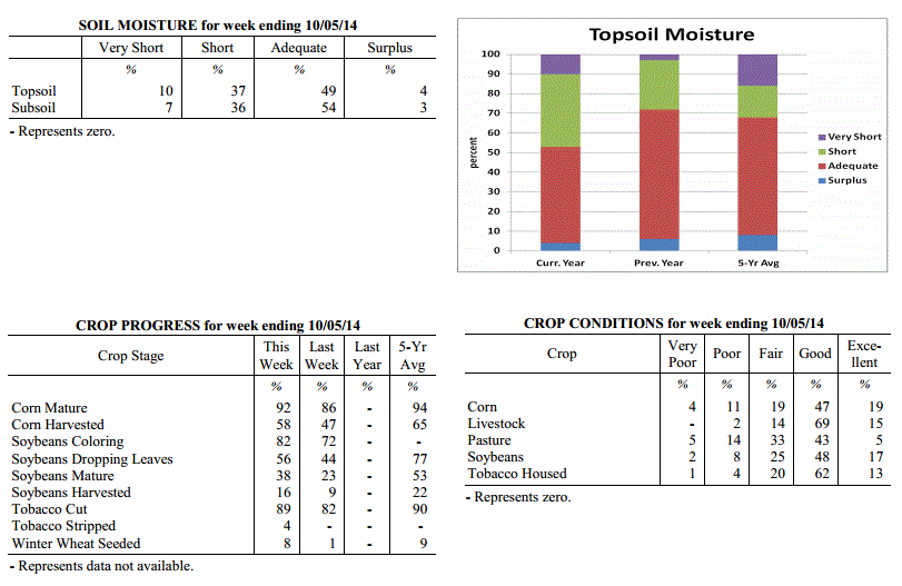 Kentucky Climate Summary
For the Period September 29, 2014 to October 5, 2014
Above Normal Temperatures and Below Normal Rainfall:
This past period started out on the warm and dry side as surface high pressure was in
control. Daytime temperatures were slightly above normal for much of the period with
highs in the low to mid 80s Monday through Wednesday. Winds shifted to the south on
Thursday, ahead of an approaching cold front. This led to the warmest day of the week
with highs typically in the mid to upper 80s. Western Kentucky saw some scattered
showers and storms through the day, before coverage became widespread later Thursday
night and into Friday. Rainfall totals were around a quarter to half inch for the
majority of the state. This was the only significant rainfall event for the week
across Kentucky and led to the third week in a row of below normal precipitation.
Much cooler air rushed into the area behind the boundary with winds from the west
gusting to around 30 mph at times. Highs on Saturday only rose into the 50s for most,
before the coolest temperatures of the fall season were felt that night. Much of the
Commonwealth fell into the low to mid 30s as skies became mostly clear, prompting a
frost advisory across the state.
Temperatures for the period averaged 64 degrees across the state which was 2 degrees
warmer than normal and no change to the previous period. High temperatures averaged
from 79 in the West to 74 in the East. Departure from normal high temperatures ranged
from 3 degrees warmer than normal in the West to near normal in the East. Low
temperatures averaged from 51 degrees in the West to 52 degrees in the East.
Departure from normal low temperature ranged from 1 degree cooler than normal in the
West to 4 degrees warmer than normal in the East. The extreme high temperature for
the period was 91 degrees at OWENSBORO AWSS and the extreme low was 27 degrees at FORT
CAMPBELL.
Precipitation (liq. equ.) for the period totaled 0.46 inches statewide which was 0.34
inches below normal and 58% of normal. Precipitation totals by climate division, West
0.58 inches, Central 0.45 inches, Bluegrass 0.39 inches and East 0.42 inches, which
was 0.24, 0.4, 0.35 and 0.37 inches below normal. By station, precipitation totals
ranged from a low of 0.13 inches at OWENTON 5E to a high of 1.12 inches at HICKMAN 2E.
---
USDA's Kentucky Crop and Weather Report
Issued 4:00 P.M., September 29, 2014, 26-14
Agricultural News: Kentucky experienced below normal temperatures and rainfall over
the past week. Precipitation for the week totaled 0.00 inches, 0.85 inches below
normal. Temperatures averaged 64 degrees for the week, 2 degrees below normal.
Topsoil moisture was rated 8 percent very short, 34 percent short, 54 percent
adequate and 4 percent surplus. Subsoil moisture was rated 6 percent very short, 32
percent short, 59 percent adequate, and 3 percent surplus. Days suitable for
fieldwork averaged 6.7 out of a possible seven.
Primary activities this week included harvesting corn, baling hay, and housing
tobacco. Farmers continue to report difficulty finding labor to complete tobacco
harvest. Corn and soybeans continue to remain in good condition. Dry weather has
allowed farmers to make good progress on their crop harvest. Late planted soybeans
are in need of rain and are showing signs of stress. Tobacco houseburn was reported
as 1 percent heavy, 5 percent moderate, 16 percent light, with 78 percent
experiencing none.
Kentucky Climate Summary
For the Period September 29, 2014 to October 5, 2014
Above Normal Temperatures and Below Normal Rainfall:
This past period started out on the warm and dry side as surface high pressure was in
control. Daytime temperatures were slightly above normal for much of the period with
highs in the low to mid 80s Monday through Wednesday. Winds shifted to the south on
Thursday, ahead of an approaching cold front. This led to the warmest day of the week
with highs typically in the mid to upper 80s. Western Kentucky saw some scattered
showers and storms through the day, before coverage became widespread later Thursday
night and into Friday. Rainfall totals were around a quarter to half inch for the
majority of the state. This was the only significant rainfall event for the week
across Kentucky and led to the third week in a row of below normal precipitation.
Much cooler air rushed into the area behind the boundary with winds from the west
gusting to around 30 mph at times. Highs on Saturday only rose into the 50s for most,
before the coolest temperatures of the fall season were felt that night. Much of the
Commonwealth fell into the low to mid 30s as skies became mostly clear, prompting a
frost advisory across the state.
Temperatures for the period averaged 64 degrees across the state which was 2 degrees
warmer than normal and no change to the previous period. High temperatures averaged
from 79 in the West to 74 in the East. Departure from normal high temperatures ranged
from 3 degrees warmer than normal in the West to near normal in the East. Low
temperatures averaged from 51 degrees in the West to 52 degrees in the East.
Departure from normal low temperature ranged from 1 degree cooler than normal in the
West to 4 degrees warmer than normal in the East. The extreme high temperature for
the period was 91 degrees at OWENSBORO AWSS and the extreme low was 27 degrees at FORT
CAMPBELL.
Precipitation (liq. equ.) for the period totaled 0.46 inches statewide which was 0.34
inches below normal and 58% of normal. Precipitation totals by climate division, West
0.58 inches, Central 0.45 inches, Bluegrass 0.39 inches and East 0.42 inches, which
was 0.24, 0.4, 0.35 and 0.37 inches below normal. By station, precipitation totals
ranged from a low of 0.13 inches at OWENTON 5E to a high of 1.12 inches at HICKMAN 2E.
---
USDA's Kentucky Crop and Weather Report
Issued 4:00 P.M., September 29, 2014, 26-14
Agricultural News: Kentucky experienced below normal temperatures and rainfall over
the past week. Precipitation for the week totaled 0.00 inches, 0.85 inches below
normal. Temperatures averaged 64 degrees for the week, 2 degrees below normal.
Topsoil moisture was rated 8 percent very short, 34 percent short, 54 percent
adequate and 4 percent surplus. Subsoil moisture was rated 6 percent very short, 32
percent short, 59 percent adequate, and 3 percent surplus. Days suitable for
fieldwork averaged 6.7 out of a possible seven.
Primary activities this week included harvesting corn, baling hay, and housing
tobacco. Farmers continue to report difficulty finding labor to complete tobacco
harvest. Corn and soybeans continue to remain in good condition. Dry weather has
allowed farmers to make good progress on their crop harvest. Late planted soybeans
are in need of rain and are showing signs of stress. Tobacco houseburn was reported
as 1 percent heavy, 5 percent moderate, 16 percent light, with 78 percent
experiencing none.
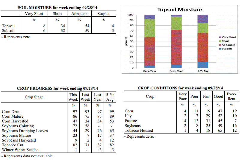 Kentucky Climate Summary
For the Period September 22, 2014 to September 28, 2014
Below Normal Temperatures and Rainfall:
The start of the autumn season opened with dry and cool conditions in place. Surface
high pressure of Canadian origin built into the Ohio Valley to start the work week.
Highs on Monday only rose into the upper 60s to low 70s, but the more noticeable
difference came later that night. Under clear skies, temperatures plummeted into the
low to mid 40s for most of the state. Some low lying and sheltered locations were able
to drop into the upper 30s, which was around 15 degrees below normal for this time of
the year. A warming trend then ensued for much of the remainder of the week,
eventually returning to near normal by the end. The Commonwealth remained under the
influence of high pressure with mostly clear skies and a light northeast wind about
each day. Other than a few isolated showers across the eastern half of Kentucky on
Sunday, most of the region was left completely dry for the week. This was the second
straight period of much below normal rainfall, but this is fairly common as the state
heads into what is normally the driest time of the year.
Temperatures for the period averaged 64 degrees across the state which was 2 degrees
cooler than normal and no change to the previous period. High temperatures averaged
from 81 in the West to 75 in the East. Departure from normal high temperatures
ranged from 2 degrees warmer than normal in the West to 2 degrees cooler than normal
in the East. Low temperatures averaged from 51 degrees in the West to 51 degrees in
the East. Departure from normal low temperature ranged from 4 degrees cooler than
normal in the West to 1 degree cooler than normal in the East. The extreme high
temperature for the period was 87 degrees at MAYFIELD 6SW and the extreme low was
37 degrees at CADIZ 4SW.
Precipitation (liq. equ.) for the period totaled 0.00 inches statewide which was 0.85
inches below normal and 0% of normal. Precipitation totals by climate division, West
0.00 inches, Central 0.00 inches, Bluegrass 0.00 inches and East 0.00 inches, which
was 0.86, 0.93, 0.77 and 0.84 inches below normal. By station, precipitation totals
ranged from a low of 0.00 inches at ALBANY 1N to a high of 0.06 inches at PADUCAH ASOS.
---
USDA's Kentucky Crop and Weather Report
Issued 4:00 P.M., September 22, 2014, 25-14
Agricultural News: Kentucky experienced mostly dry and cool conditions over the past
week. Precipitation for the week totaled 0.12 inches, 0.71 inches below normal.
Temperatures averaged 66 degrees for the week, 2 degrees below normal. Topsoil
moisture was rated 5 percent very short, 21 percent short, 67 percent adequate and 7
percent surplus. Subsoil moisture was rated 4 percent very short, 25 percent short,
67 percent adequate, and 4 percent surplus. Days suitable for fieldwork averaged 6.3
out of a possible seven.
Dry conditions have returned to the Bluegrass state. Dry weather is negatively
impacting pastures and double crop soybeans in some areas. Diseases such as sudden
death syndrome, frogeye leaf spot and root rot have been reported in soybeans.
Primary activities this week included harvesting corn and hay as well as cutting and
housing tobacco. Labor shortage remains a concern for many tobacco growers. Harvest
of early soybeans is just getting underway.
Kentucky Climate Summary
For the Period September 22, 2014 to September 28, 2014
Below Normal Temperatures and Rainfall:
The start of the autumn season opened with dry and cool conditions in place. Surface
high pressure of Canadian origin built into the Ohio Valley to start the work week.
Highs on Monday only rose into the upper 60s to low 70s, but the more noticeable
difference came later that night. Under clear skies, temperatures plummeted into the
low to mid 40s for most of the state. Some low lying and sheltered locations were able
to drop into the upper 30s, which was around 15 degrees below normal for this time of
the year. A warming trend then ensued for much of the remainder of the week,
eventually returning to near normal by the end. The Commonwealth remained under the
influence of high pressure with mostly clear skies and a light northeast wind about
each day. Other than a few isolated showers across the eastern half of Kentucky on
Sunday, most of the region was left completely dry for the week. This was the second
straight period of much below normal rainfall, but this is fairly common as the state
heads into what is normally the driest time of the year.
Temperatures for the period averaged 64 degrees across the state which was 2 degrees
cooler than normal and no change to the previous period. High temperatures averaged
from 81 in the West to 75 in the East. Departure from normal high temperatures
ranged from 2 degrees warmer than normal in the West to 2 degrees cooler than normal
in the East. Low temperatures averaged from 51 degrees in the West to 51 degrees in
the East. Departure from normal low temperature ranged from 4 degrees cooler than
normal in the West to 1 degree cooler than normal in the East. The extreme high
temperature for the period was 87 degrees at MAYFIELD 6SW and the extreme low was
37 degrees at CADIZ 4SW.
Precipitation (liq. equ.) for the period totaled 0.00 inches statewide which was 0.85
inches below normal and 0% of normal. Precipitation totals by climate division, West
0.00 inches, Central 0.00 inches, Bluegrass 0.00 inches and East 0.00 inches, which
was 0.86, 0.93, 0.77 and 0.84 inches below normal. By station, precipitation totals
ranged from a low of 0.00 inches at ALBANY 1N to a high of 0.06 inches at PADUCAH ASOS.
---
USDA's Kentucky Crop and Weather Report
Issued 4:00 P.M., September 22, 2014, 25-14
Agricultural News: Kentucky experienced mostly dry and cool conditions over the past
week. Precipitation for the week totaled 0.12 inches, 0.71 inches below normal.
Temperatures averaged 66 degrees for the week, 2 degrees below normal. Topsoil
moisture was rated 5 percent very short, 21 percent short, 67 percent adequate and 7
percent surplus. Subsoil moisture was rated 4 percent very short, 25 percent short,
67 percent adequate, and 4 percent surplus. Days suitable for fieldwork averaged 6.3
out of a possible seven.
Dry conditions have returned to the Bluegrass state. Dry weather is negatively
impacting pastures and double crop soybeans in some areas. Diseases such as sudden
death syndrome, frogeye leaf spot and root rot have been reported in soybeans.
Primary activities this week included harvesting corn and hay as well as cutting and
housing tobacco. Labor shortage remains a concern for many tobacco growers. Harvest
of early soybeans is just getting underway.
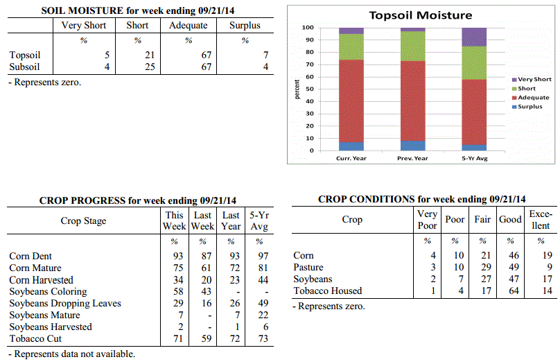 Kentucky Climate Summary
For the Period September 15, 2014 to September 21, 2014
Below Normal Temperatures and Rainfall:
Mostly dry and cool conditions took grasp of the Bluegrass State this past period.
Surface high pressure was in control for much of the week with the exception of
couple days on Monday and Sunday. Saying this, each day only featured light showers.
The first event was primarily focused to the eastern half of the state with most
locations picking up less than a quarter inch. The frontal passage on Sunday was a
bit weaker as Western and Southeastern Kentucky each picked up less than a tenth of
an inch on average. Looking at temperatures, much of the period featured highs only
rising into the 60s and 70s. The only day when temperatures were near to above normal
was on Saturday as southwesterly flow guided the mercury into the low to mid 80s.
Temperatures for the period averaged 66 degrees across the state which was 2 degrees
cooler than normal and no change to the previous period. High temperatures averaged
from 77 in the West to 75 in the East. Departure from normal high temperatures
ranged from 5 degrees cooler than normal in the West to 5 degrees cooler than normal
in the East. Low temperatures averaged from 55 degrees in the West to 56 degrees in
the East. Departure from normal low temperature ranged from 3 degrees cooler than
normal in the West to 1 degree warmer than normal in the East. The extreme high
temperature for the period was 90 degrees at PADUCAH ASOS and the extreme low was 42
degrees at HENDERSON 5E.
Precipitation (liq. equ.) for the period totaled 0.12 inches statewide which was 0.71
inches below normal and 14% of normal. Precipitation totals by climate division, West
0.14 inches, Central 0.06 inches, Bluegrass 0.14 inches and East 0.12 inches, which
was 0.71, 0.85, 0.6 and 0.7 inches below normal. By station, precipitation totals
ranged from a low of 0.00 inches at CAMPBELLSVILLE 7W to a high of 0.97
inches at HENDERSON 5E.
---
USDA's Kentucky Crop and Weather Report
Issued 4:00 P.M., September 15, 2014, 24-14
Agricultural News: Kentucky experienced below normal temperatures and above normal
rainfall over the past week. Precipitation for the week totaled 0.99 inches, 0.15
inches above normal. Temperatures averaged 68 degrees for the week, 3 degrees below
normal. Topsoil moisture was rated 5 percent very short, 16 percent short, 72 percent
adequate and 7 percent surplus. Subsoil moisture was rated 4 percent very short, 24
percent short, 68 percent adequate, and 4 percent surplus. Days suitable for
fieldwork averaged 5.5 out of a possible seven.
Primary activities this week included cutting and housing tobacco and harvesting
corn. However, recent rainfall has caused corn moisture to be high and harvesting to
proceed slowly. Pastures remain in good condition. Some farmers have reported difficulty
in harvesting tobacco due to labor shortages.
Kentucky Climate Summary
For the Period September 15, 2014 to September 21, 2014
Below Normal Temperatures and Rainfall:
Mostly dry and cool conditions took grasp of the Bluegrass State this past period.
Surface high pressure was in control for much of the week with the exception of
couple days on Monday and Sunday. Saying this, each day only featured light showers.
The first event was primarily focused to the eastern half of the state with most
locations picking up less than a quarter inch. The frontal passage on Sunday was a
bit weaker as Western and Southeastern Kentucky each picked up less than a tenth of
an inch on average. Looking at temperatures, much of the period featured highs only
rising into the 60s and 70s. The only day when temperatures were near to above normal
was on Saturday as southwesterly flow guided the mercury into the low to mid 80s.
Temperatures for the period averaged 66 degrees across the state which was 2 degrees
cooler than normal and no change to the previous period. High temperatures averaged
from 77 in the West to 75 in the East. Departure from normal high temperatures
ranged from 5 degrees cooler than normal in the West to 5 degrees cooler than normal
in the East. Low temperatures averaged from 55 degrees in the West to 56 degrees in
the East. Departure from normal low temperature ranged from 3 degrees cooler than
normal in the West to 1 degree warmer than normal in the East. The extreme high
temperature for the period was 90 degrees at PADUCAH ASOS and the extreme low was 42
degrees at HENDERSON 5E.
Precipitation (liq. equ.) for the period totaled 0.12 inches statewide which was 0.71
inches below normal and 14% of normal. Precipitation totals by climate division, West
0.14 inches, Central 0.06 inches, Bluegrass 0.14 inches and East 0.12 inches, which
was 0.71, 0.85, 0.6 and 0.7 inches below normal. By station, precipitation totals
ranged from a low of 0.00 inches at CAMPBELLSVILLE 7W to a high of 0.97
inches at HENDERSON 5E.
---
USDA's Kentucky Crop and Weather Report
Issued 4:00 P.M., September 15, 2014, 24-14
Agricultural News: Kentucky experienced below normal temperatures and above normal
rainfall over the past week. Precipitation for the week totaled 0.99 inches, 0.15
inches above normal. Temperatures averaged 68 degrees for the week, 3 degrees below
normal. Topsoil moisture was rated 5 percent very short, 16 percent short, 72 percent
adequate and 7 percent surplus. Subsoil moisture was rated 4 percent very short, 24
percent short, 68 percent adequate, and 4 percent surplus. Days suitable for
fieldwork averaged 5.5 out of a possible seven.
Primary activities this week included cutting and housing tobacco and harvesting
corn. However, recent rainfall has caused corn moisture to be high and harvesting to
proceed slowly. Pastures remain in good condition. Some farmers have reported difficulty
in harvesting tobacco due to labor shortages.
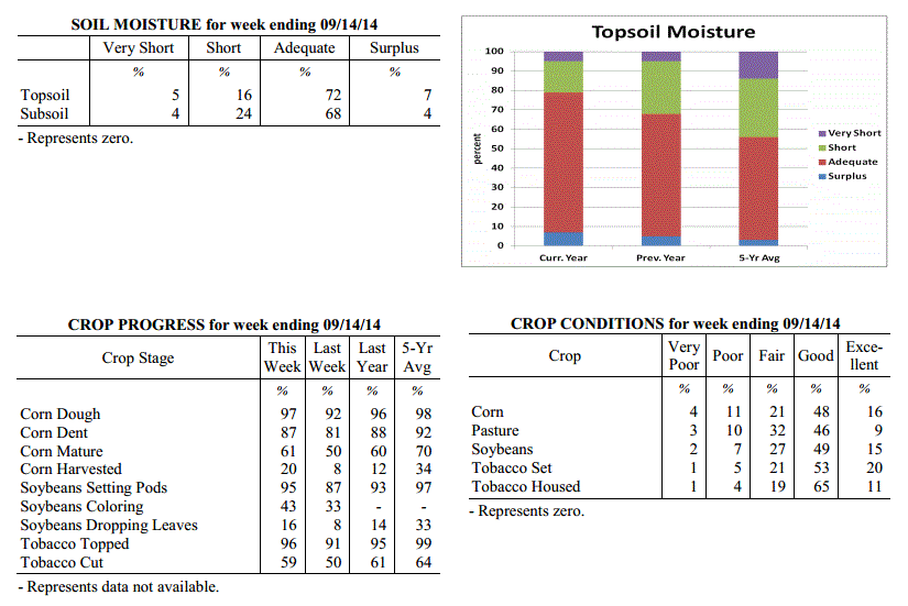 Kentucky Climate Summary
For the Period September 8, 2014 to September 14, 2014
Below Normal Temperatures and Above Normal Rainfall:
Fall-like conditions returned to the Ohio Valley this past period, but not before a
mild, first half of the work week. Highs typically rose into the low to mid 80s each
day with humid conditions remaining in place. The welcoming change came Wednesday
night and into Thursday as a cold front pushed through Ohio Valley. This boundary
sparked widespread showers across the region and while severe weather was absent, a
moist air mass allowed for moderate to heavy rainfall at times. The most significant
totals came across North-Central Kentucky and into the Bluegrass with many locations
picking up between 1.5 to around 3 inches. Lexington, Louisville, and Frankfort all
saw record daily rainfall with more than 2.5 inches at each location. Behind the
front, overcast skies kept temperatures on the cool side Friday and Saturday as highs
only rose into the mid to upper 60s for much of the state. Cloud cover then began to
taper later Saturday as surface high pressure moved into the region. Clear skies
Saturday night allowed for a very cool overnight period as the mercury dipped into
the 40s across the Commonwealth.
Temperatures for the period averaged 68 degrees across the state which was 3 degrees
cooler than normal and 8 degrees cooler than the previous period. High temperatures
averaged from 76 in the West to 76 in the East. Departure from normal high
temperatures ranged from 8 degrees cooler than normal in the West to 6 degrees cooler
than normal in the East. Low temperatures averaged from 58 degrees in the West to 61
degrees in the East. Departure from normal low temperature ranged from 3 degrees
cooler than normal in the West to 3 degrees warmer than normal in the East. The
extreme high temperature for the period was 92 degrees at POPLAR BLUFF ASOS and the
extreme low was 41 degrees at CYNTHIANA 8N.
Precipitation (liq. equ.) for the period totaled 0.99 inches statewide which was 0.15
inches above normal and 119% of normal. Precipitation totals by climate division,
West 0.82 inches, Central 0.47 inches, Bluegrass 1.70 inches and East 0.96 inches,
which was -0.02, -0.46, 0.94 and 0.15 inches respectively from normal. By station,
precipitation totals ranged from a low of 0.00 inches at BOWLING GREEN 4E to a high
of 3.85 inches at FRANKFORT 7S.
---
USDA's Kentucky Crop and Weather Report
Issued 4:00 P.M., September 8, 2014, 23-14
Agricultural News: Kentucky experienced above normal temperatures and slightly below
normal rainfall over the past week. Precipitation for the week totaled 0.72 inches,
0.05 inches below normal. Temperatures averaged 76 degrees for the week, 3 degrees
above normal. Topsoil moisture was rated 5 percent very short, 20 percent short, 66
percent adequate and 9 percent surplus. Subsoil moisture was rated 4 percent very
short, 26 percent short, 64 percent adequate, and 6 percent surplus. Days suitable
for fieldwork averaged 5.4 out of a possible seven.
Primary activities this week included harvesting hay and tobacco, chopping silage and
harvesting corn for grain. There were reports of army worms in pastures and hay
fields in western Kentucky. Hay harvesting has been slowed due to above normal
rainfall in eastern Kentucky. Pasture conditions continue to improve. Livestock are
in mostly good to excellent condition and are benefitting from recent rains.
Kentucky Climate Summary
For the Period September 8, 2014 to September 14, 2014
Below Normal Temperatures and Above Normal Rainfall:
Fall-like conditions returned to the Ohio Valley this past period, but not before a
mild, first half of the work week. Highs typically rose into the low to mid 80s each
day with humid conditions remaining in place. The welcoming change came Wednesday
night and into Thursday as a cold front pushed through Ohio Valley. This boundary
sparked widespread showers across the region and while severe weather was absent, a
moist air mass allowed for moderate to heavy rainfall at times. The most significant
totals came across North-Central Kentucky and into the Bluegrass with many locations
picking up between 1.5 to around 3 inches. Lexington, Louisville, and Frankfort all
saw record daily rainfall with more than 2.5 inches at each location. Behind the
front, overcast skies kept temperatures on the cool side Friday and Saturday as highs
only rose into the mid to upper 60s for much of the state. Cloud cover then began to
taper later Saturday as surface high pressure moved into the region. Clear skies
Saturday night allowed for a very cool overnight period as the mercury dipped into
the 40s across the Commonwealth.
Temperatures for the period averaged 68 degrees across the state which was 3 degrees
cooler than normal and 8 degrees cooler than the previous period. High temperatures
averaged from 76 in the West to 76 in the East. Departure from normal high
temperatures ranged from 8 degrees cooler than normal in the West to 6 degrees cooler
than normal in the East. Low temperatures averaged from 58 degrees in the West to 61
degrees in the East. Departure from normal low temperature ranged from 3 degrees
cooler than normal in the West to 3 degrees warmer than normal in the East. The
extreme high temperature for the period was 92 degrees at POPLAR BLUFF ASOS and the
extreme low was 41 degrees at CYNTHIANA 8N.
Precipitation (liq. equ.) for the period totaled 0.99 inches statewide which was 0.15
inches above normal and 119% of normal. Precipitation totals by climate division,
West 0.82 inches, Central 0.47 inches, Bluegrass 1.70 inches and East 0.96 inches,
which was -0.02, -0.46, 0.94 and 0.15 inches respectively from normal. By station,
precipitation totals ranged from a low of 0.00 inches at BOWLING GREEN 4E to a high
of 3.85 inches at FRANKFORT 7S.
---
USDA's Kentucky Crop and Weather Report
Issued 4:00 P.M., September 8, 2014, 23-14
Agricultural News: Kentucky experienced above normal temperatures and slightly below
normal rainfall over the past week. Precipitation for the week totaled 0.72 inches,
0.05 inches below normal. Temperatures averaged 76 degrees for the week, 3 degrees
above normal. Topsoil moisture was rated 5 percent very short, 20 percent short, 66
percent adequate and 9 percent surplus. Subsoil moisture was rated 4 percent very
short, 26 percent short, 64 percent adequate, and 6 percent surplus. Days suitable
for fieldwork averaged 5.4 out of a possible seven.
Primary activities this week included harvesting hay and tobacco, chopping silage and
harvesting corn for grain. There were reports of army worms in pastures and hay
fields in western Kentucky. Hay harvesting has been slowed due to above normal
rainfall in eastern Kentucky. Pasture conditions continue to improve. Livestock are
in mostly good to excellent condition and are benefitting from recent rains.
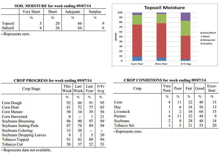 Kentucky Climate Summary
For the Period September 1, 2014 to September 7, 2014
Above Normal Temperatures and Below Normal Rainfall:
Depending on location, the first week of September kept portions of the Commonwealth
wet or dry. Attention surrounded two cold fronts that pushed through the region, one
on Tuesday and the other on Saturday. Each boundary sparked scattered to numerous,
showers and storms across mainly the eastern half of the state. In doing so, while
Eastern Kentucky saw above normal rainfall by nearly a half inch, the western half of
the state was just the opposite, only averaging a third of an inch for the week. The
dry conditions across Western Kentucky were compounded by above normal temperatures
for a third straight week. The highest temperatures were recorded on Thursday and
Friday as the mercury lifted into the upper 80s to low 90s for most. Saying this,
the Bluegrass State finally got some relief on Sunday as cool and dry conditions
moved in behind the cold front. This gave the Commonwealth a first look at fall with
highs only rising into the mid 70s to low 80s and much less humid conditions.
Temperatures for the period averaged 76 degrees across the state which was 3 degrees
warmer than normal and 2 degrees cooler than the previous period. High temperatures
averaged from 86 in the West to 83 in the East. Departure from normal high
temperatures ranged from near normal in the West to 1 degree cooler than
normal in the East. Low temperatures averaged from 69 degrees in the West to 68
degrees in the East. Departure from normal low temperature ranged from 6 degrees
warmer than normal in the West to 8 degrees warmer than normal in the East. The
extreme high temperature for the period was 95 degrees at PADUCAH ASOS and the
extreme low was 53 degrees at CARBONDALE ASOS.
Precipitation (liq. equ.) for the period totaled 0.72 inches statewide which was 0.05
inches below normal and 94% of normal. Precipitation totals by climate division, West
0.35 inches, Central 0.49 inches, Bluegrass 0.76 inches and East 1.28 inches, which
was -0.36, -0.35, 0.03 and 0.49 inches respectively from normal. By station,
precipitation totals ranged from a low of 0.00 inches at CALHOUN 5NW to a high of
2.35 inches at YELLOW CREEK.
---
USDA's Kentucky Crop and Weather Report
Issued 4:00 P.M., September 2, 2014, 22-14
Agricultural News: Kentucky experienced above normal temperatures and rainfall over
the past week. Precipitation for the week totaled 1.25 inches, 0.50 inches above
normal. Temperatures averaged 78 degrees for the week, 4 degrees above normal.
Topsoil moisture was rated 7 percent very short, 22 percent short, 62 percent
adequate and 9 percent surplus. Subsoil moisture was rated 6 percent very short, 28
percent short, 61 percent adequate, and 5 percent surplus. Days suitable for
fieldwork averaged 5.5 out of a possible seven.
Primary activities this week included harvesting and baling hay and topping and
cutting tobacco. Pasture conditions continued to improve with wide coverage of
rainfall throughout the state. However, rainfall has been causing delays to late hay
harvest and cutting tobacco. Corn harvest has begun, mostly for silage to date.
However, some early corn for grain in western Kentucky has also been harvested. With
continued warm weather, farmers are expecting the corn harvest to become widespread
in the coming weeks.
Kentucky Climate Summary
For the Period September 1, 2014 to September 7, 2014
Above Normal Temperatures and Below Normal Rainfall:
Depending on location, the first week of September kept portions of the Commonwealth
wet or dry. Attention surrounded two cold fronts that pushed through the region, one
on Tuesday and the other on Saturday. Each boundary sparked scattered to numerous,
showers and storms across mainly the eastern half of the state. In doing so, while
Eastern Kentucky saw above normal rainfall by nearly a half inch, the western half of
the state was just the opposite, only averaging a third of an inch for the week. The
dry conditions across Western Kentucky were compounded by above normal temperatures
for a third straight week. The highest temperatures were recorded on Thursday and
Friday as the mercury lifted into the upper 80s to low 90s for most. Saying this,
the Bluegrass State finally got some relief on Sunday as cool and dry conditions
moved in behind the cold front. This gave the Commonwealth a first look at fall with
highs only rising into the mid 70s to low 80s and much less humid conditions.
Temperatures for the period averaged 76 degrees across the state which was 3 degrees
warmer than normal and 2 degrees cooler than the previous period. High temperatures
averaged from 86 in the West to 83 in the East. Departure from normal high
temperatures ranged from near normal in the West to 1 degree cooler than
normal in the East. Low temperatures averaged from 69 degrees in the West to 68
degrees in the East. Departure from normal low temperature ranged from 6 degrees
warmer than normal in the West to 8 degrees warmer than normal in the East. The
extreme high temperature for the period was 95 degrees at PADUCAH ASOS and the
extreme low was 53 degrees at CARBONDALE ASOS.
Precipitation (liq. equ.) for the period totaled 0.72 inches statewide which was 0.05
inches below normal and 94% of normal. Precipitation totals by climate division, West
0.35 inches, Central 0.49 inches, Bluegrass 0.76 inches and East 1.28 inches, which
was -0.36, -0.35, 0.03 and 0.49 inches respectively from normal. By station,
precipitation totals ranged from a low of 0.00 inches at CALHOUN 5NW to a high of
2.35 inches at YELLOW CREEK.
---
USDA's Kentucky Crop and Weather Report
Issued 4:00 P.M., September 2, 2014, 22-14
Agricultural News: Kentucky experienced above normal temperatures and rainfall over
the past week. Precipitation for the week totaled 1.25 inches, 0.50 inches above
normal. Temperatures averaged 78 degrees for the week, 4 degrees above normal.
Topsoil moisture was rated 7 percent very short, 22 percent short, 62 percent
adequate and 9 percent surplus. Subsoil moisture was rated 6 percent very short, 28
percent short, 61 percent adequate, and 5 percent surplus. Days suitable for
fieldwork averaged 5.5 out of a possible seven.
Primary activities this week included harvesting and baling hay and topping and
cutting tobacco. Pasture conditions continued to improve with wide coverage of
rainfall throughout the state. However, rainfall has been causing delays to late hay
harvest and cutting tobacco. Corn harvest has begun, mostly for silage to date.
However, some early corn for grain in western Kentucky has also been harvested. With
continued warm weather, farmers are expecting the corn harvest to become widespread
in the coming weeks.
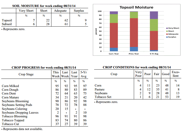 Kentucky Climate Summary
For the Period August 25, 2014 to August 31, 2014
Above Normal Temperatures and Rainfall:
Hot, humid, and wet conditions persisted across the Commonwealth for a second
straight week. An upper level ridge of high pressure was situated over the area for
the first half of the work week. This extended an already drawn-out heat wave from
the previous period. Highs repeatedly pushed into the upper 80s to middle 90s each
day. Accompanied by dewpoints in the 70s, the livestock heat stress index hovered in
the danger to emergency category each afternoon and evening. Focus then turned
toward a very active second half of the week. Isolated to scattered storms fired on
a daily basis between Wednesday and Friday as a frontal boundary meandered across the
state and combined with a moist and unstable air mass. The unsettled pattern then
continued into the holiday weekend as the Ohio Valley was placed in a southwesterly
flow pattern. Scattered to numerous showers and storms developed within this regime
as deep gulf moisture pushed into the region. Over the course of the week, the
state averaged 1.25 inches, which pushed Kentucky to a fourth straight week of above
normal rainfall.
Temperatures for the period averaged 78 degrees across the state which was 4 degrees
warmer than normal and no change to the previous period. High temperatures averaged
from 89 in the West to 85 in the East. Departure from normal high temperatures
ranged from 1 degree warmer than normal in the West to near normal in the East. Low
temperatures averaged from 70 degrees in the West to 66 degrees in the East. Departure
from normal low temperature ranged from 6 degrees warmer than normal in the West to 5
degrees warmer than normal in the East. The extreme high temperature for the period
was 98 degrees at MAYFIELD 6SW and the extreme low was 57 degrees at BLACK MOUNTAIN ARC.
Precipitation (liq. equ.) for the period totaled 1.25 inches statewide which was 0.50
inches above normal and 168% of normal. Precipitation totals by climate division,
West 1.51 inches, Central 1.50 inches, Bluegrass 0.62 inches and East 1.39 inches,
which was 0.84, 0.72, -0.12 and 0.60 inches respectively from normal. By station,
precipitation totals ranged from a low of 0.12 inches at SHELBYVILLE 10W to a high of
4.72 inches at PADUCAH ASOS.
---
USDA's Kentucky Crop and Weather Report
Issued 4:00 P.M., August 25, 2014, 21-14
Agricultural News: Kentucky experienced above normal temperatures and rainfall over
the past week. Precipitation for the week totaled 1.85 inches, 1.01 inches above
normal. Temperatures averaged 78 degrees for the week, 3 degrees above normal.
Topsoil moisture was rated 9 percent very short, 25 percent short, 58 percent
adequate and 8 percent surplus. Subsoil moisture was rated 9 percent very short, 32
percent short, 54 percent adequate, and 5 percent surplus. Days suitable for
fieldwork averaged 5.1 out of a possible seven.
Primary activities this week included harvesting hay and topping and cutting tobacco.
Scattered rainfall received last week was beneficial to most all crops. Some
locations continued to report dry conditions. Producers remain concerned that late
planted double crop soybeans may be in danger if there is an early frost. High
temperatures and humidity created heat stress conditions for livestock. Recent
precipitation has slightly improved hay and pasture conditions.
Kentucky Climate Summary
For the Period August 25, 2014 to August 31, 2014
Above Normal Temperatures and Rainfall:
Hot, humid, and wet conditions persisted across the Commonwealth for a second
straight week. An upper level ridge of high pressure was situated over the area for
the first half of the work week. This extended an already drawn-out heat wave from
the previous period. Highs repeatedly pushed into the upper 80s to middle 90s each
day. Accompanied by dewpoints in the 70s, the livestock heat stress index hovered in
the danger to emergency category each afternoon and evening. Focus then turned
toward a very active second half of the week. Isolated to scattered storms fired on
a daily basis between Wednesday and Friday as a frontal boundary meandered across the
state and combined with a moist and unstable air mass. The unsettled pattern then
continued into the holiday weekend as the Ohio Valley was placed in a southwesterly
flow pattern. Scattered to numerous showers and storms developed within this regime
as deep gulf moisture pushed into the region. Over the course of the week, the
state averaged 1.25 inches, which pushed Kentucky to a fourth straight week of above
normal rainfall.
Temperatures for the period averaged 78 degrees across the state which was 4 degrees
warmer than normal and no change to the previous period. High temperatures averaged
from 89 in the West to 85 in the East. Departure from normal high temperatures
ranged from 1 degree warmer than normal in the West to near normal in the East. Low
temperatures averaged from 70 degrees in the West to 66 degrees in the East. Departure
from normal low temperature ranged from 6 degrees warmer than normal in the West to 5
degrees warmer than normal in the East. The extreme high temperature for the period
was 98 degrees at MAYFIELD 6SW and the extreme low was 57 degrees at BLACK MOUNTAIN ARC.
Precipitation (liq. equ.) for the period totaled 1.25 inches statewide which was 0.50
inches above normal and 168% of normal. Precipitation totals by climate division,
West 1.51 inches, Central 1.50 inches, Bluegrass 0.62 inches and East 1.39 inches,
which was 0.84, 0.72, -0.12 and 0.60 inches respectively from normal. By station,
precipitation totals ranged from a low of 0.12 inches at SHELBYVILLE 10W to a high of
4.72 inches at PADUCAH ASOS.
---
USDA's Kentucky Crop and Weather Report
Issued 4:00 P.M., August 25, 2014, 21-14
Agricultural News: Kentucky experienced above normal temperatures and rainfall over
the past week. Precipitation for the week totaled 1.85 inches, 1.01 inches above
normal. Temperatures averaged 78 degrees for the week, 3 degrees above normal.
Topsoil moisture was rated 9 percent very short, 25 percent short, 58 percent
adequate and 8 percent surplus. Subsoil moisture was rated 9 percent very short, 32
percent short, 54 percent adequate, and 5 percent surplus. Days suitable for
fieldwork averaged 5.1 out of a possible seven.
Primary activities this week included harvesting hay and topping and cutting tobacco.
Scattered rainfall received last week was beneficial to most all crops. Some
locations continued to report dry conditions. Producers remain concerned that late
planted double crop soybeans may be in danger if there is an early frost. High
temperatures and humidity created heat stress conditions for livestock. Recent
precipitation has slightly improved hay and pasture conditions.
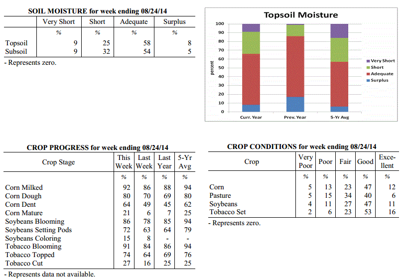 Kentucky Climate Summary
For the Period August 18, 2014 to August 24, 2014
Above Normal Temperatures and Much Above Normal Rainfall:
Intense heat and humid conditions made way back into the Commonwealth this past
period. A upper level ridge of high pressure built into the region on Thursday and
remained through the weekend, making way for the hottest and most humid conditions of
the year. Each day saw highs get into the upper 80s to middle 90s, along with
dewpoints rising into the 70s. The hot and humid conditions prompted a Heat Advisory
to be issued for much of the western half of the state as the heat index topped 100
degrees over multiple days. Conditions pushed the livestock heat stress index into
the danger to emergency category. Accompanying the heat wave was exceptionally
high rainfall totals across much of the state. Scattered showers and storms fired on
a near daily basis. The very moist and unstable air mass allowed for very efficient
rainfall producers and excessive lightning at times. The state averaged nearly 2
inches across the period, which was over an inch above normal. Saying this, the Purchase
was spared and dry conditions continue to deepen.
Temperatures for the period averaged 78 degrees across the state which was 3 degrees
warmer than normal and 6 degrees warmer than the previous period. High temperatures
averaged from 90 in the West to 85 in the East. Departure from normal high
temperatures ranged from 2 degrees warmer than normal in the West to 1 degree
cooler than normal in the East. Low temperatures averaged from 71 degrees in the
West to 68 degrees in the East. Departure from normal low temperature ranged from 6
degrees warmer than normal in the West to 6 degrees warmer than normal in the East.
The extreme high temperature for the period was 98 degrees at MAYFIELD 6SW and the
extreme low was 62 degrees at BLACK MOUNTAIN ARC.
Precipitation (liq. equ.) for the period totaled 1.85 inches statewide which was 1.01
inches above normal and 220% of normal. Precipitation totals by climate division,
West 0.69 inches, Central 2.25 inches, Bluegrass 2.17 inches and East 2.29 inches,
which was -0.07, 1.40, 1.32 and 1.38 inches respectively from normal. By station,
precipitation totals ranged from a low of 0.00 inches at MAYFIELD 6SW to a high of
5.10 inches at OWENTON 5E.
---
USDA's Kentucky Crop and Weather Report
Issued 4:00 P.M., August 18, 2014, 20-14
Agricultural News: Kentucky experienced below normal temperatures and above normal
rainfall over the past week. Precipitation for the week totaled 1.29 inches, 0.43
inches above normal. Temperatures averaged 72 degrees for the week, 4 degrees below
normal. Topsoil moisture was rated 13 percent very short, 30 percent short, 51
percent adequate and 6 percent surplus. Subsoil moisture was rated 12 percent very
short, 35 percent short, 49 percent adequate, and 4 percent surplus. Days suitable
for fieldwork averaged 5.3 out of a possible seven.
Primary activities this week included harvesting hay and topping and cutting tobacco.
Rainfall received last week was beneficial to most all crops. However, depending on
the stage of corn development, rains may be to late to improve conditions. Some
producers are concerned that late planted double crop soybeans may be in danger if
there is an early frost. There were reports of stink bugs active in soybeans. Recent
precipitation has improved hay and pasture conditions.
Kentucky Climate Summary
For the Period August 18, 2014 to August 24, 2014
Above Normal Temperatures and Much Above Normal Rainfall:
Intense heat and humid conditions made way back into the Commonwealth this past
period. A upper level ridge of high pressure built into the region on Thursday and
remained through the weekend, making way for the hottest and most humid conditions of
the year. Each day saw highs get into the upper 80s to middle 90s, along with
dewpoints rising into the 70s. The hot and humid conditions prompted a Heat Advisory
to be issued for much of the western half of the state as the heat index topped 100
degrees over multiple days. Conditions pushed the livestock heat stress index into
the danger to emergency category. Accompanying the heat wave was exceptionally
high rainfall totals across much of the state. Scattered showers and storms fired on
a near daily basis. The very moist and unstable air mass allowed for very efficient
rainfall producers and excessive lightning at times. The state averaged nearly 2
inches across the period, which was over an inch above normal. Saying this, the Purchase
was spared and dry conditions continue to deepen.
Temperatures for the period averaged 78 degrees across the state which was 3 degrees
warmer than normal and 6 degrees warmer than the previous period. High temperatures
averaged from 90 in the West to 85 in the East. Departure from normal high
temperatures ranged from 2 degrees warmer than normal in the West to 1 degree
cooler than normal in the East. Low temperatures averaged from 71 degrees in the
West to 68 degrees in the East. Departure from normal low temperature ranged from 6
degrees warmer than normal in the West to 6 degrees warmer than normal in the East.
The extreme high temperature for the period was 98 degrees at MAYFIELD 6SW and the
extreme low was 62 degrees at BLACK MOUNTAIN ARC.
Precipitation (liq. equ.) for the period totaled 1.85 inches statewide which was 1.01
inches above normal and 220% of normal. Precipitation totals by climate division,
West 0.69 inches, Central 2.25 inches, Bluegrass 2.17 inches and East 2.29 inches,
which was -0.07, 1.40, 1.32 and 1.38 inches respectively from normal. By station,
precipitation totals ranged from a low of 0.00 inches at MAYFIELD 6SW to a high of
5.10 inches at OWENTON 5E.
---
USDA's Kentucky Crop and Weather Report
Issued 4:00 P.M., August 18, 2014, 20-14
Agricultural News: Kentucky experienced below normal temperatures and above normal
rainfall over the past week. Precipitation for the week totaled 1.29 inches, 0.43
inches above normal. Temperatures averaged 72 degrees for the week, 4 degrees below
normal. Topsoil moisture was rated 13 percent very short, 30 percent short, 51
percent adequate and 6 percent surplus. Subsoil moisture was rated 12 percent very
short, 35 percent short, 49 percent adequate, and 4 percent surplus. Days suitable
for fieldwork averaged 5.3 out of a possible seven.
Primary activities this week included harvesting hay and topping and cutting tobacco.
Rainfall received last week was beneficial to most all crops. However, depending on
the stage of corn development, rains may be to late to improve conditions. Some
producers are concerned that late planted double crop soybeans may be in danger if
there is an early frost. There were reports of stink bugs active in soybeans. Recent
precipitation has improved hay and pasture conditions.
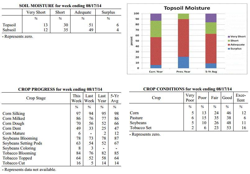 Kentucky Climate Summary
For the Period August 11, 2014 to August 17, 2014
Below Normal Temperatures and Above Normal Rainfall:
The wet and cool pattern continued for the Lower Ohio Valley this past period.
Kentucky saw above normal precipitation for the fourth time over the past five weeks
with a state average over an inch. Most of the rainfall came over the course of two
days. The first event occurred on Monday as a cluster of showers and storms pushed
east across the Commonwealth, followed by a trailing cold front. South-central
portions of Kentucky came out the winners with much of the region picking up over an
inch. The second came over the latter half of the weekend as low pressure slowly
meandered across the Ohio Valley. As was the case with both events, Kentucky was
situated within a very moist air mass, leading to torrential rainfall at times.
Looking at areas suffering from drought stress, most regions saw beneficial rainfall,
with the exception of the Purchase. Following the cold front earlier in the week,
temperatures remained cool for much of the period. High temperatures typically only
rose into the upper 70s to mid 80s, which pushed the state to a seventh straight week
of below normal temperatures.
Temperatures for the period averaged 72 degrees across the state which was 4 degrees
cooler than normal and 2 degrees cooler than the previous period. High temperatures
averaged from 83 in the West to 79 in the East. Departure from normal high
temperatures ranged from 5 degrees cooler than normal in the West to 7 degrees
cooler than normal in the East. Low temperatures averaged from 64 degrees in the
West to 62 degrees in the East. Departure from normal low temperature ranged from 2
degrees cooler than normal in the West to 1 degree cooler than normal in the East.
The extreme high temperature for the period was 91 degrees at POPLAR BLUFF ASOS and
the extreme low was 48 degrees at CYNTHIANA 8N.
Precipitation (liq. equ.) for the period totaled 1.29 inches statewide which was 0.43
inches above normal and 150% of normal. Precipitation totals by climate division,
West 1.48 inches, Central 1.80 inches, Bluegrass 0.95 inches and East 0.91 inches,
which was 0.68, 0.96, 0.08 and -0.03 inches respectively from normal. By station,
precipitation totals ranged from a low of 0.00 inches at POPLAR BLUFF ASOS to a high
of 5.26 inches at GREENVILLE 6N.
---
USDA's Kentucky Crop and Weather Report
Issued 4:00 P.M., August 11, 2014, 19-14
Agricultural News: Kentucky experienced dry conditions early in the week, but parts
of the state received some much needed relief toward the end of the week.
Precipitation for the week totaled 1.33 inches, 0.41 inches above normal.
Temperatures averaged 75 degrees for the week, 1 degrees below normal. Topsoil
moisture was rated 18 percent very short, 38 percent short, 41 percent adequate and 3
percent surplus. Subsoil moisture was rated 14 percent very short, 40 percent short,
43 percent adequate, and 3 percent surplus. Days suitable for fieldwork averaged 5.9
out of a possible seven.
Primary activities this week included the beginning of tobacco harvest and a
continuation of tobacco topping. Rains beginning on Friday were welcomed where
received and should prove beneficial to most crops. However, recent precipitation may
be a little too late for some corn fields depending on the stage of development. Many
cattle herds are on hay, but the rain provided some much needed relief to pastures.
Lack of overall rainfall continues to be a concern for many farmers.
Kentucky Climate Summary
For the Period August 11, 2014 to August 17, 2014
Below Normal Temperatures and Above Normal Rainfall:
The wet and cool pattern continued for the Lower Ohio Valley this past period.
Kentucky saw above normal precipitation for the fourth time over the past five weeks
with a state average over an inch. Most of the rainfall came over the course of two
days. The first event occurred on Monday as a cluster of showers and storms pushed
east across the Commonwealth, followed by a trailing cold front. South-central
portions of Kentucky came out the winners with much of the region picking up over an
inch. The second came over the latter half of the weekend as low pressure slowly
meandered across the Ohio Valley. As was the case with both events, Kentucky was
situated within a very moist air mass, leading to torrential rainfall at times.
Looking at areas suffering from drought stress, most regions saw beneficial rainfall,
with the exception of the Purchase. Following the cold front earlier in the week,
temperatures remained cool for much of the period. High temperatures typically only
rose into the upper 70s to mid 80s, which pushed the state to a seventh straight week
of below normal temperatures.
Temperatures for the period averaged 72 degrees across the state which was 4 degrees
cooler than normal and 2 degrees cooler than the previous period. High temperatures
averaged from 83 in the West to 79 in the East. Departure from normal high
temperatures ranged from 5 degrees cooler than normal in the West to 7 degrees
cooler than normal in the East. Low temperatures averaged from 64 degrees in the
West to 62 degrees in the East. Departure from normal low temperature ranged from 2
degrees cooler than normal in the West to 1 degree cooler than normal in the East.
The extreme high temperature for the period was 91 degrees at POPLAR BLUFF ASOS and
the extreme low was 48 degrees at CYNTHIANA 8N.
Precipitation (liq. equ.) for the period totaled 1.29 inches statewide which was 0.43
inches above normal and 150% of normal. Precipitation totals by climate division,
West 1.48 inches, Central 1.80 inches, Bluegrass 0.95 inches and East 0.91 inches,
which was 0.68, 0.96, 0.08 and -0.03 inches respectively from normal. By station,
precipitation totals ranged from a low of 0.00 inches at POPLAR BLUFF ASOS to a high
of 5.26 inches at GREENVILLE 6N.
---
USDA's Kentucky Crop and Weather Report
Issued 4:00 P.M., August 11, 2014, 19-14
Agricultural News: Kentucky experienced dry conditions early in the week, but parts
of the state received some much needed relief toward the end of the week.
Precipitation for the week totaled 1.33 inches, 0.41 inches above normal.
Temperatures averaged 75 degrees for the week, 1 degrees below normal. Topsoil
moisture was rated 18 percent very short, 38 percent short, 41 percent adequate and 3
percent surplus. Subsoil moisture was rated 14 percent very short, 40 percent short,
43 percent adequate, and 3 percent surplus. Days suitable for fieldwork averaged 5.9
out of a possible seven.
Primary activities this week included the beginning of tobacco harvest and a
continuation of tobacco topping. Rains beginning on Friday were welcomed where
received and should prove beneficial to most crops. However, recent precipitation may
be a little too late for some corn fields depending on the stage of development. Many
cattle herds are on hay, but the rain provided some much needed relief to pastures.
Lack of overall rainfall continues to be a concern for many farmers.
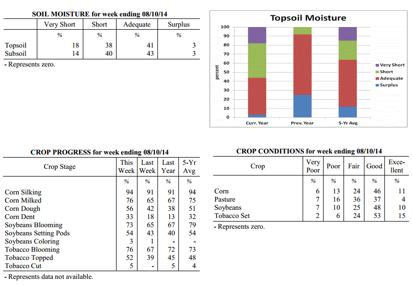 Kentucky Climate Summary
For the Period August 4, 2014 to August 10, 2014
Below Normal Temperatures and Above Normal Rainfall:
Showers and storms pushed into the Bluegrass State this past period and could not have
come at a better time. Leading up to this past Thursday, Kentucky started the week
on a dry note with surface high pressure situated across the region. Combined with
a very dry previous period, the Commonwealth saw moderate drought expand to consume 19%
of the state, mainly across the western half of Kentucky. By Thursday, the pattern
shifted dramatically. A frontal boundary stalled in the vicinity of the Lower Ohio
Valley and remained through the weekend. Most activity remained across Western
Kentucky through the remainder of the work week, before shifting east over the
weekend. Each day featured scattered to numerous showers and thunderstorms. Storms
remained under severe limits, but some were efficient rainfall producers with
torrential rainfall at times. One of the most significant cases was over Lexington
Sunday morning, when over 2 inches was reported in 1 hour. Over the course of the
period, the state was nearly a half inch above normal and temperatures were below
normal for the 6th straight week.
Temperatures for the period averaged 75 degrees across the state which was 1 degree
cooler than normal and 6 degrees warmer than the previous period. High temperatures
averaged from 88 in the West to 81 in the East. Departure from normal high
temperatures ranged from near normal in the West to 5 degrees cooler than
normal in the East. Low temperatures averaged from 67 degrees in the West to 64
degrees in the East. Departure from normal low temperature ranged from 1 degree
warmer than normal in the West to 1 degree warmer than normal in the East. The
extreme high temperature for the period was 95 degrees at FORT CAMPBELL and the
extreme low was 55 degrees at BURKESVILLE 3W.
Precipitation (liq. equ.) for the period totaled 1.33 inches statewide which was 0.41
inches above normal and 144% of normal. Precipitation totals by climate division,
West 1.26 inches, Central 1.37 inches, Bluegrass 1.22 inches and East 1.49 inches,
which was 0.37, 0.47, 0.32 and 0.48 inches above normal. By station, precipitation
totals ranged from a low of 0.01 inches at ALEXANDRIA 5NW to a high of 6.42
inches at LEXINGTON APT.
---
USDA's Kentucky Crop and Weather Report
Issued 4:00 P.M., August 4, 2014, 18-14
Agricultural News: Kentucky experienced unusually cool temperatures and dry
conditions over the past week. Precipitation for the week totaled 0.23 inches, 0.74
inches below normal. Temperatures averaged 70 degrees for the week, 6 degrees below
normal. Topsoil moisture was rated 19 percent very short, 38 percent short, 40
percent adequate and 3 percent surplus. Subsoil moisture was rated 14 percent very
short, 36 percent short, 47 percent adequate, and 3 percent surplus. Days suitable
for fieldwork averaged 6.3 out of a possible seven.
Primary activities this week included harvesting hay, topping tobacco and general
farm maintenance. Lack of rainfall continues to be a concern for many farmers as
moderate drought conditions expanded to more areas of the state. As a result of the
dry weather, crop conditions continue to deteriorate, especially in corn and
soybeans. Early planted crops appear to be fairing better than later planted crops.
Grain crops are reportedly maturing early and lack of adequate rainfall is causing
concern regarding corn kernel fill and soybean pod fill. Some fields of double crop
soybeans are showing severe stand problems and in some instances have yet to
germinate due to a lack of moisture. There were reports of fall armyworms in corn and
stink bugs in soybeans, but not causing major problems at this point. Some livestock
producers are feeding hay, which will cut into their winter supplies. Hay and
roughage supplies were reported as 4 percent very short, 26 percent short, 63 percent
adequate, and 7 percent surplus. The cool temperatures have benefitted livestock.
Kentucky Climate Summary
For the Period August 4, 2014 to August 10, 2014
Below Normal Temperatures and Above Normal Rainfall:
Showers and storms pushed into the Bluegrass State this past period and could not have
come at a better time. Leading up to this past Thursday, Kentucky started the week
on a dry note with surface high pressure situated across the region. Combined with
a very dry previous period, the Commonwealth saw moderate drought expand to consume 19%
of the state, mainly across the western half of Kentucky. By Thursday, the pattern
shifted dramatically. A frontal boundary stalled in the vicinity of the Lower Ohio
Valley and remained through the weekend. Most activity remained across Western
Kentucky through the remainder of the work week, before shifting east over the
weekend. Each day featured scattered to numerous showers and thunderstorms. Storms
remained under severe limits, but some were efficient rainfall producers with
torrential rainfall at times. One of the most significant cases was over Lexington
Sunday morning, when over 2 inches was reported in 1 hour. Over the course of the
period, the state was nearly a half inch above normal and temperatures were below
normal for the 6th straight week.
Temperatures for the period averaged 75 degrees across the state which was 1 degree
cooler than normal and 6 degrees warmer than the previous period. High temperatures
averaged from 88 in the West to 81 in the East. Departure from normal high
temperatures ranged from near normal in the West to 5 degrees cooler than
normal in the East. Low temperatures averaged from 67 degrees in the West to 64
degrees in the East. Departure from normal low temperature ranged from 1 degree
warmer than normal in the West to 1 degree warmer than normal in the East. The
extreme high temperature for the period was 95 degrees at FORT CAMPBELL and the
extreme low was 55 degrees at BURKESVILLE 3W.
Precipitation (liq. equ.) for the period totaled 1.33 inches statewide which was 0.41
inches above normal and 144% of normal. Precipitation totals by climate division,
West 1.26 inches, Central 1.37 inches, Bluegrass 1.22 inches and East 1.49 inches,
which was 0.37, 0.47, 0.32 and 0.48 inches above normal. By station, precipitation
totals ranged from a low of 0.01 inches at ALEXANDRIA 5NW to a high of 6.42
inches at LEXINGTON APT.
---
USDA's Kentucky Crop and Weather Report
Issued 4:00 P.M., August 4, 2014, 18-14
Agricultural News: Kentucky experienced unusually cool temperatures and dry
conditions over the past week. Precipitation for the week totaled 0.23 inches, 0.74
inches below normal. Temperatures averaged 70 degrees for the week, 6 degrees below
normal. Topsoil moisture was rated 19 percent very short, 38 percent short, 40
percent adequate and 3 percent surplus. Subsoil moisture was rated 14 percent very
short, 36 percent short, 47 percent adequate, and 3 percent surplus. Days suitable
for fieldwork averaged 6.3 out of a possible seven.
Primary activities this week included harvesting hay, topping tobacco and general
farm maintenance. Lack of rainfall continues to be a concern for many farmers as
moderate drought conditions expanded to more areas of the state. As a result of the
dry weather, crop conditions continue to deteriorate, especially in corn and
soybeans. Early planted crops appear to be fairing better than later planted crops.
Grain crops are reportedly maturing early and lack of adequate rainfall is causing
concern regarding corn kernel fill and soybean pod fill. Some fields of double crop
soybeans are showing severe stand problems and in some instances have yet to
germinate due to a lack of moisture. There were reports of fall armyworms in corn and
stink bugs in soybeans, but not causing major problems at this point. Some livestock
producers are feeding hay, which will cut into their winter supplies. Hay and
roughage supplies were reported as 4 percent very short, 26 percent short, 63 percent
adequate, and 7 percent surplus. The cool temperatures have benefitted livestock.
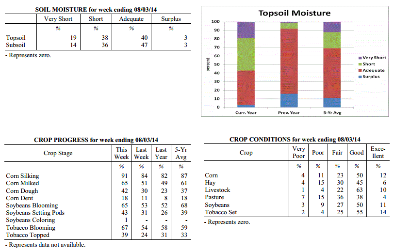 Kentucky Climate Summary
For the Period July 28, 2014 to August 3, 2014
Below Normal Temperatures and Rainfall:
The unusual pattern of cool temperatures and dry conditions continued through the end
of July and early August. Normally one of the warmest times of the year, each day
this week saw below normal temperatures, both during the day and at night. The
coolest temperatures were felt early in the work week as Kentucky was under the
influence of a Canadian air mass and northwesterly flow. Most locations only rose
into the 70s Monday through Wednesday. Some locations even broke record lows on
Monday night. A handful of stations dropped into the upper 40s, which is around 20
degrees below normal for this time of the year. The cool pattern led to the fifth
straight week of near to below normal temperatures. Looking at rainfall, it was
another dry week across the Commonwealth. The only significant activity was Saturday
when showers and storms were isolated to scattered in coverage. The state as a whole
averaged under a quarter inch for the week, but the majority came across the eastern
half of the state. Western Kentucky was once again spared and resulted in Moderate
Drought being introduced to a large section of West-Central Kentucky by the US
Drought Monitor. This was the seventh straight week Western Kentucky has seen below
normal precipitation.
Temperatures for the period averaged 70 degrees across the state which was 6 degrees
cooler than normal and 4 degrees cooler than the previous period. High temperatures
averaged from 83 in the West to 78 in the East. Departure from normal high
temperatures ranged from 6 degrees cooler than normal in the West to 9 degrees
cooler than normal in the East. Low temperatures averaged from 59 degrees in the
West to 59 degrees in the East. Departure from normal low temperature ranged from 8
degrees cooler than normal in the West to 5 degrees cooler than normal in the East.
The extreme high temperature for the period was 92 degrees at BOWLING GREEN 4E and
the extreme low was 48 degrees at BLACK MOUNTAIN ARC.
Precipitation (liq. equ.) for the period totaled 0.23 inches statewide which was 0.74
inches below normal and 24% of normal. Precipitation totals by climate division, West
0.07 inches, Central 0.08 inches, Bluegrass 0.23 inches and East 0.55 inches, which
was 0.86, 0.88, 0.73 and 0.49 inches below normal. By station, precipitation totals
ranged from a low of 0.00 inches at BENTON 4N to a high of 2.04 inches at PAINTSVILLE 4W.
---
USDA's Kentucky Crop and Weather Report
Issued 4:00 P.M., July 28, 2014, 17-14
Agricultural News: Kentucky experienced a mix of heat, severe weather, and cool
conditions over the past week. Precipitation for the week totaled 1.17 inches, 0.21
inches above normal. Temperatures averaged 75 degrees for the week, 2 degrees below
normal. Topsoil moisture was rated 15 percent very short, 36 percent short, 44
percent adequate and 5 percent surplus. Subsoil moisture was rated 12 percent very
short, 32 percent short, 51 percent adequate, and 5 percent surplus. Days suitable
for fieldwork averaged 5.9 out of a possible seven.
Primary activities this week included spraying soybeans, baling hay, topping tobacco,
and general farm maintenance. Rains continue to be scattered, providing improvement
in pasture and crop conditions in some areas. However, dry conditions have continued
throughout other areas of the state and pasture and crop conditions continue to
deteriorate. There were some reports of corn twisting due to lack of adequate
rainfall. High winds resulted in corn and tobacco being blown over in a few
locations. Some farmers reported soybeans are wilting in the afternoons and a few are
replanting double crop soybeans. Pastures continue to deteriorate in areas and more
farmers are beginning to feed hay. There were a few reports of disease issues in vegetables.
Kentucky Climate Summary
For the Period July 28, 2014 to August 3, 2014
Below Normal Temperatures and Rainfall:
The unusual pattern of cool temperatures and dry conditions continued through the end
of July and early August. Normally one of the warmest times of the year, each day
this week saw below normal temperatures, both during the day and at night. The
coolest temperatures were felt early in the work week as Kentucky was under the
influence of a Canadian air mass and northwesterly flow. Most locations only rose
into the 70s Monday through Wednesday. Some locations even broke record lows on
Monday night. A handful of stations dropped into the upper 40s, which is around 20
degrees below normal for this time of the year. The cool pattern led to the fifth
straight week of near to below normal temperatures. Looking at rainfall, it was
another dry week across the Commonwealth. The only significant activity was Saturday
when showers and storms were isolated to scattered in coverage. The state as a whole
averaged under a quarter inch for the week, but the majority came across the eastern
half of the state. Western Kentucky was once again spared and resulted in Moderate
Drought being introduced to a large section of West-Central Kentucky by the US
Drought Monitor. This was the seventh straight week Western Kentucky has seen below
normal precipitation.
Temperatures for the period averaged 70 degrees across the state which was 6 degrees
cooler than normal and 4 degrees cooler than the previous period. High temperatures
averaged from 83 in the West to 78 in the East. Departure from normal high
temperatures ranged from 6 degrees cooler than normal in the West to 9 degrees
cooler than normal in the East. Low temperatures averaged from 59 degrees in the
West to 59 degrees in the East. Departure from normal low temperature ranged from 8
degrees cooler than normal in the West to 5 degrees cooler than normal in the East.
The extreme high temperature for the period was 92 degrees at BOWLING GREEN 4E and
the extreme low was 48 degrees at BLACK MOUNTAIN ARC.
Precipitation (liq. equ.) for the period totaled 0.23 inches statewide which was 0.74
inches below normal and 24% of normal. Precipitation totals by climate division, West
0.07 inches, Central 0.08 inches, Bluegrass 0.23 inches and East 0.55 inches, which
was 0.86, 0.88, 0.73 and 0.49 inches below normal. By station, precipitation totals
ranged from a low of 0.00 inches at BENTON 4N to a high of 2.04 inches at PAINTSVILLE 4W.
---
USDA's Kentucky Crop and Weather Report
Issued 4:00 P.M., July 28, 2014, 17-14
Agricultural News: Kentucky experienced a mix of heat, severe weather, and cool
conditions over the past week. Precipitation for the week totaled 1.17 inches, 0.21
inches above normal. Temperatures averaged 75 degrees for the week, 2 degrees below
normal. Topsoil moisture was rated 15 percent very short, 36 percent short, 44
percent adequate and 5 percent surplus. Subsoil moisture was rated 12 percent very
short, 32 percent short, 51 percent adequate, and 5 percent surplus. Days suitable
for fieldwork averaged 5.9 out of a possible seven.
Primary activities this week included spraying soybeans, baling hay, topping tobacco,
and general farm maintenance. Rains continue to be scattered, providing improvement
in pasture and crop conditions in some areas. However, dry conditions have continued
throughout other areas of the state and pasture and crop conditions continue to
deteriorate. There were some reports of corn twisting due to lack of adequate
rainfall. High winds resulted in corn and tobacco being blown over in a few
locations. Some farmers reported soybeans are wilting in the afternoons and a few are
replanting double crop soybeans. Pastures continue to deteriorate in areas and more
farmers are beginning to feed hay. There were a few reports of disease issues in vegetables.
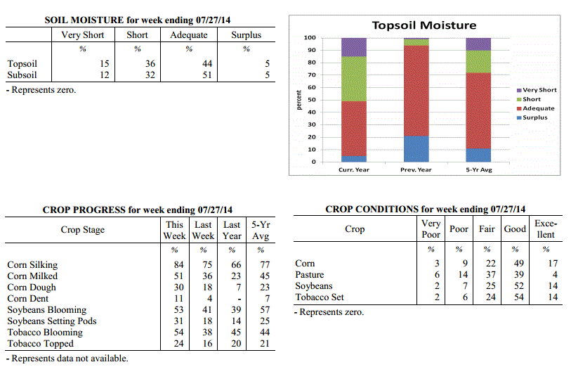 Kentucky Climate Summary
For the Period July 21, 2014 to July 27, 2014
Below Normal Temperatures and Above Normal Rainfall:
It was a very active week across the Commonwealth this past period with a mix of
summer heat, severe weather, and cool conditions. Temperatures were warm to start the
week with highs in the upper 80s to middle 90s on Monday and Tuesday. Dewpoints in
the upper 60s to low 70s pushed the heat index toward the triple digits. Attention
then turned toward a welcoming cold front on Wednesday. After an initial round of
scattered showers and storms, cooler and much drier air moved into the Bluegrass
State for the second half of the work week. Many locations saw temperatures well
below normal, staying in the mid 70s to low 80s. After a warm day Saturday, the rest
of the weekend was dominated by an unsettled pattern. A line of storms worked through
much of the state late Saturday night, before scattered to numerous storms fired on
Sunday. Both were accompanied by isolated reports of damaging winds and large hail.
Portions of Lexington saw straight line winds around 95 mph, while one report from
Leslie County measured hail at over 4 inches in diameter, nearly the size of a
softball. Over the course of the period, much of the state saw significant rainfall
in excess of an inch, but the same cannot be said for Western Kentucky where the dry
trend continues with a quarter inch on average. This was the second straight week of
above normal rainfall after an extended period of dry conditions. Average temperatures
were also near to below normal for the fourth straight week.
Temperatures for the period averaged 75 degrees across the state which was 2 degrees
cooler than normal and 6 degrees warmer than the previous period. High temperatures
averaged from 88 in the West to 82 in the East. Departure from normal high
temperatures ranged from 1 degree cooler than normal in the West to 5 degrees
cooler than normal in the East. Low temperatures averaged from 64 degrees in the
West to 65 degrees in the East. Departure from normal low temperature ranged from 3
degrees cooler than normal in the West to 1 degree warmer than normal in the East.
The extreme high temperature for the period was 97 degrees at HARTFORD 3E and the
extreme low was 52 degrees at BLACK MOUNTAIN ARC.
Precipitation (liq. equ.) for the period totaled 1.17 inches statewide which was 0.21
inches above normal and 122% of normal. Precipitation totals by climate division,
West 0.24 inches, Central 1.23 inches, Bluegrass 1.59 inches and East 1.61 inches,
which was -0.67, 0.26, 0.64 and 0.61 inches respectively from normal. By station,
precipitation totals ranged from a low of 0.00 inches at BOWLING GREEN 5S to a high
of 5.22 inches at WHITLEY CITY 3N.
---
USDA's Kentucky Crop and Weather Report
Issued 4:00 P.M., July 21, 2014, 16-14
Agricultural News: Kentucky experienced scattered rainfall over the past week.
Precipitation for the week totaled 1.48 inches, 0.49 inches above normal.
Temperatures averaged 70 degrees for the week, 7 degrees below normal. Topsoil
moisture was rated 13 percent very short, 35 percent short, 47 percent adequate and 5
percent surplus. Subsoil moisture was rated 10 percent very short, 33 percent short,
52 percent adequate, and 5 percent surplus. Days suitable for fieldwork averaged 5.8
out of a possible seven.
Primary activities this week included spraying soybeans, baling hay, and general farm
maintenance. Parts of the state received much needed rainfall this week, providing
improvement in pasture and crop conditions. However, some areas still remain dry and
pasture and crop conditions continue to deteriorate. Some cattle producers are
beginning to feed hay. There were a few reports of black shank problems starting to
appear in tobacco.
Kentucky Climate Summary
For the Period July 21, 2014 to July 27, 2014
Below Normal Temperatures and Above Normal Rainfall:
It was a very active week across the Commonwealth this past period with a mix of
summer heat, severe weather, and cool conditions. Temperatures were warm to start the
week with highs in the upper 80s to middle 90s on Monday and Tuesday. Dewpoints in
the upper 60s to low 70s pushed the heat index toward the triple digits. Attention
then turned toward a welcoming cold front on Wednesday. After an initial round of
scattered showers and storms, cooler and much drier air moved into the Bluegrass
State for the second half of the work week. Many locations saw temperatures well
below normal, staying in the mid 70s to low 80s. After a warm day Saturday, the rest
of the weekend was dominated by an unsettled pattern. A line of storms worked through
much of the state late Saturday night, before scattered to numerous storms fired on
Sunday. Both were accompanied by isolated reports of damaging winds and large hail.
Portions of Lexington saw straight line winds around 95 mph, while one report from
Leslie County measured hail at over 4 inches in diameter, nearly the size of a
softball. Over the course of the period, much of the state saw significant rainfall
in excess of an inch, but the same cannot be said for Western Kentucky where the dry
trend continues with a quarter inch on average. This was the second straight week of
above normal rainfall after an extended period of dry conditions. Average temperatures
were also near to below normal for the fourth straight week.
Temperatures for the period averaged 75 degrees across the state which was 2 degrees
cooler than normal and 6 degrees warmer than the previous period. High temperatures
averaged from 88 in the West to 82 in the East. Departure from normal high
temperatures ranged from 1 degree cooler than normal in the West to 5 degrees
cooler than normal in the East. Low temperatures averaged from 64 degrees in the
West to 65 degrees in the East. Departure from normal low temperature ranged from 3
degrees cooler than normal in the West to 1 degree warmer than normal in the East.
The extreme high temperature for the period was 97 degrees at HARTFORD 3E and the
extreme low was 52 degrees at BLACK MOUNTAIN ARC.
Precipitation (liq. equ.) for the period totaled 1.17 inches statewide which was 0.21
inches above normal and 122% of normal. Precipitation totals by climate division,
West 0.24 inches, Central 1.23 inches, Bluegrass 1.59 inches and East 1.61 inches,
which was -0.67, 0.26, 0.64 and 0.61 inches respectively from normal. By station,
precipitation totals ranged from a low of 0.00 inches at BOWLING GREEN 5S to a high
of 5.22 inches at WHITLEY CITY 3N.
---
USDA's Kentucky Crop and Weather Report
Issued 4:00 P.M., July 21, 2014, 16-14
Agricultural News: Kentucky experienced scattered rainfall over the past week.
Precipitation for the week totaled 1.48 inches, 0.49 inches above normal.
Temperatures averaged 70 degrees for the week, 7 degrees below normal. Topsoil
moisture was rated 13 percent very short, 35 percent short, 47 percent adequate and 5
percent surplus. Subsoil moisture was rated 10 percent very short, 33 percent short,
52 percent adequate, and 5 percent surplus. Days suitable for fieldwork averaged 5.8
out of a possible seven.
Primary activities this week included spraying soybeans, baling hay, and general farm
maintenance. Parts of the state received much needed rainfall this week, providing
improvement in pasture and crop conditions. However, some areas still remain dry and
pasture and crop conditions continue to deteriorate. Some cattle producers are
beginning to feed hay. There were a few reports of black shank problems starting to
appear in tobacco.
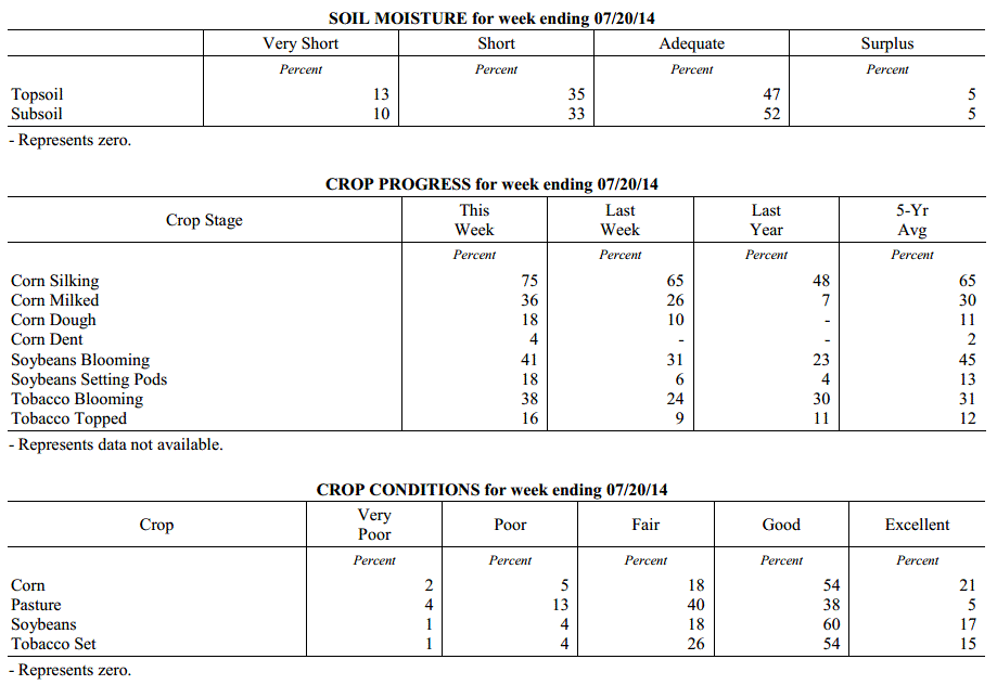 Kentucky Climate Summary
For the Period July 14, 2014 to July 20, 2014
Much Below Normal Temperatures and Above Normal Rainfall:
The Commonwealth finally saw some significant rainfall this past week, along with a
glimpse of early fall. A couple frontal boundaries started the work week off on a
wet note. Scattered to numerous showers and storms formed along a weakening frontal
boundary early Monday, before a stronger cold front moved through the area later that
night. Surface high pressure of Canadian origin then pushed into the region for much
of the remaining work week. Unseasonable temperatures with low dewpoints invaded the
Ohio Valley with highs temperatures only in the 70s about each day. Highs
in the upper 70s are normally not seen until late-September. Record lows were broken
at many locations on Thursday morning, as temperatures plummeted into the low to mid
50s. Some locations even recorded the mercury dropping into the upper 40s. Showers
then redeveloped on Friday, marking the start of extended period of unsettled
conditions heading into the weekend. Rainfall was light in nature, but was present
for an extended period of time, mostly across the eastern half of the state. Overall,
the state was nearly a half inch above normal for the week, which broke a streak of 5
consecutive periods of below normal rainfall.
Temperatures for the period averaged 70 degrees across the state which was 7 degrees
cooler than normal and 6 degrees cooler than the previous period. High temperatures
averaged from 79 in the West to 77 in the East. Departure from normal high
temperatures ranged from 11 degrees cooler than normal in the West to 10 degrees
cooler than normal in the East. Low temperatures averaged from 61 degrees in the
West to 62 degrees in the East. Departure from normal low temperature ranged from 7
degrees cooler than normal in the West to 2 degrees cooler than normal in the East.
The extreme high temperature for the period was 90 degrees at BOWLING GREEN 4E and
the extreme low was 49 degrees at CYNTHIANA 8N.
Precipitation (liq. equ.) for the period totaled 1.48 inches statewide which was 0.49
inches above normal and 149% of normal. Precipitation totals by climate division,
West 0.49 inches, Central 1.06 inches, Bluegrass 1.60 inches and East 2.76 inches,
which was -0.47, 0.05, 0.64 and 1.73 inches respectively from normal. By station,
precipitation totals ranged from a low of 0.06 inches at HARDINSBURG 5SW to a high of
5.59 inches at LONDON.
---
USDA's Kentucky Crop and Weather Report
Issued 4:00 P.M., July 14, 2014, 15-14
Agricultural News: Kentucky experienced dry conditions over the past week.
Precipitation for the week totaled 0.38 inches, 0.61 inches below normal.
Temperatures averaged 77 degrees for the week, near normal. Topsoil moisture was
rated 11 percent very short, 39 percent short, 45 percent adequate and 5 percent
surplus. Subsoil moisture was rated 9 percent very short, 34 percent short, 52
percent adequate, and 5 percent surplus. Days suitable for fieldwork averaged 6.2 out
of a possible seven.
Primary activities this week include spraying soybeans, harvesting wheat, and baling
hay. Crop conditions are deteriorating in some areas as dry conditions continue.
There were a few reports of corn curling and looking drought stressed. Pastures are
drying up and some cattle producers are starting to feed hay. A few producers
reported vomitoxin in wheat.
Kentucky Climate Summary
For the Period July 14, 2014 to July 20, 2014
Much Below Normal Temperatures and Above Normal Rainfall:
The Commonwealth finally saw some significant rainfall this past week, along with a
glimpse of early fall. A couple frontal boundaries started the work week off on a
wet note. Scattered to numerous showers and storms formed along a weakening frontal
boundary early Monday, before a stronger cold front moved through the area later that
night. Surface high pressure of Canadian origin then pushed into the region for much
of the remaining work week. Unseasonable temperatures with low dewpoints invaded the
Ohio Valley with highs temperatures only in the 70s about each day. Highs
in the upper 70s are normally not seen until late-September. Record lows were broken
at many locations on Thursday morning, as temperatures plummeted into the low to mid
50s. Some locations even recorded the mercury dropping into the upper 40s. Showers
then redeveloped on Friday, marking the start of extended period of unsettled
conditions heading into the weekend. Rainfall was light in nature, but was present
for an extended period of time, mostly across the eastern half of the state. Overall,
the state was nearly a half inch above normal for the week, which broke a streak of 5
consecutive periods of below normal rainfall.
Temperatures for the period averaged 70 degrees across the state which was 7 degrees
cooler than normal and 6 degrees cooler than the previous period. High temperatures
averaged from 79 in the West to 77 in the East. Departure from normal high
temperatures ranged from 11 degrees cooler than normal in the West to 10 degrees
cooler than normal in the East. Low temperatures averaged from 61 degrees in the
West to 62 degrees in the East. Departure from normal low temperature ranged from 7
degrees cooler than normal in the West to 2 degrees cooler than normal in the East.
The extreme high temperature for the period was 90 degrees at BOWLING GREEN 4E and
the extreme low was 49 degrees at CYNTHIANA 8N.
Precipitation (liq. equ.) for the period totaled 1.48 inches statewide which was 0.49
inches above normal and 149% of normal. Precipitation totals by climate division,
West 0.49 inches, Central 1.06 inches, Bluegrass 1.60 inches and East 2.76 inches,
which was -0.47, 0.05, 0.64 and 1.73 inches respectively from normal. By station,
precipitation totals ranged from a low of 0.06 inches at HARDINSBURG 5SW to a high of
5.59 inches at LONDON.
---
USDA's Kentucky Crop and Weather Report
Issued 4:00 P.M., July 14, 2014, 15-14
Agricultural News: Kentucky experienced dry conditions over the past week.
Precipitation for the week totaled 0.38 inches, 0.61 inches below normal.
Temperatures averaged 77 degrees for the week, near normal. Topsoil moisture was
rated 11 percent very short, 39 percent short, 45 percent adequate and 5 percent
surplus. Subsoil moisture was rated 9 percent very short, 34 percent short, 52
percent adequate, and 5 percent surplus. Days suitable for fieldwork averaged 6.2 out
of a possible seven.
Primary activities this week include spraying soybeans, harvesting wheat, and baling
hay. Crop conditions are deteriorating in some areas as dry conditions continue.
There were a few reports of corn curling and looking drought stressed. Pastures are
drying up and some cattle producers are starting to feed hay. A few producers
reported vomitoxin in wheat.
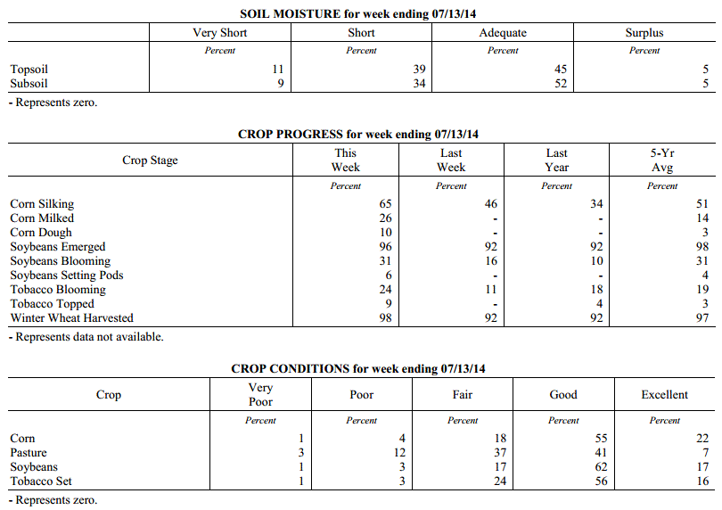 Kentucky Climate Summary
For the Period July 7, 2014 to July 13, 2014
Near Normal Temperatures and Below Normal Rainfall:
Dry conditions continued to control the weather pattern this past week across the
Commonwealth. The state averaged under a half inch for the week, which made for
the fifth straight period of below normal rainfall. This led to an intensification of
drought conditions with the US Drought Monitor now reporting 48% of the state as
abnormally dry and a slight portion of Southeastern Kentucky in a Moderate Drought.
As high pressure pushed east over the weekend, southerly flow brought scorching heat
and humidity back to the region. Highs by Sunday were in the low to mid 90s for much
of the Commonwealth along with the heat index around 100 degrees. Louisville even hit a
high of 97. Scattered storms developed across the region during the afternoon and
evening hours as instability was on the rise and a weak front pushed through the
area. Significant rainfall totals of greater than a half inch were limited to
locations across East-central Kentucky and north into the Bluegrass.
Temperatures for the period averaged 77 degrees across the state which was near
normal and 4 degrees warmer than the previous period. High temperatures averaged from
88 in the West to 88 in the East. Departure from normal high temperatures ranged from
1 degree cooler than normal in the West to 1 degree warmer than normal in the East.
Low temperatures averaged from 67 degrees in the West to 65 degrees in the East.
Departure from normal low temperature ranged from near normal in the West to 2
degrees warmer than normal in the East. The extreme high temperature for the period
was 97 degrees at LOUISA 1S and the extreme low was 56 degrees at CYNTHIANA 8N.
Precipitation (liq. equ.) for the period totaled 0.38 inches statewide which was 0.61
inches below normal and 38% of normal. Precipitation totals by climate division, West
0.38 inches, Central 0.41 inches, Bluegrass 0.23 inches and East 0.51 inches, which
was 0.6, 0.59, 0.74 and 0.49 inches below normal. By station, precipitation totals
ranged from a low of 0.00 inches at BIG SANDY to a high of 1.51 inches at MIDDLESBORO AWOS.
---
USDA's Kentucky Crop and Weather Report
Issued 4:00 P.M., July 7, 2014, 14-14
Agricultural News: Kentucky experienced dry and cool conditions over the past week.
Precipitation for the week totaled 0.38 inches, 0.61 inches below normal. Temperatures
averaged 73 degrees for the week, 3 degrees below normal. Topsoil moisture was rated 6
percent very short, 30 percent short, 58 percent adequate and 6 percent surplus.
Subsoil moisture was rated 4 percent very short, 28 percent short, 62 percent
adequate, and 6 percent surplus. Days suitable for fieldwork averaged 5.8 out of a
possible seven. Primary activities this week included planting soybeans and harvesting
wheat and hay.
Producers are finishing up with the wheat harvest and double crop soybean planting.
The average height of emerged soybeans was 17 inches. Most early planted corn looks
good, but in some locations the later fields are curling due to lack of moisture.
There were reports this week of blank shank and fusarium wilt in a few tobacco fields.
Pasture and crop conditions are starting to decline in some areas due to lack of
moisture. Farmers were bush hogging fields and performing general maintenance as they
finished up planting row crops.
Kentucky Climate Summary
For the Period July 7, 2014 to July 13, 2014
Near Normal Temperatures and Below Normal Rainfall:
Dry conditions continued to control the weather pattern this past week across the
Commonwealth. The state averaged under a half inch for the week, which made for
the fifth straight period of below normal rainfall. This led to an intensification of
drought conditions with the US Drought Monitor now reporting 48% of the state as
abnormally dry and a slight portion of Southeastern Kentucky in a Moderate Drought.
As high pressure pushed east over the weekend, southerly flow brought scorching heat
and humidity back to the region. Highs by Sunday were in the low to mid 90s for much
of the Commonwealth along with the heat index around 100 degrees. Louisville even hit a
high of 97. Scattered storms developed across the region during the afternoon and
evening hours as instability was on the rise and a weak front pushed through the
area. Significant rainfall totals of greater than a half inch were limited to
locations across East-central Kentucky and north into the Bluegrass.
Temperatures for the period averaged 77 degrees across the state which was near
normal and 4 degrees warmer than the previous period. High temperatures averaged from
88 in the West to 88 in the East. Departure from normal high temperatures ranged from
1 degree cooler than normal in the West to 1 degree warmer than normal in the East.
Low temperatures averaged from 67 degrees in the West to 65 degrees in the East.
Departure from normal low temperature ranged from near normal in the West to 2
degrees warmer than normal in the East. The extreme high temperature for the period
was 97 degrees at LOUISA 1S and the extreme low was 56 degrees at CYNTHIANA 8N.
Precipitation (liq. equ.) for the period totaled 0.38 inches statewide which was 0.61
inches below normal and 38% of normal. Precipitation totals by climate division, West
0.38 inches, Central 0.41 inches, Bluegrass 0.23 inches and East 0.51 inches, which
was 0.6, 0.59, 0.74 and 0.49 inches below normal. By station, precipitation totals
ranged from a low of 0.00 inches at BIG SANDY to a high of 1.51 inches at MIDDLESBORO AWOS.
---
USDA's Kentucky Crop and Weather Report
Issued 4:00 P.M., July 7, 2014, 14-14
Agricultural News: Kentucky experienced dry and cool conditions over the past week.
Precipitation for the week totaled 0.38 inches, 0.61 inches below normal. Temperatures
averaged 73 degrees for the week, 3 degrees below normal. Topsoil moisture was rated 6
percent very short, 30 percent short, 58 percent adequate and 6 percent surplus.
Subsoil moisture was rated 4 percent very short, 28 percent short, 62 percent
adequate, and 6 percent surplus. Days suitable for fieldwork averaged 5.8 out of a
possible seven. Primary activities this week included planting soybeans and harvesting
wheat and hay.
Producers are finishing up with the wheat harvest and double crop soybean planting.
The average height of emerged soybeans was 17 inches. Most early planted corn looks
good, but in some locations the later fields are curling due to lack of moisture.
There were reports this week of blank shank and fusarium wilt in a few tobacco fields.
Pasture and crop conditions are starting to decline in some areas due to lack of
moisture. Farmers were bush hogging fields and performing general maintenance as they
finished up planting row crops.
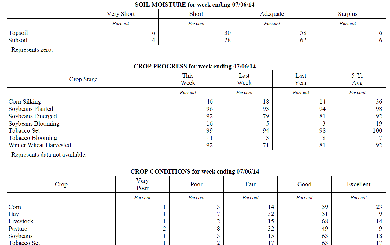 Kentucky Climate Summary
For the Period June 30, 2014 to July 06, 2014
Below Normal Temperatures and Below Normal Rainfall:
The first week of July continued the drier and cooler than normal pattern of past
weeks as another dry and cooler week occurred for the Bluegrass state. The week
started mild and became below normal on temperatures for the latter half of the week.
Those locations in the state with the driest conditions also suffered the least
rainfall last week, especially east and south. This was the 4th week with mostly below
normal rainfall.
Temperatures for the period averaged 73 degrees across the state which was 3 degrees
cooler than normal and 4 degrees cooler than the previous period. High temperatures
averaged from 84 in the West to 83 in the East. Departure from normal high
temperatures ranged from 5 degrees cooler than normal in the West to 3 degrees cooler
than normal in the East. Low temperatures averaged from 63 degrees in the West to 63
degrees in the East. Departure from normal low temperature ranged from 4 degrees
cooler than normal in the West to 1 degree warmer than normal in the East. The extreme
high temperature for the period was 95 degrees at Bowling Green and the extreme low
was 50 degrees at Covington.
Rainfall for the period totaled 0.38 inches statewide which was 0.61 inches below
normal and 38% of normal. Rainfall totals by climate division, West 0.65 inches,
Central 0.33 inches, Bluegrass 0.43 inches and East 0.11 inches, which was 0.34, 0.65,
0.53 and 0.91 inches below normal. By station, precipitation totals ranged from a low
of 0.00 inches at Big Sandy to a high of 2.22 inches at Evansville.
---
USDA's Kentucky Crop and Weather Report
Issued 4:00 P.M., June 30, 2014 13-14
Agricultural News: Kentucky experienced above normal temperatures and near normal
rainfall over the past week. Precipitation for the week totaled 0.95 inches, 0.05
inches below normal. Temperatures averaged 77 degrees for the week, 2 degrees above
normal. Topsoil moisture was rated 4 percent very short, 24 percent short, 64 percent
adequate and 8 percent surplus. Subsoil moisture was rated 3 percent very short, 23
percent short, 66 percent adequate, and 8 percent surplus. Days suitable for
fieldwork averaged 5.2 out of a possible seven.
Primary activities this week included harvesting wheat and planting soybeans. Some
areas of the state are dry while others have received rain from spotty showers. These
conditions have had strong effects on hay and the second cutting. Reports of low
quantity and low quality in hay have surfaced. Wheat harvest is in full swing. Yields
appear to be good, but vomitoxin is being reported, especially in fields that were
not treated. Double crop soybeans are being planted as wheat is harvested. Early
soybeans are now starting to bloom. Soybean average height was 10 inches. Tobacco
average height was 19 inches.
Kentucky Climate Summary
For the Period June 30, 2014 to July 06, 2014
Below Normal Temperatures and Below Normal Rainfall:
The first week of July continued the drier and cooler than normal pattern of past
weeks as another dry and cooler week occurred for the Bluegrass state. The week
started mild and became below normal on temperatures for the latter half of the week.
Those locations in the state with the driest conditions also suffered the least
rainfall last week, especially east and south. This was the 4th week with mostly below
normal rainfall.
Temperatures for the period averaged 73 degrees across the state which was 3 degrees
cooler than normal and 4 degrees cooler than the previous period. High temperatures
averaged from 84 in the West to 83 in the East. Departure from normal high
temperatures ranged from 5 degrees cooler than normal in the West to 3 degrees cooler
than normal in the East. Low temperatures averaged from 63 degrees in the West to 63
degrees in the East. Departure from normal low temperature ranged from 4 degrees
cooler than normal in the West to 1 degree warmer than normal in the East. The extreme
high temperature for the period was 95 degrees at Bowling Green and the extreme low
was 50 degrees at Covington.
Rainfall for the period totaled 0.38 inches statewide which was 0.61 inches below
normal and 38% of normal. Rainfall totals by climate division, West 0.65 inches,
Central 0.33 inches, Bluegrass 0.43 inches and East 0.11 inches, which was 0.34, 0.65,
0.53 and 0.91 inches below normal. By station, precipitation totals ranged from a low
of 0.00 inches at Big Sandy to a high of 2.22 inches at Evansville.
---
USDA's Kentucky Crop and Weather Report
Issued 4:00 P.M., June 30, 2014 13-14
Agricultural News: Kentucky experienced above normal temperatures and near normal
rainfall over the past week. Precipitation for the week totaled 0.95 inches, 0.05
inches below normal. Temperatures averaged 77 degrees for the week, 2 degrees above
normal. Topsoil moisture was rated 4 percent very short, 24 percent short, 64 percent
adequate and 8 percent surplus. Subsoil moisture was rated 3 percent very short, 23
percent short, 66 percent adequate, and 8 percent surplus. Days suitable for
fieldwork averaged 5.2 out of a possible seven.
Primary activities this week included harvesting wheat and planting soybeans. Some
areas of the state are dry while others have received rain from spotty showers. These
conditions have had strong effects on hay and the second cutting. Reports of low
quantity and low quality in hay have surfaced. Wheat harvest is in full swing. Yields
appear to be good, but vomitoxin is being reported, especially in fields that were
not treated. Double crop soybeans are being planted as wheat is harvested. Early
soybeans are now starting to bloom. Soybean average height was 10 inches. Tobacco
average height was 19 inches.
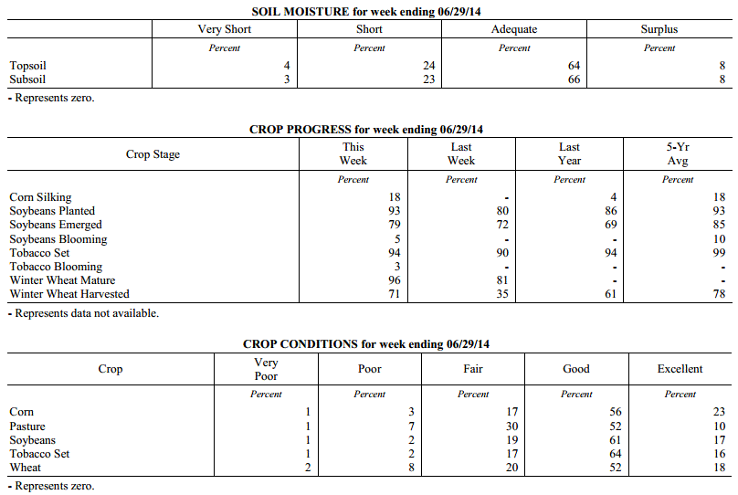 Kentucky Climate Summary
For the Period June 23, 2014 to June 29, 2014
Above Normal Temperatures and Near Normal Rainfall:
The closing week of June kept warm temperatures in place across the Commonwealth,
along with some beneficial rainfall. Storm coverage was isolated to scattered just
about each day of the period within a moist and unstable air mass. Overall, the state
averaged just under an inch, which was slightly below normal. This ended up being the
third straight period with below normal rainfall and in turn, dry conditions were
becoming evident across the Lower Ohio Valley. The latest US Drought Monitor now has
nearly 53% of the state as showing signs of being abnormally dry, along with a slight
portion of Southeastern Kentucky in a moderate drought.
Temperatures for the period averaged 77 degrees across the state which was 2 degrees
warmer than normal and 2 degrees cooler than the previous period. High temperatures
averaged from 85 in the West to 85 in the East. Departure from normal high
temperatures ranged from 3 degrees cooler than normal in the West to near normal in
the East. Low temperatures averaged from 69 degrees in the West to 67 degrees in the
East. Departure from normal low temperature ranged from 4 degrees warmer than normal
in the West to 6 degrees warmer than normal in the East. The extreme high temperature
for the period was 94 degrees at CARLISLE 5SW and the extreme low was 53 degrees at
WILLIAMSBURG AWOS.
Precipitation (liq. equ.) for the period totaled 0.95 inches statewide which was 0.05
inches below normal and 95% of normal. Precipitation totals by climate division, West
0.87 inches, Central 0.90 inches, Bluegrass 1.07 inches and East 0.97 inches, which
was -0.12, -0.08, 0.09 and -0.06 inches respectively from normal. By station,
precipitation totals ranged from a low of 0.00 inches at BIG SANDY to a high of 2.71
inches at CAPE GIRARDEAU ASOS.
---
USDA's Kentucky Crop and Weather Report
Issued 4:00 P.M., June 23, 2014 12-14
Agricultural News: Kentucky experienced above normal temperatures and below normal
rainfall over the past week. Precipitation for the week totaled 0.47 inches, 0.54
inches below normal. Temperatures averaged 78 degrees for the week, 5 degrees above
normal. Topsoil moisture was rated 4 percent very short, 20 percent short, 66 percent
adequate and 10 percent surplus. Subsoil moisture was rated 3 percent very short, 18
percent short, 72 percent adequate, and 7 percent surplus. Days suitable for
fieldwork averaged 5.9 out of a possible seven.
Primary activities this week planting soybeans, harvesting wheat, and cutting hay.
Crops are in need of rain in some conditions, as dry conditions persist. Other areas
have received adequate moisture. With hay cutting currently under way, reports of
reduced and low yields have surfaced. Also, counts of vomitoxin in wheat have been
reported. Corn average height was 39 inches. Tobacco average height was 14 inches.
Kentucky Climate Summary
For the Period June 23, 2014 to June 29, 2014
Above Normal Temperatures and Near Normal Rainfall:
The closing week of June kept warm temperatures in place across the Commonwealth,
along with some beneficial rainfall. Storm coverage was isolated to scattered just
about each day of the period within a moist and unstable air mass. Overall, the state
averaged just under an inch, which was slightly below normal. This ended up being the
third straight period with below normal rainfall and in turn, dry conditions were
becoming evident across the Lower Ohio Valley. The latest US Drought Monitor now has
nearly 53% of the state as showing signs of being abnormally dry, along with a slight
portion of Southeastern Kentucky in a moderate drought.
Temperatures for the period averaged 77 degrees across the state which was 2 degrees
warmer than normal and 2 degrees cooler than the previous period. High temperatures
averaged from 85 in the West to 85 in the East. Departure from normal high
temperatures ranged from 3 degrees cooler than normal in the West to near normal in
the East. Low temperatures averaged from 69 degrees in the West to 67 degrees in the
East. Departure from normal low temperature ranged from 4 degrees warmer than normal
in the West to 6 degrees warmer than normal in the East. The extreme high temperature
for the period was 94 degrees at CARLISLE 5SW and the extreme low was 53 degrees at
WILLIAMSBURG AWOS.
Precipitation (liq. equ.) for the period totaled 0.95 inches statewide which was 0.05
inches below normal and 95% of normal. Precipitation totals by climate division, West
0.87 inches, Central 0.90 inches, Bluegrass 1.07 inches and East 0.97 inches, which
was -0.12, -0.08, 0.09 and -0.06 inches respectively from normal. By station,
precipitation totals ranged from a low of 0.00 inches at BIG SANDY to a high of 2.71
inches at CAPE GIRARDEAU ASOS.
---
USDA's Kentucky Crop and Weather Report
Issued 4:00 P.M., June 23, 2014 12-14
Agricultural News: Kentucky experienced above normal temperatures and below normal
rainfall over the past week. Precipitation for the week totaled 0.47 inches, 0.54
inches below normal. Temperatures averaged 78 degrees for the week, 5 degrees above
normal. Topsoil moisture was rated 4 percent very short, 20 percent short, 66 percent
adequate and 10 percent surplus. Subsoil moisture was rated 3 percent very short, 18
percent short, 72 percent adequate, and 7 percent surplus. Days suitable for
fieldwork averaged 5.9 out of a possible seven.
Primary activities this week planting soybeans, harvesting wheat, and cutting hay.
Crops are in need of rain in some conditions, as dry conditions persist. Other areas
have received adequate moisture. With hay cutting currently under way, reports of
reduced and low yields have surfaced. Also, counts of vomitoxin in wheat have been
reported. Corn average height was 39 inches. Tobacco average height was 14 inches.
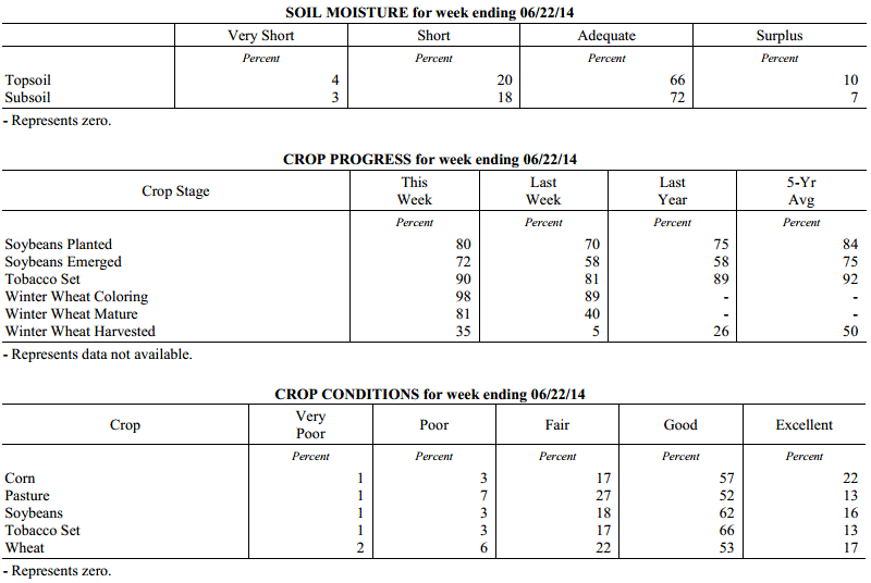 Kentucky Climate Summary
For the Period June 16, 2014 to June 22, 2014
Above Normal Temperatures and Below Normal Rainfall:
The summer season started in full force this past period with warm and humid
conditions in place. The majority of the week was controlled by above normal
temperatures with highs getting into the upper 80s to low 90s each day. A moist
atmosphere with dewpoints in the upper 60s to low 70s helped push the heat index into
the mid 90s to around 100 at times. This sent the livestock heat stress index into
the danger category about each day during the afternoon and early evening hours.
High pressure aloft kept the Commonwealth dry for the first half of the week. This
feature then broke down Thursday and allowed for daily, isolated to scattered showers
and thunderstorms for the remainder of the period. The overall dry nature of the
week sent the Bluegrass State to a second straight period of below normal rainfall
and the fourth out of the past five weeks.
Temperatures for the period averaged 78 degrees across the state which was 5 degrees
warmer than normal and 8 degrees warmer than the previous period. High temperatures
averaged from 90 in the West to 87 in the East. Departure from normal high
temperatures ranged from 3 degrees warmer than normal in the West to 3 degrees
warmer than normal in the East. Low temperatures averaged from 70 degrees in the
West to 66 degrees in the East. Departure from normal low temperature ranged from 6
degrees warmer than normal in the West to 7 degrees warmer than normal in the East.
The extreme high temperature for the period was 94 degrees at CAPE GIRARDEAU ASOS and
the extreme low was 59 degrees at LIBERTY 3SW.
Precipitation (liq. equ.) for the period totaled 0.47 inches statewide which was 0.54
inches below normal and 46% of normal. Precipitation totals by climate division, West
0.12 inches, Central 0.40 inches, Bluegrass 0.50 inches and East 0.85 inches, which
was 0.88, 0.6, 0.52 and 0.18 inches below normal. By station, precipitation totals
ranged from a low of 0.00 inches at CADIZ 4SW to a high of 1.98 inches at BARBOURVILLE 3E.
---
USDA's Kentucky Crop and Weather Report
Issued 4:00 P.M., June 16, 2014 11-14
Agricultural News: Kentucky experienced below normal temperatures and precipitation
over the past week. Precipitation for the week totaled 0.80 inches, 0.23 inches below
normal. Temperatures averaged 70 degrees for the week, 2 degrees below normal.
Topsoil moisture was rated 1 percent very short, 11 percent short, 70 percent
adequate and 18 percent surplus. Subsoil moisture was rated 1 percent very short, 12
percent short, 72 percent adequate, and 15 percent surplus. Days suitable for
fieldwork averaged 3.9 out of a possible seven.
Primary activities this week included planting soybeans and tobacco. Producers
continued side dressing corn and spraying post herbicide applications. There were
reports of wind damage and Fusarium head blight in wheat which could impact yields in
affected areas. Winter wheat grain harvest is expected to begin in earnest within the
next 1-2 weeks, depending on location. Pastures are growing well due to the recent
rains and livestock are benefiiting from good conditions. Hay harvest is behind
schedule in many areas, resulting in an over mature first cutting. Corn emerged
average height was 26 inches. The average height of set tobacco in the field was 10 inches.
Kentucky Climate Summary
For the Period June 16, 2014 to June 22, 2014
Above Normal Temperatures and Below Normal Rainfall:
The summer season started in full force this past period with warm and humid
conditions in place. The majority of the week was controlled by above normal
temperatures with highs getting into the upper 80s to low 90s each day. A moist
atmosphere with dewpoints in the upper 60s to low 70s helped push the heat index into
the mid 90s to around 100 at times. This sent the livestock heat stress index into
the danger category about each day during the afternoon and early evening hours.
High pressure aloft kept the Commonwealth dry for the first half of the week. This
feature then broke down Thursday and allowed for daily, isolated to scattered showers
and thunderstorms for the remainder of the period. The overall dry nature of the
week sent the Bluegrass State to a second straight period of below normal rainfall
and the fourth out of the past five weeks.
Temperatures for the period averaged 78 degrees across the state which was 5 degrees
warmer than normal and 8 degrees warmer than the previous period. High temperatures
averaged from 90 in the West to 87 in the East. Departure from normal high
temperatures ranged from 3 degrees warmer than normal in the West to 3 degrees
warmer than normal in the East. Low temperatures averaged from 70 degrees in the
West to 66 degrees in the East. Departure from normal low temperature ranged from 6
degrees warmer than normal in the West to 7 degrees warmer than normal in the East.
The extreme high temperature for the period was 94 degrees at CAPE GIRARDEAU ASOS and
the extreme low was 59 degrees at LIBERTY 3SW.
Precipitation (liq. equ.) for the period totaled 0.47 inches statewide which was 0.54
inches below normal and 46% of normal. Precipitation totals by climate division, West
0.12 inches, Central 0.40 inches, Bluegrass 0.50 inches and East 0.85 inches, which
was 0.88, 0.6, 0.52 and 0.18 inches below normal. By station, precipitation totals
ranged from a low of 0.00 inches at CADIZ 4SW to a high of 1.98 inches at BARBOURVILLE 3E.
---
USDA's Kentucky Crop and Weather Report
Issued 4:00 P.M., June 16, 2014 11-14
Agricultural News: Kentucky experienced below normal temperatures and precipitation
over the past week. Precipitation for the week totaled 0.80 inches, 0.23 inches below
normal. Temperatures averaged 70 degrees for the week, 2 degrees below normal.
Topsoil moisture was rated 1 percent very short, 11 percent short, 70 percent
adequate and 18 percent surplus. Subsoil moisture was rated 1 percent very short, 12
percent short, 72 percent adequate, and 15 percent surplus. Days suitable for
fieldwork averaged 3.9 out of a possible seven.
Primary activities this week included planting soybeans and tobacco. Producers
continued side dressing corn and spraying post herbicide applications. There were
reports of wind damage and Fusarium head blight in wheat which could impact yields in
affected areas. Winter wheat grain harvest is expected to begin in earnest within the
next 1-2 weeks, depending on location. Pastures are growing well due to the recent
rains and livestock are benefiiting from good conditions. Hay harvest is behind
schedule in many areas, resulting in an over mature first cutting. Corn emerged
average height was 26 inches. The average height of set tobacco in the field was 10 inches.
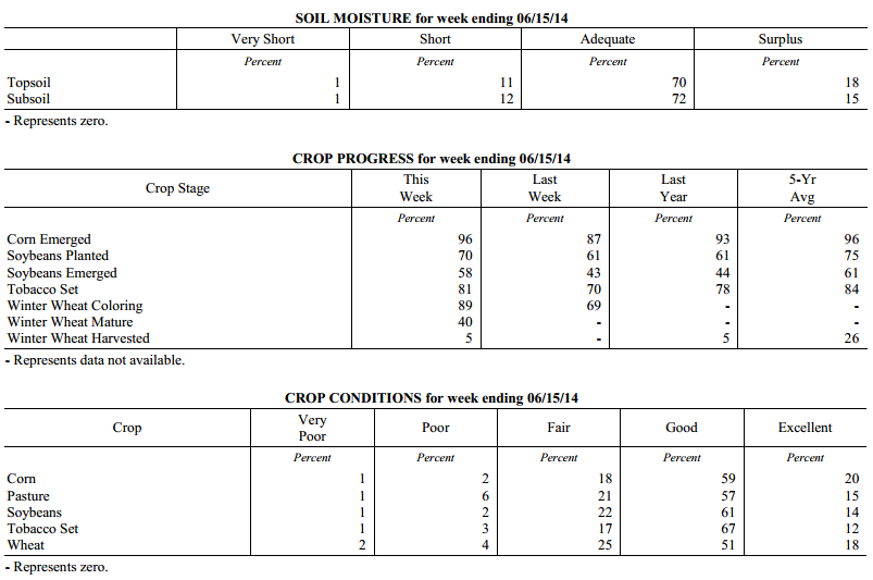 Kentucky Climate Summary
For the Period June 9, 2014 to June 15, 2014
Below Normal Temperatures and Rainfall:
The second week of June was met with a return to cooler temperatures and dry
conditions deepening across the state. The only significant rainfall event for the
period came Tuesday and Wednesday as low pressure pushed from the Southern Plains to
the Lower Great Lakes. Strong to severe storms fired along a line late Tuesday and
into the overnight with wind damage as the primary threat. Precipitation varied
across the state during this event with many seeing less than a half inch. The
exception came along East-Central Kentucky and up into the Bluegrass with totals
around an inch. The state was mostly dry for much of the remainder of the work week.
The latest US Drought Monitor now has a quarter of the state as abnormally dry
with even a slight portion of Southeastern Kentucky in the moderate drought category.
Low pressure kept clouds in place, which limited daytime highs to the mid 70s to low
80s for much of the week. High pressure of Canadian origin moved into the area to
start the weekend. Skies became clear and winds went calm Friday night, allowing for
temperatures to drop into the upper 40s for quite a few locations.
Temperatures for the period averaged 70 degrees across the state which was 2 degrees
cooler than normal and 2 degrees cooler than the previous period. High temperatures
averaged from 80 in the West to 80 in the East. Departure from normal high
temperatures ranged from 5 degrees cooler than normal in the West to 3 degrees
cooler than normal in the East. Low temperatures averaged from 62 degrees in the
West to 59 degrees in the East. Departure from normal low temperature ranged from 1
degree cooler than normal in the West to 1 degree warmer than normal in the East.
The extreme high temperature for the period was 90 degrees at BOWLING GREEN 5S and
the extreme low was 44 degrees at CYNTHIANA 8N.
Precipitation (liq. equ.) for the period totaled 0.80 inches statewide which was 0.23
inches below normal and 78% of normal. Precipitation totals by climate division, West
1.03 inches, Central 0.81 inches, Bluegrass 0.77 inches and East 0.60 inches, which
was 0.05, -0.23, -0.28 and -0.45 inches respectively from normal. By station,
precipitation totals ranged from a low of 0.06 inches at HAZARD AWOS to a high of
2.33 inches at CAPE GIRARDEAU ASOS.
---
USDA's Kentucky Crop and Weather Report
Issued 4:00 P.M., June 9, 2014 10-14
Agricultural News: Kentucky experienced above normal temperatures and rainfall over
the past week. Precipitation for the week totaled 1.23 inches, 0.14 inches above
normal. Temperatures averaged 72 degrees for the week, 2 degrees above normal.
Topsoil moisture was rated 2 percent very short, 12 percent short, 68 percent
adequate and 18 percent surplus. Subsoil moisture was rated 1 percent very short, 11
percent short, 74 percent adequate, and 14 percent surplus. Days suitable for
fieldwork averaged 4.1 out of a possible seven.
Primary activities this week included planting soybeans and tobacco, hay cutting,
fungicide applications, and side dressing corn. A lot of first cutting hay is still
standing, resulting in over maturity and decreased quality. Pastures are growing well
due to the recent rains. Some areas are getting dry while others have had plenty of
moisture. Corn average height was 17 inches. The average height of set tobacco in the
field was 7 inches.
Kentucky Climate Summary
For the Period June 9, 2014 to June 15, 2014
Below Normal Temperatures and Rainfall:
The second week of June was met with a return to cooler temperatures and dry
conditions deepening across the state. The only significant rainfall event for the
period came Tuesday and Wednesday as low pressure pushed from the Southern Plains to
the Lower Great Lakes. Strong to severe storms fired along a line late Tuesday and
into the overnight with wind damage as the primary threat. Precipitation varied
across the state during this event with many seeing less than a half inch. The
exception came along East-Central Kentucky and up into the Bluegrass with totals
around an inch. The state was mostly dry for much of the remainder of the work week.
The latest US Drought Monitor now has a quarter of the state as abnormally dry
with even a slight portion of Southeastern Kentucky in the moderate drought category.
Low pressure kept clouds in place, which limited daytime highs to the mid 70s to low
80s for much of the week. High pressure of Canadian origin moved into the area to
start the weekend. Skies became clear and winds went calm Friday night, allowing for
temperatures to drop into the upper 40s for quite a few locations.
Temperatures for the period averaged 70 degrees across the state which was 2 degrees
cooler than normal and 2 degrees cooler than the previous period. High temperatures
averaged from 80 in the West to 80 in the East. Departure from normal high
temperatures ranged from 5 degrees cooler than normal in the West to 3 degrees
cooler than normal in the East. Low temperatures averaged from 62 degrees in the
West to 59 degrees in the East. Departure from normal low temperature ranged from 1
degree cooler than normal in the West to 1 degree warmer than normal in the East.
The extreme high temperature for the period was 90 degrees at BOWLING GREEN 5S and
the extreme low was 44 degrees at CYNTHIANA 8N.
Precipitation (liq. equ.) for the period totaled 0.80 inches statewide which was 0.23
inches below normal and 78% of normal. Precipitation totals by climate division, West
1.03 inches, Central 0.81 inches, Bluegrass 0.77 inches and East 0.60 inches, which
was 0.05, -0.23, -0.28 and -0.45 inches respectively from normal. By station,
precipitation totals ranged from a low of 0.06 inches at HAZARD AWOS to a high of
2.33 inches at CAPE GIRARDEAU ASOS.
---
USDA's Kentucky Crop and Weather Report
Issued 4:00 P.M., June 9, 2014 10-14
Agricultural News: Kentucky experienced above normal temperatures and rainfall over
the past week. Precipitation for the week totaled 1.23 inches, 0.14 inches above
normal. Temperatures averaged 72 degrees for the week, 2 degrees above normal.
Topsoil moisture was rated 2 percent very short, 12 percent short, 68 percent
adequate and 18 percent surplus. Subsoil moisture was rated 1 percent very short, 11
percent short, 74 percent adequate, and 14 percent surplus. Days suitable for
fieldwork averaged 4.1 out of a possible seven.
Primary activities this week included planting soybeans and tobacco, hay cutting,
fungicide applications, and side dressing corn. A lot of first cutting hay is still
standing, resulting in over maturity and decreased quality. Pastures are growing well
due to the recent rains. Some areas are getting dry while others have had plenty of
moisture. Corn average height was 17 inches. The average height of set tobacco in the
field was 7 inches.
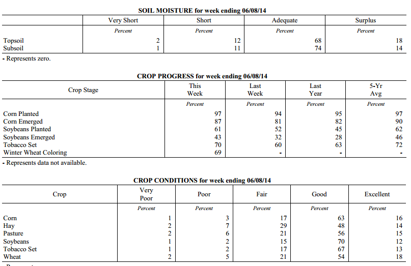 Kentucky Climate Summary
For the Period June 2, 2014 to June 8, 2014
Above Normal Temperatures and Rainfall:
A much more active pattern set up this past week across the Lower Ohio Valley. While
data shows the state receiving above normal rainfall, this can be somewhat misleading.
Most activity occurred across Western Kentucky, before diminishing farther east. The
west averaged over 2.5 inches over the course of the period, while Central Kentucky
saw less than a half inch. Much of the action came over the course of a couple storm
systems. The first pushed through the area on Wednesday. Scattered, strong to
severe storms fired across the entire state. These storms exhibited about every type
of severe weather from damaging winds, hail, to tornados. Straight line winds with
peak gusts of 95 mph were reported in Western Kentucky, along with a couple weak
tornados. Some activity lingered into Thursday, before the Commonwealth became under
the influence of high pressure to end the work week. Low pressure then passed north
of the state late Saturday and into Sunday. Once again, the main activity was
centered across Western Kentucky, before diminishing farther east. Rainfall has been
below normal across Eastern Kentucky over each of the past 5 weeks. Portions of this
area are now showing abnormally dry conditions.
Temperatures for the period averaged 72 degrees across the state which was 2 degrees
warmer than normal and 2 degrees cooler than the previous period. High temperatures
averaged from 81 in the West to 80 in the East. Departure from normal high
temperatures ranged from 2 degrees cooler than normal in the West to 1 degree
cooler than normal in the East. Low temperatures averaged from 68 degrees in the
West to 62 degrees in the East. Departure from normal low temperature ranged from 7
degrees warmer than normal in the West to 6 degrees warmer than normal in the East.
The extreme high temperature for the period was 90 degrees at PADUCAH ASOS and the
extreme low was 48 degrees at VANCEBURG 6W.
Precipitation (liq. equ.) for the period totaled 1.23 inches statewide which was 0.14
inches above normal and 113% of normal. Precipitation totals by climate division,
West 2.70 inches, Central 0.40 inches, Bluegrass 1.12 inches and East 0.70 inches,
which was 1.65, -0.70, 0.02 and -0.39 inches respectively from normal. By station,
precipitation totals ranged from a low of 0.00 inches at BLACK MOUNTAIN ARC to a high
of 7.40 inches at MAYFIELD 6SW.
---
USDA's Kentucky Crop and Weather Report
Issued 4:00 P.M., June 2, 2014 9-14
Agricultural News: Kentucky experienced above normal temperatures and below normal
rainfall over the past week. Precipitation for the week totaled 0.36 inches, 0.76
inches below normal. Temperatures averaged 73 degrees for the week, 5 degrees above
normal. Topsoil moisture was rated 1 percent very short, 11 percent short, 74 percent
adequate and 14 percent surplus. Subsoil moisture was rated 1 percent very short, 9
percent short, 79 percent adequate, and 11 percent surplus. Days suitable for
fieldwork averaged 5.4 out of a possible seven. Primary activities this week included
planting corn, soybeans and tobacco.
Farmers were also busy cutting and baling hay as weather permitted. There were some
reports of cut worms in corn. Producers continued spraying herbicides on corn and
soybean fields and applied nitrogen on corn fields. Corn average height was 9 inches.
Hay harvest was delayed in some areas due to rains, resulting in over maturity. Many
growers had hay cut on the ground when rains occurred.
Kentucky Climate Summary
For the Period June 2, 2014 to June 8, 2014
Above Normal Temperatures and Rainfall:
A much more active pattern set up this past week across the Lower Ohio Valley. While
data shows the state receiving above normal rainfall, this can be somewhat misleading.
Most activity occurred across Western Kentucky, before diminishing farther east. The
west averaged over 2.5 inches over the course of the period, while Central Kentucky
saw less than a half inch. Much of the action came over the course of a couple storm
systems. The first pushed through the area on Wednesday. Scattered, strong to
severe storms fired across the entire state. These storms exhibited about every type
of severe weather from damaging winds, hail, to tornados. Straight line winds with
peak gusts of 95 mph were reported in Western Kentucky, along with a couple weak
tornados. Some activity lingered into Thursday, before the Commonwealth became under
the influence of high pressure to end the work week. Low pressure then passed north
of the state late Saturday and into Sunday. Once again, the main activity was
centered across Western Kentucky, before diminishing farther east. Rainfall has been
below normal across Eastern Kentucky over each of the past 5 weeks. Portions of this
area are now showing abnormally dry conditions.
Temperatures for the period averaged 72 degrees across the state which was 2 degrees
warmer than normal and 2 degrees cooler than the previous period. High temperatures
averaged from 81 in the West to 80 in the East. Departure from normal high
temperatures ranged from 2 degrees cooler than normal in the West to 1 degree
cooler than normal in the East. Low temperatures averaged from 68 degrees in the
West to 62 degrees in the East. Departure from normal low temperature ranged from 7
degrees warmer than normal in the West to 6 degrees warmer than normal in the East.
The extreme high temperature for the period was 90 degrees at PADUCAH ASOS and the
extreme low was 48 degrees at VANCEBURG 6W.
Precipitation (liq. equ.) for the period totaled 1.23 inches statewide which was 0.14
inches above normal and 113% of normal. Precipitation totals by climate division,
West 2.70 inches, Central 0.40 inches, Bluegrass 1.12 inches and East 0.70 inches,
which was 1.65, -0.70, 0.02 and -0.39 inches respectively from normal. By station,
precipitation totals ranged from a low of 0.00 inches at BLACK MOUNTAIN ARC to a high
of 7.40 inches at MAYFIELD 6SW.
---
USDA's Kentucky Crop and Weather Report
Issued 4:00 P.M., June 2, 2014 9-14
Agricultural News: Kentucky experienced above normal temperatures and below normal
rainfall over the past week. Precipitation for the week totaled 0.36 inches, 0.76
inches below normal. Temperatures averaged 73 degrees for the week, 5 degrees above
normal. Topsoil moisture was rated 1 percent very short, 11 percent short, 74 percent
adequate and 14 percent surplus. Subsoil moisture was rated 1 percent very short, 9
percent short, 79 percent adequate, and 11 percent surplus. Days suitable for
fieldwork averaged 5.4 out of a possible seven. Primary activities this week included
planting corn, soybeans and tobacco.
Farmers were also busy cutting and baling hay as weather permitted. There were some
reports of cut worms in corn. Producers continued spraying herbicides on corn and
soybean fields and applied nitrogen on corn fields. Corn average height was 9 inches.
Hay harvest was delayed in some areas due to rains, resulting in over maturity. Many
growers had hay cut on the ground when rains occurred.
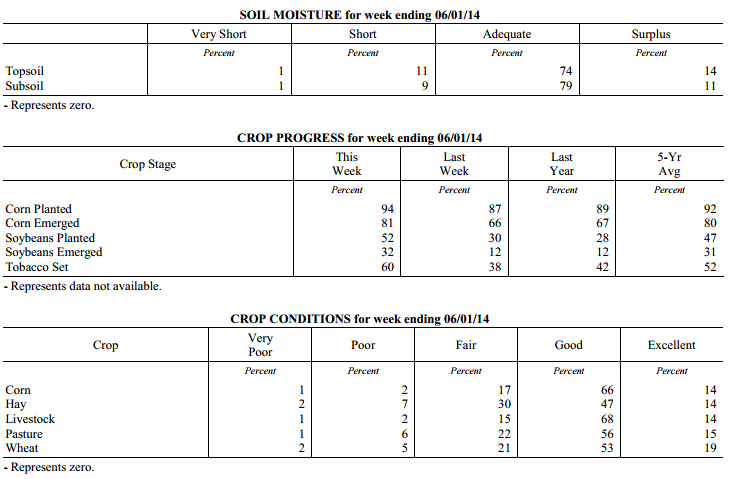 Kentucky Climate Summary
For the Period May 26, 2014 to June 1, 2014
Above Normal Temperatures and Much Below Normal Precipitation:
While the spring season will last another few weeks, weather conditions this past
period gave the impression of an early summer. High temperatures over nearly the
entire week stayed in the 80s with lows only dropping into the 60s. Some locations
even stayed in the 70s at night. The mild temperatures guided the way to a state
average of 5 degrees above normal. Looking at rainfall, Kentucky was dominated this
past week by a very moist and unstable air mass, more typical of summer. Scattered
showers and storms fired about every day during the afternoon and evening hours,
before tapering overnight. Localized heavy rainfall was the main threat with the
slow moving nature of any storms. The sporadic coverage of the storms amounted to a
very dry week across the Commonwealth. The state averaged just over a third of an
inch, which was the 4th driest week of 2014 thus far.
Temperatures for the period averaged 73 degrees across the state which was 5 degrees
warmer than normal and 6 degrees warmer than the previous period. High temperatures
averaged from 83 in the West to 82 in the East. Departure from normal high
temperatures ranged from 2 degrees warmer than normal in the West to 2 degrees
warmer than normal in the East. Low temperatures averaged from 67 degrees in the
West to 62 degrees in the East. Departure from normal low temperature ranged from 8
degrees warmer than normal in the West to 8 degrees warmer than normal in the East.
The extreme high temperature for the period was 90 degrees at PADUCAH ASOS and the
extreme low was 51 degrees at CYNTHIANA 8N.
Precipitation (liq. equ.) for the period totaled 0.36 inches statewide which was 0.76
inches below normal and 32% of normal. Precipitation totals by climate division, West
0.50 inches, Central 0.38 inches, Bluegrass 0.25 inches and East 0.32 inches, which
was 0.6, 0.78, 0.84 and 0.8 inches below normal. By station, precipitation totals
ranged from a low of 0.00 inches at BOWLING GREEN 5S to a high of 2.15 inches at BIG SANDY.
---
USDA's Kentucky Crop and Weather Report
Issued 4:00 P.M., May 27, 2014 8-14
Agricultural News: Kentucky experienced below normal precipitation and above average
temperatures over the past week. Precipitation for the week totaled 0.56 inches, 0.55
inches below normal. Temperatures averaged 68 degrees for the week, 2 degrees above
normal. Topsoil moisture was rated 4 percent short, 78 percent adequate and 18
percent surplus. Subsoil moisture was rated 4 percent short, 82 percent adequate and
14 percent surplus. Days suitable for fieldwork averaged 5.2 out of a possible seven.
Primary activities this week included planting corn, soybeans and tobacco, as well as
harvesting hay.
Crop planting progress benefitted from warmer and drier conditions. Strong storms hit
the state mid-week in some locations resulting in reports of wind and hail damage.
Bottom ground has dried out in some areas which allowed for those fields to be
planted. Producers continued spraying herbicides on corn and soybean fields and
applied nitrogen applications on early planted corn fields. A lot of hay was cut and
baled as conditions allowed, with many reports of yields from first cuttings being
down from last year.
Kentucky Climate Summary
For the Period May 26, 2014 to June 1, 2014
Above Normal Temperatures and Much Below Normal Precipitation:
While the spring season will last another few weeks, weather conditions this past
period gave the impression of an early summer. High temperatures over nearly the
entire week stayed in the 80s with lows only dropping into the 60s. Some locations
even stayed in the 70s at night. The mild temperatures guided the way to a state
average of 5 degrees above normal. Looking at rainfall, Kentucky was dominated this
past week by a very moist and unstable air mass, more typical of summer. Scattered
showers and storms fired about every day during the afternoon and evening hours,
before tapering overnight. Localized heavy rainfall was the main threat with the
slow moving nature of any storms. The sporadic coverage of the storms amounted to a
very dry week across the Commonwealth. The state averaged just over a third of an
inch, which was the 4th driest week of 2014 thus far.
Temperatures for the period averaged 73 degrees across the state which was 5 degrees
warmer than normal and 6 degrees warmer than the previous period. High temperatures
averaged from 83 in the West to 82 in the East. Departure from normal high
temperatures ranged from 2 degrees warmer than normal in the West to 2 degrees
warmer than normal in the East. Low temperatures averaged from 67 degrees in the
West to 62 degrees in the East. Departure from normal low temperature ranged from 8
degrees warmer than normal in the West to 8 degrees warmer than normal in the East.
The extreme high temperature for the period was 90 degrees at PADUCAH ASOS and the
extreme low was 51 degrees at CYNTHIANA 8N.
Precipitation (liq. equ.) for the period totaled 0.36 inches statewide which was 0.76
inches below normal and 32% of normal. Precipitation totals by climate division, West
0.50 inches, Central 0.38 inches, Bluegrass 0.25 inches and East 0.32 inches, which
was 0.6, 0.78, 0.84 and 0.8 inches below normal. By station, precipitation totals
ranged from a low of 0.00 inches at BOWLING GREEN 5S to a high of 2.15 inches at BIG SANDY.
---
USDA's Kentucky Crop and Weather Report
Issued 4:00 P.M., May 27, 2014 8-14
Agricultural News: Kentucky experienced below normal precipitation and above average
temperatures over the past week. Precipitation for the week totaled 0.56 inches, 0.55
inches below normal. Temperatures averaged 68 degrees for the week, 2 degrees above
normal. Topsoil moisture was rated 4 percent short, 78 percent adequate and 18
percent surplus. Subsoil moisture was rated 4 percent short, 82 percent adequate and
14 percent surplus. Days suitable for fieldwork averaged 5.2 out of a possible seven.
Primary activities this week included planting corn, soybeans and tobacco, as well as
harvesting hay.
Crop planting progress benefitted from warmer and drier conditions. Strong storms hit
the state mid-week in some locations resulting in reports of wind and hail damage.
Bottom ground has dried out in some areas which allowed for those fields to be
planted. Producers continued spraying herbicides on corn and soybean fields and
applied nitrogen applications on early planted corn fields. A lot of hay was cut and
baled as conditions allowed, with many reports of yields from first cuttings being
down from last year.
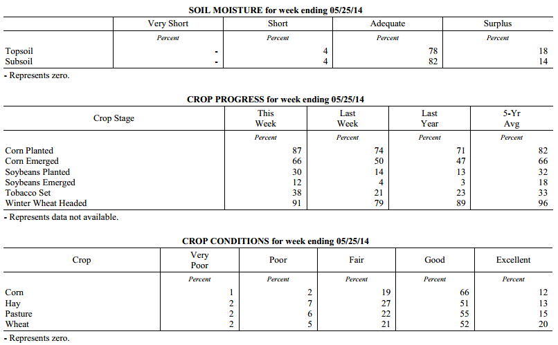 Kentucky Climate Summary
For the Period May 19, 2014 to May 25, 2014
Above Normal Temperatures and Below Normal Precipitation:
Mostly dry conditions moved back into the Commonwealth this past period. An upper
level ridge built into the Ohio Valley to start out the work week with surface high
pressure pushing east of the area. This kept skies mostly clear with a breezy
southerly wind at times. Summer-like temperatures returned to the area with highs
getting into the low to mid 80s Tuesday and Wednesday. Conditions then turned
unsettled as a broken line of strong to severe storms pushed through the region later
Wednesday and on into Thursday. There were numerous wind and hail reports, with one
in particular estimating hail in excess of 1.5 inches in Campbellsville. This was
really the only major rainfall event for the week as the state was on average 0.55
inches below normal for the period. High pressure then moved into the Ohio Valley for
the holiday weekend. This kept conditions dry with temperatures remaining around normal.
Temperatures for the period averaged 68 degrees across the state which was 2 degrees
warmer than normal and 6 degrees warmer than the previous period. High temperatures
averaged from 82 in the West to 78 in the East. Departure from normal high
temperatures ranged from 2 degrees warmer than normal in the West to near
normal in the East. Low temperatures averaged from 61 degrees in the West to 53
degrees in the East. Departure from normal low temperature ranged from 4 degrees
warmer than normal in the West to 1 degree warmer than normal in the East. The
extreme high temperature for the period was 90 degrees at PADUCAH ASOS and the
extreme low was 32 degrees at WILLIAMSBURG AWOS.
Precipitation (liq. equ.) for the period totaled 0.56 inches statewide which was 0.55
inches below normal and 50% of normal. Precipitation totals by climate division, West
0.29 inches, Central 0.34 inches, Bluegrass 0.99 inches and East 0.61 inches, which
was 0.81, 0.82, 0.08 and 0.51 inches below normal. By station, precipitation totals
ranged from a low of 0.00 inches at BENTON 4N to a high of 3.59 inches at MURRAY 1W.
---
USDA's Kentucky Crop and Weather Report
Issued 4:00 P.M., May 19, 2014 7-14
Agricultural News: Kentucky experienced below normal temperatures and above normal
precipitation over the past week. Precipitation for the week totaled 1.41 inches,
0.28 inches above normal. Temperatures averaged 61 degrees for the week, 3 degrees
below normal. Topsoil moisture was rated 2 percent short, 71 percent adequate and 27
percent surplus. Subsoil moisture was rated 3 percent short, 78 percent adequate, and
19 percent surplus. Days suitable for fieldwork averaged 3.0 out of a possible seven.
Primary activities this week included planting corn, soybeans and tobacco, along with
cutting of hay. Crop planting progress was hampered by rain and cool temperatures
throughout the week. Bottom land remains too wet to plant in most areas. Wet, cool
conditions have impacted emerged grains and hay crops. Crops could benefit from
warmer and drier conditions. Some corn ground has been replanted due to flooding.
Producers were spraying fungicides on wheat and herbicides on corn and soybean
fields. Tobacco transplant supplies were reported as 4 percent short, 90 percent
adequate, and 6 percent surplus. Fourteen percent of tobacco transplants were less
than 2 inches in height, with 47 percent between 2-4 inches, and 39 percent over 4
inches. Strawberries bloomed late due to prolonged winter and the freeze in mid-
April. Strawberry fruit size was reported as 9 percent below average, 72 percent
average, with 19 percent above average.
Kentucky Climate Summary
For the Period May 19, 2014 to May 25, 2014
Above Normal Temperatures and Below Normal Precipitation:
Mostly dry conditions moved back into the Commonwealth this past period. An upper
level ridge built into the Ohio Valley to start out the work week with surface high
pressure pushing east of the area. This kept skies mostly clear with a breezy
southerly wind at times. Summer-like temperatures returned to the area with highs
getting into the low to mid 80s Tuesday and Wednesday. Conditions then turned
unsettled as a broken line of strong to severe storms pushed through the region later
Wednesday and on into Thursday. There were numerous wind and hail reports, with one
in particular estimating hail in excess of 1.5 inches in Campbellsville. This was
really the only major rainfall event for the week as the state was on average 0.55
inches below normal for the period. High pressure then moved into the Ohio Valley for
the holiday weekend. This kept conditions dry with temperatures remaining around normal.
Temperatures for the period averaged 68 degrees across the state which was 2 degrees
warmer than normal and 6 degrees warmer than the previous period. High temperatures
averaged from 82 in the West to 78 in the East. Departure from normal high
temperatures ranged from 2 degrees warmer than normal in the West to near
normal in the East. Low temperatures averaged from 61 degrees in the West to 53
degrees in the East. Departure from normal low temperature ranged from 4 degrees
warmer than normal in the West to 1 degree warmer than normal in the East. The
extreme high temperature for the period was 90 degrees at PADUCAH ASOS and the
extreme low was 32 degrees at WILLIAMSBURG AWOS.
Precipitation (liq. equ.) for the period totaled 0.56 inches statewide which was 0.55
inches below normal and 50% of normal. Precipitation totals by climate division, West
0.29 inches, Central 0.34 inches, Bluegrass 0.99 inches and East 0.61 inches, which
was 0.81, 0.82, 0.08 and 0.51 inches below normal. By station, precipitation totals
ranged from a low of 0.00 inches at BENTON 4N to a high of 3.59 inches at MURRAY 1W.
---
USDA's Kentucky Crop and Weather Report
Issued 4:00 P.M., May 19, 2014 7-14
Agricultural News: Kentucky experienced below normal temperatures and above normal
precipitation over the past week. Precipitation for the week totaled 1.41 inches,
0.28 inches above normal. Temperatures averaged 61 degrees for the week, 3 degrees
below normal. Topsoil moisture was rated 2 percent short, 71 percent adequate and 27
percent surplus. Subsoil moisture was rated 3 percent short, 78 percent adequate, and
19 percent surplus. Days suitable for fieldwork averaged 3.0 out of a possible seven.
Primary activities this week included planting corn, soybeans and tobacco, along with
cutting of hay. Crop planting progress was hampered by rain and cool temperatures
throughout the week. Bottom land remains too wet to plant in most areas. Wet, cool
conditions have impacted emerged grains and hay crops. Crops could benefit from
warmer and drier conditions. Some corn ground has been replanted due to flooding.
Producers were spraying fungicides on wheat and herbicides on corn and soybean
fields. Tobacco transplant supplies were reported as 4 percent short, 90 percent
adequate, and 6 percent surplus. Fourteen percent of tobacco transplants were less
than 2 inches in height, with 47 percent between 2-4 inches, and 39 percent over 4
inches. Strawberries bloomed late due to prolonged winter and the freeze in mid-
April. Strawberry fruit size was reported as 9 percent below average, 72 percent
average, with 19 percent above average.
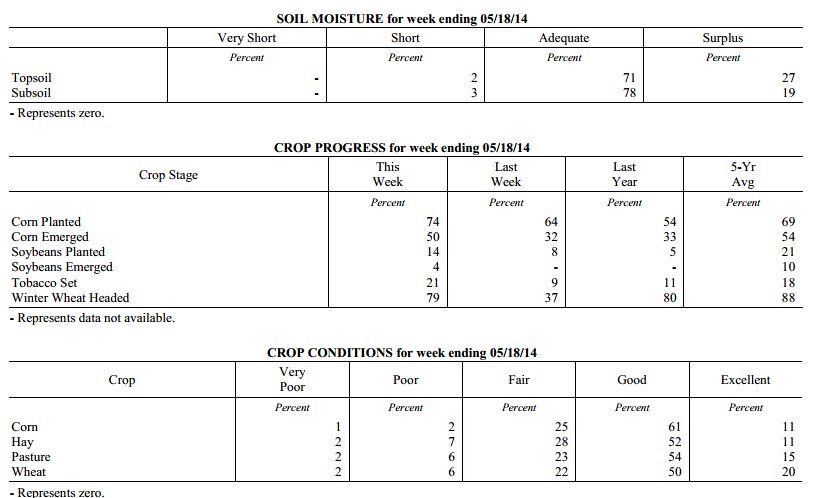 Kentucky Climate Summary
For the Period May 12, 2014 to May 18, 2014
Below Normal Temperatures and Above Normal Precipitation:
All eyes this past period were focused on a return to cool temperatures and the
threat of a late season spring frost. An upper level low then made headway into the
Ohio Valley Wednesday and through the remainder of the week with several disturbances
rotating around the system. The most prominent event came Wednesday with widespread
showers accompanied by some severe weather. Flash flooding and hail around 1 inch
were reported on several occasions. An EF2 tornado was even confirmed in Christian
County with estimated peak winds of 125 mph. The bigger story was the unseasonably
cool temperatures as highs Thursday through Saturday only peaked in the upper 50s to
mid 60s. Lows were also well below normal with temperatures dipping into the upper
30s to mid 40s for much of the state Friday and Saturday night. Saying this, some
low lying and sheltered locations across the Eastern half of Kentucky got into the
mid 30s, bringing patchy frost back into the picture. This frost event occurred at a
time when much of Kentucky had less than a 10% chance of seeing another 36 degree
reading based on the past 30 years of data.
Temperatures for the period averaged 61 degrees across the state which was 3 degrees
cooler than normal and 10 degrees cooler than the previous period. High temperatures
averaged from 69 in the West to 72 in the East. Departure from normal high
temperatures ranged from 8 degrees cooler than normal in the West to 4 degrees
cooler than normal in the East. Low temperatures averaged from 53 degrees in the
West to 52 degrees in the East. Departure from normal low temperature ranged from 2
degrees cooler than normal in the West to 3 degrees warmer than normal in the East.
The extreme high temperature for the period was 90 degrees at LOUISA 1S and the
extreme low was 33 degrees at PAINTSVILLE 4W.
Precipitation (liq. equ.) for the period totaled 1.41 inches statewide which was 0.28
inches above normal and 125% of normal. Precipitation totals by climate division,
West 1.71 inches, Central 1.81 inches, Bluegrass 1.40 inches and East 0.72 inches,
which was 0.53, 0.62, 0.33 and -0.37 inches respectively from normal. By station,
precipitation totals ranged from a low of 0.13 inches at LONDON to a high of 3.03
inches at CAMPBELLSVILLE 7W.
---
USDA's Kentucky Crop and Weather Report
Issued 4:00 P.M., May 12, 2014 6-14
Agricultural News: Kentucky experienced warmer conditions over the past week.
Precipitation for the week totaled 1.07 inches, 0.02 inches below normal.
Temperatures averaged 70 degrees for the week, 8 degrees above normal. Topsoil
moisture was rated 4 percent short, 74 percent adequate and 22 percent surplus.
Subsoil moisture was rated 4 percent short, 78 percent adequate, and 18 percent
surplus. Days suitable for fieldwork averaged 5.0 out of a possible seven. Primary
activities this week included planting corn, soybeans and tobacco, along with cutting
of alfalfa and wheat hay.
Crop planting made good progress early in the week, but raining conditions later in
the week put a hold on further advancement. The harsh conditions this past winter are
expected to impact both the quantity and quality of hay in many locations, especially
the first cutting of hay. Thinner stands and shorter height of hay are both
contributing factors to expectations of decreased hay yields from last year. Tobacco
transplant supplies were reported as 3 percent short, 91 percent adequate, and 6
percent surplus. Eighteen percent of tobacco transplants were under 2
inches, with 53 percent between 2-4 inches, and 29 percent over than 4 inches.
Kentucky Climate Summary
For the Period May 12, 2014 to May 18, 2014
Below Normal Temperatures and Above Normal Precipitation:
All eyes this past period were focused on a return to cool temperatures and the
threat of a late season spring frost. An upper level low then made headway into the
Ohio Valley Wednesday and through the remainder of the week with several disturbances
rotating around the system. The most prominent event came Wednesday with widespread
showers accompanied by some severe weather. Flash flooding and hail around 1 inch
were reported on several occasions. An EF2 tornado was even confirmed in Christian
County with estimated peak winds of 125 mph. The bigger story was the unseasonably
cool temperatures as highs Thursday through Saturday only peaked in the upper 50s to
mid 60s. Lows were also well below normal with temperatures dipping into the upper
30s to mid 40s for much of the state Friday and Saturday night. Saying this, some
low lying and sheltered locations across the Eastern half of Kentucky got into the
mid 30s, bringing patchy frost back into the picture. This frost event occurred at a
time when much of Kentucky had less than a 10% chance of seeing another 36 degree
reading based on the past 30 years of data.
Temperatures for the period averaged 61 degrees across the state which was 3 degrees
cooler than normal and 10 degrees cooler than the previous period. High temperatures
averaged from 69 in the West to 72 in the East. Departure from normal high
temperatures ranged from 8 degrees cooler than normal in the West to 4 degrees
cooler than normal in the East. Low temperatures averaged from 53 degrees in the
West to 52 degrees in the East. Departure from normal low temperature ranged from 2
degrees cooler than normal in the West to 3 degrees warmer than normal in the East.
The extreme high temperature for the period was 90 degrees at LOUISA 1S and the
extreme low was 33 degrees at PAINTSVILLE 4W.
Precipitation (liq. equ.) for the period totaled 1.41 inches statewide which was 0.28
inches above normal and 125% of normal. Precipitation totals by climate division,
West 1.71 inches, Central 1.81 inches, Bluegrass 1.40 inches and East 0.72 inches,
which was 0.53, 0.62, 0.33 and -0.37 inches respectively from normal. By station,
precipitation totals ranged from a low of 0.13 inches at LONDON to a high of 3.03
inches at CAMPBELLSVILLE 7W.
---
USDA's Kentucky Crop and Weather Report
Issued 4:00 P.M., May 12, 2014 6-14
Agricultural News: Kentucky experienced warmer conditions over the past week.
Precipitation for the week totaled 1.07 inches, 0.02 inches below normal.
Temperatures averaged 70 degrees for the week, 8 degrees above normal. Topsoil
moisture was rated 4 percent short, 74 percent adequate and 22 percent surplus.
Subsoil moisture was rated 4 percent short, 78 percent adequate, and 18 percent
surplus. Days suitable for fieldwork averaged 5.0 out of a possible seven. Primary
activities this week included planting corn, soybeans and tobacco, along with cutting
of alfalfa and wheat hay.
Crop planting made good progress early in the week, but raining conditions later in
the week put a hold on further advancement. The harsh conditions this past winter are
expected to impact both the quantity and quality of hay in many locations, especially
the first cutting of hay. Thinner stands and shorter height of hay are both
contributing factors to expectations of decreased hay yields from last year. Tobacco
transplant supplies were reported as 3 percent short, 91 percent adequate, and 6
percent surplus. Eighteen percent of tobacco transplants were under 2
inches, with 53 percent between 2-4 inches, and 29 percent over than 4 inches.
 Kentucky Climate Summary
For the Period May 5, 2014 to May 11, 2014
Above Normal Temperatures and Near Normal Precipitation:
The Commonwealth got an early glimpse of summer this past period. The work week was
dominated by dry conditions and temperatures in the low to mid 80s. The warm
conditions helped push the Bluegrass State to a week where temperatures were on average
8 degrees above normal. This made it feel more like mid-June at times. Monday even
saw the mercury jump into the upper 80s with the city of Louisville recording a
temperature of 89 degrees at the airport. The good news was the moisture supply was
limited and kept humid conditions out of the picture. It was not until Friday and
into the weekend that the weather pattern became more active. Showers and storms
fired on multiple occasions with the passage of a couple frontal boundaries and upper
level disturbances. Some small hail was reported, with the state averaging just over
an inch through the three day period.
Temperatures for the period averaged 70 degrees across the state which was 8 degrees
warmer than normal and 10 degrees warmer than the previous period. High temperatures
averaged from 82 in the West to 82 in the East. Departure from normal high
temperatures ranged from 7 degrees warmer than normal in the West to 8 degrees
warmer than normal in the East. Low temperatures averaged from 62 degrees in the
West to 57 degrees in the East. Departure from normal low temperature ranged from 10
degrees warmer than normal in the West to 10 degrees warmer than normal in the
East. The extreme high temperature for the period was 89 degrees at LOUISVILLE APT
and the extreme low was 43 degrees at PAINTSVILLE 4W.
Precipitation (liq. equ.) for the period totaled 1.07 inches statewide which was 0.02
inches below normal and 98% of normal. Precipitation totals by climate division, West
0.97 inches, Central 1.70 inches, Bluegrass 0.88 inches and East 0.73 inches, which
was -0.19, 0.55, -0.13 and -0.32 inches respectively from normal. By station,
precipitation totals ranged from a low of 0.12 inches at ALBANY 1N to a high of 4.90
inches at FORT KNOX.
---
USDA's Kentucky Crop and Weather Report
Issued 4:00 P.M., May 5, 2014 5-14
Agricultural News: The Commonwealth experienced cool, wet weather conditions this
past week. Precipitation for the week totaled 2.62 inches, 1.55 inches above normal.
Temperatures averaged 60 degrees for the week, 2 degrees cooler than the previous
period. Topsoil moisture was rated 2 percent short, 64 percent adequate and 34
percent surplus. Subsoil moisture was rated 1 percent very short, 3 percent short, 71
percent adequate and 25 percent surplus. Days suitable for fieldwork averaged 2.5 out
of a possible seven. Primary activities this week included the cutting of some hay
and the spraying and cutting of wheat for forage. Weather conditions hampered
planting progress this week.
Grains and Oilseed: As of Sunday, May 4, 39 percent of the corn crop had been
planted, compared with 32 percent last year and the five year average of 52. Fifteen
percent of the corn crop has emerged, compared with 11 percent last year and the five
year average of 34 percent. Soybean planting is in the beginning stages with 2
percent planted, compared to 1 percent last year and the five year average of 8
percent. Six percent of winter wheat has headed compared to 22 percent last year and
the five year average of 47 percent. Winter wheat is in mostly good to fair condition
with 2 percent very poor, 8 percent poor, 25 percent fair, 50 percent good and 15
percent excellent. Average height of wheat was 16 inches.
Tobacco: Seeded tobacco transplants were reported in mostly good to excellent
condition with 1 percent very poor, 2 percent poor, 11 percent fair, 64 percent good,
and 22 percent excellent.
Pasture and Hay: Pasture condition was rated as 3 percent very poor, 8 percent poor,
27 percent fair, 49 percent good, and 13 percent excellent. Average height of alfalfa
was 15 inches at the end of the week. The projected average date for the first
cutting of alfalfa is May 14th.
Kentucky Climate Summary
For the Period April 28, 2014 to May 4, 2014
Near Normal Temperatures and Much Above Normal Precipitation:
Rain, rain, and more rain. An extremely wet pattern took control of the Commonwealth
this past period and resulted in the wettest week of 2014. Looking farther back, this
could even be seen as an understatement. The 2.62 inches that the state averaged was the
most in nearly two and a half years, going all the way back to early December of 2011.
Most of the rain fell over the mid-section of the work week as an upper level low slowly
meandered to the northeast. Multiple upper level disturbances sparked numerous rounds of
rainfall with some strong to severe activity mixed within. A weak tornado touched down
in Fulton County, in addition to multiple reports of funnels clouds in south central
Kentucky. After a very unsettled work week, the Commonwealth finally got a chance to dry
out over the weekend with milder temperatures in place. Behind mostly sunny skies, highs
got into the upper 70s to mid-80s for most of the area on Sunday. One exception was in
Western Kentucky where Paducah recorded a high of 88.
Temperatures for the period averaged 60 degrees across the state which was near
normal and 2 degrees cooler than the previous period. High temperatures
averaged from 70 in the West to 71 in the East. Departure from normal high
temperatures ranged from 4 degrees cooler than normal in the West to 2 degrees
cooler than normal in the East. Low temperatures averaged from 49 degrees in the
West to 50 degrees in the East. Departure from normal low temperature ranged from 1
degree cooler than normal in the West to 5 degrees warmer than normal in the East.
The extreme high temperature for the period was 88 degrees at PADUCAH ASOS and the
extreme low was 37 degrees at BURKESVILLE 3W.
Precipitation (liq. equ.) for the period totaled 2.62 inches statewide which was 1.55
inches above normal and 244% of normal. Precipitation totals by climate division,
West 2.71 inches, Central 2.83 inches, Bluegrass 2.62 inches and East 2.30 inches,
which was 1.5, 1.73, 1.63 and 1.3 inches above normal. By station, precipitation
totals ranged from a low of 0.84 inches at PIKEVILLE 13S to a high of 6.00
inches at HICKMAN 2E.
---
USDA's Kentucky Crop and Weather Report
Issued 4:00 P.M., April 28, 2014 4-14
Agricultural News: The Commonwealth experienced drier conditions over the past week.
Precipitation for the week totaled 0.65 inches, 0.39 inches below normal.
Temperatures averaged 62 degrees for the week, 4 degrees warmer than normal. Topsoil
moisture was rated 1 percent very short, 6 percent short, 72 percent adequate and 21
percent surplus. Subsoil moisture was rated 1 percent very short, 7 percent short, 75
percent adequate and 17 percent surplus. Days suitable for fieldwork averaged 5.2 out
of a possible seven. Primary activities this week included planting corn and applying
fertilizer. Fruit trees along with early set vegetables were adversely impacted by
the freeze on April 15.
Grains and Oilseed: As of Sunday, April 27, 32 percent of the corn crop had been
planted, compared with 23 percent last year and the five year average of 44. Seven
percent of the corn crop has emerged, compared with 4 percent last year and the five
year average of 22 percent. Soybean planting is in the beginning stages with 1
percent planted, compared to the five year average of 4 percent. One percent of
winter wheat has headed compared to 7 percent last year and the five year average of
28 percent. Winter wheat is in mostly good to fair condition with 2 percent very
poor, 8 percent poor, 26 percent fair, 49 percent good, and 15 percent excellent.
Average height of wheat was 13 inches.
Tobacco: Seeded tobacco transplants were reported in mostly good to excellent
condition with 2 percent poor, 12 percent fair, 66 percent good, and 20 percent
excellent.
Pasture and Hay: Pasture condition was rated as 3 percent very poor, 8 percent poor,
29 percent fair, 52 percent good, and 8 percent excellent. Average height of alfalfa
was 9 inches at the end of the week. The projected first cutting of alfalfa is May
14th .
Other: Freeze damage to apples was reported on 58 percent of crop with 31 percent
rated light, 20 percent moderate, and 7 percent severe. Freeze damage to peaches was
reported on 61 percent of crop with 17 percent rated light, 15 percent moderate, and
29 percent severe. Strawberry condition was rated as 2 percent very poor, 3 percent
poor, 20 percent fair, 64 percent good, and 11 percent excellent. Condition of
livestock was rated as 2 percent very poor, 5 percent poor, 22 percent fair, 61
percent good, and 10 percent excellent.
Kentucky Climate Summary
For the Period April 21, 2014 to April 27, 2014
Above Normal Temperatures and Below Normal Precipitation:
The Commonwealth has now gone 3 straight weeks with seeing below normal
precipitation. The state only saw a couple significant rounds of rainfall this
previous period with the first coming Thursday night and into Friday. A cold front
was dragged through the region with soaking rainfall in place. An upper level
disturbance then pushed into Western Kentucky late Sunday, sparking scattered showers
and storms across the region. The two events combined for a statewide average of
0.65 inches, which was nearly a half inch below normal. Temperature-wise, after a
rather cool previous period, temperatures rebounded to above normal readings for much
of the week. This kept a late-season frost out of the picture. Over the course of
the period, high temperatures got into the mid 70s to low 80s on multiple occasions.
Temperatures for the period averaged 62 degrees across the state which was 4 degrees
warmer than normal and 8 degrees warmer than the previous period. High temperatures
averaged from 75 in the West to 75 in the East. Departure from normal high
temperatures ranged from 3 degrees warmer than normal in the West to 4 degrees
warmer than normal in the East. Low temperatures averaged from 51 degrees in the
West to 47 degrees in the East. Departure from normal low temperature ranged from 3
degrees warmer than normal in the West to 5 degrees warmer than normal in the East.
The extreme high temperature for the period was 87 degrees at PEABODY and the extreme
low was 33 degrees at CYNTHIANA 8N.
Precipitation (liq. equ.) for the period totaled 0.65 inches statewide which was 0.39
inches below normal and 63% of normal. Precipitation totals by climate division, West
0.62 inches, Central 0.58 inches, Bluegrass 0.57 inches and East 0.83 inches, which
was 0.57, 0.47, 0.38 and 0.12 inches below normal. By station, precipitation totals
ranged from a low of 0.11 inches at MADISONVILLE 4S to a high of 1.72
inches at CALHOUN 5NW.
---
USDA's Kentucky Crop and Weather Report
Issued 4:00 P.M., April 21, 2014 3-14
Agricultural News: Snow and below freezing temperatures interrupted work in the
Commonwealth at the beginning of the week. However, temperatures increased over the
weekend. Precipitation for the week totaled 0.71 inches, 0.28 inches below normal.
Temperatures averaged 54 degrees, across the state, for the week, 2 degrees cooler
than normal and 6 degrees cooler then last period. The highest temperature this week
was 81 degrees at the MADISONVILLE 4S weather station, and the lowest temperature was
21 degrees at the PIKEVILLE 13S weather station. Topsoil moisture was rated 4 percent
short, 69 percent adequate and 27 percent surplus. Subsoil moisture was rated 4
percent short, 75 percent adequate and 21 percent surplus. Days suitable for
fieldwork averaged 4 out of a possible seven. Soils remain too wet for most
fieldwork. Primary activities this week included preparing fields for planting, and
applying fertilizer.
Crops: Ten percent of the corn crop had been planted, behind last year�s 14 percent
and the five-year average of 30 percent. Winter wheat continues to be concentrated in
the good to fair condition with 3 percent very poor, 9 percent poor, 25 percent fair,
48 percent good, and 15 percent excellent. Winter damage was reported on 40 percent
of wheat with 29 percent rated as light, 9 percent moderate, and 2 percent severe.
Tobacco: Ninety-two percent of the tobacco transplants had been seeded in comparison
to 90 percent last year and the five-year average of 90. Tobacco transplant
conditions were rated as 2 percent poor, 13 percent fair, 67 percent good and 18
percent excellent.
Pasture and Hay: Pasture condition was reported as 3 percent very poor, 10 percent
poor, 30 percent fair, 49 percent good, and 8 percent excellent. Though, many
livestock producers are still feeding their herds hay, the pasture growth in the
state is beginning to thrive.
Kentucky Climate Summary
For the Period April 14, 2014 to April 20, 2014
Below Normal Temperatures and Precipitation:
Winter and spring both made an appearance this past period with even a late season
snow event in the mix. A frontal boundary passed across the Commonwealth to start
off the work week, making for the only precipitation event for the period. Central
portions of the state saw the most with a half to one inch falling in most areas.
Breezy northwest flow picked up behind the front with some portions of the Bluegrass
and Eastern Kentucky even seeing some snowfall on Tuesday. One inch was recorded at
the National Weather Service in Jackson. According to the office, this resulted in
the longest snow season on record with a total of 174 days. High pressure then moved
overhead that night. Skies cleared and winds slackened, allowing for a widespread
freeze across the state. Most got down into the mid to upper 20s, but some sheltered
and low lying locations even dove into the low 20s. Kentucky then became under the
influence of high pressure for the majority of the time through Sunday. Temperatures
rebounded and surpassed seasonal norms over the weekend with most locations getting
into the upper 70s to low 80s by Sunday.
Temperatures for the period averaged 54 degrees across the state which was 2 degrees
cooler than normal and 6 degrees cooler than the previous period. High temperatures
averaged from 66 in the West to 68 in the East. Departure from normal high
temperatures ranged from 4 degrees cooler than normal in the West to 1 degree
cooler than normal in the East. Low temperatures averaged from 41 degrees in the
West to 43 degrees in the East. Departure from normal low temperature ranged from 5
degrees cooler than normal in the West to 2 degrees warmer than normal in the East.
The extreme high temperature for the period was 81 degrees at MADISONVILLE 4S and the
extreme low was 21 degrees at PIKEVILLE 13S.
Precipitation (liq. equ.) for the period totaled 0.71 inches statewide which was 0.28
inches below normal and 72% of normal. Precipitation totals by climate division, West
1.15 inches, Central 0.73 inches, Bluegrass 0.57 inches and East 0.38 inches, which
was 0.03, -0.26, -0.33 and -0.55 inches respectively from normal. By station,
precipitation totals ranged from a low of 0.08 inches at PIKEVILLE 13S to a high of
1.61 inches at MURRAY 1W.
---
USDA's Kentucky Crop and Weather Report
Issued 4:00 P.M., April 14, 2014 2-14
Agricultural News: The Commonwealth experienced drier conditions over the past week.
Precipitation for the week totaled 0.45 inches, 0.57 inches below normal.
Temperatures averaged 60 degrees for the week, 6 degrees warmer than normal. Topsoil
moisture was rated 1 percent short, 59 percent adequate and 40 percent surplus.
Subsoil moisture was rated 3 percent short, 70 percent adequate and 27 percent
surplus. Days suitable for fieldwork averaged 3.3 out of a possible seven. Soils
remain too wet for most fieldwork. Primary activities this week included preparing
farm equipment for planting, seeding pastures, applying fertilizer, and seeding
tobacco transplants. Twenty-seven percent of apples and 37 percent of peaches were in
full bloom. Some producers reported significant winter damage to peaches.
Crops: As of Sunday, April 13, 4 percent of the corn crop had been planted, behind
last year�s 6 percent and the five year average of 17. Farmers expect to plant corn
as soon as field conditions permit, and planting could make considerable progress
this week. Winter wheat is in mostly good to fair condition with 3 percent very poor,
8 percent poor, 29 percent fair, 47 percent good, and 13 percent excellent.
Tobacco: As of Sunday, April 13, 76 percent of the tobacco transplants had been
seeded compared with 84 percent last year and the five year average of 84.
Pasture and Hay: Pasture condition was reported as 4 percent very poor, 13 percent
poor, 32 percent fair, 45 percent good, and 6 percent excellent. Many operators were
still feeding hay and are hoping for rapid forage growth this week as hay supplies
are running low in some areas.
Kentucky Climate Summary
For the Period April 7, 2014 to April 13, 2014
Above Normal Temperatures and Below Normal Precipitation:
The Commonwealth got the chance to dry out this past period as the state saw an
average of just under a half inch of rainfall over the course of the week. This
activity was spread out over three systems with the brunt coming Monday as surface
low pressure pushed through the area. Much more focus was given to the return of warm
temperatures. Surface high pressure transitioned to the southeast on Thursday with
temperatures rising back into the 70s. After a weak front passed through the state on
Friday, skies became mostly sunny for the weekend with some of the warmest
temperatures of the year in place. Highs rose well into the 80s on Sunday behind a
breezy southwesterly flow pattern. Some locations even got into the upper 80s. This
had a great impact on soil temperatures across the Commonwealth with most locations
reporting the upper 50s to mid-60s at a 4 inch depth by the end of the day.
Temperatures for the period averaged 60 degrees across the state which was 6 degrees
warmer than normal and 4 degrees warmer than the previous period. High temperatures
averaged from 70 in the West to 72 in the East. Departure from normal high
temperatures ranged from 2 degrees warmer than normal in the West to 5 degrees
warmer than normal in the East. Low temperatures averaged from 49 degrees in the
West to 49 degrees in the East. Departure from normal low temperature ranged from 5
degrees warmer than normal in the West to 10 degrees warmer than normal in the
East. The extreme high temperature for the period was 87 degrees at LOUISA 1S and the
extreme low was 27 degrees at Fort Campbell.
Precipitation (liq. equ.) for the period totaled 0.45 inches statewide which was 0.57
inches below normal and 44% of normal. Precipitation totals by climate division, West
0.60 inches, Central 0.45 inches, Bluegrass 0.51 inches and East 0.22 inches, which
was 0.56, 0.59, 0.41 and 0.72 inches below normal. By station, precipitation totals
ranged from a low of 0.08 inches at BIG SANDY to a high of 1.71 inches at BENTON 4N.
---
USDA's Kentucky Crop and Weather Report
Issued 4:00 P.M., April 7, 2014 1-14
Agricultural News: The Commonwealth experienced extremely wet conditions over the
past week. Precipitation for the week totaled 2.19 inches, 1.2 inches above normal.
Temperatures averaged 56 degrees for the week, 4 degrees warmer than normal. Topsoil
moisture was rated 1 percent short, 50 percent adequate and 49 percent surplus.
Subsoil moisture was rated 3 percent short, 65 percent adequate and 32 percent
surplus. Days suitable for fieldwork averaged 2.9 out of a possible seven. Primary
activities this week included securing supplies and preparing farm equipment for
planting, applying fertilizer and herbicide to wheat, and plowing for tobacco when
the weather permitted.
Tobacco: As of Sunday, April 6, 65 percent of the greenhouse and plant bed seedings
had been completed compared with 72 percent last year and the five year average of
72.
Small Grains and Legumes: Fall seeded wheat was in mostly fair to good condition.
Winter damage for wheat was estimated at 39 percent light, 16 percent moderate, and 5
percent severe. Condition of the wheat crop was rated 3 percent very poor, 7 percent
poor, 32 percent fair, 46 percent good and 12 percent excellent. Alfalfa freeze damage
was reported at 37 percent light, 19 percent moderate, and 3 percent severe.
Pasture and Hay: Pasture condition was reported as 5 percent very poor, 17 percent
poor, 34 percent fair, 39 percent good, and 5 percent excellent. Hay and roughage
supplies were rated 5 percent very short, 16 percent short, 70 percent adequate, and
9 percent surplus. A number of farms have lost cattle due to the harsh winter.
Kentucky Climate Summary
For the Period March 31, 2014 to April 6, 2014
Above Normal Temperatures and Much Above Normal Precipitation:
An extremely wet pattern setup across the Lower Ohio Valley this past week, bringing
impressive rainfall totals across the area. Most of the activity was concentrated
over the second half of the work week as a series of disturbances passed through the
Commonwealth. The state averaged 2.19 inches over the course of week, which was over
an inch above normal. This was although small in comparison to some areas of North
Central and Western Kentucky that saw in excess of 4 to 6 inches. This would
actually be more than the normal amount of precipitation seen over the entire month
of April. Accompanying the wet conditions were mild temperatures for the work week.
Highs got into the 70s numerous times, with some locations even getting into the low
80s. Canadian high pressure then pushed into the area for the weekend with cooler
conditions in place.
Temperatures for the period averaged 56 degrees across the state which was 4 degrees
warmer than normal and 14 degrees warmer than the previous period. High temperatures
averaged from 69 in the West to 71 in the East. Departure from normal high
temperatures ranged from 4 degrees warmer than normal in the West to 7 degrees
warmer than normal in the East. Low temperatures averaged from 46 degrees in the
West to 44 degrees in the East. Departure from normal low temperature ranged from 4
degrees warmer than normal in the West to 7 degrees warmer than normal in the East.
The extreme high temperature for the period was 83 degrees at LOUISA 1S and the
extreme low was 25 degrees at PAINTSVILLE 4W.
Precipitation (liq. equ.) for the period totaled 2.19 inches statewide which was 1.2
inches above normal and 220% of normal. Precipitation totals by climate division,
West 2.57 inches, Central 2.36 inches, Bluegrass 2.54 inches and East 1.31 inches,
which was 1.48, 1.32, 1.64 and 0.36 inches above normal. By station, precipitation
totals ranged from a low of 0.78 inches at MIDDLESBORO AWOS to a high of 5.60
inches at MORGANFIELD 4E.
---
Kentucky Climate Summary
For the Period March 24, 2014 to March 30, 2014
Well Below Normal Temperatures and Above Normal Precipitation:
Wet conditions moved back into the Bluegrass State this past period with even a
couple late-season snow events in the mix. Activity started over the course of
Monday night and into Tuesday as a couple upper level disturbances passed through the
region. The second round was the most prominent with scattered snow showers in place
as temperatures cooled throughout the day. The good news is that accumulations were
confined to grassy surfaces and were short-lived, but increased winds made for poor
visibilities at times. Below is a couple pictures taken Tuesday at the University of
Kentucky. The first was taken in the morning with the first round of snow showers.
The second came in the afternoon when winds picked up and visibility was reduced
drastically.
Kentucky Climate Summary
For the Period May 5, 2014 to May 11, 2014
Above Normal Temperatures and Near Normal Precipitation:
The Commonwealth got an early glimpse of summer this past period. The work week was
dominated by dry conditions and temperatures in the low to mid 80s. The warm
conditions helped push the Bluegrass State to a week where temperatures were on average
8 degrees above normal. This made it feel more like mid-June at times. Monday even
saw the mercury jump into the upper 80s with the city of Louisville recording a
temperature of 89 degrees at the airport. The good news was the moisture supply was
limited and kept humid conditions out of the picture. It was not until Friday and
into the weekend that the weather pattern became more active. Showers and storms
fired on multiple occasions with the passage of a couple frontal boundaries and upper
level disturbances. Some small hail was reported, with the state averaging just over
an inch through the three day period.
Temperatures for the period averaged 70 degrees across the state which was 8 degrees
warmer than normal and 10 degrees warmer than the previous period. High temperatures
averaged from 82 in the West to 82 in the East. Departure from normal high
temperatures ranged from 7 degrees warmer than normal in the West to 8 degrees
warmer than normal in the East. Low temperatures averaged from 62 degrees in the
West to 57 degrees in the East. Departure from normal low temperature ranged from 10
degrees warmer than normal in the West to 10 degrees warmer than normal in the
East. The extreme high temperature for the period was 89 degrees at LOUISVILLE APT
and the extreme low was 43 degrees at PAINTSVILLE 4W.
Precipitation (liq. equ.) for the period totaled 1.07 inches statewide which was 0.02
inches below normal and 98% of normal. Precipitation totals by climate division, West
0.97 inches, Central 1.70 inches, Bluegrass 0.88 inches and East 0.73 inches, which
was -0.19, 0.55, -0.13 and -0.32 inches respectively from normal. By station,
precipitation totals ranged from a low of 0.12 inches at ALBANY 1N to a high of 4.90
inches at FORT KNOX.
---
USDA's Kentucky Crop and Weather Report
Issued 4:00 P.M., May 5, 2014 5-14
Agricultural News: The Commonwealth experienced cool, wet weather conditions this
past week. Precipitation for the week totaled 2.62 inches, 1.55 inches above normal.
Temperatures averaged 60 degrees for the week, 2 degrees cooler than the previous
period. Topsoil moisture was rated 2 percent short, 64 percent adequate and 34
percent surplus. Subsoil moisture was rated 1 percent very short, 3 percent short, 71
percent adequate and 25 percent surplus. Days suitable for fieldwork averaged 2.5 out
of a possible seven. Primary activities this week included the cutting of some hay
and the spraying and cutting of wheat for forage. Weather conditions hampered
planting progress this week.
Grains and Oilseed: As of Sunday, May 4, 39 percent of the corn crop had been
planted, compared with 32 percent last year and the five year average of 52. Fifteen
percent of the corn crop has emerged, compared with 11 percent last year and the five
year average of 34 percent. Soybean planting is in the beginning stages with 2
percent planted, compared to 1 percent last year and the five year average of 8
percent. Six percent of winter wheat has headed compared to 22 percent last year and
the five year average of 47 percent. Winter wheat is in mostly good to fair condition
with 2 percent very poor, 8 percent poor, 25 percent fair, 50 percent good and 15
percent excellent. Average height of wheat was 16 inches.
Tobacco: Seeded tobacco transplants were reported in mostly good to excellent
condition with 1 percent very poor, 2 percent poor, 11 percent fair, 64 percent good,
and 22 percent excellent.
Pasture and Hay: Pasture condition was rated as 3 percent very poor, 8 percent poor,
27 percent fair, 49 percent good, and 13 percent excellent. Average height of alfalfa
was 15 inches at the end of the week. The projected average date for the first
cutting of alfalfa is May 14th.
Kentucky Climate Summary
For the Period April 28, 2014 to May 4, 2014
Near Normal Temperatures and Much Above Normal Precipitation:
Rain, rain, and more rain. An extremely wet pattern took control of the Commonwealth
this past period and resulted in the wettest week of 2014. Looking farther back, this
could even be seen as an understatement. The 2.62 inches that the state averaged was the
most in nearly two and a half years, going all the way back to early December of 2011.
Most of the rain fell over the mid-section of the work week as an upper level low slowly
meandered to the northeast. Multiple upper level disturbances sparked numerous rounds of
rainfall with some strong to severe activity mixed within. A weak tornado touched down
in Fulton County, in addition to multiple reports of funnels clouds in south central
Kentucky. After a very unsettled work week, the Commonwealth finally got a chance to dry
out over the weekend with milder temperatures in place. Behind mostly sunny skies, highs
got into the upper 70s to mid-80s for most of the area on Sunday. One exception was in
Western Kentucky where Paducah recorded a high of 88.
Temperatures for the period averaged 60 degrees across the state which was near
normal and 2 degrees cooler than the previous period. High temperatures
averaged from 70 in the West to 71 in the East. Departure from normal high
temperatures ranged from 4 degrees cooler than normal in the West to 2 degrees
cooler than normal in the East. Low temperatures averaged from 49 degrees in the
West to 50 degrees in the East. Departure from normal low temperature ranged from 1
degree cooler than normal in the West to 5 degrees warmer than normal in the East.
The extreme high temperature for the period was 88 degrees at PADUCAH ASOS and the
extreme low was 37 degrees at BURKESVILLE 3W.
Precipitation (liq. equ.) for the period totaled 2.62 inches statewide which was 1.55
inches above normal and 244% of normal. Precipitation totals by climate division,
West 2.71 inches, Central 2.83 inches, Bluegrass 2.62 inches and East 2.30 inches,
which was 1.5, 1.73, 1.63 and 1.3 inches above normal. By station, precipitation
totals ranged from a low of 0.84 inches at PIKEVILLE 13S to a high of 6.00
inches at HICKMAN 2E.
---
USDA's Kentucky Crop and Weather Report
Issued 4:00 P.M., April 28, 2014 4-14
Agricultural News: The Commonwealth experienced drier conditions over the past week.
Precipitation for the week totaled 0.65 inches, 0.39 inches below normal.
Temperatures averaged 62 degrees for the week, 4 degrees warmer than normal. Topsoil
moisture was rated 1 percent very short, 6 percent short, 72 percent adequate and 21
percent surplus. Subsoil moisture was rated 1 percent very short, 7 percent short, 75
percent adequate and 17 percent surplus. Days suitable for fieldwork averaged 5.2 out
of a possible seven. Primary activities this week included planting corn and applying
fertilizer. Fruit trees along with early set vegetables were adversely impacted by
the freeze on April 15.
Grains and Oilseed: As of Sunday, April 27, 32 percent of the corn crop had been
planted, compared with 23 percent last year and the five year average of 44. Seven
percent of the corn crop has emerged, compared with 4 percent last year and the five
year average of 22 percent. Soybean planting is in the beginning stages with 1
percent planted, compared to the five year average of 4 percent. One percent of
winter wheat has headed compared to 7 percent last year and the five year average of
28 percent. Winter wheat is in mostly good to fair condition with 2 percent very
poor, 8 percent poor, 26 percent fair, 49 percent good, and 15 percent excellent.
Average height of wheat was 13 inches.
Tobacco: Seeded tobacco transplants were reported in mostly good to excellent
condition with 2 percent poor, 12 percent fair, 66 percent good, and 20 percent
excellent.
Pasture and Hay: Pasture condition was rated as 3 percent very poor, 8 percent poor,
29 percent fair, 52 percent good, and 8 percent excellent. Average height of alfalfa
was 9 inches at the end of the week. The projected first cutting of alfalfa is May
14th .
Other: Freeze damage to apples was reported on 58 percent of crop with 31 percent
rated light, 20 percent moderate, and 7 percent severe. Freeze damage to peaches was
reported on 61 percent of crop with 17 percent rated light, 15 percent moderate, and
29 percent severe. Strawberry condition was rated as 2 percent very poor, 3 percent
poor, 20 percent fair, 64 percent good, and 11 percent excellent. Condition of
livestock was rated as 2 percent very poor, 5 percent poor, 22 percent fair, 61
percent good, and 10 percent excellent.
Kentucky Climate Summary
For the Period April 21, 2014 to April 27, 2014
Above Normal Temperatures and Below Normal Precipitation:
The Commonwealth has now gone 3 straight weeks with seeing below normal
precipitation. The state only saw a couple significant rounds of rainfall this
previous period with the first coming Thursday night and into Friday. A cold front
was dragged through the region with soaking rainfall in place. An upper level
disturbance then pushed into Western Kentucky late Sunday, sparking scattered showers
and storms across the region. The two events combined for a statewide average of
0.65 inches, which was nearly a half inch below normal. Temperature-wise, after a
rather cool previous period, temperatures rebounded to above normal readings for much
of the week. This kept a late-season frost out of the picture. Over the course of
the period, high temperatures got into the mid 70s to low 80s on multiple occasions.
Temperatures for the period averaged 62 degrees across the state which was 4 degrees
warmer than normal and 8 degrees warmer than the previous period. High temperatures
averaged from 75 in the West to 75 in the East. Departure from normal high
temperatures ranged from 3 degrees warmer than normal in the West to 4 degrees
warmer than normal in the East. Low temperatures averaged from 51 degrees in the
West to 47 degrees in the East. Departure from normal low temperature ranged from 3
degrees warmer than normal in the West to 5 degrees warmer than normal in the East.
The extreme high temperature for the period was 87 degrees at PEABODY and the extreme
low was 33 degrees at CYNTHIANA 8N.
Precipitation (liq. equ.) for the period totaled 0.65 inches statewide which was 0.39
inches below normal and 63% of normal. Precipitation totals by climate division, West
0.62 inches, Central 0.58 inches, Bluegrass 0.57 inches and East 0.83 inches, which
was 0.57, 0.47, 0.38 and 0.12 inches below normal. By station, precipitation totals
ranged from a low of 0.11 inches at MADISONVILLE 4S to a high of 1.72
inches at CALHOUN 5NW.
---
USDA's Kentucky Crop and Weather Report
Issued 4:00 P.M., April 21, 2014 3-14
Agricultural News: Snow and below freezing temperatures interrupted work in the
Commonwealth at the beginning of the week. However, temperatures increased over the
weekend. Precipitation for the week totaled 0.71 inches, 0.28 inches below normal.
Temperatures averaged 54 degrees, across the state, for the week, 2 degrees cooler
than normal and 6 degrees cooler then last period. The highest temperature this week
was 81 degrees at the MADISONVILLE 4S weather station, and the lowest temperature was
21 degrees at the PIKEVILLE 13S weather station. Topsoil moisture was rated 4 percent
short, 69 percent adequate and 27 percent surplus. Subsoil moisture was rated 4
percent short, 75 percent adequate and 21 percent surplus. Days suitable for
fieldwork averaged 4 out of a possible seven. Soils remain too wet for most
fieldwork. Primary activities this week included preparing fields for planting, and
applying fertilizer.
Crops: Ten percent of the corn crop had been planted, behind last year�s 14 percent
and the five-year average of 30 percent. Winter wheat continues to be concentrated in
the good to fair condition with 3 percent very poor, 9 percent poor, 25 percent fair,
48 percent good, and 15 percent excellent. Winter damage was reported on 40 percent
of wheat with 29 percent rated as light, 9 percent moderate, and 2 percent severe.
Tobacco: Ninety-two percent of the tobacco transplants had been seeded in comparison
to 90 percent last year and the five-year average of 90. Tobacco transplant
conditions were rated as 2 percent poor, 13 percent fair, 67 percent good and 18
percent excellent.
Pasture and Hay: Pasture condition was reported as 3 percent very poor, 10 percent
poor, 30 percent fair, 49 percent good, and 8 percent excellent. Though, many
livestock producers are still feeding their herds hay, the pasture growth in the
state is beginning to thrive.
Kentucky Climate Summary
For the Period April 14, 2014 to April 20, 2014
Below Normal Temperatures and Precipitation:
Winter and spring both made an appearance this past period with even a late season
snow event in the mix. A frontal boundary passed across the Commonwealth to start
off the work week, making for the only precipitation event for the period. Central
portions of the state saw the most with a half to one inch falling in most areas.
Breezy northwest flow picked up behind the front with some portions of the Bluegrass
and Eastern Kentucky even seeing some snowfall on Tuesday. One inch was recorded at
the National Weather Service in Jackson. According to the office, this resulted in
the longest snow season on record with a total of 174 days. High pressure then moved
overhead that night. Skies cleared and winds slackened, allowing for a widespread
freeze across the state. Most got down into the mid to upper 20s, but some sheltered
and low lying locations even dove into the low 20s. Kentucky then became under the
influence of high pressure for the majority of the time through Sunday. Temperatures
rebounded and surpassed seasonal norms over the weekend with most locations getting
into the upper 70s to low 80s by Sunday.
Temperatures for the period averaged 54 degrees across the state which was 2 degrees
cooler than normal and 6 degrees cooler than the previous period. High temperatures
averaged from 66 in the West to 68 in the East. Departure from normal high
temperatures ranged from 4 degrees cooler than normal in the West to 1 degree
cooler than normal in the East. Low temperatures averaged from 41 degrees in the
West to 43 degrees in the East. Departure from normal low temperature ranged from 5
degrees cooler than normal in the West to 2 degrees warmer than normal in the East.
The extreme high temperature for the period was 81 degrees at MADISONVILLE 4S and the
extreme low was 21 degrees at PIKEVILLE 13S.
Precipitation (liq. equ.) for the period totaled 0.71 inches statewide which was 0.28
inches below normal and 72% of normal. Precipitation totals by climate division, West
1.15 inches, Central 0.73 inches, Bluegrass 0.57 inches and East 0.38 inches, which
was 0.03, -0.26, -0.33 and -0.55 inches respectively from normal. By station,
precipitation totals ranged from a low of 0.08 inches at PIKEVILLE 13S to a high of
1.61 inches at MURRAY 1W.
---
USDA's Kentucky Crop and Weather Report
Issued 4:00 P.M., April 14, 2014 2-14
Agricultural News: The Commonwealth experienced drier conditions over the past week.
Precipitation for the week totaled 0.45 inches, 0.57 inches below normal.
Temperatures averaged 60 degrees for the week, 6 degrees warmer than normal. Topsoil
moisture was rated 1 percent short, 59 percent adequate and 40 percent surplus.
Subsoil moisture was rated 3 percent short, 70 percent adequate and 27 percent
surplus. Days suitable for fieldwork averaged 3.3 out of a possible seven. Soils
remain too wet for most fieldwork. Primary activities this week included preparing
farm equipment for planting, seeding pastures, applying fertilizer, and seeding
tobacco transplants. Twenty-seven percent of apples and 37 percent of peaches were in
full bloom. Some producers reported significant winter damage to peaches.
Crops: As of Sunday, April 13, 4 percent of the corn crop had been planted, behind
last year�s 6 percent and the five year average of 17. Farmers expect to plant corn
as soon as field conditions permit, and planting could make considerable progress
this week. Winter wheat is in mostly good to fair condition with 3 percent very poor,
8 percent poor, 29 percent fair, 47 percent good, and 13 percent excellent.
Tobacco: As of Sunday, April 13, 76 percent of the tobacco transplants had been
seeded compared with 84 percent last year and the five year average of 84.
Pasture and Hay: Pasture condition was reported as 4 percent very poor, 13 percent
poor, 32 percent fair, 45 percent good, and 6 percent excellent. Many operators were
still feeding hay and are hoping for rapid forage growth this week as hay supplies
are running low in some areas.
Kentucky Climate Summary
For the Period April 7, 2014 to April 13, 2014
Above Normal Temperatures and Below Normal Precipitation:
The Commonwealth got the chance to dry out this past period as the state saw an
average of just under a half inch of rainfall over the course of the week. This
activity was spread out over three systems with the brunt coming Monday as surface
low pressure pushed through the area. Much more focus was given to the return of warm
temperatures. Surface high pressure transitioned to the southeast on Thursday with
temperatures rising back into the 70s. After a weak front passed through the state on
Friday, skies became mostly sunny for the weekend with some of the warmest
temperatures of the year in place. Highs rose well into the 80s on Sunday behind a
breezy southwesterly flow pattern. Some locations even got into the upper 80s. This
had a great impact on soil temperatures across the Commonwealth with most locations
reporting the upper 50s to mid-60s at a 4 inch depth by the end of the day.
Temperatures for the period averaged 60 degrees across the state which was 6 degrees
warmer than normal and 4 degrees warmer than the previous period. High temperatures
averaged from 70 in the West to 72 in the East. Departure from normal high
temperatures ranged from 2 degrees warmer than normal in the West to 5 degrees
warmer than normal in the East. Low temperatures averaged from 49 degrees in the
West to 49 degrees in the East. Departure from normal low temperature ranged from 5
degrees warmer than normal in the West to 10 degrees warmer than normal in the
East. The extreme high temperature for the period was 87 degrees at LOUISA 1S and the
extreme low was 27 degrees at Fort Campbell.
Precipitation (liq. equ.) for the period totaled 0.45 inches statewide which was 0.57
inches below normal and 44% of normal. Precipitation totals by climate division, West
0.60 inches, Central 0.45 inches, Bluegrass 0.51 inches and East 0.22 inches, which
was 0.56, 0.59, 0.41 and 0.72 inches below normal. By station, precipitation totals
ranged from a low of 0.08 inches at BIG SANDY to a high of 1.71 inches at BENTON 4N.
---
USDA's Kentucky Crop and Weather Report
Issued 4:00 P.M., April 7, 2014 1-14
Agricultural News: The Commonwealth experienced extremely wet conditions over the
past week. Precipitation for the week totaled 2.19 inches, 1.2 inches above normal.
Temperatures averaged 56 degrees for the week, 4 degrees warmer than normal. Topsoil
moisture was rated 1 percent short, 50 percent adequate and 49 percent surplus.
Subsoil moisture was rated 3 percent short, 65 percent adequate and 32 percent
surplus. Days suitable for fieldwork averaged 2.9 out of a possible seven. Primary
activities this week included securing supplies and preparing farm equipment for
planting, applying fertilizer and herbicide to wheat, and plowing for tobacco when
the weather permitted.
Tobacco: As of Sunday, April 6, 65 percent of the greenhouse and plant bed seedings
had been completed compared with 72 percent last year and the five year average of
72.
Small Grains and Legumes: Fall seeded wheat was in mostly fair to good condition.
Winter damage for wheat was estimated at 39 percent light, 16 percent moderate, and 5
percent severe. Condition of the wheat crop was rated 3 percent very poor, 7 percent
poor, 32 percent fair, 46 percent good and 12 percent excellent. Alfalfa freeze damage
was reported at 37 percent light, 19 percent moderate, and 3 percent severe.
Pasture and Hay: Pasture condition was reported as 5 percent very poor, 17 percent
poor, 34 percent fair, 39 percent good, and 5 percent excellent. Hay and roughage
supplies were rated 5 percent very short, 16 percent short, 70 percent adequate, and
9 percent surplus. A number of farms have lost cattle due to the harsh winter.
Kentucky Climate Summary
For the Period March 31, 2014 to April 6, 2014
Above Normal Temperatures and Much Above Normal Precipitation:
An extremely wet pattern setup across the Lower Ohio Valley this past week, bringing
impressive rainfall totals across the area. Most of the activity was concentrated
over the second half of the work week as a series of disturbances passed through the
Commonwealth. The state averaged 2.19 inches over the course of week, which was over
an inch above normal. This was although small in comparison to some areas of North
Central and Western Kentucky that saw in excess of 4 to 6 inches. This would
actually be more than the normal amount of precipitation seen over the entire month
of April. Accompanying the wet conditions were mild temperatures for the work week.
Highs got into the 70s numerous times, with some locations even getting into the low
80s. Canadian high pressure then pushed into the area for the weekend with cooler
conditions in place.
Temperatures for the period averaged 56 degrees across the state which was 4 degrees
warmer than normal and 14 degrees warmer than the previous period. High temperatures
averaged from 69 in the West to 71 in the East. Departure from normal high
temperatures ranged from 4 degrees warmer than normal in the West to 7 degrees
warmer than normal in the East. Low temperatures averaged from 46 degrees in the
West to 44 degrees in the East. Departure from normal low temperature ranged from 4
degrees warmer than normal in the West to 7 degrees warmer than normal in the East.
The extreme high temperature for the period was 83 degrees at LOUISA 1S and the
extreme low was 25 degrees at PAINTSVILLE 4W.
Precipitation (liq. equ.) for the period totaled 2.19 inches statewide which was 1.2
inches above normal and 220% of normal. Precipitation totals by climate division,
West 2.57 inches, Central 2.36 inches, Bluegrass 2.54 inches and East 1.31 inches,
which was 1.48, 1.32, 1.64 and 0.36 inches above normal. By station, precipitation
totals ranged from a low of 0.78 inches at MIDDLESBORO AWOS to a high of 5.60
inches at MORGANFIELD 4E.
---
Kentucky Climate Summary
For the Period March 24, 2014 to March 30, 2014
Well Below Normal Temperatures and Above Normal Precipitation:
Wet conditions moved back into the Bluegrass State this past period with even a
couple late-season snow events in the mix. Activity started over the course of
Monday night and into Tuesday as a couple upper level disturbances passed through the
region. The second round was the most prominent with scattered snow showers in place
as temperatures cooled throughout the day. The good news is that accumulations were
confined to grassy surfaces and were short-lived, but increased winds made for poor
visibilities at times. Below is a couple pictures taken Tuesday at the University of
Kentucky. The first was taken in the morning with the first round of snow showers.
The second came in the afternoon when winds picked up and visibility was reduced
drastically.
Temperatures that night then dropped well below normal with many awaking Wednesday
morning to lows in the mid-teens to low 20s. The next system then crept into the
area Thursday evening and into Friday. A cold front sparked an initial round of
widespread rain showers across the area, before it eventually stalled over the state
later Friday. A wave of low pressure then rode over this boundary that night and
into Saturday, resulting in another widespread event. Some activity even lingered
into the overnight Saturday across Eastern Kentucky where rain eventually
transitioned to snow. Rainfall accumulations were in excess of an inch for most
locations over the course of the 3 days. This led the way to the first week in over
a month that above normal precipitation has been realized.
Temperatures for the period averaged 42 degrees across the state which was 8 degrees
cooler than normal and 4 degrees cooler than the previous period. High temperatures
averaged from 53 in the West to 52 in the East. Departure from normal high
temperatures ranged from 10 degrees cooler than normal in the West to 10 degrees
cooler than normal in the East. Low temperatures averaged from 34 degrees in the
West to 31 degrees in the East. Departure from normal low temperature ranged from 6
degrees cooler than normal in the West to 4 degrees cooler than normal in the East.
The extreme high temperature for the period was 72 degrees at VANCEBURG 6W and the
extreme low was 13 degrees at BRANDENBURG 4SW.
Precipitation (liq. equ.) for the period totaled 1.28 inches statewide which was 0.25
inches above normal and 124% of normal. Precipitation totals by climate division,
West 1.43 inches, Central 1.05 inches, Bluegrass 1.14 inches and East 1.51 inches,
which was 0.32, -0.04, 0.21 and 0.51 inches respectively from normal. By station,
precipitation totals ranged from a low of 0.40 inches at GLASGOW 11W to a high of
2.03 inches at MURRAY 1W.
---
Kentucky Climate Summary
For the Period March 17, 2014 to March 23, 2014
Below Normal Temperatures and Well Below Normal Precipitation:
A lull in precipitation led to the driest week of 2014 this past period. The
Commonwealth was below normal by nearly an inch with most of the state seeing just a
tenth of an inch of precipitation. Behind the latest round of snowfall the previous
weekend, high pressure moved in for the start of the work week. Temperatures Monday
were well below normal with highs generally in the mid 30s to low 40s. This occurred
before a weak cold front moved through the region Tuesday night and into Wednesday.
This system amounted to just about nothing, with only light, isolated rain showers
across the region. Surface high pressure once again developed over the second half
of the work week, but this time, was positioned southeast of the state. This put the
area in a southwesterly flow pattern to start the spring season. Highs Friday jumped
all the way into the upper 60s to low 70s. This was followed by another weak cold
front Friday night with cooler temperatures settling into Kentucky for the weekend.
Temperatures for the period averaged 46 degrees across the state which was 2 degrees
cooler than normal and no change to the previous period. High temperatures averaged
from 56 in the West to 56 in the East. Departure from normal high temperatures ranged
from 5 degrees cooler than normal in the West to 4 degrees cooler than normal in the
East. Low temperatures averaged from 36 degrees in the West to 37 degrees in the
East. Departure from normal low temperature ranged from 2 degrees cooler than normal
in the West to 3 degrees warmer than normal in the East. The extreme high temperature
for the period was 73 degrees at LOUISVILLE APT and the extreme low was 23 degrees at
BURLINGTON 4S.
Precipitation (liq. equ.) for the period totaled 0.09 inches statewide which was 0.95
inches below normal and 9% of normal. Precipitation totals by climate division, West
0.05 inches, Central 0.04 inches, Bluegrass 0.06 inches and East 0.21 inches, which
was 1.05, 1.06, 0.88 and 0.81 inches below normal. By station, precipitation totals
ranged from a low of 0.00 inches at ALEXANDRIA 5NW to a high of 0.39 inches at BIG SANDY.
---
Kentucky Climate Summary
For the Period March 10, 2014 to March 16, 2014
Above Normal Temperatures and Below Normal Precipitation:
Spring finally on the way? This past week was featured as only the 3rd week this
year, where average temperatures were actually above normal. Much of the week was
dominated by a roller-coaster pattern of up and down temperature swings. Monday and
Tuesday were controlled by a southwesterly flow pattern, which bumped temperatures
well into the 60s and 70s. Quite a few stations even got into the upper 70s, but none
hit the 80 degree threshold. This was followed by a strong cold front pushing through
the region Wednesday, which brought widespread showers and scattered thunderstorms to
the region. Breezy northwesterly flow with gusts over 40 mph then put temperatures
back into the 40s and 50s through Thursday, before the upward trend resumed going
into the weekend as high pressure shifted east. Focus then turned toward Sunday and
low pressure passing south of the Bluegrass State. Widespread rain showers spread
into the state Saturday night and into Sunday from southwest to northeast. Cooler
temperatures filtering into the region allowed for a transition to sleet and snow
through the evening and overnight hours Sunday. Most of the state saw less than an
inch, but there were a couple exceptions. The first came within a thin area in north-
central Kentucky and the Bluegrass that saw 1 to 2 inches. The second came
in extreme northeastern portions of the state where the area saw 3 to 5 inches.
Temperatures for the period averaged 47 degrees across the state which was 2 degrees
warmer than normal and 14 degrees warmer than the previous period. High temperatures
averaged from 63 in the West to 58 in the East. Departure from normal high
temperatures ranged from 4 degrees warmer than normal in the West to near normal in
the East. Low temperatures averaged from 36 degrees in the West to 34 degrees in the
East. Departure from normal low temperature ranged from near normal in the West to 2
degrees warmer than normal in the East. The extreme high temperature for the period
was 78 degrees at PEABODY and the extreme low was 16 degrees at BURLINGTON 4S.
Precipitation (liq. equ.) for the period totaled 0.53 inches statewide which was 0.45
inches below normal and 54% of normal. Precipitation totals by climate division, West
0.66 inches, Central 0.46 inches, Bluegrass 0.42 inches and East 0.58 inches, which
was 0.36, 0.57, 0.47 and 0.39 inches below normal. By station, precipitation totals
ranged from a low of 0.08 inches at PIKEVILLE 13S to a high of 1.04 inches at HICKMAN 2E.
---
Kentucky Climate Summary
For the Period March 3, 2014 to March 9, 2014
Well Below Normal Temperatures and Below Normal Precipitation:
The Commonwealth could not shake the wintry weather this past week as another round of
snow fell across the area and temperatures remained cold. Snow showers continued into
the new period as a vigorous winter storm pushed east of the region from the previous
weekend. Another 1 to 2 inches fell over the course of Monday, leaving a substantial
snowpack across the Commonwealth. The next few days then featured extremely cold
conditions in place as the state saw another round of Arctic high pressure. Monday
saw highs only in the 20s for much of the state with lows dropping solidly in
the single digits to low teens later that night. After another cool day Tuesday, a
warming trend then ensued for the remainder of the week. Temperatures hovered in the
upper 50s to low 60s by Saturday. The only other shot of precipitation took place
late Saturday and into the overnight as a cold front passed through the area. Rainfall
was light and scattered in nature, with most of the Bluegrass State remaining dry.
Temperatures for the period averaged 34 degrees across the state which was 10 degrees
cooler than normal and no change to the previous period. High temperatures averaged
from 43 in the West to 48 in the East. Departure from normal high temperatures
ranged from 14 degrees cooler than normal in the West to 8 degrees cooler than
normal in the East. Low temperatures averaged from 24 degrees in the West to 25
degrees in the East. Departure from normal low temperature ranged from 11 degrees
cooler than normal in the West to 6 degrees cooler than normal in the East. The
extreme high temperature for the period was 66 degrees at BARBOURVILLE 3E and the
extreme low was -2 degrees at PAINTSVILLE 4W.
Precipitation (liq. equ.) for the period totaled 0.89 inches statewide which was 0.09
inches below normal and 91% of normal. Precipitation totals by climate division, West
0.96 inches, Central 1.03 inches, Bluegrass 0.44 inches and East 1.12 inches, which
was -0.09, 0.00, -0.44 and 0.17 inches respectively from normal. By station,
precipitation totals ranged from a low of 0.02 inches at FORT CAMPBELL to a high of
1.72 inches at COLUMBIA 3N.
---
Kentucky Climate Summary
For the Period February 24, 2014 to March 2, 2014
Well Below Normal Temperatures and Below Normal Precipitation:
March 1st was the first day of meteorological spring, but mother nature missed the
memo in a large way. Temperatures remained below normal for much of the work week
with highs generally in the 30s and 40s with lows dropping into the teens and 20s.
These conditions helped push the Bluegrass State to an average temperature of 33
degrees, which made for the 7th week of 2014 that Kentucky has been below normal.
After the cool work week, attention turned towards a winter storm primed to push
through the region over the latter half of the weekend. An Arctic cold front in
combination with multiple upper level disturbances resulted in the most significant
winter weather event of the season. A mixed bag of precipitation was evident
throughout the event with nearly the entire state seeing freezing rain, sleet, and
snow at some point. Totals of 2 to 4 inches of snow, 0.10 to 0.25 inches of ice
accumulation, and up to 2 inches of sleet was pretty common across the state.
Temperatures for the period averaged 33 degrees across the state which was 9 degrees
cooler than normal and 14 degrees cooler than the previous period. High temperatures
averaged from 43 in the West to 44 in the East. Departure from normal high
temperatures ranged from 11 degrees cooler than normal in the West to 10 degrees
cooler than normal in the East. Low temperatures averaged from 24 degrees in the
West to 24 degrees in the East. Departure from normal low temperature ranged from 9
degrees cooler than normal in the West to 5 degrees cooler than normal in the East.
The extreme high temperature for the period was 67 degrees at BARBOURVILLE 3E and the
extreme low was 9 degrees at ALEXANDRIA 5NW.
Precipitation (liq. equ.) for the period totaled 0.94 inches statewide which was 0.05
inches below normal and 95% of normal. Precipitation totals by climate division, West
0.97 inches, Central 1.08 inches, Bluegrass 0.76 inches and East 0.96 inches, which
was -0.13, 0.03, -0.10 and 0.03 inches respectively from normal. By station,
precipitation totals ranged from a low of 0.35 inches at ALEXANDRIA 5NW to a high of
1.50 inches at CAMPBELLSVILLE 7W.
---
Kentucky Climate Summary
For the Period February 17, 2014 to February 23, 2014
Well Above Normal Temperatures and Above Normal Precipitation:
The Commonwealth got its first taste of severe weather this past period for 2014.
Much of the first half of the work week was dominated by a warming trend. Breezy
southwesterly winds put temperatures into the 50s and 60s, before increasing into the
low 70s on Thursday. Over the course of the week, the average temperature for the
state was 8 degrees above normal. This was only the second above normal deviation the
state has seen in 2014. A deepening surface low then lifted out of the Southern
Plains and into the Midwest on Thursday, where it eventually dragged a strong cold
front through the region later that evening and into the overnight. Plenty of
instability allowed for severe thunderstorms to develop ahead of the front. Damaging
winds were the primary issue with any storm, but a couple weak tornadoes were also
confirmed in Webster and Caldwell counties. The Eastern portion of the state saw the
most precipitation with this event as more than an inch fell for most areas. This tapered
farther west, but the state as a whole was still above normal for the week by 0.2 inches.
Temperatures for the period averaged 47 degrees across the state which was 8 degrees
warmer than normal and 20 degrees warmer than the previous period. High temperatures
averaged from 57 in the West to 62 in the East. Departure from normal high
temperatures ranged from 6 degrees warmer than normal in the West to 11 degrees
warmer than normal in the East. Low temperatures averaged from 37 degrees in the
West to 36 degrees in the East. Departure from normal low temperature ranged from 7
degrees warmer than normal in the West to 9 degrees warmer than normal in the East.
The extreme high temperature for the period was 75 degrees at BOWLING GREEN APT and
the extreme low was 8 degrees at VANCEBURG 6W.
Precipitation (liq. equ.) for the period totaled 1.13 inches statewide which was 0.2
inches above normal and 122% of normal. Precipitation totals by climate division,
West 0.76 inches, Central 1.16 inches, Bluegrass 1.17 inches and East 1.42 inches,
which was -0.29, 0.16, 0.37 and 0.55 inches respectively from normal. By station,
precipitation totals ranged from a low of 0.13 inches at HICKMAN 2E to a high of 2.80
inches at BARBOURVILLE 3E.
---
Kentucky Climate Summary
For the Period February 10, 2014 to February 16, 2014
Well Below Normal Temperatures and Below Normal Precipitation:
2014 has started off with every week seeing below normal temperatures, except for
one. This period was no different as the average state temperature was 10 degrees
below normal. The work week started off with cold, Arctic high pressure in place.
Lows pushed into the single digits each night and highs only getting into the 20s.
This was about 15 to 20 degrees below mid-February normal temperatures. After a dry
start to the work week, conditions then became a bit more active for the second half
of the week. A winter storm passing south of the Bluegrass State brought accumulating
snow to southeastern portions of the area. Some of the higher elevations received in
excess of 10 inches. The next significant system arrived Friday as low pressure
tracked across the Lower Ohio Valley with precipitation overspreading the
Commonwealth. The majority of the state saw a mostly rain event, but areas across
the northern Bluegrass did see anywhere from 1 to 4 inches. This was then followed by
another cool weekend with highs only getting into the 20s and 30s.
Temperatures for the period averaged 27 degrees across the state which was 10 degrees
cooler than normal and no change to the previous period. High temperatures averaged
from 35 in the West to 38 in the East. Departure from normal high temperatures
ranged from 13 degrees cooler than normal in the West to 10 degrees cooler than
normal in the East. Low temperatures averaged from 18 degrees in the West to 22
degrees in the East. Departure from normal low temperature ranged from 10 degrees
cooler than normal in the West to 3 degrees cooler than normal in the East. The
extreme high temperature for the period was 55 degrees at MONTICELLO AWOS and the
extreme low was -4 degrees at VANCEBURG 6W.
Precipitation (liq. equ.) for the period totaled 0.52 inches statewide which was 0.39
inches below normal and 57% of normal. Precipitation totals by climate division, West
0.40 inches, Central 0.46 inches, Bluegrass 0.50 inches and East 0.71 inches, which
was 0.61, 0.53, 0.28 and 0.14 inches below normal. By station, precipitation totals
ranged from a low of 0.17 inches at MORGANFIELD 4E to a high of 1.70 inches at
PIKEVILLE 13S.
---
Kentucky Climate Summary
For the Period February 3, 2014 to February 9, 2014
Well Below Normal Temperatures and Above Normal Precipitation:
The active weather pattern continued this past period with multiple opportunities for
precipitation. The first system moved through the area Tuesday and into the overnight
as low pressure passed to the southeast. Temperatures hovered around the freezing
mark, which resulted in a significant winter weather event. Winter Storm Warnings
were issued across mainly western and the northern half of Kentucky with ice
accumulations of around a quarter to half inch. The remainder of the week featured on
and off chances for snowfall as multiple quick-hitting disturbances crossed the
region. The liquid equivalent for precipitation over the course of the week averaged
just over 2 inches across the state, which was nearly 1.5 inches above normal. This
was just the second week in 2014, which had seen above normal precipitation.
Temperatures also remained cool throughout the week with high temperatures only
averaging in the upper 20s to low 30s, which is around 15 degrees below normal.
Temperatures for the period averaged 26 degrees across the state which was 9 degrees
cooler than normal and 4 degrees cooler than the previous period. High temperatures
averaged from 30 in the West to 34 in the East. Departure from normal high
temperatures ranged from 16 degrees cooler than normal in the West to 12 degrees
cooler than normal in the East. Low temperatures averaged from 21 degrees in the
West to 26 degrees in the East. Departure from normal low temperature ranged from 5
degrees cooler than normal in the West to 3 degrees warmer than normal in the East.
The extreme high temperature for the period was 56 degrees at BARBOURVILLE 3E and the
extreme low was 0 degrees at BURLINGTON 4S.
Precipitation (liq. equ.) for the period totaled 2.24 inches statewide which was 1.37
inches above normal and 257% of normal. Precipitation totals by climate division,
West 2.14 inches, Central 2.71 inches, Bluegrass 2.06 inches and East 2.06 inches,
which was 1.18, 1.76, 1.3 and 1.24 inches above normal. By station, precipitation
totals ranged from a low of 0.97 inches at PADUCAH ASOS to a high of 3.91 inches at
BOWLING GREEN 4E.
---
Kentucky Climate Summary
For the Period January 27, 2014 to February 2, 2014
Below Normal Temperatures and Precipitation:
The work week started off with another Arctic blast. Extremely cold air spilled into
the region with lows Monday and Tuesday night dropping below zero for much of the
northern half of the state. Conditons then started a warming trend as high pressure
shifted to the southeast. Gusty southerly winds pushed temperatures well above normal
into the mid 50s to low 60s by Saturday. While it was dry for the majority of the
week, conditions tapered going into the weekend as a cold front pushed through the
region. Light rainfall accompanied the boundary and was widespread in nature through
the overnight Saturday. Attention then turned toward a surface low pushing into the
region. This resulted in the most significant winter weather event of the season.
Most of the northern half of the state was either in a Winter Weather Advisory or
Winter Storm Warning. Snow blanketed most of the region with the highest totals
coming across central Kentucky and into the Bluegrass, where some saw 5 to 7 inches.
Temperatures for the period averaged 29 degrees across the state which was 4 degrees
cooler than normal and 4 degrees warmer than the previous period. High temperatures
averaged from 41 in the West to 41 in the East. Departure from normal high
temperatures ranged from 3 degrees cooler than normal in the West to 3 degrees
cooler than normal in the East. Low temperatures averaged from 19 degrees in the
West to 17 degrees in the East. Departure from normal low temperature ranged from 6
degrees cooler than normal in the West to 5 degrees cooler than normal in the East.
The extreme high temperature for the period was 68 degrees at BIG SANDY and the
extreme low was -9 degrees at BURLINGTON 4S.
Precipitation (liq. equ.) for the period totaled 0.59 inches statewide which was 0.23
inches below normal and 72% of normal. Precipitation totals by climate division, West
0.83 inches, Central 0.66 inches, Bluegrass 0.59 inches and East 0.30 inches, which
was 0.04, 0.23, 0.12 and 0.5 inches below normal. By station, precipitation totals
ranged from a low of 0.09 inches at PIKEVILLE 13S to a high of 1.31 inches at HICKMAN 2E.
---
Kentucky Climate Summary
For the Period January 20, 2014 to January 26, 2014
Well Below Normal Temperatures and Below Normal Precipitation:
The wintry pattern stayed in place this past period with multiple snow events and
well below normal temperatures. The first round of winter weather came Monday night
and into Tuesday. Most area�s across the northern half of the state saw 3 to 6
inches of snow with the clipper�s passage. This then tapered farther south. Behind
the clipper and another reinforcing cold front, the next round of Arctic air pushed
into the region. Wind chills Thursday morning were down to -15 degrees in some
locations with breezy northwesterly flow and temperatures in the single digits.
Lows that night then dropped between 0 and 10 below zero in areas that had a
snowpack. This contributed to a week in which average temperatures were 9 degrees
below normal. The next system then pushed through the region late Friday night and
into Saturday morning. Another 2 to 4 inches fell over the northern Bluegrass before
tapering farther south. This snow-cover was short-lived as high pressure moving to
the east and transitioned winds to the southwest. Highs then rose into the upper 40s
to even around 60 at Bowling Green.
Temperatures for the period averaged 24 degrees across the state which was 9 degrees
cooler than normal and 10 degrees cooler than the previous period. High temperatures
averaged from 39 in the West to 34 in the East. Departure from normal high
temperatures ranged from 5 degrees cooler than normal in the West to 10 degrees
cooler than normal in the East. Low temperatures averaged from 16 degrees in the
West to 12 degrees in the East. Departure from normal low temperature ranged from 9
degrees cooler than normal in the West to 10 degrees cooler than normal in the
East. The extreme high temperature for the period was 62 degrees at BENTON 4N and the
extreme low was -15 degrees at RICHMOND 8E.
Precipitation (liq. equ.) for the period totaled 0.22 inches statewide which was 0.59
inches below normal and 27% of normal. Precipitation totals by climate division, West
0.09 inches, Central 0.16 inches, Bluegrass 0.33 inches and East 0.31 inches, which
was 0.77, 0.7, 0.37 and 0.5 inches below normal. By station, precipitation totals
ranged from a low of 0.00 inches at CADIZ 4SW to a high of 0.64 inches at STANFORD 4NE.
---
Kentucky Climate Summary
For the Period January 13, 2014 to January 19, 2014
Above Normal Temperatures and Below Normal Precipitation:
The Commonwealth became entrenched in an unsettled weather pattern this past week.
Multiple quick-hitting disturbances allowed for at least a chance of precipitation
each day. Earlier in the work week, warmer air in place kept all precipitation
falling as rain. Highs got into the low to mid 50s, which is about 20 degrees above
normal for this time of the year. Temperatures then went below freezing Tuesday
night and in doing so, transitioned any precipitation over to snow, but accumulations
were light in nature. The most pronounced system came Thursday night and into Friday
as a disturbance aloft and surface cold front swept through the region. The northern
half of the state received anywhere from a half to 1 inch of snowfall. Some of the
heavier bands laid about 2 inches on the ground. Conditions then dried off for the
weekend.
Temperatures for the period averaged 34 degrees across the state which was 1 degree
warmer than normal and 4 degrees warmer than the previous period. High temperatures
averaged from 44 in the West to 42 in the East. Departure from normal high
temperatures ranged from 1 degree warmer than normal in the West to 1 degree
cooler than normal in the East. Low temperatures averaged from 26 degrees in the
West to 28 degrees in the East. Departure from normal low temperature ranged from 1
degree warmer than normal in the West to 5 degrees warmer than normal in the East.
The extreme high temperature for the period was 58 degrees at PADUCAH ASOS and the
extreme low was 6 degrees at CYNTHIANA 8N.
Precipitation (liq. equ.) for the period totaled 0.51 inches statewide which was 0.33
inches below normal and 61% of normal. Precipitation totals by climate division, West
0.37 inches, Central 0.66 inches, Bluegrass 0.42 inches and East 0.57 inches, which
was 0.51, 0.23, 0.31 and 0.3 inches below normal. By station, precipitation totals
ranged from a low of 0.00 inches at PADUCAH ASOS to a high of 1.02 inches at EDMONTON 5W.
---
Kentucky Climate Summary
For the Period January 6, 2014 to January 12, 2014
Below Normal Temperatures and Above Normal Precipitation:
Dangerously cold temperatures swept into the Commonwealth earlier this past period
with the passage of a strong Arctic front. High temperatures only got into the single
digits on Monday with lows that night dropping anywhere from 0 to -10 degrees below
zero. These were the coldest conditions felt across the Commonwealth since 2011.
Accompanying the bitterly cold temperatures was a breezy northwesterly wind, which
put wind chills down to below -20 at times. A warm-up then ensued through the
remainder of the week as winds shifted to the south. Temperatures by Friday and
through the weekend rose well above normal into the 50s. Conditions became unsettled
going into the second half of the period. The most significant system came Friday
night and into Saturday when a cold front moved through the area. Most areas saw a
half to a little over 1 inch rainfall.
Temperatures for the period averaged 30 degrees across the state which was 4 degrees
cooler than normal and no change to the previous period. High temperatures averaged
from 38 in the West to 41 in the East. Departure from normal high temperatures
ranged from 5 degrees cooler than normal in the West to 3 degrees cooler than normal
in the East. Low temperatures averaged from 21 degrees in the West to 20 degrees in
the East. Departure from normal low temperature ranged from 5 degrees cooler than
normal in the West to 4 degrees cooler than normal in the East. The extreme high
temperature for the period was 62 degrees at BOONEVILLE 2S and the extreme low was
-13 degrees at PIKEVILLE 13S.
Precipitation (liq. equ.) for the period totaled 1.15 inches statewide which was 0.27
inches above normal and 130% of normal. Precipitation totals by climate division,
West 1.14 inches, Central 1.05 inches, Bluegrass 1.08 inches and East 1.31 inches,
which was 0.21, 0.11, 0.33 and 0.4 inches above normal. By station, precipitation
totals ranged from a low of 0.46 inches at BIG SANDY to a high of 1.77 inches at ALBANY 1N.
---
Kentucky Climate Summary
For the Period December 30, 2013 to January 5, 2014
Below Normal Temperatures and Precipitation:
Conditions remained dry and warm as the Commonwealth rang in 2014. High pressure
shifting east allowed for some warmer temperatures on Tuesday and Wednesday with
highs in the upper 30s to lower 40s under mostly clear skies. The first of a couple
areas of low pressure then entered the lower Ohio Valley going into Thursday. 1 to 2
inches of blowing snow fell across northern portions of the state. The second low
pressure system pushed northeast through the Bluegrass State on Sunday and into the
overnight. Most precipitation started off as rain before transitioning to snow as
cooler temperatures filtered into the region. Another 1 to 2 inches was common across
northern portions of the area, before temperatures plummeted overnight.
Temperatures for the period averaged 31 degrees across the state which was 3 degrees
cooler than normal and 4 degrees cooler than the previous period. High temperatures
averaged from 40 in the West to 41 in the East. Departure from normal high
temperatures ranged from 3 degrees cooler than normal in the West to 3 degrees
cooler than normal in the East. Low temperatures averaged from 22 degrees in the
West to 22 degrees in the East. Departure from normal low temperature ranged from 4
degrees cooler than normal in the West to 2 degrees cooler than normal in the East.
The extreme high temperature for the period was 58 degrees at BURKESVILLE 3W and the
extreme low was -3 degrees at VANCEBURG 6W.
Precipitation (liq. equ.) for the period totaled 0.35 inches statewide which was 0.54
inches below normal and 39% of normal. Precipitation totals by climate division, West
0.38 inches, Central 0.41 inches, Bluegrass 0.36 inches and East 0.26 inches, which
was 0.55, 0.56, 0.42 and 0.64 inches below normal. By station, precipitation totals
ranged from a low of 0.14 inches at BIG SANDY to a high of 0.87 inches at PADUCAH ASOS.
---
Kentucky Climate Summary
For the Period December 23 to December 29, 2013
Below Normal Temperatures and Below Normal Rainfall:
A very large temperature swing from the previous week's mild conditions
occurred. The first half of the workweek was the coldest with morning
low temperatures in the teens on Tuesday and Wednesday. A warming trend
elevated the temperatures for the end of the workweek and weekend. Rain,
and mix precitition occurred at the beginning and end of the period.
The east received the greater amounts and was near normal for rainfall
and west, central and Bluegrass areas were below normal for precipitation.
Temperatures for the period averaged 34 degrees across the state which was 2
degrees cooler than normal and 14 degrees cooler than the previous period. High
temperatures averaged from 43 in the West to 45 in the East. Departure from
normal high temperatures ranged from 2 degrees cooler than normal in the West to
1 degree cooler than normal in the East. Low temperatures averaged from 24
degrees in the West to 26 degrees in the East. Departure from normal low
temperature ranged from 3 degrees cooler than normal in the West to near normal
in the East. The extreme high temperature for the period was 57 degrees at
JACKSON 3SE and the extreme low was 10 degrees at PAINTSVILLE 4W.
Precipitation (liq. equ.) for the period totaled 0.68 inches statewide which was
0.26 inches below normal and 73% of normal. Precipitation totals by climate
division, West 0.39 inches, Central 0.69 inches, Bluegrass 0.63 inches and East
0.99 inches, which was -0.60, -0.33, -0.20 and 0.08 inches respectively from
normal. By station, precipitation totals ranged from a low of 0.14 inches at
MORGANFIELD 4E to a high of 1.32 inches at PIKEVILLE 13S.
---
Kentucky Climate Summary
For the Period December 16 to December 22, 2013
Well Above Normal Temperatures and Precipitation
Warm temperatures made it feel more like fall this past period, but a very active
pattern resulted in an exceptionally wet weekend. After a cool start to the work
week, temperatures increased each day through the first half of the weekend.
Temperatures by Friday and Saturday were well into the 60s with some locations even
hitting 70. Paintsville owned the highest reading at 75 degrees. Much of the work
week consisted of mostly dry conditions until the pattern changed dramatically
Thursday night and heading into the weekend as a cold front stalled just north and
west of the state. Multiple waves of low pressure rode along this boundary and
resulted in an unseasonable, prolonged period of rainfall. Widespread showers
brought extremely high rainfall totals, especially in western portions of the
Commonwealth. Some locations recorded more than 4 inches in a 24 hour period, which
is normally only seen once every 5 years. Overall, the state averaged 1.94 inches
for the weekend, which was over an inch and a half above normal. In addition to the
heavy rainfall, an unstable atmosphere Saturday night produced a line of storms
pushing through the state. Damaging winds were reported across the area with even a
weak, isolated tornado in Taylor County. Some wind gusts were even recorded at
around 70 mph.
Temperatures for the period averaged 48 degrees across the state which was 11 degrees
warmer than normal and 16 degrees warmer than the previous period. High temperatures
averaged from 56 in the West to 58 in the East. Departure from normal high
temperatures ranged from 9 degrees warmer than normal in the West to 10 degrees
warmer than normal in the East. Low temperatures averaged from 39 degrees in the
West to 40 degrees in the East. Departure from normal low temperature ranged from 10
degrees warmer than normal in the West to 13 degrees warmer than normal in the
East. The extreme high temperature for the period was 76 degrees at LOUISA 1S and the
extreme low was 17 degrees at MONTICELLO AWOS.
Precipitation (liq. equ.) for the period totaled 1.95 inches statewide which was 0.98
inches above normal and 201% of normal. Precipitation totals by climate division,
West 2.88 inches, Central 1.78 inches, Bluegrass 1.82 inches and East 1.33 inches,
which was 1.81, 0.72, 0.98 and 0.41 inches above normal. By station, precipitation
totals ranged from a low of 0.70 inches at BIG SANDY to a high of 5.45
inches at PADUCAH ASOS.
---
Kentucky Climate Summary
For the Period December 9 to December 15, 2013
Below normal temperatures and precipitation:
Very cool temperatures and a couple more rounds of wintry weather topped the
headlines this past period. The work week started off with an upper level disturbance
dropping snowfall across the Commonwealth Tuesday. Most areas in eastern portions of
the state had snowfall accumulations ranging from a half to 2 inches. A reinforcing
cold front on Wednesday was then followed by Arctic high pressure pushing into the
region for the second half of the work week. Areas mainly in the northern portions of
the state had more snow-cover and resulted in much cooler temperatures compared to
southern Kentucky. Temperatures Wednesday night dropped into the single digits and
lower teens for much of the state. Henderson even got down to a low of -1 degree.
Wind chill values dropped well into the single digits, approaching 0 at times, which
pushed the livestock cold stress index into the emergency category. The work week
then ended with a low pressure system heading northeastward into the Ohio Valley.
This system ended up producing a wintry mix across the Bluegrass State Friday night
and into Saturday. Much of the eastern half of the state saw at least a quarter inch
of precipitation.
Temperatures for the period averaged 31 degrees across the state which was 8 degrees
cooler than normal and 12 degrees cooler than the previous period. High temperatures
averaged from 37 in the West to 41 in the East. Departure from normal high
temperatures ranged from 12 degrees cooler than normal in the West to 8 degrees
cooler than normal in the East. Low temperatures averaged from 23 degrees in the
West to 26 degrees in the East. Departure from normal low temperature ranged from 7
degrees cooler than normal in the West to 2 degrees cooler than normal in the East.
The extreme high temperature for the period was 53 degrees at BARBOURVILLE 3E and the
extreme low was -1 degree at HENDERSON 5E.
Precipitation (liq. equ.) for the period totaled 0.70 inches statewide which was 0.34
inches below normal and 68% of normal. Precipitation totals by climate division, West
0.75 inches, Central 0.65 inches, Bluegrass 0.63 inches and East 0.79 inches, which
was 0.37, 0.48, 0.28 and 0.19 inches below normal. By station, precipitation totals
ranged from a low of 0.42 inches at FORT CAMPBELL to a high of 1.47 inches at PIKEVILLE 13S.
---
Kentucky Climate Summary
For the Period December 2 to December 8, 2013
Above normal temperatures and above normal rainfall:
Two winter storms controlled Kentucky last week as copious rain, snow
and ice were the rule during the latter half of the workweek. The
first half of the week was mostly dry and very mild with temperatures
in the upper 60s to near 70 degrees on Wednesday. The first storm
crossed the Ohio Valley on Dec. 5-6* with most of the snow in the west
and along the Ohio River and freezing rain and sleet south of that
location and into central Kentucky. And if that was not enough, on Dec
7-8, a second storm from the south provided rain, snow, freezing rain
and sleet to the state.
Temperatures for the period averaged 43 degrees across the state which
was 2 degrees warmer than normal and 10 degrees warmer than the
previous period. High temperatures averaged from 50 in the West to 51
in the East. Departure from normal high temperatures ranged from 1
degree cooler than normal in the West to 1 degree cooler than normal
in the East. Low temperatures averaged from 34 degrees in the West to
39 degrees in the East. Departure from normal low temperature ranged
from 1 degree warmer than normal in the West to 9 degrees warmer than
normal in the East. The extreme high temperature for the period was
75 degrees at FORT CAMPBELL and the extreme low was 8 degrees at
MORGANFIELD 4E.
Precipitation (liq. equ.) for the period totaled 2.53 inches statewide
which was 1.45 inches above normal and 234% of normal. Precipitation
totals by climate division, West 1.73 inches, Central 2.61 inches,
Bluegrass 2.35 inches and East 3.44 inches, which was 0.49, 1.45, 1.43
and 2.43 inches above normal. By station, precipitation totals ranged
from a low of 1.02 inches at HENDERSON 5E to a high of 4.20 inches at
WHITLEY CITY 3N.
---
Kentucky Climate Summary
For the Period November 25 to December 1, 2013
Well Below Normal Temperatures and Below Normal Precipitation:
The Commonwealth got an early look at winter this past period with very cold
temperatures in place and even some snowfall. The work week started off with
unsettled conditions as low pressure passed southeast of the state. A wintery mix
Monday transitioned to an all-snow event by Tuesday night. Snowfall was mainly
confined to eastern and Bluegrass portions of the state with most getting between 0.5
to 2 inches. High pressure of arctic origin then slid into the Commonwealth
Wednesday. Highs stayed well below normal with temperatures only getting into the
upper 20s to low 30s during the day before plummeting into the teens that night.
Clearing skies then gave way to a very cool Thanksgiving Day with highs only in the
30s. One inch of snow was still on the ground at the National Weather Service in
Jackson and resulted in the greatest snow depth ever recorded for this station on the
holiday. Southerly flow then commenced on Saturday as high pressure shifted east.
This brought a bit of a warming trend, but average temperatures for the week remained
very cool. The state was on average 9 degrees below normal, which made for the 6th
week out of the past 7 that the Commonwealth has seen below normal temperatures.
Temperatures for the period averaged 34 degrees across the state which was 9 degrees
cooler than normal and 8 degrees cooler than the previous period. High temperatures
averaged from 45 in the West to 43 in the East. Departure from normal high
temperatures ranged from 9 degrees cooler than normal in the West to 11 degrees
cooler than normal in the East. Low temperatures averaged from 26 degrees in the
West to 24 degrees in the East. Departure from normal low temperature ranged from 9
degrees cooler than normal in the West to 7 degrees cooler than normal in the East.
The extreme high temperature for the period was 58 degrees at BURKESVILLE 3W and the
extreme low was 11 degrees at CARLISLE 5SW.
Precipitation (liq. equ.) for the period totaled 0.52 inches statewide which was 0.55
inches below normal and 49% of normal. Precipitation totals by climate division, West
0.28 inches, Central 0.30 inches, Bluegrass 0.33 inches and East 1.16 inches, which
was -0.97, -0.83, -0.57 and 0.16 inches respectively from normal. By station,
precipitation totals ranged from a low of 0.01 inches at HENDERSON 5E to a high of
2.14 inches at PIKEVILLE 13S.
---
USDA's Kentucky Crop and Weather Report
Issued 4:00 P.M., November 25, 2013 35-13
Agricultural News: Kentucky experienced dry conditions last week. Precipitation for
the week totaled 0.53 inches, 0.47 in below normal. Temperature for the week averaged
42 degrees, 3 degrees cooler than normal. Topsoil moisture was rated 1 percent very
short, 4 percent short, 76 percent adequate and 19 percent surplus. Subsoil moisture
was rated 5 percent short, 83 percent adequate, and 12 percent surplus. Days suitable
for fieldwork averaged 4.1 out of a possible seven. Primary activities this week
included harvesting corn and soybeans, stripping tobacco and seeding winter wheat.
Crops: As of Sunday, November 24, 96 percent of the corn crop had been harvested,
compared to 100 percent for last year and the five-year average. Eighty-seven percent
of the soybean crop has been harvested, compared to 99 percent for last year and the
five-year average.
Tobacco: Fifty percent of burley tobacco has been stripped, compared to 43 percent
last year and 61 percent for the five-year average. Condition of stripped tobacco was
rated at 1 percent very poor, 4 percent poor, 21 percent fair, 61 percent good, and
13 percent excellent.
Other Crops: Winter wheat seeded was reported at 91 percent, compared to 95 percent
last year and 94 percent for the five-year average. Fifty-nine percent of the winter
wheat crop was reported to be emerged. Condition of winter wheat was rated at 18
percent fair, 64 percent good, and 18 percent excellent.
Kentucky Climate Summary
For the Period November 18 to November 24, 2013
Below Normal Temperatures and Precipitation:
Dry conditions returned to the Bluegrass State this past period. Surface high
pressure was dominant through the early stages of the work week with clear skies
evident on a daily basis. Highs generally stayed in the upper 40s to mid 50s with
lows dropping into the upper 20s to low 30s. Clouds then began to increase Wednesday
night ahead of an approaching cold front. While rainfall was mostly confined to
northern portions of the state later in the day on Thursday, coverage became more
widespread on Friday. Rainfall totals ranged mostly between a quarter and half inch
across the state. Strong, Arctic high pressure then moved in for the weekend. High
temperatures on Saturday only made it into the upper 30s to mid 40s behind breezy
northwesterly flow. Many awoke to temperatures in the upper teens to low 20s Sunday
morning before only rising into the 30s during the day. This helped push the
Bluegrass State to a third straight week of below normal temperatures.
Temperatures for the period averaged 42 degrees across the state which was 3 degrees
cooler than normal and 4 degrees cooler than the previous period. High temperatures
averaged from 52 in the West to 51 in the East. Departure from normal high
temperatures ranged from 4 degrees cooler than normal in the West to 5 degrees
cooler than normal in the East. Low temperatures averaged from 34 degrees in the
West to 34 degrees in the East. Departure from normal low temperature ranged from 3
degrees cooler than normal in the West to 1 degree warmer than normal in the East.
The extreme high temperature for the period was 68 degrees at HINDMAN 5N and the
extreme low was 11 degrees at PIKEVILLE 13S.
Precipitation (liq. equ.) for the period totaled 0.53 inches statewide which was 0.47
inches below normal and 53% of normal. Precipitation totals by climate division, West
0.45 inches, Central 0.59 inches, Bluegrass 0.37 inches and East 0.72 inches, which
was 0.7, 0.47, 0.5 and 0.19 inches below normal. By station, precipitation totals
ranged from a low of 0.04 inches at OWENSBORO AWSS to a high of 1.27 inches at ALBANY 1N.
---
USDA's Kentucky Crop and Weather Report
Issued 4:00 P.M., November 18, 2013 34-13
Agricultural News: Kentucky experienced varied conditions last week including
snow, severe weather, and cold and warm temperatures. Precipitation for the week
totaled 1.08 inches, 0.19 in above normal. Temperature for the week averaged 46
degrees, 2 degrees cooler than normal. Topsoil moisture was rated 1 percent very
short, 4 percent short, 78 percent adequate and 17 percent surplus. Subsoil
moisture was rated 1 percent very short, 6 percent short, 80 percent adequate,
and 13 percent surplus. Days suitable for fieldwork averaged 4.7 out of a
possible seven. Primary activities this week included harvesting corn and
soybeans, stripping tobacco and seeding winter wheat.
Crops: As of Sunday, November 17, 94 percent of the corn crop had been
harvested, compared to 100 percent last year and the five-year average of 99
percent. Seventy-eight percent of the soybean crop has been harvested, compared
to 95 percent last year and 93 percent for the five-year average.
Tobacco: Forty-two percent of burley tobacco has been stripped, compared to 38
percent last year and 47 percent for the five-year average. Condition of
stripped tobacco was rated at 1 percent very poor, 4 percent poor, 21 percent
fair, 59 percent good, and 15 percent excellent.
Other Crops: Winter wheat seeded was reported at 78 percent, compared to 90
percent last year and 88 percent for the five-year average. Forty-four percent
of the winter wheat crop was reported to be emerged. Condition of winter wheat
was reported 25 percent fair, 57 percent good, and 18 percent excellent.
Kentucky Climate Summary
For the Period November 11 to November 17, 2013
Below Normal Temperatures and Above Normal Rainfall:
This past period provided a little bit of everything when it came to weather
conditions with snow, severe weather, and both cold and warm temperatures seen
throughout the week. An arctic cold front dove through the Commonwealth Monday night
and into Tuesday. Precipitation started out as rain, but slowly transitioned to snow
through the overnight as temperatures became sub-freezing. Surface high pressure
then moved into the area for the midsection of the work week. Most locations
struggled to hit 40 on Tuesday before dropping into the upper teens to low 20s that
night. After another very cool day on Wednesday, breezy southerly flow started
ushering in much warmer air for the remainder of the week. Temperatures by Sunday
were hovering in the mid 60s to around 70. An upper level disturbance brought a light
rainfall event to the Bluegrass State on Friday, but Sunday had a much more
significant impact. A very strong storm system dragged a cold front through the
area with damaging winds and even some isolated tornadoes as the primary hazards.
Combined with another batch of rainfall earlier in the morning, the Commonwealth
averaged just under an inch.
Temperatures for the period averaged 46 degrees across the state which was 2 degrees
cooler than normal and 2 degrees cooler than the previous period. High temperatures
averaged from 57 in the West to 57 in the East. Departure from normal high
temperatures ranged from 3 degrees cooler than normal in the West to 3 degrees
cooler than normal in the East. Low temperatures averaged from 37 degrees in the
West to 33 degrees in the East. Departure from normal low temperature ranged from 2
degrees cooler than normal in the West to 2 degrees cooler than normal in the East.
The extreme high temperature for the period was 71 degrees at JACKSON 3SE and the
extreme low was 14 degrees at MONTICELLO AWOS.
Precipitation (liq. equ.) for the period totaled 1.08 inches statewide which was 0.19
inches above normal and 121% of normal. Precipitation totals by climate division,
West 1.09 inches, Central 1.35 inches, Bluegrass 1.39 inches and East 0.50 inches,
which was 0.03, 0.42, 0.62 and -0.31 inches respectively from normal. By station,
precipitation totals ranged from a low of 0.18 inches at MONTICELLO AWOS to a high of
2.82 inches at LOUISVILLE APT.
---
USDA's Kentucky Crop and Weather Report
Issued 4:00 P.M., November 12, 2013 33-13
Agricultural News: Kentucky experienced very dry conditions last week. Precipitation
for the week totaled 0.47 inches, 0.31 in below normal. Temperature for the week
averaged 50 degrees, 1 degree cooler than normal. Topsoil moisture was rated 1
percent very short, 5 percent short, 80 percent adequate and 14 percent surplus.
Subsoil moisture was rated 8 percent short, 82 percent adequate, and 10 percent
surplus. Days suitable for fieldwork averaged 4.7 out of a possible seven. Primary
activities this week included harvesting corn and soybeans, stripping tobacco and
seeding winter wheat.
Crops: As of Sunday, November 10, 90 percent of the corn crop had been harvested,
compared to 100 percent last year and the five-year average of 97 percent. Sixty-six
percent of the soybean crop has been harvested, compared to 90 percent last year and
86 percent for the five-year average.
Tobacco: Thirty-five percent of burley tobacco has been stripped, compared to 32
percent last year and 34 percent for the five-year average. Condition of stripped
tobacco was rated at 1 percent very poor, 3 percent poor, 17 percent fair, 62 percent
good, and 17 percent excellent.
Other Crops: Winter wheat seeded was reported at 64 percent, compared to 84 percent
last year and 79 percent for the five-year average. Thirty-three percent of the
winter wheat crop was reported to be emerged. Condition of winter wheat was reported
as 30 percent fair, 47 percent good, and 23 percent excellent.
Kentucky Climate Summary
For the Period November 4 to November 10, 2013
Below Normal Temperatures and Rainfall:
Dry conditions were in control across the state for much of this past period. High
pressure sitting over southeastern portions of the US kept the Commonwealth warm and
dry for the first half of the work week behind breezy southerly flow. Temperatures
warmed to around normal by Tuesday with highs in the low to mid 60s. A cold front
then swept through the region on Wednesday with winds ahead of the boundary becoming
quite breezy. Wind speeds of 20 mph with gusts around 30 were common. The front
passed through the region during the afternoon and evening hours with rainfall totals
between a quarter and half inch. This ended up being the only rainfall event for the
week. Out of the past 10 weeks, this period marked the 7th time the state has seen
below normal rainfall. High pressure then moved in for the remainder of the period
with clear skies and highs hovering in the 50s.
Temperatures for the period averaged 50 degrees across the state which was 1 degree
cooler than normal and 6 degrees cooler than the previous period. High temperatures
averaged from 61 in the West to 61 in the East. Departure from normal high
temperatures ranged from 2 degrees cooler than normal in the West to 2 degrees
cooler than normal in the East. Low temperatures averaged from 40 degrees in the
West to 37 degrees in the East. Departure from normal low temperature ranged from 1
degree cooler than normal in the West to near normal in the East. The
extreme high temperature for the period was 77 degrees at LOUISA 1S and the extreme
low was 24 degrees at BOONEVILLE 2S.
Precipitation (liq. equ.) for the period totaled 0.47 inches statewide which was 0.31
inches below normal and 61% of normal. Precipitation totals by climate division, West
0.38 inches, Central 0.51 inches, Bluegrass 0.48 inches and East 0.49 inches, which
was 0.51, 0.3, 0.21 and 0.22 inches below normal. By station, precipitation totals
ranged from a low of 0.23 inches at FORT CAMPBELL to a high of 0.91 inches at LOUISA 1S.
---
USDA's Kentucky Crop and Weather Report
Issued 4:00 P.M., November 4, 2013 32-13
Agricultural News: Kentucky experienced very wet and windy conditions last week.
Precipitation for the week totaled 1.20 inches, 0.43 in above normal. Temperature for
the week averaged 56 degrees, 3 degrees warmer than normal. Topsoil moisture was
rated 1 percent very short, 6 percent short, 79 percent adequate and 14 percent
surplus. Subsoil moisture was rated 1 percent very short, 11 percent short, 80
percent adequate, and 8 percent surplus. Days suitable for fieldwork averaged 4.1 out
of a possible seven. Primary activities this week included harvesting corn and
soybeans, stripping tobacco and seeding winter wheat.
Crops: As of Sunday, November 3, 83 percent of the corn crop had been harvested,
compared to 98 percent last year and the five-year average of 93 percent. Ninety
percent of soybeans were considered mature, compared to 99 percent for last year and
the five-year average. Fifty-one percent of the soybean crop has been harvested,
compared to 81 percent last year and 76 percent for the five-year average. Condition
of the soybean crop was rated 1 percent very poor, 2 percent poor, 11 percent fair,
52 percent good, and 34 percent excellent.
Tobacco: Twenty-seven percent of burley tobacco has been stripped, compared to 25
percent last year and 26 percent for the five-year average. Condition of housed
tobacco was rated at 1 percent very poor, 4 percent poor, 20 percent fair, 58 percent
good, and 17 percent excellent. Condition of stripped tobacco was rated at 3 percent
poor, 16 percent fair, 65 percent good, and 16 percent excellent. While tobacco is in
mostly good condition, some producers are reporting its weight is lighter than
normal.
Other Crops: Winter wheat seeded was reported at 50 percent, compared to 73 percent
last year and 68 percent for the five-year average. Twenty percent of the winter
wheat crop was reported to be emerged. Condition of winter wheat was reported as 1
percent very poor, 1 percent poor, 27 percent fair, 53 percent good, and 18 percent
excellent.
Kentucky Climate Summary
For the Period October 28 to November 3, 2013
Above Normal Temperatures and Rainfall:
A strong cold front making its way through the region made for a very wet and windy
work week across the Ohio Valley. As low pressure approached the region earlier in
the period, a warm front lifting north sparked widespread showers across the area.
Temperatures then warmed significantly on Wednesday behind the frontal passage.
Breezy southerly flow put highs back into the upper 60s to mid 70s. The front then
swept through the region on Halloween and through the overnight. Winds increased
drastically ahead of the boundary with wind gusts over 40 mph common across the state.
Some severe wind gusts were recorded with even some isolated, weak tornados. Dry
conditions then moved briefly into the Bluegrass State for the day Friday before
scattered showers once again formed Saturday as an upper level disturbance passed
through the eastern half of Kentucky. Overall, the Commonwealth averaged over
an inch of rainfall over the course of the week, which is nearly a half inch above
normal. This helped push Louisville to the wettest October on record.
Temperatures for the period averaged 56 degrees across the state which was 3 degrees
warmer than normal and 12 degrees warmer than the previous period. High temperatures
averaged from 66 in the West to 64 in the East. Departure from normal high
temperatures ranged from near normal in the West to 1 degree cooler than
normal in the East. Low temperatures averaged from 48 degrees in the West to 50
degrees in the East. Departure from normal low temperature ranged from 5 degrees
warmer than normal in the West to 12 degrees warmer than normal in the East. The
extreme high temperature for the period was 79 degrees at FORT CAMPBELL and the
extreme low was 28 degrees at HARTFORD 3E.
Precipitation (liq. equ.) for the period totaled 1.20 inches statewide which was 0.43
inches above normal and 156% of normal. Precipitation totals by climate division,
West 0.92 inches, Central 1.41 inches, Bluegrass 1.50 inches and East 0.97 inches,
which was 0.06, 0.61, 0.79 and 0.26 inches above normal. By station, precipitation
totals ranged from a low of 0.44 inches at BURKESVILLE 3W to a high of 2.36
inches at SHEPHERDSVILLE 6SE.
---
USDA's Kentucky Crop and Weather Report
Issued 4:00 P.M., October 28, 2013 31-13
Agricultural News: Kentucky experienced very cool conditions last week. Precipitation
for the week totaled 0.14 inches, 0.58 in below normal. Temperature for the week
averaged 45 degrees, 10 degrees cooler than normal. Topsoil moisture was rated 1
percent very short, 10 percent short, 80 percent adequate and 9 percent surplus.
Subsoil moisture was rated 1 percent very short, 12 percent short, 79 percent
adequate, and 8 percent surplus. Days suitable for fieldwork averaged 5.0 out of a
possible seven. Primary activities this week included harvesting corn and harvesting
soybeans.
Crops: As of Sunday, October 27, all of Kentucky�s corn crop had reached the mature
stage. Seventy-six percent of corn has been harvested, compared to 96 percent last
year and the five-year average of 89 percent. Condition of the corn crop was rated as
1 percent very poor, 2 percent poor, 5 percent fair, 38 percent good, and 54 percent
excellent. Ninety-one percent of soybeans were reported to be shedding leaves,
compared to 99 percent last year and the five-year average of 100 percent. Seventy-
six percent of soybeans were considered mature, compared to 92 percent last year and
the five-year average of 95 percent. Thirty-eight percent of the soybean crop has
been harvested, compared to 68 percent last year and 65 percent for the five-year
average. Condition of the soybean crop was rated 1 percent very poor, 2 percent poor,
8 percent fair, 51 percent good, and 38 percent excellent.
Tobacco: Eighteen percent of burley tobacco has been stripped, compared to 18 percent
last year and 19 percent for the five-year average. Condition of housed tobacco was
rated at 1 percent very poor, 4 percent poor, 20 percent fair, 57 percent good, and
18 percent excellent.
Other Crops and Pasture: Winter wheat seeded was reported at 34 percent, compared to
58 percent last year and 54 percent for the five-year average. Eleven percent of the
winter wheat crop has emerged. Condition of winter wheat was reported as 1 percent
poor, 21 percent fair, 57 percent good, and 21 percent excellent. Pasture condition
was reported as 1 percent very poor, 5 percent poor, 24 percent fair, 52 percent
good, and 18 percent excellent.
Kentucky Climate Summary
For the Period October 21 to October 27, 2013
Well Below Normal Temperatures and Rainfall:
Extremely cool conditions gradually settled across the Commonwealth this past week as
multiple cold fronts passed through the state. Each front was accompanied by only
light showers and resulted in minimal accumulations across the area. Kentucky as a
whole only averaged 0.14 inches over the period, which was over a half inch below
normal. This made for the third straight week the Bluegrass State has been below
average. High temperatures dropped into the mid 40s to low 50s by Wednesday and
stayed that way through the end of the work week. The coldest temperatures were felt
Friday and Saturday morning as surface high pressure of Arctic origin moved into the
Ohio Valley. A combination of skies clearing and winds going calm allowed for the
coldest temperatures of the season with lows plummeting into the mid to upper 20s
each night. Some locations even dropped into the lower 20s. This was around 20
degrees below normal as lows are normally in the mid 40s at this point in the year.
This essentially brought the growing season to an end across the area. For the week,
the Bluegrass State was on average 10 degrees below normal, which was the largest
below normal deviation since the end of 2010. Breezy southwesterly flow then
commenced on Saturday allowing for temperatures to rebound back into the 50s for the
remainder of the weekend.
Temperatures for the period averaged 45 degrees across the state which was 10 degrees
cooler than normal and 12 degrees cooler than the previous period. High temperatures
averaged from 57 in the West to 55 in the East. Departure from normal high
temperatures ranged from 12 degrees cooler than normal in the West to 13 degrees
cooler than normal in the East. Low temperatures averaged from 35 degrees in the
West to 35 degrees in the East. Departure from normal low temperature ranged from 10
degrees cooler than normal in the West to 5 degrees cooler than normal in the East.
The extreme high temperature for the period was 71 degrees at LOUISA 1S and the
extreme low was 21 degrees at VANCEBURG 6W.
Precipitation (liq. equ.) for the period totaled 0.14 inches statewide which was 0.58
inches below normal and 20% of normal. Precipitation totals by climate division, West
0.08 inches, Central 0.13 inches, Bluegrass 0.15 inches and East 0.22 inches, which
was 0.72, 0.59, 0.51 and 0.46 inches below normal. By station, precipitation totals
ranged from a low of 0.00 inches at HENDERSON 5E to a high of 0.54 inches at LOUISA 1S.
---
USDA's Kentucky Crop and Weather Report
Issued 4:00 P.M., October 21, 2013 30-13
Agricultural News: Kentucky experienced rainy conditions last week. Precipitation for
the week totaled 0.47 inches, 0.24 in below normal. Temperature for the week averaged
56 degrees, 2 degrees cooler than normal. Topsoil moisture was rated 1 percent very
short, 11 percent short, 78 percent adequate and 10 percent surplus. Subsoil moisture
was rated 1 percent very short, 16 percent short, 76 percent adequate, and 7 percent
surplus. Days suitable for fieldwork averaged 4.6 out of a possible seven. Primary
activities this week included harvesting tobacco, harvesting corn, and harvesting
soybeans.
Crops: As of Sunday, October 20, 97 percent of corn reached the mature stage,
compared with 100 percent last year and the five-year average of 99 percent. Sixty-
five percent of corn has been harvested, compared to 94 percent last year and the
five-year average of 84 percent. Condition of the corn crop was rated as 1 percent
very poor, 2 percent poor, 5 percent fair, 38 percent good, and 54 percent excellent.
Eighty percent of soybeans were reported to be shedding leaves, compared to 93
percent last year and the five-year average of 97 percent. Sixty-one percent of
soybeans were considered mature, compared to 81 percent last year and the five-year
average of 84 percent. Twenty-five percent of the soybean crop has been harvested,
compared to 52 percent for last year and the five-year average. Condition of the
soybean crop was rated 1 percent very poor, 3 percent poor, 9 percent fair, 50
percent good, and 37 percent excellent.
Tobacco: Ninety-seven percent of burley tobacco has been cut, compared to 100 percent
for last year and the five-year average. Thirteen percent of burley tobacco has been
stripped, compared to 15 percent last year and 13 percent for the five-year average.
Ninety-one percent of dark tobacco was cut, compared to 99 percent last year and the
five-year average of 100 percent. Condition of housed tobacco was rated at 1 percent
very poor, 4 percent poor, 20 percent fair, 58 percent good, and 17 percent
excellent.
Other Crops and Pasture: Winter wheat seeded was reported at 22 percent, compared to
37 percent last year and 35 percent for the five-year average. Condition of winter
wheat was reported as 2 percent poor, 23 percent fair, 61 percent good, and 14
percent excellent. Pasture condition was reported as 2 percent very poor, 6 percent
poor, 25 percent fair, 49 percent good, and 18 percent excellent. Ninety-three
percent of farmers were reported as having adequate hay supply for this winter�s
feeding.
Kentucky Climate Summary
For the Period October 14 to October 20, 2013
Below Normal Temperatures and Rainfall:
Unsettled conditions kept chances of rain in the forecast for much of this past week.
The first significant system came over the midsection of the work week with the
passage of a slow moving cold front. Light to moderate showers overspread the
Commonwealth as the boundary pushed east through the state with most receiving less
than a quarter inch. After a brief period of dry weather on Friday, conditions once
again became unsettled on Saturday with the passage of yet another cold front and
upper level trough across the area. Moisture was limited and resulted in low rainfall
totals, but coverage was quite high. Areas across the state averaged just over a
tenth of an inch with higher totals across the Bluegrass. Cool high pressure then
settled into the lower Ohio Valley Saturday night and into Sunday morning. This
brought about the first frost of the season as clear skies and calm winds allowed
temperatures to drop into the mid 30s for many locations. Some low lying and sheltered
areas even dropped to around freezing.
Temperatures for the period averaged 56 degrees across the state which was 2 degrees
cooler than normal and 4 degrees cooler than the previous period. High temperatures
averaged from 66 in the West to 65 in the East. Departure from normal high
temperatures ranged from 6 degrees cooler than normal in the West to 5 degrees
cooler than normal in the East. Low temperatures averaged from 48 degrees in the
West to 50 degrees in the East. Departure from normal low temperature ranged from 1
degree warmer than normal in the West to 8 degrees warmer than normal in the East.
The extreme high temperature for the period was 78 degrees at FORT CAMPBELL and the
extreme low was 31 degrees at CAMPBELLSVILLE 7W.
Precipitation (liq. equ.) for the period totaled 0.47 inches statewide which was 0.24
inches below normal and 67% of normal. Precipitation totals by climate division, West
0.41 inches, Central 0.54 inches, Bluegrass 0.50 inches and East 0.44 inches, which
was 0.34, 0.18, 0.17 and 0.24 inches below normal. By station, precipitation totals
ranged from a low of 0.17 inches at PEABODY to a high of 0.93 inches at TRIANGLE MOUNTAIN.
---
Due to the Federal Government shutdown, the Kentucky Weather and Crop
Summary for this previous week is currently not available.
Kentucky Climate Summary
For the Period October 7 to October 13, 2013
Above Normal Temperatures and Below Normal Rainfall:
Dry conditions are normally a common theme throughout the month of October for the
Bluegrass State and this past week was no exception. The work week started off with
clouds on the decrease and surface high pressure moving into the area as a strong
cold front departed the state. Low temperatures Monday and Tuesday morning dropped
into the low 40s in many locations. Some areas dropped into the upper 30s briefly,
but once again, frost was not an issue over the course of the week. The Commonwealth
then continued under the influece of high pressure through the remainder of the work
week, keeping dry conditions in place. Highs in the mid to upper 70s were common,
which helped push the state to its third straight week of above normal temperatures.
Focus over the weekend then turned toward a weakening cold front. Most locations remained
dry with the frontal passage. Any locations that did receive rainfall were light in
nature. Over the course of the week, the state was 0.41 inches below normal.
Temperatures for the period averaged 61 degrees across the state which was 2 degrees
warmer than normal and 10 degrees cooler than the previous period. High temperatures
averaged from 75 in the West to 73 in the East. Departure from normal high
temperatures ranged from 1 degree warmer than normal in the West to 1 degree
warmer than normal in the East. Low temperatures averaged from 50 degrees in the
West to 49 degrees in the East. Departure from normal low temperature ranged from 1
degree warmer than normal in the West to 4 degrees warmer than normal in the East.
The extreme high temperature for the period was 82 degrees at MAYFIELD 6SW and the
extreme low was 38 degrees at CYNTHIANA 8N.
Precipitation (liq. equ.) for the period totaled 0.34 inches statewide which was 0.41
inches below normal and 45% of normal. Precipitation totals by climate division, West
0.22 inches, Central 0.10 inches, Bluegrass 0.36 inches and East 0.69 inches, which
was 0.54, 0.68, 0.36 and 0.07 inches below normal. By station, precipitation totals
ranged from a low of 0.00 inches at BOWLING GREEN APT to a high of 1.68 inches at MCKEE 5S.
---
Due to the Federal Government shutdown, the Kentucky Weather and Crop
Summary for this previous week is currently not available.
Kentucky Climate Summary
For the Period September 30 to October 6, 2013
Well Above Normal Temperatures and Rainfall
Exceptionally wet and warm conditions led to a very unordinary first week of October.
An upper level area of low pressure passing north through Kentucky on Wednesday
brought the first significant amount of rainfall for the week. Scattered showers were
mainly limited to the western half of the state. An upper level disturbance then
pushed light showers into the region Thursday morning; before conditions dried off
for the end of the work week. While it was dry, temperatures became very warm for
this time of the year. Highs pushing into the low to mid 80s and lows only dropping
into the 60s led the way in average temperatures 7 degrees above normal for the week.
This was the highest above normal deviation since early January. Conditions then once
again became unsettled for the weekend. An area of low pressure pushed a strong cold
front through the Ohio Valley. A very moist air mass allowed for substantial rainfall
totals across nearly the entire state. Over the course of the weekend, most of the
state, with the exception of the east, averaged over 2 inches of rainfall.
Louisville even recorded 7.53 inches for the weekend.
Temperatures for the period averaged 70 degrees across the state which was 8 degrees
warmer than normal and 4 degrees warmer than the previous period. High temperatures
averaged from 80 in the West to 81 in the East. Departure from normal high
temperatures ranged from 4 degrees warmer than normal in the West to 7 degrees
warmer than normal in the East. Low temperatures averaged from 63 degrees in the
West to 60 degrees in the East. Departure from normal low temperature ranged from 12
degrees warmer than normal in the West to 12 degrees warmer than normal in the
East. The extreme high temperature for the period was 87 degrees at CALHOUN 5NW and
the extreme low was 51 degrees at RICHMOND 8E.
Precipitation (liq. equ.) for the period totaled 1.93 inches statewide which was 1.13
inches above normal and 242% of normal. Precipitation totals by climate division,
West 2.47 inches, Central 2.22 inches, Bluegrass 2.70 inches and East 0.33 inches,
which was 1.65, 1.38, 1.96 and -0.46 inches respectively from normal. By station,
precipitation totals ranged from a low of 0.00 inches at HINDMAN 5N to a high of 7.57
inches at LOUISVILLE APT.
---
USDA's Kentucky Crop and Weather Report
Issued 4:00 P.M., September 30, 2013 27-13
Agricultural News: Kentucky experienced drier conditions last week. Precipitation for
the week totaled 0.29 inches, 0.56 in below normal. Temperature for the week averaged
66 degrees, 1 degree warmer than normal. Topsoil moisture was rated 3 percent very
short, 25 percent short, 66 percent adequate and 6 percent surplus. Subsoil moisture
was rated 2 percent very short, 22 percent short, 71 percent adequate, and 5 percent
surplus. Days suitable for fieldwork averaged 5.8 out of a possible seven. Primary
activities this week included harvesting tobacco and harvesting corn.
Crops: As of Sunday, September 29, 97 percent of corn reached the dent stage,
compared to 100 percent for last year and the five-year average. Eighty-seven percent
of corn reached the mature stage, compared with 98 percent last year and the five-
year average of 92 percent. Thirty-six percent of corn has been harvested, compared
to 79 percent last year and the five-year average of 56 percent. Condition of the
corn crop was rated as 1 percent very poor, 2 percent poor, 7 percent fair, 43
percent good, and 47 percent excellent. Forty-nine percent of soybeans were reported
to be shedding leaves, compared to 70 percent last year and the five-year average of
71 percent. Nineteen percent of soybeans were considered mature, compared to 48
percent last year and the five-year average of 43 percent. Four percent of the
soybean crop has been harvested, compared to 24 percent last year and the five-year
average of 14 percent. Condition of the soybean crop was rated 1 percent very poor, 3
percent poor, 12 percent fair, 53 percent good, and 31 percent excellent.
Tobacco: Eighty-three percent of burley tobacco has been cut, compared to 79 percent
last year and 85 percent for the five-year average. Eighty-five percent of dark
tobacco was cut, compared to 87 percent last year and the five-year average of 85
percent. Condition of housed tobacco was rated at 1 percent very poor, 4 percent
poor, 19 percent fair, 61 percent good, and 15 percent excellent. The amount of
tobacco ready for stripping was 10 percent while the amount of tobacco already
stripped was 2 percent.
Other Crops and Pasture: Winter wheat seeded was reported at 3 percent, compared to 6
percent last year and 4 percent for the five-year average. Pasture condition was
reported as 2 percent very poor, 7 percent poor, 24 percent fair, 51 percent
good, and 16 percent excellent.
Kentucky Climate Summary
For the Period September 23 to September 29, 2013
Above Normal Temperatures and Below Normal Rainfall:
Rainfall was below normal by over a half inch for the third week this past month.
Surface high pressure kept the Commonwealth dry through Tuesday before low pressure
began sweeping through the state that night and into Wednesday. This system brought
a round of light scattered showers to mainly the southern half of the state with most
getting less than a quarter inch. Skies then cleared Wednesday night with winds
becoming calm. This allowed for a rather significant fog event Thursday morning. Some
areas in south central Kentucky witnessed some dense fog with visibility limited to
under a half mile at times. Focus then turned toward a cold front set to move through
the Ohio Valley over the course of Sunday. This system slowly weakened as it moved
east with a shield of light rainfall over western portions of the state tapering to
only isolated showers to the east. Western portions of the state averaged 0.67
inches over the course of day with all other sections of the state under a tenth of
an inch.
Temperatures for the period averaged 66 degrees across the state which was 1 degree
warmer than normal and no change to the previous period. High temperatures averaged
from 78 in the West to 75 in the East. Departure from normal high temperatures
ranged from 1 degree cooler than normal in the West to 1 degree cooler than normal
in the East. Low temperatures averaged from 56 degrees in the West to 54 degrees in
the East. Departure from normal low temperature ranged from 2 degrees warmer than
normal in the West to 3 degrees warmer than normal in the East. The extreme high
temperature for the period was 85 degrees at PADUCAH ASOS and the extreme low was 42
degrees at RICHMOND 8E.
Precipitation (liq. equ.) for the period totaled 0.29 inches statewide which was 0.56
inches below normal and 34% of normal. Precipitation totals by climate division, West
0.89 inches, Central 0.12 inches, Bluegrass 0.04 inches and East 0.10 inches, which
was 0.03, -0.81, -0.73 and -0.73 inches respectively from normal. By station,
precipitation totals ranged from a low of 0.00 inches at CARLISLE 5SW to a high of
2.07 inches at PADUCAH ASOS.
---
USDA's Kentucky Crop and Weather Report
Issued 4:00 P.M., September 23, 2013 26-13
Agricultural News: Kentucky experienced cool and wet conditions last week.
Precipitation for the week totaled 1.57 inches, 0.74 in above normal. Temperature for
the week averaged 68 degrees, near normal. Topsoil moisture was rated 3 percent very
short, 23 percent short, 66 percent adequate and 8 percent surplus. Subsoil moisture
was rated 1 percent very short, 20 percent short, 72 percent adequate, and 7 percent
surplus. Days suitable for fieldwork averaged 5.4 out of a possible seven. Primary
activities this week included harvesting tobacco, preparing equipment for grain
harvest, and harvesting corn.
Crops: As of Sunday, September 22, 94 percent of corn reached the dent stage,
compared to 100 percent last year and the five-year average of 98 percent. Seventy-
four percent of corn reached the mature stage, compared with 96 percent last year and
the five-year average of 85 percent. Twenty-five percent of corn has been harvested,
compared to 69 percent last year and the five-year average of 44 percent. Condition
of the corn crop was rated as 1 percent very poor, 1 percent poor, 7 percent fair, 46
percent good, and 45 percent excellent. The average moisture content of corn being
harvested was at 21 percent. Twenty-eight percent of soybeans were reported to be
shedding leaves, compared to 58 percent last year and the five-year average of 55
percent. Eight percent of soybeans were considered mature, compared to 33 percent
last year and the five-year average of 26 percent. One percent of the soybean crop
has been harvested, compared to 13 percent last year and the five-year average of 6
percent. Condition of the soybean crop was rated 1 percent very poor, 2 percent poor,
12 percent fair, 55 percent good, and 30 percent excellent. Farmers reported 59
percent of the soybean crop was safe from frost damage. There were some reports of
damage to the soybean crop due to lodging.
Tobacco: Seventy-four percent of burley tobacco has been cut, compared to 69 percent
last year and 76 percent for the five-year average. Seventy-six percent of dark
tobacco was cut, compared to 79 percent last year and the five-year average of 77
percent. Condition of housed tobacco was rated at 1 percent very poor, 4 percent
poor, 22 percent fair, 59 percent good, and 14 percent excellent.
Other: Pasture condition was reported as 3 percent very poor, 8 percent poor, 24
percent fair, 48 percent good, and 17 percent excellent. There were some reports that
while hay production has been abundant, the quality is low due to delayed harvest and
rain.
Kentucky Climate Summary
For the Period September 16 to September 22, 2013
Near Normal Temperatures and Above Normal Rainfall:
Autumn-like temperatures continued across the Bluegrass State this past period, but
the passage of a strong cold front made for a particularly wet weekend. The state
averaged 1.57 inches over the course of the week, which was the wettest period since
early August. Surface high pressure to the north kept the Bluegrass State locked in a
dry pattern to start out the work week. Then conditions began to turn unsettled as a
mid-level disturbance passed through the state early on Wednesday bringing the first
round of rainfall for the week. Rainfall was then scattered in nature through the
remainder of the work week, before a cold front passed through the Commonwealth over
the first half of the weekend. Extremely moist conditions for this time of the year
made for an exceptional rainfall event. Soaking rains led to average rainfall totals
over an inch. A narrow corridor extending through central and bluegrass portions of
the state received more than 2 inches. Cool temperatures and dry air then descended
into the Bluegrass State for the remainder of the weekend. Lows in the mid 40s to
around 50 were common Saturday night.
Temperatures for the period averaged 68 degrees across the state which near normal
and 4 degrees cooler than the previous period. High temperatures averaged from 79 in
the West to 75 in the East. Departure from normal high temperatures ranged from 2
degrees cooler than normal in the West to 4 degrees cooler than normal in the East.
Low temperatures averaged from 60 degrees in the West to 58 degrees in the East.
Departure from normal low temperature ranged from 3 degrees warmer than normal in the
West to 3 degrees warmer than normal in the East. The extreme high temperature for
the period was 89 degrees at VANCEBURG 6W and the extreme low was 45 degrees at CYNTHIANA 8N.
Precipitation (liq. equ.) for the period totaled 1.57 inches statewide which was 0.74
inches above normal and 189% of normal. Precipitation totals by climate division,
West 1.61 inches, Central 1.70 inches, Bluegrass 2.00 inches and East 0.96 inches,
which was 0.76, 0.79, 1.25 and 0.14 inches above normal. By station, precipitation
totals ranged from a low of 0.51 inches at MONTICELLO AWOS to a high of 3.81
inches at SHELBYVILLE 10W.
---
USDA's Kentucky Crop and Weather Report
Issued 4:00 P.M., September 16, 2013 25-13
Agricultural News: Kentucky experienced exceptionally dry conditions again last week.
Precipitation for the week totaled 0.22 inches, 0.62 in below normal. Temperature for
the week averaged 70 degrees, near normal. Topsoil moisture was rated 5 percent very
short, 28 percent short, 62 percent adequate and 5 percent surplus. Subsoil moisture
was rated 2 percent very short, 23 percent short, 68 percent adequate, and 7 percent
surplus. Days suitable for fieldwork averaged 6.1 out of a possible seven. Primary
activities this week included harvesting tobacco and beginning to harvest corn.
Crops: As of Sunday, September 15, 97 percent of corn had reached the dough stage,
compared to 100 percent last year and the five-year average of 99 percent. Eighty-
nine percent of corn reached the dent stage, compared to 99 percent last year and the
five-year average of 94 percent. Sixty-three percent of corn reached the mature
stage, compared with 92 percent last year and the five-year average of 75 percent.
Fourteen percent of corn has been harvested, compared to 58 percent last year and the
five-year average of 33 percent. Condition of the corn crop was rated as 1 percent
very poor, 1 percent poor, 7 percent fair, 43 percent good, and 48 percent excellent.
Producers who have started harvesting corn reported very good crop conditions and
yields. Soybean setting pods reached 95 percent, compared with 100 percent last year
and the five-year average of 100 percent. Fifteen percent of soybeans were reported
to be dropping leaves, compared to 47 percent last year and the five-year average of
36 percent. Condition of the soybean crop was rated 1 percent very poor, 2 percent
poor, 12 percent fair, 52 percent good, and 33 percent excellent. While soybean
conditions have been improving, there were a few reports of soybean sudden death
syndrome in some areas.
Tobacco: Sixty-two percent of burley tobacco has been cut, compared to 59 percent
last year and 68 percent for the five-year average. Sixty-six percent of dark tobacco
was cut, compared to 67 percent last year and the five-year average of 67 percent.
Condition of housed tobacco was rated at 5 percent poor, 21 percent fair, 66 percent
good, and 8 percent excellent. Nine percent of housed tobacco showed signs of
houseburn.
Other: Pasture condition was reported as 2 percent very poor, 6 percent poor, 25
percent fair, 50 percent good, and 17 percent excellent. Pasture conditions
are continuing to deteriorate due to the lack of rain.
Kentucky Climate Summary
For the Period September 9 to September 16, 2013
Above Normal Temperatures and Below Normal Rainfall:
The dry trend continued across the lower Ohio Valley as Kentucky remained below
normal for the second straight week by a half inch. The period started off with
isolated to widely scattered showers and storms in place as weak disturbances passed
through the Commonwealth. This activity was accompanied by an unusually warm and
humid air mass for this time of the year. Highs in the upper 80s to low 90s with
dewpoints in the upper 60s to low 70s put the livestock heat stress index back into
the danger category. A cold front then pushed through the area on Thursday. This
brought the first autumn-like air mass of the season with much drier conditions
present through the remainder of the week, in addition to very cool temperatures.
Breezy northerly flow only allowed for highs in the upper 60s to low 70s Friday and
Saturday. Some even awoke to temperatures in the low 40s Saturday morning.
Temperatures for the period averaged 70 degrees across the state which was near
normal and 2 degrees cooler than the previous period. High temperatures
averaged from 80 in the West to 79 in the East. Departure from normal high
temperatures ranged from 4 degrees cooler than normal in the West to 3 degrees
cooler than normal in the East. Low temperatures averaged from 62 degrees in the
West to 61 degrees in the East. Departure from normal low temperature ranged from 2
degrees warmer than normal in the West to 4 degrees warmer than normal in the East.
The extreme high temperature for the period was 95 degrees at MORGANFIELD 4E and the
extreme low was 41 degrees at CYNTHIANA 8N.
Precipitation (liq. equ.) for the period totaled 0.22 inches statewide which was 0.62
inches below normal and 26% of normal. Precipitation totals by climate division, West
0.18 inches, Central 0.38 inches, Bluegrass 0.06 inches and East 0.24 inches, which
was 0.67, 0.55, 0.7 and 0.57 inches below normal. By station, precipitation totals
ranged from a low of 0.00 inches at ALEXANDRIA 5NW to a high of 2.66 inches at
BOWLING GREEN APT.
---
USDA's Kentucky Crop and Weather Report
Issued 4:00 P.M., September 9, 2013 24-13
Agricultural News: Kentucky experienced exceptionally dry conditions last week.
Precipitation for the week totaled 0.17 inches, 0.6 in below normal. Temperature for
the week averaged 72 degrees, 1 degree cooler than normal. Topsoil moisture was rated
3 percent very short, 20 percent short, 70 percent adequate and 7 percent surplus.
Subsoil moisture was rated 2 percent very short, 15 percent short, 75 percent
adequate, and 8 percent surplus. Days suitable for fieldwork averaged 6.1 out of a
possible seven. Primary activities this week included harvesting tobacco, cutting and
baling hay, and preparing for grain harvest.
Crops: As of Sunday, September 8, 92 percent of corn had reached the dough stage,
compared to 100 percent last year and the five-year average of 97 percent. Seventy-
nine percent of corn reached the dent stage, compared to 96 percent last year and the
five-year average of 88 percent. Forty-two percent of corn reached the mature stage,
compared with 85 percent last year and the five-year average of 62 percent. Five
percent of corn has been harvested, compared to 46 percent last year and the five-
year average of 22 percent. Condition of the corn crop was rated as 1 percent very
poor, 2 percent poor, 11 percent fair, 40 percent good, and 46 percent excellent.
Some producers reported the corn crop is looking very good and that they expect high
yields. Soybean setting pods reached 90 percent, compared with 99 percent last year
and the five-year average of 97 percent. Six percent of soybeans were reported to be
dropping leaves, compared to 34 percent last year and the five-year average of 22
percent. Condition of the soybean crop was rated 1 percent very poor, 2 percent poor,
12 percent fair, 52 percent good, and 33 percent excellent.
Tobacco: Ninety percent of Burley tobacco was topped, compared to 96 percent last
year and the five-year average of 99 percent. Fifty-four percent of burley tobacco
has been cut, compared to 48 percent last year and 56 percent for the five-year
average. Fifty-three percent of dark tobacco was cut, compared to 49 percent last
year and the five-year average of 55 percent. Condition of set tobacco was rated as 3
percent very poor, 9 percent poor, 24 percent fair, 47 percent good, and 17 percent
excellent. Condition of housed tobacco was rated at 1 percent very poor, 4 percent
poor, 19 percent fair, 65 percent good, and 11 percent excellent.
Other: Pasture condition was reported as 1 percent very poor, 5 percent poor, 20
percent fair, 53 percent good, and 21 percent excellent. Many farmers were busy
cutting and baling hay. Wet conditions this year
have been challenging for hay growers.
Kentucky Climate Summary
For the Period September 2 to September 8, 2013
Below Normal Temperatures and Rainfall:
Exceptionally dry conditions overtook Kentucky this past week as the state ended over
a half inch below normal. While it was dry, it has to be taken into account that
September and October are the state�s driest months of the year. A cold front on
Monday brought the only significant rainfall for the period. Most locations only
received less than a quarter inch. Much drier and cooler air then filtered into the
Ohio Valley by Tuesday with high pressure of Canadian origin sticking around for the
remainder of the work week. Highs hovered in the 80s with lows dropping into mainly
the mid 50s to low 60s. Patchy fog was evident just about each morning as skies
cleared and winds became calm through the overnight. As high pressure moved off to
the mid-Atlantic coast by Saturday, winds shifted to the southwest and ushered in a
bit warmer air for the weekend. The week then closed with a weak front dropping south
from the Great Lakes on Sunday with only light, isolated showers and storms.
Temperatures for the period averaged 72 degrees across the state which was 1 degree
cooler than normal and 6 degrees cooler than the previous period. High temperatures
averaged from 84 in the West to 82 in the East. Departure from normal high
temperatures ranged from 2 degrees cooler than normal in the West to 2 degrees
cooler than normal in the East. Low temperatures averaged from 62 degrees in the
West to 62 degrees in the East. Departure from normal low temperature ranged from 1
degree cooler than normal in the West to 2 degrees warmer than normal in the East.
The extreme high temperature for the period was 91 degrees at LOUISVILLE APT and the
extreme low was 49 degrees at CYNTHIANA 8N.
Precipitation (liq. equ.) for the period totaled 0.17 inches statewide which was 0.6
inches below normal and 22% of normal. Precipitation totals by climate division, West
0.07 inches, Central 0.23 inches, Bluegrass 0.11 inches and East 0.28 inches, which
was 0.65, 0.62, 0.62 and 0.51 inches below normal. By station, precipitation totals
ranged from a low of 0.00 inches at ALEXANDRIA 5NW to a high of 1.81
inches at BARBOURVILLE 3E.
---
USDA's Kentucky Crop and Weather Report
Issued 4:00 P.M., September 3, 2013 23-13
Agricultural News: Kentucky experienced very hot and humid conditions last week.
Precipitation for the week totaled 1.30 inches, 0.56 in above normal. Temperature for
the week averaged 78 degrees, 4 degrees above normal. Topsoil moisture was rated 1
percent very short, 16 percent short, 73 percent adequate and 10 percent surplus.
Subsoil moisture was rated 1 percent very short, 15 percent short, 75 percent
adequate, and 9 percent surplus. Days suitable for fieldwork averaged 5.9 out of a
possible seven. Primary activities this week included cutting and housing tobacco and
preparing for grain harvest.
Crops: As of Sunday, September 1, 85 percent of corn had reached the dough stage,
compared to 99 percent last year and the five-year average of 92 percent. Sixty-six
percent of corn reached the dent stage, compared to 92 percent last year and the
fiveyear average of 80 percent. Twenty-two percent of corn reached the mature stage,
compared with 77 percent last year and the five-year average of 46 percent. One
percent of corn has been harvested, compared to 35 percent last year and the five-
year average of 12 percent. Condition of the corn crop was rated as 1 percent very
poor, 2 percent poor, 10 percent fair, 43 percent good, and 44 percent excellent.
Soybean blooming reached 93 percent complete, compared to 100 percent last year and
the five-year average of 100 percent. Soybean setting pods reached 80 percent,
compared with 91 percent last year and the five-year average of 91 percent. Two
percent of soybeans were reported to be dropping leaves, compared to 21 percent last
year and the five-year average of 12 percent. Condition of the soybean crop was rated
1 percent very poor, 2 percent poor, 13 percent fair, 53 percent good, and 31 percent
excellent. There were some reports of soybean sudden death syndrome observed last
week.
Tobacco: Eighty-two percent of Burley tobacco was topped, compared to 81 percent last
year and the five-year average of 90 percent. Forty-one percent of burley tobacco has
been cut, compared to 32 percent last year and 43 percent for the five-year average.
Ninety-five percent of dark tobacco was topped, compared to 100 percent last year and
100 percent for the five-year average. Thirty-five percent of dark tobacco was cut,
compared to 37 percent last year and the five-year average of 44 percent. Condition
of set tobacco was rated as 4 percent very poor, 11 percent poor, 26 percent fair, 45
percent good, and 14 percent excellent. Condition of housed tobacco was rated at 4
percent poor, 21 percent fair, 66 percent good, and 9 percent excellent. Twentyone
percent of respondents reported evidence of houseburn.
Other: Pasture condition was reported as 1 percent very poor, 4 percent poor, 18
percent fair, 56 percent good, and 21 percent excellent. Pastures still remain in
mostly good to excellent condition, however, field and hay conditions are continuing
to decline in locations that have not received as much rain.
Kentucky Climate Summary
For the Period August 26 to September 1, 2013
Above Normal Temperatures and Rainfall:
Very hot and humid conditions took control of the Bluegrass State this past week.
Statewide average temperatures were 4 degrees above normal as high temperatures
stayed in the upper 80s to low 90s for much of the week. This was the first week
since mid-July that the state had an above normal period of temperatures. The
livestock heat stress index stayed in the danger to emergency category on nearly a
daily basis. While it was hot, the combination of surface high pressure at the
surface and aloft, kept the state locked into a mostly dry pattern through the first
half of the work week. This ridge then began to break down going into the latter half,
allowing for some upper level disturbances to rotate around the periphery into
Kentucky. This allowed for isolated to scattered coverage before more pronounced
activity Saturday and into the overnight. This led the way in the Commonwealth
averaging 1.3 inches over the course of the week, which was over a half inch above normal.
Temperatures for the period averaged 78 degrees across the state which was 4 degrees
warmer than normal and 4 degrees warmer than the previous period. High temperatures
averaged from 90 in the West to 86 in the East. Departure from normal high
temperatures ranged from 2 degrees warmer than normal in the West to 1 degree
warmer than normal in the East. Low temperatures averaged from 69 degrees in the
West to 68 degrees in the East. Departure from normal low temperature ranged from 5
degrees warmer than normal in the West to 7 degrees warmer than normal in the East.
The extreme high temperature for the period was 97 degrees at MORGANFIELD 4E and the
extreme low was 54 degrees at PAINTSVILLE 4W.
Precipitation (liq. equ.) for the period totaled 1.30 inches statewide which was 0.56
inches above normal and 176% of normal. Precipitation totals by climate division,
West 1.20 inches, Central 1.55 inches, Bluegrass 1.52 inches and East 0.95 inches,
which was 0.53, 0.77, 0.79 and 0.17 inches above normal. By station, precipitation
totals ranged from a low of 0.07 inches at BIG SANDY to a high of 3.86
inches at SHELBYVILLE 10W.
---
USDA's Kentucky Crop and Weather Report
Issued 4:00 P.M., August 26, 2013 22-13
Agricultural News: Kentucky experienced below average rainfall and warmer
temperatures last week. Precipitation for the week totaled 0.34 inches, 0.49 in below
normal. Temperature for the week averaged 75 degrees, near normal. Topsoil moisture
was rated 1 percent very short, 13 percent short, 70 percent adequate and 16 percent
surplus. Subsoil moisture was rated 1 percent very short, 10 percent short, 74
percent adequate, and 15 percent surplus. Days suitable for fieldwork averaged 5.4
out of a possible seven. Primary activities this week included harvesting tobacco and
starting to harvest early corn for grain.
Crops: As of Sunday, August 25, corn milking was rated at 90 percent, compared to 100
percent last year and the five-year average of 97 percent. Seventy-two percent of
corn reached the dough stage, compared to 93 percent last year and the fiveyear
average of 84 percent. Forty-eight percent of corn reached the dent stage, compared
to 86 percent last year and the five-year average of 66 percent. Eight percent of
corn reached the mature stage, compared with 66 percent last year and the five-year
average of 29 percent. Condition of the corn crop was rated as 1 percent very poor, 2
percent poor, 9 percent fair, 40 percent good, and 48 percent excellent. Soybean
blooming reached 86 percent complete, compared to 99 percent last year and the five-
year average of 96 percent. Soybean setting pods reached 66 percent, compared with 86
percent last year and the five-year average of 82 percent. Condition of the soybean
crop was rated 1 percent very poor, 2 percent poor, 12 percent fair, 49 percent good,
and 36 percent excellent. There were some reports of soybean sudden death syndrome
observed last week.
Tobacco: Eighty-seven percent of Burley tobacco was blooming, compared to 94 percent
last year and 95 percent for the five-year average. Seventy-one percent of Burley
tobacco was topped, compared to 69 percent last year and the five-year average of 79
percent. Twenty-seven percent of burley tobacco has been cut, compared to 21 percent
last year and 27 percent for the five-year average. Eighty-nine percent of dark
tobacco was topped, compared to 99 percent last year and 96 percent for the five-year
average. Twenty-one percent of dark tobacco was cut, compared to 21 percent last year
and the fiveyear average of 28 percent. Condition of set tobacco was rated as 4
percent very poor, 10 percent poor, 24 percent fair, 49 percent good, and 13 percent
excellent.
Other: Pasture condition was reported as 5 percent poor, 16 percent fair, 55 percent
good, and 24 percent excellent. While pastures remain mostly in good to excellent
condition, fields were beginning to show signs of stress in a few locations that have
not received as much rain.
Kentucky Climate Summary
For the Period August 19 to August 25, 2013
Near Normal Temperatures and Below Normal Rainfall:
After a rather cool first half of August, temperatures returned to near normal this
week, while rainfall was below normal by nearly a half inch. The work week started
off rather quiet, but with skies clearing, winds going calm, and a moist atmosphere,
fog formed on each morning. An upper level low pressure system then moved in across
the Bluegrass State through the middle section of the work week. This sparked
scattered showers and isolated thunderstorms Tuesday afternoon, before coverage
increased later in the day on Wednesday. Most activity was limited to the eastern
half of the state and was the only significant event of the week. Some of the
stronger storms produced localized flooding and small hail. An upper level ridge then
began to build into the Ohio Valley for the weekend with high pressure at the
surface. This kept conditions dry with temperatures warming slightly into the mid to
upper 80s by Sunday.
Temperatures for the period averaged 75 degrees across the state which was near
normal and 6 degrees warmer than the previous period. High temperatures averaged
from 86 in the West to 84 in the East. Departure from normal high temperatures
ranged from 2 degrees cooler than normal in the West to 2 degrees cooler than normal
in the East. Low temperatures averaged from 66 degrees in the West to 64 degrees in
the East. Departure from normal low temperature ranged from 1 degree warmer than
normal in the West to 2 degrees warmer than normal in the East. The extreme high
temperature for the period was 93 degrees at PADUCAH ASOS and the extreme low was
54 degrees at CYNTHIANA 8N.
Precipitation (liq. equ.) for the period totaled 0.34 inches statewide which was 0.49
inches below normal and 41% of normal. Precipitation totals by climate division, West
0.22 inches, Central 0.41 inches, Bluegrass 0.37 inches and East 0.35 inches, which
was 0.53, 0.43, 0.47 and 0.54 inches below normal. By station, precipitation totals
ranged from a low of 0.00 inches at BENTON 4N to a high of 2.98 inches at STANFORD 4NE.
---
USDA's Kentucky Crop and Weather Report
Issued 4:00 P.M., August 19, 2013 21-13
Agricultural News: This week consisted of unseasonably cool conditions. Precipitation
for the week totaled 1.14 inches, 0.28 above normal. Temperature for the week
averaged 70 degrees, 6 degrees cooler than normal. Topsoil moisture was rated 10
percent short, 70 percent adequate and 20 percent surplus. Subsoil moisture was rated
1 percent very short, 8 percent short, 73 percent adequate, and 18 percent surplus.
Days suitable for fieldwork averaged 4.5 out of a possible seven. Primary activities
this week included topping and cutting tobacco and preparing equipment for grain
harvest.
Crops: As of Sunday, August 18, corn silking was rated at 96 percent compared to 100
percent last year and the five-year average of 99 percent. Seventy-eight percent of
corn reached the milk stage, compared to 99 percent last year and the five-year
average of 91 percent. Fifty-four percent of corn reached the dough stage, compared
to 86 percent last year and the fiveyear average of 72 percent. Twenty-seven percent
of corn reached the dent stage, compared to 76 percent last year and the five-year
average of 52 percent. Two percent of corn reached the mature stage, compared with 51
percent last year and the five-year average of 14 percent. Condition of the corn crop
was rated as 1 percent very poor, 2 percent poor, 9 percent fair, 41 percent good,
and 47 percent excellent. Soybean blooming reached 79 percent complete, compared to
90 percent last year and the five-year average of 89 percent. Soybean setting pods
reached 54 percent, compared with 77 percent last year and the five-year average of
71 percent. Condition of the soybean crop was rated 2 percent poor, 11 percent fair,
53 percent good, and 34 percent excellent.
Tobacco: Eighty-three percent of Burley tobacco was blooming compared to 83 percent
last year and 86 percent for the five-year average. Burley was 60 percent topped,
compared to 62 percent last year and the five-year average of 67 percent. Fifteen
percent of burley tobacco has been cut, compared to 15 percent last year and for the
five-year average. Dark tobacco reached 95 percent blooming, behind last year at 99
percent and the five-year average of 98 percent. Eighty percent of dark tobacco was
topped compared to 90 percent last year and 86 percent for the five-year average.
Five percent of dark tobacco was cut, compared to 13 percent last year and the five-
year average of 14 percent. Condition of set tobacco was rated as 4 percent very
poor, 8 percent poor, 26 percent fair, 48 percent good, and 14 percent excellent.
Other: Pasture condition was reported as 2 percent poor, 17 percent fair, 57 percent
good, and 24 percent excellent. Livestock were reportedly in good shape and
have benefitted from good pasture conditions.
Kentucky Climate Summary
For the Period August 12 to August 18, 2013
Well Below Normal Temperatures and Above Normal Rainfall:
The middle of August is usually known to be one of the warmest periods of the year,
but just like this past month, cool temperatures made this previous week feel more
like September. Over the course of the period, the Commonwealth averaged 6 degrees
below normal. Highs were typically in the upper 70s with lows dropping into the low
60s. This helped in accounting for the 4th straight week of near to below normal
temperatures. The work week started off on the unsettled side as a couple frontal
boundaries passed through the state. The eventual departure of a cold front on
Tuesday allowed skies to clear as surface high pressure of Canadian origin pushed in
from the north. This air mass stayed over the region through Thursday with very dry
and cool conditions in place. While highs only rose into the low to mid 70s, the most
noticeable difference was during the overnight hours. Clear skies allowed
temperatures to plummet into the low to mid 50s. Some locations even dropped into the
mid 40s. This was the case in Bath County, when the mercury dropped to 46 early
Thursday morning. This reading is nearly 20 degrees below normal for this time of the
year. Conditions then become unsettled for the weekend as isolated to scattered
showers were the trend as moisture pooled into the area ahead of an area of low
pressure. Over the course of the week, most portions of Kentucky with the
exception of the Bluegrass saw over an inch of rainfall.
Temperatures for the period averaged 70 degrees across the state which was 6 degrees
cooler than normal and 4 degrees cooler than the previous period. High temperatures
averaged from 79 in the West to 77 in the East. Departure from normal high
temperatures ranged from 9 degrees cooler than normal in the West to 9 degrees
cooler than normal in the East. Low temperatures averaged from 62 degrees in the
West to 61 degrees in the East. Departure from normal low temperature ranged from 4
degrees cooler than normal in the West to 2 degrees cooler than normal in the East.
The extreme high temperature for the period was 86 degrees at FORT CAMPBELL and the
extreme low was 47 degrees at CYNTHIANA 8N.
Precipitation (liq. equ.) for the period totaled 1.14 inches statewide which was 0.28
inches above normal and 133% of normal. Precipitation totals by climate division,
West 1.35 inches, Central 1.38 inches, Bluegrass 0.53 inches and East 1.30 inches,
which was 0.56, 0.54, -0.34 and 0.37 inches respectively from normal. By station,
precipitation totals ranged from a low of 0.00 inches at ALEXANDRIA 5NW to a high of
3.73 inches at JACKSON.
---
USDA's Kentucky Crop and Weather Report
Issued 4:00 P.M., August 12, 2013 20-13
Agricultural News: This week consisted of extremely humid conditions.
Precipitation for the week totaled 1.78 inches, 0.86 in above normal.
Temperature for the week averaged 76 degrees, near normal. Topsoil moisture was
rated 8 percent short, 65 percent adequate and 27 percent surplus. Subsoil
moisture was rated 1 percent very short, 6 percent short, 71 percent adequate,
and 22 percent surplus. Days suitable for fieldwork averaged 4.0 out of a
possible seven.
Crops: As of Sunday, August 11, corn silking was rated at 92 percent compared to
99 percent last year and the five-year average of 96 percent. Sixty-nine percent
of corn reached the milk stage, compared to 89 percent last year and the five-
year average of 79 percent. Forty percent of corn reached the dough stage,
compared to 75 percent last year and the fiveyear average of 56 percent.
Fourteen percent of corn reached the dent stage, compared to 61 percent last
year and the five-year average of 36 percent. Condition of the corn crop was
rated as 1 percent very poor, 2 percent poor, 9 percent fair, 43 percent good,
and 45 percent excellent. Soybean blooming reached 69 percent complete, compared
to 84 percent last year and the five-year average of 82 percent. Soybean setting
pods reached 42 percent, compared with 66 percent last year and the five-year
average of 57 percent. Condition of the soybean crop was rated 2 percent poor,
11 percent fair, 56 percent good, and 31 percent excellent.
Tobacco: Seventy-four percent of Burley tobacco was blooming compared to 73
percent last year and 72 percent for the five-year average. Burley was 47
percent topped, compared to 47 last year and the five-year average of 51
percent. Six percent of burley tobacco has been cut, compared to 5 percent last
year and the five-year average. Dark tobacco reached 89 percent blooming, behind
last year at 94 percent and the five-year average of 93 percent. Seventy-two
percent of dark tobacco was topped compared to 81 percent last year and 76
percent for the five-year average. Two percent of dark tobacco was cut, compared
to 4 percent last year and the five-year average. Condition of set tobacco was
rated as 5 percent very poor, 10 percent poor, 25 percent fair, 47 percent good,
and 13 percent excellent.
Pasture: Pasture condition was reported as 3 percent poor, 15 percent fair, 56
percent good, and 26 percent excellent.
Kentucky Climate Summary
For the Period August 5 to August 11, 2013
Near Normal Temperatures and Above Normal Rainfall:
Unsettled conditions kept the Commonwealth wet for much of this past period as
the state remained in a rather unstable and very moist air mass. Over the course
of the week, the state averaged over 1.5 inches, which was nearly an inch above
normal. The rain started falling on Tuesday in mainly western portions of the
state as a complex of showers and storms moved east into Kentucky over the
course of the day. This was then followed by a front slowly sagging south into
the region for the latter half of the work week and into the weekend. This
feature allowed for higher coverage at the statewide level as multiple upper
level disturbances rode across this boundary. This resulted in a number of
rainfall opportunities across the state during this period. The week then ended
with the focus for showers primarily in southern portions of the Commonwealth as
the front sagged south and drier air moved in from the north.
Temperatures for the period averaged 76 degrees across the state which was near
normal and 4 degrees warmer than the previous period. High temperatures averaged
from 83 in the West to 83 in the East. Departure from normal high temperatures
ranged from 5 degrees cooler than normal in the West to 3 degrees cooler than
normal in the East. Low temperatures averaged from 69 degrees in the West to 67
degrees in the East. Departure from normal low temperature ranged from 3 degrees
warmer than normal in the West to 4 degrees warmer than normal in the East.
The extreme high temperature for the period was 90 degrees at FORT CAMPBELL and
the extreme low was 51 degrees at CYNTHIANA 8N.
Precipitation (liq. equ.) for the period totaled 1.78 inches statewide which was
0.86 inches above normal and 195% of normal. Precipitation totals by climate
division, West 1.53 inches, Central 1.99 inches, Bluegrass 1.86 inches and East
1.75 inches, which was 0.65, 1.1, 0.97 and 0.75 inches above normal. By station,
precipitation totals ranged from a low of 0.09 inches at SHEPHERDSVILLE 6SE to a
high of 5.32 inches at MAYFIELD 6SW.
---
USDA's Kentucky Crop and Weather Report
Issued 4:00 P.M., August 5, 2013 19-13
Agricultural News: This week consisted of unseasonably cool conditions. Precipitation
for the week totaled 0.56 inches, 0.41 in below normal. Temperature for the week
averaged 71 degrees, 6 degrees cooler than normal. Topsoil moisture was rated 1
percent very short, 8 percent short, 76 percent adequate and 15 percent surplus.
Subsoil moisture was rated 1 percent very short, 5 percent short, 79 percent
adequate, and 15 percent surplus. Days suitable for fieldwork averaged 5.3 out of a
possible seven.
Crops: Corn silking was rated at 84 percent compared to 95 percent last year and the
five-year average of 89 percent. Fifty-three percent of corn reached the milk stage,
compared to 80 percent last year and the five-year average of 64 percent. Twenty-six
percent of corn reached the dough stage, compared to 60 percent last year and the
five-year average of 41 percent. Nine percent of corn reached the dent stage,
compared to the 42 percent last year and the five-year average of 20 percent.
Condition of the corn crop was rated as 1 percent very poor, 2 percent poor, 9
percent fair, 48 percent good, and 40 percent excellent. Soybean blooming reached 54
percent complete, compared to 78 percent last year and the five-year average of 72
percent. Soybean setting pods reached 28 percent, compared with 55 percent last year
and the five-year average of 41 percent. Condition of the soybean crop was rated 2
percent poor, 11 percent fair, 60 percent good, and 27 percent excellent.
Tobacco: Sixty percent of Burley tobacco was blooming compared to 62 percent last
year and 58 percent for the five-year average. Burley was 33 percent topped, equal to
last year and the five-year average. Dark tobacco reached 80 percent blooming, behind
last year at 85 percent and the five-year average of 82 percent. Sixty percent of
dark tobacco was topped compared to 69 percent last year and 61 percent for the five-
year average. Condition of set tobacco was rated as 4 percent very poor, 9 percent
poor, 22 percent fair, 48 percent good, and 17 percent excellent.
Pasture: Pasture condition was reported as 1 percent very poor, 3 percent poor, 17
percent fair, 57 percent good, and 22 percent excellent.
Kentucky Climate Summary
For the Period July 29 to August 4, 2013
Well Below Normal Temperatures and Below Normal Rainfall:
Dry, cool, and comfortable conditions were the dominant factors over much of this
past period. Surface high pressure was in control to begin the work week with dry
conditions and temperatures hovering in the upper 70s to low 80s. This feature then
moved on to the east through the day Tuesday allowing for a minor rainfall event to
unfold later that night and into Wednesday. Scattered to widespread, light to
moderate showers only allowed for most locations to pick up less than a tenth of an
inch. Dense cloud cover kept temperatures in the upper 70s through Wednesday.
Another area of weak high pressure moved into the Ohio Valley to close the week
before a cold front dropped across the region on Saturday. This brought another
round of scattered showers and isolated storms to the region, but once again,
rainfall totals were meager with most recording less than a tenth of an inch.
Overall, rainfall for the week was below normal by nearly a half inch. This made for
the 3rd week out of the past month that has been below normal. In addition, high
temperatures in the upper 70s to around 80 and lows dropping into the low 60s paved
the way for temperatures to average 6 degrees below normal for the week. This was
the highest below normal deviation since the end of March.
Temperatures for the period averaged 71 degrees across the state which was 6 degrees
cooler than normal and 2 degrees cooler than the previous period. High temperatures
averaged from 80 in the West to 79 in the East. Departure from normal high
temperatures ranged from 9 degrees cooler than normal in the West to 8 degrees
cooler than normal in the East. Low temperatures averaged from 65 degrees in the
West to 62 degrees in the East. Departure from normal low temperature ranged from 2
degrees cooler than normal in the West to 2 degrees cooler than normal in the East.
The extreme high temperature for the period was 86 degrees at LOUISVILLE APT and the
extreme low was 48 degrees at MCKEE 5S.
Precipitation (liq. equ.) for the period totaled 0.56 inches statewide which was 0.41
inches below normal and 58% of normal. Precipitation totals by climate division, West
1.06 inches, Central 0.40 inches, Bluegrass 0.31 inches and East 0.46 inches, which
was 0.13, -0.55, -0.65 and -0.58 inches respectively from normal. By station,
precipitation totals ranged from a low of 0.04 inches at LOUISA 1S to a high of 1.95
inches at PRINCETON 2SE.
---
USDA's Kentucky Crop and Weather Report
Issued 4:00 P.M., July 29, 2013 18-13
Agricultural News: This week consisted of unseasonably cool conditions. Precipitation
for the week totaled 1.09 inches, 0.12 inches above normal for this point in the
season. Temperature for the week averaged 72 degrees, 4 degrees cooler than normal.
Topsoil moisture was rated 1 percent very short, 4 percent short, 75 percent adequate
and 20 percent surplus. Subsoil moisture was rated 1 percent very short, 2 percent
short, 78 percent adequate, and 19 percent surplus. Days suitable for fieldwork
averaged 5.0 out of a possible seven.
Crops: As of Sunday, July 28, corn silking was rated at 69 percent compared to 91
percent last year and the five year average of 81 percent. Twenty-six percent of corn
reached the milk stage, compared to 71 percent last year and the five year average of
51 percent. Eight percent of corn reached the dough stage, compared to 49 percent
last year and the five year average of 28 percent. Condition of the corn crop was
rated as 1 percent very poor, 2 percent poor, 8 percent fair, 53 percent good, and 36
percent excellent. Soybean blooming reached 41 percent complete, compared to 69
percent last year and the five year average of 61 percent. Soybean setting pods
reached 16 percent, compared with 41 percent last year and the five year average of
26 percent. Condition of the soybean crop was rated 2 percent poor, 12 percent fair,
62 percent good, and 24 percent excellent.
Tobacco: Forty-seven percent of Burley tobacco was blooming compared to 50 percent
last year and 44 percent for the five year average. Burley was 21 percent topped
compared to 22 percent last year and the five year average of 21 percent. Dark
tobacco had 66 percent blooming, behind last year at 75 percent and the five year
average of 71 percent. Forty percent of dark tobacco was topped compared to 48
percent last year and 46 percent for the five year average. Condition of set tobacco
was rated as 5 percent very poor, 9 percent poor, 24 percent fair, 48 percent good,
and 14 percent excellent.
Pasture: Pasture condition was reported as 1 percent very poor, 2 percent poor, 17
percent fair, 56 percent good, and 24 percent excellent.
Kentucky Climate Summary
For the Period July 22 to July 28, 2013
Below Normal Temperatures and Above Normal Rainfall:
An unseasonably cool pattern was the highlight of this past week as temperatures
across the Bluegrass State were on average 4 degrees below normal. A cold front
approached the state Tuesday night and sparked isolated to scattered thunderstorms
across the state. As this feature passed through the Commonwealth on Wednesday, high
pressure of Canadian origin settled across the state. Cool and dry conditions
overspread the Ohio Valley for the remainder of the work week with temperatures
mainly in the upper 70s to low 80s and dew points dropping into the 50s. The weekend
started off with another cold front passing through the Commonwealth. Moisture was
meager with this system and only light accumulations were observed. More than
anything, this front acted to reinforce dry and cooler air across the state. Highs
over the weekend stayed mainly in the mid 70s to around 80 with lows dropping into
the 50s Saturday night. Some locations in west-central portions of Kentucky even
dropped into the upper 40s. Overall, this is normally the state�s warmest period
of the year, but cool conditions made it feel more like September.
Temperatures for the period averaged 72 degrees across the state which was 4 degrees
cooler than normal and 8 degrees cooler than the previous period. High temperatures
averaged from 82 in the West to 80 in the East. Departure from normal high
temperatures ranged from 7 degrees cooler than normal in the West to 7 degrees
cooler than normal in the East. Low temperatures averaged from 64 degrees in the
West to 65 degrees in the East. Departure from normal low temperature ranged from 3
degrees cooler than normal in the West to 1 degree warmer than normal in the East.
The extreme high temperature for the period was 92 degrees at CAPE GIRARDEAU ASOS and
the extreme low was 48 degrees at HENDERSON 5E.
Precipitation (liq. equ.) for the period totaled 1.09 inches statewide which was 0.12
inches above normal and 113% of normal. Precipitation totals by climate division,
West 1.22 inches, Central 0.94 inches, Bluegrass 1.46 inches and East 0.76 inches,
which was 0.30, -0.04, 0.50 and -0.25 inches respectively from normal. By station,
precipitation totals ranged from a low of 0.09 inches at CAPE GIRARDEAU ASOS to a
high of 3.47 inches at POPLAR BLUFF ASOS.
---
USDA's Kentucky Crop and Weather Report
Issued 4:00 P.M., July 22, 2013 17-13
Agricultural News: This week consisted of exceptionally hot and humid conditions.
Precipitation for the week totaled 0.62 inches, 0.36 inches below normal for this
point in the season. Temperature for the week averaged 80 degrees, 3 degrees warmer
than normal. Topsoil moisture was rated 1 percent very short, 8 percent short, 67
percent adequate and 24 percent surplus. Subsoil moisture was rated 1 percent very
short, 4 percent short, 71 percent adequate, and 24 percent surplus. Days suitable
for fieldwork averaged 5.0 out of a possible seven.
Crops: As of Sunday, July 21, the corn crop was 70 percent tasseled, trailing both
last year at 99 percent and the five year average of 75 percent. Corn silking was
rated at 50 percent compared to 86 percent last year and the five year average of 71
percent. Eight percent of corn reached the milk stage, compared to 59 percent last
year and the five year average of 36 percent. Condition of the corn crop was rated as
1 percent very poor, 2 percent poor, 10 percent fair, 54 percent good, and 33 percent
excellent. Soybean blooming reached 25 percent complete, compared to 61 percent last
year and the five year average of 48 percent. Soybean setting pods reach 5 percent,
compared with 29 percent last year and the five year average of 16 percent. Condition
of the soybean crop was rated 1 percent very poor, 2 percent poor, 13 percent fair,
62 percent good, and 22 percent excellent.
Tobacco: Thirty-two percent of Burley tobacco was blooming compared to 36 percent
last year and 29 percent for the five year average. Burley was 12 percent topped
compared to 13 percent last year and the five year average of 12 percent. Dark
tobacco had 53 percent blooming, behind last year at 66 percent and the five year
average of 55 percent. Twenty-seven percent of dark tobacco was topped compared to 31
percent last year and 29 percent for the five year average. Condition of set tobacco
was rated as 5 percent very poor, 11 percent poor, 22 percent fair, 49 percent good,
and 13 percent excellent.
Pasture: Pasture condition was reported as 1 percent very poor, 3 percent poor, 16
percent fair, 54 percent good, and 26 percent excellent.
Kentucky Climate Summary
For the Period July 15 to July 21, 2013
Above Normal Temperatures and Below Normal Rainfall:
Exceptionally hot and humid conditions dominated the Bluegrass State this past week
as an upper level ridge of high pressure built into the region. This pattern brought
the first heat wave of the summer, whereas on many days throughout the week
temperatures peaked in the upper 80s to low 90s with dew points in the low 70s. Many
locations even had highs in the mid 90s. These warm and moist conditions led to the
heat index rising into the upper 90s to around 100 and the livestock heat stress
index in the danger category for much of the week. Conditions remained rather dry
throughout the period with Kentucky only seeing an average of just over a half inch.
This made for the state�s second straight week with below normal rainfall. Most
activity was focused toward the afternoon and evening periods when the atmosphere was
most unstable with storms remaining isolated to scattered in coverage. This held true
even into the weekend as the ridge broke down and a slow moving cold front worked
into northern portions of the state.
Temperatures for the period averaged 80 degrees across the state which was 3 degrees
warmer than normal and 4 degrees warmer than the previous period. High temperatures
averaged from 90 in the West to 88 in the East. Departure from normal high
temperatures ranged from near normal in the West to 1 degree warmer than
normal in the East. Low temperatures averaged from 71 degrees in the West to 69
degrees in the East. Departure from normal low temperature ranged from 3 degrees
warmer than normal in the West to 5 degrees warmer than normal in the East. The
extreme high temperature for the period was 96 degrees at CAPE GIRARDEAU ASOS and the
extreme low was 63 degrees at MCKEE 5S.
Precipitation (liq. equ.) for the period totaled 0.62 inches statewide which was 0.36
inches below normal and 63% of normal. Precipitation totals by climate division, West
0.84 inches, Central 0.59 inches, Bluegrass 0.49 inches and East 0.56 inches, which
was 0.1, 0.41, 0.46 and 0.46 inches below normal. By station, precipitation totals
ranged from a low of 0.00 inches at CARROLLTON 2E to a high of 3.87
inches at RUSSELLVILLE 2W.
---
USDA's Kentucky Crop and Weather Report
Issued 4:00 P.M., July 15, 2013 16-13
Agricultural News: This week consisted of drier conditions with rainfall totals at
nearly half an inch below normal. Precipitation for the week totaled 0.54 inches,
0.45 inches below normal for this point in the season. Temperature for the week
averaged 76 degrees, near normal. Topsoil moisture was rated 1 percent very short, 3
percent short, 55 percent adequate and 41 percent surplus. Subsoil moisture was rated
1 percent very short, 2 percent short, 60 percent adequate, and 37 percent surplus.
Days suitable for fieldwork averaged 3.3 out of a possible seven.
Crops: As of Sunday, July 14, the corn crop was 56 percent tasseled, trailing both
last year at 89 percent and the five year average of 62 percent. Corn silking was
rated at 37 percent compared to 75 percent last year and the five year average of 55
percent. Condition of the corn crop was rated as 2 percent poor, 13 percent fair, 50
percent good, and 35 percent excellent. The soybean crop was 93 percent emerged
compared to 100 percent last year and the five year average of 99 percent. Soybean
blooming was 11 percent complete, compared to 50 percent last year and the five year
average of 34 percent. Condition of the soybean crop was rated 2 percent poor, 14
percent fair, 59 percent good, and 25 percent excellent.
Tobacco: Nineteen percent of Burley tobacco was blooming compared to 26 percent last
year and 17 percent for the five year average. Burley was 5 percent topped compared
to 5 percent last year and the five year average of 3 percent. Dark tobacco had 32
percent blooming, behind last year at 56 percent and the five year average of 37
percent. Five percent of dark tobacco was topped compared to 13 percent last year and
8 percent for the five year average. Condition of set tobacco was rated as 4 percent
very poor, 9 percent poor, 25 percent fair, 46 percent good, and 16 percent
excellent. Reports of damage due to excess moisture in fields continue throughout the
state.
Small Grains: As of July 14, 93 percent of the winter wheat crop had been harvested
compared to 100 percent last year and the five year average of 99 percent.
Pasture: Pasture condition was reported as 1 percent very poor, 3 percent poor, 16
percent fair, 56 percent good, and 24 percent excellent.
Kentucky Climate Summary
For the Period July 8 to July 14, 2013
Near Normal Temperatures and Below Normal Rainfall:
The Commonwealth finally got the opportunity to dry out this past period as rainfall
totals were nearly a half inch below normal. This marked the first time since the
early stages of June that the state had a week of below average precipitation. The
period started off with high pressure off the east coast pumping warm, humid air from
the Gulf. Temperatures reached around 90 in many locations with dew points in the low
70s through the early portions of the work week. This pushed the livestock heat
stress index into the danger category each day. Wednesday brought the only
significant rainfall event for the week as strong to severe storms fired ahead of a
cold front passing through the area. South central Kentucky saw the highest totals
with amounts over a half inch common. Drier and cooler air filtered into the lower
Ohio Valley by Thursday night. Lows were well below normal with readings dropping into the
upper 50s to low 60s statewide. The weekend brought another period of unsettled weather
as an unusual upper level low moved west across the area. This acted to spark another
round of isolated to scattered thunderstorms.
Temperatures for the period averaged 76 degrees across the state which was near
normal and 4 degrees warmer than the previous period. High temperatures averaged from
86 in the West to 85 in the East. Departure from normal high temperatures ranged
from 3 degrees cooler than normal in the West to 2 degrees cooler than normal in
the East. Low temperatures averaged from 68 degrees in the West to 66 degrees in the
East. Departure from normal low temperature ranged from near normal in the
West to 3 degrees warmer than normal in the East. The extreme high temperature for
the period was 95 degrees at Poplar Bluff ASOS and the extreme low was 57 degrees at
BURKESVILLE 3W.
Precipitation (liq. equ.) for the period totaled 0.54 inches statewide which was 0.45
inches below normal and 54% of normal. Precipitation totals by climate division, West
0.17 inches, Central 0.61 inches, Bluegrass 0.50 inches and East 0.89 inches, which
was 0.81, 0.39, 0.48 and 0.12 inches below normal. By station, precipitation totals
ranged from a low of 0.00 inches at CARBONDALE ASOS to a high of 1.76
inches at ALBANY 1N.
---
USDA's Kentucky Crop and Weather Report
Issued 4:00 P.M., July 8, 2013 15-13
Agricultural News: Exceptionally wet conditions throughout the state hampered field
activity for most of the week. Precipitation for the week totaled 3.55 inches, 2.56
inches above normal for this point in the season. Temperature for the week averaged
72 degrees, 4 degrees cooler than normal. Topsoil moisture was rated 44 percent
adequate and 56 percent surplus. Subsoil moisture was rated 56 percent adequate, and
44 percent surplus. Days suitable for fieldwork averaged 2.0 out of a possible
seven.
Crops: As of Sunday, July 7, the corn crop was 34 percent tasseled, trailing both
last year at 81 percent and the five year average of 49 percent. Corn silking was
rated at 16 percent compared to 63 percent last year and the five year average of 38
percent. Condition of the corn crop was rated as 1 percent very poor, 2 percent poor,
13 percent fair, 52 percent good, and 32 percent excellent. Soybean planting reached
95 percent complete which trails last year at 100 percent and the five year average
of 100 percent. The soybean crop was 83 percent emerged compared to 100 percent last
year and the five year average of 95 percent. Soybean blooming was 4 percent
complete, compared to 35 percent last year and the five year average of 21 percent.
Average soybean height for the state was 11 inches. Condition of the soybean crop was
rated 1 percent very poor, 2 percent poor, 14 percent fair, 60 percent good, and 23
percent excellent.
Tobacco: Nine percent of Burley tobacco was blooming compared to 17 percent last year
and 7 percent for the five year average. Dark tobacco had 12 percent blooming, behind
last year at 45 percent and the five year average of 15 percent. Condition of set
tobacco was rated as 2 percent very poor, 4 percent poor, 21 percent fair, 56 percent
good, and 17 percent excellent. Damage to the tobacco crop due to heavy rainfall was
reported throughout the state.
Small Grains: As of July 7, 84 percent of the winter wheat crop had been harvested
compared to 100 percent last year and the five year average of 95 percent.
Pasture: Pasture condition was reported as 1 percent very poor, 3 percent poor, 16
percent fair, 57 percent good, and 23 percent excellent.
Kentucky Climate Summary
For the Period July 1 to July 7, 2013
Below Normal Temperatures and Well Above Normal Rainfall:
Exceptionally wet conditions were in place across the Bluegrass State for the second
straight week. Kentucky was wedged between an upper level low pressure system to the west
and a Bermuda high to the east for much of the period. This placed the state in a
southerly flow pattern with an abundant amount of moisture pushing north from the
Gulf of Mexico. Showers were scattered in coverage to start the work week before
becoming more widespread by the 4th of July. This put a damper on most activities
across mainly central and Bluegrass portions of the state as areas received anywhere
from 1 to around 3 inches of steady light to moderate rainfall. Widespread showers
continued into the early part of the weekend before becoming mostly dry on Sunday.
Over the course of the week, the Bluegrass State averaged over 3.5 inches of rainfall,
which is over 2.5 inches above normal. Putting this into perspective, Kentucky
normally only sees 4.5 inches for the entire month of July. This was the wettest
week since mid-April of 2011. Dense cloud cover accompanied the rainfall for much of
the week and in turn, temperatures were well below normal. High temperatures hovered
in the upper 70s to low 80s, which were on average, 8 degrees below normal. The
state has not seen a deviation of this magnitude since the end of March.
Temperatures for the period averaged 72 degrees across the state which was 4 degrees
cooler than normal and 4 degrees cooler than the previous period. High temperatures
averaged from 80 in the West to 81 in the East. Departure from normal high
temperatures ranged from 9 degrees cooler than normal in the West to 5 degrees cooler
than normal in the East. Low temperatures averaged from 64 degrees in the West to 65
degrees in the East. Departure from normal low temperature ranged from 3 degrees
cooler than normal in the West to 3 degrees warmer than normal in the East. The
extreme high temperature for the period was 92 degrees at POPLAR BLUFF ASOS and the
extreme low was 57 degrees at CAPE GIRARDEAU ASOS.
Precipitation (liq. equ.) for the period totaled 3.55 inches statewide which was 2.56
inches above normal and 358% of normal. Precipitation totals by climate division,
West 1.70 inches, Central 4.81 inches, Bluegrass 4.00 inches and East 3.67 inches,
which was 0.7, 3.82, 3.04 and 2.65 inches above normal. By station, precipitation
totals ranged from a low of 0.03 inches at POPLAR BLUFF ASOS to a high of 7.94
inches at RUSSELLVILLE 2W.
---
USDA's Kentucky Crop and Weather Report
Issued 4:00 P.M., July 1, 2013 14-13
Agricultural News: Weather for the past week consisted of higher than normal
rainfall. Precipitation for the week totaled 1.91 inches, 0.92 inches above normal
for this point in the season. Temperature for the week averaged 76 degrees, 1 degree
warmer than normal. Topsoil moisture was rated 4 short, 75 percent adequate and 21
percent surplus. Subsoil moisture was rated, 4 percent short, 81 percent adequate,
and 15 percent surplus. Days suitable for fieldwork averaged 4.2 out of a possible
seven. The wheat harvest and soybean planting continued but was delayed in some areas
due to the torrential rains that we experienced this week. Also, there were also some
reports of decreased quality of hay because of late cutting due to the rains.
Crops: The corn crop was 13 percent tasseled compared to 65 percent last year and the
five year average of 33 percent. Corn siliking was rated at 5 percent in comparison
to 45 percent last year and the five year average of 21 percent. Condition of the
corn crop was rated as 1 percent very poor, 2 percent poor, 15 percent fair, 57
percent good, and 25 percent excellent. Soybean planting reached 88 percent complete
which trails last years progress at 100 percent and the five year average of 95
percent. The soybean crop is 71 percent emerged compared to 100 percent last year and
the five year average of 89 percent. Condition of the soybean crop was rated 1
percent very poor, 2 percent poor, 16 percent fair, 65 percent good, and 16 percent
excellent.
Tobacco: Ninety�five percent of Burley tobacco has been set compared to 99 percent
last year and 100 percent for the five year average. Dark tobacco is 98 percent set,
behind last year at 99 percent and the five year average of 100 percent. Condition of
set tobacco was rated as 1 percent very poor, 2 percent poor, 19 percent fair, 56
percent good, and 22 percent excellent. Tobacco height is at 54 percent under 12
inches, 37 percent at 12-24 inches and 9 percent over 24 inches.
Small Grains: Winter wheat crop harvested reached 66 percent compared to 99 percent
last year and the five year average of 84 percent.
Pasture: Pasture condition was reported as 1 percent very poor, 2 percent poor, 20
percent fair, 57 percent good, and 20 percent excellent.
Kentucky Climate Summary
For the Period June 24 to June 30, 2013
Above Normal Temperatures and Well Above Normal Rainfall:
Extremely wet conditions soaked the Bluegrass State this past week as an average of
nearly 2 inches fell across the Commonwealth. The Bluegrass Region was the overall
winner with almost 3 inches coming down, which was around 2 inches above normal.
Numerous rounds of showers and thunderstorms soaked Kentucky, with the most
prominent system coming Wednesday and into the overnight. An upper level disturbance
diving into the state made way for a very warm, humid, and unstable environment.
Temperatures on Wednesday rose into the mid to upper 80s with dew points peaking in
the low 70s. A line of storms formed later that evening with strong winds and heavy
rainfall the primary threats. An EF2 tornado did touch down in LaRue County with
winds estimated between 100 and 135 mph. As a side note, the state averaged 6.01
inches of rainfall this past month. This is in comparison to the drought of
2012, where only 0.88 inches fell across the Commonwealth.
Temperatures for the period averaged 76 degrees across the state which was 1 degree
warmer than normal and 2 degrees warmer than the previous period. High temperatures
averaged from 87 in the West to 84 in the East. Departure from normal high
temperatures ranged from 1 degree cooler than normal in the West to 1 degree
cooler than normal in the East. Low temperatures averaged from 69 degrees in the
West to 66 degrees in the East. Departure from normal low temperature ranged from 3
degrees warmer than normal in the West to 5 degrees warmer than normal in the East.
The extreme high temperature for the period was 100 degrees at POPLAR BLUFF ASOS and
the extreme low was 27 degrees at FORT CAMPBELL.
Precipitation (liq. equ.) for the period totaled 1.91 inches statewide which was 0.92
inches above normal and 193% of normal. Precipitation totals by climate division,
West 1.76 inches, Central 1.48 inches, Bluegrass 2.95 inches and East 1.44 inches,
which was 0.78, 0.5, 1.98 and 0.41 inches above normal. By station, precipitation
totals ranged from a low of 0.01 inches at BOWLING GREEN APT to a high of 6.84
inches at MADISONVILLE 4S.
---
USDA's Kentucky Crop and Weather Report
Issued 4:00 P.M., June 24, 2013 13-13
Agricultural News: Weather for the past week consisted of lower than
normal rainfall. Precipitation for the week totaled 0.98 inches, 0.04
inches below normal for this point in the season. Temperature for the
week averaged 75 degrees, 1 degree warmer than normal. Topsoil
moisture was rated 5 short, 79 percent adequate and 16 percent
surplus. Subsoil moisture was rated 1 percent very short, 4 percent
short, 83 percent adequate, and 12 percent surplus. Days suitable for
fieldwork averaged 4.9 out of a possible seven. Producers were busy
harvesting winter wheat; planting soybeans and tobacco.
Crops: As of Sunday, June 23, the corn crop was 99 percent emerged
compared to 100 percent last year and the five year average of 100
percent. Condition of the corn crop was rated as 1 percent very poor,
2 percent poor, 15 percent fair, 58 percent good, and 24 percent
excellent. Soybean planting reached 77 percent complete. Planting
progress trails last year at 99 percent and the five year average of
87 percent. The soybean crop is 60 percent emerged compared to 98
percent last year and the five year average of 80 percent. Condition
of the soybean crop was rated 1 percent very poor, 2 percent poor, 14
percent fair, 68 percent good, and 15 percent excellent.
Tobacco: Ninety percent of Burley tobacco has been set compared to 95
percent last year and 96 percent for the five year average. Dark
tobacco is 89 percent set, behind last year at 95 percent and the five
year average of 97 percent. Condition of set tobacco was rated as 1
percent very poor, 2 percent poor, 22 percent fair, 57 percent good,
and 18 percent excellent. Tobacco height is at 68 percent under 12
inches, 27 percent at 12-24 inches and 5 percent over 24 inches.
Small Grains: Twenty-nine percent of the winter wheat crop had been
harvested compared to 94 percent last year and the five year average
of 57 percent. Condition of the winter wheat crop was rated 1 percent
very poor, 2 percent poor, 16 percent fair, 53 percent good, and 28
percent excellent.
Pasture: Pasture condition was reported as 1 percent very poor, 3
percent poor, 19 percent fair, 56 percent good, and 21 percent
excellent.
Kentucky Climate Summary
For the Period June 17 to June 23, 2013
Above Normal Temperatures and Near Normal Rainfall:
Summertime warm temperatures and high humidities started moving into the
Bluegrass state last week. Much of the state received rain during the first half
of the work week with mostly dry conditions for the remainder of the work week.
The west and parts of central Kentucky received the greater rainfall totals with
much of the remainder of the state receiving below normal rainfall and only
about half of what the west received. Many locations west and central reported
90 degrees at least once during the work week.
Temperatures for the period averaged 75 degrees across the state which was 1
degree warmer than normal and 2 degrees warmer than the previous period. High
temperatures averaged from 87 in the West to 84 in the East. Departure from
normal high temperatures ranged from near normal in the West to near normal in
the East. Low temperatures averaged from 67 degrees in the West to 63 degrees in
the East. Departure from normal low temperature ranged from 3 degrees warmer
than normal in the West to 3 degrees warmer than normal in the East. The extreme
high temperature for the period was 93 degrees at OWENSBORO AWSS and the extreme
low was 55 degrees at MOREHEAD 4NE.
Rainfall for the period totaled 0.98 inches statewide which was 0.04 inches
below normal and 96% of normal. Rainfall totals by climate division, West 1.45
inches, Central 0.78 inches, Bluegrass 0.71 inches and East 0.99 inches, which
was 0.44, -0.23, -0.31 and -0.04 inches respectively from normal. By station,
precipitation totals ranged from a low of 0.04 inches at MAYSVILLE 3SW to a high
of 3.93 inches at CAPE GIRARDEAU ASOS.
Summarized and averaged data for the period 20130617 to 20130623(Last 7 Days)
(Not for Legal purposes. Departure from Norms based on climate divisional Averages)
AIR TEMPERATURE PRECIPITATION ExtremeTemp
STATION MAX DEV MIN DEV AVR DEV TOTAL DEV %NORM HI LO
--------------------------------------------------------------------------------
WEST(CD1) 87 0 67 3 77 1 1.45 0.44 144 93 61
CENTRAL(CD2) 86 1 64 1 75 1 0.78 -0.23 77 91 58
BLUEGRASS(CD3) 84 0 63 1 74 1 0.71 -0.31 70 89 56
EAST(CD4) 84 0 63 3 73 1 0.99 -0.04 96 91 55
--------------------------------------------------------------------------------
STATE 85 0 64 2 75 1 0.98 -0.04 96 93 55
---
USDA's Kentucky Crop and Weather Report
Issued 4:00 P.M., June 17, 2013 12-13
AGRICULTURAL NEWS: Weather for the past week consisted of higher than normal amounts
of rainfall. Precipitation for the week totaled 1.25 inches, 0.23 inches above normal
for this point in the season. Temperature for the week averaged 74 degrees, 2 degrees
warmer than normal. Topsoil moisture was rated 4 short, 80 percent adequate and 16
percent surplus. Subsoil moisture was rated 4 percent short, 83 percent adequate, and
13 percent surplus. Days suitable for fieldwork averaged 4.6 out of a possible seven.
CROPS: As of Sunday, June 16, the corn crop was 95 percent emerged compared to 100
percent last year and the five year average of 98 percent. Condition of the corn crop
was rated as 1 percent very poor, 3 percent poor, 17 percent fair, 61 percent good,
and 18 percent excellent. The overall average height of corn is 21 inches, while the
average height of the most advanced corn is 35 inches. Soybean planting reached 63
percent complete. Planting progress trails last year at 94 percent and the five year
average of 78 percent. The soybean crop is 46 percent emerged compared to 85 percent
last year and the five year average of 65 percent. Condition of the soybean crop was
rated 1 percent very poor, 3 percent poor, 16 percent fair, 69 percent good, and 11
percent excellent.
TOBACCO: At this point of the season, setting of burley and dark tobacco is behind
normal. Eighty percent of Burley tobacco has been set compared to 88 percent last
year and 86 percent for the five year average. Dark tobacco is 79 percent set, behind
last year at 87 percent and the five year average of 86 percent. Condition of set
tobacco was rated as 2 percent poor, 26 percent fair, 55 percent good, and 17 percent
excellent. Tobacco height is at 83 percent under 12 inches, 16 percent at 12-24
inches and 1 percent over 24 inches.
SMALL GRAINS: As of June 16, 6 percent of the winter wheat crop had been harvested
compared to 81 percent last year and the five year average of 30 percent. Condition
of the winter wheat crop was rated 1 percent very poor, 4 percent poor, 18 percent
fair, 54 percent good, and 23 percent excellent.
PASTURE: Pasture condition was reported as 1 percent very poor, 3 percent poor, 22
percent fair, 56 percent good, and 18 percent excellent.
Kentucky Climate Summary
For the Period June 10 to June 16, 2013
Above Normal Temperatures and Rainfall:
The Bluegrass State saw above normal rainfall this past period with 1.25 inches
falling on average across Kentucky. The week started off with an upper level
disturbance sparking scattered showers and thunderstorms across the area. Strong to
severe storms were evident across the southern reaches of the state, with an EF2
tornado touching down in Logan and Simpson Counties. High pressure moved over the
region through Wednesday with mostly sunny conditions. Winds veered to the southwest
Wednesday and became gusty. This resulted in the warmest day of the season thus far.
A combination of temperatures in the low to mid 90s and very muggy conditions put
heat indices approaching the century mark. Conditions remained quiet until Thursday
morning when a cold front moved through the area. Severe thunderstorms erupted along
a line with damaging winds as the primary impacts. Drier and cooler conditions moved
in just after as surface high pressure hovered across Kentucky through Saturday,
before turning wet again on Sunday as another upper level disturbance moved through
the state.
Temperatures for the period averaged 74 degrees across the state which was 2 degrees
warmer than normal and 4 degrees warmer than the previous period. High temperatures
averaged from 86 in the West to 82 in the East. Departure from normal high
temperatures ranged from 1 degree warmer than normal in the West to 1 degree
cooler than normal in the East. Low temperatures averaged from 67 degrees in the
West to 63 degrees in the East. Departure from normal low temperature ranged from 4
degrees warmer than normal in the West to 5 degrees warmer than normal in the East.
The extreme high temperature for the period was 96 degrees at POPLAR BLUFF ASOS and the
extreme low was 51 degrees at PAINTSVILLE 4W.
Precipitation (liq. equ.) for the period totaled 1.25 inches statewide which was 0.23
inches above normal and 123% of normal. Precipitation totals by climate division,
West 0.51 inches, Central 1.33 inches, Bluegrass 1.62 inches and East 1.52 inches,
which was -0.46, 0.30, 0.58 and 0.48 inches respectively from normal. By station,
precipitation totals ranged from a low of 0.00 inches at CAPE GIRARDEAU ASOS to a
high of 3.79 inches at BARBOURVILLE 3E.
---
USDA's Kentucky Crop and Weather Report
Issued 4:00 P.M., June 10, 2013 11-13
Agricultural News: Weather for the past week consisted mostly of cool and dry
condition with limited rainfall mid week when temperatures increased to seasonal
levels. Precipitation for the week totaled 0.99 inches, 0.09 inches above normal for
this point in the season. Temperature for the week averaged 70 degrees, near normal.
Topsoil moisture was rated 1 percent very short, 6 percent short, 69 percent adequate
and 24 percent surplus. Subsoil moisture was rated 1 percent very short, 5 percent
short, 73 percent adequate, and 21 percent surplus. Days suitable for fieldwork
averaged 4.5 out of a possible seven.
Crops: As of Sunday, June 9, corn planting was 96 percent complete, trailing both
last year at 100 percent and the five year average of 98 percent. The corn crop was
84 percent emerged compared to 100 percent last year and the five year average of 93
percent. Condition of the corn crop was rated as 1 percent very poor, 3 percent poor,
18 percent fair, 57 percent good, and 21 percent excellent. The overall average
height of corn is 13 inches, while the average height of the most advanced corn is 24
inches. Soybean planting reached 48 percent complete. Planting progress trails last
year at 89 percent and the five year average of 67 percent. The soybean crop is 30
percent emerged compared to 77 percent last year and the five year average of 50
percent.
Tobacco: At this point of the season, setting of burley and dark tobacco is behind
normal. Sixty-six percent of Burley tobacco has been set compared to 82 percent last
year and 75 percent for the five year average. Dark tobacco is 67 percent set, behind
last year at 78 percent and the five year average of 72 percent. Condition of set
tobacco was rated as 2 percent poor, 25 percent fair, 57 percent good, and 16 percent
excellent.
PASTURE: Pasture condition was reported as 1 percent very poor, 3 percent poor, 20
percent fair, 55 percent good, and 21 percent excellent.
Kentucky Climate Summary
For the Period June 3 to June 9, 2013
Near Normal Temperatures and Below Normal Rainfall:
Cool, dry conditions dominated the work week with little rainfall through
mid-week when temperatures increase to seasonal levels. By the weekend, showers
and thunderstorms threatened most of the Bluegrass state with widespread
coverage Sunday.
Temperatures for the period averaged 70 degrees across the state which was near
normal and 4 degrees cooler than the previous period. High temperatures averaged
from 79 in the West to 79 in the East. Departure from normal high temperatures
ranged from 5 degrees cooler than normal in the West to 3 degrees cooler than
normal in the East. Low temperatures averaged from 61 degrees in the West to 60
degrees in the East. Departure from normal low temperature ranged from near
normal in the West to 3 degrees warmer than normal in the East. The extreme high
temperature for the period was 87 degrees at Owensboro and the extreme low was
48 degrees at Cynthiana.
Rainfall for the period totaled 0.99 inches statewide which was 0.09 inches
below normal and 92% of normal. Rainfall totals by climate division, West 1.25
inches, Central 0.67 inches, Bluegrass 0.60 inches and East 1.44 inches, which
was 0.21, -0.42, -0.50 and 0.36 inches respectively from normal. By station,
precipitation totals ranged from a low of 0.04 inches at Carbondale to a
high of 4.16 inches at Benton.
---
USDA's Kentucky Crop and Weather Report
Issued 4:00 P.M., June 3, 2013 10-13
Agricultural News: Weather for the past week consisted mostly of mild and dry
conditions with increasing humidity. A cold front moved in on Friday, however,
which brought on large amounts of rainfall in the west and central sections of
the state. Precipitation for the week totaled 1.25 inches, 0.13 inches above
normal for this point in the season. Temperature for the week averaged 74
degrees, 5 degrees warmer than normal. Topsoil moisture was rated 10 percent
short, 70 percent adequate and 20 percent surplus. Subsoil moisture was rated 1
percent very short, 5 percent short, 75 percent adequate, and 19 percent
surplus. Days suitable for fieldwork averaged 5.5 out of a possible seven.
Crops: As of Sunday, June 2, corn planting was 91 percent complete, trailing
both last year at 100 percent and the five year average of 94 percent. The corn
crop was 70 percent emerged compared to 99 percent last year and the five year
average of 85 percent. Condition of the corn crop was rated as 1 percent very
poor, 3 percent poor, 23 percent fair, 56 percent good, and 17 percent
excellent. The overall average height of corn is 8 inches, while the average
height of the most advanced corn is 16 inches. Soybean planting reached 30
percent complete. Planting progress trails last year at 79 percent and the five
year average of 51 percent. The soybean crop is 13 percent emerged compared to
66 percent last year and the five year average of 34 percent. Condition of the
Winter wheat crop was rated 1 percent very poor, 3 percent poor, 16 percent
fair, 54 percent good, and 26 percent excellent. Lodging of winter wheat was
reported throughout the state due to damage from heavy winds and rainfall.
Tobacco: At this point of the season, setting of burley and dark tobacco is
behind normal. Forty-five percent of Burley tobacco has been set compared to 71
percent last year and 57 percent for the five year average. Dark tobacco is 50
percent set, behind last year at 64 percent and the five year average of 54
percent.
PASTURE: Pasture condition was reported as 1 percent very poor, 3 percent poor,
23 percent fair, 54 percent good, and 19 percent excellent.
Kentucky Climate Summary
For the Period May 27 to June 02, 2013
Above Normal Temperatures and Above Normal Rainfall:
Mild and dry conditions with increasing humidity were the rule for most of the
work week as a frontal system stalled over northern sections of the Ohio Valley.
But as the slowly meandering cold front approached Kentucky on Friday, copious
rainfall amounts fall in west and central sections of the state. Bluegrass and
eastern locations received much less rainfall than west and central. Extensive
flooding occurred in western sections of the state with Paducah reporting over
6 inches.
Temperatures for the period averaged 74 degrees across the state which was 5
degrees warmer than normal and 8 degrees warmer than the previous period. High
temperatures averaged from 82 in the West to 84 in the East. Departure from
normal high temperatures ranged from near from normal in the West to 4
degrees warmer than normal in the East. Low temperatures averaged from 65
degrees in the West to 62 degrees in the East. Departure from normal low
temperature ranged from 6 degrees warmer than normal in the West to 7 degrees
warmer than normal in the East. The extreme high temperature for the period was
90 degrees at LOUISA and the extreme low was 37 degrees at FORT CAMPBELL.
Rainfall for the period totaled 1.25 inches statewide which was 0.13 inches
above normal and 112% of normal. Precipitation totals by climate division, West
3.22 inches, Central 0.68 inches, Bluegrass 0.63 inches and East 0.48 inches,
which was 2.12, -0.48, -0.46 and -0.65 inches respectively from normal. By
station, precipitation totals ranged from a low of 0.06 inches at
MOREHEAD to a high of 6.40 inches at PADUCAH.
---
USDA's Kentucky Crop and Weather Report
Issued 4:00 P.M., May 28, 2013
Agricultural News: Planting progress was slowed due to heavy rainfall in the
second half of the week. Precipitation for the week totaled 0.60 inches, 0.51
inches below normal for this point in the season. Precipitation amounts were
higher in the western and southern regions of the state. Temperature for the
week averaged 66 degrees, near normal. Topsoil moisture was rated 3 percent
short, 68 percent adequate and 29 percent surplus. Subsoil moisture was rated 3
percent short, 69 percent adequate, and 28 percent surplus. Days suitable for
fieldwork averaged 4.1 out of a possible seven.
Crops: As of Sunday, May 26, corn planting was 74 percent complete, trailing
both last year at 100 percent and the five year average of 86 percent. The corn
crop was 49 percent emerged compared to 95 percent last year and the five year
average of 72 percent. Condition of the corn crop was rated as 1 percent very
poor, 4 percent poor, 21 percent fair, 63 percent good, and 11 percent
excellent. Soybean planting reached 14 percent complete. Planting progress
trails last year at 68 percent and the five year average of 36 percent. The
soybean crop is 3 percent emerged compared to 50 percent last year and the five
year average of 21 percent. Condition of the Winter wheat crop was rated 1
percent very poor, 1 percent poor, 10 percent fair, 61 percent good, and 27
percent excellent. The expected date for the winter wheat harvest to begin is
June 14.
Tobacco: At this point of the season, setting of burley and dark tobacco is
behind normal. Twenty-five percent of Burley tobacco has been set compared to 53
percent last year and 37 percent for the five year average. Dark tobacco is 28
percent set, behind last year at 52 percent and the five year average of 38
percent.
PASTURE: Pasture condition was reported as 3 percent poor, 24 percent fair, 54
percent good, and 19 percent excellent.
Kentucky Climate Summary
For the Period May 20 to May 26, 2013
Near Normal Temperatures and Below Normal Rainfall:
Very warm and dry conditions started the workweek but on Tuesday
cooler, wetter conditions took over for the remainder of the week. And
by Friday morning, temperatures had dropped into the low 40s with some
central and eastern locations reporting upper 30s. Many stations
reported multiple days with small rainfall events. The west and south
received the greater rainfall totals.
Temperatures for the period averaged 66 degrees across the state which
was near normal and 2 degrees cooler than the previous period. High
temperatures averaged from 77 in the West to 76 in the East.
Departure from normal high temperatures ranged from 3 degrees cooler
than normal in the West to 2 degrees cooler than normal in the East.
Low temperatures averaged from 58 degrees in the West to 55 degrees in
the East. Departure from normal low temperature ranged from 1 degree
warmer than normal in the West to 3 degrees warmer than normal in the
East. The extreme high temperature for the period was 89 degrees at
Mayfield and the extreme low was 37 degrees at Mckee.
Rainfall for the period totaled 0.60 inches statewide which was 0.51
inches below normal and 54% of normal. Precipitation totals by climate
division, West 1.01 inches, Central 0.48 inches, Bluegrass 0.34 inches
and East 0.58 inches, which was 0.09, 0.67, 0.73 and 0.54 inches below
normal. By station, precipitation totals ranged from a low of 0.05
inches at Monticello to a high of 2.11 inches at Glasgow.
---
USDA's Kentucky Crop and Weather Report
Issued 4:00 P.M., May 20, 2013 8-13
Agricultural News: Kentucky farmers finally were granted some warm, dry weather
in the first half of the week to aid in planting progress. Precipitation for the
week totaled 0.44 inches, 0.7 inches below normal for this point in the season.
Precipitation amounts were slightly higher in the central portion of the state.
Temperature for the week averaged 67 degrees, 2 degrees higher than normal.
Topsoil moisture was rated 2 percent short, 66 percent adequate and 32 percent
surplus. Subsoil moisture was rated 1 percent very short, 2 percent short, 71
percent adequate, and 26 percent surplus. Days suitable for fieldwork averaged
4.1 out of a possible seven. This week presented much more accommodating
conditions for field activities.
Crops: Farmers were finally able to make some decent headway getting their corn
crop in the ground. Planting is 56 percent complete, trailing both last year at
98 percent and the five year average of 75 percent. The corn crop is 35 percent
emerged compared to 88 percent last year and the five year average of 60
percent. Soybean planting reached 6 percent complete. Planting progress trails
last year at 57 percent and the five year average of 24 percent. Condition of
the Winter wheat crop was rated 1 percent very poor, 3 percent poor, 13 percent
fair, 58 percent good, and 25 percent excellent. Eighty-two percent of the
state�s Winter wheat crop is in the headed stage.
Tobacco: The Commonwealth�s tobacco crop is behind schedule due to a very moist
Spring. Twelve percent of Burley tobacco has been set compared to 35 percent
last year and 20 percent for the five year average. Dark tobacco is 15 percent
set, behind last year at 36 percent and the five year average of 22 percent.
PASTURE AND OTHER CROPS: Pasture condition was reported as 1 percent very poor,
4 percent poor, 26 percent fair, 53 percent good, and 16 percent excellent.
Pasture growth has flourished with the wet conditions this Spring. The hay crop
condition was reported as 1 percent very poor, 4 percent poor, 24 percent fair,
53 percent good, and 18 percent excellent.
Kentucky Climate Summary
For the Period May 13 to May 19, 2013
Above Normal Temperatures and Below Normal Rainfall
Conditions dried out this past period with less than a half inch on average
falling across the state. This was the first time since the start of April that
the Commonwealth saw a week of below normal rainfall. The period started off
with high pressure centered over the southeastern portion of the United States.
This put Kentucky in line to see breezy southwesterly flow and a gradual warming
in temperatures through the first half of the work week. Highs rose into the
low to mid 80s for Tuesday and Wednesday. Some areas even saw the upper 80s,
such as Louisville with high of 88 on Wednesday. Unsettled weather did not make
a return until mid-work week when a frontal boundary slowly pushed south on
Thursday. This was then followed by an upper level low spinning across the
region through the weekend. Scattered showers and thunderstorms were common
each afternoon as the state was placed in an unstable and moist air mass.
Temperatures for the period averaged 67 degrees across the state which was 2
degrees warmer than normal and 6 degrees warmer than the previous period. High
temperatures averaged from 80 in the West to 77 in the East. Departure from
normal high temperatures ranged from 2 degrees warmer than normal in the West
to 1 degree warmer than normal in the East. Low temperatures averaged from 59
degrees in the West to 55 degrees in the East. Departure from normal low
temperature ranged from 4 degrees warmer than normal in the West to 5 degrees
warmer than normal in the East. The extreme high temperature for the period
was 90 degrees at MORGANFIELD 4E and the extreme low was 31 degrees at PAINTSVILLE 4W.
Precipitation (liq. equ.) for the period totaled 0.44 inches statewide which was
0.7 inches below normal and 39% of normal. Precipitation totals by climate
division, West 0.24 inches, Central 0.43 inches, Bluegrass 0.64 inches and East
0.44 inches, which was 0.93, 0.76, 0.44 and 0.66 inches below normal. By
station, precipitation totals ranged from a low of 0.00 inches at CAPE GIRARDEAU
ASOS to a high of 1.94 inches at CARLISLE 5SW.
---
USDA's Kentucky Crop and Weather Report
Issued 4:00 P.M., May 13, 2013 7-13
Agricultural News: The Commonwealth�s farmers continue to battle persistent
precipitation and saturated soil as they attempt to get their field crops in the
ground. Rainfall for the week totaled 1.38 inches, 0.28 inches above normal for this
point in the season. Precipitation amounts were distributed fairly evenly throughout
the state. Temperature for the week averaged 61 degrees, 1 degree cooler than normal.
Topsoil moisture was rated 47 percent adequate and 53 percent surplus. Subsoil
moisture was rated 1 percent short, 58 percent adequate, and 41 percent surplus. Days
suitable for fieldwork averaged 1.8 out of a possible seven. Intermittent rain has
kept farmers out of their fields and unable to make much planting progress.
Crops: Farmers are steadily making corn planting progress as the weather conditions
will allow. Planting is 39 percent complete, trailing both last year at 95 percent
and the five year average of 66 percent. The corn crop is 23 percent emerged compared
to 81 percent last year and the five year average of 50 percent. Soybean planting
continues to move slowly with 2 percent in the ground. Planting progress trails last
year at 45 percent and the five year average of 15 percent. Condition of the Winter
wheat crop was rated 2 percent very poor, 3 percent poor, 11 percent fair, 59 percent
good, and 25 percent excellent. Sixty-seven percent of Winter wheat has headed at
this juncture.
Tobacco: Like other field crops, tobacco planting is behind schedule due to a wet
Spring. Three percent of Burley tobacco has been set compared to 22 percent last year
and 10 percent for the five year average. Dark tobacco is 3 percent set, behind last
year at 19 percent and the five year average of 10 percent.
Pasture And Other Crops: Pasture condition was reported as 1 percent very poor, 3
percent poor, 24 percent fair, 56 percent good, and 16 percent excellent. Pastures
have benefitted from the continuous moisture. The hay crop condition was reported as
1 percent very poor, 3 percent poor, 23 percent fair, 55 percent good, and 18 percent
excellent. The size of Kentucky�s strawberries are reported as 50 percent small, 38
percent medium, and 12 percent large at this point in the season.
Kentucky Climate Summary
For the Period May 6 to May 12, 2013
Below Normal Temperatures and Above Normal Rainfall
Wet and unsettled weather continued this past week across the Commonwealth. Kentucky
was above normal in rainfall for the 5th straight week, as on average, 1.38 inches
fell across the state. The last time that the Bluegrass State has seen a wet period
to this extent was back at about this same time in 2011. Throughout the week, there
was isolated to scattered rainfall on nearly a daily basis. The first half of the
work week was dominated by cloud cover and rainfall rotating around a pesky upper
level low traveling up the mid-Atlantic Seaboard. This was then followed by a cold
front pushing through the area over the course of Friday. This system brought the
most widespread coverage for the week with over an inch falling across much of
central Kentucky and into the Bluegrass. The cold front eventually swept through the
area later Friday night, but was then followed by a weaker, reinforcing cold front
Saturday evening. Scattered showers were once again evident, but the bigger headline
was cooler temperatures. After hovering in the 70s and at times, 80s throughout the
week, Canadian high pressure bumped highs back into the upper 50s to low 60s for
Sunday.
Temperatures for the period averaged 61 degrees across the state which was 1 degree
cooler than normal and no change to the previous period. High temperatures averaged
from 72 in the West to 68 in the East. Departure from normal high temperatures ranged
from 4 degrees cooler than normal in the West to 7 degrees cooler than normal in the
East. Low temperatures averaged from 53 degrees in the West to 51 degrees in the
East. Departure from normal low temperature ranged from near normal in the West to 4
degrees warmer than normal in the East. The extreme high temperature for the period
was 83 degrees at BOWLING GREEN APT and the extreme low was 35 degrees at Cynthiana 8N.
Precipitation (liq. equ.) for the period totaled 1.38 inches statewide which was 0.28
inches above normal and 126% of normal. Precipitation totals by climate division,
West 0.89 inches, Central 1.61 inches, Bluegrass 1.63 inches and East 1.37 inches,
which was -0.27, 0.45, 0.61 and 0.32 inches respectively from normal. By station,
precipitation totals ranged from a low of 0.14 inches at CAPE GIRARDEAU ASOS to a
high of 2.75 inches at HARTFORD 3E.
---
USDA's Kentucky Crop and Weather Report
Issued 4:00 P.M., May 5, 2013 6-13
Agricultural News: Derby week began with promising weather conditions that gave way
to falling temperatures and heavy precipitation as the weekend approached. Rainfall
amount matched last week�s total of 1.77 inches, 0.69 inches above normal. The
heaviest precipitation occurred in the central portion of the state. Temperature for
the week averaged 62 degrees, 2 degrees higher than normal. Weather was very warm
initially with highs in the upper 70s and 80s, however the weekend was much cooler
bringing the weekly average down. Topsoil moisture was rated 1 percent short, 55
percent adequate, and 44 percent surplus. Subsoil moisture was rated 2 percent short,
68 percent adequate, and 30 percent surplus. Days suitable for fieldwork averaged 3.8
out of a possible seven. Farmers continue to wait for accommodating weather to make
significant planting progress.
Crops: Corn planting continues to be impeded by wet conditions. Planting progress is
at 32 percent, compared to 91 percent at this time last year and 57 percent for the
five year average. Twelve percent of the corn crop has emerged, well behind last year
at 73 percent and the five year average of 37 percent. Soybean planting is in the
beginning stages with only 1 percent in the ground, trailing both the five year
average of 9 percent and 31 percent for this juncture last year. The Commonwealth�s
farmers will attempt to make up for lost time as better weather permits. Condition of
the Winter wheat crop was rated 1 percent very poor, 2 percent poor, 12 percent fair,
58 percent good and 27 percent excellent.
Tobacco: Producers indicate there are adequate plants for tobacco setting. Tobacco
transplants continue to progress as 24 percent are under 2 inches, compared to 45
percent last week. Forty-three percent of transplants are in the 2-4 inch range,
while 33 percent are above 4 inches.
PASTURE AND HAY: Pasture condition was reported as 1 percent very poor, 5 percent
poor, 24 percent fair, 56 percent good, and 14 percent excellent. Pastures benefitted
from warm temperatures early in the week and rain at week�s end. The hay crop
condition was reported as 4 percent poor, 23 percent fair, 56 percent good, and 17
percent excellent.
Kentucky Climate Summary
For the Period April 29 to May 5, 2013
Above Normal Temperatures and Above Normal Rainfall
Soaking rains led the Commonwealth to its 4th straight week of above normal rainfall.
Over these past 4 weeks, Kentucky has been over 2 inches above normal. Most of the
rainfall this past period could be attributed to an upper level low over the weekend.
This very slow moving system pulled large amounts of moisture from the Gulf of Mexico
and the Atlantic Ocean as it progressed eastward. Throughout the weekend, the low
provided over 1.5 inches of rainfall on average across the state with the most coming
across central portions of the Commonwealth. While the period was wet, the start of the work
week was dry as surface high pressure nosed into the Bluegrass State. Mostly clear
skies were common with highs back into the upper 70s to low 80s. It was not until
Saturday and on into Sunday that cloud cover kept temperatures below normal and
thus, the Bluegrass Stated ended the week 2 degrees above normal.
Temperatures for the period averaged 62 degrees across the state which was 2 degrees
warmer than normal and 8 degrees warmer than the previous period. High temperatures
averaged from 71 in the West to 72 in the East. Departure from normal high
temperatures ranged from 3 degrees cooler than normal in the West to 1 degree cooler
than normal in the East. Low temperatures averaged from 51 degrees in the West to 52
degrees in the East. Departure from normal low temperature ranged from near normal
in the West to 7 degrees warmer than normal in the East. The extreme high
temperature for the period was 85 degrees at LOUISVILLE APT and the extreme low was
38 degrees at HICKMAN 2E.
Precipitation (liq. equ.) for the period totaled 1.77 inches statewide which was 0.69
inches above normal and 164% of normal. Precipitation totals by climate division,
West 1.69 inches, Central 2.17 inches, Bluegrass 1.80 inches and East 1.40 inches,
which was 0.48, 1.06, 0.81 and 0.39 inches above normal. By station, precipitation
totals ranged from a low of 0.42 inches at LOUISA 1S to a high of 2.86 inches at
POPLAR BLUFF ASOS.
---
USDA's Kentucky Crop and Weather Report
Issued 4:00 P.M., April 29, 2013 5-13
Agricultural News: Weather for the past week consisted of cooling temperatures and
scattered precipitation. Temperature statewide averaged 54 degrees which was 6
degrees cooler than the previous week. The last part of the week brought frost to
some locations as nighttime temperatures dropped as low as the upper 20s. The
rainfall average for the week was 1.77 inches, which was 0.73 inches above normal.
The central part of the state received the heaviest precipitation with 2.52 inches.
Topsoil moisture was rated 2 percent short, 62 percent adequate and 36 percent
surplus. Subsoil moisture was rated 3 percent short, 75 percent adequate and 22
percent surplus. Days suitable for fieldwork averaged 3.5 out of a possible seven.
Planting remains the primary farming activity as wet weather continues to hold
progress back.
Crops: Condition of the Winter wheat crop was rated 1 percent very poor, 1 percent
poor, 8 percent fair, 62 percent good and 28 percent excellent. Eight percent of the
wheat crop was heading by the end of the week compared to 86 percent last year and 30
percent for the five year average. As of Sunday, April 28, 24 percent of corn was in
the ground. Corn planting is well behind last year at 84 percent and the five year
average of 48 percent. Only 5 percent of the corn crop has emerged at this juncture
of the season. Planting pace should pick up as more accommodating weather arrives.
Tobacco: At 45 percent, the majority of seeded tobacco transplants are under 2 inches
at this time. Thirty-eight percent were 2-4 inches, while 17 percent were larger than
4 inches.
PASTURE: The precipitation this past week slightly improved pasture conditions
despite cool temperatures. Pasture condition was reported as 1 percent very poor, 6
percent poor, 29 percent fair, 53 percent good, and 11 percent excellent.
Kentucky Climate Summary
For the Period April 22 to April 28, 2013
Below Normal Temperatures and Above Normal Rainfall
Unsettled weather was the focus of this past period as the Bluegrass State saw
multiple opportunities for rainfall. Saying this, the week started off with high
pressure to the east and an approaching cold front to the west. Southerly flow kept
temperatures in the upper 60s to lower 70s. It was not until Tuesday evening and into
the overnight that the boundary passed through the region. Rainfall amounts averaged
over a half inch across the state during this event. Conditions dried out for the
remainder of the work week as surface high pressure nosed into the region, but with
much cooler temperatures. Clear skies and nearly calm winds created ideal conditions
for frost Thursday and Friday morning. The most extensive coverage was seen Thursday
as some locations even saw low temperatures drop into the upper 20s. The second round
of rainfall came Friday and lasted through the weekend as a slow moving upper level
disturbance passed over the Bluegrass State. This brought on and off periods of
showers across Kentucky with an average of just over an inch. Highs stayed mainly in
the 60s and assisted in leading to the first week of below normal temperatures since
the start of the month.
Temperatures for the period averaged 54 degrees across the state which was 4 degrees
cooler than normal and 6 degrees cooler than the previous period. High temperatures
averaged from 64 in the West to 66 in the East. Departure from normal high
temperatures ranged from 8 degrees cooler than normal in the West to 5 degrees cooler
than normal in the East. Low temperatures averaged from 45 degrees in the West to 43
degrees in the East. Departure from normal low temperature ranged from 4 degrees
cooler than normal in the West to 0 degrees from normal in the East. The extreme high
temperature for the period was 76 degrees at PEABODY and the extreme low was 28
degrees at HARTFORD 3E.
Precipitation (liq. equ.) for the period totaled 1.77 inches statewide which was 0.73
inches above normal and 169% of normal. Precipitation totals by climate division,
West 1.87 inches, Central 2.52 inches, Bluegrass 1.33 inches and East 1.37 inches,
which was 0.67, 1.46, 0.37 and 0.41 inches above normal. By station, precipitation
totals ranged from a low of 0.38 inches at MORGANFIELD 4E to a high of 4.04 inches at
BOWLING GREEN 5S.
---
USDA's Kentucky Crop and Weather Report
Issued 4:00 P.M., April 22, 2013 4-13
AGRICULTURAL NEWS: Heavy rainfall at mid week hampered field work. There were many
farmers still waiting for soils to dry out before resuming corn planting and final
field preparation. Temperatures averaged 60 degrees, 4 degrees warmer than normal and
2 degrees cooler than the previous week. Patchy frost reported in some areas of
northern and eastern counties. Precipitation averaged 1.64 inches statewide, .66
inches above normal. Topsoil moisture was rated 2 percent short, 71 percent adequate
and 27 percent surplus. Subsoil moisture was rated 1 percent very short, 4 percent
short, 79 percent adequate and 16 percent surplus. Days suitable for fieldwork
averaged 3.9 out of a possible seven.
CROPS: As of April 22, 15 percent of the corn had been planted which is well behind
last year�s 73 percent and the five year average of 32 percent. Winter wheat is
reported in mostly good to excellent condition with 1 percent very poor, 2 percent
poor, 12 percent fair, 60 percent good and 25 percent excellent. Three percent of the
crop was heading at the end of the week. Last year 77 percent had headed and the five
year average is 19.
TOBACCO: Seeded tobacco transplants were reported mostly good condition with 1
percent poor, 21 percent fair, 64 percent good, and 14 percent excellent. About 9
percent of transplants were over 4 inches in height as of April 22, with 33 percent
at 2 to 4 inches and 58 percent under 2 inches high.
PASTURE AND HAY: Pastures in most areas showed good growth during the week which
allowed cattle producers to reduce feeding of hay. Current pasture condition was
reported as mostly good to fair with 2 percent very poor, 9 percent poor, 33 percent
fair, 48 percent good, and 8 percent excellent. The projected first cutting of
alfalfa is May 8th.
OTHER CROPS: Strawberry condition was rated as 1 percent very poor, 6 percent poor,
31 percent fair, 55 percent good, and 7 percent excellent. Pears, peaches, and apples
are beginning to bloom.
Kentucky Climate Summary
For the Period April 15 to April 21, 2013
Above Normal Temperatures and Rainfall
The Bluegrass State was established in a rather unsettled weather pattern for much of
this past work week. A surface frontal boundary crept south on Tuesday bringing a
round of thunderstorms across primarily the northern half of the state. Some even
reached severe limits with damaging winds and large hail the primary threats. Later
in the day Wednesday, a developing low pressure system then pushed this boundary
north as a warm front. Thursday became the warmest day of the period behind breezy
southerly flow. Highs rose into the low 80s across the Commonwealth with
numerous wind gusts over 40 mph. As the day wore on, a strong cold front approached
from the west and eventually pushed through western portions of the state Thursday
evening and exiting Kentucky later in the day Friday. Through its passage, it slowly
weakened across the state. Western portions saw the most rainfall with areas
averaging more than 1.5 inches, before tapering to less than an inch farther east.
Noticeably cooler air filtered into the Ohio Valley following its passage. Highs in
the 50s were common on Saturday with patchy frost across the state that morning as
winds became calm, skies cleared, and lows got into the low to mid 30s.
Temperatures for the period averaged 60 degrees across the state which was 4 degrees
warmer than normal and 2 degrees cooler than the previous period. High temperatures
averaged from 71 in the West to 73 in the East. Departure from normal high
temperatures ranged from 1 degree warmer than normal in the West to 4 degrees warmer
than normal in the East. Low temperatures averaged from 51 degrees in the West to 49
degrees in the East. Departure from normal low temperature ranged from 4 degrees
warmer than normal in the West to 8 degrees warmer than normal in the East. The
extreme high temperature for the period was 88 degrees at CADIZ 4SW and the extreme
low was 29 degrees at PAINTSVILLE 4W.
Precipitation (liq. equ.) for the period totaled 1.64 inches statewide which was 0.66
inches above normal and 166% of normal. Precipitation totals by climate division,
West 1.73 inches, Central 1.19 inches, Bluegrass 1.66 inches and East 1.96 inches,
which was 0.6, 0.2, 0.76 and 1.04 inches above normal. By station, precipitation
totals ranged from a low of 0.78 inches at MONTICELLO AWOS to a high of 3.86 inches
at BOONEVILLE 2S.
---
USDA's Kentucky Crop and Weather Report
Issued 4:00 P.M., April 15, 2013 3-13
AGRICULTURAL NEWS: Much needed rain and warmer weather improved crop prospects. Corn
seeding was underway and farmers were preparing ground, applying fertilizer, and
spraying for weed control. Temperatures averaged 61 degrees which was 6 degrees
warmer than normal and the first week with above normal temperatures since mid
February. Rainfall amounts for the week were above normal with precipitation
averaging 1.25 inches statewide which is .23 inches above normal. Topsoil moisture
was rated 6 percent short, 74 percent adequate and 20 percent surplus. Subsoil
moisture was rated 1 percent very short, 5 percent short, 79 percent adequate and 15
percent surplus. Days suitable for fieldwork averaged 4.8 out of a possible seven.
CROPS: As of April 15, 7 percent of the corn had been seeded well behind last year�s
55 percent and the average of 18. Most seeding activity occurred in the southwest
areas of the state. Farmers expect to seed corn as soon as field conditions permit,
and planting could make considerable progress this week. Winter wheat is in mostly
good to excellent condition with 1 percent very poor, 1 percent poor, 11 percent
fair, 63 percent good and 24 percent excellent. A mild winter has minimized winter
kill. Reported wheat stand loss to winter kill was about 2 percent.
TOBACCO: Condition of seeded tobacco transplants was reported as mostly good to fair
with 1 percent poor, 25 percent fair, 61 percent good, and 13 percent excellent. As
of April 15, 86 percent of the greenhouse and plant bed seedings had been completed
compared with 88 percent last year and the five year average of 85. Fifty-eight
percent of transplants had emerged compared with 68 percent last year and the five
year average of 58.
PASTURE AND HAY: Current pasture condition was reported as mostly good to fair with 3
percent very poor, 12 percent poor, 37 percent fair, 43 percent good, and 5 percent
excellent. Pastures were starting to make good growth. Average height of alfalfa was
6 inches at the end of the week. Many farmers were fertilizing hay and pastures and
spraying for weed and insect control.
Kentucky Climate Summary
For the Period April 8 to April 14, 2013
Above Normal Temperatures and Rainfall
Rebound may be the correct word to describe this past week's weather conditions.
First, after going 9 straight weeks with below normal temperatures, the Commonwealth
finally broke the cool spell and was above normal for the first time since mid
February. Breezy southerly flow for much of the week pushed temperatures into the
70s and at times, low to mid 80s. This came as the state was sandwiched between high
pressure along the east coast and an approaching area of low pressure from the west.
Lexington even broke a record high on Wednesday when it got to a high of 84.
Secondly, the state rebounded from a 2 week dry period, where the state averaged over
an inch of rainfall through the week. Over the period, the west did see the most
rainfall with an average of 1.78 inches. Most of this came over the course of
Wednesday and into Thursday as a line of showers with embedded thunderstorms brought
widespread soaking rainfall across the Ohio Valley. Behind the line, a cold front
swept through the state sending temperatures plummeting. Westerly flow put
temperatures only in the mid 50s to low 60s for Friday and Saturday with patchy frost
each night for mainly sheltered and low lying areas.
Temperatures for the period averaged 61 degrees across the state which was 6 degrees
warmer than normal and 12 degrees warmer than the previous period. High temperatures
averaged from 72 in the West to 75 in the East. Departure from normal high
temperatures ranged from 4 degrees warmer than normal in the West to 8 degrees warmer
than normal in the East. Low temperatures averaged from 50 degrees in the West to 50
degrees in the East. Departure from normal low temperature ranged from 5 degrees
warmer than normal in the West to 11 degrees warmer than normal in the East. The
extreme high temperature for the period was 89 degrees at PEABODY and the extreme low
was 30 degrees at HARTFORD 3E.
Precipitation (liq. equ.) for the period totaled 1.25 inches statewide which was 0.23
inches above normal and 123% of normal. Precipitation totals by climate division,
West 1.78 inches, Central 1.33 inches, Bluegrass 1.10 inches and East 0.78 inches,
which was 0.62, 0.29, 0.18 and -0.16 inches respectively from normal. By station,
precipitation totals ranged from a low of 0.13 inches at LOUISA 1S to a high of 3.01
inches at MURRAY 1W.
---
USDA's Kentucky Crop and Weather Report
Issued 4:00 P.M., April 8, 2013 2-13
AGRICULTURAL NEWS: Warmer weather finally arrived at the end of the week with
temperatures in the 70's. Soil temperatures are still cool which limited field
activities to fertilizing and plowing. Temperatures averaged 48 degrees which was 4
degrees below normal. This was the 7th consecutive week with below normal
temperatures. Little precipitation was received this week with amounts ranging from
none to .52 inches. Average rainfall was .10 inches statewide, which was .89 inches
below normal. Topsoil moisture was rated 7 percent short, 74 percent adequate and 19
percent surplus. Subsoil moisture was rated 1 percent very short, 7 percent short, 76
percent adequate and 16 percent surplus. Days suitable for fieldwork averaged 4.3 out
of a possible seven. Major farm activities this week included reseeding pastures,
preparing equipment for planting and some field preparation. Most fruit trees were
just beginning to set buds and little frost damage had been reported at this time. A
few producers began planting corn over the weekend.
TOBACCO: As of Sunday, April 7, 74 percent of the greenhouse and plant bed seedings
had been completed compared with 83 percent last year and the five year average of
74. About 37 percent of the transplants had emerged, well behind the 53 percent a
year ago and the average of 39.
WHEAT: Fall seeded wheat was in mostly good to excellent condition but lack of
moisture and cool temper and causing some stress to the crop.
Condition of the wheat crop was rated 1 percent very poor, 2 percent poor, 19 percent
fair, 57 percent good and 21 percent excellent. Average height of the crop was 9 inches.
PASTURE & LIVESTOCK: Pasture condition was reported as 6 percent very poor, 15
percent poor, 38 percent fair, 37 percent good, and 4 percent excellent. Many
operators were still feeding hay and are hoping for rapid forage growth this week as
hay supplies are running low in many areas.
Kentucky Climate Summary
For the Period April 1 to April 7, 2013
Below Normal Temperatures and Below Normal Rainfall
The Bluegrass State finally saw some warmer temperatures this past week as highs
crept into the 70s for the weekend. Saying this, it was still not enough to overcome
cooler temperatures earlier in the period and Kentucky witnessed its 7th straight
week of below normal temperatures. The week started off with a weak cold front moving
through the area with breezy northwest winds and cloud cover limiting temperatures to
mainly the mid 40s to mid 50s. High pressure then eventually followed with an
extremely dry air mass in place. Relative humidity values dropping into the 20s on
Tuesday and Wednesday afternoons were common. Thursday was the only real shot at
precipitation as an upper level trough passed through the region. The main focus was
across the southern portion of the state, where widespread light rainfall was
evident. As high pressure returned over the Commonwealth on Friday, temperatures
returned to near normal levels. On Saturday, the combination of this high to the east
and a low to the west situated Kentucky in strong southerly flow. Highs over the weekend
peaked in the low to mid 70s each day.
Temperatures for the period averaged 48 degrees across the state which was 4 degrees
cooler than normal and 6 degrees warmer than the previous period. High temperatures
averaged from 61 in the West to 59 in the East. Departure from normal high
temperatures ranged from 5 degrees cooler than normal in the West to 6 degrees cooler
than normal in the East. Low temperatures averaged from 40 degrees in the West to 37
degrees in the East. Departure from normal low temperature ranged from 2 degrees
cooler than normal in the West to 0 degrees from normal in the East. The extreme high
temperature for the period was 76 degrees at BARBOURVILLE 3E and the extreme low was
18 degrees at VANCEBURG 6W.
Precipitation (liq. equ.) for the period totaled 0.10 inches statewide which was 0.89
inches below normal and 10% of normal. Precipitation totals by climate division, West
0.06 inches, Central 0.09 inches, Bluegrass 0.03 inches and East 0.20 inches, which
was 1.03, 0.94, 0.87 and 0.74 inches below normal. By station, precipitation totals
ranged from a low of 0.00 inches at CALHOUN 5NW to a high of 0.52 inches at
BARBOURVILLE 3E.
---
USDA's Kentucky Crop and Weather Report
Issued 4:00 P.M., April 1, 2013 1-13
Agricultural News: Unseasonably cool temperatures have limited pasture and small
grain growth as Kentucky recorded its sixth straight week of below normal
temperatures. Below freezing temperatures were experienced over most of the state
early in the week. Temperatures averaged 41 degrees for the week, 9 degrees below
normal. Soils remain too cool and too wet for most fieldwork. Moisture totals for the
week ranged from .10 to 1.45 inches with an average of .50 inches statewide. Topsoil
moisture was rated 2 percent short, 54 percent adequate and 44 percent surplus.
Subsoil moisture was rated 1 percent very short, 4 percent short, 69 percent adequate
and 26 percent surplus. Days suitable for fieldwork averaged 2 out of a possible
seven. Farm activities this week were limited to securing supplies and preparing farm
equipment for planting, and in some cases, finding hay to feed livestock.
Tobacco: As of Sunday, March 31, 57 percent of the greenhouse and plant bed seedings
had been completed compared with 71 percent last year and the five year average of
60. A few growers have begun transplanting tobacco.
Small Grains and Legumes: Fall seeded wheat was in mostly good to excellent
condition. Winter kill for wheat was estimated at 2 percent. Condition of the wheat
crop was rated 1 percent very poor, 2 percent poor, 19 percent fair, 60 percent good
and 18 percent excellent. Little growth has taken place so far this spring with some
yellowing reported. Alfalfa stand loss was reported at 5 percent, while red clover
stand loss was reported at 4 percent.
Pasture and Hay: Pasture condition was reported as 6 percent very poor, 19 percent
poor, 37 percent fair, 34 percent good, and 4 percent excellent. Pastures were
meeting about 23 percent of livestock roughage requirements. Farmers statewide had
approximately 30 percent of their winter hay supply still on hand, but many operators
were looking for additional hay supplies. Most livestock came through the winter in
good shape, with only minor loss reported.
Kentucky Climate Summary
For the Period March 25 to March 31, 2013
Well Below Normal Temperatures and Below Normal Rainfall
The Commonwealth ended the month of March with its 6th straight week of below normal
temperatures. While the state did see highs back into the lower 60s by the weekend,
it was not enough to offset highs earlier in the week in the mid 30s to low 40s.
Overall, the Bluegrass State ended the week on average, 9 degrees below normal.
Normal highs for this time of the year are supposed to be in the low to mid 60s.
While it was cool, Kentucky finally saw some dry conditions. Only a few notable
systems passed through the state over the course of the week. The period started off
with a surge of snow showers along the backside of a low pressure system moving
through the area on Monday. Although there were some heavier snow bands, surface
temperatures kept any accumulations to a minimum. An upper level disturbance then
passed through on Friday across mainly western and central portions of the
Commonwealth, just before a more statewide event Saturday night. Over the course of
the weekend, the state averaged 0.33 inches with higher totals out west. The rest of
the week was dry with surface high pressure in place and resulted with the state
below normal by a half inch.
Temperatures for the period averaged 41 degrees across the state which was 9 degrees
cooler than normal and 2 degrees warmer than the previous period. High temperatures
averaged from 51 in the West to 48 in the East. Departure from normal high
temperatures ranged from 12 degrees cooler than normal in the West to 14 degrees
cooler than normal in the East. Low temperatures averaged from 36 degrees in the West
to 32 degrees in the East. Departure from normal low temperature ranged from 4
degrees cooler than normal in the West to 3 degrees cooler than normal in the East.
The extreme high temperature for the period was 68 degrees at CARBONDALE ASOS and the
extreme low was 18 degrees at MONTICELLO AWOS.
Precipitation (liq. equ.) for the period totaled 0.50 inches statewide which was 0.52
inches below normal and 49% of normal. Precipitation totals by climate division, West
0.66 inches, Central 0.45 inches, Bluegrass 0.30 inches and East 0.60 inches, which
was 0.44, 0.63, 0.62 and 0.4 inches below normal. By station, precipitation totals
ranged from a low of 0.08 inches at FORT KNOX to a high of 1.45 inches at PADUCAH
ASOS.
---
Kentucky Climate Summary
For the Period March 18 to March 24, 2013
Well Below Normal Temperatures and Rainfall
Spring was supposed to start on the 20th, but Mother Nature missed the memo. It was
a very cold and wet week across the Commonwealth with temperatures averaging 9
degrees below normal, making this the 5th week in a row with below normal
temperatures. The period started off with a strong cold front pushing through the
region with nearly all locations seeing at least an inch of rainfall. Another
reinforcing cold front swept through the Commonwealth on Wednesday. This was mostly
a dry passage with its main effect on temperatures. Lows on Wednesday and Thursday
night each dropped unusually low with temperatures in the upper teens and low 20s.
Some locations in the east even dropped into the low teens. Normal lows for this
time of the year are in the upper 30s. Other than some weak upper level waves, the
rest of the week remained fairly dry until late in the weekend with the passage of
another area of low pressure. This brought another half inch on average across the
state, which put totals for the week just under 2 inches.
Temperatures for the period averaged 39 degrees across the state which was 9 degrees
cooler than normal and 6 degrees cooler than the previous period. High temperatures
averaged from 47 in the West to 48 in the East. Departure from normal high
temperatures ranged from 14 degrees cooler than normal in the West to 12 degrees
cooler than normal in the East. Low temperatures averaged from 32 degrees in the West
to 29 degrees in the East. Departure from normal low temperature ranged from 7
degrees cooler than normal in the West to 5 degrees cooler than normal in the East.
The extreme high temperature for the period was 64 degrees at ALBANY 1N and the
extreme low was 12 degrees at PAINTSVILLE 4W.
Precipitation (liq. equ.) for the period totaled 1.98 inches statewide which was 0.94
inches above normal and 190% of normal. Precipitation totals by climate division,
West 1.52 inches, Central 2.43 inches, Bluegrass 2.09 inches and East 1.90 inches,
which was 0.41, 1.33, 1.15 and 0.88 inches above normal. By station, precipitation
totals ranged from a low of 0.71 inches at HICKMAN 2E to a high of 3.73 inches at
COLUMBIA 3N.
---
Kentucky Climate Summary
For the Period March 11 to March 17, 2013
Below Normal Temperatures and Above Normal Rainfall
The Commonwealth finally put an end to the five week stretch of below normal
precipitation with the help of an unsettled weather pattern this past period. Over
the course of the week, the state averaged 1.33 inches, which was 0.35 inches above
normal. The wet week started off with a slowly progressing cold front moving through
Kentucky on Monday. Averages near an inch were common with its passage. Numerous
upper level disturbances then sparked scattered snow showers the next couple days,
but no accumulations were evident. Dry conditions eventually moved in for the
remainder of Wednesday with highs only getting into the 30s with breezy conditions.
These temperatures helped in leading Kentucky to its 4th straight week of below
normal temperatures. Winds shifted to southwesterly on Friday along a warm front,
acting to put temperatures into the upper 60s to lower 70s by Saturday, but this was
short-lived. A surface low tracking just north of Kentucky sent a cold front through
the area with highs on Sunday only getting into the 40s. Another surface boundary
then lifted from the south on Sunday under a half inch statewide.
Temperatures for the period averaged 44 degrees across the state which was 2 degrees
cooler than normal and 4 degrees warmer than the previous period. High temperatures
averaged from 54 in the West to 54 in the East. Departure from normal high
temperatures ranged from 5 degrees cooler than normal in the West to 4 degrees cooler
than normal in the East. Low temperatures averaged from 35 degrees in the West to 36
degrees in the East. Departure from normal low temperature ranged from 2 degrees
cooler than normal in the West to 4 degrees warmer than normal in the East. The
extreme high temperature for the period was 78 degrees at POPLAR BLUFF ASOS and the
extreme low was 14 degrees at MONTICELLO AWOS.
Precipitation (liq. equ.) for the period totaled 1.33 inches statewide which was 0.35
inches above normal and 135% of normal. Precipitation totals by climate division,
West 1.61 inches, Central 1.58 inches, Bluegrass 1.47 inches and East 0.68 inches,
which was 0.58, 0.55, 0.57 and -0.30 inches respectively from normal. By station,
precipitation totals ranged from a low of 0.27 inches at BIG SANDY to a high of 2.95
inches at MADISONVILLE 4S.
---
Kentucky Climate Summary
For the Period
Below Normal Temperatures and Below Normal Rainfall
The month of March tends to be a transition period for the Bluegrass State and this
past week was a prime example. The week started off with unseasonably cool
temperatures in place. Highs only crept into mainly the mid 40s to low 50s Monday and
Tuesday before only getting into the 30s on Wednesday. Over the course of Tuesday
night and into Wednesday, an area of low pressure placed anywhere from a trace to 3
inches of snow across the Commonwealth. Higher totals of 2 to 3 inches were situated
in the northern Bluegrass. These slowly diminished to just a trace to 1 inch farther
south. Surface high pressure and upper level ridging then moved in later in the work
week and into the weekend. Temperatures became very mild by Saturday and Sunday as
the state was under gusty southerly flow. As a precursor to a cold front moving
through the area Sunday night, temperatures warmed into the upper 60s to lower 70s
statewide.
Temperatures for the period averaged 41 degrees across the state which was 4 degrees
cooler than normal and 4 degrees warmer than the previous period. High temperatures
aveest to 49 in the East. Departure from normal high
temperatures ranged from 4 degrees cooler than normal in the West to 7 degrees cooler
than normal in the East. Low temperatures averaged from 35 degrees in the West to 30
degrees in the East. Departure from normal low temperature ranged from 0 degrees from
normal in the West to 1 degree cooler than normal in the East. The extreme high
temperature for the period was 78 degrees at PAINTSVILLE 4W and the extreme low was
14 degrees at CYNTHIANA 8N.
Precipitation (liq. equ.) for the period totaled 0.82 inches statewide which was 0.16
inches below normal and 84% of normal. Precipitation totals by climate division, West
0.45 inches, Central 0.80 inches, Bluegrass 0.69 inches and East 1.34 inches, which
was -0.59, -0.23, -0.19 and 0.38 inches respectively from normal. By station,
precipitation totals ranged from a low of 0.08 inches at CALHOUN 5NW to a high of
2.12 inches at BARBOURVILLE 3E.
---
Kentucky Climate Summary
For the Period February 25 to March 3, 2013
Below Normal Temperatures and Below Normal Rainfall
This past period marked the seventh week of 2013 with below normal precipitation.
The state only averaged 0.69 inches, with most of it coming at the start of the week
as a low pressure system pushed northeastward into the Bluegrass State. Rainfall
totals were around a half inch with its passage. An upper level low kept the
Commonwealth in northwesterly flow for much of the latter half of the work week and
into the weekend. Multiple pulses of energy swept around this system,
bringing on and off chances of light snow and rain accumulations. Dense cloud cover
stuck with the Commonwealth for much of the week, keeping highs in the 30s. Normal
highs for this time of the year are in the lower 50s. After the cool and dreary
week, the skies finally became mostly clear on Sunday as weak surface high pressure
descended over the state.
Temperatures for the period averaged 36 degrees across the state which was 6 degrees
cooler than normal and 2 degrees cooler than the previous period. High temperatures
averaged from 43 in the West to 41 in the East. Departure from normal high
temperatures ranged from 12 degrees cooler than normal in the West to 13 degrees
cooler than normal in the East. Low temperatures averaged from 32 degrees in the West
to 31 degrees in the East. Departure from normal low temperature ranged from 1
degree cooler than normal in the West to 1 degree warmer than normal in the East.
The extreme high temperature for the period was 63 degrees at ALBANY 1N and the
extreme low was 17 degrees at PIKEVILLE 13S.
Precipitation (liq. equ.) for the period totaled 0.69 inches statewide which was 0.3
inches below normal and 70% of normal. Prluegrass 0.66 inches and East 0.58 inches, which
was 0.24, 0.38, 0.21 and 0.35 inches below normal. By station, precipitation totals
ranged from a low of 0.27 inches at HARRODSBURG 3N to a high of 1.28 inches at
BURLINGTON 4S.
---
Kentucky Climate Summary
For the Period February 18 to February 24, 2013
Below Normal Temperatures and Below Normal Rainfall
The Bluegrass State had yet another dry week with Kentucky only averaging 0.85 inches
of precipitation. Although the week was mostly dry, plenty of focus was given to a
low pressure system pushing through the region on Wednesday and into Thursday.
Temperatures fluctuated greatly across the state making for multiple forms of
precipitation falling across the Commonwealth. Cooler temperatures led to a wintery
mix of sleet and freezing rain in western portions of the state and wrapping around
the northern periphery of Kentucky. Areas south remained warm enough for all
precipitation to remain as rainfall. Soon after its passage, a warm front pushed
through the state and put temperatures back into the 50s for Friday. This was the
general trend going into the weekend with surface high pressure providing dry
conditions, clear skies, and temperatures hovering around normal.
Temperatures for the period averaged 37 degrees across the state which was 2 degrees
cooler than normal and 2 degrees cooler than the previous period. High temperatures
averaged from 45 in the West to 49 in the East. Departure from normal high
temperatures ranged from 7 degrees cooler than normal in the West to 2 degrees cooler
than normal in the East. Low temperatures averaged from 29 degrees in the West to 28
degrees in the East. Departure from normal low temperature ranged from 2 degrees
cooler than normal in the West to 1 degrees warmer than normal in the East. The
extreme high temperature for the period was 64 degrees at FORT CAMPBELL and the
extreme low was 13 degrees at CYNTHIANA 8N.
Precipitation (liq. equ.) for the period totaled 0.85 inches statewide which was 0.09
inches below normal and 90% of normal. Precipitation totals by climate division, West
1.50 inches, Central 0.80 inches, Bluegrass 0.59 inches and East 0.50 inches, which
was 0.44, -0.21, -0.22 and -0.38 inches respectively from normal. By station,
precipitation totals ranged from a low of 0.04 inches at BIG SANDY to a high of 2.10
inches at HICKMAN 2E.
---
Kentucky Climate Summary
For the Period February 11 to February 17, 2013
Near Normal Temperatures and Below Normal Rainfall
The Commonwealth saw its driest period of 2013 this past week, where the state only
averaged just over a tenth of an inch of precipitation. This made for the 5th week
of 2013 with below average precipitation. Much of the week was dominated with high
pressure in place, which acted to provide dry and quiet conditions. The only notable
precipitation events happened on Wednesday and Friday. The first system had a heavy
band of snow, which gave way to totals in excess of an inch in central and bluegrass
portions of Kentucky, but warmer temperatures led to rapid melting through the
afternoon hours. The other system was associated with a weak surface cold front
extending into the Bluegrass State on Friday, bringing a light mix of rain and snow
showers. Temperatures fluctuated throughout the week, but averaging highs and lows
for the entire period led to temperatures right around normal for this time of the year
in the mid to upper 30s.
Temperatures for the period averaged 38 degrees across the state which was 0 degrees
from normal and 4 degrees cooler than the previous period. High temperatures averaged
from 48 in the West to 45 in the East. Departure from normal high temperatures ranged
from 1 degrees cooler than normal in the West to 3 degrees cooler than normal in the
East. Low temperatures averaged from 31 degrees in the West to 30 degrees in the
East. Departure from normal low temperature ranged from 3 degrees warmer than normal
in the West to 5 degrees warmer than normal in the East. The extreme high temperature
for the period was 65 degrees at POPLAR BLUFF ASOS and the extreme low was 10 degrees
at MONTICELLO AWOS.
Precipitation (liq. equ.) for the period totaled 0.13 inches statewide which was 0.78
inches below normal and 14% of normal. Precipitation totals by climate division, West
0.11 inches, Central 0.12 inches, Bluegrass 0.09 inches and East 0.21 inches, which
was 0.9, 0.87, 0.69 and 0.64 inches below normal. By station, precipitation totals
ranged from a low of 0.01 inches at CAPE GIRARDEAU ASOS to a high of 0.51 inches at
PIKEVILLE 13S.
---
Kentucky Climate Summary
For the Period February 4 to February 10, 2013
Above Normal Temperatures and Below Normal Rainfall
Unseasonably warm conditions stuck with the Commonwealth for the second straight week
as temperatures were on average, 6 degrees above normal. The highest temperatures
were seen on Thursday out ahead of a low pressure system, where southerly flow pushed
temperatures into the 60s statewide. In regards to rainfall, Kentucky stayed fairly dry
with only a few minor systems moving thrgrass State. The most
significant came over the course of Sunday with the movement of a front through
the area. As the boundary passed through, western portions of the state benefited
the most with just under a half inch of rainfall, but this amount tapered off to
around a tenth of an inch to the east. Although the state as a whole was below
normal for the 4th time this year, Kentucky is still above normal for the year by
0.82 inches.
Temperatures for the period averaged 42 degrees across the state which was 6 degrees
warmer than normal and 4 degrees warmer than the previous period. High temperatures
averaged from 54 in the West to 53 in the East. Departure from normal high
temperatures ranged from 8 degrees warmer than normal in the West to 7 degrees warmer
than normal in the East. Low temperatures averaged from 33 degrees in the West to 31
degrees in the East. Departure from normal low temperature ranged from 6 degrees
warmer than normal in the West to 7 degrees warmer than normal in the East. The
extreme high temperature for the period was 68 degrees at FORT CAMPBELL and the
extreme low was 6 degrees at VANCEBURG 6W.
Precipor the period totaled 0.49 inches statewide which was 0.38
inches below normal and 56% of normal. Precipitation totals by climate division, West
0.85 inches, Central 0.47 inches, Bluegrass 0.33 inches and East 0.33 inches, which
was 0.11, 0.49, 0.43 and 0.49 inches below normal. By station, precipitation totals
ranged from a low of 0.12 inches at BIG SANDY to a high of 1.18 inches at POPLAR
BLUFF ASOS.
---
Kentucky Climate Summary
For the Period January 28 to February 3, 2013
Above Normal Temperatures and Above Normal Rainfall
A strong low pressure system was at the center of all interest this past week with a
combination of warmer temperatures and extreme weather. Earlier in the work week, a
low developed and moved north of the Commonwealth with a strong cold front dragging
behind. Ahead of the front, strong southwesterly flow pushed highs into the upper 60s
and lower 70s through the start of the work week. Throughout the path of the low,
rapid intensification took place and resulted with a powerful line of strong to
severe storms moving through the Bluegrass State. Widespread damage was observed
across Kentucky, with most reports credited to high winds in excess of 70 mph.
Tornados were also a problem. An EF2 tornado was reported just east of Bowling Green
with winds around 120 to 125 mph. Cooler temperatures returned by late in the work
week with highs Friday mainly in the 20s. The last significant precipitation event
for the week occurred on Saturday with an Alberta Clipper passing through the
Bluegrass. Snowfall totals around 1 to 3 inches were numerous with its passage. Total
precipitation for the week was over 1.5 inches statewide, which was just under an inch
above normal.
Temperatures for the period averaged 40 degrees across the state which was 6 degrees
warmer than normal and 14 degrees warmer than the previous period. High temperatures
averaged from 49 in the West to 47 in the East. Departure from normal high
temperatures ranged from 4 degrees warmer than normal in the West to 3 degrees warmer
than normal in the East. Low temperatures averaged from 34 degrees in the West to 32
degrees in the East. Departure from normal low temperature ranged from 9 degrees
warmer than normal in the West to 10 degrees warmer than normal in the East. The
extreme high temperature for the period was 78 degrees at JACKSON and the extreme low
was 3 degrees at PIKEVILLE 13S.
Precipitation (liq. equ.) for the period totaled 1.71 inches statewide which was 0.87
inches above normal and 205% of normal. Precipitation totals by climate division,
West 1.83 inches, Central 1.50 inches, Bluegrass 1.57 inches and East 1.94 inches,
which was 0.93, 0.59, 0.85 and 1.13 inches above normal. By station, precipitation
totals ranged from a low of 0.50 inches at JACKSON AIRPORT to a high of 2.69 inches
at PEABODY.
---
Kentucky Climate Summary
For the Period January 21 to January 27, 2013
Below Normal Temperatures and Below Normal Rainfall
The focus for the week was trying to keep warm as frigid temperatures from an arctic
air mass invaded the Commonwealth. Over the early portions of the work week, several
systems acted to pull extremely cool air down from Canada. Most saw lows on Tuesday
morning dip down into the lower teens with some even in the single digits. Highs
Tuesday generally didn't get out of the low to mid 20s. The cold temperatures,
combined with rather breezy conditions put the livestock coldstress index well into
the danger and emergency categories. The only major precipitation event for the week
was on Friday as a low pressure system passed to the south. This brought a mix of
wintery precipitation to the region. Freezing rain was most prominent to southern
Kentucky, with a transition to sleet and even some snow farther north. Ice
accumulations of a quarter inch were numerous across the south. The weekend brought a
return to pleasant conditions with high pressure in place. Temperatures slowly
moderated into the 40s by Sunday.
Temperatures for the period averaged 27 degrees across the state which was 6 degrees
cooler than normal and 8 degrees cooler than the previous period. High temperatures
averaged from 37 in the West to 34 in the East. Departure from normal high
temperatures ranged from 7 degrees cooler than normal in the West to 10 degrees
cooler than normal in the East. Low temperatures averaged from 22 degrees in the West
to 19 degrees in the East. Departure from normal low temperature ranged from 3
degrees cooler than normal in the West to 3 degrees cooler than normal in the East.
The extreme high temperature for the period was 52 degrees at HICKMAN 2E and the
extreme low was 6 degrees at PIKEVILLE 13S.
Precipitation (liq. equ.) for the period totaled 0.16 inches statewide which was 0.64
inches below normal and 20% of normal. Precipitation totals by climate division, West
0.17 inches, Central 0.26 inches, Bluegrass 0.03 inches and East 0.18 inches, which
was 0.68, 0.59, 0.66 and 0.62 inches below normal. By station, precipitation totals
ranged from a low of 0.00 inches at CAPE GIRARDEAU ASOS to a high of 0.57 inches at
ALBANY 1N.
---
Kentucky Climate Summary
For the Period January 14 to January 20, 2013
Above Normal Temperatures and Below Normal Rainfall
The Bluegrass State returned to near seasonal temperatures and rainfall this past
week. Temperatures were only 2 degrees above normal, while rainfall was below normal
by only around a tenth of an inch. The rainfall producers were mainly felt in the
earlier portion of the work week. The most significant was the passing of a low on
Tuesday night where many areas in central and Bluegrass portions of Kentucky saw a
mix of wintery precipitation. Snow, sleet, and freezing rain were all evident. Warmer
temperatures to the southeast kept most of the precipitation as rainfall. Dry with
mostly clear conditions moved in by Friday as the Commonwealth was under the
influence of surface high pressure. As this high meandered to Kentucky�s southeast
Friday night and into Saturday, winds shifted to southerly and sent temperatures
soaring across the region. Highs by Saturday were well above normal with highs
topping out in the low to mid 50s statewide.
Temperatures for the period averaged 35 degrees across the state which was 2 degrees
warmer than normal and 14 degrees cooler than the previous period. High temperatures
averaged from 41 in the West to 42 in the East. Departure from normal high
temperatures ranged from 2 degrees cooler than normal in the West to 1 degree cooler
than normal in the East. Low temperatures averaged from 27 degrees in the West to 31
degrees in the East. Departure from normal low temperature ranged from 2 degrees
warmer than normal in the West to 8 degrees warmer than normal in the East. The
extreme high temperature for the period was 58 degrees at HARTFORD 3E and the extreme
low was 16 degrees at MONTICELLO AWOS.
Precipitation (liq. equ.) for the period totaled 0.73 inches statewide which was 0.11
inches below normal and 87% of normal. Precipitation totals by climate division, West
0.08 inches, Central 0.47 inches, Bluegrass 0.55 inches and East 1.82 inches, which
was -0.80, -0.42, -0.17 and 0.96 inches respectively from normal. By station,
precipitation totals ranged from a low of 0.00 inches at CAPE GIRARDEAU ASOS to a
high of 2.97 inches at PIKEVILLE 13S.
---
Kentucky Climate Summary
For the Period January 7 to January 13, 2013
Well Above Normal Temperatures and Rainfall
Extremely warm temperatures and well above normal precipitation set the stage for an
unusual second week of January. Temperatures for the period were 16 degrees above
normal, but this is nearly an understatement in comparison to the weekend where an
average deviation of 24 degrees above normal was felt across the state. Highs rose
well into the upper 60s and at times, 70, as a near continual southwest flow of warm
air pumped into the Commonwealth. Highs are normally only in the upper 30s to low
40s for this time of the year. Accompanying the warm air was an abundant amount of
precipitation later in the work week and into the weekend as multiple waves of low
pressure meandered through the Bluegrass State. Over the course of the period, the
state saw an average of 2.6 inches fall to the ground. The west was the leader with
more than 4 inches of beneficial rainfall following the drought of 2012. The states
above normal deviation of 1.72 inches was exceptionally high, as the highest
deviation Kentucky saw for the entire year of 2012 was only 1.38 inches back in September.
Temperatures for the period averaged 49 degrees across the state which was 16 degrees
warmer than normal and 16 degrees warmer than the previous period. High temperatures
averaged from 59 in the West to 58 in the East. Departure from normal high
temperatures ranged from 16 degrees warmer than normal in the West to 14 degrees
warmer than normal in the East. Low temperatures averaged from 39 degrees in the West
to 43 degrees in the East. Departure from normal low temperature ranged from 13
degrees warmer than normal in the West to 19 degrees warmer than normal in the East.
The extreme high temperature for the period was 72 degrees at BARBOURVILLE 3E and the
extreme low was 16 degrees at CADIZ 4SW.
Precipitation (liq. equ.) for the period totaled 2.60 inches statewide which was 1.72
inches above normal and 295% of normal. Precipitation totals by climate division,
West 4.32 inches, Central 3.17 inches, Bluegrass 2.09 inches and East 0.84 inches,
which was 3.40, 2.23, 1.34 and -0.07 inches respectively from normal. By station,
precipitation totals ranged from a low of 0.24 inches at JACKSON AIRPORT to a high of
6.30 inches at PADUCAH ASOS.
---
Kentucky Climate Summary
For the Period December 31, 2012 to January 6, 2013
Below Normal Temperatures and Below Normal Rainfall
The Commonwealth rang in the New Year with a weak cold front making its way through
the region. While most sections saw around a quarter of an inch with its passage,
this event was the only major rainfall producer for the week. Most of the other
disturbances were moisture starved and resulted in no significant precipitation.
Surface high pressure moved in shortly after New Years, bringing rather quiet and dry
conditions for a good portion of the week. After going through a wet December,
Kentucky started 2013 with a state rainfall deficit of over a half inch. In addition
to dry conditions, the Bluegrass State also saw cool temperatures as the area was 2
degrees below normal for the period. Highs were commonly in the upper 30s to lower
40s, with lows dropping into the low to mid 20s.
Temperatures for the period averaged 32 degrees across the state which was 2 degrees
cooler than normal and 2 degrees cooler than the previous period. High temperatures
averaged from 39 in the West to 39 in the East. Departure from normal high
temperatures ranged from 4 degrees cooler than normal in the West to 5 degrees cooler
than normal in the East. Low temperatures averaged from 24 degrees in the West to 27
degrees in the East. Departure from normal low temperature ranged from 2 degrees
cooler than normal in the West to 3 degrees warmer than normal in the East. The
extreme high temperature for the period was 48 degrees at ALBANY 1N and the extreme
low was 11 degrees at CARBONDALE ASOS.
Precipitation (liq. equ.) for the period totaled 0.25 inches statewide which was 0.64
inches below normal and 28% of normal. Precipitation totals by climate division, West
0.23 inches, Central 0.27 inches, Bluegrass 0.20 inches and East 0.29 inches, which
was 0.7, 0.69, 0.57 and 0.61 inches below normal. By station, precipitation totals
ranged from a low of 0.03 inches at CINCINNATI to a high of 0.50 inches at TRIANGLE
MOUNTAIN.
---
Kentucky Climate Summary
For the Period December 24 to December 30, 2012
Below Normal Temperatures and Above Normal Rainfall
The last week of 2012 ended on the white side as multiple systems brought significant
snowfall totals across western, central, and bluegrass portions of the state. A
white Christmas came a day late as a mid-level low pressure system tracked northeast
through the lower Ohio Valley Tuesday night and into Wednesday. Cool air filtering
into the backside of the system setup an extensive snowfall event for mainly western
Kentucky with totals in upwards of 4 to 6 inches for the duration of the event. The
snow did not stop there as another low crossed the Commonwealth Friday and into the
overnight period with another widespread event. Numerous snowfall totals in excess
of 3 inches were seen in northwestern and Bluegrass portions of the state. Over the
course of the week, rainfall totals in addition to the liquid equivalents of the
snowfall were over an inch across the state and were on average, over a quarter inch
above normal. This led to the fourth straight week of above normal precipitation.
Temperatures for the period averaged 34 degrees across the state which was 1 degrees
cooler than normal and 8 degrees cooler than the previous period. High temperatures
averaged from 38 in the West to 39 in the East. Departure from normal high
temperatures ranged from 6 degrees cooler than normal in the West to 6 degrees cooler
than normal in the East. Low temperatures averaged from 29 degrees in the West to 31
degrees in the East. Departure from normal low temperature ranged from 2 degrees
warmer than normal in the West to 6 degrees warmer than normal in the East. The
extreme high temperature for the period was 57 degrees at BOWLING GREEN APT and the
extreme low was 6 degrees at HENDERSON 5E.
Precipitation (liq. equ.) for the period totaled 1.24 inches statewide which was 0.31
inches above normal and 133% of normal. Precipitation totals by climate division,
West 1.16 inches, Central 1.43 inches, Bluegrass 1.16 inches and East 1.20 inches,
which was 0.19, 0.42, 0.33 and 0.29 inches above normal. By station, precipitation
totals ranged from a low of 0.37 inches at CAPE GIRARDEAU ASOS to a high of 1.98
inches at BARBOURVILLE 3E.
---
Kentucky Climate Summary
For the Period December 17 to December 23, 2012
Above Normal Temperatures and Above Normal Rainfall
An exceptionally strong cold front stole the headlines this past week as it swept
through the Commonwealth on Thursday. After starting the week comfortably with
temperatures in the upper 50s to low 60s by Wednesday, highs plunged by Friday with
readings only making it into the 30s. Winds chill values dropped into the teens and
the livestock cold stress index was put into the danger category. Throughout its
passage, a tight pressure gradient assisted in very high winds. On Thursday, there
were numerous wind gusts of 40 mph, with some even exceeding 50. The system also
brought some impressive rainfall totals with most areas of the Commonwealth, with the
exception of western portions of Kentucky, seeing at least an inch for the week. As
the system moved to the east Friday, moisture wrapping around on the backside of the
system changed to snow. Bluegrass and eastern portions of Kentucky were the
beneficiaries with very light accumulations. The Bluegrass State then became under
the influence of surface high pressure for the weekend, which acted to bring dry and
rather cool conditions.
Temperatures for the period averaged 42 degrees across the state which was 6 degrees
warmer than normal and no change to the previous period. High temperatures averaged
from 54 in the West to 49 in the East. Departure from normal high temperatures ranged
from 8 degrees warmer than normal in the West to 2 degrees warmer than normal in the
East. Low temperatures averaged from 34 degrees in the West to 34 degrees in the
East. Departure from normal low temperature ranged from 5 degrees warmer than normal
in the West to 7 degrees warmer than normal in the East. The extreme high temperature
for the period was 64 degrees at BOWLING GREEN APT and the extreme low was 17 degrees
at FORT KNOX.
Precipitation (liq. equ.) for the period totaled 1.10 inches statewide which was 0.14
inches above normal and 114% of normal. Precipitation totals by climate division,
West 0.54 inches, Central 1.17 inches, Bluegrass 1.47 inches and East 1.24 inches,
which was -0.51, 0.12, 0.63 and 0.32 inches respectively from normal. By station,
precipitation totals ranged from a low of 0.32 inches at POPLAR BLUFF ASOS to a high
of 2.18 inches at ALEXANDRIA 5NW.
---
Kentucky Climate Summary
For the Period December 10 to December 16, 2012
Above Normal Temperatures and Above Normal Rainfall
It has been a warm December across the Commonwealth thus far, as for the second week
in a row Kentucky was witnessing above normal temperatures. Highs across the week
averaged in the low 50s, while lows were in the lower 30s, ees for this time year.
The week started off with the passage of an
upper level wave bringing the brunt of the rainfall for the week. Most areas in
central and eastern portions of the state saw around an inch. Surface high pressure
and cooler temperatures then moved in through mid work week with highs only getting
into the upper 30s to low 40s on Tuesday. Clear skies on Wednesday morning allowed
for many to drop into the upper teens to low 20s. As the high shifted to the east
later in the week, winds shifted to southerly and temperatures responded with highs
jumping into the 50s by Friday and into the 60s through the weekend. As the week came
to a close, mostly cloudy conditions dominated with only light scattered showers
across the area on Saturday as a warm front lifted north.
Temperatures for the period averaged 42 degrees across the state which was 4 degrees
warmer than normal and 12 degrees cooler than the previous period. High temperatures
averaged from 52 in the West to 52 in the East. Departure from normal high
temperatures ranged from 4 degrees warmer than normal in the West to 3 degrees warmer
than normal in the East. Low temperatures averaged from 33 degrees in the West to 33
degrees in the East. Departure from normal low temperature ranged from 3 degrees
warmer than normal in the West to 6 degrees warmer than normal in the East. The
extreme high temperature for the period was 65 degrees at BARBOURVILLE 3E and the
extreme low was 17 degrees at CYNTHIANA 8N.
Precipitation (liq. equ.) for the period totaled 1.05 inches statewide which was 0.04
inches above normal and 104% of normal. Precipitation totals by climate division,
West 0.67 inches, Central 1.09 inches, Bluegrass 1.23 inches and East 1.21 inches,
which was -0.43, -0.02, 0.35 and 0.25 inches respectively from normal. By station,
precipitation totals ranged from a low of 0.13 inches at CAPE GIRARDEAU ASOS to a
high of 1.92 inches at JACKSON AIRPORT.
---
Kentucky Climate Summary
For the Period December 3 to December 9, 2012
Well Above Normal Temperatures and Well Above Normal Rainfall
This pastite the impact on the lengthy dry spell Kentucky had previously
been placed under, as the Commonwealth got soaked. After recently going 8 straight
weeks with below normal rainfall, the skies opened up and drenched the Bluegrass
State with an average of nearly 2 inches across Kentucky. The period started off
with southwesterly winds pumping very mild conditions into the Commonwealth in which
nearly the whole state saw the low to mid 70s. This was ahead of the first rainfall
producer of the week as a cold front swept through on Tuesday. The wet pattern
continued later into the work week and into the weekend as multiple frontal
boundaries crossed the Commonwealth and brought several rounds of precipitation.
Over the course of the weekend alone, Kentucky saw an average of nearly 1.5 inches.
Louisville received nearly 3 inches over the same time span. Another significant
feature of the week was the well above normal temperatures, which were 15 degrees
above normal. This high of a deviation has not been seen since all the way back into
mid March.
Temperatures for the period averaged 55 degrees across the state which was 15 degrees
warmer than normal and 10 degrees warmer than the previous period. High temperature
West to 62 in the East. Departure from normal high
temperatures ranged from 12 degrees warmer than normal in the West to 11 degrees
warmer than normal in the East. Low temperatures averaged from 49 degrees in the West
to 48 degrees in the East. Departure from normal low temperature ranged from 17
degrees warmer than normal in the West to 19 degrees warmer than normal in the East.
The extreme high temperature for the period was 75 degrees at BOWLING GREEN APT and
the extreme low was 23 degrees at CYNTHIANA 8N.
Precipitation (liq. equ.) for the period totaled 1.90 inches statewide which was 0.82
inches above normal and 177% of normal. Precipitation totals by climate division,
West 1.55 inches, Central 2.33 inches, Bluegrass 2.17 inches and East 1.57 inches,
which was 0.34, 1.18, 1.24 and 0.56 inches above normal. By station, precipitation
totals ranged from a low of 0.37 inches at MIDDLESBORO AWOS to a high of 3.45 inches
at SHELBYVILLE 10W.
---
Kentucky Climate Summary
For the Period November 26 to December 2, 2012
Above Normal Temperatures and Well Below Normal Rainfall
Very warm conditions spread throughout the Bluegrass State this past week, leaving
some to question whether it really was the beginning of December. The period started
off with a cold front passing through the region. Most areas saw around a quarter
inch before surface high pressure and dry conditions moved in behind the system. The
surface high transitioned to the east coast over the latter half of the work week and
southerly winds on the backside of the system acted to pump much warmer air into the
Commonwealth. While most areas stayed in the upper 50s to low 60s by the end of the
work week, temperatures by Sunday were mostly in the mid to upper 60s across the
state. Bowling Green made it all the way up to 72 degrees. These extremely mild high
temperatures were on average 16 degrees above normal across the state. Sunday also
saw a return of precipitation with an upper level disturbance passing through the
northern portion of the state, but once again, the rainfall was not enough from
keeping Kentucky to slipping into its 8th straight week of below normal rainfall.
Temperatures for the period averagees across the state which was 2 degrees
warmer than normal and 2 degrees cooler than the previous period. High temperatures
averaged from 57 in the West to 55 in the East. Departure from normal high
temperatures ranged from 4 degrees warmer than normal in the West to 2 degrees warmer
than normal in the East. Low temperatures averaged from 36 degrees in the West to 34
degrees in the East. Departure from normal low temperature ranged from 2 degrees
warmer than normal in the West to 3 degrees warmer than normal in the East. The
extreme high temperature for the period was 72 degrees at BARBOURVILLE 3E and the
extreme low was 16 degrees at MONTICELLO AWOS.
Precipitation (liq. equ.) for the period totaled 0.39 inches statewide which was 0.69
inches below normal and 36% of normal. Precipitation totals by climate division, West
0.44 inches, Central 0.29 inches, Bluegrass 0.56 inches and East 0.26 inches, which
was 0.82, 0.87, 0.35 and 0.75 inches below normal. By station, precipitation totals
ranged from a low of 0.03 inches at CARBONDALE ASOS to a high of 1.30 inches at
BENTON 4N.
---
USDA's Kentucky Crop and Weather Report
Issued 4:00 P.M., November 26, 2012 35-12
AGRICULTURAL NEWS: Kentucky experienced above normal temperatures and below normal
rainfall this week. There were 6.1 days suitable for fieldwork out of a possible
seven this past week. Rain for the week totaled .02 inches, 1 inch below normal and
the 7th straight week of below normal rainfall. Temperatures for the period averaged
46 degrees across the state, which was 1 degree warmer than normal, and 4 degrees
warmer than last week. Topsoil moisture was rated 6 percent very short, 30 percent
short, 61 percent adequate and 3 percent surplus. Subsoil moisture was rated 13
percent very short, 34 percent short, 51 percent adequate and 2 percent surplus.
TOBACCO: Stripped tobacco condition was rated at 1 percent very poor, 5 percent poor,
19 percent fair, 59 percent good, and 16 percent excellent. The amount of burley
tobacco already stripped was cent. Stripping progress has been delayed because some
producers are waiting for moisture to bring tobacco into case.
OTHER CROPS AND PASTURE: Winter Wheat seeded was reported at 96 percent, slightly
above the five-year average of 95 percent. The winter wheat condition was rated 1
percent poor, 16 percent fair, 70 percent good, and 13 percent excellent. Pasture
conditions have declined slightly this past week. Pastures were rated as 5 percent
very poor, 15 percent poor, 40 percent fair, 35 percent good, and 5 percent
excellent.
Kentucky Climate Summary
For the Period November 19 to November 25, 2012
Above Normal Temperatures and Well Below Normal Rainfall
Dry conditions continue to be the trend heading into the end of November as the state
was an inch below normal this past week. This was the largest below normal weekly
deviation Kentucky has seen all year. A few upper level disturbances passed over the
state earlier in the week, but were moisture starved and only brought a combination
of cloud cover and some sprinkles. Surface high pressure then descended over the
region through mid-week and as this shifted east, temperatures rose back into the 60s
for Thanksgiving Day. The mild conditions were short-lived as a strong cold front
swept through the Bluegrass State Thursday night and into Friday. This sent
temperatures plunging with highs on Saturday mainly in the mid to upper 30s. Just
like earlier in the week, precipitation was scarce through this event. Many areas of
the Commonwealth did not see any rainfall for the week and led the state to its 7th
straight week of below normal rainfall.
Temperatures for the period averaged 46 degrees across the state which was 1 degree
warmer than normal and 4 degrees warmer than the previous period. High temperatures
averaged from 59 in the West to 58 in the East. Departure from normal high
temperatures ranged from 3 degrees warmer than normal in the West to 3 degrees warmer
than normal in the East. Low temperatures averaged from 35 degrees in the West to 33
degrees in the East. Departure from normal low temperature ranged from 1 degree
cooler than normal in the West to 1 degree warmer than normal in the East. The
extreme high temperature for the period was 73 degrees at POPLAR BLUFF ASOS and the
extreme low was 17 degrees at VANCEBURG 6W.
Precipitation (liq. equ.) for the period totaledwhich was 1
inch below normal and 2% of normal. Precipitation totals by climate division, West
0.02 inches, Central 0.00 inches, Bluegrass 0.01 inches and East 0.05 inches, which
was 1.16, 1.09, 0.88 and 0.89 inches below normal. By station, precipitation totals
ranged from a low of 0.00 inches at ALBANY 1N to a high of 0.14 inches at JACKSON.
---
USDA's Kentucky Crop and Weather Report
Issued 4:00 P.M., November 19, 2012 34-12
AGRICULTURAL NEWS: Kentucky experienced below normal temperatures and below normal
rainfall this week. There were 5.5 days suitable for fieldwork out of a possible
seven this past week. Rain for the week totaled 0.79 inches, 0.15 inches below
normal. Temperatures for the period averaged 42 degrees across the state, which was 5
degrees cooler than normal, and was 6 degrees cooler than last week. Topsoil moisture
was rated 3 percent very short, 19 percent short, 73 percent adequate and 5 percent
surplus. Subsoil moisture was rated 8 percent very short, 30 percent short, 60
percent adequate and 2 percent surplus.
SOYBEANS: As of Sunday, November 18, Ninety-six percent of the soybeans had been
harvested, compared with 97 percent last year and five-year average of 95 percent.
TOBACCO: Stripped tobacco condition was rated at 1 percent very poor, 4 percent poor,
20 percent fair, 58 percent good, and 17 percent excellent. The amount of burley
tobacco already stripped was 39 percent, compared with 47 percent last year and five-
year average of 52 percent.
OTHER CROPS AND PASTURE: Winter Wheat seeded was reported at 91 percent, slightly
below of last year�s 97 percent, but the same as the five-year average of 91 percent.
The winter wheat condition was rated 1 percent poor, 16 percent fair, 63 percent
good, and 20 percent excellent. Pasture conditions have declined slightly this past
week. Pastures were rated as 4 percent very poor, 13 percent poor, 36 percent fair,
42 percent good, and 5 percent excellent.
Kentucky Climate Summary
For the Period November 12 to November 18, 2012
Below Normal Temperatures and Below Normal Rainfall
Cool temperatures were the chilly reminder of last weeks weather patterns. The work
week started off with a very strong cold front moving through the Commonwealth.
Rainfall was abundant through its passage as most areas across Kentucky saw over a
half inch. It was the only opportunity the state saw for rainfall over the course of the
period, which accounted for the Bluegrass state slipping into its 6th straight week
of below normal rainfall. Following the frontal passage, surface high pressure sunk
in for the remainder of the week. This made for an extended period of clear, dry, and
cool conditions. Highs remained in the 40s following the front before warming into
the 50s and low 60s for the weekend. Some of the lowest temperatures of the season
were also seen through the overnights with some temperatures dropping into the upper
teens. Kentucky ended the week 5 degrees below average, which makes for 9 of the past
10 weeks being near or below normal.
Temperatures for the period averaged 42 degrees across the state which was 5 degrees
cooler than normal and 6 degrees cooler than the previous period. High temperatures
averaged from 55 in the West to 56 in the East. Departure from normal high
temperatures ranged from 4 degrees cooler than normal in the West to 2 degrees cooler
than normal in the East. Low temperatures averaged from 29 degrees in the West to 29
degrees in the East. Departure from normal low temperature ranged from 9 degrees
cooler than normal in the West to 5 degrees cooler than normal in the East. The
extreme high temperature for the period was 71 degrees at LOUISA 1S and the extreme
low was 18 degrees at MONTICELLO AWOS.
Precipitation (liq. equ.) for the period totaled 0.79 inches statewide which was 0.15
inches below normal and 84% of normal. Precipitation totals by climate division, West
0.98 inches, Central 0.85 inches, Bluegrass 0.79 inches and East 0.55 inches, which
was 0.12, 0.13, 0.02 and 0.3 inches below normal. By station, precipitation totals
ranged from a low of 0.15 inches at LOUISA 1S to a high of 1.76 inches at JACKSON
AIRPORT.
---
USDA's Kentucky Crop and Weather Report
Issued 4:00 P.M., November 12, 2012 33-12
AGRICULTURAL NEWS: This past week was rather quiet with dry conditions
dominating across the Commonwealth, but ended with a rumble on Saturday with a
4.3 magnitude earthquake centered in southeastern Kentucky. Kentucky experienced
below normal temperatures and below normal rainfall. There were 5.5 days
suitable for fieldwork out of a possible seven this past week. Rain for the week
totaled 0.08 inches, 0.71 inches below normal. Temperatures for the period
averaged 48 degrees across the state, which was 2 degrees cooler than normal,
and was 4 degrees warmer than last week. Topsoil moisture was rated 3 percent
very short, 22 percent short, 71 percent adequate and 4 percent surplus. Subsoil
moisture was rated 8 percent very short, 33 percent short, 57 percent adequate
and 2 percent surplus.
SOYBEANS: As of Sunday, November 11, 91 percent of the soybeans had been
harvested, compared with 87 percent last year and five-year average of 88
percent.
TOBACCO: Stripped tobacco condition was rated at 1 percent very poor, 2 percent
poor, 14 percent fair, 67 percent good, and 16 percent excellent. The amount of
burley tobacco already stripped was 33 percent.
OTHER CROPS AND PASTURE: Winter Wheat seeded was reported at 85 percent,
slightly below of last year�s 86 percent, and the five-year average of 82
percent. The winter wheat condition was rated 1 percent poor, 9 percent fair, 70
percent good, and 20 percent excellent. Pasture conditions have remained
relatively steady over the past month. Pastures were rated as 2 percent very
poor, 12 percent poor, 35 percent fair, 44 percent good, and 7
percent excellent.
Kentucky Climate Summary
For the Period November 5 to November 11, 2012
Below Normal Temperatures and Below Normal Rainfall
This past week was rather quiet weather-wise with dry conditions dominant, but
ended with a rumble on Saturday as a 4.3 earthquake centered in southeastern
Kentucky shook parts of the Commonwealth. The work week started off with a
couple shortwaves carrying only minimal amounts of rainfall. The state as a
whole only averaged just under a tenth of an inch for the week, which was nearly
three quarters of an inch below normal. Kentucky�s dry streak therefore
continued with the 5th straight week of below normal rainfall. The skies opened
up for the latter half of the period as upper level ridging and surface high
pressure worked together to provide the Bluegrass state with dry conditions and
very warm temperatures. As the high moved east of Kentucky for the weekend, this
put the state in position for strong southerly winds, bringing an Indian summer
back to the lower Ohio Valley. Highs rose into the upper 60s and even lower 70s
each day, which were about 10 degrees above normal.
Temperatures for the period averaged 48 degrees across the state which was 2
degrees cooler than normal and 4 degrees warmer than the previous period. High
temperatures averaged from 60 in the West to 60 in the East. Departure from
normal high temperatures ranged from 2 degrees cooler than normal in the West to
2 degrees cooler than normal in the East. Low temperatures averaged from 40
degrees in the West to 34 degrees in the East. Departure from normal low
temperature ranged from 0 degrees from normal in the West to 2 degrees cooler
than normal in the East. The extreme high temperature for the period was 76
degrees at PEABODY and the extreme low was 21 degrees at VANCEBURG 6W.
Precipitation (liq. equ.) for the period totaled 0.08 inches statewide which was
0.71 inches below normal and 10% of normal. Precipitation totals by climate
division, West 0.13 inches, Central 0.12 inches, Bluegrass 0.04 inches and East
0.03 inches, which was 0.8, 0.71, 0.65 and 0.69 inches below normal. By station,
precipitation totals ranged from a low of 0.00 inches at ALEXANDRIA 5NW to a high
of 0.36 inches at POPLAR BLUFF ASOS.
---
USDA's Kentucky Crop and Weather Report
Issued 4:00 P.M., November 5, 2012 32-12
AGRICULTURAL NEWS: Kentucky experienced windy conditions and very cool temperatures
as remnants of Hurricane Sandy passed through the area. Cold air made for highs only
getting into the upper 30s and lower 40s for eastern and Bluegrass portions of
Kentucky. Kentucky experienced 4.9 days suitable for fieldwork out of a possible
seven this past week. Rain for the week totaled 0.45 inches, 0.31 inches below
normal. Temperatures for the period averaged 45 degrees across the state, which was 7
degrees cooler than normal, and was 14 degrees cooler than last week. Topsoil
moisture was rated 4 percent very short, 17 percent short, 72 percent adequate and 7
percent surplus. Subsoil moisture was rated 9 percent very short, 30 percent short,
57 percent adequate and 4 percent surplus.
CROPS: As of Sunday, November 4, 98 percent of the corn had been harvested, compared
with 95 percent last year and five-year average of 94 percent. Eighty-three percent
of soybeans have been harvested, compared with 77 percent last year and the five-year
average of 78 percent.
TOBACCO: Stripped tobacco condition was rated at 1 percent very poor, 4 percent poor,
22 percent fair, 58 percent good, and 15 percent excellent. The amount of burley
tobacco already stripped was 26 percent.
OTHER CROPS AND PASTURE: Winter Wheat seeded was reported at 75 percent, slightly
ahead of last year�s 74 percent, and the five-year average of 71 percent. The winter
wheat condition was rated 1 percent poor, 18 percent fair, 65 percent good, and 16
percent excellent. Pasture conditions have remained relatively steady over the past
month. Pastures were rated as 4 percent very poor, 13 percent poor, 35 percent fair,
42 percent good, and 6 percent excellent.
Kentucky Climate Summary
For the Period October 29 to November 4, 2012
Well Below Normal Temperatures and Below Normal Rainfall
Another hurricane? The end of October featured the Commonwealth�s second occasion to
see the remnants of a hurricane pass through the area, but this time, the main
features included windy conditions and very cool temperatures. As Hurricane Sandy
neared the eastern coastline, its central pressure dropped tremendously and a strong
pressure gradient developed. This made for very high winds as it meandered west
toward the Commonwealth. Wind speeds over 20 mph with gusts over 30 were common
during this period. Cold air wrapping around the backside of the low made for highs
only getting into the upper 30s and lower 40s for eastern and Bluegrass portions of
Kentucky. This helped in leading to the largest below normal temperature deviation Kentucky
has seen all year. The average temperature across Kentucky for the week was a cool
45 degrees, which was 7 degrees below normal. Along with cold air came a great deal
of rainfall for the eastern portion of the state. Precipitation totals well over an
inch were common across extreme eastern portions of Kentucky. Some higher elevations
even saw over a foot of snow.
Temperatures for the period averaged 45 degrees across the state which was 7 degrees
cooler than normal and 14 degrees cooler than the previous period. High temperatures
averaged from 59 in the West to 49 in the East. Departure from normal high
temperatures ranged from 6 degrees cooler than normal in the West to 15 degrees
cooler than normal in the East. Low temperatures averaged from 36 degrees in the West
to 37 degrees in the East. Departure from normal low temperature ranged from 6
degrees cooler than normal in the West to 1 degree cooler than normal in the East.
The extreme high temperature for the period was 76 degrees at MURRAY 1W and the
extreme low was 22 degrees at BURKESVILLE 3W.
Precipitation (liq. equ.) for the period totaled 0.45 inches statewide which was 0.31
inches below normal and 59% of normal. Precipitation totals by climate division, West
0.00 inches, Central 0.06 inches, Bluegrass 0.62 inches and East 1.12 inches, which
was -0.85, -0.73, -0.08 and 0.41 inches respectively from normal. By station,
precipitation totals ranged from a low of 0.00 inches at BENTON 4N to a high of 2.95
inches at PIKEVILLE 13S.
---
USDA's Kentucky Crop and Weather Report
Issued 4:00 P.M., October 29, 2012 31-12
AGRICULTURAL NEWS: Kentucky experienced the last of Indian summer this past
week. While most of the week was on the warm side, cooler temperatures set in by
the end of the week. Kentucky experienced 5.5 days suitable for fieldwork out of
a possible seven this past week. Rain for the week totaled 0.53 inches, 0.21
inches below normal. Temperatures for the period averaged 59 degrees across the
state, which was 4 degrees warmer than normal, and was 2 degrees warmer than
last week. Topsoil moisture was rated 3 percent very short, 19 percent short, 74
percent adequate and 4 percent surplus. Subsoil moisture was rated 10 percent
very short, 32 percent short, 55 percent adequate and 3 percent surplus. In
addition to stripping of tobacco, wheat seeding and the harvesting of late fall
crops, many farmers were busy getting their operations ready for the coming
winter months.
CROPS: As of Sunday October 28, 96 percent of the corn had been harvested,
compared with 91 percent last year and five-year average of 90 percent. Ninety-
four percent of the soybean crop was rated as mature compared with last year at
96 percent and the five-year average of 97 percent. Seventy percent of soybeans
have been harvested, compared with 64 percent last year and the five-year
average of 67 percent.
TOBACCO: Housed tobacco condition was rated at 1 percent very poor, 7 percent
poor, 24 percent fair, 50 percent good, and 18 percent excellent. The amount of
burley tobacco already stripped was 18 percent.
OTHER CROPS AND PASTURE: Winter Wheat seeded was reported at 61 percent,
slightly ahead of last years 57 percent, and the five-year average of 57
percent. The winter wheat condition was rated 1 percent poor, 24 percent fair,
60 percent good, and 15 percent excellent. Pasture conditions have held
relatively steady over the past three weeks due to moisture received and
seasonal temperatures. Pastures were rated as 4 percent very poor, 15 percent
poor, 39 percent fair, 37 percent good, and 5 percent excellent.
Kentucky Climate Summary
For the Period October 22 to October 28, 2012
Above Normal Temperatures and Below Normal Rainfall
Headlines this past week were all about the Indian summer and the proceeding
blast of cold air into the weekend. Surface high pressure to our southeast kept
a near continual surge of southerly winds packing into our region through the
work week. This brought much warmer temperatures into the state with nearly all
regions of Kentucky making it up into the upper 70s to low 80s. Putting this
into perspective, normal highs for this time of year are only in the mid to
upper 60s. As the weekend approached, a very strong cold front passed through
the Ohio Valley. While most sections of the Commonwealth saw beneficial rainfall
of at least a quarter inch, the bigger headline was the much cooler temperatures.
Cold air, accompanied with strong northerly winds behind the front sent temperatures
plunging, with highs only in the 40s and 50s for the remainder of the weekend.
Temperatures for the period averaged 59 degrees across the state which was 4
degrees warmer than normal and 2 degrees warmer than the previous period. High
temperatures averaged from 70 in the West to 70 in the East. Departure from
normal high temperatures ranged from 2 degrees warmer than normal in the West to
3 degrees warmer than normal in the East. Low temperatures averaged from 50
degrees in the West to 49 degrees in the East. Departure from normal low
temperature ranged from 5 degrees warmer than normal in the West to 9 degrees
warmer than normal in the East. The extreme high temperature for the period was
84 degrees at OWENSBORO AWSS and the extreme low was 32 degrees at PIKEVILLE 13S.
Precipitation (liq. equ.) for the period totaled 0.53 inches statewide which was
0.21 inches below normal and 72% of normal. Precipitation totals by climate
division, West 0.60 inches, Central 0.32 inches, Bluegrass 0.52 inches and East
0.70 inches, which was -0.22, -0.43, -0.16 and 0.00 inches respectively from
normal. By station, precipitation totals ranged from a low of 0.08 inches at
SOMERSET AWOS to a high of 1.35 inches at VANCEBURG 6W.
---
USDA's Kentucky Crop and Weather Report
Issued 4:00 P.M., October 22, 2012 30-12
AGRICULTURAL NEWS: Kentucky experienced another chilly week. While most of the
week was on the cool side, warmer temperatures set in by the end of the week.
Kentucky experienced 5.4 days suitable for fieldwork out of a possible seven
this past week. Rain for the week totaled 0.48 inches, 0.22 inches below normal.
Temperatures for the period averaged 56 degrees across the state, which was 1
degree cooler than normal, and was 2 degrees warmer than last week. Topsoil
moisture was rated 2 percent very short, 18 percent short, 74 percent adequate
and 6 percent surplus. Subsoil moisture was rated 10 percent very short, 29
percent short, 58 percent adequate and 3 percent surplus.
CROPS: As of Sunday October 21, ninety-four percent of the corn had been
harvested, compared with last year and five-year average of 85 percent. Soybeans
shedding leaves reached 94 percent, compared with 97 percent last year and 98
percent for the five-year average. Eighty-two percent of the soybean crop rated
as mature compared with last year at 83 percent and the 5-year average of 89
percent. Fifty-four percent of soybeans have been harvested, compared with 51
percent last year and the five-year average of 57 percent. Condition of the
soybean crop was reported as 6 percent very poor, 11 percent poor, 27 percent
fair, 39 percent good and 17 percent excellent.
TOBACCO: Housed tobacco condition was rated at 1 percent very poor, 5 percent
poor, 21 percent fair, 56 percent good, and 17 percent excellent. The amount of
tobacco already stripped was 16 percent.
OTHER CROPS AND PASTURE: Winter Wheat seeded was reported at 40 percent,
slightly ahead of last years 36 percent, and the five-year average of 42.
Pasture conditions continue to improve with moisture and cooler temperatures.
Pastures were rated as 3 percent very poor, 12 percent poor, 39 percent fair, 39
percent good, and 7 percent excellent.
Kentucky Climate Summary
For the Period October 15 to October 21, 2012
Below Normal Temperatures and Below Normal Rainfall
It was another chilly week across the Commonwealth with the state seeing its 6th
straight week, going back to the start of September, of normal or below normal
temperatures. While most of the week was on the cool side, warmer temperatures
were found ahead of a cold front ushering through the area. Strong southwesterly
winds with gusts over 30 mph at times, put highs well into the 70s midway
through the work week. This cold front supplied the only significant rainfall
event for the period. The western part of the state came out as the leaders in
precipitation with just under an inch measured. They were the only area of Kentucky
to see above normal precipitation, which resulted in the state being below normal
for the second straight week.
Temperatures for the period averaged 56 degrees across the state which was 1
degree cooler than normal and 2 degrees warmer than the previous period. High
temperatures averaged from 70 in the West to 65 in the East. Departure from
normal high temperatures ranged from 1 degree cooler than normal in the West to
4 degrees cooler than normal in the East. Low temperatures averaged from 47
degrees in the West to 45 degrees in the East. Departure from normal low
temperature ranged from 1 degree warmer than normal in the West to 3 degrees
warmer than normal in the East. The extreme high temperature for the period was
81 degrees at POPLAR BLUFF ASOS and the extreme low was 32 degrees at CYNTHIANA
8N.
Precipitation (liq. equ.) for the period totaled 0.48 inches statewide which was
0.22 inches below normal and 69% of normal. Precipitation totals by climate
division, West 0.88 inches, Central 0.49 inches, Bluegrass 0.27 inches and East
0.26 inches, which was 0.12, -0.22, -0.38 and -0.41 inches respectively from
normal. By station, precipitation totals ranged from a low of 0.02 inches at
JACKSON AIRPORT to a high of 1.01 inches at EVANSVILLE ASOS.
---
USDA's Kentucky Crop and Weather Report
Issued 4:00 P.M., October 15, 2012 29-12
AGRICULTURAL NEWS: Kentucky experienced a wide swing in temperatures this last
week. Temperatures ranged from the upper 20�s to low 80�s. Temperatures were
coolest Thursday morning, but rebounded by the end of the week. Kentucky
experienced 5.4 days suitable for fieldwork out of a possible seven this past
week. Rain for the week totaled 0.28 inches, 0.45 inches below normal.
Temperatures for the period averaged 54 degrees across the state, which was 5
degrees cooler than normal, and was 6 degrees cooler than last week. Topsoil
moisture was rated 3 percent very short, 16 percent short, 76 percent adequate
and 5 percent surplus. Subsoil moisture was rated 11 percent very short, 30
percent short, 56 percent adequate and 3 percent surplus.
CROPS: As of Sunday October 14, ninety-one percent of the corn had been
harvested, compared with last year�s 77 percent and the five-year average of 80
percent. Soybeans shedding leaves reached 89 percent, compared with 88 percent
last year and 93 percent for the five-year average. Seventy-three percent of the
soybean crop rated as mature compared with last year at 68 percent and the 5-
year average of 78 percent. Forty-two percent of soybeans have been harvested,
compared with 35 percent last year and the five-year average of 42 percent.
Condition of the soybean crop was reported as 9 percent very poor, 12 percent
poor, 28 percent fair, 37 percent good and 14 percent excellent.
TOBACCO: Housed tobacco condition was rated at 2 percent very poor, 6 percent
poor, 24 percent fair, 55 percent good, and 13 percent excellent. The amount of
tobacco ready for stripping was 24 percent, while the amount of tobacco already
stripped was 8 percent.
OTHER CROPS AND PASTURE: Winter Wheat seeded was reported at 21 percent,
slightly ahead of last year�s 18 percent, but the same as the five-year average.
Pasture conditions continue to improve with moisture and cooler temperatures.
Pastures were rated as 4 percent very poor, 13 percent poor, 41 percent fair,
35 percent good, and 7 percent excellent.
Kentucky Climate Summary
For the Period October 8 to October 14, 2012
Well Below Normal Temperatures and Below Normal Rainfall
A temperature swing was the center of most attention this last period. Surface
high pressure dominated most of the work week with clear skies and chilly
conditions. Temperatures were coolest on Thursday morning where many in the
Bluegrass portion of Kentucky saw morning lows drop down into the low 30s and
even the upper 20s. One station even reported a temperature of 26. It wasn�t
until the weekend when temperatures became warmer than normal. A low pressure
system with very strong southerly winds of over 20 mph at times and gusts well
into the 30s allowed for highs to rebound into the upper 70s and even lower 80s.
Although temperatures made a comeback, rainfall was at a minimum last week.
After 3 straight weeks of above normal rainfall, Kentucky ended the week nearly
a half inch below normal.
Temperatures for the period averaged 54 degrees across the state which was 5
degrees cooler than normal and 6 degrees cooler than the previous period. High
temperatures averaged from 67 in the West to 64 in the East. Departure from
normal high temperatures ranged from 6 degrees cooler than normal in the West to
7 degrees cooler than normal in the East. Low temperatures averaged from 47
degrees in the West to 41 degrees in the East. Departure from normal low
temperature ranged from 1 degrees cooler than normal in the West to 3 degrees
cooler than normal in the East. The extreme high temperature for the period was
82 degrees at POPLAR BLUFF ASOS and the extreme low was 26 degrees at CYNTHIANA
8N.
Precipitation (liq. equ.) for the period totaled 0.28 inches statewide which was
0.45 inches below normal and 38% of normal. Precipitation totals by climate
division, West 0.69 inches, Central 0.11 inches, Bluegrass 0.07 inches and East
0.25 inches, which was 0.05, 0.65, 0.64 and 0.48 inches below normal. By
station, precipitation totals ranged from a low of 0.00 inches at CARLISLE 5SW
to a high of 3.00 inches at MAYFIELD 6SW.
---
USDA's Kentucky Crop and Weather Report
Issued 4:00 P.M., October 9, 2012 28-12
AGRICULTURAL NEWS: Kentucky weather seemed to be on a roller coaster last week
with mid-week temperatures in many areas topping 80, but ending the week with
highs dropping to the upper 50s. Kentucky experienced 4.3 days suitable for
fieldwork out of a possible seven this past week. Rain for the week totaled 1.17
inches, 0.38 inches above normal. Temperatures for the period averaged 59
degrees across the state, which was 2 degrees cooler than normal, and was 6
degrees cooler than last week. Topsoil moisture was rated 4 percent very short,
15 percent short, 72 percent adequate and 9 percent surplus. Subsoil moisture
was rated 14 percent very short, 30 percent short, 52 percent adequate and 4
percent surplus.
CROPS: As of Sunday October 7, 99 percent of the corn has reached the mature
stage, compared with 95 percent last year and the five-year average of 96
percent. Eighty-seven percent of the corn has been harvested, compared with last
years 66 percent and the five-year average of 71 percent. Soybeans shedding
leaves reached 82 percent, compared with 81 percent last year and 86 percent for
the five-year average. Sixty-three percent of the soybean crop rated as mature
compared with last year at 52 percent and the 5-year average of 65 percent.
Thirty-four percent of soybeans have been harvested, compared with 18 percent
last year and the five- year average of 28 percent. Condition of the soybean
crop was reported as 8 percent very poor, 13 percent poor, 30 percent fair, 37
percent good and 12 percent excellent.
TOBACCO: Housed tobacco condition was rated at 1 percent very poor, 5 percent
poor, 24 percent fair, 53 percent good, and 17 percent excellent. Eight-five
percent of the burley tobacco has been cut, compared to 95 percent last year,
and 97 percent for the five-year average. Ninety-one percent of the dark tobacco
has been cut, compared to 98 percent last year and 96 percent for the five-year
average. The amount of tobacco ready for stripping was 18 percent, while the
amount of tobacco already stripped was 4 percent.
OTHER CROPS AND PASTURE: Winter Wheat seeded was reported at 11 percent, slightly
ahead of last years 8 percent, but the same as the five-year average of 11
percent. Pasture conditions continue to improve with moisture and cooler
temperatures. Pastures were rated as 6 percent very poor, 17 percent poor, 40
percent fair, 32 percent good, and 5 percent excellent.
Kentucky Climate Summary
For the Period October 1 to October 7, 2012
Below Normal Temperatures and Above Normal Rainfall
Unseasonably cooler temperatures overran the Ohio Valley this past weekend as a
strong cold front made its presence known. After a couple days of seeing
temperatures rise up into the mid 70s and around 80 near mid week, highs only
made it up into the mid to upper 50s through the weekend with the departure of
the front. The cooler conditions led to the Commonwealths 4th straight week of
below to near normal temperatures. Rainfall for the week was once again above
normal with central portions experiencing the most at an average of an inch and
a half. Most of the rainfall can be attributed to a low pressure system tracking
north earlier in the work week bringing widespread precipitation.
Temperatures for the period averaged 59 degrees across the state which was 2
degrees cooler than normal and 6 degrees cooler than the previous period. High
temperatures averaged from 66 in the West to 70 in the East. Departure from
normal high temperatures ranged from 9 degrees cooler than normal in the West to
3 degrees cooler than normal in the East. Low temperatures averaged from 50
degrees in the West to 53 degrees in the East. Departure from normal low
temperature ranged from 1 degree cooler than normal in the West to 6 degrees
warmer than normal in the East. The extreme high temperature for the period was
83 degrees at BIG SANDY and the extreme low was 34 degrees at CAPE GIRARDEAU
ASOS.
Precipitation (liq. equ.) for the period totaled 1.17 inches statewide which was
0.38 inches above normal and 147% of normal. Precipitation totals by climate
division, West 1.13 inches, Central 1.50 inches, Bluegrass 0.88 inches and East
1.18 inches, which was 0.31, 0.67, 0.14 and 0.39 inches above normal. By
station, precipitation totals ranged from a low of 0.24 inches at CAPE GIRARDEAU
ASOS to a high of 3.55 inches at SOMERSET AWOS.
---
USDA's Kentucky Crop and Weather Report
Issued 4:00 P.M., October 1, 2012 27-12
AGRICULTURAL NEWS: Widespread showers swept across Kentucky last week, but
cleared out just in time for the weekend. Farm operators were periodically kept
out of fields with 4.4 days suitable for fieldwork out of a possible seven this
past week. Rain for the week totaled 1.27 inches, 0.44 inches above normal.
Temperatures for the period averaged 64 degrees across the state, which is
normal for this time of year, but was 2 degrees warmer than last week. Topsoil
moisture was rated 5 percent very short, 22 percent short, 63 percent adequate
and 10 percent surplus. Subsoil moisture was rated 17 percent very short, 32
percent short, 47 percent adequate and 4 percent surplus.
CROPS: As of Sunday September 30, condition of the corn crop was rated as 47
percent very poor, 33 percent poor, 14 percent fair, 5 percent good and 1
percent excellent. Ninety-eight percent of the corn has reached the mature
stage, compared with 90 percent last year and the five-year average of 93
percent. Eighty percent of the corn has been harvested, compared with last
year�s 53 percent and the five-year average of 58 percent. Soybeans shedding
leaves reached 72 percent, compared with 68 percent last year and 74 percent for
the five-year average. Half of the soybean crop rated as mature compared with
last year at 38 percent and the 5-year average of 45 percent. Twenty-six percent
of soybeans have been harvested, compared with 8 percent last year and the five-
year average of 14 percent. Condition of the soybean crop was reported as 8
percent very poor, 13 percent poor, 30 percent fair, 38 percent good and 11
percent excellent.
TOBACCO: Housed tobacco condition was rated at 1 percent very poor, 4 percent
poor, 25 percent fair, 52 percent good, and 18 percent excellent. Eighty percent
of the burley tobacco has been cut, compared to 82 percent last year, and 89
percent for the five-year average. Eighty-eight percent of the dark tobacco has
been cut, compared to 90 percent last year and 87 percent for the five-year
average. The amount of tobacco ready for stripping was 12 percent, while the
amount of tobacco already stripped was 1 percent.
OTHER CROPS AND PASTURE: Winter Wheat seeded was reported at 6 percent. Pasture
conditions improved slightly over the last week, due to rain and cooler
temperatures. Pastures were rated as 8 percent very poor, 18 percent poor, 39
percent fair, 30 percent good, and 5 percent excellent.
Kentucky Climate Summary
For the Period September 24 to September 30, 2012
Normal Temperatures and Above Normal Rainfall
The last week of September followed the same wet pattern Kentucky had been witnessing
for nearly the entire month. A frontal boundary was draped over the Bluegrass
State for practically the entire work week, bringing scattered chances of
rainfall on nearly a daily basis. All sections of the Commonwealth averaged
over an inch of precipitation, and the state ended the week nearly a half inch
above normal. The boundary moved south into Friday and skies cleared for the
weekend as dry conditions and comfortable temperatures took control over the
Ohio Valley. Temperatures started off the week on the cool side as surface high
pressure guided lows into the mid 30s to low 40s on Monday morning, but quickly
recovered. The frontal boundary kept temperatures right around normal for the
rest of the week with highs in the 70s and lows in the 50s.
Temperatures for the period averaged 64 degrees across the state which was 0
degrees from normal and 2 degrees warmer than the previous period. High
temperatures averaged from 77 in the West to 72 in the East. Departure from
normal high temperatures ranged from 1 degree cooler than normal in the West to
4 degrees cooler than normal in the East. Low temperatures averaged from 56
degrees in the West to 52 degrees in the East. Departure from normal low
temperature ranged from 3 degrees warmer than normal in the West to 2 degrees
warmer than normal in the East. The extreme high temperature for the period was
90 degrees at POPLAR BLUFF ASOS and the extreme low was 32 degrees at CYNTHIANA 8N.
Precipitation (liq. equ.) for the period totaled 1.27 inches statewide which was
0.44 inches above normal and 153% of normal. Precipitation totals by climate
division, West 1.34 inches, Central 1.10 inches, Bluegrass 1.42 inches and East
1.23 inches, which was 0.49, 0.2, 0.66 and 0.41 inches above normal. By station,
precipitation totals ranged from a low of 0.18 inches at SCOTTSVILLE 2W to a
high of 3.31 inches at FORT KNOX.
---
USDA's Kentucky Crop and Weather Report
Issued 4:00 P.M., September 24, 2012 26-12
AGRICULTURAL NEWS: Colder temperatures moved in across the state last week as
multiple frontal passages ushered cool air down from Canada. Kentucky
experienced 5.2 days suitable for fieldwork out of a possible seven this past
week. Rain for the week totaled just 1.32 inches, 0.48 inches above normal.
Temperatures for the period averaged 62 degrees across the state, which is 5
degrees cooler than normal and 6 degrees cooler than last week. Topsoil moisture
was rated 7 percent very short, 29 percent short, 60 percent adequate and 4
percent surplus. Subsoil moisture was rated 20 percent very short, 36 percent
short, 42 percent adequate and 2 percent surplus.
CROPS: As of Sunday September 23, condition of the corn crop was rated as 47
percent very poor, 33 percent poor, 14 percent fair, 5 percent good and 1
percent excellent. Ninety-six percent of the corn has reached the mature stage,
compared with 83 percent last year and the five-year average of 86 percent.
Seventy-one percent of the corn has been harvested, compared with last year�s 41
percent and the five-year average of 45 percent. Soybeans shedding leaves
reached 59 percent, compared with 50 percent last year and 59 percent for the
five-year average. Soybeans rated as mature were reported at 34 percent, ahead
of both last year at 22 percent and the 5-year average of 30 percent. Thirteen
percent of soybeans have been harvested, compared with 3 percent last year and
the five-year average of 7 percent. Condition of the soybean crop was reported
as 10 percent very poor, 13 percent poor, 31 percent fair, 35 percent good and
11 percent excellent. Soybeans considered safe from frost damage was 74 percent.
TOBACCO: Housed tobacco condition was rated at 1 percent very poor, 5 percent
poor, 25 percent fair, 56 percent good, and 13 percent excellent. Seventy-one
percent of the burley tobacco has been cut, compared to 73 percent last year,
and 81 percent for the five-year average. Eighty-one percent of the dark tobacco
has been cut, compared to 84 percent last year and 80 percent for the five-year
average.
OTHER CROPS AND PASTURE: Winter Wheat seeded was reported at 3 percent. Pasture
conditions have improved with previous rains, but would benefit from more rain.
Pastures were rated as 10 percent very poor, 22 percent poor, 39 percent fair,
25 percent good, and 4 percent excellent.
Kentucky Climate Summary
For the Period September 17 to September 23, 2012
Well Below Normal Temperatures and Above Normalratures invaded the lower Ohio Valley last week as multiple frontal
passages ushered very cool air down from Canada. The Commonwealth woke up a few
times this week with lows averaging in the upper 30s to low 40s as surface high
pressure descended over the area. Temperatures for the week were on average 5
degrees below normal, which was the greatest below normal reading Kentucky has seen
this entire year. In regards to rainfall, the highest amounts were connected
with the eastern portion of the state, where a low pressure system moved
northeast over the area earlier in the work week. Precipitation totals in access
of 2 inches were numerous over this period for this general area.
Temperatures for the period averaged 62 degrees across the state which was 5
degrees cooler than normal and 6 degrees cooler than the previous period. High
temperatures averaged from 74 in the West to 71 in the East. Departure from
normal high temperatures ranged from 7 degrees cooler than normal in the West to
7 degrees cooler than normal in the East. Low temperatures averaged from 52
degrees in the West to 52 degrees in the East. Departure from normal low
temperature ranged from 5 degrees cooler than normal in the West to 2 degrees
cooler than normal in the East. The extreme high temperature for the period was
84 degrees at POPLAR BLUFF ASOS and the extreme low was 33 degrees at CYNTHIANA
8N.
Precipitation (liq. equ.) for the period totaled 1.32 inches statewide which was
0.48 inches above normal and 157% of normal. Precipitation totals by climate
division, West 0.52 inches, Central 1.21 inches, Bluegrass 0.79 inches and East
2.76 inches, which was -0.33, 0.29, 0.03 and 1.93 inches respectively from
normal. By station, precipitation totals ranged from a low of 0.02 inches at
CARBONDALE ASOS to a high of 3.92 inches at LONDON.
---
USDA's Kentucky Crop and Weather Report
Issued 4:00 P.M., September 17, 2012 25-12
AGRICULTURAL NEWS: It was beautiful and mostly rain-free across the state last
week. Kentucky experienced 6.2 days suitable foast week. Rain for the week totaled just 0.06 inches, 0.78 inches
below normal. Temperatures for the period averaged 68 degrees across the state,
which is 2 degrees cooler than normal and 6 degrees cooler than last week.
Topsoil moisture was rated 9 percent very short, 36 percent short, 53 percent
adequate and 2 percent surplus. Subsoil moisture was rated 24 percent very
short, 40 percent short, 35 percent adequate and 1 percent surplus.
CROPS: As of Sunday September 16, condition of the corn crop was rated as 47
percent very poor, 33 percent poor, 14 percent fair, 5 percent good and 1
percent excellent. Ninety-nine percent of the corn reached the dent stage,
compared with 89 percent last year and 95 percent for the five-year average.
Ninety-three percent of the corn has reached the mature stage, compared with 71
percent last year and the five-year average of 76 percent. Sixty percent of the
corn has been harvested, compared with last years 28 percent and the five-year
average of 33 percent. Soybeans shedding leaves reached 49 percent, compared
with 31 percent last year and 39 percent for the five-year average. Soybeans
rated as mature were reported at 27 percent, ahead of both last year at 6
percent and the 5-year average of 15 percent. Ten percent of soybeans have been
harvested, compared with the 5-year average of 3 percent. Condition of the
soybean crop was reported as 13 percent very poor, 20 percent poor, 35 percent
fair, 25 percent good and 7 percent excellent.
TOBACCO: Housed tobacco condition was rated at 3 percent very poor, 8 percent
poor, 28 percent fair, 50 percent good, and 11 percent excellent. Sixty percent
of the burley tobacco has been cut, compared to 66 percent last year, and 73
percent for the five-year average. Seventy percent of the dark tobacco has been
cut, compared to 74 percent last year and 71 percent for the five-year average.
Fifteen percent of housed tobacco showed signs of houseburn.
OTHER CROPS AND PASTURE: Pasture conditions have improved with previous rains,
but would benefit from more rain. Pastures were rated as 13 percent very poor,
25 percent poor, 38 percent fair, 22 percent good, and 2 percent eximate Summary
For the Period September 10 to September 16, 2012
Below Normal Temperatures and Below Normal Rainfall
It was a very quiet week across the Commonwealth as dry conditions were in
control. After two straight weeks of well above normal rainfall, the
combination of surface high pressure and upper level ridging kept conditions dry
for most of the week. Kentucky as a whole ended the period 0.78 inches below
normal. The west and central portions of the state were the only ones to see
any significant rainfall as a disturbance passed through the area over the
course of Saturday evening. Temperatures were only below normal by two degrees,
which made for a rather comfortable week with highs only averaging in the upper
70s. High pressure in place for most of the period resulted in rather extensive
diurnal swings with lows dropping into the 50s at night. Some areas even saw lows
plunge into the mid 40s.
Temperatures for the period averaged 68 degrees across the state which was 2
degrees cooler than normal and 6 degrees cooler than the previous period. High
temperatures averaged from 79 in the West to 78 in the East. Departure from
normal high temperatures ranged from 4 degrees cooler than normal in the West to
3 degrees cooler than normal in the East. Low temperatures averaged from 59
degrees in the West to 56 degrees in the East. Departure from normal low
temperature ranged from 0 degrees from normal in the West to 1 degree cooler
than normal in the East. The extreme high temperature for the period was 87
degrees at OWENSBORO AWSS and the extreme low was 44 degrees at PAINTSVILLE 4W.
Precipitation (liq. equ.) for the period totaled 0.06 inches statewide which was
0.78 inches below normal and 7% of normal. Precipitation totals by climate
division, West 0.19 inches, Central 0.05 inches, Bluegrass 0.00 inches and East
0.00 inches, which was 0.67, 0.89, 0.76 and 0.82 inches below normal. By
station, precipitation totals ranged from a low of 0.00 inches at ALBANY 1N to a
high of 0.93 inches at CAPE GIRARDEAU ASOS.
---
USDA's Kentucky Crop and Weather Report
Issued 4:00 P.M., September 10, 2012 24-12
AGRICULTURAL NEWS: Significant and beneficial rains were received across the
state last week. Kentucky experienced 4.4 days suitable for fieldwork out of a
possible seven this past week. Rain for the week totaled 2.12 inches, 1.33
inches above normal. Temperatures for the period averaged 74 degrees across the
state which is 2 degrees warmer than normal, but 4 degrees cooler than last
week. Topsoil moisture was rated 9 percent very short, 31 percent short, 56
percent adequate and 4 percent surplus. Subsoil moisture was rated 24 percent
very short, 38 percent short, 36 percent adequate and 2 percent surplus.
CROPS: As of Sunday September 9, condition of the corn crop was rated as 48
percent very poor, 32 percent poor, 13 percent fair, 5 percent good and 2
percent excellent. Ninety-six percent of the corn reached the dent stage,
compared with 78 percent last year and 89 percent for the five-year average.
Eighty-six percent of the corn has reached the mature stage, compared with 52
percent last year and the five-year average of 64 percent. Forty-seven percent
of the corn has been harvested, compared with last years 16 percent and the
five-year average of 21 percent. Soybeans shedding leaves reached 36 percent,
compared with 19 percent last year and 21 percent for the five-year average.
Soybeans rated as mature were reported at 13 percent, ahead of the 5-year
average of 5 percent. Four percent of soybeans have been harvested. Condition of
the soybean crop was reported as 15 percent very poor, 23 percent poor, 29
percent fair, 25 percent good and 8 percent excellent.
TOBACCO: Set tobacco condition was rated at 5 percent very poor, 10 percent
poor, 27 percent fair, 43 percent good, and 15 percent excellent. 50 percent of
the burley tobacco has been cut, compared to 55 percent last year, and 61
percent for the five-year average. Half of the dark tobacco has been cut,
compared to 59 percent last year and 60 percent for the five-year average.
Housed tobacco condition was rated at 3 percent very poor, 7 percent poor, 30
percent fair, 51 percent good, and 9 percent excellent. Tobacco curing
conditions were improved by the cooler temperatures and increased moisture.
OTHER CROPS AND PASTURE: Pasture conditions improved with recent rains and were
rated as 15 percent very poor, 28 percent poor, 35 percent fair, 20 percent
good, and 2 percent excellent. Last weeks rains should have been a boon to not
only pastures, but also ponds and streams.
Kentucky Climate Summary
For the Period September 3 to September 9, 2012
Above Normal Temperatures and Well Above Normal Rainfall
Excessive rainfall drenched the Commonwealth last week with the combination of a
couple strong systems and the eventual departure of Isaac. The holiday was
somewhat of a letdown this year as the remnants of Isaac put a damper on outdoor
activities. Rain continued to fall in mainly bluegrass and eastern portions of
the state before finally moving clear of the area Tuesday. Precipitation then
continued on into the work week as a shortwave and strong cold front brought a
couple lines of strong and severe storms through the area. Each system had
significant rainfall as both had widespread precipitation following the initial
line. Over the course of the week, Kentucky saw an average of just over 2
inches, which was over an inch above normal. This was the highest amount of
above normal rainfall Kentucky has seen all year. The departure of the front on
Saturday brought much cooler temperatures as northwest winds kept highs in the
mid to upper 70s and lows in the 50s throughout the rest of the weekend.
Temperatures for the period averaged 74 degrees across the state which was 2
degrees warmer than normal and 4 degrees cooler than the previous period. High
temperatures averaged from 85 in the West to 82 in the East. Departure from
normal high temperatures ranged from 1 degree cooler than normal in the West to
1 degree cooler than normal in the East. Low temperatures averaged from 66
degrees in the West to 65 degrees in the East. Departure from normal low
temperature ranged from 4 degrees warmer than normal in the West to 6 degrees
warmer than normal in the East. The extreme high temperature for the period was
96 degrees at OWENSBORO AWSS and the extreme low was 48 degrees at CYNTHIANA 8N.
Precipitation (liq. equ.) for the period totaled 2.12 inches statewide which was
1.33 inches above normal and 268% of normal. Precipitation totals by climate
division, West 2.08 inches, Central 2.00 inches, Bluegrass 2.86 inches and East
1.53 inches, which was 1.33, 1.12, 2.12 and 0.74 inches above normal. By
station, precipitation totals ranged from a low of 0.38 inches at POPLAR BLUFF
ASOS to a high of 5.06 inches at CARROLLTON 2E.
---
USDA's Kentucky Crop and Weather Report
Issued 4:00 P.M., September 4, 2012 23-12
AGRICULTURAL NEWS: Kentucky experienced 6.0 days suitable for fieldwork out of a
possible seven this past week. Rain for the week totaled 1.25 inches, 0.51
inches above normal, and most of that occurred this past weekend from the
remnants of Hurricane Isaac. Temperatures for the period averaged 78 degrees
across the state which is 4 degrees warmer than normal and 6 degrees warmer than
last week. Topsoil moisture was rated 27 percent very short, 37 percent short,
34 percent adequate and 2 percent surplus. Subsoil moisture was rated 37 percent
very short, 39 percent short, 23 percent adequate and 1 percent surplus. There
have been a few reports of fall army worms in the western part of the State in
conjunction with the grain harvest.
CROPS: As of Sunday September 2nd, condition of the corn crop was rated as 45
percent very poor, 35 percent poor, 14 percent fair, 5 percent good and 1
percent excellent. Ninety-three percent of the corn reached the dent stage,
compared with 67 percent last year and 82 percent for the five-year average.
Seventy-eight percent of the corn has reached the mature stage, compared with
the five-year average of 49 percent. Thirty-seven percent of the corn has been
harvested, compared withent. Soybeans setting pods reached 92 percent, compared with 88 percent last
year and 92 percent for the five-year average. Twenty-two percent of the
soybeans were reported to be dropping their leaves, compared to 8 percent last
year and 10 percent for the five-year average. Soybeans rated as mature were
reported at 5 percent. Condition of the soybean crop was reported as 20 percent
very poor, 27 percent poor, 28 percent fair, 21 percent good and 4 percent
excellent.
TOBACCO: Set tobacco condition was rated at 7 percent very poor, 13 percent
poor, 29 percent fair, 39 percent good, and 12 percent excellent. There have
been random reports of black shank in the fields. Burley tobacco topped was 83
percent, compared with 91 percent last year and 95 percent for the five-year
average. Thirty-four percent of the burley tobacco has been cut, compared to 45
percent last year, and 49 percent for the five-year average. Forty percent of
the dark tobacco has been cut, compared to 46 percent last year and 48 percent
for the five-year average. Housed tobacco condition was rated at 4 percent very
poor, 8 percent poor, 28 percent fair, 49 percent good, and 11 percent
excellent. Of the tobacco which has been housed, eight percent is showing
evidence of houseburn.
OTHER CROPS AND PASTURE: Pasture conditions were rated as 27 percent very poor,
30 percent poor, 28 percent fair, 14 percent good, and 1 percent excellent. This
past weekends rain was very beneficial, but more precipitation is needed to
restore the pasture base.
Kentucky Climate Summary
For the Period August 27 to September 2, 2012
Above Normal Temperatures and Above Normal Rainfall
The remnants of Hurricane Isaac dominated headlines last week as the system
slowly progressed through the nations midsection. Throughout the holiday
weekend, the Commonwealth saw multiple rounds of scattered precipitation. When
portions of the Bluegrass State did see rainfall, it was abundant and at times,
torrential. The tropical air mass in place supplied the system with an elevated
amount of moisture and was represented through the higher rainfall totals in
numerous bands of precipitation. The state ended the week 0.51 inches above
normal as most sections of the state received an inch or more. Western portions
of Kentucky saw an average of about 2 inches, which was highly beneficial as
they still remain in extreme to exceptional drought conditions. In addition,
Kentucky did see an end to our 3 week stretch of near to below normal
temperatures as the state ended the week 4 degrees above normal.
Temperatures for the period averaged 78 degrees across the state which was 4
degrees warmer than normal and 6 degrees warmer than the previous period. High
temperatures averaged from 89 in the West to 88 in the East. Departure from
normal high temperatures ranged from 2 degrees warmer than normal in the West to
3 degrees warmer than normal in the East. Low temperatures averaged from 70
degrees in the West to 66 degrees in the East. Departure from normal low
temperature ranged from 6 degrees warmer than normal in the West to 5 degrees
warmer than normal in the East. The extreme high temperature for the period was
100 degrees at OWENSBORO AWSS and the extreme low was 51 degrees at CYNTHIANA
8N.
Precipitation (liq. equ.) for the period totaled 1.25 inches statewide which was
0.51 inches above normal and 168% of normal. Precipitation totals by climate
division, West 2.01 inches, Central 1.46 inches, Bluegrass 1.00 inches and East
0.52 inches, which was 1.33, 0.66, 0.27 and -0.25 inches respectively from
normal. By station, precipitation totals ranged from a low of 0.00 inches at
PIKEVILLE 13S to a high of 5.43 inches at POPLAR BLUFF ASOS.
---
USDA's Kentucky Crop and Weather Report
Issued 4:00 P.M., August 27, 2012 22-12
AGRICULTURAL NEWS: Kentucky experienced both below average rainfall and
temperatures last week. Rain for the week totaled 0.05 inches, 0.75 inches below
normal. Temperatures for the period averaged 72 degrees across the state which
is 3 degrees cooler than normal, but the same as the last reporting period.
Topsoil moisture was rated 28 percent very short, 39 percent short, 31 percent
adequate and 2 percent surplus. Subsoil moisture was rated 34 percent very
short, 36 percent short, 29 percent adequate and 1 percent surplus. Days
suitable for fieldwork averaged 6.5 out of a possible seven.
CROPS: As of Sunday August 26th, condition of the corn crop was rated as 45
percent very poor, 38 percent poor, 14 percent fair, 2 percent good and 1
percent excellent. Ninety-four percent of corn had reached the dough stage,
compared with 72 percent last year and the five-year average of 86 percent.
Eighty-seven percent of the corn reached the dent stage, compared with 51
percent last year and 68 percent for the five-year average. Sixty-eight percent
of the corn has reached the mature stage, compared with the five year average of
30 percent. Twenty-five percent of the corn has been harvested, compared to the
five year average of 3 percent. Soybeans setting pods reached 87 percent,
compared with 77 percent last year and 84 percent for the five-year average.
Thirteen percent of the soybeans were reported to be dropping their leaves,
compared to 3 percent last year and 4 percent for the 5 year average. Condition
of the soybean crop was reported as 18 percent very poor, 29 percent poor, 26
percent fair, 21 percent good and 6 percent excellent.
TOBACCO: Burley tobacco topped was 70 percent, compared with 77 percent last
year and 85 percent for the five-year average. Twenty-two percent of the burley
tobacco has been cut, compared to 30 percent last year, and 33 percent for the
five-year average. Twenty-two percent of the dark tobacco has been cut, compared
to 35 percent last year and 36 percent for the five-year average. Condition of
set tobacco is rated as 5 percent very poor, 13 percent poor, 32 percent fair,
40 percent good, and 10 percent excellent. The more moderate temperatures
received this past week should continue to help the tobacco crop but all field
crops still maturing are still short on adequate precipitation.
OTHER CROPS AND PASTURE: Condition of the State�s pasture base experienced a
slight decline this past week due to the lack of rain even though temperatures
were below normal. Pasture conditions were rated as 23 percent very poor,
26 percent poor, 33 percent fair, 16 percent good, and 2 percent excellent.
Kentucky Climate Summary
For the Period August 20 to August 26, 2012
Below Normal Temperatures and Well Below Normal Rainfall
Quiet and comfortable conditions were experienced across the Bluegrass State
last week. Dry conditions dominated as the Commonwealth was under the influence
of surface high pressure and upper level ridging. Kentucky saw its third
straight week of below normal rainfall, as it ended 0.75 inches below average.
The area has not seen a deficit this large since the last week of June.
Temperatures were also on the cool side for the second straight week as the
state fell 3 degrees below normal. This was mainly due to mostly clear
conditions throughout the overnight hours giving way to low temperatures that
were on average 6 degrees below normal across the state. Some portions of the
state even dropped into the upper 40s for the second straight week.
Temperatures for the period averaged 72 degrees across the state which was 3
degrees cooler than normal and no change to the previous period. High
temperatures averaged from 89 in the West to 85 in the East. Departure from
normal high temperatures ranged from 1 degree warmer than normal in the West to
1 degree cooler than normal in the East. Low temperatures averaged from 60
degrees in the West to 57 degrees in the East. Departure from normal low
temperature ranged from 5 degrees cooler than normal in the West to 5 degrees
cooler than normal in the East. The extreme high temperature for the period was
98 degrees at MAYFIELD 6SW and the extreme low was 49 degrees at BURKESVILLE 3W.
Precipitation (liq. equ.) for the period totaled 0.05 inches statewide which was
0.75 inches below normal and 6% of normal. Precipitation totals by climate
division, West 0.06 inches, Central 0.00 inches, Bluegrass 0.08 inches and East
0.06 inches, which was 0.66, 0.81, 0.72 and 0.8 inches below normal. By station,
precipitation totals ranged from a low of 0.00 inches at ALBANY 1N to a high of
0.83 inches at CADIZ 4SW.
---
USDA's Kentucky Crop and Weather Report
Issued 4:00 P.M., August 20, 2012 21-12
AGRICULTURAL NEWS: Kentucky experienced below average rainfall and cooler
temperatures last week. Rain for the week totaled 0.77 inches, 0.09 inches below
normal. Temperatures for the period averaged 72 degrees across the state which
is 4 degrees cooler than normal. Topsoil moisture was rated 25 percent very
short, 27 percent short, 45 percent adequate and 3 percent surplus. Subsoil
moisture was rated 32 percent very short, 32 percent short, 34 percent adequate
and 2 percent surplus. Days suitable for fieldwork averaged 5.8 out of a
possible seven.
CROPS: As of Sunday August 19th, condition of the corn crop was rated as 45
percent very poor, 34 percent poor, 15 percent fair, 5 percent good and 1
percent excellent. Eighty-eight percent of corn had reached the dough stage,
compared with 59 percent last year and the five-year average of 73 percent.
Seventy-eight percent of the corn reached the dent stage, compared with 36
percent last year and 50 percent for the five-year average. Fifty-five percent
of the corn has reached the mature stage, compared with the five year average of
10 percent. Eleven percent of the corn has been harvested. Soybeans blooming
reached 91 percent, compared with 87 percent from the previous year and 90
percent for the five-year average. Soybeans setting pods reached 79 percent,
compared with 63 percent last year and 72 percent for the five-year average.
Nine percent of the soybeans were reported to be dropping their leaves.
Condition of the soybean crop was reported as 19 percent very poor, 27 percent
poor, 29 percent fair, 21 percent good and 4 percent excellent.
TOBACCO: Eighty-five percent of burley tobacco was blooming, which matched the
same as last year. Burley tobacco topped was 64 percent, compared with 62
percent last year and 72 percent for the five-year average. Dark Tobacco had 91
percent topped, compared with 87 percent last year and 86 percent for the five-
year average. Seventeen percent of the burley tobacco has been cut, compared to
13 percent last year, and 17 percent for the five-year average. Fourteen percent
of the dark tobacco has been cut, compared to 21 percent last year and 16
percent for the five-year average. Condition of set tobacco is rated as 9
percent very poor, 14 percent poor, 31 percent fair, 36 percent good, and 10
percent excellent. Cooler temperatures received this past week should continue
to benefit the tobacco crop, but there are always concerns about how it will
cure in the barns after it is cut.
OTHER CROPS AND PASTURE: Condition of the State�s pasture base continues to
improve with the cooler temperatures and intermittent rains. Pasture conditions
were rated as 23 percent very poor, 25 percent poor, 34 percent fair, 16 percent
good, and 2 percent excellent.
Kentucky Climate Summary
For the Period August 13 to August 19, 2012
Below Normal Temperatures and Below Normal Rainfall
Attention last week seemed to be drawn to the well below normal temperatures
across the Commonwealth. Areas averaged 4 degrees below normal for this mid-
August time frame, with highs only averaging in the lower 80s and lows in the
lower 60s. Some spots in the west even saw lows drop all the way into the upper
40s. This comes as the area has seen multiple strong cold fronts pass through
during the last couple weeks. Precipitation was also slightly below normal for the
second straight week with the state being nearly a tenth of an inch below
average. Following a frontal passage later in the work week, the weekend was
very comfortable as surface high pressure descended on the lower Ohio Valley and
brought dry conditions, mostly clear skies, and even cooler temperatures.
Temperatures for the period averaged 72 degrees across the state which was 4
degrees cooler than normal and 2 degrees cooler than the previous period. High
temperatures averaged from 83 in the West to 80 in the East. Departure from
normal high temperatures ranged from 5 degrees cooler than normal in the West to
6 degrees cooler than normal in the East. Low temperatures averaged from 62
degrees in the West to 62 degrees in the East. Departure from normal low
temperature ranged from 4 degrees cooler than normal in the West to 0 degrees
from normal in the East. The extreme high temperature for the period was 98
degrees at MAYFIELD 6SW and the extreme low was 49 degrees at CAPE GIRARDEAU
ASOS.
Precipitation (liq. equ.) for the period totaled 0.77 inches statewide which was
0.09 inches below normal and 90% of normal. Precipitation totals by climate
division, West 1.54 inches, Central 0.80 inches, Bluegrass 0.22 inches and East
0.52 inches, which was 0.76, -0.05, -0.65 and -0.41 inches respectively from
normal. By station, precipitation totals ranged from a low of 0.00 inches at
LEXINGTON APT to a high of 4.05 inches at MARION 4NE.
---
USDA's Kentucky Crop and Weather Report
Issued 4:00 P.M., August 13, 2012 20-12
AGRICULTURAL NEWS: Kentucky experienced below average rainfall and cooler
temperatures last week. Rain for the week totaled 0.48 inches, 0.42 inches below
normal. Temperatures for the period averaged 75 degrees across the state which
is the normal temperature. Topsoil moisture was rated 27 percent very short, 27
percent short, 41 percent adequate and 5 percent surplus. Subsoil moisture was
rated 32 percent very short, 35 percent short, 30 percent adequate and 3 percent
surplus. Days suitable for fieldwork averaged 5.6 out of a possible seven.
CROPS: As of Sunday August 12th, condition of the corn crop was rated as 44
percent very poor, 34 percent poor, 16 percent fair, 5 percent good and 1
percent excellent. Corn milking was at 90 percent by the end of the week,
compared with 67 percent last year and the five-year average of 80 percent.
Seventy seven percent of corn reached the dough stage, compared with 44 percent
last year and the five-year average of 58 percent. Sixty four percent of the
corn reached the dent stage, compared with 24 percent last year and 35 percent
for the five-year average. Thirty percent of the corn has reached the mature
stage, compared with the five year average of 3 percent. Four percent of the
corn has been harvested. Soybeans blooming reached 85 percent, compared with 80
percent from the previous year and 84 percent for the five-year average.
Soybeans setting pods reached 67 percent, compared with 52 percent last year and
59 percent for the five-year average. Condition of the soybean crop improved
slightly with 19 percent very poor, 28 percent poor, 29 percent fair, 20 percent
good and 4 percent excellent.
TOBACCO: Seventy four percent of burley tobacco was blooming, compared with 71
percent last year and 75 percent for the five-year average. The dark tobacco had
95 percent blooming, compared with 97 percent last year and 88 percent for the
five-year average. Burley tobacco topped was 49 percent, compared with 44
percent last year and 57 percent for the five-year average. Dark Tobacco had 83
percent topped, compared with 75 percent last year and 78 percent for the five-
year average. Six percent of the burley tobacco has been cut, compared to 6
percent last year, and 7 percent for the five year average. Five percent of the
dark tobacco has been cut, compared to 9 percent last year and 5 percent for the
five year average. Condition of set tobacco is rated as 8 percent very poor, 14
percent poor, 34 percent fair, 35 percent good, and 9 percent excellent.
Rainfall received this past week should continue to benefit the tobacco crop,
but there are a few reports of black shank in the tobacco.
OTHER CROPS AND PASTURE: Condition of pasture improved with 27 percent rated as
very poor, 25 percent poor, 30 percent fair, 16 percent good, and 2 percent
excellent. Rains that were received this past week continues to improve
pastures.
Kentucky Climate Summary
For the Period August 6 to August 12, 2012
Near normal temperatures and below normal rainfall
An impressive cold front was the highlight of last week as it brought much
cooler temperatures and less humid conditions to the Bluegrass State. Going
into the weekend, highs were in the upper 70s to mid 80s. This led to all
portions of Kentucky with temperatures near or slightly below normal for the
weekly average. In regards to rainfall, the state was fairly dry overall as
surface high pressure dominated both the start of the work week and following
the frontal passage into the weekend. After four straight weeks of above normal
rainfall, the state ended the week almost a half an inch below normal. This was
an unwelcome sign as western sections of the state continue in exceptional
drought conditions.
Temperatures for the period averaged 75 degrees across the state which was 0
degrees from normal and 4 degrees cooler than the previous period. High
temperatures averaged from 89 in the West to 83 in the East. Departure from
normal high temperatures ranged from 1 degree warmer than normal in the West to
3 degrees cooler than normal in the East. Low temperatures averaged from 64
degrees in the West to 64 degrees in the East. Departure from normal low
temperature ranged from 2 degrees cooler than normal in the West to 1 degree
warmer than normal in the East. The extreme high temperature for the period was
100 degrees at MAYFIELD 6SW and the extreme low was 49 degrees at MAYFIELD 6SW.
Precipitation (liq. equ.) for the period totaled 0.48 inches statewide wipitation totals by climate
division, West 0.09 inches, Central 0.14 inches, Bluegrass 0.75 inches and East
0.93 inches, which was 0.76, 0.73, 0.13 and 0.06 inches below normal. By
station, precipitation totals ranged from a low of 0.00 inches at BENTON 4N to a
high of 2.79 inches at OWENTON 5E.
---
USDA's Kentucky Crop and Weather Report
Issued 4:00 P.M., August 6, 2012 19-12
AGRICULTURAL NEWS: Kentucky experienced above normal rainfall and temperatures
last week. Rain for the week totaled 1.34 inches, 0.38 inches above normal.
Temperatures for the period averaged 80 degrees across the state which was 4
degrees warmer than normal. Topsoil moisture was rated 28 percent very short, 29
percent short, 39 percent adequate and 4 percent surplus. Subsoil moisture was
rated 33 percent very short, 36 percent short, 29 percent adequate and 2 percent
surplus. Days suitable for fieldwork averaged 5.6 out of a possible seven.
CROPS: As of Sunday August 5th, condition of the corn crop was rated as 42
percent very poor, 35 percent poor, 17 percent fair, 5 percent good and 1
percent excellent. Corn silking was at 96 percent by the end of the week,
compared with 80 percent last year and the five- year average of 90 percent.
Eighty one percent of corn reached the milk stage, compared with 53 percent last
year and the five-year average of 65 percent. Sixty two percent of the corn
reached the dough stage, compared with 32 percent last year and 41 percent for
the five-year average. Forty four percent of the corn has reached the dent
stage, compared with 12 percent last year and 19 percent for the five-year
average. Ten percent of the corn crop had reached maturity. Soybeans blooming
reached 79 percent, compared with 68 percent from previous year and 75 percent
for the five-year average. Soybeans setting pods reached 57 percent, compared
with 37 percent last year and 44 percent for the five-year average. Condition of
the soybean crop improved slightly with 19 percent very poor, 29 percent poor,
30 percent fair, 18 percent good and 4 percent excellent. Farmers in areas hit
worst by dry conditions are starting to harvest their corn for grain.
TOBACCO: Sixty four percent of burley tobacco was blooming, compared with 56
percent last year and 61 percent for the five-year average. The dark tobacco had
87 percent blooming, compared with 84 percent last year and 76 percent for the
five-year average. Burley tobacco topped was 35 percent, compared with 28
percent last year and 37 percent for the five-year average. Dark Tobacco had 72
percent topped, compared with 61 percent last year and 65 percent for the five-
year average. Condition of set tobacco is rated as 9 percent very poor, 15
percent poor, 37 percent fair, 32 percent good, and 7 percent excellent.
Rainfall received this past week should continue to benefit the tobacco crop.
OTHER CROPS AND PASTURE: Condition of pasture is rated as 27 percent very poor,
26 percent poor, 32 percent fair, 14 percent good, and 1 percent excellent.
Rains that were received this past week continues to improve pastures and hay
fields a little bit, but more rain is needed.
Kentucky Climate Summary
For the Period July 30 to August 5, 2012
Above normal temperatures and above normal rainfall
Extremely warm temperatures and high humidity continued to lay claim to the
state of Kentucky. In relation to this, the Bluegrass State witnessed its 8th
straight week of above or near normal temperatures. Continuing the trend from
recent weeks, Kentucky did see numerous rounds of beneficial precipitation. It
was hit and miss across the lower Ohio Valley during the period, until a more
organized cold front came through on Sunday that brought widespread
precipitation and cooler temperatures. The multiple rounds of precipitation
resulted in Kentucky seeing its 4th straight week of above normal rainfall. The
western climate division was also above normal for the week, ending over a half
of an inch above average. The rainfall was very beneficial in helping
to alleviate exceptional drought in the west.
Temperatures for the period averaged 80 degrees across the state which was 4
degrees warmer than normal and no change to the previous period. High
temperatures averaged from 94 in the West to 87 in the East. Departure from
normal high temperatures ranged from 5 degrees warmer than normal in the West to
0 degrees from normal in the East. Low temperatures averaged from 72 degrees in
the West to 67 degrees in the East. Departure from normal low temperature ranged
from 5 degrees warmer than normal in the West to 4 degrees warmer than normal in
the East. The extreme high temperature for the period was 101 degrees at BENTON
4N and the extreme low was 60 degrees at HENDERSON 5E.
Precipitation (liq. equ.) statewide which was
0.38 inches above normal and 140% of normal. Precipitation totals by climate
division, West 1.49 inches, Central 2.10 inches, Bluegrass 0.61 inches and East
1.15 inches, which was 0.57, 1.17, -0.33 and 0.11 inches respectively from
normal. By station, precipitation totals ranged from a low of 0.00 inches at
BURLINGTON 4S to a high of 6.48 inches at ELIZABETHTOWN 8W.
---
USDA's Kentucky Crop and Weather Report
Issued 4:00 P.M., July 30, 2012 18-12
AGRICULTURAL NEWS: Kentucky experienced above normal rainfall and temperatures
last week. Rain for the week totaled 1.17 inches, 0.19 inches above normal.
Temperatures for the period averaged 81 degrees across the state which was 4
degrees warmer than normal. Topsoil moisture was rated 33 percent very short, 27
percent short, 36 percent adequate and 4 percent surplus. Subsoil moisture was
rated 38 percent very short, 34 percent short, 25 percent adequate and 3 percent
surplus. Days suitable for fieldwork averaged 5.5 out of a possible seven.
CROPS: As of Sunday July 29th, condition of the corn crop was rated as 45
percent very poor, 34 percent poor, 15 percent fair, 5 percent good and 1
percent excellent. Corn silking was at 92 percent by the end of the week,
compared with 71 percent last year and the five-year average of 82 percent.
Seventy three percent of corn reached the milk stage, compared with 41 percent
last year and the five-year average of 49 percent. Fifty one percent of the corn
reached the dough stage, compared with 22 percent last year and 26 percent for
the five-year average. Twenty nine percent of the corn has reached the dent
stage, compared with 4 percent last year and 7 percent for the five-year
average. Soybeans blooming reached 70 percent, compared with 56 percent from
previous year and 62 percent for the five-year average. Soybeans setting pods
reached 43 percent, compared with 22 percent last year and 27 percent for the
five-year average. Condition of the soybean crop was rated as 23 percent very
poor, 31 percent poor, 28 percent fair, 16 percent good and 2 percent excellent.
The rains received this past week has helped improve the soybean crop
conditions, but still need more rain for further development. Farmers in areas
hit worst by dry conditions are harvesting their poorer corn fields for silage.
TOBACCO: Fifty two percent of burley tobacco was blooming, compared with 40
percent last year and 44 percent for the five-year average. The dark tobacco had
76 percent blooming, compared with 74 percent last year and 67 percent for the
five-year average. Burley tobacco topped was 23 percent, compared with 16
percent last year and 22 percent for the five-year average. Dark Tobacco had 50
percent topped, compared with 46 percent last year and 50 percent for the five-
year average. Condition of set tobacco is rated as 10 percent very poor, 19
percent poor, 36 percent fair, 29 percent good, and 6 percent excellent.
Rainfall received this past week should continue to benefit the tobacco crop.
OTHER CROPS AND PASTURE: Condition of pasture is rated as 32 percent very poor,
26 percent poor, 31 percent fair, 10 percent good, and 1 percent excellent. The
condition of the hay crop is rated as 21 percent very poor, 28 percent poor, 33
percent fair, 17 percent good and 1 excellent. Rains that were received this
past week has improved pastures and hay fields a little bit, but more rain is
needed.
Kentucky Climate Summary For the Period July 23 to July 29, 2012
Above Normal Temperatures and Above Normal Rainfall:
Hot and humid start of the work week transitioned into a much cooler and wet
pattern by weeks end. Heat indices were well into the 100s for most of the work
week and led to the 7th straight week of above normal temperatures. Exceptional
drought conditions continued to expand and deepen across western portions of
Kentucky, but were aided with the propagation of a stronger cold front through
the lower Ohio Valley in the latter half of the work week. The frontal boundary
was associated with some severe weather as the atmosphere was very unstable, but
it was very beneficial in regards to rainfall totals. Kentucky, as a whole, saw
its third straight week of above normal rainfall, but the west continued to
struggle and ended the week a half of an inch below normal. The weekend brought
much relief to the Bluegrass State, as surface high pressure brought near normal
temperatures and lower dew points, which acted to end the streak of extreme
temperatures and high humidity that the state had been witnessing.
Temperatures for the period averaged 81 degrees across the state which was 4
degrees warmer than normal and 2 degrees warmer than the previous period. High
temperatures averaged from 95 in the West to 88 in the East. Departure from
normal high temperatures ranged from 6 degrees warmer than normal in the West to
1 degree warmer than normal in the East. Low temperatures averaged from 72
degrees in the West to 69 degrees in the East. Departure from normal low
temperatures ranged from 5 degrees warmer than normal in the West to 5 degrees
warmer treme high temperature for the period was
106 degrees at CARBONDALE ASOS and the extreme low was 60 degrees at MCKEE 5S.
Precipitation (liq. equ.) for the period totaled 1.17 inches statewide which was
0.19 inches above normal and 119% of normal. Precipitation totals by climate
division, West 0.44 inches, Central 1.12 inches, Bluegrass 1.79 inches and East
1.33 inches, which was -0.50, 0.13, 0.82 and 0.31 inches respectively from
normal. By station, precipitation totals ranged from a low of 0.03 inches at
OWENSBORO AWSS to a high of 5.15 inches at MAYSVILLE 3SW.
---
USDA's Kentucky Crop and Weather Report
Issued 4:00 P.M., July 23, 2012 17-12
AGRICULTURAL NEWS: Kentucky experienced above normal rainfall and temperatures
last week. Rain for the week totaled 1.15 inches, 0.18 inches above normal.
Temperatures for the period averaged 80 degrees across the state which was 3
degrees warmer than normal. Topsoil moisture was rated 34 percent very short, 29
percent short, 34 percent adequate and 3 percent surplus. Subsoil moisture was
rated 39 percent very short, 38 percent short, 21 percent adequate and 2 percent
surplus. Days suitable for fieldwork averaged 4.8 out of a possible seven.
CROPS: As of Sunday July 22nd, condition of the corn crop was rated as 43
percent very poor, 34 percent poor, 17 percent fair, 5 percent good and 1
percent excellent. Corn silking was at 88 percent by the end of the week,
compared with 59 percent last year and the five-year average of 73 percent.
Sixty one percent of corn reaching the milk stage, compared with 28 percent last
year and the five-year average of 36 percent. Thirty four percent of the corn
reached the dough stage, compared with 10 percent last year and 14 percent for
the five-year average. Twelve percent of the corn has reached the dent stage.
Soybeans blooming reached 62 percent, compared with 41 percent from previous
year and 49 percent for the five-year average. Soybeans setting pods reached 32
percent, compared with 9 percent last year and 16 percent for the five-year
average. Condition of the soybean crop was rated as 23 percent very poor, 33
percent poor, 28 percent fair, 14 percent good and 2 percent excellent. The
rains received this past week has helped the soybean crop, but still need more
rain for further development. Farmers in areas hit worst by dry conditions are
making decisions on the utilization of their corn crop.
TOBACCO: Thirty eight percent of burley tobacco was blooming, compared with 24
percent last year and 29 percent for the five-year average. The dark tobacco had
67 percent blooming, compared with 56 percent last year and 53 percent for the
five-year average. Burley tobacco topped was 14 percent, compared with 7 percent
last year and 13 percent for the five-year average. Dark Tobacco had 34 percent
topped, compared with 25 percent last year and 33 percent for the five-year
average. Condition of set tobacco is rated as 11 percent very poor, 24 percent
poor, 35 percent fair, 27 percent good, and 3 percent excellent. Rainfall
received this past week should benefit the tobacco crop.
OTHER CROPS AND PASTURE: Condition of pasture is rated as 34 percent very poor,
32 percent poor, 28 percent fair and 6 percent good. Recent rains improved
pasture a little bit, but more rain is needed. Some cattle producers are feeding
hay due to poor pasture conditions.
Kentucky Climate Summary For the Period July 16 to July 22, 2012
Above Normal Temperatures and Above Normal Rainfall:
Hot and humid conditions returned to the Bluegrass state for the beginning of
the work week, helping to account for the 6th straight week of normal or above
normal temperatures. Rainfall was also well above normal for most sections of
Kentucky as the area was under a very unstable and moist air mass. Earlier
portions of the work week were dominated by diurnal showers and thunderstorms,
while a cold front passed through toward the end, bringing a more organized
precipitation event. Western parts of the state were once again, excluded from
any significant rainfall opportunities and ended the week well below normal.
The lack in precipitation expanded and deepened exceptional drought conditions
in the west, while all other areas saw significant improvement. The week ended
with dryer and cooler conditions following the passage of the front, bringing a
brief relief from hot and humid conditions to the lower Ohio Valley.
Temperatures for the period averaged 80 degrees across the state which was 3
degrees warmer than normal and 4 degrees warmer than the previous period. High
temperatures averaged from 95 in the West to 86 in the East. Departure from
normal high temperatures ranged from 5 degrees warmer than normal in the West to
1 degrees cooler than normal in the East. Low temperatures averaged from 71
degrees in the West to 69 degrees in the East. Departure from normal low
temperature ranged from 3 degrees warmer than normal in the West to 5 degrees
warmer than normal in the East. The extreme high temperature for the period was
105 degrees at CARBONDALE ASOS and the extreme low was 59 degrees at CARBONDALE
ASOS.
Precipitation (liq. equ.) for the period totaled 1.15 inches statewide
which was 0.18 inches above normal and 119% of normal. Precipitation totals by
climate division, West 0.50 inches, Central 1.34 inches, Bluegrass 1.22 inches
and East 1.54 inches, which was -0.42, 0.35, 0.28 and 0.53 inches respectively
from normal. By station, precipitation totals ranged from a low of 0.00 inches
at CAPE GIRARDEAU ASOS to a high of 3.55 inches at CARLISLE 5SW.
---
USDA's Kentucky Crop and Weather Report
Issued 4:00 P.M., July 16, 2012 16-12
AGRICULTURAL NEWS: Kentucky experienced above normal rainfall and normal
temperatures last week. Rain for the week totaled 1.77 inches, 0.77 inches above
normal. Temperatures for the period averaged 77 degrees across the state which
was near normal. Topsoil moisture was rated 49 percent very short, 30 percent
short, 20 percent adequate and 1 percent surplus. Subsoil moisture was rated 52
percent very short, 33 percent short, 14 percent adequate and 1 percent surplus.
Days suitable for fieldwork averaged 5.3 out of a possible seven.
CROPS: As of Sunday July 15th, condition of the corn crop was rated as 38
percent very poor, 39 percent poor, 17 percent fair, 5 percent good and 1
percent excellent. Corn reaching the tasseling stage was 90 percent, compared to
57 percent from the previous year and 60 percent for the five-year average. Corn
silking was at 76 percent by the end of the week, compared with 40 percent last
year and the five-year average of 58 percent. Percent of corn reaching the milk
stage was 46 percent, compared with 8 percent last year and the five-year
average of 18 percent. Corn to reach the dough stage was 15 percent. Soybeans
blooming reached 52 percent, compared with 26 percent from previous year and 35
percent for the five-year average. Soybeans setting pods reached 13 percent.
Condition of the soybean crop was rated as 21 percent very poor, 31 percent
poor, 32 percent fair, 15 percent good and 1 percent excellent. Both the corn
and soybean crops are advanced for this point in the season and continue to be
stressed in some areas due to lack of moisture and high temperatures. Farmers in
areas hit worst by dry conditions are making decisions on the utilization of
their crops.
TOBACCO: Twenty-Seven percent of burley tobacco is blooming while 58 percent of
dark tobacco is in the bloom stage. Burley tobacco topped was 6 percent while 15
percent of dark tobacco was topped. Condition of set tobacco is rated as 12
percent very poor, 26 percent poor, 38 percent fair, 21 percent good, and 3
percent excellent. Rainfall received this past week should benefit the tobacco
crop.
OTHER CROPS AND PASTURE: Condition of pasture is rated as 39 percent very poor,
34 percent poor, 22 percent fair and 5 percent good. Recent rains should improve
pasture somewhat, but more rain is needed. Some cattle producers are feeding hay
already due to poor pasture conditions.
Kentucky Climate Summary
For the Period July 9 to July 15, 2012
Near Normal Temperatures and Above Normal Rainfall:
Widespread, beneficial rainfall returned to the Bluegrass state last
week as a frontal system slowly meandered north and south of the
Kentucky/Tennessee border. Rainfall dominated the southern half of the
state during the workweek and became more widespread during the
weekend. Central and east received the greater amounts of rainfall
last week, but all areas received above normal rainfall. Extreme
temperatures were in the mid 90s but the weekly average was tempered
by extended cloud cover and a much cooler second half of the workweek
and weekend.
Temperatures for the period averaged 77 degrees across the state which
was near normal and 8 degrees cooler than the previous period. High
temperatures averaged from 88 in the West to 83 in the East. Departure
from normal high temperatures ranged from 2 degrees cooler than normal
in the West to 4 degrees cooler than normal in the East. Low
temperatures averaged from 70 degrees in the West to 67 degrees in the
East. Departure from normal low temperature ranged from 2 degrees
warmer than normal in the West to 4 degrees warmer than normal in the
East. The extreme high temperature for the period was 97 degrees at
CARBONDALE ASOS and the extreme low was 60 degrees at BLACK MOUNTAIN
ARC.
Precipitation (liq. equ.) for the period totaled 1.77 inches statewide
which was 0.77 inches above normal and 177% of normal. Precipitation
totals by climate division, West 1.18 inches, Central 1.89 inches,
Bluegrass 1.18 inches and East 2.81 inches, which was 0.20, 0.88, 0.20
and 1.79 inches above normal. By station, precipitation totals ranged
from a low of 0.10 inches at BURLINGTON 4S to a high of 5.38 inches at
BARBOURVILLE 3E.
---
USDA's Kentucky Crop and Weather Report
Issued 4:00 P.M., July 9, 2012 15-12
AGRICULTURAL NEWS: The State experienced another hot and dry week. Rain for the
week totaled 0.79 inches, 0.2 inches below normal. Temperatures for the period
averaged 84 degrees, which was 8 degrees warmer than normal and 4 degrees warmer
than last week. Topsoil moisture was rated 66 percent very short, 28 percent
short and 6 percent adequate. Subsoil moisture was rated 60 percent very short,
33 percent short and 7 percent adequate. Days suitable for fieldwork averaged
6.4 out of a possible seven.
CROPS: As of Sunday July 8th, condition of the corn crop was rated as 34 percent
very poor, 38 percent poor, 23 percent fair and 5 percent good. Corn tasseling
was 83 percent complete, compared to 39 percent from the previous year and 45
percent for the five-year average. Corn silking was 66 percent complete by the
end of the week, compared with 24 percent last year and the five-year average of
41 percent. Percent of corn reaching the milk stage was 24 percent, compared to
6 percent for the average. Soybean blooming was 37 percent complete, compared
with 14 percent from previous year and 20 percent for the five-year average.
Condition of the soybean crop was rated as 23 percent very poor, 39 percent
poor, 30 percent fair and 8 percent good. Both the corn and soybean crops
continue to be advanced for this point in the season and are stressed due to
lack of moisture and high temperatures. Some farmers are already chopping corn
for silage.
TOBACCO: Eighteen percent of burley tobacco is blooming while 47 percent of dark
tobacco is in the bloom stage. Condition of set tobacco is rated as 12 percent
very poor, 28 percent poor, 39 percent fair, 19 percent good, and 2 percent
excellent. Tobacco has withstood the high heat and drought conditions better
than corn and soybeans, but in desperate need of rain as well.
OTHER CROPS AND PASTURE Condition of pasture is rated as 39 percent very poor,
37 percent poor, 20 percent fair and 4 percent good. Pasture conditions continue
to deteriorate due to less than normal rainfall and above normal temperatures.
Some cattle producers are feeding hay already due to declining pasture
conditions.
Kentucky Climate Summary
For the Period July 2 to 8, 2012
Above Normal Temperatures and Below Normal Rainfall:
Record and near record temperatures dominated this past work week, as drought
conditions continued to intensify and expand eastward across the Bluegrass
state. High temperatures averaged in the upper 90s across the state, which is
11 degrees above normal for this time of year. Most locations had several days
with high temperatures at or above 100 degrees. Extreme hydrologic drought
conditions continued in western sections of the state, while a severe drought
developed and expanded east over the southern portion of Kentucky. While the
weekend started following a similar pattern, it ended wet for the northern
portions of the state, with the passage of a slow moving cold front. This event
brought much needed rainfall to the state as Kentucky ended the week only 20% below
normal.
Temperatures for the period averaged 84 degrees across the state which was 8
degrees warmer than normal and 4 degrees warmer than the previous period. High
temperatures averaged from 101 in the West to 96 in the East. Departure from
normal high temperatures ranged from 12 degrees warmer than normal in the West
to 10 degrees warmer than normal in the East. Low temperatures averaged from 73
degrees in the West to 69 degrees in the East. Departure from normal low
temperature ranged from 6 degrees warmer than normal in the West to 7 degrees
warmer than normal in the East. The extreme high temperature for the period was
107 degrees at CARBONDALE ASOS and the extreme low was 63 degrees at HINDMAN 5N.
Precipitation (liq. equ.) for the period totaled 0.79 inches statewide which was
0.2 inches below normal and 80% of normal. Precipitation totals by climate
division, West 0.60 inches, Central 0.56 inches, Bluegrass 0.75 inches and East
1.23 inches, which was -0.40, -0.43, -0.21 and 0.22 inches respectively from
normal. By station, precipitation totals ranged from a low of 0.00 inches at
BURLINGTON 4S to a high of 3.28 inches at MCKEE 5S.
---
USDA's Kentucky Crop and Weather Report
Issued 4:00 P.M., July 2, 2012 14-12
AGRICULTURAL NEWS: The State experienced a hot and dry week. Rain for
the week totaled 0.04 inches, 0.94 inches below normal. Temperatures
for the period averaged 80 degrees, wmal and 2 degrees warmer than last week. Topsoil moisture was rated
62 percent very short, 30 percent short and 8 percent adequate.
Subsoil moisture was rated 50 percent very short, 38 percent short and
12 percent adequate. Days suitable for fieldwork averaged 6.7 out of a
possible seven.
CROPS: As of Sunday July 1st, condition of the corn crop was rated as
19 percent very poor, 29 percent poor, 32 percent fair, 19 percent
good, and 1 percent excellent. Also, corn tasseling was 68 percent
complete, compared to 23 percent from the previous year and 29 percent
for the five year average. Corn silking was 48 percent complete by the
end of the week, compared with 13 percent last year and the five year
average of 24 percent. Soybean blooming was 25 percent complete,
compared with 5 percent complete last year and the five year average
of 10 percent. Condition of the soybean crop was rated as 15 percent
very poor, 25 percent poor, 36 percent fair, 23 percent good, and 1
percent excellent. Both the corn and soybean crops continue to be
advanced for this point in the season and are stressed due to lack of
moisture and high temperatures. Condition of corn rated good to
excellent declined 19 percent from 39 percent last week to 20 percent.
Condition of soybeans rated good to excellent declined 19 percent from
43 percent to 24 percent by weeks end.
TOBACCO: Thirteen percent of burley tobacco is blooming while 30
percent of dark tobacco is in the bloom stage. Condition of set
tobacco is rated as 9 percent very poor, 20 percent poor, 37 percent
fair, 30 percent good, and 4 percent excellent. Tobacco less than 12
inches high is at 39 percent, with 41 percent 12 to 24 inches in
height, and 20 percent over 24 inches high.
OTHER CROPS AND PASTURE Condition of pasture is rated as 28 percent
very poor, 36 percent poor, 26 percent fair, 9 percent good, and 1
percent excellent. Pasture conditions continue to deteriorate due to
less than normal rainfall and above normal temperatures.
Kentucky Climate Summary
For the Period June 25 to July 1, 2012
Much Above Normal Temperatures and Below Normal Rainfall:
Exceptionally hot temperatures and dry conditions dominated the
Bluegrass state last week as drought conditions continued to deepen
and expand. Record and near record temperatures occurred during the
middle of the workweek and on the weekend, especially across west and
central sections. Locations in the west had 4 to 5 days with
temperatures of 100 degrees or greater and livestock heat stress in
the emergency category.
Temperatures for the period averaged 80 degrees across the state which
was 5 degrees warmer than normal and 2 degrees warmer than the
previous period. High temperatures averaged from 99 in the West to 94
in the East. Departure from normal high temperatures ranged from 11
degrees warmer than normal in the West to 9 degrees warmer than normal
in the East. Low temperatures averaged from 66 degrees in the West to
62 degrees in the East. Departure from normal low temperature ranged
from near normal in the West to 1 degree warmer than normal in the
East. The extreme high temperature for the period was 110 degrees at
BOWLING GREEN APT and the extreme low was 44 degrees at
VANCEBURG 6W.
Rainfall for the period totaled 0.04 inches statewide which was 0.94
inches below normal and 4% of normal. Precipitation totals by climate
division, West 0.00 inches, Central 0.00 inches, Bluegrass 0.08 inches
and East 0.08 inches, which was 0.98, 0.97, 0.89 and 0.94 inches below
normal. By station, precipitation totals ranged from a low of 0.00
inches at ALBANY 1N to a high of 0.50 inches at JACKSON 3SE.
--------------------------------------------------------------------------------
WEST(CD1) 99 11 66 0 83 6 0.00 -0.98 0 108 48
CENTRAL(CD2) 96 10 64 0 81 6 0.00 -0.97 0 110 48
BLUEGRASS(CD3) 94 9 63 0 79 5 0.08 -0.89 8 104 47
EAST(CD4) 94 9 62 1 78 5 0.08 -0.94 8 106 44
--------------------------------------------------------------------------------
STATE 96 10 64 0 80 5 0.04 -0.94 4 110 44
---
USDA's Kentucky Crop and Weather Report
Issued 4:00 P.M., June 25, 2012 13-12
AGRICULTURAL NEWS: The State experienced another hot and dry week. Rain for the
week totaled 0.04 inches, 0.98 inches below normal. Temperatures for the period
averaged 78 degrees, both 4 degrees warmer than normal and the previous week.
Topsoil moisture was rated 44 percent very short, 38 percent short and 18
percent adequate. Subsoil moisture was rated 30 percent very short, 45 percent
short and 25 percent adequate. Days suitable for fieldwork averaged 6.5 out of a
possible seven. Major farming activities included finishing the wheat harvest
and cutting hay.
CROPS: As of Sunday June 24, condition of the corn crop was rated as 8 percent
very poor, 18 percent poor, 35 percent fair, 33 percent good, and 6 percent
excellent. Corn tasseling was 50 percent complete as of Sunday June 24, compared
to 6 percent from the previous year. Corn Silking was 29 percent complete by the
end of the week, compared with 1 percent last year and the five year average of
5 percent. Soybean blooming was 14 percent complete, 8 percent above previous
week and above the five year average of 2 percent. Average soybean height for
the state is twelve inches. Both the corn and soybean crops continue to be
advanced for this point in the season and are stressed due to lack of moisture.
Condition of corn rated good to excellent declined from 50 percent last week to
39 percent. Condition of soybeans rated good to excellent declined from 50
percent to 43 percent by weeks end.
TOBACCO: Burley tobacco is 96 percent set, compared to 97 percent last year.
Dark tobacco setting is 96 percent complete, behind the five year average of 99
percent. Condition of set tobacco is rated as 3 percent very poor, 9 percent
poor, 29 percent fair, 50 percent good, and 9 percent excellent. Tobacco height
under 12 inches is at 50 percent, with 12-24 inches at 38 percent, and over 24
inches at 12 percent.
OTHER CROPS AND PASTURE: Winter wheat harvesting is winding down across the
state with 95 percent completed. Condition of pasture is rated as 10 percent
very poor, 25 percent poor, 37 percent fair, 25 percent good, and 3 percent
excellent. Pasture conditions continue to deteriorate due to less than normal
rainfall and above normal temperatures.
Kentucky Climate Summary
For the Period June 18 to 24, 2012
Above Normal Temperatures and Below Normal Rainfall:
Another hot, dry week for Kentucky. Drought conditions continued to
deepen and expand eastward across the Bluegrass state last week.
Western sections continued in extreme hydrologic drought and the
moderate drought category had developed in eastern sections of the
state. Temperatures were in the 90s most of the week, especially west
where upper 90s occurred on Sunday.
Temperatures for the period averaged 78 degrees across the state which
was 4 degrees warmer than normal and 4 degrees warmer than the
previous period. High temperatures averaged from 92 in the West to 90
in the East. Departure from normal high temperatures ranged from 5
degrees warmer than normal in the West to 6 degrees warmer than normal
in the East. Low temperatures averaged from 65 degrees in the West to
65 degrees in the East. Departure from normal low temperature ranged
from near normal in the West to 5 degrees warmer than normal in the
East. The extreme high temperature for the period was 99 degrees at
PADUCAH ASOS and the extreme low was 55 degrees at BURKESVILLE 3W.
Rainfall for the period totaled 0.04 inches statewide which was 0.98
inches below normal and 4% of normal. Precipitation totals by climate
division, West 0.01 inches, Central 0.00 inches, Bluegrass 0.02 inches
and East 0.13 inches, which was 1, 1.01, 0.99 and 0.9 inches below
normal. By station, precipitation totals ranged from a low of 0.00
inches at ALBANY 1N to a high of 0.81 inches at PIKEVILLE 13S.
---
USDA's Kentucky Crop and Weather Report
Issued 4:00 P.M., June 18, 2012 12-12
AGRICULTURAL NEWS: Kentucky�s trend of less than normal precipitation
continued. The State received scattered rainfall at the beginning of
the week and the weekend. Rain for the week totaled 0.58 inches, 0.43
inches below normal. Temperatures for the period averaged 73 degrees,
near normal, and 6 degrees above the previous week. Topsoil moisture
was rated 23 percent very short, 39 percent short, 37 percent
adequate, and 1 percent surplus. Subsoil moisture was rated 18 percent
very short, 38 percent short, and 44 percent adequate. Days suitable
for fieldwork averaged 6.1 out of a possible seven. Farmers proceeded
with fieldwork as weather permitted.
CROPS: As of Sunday June 17, condition of the corn crop was rated as 4
percent very poor, 12 percent poor, 34 percent fair, 40 percent good,
and 10 percent excellent. Corn acreage which reached the tasseling
stage was 25 percent with 12 percent already silking. Soybean planting
is 95 percent complete, well ahead of the five year average of 78
percent. Eighty-six percent of the planted soybean crop has emerged,
compared to 56 percent last year and the five year average of 67
percent. Average soybean height for the state is nine inches. Both the
corn and soybean crops continue to be advanced for this point in the
season. Fields in western Kentucky that received showers this week are
still stressed due to drought conditions.
TOBACCO: Burley tobacco is 89 percent set, ahead of 84 percent last
year. Dark tobacco setting is 88 percent complete, equal to 2011.
Condition of set tobacco is rated as 1 percent very poor, 4 percent
poor, 25 percent fair, 59 percent good, and 11 percent excellent.
Tobacco height under 12 inches is at 64 percent, with 12-24 inches at
29 percent, and over 24 inches at 7 percent.
OTHER CROPS AND PASTURE: Winter wheat harvesting continues throughout
the state with 85 percent completed. Condition of pasture is rated as
4 percent very poor, 13 percent poor, 36 percent fair, 42 percent
good, and 5 percent excellent. Pasture conditions have deteriorated
due to less than normal rainfall over the past month.
Kentucky Climate Summary
For the Period June 11 to 17, 2012
Near Normal Temperatures and Below Normal Rainfall:
Both the start of the workweek and the weekend were wet and seasonably
warm. West and Bluegrass areas received beneficial rainfall last week
as seasonably warm temperatures peaked at week's end into the upper
80s and low 90s. The weekend was mostly cloudy and wet with scattered
showers and thunderstorms. In the past 30 days, the state has received
less than half of normal rainfall.
Temperatures for the period averaged 73 degrees across the state which
was near normal and 6 degrees warmer than the previous period. High
temperatures averaged from 88 in the West to 83 in the East. Departure
from normal high temperatures ranged from 2 degrees warmer than normal
in the West to near normal in the East. Low temperatures averaged from
63 degrees in the West to 61 degrees in the East. Departure from
normal low temperature ranged from near normal in the West to 2
degrees warmer than normal in the East. The extreme high temperature
for the period was 94 degrees at CARBONDALE ASOS and the extreme low
was 45 degrees at VANCEBURG 6W.
Precipitation (liq. equ.) for the period totaled 0.58 inches statewide
which was 0.43 inches below normal and 58% of normal. Precipitation
totals by climate division, West 0.54 inches, Central 0.41 inches,
Bluegrass 0.93 inches and East 0.45 inches, which was 0.43, 0.6, 0.09
and 0.58 inches below normal. By station, precipitation totals ranged
from a low of 0.04 inches at MUNFORDVILLE 6E to a high of 4.09 inches
at SHELBYVILLE 10W.
---
USDA's Kentucky Crop and Weather Report
Issued 4:00 P.M., June 11, 2012 11-12
AGRICULTURAL NEWS: The State received spotty rainfall at the beginning of the
week with drier weather ending the week. Rain for the week totaled 0.19 inches,
0.70 inches below normal. Temperatures for the period averaged 68 degrees, 4
degrees below normal, and 1 degree below the previous week. Topsoil moisture was
rated 15 percent very short, 34 percent short, 49 percent adequate, and 2
percent surplus. Subsoil moisture was rated 13 percent very short, 32 percent
short, 54 percent adequate and 1 percent surplus. Days suitable for fieldwork
averaged 6.3 out of a possible seven. Farmers proceeded with fieldwork as
weather permitted.
CROPS: As of Sunday June 10, condition of the corn crop was rated as 3 percent
very poor, 8 percent poor, 30 percent fair, 44 percent good, and 15 percent
excellent. Corn acreage which reached the tasseling stage was 11 percent with 3
percent already silking. Soybean planting is 90 percent complete, well ahead of
the five year average of 68 percent. Seventy-eight percent of the planted
soybean crop has emerged, compared to 34 percent last year and the five year
average of 52 percent. Average soybean height for the state is six inches. Both
the corn and soybean crops are advanced for this point in the season. Fields in
western Kentucky are stressed due to drought conditions.
TOBACCO: Burley tobacco is 84 percent set, ahead of 71 percent last year. Dark
tobacco setting is 80 percent complete, compared to 78 percent in 2011.
Condition of set tobacco is rated as 1 percent very poor, 3 percent poor, 24
percent fair, 61 percent good, and 11 percent excellent. Tobacco height under 12
inches is at 77 percent, with 12-24 inches at 20 percent, and over 24 inches is
3 percent.
OTHER CROPS AND PASTURE: Winter wheat harvesting continues throughout the state
with 60 percent completed. Condition of pasture is rated as 2 percent very poor,
11 percent poor, 33 percent fair, 47 percent good, and 7 percent excellent.
Kentucky Climate Summary
For the Period June 4 to 10, 2012
Below Normal Temperatures and Below Normal Rainfall:
The week started off with scattered showers and cooler temperatures.
Dry weather returned for the remainder of the workweek and into the
weekend as cooler temperatures warmed slightly to more seasonal, muggy
levels by the weekend. This was the 2nd straight week with near or
below normal temperatures and the 4th week straight with near or below
nroaml rainfall. The far western sections of the state recieved about
35 percent of normal rainfall which was the most received for the week
across the state and the most received by that area in weeks.
Temperatures for the period averaged 68 degrees across the state which
was 4 degrees below normal. High temperatures averaged from 83 in the
West to 79 in the East. Departure from normal high temperatures ranged
from 2 degrees below normal in the West to 2 degrees below normal in
the East. Low temperatures averaged from 57 degrees in the West to 54
degrees in the East. Departure from normal low temperature ranged from
5 degrees below normal in the West to 7 degrees below normal in the
East.
Precipitation (liq. equ.) for the period totaled 0.19 inches statewide
which was 0.70 inches below normal, or about 21 percent of normal.
Precipitation totals by climate division, West 0.47 inches, Central
0.21 inches, Bluegrass 0.03 inches and East 0.06 inches, which was
0.39, 0.71, 0.84 and 0.86 inches respectively below normal. By
station, precipitation totals ranged from a low of 0.00 inches at
Covington to a high of 0.93 inches at Cape Girardeau.
---
Kentucky Crop and Weather Report
Issued 4:00 P.M., June 4, 2012 10-12
AGRICULTURAL NEWS: The State received much needed rainfall this past
week. Both Central and Bluegrass sections benefitted from widespread
precipitation, while Western Kentucky received only spotty rain
showers. Rain for the week totaled 1.07 inches, 0.03 inches below
normal. Temperatures cooled off from the previous week with the
average temperature for the period at 69 degrees, near normal, and 4
degrees below the previous week. Topsoil moisture was rated 13 percent
very short, 23 percent short, 60 percent adequate, and 4 percent
surplus. Subsoil moisture was rated 12 percent very short, 25 percent
short, 61 percent adequate and 2 percent surplus. Days suitable for
fieldwork averaged 5.2 out of a possible seven. Farmers proceeded with
fieldwork as weather permitted.
CROPS: As of Sunday June 3, condition of the corn crop was rated as 2
percent very poor, 11 percent poor, 30 percent fair, 44 percent good,
and 13 percent excellent. Soybeans continue to be ahead of five year
average. Planting of soybeans is 80 percent complete, well ahead of
the five year average of 53 percent. Sixty-eight percent of the
planted soybean crop has emerged, compared to 16 percent last year and
the five year average of 36 percent. Both the corn and soybean crops
are advanced for this point in the season. With precipitation last
week, farmers will now be able to proceed with no-till soybean
planting.
TOBACCO: Burley tobacco is 73 percent set, ahead of 49 percent last
year. Dark tobacco setting is 66 percent complete, compared to 59
percent in 2011. Condition of set tobacco is rated as 3 percent poor,
20 percent fair, 65 percent good, and 12 percent excellent.
SMALL GRAINS: The condition of winter wheat is reported as 4 percent
very poor, 14 percent poor, 30 percent fair, 46 percent good, and 6
percent excellent. Harvesting continues throughout the state with 30
percent completed.
PASTURE AND HAY: Condition of pasture is rated as 2 percent very
poor, 9 percent poor, 31 percent fair, 50 percent good, and 8 percent
excellent. Rains this past week were beneficial to the growth of hay
and pasture.
Kentucky Climate Summary
For the Period May 28 to June 3, 2012
Near Normal Temperatures and Near Normal Rainfall:
The week started off hot and dry with temperatures in the 90s. By mid-
week temperatures had started to cool and widespread rainfall
occurred. Central and Bluegrass sections of the state benefitted by
receiving 1 to 2 inches of rain. Even southeastern sections received a
good soaking. Yet to benefit completely was western Kentucky where
isolated to scattered rainfall occurred but not everywhere. For
example, Mayfield received 1.26 inches but Paducah only received 0.07
inches of rain for the 7 day period. The weekend was very cool with
isolated showers.
Temperatures for the period averaged 69 degrees across the state which
was near normal and 4 degrees cooler than the previous period. High
temperatures averaged from 83 in the West to 79 in the East. Departure
from normal high temperatures ranged from 1 degrees warmer than normal
in the West to 1 degree cooler than normal in the East. Low
temperatures averaged from 59 degrees in the West to 58 degrees in the
East. Departure from normal low temperature ranged from 1 degrees
cooler than normal in the West to 3 degrees warmer than normal in the
East. The extreme high temperature for the period was 96 degrees at
CADIZ 4SW and the extreme low was 43 degrees at MONTICELLO AWOS.
Precipitation (liq. equ.) for the period totaled 1.07 inches statewide
which was 0.03 inches below normal and 97% of normal. Precipitation
totals by climate division, West 0.73 inches, Central 1.59 inches,
Bluegrass 1.27 inches and East 0.70 inches, which was -0.35, 0.45,
0.19 and -0.41 inches respectively from normal. By station,
precipitation totals ranged from a low of 0.02 inches at OWENSBORO
AWSS to a high of 4.49 inches at LOUISVILLE APT.
Summarized and averaged data for the period 20120528 to 20120603(Last 7 Days)
(Not for Legal purposes. Departure from Norms based on climate divisional Averages)
AIR TEMPERATURE PRECIPITATION ExtremeTemp
STATION MAX DEV MIN DEV AVR DEV TOTAL DEV %NORM HI LO
--------------------------------------------------------------------------------
WEST(CD1) 83 1 59 -1 71 0 0.73 -0.35 68 96 44
CENTRAL(CD2) 80 -1 58 0 69 0 1.59 0.45 139 93 44
BLUEGRASS(CD3) 78 -1 58 1 68 0 1.27 0.19 118 91 45
EAST(CD4) 79 -1 58 3 69 1 0.70 -0.41 63 92 43
--------------------------------------------------------------------------------
STATE 80 -0 58 0 69 0 1.07 -0.03 97 96 43
---
Kentucky Crop and Weather Report
Issued 4:00 P.M., May 29, 2012 9-12
AGRICULTURAL NEWS: Weather for this past week continued to be very dry statewide
and increasingly hot. Many areas continue to be in need of rainfall to aid the
development of planted crops. Rain for the week totaled 0.23 inches, 0.88 inches
below normal. The average temperature for the period was 72 degrees, 5 degrees
higher than normal, and 4 degrees higher than the previous week. Topsoil
moisture was rated 14 percent very short, 30rcent surplus. Subsoil moisture was rated 12 percent very short, 29
percent short, 57 percent adequate and 2 percent surplus. Days suitable for
fieldwork averaged 6.1 out of a possible seven. Dry conditions throughout the
week allowed farmers to proceed with fieldwork.
CROPS: As of Sunday May 27, planted corn that has emerged reached 96 percent,
compared to 51 percent for this time last year. Condition of the corn crop is
rated as 3 percent very poor, 10 percent poor, 34 percent fair, 44 percent good,
and 9 percent excellent. The average height of the most advanced corn is 35
inches, while the overall average height is 20 inches. Like the corn crop,
soybeans continue to be ahead of five year average. Planting of soybeans is 70
percent complete, well ahead of the five year average of 36 percent. Fifty-two
percent of the planted soybean crop has emerged, compared to 7 percent last year
and the five year average of 20 percent. Both the corn and soybean crops are
advanced for this point in the season. Dry conditions now are forcing farmers to
wait for precipitation before proceeding with no-till soybean planting.
TOBACCO: Warm and dry weather conditions spurred on the setting of tobacco.
Burley tobacco is 56 percent set, ahead of 25 percent last year. Dark tobacco
setting is 54 percent complete, compared to 39 percent in 2011. Condition of set
tobacco is rated as 2 percent poor, 20 percent fair, 72 percent good, and 6
percent excellent.
SMALL GRAINS: The condition of winter wheat is reported as 3 percent very poor,
14 percent poor, 32 percent fair, 47 percent good, and 4 percent excellent.
Harvesting continues throughout the state with 13 percent completed. Winter
wheat harvest for grain is expected to be in full swing within the next two
weeks.
PASTURE AND HAY: Condition of pasture is rated as 2 percent very poor, 8 percent
poor, 31 percent fair, 51 percent good, and 8 percent excellent.
Kentucky Climate Summary
For the Period May 21 to May 27, 2012
Above Normal Temperature and Below Normal Rainfall:
Very limited rainfall from isolated showers and thunderstorms again this week. A
warming trend soared to record and near-record temperatures by the end of the
workweek and extended thru the entire Memorial Day weekend.
Temperatures for the period averaged 72 degrees across the state which was 5
degrees warmer than normal and 4 degrees warmer than the previous period. High
temperatures averaged from 86 in the West to 82 in the East. Departure from
normal high temperatures ranged from 6 degrees warmer than normal in the West to
3 degrees warmer than normal in the East. Low temperatures averaged from 60
degrees in the West to 60 degrees in the East. Departure from normal low
temperature ranged from 2 degrees warmer than normal in the West to 7 degrees
warmer than normal in the East. The extreme high temperature for the period was
96 degrees at CAPE GIRARDEAU ASOS and the extreme low was 45 degrees at MAYFIELD
6SW.
Precipitation (liq. equ.) for the period totaled 0.23 inches statewide which was
0.88 inches below normal and 21% of normal. Precipitation totals by climate
division, West 0.34 inches, Central 0.07 inches, Bluegrass 0.21 inches and East
0.30 inches, which was 0.76, 1.09, 0.86 and 0.82 inches below normal. By
station, precipitation totals ranged from a low of 0.00 inches at BURLINGTON 4S
to a high of 2.85 inches at FORT CAMPBELL.
Summarized and averaged data for the period 20120521 to 20120527(Last 7 Days)
(Not for Legal purposes. Departure from Norms based on climate divisional Averages)
AIR TEMPERATURE PRECIPITATION ExtremeTemp
STATION MAX DEV MIN DEV AVR DEV TOTAL DEV %NORM HI LO
--------------------------------------------------------------------------------
WEST(CD1) 86 6 60 2 73 4 0.34 -0.76 31 96 45
CENTRAL(CD2) 84 5 61 5 73 5 0.07 -1.09 6 95 54
BLUEGRASS(CD3) 83 6 61 6 72 6 0.21 -0.86 20 92 53
EAST(CD4) 82 3 60 7 71 5 0.30 -0.82 27 93 51
--------------------------------------------------------------------------------
STATE 84 5 60 4 72 5 0.23 -0.88 21 96 45
---
Kentucky Crop and Weather Report
Issued 4:00 P.M., May 21, 2012 8-12
AGRICULTURAL NEWS: Weather for this past week was very dry statewide and
increasingly hot as the weekend approached. Many areas are in need of
significant rainfall to aid the development of planted crops. Rain for the week
totaled 0.22 inches, 0.92 inches below normal. The average temperature for the
period was 68 degrees, 3 degrees higher than normal, and 4 degrees higher than
the previous week. Topsoil moisture was rated 9 percent very short, 18 percent
short, 67 percent adequate, and 6 percent surplus. Subsoil moisture was rated 7
percent very short, 21 percent short, 68 percent adequate and 4 percent surplus.
Days suitable for fieldwork averaged 5.2 out of a possible seven. Dry conditions
throughout the week allowed farmers to proceed with fieldwork, although many
would benefit from precipitation.
CROPS: Farmers across the state have nearly finished with corn planting. As of
Sunday May 20, 98 percent of the crop is in the ground, well ahead of the five
year average of 76 percent. Planted corn that has emerged reached 89 percent,
compared to 33 percent for this time last year. Condition of the corn crop is
rated as 1 percent very poor, 5 percent poor, 32 percent fair, 53 percent good,
and 9 percent excellent. The average height of the most advanced corn is 23
inches, while the overall average height is 14 inches. Like the corn crop,
soybeans continue to be ahead of schedule when viewed historically. Planting of
soybeans is 59 percent complete, surpassing the five year average of 21 percent.
Thirty-eight percent of the planted bean crop has emerged, compared to 1 percent
last year and the five year average of 8 percent. Both the corn and soybean
crops are advanced for this point in the season. A very warm spring encouraged
early planting and many farmers are now faced with very dry conditions that may
pose a threat to their young crops.
TOBACCO: The setting of tobacco has been spurred on by warm dry weather
throughout the planting season. Burley tobacco is 37 percent set, ahead of 15
percent last year. Dark tobacco setting is 39 percent complete, compared to 21
percent in 2011.
SMALL GRAINS: The condition of winter wheat is reported as 3 percent very poor,
15 percent poor, 34 percent fair, 43 percent good, and 5 percent excellent. The
damage to winter wheat from a mid April frost varies based on location and the
maturity at that point as development was encouraged by unseasonably warm
weather.
PASTURE AND HAY: Condition of pasture is rated as 1 percent very poor, 8 percent
poor, 29 percent fair, 51 percent good, and 11 percent excellent. Hay condition
reported as 2 percent very poor, 11 percent poor, 31 percent fair, 45 percent
good, and 11 percent excellent.
Kentucky Climate Summary
For the Period May 14 to 20, 2012
Above Normal Temperatures and Below Normal Rainfall:
After a couple weeks with above normal rainfall, last week was very dry.
Temperatures averaged above normal for the week but they started out the
workweek on the cool side. By the weekend, temperatures had warmed to the mid to
upper 80s and dewpoint temperatures in the mid 60s provided muggy conditions.
This was the fourth straight week with above normal temperatures. Much of the
far western section of the state had moved into severe drought.
Temperatures for the period averaged 68 degrees across the state which was 3
degrees warmer than normal and 4 degrees warmer than the previous period. High
temperatures averaged from 84 in the West to 78 in the East. Departure from
normal high temperatures ranged from 6 degrees warmer than normal in the West to
1 degree warmer than normal in the East. Low temperatures averaged from 58
degrees in the West to 55 degrees in the East. Departure from normal low
temperature ranged from 2 degrees warmer than normal in the West to 5 degrees
warmer than normal in the East. The extreme high temperature for the period
was 93 degrees at PADUCAH ASOS and the extreme low was 41 degrees at VANCEBURG 6W.
Precipitation (liq. equ.) for the period totaled 0.22 inches statewide which was
0.92 inches below normal and 19% of normal. Precipitation totals by climate
division, West 0.11 inches, Central 0.21 inches, Bluegrass 0.17 inches and East
0.39 inches, which was 1.04, 0.98, 0.91 and 0.73 inches below normal. By
station, precipitation totals ranged from a low of 0.00 inches at BENTON 4N to a
high of 1.14 inches at PIKEVILLE 13S.
Summarized and averaged data for the period 20120514 to 20120520(Last 7 Days)
(Not for Legal purposes. Departure from Norms based on climate divisional Averages)
AIR TEMPERATURE PRECIPITATION ExtremeTemp
STATION MAX DEV MIN DEV AVR DEV TOTAL DEV %NORM HI LO
--------------------------------------------------------------------------------
WEST(CD1) 84 6 58 2 71 4 0.11 -1.04 10 93 45
CENTRAL(CD2) 80 3 57 3 69 4 0.21 -0.98 18 90 49
BLUEGRASS(CD3) 78 2 54 1 66 2 0.17 -0.91 16 87 44
EAST(CD4) 78 1 55 5 66 2 0.39 -0.73 35 87 41
--------------------------------------------------------------------------------
STATE 80 3 56 3 68 3 0.22 -0.92 19 93 41
---
Kentucky Crop and Weather Report
Issued 4:00 P.M., May 14, 2012 7-12
AGRICULTURAL NEWS: Warm temperatures and scattered showers early in the week
gave way to milder weather and increased rainfall by the weekend. Part of the
state is still contending with dry conditions despite the increased
precipitation. Rain for the week totaled 1.78 inches, 0.68 inches above normal.
The average temperature statewide was 64 degrees, 1 degree higher than normal,
and 8 degrees cooler than the previous week. Topsoil moisture was rated 5
percent very short, 19 percent short, 62 percent adequate and 14 percent
surplus. Subsoil moisture was rated 5 percent very short, 23 percent short, 64
percent adequate and 8 percent surplus. Days suitable for fieldwork averaged 4.8
out of a possible seven. The middle portion of the week offered dry weather
allowing farmers to make progress in the fields.
CROPS: As of Sunday May 13, corn planting was 96 percent complete, substantially
ahead of last year at 38 percent. Eighty-two percent of corn has emerged
compared to 17 percent last year and the five year average of 50 percent.
Condition of the corn crop is rated as 1 percent very poor, 3 percent poor, 28
percent fair, 61 percent good, and 7 percent excellent. The average height of
the most advanced corn is 15 inches, while the overall average height is 9
inches. Soybean planting is 47 percent complete, much further along than last
year at 2 percent and the five year average of 11 percent. Soybean emergence was
at 22 percent, compared to none last year at this time. The corn and soybean
crops continue to progress rapidly when viewed in a historical context.
TOBACCO: Burley tobacco is 24 percent set, ahead of 6 percent last year. Dark
tobacco setting is 20 percent complete, compared to 7 percent in 2011. At this
point in the season, both burley and dark tobacco are ahead of schedule.
SMALL GRAINS: The condition of winter wheat is reported as 2 percent very poor,
14 percent poor, 34 percent fair, 45 percent good, and 5 percent excellent. The
condition has deteriorated slightly as the season has progressed possibly due to
some late frost and heavy rainfall amounts in some locations. The winter wheat
grain harvest is expected to begin around June 1.
PASTURE AND HAY: Condition of pasture is rated as 1 percent very poor, 7 percent
poor, 31 percent fair, 49 percent good, and 12 percent excellent. Hay condition
reported as 1 percent very poor, 11 percent poor, 33 percent fair, 45 percent
good, and 10 percent excellent. Strawberry production is at about the same level
it was at this time last year with 41 percent small, 45 percent medium, and 14
percent large.
Kentucky Climate Summary
For the Period May 7 to 13, 2012
Above Normal Temperature and Above Normal Rainfall:
The week started warm with scattered showers, then turned slightly cooler and
drier thru Friday. Beneficial rainfall returned to most of the state during the
weekend with rainfall totals of one-half to 2 inches common for central and
Bluegrass regions. Rainfall was very limited for west and southeast. Last week
was the second week straight with above normal temperatures and rainfall.
Temperatures for the period averaged 64 degrees across the state which was 1
degree warmer than normal and 8 degrees cooler than the previous period. High
temperatures averaged from 75 in the West to 72 in the East. Departure from
normal high temperatures ranged from 1 degrees cooler than normal in the West to
3 degrees cooler than normal in the East. Low temperatures averaged from 56
degrees in the West to 54 degrees in the East. Departure from normal low
temperature ranged from 3 degrees warmer than normal in the West to 6 degrees
warmer than normal in the East. The extreme high temperature for the period was
86 degrees at OWENSBORO AWSS and the extreme low was 39 degrees at BURKESVILLE
3W.
Precipitation (liq. equ.) for the period totaled 1.78 inches statewide which was
0.68 inches above normal and 161% of normal. Precipitation totals by climate
division, West 0.74 inches, Central 2.15 inches, Bluegrass 2.42 inches and East
1.82 inches, which was -0.42, 0.99, 1.39 and 0.76 inches respectively from
normal. By station, precipitation totals ranged from a low of 0.04 inches at
CAPE GIRARDEAU ASOS to a high of 4.26 inches at OWENTON 5E.
Summarized and averaged data for the period 20120507 to 20120513(Last 7 Days)
(Not for Legal purposes. Departure from Norms based on climate divisional Averages)
AIR TEMPERATURE PRECIPITATION ExtremeTemp
STATION MAX DEV MIN DEV AVR DEV TOTAL DEV %NORM HI LO
--------------------------------------------------------------------------------
WEST(CD1) 75 -1 56 3 65 0 0.74 -0.42 64 86 41
CENTRAL(CD2) 73 -2 55 3 64 1 2.15 0.99 185 85 39
BLUEGRASS(CD3) 71 -3 54 4 63 1 2.42 1.39 235 84 39
EAST(CD4) 72 -3 54 6 63 2 1.82 0.76 172 85 39
--------------------------------------------------------------------------------
STATE 73 -2 55 4 64 1 1.78 0.68 161 86 39
---
Kentucky Crop and Weather Report
Issued 4:00 P.M., May 7, 2012 6-12
AGRICULTURAL NEWS: Weather for this past week consisted of warm temperatures and
pockets of precipitation throughout the state. With the increased humidity came
scattered thunderstorms of varying severity. Rainfall for the week totaled 1.47
inches, 0.38 inches above normal. The average temperature statewide was 73
degrees, 12 degrees higher than normal, and 14 degrees higher than the previous
week. Topsoil moisture was rated 7 percent very short, 25 percent short, 60
percent adequate and 8 percent surplus. Subsoil moisture was rated 5 percent
very short, 28 percent short, 63 percent adequate and 4 percent surplus. Days
suitable for fieldwork averaged 5.0 out of a possible seven. The increased
precipitation aided crop progression and offered marginal relief to several
areas facing dry conditions.
CROPS: As of Sunday May 6, corn planting was mostly complete at 92 percent.
Planting is far ahead of both last year at 18 percent and the five year average
of 56 percent. Seventy-six percent of corn has emerged compared to 10 percent
last year and the five year average of 35 percent. Condition of the corn crop is
rated as 1 percent very poor, 3 percent poor, 31 percent fair, 57 percent good,
and 8 percent excellent. Soybean planting is now 33 percent complete, well ahead
of the five year average of 4 percent. Nine percent of the bean crop has emerged
with no recent comparison for this point in the season. Both corn and soybeans
continue to be ahead of where they are historically at this juncture.
TOBACCO: Thirteen percent of tobacco transplants were less than 2 inches in
height, with 36 percent at 2 to 4 inches and 51 percent over 4 inches. Nine
percent of the state�s burley has been set, an early start for producers. Dark
tobacco is 12 percent set, ahead of the five year average of 3 percent.
Producers indicate that there are adequate plants for tobacco setting in the
state.
PASTURE AND HAY: Condition of pasture is rated as 1 percent very poor, 9 percent
poor, 30 percent fair, 49 percent good, and 11 percent excellent. Hay condition
reported as 1 percent very poor, 10 percent poor, 35 percent fair, 46 percent
good, and 8 percent excellent.
Kentucky Climate Summary
For the Period April 30 to May 06, 2012
Much Above Normal Temperatures and Above Normal Rainfall:
It was a muggy, very warm and mostly dry workweek. Scattered storms threatened
on Monday for southern locations. Beneficial rains of 1 to 2 inches returned on
Friday to much of the Central, Bluegrass and eastern sections of the state after
six weeks of below normal rainfall. The western counties that needed rainfall
the most received the least last week and abnormally dry to moderate drought
conditions, especially west, continued to threatened crops.
Temperatures for the period averaged 73 degrees across the state which was 12
degrees warmer than normal and 14 degrees warmer than the previous period. High
temperatures averaged from 86 in the West to 82 in the East. Departure from
normal high temperatures ranged from 12 degrees warmer than normal in the West
to 9 degrees warmer than normal in the East. Low temperatures averaged from 65
degrees in the West to 61 degrees in the East. Departure from normal low
temperature ranged from 14 degrees warmer than normal in the West to 16 degrees
warmer than normal in the East. The extreme high temperature for the period was
94 degrees at POPLAR BLUFF ASOS and the extreme low was 49 degrees at
VANCEBURG 6W.
Precipitation (liq. equ.) for the period totaled 1.47 inches statewide which was
0.38 inches above normal and 135% of normal. Precipitation totals by climate
division, West 0.81 inches, Central 1.97 inches, Bluegrass 1.40 inches and East
1.69 inches, which was -0.39, 0.84, 0.39 and 0.67 inches respectively from
normal. By station, precipitation totals ranged from a low of 0.00 inches at
POPLAR BLUFF ASOS to a high of 3.24 inches at COLUMBIA 3N.
Summarized and averaged data for the period 20120430 to 20120506(Last 7 Days)
(Not for Legal purposes. Departure from Norms based on climate divisional Averages)
AIR TEMPERATURE PRECIPITATION ExtremeTemp
STATION MAX DEV MIN DEV AVR DEV TOTAL DEV %NORM HI LO
--------------------------------------------------------------------------------
WEST(CD1) 86 12 65 14 76 13 0.81 -0.39 68 94 58
CENTRAL(CD2) 83 10 63 14 73 12 1.97 0.84 174 90 55
BLUEGRASS(CD3) 82 10 61 13 72 12 1.40 0.39 139 87 51
EAST(CD4) 82 9 61 16 72 13 1.69 0.67 166 89 49
--------------------------------------------------------------------------------
STATE 83 10 62 14 73 12 1.47 0.38 135 94 49
---
Kentucky Crop and Weather Report
Issued 4:00 P.M., April 30, 2012 5-12
AGRICULTURAL NEWS: Much of Kentucky remains very dry despite some rainfall and
storms occurring this past week. The week started off with mild temperatures and
some scattered patches of frost that gave way to warmer conditions. Rainfall for
the week totaled 0.64 inches, 0.42 inches below normal. The average temperature
statewide was 60 degrees, 1 degree above normal, and 4 degrees higher than the
previous week. Topsoil moisture was rated 7 percent very short, 32 percent
short, 57 percent adequate and 4 percent surplus. Subsoil moisture was rated 5
percent very short, 27 percent short, 64 percent adequate and 4 percent surplus.
Days suitable for fieldwork averaged 5.4 out of a possible seven. Farmers were
able to make progress in field work due to mostly dry conditions statewide.
CROPS: As of April 29, 86 percent of the corn had been planted, greatly
surpassing both last year at 17 percent and the five year average of 44 percent.
The percentage of corn emerged is high for this point in the season at 56,
compared to 5 percent last year and the five year average of 18 percent. Winter
wheat condition is reported as 1 percent very poor, 10 percent poor, 28 percent
fair, 49 percent good, and 12 percent excellent. Most of the crop, at 87
percent, is in the headed stage. This compares to 37 percent last year and a
five year average of 19 percent. Soybean planting is now 18 percent complete. At
this juncture last year there were no beans in the ground.
TOBACCO: Twenty-two percent of tobacco transplants were less than 2 inches in
height, with 40 percent at 2 to 4 inches and 38 percent over 4 inches. Weather
permitting, tobacco setting should begin and proceed throughout the coming week.
PASTURE AND HAY: Condition of pastureland remains mostly good with 1 percent
very poor, 7 percent poor, 28 percent fair, 54 percent good, and 10 percent
excellent. Pastures would benefit greatly from consistent precipitation and warm
temperatures. Some alfalfa has been cut and farmers continue to make progress on
getting their hay up.
Kentucky Climate Summary
For the Period April 23 to April 29, 2012
Above Normal Temperatures and Below Normal Rainfall:
Patchy frost threatened again last week but mostly central and east. And, while
it started off cool, by mid-week many locations experienced near to low 80s.
Rainfall continued to be scarce in the west and parts of central Kentucky last
week. The west only received 12 percent of normal rainfall last week and
continued to dry-out, and received less than 25 percent for the past 30 days.
Eastern sections received 120 percent of normal rainfall last week. Last week
was also the 6th week straight with below normal rainfall in Kentucky.
Temperatures for the period averaged 60 degrees across the state which was 1
degree warmer than normal and 4 degrees warmer than the previous period. High
temperatures averaged from 75 in the West to 70 in the East. Departure from
normal high temperatures ranged from 2 degrees warmer than normal in the West
to 2 degrees cooler than normal in the East. Low temperatures averaged from 52
degrees in the West to 46 degrees in the East. Departure from normal low
temperature ranged from 3 degrees warmer than normal in the West to 3 degrees
warmer than normal in the East. The extreme high temperature for the period
was 90 degrees at POPLAR BLUFF ASOS and the extreme low was 28 degrees at
BOONEVILLE 2S.
Precipitation (liq. equ.) for the period totaled 0.64 inches statewide which was
0.42 inches below normal and 61% of normal. Precipitation totals by climate
division, West 0.14 inches, Central 0.57 inches, Bluegrass 0.67 inches and East
1.18 inches, which was -1.06, -0.51, -0.30 and 0.20 inches respectively from
normal. By station, precipitation totals ranged from a low of 0.00 inches at
HICKMAN 2E to a high of 2.45 inches at MOREHEAD 4NE.
Summarized and averaged data for the period 20120423 to 20120429(Last 7 Days)
(Not for Legal purposes. Departure from Norms based on climate divisional Averages)
AIR TEMPERATURE PRECIPITATION ExtremeTemp
STATION MAX DEV MIN DEV AVR DEV TOTAL DEV %NORM HI LO
--------------------------------------------------------------------------------
WEST(CD1) 75 2 52 3 64 3 0.14 -1.06 12 90 36
CENTRAL(CD2) 73 2 48 1 60 1 0.57 -0.51 53 86 35
BLUEGRASS(CD3) 68 -2 45 -1 56 -2 0.67 -0.30 69 82 29
EAST(CD4) 70 -2 46 3 58 0 1.18 0.20 120 85 28
--------------------------------------------------------------------------------
STATE 72 0 48 2 60 1 0.64 -0.42 61 90 28
---
Kentucky Crop and Weather Report
Issued 4:00 P.M., April 23, 2012 4-12
AGRICULTURAL NEWS: Mostly dry conditions allowed farmers to continue planting
corn and soybeans, cutting hay and silage and preparing fields for planting.
Rainfall amounts for the week were below normal for the sixth straight week with
precipitation averaging 0.61 inches statewide, about 61 percent of normal.
Topsoil moisture was rated 6 percent very short, 34 percent short, 56 percent
adequate and 4 percent surplus. Subsoil moisture was rated 4 percent very short,
24 percent short, 68 percent adequate and 4 percent surplus. Most of the state
needs rain for good crop germination with a few producers waiting for moisture
to continue seeding. Days suitable for fieldwork averaged 5.7 out of a possible
seven. Temperatures averaged 57 degrees, near normal and 2 degrees warmer than
the previous week. Last week�s frost will reduce the amount of fruit and berries
available this year. The fruit not damaged by frost is currently reported in
mostly good to fair condition.
CROPS: As of April 23, 75 percent of the corn had been planted which is well
ahead of 16 percent last year and the five year average of 29 percent. Thirty-
five percent of the corn had emerged compared with none last year and the five
year average of 9. Cool temperatures and dry soils slowed the germination rate.
Winter wheat is reported in mostly good to fair condition with 8 percent poor,
27 percent fair, 52 percent good and 13 percent excellent. Damage from last
week�s frost appears to be fairly light in most areas, but a few areas will
experience reduced yields. Seventy-eight percent of the crop was heading at the
end of the week. Last year 13 percent had headed and the five year average is 6.
Soybean planting reached 7 percent complete at the end of the week which is
about a week to 10 days ahead of normal.
TOBACCO: About 26 percent of transplants were over 4 inches in height as of
April 23, with 35 percent at 2 to 4 inches and 39 percent under 2 inches high.
Producers are ready to set tobacco and may start this week.
PASTURE AND HAY: Pastures continue in mostly good condition with 1 percent very
poor, 6 percent poor, 26 percent fair, 56 percent good, and 11 percent
excellent. Rainfall would be welcomed to improve pasture growth. Some alfalfa
has been harvested and many expect to cut by the end of the week. Frost damaged
some alfalfa fields causing some concern with weevils and the quality of first
cutting hay.
Kentucky Climate Summary
For the Period April 16 to April 22, 2012
Near Normal Temperatures and Below Normal Rainfall:
Temperatures averaged near normal last week but only by a little. Several cooler
than normal days offset the warmer days in the 60s and 70s. Cooler temperatures
occurred at mid-week and on the weekend. Beneficial rainfall occurred at the
beginning and toward the end of the workweek with central receiving the greater
amounts. Sections of west-central Kentucky, along the Ohio River, (ie. Union,
Crittenden, Caldwell, Hopkins, Lyon, Mclean and Webster county) moved into
Moderate drought. Much of west, central and parts of the Bluegrass area are
abnormaly dry, according to the US Drought Monitor.
Temperatures for the period averaged 57 degrees across the state which was near
normal and 2 degrees warmer than the previous period. High temperatures
averaged from 68 in the West to 65 in the East. Departure from normal high
temperatures ranged from 3 degrees cooler than normal in the West to 5 degrees
cooler than normal in the East. Low temperatures averaged from 46 degrees in
the West to 49 degrees in the East. Departure from normal low temperature
ranged from 1 degree cooler than normal in the West to 8 degrees warmer than
normal in the East. The extreme high temperature for the period was 83 degrees
at OWENSBORO AWSS and the extreme low was 33 degrees at CADIZ 4SW.
Precipitation (liq. equ.) for the period totaled 0.61 inches statewide which was
0.38 inches below normal and 61% of normal. Precipitation totals by climate
division, West 0.56 inches, Central 0.87 inches, Bluegrass 0.62 inches and East
0.37 inches, which was 0.59, 0.12, 0.29 and 0.55 inches below normal. By
station, precipitation totals ranged from a low of 0.18 inches at LONDON to a
high of 1.52 inches at RUSSELLVILLE 2W.
Summarized and averaged data for the period 20120416 to 20120422(Last 7 Days)
(Not for Legal purposes. Departure from Norms based on climate divisional Averages)
AIR TEMPERATURE PRECIPITATION ExtremeTemp
STATION MAX DEV MIN DEV AVR DEV TOTAL DEV %NORM HI LO
--------------------------------------------------------------------------------
WEST(CD1) 68 -3 46 -1 57 -2 0.56 -0.59 49 83 33
CENTRAL(CD2) 67 -2 48 3 58 1 0.87 -0.12 88 80 35
BLUEGRASS(CD3) 64 -3 48 4 56 0 0.62 -0.29 68 78 37
EAST(CD4) 65 -5 49 8 57 2 0.37 -0.55 40 81 34
--------------------------------------------------------------------------------
STATE 66 -3 48 4 57 0 0.61 -0.38 61 83 33
---
Kentucky Crop and Weather Report
Issued 4:00 P.M., April 17, 2012
AGRICULTURAL NEWS: Mostly dry conditions allowed farmers to make good progress
planting corn and preparing fields. Temperatures averaged 54 degrees, 1 degree
cooler than normal and 6 degrees cooler than the previous week. Frost during the
week damaged early fruit and vegetable crops. Low temperatures ranged from 24 to
34 degrees. Producers are waiting to evaluate the damage to the wheat crop.
Rainfall amounts for the week were below normal for the fourth straight week
with precipitation averaging 0.10 inches statewide, just 10 percent of normal.
Topsoil moisture was rated 5 percent very short, 29 percent short, 62 percent
adequate and 4 percent surplus. Subsoil moisture was rated 2 percent very short,
21 percent short, 71 percent adequate and 6 percent surplus. Days suitable for
fieldwork averaged 6.2 out of a possible seven. Activities during the week
included harvesting hay and small grain silage. Most crops are up to three
weeks ahead of normal development this year.
CROPS: As of April 15, 59 percent of the corn had been planted compared with 11
percent last year and the five year average of 14 percent. Winter wheat is
reported in mostly good to excellent condition with 1 percent poor, 9 percent
fair, 58 percent good and 32 percent excellent. Seventy percent of the crop was
heading or beyond which is about 3 weeks ahead of normal. The average height of
alfalfa was reported at 13 inches but some of the crop has already been cut for
hay or silage. A few acres were damaged by frost before harvest. A small
percentage of the soybean crop has also been planted.
TOBACCO: Growers had seeded 89 percent of the transplants in greenhouses and
plant beds by April 15. This compares with 81 percent last year and the five
year average of 86. Seventy percent of the transplants had emerged compared
with 61 percent a year ago and the five year average of 60. The condition of
tobacco transplants was reported as 1 percent poor, 12 percent fair, 72 percent
good, and 15 percent excellent.
PASTURE AND LIVESTOCK: Current pasture condition was reported as mostly good to
excellent with 4 percent poor, 21 percent fair, 57 percent good, and 18 percent
excellent. Rainfall would be welcomed to improve pasture growth.
Kentucky Weather Summary
For the Period April 09 to April 15, 2012
Below Normal Temperatures and Below Normal Rainfall:
In only the second week so far this entire year, the Bluegrass state received
below normal weekly temperatures, due mainly from several mornings when frost
and freeze occurred. The coolest day of the week was Wednesday when high
temperatures only reached the low 50s. Temperatures on the weekend surged into
the low 80s to offset the cooler weather. Most locations reported no rainfall
last week. Only the far northern counties reported significant rainfall. This
was the fourth straight week with below normal rainfall. Since the middle of
March, the state has only received 42 percent of normal rainfall.
Temperatures for the period averaged 54 degrees across the state which was 1
degree cooler than normal and 6 degrees cooler than the previous period. High
temperatures averaged from 69 in the West to 67 in the East. Departure from
normal high temperatures ranged from near normal in the West to 1 degree cooler
than normal in the East. Low temperatures averaged from 44 degrees in the West
to 39 degrees in the East. Departure from normal low temperature ranged from 1
degree cooler than normal in the West to 1 degree cooler than normal in the
East. The extreme high temperature for the period was 85 degrees at LOUISA 1S
and the extreme low was 24 degrees at MONTICELLO
AWOS.
Precipitation (liq. equ.) for the period totaled 0.10 inches statewide which was
0.91 inches below normal and 10% of normal. Precipitation totals by climate
division, West 0.09 inches, Central 0.02 inches, Bluegrass 0.28 inches and East
0.01 inches, which was 1.06, 1.02, 0.64 and 0.94 inches below normal. By
station, precipitation totals ranged from a low of 0.00 inches at ALBANY 1N to a
high of 1.25 inches at CINCINNATI.
---
Kentucky Crop and Weather Report
Issued 4:00 P.M., April 9, 2012
AGRICULTURAL NEWS: Mild temperatures and mostly dry conditions allowed farmers
to plant corn, spray for weed control, apply fertilizer, and prepare fields for
planting. Temperatures averaged 60 degrees which was 7 degrees warmer than
normal but 2 degrees cooler than the previous week. Patchy frost was experienced
in various areas at the end of the week, but no damage to fruit or crops was
noted. Rainfall amounts for the week were below normal for the 3rd straight week
with precipitation averaging .49 inches statewide, about half the normal rate.
Many areas of the state could use a good rain. Topsoil moisture was rated 2
percent very short, 11 percent short, 76 percent adequate and 11 percent
surplus. Subsoil moisture was rated 8 percent short, 82 percent adequate and 10
percent surplus. Days suitable for fieldwork averaged 5.2 out of a possible
seven. Most of the fruit trees are in bloom or beyond. Wheat crop is already
heading in some areas and alfalfa is approaching the cutting stage. Damage to
wheat, alfalfa, and fruit crops is a concern with possible frost in the forecast
this week.
CROPS: As of April 8, 32 percent of the corn had been seeded compared with 4
percent last year and the five year average of 7 percent. A few producers in
western Kentucky have completed most of the corn planting and are starting to
plant soybeans. A few reporters noted a shortage of anhydrous ammonia. Winter
wheat is reported in mostly good to excellent condition with 1 percent poor, 8
percent fair, 53 percent good and 38 percent excellent. Average height of wheat
was 20 inches. A mild winter and early spring have minimized winter kill. Some
of the wheat is heading and an early harvest with generally good yields is
projected if current favorable weather persists.
TOBACCO: As of April 8, 84 percent of the greenhouse and plant bed seedings had
been completed compared with 71 percent last year and the five year average of
75. Fifty-five percent of the transplants had emerged compared with 36 percent a
year ago and the five year average of 40.
PASTURE AND LIVESTOCK: Current pasture condition was reported as mostly fair to
good with 3 percent poor, 19 percent fair, 54 percent good, and 24 percent
excellent. Hay stands are good with some producers preparing to cut hay and
greenchop as soon as weather conditions permit.
Kentucky Climate Summary
For the Period April 02 to April 08, 2012
Above Normal Temperatures and Below Normal Rainfall:
With the third straight week receiving below normal rainfall, over 30 percent of
the Bluegrass state had started to show "abnormally dry" on the U.S. Drought
Monitor. The rainfall that did occur last week was at mid-week and only for the
Bluegrass area and eastern locations. Several locations in the west reported
less than one tenth of an inch of rainfall for the week. Patchy frost threatened
again toward the end of the workweek.
Temperatures for the period averaged 60 degrees across the state which was 7
degrees warmer than normal and 2 degrees cooler than the previous period. High
temperatures averaged from 74 in the West to 70 in the East. Departure from
normal high temperatures ranged from 8 degrees warmer than normal in the West to
5 degrees warmer than normal in the East. Low temperatures averaged from 52
degrees in the West to 46 degrees in the East. Departure from normal low
temperature ranged from 9 degrees warmer than normal in the West to 8 degrees
warmer than normal in the East. The extreme high temperature for the period was
89 degrees at OWENSBORO AWSS and the extreme low was 25 degrees at VANCEBURG
6W.
Precipitation (liq. equ.) for the period totaled 0.49 inches statewide which was
0.5 inches below normal and 50% of normal. Precipitation totals by climate
division, West 0.21 inches, Central 0.39 inches, Bluegrass 0.53 inches and East
0.84 inches, which was 0.89, 0.63, 0.37 and 0.09 inches below normal. By
station, precipitation totals ranged from a low of 0.00 inches at CAPE GIRARDEAU
ASOS to a high of 2.10 inches at PAINTSVILLE 4W.
Summarized and averaged data for the period 20120402 to 20120408(Last 7 Days)
(Not for Legal purposes. Departure from Norms based on climate divisional Averages)
AIR TEMPERATURE PRECIPITATION ExtremeTemp
STATION MAX DEV MIN DEV AVR DEV TOTAL DEV %NORM HI LO
--------------------------------------------------------------------------------
WEST(CD1) 74 8 52 9 63 8 0.21 -0.89 19 89 33
CENTRAL(CD2) 72 7 50 9 61 8 0.39 -0.63 38 85 30
BLUEGRASS(CD3) 68 5 46 6 57 6 0.53 -0.37 59 84 29
EAST(CD4) 70 5 46 8 58 6 0.84 -0.09 90 87 25
--------------------------------------------------------------------------------
STATE 71 6 48 8 60 7 0.49 -0.50 50 89 25
---
Kentucky Crop and Weather Report
Issued 4:00 P.M., April 2, 2012 1-12
AGRICULTURAL NEWS: Mild and mostly dry conditions early in the week promoted
field work and pasture growth. Temperatures averaged 62 degrees which was 12
degrees warmer than normal and 4 degrees cooler than the previous week. Patchy
frost was experienced in a few eastern areas on Tuesday. Rainfall amounts for
the week were below normal with precipitation averaging .29 inches statewide.
Topsoil moisture was rated 5 percent short, 81 percent adequate and 14 percent
surplus. Subsoil moisture was rated 5 percent short, 82 percent adequate and 13
percent surplus. Days suitable for fieldwork averaged 5.0 out of a possible
seven. Many reporters estimated pasture and foliage growth was up to three weeks
ahead of normal this year. Insect activity is also ahead of normal. There is
some concern that a late frost could hurt early crop and fruit production. Major
farm activities this week included preparing ground for seeding, planting corn,
fertilizing hay and pasture, seeding tobacco transplants and preparing equipment
for the planting season.
CROPS: As of April 1, 5 percent of the corn had been seeded. Last year no corn
was planted on April 1, with the five year average at 2 percent. Most seeding
activity occurred in the southwest areas of the state. Farmers expect to seed
corn as soon as field conditions permit, and planting could make considerable
progress this week. Winter wheat is in mostly good to excellent condition with 1
percent very poor, 1 percent poor, 7 percent fair, 56 percent good and 35
percent excellent. A mild winter and early spring have minimized winter kill.
Reported wheat stand loss to winter kill was less than 1 percent. Alfalfa and
clover stand losses to winter kill were reported at 2 percent each.
TOBACCO: As of April 1, 75 percent of the greenhouse and plant bed seedings had
been completed compared with 57 percent last year and the five year average of
62. Cultivation of tobacco ground is underway.
PASTURE AND LIVESTOCK: Current pasture condition was reported as mostly fair to
good with 1 percent very poor, 4 percent poor, 22 percent fair, 53 percent good,
and 20 percent excellent. Pastures were meeting 60 percent of livestock roughage
requirements. Farmers statewide had approximately 35 percent of their winter hay
supply still on hand. Early lush clover growth made bloat a concern for some
livestock operators.
Kentucky Climate Summary
For the Period March 26 to April 01, 2012
Well Above Normal Temperatures and Below Normal Rainfall:
A frontal boundry stalled out west to east across Kentucky at mid-week finally
providing the Bluegrass state with rainfall last week. It was another very mild
and mostly dry week for most locations with south and west experiencing 70s and
80s while most eastern locations had a couple of days in the upper 60's. Patchy
frost threatened on Tuesday morning in the eastern half of the state with low to
mid 30s. According to Kentucky Mesonet stations, drier than normal conditions
had started to show up in west and central sections.
Temperatures for the period averaged 62 degrees across the state which was 12
degrees warmer than normal and 4 degrees cooler than the previous period. High
temperatures averaged from 79 in the West to 73 in the East. Departure from
normal high temperatures ranged from 15 degrees warmer than normal in the West
to 10 degrees warmer than normal in the East. Low temperatures averaged from
54 degrees in the West to 47 degrees in the East. Departure from normal low
temperature ranged from 13 degrees warmer than normal in the West to 11 degrees
warmer than normal in the East. The extreme high temperature for the period
was 88 degrees at OWENSBORO AWSS and the extreme low was 28 degrees at PIKEVILLE
AWOS.
Precipitation (liq. equ.) for the period totaled 0.29 inches statewide which was
0.73 inches below normal and 29% of normal. Precipitation totals by climate
division, West 0.13 inches, Central 0.24 inches, Bluegrass 0.50 inches and East
0.27 inches, which was 0.97, 0.83, 0.42 and 0.71 inches below normal. By
station, precipitation totals ranged from a low of 0.00 inches at Benton 4N to a
high of 1.67 inches at Bardstown.
---
Kentucky Climate Summary
For the Period December 12th to 18th, 2011
Above Normal Temperature and Below Normal Precipitation
For the first time since mid November the Commonwealth experienced a below
normal week for precipitation. Rainfall came in mid week from a passing cold
front. However unlike the previous few fronts, this front only provided light to
moderate rainfall across the state. Prior to the front passing through southerly
flow provided some much above normal high temperatures during the middle of the
week. Much of the state recorded highs in the 60�s Wednesday and Thursday.
Temperatures for the period averaged 44 degrees across the state which was 6
degrees warmer than normal and 8 degrees warmer than the previous period. High
temperatures averaged from 52 in the West to 52 in the East. Departure from
normal high temperatures ranged from 4 degrees warmer than normal in the West to
4 degrees warmer than normal in the East. Low temperatures averaged from 35
degrees in the West to 36 degrees in the East. Departure from normal low
temperature ranged from 5 degrees warmer than normal in the West to 9 degrees
warmer than normal in the East. The extreme high temperature for the period was
68 degrees at Bowling Green and the extreme low was 16 degrees at Paintsville.
Precipitation for the period totaled 0.53 inches statewide which was 0.47 inches
below normal and 53% of normal. Precipitation totals by climate division, West
0.75 inches, Central 0.52 inches, Bluegrass 0.38 inches and East 0.46 inches,
which was 0.34, 0.57, 0.48 and 0.49 inches below normal. By station,
precipitation totals ranged from a low of 0.06 inches at Louisa to a high of
1.03 inches at Vanceburg.
---
Kentucky Climate Summary
For the Period December 5th to 11th, 2011
Below Normal Temperature and Above Normal Precipitation
This past week was the 4th week in a row that the Commonwealth has received
nearly double its normal precipitation. All the precipitation came early in the
week from another slow moving low pressure system. Unlike precipitation,
temperatures did not stay above normal. Behind the low pressure system
temperatures cooled down to below seasonal normals and stayed that way for the
remainder of the week.
Temperatures for the period averaged 38 degrees across the state which was 2
degrees cooler than normal and 4 degrees cooler than the previous period. High
temperatures averaged from 43 in the West to 48 in the East. Departure from
normal high temperatures ranged from 7 degrees cooler than normal in the West to
2 degrees cooler than normal in the East. Low temperatures averaged from 29
degrees in the West to 32 degrees in the East. Departure from normal low
temperature ranged from 3 degrees cooler than normal in the West to 3 degrees
warmer than normal in the East. The extreme high temperature for the period was
69 degrees at Booneville and the extreme low was 12 degrees at Monticello.
Precipitation for the period totaled 2.11 inches statewide which was 1.04 inches
above normal and 198% of normal. Precipitation totals by climate division, West
2.57 inches, Central 2.22 inches, Bluegrass 2.08 inches and East 1.57 inches,
which was 1.38, 1.07, 1.15 and 0.57 inches above normal. By station,
precipitation totals ranged from a low of 1.00 inches at Morehead to a high of
3.42 inches at Hickman.
---
Kentucky Climate Summary
For the Period November 28th to December 4th, 2011
Near Normal Temperatures and Above Normal Precipitation
This past week was the third week in a row that the Commonwealth has more than
doubled its normal precipitation. Early in the week a front moved across the
state which brought widespread heavy rainfall. Then late in the week another
front moved in from the northwest, which brought heavy rainfall to western parts
of the state. Temperatures dropped of considerably from the previous week, with
below normal temperatures for the first half of the week. A brief warm up came
over the weekend. This was due to southerly flow ahead of the late week frontal
system.
Temperatures for the period averaged 43 degrees across the state which was near
normal and 10 degrees cooler than the previous period. High temperatures
averaged from 50 in the West to 54 in the East. Departure from normal high
temperatures ranged from 3 degrees cooler than normal in the West to 1 degree
warmer than normal in the East. Low temperatures averaged from 34 degrees in the
West to 34 degrees in the East. Departure from normal low temperature ranged
from near normal in the West to 3 degrees warmer than normal in the East. The
extreme high temperature for the period was 68 degrees at Burkesville and the
extreme low was 17 degrees at Monticello.
Precipitation for the period totaled 2.81 inches statewide which was 1.72 inches
above normal and 258% of normal. Precipitation totals by climate division, West
2.19 inches, Central 2.58 inches, Bluegrass 3.21 inches and East 3.28 inches,
which was 0.92, 1.42, 2.29 and 2.27 inches above normal. By station,
precipitation totals ranged from a low of 0.49 inches at Jackson to a high of
12.54 inches at Williamsburg.
---
Kentucky Climate Summary
For the Period November 21st to 27th, 2011
Above Normal Temperature and Above Normal Rainfall
This past week was the second week in a row that the Commonwealth has more than
doubled its normal rainfall. Rainfall came from two separate lingering frontal
boundaries that came early and late in the week. Once again the majority of rain
fell in the western portion of the state. Winds for much of the week were
moderate and southerly, which kept temperatures above normal.
Temperatures for the period averaged 53 degrees across the state which was 8
degrees warmer than normal and no change to the previous period. High
temperatures averaged from 59 in the West to 63 in the East. Departure from
normal high temperatures ranged from 4 degrees warmer than normal in the West to
8 degrees warmer than normal in the East. Low temperatures averaged from 45
degrees in the West to 46 degrees in the East. Departure from normal low
temperature ranged from 9 degrees warmer than normal in the West to 14 degrees
warmer than normal in the East. The extreme high temperature for the period was
74 degrees at Bowling Green and the extreme low was 26 degrees at Paintsville.
Rainfall for the period totaled 2.29 inches statewide which was 1.26 inches
above normal and 222% of normal. Rainfall totals by climate division, West 3.23
inches, Central 2.33 inches, Bluegrass 1.92 inches and East 1.70 inches, which
was 2.04, 1.24, 1.03 and 0.75 inches above normal. By station, precipitation
totals ranged from a low of 0.80 inches at Jackson to a high of 4.05 inches at
Marion.
---
Kentucky Climate Summary
For the Period November 14th to 20th, 2011
Above Normal Temperature and Above Normal Rainfall
This past week was a wet one. Heavy rainfall came early in the week from a
stationary front that set up to the northwest. A very similar system set up late
in the week as well and dumped another batch of heavy rainfall on Sunday, mainly
in the western part of the state. Temperatures started off well above normal
early in the week with highs in the 70s. By mid week the first system moved
through which dropped temperatures down to some of the coldest so far this
season. Later in the week southerly flow returned and temperatures warmed back
up to above normal.
Temperatures for the period averaged 52 degrees across the state which was 5
degrees warmer than normal and 2 degrees cooler than the previous period. High
temperatures averaged from 60 in the West to 60 in the East. Departure from
normal high temperatures ranged from 2 degrees warmer than normal in the West to
2 degrees warmer than normal in the East. Low temperatures averaged from 46
degrees in the West to 44 degrees in the East. Departure from normal low
temperature ranged from 8 degrees warmer than normal in the West to 10 degrees
warmer than normal in the East. The extreme high temperature for the period was
78 degrees at Hartford and the extreme low was 16 degrees at Monticello.
Rainfall for the period totaled 2.82 inches statewide which was 1.86 inches
above normal and 295% of normal. Rainfall totals by climate division, West 3.89
inches, Central 3.11 inches, Bluegrass 2.28 inches and East 2.02 inches, which
was 2.78, 2.1, 1.45 and 1.15 inches above normal. By station, rainfall totals
ranged from a low of 1.38 inches at Big Sandy to a high of 6.57 inches at
Hopkinsville.
---
Kentucky Crop and Weather Report
Issued 4:00 P.M. November 14th, 2011
AGRICULTURAL NEWS: For the first time since mid-October, weekly average
temperatures were above normal. Temperatures were warm early in the week, but a
mid week cold front brought cooler weather with minimal moisture. By the
weekend, warmer weather had returned. Average precipitation for the week totaled
0.16 inches, 0.65 inches below normal. The average temperature statewide was 53
degrees, 3 degrees above normal. Topsoil moisture was rated 2 percent very
short, 12 percent short, 81 percent adequate and 5 percent surplus. Subsoil
moisture was rated 4 percent very short, 15 percent short, 77 percent adequate
and 4 percent surplus. There were 5.5 days out of a possible 7 that were
suitable for fieldwork. Main farm activities for the past week primarily
consisted of corn and soybean harvest, planting of winter wheat and stripping
tobacco.
ROW CROPS: Corn harvesting reached 98 percent complete, compared to 100 percent
for this time last year and equal to the five year average of 98 percent.
Harvest is winding down with good yields reported. Soybeans are 90 percent
harvested, behind last year when harvest was complete, but slightly above the
five year average of 87 percent. Dry conditions allowed farmers to make good
progress on harvest in most locations.
TOBACCO: The Burley tobacco crop is at 37 percent stripped, below both 46
percent for the previous year and 41 percent for the five year average. The
condition of tobacco that has been stripped was rated at 1 percent very poor, 3
percent poor, 22 percent fair, 64 percent good, and 10 percent excellent. Crop
quality and yields vary greatly depending on many factors which occurred
throughout the growing and curing season.
OTHER CROPS AND PASTURE: Wheat: The percent of winter wheat planted was reported
at 89 percent, compared to 99 percent for last year and the five year average of
83 percent. Wheat field conditions were rated 1 percent poor, 6 percent fair, 77
percent good, and 16 percent excellent. Winter wheat has gotten off to a good
start due to adequate moisture levels in most areas. Pasture condition was
reported at 1 percent very poor, 6 percent poor, 37 percent fair, 48 percent
good, and 8 percent excellent. Pasture growth has become limited and some
livestock producers are feeding hay.
Kentucky Climate Summary
For the Period November 7th to 13th, 2011
Above Normal Temperature and Below Normal Rainfall
This past week was the first with above normal temperatures since mid October.
Temperatures started off warm early in the week then dropped off quite a few
degrees below normal mid week from a passing cold front. After the front passed,
winds picked up and shifted to out of the south. This brought in warmer
temperatures for the last 2 days of the week. The cold front that passed through
mid week did not bring much moisture, as showers were light and scattered at
best.
Temperatures for the period averaged 53 degrees across the state which was 3
degrees warmer than normal and 2 degrees warmer than the previous period. High
temperatures averaged from 65 in the West to 63 in the East. Departure from
normal high temperatures ranged from 3 degrees warmer than normal in the West to
2 degrees warmer than normal in the East. Low temperatures averaged from 45
degrees in the West to 40 degrees in the East. Departure from normal low
temperature ranged from 5 degrees warmer than normal in the West to 4 degrees
warmer than normal in the East. The extreme high temperature for the period was
77 degrees at Fort Campbell and the extreme low was 19 degrees at Burkesville.
Rainfall for the period totaled 0.16 inches statewide which was 0.65 inches
below normal and 20% of normal. Rainfall totals by climate division, West 0.45
inches, Central 0.06 inches, Bluegrass 0.03 inches and East 0.09 inches, which
was 0.51, 0.78, 0.67 and 0.64 inches below normal. By station, rainfall totals
ranged from a low of 0.00 inches at Carlisle to a high of 1.59 inches at
Carbondale.
---
Kentucky Crop and Weather Report
Issued 4:00 P.M. November 7th, 2011
AGRICULTURAL NEWS: Cooler temperatures continued throughout the Commonwealth
for the third straight week. Rainfall accompanied a mid-week low pressure
system. Northern parts of the state received the most precipitation. Average
precipitation for the week totaled 0.59 inches, 0.17 inches below normal. The
average temperature statewide was 50 degrees, 2 degrees below normal. Topsoil
moisture was rated 1 percent very short, 10 percent short, 79 percent adequate
and 10 percent surplus. Subsoil moisture was rated 3 percent very short, 14
percent short, 76 percent adequate and 7 percent surplus. There were 4.7 days
out of a possible 7 that were suitable for fieldwork. Main farm activities for
the past week primarily consisted of corn and soybean harvest, planting of
winter wheat, tobacco stripping and tending livestock.
ROW CROPS: Corn harvesting reached 96 percent complete, compared to 100 percent
for this time last year and 95 percent for the five year average. Harvest is
inching closer to completion with good yields reported. Soybeans are 81 percent
harvested, below the previous year level of 99 percent, but slightly above the
five year average of 79 percent. Weather conditions allowed farmers to make good
progress on harvest.
TOBACCO: The Burley tobacco crop is at 28 percent stripped, below both 35
percent for the previous year and 33 percent for the five year average. The
condition of tobacco that has been stripped was rated at 1 percent very poor, 3
percent poor, 25 percent fair, 60 percent good, and 11 percent excellent.
OTHER CROPS AND PASTURE: Wheat: The percent of winter wheat planted was
reported at 78 percent, compared to 92 percent for last year and the five year
average of 74 percent. Wheat field conditions were rated 1 percent poor, 6
percent fair, 79 percent good, and 14 percent excellent. Winter wheat has gotten
off to a good start due to adequate moisture levels. Pasture condition was
reported at 2 percent very poor, 7 percent poor, 39 percent fair, 45 percent
good, and 7 percent excellent. Recent rains have benefitted pastures as well as
livestock, which are reported in good condition.
Kentucky Climate Summary
For the Period October 31st to November 6th, 2011
Below Normal Temperature and Below Normal Rainfall
The cooling trend continues for the Commonwealth as this was the 3rd week in a
row with below normal temperature. Once again rainfall was provided by a low
pressure system from the west that moved through mid week. Most of the state
received around a half an inch; however some northern parts of the state
received around an inch or more.
Temperatures for the period averaged 50 degrees across the state which was 2
degrees cooler than normal and 2 degrees cooler than the previous period. High
temperatures averaged from 64 in the West to 62 in the East. Departure from
normal high temperatures ranged from 1 degree cooler than normal in the West to
2 degrees cooler than normal in the East. Low temperatures averaged from 41
degrees in the West to 36 degrees in the East. Departure from normal low
temperature ranged from 1 degree cooler than normal in the West to 1 degree
cooler than normal in the East. The extreme high temperature for the period was
71 degrees at Fort Campbell and the extreme low was 25 degrees at Paintsville.
Rainfall for the period totaled 0.59 inches statewide which was 0.17 inches
below normal and 78% of normal. Rainfall totals by climate division, West 0.42
inches, Central 0.50 inches, Bluegrass 0.89 inches and East 0.57 inches, which
was -0.43, -0.29, 0.19 and -0.13 inches respectively from normal. By station,
rainfall totals ranged from a low of 0.13 inches at Louisa to a high of 2.29
inches at Covington.
---
Kentucky Crop and Weather Report
Issued 4:00 P.M. October 31st, 2011
AGRICULTURAL NEWS: A mid-week cold front brought scattered precipitation and
cool temperatures throughout the state. With the weekend came some very nice
weather for the season exemplified by mild temperatures and dry conditions.
Average precipitation for the week totaled 1.01 inches, 0.26 inches above
normal. The average temperature statewide was 52 degrees, 2 degrees lower than
normal. Topsoil moisture was rated 1 percent very short, 10 percent short, 79
percent adequate and 10 percent surplus. Subsoil moisture was rated 2 percent
very short, 16 percent short, 76 percent adequate and 6 percent surplus. There
were 4.3 days out of a possible 7 that were suitable for fieldwork. Farm
activities for the past week primarily consisted of corn and soybean harvest,
planting of winter wheat, and tobacco stripping.
ROW CROPS: Corn harvesting is now 92 percent complete, compared to 100 percent
for this time last year and 91 percent for the five year average. Soybeans are
68 percent harvested, below both the previous year level of 95 percent and the
five year average 69 percent. Farmers benefitted from better weather as the week
moved forward and were able to make progress on the remaining field work.
TOBACCO: The Burley tobacco crop is now 21 percent stripped, compared to 22
percent for the previous year and 24 percent for the five year average. The
housed tobacco condition was rated at 1 percent very poor, 5 percent poor, 35
percent fair, 51 percent good, and 8 percent excellent.
OTHER CROPS AND PASTURE: Wheat: The percent of winter wheat planted was
reported at 63 percent, compared to 79 percent for last year and the five year
average of 63 percent. Pasture condition was reported at 1 percent very poor, 7
percent poor, 43 percent fair, 44 percent good, and 5 percent excellent.
Pastures have been aided by some rainfall and mild daytime temperatures.
Kentucky Climate Summary
For the Period October 24th to 30th, 2011
Below Normal Temperature and Above Normal Rainfall
For the first time since late September each climate division received above
normal rainfall. Most of the rainfall came mid week from a passing cold front,
with the highest rainfall totals having occurred in the northern and eastern
parts of the state. Prior to the cold front passing temperatures were above
normal with highs in the 70s. Behind the front temperatures dropped sharply and
stayed below normal for the remainder of the week, with lows in the mid to upper
20s to end the week.
Temperatures for the period averaged 52 degrees across the state which was 2
degrees cooler than normal and no change to the previous period. High
temperatures averaged from 66 in the West to 62 in the East. Departure from
normal high temperatures ranged from 2 degrees cooler than normal in the West to
5 degrees cooler than normal in the East. Low temperatures averaged from 43
degrees in the West to 40 degrees in the East. Departure from normal low
temperature ranged from 1 degree cooler than normal in the West to near normal
in the East. The extreme high temperature for the period was 81 degrees at
Calhoun and the extreme low was 24 degrees at Cynthiana.
Rainfall for the period totaled 1.01 inches statewide which was 0.26 inches
above normal and 135% of normal. Rainfall totals by climate division, West 0.90
inches, Central 0.89 inches, Bluegrass 1.20 inches and East 1.06 inches, which
was 0.06, 0.12, 0.52 and 0.36 inches above normal. By station, rainfall totals
ranged from a low of 0.12 inches at Poplar Bluff to a high of 1.75 inches at
Lexington.
---
Kentucky Crop and Weather Report
Issued 4:00 P.M. October 24th, 2011
AGRICULTURAL NEWS: Cool temperatures and rain were prevalent throughout most of
the week with the weekend bringing some clearing and warmer weather. Average
precipitation for the week totaled 1.18 inches, 0.48 inches above normal. The
average temperature statewide was 52 degrees, 4 degrees lower than normal.
Topsoil moisture was rated 2 percent very short, 12 percent short, 78 percent
adequate and 8 percent surplus. Subsoil moisture was rated 3 percent very short,
18 percent short, 73 percent adequate and 6 percent surplus. There were 4.3 days
out of a possible 7 that were suitable for fieldwork. Primary farm activities
for the week were harvesting corn and soybeans, seeding wheat, and stripping
tobacco.
ROW CROPS: Corn crop condition was rated as 2 percent very poor, 7 percent
poor, 36 percent fair, 47 percent good, and 8 percent excellent. The corn crop
is now completely mature and ready to harvest. Corn harvesting is now 87 percent
complete, compared to 99 percent for this time last year and 87 percent for the
five year average. Soybean condition was rated 3 percent very poor, 8 percent
poor, 28 percent fair, 50 percent good, and 11 percent excellent. As of Sunday,
October 23rd, soybeans were 55 percent harvested, trailing last year at 88
percent and the five year average of 58 percent.
TOBACCO: While there was some concern regarding quality and weight, all
indications are that the tobacco crop is looking good for most growers. The
tobacco crop is now 14 percent stripped, compared to 16 percent for the previous
year and 17 percent for the five year average. The housed tobacco condition was
rated at 2 percent very poor, 4 percent poor, 29 percent fair, 55 percent good,
and 10 percent excellent.
OTHER CROPS AND PASTURE: Wheat: The percent of winter wheat seeded was
reported at 41 percent, compared to 68 percent for last year and the five year
average of 49 percent. Condition of wheat was rated as 1 percent very poor, 1
percent poor, 15 percent fair, 79 percent good, and 4 percent excellent.
Pasture condition was reported at 3 percent very poor, 11 percent poor, 37
percent fair, 44 percent good, and 5 percent excellent. The rainfall from this
past week should continue to promote pasture growth. The vast majority of
farmers, at 89 percent, stated that they have an adequate hay supply.
Kentucky Climate Summary
For the Period October 17th to 23rd, 2011
Below Normal Temperature and Above Normal Rainfall
This past week conditions were the complete opposite of the previous two, with
above normal rainfall and below normal temperatures. Rainfall came from a low
pressure system that started to our south on Tuesday and migrated to northern
Ohio by Thursday. Along with the rainfall the low pressure provided cloudy
skies, cool temperatures, and breezy conditions. Behind the system high pressure
built in and allowed skies to clear up. This warmed up afternoon high
temperatures; however the clear skies allowed overnight lows to drop to around
freezing. This provided widespread frost late in the week.
Temperatures for the period averaged 52 degrees across the state which was 4
degrees cooler than normal and 10 degrees cooler than the previous period. High
temperatures averaged from 61 in the West to 63 in the East. Departure from
normal high temperatures ranged from 10 degrees cooler than normal in the West
to 6 degrees cooler than normal in the East. Low temperatures averaged from 42
degrees in the West to 43 degrees in the East. Departure from normal low
temperature ranged from 4 degrees cooler than normal in the West to 2 degrees
warmer than normal in the East. The extreme high temperature for the period was
82 degrees at Pikeville and the extreme low was 28 degrees at Mayfield.
Rainfall for the period totaled 1.18 inches statewide which was 0.48 inches
above normal and 169% of normal. Rainfall totals by climate division, West 0.56
inches, Central 0.54 inches, Bluegrass 1.78 inches and East 1.82 inches, which
was -0.21, -0.17, 1.13 and 1.16 inches respectively from normal. By station,
rainfall totals ranged from a low of 0.23 inches at Glasgow to a high of 2.53
inches at Peabody.
---
Kentucky Crop and Weather Report
Issued 4:00 P.M. October 17th, 2011
AGRICULTURAL NEWS: Average temperatures across the State edged above normal for
the second straight week after four weeks below normal. Temperatures averaged 62
degrees which was 4 degrees warmer than normal. Average rainfall for the week
totaled 0.62 inches statewide, which is 0.10 inches below normal. Topsoil
moisture was rated 3 percent very short, 22 percent short, 72 percent adequate
and 3 percent surplus. Subsoil moisture was rated 4 percent very short, 23
percent short, 71 percent adequate and 2 percent surplus. There were 5.6 days
out of a possible 7 that were suitable for fieldwork. Main farm activities for
the week were harvesting corn, harvesting soybeans, planting wheat, cutting and
housing tobacco, stripping tobacco, and the reseeding of hay fields and
pastures.
ROW CROPS: Corn crop condition was rated as 2 percent very poor, 7 percent
poor, 36 percent fair, 47 percent good, and 8 percent excellent. Corn harvested
was 80 percent, compared to 98 percent last year and 82 percent on average.
Ninety-nine percent of the corn acreage was considered mature. Soybean condition
was rated 3 percent very poor, 8 percent poor, 31 percent fair, 48 percent good,
and 10 percent excellent. Soybeans reported harvested was 40 percent, compared
to 73 percent last year and 45 percent on average. Ninety percent of soybeans
were reported to be shedding leaves, compared to 100 percent last year and 96
percent for the five year average.
TOBACCO: No major disease problems have been reported in tobacco, and most
concern has been weather related to quality, curing and demand. The housed
tobacco condition was rated at 2 percent very poor, 6 percent poor, 29 percent
fair, 51 percent good, and 12 percent excellent.
OTHER CROPS AND PASTURE: Wheat: The percent of winter wheat seeded was
reported at 22 percent compared to last year�s 39 percent and the five year
average of 29 percent. Pasture conditions have continued to improve due to more
seasonal temperature and precipitation patterns. Pasture condition was reported
at 3 percent very poor, 10 percent poor, 43 percent fair, 37 percent good, and 7
percent excellent.
Kentucky Climate Summary
For the Period October 10th to 16th, 2011
Above Normal Temperature and Below Normal Rainfall
This past week was the 2nd straight week with above normal temperatures after
the previous 4 weeks were all below normal. The week started off with high
pressure in control of the Commonwealth�s weather. This provided mostly clear
skies and highs in mid 70s to low 80s. Mid to late week a low pressure system
from the west moved through the state, which dropped an average of just over a
half an inch of rainfall state wide. Behind this system conditions were windy
and skies cleared back up.
Temperatures for the period averaged 62 degrees across the state which was 4
degrees warmer than normal and no change from the previous period. High
temperatures averaged from 76 in the West to 71 in the East. Departure from
normal high temperatures ranged from 3 degrees warmer than normal in the West to
near normal in the East. Low temperatures averaged from 51 degrees in the West
to 52 degrees in the East. Departure from normal low temperature ranged from 3
degrees warmer than normal in the West to 8 degrees warmer than normal in the
East. The extreme high temperature for the period was 88 degrees at Poplar Bluff
and the extreme low was 36 degrees at Burkesville.
Rainfall for the period totaled 0.62 inches statewide which was 0.10 inches
below normal and 86% of normal. Rainfall totals by climate division, West 0.39
inches, Central 0.56 inches, Bluegrass 0.65 inches and East 0.90 inches, which
was -0.35, -0.18, -0.05 and 0.18 inches respectively from normal. By station,
rainfall totals ranged from a low of 0.13 inches at Fort Campbell to a high of
1.71 inches at Pikeville.
---
Kentucky Crop and Weather Report
Issued 4:00 P.M. October 11th, 2011
AGRICULTURAL NEWS: Average temperatures across the State edged above normal this
week after four weeks below normal. Temperatures averaged 62 degrees which was
1 degree warmer than normal. Average rainfall for the week totaled 0.00 inches
statewide, which is 0.79 inches below normal. Topsoil moisture was rated 2
percent very short, 23 percent short, 72 percent adequate and 3 percent surplus.
Subsoil moisture was rated 3 percent very short, 22 percent short, 72 percent
adequate and 3 percent surplus. There were 6.6 days out of a possible 7 that
were suitable for fieldwork. Main farm activities for the week were harvesting
corn, harvesting soybeans, planting wheat, cutting and housing tobacco,
reseeding of hay fields and pastures, and general farm preparation for the
coming winter months.
ROW CROPS: Corn crop condition was rated as 2 percent very poor, 7 percent
poor, 36 percent fair, 47 percent good, and 8 percent excellent. Corn harvested
was 69 percent, compared to 95 percent last year and 74 percent on average.
Ninety-six percent of the corn acreage was considered mature, behind the 100
percent for the previous year and the five year average of 97 percent. Soybean
condition was rated 2 percent very poor, 8 percent poor, 37 percent fair, 46
percent good, and 7 percent excellent. Soybeans reported harvested was 21
percent, compared to 58 percent last year and 32 percent on average. Fifty-seven
percent of the soybeans were considered mature, far behind the 89 percent last
year and the five year average of 71 percent. Eighty-four percent of soybeans
were reported to be shedding leaves, compared to 97 percent last year and 89
percent for the five year average.
TOBACCO: No major disease problems have been reported in tobacco, but there is
considerable concern about weight and quality. Burley tobacco not ready for
stripping was 80 percent. The amount of tobacco ready for stripping was 17
percent, while the amount of tobacco stripped was 3 percent. The housed tobacco
condition was rated at 1 percent very poor, 5 percent poor, 35 percent fair, 51
percent good, and 8 percent excellent.
OTHER CROPS AND PASTURE: Wheat: The percent of winter wheat seeded was
reported at 9 percent compared to last year�s 23 percent and the five year
average of 15 percent. Pasture conditions have continued to improve due to more
seasonal weather patterns. Pasture condition was reported at 3 percent very
poor, 11 percent poor, 43 percent fair, 38 percent good, and 5 percent
excellent.
Kentucky Climate Summary
For the Period October 3rd to 9th, 2011
Above Normal Temperature and Below Normal Rainfall
After 4 weeks in a row of below normal temperatures the first full week of
October starts off on the warm side. However; low temperatures to start the week
dropped to the 30s in some locations. The warm temperatures and clear skies were
provided by a large area of high pressure that remained over the region all
week. This high pressure also kept moisture out of the state, with no rainfall
recorded anywhere in the Commonwealth.
Temperatures for the period averaged 62 degrees across the state which was 1
degree warmer than normal and 4 degrees warmer than the previous period. High
temperatures averaged from 80 in the West to 75 in the East. Departure from
normal high temperatures ranged from 5 degrees warmer than normal in the West to
2 degrees warmer than normal in the East. Low temperatures averaged from 48
degrees in the West to 46 degrees in the East. Departure from normal low
temperature ranged from 2 degrees cooler than normal in the West to 1 degree
cooler than normal in the East. The extreme high temperature for the period was
86 degrees at Morganfield and the extreme low was 32 degrees at Burkesville.
Rainfall for the period totaled 0.00 inches statewide which was 0.79 inches
below normal and 0% of normal. Rainfall totals by climate division, West 0.00
inches, Central 0.00 inches, Bluegrass 0.00 inches and East 0.00 inches, which
was 0.82, 0.83, 0.74 and 0.79 inches below normal.
---
Kentucky Crop and Weather Report
Issued 4:00 P.M. October 3rd, 2011
AGRICULTURAL NEWS: For the fourth week in a row temperatures averaged below
normal. Temperatures averaged 59 degrees which was 5 degrees cooler than normal
and 6 degrees cooler than the previous week. Patchy frost was reported across
the State. Average rainfall for the week totaled 1.16 inches statewide, which is
0.34 inches above normal. Topsoil moisture was rated 2 percent very short, 11
percent short, 80 percent adequate and 7 percent surplus. Subsoil moisture was
rated 3 percent very short, 19 percent short, 74 percent adequate and 4 percent
surplus. There were 4.7 days out of a possible 7 that were suitable for
fieldwork. Main farm activities for the week were harvesting corn, harvesting
soybeans, cutting and housing tobacco, reseeding of hay fields and pastures, and
general farm preparation for the coming winter months.
ROW CROPS: Corn crop condition was rated as 2 percent very poor, 7 percent
poor, 36 percent fair, 47 percent good, and 8 percent excellent. Corn harvested
was 57 percent, compared to 89 percent last year and 62 percent on average.
Ninety-two percent of the corn acreage was considered mature, well behind the 99
percent for the previous year and the five year average of 95 percent. As the
corn harvest continues, reported yields remain mixed. Soybean condition was
rated 2 percent very poor, 9 percent poor, 39 percent fair, 42 percent good, and
8 percent excellent. Soybeans mature enough to be safe from frost damage was
reported at 76 percent. Soybeans reported harvested was 10 percent, compared to
35 percent last year and 17 percent on average. Thirty-eight percent of the
soybeans were considered mature, still far behind the 72 percent last year and
the five year average of 52 percent. Seventy-two percent of soybeans were
reported to be shedding leaves, compared to 92 percent last year and 78 percent
for the five year average.
TOBACCO: No major disease problems have been reported in tobacco, but there is
considerable concern about weight and quality. Burley tobacco cut was at 85
percent, compared to 94 percent last year and 93 percent for the five year
average. Dark tobacco cut, was 92 percent, which is slightly ahead of the
reported 91 percent for the previous year and 90 percent for the five year
average. Burley tobacco not ready for stripping was 87 percent. The amount of
tobacco ready for stripping was 12 percent, while the amount of tobacco already
stripped was 1 percent. The housed tobacco condition was rated at 1 percent very
poor, 4 percent poor, 34 percent fair, 53 percent good, and 8 percent excellent.
OTHER CROPS AND PASTURE: Wheat: The percent of winter wheat seeded was
reported at 4 percent compared to last year's 10 percent and the five year
average of 6 percent. Pasture conditions have continued to improve due to more
seasonal weather patterns. Pasture condition was reported at 3 percent very
poor, 13 percent poor, 40 percent fair, 39 percent good, and 5 percent
excellent.
Kentucky Climate Summary
For the Period September 26th to October 2nd, 2011
Below Normal Temperature and Above Normal Rainfall
This past week made for the fourth week in a row with below normal temperatures.
For the beginning and middle part of the week temperatures were just below
seasonal highs and lows; however after a cold front moved through towards the
end of the week temperatures dropped sharply. Sunday morning the lowest
temperatures of the season so far occurred all across the state. Lows dropped to
31 in some locations and patchy frost occurred across the Commonwealth. Most all
rainfall came on Monday from a cut off low pressure system set up to the north.
Temperatures for the period averaged 59 degrees across the state which was 5
degrees cooler than normal and 6 degrees cooler than the previous period. High
temperatures averaged from 72 in the West to 67 in the East. Departure from
normal high temperatures ranged from 5 degrees cooler than normal in the West to
8 degrees cooler than normal in the East. Low temperatures averaged from 49
degrees in the West to 49 degrees in the East. Departure from normal low
temperature ranged from 4 degrees cooler than normal in the West to 1 degree
cooler than normal in the East. The extreme high temperature for the period was
90 degrees at Poplar Bluff and the extreme low was 31 degrees at Liberty.
Rainfall for the period totaled 1.16 inches statewide which was 0.34 inches
above normal and 141% of normal. Rainfall totals by climate division, West 0.90
inches, Central 1.40 inches, Bluegrass 1.70 inches and East 0.63 inches, which
was 0.06, 0.51, 0.95 and -0.18 inches respectively from normal. By station,
rainfall totals ranged from a low of 0.01 inches at Carbondale to a high of 4.21
inches at Covington.
---
Kentucky Crop and Weather Report
Issued 4:00 P.M. September 26th, 2011
AGRICULTURAL NEWS: Rain continued to fall this past week around the Commonwealth
nearly every day. Temperatures averaged 66 degrees which was 1 degree cooler
than normal. Average rainfall for the week totaled 1.52 inches statewide, which
is 0.68 inches above normal. Topsoil moisture was rated 3 percent very short, 14
percent short, 76 percent adequate and 7 percent surplus. Subsoil moisture was
rated 5 percent very short, 25 percent short, 67 percent adequate and 3 percent
surplus. There were 3.5 days out of a possible 7 that were suitable for
fieldwork. Main farm activities for the week were harvesting corn, harvesting
soybeans, cutting and housing tobacco, and clipping pastures.
ROW CROPS: Corn crop condition was rated as 2 percent very poor, 7 percent
poor, 36 percent fair, 46 percent good, and 9 percent excellent. Corn harvested
was 44 percent, compared to 78 percent last year and 48 percent on average.
Eighty-six percent of the corn acreage was considered mature, well behind the 96
percent for the previous year and the five year average of 89 percent. Ninety-
six percent of corn had dented, also behind the 100 percent of a year ago and
the average. As corn harvest continues, reported yields remain mixed. Soybean
condition was rated 2 percent very poor, 11 percent poor, 41 percent fair, 39
percent good, and 7 percent excellent. Soybean harvested was 3 percent complete,
compared to 17 percent last year and 8 percent on average. Twenty-two percent of
the soybeans were considered mature, still far behind the 57 percent last year
and the five year average of 35 percent. Fifty-seven percent of soybeans were
reported to be shedding leaves, compared to 82 percent last year and 63 percent
for the five year average.
TOBACCO: No major disease problems have been reported in tobacco, but there is
considerable concern about weight and quality. Burley tobacco cut was at 75
percent, compared to 89 percent last year and 84 percent for the five year
average. Dark tobacco cut, was 86 percent, which is slightly ahead of the
reported 85 percent for the previous year and 79 percent for the five year
average. The housed tobacco condition was rated at 1 percent very poor, 4
percent poor, 42 percent fair, 45 percent good, and 8 percent excellent.
OTHER CROPS AND PASTURE: Pasture conditions have improved this past week.
Pasture condition was reported at 4 percent very poor, 14 percent poor, 42
percent fair, 35 percent good, and 5 percent excellent.
Kentucky Climate Summary
For the Period September 19th to 25th, 2011
Below Normal Temperature and Above Normal Rainfall
This past week was the third week in a row with below normal temperatures. Cloud
cover and rainfall once again kept high temperatures well below normal; however
this kept overnight lows above normal. Rainfall was present in the state nearly
everyday, with the heaviest rain falling in the west late in the week.
Temperatures for the period averaged 66 degrees across the state which was 1
degree cooler than normal and no change to the previous period. High
temperatures averaged from 73 in the West to 74 in the East. Departure from
normal high temperatures ranged from 7 degrees cooler than normal in the West to
4 degrees cooler than normal in the East. Low temperatures averaged from 59
degrees in the West to 58 degrees in the East. Departure from normal low
temperature ranged from 3 degrees warmer than normal in the West to 5 degrees
warmer than normal in the East. The extreme high temperature for the period
was 85 degrees at Poplar Bluff and the extreme low was 44 degrees at Carlisle.
Rainfall for the period totaled 1.52 inches statewide which was 0.68 inches
above normal and 181% of normal. Rainfall totals by climate division, West 2.60
inches, Central 1.05 inches, Bluegrass 1.36 inches and East 1.06 inches, which
was 1.75, 0.13, 0.6 and 0.23 inches above normal. By station, rainfall totals
ranged from a low of 0.45 inches at Paintsville to a high of 4.32 inches at
Marion.
---
Kentucky Crop and Weather Report
Issued 4:00 P.M. September 19th, 2011
AGRICULTURAL NEWS: Rain continued to fall this past week around most of the
Commonwealth. Temperatures averaged 66 degrees which was 4 degrees cooler than
normal. The double crop soybeans continue to improve with a few more good
soaking rains this week. Average rainfall for the week totaled 0.62 inches
statewide, which is 0.22 inches below normal. Topsoil moisture was rated 7
percent very short, 26 percent short, 64 percent adequate and 3 percent surplus.
Subsoil moisture was rated 10 percent very short, 31 percent short, 57 percent
adequate and 2 percent surplus. There were 5.1 days out of a possible 7 that
were suitable for fieldwork. Main farm activities for the week were harvesting
corn, cutting and housing tobacco, and clipping pastures.
ROW CROPS: Corn crop condition was rated as 2 percent very poor, 8 percent
poor, 33 percent fair, 45 percent good, and 12 percent excellent. Corn harvested
was 32 percent, compared to 66 percent last year and 36 percent on average.
Seventy-six percent of the corn acreage was considered mature, well behind the
92 percent for the previous year and the five year average of 81 percent.
Ninety-two percent of corn had dented, also behind the 99 percent of a year ago
and 98 percent for the average. The expectations of the crop in the field remain
mixed. It remains to be seen if this return to more seasonable weather has an
affect on the amount of grain going into the bins. Soybean condition was rated 3
percent very poor, 12 percent poor, 40 percent fair, 38 percent good, and 7
percent excellent. Six percent of the soybeans were considered mature, far
behind the 38 percent last year and the five year average of 14 percent. Thirty-
four percent of soybeans were reported to be shedding leaves, compared to 67
percent last year, and 44 percent for the five year average. Farmers are hopeful
that the recent rains will be able to stem the decline in their soybeans and
start filling the pods.
TOBACCO: No major disease problems have been reported in tobacco, but there is
considerable concern about weight and quality. Burley tobacco cut was at 69
percent, compared to 81 percent last year and 77 percent for the five year
average. Dark tobacco cut, was 79 percent, which is ahead of the reported 74
percent for the previous year and the 72 percent for the five year average. The
housed tobacco condition was rated at 1 percent very poor, 5 percent poor, 41
percent fair, 44 percent good, and 9 percent excellent. Eleven percent of housed
tobacco showing houseburn was rated as 10 percent light and 1 percent moderate.
OTHER CROPS AND PASTURE: Pasture conditions have slightly improved this past
week. Pasture condition was reported at 6 percent very poor, 23 percent poor,
41 percent fair, 27 percent good, and 3 percent excellent. Hay crop condition
was rated at 6 percent very poor, 20 percent poor, 41 percent fair, 29 percent
good, and 4 percent excellent.
Kentucky Climate Summary
For the Period September 12th to 18th, 2011
Below Normal Temperature and Below Normal Rainfall
For the first time since January of this year the Commonwealth experienced 2
weeks in a row of below normal temperature. Temperatures started off a little
warmer than normal this past week, with highs in the 80s to low 90s. However; by
mid week a cold front moved through the state which dropped temperatures well
below seasonal normals. The cold front also brought in the majority of rainfall
for the week, which fell mostly in the western parts of the state.
Temperatures for the period averaged 66 degrees across the state which was 4
degrees cooler than normal and 2 degrees warmer than the previous period. High
temperatures averaged from 79 in the West to 75 in the East. Departure from
normal high temperatures ranged from 4 degrees cooler than normal in the West to
6 degrees cooler than normal in the East. Low temperatures averaged from 56
degrees in the West to 54 degrees in the East. Departure from normal low
temperature ranged from 3 degrees cooler than normal in the West to 2 degrees
cooler than normal in the East. The extreme high temperature for the period was
95 degrees at Carbondale and the extreme low was 39 degrees at Vanceburg.
Rainfall for the period totaled 0.62 inches statewide which was 0.22 inches
below normal and 74% of normal. Rainfall totals by climate division, West 1.39
inches, Central 0.33 inches, Bluegrass 0.59 inches and East 0.17 inches, which
was 0.53, -0.61, -0.16 and -0.65 inches respectively from normal. By station,
rainfall totals ranged from a low of 0.00 inches at Big Sandy to a high of 2.48
inches at Harrodsburg.
---
Kentucky Crop and Weather Report
Issued 4:00 P.M. September 12th, 2011
AGRICULTURAL NEWS: After seven straight weeks of below normal rainfall, most of
the Commonwealth received some welcome rainfall during the first part of the
week. Temperatures averaged 64 degrees which was 8 degrees cooler than normal,
and except for the purchase area, a good portion of the State received
beneficial rains this past week. The outlook for double crop soybeans took a
positive turn in the face of what was becoming a pessimistic situation. A few
more good soaking rains can help turn around pastures and start to refill ponds.
Average rainfall for the week totaled 1.91 inches statewide, which is 1.11
inches above normal. Twenty-three out of 31 statewide weather stations reported
precipitation of at least 0.10 inches for the week. Topsoil moisture was rated 8
percent very short, 28 percent short, 59 percent adequate and 5 percent surplus.
Subsoil moisture was rated 11 percent very short, 33 percent short, 54 percent
adequate and 2 percent surplus. There were 3.1 days out of a possible 7 that
were suitable for fieldwork. Main farm activities for the week were harvesting
corn, cutting and housing tobacco, and clipping pastures.
ROW CROPS: Corn crop condition was rated as 2 percent very poor, 6 percent
poor, 30 percent fair, 49 percent good, and 13 percent excellent. Corn harvested
was 19 percent, compared to 51 percent last year and 25 percent on average.
Fifty-eight percent of the corn acreage was considered mature, well behind the
85 percent for the previous year and the five year average of 71 percent.
Eighty-one percent of corn had dented, also behind the 97 percent of a year ago
and 94 percent for the average. Ninety-one percent of the corn has reached the
dough stage, behind both 100 percent for the previous year and 99 percent for
the average. The expectations of the crop in the field remain mixed. There has
been a continued fear that both the size of the ear and the kernel fill will
have been severely compromised by the hot summer. It remains to be seen if this
return to more seasonable weather has an affect on the amount of grain going
into the bins. Soybean condition was rated 3 percent very poor, 11 percent poor,
38 percent fair, 41 percent good, and 7 percent excellent. Twenty-two percent of
soybeans were reported to be shedding leaves, compared to 50 percent last year,
and 24 percent for the five year average. Farmers are concerned about whether
the recent rains will be able to stem the decline in their soybeans and start
filling the pods.
TOBACCO: No major disease problems have been reported in tobacco, but there is
considerable concern about weight and quality. Burley tobacco cut was at 57
percent, compared to 72 percent last year and 67 percent for the five year
average. Dark tobacco cut, was 63 percent, which was the same as reported for
the previous year, and near the 61 percent for the five year average. The past
week has greatly improved the curing conditions for hanging tobacco. The housed
tobacco condition was rated at 2 percent very poor,6 percent poor, 33 percent
fair, 52 percent good, and 7 percent excellent.
OTHER CROPS AND PASTURE: Pasture conditions have improved this past week but
they have a long way to full recovery. Pasture condition was reported at 7
percent very poor, 22 percent poor, 41 percent fair, 27 percent good, and 3
percent excellent. Hay crop condition was rated at 7 percent very poor, 19
percent poor,41 percent fair, 29 percent good, and 4 percent excellent.
Kentucky Climate Summary
For the Period September 5th to 11th, 2011
Below Normal Temperature and Above Normal Rainfall
After 7 straight weeks in a row of below normal rainfall, the remnants of
Tropical Storm Lee provided a wet week. Most of the heavy rainfall fell Sunday
and Monday, with light showers and drizzle through Friday. Unfortunately, little
to no rainfall reached the far western purchase area of the state. However; all
other counties in drought received around or above normal rainfall for the week.
Temperatures also changed a great deal this past week. For the first time since
mid June, the Commonwealth experienced a below normal week for temperature.
Average high temperatures changed from the 90s one week ago to the mid 70s and
upper 60s this past week, all due to the heavy cloud cover from Lee.
Temperatures for the period averaged 64 degrees across the state which was 8
degrees cooler than normal and 14 degrees cooler than the previous period. High
temperatures averaged from 75 in the West to 69 in the East. Departure from
normal high temperatures ranged from 10 degrees cooler than normal in the West
to 14 degrees cooler than normal in the East. Low temperatures averaged from 56
degrees in the West to 58 degrees in the East. Departure from normal low
temperature ranged from 6 degrees cooler than normal in the West to 1 degree
cooler than normal in the East. The extreme high temperature for the period was
85 degrees at Mayfield and the extreme low was 45 degrees at Mayfield.
Rainfall for the period totaled 1.91 inches statewide which was 1.11 inches
above normal and 239% of normal. Rainfall totals by climate division, West 0.21
inches, Central 2.54 inches, Bluegrass 1.82 inches and East 3.08 inches, which
was -0.56, 1.65, 1.08 and 2.28 inches respectively from normal. By station,
rainfall totals ranged from a low of 0.00 inches at Benton to a high of 5.56
inches at Pikeville.
---
Kentucky Crop and Weather Report
Issued 4:00 P.M. September 6, 2011
AGRICULTURAL NEWS: Skies last week yielded no rain until the weekend and
daytime temperatures rose to hazardous levels. Producers have become very
concerned about the lack of precipitation and the stress of the heat on crops. A
good soaking rain is needed to refresh pastures and ponds. Average rainfall for
the week totaled 0.38 inches statewide, which is 0.37 inches below normal. The
largest rainfall amount reported from a weather station was for Morganfield at
1.38 inches. Topsoil moisture was rated 29 percent very short, 43 percent short,
27 percent adequate and 1 percent surplus. Subsoil moisture was rated 21 percent
very short, 47 percent short, 30 percent adequate and 2 percent surplus. There
were 6.5 days out of a possible 7 that were suitable for fieldwork. Main farm
activities for the week included cutting and housing tobacco, preparing for and
harvesting corn, and clipping pastures.
ROW CROPS: Corn crop condition was rated as 2 percent very poor, 8 percent
poor, 33 percent fair, 45 percent good, and 12 percent excellent. Corn harvested
was 7 percent, compared to 30 percent last year and 14 percent on average.
Thirty-seven percent of the corn acreage was considered mature, well behind the
74 percent for the previous year and the five year average of 58 percent.
Seventy-one percent had dented, also behind the 93 percent of a year ago and 88
percent for the average. Eighty-six percent of the corn has reached the dough
stage, behind both 100 percent for the previous year and 98 percent for the
average. Due to the probable impact of dry and at times hot conditions during
pollination, growers remain concerned about adequate kernel fill. Soon it will
be too late for the later planted fields to get much benefit from moisture.
Soybean condition was rated 3 percent very poor, 13 percent poor, 39 percent
fair, 38 percent good, and 7 percent excellent. Soybeans setting pods was at 90
percent, behind both last year at 100 percent and 93 percent for the average.
Ten percent of soybeans were shedding leaves, compared to 28 percent last year,
and 12 percent for the five year average. Farmers are increasingly concerned
about pod fill due to the heat and lack of adequate moisture.
TOBACCO: Set tobacco condition was rated at 4 percent very poor, 12 percent
poor, 32 percent fair, 41 percent good, and 11 percent excellent. No major
disease problems were reported. Burley tobacco cut was at 49 percent, compared
to 57 percent last year and 54 percent for the average. Dark tobacco cut, was 48
percent, slightly behind 51 percent for the previous year, and 49 percent for
the five year average. Some producers are concerned about unfavorable curing
conditions due to the lack of moisture in the air. Ten percent of respondents
reported evidence of houseburn. Housed tobacco condition was rated at 2 percent
very poor, 6 percent poor, 36 percent fair, 50 percent good, and 6 percent
excellent.
OTHER CROPS AND PASTURE: Pastures continued to deteriorate last week and
producers have begun feeding hay to livestock. Pasture condition was reported as
13 percent very poor, 23 percent poor, 36 percent fair, 26 percent good, and 2
percent excellent. Hay crop condition was rated at 10 percent very poor, 18
percent poor, 41 percent fair, 27 percent good, and 4 percent excellent.
Kentucky Climate Summary
For the Period August 29th to September 4th, 2011
Above Normal Temperature and Below Normal Rainfall
This past week the Commonwealth experienced the hot weather from earlier this
summer. Highs were well above normal, with most days topping out in the mid to
upper 90s and even the low 100s in some locations. Rainfall was also below
normal for the 7th straight week. Most all of the week was rain free until a
cold front moved through the state on Sunday. This brought everything from a
trace of rainfall to over an inch across the state.
Temperatures for the period averaged 78 degrees across the state which was 4
degrees warmer than normal and 2 degrees warmer than the previous period. High
temperatures averaged from 92 in the West to 90 in the East. Departure from
normal high temperatures ranged from 5 degrees warmer than normal in the West to
5 degrees warmer than normal in the East. Low temperatures averaged from 66
degrees in the West to 63 degrees in the East. Departure from normal low
temperature ranged from 2 degrees warmer than normal in the West to 3 degrees
warmer than normal in the East. The extreme high temperature for the period was
102 degrees at Louisville and the extreme low was 46 degrees at Richmond.
Rainfall for the period totaled 0.38 inches statewide which was 0.37 inches
below normal and 51% of normal. Rainfall totals by climate division, West 0.40
inches, Central 0.44 inches, Bluegrass 0.45 inches and East 0.24 inches, which
was 0.28, 0.37, 0.28 and 0.54 inches below normal. By station, rainfall totals
ranged from a low of 0.00 inches at Louisville to a high of 1.38 inches at
Morganfield.
---
Kentucky Crop and Weather Report
Issued 4:00 P.M. August 29, 2011
AGRICULTURAL NEWS: Kentucky was beautiful and seasonal last week, but
practically no rain was received statewide. Average rainfall for the week
totaled 0.14 inches statewide, which is 0.64 inches below normal. The largest
rainfall amount reported from a weather station was Quicksand at 1.17 inches.
Topsoil moisture was rated 22 percent very short, 41 percent short, 36 percent
adequate and 1 percent surplus. Subsoil moisture was rated 16 percent very
short, 40 percent short, 42 percent adequate and 2 percent surplus. There were
6.5 days out of a possible 7 that were suitable for fieldwork. Main farm
activities for the week included topping, cutting and housing of tobacco,
preparing for corn harvest, mowing pastures, and corn silage harvest.
ROW CROPS: Corn crop condition was rated as 2 percent very poor, 8 percent
poor, 32 percent fair, 46 percent good, and 12 percent excellent. Corn milked
was at 89 percent. The corn crop is normally beyond this stage with both last
year and the average at 100 percent. Seventy-six percent of the corn has reached
the dough stage, behind both 98 percent for the previous year and 93 percent for
the average. There is concern about adequate kernel fill due to the lack of rain
during the milk and dough stages. Later planted fields could still benefit from
a good shower. Fifty-six percent had dented, also behind the 86 percent of a
year ago and 79 percent for the average. Sixteen percent of the corn acreage was
considered mature, behind the 60 percent for the previous year and the five year
average of 42 percent. Corn is being harvested in earlier planted fields that
have dried down quickly due to lack of rain. Soybean condition was rated 2
percent very poor, 10 percent poor, 36 percent fair, 44 percent good, and 8
percent excellent. Soybeans setting pods was at 82 percent, behind both last
year at 96 percent and 87 percent for the average. Moisture is greatly needed at
this stage for adequate pod-fill. Four percent of soybeans were shedding leaves,
compared to 13 percent last year, and 6 percent for the five year average.
Producers are becoming increasingly concerned about the effect of the extended
dry period on yields.
TOBACCO: Set tobacco condition was rated at 3 percent very poor, 11 percent
poor, 35 percent fair, 41 percent good, and 10 percent excellent. Problems with
fall army worm and hornworms were noted. No major disease problems. Burley
tobacco cut was at 36 percent, compared to 38 percent last year and 39 percent
for the average. Dark tobacco cut, was 40 percent, slightly behind 42 percent
for the previous year, but just ahead of 39 percent for the five year average.
OTHER CROPS AND PASTURE: Pasture condition continues to slip and was reported
as 8 percent very poor, 19 percent poor, 40 percent fair, 29 percent good, and 4
percent excellent. Hay crop condition was rated at 5 percent very poor, 15
percent poor, 40 percent fair, 35 percent good, and 5 percent excellent.
Kentucky Climate Summary
For the Period August 22nd to 28th, 2011
Near Normal Temperature and Below Normal Rainfall
This past week was another dry one across the Commonwealth, with many locations
recording no rainfall. Western and central parts of the state, which needed rain
the most, received the least amount of rainfall. This worsened drought
conditions in those areas and helped to spread them further east. Temperature
wise the state had its 3rd week in a row with near normal temperatures.
Temperatures for the period averaged 75 degrees across the state which was 0
degrees from normal and no change to the previous period. High temperatures
averaged from 89 in the West to 84 in the East. Departure from normal high
temperatures ranged from 1 degree warmer than normal in the West to 1 degree
cooler than normal in the East. Low temperatures averaged from 66 degrees in
the West to 62 degrees in the East. Departure from normal low temperature
ranged from 1 degree warmer than normal in the West to near normal in the East.
The extreme high temperature for the period was 97 degrees at Bowling Green and
the extreme low was 50 degrees at Paintsville.
Rainfall for the period totaled 0.14 inches statewide which was 0.64 inches
below normal and 18% of normal. Rainfall totals by climate division, West 0.02
inches, Central 0.03 inches, Bluegrass 0.18 inches and East 0.32 inches, which
was 0.69, 0.77, 0.6 and 0.52 inches below normal. By station, rainfall totals
ranged from a low of 0.00 inches at Benton to a high of 1.17 inches at
Quicksand.
---
Kentucky Crop and Weather Report
Issued 4:00 P.M. August 22, 2011
AGRICULTURAL NEWS: Some welcome rainfall was received statewide last week.
Limited in much of the commonwealth, rainfall amounts were heavier in some
western areas. Rainfall for the week averaged 0.47 inches statewide, which is
0.39 inches below normal. The largest rainfall amount reported from a weather
station was Princeton at 2.83 inches. The break from the oppressive heat also
continued. Kentucky weather for the past week was typical for this time of year
and both day and nighttime temperatures averaging at or close to normal. Topsoil
moisture was rated 13 percent very short, 40 percent short, 45 percent adequate
and 2 percent surplus. Subsoil moisture was rated 10 percent very short, 36
percent short, 52 percent adequate and 2 percent surplus. There were 6.3 days
out of a possible 7 that were suitable for fieldwork. Main farm activities for
the week included topping, cutting and housing of tobacco, mowing pastures,
spraying soybeans and corn silage harvest in some areas.
ROW CROPS: Corn crop condition was rated as 1 percent very poor, 6 percent
poor, 28 percent fair, 49 percent good, and 16 percent excellent. Corn milked
was at 80 percent. The corn crop is usually beyond this phase and last year was
100 percent complete at this time, which is very close to the average of 98
percent. Sixty-three percent of the corn has reached the dough stage, behind
both 89 percent for the previous year and 83 percent for the average. Thirty-
nine percent had dented, also behind the 76 percent of a year ago and 60 percent
for the average. Poor pollination and seed set are a concern in some fields.
Corn harvest was reported as beginning in a few early fields. Soybean condition
was rated 1 percent very poor, 8 percent poor, 32 percent fair, 47 percent good,
and 12 percent excellent. Percent of soybeans blooming was at 88 percent, which
was virtually complete this time last year at 99 percent, compared with the
average of 93 percent. Soybeans setting pods was at 66 percent, also behind last
year at 89 percent and 78 percent for the average. Double crop beans still have
a chance to yield well, if timely rains are received over the next couple of
weeks.
TOBACCO: Burley tobacco topped was 67 percent of the crop, compared to 81
percent a year ago and the five year average of 78 percent. Percent of Burley
tobacco cut was at 14 percent, compared to 25 percent last year and 23 percent
for the average. Dark tobacco topped was at 90 percent, behind the 99 percent
for last year, but ahead of the average of 87 percent. Twenty-four percent of
the dark tobacco was cut, just ahead of 23 percent the previous year and 20
percent for the five year average. Set tobacco condition was rated at 2 percent
very poor, 10 percent poor, 31 percent fair, 44 percent good, and 13 percent
excellent. No major disease problems, although presence of black shank was
noted. Some producers are concerned that the lateness of the Burley crop will
put downward pressure on yields.
OTHER CROPS AND PASTURE: Pasture condition was reported as 6 percent very poor,
15 percent poor, 32 percent fair, 41 percent good, and 6 percent excellent. Hay
crop condition was rated at 2 percent very poor, 12 percent poor, 33 percent
fair, 48 percent good, and 5 percent excellent.
Kentucky Climate Summary
For the Period August 15th to 21st, 2011
Near Normal Temperature and Below Normal Rainfall
This past week made for the 5th week in a row with below normal rainfall.
However; unlike last week the majority of rainfall that the state received fell
in the west. Fortunately some of our drier counties like Christian, Todd, and
Logan received the most rainfall. Temperatures across the Commonwealth did not
differ much from last week, with most locations near or just below seasonal
normals.
Temperatures for the period averaged 75 degrees across the state which was near
normal and no change to the previous period. High temperatures averaged from 88
in the West to 84 in the East. Departure from normal high temperatures ranged
from near normal in the West to 2 degrees cooler than normal in the East. Low
temperatures averaged from 65 degrees in the West to 62 degrees in the East.
Departure from normal low temperature ranged from 1 degree cooler than normal in
the West to near normal in the East. The extreme high temperature for the period
was 95 degrees at Bowling Green and the extreme low was 46 degrees at Pikeville.
Rainfall for the period totaled 0.47 inches statewide which was 0.39 inches
below normal and 55% of normal. Rainfall totals by climate division, West 0.70
inches, Central 0.57 inches, Bluegrass 0.34 inches and East 0.26 inches, which
was 0.08, 0.29, 0.53 and 0.67 inches below normal. By station, rainfall totals
ranged from a low of 0.00 inches at Harrodsburg to a high of 2.83 inches at
Princeton.
---
Kentucky Crop and Weather Report
Issued 4:00 P.M. August 15, 2011
AGRICULTURAL NEWS: The Commonwealth finally received a break in the oppressive
weather pattern of the past two months. Both temperature and humidity returned
to more normal conditions. It�s too early to tell if this signals a return to
average conditions or just welcome relief. Rainfall for the week averaged 0.74
inches Statewide which is 84 percent of normal. Many fields continue to be
stressed. The rate of decline of crop conditions was probably slowed by this
return to more normal weather conditions. Topsoil moisture was rated 9 percent
very short, 35 percent short, 54 percent adequate and 2 percent surplus. Subsoil
moisture was rated 6 very short, 35 percent short, 57 percent adequate and 2
percent surplus. There were 5.9 days out of a possible 7 that were suitable for
fieldwork. Main farm activities for the week included mowing pastures, reseeding
of hay fields and pastures, spraying field crops, topping and cutting of
tobacco.
ROW CROPS: Corn crop condition was rated as 1 percent very poor, 5 percent
poor, 27 percent fair, 48 percent good, and 19 percent excellent. Percent of
corn silked was at 92 percent complete as of Sunday August 14. Last year it was
99 percent and the five year average was 99 percent. Corn milked was at 71
percent, well behind 95 percent for 2010 and the average of 87 percent. Percent
of corn that has reached the dough stage was 48 percent, compared to 77 percent
the previous year and 67 percent for the average. Twenty-eight percent had
dented, behind the 63 percent of a year ago and the 44 percent average. Soybean
condition was rated 1 percent very poor, 7 percent poor, 28 percent fair, 50
percent good, and 14 percent excellent. Percent of soybeans blooming was at 84
percent, compared to 91 percent the previous year and 85 percent on average.
Soybeans setting pods was at 56 percent, also behind last year at 79 percent and
64 percent for the average. Full season beans are fairing much better than
double crop beans.
TOBACCO: Burley tobacco topped was 49 percent of the crop, compared to 70
percent a year ago and the five year average of 64 percent. Percent of Burley
tobacco cut was at 9 percent, compared to 13 percent last year and 11 percent
for the average. Dark tobacco topped was at 79 percent, comparable to 88 percent
last year, but almost the same as the average of 80 percent. Thirteen percent of
the dark tobacco was cut, compared to 9 percent the previous year and 6 percent
for the five year average. Set tobacco condition varied little over the week and
was rated at 1 percent very poor, 7 percent poor, 30 percent fair, 46 percent
good, and 16 percent excellent.
OTHER CROPS AND PASTURE: Pasture condition was reported as 3 percent very poor,
12 percent poor, 35 percent fair, 41 percent good, and 9 percent excellent. Hay
crop condition was rated at 1 percent very poor, 9 percent poor, 33 percent
fair, 49 percent good, and 8 percent excellent.
Kentucky Climate Summary
For the Period August 8 to August 14, 2011
Near Normal Temperatures and Below Normal Rainfall:
Big temperature change for the past week as cloudy skies and cooler temperatures
were the rule. After nearly 5 weeks of oppressive heat and humidity, seasonably
cooler temperatures prevailed last week. The eastern half of the Commonwealth
was the big winner on rainfall last week. West and Central locations were well
below normal for the week, the Bluegrass area near normal rainfall and east well
above normal rainfall.
Temperatures for the past 7 days averaged 75 degrees across the state which was
near normal and 6 degrees cooler than the previous period. High temperatures
averaged from 86 in the West to 85 in the East. Departure from normal high
temperatures ranged from 2 degrees cooler than normal in the West to 1 degree
cooler than normal in the East. Low temperatures averaged from 67 degrees in the
West to 64 degrees in the East. Departure from normal low temperature ranged
from 1 degree warmer than normal in the West to 1 degree warmer than normal in
the East. The extreme high temperature for the period was 96 degrees at Bowling
Green and the extreme low was 51 degrees at Cynthiana.
Rainfall for the period totaled 0.74 inches statewide which was 0.14 inches
below normal and 84% of normal. Rainfall totals by climate division, West 0.32
inches, Central 0.40 inches, Bluegrass 0.81 inches and East 1.42 inches, which
was -0.51, -0.46, -0.06 and 0.45 inches respectively from normal. By station,
rainfall totals ranged from a low of 0.00 inches at Fort Campbell to a high of
2.41 inches at Barbourville.
---
Kentucky Crop and Weather Report
Issued 4:00 P.M. August 8th, 2011
AGRICULTURAL NEWS: The Commonwealth endured another week of above average
temperatures and high humidity continued to impact crops and livestock again
this week. Many fields continued to be stressed. Most crop conditions
declined, even though most areas received some precipitation. Topsoil moisture
was rated 12 percent very short, 35 percent short, 49 percent adequate and 4
percent surplus. Subsoil moisture was rated 5 very short, 31 percent short, 61
percent adequate and 3 percent surplus. There were 6.0 days out of a possible 7
that were suitable for fieldwork. Main farm activities for the week included
mowing pastures, spraying field crops, and topping tobacco.
ROW CROPS: Corn crop condition was rated as 1 percent very poor, 4 percent
poor, 26 percent fair, 49 percent good, and 20 percent excellent. Percent of
corn silked was at 82 percent complete as of Sunday August 7. Last year it was
93 percent and the five year average was 95 percent. Corn milked was at 57
percent, well behind 81 percent for 2010 and the average of 74 percent. Percent
of corn that has reached the dough stage was 35 percent, compared to 57 percent
the previous year and 49 percent for the average. Fifteen percent had dented,
behind the 38 percent of a year ago and the 26 percent average. Soybean
condition was rated 1 percent very poor, 6 percent poor, 31 percent fair, 51
percent good, and 11 percent excellent. Percent of soybeans blooming was at 71
percent, compared to 86 percent the previous year and 78 percent on average.
Soybeans setting pods was at 42 percent, also behind last year at 61 percent and
50 percent for the average. Some fields have reportedly aborted blooms due to
the heat.
TOBACCO: Burley tobacco has bloomed on 61 percent of the crop, compared to 75
percent a year ago and the five year average of 68 percent. Percent of Burley
tobacco topped was at 32 percent, compared to 52 percent last year and 47
percent for the average. Dark tobacco bloomed was at 87 percent, comparable to
88 percent last year, but ahead of the average of 74 percent. Sixty-five percent
of the dark tobacco was topped, compared to 71 percent the previous year and 70
percent for the five year average. Set tobacco condition varied little over the
week and was rated at 1 percent very poor, 7 percent poor, 28 percent fair, 47
percent good, and 17 percent excellent.
OTHER CROPS AND PASTURE: Pasture condition was reported as 3 percent very poor,
11 percent poor, 34 percent fair, 44 percent good, and 8 percent excellent. Hay
crop condition was rated at 1 percent very poor, 6 percent poor, 34 percent
fair, 49 percent good, and 10 percent excellent.
Kentucky Climate Summary
For the Period August 1 to August 7, 2011
Above Normal Temperatures and Below Normal Rainfall:
Another hot week as rain from isolated thunderstorms was sparse during the
workweek. The far west and Bluegrass areas were the big winners on rainfall over
the weekend. This was especially beneficial for many of the western counties
where agricultural drought had started to develop. Very dry conditions continued
in many sections of the west, along the KY/TN border and some northern counties
along the Ohio River. It was the 5th week in a row with above normal
temperatures. By mid-week, several locations reported daily temperatures of 100
degrees or greater and heat indices of 115 and greater.
Temperatures for the first week of August averaged 80 degrees across the state
which was 4 degrees warmer than normal and no change to the previous period.
High temperatures averaged from 92 in the West to 88 in the East. Departure from
normal high temperatures ranged from 3 degrees warmer than normal in the West to
2 degrees warmer than normal in the East. Low temperatures averaged from 73
degrees in the West to 69 degrees in the East. Departure from normal low
temperature ranged from 7 degrees warmer than normal in the West to 6 degrees
warmer than normal in the East. The extreme high temperature for the period was
104 degrees at Poplar Bluff and the extreme low was 60 degrees at
Monticello.
Rainfall for the period totaled 0.85 inches statewide which was 0.10 inches below
normal and 90% of normal. Rainfall totals by climate division, West 1.16 inches,
Central 0.48 inches, Bluegrass 1.16 inches and East 0.61 inches, which was 0.25,
-0.44, 0.23 and -0.42 inches respectively from normal. By station, rainfall
totals ranged from a low of 0.06 inches at Burkesville to a high of 2.53 inches
at Lexington.
---
Kentucky Crop and Weather Report
Issued 4:00 P.M. August 1st, 2011
AGRICULTURAL NEWS: Very hot temperatures and little rainfall continued to
affect agriculture throughout the State again this week. Stress from the heat
remained an issue for crops and livestock in spite of the occasional showers
that fell in parts of Kentucky. Topsoil moisture was rated 6 percent very short,
36 percent short, 53 percent adequate and 5 percent surplus. Subsoil moisture
was rated 3 very short, 27 percent short, 65 percent adequate and 5 percent
surplus. Out of a possible 7 days, there were 6.1 days suitable for fieldwork.
The continued heat limited farm activities, but farmers were still able to bale
hay, clip pastures, spray field crops, and top tobacco.
ROW CROPS: Corn silked was 74 percent complete as of Sunday July 31, compared
to 89 percent for 2010 and the five year average. Percent of corn that have
reach the milk stage was 44 percent, compared to 66 percent for the previous
year and 58 percent for the average. A quarter of the corn crop has reached the
dough stage. It was 41 percent a year ago, with one-third for the average. Six
percent was dented, compared to 14 percent last year and the average at 12
percent. Corn condition was rated 1 percent very poor, 3 percent poor, 30
percent fair, 40 percent good, and 26 percent excellent. Sixty percent of the
soybean crop has bloomed, well behind last year�s 79 percent and 66 percent for
the average. One-quarter of the soybeans have set pods, compared to 43 percent a
year ago and 33 percent for the average. The soybean condition was assessed at 4
percent poor, 34 percent fair, 45 percent good, and 17 percent excellent.
TOBACCO: Tobacco continued to be topped at a good clip this week. Half of the
dark tobacco was topped compared to 56 percent for 2010 and the five year
average. Dark tobacco bloomed was at 78 percent, close to last year�s 79
percent, but ahead of the average which was 63 percent. Burley tobacco topped
was 18 percent, compared to 32 percent a year ago and 30 percent for the
average. Burley tobacco that had bloomed was 45 percent, behind 2010�s 57
percent and five year average of 51 percent. Condition of the set tobacco was at
1 percent very poor, 5 percent poor, 29 percent fair, 46 percent good, and 19
percent excellent.
OTHER CROPS AND PASTURE: Hay cuttings have been promising. The condition of the
hay crop was 1 percent very poor, 5 percent poor, 30 percent fair, 52 percent
good, and 12 percent excellent. Pasture condition was reported as 3 percent very
poor, 8 percent poor, 30 percent fair, 48 percent good, and 11 percent
excellent.
For the Period July 25th to 31st, 2011
Above Normal Temperature and Below Normal Rainfall
This past week was the 4th week in a row with above normal temperature; however
it was the first week in 5 that temperatures cooled down from the previous week.
This last week was very similar to the previous week, with only slightly lower
temperatures and less rainfall. Highs were in the upper 80s to mid 90s
throughout the week, which once again stressed livestock and crops. Rainfall was
isolated in the Commonwealth, with several stations reporting little to no
rainfall for the week.
Temperatures for the period averaged 81 degrees across the state which was 4
degrees warmer than normal and 2 degrees cooler than the previous period. High
temperatures averaged from 92 in the West to 89 in the East. Departure from
normal high temperatures ranged from 3 degrees warmer than normal in the West to
2 degrees warmer than normal in the East. Low temperatures averaged from 73
degrees in the West to 70 degrees in the East. Departure from normal low
temperature ranged from 6 degrees warmer than normal in the West to 6 degrees
warmer than normal in the East. The extreme high temperature for the period was
98 degrees at Louisville and the extreme low was 64 degrees at Buckhorn Lake.
Rainfall for the period totaled 0.59 inches statewide which was 0.39 inches
below normal and 60% of normal. Rainfall totals by climate division, West 0.11
inches, Central 0.81 inches, Bluegrass 0.56 inches and East 0.90 inches, which
was 0.83, 0.17, 0.41 and 0.12 inches below normal. By station, rainfall totals
ranged from a low of 0.00 inches at Carrollton to a high of 4.72 inches at
Glasgow.
---
Kentucky Crop and Weather Report
Issued 4:00 P.M. July 25th, 2011
AGRICULTURAL NEWS: Kentucky experienced the hottest week so far this year, with
temperatures averaging 82 degrees. High humidity levels made the heat even worse
with the heat indices going above 100 and even 110 in some areas. Both crops
and livestock are starting to be stressed from the high heat and humidity.
Rainfall for the State totaled 0.69 inches of rainfall which was 0.27 inches
below normal. Topsoil moisture was rated 3 percent very short, 27 percent short,
62 percent adequate and 8 percent surplus. Subsoil moisture was rated 2 very
short, 17 percent short, 75 percent adequate and 6 percent surplus. Days
suitable for fieldwork averaged 5.8 out of a possible 7. Major farming
activities included baling hay, clipping pastures, and topping tobacco.
ROW CROPS: Corn silking was 65 percent complete as of Sunday July 24, compared
to 84 percent for the previous year and 81 percent for the five year average.
Corn milking was 35 percent complete by the end of the week, compared with 57
percent last year and the five year average of 44 percent. Corn dough was 14
percent, compared with 28 percent last year and the five year average of 18
percent. Corn condition was rated 2 percent poor, 26 percent fair, 45 percent
good, and 27 percent excellent. Soybeans blooming was 46 percent complete,
behind last year�s 74 percent and the five year average of 56 percent. Soybeans
setting pods was 13 percent complete, compared to last year�s 31 percent and the
five year average of 22 percent. The soybean conditions were rated as 2 percent
poor, 26 percent fair, 52 percent good, and 20 percent excellent.
TOBACCO: Tobacco set condition was 1 percent very poor, 4 percent poor, 26
percent fair, 50 percent good, and 19 percent excellent. Dark tobacco blooming
was 65 percent, behind last year�s 69 percent, but ahead of the five year
average of 53 percent. Dark tobacco topped was 35 percent complete compared to
last year�s 44 percent and 40 percent for the five year average. Burley tobacco
blooming was 28 percent, behind last year�s 49 percent and five year average of
36 percent. Burley tobacco blooming was 10 percent, compared to 25 percent last
year and 18 percent for the five year average. Disease pressure is being
reported in some tobacco fields.
OTHER CROPS AND PASTURE: Pasture conditions declined slightly due to the
excessive heat with 2 percent reported as very poor, 6 percent poor, 28 percent
fair, 52 percent good, and 12 percent excellent. Hay condition was 1 percent
very poor, 4 percent poor, 30 percent fair, 53 percent good, and 12 percent
excellent.
Kentucky Climate Summary
For the Period July 18th to 24th, 2011
Above Normal Temperature and Below Normal Rainfall
This past week was the 3rd week in a row with above normal temperatures. It was
also the hottest week thus far in the Commonwealth, with many locations topping
out above 90 everyday. High humidity levels only made conditions worse, having
caused heat indices to go above 100 and even 110 in some locations. Rainfall was
scattered this past week, which caused stations to either record little to no
rainfall to a couple of inches.
Temperatures for the period averaged 82 degrees across the state which was 5
degrees warmer than normal and 4 degrees warmer than the previous period. High
temperatures averaged from 93 in the West to 89 in the East. Departure from
normal high temperatures ranged from 4 degrees warmer than normal in the West to
2 degrees warmer than normal in the East. Low temperatures averaged from 74
degrees in the West to 71 degrees in the East. Departure from normal low
temperature ranged from 6 degrees warmer than normal in the West to 7 degrees
warmer than normal in the East. The extreme high temperature for the period was
100 degrees at Poplar Bluff and the extreme low was 66 degrees at Paintsville.
Rainfall for the period totaled 0.69 inches statewide which was 0.27 inches
below normal and 72% of normal. Rainfall totals by climate division, West 0.46
inches, Central 0.48 inches, Bluegrass 0.59 inches and East 1.22 inches, which
was -0.45, -0.50, -0.35 and 0.22 inches respectively from normal. By station,
rainfall totals ranged from a low of 0.00 inches at Calhoun to a high of 3.56
inches at Big Sandy.
---
Kentucky Crop and Weather Report
Issued 4:00 P.M. July 18th, 2011
AGRICULTURAL NEWS: Kentucky experienced above normal rainfall and temperatures
last week. Four out of the last five weeks have been wetter than normal. The
Bluegrass State has received nearly 7 inches of rainfall in the past 30 days.
Rainfall for the past week totaled 1.27 inches statewide, 0.27 inches above
normal. Most locations reported several (3 to 5) days with temperatures in the
90s with the west topping out in the upper 90s. Temperatures averaged 79
degrees, 2 degrees warmer than normal, and 2 degrees warmer than the previous
week. Topsoil moisture was rated 2 percent very short, 12 percent short, 78
percent adequate and 8 percent surplus. Subsoil moisture was rated 1 very short,
10 percent short, 83 percent adequate and 6 percent surplus. Days suitable for
fieldwork averaged 5.4 out of a possible 7. Major farming activities included
baling hay.
ROW CROPS: Corn tasseling was 63 percent complete as of Sunday July 17,
compared to 84 percent for the previous year. Corn silking was 45 percent
complete by the end of the week, compared with 79 percent last year and the five
year average of 69 percent. Corn milking was 11 percent, compared with 44
percent last year and the five year average of 27 percent. Corn condition was
rated 1 percent very poor, 1 percent poor, 18 percent fair, 51 percent good, and
29 percent excellent. Soybeans blooming was 30 percent complete, behind last
year�s 65 percent and the five year average of 42 percent. The soybean
conditions were rated as 2 percent poor, 20 percent fair, 58 percent good, and
20 percent excellent.
TOBACCO: Tobacco set condition was 1 percent very poor, 4 percent poor, 26
percent fair, 51 percent good, and 18 percent excellent. Dark tobacco blooming
was 34 percent, behind last year�s 58 percent and the five year average at 37
percent. Burley tobacco blooming was 14 percent, behind previous year�s 38
percent and five year average at 21 percent. Disease pressure is being reported
in some tobacco fields.
OTHER CROPS AND PASTURE: Pasture conditions improved slightly with 1 percent
reported as very poor, 4 percent poor, 26 percent fair, 57 percent good, and 12
percent excellent. Hay condition was 1 percent very poor, 5 percent poor, 28
percent fair, 53 percent good, and 13 percent excellent.
Kentucky Climate Summary
For the Period July 11 to July 17, 2011
Above Normal Temperatures and Above Normal Rainfall:
Above normal rainfall and temperatures for the second week and 4 out of the last
5 weeks have been wetter than normal. And, while there are scattered holes in
the rainfall pattern received, especially in the far northern part of the state,
for the most part the state is wet and lush. The Bluegrass state has received
nearly 7 inches of rainfall in the past 30 days. Most locations reported several
(3 to 5) days with temperatures in the 90s with the west topping out in the
upper 90s. Dewpoint temperatures hit record highs in the low 80s at the
beginning of the work week adding extreme humidity to the hazy, hot summer
weather, uncomfortable outdoor working conditions and livestock heat stress in
the emergency levels.
Temperatures for the period averaged 79 degrees across the state which was 2
degrees warmer than normal and 2 degrees warmer than the previous period. High
temperatures averaged from 91 in the West to 85 in the East. Departure from
normal high temperatures ranged from 1 degrees warmer than normal in the West to
2 degrees cooler than normal in the East. Low temperatures averaged from 73
degrees in the West to 68 degrees in the East. Departure from normal low
temperature ranged from 5 degrees warmer than normal in the West to 5 degrees
warmer than normal in the East. The extreme high temperature for the period was
99 degrees at Cape Girardeau ASOS and the extreme low was 58 degrees at
Vanceburg 6W.
Rainfall for the past week totaled 1.27 inches statewide which was 0.27 inches
above normal and 127% of normal. Rainfall totals by climate division, West
1.02 inches, Central 1.10 inches, Bluegrass 1.08 inches and East 1.87 inches,
which was 0.04, 0.09, 0.10 and 0.84 inches above normal. By station,
rainfall totals ranged from a low of 0.00 inches at Carrollton 2E to a high
of 3.76 inches at Maysville 3SW.
---
Kentucky Crop and Weather Report
Issued 4:00 P.M. July 11th, 2011
AGRICULTURAL NEWS: A stationary front was stretched across the State for most
of this past week. This provided isolated showers and thunderstorms and near
normal temperatures. The front finally moved out of the State by the end of the
week, whichnfall to isolated parts of the State. Rainfall
totaled 1.36 inches statewide, 0.37 inches above normal. Temperatures averaged
77 degrees, 1 degree warmer than normal, and 2 degrees warmer than the previous
week. Topsoil moisture was rated 1 percent very short, 10 percent short, 78
percent adequate and 11 percent surplus. Subsoil moisture was rated 8 percent
short, 82 percent adequate, and 10 percent surplus. Days suitable for fieldwork
averaged 5.2 out of a possible 7. Major farming activities included finishing
the wheat harvest and cutting hay.
ROW CROPS: Corn tasseling was 43 percent complete as of Sunday July 10,
compared to 70 percent previous year and five year average of 50 percent. Corn
silking was 27 percent complete by the end of the week, compared with 66 percent
last year and the five year average of 55 percent. Corn condition was rated 2
percent poor, 18 percent fair, 51 percent good, and 29 percent excellent.
Soybeans emerged was reported at 94 percent, trailing last year and the five
year average of 99 percent. Seventeen percent of the soybeans were reported as
blooming, behind last year�s 47 percent and the five year average of 27 percent.
The emerged soybean conditions were rated as 1 percent very poor, 2 percent
poor, 17 percent fair, 58 percent good, and 22 percent excellent.
TOBACCO: Tobacco set condition was 1 percent very poor, 3 percent poor, 24
percent fair, 54 percent good, and 18 percent excellent. Twenty-eight percent of
tobacco plants in the field were under 12 inches in height, with 41 percent
between 12-24 inches in height, and 31 percent of the set tobacco was over 24
inches in height.
SMALL GRAINS: As of July 10, 95 percent of the wheat had been harvested,
compared to 99 percent last year and 97 percent for the five year average. Wheat
harvest is completed or is near completion.
OTHER CROPS AND PASTURE: Pasture conditions improved slightly with 1 percent
report as very poor, 4 percent poor, 21 percent fair, 59 percent good, and 15
percent excellent.
Kentucky Climate Summary
For the Period July 4th to 10th, 2011
Above Normal Temperature and Above Normal Rainfall
A stationary front was stretched across the state for most of this past week.
This provided isolated showers and thunderstorms and near normal temperatures.
Friday the front finally moved out of the state, which brought heavy rainfall to
isolated parts of the state.
Temperatures for the period averaged 77 degrees across the state which was 1
degrees warmer than normal and 2 degrees warmer than the previous period. High
temperatures averaged from 88 in the West to 85 in the East. Departure from
normal high temperatures ranged from 1 degree cooler than normal in the West to
1 degree cooler than normal in the East. Low temperatures averaged from 69
degrees in the West to 67 degrees in the East. Departure from normal low
temperature ranged from 2 degrees warmer than normal in the West to 5 degrees
warmer than normal in the East. The extreme high temperature for the period was
97 degrees at Poplar Bluff and the extreme low was 61 degrees at Cynthiana.
Rainfall for the period totaled 1.36 inches statewide which was 0.37 inches
above normal and 138% of normal. Rainfall totals by climate division, West 1.59
inches, Central 1.38 inches, Bluegrass 1.19 inches and East 1.28 inches, which
was 0.6, 0.39, 0.23 and 0.27 inches above normal. By station, rainfall totals
ranged from a low of 0.17 inches at Munfordville to a high of 4.01 inches at
Morganfield.
---
Kentucky Crop and Weather Report
Issued 4:00 P.M. July 5th, 2011
AGRICULTURAL NEWS: The State received very little rain this week, with totals
of 0.46 inches statewide, 0.53 inches below normal. Temperatures averaged 75
degrees, 0 degrees from normal, and 2 degrees warmer than the previous week.
Temperatures did get hot enough to put livestock heat stress in the danger
category in the afternoon on several days. Topsoil moisture was rated 8 percent
short, 78 percent adequate and 14 percent surplus. Subsoil moisture was rated 5
percent short, 83 percent adequate, and 12 percent surplus. Days suitable for
fieldwork averaged 4.9 out of a possible 7. Major farming activities included
planting double cropped soybeans, cutting hay, and harvesting wheat.
ROW CROPS: Corn tasseling was 28 percent complete as of Sunday July 3, compared
to 56 percent previous year and five year average of 36 percent. Corn silking
was 17 percent complete by the end of the week, compared with 46 percent last
year and the five year average of 37 percent. Corn condition was rated 1 percent
very poor, 1 percent poor, 17 percent fair, 54 percent good, and 27 percent
excellent. Soybean planting advanced to 95 percent complete, still behind last
year and the five year average of 99 percent. Soybeans emerged was reported at
85 percent, trailing last year and the five year average of 95 percent. Seven
percent of the soybeans were reported as blooming, behind last year�s 32 percent
and the five year average of 16 percent. The emerged soybean conditions were
rated as 2 percent poor, 15 percent fair, 56 percent good, and 27 percent
excellent.
TOBACCO: Tobacco set condition was 1 percent very poor, 3 percent poor, 23
percent fair, 57 percent good, and 16 percent excellent. Forty-four percent of
tobacco plants in the field were under 12 inches in height, with 37 percent
between 12-24 inches in height, and 19 percent of the set tobacco was over 24
inches in height.
SMALL GRAINS: As of July 3, 85 percent of the wheat had been harvested,
compared to 93 percent last year and 89 percent for the five year average. Wheat
harvest continues with generally good yields reported.
OTHER CROPS AND PASTURE: Farmers had good weather to harvest hay this past
week. Pasture conditions improved slightly with 1 percent report as very poor, 4
percent poor, 24 percent fair, 58 percent good, and 13 percent excellent.
Kentucky Climate Summary
For the Period June 27th to July 3rd, 2011
Near Normal Temperature and Below Normal Rainfall
This past week was dominated by high pressure, which brought dry conditions to
most of the state. Most all rain that did fall came in the beginning of the week
from a passing frontal system, which dumped the majority of rainfall in the
western half of the state. Temperatures just like last week were right at
seasonal normals. However; high temperatures did get warm enough to put
livestock heat stress in the danger category during the afternoon hours several
times this past week.
Temperatures for the period averaged 75 degrees across the state which was 0
degrees from normal and 2 degrees warmer than the previous period. High
temperatures averaged from 88 in the West to 84 in the East. Departure from
normal high temperatures ranged from 0 degrees from normal in the West to 2
degrees cooler than normal in the East. Low temperatures averaged from 67
degrees in the West to 63 degrees in the East. Departure from normal low
temperature ranged from 1 degree warmer than normal in the West to 1 degree
warmer than normal in the East. The extreme high temperature for the period was
102 degrees at Owensboro and the extreme low was 51 degrees at Paintsville.
Rainfall for the period totaled 0.46 inches statewide which was 0.53 inches
below normal and 46% of normal. Rainfall totals by climate division, West 0.70
inches, Central 0.62 inches, Bluegrass 0.24 inches and East 0.28 inches, which
was 0.28, 0.36, 0.73 and 0.75 inches below normal. By station, rainfall totals
ranged from a low of 0.01 inches at Big Sandy to a high of 2.25 inches at
Bowling Green.
---
Kentucky Crop and Weather Report
Issued 4:00 P.M. June 27th, 2011
AGRICULTURAL NEWS: The State, once again, received much needed rains this past
week, which benefited the emerging crops. Severe storms were also experienced
across the State due to a cold front that swept through. Temperatures averaged
74 degrees, 0 degrees from normal, and 4 degrees warmer than the previous week.
Rainfall totals were above normal with the State receiving 1.89 inches this past
week. Topsoil moisture was rated 4 percent short, 77 percent adequate and 19
percent surplus. Subsoil moisture was rated 4 percent short, 82 percent
adequate, and 14 percent surplus. Days suitable for fieldwork averaged 3.8 out
of a possible 7. Major farming activities included planting double cropped
soybeans, setting tobacco, cutting hay, and harvesting wheat.
ROW CROPS: Corn tasseling was 9 percent complete as of Sunday June 26, compared
to 40 percent previous year and five year average of 21 percent. Corn silking
was 2 percent complete by the end of the week, compared with 15 percent last
year and the five year average of 11 percent. Corn tasseling and silking are
about two weeks behind last year due to weather conditions. Corn condition was
rated 1 percent very poor, 1 percent poor, 19 percent fair, 59 percent good, and
20 percent excellent. Soybean planting advanced to 85 percent complete, still
behind last year�s 94 percent and the five year average of 92. Soybeans emerged
was reported at 77 percent, trailing last year�s 88 percent and the five year
average of 86 percent. The average soybean height was reported at 7 inches,
behind last year�s 11 inches. The emerged soybean conditions were rated as 1
percent poor, 15 percent fair, 66 percent good, and 18 percent excellent.
TOBACCO: Tobacco set condition was 1 percent very poor, 2 percent poor, 23
percent fair, 62 percent good, and 12 percent excellent. Sixty-eight percent of
tobacco plants in the field were under 12 inches in height, with 24 percent
between 12-24 inches in height, and 8 percent of the set tobacco was over 24
inches in height.
SMALL GRAINS: As of June 26, 64 percent of the wheat had been harvested,
compared to 74 percent last year and 66 percent for the five year average. Wheat
harvest continues with generally good yields reported.
OTHER CROPS AND PASTURE: Second cutting of hay is coming along well. Pasture
conditions reported as 1 percent very poor, 4 percent poor, 25 percent fair, 60
percent good, and 10 percent excellent.
Kentucky Climate Summary
For the Period June 20th to 26th, 2011
Near Normal Temperature and Above Normal Rainfall
This past week the Commonwealth once again received above normal rainfall.
Rainfall totals across the state were fairly uniform, with the east having
received the most. Severe storms were also experienced across the state due to a
cold front that swept through. Average temperature for the week was near normal,
with highs just below normal and lows just above normal due to cloud cover.
Temperatures for the period averaged 74 degrees across the state which was 0
degrees from normal and 4 degrees warmer than the previous period. High
temperatures averaged from 84 in the West to 81 in the East. Departure from
normal high temperatures ranged from 3 degrees cooler than normal in the West to
3 degrees cooler than normal in the East. Low temperatures averaged from 68
degrees in the West to 64 degrees in the East. Departure from normal low
temperature ranged from 3 degrees warmer than normal in the West to 4 degrees
warmer than normal in the East. The extreme high temperature for the period
was 95 degrees at Poplar Bluff and the extreme low was 55 degrees at
Paintsville.
Rainfall for the period totaled 1.89 inches statewide which was 0.88 inches
above normal and 187% of normal. Rainfall totals by climate division, West 1.98
inches, Central 1.44 inches, Bluegrass 1.92 inches and East 2.20 inches, which
was 0.97, 0.44, 0.92 and 1.17 inches above normal. By station, rainfall totals
ranged from a low of 0.03 inches at Poplar Bluff to a high of 6.91 inches at
Middlesboro.
---
Kentucky Crop and Weather Report
Issued 4:00 P.M. June 20th, 2011
AGRICULTURAL NEWS: The State received much needed rains this past week, which
benefited the emerging crops. Temperatures broke the trend this past week and
were below normal, with temperatures averaging 71 degrees, 2 degrees below
normal, and 8 degrees cooler than the previous week. Rainfall totals were above
normal with the State receiving 2.24 inches this past week. Topsoil moisture was
rated 1 percent very short, 16 percent short, 74 percent adequate and 9 percent
surplus. Subsoil moisture was rated 1 percent very short, 12 percent short, 78
percent adequate, and 9 percent surplus. Days suitable for fieldwork averaged
4.9 out of a possible 7. Major farming activities included planting soybeans,
setting tobacco, cutting hay, and harvesting wheat.
ROW CROPS: Corn planting was 99 percent complete as of Sunday June 19. Ninety-
seven percent of corn planted had emerged, compared with 100 percent a year ago
and 99 percent for the five year average. Emerged corn condition was rated 1
percent very poor, 2 percent poor, 24 percent fair, 58 percent good, and 15
percent excellent. Soybean planting advanced to 77 percent complete, still
behind last year�s 84 percent and the five year average of 82. Soybeans emerged
was reported at 63 percent, trailing last year�s 79 percent and the five year
average of 75 percent. The average soybean height was reported at 5 inches,
behind last year�s 7 inches and the five year average of 6 inches. The emerged
soybean conditions were rated as 1 percent poor, 19 percent fair, 68 percent
good, and 12 percent excellent.
TOBACCO: Burley set reached 87 percent complete by the end of the week,
compared with 94 percent last year and the five year average of 91 percent. Dark
tobacco was 90 percent set, compared with 94 percent last year and 92 for the
average. Tobacco set condition was 1 percent very poor, 2 percent poor, 28
percent fair, 56 percent good, and 13 percent excellent. Eighty-two percent of
tobacco plants in the field were under 12 inches in height, with 15 percent
between 12-24 inches in height, and 3 percent of the set tobacco was over 24
inches in height.
SMALL GRAINS: As of June 19, 40 percent of the wheat had been harvested,
compared to 32 percent last year and 33 percent for the five year average. The
condition of winter wheat was reported as 1 percent very poor, 2 percent poor,
15 percent fair, 63 percent good, and 19 percent excellent. Wheat harvest was
well underway with generally good yields reported.
OTHER CROPS AND PASTURE: Cutting and baling hay is underway with the average
hay yields remaining lower than expected in many areas of Kentucky. Pastures
improved slightly with conditions reported as 1 percent very poor, 5 percent
poor, 29 percent fair, 55 percent good, and 10 percent excellent.
Kentucky Climate Summary
For the Period June 13 to 19, 2011
Much above normal rainfall and cooler than normal temperatures:
Much needed rainfall returned to the Bluegrass state last week as a stalled low
pressure system and associated fronts slowly meander through the Ohio Valley.
After several weeks of drier than normal weather and hot conditions, most
locations received ample rain to renew the somewhat stalled growing season
across the state. Showers and thunderstorms were scattered at mid-week and more
widespread during the weekend. Last week's cooler than normal temperatures also
broke a three-week spell of warmer than normal conditions.
Temperatures for the period averaged 71 degrees across the state which was 2
degrees cooler than normal and 8 degrees cooler than the previous period. High
temperatures averaged from 84 in the West to 78 in the East. Departure from
normal high temperatures ranged from 2 degrees cooler than normal in the West to
5 degrees cooler than normal in the East. Low temperatures averaged from 65
degrees in the West to 60 degrees in the East. Departure from normal low
temperature ranged from 1 degree warmer than normal in the West to 1 degree
warmer than normal in the East. The extreme high temperature for the period was
95 degrees at Mayfield and the extreme low was 49 degrees at Morehead.
Precipitation (liq. equ.) for the period totaled 2.24 inches statewide which was
1.24 inches above normal and 223% of normal. Precipitation totals by climate
division, West 2.59 inches, Central 2.88 inches, Bluegrass 1.85 inches and East
1.65 inches, which was 1.62, 1.88, 0.83 and 0.63 inches above normal. By
station, precipitation totals ranged from a low of 0.36 inches at Pikeville
to a high of 5.00 inches at Fort Knox.
---
Kentucky Crop and Weather Report
Issued 4:00 P.M. June 13th, 2011
AGRICULTURAL NEWS: Hot and dry conditions allowed producers to make hay and
finish crop planting, but stressed livestock and dried out soils. Above normal
temperatures prevailed again this past week with temperatures averaging 78
degrees, 7 degrees above normal and unchanged from the previous week. A few
showers and cooler temperatures arrived at the end of the week. However,
rainfall was light and scattered, averaging just 0.61 inches, 0.45 inches below
normal. Rainfall totals have been below normal for 3 of the last 4 weeks.
Topsoil moisture was rated 3 percent very short, 27 percent short, 65 percent
adequate and 5 percent surplus. Subsoil moisture was rated 1 percent very short,
14 percent short, 77 percent adequate, and 8 percent surplus. Days suitable for
fieldwork averaged 6.3 out of a possible 7. Major farming activities included
planting soybeans, setting tobacco, and cutting hay. Wheat harvest began at the
end of the week.
ROW CROPS: Corn planting was 97 percent complete as of Sunday June 12. Eighty-
seven percent of corn planted had emerged, compared with 99 percent a year ago
and 97 percent for the five year average. Emerged corn condition was rated 1
percent very poor, 3 percent poor, 32 percent fair, 50 percent good, and 14
percent excellent. Some fields were beginning to show stress from high
temperatures and lack of rain. Soybean planting advanced to 65 percent complete,
still behind last year�s 80 percent and the five year average of 75. Soybeans
emerged was reported at 40 percent, trailing last year�s 73 percent and the five
year average of 61 percent.
TOBACCO: Burley set reached 76 percent complete by the end of the week,
compared with 86 percent last year and the five year average of 82. Dark tobacco
was 83 percent set, compared with 90 percent last year and 81 for the average.
Tobacco set condition was 3 percent poor, 25 percent fair, 65 percent good, and
7 percent excellent. About 7 percent of tobacco plants in the field were over 12
inches in height, with the remaining 93 percent under 12 inches in height.
Recently transplanted plants were showing some heat stress and need rain.
SMALL GRAINS: The condition of winter wheat was reported as 2 percent very
poor, 3 percent poor, 23 percent fair, 56 percent good, and 16 percent
excellent. Wheat harvest was underway at the end of the week with generally good
yields reported.
OTHER CROPS AND PASTURE: Cutting and baling hay were major activities this
week. Average hay yields remain lower than expected in many areas of Kentucky.
Pastures were beginning to show heat stress with condition reported as 1 percent
very poor, 7 percent poor, 31 percent fair, 50 percent good, and 11 percent
excellent.
Kentucky Climate Summary
For the Period June 6th to 12th, 2011
Above Normal Temperature and Below Normal Rainfall
This past week was just as hot as the previous week. Most days highs were in the
upper 80s to low 90s. This once again kept livestock heat stress in the danger
category during the afternoon hours most every day. Rainfall this past week was
once again scattered, with several locations having received no rainfall. Of the
last 4 weeks this is the 3rd with below normal rainfall. The majority of
showers were in the northern part of the state.
Temperatures for the period averaged 78 degrees across the state which was 7
degrees warmer than normal and no change to the previous period. High
temperatures averaged from 91 in the West to 88 in the East. Departure from
normal high temperatures ranged from 7 degrees warmer than normal in the West to
6 degrees warmer than normal in the East. Low temperatures averaged from 69
degrees in the West to 65 degrees in the East. Departure from normal low
temperature ranged from 7 degrees warmer than normal in the West to 8 degrees
warmer than normal in the East. The extreme high temperature for the period
was 94 degrees at Mayfield and the extreme low was 59 degrees at Paintsville.
Rainfall for the period totaled 0.61 inches statewide which was 0.45 inches
below normal and 58% of normal. Rainfall totals by climate division, West 0.22
inches, Central 0.30 inches, Bluegrass 1.10 inches and East 0.84 inches, which
was -0.79, -0.77, 0.01 and -0.23 inches respectively from normal. By station,
rainfall totals ranged from a low of 0.00 inches at Calhoun to a high of 4.70
inches at Covington.
---
Kentucky Crop and Weather Report
Issued 4:00 P.M. June 6th, 2011
AGRICULTURAL NEWS: Farmers welcomed a week of dry conditions to catch up their
crop planting and hay harvesting. Above normal temperatures prevailed again this
past week with temperatures averaging 78 degrees, 8 degrees above normal and
also 8 degrees above the previous week. High temperatures stressed livestock and
dried out soils. Rainfall was light this week, averaging just 0.10 inch, just 9
percent of normal and 1 inch below normal. Many areas received no rain this
week. Topsoil moisture was rated 11 percent short, 77 percent adequate and 12
percent surplus. Subsoil moisture was rated 4 percent short, 75 percent
adequate, and 21 percent surplus. Days suitable for fieldwork averaged 6.2 out
of a possible 7. Major farming activities this week were planting corn and
soybeans, setting tobacco, cutting hay and applying fertilizer.
ROW CROPS: Corn planting made excellent progress and was 90 percent complete at
the end of the week. Usually more than 95 percent of the crop has been planted
at this time. Seventy-five percent of corn planted had emerged, compared with 97
percent a year ago and 92 percent for the five year average. The average corn
height was 11 inches, with the most advanced height at 21 inches. Emerged corn
condition was rated 1 percent very poor, 3 percent poor, 34 percent fair, 46
percent good, and 16 percent excellent. Soybean planting progress was 40 percent
complete, well behind last year�s 75 percent and the five year average of 64.
Soybeans emerged was reported at 19 percent, trailing last year�s 60 percent
and the five year average of 46 percent.
TOBACCO: As of Sunday June 5, 57 percent of the state�s burley had been set,
compared with 71 percent last year and 70 for the five year average. Dark
tobacco is 65 percent set, compared with 71 percent last year and 62 for the
average. Tobacco set condition was 1 percent very poor, 2 percent poor, 30
percent fair, 58 percent good, and 9 percent excellent. Several areas reported
transplants had some disease and quality issues due to the extended time in
float beds.
SMALL GRAINS: The condition of winter wheat was reported as 2 percent very
poor, 4 percent poor, 27 percent fair, 54 percent good, and 13 percent
excellent. Some of the more advanced wheat has begun to turn color with harvest
expected to get underway within the next week.
OTHER CROPS AND PASTURE: Cutting and baling hay were major activities this
week. Average hay yields remain lower than expected. Pasture condition was 1
percent very poor, 7 percent poor, 25 percent fair, 49 percent good, and 18
percent excellent.
Kentucky Climate Summary
For the Period May 30th to June 5th, 2011
Above Normal Temperature and Below Normal Rainfall
This past week was the hottest the Commonwealth has experienced thus far this
year. Everyday was mostly clear with highs ranging from the mid 80s to mid 90s.
These high temperatures put livestock heat stress in the danger category during
the peak warm hours of the day nearly all week. Rainfall for the week was
isolated, with most locations having received no rainfall.
Temperatures for the period averaged 78 degrees across the state which was 8
degrees warmer than normal and 8 degrees warmer than the previous period. High
temperatures averaged from 91 in the West to 88 in the East. Departure from
normal high temperatures ranged from 8 degrees warmer than normal in the West to
7 degrees warmer than normal in the East. Low temperatures averaged from 69
degrees in the West to 64 degrees in the East. Departure from normal low
temperature ranged from 9 degrees warmer than normal in the West to 9 degrees
warmer than normal in the East. The extreme high temperature for the period was
99 degrees at Owensboro and the extreme low was 53 degrees at Vanceburg.
Rainfall for the period totaled 0.10 inches statewide which was 1 inch below
normal and 9% of normal. Rainfall totals by climate division, West 0.18 inches,
Central 0.18 inches, Bluegrass 0.02 inches and East 0.02 inches, which was 0.89,
0.94, 1.06 and 1.09 inches below normal. By station, rainfall totals ranged from
a low of 0.00 inches at Albany to a high of 1.28 inches at Bowling Green.
---
Kentucky Crop and Weather Report
Issued 4:00 P.M. May 31st, 2011
AGRICULTURAL NEWS: Wet conditions continued to hamper field activities for much
of the week. Warm and dry weather at the end of the week allowed hay cutting,
tobacco transplanting and planting to make good progress. Above normal
temperatures and rainfall prevailed across the Commonwealth this past week.
Temperatures averaged 70 degrees, 2 degrees above normal and 8 degrees above
last week�s average. Rainfall for the week totaled 1.98 inches, 0.87 inches
above normal. Topsoil moisture was rated 1 percent short, 53 percent adequate
and 46 percent surplus. Subsoil moisture was rated 1 percent short, 56 percent
adequate, and 43 percent surplus. Days suitable for fieldwork averaged 2.8 out
of a possible 7. The main farming activities for the week were planting corn and
soybeans, setting tobacco, cutting hay and spraying fungicide. Producers are
hoping for a dry week to allow fields to dry out.
ROW CROPS: Corn planting made significant progress this week, but remains about
two weeks behind average. Planting progressed to 75 percent complete. Usually
more than 90 percent of the crop is planted at this time. Corn emergence was
reported at 56 percent, compared with 93 percent a year ago and 85 percent for
the five year average. The average corn height was 6 inches, with the most
advanced height at 13 inches. Emerged corn condition was rated 2 percent very
poor, 4 percent poor, 29 percent fair, 47 percent good, and 18 percent
excellent. Unless fields dry soon, some producers will consider switching to
soybeans or accepting prevented planting payments. Soybean planting progress was
reported at 19 percent, well behind last year�s 61 percent and the five year
average of 48. Soybeans emerged was reported at 9 percent, compared with last
year�s 40 percent and the five year average of 28 percent.
TOBACCO: As of Sunday May 29, 28 percent of the state�s burley had been set,
compared with 42 percent last year and 50 for the five year average. Dark
tobacco is 44 percent set, compared with 48 percent last year and 43 for the
average. Tobacco set condition was 1 percent very poor, 2 percent poor, 35
percent fair, 53 percent good, and 9 percent excellent.
SMALL GRAINS: The condition of winter wheat was reported as 2 percent very
poor, 4 percent poor, 22 percent fair, 57 percent good, and 15 percent
excellent. Some farmers report that the wet weather has increased the disease
level in the winter wheat crop.
OTHER CROPS AND PASTURE: Farmers were able to cut and bale hay at the end of
the week. Hay crop condition was reported as 3 percent very poor, 6 percent
poor, 31 percent fair, 46 percent good, and 14 percent excellent. Average hay
yields are not as good as expected. The quality of hay cut early in the week
will be reduced because of rain damage. Pasture condition was 2 percent very
poor, 5 percent poor, 24 percent fair, 51 percent good, and 18 percent
excellent.
Kentucky Climate Summary
For the Period May 23rd to 29th, 2011
Above Normal Temperature and Above Normal Rainfall
This past week the Commonwealth had a warm and wet week much like the ones
experienced in April and early May of this year. Low pressure developed early in
the week west and warm moist air came in from the south. This provided scattered
showers and thunderstorms early in the week. Late in the work week the low
pressure moved east dragging a cold front across the state, which brought
widespread heavy rainfall. Behind the front temperatures cooled down a bit;
however building high pressure and a return to southerly flow warmed things back
up for the weekend.
Temperatures for the period averaged 70 degrees across the state which was 2
degrees warmer than normal and 8 degrees warmer than the previous period. High
temperatures averaged from 79 in the West to 80 in the East. Departure from
normal high temperatures ranged from 2 degrees cooler than normal in the West to
1 degree warmer than normal in the East. Low temperatures averaged from 62
degrees in the West to 60 degrees in the East. Departure from normal low
temperature ranged from 4 degrees warmer than normal in the West to 7 degrees
warmer than normal in the East. The extreme high temperature for the period was
93 degrees at Bowling Green and the extreme low was 50 degrees at Frankfort.
Rainfall for the period totaled 1.98 inches statewide which was 0.87 inches
above normal and 178% of normal. Rainfall totals by climate division, West 1.78
inches, Central 2.27 inches, Bluegrass 2.18 inches and East 1.67 inches, which
was 0.68, 1.12, 1.11 and 0.55 inches above normal. By station, rainfall totals
ranged from a low of 0.38 inches at Pikeville to a high of 3.43 inches at
Shelbyville.
---
Kentucky Crop and Weather Report
Issued 4:00 P.M. May 23rd, 2011
AGRICULTURAL NEWS: Below normal temperatures and below normal rainfall
prevailed across the Commonwealth this past week. Temperatures averaged 62
degrees, 3 degrees below normal and 6 degrees below last week�s average. Overall
rainfall for the time period averaged 0.69 inches, 0.44 inches below normal.
Regionally, the East had the highest average at 1.22 inch while Western Kentucky
had the lowest average at 0.19 inches. Topsoil moisture was rated 1 percent
short, 48 percent adequate and 51 percent surplus. Subsoil moisture was rated 1
percent short, 48 percent adequate, and 51 percent surplus. Days suitable for
fieldwork averaged 3.1 out of a possible 7. Farmers were once again contending
with the wet conditions. The main farming activities for the week were planting
corn and soybeans, setting tobacco, cutting hay and spraying fungicide; however
many fields are still saturated.
TOBACCO: As of Sunday May 22, 18 percent of the state�s burley had been set, 4
percent below last year, and 11 percent below the five year average. Dark
tobacco is 26 percent set, no change from the five year average. Wet fields from
continued precipitation hindered setting progress for the week. Some producers
are still waiting on the fields to dry out.
ROW CROPS: Corn planting made significant progress this week, but some
locations were once again inhibited by the wet weather. Reported progress was 62
percent, down 34 percent from last year, and down 25 percent from the five year
average. Corn emergence was reported at 38 percent, down 50 percent from last
year and down 36 percent for the five year average. The average corn height was
3 inches, with the most advanced height at 7 inches. Emerged corn condition was
rated 2 percent very poor, 5 percent poor, 37 percent fair, 40 percent good, and
16 percent excellent. In some fields water damage will force replanting or
possible switch from corn to soybeans. Soybean planting progress was reported at
10 percent, 33 percent below last year, and 19 percent below the five year
average. Soybeans emerged was reported at 2 percent, behind last year�s 21
percent and the five year average of 13 percent.
SMALL GRAINS: The condition of winter wheat was reported as 2 percent very
poor, 3 percent poor, 24 percent fair, 53 percent good, and 18 percent
excellent. Some farmers report that the wet weather has increased the disease
level in the winter wheat crop. The winter wheat harvest is expected to begin
around June 12.
OTHER CROPS AND PASTURE: The hay crop condition has been reported as 2 percent
very poor, 7 percent poor, 32 percent fair, 47 percent good, and 12 percent
excellent. Pasture condition was 1 percent very poor, 6 percent poor, 27 percent
fair, 50 percent good, and 16 percent excellent. Some farmers were busy cutting
and baling hay this past week.
Kentucky Climate Summary
For the Period May 16th to 22nd, 2011
Below Normal Temperature and Below Normal Rainfall
For the second week in a row the Commonwealth received a drier than normal week.
Rainfall was scattered for the week, with the majority of rainfall in the
eastern part of the state. The Eastern Climate Division even received above
normal rainfall and over an inch more rain than the Western Climate Division.
Temperatures this week were the exact opposite of last week. The week started
off cool, then gradually warmed up to the 80s for highs across the state late in
the week.
Temperatures for the period averaged 62 degrees across the state which was 3
degrees cooler than normal and 6 degrees cooler than the previous period. High
temperatures averaged from 73 in the West to 66 in the East. Departure from
normal high temperatures ranged from 6 degrees cooler than normal in the West to
11 degrees cooler than normal in the East. Low temperatures averaged from 55
degrees in the West to 52 degrees in the East. Departure from normal low
temperature ranged from 1 degree cooler than normal in the West to 1 degree
warmer than normal in the East. The extreme high temperature for the period
was 88 degrees at Bowling Green and the extreme low was 37 degrees at Black
Mountain.
Rainfall for the period totaled 0.69 inches statewide which was 0.44 inches
below normal and 61% of normal. Rainfall totals by climate division, West 0.19
inches, Central 0.74 inches, Bluegrass 0.61 inches and East 1.22 inches, which
was -0.94, -0.45, -0.47 and 0.09 inches respectively from normal. By station,
rainfall totals ranged from a low of 0.02 inches at Cadiz to a high of 1.70
inches at Jackson.
---
Kentucky Crop and Weather Report
Issued 4:00 P.M. May 16th, 2011
AGRICULTURAL NEWS: Above normal temperatures and below normal rainfall
prevailed across the Commonwealth this past week. Temperatures averaged 68
degrees, 5 degrees above normal and 12 degrees above last week�s average.
Overall rainfall for the time period averaged 0.82 inches, 0.29 inches below
normal. Regionally, the East had the highest average at 1.00 inch while Western
Kentucky had the lowest average at 0.63 inches. Topsoil moisture was rated 1
percent short, 50 percent adequate and 49 percent surplus. Subsoil moisture was
rated 1 percent short, 46 percent adequate, and 53 percent surplus. Days
suitable for fieldwork averaged 3.7 out of a possible 7, suitable for fieldwork.
Farmers were once again contending with the wet conditions. The main farming
activities for the week were planting corn and soybeans, setting tobacco,
cutting hay and spraying fungicide; however many fields are still saturated.
TOBACCO: As of Sunday May 15, 9 percent of the state�s burley had been set, 9
percent below last year, and 5 percent below the five year average. Dark tobacco
is 10 percent set, 3 percent below the five year average. Wet fields from
continued precipitation hindered setting progress for the week. Producers
indicate that there will be adequate plants for tobacco setting in the State.
ROW CROPS: Corn planting made significant progress this week, but some
locations were once again inhibited by the wet weather. Reported progress was 45
percent, down 48 percent from last year, and down 33 percent from the five year
average. Corn emergence was reported at 19 percent, down 63 percent from last
year and down 45 percent for the five year average. In some fields water damage
will force replanting or possible switch from corn to soybeans. Soybean planting
progress was reported at 3 percent, 23 percent below last year, and 14 percent
below the five year average.
SMALL GRAINS: The condition of winter wheat was reported as 2 percent very
poor, 4 percent poor, 24 percent fair, 52 percent good, and 18 percent
excellent. Some of the wheat crop has been damaged by flooding.
OTHER CROPS AND PASTURE: The hay crop condition has been reported as 2 percent
very poor, 8 percent poor, 31 percent fair, 45 percent good, and 14 percent
excellent. Pasture condition was 1 percent very poor, 5 percent poor, 24 percent
fair, 49 percent good, and 21 percent excellent. Strawberry growers reported 44
percent of their berries as small, 43 percent medium and 13 percent large.
Kentucky Climate Summary
For the Period May 9th to 15th, 2011
Above Normal Temperature and Below Normal Rainfall
This past week the Commonwealth received a much needed drier than normal week;
especially western parts of the state, which received the least amount of
rainfall. This was the first week in the past 6 with below normal rainfall. The
below normal rainfall in the state allowed river heights to drop and fields to
begin drying out. Most all of the rainfall came in the second half of the week
from a slow moving low pressure system. This brought in scattered showers that
were concentrated mostly in the east. On the back side of this system
temperatures cooled considerably from the summer like conditions felt in the
beginning of the week.
Temperatures for the period averaged 68 degrees across the state which was 5
degrees warmer than normal and 12 degrees warmer than the previous period. High
temperatures averaged from 77 in the West to 78 in the East. Departure from
normal high temperatures ranged from 0 degrees from normal in the West to 3
degrees warmer than normal in the East. Low temperatures averaged from 62
degrees in the West to 59 degrees in the East. Departure from normal low
temperature ranged from 8 degrees warmer than normal in the West to 11 degrees
warmer than normal in the East. The extreme high temperature for the period was
91 degrees at Owensboro and the extreme low was 45 degrees at Big Sandy.
Rainfall for the period totaled 0.82 inches statewide which was 0.29 inches
below normal and 74% of normal. Rainfall totals by climate division, West 0.63
inches, Central 0.89 inches, Bluegrass 0.77 inches and East 1.00 inches, which
was 0.54, 0.28, 0.27 and 0.06 inches below normal. By station, rainfall totals
ranged from a low of 0.22 inches at Princeton to a high of 2.83 inches at
Burkesville.
---
Kentucky Crop and Weather Report
Issued 4:00 P.M. May 9th, 2011
AGRICULTURAL NEWS: Below normal temperatures and above normal rainfall
prevailed across the Commonwealth this past week. There have been very few
breaks in the rain and flooding has continued to be a concern. Ground saturation
continues to be a deterrent on days when the precipitation ceases. Temperatures
averaged 56 degrees, 5 degrees below normal and 8 degrees below last week�s
average. Overall rainfall for the time period averaged 2.54 inches, 1.45 inches
above normal. Regionally, the West had the highest average at 3.42 inches while
eastern Kentucky had the lowest average at 1.46 inches. Topsoil moisture was
rated 25 percent adequate and 75 percent surplus. Subsoil moisture was rated 1
percent short, 30 percent adequate, and 69 percent surplus. Days suitable for
fieldwork averaged 1.4 out of a possible seven, with very limited activities
reported due to wet conditions. Farmers were once again contending with the wet
conditions. Many regions in the state are still contending with flooding.
TOBACCO: Tobacco seeding is finished at this point in the season, and as a
result focus has now shifted to plant progress. The majority of plants, 27
percent, were less than 2 inches in stature. Plants in the 2-4 inch range were
rated at 40 percent. The remaining plants, at 33 percent, were larger than 4
inches. The condition of tobacco transplants was reported as 1 percent very
poor, 5 percent poor, 21 percent fair, 55 percent good, and 18 percent
excellent. Producers indicate that there will be adequate plants for tobacco
setting in the State.
ROW CROPS: Corn planting progress was once again inhibited by the wet weather.
Reported progress was 19 percent, down 69 percent from last year, and down 52
percent from the five year average. Corn emergence was reported at 11 percent,
down 63 percent from last year and down 41 percent for the five year average.
Farmers who intend to plant soybeans are facing the same weather troubles. There
were no plantings reported for this period. At this time last year, 10 percent
was in the ground with a five year average of 8 percent.
SMALL GRAINS: The condition of winter wheat was reported as 2 percent very
poor, 3 percent poor, 29 percent fair, 48 percent good, and 18 percent
excellent. Winter wheat headed was 73 percent, ahead of both last year at 59
percent and the five year average of 58 percent. Some of the wheat crop has been
damaged by flooding.
OTHER CROPS AND PASTURE: The hay crop condition has been reported as 3 percent
very poor, 7 percent poor, 31 percent fair, 46 percent good, and 13 percent
excellent. Pasture condition was 2 percent very poor, 5 percent poor, 26 percent
fair, 52 percent good, and 15 percent excellent.
Kentucky Climate Summary
For the Period May 2nd to 8th, 2011
Below Normal Temperature and Above Normal Rainfall
Another wet week in the Commonwealth, which made this the 5th week in a row with
above normal rainfall and the 4th in a row with more than double the normal
amount. Unlike the previous few weeks, this past week only had one major system
pass that dumped heavy rainfall early in the week. Rainfall was heaviest in
western portions of the state, which worsened flood conditions along the Ohio
River. The rest of the week only isolated to scattered showers were seen. This
past week was also the 1st week since the end of March beginning of April with
below normal temperatures. Cool temperatures came in behind the cold front that
passed through early in the week. Low temperatures even dropped far enough in
the middle of the week for a patchy frost across the state.
Temperatures for the period averaged 56 degrees across the state which was 5
degrees cooler than normal and 8 degrees cooler than the previous period. High
temperatures averaged from 67 in the West to 67 in the East. Departure from
normal high temperatures ranged from 8 degrees cooler than normal in the West to
7 degrees cooler than normal in the East. Low temperatures averaged from 47
degrees in the West to 46 degrees in the East. Departure from normal low
temperature ranged from 5 degrees cooler than normal in the West to 0 degrees
from normal in the East. The extreme high temperature for the period was 86
degrees at Cadiz and the extreme low was 30 degrees at Frankfort.
Rainfall for the period totaled 2.54 inches statewide which was 1.45 inches
above normal and 232% of normal. Rainfall totals by climate division, West 3.42
inches, Central 2.41 inches, Bluegrass 2.86 inches and East 1.46 inches, which
was 2.23, 1.27, 1.85 and 0.43 inches above normal. By station, rainfall totals
ranged from a low of 1.29 inches at Cumberland Gap to a high of 4.56 inches at
Frankfort.
---
Kentucky Crop and Weather Report
Issued 4:00 P.M. May 2nd, 2011
AGRICULTURAL NEWS: For the week ending May 1, residents of the Commonwealth
once again dealt with extremely wet conditions accompanied by occasional severe
weather. There have been very few breaks in the rain and flooding has continued
to be a concern. While excessive precipitation has been the overlying problem,
many Kentuckians have had to deal with damage resulting from storms and high
wind. Ground saturation continues to be a deterrent on days when the
precipitation ceases. Temperatures averaged 63 degrees, 4 degrees above normal
and 2 degrees below last week�s average. Overall rainfall for the time period
averaged 3.89 inches, 2.83 inches above normal. Regionally, the West had the
highest average at 6.32 inches while eastern Kentucky had the lowest average at
2.26 inches. Topsoil moisture was rated 14 percent adequate, and 86 percent
surplus. Subsoil moisture was rated 25 percent adequate, and 75 percent surplus.
Days suitable for fieldwork averaged 1.0 out of a possible seven, with very
limited activities reported due to wet conditions.
TOBACCO: Tobacco seeding is finished at this point in the season, and as a
result focus has now shifted to plant progress. The majority of plants, 41
percent, were less than 2 inches in stature. Plants in the 2-4 inch range were
rated at 39 percent. The remaining plants, at 20 percent, were larger than 4
inches.
ROW CROPS: Planting of corn has continued to lag behind due to the seemingly
nonstop rain and resulting saturated fields. Progress is significantly behind
where it is traditionally by this point in the season. Planting progress matched
last week�s report of 17 percent, compared to 82 percent last year and 59
percent for the five year average. Corn emergence was reported at 7 percent,
well behind 56 percent last year and 31 percent for the five year average.
Farmers who intend to plant soybeans are facing the same weather troubles. There
were no plantings reported for this period. At this time last year, 6 percent
was in the ground while the five year average is 4 percent.
SMALL GRAINS: The condition of Winter wheat was reported as 1 percent very
poor, 2 percent poor, 27 percent fair, 56 percent good, and 14 percent
excellent. Winter wheat headed was 45 percent, ahead of both last year at 20
percent and the five year average of 30 percent. Some of the wheat crop has been
damaged by flooding.
OTHER CROPS AND PASTURE: The hay crop condition has been reported as 2 percent
very poor, 5 percent poor, 26 percent fair, 51 percent good, and 16 percent
excellent. Pasture condition was 1 percent very poor, 5 percent poor, 25 percent
fair, 48 percent good, and 21 percent excellent.
Kentucky Climate Summary
For the Period March 25th to May 1st, 2011
Above Normal Temperature and Above Normal Rainfall
For the 4th week in a row the Commonwealth received above normal rainfall, and
for the 3rd week in a row received over 3 inches of rainfall. This past week was
the wettest week thus far this year for the state. Western parts of the state,
especially along the Ohio River, received the most rainfall. This caused
widespread flooding and even caused the Ohio River at the station in Cairo to
rise above the record stage set back in 1937. Along with the heavy rainfall
there was also widespread severe weather across the state. Temperatures were
also above normal as the southerly flow not only kept the state wet, but also
warmer than normal.
Temperatures for the period averaged 63 degrees across the state which was 4
degrees warmer than normal and 2 degrees cooler than the previous period. High
temperatures averaged from 71 in the West to 74 in the East. Departure from
normal high temperatures ranged from 2 degrees cooler than normal in the West to
2 degrees warmer than normal in the East. Low temperatures averaged from 55
degrees in the West to 54 degrees in the East. Departure from normal low
temperature ranged from 5 degrees warmer than normal in the West to 10 degrees
warmer than normal in the East. The extreme high temperature for the period
was 88 degrees at Pikeville and the extreme low was 38 degrees at Whitley City.
Rainfall for the period totaled 3.89 inches statewide which was 2.83 inches
above normal and 366% of normal. Rainfall totals by climate division, West 6.32
inches, Central 4.34 inches, Bluegrass 2.62 inches and East 2.26 inches, which
was 5.12, 3.26, 1.64 and 1.27 inches above normal. By station, rainfall totals
ranged from a low of 1.30 inches at Hindman to a high of 12.74 inches at Poplar
Bluff.
---
Kentucky Crop and Weather Report
Issued 4:00 P.M. April 25th, 2011
AGRICULTURAL NEWS: Heavy rainfall and storms of varying severity have continued
to plague the Commonwealth. Many areas were hit with severe storms and suffered
damage as a result. The statewide precipitation has been relentless and left
farmers with little time to make any progress with their field crops. Flooding
continues to be a problem for areas near rivers and streams and even when there
were breaks in the weather it was difficult to do fieldwork due to ground
saturation. Temperatures averaged 64 degrees, 7 degrees above normal and 8
degrees above the previous week. Overall rainfall for the time period averaged
3.49 inches, 2.49 inches above normal. Regionally, the West had the highest
average at 5.30 inches while eastern Kentucky had the lowest average at 1.44
inches. Topsoil moisture was rated 21 percent adequate, and 79 percent surplus.
Subsoil moisture was rated 2 percent short, 39 percent adequate, and 59 percent
surplus. Days suitable for fieldwork averaged 1.0 out of a possible seven.
TOBACCO: As nearly all of the tobacco seedings have been completed at this
juncture, the plant growth is now being monitored. The majority of plants, 52
percent, were less than 2 inches in stature. Plants in the 2-4 inch range were
rated at 37 percent. The remaining plants, at 11 percent, were larger than 4
inches.
CROPS AND PASTURE: For the second consecutive week there was very little
progress made in corn planting. Only 17 percent of corn is in the ground, well
behind last year at 68 percent, and the five year average of 45 percent. As a
result of the halted planting progress and uncooperative weather, a mere 5
percent of corn had emerged. Corn emergence was far behind last year at 37
percent as well as the five year average of 18 percent. Fall seeded wheat
condition was rated as 1 percent very poor, 2 percent poor, 14 percent fair, 54
percent good and 29 percent excellent. As of April 24, 18 percent of wheat was
headed compared to 5 percent last year and 11 percent for the five year average.
Pasture condition was reported as mostly fair to good with 1 percent very poor,
6 percent poor, 29 percent fair, 49 percent good, and 15 percent excellent.
Strawberry condition was rated as 1 percent very poor, 4 percent poor, 36
percent fair, 50 percent good, and 9 percent excellent. The projected first
cutting of Alfalfa hay is May 9th.
Kentucky Climate Summary
For the Period April 18th to 24th, 2011
Above Normal Temperature and Above Normal Rainfall
This past week was another very wet week across the Commonwealth. Rainfall was
measured 4 to 5 days out of the week in most all locations through the state.
Most of the rainfall came late in the week due to a stationary front that set up
to our northwest. This caused the majority of rain to fall in northern and
western portions of the state along the Ohio River. This frontal boundary also
caused multiple severe thunderstorms to form and added to the flooding across
the state. Temperatures were also above normal as the southerly flow not only
kept the state wet, but also warmer than normal.
Temperatures for the period averaged 64 degrees across the state which was 7
degrees warmer than normal and 8 degrees warmer than the previous period. High
temperatures averaged from 72 in the West to 76 in the East. Departure from
normal high temperatures ranged from 1 degree warmer than normal in the West to
6 degrees warmer than normal in the East. Low temperatures averaged from 57
degrees in the West to 55 degrees in the East. Departure from normal low
temperature ranged from 10 degrees warmer than normal in the West to 13 degrees
warmer than normal in the East. The extreme high temperature for the period
was 87 degrees at Bowling Green and the extreme low was 36 degrees at
Carrollton.
Rainfall for the period totaled 3.49 inches statewide which was 2.49 inches
above normal and 349% of normal. Rainfall totals by climate division, West 5.30
inches, Central 2.92 inches, Bluegrass 4.31 inches and East 1.44 inches, which
was 4.14, 1.92, 3.39 and 0.52 inches above normal. By station, rainfall totals
ranged from a low of 0.37 inches at Pikeville to a high of 8.30 inches at
Morganfield.
---
Kentucky Crop and Weather Report
Issued 4:00 P.M. April 18th, 2011
AGRICULTURAL NEWS: Weather for this past week was once again a mixed bag. Heavy
precipitation was prevalent in the early part of the week followed by a
beautiful day on Thursday. The good conditions gave way to more rain and cool
temperatures heading into the weekend ending with fair weather on Sunday.
Planting progress was stunted by rain and overall ground saturation. Many areas
in the Commonwealth are dealing with flooding as this past week was the wettest
of the year thus far. Temperatures averaged 57 degrees, 2 degrees above normal
and 6 degrees below the previous week. Overall rainfall for the time period
averaged 3.75 inches, 2.74 inches above normal. Regionally, the West had the
lowest average at 3.08 inches while central Kentucky had the highest average at
4.42 inches. Topsoil moisture was rated 1 percent short, 39 percent adequate,
and 60 percent surplus. Subsoil moisture was rated 3 percent short, 59 percent
adequate, and 38 percent surplus. Days suitable for fieldwork averaged 2.1 out
of a possible seven.
TOBACCO: As of April 17, 83 percent of the greenhouse and plant bed seedings
had been completed compared with 89 percent last year and the five year average
of 90. The tobacco seedings were 65 percent emerged, ahead of 59 percent for
the previous year, but equal to the five year average. Condition of tobacco
transplants was rated as 1 percent very poor, 2 percent poor, 26 percent fair,
54 percent good, and 17 percent excellent.
CROPS AND PASTURE: Corn planting made very little progress this week due to
rain and overall wet conditions. Even when there was a break in the rain and
severe weather, the ground remained too moist to do much fieldwork. For the week
ending April 17, planting was 13 percent complete compared to 31 percent last
year and 22 percent for the five year average. Fall seeded wheat condition was
rated as 1 percent very poor, 1 percent poor, 12 percent fair, 56 percent good
and 30 percent excellent. Pasture condition was reported as mostly fair to good
with 2 percent very poor, 7 percent poor, 35 percent fair, 44 percent good, and
12 percent excellent. Average height of Alfalfa was 11 inches.
Kentucky Climate Summary
For the Period April 11th to 17th, 2011
Above Normal Temperature and Above Normal Rainfall
This past week the Commonwealth got soaked by two separate systems. The first
system came in on Tuesday and lingered into late Wednesday morning. The second
system moved thru on Friday and Saturday, which even produced some severe
weather in the western part of the state. These two systems combined to give the
wettest week thus far this year and caused widespread flooding. Temperatures
over the week were near normal; however on the backside of each system
conditions did get a bit cooler than normal. Some isolated locations dropped to
the mid and even low 30s for lows, which produced some very patchy frost.
Temperatures for the period averaged 57 degrees across the state which was 2
degrees warmer than normal and 6 degrees cooler than the previous period. High
temperatures averaged from 68 in the West to 69 in the East. Departure from
normal high temperatures ranged from 1 degree cooler than normal in the West to
1 degree warmer than normal in the East. Low temperatures averaged from 48
degrees in the West to 44 degrees in the East. Departure from normal low
temperature ranged from 2 degrees warmer than normal in the West to 4 degrees
warmer than normal in the East. The extreme high temperature for the period
was 88 degrees at Louisa and the extreme low was 31 degrees at Cynthiana.
Rainfall for the period totaled 3.75 inches statewide which was 2.74 inches
above normal and 371% of normal. Rainfall totals by climate division, West 3.08
inches, Central 4.42 inches, Bluegrass 4.10 inches and East 3.42 inches, which
was 1.94, 3.39, 3.18 and 2.47 inches above normal. By station, rainfall totals
ranged from a low of 1.70 inches at Poplar Bluff to a high of 6.37 inches at
Munfordville.
---
Kentucky Crop and Weather Report
Issued 4:00 P.M. April 11th, 2011
AGRICULTURAL NEWS: Very unsettled weather this week included some severe weather
early in the week. At least one tornado touched down in central Kentucky, but no
damage to crops or farm structures was reported. High winds did some damage to
buildings in central Kentucky. Warm temperatures followed the severe weather
allowing farmers to make good progress preparing ground, applying fertilizer,
and planting corn in the southern and western areas of the state. Temperatures
averaged 62 degrees, 9 degrees above normal and 18 degrees warmer than the
previous week. However, below freezing temperatures were recorded in the
southeast. Rainfall amounts for the week were well above normal with
precipitation ranging from .76 to 4.18 inches with an average of 1.68 inches
statewide. Topsoil moisture was rated 3 percent short, 70 percent adequate and
27 percent surplus. Subsoil moisture was rated 11 percent short, 74 percent
adequate and 15 percent surplus. Days suitable for fieldwork averaged 4.0 out of
a possible seven. Fruit trees were 62 percent in bloom. Wet and windy conditions
caused some pollination problems, and some limited damage may occur as a result
of the below freezing temperatures early in the week.
TOBACCO: As of April 10, 75 percent of the greenhouse and plant bed seedings
had been completed compared with 79 percent last year and the five year average
of 80. About 50 percent of the transplants had emerged, ahead of 39 percent
last year and 47 percent for the five year average.
CROPS AND PASTURE: Corn seeding was 5 percent complete as of Sunday, April 10,
compared with 9 percent a year ago and the five year average of 11. Farmers are
waiting for soil temperatures to rise and soil to dry out before seeding becomes
general. Fall seeded wheat was in mostly good to excellent condition. Average
height of wheat was estimated at 12 inches. Condition of the wheat crop was
rated 1 percent very poor, 2 percent poor, 17 percent fair, 51 percent good and
29 percent excellent. Pastures benefited from moisture and warm weather. Current
pasture condition was reported as mostly fair to good with 4 percent very poor,
12 percent poor, 35 percent fair, 37 percent good, and 12 percent excellent.
Kentucky Climate Summary
For the Period April 4th to 10th, 2011
Above Normal Temperature and Above Normal Rainfall
Unlike the prior week, this past week was a shot of spring. The past week
started off with a strong cold front passing through the Commonwealth. The front
brought widespread heavy rainfall as well as some severe weather. Through the
middle and end of the week temperatures continued to rise, having reached the
upper 80s by Sunday. Another shot of rainfall and severe weather moved through
the Central, Bluegrass, and Eastern regions of the state as well on Sunday.
Temperatures for the period averaged 62 degrees across the state which was 9
degrees warmer than normal and 18 degrees warmer than the previous period. High
temperatures averaged from 76 in the West to 73 in the East. Departure from
normal high temperatures ranged from 9 degrees warmer than normal in the West to
7 degrees warmer than normal in the East. Low temperatures averaged from 53
degrees in the West to 50 degrees in the East. Departure from normal low
temperature ranged from 10 degrees warmer than normal in the West to 12 degrees
warmer than normal in the East. The extreme high temperature for the period was
90 degrees at Booneville and the extreme low was 27 degrees at Paintsville.
Rainfall for the period totaled 1.68 inches statewide which was 0.69 inches
above normal and 170% of normal. Rainfall totals by climate division, West 0.99
inches, Central 1.58 inches, Bluegrass 1.91 inches and East 2.24 inches, which
was -0.12, 0.56, 1.01 and 1.31 inches respectively from normal. By station,
rainfall totals ranged from a low of 0.76 inches at Mayfield to a high of 4.18
inches at Quicksand.
---
Kentucky Crop and Weather Report
Issued 4:00 P.M. April 4th, 2011
AGRICULTURAL NEWS: Cooler weather conditions during the week limited field work
and pasture growth. Temperatures averaged 44 degrees which was 7 degrees below
normal and 8 degrees cooler than the previous week. Rainfall amounts for the
week were below normal for the third week in a row. Precipitation ranged from
none to 1.15 inches with an average of .37 inches statewide. Soils remained wet
over much of Kentucky which limited the amount of fieldwork done. Topsoil
moisture was rated 7 percent short, 71 percent adequate and 22 percent surplus.
Subsoil moisture was rated 12 percent short, 76 percent adequate and 12 percent
surplus. Days suitable for fieldwork averaged 3.0 out of a possible seven. Major
farm activities this week included fertilizing hay and pasture, seeding tobacco
transplants and preparing equipment for the planting season. Where conditions
permitted, western Kentucky farmers began seeding corn at the end of the week.
TOBACCO: As of April 3, 60 percent of the greenhouse and plant bed seedings had
been completed compared with 63 percent last year and the five year average of
67. Considerable uncertainty remains relative to contracts and prices for burley
tobacco after a difficult season last year.
SMALL GRAINS & LEGUMES: Fall seeded wheat was in mostly good to excellent
condition. Winter kill for wheat was estimated at 4 percent. Early spring
flooding and lack of moisture during seeding were the major causes of winter
kill. Losses were higher in the north and east this year. Condition of the wheat
crop was rated 1 percent very poor, 1 percent poor, 17 percent fair, 54 percent
good and 27 percent excellent. Alfalfa stand loss was reported at 6 percent,
while red clover stand loss was 5 percent.
PASTURE & LIVESTOCK: Pastures suffered due to lack of moisture last season and
did not recover well in the fall. Current pasture condition was reported as
mostly fair to good with 5 percent very poor, 15 percent poor, 40 percent fair,
35 percent good, and 5 percent excellent. Pastures were meeting just 30 percent
of livestock roughage requirements. Farmers statewide had approximately 30
percent of their winter hay supply still on hand with some expecting to feed
livestock through the end of April. Poor pastures and limited hay supplies
affected livestock conditions with some higher than normal calving loss
reported.
Kentucky Climate Summary
For the Period March 28th to April 3rd, 2011
Below Normal Temperature and Below Normal Precipitation
This past week was the first colder than normal week since early February. Low
temperatures all week hovered at and just below the freezing mark. Scattered
rainfall came in on two separate occasions from passing low pressure systems.
Precipitation from these systems was light, with the majority falling in the
southeastern part of the state.
Temperatures for the period averaged 44 degrees across the state which was 7
degrees cooler than normal and 8 degrees cooler than the previous period. High
temperatures averaged from 58 in the West to 53 in the East. Departure from
normal high temperatures ranged from 6 degrees cooler than normal in the West to
10 degrees cooler than normal in the East. Low temperatures averaged from 38
degrees in the West to 33 degrees in the East. Departure from normal low
temperature ranged from 3 degrees cooler than normal in the West to 3 degrees
cooler than normal in the East. The extreme high temperature for the period
was 84 degrees at Benton and the extreme low was 21 degrees at Vanceburg.
Precipitation (liq. equ.) for the period totaled 0.37 inches statewide which was
0.64 inches below normal and 37% of normal. Precipitation totals by climate
division, West 0.31 inches, Central 0.42 inches, Bluegrass 0.20 inches and East
0.56 inches, which was 0.79, 0.64, 0.71 and 0.41 inches below normal. By
station, precipitation totals ranged from a low of 0.03 inches at Hardinsburg to
a high of 1.10 inches at Cumberland Gap.
---
Kentucky Climate Summary
For the Period March 21st to 27th, 2011
Above Normal Temperature and Below Normal Precipitation
This past week was the first week of Spring, and it started off that way. Highs
for the first half of the week were in the 70s and even 80s across the
Commonwealth. However; mid week a strong cold front moved through the state.
This brought scattered showers and strong to severe thunderstorms, and much
colder temperatures on the backside. Highs for the 2nd half of the week dropped
considerably down to the 40s, and to the 30s for lows. These cold temperatures
caused rainfall to switch over to a wintery mix late in the week for northern
and eastern parts of the state. Precipitation was scattered throughout the week,
which caused rainfall totals to vary across the state.
Temperatures for the period averaged 52 degrees across the state which was 3
degrees warmer than normal and 2 degrees cooler than the previous period. High
temperatures averaged from 59 in the West to 58 in the East. Departure from
normal high temperatures ranged from 3 degrees cooler than normal in the West to
3 degrees cooler than normal in the East. Low temperatures averaged from 46
degrees in the West to 44 degrees in the East. Departure from normal low
temperature ranged from 7 degrees warmer than normal in the West to 9 degrees
warmer than normal in the East. The extreme high temperature for the period was
82 degrees at Louisa and the extreme low was 25 degrees at Alexandria.
Precipitation (liq. equ.) for the period totaled 0.47 inches statewide which was
0.57 inches below normal and 45% of normal. Precipitation totals by climate
division, West 0.55 inches, Central 0.48 inches, Bluegrass 0.26 inches and East
0.61 inches, which was 0.56, 0.62, 0.68 and 0.41 inches below normal. By
station, precipitation totals ranged from a low of 0.06 inches at Carlisle to a
high of 1.65 inches at Barbourville.
---
Kentucky Climate Summary
For the Period March 14th to 20th, 2011
Above Normal Temperature and Below Normal Precipitation
This past week was the 5th week in a row with warmer than normal temperatures.
Temperatures were the warmest later in the week, with highs in the 70s and even
80s in some locations. This was also the first drier than normal week since mid
February. Despite being just below normal for the week, the rainfall early this
week and from the previous 3 weeks was enough to end all drought conditions
across the Commonwealth.
Temperatures for the period averaged 55 degrees across the state which was 8
degrees warmer than normal and 10 degrees warmer than the previous period. High
temperatures averaged from 64 in the West to 63 in the East. Departure from
normal high temperatures ranged from 4 degrees warmer than normal in the West to
4 degrees warmer than normal in the East. Low temperatures averaged from 47
degrees in the West to 44 degrees in the East. Departure from normal low
temperature ranged from 10 degrees warmer than normal in the West to 11 degrees
warmer than normal in the East. The extreme high temperature for the period
was 83 degrees at Fort Campbell and the extreme low was 28 degrees at
Paintsville.
Precipitation (liq. equ.) for the period totaled 0.74 inches statewide which was
0.28 inches below normal and 73% of normal. Precipitation totals by climate
division, West 0.95 inches, Central 0.61 inches, Bluegrass 0.80 inches and East
0.59 inches, which was 0.13, 0.46, 0.13 and 0.41 inches below normal. By
station, precipitation totals ranged from a low of 0.20 inches at Barbourville
to a high of 2.10 inches at Carbondale.
---
Kentucky Climate Summary
For the Period March 7th to 13th, 2011
Above Normal Temperature and Above Normal Precipitation
For the third week in a row the Commonwealth received above normal
precipitation. Rainfall came from yet another strong low pressure system that
brought in ample moisture from the Gulf. The majority of rainfall came in the
middle of the week, with some light snowfall having occurred on the backside of
the system late Thursday into Friday in the east. Temperatures were just above
normal for the week, which made this the 4th week in a row with above normal
temperatures. This past week's rainfall and the previous 2 have erased any
drought conditions across the state, and crop moisture indices are extremely
wet all across the state.
Temperatures for the period averaged 46 degrees across the state which was 1
degree warmer than normal and 2 degrees cooler than the previous period. High
temperatures averaged from 55 in the West to 56 in the East. Departure from
normal high temperatures ranged from 3 degrees cooler than normal in the West to
1 degree cooler than normal in the East. Low temperatures averaged from 39
degrees in the West to 35 degrees in the East. Departure from normal low
temperature ranged from 3 degrees warmer than normal in the West to 4 degrees
warmer than normal in the East. The extreme high temperature for the period was
72 degrees at Middlesboro and the extreme low was 23 degrees at Maysville.
Precipitation (liq. equ.) for the period totaled 1.75 inches statewide which was
0.77 inches above normal and 178% of normal. Precipitation totals by climate
division, West 1.86 inches, Central 1.76 inches, Bluegrass 1.89 inches and East
1.48 inches, which was 0.83, 0.73, 0.99 and 0.51 inches above normal. By
station, precipitation totals ranged from a low of 0.95 inches at Carbondale to
a high of 3.06 inches at Louisville.
---
Kentucky Climate Summary
For the Period February 28th to March 6th, 2011
Above Normal Temperature and Above Normal Precipitation
Another wet week in the Commonwealth as two different systems dumped widespread
rainfall on the state. Both rainfall events were the result of a low pressure
system moving in from the west and ample amounts of moisture moving up from the
Gulf. This once again doubled the normal amount of rainfall for the week, and
nearly tripled it. Temperatures were also above normal as the southerly flow
that brought in moisture also brought in warmer than normal air. Drought
conditions in the western part of the state were lessened by the heavy rainfall.
Temperatures for the period averaged 48 degrees across the state which was 4
degrees warmer than normal and 2 degrees warmer than the previous period. High
temperatures averaged from 59 in the West to 59 in the East. Departure from
normal high temperatures ranged from 3 degrees warmer than normal in the West to
4 degrees warmer than normal in the East. Low temperatures averaged from 37
degrees in the West to 38 degrees in the East. Departure from normal low
temperature ranged from 3 degrees warmer than normal in the West to 8 degrees
warmer than normal in the East. The extreme high temperature for the period was
73 degrees at Burkesville and the extreme low was 22 degrees at Carbondale.
Precipitation (liq. equ.) for the period totaled 2.64 inches statewide which was
1.67 inches above normal and 272% of normal. Precipitation totals by climate
division, West 2.24 inches, Central 2.83 inches, Bluegrass 2.48 inches and East
3.00 inches, which was 1.18, 1.81, 1.62 and 2.06 inches above normal. By
station, precipitation totals ranged from a low of 1.00 inches at Owensboro to a
high of 4.05 inches at Barbourville.
---
Kentucky Climate Summary
For the Period February 21st to 27th, 2011
Above Normal Temperature and Above Normal Precipitation
The Commonwealth finally received a wet week. This past week was the first week
since late last November that the state received over an inch of normal
precipitation. Western and central parts of the state got the most rainfall,
while eastern parts of the state got the least. The heavy rains came from a
powerful low pressure system from the southwest that moved in Thursday and
Friday. Temperatures were also above normal for the second straight week, due to
the warm moist southerly flow.
Temperatures for the period averaged 46 degrees across the state which was 5
degrees warmer than normal and 4 degrees cooler than the previous period. High
temperatures averaged from 53 in the West to 57 in the East. Departure from
normal high temperatures ranged from 0 degrees from normal in the West to 4
degrees warmer than normal in the East. Low temperatures averaged from 27
degrees in the West to 39 degrees in the East. Departure from normal low
temperature ranged from 5 degrees cooler than normal in the West to 11 degrees
warmer than normal in the East. The extreme high temperature for the period was
70 degrees at Fort Campbell and the extreme low was 20 degrees at Monticello.
Precipitation (liq. equ.) for the period totaled 2.85 inches statewide which was
1.87 inches above normal and 292% of normal. Precipitation totals by climate
division, West 3.27 inches, Central 3.11 inches, Bluegrass 2.92 inches and East
2.08 inches, which was 2.17, 2.06, 2.07 and 1.17 inches above normal. By
station, precipitation totals ranged from a low of 1.36 inches at Pikeville to a
high of 4.29 inches at Hopkinsville.
---
Kentucky Climate Summary
For the Period February 14th to 20th, 2011
Above Normal Temperature and Below Normal Precipitation
This past week was a warm one. High temperatures were above normal most
everyday, and multiple locations even reached the 70s. The warm temperatures
came from southerly flow that was present nearly all week. Despite the southerly
flow, the Commonwealth did not receive much precipitation. The majority of the
state did not even receive a tenth of an inch of rainfall. This leaves around
42% of the state abnormally dry, while about 8% is still in severe drought.
Temperatures for the period averaged 50 degrees across the state which was 12
degrees warmer than normal and 22 degrees warmer than the previous period. High
temperatures averaged from 62 in the West to 60 in the East. Departure from
normal high temperatures ranged from 12 degrees warmer than normal in the West
to 10 degrees warmer than normal in the East. Low temperatures averaged from 36
degrees in the West to 38 degrees in the East. Departure from normal low
temperature ranged from 7 degrees above normal in the West to 12 degrees warmer
than normal in the East. The extreme high temperature for the period was 74
degrees at Benton and the extreme low was 17 degrees at Cynthiana.
Precipitation (liq. equ.) for the period totaled 0.08 inches statewide which was
0.83 inches below normal and 9% of normal. Precipitation totals by climate
division, West 0.06 inches, Central 0.12 inches, Bluegrass 0.05 inches and East
0.08 inches, which was 0.96, 0.86, 0.73 and 0.77 inches below normal. By
station, precipitation totals ranged from a low of 0.00 inches at Calhoun to a
high of 0.39 inches at Glasgow.
---
Kentucky Climate Summary
For the Period February 7th to 13th, 2011
Below Normal Temperature and Below Normal Precipitation
This past week as a whole was bitterly cold. The week started off just a bit
below normal; however by Thursday and Friday lows were dipping down to the
negatives in several locations. Conditions changed rapidly across the
Commonwealth by the end of the weekend, with highs in the 50s and low 60s on
Sunday. Light precipitation could be seen across the state all through the
middle of the week, but overall it was below normal. Most of the precipitation
came as snowfall. Heaviest amounts fell in western sections of the state where
accumulations between 4 to 8 inches were recorded. Elsewhere in the state
received 1 to 4 inches. Latest U.S. Drought Monitor has around 40% of the state
abnormally dry and about 8% still in severe drought.
Temperatures for the period averaged 28 degrees across the state which was 8
degrees cooler than normal and 8 degrees cooler than the previous period. High
temperatures averaged from 35 in the West to 40 in the East. Departure from
normal high temperatures ranged from 12 degrees cooler than normal in the West
to 7 degrees cooler than normal in the East. Low temperatures averaged from 13
degrees in the West to 20 degrees in the East. Departure from normal low
temperature ranged from 14 degrees cooler than normal in the West to 4 degrees
cooler than normal in the East. The extreme high temperature for the period
was 65 degrees at Fort Campbell and the extreme low was -10 degrees at Bowling
Green.
Precipitation (liq. equ.) for the period totaled 0.45 inches statewide which was
0.44 inches below normal and 50% of normal. Precipitation totals by climate
division, West 0.51 inches, Central 0.58 inches, Bluegrass 0.38 inches and East
0.32 inches, which was 0.48, 0.39, 0.39 and 0.52 inches below normal. By
station, precipitation totals ranged from a low of 0.07 inches at Owensboro to a
high of 1.14 inches at Elizabethtown. Dewpoint temperatures for the state
averaged near 18.4 degrees.
---
Kentucky Climate Summary
For the Period January 31st to February 6th, 2011
Near Normal Temperature and Above Normal Precipitation
This past week was the Commonwealth�s first full week of the year with above
normal precipitation. Most of the precipitation came in on Tuesday and Wednesday
from a very powerful low pressure system that passed just to the north of the
state. Some light snowfall could be seen on the back side of the system.
Temperature for the state as a whole was right at normal for the week; however
temperatures did differ from east to west. Western portions of the state were
around 5 or 6 degrees cooler than normal, while eastern portions of the state
had above normal temperature.
Temperatures for the period averaged 35 degrees across the state which was near
normal and no change to the previous period. High temperatures averaged from 39
in the West to 45 in the East. Departure from normal high temperatures ranged
from 6 degrees cooler than normal in the West to 0 degrees from normal in the
East. Low temperatures averaged from 21 degrees in the West to 29 degrees in
the East. Departure from normal low temperature ranged from 5 degrees cooler
than normal in the West to 6 degrees warmer than normal in the East. The
extreme high temperature for the period was 61 degrees at Jackson and the
extreme low was 8 degrees at Carbondale.
Precipitation (liq. equ.) for the period totaled 0.94 inches statewide which was
0.07 inches above normal and 108% of normal. Precipitation totals by climate
division, West 0.89 inches, Central 1.05 inches, Bluegrass 1.28 inches and East
0.54 inches, which was -0.05, 0.10, 0.53 and -0.29 inches respectively from
normal. By station, precipitation totals ranged from a low of 0.06 inches at
Pikeville to a high of 1.55 inches at Harrodsburg. Dewpoint temperatures
averaged near 27.8 degrees.
---
Kentucky Climate Summary
For the Period January 24th to 30th, 2011
Above Normal Temperatures and Below Normal Precipitation
Despite this past week being the first full week of the year that was warmer
than normal, the first half of the week was still cool. Also a low pressure
system moved thru the region, which dropped some heavy wet snow across most of
the state and rainfall in the far southeast. Later in the week temperatures
warmed up to some of the highest temperatures Kentucky has seen this year, highs in
the 50s and even 60s in some locations. Skies even cleared up on Saturday for a
mostly sunny day. Current U.S. Drought Monitor has over 60% of the Commonwealth
as abnormally dry and around 7% still in severe drought.
Temperatures for the period averaged 36 degrees across the state which was 3
degrees warmer than normal and 8 degrees warmer than the previous period. High
temperatures averaged from 44 in the West to 46 in the East. Departure from
normal high temperatures ranged from 0 degrees from normal in the West to 2
degrees warmer than normal in the East. Low temperatures averaged from 21
degrees in the West to 28 degrees in the East. Departure from normal low
temperature ranged from 4 degrees cooler than normal in the West to 6 degrees
warmer than normal in the East. The extreme high temperature for the period
was 66 degrees at Barbourville and the extreme low was 8 degrees at Maysville.
Precipitation (liq. equ.) for the period totaled 0.55 inches statewide which was
0.23 inches below normal and 70% of normal. Precipitation totals by climate
division, West 0.27 inches, Central 0.54 inches, Bluegrass 0.45 inches and East
0.94 inches, which was -0.56, -0.30, -0.23 and 0.16 inches respectively from
normal. By station, precipitation totals ranged from a low of 0.01 inches at
Poplar Bluff to a high of 1.21 inches at Booneville. Dewpoint temperatures for
the state averaged near 30.1 degrees.
---
Kentucky Climate Summary
For the Period January 17th to 23rd, 2011
Below Normal Temperatures and Below Normal Precipitation
This past week was another below normal temperature week in the Commonwealth.
The week started off in the 40s for highs, but by mid week a cold front from a
passing low pressure system moved thru the state. This dropped temperatures all
across the state to well below seasonal normals. The system also produced
widespread snowfall in the state. Accumulations were highest in the northern
portion of the state, around 5 to 6 inches. Elsewhere in the state accumulations
ranged from 1 to 4 inches.
Temperatures for the period averaged 28 degrees across the state which was 5
degrees cooler than normal and 1 degree cooler than the previous week. High
temperatures averaged from 34 in the West to 36 in the East. Departure from
normal high temperatures ranged from 9 degrees cooler than normal in the West to
7 degrees cooler than normal in the East. Low temperatures averaged from 16
degrees in the West to 24 degrees in the East. Departure from normal low
temperature ranged from 9 degrees cooler than normal in the West to 1 degree
warmer than normal in the East. The extreme high temperature for the period was
50 degrees at Middlesboro and the extreme low was -8.5 degrees at Harrison
County.
Precipitation (liq. equ.) for the period totaled 0.56 inches statewide which was
0.26 inches below normal and 68% of normal. Precipitation totals by climate
division, West 0.49 inches, Central 0.67 inches, Bluegrass 0.66 inches and East
0.43 inches, which was 0.38, 0.21, 0.05 and 0.41 inches below normal. By
station, precipitation totals ranged from a low of 0.14 inches at Carbondale to
a high of 0.93 inches at Burlington. Dewpoint temperatures for the state
averaged near 23.2 degrees.
---
Kentucky Climate Summary
For the Period January 10th to 16th, 2011
Below Normal Temperature and Below Normal Precipitation
This past week was another cold one in the Commonwealth. High temperatures
stayed around 30 for most of the week, with lows in the 20s and even teens.
Precipitation across the state was very light, and came in the form of light
snow. Due to the light amounts of precipitation nearly 10% of the state remains
in severe drought.
Temperatures for the period averaged 27.0 degrees across the state which was 6.4
degrees cooler than normal and no change to the previous period. High
temperatures averaged from 34.7 in the West to 32.3 in the East. Departure from
normal high temperatures ranged from 8.5 degrees cooler than normal in the West
to 11.3 degrees cooler than normal in the East. Low temperatures averaged from
19.9 degrees in the West to 20.6 degrees in the East. Departure from normal low
temperature ranged from 5.6 degrees cooler than normal in the West to 2.7
degrees cooler than normal in the East. The extreme high temperature for the
period was 50.0 degrees at Graves County and the extreme low was 6.8 degrees at
Clinton County.
Precipitation (liq. equ.) for the period totaled 0.13 inches statewide which was
0.73 inches below normal and 15.1% of normal. Precipitation totals by climate
division, West 0.09 inches, Central 0.11 inches, Bluegrass 0.13 inches and East
0.18 inches, which was 0.81, 0.81, 0.61 and 0.71 inches below normal. By
station, precipitation totals ranged from a low of 0.02 inches at Graves County
to a high of 0.85 inches at Owsley County. Dewpoint temperatures for the state
averaged near 19.5 degrees.
---
Kentucky Climate Summary
For the Period January 3rd to January 9th, 2011
Below Normal Temperature and Below Normal Rainfall
The first full week of the New Year was a cold one. The first half of the week
highs were in the 40s with lows in the 20s. By the second half of the week highs
were in the low 30s to mid 20s, with lows in the teens to even single digits.
Along with windy conditions this put livestock cold stress in the emergency
category late in the week. The cold temperatures were due to an Alberta Clipper
that moved thru the Great Lakes region. The system also brought some snowfall to
the Commonwealth, with locations having received a dusting to around 3 inches.
Also, nearly 10% of the state is still in severe drought.
Temperatures for the period averaged 27.1 degrees across the state which was 6.4
degrees cooler than normal and 9.6 degrees cooler than the previous period. High
temperatures averaged from 38.8 in the West to 35.7 in the East. Departure from
normal high temperatures ranged from 4.2 degrees cooler than normal in the West
to 7.9 degrees cooler than normal in the East. Low temperatures averaged from
16.6 degrees in the West to 16.3 degrees in the East. Departure from normal low
temperature ranged from 9.1 degrees cooler than normal in the West to 7.5
degrees cooler than normal in the East. The extreme high temperature for the
period was 50.4 degrees at Breathitt County and the extreme low was -5.1 degrees
at Madison County.
Precipitation (liq. equ.) for the period totaled 0.13 inches statewide which was
0.76 inches below normal and 14.6% of normal. Precipitation totals by climate
division, West 0.04 inches, Central 0.15 inches, Bluegrass 0.07 inches and East
0.25 inches, which was 0.89, 0.8, 0.69 and 0.66 inches below normal. By station,
precipitation totals ranged from a low of 0.00 inches at Calloway County to a
high of 0.48 inches at Owsley County. Dewpoint temperatures for the state
averaged near 18.3 degrees.
---
Kentucky Climate Summary
For the Period December 27th 2010 to January 2nd 2011
Above Normal Temperature and Above Normal Precipitation
The first week that moved into the New Year was the first above normal
temperature week since late November. This brought widespread rainfall instead
of the snowfall, sleet, and freezing rain the state experienced earlier in the
month. Rainfall came in on two occasions, mid week and New Year�s Eve into New
Years Day, which put the state just above normal for precipitation for the first
time in 3 weeks. Despite the average temperature being above normal, the week
did end on a cold note with many locations staying around the freezing mark for
highs.
Temperatures for the period averaged 36.6 degrees across the state which was 2.2
degrees warmer than normal and 6 degrees warmer than the previous period. High
temperatures averaged from 46.9 in the West to 45.8 in the East. Departure from
normal high temperatures ranged from 3 degrees warmer than normal in the West to
1.1 degrees warmer than normal in the East. Low temperatures averaged from 25.2
degrees in the West to 27.1 degrees in the East. Departure from normal low
temperature ranged from 1.2 degrees cooler than normal in the West to 2.3
degrees warmer than normal in the East. The extreme high temperature for the
period was 68.5 degrees at Cumberland County and the extreme low was 5.7 degrees
at Clinton County.
Precipitation (liq. equ.) for the period totaled 1.12 inches statewide which was
0.2 inches above normal and 121.7% of normal. Precipitation totals by climate
division, West 1.43 inches, Central 1.27 inches, Bluegrass 0.82 inches and East
0.95 inches, which was 0.47, 0.27, 0.01 and 0.04 inches above normal. By
station, precipitation totals ranged from a low of 0.61 inches at Pike County to
a high of 2.25 inches at Calloway County. Dewpoint temperatures for the state
averaged near 29.8 degrees.
---
Kentucky Climate Summary
For the Period December 20 to 26, 2010
Below Normal Temperatures and Below Normal Precipitation:
Cold temperatures and a couple of winter precipitation events were the rule for
the final full week of December 2010. Light snow and flurries occurred just
about every day for the past week with some snow on the ground most days of the
week. Snowfall totals were significant, considering the past few years in
December, Kentucky has not experienced heavy snowfall totals. Snowfall has been
especially large this year, for eastern sections of the Commonwealth where over
18 inches of snow has accumulated.
Temperatures for the period averaged 31 degrees across the state which was 5
degrees cooler than normal and 8 degrees warmer than the previous period. High
temperatures averaged from 39 in the West to 33 in the East. Departure from
normal high temperatures ranged from 7 degrees cooler than normal in the West to
14 degrees cooler than normal in the East. Low temperatures averaged from 19
degrees in the West to 25 degrees in the East. Departure from normal low
temperature ranged from 9 degrees cooler than normal in the West to 1 degrees
cooler than normal in the East. The extreme high temperature for the period was
53 degrees at Hickman 2E and the extreme low was 11 degrees at Black Mountain.
Precipitation (liq. equ.) for the period totaled 0.26 inches statewide which was
0.69 inches below normal and 27% of normal. Precipitation totals by climate
division, West 0.25 inches, Central 0.30 inches, Bluegrass 0.24 inches and East
0.25 inches, which was 0.77, 0.73, 0.59 and 0.66 inches below normal.
---
Kentucky Climate Summary
For the Period December 13th to 19th, 2010
Below Normal Temperature and Below Normal Precipitation
The last full week of fall ended on a frigid note. In fact this past week had
some of the coldest days so far this season, especially with daily high
temperatures, which averaged around 20 degrees cooler than normal. Precipitation
for the week came in the form of another wintery storm. Southwestern parts of
the state received mostly rainfall, however much of Central and all of Bluegrass
and Eastern Kentucky received a snow and freezing rain mix. Ice accumulations
ranged from a tenth of an inch to half an inch. This snow and ice pack from mid
week stayed on the ground and in the trees thru the end of the week.
Temperatures for the week averaged 22.4 degrees across the state which was 15.2
degrees cooler than normal and 5.6 degrees cooler than the previous week. High
temperatures averaged from 30.4 in the West to 26.9 in the East. Departure from
normal high temperatures ranged from 17.3 degrees cooler than normal in the West
to 21.3 degrees cooler than normal in the East. Low temperatures averaged from
15.9 degrees in the West to 16.0 degrees in the East. Departure from normal low
temperature ranged from 13.6 degrees cooler than normal in the West to 11.2
degrees cooler than normal in the East. The extreme high temperature for the
week was 48.4 at Clinton county and the extreme low was -5.3 at Madison county.
Precipitation (liq. equ.) for the week totaled 0.77 inches statewide which was
0.22 inches below normal and 78.0% of normal. Precipitation totals by climate
division, West 0.41 inches, Central 0.88 inches, Bluegrass 0.62 inches and East
1.15 inches, which was -0.67, -0.20, -0.23 and 0.21 inches respectively from
normal. By station, precipitation totals ranged from a low of 0.20 inches at
Fulton County to a high of 1.76 inches at Pike County. Dewpoint temperatures for
the state averaged near 18.3 degrees.
---
Kentucky Climate Summary
For the Period December 6th to 12th, 2010
Below Normal Temperature and Below Normal Precipitation
This past week was another bitter cold week. Temperatures were coldest early in
the week, with highs not even getting above freezing Monday and Tuesday in many
locations. Lows got down to single digits, with wind chills around zero. This
put livestock coldstress in the emergency category several times for the
Commonwealth in the first half of the week. Late in the week a low pressure
system moved thru the Great Lakes region, bringing in the majority of the
precipitation for the week. Precipitation started as rainfall on Saturday and
switched over to snowfall on Sunday.
Temperatures for the period averaged 27.9 degrees across the state which was
11.7 degrees cooler than normal and 8 degrees cooler than the previous week.
High temperatures averaged from 37.9 in the West to 36.1 in the East. Departure
from normal high temperatures ranged from 11.9 degrees cooler than normal in the
West to 14 degrees cooler than normal in the East. Low temperatures averaged
from 18.6 degrees in the West to 17.8 degrees in the East. Departure from normal
low temperature ranged from 12.7 degrees cooler than normal in the West to 10.9
degrees cooler than normal in the East. The extreme high temperature for the
period was 55.2 at Cumberland County and the extreme low was 4.6 at Owen County.
Precipitation (liq. equ.) for the period totaled 0.68 inches statewide which was
0.38 inches below normal and 64.0% of normal. Precipitation totals by climate
division, West 0.62 inches, Central 0.76 inches, Bluegrass 0.62 inches and East
0.71 inches, which was 0.55, 0.39, 0.31 and 0.29 inches below normal. By
station, precipitation totals ranged from a low of 0.26 inches at Pike County to
a high of 1.24 inches at McCreary County. Dewpoint temperatures for the state
averaged near 19.1 degrees.
---
Kentucky Climate Summary
For the Period November 29th to December 5th, 2010
Below Normal Temperatures and Above Normal Precipitation
This past week the state once again received above normal precipitation. The
majority of precipitation came from a low pressure system that moved thru early
in the week. On the front side of the system the state received some heavy
rainfall; however on the back side temperatures plummeted below normal causing
much of the state to get some light snowfall. Intermittent snowfall continued
thru the rest of the week in northern and eastern parts of the Commonwealth.
Snow accumulations ranged from a light dusting to a max of about 5 inches in
Frankfort.
Temperatures for the period averaged 37 degrees across the state which was 4
degrees below normal and 10 degrees cooler than the previous week. High
temperatures averaged from 45 in the West to 43 in the East. Departure from
normal high temperatures ranged from 7 degrees below normal in the West to 6
degrees below normal in the East. Low temperatures averaged from 30 degrees in
the West to 30 degrees in the East. Departure from normal low temperature ranged
from 3 degrees below normal in the West to 2 degrees above normal in the East.
Precipitation (liq. equ.) for the period totaled 1.54 inches statewide which was
0.60 inches above normal. Precipitation totals by climate division, West 1.39
inches, Central 1.20 inches, Bluegrass 1.47 inches and East 2.10 inches, which
was 0.39, 0.19, 0.62 and 1.19 inches respectively above normal. By station,
precipitation totals ranged from a low of 0.44 inches at Princeton to a high of
3.36 inches at London.
---
Kentucky Climate Summary
For the Period November 22nd to 28th 2010
Above Normal Temperature and Above Normal Precipitation
This past week the Commonwealth finally received a widespread big rainfall
event. In fact most all locations across the state received over an inch of
precipitation. This is the first week's worth of precipitation to put a
significant dent in drought conditions across the state. The highest rainfall
totals were in the central and west along the Ohio River, where drought
conditions are the worst. Precipitation came in two separate times in the week,
first as a cold front past thru early in the week and next as a slow moving low
pressure system moved by just to our north mid week. On the back side of the low
pressure system temperatures dropped considerably. This caused a light dusting
to an inch of snow to fall in some parts of the state late Thursday night into
Friday morning.
Temperatures for the period averaged 47 degrees across the state which was 4
degrees above normal and 1 degree warmer than the previous week. High
temperatures averaged from 56 in the West to 56 in the East. Departure from
normal high temperatures ranged from 1 degree above normal in the West to 4
degrees above normal in the East. Low temperatures averaged from 38 degrees in
the West to 36 degrees in the East. Departure from normal low temperature ranged
from 3 degrees above normal in the West to 6 degrees above normal in the East.
Precipitation (liq. equ.) for the period totaled 2.08 inches statewide which was
1.16 inches above normal. Precipitation totals by climate division, West 3.04
inches, Central 2.35 inches, Bluegrass 2.06 inches and East 0.88 inches, which
was +2.04, +1.38, +1.24 and -0.01 inches respectively from normal. By station,
precipitation totals ranged from a low of 0.54 inches at Cumberland Gap to a
high of 4.15 inches at Covington.
---
Kentucky Climate Summary
For the Period November 15th to 21st, 2010
Just Above Normal Temperature and Just Below Normal Rainfall
The first half of this past week the Commonwealth received a good widespread
rainfall. Despite being just below normal for the week, many locations received
at least 3 quarters of an inch. This was not enough to make a significant dent
in the drought conditions in the state, but it did help. Temperatures were right
around normal, due to cloud cover staying in place for most of the week.
Temperatures for the period averaged 46 degrees across the state which was 1
degree above normal and 7 degrees cooler than the previous week. High
temperatures averaged from 53 in the West to 57 in the East. Departure from
normal high temperatures ranged from 6 degrees below normal in the West to 2
degrees above normal in the East. Low temperatures averaged from 36 degrees in
the West to 37 degrees in the East. Departure from normal low temperature ranged
from 1 degree below normal in the West to 4 degrees above normal in the East.
Rainfall for the period totaled 0.83 inches statewide which was 0.08 inches
below normal. Rainfall totals by climate division, West 0.74 inches, Central
1.01 inches, Bluegrass 0.74 inches and East 0.84 inches, which was -0.25, +0.04,
-0.08 and -0.05 inches respectively from normal. By station, rainfall totals
ranged from a low of 0.55 inches at Dix Dam to a high of 1.47 inches at London.
---
Kentucky Climate Summary
For the Period November 8 to November 14, 2010
Above Normal Temperatures and Below Normal Rainfall:
Another mostly dry and mild week which continued the lengthy period of warm and
dry weather for the Bluegrass state this past summer and all this fall season.
Most locations received light rainfall over the weekend with amounts of generally
less than one-tenth of an inch. Nearly 10 counties in west-central sections
reported nearly one-quarter inch of rain. Extreme drought conditions had
move into far western sections and along the Ohio River in northwest sections.
Temperatures for the period averaged 53 degrees across the state which was 5
degrees above normal. High temperatures averaged from 69 in the West to 68 in the
East. Departure from normal high temperatures ranged from 7 degrees above normal
in the West to 10 degrees above normal in the East. Low temperatures averaged
from 37 degrees in the West to 34 degrees in the East. Departure from normal low
temperature ranged from 3 degrees below normal in the West to 2 degrees below
normal in the East.
Rainfall for the period totaled 0.10 inches statewide which was 0.82 inches
below normal. Rainfall totals by climate division, West 0.19 inches, Central
0.12 inches, Bluegrass 0.02 inches and East 0.05 inches, which was 0.81, 0.84,
0.81 and 0.83 inches respectively below normal. By station, rainfall totals
ranged from a low of 0.00 inches at Campbellville to a high of 0.32 inches at
Princeton.
---
Kentucky Climate Summary
For the Period November 1st to 7th, 2010
Below Normal Temperature and Below Normal Rainfall
This past week was the complete opposite of the previous week, with little to no
rainfall and cool temperatures. Most locations received less than half an inch
of rainfall for the week. The first half of the week temperatures were not to
far from normal; however towards the end of the week a deep upper level trough
moved over the region. This dropped temperatures well below normal at the end of
the week.
Temperatures for the period averaged 46 degrees across the state which was 5
degrees below normal and 11 degrees cooler than the previous week. High
temperatures averaged from 57 in the West to 54 in the East. Departure from
normal high temperatures ranged from 7 degrees below normal in the West to 6
degrees below normal in the East. Low temperatures averaged from 37 degrees in
the West to 36 degrees in the East. Departure from normal low temperature ranged
from 5 degrees below normal in the West to 2 degrees below normal in the East.
Rainfall for the period totaled 0.18 inches statewide which was 0.74 inches
below normal. Rainfall totals by climate division, West 0.10 inches, Central
0.17 inches, Bluegrass 0.13 inches and East 0.34 inches, which was 0.90, 0.80,
0.70 and 0.55 inches respectively below normal. By station, rainfall totals
ranged from a low of 0.02 inches at Covington to a high of 0.77 inches at
London.
---
Kentucky Crop and Weather Report
Issued 4:00 P.M. November 1st, 2010
AGRICULTURAL NEWS: Finally, some relief! The drop in the humidity levels has
made even our above average temperatures much more tolerable. Storms rumbled
through the State this past Tuesday providing some much needed rain, but not
enough to change sub-soil moisture levels. Across the state, all of the Kentucky
reporting stations received rain over the past week, but overall conditions
statewide remain dry. Temperatures for the week were above normal for the week
even if the average was 3 degrees lower than the previous week. Temperatures for
the week averaged 57 degrees. Topsoil moisture was rated as 67 percent very
short, 21 percent short, and 12 percent adequate. Subsoil moisture was rated as
82 percent very short, 13 percent short, and 5 percent adequate. There were 5.4
days out of a possible 7 that were suitable for fieldwork. Farming activity
continues to be primarily tobacco stripping, soybean harvesting, and wheat
planting. Our livestock operators are beginning to transition to the upcoming
changes in the weather.
ROW CROPS: Corn harvest is nearly 100 percent complete, well ahead of both the
previous year at 72 percent and the five year average of 91 percent. Ninety-six
percent of soybean acreage has been harvested, compared to 40 percent for the
previous year and 67 percent for the five year average. Our dry weather has
accelerated the normal development of both crops and allowed them to be
harvested early, but not without yield consequences in some areas.
TOBACCO: Housed tobacco conditions were reported as 12 percent very poor, 16
percent poor, 29 percent fair, 35 percent good and 8 percent excellent. The
amount of burley already stripped was 23 percent. This was slightly ahead of
last year�s 21 percent, and just behind the five year average of 25 percent.
OTHER CROPS AND PASTURE: As of Sunday, October 31, winter wheat seeding is 80
percent complete. Wheat seeding is dramatically ahead of both the previous
year�s 21 percent and the five year average of 65 percent. Producers are more
optimistic about a return to our normal weather patterns with recent changes in
the weather. Many farmers continue to feed hay to their cattle as pasture
conditions remain very dry. Pastures were rated as 66 percent very poor, 23
percent poor, 9 percent fair and 2 percent good.
Kentucky Climate Summary
For the Period October 25th to 31st, 2010
Above Normal Temperature and Above Normal Rainfall
This past week the Commonwealth finally received a widespread rainfall. This was
also the first week with above normal rainfall since the second week in
September. Some areas in the south central and eastern parts of the state
received rainfall on Monday from a pocket of moisture moving up from the south.
However; all of the state received rainfall on Tuesday as a strong cold front
moved west to east across the state. This line of storms was severe, causing a
few tornadoes to spin up and some straight line wind damage. Temperature was
also once again above normal, and was the 3rd week in a row for above normal
temperature.
Temperatures for the period averaged 57 degrees across the state which was 3
degrees above normal and 3 degrees cooler than the previous week. High
temperatures averaged from 69 in the West to 69 in the East. Departure from
normal high temperatures ranged from 2 degrees above normal in the West to 6
degrees above normal in the East. Low temperatures averaged from 43 degrees in
the West to 45 degrees in the East. Departure from normal low temperature ranged
from 1 degree below normal in the West to 5 degrees above normal in the East.
Rainfall for the period totaled 1.08 inches statewide which was 0.42 inches
above normal. Rainfall totals by climate division, West 0.74 inches, Central
1.03 inches, Bluegrass 1.20 inches and East 1.35 inches, which was 0.05, 0.37,
0.58 and 0.67 inches respectively above normal. By station, rainfall totals
ranged from a low of 0.48 inches at Hardinsburg to a high of 2.19 inches at
Somerset.
---
Kentucky Crop and Weather Report
Issued 4:00 P.M. October 25th, 2010
AGRICULTURAL NEWS: Across the state, nine reporting stations received rain over
the past week, but overall conditions statewide remain dry. Temperatures for the
week were above normal at all reporting stations for this time of year with an
average of 60 degrees. Topsoil moisture was rated as 80 percent very short, 17
percent short, and 3 percent adequate. Subsoil moisture was rated as 77 percent
very short, 21 percent short, and 2 percent adequate. There were 6.7 days out of
a possible 7 that were suitable for fieldwork. Farming activity for the state
primarily consisted of tobacco stripping, soybean harvesting, and wheat
planting.
ROW CROPS: Corn harvest is 99 percent complete, well ahead of both the previous
year at 65 percent and the five year average of 87 percent. Ninety percent of
soybean acreage has been harvested, compared to 33 percent for the previous year
and 55 percent for the five year average. Dry weather has pushed the maturation
of both crops and allowed them to be harvested unusually early.
TOBACCO: Housed tobacco conditions were reported as 8 percent very poor, 13
percent poor, 33 percent fair, 41 percent good and 5 percent excellent. The
amount of burley already stripped was 17 percent. This was slightly ahead of
last year�s 16 percent, but just under the five year average of 19 percent.
OTHER CROPS AND PASTURE: As of Sunday, October 24, winter wheat seeding is 72
percent complete. Wheat seeding is well ahead of the previous year�s 17 percent
and the five year average of 52 percent as producers try to plant ahead of
anticipated precipitation. Many farmers continue to feed hay to their cattle as
pasture conditions remain very dry. Pastures were rated as 61 percent very poor,
26 percent poor, 10 percent fair and 3 percent good. Seventy-eight percent of
farmers reported they had an adequate amount of hay for Winter feeding.
Kentucky Climate Summary
For the Period October 18th to 24th, 2010
Above Normal Temperature and Below Normal Rainfall
This past week was another bone dry week in the Commonwealth, with most
locations not reporting any rainfall. The only rainfall that came in was late in
the week, and mostly fell in central and western parts of the state. The past
week was also mostly clear each day, which provided some above normal day time
highs. However the clear nights made for some cool overnight lows, which were
right around normal.
Temperatures for the period averaged 60 degrees across the state which was 4
degrees above normal and 1 degree cooler than the previous week. High
temperatures averaged from 76 in the West to 73 in the East. Departure from
normal high temperatures ranged from 6 degrees above normal in the West to 7
degrees above normal in the East. Low temperatures averaged from 47 degrees in
the West to 43 degrees in the East. Departure from normal low temperature ranged
from 0 degrees from normal in the West to 1 degree below normal in the East.
Rainfall for the period totaled 0.05 inches statewide which was 0.62 inches
below normal. Rainfall totals by climate division, West 0.04 inches, Central
0.14 inches, Bluegrass 0.01 inches and East 0.00 inches, which was 0.65, 0.52,
0.62 and 0.68 inches respectively from normal. By station, rainfall totals
ranged from a low of 0.00 inches at Bardstown to a high of 0.49 inches at Nolin
Lake.
---
Kentucky Crop and Weather Report
Issued 4:00 P.M. October 18th, 2010
AGRICULTURAL NEWS: Although certain parts of the state received some rain over
the past week, overall conditions statewide remain dry. Temperatures for the
week were slightly above normal for this time of year with an average of 61
degrees. The average precipitation across the state was 0.12 inches, well below
the normal average of 0.54. Topsoil moisture was rated as 76 percent very short,
22 percent short, and 2 percent adequate. Subsoil moisture was rated as 76
percent very short, 22 percent short, and 2 percent adequate. There were 6.3
days out of a possible 7 that were suitable for fieldwork. Farming activity for
the state primarily consisted of tobacco housing, soybean harvesting, and wheat
planting.
ROW CROPS: Corn harvest is 98 percent complete, well ahead of both the previous
year at 52 percent and the five year average of 80 percent. Seventy-five percent
of soybean acreage has been harvested, compared to 24 percent for the previous
year and 42 percent for the five year average. Dry weather has pushed the
maturation of both crops and allowed them to be harvested unusually early.
TOBACCO: Housed tobacco conditions were reported as 9 percent very poor, 16
percent poor, 26 percent fair, 43 percent good and 6 percent excellent. The
amount of burley already stripped was 11 percent. This was ahead of last year�s
7 percent, but just under the five year average of 12 percent.
OTHER CROPS AND PASTURE: As of Sunday, October 17, winter wheat seeding is 41
percent complete. Some wheat producers are hoping for rain before beginning
their planting. Pastures have suffered due to the dry weather and many farmers
are feeding hay to their cattle. Pastures were rated as 50 percent very poor,
33 percent poor, 14 percent fair and 3 percent good. Producers are hoping the
Fall will bring some much needed rain.
Kentucky Climate Summary
For the Period October 11th to 17th, 2010
Above Normal Temperatures and Below Normal Rainfall
This past week was another dry one, being the 5th week in a row with below
normal rainfall. Only one location reported over a half an inch, while others
received around a couple tenths to no rainfall at all. The Commonwealth also
heated back up last week, due to most everyday having clear skies. This provided
warm afternoons and cool evening temperatures.
Temperatures for the period averaged 61 degrees across the state which was 3
degrees above normal. High temperatures averaged from 78 in the West to 73 in
the East. Departure from normal high temperatures ranged from 6 degrees above
normal in the West to 5 degrees above normal in the East. Low temperatures
averaged from 46 degrees in the West to 45 degrees in the East. Departure from
normal low temperature ranged from 3 degrees below normal in the West to 1
degree below normal in the East.
Rainfall for the period totaled 0.12 inches statewide which was 0.54 inches
below normal. Rainfall totals by climate division, West 0.11 inches, Central
0.15 inches, Bluegrass 0.11 inches and East 0.10 inches, which was 0.58, 0.51,
0.52 and 0.57 inches respectively from normal. By station, rainfall totals
ranged from a low of 0.00 inches at Buckhorn Lake to a high of 0.55 inches at
Grayson.
---
Kentucky Crop and Weather Report
Issued 4:00 P.M. October 12th, 2010
AGRICULTURAL NEWS: The prolonged dry conditions remain the story for Kentucky
agriculture and the State as a whole. Seldom does the State experience the
length of the current dry spell. Temperatures for the second week in a row were
below normal and hopefully will moderate to more normal conditions. Statewide
precipitation averaged 0.01 inches; the heaviest rainfall from our 29 reporting
stations was 0.10 inches. Topsoil moisture was rated as 81 percent very short,
18 percent short, and 1 percent adequate. Subsoil moisture was rated as 76
percent very short, 23 percent short, and 1 percent adequate. There were 6.6
days out of a possible 7 that were suitable for fieldwork. Farming activity for
the state primarily consisted of tobacco cutting and housing along with
harvesting of soybeans. Additional day to day farming duties include normal farm
and livestock maintenance.
ROW CROPS: Corn harvest is 96 percent complete, well ahead of both the previous
year at 45 percent and the five year average of 72 percent. All of the corn
acreage is basically considered mature, ahead of the 93 percent for last year
and the five year average of 98 percent. Sixty-one percent of soybean acreage
has been harvested, compared to 17 percent for the previous year and 28 percent
for the five year average. Ninety-two percent of the soybean crop was considered
mature, ahead of last year at 62 percent and the five year average of 69
percent. The percentage of soybeans shedding leaves was 98, ahead of both the
previous year at 85 percent and the five year average of 89 percent. Soybean
crop condition was reported as 16 percent very poor, 25 percent poor, 33 percent
fair, 22 percent good, and 4 percent excellent.
TOBACCO: Housed tobacco conditions were reported as 10 percent very poor, 20
percent poor, 25 percent fair, 42 percent good and 3 percent excellent. The
amount of burley already stripped was 6 percent. This was ahead of last year�s 3
percent, but equal to the five year average.
OTHER CROPS AND PASTURE: Winter wheat seeding was reported to be 25 percent
complete. Moisture is still a primary concern of our wheat producers. Pastures
are currently under substantial stress but the drop in our temperatures have
slowed soil evaporation. Pastures were rated as 47 percent very poor, 30
percent poor, 18 percent fair, and 5 percent good. Hopefully the fall rains will
be substantial enough to restore our sub-soil moisture levels.
Kentucky Climate Summary
For the Period October 4th to 10th, 2010
Below Normal Temperatures and Below Normal Rainfall
For the second week in a row the Commonwealth had a below normal average
temperature. Many locations, especially in the western half of the state,
received there first frost of the season early in the week. However; despite
cool morning lows, afternoon highs got above normal and stayed in the 80s toward
the end of the week. Rainfall was almost completely absent for the week, with
only 5 stations recording a measurable amount of rain.
Temperatures for the period averaged 59 degrees across the state which was 2
degrees below normal and equal to last week�s average. High temperatures
averaged from 79 in the West to 73 in the East. Departure from normal high
temperatures ranged from 4 degrees above normal in the West to 2 degrees above
normal in the East. Low temperatures averaged from 40 degrees in the West to 42
degrees in the East. Departure from normal low temperature ranged from 12
degrees below normal in the West to 7 degrees below normal in the East.
Rainfall for the period totaled 0.01 inches statewide which was 0.66 inches
below normal. Rainfall totals by climate division, West 0.00 inches, Central
0.00 inches, Bluegrass 0.00 inches and East 0.03 inches, which was 0.69, 0.66,
0.63 and 0.65 inches respectively below normal. By station, rainfall totals
ranged from a low of 0.00 inches at Bardstown to a high of 0.10 inches at
Cumberland Gap.
---
Kentucky Crop and Weather Report
Issued 4:00 P.M. October 4th, 2010
AGRICULTURAL NEWS: The temperature and the lack of precipitation remain the
story for Kentucky agriculture. Seldom does the State experience the breadth of
the current dry spell. Temperatures for the week finally fell 4 degrees below
normal and hopefully reflects a return to more normal conditions. The dry
conditions persisted as only a few areas received moderate precipitation.
Topsoil moisture was rated as 65 percent very short, 25 percent short, and 10
percent adequate. Subsoil moisture was rated as 65 percent very short, 24
percent short, and 11 percent adequate. There were 6.5 days out of a possible 7
that were suitable for fieldwork. Farming activity for the state primarily
consisted of tobacco cutting and housing along with harvesting of corn and
soybeans. These activities were in addition to day to day farming duties.
ROW CROPS: Corn harvest is 90 percent complete, well ahead of both the previous
year at 35 percent and the five year average of 60 percent. Ninety-nine percent
of the corn acreage was considered mature, ahead of the 85 percent for last year
and the five year average of 95 percent. Thirty-eight percent of soybean acreage
has been harvested, compared to 9 percent for the previous year and 16 percent
for the five year average. Seventy-four percent of the soybean crop was
considered mature, ahead of last year at 42 percent and the five year average of
53 percent. The percentage of soybeans shedding leaves was 93, ahead of both the
previous year at 72 percent and the five year average of 78 percent. Soybean
crop condition was reported as 16 percent very poor, 26 percent poor, 31 percent
fair, 24 percent good, and 3 percent excellent. Soybeans reported safe from
frost damage was 88 percent.
TOBACCO: Housed tobacco conditions were reported as 4 percent very poor, 12
percent poor, 35 percent fair, 44 percent good and 5 percent excellent. Ninety-
five percent of burley and 92 percent of dark tobacco has been cut. Burley
tobacco not ready for stripping was 64 percent. Burley ready for stripping was
32 percent, and the amount already stripped was 4 percent.
OTHER CROPS AND PASTURE: Winter wheat seeding was reported to be 12 percent
complete. Moisture is needed for germination to occur. Our prolonged dry spell
could have long range implications for our beef and dairy farmers statewide.
Pastures are currently under substantial stress. Some operators are already
feeding stored hay set aside for winter months. Pastures were rated as 37
percent very poor, 29 percent poor, 20 percent fair, 13 percent good, and 1
percent excellent. The crop year turned from hot and wet to hot and dry in June.
Hopefully hay stocks put up before the dry spell will be enough to carry those
producers through the season.
Kentucky Climate Summary
For the Period September 27th to October 3rd, 2010
Below Normal Temperature and Below Normal Rainfall
Finally, after 12 weeks in a row of above normal temperature the Commonwealth
cools down for a below normal week. This is also the first week in multiple that
did not have highs reaching into the 90s, in fact many locations only broke 80
once if at all. Rainfall was not much different than the previous several weeks,
as little to no rain fell in most locations. This helped to further worsen
drought conditions across the state.
Temperatures for the period averaged 59 degrees across the state which was 4
degrees below normal and 15 degrees cooler than the previous week. High
temperatures averaged from 75 in the West to 68 in the East. Departure from
normal high temperatures ranged from 2 degrees below normal in the West to 5
degrees below normal in the East. Low temperatures averaged from 45 degrees in
the West to 49 degrees in the East. Departure from normal low temperature ranged
from 9 degrees below normal in the West to 2 degrees below normal in the East.
Rainfall for the period totaled 0.13 inches statewide which was 0.62 inches
below normal. Rainfall totals by climate division, West 0.07 inches, Central
0.03 inches, Bluegrass 0.11 inches and East 0.29 inches, which was 0.69, 0.74,
0.60 and 0.44 inches respectively below normal. By station, rainfall totals
ranged from a low of 0.00 inches at Bowling Green to a high of 0.64 inches at
Jackson.
---
Kentucky Crop and Weather Report
Issued 4:00 P.M. September 27th, 2010
AGRICULTURAL NEWS: Temperatures for Kentucky remained unseasonably high for the
majority of the week with some reprieve coming over the weekend. The dry
conditions persisted as only a few areas received moderate precipitation.
Topsoil moisture was rated as 60 percent very short, 28 percent short, and 12
percent adequate. Subsoil moisture was rated as 62 percent very short, 27
percent short, and 11 percent adequate. There were 6.6 days out of a possible 7
that were suitable for fieldwork. Farming activity for the state primarily
consisted of tobacco cutting and housing along with harvesting of corn and
soybeans. These activities were in addition to day to day farming duties.
ROW CROPS: Corn harvest is 80 percent complete, well ahead of both the previous
year at 17 percent and the five year average of 44 percent. Ninety-six percent
of the corn acreage was considered mature, ahead of the 76 percent for last year
and the five year average of 90 percent. Eighteen percent of soybean acreage has
been harvested, compared to 2 percent for the previous year and 7 percent for
the five year average. Sixty percent of the soybean crop was considered mature,
ahead of last year at 21 percent and the five year average of 33 percent. The
percentage of soybeans shedding leaves was 84, ahead of the previous year at 57
percent and the five year average of 61 percent. Soybean crop condition was
reported as 12 percent very poor, 23 percent poor, 38 percent fair, 23 percent
good, and 4 percent excellent.
TOBACCO: Housed tobacco conditions were reported as 2 percent very poor, 10
percent poor, 32 percent fair, 48 percent good and 8 percent excellent. Ninety
percent of burley and 86 percent of dark tobacco has been cut. Dry conditions
are causing concern for both quantity and quality of the crop.
OTHER CROPS AND PASTURE: Lack of precipitation continues to be a problem for
farmers statewide. Pastures are in need of substantial rain causing some
producers to begin feeding hay normally set aside for winter months. Pastures
were rated as 36 percent very poor, 29 percent poor, 18 percent fair, 16 percent
good, and 1 percent excellent.
Kentucky Climate Summary
For the Period September 20 to 26th, 2010
Above Normal Temperature and Below Normal Rainfall
This past week was another dry week, with several locations having received less
than a tenth of an inch of rainfall total. The continued dry weather across the
Commonwealth helped to further worsen the drought conditions in the Bluegrass,
Central, and Western climate divisions. The past week, just like the previous
11, was above normal for temperature. High temperatures even got into the 90s
several times this past week all across the state.
Temperatures for the period averaged 74 degrees across the state which was 9
degrees above normal. High temperatures averaged from 88 in the West to 84 in
the East. Departure from normal high temperatures ranged from 8 degrees above
normal in the West to 8 degrees above normal in the East. Low temperatures
averaged from 62 degrees in the West to 61 degrees in the East. Departure from
normal low temperature ranged from 6 degrees above normal in the West to 8
degrees above normal in the East.
Rainfall for the period totaled 0.12 inches statewide which was 0.69 inches
below normal. Rainfall totals by climate division, West 0.03 inches, Central
0.17 inches, Bluegrass 0.16 inches and East 0.10 inches, which was 0.79, 0.68,
0.61 and 0.68 inches respectively below normal. By station, rainfall totals
ranged from a low of 0.00 inches at Berea to a high of 0.55 inches at Cumberland
Gap.
---
Kentucky Crop and Weather Report
Issued 4:00 P.M. September 20th, 2010
AGRICULTURAL NEWS: Kentucky received little rainfall this week with only 4 out
of 22 stations that received rainfall, recording a quarter inch of precipitation
or more. Temperatures for the State were above normal with low humidity for the
week. Topsoil moisture was rated as 48 percent very short, 35 percent short, 16
percent adequate, and 1 percent surplus. Subsoil moisture was rated as 50
percent very short, 35 percent short and 15 percent adequate. There were 6.3
days out of a possible 7 that were suitable for fieldwork. Main farm activities
last week included cutting and housing tobacco, harvesting corn and soybeans,
and other general farm work.
ROW CROPS: Corn has been harvested on 68 percent of the acreage, compared to 31
percent for the five year average. Ninety-three percent of the corn acreage was
considered mature, well ahead of the 59 percent for the previous year and the
five year average of 82 percent. Ninety-nine percent of the corn acreage was in
the dent stage, ahead of both the previous year at 96 percent and the five year
average of 98 percent. Soybeans on 12 percent of the acreage have been harvested
at this time, well above the five year average of 2 percent. Forty-one percent
of the soybean acreage was considered mature, ahead of the five year average of
13 percent. Sixty-nine percent of soybeans were shedding leaves, compared to 38
percent last year, and 41 percent for the five year average. Soybean crop
condition was reported as 11 percent very poor, 22 percent poor, 40 percent
fair, 22 percent good, and 5 percent excellent.
TOBACCO: Housed tobacco conditions were reported as 4 percent very poor, 11
percent poor, 32 percent fair, 41 percent good and 12 percent excellent. As of
September 19, 76 percent of the dark tobacco and 82 percent of the burley was
cut. Eleven percent of housed tobacco showing houseburn was rated as 10 percent
light and 1 percent moderate.
OTHER CROPS AND PASTURE: Due to the lack of rainfall, livestock producers in
some areas have begun to start supplementing their cattle with hay. Ponds,
pastures and hay all still need a good, steady rain. Pastures were rated as 27
percent very poor, 33 percent poor, 20 percent fair, 18 percent good, and 2
percent excellent. Hay crop condition was rated as 19 percent very poor, 26
percent poor, 33 percent fair, 16 percent good, and 6 percent excellent.
Kentucky Climate Summary
For the Period September 13th to 19th, 2010
Above Normal Temperature and Below Normal Rainfall
This past week, unlike the previous, the rainfall once again slowed down to a
trickle to not at all in some locations. Most if not all rainfall came in on
Thursday from storms moving out ahead of an approaching cold front. This dry
weather helped to expand moderate agricultural drought further into central and
northern sections of Kentucky. Just like the previous 10 weeks, this past week
was also above normal for temperature. Many locations still had highs reaching
into the 90s; however the clear night skies let lows drop to around their
seasonal averages.
Temperatures for the period averaged 72 degrees across the state which was 4
degrees above normal and one degree warmer than the previous week. High
temperatures averaged from 88 in the West to 84 in the East. Departure from
normal high temperatures ranged from 7 degrees above normal in the West to 7
degrees above normal in the East. Low temperatures averaged from 58 degrees in
the West to 56 degrees in the East. Departure from normal low temperature ranged
from 0 degrees from normal in the West to 1 degree above normal in the East.
Rainfall for the period totaled 0.14 inches statewide which was 0.67 inches
below normal. Rainfall totals by climate division, West 0.07 inches, Central
0.03 inches, Bluegrass 0.24 inches and East 0.21 inches, which was 0.74, 0.82,
0.53 and 0.57 inches respectively below normal. By station, rainfall totals
ranged from a low of 0.00 inches at Bowling Green to a high of 0.75 inches at
Berea.
---
Kentucky Crop and Weather Report
Issued 4:00 P.M. September 13th, 2010
AGRICULTURAL NEWS: Kentucky received much needed rainfall due to the remains of
Tropical Storm Hermine. Temperatures for the State were mostly above normal with
low humidity for the week. Concerns continue to be present throughout the State
for crop outcomes despite rainfall this week. Topsoil moisture was rated as 40
percent very short, 31 percent short, 28 percent adequate, and 1 percent
surplus. Subsoil moisture was rated as 40 percent very short, 39 percent short
and 21 percent adequate. There were 5.7 days out of a possible 7 that were
suitable for fieldwork. Main farm activities last week included cutting and
housing tobacco, shelling corn, and other general farm work.
ROW CROPS: Over half of the corn has been harvested, compared to 19 percent for
the five year average. Eighty-seven percent of the corn acreage was considered
mature, well ahead of the 42 percent for the previous year and the five year
average of 71 percent. Ninety-eight percent of the corn acreage was in the dent
stage, ahead of both the previous year at 91 percent and the five year average
of 94 percent. Condition of the corn crop was rated 5 percent very poor, 15
percent poor, 34 percent fair, 40 percent good, and 6 percent excellent. Fifty-
three percent of soybeans were shedding leaves, compared to 17 percent last
year, and 20 percent for the five year average. Soybean crop condition was
reported as 8 percent very poor, 22 percent poor, 43 percent fair, 20 percent
good, and 7 percent excellent.
TOBACCO: Housed tobacco conditions were reported as 2 percent very poor, 7
percent poor, 31 percent fair, 51 percent good and 9 percent excellent. As of
September 12, 65 percent of the dark tobacco and 74 percent of the burley was
cut.
OTHER CROPS AND PASTURE: While livestock has benefitted from moderate
temperatures and humidity; ponds, pastures and hay all need a good, steady rain.
Pastures were rated as 17 percent very poor, 32 percent poor, 22 percent fair,
26 percent good, and 3 percent excellent. Hay crop condition was rated as 11
percent very poor, 21 percent poor, 34 percent fair, 27 percent good, and 7
percent excellent.
Kentucky Climate Summary
For the Period September 6th to 12th, 2010
Above Normal Temperature and Above Normal Rainfall
This past week the Commonwealth finally got some rainfall courtesy of the
remnants of Tropical Storm Hermine. The Western climate division was in the most
need of rainfall and received the most. The Bluegrass climate division was also
in need of some rainfall; however it received the least amount of rain and was
the only climate division to receive less than normal for the week. Temperatures
for the week were just above normal with low humidity, which made for a
comfortable week.
Temperatures for the period averaged 71 degrees across the state which was 2
degrees above normal and 2 degrees cooler than the previous week. High
temperatures averaged from 84 in the West to 82 in the East. Departure from
normal high temperatures ranged from 1 degree above normal in the West to 2
degrees above normal in the East. Low temperatures averaged from 61 degrees in
the West to 56 degrees in the East. Departure from normal low temperature ranged
from 2 degrees above normal in the West to 1 degree below normal in the East.
Rainfall for the period totaled 1.09 inches statewide which was 0.29 inches
above normal. Rainfall totals by climate division, West 1.92 inches, Central
1.11 inches, Bluegrass 0.42 inches and East 0.93 inches, which was +1.10, +0.26,
-0.35 and +0.15 inches respectively from normal. By station, rainfall totals
ranged from a low of 0.09 inches at Hardinsburg to a high of 4.24 inches at
Bardstown.
---
Kentucky Crop and Weather Report
Issued 4:00 P.M. September 7th, 2010
AGRICULTURAL NEWS: Temperatures were seasonal in Kentucky last week, but it was
another below normal week for rainfall. The lack of water for crops and
livestock is a serious concern for farmers. Due to stress this summer from
extended hot weather and continued dry conditions, there is widespread concern
about how late crops will turn out. Topsoil moisture was rated as 47 percent
very short, 33 percent short, 19 percent adequate, and 1 percent surplus.
Subsoil moisture was rated as 35 percent very short, 40 percent short and 25
percent adequate. There were 6.6 days out of a possible 7 that were suitable for
fieldwork. Main farm activities last week included cutting and housing tobacco,
shelling corn and other general farm work.
ROW CROPS: One-third of the corn has been harvested, compared to 11 percent
for the five year average. Three-fourth�s of the corn acreage was considered
mature, well ahead of the 28 percent for the previous year and the five year
average of 57 percent. Ninety-four percent of the corn acreage was in the dent
stage, ahead of both the previous year at 80 percent and the five year average
of 88 percent. Condition of the corn crop was rated 5 percent very poor, 15
percent poor, 34 percent fair, 38 percent good, and 8 percent excellent. Thirty
percent of soybeans were shedding leaves, compared to 7 percent last year, and 9
percent for the five year average. Soybean crop condition was reported as 10
percent very poor, 22 percent poor, 35 percent fair, 26 percent good, and 7
percent excellent.
TOBACCO: Tobacco conditions in the field were reported as 1 percent very poor,
7 percent poor, 29 percent fair, 46 percent good and 17 percent excellent. As of
September 5, 52 percent of the dark tobacco and 60 percent of the burley was
cut. Eight percent of our respondents reported evidence of houseburn. Leaf spot
was reported as affecting some burley tobacco fields.
OTHER CROPS AND PASTURE: While livestock has benefitted from lower temperatures
and humidity; ponds, pastures and hay all need a good, steady rain. Pastures
were rated as 16 percent very poor, 26 percent poor, 25 percent fair, 30 percent
good, and 3 percent excellent. Hay crop condition was rated as 8 percent very
poor, 17 percent poor, 29 percent fair, 38 percent good, and 8 percent
excellent.
Kentucky Climate Summary
For the Period August 30th to September 5th, 2010
Above Normal Temperature and Below Normal Rainfall
This past week was another dry one, with very little rainfall across the
Commonwealth. The continued dry conditions has stressed crops and even forced
farmers to truck in water to livestock in several counties. The dry conditions
have been the worst in the Bluegrass and Western climate divisions, with level
one drought having been declared for several western counties. Fortunately
temperatures this week were not to far above normal; however with a cold front
passing through late in the week lows did drop to the 40s in many locations.
Temperatures for the period averaged 73 degrees across the state which was 2
degrees above normal and one degree cooler than the previous week. High
temperatures averaged from 86 in the West to 84 in the East. Departure from
normal high temperatures ranged from 2 degrees above normal in the West to 3
degrees above normal in the East. Low temperatures averaged from 62 degrees in
the West to 59 degrees in the East. Departure from normal low temperature ranged
from 1 degree above normal in the West to 1 degree below normal in the East.
Rainfall for the period totaled 0.12 inches statewide which was 0.70 inches
below normal. Rainfall totals by climate division, West 0.33 inches, Central
0.00 inches, Bluegrass 0.07 inches and East 0.07 inches, which was 0.47, 0.85,
0.73 and 0.74 inches respectively below normal. By station, rainfall totals
ranged from a low of 0.00 inches at Bardstown to a high of 1.67 inches at
Paducah.
---
Kentucky Crop and Weather Report
Issued 4:00 P.M. August 30th, 2010
AGRICULTURAL NEWS: It was beautiful, but unfortunately rain-free across
Kentucky last week. Only five weather stations had any measurable precipitation
for the week. Topsoil moisture was rated as 36 percent very short, 31 percent
short, 32 percent adequate, and 1 percent surplus. Subsoil moisture was rated as
37 percent very short, 31 percent short and 32 percent adequate. There were 6.4
days out of a possible 7 that were suitable for fieldwork. Main farm activities
last week included topping, cutting and housing tobacco, shelling corn and other
general farm work.
ROW CROPS: Corn harvest is ahead of schedule at 12 percent, compared to 5
percent for the five year average. Sixty-five percent of the corn acreage was
considered mature, well ahead of the 17 percent for the previous year and the
five year average of 42 percent. Eighty-seven percent of the corn acreage was in
the dent stage, running ahead of both the previous year at 66 percent and the
five year average of 81 percent. Corn dough was 99 percent, ahead of the 83
percent for 2009 and the five year average of 94 percent. Condition of the corn
crop was rated 7 percent very poor, 16 percent poor, 33 percent fair, 38 percent
good, and 6 percent excellent. Ninety-seven percent of the soybeans were setting
pods, ahead of both last year and the five year average at 86 and 85 percent,
respectively. Fifteen percent of soybeans were shedding leaves, compared to 3
percent last year, and 5 percent for the five year average. Soybean crop
condition was reported as 13 percent very poor, 22 percent poor, 34 percent
fair, 24 percent good, and 7 percent excellent.
TOBACCO: Tobacco conditions in the field were reported as 1 percent very poor,
9 percent poor, 33 percent fair, 42 percent good and 15 percent excellent. As of
August 29, 45 percent of the dark tobacco and 40 percent of the burley was cut.
Burley was 94 percent topped, which compares to 87 percent topped a year ago and
92 percent for the average.
OTHER CROPS AND PASTURE: Pastures were rated as 16 percent very poor, 22
percent poor, 22 percent fair, 35 percent good, and 5 percent excellent. Hay
crop condition was rated as 9 percent very poor, 18 percent poor, 23 percent
fair, 40 percent good, and 10 percent excellent. Both pastures and hay are in
need of a good, steady rain. Livestock benefitted from lower temperatures and
humidity.
Kentucky Climate Summary
For the Period August 23rd to 29th, 2010
Near Normal Temperature and Below Normal Rainfall
This past week the rainfall simply turned off. Only the Western climate
division received a measurable amount of rainfall. Besides the loan shower in
the west, skies were mostly clear for the week and highs were just above normal.
The biggest change of the past week was the lack of moisture in the air, which
kept humidity levels far lower than they had been over the previous several
weeks.
Temperatures for the period averaged 74 degrees across the state which was 1
degree above normal and 4 degrees cooler than the previous week. High
temperatures averaged from 88 in the West to 83 in the East. Departure from
normal high temperatures ranged from 2 degrees above normal in the West to 1
degree above normal in the East. Low temperatures averaged from 62 degrees in
the West to 61 degrees in the East. Departure from normal low temperature ranged
from 1 degree below normal in the West to 0 degrees from normal in the East.
Rainfall for the period totaled 0.01 inches statewide which was 0.83 inches
below normal. Rainfall totals by climate division, West 0.03 inches, Central
0.00 inches, Bluegrass 0.00 inches and East 0.00 inches, which was 0.76, 0.84,
0.86 and 0.87 inches respectively below normal. By station, rainfall totals
ranged from a low of 0.00 inches at Bardstown to a high of 0.16 inches at
Princeton.
---
Kentucky Crop and Weather Report
Issued 4:00 P.M. August 23rd, 2010
AGRICULTURAL NEWS: Rain and cooler weather were received over much of the state
last week. Over the weekend, western Kentucky also received much needed
rainfall. All weather stations reported receiving some precipitation over the
past week. Temperatures averaged 6 degrees cooler than the previous week,
ranging from 92 degrees in the west to 84 degrees in the east. Topsoil moisture
was rated as 32 percent very short, 33 percent short, 34 percent adequate, and 1
percent surplus. Subsoil moisture was rated as 37 percent very short, 33 percent
short and 30 percent adequate. There were 5.7 days out of a possible 7 that were
suitable for fieldwork. Main farm activities last week included topping, cutting
and housing tobacco, spraying, shelling corn in some of the driest areas, and
other general farm work.
ROW CROPS: The corn crop continues to run ahead of normal. One-third of the
corn acreage was considered mature, ahead of the 4 percent for the previous year
and the five year average of 22 percent. Seventy-eight percent of the corn
acreage was in the dent stage, ahead of both the previous year at 48 percent and
the five year average of 61 percent. Corn dough was 90 percent, ahead of the 71
percent for 2009 and the five year average of 85 percent. Condition of the corn
crop was rated 6 percent very poor, 17 percent poor, 34 percent fair, 34 percent
good, and 9 percent excellent. Corn is being harvested in areas where it has
been very dry. Reports received have noted that yields are highly variable.
Ninety percent of the soybeans were setting pods, well ahead of both last year
and the five year average at 77 percent. Soybean crop condition was reported as
10 percent very poor, 25 percent poor, 37 percent fair, 22 percent good, and 6
percent excellent. Moisture is greatly needed at this stage for adequate pod-
fill. In some areas double-cropped soybeans may be cut for hay instead of beans
if conditions do not substantially improve.
TOBACCO: Tobacco conditions in the field were reported as 3 percent very poor,
11 percent poor, 33 percent fair, 38 percent good and 15 percent excellent. As
of August 22, 25 percent of the dark tobacco and 27 percent of the burley was
cut. Burley was 83 percent topped, which compares to 79 percent topped a year
ago and 80 percent for the average.
OTHER CROPS AND PASTURE: Recent rains should help maintain pastures and hay.
Pastures were rated as 15 percent very poor, 23 percent poor, 23 percent fair,
34 percent good, and 5 percent excellent. Hay crop condition was rated 6 percent
very poor, 18 percent poor, 27 percent fair, 40 percent good, and 9 percent
excellent.
Kentucky Climate Summary
For the Period August 16th to 22nd, 2010
Above Normal Temperature and Above Normal Rainfall
This past week the south central and southeastern parts of the state received
some heavy rainfall. The rain moved in on Wednesday giving a few locations
record rainfall, one of which was Glasgow which received over 5 inches. More
showers moved in over the weekend from a cold front, which gave the Western
climate division some much needed rainfall. High temperatures last week were
considerably cooler than the previous few weeks, with most days topping out in
the 80s central and east.
Temperatures for the period averaged 78 degrees across the state which was 4
degrees above normal and 6 degrees cooler than the previous week. High
temperatures averaged from 92 in the West to 84 in the East. Departure from
normal high temperatures ranged from 5 degrees above normal in the West to 0
degrees from normal in the East. Low temperatures averaged from 69 degrees in
the West to 68 degrees in the East. Departure from normal low temperature ranged
from 5 degrees above normal in the West to 6 degrees above normal in the East.
Rainfall for the period totaled 1.33 inches statewide which was 0.48 inches
above normal. Rainfall totals by climate division, West 0.59 inches, Central
1.90 inches, Bluegrass 0.50 inches and East 2.32 inches, which was -0.20, +1.05,
-0.36 and +1.45 inches respectively from normal. By station, rainfall totals
ranged from a low of 0.11 inches at Spindletop to a high of 5.58 inches at
Glasgow.
---
Kentucky Crop and Weather Report
Issued 4:00 P.M. August 16th, 2010
AGRICULTURAL NEWS: While several parts of the State welcomed a few showers this
past week, most places continue to endure above average temperatures and not
enough rain. Crops may be harvested earlier to maintain current quality.
Topsoil moisture was rated as 46 percent very short, 25 percent short, 28
percent adequate, and 1 percent surplus. Subsoil moisture was rated as 41
percent very short, 35 percent short and 24 percent adequate. There were 6.2
days out of a possible 7 that were suitable for fieldwork. Main farm activities
last week included topping, cutting or preparing to cut tobacco, spraying, and
other general farm work.
ROW CROPS: Continued hot and mostly dry conditions accelerated progression of
the corn crop this past week. Corn dough advanced to 80 percent, ahead of the 51
percent for 2009 and the five year average of 67 percent. Almost two-thirds of
the corn (66 percent) has reached the dent stage. Last year it was 29 percent
and the average was 43 percent. Condition of the corn crop was rated 8 percent
very poor, 20 percent poor, 34 percent fair, 30 percent good, and 8 percent
excellent. Ninety-two percent of soybeans have bloomed, compared to 84 percent
for last year and the five year average. Soybeans that have set pods were at 81
percent, well ahead of the 61 percent a year ago and the average of 63 percent.
Soybean crop conditions were reported as 13 percent very poor, 19 percent poor,
38 percent fair, 22 percent good, and 8 percent excellent. Some of the double-
cropped soybeans may be cut for hay instead of beans if conditions do not
improve.
TOBACCO: Tobacco harvest was off to a good start in Kentucky. As of August 15,
11 percent of the dark tobacco and 15 percent of the burley was cut. In 2009,
harvest of dark tobacco was just beginning and 10 percent of the burley was cut,
with an average of 7 and 12 percent, respectively. About 90 percent of the dark
tobacco has been topped, compared to 79 percent for last year and the five year
average. Burley was at 72 percent topped, which was more than the 64 percent
topped a year ago and 65 percent for the average. Tobacco conditions in the
field were reported as 2 percent very poor, 11 percent poor, 26 percent fair, 42
percent good and 19 percent excellent.
OTHER CROPS AND PASTURE: Pastures were rated as 14 percent very poor, 22
percent poor, 24 percent fair, 32 percent good, and 8 percent excellent.
Livestock have been stressed by the heat and humidity. In some areas, farmers
have fed hay due to deteriorating pasture conditions. Hay crop condition was
rated 8 percent very poor, 14 percent poor, 23 percent fair, 42 percent good,
and 13 percent excellent.
Kentucky Climate Summary
For the Period August 9th to 15th, 2010
Above Normal Temperature and Above Normal Rainfall
This past week was another very hot week; with most locations having heat index
values over 100 degrees almost everyday. In fact the average temperature
recorded this past week was the highest recorded all year. The heat and humidity
put livestock heat stress in the emergency category multiple times all across
the Commonwealth. Rain came in the form of scattered showers and thunderstorms
during the week, and was enough to put the state as a whole above normal. Even
the west received above normal rainfall, which had not happened for the past 7
weeks.
Temperatures for the period averaged 84 degrees across the state which was 9
degrees above normal and 5 degrees warmer than the previous week. High
temperatures averaged from 98 in the West to 93 in the East. Departure from
normal high temperatures ranged from 10 degrees above normal in the West to 8
degrees above normal in the East. Low temperatures averaged from 74 degrees in
the West to 70 degrees in the East. Departure from normal low temperature ranged
from 9 degrees above normal in the West to 7 degrees above normal in the East.
Rainfall for the period totaled 1.22 inches statewide which was 0.38 inches
above normal. Rainfall totals by climate division, West 1.18 inches, Central
1.39 inches, Bluegrass 0.70 inches and East 1.60 inches, which was +0.39, +0.54,
-0.15 and +0.73 inches respectively from normal. By station, rainfall totals
ranged from a low of 0.00 inches at Berea to a high of 4.71 inches at Mayfield.
---
Kentucky Crop and Weather Report
Issued 4:00 P.M. August 9th, 2010
AGRICULTURAL NEWS: A mid-week system did little to alleviate the high
temperatures or lack of significant precipitation as soil moisture and crop
conditions continued to decline last week. Topsoil moisture was rated as 30
percent very short, 33 percent short, 36 percent adequate, and 1 percent
surplus. Subsoil moisture was rated as 22 percent very short, 39 percent short
and 39 percent adequate. There were 6.3 days out of a possible 7 that were
suitable for fieldwork. Main activities for the week included spraying crops,
harvesting hay, topping tobacco, and preparing for harvest.
ROW CROPS: A few corn and soybean fields have reported pest and worm problems,
but the major issue remains to be a lack of rain and very high temperatures.
Corn silking has reached 94 percent, slightly behind the five-year average of 97
percent and the 95 percent reported last year. Percent of corn that has reached
the milk stage was at 83 percent, well ahead of the 66 percent a year ago and 76
percent for the average. Corn dough is at 59 percent, ahead of last year�s 36
percent and the average of 51 percent. Corn dented was at 42 percent. It was 19
percent a year ago with an average of 27 percent. Corn crop condition was rated
at 7 percent very poor, 12 percent poor, 28 percent fair, 39 percent good, and
14 percent excellent. If ear quality continues to decline, some farmers may
harvest early to preserve their yields. Soybeans continue to progress ahead of
schedule. By August 8, 87 percent of soybeans had reached the blooming stage,
compared to 76 percent for 2009 and the average of 78 percent. Though the
quality of pod-fill may still be in question, 64 percent of soybeans have set
pods. This compares to 45 percent last year and the five year average of 51
percent. The condition of the soybean crop was reported as 6 percent very poor,
13 percent poor, 37 percent fair, 29 percent good, and 15 percent excellent.
TOBACCO: Dark tobacco bloomed was at 89 percent, while burley had 78 percent
bloomed. A year ago it was 86 and 68 with an average of 74 and 68, respectively.
Percent of dark tobacco topped was 73 percent, same as the average, but above 67
percent last year. Fifty-five percent of the burley was topped, ahead of the 48
percent for 2009 and 49 for the average. There were scattered reports of
problems with disease and pests in the tobacco. The condition of the tobacco was
reported as 1 percent very poor, 7 percent poor, 25 percent fair, 50 percent
good and 17 percent excellent.
OTHER CROPS AND PASTURE: Pastures were rated as 6 percent very poor, 18 percent
poor, 25 percent fair, 44 percent good, and 7 percent excellent. Farmers took
advantage of the weather this week to harvest hay. The hay crop condition was
rated 4 percent very poor, 14 percent poor, 24 percent fair, 47 percent good,
and 11 percent excellent.
Kentucky Climate Summary
For the Period August 2nd to 8th, 2010
Above Normal Temperature and Below Normal Rainfall
This past week was another hot one, with multiple days having heat indices above
100 degrees. In fact, Wednesday the entire state had a heat index above 100
degrees, with the western portion of the Commonwealth having heat indices above
110 degrees. The heat and humidity put livestock heat stress in the emergency
category several times early in the week, especially in the west, until a cold
front moved across the state Thursday, cooling things off a bit. The cold front
brought in the only rainfall for the week, which was light and fell mainly in
the northern and eastern parts of the state. This left the Western climate
division with the least amount of rain in the state for the 4th straight week.
Temperatures for the period averaged 79 degrees across the state which was 4
degrees above normal and equal to last week�s average. High temperatures
averaged from 92 in the West to 89 in the East. Departure from normal high
temperatures ranged from 4 degrees above normal in the West to 3 degrees above
normal in the East. Low temperatures averaged from 70 degrees in the West to 67
degrees in the East. Departure from normal low temperature ranged from 4 degrees
above normal in the West to 3 degrees above normal in the East.
Rainfall for the period totaled 0.14 inches statewide which was 0.70 inches
below normal. Rainfall totals by climate division, West 0.07 inches, Central
0.12 inches, Bluegrass 0.12 inches and East 0.24 inches, which was 0.72, 0.73,
0.74 and 0.64 inches respectively below normal. By station, rainfall totals
ranged from a low of 0.00 inches at Berea to a high of 0.41 inches at Bardstown.
---
Kentucky Crop and Weather Report
Issued 4:00 P.M. August 2nd, 2010
AGRICULTURAL NEWS: Above normal temperatures were recorded again last week. In
spite of isolated showers throughout the State, precipitation was slightly below
average. Topsoil moisture was rated as 20 percent very short, 21 percent short,
56 percent adequate, and 3 percent surplus. Subsoil moisture was rated as 16
percent very short, 28 percent short, 55 percent adequate, and 1 percent
surplus. Out of a possible 7 days, there were 5.5 days suitable for fieldwork.
ROW CROPS: Sixteen percent of the corn crop has reached the dent stage,
compared to nine percent in 2009. The five-year average was 13 percent. Corn
dough is at 43 percent, ahead of last year�s 24 percent and the average of 34
percent. Roughly two-thirds (67 percent) of the corn has milked, well ahead of
last year at 48 percent and the average of 60 percent. The percent of corn that
has reached the silking stage was at 90 percent, compared to 85 percent a year
ago and 91 percent for the average. The condition of the corn crop was reported
at 5 percent very poor, 12 percent poor, 26 percent fair, 40 percent good, and
17 percent excellent. Percent of soybeans that have bloomed was at 80 percent,
well ahead of last year�s 62 percent, and 67 percent for the average. Soybeans
that have set pods were at 45 percent, compared to 28 percent a year ago and 37
percent for the average. Soybean crop condition was reported as 4 percent very
poor, 10 percent poor, 29 percent fair, 38 percent good, and 19 percent
excellent. The constant heat has continued concerns that soybean pods may abort
and pollination was still an issue in some cornfields.
TOBACCO: The condition of the tobacco was reported as 2 percent very poor, 5
percent poor, 16 percent fair, 55 percent good and 22 percent excellent. Dark
tobacco bloomed was at 80 percent, with 58 percent for the burley. Last year it
was 73 and 55, with an average of 62 and 52 percent. Fifty-eight percent of the
dark was topped. One-third of the burley was also topped. In 2009 it was 51 and
35 percent, with an average of 62 and 31 percent.
OTHER CROPS AND PASTURE: Some pastures in the State have dried up, while others
benefited from the recent showers. As of August 1, pastures were rated as 6
percent very poor, 11 percent poor, 26 percent fair, 49 percent good, and 8
percent excellent. The rain seemed to improve the hay crop condition, with 3
percent rated very poor, 9 percent poor, 25 percent fair, 49 percent good, and
14 percent excellent.
Kentucky Climate Summary
For the Period July 26th to August 1st, 2010
Above Normal Temperature and Below Normal Rainfall
This past week was another warm one, making it the 4th week in a row with above
normal temperature. In fact, in the last 10 weeks 9 have had above normal
temperature. For the state as a whole rainfall was just below normal; however
the Western, Bluegrass, and Eastern climate divisions were all below normal with
only the Central division above normal.
Temperatures for the period averaged 79 degrees across the state which was 3
degrees above normal and 2 degrees below the previous week�s average. High
temperatures averaged from 91 in the West to 86 in the East. Departure from
normal high temperatures ranged from 2 degrees above normal in the West to 0
degrees from normal in the East. Low temperatures averaged from 72 degrees in
the West to 69 degrees in the East. Departure from normal low temperature ranged
from 6 degrees above normal in the West to 4 degrees above normal in the East.
Rainfall for the period totaled 0.95 inches statewide which was 0.08 inches
below normal. Rainfall totals by climate division, West 0.54 inches, Central
1.71 inches, Bluegrass 0.59 inches and East 0.95 inches, which was -0.37, +0.64,
-0.44 and -0.14 inches respectively from normal. By station, precipitation
totals ranged from a low of 0.01 inches at Covington to a high of 3.15 inches at
Campbellsville.
---
Kentucky Crop and Weather Report
Issued 4:00 P.M. July 26th, 2010
AGRICULTURAL NEWS: Both rainfall and temperatures were above normal again last
week; with the average temperature throughout the State 5 degrees above normal
and two degrees warmer than the previous week at 81 degrees. Precipitation
throughout the State was 0.48 inches above normal, totaling 1.53 inches. Topsoil
moisture was rated as 11 percent very short, 27 percent short, 56 percent
adequate, and 6 percent surplus. Subsoil moisture was rated as 9 percent very
short, 33 percent short, 56 percent adequate, and 2 percent surplus. There were
5.1 days, out of a possible 7, suitable for fieldwork.
ROW CROPS: There are still reports of corn pollination problems in some fields.
The corn crop condition was reported at 4 percent very poor, 9 percent poor, 25
percent fair, 45 percent good, and 17 percent excellent. Corn silking is at 85
percent, well ahead of last year�s 69 percent and the five year average of 84
percent. Corn milked is at 58 percent, ahead of last year�s 27 percent and the
five year average of 46 percent. Corn dough is at 30 percent, ahead of last
year�s 8 percent and the five year average of 19 percent. Soybeans blooming was
75 percent, well ahead of last year�s 48 percent, and the five year average of
56 percent. Soybean setting pods is at 33 percent, ahead of last year�s 14
percent and the five year average of 26 percent. The condition of the soybean
crop was reported as 3 percent very poor, 6 percent poor, 28 percent fair, 43
percent good, and 20 percent excellent.
TOBACCO: Throughout the State, there are reports of worms and black shank in
the tobacco crop. The condition of tobacco was reported as 3 percent very poor,
6 percent poor, 19 percent fair, 53 percent good and 19 percent excellent.
Producers also report that tobacco harvest may begin this week.
OTHER CROPS AND PASTURE: As of July 25, pastures were rated as 4 percent very
poor, 12 percent poor, 29 percent fair, 47 percent good, and 8 percent
excellent. Hay crop condition was reported at 2 percent very poor, 9 percent
poor, 32 percent fair, 46 percent good, and 11 percent excellent.
Kentucky Climate Summary
For the Period July 19 to July 25, 2010
Above Normal Temperatures and Above Normal Rainfall:
Both rainfall and temperatures were above normal again last week as heat started
to build across the Bluegrass state. The exception to that rule was western
Kentucky which received very little rainfall last week or for the past 30 days.
Livestock heat stress levels moved into the emergency category for most of the
state in response to the increase in heat and humidity.
Temperatures for the period averaged 81 degrees across the state which was 5
degrees above normal and two degrees warmer than the previous week. High
temperatures averaged from 92 in the West to 88 in the East. Departure from
normal high temperatures ranged from 3 degrees above normal in the West to 2
degrees above normal in the East. Low temperatures averaged from 73 degrees in
the West to 70 degrees in the East. Departure from normal low temperature ranged
from 7 degrees above normal in the West to 6 degrees above normal in the East.
Rainfall for the period totaled 1.53 inches statewide which was 0.48 inches
above normal. Rainfall totals by climate division, West 0.54 inches, Central
2.00 inches, Bluegrass 1.84 inches and East 1.76 inches, which was 0.38 inches
below normal, 0.89 inches above normal, 0.78 inches above normal, and 0.63
inches above normal. By station, precipitation totals ranged from a low of 0.01
inches at Paducah to a high of 3.70 inches at Glasgow.
---
Kentucky Crop and Weather Report
Issued 4:00 P.M. July 19th, 2010
AGRICULTURAL NEWS: This past week the Commonwealth experienced another hot and
humid week; with the average temperature throughout the State 3 degrees above
normal and equal to the previous week at 79 degrees. Precipitation throughout
the State was 0.15 inches above normal, totaling 1.21 inches. Topsoil moisture
was rated as 16 percent very short, 35 percent short, 44 percent adequate, and 5
percent surplus. Subsoil moisture was rated as 15 percent very short, 36 percent
short, and 49 percent adequate. There were 5.3 days, out of a possible 7,
suitable for fieldwork. Spraying tobacco and soybeans, mowing, baling hay, and
topping tobacco were the major activities for the week.
ROW CROPS: There are reports of poor corn pollination conditions and gray leaf
spot moving into corn fields. The corn crop condition was reported at 4 percent
very poor, 13 percent poor, 31 percent fair, 39 percent good, and 13 percent
excellent. Corn silking is at 81 percent, well ahead of last year�s 53 percent
and the five year average of 72 percent. Corn milked is at 48 percent, ahead of
last year�s 8 percent and the five year average of 29 percent. Corn dough is at
16 percent, ahead of the five year average of 6 percent. Soybeans blooming was
68 percent, well ahead of last year�s 33 percent, and the five year average of
42 percent. Soybean setting pods is at 22 percent, ahead of the five year
average of 13 percent. The condition of the soybean crop was reported as 2
percent very poor, 8 percent poor, 30 percent fair, 43 percent good, and 17
percent excellent.
TOBACCO: Throughout the State, producers are reporting tobacco is revealing the
effects of a lack of subsoil moisture and growth stalled in many fields. The
condition of set tobacco was reported as 2 percent very poor, 7 percent poor, 27
percent fair, 46 percent good and 18 percent excellent. There are reports of
insect pressure and blooming of short tobacco.
OTHER CROPS AND PASTURE: As of July 18, pastures were rated as 1 percent very
poor, 13 percent poor, 29 percent fair, 47 percent good, and 10 percent
excellent. Hay crop condition was reported at 2 percent very poor, 11 percent
poor, 29 percent fair, 47 percent good, and 11 percent excellent.
Kentucky Climate Summary
For the Period July 12th to 18th, 2010
Above Normal Temperature and Above Normal Rainfall
This past week the Commonwealth experienced another hot and humid week. The week
started off with some showers, which dropped the majority of the rainfall on the
Bluegrass and Eastern climate divisions. Conditions heated up soon after, with
parts of the west reaching the emergency level for livestock heat stress for the
first time this year in the state. By the end of the week another system pushed
into the state, which brought scattered showers and thunderstorms.
Temperatures for the period averaged 79 degrees across the state which was 3
degrees above normal and equal to the previous week�s average. High temperatures
averaged from 90 in the West to 86 in the East. Departure from normal high
temperatures ranged from 0 degrees from normal in the West to 0 degrees from
normal in the East. Low temperatures averaged from 72 degrees in the West to 69
degrees in the East. Departure from normal low temperature ranged from 6 degrees
above normal in the West to 4 degrees above normal in the East.
Rainfall for the period totaled 1.21 inches statewide which was 0.15 inches
above normal. Rainfall totals by climate division, West 0.91 inches, Central
0.91 inches, Bluegrass 1.52 inches and East 1.48 inches, which was -0.02, -0.20,
+0.46 and +0.35 inches respectively from normal. By station, rainfall totals
ranged from a low of 0.30 inches at Somerset to a high of 3.08 inches at
Grayson.
---
Kentucky Crop and Weather Report
Issued 4:00 P.M. July 12th, 2010
AGRICULTURAL NEWS: This past week went back to the hot weather the State has
been used to since early June; with the average temperature throughout the State
3 degrees above normal and 5 degrees warmer than the previous week at 79
degrees. Precipitation throughout the State was 0.37 inches below normal,
totaling 0.68 inches. The hot and dry weather has put crops under a lot of
stress and are now in need of a good rain. Topsoil moisture was rated as 19
percent very short, 44 percent short, and 37 percent adequate. Subsoil moisture
was rated as 12 percent very short, 40 percent short, 47 percent adequate, and 1
percent surplus. There were 6.1 days, out of a possible 7, suitable for
fieldwork. Spraying double crop soybeans and tobacco, and cutting some hay were
the major activities for the week.
ROW CROPS: Extremely hot and dry weather conditions are beginning to impact
both early and late corn and soybeans in different stages of development.
However, the corn crop is still in mostly good condition with 2 percent rated as
very poor, 7 percent poor, 26 percent fair, 50 percent good, and 15 percent
excellent. Corn silking is at 68 percent, well ahead of last year�s 35 percent
and the five year average of 57 percent. Corn milked is at 17 percent. Soybeans
blooming was 49 percent, well ahead of last year�s 16 percent, and the five year
average of 28 percent. Soybean setting pods is at 7 percent. The condition of
the soybean crop was reported as 1 percent very poor, 4 percent poor, 27 percent
fair, 44 percent good, and 24 percent excellent.
TOBACCO: Throughout the State, the tobacco crop continues to look good,
although like most of the State�s crops, needs rain. The condition of set
tobacco was reported as 2 percent very poor, 7 percent poor, 21 percent fair, 56
percent good and 14 percent excellent. Sixteen percent of set tobacco was less
than 12 inches high, with 36 percent from 12 to 24 inches in height, and 48
percent over 24 inches tall. There are reports of insect pressure and blooming
of short tobacco.
OTHER CROPS AND PASTURE: Pastures are showing effects of the hot and dry
weather as conditions declined. As of July 11, pastures were rated as 2 percent
very poor, 11 percent poor, 33 percent fair, 46 percent good, and 8 percent
excellent. Hay crop condition was reported at 1 percent very poor, 9 percent
poor, 34 percent fair, 49 percent good, and 7 percent excellent.
Kentucky Climate Summary
For the Period July 5th to 11th, 2010
Above Normal Temperature and Below Normal Rainfall
This past week went back to the hot weather the state has been used to since
early June. Through the beginning and middle parts of the past week each day was
mostly clear with highs in most locations in the 90s. By Friday a cold front
swept southeast across the state bringing the only rainfall for the week in most
locations. Most of the rain that came from the front fell in the Western and
Bluegrass climate divisions.
Temperatures for the period averaged 79 degrees across the state which was 3
degrees above normal and 5 degrees warmer than the previous week. High
temperatures averaged from 90 in the West to 89 in the East. Departure from
normal high temperatures ranged from 1 degree above normal in the West to 3
degrees above normal in the East. Low temperatures averaged from 68 degrees in
the West to 67 degrees in the East. Departure from normal low temperature ranged
from 2 degrees above normal in the West to 2 degrees above normal in the East.
Rainfall for the period totaled 0.68 inches statewide which was 0.37 inches
below normal. Rainfall totals by climate division, West 0.90 inches, Central
0.44 inches, Bluegrass 0.86 inches and East 0.53 inches, which was 0.03, 0.67,
0.20 and 0.60 inches respectively below normal. By station, rainfall totals
ranged from a low of 0.00 inches at Bowling Green to a high of 1.62 inches at
Lexington.
---
Kentucky Crop and Weather Report
Issued 4:00 P.M. July 6th, 2010
AGRICULTURAL NEWS: This past week broke the trend of above normal temperatures,
with the average temperature throughout the State 2 degrees below normal at 74
degrees. Precipitation throughout the State was 0.54 inches below normal,
totaling 0.44 inches. The crops are mostly in good condition, but the past weeks
of above normal temperatures has dried out the fields and the crops are now in
need of a good rain. Topsoil moisture was rated as 12 percent very short, 31
percent short, 52 percent adequate, and 5 percent surplus. Subsoil moisture was
rated as 3 percent very short, 23 percent short, 69 percent adequate, and 5
percent surplus. There were 6.3 days, out of a possible 7, suitable for
fieldwork. Harvesting wheat, planting double crop soybeans, cutting hay, and
spraying soybeans and tobacco were the major activities for the week.
ROW CROPS: The corn is still in mostly good condition with 1 percent rated as
very poor, 4 percent poor, 18 percent fair, 57 percent good, and 20 percent
excellent. Corn silking is at 51 percent, well ahead of last year�s 21 percent
and the five year average of 38 percent. As of Sunday July 4, 96 percent of the
planted soybeans had emerged, ahead of the 91 percent last year, but the same as
the five year average. Soybeans blooming was 35 percent, well ahead of last
year�s 6 percent, and the five year average of 17 percent. The condition of the
soybean crop was reported as 1 percent very poor, 2 percent poor, 10 percent
fair, 57 percent good, and 30 percent excellent.
TOBACCO: Throughout the State, the tobacco crop continues to look good,
although like most of the State�s crops, needs rain. The condition of set
tobacco was reported as 1 percent very poor, 2 percent poor, 16 percent fair, 61
percent good and 20 percent excellent. Twenty-eight percent of set tobacco was
less than 12 inches high, with 39 percent from 12 to 24 inches in height, and 33
percent over 24 inches tall.
SMALL GRAINS: Winter wheat harvest for grain is nearing completion, with the
majority of the crop in good condition. As of Sunday July 4, the winter wheat
harvested was at 95 percent, compared to last year�s 89 percent and the five
year average of 91 percent.
OTHER CROPS AND PASTURE: With the dry weather farmers have been busy harvesting
hay, with the hay condition still remaining mostly in good condition. As of July
4, pastures were rated as 2 percent very poor, 3 percent poor, 24 percent fair,
56 percent good, and 15 percent excellent.
Kentucky Climate Summary
For the Period June 28th to July 04th, 2010
Below Normal Temperature and Below Normal Rainfall
This past week broke the 5 straight weeks in a row with above normal
temperature, with an average temperature 2 degrees below normal. The below
normal temperatures were due to a high pressure that stayed to our north, which
brought in cooler air from the north most all week. Rain was scarce this past
week, with Monday being the day most all the rainfall came in, due to a passing
cold front.
Temperatures for the period averaged 74 degrees across the state which was 2
degrees below normal and 7 degrees cooler than the previous week. High
temperatures averaged from 86 in the West to 83 in the East. Departure from
normal high temperatures ranged from 3 degrees below normal in the West to 2
degrees below normal in the East. Low temperatures averaged from 64 degrees in
the West to 62 degrees in the East. Departure from normal low temperature ranged
from 2 degrees below normal in the West to 2 degrees below normal in the East.
Rainfall for the period totaled 0.44 inches statewide which was 0.54 inches
below normal. Rainfall totals by climate division, West 0.27 inches, Central
0.38 inches, Bluegrass 0.60 inches and East 0.52 inches, which was 0.62, 0.65,
0.38 and 0.52 inches respectively below normal. By station, rainfall totals
ranged from a low of 0.02 inches at Campbellsville to a high of 1.24 inches at
Covington.
---
Kentucky Crop and Weather Report
Issued 4:00 P.M. June 28th, 2010
AGRICULTURAL NEWS: Once again, this past week has been the warmest week on
average so far this year. Temperatures averaged 81 degrees, 6 degrees above
normal and 3 degrees warmer than last week. Precipitation throughout the State
was below normal, totaling 0.60 inches with ranges from 0.01 inches in the West
to 1.54 inches in the East. The crops are mostly in good condition, but could
use a good rain for continued development. Topsoil moisture was rated as 2
percent very short, 26 percent short, 64 percent adequate, and 8 percent
surplus. Subsoil moisture was rated as 1 percent very short, 15 percent short,
76 percent adequate, and 8 percent surplus. There were 5.8 days, out of a
possible 7, suitable for fieldwork. Harvesting wheat, planting double crop
soybeans and cutting hay were the major activities for the week.
ROW CROPS: The emerged corn is still in mostly good condition with 5 percent
rated as poor, 20 percent fair, 58 percent good, and 17 percent excellent. Corn
tasseling is at 44 percent, considerably ahead of last year�s 10 percent and the
five year average of 18 percent. Corn silking is at 17 percent, also well ahead
of last year�s 3 percent and the five year average of 14 percent. As of Sunday
June 27, soybeans planted progressed to 95 percent, ahead of the 89 percent
reported last year and the five year average of 94 percent. Eighty-nine percent
of the planted soybeans had emerged, well ahead of the 80 percent last year, but
the same as the five year average. Soybeans blooming was 15 percent, well ahead
of last year�s 3 percent, and the five year average of 7 percent. The average
height of emerged soybeans was 11 inches, compared to last year�s 7 inches. The
condition of the soybean crop was reported as 1 percent poor, 15 percent fair,
57 percent good, and 27 percent excellent.
TOBACCO: For the most part, the tobacco crop looks good, although some counties
are reporting the presence of black shank. The condition of set tobacco was
reported as 1 percent very poor, 2 percent poor, 21 percent fair, 62 percent
good and 14 percent excellent. Forty-two percent of set tobacco was less than 12
inches high, with 43 percent from 12 to 24 inches in height, and 15 percent over
24 inches tall.
SMALL GRAINS: Winter wheat harvest for grain continues, with the majority of
the crop in good condition. As of Sunday June 27, the winter wheat harvested was
at 80 percent, compared to last year�s 66 percent and the five year average of
69 percent. The condition of winter wheat was reported as 1 percent very poor, 2
percent poor, 22 percent fair, 52 percent good and 23 percent excellent.
OTHER CROPS AND PASTURE: The hay condition still remains mostly in good
condition, although some hay fields are suffering from too much rain. As of June
27, pasture was rated as 1 percent very poor, 3 percent poor, 22 percent fair,
58 percent good, and 16 percent excellent.
Kentucky Climate Summary
For the Period June 21st to 27th, 2010
Above Normal Temperature and Below Normal Rainfall
The Commonwealth experienced another warm week, with the average temperature
breaking the 80 degree mark for the first time this year. The warm temperatures
were due to high pressure that was in place most all week, which provided mostly
sunny skies nearly everyday. Rainfall came in the form of scattered
thunderstorms through the week. The most organized rainfall was from a cold
front that swept across the state Thursday. The majority of the rain from the
cold front fell in the eastern part of the state, which helped to give above
normal rainfall for the period.
Temperatures for the period averaged 81 degrees across the state which was 6
degrees above normal and 3 degrees warmer than the previous week. High
temperatures averaged from 92 in the West to 89 in the East. Departure from
normal high temperatures ranged from 4 degrees above normal in the West to 5
degrees above normal in the East. Low temperatures averaged from 73 degrees in
the West to 69 degrees in the East. Departure from normal low temperature ranged
from 9 degrees above normal in the West to 6 degrees above normal in the East.
Rainfall for the period totaled 0.60 inches statewide which was 0.29 inches
below normal. Rainfall totals by climate division, West 0.01 inches, Central
0.18 inches, Bluegrass 0.66 inches and East 1.54 inches, which was -0.85, -0.73,
-0.22 and +0.62 inches respectively from normal. By station, rainfall totals
ranged from a low of 0.00 inches at Hardinsburg to a high of 2.91 inches at
Jackson.
---
Kentucky Crop and Weather Report
Issued 4:00 P.M. June 21st, 2010
AGRICULTURAL NEWS: This past week has been the warmest week on average so far
this year. Almost every day livestock heat stress reached the danger category,
especially in the western half of the State. Temperatures averaged 78 degrees,
4 degrees above normal and 2 degrees warmer than last week. Precipitation for
the week was above normal, totaling 1.02 inches with ranges from 0.09 to 2.40
inches throughout the State. Topsoil moisture was rated as 1 percent very short,
16 percent short, 71 percent adequate, and 12 percent surplus. Subsoil moisture
was rated as 8 percent short, 81 percent adequate, and 11 percent surplus. There
were 4.8 days, out of a possible 7, suitable for fieldwork. Harvesting wheat,
planting soybeans and setting tobacco were the major activities for the week. No
major problems with diseases or insects has been reported.
ROW CROPS: Emerged corn is in mostly good condition with 5 percent poor, 18
percent fair, 57 percent good, and 20 percent excellent. Corn tasseling is at 17
percent, compared to the 1 percent last year and 6 percent for the five year
average. As of Sunday, June 20 soybeans planted progressed to 85 percent, ahead
of the 73 percent reported last year and the five year average of 84 percent.
Eighty percent of the planted soybeans had emerged, well ahead of the 67 percent
last year and the five year average of 78 percent. The average height of emerged
soybeans was 8 inches, compared to last year�s 6 inches and the five year
average of 7 inches. The condition of the soybean crop was reported as 1 percent
poor, 9 percent fair, 62 percent good, and 28 percent excellent.
TOBACCO: Tobacco setting is winding down with 95 percent of the burley in the
ground, compared with 87 percent last year and the five year average of 92
percent. Dark tobacco setting was also nearly complete with 94 percent set,
ahead of the 89 percent last year and the five year average of 94. The condition
of set tobacco was reported as 1 percent very poor, 1 percent poor, 23 percent
fair, 60 percent good and 15 percent excellent. Sixty percent of set tobacco was
less than 12 inches high, with 33 percent from 12 to 24 inches in height, and 7
percent over 24 inches tall.
SMALL GRAINS: Winter wheat harvest for grain continues, with the majority of
the crop in good condition. As of Sunday June 20, the winter wheat harvested was
at 36 percent, compared to last year�s 24 percent and the five year average of
34 percent. The condition of winter wheat was reported as 1 percent very poor, 3
percent poor, 18 percent fair, 58 percent good and 20 percent excellent.
OTHER CROPS AND PASTURE: The hay harvest has been hampered by rain wet fields
in some areas of the State. Pastures showed moisture stress in a few areas with
conditions rated as 1 percent very poor, 2 percent poor, 19 percent fair, 58
percent good, and 20 percent excellent. Forty two percent of the alfalfa hay has
had a second cutting.
Kentucky Climate Summary
For the Period June 14th to 20th, 2010
Above Normal Temperature and Above Normal Rainfall
This past week was the warmest week on average in the Commonwealth this year.
Almost every day livestock heat stress reached the danger category, especially
in the western half of the state where temperatures were the hottest. The only
form of rainfall in the state came from scattered thunderstorms, which was
enough to put the Western and Bluegrass climate divisions above normal for the
week and the state as a whole.
Temperatures for the period averaged 78 degrees across the state which was 4
degrees above normal and 2 degrees warmer than the previous week. High
temperatures averaged from 91 in the West to 87 in the East. Departure from
normal high temperatures ranged from 4 degrees above normal in the West to 3
degrees above normal in the East. Low temperatures averaged from 70 degrees in
the West to 66 degrees in the East. Departure from normal low temperature ranged
from 6 degrees above normal in the West to 4 degrees above normal in the East.
Rainfall for the period totaled 1.02 inches statewide which was 0.13 inches
above normal. Rainfall totals by climate division, West 1.00 inches, Central
0.87 inches, Bluegrass 1.49 inches and East 0.71 inches, which was +0.15, -0.05,
+0.62 and -0.21 inches respectively from normal. By station, rainfall totals
ranged from a low of 0.09 inches at Quicksand to a high of 2.40 inches at
Williamstown.
---
Kentucky Crop and Weather Report
Issued 4:00 P.M. June 14th, 2010
AGRICULTURAL NEWS: Above normal temperatures continued over most of the
Commonwealth with thunderstorms late in the week bringing moderate to heavy
rainfall. Temperatures averaged 76 degrees, 4 degrees above normal and unchanged
from last week. Precipitation for the week was above normal, averaging 1.51
inches with ranges totaling .62 to 3.72 inches. Topsoil moisture was rated as 1
percent very short, 6 percent short, 77 percent adequate, and 16 percent
surplus. Subsoil moisture was rated as 5 percent short, 84 percent adequate, and
11 percent surplus. There were 4.3 days, out of a possible 7, suitable for
fieldwork. Setting tobacco, planting soybeans and replanting corn were major
activities for the week. No major problems with disease or insects has been
reported.
ROW CROPS: A few producers still have corn acreage to replant from flooding
losses, and some are sowing seed in existing stands to strengthen them. Emerged
corn is in mostly good condition and benefitted from the warm weather this week.
Heavy rain this week in isolated areas caused some additional damage to planted
corn. Soybean seeding progressed to 80 percent complete, ahead of the 64 percent
reported last year and the five year average of 78. Most full season beans have
been planted, and producers are waiting to complete wheat harvest before seeding
double crop acres. As of Sunday, June 13, 75 percent of the soybeans planted had
emerged, well ahead of the 47 percent last year and the five year average of 64.
The average height of emerged soybeans was 4 inches. Soybean condition was
reported as 1 percent poor, 12 percent fair, 64 percent good and 23 percent
excellent.
TOBACCO: Tobacco setting is winding down with 88 percent of the burley in the
ground, compared with 82 percent last year and the five year average of 84. Dark
tobacco setting was nearly complete with 92 percent set, ahead of the 77 percent
last year and the five year average of 81. The condition of set tobacco was
reported as 1 percent very poor, 3 percent poor, 27 percent fair, 59 percent
good and 10 percent excellent. Eighty-one percent of set tobacco was less than
12 inches high, with 17 percent from 12 to 24 inches in height, and 2 percent
over 24 inches tall.
SMALL GRAINS: Winter wheat harvest for grain is just beginning, with the
majority of the crop in good condition. Some early yields and quality have been
below farmers expectations. Acreage which did not recover from the early May
flooding has been cut for hay or silage and some may be plowed down.
OTHER CROPS AND PASTURE: Warm, humid weather hampered hay harvest as the crop
did not cure well. Pastures showed moisture stress in a few areas with condition
rated as 1 percent very poor, 2 percent poor, 20 percent fair, 63 percent good,
and 14 percent excellent. High temperatures and humidity at the end of the week
caused some livestock stress.
Kentucky Climate Summary
For the Period June 7th to 13th, 2010
Above Normal Temperatures and Above Normal Rainfall
This past week was another warm week for the Commonwealth. Daytime highs were
once again in the upper 80s to low 90s. The warmest temperatures came late in
the week from a high pressure that set up just to the east. This brought in some
hot and humid tropical air, which was enough to put livestock heat stress in the
danger category. The hot humid air over the state was also enough to create
plenty of pop-up thunderstorms, which dumped above normal rainfall on the state.
Temperatures for the period averaged 76 degrees across the state which was 4
degrees above normal and equal to the previous week�s average. High temperatures
averaged from 88 in the West to 83 in the East. Departure from normal high
temperatures ranged from 2 degrees above normal in the West to 1 degree above
normal in the East. Low temperatures averaged from 69 degrees in the West to 65
degrees in the East. Departure from normal low temperature ranged from 6 degrees
above normal in the West to 3 degrees above normal in the East.
Rainfall for the period totaled 1.51 inches statewide which was 0.62 inches
above normal. Rainfall totals by climate division, West 1.31 inches, Central
1.50 inches, Bluegrass 2.04 inches and East 1.19 inches, which was 0.45, 0.58,
1.16 and 0.27 inches respectively above normal. By station, rainfall totals
ranged from a low of 0.32 inches at Jackson to a high of 3.72 inches at
Covington.
---
Kentucky Crop and Weather Report
Issued 4:00 P.M. June 7th, 2010
AGRICULTURAL NEWS: Sunny skies and above normal temperatures over most of the
state promoted crop growth and allowed replanting of flooded fields to continue.
The week was the warmest so far this year with temperatures averaging 76
degrees, 5 degrees above normal and 2 degrees above last week. Total
precipitation for the week was below normal and averaged .65 inches.
Thunderstorms and scattered showers hampered hay harvest and slowed planting in
some areas late in the week. Topsoil moisture was rated as 1 percent very short,
14 percent short, 72 percent adequate, and 13 percent surplus. Subsoil moisture
was rated as 6 percent short, 87 percent adequate, and 7 percent surplus. There
were 5.3 days, out of a possible 7, suitable for fieldwork. Cutting hay, setting
tobacco, planting soybeans and replanting corn were major activities for the
week.
ROW CROPS: Ninety-eight percent of the corn had emerged compared with 84
percent last year and the five year average of 93. The average emerged corn
height was 25 inches, with the most advanced height at 38 inches. Condition of
emerged corn was rated at 3 percent very poor, 7 percent poor, 21 percent fair,
52 percent good and 17 percent excellent. Soybean planting progressed to 77
percent complete, ahead of both the 45 percent reported last year and the five
year average of 67. As of Sunday, June 6, 63 percent of the soybeans planted had
emerged, also ahead of the 29 percent last year and the five year average of 51.
TOBACCO: Tobacco setting made excellent progress this week with 75 percent of
the burley in the ground, compared with 70 percent last year and the five year
average of 73. Dark tobacco setting was also 75 percent complete, ahead of the
54 percent last year and the five year average of 65. The condition of set
tobacco was reported as 2 percent poor, 23 percent fair, 61 percent good and 14
percent excellent. Eighty-eight percent of set tobacco was less than 12 inches
high, with the remaining 12 percent from 12 to 24 inches in height.
SMALL GRAINS: Winter wheat condition was reported as 3 percent very poor, 3
percent poor, 13 percent fair, 64 percent good, and 17 percent excellent. Some
acreage did not recover from the early May flooding and may be cut for hay or
plowed down, while many reporters expected good yield and quality from this
year�s wheat crop.
OTHER CROPS AND PASTURE: Warm, dry weather early in the week allowed most
producers to cut and cure hay before more unsettled weather arrived at the end
of the week. However, a few reporters indicate hay crops did not cure well in
the humid conditions and some first crop hay was very mature. Pastures showed
moisture stress in a few areas with condition rated as 1 percent very poor, 2
percent poor, 18 percent fair, 61 percent good, and 18 percent excellent.
Kentucky Climate Summary
For the Period May 31st to June 6th, 2010
Above Normal Temperature and Below Normal Rainfall
Just like the prior week this past week was warm and sunny most every day.
Daytime highs were in the 80s and reached the 90s on a few occasions. Rainfall
was isolated in the form of thunderstorms, and came late in the week. The
rainfall was due to a front that set up to our north and very slowly moved
toward the Commonwealth. Finally, on Sunday the front moved into the state and
brought scattered thunderstorms mainly to the east.
Temperatures for the period averaged 76 degrees across the state which was 5
degrees above normal and 2 degrees warmer than the previous week. High
temperatures averaged from 87 in the West to 84 in the East. Departure from
normal high temperatures ranged from 2 degrees above normal in the West to 4
degrees above normal in the East. Low temperatures averaged from 69 degrees in
the West to 66 degrees in the East. Departure from normal low temperature ranged
from 8 degrees above normal in the West to 6 degrees above normal in the East.
Rainfall for the period totaled 0.65 inches statewide which was 0.27 inches
below normal. Rainfall totals by climate division, West 0.30 inches, Central
0.92 inches, Bluegrass 0.55 inches and East 0.83 inches, which was 0.59, 0.03,
0.34 and 0.10 inches respectively below normal. By station, rainfall totals
ranged from a low of 0.03 inches at Paducah to a high of 3.05 inches at Bowling
Green.
---
Kentucky Crop and Weather Report
Issued 4:00 P.M. June 1st, 2010
AGRICULTURAL NEWS: Mostly sunny skies and above normal temperatures early in
the week allowed many fields to dry out and planting made good progress across
the Commonwealth. The week was the warmest so far this year with temperatures
averaging 74 degrees, 5 degrees above normal and 9 degrees above last week.
Total precipitation for the week was .26 inches, 0.80 inches below normal.
Topsoil moisture was rated as 5 percent short, 78 percent adequate, and 17
percent surplus. Subsoil moisture was rated as 1 percent short, 86 percent
adequate, and 13 percent surplus. There were 5.3 days, out of a possible 7,
suitable for fieldwork. Cutting hay, setting tobacco, planting soybeans and
replanting corn were major activities for the week.
ROW CROPS: Many farmers were able to begin replanting corn during the week.
Reported progress was 98 percent of intended acreage planted, compared with 96
percent last week and the five year average of 94. Ninety-four percent of the
corn had emerged compared with 89 percent last week and the five year average of
86. Corn not affected by the excessive rainfall appears to be doing well. The
average emerged corn height was 14 inches, with the most advanced height at 26
inches. Soybean planting progressed to 64 percent complete, ahead of the 45
percent reported last week and the five year average of 53. As of Sunday, May
30, 43 percent of the soybeans planted had emerged, ahead of the 23 percent last
week and the five year average of 34.
TOBACCO: Tobacco setters were busy this week as fields dried out. As of Sunday
May 30, 45 percent of the state�s burley had been set, compared with 22 percent
last week and the five year average of 55. Half of the dark tobacco had been
set, compared with 34 percent last week and the five year average of 49. The
condition of set tobacco was reported as 1 percent very poor, 2 percent poor, 24
percent fair, 63 percent good and 10 percent excellent.
SMALL GRAINS: Winter wheat condition was reported as 4 percent very poor, 5
percent poor, 16 percent fair, 60 percent good, and 15 percent excin concerned with potential disease problem in the winter wheat
crop.
OTHER CROPS AND PASTURE: For the week of May 30, hay crop condition was rated
as 1 percent very poor, 4 percent poor, 23 percent fair, 55 percent good, and 17
percent excellent. Warm, dry weather early in the week allowed farmers to cut
and cure hay before more unsettled weather arrived at the end of the week.
Pasture condition was rated as 1 percent very poor, 2 percent poor, 21 percent
fair, 58 percent good, and 18 percent excellent.
Kentucky Climate Summary
For the Period May 24th to 30th, 2010
Above Normal Temperature and Below Normal Rainfall
This past week broke the cloudy and wet trend set by the two previous weeks. All
through the work week skies were mostly sunny, with highs in the 80s. Even
overnight lows were above normal for the week, making for the highest average
temperature for a week so far this year. Rain fell periodically through the week
from isolated thunderstorms, however most rain came over the weekend from some
scattered thunderstorms.
Temperatures for the period averaged 74 degrees across the state which was 5
degrees above normal and 9 degrees warmer than the previous week. High
temperatures averaged from 87 in the West to 84 in the East. Departure from
normal high temperatures ranged from 4 degrees above normal in the West to 5
degrees above normal in the East. Low temperatures averaged from 66 degrees in
the West to 61 degrees in the East. Departure from normal low temperature ranged
from 6 degrees above normal in the West to 3 degrees above normal in the East.
Rainfall for the period totaled 0.26 inches statewide which was 0.80 inches
below normal. Rainfall totals by climate division, West 0.49 inches, Central
0.24 inches, Bluegrass 0.20 inches and East 0.12 inches, which was 0.62, 0.86,
0.82 and 0.89 inches respectively below normal. By station, rainfall totals
ranged from a low of 0.00 inches at Berea to a high of 1.40 inches at Princeton.
---
Kentucky Crop and Weather Report
Issued 4:00 P.M. May 24, 2010
AGRICULTURAL NEWS: Below normal temperatures and above normal rainfall was the
trend across the Commonwealth last week. Temperature average, at 65 degrees, was
2 degree below normal for this time of year. Total precipitation for the week
was 1.11 inches, 0.05 inches above normal. Topsoil moisture was rated as 65
percent adequate, and 35 percent surplus. Subsoil moisture was rated as 4
percent short, 77 percent adequate, and 19 percent surplus. There were 2.8 days,
out of a possible 7, suitable for fieldwork. Rain during the week delayed
fieldwork and caused additional flooding in some locations. Many fields are
still saturated due to rainfall received since May 1.
ROW CROPS: Wet conditions inhibited corn planting last week. Reported progress
was 96 percent of intended acreage planted, up 25 percent from last year, and up
8 percent from the five year average. Corn emergence was reported at 89 percent,
41 percent above the previous year, and 14 percent above the five year average.
In some areas, water damage will force replanting or a possible switch from corn
to soybeans or milo. Corn not affected by the excessive rainfall appears to be
doing well. The average emerged corn height was 10 inches, with the most
advanced height at 17 inches. Soybean planting progress was reported at 45
percent, 33 percent above last year, and 9 percent above the five year average.
Emerged soybeans reported at 23 percent, 18 percent above the previous year, and
6 percent above the five year average.
TOBACCO: As of Sunday May 23, 22 percent of the state�s burley had been set, 12
percent below last year, and 11 percent below the five year average. Dark
tobacco is 34 percent set, 4 percent ahead of the five year average. Wet fields
from continued precipitation hindered setting progress for the week. Tobacco
producers were still anxious for the fields to dry from the rain to continue
tobacco setting. Some producers have mowed transplants to keep from getting too
large.
SMALL GRAINS: Winter wheat condition was reported as 3 percent very poor, 7
percent poor, 21 percent fair, 49 percent good, and 20 percent excellent. Some
farmers were concerned that the wet weather could pose a potential disease
problem in the winter wheat crop. The winter wheat harvest is expected to begin
on June 15.
OTHER CROPS AND PASTURE: For the week of May 23, hay crop condition was rated
as 1 percent very poor, 6 percent poor, 30 percent fair, 46 percent good, and 17
percent excellent. Farmers are cutting hay as much as the weather will allow.
Rain delays will impact both yield and quality on first cutting of hay. Pasture
condition was rated as 1 percent very poor, 3 percent poor, 23 percent fair, 54
percent good, and 19 percent excellent.
Kentucky Climate Summary
For the Period May 17th to 23rd, 2010
Below Normal Temperature and Just Above Normal Rainfall
Like the week before, this past week was cloudy with rainfall somewhere in the
state nearly everyday. Most days rain fell just as drizzle or as light rain;
however by late Friday, early Saturday a cold front passed through the
Commonwealth bringing a line of heavy rain and thunderstorms. Temperatures were
just below normal due to cloud cover most of the week, keeping daytime highs
below average.
Temperatures for the period averaged 65 degrees across the state which was 2
degrees below normal and 2 degrees cooler than the previous week. High
temperatures averaged from 76 in the West to 73 in the East. Departure from
normal high temperatures ranged from 5 degrees below normal in the West to 4
degrees below normal in the East. Low temperatures averaged from 59 degrees in
the West to 57 degrees in the East. Departure from normal low temperature ranged
from 1 degree above normal in the West to 1 degree above normal in the East.
Rainfall for the period totaled 1.11 inches statewide which was 0.05 inches
above normal. Rainfall totals by climate division, West 0.78 inches, Central
1.00 inches, Bluegrass 1.68 inches and East 0.97 inches, which was -0.32, -0.11,
+0.66 and -0.04 inches respectively from normal. By station, rainfall totals
ranged from a low of 0.27 inches at Henderson to a high of 2.99 inches at
Lexington.
---
Kentucky Crop and Weather Report
Issued 4:00 P.M. May 17, 2010
AGRICULTURAL NEWS: The Commonwealth experienced above normal temperatures and
the return of rain this past week. Temperature average, at 67 degrees, was 1
degree above normal for this time of year. Total precipitation for the week was
1.26 inches, 0.19 inches above normal. Topsoil moisture was rated as 68 percent
adequate, and 32 percent surplus. Subsoil moisture was rated as 3 percent short,
75 percent adequate, and 22 percent surplus. There were 4.0 days, out of a
possible 7, suitable for fieldwork. Reoccurring rainfall further complicates the
situation for farmers still battling flood damage from the first weekend in May.
The major rivers have crested allowing the standing water in some low-lying
fields to descend, however many fields are still saturated.
ROW CROPS: Wet conditions inhibited corn planting last week. Reported progress
was 94 percent of intended acreage planted, up 50 percent from last year, and up
15 percent from the five year average. Corn emergence was reported at 83
percent, 47 percent above the previous year, and 20 percent above the five year
average. In some regions, water damage will force replanting or a possible
switch from corn to soybeans. Corn not affected by the excessive rainfall
appears to be doing well. Soybean planting progress was reported at 28 percent,
25 percent above last year, and 6 percent above the five year average. Emerged
soybeans reported at 9 percent, 7 percent above the previous year, and 5 percent
above the five year average.
TOBACCO: As of Sunday May 16, 20 percent of the state�s burley had been set, 14
percent above last year, and 6 percent above the five year average. Dark tobacco
is 30 percent set, 19 percent ahead of the five year average. Wet fields from
continued precipitation hindered setting progress for the week. Recent weather
has contributed to an increase of disease in float beds.
SMALL GRAINS: Winter wheat condition was reported as 1 percent very poor, 4
percent poor, 18 percent fair, 60 percent good, and 17 percent excellent. Wet
conditions raise concern at this time of year, but for the most part, insects
and diseases do not currently pose any major problems.
OTHER CROPS AND PASTURE: For the week of May 16, hay crop condition was rated
as 1 percent very poor, 7 percent poor, 23 percent fair, 50 percent good, and 19
percent excellent. Farmers are cutting hay as much as the weather will allow.
Pasture condition was rated as 1 percent very poor, 2 percent poor, 25 percent
fair, 51 percent good, and 21 percent excellent. Strawberry growers reported 39
percent of their berries as small, 49 percent medium, and 12 percent large.
Kentucky Climate Summary
For the Period May 10th to 16th, 2010
Just Above Normal Temperature and Above Normal Rainfall
Just the opposite of the week prior, this past week was cloudy with rainfall
somewhere in the state nearly everyday. Most days rainfall came in the form of
scattered thunderstorms; however mid way through the weekend some very moist air
from the south moved into the Commonwealth. This brought widespread rainfall to
all parts of the state except extreme western areas. The cloudy skies kept highs
just a bit cooler than normal, but kept lows just above normal for a daily
average that was right around normal for this time of year.
Temperatures for the period averaged 67 degrees across the state which was 1
degree above normal and 3 degrees warmer than the previous week. High
temperatures averaged from 75 in the West to 75 in the East. Departure from
normal high temperatures ranged from 5 degrees below normal in the West to 0
degrees from normal in the East. Low temperatures averaged from 61 degrees in
the West to 56 degrees in the East. Departure from normal low temperature ranged
from 6 degrees above normal in the West to 2 degrees above normal in the East.
Rainfall for the period totaled 1.26 inches statewide which was 0.19 inches
above normal. Rainfall totals by climate division, West 0.58 inches, Central
1.38 inches, Bluegrass 1.41 inches and East 1.65 inches, which was -0.52, +0.27,
+0.39 and +0.65 inches respectively from normal. By station, rainfall totals
ranged from a low of 0.20 inches at Paducah to a high of 2.72 inches at
Williamstown.
---
Kentucky Crop and Weather Report
Issued 4:00 P.M. May 10, 2010
AGRICULTURAL NEWS: Above normal temperatures and below normal rainfall
prevailed across the Commonwealth this past week. Temperature average, at 64
degrees, was 1 degree above normal for this point in the season. Total rainfall
for the week was 0.63 inches, 0.43 inches below normal. Topsoil moisture was
rated as 1 percent short, 49 percent adequate, and 50 percent surplus. Subsoil
moisture was rated as 1 percent very short, 2 percent short, 58 percent
adequate, and 39 percent surplus. There were 2.7 days, out of a possible 7,
suitable for fieldwork. Farmers were once again contending with the wet
conditions. Many regions in the state are still contending with flooding as a
result of the rainfall received during the first weekend in May. Some areas will
undoubtedly suffer crop damage; however the extent cannot be determined at this
time.
ROW CROPS: Corn planting progress was once again inhibited by the wet weather.
Reported progress was 89 percent of intended acreage planted, up 51 percent from
last year, and up 17 percent from the five year average. Corn emergence was
reported at 76 percent, 51 percent above the previous year, and 26 percent above
the five year average. Some fields will need to be replanted due to standing
water. Soybean planting progress was reported at 11 percent, 9 percent above
last year, and the same as the five year average.
TOBACCO: As of Sunday May 9, 9 percent of tobacco plants were less than 2
inches tall, 33 percent were 2 to 4 inches tall, and 58 percent were taller than
4 inches. Only 5 percent of burley tobacco acreage had been set, 1 percent under
the five year average. Dark tobacco is 10 percent set, six percent ahead of the
five year average. Producers indicate that there will be adequate plants for
tobacco setting in the State.
SMALL GRAINS: Winter wheat condition was reported as 2 percent very poor, 4
percent poor, 19 percent fair, 55 percent good, and 20 percent excellent. Winter
wheat headed was 65 percent, 1 percent ahead of last year, and 5 percent above
the five year average.
OTHER CROPS AND PASTURE: For the week of May 9, hay crop condition was rated as
2 percent very poor, 5 percent poor, 18 percent fair, 55 percent good, and 20
percent excellent. Some farmers made their first cutting of hay this past week
where conditions allowed. Pasture condition was rated as 1 percent very poor, 2
percent poor, 22 percent fair, 53 percent good, and 22 percent excellent.
Kentucky Climate Summary
For the Period May 3rd to 9th, 2010
Just Above Normal Temperature and Below Normal Rainfall
This past week most everyday was sunny and clear, with temperatures right around
seasonal normals. The majority of rain fell early in the week in the eastern
part of the state, due to the leftovers from the system that dropped record
rainfall the weekend of May 1st and 2nd. The rest of the work week was mostly
dry, which is precisely what the Commonwealth needed to ease the widespread
flooding caused the week before. The only other widespread period of rainfall
was late Friday early Saturday from a cold front moving across the state, which
brought scattered rainfall in the form of thunderstorms. After the cold front
passed cool conditions entered the state, bringing some patchy frost in the east
on Sunday morning.
Temperatures for the period averaged 64 degrees across the state which was 1
degree above normal and 4 degrees warmer than the previous week. High
temperatures averaged from 76 in the West to 75 in the East. Departure from
normal high temperatures ranged from 2 degrees below normal in the West to 2
degrees above normal in the East. Low temperatures averaged from 54 degrees in
the West to 52 degrees in the East. Departure from normal low temperature ranged
from 1 degree above normal in the West to 0 degrees from normal in the East.
Rainfall for the period totaled 0.63 inches statewide which was 0.43 inches
below normal. Rainfall totals by climate division, West 0.14 inches, Central
0.20 inches, Bluegrass 0.37 inches and East 1.83 inches, which was -0.96, -0.91,
-0.66 and +0.82 inches respectively from normal. By station, rainfall totals
ranged from a low of 0.00 inches at Glasgow to a high of 2.12 inches at Buckhorn
Lake.
---
Kentucky Crop and Weather Report
Issued 4:00 P.M. May 3, 2010
AGRICULTURAL NEWS: Derby week started off with dry weather and comfortable
temperatures only to give way to record setting rainfall for the weekend.
Temperature average, at 60 degrees, was 2 degrees below normal for this point in
the season. Total rainfall for the week was 4.79 inches, 3.79 inches above
average. Topsoil moisture was rated as 1 percent very short, 4 percent short, 38
percent adequate, and 57 percent surplus. Subsoil moisture was rated as 1
percent very short, 5 percent short, 49 percent adequate, and 45 percent
surplus. There were 3.0 days, out of a possible 7, suitable for fieldwork.
Farmers were able to enjoy favorable working conditions mid-week, however heavy
precipitation over the weekend halted progress. Many regions in the state are
now contending with flooding as a result of the weather conditions. Some areas
will undoubtedly suffer crop damage, however the extent cannot be determined at
this time.
ROW CROPS: Corn planting progress was aided by nice weather during the middle
part of the week. However, widespread flooding over the weekend damaged some of
the crop. Much of the damage to the corn crop occurred in the low lying areas,
especially near creeks and rivers. Reported progress was 83 percent of intended
acreage planted, up 50 percent from last year, and up 24 percent from the five
year average. Corn emergence was reported at 59 percent, 48 percent above the
previous year, and 29 percent above the five year average. Soybean planting
progress was reported at 6 percent, 5 percent above last year, and 1 percent
above the five year average.
TOBACCO: As of Sunday May 2, 33 percent of tobacco plants were less than 2
inches tall, 37 percent were 2 to 4 inches tall, and 30 percent were taller than
4 inches. Only 1 percent of burley tobacco acreage had been set, 1 percent under
the five year average. Dark tobacco is 3 percent set, two percent ahead of the
five year average. The heavy rains may have washed out some float bed seedlings.
SMALL GRAINS: Winter wheat condition was reported as 1 percent very poor, 1
percent poor, 20 percent fair, 58 percent good, and 20 percent excellent. Winter
wheat headed was 22 percent, 2 percent below last year, and 13 percent below the
five year average.
OTHER CROPS AND PASTURE: For the week of May 2, hay crop condition was rated as
1 percent very poor, 4 percent poor, 33 percent fair, 48 percent good, and 14
percent excellent. Recent rains have benefitted pastures. Pasture condition was
rated as 1 percent very poor, 4 percent poor, 26 percent fair, 51 percent good,
and 18 percent excellent.
Kentucky Climate Summary
For the Period April 26th to May 2nd, 2010
Just Below Normal Temperature and Above Normal Rainfall
The past week makes the 2nd week in a row with above normal rainfall. In fact
with the heavy rains over the weekend, this past week has been the wettest all
year. The week started off with some light rain mainly east, which came from a
system that dropped most of its rainfall the previous week. By mid week the
state was mostly clear and warm; however for the weekend things changed a great
deal. Due to a low pressure and cold front moving in from the west and an
abundance of very moist air being brought in from the Gulf Coast, the
Commonwealth received some record heavy rainfall over the weekend. The majority
of rain fell in the western two thirds of the state with the maximum in the south
central, where some places received around 10 inches for the weekend. The system
caused widespread flooding across the state as well as some severe weather;
including large hail, flash flooding, damaging winds, and tornadoes.
Temperatures for the period averaged 60 degrees across the state which was 2
degrees below normal and equal to the previous week�s temperature. High
temperatures averaged from 70 in the West to 68 in the East. Departure from
normal high temperatures ranged from 6 degrees below normal in the West to 2
degrees below normal in the East. Low temperatures averaged from 54 degrees in
the West to 48 degrees in the East. Departure from normal low temperature ranged
from 3 degrees above normal in the West to 1 degree below normal in the East.
Rainfall for the period totaled 4.79 inches statewide which was 3.79 inches
above normal. Rainfall totals by climate division, West 4.05 inches, Central
6.66 inches, Bluegrass 5.39 inches and East 3.09 inches, which was 2.96, 5.62,
4.43 and 2.14 inches respectively above normal. By station, rainfall totals
ranged from a low of 1.94 inches at Covington to a high of 9.06 inches at
Bowling Green.
---
Kentucky Crop and Weather Report
Issued 4:00 P.M., April 26, 2010
AGRICULTURAL NEWS: Above normal rainfall prevailed across the Commonwealth
this past week. Temperatures for the week average 60 degrees across the State
which was 1 degree above normal. Statewide precipitation averaged 1.54 inches,
.55 inches above normal. Topsoil moisture was rated 3 percent very short, 18
percent short, 69 percent adequate and 10 percent surplus. Subsoil moisture was
rated 4 percent very short, 30 percent short, 63 percent adequate and 3 percent
surplus. There were 5.5 days, out of the possible 7, suitable for fieldwork. The
majority of farm work for the week consisted of planting corn and soybeans,
applying fertilizer, ground preparation and spraying weeds.
ROW CROPS: Corn planting saw significant progress last week. As of Sunday April
25, 74 percent of the intended corn acreage had been planted compared to 35
percent last week, and 45 percent for the five year average. Corn emergence was
reported at 39 percent, 37 percent above last year�s 2 percent and the five year
average of 16 percent. Rainfall received over the weekend will be beneficial to
crop development. Farmers were slowly starting to plant soybeans. As of Sunday,
3 percent had been planted.
TOBACCO: Greenhouse and floatbeds represent 98 percent of tobacco planted while
conventional beds represent just 2 percent. As of April 25, 41 percent of
tobacco plants were less than 2 inches tall, 35 percent were 2 to 4 inches tall,
and 24 percent were taller than 4 inches.
SMALL GRAINS: The winter wheat crop headed or heading was 6 percent, above last
year�s 3 percent and below the five-year average of 13 percent. Wheat condition
was reported as 1 percent very poor, 2 percent poor, 19 percent fair, 56 percent
good, and 22 percent excellent.
OTHER CROPS AND PASTURE: Farmers expect to get their first cut of Alfalfa around
the first week of May. For the week of April 25, strawberry condition was rated
as 1 percent poor, 26 percent fair, 54 percent good, and 19 percent excellent.
Pasture condition was rated as 1 percent very poor, 4 percent poor, 32 percent
fair, 53 percent good, and 10 percent excellent.
Kentucky Climate Summary
For the Period April 19th to 25th, 2010
Near Normal Temperature and Above Normal Rainfall
Finally the Commonwealth experienced a wet week, with all climate divisions
having received above normal rainfall. Rain fell nearly every day this past week
somewhere in the state, caused by scattered to isolated showers through early
and mid week and the widespread rainfall late in the week. The majority of
rainfall came late in the week on Saturday and Sunday. This was due to a large
low pressure system that moved east out of the central plains, which produced
one of the first widespread severe weather events of the year. Temperatures
started off cool with some scattered frost Monday morning in the east; however
conditions warmed up through the week to seasonal averages.
Temperatures for the period averaged 60 degrees across the state which was 1
degree above normal and 2 degrees cooler than the previous week. High
temperatures averaged from 71 in the West to 70 in the East. Departure from
normal high temperatures ranged from 2 degrees below normal in the West to 2
degrees above normal in the East. Low temperatures averaged from 52 degrees in
the West to 48 degrees in the East. Departure from normal low temperature ranged
from 3 degrees above normal in the West to 1 degree above normal in the East.
Rainfall for the period totaled 1.54 inches statewide which was 0.55 inches
above normal. Rainfall totals by climate division, West 1.50 inches, Central
2.01 inches, Bluegrass 1.34 inches and East 1.30 inches, which was 0.42, 1.01,
0.40 and 0.38 inches respectively above normal. By station, rainfall totals
ranged from a low of 0.83 inches at Jackson to a high of 2.49 inches at
Hardinsburg.
---
Kentucky Crop and Weather Report
Issued 4:00 P.M., April 19, 2010
AGRICULTURAL NEWS: Weather throughout the state remained mostly dry with warm
temperatures during the past week. There was some rain received by the weekend,
however accumulation remains low for this time of year. Average temperature, at
62 degrees, was 1 degree above last week�s average, and 5 degrees above normal.
Statewide precipitation averaged .11 inches, .87 inches below normal. Topsoil
moisture was rated 6 percent very short, 31 percent short, 57 percent adequate
and 6 percent surplus. Subsoil moisture was rated 3 percent very short, 25
percent short, 66 percent adequate and 6 percent surplus. There were 6.1 days,
out of the possible 7, suitable for fieldwork. The heavy rain that affected the
western part of the state last week subsided as no region received more than .15
inches. Although the overall lack of rain is a concern, it has allowed for good
planting weather. The majority of farm work for the week consisted of planting
corn and prepping tobacco ground.
CORN: Planting progress was aided by the dry weather and pleasant temperatures.
Reported progress was 35 percent complete, compared to 10 percent last week, and
23 percent for the five year average. If current conditions remain, planting
will move quickly.
TOBACCO: As of April 18, 90 percent of the greenhouse and plant bed seeding had
been completed, slightly ahead of last year, and right on the five year average.
Tobacco transplants were 62 percent emerged, down 1 percent from the previous
year, and 6 percent below the five year average. The condition of tobacco
transplants was rated as 1 percent very poor, 3 percent poor, 19 percent fair,
54 percent good, and 23 percent excellent.
SMALL GRAINS: Wheat condition remained in good standing with 1 percent rated
very poor, 2 percent poor, 18 percent fair, 54 percent good, and 25 percent
excellent. The amount of wheat winter kill was 2 percent.
OTHER CROPS AND PASTURE: Fruit trees continue to be doing reasonably well.
Average height of Alfalfa was 13 inches. Pasture condition was rated as 2
percent very poor, 5 percent poor, 29 percent fair, 51 percent good, and 13
percent excellent.
Kentucky Climate Summary
For the Period April 12th to 18th, 2010
Above Normal Temperature and Below Normal Rainfall
Another warm and dry week all across the Commonwealth made this one of the
driest weeks all year, with no region receiving more than 0.15 inches of
rainfall. This also made this the 6th straight week with at or above normal
temperature and the 13th week this year with below normal precipitation. The
majority of the week was ruled by high pressure, which gave sunny skies and warm
conditions. The state�s only source of rainfall came late in the week, from a
cold front out of the northwest. Behind the cold front temperatures fell a bit
and even produced some areas of frost.
Temperatures for the period averaged 62 degrees across the state which was 5
degrees above normal and 1 degree warmer than the previous week. High
temperatures averaged from 78 in the West to 76 in the East. Departure from
normal high temperatures ranged from 7 degrees above normal in the West to 10
degrees above normal in the East. Low temperatures averaged from 48 degrees in
the West to 45 degrees in the East. Departure from normal low temperature ranged
from 2 degrees above normal in the West to 0 degrees from normal in the East.
Rainfall for the period totaled 0.11 inches statewide which was 0.87 inches
below normal. Rainfall totals by climate division, West 0.07 inches, Central
0.12 inches, Bluegrass 0.12 inches and East 0.14 inches, which was 1.00, 0.88,
0.82 and 0.78 inches respectively below normal. By station, rainfall totals
ranged from a low of 0.00 inches at Campbellsville to a high of 0.26 inches at
Louisville.
---
Kentucky Crop and Weather Report
Issued 4:00 P.M., April 12, 2010
AGRICULTURAL NEWS: Another week of warm weather was interrupted by light frost
late in the week in central and eastern Kentucky. Scattered showers were
received at midweek over most of the state but Kentucky has received below
normal rainfall for the 12th week this year. Temperatures averaged 61 degrees
which was 7 degrees above normal and 2 degrees warmer than the previous week.
Rainfall amounts for the week ranged from .12 inches to 1.6 inches with an
average of .67 inches statewide. Topsoil moisture was rated 3 percent very
short, 16 percent short, 62 percent adequate and 19 percent surplus. Subsoil
moisture was rated 2 percent very short, 13 percent short, 73 percent adequate
and 12 percent surplus. Days suitable for fieldwork averaged 5.1 out of a
possible seven. Western Kentucky has received more moisture than the rest of the
state for the last several weeks and heavy rains have flooded a few low lying
fields. Lack of rain is beginning to be a concern in other areas of the state.
Major farm activities this week included topdressing wheat, applying fertilizer,
plowing, seeding tobacco transplants and planting corn. Growers report that
light frost has not affected fruit crops, with about 40 percent of fruit trees
in bloom.
CORN: Planting progressed to 10 percent complete as of Sunday, April 11, well
ahead of last year�s 2 percent and close to the five year average of 12 percent.
With current conditions corn planting should make excellent progress this week.
A few producers were waiting for soil temperatures to rise before planting the
crop.
TOBACCO: As of April 11, 81 percent of the greenhouse and plant bed seeding had
been completed, very similar to 82 percent last year and the five year average
of 80 percent. About 41 percent of the transplants had emerged, somewhat behind
the 50 percent a year ago and the average of 51.
WHEAT AND PASTURE: Fall seeded wheat remains in mostly good condition with 2
percent rated very poor, 2 percent poor, 19 percent fair, 59 percent good, and
18 percent excellent. The average height of wheat at the end of the week was 9
inches. Pasture condition was reported as 2 percent very poor, 10 percent poor,
22 percent fair, 56 percent good, and 10 percent excellent.
Kentucky Climate Summary
For the Period April 5 to 11, 2010
Above Normal Temperature and Below Normal Rainfall
Another warm and dry week made this the 5th straight week with at or above
normal temperature, and the 12th week this year with below normal precipitation.
This also was the 4th straight week that the western portions of the state
received a considerable amount more rainfall than the rest of the state. The
only traces of rainfall for the week came from a cold front sweeping east, which
moved in late Wednesday early Thursday. Despite the warm temperatures nearly
everyday the Commonwealth did experience some overnight lows around freezing.
This was caused by the passing of the cold front and produced some frost for
mainly the central and eastern parts of the state.
Temperatures for the period averaged 61 degrees across the state which was 7
degrees above normal and 2 degrees warmer than the previous week. High
temperatures averaged from 73 in the West to 74 in the East. Departure from
normal high temperatures ranged from 4 degrees above normal in the West to 11
degrees above normal in the East. Low temperatures averaged from 51 degrees in
the West to 49 degrees in the East. Departure from normal low temperature ranged
from 8 degrees above normal in the West to 6 degrees above normal in the East.
Rainfall for the period totaled 0.67 inches statewide which was 0.31 inches
below normal. Rainfall totals by climate division, West 1.05 inches, Central
0.78 inches, Bluegrass 0.41 inches and East 0.46 inches, which was 0.02, 0.22,
0.53 and 0.46 inches respectively below normal. By station, rainfall totals
ranged from a low of 0.12 inches at Grayson to a high of 1.60 inches at
Princeton.
---
Kentucky Crop and Weather Report
Issued 4:00 P.M., April 5, 2010
AGRICULTURAL NEWS: Warmer weather conditions during the week promoted pasture
growth. At the end of the week corn planting was underway in the southern part
of the state. Temperatures averaged 59 degrees which was 7 degrees above normal
and 10 degrees warmer than the previous week. Scattered showers at the end of
the week helped maintain soil moisture conditions. Rainfall amounts for the week
ranged from none to .56 inches with an average of .20 inches statewide. This
week was the 11th week this year with below normal precipitation. Topsoil
moisture was rated 9 percent short, 73 percent adequate and 18 percent surplus.
Subsoil moisture was rated 4 percent short, 85 percent adequate and 11 percent
surplus. Days suitable for fieldwork averaged 4.4 out of a possible seven. Major
farm activities this week included fertilizing hay and pasture, seeding tobacco
transplants and planting corn.
TOBACCO: As of April 4, 65 percent of the greenhouse and plant bed seedings had
been completed compared with 66 percent last year and the five year average of
67 percent. Major tobacco buyers have cut back on contracts this year, leaving
farmers without contracts and unsure whether they will grow tobacco this year.
SMALL GRAINS & LEGUMES: Fall seeded wheat was in mostly good to excellent
condition with adequate snow cover available to protect the crop from the cold
temperatures during the winter. Winter kill for wheat was estimated at 1
percent. Condition of the wheat crop was rated, 2 percent poor, 18 percent fair,
50 percent good, and 30 percent excellent. Alfalfa stand loss was reported at 3
percent, while red clover stand loss was 9 percent.
PASTURE & LIVESTOCK: Pasture condition was reported as 4 percent very poor, 6
percent poor, 28 percent fair, 46 percent good, and 16 percent excellent.
Pastures were meeting 40 percent of livestock roughage requirements. Farmers
statewide had approximately 40 percent of their winter hay supply still on hand.
Most livestock came through the winter in good shape, with only minor loss
reported.
Kentucky Climate Summary
For the Period March 29th to April 4th, 2010
Above Normal Temperature and Below Normal Rainfall
The past week�s dry weather made this the 11th week with below normal
precipitation this year. The week started off with som e light rain showers
east, and then cleared up during the work week with mostly sunny skies and highs
reaching the 80s for a few days. By Saturday a weak front came across the state
dumping most all of its rainfall in the west and a little central. This made for
the 3rd week in a row that the western portion of the state received a
considerable amount more rainfall than the rest of the state.
Temperatures for the period averaged 59 degrees across the state which was 7
degrees above normal and 10 degrees warmer than the previous week. High
temperatures averaged from 73 in the West to 72 in the East. Departure from
normal high temperatures ranged from 7 degrees above normal in the West to 12
degrees above normal in the East. Low temperatures averaged from 46 degrees in
the West to 45 degrees in the East. Departure from normal low temperature ranged
from 5 degrees above normal in the West to 5 degrees above normal in the East.
Rainfall for the period totaled 0.20 inches statewide which was 0.81 inches
below normal. Rainfall totals by climate division, West 0.51 inches, Central
0.18 inches, Bluegrass 0.05 inches and East 0.05 inches, which was 0.58, 0.85,
0.91 and 0.89 inches respectively below normal. By station, rainfall totals
ranged from a low of 0.00 inches at Dix Dam to a high of 0.56 inches at Paducah.
---
Kentucky Climate Summary
For the Period March 22nd to 28th, 2010
Normal Temperature and Above Normal rainfall
After five straight weeks with below normal precipitation the Commonwealth
finally got a wet week. In fact, the past week is only one of three weeks so far
this year that have had above normal precipitation. The week started wet with a
low pressure to our east and ended wet with the passing of another low pressure.
Sunshine broke through a couple days giving highs in the 60s; however overnight
lows did go below the freezing mark in a few locations a couple nights as well.
Temperatures for the period averaged 49 degrees across the state which was 0
degrees from normal and 2 degrees cooler than the previous week. High
temperatures averaged from 59 in the West to 58 in the East. Departure from
normal high temperatures ranged from 5 degrees below normal in the West to 1
degree above normal in the East. Low temperatures averaged from 40 degrees in
the West to 37 degrees in the East. Departure from normal low temperature ranged
from 1 degree above normal in the West to 0 degrees from normal in the East.
Rainfall for the period totaled 1.31 inches statewide which was 0.28 inches
above normal. Rainfall totals by climate division, West 1.89 inches, Central
1.18 inches, Bluegrass 1.05 inches and East 1.14 inches, which was 0.77, 0.13,
0.05 and 0.17 inches respectively above normal. By station, rainfall totals
ranged from a low of 0.49 inches at Spindletop to a high of 1.96 inches at
Henderson.
---
Kentucky Climate Summary
For the Period March 15th to 21st, 2010
Above Normal Temperature and Below Normal Rainfall
After the prior week broke the cold spell, the Commonwealth experienced another
warmer than normal week. This past week started off cloudy due to a low pressure
well east of the state, with highs in the 50s. As the week went on high pressure
started to build in clearing skies and raising high temperatures to the 60s. Not
till late in the weekend did skies begin to cloud up again, due to a low
pressure that produced some heavy rainfall for the western part of the state
Sunday. This provided some just above normal rainfall measurements for western
portions of the state; however central and eastern parts of the state were still
well below normal.
Temperatures for the period averaged 51 degrees across the state which was 5
degrees above normal and 1 degree cooler than the previous week. High
temperatures averaged from 60 in the West to 61 in the East. Departure from
normal high temperatures ranged from 1 degree below normal in the West to 6
degrees above normal in the East. Low temperatures averaged from 41 degrees in
the West to 39 degrees in the East. Departure from normal low temperature ranged
from 5 degrees above normal in the West to 5 degrees above normal in the East.
Rainfall for the period totaled 0.43 inches statewide which was 0.61 inches
below normal. Rainfall totals by climate division, West 1.14 inches, Central
0.46 inches, Bluegrass 0.05 inches and East 0.07 inches, which was +0.02, -0.60,
-0.94 and -0.90 inches respectively from normal. By station, rainfall totals
ranged from a low of 0.00 inches at Covington to a high of 1.63 inches at
Paducah.
---
Kentucky Climate Summary
For the Period March 8 to 14th, 2010
Above Normal Temperature and Below Normal Rainfall
Finally, after six straight weeks with below normal temperature the Commonwealth
got some warm weather. The week started off with clear skies and highs in the
70s in some locations. By mid week the large low pressure in the Plains began to
cloud up skies and bring in some rainfall. This low pressure would drive the
weather for the remainder of the week, with cloudy skies and scattered rainfall
each day. By the weekend the low reached and passed the state, leaving it a bit
colder with continued scattered rainfall. Despite having rainfall nearly every
day through the week, the state still received below normal precipitation,
however only slightly.
Temperatures for the period averaged 52 degrees across the state which was 8
degrees above normal. High temperatures averaged from 59 in the West to 61 in
the East. Departure from normal high temperatures ranged from 1 degree above
normal in the West to 9 degrees above normal in the East. Low temperatures
averaged from 45 degrees in the West to 41 degrees in the East. Departure from
normal low temperature ranged from 11 degrees above normal in the West to 9
degrees above normal in the East.
Rainfall for the period totaled 0.85 inches statewide which was 0.19 inches
below normal. Rainfall totals by climate division, West 0.99 inches, Central
0.61 inches, Bluegrass 0.83 inches and East 0.95 inches, which was 0.13, 0.45,
0.16 and 0.01 inches respectively below normal. By station, rainfall totals
ranged from a low of 0.31 inches at Louisville to a high of 1.63 inches at
Covington.
---
Kentucky Climate Summary
For the Period March 1 to 7, 2010
Below Normal Temperature and Below Normal Precipitation
This past week kept the cold trend going, making this the sixth week in a row
with below normal temperatures. In fact out of the past six weeks the
Commonwealth has averaged just over 5 degrees below normal. Although much of the
week was cloudy and overcast most locations did not see a drop of rainfall,
which made this the driest week this year. Despite the cloudy cold weather
during the beginning and middle part of the week, the weekend cleared and warmed
up. The clear skies got temperatures into the 50s and even 60s in some
locations.
Temperatures for the period averaged 36 degrees across the state which was 5
degrees below normal. High temperatures averaged from 50 in the West to 44 in
the East. Departure from normal high temperatures ranged from 6 degrees below
normal in the West to 5 degrees below normal in the East. Low temperatures
averaged from 26 degrees in the West to 26 degrees in the East. Departure from
normal low temperature ranged from 5 degrees below normal in the West to 4
degrees below normal in the East.
Precipitation (liq. equ.) for the period totaled 0.00 inches statewide which was
1.03 inches below normal. Precipitation totals by climate division, West 0.00
inches, Central 0.00 inches, Bluegrass 0.00 inches and East 0.02 inches, which
was 1.12, 1.06, 0.99 and 0.95 inches respectively below normal. By station,
precipitation totals ranged from a low of 0.00 inches at Bardstown to a high of
0.10 inches at Cumberland Gap.
---
Kentucky Climate Summary
For the Period February 22 to 28, 2010
Below Normal Temperature and Below Normal Precipitation
This lastary, was below normal for
temperatures. Most every day was in the mid 30s to low 40s for highs, with lows
in the 20s. Precipitation was also well below normal, with most of the
precipitation coming in the form of rainfall early in the week. The rainfall was
due to a low pressure system that past through the state Monday, dropping the
majority of its rainfall in our southern counties. Some light snowfall was also
seen throughout the middle and late parts of the week.
Temperatures for the period averaged 33 degrees across the state which was 6
degrees below normal and identical to the average temperature from the previous
week. High temperatures averaged from 42 in the West to 37 in the East.
Departure from normal high temperatures ranged from 12 degrees below normal in
the West to 10 degrees below normal in the East. Low temperatures averaged from
26 degrees in the West to 29 degrees in the East. Departure from normal low
temperature ranged from 4 degrees below normal in the West to 1 degree above
normal in the East.
Precipitation (liq. equ.) for the period totaled 0.14 inches statewide which was
0.74 inches below normal. Precipitation totals by climate division, West 0.14
inches, Central 0.12 inches, Bluegrass 0.11 inches and East 0.20 inches, which
was 0.81, 0.84, 0.65 and 0.67 inches respectively below normal. By station,
precipitation totals ranged from a low of 0.04 inches at Spindletop to a high of
0.27 inches at Cumberland Gap.
---
Kentucky Climate Summary
For the Period February 15 to 21, 2010
Below Normal Temperature and Below Normal Precipitation
Just like the previous three weeks, this past week had below normal temperatures
across the Commonwealth. However this was not the case for the entire week. Like
every other week this past week started off cold, with an occluded low pressure
system moving east out of the state. This brought some cold arctic air down into
the state for the beginning and middle part of the week, along with some
scattered light snow. By late last week a high pressure set up to our south,
bringing locations all around the Bluegrass state mostly to partly clear skies
and temperatures in the 50�s and 60�s.
Temperatures for the period averaged 33 degrees across the state which was 4
degrees below normal and 8 degrees warmer than the previous week. High
temperatures averaged from 45 in the West to 41 in the East. Departure from
normal high temperatures ranged from 6 degrees below normal in the West to 4
degrees below normal in the East. Low temperatures averaged from 25 degrees in
the West to 24 degrees in the East. Departure from normal low temperature ranged
from 3 degrees below normal in the West to 2 degrees below normal in the East.
Precipitation (liq. equ.) for the period totaled 0.15 inches statewide which was
0.74 inches below normal. Precipitation totals by climate division, West 0.15
inches, Central 0.14 inches, Bluegrass 0.13 inches and East 0.17 inches, which
was 0.79, 0.82, 0.63 and 0.69 inches respectively below normal. By station,
precipitation totals ranged from a low of 0.05 inches at London to a high of
0.27 inches at Jackson.
---
Kentucky Climate Summary
For the Period February 8 to 14, 2010
Much Below Normal Temperatures, Above Normal Snowfall and Below Normal Precipitation (liq. Eq.):
Last week's weather pattern has reminded Kentuckian's of winter's past with very
cold temperatures, above normal snowfall and extended periods of just plain
terrable winter weather...yet similar to normal winters of the 1970's. Snowfall
from previous weeks continued on the ground for an unprecedented lengthy period
compared to previous years. And, additionally, significant snowfall occurred
last week to add to the duration of days with snow on the ground.
Temperatures for the period averaged 25 degrees across the state which was 10
degrees below normal. High temperatures averaged from 34 in the West to 32 in
the East. Departure from normal high temperatures ranged from 9 degrees below
normal in the West to 8 degrees below normal in the East. Low temperatures
averaged from 22 degrees in the West to 19 degrees in the East. Departure from
normal low temperature ranged from 5 degrees below normal in the West to 6
degrees below normal in the East.
Precipitation (liq. equ.) for the period totaled 0.46 inches statewide which was
0.42 inches below normal. Precipitation totals by climate division, West 0.33
inches, Central 0.61 inches, Bluegrass 0.46 inches and East 0.46 inches, which
was 0.62, 0.35, 0.30 and 0.41 inches respectively below normal. By station,
precipitation totals ranged from a low of 0.34 inches at Paducah to a high of
0.77 inches at Glasgow.
---
Kentucky Climate Summary
For the Period February 1 to 7, 2010
Slightly Below Normal Temperature and Above Normal Precipitation
After a cold and snowy ending to January, February starts off cold and rainy. In
fact Monday was the only day that no precipitation fell in the Commonwealth. For
the middle part of the week rain stayed in eastern portions of the state and was
light. It was not until Friday that heavy rains came in to put us above average
for the week. The rainfall was courtesy of a low pressure system that developed
along the Gulf. After temperatures began to drop, rainfall from the low pressure
slowly changed over to snow for some locations. Temperatures were just below
normal, which was due to cloudy conditions for most of the week. This kept
daytime highs well below average, but also kept lows above average.
Temperatures for the period averaged 32 degrees across the state which was 1
degree below normal and 5 degrees warmer than the previous week. High
temperatures averaged from 38 in the West to 38 in the East. Departure from
normal high temperatures ranged from 9 degrees below normal in the West to 4
degrees below normal in the East. Low temperatures averaged from 26 degrees in
the West to 27 degrees in the East. Departure from normal low temperature ranged
from 1 degree above normal in the West to 4 degrees above normal in the East.
Precipitation (liq. equ.) for the period totaled 1.24 inches statewide which was
0.35 inches above normal. Precipitation totals by climate division, West 0.88
inches, Central 1.29 inches, Bluegrass 0.92 inches and East 1.86 inches, which
was -0.07, +0.34, +0.15 and +0.99 inches respectively from normal. By station,
precipitation totals ranged from a low of 0.48 inches at Covington to a high of
2.14 inches at London.
---
Kentucky Climate Summary
For the Period January 25 to 31, 2010
Below Normal Temperature and Below Normal Precipitation
After two weeks of warmer than average temperatures and rain, the Commonwealth
got a cold snowy reminder of winter. The week started off mild with just below
normal temperatures and some isolated snowfall. The big snowstorm did not arrive
until Friday night Saturday morning. Due to the low pressure that caused this
weather being well to our south, southern portions of the state received the
most snowfall with the southeast corner of the state receiving the most. Behind
the winter storm was a strong arctic high that drove temperatures well below
normal and with the wind chill even down to the emergency level for livestock
coldstress.
Temperatures for the period averaged 27 degrees across the state which was 6
degrees below normal and 18 degrees cooler than the previous week. High
temperatures averaged from 33 in the West to 34 in the East. Departure from
normal high temperatures ranged from 12 degrees below normal in the West to 6
degrees below normal in the East. Low temperatures averaged from 21 degrees in
the West to 23 degrees in the East. Departure from normal low temperature ranged
from 3 degrees below normal in the West to 0 degrees from normal in the East.
Precipitation (liq. equ.) for the period totaled 0.38 inches statewide which was
0.34 inches below normal. Precipitation totals by climate division, West 0.26
inches, Central 0.36 inches, Bluegrass 0.28 inches and East 0.64 inches, which
was 0.46, 0.41, 0.35 and 0.13 inches respectively below normal. By station,
precipitation totals ranged from a low of 0.16 inches at Williamstown to a high
of 1.00 inches at Jackson.
---
Kentucky Climate Summary
For the Period January 18 to 24, 2010
Above Normal Temperature and Above Normal Precipitation
The warming trend continued, however the dry streak of 2010 came to an abrupt
end. The wet weather started Tuesday with a warm front moving in from the south.
The front soon became stationary, which gave the state constantly cloudy skies
and rainy weather through early Friday. Saturday would clear up a bit only to be
followed by a strong cold front Sunday, which dumped heavy rain on the
Commonwealth. Temperatures for the week were well above average due to the flow
from the gulf, which in turn is the reason for all the rainfall the state
received. Despite having above average temperatures for the state as a whole,
some northern parts of the state had much cooler days than the rest of the
state. This was due to the stationary front in place, which kept the cooler air
to the north and warmer air to the south for the middle part of the week.
Temperatures for the period averaged 45 degrees across the state which was 13
degrees above normal and 11 degrees warmer than the previous week. High
temperatures averaged from 53 in the West to 52 in the East. Departure from
normal high temperatures ranged from 9 degrees above normal in the West to 13
degrees above normal in the East. Low temperatures averaged from 40 degrees in
the West to 40 degrees in the East. Departure from normal low temperature ranged
from 16 degrees above normal in the West to 18 degrees above normal in the East.
Rainfall for the period totaled 2.15 inches statewide which was 1.43 inches
above normal. Rainfall totals by climate division, West 1.99 inches, Central
2.30 inches, Bluegrass 1.89 inches and East 2.44 inches, which was 1.26, 1.53,
1.27 and 1.67 inches respectively above normal. By station, rainfall totals
ranged from a low of 1.26 inches at Covington to a high of 3.24 inches at
Cumberland Gap.
---
Kentucky Climate Summary
For the Period January 11 to 17, 2010
Above Normal Temperature and Below Normal Precipitation
After a bitterly cold first full week of the New Year, this past week warmed up
considerably. However, for Monday and Tuesday this was not the case as much of
the Commonwealth had temperatures below freezing. The warm up came in on
Wednesday, due to a high pressure that set up in the Ohio Valley. This brought
in highs into the 50s and lows that did not even get below the freezing mark.
Precipitation for the week came late with some heavy rain on Saturday night and
Sunday. The heavy rains were due to a low pressure that came north off of the
gulf, and was the only significant amount of precipitation that fell, other than
a few flurries on Monday.
Temperatures for the period averaged 34 degrees across the state which was 3
degrees above normal and 17 degrees warmer than the previous week. High
temperatures averaged from 45 in the West to 43 in the East. Departure from
normal high temperatures ranged from 3 degrees above normal in the West to 4
degrees above normal in the East. Low temperatures averaged from 27 degrees in
the West to 23 degrees in the East. Departure from normal low temperature ranged
from 3 degrees above normal in the West to 0 degrees from normal in the East.
Precipitation (liq. equ.) for the period totaled 0.53 inches statewide which was
0.19 inches below normal. Precipitation totals by climate division, West 0.33
inches, Central 0.59 inches, Bluegrass 0.48 inches and East 0.73 inches, which
was 0.39, 0.18, 0.15 and 0.04 inches respectively below normal. By station,
precipitation totals ranged from a low of 0.11 inches at Covington to a high of
0.93 inches at Cumberland Gap.
---
Kentucky Climate Summary
For the Period January 4 to 10, 2010
Much Below Normal Temperature and Below Normal Precipitation
Last week was by far the coldest week of this winter season. For most all
locations in the Commonwealth, highs never even broke the freezing mark. Wind
chills also kept livestock cold stress in the emergency category for more hours
than any other week this winter. Despite there being less than normal
precipitation this past week, the state received it�s most widespread snowfall.
Light snow fell early in the week, giving a light accumulation for many
locations. Thursday and Friday the main producer of snowfall moved through the
Ohio Valley as a low pressure and cold front. This system dropped most of its
snowfall throughout the north central and eastern parts of the state. For the
week north central and eastern parts of the state received between 3-6 inches of
snowfall, with greater amounts in higher elevations, and 1-2 inches in south
central and western portions of the state.
Temperatures for the period averaged 17 degrees across the state which was 14
degrees below normal and 12 degrees cooler than the previous week. High
temperatures averaged from 24 in the West to 22 in the East. Departure from
normal high temperatures ranged from 18 degrees below normal in the West to 16
degrees below normal in the East. Low temperatures averaged from 8 degrees in
the West to 13 degrees in the East. Departure from normal low temperature ranged
from 17 degrees below normal in the West to 10 degrees below normal in the East.
Precipitation (liq. equ.) for the period totaled 0.10 inches statewide which was
0.62 inches below normal. Precipitation totals by climate division, West 0.07
inches, Central 0.12 inches, Bluegrass 0.12 inches and East 0.10 inches, which
was 0.65, 0.65, 0.51 and 0.67 inches respectively below normal. By station,
precipitation totals ranged from a low of 0.02 inches at Mayfield to a high of
0.15 inches at Jackson.
---
Kentucky Climate Summary
For the Period December 28, 2009 to January 3, 2010
Below Normal Temperature and Below Normal Precipitation
After a warmer than normal ending week of 2009, the week pushing into 2010
started the year off cold. Highs were only in the mid to upper 30s, while lows
ranged from the mid 20s to upper teens. The cool temperatures were due to two
cold fronts that passed through the state in the beginning and middle parts of
the week. Despite two cold fronts passing through the Commonwealth during the
week, less than normal precipitation was observed. This was mainly due to the
fact the cold fronts did not have enough moisture.
Temperatures for the period averaged 29 degrees across the state which was 3
degrees below normal and 11 degrees cooler than the previous week. High
temperatures averaged from 35 in the West to 36 in the East. Departure from
normal high temperatures ranged from 7 degrees below normal in the West to 4
degrees below normal in the East. Low temperatures averaged from 23 degrees in
the West to 23 degrees in the East. Departure from normal low temperature ranged
from 4 degrees below normal in the West to 1 degree above normal in the East.
Precipitation for the period totaled 0.25 inches statewide which was 0.60 inches
below normal. Precipitation totals by climate division, West 0.16 inches,
Central 0.26 inches, Bluegrass 0.26 inches and East 0.33 inches, which was 0.73,
0.65, 0.49 and 0.52 inches respectively below normal. By station, precipitation
totals ranged from a low of 0.07 inches at Mayfield to a high of 0.76 inches at
Campbellsville.
---
Kentucky Climate Summary
For the Period December 21 to 27, 2009
Above Normal Temperatures and Below Normal Rainfall:
The final full week of 2009 started and ended with cold temperatures. But by
mid-week a warming trend pushed temperatures into the mid and upper 50s for a
couple of days. Rainfall was below normal for the state but western sections received
considerable rainfauring the cold periods, light snow and flurries were
frequent.
Temperatures for the period averaged 40 degrees across the state which was 5
degrees above normal and 4 degrees warmer than the previous week. High
temperatures averaged from 45 in the West to 47 in the East. Departure from
normal high temperatures ranged from 2 degrees above normal in the West to 5
degrees above normal in the East. Low temperatures averaged from 33 degrees in
the West to 32 degrees in the East. Departure from normal low temperature ranged
from 5 degrees above normal in the West to 10 degrees above normal in the East.
Precipitation (liq. equ.) for the period totaled 0.66 inches statewide which was
0.29 inches below normal. Precipitation totals by climate division, West 1.65
inches, Central 0.42 inches, Bluegrass 0.31 inches and East 0.28 inches, which
was +0.64, -0.61, -0.55 and -0.64 inches respectively from normal. By station,
precipitation totals ranged from a low of 0.16 inches at Berea to a high of 3.51
inches at Cape Girardeau.
---
Kentucky Climate Summary
For the Period December 14 to 20, 2009
Just Above Normal Temperature and Below Normal Precipitation
After two cold, wet weeks of December the pendulum swung the other way, bringing
the state some slightly warmer and drier conditions. Early in the week a weak
cold front moved through, which provided cloudy skies and drizzle in a few
locations. High pressure quickly followed for mid week, which provided sunny
skies. The main weather maker of the week came in on Friday. This came as a
moist low pressure system off of the gulf, which started off as rain and slowly
turned to snow. Over the weekend eastern parts of the state experienced the
brunt of the system, receiving over a foot of snow in some locations. Central
and western parts of the state received little to no snow accumulation.
Temperatures for the period averaged 36 degrees across the state which was 1
degree above normal and 1 degree warmer than the previous week. High
temperatures averaged from 42 in the West to 43 in the East. Departure from
normal high temperatures ranged from 4 degrees below normal in the West to 2
degrees below normal in the East. Low temperatures averaged from 30 degrees in
the West to 30 degrees in the East. Departure from normal low temperature ranged
from 0 degrees from normal in the West to 7 degrees above normal in the East.
Precipitation (liq. equ.) for the period totaled 0.61 inches statewide which was
0.34 inches below normal. Precipitation totals by climate division, West 0.07
inches, central 0.38 inches, Bluegrass 0.72 inches and East 1.28 inches, which
was -0.94, -0.64, -0.14 and +0.36 inches respectively from normal. By station,
precipitation totals ranged from a low of 0.02 inches at Paducah to a high of
1.88 inches at Jackson.
---
Kentucky Climate Summary
For the Period December 7 to 13, 2009
Below Normal Temperature and Above Normal Precipitation
December�s cold and wet trend continued after another cool and rainy week. The
cold wet conditions were mainly due to a strong low pressure system that rolled
in Tuesday and Wednesday. It was these two days that the heaviest rain fell in
the state. Behind the low pressure system were the coldest temperatures felt
across the Commonwealth this season. Wind chills in some places even got down to
the single digits, giving our first widespread emergency livestock cold stress
conditions of the season. Also behind the system were some widespread flurries
on Thursday for central and eastern parts of the state.
Temperatures for the period averaged 35 degrees across the state, which was 3
degrees below normal and 1 degree cooler than the previous week. High
temperatures averaged from 42 in the West to 43 in the East. Departure from
normal high temperatures ranged from 7 degrees below normal in the West to 4
degrees below normal in the East. Low temperatures averaged from 28 degrees in
the West to 27 degrees in the East. Departure from normal low temperature ranged
from 2 degrees below normal in the West to 1 degree above normal in the East.
Precipitation (liq. equ.) for the period totaled 1.95 inches statewide which was
0.99 inches above normal. Precipitation totals by climate division, West 1.29
inches, Central 2.08 inches, Bluegrass 2.09 inches and East 2.31 inches, which
was 0.29, 1.06, 1.24 and 1.39 inches respectively above normal. By station,
precipitation totals ranged from a low of 1.12 inches at Paducah to a high of
2.61 inches at Buckhorn Lake.
---
Kentucky Climate Summary
For the Period November 30 to December 6, 2009
Below Normal Temperature and Just Above Normal Precipitation:
After 5 straight weeks with above average temperatures and 4 straight weeks with
below normal precipitation, this past week Kentucky finally experienced the
colder and wetter side of weather. A cold front started off the week dropping
some moderate rainfall and produced the weeks first fall in temperature. The
main producer of last week�s wet and cold weather came in the middle of the
week. This was due to a low pressure system that came off the gulf and tracked
northeast through the state. The heaviest rainfall came on Wednesday, with some
rap around rain the next day. Behind this low pressure, temperatures plummeted
for the season�s first arctic blast. Along with another low pressure system that
tracked up the east coast late in the week, the cold blast helped produce the
first widespread snowfall in the eastern half of the state during the weekend.
Temperatures for the period averaged 36 degrees across the state which was 4
degrees below normal and 11 degrees cooler than the previous week. High
temperatures averaged from 42 in the West to 44 in the East. Departure from
normal high temperatures ranged from 10 degrees below normal in the West to 6
degrees below normal in the East. Low temperatures averaged from 29 degrees in
the West to 30 degrees in the East. Departure from normal low temperature ranged
from 4 degrees below normal in the West to 3 degrees above normal in the East.
Precipitation (liq. equ.) for the period totaled 1.03 inches statewide which was
0.08 inches above normal. Precipitation totals by climate division, West 0.84
inches, Central 0.87 inches, Bluegrass 0.91 inches and East 1.49 inches, which
was -0.16, -0.14, +0.06 and +0.57 inches respectively from normal. By station,
precipitation totals ranged from a low of 0.44 inches at Covington to a high of
1.97 inches at Jackson.
---
Kentucky Climate Summary
For the Period November 13 to 29, 2009
Above Normal Temperature and Below Normal Rainfall:
Just like last week patchy rainfall could be seen nearly every day�but still
accumulated to less than average for the week. The drizzly conditions were due
to an upper level trough that rolled in early in the week and two cold fronts
that moved in back to back in the middle of the week. Western parts of the state
received the most rainfall from these relatively dry systems that only got drier
as they pushed further east. Despite average temperatures being mild and above
normal due to cloud cover most of the week�the second cold front brought in some
pretty frigid conditions. This included lows in the 20s and highs in the 40s for
a couple days late in the week. It was not until Saturday that a break in the
clouds came to warm up the state.
Temperatures for the period averaged 47 degrees across the state which was 4
degrees above normal and 2 degrees cooler than the previous week. High
temperatures averaged from 56 in the West to 55 in the East. Departure from
normal high temperatures ranged from 0 degrees from normal in the West to 3
degrees above normal in the East. Low temperatures averaged from 39 degrees in
the West to 39 degrees in the East. Departure from normal low temperature ranged
from 5 degrees above normal in the West to 9 degrees above normal in the East.
Rainfall for the period totaled 0.06 inches statewide which was 0.86 inches
below normal. Rainfall totals by climate division, West 0.13 inches, Central
0.04 inches, Bluegrass 0.02 inches and East 0.04 inches, which was 0.87, 0.92,
0.80 and 0.84 inches respectively below normal. By station, rainfall totals
ranged from a low of 0.00 inches at Dix Dam to a high of 0.16 inches at Paducah.
---
Kentucky Crop and Weather Report
Issued 4:00 P.M., November 23, 2009 34-10
AGRICULTURAL NEWS: After a very dry start to November, patchy rain occurred
throughout the week in Kentucky. Even with rainfall totals at 0.52 inches
statewide, it was 0.39 inches less than normal. Temperatures for the week
averaged 49 degrees, 4 degrees above normal and 5 degrees cooler than the
previous week. Farmers continued to make progress on their fieldwork even with
the rains that were received. Farm activities included harvesting corn and
soybeans, stripping tobacco, and seeding wheat. There were 5.0 days out of 7
that were suitable for fieldwork. Topsoil moisture was rated 4 percent short,
81 percent adequate and 15 percent surplus. Subsoil moisture was rated 5
percent short, 73 percent adequate, and 22 percent surplus.
SOYBEANS: As of Sunday November 22, soybean harvest was at 92 percent, compared
to 99 percent a year ago and 94 percent for the five year average. Producers
continued to make good progress on harvest as conditions allowed. Throughout
the growing season, conditions were excellent for full season beans and double
crop beans received adequate moisture to produce a good crop.
CORN: The corn harvest is winding down for many farmers. Corn harvest was at
98 percent complete. Normally, the harvest is all but complete by this time of
the year. Many farmers are expecting record yields due to timely rains
throughout the growing season.
TOBACCO: Forty percent of the burley has been stripped, compared to 54 percent
last year and the five year average of 60 percent. The condition of the tobacco
that has been stripped was rated as 2 percent very poor, 7 percent poor, 23
percent fair, 53 percent good, and 15 percent excellent. The dry start to the
month of November has slowed the pace of stripping tobacco, but last week�s rain
helped bring housed tobacco into case and allowed farmers to bulk tobacco.
OTHER CROPS AND PASTURE: Wheat seedings progressed as conditions permitted and
the corn and soybean harvest progressed. Seedings were at 70 percent, well
behind 2008 and the five year average. Wheat field conditions were rated 1
percent poor, 24 percent fair, 61 percent good, and 14 percent excellent.
Pasture conditions were rated 2 percent very poor, 5 percent poor, 21 percent
fair, 58 percent good, and 14 percent excellent. Livestock are reported to be
in good condition with adequate hay supplies available going into winter.
Kentucky Climate Summary
For the Period November 16 to 22, 2009
Above Normal Temperature and Below Normal Rainfall:
After a very dry start to November some wet weather finally presented itself
this past week. However�even though patchy rain could be seen nearly every day
last week�it was still less than normal. This rainy overcast weather was due to
a very slow moving low pressure that setup to our west and gradually moved
north. It was not until late in the week that the low pressure system exited the
state and gave way to high pressure�which provided a couple days of sunny dry
weather. The overcast skies of last week also provided some mild temperatures
that were slightly above normal.
Temperatures for the period averaged 49 degrees across the state which was 4
degrees above normal and 5 degrees cooler than the previous week. High
temperatures averaged from 58 in the West to 60 in the East. Departure from
normal high temperatures ranged from 0 degrees from normal in the West to 6
degrees above normal in the East. Low temperatures averaged from 42 degrees in
the West to 38 degrees in the East. Departure from normal low temperature ranged
from 5 degrees above in the West to 6 degrees above normal in the East.
Rainfall for the period totaled 0.52 inches statewide which was 0.39 inches
below normal. Rainfall totals by climate division, West 0.81 inches, Central
0.60 inches, Bluegrass 0.52 inches and East 0.17 inches, which was 0.19, 0.36,
0.31 and 0.71 inches respectively below normal. By station, rainfall totals
ranged from a low of 0.00 inches at Quicksand to a high of 1.08 inches at
Princeton.
---
Kentucky Crop and Weather Report
Issued 4:00 P.M., November 16, 2009 33-10
AGRICULTURAL NEWS: Kentucky experienced a second straight week of warm, dry
weather. Only trace amounts of precipitation occurred in the southeast as
rainfall for the week totaled 0.02 inches statewide, which was 0.89 inches below
normal. Temperatures for the week averaged 54 degrees, 6 degrees above normal
and 3 degrees warmer than the previous week. The dry conditions once again
allowed farmers to make needed progress on their fieldwork. Farm activities
included harvesting corn and soybeans, stripping tobacco, and seeding wheat.
There were 6.3 days out of 7 that were suitable for fieldwork. Topsoil moisture
was rated 6 percent short, 79 percent adequate and 15 percent surplus. Subsoil
moisture was rated 4 percent short, 72 percent adequate, and 24 percent surplus.
SOYBEANS: As of Sunday November 15, soybean harvest was at 81 percent, compared
to 91 percent a year ago and 88 percent for the five year average. Soybean
condition was rated 1 percent poor, 8 percent fair, 49 percent good, and 42
percent excellent. Producers made good progress on harvest as dry conditions
prevailed.
CORN: The corn harvest continued to progress as dry conditions continued for
the second straight week. Corn harvest was at 95 percent complete, compared to
99 percent for both last year and the five year average. Some producers
experienced long delays unloading their crop at elevators.
TOBACCO: Thirty-seven percent of the burley has been stripped, compared to 40
percent last year and the five year average of 46 percent. The condition of the
tobacco that has been stripped was rated as 2 percent very poor, 7 percent poor,
21 percent fair, 54 percent good, and 16 percent excellent. The quality of
stripped tobacco remains mostly good, however there are still reports of
problems with mold and houseburn.
OTHER CROPS AND PASTURE: Wheat seedings progressed as fields dried out and the
corn and soybean harvest progressed. Seedings were at 50 percent, well behind
2008, which was 99 percent, and the average of 90 percent. Wheat field
conditions were rated 1 percent very poor, 4 percent poor, 21 percent fair, 59
percent good, and 15 percent excellent. Pasture conditions were rated 2 percent
very poor, 5 percent poor, 16 percent fair, 56 percent good, and 21 percent
excellent.
Kentucky Climate Summary
For the Period November 9 to 15, 2009
Above Normal Temperature and Below Normal Rainfall:
Another warm dry week gets us through the first half of November with hardly a
drop of rain. The only traces of precipitation fell in the southeast from the
remnants of hurricane Ida. Other than that the Commonwealth�s weather was
dominated by high pressure�which provided clear to mostly clear skies most every
day. Clear skies also gave warmer than average temperatures�with most days
having highs at least in the 60s.
Temperatures for the period averaged 54 degrees across the state which was 6
degrees above normal and 3 degrees warmer than the previous week. High
temperatures averaged from 68 in the West to 64 in the East. Departure from
normal high temperatures ranged from 7 degrees above normal in the West to 6
degrees above normal in the East. Low temperatures averaged from 44 degrees in
the West to 40 degrees in the East. Departure from normal low temperature ranged
from 5 degrees above normal in the West to 5 degrees above normal in the East.
Rainfall for the period totaled 0.02 inches statewide which was 0.89 inches
below normal. Precipitation totals by climate division, West 0.00 inches,
Central 0.00 inches, Bluegrass 0.00 inches and East 0.09 inches, which was 1.00,
0.96, 0.83 and 0.79 inches respectively below normal. By station, precipitation
totals ranged from a low of 0.00 inches at Bardstown to a high of 0.41 inches at
Cumberland Gap.
---
Kentucky Crop and Weather Report
Issued 4:00 P.M., November 9, 2009 32-10
AGRICULTURAL NEWS: Kentucky received a much needed dry week after experiencing
an unusually wet month of October. Temperatures for the week averaged 51
degrees, 1 degree above normal and 3 degrees cooler than the previous week. The
dry conditions allowed farmers to make much needed progress on their fieldwork.
Farm activities included harvesting corn and soybeans, stripping tobacco, and
seeding wheat. There were 5.7 days out of 7 that were suitable for fieldwork.
Topsoil moisture was rated 1 percent short, 62 percent adequate and 37 percent
surplus. Subsoil moisture was rated 3 percent short, 55 percent adequate, and
42 percent surplus.
SOYBEANS: As of Sunday November 8, soybean harvest was at 61 percent, compared
to 88 percent a year ago and 80 percent for the five year average. Soybean
condition was rated 1 percent poor, 9 percent fair, 54 percent good, and 36
percent excellent. Producers took advantage of drier conditions and made good
progress on the harvest this past week.
CORN: The corn harvest progressed as the weather cooperated for the first time
in weeks. Corn harvest at 86 percent complete, compared to 99 percent last year
and the average of 98 percent. Producers are still contending with high
moisture levels resulting in higher drying costs.
TOBACCO: Thirty-two percent of the burley has been stripped, compared to 28
percent last year and the five year average of 38 percent. The condition of the
tobacco that has been stripped was rated as 1 percent very poor, 8 percent poor,
18 percent fair, 58 percent good, and 15 percent excellent. The quality of
stripped tobacco looked mostly good, however there are still reports of problems
with stalk rot and houseburn.
OTHER CROPS AND PASTURE: Wheat seedings advanced as fields dried out and the
corn and soybean harvest progressed. Seedings were at 35 percent, well behind
2008, which was 89 percent, and the average of 79 percent. Wheat field
conditions were rated 4 percent very poor, 10 percent poor, 18 percent fair, 54
percent good, and 14 percent excellent. Pasture conditions were rated 2 percent
very poor, 4 percent poor, 19 percent fair, 54 percent good, and 21 percent
excellent.
Kentucky Weather Summary
For the Period November 2 to 8, 2009
Just Above Normal Temperature and Below Normal Rainfall:
After a brutally wet October and an even wetter finish�November started off with
a much needed dry week. The only traces of precipitation came Wednesday in the
north central and east�which in most locations was not even measurable amounts.
Every other day was mostly sunny or completely clear...with the only cloud cover
coming in on a few nights. The clear skies made for some slightly above normal
high temperatures for the week�but they also gave some below normal lows in the
mornings which produced frost on a few occasions.
Temperatures for the period averaged 51 degrees across the state which was 1
degree above normal and 3 degrees cooler than the previous week. High
temperatures averaged from 68 in the West to 62 in the East. Departure from
normal high temperatures ranged from 4 degrees above normal in the West to 2
degrees above normal in the East. Low temperatures averaged from 42 degrees in
the West to 34 degrees in the East. Departure from normal low temperature ranged
from 0 degrees from normal in the West to 4 degrees below normal in the East.
Rainfall for the period totaled 0.00 inches statewide which was 0.91 inches below
normal. Rainfall totals by climate division, West 0.00 inches, Central 0.00
inches, Bluegrass 0.01 inches and East 0.00 inches, which was 1.00, 0.96, 0.81
and 0.88 inches respectively below normal. By station, precipitation totals
ranged from a low of 0.00 inches at Bardstown to a high of 0.03 inches at
Lexington.
---
Kentucky Crossued 4:00 P.M., November 2, 2009 31-10
AGRICULTURAL NEWS: Wet weather prevailed across Kentucky this past week. The
weather continued to delay corn and soybean harvest and wheat seeding, though
some activity did occur in parts of the state. Farmers are in need of drier
conditions to catch up with the harvest. There were 2.8 days out of 7 that were
suitable for fieldwork. Topsoil moisture was rated as 33 percent adequate and 67
percent surplus. Subsoil moisture was rated 2 percent short, 41 percent
adequate, and 57 percent surplus.
SOYBEANS: As of Sunday November 1, soybean harvest was at 41 percent, compared
to 77 percent a year ago and 72 percent for the five year average. Maturity was
at 95 percent. This time last year and on average the crop was fully matured.
Soybean condition was rated 2 percent poor, 10 percent fair, 52 percent good,
and 36 percent excellent. Some late maturing double-cropped beans have
experienced mild frost damage.
CORN: The pace of harvest did not pick up much over the week. Corn harvest was
at 73 percent complete, behind 2008 and the average of 96 percent. Corn with
high moisture levels are being dried for storage.
TOBACCO: Twenty-two percent of the burley has been stripped, compared to 25
percent last year and the average of 29 percent. The condition of the tobacco
that has been stripped was rated as 2 percent very poor, 7 percent poor, 20
percent fair, 55 percent good, and 16 percent excellent. The quality of the
housed tobacco looked mostly good. However, there continues to be reports of
mold and houseburn.
OTHER CROPS AND PASTURE: Most wheat fields were too wet to plant, or waiting
for completion of the corn and soybean harvest. Seedings were at 21 percent,
well behind 2008, which was 82 percent, and the average of 71 percent. Wheat
field conditions were rated 3 percent very poor, 3 percent poor, 39 percent
fair, 49 percent good, and 6 percent excellent. Pasture growth has waned with
the coo Conditions were rated 2 percent very poor, 5 percent
poor, 14 percent fair, 56 percent good, and 23 percent excellent.
Kentucky Weather Summary
For the Period October 26 to November 1, 2009
Above Normal Temperature and Above Normal Rainfall:
Two passing low pressure systems made for a very soggy week. Starting Tuesday a
low pressure system rolled up from the south giving widespread rain across the
Commonwealth. By Friday another low pressure system was moving to our north from
the plains�which drug a strong slow moving cold front across our region. It was
not until late Saturday early Sunday that the cold front finally left the
eastern part of the state. Both of these systems dropped a considerable amount
of rainfall across the state�however the most rain by far fell in the west.
Temperatures were mild and just above average for the week�with a couple of
day�s high temperatures reaching the 70s.
Temperatures for the period averaged 54 degrees across the state which was 2
degrees above normal and 1 degree warmer than the previous week. High
temperatures averaged from 63 in the West to 63 in the East. Departure from
normal high temperatures ranged from 4 degrees below normal in the West to 1
degree above normal in the East. Low temperatures averaged from 47 degrees in
the West to 45 degrees in the East. Departure from normal low temperature ranged
from 3 degrees above normal in the West to 4 degrees above normal in the East.
Rainfall for the period totaled 2.06 inches statewide which was 1.36 inches
above normal. Rainfall totals by climate division, West 2.61 inches, Central
2.40 inches, Bluegrass 1.72 inches and East 1.51 inches, which was 1.88, 1.70,
1.07 and 0.80 inches respectively above normal. By station, rainfall totals
ranged from a low of 1.28 inches at Jackson to a high of 3.08 inches at
Mayfield.
---
Kentucky Crop and Weather Report
Issued 4:00 P.M., October 26, 2009 30-10
AGRICULTURAL NEWS: Cool temperatures early in the week gave way to warmer
conditions by the weekend. For much of the state, the warming trend brought more
precipitation, thus slowing harvesting progress. Temperatures for the week
averaged 54 degrees which was 1 degree below normal and 5 degrees higher than
the previous week. Total rainfall for the period was 0.67 inches, normal for
this time of year. There were 4.2 days suitable for fieldwork out of the
possible 7 days. Work for the week consisted mostly of harvesting corn and
soybeans, seeding wheat, and stripping tobacco. Topsoil moisture was rated as 1
percent short, 51 percent adequate, and 48 percent surplus. Subsoil moisture was
rated 2 percent short, 55 percent adequate, and 43 percent surplus.
CORN: Corn harvesting continues to trail where it would normally be at this
point in the season. Corn was 67 percent harvested, behind the 92 percent a year
ago and the five year average of 93 percent.
SOYBEANS: Soybean harvesting, at 34 percent, remained behind both last year at
63 percent and the five yercent. Eighty-six percent of
soybeans are now mature compared to 97 percent for the previous year and 98
percent for the five year average. Nearly all of the leaves have been shed from
the soybean crop. As of Sunday October 25, the average was 99 percent, just
behind 100 percent for both the five year average and the previous year. Soybean
condition was rated 1 percent poor, 10 percent fair, 46 percent good, and 43
percent excellent. Some mild frost damage was reported in the state.
TOBACCO: Seventeen percent of burley had been stripped, slightly behind the
five year average and last year, which were both 21 percent. The condition of
stripped tobacco was rated as 1 percent very poor, 5 percent poor, 22 percent
fair, 51 percent good, and 21 percent excellent.
OTHER CROPS AND PASTURE: Wheat planting progress continues to be delayed due to
the late corn and soybean harvest. Eighteen percent of the crop was seeded this
week, compared to 58 percent for both last year and the five year average.
Condition of the emerged crop was rated as 1 percent poor, 26 percent fair, 61
percent good, and 12 percent excellent. Ninety-eight percent of farmers reported
they had an adequate amount of hay for winter feeding. Pasture condition was
rated as 1 percent very poor, 4 percent poor, 16 percent fair, 50 percent good,
and 29 percent excellent.
Kentucky Weather Summary
For the Period October 19 to 25, 2009
Below Normal Temperature and Near Normal Rainfall:
Cool early week conditions that delivered frosty conditions central and east
Monday morning�gave way to warming temperatures mid week and rain by late in the
week. Highs for the week were in the 60s and 70s with lows ranging from the 30s
to 50s. Starting Thursday a large frontal system stretching from Michigan to the
Gulf entered the western part of the state. This system was slow moving and its
affects did not exit the eastern part of the state until Saturday afternoon.
Behind this frontal system just like the one from last week were clearing skies
and cool morning temperatures.
Temperatures for the period averaged 54 degrees across the state which was 1
degree below normal and 5 degrees warmer than the previous week. High
temperatures averaged from 66 in the West to 66 in the East. Departure from
normal high temperatures ranged from 3 degrees below normal in the West to near
normal in the East. Low temperatures averaged from 45 degrees in the West to 40
degrees in the East. Departure from normal low temperature ranged from 1 degree
below normal in the West to 3 degrees below normal in the East.
Rainfall for the period totaled 0.67 inches statewide which was 0.00 inches from
normal. Precipitation totals by climate division, West 1.03 inches, Central 0.70
inches, Bluegrass 0.64 inches and East 0.28 inches, which was 0.35, 0.04, and
0.02 inches above and 0.39 inches below normal. By station, precipitation totals
ranged from a low of 0.09 inches at Jackson to a high of 1.37
inches at Mayfield.
---
Kentucky Crop and Weather Report
Issued 4:00 P.M., October 18, 2009 29-10
AGRICULTURAL NEWS: Freezing temperatures were reported in several counties of
Kentucky toward the end of this week. Most of the crops have matured and were
not affected by the frost. Harvest continues to be hindered by wet fields and
precipitation. However, there were 2.1 days suitable for fieldwork out of the
possible 7 days. Work for the week consisted mostly of harvesting corn and
soybeans, seeding wheat, stripping tobacco, and fertilizing pastures. Topsoil
moisture was rated as 43 percent adequate, and 57 percent surplus. Subsoil
moisture was rated 3 percent short, 54 percent adequate, and 43 percent surplus.
CORN: Harvest was about three weeks behind schedule as of Sunday, October 18.
Corn was 53 percent harvested, behind the 84 percent a year ago and the five
year average of 88 percent. Maturity was at 97 percent. Last year the entire
crop was matured, which was par for the five year average.
SOYBEANS: With three-fourths of the crop matured, most soybean fields should
not be affected by the cooler temperatures. In 2008, 80 percent of the crop was
matured, with an average of 86 percent. One quarter of the soybeans have been
harvested, compared to 46 percent a year ago and 48 percent for the average. The
percent of soybeans shedding leaves has nearly caught up with 2008 and was
reported at 95 percent. The average was 96 percent, which was the same as last
year. Condition of the soybeans was rated 1 percent poor, 11 percent fair, 45
percent good, and 43 percent excellent.
TOBACCO: Excess moisture continued to affect the condition of the housed
tobacco, which was rated 3 percent very poor, 7 percent poor, 31 percent fair,
46 percent good, and 13 percent excellent. Eight percent of tobacco had been
stripped, behind the five year average and last year�s progress of 15 percent. A
few late-planted fields have not been cut yet.
OTHER CROPS AND PASTURE: Wheat planting progress was delayed because of the
late corn and soybean harvest. Only 8 percent of the crop was seeded this week,
compared to 33 percent last year and 40 percent for the five year average.
Pasture condition was rated as 1 percent very poor, 2 percent poor, 17 percent
fair, 57 percent good, and 23 percent excellent.
Kentucky Weather Summary
For the Period October 12 to 18, 2009
Below Normal Temperature and Above Normal Rainfall:
Cloudy, cool and wet conditions continued across the Commonwealth last week.
Rainfall for the state was above normal for the week with the highest amounts
falling in the southern parts of the state. The majority of rain fell between
Wednesday and Thursday as a low pressure system swept across the southern
states. For the beginning part of the week temperatures were moderate between the mid
60s for highs and mid 40s for lows. Starting Wednesday night to Sunday temperatures
began to fall to mid 50s for highs and low 40s to mid 30s for lows. Sunday
morning was by far the coolest time of the week giving widespread areas of frost
across the state due to clearing skies.
Temperatures for the period averaged 49 degrees across the state which was 9
degrees below normal, and 8 degrees cooler than the previous week. High
temperatures averaged from 56 in the West to 53 in the East. Departure from
normal high temperatures ranged from 16 degrees below normal in the West to 15
degrees below normal in the East. Low temperatures averaged from 44 degrees in
the West to 44 degrees in the East. Departure from normal low temperature ranged
from 4 degrees below normal in the West to 1 degree below normal in the East.
Rainfall for the period totaled 1.12 inches statewide which was 0.46 inches
above normal. Precipitation totals by climate division, West 1.45 inches,
Central 1.06 inches, Bluegrass 0.85 inches and East 1.11 inches, which was 0.76,
0.41, 0.23 and 0.43 inches respectively above normal. By station, rainfall
totals ranged from a low of 0.24 inches at Covington to a high of 1.94 inches at
Mayfield.
---
Kentucky Crop and Weather Report
Issued 4:00 P.M., October 12, 2009 28-10
AGRICULTURAL NEWS: Wet weather returned to the region leaving some areas
subjected to heavy rainfall which caused ponding and flooding. Also, heavy winds
were reported in the central part of the state causing damage to crops and
structures. There were 3 days suitable for fieldwork out of the possible 7 days.
Topsoil moisture was rated as 1 percent short, 50 percent adequate, and 49
percent surplus. Subsoil moisture was rated 4 percent short, 62 percent
adequate, and 34 percent surplus. Rainfall totaled 2.29 inches across the state,
1.71 inches above normal for this time of year. Temperatures remained very
Autumn-like averaging 57 degrees which fell 2 degrees below normal.
CORN: As of Sunday, October 11, 46 percent of the corn acreage was reported
harvested, well behind last year�s 75 percent and the five year average of 81
percent. Ninety-four percent of corn acreage was considered mature, behind both
the 99 percent for the previous year and the five year average of 99 percent.
The corn condition remained in good standing with 1 percent rated poor, 7
percent fair, 49 percent good, and 43 percent excellent.
SOYBEANS: Eighteen percent of soybeans were harvested, compared to 29 percent
last year and 34 percent for the five year average. Soybean condition was rated
1 percent poor, 10 percent fair, 50 percent good, and 39 percent excellent.
Eighty-seven percent of soybeans were shedding leaves, compared to last year�s
90 percent and 91 percent for the five year average. Sixty-five percent of the
soybean crop had matured, compared to last year�s 68 percent and 73 percent for
the five year average.
TOBACCO: At this point in the season, most tobacco has been cut and housed. The
condition of housed tobacco was rated 3 percent very poor, 8 percent poor, 29
percent fair, 45 percent good, and 15 percent excellent. Three percent of
tobacco had been stripped, 26 percent was ready for stripping and 71 percent was
not ready for stripping. Houseburn and mold continue to be a concern.
OTHER CROPS AND PASTURE: Wheat planting continued as the weather would allow
with 7 percent of the crop seeded, compared to 15 percent last year and 22
percent for the five year average. Pasture condition was rated as 1 percent very
poor, 4 percent poor, 15 percent fair, 59 percent good, and 21 percent
excellent.
Kentucky Weather Summary
For the Period October 5 to 11, 2009
Below Normal Temperatures and Much Above Normal Rainfall:
Cool, wet conditions continued to grip the Commonwealth last week as heavy rain
caused flooding and considerable ponding in west and central fields. Many
locations reported measurable rainfall on 4 to 6 days. For the state as a
whole, this amount of rainfall was nearly 400 percent of normal for, typically,
the driest time of the year. While no widespread frosts were reported, high
temperatures stayed mostly in the low to mid 60s last week and low temperatures
were mostly in the 40s and low 50s. North and eastern locations reported lows in
the upper 30s on Sunday.
Temperatures for the period averaged 57 degrees across the state which was 2
degrees below normal. High temperatures averaged from 65 in the West to 67 in
the East. Departure from normal high temperatures ranged from 5 degrees below
normal in the West to 4 degrees below normal in the East. Low temperatures
averaged from 49 degrees in the West to 50 degrees in the East. Departure from
normal low temperature ranged from 2 degrees below normal in the West to near
normal in the East.
Rainfall for the period totaled 2.29 inches statewide which was 1.71 inches
above normal. Rainfall totals by climate division, West 3.45 inches, Central
2.82 inches, Bluegrass 1.92 inches and East 1.26 inches, which was 2.89, 2.22,
1.37 and 0.67 inches respectively above normal. By station, rainfall totals
ranged from a low of 0.74 inches at Bristol to a high of 5.93 inches at
Henderson.
---
Kentucky Crop and Weather Report
Issued 4:00 P.M., October 5, 2009 27-10
AGRICULTURAL NEWS: Dry, cool weather enabled farmers to make some much needed
progress on their fieldwork this past week. There were 4.4 days suitable for
fieldwork out of the possible 7 days. Topsoil moisture was rated as 1 percent
short, 82 percent adequate, and 17 percent surplus. Subsoil moisture was rated 8
percent short, 84 percent adequate, and 8 percent surplus. Rainfall totaled 0.47
inches statewide which was 0.26 inches below normal. Temperatures for the week
averaged 58 degrees which was 5 degrees below normal.
CORN: Thirty-eight percent of the corn acreage was reported harvested, well
behind last year�s 57 percent and the five year average of 69 percent. The corn
condition reported was mostly good to excellent with 1 percent rated poor, 5
percent fair, 51 percent good, and 43 percent excellent. Eighty-six percent of
the corn acreage was considered mature, behind both the 96 percent for the
previous year and the five year average of 97 percent.
SOYBEANS: As of Sunday, October 4, 10 percent of soybeans were harvested,
compared to 16 percent last year and 20 percent for the five year average.
Soybean condition was rated 1 percent poor, 8 percent fair, 52 percent good, and
39 percent excellent. Seventy-four percent of soybeans were shedding leaves,
compared to last year�s 79 percent and 81 percent for the five year average.
About 45 percent of the soybean crop had matured, compared to last year�s 51
percent and 58 percent for the five year average. Farmers reported 83 percent of
the soybean crop was safe from frost damage.
TOBACCO: Housed tobacco condition was rated 1 percent very poor, 3 percent
poor, 26 percent fair, 54 percent good, and 16 percent excellent. Eighty-nine
percent of burley tobacco had been cut, behind both the 99 percent cut last
year, and 96 percent for the five year average. Eighty-one percent of the dark
tobacco had been cut, compared to 96 percent last year and the five year average
of 97 percent. One percent of tobacco had been stripped, 14 percent was ready
for stripping and 85 percent was not ready for stripping. Farmers reported that
houseburn and mold continued to be a concern.
OTHER CROPS AND PASTURE: Wheat seeding was underway with 5 percent of the crop
seeded, compared to 6 percent last year and 10 percent for the five year
average. Pasture condition was rated as 1 percent very poor, 3 percent poor, 16
percent fair, 58 percent good, and 22 percent excellent.
Kentucky Weather Summary
For the Period September 28 to October 4, 2009
Below Normal Temperatures and Below Normal Rainfall:
After two weeks with wet, mild conditions, last week was both
than normal which benefited field activities and harvest operations...mainly
in central and east locations.
Temperatures for the period averaged 58 degrees across the state which was 5
degrees below normal and over 10 degrees cooler than the previous week. High
temperatures averaged from 69 in the West to 66 in the East. Departure from
normal high temperatures ranged from 8 degrees below normal in the West to 8
degrees below normal in the East. Low temperatures averaged from 49 degrees in
the West to 49 degrees in the East. Departure from normal low temperature ranged
from 4 degrees below normal in the West to 2 degrees below normal in the East.
Rainfall for the period totaled 0.47 inches statewide which was 0.26 inches
below normal. Rainfall totals by climate division, West 0.59 inches, Central
0.76 inches, Bluegrass 0.42 inches and East 0.09 inches, which was -0.15, +0.02,
-0.27 and -0.63 inches respectively from normal. By station, rainfall totals
ranged from a low of 0.00 inches at Bristol to a high of 1.04 inches at Louisville.
---
Kentucky Crop and Weather Report
Issued 4:00 P.M., September 28, 2009 26-10
AGRICULTURAL NEWS: Widespread precipitation continued across the Commonwealth
this past week. Heavy rains hampered field work. There were 2.2 days suitable
for fieldwork out of the possible 7 days. Topsoil moisture was rated as 5
percent short, 58 percent adequate, and 37 percent surplus. Subsoil moisture was
rated 1 percent very short, 10 percent short, 73 percent adequate, and 16
percent surplus. Rainfall totaled 3.28 inches statewide which was 2.17 inches
above normal. Temperatures for the week averaged 72 degrees which was 6 degrees
above normal.
CORN: The corn harvest continued, but was slowed down by the heavy
precipitation. Eighteen percent of the corn acreage was reported harvested,
well behind last year�s 36 percent and the five year average of 53 percent.
Average moisture content of corn being harvested was at 22 percent. The corn
condition reported was mostly good to excellent with 1 percent rated poor, 11
percent fair, 43 percent good, and 45 percent excellent. Seventy-eight percent
of the corn acreage was considered mature, behind both the 92 percent for the
previous year and the five year average of 94 percent.
SOYBEANS: The soybean harvest began last week, but was off to a slow start due
to weather conditions. Soybean condition was rated 1 percent poor, 9 percent
fair, 53 percent good, and 37 percent excellent. Several reporters noted that
prior concern over double crop yields have eased somewhat because of the recent
rains. As of Sunday, September 27, 60 percent of soybeans were shedding leaves,
compared to last year�s 61 percent and 66 percent for the five year average.
About 25 percent of the soybean crop had matured, compared to last year�s 35
percent and 41 percent for the five year average. Two percent of soybeans have
been harvested, behind last year�s 6 percent and 10 percent for the five year
average.
TOBACCO: Housed tobacco condition was rated 1 percent very poor, 5 percent
poor, 26 percent fair, 45 percent good, and 23 percent excellent. Seventy-nine
percent of burley tobacco has been cut, behind both the 89 percent cut last
year, and 89 percent for the five year average. Sixty-eight percent of the dark
tobacco has been cut, compared to 83 percent last year and the five year average
of 86 percent. Some farmers reported that high humidity and wet weather are
taking a toll on housed tobacco. Houseburn and scattered occurrences of mold
were reported.
OTHER CROPS AND PASTURE: Some farmers reported that these late rains will help
improve pasture condition, and are optimistic there will be plenty of hay and
roughages for livestock. Pasture condition was rated as 2 percent very poor, 5
percent poor, 21 percent fair, 52 percent good, and 20 percent excellent.
Kentucky Weather Summary
For the Period September 21 to 27, 2009
Above Normal Temperatures and Much Above Normal Rainfall:
Cloudy, wet conditions plagued the Bluegrass state last week interrupting
harvest activity and making farmsteads a muddy mess. Frequent showers and
isolated thunderstorms with heavy rainfall were a daily concern. Many locations
in central and eastern Kentucky received rainfall every day during the period
and 3 to 5 inch rainfall totals were common.
Temperatures for the period averaged 72 degrees across the state which was 6
degrees above normal. High temperatures averaged from 80 in the West to 77 in the
East. Departure from normal high temperatures ranged from 1 degree above normal
in the West to 2 degrees above normal in the East. Low temperatures averaged
from 66 degrees in the West to 65 degrees in the East. Departure from normal low
temperature ranged from 7 degrees above normal in the West to 8 degrees above
normal in the East.
Rainfall for the period totaled 3.28 inches statewide which was 2.17 inches
above normal. Rainfall totals by climate division, West 2.23 inches, Central
3.06 inches, Bluegrass 4.43 inches and East 3.48 inches, which was 1.04, 1.83,
3.36 and 2.49 inches respectively above normal. By station, rainfall totals
ranged from a low of 0.25 inches at Nolin Lake to a high of 4.77 inches at
Buckhorn Lake.
---
Kentucky Crop and Weather Report
Issued 4:00 P.M., September 21, 2009 25-10
AGRICULTURAL NEWS: Kentucky experienced widespread precipitation on the
southern border and warmer temperatures for the week. There were 5.4 days
suitable for fieldwork out of the possible 7 days. Farm activities of cutting,
curing and housing of tobacco, and cutting hay were wrapped around the week�s
showers. Topsoil moisture was rated as 9 percent very short, 29 percent short,
56 percent adequate, and 6 percent surplus. Subsoil moisture was rated 7 percent
very short, 28 percent short, 60 percent adequate, and 5 percent surplus.
CORN: The corn harvest has begun in earnest in the western third of the State.
Optimism remains high based on early reported yields. The corn condition
reported was mostly good to excellent with 1 percent rated poor, 10 percent
fair, 44 percent good, and 45 percent excellent. Ninety-seven percent of the
corn acreage was in the dent stage, just behind both the previous year�s 98
percent and the five year average of 99 percent. Sixty-one percent of the corn
acreage was considered mature, behind both the 83 percent for the previous year
and the five year average of 88 percent. Twelve percent of the corn acreage was
reported harvested compared to last year�s 21 percent and the five year average
of 38 percent.
SOYBEANS: Soybean condition was rated 1 percent poor, 16 percent fair, 48
percent good, and 35 percent excellent. Several reporters noted that prior
concern over double crop yields have eased somewhat because of the recent rains.
As of Sunday, September 20, 41 percent of soybeans were shedding leaves,
slightly ahead of last year�s 39 percent, but behind the 44 percent for the five
year average.
TOBACCO: Tobacco condition is mostly good to excellent with 1 percent rated
very poor, 4 percent poor, 14 percent fair, 53 percent good, and 28 percent
excellent. Sixty-nine percent of burley tobacco has been cut, behind both the 79
percent cut last year, and 81 percent for the five year average. Sixty-four
percent of the dark tobacco has been cut, compared to 73 percent last year and
the five year average of 75 percent. Sixteen percent of housed tobacco showing
houseburn was rated as 9 percent light, 6 percent moderate and 1 percent heavy.
OTHER CROPS AND PASTURE: The hay harvest was curtailed the past week due to
the change in the weather. Several reporters indicate there was enough hay from
previous cuttings to make it through the winter. Hay remains in mostly good to
excellent condition with 1 percent very poor, 8 percent poor, 22 percent fair,
50 percent good, and 19 percent excellent. Pasture condition was rated as 2
percent very poor, 7 percent poor, 26 percent fair, 47 percent good, and 18
percent excellent.
Kentucky Weather Summary
For the Period September 14 to 20, 2009
Above Normal Temperatures and Slightly Above Normal Rainfall:
A stalled low pressure system parked over Louisiana and provided scattered
showers and thunderstorms for most of the workweek along the Kentucky/Tennessee
border, but little rainfall for the remainder of the Bluegrass state, until
Sunday when the low moved to the northeast and heavy rainfall occurred for many
sections in the state. This was the first week with above normal temperatures
and rainfall in the past month.
Temperatures for the period averaged 71 degrees across the state which was 3
degrees above normal. High temperatures averaged from 81 in the West to 79 in
the East. Departure from normal high temperatures ranged from near normal in the
West to 1 degree above normal in the East. Low temperatures averaged from 65
degrees in the West to 62 degrees in the East. Departure from normal low
temperature ranged from 4 degrees above normal in the West to 5 degrees above
normal in the East.
Rainfall for the period totaled 0.96 inches statewide which was 0.09 inches
above normal. Rainfall totals by climate division, West 1.36 inches, Central
1.28 inches, Bluegrass 0.68 inches and East 0.63 inches, which was +0.47, +0.17,
-0.23 and -0.18 inches respectively from normal. By station, rainfall totals
ranged from a low of 0.12 inches at Henderson to a high of 2.24 inches at
London.
---
Kentucky Crop and Weather Report
Issued 4:00 P.M., September 14, 2009 24-10
AGRICULTURAL NEWS: Kentucky experienced a warmer but drier week in which there
were 5.9 days suitable for fieldwork out of the possible 7 days. Farm activities
last week included cutting, curing and housing of tobacco, and cutting hay. In
the western part of the State the corn harvest has begun. Topsoil moisture was
rated as 5 percent very short, 32 percent short, 62 percent adequate, and 1
percent surplus. Subsoil moisture was rated 4 percent very short, 25 percent
short, 67 percent adequate, and 4 percent surplus.
CORN: The primary concern for corn appears to be ear moisture content in the
earliest planted fields. Optimism remains high about yields. The corn condition
reported was mostly good to excellent with 1 percent rated poor, 11 percent
fair, 45 percent good, and 43 percent excellent. Ninety-two percent of the corn
acreage was in the dent stage, the same as reported for the previous year and
behind the five year average of 96 percent. Forty-four percent of the corn
acreage was considered mature, behind both the 72 percent for the previous year
and the five year average of 79 percent. Six percent of the corn acreage was
reported harvested compared to last year�s 11 percent and the five year average
of 25 percent
SOYBEANS: Soybean condition was rated 1 percent very poor, 3 percent poor, 22
percent fair, 40 percent good, and 34 percent excellent. Several reporters noted
that rain would be beneficial for double crop yield prospects. As of Sunday,
September 13, 18 percent of soybeans were shedding leaves, slightly ahead of
last year�s 15 percent, but behind the 23 percent for the five year average.
TOBACCO: Tobacco condition is mostly good to excellent with 1 percent rated
very poor, 5 percent poor, 13 percent fair, 49 percent good, and 32 percent
excellent. Sixty-five percent of burley tobacco has been cut, behind both the 71
percent cut last year, and 73 percent for the five year average. Fifty-five
percent of the dark tobacco has been cut, compared to 68 percent last year and
the five year average of 66 percent.
OTHER CROPS AND PASTURE: Hay harvest conditions have been excellent the last
week due to the hot and generally dry weather. Hay remains in mostly good to
excellent condition with 1 percent very poor, 5 percent poor, 22 percent fair,
54 percent good, and 18 percent excellent. Pasture condition was rated as 2
percent very poor, 5 percent poor, 26 percent fair, 50 percent good, and 17
percent excellent.
Kentucky Weather Summary
For the Period September 7 to 13, 2009
Near Normal Temperatures and Below Normal Rainfall:
Drier conditions dominated most of the Bluegrass state last week after a wet
start to the workweek. Seasonal temperatures lasted most of the week but
increased slightly toward the end of the workweek. Cooler temperatures
returned on Sunday. This was the third week in a row with below normal
rainfall.
Temperatures for the period averaged 71 degrees across the state which was near
normal and 2 degrees warmer than the previous week. High temperatures averaged
from 83 in the West to 78 in the East. Departure from normal high temperatures
ranged from 1 degree above normal in the West to 1 degree below normal in the
East. Low temperatures averaged from 61 degrees in the West to 59 degrees in the
East. Departure from normal low temperature ranged from 2 degrees above normal
in the West to near normal in the East.
Rainfall for the period totaled 0.60 inches statewide which was 0.20 inches
below normal. Rainfall totals by climate division, West 0.31 inches, Central
0.30 inches, Bluegrass 0.67 inches and East 1.12 inches, which was -0.51, -0.55,
-0.10 and +0.34 inches respectively from normal. By station, rainfall totals
ranged from a low of 0.00 inches at Henderson to a high of 2.15 inches at Grayson.
---
Kentucky Crop and Weather Report
Issued 4:00 P.M., September 8, 2009 23-10
AGRICULTURAL NEWS: Kentucky experienced a pleasant, unusually cool but mostly
rain free period last week in which there were 6.0 days suitable for fieldwork
out of the possible 7 days. Farm activities last week included cutting and
housing of tobacco, cutting hay, and preparing combines, trucks and grain bins
for corn harvest. Topsoil moisture was rated as 5 percent very short, 32
percent short, 62 percent adequate, and 1 percent surplus. Subsoil moisture was
rated 4 percent very short, 25 percent short, 67 percent adequate, and 4 percent
surplus.
CORN: Despite several reports of pest and disease problems, most reporters feel
generally confident about the corn crop and rated corn condition as mostly good
to excellent with 1 percent rated pr, 41 percent good, and 48
percent excellent. Ninety-five percent was in the dough stage or beyond, behind
both last year�s 98 percent and the five year average of 100 percent. Eighty-two
percent of the corn acreage was in the dent stage, compared to 84 percent for
the previous year and the five year average of 91 percent. Thirty percent of the
corn acreage was considered mature, behind the 56 percent for the previous year
and the five year average of 66 percent.
SOYBEANS: Soybean condition was rated 1 percent poor, 18 percent fair, 41
percent good, and 40 percent excellent. Although the crop is rated mostly good
to excellent, producers seem to be reserving judgment about this year�s double-
crop beans. There were reports of double crop beans being under stress due to
lack of rain in some locations. As of Sunday, September 6, 95 percent of the
soybeans were setting pods, ahead of both the five year average of 94 percent
and last year�s 91 percent. Eight percent of soybeans were shedding leaves,
slightly ahead of last year�s 6 percent, but behind the 11 percent for the five
year average.
TOBACCO: Tobacco condition is mostly good to excellent with 1 percent rated
very poor, 6 percent poor, 17 percent fair, 49 percent good, and 27 percent
excellent. Fifty percent of burley tobacco has been cut, behind both the 55
percent cut last year, and 59 percent for the five year average. Forty-six
percent of the dark tobacco has been cut, compared to 59 percent last year and
the five year average of 53 percent. Twenty percent of our respondents reported
evidence of houseburn.
OTHER CROPS AND PASTURE: Hay harvest conditions have been excellent the last
week due to the generally clear weather. Hay remains in mostly good to
excellent condition with 1 percent very poor, 6 percent poor, 20 percent fair,
52 percent good, and 21 percent excellent. Pasture condition was rated as 2
percent very poor, 6 percent poor, 22 percent fair, 50 percent good, and 20
percent excellent.
Kentucky Weather Summary
For the Period August 31 to September 6, 2009
Below Normal Temperatures and Below Normal Rainfall:
Another cool week for the Bluegrass state as dry conditions dominated the
eastern half of the state...with more rainfall in the west and below normal
rainfall overall. Cooler temperatures started off the workweek with a slight
warming trend through Friday and a return to slightly cooler temperaturen during
the weekend.
Temperatures for the period averaged 69 degrees across the state which was 2
degrees below normal and 4 degrees cooler than the previous week. High
temperatures averaged from 80 in the West to 79 in the East. Departure from
normal high temperatures ranged from 4 degrees below normal in the West to 2
degrees below normal in the East. Low temperatures averaged from 58 degrees in
the West to 57 degrees in the East. Departure from normal low temperature ranged
from 3 degrees below normal in the West to 2 degrees below normal in the East.
Rainfall for the period totaled 0.65 inches statewide which was 0.16 inches
below normal. Rainfall totals by climate division, West 1.42 inches, Central
0.81 inches, Bluegrass 0.19 inches and East 0.18 inches, which was +0.61, -0.04,
-0.60 and -0.61 inches respectively from normal. By station, rainfall totals
ranged from a low of 0.00 inches at Cape Girardeau to a high of 2.60 inches at
Evansville.
---
Kentucky Crop and Weather Report
Issued 4:00 P.M., August 31, 2009 22-10
AGRICULTURAL NEWS: Kentucky experienced a beautiful, mostly rain free period
last week in which there were 6.1 days suitable for fieldwork out of the
possible 7 days. Farm activities last week included tobacco topping, cutting
and housing, harvesting hay, preparing combines, trucks and grain bins for corn
harvest. Topsoil moisture was rated as 2 percent very short, 23 percent short,
73 percent adequate, and 2 percent surplus. Subsoil moisture was rated 1 percent
very short, 20 percent short, 76 percent adequate, and 3 percent surplus.
CORN: Reporters feel generally confident about the corn crop and rated corn
condition as mostly good to excellent with 2 percent rated poor, 10 percent
fair, 46 percent good, and 42 percent excellent. Eighty-four percent was in the
dough stage or beyond, behind both last year�s 91 percent and the five year
average of 98 percent. Sixty-eight percent of the corn acreage was in the dent
stage, compared to 75 percent for the previous year and the five year average of
86 percent. Nineteen percent of the corn acreage was considered mature, behind
the 27 percent for the previous year and the five year average of 51 percent.
SOYBEANS: Soybean condition was rated 1 percent very poor, 3 percent poor, 14
percent fair, 44 percent good, and 38 percent excellent. Although the crop is
rated mostly good to excellent, producers seem to be reserving judgment about
this year�s crop, waiting to see how pod fill develops and how much rain the
double-crop beans receive. As of Sunday, August 30, 87 percent of the soybeans
were setting pods, tied with the five year average of 87 percent and slightly
ahead of last year�s 86 percent. Three percent of soybeans were shedding
leaves, the same as last year, but behind the 6 percent for the five year
average.
TOBACCO: Tobacco condition is mostly good to excellent with 1 percent rated
very poor, 2 percent poor, 10 percent fair, 51 percent good, and 36 percent
excellent. As of Sunday, August 30, 88 percent of the burley had been topped,
compared to last year�s 90 percent, and the average of 95 percent. Thirty-nine
percent of burley tobacco has been cut, behind both the 43 percent cut last
year, and 47 percent for the five year average. Thirty-eight percent of the
dark tobacco has been cut, compared to 45 percent last year and the average of
42 percent.
OTHER CROPS AND PASTURE: Hay harvest picked up again last week due to the
generally clear weather. Hay remains in mostly good to excellent condition with
2 percent very poor, 3 percent poor, 15 percent fair, 56 percent good, and 24
percent excellent. Pasture condition was rated as 2 percent very poor, 4 percent
poor, 17 percent fair, 57 percent good, and 20 percent excellent.
Kentucky Climate Summary
For the Period August 24 to 30, 2009
Below normal temperatures and rainfall...
Last week was a mild and dry week in the Bluegrass State. Conditions seem to
have dried out some as the state received below normal rainfall for the 2nd time
in 3 weeks. Below normal temperatures continued to be the rule as they have for
the majority of the summer as below normal values were reported throughout the
Commonwealth for the 7th week of the past 9.
Temperatures for the period averaged 73 degrees across the state which was 2
degrees below normal. High temperatures averaged from 83 in the West to 81 in the
East. Departure from normal high temperatures ranged from 2 degrees below normal
in the West to 1 degree below normal in the East. Low temperatures averaged
from 61 degrees in the West to 61 degrees in the East. Departure from normal low
temperature ranged from 2 degrees below normal in the West to 1 degree above
normal in the East.
Rainfall for the period totaled 0.20 inches statewide which was
0.64 inches below normal. Rainfall totals by climate division, West 0.27
inches, Central 0.13 inches, Bluegrass 0.21 inches and East 0.19 inches, which
was respectively 0.52, 0.78, 0.70 and 0.60 inches below normal. By station,
precipitation totals ranged from a low of 0.00 inches at Glasgow to a high of
0.50 inches at Berea.
---
Kentucky Crop and Weather Report
Issued 4:00 P.M., August 24, 2009 21-10
AGRICULTURAL NEWS: After only a one week break, rain was back again, bringing
another week of above normal precipitation. However, days suitable for fieldwork
remained unchanged from the week before averaging 5.2 days out of a possible 7
days. Farm activities last week included topping, cutting or preparing to cut
tobacco, harvesting hay and preparing equipment for corn harvest. Topsoil
moisture was rated as 1 percent very short, 10 percent short, 82 percent
adequate, and 7 percent surplus. Subsoil moisture was rated 1 percent very
short, 9 percent short, 82 percent adequate, and 8 percent surplus.
TOBACCO: Tobacco condition is mostly good to excellent with 1 percent rated
very poor, 5 percent poor, 14 percent fair, 52 percent good, and 28 percent
excellent. Blue mold and black shank continues to be reported as being present
in some fields. As of Sunday, August 23, 81 percent of the burley had been
topped, ahead of last year�s 76 percent, but just behind the average of 82
percent. Twenty percent of burley tobacco has been cut, behind both the 26
percent cut last year, and 33 percent for the five year average. Ninety-four
percent of the dark tobacco was topped, compared to 87 percent last year and the
average of 91 percent. Twelve percent of the dark tobacco has been cut, compared
to 28 percent last year and the average of 29 percent.
CORN: Producers rated corn condition as mostly good to excellent with 2 percent
rated poor, 9 percent fair, 47 percent good, and 42 percent excellent. Seventy-
four percent was in the dough stage or beyond, behind last year�s 81 percent and
the five year average of 91 percent. Just over half of the corn acreage was in
the dent stage at 51 percent, compared to 52 percent for the previous year and
the five year average of 69 percent. Just 5 percent of the corn acreage was
considered mature, compared to 11 percent for the previous year and well behind
the five year average of 29 percent.
SOYBEANS: Soybean condition was rated 1 percent very poor, 2 percent poor, 14
percent fair, 46 percent good, and 37 percent excellent. As of Sunday, August
23, 94 percent of soybeans were blooming, slightly ahead of the 92 percent for
last year and tied with the five year average. Seventy-nine percent of the
soybeans were setting pods, ahead of both last year�s 73 percent and the five
year average of 78 percent.
OTHER CROPS AND PASTURE: Hay harvest continued last week between rains. Hay
remains in mostly good to excellent condition with 1 percent very poor, 4
percent poor, 13 percent fair, 57 percent good, and 25 percent excellent.
Pasture condition was also rated mostly good to excellent with 1 percent very
poor, 4 percent poor, 12 percent fair, 56 percent good, and 27 percent
excellent.
Kentucky Climate Summary
For the Period August 17 to 23, 2009
Above normal temperatures and rainfall...
A slow-moving weather system moved through the Ohio Valley during the middle of
last week and provided the Commonwealth with above normal rainfall for the 5th
time in 6 weeks. Above normal temperatures also continued for the 2nd straight
week despite high temperatures in the 70s over the weekend.
Temperatures for the period averaged 76 degrees across the state which was 1
degree above normal. High temperatures averaged from 83 in the West to 81 in the
East. Departure from normal high temperatures ranged from 4 degrees below normal
in the West to 2 degrees below normal in the East. Low temperatures averaged
from 65 degrees in the West to 67 degrees in the East. Departure from normal low
temperature ranged from 1 degree below normal in the West to 5 degrees below
normal in the East.
Rainfall for the period totaled 1.00 inch statewide which was 0.30 inches above
normal. Rainfall totals by climate division, West 1.00 inches, Central 0.68
inches, Bluegrass 0.94 inches and East 1.26 inches, which was respectively 0.45,
0.02, 0.26 and 0.40 inches above normal. By station, rainfall totals ranged
from a low of 0.05 inches at Covington to a high of 2.28 inches at Lexington.
---
Kentucky Crop and Weather Report
Issued 4:00 P.M., August 17, 2009 20-10
AGRICULTURAL NEWS: Finally, Kentucky was back to a more traditional summerlike
weather pattern last week with the return of heat and humidity. Drier
conditions allowed Kentucky farmers to spend a couple of more days in the field
last week with 5.2 days suitable for fieldwork. Farm activities last week
included topping, cutting or preparing to cut tobacco, spraying, harvesting hay
and other general farm work. Topsoil moisture was rated as 5 percent short, 77
percent adequate, and 18 percent surplus. Subsoil moisture was rated 6 percent
short, 78 percent adequate, and 16 percent surplus.
TOBACCO: Tobacco condition is mostly good to excellent with 1 percent rated
very poor, 3 percent poor, 12 percent fair, 55 percent good, and 29 percent
excellent. Blue mold and black shank was reported, but was not a serious
concern. As of Sunday, August 16, 66 percent of the burley had been topped,
ahead of last year�s 61 percent, but just behind 68 percent for the five year
average. Harvest has begun in early planted fields with 12 percent of burley
tobacco cut, compared to 10 percent cut last year and 17 percent for the
average. Ninety-seven percent of the dark tobacco was blooming, compared to 90
percent last year and the average of 82 percent. Eighty-one percent of the dark
tobacco has been topped, compared to 75 percent last year and the average of 81
percent.
CORN: Producers generally feel optimistic about the crop at this time and are
expecting very good yields. Corn condition was rated 1 percent poor, 9 percent
fair, 48 percent good, and 42 percent excellent. Most corn has moved through the
silking phase with 98 percent of the corn silked or was silking as of Sunday,
August 16, which was slightly behind both last year and the average of 100
percent. Eighty percent of the corn was in the milk stage or beyond, compared to
92 percent a year ago and the five year average of 93 percent. Just over half of
the crop was in the dough stage or beyond at 53 percent, behind last year�s 69
percent and the five year average of 75 percent. About a third of the corn
acreage was in the dent stage at 30 percent, compared to 38 percent for the
previous year and the five year average of 50 percent.
SOYBEANS: Soybean condition was rated 3 percent poor, 14 percent fair, 42
percent good, and 41 percent excellent. As of Sunday, August 16, 85 percent of
soybeans were blooming, compared to 84 percent for both last year and the five
year average. Sixty-three percent of the soybeans were setting pods, slightly
ahead of last year�s 61 percent, but just behind the five year average of 65
percent.
OTHER CROPS AND PASTURE: Drier weather was favorable for hay harvest last week.
Hay remains in mostly good to excellent condition with 2 percent very poor, 2
percent poor, 17 percent fair, 56 percent good, and 23 percent excellent.
Pasture condition was also rated mostly good to excellent with 1 percent very
poor, 3 percent poor, 15 percent fair and 55 percent good and 26 percent
excellent.
Kentucky Climate Summary
For the Period August 10 to 16, 2009
Above normal temperatures and below normal rainfall...
Summer conditions returned to the Commonwealth as above normal temperatures were
reported for the 1st time in 7 weeks. The majority of the Bluegrass State also
experienced a relaively dry week as below normal rainfall fell for the 1st time
in 5 weeks; however, southeastern portions of the state continued to receive
ample rainfall.
Temperatures for the period averaged 77 degrees across the state which was 2
degrees above normal. High temperatures averaged from 87 in the West to 86 in the
East. Departure from normal high temperatures ranged from 1 degree below normal
in the West to 1 degree above normal in the East. Low temperatures averaged
from 67 degrees in the West to 66 degrees in the East. Departure from normal low
temperature ranged from 2 degrees above normal in the West to 3 degrees above
normal in the East.
Rainfall for the period totaled 0.58 inches statewide which was 0.23 inches
below normal. Rainfall totals by climate division, West 0.23 inches, Central
0.19 inches, Bluegrass 0.59 inches and East 1.12 inches, which was respectively
0.48 inches below normal, 0.57 inches below normal, 0.21 inches below normal and
0.19 inches above normal. By station, precipitation totals ranged from a low of
0.00 inches at Buckhorn Lake to a high of 1.11 inches at Williamstown.
---
Kentucky Crop and Weather Report
Issued 4:00 P.M., August 10, 2009 19-10
Agricultural News: Rain has become too much of a good thing for some areas in
Kentucky. Most crops are in good condition, but the cool wet weather may have
hindered growth in some fields. Topsoil moisture was rated as 4 percent short,
68 percent adequate, and 28 percent surplus. Subsoil moisture was rated as 6
percent short, 74 percent adequate, and 20 percent surplus. There were 3.8 days
out of 7 that were suitable for fieldwork, which consisted of spraying crops,
harvesting hay, topping and cutting early tobacco, and preparing for harvest.
Tobacco: Too much rain has flooded a few fields, especially in the northern
part of the State. Most of the crop is still in good condition in spite of some
reports of blue mold, black shank, scalding, and other weather-induced problems.
The tobacco crop condition as of Sunday, August 9 was rated as 2 percent very
poor, 4 percent poor, 16 percent fair, 55 percent good and 23 percent excellent.
Seventy percent of the burley has bloomed. Last year it was 58 percent, with a
five year average of 72 percent. Half of the crop was topped, compared to 42
percent in 2008 and 52 percent for the average. Dark tobacco that had bloomed
was 88 percent, same as last year and ahead of the five year average of 74
percent. Sixty-nine percent was topped, compared to 72 percent a year ago and 76
percent for the average.
Corn: Twenty percent of the corn crop has dented, compared to 16 percent in
2008 and the average of 34 percent. Percent of the crop that has reached the
dough stage was 38 percent. Last year it was 47 percent with an average of 59
percent. Sixty-nine percent of the corn had reached the milk stage, compared to
74 percent a year ago and 83 percent for the average. Ninety-six percent of the
corn had silked, same as last year and close to the average of 98 percent.
Condition of the corn crop was rated 1 percent poor, 9 percent fair, 48 percent
good, and 42 percent excellent.
Soybeans: Crop condition was rated 2 percent poor, 14 percent fair, 44 percent
good, and 40 percent excellent. Seventy-eight percent of the crop has bloomed,
same as the average, and close to the 76 percent that bloomed this time last
year. Soybeans setting pods was at 48 percent, in between the 39 percent that
set pods a year ago and the 54 percent for the average.
Other Crops And Pasture: The rain has kept the pastures green this week, but
some hayfields may be too muddy to cut. Pasture conditions were rated as 1
percent very poor, 3 percent poor, 17 percent fair, 59 percent good, and 20
percent excellent. Hay condition was reported as 2 percent very poor, 4 percent
poor, 17 percent fair, 58 percent good, and 19 percent excellent.
Kentucky Weather Summary
For the Period August 3 to 9, 2009
Below Normal Temperatures and Above Normal Rainfall:
Summer-like weather conditions gripped the entire Bluegrass state on the weekend
which provided the first day this summer that many central and eastern locations
experienced high temperatures of 90 degrees or greater. But the workweek,
however, continued the cool conditions of the past 6 weeks. Showers and
thunderstorms on the 4th caused historic flooding in central Kentucky,
especially in the Louisville area where over 4 inches of rainfall occurred in a
few hours. This was the 4th week straight with above normal rainfall.
Temperatures for the period averaged 74 degrees across the state which was 2
degrees below normal. High temperatures averaged from 87 in the West to 82 in
the East. Departure from normal high temperatures ranged from 2 degrees below
normal in the West to 4 degrees below normal in the East. Low temperatures
averaged from 65 degrees in the West to 62 degrees in the East. Departure from
normal low temperature ranged from 1 degree below normal in the West to 2
degrees below normal in the East.
Rainfall for the period totaled 1.22 inches statewide which was 0.38 inches
above normal. Precipitation totals by climate division, West 0.86 inches,
Central 1.27 inches, Bluegrass 1.34 inches and East 1.42 inches, which was 0.07,
0.42, 0.48 and 0.54 inches respectively above normal. By station, precipitation
totals ranged from a low of 0.00 inches at Evansville to a high of 4.53 inches
at Louisville.
---
Kentucky Crop and Weather Report
Issued 4:00 P.M., August 3, 2009 18-10
AGRICULTURAL NEWS: July ended with rain throughout the State and with below
average temperatures. Most fieldwork for the week consisted of spraying crops,
harvesting hay, topping tobacco, and preparing for future harvest. Rain has been
beneficial for most farmers, except for those with fields in low-lying areas.
Topsoil moisture was rated as 1 percent short, 73 percent adequate, and 26
percent surplus. Subsoil moisture was rated as 6 percent short, 75 percent
adequate, and 19 percent surplus. There were 3.2 days out of 7 that were
suitable for fieldwork.
TOBACCO: As of Sunday August 2, the condition of the tobacco crop was rated as
2 percent very poor, 4 percent poor, 17 percent fair, 51 percent good and 26
percent excellent. Some fields may be affected by surplus rain, but most of the
tobacco has progressed well. Three-quarters of the dark tobacco has reached the
blooming stage, same as last year and faster than the five year average of 61
percent. Fifty-three percent was topped, compared to 52 percent a year ago and
67 percent for the average. Burley is ahead of last year with 58 percent
blooming or better. It was 44 percent in 2008 with an average of 56 percent.
Thirty-seven percent of the burley has been topped. One-third was the average,
but last year only one-fifth had been topped.
CORN: Reports have been very positive about the corn crop. Conditions were
rated 2 percent poor, 9 percent fair, 49 percent good, and 40 percent excellent.
Eighty-seven percent of the corn had silked, which was behind last year�s 89
percent and 94 for the average. Fifty-one percent of the corn had reached the
milk stage, compared to 55 percent a year ago and 67 percent for the average.
Twenty-six percent had reached the dough stage. In 2008 it was 29 percent with
an average of 41 percent. One-tenth of the corn has reached the dent stage,
which was in between the 6 percent last year and the average of 18 percent.
SOYBEANS: Single and double-cropped soybeans have progressed well for the most
part. Soybean condition was rated 1 percent poor, 15 percent fair, 48 percent
good, and 36 percent excellent. Sixty-four percent of the crop has bloomed,
compared to 62 percent last year and 69 percent for the average. Thirty percent
of the soybeans have set pods, ahead of the 22 percent a year ago, and the five
year average of 42 percent.
OTHER CROPS AND PASTURE: The wet July was great for pastures and hay
production, but brought less than ideal conditions for cutting and storing the
hay. Pasture conditions were rated as 1 percent very poor, 3 percent poor, 16
percent fair, 56 percent good, and 24 percent excellent. Hay condition was
reported as 1 percent very poor, 3 percent poor, 15 percent fair, 59 percent
good, and 22 percent excellent.
Kentucky Weather Summary
For the Period July 27 to August 2, 2009
Below Normal Temperatures and Above Normal Rainfall:
Heavy rain occurred across the Bluegrass state last week which continued the
wet, cool weather pattern of the past several weeks. Tuesday and Sunday were the
drier days of last week. Rainfall totals of 1 to 3 inches were common with
localized totals of 4 to 6 inches received, especially in northern counties and
along the Ohio River.
Temperatures for the period averaged 74 degrees across the state which was 2
degrees below normal and 4 degrees warmer than the previous week. High
temperatures averaged from 82 in the West to 81 in the East. Departure from
normal high temperatures ranged from 7 degrees below normal in the West to 4
degrees below normal in the East. Low temperatures averaged from 65 degrees in
the West to 66 degrees in the East. Departure from normal low temperature ranged
from 1 degree below normal in the West to 1 degree above normal in the East.
Rainfall for the period totaled 2.14 inches statewide which was 1.15 inches
above normal. rainfall totals by climate division, West 1.47 inches, Central
2.36 inches, Bluegrass 2.55 inches and East 2.18 inches, which was 0.58, 1.33,
1.54 and 1.12 inches respectively above normal. By station, rainfall totals
ranged from a low of 0.35 inches at Nashville to a high of 3.67 inches at
Williamstown.
---
Kentucky Crop and Weather Report
Issued 4:00 P.M., July 27, 2009 17-10
AGRICULTURAL NEWS: Farmers continue to enjoy frequent showers that have
created a very unusual July across Kentucky. Most of the crops are in very good
condition. Milder weather prevailed again with below normal temperatures
reported for the last 4 weeks. Topsoil moisture was rated as 4 percent short, 80
percent adequate, and 16 percent surplus. Subsoil moisture was rated as 13
percent short, 80 percent adequate, and 7 percent surplus. There were 4.4 days
out of 7 that were suitable for fieldwork, which mostly consisted of topping and
spraying tobacco.
CORN: Rain has been very good for ear development, though the crop progression
is still behind last year and the five year average. Seventy-one percent of the
corn had silked as of July 26, compared with 80 percent in 2008 and 89 percent
for the average. Thirty percent of the corn had reached the milk stage, compared
with 41 percent a year ago and 54 percent for the average. Only 9 percent of the
crop has reached the dough stage. The average is a quarter of the crop, though
last year it was 17 percent. The corn condition was rated 1 percent very poor, 2
percent poor, 10 percent fair, 46 percent good, and 41 percent excellent.
SOYBEANS: Half of the crop has bloomed, compared to 45 percent last year and 59
percent for the average. Sixteen percent of the soybeans have set pods, ahead of
the 9 percent a year ago, and the five year average of 31 percent. Soybean
condition was rated 1 percent very poor, 2 percent poor, 11 percent fair, 43
percent good, and 43 percent excellent. All the pleasant weather this year has
made farmers cautiously optimistic about the soybeans. There have been some
concerns that the crop might get too wet and rust might be an issue later.
TOBACCO: Though topping tobacco was a priority for the week, only 21 percent of
the burley and 36 percent of the dark tobacco has been topped. In 2008 it was 14
and 41 percent, with an average of 20 and 45 percent, respectively. Condition of
the tobacco crop was reported as 1 percent very poor, 5 percent poor, 18 percent
fair, 49 percent good and 27 percent excellent as of Sunday July 26. Thirty-
eight percent of the burley and sixty percent of the dark tobacco was blooming
or beyond. Except for a few minor quality issues, all tobacco crops are doing
very well.
OTHER CROPS AND PASTURE: Abundant rain and lower temperatures have encouraged
hay and pasture growth with little stress. Hay condition was reported as 1
percent very poor, 3 percent poor, 17 percent fair, 58 percent good, and 21
percent excellent. Pasture conditions are rated as 1 percent very poor, 3
percent poor, 20 percent fair, 57 percent good, and 19 percent excellent.
Kentucky Climate Summary
For the Period July 20 to 26, 2009
A wet pattern returned to the Commonwealth as the state received the most
rainfall in a weekly period since the beginning of May. Last week was also the
2nd straight week of above normal rainfall. Cool temperatures continued to be
the rule as below normal temperatures were reported for the 4th straight week.
With the current trend of below normal temperatures, the Bluegrass State is
experiencing one of the coolest Julys in the past 100 years.
Temperatures for the period averaged 70 degrees across the state which was 7
degrees below normal. High temperatures averaged from 81 in the West to 80 in
the East. Departure from normal high temperatures ranged from 8 degrees below
normal in the West to 6 degrees below normal in the East. Low temperatures
averaged from 64 degrees in the West to 61 degrees in the East. Departure from
normal low temperature ranged from 3 degrees below normal in the West to 4
degrees below normal in the East.
Rainfall for the period totaled 1.95 inches statewide which was 0.98 inches
above normal. Rainfall totals by climate division, West 2.11 inches, Central
1.93 inches, Bluegrass 1.99 inches and East 1.80 inches, which was respectively
1.16, 0.99, 1.00 and 0.83 inches above normal. By station, precipitation totals
ranged from a low of 0.63 inches at Grayson to a high of 3.28 inches at Paducah.
---
Kentucky Crop and Weather Report
Issued 4:00 P.M., July 20, 2009 16-10
AGRICULTURAL NEWS: The Commonwealth received above normal rainfall for the
first time in 3 weeks; however, not all of the State experienced high weekly
rainfall totals. The cool trend for summer continued as below normal temperature
values were reported for the third straight week. The main fieldwork this past
week consisted of tobacco topping and soybean spraying. Topsoil moisture was
rated as 1 percent very short, 12 percent short, 80 percent adequate, and 7
percent surplus. Subsoil moisture was rated as 2 percent very short, 11 percent
short, 80 percent adequate, and 7 percent surplus. There were 5.2 days, out of a
possible 7, suitable for fieldwork.
CORN: The corn continues to look good. As of July 19, fifty-six percent of the
corn was silking compared to the 65 percent last year and 80 percent for the
five year average. Corn milking was reported at 9 percent, compared to last
year�s 23 percent and the five year average of 39 percent. The corn condition
was rated 1 percent very poor, 4 percent poor, 17 percent fair, 53 percent good,
and 25 percent excellent.
SOYBEANS: Farmers report soybeans continue to look good and are optimistic
about the crop prospects if they continue to receive timely rain. Soybean
blooming was reported at 35 percent, compared to last year�s 27 percent and the
five year average of 47 percent. Soybean condition was rated 3 percent poor, 17
percent fair, 53 percent good, and 27 percent excellent.
TOBACCO: As of Sunday July 19, the tobacco crop condition was reported as 1
percent very poor, 3 percent poor, 21 percent fair, 53 percent good and 22
percent excellent. Twenty-four percent of the burley tobacco was blooming or
beyond, and 10 percent has been topped. Thirty-one percent of the dark tobacco
was blooming or beyond, and 19 percent has been topped. Farmers are still
reporting worms on tobacco and some are reporting black shank in their tobacco
fields.
OTHER CROPS AND PASTURE: Hay harvesting is continuing to hold with the cooler
than normal temperatures. Hay condition was reported as 3 percent poor, 17
percent fair, 61 percent good, and 19 percent excellent. Pasture conditions are
rated as 1 percent very poor, 3 percent poor, 22 percent fair, 56 percent good,
and 18 percent excellent.
Kentucky Climate Summary
For the Period July 13 to 19, 2009
The Commonwealth received above normal rainfall for the 1st time in 3 weeks,
however, not all of the state experienced high weekly rainfall totals. Southern
and western portions of the state received abundant rainfall, while showers in
the north and east were few and far between. The cool trend for Summer continued
as below normal temperature values were reported for the 3rd straight week.
Temperatures for the period averaged 72 degrees across the state which was 5
degrees below normal. High temperatures averaged from 82 in the West to 79 in
the East. Departure from normal high temperatures ranged from 8 degrees below
normal in the West to 7 degrees below normal in the East. Low temperatures
averaged from 65 degrees in the West to 62 degrees in the East. Departure from
normal low temperature ranged from 2 degrees below normal in the West to 3
degrees below normal in the East.
Rainfall for the period totaled 1.06 inches statewide which was 0.15 inches
above normal. Rainfall totals by climate division, West 1.46 inches, Central
1.63 inches, Bluegrass 0.57 inches and East 0.68 inches, which was respectively
0.74 inches above normal, 0.56 inches above normal, 0.43 inches below normal and
0.21 inches below normal. By station, rainfall totals ranged from a low of 0.00
inches at Nolin Lake to a high of 2.82 inches at Bowling Green.
---
Kentucky Crop and Weather Report
Issued 4:00 P.M., July 13, 2009 15-10
AGRICULTURAL NEWS: Temperatures continued to be mild as below normal values
were reported for the second straight week. The main fieldwork this past week
consisted of hay cutting, crop spraying, and harvesting alfalfa. Topsoil
moisture was rated as 2 percent very short, 14 percent short, 75 percent
adequate, and 9 percent surplus. Subsoil moisture was rated as 1 percent very
short, 12 percent short, 76 percent adequate, and 11 percent surplus. There were
5.7 days, out of a possible 7, suitable for fieldwork.
CORN: The corn continues to look good. As of July 12, thirty-seven percent of
the corn was silking compared to the 40 percent last year and 68 percent for the
five year average. The corn condition was rated 1 percent very poor, 3 percent
poor, 19 percent fair, 58 percent good, and 19 percent excellent.
SOYBEANS: The majority of the single and double crop soybeans look good.
Soybeans blooming was reported at 18 percent, compared to last year�s 14 percent
and the five year average of 32 percent. Soybean condition was rated 1 percent
very poor, 2 percent poor, 18 percent fair, 57 percent good, and 22 percent
excellent.
TOBACCO: Most tobacco is looking good; however, some farmers are reporting
worms on tobacco. As of Sunday July 12, the tobacco crop condition was reported
as 1 percent very poor, 3 percent poor, 23 percent fair, 51 percent good and 22
percent excellent. Twenty-five percent of set tobacco was under 12 inches high,
40 percent between 12 and 24 inches, and 35 percent was over 24 inches high.
OTHER CROPS AND PASTURE: As of July 12, 97 percent of the wheat had been
harvested, ahead of last year�s 91 percent, and the five year average of 93
percent. Hay harvesting is well under way. Cooler weather continues to aid in
pastures holding up well. Pasture conditions are rated as 1 percent very poor, 4
percent poor, 25 percent fair, 51 percent good, and 19 percent excellent.
Kentucky Climate Summary
For the Period July 6 to 12, 2009
Below normal temperatures and rainfall...
High pressure built in over the Commonwealth during the work week keeping the
state relatively dry until the weekend. A frontal boundary did move through the
region Saturday and Sunday and caused scattered showers and thunderstorms;
however, not much rainfall was received in much of the state, and this led to
below normal rainfall for the 2nd straight week. Temperatures also continued to
be mild as below normal values were reported for the 2nd straight week as well.
Temperatures for the period averaged 74 degrees across the state which was 3
degrees below normal. High temperatures averaged from 87 in the West to 83 in
the East. Departure from normal high temperatures ranged from 2 degrees below
normal in the West to 3 degrees below normal in the East. Low temperatures
averaged from 67 degrees in the West to 63 degrees in the East. Departure from
normal low temperature ranged from 1 degree above normal in the West to 2
degrees below normal in the East.
Rainfall for the period totaled 0.35 inches statewide which was 0.71 inches
below normal. Rainfall totals by climate division, West 0.62 inches, Central
0.22 inches, Bluegrass 0.29 inches and East 0.26 inches, which was 0.31, 0.88,
0.77 and 0.87 inches respectively below normal. By station, precipitation totals
ranged from a low of 0.00 inches at Campbellsville to a high of 1.24 inches at
Paducah.
---
Kentucky Crop and Weather Report
Issued 4:00 P.M., July 6, 2009 14-10
AGRICULTURAL NEWS: Temperatures throughout the State were below normal for
the first time in 3 weeks and below normal rainfall was reported for the first
time in 6 weeks. The main fieldwork this past week consisted of harvesting wheat
and hay, planting soybeans, and setting tobacco. Topsoil moisture was rated as 2
percent very short, 18 percent short, 75 percent adequate, and 5 percent
surplus. Subsoil moisture was rated as 13 percent short, 78 percent adequate,
and 9 percent surplus. There were 5.6 days, out of a possible 7, suitable for
fieldwork.
CORN: The corn continues to look good. As of July 5, twenty-four percent of the
corn was silking compared to the 15 percent last year and 50 percent for the
five year average. The emerged corn condition was rated 1 percent very poor, 4
percent poor, 21 percent fair, 55 percent good, and 19 percent excellent.
SOYBEANS: The majority of the soybean crop looks good. Eighty-two percent of
double cropped soybeans were planted compared to 88 percent last year. Soybeans
emerged was reported at 92 percent, compared with last year�s 93 percent, and
the five year average of 96 percent. Soybeans blooming was reported at 6
percent, compared to last year�s 7 percent and the five year average of 21
percent. Soybean condition was rated 1 percent very poor, 3 percent poor, 17
percent fair, 53 percent good, and 26 percent excellent.
TOBACCO: Some reporters stated that the tobacco crop looks yellow and uneven.
As of Sunday July 5, the tobacco crop condition was reported as 1 percent very
poor, 7 percent poor, 24 percent fair, 51 percent good and 17 percent excellent.
Forty percent of set tobacco was under 12 inches high, 39 percent between 12 and
24 inches, and 21 percent was over 24 inches high.
SMALL GRAINS: As of July 5, 92 percent of the wheat had been harvested,
slightly ahead of last year�s 91 percent, but slightly behind the five year
average of 93 percent. Farmers are continuing to report disease, low test
weights and yields as their main concerns for the wheat crop.
OTHER CROPS AND PASTURE: Hay harvesting is well under way. Cooler weather aided
in pastures holding up well. Pasture conditions are rated as 1 percent very
poor, 3 percent poor, 28 percent fair, 50 percent good, and 18 percent
excellent.
Kentucky Climate Summary
For the Period June 29 to July 5, 2009
Below normal temperatures and rainfall...
Recent trends of above normal temperatures and rainfall came to an end last
week. Temperatures throughout the Commonwealth were below normal for the first
time in 3 weeks, and below normal rainfall was reported for the first time in 6
weeks.
Temperatures for the period averaged 70 degrees across the state which was 5
degrees below normal. High temperatures averaged from 84 in the West to 76 in the
East. Departure from normal high temperatures ranged from 5 degrees below normal
in the West to 9 degrees below normal in the East. Low temperatures averaged
from 63 degrees in the West to 60 degrees in the East. Departure from normal low
temperature ranged from 3 degrees below normal in the West to 4 degrees below
normal in the East.
Rainfall for the period totaled 0.74 inches statewide which was 0.46 inches
below normal. Rainfall totals by climate division, West 1.22 inches, Central
0.74 inches, Bluegrass 0.63 inches and East 0.46 inches, which was 0.06, 0.42,
0.51 and 0.75 inches respectively below normal. By station, rainfall
totals ranged from a low of 0.13 inches at Dix Dam to a high of 2.39 inches at
Nashville.
---
Kentucky Crop and Weather Report
Issued 4:00 P.M., June 29, 2009 13-10
AGRICULTURAL NEWS: The main weather topic of discussion this week was the
high temperatures throughout the State that even produced heat advisories for a
couple of days. The State did receive rain towards the end of the week. The
main fieldwork this past week consisted of harvesting wheat, planting soybeans,
and setting tobacco. Topsoil moisture was rated as 1 percent very short, 9
percent short, 77 percent adequate, and 13 percent surplus. Subsoil moisture was
rated as 1 percent very short, 8 percent short, 76 percent adequate, and 15
percent surplus. There were 5.0 days, out of a possible 7, suitable for
fieldwork.
CORN: The corn is looking good, and with the heat and rains received last week
it matured quickly. The early planted corn is beginning to tassel. As of June
28, 11 percent of the corn was tasseling, compared to the 9 percent last year,
and 28 percent for the five year average. Three percent of the corn was silking
compared to the 6 percent last year and 25 percent for the five year average.
The emerged corn condition was rated 3 percent poor, 26 percent fair, 53 percent
good, and 18 percent excellent.
SOYBEANS: Soybean planting made excellent progress and was 92 percent complete,
compared to last year�s 90 percent, and the five year average of 95 percent.
Soybeans emerged was reported at 82 percent, compared with last year�s 83
percent, and the five year average of 89 percent. The emerged soybean height
was 7 inches high, last year the soybean height was 8 inches. Soybeans blooming
was reported at 3 percent, compared with the five year average of 9 percent.
Soybean condition remained stable with 1 percent rated as poor, 24 percent fair,
54 percent good, and 21 percent excellent.
TOBACCO: Late tobacco is still being set in fields that were previously too wet
to get into. The tobacco generally looks good with no reports of disease or
insects. As of Sunday June 28, farmers reported the tobacco crop condition as 2
percent very poor, 3 percent poor, 28 percent fair, 49 percent good and 18
percent excellent. Fifty-two percent of set tobacco was under 12 inches high, 35
percent between 12 and 24 inches, and 13 percent was over 24 inches high.
SMALL GRAINS: As of June 28, Seventy-two percent of the wheat had been
harvested, equal to last year, but slightly behind the five year average of 74
percent. Farmers are reporting that head scab, low test weights and yields are
the main concerns for the wheat crop.
OTHER CROPS AND PASTURE: Hay production throughout the state is behind, and is
being cut when the fields are dry enough for farmers to get in them. Pasture
conditions are rated as 1 percent very poor, 4 percent poor, 24 percent fair,
54 percent good, and 17 percent excellent.
Kentucky Climate Summary
For the Period June 22 to 28, 2009
Above normal temperatures and rainfall...
Above normal temperatures were the rule last week, especially in western
portions of the Commonwealth where heat advisories were in effect multiple days.
Showers and thunderstorms rolled through the Bluegrass State towards the end of
the week which resulted in the state receiving above normal rainfall for the 5th
straight week.
Temperatures for the period averaged 79 degrees across the state which was 5
degrees above normal. High temperatures averaged from 93 in the West to 86 in the
East. Departure from normal high temperatures ranged from 5 degrees above normal
in the West to 1 degree above normal in the East. Low temperatures averaged
from 74 degrees in the West to 65 degrees in the East. Departure from normal low
temperature ranged from 9 degrees above normal in the West to 2 degrees above
normal in the East.
Rainfall for the period totaled 0.99 inches statewide which was 0.09 inches
above normal. Rainfall totals by climate division, West 0.31 inches, Central
0.99 inches, Bluegrass 1.74 inches and East 1.01 inches, which was respectively
0.58 inches below normal, 0.13 inches above normal, 0.86 inches above normal and
0.06 inches above normal. By station, precipitation totals ranged from a low of
0.00 inches at Mayfield to a high of 3.28 inches at Covington.
---
Kentucky Crop and Weather Report
Issued 4:00 P.M., June 22, 2009 12-10
AGRICULTURAL NEWS: It has rained nearly continuously this past week throughout
the Commonwealth. With all of the rain that has been received this month, almost
all of the farming activities that would be going on right now are behind. If
farmers where able to get into their fields this past week, the majority of the
fieldwork included harvesting wheat, setting tobacco, cutting and baling hay,
and planting soybeans. Topsoil moisture was rated as 2 percent short, 69 percent
adequate, and 29 percent surplus. Subsoil moisture was rated as 3 percent short,
73 percent adequate, and 24 percent surplus. There were 2.9 days, out of a
possible 7 suitable for fieldwork.
CORN: Despite some of the corn starting to yellow due to the rains, the corn
crop throughout the State improved from last week. The emerged corn condition
was rated 5 percent poor, 20 percent fair, 57 percent good, and 18 percent
excellent.
SOYBEANS: Soybean planting made progress and was 74 percent complete, although
still behind last year�s 80 percent, and the five year average of 86 percent.
Soybeans emerged was reported at 70 percent, compared with last year�s 71
percent, but also well behind the five year average of 80 percent. The emerged
soybean height was 6 inches high. Soybean condition was rated as 2 percent
poor, 23 percent fair, 53 percent good, and 22 percent excellent.
TOBACCO: Farmers were setting tobacco when the rains permitted. As of Sunday
June 21, 88 percent of burley tobacco acreage had been set, compared with 91
percent last year and the five year average of 93 percent. Dark tobacco set
advanced to 91 percent complete, same as last year, but behind the five year
average of 94 percent. Farmers reported the tobacco crop condition as 2 percent
poor, 27 percent fair, 55 percent good and 16 percent excellent. Sixty-six
percent of set tobacco was under 12 inches high, 31 percent between 12 and 24
inches, and 3 percent was over 24 inches high.
SMALL GRAINS: As of June 21, 27 percent of the wheat has been harvested, behind
both last year�s 33 percent and the five year average of 41 percent. Farmers are
reporting that disease and excessive rains are causing low test weights and
yields for the wheat crop.
OTHER CROPS AND PASTURE: Hay production throughout the state is behind, and is
being cut when the fields are dry enough for farmers to get in them. In some
areas hay production has come to a halt due to the wet fields. As of June 21, 18
percent of the second cutting of alfalfa hay has been completed. Pasture
conditions remained the same from last week with 1 percent rated as very poor, 4
percent poor, 23 percent fair, 52 percent good, and 20 percent excellent.
Kentucky Climate Summary
For the Period June 15 to 21, 2009
Above normal temperatures and rainfall...
Abundant rainfall and warm temperatures were the story during the final week of
Spring. A frontal boundary stalled out over the Ohio Valley and caused showers
and thunderstorm nearly every day. The Bluegrass State was on the warm side of
the frontal boundary for much of the week, which in turn caused above normal
temperatures for the 6th week out of the past 9.
Temperatures for the period averaged 77 degrees across the state which was 3
degrees above normal. High temperatures averaged from 87 in the West to 83 in the
East. Departure from normal high temperatures ranged from 0 degrees from normal
in the West to 0 degrees from normal in the East. Low temperatures averaged
from 68 degrees in the West to 63 degrees in the East. Departure from normal low
temperature ranged from 4 degrees above normal in the West to 0 degrees above
normal in the East.
Rainfall for the period totaled 1.83 inches statewide which was 0.93 inches
above normal. Rainfall totals by climate division, West 1.76 inches, Central
1.78 inches, Bluegrass 1.49 inches and East 2.13 inches, which was 1.05, 0.89,
0.49 and 1.17 inches respectively above normal. By station, precipitation totals
ranged from a low of 0.13 inches at Henderson to a high of 4.76 inches at
Princeton.
---
Kentucky Crop and Weather Report
Issued 4:00 P.M., June 15, 2009 11-10
AGRICULTURAL NEWS: Once again, rains and slightly cooler temperatures prevailed
across Kentucky this past week. The rains received were 0.79 inches above
normal and the temperatures across the State were 2 degrees below normal.
Topsoil moisture was rated as 1 percent short, 63 percent adequate, and 36
percent surplus. Subsoil moisture was rated as 3 percent short, 73 percent
adequate, and 24 percent surplus. There were 3.7 days, out of a possible 7
suitable for fieldwork. The majority of the fieldwork this week included the
planting of soybeans, setting tobacco, and beginning to harvest the wheat.
CORN: As of Sunday June 14, Corn emerged was reported at 96 percent, right on
target with the 97 percent from the previous year, and the 98 percent from the
five year average. Emerged corn condition improved slightly from last week with
5 percent rated poor, 28 percent fair, 52 percent good, and 15 percent
excellent.
SOYBEANS: Soybean planting made good progress and was 67 percent complete,
compared with 69 percent last year, but well behind the five year average of 79
percent. Soybeans emerged was reported at 50 percent, compared with last year�s
48 percent, but also well behind the five year average of 67 percent. The
emerged soybean height was 3 inches high. Soybean condition was rated as 1
percent poor, 25 percent fair, 57 percent good, and 17 percent excellent.
TOBACCO: Farmers were setting tobacco when the rains permitted. As of Sunday
June 14, 84 percent of burley tobacco acreage had been set, compared with 78
percent last year and the five year average of 86 percent. Dark tobacco set
advanced to 80 percent complete, ahead of last year�s 73 percent, but behind the
five year average of 84 percent. Farmers reported the tobacco crop condition as
2 percent poor, 24 percent fair, 55 percent good and 19 percent excellent.
Eighty-five percent of set tobacco was under 12 inches high, 14 percent between
12 and 24 inches, and 1 percent was over 24 inches high.
SMALL GRAINS: As of July 14, 7 percent of the wheat has been harvested,
compared to 3 percent last year, but behind the five year average of 15 percent.
The winter wheat condition was reported as 2 percent very poor, 11 percent poor,
29 percent fair, 49 percent good, and 9 percent excellent. There are reports of
disease in the wheat causing low test weights and yields, and heavy rains in
parts of the State caused some fields to become lodged.
OTHER CROPS AND PASTURE: Hay is being cut when the fields are dry enough for
farmers to get in them. Many have mentioned that the hay quality and production
has been hampered by the wet spring. Pasture condition improved slightly from
last week with 1 percent rated as very poor, 4 percent poor, 23 percent fair, 52
percent good, and 20 percent excellent.
Kentucky Climate Summary
For the Period June 8 to 14, 2009
Below normal temperatures and above normal rainfall...
Mild and wet conditions continued throughout the Bluegrass State as the trend in
weather remained unsettled. Above normal rainfall was reported for the 10th week
out of the past 12. Temperatures continued to be relatively cool for the end of
Spring with below normal values being reported for the 3rd week out of the past 4.
Temperatures for the period averaged 71 degrees across the state which was 2
degrees below normal. High temperatures averaged from 83 in the West to 80 in
the East. Departure from normal high temperatures ranged from 3 degrees below
normal in the West to 2 degrees below normal in the East. Low temperatures
averaged from 62 degrees in the West to 61 degrees in the East. Departure from
normal low temperature ranged from 1 degree below normal in the West to 1 degree
below normal in the East.
Rainfall for the period totaled 1.68 inches statewide which was 0.79 inches
above normal. Rainfall totals by climate division, West 1.08 inches, Central
2.47 inches, Bluegrass 1.66 inches and East 1.51 inches, which was respectively
0.22, 1.55, 0.78 and 0.60 inches above normal. By station, rainfall totals
ranged from a low of 0.01 inches at Hardinsburg to a high of 4.13 inches at
Louisville.
---
Kentucky Crop and Weather Report
Issued 4:00 P.M., June 8, 2009 10-10
AGRICULTURAL NEWS: After a couple of warm, sunny days, rain and cool
temperatures returned to the Commonwealth, which slowed planting and hay
harvest. For the week, temperatures averaged 3 degrees below normal and
rainfall averaged 1.15 inches, 0.26 inches above normal. Topsoil moisture was
rated as 2 percent short, 72 percent adequate, and 26 percent surplus. Subsoil
moisture was rated as 4 percent short, 76 percent adequate, and 20 percent
surplus. There were 4.2 days, out of a possible 7 suitable for fieldwork. Main
farming activities included planting soybeans, setting tobacco, cutting and
baling hay and spraying fungicide.
TOBACCO: As of Sunday June 7, 72 percent of burley tobacco acreage had been set
compared with 66 percent last year and the five year average of 73 percent. Dark
tobacco set advanced to 57 percent complete, equal to last year but behind the
five year average of 69 percent. Farmers reported the tobacco crop condition as
2 percent poor, 29 percent fair, 51 percent good and 18 percent excellent. About
95 percent of set tobacco was under 12 inches high, with 5 percent more than 12
inches high. Tobacco producers remain anxious for the fields to dry out so they
can complete tobacco setting.
CORN: Corn planting is beginning to wind down, and most replanting is complete.
As of Sunday, June 7, 96 percent of intended acreage had been planted, compared
with 98 percent a year ago and the average of 99 percent. Corn emergence was
reported at 86 percent, compared with 92 percent the previous year, and 96
percent for the five year average. Emerged corn height averaged 12 inches, with
the most advanced fields at 23 inches. Emerged corn condition was rated 7
percent poor, 29 percent fair, 48 percent good, and 16 percent excellent.
SOYBEANS: Soybean planting made good progress and was 48 percent complete,
compared with 55 percent last year, and 71 percent for the five year average.
Soybeans emerged was reported at 32 percent, compared with last year�s 33
percent but well behind the five year average of 56 percent.
SMALL GRAINS: Winter wheat condition was reported as 2 percent very poor, 10
percent poor, 28 percent fair, 50 percent good, and 10 percent excellent.
Continued wet weather is reducing the yield potential with head scab causing the
most concern. Wheat harvest should begin this week. Barley harvest is getting
underway.
OTHER CROPS AND PASTURE: Spring hay cutting in many areas has been hampered by
wet weather which has caused yield and quality to be poor. However, some
producers were able to cut and bale their hay between showers and are reporting
a good crop. Pasture condition was rated as 1 percent very poor, 4 percent
poor, 24 percent fair, 54 percent good, and 17 percent excellent.
Kentucky Climate Summary
For the Period June 1 to 7, 2009
Below normal temperature and above normal rainfall:
The weather for the first full week of June 2009 was a continuation of the
previous weeks...a wet weather pattern! As most weeks for this spring, above
normal rainfall has been the rule...and not the exception. The week started off
very warm...in the upper 80s... but by Thursday, very cool weather dominated
...with most locations not getting out of the 50s for highs.
Temperatures for the period averaged 69 degrees across the state which was 3
degrees below normal and 3 degrees cooler than the previous week. High
temperatures averaged from 82 in the West to 79 in the East. Departure from
normal high temperatures ranged from 3 degrees below normal in the West to 2
degrees below normal in the East. Low temperatures averaged from 59 degrees in
the West to 57 degrees in the East. Departure from normal low temperature ranged
from 3 degrees below normal in the West to 3 degrees below normal in the East.
Precipitation (liq. equ.) for the period totaled 1.15 inches statewide which was
0.26 inches above normal. Precipitation totals by climate division, West 0.69
inches, Central 1.27 inches, Bluegrass 1.24 inches and East 1.39 inches, which
was -0.16, +0.35, +0.36 and +0.48 inches respectively from normal. By station,
precipitation totals ranged from a low of 0.14 inches at Evansville to a high of
2.17 inches at Bowling Green.
---
Kentucky Crop and Weather Report
Issued 4:00 P.M., June 1, 2009 9-10
AGRICULTURAL NEWS: Temperatures returned to above normal levels over most of
the state. Many areas experienced above normal rainfall, limiting fieldwork
during the week. Total rainfall for the week was 1.66 inches, 0.6 inches above
average. Topsoil moisture was rated as 2 percent short, 75 percent adequate, and
23 percent surplus. Subsoil moisture was rated as 3 percent short, 72 percent
adequate, and 25 percent surplus. Days suitable for fieldwork averaged 4.1 out
of a possible seven. Producers continued to plant corn and soybeans and cut hay
as conditions permitted.
TOBACCO: As of Sunday May 31, 55 percent of burley tobacco acreage had been set
compared with 45 percent last year and the five year average of 57 percent.
Thirty-seven percent of the dark tobacco has been set, behind last year�s 41
percent and the five year average of 53 percent. Farmers reported the tobacco
crop condition as 2 percent poor, 36 percent fair, 50 percent good and 12
percent excellent.
CORN: Corn planting progress was limited due to weather conditions. Reported
progress was 89 percent of intended acreage planted, compared with 93 percent
last year, and 97 percent for the five year average. Corn emergence was reported
at 73 percent, compared with 82 percent a year ago, and 92 percent for the five
year average. The average emerged corn height was 8 inches, with the most
advanced height at 16 inches. Average height varied considerably depending on
whether the crop had been replanted. Emerged corn condition was rated 1 percent
very poor, 7 percent poor, 40 percent fair, 42 percent good, and 10 percent
excellent. Producers reported mostly good stands, but noted a few problems with
replanted areas.
SOYBEANS: Soybean planting progress was reported at 30 percent, compared with
36 percent last year, and 58 percent for the five year average. Soybeans emerged
was reported at 14 percent, behind last year�s 17 percent and the five year
average of 41 percent.
SMALL GRAINS: Winter wheat condition was reported as 1 percent very poor, 9
percent poor, 29 percent fair, 51 percent good, and 10 percent excellent. Some
farmers report that the wet weather has increased the potential for disease
problems in the winter wheat crop.
OTHER CROPS AND PASTURE: As of Sunday May 31, hay crop condition was rated as 6
percent poor, 29 percent fair, 47 percent good, and 18 percent excellent.
Pasture condition was rated as 1 percent very poor, 5 percent poor, 27 percent
fair, 49 percent good, and 18 percent excellent. Farmers were busy cutting and
baling hay this past week as conditions permitted. Several reporters indicated
hay quality would be hampered as the crop was very mature.
Kentucky Weather Summary
For the Period May 25 to May 31, 2009
Above Normal Temperatures and Above Normal Rainfall:
The final week of May 2009 was mostly wet and warm. Many locations recorded
rainfall on 4 to 5 days with several locations, such as Lexington, receiving
rainfall everyday for the week. One to 3 inches of rainfall was common last week
and heavy rainfall was reported across the state, especially east and north. Out
of the previous 5 weeks, 4 weeks have had above normal rainfall for the state.
Temperatures started the work week in the 80's, cooled to the 70's at mid-week,
then warmed back into the 80's for the weekend. And out of the past 6 weeks, 5
weeks have experienced above normal temperatures. For the month of May, the
eastern section of the state reported 3 to 5 inches above normal rainfall.
Temperatures for the period averaged 72 degrees across the state which was 2
degrees above normal and 7 degrees warmer than the previous week. High
temperatures averaged from 81 in the West to 79 in the East. Departure from
normal high temperatures ranged from 3 degrees below normal in the West to near
normal in the East. Low temperatures averaged from 64 degrees in the West to 63
degrees in the East. Departure from normal low temperature ranged from 4 degrees
above normal in the West to 5 degrees above normal in the East.
Rainfall for the period totaled 1.66 inches statewide which was 0.60 inches
above normal. Precipitation totals by climate division, West 1.70 inches,
Central 1.72 inches, Bluegrass 1.77 inches and East 1.45 inches, which was 0.60,
0.62, 0.75 and 0.44 inches respectively above normal. By station, precipitation
totals ranged from a low of 0.23 inches at Nashville to a high of
3.10 inches at Grayson.
---
Kentucky Crop and Weather Report
Issued 4:00 P.M., May 26, 2009 8-10
AGRICULTURAL NEWS: Below normal temperatures and rainfall was the trend across
the Commonwealth during last week, pushing the average temperature 3 degrees
below normal. Total rainfall for the week was 0.13 inches, 0.93 inches below
average. Some rains over the weekend may have caused some additional flooding
or delays for fieldwork. Topsoil moisture was rated as 5 percent short, 77
percent adequate, and 18 percent surplus. Subsoil moisture was rated as 1
percent very short, 4 percent short, 71 percent adequate, and 24 percent
surplus. There were 5.4 days, out of a possible 7, suitable for fieldwork. This
was the first week in a month with below normal rainfall which allowed field
work to show significant progress. The main farming activities for the week were
planting corn and soybeans, setting tobacco, cutting and baling hay and spraying
fungicide. However, soil saturation in a few areas did not permit much
fieldwork.
TOBACCO: As of Sunday May 24, 38 percent of burley tobacco acreage had been set
compared with 27 percent last year and the five year average of 37 percent.
Twenty Seven percent of the dark tobacco has been set, behind of last year�s 29
percent and the five year average of 34 percent. Farmers reported the tobacco
crop condition as 2 percent poor, 18 percent fair, 63 percent good and 17
percent excellent. Tobacco producers were still anxious for the fields to dry
from the rain to continue tobacco setting.
CORN: Corn planting progress accelerated due to the dry weather conditions.
Reported progress was 75 percent of intended acreage planted, down 7 percent
from last year, and down 18 percent from the five year average. Corn emergence
was reported at 50 percent, 17 percent below the previous year, and 34 percent
below the five year average. The average emerged corn height was 4 inches, with
the most advanced height at 11 inches. Emerged corn condition was rated 1
percent very poor, 12 percent poor, 42 percent fair, 37 percent good, and 8
percent excellent. Some fields were still in the process of being replanted.
SOYBEANS: Soybean planting progress was reported at 13 percent, down 8 percent
from last year, and 30 percent below the five year average. Soybeans emerged
was reported at 5 percent, behind last year�s 8 percent and the five year
average of 24 percent.
SMALL GRAINS: Winter wheat condition was reported as 1 percent very poor, 6
percent poor, 22 percent fair, 53 percent good, and 18 percent excellent. Some
lodging was reported due to the rain and wind, but overall not a major concern.
Some farmers report that the wet weather has increased the disease level in the
winter wheat crop. Rains and wind have prevented widespread spraying for
disease; however some farmers have been applying fungicides.
OTHER CROPS AND PASTURE: For the week of May 24, hay crop condition was rated
as 1 percent very poor, 4 percent poor, 28 percent fair, 45 percent good, and 22
percent excellent. Pasture condition was rated as 1 percent very poor, 4 percent
poor, 25 percent fair, 52 percent good, and 18 percent excellent. Farmers were
busy cutting and baling hay this past week as ideal weather condition prevailed.
Kentucky Weather Summary
For the Period May 18 to May 24, 2009
Below Normal Temperatures and Rainfall:
Much needed dry conditions and a warming trend aided Kentucky agriculture last
week. For the first week in the past month, below normal rainfall allowed field
activity to advance and flooded fields to recede across the Commonwealth. This
was the longest period of dry weather so far this spring season.
Temperatures for the period averaged 65 degrees across the state which was 3
degrees below normal and similar to the previous week. High temperatures
averaged from 79 in the West to 78 in the East. Departure from normal high
temperatures ranged from 3 degrees below normal in the West to 1 degree above
normal in the East. Low temperatures averaged from 53 degrees in the West to 51
degrees in the East. Departure from normal low temperature ranged from 4 degrees
below normal in the West to 5 degrees below normal in the East.
Rainfall for the period totaled 0.13 inches statewide which was 0.93 inches
below normal. Rainfall totals by climate division, West 0.38 inches, Central
0.07 inches, Bluegrass 0.04 inches and East 0.02 inches, which was respectively
0.72, 1.04, 0.98 and 0.99 inches below normal. By station, precipitation totals
ranged from a low of 0.00 inches at Bardstown to a high of 0.82 inches at
Princeton.
---
Kentucky Crop and Weather Report
Issued 4:00 P.M., May 18, 2009 7-10
AGRICULTURAL NEWS: Above normal rainfall and temperatures prevailed across
the commonwealth this past week. Temperature average, at 65 degrees, was 1
degree above normal for this point in the season. Total rainfall for the week
was 1.15 inches, 0.12 inches above average. Topsoil moisture was rated as 1
percent short, 39 percent adequate, and 60 percent surplus. Subsoil moisture was
rated as 2 percent short, 53 percent adequate, and 45 percent surplus. There was
1.5 days, out of a possible 7, suitable for fieldwork. Farmers were once again
contending with the wet conditions. The main farming activities for the week
were planting corn and soybeans, setting tobacco, harvesting hay and spraying
fungicide; however the wet weather and soil saturation did not permit much
fieldwork.
TOBACCO: As of Sunday May 17, 7 percent of burley tobacco acreage had been set
compared with 10 percent last year and the five-year average of 19 percent.
Three percent of the dark tobacco has been set, behind of last�s year�s 9
percent and the five-year average of 15 percent. Farmers reported the tobacco
crop condition as 2 percent poor, 34 percent fair, 51 percent good and 13
percent excellent. Tobacco producers were anxious for the fields to dry from
the rain to continue tobacco setting
ROW CROPS: Corn planting progress was once again inhibited by the wet weather.
Reported progress was 45 percent of intended acreage planted, down 27 percent
from last year, and down 44 percent from the five year average. Corn emergence
was reported at 37 percent, 15 percent below the previous year, and 36 percent
below the five year average. Emerged corn condition was rated 4 percent very
poor, 15 percent poor, 38 percent fair, 37 percent good, and 6 percent
excellent. Some fields will need to be replanted due to standing water. Soybean
planting progress was reported at 3 percent, 9 percent below last year, and 24
percent below the five year average.
SMALL GRAINS: Winter wheat condition was reported as 1 percent very poor, 7
percent poor, 26 percent fair, 49 percent good, and 17 percent excellent. Some
lodging was reported due to the rain. Some farmers report that the wet weather
has increased the disease level in the winter wheat crop, and rains have
prevented spraying for disease; however some farmers have been applying
fungicides.
OTHER CROPS AND PASTURE: For the week of May 17, hay crop condition was rated
as 1 percent very poor, 6 percent poor, 32 percent fair, 46 percent good, and 15
percent excellent. Pasture condition was rated as 1 percent very poor, 4 percent
poor, 25 percent fair, 53 percent good, and 17 percent excellent. Some farmers
reported cutting their first crop of hay in the past week. Strawberry growers
reported 39 percent of their berries as small, 46 percent medium, and 15 percent
as large.
Kentucky Climate Summary
For the Period May 11 to 17, 2009
Above normal rainfall and temperatures...
Wet conditions continued across the Commonwealth as above normal rainfall was
reported for the 7th week out of the past 8. Consequently, the excessive
rainfall further delayed field operations throughout the state. Temperatures
continued to be warm with the Bluegrass State seeing above normal temperatures
for the 4th straight week.
Temperatures for the period averaged 65 degrees across the state which was 1
degree above normal. High temperatures averaged from 76 in the West to 74 in the
East. Departure from normal high temperatures ranged from 4 degrees below normal
in the West to 1 degree below normal in the East. Low temperatures averaged from
57 degrees in the West to 54 degrees in the East. Departure from normal low
temperature ranged from 1 degree above normal in the West to 0 degrees from
normal in the East.
Rainfall for the period totaled 1.15 inches statewide which was 0.12 inches
above normal. Rainfall totals by climate division, West 1.25 inches, Central
1.27 inches, Bluegrass 0.99 inches and East 1.10 inches, which was 0.16, 0.13,
0.01 and 0.14 inches respectively above normal. By station, rainfall totals
ranged from a low of 0.35 inches at Mayfield to a high of 1.53 inches at
Henderson.
---
Kentucky Crop and Weather Report
Issued 4:00 P.M., May 11, 2009 6-10
AGRICULTURAL NEWS: Above normal temperatures and rainfall prevailed across
the commonwealth this past week. Temperature average, at 64 degrees, was 2
degrees above normal for this point in the season. Total rainfall for the week
was 3.19 inches, 2.06 inches above average. Topsoil moisture was rated as 1
percent short, 33 percent adequate, and 66 percent surplus. Subsoil moisture was
rated as 1 percent very short, 2 percent short, 46 percent adequate, and 51
percent surplus. There was 1 day, out of a possible 7, suitable for fieldwork.
Farmers were once again contending with the wet conditions.
TOBACCO: As of Sunday May 10, 12 percent of tobacco plants were less than 2
inches tall, 37 percent were 2 to 4 inches tall, and 51 percent were taller than
4 inches. Only 2 percent of burley tobacco acreage had been set, 6 percent under
the five year average. Producers indicate that there will be adequate plants for
tobacco setting in 96 percent of the State.
ROW CROPS: Corn planting progress was once again inhibited by the wet weather.
Reported progress was 39 percent of intended acreage planted, down 28 percent
from last year, and down 44 percent from the five year average. Corn emergence
was reported at 27 percent, 10 percent below the previous year, and 34 percent
below the five year average. Emerged corn condition was rated 4 percent very
poor, 12 percent poor, 42 percent fair, 39 percent good, and 3 percent
excellent. Some fields will need to be replanted due to standing water. Soybean
planting progress was reported at 2 percent, 6 percent below last year, and 13
percent below the five year average.
SMALL GRAINS: Winter wheat condition was reported as 1 percent very poor, 6
percent poor, 27 percent fair, 53 percent good, and 13 percent excellent. Winter
wheat headed was 70 percent, 36 percent ahead of last year, and 6 percent above
the five year average. Some lodging was reported due to the rain.
OTHER CROPS AND PASTURE: For the week of May 10, hay crop condition was rated
as 5 percent poor, 33 percent fair, 50 percent good, and 12 percent excellent.
Pasture condition was rated as 2 percent very poor, 6 percent poor, 25 percent
fair, 56 percent good, and 11 percent excellent.
Kentucky Climate Summary
For the Period May 4 to 10, 2009
The Commonwealth experienced yet another week of excessive rainfall as last week
was the 6th week out of the past 7 with above normal rainfall. Consequently,
this wet pattern has caused growers throughout the Bluegrass State to be
continually delayed in field operations. In fact, several counties have reported
areas of excessive flooding to the point that they are underwater. Temperatures
continued on the warm trend as above normal values were reported for the 3rd
straight week.
Temperatures for the period averaged 64 degrees across the state which was 2
degrees above normal. High temperatures averaged from 73 in the West to 70 in the
East. Departure from normal high temperatures ranged from 6 degrees below normal
in the West to 3 degrees below normal in the East. Low temperatures averaged
from 57 degrees in the West to 56 degrees in the East. Departure from normal low
temperature ranged from 4 degrees above normal in the West to 3 degrees above
normal in the East.
Rainfall for the period totaled 3.19 inches statewide which was 2.06 inches from
normal. Rainfall totals by climate division, West 3.01 inches, Central 3.19
inches, Bluegrass 2.71 inches and East 3.64 inches, which was 1.93, 2.01, 1.62
and 2.51 inches respectively above normal. By station, rainfall totals ranged
from a low of 0.05 inches at Buckhorn Lake to a high of 6.00 inches at Jackson.
---
Kentucky Crop and Weather Report
Issued 4:00 P.M., May 4, 2009 5-10
AGRICULTURAL NEWS: Derby week brought the return of precipitation and
increasingly milder weather. Temperature average, at 67 degrees, was 6 degrees
above normal for this point in the season. Total rainfall for the week was 1.54
inches, .52 inches above average. Topsoil moisture was rated as 2 percent short,
47 percent adequate, and 51 percent surplus. Subsoil moisture was rated as 4
percent short, 58 percent adequate, and 38 percent surplus. There were 2.5 days,
out of a possible 7, suitable for fieldwork. Farmers were once again contending
with the wet conditions.
TOBACCO: As of Sunday May 3, 30 percent of tobacco plants were less than 2
inches tall, 39 percent were 2 to 4 inches tall, and 31 percent were taller than
4 inches. Only 1 percent of burley tobacco acreage had been set, 2 percent under
the five year average.
ROW CROPS: Corn planting progress was once again inhibited by the wet weather.
Reported progress was 35 percent of intended acreage planted, down 16 percent
from last year, and down 36 percent from the five year average. Corn emergence
was reported at 12 percent, 4 percent below the previous year, and 29 percent
below the five year average. Emerged corn condition was rated 5 percent poor, 28
percent fair, 59 percent good, and 8 percent excellent. Soybean planting
progress was reported at 1 percent, 4 percent below last year, and 6 percent
below the five year average.
SMALL GRAINS: Winter wheat condition was reported as 2 percent poor, 18 percent
fair, 59 percent good, and 21 percent excellent. Winter wheat headed was 27
percent, 7 percent ahead of last year, and 14 percent below the five year
average.
OTHER CROPS AND PASTURE: For the week of May 3, hay crop condition was rated as
1 percent very poor, 6 percent poor, 36 percent fair, 44 percent good, and 13
percent excellent. There was 99 percent of the normal nitrogen fertilizer supply
available to farmers. Pasture condition was rated as 1 percent very poor, 7
percent poor, 31 percent fair, 49 percent good, and 12 percent excellent.
Kentucky Weather Summary
For the Period April 27 to May 03, 2009
Above Normal Temperatures and Above Normal Rainfall:
Warm, dry weather conditions started off the work week with temperatures in the
80's. Wet, cool conditions returned to the Bluegrass state by mid-week as
agricultural operations and most field activities were interrupted again this
planting season. This was the 5th week in the past 6 weeks with above normal
rainfall.
Temperatures for the period averaged 67 degrees across the state which was 6
degrees above normal and 6 degrees warmer than the previous week. High
temperatures averaged from 74 in the West to 75 in the East. Departure from
normal high temperatures ranged from 2 degrees below normal in the West to 4
degrees above normal in the East. Low temperatures averaged from 60 degrees in
the West to 59 degrees in the East. Departure from normal low temperature ranged
from 9 degrees above normal in the West to 9 degrees above normal in the East.
Precipitation (liq. equ.) for the period totaled 1.54 inches statewide which was
0.52 inches above normal. Precipitation totals by climate division, West 2.52
inches, Central 1.53 inches, Bluegrass 0.93 inches and East 1.16 inches, which
was +1.44, +0.48, -0.05 and +0.20 inches respectively from normal. By station,
precipitation totals ranged from a low of 0.54 inches at Quicksand to a high of
3.93 inches at Nashville.
---
Kentucky Crop and Weather Report
Issued 4:00 P.M., April 27, 2009 4-09
AGRICULTURAL NEWS: Wet weather at the beginning of the week gave way to
clear skies and warmer temperatures. Temperature average, at 61 degrees, was 3
degrees above normal for this point in the season. Total rainfall for the week
was .35 inches, .64 inches below average. Topsoil moisture was rated as 8
percent short, 70 percent adequate, and 22 percent surplus. Subsoil moisture was
rated as 1 percent very short, 8 percent short, 76 percent adequate, and 15
percent surplus. There were 3.8 days, out of a possible 7, suitable for
fieldwork. Farmers were finally able to get back into their fields towards the
weekend. The majority of farm activity involved fieldwork like planting,
fertilizing, and tilling.
TOBACCO: The vast majority of tobacco for 2009 will be grown in greenhouses and
floatation systems leaving conventional beds by the wayside. Greenhouse and
floatbeds represent 97 percent of tobacco planted while conventional beds
represent just 3 percent. As of Sunday April 26, 52 percent of tobacco plants
were less than 2 inches tall, 39 percent were 2 to 4 inches tall, and 9 percent
were taller than 4 inches.
CORN: Corn planting progress continued to trail the previous year and the five
year average. Reported progress was 20 percent of intended acreage planted, down
8 percent from last year, and down 37 percent from the five year average. Corn
emergence was reported at 2 percent, 1 percent below the previous year, and 21
percent below the five year average. Emerged corn condition was rated 3 percent
poor, 29 percent fair, 64 percent good, and 4 percent excellent. As the week
went on weather conditions improved allowing farmers to resume planting and
presumably make up for lost time.
SMALL GRAINS: Winter wheat condition was reported as 2 percent poor, 20 percent
fair, 55 percent good, and 23 percent excellent. Winter wheat headed was 4
percent, 2 percent below last year, and 12 percent below the five year average.
OTHER CROPS AND PASTURE: Farmers expect to get their first cut of Alfalfa
around May 8th. For the week of April 26, strawberry condition was rated as 3
percent poor, 23 percent fair, 60 percent good, and 14 percent excellent.
Pasture condition was rated as 2 percent very poor, 11 percent poor, 38 percent
fair, 42 percent good, and 7 percent excellent.
Kentucky Climate Summary
For the Period April 20 to 26, 2009
Above normal temperatures and below normal rainfall...
The period began with showers across the Commonwealth, but warm temperatures and
optimal drying conditions during the mid and latter parts of the week allowed
field operations to get underway. Temperatures were above normal for the 1st
time in 4 weeks, and rainfall totals were below normal for the first time in 5
weeks.
Temperatures for the period averaged 61 degrees across the state which was 3
degrees above normal and 7 degrees above the previous week. High temperatures
averaged from 75 in the West to 71 in the East. Departure from normal high
temperatures ranged from 1 degree above normal in the West to 3 degrees above
normal in the East. Low temperatures averaged from 52 degrees in the West to 50
degrees in the East. Departure from normal low temperature ranged from 3 degrees
above normal in the West to 3 degrees above normal in the East.
Rainfall for the period totaled 0.35 inches statewide which was
0.64 inches below normal. Rainfall totals by climate division, West 0.31
inches, Central 0.36 inches, Bluegrass 0.42 inches and East 0.31 inches, which
was 0.77, 0.64, 0.52 and 0.61 inches respectively below normal. By station,
rainfall totals ranged from a low of 0.04 inches at Princeton to a high of
1.21 inches at Hardinsburg.
---
Kentucky Crop and Weather Report
Issued 4:00 P.M., April 20, 2009 3-09
AGRICULTURAL NEWS: Weather throughout the state continued to be wet and cool
with below average temperatures for most of the week. Average temperature at 54
degrees, fell 2 degrees below normal for this point in the season. The
accumulated precipitation for the week averaged 1.29 inches, .31 inches above
average. Topsoil moisture was rated as 2 percent short, 49 percent adequate, and
49 percent surplus. Subsoil moisture was rated as 1 percent very short, 7
percent short, 68 percent adequate, and 24 percent surplus. There were 2.2 days,
out of a possible 7, suitable for fieldwork. Rain and cool temperatures
postponed most field work. Farmers have been seeding and fertilizing tobacco as
their main activities.
TOBACCO: For the week ending April 19, plant bed and greenhouse seeding was 89
percent complete, 7 percent below last year, and 4 percent below the five year
average. Transplant emergence reached 65 percent, 2 percent below the previous
year and 6 percent below the five year average. Reported condition of
transplanted tobacco was 1 percent very poor, 2 percent poor, 23 percent fair,
56 percent good and 18 percent excellent.
CORN: Corn planting progress was further hindered by the continuing
precipitation. Reported progress was 4 percent of intended acreage planted, down
6 percent from last year, and down 33 percent from the five year average. Many
farmers are waiting for facilitating weather to begin their planting.
SMALL GRAINS: Winter wheat condition was reported as 2 percent poor, 24 percent
fair, 50 percent good, and 24 percent excellent. The amount of wheat winter kill
was 2 percent.
OTHER CROPS AND PASTURE: Early indications are that fruit is doing fine despite
the cool weather. Average height of alfalfa was 10 inches. Pasture condition was
rated as 3 percent very poor, 11 percent poor, 35 percent fair, 45 percent good,
and 6 percent excellent.
Kentucky Climate Summary
For the Period April 13 to 19, 2009
...Below normal temperatures and above normal rainfall...
A moisture-rich weather system moved through the Commonwealth during the end of
the period which resulted in the state receiving above normal rainfall for the
4th straight week. Temperatures were below normal for the 3rd straight week;
however, freezing temperatures were not seen in the Bluegrass State during the
period. Rain, wet field conditions and cool temperatures for crop development
continued to interrupt the start of the planting season.
Temperatures for the period averaged 54 degrees across the state which was 2
degrees below normal. High temperatures averaged from 64 in the West to 63 in the
East. Departure from normal high temperatures ranged from 7 degrees below normal
in the West to 3 degrees below normal in the East. Low temperatures averaged
from 45 degrees in the West to 45 degrees in the East. Departure from normal low
temperature ranged from 1 degree below normal in the West to 0 degrees from
normal in the East.
Rainfall for the period totaled 1.29 inches statewide which was
0.31 inches above normal. Rainfall totals by climate division, West 1.23
inches, Central 1.76 inches, Bluegrass 1.23 inches and East 0.95 inches, which
was 0.16, 0.76, 0.29 and 0.03 inches respectively above normal. By station,
precipitation totals ranged from a low of 0.20 inches at Princeton to a high of
3.41 inches at Hardinsburg.
---
Kentucky Crop and Weather Report
Issued 4:00 P.M., April 13, 2009 2-09
AGRICULTURAL NEWS: Precipitation and below normal temperatures continued across
the Commonwealth this past week. Temperatures averaged 46 degrees, 6 degrees
below normal for this time of year. Total precipitation for the week was 1.27
inches, which was 0.49 inches above normal. Topsoil moisture was rated as 2
percent very short, 4 percent short, 46 percent adequate, and 48 percent
surplus. Subsoil moisture was rated 3 percent very short, 10 percent short, 62
percent adequate, and 25 percent surplus. There were 2.3 days, out of a possible
7, suitable for fieldwork. Farmers reported the main farm activities for the
week were tobacco seeding and fertilization, and continued debris clean up. The
wet conditions have hampered most field work.
TOBACCO: As of April 12, plant bed and greenhouse seeding was 84 percent
complete, ahead of last year and the five year average of 82 percent. Emergence
of transplants reached 52 percent which was slightly behind last year�s 53
percent and the five year average of 54 percent.
CORN: Corn planting progress was adversely affected by the wet weather. Farmers
reported 2 percent of intended acreage planted, slightly ahead of 1 percent last
year which experienced very similar weather conditions, but down 19 percent from
the five year average. Many producers reported they were ready to begin planting
as soon as weather conditions improve.
SMALL GRAINS: The average height for winter wheat was 11 inches. The condition
of winter wheat was 1 percent poor, 20 percent fair, 56 percent good, and 23
percent excellent. Farmers reported only minor damage to their wheat from the
week�s cold snap.
OTHER CROPS AND PASTURE: According to producers, early fruit crops were in
relatively good shape and seemed to be able to avoid any significant freeze
damage. Fruit trees budding or in bloom was rated at 75 percent. Pasture
condition was reported as 5 percent very poor, 9 percent poor, 35 percent fair,
43 percent good, and 8 percent excellent.
Kentucky Climate Summary
For the Period April 6 to 12, 2009
Below normal temperatures and above normal rainfall...
A sharp cold snap hit the Commonwealth this past week as temperatures were below
normal for the 2nd straight week. Low temperatures dropped to frost/freeze
levels, including some values in the 20s, on April 6th, 7th, 8th, and 9th. The
Bluegrass State also continued to receive above normal rainfall for the 3rd
straight week with some locations getting over 2.5 inches of rain.
Temperatures for the period averaged 46 degrees across the state which was 6
degrees below normal. High temperatures averaged from 59 in the West to 58 in the
East. Departure from normal high temperatures ranged from 10 degrees below
normal in the West to 5 degrees below normal in the East. Low temperatures
averaged from 38 degrees in the West to 39 degrees in the East. Departure from
normal low temperature ranged from 6 degrees below normal in the West to 4
degrees below normal in the East.
Rainfall for the period totaled 1.27 inches statewide which was 0.49 inches from
normal. Rainfall totals by climate division, West 0.93 inches, Central 1.04
inches, Bluegrass 1.61 inches and East 1.49 inches, which was 0.09, 0.22, 0.85
and 0.75 inches respectively above normal. By station, rainfall totals ranged
from a low of 0.36 inches at Mayfield to a high of 2.56 inches at Bardstown.
---
Kentucky Crop and Weather Report
Issued 4:00 P.M., April 6, 2009 1-09
AGRICULTURAL NEWS: The first week of April was characterized by below normal
temperatures and above normal rainfall. Temperatures averaged 51 degrees, which
was 1 degree below normal for this time of year. Total precipitation for the
week was 1.27 inches, which was 0.08 inches above normal. Topsoil moisture was
rated as 1 percent very short, 3 percent short, 64 percent adequate, and 32
percent surplus. Subsoil moisture was rated 3 percent very short, 14 percent
short, 62 percent adequate, and 21 percent surplus. There were 2.7 days, out of
a possible 7, suitable for fieldwork. The supply of Nitrogen fertilizer
available is expected to meet 97 percent of anticipated need. Planting
preparation, including plowing and fertilization, was 25 percent complete.
Farmers reported the main farm activities for the week were tobacco seeding and
fertilization, planting preparation, clean up and repairs from the ice and wind
storms that struck in late January. Many producers report that the continued
clean up of their fields will delay planting and harvesting activities.
TOBACCO: As of April 5, plant bed and greenhouse seeding was 68 percent
complete. Seeding completion was slightly behind that of last year and the five
year average. Producers are concerned by the reduction or elimination of
contracts with tobacco companies.
SMALL GRAINS & LEGUMES: The Commonwealth�s winter wheat crop is in mostly good
condition. Winter wheat lost due to winter kill was reported at 2 percent. The
condition of winter wheat was 1 percent poor, 15 percent fair, 58 percent good,
and 26 percent excellent. Alfalfa stand loss was reported at 8 percent, while
red clover stand loss was 9 percent.
PASTURE & LIVESTOCK: Pasture condition was reported as 8 percent very poor, 10
percent poor, 35 percent fair, 40 percent good, and 7 percent excellent.
Pastures were meeting 44 percent of livestock roughage requirements. Seventy-two
percent of farms statewide were still providing livestock with winter feed.
Farmers statewide had approximately 17 percent of their winter hay supply still
on hand. Farmers reported sporadic losses of livestock caused by
the ice storm in late January.
Kentucky Climate Summary
For the Period March 30 to April 5, 2009
Below normal temperatures and above normal rainfall...
The Commonwealth continued to replenish moisture as the state received above
normal rainfall for the 2nd straight week. Temperatures were slightly cooler
during the period as below normal values were reported for the 1st time in 5
weeks. Temperatures did drop to frost/freeze levels on March 30.
Temperatures for the period averaged 51 degrees across the state which was 1
degree below normal. High temperatures averaged from 65 in the West to 65 in the
East. Departure from normal high temperatures ranged from 1 degree below normal
in the West to 4 degrees above normal in the East. Low temperatures averaged
from 41 degrees in the West to 40 degrees in the East. Departure from normal low
temperature ranged from 1 degree below normal in the West to 1 degree above
normal in the East.
Rainfall for the period totaled 1.27 inches statewide which was 0.08 inches
above normal. Rainfall totals by climate division, West 1.52 inches, Central
1.53 inches, Bluegrass 1.27 inches and East 0.89 inches, which was respectively
0.24 inches above normal, 0.29 inches above normal, 0.16 inches above normal and
0.24 inches below normal. By station, rainfall totals ranged from a low of 0.39
inches at Grayson to a high of 3.08 inches at Glasgow.
---
Kentucky Climate Summary
For the Period March 23 to 29, 2009
Above normal temperatures and rainfall...
The Commonwealth had a much needed wet week with some locations receiving well
over 2 inches of rainfall. With the Bluegrass State already below normal on
rainfall for the year, a wet period was beneficial for Kentucky agriculture at
the start of the growing season: the state has received above normal rainfall 2
out of the past 3 weeks. Temperatures remained above normal for the 4th straight
week, but lows did drop to frost/freeze levels during the evening of March 29th.
Temperatures for the period averaged 55 degrees across the state which was 6
degrees above normal and 5 degrees above the previous week. High temperatures
averaged from 65 in the West to 63 in the East. Departure from normal high
temperatures ranged from 1 degree above normal in the West to 5 degrees above
normal in the East. Low temperatures averaged from 48 degrees in the West to 45
degrees in the East. Departure from normal low temperature ranged from 9
degrees above normal in the West to 7 degrees above normal in the East.
Rainfall for the period totaled 1.68 inches statewide which was 0.80 inches
above normal. Rainfall totals by climate division, West 1.97 inches, Central
1.67 inches, Bluegrass 1.40 inches and East 1.66 inches, which was 0.96, 0.76,
0.61 and 0.83 inches respectively above normal. By station, precipitation totals
ranged from a low of 0.46 inches at Berea to a high of 2.72 inches at Henderson.
---
Kentucky Climate Summary
For the Period March 16 to 22, 2009
...Above normal temperatures and below normal rainfall...
Relatively warm and dry conditions continued during the final days of Winter and
the first days of Spring. The Commonwealth received below normal rainfall for
the 5th week out of the past 7. Southeastern portions of the state continued
to receive the majority of the Bluegrass State's total rainfall. Temperatures
continued to be mild as above normal values were reported for the 3rd straight
week, although low temperatures did drop down to frost/freeze levels on March 20
and 21.
Temperatures for the period averaged 50 degrees across the state which was 3
degrees above normal and 5 degrees above the previous week. High temperatures
averaged from 65 in the West to 61 in the East. Departure from normal high
temperatures ranged from 3 degrees above normal in the West to 6 degrees above
normal in the East. Low temperatures averaged from 40 degrees in the West to 38
degrees in the East. Departure from normal low temperature ranged from 4 degrees
above normal in the West to 3 degrees above normal in the East.
Rainfall for the period totaled 0.22 inches statewide which was 0.89 inches
below normal. Rainfall totals by climate division, West 0.04 inches, Central
0.06 inches, Bluegrass 0.28 inches and East 0.43 inches, which was 1.06, 1.13,
0.79 and 0.65 inches respectively below normal. By station, precipitation totals
ranged from a low of 0.00 inches at Bowling Green to a high of 0.65 inches at
Williamstown.
---
Kentucky Climate Summary
For the Period March 9 to 15, 2009
...Above normal rainfall and temperatures...
Multiple weather systems impacted the Commonwealth during the past week
bringing showers and a few thunderstorms. Some locations in the southeastern
portion of the state received over two and a half inches of rain while northern
portions of the Bluegrass State received under a quarter of an inch.
Temperatures during the period remained mild with above normal values being
reported for the 2nd straight week.
Temperatures for the period averaged 45 degrees across the state which was 1
degree above normal and 2 degrees below the previous week. High temperatures
averaged from 57 in the West to 55 in the East. Departure from normal high
temperatures ranged from 2 degrees below normal in the West to 3 degrees above
normal in the East. Low temperatures averaged from 39 degrees in the West to 40
degrees in the East. Departure from normal low temperature ranged from 5
degrees above normal in the West to 8 degrees above normal in the East.
Rainfall for the period totaled 1.40 inches statewide which was 0.48 inches
above normal. Rainfall totals by climate division, West 1.21 inches, Central
1.61 inches, Bluegrass 0.88 inches and East 1.75 inches, which was 0.30, 0.63,
0.00 and 0.84 inches respectively above normal. By station, precipitation totals
ranged from a low of 0.24 inches at Covington to a high of 2.73 inches at
Cumberland Gap.
---
Kentucky Climate Summary
For the Period March 2 to 8, 2009
Below normal rainfall and above normal temperatures...
Last week was very dry for the majority of the Commonwealth with many locations
receiving zero rainfall. This led to a continuation of the dry trend with 4 of
the past 5 weeks receiving below normal rainfall. Temperatures during the period
were above normal as southerly winds ushered in a warm, humid airmass for much
of the period. During the latter part of the week,temperatures rose as
high as 80 degrees in some locations.
Temperatures for the period averaged 47 degrees across the state which was 5
degrees above normal and 9 degrees above the previous week. High temperatures
averaged from 59 in the West to 56 in the East. Departure from normal high
temperatures ranged from 2 degrees above normal in the West to 6 degrees above
normal in the East. Low temperatures averaged from 40 degrees in the West to 34
degrees in the East. Departure from normal low temperature ranged from 8 degrees
above normal in the West to 4 degrees above normal in the East.
Rainfall for the period totaled 0.08 inches statewide which was 0.95 inches
below normal. Rainfall totals by climate division, West 0.18 inches, Central
0.00 inches, Bluegrass 0.00 inches and East 0.06 inches, which was 0.94, 1.19,
1.00 and 1.00 inches respectively below normal. By station, precipitation totals
ranged from a low of 0.00 inches at Bardstown to a high of 0.70 inches at
Paducah.
---
Kentucky Climate Summary
For the Period February 23 to March 01, 2009
Below Normal Temperatures and Slightly Above Normal Precipitation:
Another winter storm produced rain, sleet and light snow across the Bluegrass
state last week with central, Bluegrass and eastern areas receiving the greater
amounts of rainfall...and southern KY receiving most of the snow. This storm did
not have the impact of the ice storm several weeks ago. Temperatures averaged
below normal but reached into the 50s and 60s on Wednesday and Thursday. The
workweek started out with low temperatures in the teens on Monday and Tuesday.
Temperatures for the period averaged 39 degrees across the state which was 3
degrees below normal and 5 degrees warmer than the previous week. High
temperatures averaged from 47 in the West to 47 in the East. Departure from
normal high temperatures ranged from 7 degrees below normal in the West to near
normal in the East. Low temperatures averaged from 32 degrees in the West to 31
degrees in the East. Departure from normal low temperature ranged from 2 degrees
above normal in the West to 3 degrees above normal in the East.
Precipitation (liq. equ.) for the period totaled 1.07 inches statewide which was
0.12 inches above normal. Precipitation totals by climate division, West 0.97
inches, Central 1.30 inches, Bluegrass 0.95 inches and East 1.05 inches, which
was -0.13, +0.26, +0.05 and +0.26 inches respectively from normal. By station,
precipitation totals ranged from a low of 0.23 inches at Buckhorn Lake to a high
of 1.71 inches at Nashville.
---
Kentucky Climate Summary
For the Period February 16 to 22, 2009
Two weather systems tracked through the Ohio Valley last week, the first
providing another bout of severe weather, and the second bringing some snow to
the Commonwealth. Even though the state was impacted by multiple weather
systems, below normal rainfall was reported for the 3rd straight week.
Temperatures reverted back to a cold trend as below normal values were reported
for the 5th week out of the past 6.
Temperatures for the period averaged 34 degrees across the state which was 7
degrees below normal and 15 degrees below the previous week. High temperatures
averaged from 45 in the West to 45 in the East. Departure from normal high
temperatures ranged from 7 degrees below normal in the West to 1 degree below
normal in the East. Low temperatures averaged from 27 degrees in the West to 25
degrees in the East. Departure from normal low temperature ranged from 1 degree
below normal in the West to 2 degrees below normal in the East.
Rainfall for the period totaled 0.80 inches statewide which was 0.09 inches
below normal. Rainfall totals by climate division, West 0.69 inches, Central
1.08 inches, Bluegrass 0.61 inches and East 0.83 inches, which was respectively
0.24 inches below normal, 0.10 inches above normal, 0.22 inches below normal and
0.01 inches above normal. By station, rainfall totals ranged from a low of
0.16 inches at Grayson to a high of 1.64 inches at Glasgow.
---
Kentucky Climate Summary
For the Period February 9 to 15, 2009
Two weather systems moved through the Commonwealth during the beginning of the
period, the second of which caused a squall line with wind gusts topping 70 mph
in some locations. Despite having two weather systems pass through the Ohio
Valley, rainfall was still below normal for the 4th time in 5 weeks.
Temperatures warmed up during the period as above normal values were recorded
for the 1st time in 5 weeks.
Temperatures for the period averaged 49 degrees across the state which was 14
degrees above normal. High temperatures averaged from 56 in the West to 58 in the
East. Departure from normal high temperatures ranged from 7 degrees above normal
in the West to 14 degrees above normal in the East. Low temperatures averaged
from 40 degrees in the West to 40 degrees in the East. Departure from normal low
temperature ranged from 13 degrees a15 degrees above
normal in the East.
Rainfall for the period totaled 0.88 inches statewide which was 0.23 inches
below normal. Rainfall totals by climate division, West 1.52 inches, Central
0.81 inches, Bluegrass 0.91 inches and East 0.43 inches, which was respectively
0.26 inches above normal, 0.43 inches below normal, 0.06 inches below normal and
0.56 inches below normal. By station, precipitation totals ranged from a low of
0.02 inches at Cumberland Gap to a high of 1.61 inches at Paducah.
---
Kentucky Climate Summary
For the Period February 2 to 8, 2009
Below normal temperatures and rainfall...
The Commonwealth experienced a fairly tame week weather-wise while attemping to
recover from the winter storm that hit the state 2 weeks ago. Temperatures
warmed significantly towards the end of the period, but the beginning of the
week continued the cold trend as the Bluegrass State saw below normal
temperatures for the 4th straight week.
Temperatures for the period averaged 29 degrees across the state which was 4
degrees below normal. High temperatures averaged from 44 in the West to 43 in the
East. Departure from normal high temperatures ranged from 3 degrees below normal
in the West to 1 degree above normal in the East. Low temperatures averaged
from 27 degrees in the West to 25 degrees in the East. Departure from normal low
temperature ranged from 2 degrees above normal in the West to 2 degrees above
normal in the East.
Rainfall for the period totaled 0.20 inches statewide which was 0.63 inches
below normal. Rainfall totals by climate division, West 0.02 inches, Central
0.11 inches, Bluegrass 0.20 inches and East 0.42 inches, which was 0.76, 0.79,
0.59 and 0.46 inches respectively below normal. By station, precipitation totals
ranged from a low of 0.00 inches at Cape Girardeau to a high of 1.00 inches at
Evansville.
---
Kentucky Climate Summary
For the Period January 26 to February 1, 2009
Last week, the Commonwealth was hit by a winter storm that blanketed the state
with a mixture of freezing rain, snow and sleet. The combination of wintry
precipitation led to above normal rainfall totals for the first time in 3 weeks.
Temperatures remained cold in the Bluegrass State as below normal values were
reported for the 3rd straight week.
Temperatures for the period averaged 28 degrees across the state which was 5
degrees below normal. High temperatures averaged from 35 in the West to 36 in the
East. Departure from normal high temperatures ranged from 11 degrees below
normal in the West to 4 degrees below normal in the East. Low temperatures
averaged from 22 degrees in the West to 23 degrees in the East. Departure from
normal low temperature ranged from 2 degrees below normal in the West to 1
degree above normal in the East.
Rainfall for the period totaled 2.81 inches statewide which was 2.09 inches
above normal. Rainfall totals by climate division, West 3.12 inches, Central
3.64 inches, Bluegrass 2.54 inches and East 2.17 inches, which was 2.35, 2.86,
1.85 and 1.51 inches respectively above normal. By station, precipitation totals
ranged from a low of 0.25 inches at Cape Girardeau to a high of 4.69 inches at
Glasgow.
---
Kentucky Climate Summary
For the Period January 19 to 25, 2009
Below normal temperatures and rainfall...
The dry trend present thus far in 2009 continued last week as the Commonwealth
received below normal rainfall for the 3rd time in 4 weeks. Below normal
temperatures were felt across the Bluegrass State for the 2nd straight week.
Temperatures for the period averaged 29 degrees across the state which was 5
degrees below normal. High temperatures averaged from 39 in the West to 37 in the
East. Departure from normal high temperatures ranged from 5 degrees below normal
in the West to 2 degrees below normal in the East. Low temperatures averaged
from 21 degrees in the West to 20 degrees in the East. Departure from normal low
temperature ranged from 3 degrees below normal in the West to 2 degrees below
normal in the East.
Rainfall for the period totaled 0.07 inches statewide which was 0.85 inches
below normal. Rainfall totals by climate division, West 0.02 inches, Central
0.07 inches, Bluegrass 0.07 inches and East 0.10 inches, which was 0.97, 0.91,
0.74 and 0.79 inches respectively below normal. By station, precipitation totals
ranged from a low of 0.00 inches at Bowling Green to a high of 0.13 inches at
Bardstown.
---
Kentucky Climate Summary
For the Period January 12 to 18, 2009
Below normal Temperatures and Rainfall:
Some of the coldest temperatures of the past few winters invaded the Bluegrass
state last week as arctic air moved south into the Ohio Valley. Flurries were
frequent but total rainfall was limited.
Temperatures for the period averaged 24 degrees across the state which was 7
degrees below normal and 12 degrees colder than the previous week. High
temperatures averaged from 36 in the West to 32 in the East. Departure from
normal high temperatures ranged from 7 degrees below normal in the West to 7
degrees below normal in the East. Low temperatures averaged from 16 degrees in
the West to 16 degrees in the East. Departure from normal low temperature ranged
from 8 degrees below normal in the West to 6 degrees below normal in the East.
Precipitation (liq. equ.) for the period totaled 0.03 inches statewide which was
0.69 inches below normal. Precipitation totals by climate division, West 0.00
inches, Central 0.01 inches, Bluegrass 0.07 inches and East 0.03 inches, which
was 0.72, 0.76, 0.55 and 0.74 inches respectively below normal. By station,
precipitation totals ranged from a low of 0.00 inches at Bardstown to a high of
0.14 inches at Bristol.
---
Kentucky Climate Summary
For the Period January 5 to 11, 2009
Above normal temperatures and rainfall...
Exceptionally wet conditions continued as the Commonwealth received above normal
rainfall for the 4th week out of the past 5. After temperatures were
consistantly below average toward the end of autumn, the Bluegrass State has
seen a recent warming trend. Temperatures have now been above average for 4
straight weeks.
Temperatures for the period averaged 36 degrees across the state which was 4
degrees above normal. High temperatures averaged from 41 in the West to 42 in the
East. Departure from normal high temperatures ranged from 0 degrees from normal
in the West to 3 degrees above normal in the East. Low temperatures averaged
from 27 degrees in the West to 30 degrees in the East. Departure from normal low
temperature ranged from 3 degrees above normal in the West to 7 degrees above
normal in the East.
Rainfall for the period totaled 1.97 inches statewide which was 0.99 inches
above normal. Rainfall totals by climate division, West 1.10 inches, Central
1.76 inches, Bluegrass 1.61 inches and East 3.01 inches, which was 0.22, 0.66,
0.70 and 2.03 inches respectively above normal. By station, precipitation totals
ranged from a low of 0.15 inches at Cape Girardeau to a high of 4.05 inches at
Bristol.
---
Kentucky Climate Summary
For the Period December 29, 2008 to Jan 4, 2009
...Above normal temperatures and below normal rainfall...
Temperatures for the period averaged 37 degrees across the state which was 1
degree above normal. High temperatures averaged from 51 in the West to 50 in the
East. Departure from normal high temperatures ranged from 9 degrees above normal
in the West to 11 degrees above normal in the East. Low temperatures averaged
from 30 degrees in the West to 31 degrees in the East. Departure from normal low
temperature ranged from 3 degrees above normal in the West to 8 degrees above
normal in the East.
Rainfall for the period totaled 0.27 inches statewide which was 0.67 inches
below normal. Rainfall totals by climate division, West 0.06 inches, Central
0.11 inches, Bluegrass 0.46 inches and East 0.42 inches, which was 0.91, 0.89,
0.46 and 0.46 inches respectively below normal. By station, precipitation totals
ranged from a low of 0.00 inches at Henderson to a high of 1.49 inches at Dix
Dam.
---
Kentucky Climate Summary
For the Period December 22 to 28, 2008
...Above Normal Temperatures And Above Normal Rainfall...
Heavy rainfall covered much of the Bluegrass state last week as temperatures
averaged above normal normal. Click here for the weekly rainfall map.
Temperatures for the 7 day period averaged 37 degrees across the Bluegrass state
which was 3 degrees above normal and 4 degrees cooler than the previous week.
High temperatures averaged from 49 in the West to 49 in the East. Departure from
normal high temperatures ranged from 6 degrees above normal in the West to 7
degrees above normal in the East. Low temperatures averaged from 31 degrees in
the West to 29 degrees in the East. Departure from normal low temperature ranged
from 3 degrees above normal in the West to 8 degrees above normal in the East.
Precipitation (liq. equ.) for the period totaled 1.90 inches statewide which was
0.95 inches above normal. Precipitation totals by climate division, West 1.77
inches, Central 2.65 inches, Bluegrass 2.21 inches and East 0.98 inches, which
was 0.77, 1.62, 1.36 and 0.06 inches respectively above normal. By station,
precipitation totals ranged from a low of 0.00 inches at Buckhorn Lake to a high
of 3.30 inches at Glasgow.
---
Kentucky Climate Summary
For the Period December 15 to 21, 2008
Above normal temperatures and rainfall...
Last week was a perfect example of how drastically weather can fluctuate in the
Bluegrass State. The period began with a winter storm that produced freezing
rain, sleet, and snow across the Commonwealth. Some areas received as much as 6
inches of snow from this weather system. Another system moved into the Ohio
Valley from the southwest late in the period, bringing with it significant
rainfall and very warm temperatures...Near record high temperatures in the upper
60s were seen across the state on Friday.
Temperatures for the period averaged 41 degrees across the state which was 5
degrees above normal. High temperatures averaged from 40 in the West to 47 in the
East. Departure from normal high temperatures ranged from 6 degrees below normal
in the West to 3 degrees above normal in the East. Low temperatures averaged
from 27 degrees in the West to 34 degrees in the East. Departure from normal low
temperature ranged from 2 degrees below normal in the West to 11 degrees above
normal in the East.
Rainfall for the period totaled 1.20 inches statewide which was 0.28 inches
above normal. Rainfall totals by climate division, West 1.04 inches, Central
1.14 inches, Bluegrass 1.15 inches and East 1.39 inches, which was 0.04, 0.09,
0.21 and 0.63 inches respectively above normal. By station, precipitation totals
ranged from a low of 0.54 inches at Campbellsville to a high of 1.75 inches at
Lexington.
---
Kentucky Climate Summary
For the Period December 8 to 14, 2008
...Below Normal Temperatures and Above Normal Rainfall...
The second week of December started off very wet with seasonably mild
temperatures through Wednesday then turned colder for the entire state with snow
in the east as a low pressure system moved south of Kentucky and up the east
coast. Two to four inches of snow was received in some southcentral and
southeastern sections of the state during the latter half of the week. Mild
temperatures returned on Sunday.
Temperatures for the period averaged 37 degrees across the state which was 2
degrees below normal and 5 degrees warmer than the previous week. High
temperatures averaged from 47 in the West to 47 in the East. Departure from
normal high temperatures ranged from 3 degrees below normal in the West to 1
degree below normal in the East. Low temperatures averaged from 34 degrees in
the West to 30 degrees in the East. Departure from normal low temperature ranged
from 1 degree above normal in the West to 2 degrees above normal in the East.
Precipitation (liq. equ.) for the period totaled 1.81 inches statewide which was
0.86 inches above normal. Precipitation totals by climate division, West 1.50
inches, Central 1.97 inches, Bluegrass 1.51 inches and East 2.25 inches, which
was 0.50, 0.94, 0.66 and 1.33 inches respectively above normal. By station,
precipitation totals ranged from a low of 0.69 inches at Williamstown to a high
of 4.03 inches at Nashville.
---
Kentucky Climate Summary
For the Period December 1 to 7, 2008
Cold and relatively dry conditions continued during the first week of December.
Multiple weather systems tracked across the Commonwealth, providing a mixed bag
of precipitation and well below normal temperatures. Rainfall was below normal
for the 5th week out of the past 6, and temperatures were below normal for the
6th time out of the past 7 weeks.
Temperatures for the period averaged 32 degrees across the state which was 9
degrees below normal and 6 degrees below the previous week. High temperatures
averaged from 40 in the West to 37 in the East. Departure from normal high
temperatures ranged from 11 degrees below normal in the West to 11 degrees below
normal in the East. Low temperatures averaged from 24 degrees in the West to 25
degrees in the East. Departure from normal low temperature ranged from 8 degrees
below normal in the West to 2 degrees below normal in the East.
Rainfall for the period totaled 0.59 inches statewide which was 0.40 inches
below normal. Rainfall totals by climate division, West 0.65 inches, Central
0.53 inches, Bluegrass 0.46 inches and East 0.66 inches, which was 0.34, 0.63,
0.47 and 0.23 inches respectively below normal. By station, precipitation totals
ranged from a low of 0.13 inches at Buckhorn Lake to a high of 0.81 inches at
Paducah.
---
Kentucky Climate Summary
For the Period November 24 to 30, 2008
Below Normal Temperatures and Rainfall...
One cold front at the beginning of the period and one at the end brought some
decent rainfall amounts to portions of the Commonwealth, but the state on the
whole received below normal rainfall for the 4th time in 5 weeks. These frontal
passages also ushered in a cold air mass that provided the Bluegrass State with
below normal temperatures for the 3rd straight week.
Temperatures for the period averaged 38 degrees across the state which was 5
degrees below normal. High temperatures averaged from 52 in the West to 49 in the
East. Departure from normal high temperatures ranged from 3 degrees below normal
in the West to 2 degrees below normal in the East. Low temperatures averaged
from 32 degrees in the West to 30 degrees in the East. Departure from normal low
temperature ranged from 3 degrees below normal in the West to 1 degrees below
normal in the East.
Rainfall for the period totaled 0.79 inches statewide which was 0.48 inches
below normal. Rainfall totals by climate division, West 0.76 inches, Central
0.76 inches, Bluegrass 0.86 inches and East 0.78 inches, which was respectively
0.65, 0.57, 0.32 and 0.39 inches below normal. By station, precipitation totals
ranged from a low of 0.37 inches at Buckhorn Lake to a high of 1.58 inches at
Grayson.
---
Kentucky Climate Summary
For the Period November 17 to 23, 2008
Below normal temperatures and rainfall...
Last week, two successive cold fronts swept through the Ohio Valley and ushered
in the coldest temperatures of the season thus far. Temperatures dipped into the
teens a couple of nights during the period, and these lows contributed to the
Commonwealth seeing below normal temperatures for the 4th time in 5 weeks. Last
week was the coldest week that Kentucky has seen in November since 1976. Even
with the passage of two cold fronts, minimal rainfall was reported throughout
the Bluegrass State because of a lack of moisture.
Temperatures for the period averaged 31 degrees across the state which was 14
degrees below normal and 16 degrees below the previous week. High temperatures
averaged from 44 in the West to 40 in the East. Departure from normal high
temperatures ranged from 14 degrees below normal in the West to 14 degrees below
normal in the East. Low temperatures averaged from 25 degrees in the West to 23
degrees in the East. Departure from normal low temperature ranged from 12
degrees below normal in the West to 9 degrees below normal in the East.
Rainfall for the period totaled 0.06 inches statewide which was
0.87 inches below normal. Rainfall totals by climate division, West 0.00
inches, Central 0.00 inches, Bluegrass 0.04 inches and East 0.15 inches, which
was 1.15, 1.03, 0.73 and 0.64 inches respectively below normal. By station,
precipitation totals ranged from a low of 0.00 inches at Bardstown to a high of
0.10 inches at Bristol.
---
Kentucky Climate Summary
For the Period November 10 to 16, 2008
...Below normal temperatures and above normal rainfall...
Above normal rainfall returned to the Commonwealth for the first time in 3 weeks
as a couple of frontal systems tracked through the region. A cold Canadian
airmass dove into the Ohio Valley behind a cold front creating showers and
chilly temperatures late in the period.
Temperatures for the period averaged 47 degrees across the state which was 1
degree below normal and 7 degrees below the previous week. High temperatures
averaged from 52 in the West to 53 in the East. Departure from normal high
temperatures ranged from 8 degrees below normal in the West to 4 degrees below
normal in the East. Low temperatures averaged from 40 degrees in the West to 40
degrees in the East. Departure from normal low temperature ranged from 1 degree
above normal in the West to 5 degrees above normal in the East.
Rainfall for the period totaled 1.55 inches statewide which was 0.86 inches
above normal. Rainfall totals by climate division, West 1.53 inches, Central
1.26 inches, Bluegrass 1.39 inches and East 1.86 inches, which was 0.77, 0.59,
0.72 and 1.23 inches respectively above normal. By station, precipitation totals
ranged from a low of 0.66 inches at Nashville to a high of 2.74 inches at
Cumberland Gap.
---
Kentucky Crop and Weather Report
Issued 4:00 P.M., November 10, 2008
AGRICULTURAL NEWS: Mild temperatures and dry conditions this past week were
favorable for fall harvesting and seeding activities. Limited rain was received
on Friday. Kentucky continues to be dry following a dry summer and early fall.
Corn harvesting was virtually complete and soybean harvesting was advancing.
Farmers continued to seed their winter wheat. Farmers were able to work in the
fields 6.0 days. Tobacco stripping continues to be slowed by dry weather. As of
Sunday, November 9, topsoil moisture was rated 45 percent very short, 37 percent
short, 17 percent adequate and 1 percent surplus. Subsoil moisture was rated 53
percent very short, 37 percent short and 10 percent adequate. Activities for the
week included harvesting corn and soybeans, seeding winter wheat and stripping
tobacco.
CORN: Corn harvest was virtually complete with 99 percent harvested as of
Sunday, November 9. Harvesting was equal to the 2007 crop and up one percent
from the five year average. Corn yields have been good given the dry summer.
SOYBEANS: Soybean harvest continued to advance with the dry fall. As of Sunday,
November 9, 89 percent of the soybean acreage for beans had been harvested. This
was behind last year with 92 percent while ahead of the five year average of 81
percent. Farmers have reported good yields from full season soybeans given the
dry summer. Double crop soybeans following the wheat harvest have yielded from
good to very poor.
TOBACCO: The burley tobacco crop was 28 percent stripped. This was up slightly
from the previous week with 26 percent but continues to be behind 37 percent for
last year and the 40 percent for average. Lack of rain to bring tobacco into
order has slowed stripping. Condition of stripped tobacco was 1 percent very
poor, 12 percent poor, 37 percent fair, 44 percent good and 6 percent excellent.
OTHER CROPS AND PASTURE: Winter wheat was 90 percent seeded as of Sunday. This
equals last year and was ahead of 81 percent for average. Most farmers report
adequate moisture for seeding and germination while some report conditions too
dry to seed. Condition of the emerged crop was 1 percent very poor, 8 percent
poor, 22 percent fair, 55 percent good and 14 percent excellent. Pasture
conditions were rated 41 percent very poor, 30 percent poor, 22 percent fair and
7 percent good. Many farmers were feeding hay to their livestock as their
pastures were not able to supply needed feed.
Kentucky Climate Summary
For the Period November 3 to 9, 2008
...Above Normal Temperatures and Below Normal Rainfall...
Unseasonably mild temperatures and dry conditions were the rule last week as
high pressure dominated the Bluegrass state through Friday. Limited rainfall
occurred on Friday and temperatures turned seasonably cool through the weekend.
Nearly half of the state continued in moderate to severe hydrologic drought
...with some southeast sections in extreme drought.
Temperatures for the period averaged 54 degrees across the state which was 4
degrees above normal and 5 degrees warmer than the previous week. High
temperatures averaged from 64 in the West to 66 in the East. Departure from
normal high temperatures ranged from 1 degree above normal in the West to 6
degrees above normal in the East. Low temperatures averaged from 42 degrees in
the West to 42 degrees in the East. Departure from normal low temperature ranged
from near normal in the West to 4 degrees above normal in the East. Extreme high
temperatures were in the mid 70s and extreme lows were in the low to mid 30s.
Rainfall for the period totaled 0.22 inches statewide which was 0.70 inches
below normal. Rainfall totals by climate division, West 0.15 inches, Central
0.23 inches, Bluegrass 0.25 inches and East 0.25 inches, which was 0.85, 0.73,
0.58 and 0.63 inches respectively below normal. By station, rainfall totals
ranged from a low of 0.02 inches at Covington to a high of 0.48 inches at
Berea.
---
Kentucky Crop and Weather Report
Issued 4:00 P.M., November 3, 2008
AGRICULTURAL NEWS: Cool conditions prevailed throughout the Commonwealth last
week. As of Sunday, November 2, topsoil moisture was rated as 40 percent very
short, 36 percent short and 24 percent adequate. Subsoil moisture was rated 55
percent very short, 34 percent short and 11 percent adequate. The Commonwealth
experienced below normal precipitation last week, and rainfall totaled 0.00
inches, which was 0.73 inches below normal. The lack of rain in some areas
continued to cause concern. Temperatures for the week averaged 49 degrees, 4
degrees below normal and 4 degrees cooler than the previous week. Conditions
were favorable for field work as there were 6.4 days suitable for fieldwork.
Main farm activities for the past week included seeding wheat, harvesting corn
and soybeans, and stripping tobacco.
CORN: The corn harvest was nearly complete at 96 percent as of Sunday, November
2. Harvesting progress was behind last year�s 99 percent, but equal to the five
year average.
SOYBEANS: As of Sunday, November 2, 79 percent of the soybeans were harvested,
compared to 81 percent last year and 71 percent for the five year average.
Farmers reported mixed yields for double cropped soybeans.
TOBACCO: Stripped tobacco condition was reported as 8 percent poor, 33 percent
fair, 49 percent good, and 10 percent excellent. Twenty-six percent of burley
tobacco had been stripped, behind last year�s 33 percent, and 31 percent for the
average.
OTHER CROPS AND PASTURE: Wheat seeding was 85 percent complete, above last
year�s 76 percent and above the five year average of 71 percent. Condition of
the emerged crop was rated 9 percent poor, 23 percent fair, 60 percent good, and
8 percent excellent. Pastures were rated 43 percent very poor, 32 percent poor,
19 percent fair, and 6 percent good. Pastures were not supplying adequate
nutrients for livestock following a very dry season. Moisture continued to be a
concern.
Kentucky Climate Summary
For the Period October 27 to November 2, 2008
High pressure built in over the Ohio Valley for the majority of the week and
ushered in the coldest air mass of the season. During the middle of the period,
low temperatures dropped into the low to mid 20s across much of the state. Dry
conditions continued as the persistent high pressure system suppressed shower
activity across the Commonwealth.
Temperatures for the period averaged 49 degrees across the state which was 4
degrees below normal. High temperatures averaged from 64 in the West to 60 in the
East. Departure from normal high temperatures ranged from 2 degrees below normal
in the West to 2 degrees below normal in the East. Low temperatures averaged
from 36 degrees in the West to 34 degrees in the East. Departure from normal low
temperature ranged from 8 degrees below normal in the West to 6 degrees below
normal in the East.
Rainfall for the period totaled 0.00 inches statewide which was
0.73 inches below normal. Rainfall totals by climate division, West 0.00
inches, Central 0.00 inches, Bluegrass 0.01 inches and East 0.01 inches, which
was 0.78, 0.75, 0.67 and 0.73 inches respectively below normal. By station,
precipitation totals ranged from a low of 0.00 inches at Bardstown to a high of
0.04 inches at Dix Dam.
---
Kentucky Crop and Weather Report
Issued 4:00 P.M., October 27, 2008
AGRICULTURAL NEWS: Much needed rainfall arrived last week across Kentucky. As
of Sunday, October 26, topsoil moisture was rated as 36 percent very short, 41
percent short and 23 percent adequate. Subsoil moisture was rated 51 percent
very short, 37 percent short and 12 percent adequate. The Commonwealth
experienced above normal precipitation last week, and rainfall totaled 0.95
inches, which was 0.29 inches above normal. Temperatures for the week averaged
53 degrees, 2 degrees below normal and 9 degrees cooler than the previous week.
There were 5.4 days suitable for fieldwork. Main farm activities for the past
week included seeding wheat, harvesting corn and soybeans, and stripping
tobacco.
CORN: The corn harvest continued with 93 percent of the corn crop combined as
of Sunday, October 26. Harvesting progress was still behind last year�s 98
percent, and equal to the five year average. Lodging of the crop continues to
slow harvest.
SOYBEANS: As of Sunday, October 26, 65 percent of the soybeans were harvested,
compared to 72 percent last year and 62 percent for the five year average.
Soybean condition was rated 6 percent very poor, 20 percent poor, 28 percent
fair, 33 percent good, and 13 percent excellent.
TOBACCO: Stripped tobacco condition was reported as 1 percent very poor, 7
percent poor, 37 percent fair, 46 percent good, and 9 percent excellent. Twenty-
two percent of burley tobacco had been stripped, equal to last year and the five
year average. Some farmers report their tobacco weighing light and being light
in color.
OTHER CROPS AND PASTURE: Wheat seeding was 62 percent complete, slightly behind
last year�s 63 percent and slightly above the five year average of 61 percent.
Condition of the emerged crop was rated 1 percent very poor, 10 percent poor, 36
percent fair, 45 percent good, and 8 percent excellent. Pastures were rated 37
percent very poor, 35 percent poor, 22 percent fair, and 6 percent good.
Pastures were not supplying much food nutrients for livestock following a very
dry season.
Kentucky Climate Summary
For the Period October 20 to 26, 2008
...Below Normal Temperature and Above Normal Rainfall...
Higher humidity and much needed rainfall occurred at the end of the workweek as
a large low pressure system slowly worked its way from the central plains
through the Bluegrass state. Otherwise, dry conditions prevailed for most of the
week. Seasonal temperatures dominated the first half of the workweek, then
cooler on Friday and Saturday, but mild conditions returned to the 60's on
Sunday. Moderate to severe hydrologic drought and abnormally dry conditions for
agriculture continued for mainly the Bluegrass and eastern sections of the
state.
Temperatures for the period averaged 53 degrees across the state which was 2
degrees below normal and 9 degrees cooler than the previous week. High
temperatures averaged from 65 in the West to 62 in the East. Departure from
normal high temperatures ranged from 4 degrees below normal in the West to 3
degrees below normal in the East. Low temperatures averaged from 45 degrees in
the West to 41 degrees in the East. Departure from normal low temperature ranged
from 1 degree below normal in the West to 2 degrees below normal in the East.
Extreme high temperatures were in the low 70's and extreme low temperatures were
in the low to mid 30's. No widespread frost was reported.
Rainfall for the period totaled 0.95 inches statewide which was 0.29 inches
above normal. Rainfall totals by climate division, West 0.93 inches, Central
1.41 inches, Bluegrass 0.73 inches and East 0.73 inches, which was 0.24, 0.76,
0.10 and 0.05 inches respectively above normal. By station, rainfall totals
ranged from a low of 0.38 inches at Quicksand to a high of 1.84 inches at
Nashville.
---
Kentucky Crop and Weather Report
Issued 4:00 P.M., October 20, 2008
AGRICULTURAL NEWS: As of Sunday, October 19, topsoil moisture was rated as 45
percent very short, 44 percent short and 11 percent adequate. Subsoil moisture
was rated 60 percent very short, 36 percent short and 4 percent adequate. The
Commonwealth experienced below normal precipitation last week. Rainfall totaled
0.23 inches, which was 0.43 inches below normal. Temperatures for the week
averaged 62 degrees, 4 degrees above normal and 3 degrees cooler than the
previous week. There were 5.6 days suitable for fieldwork. Main farm activities
for the past week included seeding wheat, harvesting corn and soybeans, and
stripping tobacco.
CORN: The corn harvest continued with 85 percent of the corn crop combined as
of Sunday, October 19. Harvesting progress was still behind last year�s 97
percent, and 88 percent for the five year average. Lodging of the corn crop has
continued to slow the harvest.
SOYBEANS: As of Sunday, October 19, 48 percent of soybeans were harvested,
compared to 63 percent last year and 47 percent for the five year average.
Ninety-seven percent of soybeans have dropped leaves, compared to 99 percent
last year and the five year average of 98 percent. Soybeans reaching the mature
stage were 81 percent, compared to last year�s 93 percent, and the five year
average of 91 percent. Soybean condition was rated 4 percent very poor, 19
percent poor, 31 percent fair, 30 percent good, and 16 percent excellent.
TOBACCO: Stripped tobacco condition was reported as 7 percent poor, 37 percent
fair, 49 percent good, and 7 percent excellent. Sixteen percent of tobacco had
been stripped, equal to last year and the five year average. Some farmers report
their tobacco weighing light.
OTHER CROPS AND PASTURE: Wheat seeding was 36 percent complete, behind last
year�s 49 percent and 43 percent for the five year average. The winter wheat
crop condition was rated 11 percent poor, 38 percent fair, 46 percent good, and
5 percent excellent. Pastures were rated 42 percent very poor, 35 percent poor,
19 percent fair, and 4 percent good. Fifty-eight percent of producers reported
that they will have an adequate supply of hay for this winters feeding.
Kentucky Climate Summary
For the Period October 13 to 19, 2008
...Above Normal Temperatures and Below Normal Rainfall...
Limited rainfall continued the dry weather pattern for the Bluegrass state. Dry,
very warm weather occurred through Wednesday, scattered showers during the
latter half of the work week, then cooler temperatures in the 60's prevailed
through the weekend.
Temperatures for the 7 day period averaged 62 degrees across the state which was
4 degrees above normal and 3 degrees cooler than the previous week. High
temperatures averaged from 73 in the West to 71 in the East. Departure from
normal high temperatures ranged from 2 degrees above normal in the West to 4
degrees above normal in the East. Low temperatures averaged from 52 degrees in
the West to 50 degrees in the East. Departure from normal low temperature ranged
from 3 degrees above normal in the West to 4 degrees above normal in the East.
Rainfall for the period totaled 0.23 inches statewide which was 0.43 inches
below normal. Rainfall totals by climate division, West 0.25 inches, Central
0.29 inches, Bluegrass 0.24 inches and East 0.15 inches, which was 0.44, 0.37,
0.39 and 0.52 inches respectively below normal. By station, rainfall totals
ranged from a low of 0.00 inches at Cumberland Gap to a high of 0.68 inches at
Bardstown.
----
Kentucky Crop and Weather Report
Issued 4:00 P.M., October 14, 2008
AGRICULTURAL NEWS: As of Sunday, October 12, topsoil moisture was rated as 43
percent very short, 35 percent short and 22 percent adequate. Subsoil moisture
was rated 53 percent very short, 34 percent short and 13 percent adequate.
Precipitation in Kentucky was above normal for the first time in 6 weeks, but
arrived too late to help most crops. Rainfall totaled 1.00 inches, which was
0.43 inches above normal. Temperatures for the week averaged 65 degrees, 7
degrees above normal and 5 degrees higher than the previous week. There were 5.3
days suitable for fieldwork. Main farm activities included seeding wheat,
harvesting corn and soybeans, and cutting and housing tobacco.
CORN: By October 12, 77 percent of the corn had been harvested, behind 94
percent last year and 83 percent for the five year average. Some producers
reported good test weights for harvested corn and were pleased with the quality
of the crop. Farmers indicated they have been able to harvest much of the lodged
corn that was damaged by the remnants of Hurricane Ike.
SOYBEANS: As of Sunday, October 12, 31 percent of soybeans were harvested,
compared to 45 percent last year and 35 percent for the five year average.
Ninety-one percent of soybeans have dropped leaves, compared to 94 percent last
year and the five year average of 93 percent. Soybeans reaching the mature stage
were 71 percent, compared to last year and the five year average of 81 percent.
Soybean condition was rated 7 percent very poor, 18 percent poor, 29 percent
fair, 27 percent good, and 19 percent excellent. As with corn, producers
reported good test weights for harvested soybeans, and they were pleased with
the quality of the crop.
TOBACCO: The condition of housed tobacco was reported as 4 percent very poor, 9
percent poor, 29 percent fair, 46 percent good, and 12 percent excellent. Eleven
percent of tobacco had been stripped, compared with 10 percent last year and 8
percent for the five year average. Farmers reported tobacco quality has been
hurt by lack of rainfall, but could improve with better conditions through the
rest of the curing season.
OTHER CROPS AND PASTURE: Wheat seeding was 17 percent complete, behind last
year�s 21 percent and 24 percent for the five year average. Producers are
hopeful that the rainfall last week will improve pasture conditions. Hay stocks
for the winter remain a concern for some areas, and some cattle are being moved
to market. Pastures were rated 45 percent very poor, 29 percent poor, 18 percent
fair, and 8 percent good.
Kentucky Climate Summary
For the Period October 2 to 12, 2008
The Commonwealth received above normal rainfall for the 1st time in 6 weeks as a
cold front swept through the region and caused numerous showers and
thunderstorms early in the period. Despite the rain event, the majority of the
Bluegrass State remained in hydrologic drought. Temperatures remained
unseasonably warm with above normal values being reported for the 2nd time in 3
weeks.
Temperatures for the period averaged 65 degrees across the state which was 7
degrees above normal and 5 degrees above the previous week. High temperatures
averaged from 80 in the West to 80 in the East. Departure from normal high
temperatures ranged from 6 degrees above normal in the West to 9 degrees above
normal in the East. Low temperatures averaged from 54 degrees in the West to 54
degrees in the East. Departure from normal low temperature ranged from 3 degrees
above normal in the West to 6 degrees above normal in the East.
Rainfall for the period totaled 1.00 inche statewide which was 0.43 inches above
normal. Rainfall totals by climate division, West 1.56 inches, Central 1.45
inches, Bluegrass 0.60 inches and East 0.52 inches, which was respectively 0.99
inches above normal, 0.87 inches above normal, 0.05 inches above normal and 0.05
inches belwo normal. By station, precipitation totals ranged from a low of 0.13
inches at Cumberland Gap to a high of 2.90 inches at Nashville.
----
Kentucky Crop and Weather Report
Issued 4:00 P.M., October 6, 2008
AGRICULTURAL NEWS: Last week, much needed precipitation fell throughout parts
of Kentucky. However, much more rainfall was needed to reach normal levels, as
some areas received no measurable rainfall. As of Sunday, October 5, topsoil
moisture was rated as 69 percent very short, 27 percent short and 4 percent
adequate. Subsoil moisture was rated 64 percent very short, 27 percent short and
9 percent adequate. Rainfall totaled 0.22 inches, which was 0.53 inches below
normal. Temperatures for the week averaged 60 degrees, 2 degrees below normal
and 10 degrees cooler than the previous week. Main farm activities for the week
were harvesting corn and soybeans. Fieldwork was possible for 6.6 days out of a
total 7 days.
CORN: By October 5, 60 percent of the corn had been harvested, behind both last
year�s 88 percent and 72 percent for the five year average. The corn crop was
rated 97 percent mature, equal to the five year average. The crop condition was
rated 1 percent very poor, 11 percent poor, 31 percent fair, 35 percent good,
and 22 percent excellent. Farmers reported that corn lodging has caused losses
and is slowing the harvest.
SOYBEANS: As of Sunday, October 5, 18 percent of soybeans were harvested,
compared to 30 percent last year and 21 percent for the five year average.
Eighty-one percent of soybeans have dropped leaves, compared to 87 percent last
year and the five year average of 85 percent. Soybeans reaching the mature stage
was at 53 percent, compared to last year�s 69 percent and 66 percent for the
five year average. Soybean condition was rated 5 percent very poor, 20 percent
poor, 27 percent fair, 29 percent good, and 19 percent excellent.
TOBACCO: The condition of housed tobacco was reported as 1 percent very poor,
10 percent poor, 29 percent fair, 45 percent good, and 15 percent excellent.
Three percent of tobacco had been stripped, 18 percent was ready for stripping
and 79 percent was not ready for stripping. Conditions are too dry for curing,
and some producers were applying moisture to bring tobacco into case.
OTHER CROPS AND PASTURE: Wheat seeding was proceeding slowly as many farmers
continued to wait for additional rainfall to improve germination. Seeding of
wheat was rated at 6 percent, behind last year�s 10 percent and 12 percent for
the five year average. Producers report they have begun feeding hay due to poor
pasture conditions. Hay stocks for the winter are a growing concern for some
areas. Pastures were rated 47 percent very poor, 33 percent poor, 16 percent
fair, and 4 percent good.
Kentucky Climate Summary
For the Period September 29 to October 5, 2008
Much of the Commonwealth received measurable rainfall at the beginning of the
period as a cold front swept through the Ohio valley, but the rainfall received
was still well below normal. Last week marked the 8th week out of the past 9 in
which below normal rainfall was reported. As relatively dry conditions persisted
for another week, 82 percent of the state regressed into moderate drought, and
26 percent of the state regressed into severe drought. A cool air mass built in
behind the cold front and provided the Bluegrass State with below normal
temperatures for the 1st time in 7 weeks.
Temperatures for the period averaged 60 degrees across the state which was 2
degrees below normal and 10 degrees below the previous week. High temperatures
averaged from 77 in the West to 74 in the East. Departure from normal high
temperatures ranged from 0 degrees from normal in the West to 1 degree above
normal in the East. Low temperatures averaged from 47 degrees in the West to 47
degrees in the East. Departure from normal low temperature ranged from 6 degrees
below normal in the West to 3 degrees below normal in the East.
Rainfall for the period totaled 0.22 inches statewide which was
0.53 inches below normal. Rainfall totals by climate division, West 0.18
inches, Central 0.24 inches, Bluegrass 0.26 inches and East 0.20 inches, which
was 0.46, 0.55, 0.48 and 0.59 inches respectively below normal. By station,
precipitation totals ranged from a low of 0.00 inches at Cumberland Gap to a
high of 0.78 inches at Henderson.
----
Kentucky Crop and Weather Report
Issued 4:00 P.M., September 29, 2008
AGRICULTURAL NEWS: Dry conditions continued throughout the Commonwealth last
week. As of Sunday, September 28, topsoil moisture was rated as 65 percent very
short, 28 percent short and 7 percent adequate. Subsoil moisture was rated 60
percent very short, 31 percent short and 9 percent adequate. Rainfall totaled
0.0 inches, which was 0.80 inches below normal. Temperatures for the week
averaged 70 degrees, 5 degrees above normal and 3 degrees warmer than the
previous week. Main farm activities for the week were harvesting corn and
soybeans, cutting hay and harvesting tobacco. Fieldwork was possible for 6.6
days out of a total 7 days.
CORN: Grain and silage harvest continued, but remained behind normal. By
September 28, 38 percent of the corn had been harvested, compared to last year�s
78 percent and 58 percent for the five year average. At 93 percent, maturity
levels are still behind the 99 percent a year ago and the five year average of
95 percent. Virtually all the corn crop had reached the dent stage. The crop was
rated 3 percent very poor, 14 percent poor, 31 percent fair, 34 percent good,
and 18 percent excellent.
SOYBEANS: Farmers began harvesting their soybean crop. Seven percent of
soybeans were harvested, compared to 17 percent last year and 11 percent for the
five year average. Sixty-four percent of soybeans have dropped leaves, compared
to 76 percent last year and the five year average of 70 percent. About 37
percent of the soybean crop had matured, compared to last year�s 50 percent and
46 percent for the five year average. Soybean condition was rated 8 percent very
poor, 23 percent poor, 30 percent fair, 24 percent good, and 15 percent
excellent. Farmers reported 78 percent of the soybean crop was safe from frost
damage.
TOBACCO: The tobacco harvest continued to progress. Ninety-one percent of
burley tobacco had been cut as of Sunday, September 28, even with last year, and
ahead of the five year average of 89 percent. Eighty-four percent of the dark
tobacco had been cut, behind last year�s 95 percent and the five year average of
88 percent. Two percent of the tobacco crop had been stripped, 11 percent was
ready for stripping, and 87 percent was not ready. Housed crop condition was
rated 2 percent very poor, 7 percent poor, 32 percent fair, 48 percent good, and
11 percent excellent.
OTHER CROPS AND PASTURE: Wheat seeding had begun with farmers reporting 4
percent of the crop seeded. Many farmers continued to wait for improved moisture
for germination before planting fall grains. Farmers continued to report poor
conditions for pastures and hay crops due to dry weather. Pastures were rated 42
percent very poor, 35 percent poor, 17 percent fair, and 6 percent good.
Kentucky Weather Summary
For the Period September 22 to 28, 2008.
Above Normal Temperatures and Below Normal Rainfall:
Abnormally dry crop moisture conditions and very warm temperatures dominated
the Bluegrass state last week. Afternoon humidities were repeatedly near or
below 30 percent and only limited rainfall was received across the state. The
latest U.S. Drought Monitor indicated over 82 percent of the Commonwealth in
Moderate hydrologic drought and nearly 20 percent in Severe hydrologic drought.
It was the 7th week in the past 8 weeks with below normal rainfall in Kentucky.
Temperatures for the period averaged 70 degrees across the state which was 5
degrees above normal and 3 degrees warmer than the previous week. High
temperatures averaged from 86 in the West to 82 in the East. Departure from
normal high temperatures ranged from 7 degrees above normal in the West to 7
degrees above normal in the East. Low temperatures averaged from 55 degrees in
the West to 56 degrees in the East. Departure from normal low temperature ranged
from near normal in the West to 3 degrees above normal in the East.
Rainfall for the past 7 days totaled 0.00 inches statewide which was 0.80 inches
below normal. Rainfall totals by climate division, West 0.00 inches, Central
0.00 inches, Bluegrass 0.00 inches and East 0.01 inches, which was 0.82, 0.85,
0.77 and 0.77 inches respectively below normal. By station, precipitation totals
ranged from a low of 0.00 inches at Bardstown to a high of 0.41 inches at
Bristol.
---
Kentucky Crop and Weather Report
Issued 4:00 P.M., September 22, 2008
AGRICULTURAL NEWS: Dry weather continues as below normal rainfall was received
in the State for the 6th time in 7 weeks. Topsoil moisture was rated as 58
percent very short, 34 percent short and 8 percent adequate. Subsoil moisture
was rated 53 percent very short, 37 percent short and 10 percent adequate. There
were 6.5 days suitable for fieldwork. Main farm activities for the week were
harvesting corn, cutting hay and harvesting tobacco.
CORN: Grain and silage harvest continued, but remained behind normal. By
September 21, 22 percent of the corn had been harvested. Last year it was 64
percent and 44 percent for the average. Some producers are reporting lodging in
corn fields because of wind damage from the previous week. At 84 percent,
maturity levels are still behind the 97 percent a year ago and the average of 90
percent. Ninety-nine percent had reached the dent stage. The crop was rated 2
percent very poor, 12 percent poor, 29 percent fair, 36 percent good, and 21
percent excellent.
SOYBEANS: Farmers are continuing to report that soybean yields, both full
season and double crop, may be reduced because of the dry conditions. Some
farmers also reported damage to their soybeans due to wind storm from previous
week. Soybean condition was rated 4 percent very poor, 19 percent poor, 31
percent fair, 28 percent good, and 18 percent excellent. Forty-three percent of
soybeans have dropped leaves, compared to 65 percent last year and the five year
average of 45 percent. About 20 percent of soybean crop had matured. Last year
it was 31 percent and 24 percent for the average.
TOBACCO: Tobacco harvest continues to progress. Eighty percent of burley
tobacco and 74 percent of the dark tobacco had been cut as of Sunday, September
21. The five year average was 82 percent for burley tobacco and 78 percent for
dark tobacco. Housed crop condition was rated 1 percent very poor, 5 percent
poor, 32 percent fair, 46 percent good, and 16 percent excellent. Damage is
being reported to barns and standing tobacco due to the high winds of Hurricane
Ike.
OTHER CROPS AND PASTURE: Pasture and hay conditions continue to deteriorate due
to extreme dry weather. Pastures were rated 29 percent very poor, 34 percent
poor, 28 percent fair, and 9 percent good.
Kentucky Climate Summary
For the Period September 15 to 21, 2008
High pressure set up over the Ohio Valley early in the period and suppressed
shower activity for the vast majority of the Commonwealth. The virtually rain-
free week was the 6th time in the past 7 weeks that below normal rainfall was
received. Temperatures during the last week of summer were true to the season
with no deviation from normal.
Temperatures for the period averaged 67 degrees across the state which was 0
degrees from normal. High temperatures averaged from 80 in the West to 80 in the
East. Departure from normal high temperatures ranged from 1 degree below normal
in the West to 3 degrees above normal in the East. Low temperatures averaged
from 55 degrees in the West to 56 degrees in the East. Departure from normal low
temperature ranged from 3 degrees below normal in the West to 1 degree above
normal in the East.
Rainfall for the period totaled 0.06 inches statewide which was
0.81 inches below normal. Rainfall totals by climate division, West 0.07
inches, Central 0.03 inches, Bluegrass 0.03 inches and East 0.10 inches, which
was respectively 0.82, 0.94, 0.75 and 0.74 inches below normal. By station,
precipitation totals ranged from a low of 0.00 inches at Bardstown to a high of
1.20 inches at Cape Girardeau.
----
Kentucky Crop and Weather Report
Issued 4:00 P.M., September 15, 2008
AGRICULTURAL NEWS: Dry weather continues as below normal rainfall was received
in the State for the 5th time in 6 weeks. Remnants of Ike affected the State
late in the period; but it was wind, not rain, that made its� impact. Near
hurricane force gusts were felt Sunday across the State. Topsoil moisture was
rated as 44 percent very short, 34 percent short and 22 percent adequate.
Subsoil moisture was rated 41 percent very short, 40 percent short and 19
percent adequate. There were 6.0 days suitable for fieldwork. Main farm
activities for the week were cutting tobacco, harvesting corn and other general
farm work.
CORN: Grain and silage harvest continued, but remained behind normal. By
September 14, 12 percent of the corn had been harvested. Last year it was 48
percent and 29 percent for the average. Some producers are reporting entire corn
fields are flat on the ground because of the wind damage. At 74 percent,
maturity levels are still behind the 90 percent a year ago and the average of 80
percent. Ninety-three percent had reached the dent stage, behind last year�s 98
percent and 96 percent for the average. The crop was rated 2 percent very poor,
10 percent poor, 21 percent fair, 39 percent good, and 28 percent excellent.
SOYBEANS: Farmers are continuing to report that soybean yields, both full
season and double crop, may be reduced because of the dry conditions. Soybean
condition was rated 5 percent very poor, 15 percent poor, 27 percent fair, 35
percent good, and 18 percent excellent. Sixteen percent of soybeans have dropped
leaves, compared to 41 percent last year and the five year average of 24
percent. About 36 percent of soybean leaves had turned yellow. Last year it was
48 percent and 43 percent for the average.
TOBACCO: Tobacco is curing well. Seventy-three percent of burley tobacco and 69
percent of the dark tobacco had been cut as of Sunday, September 14. The five
year average was 73 percent for burley tobacco and 66 percent for dark tobacco.
Crop condition was rated 5 percent very poor, 12 percent poor, 29 percent fair,
38 percent good, and 16 percent excellent. There are reports of major wind
damage to tobacco barns, as well as the standing crop.
OTHER CROPS AND PASTURE: Conditions continue to decline due to dry weather.
Pastures were rated 29 percent very poor, 29 percent poor, 29 percent fair, 12
percent good, and 1 percent excellent. Hay crops were rated 17 percent very
poor, 31 percent poor, 35 percent fair, 16 percent good, and 1 percent
excellent.
Kentucky Climate Summary
For the Period September 8 to 14, 2008
Above normal temperatures and below normal rainfall...
Dry weather continues as below normal rainfall was received in the Commonwealth
for the 5th time in 6 weeks. The remnants of Ike affected the Bluegrass State
late in the period; but it was wind, not rain, that made its' impact. Near
hurricane force gusts were felt Sunday in the western half of the state. With
only 1 week of summer left, temperatures remained warm as above normal values
were reported for the 3rd time in 4 weeks.
Temperatures for the period averaged 74 degrees across the state which was 3
degrees above normal. High temperatures averaged from 86 in the West to 85 in the
East. Departure from normal high temperatures ranged from 3 degrees above normal
in the West to 7 degrees above normal in the East. Low temperatures averaged
from 66 degrees in the West to 65 degrees in the East. Departure from normal low
temperature ranged from 6 degrees above normal in the West to 8 degrees above
normal in the East.
Rainfall for the period totaled 0.32 inches statewide which was
0.46 inches below normal. Rainfall totals by climate division, West 0.21
inches, Central 0.18 inches, Bluegrass 0.37 inches and East 0.49 inches, which
was 0.51, 0.77, 0.39 and 0.24 inches respectively below normal. By station,
precipitation totals ranged from a low of 0.00 inches at Bardstown to a high of
1.66 inches at Bristol.
----
Kentucky Crop and Weather Report
Issued 4:00 P.M., September 8, 2008
AGRICULTURAL NEWS: Remnants of Gustav helped to bring above normal rainfall to
western portions of the State. Eastern portions of the Commonwealth saw below
normal rainfall. Temperatures continued to be very warm with above normal
temperatures being reported. Topsoil moisture was rated as 43 percent very
short, 37 percent short and 20 percent adequate. Subsoil moisture was rated 35
percent very short, 43 percent short and 22 percent adequate. There were 6.0
days suitable for fieldwork. Main farm activities for the week were cutting
tobacco, cutting hay, and other general farm work.
CORN: Five percent of corn was harvested. Last year it was 32 percent and 17
percent for the average. At 61 percent, maturity levels are still behind the 82
percent a year ago and the average of 68 percent. Eighty-five percent had
reached the dent stage, behind last year�s 97 percent and 92 percent for the
average. Ninety-nine percent had reached the dough stage or beyond. The crop was
rated 1 percent very poor, 6 percent poor, 28 percent fair, 40 percent good, and
25 percent excellent.
SOYBEANS: Farmers are reporting that soybean yields may be reduced because of
the dry conditions. Soybean condition was rated 3 percent very poor, 14 percent
poor, 31 percent fair, 37 percent good, and 15 percent excellent. Seven percent
of soybeans have dropped leaves, compared to 17 percent last year and the five
year average of 11 percent. About 21 percent of soybean leaves had turned
yellow. Last year it was 35 percent and 27 percent for the average. About 92
percent of soybeans have set pods. It was 98 percent in 2007, with the average
at 95 percent.
TOBACCO: Fifty-seven percent of burley tobacco and 61 percent of the dark
tobacco had been cut as of Sunday, September 7. The five year average was 59
percent for burley tobacco and 52 percent for dark tobacco. Crop condition was
rated 4 percent very poor, 10 percent poor, 24 percent fair, 44 percent good,
and 18 percent excellent.
OTHER CROPS AND PASTURE: Conditions continue to decline due to dry weather.
Pastures were rated 21 percent very poor, 29 percent poor, 33 percent fair, 16
percent good, and 1 percent excellent. Hay crops were rated 16 percent very
poor, 27 percent poor, 37 percent fair, 19 percent good, and 1 percent
excellent.
Kentucky Climate Summary
For the Period September 1 to 7, 2008
While the remnants of Gustav helped to bring above normal rainfall to western
portions of the state for the first time in 5 weeks, eastern portions of the
Commonwealth saw below normal rainfall values for the 4th time in 5 weeks as a
cold front caused a few showers late in the period. Temperatures continued to be
very warm with above normal values being reported for the 2nd time in 3 weeks.
Temperatures for the period averaged 76 degrees across the state which was 3
degrees above normal. High temperatures averaged from 85 in the West to 88 in the
East. Departure from normal high temperatures ranged from 1 degree above normal
in the West to 7 degrees above normal in the East. Low temperatures averaged
from 66 degrees in the West to 65 degrees in the East. Departure from normal low
temperature ranged from 6 degrees above normal in the West to 6 degrees above
normal in the East.
Rainfall for the period totaled 0.44 inches statewide which was 0.13 inches
below normal. Rainfall totals by climate division, West 0.57 inches, Central
0.88 inches, Bluegrass 0.35 inches and East 0.10 inches, which was respectively
0.01 inches above normal, 0.23 inches above nomal, 0.17 inches below normal and
0.48 inches below normal. By station, precipitation totals ranged from a low of
0.01 inches at London to a high of 1.39 inches at Bowling Green.
----
Kentucky Crop and Weather Report
Issued 4:00 P.M., September 2, 2008
AGRICULTURAL NEWS: Rain fell across parts of the State this week, but did
little to improve soil and crop conditions. All areas need more rain, especially
in the west. Average temperatures were normal for this time of year. Topsoil
moisture was rated as 43 percent very short, 36 percent short, and 21 percent
adequate. Subsoil moisture was rated 38 percent very short, 41 percent short,
and 21 percent adequate. There were 5.8 days suitable for fieldwork. Main farm
activities for the week were cutting and housing tobacco, cutting hay,
harvesting corn, and other general farm work.
CORN: Reports on current crop conditions were mixed due to delayed planting and
drier growing conditions. The crop was rated 1 percent very poor, 11 percent
poor, 29 percent fair, 42 percent good, and 17 percent excellent. More silage
was cut and farmers were preparing for the grain harvest. At 29 percent,
maturity levels are still behind the 74 percent a year ago and the average of 57
percent. Seventy-eight percent had reached the dent stage. Progress was still
behind last year�s 94 percent and 89 percent for the average. Ninety-three
percent had reached the dough stage or beyond. Last year the entire crop had
passed through this stage, and with the five year average at 99 percent.
SOYBEANS: The weather has not been very cooperative for soybean production.
Double cropped beans have been impacted the most. Soybean condition was rated 3
percent very poor, 16 percent poor, 38 percent fair, 33 percent good, and 10
percent excellent. Three percent of soybeans have dropped leaves, compared to 9
percent last year and the five year average of 6 percent. About 9 percent of
soybeans leaves had turned yellow. Last year it was 25 percent and 16 percent
for the average. About 88 percent of soybeans have set pods. It was 91 percent
in 2007, with the average at 87 percent.
TOBACCO: In spite of the recent high temperatures and lack of rain, only 5
percent of the housed tobacco showed signs of houseburn. Tobacco harvest gained
momentum during the week. Forty-five percent of burley tobacco and 48 percent of
the dark tobacco had been cut as of Sunday, August 31. This time last year half
of all Kentucky tobacco was cut. The five year average was 47 percent for
burley tobacco and 39 percent for dark tobacco. Crop condition was rated 4
percent very poor, 12 percent poor, 26 percent fair, 43 percent good, and 15
percent excellent.
OTHER CROPS AND PASTURE: More hay was cut this week, but many farmers are
debating whether another cutting is worth making. Conditions continue to
decline. Pastures were rated 24 percent very poor, 28 percent poor, 31 percent
fair, 16 percent good, and 1 percent excellent. Hay crops were rated 14 percent
very poor, 25 percent poor, 34 percent fair, 25 percent good, and 2 percent
excellent.
Kentucky Climate Summary
For the Period August 25 to 31, 2008
Normal temperatures and above normal rainfall...
The remnants of Tropical Storm Fay provided much needed rainfall in the
southeastern quarter of the Commonwealth that has been experiencing moderate
drought conditions. Unfortunately, that weather system did not help western
portions of the state which have seen below normal rain for 4 straight weeks.
Temperatures during the period remained true to form for late summer as normal
temperatures were reported.
Temperatures for the period averaged 75 degrees across the state which was 0
degrees from normal. High temperatures averaged from 86 in the West to 82 in the
East. Departure from normal high temperatures ranged from 0 degrees from normal
in the West to 0 degrees from normal in the East. Low temperatures averaged
from 66 degrees in the West to 66 degrees in the East. Departure from normal low
temperature ranged from 3 degrees above normal in the West to 6 degrees above
normal in the East.
Rainfall for the period totaled 0.92 inches statewide which was 0.09 inches from
normal. Rainfall totals by climate division, West 0.41 inches, Central 0.61
inches, Bluegrass 0.86 inches and East 1.57 inches, which was respectively 0.37
inches below normal, 0.25 inches below normal, 0.05 inches below normal and 0.78
inches above normal. By station, precipitation totals ranged from a low of 0.09
inches at Bardstown to a high of 2.02 inches at Bristol.
----
Kentucky Crop and Weather Report
Issued 4:00 P.M., August 25, 2008
AGRICULTURAL NEWS: It is dry! That was the number one comment made by most
reporters this week. A few fortunate spots in the west benefitted from a shower
or two. Above average temperatures returned as well. Crops have started to
show signs of stress. Topsoil moisture was rated as 44 percent very short, 40
percent short, and 16 percent adequate. Subsoil moisture was rated 32 percent
very short, 43 percent short, and 25 percent adequate. There were 6.5 days
suitable for fieldwork. Most of the farm work consisted of topping, spraying,
cutting, and housing tobacco, cutting hay, watering cattle, and other farm work.
TOBACCO: As of Sunday, August 24, set tobacco condition was rated 2 percent
very poor, 10 percent poor, 27 percent fair, 44 percent good, and 17 percent
excellent. Thirty percent of the dark tobacco has been cut, behind the 39
percent cut last year and on par with the five year average of 29 percent.
Burley cut was at 28 percent. In 2007 it was 33 percent with an average of 34
percent. There is concern that the housed tobacco may dry up instead of curing.
CORN: Some fields have been cut for silage before the quality had a chance to
decline. However, only 12 percent of the corn crop has matured. It was 48
percent last year with an average of 34 percent. Fifty-four percent was in the
dent stage, compared to 80 percent a year ago and 76 percent for the five year
average. About 82 percent of the corn crop was at the dough stage or beyond. It
was 94 percent in 2007 and the five year average was 95 percent. Fields were
rated 1 percent very poor, 9 percent poor, 30 percent fair, 43 percent good, and
17 percent excellent.
SOYBEANS: Crop condition declined this week as well. Soybeans were rated 2
percent very poor, 10 percent poor, 34 percent fair, 40 percent good, and 14
percent excellent. Additional rain would go a long way to improve pod fill.
Percent of soybeans that have bloomed was at 93 percent. Last year it was 97
percent with 94 percent for the average. Seventy-four percent of soybeans have
set pods, behind the 84 percent and in 2007 and the average of 78 percent.
OTHER CROPS AND PASTURE: Pastures and hay fields were also stressed over the
last few days. Hay was cut, but field conditions were rated 11 percent very
poor, 21 percent poor, 39 percent fair, 27 percent good, and 2 percent
excellent. Pastures faired worse and were rated 14 percent very poor, 26
percent poor, 37 percent fair, 22 percent good, and 1 percent excellent.
Kentucky Climate Summary
For the Period August 18 to 24, 2008
The Bluegrass State experienced another unseasonably dry week as high pressure
set in over the region. With the exception of a few mid-week showers in western
portions of the state, much of the Commonwealth received no rainfall during the
period. Warm temperatures accompanied the dry weather as above normal values
were reported for the first time in 3 weeks.
Temperatures for the period averaged 75 degrees across the state which was 1
degree above normal. High temperatures averaged from 89 in the West to 90 in the
East. Departure from normal high temperatures ranged from 2 degrees above normal
in the West to 7 degrees above normal in the East. Low temperatures averaged
from 65 degrees in the West to 63 degrees in the East. Departure from normal low
temperature ranged from 1 degree above normal in the West to 1 degree above
normal in the East.
Rainfall for the period totaled 0.06 inches statewide which was
0.65 inches below normal. Rainfall totals by climate division, West 0.25
inches, Central 0.01 inches, Bluegrass 0.00 inches and East 0.00 inches, which
was 0.58, 0.68, 0.68 and 0.86 inches respectively below normal. By station,
precipitation totals ranged from a low of 0.00 inches at Bardstown to a high of
3.37 inches at Cape Girardeau.
----
Kentucky Crop and Weather Report
Issued 4:00 P.M., August 18, 2008
AGRICULTURAL NEWS: Kentucky weather continued to be cooler this week, which is
not typical for mid-August. The lack of adequate rainfall in some areas
continued to cause concern. Conditions were favorable for fieldwork as there
were 6.5 days suitable for fieldwork. Farm activities included topping,
spraying, cutting, and housing tobacco, cutting hay, and other general farm
work. Topsoil moisture was rated as 18 percent very short, 47 percent short, 34
percent adequate, and 1 percent surplus. Subsoil moisture was rated 16 percent
very short, 42 percent short and 42 percent adequate.
TOBACCO: Harvest has progressed slowly with 11 percent of the burley cut as of
Sunday, August 17. Last year it was 16 percent with a five year average of 18
percent. Sixty-four percent has been topped, compared with 77 percent in 2007
and 69 percent for the average. Dark tobacco harvest was at 13 percent, same as
the average and 1 percent ahead of a year ago. Tobacco condition was rated 1
percent very poor, 6 percent poor, 27 percent fair, 48 percent good, and 18
percent excellent. Early housed tobacco was in good condition, but remaining
crop in the field is in need of more rain. Minor black shank problems still
exist in some fields.
CORN: Just a few fields have begun to mature at 3 percent. This time last year
22 percent was mature with a five year average of 14 percent. A few early
maturing fields may be harvested for silage in a week or two. Percentage of corn
in the dent stage was 41 percent. It was 56 percent in 2007 with 53 percent for
the average. Seventy-two percent was in the dough stage or beyond, behind last
year�s 79 percent and the five year average of 78 percent. Condition of the
corn was rated 1 percent very poor, 7 percent poor, 25 percent fair, 48 percent
good, and 19 percent excellent.
SOYBEANS: Rain would improve soybean conditions. Moisture is needed to fill
pods and prevent a decline in crop condition. Fields were rated 1 percent very
poor, 6 percent poor, 30 percent fair, 44 percent good, and 19 percent
excellent. Eighty-five percent of soybeans were blooming, though a year ago it
was 90 percent. Progress over the entire season was close to the five year
average of 84 percent. Percent of soybeans setting pods was on track with the
average at 64 percent. Last year it was 73 percent.
OTHER CROPS AND PASTURE: Weather was favorable for baling hay, but fields will
need more precipitation in order to promote growth. Conditions were rated 3
percent very poor, 17 percent poor, 36 percent fair, 40 percent good, and 4
percent excellent for hay. Pastures were rated 6 percent very poor, 19 percent
poor, 38 percent fair, 34 percent good, and 3 percent excellent.
Kentucky Climate Summary
For the Period August 11 to 17, 2008
Below normal temperatures and rainfall...
High pressure was the dominant weather feature over the Ohio Valley for much of
the period as the Commonwealth experienced the 2nd straight week of very dry
conditions. A weak upper level disturbance rotated throught the region on the
14th and 15th, but this feature only resulted in isolated showers and minimal
rainfall totals. The high pressure that was centered over the midwest ushered in
a cool air mass which continued the relatively mild summer pattern. Last week
was the 8th week out of the past 9 with either normal or below normal
temperatures.
Temperatures for the period averaged 70 degrees across the state which was 5
degrees below normal. High temperatures averaged from 84 in the West to 83 in the
East. Departure from normal high temperatures ranged from 4 degrees below normal
in the West to 2 degrees below normal in the East. Low temperatures averaged
from 59 degrees in the West to 57 degrees in the East. Departure from normal low
temperature ranged from 6 degrees below normal in the West to 6 degrees below
normal in the East.
Rainfall for the period totaled 0.08 inches statewide which was 0.75 inches
below normal. Rainfall totals by climate division, West 0.01 inches, Central
0.02 inches, Bluegrass 0.11 inches and East 0.16 inches, which was 0.64, 0.79,
0.74 and 0.80 inches respectively below normal. By station, rainfall totals
ranged from a low of 0.00 inches at Berea to a high of 0.42 inches at
Spindletop.
----
Kentucky Crop and Weather Report
Issued 4:00 P.M., August 11, 2008
AGRICULTURAL NEWS: Kentucky had beautiful and much more comfortable weather
last week, a welcome break from heat and high humidity. However, minimal
rainfall was received and was scattered across the state. Topsoil moisture was
rated as 11 percent very short, 36 percent short, 52 percent adequate, and 1
percent surplus. Subsoil moisture was rated 14 percent very short, 35 percent
short and 51 percent adequate. There were 5.9 days suitable for fieldwork. Farm
activities last week included topping, cutting or preparing to cut tobacco and
other general farm work.
TOBACCO: Tobacco condition is mostly fair to excellent with 1 percent rated
very poor, 6 percent poor, 23 percent fair, 52 percent good, and 18 percent
excellent. There were still reports of black shank in some fields and reports
of worms. As of Sunday, August 10, 45 percent of the burley had been topped,
compared to 60 percent for a year ago and the five year average of 55 percent.
Harvest is just beginning with 3 percent of burley tobacco cut, compared to 7
percent cut last year and 6 percent for the average. Seventy-five percent of
the dark tobacco has been topped, compared to 82 percent last year and the
average of 77 percent.
CORN: Corn condition was rated 1 percent very poor, 7 percent poor, 18 percent
fair, 41 percent good, and 33 percent excellent. Ninety-seven percent of the
corn has silked or was silking as of Sunday, August 10, behind both last year
and the average of 99 percent. Seventy-seven percent of the corn was in the milk
stage or beyond, compared to 83 percent a year ago and the five year average of
84 percent. Half of the crop was in the dough stage or beyond, behind last
year�s 66 percent and the five year average of 63 percent. Eighteen percent of
the corn acreage was in the dent stage, compared to 42 percent for the previous
year and the five year average of 39 percent.
SOYBEANS: Soybean condition improved where rains were received and was rated 1
percent very poor, 6 percent poor, 23 percent fair, 45 percent good, and 25
percent excellent. As of Sunday, August 10, 78 percent of soybeans were
blooming, behind last year�s 88 percent, but slightly ahead of the five year
average of 77 percent. Forty-one percent of the soybeans were setting pods,
behind last year�s 66 percent and the five year average of 54 percent. Although
some rain was received, some areas are still very dry and producers of double-
crop beans are especially concerned about pod fill.
OTHER CROPS AND PASTURE: Hay remains in mostly fair to good condition, with 4
percent very poor, 12 percent poor, 36 percent fair, 42 percent good, and 6
percent excellent. Pasture condition improved somewhat over the past week and
was rated 4 percent very poor, 14 percent poor, 34 percent fair, 43 percent
good, and 5 percent excellent.
Kentucky Climate Summary
For the Period August 4 to 10, 2008
Below normal temperatures and rainfall...
Aside from one weather system that affected the Commonwealth on August 5th and
6th, last week was relatively dry. The Bluegrass State seems to be trending
towards below normal rainfall as 3 of the past 4 weeks have seen below normal
values. An unseasonably cool air mass accompanied high pressure in the latter
part of the period to continue the relatively mild summer. Above normal
temperature values have not been reported in 7 of the past 8 weeks.
Temperatures for the period averaged 75 degrees across the state which was 1
degree below normal. High temperatures averaged from 87 in the West to 85 in the
East. Departure from normal high temperatures ranged from 1 degree below normal
in the West to 1 degree below normal in the East. Low temperatures averaged from
65 degrees in the West to 63 degrees in the East. Departure from normal low
temperature ranged from 1 degree below normal in the West to 1 degree below
normal in the East.
Rainfall for the period totaled 0.35 inches statewide which was 0.65 inches
below normal. Rainfall totals by climate division, West 0.17 inches, Central
0.13 inches, Bluegrass 0.59 inches and East 0.348 inches, which was 0.81, 0.84,
0.42 and 0.56 inches respectively below normal. By station, precipitation totals
ranged from a low of 0.00 inches at Cape Girardeau to a high of 1.41 inches at
Williamstown.
----
Kentucky Crop and Weather Report
Issued 4:00 P.M., August 4, 2008
AGRICULTURAL NEWS: Much of the State received much needed rain this past week,
which benefited all crops. More rain is needed throughout the State to
counteract the hot August temperatures. Topsoil moisture was rated as 8 percent
very short, 37 percent short, 53 percent adequate, and 2 percent surplus.
Subsoil moisture was rated 14 percent very short, 35 percent short, 50 percent
adequate, and 1 percent surplus. There were 5.0 days suitable for fieldwork.
The majority of field work this past week included mowing pastures and topping
tobacco.
TOBACCO: As of Sunday, August 3, the tobacco crop condition was reported as 1
percent very poor, 7 percent poor, 28 percent fair, 49 percent good, and 15
percent excellent. Forty-six percent of the burley tobacco was blooming or
beyond, behind last year�s average of 59 percent and the five-year average of 60
percent. Burley tobacco topped was at 21 percent compared to last year�s 36
percent and the five-year average of 37 percent. Seventy-six percent of the dark
tobacco was blooming or beyond, and fifty-three percent has been topped. Black
shank continues to be the main concern with tobacco, since farmers are spraying
for worms.
CORN: The corn condition improved with 1 percent rated as very poor, 7 percent
poor, 18 percent fair, 41 percent good, and 33 percent excellent. Ninety percent
of the corn has silked or was silking as of Sunday, August 3, behind both last
year�s 95 percent and the five-year average of 94 percent. Fifty-seven percent
of the corn was in milk stage or beyond, compared to 70 percent last year and
the five-year average of 71 percent. Thirty-one percent of the corn was in dough
stage or beyond, compared to last year and the five-year average of 46 percent.
Six percent of the corn was in dent stage or beyond, compared to last year�s 23
percent and the five-year average of 22 percent.
SOYBEANS: As of Sunday, August 3, sixty-four percent of the soybeans were
blooming, behind last year�s 79 percent and the five-year average of 69 percent.
Twenty-four percent of the soybeans were setting pods, behind last year�s 53
percent and the five-year average of 43 percent. The soybean condition remained
steady compared to last week with 2 percent rated very poor, 10 percent poor, 22
percent fair, 42 percent good, and 24 percent excellent. The single crop
soybeans are generally doing better than the double cropped soybeans, which need
more rain for good crop development.
OTHER CROPS AND PASTURE The rains this past week improved the pasture conditions
with 3 percent rated very poor, 16 percent poor, 40 percent fair, 38 percent
good, and 3 percent excellent. The hay condition remained steady with 3 percent
rated percent very poor, 11 percent poor, 40 percent fair, 41 percent good,
and 5 percent excellent.
Kentucky Climate Summary
For the Period July 27 to August 3, 2008
The Bluegrass State experienced a wet week last week as a couple weather systems
impacted the Ohio Valley and continued to fend off summertime drought conditions
for much of the state. The majority of the rain came late in the week as a
frontal boundary extended just to the north of the Commonwealth and remained in
place long enough to cause widespread showers and thunderstorms. This pattern
also resulted in a hot week as Kentucky was oriented on the southern side of the
frontal boundary; above normal temperatures were reported for the first time in
7 weeks.
Temperatures for the period averaged 78 degrees across the state which was 3
degrees above normal. High temperatures averaged from 91 in the West to 87 in the
East. Departure from normal high temperatures ranged from 1 degree above normal
in the West to 1 degree above normal in the East. Low temperatures averaged
from 70 degrees in the West to 67 degrees in the East. Departure from normal low
temperature ranged from 4 degrees above normal in the West to 3 degrees above
normal in the East.
Rainfall for the period totaled 1.84 inches statewide which was
0.80 inches above normal. Rainfall totals by climate division, West 1.81
inches, Central 1.78 inches, Bluegrass 1.48 inches and East 2.13 inches, which
was 0.85, 0.75, 0.43 and 1.03 inches respectively above normal. By station,
precipitation totals ranged from a low of 0.09 inches at Covington to a high of
3.39 inches at Hardinsburg.
----
Kentucky Crop and Weather Report
Issued 4:00 P.M., July 28, 2008
AGRICULTURAL NEWS: The traditional Kentucky summer of hazy, hot, and humid
conditions continued last week with little to no wide spread rainfall. At this
point all crops reflect the adequacy of local rainfall. The State needs a good
soaking rain for continued crop development. Topsoil moisture was rated as 16
percent very short, 47 percent short, 36 percent adequate, and 1 percent
surplus. Subsoil moisture was rated 17 percent very short, 35 percent short, 47
percent adequate, and 1 percent surplus. There were 6.0 days suitable for
fieldwork. The majority of farm work this week included cutting hay, topping
tobacco, and spraying crops for weeds and insects.
TOBACCO: As of Sunday, July 27, the tobacco crop condition was reported as 6
percent poor, 27 percent fair, 49 percent good, and 18 percent excellent. About
13 percent of tobacco plants were under 24 inches tall, with 37 percent between
24-36 inches in height, and 50 percent were over 36 inches. Thirty percent of
the burley tobacco was blooming or beyond, and fifteen percent has been topped.
Seventy percent of the dark tobacco was blooming or beyond, and 43 percent has
been topped. Farmers were both spraying and topping their tobacco last week. The
tobacco crop looks good overall but there were some reports of heavy worm
infestations and black shank.
CORN: The corn condition has slipped a little because of the lack of rain. Corn
was rated 1 percent very poor, 5 percent poor, 19 percent fair, 49 percent good,
and 26 percent excellent. Eighty-two percent of the corn has silked or was
silking as of Sunday, July 27, behind both last year�s 90 percent and the five-
year average of 88 percent. Forty-four percent of the corn was in milk stage or
beyond, compared to 53 percent last year and the five-year average of 58
percent. Eighteen percent of the corn was in dough stage or beyond, compared to
last year�s 29 percent and the five-year average of 29 percent.
SOYBEANS: As of Sunday, July 27, forty-eight percent of the soybeans were
blooming, significantly behind last year�s 63 percent and the five-year average
of 58 percent. Soybean condition declined slightly from last week with 2 percent
rated very poor, 9 percent poor, 24 percent fair, 46 percent good, and 19
percent excellent..
OTHER CROPS AND PASTURE: Kentucky pastures and hay crops continue to look good,
although they are declining in condition due to lack of rain. Pasture condition
was rated 4 percent very poor, 18 percent poor, 42 percent fair, 34 percent
good, and 2 percent excellent. Hay in the field was rated as 3 percent very
poor, 11 percent poor, 41 percent fair, 40 percent good, and 5 percent
Kentucky Weather Summary
For the Period July 21 to July 27, 2008
Below Normal Temperatures and Slightly Below Normal Rainfall:
Rainfall was slightly below normal for the Bluegrass state again last week and
it was the second week straight with below normal rainfall. The south and west
sections of the state received the bulk of the rain for the state. The northern
half of the state received only limited rainfall. Temperatures were also below
to slightly below normal which continued the extended spell of seasonal to below
seasonal temperatures.
Temperatures for the 7 day period averaged 77 degrees across the state which was 1
degree below normal. High temperatures averaged from 89 in the West to 87 in the
East. Departure from normal high temperatures ranged from 1 degree below
normal in the West to 1 degrees above normal in the East. Low temperatures
averaged from 68 degrees in the West to 66 degrees in the East. Departure from
normal low temperature ranged from 1 degree above normal in the West to 1 degree
below normal in the East.
Rainfall for the period totaled 0.87 inches statewide which was 0.19 inches
below normal. Rainfall totals by climate division, West 1.02 inches, Central
1.04 inches, Bluegrass 0.79 inches and East 0.62 inches, which was +0.09, -0.07,
-0.27 and -0.51 inches respectively from normal. By station, rainfall totals
ranged from a low of 0.06 inches at Cumberland Gap to a high of 2.33 inches at
Princeton.
---
Kentucky Crop and Weather Report
Issued 4:00 P.M., July 21, 2008
AGRICULTURAL NEWS: The traditional Kentucky summer of hazy, hot, and humid
conditions returned last week with little to no rainfall. At this point all the
crops need rain for continued good crop development. Topsoil moisture was rated
as 12 percent very short, 42 percent short, 44 percent adequate, and 2 percent
surplus. Subsoil moisture was rated 11 percent very short, 36 percent short, 51
percent adequate, and 2 percent surplus. There were 6.3 days suitable for
fieldwork. The majority of farm work this week included cutting hay, working
with their tobacco, and spraying crops for weeds and insects.
TOBACCO: As of Sunday, July 20, the tobacco crop condition was reported as 5
percent poor, 20 percent fair, 53 percent good, and 22 percent excellent. About
28 percent of tobacco plants were under 24 inches tall, with 36 percent between
24-36 inches in height, and 36 percent were over 36 inches. Fourteen percent of
the burley tobacco was blooming or beyond, and five percent has been topped.
Forty-eight percent of the dark tobacco was blooming or beyond, and 30 percent
has been topped. Farmers were spraying and topping their tobacco this past week.
The tobacco crop looks good overall with some reports of bud and horn worms and
blank shank.
CORN: The corn condition remained steady with 1 percent rated very poor, 3
percent poor, 13 percent fair, 48 percent good, and 35 percent excellent. Sixty-
eight percent of the corn has silked or was silking as of Sunday, July 20, well
behind both last year�s 87 percent and the five-year average of 82 percent.
Twenty-six percent of the corn was in milk stage or beyond, compared to 43
percent last year and the five-year average of 44 percent. Ten percent of the
corn was in dough stage or beyond, compared to last year�s 14 percent and the
five-year average of 15 percent.
SOYBEANS: As of Sunday, July 20, twenty-nine percent of the soybeans were
blooming, significantly behind last year�s 54 percent and the five-year average
of 48 percent. Soybean condition improved slightly from last week with 1 percent
rated very poor, 6 percent poor, 21 percent fair, 47 percent good, and 25
percent excellent.
OTHER CROPS AND PASTURE: Throughout Kentucky pastures and hay crops continue to
look good, although they are in need of rain. Pasture condition was rated 3
percent very poor, 15 percent poor, 33 percent fair, 41 percent good, and 8
percent excellent. Hay in the field was rated as 3 percent very poor, 10
percent poor, 32 percent fair, 46 percent good, and 9 percent excellent.
Kentucky Climate Summary
For the Period July 14 to 20, 2008
The Bluegrass State experienced a very dry week last week with many locations
throughout the state reporting no rainfall. Strong high pressure set up over the
Ohio Valley and suppressed shower activity for the majority of the period. Most
of the rainfall during the period occurred Sunday, July 20 ahead of an
approaching cold front. Although temperatures seemed hot across the Commonwealth
under sunny skies for much of the week, above normal temperatures still have not
been reported for 5 straight weeks.
Temperatures for the period averaged 75 degrees across the state which was 1
degrees below normal. High temperatures averaged from 91 in the West to 89 in the
East. Departure from normal high temperatures ranged from 1 degree above normal
in the West to 3 degrees above normal in the East. Low temperatures averaged
from 65 degrees in the West to 63 degrees in the East. Departure from normal low
temperature ranged from 1 degree below normal in the West to 2 degrees below
normal in the East.
Rainfall for the period totaled 0.19 inches statewide which was
0.72 inches from normal. Rainfall totals by climate division, West 0.02
inches, Central 0.09 inches, Bluegrass 0.21 inches and East 0.40 inches, which
was 0.76, 1.00, 0.80 and 0.44 inches respectively below normal. By station,
precipitation totals ranged from a low of 0.00 inches at Bardstown to a high of
0.54 inches at Covington.
----
Kentucky Crop and Weather Report
Issued 4:00 P.M., July 14, 2008
AGRICULTURAL NEWS: Kentucky received varying amounts of rain this past week,
which improved crop prospects. However, there are some areas of the State that
are dry and could use some more rain for good crop development. Farmers in
general commented that the row crops, apples and peaches were looking good
throughout the State. Topsoil moisture was rated as 6 percent very short, 26
percent short, 63 percent adequate, and 5 percent surplus. Subsoil moisture was
rated 9 percent very short, 24 percent short, 62 percent adequate, and 5 percent
surplus. There were 4.8 days suitable for fieldwork. Farmers were busy with
mowing pastures, cutting hay, baling straw, and other odd jobs around the farm
that needed to be done.
TOBACCO: As of Sunday, July 13, the tobacco crop condition was reported as 3
percent poor, 23 percent fair, 53 percent good, and 21 percent excellent. About
37 percent of tobacco plants were under 24 inches high, with 41 percent between
24-36 inches in height, and 22 percent were over 36 inches. Farmers were
spraying and starting to top their tobacco this past week. The tobacco crop
looks good overall with only a few reports of worms in the tobacco.
CORN: The corn condition improved with 1 percent rated very poor, 2 percent
poor, 14 percent fair, 48 percent good, and 35 percent excellent. Forty-four
percent of the corn has silked or was silking as of Sunday, July 13, well behind
both last year�s 77 percent and the five-year average of 72 percent. Six
percent of the corn was in milk stage or beyond, compared to 28 percent last
year and the five-year average of 27 percent. One percent of the corn was in
dough stage or beyond, compared to the five-year average of 4 percent. There
were minimal reports of disease in the corn.
SOYBEANS: Farmers are winding down their planting of double crop soybeans, and
with the recent rains they are germinating well. As of Sunday, July 13, ninety-
seven percent of the planted soybeans had emerged, which was behind both last
year and the five-year average. Fifteen percent of the soybeans were blooming,
significantly behind last year�s 39 percent and the five-year average of 33
percent. Soybean condition improved with 1 percent rated very poor, 7 percent
poor, 23 percent fair, 46 percent good, and 23 percent excellent.
OTHER CROPS AND PASTURE: Throughout Kentucky pastures and the hay crop continue
to look good. Pasture condition was rated 3 percent very poor, 8 percent poor,
35 percent fair, 43 percent good, and 11 percent excellent. Hay in the field
was rated as 3 percent very poor, 6 percent poor, 30 percent fair, 50 percent
good, and 11 percent excellent.
Kentucky Climate Summary
For the Period July 7 to 13, 2008
Normal temperatures and above normal rainfall...
Moisture-rich weather systems tracking across the Ohio Valley last week provided
the Commonwealth with a relatively wet second week of July, especially western
portions of the state. Drought conditions continue to be avoided for the
majority of the Bluegrass State as above normal rainfall was reported for the
2nd week out of the past 3. Summertime temperatures have yet to be excessively
hot as normal or below normal temperatures were reported for the 4th straight
week.
Temperatures for the period averaged 76 degrees across the state which was 0
degrees from normal. High temperatures averaged from 89 in the West to 85 in the
East. Departure from normal high temperatures ranged from 1 degree below normal
in the West to 1 degree below normal in the East. Low temperatures averaged
from 70 degrees in the West to 66 degrees in the East. Departure from normal low
temperature ranged from 3 degrees above normal in the West to 1 degree above
normal in the East.
Rainfal for the period totaled 1.51 inches statewide which was 0.67 inches from
normal. Rainfall totals by climate division, West 2.21 inches, Central 1.81
inches, Bluegrass 0.95 inches and East 1.14 inches, which was respectively 1.53
inches above normal, 1.04 inches above normal, 0.03 inches below normal and 0.20
inches above normal. By station, rainfall totals ranged from a low of 0.42
inches at Spindletop to a high of 3.86 inches at Glasgow.
----
Kentucky Crop and Weather Report
Issued 4:00 P.M., July 7, 2008
AGRICULTURAL NEWS: Kentucky weather was practically picture perfect for wheat
harvest last week being cooler and dry for most of the week. However, there is
some apprehension about soil moisture levels and concern about the lack of rain
for crop development. Topsoil moisture was rated as 9 percent very short, 27
percent short, 61 percent adequate, and 3 percent surplus. Subsoil moisture was
rated 8 percent very short, 25 percent short, 63 percent adequate, and 4 percent
surplus. There were 5.3 days suitable for fieldwork. Farmers were busy this past
week finishing small grain harvest, planting double-crop soybeans and cutting
hay.
TOBACCO: As of Sunday, July 6, the tobacco crop condition was reported as 4
percent poor, 26 percent fair, 51 percent good, and 19 percent excellent. About
46 percent of tobacco plants were under 12 inches high, with 36 percent 12-24
inches in height, and 18 percent were over 24 inches. Tobacco is doing well
overall with no wide spread disease problems and only a couple of reports of
hornworms.
CORN: Corn condition was rated 1 percent very poor, 3 percent poor, 20 percent
fair, 54 percent good, and 22 percent excellent. Thirty-one percent of the corn
has tasseled or is tasseling. Sixteen percent of the corn has silked or was
silking as of Sunday, July 6, well behind both last year�s 62 percent and the
five-year average of 59 percent. Lack of rain is becoming an increasing concern
in central Kentucky and a few western counties. There were very few reports
about insect or disease damage.
SOYBEANS: As of Sunday, July 6, single crop soybean planting is virtually
complete with 100 percent reported planted, tied with the 100 percent reported
for both last year and the five-year average. Ninety-one percent of double crop
soybeans have been planted, slightly ahead of both last year and the average at
90 and 89 percent respectively. Eight percent of soybeans were blooming,
significantly behind last year�s 20 percent and the five-year average of 21
percent. Ninety-four percent of the soybeans have emerged which was behind last
year�s 100 percent, but ahead of the five-year average of 90 percent. The
average height of emerged soybeans was 10 inches. Soybean condition was rated 2
percent very poor, 7 percent poor, 24 percent fair, 56 percent good, and 11
percent excellent. Some producers, especially in central and some western
counties, are concerned that dry soils will slow crop development for emerged
double-crop soybeans.
SMALL GRAINS: Wheat harvest is beginning to wind down with 93 percent of the
crop harvested, ahead of the 89 percent harvested last year, but just behind the
five-year average of 94 percent. Reporters are extremely positive about yields.
OTHER CROPS AND PASTURE: Pasture condition was rated 2 percent very poor, 9
percent poor, 37 percent fair, 41 percent good, and 11 percent excellent. The
condition of hay in the field was rated 3 percent very poor, 9 percent poor, 30
percent fair, 45 percent good, and 13 percent excellent.
Kentucky Weather Summary
For the Period June 30 to July 6, 2008
Below Normal Temperature and Below Normal Rainfall:
Cool temperatures and mostly dry conditions dominated the Bluegrass state last
week with scattered showers and thunderstorms at the start of the week and on
Friday and Saturday which continued the below normal rainfall pattern.
Temperatures for the period averaged 73 degrees across the state which was 3
degrees below normal. High temperatures averaged from 84 in the West to 81 in the
East. Departure from normal high temperatures ranged from 5 degrees below normal
in the West to 4 degrees below normal in the East. Low temperatures averaged
from 64 degrees in the West to 61 degrees in the East. Departure from normal low
temperature ranged from 2 degrees below normal in the West to 3 degrees below
normal in the East.
Precipitation (liq. equ.) for the period totaled 0.61 inches statewide which was
0.42 inches below normal. Precipitation totals by climate division, West 0.46
inches, Central 0.86 inches, Bluegrass 0.50 inches and East 0.62 inches, which
was 0.46, 0.22, 0.54 and 0.47 inches respectively below normal. By station,
precipitation totals ranged from a low of 0.00 inches at Mayfield to a high of
1.40 inches at Jackson.
----
Kentucky Crop and Weather Report
Issued 4:00 P.M., June 30, 2008
AGRICULTURAL NEWS: Showers were received at week�s end, but more rain is needed
in central and western parts of the state. Topsoil moisture was rated as 10
percent very short, 31 percent short, 56 percent adequate, and 3 percent
surplus. Subsoil moisture was rated 7 percent very short, 28 percent short, 60
percent adequate, and 5 percent surplus. There were 5.6 days suitable for
fieldwork. Farmers were busy this past week with small grain harvest, spraying
crops, planting double-crop soybeans and cutting hay.
TOBACCO: As of Sunday, June 29, the tobacco crop condition was reported as 2
percent poor, 32 percent fair, 50 percent good, and 16 percent excellent. About
59 percent of tobacco plants were under 12 inches high, with 29 percent 12-24
inches in height, and 12 percent were over 24 inches. Tobacco is doing well
overall with only minimal disease or insect problems reported.
CORN: Corn condition was rated 4 percent poor, 18 percent fair, 55 percent
good, and 23 percent excellent. Ten percent of the corn has tasseled or is
tasseling, compared to last year�s 35 percent and the five-year average of 33
percent. Seven percent of the corn has silked or was silking as of Sunday, June
29, behind both last year�s 39 percent and the five year average of 30 percent.
Lack of rain and drying winds were the main concerns regarding the corn crop.
There were very few reports about insect or disease damage.
SOYBEANS: As of Sunday, June 29, almost all of the single crop soybeans had
been planted at 99 percent, just behind the 100 percent reported last year but
ahead of the five-year average of 97 percent. Sixty-seven percent of double crop
soybeans have been planted compared to 76 percent last year and the five-year
average of 71 percent. All soybeans planted was 91 percent, behind last year�s
98 percent and the five-year average of 94 percent. Eighty-four percent of the
soybeans have emerged which was behind last year�s 97 percent, but equal to the
five-year average of 84 percent. The average height of emerged soybeans was 8
inches. Soybean condition was rated 1 percent very poor, 5 percent poor, 22
percent fair, 55 percent good, and 17 percent excellent. Double-crop producers
are looking for rain to facilitate planting in wheat fields and help with seed
germination.
SMALL GRAINS: Wheat harvest continues just ahead of last year and average with
78 percent of the crop harvested. A year ago, 75 percent had been harvested and
the five-year average was 76 percent. Early reports remain extremely positive
with yields approaching State record levels. Barley harvest was 93 percent
complete compared with 100 percent last year and the five-year average of 98
percent.
OTHER CROPS AND PASTURE: About 84 percent of the sorghum acres had been planted
as of Sunday, June 29 compared with 99 percent a year ago and the five-year
average of 96 percent. Pasture condition was rated 1 percent very poor, 10
percent poor, 34 percent fair, 44 percent good, and 11 percent excellent.
Kentucky Climate Summary
For the Period June 23 to 29, 2008
Normal temperatures and above normal rainfall...
The majority of the rainfall received in the period came from a slow moving
weather system that affected the Commonwealth from June 27th to 29th. For the
state, this was the 2nd week out of the past 4 with just slightly above normal
rainfall. Eastern portions of the state experiencing moderate drought recieved
above normal rainfall for the 1st time in 6 weeks. The Bluegrass State has not
experienced an excessively hot start to the summer as the 1st full week of
summer reported normal temperatures.
Temperatures for the period averaged 74 degrees across the state which was 0
degrees from normal and 5 degrees above the previous week. High temperatures
averaged from 88 in the West to 86 in the East. Departure from normal high
temperatures ranged from 1 degree below normal in the West to 1 degree above
normal in the East. Low temperatures averaged from 67 degrees in the West to 64
degrees in the East. Departure from normal low temperature ranged from 2
degrees above normal in the West to 0 degrees from normal in the East.
Rainfall for the period totaled 0.99 inches statewide which was 0.07 inches
above normal. Rainfall totals by climate division, West 0.66 inches, Central
0.73 inches, Bluegrass 1.32 inches and East 1.21 inches, which was respectively
0.34 inches below normal, 0.16 inches below normal, 0.43 inches above normal and
0.31 inches above normal. By station, precipitation totals ranged
from a low of 0.10 inches at Bowling Green to a high of 1.70 inches at
Huntington.
----
Kentucky Crop and Weather Report
Issued 4:00 P.M., June 23, 2008
AGRICULTURAL NEWS: Concerns are growing about adequate rainfall, especially in
the eastern part of the State. Producers are painfully aware of the similar
scenario from 2007. Weekly precipitation for the State was slightly below normal
for only the second time in the past month and averaged 0.49 inches below
normal. Temperatures statewide averaged 69 degrees, 5 degrees below normal,
which helped moderate the effects of the rainfall shortage. Topsoil moisture was
rated as 6 percent very short, 26 percent short, 64 percent adequate, and 4
percent surplus. Subsoil moisture was rated 6 percent very short, 19 percent
short, 71 percent adequate, and 4 percent surplus. There were 5.8 days suitable
for fieldwork.
TOBACCO: Burley setting was 93 percent complete as of Sunday, June 22, compared
with 97 percent for last year and the five-year average of 92 percent. Ninety-
four percent of the dark tobacco had been set. Last year 99 percent had been set
and the five-year average was 95 percent. About 74 percent of tobacco plants
were under 12 inches high, with 22 percent 12-24 inches in height, and 4 percent
were over 24 inches. The tobacco crop condition was reported as 3 percent poor,
18 percent fair, 63 percent good, and 16 percent excellent.
CORN: Corn condition was rated 2 percent poor, 11 percent fair, 56 percent
good, and 31 percent excellent. Two percent of the corn has tasseled or is
tasseling, compared to last year�s 19 percent and the five-year average of 15
percent. There were some reports of corn borer activity, but on average very few
reports about insect or disease damage.
SOYBEANS: As of Sunday, June 22, 95 percent of the single crop soybeans had
been planted, behind the 99 percent reported last year but ahead of the five-
year average of 92 percent. Twenty-seven percent of double crop soybeans have
been planted, compared to 54 percent last year and the five year average of 37
percent. All beans planted was 82 percent, behind last year�s 92 percent but
equal to the five-year average. Some concern was expressed about the ability of
planters to get through both the hard soil crust and the crop residue left by
the wheat harvest. Seventy-four percent of the soybeans have emerged which was
behind last year�s 89 percent and the five-year average of 75 percent. Soybean
condition was rated 1 percent very poor, 6 percent poor, 20 percent fair, 54
percent good, and 19 percent excellent. The average height of emerged soybeans
was 6 inches, behind both last year�s 7 inches and the five-year average of 7
inches.
SMALL GRAINS: Wheat harvest is beginning in earnest with 38 percent of the crop
harvested compared with 57 percent a year ago and the five-year average of 43
percent. Early reports remain extremely positive with yields approaching State
record levels. Barley harvest was 91 percent complete compared with 99 percent
last year and the five-year average of 95 percent.
OTHER CROPS AND PASTURE: About 80 percent of the sorghum acres had been planted
as of Sunday, June 22 compared with 98 percent a year ago and the five-year
average of 91 percent. About 37 percent of second alfalfa cutting has been
completed. The recent dry spell and the shortage of forage in 2007 has farmers
cutting hay to replenish supplies exhausted during the dry summer of 2007 and
past winter. Pasture condition was rated 2 percent very poor, 8 percent poor, 29
percent fair, 53 percent good, and 8 percent excellent.
Kentucky Climate Summary
For the Period June 16 to 22, 2008
Below normal temperatures and rainfall...
Rainfall last week was spotty and minimal, most of which fell at the beginning
of the period when a cold front swept across the Bluegrass State. Although
rainfall totals in the state were below normal only for the 2nd time in the past
month, rainfall totals in the east were below normal for the 5th straight week.
This lack of rainfall has caused the east to slip into moderate drought
conditions. Temperatures cooled down a bit behind the cold front as the
Commonwealth experienced below normal temperatures for the first time in a
month.
Temperatures for the period averaged 69 degrees across the state which was 5
degrees below normal and 7 degrees cooler than the previous week. High
temperatures averaged from 83 in the West to 81 in the East. Departure from
normal high temperatures ranged from 4 degrees below normal in the West to 3
degrees below normal in the East. Low temperatures averaged from 61 degrees in
the West to 58 degrees in the East. Departure from normal low temperature ranged
from 3 degrees below normal in the West to 5 degrees below normal in the East.
Rainfall for the period totaled 0.45 inches statewide which was
0.49 inches below normal. Rainfall totals by climate division, West 0.28
inches, Central 0.17 inches, Bluegrass 0.66 inches and East 0.62 inches, which
was 0.43, 0.72, 0.40 and 0.42 inches respectively below normal. By station,
rainfall totals ranged from a low of 0.00 inches at Bowling Green to a high
of 1.34 inches at Louisville.
----
Kentucky Crop and Weather Report
Issued 4:00 P.M., June 16, 2008
AGRICULTURAL NEWS: Most areas of Kentucky would like some additional rain even
though it�s been a very wet spring. A few farmers are reporting issues with army
worms and black shank in tobacco. Precipitation for the week was slightly above
normal for the fourth time in the last seven weeks and averaged 0.09 inches
above normal. Temperatures statewide averaged 76 degrees, 4 degrees above
normal. Topsoil moisture was rated as 3 percent very short, 23 percent short, 64
percent adequate, and 10 percent surplus Subsoil moisture was rated 3 percent
very short, 14 percent short, 71 percent adequate, and 12 percent surplus. There
were 5.4 days suitable for fieldwork. Many areas were replanting blank spots in
the corn fields.
TOBACCO: Burley setting was 79 percent complete as of Sunday, June 15, compared
with 89 percent for last year and the five-year average of 84 percent. Seventy-
five percent of the dark tobacco had been set. Last year 94 percent had been set
and the five-year average was 87 percent. About 82 percent of tobacco plants
were under 12 inches high, with 16 percent 12-24 inches in height, and 2 percent
were over 24 inches. The tobacco crop condition was reported as 5 percent poor,
28 percent fair, 54 percent good, and 13 percent excellent.
CORN: Corn condition was rated 4 percent poor, 16 percent fair, 54 percent
good, and 26 percent excellent. Ninety-eight percent of the corn has emerged,
compared to last year�s 99 percent and the five-year average of 96 percent.
There were some reports of corn leaves rolling up in the mid-day heat.
SOYBEANS: As of Sunday, June 15, 71 percent of the single crop soybeans had
been planted, behind the 89 percent reported last year and the five-year average
of 76 percent. Fifty percent of the soybeans had emerged which was behind last
year�s 84 percent and the five-year average of 66 percent. Soybean condition was
rated 4 percent poor, 19 percent fair, 62 percent good, and 15 percent
excellent. The average height of emerged soybeans was 4 inches, behind both last
year and the five-year average of 5 inches.
SMALL GRAINS: Wheat harvest is just underway, with 3 percent of the crop
harvested compared with 26 percent a year ago and the five-year average of 18
percent. Early reports are extremely positive about yields although the moisture
content appears somewhat high. Barley harvest was 50 percent complete compared
with 84 percent last year and the five-year average of 74 percent.
OTHER CROPS AND PASTURE: About 65 percent of the sorghum acres had been planted
as of Sunday, June 15 compared with 94 percent a year ago and the five-year
average of 80 percent. Pasture condition was rated 1 percent very poor, 6
percent poor, 32 percent fair, 50 percent good, and 11 percent excellent.
Kentucky Climate Summary
For the Period June 9 to 15, 2008
Above normal temperatures and rainfall...
Two separate weather systems provided the Commonwealth with slightly above
normal rainfall for the fourth time in the past seven weeks. Although adequate
rainfall has been received in much of the state, drought conditions are
beginning to build once again in the east as below normal rainfall was reported
for the fourth straight week in that portion of the state. The period was
unseasonably hot as above normal temperatures were reported for the second
straight week.
Temperatures for the period averaged 76 degrees across the state which was 4
degrees above normal and 1 degree below the previous period. High temperatures
averaged from 89 in the West to 87 in the East. Departure from normal high
temperatures ranged from 2 degrees above normal in the West to 5 degrees above
normal in the East. Low temperatures averaged from 68 degrees in the West to 66
degrees in the East. Departure from normal low temperature ranged from 5
degrees above normal in the West to 5 degrees above normal in the East.
Rainfall for the period totaled 1.07 inches statewide which was 0.09 inches
above normal. Rainfall totals by climate division, West 1.70 inches, Central
0.70 inches, Bluegrass 1.22 inches and East 0.76 inches, which was respectively
0.82 inches above normal, 0.38 inches below normal, 0.24 inches above normal and
0.23 inches below normal. By station, precipitation totals ranged from a low of
0.00 inches at Dix Dam to a high of 2.30 inches at Hardinsburg.
----
Kentucky Crop and Weather Report
Issued 4:00 P.M., June 9, 2008
AGRICULTURAL NEWS: Unseasonably warm temperatures arrived over the weekend
pushing average temperatures from 6 to 11 degrees above normal. Rainfall amounts
were below normal and ranged from none to 4.3 inches with an average of .72
inches statewide. Some river bottoms have experienced flooding. Heavy rains over
the weekend north of the Ohio River may cause additional crop loss as water
levels rise. Days suitable for fieldwork averaged 5.4 out of a possible seven.
High temperatures at the end of the week stressed young corn and tobacco plants.
Topsoil moisture was rated 1 percent very short, 19 percent short, 70 percent
adequate and 10 percent surplus. Subsoil moisture was rated 2 percent very
short, 11 percent short, 78 percent adequate and 9 percent surplus. Major farm
activities included putting up hay, planting soybeans, and setting tobacco.
CORN: Corn planting reached 98 percent complete by Sunday, June 8. This is
equal to the five year average and slightly behind last year. About 93 percent
of the planted acreage had emerged, compared with 98 percent a year ago and the
average of 95 percent. Emerged corn was in fair to excellent condition, with 5
percent rated poor, 18 percent fair, 61 percent good and 16 percent excellent.
Height of the most advanced fields averaged 25 inches statewide, while average
height of emerged corn was 15 inches. Some reports of armyworm infestations have
been received.
SOYBEANS: Planting made good progress during the week but remains behind last
year and average. Fifty-eight percent was seeded by Sunday June 8, compared with
85 percent last year and the five year average of 69 percent. Thirty-six percent
of planted acreage had emerged, compared with last year�s 73 percent and the
average of 55. Condition of emerged soybeans was rated 3 percent poor, 27
percent fair, 59 percent good, and 11 percent excellent.
TOBACCO: High temperatures have stressed transplants and have slowed plant
growth. Transplanting progressed well with 69 percent of the intended burley
acreage set as of Sunday June 8, compared with 84 percent a year ago and the
average of 74 percent. Dark tobacco acreage was 60 percent set, compared with 81
percent last year and the average of 76. Condition of set tobacco was reported
as 1 percent very poor, 2 percent poor, 30 percent fair, 55 percent good, and 12
percent excellent. About 90 percent of tobacco plants were less than 12 inches
high with 10 percent 12-24 inches in height.
SMALL GRAINS: Barley harvest was 33 percent complete at the end of the week,
slightly behind last year�s 44 percent and the average of 49. Most producers
expect a good quality crop. Wheat harvest is expected to begin the week of June
15, although continued warm weather may move up the harvesting date. Some
reported wheat was turning color. Head scab and blight may affect yield and test
weight and armyworms were a problem in a few areas. Most expectations are for
excellent yields on wheat. Condition was reported as 1 percent very poor, 2
percent poor, 20 percent fair, 53 percent good and 24 percent excellent.
OTHER CROPS: Rain in northeast areas made hay harvest difficult but conditions
improved toward the end of the week for making hay. Pastures were in mostly fair
to good condition and were rated 2 percent very poor, 7 percent poor, 28 percent
fair, 50 percent good and 13 percent excellent. Grain sorghum planting advanced
to 50 percent complete, well behind last year and the average.
Kentucky Climate Summary
For the Period June 2 to 8, 2008
Above normal temperatures and below normal rainfall...
A strong yet short-lived weather system early in the period accounted for the
only rainfall last week in the Bluegrass State. For the majority of the week,
strong high pressure set up over the southeastern United States and controlled
weather in the Commonwealth. Unseasonably warm weather was the result as above
normal temperatures were reported for the first time in six weeks. Warm
temperatures, abundant sunshine, and minimal rainfall led to a rapid progression
of field activities.
Temperatures for the period averaged 77 degrees across the state which was 7
degrees above normal and 9 degrees above the previous week. High temperatures
averaged from 89 in the West to 87 in the East. Departure from normal high
temperatures ranged from 4 degrees above normal in the West to 6 degrees above
normal in the East. Low temperatures averaged from 72 degrees in the West to 66
degrees in the East. Departure from normal low temperature ranged from 11
degrees above normal in the West to 6 degrees above normal in the East.
Rainfall for the period totaled 0.72 inches statewide which was 0.38 inches
below normal. Rainfall totals by climate division, West 0.16 inches, Central
0.25 inches, Bluegrass 1.50 inches and East 0.98 inches, which was respectively
0.88 inches below normal, 0.93 inches below normal, 0.38 inches above normal and
0.10 inches below normal. By station, precipitation totals ranged
from a low of 0.00 inches at Bowling Green to a high of 4.30 inches at
Williamstown.
----
Kentucky Crop and Weather Report
Issued 4:00 P.M., June 2, 2008
AGRICULTURAL NEWS: Temperatures averaged a more normal 68 degrees after two
weeks of below normal readings. Western areas of Kentucky experienced above
normal rainfall while central areas had very little moisture. Rainfall amounts
ranged from .2 to 3.1 inches with an average of 1.18 inches statewide, slightly
above normal. Weather conditions have put much of the state at least a week
behind schedule. Days suitable for fieldwork averaged 4.4 out of a possible
seven. Topsoil moisture was rated 5 percent short, 80 percent adequate and 15
percent surplus. Subsoil moisture was rated 6 percent short, 74 percent
adequate and 20 percent surplus. Major farm activities this week included
harvesting hay when possible, planting soybeans, setting tobacco and finishing
up corn planting.
CORN: Corn planting was nearing completion by Sunday, June 1, with 95 percent
in the ground. A year ago, virtually all corn had been planted with the five
year average at 96 percent. About 84 percent of the planted acreage had emerged,
compared with 96 percent a year ago and the average of 92 percent. Emerged corn
was in fair to excellent condition, with 6 percent rated poor, 20 percent fair,
59 percent good and 15 percent excellent. Height of the most advanced fields
averaged 17 inches statewide, while average height of emerged corn was 10
inches.
SOYBEANS: As of Sunday, June 1, just 38 percent of the crop had been seeded.
This is about two weeks behind last year and 10 days behind the average. Last
year 74 percent had been seeded on June 1, and the five year average was 57
percent. About 18 percent of planted acreage had emerged, compared with last
years 56 percent and the average of 42. Condition of emerged soybeans was rated
2 percent poor, 31 percent fair, 60 percent good, and 7 percent excellent.
TOBACCO: Cool temperatures and wet weather have slowed the progress of the
tobacco crop. Close to half of the intended burley acreage had been set by June
1. Producers reported 48 percent of the crop had been transplanted compared with
75 percent a year ago and the average of 58 percent. Dark tobacco acreage was 42
percent set, compared with 69 percent last year and the average of 58.
Condition of set tobacco was reported as 4 percent poor, 33 percent fair, 51
percent good, and 12 percent excellent. Some producers have mowed plants in beds
several times to keep them small enough to set in the field. Other producers are
dealing with transplants too small to set.
SMALL GRAINS: Harvest should start late this week for barley. Most producers
expect a good quality crop. Wheat harvest is expected to begin in southern
Kentucky in about two weeks. Wet weather has caused some lodging, along with
some concern that head scab and blight may affect yield and test weight. Wheat
condition was reported as 1 percent very poor, 2 percent poor, 20 percent fair,
45 percent good and 32 percent excellent.
OTHER CROPS: Weather conditions have made hay harvest difficult. Much cut hay
was rained on or had very poor curing conditions. Pastures were in fair to
excellent condition and were rated 2 percent very poor, 6 percent poor, 34
percent fair, 48 percent good and 10 percent excellent. Grain sorghum planting
advanced to 30 percent complete, well behind last year and the average.
Kentucky Climate Summary
For the Period May 26 to June 1, 2008
Near Normal Temperatures and Rainfall...
Although state averaged precipitation was near normal, the amount of rainfall
received varied greatly across the Commonwealth. A moisture rich weather system
early in the period produced over 2 inches of rainfall for some locations in the
West, resulting in well above average rainfall for the period at these
locations. Some areas in Central and Bluegrass, however, received less than a
tenth of an inch for the entire period; this resulted in significantly below
average rainfall for these locations. Temperatures continued to be mild for the
season with the 5th week in a row of normal or below normal temperatures.
Temperatures for the period averaged 68 degrees across the state which was 0
degrees from normal and 6 degrees above the previous week. High temperatures
averaged from 82 in the West to 80 in the East. Departure from normal high
temperatures ranged from 2 degrees below normal in the West to 0 degrees from
normal in the East. Low temperatures averaged from 62 degrees in the West to 59
degrees in the East. Departure from normal low temperature ranged from 2
degrees above normal in the West to 0 degrees from normal in the East.
Rainfall for the period totaled 1.18 inches statewide which was 0.04 inches
above normal. Rainfall totals by climate division, West 2.30 inches, Central
1.58 inches, Bluegrass 0.28 inches and East 0.64 inches, which was respectively
1.13 inches above normal, 0.37 inches above normal, 0.92 inches below normal and
0.39 inches below normal. By station, precipitation totals ranged
from a low of 0.07 inches at Lexington to a high of 4.60 inches at Evansville.
----
Kentucky Crop and Weather Report
Issued 4:00 P.M., May 27, 2008
AGRICULTURAL NEWS: Below normal precipitation and temperatures was the trend
across Kentucky last week. Temperatures for the week averaged 62 degrees across
the State which was 6 degrees below normal. Total precipitation was 0.32 inches
statewide, which was 0.79 inches below normal. Topsoil moisture was rated 2
percent short, 85 percent adequate, and 13 percent surplus. Subsoil moisture was
rated 3 percent short, 82 percent adequate, and 15 percent surplus. There were
5.2 days suitable for fieldwork. The primary farming activities for the week
were cutting and baling hay, setting tobacco, planting corn and soybeans.
TOBACCO: Tobacco setting continued to be behind last year and the five-year
average. Thirty percent of the burley tobacco plants had been set, compared with
55 percent last year and the five-year average of 39 percent. Thirty-two percent
of the dark tobacco had been set, behind last year�s 52 percent and the five-
year average of 37 percent. Farmers reported the tobacco crop condition as 1
percent poor, 36 percent fair, 57 percent good, and 6 percent excellent.
CORN: Corn producers have seeded 83 percent of their acres, compared to 98
percent last year, and 94 percent for the five-year average. Crop emergence was
reported at 69 percent, below last year�s 92 percent and the five-year average
of 86 percent. The average emerged corn height was 6 inches, with the most
advanced height at 11 inches. Corn condition was rated 1 percent very poor, 4
percent poor, 20 percent fair, 62 percent good, and 13 percent excellent.
SOYBEANS: As of Sunday, May 25, soybeans were 23 percent planted compared to
55 percent last year and 44 percent for the five-year average. Soybeans emerged
was reported at 8 percent, behind last year�s 30 percent and the five-year
average of 26 percent.
SMALL GRAINS: The winter wheat crop condition was rated 1 percent very poor, 2
percent poor, 19 percent fair, 44 percent good, and 34 percent excellent. Some
farmers report that rain and cool weather has delayed their wheat crop
development.
OTHER CROPS AND PASTURE: As of Sunday, May 25, 22 percent of sorghum acres had
been planted, behind last year�s 57 percent, and the five-year average of 41
percent. The hay crop condition was rated at 2 percent very poor, 8 percent
poor, 32 percent fair, 46 percent good, and 12 percent excellent. Pasture
condition was rated 1 percent very poor, 5 percent poor, 35 percent fair, 48
percent good, and 11 percent excellent.
Kentucky Climate Summary
For the Period May 19 to May 25, 2008
Below normal rainfall and temperatures...
The Commonwealth experienced another relatively dry week as no significant
weather system impacted the state. Some counties in extreme northern Kentucky
received near normal rainfall, but on the whole, the state remained dry. In
fact, below normal rainfall was received for the 4th week out of the past 6.
Mild temperatures continued to be the rule as above normal temperatures have not
been reported in 4 weeks. The latest Palmer Drought Index holds West, Central
and Bluegrass in a VERY MOIST SPELL; East is NEAR NORMAL hydrologic conditions.
Temperatures for the period averaged 62 degrees across the state which was 6
degrees below normal. High temperatures averaged from 77 in the West to 73 in the
East. Departure from normal high temperatures ranged from 5 degrees below normal
in the West to 5 degrees below normal in the East. Low temperatures averaged
from 52 degrees in the West to 49 degrees in the East. Departure from normal low
temperature ranged from 6 degrees below normal in the West to 8 degrees below
normal in the East.
Rainfall for the period totaled 0.32 inches statewide which was
0.79 inches below normal. Rainfall totals by climate division, West 0.07
inches, Central 0.10 inches, Bluegrass 0.58 inches and East 0.48 inches, which
was 0.98, 1.01, 0.47 and 0.71 inches respectively below normal. By station,
precipitation totals ranged from a low of 0.00 inches at Bardstown to a high of
1.31 inches at Covington.
----
Kentucky Crop and Weather Report
Issued 4:00 P.M., May 19, 2008
AGRICULTURAL NEWS: Above normal rainfall and below normal temperatures was the
trend across the Commonwealth. Temperatures for the week averaged 58 degrees
across the State which was 6 degrees below normal for the week. Total
precipitation for the week was 1.36 inches statewide, which was 0.19 inches
above normal. Topsoil moisture was rated as 2 percent short, 57 percent
adequate, and 41 percent surplus. Subsoil moisture was rated 3 percent short, 67
percent adequate, and 30 percent surplus. There were 2.3 days suitable for
fieldwork. The primary farming activities for the week were setting tobacco,
planting corn and soybeans.
TOBACCO: Tobacco setting was behind last year and the five-year average, slowed
by damp field conditions. Ten percent of the burley tobacco plants have been
set, compared with 32 percent last year and the five-year average of 21 percent.
Nine percent of the dark tobacco has been set, behind last year�s 28 percent and
the five-year average of 18 percent. Farmers reported the tobacco crop
condition as 6 percent poor, 34 percent fair, 46 percent good, and 14 percent
excellent.
ROW CROPS: Corn producers have seeded 73 percent of their acres, compared to 95
percent last year, and 90 percent for the five-year average. Crop emergence was
reported at 54 percent, below last year�s 83 percent and the five-year average
of 77 percent. The average emerged corn height was 4 inches, with the most
advanced height at 7 inches. Corn condition was rated 1 percent very poor, 4
percent poor, 23 percent fair, 56 percent good, and 16 percent excellent. As of
Sunday, May 18, soybeans were 12 percent planted compared to 33 percent last
year and 29 percent for the five-year average. Soybeans emerged was reported at
5 percent, behind last year�s 7 percent and the five-year average of 8 percent.
SMALL GRAINS: The winter wheat crop condition was rated 1 percent very poor, 3
percent poor, 16 percent fair, 46 percent good, and 34 percent excellent. Some
farmers continued to report some lodging in their wheat crop. The winter wheat
harvest is expected to begin June 17, and barley on June 11.
OTHER CROPS AND PASTURE: As of Sunday, May 18, three percent of sorghum acres
had been planted, behind last year�s 29 percent, and the five-year average of 24
percent. The hay crop condition was rated at 3 percent very poor, 9 percent
poor, 33 percent fair, 45 percent good, and 10 percent excellent. Pasture
condition was rated 2 percent very poor, 8 percent poor, 36 percent fair, 43
percent good, and 11 percent excellent.
Kentucky Climate Summary
For the Period May 12 to 18, 2008
Above normal rainfall and below normal temperatures...
A moist weather system swept across the Bluegrass State during the middle of
last week, providing the Commonwealth with above normal rainfall for the 2nd
time in the past 5 weeks. A cooler air mass filtered into the region during the
period and allowed for unseasonably cool overnight temperatures. With rainfall
amounts continuing to moderate, field activities continued to progress normally.
The latest Palmer Drought Index shows that West is in an EXTREME MOIST SPELL,
Central is in a VERY MOIST SPELL, Bluegrass is in an UNUSUAL MOIST SPELL, and
East is NEAR NORMAL hydrologic conditions.
Temperatures for the period averaged 58 degrees across the state which was 6
degrees below normal and 4 degrees less than the previous week. High
temperatures averaged from 70 in the West to 67 in the East. Departure from
normal high temperatures ranged from 10 degrees below normal in the West to 9
degrees below normal in the East. Low temperatures averaged from 52 degrees in
the West to 50 degrees in the East. Departure from normal low temperature ranged
from 5 degrees below normal in the West to 5 degrees below normal in the East.
Rainfall for the period totaled 1.36 inches statewide which was
0.19 inches above normal. Rainfall totals by climate division, West 1.20
inches, Central 1.45 inches, Bluegrass 1.259 inches and East 1.27 inches, which
was 0.01, 0.17, 0.48 and 0.17 inches respectively above normal. By station,
rainfall totals ranged from a low of 0.47 inches at Berea to a high of 2.38
inches at Covington.
----
Kentucky Crop and Weather Report
Issued 4:00 P.M., May 12, 2008
AGRICULTURAL NEWS: Normal temperatures and below normal rainfall prevailed
across the Commonwealth this past week. Temperatures for the week averaged 62
degrees across the State which was normal for the week. Total precipitation for
the week was 0.97 inches statewide, which was 0.06 inches below normal. Topsoil
moisture was rated as 7 percent short, 64 percent adequate, and 29 percent
surplus. Subsoil moisture was rated 1 percent very short, 6 percent short, 71
percent adequate, and 22 percent surplus. There were 3.6 days suitable for
fieldwork. The primary farming activities for the week were planting corn and
soybeans, applying fertilizer, preparing soil for planting, setting tobacco and
spraying weeds.
TOBACCO: As of Sunday May 11, 7 percent of the burley tobacco plants have been
set compared with 17 percent last year and the five-year average of 9 percent.
Six percent of the dark tobacco has been set, behind of last�s year�s 15 percent
and the five-year average of 7 percent.
ROW CROPS: Corn planting continued to see good progress last week while it
still continued to trail last year and the five-year average. As of Sunday May
11, 69 percent of the intended corn acreage had been planted compared to 89
percent last year and 85 percent for the five-year average. Last week 54 percent
of the corn acreage had been planted. Corn emergence was reported at 40 percent,
up from last week�s 18 percent while below last year�s 70 percent and the five
year average of 68 percent. The condition of the emerged corn crop was rated 2
percent poor, 26 percent fair, 59 percent good, and 13 percent excellent.
Farmers continue to plant soybeans. As of Sunday 9 percent had been planted
compared to 15 percent last year and 16 percent for the five-year average. Last
week 5 percent had been planted.
SMALL GRAINS: The winter wheat crop was rated 4 percent poor, 20 percent fair,
53 percent good, and 23 percent excellent. Some lodging was reported following
the rain and winds. Some farmers have been applying fungicides to their small
grains.
OTHER CROPS AND PASTURE: Hay crops were rated 3 percent very poor, 11 percent
poor, 32 percent fair, 45 percent good, and 9 percent excellent. Only a few
reports of alfalfa weevil have been received. As of May 11, pasture condition
was rated 2 percent very poor, 11 percent poor, 31 percent fair, 46 percent
good, and 10 percent excellent. As of Sunday, May 11, 2 percent of sorghum
acreage had been planted. Strawberry growers reported 51 percent of their
berries as small, 41 percent medium, and 8 percent as large.
Kentucky Climate Summary
For the Period May 5 to 11, 2008
Normal Temperatures and Below Normal Rainfall...
Despite two late week weather systems, rainfall amounts continued to moderate as
below normal values were received for the 3rd time in the past 4 weeks. Although
the Commonwealth did experience some severe weather, the state has not received
the copious weekly rainfall totals since early April. Consequently, field
activities continued normally for much of the week. Temperatures were once again
near normal, holding the yearly departures to less than 1 degree from normal.
The latest Palmer Drought Index shows that West and Central are in an EXTREME
MOIST SPELL, Bluegrass is in a VERY MOIST SPELL, and East is NEAR NORMAL
hydrologic conditions.
Temperatures for the period averaged 62 degrees across the state which was 0
degrees from normal and 6 degrees higher than the previous week. High
temperatures averaged from 72 in the West to 72 in the East. Departure from
normal high temperatures ranged from 7 degrees below normal in the West to 1
degree below normal in the East. Low temperatures averaged from 52 degrees in
the West to 52 degrees in the East. Departure from normal low temperature ranged
from 2 degrees below normal in the West to 1 degree below normal in the East.
Rainfall for the period totaled 0.97 inches statewide which was 0.06 inches
below normal. Precipitation totals by climate division, West 0.85 inches,
Central 0.91 inches, Bluegrass 1.47 inches and East 0.79 inches, which was
respectively 0.15 inches below normal, 0.21 inches below normal, 0.48 inches
above normal and 0.24 inches below normal. By station, precipitation totals
ranged from a low of 0.46 inches at Mayfield to a high of 3.57 inches at
Grayson.
----
Kentucky Crop and Weather Report
Issued 4:00 P.M., May 5, 2008
AGRICULTURAL NEWS: Below normal temperatures and above normal rainfall
prevailed across the Commonwealth this past week. Temperatures for the week
averaged 56 degrees across the State which was 4 degrees below normal. Total
precipitation for the week was 1.48 inches statewide, which was 0.30 inches
above normal. Topsoil moisture was rated as 1 percent very short, 9 percent
short, 76 percent adequate, and 14 percent surplus. Subsoil moisture was rated 1
percent very short, 7 percent short, 79 percent adequate, and 13 percent
surplus. There were 5.3 days suitable for fieldwork. The primary farming
activities for the week were planting corn and soybeans, applying fertilizer,
preparing soil for planting, setting tobacco and spraying weeds.
TOBACCO: As of Sunday May 4, 29 percent of tobacco plants were less than 2
inches in height, 39 percent were 2 to 4 inches tall, and 32 percent were taller
than 4 inches. Only 1 percent of burley tobacco acreage had been set compared to
6 percent the previous year. Three percent of dark tobacco had been set, equal
to 2007.
ROW CROPS: Corn planting saw significant progress last week while it still
continued to trail last year and the five-year average. As of Sunday May 4, 54
percent of the intended corn acreage had been planted compared to 74 percent
last year and 76 percent for the five-year average. Last week 31 percent of the
corn acreage had been planted. Corn emergence was reported at 18 percent, up
from last week�s 4 percent while below last year�s 45 percent and the five year
average of 51 percent. The condition of the emerged corn crop was rated 23
percent fair, 64 percent good, and 13 percent excellent. Farmers were slowly
starting to plant soybeans. As of Sunday 5 percent had been planted which was
the same as last year but behind the five-year average of 8 percent.
SMALL GRAINS: The winter wheat crop headed or heading as of Sunday was 22
percent, behind last year�s 44 percent and the five year-average of 50 percent.
Wheat condition was rated 1 percent very poor, 3 percent poor, 21 percent fair,
47 percent good, and 28 percent excellent. Some lodging was reported following
the rain and winds this past Friday.
OTHER CROPS AND PASTURE: Hay crops were rated 3 percent very poor, 10 percent
poor, 31 percent fair, 49 percent good, and 7 percent excellent. Farmers expect
the first date of alfalfa cutting to be around May 9th. Only a few reports of
alfalfa weevil have been received. As of May 4, pasture condition was rated 3
percent very poor, 12 percent poor, 37 percent fair, 42 percent good, and 6
percent excellent.
Kentucky Climate Summary
For the Period April 28 to May 4, 2008
Below Normal Temperatures and Above Normal Rainfall...
The Bluegrass State received above normal rainfall for the first time in 3
weeks, due largely to a potent cold front that swept through the region early
last weekend. Temperatures for the period were below normal for the second time
in the past 4 weeks as a cold air mass was in place over the Commonwealth early
in the week. Overnight low temperatures dropped into the upper 20s and lower 30s
in some locations on the last 2 days of April, resulting in some patchy frost.
Despite receiving above normal rainfall, field conditions improved during the
majority of the week. The latest Palmer Drought Index shows that West is in an
EXTREME MOIST SPELL, Central and Bluegrass are in a VERY MOIST SPELL, and East
is NEAR NORMAL hydrologic conditions.
Temperatures for the period averaged 56 degrees across the state which was 4
degrees below normal and 8 degrees below the previous week. High temperatures
averaged from 68 in the West to 68 in the East. Departure from normal high
temperatures ranged from 8 degrees below normal in the West to 3 degrees below
normal in the East. Low temperatures averaged from 46 degrees in the West to 47
degrees in the East. Departure from normal low temperatures ranged from 6
degrees below normal in the West to 3 degrees below normal in the East.
Rainfall for the period totaled 1.48 inches statewide which was
0.30 inches above normal. Rainfall totals by climate division, West 1.62
inches, Central 2.09 inches, Bluegrass 1.33 inches and East 1.04 inches, which
was 0.23, 0.83, 0.19 and 0.04 inches respectively above normal. By station,
precipitation totals ranged from a low of 0.35 inches at Mayfield to a high of
2.52 inches at Bowling Green
----
Kentucky Crop and Weather Report
Issued 4:00 P.M., April 28, 2008
AGRICULTURAL NEWS: Above normal temperatures and below normal rainfall
prevailed across the Commonwealth this past week. Temperatures for the week
averaged 64 degrees across the State which was 5 degrees above normal. Total
precipitation for the week was 0.29 inches statewide, which was 0.64 inches
below normal. Topsoil moisture was rated as 5 percent short, 79 percent
adequate, and 16 percent surplus. Subsoil moisture was rated 3 percent short, 80
percent adequate, and 17 percent surplus. There were 5.5 days suitable for
fieldwork. The primary farming activities for the week were planting corn,
seeding tobacco, applying fertilizer, spraying weeds, plowing, marketing cattle,
and working on farm equipment. In some areas soil saturation continues.
TOBACCO: As of Sunday April 27, 43 percent of tobacco plants were less than 2
inches in height, 37 percent were 2 to 4 inches tall, and 20 percent were taller
than 4 inches.
ROW CROPS: Corn planting progress continued to be behind last year and the
five-year average. As of Sunday April 27, 31 percent of the intended corn
acreage had been planted compared to 54 percent for last year and 64 percent for
the five-year average. Last week 11 percent of the intended corn acreage had
been planted. Corn emergence was reported at 4 percent, below last year�s 18
percent and the five year average of 30 percent. The condition of the corn crop
was rated 3 percent poor, 22 percent fair, 64 percent good, and 11 percent
excellent. Farmers were slowly planting soybeans, with 2 percent planted as of
Sunday which was the same as the previous year and 4 percent for the five-year
average. Producers indicate that nitrogen fertilizer supplies in their area were
95 percent of normal.
SMALL GRAINS: Seven percent of the winter wheat crop had headed, well behind
last year�s 16 percent and the five year-average of 20 percent. Winter wheat
condition was rated 5 percent poor, 22 percent fair, 53 percent good, and 20
percent excellent.
OTHER CROPS AND PASTURE: Hay crops were rated 3 percent very poor, 11 percent
poor, 28 percent fair, 48 percent good, and 10 percent excellent. Farmers expect
the first date of alfalfa cutting to be around May 9th. Only a few reports of
alfalfa weevil have been received. As of April 27, pasture condition was 5
percent very poor, 12 percent poor, 38 percent fair, 38 percent good, and 7
percent excellent.
Kentucky Climate Summary
For the Period April 21 to 27, 2008
Above Normal Temperatures and Below Normal Rainfall...
The Bluegrass State experienced a warm and relatively dry week as high pressure
controlled the weather for most of the period. Decent drying conditions and
below normal rainfall for the second straight week allowed field activities to
progress across the state. Warmer temperatures were finally being felt as last
week was only the second week to experience above normal temperatures since mid-
February. According to the latest Palmer Drought Index, the Commonwealth is
becoming drier: West is in an EXTREME MOIST SPELL, Central and Bluegrass are in a
VERY MOIST SPELL, and East is NEAR NORMAL hydrologic conditions.
Temperatures for the period averaged 64 degrees across the state which was 5
degrees above normal and 13 degrees above the previous week. High temperatures
averaged from 77 in the West to 76 in the East. Departure from normal high
temperatures ranged from 3 degrees above normal in the West to 7 degrees above
normal in the East. Low temperatures averaged from 52 degrees in the West to 53
degrees in the East. Departure from normal low temperature ranged from 3 degrees
above normal in the West to 5 degrees above normal in the East.
Rainfall for the period totaled 0.29 inches statewide which was
0.64 inches below normal. Precipitation totals by climate division, West 0.46
inches, Central 0.39 inches, Bluegrass 0.24 inches and East 0.13 inches, which
was 0.50, 0.52, 0.69 and 0.80 inches respectively below normal. By station,
precipitation totals ranged from a low of 0.00 inches at Cumberland Gap to a
high of 0.53 inches at Cape Girardeau.
----
Kentucky Crop and Weather Report
Issued 4:00 P.M., April 21, 2008
AGRICULTURAL NEWS: Precipitation and below normal temperatures continued across
the Commonwealth this past week. Temperatures for the week averaged 51 degrees
across the State which was 5 degrees below normal. Total precipitation for the
week was 0.19 inches statewide, which was 0.80 inches below normal. Topsoil
moisture was rated as 1 percent short, 60 percent adequate, and 39 percent
surplus. Subsoil moisture was rated 3 percent short, 57 percent adequate, and 40
percent surplus. There were 4.0 days suitable for fieldwork. The main farming
activities for the week were planting corn, seeding tobacco, applying
fertilizer, spraying weeds, plowing, marketing cattle, and working on farm
equipment. In some areas soil saturation and wet weather did not permit much
fieldwork.
TOBACCO: For 2008, 94 percent of tobacco plants will be grown in greenhouses
compared to 6 percent in conventional beds. As of Sunday April 20, 64 percent of
tobacco plants were less than 2 inches in height, 25 percent were 2 to 4 inches
tall, and 11 percent were taller than 4 inches.
CORN: Corn planting progress continued to be behind last year and the five year
average. As of Sunday April 20, 11 percent of the intended corn acreage had been
planted compared to 39 percent for last year and 47 percent for the five year
average. Last week 1 percent of the intended had been planted.
SMALL GRAINS: Winter wheat condition was rated 3 percent very poor, 4 percent
poor, 20 percent fair, 47 percent good, and 26 percent excellent.
OTHER CROPS AND PASTURE: Farmers expect the first date of alfalfa cutting to be
around May 9th. This year�s anticipated alfalfa hay crop will be a welcome
change from last year�s freeze and drought reduced crop. As of April 20,
condition of strawberry crop was 1 percent very poor, 7 percent poor, 32
percent fair, 52 percent good, and 8 percent excellent. Pasture condition was 5
percent very poor, 17 percent poor, 40 percent fair, 34 percent good, and 4
percent excellent.
Kentucky Weather Summary
For the Period April 14 to 20, 2008
Below Normal Temperatures and Below Normal Rainfall:
Last week was the driest week since January for the Bluegrass state as high
pressure dominated eastern U.S. and provided a return to drier outdoor working
conditions during the workweek. A significant but short warming trend occurred
during the middle of the week. The week started out dry and cool but ended with
light rainfall and cooler temperatures on the weekend. Areas of frost were
reported on Tuesday morning (Apr. 15).
Temperatures for the period averaged 51 degrees across the state which was 5
degrees below normal and 7 degrees cooler than the previous week. High
temperatures averaged from 64 in the West to 65 in the East. Departure from
normal high temperatures ranged from 7 degrees below normal in the West to 1
degree below normal in the East. Low temperatures averaged from 42 degrees in
the West to 41 degrees in the East. Departure from normal low temperature ranged
from 5 degrees below normal in the West to 4 degrees below normal in the East.
Rainfall for the past 7 day period totaled 0.19 inches statewide which was 0.80
inches below normal. Rainfall totals by climate division, West 0.30 inches,
Central 0.21 inches, Bluegrass 0.12 inches and East 0.12 inches, which was 0.77,
0.80, 0.81 and 0.80 inches respectively below normal. By station, rainfall
totals ranged from a low of 0.03 inches at Somerset to a high of 0.69 inches at
Evansville.
---
Kentucky Crop and Weather Report
Issued 4:00 P.M., April 14, 2008 MJH 34-07
AGRICULTURAL NEWS: The week began with relatively little precipitation and
increasingly warmer weather. Temperatures fell by the latter part of the week
bringing periods of rain and drizzle that lasted through the weekend.
Temperatures averaged 58 degrees, 4 degrees above normal for this point in the
season. Total precipitation for the week was 1.07 inches, which was 0.28 inches
above normal. Topsoil moisture was rated as 1 percent short, 29 percent
adequate, and 70 percent surplus. Subsoil moisture was rated 3 percent short, 43
percent adequate, and 54 percent surplus. There were 2.2 days suitable for
fieldwork. The main farming activity for the week was tobacco seeding as the wet
weather and soil saturation did not permit much fieldwork.
TOBACCO: As of April 13, plant bed and greenhouse seeding was 84 percent
complete. This was 1 percent below the previous year and equal to the five year
average. Emergence of transplants reached 55 percent, down 7 percent from last
year and down 1 percent from the 5 year average. Tobacco transplants condition
was rated as 3 percent very poor, 2 percent poor, 22 percent fair, 61 percent
good, and 12 percent excellent.
CORN: Corn planting progress continued to be hampered by wet conditions and
showed very little progress from last week with 1 percent of intended acreage in
the ground. This was down 27 percent from the previous year and down 25 percent
from the 5 year average.
SMALL GRAINS: Winter wheat condition was rated 1 percent very poor, 3 percent
poor, 18 percent fair, 43 percent good, and 35 percent excellent. Barley
condition was 1 percent poor, 4 percent fair, 47 percent good, and 48 percent
excellent.
OTHER CROPS AND PASTURE: Early fruit crops remain in relatively good shape with
no freeze damage. Average height of alfalfa was 7 inches. Pasture condition was
6 percent very poor, 17 percent poor, 37 percent fair, 33 percent good, and 7
percent excellent.
Kentucky Climate Summary
For the Period April 7 to 13, 2008
Above normal temperatures and rainfall...
The Bluegrass State received above normal rainfall for the fourth straight week,
due largely to a late week weather system that also produced severe weather. The
Commonwealth did experience above normal temperatures for the first time in 9
weeks, but a cold airmass filtered into the region late and brought morning lows
into the 30s during the weekend. Wet conditions continue to be problematic
across the state: the latest Palmer Drought Index holds the majority of the
state in an EXTREME MOIST SPELL, with east Kentucky in an INCIPIENT MOIST SPELL.
Temperatures for the period averaged 58 degrees across the state which was 4
degrees above normal and 6 degrees above last week. High temperatures averaged
from 65 in the West to 69 in the East. Departure from normal high temperatures
ranged from 4 degrees below normal in the West to 5 degrees above normal in the
East. Low temperatures averaged from 49 degrees in the West to 50 degrees in the
East. Departure from normal low temperature ranged from 4 degrees above normal
in the West to 8 degrees above normal in the East.
Rainfall for the period totaled 1.07 inches statewide which was
0.28 inches above normal. Rainfall totals by climate division, West 1.66
inches, Central 1.13 inches, Bluegrass 0.83 inches and East 0.75 inches, which
was 0.74, 0.28, 0.08 and 0.05 inches respectively above normal. By station,
precipitation totals ranged from a low of 0.14 inches at Bristol to a high of
2.70 inches at Nashville.
----
Kentucky Crop and Weather Report
Issued 4:00 P.M., April 7, 2008 MJH 34-07
AGRICULTURAL NEWS: The first week of April consisted of gradually rising
temperatures and periods of heavy rain. Wet conditions hampered prospective
fieldwork throughout the week and caused flooding in some areas. Temperatures
averaged 52 degrees, normal for this time of year. Total precipitation for the
week was 3.46 inches, which was 2.44 inches above normal. Topsoil moisture was
rated as 1 percent short, 25 percent adequate, and 74 percent surplus. Subsoil
moisture was rated 2 percent short, 39 percent adequate, and 59 percent surplus.
There were 1.5 days suitable for fieldwork. The main farming activity for the
week was tobacco seeding as the weather did not permit other tasks.
TOBACCO: As of April 6, plant bed and greenhouse seeding was 73 percent
complete. This was 4 percent below the previous year but 2 percent above the
five year average. Emergence of transplants reached 38 percent, down 2 percent
from last year but equal to the 5 year average.
CORN: Corn planting progress was adversely affected by the wet weather with 1
percent of intended acreage in the ground. This was down 21 percent from the
previous year and down 11 percent from the 5 year average.
SMALL GRAINS: The average height for winter wheat was 10 inches. Winter wheat
condition was rated 3 percent poor, 17 percent fair, 57 percent good, and 23
percent excellent. Barley condition was 3 percent poor, 8 percent fair, 53
percent good, and 36 percent excellent.
OTHER CROPS AND PASTURE: Early fruit crops are in relatively good shape with no
freeze damage. Due to wet weather, first cutting of alfalfa has been delayed.
Pasture condition was 11 percent very poor, 29 percent poor, 35 percent fair, 22
percent good, and 3 percent excellent.
Wet conditions continued as the Bluegrass State received above normal rainfall
for the third week in a row. Over the past 30 days, the state as a whole has
received over 9 inches of rain. Showers and thunderstorms from a slow moving
frontal boundary dropped copious amounts of rain across an already saturated
Commonwealth and once again created widespread flooding. Temperatures were right
at normal yet again for the second week of Spring. The latest Palmer Drought
Index holds the majority of the state in a VERY MOIST SPELL, with east Kentucky
NEAR NORMAL hydrologic conditions.
Temperatures for the period averaged 52 degrees across the state which was 0
degrees from normal and 4 degrees above last week. High temperatures averaged
from 60 in the West to 60 in the East. Departure from normal high temperatures
ranged from 7 degrees below normal in the West to 1 degree below normal in the
East. Low temperatures averaged from 43 degrees in the West to 45 degrees in the
East. Departure from normal low temperature ranged from 1 degree above normal in
the West to 5 degrees above normal in the East.
Rainfall for the period totaled 3.46 inches statewide which was
2.44 inches above normal. Rainfall totals by climate division, West 4.67
inches, Central 3.94 inches, Bluegrass 3.49 inches and East 2.18 inches, which
was 3.58, 2.90, 2.53 and 1.19 inches respectively above normal. By station,
precipitation totals ranged from a low of 1.31 inches at Bristol to a high of
5.69 inches at Nolin Lake.
----
Kentucky Crop and Weather Report
Issued 4:00 P.M., March 31, 2008 MJH 34-07
AGRICULTURAL NEWS: March ended with adequate amounts of rainfall and near
average temperatures sustaining crop and pasture growth. Heavy rainfall in the
middle of the month resulted in flood conditions for the western part of the
State and along the Ohio River. For the last week of March the average
temperature across the State was 48 degrees, 1 degree below normal. The amount
of precipitation averaged 1.04 inches, 0.01 inches above normal. Topsoil
moisture was 1 percent short, 43 percent adequate, and 56 percent surplus.
Subsoil moisture was 2 percent very short, 3 percent short, 50 percent adequate,
and 45 percent surplus. There were 2.7 days, out of the possible 7, suitable for
fieldwork. Farm work during the week consisted primarily of tobacco seeding,
fertilization, and planting preparation. The supply of Nitrogen fertilizer
available is expected to meet 95 percent of anticipated need. Planting
preparation, including plowing and fertilization, was 19 percent complete.
TOBACCO: As of March 30, plant bed and greenhouse seeding was 56 percent
complete. Seeding completion was behind that of last year but ahead of average.
SMALL GRAINS & LEGUMES: Due to a relatively mild winter, the State�s winter
wheat crop is in mostly good condition. Winter wheat lost due to winter kill was
reported at 3 percent. The condition of winter wheat was 1 percent very poor, 2
percent poor, 18 percent fair, 60 percent good, and 19 percent excellent. The
barley acreage lost to winter kill was reported at 1 percent. Barley condition
was 9 percent fair, 78 percent good, and 13 percent excellent. Alfalfa stand
loss was 10 percent, while red clover stand loss was 9 percent.
PASTURE & LIVESTOCK: Pasture condition was reported as 14 percent very poor,
25 percent poor, 42 percent fair, 18 percent good, and 1 percent excellent.
Pastures were meeting 18 percent of livestock roughage requirements. Ninety-one
percent of farms statewide were still providing livestock with winter feed.
Farmers statewide had approximately 10 percent of their winter hay supply still
on hand. Livestock were in mostly fair condition.
Kentucky Climate Summary
For the Period March 24 to 30, 2008
Above normal rainfall and below normal temperatures...
The first full week of Spring proved to be a mild one weather-wise as near
normal temperatures and rainfall were reported. The majority of rainfall in the
Bluegrass State fell on Thursday and Friday as a stalled frontal boundary kicked
off showers and thunderstorms throughout the two day period. Temperatures still
showed a little hint of winter lingering as morning lows dropped below the
freezing mark throughout the state a few times in the period. The latest Palmer
Drought Index holds the majority of the state in a VERY MOIST SPELL, with east
Kentucky NEAR NORMAL hydrologic conditions.
Temperatures for the period averaged 48 degrees across the state which was 1
degree below normal and 1 degree above the previous week. High temperatures
averaged from 58 in the West to 58 in the East. Departure from normal high
temperatures ranged from 6 degrees below normal in the West to normal in the
East. Low temperatures averaged from 40 degrees in the West to 39 degrees in the
East. Departure from normal low temperature ranged from normal in the West to 2
degrees above normal in the East.
Rainfall for the period totaled 1.04 inches statewide which was 0.01 inches
above normal. Rainfall totals by climate division, West 1.02 inches, Central
0.69 inches, Bluegrass 1.75 inches and East 0.69 inches, which was respectively
0.11 inches below normal, 0.36 inches below normal, 0.74 inches above normal and
0.27 inches below normal. By station, rainfall totals ranged from a low of 0.09
inches at Bowling Green to a high of 3.50 inches at Williamstown.
----
Kentucky Crop and Weather Report
Issued 4:00 P.M., November 13, 2007 MJH 34-07
AGRICULTURAL NEWS: Temperature and rainfall for the past week were favorable for
fall harvesting and seeding activities. Some rainfall was received but it did
not slow harvesting substantially. Corn harvesting was virtually complete and
soybean harvesting was advancing. Farmers continued to seed their winter wheat.
Farmers were able to work in their fields 5.6 days. Tobacco stripping continues
to be slowed by the dry fall weather. Moisture received this fall has help to
improve dry soil moisture conditions of this past summer. Farmers are thankful
for the moisture received to date but more is needed to replenish soil moisture
reserves. Topsoil moisture as of Sunday, November 11 was rated 14 percent very
short, 33 percent short, 51 percent adequate and 2 percent surplus. Subsoil
moisture was rated 30 percent very short, 37 percent short, 32 percent adequate
and 1 percent surplus.
TOBACCO: Burley tobacco stripping as of Sunday, November 11 advanced to 38
percent complete, an increase of 2 percent from last week�s 36 percent.
Stripping continues to behind last year with 41 percent and the five-year
average of 44 percent. Stripping this fall has been slowed by generally dry
weather. Moisture is needed for the tobacco to come in and out of case for it to
cure properly prior to stripping. Many farmers expect burley to be light in
weight, lighter in color and quality to be lower than normal. Condition of the
stripped crop was 3 percent very poor, 14 percent poor, 35 percent fair, 39
percent good and 9 percent excellent.
CORN AND SOYBEANS: The generally dry fall has been good for corn and soybean
harvesting. Corn harvesting was virtually complete at 99 percent. This was ahead
of 98 percent for last year and equal to 99 percent for the five-year average.
Yields throughout the state varied greatly by county and within a county.
Soybean harvest continued to advance with the dry fall. As of Sunday, November
11, 95 percent of the soybean acreage had been harvested. This continued to be
well ahead of last year with 71 percent and the five year average of 79 percent.
Soybean yields for 2007 were down due to the dry summer and varied greatly
across the State depending on rainfall received and when it rained. The dry
summer especially hurt double crop (planted after the winter wheat harvest)
soybeans.
OTHER CROPS; Seeding of winter wheat was 94 percent complete on November 11.
This was ahead of 75 percent for last year�s seeding and the 78 percent for the
five year average. Germination has been good given the current favorable top
soil moisture conditions. Condition of the germinated plants was 3 percent poor,
21 percent fair, 43 percent good and 33 percent excellent. Pastures continue to
be used for grazing where available. Keeping cattle on pasture is helping
farmers save their hay for winter feeding. Condition of pastures was 18 percent
very poor, 33 percent poor, 33 percent fair, 14 percent good and 2 percent
excellent. Some farmers have been harvesting late fall hay for winter feed. Many
farmers are currently working on ration changes to get their cattle though the
winter months. Hay is in short supply and will need to be shipped in from out of
state to provide winter feed for the State�s cattle.
Kentucky Climate Summary
For the Period 11-05-2007 to 11-11-2007
Below normal temperatures and rainfall...
Two frontal passages brought minimal rainfall to the Bluegrass State as Kentucky
experienced the 6th week out of the past 8 with below normal rainfall. These
cold fronts did, however, bring in the coldest air mass of the season thus far
as the state saw the 2nd straight week with below normal temperatures. Low
temperatures dropped into the 20's at many locations across the state, but the
coldest temperatures came on November 7 as western portions of the Commonwealth
experienced the season's first hard freeze.
Temperatures for the period averaged 43.6 degrees across the state which was 4.2
degrees below normal and 5.4 degrees cooler than last week. High temperatures
averaged from 59 in the West to 55 in the East. Departure from normal high
temperatures ranged from 3 degrees below normal in the West to 5 degrees below
normal in the East. Low temperatures averaged from 35 degrees in the West to 33
degrees in the East. Departure from normal low temperature ranged from 5 degrees
below normal in the West to 3 degrees below normal in the East.
Rainfall for the period totaled 0.37 inches statewide which was 0.57 inches
below normal. Rainfall totals by climate division, West 0.12 inches, Central
0.29 inches, Bluegrass 0.53 inches and East 0.50 inches, which was 0.81, 0.76,
0.33 and 0.41 inches respectively below normal. By station, precipitation totals
ranged from a low of 0.00 inches at Mayfield to a high of 1.65 inches at
Nashville.
----
Kentucky Crop and Weather Report
Issued 4:00 P.M., November 5, 2007 SKB 33-07
AGRICULTURAL NEWS: Temperatures were 5 degrees below normal across the State,
averaging 49 degrees. Rainfall for the week totaled 0.00 inches which was 0.65
inches below normal. There were 5.6 days suitable for fieldwork. Main farm
activities were harvesting corn and soybeans, planting winter wheat, and
stripping tobacco. Topsoil moisture was rated 12 percent very short, 26 percent
short, 55 percent adequate, and 7 percent surplus as of Sunday, November 4.
Subsoil moisture was rated 30 percent very short, 34 percent short, 34 percent
adequate, and 2 percent surplus.
TOBACCO: The rainfall from two weeks ago has continued to help the quality and
color of stripped tobacco. The condition of stripped tobacco was reported as 2
percent very poor, 12 percent poor, 34 percent fair, 44 percent good and 8
percent excellent. Thirty-six percent of burley tobacco had been stripped
compared to 33 percent last year and 36 percent for the five year average.
CORN: The corn harvest was virtually finished with 99 percent of the crop
combined as of Sunday, November 4. This continued well ahead of the 93 percent
harvested last year and the five year average of 96 percent. Farmers report
yield varies greatly from county to county and even within counties.
SOYBEANS: Soybean harvest surged ahead with the dry weather and was 84 percent
complete as of Sunday, November 4. This is well ahead of last year�s 64 percent
and the five year average of 69 percent.
OTHER CROPS AND PASTURE: As of Sunday, November 4, 81 percent of winter wheat
was seeded, ahead of the 72 percent seeded last year and 70 percent for the five
year average. Germinated winter wheat was in mostly good to excellent condition
after the much needed rainfall received two weeks ago. Pasture condition was
rated 29 percent very poor, 25 percent poor, 32 percent fair, 13 percent good,
and 1 percent excellent. The rains helped to green up the pastures which allowed
producers to put their livestock out for some fall grazing.
Kentucky Climate Summary
For the Period 10-29-2007 to 11-04-2007
Below normal temperatures and rainfall...
The Bluegrass State experienced another dry week as no rainfall was received
statewide, making it the fifth week in the past two months with below normal
rainfall. A cold front did pass through the region last week, but an apparent
lack of moisture in the region did not allow the frontal passage to provide any
showers. Temperatures took a seasonal plunge behind the cold front with many
stations reporting morning low values below the freezing mark.
Temperatures for the period averaged 49 degrees across the state which was 5
degrees below normal and seven degrees below last week. High temperatures
averaged from 65 in the West to 64 in the East. Departure from normal high
temperatures ranged from 1 degree below normal in the West to 2 degrees above
normal in the East. Low temperatures averaged from 36 degrees in the West to 36
degrees in the East. Departure from normal low temperature ranged from 7 degrees
below normal in the West to 3 degrees below normal in the East.
Rainfall for the period totaled 0.00 inches statewide which was
0.65 inches below normal. Rainfall totals by climate division, West 0.00
inches, Central 0.00 inches, Bluegrass 0.00 inches and East 0.00 inches, which
was 0.78, 0.61, 0.58 and 0.61 inches respectively below normal. By station,
rainfall totals ranged from a low of 0.00 inches at Bardstown to a high of
0.02 inches at Berea.
----
Kentucky Crop and Weather Report
Issued 4:00 P.M., October 29, 2007 NLB 32-07
AGRICULTURAL NEWS: Much needed rainfall arrived last week across the State as
significant rainfall provided higher rainfall totals in a four day period than
the October monthly normal. The heavy rain provided much needed relief from
drought conditions. Temperatures in the Commonwealth averaged 56 degrees, which
was 1 degree above normal and 11 degrees below last week. There were 2.3 days
suitable for fieldwork. Main farm activities were harvesting corn and soybeans,
and stripping tobacco. Topsoil moisture was rated 8 percent very short, 13
percent short, 58 percent adequate, 21 percent surplus as of Sunday, October 28.
Subsoil moisture was rated 32 percent very short, 24 percent short, 38 percent
adequate, and 6 percent surplus.
TOBACCO: Increased humidity helped tobacco curing and stripping. The condition
of stripped tobacco was reported as 3 percent very poor, 13 percent poor, 33
percent fair, 41 percent good and 10 percent excellent. Twenty-four percent of
tobacco had been stripped compared to 23 percent last year and 25 percent the
five year average.
CORN: The corn harvest was nearly complete with 98 percent of the crop combined
as of Sunday, October 28. This continued well ahead of the 89 percent harvested
last year and the five year average of 93 percent. Heavy rain prevented
completion of combining.
SOYBEANS: Very wet field conditions slowed the soybean harvest. As of Sunday,
October 28, 73 percent of the soybeans had been harvested, well ahead of the 57
percent reported last year and the five year average of 62 percent.
OTHER CROPS AND PASTURE: As of Sunday, October 28, 65 percent of wheat was
seeded, behind 67 percent seeded last year and ahead 62 percent for the five
year average. Pasture condition improved dramatically with rainfall with 28
percent very poor, 35 percent poor, 27 percent fair, 9 percent good, and 1
percent excellent. Eighty-four percent of producers reported they will not have
an adequate supply of hay for this winters feeding. Rain replenished drought
stricken stock ponds.
Kentucky Climate Summary
For the Period 10-22-2007 to 10-28-2007
Above normal temperatures and rainfall...
Much needed rainfall arrived last week to the Bluegrass State as a significant
rainfall event at the beginning of last week provided higher rainfall totals in
a 4 day period than the October monthly normal for 3 out of the 4 climate
divisions. Although last week was only the third week out of the past thirteen
with above normal rainfall, much of the state received enough rain to put a
significant dent in the hydrologic drought situation. Above normal temperatures
remained the rule as Kentucky experienced the sixth straight week with above
normal temperatures.
Temperatures for the period averaged 56 degrees across the state which was 1
degree above normal and 11 degrees below last week. High temperatures averaged
from 60 in the West to 64 in the East. Departure from normal high temperatures
ranged from 8 degree below normal in the West to 1 degree below normal in the
East. Low temperatures averaged from 48 degrees in the West to 50 degrees in the
East. Departure from normal low temperature ranged from 3 degrees above normal
in the West to 8 degrees above normal in the East.
Rainfall for the period totaled 4.11 inches statewide which was
3.37 inches above normal. Rainfall totals by climate division, West 4.24
inches, Central 6.27 inches, Bluegrass 4.52 inches and East 2.18 inches, which
was 3.47, 5.43, 3.81 and 1.51 inches respectively above normal. By station,
rainfall totals ranged from a low of 0.78 inches at Bristol to a high of
7.58 inches at Nolin Lake.
----
Kentucky Crop and Weather Report
Issued 4:00 P.M., October 22, 2007 SAL 31-07
AGRICULTURAL NEWS: Farmers received some much needed rain last week. Rainfall
was above normal for the first time in the last 12 weeks, totaling 1.10 inches
statewide. This was .27 inches above normal. Topsoil moisture was rated 49
percent very short, 32 percent short, 18 percent adequate, 1 percent surplus as
of Sunday, October 21. Subsoil moisture was rated 64 percent very short, 29
percent short, and 7 percent adequate. Temperatures in the Commonwealth climbed
an average of 5 degrees from the previous week, averaging 67 degrees, which was
10 degrees above normal. There were 5.3 days suitable for fieldwork. Main farm
activities included seeding wheat, and harvesting soybeans.
TOBACCO: The condition of housed tobacco was reported as 3 percent very poor, 16
percent poor, 27 percent fair, 43 percent good and 11 percent excellent.
Eighteen percent of tobacco had been stripped compared to 15 percent last year
and equal to the five year average. Many farmers report good weights on their
tobacco.
CORN: The corn harvest was nearly complete with 97 percent of the crop combined
as of Sunday, October 21. This continued well ahead of the 84 percent harvested
last year and the five year average of 88 percent.
SOYBEANS: As of Sunday, October 21, 69 percent of the soybeans had been
harvested, well ahead of the 38 percent reported last year and the average of 47
percent. Some farmers report they will not harvest their beans due to low
yields.
OTHER CROPS AND PASTURE: Farmers reported they have seeded more than half of
their winter wheat. As of Sunday, October 21, 58 percent of wheat was seeded,
ahead of 46 percent last year and 46 percent for the five year average. Pasture
condition improved slightly compared to the previous week with 49 percent very
poor, 31 percent poor, 18 percent fair, and 2 percent good. Eighty-four percent
of producers reported they will not have an adequate supply of hay for this
winters
feeding.
Kentucky Climate Summary
For the Period October 15 to October 21, 2007
...Above normal temperatures and rainfall...
Much needed rainfall came to the Bluegrass State last week, mostly from a deep
low pressure system that caused a widespread thunderstorm outbreak on Thursday.
Several stations in western and central Kentucky, such as Paducah, reported well
over two inches of rainfall from this event alone. Many more rainfall events
like this will be needed to escape drought conditions, however, as last week was
only the second week in the past twelve to receive above normal rainfall. Warm
temperatures remained the rule as above normal values were recorded for the
fifth straight week.
Temperatures for the period averaged 67 degrees across the state which was 10
degrees above normal and 5 degrees warmer than the previous week. High
temperatures averaged from 78 in the West to 77 in the East. Departure from
normal high temperatures ranged from 7 degrees above normal in the West to 10
degrees above normal in the East. Low temperatures averaged from 56 degrees in
the West to 55 degrees in the East. Departure from normal low temperature ranged
from 8 degrees above normal in the West to 11 degrees above normal in the East.
Rainfall for the period totaled 1.10 inches statewide which was 0.27 inches
above normal. Rainfall totals by climate division, West 1.91 inches, Central
0.95 inches, Bluegrass 0.91 inches and East 0.70 inches, which was 0.97 inches
above normal, 0.15 inches above normal, 0.12 inches above normal and 0.08 inches
below normal respectively. By station, rainfall totals ranged from a low of
0.07 inches at Bristol to a high of 3.18 inches at Cape Girardeau.
----
Kentucky Crop and Weather Report
Issued 4:00 P.M., October 15, 2007 SKB 30-07
AGRICULTURAL NEWS: Temperatures dropped an average of 12 degrees from last week,
but were still above normal for this time of year. Temperatures averaged 62
degrees, 3 degrees above normal. Rainfall was again below normal with only 0.10
inches received statewide during the week. This was 0.56 inches below normal.
Currently, the Commonwealth is experiencing its second driest January thru
October in the past 113 years. Topsoil moisture was rated 73 percent very short,
23 percent short, and 4 percent adequate as of Sunday, October 14. Subsoil
moisture was rated 79 percent very short, 17 percent short, and 4 percent
adequate. There were 6.4 days suitable for fieldwork. Main farm activities
included seeding wheat, harvesting soybeans, and cutting and housing tobacco.
TOBACCO: The condition of housed tobacco was reported as 2 percent very poor, 6
percent poor, 36 percent fair, 48 percent good and 8 percent excellent. Twelve
percent of tobacco had been stripped compared to 7 percent last year and 11
percent for the average. Some farmers continued to report their tobacco was
drying too fast and losing color.
CORN: The corn harvest was nearly complete with 96 percent of the crop combined
as of Sunday, October 14. This continues well ahead of the 80 percent harvested
last year and the five year average of 84 percent.
SOYBEANS: As of Sunday, October 14, 49 percent of the soybeans had been
harvested, well ahead of the 30 percent reported last year and the average of 35
percent. Eighty-three percent of soybeans were mature, ahead of last year�s 76
percent but slightly behind the five year average of 87 percent. Ninetyfive
percent of the crop had dropped leaves compared with 93 percent a year ago and
the five year average of 95 percent. Soybean condition was rated 22 percent very
poor, 20 percent poor, 26 percent fair, 22 percent good, and 10 percent
excellent.
OTHER CROPS AND PASTURE: Winter wheat seeding is underway with farmers reporting
25 percent of the crop seeded as of Sunday, October 14. This is behind last
years 32 percent and the five year average of 28 percent. Seeding is still slow
due to the concern of very little moisture for germination. Pasture condition
continued to deteriorate with 57 percent very poor, 29 percent poor, 13 percent
fair, and 1 percent good. Producers reported that they are hauling water to
their cattle and feeding hay months early.
Kentucky Climate Summary
For the Period October 8 to October 14, 2007
Above Normal Temperatures and Below Normal Rainfall:
The Bluegrass state experienced a significant temperature change last week for
the third full week of autumn. The work week started off with temperatures in
the upper 80s and low 90s on Monday. Cold Canadian air moved into the state
starting on Tuesday and by Thursday morning temperatures had dropped into the
upper 30s for lows and upper 50s for highs. Very little rainfall occurred last
week, which continued the very deep drought conditions across the Commonwealth.
So far this month the state has received less than 20 percent of normal
rainfall. Since the beginning of the year, the state has received nearly 27
inches, over 11 inches below normal...ranking it as the 2nd driest January thru
October in the past 113 years. The only drier year was 1930 with 24.93 inches.
Temperatures for the 7 day period averaged 62 degrees across the state which was
3 degrees above normal and 12 degrees cooler than the previous week. High
temperatures averaged from 76 in the West to 73 in the East. Departure from
normal high temperatures ranged from 3 degrees above normal in the West to 3
degrees above normal in the East. Low temperatures averaged from 50 degrees in
the West to 49 degrees in the East. Departure from normal low temperature ranged
from near normal in the West to 2 degrees above normal in the East.
Rainfall for the period totaled 0.10 inches statewide which was 0.56 inches
below normal. Precipitation totals by climate division, West 0.09 inches,
Central 0.11 inches, Bluegrass 0.04 inches and East 0.16 inches, which was 0.60,
0.55, 0.59 and 0.52 inches respectively below normal. By station, rainfall
totals ranged from a low of 0.00 inches at Bardstown to a high of 0.49 inches at
Somerset.
---
Kentucky Crop and Weather Report
Issued 4:00 P.M., October 9, 2007 SAL 29-07
AGRICULTURAL NEWS: Unseasonably warm temperatures remained across the
Commonwealth. Temperatures averaged 74 degrees, 12 degrees above normal. Nine of
the last ten weeks have had above normal temperatures. Most of the state
remained dry with topsoil moisture rated 69 percent very short, 26 percent
short, and 5 percent adequate as of Sunday, October 7. Subsoil moisture was
rated 74 percent very short, 20 percent short, and 6 percent adequate. There
were 6.6 days suitable for fieldwork. Main farm activities included cutting and
housing tobacco, soybean harvest, and wheat seeding.
TOBACCO: The condition of housed tobacco was reported as 6 percent very poor, 7
percent poor. 35 percent fair, 44 percent good and 8 percent excellent. Six
percent of tobacco had been stripped, 26 percent was ready for stripping and 68
percent was not ready for stripping. Some farmers reported their tobacco was
drying too fast and losing color.
CORN: The corn harvest continued with 90 percent of the crop combined as of
Sunday, October 7. This is well ahead of the 65 percent harvested last year and
the five year average of 73 percent.
SOYBEANS: As of Sunday, October 7, 34 percent of the soybeans had been
harvested, well ahead of the 18 percent reported last year and the average of 22
percent. Seventy-five percent of soybeans were mature, ahead of last year�s 63
percent and equal to the five year average. Ninety percent of the crop had
dropped leaves compared with 83 percent a year ago and the five year average of
88 percent. Soybean condition was rated 23 percent very poor, 24 percent poor,
25 percent fair, 22 percent good, and 6 percent excellent.
OTHER CROPS AND PASTURE: Winter wheat seeding is underway with farmers reporting
12 percent of the crop seeded as of Sunday, October 7. This is ahead of last
years 11 percent, but below the 5 year average of 14 percent. Some farmers
report they are waiting for improved moisture for germination before planting
fall grains. Pasture condition remained poor. Pastures were rated 50 percent
very poor, 32 percent poor, 15 percent fair, and 3 percent good. Producers have
growing concern over livestock water sources.
Kentucky Climate Summary
For the Period October 1 to October 7, 2007
Much above normal temperatures and below normal rainfall...
Hot and dry for the second full week of autumn as the Bluegrass state
experienced the third week in a row with above normal temperatures and below
normal rainfall. High pressure dominated much of the week allowing for record
and near-record temperatures near 90 degrees at many stations, with a high of 94
degrees at Princeton on October 7. Rainfall was again scarce as a weak frontal
boundary provided minimal showers toward the end of the work week. Extended
drought conditions continued as the state received below normal rainfall for the
ninth week out of the past ten.
Temperatures for the period averaged 74 degrees across the state which was 12
degrees above normal and 2 degrees warmer than the previous week. High
temperatures averaged from 87 in the West to 86 in the East. Departure from
normal high temperatures ranged from 11 degrees above normal in the West to 14
degrees above normal in the East. Low temperatures averaged from 64 degrees in
the West to 60 degrees in the East. Departure from normal low temperature ranged
from 12 degrees above normal in the West to 11 degrees below normal in the East.
Rainfall for the period totaled 0.08 inches statewide which was 0.57 inches
below normal. Rainfall totals by climate division, West 0.01 inches, Central
0.04 inches, Bluegrass 0.13 inches and East 0.13 inches, which was 0.62, 0.68,
0.51 and 0.50 inches respectively below normal. By station, rainfall totals
ranged from a low of 0.00 inches at Bardstown (and most locations) to a high of
0.24 inches at Lexington.
----
Kentucky Crop and Weather Report
Issued 4:00 P.M., October 1, 2007 RPT 28-07
AGRICULTURAL NEWS: Kentucky received some much needed moisture during the week.
The rain was too late for most crops but stabilized pasture conditions and
conserved water supplies. Rain received varied widely ranging from no rain to
3.5 inches. Temperatures remained unseasonably warm with all areas of the state
reaching 90 degrees. Temperatures averaged 72 degrees, 8 degrees above normal.
Eight of the last nine weeks have had above normal temperatures. Most of the
state remained dry with topsoil moisture rated 59 percent very short, 33 percent
short, and 8 percent adequate as of Sunday, September 30. Subsoil moisture was
rated 75 percent very short, 20 percent short, and 5 percent adequate. There
were 5.6 days suitable for fieldwork. Main farm activities included shelling
corn, cutting and housing tobacco, and soybean harvest.
TOBACCO: The condition of housed tobacco was reported as 3 percent very poor, 7
percent poor. 33 percent fair, 49 percent good and 8 percent excellent. Three
percent of tobacco had been stripped, 21 percent was ready for stripping and 76
percent was not ready for stripping. Nearly 93 percent of the burley had been
cut by Sunday, September 30, compared with 89 percent a year ago and the five-
year average of 91 percent. Dark tobacco harvest was nearly complete with 95
percent cut. Last year 87 percent had been cut and the fiveyear average was 92
percent. Producers concerns include tobacco drying too fast and losing color.
CORN: Harvest continued at a rapid pace with 82 percent of the crop combined as
of Sunday, September 30. This is well ahead of the 50 percent harvested last
year and the five year average of 59 percent. Reported yields vary widely
depending of the amount and timing of rain received.
SOYBEANS: As of Sunday, September 30, 19 percent of the soybeans had been
harvested, well ahead of the 5 percent reported last year and the average of 11
percent. Fifty-three percent of soybeans were mature, ahead of last year�s 39
percent but slightly behind the five year average of 56 percent. Nearly 78
percent of the crop had dropped leaves compared with 69 percent a year ago and
the five year average of 74 percent. Soybean condition continued to decline and
was rated 27 percent very poor, 26 percent poor, 26 percent fair, 17 percent
good, and 4 percent excellent. Eighty percent of the crop was considered safe
from frost. Small size of bean is a concern for some producers, especially with
double crop beans.
OTHER CROPS AND PASTURE: Rain this week slowed the decline in pasture condition,
but pastures are rated in mostly very poor to poor condition. Pastures were
rated 53 percent very poor, 29 percent poor, 15 percent fair, and 3 percent
good. A few reports indicate corn stocks are being cut for livestock forage as
hay supplies remain in short supply. Wheat seeding was underway but many farmers
are waiting for improved moisture for germination before planting fall grains.
Kentucky Climate Summary
For the Period September 24 to September 30, 2007
Above normal temperatures and below normal rainfall...
Much needed rainfall arrived throughout the majority of the Bluegrass State as
tropical moisture pooled up ahead of a cold front by mid-week. However, with
only the one rainfall event, the drying trend persisted. Unseasonably warm
temperatures continued as the state experienced the eighth week out of the past
nine with above normal temperatures. All stations reported at least one day with
high temperatures at or above 90 degrees. Cool, dry conditions occurred on
Friday and Saturday with warmer conditions on Sunday.
Temperatures for the period averaged 72 degrees across the state which was 8
degrees above normal and 1 degree cooler than the previous week. High
temperatures averaged 84 degrees across the state. Departure from normal high
temperatures ranged from 6 degrees above normal in the West to 10 degrees above
normal in the East. Low temperatures averaged from 61 degrees in the West to 59
degrees in the East. Departure from normal low temperature averaged 7 degrees
above normal throughout the state.
Rainfall for the period totaled 0.62 inches statewide which was 0.28 inches
below normal. Rainfall totals by climate division, West 1.10 inches, Central
0.41 inches, Bluegrass 0.84 inches and East 0.27 inches, which was 0.27 above
normal, 0.52 below normal, 0.02 below normal and 0.67 inches below normal
respectively. By station, rainfall totals ranged from a low of 0.00 inches at
Dix Dam to a high of 3.50 inches at Williamstown for the period.
----
Kentucky Crop and Weather Report
Issued 4:00 P.M., September 24, 2007 SKB 27-07
AGRICULTURAL NEWS: As of Sunday, September 23, topsoil moisture was rated 69
percent very short, 26 percent short, and 5 percent adequate. Subsoil moisture
was rated 70 percent very short, 23 percent short, and 7 percent adequate. Above
normal temperatures and below normal rainfall continued to dominate the State
last week. Seven of the past eight weeks have had above normal temperatures and
below normal rainfall. Temperatures for the week averaged 73 degrees, 6 degrees
above normal and 5 degrees warmer than the previous week. Rainfall totaled 0.0
inches, which was 0.81 inches below normal. Main farm activities were shelling
corn, cutting and housing tobacco, and beginning the soybean harvest. Fieldwork
was possible for 6.6 days out of a total 7 days.
TOBACCO: Farmers continue to report housed tobacco drying fast instead of
curing. Condition of the housed tobacco was rated 1 percent very poor, 8 percent
poor, 31 percent fair, 50 percent good, and 10 percent excellent. Eighty-seven
percent of the burley was cut, ahead of last year�s 79 percent and the five year
average of 84 percent. Nearly all of the dark tobacco has been cut with 94
percent complete. Last year at this time, only 66 percent of the dark tobacco
had been cut. The five year was average is 80 percent.
CORN: Nearly all of the corn was mature at 98 percent compared to 87 percent for
last year and the five year average of 91 percent. As of September 23, 68
percent of the corn for grain had been harvested. Only 38 percent was harvested
last year, with 46 percent for the five year average. Yields look good in some
places, while ranging from good to poor in other areas.
SOYBEANS: The soybean crop continues to decline as harvest begins. Soybean
condition was rated 19 percent very poor, 23 percent poor, 36 percent fair, 18
percent good, and 4 percent excellent. Acreage that had dropped leaves was 71
percent, compared to 43 percent last year and the average of 51 percent.
Soybeans mature was 43 percent, ahead of both last year�s 17 percent and the
five year average of 34 percent. Twelve percent of the soybean acreage had been
harvested as of September 23, also ahead of last year�s 3 percent and the
average of 4 percent.
OTHER CROPS: Pasture condition declined from last week with 78 percent of
Kentucky�s pastures in poor to very poor condition. Eighteen percent of the
pasture was in fair condition and with 4 percent in good condition. Farmers
report cutting and baling corn stalks for livestock forage as there is very
little hay available.
Kentucky Climate Summary
For the Period September 17 to September 23, 2007
Above normal temperatures and below normal rainfall...
High pressure dominated the Bluegrass state last week. Due to the strong
ridging, it was hot and dry for the final week of summer 2007. Kentucky has
experienced seven of the past eight weeks with above normal temperatures and
below normal rainfall. High temperature records dating back to 1891 were broken
by as much as three degrees on September 23. As a result, the already moisture-
starved Commonwealth sunk deeper into drought to usher in the autumn season.
Temperatures for the period averaged 73 degrees across the state which was 6
degrees above normal and 5 degrees warmer than the previous week. High
temperatures averaged from 89 in the West to 87 in the East. Departure from
normal high temperatures ranged from 9 degrees above normal in the West to 10
degrees above normal in the East. Low temperatures averaged from 58 degrees in
the West to 57 degrees in the East. Departure from normal low temperature ranged
from 1 degree above normal in the West to 2 degrees above normal in the East.
Rainfall for the period totaled 0.00 inches statewide which was 0.81 inches
below normal. Rainfall totals by climate division, West 0.00 inches, Central
0.00 inches, Bluegrass 0.00 inches and East 0.00 inches, which was 0.82, 0.85,
0.77 and 0.78 inches respectively below normal. No rainfall was reported
by any stations last week.
----
Kentucky Crop and Weather Report
Issued 4:00 P.M., September 17, 2007 NLB 26-07
AGRICULTURAL NEWS: As of Sunday, September 16, topsoil moisture was rated 55
percent very short, 32 percent short, and 13 percent adequate. Subsoil moisture
was rated 66 percent very short, 24 percent short, and 10 percent adequate.
Main farm activities were shelling corn and cutting and housing tobacco.
Fieldwork was possible for 5.7 days out of a total 7 days.
TOBACCO: Farmers still report housed tobacco drying fast instead of curing.
Condition of the tobacco in fields was rated 5 percent very poor, 11 percent
poor, 30 percent fair, 41 percent good, and 13 percent excellent. Seventy-eight
percent of the burley was cut, above previous year�s 74 percent. The five year
average was 76 percent. Eighty-one percent of dark tobacco has been cut. In
2006, it was 64 percent and the average was 71 percent.
CORN: By September 16, 53 percent of the corn had been harvested. Only 27
percent was harvested last year, with 33 percent for the five year average.
Yields look good in some places, while other areas are yielding below normal.
Corn dried quickly again this week with 93 percent mature. Eighty-three percent
was matured a year ago, same as the 5 year average. Most of the corn had reached
the dent stage at 99 percent. It was 98 percent in 2006, with 97 percent for the
average. The condition of the corn was rated 6 percent very poor, 13 percent
poor, 22 percent fair, 34 percent good, and 25 percent excellent.
SOYBEANS: Farmers continued to report decline in the soybean crop. Soybean
condition was rated 19 percent very poor, 19 percent poor, 39 percent fair, 20
percent good, and 3 percent excellent. Acreage that had dropped leaves was at 50
percent, compared to 27 percent last year and the average of 28 percent.
OTHER CROPS: Some farmers reported their pastures starting to recover after
recent rains. Farmers report a severe hay shortage in some areas. Hay condition
was rated 38 percent very poor, 34 percent poor, 25 percent fair, and 3 percent
good. Pasture condition was rated 39 percent very poor, 33 percent poor, 23
percent fair, 4 percent good, and 1 percent excellent.
Kentucky Climate Summary
For the Period September 10 to September 16, 2007.
Below normal temperatures and above normal rainfall:
Kentucky enjoyed a much needed reprieve from heat and lack of rainfall this
week. For the first time in six weeks, temperatures averaged below normal, and
rainfall totals were above normal. This pattern shift was due largely to the
passage of two cold fronts, one at the beginning of the week and one at week's
end. The frontal passage that occurred late Friday evening actually knocked
lows down into the 40s for many portions of the Commonwealth. Thunderstorms from
frontal passages and some limited moisture from the remnants of Hurricane
Humberto helped the Bluegrass state to realize some decent weekly rainfall
totals as well. Areas around Jackson and Buckhorn Lake received over 2 inches
of rain, and areas around Glasgow and Nolin Lake received just under two inches.
Temperatures for the period averaged 68 degrees across the state which was 1
degree below normal and nearly 10 degrees cooler than the previous week. High
temperatures averaged from 80 in the West to 78 in the East. Departure from
normal high temperatures ranged from 2 degrees below normal in the West to 1
degrees below normal in the East. Low temperatures averaged from 56 degrees in
the West to 57 degrees in the East. Departure from normal low temperature ranged
from 2 degrees below normal in the West to 1 degrees above normal in the East.
Extreme high temperature were near 90 and extreme lows were in the 40s.
Rainfall for the period totaled 1.24 inches statewide which was 0.30 above
normal. Rainfall totals by climate division, West 1.08 inches, Central 2.16
inches, Bluegrass 0.70 inches and East 1.06 inches, which was respectively 0.18
above normal, 1.09 above normal, 0.17 below normal and 0.13 inches above normal.
By station, rainfall totals ranged from a low of 0.00 inches at Louisville to a
high of 2.10 inches at Jackson.
----
Kentucky Crop and Weather Report
Issued 4:00 P.M., September 10, 2007 NLB 25-07
AGRICULTURAL NEWS: Hot, dry weather continued to further stress field crops. The
occasional shower did not improve overall soil moisture condition. As of Sunday,
September 9, topsoil moisture was rated 66 percent very short, 26 percent short,
6 percent adequate, and 2 percent surplus. Subsoil moisture was rated 72 percent
very short, 23 percent short, and 5 percent adequate. Main farm activities were
cutting and housing tobacco and shelling corn. Fieldwork was possible for 6.2
days out of a total 7 days.
TOBACCO: There were numerous reports of housed tobacco drying fast instead of
curing. Some farmers are spraying water in their tobacco barns to create some
moisture to insure better curing conditions. Condition of the tobacco was rated
9 percent very poor, 14 percent poor, 29 percent fair, 36 percent good, and 12
percent excellent. Sixtyfour percent of the burley was cut, above previous
year�s 63 percent. The five year average was 64 percent. Seventy percent of dark
tobacco has been cut. In 2006, it was 48 percent and the average was 55 percent.
Tobacco yields suffered due to the dry conditions.
CORN: By September 9, 35 percent of the corn had been harvested. Only 17 percent
was harvested last year, with 21 percent for the five year average. Yields look
good in some places, while other areas are yielding below normal. Corn dried
quickly again this week with 83 percent mature. Seventy-three percent was
matured a year ago. The average was 70 percent. Most of the corn had reached the
dent stage at 97 percent. It was 95 percent in 2006, with 93 percent for the
average. The condition of the corn was rated 7 percent very poor, 17 percent
poor, 24 percent fair, 38 percent good, and 14 percent excellent.
SOYBEANS: The quality of the soybean crop declined further this week. Early
planted soybeans will yield beans but it will be lower than normal. Double crop
soybeans have suffered extensive damage. Some farmers are baling late soybeans
for hay. Soybean condition was rated 18 percent very poor, 22 percent poor, 40
percent fair, 18 percent good, and 2 percent excellent. Thirty-eight percent of
soybeans had leaves turning yellow, more than the 32 percent a year ago and 33
percent for the average. Acreage that had dropped leaves was at 19 percent,
compared to 10 percent last year and the average of 13 percent.
OTHER CROPS: Farmers continue to report their pastures and hay crops were very
poor due to the dry conditions. Hay condition was rated 47 percent very poor, 29
percent poor, 21 percent fair, and 3 percent good. Pasture condition was rated
54 percent very poor, 29 percent poor, 14 percent fair and 3 percent good.
Kentucky Climate Summary
For the Period September 3 to September 9, 2007.
Above normal temperatures and below normal rainfall:
High pressure dominated the Bluegrass state for much of the work week, once
again providing mostly dry conditions throughout the week. Thursday, a
southerly wave coupled with moisture from the remnants of Henriette provided
scattered showers to western and parts of central Kentucky. A cold front
approaching the state early in the weekend stalled Saturday morning, resulted in
scattered showers and thunderstorms for much of the state through the weekend.
Statewide, rainfall totals were below normal for the sixth straight week.
Temperatures were significantly above normal for the sixth straight week as
well, as high temperatures climbed into the upper 90's for many locations
statewide. The extreme high for the week occurred on September 4th as Bowling
Green and Glasgow reached 98 degrees. The extreme low for the week occurred on
September 4th in Huntington at 57 degrees.
Temperatures for the period averaged 77.9 degrees across the state which was 5.8
degrees above normal and nearly 1 degree cooler than the previous week. High
temperatures averaged from 89 in the West to 92 in the East. Departure from
normal high temperatures ranged from 5 degrees above normal in the West to 12
degrees above normal in the East. Low temperatures averaged from 70 degrees in
the West to 66 degrees in the East. Departure from normal low temperature ranged
from 9 degrees above normal in the West to 8 degrees above normal in the
East.
Rainfall for the period totaled 0.67 inches statewide which was 0.13 inches
below normal. Rainfall totals by climate division, West 1.28 inches, Central
1.17 inches, Bluegrass 0.22 inches and East 0.02 inches, which was 0.46 above
normal, 0.32 above normal, 0.55 below normal and 0.76 inches below normal
respectively. By station, rainfall totals ranged from a low of 0.00 inches at
Bristol to a high of 2.84 inches at Cape Girardeau.
----
Kentucky Crop and Weather Report
Issued 4:00 P.M., September 4, 2007 KGC 24-07
AGRICULTURAL NEWS: Hot, dry weather continued to further stress field crops. The
occasional shower did not improve overall soil moisture condition. As of Sunday,
September 2, topsoil moisture was rated 64 percent very short, 29 percent short,
and 7 percent adequate. Subsoil moisture was rated 70 percent very short, 24
percent short, and 6 percent adequate. Main farm activities were cutting and
housing tobacco, harvesting corn for grain and silage, baling hay, feeding hay
to cattle, and providing water to livestock. Fieldwork was possible for 6.4 days
out of a total 7 days.
TOBACCO: There were a few reports of housed tobacco just drying instead of
curing. Eleven percent of the housed tobacco showed some houseburn, brought on
by the recent high temperatures and low humidity. Condition of the tobacco was
rated 7 percent very poor, 13 percent poor, 30 percent fair, 39 percent good,
and 11 percent excellent. Burley tobacco harvest maintained momentum during the
week. Fifty-four percent of the burley was cut, on par with last year�s 52
percent. The five year average was 49 percent. Extreme temperatures slowed down
the harvest for dark tobacco. Fifty percent has been cut. In 2006, it was 36
percent and the average was 41 percent. Labor market has been tight, but most
farmers have found enough workers to get the job done. Only a few have delayed
harvest due to short
labor.
CORN: Grain and silage harvest continued at a rapid pace. By September 2, 23
percent of the corn had been harvested. Only 10 percent was harvested last year,
with 11 percent for the five year average. Yields look good in some places,
while other areas will yield only half of their average production. Corn dried
quickly again this week with 81 percent mature. This is almost two weeks ahead
of schedule. Fiftyeight percent was matured a year ago. The average was 57
percent. Most of the corn had reached the dent stage at 96 percent. It was 92
percent in 2006, with 89 percent for the average. The condition of the corn was
rated 15 percent very poor, 19 percent poor, 27 percent fair, 32 percent good,
and 7 percent
excellent.
SOYBEANS: The quality of the soybean crop declined further this week. Some
fields may be cut for hay instead. Soybean condition was rated 28 percent very
poor, 21 percent poor, 35 percent fair, 15 percent good, and 1 percent
excellent. Ninety-two percent of the soybeans were setting or had set pods. Last
year it was 86 percent and 88 percent for the average. Twenty-eight percent of
soybeans had leaves turning yellow, more than the 12 percent a year ago and 17
percent for the average. Acreage that had dropped leaves was at 11 percent,
compared to 5 percent last year and the average of 6 percent.
OTHER CROPS: Farmers are trying to bale every bit of hay they can find. Dried
pastures are providing little feed. Hay condition was rated 37 percent very
poor, 34 percent poor, 24 percent fair, and 5 percent good. Pasture condition
was rated 37 percent very poor, 35 percent poor, 21 percent fair and 7 percent
good.
Kentucky Weather and Climate Summary
For the Period August 27 to September 2, 2007
Above Normal Temperatures and Below Normal Rainfall:
A cool front moved through central Kentucky at mid-week and provided scattered
showers and thunderstorms. Otherwise it was a dry, muggy and very warm
week...the 5th week straight with above normal temperatures and below normal
rainfall. Drought conditions continued to deepen across the Commonwealth.
Temperatures for the period averaged 79 degrees across the state which was 7
degrees above normal but 4 degrees cooler than the previous week. High
temperatures averaged from 93 in the West to 90 in the East. Departure from
normal high temperatures ranged from 8 degrees above normal in the West to 9
degrees above normal in the East. Low temperatures averaged from 64 degrees in
the West to 66 degrees in the East. Departure from normal low temperature ranged
from 2 degrees above normal in the West to 6 degrees above normal in the
East.
Rainfall for the period totaled 0.36 inches statewide which was 0.47 inches
below normal. Rainfall totals by climate division, West 0.28 inches, Central
0.30 inches, Bluegrass 0.45 inches and East 0.43 inches, which was 0.52, 0.55,
0.38 and 0.41 inches respectively below normal. By station, rainfall totals
ranged from a low of 0.00 inches at Bristol to a high of 2.67 inches at
Grayson.
---
Kentucky Crop and Weather Report
Issued 4:00 P.M., August 27, 2007 KGC 23-07
AGRICULTURAL NEWS: Scattered showers brought much needed precipitation to most
of the State. The rain was appreciated, but record high temperatures evaporated
most of the moisture. Many farmers cut and housed tobacco, chopped silage,
harvested grain corn, baled hay, fed hay, and watered livestock during the past
week. Days suitable for fieldwork averaged 6.3 days out of a possible 7 days.
Topsoil moisture was rated 63 percent very short, 29 percent short, and 8
percent adequate. Subsoil moisture was rated 64 percent very short, 27 percent
short, and 9 percent adequate.
CORN: The corn crop dried down early due to high temperatures which allowed
farmers to harvest their grain crop ahead of schedule. By Sunday, August 26, 9
percent of the corn had been harvested. This is more than the 4 percent
harvested in 2006 and the five year average. A wide range of yields have been
reported for corn harvested for grain. Percent matured jumped to 57 percent,
well ahead of the 44 percent for 2006 and 39 for the average. Eighty-eight
percent of the crop had reached the dent stage. Last year it was 86 percent,
with the five year average at 81 percent. Field corn condition changed little
this week. It rated 7 percent very poor, 18 percent poor, 27 percent fair, 42
percent good, and 6 percent excellent.
SOYBEANS: Due to poor growing conditions, some pods may not fill. Double cropped
soybeans have been a disappointment. The condition of the soybeans was rated 15
percent very poor, 22 percent poor, 42 percent fair, and 21 percent good. The
crop continued to progress faster than last year and the five year average.
Eighty-eight percent were setting or had set pods. A year ago, it was 83
percent, with the average at 80 percent. Soybeans whose leaves had turned yellow
were at 16 percent, compared to 7 percent last year and 9 percent for the
average. Five percent had dropped leaves. In 2006 it was 3 percent, close to the
five year average of 2 percent. Soybeans need more rain to fill pods.
TOBACCO: Harvest has progressed rapidly in spite of the extreme heat. Early
housed tobacco looks good, though some farmers are concerned about houseburn.
Additional humidity would improve curing conditions. Field tobacco condition was
rated 6 percent very poor, 13 percent poor, 23 percent fair, 42 percent good,
and 16 percent excellent. Burley harvest moved back on schedule with 39 percent
cut. In 2006 it was 38 percent and 37 percent for the five year average. Nearly
half of the dark tobacco has been cut, much more than the 31 percent cut last
year and 29 percent for the average.
OTHER CROPS: Condition of the hay fields was rated 38 percent very poor, 33
percent poor, 23 percent fair, and 6 percent good. Pasture condition was rated
40 percent very poor, 31 percent poor, 22 percent fair and 7 percent good. More
acres were cut, though little hay was made. There is a concern that there will
not be enough hay for winter use since many farmers had to feed their hay out
this summer. The hot, dry weather this August significantly hurt the hay crop
and pastures throughout Kentucky.
Kentucky Weather and Climate Summary
For the Period August 20 to August 26, 2007
Much Above Normal Temperatures and Below Normal Rainfall:
Another mostly dry, muggy and very hot week for the Bluegrass state last week
with central, bluegrass and some eastern sections receiving the greatest
rainfall which occurred on Tuesday...compliments of the remnants of T.S. Erin.
In the west and south, very little rainfall occurred. Record and near-record
temperatures dominated with most locations approaching and exceeding the 100
degree mark...for the third heat wave this growing season. Princeton hit or
exceeded 100 degrees 11 times so far this growing season. Somerset hit 106
degrees for the extreme high temperature and the extreme low was in the low 60s.
Last week's US Drought Monitor held 73 percent of Kentucky in Extreme hydrologic
drought. This was the fourth week straight with above normal temperatures and
below normal rainfall.
Temperatures for the 7 day period averaged 83 degrees across the state which was
10 degrees above normal and 3 degrees warmer than the previous week. High
temperatures averaged from 95 in the West to 94 in the East. Departure from
normal high temperatures ranged from 9 degrees above normal in the West to 11
degrees above normal in the East. Low temperatures averaged from 71 degrees in
the West to 71 degrees in the East. Departure from normal low temperature ranged
from 8 degrees above normal in the West to 10 degrees above normal in the East.
Rainfall for the period totaled 0.71 inches statewide which was 0.13 inches
below normal. Rainfall totals by climate division, West 0.18 inches, Central
1.53 inches, Bluegrass 0.62 inches and East 0.52 inches, which was -0.61, +0.68,
-0.23 and -0.35 inches respectively from normal. By station, rainfall totals
ranged from a low of 0.00 inches at Cape Girardeau to a high of 2.53 inches at
Bardstown.
---
Kentucky Crop and Weather Report
Issued 4:00 P.M., August 20, 2007 KGC 22-07
AGRICULTURAL NEWS: Record-breaking temperatures were common throughout the State
during the first part of the week. Then a cold front swung through parts of
Kentucky on Thursday. It brought temporary relief from triple-digit
temperatures, but did not change the very dry soil conditions. Topsoil moisture
was rated 49 percent very short, 40 percent short, and 11 percent adequate.
Subsoil moisture was rated 52 percent very short, 37 percent short, and 11
percent adequate. The number of days suitable for fieldwork equaled the previous
week. The average days worked was 6.4 days out of a possible 7. Most farm work
included topping, spraying, cutting and housing tobacco, harvesting of corn for
silage, baling hay, feeding hay and
watering cattle.
CORN: Fields continue to dry down ahead of schedule due to the extreme heat. The
condition of the corn crop declined again this week, with 7 percent rated very
poor, 17 percent poor, 24 percent fair, 43 percent good, and 9 percent
excellent. As of Sunday, August 19, 82 percent of the corn was in the dough
stage or beyond, behind the 88 percent in 2006 and the five year average of 84
percent. Percent of the crop in the dent stage was at 59 percent, same as the
five year average, but one percent ahead of last year. One quarter of the corn
acreage has matured. A few fields have even been cut for silage. Grain harvest
may start in a couple of weeks.
SOYBEANS: Soybean condition declined due to lack of moisture. Those fields
planted earlier in the year are better than the double cropped beans. The crop
was rated 10 percent very poor, 22 percent poor, 34 percent fair, 28 percent
good, and 6 percent excellent. Ninetyone percent of the soybeans were blooming,
as of Sunday, August 19. Last year 89 percent had bloomed, with the five year
average of 85 percent. Threequarters of crop had set pods, compared to 73
percent a year ago and 66 percent for the five year average.
TOBACCO: Even though a few fields have experienced some disease problems earlier
in the year, most of the tobacco is good. Condition of the crop still in the
field was rated 6 percent rated very poor, 10 percent poor, 26 percent fair, 45
percent good, and 13 percent excellent. Lack of adequate moisture has caused
curing problems in some of the housed tobacco. Harvest is a little behind
schedule with 19 percent of the burley tobacco cut. Last year it was 24 percent
with 23 percent for the average. Fifteen percent of the dark tobacco has been
cut, with 19 percent cut in 2006 and
18 percent for the five year average.
OTHER CROPS: With declining quality of pasture and hay, some farmers cut what
hay they could. Hot and dry conditions continue to cause problems for livestock.
Lack of adequate pastures force farmers to feed out hay stores early. Grazing
CRP land has helped a little. Hay conditions were rated 30 percent very poor, 35
percent poor, 25 percent fair, 9 percent good, and 1 percent excellent. Pasture
condition was rated 29 percent very poor, 35 percent poor, 26 percent fair and
10 percent
good.
Kentucky Climate Summary
For the Period August 13 to August 19, 2007
Above Normal Temperatures and Below Normal Rainfall:
Record-breaking temperatures were the trend last week as stagnate high pressure
dominated the weather in the Bluegrass state. Most locations exceeded high
temperatures at or near 100 degrees for one or more days breaking records in
most locations. This was the third week straight with very hot, muggy
conditions. Also, drought conditions continued with below normal rainfall for
the third week straight. A frontal system brought scattered showers and
thunderstorms to the northern third of the state on Friday. Cooler temperatures
occurred on Saturday.
Temperatures for the 7 day period averaged 80 degrees across the state which was
5 degrees above normal but 4 degrees cooler than the previous week. High
temperatures averaged from 97 in the West to 94 in the East. Departure from
normal high temperatures ranged from 9 degrees above normal in the West to 10
degrees above normal in the East. Low temperatures averaged from 69 degrees in
the West to 66 degrees in the East. Departure from normal low temperature ranged
from 5 degrees above normal in the West to 3 degrees above normal in the East.
Extreme high temperatures were near 106 degrees and extreme low temperatures
were in the upper 50s.
Rainfall for the period totaled 0.26 inches statewide which was 0.58 inches
below normal. Precipitation totals by climate division, West 0.15 inches, Central
0.12 inches, Bluegrass 0.37 inches and East 0.40 inches, which was 0.64, 0.73,
0.49 and 0.47 inches respectively below normal. By station, precipitation
totals ranged from a low of 0.00 inches at Bardstown to a high of 1.55 inches at
Williamstown.
---
Kentucky Crop and Weather Report
Issued 4:00 P.M., August 13, 2007 KBM 21-07
AGRICULTURAL NEWS: It was extremely hot and very dry in Kentucky. With the
recent heat the state has experienced, it will take slow, drenching rains to
relieve crops and refill ponds for livestock. While, some central and eastern
parts of the state have recently received rain, parts of western Kentucky have
received no or little moisture for many weeks. Topsoil moisture was rated 48
percent very short, 39 percent short, and 13 percent adequate. Subsoil moisture
was rated 49 percent very short, 38 percent short, and 13 percent adequate. The
heat made working outside more difficult, but work continued with the days
suitable for fieldwork averaging 6.4 days out of a possible 7 days. Farm
activities last week included topping, cutting and housing tobacco, baling hay
and feeding hay to cattle. CORN: There were reports that the crop is drying down
fast. Crop condition for corn slipped and was rated 6 percent very poor, 14
percent poor, 26 percent fair, 45 percent good, and 9 percent excellent. Eighty-
six percent of the corn was in the milk stage or beyond as of Sunday, August 12,
compared to 84 percent for last year and the five year average of 87 percent.
Seventy-two percent was in the dough stage or beyond, ahead of last year�s 64
percent and the five year average of 66 percent. Forty-seven percent of the corn
acreage was in the dent stage, compared to 42 percent for both the previous year
and the five year average.
SOYBEANS: Sixty-seven percent of the soybeans were setting pods, ahead of last
year�s 54 percent and the five year average of 52 percent. Moisture is greatly
needed at this stage for adequate pod-fill. As of Sunday, August 12, 89 percent
of soybeans were blooming, ahead of last year�s 77 percent and the five year
average of 76 percent. Soybean crop condition declined compared to last week and
was rated 7 percent very poor, 19 percent poor, 28 percent fair, 38 percent
good, and 8 percent excellent.
TOBACCO: Tobacco condition is mostly fair to excellent with 7 percent rated very
poor, 8 percent poor, 24 percent fair, 45 percent good, and 16 percent
excellent. There were still reports of black shank in some fields. However,
disease presence is not considered serious at this time. The heat is keeping
blue mold in check. As of Sunday, August 12, 67 percent of the burley had been
topped, compared to last year�s 58 percent and the five year average of 60
percent. Ten percent of burley tobacco has been cut, compared to 9 percent cut
both last year and for the average. Eight-four percent of the dark tobacco has
been topped, compared to 74 percent last year and the average of 80 percent.
Five percent of dark tobacco has been cut, compared to 3 percent cut last year
and 6 percent for the five year
average.
OTHER CROPS: Many farmers are very concerned about the condition of the hay crop
and the early feeding of hay to cattle. Hay remains in mostly very poor to fair
condition, with 26 percent very poor, 35 percent poor, 28 percent fair, 10
percent good, and 1 percent excellent. The extreme heat has been very stressful
to livestock and pastures. Pasture condition continues to deteriorate and was
rated as 24 percent very poor, 35 percent poor, 31 percent fair and 10
percent good.
Kentucky Weather and Climate Summary
For the Period August 6 to August 12, 2007
Much Above Normal Temperatures and Below Normal Rainfall:
Hazy, hot and humid with record and near-record temperatures gripped the
Commonwealth during the work week which joined a long string of weeks with dry
conditions this growing season. Temperatures in the upper 90s and low 100s were
the rule during the work week which were the warmest temperatures since August
2005. Rainfall was limited to the northeast sections of the state. Slightly less
humid conditions with temperatures in the low 90s occurred during the weekend.
Temperatures for the 7 day period averaged 84 degrees across the state which was
9 degrees above normal and 4 degrees warmer than the previous. High temperatures
averaged from 94 in the West to 94 in the East. Departure from normal high
temperatures ranged from 5 degrees above normal in the West to 9 degrees above
normal in the East. Low temperatures averaged from 72 degrees in the West to 72
degrees in the East. Departure from normal low temperature ranged from 6 degrees
above normal in the West to 8 degrees above normal in the East. Princeton
reported the extreme high temperature of 104 and Lexington's Spindletop Research
Farm reported the extreme low temperature of 62 degrees in Kentucky
Rainfall for the period totaled 0.08 inches statewide which was 0.76 inches
below normal. Rainfall totals by climate division, West 0.00 inches, Central
0.01 inches, Bluegrass 0.21 inches and East 0.11 inches, which was 0.79, 0.84,
0.65 and 0.76 inches respectively below normal. By station, rainfall totals
ranged from a low of 0.00 inches at Bowling Green to a high of 0.80 inches at
Berea.
---
Kentucky Crop and Weather Report
Issued 4:00 P.M., August 6, 2007 KBM 20-07
AGRICULTURAL NEWS: The number one concern for most Kentucky farmers is the need
for rain. Recently received showers were just not enough for many areas,
particularly western counties. Topsoil moisture was rated 31 percent very short,
40 percent short, and 29 percent adequate. Subsoil moisture was rated 40 percent
very short, 39 percent short, and 21 percent adequate. Days suitable for
fieldwork averaged 6.2 days out of a possible 7 days. Farm activities last week
included topping and some cutting and housing of tobacco, baling hay and feeding
hay to cattle.
CORN: Crop condition for corn was rated 6 percent very poor, 9 percent poor, 21
percent fair, 42 percent good, and 22 percent excellent. Ninety-six percent of
the corn has silked or was silking as of Sunday, August 5, just behind 97
percent for both last year and the five year average. Seventy-six percent was in
the milk stage or beyond, compared to 74 percent for a year ago and the five
year average of 78 percent. Fifty-one percent was in the dough stage or beyond,
ahead of last year�s 49 percent, but behind the five year average of 53 percent.
Twenty-eight percent of the corn acreage was in the dent stage, compared to 25
percent for the previous year and the five year average of 27 percent.
SOYBEANS: Sixty percent of the soybeans were setting pods, significantly ahead
of last year�s 48 percent and the five year average of 44 percent. The se
soybeans will need much more rain during this critical stage of development for
adequate podfill. As of Sunday, August 5, eighty-four percent of soybeans were
blooming, ahead of last year�s 72 percent and the five year average of 70
percent. Soybean crop condition slipped compared to last week and was rated 6
percent very poor, 10 percent poor, 20 percent fair, 49 percent good, and 15
percent excellent.
TOBACCO: There were several reports of black shank in some fields. Blue mold has
been spotted in a couple of counties. However, the presence of these diseases is
not considered serious at this time. Tobacco condition was rated 5 percent very
poor, 12 percent poor, 25 percent fair, 44 percent good, and 14 percent
excellent. As of Sunday, August 5, 66 percent of the burley tobacco was blooming
or beyond, behind last year�s 68 percent, but just ahead of the five year
average of 65 percent. Forty-two percent of the burley had been topped, behind
both last year�s 49 percent the five year average of 43 percent. Seventy-eight
percent of the dark tobacco has been topped, compared to 68 percent last year
and average at 73 percent.
OTHER CROPS: Hay condition has not improved and remains in mostly poor to fair
condition, with 21 percent very poor, 31 percent poor, 34 percent fair, 12
percent good, and 2 percent excellent. Pastures continue to suffer this summer
with condition rated as 23 percent very poor, 27 percent poor, 33 percent fair,
15 percent good, and 2 percent excellent.
Kentucky Weather and Climate Summary
For the Period July 30 to August 5, 2007
Above Normal Temperatures and Below Normal Rainfall:
Typical summer weather pattern prevailed over the Bluegrass state last week as
hazy, hot and very humid conditions were observed daily. Rainfall from isolated
showers and thunderstorms were mostly limited to southeast sections of the state
during the work week with slightly better coverage and amounts in the
northcentral and east sections on Sunday. This was the first week with weekly
temperatures averaging above normal in the past 5 weeks. Since May 1, the state
had received 68 percent of normal rainfall. Moderate to severe hydrologic
drought continued.
Temperatures for the period averaged 80 degrees across the state which was 4
degrees above normal and 7.4 degrees warmer than the previous week. High
temperatures averaged from 94 in the West to 90 in the East. Departure from
normal high temperatures ranged from 4 degrees above normal in the West to 4
degrees above normal in the East. Low temperatures averaged from 68 degrees in
the West to 68 degrees in the East. Departure from normal low temperature ranged
from 2 degrees above normal in the West to 4 degrees above normal in the East.
Extreme high temperatures were in the upper 90s and extreme low temperatures
were in the low to mid 60s.
Rainfall for the 7 day period totaled 0.31 inches statewide which was 0.59
inches below normal. Rainfall totals by climate division, West 0.03 inches,
Central 0.47 inches, Bluegrass 0.47 inches and East 0.29 inches, which was -
0.80, -0.46, -0.44 and -0.66 inches respectively below normal. By station,
rainfall totals ranged from a low of 0.00 inches at Cumberland Gap to a
high of 2.02 inches at Bardstown.
---
Kentucky Crop and Weather Report
Issued 4:00 P.M., July 30, 2007 KBM 19-07
AGRICULTURAL NEWS: Widespread rains swept across Kentucky on the 26th and 27th.
With the exception of many western areas, most counties received some of the
welcome rain. Much more rain is needed statewide to benefit crops and creeks.
Topsoil moisture was rated 23 percent very short, 42 percent short, 34 percent
adequate, and 1 percent surplus. Subsoil moisture was rated 35 percent very
short, 38 percent short, 26 adequate, and 1 percent surplus. Days suitable for
fieldwork averaged 5.8 days out of a possible 7 days. Farm activities last week
included baling hay, topping tobacco, and
spraying soybeans and tobacco.
TOBACCO: There was some improvement in tobacco condition last week with 5
percent very poor, 11 percent poor, 27 percent fair, 45 percent good, and 12
percent excellent. Disease and insect pressure has been minimal. As of Sunday,
July 29, 42 percent of the burley tobacco was blooming or beyond, behind last
year�s 55 percent and the five year average of 51 percent. Twenty-one percent of
the burley had been topped, behind both last year�s 33 percent and the five year
average of 27 percent. Sixty-three percent of the dark tobacco has been topped,
ahead of last year and average at 55 percent and 54 percent, respectively.
CORN: Crop condition for corn improved some with the recent rains and was rated
6 percent very poor, 8 percent poor, 25 percent fair, 35 percent good, and 26
percent excellent. Ninety-one percent of the corn has silked or was silking as
of Sunday, July 29, the same as last year, but slightly ahead of the five year
average of 89 percent. Fifty-six percent was in the milk stage or beyond, behind
65 percent for a year ago and the five year average of 62 percent. Thirtytwo
percent was in the dough stage or beyond, behind both last year and the five
year average of 35 percent. Twelve percent of the corn acreage was in the dent
stage, which was tied with the five year average, but slightly behind the 14
percent for the
previous year.
SOYBEANS: Thirty-six percent of the soybeans were setting pods, just ahead of
last year�s 34 percent and the five year average of 31 percent. These soybeans
will need more rain during this critical stage of development for adequate pod-
fill. As of Sunday, July 29, 66 percent of soybeans were blooming, ahead of last
year�s 61 percent and the five year average of 56 percent. Overall, the soybean
crops benefited slightly from the added moisture with 3 percent very poor, 8
percent poor, 20 percent fair,
40 percent good, and 29 percent excellent.
OTHER CROPS: Hay condition improved significantly, but remains in mostly poor to
fair condition, with 20 percent very poor, 33 percent poor, 31 percent fair, 14
percent good, and 2 percent excellent. Pastures have not faired well this
summer. Despite the recent, much needed showers, pastures need more moisture to
recover. The pasture condition was rated as 20 percent very poor, 32 percent
poor, 30 percent fair, 15 percent good, and 3 percent excellent.
Kentucky Weather and Climate Summary
For the Period July 23 to July 29, 2007
Below Normal Temperatures and Above Normal Rainfall:
It was mostly a cool week with only a day or two near 90 degrees in the west.
Rainfall was limited for most of the workweek until late Thursday and Friday
when widespread rainfall occurred for most locations except in the west.
Rainfall for most of central, bluegrass and east areas was of low intensity and
long duration, exactly what was needed to provide some long-term hydrologic
drought relief in those sections of the state that needed it most due to large
long-term rainfall deficits. Locally heavy rainfall of 3 to 4 inches occurred in
the southeastern part of the state. The weekend was mostly cloudy and cool with
lingering rainfall ending in the east. This was only the third week this growing
season for above normal rainfall for the state as a whole.
Temperatures for the 7 day period averaged 72.6 degrees across the state which was
4.1 degrees below normal and 3.4 degrees cooler than the previous week. High
temperatures averaged from 87 in the West to 83 in the East. Departure from
normal high temperatures ranged from 3 degrees below normal in the West to 5
degrees below normal in the East. Low temperatures averaged from 64 degrees in
the West to 64 degrees in the East. Departure from normal low temperature ranged
from 3 degrees below normal in the West to 5 degrees below normal in the East.
Rainfall for the period totaled 1.48 inches statewide which was 0.48 inches
above normal. Rainfall totals by climate division, West 0.25 inches, Central 1.24
inches, Bluegrass 2.01 inches and East 2.24 inches, which was -0.75, +0.27,
+1.06 and +1.18 inches respectively from normal. By station, rainfall totals
ranged from a low of 0.02 inches at Mayfield to a high of 2.81 inches at
Cumberland Gap.
---
Kentucky Crop and Weather Report
Issued 4:00 P.M., July 23, 2007 JMB 18-07
AGRICULTURAL NEWS: The State once again received scattered showers this week.
This is only the second time this growing season the entire State received above
normal rainfall. Farmers commented that the rains benefited tobacco and soybeans
the most. Topsoil moisture was rated 21 percent very short, 40 percent short, 38
percent adequate, and 1 percent surplus. Subsoil moisture was rated 42 percent
very short, 35 percent short, and 23 percent adequate. There were 5.4 days
suitable for fieldwork. Work in the fields this past week included topping
tobacco, and spraying soybeans and tobacco.
TOBACCO: Twenty-seven percent of the burley tobacco was blooming or has bloomed,
behind last year�s 37 percent and the five year average of 35 percent. Burley
tobacco topped was at 13 percent, also behind last year�s 16 percent and the
five year average of 14 percent. The dark tobacco topped was at 42 percent,
considerably ahead of the previous year and the five year average of 28 percent.
The tobacco crop condition was reported as 6 percent very poor, 16 percent poor,
28 percent fair, 38 percent good, and 12 percent excellent. Black shank
continues to be the minor problem in tobacco.
CORN: As of Sunday, July 22, eighty-nine percent of the corn has silked or was
silking, ahead of last year�s 84 percent and the five year average of 81
percent. Forty-seven percent of the corn was in the milk stage, the same as last
year and the five year average. Twenty percent of the corn was in dough stage,
above last year�s 15 percent and the five year average of 19 percent. The corn
condition was rated as 7 percent very poor, 10 percent poor, 24 percent fair, 36
percent good, and 23 percent excellent. Farmers commented that they think the
corn yield will be lower than usual due to the lack of rain.
SOYBEANS: As of Sunday, July 22, fifty-seven percent of the soybeans were
blooming. This is ahead of the previous year�s 56 percent, and the five year
average of 47 percent. Twenty-seven percent of the soybeans were setting pods,
the same as last year, but ahead of the five year average of 22 percent. The
soybean condition was rated as 5 percent very poor, 6 percent poor, 23 percent
fair, 39 good, and 27 percent excellent.
OTHER CROPS AND PASTURE: The pastures and hay fields are still very slow to
recover, even with the recent rains. Cattle farmers are starting to contemplate
selling off their herds due to poor pasture and hay conditions. The pasture
condition was rated as 25 percent very poor, 33 percent poor, 26 percent fair,
15 percent good, and 1 percent excellent. The hay crop condition was rated as 29
percent very poor, 32 percent poor, 29 percent fair, 9 percent good, and 1
percent excellent.
Kentucky Weather and Climate Summary
For the Period July 16 to July 22, 2007
Below Normal Temperatures and Above Normal Rainfall:
For only the second time this growing season...rainfall was above normal for the
entire state. Scattered showers and thunderstorms were a daily occurrance in
central and eastern sections of the state during much of the work week. The west waited
until Friday for a decent wetting. Temperatures were very warm during most of the
work week but unseasonably cool, dry conditions dominated the weekend. Jackson
reported record low temperatures on both Saturday and Sunday morning.
Temperatures for the 7 day period averaged 76 degrees across the state which was
1 degree below normal and similar to the previous week. High temperatures
averaged from 88 in the West to 86 in the East. Departure from normal high
temperatures ranged from 2 degrees below normal in the West to 1 degree below
normal in the East. Low temperatures averaged from 66 degrees in the West to 65
degrees in the East. Departure from normal low temperature ranged from 1 degree
below normal in the West to near normal in the East. Extreme high temperatures
were in the mid 90s and extreme low temperatures were in the mid 50s.
Rainfall for the period totaled 1.32 inches statewide which was 0.43 inches
above normal. Rainfall totals by climate division, West 1.25 inches, Central
1.22 inches, Bluegrass 1.67 inches and East 1.23 inches, which was 0.50, 0.18,
0.62 and 0.44 inches respectively above normal. By station, rainfall totals
ranged from a low of 0.04 inches at Nashville to a high of 2.67 inches at
Hardinsburg.
---
Kentucky Crop and Weather Report
Issued 4:00 P.M., July 16, 2007 JMB 17-07
AGRICULTURAL NEWS: The State received scattered rains this week, which helped
crops, but more rain is needed to maintain good development for all crops.
Despite receiving rain this past week, three quarters of the State are still
considered to be in a moderate drought. Topsoil moisture was rated 29 percent
very short, 36 percent short, 33 percent adequate, and 2 percent surplus.
Subsoil moisture was rated 42 percent very short, 34 percent short, 23 percent
adequate, and 1 percent surplus. There were 5.6 days suitable for fieldwork.
Work in the fields this past week included mowing field borders, topping
tobacco, and spraying for insect and diseases. Very little insect and disease
presence in crops was reported.
TOBACCO: Fourteen percent of the burley tobacco was blooming or has bloomed,
while 6 percent had been topped. The dark tobacco blooming or beyond was at 21
percent, behind the previous year�s 29 percent and the five year average of 26
percent. The tobacco crop condition was reported as 8 percent very poor, 17
percent poor, 31 percent fair, 36 percent good, and 8 percent excellent. Black
shank continues to be the minor problem in tobacco.
CORN: As of Sunday, July 15 eighty-one percent of the corn has silked or was
silking, ahead of last year�s 74 percent and the five year average of 71
percent. Thirty-two percent of the corn was in the milk stage, also ahead of
last year�s 26 percent and the five year average of 31 percent. The corn
condition was rated as 9 percent very poor, 10 percent poor, 25 percent fair, 36
percent good, and
20 percent excellent.
SOYBEANS: As of Sunday, July 15 forty-six percent of the soybeans were blooming.
This is ahead of the previous year�s 40 percent, and the five year average of 32
percent. Ten percent of the soybeans were setting pods, behind last year�s 15
percent, but comparable to the five year average of 9 percent. The soybean
condition was rated as 7 percent very poor, 12 percent poor, 22 percent fair, 35
good, and 24 percent excellent.
OTHER CROPS AND PASTURE: The pastures and hay fields are still very slow to
recover, even with the recent rains. The pasture condition was rated as 21
percent very poor, 34 percent poor, 33 percent fair, and 12 percent good. The
hay crop condition was rated as 22 percent very poor, 36 percent poor, 36
percent fair, and 6 percent good. The lack of consistent rain has resulted in
neither crop receiving a rating of excellent for the past week.
Kentucky Weather and Climate Summary
For the Period July 09 to July 15, 2007
Below Normal Temperature and Below Normal Rainfall:
Scattered showers and thunderstorms provided most locations with measurable
rainfall last week, with the southcentral section of the state receiving locally
heavy rainfall of 2 to 3 inches. Moderate hydrologic drought continued to hold a
grip over three-quarters of the state with Severe drought conditions in the
south and east; nearly 50 percent of the state, according to the latest U.S.
Drought Monitor. Several counties in the southeast continued in Extreme
hydrologic drought. Improving conditions were indicated in the far western
counties and along the Ohio River from Fulton county to Jefferson county.
Temperatures for the 7 day period averaged 76 degrees across the state which was 1
degree below normal and similar to the previous week. High temperatures averaged
from 87 in the West to 86 in the East. Departure from normal high temperatures
ranged from 2 degrees below normal in the West to near normal in the
East. Low temperatures averaged from 65 degrees in the West to 64 degrees in the
East. Departure from normal low temperature ranged from 1 degree below normal
in the West to 1 degree below normal in the East.
Rainfall for the period totaled 0.69 inches statewide which was 0.31 inches
below normal. Rainfall totals by climate division, West 0.45 inches, Central
0.91 inches, Bluegrass 0.47 inches and East 0.86 inches, which was 0.40, 0.09,
0.59 and 0.22 inches respectively below normal. By station, precipitation totals
ranged from a low of 0.00 inches at Mayfield to a high of 3.16 inches at
Somerset.
---
Kentucky Crop and Weather Report
Issued 4:00 P.M., July 9, 2007 JMB 16-07
AGRICULTURAL NEWS: Most of the State received various amounts of rain last week,
which helped the crops. More rain is still needed across Kentucky to aid in crop
development. Farmers commented that the earlier planted crops benefited more
from the rain than the later planted crops. Topsoil moisture was rated as 25
percent very short, 30 percent short, 41 percent adequate, and 4 percent
surplus. Subsoil moisture was rated 32 percent very short, 36 percent short, 30
percent adequate, and 2 percent surplus. There were 5.0 days suitable for
fieldwork.
TOBACCO: A few farmers were still resetting their tobacco last week, while
earlier set tobacco was starting to bloom. Thirty-six percent of the tobacco
plants were under 24 inches, 37 percent were between 24 to 36 inches, and 27
percent were over 36 inches. The tobacco crop condition was reported as 8
percent very poor, 15 percent poor, 32 percent fair, 37 percent good, and 8
percent excellent. There have been a few reports of black shank, although the
majority of the tobacco is disease and insect free.
CORN: As of Sunday, July 8 sixty-seven percent of the corn has silked or was
silking. Comparable to last year�s 68 percent, but ahead of the five year
average of 60 percent. The corn condition was rated as 6 percent very poor, 11
percent poor, 24 percent fair, 43 good, and 16 percent excellent.
SOYBEANS: As of Sunday, July 8 twenty-three percent of the soybeans were
blooming. This is behind the previous year�s 29 percent, but comparable to the
five year average of 22 percent. The soybean condition was rated as 5 percent
very poor, 10 percent poor, 25 percent fair, 43 good, and 17 percent excellent.
SMALL GRAINS: Ninety-three percent of the wheat crop has been harvested, behind
last year�s 98 percent and the five year average of 97 percent. Although the
early spring freeze devastated many wheat fields, the remaining harvested wheat
crop yield and test weights look better than what farmers initially expected.
OTHER CROPS AND PASTURE: The rain received this past week did slightly improve
the pasture conditions, but more rain is still needed to revive the State�s
pastures and hay fields. The pasture condition was rated as 21 percent very
poor, 34 percent poor, 32 percent fair, 12 percent good, and 1 percent
excellent. The hay crop condition was rated as 22 percent very poor, 34 percent
poor, 35 percent fair, 8 percent good, and 1 percent excellent. Farmers have
been feeding hay to their cattle since the pastures are in poor to very poor
condition. Now with the low hay cuttings, farmers are trying to find hay to buy.
Kentucky Weather and Climate Summary
For the Period July 2 to July 8, 2007
Below Normal Temperatures and Below Normal Rainfall:
Measurable rainfall occurred over most of the state last week, but only the West
and Bluegrass areas received normal or above normal rainfall. The northern half
of the state received locally heavy rainfall, while much less rainfall occurred
in the southern counties...especially along the KY/TN and KY/VA borders. The end
result was that the central section only received 13 percent and eastern only
received 65 percent of normal rainfall, while the west received 96 percent and
Bluegrass area received 181 percent of normal.
Temperatures for the 7 day period averaged 76 degrees across the state which was
1 degree below normal and 2 degrees cooler than the previous week. High
temperatures averaged from 88 in the West to 87 in the East. Departure from
normal high temperatures ranged from 2 degrees below normal in the West to 2
degrees above normal in the East. Low temperatures averaged from 65 degrees in
the West to 64 degrees in the East. Departure from normal low temperature ranged
from 2 degrees below normal in the West to 1 degree below normal in the East.
Rainfall for the period totaled 0.84 inches statewide which was 0.16 inches
below normal. Rainfall totals by climate division, West 1.01 inches, Central
0.13 inches, Bluegrass 1.72 inches and East 0.63 inches, which was -0.04, -0.88,
+0.77 and -0.34 inches respectively from normal. By station, rainfall totals
ranged from a low of 0.00 inches at Nashville to a high of 2.53 inches at
Spindletop Research Farm in Lexington.
---
Kentucky Crop and Weather Report
Issued 4:00 P.M., July 2, 2007 TNS 15-07
AGRICULTURAL NEWS: Scattered showers and thunderstorms during the week provided
soil moisture to many areas of the State. Many areas continue to be short of
soil moisture and more rainfall is needed to produce good crops. Precipitation
for the week was above normal for the first time in eight weeks and averaged
1.58 inches, 0.63 inches above normal. There were mixed reports across the State
concerning rainfall amounts as many locations especially in the Bluegrass area
received little to no rain. Temperatures averaged 78 degrees, which was three
degrees above normal. Topsoil moisture was rated as 39 percent very short, 36
percent short, 24 percent adequate and 1 percent surplus. Subsoil moisture was
rated 41 percent very short, 38 percent short, 20 percent adequate, and 1
percent surplus. There were 5.2 days suitable for fieldwork. Several reports
were received of farmers getting out long unused irrigation equipment as well as
the cultivating of tobacco and mowing of pastures.
TOBACCO: Fifty-five percent of tobacco plants were under 12 inches, with 32
percent 12-24 inches in height, and 13 percent were over 24 inches. The tobacco
crop condition was reported as 12 percent very poor, 16 percent poor, 30 percent
fair, 36 percent good, and 6 percent excellent. Statewide tobacco seems to be
weathering this dry spell better than most crops but several reports of black
shank in the western part of the State were received.
CORN: Corn condition was rated 9 percent very poor, 11 percent poor, 20 percent
fair, 44 percent good, and 16 percent excellent. As of Sunday July 1, 50 percent
of the corn had silked or was silking, ahead of both last year�s 43 percent and
the five-year average of 37 percent.
SOYBEANS: Double-crop soybeans were 80 percent planted, behind last year�s 91
percent and same as the five-year average. Farmers in drier areas of the State
had slowed planting of soybeans due to dry soil conditions. Planting should
rapidly advance in areas that received moisture. Thirteen percent of the
soybeans were blooming which was behind last year�s 15 percent but ahead of the
five-year average of 12 percent. Soybean condition was rated 6 percent very
poor, 8 percent poor, 25 percent fair, 41 percent good, and 20 percent
excellent.
SMALL GRAINS: Seventy-eight percent of the wheat crop has been harvested,
compared with 90 percent a year ago and the five-year average of 86 percent.
Early reports indicated both yields and test weights to be better than
previously anticipated.
OTHER CROPS AND PASTURE: Pasture condition was rated 26 percent very poor, 36
percent poor, 28 percent fair, 9 percent good and 1 percent excellent. Farmers
are feeding hay stocks to supplement failed pastures. Many are cutting hay for
feed where they can find it.
Kentucky Weather and Climate Summary
For the 7 day Period June 25 to July 1, 2007
Above Normal Temperatures and Above Normal Rainfall:
Scattered to numerous showers and thunderstorms occurred daily during the work
week and the first half of the weekend in the Commonwealth with temperatures in
the upper 80s and low 90s. Locally heavy rainfall occurred in many sections of
the state ...especially west and central where rainfall totals of 2 to 4 inches
were common and flooding and flash flooding was of concern. These very timely
rain events for agriculture provided above normal rainfall for much of the state
with only the Bluegrass area receiving near normal rainfall. There were still
areas that received little rainfall... especially in the Bluegrass area. Sunday
was mostly dry and slightly cooler. Moderate to severe hydrologic drought
continued across the state.
Temperatures for the period averaged 78 degrees across the state which was 3
degrees above normal and 3 degrees warmer than the previous week. High
temperatures averaged from 87 in the West to 87 in the East. Departure from
normal high temperatures ranged from 2 degrees below normal in the West to 2
degrees above normal in the East. Low temperatures averaged from 69 degrees in
the West to 67 degrees in the East. Departure from normal low temperature ranged
from 4 degrees above normal in the West to 3 degrees above normal in the East.
Extreme high temperatures were in the low 90s and extreme low temperatures were
in the upper 50s.
Rainfall for the period totaled 1.58 inches statewide which was 0.63 inches
above normal. Rainfall totals by climate division, West 2.10 inches, Central
1.97 inches, Bluegrass 0.94 inches and East 1.34 inches, which was 1.14, 1.12,
-0.02 and 0.33 inches respectively from normal. By station, rainfall totals
ranged from a low of 0.13 inches at Jackson to a high of 3.49 inches at Paducah.
---
Kentucky Crop and Weather Report
Issued 4:00 P.M., June 25, 2007 TNS 14-07
AGRICULTURAL NEWS: Widely scattered showers during the week provided some local
relief. Most areas of Kentucky remained very dry and early planted crops were
becoming stressed from lack of moisture at critical points in their development.
Precipitation for the week remained below normal for the seventh week in a row
and averaged 0.76 inches 0.13 inches below normal. There were reports received
about the beginnings of a shortage of livestock water across the State.
Temperatures averaged 75 degrees, which was near normal. Topsoil moisture was
rated as 52 percent very short, 31 percent short, and 16 percent adequate and 1
percent surplus. Subsoil moisture was rated 47 percent very short, 36 percent
short, and 17 percent adequate. There were 6.1 days suitable for fieldwork.
Several reports were received of double crop soybeans being planted following
the early week rains.
TOBACCO: Sixty-nine percent of tobacco plants were under 12 inches, with 26
percent 12-24 inches in height, and 5 percent were over 24 inches. The tobacco
crop condition was reported as 13 percent very poor, 16 percent poor, 34 percent
fair, 31 percent good, and 6 percent excellent. CORN: Corn condition was rated 7
percent very poor, 14 percent poor, 30 percent fair, 40 percent good, and 9
percent excellent. Twenty-five percent of the corn has tasseled or is tasseliing
as of Sunday June 24, ahead of both last year�s 18 percent and the five-year
average of 21 percent. Ten percent of the corn had silked or was silking, ahead
of last year�s 7 percent and behind the five-year average of 12 percent. There
is concern from some reporters that as more corn starts to tassel the continued
dry spell will adversely affect kernel development.
SOYBEANS: Ninety-nine percent of the single crop soybeans had been planted,
ahead of the 98 percent reported last year and the five-year average of 93. The
percent of double-crop soybeans planted was 66 percent, ahead of both last
year�s 54 percent and the five-year average of 49 percent. Total crop planted
was 93 percent, behind last year�s 96 percent but ahead of the five-year average
of 85 percent. Ninety percent of the soybeans had emerged which was ahead of
last year�s 89 percent and the five-year average of 74 percent. Soybean
condition was rated 5 percent very poor, 12 percent poor, 33 percent fair, 39
percent good, and 11 percent excellent. The average height of emerged soybeans
was 8 inches, the same as in 2006.
SMALL GRAINS: Sixty-six percent of the wheat crop has been harvested, compared
with 60 percent a year ago and the five-year average of 56 percent. Early
reports indicated both yields and test weights to be better than anticipated.
Barley harvest was 99 percent complete compared with 93 percent last year and
the five-year average of 95.
OTHER CROPS AND PASTURE: About 98 percent of the sorghum acres had been planted
compared with 90 percent both a year ago and the five-year average. Pasture
condition was rated 30 percent very poor, 34 percent poor, 29 percent fair, 6
percent good and 1 percent excellent. Pastures in some areas were not meeting
livestock feed requirements. Producers were feeding hay from this year�s
cuttings.
Kentucky Weather and Climate Summary
For the Period June 18 to June 24, 2007
Near Normal Temperatures and Below Normal Rainfall:
Beneficial rainfall returned to some sections of the Bluegrass state last week.
The western half of the state received much more rainfall than did the eastern
half of the state. Yet, even some localized heavy rainfall occurred in the
eastern half of the state. With scattered showers and thunderstorms during the
work week and numerous showers and thunderstorms during the weekend, this was
the most rainfall for the state in the past 7 weeks. West and Central sections
of the state received above normal rainfall, while Bluegrass and East received
below normal rainfall. The end result was a considerable part of the state
received beneficial rainfall for agriculture.
Temperatures for the 7 day period averaged 75 degrees across the state which was
near normal and similar to the previous weeks average temperature. High
temperatures averaged from 88 in the West to 87 in the East. Departure from
normal high temperatures ranged from near normal in the West to 3 degrees above
normal in the East. Low temperatures averaged from 65 degrees in the West to 63
degrees in the East. Departure from normal low temperature ranged from 1 degree
above normal in the West to near normal in the East. Extreme high temperatures
were in the mid 90s and extreme low temperatures were in the low 50s.
Rainfall for the period totaled 0.76 inches statewide which was 0.13 inches
below normal. Rainfall totals by climate division, West 0.84 inches, Central
1.19 inches, Bluegrass 0.33 inches and East 0.70 inches, which was -0.02, +0.27,
-0.55 and -0.22 inches respectively from normal. By station, rainfall totals
ranged from a low of 0.00 inches at Buckhorn Lake to a high of 1.82 inches at
Nolin Lake.
---
Kentucky Crop and Weather Report
Issued 4:00 P.M., June 18, 2007 TNS 13-07
AGRICULTURAL NEWS: Most areas of Kentucky remain very dry and crops are becoming
stressed from lack of moisture. A few farmers are irrigating corn and tobacco.
Precipitation for the week remained below normal for the sixth week in a row and
averaged 0.00 inches. Statewide the only relief came in the form of isolated
showers in the southeast. Temperatures averaged 75 degrees, 1 degree above
normal. Topsoil moisture was rated as 55 percent very short, 37 percent short,
and 8 percent adequate. Subsoil moisture was rated 40 percent very short, 44
percent short, and 16 percent adequate. There were 6.6 days suitable for
fieldwork. Many areas are reporting that the ground is too dry and hard to
complete soybean planting. Livestock are receiving hay to supplement drying
pastures.
TOBACCO: Burley setting was 91 percent complete as of Sunday, June 17, compared
with 90 percent for last year and the five-year average of 85 percent. Ninety-
seven percent of the dark tobacco had been set. Last year 91 percent had been
set and the five-year average was 89 percent. About 82 percent of tobacco plants
were under 12 inches high, with 16 percent 12-24 inches in height, and 2 percent
were over 24 inches. The tobacco crop condition was reported as 10 percent very
poor, 17 percent poor, 39 percent fair, 32 percent good, and 2 percent
excellent.
CORN: Corn condition was rated 6 percent very poor, 20 percent poor, 31 percent
fair, 37 percent good, and 6 percent excellent. Five percent of the corn has
tasseled or is tasseliing as of Sunday June 17, behind both last year and the
five-year average of 6 percent. One percent of the corn has silked or was
silking as of Sunday, June 17, behind both last year and the five-year average
of 2 percent. There were reports of corn leaves rolling up to conserve moisture.
SOYBEANS: As of Sunday, June 17, 98 percent of the single crop soybeans had been
planted, ahead of the 83 percent reported last year and the five-year average of
81. The percent of double-crop soybeans planted was at 24 percent, behind last
year�s 35 percent but ahead of the five-year average of 16 percent. The total
crop planted was 90 percent, ahead of both last years 84 percent and the five-
year average of 73 percent. Eighty-seven percent of the soybeans had emerged
which was ahead of last year�s 75 percent and the five-year average of 64
percent. Soybean condition was rated 4 percent very poor, 16 percent poor, 29
percent fair, 45 percent good, and 6 percent excellent. The average height of
emerged soybeans was 6 inches, the same as last year and ahead of the five-year
average of 5 inches. There were reports of the planting of double-crop beans
being suspended due to the ground being to hard and dry.
SMALL GRAINS: Wheat harvest was underway, with 33 percent of the freeze reduced
crop harvested, compared with 41 percent a year ago and the five-year average of
23 percent. Early reports indicated test weights to be better than anticipated.
Barley harvest was 99 percent complete compared with 88 percent last year and
the five-year average of 84. Barley was also affected by the April freeze and
yields were affected.
OTHER CROPS AND PASTURE: About 97 percent of the sorghum acres had been planted
as of Sunday, June 17 compared with 85 percent a year ago and the five-year
average of 80 percent. Twenty-nine percent of the second alfalfa cutting has
been completed as of Sunday, June 17. The second cutting of hay was lighter
because of the dry conditions. Pasture condition was rated 22 percent very poor,
39 percent poor, 32 percent fair, and 7 percent good. Pastures in some areas are
not meeting livestock feed requirements and producers are feeding hay. Producers
are concerned about hay stocks needed to carryover through the winter.
Kentucky Weather and Climate Summary
For the Period June 11 to June 17, 2007
Above Normal Temperatures and Below Normal Rainfall:
Limited rain occurred in extreme southeast sections of the state along the KY/VA
border. Otherwise, for most of the Bluegrass state, no rainfall occurred last
week. This was the 6th week straight with below normal rainfall and the 4th week
straight with above normal temperatures. Drought conditions continued to deepen
across the Commonwealth with drought indices indicating moderate to severe
hydrologic drought across the state and short to very short topsoil moisture for
crops.
Temperatures for the 7 day period averaged 75 degrees across the state which was
1 degree above normal and 2 degrees warmer than the previous week. High
temperatures averaged from 90 in the West to 87 in the East. Departure from
normal high temperatures ranged from 3 degrees above normal in the West to 4
degrees above normal in the East. Low temperatures averaged from 62 degrees in
the West to 59 degrees in the East. Departure from normal low temperature ranged
from 2 degrees below normal in the West to 3 degrees below normal in the East.
Extreme high temperatures were in the mid 90s and extreme low temperatures were
in the low 50s.
Rainfall for the period totaled 0.00 inches statewide which was 0.89 inches
below normal. Rainfall totals by climate division, West 0.00 inches, Central
0.00 inches, Bluegrass 0.00 inches and East 0.03 inches, which was 0.85, 0.92,
0.88 and 0.89 inches respectively below normal. By station, rainfall totals
ranged from a low of 0.00 inches at most locations to a high of 0.17 inches at
Cumberland Gap.
---
Kentucky Crop and Weather Report
Issued 4:00 P.M., June 11, 2007 RPT 12-07
AGRICULTURAL NEWS: Showers gave growers limited relief over the weekend. Eastern
areas of the state received the most rainfall. Western and central areas had
more scattered showers, but most areas of Kentucky remain very dry and crops are
becoming stressed from lack of moisture. A few farmers are irrigating corn and
tobacco. Precipitation for the week remained below normal for the fifth week in
a row and averaged 0.53 inches Statewide. The Bluegrass region received up to
1.8 inches of rain while some areas of the state received very little.
Temperatures averaged 73 degrees, 1 degree above normal. Topsoil moisture was
rated as 35 percent very short, 41 percent short, 21 percent adequate and 3
percent surplus. Subsoil moisture was rated 26 percent very short, 44 percent
short, 29 percent adequate, and 1 percent surplus. There were 5.7 days suitable
for fieldwork. Many areas are reporting that the ground is too dry and hard to
complete planting. Livestock are receiving hay to supplement pasture feed in a
few areas.
TOBACCO: Burley setting was 85 percent complete as of Sunday, June 10, compared
with 79 percent for last year and the five-year average of 76 percent. Eighty
five percent of the dark tobacco had been set. Last year 78 percent had been set
and the five-year average was 77 percent. About 84 percent of tobacco plants
were under 12 inches high, with 16 percent 12 -24 inches in height. The tobacco
crop condition was reported as 6 percent very poor, 15 percent poor, 33 percent
fair, 42 percent good, and 4 percent excellent.
CORN: Almost all of the planted crop had emerged by Sunday, June 10. Corn
condition was rated 3 percent very poor, 11 percent poor, 22 percent fair, 51
percent good, and 13 percent excellent. A little corn for silage remains to be
planted. Several reports were received of corn twisting due to dry conditions.
SOYBEANS: As of Sunday, June 10, 88 percent of the soybeans had been planted,
ahead of the 80 percent reported last year and the average of 66. Seventy-seven
percent of the soybeans planted had emerged which was ahead of last year�s 60
percent and the five year average of 52 percent. Soybean condition was rated 2
percent very poor, 8 percent poor, 27 percent fair, 50 percent good, and 13
percent excellent. Average height of emerged soybeans was 4 inches.
SMALL GRAINS: Wheat harvest was underway, with 9 percent of the freeze reduced
crop harvested, compared with 14 percent a year ago and the average of 7
percent. Early reports showed widely varied yields and test weights. Winter
wheat condition was rated 33 percent very poor, 31 percent poor, 29 percent
fair, and 7 percent good. Barley harvest was 45 percent complete compared with
76 percent last year and the average of 58.
OTHER CROPS AND PASTURE: About 85 percent of the sorghum acres had been planted
as of Sunday, June 10 compared with 68 percent a year ago and the average of 67.
Pasture condition was rated 12 percent very poor, 37 percent poor, 37 percent
fair, 13 percent good, and 1 percent excellent. Pastures in some areas are not
meeting livestock feed requirements and producers are feeding hay as supplement.
Hay crops have been short in many areas so far this year leading to some concern
about winter feed supplies for livestock.
Kentucky Weather and Climate Summary
For the Period June 4 to June 10, 2007
Above Normal Temperatures and Below Normal Rainfall:
Scattered to numerous showers and thunderstorms provided beneficial rainfall
to mainly Bluegrass and Eastern sections of the state. Rainfall in west and
central areas was limited. The end result was below normal rainfall for the
state for the 5th straight week and above normal temperatures for the 3rd
straight week. Hydrologic and agricultural drought continued across the state.
Temperatures for the 7 day period averaged 73 degrees across the state which was
1 degree above normal and 2 degrees cooler than the previous week. High
temperatures averaged from 85 in the West to 83 in the East. Departure from
normal high temperatures ranged from 1 degree below normal in the West to 2
degrees above normal in the East. Low temperatures averaged from 61 degrees in
the West to 61 degrees in the East. Departure from normal low temperature ranged
from 1 degree below normal in the West to near normal in the East.
Rainfall for the period totaled 0.53 inches statewide which was 0.36 inches
below normal. Rainfall totals by climate division, West 0.30 inches, Central
0.26 inches, Bluegrass 0.99 inches and East 0.57 inches, which was -0.56, -0.66,
+0.11 and -0.34 inches respectively from normal. By station, precipitation
totals ranged from a low of 0.04 inches at Bowling Green to a high of 1.80 inches at
Lexington.
---
Kentucky Crop and Weather Report
Issued 4:00 P.M., June 4, 2007 RPT 11-07
AGRICULTURAL NEWS: Hot and dry weather prevailed during the week with scattered
showers providing some relief at the end of the week. Most areas remained in
need of rain for plant germination and growth. Precipitation for the week
averaged 0.36 inches Statewide, which was .63 inches below normal. Temperatures
averaged 75 degrees, 3 degrees above normal. Topsoil moisture was rated as 40
percent very short, 43 percent short, and 17 percent adequate. Subsoil moisture
was rated 23 percent very short, 50 percent short, 25 percent adequate, and 2
percent surplus. There were 6.4 days suitable for fieldwork. Major activities
for the week included setting tobacco and planting soybeans. Small grain harvest
was underway and farmers were cutting hay. The first crop of hay is small
causing some concern about hay supplies for the coming year.
TOBACCO: Tobacco setting made good progress during the week with 80 percent of
the burley tobacco set as of Sunday, June 3, compared with 65 percent for last
year and the five-year average of 59 percent. Seventy-two percent of the dark
tobacco had been set, ahead of last year�s 50 percent and the five-year average
of 58 percent. About 91 percent of tobacco plants were under 12 inches high,
with 9 percent 12-24 inches in height. The tobacco crop condition was reported
as 5 percent very poor, 12 percent poor, 32 percent fair, 43 percent good, and 8
percent excellent. No major disease or pest problems were noted. Most tobacco
has weathered the dry conditions fairly well at this point.
CORN: Very little corn remained to be planted. Crop eme rgence was reported at
97 percent, above last year�s 94 percent and the five-year average of 87
percent. The average emerged corn height was 20 inches, with the most advanced
height at 33 inches. Corn condition was rated 2 percent very poor, 8 percent
poor, 31 percent fair, 43 percent good, and 16 percent excellent. Much of the
corn crop has stopped growing, as it waits for moisture. A few areas saw some
twisting and other signs of moisture
related stress.
SOYBEANS: As of Sunday, June 3, 79 percent of the soybeans had been planted,
well ahead of the 66 percent reported last year and the average of 51 percent.
Sixty-three percent of the soybeans planted had emerged compared with last
year�s 43 percent and the five-year average of 38 percent. Soybean condition was
rated 2 percent very poor, 6 percent poor, 28 percent fair, 48 percent good, and
16 percent excellent. Some producers are waiting for rain to complete planting.
SMALL GRAINS: The barley harvest was well underway with 40 percent harvested
compared with 17 percent last year and the average of 21 percent. Winter wheat
condition was rated 47 percent very poor, 21 percent poor, 28 percent fair, and
4 percent good. Wheat combining was just beginning, with 8 percent of the
harvest completed. Last year wheat harvest was 5 percent complete and the five-
year average was 2 percent. Yields and test weights are expected to be below
normal for much of the crop
OTHER CROPS AND PASTURE: Nearly three quarters of sorghum acreage had been
planted as of Sunday, June 3 well ahead of the 55 percent reported last year at
this time, and the five-year average of 54 percent. Pasture condition was rated
11 percent very poor, 25 percent poor, 40 percent fair, 23 percent good, and 1
percent excellent.
Kentucky Weather and Climate Summary
For the 7-Day Period May 28 to June 3, 2007
Above Normal Temperatures and Below Normal Rainfall:
Scattered to numerous showers and thunderstorms occurred over much of the state
over the weekend with locally heavy rainfall. Otherwise, it was a dry and very
warm workweek. This was the 4th week in a row with below normal rainfall for the
Bluegrass state. Mild to moderate drought conditions continued to plague much of
the state, according to most drought indices. Extreme high temperatures were
near 90 degrees and extreme low temperatures were in the mid 50s.
Temperatures for the period averaged 75 degrees across the state which was 5
degrees above normal and 3 degrees warmer than the previous week. High
temperatures averaged from 86 in the West to 86 in the East. Departure from
normal high temperatures ranged from 2 degrees above normal in the West to 6
degrees above normal in the East. Low temperatures averaged from 64 degrees in
the West to 63 degrees in the East. Departure from normal low temperature ranged
from 4 degrees above normal in the West to 4 degrees above normal in the East.
Rainfall for the period totaled 0.36 inches statewide which was 0.63 inches
below normal. Rainfall totals by climate division, West 0.72 inches, Central
0.34 inches, Bluegrass 0.19 inches and East 0.19 inches, which was 0.28, 0.69,
0.78 and 0.78 inches respectively below normal. By station, precipitation totals
ranged from a low of 0.00 inches at Bardstown to a high of 1.55 inches at Nolin
Lake.
---
Kentucky Crop and Weather Report
Issued 4:00 P.M., May 29, 2007 SAL 10-07
AGRICULTURAL NEWS: Above normal temperatures and below normal precipitation
remained the trend across the Commonwealth. Farmers were in need of rain for
plant germination and growth. Rainfall was below average for the third week in a
row. Precipitation for the week totaled 0.02 inches Statewide, which was 1.04
inches below normal. Topsoil moisture was rated as 22 percent very short, 48
percent short, 28 percent adequate, and 2 percent surplus. Subsoil moisture was
rated 14 percent very short, 44 percent short, 38 percent adequate, and 4
percent surplus. There were 6.5 days suitable for fieldwork.
TOBACCO: Tobacco setting was ahead of last year and the five-year average. Sixty-
two percent of the burley tobacco had been set compared with 44 percent for last
year and the five-year average of 38 percent. Sixty percent of the dark tobacco
had been set, ahead of last year�s 28 percent and the five-year average of 38
percent. Farmers reported the tobacco crop condition was 5 percent very poor, 6
percent poor, 29 percent fair, 51 percent good, and 9 percent
excellent.
CORN: Corn planting was virtually completed with producers having seeded 99
percent of their acres, compared to 97 percent last year, and 89 percent for the
five-year average. Crop emergence was reported at 94 percent, above last year�s
90 percent and the five year average of 82 percent. The average emerged corn
height was 13 inches, with the most advanced height at 22 inches. Corn condition
was rated 1 percent very poor, 3 percent poor, 23 percent fair, 54 percent good,
and 19 percent excellent.
SOYBEANS: As of Sunday, May 27, soybeans were 62 percent planted, compared to 48
percent last year and 39 percent for the five year average. Soybeans emerged was
reported at 38 percent, ahead of last year�s 23 percent and above the five year
average of 25 percent. Soybean condition was rated 1 percent very poor, 4
percent poor, 22 percent fair, 57 percent good, and 16 percent excellent.
SMALL GRAINS: Winter wheat condition was rated 40 percent very poor, 28 percent
poor, 21 percent fair, and 11 percent good. The barley harvest had begun with 1
percent of the crop harvested, equal to last year, and below the 5 year average
of 3 percent. Some farmers reported that disease and pest issues seemed to be
minor at this time.
OTHER CROPS AND PASTURE: Sixty-five percent of sorghum acreage had been planted,
compared to 44 percent last year at this time, and above 38 percent as the 5-
year average. Pasture condition was rated 5 percent very poor, 20 percent poor,
41 percent fair, 30 percent good, and 4 percent excellent. The hay crop
condition was rated 10 percent very poor, 25 percent poor, 39 percent fair,
24 percent good, and 2 percent excellent.
Kentucky Weather and Climate Summary
For the Period May 21 to May 27, 2007
Above Normal Temperature and Below Normal Rainfall:
Another dry week for the Bluegrass state. High temperatures were in the 80s the
entire week with upper 80s on the weekend. The state has experienced below
normal rainfall for five out of the past six weeks. Most drought indices
indicated drought conditions were becoming established.
Temperatures for the period averaged 72 degrees across the state which was 3
degrees above normal and 10 degrees warmer than the previous week. High
temperatures averaged from 86 in the West to 85 in the East. Departure from
normal high temperatures ranged from 3 degrees above normal in the West to 7
degrees above normal in the East. Low temperatures averaged from 59 degrees in
the West to 58 degrees in the East. Departure from normal low temperature ranged
from near normal in the West to near normal in the East.
Rainfall for the period totaled 0.02 inches statewide which was 1.04 inches
below normal. Rainfall totals by climate division, West 0.05 inches,
Central 0.00 inches, Bluegrass 0.00 inches and East 0.04 inches, which was
1.05, 1.11, 1.02 and 0.96 inches respectively below normal. By station,
precipitation totals ranged from a low of 0.00 inches at Bardstown to a high of
0.20 inches at Cape Girardeau.
---
Kentucky Crop and Weather Report
Issued 4:00 P.M., May 21, 2007 SAL 9-07
AGRICULTURAL NEWS: Rainfall was below average for the second week in a row. The
cold front that moved through the Commonwealth midweek made cooler temperatures
the trend until the end of the weekend. Precipitation for the week totaled 0.49
inches Statewide, which was 0.57 inches below normal. Topsoil moisture was rated
as 5 percent very short, 28 percent short, 59 percent adequate, and 8 percent
surplus. Subsoil moisture was rated 4 percent very short, 25 percent short, 65
percent adequate, and 6 percent surplus. There were 5.3 days suitable for
fieldwork. Farmers� primary activities for the week were planting corn and
soybeans, setting tobacco, and harvesting hay.
TOBACCO: Tobacco setting is ahead of last year and the five-year average. Thirty-
seven percent of the burley tobacco has been set compared with 21 percent for
last year and the five-year average of 20 percent. Thirty-one percent of the
dark tobacco has been set, ahead of last year�s 14 percent and the fiveyear
average of 18 percent. Farmers report the tobacco crop condition as 2 percent
poor, 31 percent fair, 58 percent good, and 9 percent excellent.
ROW CROPS: Corn producers have seeded 96 percent of their acres, compared to 94
percent last year, and 83 percent for the five-year average. Crop emergence was
reported at 86 percent, above last year�s 80 percent and the five year average
of 72 percent. The average emerged corn height was 9 inches, with the most
advanced height at 15 inches. Corn condition was rated 1 percent poor, 17
percent fair, 57 percent good, and 25 percent excellent. As of Sunday, May 20,
soybeans were 38 percent planted, compared to 25 percent last year and 26
percent for the five year average. Soybeans emerged was reported at 10 percent,
equal to last year and below the five year average of 11 percent.
SMALL GRAINS: Winter wheat condition was rated 33 percent very poor, 35 percent
poor, 26 percent fair, and 6 percent good. The winter wheat harvest is expected
to begin June 14, and barley on June 6. Poor yields are expected from the freeze
damaged winter wheat crop, and some farmers report they also expect a poor
barley harvest.
OTHER CROPS AND PASTURE: Thirty-seven percent of sorghum acreage had been
planted equal to last year at this time, and above 23 percent as the 5-year
average. Pasture condition was rated 13 percent poor, 41 percent fair, 40
percent good, and 6 percent excellent. The hay crop condition was rated 5
percent very poor, 29 percent poor, 39 percent fair, 25 percent good, and 2
percent excellent.
Kentucky Weather and Climate Summary
For the Period May 14 to May 20, 2007
Below Normal Temperatures and Below Normal Rainfall:
With limited rainfall at mid-week, it was the second week straight with below
normal rainfall. Temperatures were very warm until a cold front moved through
on Wednesday. Cool temperatures were the trend until Sunday. Patchy frost was
reported in eastern sections of the state on Saturday morning.
Temperatures for the period averaged 62 degrees across the state which was 5
degrees below normal and 8 degrees cooler than the previous week. High
temperatures averaged from 76 in the West to 74 in the East. Departure from
normal high temperatures ranged from 5 degrees below normal in the West to 2
degrees below normal in the East. Low temperatures averaged from 49 degrees in
the West to 48 degrees in the East. Departure from normal low temperature ranged
from 8 degrees below normal in the West to 8 degrees below normal in the East.
Extreme high temperatures were in the upper 80s and extreme low temperatures
were in the mid 30s.
Precipitation (liq. equ.) for the period totaled 0.49 inches statewide which was
0.57 inches below normal. Precipitation totals by climate division, West 0.35
inches, Central 0.59 inches, Bluegrass 0.45 inches and East 0.56 inches, which
was 0.75, 0.51, 0.57 and 0.45 inches below normal. By station, precipitation
totals ranged from a low of 0.14 inches at Cumberland Gap to a high of 1.04
inches at Berea.
---
Kentucky Crop and Weather Report
Issued 4:00 P.M., May 14, 2007 SAL 8-07
AGRICULTURAL NEWS: Scattered showers and thunderstorms provided west and central
sections of the State with heavy rainfall prior to the weekend. Otherwise, it
was a warm, dry week with high humidity, above normal temperatures and below
normal rainfall. Precipitation for the week totaled 0.31 inches Statewide, which
was 0.75 inches below normal. Topsoil moisture was rated as 19 percent short, 73
percent adequate, and 8 percent surplus. Subsoil moisture was rated 15 percent
short, 76 percent adequate, and 9 percent surplus. There were 5.5 days suitable
for fieldwork. Farmers� primary activities for the week continued to be planting
corn and soybeans and setting
tobacco.
TOBACCO: Tobacco setting is ahead of last year and the five-year average. Twenty-
one percent of the burley tobacco has been set compared with 11 percent for last
year and the five-year average of 9 percent. Nineteen percent of the dark
tobacco has been set, ahead of last year�s 5 percent and the
five-year average of 6 percent.
ROW CROPS: Nice weather for this week allowed farmers to catch up on their corn
planting. Corn planting is now ahead of last year, and the five-year average. As
of Sunday, May 13, 92 percent of the corn was planted compared to 88 percent for
last year and 78 percent for the five-year average. Seventy-seven percent of the
crop had emerged, ahead of last year�s 75 percent, and the five-year average of
65 percent. The condition of the corn crop continued to improve and was rated 1
percent poor, 20 percent fair, 56 percent good, and 23 percent excellent.
Farmers have continued to plant soybeans with 19 percent planted as of Sunday
compared to 17 percent last year and 16 percent
for the five-year average.
SMALL GRAINS: The winter wheat crop is in very poor condition with 40 percent
rated very poor, 30 percent poor, 24 percent fair, and 6 percent good. Of the
crop left in the field, producers expect greatly reduced yields.
OTHER CROPS AND PASTURE: Pasture condition was rated 1 percent very poor, 12
percent poor, 40 percent fair, 40 percent good, and 7 percent excellent. The hay
crop condition was rated 5 percent very poor, 23 percent poor, 42 percent fair,
26 percent good, and 4 percent excellent. As of Sunday, May 13, 9 percent of
sorghum acreage had been planted compared to 20 percent last year at this time,
and 11 percent as the 5-year average. Strawberry growers reported 63 percent of
their berries as small, 32 percent as medium, and 5
percent as large.
Kentucky Weather and Climate Summary
For the Period May 7 to May 13, 2007
Above Normal Temperatures and Below Normal Rainfall:
Scattered showers and isolated thunderstorms provided west and central sections
of the state with locally heavy rainfall on Thursday and Friday. Otherwise, it
was a warm, dry week with high humidity for most of the week. Temperatures in
the 80s were common for most of the week. Cooler, less humid weather returned on
Sunday.
Temperatures for the period averaged 70 degrees across the state which was 5
degrees above normal and 2 degrees warmer than the previous week. High
temperatures averaged from 84 in the West to 82 in the East. Departure from
normal high temperatures ranged from 5 degrees above normal in the West to 8
degrees above normal in the East. Low temperatures averaged from 61 degrees in
the West to 55 degrees in the East. Departure from normal low temperature ranged
from 6 degrees above normal in the West to 2 degrees above normal in the East.
Extreme high temperatures were near 90 degrees and extreme low temperatures
were in the mid 40s. This was the third week straight with above normal
temperatures.
Precipitation (liq. equ.) for the period totaled 0.31 inches statewide which was
0.75 inches below normal. Precipitation totals by climate division, West 0.63
inches, Central 0.59 inches, Bluegrass 0.01 inches and East 0.03 inches, which
was 0.48, 0.52, 1.01 and 0.98 inches respectively below normal. By station,
precipitation totals ranged from a low of 0.00 inches at Bristol to a high of
1.83 inches at Bowling Green.
---
Kentucky Crop and Weather Report
Issued 4:00 P.M., May 7, 2007 SKB 7-07
AGRICULTURAL NEWS: Temperatures averaged 68 degrees across the State, which was
8 degrees above normal and 2 degrees warmer than the previous week.
Precipitation for the week totaled 1.25 inches Statewide, which was 0.08 inches
above normal. Showers and thunderstorms on Friday and Saturday with locally
heavy rainfall caused some flood and flash flood problems. Topsoil moisture was
rated as 7 percent short, 76 percent adequate, and 17 percent surplus. Subsoil
moisture was rated 11 percent short, 77 percent adequate, and 12 percent
surplus. There were 3.8 days suitable for fieldwork. The main farming activities
for the week were planting corn and soybeans and setting tobacco.
TOBACCO: Only a fourth of the tobacco seedlings are less than 2 inches tall,
while 43 percent are 2 to 4 inches tall, and 32 percent are over 4 inches. Eight
percent of the burley tobacco has been set compared with 4 percent for last year
and the fiveyear average of 3 percent. Four percent of the dark tobacco has been
set, ahead of last year�s 1 percent and the five-year average of 2 percent.
Producers indicate that there will be adequate plants for tobacco setting in 96
percent of the State.
ROW CROPS: Corn planting remains behind last year, but is now ahead of the five-
year average. As of Sunday, May 6, 80 percent of the corn was planted compared
to 83 percent for last year and 73 percent for the five-year average. Fifty-four
percent of the crop had emerged, well behind last year�s 66 percent, but the
same as the five-year average. After replanting from the late freeze, the
condition of the corn crop had improved and was rated 3 percent poor, 21 percent
fair, 55 percent good, and 21 percent excellent. Farmers have continued to plant
soybeans with 6 percent planted as of Sunday compared to 11 percent last year
and 9 percent for the five-year average.
SMALL GRAINS: Fifty-four percent of the winter wheat crop had headed, still well
behind last year�s 81 percent and the five-year average of 61 percent. The crop
is still in very poor condition with seventyfour percent rated poor or very
poor. Of the crop left in the field, producers expect greatly reduced yields.
OTHER CROPS AND PASTURE: Hay crops were rated 3 percent very poor, 23 percent
poor, 45 percent fair, 24 percent good, and 5 percent excellent. Compared to the
previous week�s rating of 39 percent poor to very poor, the hay has begun to
recover from the late freeze. Pasture condition was rated 1 percent very poor, 9
percent poor, 41 percent fair, 41 percent good, and 8 percent excellent.
Kentucky Climate Summary
For the Period April 30 to May 6, 2007
Above Normal Temperatures and Slightly Above Normal Rainfall:
The workweek started off very warm and dry with temperatures in the 80s. By
mid-week, a very slow moving low pressure system moved from the central plains
into the Ohio Valley. A meandering front connected to this low moved into
Kentucky and threatened showers and thunderstorms into the weekend. Widespread
showers and thunderstorms occurred from Friday thru Saturday with locally
heavy rainfall which created flood and flash flood problems. Sunday was dry
and mild with gusty winds.
Temperatures for the period averaged 67.9 degrees across the state which was 8
degrees above normal and 2 degrees warmer than the previous week. High
temperatures averaged from 79 in the West to 78 in the East. Departure from
normal high temperatures ranged from 2 degrees above normal in the West to 6
degrees above normal in the East. Low temperatures averaged from 61 degrees in
the West to 58 degrees in the East. Departure from normal low temperature ranged
from 8 degrees above normal in the West to 7 degrees above normal in the East.
Extreme high temperatures were in the upper 80s and extreme low temperatures
were in the mid 50s.
Precipitation (liq. equ.) for the period totaled 1.25 inches statewide which was
0.08 inches above normal. Precipitation totals by climate division, West 0.98
inches, Central 1.27 inches, Bluegrass 1.17 inches and East 1.50 inches, which
was -0.31, +0.05, +0.06 and +0.42 inches respectively from normal. By station,
precipitation totals ranged from a low of 0.00 inches at Buckhorn Lake to a high
of 2.94 inches at London.
---
Kentucky Crop and Weather Report
Issued 4:00 P.M., April 30, 2007 SKB 6-07
AGRICULTURAL NEWS: Temperatures averaged 66 degrees across the State, which was
6 degrees above normal and 10 degrees warmer than last week. Precipitation for
the week totaled 0.76 inches Statewide, which was 0.23 inches below normal. For
a second week, most of the precipitation in the State was received over central
Kentucky. Topsoil moisture was rated as 9 percent short, 78 percent adequate,
and 13 percent surplus. Subsoil moisture was rated 1 percent very short, 12
percent short, 77 percent adequate, and 10 percent surplus. There were 4.3 days
suitable for fieldwork. The main farming activities for the week were replanting
corn, cutting damaged wheat for hay, and disking and fertilizing fields.
TOBACCO: Forty-three percent of the tobacco seedlings are less than 2 inches
tall, 42 percent are 2 to 4 inches tall, and 15 percent are over 4 inches. Two
percent of the burley tobacco has been set compared with 1 percent for last year
and the fiveyear average.
ROW CROPS: Corn planting remains behind last year and the five year average. As
of Sunday, April 29, 59 percent of the corn was planted compared to 72 percent
for last year and 64 percent for the five year average. Twenty-one percent of
the crop had emerged, well behind last year�s 43 percent and the five-year
average of 37 percent. The condition of the corn crop was rated 1 percent very
poor, 9 percent poor, 37 percent fair, 46 percent good, and 7 percent excellent.
Farmers continue to slowly plant soybeans, with 2 percent planted as of Sunday
compared to 6 percent last year and 4 percent for the five-year average.
Producers indicate that nitrogen fertilizer supplies in their area are 98
percent of need.
SMALL GRAINS: Eighteen percent of the winter wheat crop had headed, well behind
last year�s 55 percent and the five-year average of 29 percent. The crop is
still in very poor condition with eightyone percent rated poor or very poor.
Many farmers are cutting the wheat for hay or burning down the damaged wheat and
plan to replant with early season soybeans.
OTHER CROPS AND PASTURE: Hay crops were rated 9 percent very poor, 30 percent
poor, 38 percent fair, 20 percent good, and 3 percent excellent. Pasture
condition was rated 4 percent very poor, 15 percent poor, 40 percent fair, 37
percent good, and 4 percent excellent.
Kentucky Weather and Climate Summary
For the Period April 23 to April 29, 2007
Above Normal Temperatures and Below Normal Rainfall:
The first half of the workweek was mild with scattered showers and thunderstorms
due to a very slow moving low pressure system and a stalled front meandering
over the Ohio Valley. Rainfall was limited for much of the state except central
and Bluegrass sections where near and slightly above normal rainfall occurred.
On Friday, the entire system moved east of the Bluegrass state and provided a
very cool day. Temperatures rebounded and dry conditions returned on the weekend
with highs into the 70s.
Temperatures for the 7 day period averaged 66 degrees across the state which was
6 degrees above normal and 10 degrees warmer than the previous week. High
temperatures averaged from 77 in the West to 76 in the East. Departure from
normal high temperatures ranged from 2 degrees above normal in the West to 7
degrees above normal in the East. Low temperatures averaged from 57 degrees in
the West to 56 degrees in the East. Departure from normal low temperature ranged
from 7 degrees above normal in the West to 8 degrees above normal in the East.
Extreme high temperatures were in the low to mid 80s and extreme lows were in
the upper 40s.
Precipitation (liq. equ.) for the period totaled 0.76 inches statewide which was
0.23 inches below normal. Precipitation totals by climate division, West 0.45
inches, Central 1.28 inches, Bluegrass 0.89 inches and East 0.40 inches, which
was -0.63, +0.27, -0.05 and -0.52 inches respectively from normal. By station,
precipitation totals ranged from a low of 0.03 inches at Buckhorn Lake to a high
of 1.53 inches at Hardinsburg.
---
Kentucky Crop and Weather Report
Issued 4:00 P.M., April 23, 2007 SKB 5-07
AGRICULTURAL NEWS: Temperatures were only 1 degree below normal this week with
more moderate temperatures in west Kentucky. Precipitation was well below normal
with only .06 inches received, 0.92 inches below normal. Most of the
precipitation in the State was received over central Kentucky. Topsoil moisture
was rated as 1 percent very short, 6 percent short, 76 percent adequate, and 17
percent surplus. Subsoil moisture was rated 11 percent short, 75 percent
adequate, and 14 percent surplus. There were 4.4 days suitable for fieldwork.
The main farming activities for the week were assessing damage to wheat and corn
fields, planting corn, and mowing down the alfalfa due to the freeze damage.
TOBACCO: Sixty-five percent of the tobacco seedlings are less than 2 inches
tall, 23 percent are 2 to 4 inches tall, and 12 percent are over 4 inches.
Ninety-five percent of the tobacco is in float beds and the remainder is in
conventional beds.
ROW CROPS: Corn planting continues to progress behind last year and the five
year average. As of Sunday, April 22, 43 percent of the corn was planted
compared to 64 percent for last year and 52 percent for the five year average.
Twelve percent of the crop had emerged, also behind last year and the average.
The condition of the corn crop was rated 20 percent very poor, 19 percent poor,
43 percent fair, and 18 percent good. Some farmers are considering replanting
corn due to the freezing temperatures earlier in the month. Farmers have just
begun to plant soybeans with 1 percent planted as of Sunday. This is behind both
last year and the five year average.
SMALL GRAINS: Ten percent of the winter wheat crop had headed, well behind last
year�s 23 percent, but ahead of the five year average of 8 percent. Eighty
percent of the winter wheat crop condition was rated poor or very poor. Reports
indicate worse damage from the freeze than thought last week. Farmers are
considering replacing the damaged wheat by planting early season soybeans.
OTHER CROPS AND PASTURE: Strawberries also suffered from the untimely freeze and
were rated 26 percent very poor, 40 percent poor, 23 percent fair, 8 percent
good, and 3 percent excellent. Farmers expect the first date of alfalfa cutting
to be around May 10, although quality and quantity will be poor due to the
freeze. Pasture condition was rated 5 percent very poor, 16 percent poor, 39
percent fair, 34 percent good, and 6 percent excellent.
Kentucky Climate Summary
For the Period April 16 to April 22, 2007
Below Normal Temperatures and Below Normal Rainfall:
High pressure dominated Bluegrass weather through Tuesday of last week. Cool
temperatures were the rule in the east...but temperatures moderated for west
Kentucky. Low pressure stalled over the state on Wednesday and Thursday and
provided very cool temperatures, clouds and limited rainfall. A warming trend
started on Friday and lasted into Sunday with temperatures in and near the 80s
and sunny, dry conditions.
Temperatures for the period averaged 56 degrees across the state which was 1
degree below normal and 10 degrees warmer than the previous week. High
temperatures averaged from 72 in the West to 68 in the East. Departure from
normal high temperatures ranged from 1 degrees below normal in the West to 2
degrees above normal in the East. Low temperatures averaged from 43 degrees in
the West to 42 degrees in the East. Departure from normal low temperature ranged
from 4 degrees below normal in the West to 4 degrees below normal in the East.
Precipitation (liq. equ.) for the period totaled 0.06 inches statewide which was
0.92 inches below normal. Precipitation totals by climate division, West 0.00
inches, Central 0.02 inches, Bluegrass 0.20 inches and East 0.03 inches, which
was 1.07, 0.99, 0.74 and 0.89 inches respectively below normal. By station,
precipitation totals ranged from a low of 0.00 inches at Bardstown to a high of
0.50 inches at Williamstown.
---
Kentucky Crop and Weather Report
Issued 4:00 P.M., April 16, 2007 SRM 4-07
AGRICULTURAL NEWS: The week began very cold with temperatures gradually rising
to normal by mid-week. As the weekend approached, temperatures again dropped
bringing frost. The cold front brought moderate to heavy rain. Temperatures
averaged 46 degrees, 9 degrees below normal. Total precipitation for the week
was 1.74 inches, which was 0.76 inches above normal. Topsoil moisture was rated
as 1 percent very short, 4 percent short, 63 percent adequate, and 32 percent
surplus. Subsoil moisture was rated 1 percent very short, 11 percent short, 70
percent adequate, and 18 percent surplus. There were 2.6 days suitable for
fieldwork. The main farming activity for the week was tobacco seeding as the
weather did not permit other tasks.
TOBACCO: As of April 15, plant bed and greenhouse seeding was 88 percent
complete. This was 3 percent above the previous year and 1 percent above the
five year average. Emergence of transplants reached 69 percent. In comparison,
65 percent of transplants had emerged at this time last year with 61 percent
being the five year average.
CORN: Corn planting progress was hampered by the weather with 29 percent of
intended acreage in the ground. Planting was 2 percent ahead of the previous
year and 1 percent ahead of the five year average.
SMALL GRAINS: Winter wheat condition was rated 30 percent very poor, 34 percent
poor, 20 percent fair, 15 percent good, and 1 percent excellent. Barley
condition was 57 percent very poor, 31 percent poor, and 12 percent fair. Freeze
damage to small grains was reflected in the dramatic decline in reported
conditions.
OTHER CROPS AND PASTURE: Early fruit crops and first cutting alfalfa suffered
extensive damage resulting from multiple nights of freezing temperatures in the
past week. Pasture condition was 1 percent very poor, 12 percent poor, 42
percent fair, 38 percent good, and 7 percent excellent.
Kentucky Weather and Climate Summary
For the Period April 9 to April 15, 2007
Below Normal Temperatures and Above Normal Rainfall:
It was a very cool, wet week for the Bluegrass state. The week started off
with temperatures in the low to mid 20s on Monday morning which was a
continuation of the previous week's historic cold temperatures. A slight
warming trend occurred on Tuesday and Wednesday with highs in the upper
50s and low 60s. The remainder of the week returned to very cool temperatures...
with frost threatening again late in the weekend. Light to moderate rain
occurred on Tuesday and Wednesday. Widespread moderate to heavy rainfall
through the weekend interrupted most outdoor activites with flooding and
flash flooding...mainly in eastern Kentucky.
Temperatures for the past 7 days averaged 46 degrees across the state which was
9 degrees below normal with the same average temperature as the previous week.
High temperatures averaged from 57 in the West to 55 in the East. Departure from
normal high temperatures ranged from 13 degrees below normal in the West to 9
degrees below normal in the East. Low temperatures averaged from 37 degrees in
the West to 37 degrees in the East. Departure from normal low temperature ranged
from 8 degrees below normal in the West to 7 degrees below normal in the East.
Precipitation (liq. equ.) for the period totaled 1.74 inches statewide which was
0.76 inches above normal. Precipitation totals by climate division, West 2.08
inches, Central 2.10 inches, Bluegrass 1.58 inches and East 1.19 inches, which
was 1.00, 1.10, 0.64 and 0.28 inches respectively above normal. By station,
precipitation totals ranged from a low of 0.27 inches at Buckhorn Lake to a high
of 2.69 inches at Cape Girardeau.
---
Kentucky Crop and Weather Report
Issued 4:00 P.M., April 9, 2007 SRM 3-07
AGRICULTURAL NEWS: The week began warm and dry, however temperatures dropped
considerably by mid-week. The cold front brought freezing temperatures and snow
flurries. After dropping, the temperature stabilized through the weekend.
Temperatures averaged 46 degrees, 7 degrees below normal. Total precipitation
for the week was 0.68 inches, which was 0.30 inches below normal. Topsoil
moisture was rated as 1 percent very short, 10 percent short, 70 percent
adequate, and 19 percent surplus. Subsoil moisture was rated 1 percent very
short, 13 percent short, 75 percent adequate, and 11 percent surplus. There were
3.5 days suitable for fieldwork. Farming activity for the week consisted
primarily of tobacco seeding, corn planting, fertilization, and working ground
for the planting season.
TOBACCO: As of April 8, plant bed and greenhouse seeding was 78 percent
complete. Completion of seeding equaled the previous year. Emergence of
transplants was 44 percent complete.
CORN: Corn planting was ahead of schedule with 26 percent of intended acreage in
the ground. Planting was only 13 percent for both the previous year and the five
year average.
SMALL GRAINS: The average height for winter wheat was 13 inches. Winter wheat
condition was 9 percent very poor, 6 percent poor, 21 percent fair, 49 percent
good, and 15 percent excellent. Barley condition was 4 percent very poor, 6
percent poor, 17 percent fair, 53 percent good, and 20 percent excellent.
Dependent upon the stage of development, small grains may have suffered some
freeze damage.
OTHER CROPS AND PASTURE: Fruit trees were reported as 74 percent budding or in
bloom. There was freeze damage to early blooming fruit crops of which the extent
is not yet known. Pasture condition was 4 percent poor, 28 percent fair, 53
percent good, and 15 percent excellent.
Kentucky Weather and Climate Summary
For the Period April 2 to 8, 2007
Below Normal Temperatures and Below Normal Rainfall:
Record and near-record high temperatures started the workweek. Record and near-
record low temperatures ended the workweek. After several weeks with very mild
conditions, Arctic air invaded the Commonwealth starting on Wednesday and
brought with it a drastic change in weather patterns...along with several
morning's with frosts and freezing temperatures. High temperatures on Monday and
Tuesday were in the low to mid 80s. By Thursday, low temperatures dropped into
the upper 20s to low 30s. By Sunday, low temperatures reached record levels in
the upper teens to low 20s. Flurries and snow showers were common from Thursday
to Sunday.
Temperatures for the 7 day period averaged 46 degrees across the state which was
7 degrees below normal and 22 degrees colder than the previous week. High
temperatures averaged from 56 in the West to 54 in the East. Departure from
normal high temperatures ranged from 11 degrees below normal in the West to 7
degrees below normal in the East. Low temperatures averaged from 37 degrees in
the West to 37 degrees in the East. Departure from normal low temperature ranged
from 6 degrees below normal in the West to 4 degrees below normal in the East.
Precipitation (liq. equ.) for the period totaled 0.68 inches statewide which was
0.30 inches below normal. Precipitation totals by climate division, West 0.51
inches, Central 0.90 inches, Bluegrass 0.90 inches and East 0.42 inches, which
was 0.56, 0.10, 0.04 and 0.50 inches respectively below normal. By station,
precipitation totals ranged from a low of 0.00 inches at London to a high of
1.62 inches at Campbellsville.
---
Kentucky Crop and Weather Report
Issued 4:00 P.M., April 2, 2007 SRM 2-07
AGRICULTURAL NEWS: March ended with adequate amounts of rainfall to sustain crop
and pasture growth, with above average temperatures aiding development. There
were several thunderstorms, but none particularly severe in nature. The average
temperature across the State was 68 degrees, 17 degrees above normal. The amount
of precipitation averaged 0.98 inches. Precipitation amount was 0.04 inches
below normal. Topsoil moisture was 2 percent very short, 11 percent short, 72
percent adequate, and 15 percent surplus. Subsoil moisture was 3 percent very
short, 16 percent short, 69 percent adequate, and 12 percent surplus. Drier
conditions persisted in the extreme southeast part of the State. There were 4.4
days, out of the possible 7, suitable for fieldwork. Farm work during the week
consisted primarily of tobacco seeding, fertilization, and planting preparation.
Supply of Nitrogen fertilizer is expected to meet 97 percent of anticipated
need. Planting preparation, including plowing and fertilization was 43 percent
complete.
TOBACCO: As of April 1, plant bed and greenhouse seeding was 73 percent
complete. Seeding completion was 6 percent ahead of last year.
SMALL GRAINS & LEGUMES: Due to a relatively mild winter, the State�s winter
wheat crop is in mostly good condition. Winter wheat lost due to winter kill was
reported at 5 percent. The condition of winter wheat was 1 percent very poor, 4
percent poor, 18 percent fair, 49 percent good, and 28 percent excellent. The
barley acreage lost to winter kill was reported at 3 percent. Barley condition
was 1 percent poor, 13 percent fair, 68 percent good, and 18 percent excellent.
Alfalfa stand loss was 4 percent, while Red clover stand loss was 5 percent.
PASTURE & LIVESTOCK: Pasture condition was reported as 1 percent very poor, 7
percent poor, 31 percent fair, 47 percent good, and 14 percent excellent.
Roughage requirements for livestock were 43 percent met by pasture. The majority
of farms statewide, 69 percent, were still providing livestock with winter feed.
Approximately 20 percent of the winter hay supply was reported as still on hand.
Livestock were in mostly good condition.
Kentucky Weather and Climate Summary
For the Period March 26 to April 1, 2007
Much Above Normal Temperatures and Near Normal Rainfall:
A very warm and early start to Spring for the Bluegrass state. The warm
temperatures dominated the entire 7 day period with rainfall at mid-week and on
the weekend. This caused an explosion of growth across the entire Commonwealth.
Yet, dry conditions were indicated in southern and southeast sections of the
state. Temperatures in the low 80s were recorded at most locations. Last week
was the 6th week straight with above normal temperatures.
Temperatures for the 7 day period averaged 68 degrees across the state which was
17 degrees above normal and 7 degrees warmer than the previous week. High
temperatures averaged from 79 in the West to 76 in the East. Departure from
normal high temperatures ranged from 14 degrees above normal in the West to 18
degrees above normal in the East. Low temperatures averaged from 58 degrees in
the West to 58 degrees in the East. Departure from normal low temperature ranged
from 18 degrees above normal in the West to 19 degrees from above in the East.
The extreme high temperature was near 85 degrees at Paducah and the extreme
low temperatures was near 49 degrees at Jackson.
Precipitation (liq. equ.) for the period totaled 0.98 inches statewide which was
-0.04 inches from normal. Precipitation totals by climate division, West 1.09
inches, Central 0.57 inches, Bluegrass 1.58 inches and East 0.70 inches, which
was -0.03, -0.47, +0.59 and -0.26 inches respectively from normal. By station,
precipitation totals ranged from a low of 0.16 inches at Bristol to a high of
3.08 inches at Williamstown.
---
This first Crop & Weather Report of 2007 is a summary of winter weather. Freeze
probabilities are included on the next page. The regular releases will begin on
April 2. The primary purpose of the weekly report is to provide producers,
agricultural media and others with up-to-date information on crops, moisture,
temperatures, etc. Information is made possible through cooperation of the
University of Kentucky Agricultural Weather Center, National Weather Service,
County Agricultural Agents of the Extension Service, Farm Service Agency,
voluntary crop reporters and weather observers.
March 2007: March began with above normal temperatures and below normal
rainfall. The warmer than normal temperatures persisted the entire month.
However, frequent storm systems brought increased shower activity which provided
greater than normal rainfall through the
month�s end.
February 2007: The month was the 11th coldest and 26th driest in the past 112
years. Very moist conditions continued in west, central and bluegrass areas for
the entire month. Yet, southeastern sections of the State moved into the
moderate hydrologic drought stage. Temperatures averaged 29.7 degrees, 7.7
degree below normal. Precipitation (liq. equ.) totaled 2.30 in., 1.45 in. below
normal. Precipitation totals ranged from a low of 0.55 in. at Buckhorn Lake to a
high of 3.69 in. at Cape Girardeau.
January 2007: January was the third warmer-than-normal month in a row.
Temperatures averaged 37.4 degrees, 4.3 degrees above normal. Extreme high
temperatures were in the mid to upper 60�s and extreme low temperatures were in
upper single digits. Precipitation (liq. equ.) totaled 4.21 in., 0.49 in. above
normal. Precipitation totals ranged from a low of 1.59 in. at Bristol to a high
of 6.43 in. at Paducah.
December 2006: Mild temperatures held snowfall at bay for most of the month.
Louisville, Paducah and many locations set new record high temperatures on
December 17th with 70 and 77 degrees respectively. Temperatures averaged 41
degrees, 4 degrees above normal. Precipitation (liq. equ.) totaled 2.99 in.,
1.29 in. below normal. Precipitation totals ranged from a low of 0.34 in. at
Cumberland Gap to a high of 4.82 in. at Princeton.
November 2006: Temperatures averaged 47 degrees, 0.5 degrees above normal.
Precipitation (liq. equ.) totaled 3.27 in., 0.77 in. below normal. Precipitation
totals ranged from a low of 1.08 in. at Berea to a high of 5.67 in. at Paducah.
---
Kentucky Weather Summary
For the Period December 24, 2006 to December 31, 2006
Above Normal Temperatures and Below Normal Rainfall:
Temperatures for the final full week of December 2006 averaged 42 degrees across
the state which was 9 degrees above normal but 5 degrees cooler than the
previous week. High temperatures averaged from 49 in the West to 50 in the East.
Departure from normal high temperatures ranged from 7 degrees above normal in
the West to 9 degrees above normal in the East. Low temperatures averaged from
35 degrees in the West to 34 degrees in the East. Departure from normal low
temperature ranged from 7 degrees above normal in the West to 13 degrees above
normal in the East.
Precipitation (liq. equ.) for the period totaled 0.82 inches statewide which was
0.13 inches below normal. Precipitation totals by climate division, West 0.89
inches, Central 1.29 inches, Bluegrass 0.71 inches and East 0.39 inches, which
was -0.12, +0.27, -0.15 and -0.54 inches respectively from normal. By station,
precipitation totals ranged from a low of 0.00 inches at Mayfield to a high of
2.18 inches at Hardinsburg.
---
Kentucky Weather Summary: For the Period December 18 to 24, 2006
Above Normal Temperatures and Below Normal Rainfall:
Below normal precipitation fell again across the Bluegrass state this week,
which was the 4th straight week for this trend...and the second week straight
for mild temperatures.
Temperatures for the period averaged 47 degrees across the state which was 13
degrees above normal and 5 degrees cooler than the previous week. High
temperatures averaged from 52 in the West to 55 in the East. Departure from
normal high temperatures ranged from 8 degrees above normal in the West to 12
degrees above normal in the East. Low temperatures averaged from 40 degrees in
the West to 40 degrees in the East. Departure from normal low temperature ranged
from 12 degrees above normal in the West to 18 degrees above normal in the East.
Precipitation (liq. equ.) for the period totaled 0.92 inches statewide which was
0.03 inches beow normal. Precipitation totals by climate division, West 1.28
inches, Central 0.59 inches, Bluegrass 1.05 inches and East 0.77 inches, which
was +0.27, -0.44, +0.19 and -0.15 inches respectively from normal. By station,
precipitation totals ranged from a low of 0.12 inches at Cumberland Gap to a
high of 1.81 inches at Paducah.
---
Kentucky Weather Summary
For the Period December 11 to December 17, 2006
Above Normal Temperatures and Below Normal Rainfall
Below normal precipitation fell across the Bluegrass this week, which is the 3rd
straight week for this trend. High pressure was dominant over the Ohio River
Valley during the early portion of the work week, with temperatures close to
normal. By Tuesday, a warm front swept through the region, which turned the
winds in a southerly direction and brought in warmer air from the gulf coast.
Mid-week saw the passage of a cold front, which brought some scattered showers
to the state. High pressure remained dominant over the region from the end of
the work week through the weekend with much above normal temperatures.
Temperatures for the period averaged 52 degrees across the state which was 15
degrees above normal and 21 degrees above the previous weeks average. High
temperatures averaged from 62 in the West to 63 in the East. Departure from
normal high temperatures ranged from 15 degrees above normal in the West to 17
degrees above normal in the East. Low temperatures averaged from 42 degrees in
the West to 40 degrees in the East. Departure from normal low temperature ranged
from 12 degrees above normal in the West to 16 degrees above normal in the East.
Extreme temperatures ranged from a maximum in the low 70s to a minimum in the
low 20s.
Precipitation (liq. equ.) for the period totaled 0.43 inches statewide which was
0.52 inches below normal. Precipitation totals by climate division, West 1.05
inches, Central 0.30 inches, Bluegrass 0.25 inches and East 0.13 inches, which
was +0.05, -0.73, -0.60 and -0.79 inches respectively from normal. By station,
precipitation totals ranged from a low of 0.06 inches at Bristol to a high of
1.50 inches at Evansville.
---
Kentucky Weather Summary
For the Period December 4 to December 10, 2006
Below Normal Temperatures and Below Normal Precipitation
The trend of below normal precipitation continued this previous
week. Temperatures were below normal during the early portion of the week as
Canadian high pressure was dominant over the Ohio River Valley. By mid-week, a
cold front moved across the region and brought snow flurries and a few snow
showers to the Commonwealth. After the cold front passage, a massive rush of
arctic air pushed into the already cold Ohio Valley. Temperatures began to
moderate towards the weekend, however, no other measurable precipitation
occurred.
Temperatures for the period averaged 31 degrees across the state which was 8
degrees below normal and 18 degrees below the previous weeks average. High
temperatures averaged from 42 in the West to 41 in the East. Departure from
normal high temperatures ranged from -9 degrees from normal in the West to -7
degrees from normal in the East. Low temperatures averaged from 21 degrees in
the West to 21 degrees in the East. Departure from normal low temperature ranged
from -11 degrees from normal in the West to -5 degrees from normal in the East.
Extreme temperatures ranged from a maximum in the mid 50s to a minimum in the
upper single digits.
Precipitation (liq. equ.) for the period totaled 0.00 inches statewide which was
0.95 inches below normal. Precipitation totals by climate division, West 0.00
inches, Central 0.00 inches, Bluegrass 0.00 inches and East 0.01 inches, which
was 1.00, 1.02, 0.85 and 0.91 inches respectively below normal. By station,
precipitation totals ranged from a low of 0.00 inches at Bardstown to a high of
0.02 inches at Jackson.
---
Kentucky Weather Summary
For the Period November 27 to December 3, 2006
Above Normal Temperatures and Below Normal Rainfall
The trend of above normal temperatures and below normal rainfall continued this
previous week. The work week started off with high pressure over the Ohio River
Valley. A southerly flow of air brought in mild and moist air from the Gulf of
Mexico. By Thursday, a strong low pressure system began to make its way from
Texas and brought some rain showers Thursday into Friday morning. On Friday,
the cold front passed through the State and temperatures dropped some 20 degrees
in a matter of a few hours in some locations. Some severe weather was reported
early Friday in the form of wind damage. The weekend saw Canadian high pressure
build in, which ushered in extremely cold temperatures.
Temperatures for the period averaged 49 degrees across the state which was 8
degrees above normal and 4 degrees above the previous weeks average. High
temperatures averaged from 55 in the West to 61 in the East. Departure from
normal high temperatures ranged from 2 degrees above normal in the West to 10
degrees above normal in the East. Low temperatures averaged from 39 degrees in
the West to 42 degrees in the East. Departure from normal low temperature ranged
from 5 degrees above normal in the West to 13 degrees above normal in the East.
Extreme temperatures ranged from a maximum in the low 70s to a minimum in the
low 20s.
Precipitation (liq. equ.) for the period totaled 0.88 inches statewide which was
0.05 inches below normal. Precipitation totals by climate division, West 1.71
inches, Central 0.97 inches, Bluegrass 0.52 inches and East 0.33 inches, which
was +0.71, -0.02, -0.32 and -0.57 inches respectively from normal. By station,
precipitation totals ranged from a low of 0.19 inches at Bristol to a high of
2.38 inches at Paducah.
---
Kentucky Weather Summary
For the Period November 20 to November 26, 2006
Above Normal Temperatures and Below Normal Rainfall
The trend of above normal temperatures and below normal rainfall continued for
the second straight week. High pressure was dominant over the Ohio River
Valley the previous week. Cool temperatures were felt during the first part of the
work week, as the high pressure system was to the west of the Commonwealth, resulting
in a cool air flow from Canada. By mid-week, temperatures began to rise as
the high moved to the east and a southerly flow from the Gulf ensued. Conditions
remained the same through the weekend.
Temperatures for the period averaged 45 degrees across the state which was 2
degrees above normal and 1 degree above the previous weeks average. High
temperatures averaged from 60 in the West to 58 in the East. Departure from
normal high temperatures ranged from 4 degrees above normal in the West to 5
degrees above normal in the East. Low temperatures averaged from 31 degrees in
the West to 31 degrees in the East. Departure from normal low temperature ranged
from 5 degrees below normal in the West to near normal in the East. Extreme
temperatures ranged from a maximum in the low 70s to a minimum in the low 20s.
Precipitation (liq. equ.) for the period totaled 0.02 inches statewide which was
0.90 inches below normal. Precipitation totals by climate division, West 0.00
inches, Central 0.02 inches, Bluegrass 0.02 inches and East 0.03 inches, which
was 1.00, 0.94, 0.81 and 0.86 inches respectively below normal. By station,
precipitation totals ranged from a low of 0.00 inches at Bristol to a high of
0.08 inches at Huntington.
---
Kentucky Weather Summary
For the Period November 13 to November 19, 2006
Below Normal Temperatures and Above Normal Rainfall:
Temperatures for the period averaged 44 degrees across the state which was 2
degrees below normal. High temperatures averaged from 50 in the West to 51 in the
East. Departure from normal high temperatures ranged from 9 degrees below normal
in the West to 4 degrees below normal in the East. Low temperatures averaged
from 36 degrees in the West to 38 degrees in the East. Departure from normal low
temperature ranged from 1 degree below normal in the West to 4 degrees above
normal in the East.
Precipitation (liq. equ.) for the period totaled 1.34 inches statewide which was
0.42 inches above normal. Precipitation totals by climate division, West 1.67
inches, Central 1.77 inches, Bluegrass 1.00 inches and East 0.91 inches, which
was 0.68, 0.80, 0.17 and 0.03 inches respectively above normal. By station,
precipitation totals ranged from a low of 0.50 inches at Bristol to a high of
2.29 inches at Hardinsburg.
---
Kentucky Crop and Weather Report
Issued 4:00 P.M., November 13, 2006 MJH 34-06
AGRICULTURAL NEWS: Farmers actively harvested their corn and soybeans when wet
soil conditions and high grain moisture levels permitted. Farmers also continued
to actively sow their winter wheat as wet soil conditions permitted. Stripping
of tobacco advanced slowly as high humidity has slowed hanging tobacco from
going into case. Scattered showers were received during last week. Temperatures
were above normal and averaged from the mid 40 degrees to the mid 60 degrees
with some temperatures in the 70�s reported. Days suitable for fieldwork
averaged 3.2 days out of seven. As of Friday, November 10, topsoil moisture was
1 percent short, 48 percent adequate and 51 percent surplus. Subsoil moisture
was 3 percent short, 64 percent adequate and 33 percent surplus.
CORN AND SOYBEANS: Harvesting of corn and soybeans continued as field conditions
permitted. Combining of corn is nearing completion with 99 percent of the crop
harvested as of November 12. This was 1 percent behind last year at this time
and equal to the five year average. Even with wet soil conditions farmers were
able to harvest 6 percent of their acreage last week. Farmers report harvesting
a very good yielding corn crop. Soybean harvest advanced as weather conditions
permitted. As of Sunday, 72 percent of the State�s soybean acreage had been
harvested. This was behind last year�s 95 percent harvested and 85 percent for
average. The fall of 2005 was an unusual year in that it was dry and had nearly
ideal harvesting weather. Last week farmers were able to harvest 7 percent of
their soybean acreage. Farmers are harvesting a record high yielding soybean
crop.
TOBACCO: Burley stripping advanced to 42 percent complete, an increase of 7
percent from a week earlier. This was ahead of 40 percent for 2005 while behind
47 for average. Stripping this fall has been slowed by too much humidity in the
air while in 2005 stripping was slowed by low humidity levels that delayed
tobacco going into case. Condition of the stripped crop was 1 percent very poor,
3 percent poor, 31 percent fair, 52 percent good and 13 percent excellent.
OTHER CROPS: Winter wheat seeding was 75 percent complete, behind both last year
with 94 percent planted and the five year average with 84 percent. Wet field
conditions have slowed both seeding and germination this fall. Condition of the
emerged wheat plants was good considering the wet fall with 34 percent in fair
condition, 44 percent in good condition and 22 percent in excellent condition.
Pastures continue to be used for grazing by farmers. As of Sunday, November 15,
pastures in Kentucky were 1 percent very poor, 4 percent poor, 24 percent fair,
52 percent good and 19 percent excellent. With the large quantities of hay
harvested in 2006, farmers should have adequate feed for their livestock this
winter.
---
Kentucky Weather Summary
For the Period November 6 to November 12, 2006
Above Normal Temperatures and Above Normal Rainfall
After four straight weeks of below normal temperatures, above normal
temperatures were felt across the Bluegrass this past week. The work week
started off mild as high pressure over the Atlantic coast brought on a southerly
flow of air. By Tuesday, a low pressure system began to make its way from
Texas, which triggered scattered showers through Wednesday evening. The end of
the work week saw high pressure build in from Canada, bringing cool temperatures
to the State. The weekend saw more showers as another cold front passed through
the Commonwealth.
Temperatures for the period averaged 54 degrees across the state which was 5
degrees above normal and 7 degrees above the previous weeks average. High
temperatures averaged from 60 in the West to 62 in the East. Departure from
normal high temperatures ranged from 2 degrees below normal in the West to 4
degrees above normal in the East. Low temperatures averaged from 46 degrees in
the West to 47 degrees in the East. Departure from normal low temperature ranged
from 6 degrees above normal in the West to 10 degrees above normal in the East.
Extreme temperatures ranged from a maximum in the upper 70s to a minimum in the
low 30s.
Precipitation (liq. equ.) for the period totaled 0.95 inches statewide which was
0.03 inches above normal. Precipitation totals by climate division, West 1.50
inches, Central 1.06 inches, Bluegrass 0.30 inches and East 0.93 inches, which
was +0.50, +0.10, -0.52 and +0.05 inches respectively from normal. By station,
precipitation totals ranged from a low of 0.17 inches at Spindletop to a high of
2.46 inches at Henderson.
---
Kentucky Crop and Weather Report
Issued 4:00 P.M., November 6, 2006 SKB 33-06
AGRICULTURAL NEWS: A break in the rain resulted in below normal rainfall across
the Commonwealth for the first time in two weeks. Precipitation totaled 0.50
inches statewide, 0.35 inches below normal. Temperatures averaged 47 degrees,
which was 5 degrees below normal. Some progress was made this week harvesting
soybeans and corn and sowing winter wheat, but all field activities were behind
the 5-year average. Topsoil moisture was rated 2 percent short, 54 percent
adequate, and 44 percent surplus, as of Friday, November 3. Subsoil moisture was
rated 1 percent very short, 4 percent short, 60 percent adequate, and 35 percent
surplus. Days suitable for fieldwork averaged 3.3 out of a possible 7 days.
TOBACCO: As of Sunday, November 5, 35 percent of burley tobacco had been
stripped, slightly ahead of last year, but behind the fiveyear average. This was
an increase of 11 percent from last week. Stripped tobacco was rated 1 percent
very poor, 2 percent poor, 27 percent fair, 56 percent good, and 14 percent
excellent. Farmers still reported cases of houseburn and some spotting on leaves
due to cool temperatures.
CORN: Harvested corn acreage was at 93 percent, behind 99 percent for the
previous year and 97 percent for the average. Farmers were still having trouble
getting into the fields to finish combining.
SOYBEANS: Harvested soybean acreage was at 65 percent, behind 86 percent for the
previous year and 74 percent for the average. Harvesting was about two weeks
behind last year and a week behind the average. Farmers report that most of the
double cropped soybeans were still in the fields.
OTHER CROPS: Farmers have seeded 72 percent of the winter wheat crop as of
Sunday, November 5. This was behind last year�s 89 percent and the average of 74
percent. Farmers reported good germination where the crop has been planted.
Winter wheat condition was rated 3 percent poor, 26 percent fair, 55 percent
good, and 16 percent excellent. The winter wheat crop condition declined from 74
percent rated good to excellent last week to 71 percent rated good to excellent
this week. On Friday, November 3, pastures were rated 1 percent very poor, 5
percent poor, 27 percent fair, 50 percent good, and 17 percent excellent.
---
Kentucky Weather Summary
For the Period October 30 to November 5, 2006
Below Normal Temperatures and Below Normal Rainfall
After two consecutive weeks of above normal rainfall, the Commonwealth saw a
break in the wet weather this past week with below normal rainfall. The work
week started off mild, as high pressure and southerly winds brought normal
temperatures to the State. By Tuesday, a cold front moved into the Ohio River
Valley, triggering scattered showers and a few thunderstorms through Wednesday.
By the end of the work week, Canadian high pressure built into the State, which
brought dry conditions and cold temperatures, lasting through the weekend.
Temperatures for the period averaged 47 degrees across the state which was 5
degrees below normal and 1 degree above the previous weeks average. High
temperatures averaged from 56 in the West to 58 in the East. Departure from
normal high temperatures ranged from 9 degrees below normal in the West to 3
degrees below normal in the East. Low temperatures averaged from 38 degrees in
the West to 37 degrees in the East. Departure from normal low temperature ranged
from 5 degrees below normal in the West to 2 degrees below normal in the East.
Extreme temperatures ranged from a maximum in the low 70s to a minimum in the
low 20s.
Precipitation (liq. equ.) for the period totaled 0.50 inches statewide which was
0.35 inches below normal. Precipitation totals by climate division, West 0.33
inches, Central 0.41 inches, Bluegrass 0.68 inches and East 0.57 inches, which
was 0.58, 0.47, 0.09 and 0.26 inches respectively below normal. By station,
precipitation totals ranged from a low of 0.09 inches at Cumberland Gap to a
high of 1.40 inches at London.
---
Kentucky Crop and Weather Report
Issued 4:00 P.M., October 30, 2006 SKB 32-06
AGRICULTURAL NEWS: Heavy rains and cold temperatures continued this week.
Temperatures across the State averaged 46 degrees, 8 degrees below normal.
Precipitation for the week totaled 1.91 inches statewide, which was 1.25 inches
above normal. Harvest activities and winter wheat planting were slowed again
this week due to wet weather. Topsoil moisture was rated 1 percent short, 46
percent adequate, and 53 percent surplus, as of Friday, October 27. Subsoil
moisture was rated 4 percent short, 64 percent adequate, and 32 percent surplus.
Days suitable for fieldwork averaged 3.2 out of a possible 7 days.
TOBACCO: As of Sunday, October 29, 24 percent of burley tobacco had been
stripped, slightly ahead of last year, but behind the average. Stripped tobacco
was rated 3 percent poor, 28 percent fair, 52 percent good, and 17 percent
excellent. Farmers report above average tobacco quality, but are still concerned
about the wet weather received during the growing season affecting weight and
high humidity during stripping.
CORN: Harvested acreage was at 90 percent, behind 98 percent for the previous
year and 95 percent for the average. Wet fields continued to limit combining.
SOYBEANS: Harvested acreage was at 60 percent, behind 79 percent the previous
year and 65 percent for the average. Harvesting is only about a half a week
behind average compared to a week behind a week earlier. Farmers report above
average yields for the soybean crop.
OTHER CROPS: Farmers have seeded 70 percent of the winter wheat as of Sunday,
October 29. This is behind last year�s 79 percent, but ahead of the average of
63 percent. Farmers report good germination where the crop has been planted, but
are concerned with ponding in some fields. The crop was rated 3 percent poor, 23
percent fair, 67 percent good, and 7 percent excellent. On Friday, October 27,
pastures were rated 4 percent poor, 23 percent fair, 52 percent good, and 21
percent excellent. Pastures are in good shape right now for winter grazing.
---
Kentucky Weather Summary
For the Period October 23 to October 29, 2006
Below Normal Temperatures and Above Normal Rainfall
...Unseasonably Cold High Temperatures Early in the Work Week...
Heavy rains and cold temperatures were the trend for last weeks weather, which
continued a two week trend of such weather. The work week started off cold and
dry as Canadian high pressure dominated over the Ohio River Valley. By
Thursday, a strong low pressure system began to move northeast from the
Texas/Oklahoma Panhandle, which triggered scattered showers and thunderstorms
for the Commonwealth. Friday brought widespread rain and localized flooding to
areas of the state. The weekend saw rain very early Saturday morning, which was
then followed by clearing as high pressure built in. Sunday saw a return of
normal temperatures to the state with clear skies.
Temperatures for the period averaged 46 degrees across the state which was 8
degrees below normal and 8 degrees below the previous weeks average. High
temperatures averaged from 56 in the West to 53 in the East. Departure from
normal high temperatures ranged from 12 degrees below normal in the West to 11
degrees below normal in the East. Low temperatures averaged from 39 degrees in
the West to 38 degrees in the East. Departure from normal low temperature ranged
from 6 degrees below normal in the West to 4 degrees below normal in the East.
Extreme temperatures ranged from a maximum in the low 70s to a minimum in the
upper 20s.
Precipitation (liq. equ.) for the period totaled 1.91 inches statewide which was
1.25 inches above normal. Precipitation totals by climate division, West 2.38
inches, Central 1.71 inches, Bluegrass 1.83 inches and East 1.73 inches, which
was 1.69, 1.05, 1.20 and 1.06 inches respectively above normal. By station,
precipitation totals ranged from a low of 0.86 inches at Bristol to a high of
2.98 inches at Paducah.
---
Kentucky Crop and Weather Report
Issued 4:00 P.M., October 23, 2006 SKB 31-06
AGRICULTURAL NEWS: Below normal temperatures and above normal rainfall were the
norm this week across the Commonwealth. Statewide, a total of 2.25 inches of
rain were received, which was 1.59 inches above normal. Harvest of row crops and
planting of winter wheat slowed down this week due to wet fields. Topsoil
moisture was rated 2 percent short, 64 percent adequate, and 34 percent surplus,
as of Friday, October 20. Subsoil moisture was rated 1 percent very short, 5
percent short, 73 percent adequate, and 21 percent surplus. Days suitable for
fieldwork averaged 2.8 out of a possible 7 days.
TOBACCO: As of Sunday, October 22, 16 percent of burley tobacco had been
stripped, slightly behind both last year and the average. Stripped tobacco was
rated 3 percent poor, 31 percent fair, 54 percent good, and 12 percent
excellent. Farmers continue to report problems with tobacco curing due to wet
weather. Some houseburn was also reported.
CORN: Harvested acreage was at 84 percent, behind 92 percent for the previous
year and 90 percent for the average. Wet fields limited combining.
SOYBEANS: Harvested acreage was at 39 percent, behind 64 percent the previous
year and 51 percent for the average. Farmers are concerned about getting the
double cropped soybeans harvested due to the wet weather. Currently, harvesting
is about a week behind average.
OTHER CROPS: Farmers are almost half done seeding winter wheat. As of Sunday,
October 22, 48 percent of the winter wheat had been planted, behind the previous
year�s 67 percent, but slightly ahead of the 5-year average of 47 percent. The
crop was rated 2 percent poor, 22 percent fair, 64 percent good, and 12 percent
excellent. On Friday, October 20, pastures were rated 4 percent poor, 22 percent
fair, 52 percent good, and 22 percent excellent. Ninety percent of producers
reported having an adequate hay supply for this winter�s feeding.
---
Kentucky Weather Summary
For the Period October 16 to October 22, 2006
Below Normal Temperatures and Above Normal Rainfall
The trend of below normal temperatures continued this past week for the
Commonwealth as two bouts of Canadian high pressure ushered in cold air. The
work week started off with high pressure and cool temperatures over the Ohio
River Valley. By Tuesday, low pressure made its way into the region and brought
heavy rainfall to the entire state along with milder temperatures. Thursday
into Friday saw the passage of a cold front, bringing scattered showers and
cooler temperatures. High pressure built in from the west late on Friday and
held firm through the weekend.
Temperatures for the period averaged 54 degrees across the state which was 2
degrees below normal and the same as the previous weeks average. High
temperatures averaged from 61 in the West to 62 in the East. Departure from
normal high temperatures ranged from 10 degrees below normal in the West to 4
degrees below normal in the East. Low temperatures averaged from 47 degrees in
the West to 47 degrees in the East. Departure from normal low temperature ranged
from 1 degree below normal in the West to 2 degrees above normal in the East.
Extreme temperatures ranged from a maximum in the low 80s to a minimum in the
low 30s.
Precipitation (liq. equ.) for the period totaled 2.25 inches statewide which was
1.59 inches above normal. Precipitation totals by climate division, West 2.40
inches, Central 2.54 inches, Bluegrass 2.33 inches and East 1.73 inches, which
was 1.72, 1.88, 1.70 and 1.06 inches respectively above normal. By station,
precipitation totals ranged from a low of 0.45 inches at Cumberland Gap to a
high of 3.19 inches at Cape Girardeau.
---
Kentucky Crop and Weather Report
Issued 4:00 P.M., October 16, 2006 SAL 30-06
AGRICULTURAL NEWS: Farmers were busy harvesting their crops and sowing winter
wheat as weather permitted. High pressure was dominant early in the week as mild
temperatures made it feel like late summer. A cold front moved in by mid-week
which brought scattered showers across the Commonwealth. The remainder of the
week had little precipitation and temperatures were below normal. Topsoil
moisture was rated 3 percent short, 78 percent adequate, and 19 percent surplus,
as of Friday, October 13. Subsoil moisture was rated 1 percent very short, 7
percent short, 80 percent adequate, and 12 percent surplus. Days suitable for
fieldwork averaged 4.8 out of a possible 7 days.
TOBACCO: As of Sunday, October 15, one percent of the housed tobacco was rated
very poor, with 4 percent poor, 21 percent fair, 56 percent good, and 18 percent
excellent. Eight percent of the burley tobacco crop was reported stripped,
behind 12 percent for the previous year and 13 percent for the average. Farmers
report a slow harvest due to combination of weather delays and labor shortage.
CORN & SOYBEANS: Corn harvested acreage was at 82 percent complete, behind 87
percent for the previous year and 86 percent for the average. Soybean condition
in the field was 3 percent poor, 15 percent fair, 49 percent good, and 33
percent excellent. Ninety-four percent of the State�s acreage has dropped
leaves, behind 97 percent a year ago and 96 percent on average. Seventy-eight
percent of soybeans were matured, behind 79 percent for the previous year and 92
percent for the average. Harvested acreage was 32 percent complete, behind 47
percent the previous year and 38 percent for the average. Some farmers report
concern that their soybeans were not safe from frost.
OTHER CROPS: Winter wheat seeding was getting back on track this week. As of
Sunday, October 15, 35 percent of winter wheat had been planted, behind the
previous year�s 46 percent while ahead of the 5-year average of 29 percent. On
Friday, October 13, pastures were rated 3 percent poor, 23 percent fair, 56
percent good, and 18 percent excellent.
---
Kentucky Weather Summary
For the Period October 9 to October 15, 2006
Below Normal Temperatures and Below Normal Rainfall
Winter-like temperatures were the main weather highlight this week. High
pressure was dominant early in the week as mild temperatures made it feel like
late summer. By Wednesday, a cold front began to make its way into the Ohio
River Valley and brought scattered showers to the Commonwealth. After the
passage of a very stong cold front, which brought showers to the state on
Thursday, Canadian high pressure took hold over much of the Upper Midwest and
Ohio River Valley. High temperatures on Friday struggled to reach the mid 40s
with frost/freeze across the state. The weekend saw dry conditions and below
normal temperatures.
Temperatures for the period averaged 54 degrees across the state which was 6
degrees below normal and 9 degrees below the previous weeks average. High
temperatures averaged from 67 in the West to 64 in the East. Departure from
normal high temperatures ranged from 6 degrees below normal in the West to 6
degrees below normal in the East. Low temperatures averaged from 42 degrees in
the West to 42 degrees in the East. Departure from normal low temperature ranged
from 8 degrees below normal in the West to 5 degrees from below in the East.
Extreme temperatures ranged from a maximum in the low 80s to a minimum in the
upper 20s.
Precipitation (liq. equ.) for the period totaled 0.38 inches statewide which was
0.28 inches below normal. Precipitation totals by climate division, West 0.10
inches, Central 0.21 inches, Bluegrass 0.54 inches and East 0.68 inches, which
was -0.59, -0.45, -0.09 and 0.00 inches respectively from normal. By station,
precipitation totals ranged from a low of 0.01 inches at Evansville to a high of
1.60 inches at Buckhorn Lake.
================================================================================
| | | |Relative
| Rainfall | Dev. From | Air Temperature |Humidity
|==================|==============|=====================|========
| Since Last| Norm Norm | Dev. | Average
Weather |Last April Four| Since Last | Wkly. From |
Station |Week 1 Wks.| Apr 1 4 Wks.| High Low Avg. Normal|High Low
================================================================================
(Inches) (Degrees Fahrenheit)
Bardstown 0.42 26.96 7.60 +1.58 +4.97 78 30 53.9 -5 92 46
Berea 0.54 26.49 6.55 -0.29 +3.46 79 30 55.9 -2 87 48
Bowling Green 0.13 27.02 5.34 +0.16 +2.27 81 30 54.5 -5 -- --
Bristol 0.33 24.78 2.62 +2.04 -0.05 79 27 53.6 -4 -- --
Buckhorn Lake 1.60 24.65 6.19 -0.87 +3.24 79 31 53.6 -5 -- --
Cape Girardeau 0.26 26.76 4.47 +1.62 +1.47 78 25 52.6 -9 -- --
Campbellsville 0.46 25.05 5.92 -5.14 +2.39 78 29 53.4 -6 93 51
Covington 0.13 24.00 4.33 +0.28 +1.70 79 28 52.2 -6 -- --
Cumberland Gap 0.30 22.64 3.53 -4.79 +0.60 79 31 53.6 -5 94 50
Dix Dam 0.61 26.10 5.83 -0.18 +2.97 78 30 53.9 -4 -- --
Evansville 0.01 33.72 3.84 +9.95 +1.16 78 31 53.4 -8 -- --
Glasgow 0.23 29.82 6.15 +0.92 +3.01 82 29 55.5 -4 98 57
Grayson 0.46 30.00 4.74 +5.46 +2.10 78 31 52.8 -5 94 50
Hardinsburg 0.21 32.65 5.89 +6.00 +2.83 81 32 54.1 -5 95 57
Henderson 0.19 29.42 5.47 +4.75 +2.63 79 29 53.1 -8 93 50
Huntington 0.83 32.70 6.76 +8.04 +4.11 78 32 53.4 -5 -- --
Jackson 0.93 26.52 6.19 -0.07 +3.26 77 29 52.6 -5 -- --
Lexington 0.93 30.94 9.54 +5.56 +6.91 78 31 52.1 -6 -- --
London 0.23 27.32 5.88 +2.63 +3.04 80 29 52.8 -5 -- --
Louisville 0.12 36.70 7.37 +11.87 +4.69 80 32 53.4 -6 -- --
Mayfield 0.05 36.87 15.27 +9.40 +11.80 79 31 53.6 -8 94 50
Nashville 0.26 23.68 3.71 -1.25 +0.96 83 32 57.6 -2 -- --
Nolin Lake 0.17 30.16 7.06 +1.68 +3.70 81 31 54.7 -5 -- --
Paducah 0.02 37.13 10.79 +10.46 +7.74 80 31 54.4 -7 89 48
Princeton 0.07 29.07 8.01 +2.35 +5.09 80 31 57.1 -4 95 49
Quicksand 0.93 24.09 6.27 -2.50 +3.34 79 31 53.6 -5 94 50
Somerset 0.13 27.58 6.35 -0.47 +3.03 78 26 50.8 -7 93 50
Spindletop 0.54 26.56 7.52 +1.18 +4.89 77 31 52.4 -6 96 53
Williamstown 0.46 31.65 7.80 +6.42 +4.97 79 29 52.1 -6 93 50
================================================================================
Missing data estimated by Doppler radar, Midwest Climate Service,
and UK Ag Weather Center.
World Wide Web URL: http://wwwagwx.ca.uky.edu/
Phone: 859/2577381-245
---
Kentucky Crop and Weather Report
Issued 4:00 P.M., October 10, 2006 SAL 29-06
AGRICULTURAL NEWS: The trend of below normal temperatures and above normal
rainfall ended this week with above normal temperatures and below normal
rainfall occurring over the Commonwealth. Some farmers report that their fields
were still wet from the previous week�s rains; however the favorable weather
this week has allowed them to begin their winter wheat planting. Topsoil
moisture was rated 2 percent short, 72 percent adequate, and 26 percent surplus,
as of Friday, October 6. Subsoil moisture was rated 4 percent short, 79 percent
adequate, and 17 percent surplus. Days suitable for fieldwork averaged 4.7 out
of a possible 7 days.
TOBACCO: As of Sunday, October 8, three percent of burley tobacco had been
stripped, 18 percent was ready to be stripped, and 79 percent was still curing
or uncut. One percent of the housed tobacco was rated very poor, with 5 percent
poor, 23 percent fair, 56 percent good, and 15 percent excellent. Some farmers
report problems with tobacco curing, due to wet weather and houseburn.
CORN: Ninety-seven percent of the corn had matured, behind 99 percent for last
year and the 5-year average. Harvested acreage was at 67 percent, behind 78
percent for the previous year and 79 percent for the average.
SOYBEANS: Soybean condition was 3 percent poor, 20 percent fair, 45 percent
good, and 32 percent excellent. Eighty-five percent has dropped leaves, behind
92 percent a year ago and 90 percent on average. Sixty-six percent of soybeans
had matured, behind 69 percent for the previous year and 82 percent for the
average. Harvested acreage was at 20 percent, behind 29 percent the previous
year and 25 percent for the average.
OTHER CROPS: Winter wheat seeding continued slowly, due to the wet fields from
the previous week�s rain. As of Sunday, October 8, 12 percent of winter wheat
had been planted, behind the previous year�s 23 percent and the 5-year average
of 17 percent. On Friday, October 6, pastures were rated 4 percent poor, 21
percent fair, 58 percent good, and 17 percent excellent.
---
Kentucky Weather Summary
For the Period October 2 to October 8, 2006
Above Normal Temperatures and Below Normal Rainfall
The trend of below normal temperatures and above normal rainfall ended this
previous week with above normal temperatures and below normal rainfall occuring
over the Commonwealth. The work week started off mild and dry as high pressure
dominated over the Ohio River Valley. By Thursday, a cold front moved through the Commonwealth
and brought scattered showers and thunderstorms. Behind the front, cool air from Canada
brought below normal temperatures for Thursday and Friday. By the weekend high
pressure was once again in control. Mild temperatures and dry conditions were felt
during the weekend.
Temperatures for the period averaged 63 degrees across the state which was 2
above from normal and 2 degrees above the previous weeks average. High
temperatures averaged from 77 in the West to 74 in the East. Departure from
normal high temperatures ranged from 1 degree above normal in the West to 2
degrees above normal in the East. Low temperatures averaged from 52 degrees in
the West to 51 degrees in the East. Departure from normal low temperature ranged
from near normal in the West to 1 degree above normal in the East. Extreme
temperatures ranged from a maximum in the low 90s to a minimum in the mid 30s.
Precipitation (liq. equ.) for the period totaled 0.21 inches statewide which was
0.45 inches below normal. Precipitation totals by climate division, West 0.02
inches, Central 0.21 inches, Bluegrass 0.16 inches and East 0.44 inches, which
was 0.67, 0.44, 0.46 and 0.23 inches respectively below normal. By station,
precipitation totals ranged from a low of 0.00 inches at Cape Girardeau to a
high of 1.45 inches at Huntington.
---
Kentucky Crop and Weather Report
Issued 4:00 P.M., October 2, 2006 SAL 28-06
AGRICULTURAL NEWS: Below normal temperatures and above normal rainfall continued
for a second straight week for the Commonwealth. Farmers reported that excessive
moisture hampered fieldwork, and damaged crops in some areas. Topsoil moisture
was rated 1 percent short, 49 percent adequate, and 50 percent surplus, as of
Friday, September 29. Subsoil moisture was rated 1 percent very short, 5 percent
short, 63 percent adequate, and 31 percent surplus. Days suitable for fieldwork
averaged 3.0 out of a possible 7 days.
TOBACCO: Farmers reported a slow down in harvesting due to excessive rain, and
some farmers reported a shortage of labor as a contributing factor. By Sunday,
October 1, 90 percent of the burley tobacco crop had been cut, behind the
previous year�s 93 percent and the average of 94 percent. As of Sunday, October
1, two percent of burley tobacco was stripped, 14 percent was ready to be
stripped, and 84 percent was still curing or uncut. One percent of the housed
tobacco was rated very poor, with 6 percent poor, 23 percent fair, 55 percent
good, and 15 percent excellent. Ninety percent of the dark tobacco was cut,
behind 94 percent for the previous year and 95 percent for the average.
CORN: Ninety-six percent of the corn had matured, behind 97 percent for last
year and equal to the 5-year average. Harvested acreage was at 52 percent,
behind 63 percent for the previous year and 65 percent for the average.
SOYBEANS: Soybean condition was 2 percent poor, 14 percent fair, 48 percent
good, and 36 percent excellent. Seventy-three percent has dropped leaves, behind
75 percent a year ago and 78 percent on average. Fortytwo percent of soybeans
had matured, behind 57 percent for the previous year and 67 percent for the
average. Harvested acreage was at 5 percent, behind 18 percent the previous year
and 15 percent for the average. Seventy-eight percent of the soybean crop was
reported safe from frost. Excessive rainfall continued to be a problem for the
corn and soybean fieldwork.
OTHER CROPS: As of Sunday, October 1, only five percent of winter wheat had been
planted due to wet field conditions, behind the previous year�s 12 percent and
the 5-year average of 8 percent. On Friday, September 29, pastures were rated 3
percent poor, 19 percent fair, 57 percent good, and 21 percent excellent.
---
Kentucky Weather Summary
For the Period September 25 to October 1, 2006
Below Normal Temperatures and Above Normal Rainfall
The trend of below normal temperatures and above normal rainfall continued for
the second straight week for the Commonwealth. The workweek started out with
mild temperatures as high pressure dominated over the Ohio River Valley. By
Wednesday high pressure began to break down and a cold front swept through the
region, bringing showers to the state. Behind the mid-week cold front, high
pressure built in for Friday and brought cool temperatures from Canada. The
weekend saw the high slide to the east and another cold front bring showers into
Central and Eastern Kentucky.
Temperatures for the period averaged 61 degrees across the state which was 3
degrees below normal and 2 degrees below the previous weeks average. High
temperatures averaged from 74 in the West to 70 in the East. Departure from
normal high temperatures ranged from 3 degrees below normal in the West to 4
degrees below normal in the East. Low temperatures averaged from 49 degrees in
the West to 50 degrees in the East. Departure from normal low temperature ranged
from 5 degrees below normal in the West to 2 degrees below normal in the East.
Extreme temperatures ranged from a maximum in the low 80s to a minimum in the
upper 30s.
Precipitation (liq. equ.) for the period totaled 0.90 inches statewide which was
0.11 inches above normal. Precipitation totals by climate division, West 0.36
inches, Central 0.97 inches, Bluegrass 1.30 inches and East 0.95 inches, which
was -0.44, +0.15, +0.55 and +0.18 inches respectively from normal. By station,
precipitation totals ranged from a low of 0.08 inches at Cape Girardeau to a
high of 2.04 inches at Williamstown.
---
Kentucky Crop and Weather Report
Issued 4:00 P.M., September 25, 2006 NLB 27-06
AGRICULTURAL NEWS: Above normal rainfall continued to fall across the
Commonwealth this week. Heavy late week rain caused flash flooding of streams
and low lying areas. Standing crops in flooded areas sustained varying degrees
of damage. Topsoil moisture was rated 6 percent short, 61 percent adequate, and
33 percent surplus, as of Friday, September 22. Subsoil moisture was rated 2
percent very short, 14 percent short, 59 percent adequate, and 25 percent
surplus. Days suitable for fieldwork averaged 3.7 out of a possible 7 days.
TOBACCO: Farmers reported increased houseburn to some of the tobacco crop. By
Sunday, September 24, eighty percent of the burley tobacco crop had been cut,
behind the previous year�s 86 percent and the average of 88 percent. Two percent
of the housed tobacco was rated very poor, with 4 percent poor, 20 percent fair,
61 percent good, and 13 percent excellent. Sixty-six percent of the dark tobacco
was cut, behind 78 percent for the previous year and 87 percent for the average.
CORN: Eighty-seven percent of the corn had matured, behind 94 percent for last
year and 93 percent on average. Harvested acreage was at 39 percent, behind 46
percent for the previous year and 51 percent for the average.
SOYBEANS: Soybean condition was 1 percent very poor, 3 percent poor, 15 percent
fair, 48 percent good, and 33 percent excellent. Forty-five percent has dropped
leaves, behind 55 percent a year ago and 57 percent on average. Nineteen percent
of soybeans had matured, behind 32 percent for the previous year and 45 percent
for the average. Harvested acreage was at 4 percent, behind 5 percent previous
year and 6 percent for the average. Excessive rainfall caused flood damage to
corn and soybean crops in low lying areas.
OTHER CROPS: Fall seeded small grain planting gained momentum. On Friday,
September 22, pastures were rated 4 percent poor, 27 percent fair, 55 percent
good, and 14 percent excellent.
---
Kentucky Weather Summary
For the Period September 18 to September 24, 2006
Below Normal Temperatures and Above Normal Rainfall:
The trend of above normal rainfall continued this week as a series of
cold fronts moved through the Commonwealth. The first cold front moved through
the state on Monday bringing scattered showers. High pressure build into the
Ohio River Valley on Tuesday, which ushered in cooler and drier air from Canada.
By Friday, high pressure moved east as a strong low pressure system moved into the region.
Heavy rainfall was experienced Friday with the passage of a warm front, followed by
more heavy rain over the weekend as the second cold front passed through the state.
Temperatures for the period averaged 63 degrees across the state which was 3
degrees below normal and 5 degrees below the previous weeks average. High
temperatures averaged from 71 in the West to 72 in the East. Departure from
normal high temperatures ranged from 9 degrees below normal in the West to 5
degrees below normal in the East. Low temperatures averaged from 54 degrees in
the West to 54 degrees in the East. Departure from normal low temperature ranged
from 2 degrees below normal in the West to near normal in the East.
Extreme temperatures ranged from a maximum in the mid 80s to a minimum in the
upper 30s.
Precipitation (liq. equ.) for the period totaled 3.95 inches statewide which was
3.15 inches above normal. Precipitation totals by climate division, West 4.20
inches, Central 3.89 inches, Bluegrass 4.30 inches and East 3.41 inches, which
was 3.39, 3.04, 3.52 and 2.63 inches respectively above normal. By station,
precipitation totals ranged from a low of 0.86 inches at Bardstown to a high of
10.41 inches at Paducah.
---
Kentucky Crop and Weather Report
Issued 4:00 P.M., September 18, 2006 NLB 26-06
AGRICULTURAL NEWS: Above normal rainfall fell across the Commonwealth this week.
Showers slowly moved across the State for most of the week, with pleasant
weather over the weekend. Topsoil moisture was rated 1 percent very short, 8
percent short, 76 percent adequate, and 15 percent surplus, as of Friday,
September 15. Subsoil moisture was rated 4 percent very short, 17 percent short,
69 percent adequate, and 10 percent surplus. Farmers continued to cut and house
tobacco, cut and bale hay, and harvest mature corn. Days suitable for fieldwork
averaged 3.5 out of a possible 7 days.
TOBACCO: Farmers are still experiencing difficulty finding enough workers to
harvest the tobacco crop. By Sunday, September 17, seventy-six percent of the
burley tobacco crop had been cut, behind the previous year�s 79 percent and the
five year average of 80 percent. Only 1 percent of the tobacco in the field was
rated very poor, with 3 percent poor, 14 percent fair, 51 percent good, and 31
percent excellent. Sixty-six percent of the dark tobacco was cut, behind 68
percent for the previous year and 76 percent for the average.
CORN: Excellent corn yields are expected. Field corn condition as of Friday,
September 15, was rated 3 percent poor, 12 percent fair, 35 percent good, and 50
percent excellent. Ninetyeight percent of corn crop was in the dent stage or
beyond equal to 2005 and the five year average. Eighty-four percent of the corn
had matured, behind 88 percent for last year and 86 percent average. Harvested
acreage was at 29 percent, equal to last year, but behind the average at 35
percent.
SOYBEANS: Soybean condition was 3 percent poor, 13 percent fair, 41 percent
good, and 43 percent excellent. Thirty percent of the average has dropped
leaves, behind the 33 percent a year ago and 34 percent on average.
OTHER CROPS: Pasture and hay conditions held steady this week. One percent of
the hay fields were rated very poor, 6 percent poor, 27 percent fair, 50 percent
good, and 16 percent excellent. On Friday, September 15, pastures were rated 1
percent very poor, 6 percent poor, 27 percent fair, 51 percent good, and 15
percent excellent.
---
Kentucky Weather Summary
For the Period September 11 to September 17, 2006
Near Normal Temperatures and Above Normal Rainfall
After a week of below normal rainfall, above normal rainfall fell across the
Commonwealth this previous week. A stationary front was in place Monday, which
sparked showers and thunderstorms over Western Kentucky. By Tuesday, the
stationary front began to slowly move east as a cold front and brought heavy
showers to the state. The front moved out by Thursday and high pressure
asserted itself over the Ohio River Valley and brought pleasant weather over the
weekend.
Temperatures for the period averaged 68 degrees across the state which was near
normal and 1 degree below last weeks average. High temperatures averaged from 79
in the West to 76 in the East. Departure from normal high temperatures ranged
from 3 degrees below normal in the West to 2 degrees below normal in the East.
Low temperatures averaged from 59 degrees in the West to 58 degrees in the East.
Departure from normal low temperature ranged from 1 degree above normal in the
West to 2 degrees above normal in the East. Extreme temperatures ranged from a
maximum in the upper 80s to a minimum in the low 50s.
Precipitation (liq. equ.) for the period totaled 1.19 inches statewide which was
0.39 inches above normal. Precipitation totals by climate division, West 1.19
inches, Central 1.27 inches, Bluegrass 1.50 inches and East 0.81 inches, which
was 0.37, 0.42, 0.73 and 0.03 inches respectively above normal. By station,
precipitation totals ranged from a low of 0.15 inches at Cumberland Gap to a
high of 3.17 inches at Evansville.
---
Kentucky Crop and Weather Report
Issued 4:00 P.M., September 11, 2006 NLB 25-06
AGRICULTURAL NEWS: The week started off with below normal temperatures, and no
precipitation. Isolated showers and thunderstorms occurred across the State by
the end of the week. Topsoil moisture was rated 3 percent very short, 23 percent
short, 70 percent adequate, and 4 percent surplus, as of Friday, September 8.
Subsoil moisture was rated 5 percent very short, 29 percent short, 62 percent
adequate, and 4 percent surplus. Farmers continued to cut and house tobacco, cut
and bale hay, and harvest early maturing corn. Days suitable for fieldwork
averaged 5.7 out of a possible 7 days.
TOBACCO: Some farmers are still experiencing difficulty finding enough workers
to put up the tobacco crop. Housed tobacco continued to cure well with adequate
humidity to bring it in and out of case. By Sunday, September 10, sixty-five
percent of the burley tobacco crop had been cut, behind the previous year�s 70
percent and the five year average of 69 percent. Only 1 percent of the tobacco
in the field was rated very poor, with 3 percent poor, 14 percent fair, 56
percent good, and 26 percent excellent. Fifty percent of the dark tobacco was
cut, equal to last year, but lagging the 62 percent for the average.
CORN: Early maturing fields were harvested this week. Grain harvest should
become more prevalent in the next week or so. Field corn condition as of Friday,
September 8, was rated 3 percent poor, 11 percent fair, 41 percent good, and 45
percent excellent. Ninety-six percent of corn crop was in the dent stage or
beyond compared with 94 percent for both 2005 and five year average.
Seventy-five percent of the corn had matured, compared with 73 percent for both
last year and the five year average. Harvested acreage was at 18 percent, behind
the average at 23 percent. It was 14 percent a year ago.
SOYBEANS: Soybean condition was 2 percent poor, 15 percent fair, 48 percent
good, and 35 percent excellent. Farmers are expecting excellent yields.
Thirty-five percent had leaves turning yellow compared with 45 percent last year
and 37 percent for average. Eleven percent has dropped leaves, behind the 16
percent for a year ago and 17 percent on average.
OTHER CROPS: The week was dry enough to allow hay to be cut and baled. Pasture
and hay conditions held steady this week. Two percent of the hay fields were
rated very poor, 8 percent poor, 32 percent fair, 47 percent good, and 11
percent excellent. On Friday, September 8, pastures were rated 1 percent very
poor, 7 percent poor, 31 percent fair, 51 percent good, and 10 percent
excellent.
---
Kentucky Weather Summary
For the Period September 4 to September 10, 2006
Below Normal Temperatures and Below Normal Rainfall
Eight consecutive weeks of near or above normal temperatures came to an end this
past week as below normal temperatures occurred. The work week started off cool
and dry as high pressure was dominant over the Ohio River Valley. Some rainfall
occurred over far Eastern Kentucky during the work week. High pressure remained
in control of the weather until Saturday, when isolated showers and
thunderstorms effected the Commonwealth. More scattered showers and
thunderstorms fell across the state on Sunday as well.
Temperatures for the period averaged 69 degrees across the state which was 1
degree below normal and 3 degrees below last weeks average. High temperatures
averaged from 82 in the West to 79 in the East. Departure from normal high
temperatures ranged from 2 degrees below normal in the West to 1 degree below
normal in the East. Low temperatures averaged from 56 degrees in the West to 58
degrees in the East. Departure from normal low temperature ranged from 4 degrees
below normal in the West to near normal in the East. Extreme temperatures
ranged from a maximum in the upper 80s to a minimum in the low 50s.
Precipitation (liq. equ.) for the period totaled 0.27 inches statewide which was
0.53 inches below normal. Precipitation totals by climate division, West 0.20
inches, Central 0.40 inches, Bluegrass 0.19 inches and East 0.30 inches, which
was 0.62, 0.45, 0.58 and 0.48 inches respectively below normal. By station,
precipitation totals ranged from a low of 0.00 inches at Bardstown to a high of
1.90 inches at Bristol.
Kentucky & Regional Weather Data for Week ending Sep 10, 2006 - Summer Format
================================================================================
| | | | Growing
| Rainfall | Dev. From | Air Temperature | Degree Days
|=================|==============|=================|===============
| Since Last| Norm Norm | Dev.| Since Dev.
Weather |Last April Four| Since Last | Wkly. From|Last Apr Since
Station |Week 1 Wks.| Apr 1 4 Wks.|Hi Lo Avg. Norm|Week 1 Apr 1
================================================================================
(Inches) (Degrees F)
Bardstown 0.00 17.62 2.09 -4.39 -1.26 84 54 67.9 -2 124 3144 +82
Berea 0.04 18.96 3.85 -3.80 +0.20 81 52 68.0 -1 124 3221 +56
Bowling Gree 0.90 20.97 5.81 -1.95 +2.53 84 55 70.6 +1 142 3447 +252
Bristol 1.90 21.56 5.07 +2.24 +2.14 85 56 69.7 +1 136 3069 +129
Buckhorn Lak 0.10 17.22 1.70 -4.50 -1.64 84 55 68.6 -0 129 3219 +442
Cape Girarde 0.04 22.01 3.18 +0.70 -0.04 87 52 68.4 -3 128 3459 +110
Campbellsvil 0.22 17.98 2.72 -7.60 -1.48 84 54 69.1 -1 132 3163 +28
Covington 0.05 17.56 1.46 -2.86 -1.45 85 54 68.1 -1 124 3056 +155
Cumberland G 0.09 18.96 3.61 -4.82 +0.07 84 55 68.9 -0 131 3189 +279
Dix Dam 0.02 19.20 3.67 -3.43 +0.27 83 54 68.0 -1 124 3086 -17
Evansville 0.00 26.71 3.06 +6.31 +0.26 86 53 68.9 -3 131 3387 +191
Glasgow 0.52 22.55 3.70 -2.30 +0.06 86 54 70.9 +1 145 3413 +308
Grayson 0.13 24.68 5.31 +3.42 +2.22 83 55 68.0 -1 124 3120 +373
Hardinsburg 0.18 25.47 4.84 +2.73 +1.43 85 54 69.7 -0 136 3241 +36
Henderson 0.88 22.58 3.36 +1.57 +0.37 85 54 68.8 -3 130 3219 -7
Huntington 0.61 24.53 6.45 +3.17 +3.23 83 54 68.0 -1 125 3207 +276
Jackson 0.31 19.62 4.18 -3.21 +0.68 81 56 68.3 -1 125 3235 +458
Lexington 0.00 19.55 2.29 -2.46 -1.06 85 54 68.4 -1 127 3112 +171
London 0.83 20.69 4.31 -0.34 +1.23 83 54 68.9 -0 130 3147 +247
Louisville 0.50 27.54 2.81 +6.13 -0.30 86 55 68.9 -1 130 3174 -53
Mayfield 0.09 20.13 1.95 -2.94 -1.60 84 55 68.9 -3 130 3192 -74
Nashville 0.09 19.52 1.36 -1.87 -1.79 89 64 76.2 +6 177 3739 +309
Nolin Lake 0.29 22.13 2.42 -2.01 -1.16 84 55 70.4 +1 141 3263 +292
Paducah 0.03 25.54 2.44 +2.78 -0.73 87 53 69.1 -3 131 3538 +220
Princeton 0.15 19.62 1.59 -3.40 -1.85 88 53 69.5 -2 133 3471 +174
Quicksand 0.31 17.11 3.53 -5.72 +0.03 84 55 68.6 -0 128 3184 +407
Somerset 0.02 20.28 2.43 -3.52 -1.18 83 53 67.7 -1 122 3097 +96
Spindletop 1.03 17.73 2.49 -4.28 -0.86 84 53 67.5 -2 120 3022 +81
Williamstown 0.03 22.15 2.48 +0.50 -0.75 85 54 68.3 -1 126 3036 +95
================================================================================
Missing data estimated by Doppler radar, Midwest Climate Service,
and UK Ag Weather Center.
World Wide Web URL: http://wwwagwx.ca.uky.edu/
Phone: 859/2577381-245
---
Kentucky Crop and Weather Report
Issued 4:00 P.M., September 5, 2006 KBM 24-06
AGRICULTURAL NEWS: Kentucky weather last week was a welcome departure from the
summer�s heat. Temperatures were comfortable and much needed rain was received
statewide. Topsoil moisture as of Friday, September 1, was rated 1 percent very
short, 10 percent short, 73 percent adequate, and 16 percent surplus. Subsoil
moisture was rated 4 percent very short, 25 percent short, 63 percent adequate,
and 8 percent surplus. Days suitable for fieldwork were limited to 3.9 days out
of a possible 7 days. Farmers were busy preparing for harvest and other general
farm work.
TOBACCO: As rains permitted, tobacco producers were busy with various jobs
related to tobacco; topping, spraying, cutting and housing. As of Sunday,
September 3, over half of the burley had been cut at 54 percent, ahead of the
average of 53 percent and the 48 percent cut a year ago. Thirtyseven percent of
the dark tobacco has been cut, the same as last year, but well behind the 45
percent for the five year average. Tobacco condition in the field remains fairly
stable with 3 percent rated poor, 15 percent fair, 58 percent good, and 24
percent excellent. Concerns remain about having adequate labor for harvest and
housing. Some houseburn has been reported, but is considered minor at this time.
CORN: Corn harvest is picking up at 11 percent, just behind the average of 12
percent, but ahead of last year�s 8 percent. Sixty percent was mature, just one
percent behind average, but 4 percent ahead of last year�s 56 percent.
Ninety-two percent of the corn acreage was in the dent stage, compared to 88
percent last year and 90 percent for average. Corn condition was mostly good to
excellent with 1 percent very poor, 2 percent poor, 11 percent fair, 44 percent
good, and 42 percent excellent. Reporters also noted that some corn for silage
was also ready for harvest.
SOYBEANS: As of Sunday, September 3, 86 percent of the soybeans were setting
pods, the same as last year, but slightly behind the average of 91 percent.
Thirteen percent of soybeans had leaves turning yellow, behind both 25 percent a
year ago and the five year average of 21 percent. Five percent of soybeans were
shedding leaves, behind the 10 percent a year ago and the average of 8 percent.
Overall, the soybean condition changed little with 2 percent rated as poor, 18
percent fair, 44 percent good, and 36 percent excellent.
OTHER CROPS: Hay harvest was hampered last week, but the wet weather was
beneficial for pastures. Hay condition was rated 1 percent very poor, 6 percent
poor, 39 percent fair, 42 percent good, and 12 percent excellent. As of Friday,
September 1, the pasture condition improved, with 1 percent very poor, 8 percent
poor, 31 percent fair, 49 percent good, and 11 percent excellent.
---
Kentucky Weather Summary
For the Period August 28 to September 03, 2006
Near Normal Temperatures and Above Normal Rainfall:
The workweek start off warm and wet as a low pressure system slowly advanced toward
the Ohio Valley and high pressure anchored over southeast U.S. pumped warm, moisture
air into the Bluegrass state. By Wednesday, cooler air started to filter into the
west and central sections of the state as the low pressure system moved east of the
state. By Thursday, the remenants of Tropical Storm Ernesto moved along the southeast
U.S. coast and influenced northern and eastern Kentucky's weather with scattered showers
and thunderstorms...which continued into the weekend.
Temperatures for the period averaged 72 degrees across the state which was near normal.
High temperatures averaged from 79 in the West to 77 in the East. Departure from normal
high temperatures ranged from 6 degrees below normal in the West to 4 degrees below normal
in the East. Low temperatures averaged from 65 degrees in the West to 66 degrees in the
East. Departure from normal low temperature ranged from 4 degrees above normal in the West
to 6 degrees above normal in the East. Extreme temperatures ranged from a maximum in the
low 90s to a minimum in the mid 50s.
Rainfall for the period totaled 1.40 inches statewide which was 0.58 inches above normal.
Precipitation totals by climate division, West 0.73 inches, Central 1.27 inches, Bluegrass
1.28 inches and East 2.34 inches, which was -0.07, +0.42, +0.46 and +1.50 inches
respectively from normal. By station, precipitation totals ranged from a low of 0.21 inches
at Cape Girardeau to a high of 5.17 inches at Huntington.
Kentucky & Regional Weather Data for Week ending Sep 3, 2006 - Summer Format
================================================================================
| | | | Growing
| Rainfall | Dev. From | Air Temperature | Degree Days
|=================|==============|=================|===============
| Since Last| Norm Norm | Dev.| Since Dev.
Weather |Last April Four| Since Last | Wkly. From|Last Apr Since
Station |Week 1 Wks.| Apr 1 4 Wks.|Hi Lo Avg. Norm|Week 1 Apr 1
================================================================================
(Inches) (Degrees F)
Bardstown 1.27 17.62 3.28 -3.64 -0.21 85 57 70.9 -1 145 3020 +84
Berea 2.36 18.92 5.30 -2.91 +1.68 85 54 71.6 +1 149 3097 +65
Bowling Gree 1.95 20.07 5.96 -1.98 +2.76 90 61 73.9 +2 164 3305 +243
Bristol 2.67 19.66 3.87 +1.10 +0.99 89 61 73.8 +3 163 2933 +119
Buckhorn Lak 0.80 17.12 2.09 -3.75 -1.22 86 58 71.9 +1 151 3090 +432
Cape Girarde 0.21 21.97 4.20 +1.49 +1.03 87 54 72.6 -1 156 3331 +115
Campbellsvil 1.33 17.76 3.90 -6.73 -0.25 88 59 73.4 +2 161 3031 +29
Covington 0.97 17.51 1.61 -2.24 -1.38 84 56 70.8 +0 143 2932 +150
Cumberland G 2.19 18.87 4.02 -4.19 +0.22 86 58 71.9 +1 151 3058 +274
Dix Dam 1.95 19.18 5.64 -2.65 +2.15 84 56 70.9 +0 144 2962 -8
Evansville 0.38 26.71 7.30 +7.00 +4.49 88 57 72.1 -1 152 3256 +193
Glasgow 1.33 22.03 3.99 -1.91 +0.35 93 59 73.9 +2 158 3268 +296
Grayson 3.83 24.55 6.84 +3.93 +3.54 86 58 71.0 +0 145 2996 +368
Hardinsburg 1.89 25.29 6.78 +3.40 +3.37 87 58 71.9 +0 151 3105 +40
Henderson 0.43 21.70 3.88 +1.49 +0.98 87 56 71.9 -2 152 3089 -4
Huntington 5.17 23.92 6.09 +3.21 +2.63 87 58 71.4 +1 149 3082 +270
Jackson 1.98 19.31 4.18 -2.70 +0.59 86 56 69.6 -1 136 3110 +452
Lexington 0.73 19.55 3.49 -1.71 +0.00 84 58 70.5 -0 141 2985 +170
London 2.36 19.86 6.09 -0.36 +3.07 86 60 71.9 +1 152 3017 +236
Louisville 0.60 27.04 3.79 +6.36 +0.62 86 57 70.8 -1 144 3044 -50
Mayfield 1.12 20.04 3.15 -2.11 -0.34 86 58 71.9 -2 151 3062 -64
Nashville 0.47 19.43 3.52 -1.16 +0.39 94 65 77.5 +6 185 3562 +279
Nolin Lake 0.59 21.84 3.60 -1.31 +0.15 90 59 73.2 +2 159 3122 +277
Paducah 1.70 25.51 4.25 +3.61 +1.19 87 58 72.3 -1 153 3407 +222
Princeton 0.52 19.47 2.71 -2.77 -0.86 88 58 72.8 -1 156 3338 +181
Quicksand 1.28 16.80 3.50 -5.21 -0.09 86 58 71.9 +1 151 3056 +398
Somerset 1.07 20.26 4.70 -2.61 +1.14 86 59 74.5 +4 171 2975 +100
Spindletop 0.66 16.70 3.24 -4.56 -0.25 85 57 69.6 -1 135 2902 +87
Williamstown 1.02 22.12 3.64 +1.21 +0.31 83 57 70.6 -0 143 2910 +95
================================================================================
Missing data estimated by Doppler radar, Midwest Climate Service,
and UK Ag Weather Center.
World Wide Web URL: http://wwwagwx.ca.uky.edu/
Phone: 859/2577381-245
---
Kentucky Crop and Weather Report
Issued 4:00 P.M., August 28, 2006 KGC 23-06
AGRICULTURAL NEWS: Drier weather this week allowed Kentucky farmers to harvest
more tobacco and corn. Some parts of the State had spotty showers toward the end
of the week, with more comfortable temperatures. Most producers were optimistic
about crop yields this year. Topsoil moisture was rated 6 percent very short, 32
percent short, 60 percent adequate, and 2 percent surplus, as of Friday, August
25. Subsoil moisture was rated 9 percent very short, 38 percent short, 51
percent adequate, and 2 percent surplus. Farmers continued to cut and house
tobacco, cut and bale hay, and harvest early maturing corn. Days suitable for
fieldwork averaged 5.9 out of a possible 7 days.
TOBACCO: Some farmers experienced difficulty in finding enough workers to put up
the tobacco crop. Housed tobacco continued to cure well with adequate humidity
to bring it in and out of case. By Sunday, August 27, forty percent of the
burley tobacco crop had been cut, above the previous year�s 37 percent and the
five year average of 39 percent. Only 1 percent of the tobacco in the field was
rated very poor, with 3 percent poor, 15 percent fair, 57 percent good, and 24
percent excellent. Onethird of the dark tobacco was cut, also ahead of last
year. In 2005, 27 percent of the dark tobacco was cut, with 32 percent for the
average.
CORN: A few more early maturing fields were harvested this week. Grain harvest
should become more prevalent in the next week or so. Field corn condition as of
Friday, August 25, was rated 2 percent poor, 16 percent fair, 44 percent good,
and 38 percent excellent. Ninety percent of corn crop was in the dent stage or
beyond. A year ago, it was 82 percent. The five year average was 84 percent.
Nearly half the corn had matured, at 48 percent. Last year, 46 percent was
matured, and the average was 44 percent. Harvested was at 5 percent, same as the
average. It was 3 percent a year ago.
SOYBEANS: Soybean condition was 1 percent poor, 19 percent fair, 52 percent
good, and 28 percent excellent. Projected yields look promising, though
double-cropped soybeans could benefit from more rain. Eighty-four percent of the
soybeans have set pods, slightly faster than the 81 percent for 2005, and 83
percent for the five year average. Only 8 percent had leaves turning yellow
compared with 15 percent last year and 12 percent for the average. Three percent
has dropped leaves, behind the 5 percent for a year ago and 4 percent on
average.
OTHER CROPS: The week was dry enough to allow hay to be cut and baled. A few
farmers in drier areas had to feed hay to their livestock, and some were
concerned about having enough hay for winter use. Pasture and hay conditions
held steady this week. Two percent of the hay fields were rated very poor, 7
percent poor, 36 percent fair, 46 percent good, and 9 percent excellent. On
Friday, August 25, pastures were rated 2 percent very poor, 10 percent poor, 38
percent fair, 44 percent good, and 6 percent excellent.
---
Kentucky Weather Summary
For the Period August 21 to August 27, 2006
Above Normal Temperatures and Below Normal Rainfall:
After two consecutive weeks of above normal rainfall, below normal rainfall fell
across the Commonwealth this past week. High pressure was dominant over the
entire work week. Temperatures were comfortable for the first half of the work
week as the high pressure system ushered in cool, dry air from Canada. By the
weekend, high pressure began to break down as a cold front started to slowly
move in from the Upper Midwest. Scattered showers and thunderstorms were felt
over the weekend with the slowly approaching cold front.
Temperatures for the period averaged 76 degrees across the state which was 3
degrees above normal and 1 degree cooler than the previous weeks average. High
temperatures averaged from 88 in the West to 86 in the East. Departure from
normal high temperatures ranged from 1 degree above normal in the West to 4
degrees above normal in the East. Low temperatures averaged from 65 degrees in
the West to 64 degrees in the East. Departure from normal low temperature ranged
from 2 degrees above normal in the West to 3 degrees above normal in the East.
Extreme temperatures ranged from a maximum in the mid 90s to a minimum in the
upper 50s.
Precipitation (liq. equ.) for the period totaled 0.26 inches statewide which was
0.58 inches below normal. Precipitation totals by climate division, West 0.59
inches, Central 0.17 inches, Bluegrass 0.15 inches and East 0.12 inches, which
was 0.20, 0.68, 0.71 and 0.75 inches respectively below normal. By station,
precipitation totals ranged from a low of 0.00 inches at Buckhorn Lake to a high
of 2.17 inches at Cape Girardeau.
---
Kentucky Crop and Weather Report
Issued 4:00 P.M., August 21, 2006 KGC 22-06
AGRICULTURAL NEWS: Two rounds of showers helped maintain crop growth throughout
Kentucky. Average temperatures were cooler compared to the previous week, which
was a welcome change. Recent rains improved the topsoil moisture, which was
rated 5 percent very short, 32 percent short, 58 percent adequate, and 5 percent
surplus, as of Friday, August 18. Subsoil moisture was rated 8 percent very
short, 35 percent short, 54 percent adequate, and 3 percent surplus. During the
week, most of the farm work consisted of equipment maintenance, working
livestock, cutting tobacco and hay, chopping early maturing corn for silage, and
seeding pastures. Days suitable for fieldwork averaged 5.3 out of a possible 7
days.
CORN: Some early maturing fields were chopped for silage. Corn harvest for grain
is expected to occur within a couple of weeks. Field corn condition was rated 1
percent very poor, 3 percent poor, 11 percent fair, 43 percent good, and 42
percent excellent. Onefifth of the corn crop had matured, slower than a year ago
at 23 percent, but faster than the five year average. Sixty percent of the corn
acreage was in the dent stage, behind both last year, at 61 percent, and the
average of 64 percent. Corn in the dough stage or beyond was at 92 percent, well
ahead of 87 percent for the previous year and 86 percent for the average.
SOYBEANS: Rainfall was beneficial to soybeans, especially for double-cropped
fields. The condition of the soybeans improved to 2 percent rated as poor, 15
percent fair, 48 percent good, and 35 percent excellent. Soybeans setting pods,
as of Sunday, August 20, was 76 percent. Progress was faster than both last
year�s rate of 73 percent, and the five year average of 69 percent. Ninety-one
percent was in the blooming stage or beyond, more than 90 percent for a year ago
and 87 percent for the average.
TOBACCO: Twenty-six percent of the burley tobacco crop has been cut. That was
the same as the five year average, but was slower than last year�s progress of
30 percent. The condition of the tobacco still in the field was rated 1 percent
very poor, 4 percent poor, 21 percent fair, 56 percent good, and 18 percent
excellent. Blue mold, black shank, and insects did not pose a big problem last
week. Early housed tobacco was curing well. By Sunday, August 20, 21 percent of
the dark tobacco was cut, more than 17 percent for a year ago, but behind the 22
percent for the average.
OTHER CROPS: Pasture condition improved in areas of the State receiving rain.
Other areas not receiving the showers still need additional moisture. On Friday,
August 18, pastures were rated 2 percent very poor, 10 percent poor, 34 percent
fair, 47 percent good, and 7 percent excellent. Additional hay was cut and baled
this week in between showers. Hay condition changed little over the past week.
One percent was rated very poor, 12 percent poor, 38 percent fair, 42 percent
good, and 7 percent excellent.
---
Kentucky Weather Summary
For the Period August 14 to August 20, 2006
Above Normal Temperatures and Above Normal Rainfall:
The trend of above normal temperatures continued this past week, as this was the
sixth straight week of above normal temperatures for the Commonwealth. On
Monday high pressure dominated the weather pattern, but by Tuesday a cold front
dropped into the Ohio River Valley and brought showers and thunderstorms to the
state. The rest of the work week remained dry as high pressure took hold. By
the weekend, another cold front moved into the Ohio River Valley and blanketed
the state with rainfall.
Temperatures for the period averaged 77 degrees across the state which was 3
degrees above normal but 2 degrees cooler than the previous weeks average. High
temperatures averaged from 87 in the West to 86 in the East. Departure from
normal high temperatures ranged from 1 degree below normal in the West to 2
degrees above normal in the East. Low temperatures averaged from 68 degrees in
the West to 68 degrees in the East. Departure from normal low temperature ranged
from 4 degrees above normal in the West to 5 degrees above normal in the East.
Extreme temperatures ranged from a maximum in the mid 90s to a minimum in the
upper 50s.
Precipitation (liq. equ.) for the period totaled 1.17 inches statewide which was
0.33 inches above normal. Precipitation totals by climate division, West 1.13
inches, Central 1.74 inches, Bluegrass 0.99 inches and East 0.85 inches, which
was +0.34, +0.89, +0.13 and -0.03 inches respectively from normal. By station,
precipitation totals ranged from a low of 0.06 inches at Covington to a high of
2.69 inches at Bowling Green.
---
Kentucky Crop and Weather Report
Issued 4:00 P.M., August 14, 2006 KBM 21-06
AGRICULTURAL NEWS: Kentucky received welcome and widespread rains last week. The
most significant amounts of precipitation were received in western and central
Kentucky. Some locales, especially southeastern parts of the State are still in
need of moisture to benefit stressed crops. Topsoil moisture as of Friday,
August 11, was rated 8 percent very short, 30 percent short, 59 percent
adequate, and 3 percent surplus. Subsoil moisture was rated 8 percent very
short, 34 percent short, 56 adequate, and 2 percent surplus. Days suitable for
fieldwork averaged 5.1 days out of a possible 7 days. Along with general farm
work; farm activities last week included topping and cutting tobacco, spraying
tobacco for blue mold and baling hay.
TOBACCO: Tobacco condition was mostly good to excellent with 1 percent rated
very poor, 5 percent poor, 20 percent fair, 51 percent good, and 23 percent
excellent. Blue mold is still a presence across the State, but not generally
considered severe. There were a few reports of black shank. Farmers have started
cutting their tobacco. As of Sunday, August 13, 11 percent of the burley had
been cut, just behind the average of 12 percent, but ahead of the 9 percent cut
a year ago. Fifty-nine percent of the burley had been topped, behind both the
five year average of 66 percent and last year�s 64 percent. Four percent of the
dark tobacco has been cut, compared to last year�s 7 percent and 9 percent for
the five year average. Three-fourth�s of the dark tobacco has been topped,
behind 81 percent for last year and 85 percent on average.
CORN: Forty-four percent of the corn acreage was in the dent stage, just behind
45 percent last year and 46 percent for average. Sixty-six percent was in the
dough stage or beyond, the same as a year earlier, but behind the five year
average of 71 percent. Eighty-six percent was in the milk stage or beyond,
compared to 89 percent a year ago and the five year average of 90 percent. Corn
condition was mostly good to excellent with 4 percent poor, 10 percent fair, 48
percent good, and 38 percent excellent.
SOYBEANS: Fifty-five percent of the soybeans were setting pods, behind last
year�s 60 percent, but only slightly behind the average of 56 percent. As of
Sunday, August 13, 77 percent of soybeans were blooming, behind 81 percent a
year ago and the five year average of 79 percent. Overall, the soybean condition
remained steady with 3 percent rated as poor, 14 percent fair, 56 percent good,
and 27 percent excellent.
OTHER CROPS: Hay was harvested and baled as weather permitted last week. Overall
hay condition declined some last week, but still remains in mostly fair to good
condition, with 3 percent very poor, 12 percent poor, 31 percent fair, 46
percent good, and 8 percent excellent. As of Friday, August 11, pasture
condition had also declined, with 4 percent very poor, 12 percent poor, 34
percent fair, 43 percent good, and 7 percent excellent. Some areas of the State
need more rain to green up pastures.
---
Kentucky Weather Summary
For the Period August 7 to August 13, 2006
Above Normal Temperatures and Above Normal Rainfall:
After three consecutive weeks of below normal rainfall, above normal rainfall
fell across the Commonwealth this past week. The work week started off warm and
humid as high pressure dominated the weather pattern. By Tuesday, a cold front
moved into the Ohio River Valley and stalled over Kentucky. Rain fell in
portions of the state Tuesday and Wednesday, with benefitial rainfall coming
state-wide on Thursday and Friday. By the weekend, high pressure moved in and
brought cooler and drier conditions to the Bluegrass.
Temperatures for the period averaged 79 degrees across the state which was 4
degrees above normal, and 3 degrees cooler than the previous weeks average. High
temperatures averaged from 90 in the West to 87 in the East. Departure from
normal high temperatures ranged from 2 degrees above normal in the West to 2
degrees above normal in the East. Low temperatures averaged from 71 degrees in
the West to 70 degrees in the East. Departure from normal low temperature ranged
from 6 degrees above normal in the West to 6 degrees above normal in the East.
Extreme temperatures ranged from a maximum in the upper 90s to a minimum in the
low 60s.
Precipitation (liq. equ.) for the period totaled 1.36 inches statewide which was
0.52 inches above normal. Precipitation totals by climate division, West 1.70
inches, Central 1.54 inches, Bluegrass 1.19 inches and East 1.02 inches, which
was 0.91, 0.69, 0.33 and 0.15 inches respectively above normal. By station,
precipitation totals ranged from a low of 0.07 inches at Quicksand to a high of
4.24 inches at Evansville.
---
Kentucky Crop and Weather Report
Issued 4:00 P.M., August 7, 2006 KGC 20-06
AGRICULTURAL NEWS: A week of hot, humid weather was experienced by Kentucky
farmers. Very few places received much precipitation. The hot, dry humid
conditions have started to stress livestock and crops throughout the State. On
Friday, August 4, topsoil moisture was rated 13 percent very short, 39 percent
short, 46 percent adequate, and 2 percent surplus. Subsoil moisture was rated 9
percent very short, 39 percent short, 49 adequate, and 3 percent surplus. Days
suitable for fieldwork averaged 6.3 days out of a possible 7 days. Farm
activities continued to include baling hay, spraying and topping tobacco, and
tobacco barn maintenance.
TOBACCO: Crop condition did not change much over the week with 1 percent very
poor, 3 percent poor, 20 percent fair, 55 percent good, and 21 percent
excellent. Seventy percent of the burley tobacco was blooming or beyond as of
Sunday, August 6. Blooming rate was further advanced than last year�s 63
percent, but the same as the five year average. Tobacco topped at 51 percent was
greater than the five year average of 48 percent and the previous year at 45
percent. Dark tobacco topped at 70 percent was lower than the 78 percent for
2005 and the five year average. Blue mold remained active in the State. A few
fields of early set tobacco were cut this week. Most farmers prepared their
barns for housing tobacco in the next few weeks.
CORN: Three-fourths of the corn crop was in the milk stage or beyond, behind
last year�s 81 percent and 83 percent for the five year average. Fifty-one
percent was in the dough stage, compare to 53 percent in 2005 and 59 percent for
the average. Percent in the dent stage was at 27, same as a year ago but behind
the five year average of 31 percent. The corn condition improved a little this
week with 4 percent poor, 9 percent fair, 45 percent good, and 42 percent
excellent.
SOYBEANS: Half of the soybean crop was setting pods, up from the 35 percent a
year earlier, but still slower than the five year average of 56 percent. Fields
need adequate rainfall for blooms and pod development. Seventy-four percent of
soybeans have bloomed, up one percent from the average and ahead of last year�s
62 percent. Crop condition was rated at 3 percent poor, 15 percent fair, 53
percent good, and 29 percent excellent.
OTHER CROPS: Pastured suffered last week with the hot, dry weather. Conditions
dropped slightly to 2 percent very poor, 10 percent poor, 34 percent fair, 44
percent good, and 10 percent excellent. As of Friday, August 4, hay condition
was 1 percent very poor, 10 percent poor, 31 percent fair, 47 percent good, and
11 percent excellent. Farmers continued to cut and bale hay while weather
conditions favored such activity.
---
Kentucky Weather Summary
For the Period July 31 to August 06, 2006
Above Normal Temperatures and Below Normal Rainfall:
The trend of above normal temperatures and below normal rainfall continued this
past week. High pressure dominated during most of the work week as conditions
were hot, humid, and dry. By Friday, a weak cold front made its way into the
Ohio Valley bringing temporary relief from the sultry conditions. Widespread
showers and thunderstorms were touched off by the cold front. By the weekend,
high pressure again built back into the region.
Temperatures for the period averaged 82 degrees across the state which was 6
degrees above normal and 4 degrees above the previous weeks average. High
temperatures averaged from 92 in the West to 92 in the East. Departure from
normal high temperatures ranged from 3 degrees above normal in the West to 6
degrees above normal in the East. Low temperatures averaged from 72 degrees in
the West to 71 degrees in the East. Departure from normal low temperature ranged
from 6 degrees above normal in the West to 7 degrees above normal in the East.
Extreme temperatures ranged from a maximum in the upper 90s to a minimum in the
mid 60s.
Precipitation (liq. equ.) for the period totaled 0.07 inches statewide which was
0.80 inches below normal. Precipitation totals by climate division, West 0.05
inches, Central 0.01 inches, Bluegrass 0.09 inches and East 0.14 inches, which
was 0.76, 0.88, 0.79 and 0.77 inches respectively below normal. By station,
precipitation totals ranged from a low of 0.00 inches at Bardstown to a high of
1.68 inches at Bristol.
---
Kentucky Crop and Weather Report
Issued 4:00 P.M., July 31, 2006 KBM 19-06
AGRICULTURAL NEWS: The week started out hot and dry and ended hot and steamy.
Some areas received welcome rains on Thursday and Friday. Topsoil moisture as of
Friday, July 28, was rated 7 percent very short, 25 percent short, 65 percent
adequate, and 3 percent surplus. Subsoil moisture was rated 8 percent very
short, 24 percent short, 65 adequate, and 3 percent surplus. Days suitable for
fieldwork averaged 5.5 days out of a possible 7 days. Farm activities last week
included baling hay, spraying tobacco for blue mold, topping tobacco, and
spraying soybeans for weeds.
TOBACCO: Although the blue mold presence is widespread, many producers have been
spraying; which, along with hot dry weather, has helped keep the blue mold
threat somewhat in check up to this point. There was very little change in
tobacco condition last week with 1 percent very poor, 4 percent poor, 20 percent
fair, 53 percent good, and 22 percent excellent. As of Sunday, July 30, 58
percent of the burley tobacco was blooming or beyond, ahead of the five year
average of 54 percent and last year�s 46 percent. Thirty-six percent of the
burley had been topped, well ahead of the five year average of 29 percent, and
last year�s 24 percent. Fifty-nine percent of the dark tobacco has been topped,
behind last year and average.
CORN: The corn crop was still rated mostly good to excellent, with good yields
expected. The corn condition slipped only slightly and was rated 1 percent very
poor, 2 percent poor, 12 percent fair, 43 percent good, and 42 percent
excellent. Ninety-two percent of the corn has silked or was silking as of
Sunday, July 30, behind last year�s 96 percent, but ahead of the five year
average of 90 percent. Sixtyseven percent was in the milk stage or beyond, ahead
of last year�s 59 percent, and the five year average of 65 percent. Thirty-eight
percent was in the dough stage or beyond, ahead of last year�s 33 percent, but
behind the five year average of 40 percent. Sixteen percent of the corn acreage
was in the dent stage, up from the 10 percent last year at this time and 15
percent for average.
SOYBEANS: Thirty-five percent of the soybeans were setting pods, significantly
behind last year�s 50 percent, but just ahead of the five year average of 34
percent. These soybeans will need timely rains during this critical stage of
development for adequate podfill. As of Sunday, July 30, 62 percent of soybeans
were blooming, behind last year�s 72 percent, but ahead of the five year average
of 60 percent. Overall, the soybean condition declined slightly with 1 percent
rated as very poor, 4 percent poor, 15 percent fair, 51 percent good, and 29
percent excellent.
OTHER CROPS: One of the main activities of the past week continued to be baling
hay. Hay condition remains in mostly fair to good condition, with 1 percent very
poor, 8 percent poor, 32 percent fair, 47 percent good, and 12 percent
excellent. As of Friday, July 28, the pasture condition had declined slightly
due to the hot weather, with 1 percent very poor, 7 percent poor, 29 percent
fair, 52 percent good, and 11 percent excellent.
---
Kentucky Weather Summary
For the Period July 24 to July 30, 2006
Above Normal Temperatures and Below Normal Rainfall:
High pressure was firmly entrenched over the Ohio Valley throughout the work
week last week as hot and dry weather was felt across all of the Commonwealth.
By the end of the work week, the high pressure system moved to the east and a
weak cold front made its way into the area. Spotty showers and thunderstorms
occurred Thursday, with Friday being the day with the most widespread rain
coverage. High pressure once again set in over the weekend, ushering in more
hot and humid weather.
Temperatures for the period averaged 78 degrees across the state which was 2
degrees above normal and 1 degree below the previous weeks average. High
temperatures averaged from 88 in the West to 88 in the East. Departure from
normal high temperatures ranged from 2 degrees below normal in the West to 2
degrees above normal in the East. Low temperatures averaged from 68 degrees in
the West to 68 degrees in the East. Departure from normal low temperature ranged
from 2 degrees above normal in the West to 3 degrees above normal in the East.
Extreme temperatures ranged from a maximum in the mid 90s to a minimum in the
upper 50s.
Precipitation (liq. equ.) for the period totaled 0.42 inches statewide which was
0.64 inches below normal. Precipitation totals by climate division, West 0.71
inches, Central 0.44 inches, Bluegrass 0.17 inches and East 0.34 inches, which
was 0.21, 0.67, 0.89 and 0.79 inches respectively below normal. By station,
precipitation totals ranged from a low of 0.01 inches at Buckhorn Lake to a high
of 1.38 inches at Mayfield.
---
Kentucky Crop and Weather Report
Issued 4:00 P.M., July 24, 2006 JMB 18-06
AGRICULTURAL NEWS: The week was hot and humid with farmers receiving less rain
than the previous week. The high heat and humidity began to stress the crops and
livestock. Although some rain was received, more rain is needed. Topsoil
moisture as of Friday, July 21, was rated 6 percent very short, 27 percent
short, 61 percent adequate, and 6 percent surplus. Subsoil moisture was rated 6
percent very short, 24 percent short, 65 adequate, and 5 percent surplus. Days
suitable for fieldwork averaged 5.6 days out of a possible 7 days. The majority
of fieldwork included baling hay, spraying tobacco for blue mold, topping
tobacco, and spraying for weeds.
TOBACCO: There were 48 counties with confirmed blue mold sightings, up from 43
counties a week ago. Although the blue mold presence has increased slightly, the
rate at which it has spread throughout the State has slowed down. The tobacco
condition improved due to good growing conditions with 4 percent poor, 19
percent fair, 54 percent good, and 23 percent excellent. As of Sunday, July 23,
40 percent of the burley tobacco was blooming or beyond, the same as the five
year average, and ahead of last year�s 37 percent. Eighteen percent of the
burley had been topped, the same as the five year average, and ahead of last
year�s 17 percent. Thirty-three percent of the dark tobacco has been topped.
CORN: The corn crop looks very good with continued optimism for high yields. The
corn condition was rated 6 percent poor, 9 percent fair, 35 percent good, and 50
percent excellent. Eighty-five percent of the corn has silked or was silking as
of Sunday, July 23, behind last year�s 92 percent, but ahead of the five year
average of 83 percent. Fifty percent was in the milk stage or beyond, behind
last year�s 55 percent, and the five year average of 51 percent. Sixteen percent
was in the dough stage or beyond, behind last year�s 19 percent, and the five
year average of 24 percent.
SOYBEANS: Some of the soybeans have reached a critical stage of growth and need
rain to sustain development. As of Sunday, July 23, 58 percent of soybeans were
blooming, behind last year�s 68 percent, but ahead of the five year average of
48 percent. Twentynine percent of the soybeans were setting pods, behind last
year�s 42 percent, but ahead of the five year average of 24 percent. Overall,
the soybean condition improved with 2 percent rated as poor, 20 percent fair, 44
percent good, and 34 percent excellent.
OTHER CROPS: One of the main activities continued to be baling hay. The hay
condition remained primarily unchanged, with 64 percent rated good to excellent.
Hay condition as of Friday, July 21 was rated 1 percent very poor, 6 percent
poor, 29 percent fair, 51 percent good, and 13 percent excellent. As of Friday,
July 21, the pasture condition had declined slightly in the hot, dry weather,
with 6 percent poor, 30 percent fair, 49 percent good, and 15 percent excellent.
---
Kentucky Weather Summary
For the Period July 17, 2006 to July 23, 2006
Above Normal Temperatures and Near Normal Rainfall:
After experiencing above normal rainfall last week, near normal rainfall fell
across the Bluegrass State this past week. High pressure dominated our weather
during most of the work week as hot, dry, and humid conditions were felt. By
friday a cold front moved into the Ohio River Valley and brought cooler
temperatures and rain across the state. Cool temperatures and clear skies made
for a pleasant weekend.
Temperatures for the period averaged 79 degrees across the state which was 3
degrees above normal and the same as the previous weeks average. High
temperatures averaged from 90 in the West to 89 in the East. Departure from
normal high temperatures ranged near normal in the West to 3 degrees above
normal in the East. Low temperatures averaged from 69 degrees in the West to 69
degrees in the East. Departure from normal low temperature ranged from 2 degrees
above normal in the West to 4 degrees above normal in the East. Extreme
temperatures ranged from a maximum in the upper 90s to a minimum in the upper
50s.
Precipitation (liq. equ.) for the period totaled 0.99 inches statewide which was
0.06 inches below normal. Precipitation totals by climate division, West 0.97
inches, Central 1.65 inches, Bluegrass 0.83 inches and East 0.53 inches, which
was +0.04, +0.54, -0.23 and -0.60 inches respectively from normal. By station,
precipitation totals ranged from a low of 0.10 inches at Cape Girardeau to a
high of 2.74 inches at Louisville.
---
Kentucky Crop and Weather Report
Issued 4:00 P.M., July 17, 2006 JMB 17-06
AGRICULTURAL NEWS: The State received 2.10 inches of much needed rain this week,
1.04 inches above normal. The average temperature for the week was 79 degrees, 3
degrees above normal. Topsoil moisture as of Friday, July 14, was rated 3
percent very short, 19 percent short, 63 percent adequate, and 15 percent
surplus. Subsoil moisture was rated 4 percent very short, 20 percent short, 66
percent adequate, and 10 percent surplus. Due to the rain received over most of
the State, days suitable for fieldwork averaged 3.5 days out of a possible 7
days. The majority of fieldwork included baling hay, spraying tobacco for blue
mold, soybeans for weeds, and topping tobacco.
TOBACCO: There were 43 counties with confirmed blue mold sightings, up from 25
counties a week ago. The blue mold presence has been mostly in the middle to
eastern portion of the State. The tobacco condition was rated 1 percent very
poor, 3 percent poor, 21 percent fair, 55 percent good, and 20 percent
excellent. As of Sunday, July 16, 20 percent of the burley tobacco was blooming
or beyond, the same as last year, but behind the five year average of 22
percent. Seven percent of the burley had been topped, the same as the five year
average and up from last year�s 3 percent. Thirty-one percent of the dark
tobacco was blooming or beyond, behind last year�s 33 percent, and the five year
average of 32 percent.
CORN: The rains received last week have helped the corn, and the potential yield
looks good. The condition of the corn was rated 2 percent poor, 13 percent fair,
47 percent good, and 38 percent excellent. Seventy-five percent of the corn has
silked or was silking as of Sunday, July 16, behind last year�s 77 percent, but
ahead of the five year average of 74 percent. Twenty-eight percent of the corn
was in the milk stage or beyond, behind last year�s 43 percent, and the five
year average of 35 percent.
SOYBEANS: As of Sunday, July 16, 41 percent of soybeans were blooming, behind
last year�s 53 percent, but ahead of the five year average of 35 percent.
Seventeen percent of the soybeans were setting pods, ahead of last year�s 13
percent and the five year average of 10 percent. The soybean condition was rated
1 percent very poor, 4 percent poor, 23 percent fair, 47 percent good, and 25
percent excellent. The rain, where received, last week will help the development
of the double crop soybeans.
OTHER CROPS: One of the main activities this week was baling hay. Hay condition
as of Friday, July 14, was rated 1 percent very poor, 5 percent poor, 30 percent
fair, 53 percent good, and 11 percent excellent. The condition of pastures has
improved as well with the percent rated good to excellent increasing 5 percent.
The condition of the pastures as of Friday, July 14, was rated 1 percent very
poor, 4 percent poor, 29 percent fair, 56 percent good, and 10 percent
excellent.
---
Kentucky Weather Summary
For the Period July 10 to July 16, 2006
Above Normal Temperatures and Above Normal Rainfall:
After 6 weeks of near or below normal rainfall, above normal rainfall fell
across the commonwealth this past week. The work week started off cool and wet
as a stationary front remained to our north. Beneficial rainfall fell each day
during the work week with high temperatures in the 80s to mid 90s. By the
weekend, high pressure moved into the Ohio Valley and above normal temperatures
were felt along with dry conditions.
Temperatures for the period averaged 79 degrees across the state which was 3
degrees above normal and 6 degrees above the previous weeks average. High
temperatures averaged from 88 in the West to 87 in the East. Departure from
normal high temperatures ranged from 1 degree below normal in the West to 1
degree above normal in the East. Low temperatures averaged from 71 degrees in
the West to 70 degrees in the East. Departure from normal low temperature ranged
from 4 degrees above normal in the West to 5 degrees above normal in the East.
Extreme temperatures ranged from a maximum in the mid 90s to a minimum in the
mid 60s.
Precipitation (liq. equ.) for the period totaled 2.10 inches statewide which was
1.04 inches above normal. Locally heavy rain occurred in the West, Central, and
Bluegrass areas of 3 to 4 inches. Precipitation totals by climate division,
West 3.59 inches, Central 1.97 inches, Bluegrass 1.91 inches and East 0.91
inches, which was +2.66, +0.87, +0.85 and -0.22 inches respectively from normal.
By station, precipitation totals ranged from a low of 0.13 inches at Cumberland
Gap to a high of 5.04 inches at Cape Girardeau.
---
Kentucky Crop and Weather Report
Issued 4:00 P.M., July 10, 2006 JMB 16-06
AGRICULTURAL NEWS: Most of the State received much needed rain this week, after
nearly 5 weeks of below normal rainfall. There are some parts of the State that
still need rain. The average temperature for the week was 73 degrees, 2 degrees
below normal. Topsoil moisture as of Friday, July 7, was rated 4 percent very
short, 31 percent short, 61 percent adequate, and 4 percent surplus. Subsoil
moisture was rated 6 percent very short, 25 percent short, 67 adequate, and 2
percent surplus. Days suitable for fieldwork averaged 5.1 days out of a possible
7 days. The majority of fieldwork included baling hay, topping early set
tobacco, and harvesting wheat.
TOBACCO: Tobacco has limited disease presence, with blue mold and blank shank
being the most common reported. There were 25 counties with confirmed blue mold
sightings, mostly in the eastern part of the State. The tobacco condition was
rated 1 percent very poor, 4 percent poor, 24 percent fair, 53 percent good, and
18 percent excellent. As of Sunday, July 9, 50 percent of the tobacco plants
were under 24 inches in height, 30 percent 24-36 inches in height, and 20
percent were over 36 inches.
CORN: The corn crop is silking, and the potential yields on the early planted
corn looks good. The rain received this past week helped, but rain is still
needed to continue good crop development. The condition of the corn was rated 5
percent poor, 16 percent fair, 41 percent good, and 38 percent excellent.
Seventy-one percent of the corn has silked or was silking as of Sunday, July 9,
well ahead of both last year and the five year average of 63 percent.
SOYBEANS: As of Sunday, July 9, 31 percent of soybeans were blooming, behind
last year�s 41 percent, but ahead of the five year average of 22 percent. Four
percent of the soybeans were setting pods, ahead of the five year average of 1
percent. The soybean condition was rated 1 percent very poor, 4 percent poor, 22
percent fair, 46 percent good, and 27 percent excellent. The early planted
soybeans look good. The rains received last week were beneficial, but more rain
is needed for the development of the late planted double crop soybeans.
SMALL GRAINS: Wheat harvested was 98 percent complete as of Sunday, July 9. The
same percent was harvested last year at this time, and is slightly ahead of the
five year average of 97 percent. The wheat yield and quality is reported to be
good to excellent.
OTHER CROPS: One of the main activities this week was baling hay. The hay
condition varies throughout the State, depending on how much rain the hay fields
have received. Hay condition as of Friday, July 7 was rated 2 percent very poor,
8 percent poor, 37 percent fair, 43 percent good, and 10 percent excellent. The
condition of pastures has improved slightly, with conditions as of Friday, July
7 rated 1 percent very poor, 6 percent poor, 32 percent fair, 51 percent good,
and 10 percent excellent.
---
Kentucky Weather Summary
For the Period July 3 to July 9, 2006
Below Normal Temperatures and Above Normal Rainfall:
After nearly 5 weeks of below normal rainfall, above normal rainfall fell across
the Commonwealth this past week. The work week started off dry with highs in the
90s across much of the region. By Tuesday and Wednesday, a cold front approached
from the north and brought widespread rainfall and below normal temperatures to
the Commonwealth. High pressure built in by the end of the work week and stayed
through the weekend. Cool temperatures and dry conditions followed and made for
a pleasant weekend.
Temperatures for the period averaged 73 degrees across the state which was 2
degrees below normal and 2 degrees below the previous weeks average. High
temperatures averaged from 86 in the West to 83 in the East. Departure from
normal high temperatures ranged from 4 degrees below normal in the West to 2
degrees below normal in the East. Low temperatures averaged from 64 degrees in
the West to 63 degrees in the East. Departure from normal low temperature ranged
from 2 degrees below normal in the West to 2 degrees below normal in the East.
Extreme high temperatures were in the mid 90s with extreme low temperatures in
the mid 50s.
Precipitation (liq. equ.) for the period totaled 1.15 inches statewide which was
0.09 inches above normal. Precipitation totals by climate division, West 0.59
inches, Central 1.16 inches, Bluegrass 1.03 inches and East 1.82 inches, which
was -0.34, +0.05, -0.03 and +0.69 inches respectively from normal. By station,
precipitation totals ranged from a low of 0.10 inches at Berea to a high of 2.95
inches at Jackson.
---
Kentucky Crop and Weather Report
Issued 4:00 P.M., July 3, 2006 TNS 15-06
AGRICULTURAL NEWS: The State needs widespread precipitation to maintain crop
development, despite localized reports of heavy rainfall in some spotty eastern
locations. Precipitation during the week was 0.19 inches which was 0.75 inches
below normal. Crops could lose some yield potential due to the lack of soil
moisture. The average temperature was the same as the previous week at 75
degrees. Topsoil moisture as of Friday, June 30, was rated 5 percent very short,
31 percent short, 59 percent adequate, and 5 percent surplus. Subsoil moisture
was rated 3 percent very short, 29 percent short, 63 percent adequate, and 5
percent surplus. With the lack of rain, fieldwork for the week ending June 30,
averaged 5.8 days out of a possible 7 days. The majority of fieldwork included
wheat combining, soybean planting, cultivating tobacco, baling hay, and mowing
pastures where needed.
TOBACCO: Most of the tobacco crop throughout the State has limited disease
presence. However, increased blue mold is affecting the tobacco crop in some
eastern and central counties. Black shank and flea beetles were also reported in
the eastern part of the State. The tobacco condition was rated 1 percent very
poor, 3 percent poor, 18 percent fair, 59 percent good, and 19 percent
excellent. As of Sunday, July 2, 52 percent of transplants were under 12 inches
in height, 35 percent 12-24 inches in height, and 13 percent were over 24
inches.
CORN: Some corn began twisting from lack of moisture. The condition of the corn
was rated 1 percent very poor, 3 percent poor, 16 percent fair, 42 percent good,
and 38 percent excellent. Forty-nine percent of the corn has silked or was
silking as of Sunday, July 2, well ahead of last year�s 37 percent, and the
5-year average of 41 percent.
SOYBEANS: As of Sunday, July 2, 97 percent of the soybeans have been planted,
well ahead of both last year�s 82 percent, and the 5-year average of 81 percent.
Soybean blooming was at 18 percent, well behind last year�s 33 percent, but just
ahead of the 5-year average of 14 percent. The soybean condition was rated 1
percent very poor, 4 percent poor, 20 percent fair, 54 percent good, and 21
percent excellent. The soybean crop has been least affected by the dry weather
but still needs additional rain, especially for germination of recently planted
double crop soybeans.
SMALL GRAINS: Winter wheat harvested was 95 percent completed as of Sunday, July
2, just ahead of last year�s 92 percent, and the 5-year average of 89 percent.
Optimism for excellent wheat yields and grain quality remain high.
OTHER CROPS: The dry weather has allowed farmers windows of opportunity to bale
and haul hay. The second cutting of hay is well underway statewide. Pasture
condition deteriorated due to lack of rainfall. Pasture condition as of Friday,
June 30 was rated 1 percent very poor, 7 percent poor, 32 percent fair, 47
percent good, and 13 percent excellent.
---
Kentucky Weather Summary
For the Period June 26 to July 02, 2006
Near Normal Temperatures and Below Normal Rainfall:
After seeing benefitial rainfall the previous week, below normal rainfall fell
across the Commonwealth this past week. A stationary front established itself
across Eastern Kentucky bringing scattered showers to east and central portions
of the state. By mid-week a weak cold front moved through bringing showers to
the northern portion of Kentucky and above normal temperatures to the west.
Over the weekend high pressure had settled in and hot, dry conditions were
present. There were unoffical reports of isolated rainfall totals of 1 to 2
inches in far Eastern Kentucky early in the work week. Temperatures were near
normal during the work week and above normal during the weekend.
Temperatures for the period averaged 75 degrees across the state which was near
normal and the same as last weeks average. High temperatures averaged from 88
in the West to 85 in the East. Departure from normal high temperatures ranged
from near normal in the West to near normal in the East. Low temperatures
averaged from 64 degrees in the West to 63 degrees in the East. Departure from
normal low temperature ranged from 1 degree below normal in the West to 1 degree
below normal in the East. Extreme high temperatures were in the low to mid 90s
with extreme low temperatures in the mid 50s.
Precipitation (liq. equ.) for the period totaled 0.19 inches statewide which was
0.75 inches below normal. Precipitation totals by climate division, West 0.16
inches, Central 0.25 inches, Bluegrass 0.23 inches and East 0.12 inches, which
was 0.71, 0.72, 0.70 and 0.85 inches respectively below normal. By station,
precipitation totals ranged from a low of 0.00 inches at Berea to a high of 0.89
inches at Grayson.
---
Kentucky Crop and Weather Report
Issued 4:00 P.M., June 26, 2006 TNS 14-06
AGRICULTURAL NEWS: The State received scattered rains last week, which
helped the crops in some areas. For the week the western part of the State
remains short of rain. The central, bluegrass and eastern parts of the
State received average and above average amounts respectively. Topsoil
moisture as of Friday, June 23, was rated 5 percent very short, 22 percent
short, 56 percent adequate, and 17 percent surplus. Subsoil moisture was
rated 6 percent very short, 21 percent short, 64 percent adequate, and 9
percent surplus. With intermittent rain, fieldwork for the week ending June
23, averaged 4.6 days out of a possible 7 days. The majority of fieldwork
included baling and hauling hay, intermittent small grain harvest, and side
dressing of tobacco.
TOBACCO: Most of the tobacco crop shows only limited disease presence. There
have been reports of blue mold in several of the central and the east central
counties of the State. Most of the blue mold problem seems to stem from infected
plants from out of state. The general appearance of the crop is excellent at
this time. The tobacco condition was rated 3 percent poor, 18 percent fair, 64
percent good, and 15 percent excellent. As of Sunday, June 25, 67 percent of
transplants were under 12 inches in height, 26 percent 12-24 inches in height,
and 7 percent were over 24 inches.
CORN: The corn crop in western Kentucky needs rain to complement the natural
rise in the seasonal temperature. There was one report of heavy damage because
of an isolated hailstorm in Daviess county. The condition of the corn was rated
3 percent poor, 13 percent fair, 51 percent good, and 33 percent excellent.
Twenty percent of the corn has tasseled or is tasseling as of Sunday, June 25,
well ahead of last year�s 14 percent, but behind the five year average of 28
percent. Eight percent of the corn has silked or was silking as of Sunday, June
25, this was the same as last year, but behind the five-year average of 15
percent.
SOYBEANS: As of Sunday, June 25, 98 percent of the single-crop soybeans were
planted, behind the 100 percent of last year, but ahead of the five-year average
of 94 percent. The percent of double-crop soybeans planted was at 56 percent,
just behind both last year�s 62 percent and the five-year average of 58 percent.
The total crop planted is approximately 88 percent. The percent of planted
soybeans emerged was 91 percent, just behind last year�s 93 percent, but well
ahead of the five-year average of 75 percent. There were no reports of soybeans
blooming this week. The soybean condition was rated 2 percent poor, 27 percent
fair, 53 percent good, and 18 percent excellent. The average soybean emerged
height as of Sunday June 25 was 8 inches, just behind last year�s average of 12
inches.
SMALL GRAINS: Wheat combining was 62 percent complete as of Sunday, June 25,
just ahead of last year�s 60 percent, but behind the five year average of 65
percent. Barley harvested was 94 percent complete as of Sunday, June 25, behind
both last year and the five-year average of 97 percent. Excellent wheat yields
are anticipated across the wheat growing areas. Showers have delayed some wheat
harvesting.
OTHER CROPS: Farmers were dodging intermittent showers to bale and haul hay.
Sorghum planting at 91 percent, is slightly behind both last year�s 94 percent,
and the five-year average of 93 percent. Pasture conditions as of Friday, June
23 was rated 1 percent very poor, 6 percent poor, 25 percent fair, 54 percent
good, and 14 percent excellent.
---
Kentucky Weather Summary
For the Period June 19 to June 25, 2006
Above Normal Temperatures and Near Normal Rainfall:
After 3 weeks of below normal rainfall, a stationary front remained in the area
for the entire week bringing with it showers and thunderstorms to the
Commonwealth. The central and east portions of Kentucky saw the biggest benefit
with above normal precipitation while Bluegrass area was near normal and the
west below normal. Temperatures during the period were above normal for most of
the state during the work week with near normal to below normal temperatures
over the weekend.
Temperatures for the period averaged 75 degrees across the state which was 1
degree above normal and 5 degrees above last weeks average. High temperatures
averaged from 88 in the West to 84 in the East. Departure from normal high
temperatures ranged from near normal in the West to near normal in the East. Low
temperatures averaged from 67 degrees in the West to 64 degrees in the East.
Departure from normal low temperature ranged from 2 degrees above normal in the
West to 1 degrees above normal in the East. Extreme high temperatures were in
the low 90s with extreme low temperatures in the low 50s.
Precipitation (liq. equ.) for the period totaled 0.85 inches statewide which was
0.04 inches below normal. Precipitation totals by climate division, West 0.41
inches, Central 1.09 inches, Bluegrass 0.84 inches and East 1.07 inches, which
was -0.45, +0.17, -0.04 and +0.16 inches respectively from normal. By station,
precipitation totals ranged from a low of 0.00 inches at Cumberland Gap to a
high of 1.98 inches at Jackson.
---
Kentucky Crop and Weather Report
Issued 4:00 P.M., June 19, 2006 TNS 13-06
AGRICULTURAL NEWS: Rain is needed in some areas to maintain crop development and
to improve crop conditions. Crops are starting to lose yield potential due to
the lack of soil moisture. The State received scattered rains last week, which
helped the crops in some areas, but other areas still need a soaking rain.
Topsoil moisture as of Friday, June 16, was rated 4 percent very short, 24
percent short, 67 percent adequate, and 5 percent surplus. Subsoil moisture was
rated 4 percent very short, 24 percent short, 66 percent adequate, and 6 percent
surplus. With intermittent rain, fieldwork for the week ending June 16, averaged
5.8 days out of a possible 7 days. The majority of fieldwork included baling and
hauling hay, small grain harvest, and some late tobacco setting.
TOBACCO: Most of the tobacco crop throughout the State has limited disease
presence. There were reports of both black shank in the western part of the
State and blue mold in the eastern central part of the State. There were reports
of late setting of tobacco in the west. The general appearance of the crop is
excellent at this time. The tobacco condition was rate 2 percent poor, 18
percent fair, 65 percent good, and 15 percent excellent. As of Sunday, June 18,
77 percent of transplants were under 12 inches in height, 19 percent 12-24
inches in height, and 4 percent were over 24 inches. Burley tobacco acreage set
was 92 percent, compared to 93 percent for 2005, and 86 percent for the five
year average. Dark tobacco acreage set was also 92 percent, compared to 97
percent for 2005, and 91 percent for the five year average.
CORN: The corn crop in many areas would benefit from rain. There was a report of
corn leaves rolling up to conserve moisture. The condition of the corn was rated
1 percent very poor, 3 percent poor, 18 percent fair, 50 percent good, and 28
percent excellent. Seven percent of the corn has tasseled or is tasseling as of
Sunday, June 18, well ahead of last year�s 2 percent, but behind the five year
average of 10 percent. Two percent of the corn has silked or was silking as of
Sunday, June 18, but behind the five-year average of 3 percent.
SOYBEANS: As of Sunday, June 18, 97 percent of the single-crop soybeans have
been planted, ahead of both the 96 percent of last year, and the five-year
average of 86 percent. The percent of double-crop soybeans planted was at 41
percent, well ahead of last year�s 11 percent and the five-year average of 20
percent. The total crop planted was 84 percent, slightly behind last year�s 88
percent, but ahead of the five-year average of 74 percent. The percent of
planted soybeans emerged was 77, well behind last years 84 percent, but ahead of
the five-year average of 66 percent. The soybean condition was rated 3 percent
poor, 32 percent fair, 50 percent good, and 15 percent excellent. The average
soybean emerged height as of Sunday June 18 was 6 inches, behind last year�s 9
inches, but equal to the five-year average. The soybean crop has been least
affected by the intermittent dry weather, but recently planted double-crop
soybeans need rain soon for germination and growth.
SMALL GRAINS: Wheat harvested was 45 percent completed as of Sunday, June 18,
well ahead of last year�s 13 percent, and the five year average of 27 percent.
Barley harvested was 89 percent completed as of Sunday, June 18, ahead of both
last year�s 86 percent, and the five-year average of 88 percent. The mild winter
and favorable spring created conditions for excellent wheat yields.
OTHER CROPS: Farmers were dodging intermittent showers to bale and haul hay.
Sorghum planting at 87 percent, is slightly behind last year�s 90 percent, but
ahead of the five-year average of 82 percent. Thirty percent of the second
alfalfa cutting has been completed as of Sunday, June 18. For the second cutting
of hay it was hard to get enough extended dry periods. There were several
reports of hay being baled wet. Pasture conditions as of Friday, June 16 was
rated 1 percent very poor, 5 percent poor, 25 percent fair, 55 percent good, and
14 percent excellent.
---
Kentucky Climate Summary
For the Period June 12 to June 18, 2006
Below Normal Temperatures and Below Normal Rainfall:
The work week started out cool and wet with showers and
thunderstorms statewide. Weather conditions dried on Tuesday but
continued cool. Warm, muggy weather conditions occurred on
Thursday as high pressure moved east of the Commonwealth and
continued through most of the weekend...which ended with
widespread showers late Sunday.
Temperatures for the period averaged 70 degrees across the state
which was 3 degrees below normal. High temperatures averaged from
84 in the West to 82 in the East. Departure from normal high
temperatures ranged from 3 degrees below normal in the West to 1
degree below normal in the East. Low temperatures averaged from
60 degrees in the West to 57 degrees in the East. Departure from
normal low temperature ranged from 4 degrees below normal in the
West to 6 degrees below normal in the East. Extreme high
temperatures were in the low 90s and extreme low temperatures
were in the low 50s.
Precipitation (liq. equ.) for the period totaled 0.67 inches
statewide which was 0.22 inches below normal. Precipitation
totals by climate division, West 1.01 inches, Central 0.74
inches, Bluegrass 0.38 inches and East 0.55 inches, which was
+0.15, -0.18, -0.50 and -0.37 inches respectively from normal. By
station, precipitation totals ranged from a low of 0.00 inches at
Campbellsville to a high of 2.61 inches at Paducah.
---
Kentucky Crop and Weather Report
Issued 4:00 P.M., June 12, 2006 RPT 12-06
AGRICULTURAL NEWS: Mostly cool and dry weather early in the week gave way
to more summer like conditions at the end of the week. Planting soybeans,
setting tobacco making hay and clipping pastures were the major farm
activities. Days suitable for fieldwork averaged 5.4 out of a possible 7.
Precipitation for the week totaled 0.43 inches statewide, which was 0.46
inches below normal. Northern and Central Kentucky received most of the
moisture. Average temperature across Kentucky was 69 degrees, 3 degrees
below normal. Topsoil moisture as of Friday, June 9 was rated 3 percent
very short, 18 percent short, 71 percent adequate and 8 percent surplus.
Subsoil moisture was rated 4 percent very short, 16 percent short, 73
percent adequate, and 7 percent surplus. Most crops were reported in good
to excellent condition with few significant disease or pest problems at
this point.
TOBACCO: Eighty-one percent of the burley tobacco was set as of Sunday June
11, slightly behind last year�s 88 percent but ahead of the five year
average of 78. Dark tobacco setting reached 82 percent complete, compared
with 81 percent a year ago and the five year average of 79 percent. As of
Sunday, June 11, 90 percent of transplants were under 12 inches in height,
with 9 percent at 12-24 inches, and 1 percent over 24 inches high. Set
tobacco was rated 2 percent poor, 18 percent fair, 67 percent good, and 13
percent excellent. Blue mold continues to be a concern in Eastern and
Central Kentucky with a few severe outbreaks.
CORN: Corn planting is complete except for some replanting and river bottom
land too wet to plant yet. Almost all of the corn had emerged as of Sunday
June 11. Corn condition was rated 1 percent very poor, 3 percent poor, 18
percent fair, 50 percent good, and 28 percent excellent. Army worms and
corn borers were a concern in isolated areas.
SOYBEANS: Soybeans were 82 percent planted as of Sunday June 11, similar to
last year�s 84 percent but ahead of the five year average of 67 percent.
About 62 percent of the planted acres had emerged, behind the 76 percent
reported a year ago but above the average of 56. Soybean condition was
rated 3 percent poor, 24 percent fair, 56 percent good, and 17 percent
excellent.
SMALL GRAINS: As of Friday, June 9, wheat condition was rated 3 percent
poor, 23 percent fair, 50 percent good, and 24 percent excellent. Harvest
was 15 percent complete, well ahead of the 3 percent reported last year and
the average of 7. Some wheat was being cut for hay. Barley harvest was 85
percent complete, compared with 32 percent
last year, and the average of 55.
OTHER CROPS & PASTURE: Pastures were rated 1 percent very poor, 3 percent
poor, 24 percent fair, 54 percent good, and 18 percent excellent. As of
Sunday, June 11, 70 percent of the grain sorghum acreage had been planted
which was well behind the 89 percent reported a year ago but similar to the
average of 71.
Kentucky Weather Summary
For the Period June 5 to June 11, 2006
Below Normal Temperatures and Below Normal Rainfall:
The week started cool and mostly dry with only isolated showers through
Wednesday for the Commonwealth. Then temperatures warmed from mid-week into
Saturday. Sunday was cool for the northern half of the state...warmer for
the south due to a stalled frontal system. Several days with temperatures
in the 90s occurred in the weatern half of the state...but the eastern half
of the state didn't report any days with temperatures in the 90s. Most of
the rainfall for the past week occurred in central and northern sections of
the state with 1 to 2 inches of rainfall from showers and thunderstorms...
while many western locations didn't receive any rainfall the entire week.
Temperatures for the 7 day period averaged 69 degrees across the state
which was 3 degrees below normal and 1 degrees warmer than the previous
week. High temperatures averaged from 85 in the West to 81 in the East.
Departure from normal high temperatures ranged from 1 degree below normal
in the West to 1 degree below normal in the East. Low temperatures averaged
from 58 degrees in the West to 55 degrees in the East. Departure from
normal low temperature ranged from 4 degrees below normal in the West to 6
degrees below normal in the East. Extreme high temperatures were in the
low 90s and extreme low temperatures were in the upper 40s.
Precipitation (liq. equ.) for the period totaled 0.43 inches statewide
which was 0.46 inches below normal. Precipitation totals by climate
division, West 0.05 inches, Central 0.38 inches, Bluegrass 0.82 inches and
East 0.48 inches, which was 0.81, 0.54, 0.06 and 0.44 inches respectively
below normal. By station, precipitation totals ranged from a low of 0.00
inches at Bowling Green, Paduach and Princeton...to a high of 1.68 inches
at Williamstown.
---
Kentucky Crop and Weather Report
Issued 4:00 P.M., June 5, 2006 RPT 11-06
AGRICULTURAL NEWS: Mid-week showers slowed fieldwork over Central and Western
Kentucky, hampering fieldwork and making hay harvest difficult. Days suitable
for fieldwork averaged 4.1 out of a possible 7. Precipitation for the week
totaled 0.89 inches statewide, which was 0.07 inches below normal. Average
temperature across Kentucky was 73 degrees, 3 degrees above normal. Topsoil
moisture as of Friday, June 2 was rated 2 percent very short, 9 percent short,
70 percent adequate and 19 percent surplus. Subsoil moisture was rated 2 percent
very short, 14 percent short, 72 percent adequate, and 12 percent surplus. Small
grain fields continue to have problems with lodging. Major field activities
included planting soybeans, setting tobacco and cutting hay. Small grain harvest
was getting
underway.
TOBACCO: Setting progressed rapidly when field conditions permitted with 68
percent of the burley tobacco set as of Sunday June 4. This is slightly behind
last year�s 72 percent but ahead of the five year average of 63. Dark tobacco
setting reached 53 percent complete, well behind the 74 percent recorded a year
ago and the five year average of 65 percent. As of Sunday, June 4, 97 percent of
transplants were under 12 inches in height, with just 3 percent 12-24 inches
high. Set tobacco was rated 2 percent poor, 21 percent fair, 65 percent good,
and 12 percent excellent. Blue mold has been detected in a few Central and
Eastern Kentucky greenhouses, with some concern that set plants in limited areas
may also have the disease.
CORN: Corn planting is virtually complete. Producers may reseed a few flooded
fields and there may be a few more fields to plant in northern Kentucky. About
94 percent of the corn had emerged, slightly behind last year�s 97 percent but
above the five year average of 89 percent. The average emerged corn height was
19 inches, with the most advanced fields at 32 inches in height. Corn condition
was rated 1 percent very poor, 4 percent poor, 14 percent fair, 55 percent good,
and 26 percent excellent. No major pest problems were
reported.
SOYBEANS: Soybeans were 68 percent planted as of Sunday June 4, trailing last
year�s 80 percent but above the five year average of 55 percent. About 46
percent of the planted acres had emerged, behind the 72 percent reported a year
ago but close to the average of 45. Soybean condition was rated 6 percent poor,
19 percent fair, 53 percent good, and
22 percent excellent.
SMALL GRAINS: As of Friday, June 2, winter wheat condition was rated 2 percent
poor, 23 percent fair, 51 percent good, and 24 percent excellent. Continued wet
weather caused some concern with grain quality. Lodging is becoming more of a
concern with continued showers. Wheat harvest was getting underway and barley
harvest was 20 percent complete, compared with 11 percent
last year, but behind the five year average of 27.
OTHER CROPS & PASTURE: Pastures were rated 3 percent poor, 27 percent fair, 52
percent good, and 18 percent excellent. Quality of the hay harvested has been
reduced due to poor curing conditions. As of Sunday, June 4, 57 percent of the
grain sorghum acreage had been planted which was well behind the 81 percent
reported a year ago and trailed the average of 61.
Kentucky Weather Summary
For the Period May 29 to June 4, 2006
Above Normal Temperatures and Slightly Below Normal Rainfall:
Very mild, dry conditions started out the work week thru mid-week. A cold
front approached the Commonwealth later on Wednesday...and by Thursday
the weather pattern changed to wet and cool...which lasted into the
start of the weekend. Drier conditions returned with near normal
temperatures on Saturday and Sunday. Scattered showers occurred in the
west and south on Sunday.
Temperatures for the period averaged 73 degrees across the state which was
3 degrees above normal. High temperatures averaged from 85 in the West to
84 in the East. Departure from normal high temperatures ranged from near
normal in the West to 4 degrees above normal in the East. Low temperatures
averaged from 64 degrees in the West to 62 degrees in the East. Departure
from normal low temperature ranged from 4 degrees above normal in the West
to 2 degrees above normal in the East.
Precipitation (liq. equ.) for the period totaled 0.89 inches statewide
which was 0.07 inches below normal. Precipitation totals by climate
division, West 1.40 inches, Central 0.93 inches, Bluegrass 0.46 inches and
East 0.79 inches, which was +0.44, -0.07, -0.48 and -0.17 inches
respectively from normal. By station, precipitation totals ranged from a
low of 0.01 inches at Quicksand to a high of 3.21 inches at Evansville.
---
Kentucky Crop and Weather Report
Issued 4:00 P.M., May 30, 2006 RPT 10-06
AGRICULTURAL NEWS: Mid to late week storms dropped up to 7 inches of rain
in a few areas of central Kentucky, slowing fieldwork and hay harvest.
Storms were followed by very warm weather which promoted plant development.
Temperatures were above normal for the first time in 3 weeks. Average
temperature across Kentucky was 68 degrees, 1 degree above normal.
Precipitation for the week totaled 1.23 inches statewide, which was 0.17
inches above normal. Topsoil moisture as of Friday, May 26 was rated 1
percent very short, 6 percent short, 69 percent adequate and 24 percent
surplus. Subsoil moisture was rated 1 percent very short, 12 percent short,
69 percent adequate, and 18 percent surplus. Days suitable for fieldwork
averaged 4.5 out of a possible 7 days. Heavy rain caused some localized
flooding, which washed out parts of fields. Wind associated with the storms
caused some lodging in wheat and barley.
TOBACCO: Setting progressed rapidly when field conditions permitted with 47
percent of the burley tobacco set as of Sunday May 28. This is slightly
behind last year�s 48 percent but ahead of the five year average of 43.
Dark tobacco setting reached 30 percent complete, well behind the 61
percent recorded a year ago and the five year average of 47 percent. As of
Friday, May 26 set tobacco was rated 1 percent poor, 20 percent fair, 70
percent good, and 9 percent excellent. Most growers report few disease and
insect problems so far, but blue mold was detected in a few transplants in
Eastern Kentucky late in the week.
CORN: Corn planting is nearly complete except in the eastern and northern
parts of Kentucky. Pro ducers had seeded 97 percent of their intended
acreage as of Sunday, May 28, unchanged from last year, and ahead of the
five year average of 90 percent. About 92 percent of the corn had emerged,
slightly behind last year�s 93 percent but above the five year average of
84 percent. The average emerged corn height was 15 inches, with the most
advanced fields at 25 inches in height. Corn condition was rated 4 percent
poor, 20 percent fair, 43 percent good, and 33 percent excellent. A few
fields may need to be replanted after the heavy rain late in the week.
SOYBEANS: Soybeans were 50 percent planted as of Sunday May 28, trailing
last year�s 75 percent but above the five year average of 44 percent. About
25 percent of the planted acres had emerged, behind the 57 percent reported
a year ago and the average of 34. Soybean condition was rated 6 percent
poor, 27 percent fair, 48 percent good, and 19 percent excellent.
SMALL GRAINS: As of Friday, May 26, winter wheat condition was rated 2
percent poor, 19 percent fair, 58 percent good, and 21 percent excellent.
Disease and pest issues seem to be minor at this time. Heavy rains caused
some lodging. Barley harvest was just underway in the southern part of the
State.
OTHER CROPS & PASTURE: Pastures were rated 3 percent poor, 23 percent fair,
55 percent good, and 19 percent excellent. Hay crops were rated 1 percent
very poor, 4 percent poor, 28 percent fair, 51 percent good, and 16 percent
excellent. Cool weather and heavy rains have delayed hay harvest. As of
Sunday, May 28, 45 percent of the sorghum acreage had been planted compared
to 57 percent last year at this time.
Kentucky Weather Summary
For the Period May 22 to 28, 2006
Above Normal Temperatures and Above Normal Rainfall:
The work week started out cool with temperatures in the upper 60s
and low 70s and showers and thunderstorms in the west and
southwest. By mid-week, a significant warming trend reversed
May's near-record cool temperatures...and brought summer-like
heat into the Commonwealth. Showers and severe thunderstorms
ended the short dry spell with copious rainfall to many parts of
the state on Thursday and Friday, especially central and south.
Temperatures for the week averaged 68 degrees across the state
which was one degree above normal. High temperatures averaged
from 85 in the West to 81 in the East. Departure from normal high
temperatures ranged from 2 degrees above normal in the West to 2
degrees above normal in the East. Low temperatures averaged from
59 degrees in the West to 54 degrees in the East. Departure from
normal low temperature ranged from near normal in the West to 3
degrees below normal in the East. Extreme high temperatures were
in the low 90s and extreme low temperatures were in the upper 30s
to low 40s. Western locations received 5 days with high
temperatures near or above 90 degrees. Eastern northern locations
reported only 1 day in the upper 80s to near 90 degrees.
Precipitation (liq. equ.) for the period totaled 1.23 inches
statewide which was 0.17 inches above normal. Precipitation
totals by climate division, West 1.25 inches, Central 1.32
inches, Bluegrass 1.18 inches and East 1.17 inches, which was
0.15, 0.21, 0.16 and 0.17 inches respectively above normal. By
station, precipitation totals ranged from a low of 0.00 inches at
Mayfield to a high of 4.00 inches at Hardinsburg.
---
Kentucky Crop and Weather Report
Issued 4:00 P.M., May 22, 2006 SAL 9-06
AGRICULTURAL NEWS: Planting and crop development continued to be hampered
by cloudy, cool, weather. Rainfall was below normal across the State,
however sprinkles, light showers, and isolated thunderstorms prevented some
fieldwork. Temperatures were below normal during the week, averaging 59
degrees across the State, 8 degrees below normal. Precipitation for the
week totaled 0.62 inches statewide, which was 0.44 inches below normal.
Topsoil moisture as of Friday, May 19 was rated 3 percent short, 68 percent
adequate and 29 percent surplus. Subsoil moisture was rated 1 percent very
short, 8 percent short, 69 percent adequate, and 22 percent surplus. Days
suitable for fieldwork averaged 2.6 out of a possible 7 days.
TOBACCO: Twenty-three percent of the burley tobacco has been set, slightly
behind last year and the five year average. Fifteen percent of the dark
tobacco was set, 17 percent behind last year, and progress also lagged the
five year average of 28 percent. As of Friday, May 19, set tobacco was
rated 2 percent poor, 38 percent fair, 57 percent good, and 3 percent
excellent. Some farmers report cold injury to their tobacco plants, and
needed the ground to dry in order to continue setting.
ROW CROPS: Corn producers have seeded 95 percent of their acres, as of
Sunday, May 21, compared to 94 percent last year, and 85 percent for the
five year average. Crop emergence was reported at 81 percent, behind last
year�s 83 percent and above the five year average of 76 percent. The
average emerged corn height was 9 inches, with the most advanced height at
15 inches. Corn condition was rated 4 percent poor, 27 percent fair, 54
percent good, and 15 percent excellent. Soybeans were 26 percent planted,
behind last years 62 percent and below the five year average of 34 percent.
Farmers report some soybeans are in need of replanting.
SMALL GRAINS: As of Friday, May 19 winter wheat condition was rated 3
percent poor, 26 percent fair, 53 percent good, and 18 percent excellent.
Farmers report very little lodging in the small grains. Very little disease
or insect problems have been reported in the small grains in spite of the
cool, damp conditions. The winter wheat harvest is expected to begin June
14, and barley on June 7.
OTHER CROPS & PASTURE: Pasture condition was rated 1 percent very poor, 3
percent poor, 21 percent fair, 57 percent good, and 18 percent excellent.
Hay crops were rated 1 percent very poor, 5 percent poor, 31 percent fair,
50 percent good, and 13 percent excellent. As of Sunday, May 21, 40 percent
of sorghum acreage had been planted compared to 39 percent last year at
this time.
Kentucky Weather Summary
For the Period May 15 to 21, 2006
Below Normal Temperatures and Below Normal Rainfall:
The pesky, large low pressure system that stalled over northern
Ohio Valley from the previous week continued to provide Kentucky
with cloudy, very cool weather and, what folklorists call "Blackberry
Winter," which is a return of cool temperatures when blackberry
blooms are occurring in spring. Since the first of the month,
Kentucky's cool temperatures were on track as the 2nd coolest May
in the past 111 years, with only 1917's May temperatures cooler,
so far. Yet, no frost occurred last week.
The difference this week was below normal rainfall for the
Commonwealth, except for east-central and south-central sections
of the state. Mostly sprinkles, light showers and isolated
thunderstorms threaten many locations on 4 to 6 days. Storms went
severe at midweek, causing damage and at least one death in the
state.
Temperatures for the period averaged 59 degrees across the state
which was 8 degrees below normal. High temperatures averaged from
72 in the West to 69 in the East. Departure from normal high
temperatures ranged from 10 degrees below normal in the West to
8 degrees below normal in the East. Low temperatures averaged
from 50 degrees in the West to 48 degrees in the East. Departure
from normal low temperature ranged from 7 degrees below normal in
the West to 8 degrees below normal in the East. Extreme high
temperatures were near 80 and extreme low temperatures were in
the low 40's
Precipitation (liq. equ.) for the period totaled 0.62 inches
statewide which was 0.44 inches below normal. Precipitation
totals by climate division, West 0.63 inches, Central 0.49
inches, Bluegrass 0.94 inches and East 0.42 inches, which was
0.48, 0.62, 0.08 and 0.59 inches respectively below normal. By
station, precipitation totals ranged from a low of 0.08 inches at
Cumberland Gap to a high of 1.50 inches at Covington.
---
Kentucky Crop & Weather Report
Issued 4:00 P.M., May 15, 2006 SAL 8-06
AGRICULTURAL NEWS: Cloudy, cool, wet weather allowed for limited planting
and crop development. Temperatures were below normal during the week,
averaging 59 degrees across the State, 5 degrees below normal.
Precipitation for the week totaled 0.94 inches statewide, which was 0.05
inches below normal. Topsoil moisture as of Friday, May 12 was rated 5
percent short, 64 percent adequate and 31 percent surplus. Subsoil moisture
was rated 2 percent very short, 11 percent short, 70 percent adequate, and
17 percent surplus. Days suitable for fieldwork averaged 2.4 out of a
possible 7 days.
TOBACCO: Twelve percent of the burley tobacco was set, slightly ahead of
last year and on par with the five year average. Six percent of the dark
tobacco was set, 1 percent below last year, and behind the five year
average of 12 percent. As of Friday, May 12, Set tobacco was rated at 1
percent poor, 23 percent fair, 65 percent good, and 11 percent excellent.
Tobacco producers were anxious for the fields to dry from the rain to
continue tobacco setting.
ROW CROPS: Corn producers have seeded 88 percent of their acres, as of
Sunday, May 14, compared to 92 percent last year, and 80 percent for the
five year average. Crop emergence was reported at 76 percent, ahead of last
years 65 percent and above the five year average of 66 percent. Corn
condition was rated 1 percent very poor, 4 percent poor, 21 percent fair,
50 percent good, and 24 percent excellent. Soybeans were 18 percent planted
behind last years 39 percent and below the five year average of 23 percent.
SMALL GRAINS: As of Friday, May 12, winter wheat condition was rated 2
percent very poor, 3 percent poor, 20 percent fair, 52 percent good, and 23
percent excellent. Some farmers report that the cool, wet weather has
increased the disease level in the winter wheat crop, and rains have
prevented spraying for disease.
OTHER CROPS & PASTURE: Pasture condition was rated 3 percent poor, 22
percent fair, 55 percent good, and 20 percent excellent. Hay crops
condition was rated 1 percent very poor, 5 percent poor, 28 percent fair,
49 percent good, and 17 percent excellent. As of Sunday, May 14, 22 percent
of sorghum acreage had been planted compared to 28 percent last year at
this time. Strawberry growers reported 43 percent of their berries as
small, 43 percent as medium, and 14 percent as large.
Kentucky Weather Summary
For the Period May 8 to 14, 2006
Below Normal Temperatures and Near Normal Rainfall:
It was a cloudy, cool, wet week as a very strong low pressure system
stalled over the northern Ohio Valley for most of the week. The first
couple of days of the work week were dry with mild temperatures. Cooler
temperatures dominated the remainder of the week with scattered to numerous
showers through Sunday.
Temperatures for the period averaged 59 degrees across the state which was
5 degrees below normal. High temperatures averaged from 68 in the West to
67 in the East. Departure from normal high temperatures ranged from 7
degrees below normal in the West to 6 degrees below normal in the East. Low
temperatures averaged from 51 degrees in the West to 50 degrees in the
East. Departure from normal low temperature ranged from 4 degrees below
normal in the West to 4 degrees below normal in the East. Extreme high
temperatures were in the mid 70s and extreme low temperatures were in the
40s.
Precipitation (liq. equ.) for the period totaled 0.94 inches statewide
which was near (-0.05) normal. Precipitation totals by climate division,
West 1.10 inches, Central 0.97 inches, Bluegrass 0.75 inches and East 0.92
inches, which was +0.09, -0.12, -0.20 and -0.01 inches respectively from
normal. By station, precipitation totals ranged from a low of 0.06 inches
at Cumberland Gap to a high of 2.41 inches at Cape Girardeau.
---
Kentucky Crop & Weather Report
Issued 4:00 P.M., May 8, 2006 SKB 7-06
AGRICULTURAL NEWS: Temperatures were near normal during the week, averaging
63 degrees across the State. Precipitation for the week totaled 0.83 inches
statewide, which was 0.23 inches below normal. Topsoil moisture as of
Friday, May 5 was rated 1 percent very short, 3 percent short, 73 percent
adequate and 23 percent surplus. Subsoil moisture was rated 2 percent very
short, 10 percent short, 76 percent adequate, and 12 percent surplus. Days
suitable for fieldwork averaged 3.5 out of a possible 7 days. Main farming
activities for the week included planting corn and soybeans, setting
tobacco, tending livestock, and cutting hay.
TOBACCO: Five percent of the burley tobacco was set, slightly ahead of last
year and on par with the five year average. One percent of the dark tobacco
was set, the same as last year, but behind the five year average of 4
percent. As of Sunday, May 7, 20 percent of tobacco plants were less than 2
inches in height, 40 percent were 2 to 4 inches, and 40 percent were larger
than 4 inches. Ninety-seven percent of farmers report adequate tobacco
plants for setting.
ROW CROPS: Corn planting was nearing completion with 85 percent planted as
of Sunday, May 7, ahead of both last year and the five year average.
Seventy percent of the crop had emerged, also ahead of last year and the
five year average. Corn condition was rated 2 percent poor, 11 percent
fair, 56 percent good, and 31 percent excellent. Soybean planting increased
to 12 percent over the past week, slightly behind last year and the five
year average.
SMALL GRAINS: Eighty-five percent of the winter wheat crop was in the
heading stage as of Sunday, May 7, which is a week ahead of schedule. Some
farmers report disease problems developing and have sprayed fungicides. As
of Friday, May 5 winter wheat condition was rated 1 percent poor, 18
percent fair, 53 percent good, and 28 percent excellent.
OTHER CROPS & PASTURE: Pasture condition was rated 3 percent poor, 21
percent fair, 57 percent good, and 19 percent excellent. Hay crops
condition was rated 1 percent very poor, 4 percent poor, 22 percent fair,
55 percent good, and 18 percent excellent. Some farmers reported cutting
their first crop of hay in the past week.
Kentucky Weather Summary
For the Period May 1 to 7, 2006
Near Normal Temperatures and Below Normal Rainfall:
For the first full week of May, rainfall was quite variable with
most locations receiving at least 3 days of measurable amounts
...and some western areas receiving rainfall 6 out of 7 days
(ie., Paducah). For the remainder of the state, most locations
were dry on Wednesday, Friday and Saturday. Mid-week was very warm
with temperatures in the mid 70's to low 80's... with both ends
of the period closer to normal temperatures. The western section
of the state was considerably wetter than the remainder of the
Commonwealth.
Temperatures for the week averaged 63 degrees across the state
which was near normal. High temperatures averaged from 73 in the
West to 72 in the East. Departure from normal high temperatures
ranged from 5 degrees below normal in the West to near normal in
the East. Low temperatures averaged from 53 degrees in the West
to 53 degrees in the East. Departure from normal low temperature
ranged from 1 degree above normal in the West to 1 degree above
normal in the East.
Precipitation (liq. equ.) for the period totaled 0.83 inches
statewide which was 0.23 inches below normal. Precipitation
totals by climate division, West 1.57 inches, Central 0.77
inches, Bluegrass 0.64 inches and East 0.35 inches, which was
+0.46, -0.34, -0.39 and -0.66 inches respectively from normal. By
station, precipitation totals ranged from a low of 0.08 inches at
Huntington to a high of 3.12 inches at Paducah.
---
Kentucky Crop & Weather Report
Issued 4:00 P.M., May 1, 2006 SKB 6-06
AGRICULTURAL NEWS: Temperatures were only slightly higher than normal,
averaging 60 degrees across the State. Precipitation for the week totaled
0.88 inches statewide, which was 0.10 inches below normal. Topsoil moisture
as of Friday, April 28 was rated 3 percent short, 78 percent adequate and
19 percent surplus. Subsoil moisture was rated 2 percent very short, 11
percent short, 73 percent adequate, and 14 percent surplus. Days suitable
for fieldwork averaged 3.8 out of a possible 7 days. Main farming
activities for the week included caring for tobacco float beds and
preparing the ground for tobacco setting, repairing fences and barns, and
corn and soybean planting. Farmers indicate that nitrogen supplies in their
area are at 96 percent of normal.
TOBACCO: Burley tobacco setting has just begun, and is slightly ahead of
last year. No dark tobacco setting was reported. As of Sunday, April 30, 43
percent of tobacco plants were less than 2 inches in height, 35 percent
were 2 to 4 inches, and 22 percent were larger than 4 inches.
ROW CROPS: Planting progress slowed down this week due to a large number of
days with precipitation. However, corn planting continued ahead of schedule
with 72 percent of the intended acreage planted as of Sunday, April 30
compared to 69 percent last year and 66 percent for the five year average.
The crop was 45 percent emerged as of Sunday, ahead of both last year and
the five year average. Corn was rated 1 percent very poor, 1 percent poor,
18 percent fair, 58 percent good, and 22 percent excellent. Soybean
planting made limited progress, but was on par with last year and the five
year average at 6 percent.
SMALL GRAINS: Sixty percent of the winter wheat crop was in the heading
stage as of Sunday, April 30, which is almost a week ahead of schedule. As
of Friday, April 28 winter wheat condition was rated 2 percent poor, 20
percent fair, 50 percent good, and 28 percent excellent.
OTHER CROPS & PASTURE: Pasture condition was rated 4 percent poor, 25
percent fair, 53 percent good, and 18 percent excellent. Hay crops
condition was rated 1 percent very poor, 4 percent poor, 24 percent fair,
55 percent good, and 16 percent excellent. Farmers reported wet weather
limited spraying for alfalfa weevil.
Kentucky Weather Summary
For the Period April 24 to April 30, 2006
Above Normal Temperatures and Near Normal Rainfall:
A low pressure system and associated cold front provided showers and
scattered thunderstorms for the Commonwealth for the first few days of the
work week along with temperatures in the 70's. After passage of the cold
front, cooler temperatures in the upper 50's and low 60's and drier weather
dominated the Bluegrass state. Mild temperatures returned by Friday and
the weekend with a slow, soaking rain on Sunday.
Temperatures for the period averaged 60 degrees across the state which was
1 degree above normal. High temperatures averaged from 71 in the West to 71
in the East. Departure from normal high temperatures ranged from 1 degrees
below normal in the West to 2 degrees above normal in the East. Low
temperatures averaged from 51 degrees in the West to 49 degrees in the
East. Departure from normal low temperature near normal normal in the West
to near normal in the East. Extreme high temperatures were in the upper
70's and extreme low temperatures were in the mid to upper 30's.
Rainfall for the period totaled 0.88 inches statewide which was 0.10
inches below normal. Precipitation totals by climate division, West 1.11
inches, Central 1.03 inches, Bluegrass 0.93 inches and East 0.46 inches,
which was +0.04, +0.02, -0.01 and -0.46 inches respectively from normal. By
station, precipitation totals ranged from a low of 0.05 inches at
Cumberland Gap to a high of 2.55 inches at Cape Girardeau.
---
Kentucky Crop & Weather Report
Issued 4:00 P.M., April 24, 2006
AGRICULTURAL NEWS: The Commonwealth experienced above normal temperatures
and above normal rainfall for the week. Temperatures averaged 65 degrees,
which was 6 degrees above normal. Precipitation for the week totaled 1.47
inches statewide, which was 0.48 inches above normal. Topsoil moisture as
of Friday, April 21 was rated 1 percent very short, 9 percent short, 71
percent adequate and 19 percent surplus. Subsoil moisture was rated 2
percent very short, 16 percent short, 70 percent adequate, and 12 percent
surplus. Days suitable for fieldwork averaged 3.9 out of a possible 7 days.
Main farming activities for the week included planting corn and soybeans
and preparing equipment for cutting hay.
TOBACCO: Ninety-six percent of tobacco plants are being grown in
greenhouses compared to 4 percent in conventional beds. As of Sunday, April
23, 54 percent of tobacco plants were less than 2 inches, 28 percent were 2
to 4 inches, and 18 percent were larger than 4 inches.
ROW CROPS: Many producers feel that corn planting will be finished in the
next week. Planting continued ahead of schedule with 70 percent of the
intended acreage planted as of Sunday, April 23 compared to 54 percent last
year and 52 percent for the five year average. With the above average
temperatures and rainfall, 32 percent of the corn crop had emerged as of
Sunday, also. Corn was rated 1 percent poor, 11 percent fair, 59 percent
good, and 29 percent excellent. Soybean planting began last week with 5
percent complete as of Sunday, April 23.
SMALL GRAINS: Twenty-five percent of the winter wheat crop was in the
heading stage as of Sunday, April 23. As of Friday, April 21 winter wheat
condition was rated 2 percent poor, 16 percent fair, 52 percent good, and
30 percent excellent. Farmers report that the recent rain helped with
winter wheat development.
OTHER CROPS & PASTURE: Pasture condition was rated 1 percent very poor, 4
percent poor, 30 percent fair, 52 percent good, and 13 percent excellent.
Farmers report May 8 as the expected first cutting date of alfalfa. As of
Friday, April 21, strawberry condition was rated 3 percent poor, 23 percent
fair, 63 percent good, and 11 percent excellent.
Kentucky Weather Summary
For the Period April 17 to 23, 2006
Above Normal Temperatures and Above Normal Rainfall:
Showers and thunderstorms were frequent over the past 7 days as
an upper-level low pressure system stalled near the Ohio Valley.
Most locations recorded dry days on Tuesday and during most of
the weekend. Very mild temperatures were the rule last week.
Extreme high temperatures were in the upper 70s to low 80s...
and extreme low temperatures were in the mid 40s.
Temperatures for the period averaged 65 degrees across the state
which was 6 degrees above normal. High temperatures averaged from
76 in the West to 74 in the East. Departure from normal high
temperatures ranged from 4 degrees above normal in the West to 7
degrees above normal in the East. Low temperatures averaged from
55 degrees in the West to 55 degrees in the East. Departure from
normal low temperature ranged from 7 degrees above normal in the
West to 8 degrees above normal in the East.
Precipitation (liq. equ.) for the period totaled 1.47 inches
statewide which was 0.48 inches above normal. Precipitation
totals by climate division, West 1.03 inches, Central 1.86
inches, Bluegrass 1.67 inches and East 1.31 inches, which was
-0.05, +0.85, +0.73 and +0.39 inches respectively from normal.
Louisville received the greatest weekly rainfall total of 4.70
inches...however, most of southern Kentucky received 2 to 3
inches over the entire area. Very few weather stations reported
less than an inch of rainfall for the week..(ie. Paducah, 0.64").
---
Kentucky Crop & Weather Report
Issued 4:00 P.M., April 17, 2006 NLB 4-06
AGRICULTURAL NEWS: Several days with temperatures near and exceeding 80
degrees with above normal temperatures the entire week. Temperatures
averaged 66 degrees, which was 10 degrees above normal. Precipitation for
the week totaled 0.16 inches statewide, which was 0.82 inches below normal.
Topsoil moisture as of Friday, April 14 was rated 1 percent very short, 14
percent short, 74 percent adequate and 11 percent surplus. Subsoil moisture
was rated 3 percent very short, 17 percent short, 71 percent adequate, and
9 percent surplus. Days suitable for fieldwork averaged 5.4 out of a
possible 7 days. Main farming activities for the week included seeding
tobacco, corn planting, spreading manure, applying fertilizer, working
livestock and fixing fences.
TOBACCO: Plant bed and greenhouse tobacco seeding was 86 percent complete
by Sunday, April 16. This compared with 83 percent in 2005 and 88 percent
for the five year average. Tobacco transplants had emerged on 68 percent of
the seeded beds and flats, compared to 62 percent for both last year and
the five year average. Tobacco transplants condition was rated 2 percent
poor, 19 percent fair, 63 percent good, and 16 percent excellent.
CORN: Corn planting is going very well. Planting was ahead of schedule with
29 percent of the intended acreage planted as of Sunday, April 16 compared
to 18 percent last year and 30 percent for the five year average.
SMALL GRAINS: As of Friday, April 14 winter wheat condition was 2 percent
poor, 14 percent fair, 61 percent good, and 23 percent excellent. Barley
was rated 14 percent fair, 49 percent good, and 37 percent excellent.
Farmers report that dry conditions are helping wheat crop.
OTHER CROPS & PASTURE: Pasture condition was rated 1 percent very poor, 7
percent poor, 32 percent fair, 51 percent good, and 9 percent excellent.
Farmers report pasture and hay fields are beginning to grow rapidly, with
average alfalfa hay height at 9 inches.
Kentucky Weather Summary
For the Period April 10 to 16, 2006
Above Normal Temperatures and Below Normal Rainfall:
Several days with temperatures near and exceeding 80 degrees
with above normal temperatures the entire week. Less active
week for severe weather in Kentucky but storms were in the
Ohio Valley during the latter half of the week.
Temperatures for the period averaged 66 degrees across the state
which was 10 degrees above normal. High temperatures averaged
from 79 in the West to 78 in the East. Departure from normal high
temperatures ranged from 8 degrees above normal in the West to
14 degrees above normal in the East. Low temperatures averaged
from 54 degrees in the West to 52 degrees in the East. Departure
from normal low temperature ranged from 9 degrees above normal in
the West to 8 degrees above normal in the East.
Precipitation (liq. equ.) for the period totaled 0.16 inches
statewide which was 0.82 inches below normal. Precipitation
totals by climate division, West 0.05 inches, Central 0.10
inches, Bluegrass 0.34 inches and East 0.16 inches, which was
1.03, 0.90, 0.60 and 0.76 inches respectively below normal. By
station, precipitation totals ranged from a low of 0.00 inches at
Buckhorn Lake to a high of 1.13 inches at Covington.
---
Kentucky Crop & Weather Report
Issued 4:00 P.M., April 10, 2006 NLB 3-06
AGRICULTURAL NEWS: The week began dry and cool, but quickly warmed to the
middle and upper 70s with severe storms and rain rolling in mid week
through Friday. The weather dried out for the weekend, however, and was
nearly perfect with sunny skies and light winds. Temperatures averaged 53
degrees, which was near normal. Precipitation for the week totaled 1.26
inches statewide, which was 0.28 inches above normal. Topsoil moisture as
of Friday, April 7 was rated 6 percent short, 76 percent adequate and 18
percent surplus. Subsoil moisture was rated 3 percent very short, 12
percent short, 73 percent adequate, and 12 percent surplus. Days suitable
for fieldwork averaged 3.9 out of a possible 7 days. Main farming
activities for the week included seeding tobacco, corn planting, spreading
manure, applying fertilizer, working livestock and fixing fences.
TOBACCO: Plant bed and greenhouse tobacco seeding was 80 percent complete
by Sunday, April 9. This compared with 67 percent in 2005 and 75 percent
for the five year average. Tobacco transplants had emerged on 47 percent of
the seeded beds and flats, compared to 40 percent last year and
43 percent for the five year average.
CORN: Planting was ahead of schedule with 15 percent of the intended
acreage planted as of Sunday, April 9 compared to 7 percent last year and
14 percent for the five year average.
SMALL GRAINS: Winter wheat that was planted on schedule last fall is doing
well. Farmers report average wheat height at 11 inches. As of Friday, April
7 winter wheat condition was 1 percent poor, 17 percent fair, 57 percent
good, and 25 percent excellent. Barley was rated 21 percent fair, 51
percent good, and 28 percent excellent.
OTHER CROPS & PASTURE: Fruit trees were reported at 50 percent budding or
in bloom, ahead of last year�s 48 percent but behind the five year average
of 53 percent. Farmers report little or no freeze damage to early blooming
fruits. Pasture condition was rated 1 percent very poor, 8 percent poor, 34
percent fair, 47 percent good, and 10 percent excellent.
Kentucky Weather Summary
For the Period April 3 to 9, 2006
Near Normal Temperatures and Above Normal Rainfall:
The first half of the work week was dry and cool. Severe storms
moved into western Kentucky on Thursday as a extensive low
pressure system approached from the central plains...and
redeveloped on Friday for the entire state as the low moved into
and thru the Commonwealth. Tornadoes were reported near
Louisville, Spencer county and Lawrenceburg in Anderson county.
Saturday was cool and dry with warmer temperatures on Sunday.
This was the first week in the past four weeks with above normal
rainfall.
Temperatures for the period averaged 53 degrees across the state
which was near normal. High temperatures averaged from
67 in the West to 63 in the East. Departure from normal high
temperatures ranged from 1 degree below normal in the West to 2
degrees above normal in the East. Low temperatures averaged from
44 degrees in the West to 42 degrees in the East. Departure from
normal low temperature ranged from 1 degree above normal in the
West to 1 degree above normal in the East.
Precipitation (liq. equ.) for the period totaled 1.26 inches
statewide which was 0.28 inches above normal. Precipitation
totals by climate division, West 0.62 inches, Central 1.55
inches, Bluegrass 1.66 inches and East 1.24 inches, which was
-0.45, +0.54, +0.72 and +0.32 inches respectively from normal. By
station, precipitation totals ranged from a low of 0.00 inches at
Buckhorn Lake to a high of 2.67 inches at Jackson.
---
Kentucky Crop & Weather Report
Issued 4:00 P.M., April 3, 2006 NLB 2-06
AGRICULTURAL NEWS: The first week of April had a mix of cold and warm
weather combined with lots of rain and a few areas of severe thunderstorms.
Average temperatures across the State were 5 degrees above normal at 55
degrees. Precipitation for the period totaled 0.51 inches statewide, which
was 0.51 inches below normal. Topsoil moisture as of Friday, March 31 was
rated 2 percent very short, 14 percent short, 71 percent adequate and 13
percent surplus. Subsoil moisture was rated 4 percent very short, 16
percent short, 70 percent adequate, and 10 percent surplus. Days suitable
for fieldwork averaged 4.5 out of a possible 7 days. Main farming
activities during the week included seeding tobacco, applying fertilizer,
and preparing equipment for planting. Corn planting began in a few areas.
Approximately 28 percent of plowing and field preparation for planting was
reported as complete. Nitrogen fertilizer supplies were reported to meet 97
percent of anticipated needs.
TOBACCO: Plant bed and greenhouse seeding was only 67 percent complete by
Sunday, April 2. This was up 34 percent from last year.
SMALL GRAINS & LEGUMES: Despite a relatively wet winter, Kentucky�s winter
wheat crop is in mostly good to excellent condition. Producers reported 2
percent of the wheat lost due to winter kill. As of Sunday, April 2 winter
wheat condition was 2 percent poor, 15 percent fair, 58 percent good, and
25 percent excellent. Barley acreage lost to winter kill was reported as 1
percent. Barley was rated 1 percent poor, 15 percent fair, 49 percent good,
and 35 percent excellent. Losses to alfalfa and red clover stands were 4
percent and 5 percent respectively.
PASTURE & LIVESTOCK: Pasture condition was rated 2 percent very poor, 16
percent poor, 35 percent fair, 41 percent good, and 6 percent excellent.
Only 25 percent of the current roughage requirements were being met from
pastures. Some 81 percent of the state�s farms with livestock were still
providing winter feed. Producers report that 23 percent of the winter hay
supply was still on hand. Livestock were reported in mostly good condition.
Kentucky Weather Summary
For the Period March 27 to April 2, 2006
Above Normal Temperatures and Below Normal Rainfall:
The work week started off dry and cool. On Tuesday, a low
pressure system moved across the state with light rainfall. Dry,
warm conditions occurred Wednesday and Thurday. Showers and
thunderstorms moved thru the Commonwealth on Friday and Sunday.
Severe weather occurred with Sunday's storms.
Temperatures for the period averaged 55 degrees across the state
which was 5 degrees above normal. High temperatures averaged from
68 in the West to 68 in the East. Departure from normal high
temperatures ranged from 2 degrees above normal in the West to 9
degrees above normal in the East. Low temperatures averaged from
43 degrees in the West to 44 degrees in the East. Departure from
normal low temperature ranged from 3 degrees above normal in the
West to 5 degrees above normal in the East. Extreme high temperatures
were in the low 80's and extreme low temperatures were in the
mid to upper 20's.
Precipitation (liq. equ.) for the period totaled 0.51 inches
statewide which was 0.51 inches below normal. Precipitation
totals by climate division, West 0.44 inches, Central 0.49
inches, Bluegrass 0.80 inches and East 0.31 inches, which was
0.67, 0.55, 0.18 and 0.64 inches respectively below normal. By
station, precipitation totals ranged from a low of 0.00 inches at
Buckhorn Lake to a high of 1.37 inches at Nashville.
---
Kentucky Weather Summary
For the Period March 20 to 26, 2006
Below Normal Temperature and Below Normal Rainfall:
A low pressure system passed south of the Commonwealth at the start of the
work week which provided light snow for the northern half and light rain
mixed for sleet for the remainder of the state. High pressure took control
at mid-week which provided colder, drier weather throught Friday. An upper-
level trough over the eastern Carolina's on Saturday brought clouds and
mixed precipitation over the eastern half of Kentucky thru the afternoon
hours. Sunday had drier conditions with some sunshine. The latest Palmer
Drought Index indicated eastern Kentucky had returned to Moderate
hydrologic drought with the remainder of the state closer to normal
hydrologic moisture conditions. This is the first week to average well
below normal temperatures in the past 4 weeks.
Temperatures for the period averaged 36 degrees across the state which was
11 degrees below normal. High temperatures averaged from 45 in the West to
44 in the East. Departure from normal high temperatures ranged from 18
degrees below normal in the West to 13 degrees below normal in the East. Low
temperatures averaged from 29 degrees in the West to 29 degrees in the
East. Departure from normal low temperature ranged from 9 degrees below
normal in the West to 7 degrees below normal in the East.
Precipitation (liq. equ.) for the period totaled 0.48 inches statewide
which was 0.56 inches below normal. Precipitation totals by climate
division, West 0.76 inches, Central 0.56 inches, Bluegrass 0.27 inches and
East 0.31 inches, which was 0.36, 0.49, 0.72 and 0.65 inches respectively
below normal. By station, precipitation totals ranged from a low of 0.01
inches at Mayfield to a high of 1.33 inches at Paducah.
---
Kentucky Weather Summary
For the Period March 13 to 19, 2006
Above Normal Temperatures and Below Normal Rainfall:
The work week started off wet and very mild with temperatures in the 70's.
Heavy rainfall from the previous weekend's storms lingered into Monday. The
remainder of the week was mostly dry. Temperatures, on the other hand,
cooled into Wednesday. Thursday was another very mild day across the
Commonwealth with temperatures in the 60's. Friday through the weekend
received cooler temperatures, closer to seasonal normal. Both Saturday
and Sunday mornings low temperatures in the 20's were the coolest of the
previous 7 days.
Temperatures for the period averaged 47 degrees across the state which was
2 degrees above normal. High temperatures averaged from 58 in the West to
57 in the East. Departure from normal high temperatures ranged from 2
degrees below normal in the West to 3 degrees above normal in the East. Low
temperatures averaged from 39 degrees in the West to 38 degrees in the
East. Departure from normal low temperature ranged from 4 degrees abvoe
normal in the West to 4 degrees above normal in the East. Extreme high
temperatures were in the mid to upper 70's and extreme low temperatures
were in the low to mid 20's.
Precipitation (liq. equ.) for the period totaled 0.73 inches statewide
which was 0.30 inches below normal. Precipitation totals by climate
division, West 0.34 inches, Central 0.90 inches, Bluegrass 0.83 inches and
East 0.87 inches, which was 0.79, 0.16, 0.17 and 0.09 inches
respectively below normal. By station, precipitation totals ranged from a
low of 0.25 inches at Cape Girardeau to a high of 1.51 inches at
Williamstown.
---
Kentucky Weather Summary
For the Period March 6 to 12, 2006
Above Normal Temperatures and Above Normal Rainfall:
A very mild and wet week with severe thunderstorms moving thru the Bluegrass
state. Rainfall totals ranged from 4 to 6 inches along and south of the
Ohio River from Paducah to Covington. As such, flooding was reported in
northern sections of the Commonwealth. The southern tier of counties along
the TN/KY border reported one inch or less. Extreme high temperatures were
in the mid to upper 70's with Paducah and Bowling Green reporting 80 degrees
on Sunday. Extreme low temperatures were in the mid to upper 20's.
Temperatures for the past week averaged 53 degrees across the state which was
10 degrees above normal. High temperatures averaged from 64 in the West to
62 in the East. Departure from normal high temperatures ranged from 6
degrees above normal in the West to 10 degrees above normal in the East. Low
temperatures averaged from 46 degrees in the West to 43 degrees in the
East. Departure from normal low temperature ranged from 13 degrees above
normal in the West to 12 degrees above normal in the East.
Precipitation (liq. equ.) for the period totaled 2.61 inches statewide
which was 1.58 inches above normal. Precipitation totals by climate
division, West 4.30 inches, Central 2.59 inches, Bluegrass 2.67 inches and
East 0.88 inches, which was +3.18, +1.53, +1.68 and -0.08 inches
respectively from normal. By station, precipitation totals ranged from a
low of 0.26 inches at Quicksand to a high of 7.06 inches at Evansville.
---
Kentucky Weather Summary
For the Period February 27 to March 5, 2006
Above Normal Temperatures and Below Normal Rainfall:
It was the fourth week straight with below normal rainfall. The work week
started with seasonal temperatures but by Wednesday temperatures soared
into the low to mid 70s. Slightly below seasonal temperatures rounded out the
weekend. Very light rainfall occurred later on Sunday. It was the first
week with temperatures averaging above normal in the past four weeks.
Temperatures for the period averaged 46 degrees across the state which was
6 degrees above normal. High temperatures averaged from 60 in the West to
57 in the East. Departure from normal high temperatures ranged from 4
degrees above normal in the West to 8 degrees above normal in the East. Low
temperatures averaged from 35 degrees in the West to 34 degrees in the
East. Departure from normal low temperature ranged from 4 degrees above
normal in the West to 5 degrees above normal in the East. Extreme high
temperatures were in the low to mid 70s and extreme low temperatures
were in the upper teens. Saturday was the coolest morning.
Precipitation (liq. equ.) for the period totaled 0.02 inches statewide
which was 0.97 inches below normal. Precipitation totals by climate
division, West 0.03 inches, Central 0.02 inches, Bluegrass 0.04 inches and
East 0.01 inches, which was 1.05, 1.01, 0.88 and 0.93 inches respectively
below normal. By station, precipitation totals ranged from a low of 0.00
inches at Buckhorn Lake to a high of 0.11 inches at Covington.
---
Kentucky Weather Summary
For the Period February 20 to 26, 2006
Below Normal Temperatures and Below Normal Rainfall:
It was dry week. Light rainfall occurred on Monday (Feb 20) and Wednesday
(Feb 22) in mostly the southern 2/3's of the state. Daily temperatures
started off cold but warmed into the 50s and low 60s by Thursday. Mild
temperatures continued until a cold front moved through the Commonwealth on
Saturday, allowing a return to cold conditions on Sunday. Last Saturday
(Feb 25) was the first time in 4 weeks with no snowfall or snowcover on
Saturday across the state. Last week was also the 3rd consecutive week with
both temperatures averaging below normal and precip averaging below normal.
Temperatures for the previous 7 days averaged 38 degrees across the state
which was 1 degree below normal. High temperatures averaged from 48 in the
West to 47 in the East. Departure from normal high temperatures ranged from
5 degrees below normal in the West to near normal in the East. Low
temperatures averaged from 27 degrees in the West to 29 degrees in the
East. Departure from normal low temperature ranged from 2 degrees below
normal in the West to 1 degree above normal in the East. Extreme high
temperatures were in the low 60s and extreme low temperatures were in
the low teens.
Precipitation (liq. equ.) for the period totaled 0.17 inches statewide
which was 0.71 inches below normal. Precipitation totals by climate
division, West 0.11 inches, Central 0.27 inches, Bluegrass 0.11 inches and
East 0.19 inches, which was 0.83, 0.69, 0.65 and 0.67 inches
respectively below normal. By station, precipitation totals ranged from a
low of 0.00 inches at Covington to a high of 0.74 inches at Bristol.
---
Kentucky Weather Summary
For the Period February 13 to 19, 2006
Below Normal Temperatures and Below Normal Precipitation:
Similar to the previous week, Kentucky's weather repeated itself: seasonal
temperatures during the workweek, bitter cold air over the weekend with
a winter storm kissing the Commonwealth with 1 to 3 inches of snow north
...3 to 5 inches south. But not enough liquid equvalnent precipitation to
move into above normal precip category. Bitter cold air blew into the state
over the weekend with extreme low temperatures into the single digits by
Sunday morning...and wind chill temperatures below zero. Extreme high
temperatures were in the upper 60's and low 70's on Wednesday and Thursday.
Temperatures for the period averaged 37 degrees across the state which was
1 degree below normal. High temperatures averaged from 45 in the West to
45 in the East. Departure from normal high temperatures ranged from 6
degrees below normal in the West to near normal in the East. Low
temperatures averaged from 27 degrees in the West to 28 degrees in the
East. Departure from normal low temperature ranged from near
normal in the West to 3 degrees above normal in the East.
Precipitation (liq. equ.) for the period totaled 0.53 inches statewide
which was 0.35 inches below normal. Precipitation totals by climate
division, West 0.54 inches, Central 0.66 inches, Bluegrass 0.58 inches and
East 0.35 inches, which was -0.41, -0.29, -0.18 and -0.52 inches
respectively below normal. By station, precipitation totals ranged from a
low of 0.18 inches at Huntington to a high of 0.78 inches at Louisville.
---
Kentucky Weather Summary
For the Period February 6 to 12, 2006
BELOW NORMAL TEMPERATURES AND BELOW NORMAL RAINFALL:
A major shift in the weather pattern occurred during the past week...from
the very mild, wet weather experienced in the past January in the Commonwealth
...to winter temperatures and below normal precipitation...but an increase
in snow events. For most of the workweek, mostly dry conditions occurred
across the Bluegrass state. A low pressure system moved south of the state
starting on Friday providing snow to the state through the weekend.
Snowfall totals were light in the west with 1 to 3 inches, 3 to 4 inches
central and 5 to 7 inches in the east with localized amounts in the
southeast of up to 10 inches. Extreme high temperatures were in the mid to
upper 40's and extreme low temperatures were in the mid to upper teens.
Temperatures for the period averaged 31 degrees across the state which was
4 degrees below normal. High temperatures averaged from 39 in the West to
39 in the East. Departure from normal high temperatures ranged from 10
degrees from below in the West to 4 degrees below normal in the East. Low
temperatures averaged from 22 degrees in the West to 24 degrees in the
East. Departure from normal low temperature ranged from 4 degrees below
normal in the West to near normal in the East.
Precipitation (liq. equ.) for the period totaled 0.29 inches statewide
which was 0.59 inches below normal. Precipitation totals by climate
division, West 0.26 inches, Central 0.26 inches, Bluegrass 0.24 inches and
East 0.40 inches, which was 0.69, 0.70, 0.52 and 0.47 inches
respectively below normal. By station, precipitation totals ranged from a
low of 0.02 inches at Covington to a high of 0.73 inches at Somerset.
---
Kentucky Weather Summary
For the January 30 to February 5, 2006
Above Normal Temperatures and Above Normal Rainfall:
...Kentucky Returns to a Winter Weather Pattern on the Weekend...
The work week was very mild with rainfall in eastern Kentucky on Monday
and Tuesday...and again for the entire state on Friday. Friday was
also a transition day to a return to winter weather...with rain changing
to snow by Saturday...ending Sunday east. Temperatures continued to
drop into the low to mid 20s by Sunday and snowfall totals ranged from
1 to 3 inches. The return to winter-like conditions ended a very mild
period of 35 to 43 days across the Commonwealth. Extreme high temperatures
were in the low 60's and extreme low temperatures were in the low 20's.
Temperatures for the period averaged 41 degrees across the state which was
8 degrees above normal. High temperatures averaged from 49 in the West to
49 in the East. Departure from normal high temperatures ranged from 3
degrees above normal in the West to 8 degrees above normal in the East. Low
temperatures averaged from 34 degrees in the West to 35 degrees in the
East. Departure from normal low temperature ranged from 9 degrees above
normal in the West to 12 degrees above normal in the East.
Precipitation (liq. equ.) for the period totaled 0.91 inches statewide
which was 0.08 inches above normal. Precipitation totals by climate
division, West 0.87 inches, Central 1.10 inches, Bluegrass 1.11 inches and
East 0.57 inches, which was -0.01, +0.20, +0.39 and -0.26 inches
respectively from normal. By station, precipitation totals ranged from a
low of 0.17 inches at Cape Girardeau to a high of 1.65 inches at Paducah.
---
Kentucky Weather Summary
For the Period January 23 to 29, 2006
Above Normal Temperature and Above Normal Rainfall:
High pressure dominated the weather for the Commonwealth for most of the
past 7 days. Low pressure systems crossed the state and provided two
rainfall events...very similar to the previous week. Moderate to heavy
rainfall occurred at the beginning of the period...ending in light snow in
the east, and on Sunday light showers covered the state. Mild temperatures
occurred on Tuesday and Friday thru Sunday as southerly wind flow kicked
in, with temperatures readings in the 50's and 60's. This was the 3rd week
straight with above normal rainfall. And, the final full week of January
with above normal temperatures, as in the entire month with above normal
temperatures.
Temperatures for the period averaged 43 degrees across the state which was
10 degrees above normal. High temperatures averaged from 54 in the West to
52 in the East. Departure from normal high temperatures ranged from 9
degrees above normal in the West to 12 degrees above normal in the East.
Low temperatures averaged from 33 degrees in the West to 33 degrees in the
East. Departure from normal low temperature ranged from 9 degrees above
normal in the West to 11 degrees above normal in the East.
Precipitation (liq. equ.) for the period totaled 1.47 inches statewide
which was 0.75 inches above normal. Precipitation totals by climate
division, West 1.11 inches, Central 1.71 inches, Bluegrass 1.63 inches and
East 1.42 inches, which was 0.39, 0.95, 1.01 and 0.65 inches respectively
above normal. By station, precipitation totals ranged from a low of 0.12
inches at Cumberland Gap to a high of 2.66 inches at Glasgow.
---
Kentucky Weather Summary:
For the Period January 16 to 22, 2006
Above Normal Temperatures and Much Above Normal Rainfall:
The very mild conditions continued across the Commonwealth during the past
week. But one major change occurred; this was the second week with above
normal rainfall across the state. This was the first time for a consecutive
two-week period with above normal rainfall since last August. Rainfall
totals ranged from 2 to 3 inches south...to 1 to 2 inches in the northern
half of the state. Two significant rainfall events occurred; on Tuesday/
Wednesday (Jan 17/18) and on Sunday (Jan 22). Extreme high temperatures
were in the mid to upper 60's and extreme low temperatures were in the mid
20's.
Temperatures for the period averaged 45 degrees across the state which was
13 degrees above normal. High temperatures averaged from 52 in the West to
54 in the East. Departure from normal high temperatures ranged from 9
degrees above normal in the West to 15 degrees above normal in the East. Low
temperatures averaged from 37 degrees in the West to 37 degrees in the
East. Departure from normal low temperature ranged from 13 degrees above
normal in the West to 15 degrees above normal in the East.
Precipitation (liq. equ.) for the period totaled 2.11 inches statewide
which was 1.39 inches above normal. Precipitation totals by climate
division, West 1.59 inches, Central 2.74 inches, Bluegrass 2.04 inches and
East 2.09 inches, which was 0.87, 1.98, 1.41 and 1.32 inches respectively
above normal. By station, precipitation totals ranged from a low of 1.00
inches at Mayfield to a high of 3.54 inches at Nolin Lake.
---
Kentucky Weather Summary: For the Period Jan. 9 to 15, 2006
Above Normal Temperatures and Above Normal Precipitation:
Temperatures for the period averaged 43 degrees across the state
which was 12 degrees above normal. High temperatures averaged
from 51 in the West to 53 in the East. Departure from normal high
temperatures ranged from 8 degrees above normal in the West to
15 degrees above normal in the East. Low temperatures averaged
from 33 degrees in the West to 37 degrees in the East. Departure
from normal low temperature ranged from 9 degrees above normal in
the West to 15 degrees above normal in the East.
Precipitation (liq. equ.) for the period totaled 1.20 inches
statewide which was 0.48 inches above normal. Precipitation
totals by climate division, West 1.79 inches, Central 1.53
inches, Bluegrass 0.99 inches and East 0.48 inches, which was
+1.07, +0.76, +0.37 and -0.29 inches respectively from normal. By
station, precipitation totals ranged from a low of 0.28 inches at
Cumberland Gap to a high of 2.70 inches at Paducah.
---
Kentucky Weather Summary
For the Period January 2 to 8, 2006
MUCH ABOVE NORMAL TEMPERATURES AND BELOW NORMAL RAINFALL:
...Strong Winds and Recording Breaking Temperatures on Sunday...
The very mild weather conditions across the Commonwealth and lack of any
kind of precipitation have been the story for this short January period. In
the past week, most locations reported high temperatures of near 60 degrees
or greater on 4 of the past 8 days with several locations reaching near
70's. The high temperature at Bowling Green on Sunday was 69 degrees,
breaking the old record of 68 set 99 years ago in 1907. The high
temperature at Louisville got to within one degree of the current record.
Strong southwest winds also buffeted the region Sunday afternoon. Below is
a listing of peak wind gusts from official observing stations:
LOUISVILLE INTERNATIONAL...37 MPH
LOUISVILLE BOWMAN...38 MPH
FRANKFORT...43 MPH
LEXINGTON...45 MPH
FORT KNOX...43 MPH
BOWLING GREEN...43 MPH
Temperatures for the period averaged 45 degrees across the state which was
13 degrees above from normal. Hi