Welcome to the 51st National Farm Machinery Show
UK Agricultural Weather
Today's NWS National Forecast Maps

The UK PointAgCast is available for Kentucky and the entire nation here!
The entire nation County-by-County here!
click for West, Central or East for the 7-day text forecast. Or next 48 hrs here.
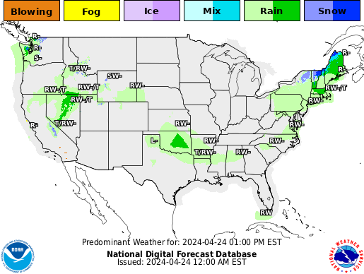
Click here to see the forecast locations for rain, snow and a winter mix in Kentucky.
Click here to see the forecast temperatures for Kentucky.
Current Agricultural Weather Conditions in Kentucky
Based on observations at 900am EDT, Thursday April 25, 2024
Across Kentucky...temperatures are near 51 degrees west, near 45 degrees central, and near 42 degrees east. Current sky conditions are sunny west, sunny central, and cloudy east. In the west, relative humidity is near 71%, and the dew point is near 42 degrees. In the central part of the state, relative humidity is near 70%, and the dew point is near 36 degrees. In the east, relative humidity is near 82%, and the dew point is near 37 degrees. Current drying conditions are fair west, fair central, and poor east. Winds are from the northeast at 8 mph west, where conditions are favorable for spraying. Winds are from the northeast at 15 mph central, where conditions are not favorable for spraying due to strong winds. Winds are calm east, where conditions are favorable for spraying. Based on current available observations, the highest temperature is 51 degrees at Paducah. The lowest temperature is 42 degrees at Jackson.
Click here
Updated Thursday Evening, December 9, 2021

Severe weather on the table
It has been a rather active weather pattern to start December. Through the 8th, the
state has averaged 1.39 inches. Attention now turns to another round of showers and
storms tomorrow and Saturday. Altogether, another half to 1.5 inches will be on the
table. Coverage will start tomorrow scattered in nature. Highs will jump into the 60s
across much of the area behind breezy southerly winds. Shower/storm coverage and
intensity then increases tomorrow night and into Saturday morning. A line of storms is expected with damaging
winds as the main threat, but tornadoes also very much possible. Heavy rain also presents
a flooding threat, especially for low lying areas. Now is the time to get animals out
of those spots. Bottom line, this will present an overnight threat, so please have
a way to get warning (highly suggest a NOAA Weather Radio).
After a brief cool down for the latter half of the weekend, temperatures go on the uphill
climb next week. Outlooks hint the warm air will hang around the area through the third
full week of December. Any additional rain chances look to hold off until late workweek.
The UK PointAgCast is available for Kentucky and the entire nation here!
The entire nation here!
click for West, Central or East for the 7-day text forecast. Or next 48 hrs here.
Click here to see the forecast locations for rain, snow and a winter mix in Kentucky.
Click here to see the forecast temperatures for Kentucky.
ILL:

|
IND:

|
US:
|
Western KY:
|
Central KY:

|
Eastern KY:
|
 Across the Commonwealth for the next week...
Kentucky Medium & Long Range Outlook:
                             KENTUCKY
                 ---------------------------------------------
                 6 TO 10 DAY  8 TO 14 DAY   30 DAY    90 DAY
                APR 30-MAY 4  MAY 2-MAY 8    JUN       JUN-AUG
                 -----------  -----------  --------  ---------
   Temperature:      Above        Above
 Precipitation:      Below       Normal

....  Medium and long range outlooks provided by NCEP/K. Thomas Priddy


Click here for the outlook maps.
2
�
Temperature
LMK
163
FXUS63 KLMK 251334
AFDLMK

Area Forecast Discussion
National Weather Service Louisville KY
934 AM EDT Thu Apr 25 2024

.KEY MESSAGES...

*   Sunny Thursday, with temperatures slightly cooler than normal.

*   Best chances for rain through next week will come Friday ahead
    of a warm front and Monday ahead of a cold front.

*   Warm and breezy this weekend, with gusts exceeding 30 mph out of
    the southwest at times.

&&

.UPDATE...
Issued at 934 AM EDT Thu Apr 25 2024

Temperatures have warmed up into the 40s and low 50s after a chilly
start to the day. Most spots are seeing lots of sunshine at this
time, but some strato-cu may develop across northern portions of the
region later this morning while cirrus drifts in from the west.
Overall still a nice day on track with highs topping out in the 60s
to low 70s.

&&

.SHORT TERM /THROUGH TONIGHT/...
Issued at 323 AM EDT Thu Apr 25 2024

Clear skies and light winds this morning across southern Indiana and
the Bluegrass have supported a good radiational cooling night. We
have see temperatures early this morning drop into the mid-upper 30s
for those areas north of the I-64 corridor. Winds south of I-64 have
been enough to help keep temps closer to climate normals this
morning, with most obs in the mid-upper 40s. There's likely some
patchy frost out there this morning across southern Indiana and the
Bluegrass, especially for any sheltered areas. Frosty conditions
will quickly dissipate after sunrise.

For the rest of today, we'll have plenty of sunshine as sfc high
pressure to our north slides eastward and upper ridging to our west
keeps the column dry. Flow around the sfc high will translate to a
light E-NE sfc wind. These winds won't bring any WAA into the region
today, so high temperatures are expected to be a few degrees cooler
than climate normals. We'll have low to mid 60s north of the
Kentucky Parkways, and upper 60s and around 70 to the south.

Tranquil weather continues this evening, though we'll begin to see
cloud cover increase ahead of our next weather system. A warm front
will be approaching from the south tonight, which will introduce
small precip chances in the predawn hours tomorrow for only south-
central Kentucky. Precip chances will hold off for the rest of the
forecast area until the Long Term forecast period, which you can
read about below.

&&

.LONG TERM /FRIDAY THROUGH WEDNESDAY/...
Issued at 323 AM EDT Thu Apr 25 2024

Friday through Sunday Night...

A surface warm front will lift through the region on Friday bringing
a narrow band of rain showers to the region.  Model soundings show
hardly any instability with this boundary, so thunder looks to be
very limited.  Highs on the day will range from the lower 70s across
southern Indiana and the Bluegrass region of central Kentucky.  Mid-
upper 70s will be found further south/southwest.  For Friday night,
convection may be in progress near St. Louis, but this is forecast
to lift northeastward and away from our region.  We could have a few
showers/storms on some residual outflow boundaries across our
northern row of southern Indiana counties.  For now, will keep PoPs
in the slight chance range.  Lows Friday night will be in the low-
mid 60s.

For Saturday and into Sunday, temperatures will be above normal
during the period as we will be in a deep southwest flow and will be
solidly in the warm sector.  Model soundings show an increasing EML
across the region which is stronger on Sunday than Saturday.
Nonetheless model proximity soundings show subsidence aloft and a
cap around 850 hPa which likely keep any convection from developing.
In terms of sensible weather, as mentioned above, it will be rather
warm but it will also be breezy as well given the pressure gradient
across the region.  Highs Saturday will warm into the upper 70s and
lower 80s with highs on Sunday warming into the 80-85 degree range.
Wind gusts in the afternoon will likely be in the 25-30 mph range
both days.  Overnight lows during the period will be in the low-mid
60s.  A weakening cold front will push eastward toward the region
Sunday night and may bring a few showers to the western sections of
the CWA.

Monday through Wednesday...

Moving into next week, the active weather pattern to our west will
settle down a bit as the central US trough pulls northeast and
deamplifies with time.  A cold front will push through the region on
Monday yielding a good chance of showers and some storms.  The
severe threat across the region does not look all that impressive as
both instability (weak lapse rates) and decreasing bulk shear will
likely hinder strongly organized convective development.  Some
cooler air will work into the region behind the front. Highs on
Monday will likely exhibit a gradient with mid-upper 70s west of I-
65 and highs in the lower 80s east of I-65.  Lows Monday night will
cool into the 60-65 degree range.

Tuesday and Wednesday will feature cooler conditions, but
temperatures are likely to rebound a bit on Wednesday.  Tuesday
looks to be a dry day across the region. NBM PoPs are likely
overdone here and I expect them to decrease a bit in the next
forecast iteration.  Highs Tuesday will be in the upper 70s to
around 80.  Another frontal boundary may approach the region by
Wednesday yielding another round of showers/storms across the area.
Highs Wednesday will be in the lower 80s.

&&

.AVIATION /12Z TAFS THROUGH 18Z FRIDAY/...
Issued at 721 AM EDT Thu Apr 25 2024

VFR conditions will prevail at the TAF sites through this forecast
cycle as high pressure centers over the Great Lakes region. NE winds
continue through today with only a few upper clouds.

&&

.LMK WATCHES/WARNINGS/ADVISORIES...
KY...None.
IN...None.

&&

$$

UPDATE...DM
SHORT TERM...CJP
LONG TERM...MJ
AVIATION...CJP


