| ||||||
UKAWC: NEW weather pages here... A joint service of the UK Ag Weather Center and the National Weather Service. Regional Hourly Observations For SHELBY County, Kentucky Issued at 300 PM EDT TUE APR 16 2024 NORTH CENTRAL KENTUCKY CITY SKY/WX TMP DP RH WIND PRES REMARKS LOUISVILLE/SDF PTSUNNY 80 54 40 S16 29.98F LOUISVILLE/LOU MOSUNNY 77 58 51 S10 29.99F FORT KNOX N/A 84 N/A N/A MISG 29.96F
Current Agriculture, Lawn & Garden Weather Conditions in Kentucky Based on observations at 300pm EDT, Tuesday April 16, 2024 Across Kentucky...temperatures are near 82 degrees west, near 79 degrees central, and near 83 degrees east. Current sky conditions are partly sunny west, partly sunny central, and mostly sunny east. In the west, relative humidity is near 42%, and the dew point is near 57 degrees. In the central part of the state, relative humidity is near 46%, and the dew point is near 57 degrees. In the east, relative humidity is near 33%, and the dew point is near 51 degrees. Current drying conditions are good west, good central, and good east. Winds are from the southwest at 17 mph west, where conditions are not favorable for spraying due to strong winds. Winds are from the south at 16 mph central, where conditions are not favorable for spraying due to strong winds. Winds are variable at 5 mph east, where conditions are favorable for spraying. Based on current available observations, the highest temperature is 85 degrees at Henderson. The lowest temperature is 77 degrees at Louisville Bowman and London.
Radar: NWS Radar (NEW!), Bowling Green, KY Regional Radar, Hazardous Weather Outlook For SHELBY County, Kentucky 1152 AM EDT Tue Apr 16 2024 /1052 AM CDT Tue Apr 16 2024/ DAY ONE This afternoon and tonight. Thunderstorms are expected tonight ahead of a cold front. The main hazards will be brief heavy rain and lightning. There is a low chance of a few instances of strong gusty winds. DAYS TWO THROUGH SEVEN Wednesday through Monday. A severe storm threat could linger into Wednesday, although confidence is low at this time. The best chance for any severe storm during the daylight hours would be along and north of the Ohio River. Another chance at strong to severe storms arrives Thursday night ahead of a cold front. Stay up to date with the latest forecasts. SPOTTER INFORMATION STATEMENT Spotter activation may be needed late tonight, Wednesday afternoon, and Thursday night. GENERAL STORM MOTION OF THE DAY: Storm motion tonight should be from southwest to northeast around 30 to 40 mph. Any users of this storm motion must be aware that thunderstorm activity can be erratic and constantly evolving. Please use this with caution and be prepared for changing conditions.
7-Day Forecast For SHELBY County, KY 403 AM EDT Tue Apr 16 2024 TODAY Mostly cloudy until late afternoon then becoming mostly sunny. A 20 percent chance of thunderstorms until late afternoon. Highs in the lower 80s. South winds 5 to 15 mph. TONIGHT Mostly cloudy. Showers and chance of thunderstorms after midnight. Lows in the lower 60s. South winds 10 to 15 mph. Gusts up to 30 mph after midnight. Chance of precipitation 90 percent. WEDNESDAY Breezy. Showers likely and chance of thunderstorms in the morning, then showers and chance of thunderstorms in the afternoon. Highs in the upper 70s. Southwest winds 15 to 25 mph. Chance of precipitation 90 percent. WEDNESDAY NIGHT Mostly clear. Rain showers and chance of thunderstorms in the evening, then chance of rain showers and slight chance of thunderstorms after midnight. Lows in the mid 50s. Southwest winds 5 to 15 mph. Gusts up to 30 mph in the evening. Chance of precipitation 80 percent. THURSDAY Sunny. Highs in the lower 80s. Southwest winds 5 to 10 mph. THURSDAY NIGHT Partly cloudy with chance of rain showers and slight chance of thunderstorms in the evening, then mostly cloudy with rain showers likely and chance of thunderstorms after midnight. Lows in the upper 50s. Chance of precipitation 70 percent. FRIDAY Cooler. Mostly cloudy. Rain showers likely and chance of thunderstorms in the morning, then chance of rain showers and slight chance of thunderstorms in the afternoon. Highs in the upper 60s. Chance of precipitation 70 percent. FRIDAY NIGHT Cooler. Partly cloudy. Slight chance of thunderstorms in the evening, then slight chance of rain showers after midnight. Lows in the mid 40s. Chance of precipitation 20 percent. SATURDAY Mostly sunny. A 20 percent chance of rain showers in the morning. Highs in the lower 60s. SATURDAY NIGHT Mostly cloudy. Lows in the lower 40s. SUNDAY Partly sunny. Highs around 60. SUNDAY NIGHT Partly cloudy. Lows in the upper 30s. MONDAY Mostly sunny. Highs in the mid 60s.
Medium & Long Range Outlook For SHELBY County, Kentucky
                             KENTUCKY
                 ---------------------------------------------
                 6 TO 10 DAY  8 TO 14 DAY   30 DAY    90 DAY
                   APR 21-25    APR 23-29    JUN       JUN-AUG
                 -----------  -----------  --------  ---------
   Temperature:      Below        Above     Normal      Above
 Precipitation:     Normal        Above      Above      Above

....  Medium and long range outlooks provided by NCEP/K. Thomas Priddy
Drought Status For SHELBY County, Kentucky (Based on the latest Palmer Drought Severity and Crop Moisture Indices) BLUEGRASS KY CLIMATE DIVISION Hydrological Drought (PDSI) Situation: ------------------------------------------------------------------------------------ Current Long-term Hydrological Moisture Status: NEAR NORMAL (PDSI= 1.68) Rainfall Needed: 0.00 inches ABOVE NORMAL Crop Moisture (CMI) Situation: ---------------------------------------------------------------------------------------------------------- Current Short-term Crop Moisture Status: Favorable, Except Still Too Wet In Spots (CMI= 1.03) Change From Previous Week: DRIER SOILS ( -0.59) Note: Due to rainfall variability within each climate division, check Precip Reports/GIS Estimates and the Kentucky Climate Summary for the latest moisture information for this county.
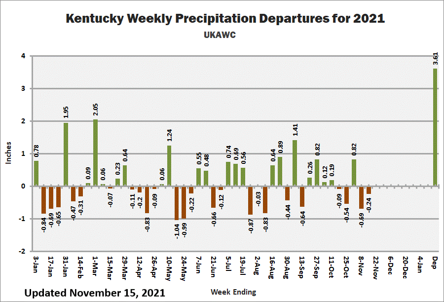
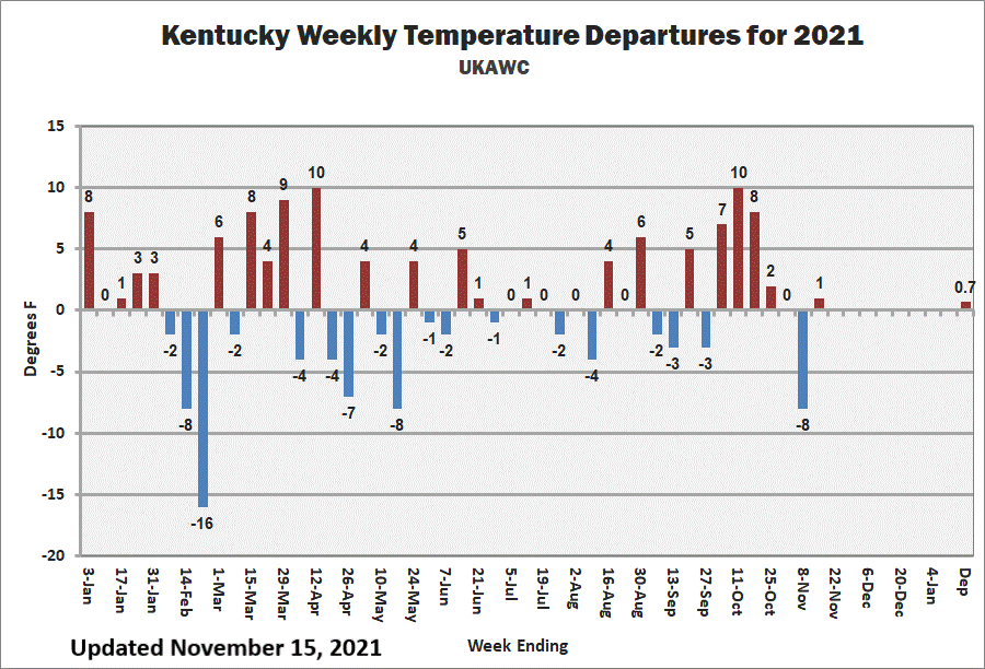
Kentucky Climate Summary Kentucky Climate Summary For the Period 04-09-2024 to 04-15-2024 Temperatures for the period averaged 62 degrees across the state which was 7 degrees warmer than normal and 12 degrees warmer than the previous period. High temperatures averaged from 73 in the West to 71 in the East. Departure from normal high temperatures ranged from 4 degrees warmer than normal in the West to 3 degrees warmer than normal in the East. Low temperatures averaged from 54 degrees in the West to 51 degrees in the East. Departure from normal low temperature ranged from 9 degrees warmer than normal in the West to 10 degrees warmer than normal in the East. The extreme high temperature for the period was 88 degrees at LOUISVILLE APT and the extreme low was 34 degrees at BURKESVILLE 3W.Precipitation (liq. equ.) for the period totaled 1.67 inches statewide which was 0.59 inches above normal and 155% of normal. Precipitation totals by climate division, West 1.55 inches, Central 1.61 inches, Bluegrass 2.09 inches and East 1.44 inches, which was 0.4, 0.51, 1.05 and 0.42 inches above normal. By station, precipitation totals ranged from a low of 0.52 inches at FRANKLIN 4SW to a high of 2.81 inches at MADISONVILLE 4S.
|


