| ||||||
UKAWC: NEW weather pages here... A joint service of the UK Ag Weather Center and the National Weather Service. Regional Hourly Observations For LOGAN County, Kentucky Issued at 400 AM EDT TUE APR 23 2024 WESTERN AND SOUTH CENTRAL KENTUCKY CITY SKY/WX TMP DP RH WIND PRES REMARKS PADUCAH PTCLDY 49 35 58 CALM 30.06S HENDERSON PTCLDY 47 37 68 SW7 30.06F OWENSBORO PTCLDY 46 38 73 S7 30.07F HOPKINSVILLE NOT AVBL BOWLING GREEN PTCLDY 46 36 68 CALM 30.11S GLASGOW NOT AVBL
Current Agriculture, Lawn & Garden Weather Conditions in Kentucky Based on observations at 400am EDT, Tuesday April 23, 2024 Across Kentucky...temperatures are near 49 degrees west, near 48 degrees central, and near 46 degrees east. Current sky conditions are partly cloudy west, mostly cloudy central, and partly cloudy east. In the west, relative humidity is near 58%, and the dew point is near 35 degrees. In the central part of the state, relative humidity is near 56%, and the dew point is near 33 degrees. In the east, relative humidity is near 49%, and the dew point is near 28 degrees. Current drying conditions are fair west, fair central, and good east. Winds are calm west, where conditions are favorable for spraying. Winds are from the south at 7 mph central, where conditions are favorable for spraying. Winds are from the south at 5 mph east, where conditions are favorable for spraying. Based on current available observations, the highest temperature is 56 degrees at Louisville International. The lowest temperature is 39 degrees at London.
Radar: NWS Radar (NEW!), Bowling Green, KY Regional Radar, Hazardous Weather Outlook For LOGAN County, Kentucky 317 AM EDT Tue Apr 23 2024 /217 AM CDT Tue Apr 23 2024/ DAY ONE Today and tonight. Southwest winds will gust 25-35 mph today, especially this afternoon. The gusty winds combined with filtered sunshine and temperatures rising into the lower and middle 70s may lead to slightly increased fire danger this afternoon in exposed areas where fuels can lose moisture. DAYS TWO THROUGH SEVEN Wednesday through Monday. No hazardous weather is expected at this time. SPOTTER INFORMATION STATEMENT Spotter activation is not expected at this time.
7-Day Forecast For LOGAN County, KY 303 AM CDT Tue Apr 23 2024 TODAY Mostly sunny. Highs in the lower 70s. South winds 5 to 15 mph shifting to the southwest 15 to 20 mph in the afternoon. TONIGHT Warmer. Mostly cloudy with a 50 percent chance of rain showers. Lows in the mid 50s. Southwest winds 5 to 15 mph. WEDNESDAY Mostly sunny. Highs in the lower 70s. Northwest winds 5 to 10 mph. WEDNESDAY NIGHT Cooler. Mostly clear. Lows in the mid 40s. Northeast winds 5 to 10 mph. THURSDAY Sunny. Highs in the lower 70s. East winds 5 to 10 mph. THURSDAY NIGHT Mostly cloudy. Isolated rain showers in the evening, then scattered rain showers after midnight. Lows in the mid 50s. Chance of showers 30 percent. FRIDAY Mostly cloudy with scattered rain showers and isolated thunderstorms. Highs in the upper 70s. Chance of precipitation 40 percent. FRIDAY NIGHT Warmer. Mostly cloudy with isolated thunderstorms. Lows in the mid 60s. Chance of thunderstorms 20 percent. SATURDAY Breezy. Partly sunny with isolated thunderstorms. Highs around 80. Chance of thunderstorms 20 percent. SATURDAY NIGHT Breezy. Partly cloudy. Lows in the upper 60s. SUNDAY Mostly sunny. Isolated showers in the morning, then scattered showers and isolated thunderstorms in the afternoon. Highs in the lower 80s. Chance of precipitation 30 percent. SUNDAY NIGHT Mostly cloudy with scattered thunderstorms. Lows in the mid 60s. Chance of thunderstorms 50 percent. MONDAY Numerous showers and scattered thunderstorms. Highs in the mid 70s. Chance of precipitation 60 percent.
Medium & Long Range Outlook For LOGAN County, Kentucky
                             KENTUCKY
                 ---------------------------------------------
                 6 TO 10 DAY  8 TO 14 DAY   30 DAY    90 DAY
                APR 28-MAY 2 APR 30-MAY 6    JUN       JUN-AUG
                 -----------  -----------  --------  ---------
   Temperature:      Above        Above
 Precipitation:     Normal       Normal

....  Medium and long range outlooks provided by NCEP/K. Thomas Priddy
Drought Status For LOGAN County, Kentucky (Based on the latest Palmer Drought Severity and Crop Moisture Indices) WESTERN KY CLIMATE DIVISION Hydrological Drought (PDSI) Situation: ------------------------------------------------------------------------------------ Current Long-term Hydrological Moisture Status: NEAR NORMAL (PDSI= 0.35) Rainfall Needed: 0.00 inches ABOVE NORMAL Crop Moisture (CMI) Situation: ---------------------------------------------------------------------------------------------------------- Current Short-term Crop Moisture Status: Favorable For Normal Growth And Fieldwork (CMI= 0.16) Change From Previous Week: DRIER SOILS ( -0.06) Note: Due to rainfall variability within each climate division, check Precip Reports/GIS Estimates and the Kentucky Climate Summary for the latest moisture information for this county.
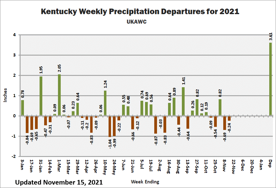
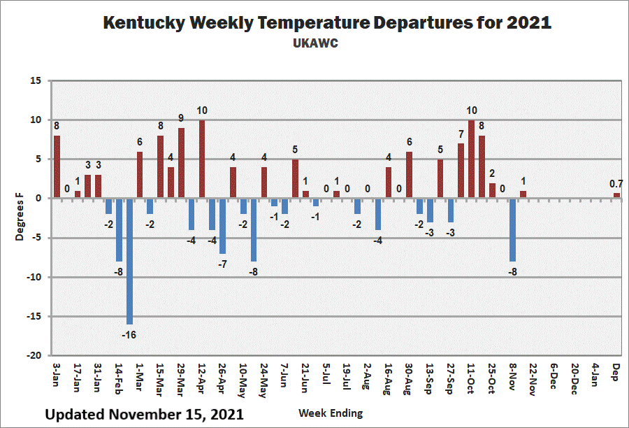
Kentucky Climate Summary Kentucky Climate Summary For the Period 04-15-2024 to 04-21-2024 Temperatures for the period averaged 64 degrees across the state which was 7 degrees warmer than normal and 4 degrees warmer than the previous period. High temperatures averaged from 74 in the West to 74 in the East. Departure from normal high temperatures ranged from 4 degrees warmer than normal in the West to 4 degrees warmer than normal in the East. Low temperatures averaged from 56 degrees in the West to 56 degrees in the East. Departure from normal low temperature ranged from 9 degrees warmer than normal in the West to 13 degrees warmer than normal in the East. The extreme high temperature for the period was 89 degrees at KOOMER RIDGE and the extreme low was 35 degrees at BURLINGTON 4S.Precipitation (liq. equ.) for the period totaled 0.65 inches statewide which was 0.51 inches below normal and 56% of normal. Precipitation totals by climate division, West 0.91 inches, Central 0.80 inches, Bluegrass 0.59 inches and East 0.28 inches, which was 0.37, 0.39, 0.51 and 0.78 inches below normal. By station, precipitation totals ranged from a low of 0.00 inches at YELLOW CREEK to a high of 2.81 inches at EVANSVILLE ASOS.
|


