Weather and Climate Synopsis
|
|
De Kalb County, Indiana Weather and Climate Synopsis |

[National] [International] [Learning] [EWOCK] [Reg Clim Ctrs] |
(Click image to zoom) or
Click Here
Satellite images from NOAA
Also see NWS Watch/Warning Maps |
A joint service of the UK Ag Weather Center and the National Weather Service.
Synopsis...

THE HOOSIER STATE SAW A RETURN TO MORE SEASONAL TEMPERATURES
WEDNESDAY AFTERNOON AFTER SEVERAL DAYS BELOW NORMAL. READINGS
CLIMBED INTO THE LOWER 80S AT MOST LOCATIONS. SKIES WERE MOSTLY
SUNNY STATEWIDE TOO.

TONIGHT WILL BE MOSTLY CLEAR OVER NORTH AND CENTRAL SECTIONS AND
PARTLY CLOUDY IN THE FAR SOUTH.  A WEAK RIDGE OF HIGH PRESSURE OVER
INDIANA WILL DRIFT SLOWLY EASTWARD.  HOWEVER IT SHOULD PROVIDE ONE
MORE DAY OF DRY WEATHER OVER CENTRAL AND NORTHERN SECTIONS ON
THURSDAY.

LOW TEMPERATURES TONIGHT WILL RANGE FROM 60 TO 65 AND HIGH
TEMPERATURES ON THURSDAY WILL BE IN THE MIDDLE 80S. AN AREA OF LOW
PRESSURE IN THE UPPER ATMOSPHERE OVER THE CENTRAL U.S. WILL DRIFT
TOWARDS THE OHIO VALLEY NEXT FEW DAYS.  THIS SYSTEM MAY PRODUCE A
FEW THUNDERSTORMS LATE THURSDAY OVER SOUTHWEST SECTIONS OF OUR
STATE.  THEN WE CAN EXPECT A BETTER CHANCE OF THUNDERSTORMS STATE
WIDE BY FRIDAY.

$$

JEH/CS

IMPORTANT NOTICE...THIS WILL BE THE LAST ISSUANCE OF THIS PRODUCT.
THIS PRODUCT WILL BE DISCONTINUED AFTER JUNE 30 2004. ALTERNATIVE
PRODUCTS TO USE AFTER THAT DATE WITH INFORMATION SIMILAR TO THE
STATE WEATHER SUMMARY INCLUDE THE WEATHER ROUNDUP FOR INDIANA
/ASUS43 KIND SWRIN/...THE TABULAR STATE FORECAST FOR INDIANA
/FPUS63 KIND SFTIN/...AND THE MAXIMUM/MINIMUM TEMPERATURE AND
PRECIPITATION TABLE FOR INDIANA /ABUS21 KIND STPIN/.

FOR GRAPHICS SHOWING THE LOCATIONS OF WEATHER SYSTEMS AND FRONTS GO
TO WWW.WEATHER.GOV AND SELECT THE NATIONAL MAPS TAB.

LAST
NORTHEAST INDIANA

CITY           SKY/WX    TMP DP  RH WIND       PRES   REMARKS
ANGOLA *+      CLOUDY    43  34  70 NE5       30.25R
AUBURN +       CLOUDY    43  34  70 N3        30.26R
FORT WAYNE     CLOUDY    44  35  70 N5        30.25S
6HR MIN TEMP:  44; 6HR MAX TEMP:  46;

HUNTINGTON +   CLOUDY    43  34  69 N6        30.25R
6HR MIN TEMP:  43; 6HR MAX TEMP:  45;

KENDALLVILLE + CLOUDY    42  35  74 CALM      30.25S
![]() Current Temperatures, Dewpoint, Rh, Wind, Regional Obs., Station Model, Surface 4-Panel
Current Temperatures, Dewpoint, Rh, Wind, Regional Obs., Station Model, Surface 4-Panel
![]() Meteograms : South Bend , Fort Wayne , Lafayette , Indianapolis , Evansville
Meteograms : South Bend , Fort Wayne , Lafayette , Indianapolis , Evansville
...FREEZE WARNING IN EFFECT FROM 1 AM TO 9 AM EDT THURSDAY...
.TONIGHT...Mostly cloudy this evening, then clearing. Widespread
frost after midnight. Lows around 30. Northeast winds 5 to
10 mph.
.THURSDAY...Widespread frost in the morning. Mostly sunny. Highs
in the mid 50s. East winds around 5 mph.
.THURSDAY NIGHT...Clear. Patchy frost after midnight. Lows in the
mid 30s. East winds 5 to 10 mph.
.FRIDAY...Patchy frost in the morning. Mostly sunny in the
morning, then mostly cloudy with a chance of rain showers in the
afternoon. Highs in the upper 60s. Southeast winds 10 to 15 mph.
Chance of rain 30 percent.
.FRIDAY NIGHT...Showers likely with a slight chance of
thunderstorms in the evening, then showers with a chance of
thunderstorms after midnight. Not as cool with lows in the mid
50s. Southeast winds 15 to 20 mph with gusts up to 30 mph. Chance
of rain 80 percent.
.SATURDAY...Mostly cloudy with showers with a chance of
thunderstorms in the morning, then partly cloudy with a chance of
showers with a slight chance of thunderstorms in the afternoon.
Breezy with highs in the mid 70s. Chance of rain 80 percent.
.SATURDAY NIGHT...Partly cloudy with a slight chance of showers
and thunderstorms. Breezy with lows in the lower 60s. Chance of
rain 20 percent.
.SUNDAY...Partly cloudy with a slight chance of thunderstorms. A
slight chance of showers in the morning, then a chance of showers
in the afternoon. Breezy with highs around 80. Chance of rain
30 percent.
.SUNDAY NIGHT...Partly cloudy with a chance of showers with a
slight chance of thunderstorms. Lows in the lower 60s. Chance of
rain 40 percent.
.MONDAY...Showers likely. A slight chance of thunderstorms in the
morning, then a chance of thunderstorms in the afternoon. Highs
in the mid 70s. Chance of rain 70 percent.
.MONDAY NIGHT...Mostly cloudy with a chance of thunderstorms.
Showers likely, mainly in the evening. Lows in the mid 50s.
Chance of rain 70 percent.
.TUESDAY...Partly cloudy. A chance of showers with a slight
chance of thunderstorms in the morning, then a slight chance of
showers in the afternoon. Highs in the upper 60s. Chance of rain
30 percent.
.TUESDAY NIGHT...Mostly clear. A slight chance of showers in the
evening. Lows around 50. Chance of rain 20 percent.
.WEDNESDAY...Mostly sunny. Highs in the mid 70s.
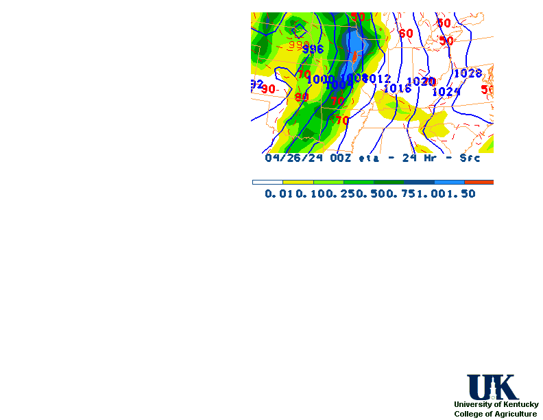
![]() 12-48 Hr ETA Surface, 12-48 Hr ETA 500mb/Sfc, 24 Hr. Comparsion, TWC Forecast, Fire Danger, Day 1 Precip, Day 2
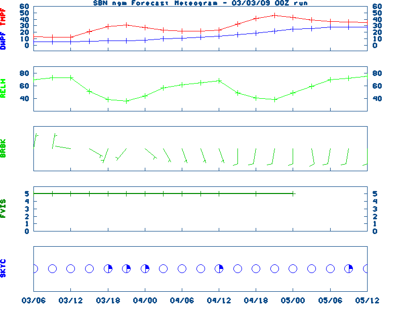
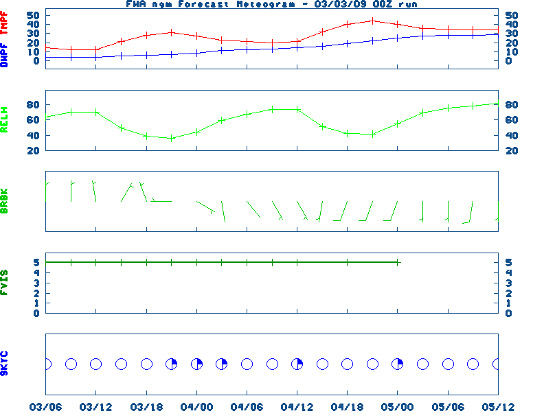
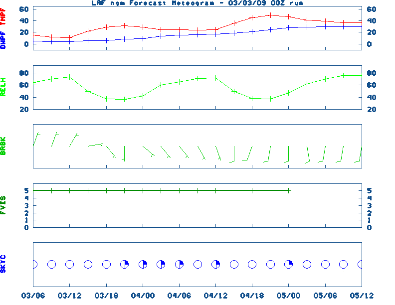
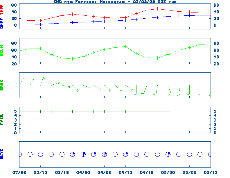
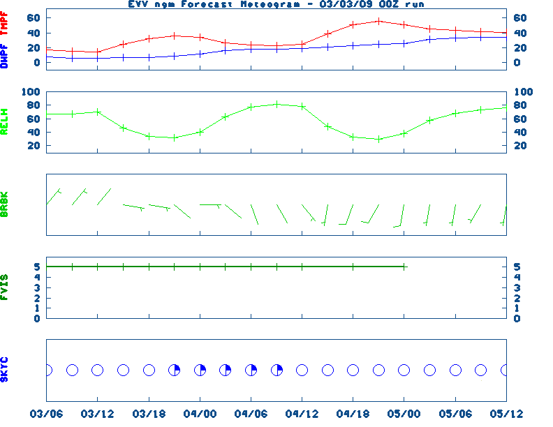
12-48 Hr ETA Surface, 12-48 Hr ETA 500mb/Sfc, 24 Hr. Comparsion, TWC Forecast, Fire Danger, Day 1 Precip, Day 2![]() NGM 60 Hr Forecast Meteograms : South Bend , Fort Wayne , Lafayette , Indianapolis , Evansville
NGM 60 Hr Forecast Meteograms : South Bend , Fort Wayne , Lafayette , Indianapolis , Evansville
                 6 TO 10 DAY  8 TO 14 DAY   30 DAY    90 DAY     120 DAY    180 DAY
                                           NOV05   NOV05-JAN06 DEC05-FEB06 FEB06-APR06
                 -----------  -----------  --------  ---------  ---------  ---------
   Temperature:      Below        Below      Above     Normal     Normal     Normal
 Precipitation:      Below        Below     Normal     Normal     Normal     Normal

....  Medium and long range outlooks provided by NCEP/K. Thomas Priddy
Wednesday April 24, 2024 the 115th Day of Year

---------------------------------------------------
SUN
Declination 13.360000
Distance 0.999718 AU
Rise 06:53 EDT Set 20:33 EDT
Transit Meridian 13:43 EDT
Civil Twilight Begins 06:26 EDT Ends 21:01 EDT

Calculations made for central point in the state.
Time in ET -- and will vary due to location and
elevation -- Priddy
APRIL 24TH
HISTORIC WEATHER EVENTS
...1899...
Two women and one son lived to tell the story of being picked up by a
tornado and carried more than a fourth of a mile, flying far above the
church steeples, before being gently set down again. The young boy and one
of the ladies said they had the pleasure of flying alongside a horse. The
horse "kicked and struggled" as it flew high above, and was set down
unharmed about a mile away. (The Weather Channel)
...1908...
Severe thunderstorms spawned eighteen tornadoes over across the Central
Gulf Coast States claiming the lives of 310 persons. The state of
Mississippi was hardest hit. A tornado near Hattiesburg MS killed 143
persons and caused more than half a million dollars damage. Four violent
tornadoes accounted for 279 of the 310 deaths. The deadliest of the four
tornadoes swelled to a width of 2.5 miles as it passed near Amite LA. The
tornado also leveled most of Purvis MS. (David Ludlum) (The Weather
Channel)
...1925...
Louisville's and Bowling Green's warmest April temperature: 91 and 96
degrees, respectively. Also, Lexington's earliest 90 degree temperature (90
degrees). (NWS Louisville)
...1980...
Three of eight helicopters were damaged in a sandstorm during a
failed-attempt to rescue 52 American hostages held in Iran. The hostages
were later released on January 20, 1981.
...2005...
The latest measurable snowfall on record occurred across parts of Kentucky
last year. The snow was the result of cold air and moisture wrapping around
an area of low pressure located over the northeast United States.
Accumulating snow was mainly confined to the ridgetops and higher
elevations of extreme east Kentucky but at least a few flakes were reported
just about everywhere. Some amounts reported from across eastern and
central Kentucky  include...0.6 inches in Booneville...1.0 inch at
Jeremiah...1.2 inches at the Jackson Weather Office...1.5 inches at
Cumberland...4.0 inches at Lynch...and 5.0 inches at Closplint. (NWS Jackson)
|
|
|