A joint service of the UK Ag Weather Center and the National Weather Service.
National Weather Service Indianapolis IN
107 PM EDT Wed Apr 24 2024

.KEY MESSAGES...

-  Cooler mid-week, some frost possible Wednesday night for North
Central and Eastern Indiana

- Active pattern returns Friday into next week with above normal
  temperatures and frequent storm chances
 NWS Weather Discussion
National Ag. Weather Outlook (Repair this link), International Highlights ,International Ag. Weather Summary
Current Surface Map,
[2nd Source TWC]
Click here for UKAWC Point Agricultural, Lawn & Garden Forecast/Outlook in case of corrupt tables.
Regional Hourly Observations For SWITZERLAND County
Issued at 200 PM EDT WED APR 24 2024
SOUTH CENTRAL AND SOUTHEAST INDIANA

CITY           SKY/WX    TMP DP  RH WIND       PRES   REMARKS
BLOOMINGTON    SUNNY     55  44  66 N13G18    30.19S
6HR MIN TEMP:  49; 6HR MAX TEMP:  55;

FRENCH LICK *+ PTSUNNY   61  41  48 NE6       30.15S
MADISON *+     MOSUNNY   61  46  59 NW9       30.17S
Hourly Obs.,
Current Temperatures,
Dewpoint,
Rh,
Wind,
Regional Obs.,
Station Model,
Surface 4-Panel
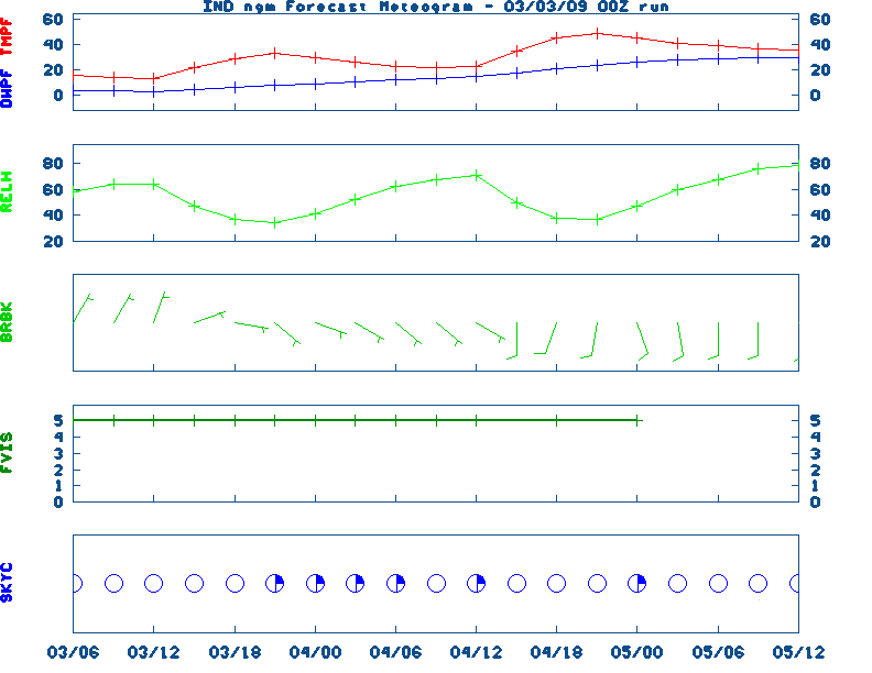
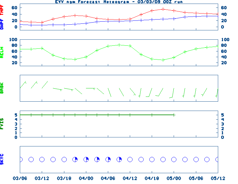
Meteograms:
South Bend ,
Fort Wayne ,
Lafayette ,
Indianapolis ,
Evansville
Current Agricultural Weather Conditions in Indiana
Based on observations at 100pm EDT, Wednesday April 24, 2024
Across Indiana...temperatures are near 43 degrees north, near 47 degrees central, and near 66 degrees south. Current sky conditions are cloudy north, cloudy central, and mostly sunny south. In the north, relative humidity is near 68%, and the dew point is near 33 degrees. In the central part of the state, relative humidity is near 71%, and the dew point is near 38 degrees. In the south, relative humidity is near 45%, and the dew point is near 44 degrees. Winds are from the northwest at 9 mph north, where conditions are favorable for spraying. Winds are from the north at 10 mph central, where conditions are favorable for spraying. Winds are from the north at 13 mph with gusts at 23 mph south, where conditions are not favorable for spraying due to strong winds. Based on current available observations, the highest temperature is 66 degrees at Evansville. The lowest temperature is CLOUDY degrees at Warsaw and Kokomo.
Current NOWCAST not available:
Nowcasts are not issued routinely during fair weather. Only when
precipitation or other significant weather is occuring in this county will these
forecasts be issued. Currently, there is no short term forecast in effect.
U.S. Radar,
All NWS Radars (In near-real time),
LSI Heat Index,
Wind Chill Map
Hazardous Weather Outlook For SWITZERLAND County,IN
236 AM EDT Wed Apr 24 2024

 DAY ONE  Today and tonight.

Patchy frost will be possible tonight into Thursday morning.

 DAYS TWO THROUGH SEVEN  Thursday through Tuesday.

There is a low probability for widespread hazardous weather.

 SPOTTER INFORMATION STATEMENT

Spotter activation is not expected at this time.
NWS Severe Weather Map , Convective Outlook
7-Day Forecast For SWITZERLAND County, IN
Issued at
1221 PM EDT Wed Apr 24 2024
THIS AFTERNOON
Mostly sunny. Near steady temperatures in the
lower 60s. North winds around 10 mph.
TONIGHT
Mostly clear. Patchy frost after midnight. Lows in the
upper 30s. Northeast winds 5 to 10 mph.
THURSDAY
Patchy frost in the morning. Mostly sunny. Highs in
the lower 60s. East winds 5 to 10 mph.
THURSDAY NIGHT
Mostly clear. Lows in the mid 40s. East winds
around 5 mph.
FRIDAY
Partly cloudy with a slight chance of showers in the
morning, then mostly cloudy with a chance of showers in the
afternoon. Highs around 70. East winds 5 to 10 mph, becoming
southeast 10 to 15 mph with gusts up to 25 mph in the afternoon.
Chance of rain 50 percent.
FRIDAY NIGHT
Mostly cloudy with a chance of showers. Warmer
with lows around 60. Chance of rain 50 percent.
SATURDAY
Mostly cloudy with a chance of showers in the
morning, then partly cloudy with a chance of showers in the
afternoon. Breezy with highs in the upper 70s. Chance of rain
40 percent.
SATURDAY NIGHT
Partly cloudy. Unseasonably warm with lows in
the mid 60s.
SUNDAY
Partly cloudy. Unseasonably warm with highs in the
lower 80s.
SUNDAY NIGHT
Partly cloudy with a chance of showers and
thunderstorms. Unseasonably warm with lows in the mid 60s. Chance
of rain 50 percent.
MONDAY
Showers likely in the morning, then showers likely with
a chance of thunderstorms in the afternoon. Highs in the mid 70s.
Chance of rain 60 percent.
MONDAY NIGHT
Partly cloudy. Showers likely with a chance of
thunderstorms in the evening, then a chance of showers and
thunderstorms after midnight. Unseasonably warm with lows in the
upper 50s. Chance of rain 60 percent.
TUESDAY
Partly cloudy. A chance of showers. Highs in the lower
70s. Chance of rain 50 percent.
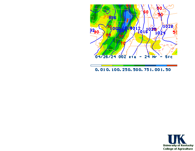
12-48 Hr ETA Surface,
12-48 Hr ETA 500mb/Sfc,
24 Hr. Comparsion,
TWC Forecast,
Fire Danger,
Day 1 Precip,
Day 2 Precip,
Days 1-5 Precip
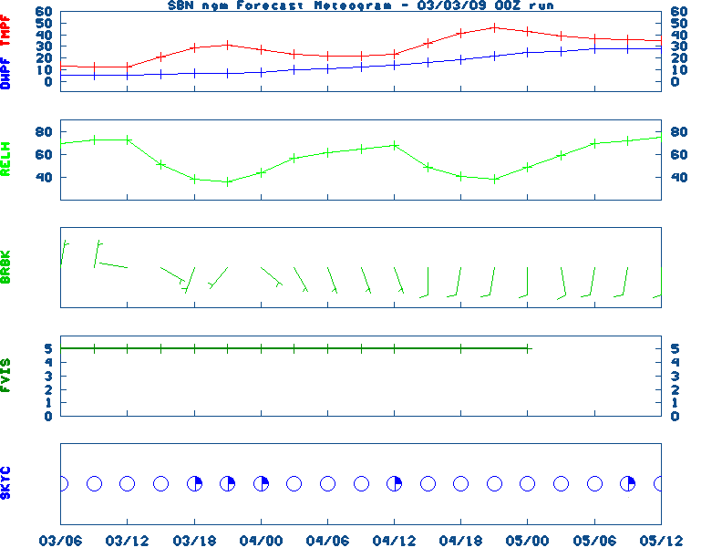
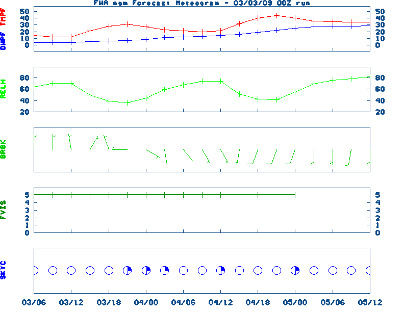
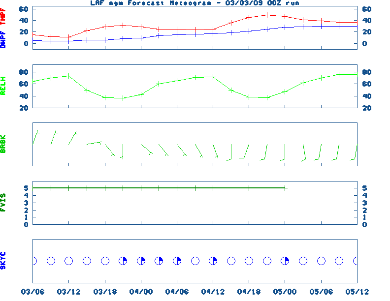
NGM 60 Hr Forecast Meteograms:
South Bend ,
Fort Wayne ,
Lafayette ,
Indianapolis ,
Evansville ,
Severe Weather Pot.-Day 1,
Day 2
Medium & Long Range Outlook For Indiana
                              INDIANA
                 ---------------------------------------------
                 6 TO 10 DAY  8 TO 14 DAY   30 DAY    90 DAY
                APR 29-MAY 3  MAY 1-MAY 7    JUN       JUN-AUG
                 -----------  -----------  --------  ---------
   Temperature:      Above        Above
 Precipitation:     Normal       Normal

....  Medium and long range outlooks provided by NCEP/K. Thomas Priddy
5 Day Rainfall Total Forecast,
6 to 10 Day ,
8 to 14 Day ,
Text,
30-Day Outook,
90-Day,
120-Day
Almanac Information
Wednesday April 24, 2024 the 115th Day of Year

---------------------------------------------------
SUN
Declination 13.360000
Distance 0.999718 AU
Rise 06:53 EDT Set 20:33 EDT
Transit Meridian 13:43 EDT
Civil Twilight Begins 06:26 EDT Ends 21:01 EDT

Calculations made for central point in the state.
Time in ET -- and will vary due to location and
elevation -- Priddy
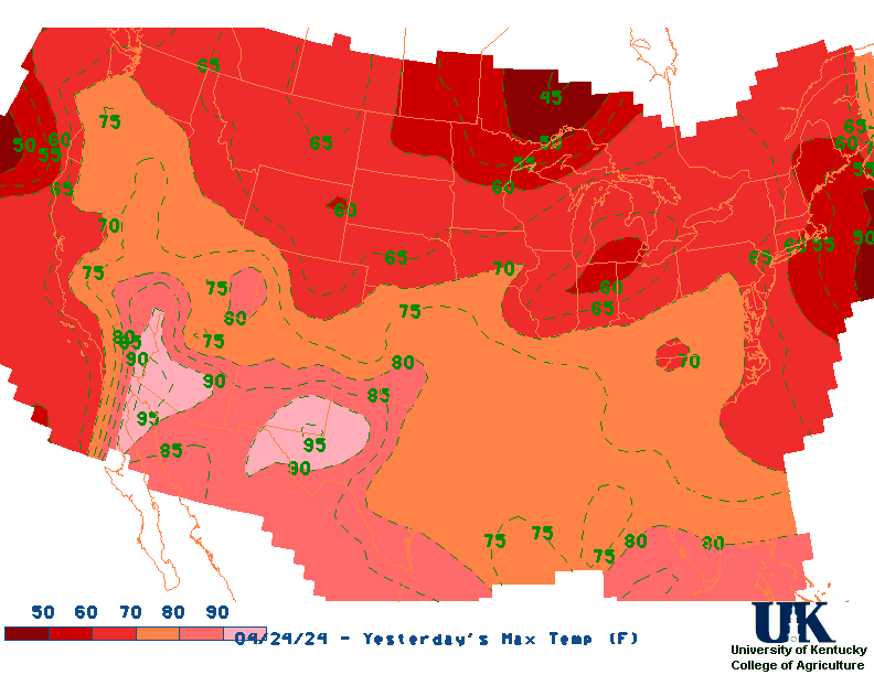
Yesterday's Highs ,
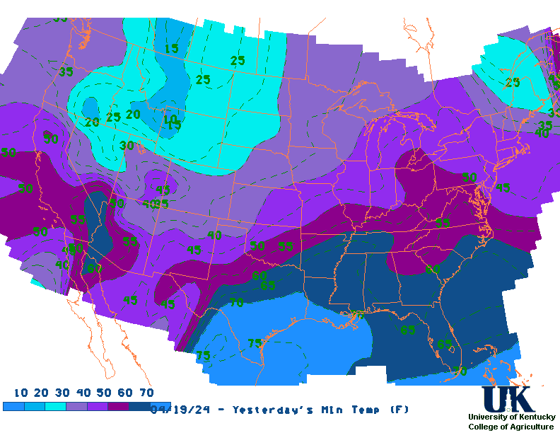
Lows
Sunrise/Sunset/Moonrise/Moonset Computation (USN)
Historical Weather And Climate Facts For Today
APRIL 24TH
HISTORIC WEATHER EVENTS
...1899...
Two women and one son lived to tell the story of being picked up by a
tornado and carried more than a fourth of a mile, flying far above the
church steeples, before being gently set down again. The young boy and one
of the ladies said they had the pleasure of flying alongside a horse. The
horse "kicked and struggled" as it flew high above, and was set down
unharmed about a mile away. (The Weather Channel)
...1908...
Severe thunderstorms spawned eighteen tornadoes over across the Central
Gulf Coast States claiming the lives of 310 persons. The state of
Mississippi was hardest hit. A tornado near Hattiesburg MS killed 143
persons and caused more than half a million dollars damage. Four violent
tornadoes accounted for 279 of the 310 deaths. The deadliest of the four
tornadoes swelled to a width of 2.5 miles as it passed near Amite LA. The
tornado also leveled most of Purvis MS. (David Ludlum) (The Weather
Channel)
...1925...
Louisville's and Bowling Green's warmest April temperature: 91 and 96
degrees, respectively. Also, Lexington's earliest 90 degree temperature (90
degrees). (NWS Louisville)
...1980...
Three of eight helicopters were damaged in a sandstorm during a
failed-attempt to rescue 52 American hostages held in Iran. The hostages
were later released on January 20, 1981.
...2005...
The latest measurable snowfall on record occurred across parts of Kentucky
last year. The snow was the result of cold air and moisture wrapping around
an area of low pressure located over the northeast United States.
Accumulating snow was mainly confined to the ridgetops and higher
elevations of extreme east Kentucky but at least a few flakes were reported
just about everywhere. Some amounts reported from across eastern and
central Kentucky  include...0.6 inches in Booneville...1.0 inch at
Jeremiah...1.2 inches at the Jackson Weather Office...1.5 inches at
Cumberland...4.0 inches at Lynch...and 5.0 inches at Closplint. (NWS Jackson)

Ag Weather Center, Department of Biosystems & Agricultural Engineering, University of Kentucky
|


![[2nd Source TWC]](http://maps.weather.com/images/maps/current/curwx_720x486.jpg)