A joint service of the UK Ag Weather Center and the National Weather Service.
National Weather Service Indianapolis IN
939 PM EDT Fri Apr 26 2024

.KEY MESSAGES...

- Showers and a few thunderstorms at times this evening into
  Saturday.

- Warm through much of the period, particularly Sunday, when record
  highs may be threatened.

- Active weather, with multiple chances for showers and storms next
  week.
 NWS Weather Discussion
National Ag. Weather Outlook (Repair this link), International Highlights ,International Ag. Weather Summary
Current Surface Map,
[2nd Source TWC]
Click here for UKAWC Point Agricultural, Lawn & Garden Forecast/Outlook in case of corrupt tables.
Regional Hourly Observations For MARTIN County
Issued at 1200 AM EDT SAT APR 27 2024
SOUTHWEST INDIANA

CITY           SKY/WX    TMP DP  RH WIND       PRES   REMARKS
EVANSVILLE     MOCLDY    70  60  70 SE10      29.95F
HUNTINGBURG *+ MOCLDY    67  59  75 SE14G20   29.98S
WASHINGTON +   MOCLDY    66  54  63 S13G18    29.96S
Hourly Obs.,
Current Temperatures,
Dewpoint,
Rh,
Wind,
Regional Obs.,
Station Model,
Surface 4-Panel
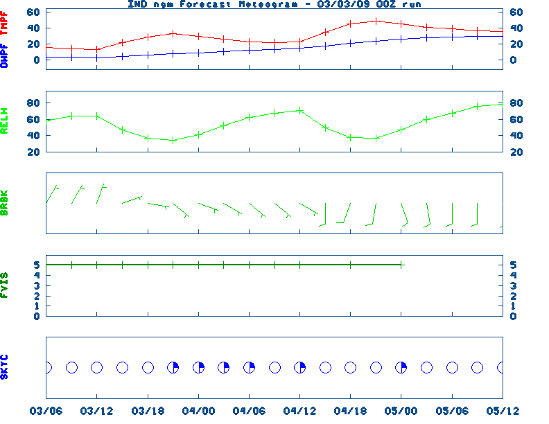
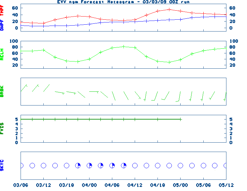
Meteograms:
South Bend ,
Fort Wayne ,
Lafayette ,
Indianapolis ,
Evansville
Current Agricultural Weather Conditions in Indiana
Based on observations at 1200am EDT, Saturday April 27, 2024
Across Indiana...temperatures are near 58 degrees north, near 63 degrees central, and near 70 degrees south. Current sky conditions are cloudy north, cloudy central, and mostly cloudy south. In the north, relative humidity is near 75%, and the dew point is near 50 degrees. In the central part of the state, relative humidity is near 78%, and the dew point is near 56 degrees. In the south, relative humidity is near 70%, and the dew point is near 60 degrees. Winds are from the southeast at 17 mph north, where conditions are not favorable for spraying due to strong winds. Winds are from the southeast at 10 mph central, where conditions are favorable for spraying. Winds are from the southeast at 10 mph south, where conditions are favorable for spraying. Based on current available observations, the highest temperature is 70 degrees at Evansville. The lowest temperature is CLOUDY degrees at Warsaw.
Current NOWCAST not available:
Nowcasts are not issued routinely during fair weather. Only when
precipitation or other significant weather is occuring in this county will these
forecasts be issued. Currently, there is no short term forecast in effect.
U.S. Radar,
All NWS Radars (In near-real time),
LSI Heat Index,
Wind Chill Map
Hazardous Weather Outlook For MARTIN County,IN
333 PM EDT Fri Apr 26 2024

 DAY ONE  Through Tonight.

No hazardous weather is expected at this time.

 DAYS TWO THROUGH SEVEN  Saturday through Thursday.

Thunderstorms are possible at times from Saturday through
Thursday. Organized severe storms do not appear likely much of the
time, though strong storms cannot be completely ruled out Tuesday
into Wednesday of next week. Lightning is a hazard with any
storm.

 SPOTTER INFORMATION STATEMENT

Spotter activation will not be needed through tonight.
NWS Severe Weather Map , Convective Outlook
7-Day Forecast For MARTIN County, IN
Issued at
1229 AM EDT Sat Apr 27 2024
REST OF TONIGHT
Mostly cloudy. Isolated showers and
thunderstorms early this morning, then scattered showers and
thunderstorms toward daybreak. Much warmer with lows in the mid
60s. South winds 10 to 15 mph. Gusts up to 25 mph toward
daybreak. Chance of rain 50 percent.
SATURDAY
Partly cloudy with a slight chance of thunderstorms.
A chance of showers, mainly in the morning. Highs in the lower
80s. South winds 15 to 20 mph with gusts up to 30 mph. Chance of
rain 30 percent.
SATURDAY NIGHT
Partly cloudy through midnight, then clearing.
Lows in the mid 60s. South winds 10 to 15 mph.
SUNDAY
Partly cloudy. Highs in the mid 80s. South winds 10 to
15 mph with gusts up to 25 mph.
SUNDAY NIGHT
Partly cloudy. A chance of showers with a slight
chance of thunderstorms toward daybreak. Lows in the mid 60s.
South winds 10 to 15 mph with gusts up to 25 mph. Chance of rain
40 percent.
MONDAY AND MONDAY NIGHT
Mostly cloudy with showers with a
chance of thunderstorms. Highs in the mid 70s. Lows around 60.
Chance of rain 80 percent.
TUESDAY
Partly cloudy in the morning, then clearing. A chance
of showers. A chance of thunderstorms in the afternoon. Highs
around 80. Chance of rain 30 percent.
TUESDAY NIGHT
Mostly clear through midnight, then becoming
partly cloudy. A slight chance of showers and thunderstorms. Lows
in the lower 60s. Chance of rain 20 percent.
WEDNESDAY AND WEDNESDAY NIGHT
Partly cloudy with a chance of
showers and thunderstorms. Highs in the lower 80s. Lows around
60. Chance of rain 30 percent.
THURSDAY
Partly cloudy with a chance of showers and
thunderstorms. Highs around 80. Chance of rain 50 percent.
THURSDAY NIGHT
Partly cloudy. A chance of showers and
thunderstorms through midnight, then a slight chance of showers
and thunderstorms toward daybreak. Lows in the mid 50s. Chance of
rain 40 percent.
FRIDAY
Partly cloudy with a 20 percent chance of showers.
Highs in the lower 70s.
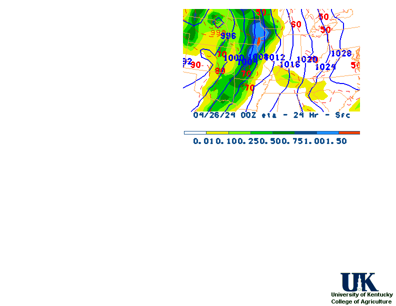
12-48 Hr ETA Surface,
12-48 Hr ETA 500mb/Sfc,
24 Hr. Comparsion,
TWC Forecast,
Fire Danger,
Day 1 Precip,
Day 2 Precip,
Days 1-5 Precip
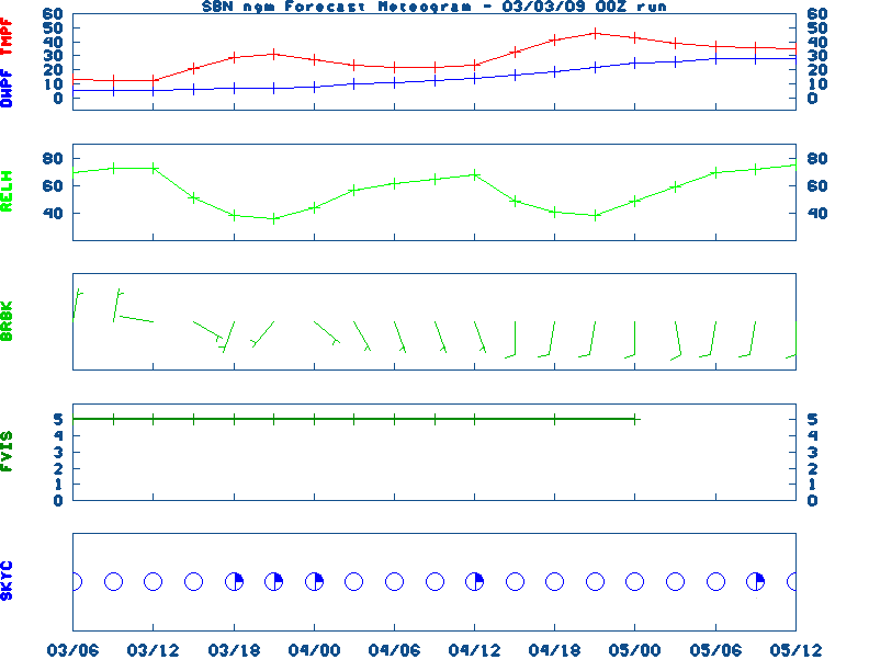
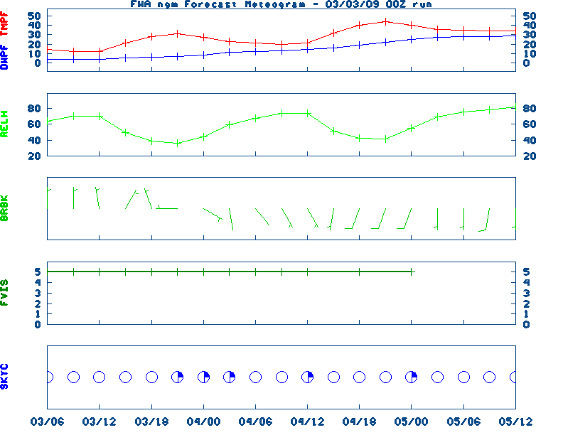
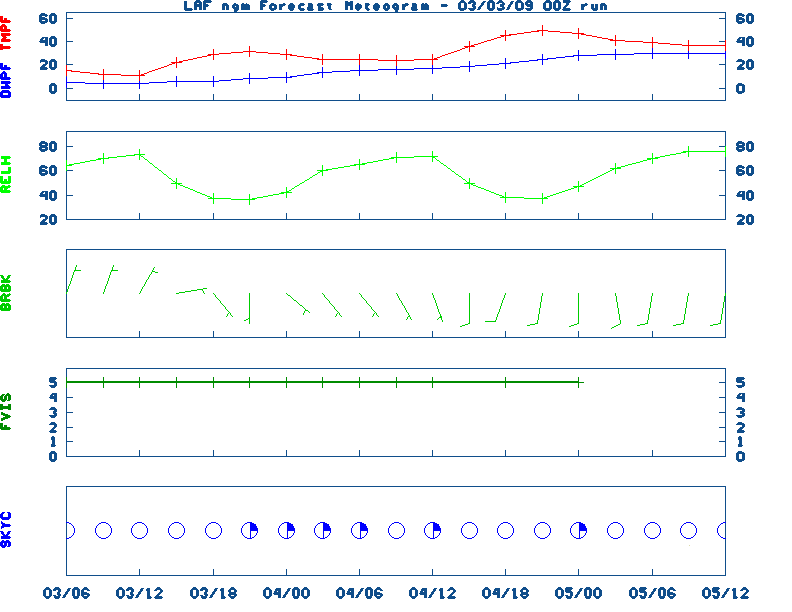
NGM 60 Hr Forecast Meteograms:
South Bend ,
Fort Wayne ,
Lafayette ,
Indianapolis ,
Evansville ,
Severe Weather Pot.-Day 1,
Day 2
Medium & Long Range Outlook For Indiana
                              INDIANA
                 ---------------------------------------------
                 6 TO 10 DAY  8 TO 14 DAY   30 DAY    90 DAY
                 MAY 2-MAY 6 MAY 4-MAY 10    JUN       JUN-AUG
                 -----------  -----------  --------  ---------
   Temperature:      Above        Above
 Precipitation:     Normal       Normal

....  Medium and long range outlooks provided by NCEP/K. Thomas Priddy
5 Day Rainfall Total Forecast,
6 to 10 Day ,
8 to 14 Day ,
Text,
30-Day Outook,
90-Day,
120-Day
Almanac Information
Saturday April 27, 2024 the 118th Day of Year

---------------------------------------------------
SUN
Declination 14.320000
Distance 0.999718 AU
Rise 06:49 EDT Set 20:36 EDT
Transit Meridian 13:42 EDT
Civil Twilight Begins 06:22 EDT Ends 21:04 EDT

Calculations made for central point in the state.
Time in ET -- and will vary due to location and
elevation -- Priddy
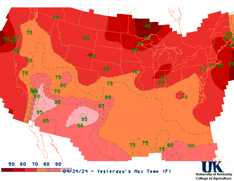
Yesterday's Highs ,
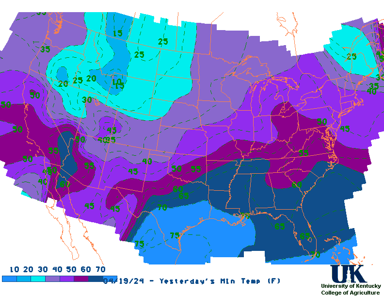
Lows
Sunrise/Sunset/Moonrise/Moonset Computation (USN)
Historical Weather And Climate Facts For Today
APRIL 27TH
HISTORIC WEATHER EVENTS
...1899...
A tornado struck Kirksville MO killing 34 persons and destroying 300
buildings. (David Ludlum)
...1931...
The temperature at Pahala, located on the main island of Hawaii, soared to
100 degrees to establish a state record. (The Weather Channel)
...1938...Bowling Green's warmest April low: 69 degrees.
(NWS Louisville)
...1937...Beginning today, Bowling Green received 10 consecutive
days with measurable precipitation, a record.
(NWS Louisville)
...1942...
A destructive tornado swept across Rogers County and Mayes County in
Oklahoma. The tornado struck the town of Pryor killing 52 persons and
causing two million dollars damage. (David Ludlum)
...1971...
A tornado tore through Green and Adair counties with F4
damage in its wake. Two and a half million dollars in damage
was done along the 14 mile long path. Six people were killed
and 58 hurt. The twister dropped to earth near Bramlett and
proceeded to Vester and Christine. The six fatalities
occurred in the Mount Pleasant Church area along KY 551 north
of Columbia. In Butler and Warren counties a tornado did F3
damage, killing one person and costing two and a half million
dollars. South View (Butler County) and Riverside (Warren
County) were struck. A tornado of F1 strength injured 2
people in Harrison County IN between Mauckport and Laconia.
Debris from a demolished barn was carried a quarter mile. An
F3 tornado did damage in Ohio and Butler counties. It touched
down near Island Lake along Wysox Road in Ohio County and
moved east near Logansport and Little Bend, lifting just
outside of Morgantown. An asphalt shingle was found embedded
two inches deep into an oak tree. An F4 tornado killed two
people in Russell County. It began east of Russell Springs
and moved through Salem to Faubush. The two fatalities
occurred when a farm was swept away at Gosser Ridge near
Dorena. At one point there were actually two distinct paths,
as two funnels moved parallel to each other. (NWS Louisville)

Ag Weather Center, Department of Biosystems & Agricultural Engineering, University of Kentucky
|


![[2nd Source TWC]](http://maps.weather.com/images/maps/current/curwx_720x486.jpg)