A joint service of the UK Ag Weather Center and the National Weather Service.
National Weather Service Indianapolis IN
1134 PM EDT Fri Apr 19 2024

.KEY MESSAGES...

- Partly Cloudy Tonight and Saturday; Cooler

- Some frost potential Sunday morning, more widespread frost
  possible Monday morning.

- Increasing rain chances next Tuesday, chance for PM thunderstorms

- Temperatures generally near seasonal next week, but brief cooldown
  is possible Wednesday into Thursday
 NWS Weather Discussion
National Ag. Weather Outlook (Repair this link), International Highlights ,International Ag. Weather Summary
Current Surface Map,
[2nd Source TWC]
Click here for UKAWC Point Agricultural, Lawn & Garden Forecast/Outlook in case of corrupt tables.
Regional Hourly Observations For GRANT County
Issued at 100 AM EDT SAT APR 20 2024
CENTRAL INDIANA

CITY           SKY/WX    TMP DP  RH WIND       PRES   REMARKS
ANDERSON       CLOUDY    49  31  50 W3        30.16S
FISHERS *+     CLOUDY    50  32  50 W8        30.19R
FRANKFORT +      N/A    N/A N/A N/A MISG        N/A
INDIANAPOLIS   MOCLDY    50  33  52 W7        30.18R
-EAGLE CREEK   MOCLDY    51  32  48 W7        30.17R
KOKOMO +       MOCLDY    47  36  65 W9        30.15R
MT COMFORT *+  CLOUDY    49  33  54 W10       30.18S
SHELBYVILLE    CLOUDY    53  33  46 W7        30.16S
ZIONSVILLE +   CLOUDY    47  33  58 W9        30.17R
Hourly Obs.,
Current Temperatures,
Dewpoint,
Rh,
Wind,
Regional Obs.,
Station Model,
Surface 4-Panel
Meteograms:
South Bend ,
Fort Wayne ,
Lafayette ,
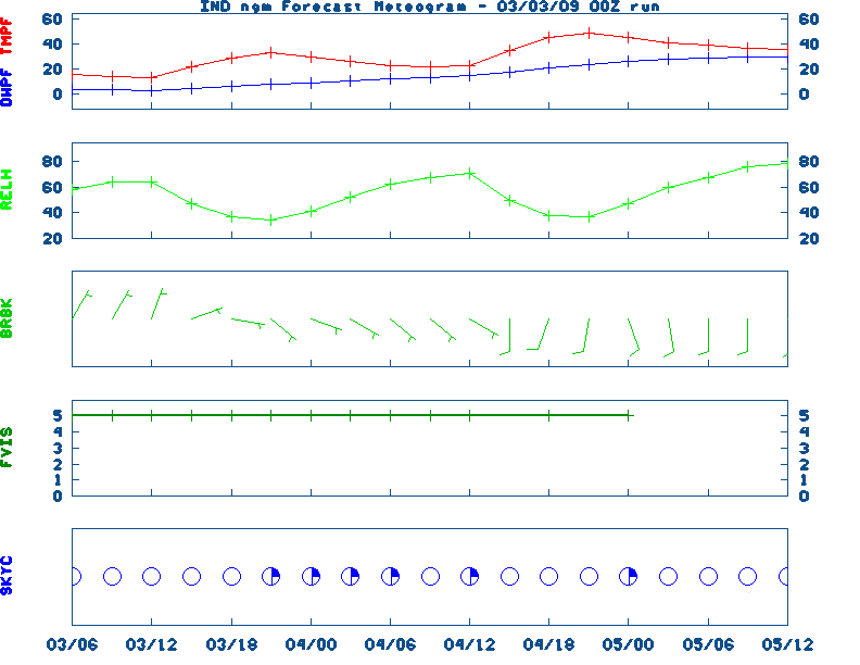
Indianapolis ,
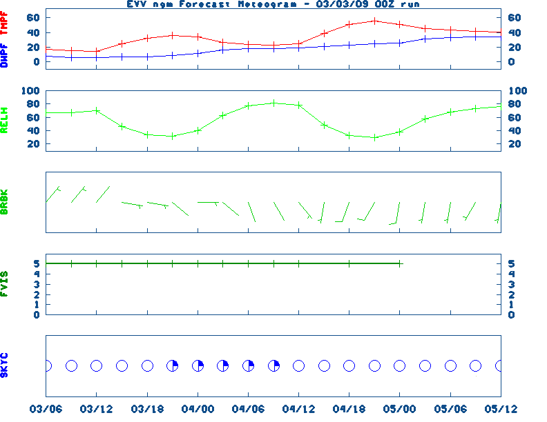
Evansville
Current Agricultural Weather Conditions in Indiana
Based on observations at 100am EDT, Saturday April 20, 2024
Across Indiana...temperatures are near 46 degrees north, near 50 degrees central, and near 52 degrees south. Current sky conditions are clear north, mostly cloudy central, and partly cloudy south. In the north, relative humidity is near 53%, and the dew point is near 30 degrees. In the central part of the state, relative humidity is near 52%, and the dew point is near 33 degrees. In the south, relative humidity is near 61%, and the dew point is near 39 degrees. Winds are from the northwest at 14 mph with gusts at 26 mph north, where conditions are not favorable for spraying due to strong winds. Winds are from the west at 7 mph central, where conditions are favorable for spraying. Winds are from the northwest at 5 mph south, where conditions are favorable for spraying. Based on current available observations, the highest temperature is 53 degrees at Shelbyville. The lowest temperature is CLOUDY degrees at Warsaw and Huntingburg.
Current NOWCAST not available:
Nowcasts are not issued routinely during fair weather. Only when
precipitation or other significant weather is occuring in this county will these
forecasts be issued. Currently, there is no short term forecast in effect.
U.S. Radar,
All NWS Radars (In near-real time),
LSI Heat Index,
Wind Chill Map
Hazardous Weather Outlook For GRANT County,IN
240 PM EDT Fri Apr 19 2024 /140 PM CDT Fri Apr 19 2024/

 DAY ONE  This afternoon and tonight.

No hazardous weather is expected at this time.

 DAYS TWO THROUGH SEVEN  Saturday through Thursday.

Frost is likely early Sunday morning especially north of US30.

 SPOTTER INFORMATION STATEMENT

Spotter activation is not expected at this time.
NWS Severe Weather Map , Convective Outlook
7-Day Forecast For GRANT County, IN
Issued at
113 AM EDT Sat Apr 20 2024
REST OF TONIGHT
Mostly clear. Lows in the upper 30s. West
winds around 10 mph.
SATURDAY
Mostly sunny. Highs around 50. Northwest winds 10 to
15 mph with gusts up to 25 mph.
SATURDAY NIGHT
Partly cloudy. Areas of frost after midnight.
Lows in the mid 30s. Northwest winds 10 to 15 mph, diminishing to
around 5 mph after midnight.
SUNDAY
Mostly sunny. Highs in the mid 50s. West winds 5 to
10 mph.
SUNDAY NIGHT
Clear. Lows in the upper 30s. Northwest winds
5 to 10 mph, becoming west after midnight.
MONDAY
Areas of frost in the morning. Sunny. Highs in the
lower 60s.
MONDAY NIGHT
Partly cloudy in the evening, then becoming
mostly cloudy. Lows in the mid 40s.
TUESDAY
Mostly cloudy. A slight chance of showers in the
morning, then a chance of showers with a slight chance of
thunderstorms in the afternoon. Highs in the lower 60s. Chance of
rain 50 percent.
TUESDAY NIGHT
Showers likely with a slight chance of
thunderstorms. Lows in the lower 40s. Chance of rain 60 percent.
WEDNESDAY
Mostly sunny. A slight chance of showers and
thunderstorms in the morning. Highs in the upper 50s. Chance of
rain 20 percent.
WEDNESDAY NIGHT
Mostly clear. Areas of frost after midnight.
Lows in the lower 30s.
THURSDAY
Areas of frost in the morning. Mostly sunny. Highs in
the upper 50s.
THURSDAY NIGHT
Mostly clear in the evening, then partly cloudy
with a slight chance of showers after midnight. Lows in the lower
40s. Chance of rain 20 percent.
FRIDAY
Partly cloudy. A slight chance of showers in the
morning, then a chance of showers with a slight chance of
thunderstorms in the afternoon. Highs in the mid 60s. Chance of
rain 40 percent.
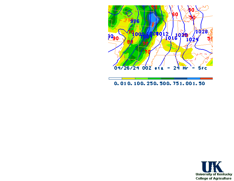
12-48 Hr ETA Surface,
12-48 Hr ETA 500mb/Sfc,
24 Hr. Comparsion,
TWC Forecast,
Fire Danger,
Day 1 Precip,
Day 2 Precip,
Days 1-5 Precip
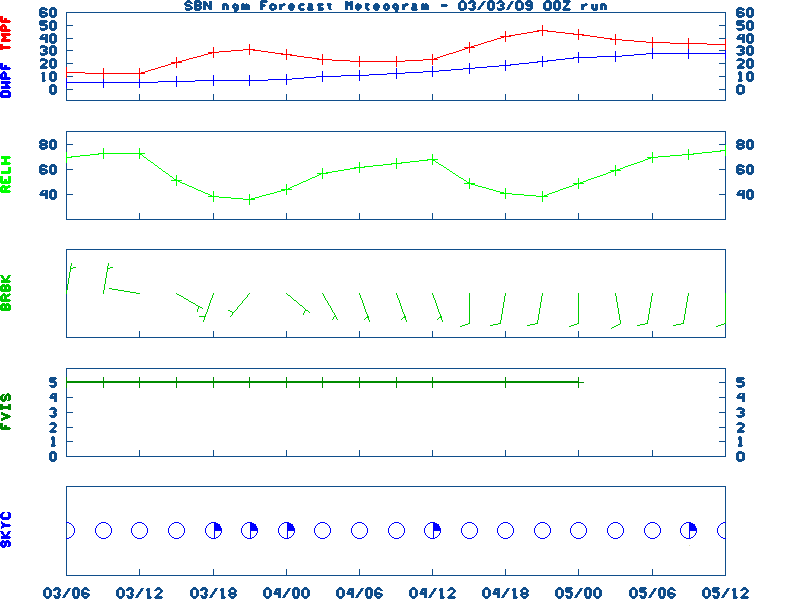
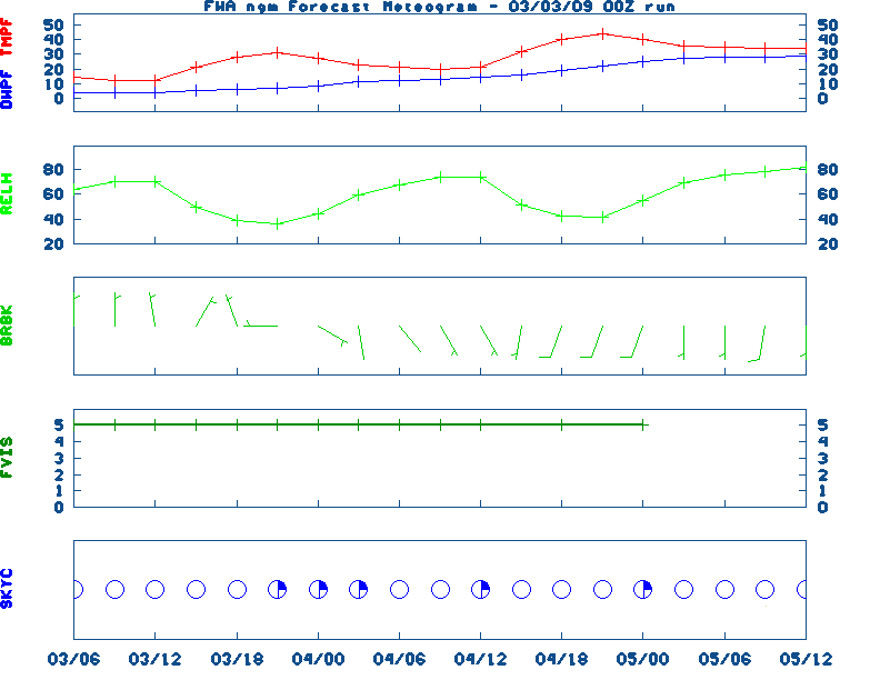
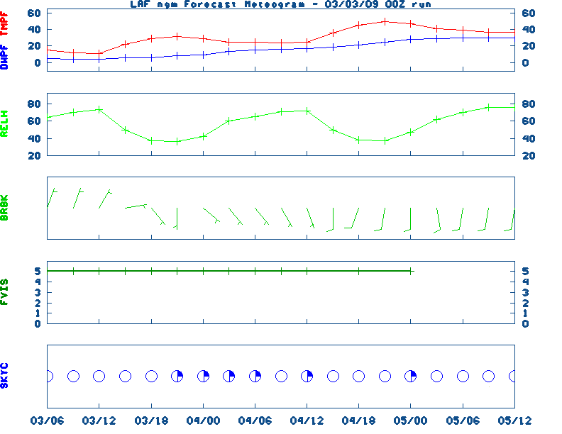
NGM 60 Hr Forecast Meteograms:
South Bend ,
Fort Wayne ,
Lafayette ,
Indianapolis ,
Evansville ,
Severe Weather Pot.-Day 1,
Day 2
Medium & Long Range Outlook For Indiana
                              INDIANA
                 ---------------------------------------------
                 6 TO 10 DAY  8 TO 14 DAY   30 DAY    90 DAY
                   APR 25-29 APR 27-MAY 3    JUN       JUN-AUG
                 -----------  -----------  --------  ---------
   Temperature:
 Precipitation:

....  Medium and long range outlooks provided by NCEP/K. Thomas Priddy
5 Day Rainfall Total Forecast,
6 to 10 Day ,
8 to 14 Day ,
Text,
30-Day Outook,
90-Day,
120-Day
Almanac Information
Saturday April 20, 2024 the 111th Day of Year

---------------------------------------------------
SUN
Declination 12.040000
Distance 0.999719 AU
Rise 06:59 EDT Set 20:29 EDT
Transit Meridian 13:43 EDT
Civil Twilight Begins 06:32 EDT Ends 20:57 EDT

Calculations made for central point in the state.
Time in ET -- and will vary due to location and
elevation -- Priddy
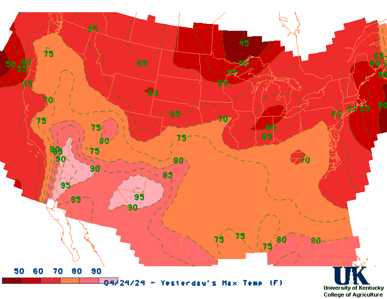
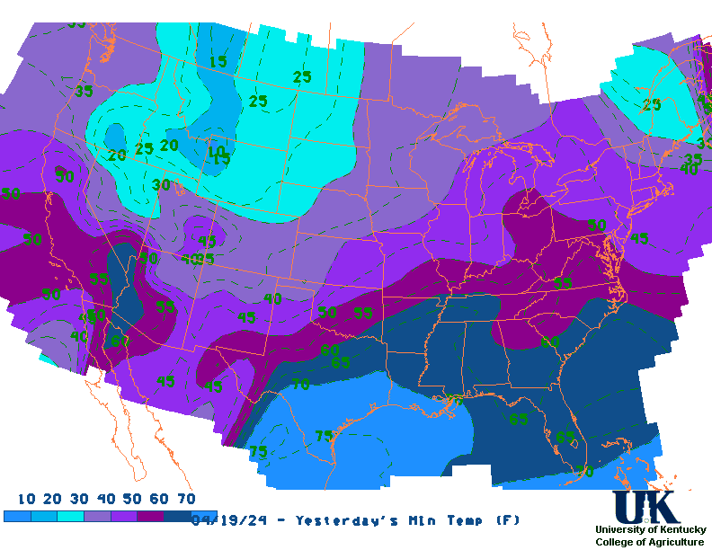
Yesterday's Highs ,
Lows
Sunrise/Sunset/Moonrise/Moonset Computation (USN)
Historical Weather And Climate Facts For Today
APRIL 20TH
HISTORIC WEATHER EVENTS
...1901...
A spring storm produced unusally heavy snow in northeast Ohio. Warren
received 35.5 inches in thirty-six hours, and 28 inches fell at Green Hill.
Akron OH established April records of 15.6 inches in 24 hours, and 26.6
inches for the month. Pittsburgh PA established April records of 12.7
inches in 24 hours, and 13.5 inches for the month. (David Ludlum) (The
Weather Channel)
...1920...
Tornadoes in Mississippi and Alabama killed 219 persons. (David Ludlum)
...2002...
An unseasonably warm and moist air mass had settled across eastern Kentucky
leading to record breaking temperatures at the Jackson Weather Office and the
London Corbin Airport between the 16th and 21st of April. Jackson saw several
days in a row with record high temperatures as well as maximum low records. On
the 19th the mercury soared to a record high of 89 degrees at Jackson and a
record tying 87 degrees at London. The low temperature at Jackson was a balmy 69
degrees good enough for a daily as well as a monthly maximum low temperature
record. (NWS Jackson)

Ag Weather Center, Department of Biosystems & Agricultural Engineering, University of Kentucky
|


![[2nd Source TWC]](http://maps.weather.com/images/maps/current/curwx_720x486.jpg)