A joint service of the UK Ag Weather Center and the National Weather Service.
National Weather Service Indianapolis IN
626 AM EDT Wed May 8 2024

.KEY MESSAGES...

- Severe storms possible today, especially during the late afternoon
  and evening. Hail and wind are the primary threats.

- Heavy rain is possible at times through Wednesday night. Localized
  flooding will also be possible.

- Periodic chances for showers and a few storms late week into early
  next week.

- Normal to slightly below normal temperatures Thursday through
  Saturday with warmer temperatures next week.
 NWS Weather Discussion
National Ag. Weather Outlook (Repair this link), International Highlights ,International Ag. Weather Summary
Current Surface Map,
[2nd Source TWC]
Click here for UKAWC Point Agricultural, Lawn & Garden Forecast/Outlook in case of corrupt tables.
Regional Hourly Observations For DELAWARE County
Issued at 800 AM EDT WED MAY 08 2024
EAST CENTRAL INDIANA

CITY           SKY/WX    TMP DP  RH WIND       PRES   REMARKS
MUNCIE         SUNNY     64  59  83 SW3       29.75R
6HR MIN TEMP:  62; 6HR MAX TEMP:  66;

PORTLAND +     SUNNY     61  61 100 CALM      29.75R FOG
RICHMOND +     FOG       57  57 100 S6        29.76S VSB<1/4
Hourly Obs.,
Current Temperatures,
Dewpoint,
Rh,
Wind,
Regional Obs.,
Station Model,
Surface 4-Panel
Meteograms:
South Bend ,
Fort Wayne ,
Lafayette ,
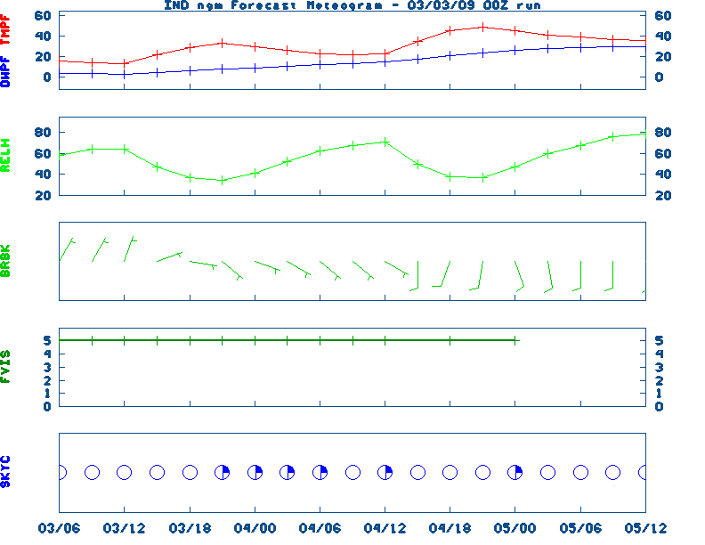
Indianapolis ,
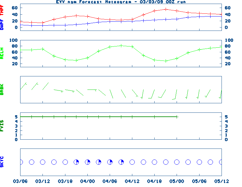
Evansville
Current Agricultural Weather Conditions in Indiana
Based on observations at 800am EDT, Wednesday May 08, 2024
Across Indiana...temperatures are near 56 degrees north, near 62 degrees central, and near 66 degrees south. Current sky conditions are sunny north, mostly sunny central, and sunny south. In the north, relative humidity is near 90%, and the dew point is near 53 degrees. In the central part of the state, relative humidity is near 100%, and the dew point is near 62 degrees. In the south, relative humidity is near 93%, and the dew point is near 64 degrees. The livestock heat stress category is no stress north, no stress central, and no stress south. Winds are from the south at 6 mph north, where conditions are favorable for spraying. Winds are from the south at 3 mph central, where conditions are favorable for spraying. Winds are from the southeast at 3 mph south, where conditions are favorable for spraying. Based on current available observations, the highest temperature is 66 degrees at Evansville. The lowest temperature is SUNNY degrees at Kokomo, Huntingburg, and Anderson.
Current NOWCAST not available:
Nowcasts are not issued routinely during fair weather. Only when
precipitation or other significant weather is occuring in this county will these
forecasts be issued. Currently, there is no short term forecast in effect.
U.S. Radar,
All NWS Radars (In near-real time),
LSI Heat Index,
Wind Chill Map
Hazardous Weather Outlook For DELAWARE County,IN
715 AM EDT Wed May 8 2024

 DAY ONE  Today and Tonight.

Weather hazards expected
Elevated hail risk.
Elevated thunderstorm wind damage risk.
Elevated lightning risk.
DISCUSSION
Thunderstorms are expected to develop and move through central
Indiana beginning early this evening and continue into tonight.
Greatest threat for severe weather will be along and south of the
I-70 corridor. Repeated rounds of rainfall may allow river
flooding to redevelop along with localized flash flooding as
well.
Storm motion this evening will be out of the W/SW between 30 and 35
MPH
DAYS TWO THROUGH SEVEN Thursday through Tuesday.
Thunderstorms are expected at times Saturday afternoon and
Monday.
SPOTTER INFORMATION STATEMENT
Spotter activation may be needed later today or tonight for central
Indiana.
NWS Severe Weather Map , Convective Outlook
7-Day Forecast For DELAWARE County, IN
Issued at
649 AM EDT Wed May 8 2024
TODAY
Sunny this morning, then partly cloudy with scattered
showers with isolated thunderstorms this afternoon. Highs in the
lower 80s. South winds 5 to 10 mph. Chance of rain 30 percent.
TONIGHT
Scattered thunderstorms. Numerous showers. Locally
heavy rainfall possible through midnight. Lows in the upper 50s.
Southeast winds 5 to 10 mph. Gusts up to 20 mph toward daybreak.
Chance of rain 70 percent.
THURSDAY
Mostly cloudy with showers likely with a chance of
thunderstorms in the morning, then partly cloudy with a chance of
showers with a slight chance of thunderstorms in the afternoon.
Not as warm with highs in the mid 60s. South winds 10 to 15 mph,
becoming west in the afternoon. Gusts up to 25 mph. Chance of
rain 60 percent.
THURSDAY NIGHT
Mostly cloudy with a slight chance of showers
and thunderstorms through midnight, then partly cloudy toward
daybreak. Cooler with lows in the mid 40s. North winds 10 to
15 mph. Chance of rain 20 percent.
FRIDAY
Partly cloudy. Highs in the lower 60s. Northwest winds
around 10 mph.
FRIDAY NIGHT
Mostly clear through midnight, then partly cloudy
with a chance of showers toward daybreak. Lows in the upper 40s.
Chance of rain 30 percent.
SATURDAY
Partly cloudy in the morning, then clearing. A chance
of showers. A slight chance of thunderstorms in the afternoon.
Highs in the mid 60s. Chance of rain 50 percent.
SATURDAY NIGHT
Mostly clear. Lows in the mid 40s.
SUNDAY AND SUNDAY NIGHT
Mostly clear. A 20 percent chance of
showers. Highs in the upper 60s. Lows around 50.
MONDAY AND MONDAY NIGHT
Partly cloudy with a chance of showers
with a slight chance of thunderstorms. Highs in the mid 70s. Lows
in the mid 50s. Chance of rain 30 percent.
TUESDAY
Partly cloudy. A slight chance of showers in the
morning, then a chance of showers with a slight chance of
thunderstorms in the afternoon. Highs in the upper 70s. Chance of
rain 40 percent.
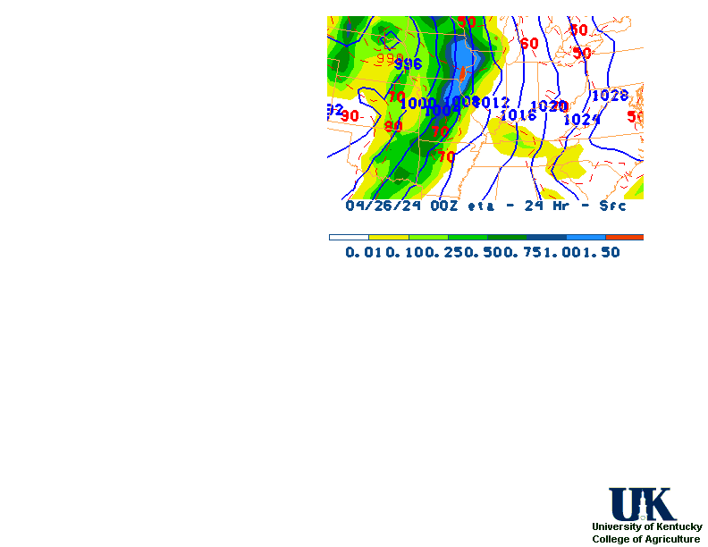
12-48 Hr ETA Surface,
12-48 Hr ETA 500mb/Sfc,
24 Hr. Comparsion,
TWC Forecast,
Fire Danger,
Day 1 Precip,
Day 2 Precip,
Days 1-5 Precip
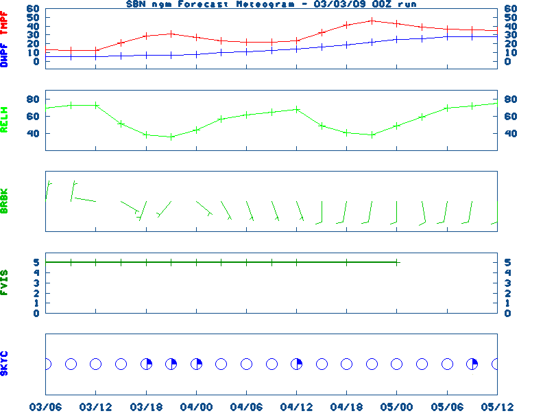
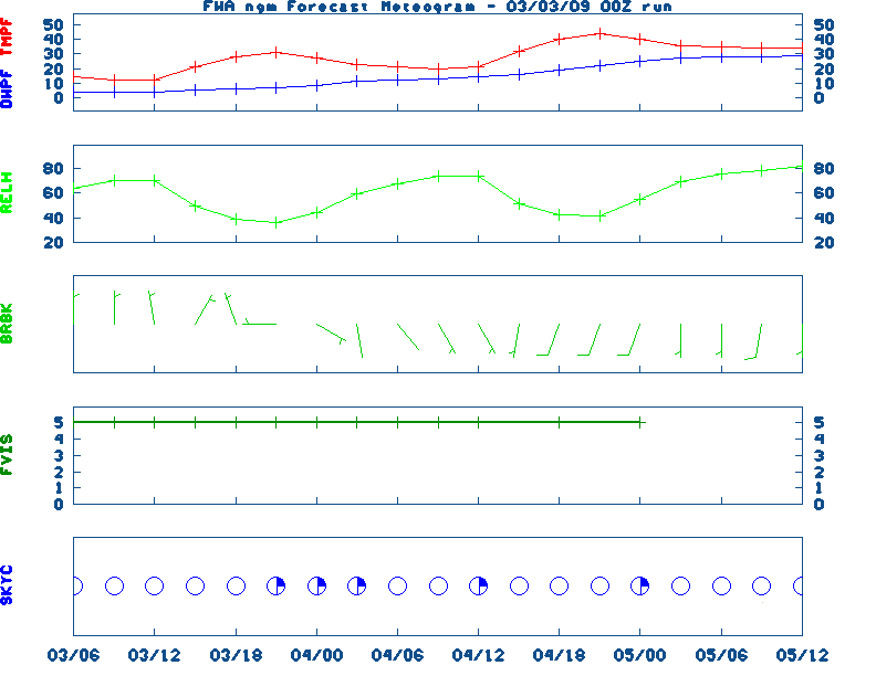
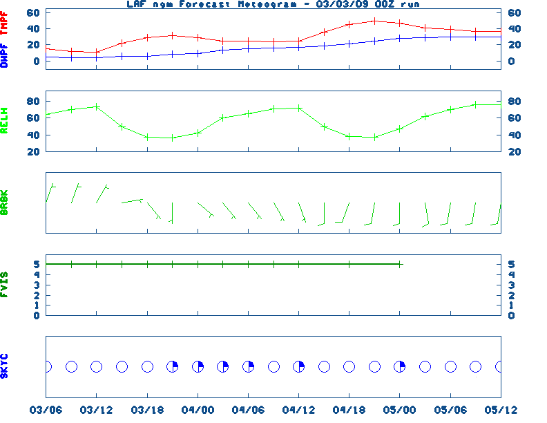
NGM 60 Hr Forecast Meteograms:
South Bend ,
Fort Wayne ,
Lafayette ,
Indianapolis ,
Evansville ,
Severe Weather Pot.-Day 1,
Day 2
Medium & Long Range Outlook For Indiana
                              INDIANA
                 ---------------------------------------------
                 6 TO 10 DAY  8 TO 14 DAY   30 DAY    90 DAY
                   MAY 13-17    MAY 15-21    JUN       JUN-AUG
                 -----------  -----------  --------  ---------
   Temperature:      Above        Above
 Precipitation:      Above       Normal

....  Medium and long range outlooks provided by NCEP/K. Thomas Priddy
5 Day Rainfall Total Forecast,
6 to 10 Day ,
8 to 14 Day ,
Text,
30-Day Outook,
90-Day,
120-Day
Almanac Information
Wednesday May 08, 2024 the 129th Day of Year

---------------------------------------------------
SUN
Declination 17.500000
Distance 0.999717 AU
Rise 06:36 EDT Set 20:47 EDT
Transit Meridian 13:41 EDT
Civil Twilight Begins 06:08 EDT Ends 21:16 EDT

Calculations made for central point in the state.
Time in ET -- and will vary due to location and
elevation -- Priddy
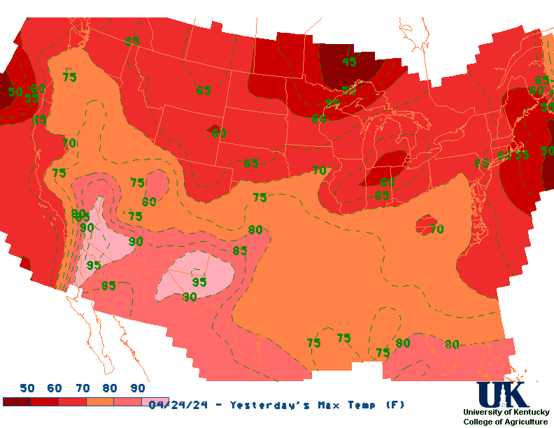
Yesterday's Highs ,
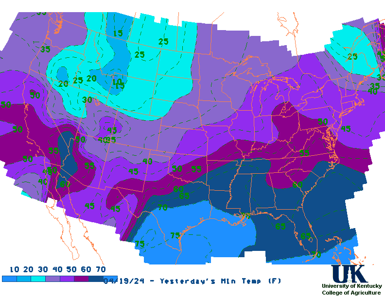
Lows
Sunrise/Sunset/Moonrise/Moonset Computation (USN)
Historical Weather And Climate Facts For Today
/////////////////////////////////////////////////////////////////////
MAY 8TH...HISTORIC WEATHER EVENTS
...1784...
A deadly hailstorm in South Carolina hit the town of Winnsborough. The
hailstones, measuring as much as nine inches in circumference, killed
several persons, and a great number of sheep, lambs and birds. (David
Ludlum)
...1803...
A freak spring storm produced heavy snow from southern Indiana to New
England. The storm made sleighing possible in Massachusetts, but also
ruined shade trees in Philadelphia. (David Ludlum)
...1895...
A light rainshower in Winnipeg dropped a mixture of rain and black ants on
the city. Most of the black ants were the size of huge wasps.
...1981...
The Dallas/Fort Worth area experienced its worst hailstorm of record as
baseball to grapefruit size hail, accompanied by 100 mph winds, caused
nearly 200 million dollars damage. Hail accumulated eight inches deep at
Cedar Hill TX. (The Weather Channel)
... 2003...
A tornado (F0) occurred in Breckinridge County along a one mile long path.
Numerous adult trees were uprooted in the Hoosier National Forest by an F1
tornado in Perry County. (NWS Louisville)

Ag Weather Center, Department of Biosystems & Agricultural Engineering, University of Kentucky
|


![[2nd Source TWC]](http://maps.weather.com/images/maps/current/curwx_720x486.jpg)